ENABLING ACCESS TO SPATIAL INFORMATION FOR INFORMED DECISION-MAKING: A CASE STUDY OF THE STRUCTURE...
10
TS12.4 Selwyn W. Willoughby: Enabling Access to Spatial Information for Informed Decision- Making: A Case Study of the Structure Plan for Mining International Conference on Spatial Information for Sustainable Development Nairobi, Kenya 2–5 October 2001 1 ENABLING ACCESS TO SPATIAL INFORMATION FOR INFORMED DECISION-MAKING: A CASE STUDY OF THE STRUCTURE PLAN FOR MINING. Selwyn W. WILLOUGHBY, South Africa Key words: spatial information, spatial planning, GIS, Internet, structure plan for mining. ABSTRACT The collection of accurate and relevant spatial information, for spatial planning purposes is of critical importance to assist in well-informed decision-making. The true value of collected information will only be achieved when the information is shared. The proper dissemination of information can ensure that spatial information contributes towards sustainable development. The paper discusses the Structure Plan for Mining and the method of disseminating information to ensure rational decision-making. INTRODUCTION In January 1999 the former Cape Metropolitan Council, now part of the City of Cape Town, initiated a structure Plan for Mining. The plan deals with mineral resource extraction and contains policies and guidelines to provide a framework for decision- making in respect of the applications for land-use changes. The primary objective of the Structure Plan for Mining is to facilitate decision-making in regard to the appropriate long- term use of land. However the overall goal of improving or maintaining the quality of life of the inhabitants of the area remains the primary concern. The study area included the then six Metropolitan Local Councils as well as two District Councils. The challenge was to ensure that the information is used across the study area and applied consistently. This paper outlines the Structure Plan for Mining and the method for ensuring that the spatial information generated by the study, contributes toward sustainable spatial planning practices. THE STRUCTURE PLAN FOR MINING – AN OVERVIEW The planning process that the Structure Plan followed includes technical studies, a public participation process leading to goals and objectives, which informed the policy and management proposals. The proposals and recommendations of the plan include land-use change policy recommendations for the identification and delineation of where mining should not be permitted, as well as areas where mining should be given priority. These management guidelines focus on the potential impact of mining on the environment and do not address operational and technical aspects of mining.
-
Upload
independent -
Category
Documents
-
view
2 -
download
0
Transcript of ENABLING ACCESS TO SPATIAL INFORMATION FOR INFORMED DECISION-MAKING: A CASE STUDY OF THE STRUCTURE...
TS12.4 Selwyn W. Willoughby: Enabling Access to Spatial Information for Informed Decision-Making: A Case Study of the Structure Plan for Mining
International Conference on Spatial Information for Sustainable DevelopmentNairobi, Kenya2–5 October 2001
1
ENABLING ACCESS TO SPATIAL INFORMATION FORINFORMED DECISION-MAKING: A CASE STUDY OF THE
STRUCTURE PLAN FOR MINING.
Selwyn W. WILLOUGHBY, South Africa
Key words: spatial information, spatial planning, GIS, Internet, structure plan for mining.
ABSTRACT
The collection of accurate and relevant spatial information, for spatial planning purposes isof critical importance to assist in well-informed decision-making. The true value ofcollected information will only be achieved when the information is shared. The properdissemination of information can ensure that spatial information contributes towardssustainable development. The paper discusses the Structure Plan for Mining and themethod of disseminating information to ensure rational decision-making.
INTRODUCTION
In January 1999 the former Cape Metropolitan Council, now part of the City of CapeTown, initiated a structure Plan for Mining. The plan deals with mineral resourceextraction and contains policies and guidelines to provide a framework for decision-making in respect of the applications for land-use changes. The primary objective of theStructure Plan for Mining is to facilitate decision-making in regard to the appropriate long-term use of land. However the overall goal of improving or maintaining the quality of lifeof the inhabitants of the area remains the primary concern.
The study area included the then six Metropolitan Local Councils as well as two DistrictCouncils. The challenge was to ensure that the information is used across the study areaand applied consistently. This paper outlines the Structure Plan for Mining and the methodfor ensuring that the spatial information generated by the study, contributes towardsustainable spatial planning practices.
THE STRUCTURE PLAN FOR MINING – AN OVERVIEW
The planning process that the Structure Plan followed includes technical studies, a publicparticipation process leading to goals and objectives, which informed the policy andmanagement proposals. The proposals and recommendations of the plan include land-usechange policy recommendations for the identification and delineation of where miningshould not be permitted, as well as areas where mining should be given priority. Thesemanagement guidelines focus on the potential impact of mining on the environment and donot address operational and technical aspects of mining.
TS12.4 Selwyn W. Willoughby: Enabling Access to Spatial Information for Informed Decision-Making: A Case Study of the Structure Plan for Mining
International Conference on Spatial Information for Sustainable DevelopmentNairobi, Kenya2–5 October 2001
2
The major inputs for the study came from town planners, geology/soil experts,environmentalists/botanists and public participation facilitators.
Study Area
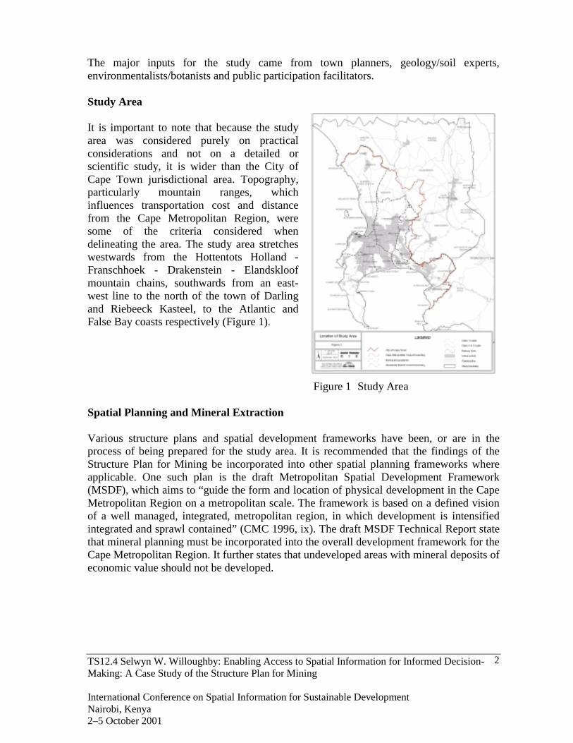
It is important to note that because the studyarea was considered purely on practicalconsiderations and not on a detailed orscientific study, it is wider than the City ofCape Town jurisdictional area. Topography,particularly mountain ranges, whichinfluences transportation cost and distancefrom the Cape Metropolitan Region, weresome of the criteria considered whendelineating the area. The study area stretcheswestwards from the Hottentots Holland -Franschhoek - Drakenstein - Elandskloofmountain chains, southwards from an east-west line to the north of the town of Darlingand Riebeeck Kasteel, to the Atlantic andFalse Bay coasts respectively (Figure 1).
Figure 1 Study Area
Spatial Planning and Mineral Extraction
Various structure plans and spatial development frameworks have been, or are in theprocess of being prepared for the study area. It is recommended that the findings of theStructure Plan for Mining be incorporated into other spatial planning frameworks whereapplicable. One such plan is the draft Metropolitan Spatial Development Framework(MSDF), which aims to “guide the form and location of physical development in the CapeMetropolitan Region on a metropolitan scale. The framework is based on a defined visionof a well managed, integrated, metropolitan region, in which development is intensifiedintegrated and sprawl contained” (CMC 1996, ix). The draft MSDF Technical Report statethat mineral planning must be incorporated into the overall development framework for theCape Metropolitan Region. It further states that undeveloped areas with mineral deposits ofeconomic value should not be developed.
TS12.4 Selwyn W. Willoughby: Enabling Access to Spatial Information for Informed Decision-Making: A Case Study of the Structure Plan for Mining
International Conference on Spatial Information for Sustainable DevelopmentNairobi, Kenya2–5 October 2001
3
The Draft Statutory MSDF includes the following policies relevant to mining;- Integrated Environmental Management procedures, or similar methodologies, as
required by the Environmental Conservation Act should be part of developmentproposals for any environmental and economic resource,
- All Local Authorities should ensure that compatible strategies are perused whendealing with mineral or extractive resources/rights, and existing and future land-usedevelopment or conservation requirements for the area.
- Disused mineral works and quarries can contribute to the Metropolitan Open SpaceSystem
- The Urban Edge, the line beyond which no urban development should not bepermitted, aims to make optimal use of natural resources, and though not explicitlystated would include mineral deposits. Economic mineral deposits may be used toassist in the delineation of an urban edge.
The spatial information on vegetation and mineral resources are thus important informantsin forward and reactive planning practices.
Spatial Information
Access to, and the capturing of spatial information is central to this structure plan.Therefore it was important for the various specialists to have access to the latestinformation to aid in identifying the scope for capturing new data. To achieve the desiredresults all information was captured to acommon base provided by the Corporate GISDepartment. The mineral and environmentalresources spatial databases were created forthis study. This information was incorporatedwith existing spatial and non-spatialinformation.
Geological Assessment
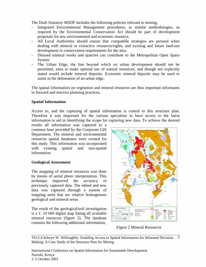
The mapping of mineral resources was doneby means of aerial photo interpretation. Thistechnique improved the accuracy ofpreviously captured data. The edited and newdata was captured through a system ofmapping units that are relative homogenousgeological and mineral areas.
The result of the geological/soil investigationis a 1: 10 000 digital map listing all availablemineral resources (figure 2). The databasecontains the following additional information,
Figure 2 Mineral Resources
TS12.4 Selwyn W. Willoughby: Enabling Access to Spatial Information for Informed Decision-Making: A Case Study of the Structure Plan for Mining
International Conference on Spatial Information for Sustainable DevelopmentNairobi, Kenya2–5 October 2001
4
- The geological condition,- The occurrence of the mineral,- The relative importance of the mineral,- The economic potential of the resource over time,- The method of excavation,- The physical end-result of mining,- The presence of a water table, and- The occurrence of a secondary mineral deposit.
Through the geological assessment, the most important building and construction materialswere identified. Furthermore, it was found that larger quantities of silica (glass) sand existthan previously known. The findings provide an opportunity for land-use change decisionsto consider the importance of the mineral deposits as well as the feasibility of successfulpost-mining rehabilitation.
Environmental Investigation
The aim of the environmental investigation is to provide an overview of the generalecology and conservation status of the area, focussing on the natural plant life, particularlyin relation to the soil and habitat types. Furthermore, the investigation rated the variousecosystems and vegetation formations on the basis of conservation importance. The studyconcludes with guidelines for mining, from an environmental perspective.
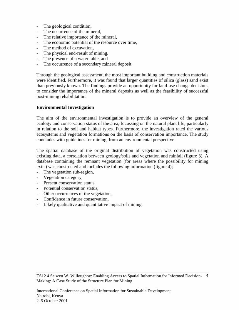
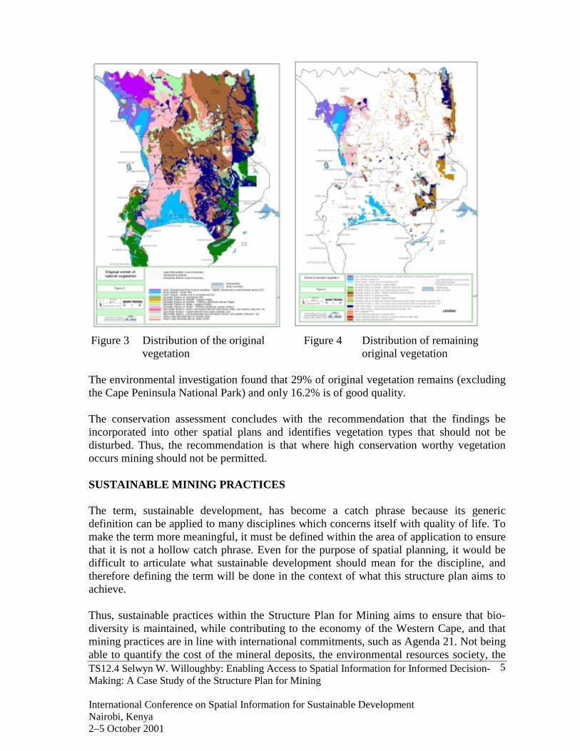
The spatial database of the original distribution of vegetation was constructed usingexisting data, a correlation between geology/soils and vegetation and rainfall (figure 3). Adatabase containing the remnant vegetation (for areas where the possibility for miningexits) was constructed and includes the following information (figure 4);- The vegetation sub-region,- Vegetation category,- Present conservation status,- Potential conservation status,- Other occurrences of the vegetation,- Confidence in future conservation,- Likely qualitative and quantitative impact of mining.
TS12.4 Selwyn W. Willoughby: Enabling Access to Spatial Information for Informed Decision-Making: A Case Study of the Structure Plan for Mining
International Conference on Spatial Information for Sustainable DevelopmentNairobi, Kenya2–5 October 2001
5
Figure 3 Distribution of the original Figure 4 Distribution of remaining
vegetation original vegetation
The environmental investigation found that 29% of original vegetation remains (excludingthe Cape Peninsula National Park) and only 16.2% is of good quality.
The conservation assessment concludes with the recommendation that the findings beincorporated into other spatial plans and identifies vegetation types that should not bedisturbed. Thus, the recommendation is that where high conservation worthy vegetationoccurs mining should not be permitted.
SUSTAINABLE MINING PRACTICES
The term, sustainable development, has become a catch phrase because its genericdefinition can be applied to many disciplines which concerns itself with quality of life. Tomake the term more meaningful, it must be defined within the area of application to ensurethat it is not a hollow catch phrase. Even for the purpose of spatial planning, it would bedifficult to articulate what sustainable development should mean for the discipline, andtherefore defining the term will be done in the context of what this structure plan aims toachieve.
Thus, sustainable practices within the Structure Plan for Mining aims to ensure that bio-diversity is maintained, while contributing to the economy of the Western Cape, and thatmining practices are in line with international commitments, such as Agenda 21. Not beingable to quantify the cost of the mineral deposits, the environmental resources society, the
TS12.4 Selwyn W. Willoughby: Enabling Access to Spatial Information for Informed Decision-Making: A Case Study of the Structure Plan for Mining
International Conference on Spatial Information for Sustainable DevelopmentNairobi, Kenya2–5 October 2001
6
final decision for finding a balance between mining activities and the environment restwith political decision-makers. For informed political decisions to be made, thedissemination of the collected spatial information is of critical importance. An informationdissemination strategy has been developed to ensure that the information reaches its targetaudience.
DISSEMINATION OF SPATIAL INFORMATION
At the time of the study, Cape Town had six Metropolitan Local Councils, each with itsown political autonomy. In the absence of a comprehensive database of mineral andvegetation resources and a framework for mining, each Local Council applied its own rulesto approving applications for mining. As a result the collective impact of mining across theCity could not be established. To ensure that the results of this study inform land-usechange decisions, the information had to be disseminated to all the Local Councils.
Compact Disc
The first version of the structure plan for mining decision support information was writtento a Compact Disc (CD). The CD contained the spatial information, the full report, theexecutive summary, as well as GIS viewer, ArcExplorer, and the accompanying help files.The spatial information was captured in Shapefile format and predefined views were set-upfor ease of use. The CD was distributed to all officials throughout the study area.
The feedback from the officials was that not everyone had access to a CD-ROM. Althoughthe spatial data was prepared for viewing, not everybody who did have access knew how toeffectively use information contained on the disc. Most of the users found it difficult torelate the spatial information to written report.
Internet
An informal survey found that more officials had access to the Internet than to CD-ROMs,thus the alternative was to disseminate the information via the Internet. The Internetprovided the perfect medium to reach a large audience with minimal or no investment inadditional software, hardware or training. The major challenge with developing thedecision support website, was to develop user-friendly web pages. Proving access to spatialinformation over the Internet was the first such challenge for the Spatial PlanningDepartment.
Unlike the CD-ROM, developing web pages for the Internet provided the opportunity toadd additional functionality to the Structure Plan for Mining information. The web site wasdeveloped to act as a decision support website because it provides more functionality at afraction of the cost than of a CD-ROM. The structure of the web site ensures easynavigation and contains links for reading the full report, viewing all the maps in an imageformat, downloading all the information, including a mapping (GIS) component, and themost important, the site assessment page.
TS12.4 Selwyn W. Willoughby: Enabling Access to Spatial Information for Informed Decision-Making: A Case Study of the Structure Plan for Mining
International Conference on Spatial Information for Sustainable DevelopmentNairobi, Kenya2–5 October 2001
7
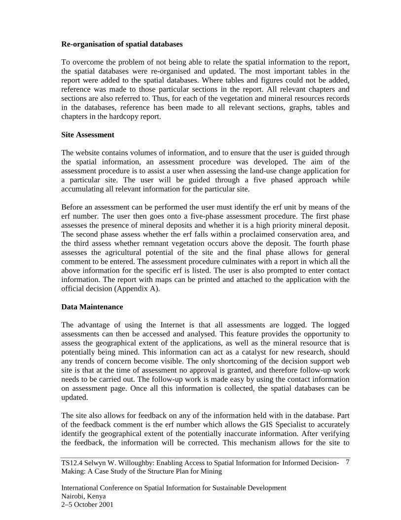
Re-organisation of spatial databases
To overcome the problem of not being able to relate the spatial information to the report,the spatial databases were re-organised and updated. The most important tables in thereport were added to the spatial databases. Where tables and figures could not be added,reference was made to those particular sections in the report. All relevant chapters andsections are also referred to. Thus, for each of the vegetation and mineral resources recordsin the databases, reference has been made to all relevant sections, graphs, tables andchapters in the hardcopy report.
Site Assessment
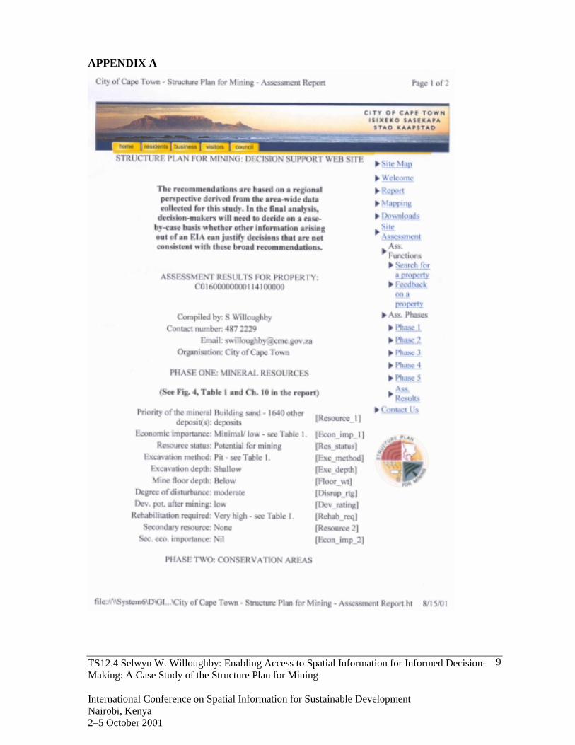
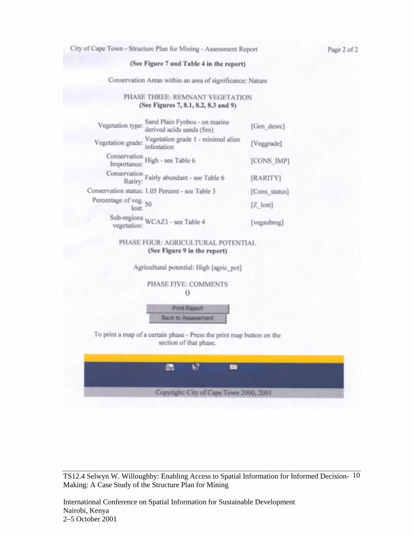
The website contains volumes of information, and to ensure that the user is guided throughthe spatial information, an assessment procedure was developed. The aim of theassessment procedure is to assist a user when assessing the land-use change application fora particular site. The user will be guided through a five phased approach whileaccumulating all relevant information for the particular site.
Before an assessment can be performed the user must identify the erf unit by means of theerf number. The user then goes onto a five-phase assessment procedure. The first phaseassesses the presence of mineral deposits and whether it is a high priority mineral deposit.The second phase assess whether the erf falls within a proclaimed conservation area, andthe third assess whether remnant vegetation occurs above the deposit. The fourth phaseassesses the agricultural potential of the site and the final phase allows for generalcomment to be entered. The assessment procedure culminates with a report in which all theabove information for the specific erf is listed. The user is also prompted to enter contactinformation. The report with maps can be printed and attached to the application with theofficial decision (Appendix A).
Data Maintenance
The advantage of using the Internet is that all assessments are logged. The loggedassessments can then be accessed and analysed. This feature provides the opportunity toassess the geographical extent of the applications, as well as the mineral resource that ispotentially being mined. This information can act as a catalyst for new research, shouldany trends of concern become visible. The only shortcoming of the decision support website is that at the time of assessment no approval is granted, and therefore follow-up workneeds to be carried out. The follow-up work is made easy by using the contact informationon assessment page. Once all this information is collected, the spatial databases can beupdated.
The site also allows for feedback on any of the information held with in the database. Partof the feedback comment is the erf number which allows the GIS Specialist to accuratelyidentify the geographical extent of the potentially inaccurate information. After verifyingthe feedback, the information will be corrected. This mechanism allows for the site to
TS12.4 Selwyn W. Willoughby: Enabling Access to Spatial Information for Informed Decision-Making: A Case Study of the Structure Plan for Mining
International Conference on Spatial Information for Sustainable DevelopmentNairobi, Kenya2–5 October 2001
8
automatically maintain its datasets, and thus eliminate the need for expensive follow-upsurveys of the spatial data.
Public access to the information does not necessarily mean that all minerals are open to bemined. Public access to the information is beneficial to the officials, as the potential of asuccessful application can be assessed before submitting it to Council for approval.
CONCLUSION
The accuracy of spatial information has increased over the last decade resulting in greateruser confidence. Also, the continual improvement of the technology employed with spatialinformation ensures that the information can be applied to assist in rational decision-making. The problem that is generally encountered is the reluctance of making informationavailable. To ensure that spatial information contributes to sustainable spatial planningpractices, information sharing is critical. Therefore, the dissemination of information is animportant criterion in realising the aim of the Structure Plan for Mining, and publishing theinformation to a website ensures that consistent well-informed decisions regarding miningis made throughout the study area.
The publication of the Structure Plan for Mining website promotes the City of CapeTown’s strategic pledge of creating a smart city. It also promotes the goals of thePromotion of Access to Information Act (Act 2 of 2000) as well as the Green Paper onPreparing the Western Cape for the Knowledge Economy of the 21st Century.
REFERENCES
Cape Metropolitan Council, 1996. Metropolitan Spatial Development Framework.Technical Report.
Cape Metropolitan Council, 2000. Structure Plan for Mining. Volume 1.Yeh, A, G-O, 1999. Urban Applications in GIS. Geographical Information Systems,
Volume 1. Ed Longley et al. John Wiley & Sons Inc. New York.
CONTACTS
Selwyn W. WilloughbyCity of Cape TownCape Metropolitan Council AdministrationCape TownSOUTH AFRICATel. + 27 21 487 2229Fax + 27 21 487 2750Email: [email protected] Site: http://www.capetown.gov.za
TS12.4 Selwyn W. Willoughby: Enabling Access to Spatial Information for Informed Decision-Making: A Case Study of the Structure Plan for Mining
International Conference on Spatial Information for Sustainable DevelopmentNairobi, Kenya2–5 October 2001
9
APPENDIX A
TS12.4 Selwyn W. Willoughby: Enabling Access to Spatial Information for Informed Decision-Making: A Case Study of the Structure Plan for Mining
International Conference on Spatial Information for Sustainable DevelopmentNairobi, Kenya2–5 October 2001
10