ELECTRONIC CULTURAL ATLAS INITIATIVE EARLY AUSTRONESIAN HISTORICAL VOYAGING IN MONSOON ASIA:...
16
January 3, 2014 Time: 10:34am ijhac.2014.0110.tex ELECTRONIC CULTURAL ATLAS INITIATIVE EARLY AUSTRONESIAN HISTORICAL VOYAGING IN MONSOON ASIA: HERITAGE AND KNOWLEDGE FOR MUSEUM DISPLAYS UTILIZING TEXTS, ARCHAEOLOGY, DIGITAL INTERACTIVE COMPONENTS, AND GIS APPROACHES 1 DAVID BLUNDELLAND JEANETTE ZERNEKE Abstract This paper covers work using historical geographic information systems (GIS) by the Electronic Cultural Atlas Initiative (ECAI) 2 to trace early navigation in Monsoon Asia. To open a scholarly Web-based platform to a broader audience, the ECAI Austronesia Team is collaborating with the Maritime Buddhism project conceived by Lewis Lancaster. The Maritime Buddhism project is being developed to reach general audiences with a high level of interactivity and 3D visualizations featuring historic timelines, ships, trade routes and trade winds, travelling monks, life at ports, and stories. To allow the information to be more accessible, mobile phone apps and multi-media museum displays are being developed. Austronesian speaking peoples made navigation a way of life across the Indian and Pacific oceans spanning thousands of years. The goal of this integration of content and technology is to enable our understanding of Monsoon Asia, its diffusion of culture, and oceanic navigation to become alive and accessible. Keywords: Maritime Buddhism, history, geographic information systems (GIS), Monsoon Asia, Electronic Cultural Atlas Initiative (ECAI), Austronesia, interactive museum displays, 3D, ALiVE – Applied Laboratory for Interactive Visualization Embodiment International Journal of Humanities and Arts Computing 8 (2014) Supplement: 237–252 DOI: 10.3366/ijhac.2014.0110 © Edinburgh University Press www.euppublishing.com/ijhac 237
Transcript of ELECTRONIC CULTURAL ATLAS INITIATIVE EARLY AUSTRONESIAN HISTORICAL VOYAGING IN MONSOON ASIA:...

January 3, 2014 Time: 10:34am ijhac.2014.0110.tex
ELECTRONIC CULTURAL ATLAS INITIATIVE
EARLY AUSTRONESIAN HISTORICAL VOYAGING IN MONSOONASIA: HERITAGE AND KNOWLEDGE FOR MUSEUM DISPLAYSUTILIZING TEXTS, ARCHAEOLOGY, DIGITAL INTERACTIVE
COMPONENTS, AND GIS APPROACHES1
DAVID BLUNDELL AND JEANETTE ZERNEKE
Abstract This paper covers work using historical geographic informationsystems (GIS) by the Electronic Cultural Atlas Initiative (ECAI)2 to traceearly navigation in Monsoon Asia. To open a scholarly Web-based platformto a broader audience, the ECAI Austronesia Team is collaborating withthe Maritime Buddhism project conceived by Lewis Lancaster. The MaritimeBuddhism project is being developed to reach general audiences with a high levelof interactivity and 3D visualizations featuring historic timelines, ships, traderoutes and trade winds, travelling monks, life at ports, and stories. To allow theinformation to be more accessible, mobile phone apps and multi-media museumdisplays are being developed. Austronesian speaking peoples made navigation away of life across the Indian and Pacific oceans spanning thousands of years. Thegoal of this integration of content and technology is to enable our understandingof Monsoon Asia, its diffusion of culture, and oceanic navigation to become aliveand accessible.
Keywords: Maritime Buddhism, history, geographic information systems(GIS), Monsoon Asia, Electronic Cultural Atlas Initiative (ECAI), Austronesia,interactive museum displays, 3D, ALiVE – Applied Laboratory for InteractiveVisualization Embodiment
International Journal of Humanities and Arts Computing 8 (2014) Supplement: 237–252DOI: 10.3366/ijhac.2014.0110© Edinburgh University Presswww.euppublishing.com/ijhac
237
January 3, 2014 Time: 10:34am ijhac.2014.0110.tex
David Blundell and Jeanette Zerneke
1. introduction
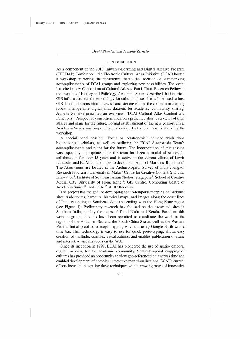
As a component of the 2013 Taiwan e-Learning and Digital Archive Program(TELDAP) Conference3, the Electronic Cultural Atlas Initiative (ECAI) hosteda workshop mirroring the conference theme that focused on summarizingaccomplishments of ECAI groups and exploring new possibilities. The eventlaunched a new Consortium of Cultural Atlases. Fan I-Chun, Research Fellow atthe Institute of History and Philology, Academia Sinica, described the historicalGIS infrastructure and methodology for cultural atlases that will be used to hostGIS data for the consortium. Lewis Lancaster envisioned the consortium creatingrobust interoperable digital atlas datasets for academic community sharing.Jeanette Zerneke presented an overview: ‘ECAI Cultural Atlas Content andFunctions’. Prospective consortium members presented short overviews of theiratlases and plans for the future. Formal establishment of the new consortium atAcademia Sinica was proposed and approved by the participants attending theworkshop.
A special panel session: ‘Focus on Austronesia’ included work doneby individual scholars, as well as outlining the ECAI Austronesia Team’saccomplishments and plans for the future. The incorporation of this sessionwas especially appropriate since the team has been a model of successfulcollaboration for over 15 years and is active in the current efforts of LewisLancaster and ECAI collaborators to develop an Atlas of Maritime Buddhism.4
The Atlas teams are located at the Archaeological Survey of India5; AngkorResearch Program6; University of Malay7 Centre for Creative Content & DigitalInnovation8; Institute of Southeast Asian Studies, Singapore9; School of CreativeMedia, City University of Hong Kong10; GIS Centre, Computing Centre ofAcademia Sinica11; and ECAI12 at UC Berkeley.
The project has the goal of developing spatio-temporal mapping of Buddhistsites, trade routes, harbours, historical maps, and images along the coast linesof India extending to Southeast Asia and ending with the Hong Kong region(see Figure 1). Preliminary research has focused on the excavated sites inSouthern India, notably the states of Tamil Nadu and Kerala. Based on thiswork, a group of teams have been recruited to coordinate the work in theregions of the Andaman Sea and the South China Sea as well as the WesternPacific. Initial proof of concept mapping was built using Google Earth with atime bar. This technology is easy to use for quick proto-typing, allows easycreation of multiple, complex visualizations, and enables publication of staticand interactive visualizations on the Web.
Since its inception in 1997, ECAI has pioneered the use of spatio-temporaldigital mapping for the academic community. Spatio-temporal mapping ofcultures has provided an opportunity to view geo-referenced data across time andenabled development of complex interactive map visualizations. ECAI’s currentefforts focus on integrating these techniques with a growing range of innovative
238

January 3, 2014 Time: 10:34am ijhac.2014.0110.tex
Early Austronesian Historical Voyaging in Monsoon Asia
Figure 1. Maps of historical kingdoms in Southern Asia, their associated traderoutes, and other information are used to construct geo-registered layers by timein Google Earth.
strategies to develop robust interactive access to the atlas projects for the publicin venues, such as museums, offering new ways of delivering cultural researchto the public.
2. retrospect – ecai austronesia atlas / pacific language mapping
In 1997, the Austronesia Team13 was conceived by the founder of ECAI,Lewis Lancaster, during a conference entitled ‘Austronesian Studies in Taiwan:Retrospective and Prospect’14 held at UC Berkeley and co-sponsored bythe Shung Ye Museum of Formosan Aborigines15. The projects of theAustronesia Team16 have contributed to and developed along with the conceptsand technologies of ECAI cultural atlases. Methods used in these projectsinclude visual anthropology, community discussions, photography, life historyinterviews, geographic information systems (GIS) mapping, scanning original
239
January 3, 2014 Time: 10:34am ijhac.2014.0110.tex
David Blundell and Jeanette Zerneke
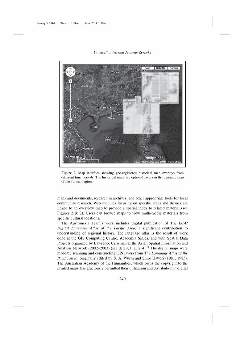
Figure 2. Map interface showing geo-registered historical map overlays fromdifferent time periods. The historical maps are optional layers in the dynamic mapof the Taiwan region.
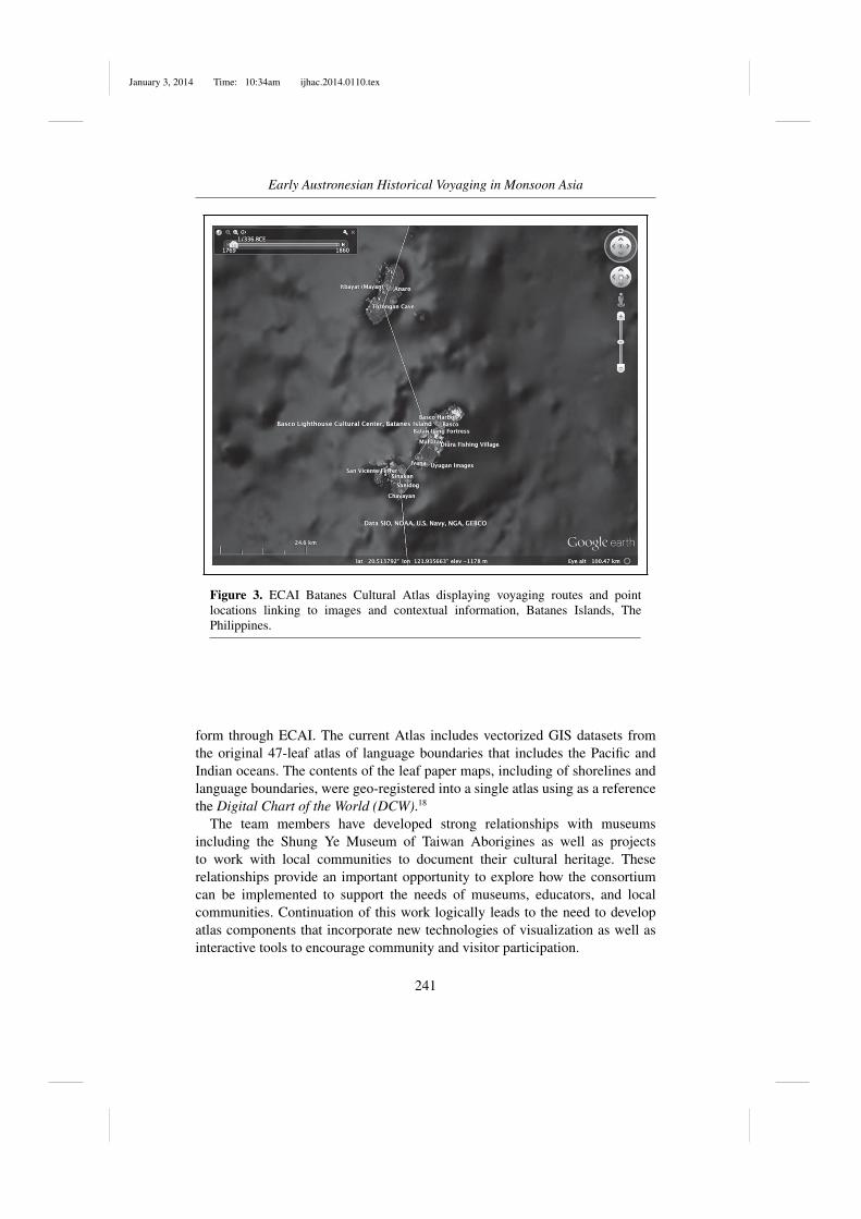
maps and documents, research in archives, and other appropriate tools for localcommunity research. Web modules focusing on specific areas and themes arelinked to an overview map to provide a spatial index to related material (seeFigures 2 & 3). Users can browse maps to view multi-media materials fromspecific cultural locations.
The Austronesia Team’s work includes digital publication of The ECAIDigital Language Atlas of the Pacific Area, a significant contribution tounderstanding of regional history. The language atlas is the result of workdone at the GIS Computing Centre, Academia Sinica, and with Spatial DataProjects organized by Lawrence Crissman at the Asian Spatial Information andAnalysis Network (2002–2003) (see detail, Figure 4).17 The digital maps weremade by scanning and constructing GIS layers from The Language Atlas of thePacific Area, originally edited by S. A. Wurm and Shiro Hattori (1981, 1983).The Australian Academy of the Humanities, which owns the copyright to theprinted maps, has graciously permitted their utilization and distribution in digital
240
January 3, 2014 Time: 10:34am ijhac.2014.0110.tex
Early Austronesian Historical Voyaging in Monsoon Asia
Figure 3. ECAI Batanes Cultural Atlas displaying voyaging routes and pointlocations linking to images and contextual information, Batanes Islands, ThePhilippines.
form through ECAI. The current Atlas includes vectorized GIS datasets fromthe original 47-leaf atlas of language boundaries that includes the Pacific andIndian oceans. The contents of the leaf paper maps, including of shorelines andlanguage boundaries, were geo-registered into a single atlas using as a referencethe Digital Chart of the World (DCW).18
The team members have developed strong relationships with museumsincluding the Shung Ye Museum of Taiwan Aborigines as well as projectsto work with local communities to document their cultural heritage. Theserelationships provide an important opportunity to explore how the consortiumcan be implemented to support the needs of museums, educators, and localcommunities. Continuation of this work logically leads to the need to developatlas components that incorporate new technologies of visualization as well asinteractive tools to encourage community and visitor participation.
241

January 3, 2014 Time: 10:34am ijhac.2014.0110.tex
David Blundell and Jeanette Zerneke
Figure 4. ECAI Digital Language Atlas of the Pacific Area includes a vectorizedGIS datasets illustrating northern Borneo language areas and coastline detailssupplied by Lawrence Crissman.
3. reaching the public
Today people are saturated with electronics bearing information. Yet, what doesit all mean? How are people given a broader idea of their life situation inthe world at large? We have memory institutions, such as museums to assistwith the greater societal needs of understanding. However, since the end of the20th century, these eminent institutions are becoming antiquated. Static displaysremain the norm when they could be brought to life. The challenge is to developenhanced versions of academic information with context such as source of anobject, its lifetime, and conceptualizations of meaning, formatted in 3D, withinteractive, dynamic objects delivering maps, routes, and stories meaningful tothe public.
Presently, many museums are considering technological enhancements basedon ‘rich media’ featuring images, ‘augmented reality’ (AR), and animationscapturing high-quality media documentation related to collections. Educatorsand researchers are embracing multimodal learning with portability. The newtechnologies are a plus to curators and audiences stimulating new ways ofobserving things, concepts, and society. For museums, the advantages includehaving the flexibility to develop multiple exhibits from existing collections and
242

January 3, 2014 Time: 10:34am ijhac.2014.0110.tex
Early Austronesian Historical Voyaging in Monsoon Asia
shorter development times. Museums are distinguished by what they present andinterpret for visitors using readily accessible bona fide information with high-quality media.
Today’s visitors demand storytelling in a colourful, accessible way andexpect to be an active partner in the museum experience, rather than to bepassively ‘walking through’ during their time in the galleries, to this end,various approaches utilizing different technologies have been considered andimplemented, a few of the most prominent ones adapted for this project will beintroduced in this paper.
4. current project overview
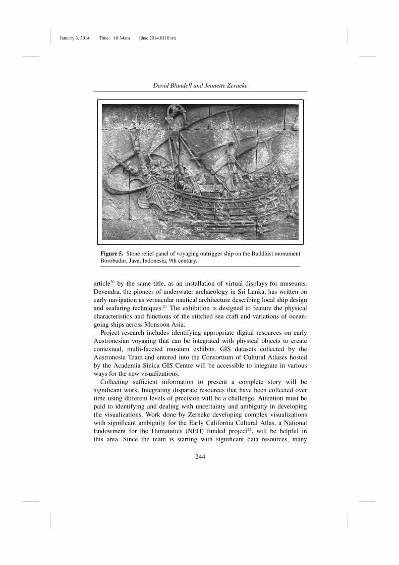
Our contribution to ECAI’s Maritime Buddhism Project is to collect andserve informative documentation of voyaging across Monsoon Asia from theperspective of Austronesian navigation including mariners, merchants, andmonks of the dharma from the 2nd century CE. Information collected includestexts, seaport locations, trade winds (regular monsoons), ship technology,navigation techniques, and extensive research on transport networks in Southand Southeast Asia from earliest historic times.19 Information tracing thedevelopment of craft traditions, visualizing variations in aesthetic traditionsover time, and migration of cultural groups will be highlighted. Our researchgoals include exploring the physical capabilities of the stitched sea craft ‘oru’and its variations within a navigation network of staged voyaging across theIndian Ocean to Southeast Asia and the South China Sea. Merchants and monksnot inhibited by restrictions in sea travel commissioned skilled navigators tosail in ocean-going ships – made of wood plank hulls stitched together withlashed outriggers – across the Bay of Bengal. Ancient depictions of ships arefeatured in architecture, such as the stone relief panel of the 9th century Buddhistmonument Borobudur, Java, Indonesia (see Figure 5). Destinations were to seatsof kingdoms and trade centres where the word of the dharma and its faithdeveloped in a healthy, vigorous way, as the result of a particularly congenialenvironment of Southeast Asia. As far back as two millennia ago people in thetrappings of this new international spiritual authority (Buddhism) introduceda web of connections forming a world trade system in a tropical region ofpeninsulas and islands.
The ECAI Austronesia Team is working on the sub-project on earlyAustronesian historical voyaging in Monsoon Asia to contribute to thiscollaboration. This project will bring digital resources collected by theAustronesia Team, along with contributions from new collaborators, to hand-held devices to be used in-situ. A major goal of this sub-project is to developdigital materials for an exhibit tentatively titled: Mariners, Merchants, Monks.The display’s name was conceived by Somasiri Devendra, adapted from his
243
January 3, 2014 Time: 10:34am ijhac.2014.0110.tex
David Blundell and Jeanette Zerneke
Figure 5. Stone relief panel of voyaging outrigger ship on the Buddhist monumentBorobudur, Java, Indonesia, 9th century.
article20 by the same title, as an installation of virtual displays for museums.Devendra, the pioneer of underwater archaeology in Sri Lanka, has written onearly navigation as vernacular nautical architecture describing local ship designand seafaring techniques.21 The exhibition is designed to feature the physicalcharacteristics and functions of the stitched sea craft and variations of ocean-going ships across Monsoon Asia.
Project research includes identifying appropriate digital resources on earlyAustronesian voyaging that can be integrated with physical objects to createcontextual, multi-faceted museum exhibits. GIS datasets collected by theAustronesia Team and entered into the Consortium of Cultural Atlases hostedby the Academia Sinica GIS Centre will be accessible to integrate in variousways for the new visualizations.
Collecting sufficient information to present a complete story will besignificant work. Integrating disparate resources that have been collected overtime using different levels of precision will be a challenge. Attention must bepaid to identifying and dealing with uncertainty and ambiguity in developingthe visualizations. Work done by Zerneke developing complex visualizationswith significant ambiguity for the Early California Cultural Atlas, a NationalEndowment for the Humanities (NEH) funded project22, will be helpful inthis area. Since the team is starting with significant data resources, many
244

January 3, 2014 Time: 10:34am ijhac.2014.0110.tex
Early Austronesian Historical Voyaging in Monsoon Asia
valuable contacts, and enthusiastic partners, these challenges while formidableare surmountable.
5. prospective technology
Technical advances and a wealth of digitized retrospective cultural data provideopportunities to bring cultural data into immersive environments to enablenew ways of learning. The technologies include augmented reality, immersiveenvironments, and interactive navigation of 3D models, presently being exploredby colleagues for science, cultural heritage, museum exhibits, and text corpusresearch. Small-scale 3D installations with a variety of user interfaces includingiPads have been tested.
In order to accomplish convergence of the multiple resources into complexvisualizations of data, more advanced web tools with support for design andcartography of the visualizations is required. Authoring tools need to beexpanded to accommodate dynamic implementation methodologies. Althoughthe technology is maturing rapidly, the technical skills needed to developappropriate apps is still significant. The Austronesia Team will work with otherECAI teams and their affiliates to help design the apps needed to implement thisvision. ECAI affiliates have already built modules which incorporate images,mapping and simple 3D visualizations for desktop and laptop computers. ECAIis now investigating a number of approaches to accomplish development ofapps to support researchers and collaborators authoring multi-faceted interactivevisualizations.
6. visualization of displays
For almost ten years, Lewis Lancaster has been working with Sarah Kenderdineand the Applied Laboratory of Interactive Visualization and Embodiment(ALiVE), School of Creative Media, City University Hong Kong.23 The Labhas implemented small-scale 3D environments to research use of a variety ofimmersive environments and interfaces (see Figure 6) and has created manyimmersive museum exhibits internationally.24
In 2012 an installation created by ALiVE allowed multiple users to interactwith a 3D projection in a museum space (see Figure 7)25. This technology isdeveloping rapidly and less expensive implementations are becoming affordable.
For voyaging in Monsoon Asia, installations are planned to be animatedand interactive, using 3D immersive theatre environments and apps for hand-held devices as pioneered by ALiVE. Work on development and applicationof this technology conducted at the iCinema Centre for Interactive CinemaResearch in conjunction with Museum Victoria, Australia demonstrates thepotential of currently available visualization and 3D audio technology to provide
245

January 3, 2014 Time: 10:34am ijhac.2014.0110.tex
David Blundell and Jeanette Zerneke
Figure 6. Immersive environments, ALiVE. City University Hong Kong.
an immersive environment that supports user participation in the historicaland cultural heritage narrative. The recently developed Advanced VisualizationInteractive Environment (AVIE)26 enables simulation of multiple sequences ofinformation, thus allowing users to experience of a variety of possible journeysfrom the past to the present. Characters and environmental influences included inthe immersive experience can simulate period-appropriate responses to the rangeof potential actions that visitors within the environment can take. Experiencingthis range of possible historical narratives encourages reflection and realizationthat daily life is not static or mundane but changes over time and place.The integration of 3D stereographic panoramas with story telling encouragesvisitors to experience a stronger connection with historical figures and events,developing greater understanding and empathy.
The application of augmented reality as utilized through mobile apps hasshowcased presently available technologies such as GPS and enhanced functionson phone viewfinders providing a new layer of experience to the physicalartefacts. This synergetic process, though well established in related literature,could prove to be difficult in practice. The concept of AR requires a high degreeof synchronization between all components involved so as not to disrupt theillusion of a blended reality.27
246

January 3, 2014 Time: 10:34am ijhac.2014.0110.tex
Early Austronesian Historical Voyaging in Monsoon Asia
Figure 7. Installation showing multiple users interacting with a 3D projection in anexhibit space, ALiVE, 2012. Sarah Kenderdine, ‘Inhabiting the cultural imaginary:Future trends in interpretation’, paper presented at TELDAP 2013.
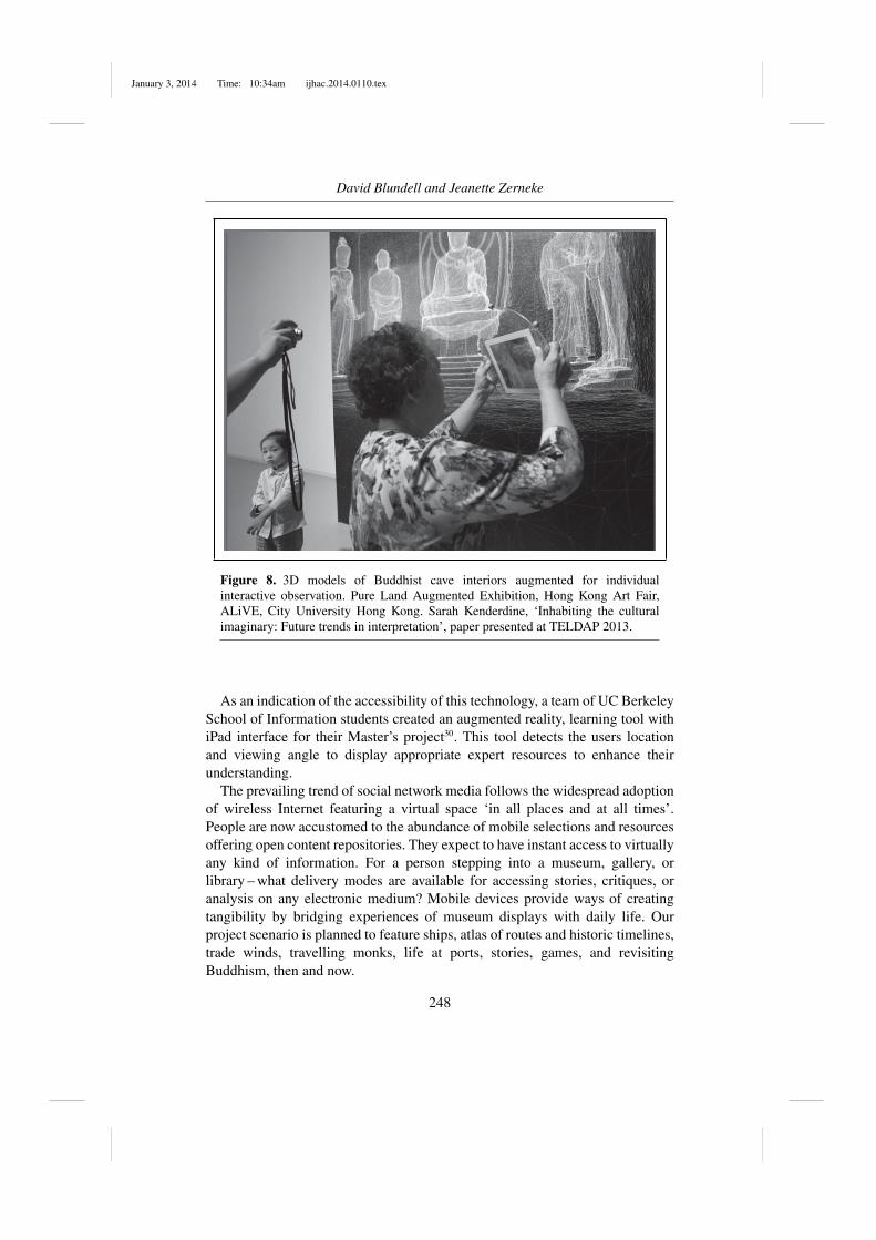
Museums have started to leverage the capabilities of mobile smart com-puting providing online wireless resources with rich content and generalizedinformation. The San Francisco Museum of Modern Art28, California, and thePowerhouse Museum29, Sydney, Australia, recently redesigned their websitesknowing that a majority of their visitors have selected the option of ‘beingvirtual’ when obtaining information via their mobiles. The technology providesan instant supplement of information to real life objects, sites, geographicalformations, locations in the manner of the ‘head-up display’ wherein one couldperceive simulated objects, pop-up information boxes, and virtual stickers ontop of real life physical items marking ‘point-of-interest’ through the viewfinderof any given mobile devices. The technologies are powerful and compact whendelivered to mobile devices (see Figures 7 and 8). Wireless apps are driving thetechnology away from bulky headsets and computer tethers. Augmenting ‘realworld’ data with virtual data utilizing GPS, image recognition, an accelerometer,and compass. AR has previously specialized in entertainment and marketing.Now these technologies can be used in other culturally orientated arenas (seeFigure 8).
247
January 3, 2014 Time: 10:34am ijhac.2014.0110.tex
David Blundell and Jeanette Zerneke
Figure 8. 3D models of Buddhist cave interiors augmented for individualinteractive observation. Pure Land Augmented Exhibition, Hong Kong Art Fair,ALiVE, City University Hong Kong. Sarah Kenderdine, ‘Inhabiting the culturalimaginary: Future trends in interpretation’, paper presented at TELDAP 2013.
As an indication of the accessibility of this technology, a team of UC BerkeleySchool of Information students created an augmented reality, learning tool withiPad interface for their Master’s project30. This tool detects the users locationand viewing angle to display appropriate expert resources to enhance theirunderstanding.
The prevailing trend of social network media follows the widespread adoptionof wireless Internet featuring a virtual space ‘in all places and at all times’.People are now accustomed to the abundance of mobile selections and resourcesoffering open content repositories. They expect to have instant access to virtuallyany kind of information. For a person stepping into a museum, gallery, orlibrary – what delivery modes are available for accessing stories, critiques, oranalysis on any electronic medium? Mobile devices provide ways of creatingtangibility by bridging experiences of museum displays with daily life. Ourproject scenario is planned to feature ships, atlas of routes and historic timelines,trade winds, travelling monks, life at ports, stories, games, and revisitingBuddhism, then and now.
248

January 3, 2014 Time: 10:34am ijhac.2014.0110.tex
Early Austronesian Historical Voyaging in Monsoon Asia
7. prospective narrative
Perspective for the proposed visualizations is formulated by the Austronesiaview that the basis of moving trade, people, and beliefs resulted from maritimetechnology. Austronesian-speaking peoples conceived navigation as a way of lifeacross the Indian and Pacific oceans spanning thousands of years. Their sailingconnected people of islands and peninsulas across two-thirds of the Earth’ssurface. The exhibit design will include archaeology of Indian Ocean sea crafts,interviews with seafaring elders living at ancient Southern Asian harbours, andspecific clues about trans-ocean technology of sailing crafts from Southern Asianand Austronesian languages.
Our exhibit will feature a scrolling time atlas of overlaying maps showing theroutes of maritime Buddhism across Monsoon Asia. The atlas, constructed fromdigitized manuscripts, archaeological site maps, and historical maps in concert,will give a comprehensive understanding of the marine navigation routes. ECAIAustronesia maps will provide detailed coastlines giving context for shippinglanes and ports. The visitor will experience a walking tour across the seas withtemporal selections and zooming options for specific locations.
Monsoons made trade predicable and profitable in accordance with the annualshift of direction that marked the trade calendar for ocean shipments. By therhythm of the Monsoon breezes, seafarers founded their way to South Asiafrom Southeast Asia and Southwest Asia. A 3D seasonal visualization placesthe visitor amidst directional winds and rains. The public enters and experiencesMonsoon Asia weather systems.
Narratives are important to bring Buddhist ports to life. Monks travelled searoutes to reach the lands of Buddhist sources31. For instance, Faxian, a Buddhistmonk from China travelling in South Asia between 395 and 414 CE, describedhis journey in an important travelogue. On his return trip to China, he stayed fivemonths in Java. Once back home, he spent the remainder of his life translatingand editing his collection of Buddhist texts and writing on the lands of his travels.Narratives such as this, supplemented with pictures and audio, will augment theatlas as an optional layer of user experience.
8. conclusion
Since its inception in 1997, ECAI Austronesia has collaborated with scholarsto share ideas and develop modules to illustrate best practices. Projectsdemonstrate the feasibility of utilizing maps for zooming into regions or specificcultures and providing geo-referenced links to related online resources such aslibrary catalogue records, text corpora, online dictionaries, images, and relateddatabases. Space is expressed as latitude and longitude and calendar time. Itsutility is to bridge resources from very diverse sources in an interdisciplinary
249

January 3, 2014 Time: 10:34am ijhac.2014.0110.tex
David Blundell and Jeanette Zerneke
manner. Interactive spatio-temporal visualizations show data pertaining todifferent periods of time in a unified interface and provide a basis for visualanalysis of datasets. Cultural atlases are created with digital maps, contextuallayers of topography, administrative boundaries, and current place names as wellas links to sound files, video recordings, and other examples of cultural heritagedocumentation.
It is time to utilize this huge investment, many people working for over 15years, to launch the capabilities of cultural atlas tools for the public. We havethe unique opportunity to use technologies developed for our networked, globalculture to allow users to explore and experience a historical period of networkingand globalization.
The resources we have developed, both content and methodologies, needto be integrated to create contextualized environments and made available tointeractive digital users. Museums with an interest in ocean-going navigationhave a new opportunity to utilize maritime archaeology, linguistic audio andtexts, and ethnographic 3D visualizations. Users want hands on immersivecontrol of their digital environment. Museum curators and digital resourcedevelopers, as well as visitors in museums, educators, and researchers all havesimilar data interaction needs. Working with ECAI to design and develop theEarly Austronesian Voyaging modules gives us the opportunity to begin toaddress this challenge.
The project story is about Buddhism in the first millennium sourced fromSouth Asia and moving out by sea to China through a series of ports. Sailingvessels and their technology of construction and navigation techniques play amajor role. Maps illustrate the routes and stories enhance the human element.Providing the grand narrative and focusing on specific locations and culturesweaves together a virtual reality of spatio-temporal heritage for the public tointeract with as a museum display.
acknowledgements
Our appreciation is given to TELDAP Conference and ECAI Workshop organizers, andco-sponsorship provided by the Shung Ye Museum of Formosan Aborigines, Taipei. Thanks toHui-ji Wang and Kitsch Yen-fan Liao for their proofing and copyediting skills.
end notes1
This article is the result of the Taiwan e-Learning and Digital Archive Program (TELDAP)Conference, March 14–16, 2013.
2Electronic Cultural Atlas Initiative (ECAI), http://ecai.org
3Taiwan e-Learning and Digital Archive Program (TELDAP), http://collab.teldap.tw/teldap2013
250

January 3, 2014 Time: 10:34am ijhac.2014.0110.tex
Early Austronesian Historical Voyaging in Monsoon Asia
4Prof Lewis R. Lancaster initiated the ECAI project – Atlas of Maritime Buddhism, view histalk (http://vimeo.com/43581226). He is founder and co-director with Michael Buckland ofthe Electronic Cultural Atlas Initiative (ECAI).
5Archaeological Survey of India, http://asi.nic.in
6Angkor Research Program, http://sydney.edu.au/angkor. See related article,http://www.pnas.org/content/104/36/14277.long
7University of Malay, http://www.um.edu.my/index.php
8Centre for Creative Content and Digital Innovation, http://www.3cdium.com/resources
9Institute of Southeast Asian Studies, Singapore, http://www.iseas.edu.sg
10School of Creative Media, City University of Hong Kong, http://www.scm.cityu.edu.hk
11GIS Centre, Computing Centre of Academia Sinica, http://www.ascc.sinica.edu.tw/en/service/gis.html
12Electronic Cultural Atlas Initiative (ECAI), http://ecai.org
13ECAI Austronesia, http://ecai.org/austronesiaweb/ECAIaustronesia/AustronesiaProjects.htm
14See the resulting the publication, Austronesian Taiwan: linguistics, history, ethnology,prehistory. David Blundell, ed. (Berkeley & Taipei, 2000, Revised ed., 2009).
15Shung Ye Museum of Taiwan Aborigines, www.museum.org.tw
16ECAI Austronesia Team Projects, http://ecai.org/austronesiaweb/ECAIaustronesia/AustronesiaProjects.htm
17See, The Asian Spatial Information and Analysis Network, http://acasian.com
18See, David Blundell, Michael Buckland, and Jeanette Zerneke with Yu-Hsiu Lu and AndrewLimond. Empowering Pacific language and culture mapping with applied case studies inTaiwan and the Philippines. In Gunter Senft, ed. Pacific Linguistics, (2010), 137–152.
19See David Blundell, Atlas on maritime Buddhism – ECAI project. Pacific NeighborhoodConsortium (PNC) Annual Conference and Joint Meetings. Bangkok, Thailand, October19–21, 2011.
20Devendra Somasiri, ‘Mariners, merchants, monks: Sri Lanka and the eastern seas’. In SatishChandra and Himanshu Prabha Ray, eds. The sea, identity and history: from the Bay of Bengalto the South China Sea. Society for Indian Ocean Studies (New Delhi, 2013), 169–220.
21Devendra Somasiri, ‘Ships and ship building in Sri Lanka, with particular reference tovernacular naval architecture’. In M. A. T. de Silva, ed. Evolution of technical innovationsin Sri Lanka. (Colombo, 2010), 313–401.
22Steven W. Hackel, Jeanette Zerneke, and Natale Zappia, The Early CaliforniaCultural Atlas, National Endowment for the Humanities Grant, White Paper, 2013,https://securegrants.neh.gov/PublicQuery/main.aspx?f=1&gn=HD-51185–10
23Applied Laboratory for Interactive Visualization and Embodiment (ALiVE),http://www.scm.cityu.edu.hk/research/alive
24For related imagery, Sarah Kenderdine and Jeffrey Shaw, ‘Immersive strategies for theembodiment of culture and heritage’, keynote speech presented at the Pacific NeighborhoodConsortium (PNC) 2010 Conference and Joint Meetings, City University of Hong Kong fromDecember 1–3. http://www.pnclink.org/pnc2010/english/PPT/Dec2/Keynote/PNC2010.pdf
25Sarah Kenderdine, ‘Inhabiting the cultural imaginary: Future trends in interpretation’, MCNAnnual Meeting, TELDAP 2013. http://indico3.twgrid.org/indico/contributionDisplay.py?contribId=159&confId=360
26Sarah Kenderdine, Jeffrey Shaw, Dennis Del Favero, and Neil Brown, ‘Place-Hampi: co-evolutionary narrative and augmented stereographic panoramas, Vijayanagara, India’. InYehuda Kalay, Thomas Kvan, and Janice Affleck, eds. New heritage: new media culturalheritage. (New York, 2008), 275–293.
251

January 3, 2014 Time: 10:34am ijhac.2014.0110.tex
David Blundell and Jeanette Zerneke
27Steve Feiner, ‘Augmented reality: a long way off?’. AR Week. Pocket-lint, http://www.pocket-lint.com/news/108949-augmented-reality-interview-steve-feiner
28San Francisco Museum of Modern Art, http://www.sfmoma.org/explore/multimedia
29Powerhouse Museum, Sydney, http://www.powerhousemuseum.com/online
30Deepak Subramanian and Leslie Tom, advised by Prof Kimiko Ryokai, ‘Navigating aneducational experience by augmenting our reality (NEEAR)’, UC Berkeley School ofInformation Masters 2012 final project, http://www.ischool.berkeley.edu/programs/mims/projects/2012/neear
31See, Tansen Sen, The travel records of Chinese pilgrims Faxian, Xuanzang, and Yijing:sources for cross-cultural encounters between China and ancient India. Educate About Asia(Winter 2006) 11(3), 24–33, http://afe.easia.columbia.edu/special/travel_records.pdf
252