Ecological capacity measures as useful tools for planning land management in lake district: case...
10
Ecological capacity measures as useful tools for planning land management in lake district: case study Ilavian Landscape Park A. Czarnecki, M. Luc, A. Lewandowska-Czarnecka Nicolaus Copernicus University, Faculty of Biology and Earth Sciences Torun, Poland Abstract For tourism development it is presented an analysis of lake and its catchment ecosystems in a view of natural and anthropogenic conditions and stressors. For socioeconomic reason the research is focused on littoral zone and its assimilation capacity for a wide range of human activities. For sustainable development reason burden below capacity is a necessary condition. Keywords: lake catchment; assimilation capacity; resources management; sustainable development 1 Introduction Among city inhabitants in Poland you may observe a growing interest for leisure and tourism especially in lake districts. This demand meets a need of local societies, whose economics depends on natural resources, to expand their traditional products i.e. food, timber, fish and biomass. Poor job market and decreasing income from traditional activities are the main reasons for creating the exchange for tourist products and services. However, even traditional enterprises engage several environmental issues. In rural areas where the spatial sources are implemented into the economic activities and where products create profiled ecosystem services, inconformity to unchangeable ecosystem functioning may result not only in media abatement [6]. It could also be an obstacle for further economical development. Agriculture and tourism are both intensive branches so looking for rational solution in their coexistence problem must be organized in an aspect of environmental impact [8]. In the research area
-
Upload
jagiellonian -
Category
Documents
-
view
0 -
download
0
Transcript of Ecological capacity measures as useful tools for planning land management in lake district: case...

Ecological capacity measures as useful tools for planning land management in lake district: case study Ilavian Landscape Park
A. Czarnecki, M. Luc, A. Lewandowska-Czarnecka Nicolaus Copernicus University, Faculty of Biology and Earth Sciences Torun, Poland
Abstract
For tourism development it is presented an analysis of lake and its catchment ecosystems in a view of natural and anthropogenic conditions and stressors. For socioeconomic reason the research is focused on littoral zone and its assimilation capacity for a wide range of human activities. For sustainable development reason burden below capacity is a necessary condition. Keywords: lake catchment; assimilation capacity; resources management; sustainable development
1 Introduction
Among city inhabitants in Poland you may observe a growing interest for leisure and tourism especially in lake districts. This demand meets a need of local societies, whose economics depends on natural resources, to expand their traditional products i.e. food, timber, fish and biomass. Poor job market and decreasing income from traditional activities are the main reasons for creating the exchange for tourist products and services. However, even traditional enterprises engage several environmental issues. In rural areas where the spatial sources are implemented into the economic activities and where products create profiled ecosystem services, inconformity to unchangeable ecosystem functioning may result not only in media abatement [6]. It could also be an obstacle for further economical development. Agriculture and tourism are both intensive branches so looking for rational solution in their coexistence problem must be organized in an aspect of environmental impact [8]. In the research area

a traditional land use meaning agriculture, forestry and fishing create inefficient income. At the same time tourism and leisure activities based on the landscape and natural hydrological resources might become a serious development branch. In between you may observe the residential housing. However, increasing demand for the most attractive but restricted in amount residential areas create bad conditions of environmental factors. The pressure on environment increases and shows about a conflict of interest. For that reason it is important to find a method, which could reconcile different aspects of various sectors’ economy and environment [5].
The aim of the research conducted in the Ilavian Landscape Park is to build a decision support system for a non-conflict, sustainable use of a total range of resources. Ecosystem approach seems to be the best in a situation where all users adapt the ecosystem solutions.
2 System analysis
Used method is in a wide sense system analysis that integrates environmental and socio-economic aspects by the use of aggregated indicators in a form of links between measured components. To establish a state of considered system a three stage analysis was conducted. The main research considered on one hand, traditional economic sectors such as agriculture, settlement, forestry, and, on the other one, residential housing, leisure and tourism - new ones which aggressive progress occur on a border between land and water. The final step is a compromise for all users; it considered a structure and flow between elements in an aspect of natural and anthropogenic processes. It was suggested the calculations that represent important concepts in the model as auxiliary variables. They are used to compute rates of material transfer in the system, or to compute some end products such as a very important rate of the lake ageing.
2.1 Area - characteristic of catchments structure
The Jeziorak lake catchment characterizes of beautiful landscape values as well as spatial resources applicable for agriculture, forestry or fishing. It belongs to the Iławka river basin, the right tributary of the upper Drwęca river. For a landscape matter it was decided to create a protection zone around the catchment area. The whole area structure is characteristic for a young glacial lowland relief with height differences over 45 m (92.0 m a.s.l. Gawda depression and 137.6 m a.s.l. in Karpowo village area).
The lake Jeziorak itself creates multicavity, very picturesque and so attractive for sailing. It divides into many linked reservoirs of different genesis – long subglacial channels and backwaters with lagoons. Water comes from North out of 165 km2 of the catchment and out of 149.9 km2 of the rivers. Generally it is a shallow reservoir (in average 4m) with varied types of geological bad. Some parts have complicated water exchange and difficulties with oxygenation. There are two cities (fig.1) at the north (Zalewo) and south edge of the lake (Iława).

Table 1: Main characteristics of catchment, natural and human components.
Components Park Protection zone Total Total area [ha] 25279 17804 43083 Catchment area [ha] 31495 Lake area [ha] 5006 Forest area [ha] 8879 Population 1500 9300 10800 Tourists (daily average) 4600 7000 11600 sailors yachts
800-2000 700
2.2 State of system and development tendencies
The Jeziorak lake catchment system consists mostly of lake water, agricultural area, forest area and wetlands area. It is a part of a water route from the Baltic Sea down south to the Drwęca river. That 90 m of attitude difference was overcome by a lifting system hauled by water movement. The water transport of timber and food was a driving force for the trade development of the area. As time passed by the system changed but the human impact on the system in each period added up. The trade used to be combined with land improvement for agriculture in north and forest management in south and central part of the catchment. Nowadays, the extensive husbandry along with the human impact causes water cloudiness and pollution [3]. The local society makes a lot to decrease the stress on water ecosystem, e.g. by creating a commonwealth of municipalities. They built the waste dumps and sewage disposals that caused omitting the lake with the polluted water. However, the income of the most people is rather low, the unemployment rate is high and most people live rather out of farming then tourism. All these aspects are a part of the socioeconomic and environmental problems. Tourism may be a solution as there is a high demand for this type of services and the catchment characterizes of great potential. The lake is a delicate system of a low environmental capacity because of a well-developed coastline and not high amount of water. Recently, it may be observed a high demand for the lake coast areas for residential housing. New landowners also create a leisure offer in the form of bars or sailing boat hires. There is a real danger for intensification of environmental problems that could threaten the sustainable development.
2.3 System functioning – characteristics and variables
Lithology and relief The Jeziorak lake catchment covers three regions varied by relief and geological structure. The northeast part belongs to a hummock moraine plateau with many cavities and subglacial channels filled by organic and lacustrine deposits. The other one built of similar material lies along the eastern part of the lake, between Iława, Tynwałd and Jeziorzyce. The central and west part covers the Ilavian sandur built of sands and gravels and filled in cavities by organic, lacustrine and

mineral sediments. Moreover, two sandur levels, lower and younger over 2- 5 m and higher 10 - 15 m, differentiate the Ilavian sandur relief. Land use and land cover A great majority of the area is covered by pine forests and along the high and steep coast (around Szałkowo village) broadleaved with a high percentage of beech. The north areas are agriculturally exploited and meadows, pastures, arable lands, fallowed lands and wetlands cover only minority of the area.
Only 13% of the park is covered by cattle stations (100 farms) and in the protection zone 70% of the area (550 farms of total 7500 ha and average 13ha for a farm). It is common in farms a domination of growing pigs over cows. The scale of some of them is big - 400 pigs in Olbrachtowo, or 100 cows, 300 calf and 600 pigs in Rudniki or 130 cows, 500 pigs and 200 sheep in Kamieniec. In Iława area there are 70 chicken farms of 6000 pieces each.
2.4 Ecosystem
In the catchment area we can distinguish three types of biota and ecosystems: lake, land and wetlands. On the land area forests generated seminatural ecosystems and are managed extensively. Crop fields build a high-developed input-output ecosystem, which part increased a matter by erosion acceleration and input to the lake. It created a threat for lake ecosystem. A lack of counteract to erosion is also a threat for sustainable farming.
The lake ecosystem is close to a natural one, however wetlands wide spreading are intermediate stage along the transformation into land. Bad managing of ecosystems can accelerate ageing of the Jeziorak lake [2]. This process is visible mostly in lithoral zone where occurs interference between land and water. Protection activities must though activate in that part of the lake to stop degradation if the lake is going to be an attractive resource for tourism and leisure activities. Lithoral zone characterizes of a great dynamic of physicochemical conditions as well as processes of mass plants’ exchange and mobility. Two epilithoral sub-zones can be discerned there - the highest level above water and lithoral level where water plants communities are under water. Along the lake coast epilithoral is on sandur covered by forest and on moraine surface by meadows and tree stripes. In Gradno it may be found small patches of pits with alder and willow shrubs and wet meadows. Reeds cover some places exposed to wind and waving. The opposite ones – places in wind side are covered by trees or a rich composition of water plants and the lack of waving caused accumulation of organic and inorganic deposits resulting the processes of water shallowing.

Figure 1: Land cover in Ilavian Landscape Park
2.5 Processes and management (regulations)
Natural hydrological regime There is an intensive water overflow through the forest from north to south and its surplus is caught by the Iławka river. Contribution of water to lake differs and depends on lithology. On the sandur area the surface-run of water is reduced by an infiltration rate. The ground water inflows straight to the lake and supplies numerous wetlands filling the small ground cavities. Water retention is slow. In that part of catchment water inflow is not enriched in inorganic compounds opposite to the water overflow through wetlands. Before water reaches the lake it gets also organic compounds coming from mineral layers of gythia and lacustrine chalk stored there through centuries.
Surface of moraine plateau is built of loamy soil that overlays a clay layer and its hummocky relief makes enable a surface-run of water. This process is usually tied to erosion mostly of small particles. It caused a major cloudiness of water in channels and in lake. Water flowing across wetlands in channels is enriched in highly polluted and eutrophicated sanitation wastes from villages. Man-made regulations The need of regulate water flow through the catchment has always been a driving factor in creating a flow and storing system. Such a possibility occurred in the

19th century when there was a need to create a cheep way for goods’ transportation between two regions relatively close to the sea. The only obstacle was a 90 m difference in attitude between the sea and a moraine plateau. Wetlands, pits and well-organized drainage system collected the surplus of water. Moreover, between two lakes (Ewingi and Jeziorak) gravital water flew down and reinforced the lower part of the lakes. After the regulation arable fields with crops and developed agricultural sector of regional economy replaced wetlands. Also the surplus of water flew out of the forest ground and enlarged the timber production. Additional water volume that flew down the channel to move boats was obtained by lowering level of water in lake trade off the accelerating run of water.
Table 2: Main stages of the catchment natural and socioeconomic changes.
stage technical change
Socioeconomic driver
Land use/cover
Impact on water regime
Matter balance
Conflict
Before 1939
channels trade timber, corns and bricks exchange
expansion of agriculture and forestry
level of surface water lowers
water enriched in compounds
None
To 1990
pipe drainage
growing demand for food and export
decreasing area of wetlands
accelerated flow of water
overdosed in nutrients lake pollution
Between tourism and farming
Up today
city sewage system
standards of environmental protection
residential housing
as above change in lithoral
With nature
3 Problem definition
The condition of the lake system depends on natural and anthropogenic stressors [7]. Some of them are a trade-off by the infrastructure enhancing the growing capacity for economy, e.g. a sewage plant against the lake pollution. However, in Ilavian Landscape Park new stressor has occurred – a man. The residential housing built very close to the lake coast replaced the natural meadows and lithoral plants with gardens or loans. Also the sailors by penetrating the shore for camping purposes as well as tourist services such as lake ports injure the plant communities. As a result the balance of matter is uncontrolled and occasionally, or in some places permanently, some land masses erode to the lake. The soil particles moved towards the wind bank where the substrata for biomass production cumulate. Water is clouded and a huge dose of Ca and other minerals coming from farming pollute water and influence the plant production.
In all historic stages of the system development the strongest stress in the lake ecosystem has always been focused in lithoral zone. Processes that take place there influence the water quality have impact on the state and sustainability of the lake. The zone on the border between land and water functions as a biofilter that controls the land expansion. It can only work properly in a situation of the lack of waving and wind. It is very important for the future of the whole

catchment system and local people who use the resources to recognize sufficiently the physicochemical processes.
Figure 2: Conceptual diagram presenting simple approach to analysis of the
ecosystem structures and functions for management purposes.
3.1 Scientific approach
The aim of the research was to analyse the functions of lithoral zone and its capacity against natural and anthropogenic stressors. It also assumes establishing the impact of assimilation capacity in the lake ecosystem and recommendation for the main user to resources management in an aspect of sustainable development.
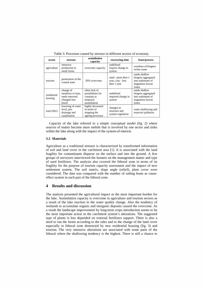
Table 3: Processes caused by stressor in different sectors of economy.
Capacity of the lake referred to a simple conceptual model (fig. 2) where
sources of matter become more mobile that is involved by one sector and sinks within the lake along with the impact of the system-of-interest.
3.2 Materials
Agriculture as a traditional stressor is characterized by transformed information of soil and land cover in the catchment area [1]. It is associated with the land fragility for contaminants disperse on the surface and into the ground. A few groups of surveyors interviewed the farmers on the management matter and type of used fertilizers. The analysis also covered the lithoral zone in terms of its fragility for the purpose of tourism capacity assessment and the impact of new settlement system. The soil matrix, slope angle (relief), plant cover were considered. The data was compared with the number of sailing boats as cause-effect system in each part of the lithoral zone.
4 Results and discussion
The analysis presented the agricultural impact as the most important burden for the lake. Assimilation capacity is overcome in agriculture and tourism sectors as a result of the lake reaction to the water quality change. Also the tendency of wetlands to accumulate organic and inorganic deposits caused the overcome. As a result the landscape improvement by long-term crops introduction seems to be the most important action in the catchment system’s alterations. The suggested type of plants is less depended on external fertilizers support. There is also a need to run the farms according to the rules and to the change of the land cover especially in lithoral zone destructed by new residential housing (fig. 3) and tourism. The very intensive alterations are associated with some parts of the lithoral where the shallowing tendency is the highest. There is still a chance to
sector stressor assimilation capacity
recovering time State/process
agriculture intensive production in small farms
overcome capacity undefined require change in system
overdose of biogens riches water
tourism penetration of the coastal zone
20% overcome sand - more then 1 year; clay - less then 1 year
sands shallow biogens aggregated into sediments of stagnation favour zones
residential housing
change of meadows to loan, reeds removed changed into beach
often lack of possibilities for constant or temporal assimilation
undefined required change in system
sands shallow biogens aggregated into sediments of stagnation favour zones
total effect
lowering of water level, pits drainage and canalisation
highly decreased in terms of stopping the ageing processes
changes in structure and system regulation
water shallowing and reservoir pollution

protect other areas in near future. This can be gained through the system protection from the improvement of places to the tourists’ invasion. Integrated land and water management would overcome threat for further development of this district [4]. However, it does not mean stopping neither tourism nor the leisure activities development. Table 4: Suggested actions for the future effects in different sectors of economy Sector Future features Action Expected effect
agriculture farm development
Landscape design Farming controlling Short Rotation Coppice Precise agriculture Agrotourism
burden of biogens below assimilation capacity
tourism contact with coast
properly equipped ports, piers, camp sites
renaturalization
total development renaturalization and protection through discrete infrastructure development
stopping the reservoir shallowing and agening
Figure 3: Photograph of the lithoral zone destruction as a result of processes
caused by new residential housing
5 Summary
Tourism in a form of residential housing added to other traditional activities depends on ecosystem services. To create sustainable development all of them ought to be compatible with natural rules while conflict of interest is obvious. Fragility of this system depends on type of plant communities and geomorhological features. The stress ratio results in activated natural and anthropogenic different masses sinking in different lake parts. The measurements and assessments were done in relation to assimilation capacity. Finally, some simple measures were suggested to reduce the negative impact, i.e. below the capacity threshold to restore the balance in the Jeziorak lake.

6 References
[1] Bechmann M.E., Berge D., Eggestad H.O. & Vandsemb S.M., Phosphorus transfer from agricultural areas and its impact on the eutrophication of lakes-two long-term integrated studies from Norway: Journal of Hydrology 304, pp. 238-250, 2005.
[2] Crisman T.L., Mitraki C. & Zalidis G., Integrating vertical and horizontal approaches for management of shallow lakes and wetlands: Ecological engineering 24, pp. 379-389, 2005.
[3] Czarnecki A., Non-point ground and surface water pollution as an effect of inadequate resource management in rural areas: Proceedings of International Symposium On the Assessment Disposal and Treatment of Rural Wastes. The Protection of Freshwater Resources. Rivers, Lakes and Groundwater, Kraków 25-27 November, Politechnika and Swiss National Science Foundation Press, pp. 12-17, 1998.
[4] Johnson A.K.L., Shrubsole D. & Merrin M., Integrated catchment management in northern Australia: Land Use Policy, vol. 13, pp. 303-316, 1996.
[5] Machiwa P.K., Water quality management and sustainability: the experience of Lake Victoria environmental management project: Physics and Chemistry of the Earth 28, pp. 1111-1115, 2003.
[6] Matsui S., Ide S. & Ando M., Lakes and reservoirs: reflecting waters of sustainable use: Wat. Sci. Tech. vol. 32, no7, pp. 331-224, 1995. [7] Puijenbroek van P.J.T.M., Janse J.H. & Knoop J.M., Integrated modeling for
nutrient loading and ecology of lakes in The Netherlands: Ecological Modeling 174, pp. 127-141, 2004.
[8] Weston D.R., Quibell G. &Pitman W.V., Towards managing catchment water utilization for the St. Lucia ecosystem: Wat. Sci. Tech. vol. 32, no. 5-6. pp. 95-101, 1995.