Making coastal research useful - cases from practice.
14
+ Models OCEANO-6; No. of Pages 14 Please cite this article in press as: von Storch, H., et al., Making coastal research useful — Cases from practice. Oceanologia (2014), http:// dx.doi.org/10.1016/j.oceano.2014.09.001 ORIGINAL RESEARCH ARTICLE Making coastal research useful — Cases from practice Hans von Storch * , Kay Emeis, Insa Meinke, Andreas Kannen, Volker Matthias, Beate M.W. Ratter, Emil Stanev, Ralf Weisse, Kai Wirtz Institute of Coastal Research, Helmholtz Zentrum Geesthacht, Geesthacht, Germany Received 10 August 2014; accepted 23 September 2014 1. Societal utility — bugaboo or reality? It is nowadays a common requirement when preparing scien- tific proposals that the project is generating societally useful knowledge or skills. Thus, almost all proposals feature a section or at least a paragraph which describes ‘‘outreach’’, ‘‘knowledge transfer’’ or ‘‘stakeholder-interaction’’. In many cases, the proposers and reviewers have only lay-concepts for doing so, and the activity goes rarely beyond giving a few Oceanologia (2014) xxx, xxx—xxx KEYWORDS Coastal research; Marine spatial planning; Monitoring; Risks and hazards; Making sense; Utility Summary Coastal research deals with that part of the sea, which is significantly affected by the land, and the part of the land, which is significantly affected by the sea. Coasts are in most cases densely populated, and the activities of people are shaping and changing the land/seascape of the coast. Thus, coast encompasses the coastal sea, the coastal land, coastal flora and fauna, and people. Since peoples' economic and political preferences change and compete, the human impact on the coast changes is contested and subject to societal decision making processes. While some coastal research can help informing and constraining such decisions, many legitimate scientific efforts have little bearing on society. All decision making processes are political, so that scientific knowledge is not the dominant driver in such processes. Using cases from the Institute of Coastal Research of Helmholtz Zentrum Geesthacht, we describe some of these potentially useful parts of science, and discuss under which circumstances the potential usefulness transform into real utility. These cases do not span the full range of coastal science. Important issues are the recognition of alternative knowledge claims, the inevitableness of uncertainties and incompleteness of scientific analysis, the acceptance of the political nature of decisions and the ubiquitous presence of social values. Modesty, self-reflexivity and skepticism are needed on the side of science and an organized exchange with stakeholders and public through designated ‘‘border’’ services. # 2014 Institute of Oceanology of Polish Academy of Sciences. Production and hosting by Elsevier Urban & Partner Sp. z o.o. All rights reserved. Peer review under the responsibility of Institute of Oceanology of the Polish Academy of Sciences. * Corresponding author at: Institute of Coastal Research, Helmholtz Zentrum Geesthacht, Max-Planck-Straße 1, 21502 Geesthacht, Germany. Tel.: +49 4152871831; fax: +49 41528741831. E-mail address: [email protected] (H. von Storch). Available online at www.sciencedirect.com ScienceDirect j our na l h omepa g e: www.e lse vie r.c om/l ocat e/ ocea no http://dx.doi.org/10.1016/j.oceano.2014.09.001 0078-3234/# 2014 Institute of Oceanology of Polish Academy of Sciences. Production and hosting by Elsevier Urban & Partner Sp. z o.o. All rights reserved.
Transcript of Making coastal research useful - cases from practice.

+ Models
OCEANO-6; No. of Pages 14
ORIGINAL RESEARCH ARTICLE
Making coastal research useful — Cases from practice
Hans von Storch *, Kay Emeis, Insa Meinke, Andreas Kannen, Volker Matthias,Beate M.W. Ratter, Emil Stanev, Ralf Weisse, Kai Wirtz
Institute of Coastal Research, Helmholtz Zentrum Geesthacht, Geesthacht, Germany
Received 10 August 2014; accepted 23 September 2014
Oceanologia (2014) xxx, xxx—xxx
KEYWORDSCoastal research;Marine spatial planning;Monitoring;Risks and hazards;Making sense;Utility
Summary Coastal research deals with that part of the sea, which is significantly affected by theland, and the part of the land, which is significantly affected by the sea. Coasts are in most casesdensely populated, and the activities of people are shaping and changing the land/seascape ofthe coast. Thus, coast encompasses the coastal sea, the coastal land, coastal flora and fauna, andpeople. Since peoples' economic and political preferences change and compete, the humanimpact on the coast changes is contested and subject to societal decision making processes.
While some coastal research can help informing and constraining such decisions, manylegitimate scientific efforts have little bearing on society. All decision making processes arepolitical, so that scientific knowledge is not the dominant driver in such processes. Using casesfrom the Institute of Coastal Research of Helmholtz Zentrum Geesthacht, we describe some ofthese potentially useful parts of science, and discuss under which circumstances the potentialusefulness transform into real utility. These cases do not span the full range of coastal science.
Important issues are the recognition of alternative knowledge claims, the inevitableness ofuncertainties and incompleteness of scientific analysis, the acceptance of the political nature ofdecisions and the ubiquitous presence of social values. Modesty, self-reflexivity and skepticismare needed on the side of science and an organized exchange with stakeholders and publicthrough designated ‘‘border’’ services.# 2014 Institute of Oceanology of Polish Academy of Sciences. Production and hosting by ElsevierUrban & Partner Sp. z o.o. All rights reserved.
Available online at www.sciencedirect.com
ScienceDirect
j our na l h omepa g e: www.e l se v ie r.c om/l ocat e/ ocea no
Please cite this article in press as: von Storch, H., et al., Making coastal
dx.doi.org/10.1016/j.oceano.2014.09.001
Peer review under the responsibility of Institute of Oceanology of thePolish Academy of Sciences.
* Corresponding author at: Institute of Coastal Research, HelmholtzZentrum Geesthacht, Max-Planck-Straße 1, 21502 Geesthacht,Germany. Tel.: +49 4152871831; fax: +49 41528741831.
E-mail address: [email protected] (H. von Storch).
http://dx.doi.org/10.1016/j.oceano.2014.09.0010078-3234/# 2014 Institute of Oceanology of Polish Academy of Sciencerights reserved.
1. Societal utility — bugaboo or reality?
It is nowadays a common requirement when preparing scien-tific proposals that the project is generating societally usefulknowledge or skills. Thus, almost all proposals feature asection or at least a paragraph which describes ‘‘outreach’’,‘‘knowledge transfer’’ or ‘‘stakeholder-interaction’’. In manycases, the proposers and reviewers have only lay-conceptsfor doing so, and the activity goes rarely beyond giving a few
research useful — Cases from practice. Oceanologia (2014), http://
s. Production and hosting by Elsevier Urban & Partner Sp. z o.o. All
+ Models
OCEANO-6; No. of Pages 14
2 H. von Storch et al.
talks on public events and a press release, while others gen-erate advanced web-pages (‘‘tool boxes’’ and ‘‘roadmaps’’) forthe public and policy makers.
Thus, the reference to stakeholders and decision making isoften merely rhetorical and is not backed by thought—through concepts and approaches, but are based on naïve‘‘linear’’ models operating with superior knowledge, whichneeds to be filled in stakeholders, who ask for enlightenment(e.g., van der Sluijs, 2010).
Many scientifically legitimate and valid questions oranswers have no direct bearing for any stakeholder. There-fore it is not surprising that the stakeholder-interaction isoften not taken seriously. Indeed, most scientific achieve-ments will have no significant direct applications, but con-tribute ‘‘merely’’ to the overall understanding of a complexand multi-faceted natural and social milieu. Indeed, it is oneof the narratives of the logic of funding science, which somerelate to the US thinker Vannevar Bush (1945), that a fewsupported efforts of many will result in very useful off-springs, such as the famous Teflon pan. In this logic, thecost—benefit balance of funding science is positive becauseof some practical hits, while most efforts result in scienti-fically exciting insights with little relevance for anythingexcept for a better understanding of often remote nichesof reality. Since nobody knows, which of the many efforts willprove useful, it is best to fund all of them, as long as they are‘‘scientifically good’’. Whether this strategy is realistic isanother question, and other thinkers contend that science,which is based on the desire for being able to explain ournatural and social environment, is just a fundamental need ofwestern civilization and culture.
Admittedly, some of these scientific insights provide cluesfor a better understanding or better modeling of the systemat hand. In the spirit of Vannevar Bush, some of theseimprovements turn out being useful in decision processesat a later time. However, it is not so that science would solvesocietal conflicts and would lead to sustainable ‘‘solutions’’,such as how to use certain areas, or how to decide aboutconflicting usages of coastal seas, such as off-shore windenergy, fishing and natural conversation.
In the end, all decisions about solutions are political. Theyare related to and associated with socially constructedvalues, preferences and interests. But science can help todetermine which probable or possible consequences thedifferent options may have (‘‘recursive model’’, cf. Weingart,1999). By answering ‘‘if—then’’ questions and dealing withoptions of decision making, science can contribute valuablyto quality of life, both in terms of ‘‘making sense’’ of acomplex environment and practical management. This isparticularly so with respect to coastal sea systems.
The body of potentially useful knowledge about the state,the development of the coast, about options for managingthe coast, needs a sustainably managed infrastructure. Thisinfrastructure comprises coastal observatories, process andsimulation models, tools for dynamical and statistical analysisof change, interdisciplinary exchange between the involveddisciplines from physics to geology, from engineering to ecol-ogy, and socio-economic assessment methods for the integra-tion of relevant data and expert judgments. Useful coastalscience must be based on a solid scientific basis.
But such a basis is not enough for making coastal science‘‘useful’’. The attribute ‘‘scientific’’ is not sufficient for an
Please cite this article in press as: von Storch, H., et al., Making coastal
dx.doi.org/10.1016/j.oceano.2014.09.001
analysis to gain acceptance in the public and among stake-holders. This is clearly demonstrated by the public debateabout the reality of man-made climate change. Instead,scientifically legitimized knowledge is just one form ofknowledge, which has to compete with other forms of knowl-edge in the public domain (von Storch, 2009).
Stakeholders, including the public and media, are oftenconfronted with developments and events in coastal envir-onments that appear hazardous, alarming or promising. Someevents are noticed only by a few decision makers, who ask forintensity, spatial and temporal extension, for options, sys-tematic changes and perspectives. In other cases, the gen-eral public is getting involved, and the issue becomes a legalor political one. In both cases, coastal science is asked foranswers, orientation and, when societal interests areinvolved, provision of a broader context. However, stake-holders have already knowledge what is going on; sometimesthis understanding is consistent with scientific insights, butoften it is partially or even completely inconsistent. Forplacing consolidated scientific knowledge in such a ‘‘knowl-edge-environment’’, scientific actors need to understandthese ‘‘other’’ knowledge about the dynamics, statisticsand conditioning of the coastal sea environment. We comeback to this issue in the concluding section.
For this purpose, we not only need ‘‘border organiza-tions’’, which identify the utility of scientific achievementsfor societal needs, but also apprehend societally relevantquestions. These border organizations nowadays go oftenwith the concept of ‘‘services’’. A successful service needsa rooting in scientific concepts, in understanding socialdynamics, and in an exchange with stakeholder perceptions(von Storch and Stehr, 2014).
Under the headline of servicing, political manipulation infavor of specific ‘‘solutions’’ may take place. The issue ofblending the roles of activists and scientists, for instance inthe form of stealth activist scientists (Pielke, 2007) is asignificant challenge, also for coastal science. Some politicaland economic actors appreciate favorable support by suchstealth advocate scientists for pushing their views and inter-ests. It seems that many in the scientific community havelittle reservation with such activities.
In this situation it makes sense to think about and discuss,in which way coastal science can become useful. What arethe typical types of knowledge, which provides utility in real-world problems, tasks and decisions? For doing so, we firstsketch five categories. These categories are not independentof each other. Also, they may be considered of differentepistemological levels; they address different stakeholdergroups.
1. ‘‘Making sense’’ refers to the scientific understanding ofcomplex phenomena, and its use for supporting societalframing and decision making. Examples are consequencesof eutrophication or the manifestation of natural systemvariations vis-a-vis anthropogenic climate change. Novelor recurrent but threatening events in complex coastalenvironments can attract considerable attention instakeholder groups and the public. Meaning-providingframes, which allow for causal interpretation and under-standing, satisfy not only curiosity, but allow for engi-neering preparedness and options for specificstakeholders. A significant constraint is that science is
research useful — Cases from practice. Oceanologia (2014), http://

+ Models
OCEANO-6; No. of Pages 14
Making coastal research useful 3
not the sole supplier of such understanding, but otherknowledge brokers are active as well (cf. Section 2)
2. ‘‘Marine Spatial Planning (MSP)’’ describes the ‘‘publicprocess of analyzing and allocating the spatial and tem-poral distribution of human activities in marine areas toachieve ecological, economic and social objectives thathave been specified through a political process’’.1 MSP isan approach for deciding about competitive concepts ofusage of coastal space. This process needs mostly quan-titative information from natural sciences for project-specific technical planning exercises, but in addition(social) science needs to provide (mainly qualitative)information concerning societal and political contextand structures to inform decision makers in strategicplanning (cf. Section 3)
3. ‘‘Monitoring’’ aims at the assessment of the currentstatus of the coastal environment and short term trends,and their (deterministic) short-term forecasts. Suchassessments are based on observations and related (mod-el-guided) data analysis. The process of making data,assessments and forecasts available for users is also achallenge (cf. Section 4)
4. Assessments of (statistical) ‘‘hazards, risks and oppor-tunities’’ are needed for almost any kind of onshore andoffshore operation. An important component of this ac-tivity is the determination of ongoing long-term changes.For the assessment of negative outlooks and positiveperspectives comprehensive and homogeneous data areneeded. The situation is particularly challenging, whentoo short, too fragmented or only inhomogeneous ob-served data are available. Then, sometimes, model-de-rived estimates can be used (cf. Section 5)
5. ‘‘Scenarios’’, differently to forecasts, address questionsof the type ‘‘What may happen, if . . . and nothing else’’.Such projections provide a useful outlook for assessingconsequences of possible future developments anduncertainties. Therefore scenarios have become increas-ingly popular in various scientific and decision makingcontexts (Schwartz, 1991; cf. Section 6).
The first ‘‘making sense’’ addresses the general public,scientists, media, but to a lesser extent planning exercises.This is so, because this category provides first of all qualitative‘‘knowledge’’ about mechanisms. This is different with theother categories, where numbers are produced, which mayguide short term decisions, as in case of monitoring, or eco-nomic planning, as in case of assessing risks and their changes.
In the center part of the paper, we illustrate these cate-gories with the help of examples selected from the practiceof the HZG Institute of Coastal Research In Geesthacht,Germany. In the concluding Section 7, the issue of buildingscience-stakeholder interaction is addressed.
2. Making sense
‘‘Making sense’’ refers to the scientific understanding ofcomplex phenomena, and its use for supporting societalframing and decision making. Conceptual frames, which
Please cite this article in press as: von Storch, H., et al., Making coastal
dx.doi.org/10.1016/j.oceano.2014.09.001
1 www.unesco-ioc-marinesp.be.
allow for causal interpretation and understanding, servenot only curiosity but allow for rising awareness, engineeringpreparedness and options for specific stakeholders.
2.1. The case of Baltic Sea eutrophication
Eutrophication is the term used for environmental degrada-tion by increased production of organic matter and subse-quent oxygen depletion in deeper waters of freshwater,estuarine, or marine water bodies. Although it is a naturalphenomenon associated with organic matter transformationand oxygen depletion in aging water bodies isolated fromatmospheric oxygen, it is accelerated by nutrient enrichmentfrom human sources that enhance organic matter flux.
One difficulty in dealing with eutrophication is that thereis no accepted metric for eutrophication thresholds, butthose marine systems are considered eutrophic whereorganic carbon fluxes are in excess of 300 g m�2 a�1 (Nixon,1995). More frequently, eutrophication is qualitatively iden-tified by changes in oxygenation status, in winter waternutrient concentrations, in water transparency, or in biolo-gical assemblages as compared to a reference condition inthe past.
Productivity estimates for the entire Baltic Sea are around150 gC m�2 a�1 (Wasmund et al., 2001), but it is consideredto be one of the most glaring examples of eutrophication inEurope (HELCOM, 2010). Large areas of its seafloor areintermittently anoxic, blooms of nitrogen-fixing bacteriaare a recurring nuisance during summer months, and thecoincidence of deteriorating environmental conditionsobserved with increasing river nutrient loads in the 1970sand 1980s implicated nutrient effluxes from rivers (andreactive N inputs from the atmosphere) as the causal reason(Rosenberg et al., 1990).
The Baltic Sea is a silled basin with an excess of precipita-tion and river runoff over evaporation, and thus is an arche-typical estuarine nutrient trap prone to oxygen depletion indense deep water that is isolated (Seibold, 1970). Investiga-tions of sediment cores suggest that its largest depositionarea of fine-grained and organic-rich sediments in theGotland Basin has been intermittently anoxic for much ofits history since 8000 years ago (Sohlenius et al., 2001).Biogeochemical proxies in sediment dated cores imply thatcyanobacterial nitrogen fixation has been a characteristicfeature of the pre-industrial Baltic Sea since that time(Bianchi et al., 2000; Struck et al., 2000).
Even though countries bordering the Baltic Sea reducedphosphate and nitrate loads of rivers to the Baltic Sea by 68%and 60% in the period from 1990 to 2000 (HELCOM, 2010),direct positive responses of winter nitrate and phosphateconcentrations in surface water of the central Baltic Seawere not observed. Nutrient concentrations remained highand phosphate concentrations showed no reaction.
This is a plausible consequence of phosphate release fromanoxic sea floor sediments (Conley et al., 2002, 2009; Emeiset al., 2000). These anoxic sediments release 2/3 back intothe water column (Hille et al., 2005) of the phosphatearriving in sedimented organic matter. The added phosphatein turn promotes blooms of N2-fixing cyanobacteria in the seasurface (Vahtera et al., 2007). Recent model experimentssuggest that the residence time of river-borne phosphorus inthe Baltic Sea exceeds 35 years.
research useful — Cases from practice. Oceanologia (2014), http://
+ Models
OCEANO-6; No. of Pages 14
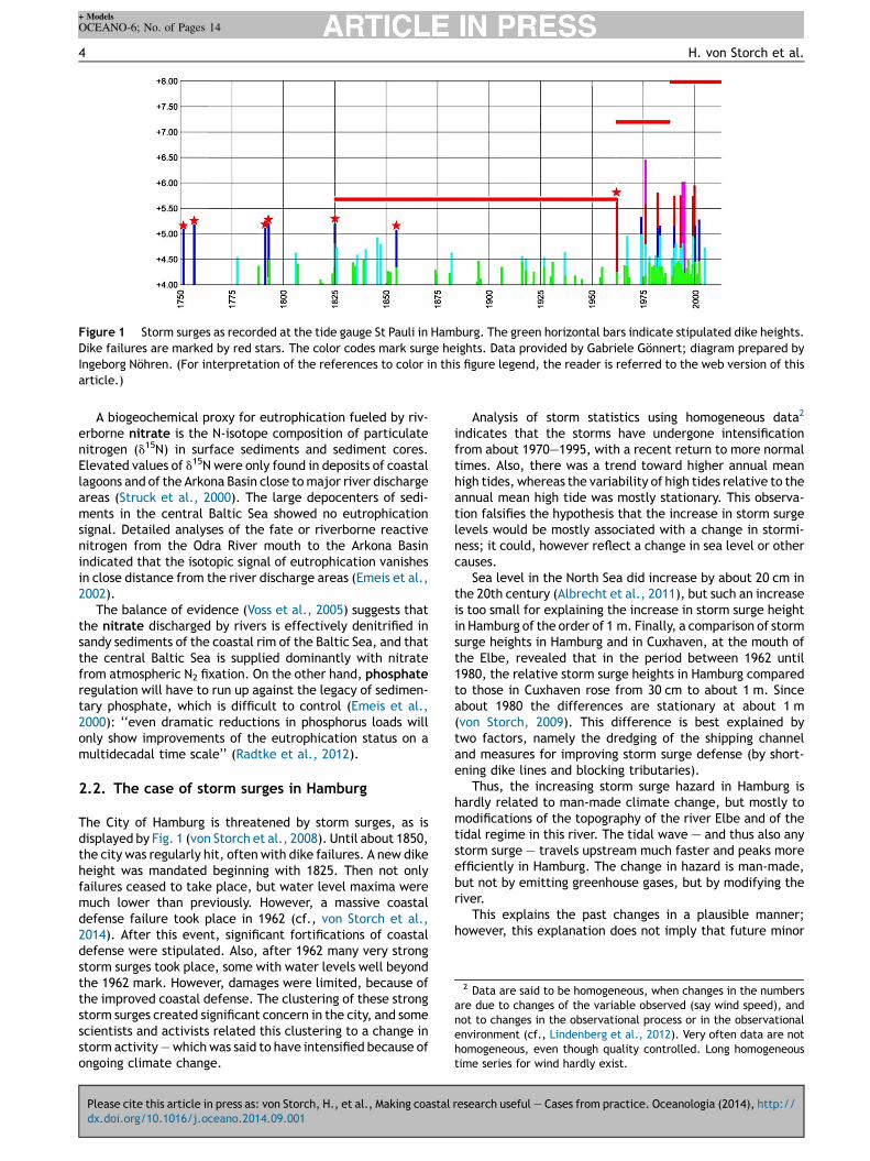
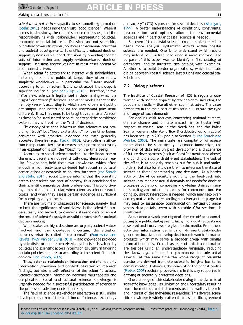
Figure 1 Storm surges as recorded at the tide gauge St Pauli in Hamburg. The green horizontal bars indicate stipulated dike heights.Dike failures are marked by red stars. The color codes mark surge heights. Data provided by Gabriele Gönnert; diagram prepared byIngeborg Nöhren. (For interpretation of the references to color in this figure legend, the reader is referred to the web version of thisarticle.)
2 Data are said to be homogeneous, when changes in the numbersare due to changes of the variable observed (say wind speed), andnot to changes in the observational process or in the observationalenvironment (cf., Lindenberg et al., 2012). Very often data are nothomogeneous, even though quality controlled. Long homogeneoustime series for wind hardly exist.
4 H. von Storch et al.
A biogeochemical proxy for eutrophication fueled by riv-erborne nitrate is the N-isotope composition of particulatenitrogen (d15N) in surface sediments and sediment cores.Elevated values of d15N were only found in deposits of coastallagoons and of the Arkona Basin close to major river dischargeareas (Struck et al., 2000). The large depocenters of sedi-ments in the central Baltic Sea showed no eutrophicationsignal. Detailed analyses of the fate or riverborne reactivenitrogen from the Odra River mouth to the Arkona Basinindicated that the isotopic signal of eutrophication vanishesin close distance from the river discharge areas (Emeis et al.,2002).
The balance of evidence (Voss et al., 2005) suggests thatthe nitrate discharged by rivers is effectively denitrified insandy sediments of the coastal rim of the Baltic Sea, and thatthe central Baltic Sea is supplied dominantly with nitratefrom atmospheric N2 fixation. On the other hand, phosphateregulation will have to run up against the legacy of sedimen-tary phosphate, which is difficult to control (Emeis et al.,2000): ‘‘even dramatic reductions in phosphorus loads willonly show improvements of the eutrophication status on amultidecadal time scale’’ (Radtke et al., 2012).
2.2. The case of storm surges in Hamburg
The City of Hamburg is threatened by storm surges, as isdisplayed by Fig. 1 (von Storch et al., 2008). Until about 1850,the city was regularly hit, often with dike failures. A new dikeheight was mandated beginning with 1825. Then not onlyfailures ceased to take place, but water level maxima weremuch lower than previously. However, a massive coastaldefense failure took place in 1962 (cf., von Storch et al.,2014). After this event, significant fortifications of coastaldefense were stipulated. Also, after 1962 many very strongstorm surges took place, some with water levels well beyondthe 1962 mark. However, damages were limited, because ofthe improved coastal defense. The clustering of these strongstorm surges created significant concern in the city, and somescientists and activists related this clustering to a change instorm activity — which was said to have intensified because ofongoing climate change.
Please cite this article in press as: von Storch, H., et al., Making coastal
dx.doi.org/10.1016/j.oceano.2014.09.001
Analysis of storm statistics using homogeneous data2
indicates that the storms have undergone intensificationfrom about 1970—1995, with a recent return to more normaltimes. Also, there was a trend toward higher annual meanhigh tides, whereas the variability of high tides relative to theannual mean high tide was mostly stationary. This observa-tion falsifies the hypothesis that the increase in storm surgelevels would be mostly associated with a change in stormi-ness; it could, however reflect a change in sea level or othercauses.
Sea level in the North Sea did increase by about 20 cm inthe 20th century (Albrecht et al., 2011), but such an increaseis too small for explaining the increase in storm surge heightin Hamburg of the order of 1 m. Finally, a comparison of stormsurge heights in Hamburg and in Cuxhaven, at the mouth ofthe Elbe, revealed that in the period between 1962 until1980, the relative storm surge heights in Hamburg comparedto those in Cuxhaven rose from 30 cm to about 1 m. Sinceabout 1980 the differences are stationary at about 1 m(von Storch, 2009). This difference is best explained bytwo factors, namely the dredging of the shipping channeland measures for improving storm surge defense (by short-ening dike lines and blocking tributaries).
Thus, the increasing storm surge hazard in Hamburg ishardly related to man-made climate change, but mostly tomodifications of the topography of the river Elbe and of thetidal regime in this river. The tidal wave — and thus also anystorm surge — travels upstream much faster and peaks moreefficiently in Hamburg. The change in hazard is man-made,but not by emitting greenhouse gases, but by modifying theriver.
This explains the past changes in a plausible manner;however, this explanation does not imply that future minor
research useful — Cases from practice. Oceanologia (2014), http://
+ Models
OCEANO-6; No. of Pages 14
Making coastal research useful 5
modifications of the river will lead to further significantincrease of hazards. Also, even if presently climate changeis a minor factor, this may change, when an accelerated sealevel rise takes place in the North Sea.
This analysis is a typical ‘‘detection and attribution’’ case(Hasselmann, 1979): In this format, it is first asked if weobserve a change, which is beyond the range of ‘‘normal’’variations — and the increase of storm surge heights after1962 is clearly beyond that range. In that case we concludethat we have ‘‘detected’’ a change, which needs an explana-tion beyond ‘‘natural variations’’. In the ‘‘attribution’’-step,different possible causes are examined, which of them ismost successful in explaining the change. In our case it is themodification of the estuary.
Unfortunately, all too often, complex phenomena areprematurely related to some causes, often those which fitcertain political or economic interests best. Also, somescientific institutions seem to have bound themselves tocertain explanatory frameworks, and find it difficult to thinkbeyond a once chosen paradigm (Fleck, 1980).
3. Marine spatial planning
The use of coastal zones are changing, reflecting changingpolitical, economic and societal human activities and pre-ferences. ‘‘Marine Spatial Planning’’ (MSP) describes the‘‘public process of analyzing and allocating the spatial andtemporal distribution of human activities in marine areas toachieve ecological, economic and social objectives that havebeen specified through a political process’’ (UNESCO, 2014).This process needs contributions not only from naturalsciences and engineering, but also from social science forunderstanding structures, perceptions, interests and powerbalances of the involved actors and affected population.
Marine Spatial Planning is in itself not a scientific task;science contributes to this task by providing backgroundknowledge and information, and by analyzing and suggestingmethods of how to implement this type of planning.
When planning for future use, various different uses andinterests have to be considered as determining factors (Geeet al., 2006). Relevant factors are: shipping, due to globa-lization and increasing global exchange of goods, and asso-ciated expansions of ports and hinterland connections;energy generations, for example using large-scale offshorewind farms, and associated cable connections to the land;environmental regulations, such as designation of marineprotected areas and the obligations for achieving good eco-logical status in coastal seas. Other constraints relate tocoastal defense, sand and gravel extraction, military, andall forms of cables and pipelines. Factors of direct economicsignificance relate marine aquaculture, fishing, mussel fish-ing, and tourism. An overarching issue in all planning exer-cises is anthropogenic climate change.
Marine planning is confronted not only with ecological,hydrodynamic and morphological dynamics but also withsignificant social dynamics (cf., Kannen, 2012) — such as:Conflicting options for using coastal space and resources;Cumulative impacts from the existing or developing usages;Competition of partially antagonistic perceptions and atti-tudes of stakeholders and public; Complexities arising fromtransnational levels and transboundary scales.
Please cite this article in press as: von Storch, H., et al., Making coastal
dx.doi.org/10.1016/j.oceano.2014.09.001
These challenges request particular processes and posespecific information demands for planners and managers inorder to attain a holistic understanding of the coastal sea as asystem with a multitude of social and ecological interactions.However, these challenges are not independent of each otherand interfere in many ways.
Spatial planning takes place on two different levels,namely on the management level and on the strategic level.Management relates to the process by which human andmaterial resources are harnessed to achieve a known goalwithin a known institutional structure. Strategic planning isrelated to governance — understood as the regulating andmoderating processes between parties beyond fixed decisionstructures.
For management planning, goals and administrativemechanisms are usually well established and widely accepted(Olsen, 2003). Typical examples are the design of a specificwind farm, port extension measures, the installation ofmarine protected areas or specific environmental compensa-tion measures.
This type of planning is mostly a technical approach,which asks for specific data and information to supporteconomic or political decisions. Scientific support for suchplanning includes the provision of specific data, such asconsistent meteo-ocean data. An example is ‘‘CoastDat’’(Geyer, 2013; Weisse and Günther, 2007), which describeswind, currents and waves derived at high space-time detail inthe North Sea (see also below in Section 5). This data set wasused in ship-building design and offshore operation profilesand design, in offshore wind industries planning, or in setting-up oil-release fighting strategies (Weisse et al., 2009), orlong-term strategic co-operation of offshore wind energy andcoal-fired power plants (Wiese, 2008).
Strategic planning, on the other hand, is often subject tothe values, policies, laws and institutions by which a set ofissues are addressed. Governance in this context relatesinterests, stakeholder driven objectives as well as institu-tional processes and structures which are the basis for plan-ning and decision-making. Governance therefore sets thestage within which management occurs (Olsen, 2003).
While management focuses on ‘‘tame’’ problems, strate-gic planning is often related to so-called ‘‘wicked’’ problems.‘‘Wicked’’ problems are described as complex, tricky,unstructured, and difficult to define. They delineate fromother and bigger problems and involve normative judgments(Jentoft and Chuengpagdee, 2009). Therefore, in addition totechnical information from natural sciences and economics,information and scientific advice referring to the political,societal and cultural context of decision making is needed.
Solutions of such wicked problems require the recognitionof conflicting values, beliefs and perceptions. Such planningproduces winners and losers. Also the scientific support needsto be understood as a social process comprising interactionsamong actors, mediating between different stakeholders'interest and respecting lobbying and existing power struc-tures (Kannen, 2012). For a scientist to be a successfulknowledge broker, the scientist needs to understand actors'perceptions of particular problems and issues and how thisis related to their attitudes and values (von Storch, 2009;von Storch and Stehr, 2014).
A tool for doing so is surveying stakeholders and regionaland local residents. In one case, local residents from the
research useful — Cases from practice. Oceanologia (2014), http://

+ Models
OCEANO-6; No. of Pages 14
Figure 2 A landscape of values at the West coast of Schleswig-Holstein, Germany (categories mentioned in answers to the question‘‘What springs to your mind when you hear `West coast of Schleswig-Holstein’’', Ratter and Gee, 2012).
6 H. von Storch et al.
North Sea coast of Schleswig-Holstein shared antagonisticviews about wind farms emerged (Gee, 2010; Ratter and Gee,2012, see Fig. 2). One group saw wind farms as incompatiblewith their understanding of the sea as an open and wildnatural area, mainly due to their esthetic impacts. Othersargue that wind farms as a renewable source for electricityproduction are favorable and visual aspects are less relevant.This information may guide communication strategies ofproject developers and planners and help them to properlyaddress particular groups of society.
In general, social science analysis may support planningprocesses and (re-)shaping governance processes and actorinteractions (e.g., Cormier et al., 2013; Kannen et al., 2013).An example is the long-term vision for MSP in the Baltic Seadeveloped in the framework of the BalticSeaPlan project.Gee et al. (2011a) first identified a set of key transnationalissues: a healthy marine environment, a coherent Pan-Balticenergy policy, safe, clean and efficient maritime transportand sustainable fisheries and aquaculture. Together withthree key principles, namely Pan-Baltic thinking, spatialefficiency and spatial connectivity, these provide the coreof a vision for transnational MSP (Gee et al., 2011b; Kannen,2012). How this vision or elements of this vision can beimplemented is currently under discussion in relevant policynetworks including HELCOM and VASAB (Vision and Strategiesaround the Baltic Sea).
4. Monitoring
‘‘Monitoring’’ aims at the assessment of the current status ofthe coastal environment and short term trends, and their(deterministic) short-term forecasts. Such routine analysesand short-term forecasts are required for dealing with all
Please cite this article in press as: von Storch, H., et al., Making coastal
dx.doi.org/10.1016/j.oceano.2014.09.001
sorts of practical problems such as coastal risk management(coastal flooding and extreme wave conditions), combatingocean pollution (Soomere et al., 2014; Xi et al., 2012), searchand rescue operations.
Similar as with marine spatial planning, monitoring is not ascientific task itself; but, again, the task of monitoring issupported by coastal science in providing methods — in thiscase, of observations, analysis and prediction. Also, scienceis a stakeholder in monitoring efforts as well: Chances todisentangle complex oceanic processes and phenomena areconsiderably increased if a good state description in spaceand time is available.
For spatial domains and time intervals of practical interestthe space—time detailed state of the coastal sea can hardlybe determined from observations alone, because a sustain-able data acquisition is too expensive. However, amalgamat-ing observations and output of dynamical models enablesefficient, consistent and realistic estimations and forecastingof the ocean state (Robinson et al., 1998). The challenge ofsuch an amalgamation, also named data assimilation, is theextraction of the most important information from relativelysparse observations, and the propagation of this informationin an optimal way into predictive models accounting forerrors in the models and observations.
There exist still a number of challenges in coastal oceandata assimilation. Diagnostics and metrics for assessing per-formance of the coastal assimilation models need furtherimprovements. Coupling between coastal and open-oceanassimilation systems is still an open problem. Forecastingbiogeochemistry state in the coastal ocean, although muchasked for, is still in infancy. Treatment of river flows, mixing,bottom roughness and small-scale topography is still an issue.Non-homogeneity in space and time of model error statisticsneeds further consideration. Of particular importance is the
research useful — Cases from practice. Oceanologia (2014), http://
+ Models
OCEANO-6; No. of Pages 14
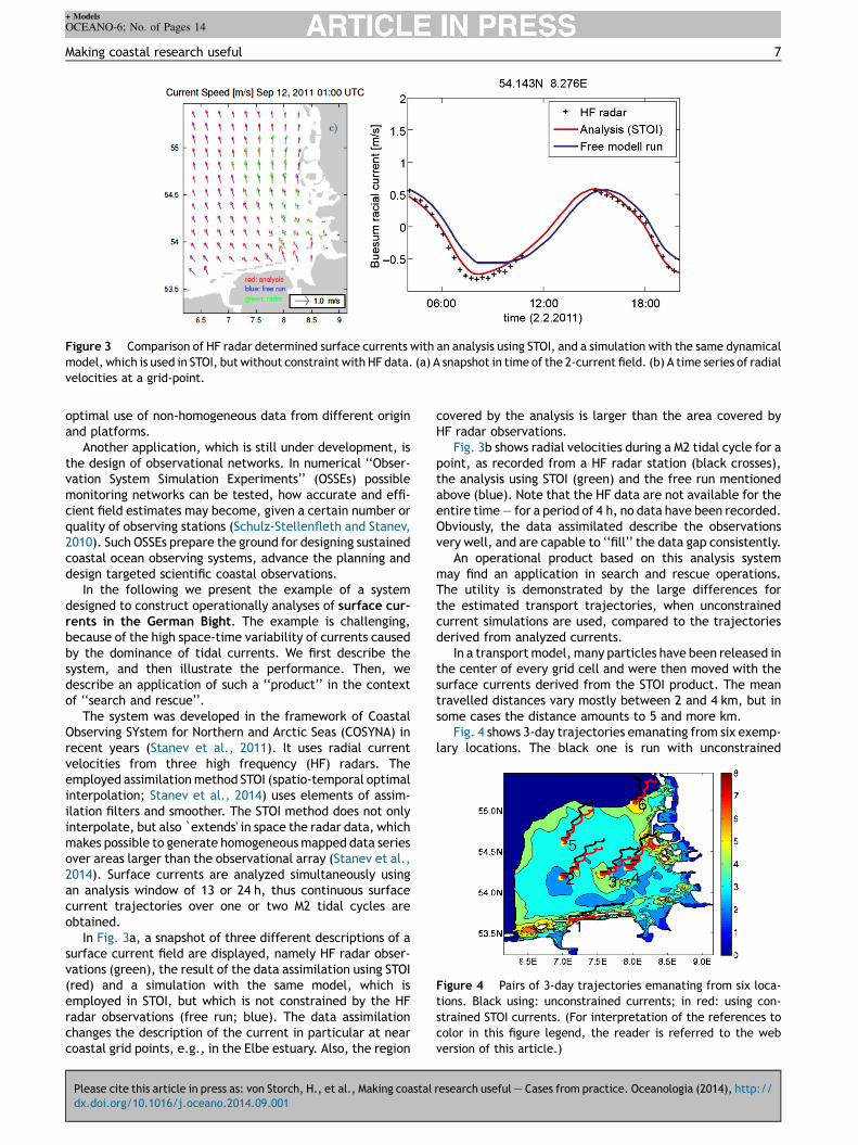
Figure 3 Comparison of HF radar determined surface currents with an analysis using STOI, and a simulation with the same dynamicalmodel, which is used in STOI, but without constraint with HF data. (a) A snapshot in time of the 2-current field. (b) A time series of radialvelocities at a grid-point.
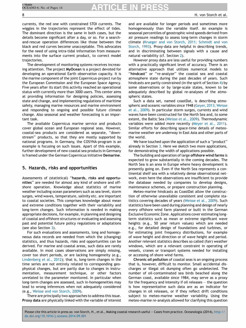
Figure 4 Pairs of 3-day trajectories emanating from six loca-tions. Black using: unconstrained currents; in red: using con-strained STOI currents. (For interpretation of the references tocolor in this figure legend, the reader is referred to the webversion of this article.)
Making coastal research useful 7
optimal use of non-homogeneous data from different originand platforms.
Another application, which is still under development, isthe design of observational networks. In numerical ‘‘Obser-vation System Simulation Experiments’’ (OSSEs) possiblemonitoring networks can be tested, how accurate and effi-cient field estimates may become, given a certain number orquality of observing stations (Schulz-Stellenfleth and Stanev,2010). Such OSSEs prepare the ground for designing sustainedcoastal ocean observing systems, advance the planning anddesign targeted scientific coastal observations.
In the following we present the example of a systemdesigned to construct operationally analyses of surface cur-rents in the German Bight. The example is challenging,because of the high space-time variability of currents causedby the dominance of tidal currents. We first describe thesystem, and then illustrate the performance. Then, wedescribe an application of such a ‘‘product’’ in the contextof ‘‘search and rescue’’.
The system was developed in the framework of CoastalObserving SYstem for Northern and Arctic Seas (COSYNA) inrecent years (Stanev et al., 2011). It uses radial currentvelocities from three high frequency (HF) radars. Theemployed assimilation method STOI (spatio-temporal optimalinterpolation; Stanev et al., 2014) uses elements of assim-ilation filters and smoother. The STOI method does not onlyinterpolate, but also `extends' in space the radar data, whichmakes possible to generate homogeneous mapped data seriesover areas larger than the observational array (Stanev et al.,2014). Surface currents are analyzed simultaneously usingan analysis window of 13 or 24 h, thus continuous surfacecurrent trajectories over one or two M2 tidal cycles areobtained.
In Fig. 3a, a snapshot of three different descriptions of asurface current field are displayed, namely HF radar obser-vations (green), the result of the data assimilation using STOI(red) and a simulation with the same model, which isemployed in STOI, but which is not constrained by the HFradar observations (free run; blue). The data assimilationchanges the description of the current in particular at nearcoastal grid points, e.g., in the Elbe estuary. Also, the region
Please cite this article in press as: von Storch, H., et al., Making coastal
dx.doi.org/10.1016/j.oceano.2014.09.001
covered by the analysis is larger than the area covered byHF radar observations.
Fig. 3b shows radial velocities during a M2 tidal cycle for apoint, as recorded from a HF radar station (black crosses),the analysis using STOI (green) and the free run mentionedabove (blue). Note that the HF data are not available for theentire time — for a period of 4 h, no data have been recorded.Obviously, the data assimilated describe the observationsvery well, and are capable to ‘‘fill’’ the data gap consistently.
An operational product based on this analysis systemmay find an application in search and rescue operations.The utility is demonstrated by the large differences forthe estimated transport trajectories, when unconstrainedcurrent simulations are used, compared to the trajectoriesderived from analyzed currents.
In a transport model, many particles have been released inthe center of every grid cell and were then moved with thesurface currents derived from the STOI product. The meantravelled distances vary mostly between 2 and 4 km, but insome cases the distance amounts to 5 and more km.
Fig. 4 shows 3-day trajectories emanating from six exemp-lary locations. The black one is run with unconstrained
research useful — Cases from practice. Oceanologia (2014), http://
+ Models
OCEANO-6; No. of Pages 14
8 H. von Storch et al.
currents, the red one with constrained STOI currents. Thewiggles in the trajectories represent the effect of tides.The dominant direction is the same in both cases, but thedetails become significant after a day, or so. For a search-and-rescue operation differences like those between theblack and red curves become unacceptable. This advocatesfor the need of using intra-tidal information from measure-ments into the surface current product, to correct modeltrajectories.
The development of monitoring systems receives increas-ing attention. The project MyOcean is a project devoted fordeveloping an operational Earth observation capacity. It isthe marine component of the joint Copernicus-project run bythe European Commission and the European Space Agency.Five years after its start this activity reached an operationalstatus with currently more than 3000 users. This center aimsat providing information for designing policies, assessingstate and change, and implementing regulations of maritimesafety, managing marine resources and marine environmentand responding to ongoing and possible future climatechange. Also seasonal and weather forecasting is an impor-tant task.
The available Copernicus marine service and productscover global ocean and European regional seas. However,coastal-sea products are considered as separate, ‘‘down-stream’’ products, so that they are mostly supported bynational programs. In Germany, the COSYNA-program is anexample is focusing on such issues. Apart of this example,further development of new coastal sea products in Germanyis framed under the German Copernicus initiative Demarine.
5. Hazards, risks and opportunities
Assessments of (statistical) ‘‘hazards, risks and opportu-nities’’ are needed for almost any kind of onshore and off-shore operation. Knowledge about statistics of marineweather including ocean parameters such as sea level, stormsurges, wind waves, temperature, salinity etc. are importantto coastal societies. This comprises knowledge about meanand extreme conditions together with their variability andlong-term changes. Such information is needed in makingappropriate decisions, for example, in planning and designingof coastal and offshore structures or evaluating and assessingpast and potential future policy regulations or adaptations(see also Section 3).
For such evaluations and assessments, long and homoge-neous data records are needed from which the (changing)statistics, and thus hazards, risks and opportunities can bederived. For marine and coastal areas, such data are rarelyavailable. In most cases observations are simply missing,cover too short periods, or are lacking homogeneity (e.g.,Lindenberg et al., 2012); that is, long-term changes in thetime series are not entirely related to corresponding geo-physical changes, but are partly due to changes in instru-mentation, measurement technique, or other factorsunrelated to the parameter monitored. In particular whenlong-term changes are assessed, such in-homogeneities maylead to wrong inferences when not adequately considered(e.g., Weisse and von Storch, 2009).
There are principally two approaches to address this issue.Proxy data are physically linked with the variable of interest
Please cite this article in press as: von Storch, H., et al., Making coastal
dx.doi.org/10.1016/j.oceano.2014.09.001
and are available for longer periods and sometimes morehomogeneously than the variable itself. An example isseasonal percentiles of geostrophic wind speeds derived fromair pressure readings to assess long-term changes in stormclimate (Krueger and von Storch, 2011; Schmidt and vonStorch, 1993). Proxy-data are helpful in describing trends,and in discriminating between signals with a cause andnatural variability (cf. Section 2).
However proxy data are less useful for providing numberswith a practically significant level of accuracy. There is analternative approach that utilizes numerical models to‘‘hindcast’’ or ‘‘re-analyze’’ the coastal sea and coastalatmosphere state during the past decades of years. Suchhindcasts are partly constrained (in the spirit of Section 4) bysome observations or by large-scale states, known to beadequately described by global re-analyses of the atmo-spheric states.
Such a data set, named coastDat, is describing atmo-spheric and oceanic variables since 1948 (Geyer, 2013; Weisseet al., 2009). In particular storm surges, currents and windwaves have been constructed for the North Sea and, to someextent, the Baltic Sea (Weisse et al., 2009). Thermodynamicvariables were added more recently (Meyer et al., 2011).Similar efforts for describing space-time details of meteo-marine weather are underway in East Asia and other parts ofthe world.
We have touched upon the application of such a ‘‘product’’already in Section 3. Here we sketch two more applications,for demonstrating the width of applications possible.
The building and operation of large offshore wind farms isexpected to grow substantially in the coming decades. TheNorth Sea is an area in Europe where heavy development ispresently going on. Even if the North Sea represents a con-tinental shelf sea with a relatively dense observational net-work, even here the observations are insufficient to providethe database needed by companies to develop designs,maintenance schemes, or prepare construction planning.
Meteo-marine hindcasts as CoastDat allow the construc-tion of otherwise unavailable consistent and complete sta-tistics covering decades of years (Weisse et al., 2009). Suchstatistics have been used during planning and design of nearlyevery offshore wind farm planned or built in the GermanExclusive Economic Zone. Applications cover estimating long-term statistics such as mean or extreme significant waveheights (e.g., 50 year return values) which are needede.g., for detailed design of foundations and turbines, orfor estimating joint frequency distributions, for exampleof wave height and direction or of wave height and period.Another relevant statistics describes so called (fair) weatherwindows, which are a relevant constraint in operating ofvessels, cranes or transport systems needed for installingor accessing of-shore wind farms.
Chronic oil pollution of coastal seas is an ongoing processthat is, however, difficult to monitor. Small accidental dis-charges or illegal oil dumping often go undetected. Thenumber of oil-contaminated sea birds beached along theGerman coast, available since 1984, may serve as a proxyfor the frequency and intensity if oil releases — the questionis how representative such data are as an indicator forchanges in oil releases, or if they reflect drift conditionssubject to meteo-marine weather variability. Using themeteo-marine re-analysis allowed for clarifying this question
research useful — Cases from practice. Oceanologia (2014), http://
+ Models
OCEANO-6; No. of Pages 14
Figure 5 Estimated annual depositions of lead into the BalticSea (black curve) plus estimated depositions derived from anumber of limited observations (von Storch et al., 2003).
Making coastal research useful 9
(Chrastansky and Callies, 2009; Chrastansky et al., 2009) —
the seasonal drift conditions are not stationary but showsubstantial inter-annual variations and even decadal trends.Thus, the survey data of beached sea birds may be used asproxies for oil-releases only to limited extent.
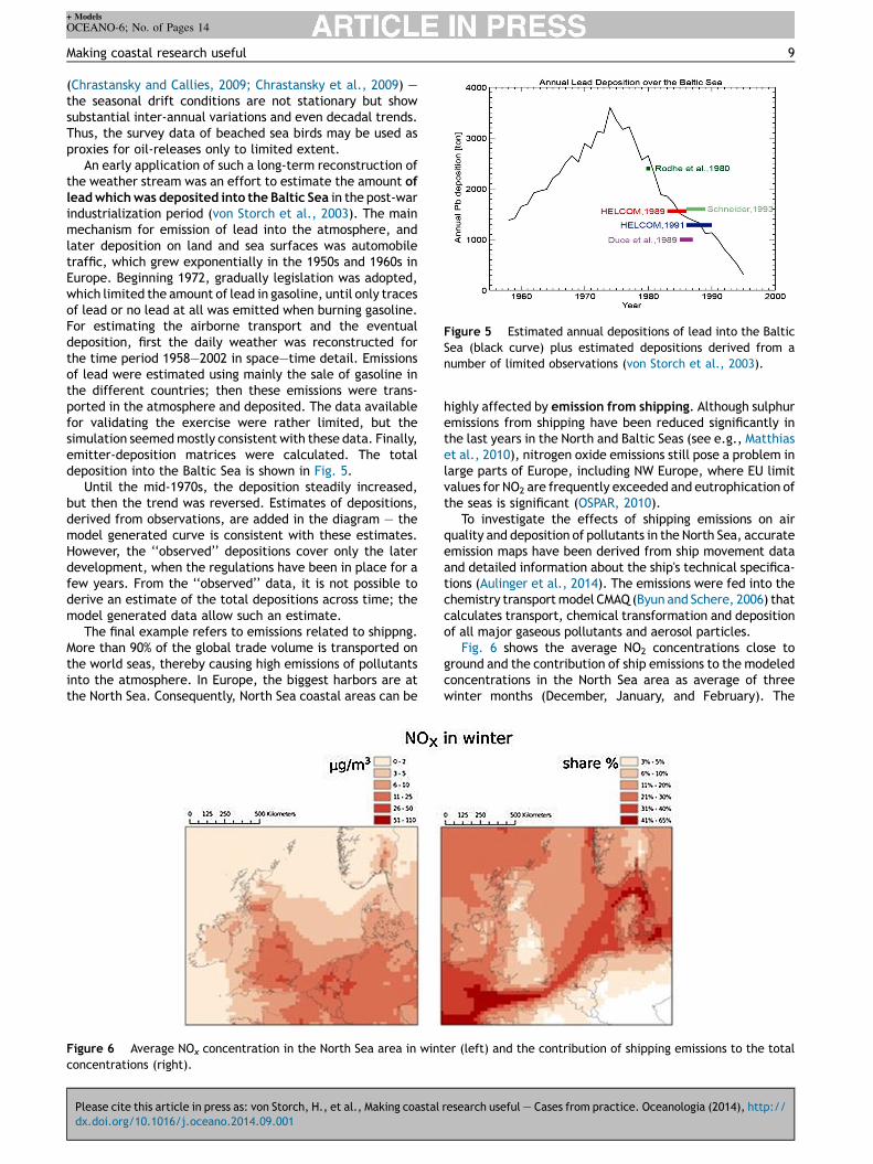
An early application of such a long-term reconstruction ofthe weather stream was an effort to estimate the amount oflead which was deposited into the Baltic Sea in the post-warindustrialization period (von Storch et al., 2003). The mainmechanism for emission of lead into the atmosphere, andlater deposition on land and sea surfaces was automobiletraffic, which grew exponentially in the 1950s and 1960s inEurope. Beginning 1972, gradually legislation was adopted,which limited the amount of lead in gasoline, until only tracesof lead or no lead at all was emitted when burning gasoline.For estimating the airborne transport and the eventualdeposition, first the daily weather was reconstructed forthe time period 1958—2002 in space—time detail. Emissionsof lead were estimated using mainly the sale of gasoline inthe different countries; then these emissions were trans-ported in the atmosphere and deposited. The data availablefor validating the exercise were rather limited, but thesimulation seemed mostly consistent with these data. Finally,emitter-deposition matrices were calculated. The totaldeposition into the Baltic Sea is shown in Fig. 5.
Until the mid-1970s, the deposition steadily increased,but then the trend was reversed. Estimates of depositions,derived from observations, are added in the diagram — themodel generated curve is consistent with these estimates.However, the ‘‘observed’’ depositions cover only the laterdevelopment, when the regulations have been in place for afew years. From the ‘‘observed’’ data, it is not possible toderive an estimate of the total depositions across time; themodel generated data allow such an estimate.
The final example refers to emissions related to shippng.More than 90% of the global trade volume is transported onthe world seas, thereby causing high emissions of pollutantsinto the atmosphere. In Europe, the biggest harbors are atthe North Sea. Consequently, North Sea coastal areas can be
Please cite this article in press as: von Storch, H., et al., Making coastal
dx.doi.org/10.1016/j.oceano.2014.09.001
Figure 6 Average NOx concentration in the North Sea area in wintconcentrations (right).
highly affected by emission from shipping. Although sulphuremissions from shipping have been reduced significantly inthe last years in the North and Baltic Seas (see e.g., Matthiaset al., 2010), nitrogen oxide emissions still pose a problem inlarge parts of Europe, including NW Europe, where EU limitvalues for NO2 are frequently exceeded and eutrophication ofthe seas is significant (OSPAR, 2010).
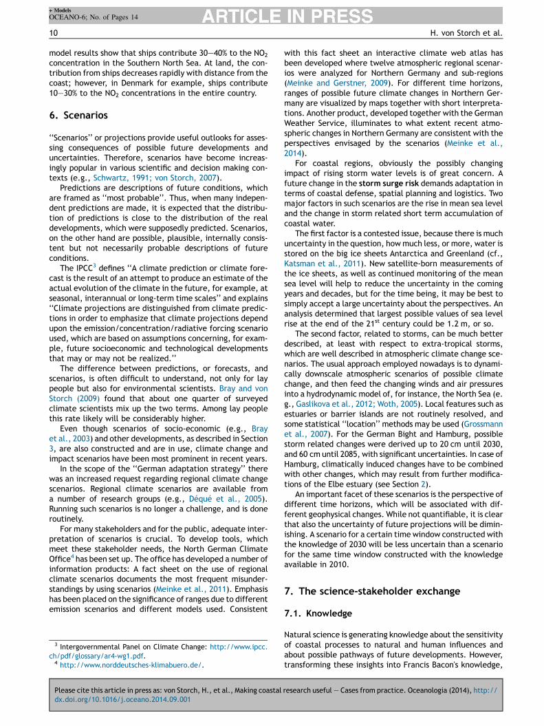
To investigate the effects of shipping emissions on airquality and deposition of pollutants in the North Sea, accurateemission maps have been derived from ship movement dataand detailed information about the ship's technical specifica-tions (Aulinger et al., 2014). The emissions were fed into thechemistry transport model CMAQ (Byun and Schere, 2006) thatcalculates transport, chemical transformation and depositionof all major gaseous pollutants and aerosol particles.
Fig. 6 shows the average NO2 concentrations close toground and the contribution of ship emissions to the modeledconcentrations in the North Sea area as average of threewinter months (December, January, and February). The
research useful — Cases from practice. Oceanologia (2014), http://
er (left) and the contribution of shipping emissions to the total
+ Models
OCEANO-6; No. of Pages 14
10 H. von Storch et al.
model results show that ships contribute 30—40% to the NO2
concentration in the Southern North Sea. At land, the con-tribution from ships decreases rapidly with distance from thecoast; however, in Denmark for example, ships contribute10—30% to the NO2 concentrations in the entire country.
6. Scenarios
‘‘Scenarios’’ or projections provide useful outlooks for asses-sing consequences of possible future developments anduncertainties. Therefore, scenarios have become increas-ingly popular in various scientific and decision making con-texts (e.g., Schwartz, 1991; von Storch, 2007).
Predictions are descriptions of future conditions, whichare framed as ‘‘most probable’’. Thus, when many indepen-dent predictions are made, it is expected that the distribu-tion of predictions is close to the distribution of the realdevelopments, which were supposedly predicted. Scenarios,on the other hand are possible, plausible, internally consis-tent but not necessarily probable descriptions of futureconditions.
The IPCC3 defines ‘‘A climate prediction or climate fore-cast is the result of an attempt to produce an estimate of theactual evolution of the climate in the future, for example, atseasonal, interannual or long-term time scales’’ and explains‘‘Climate projections are distinguished from climate predic-tions in order to emphasize that climate projections dependupon the emission/concentration/radiative forcing scenarioused, which are based on assumptions concerning, for exam-ple, future socioeconomic and technological developmentsthat may or may not be realized.’’
The difference between predictions, or forecasts, andscenarios, is often difficult to understand, not only for laypeople but also for environmental scientists. Bray and vonStorch (2009) found that about one quarter of surveyedclimate scientists mix up the two terms. Among lay peoplethis rate likely will be considerably higher.
Even though scenarios of socio-economic (e.g., Brayet al., 2003) and other developments, as described in Section3, are also constructed and are in use, climate change andimpact scenarios have been most prominent in recent years.
In the scope of the ‘‘German adaptation strategy’’ therewas an increased request regarding regional climate changescenarios. Regional climate scenarios are available froma number of research groups (e.g., Déqué et al., 2005).Running such scenarios is no longer a challenge, and is doneroutinely.
For many stakeholders and for the public, adequate inter-pretation of scenarios is crucial. To develop tools, whichmeet these stakeholder needs, the North German ClimateOffice4 has been set up. The office has developed a number ofinformation products: A fact sheet on the use of regionalclimate scenarios documents the most frequent misunder-standings by using scenarios (Meinke et al., 2011). Emphasishas been placed on the significance of ranges due to differentemission scenarios and different models used. Consistent
Please cite this article in press as: von Storch, H., et al., Making coastal
dx.doi.org/10.1016/j.oceano.2014.09.001
3 Intergovernmental Panel on Climate Change: http://www.ipcc.ch/pdf/glossary/ar4-wg1.pdf.4 http://www.norddeutsches-klimabuero.de/.
with this fact sheet an interactive climate web atlas hasbeen developed where twelve atmospheric regional scenar-ios were analyzed for Northern Germany and sub-regions(Meinke and Gerstner, 2009). For different time horizons,ranges of possible future climate changes in Northern Ger-many are visualized by maps together with short interpreta-tions. Another product, developed together with the GermanWeather Service, illuminates to what extent recent atmo-spheric changes in Northern Germany are consistent with theperspectives envisaged by the scenarios (Meinke et al.,2014).
For coastal regions, obviously the possibly changingimpact of rising storm water levels is of great concern. Afuture change in the storm surge risk demands adaptation interms of coastal defense, spatial planning and logistics. Twomajor factors in such scenarios are the rise in mean sea leveland the change in storm related short term accumulation ofcoastal water.
The first factor is a contested issue, because there is muchuncertainty in the question, how much less, or more, water isstored on the big ice sheets Antarctica and Greenland (cf.,Katsman et al., 2011). New satellite-born measurements ofthe ice sheets, as well as continued monitoring of the meansea level will help to reduce the uncertainty in the comingyears and decades, but for the time being, it may be best tosimply accept a large uncertainty about the perspectives. Ananalysis determined that largest possible values of sea levelrise at the end of the 21st century could be 1.2 m, or so.
The second factor, related to storms, can be much betterdescribed, at least with respect to extra-tropical storms,which are well described in atmospheric climate change sce-narios. The usual approach employed nowadays is to dynami-cally downscale atmospheric scenarios of possible climatechange, and then feed the changing winds and air pressuresinto a hydrodynamic model of, for instance, the North Sea (e.g., Gaslikova et al., 2012; Woth, 2005). Local features such asestuaries or barrier islands are not routinely resolved, andsome statistical ‘‘location’’ methods may be used (Grossmannet al., 2007). For the German Bight and Hamburg, possiblestorm related changes were derived up to 20 cm until 2030,and 60 cm until 2085, with significant uncertainties. In case ofHamburg, climatically induced changes have to be combinedwith other changes, which may result from further modifica-tions of the Elbe estuary (see Section 2).
An important facet of these scenarios is the perspective ofdifferent time horizons, which will be associated with dif-ferent geophysical changes. While not quantifiable, it is clearthat also the uncertainty of future projections will be dimin-ishing. A scenario for a certain time window constructed withthe knowledge of 2030 will be less uncertain than a scenariofor the same time window constructed with the knowledgeavailable in 2010.
7. The science-stakeholder exchange
7.1. Knowledge
Natural science is generating knowledge about the sensitivityof coastal processes to natural and human influences andabout possible pathways of future developments. However,transforming these insights into Francis Bacon's knowledge,
research useful — Cases from practice. Oceanologia (2014), http://
+ Models
OCEANO-6; No. of Pages 14
Making coastal research useful 11
scientia est potentia = capacity to set something in motion(Stehr, 2012), needs more than just ‘‘good science’’. When itcomes to decisions, the role of science diminishes, and theresponsibility is with stakeholders representing political,economic or social interests. Decisions are not scientific,but follow power structures, political and economic prioritiesand societal developments. Scientifically produced decisionsupport systems can support decisions by providing specificsets of information and supply evidence-based decisionsupport. Decisions themselves are in most cases normativeand interest driven.
When scientific actors try to interact with stakeholders,including media and public at large, they often followsimplistic worldviews — in particular the ‘‘linear model’’according to which scientifically constructed knowledge issuperior und ‘‘true’’ (van der Sluijs, 2010). Therefore, in thisnaïve view, science is legitimized in determining what is a‘‘right’’ or a ‘‘wrong’’ decision. The other model is that of the‘‘empty vessel’’, according to which stakeholders and publicare simply uneducated and do not understand (like smallchildren). Thus, they need to be taught by scientists. As soonas these so far uneducated people understand the consideredsystem, they will opt for the ‘‘right’’ decision.
Philosophy of science informs us that science is not pro-viding ‘‘truth’’ but ‘‘best explanations’’ for the time being,consistent with empirical evidence and with generallyaccepted theories (e.g., Fleck, 1980). Attempting falsifica-tion is important, because it represents a permanent testingif an explanation is still the ‘‘best’’ for the time being.
According to social science models like the linear one orthe empty vessel are not realistically describing social rea-lity. Stakeholders hold their own knowledge, which oftenenough is not really science-based but rooted in culturalconstructions or economic or political interests (von Storchand Stehr, 2014). Social science informs that the scientificactors themselves are part of society, thus conditioned intheir scientific analysis by their preferences. This condition-ing takes place, in particular, when scientists select researchtopics, and when they assess certain evidence as sufficientfor accepting a hypothesis.
There are two major challenges for science, namely, firstto limit the significance of worldviews in the scientific pro-cess itself, and second, to convince stakeholders to acceptthe result of scientific analysis as valid constraints for societaldecision making.
When stakes are high, decisions are urgent, societal valuesinvolved and the knowledge uncertain, the situationbecomes what is called ‘‘post-normal’’ (Funtowicz andRavetz, 1985; van der Sluijs, 2010) — and knowledge providedby scientists, or people perceived as scientists, is valued bypolitical and scientific actors in terms of its utility in favoringcertain policies and less so according to the scientific meth-odology (von Storch, 2009).
Thus, science-stakeholder interaction entails not onlyinformation provision and contextualization of researchfindings, but also a self-reflection of the scientific actors.Science-stakeholder interaction becomes multifaceted andcomplicated. Social and cultural science knowledge isurgently needed for a successful participation of science inthe process of advising decision making.
The field of science-stakeholder interaction is still underdevelopment, even if the tradition of ‘‘science, technology
Please cite this article in press as: von Storch, H., et al., Making coastal
dx.doi.org/10.1016/j.oceano.2014.09.001
and society’’ (STS) is pursued for several decades (Weingart,1999). A better understanding of conditions, constraints,misconceptions and options tailored for environmentalsciences and in particular coastal science is needed.
But even if the coastal science—coastal stakeholder linkneeds more analysis, systematic efforts within coastalscience are needed. One is to understand which resultsmay indeed be ‘‘useful’’, and what is mere rhetoric. Thepurpose of this paper was to identify a first catalog ofcategories, and to illustrate this catalog with examples.Another is to build border organizations, which facilitatedialog between coastal science institutions and coastal sta-keholders.
7.2. Dialog platforms
The Institute of Coastal Research of HZG is regularly con-fronted with specific request by stakeholders, including thepublic and media — like all other such institutes. The casespresented in the main part of this article illustrate the typeand range of such demands.
For dealing with requests concerning regional climate,climate change and climate impact, in particular withrespect to coastal seas in the North Sea and the BalticSea, a regional climate office (Norddeutsches Klimabüro)has been set up in 2006 (see also Section 5; von Storch andMeinke, 2008). The main tasks are compilation of assess-ments about the scientifically legitimate knowledge, theprovision of data sets on past development and scenariosof future developments (such as CoastDat mentioned above)and building dialogs with different stakeholders. The task ofthe office is to not only reaching out for public and stake-holders, but also for allowing them to integrate the state ofscience in their understanding and decisions. As a borderactivity, the office monitors not only the feed-back intoscience, assumed and actual demands and needs for decisionprocesses but also of competing knowledge claims, misun-derstanding and other hindrances for communication. Fordoing so, direct interaction is needed, which may help over-coming mutual misunderstanding and divergent language butmay lead to sustainable communication. Setting up anon-ymous data-portals, even with suitable Q&A sections, isinsufficient.
About once a week the regional climate office is contri-buting to a public dialog event. Many individual requests areanswered and interviews are given to the media. From theseactivities information demands of different stakeholdergroups are localized to develop decision relevant informationproducts which may serve a broader group with similarinformation needs. Crucial aspects of this transformationare besides using an understandable language, reducingthe knowledge of complex phenomena to substantialaspects. At the same time the whole range of plausibleconclusions derived from the scientific insights has to becommunicated. Following the concept of the honest broker(Pielke, 2007) societal processes are in this way supported inarriving at societally preferred decisions.
One challenge of this stakeholder dialog is the dynamic ofscientific knowledge, its limitation and uncertainty resultingfrom the methods and instruments used as well as the roleand interest of the individual researcher. This diverse scien-tific knowledge is widely scattered, and scientific agreement
research useful — Cases from practice. Oceanologia (2014), http://

+ Models
OCEANO-6; No. of Pages 14
12 H. von Storch et al.
is hardly documented especially on regional and local scales.Hence, important instruments are assessments of the scien-tifically legitimate knowledge about the regional coastalstate, its change, its risks and societal role. The resultsare regional knowledge assessment reports, mimicking tosome extent the IPCC documents. Two such regional assess-ment reports have been published so far, one for the BalticSea Region (BACC, 2008) and one for the metropolitan regionof Hamburg (von Storch et al., 2010). Another one on theNorth Sea Region as well as a second version of the Balticreport is presently in the concluding phase. For the Baltic Seareport, a ‘‘stakeholder’’ summary (Reckermann et al., 2008)has been assembled. The Hamburg assessment has beenupdated after three years on a web-platform.5 All regionalassessments procedures are repeated after a couple of years.
Scientists need interaction with critical and independentsocial and cultural science competence encouraging self-reflexivity, such as to whether ‘‘stealth advocating’’ (Pielke,2007) is going on, if fallacious models like the linear com-munication model or the empty vessel model are in use, or ifthe reference to societal needs is just rhetorical camouflage.
References
Albrecht, F., Wahl, T., Jensen, J., Weisse, R., 2011. Determining sealevel change in the German Bight. Ocean Dyn. 61, 2037—2050,http://dx.doi.org/10.1007/s10236-011-0462-z.
Aulinger, A., Matthias, V., Bieser, J., Quante, M., 2014. Effects offuture ship emissions in the north sea on air quality. In: Steyn, D.G., Mathur, R. (Eds.), Air Pollution Modeling and Its ApplicationXXIII. Springer, Dordrecht, The Netherlands, pp. 295—299,http://dx.doi.org/10.1007/978-3-319-04379-1.
BACC Author Team, 2008. Assessment of Climate Change in the BalticSea Basin. Springer Verlag, Berlin/Heidelberg473, 978-3-540-72785.
Bianchi, T.S., Engelhaupt, E., Westman, P., Andrén, T., Rolff, C.,Elmgren, R., 2000. Cyanobacterial blooms in the Baltic Sea:natural or human-induced? Limnol. Oceanogr. 45, 716—726.
Bray, D., von Storch, H., 2009. `Prediction' or `Projection'?The nomenclature of climate science. Sci. Commun. 30,534—543, http://dx.doi.org/10.1177/1075547009333698.
Bray, D., Hagner, C., Grossmann, I., 2003. Grey, Green, Big Blue:three regional development scenarios addressing the future ofSchleswig Holstein. GKSS-Report 2003/25, GKSS Research Center,Geesthacht. , https://www.academia.edu/6638415/Grey_-Green_Big_Blue_three_regional_development_scenarios_ad-dressing_the_future_of_Schleswig-Holstein.
Bush, V., 1945. Science The Endless Frontier. United States Govern-ment Printing Office, Washington. http://www.nsf.gov/od/lpa/nsf50/vbush1945.htm (accessed 26.07.14).
Byun, D., Schere, K., 2006. Review of the governing equations,computational algorithms, and other components of the mod-els-3 community multiscale air quality (CMAQ) modeling system.Appl. Mech. Rev. 59, 51—77.
Chrastansky, A., Callies, U., 2009. Model-based long-term recon-struction of weather-driven variations in chronic oil pollutionalong the German North Sea coast. Mar. Pollut. Bull. 58, 967—975.
Chrastansky, A., Callies, U., Fleet, D.M., 2009. Estimation of theimpact of prevailing weather conditions on the occurrence of oil-contaminated dead birds on the German North Sea coast. Environ.Pollut. 157, 194—198.
Please cite this article in press as: von Storch, H., et al., Making coastal
dx.doi.org/10.1016/j.oceano.2014.09.001
5 www.klimabericht-hamburg.de/update2013.html.
Conley, D., Humborg, C., Rahm, L., Savchuk, O., Wulff, F., 2002.Hypoxia in the Baltic Sea and basin-scale changes in phosphorusbiogeochemistry. Environ. Sci. Technol. 36, 5315—5320.
Conley, D.J., Bjorck, S., Bonsdorff, E., Carstensen, J., Destouni, G.,Gustafsson, B.G., Hietanen, S., Kortekaas, M., Kuosa, H., Meier,H.E.M., Muller-Karulis, B., Nordberg, K., Norkko, A., Nurnberg,G., Pitkanen, H., Rabalais, N.N., Rosenberg, R., Savchuk, O.P.,Slomp, C.P., Voss, M., Wulff, F., Zillen, L., 2009. Hypoxia-relatedprocesses in the Baltic Sea. Environ. Sci. Technol. 43, 3412—3420.
Cormier, R., Kannen, A., Elliott, M., Hall, P., Davies, I.A. (Eds.), 2013.Marine and Coastal Ecosystem-Based Risk Management Handbook.ICES Cooperative Research Report No. 317, 60 pp. http://www.ices.dk/sites/pub/Publication%20Reports/Cooperative%20Research%20Report%20%28CRR%29/crr317/CRR317%20Marine%20and%20coastal%20ecosystem%20based%20risk%20management%20handbook.pdf
Déqué, M., Jones, R.G., Wild, M., Giorgi, F., Christensen, J.H.,Hassell, D.C., Vidale, P.L., Rockel, B., Jacob, D., Kjellström,E., de Castro, M., Kucharski, F., van den Hurk, B., 2005. Globalhigh resolution versus Limited Area Model climate change projec-tions over Europe: quantifying confidence level from PRUDENCEresults. Clim. Dyn. 25 (6), 653—670.
Emeis, K.-C., Christiansen, C., Edelvang, K., Jähmlich, S., Kozuch,J., Laima, M., Leipe, T., Löffler, A., Lund-Hansen, L.L., Miltner,A., Pazdro, K., Pempkowiak, J., Shimmield, G.B., Shimmield, T.,Smith, J., Voß, M., Witt, G., 2002. Material transport from thenear shore to the basinal environment in the Southern Baltic Sea,II: Origin and properties of material. J. Mar. Syst. 35, 151—168.
Emeis, K.C., Struck, U., Leipe, T., Pollehne, F., Kunzendorf, H.,Christiansen, C., 2000. Changes in the C, N, P burial rates insome Baltic Sea sediments over the last 150 years — relevance toP regeneration rates and the phosphorus cycle. Mar. Geol. 167,43—59.
Fleck, L., 1980. Entstehung und Entwicklung einer wissenschaftli-chen Tatsache: Einführung in die Lehre vom Denkstil und Denk-kollektiv. Suhrkamp Verlag, Frankfurt am Main, 190 pp.
Funtowicz, S.O., Ravetz, J.R., 1985. Three types of risk assessment:a methodological analysis. In: Whipple, C., Covello, V.T. (Eds.),Risk Analysis in the Private Sector. Plenum, New York, pp. 217—231.
Gaslikova, L., Grabemann, I., Groll, N., 2012. Changes in North Seastorm surge conditions for four transient future climate realiza-tions. Nat. Hazards, http://dx.doi.org/10.1007/s11069-012-0279-1.
Gee, K., 2010. Offshore wind power development as affected byseascape values on the German North Sea coast. Land Use Policy27, 185—194.
Gee, K., Kannen, A., Heinrichs, B., 2011a. Towards a Common SpatialVision: Implications of the international and national policycontext for Baltic Sea space and MSP. BaltSeaPlan Report No. 8,http://www.baltseaplan.eu/index.php?cmd=download&subcmd=downloads/0_BaltSeaPlan_8_final.pdf (viewed 21.02.13).
Gee, K., Kannen, A., Heinrichs, B., 2011b. BaltSeaPlan Vision 2030.http://www.baltseaplan.eu/index.php/BaltSeaPlan-Vision-2030;494/1 (viewed 21.02.13).
Gee, K., Kannen, A., Licht-Eggert, K., Glaeser, B., Sterr, H., 2006.Raumordnerische Bestandsaufnahme für die deutschen Küsten-und Meeresbereiche. Berichte aus dem Forschungs- und Technolo-giezentrum Westküste der Universität Kiel No. 38, Büsum.
Geyer, B., 2013. High resolution atmospheric reconstruction forEurope 1948—2012: coastDat2. Earth Syst. Sci. Data, http://dx.doi.org/10.5194/essdd-6-779-2013.
Grossmann, I., Woth, K., von Storch, H., 2007. Localization of globalclimate change: Storm surge scenarios for Hamburg in 2030 and2085. Die Küste 71, 169—182.
Hasselmann, K., 1979. On the signal-to-noise problem in atmosphericresponse studies. In: Shaw, B.D. (Ed.), Meteorology Over theTropical Oceans. Royal Met. Soc., Bracknell, Berkshire, England,pp. 251—259.
research useful — Cases from practice. Oceanologia (2014), http://

+ Models
OCEANO-6; No. of Pages 14
Making coastal research useful 13
HELCOM, 2010. Ecosystem health of the Baltic Sea 2003—2007:HELCOM initial holistic assessment. In: Baltic Sea EnvironmentProceedings No. 122, Helsinki Commission, Helsinki, pp. 1—63.
Hille, S., Nausch, G., Leipe, T., 2005. Sedimentary deposition andreflux of phosphorus (P) in the Eastern Gotland Basin and theircoupling with P concentrations in the water column. Oceanologia47, 663—679.
Jentoft, S., Chuengpagdee, R., 2009. Fisheries and coastal gover-nance as a wicked problem. Mar. Policy 33, 553—560.
Kannen, A., 2012. Challenges for marine spatial planning in thecontext of multiple sea uses, policy arenas and actors based onexperiences from the German North Sea. Reg. Environ. Change,http://dx.doi.org/10.1007/s10113-012-0349-7.
Kannen, A., Gee, K., Fischer, C., 2013. Recommendations for MarineGovernance in the EU. Policy Brief No. 4, EU FP7 KnowSeas Project.
Katsman, C.A., Sterl, A., Beersma, J.J., van den Brink, H.W., Church,J.A., Hazeleger, W., Kopp, R.E., Kroon, D., Kwadijk, J., Lammer-sen, R., Lowe, J., Oppenheimer, M., Plag, H.-P., Ridley, J., vonStorch, H., Vaughan, D.G., Vellinga, P., Vermeersen, L.L.A., vande Wal, R.S.W., Weisse, R., 2011. Exploring high-end scenarios forlocal sea level rise to develop flood protection strategies for alow-lying delta — the Netherlands as an example. Clim. Change109, http://dx.doi.org/10.1007/s10584-011-0037-5.
Krueger, O., von Storch, H., 2011. Evaluation of an air pressure basedproxy for storm activity. J. Climate 24, 2612—2619.
Lindenberg, J., Mengelkamp, H.-T., Rosenhagen, G., 2012. Repre-sentativity of near surface wind measurements from coastalstations at the German Bight. Meteor. Z. 21, 99—106, http://dx.doi.org/10.1127/0941-2948/2012/0131.
Matthias, V., Bewersdorff, I., Aulinger, A., Quante, M., 2010. Thecontribution of ship emissions to air pollution in the North Searegions. Environ. Pollut. 158, 2241—2250.
Meinke, I., Gerstner, E.-M., 2009. Digitaler Norddeutscher Klimaatlasinformiert über möglichen künftigen Klimawandel. DMG Mittei-lungen 3-2009, 17 pp.http://www.dmg-ev.de/gesellschaft/pub-likationen/pdf/dmg-mitteilungen/2009_3.pdf
Meinke, I., Maneke, M., Riecke, W., Tinz, B., 2014. NorddeutscherKlimamonitor: Klimazustand und Klimaentwicklung der letzten60 Jahre (1951—2010). DMG 2014/1, Supplement 2—11. http://www.hzg.de/imperia/md/content/gkss/presse/pressemittei-lungen/2014/norddeutscher_klimamonitor.pdf (25.07.14).
Meinke, I., Weisse, R., von Storch, H., 2011. 2011: Regionale Kli-maszenarien in der Praxis-Beispiel Norddeutschland. Geesthacht., 6 pp.http://www.norddeutsches-klimabuero.de/PDFs/Fact-sheet_Norddeutschland.pdf
Meyer, E.M.I., Pohlmann, T., Weisse, R., 2011. Thermodynamicvariability and change in the North Sea (1948—2007) derived froma multidecadal hindcast. J. Mar. Syst. 86, 35—44, http://dx.doi.org/10.1016/j.jmarsys.2011.02.001.
Nixon, S.W., 1995. Coastal marine eutrophication: a definition, socialcauses, and future concerns. Ophelia 199—219.
Olsen, S.B., 2003. Frameworks and indicators for assessing progressin integrated coastal management initiatives. Ocean Coast. Man-age. 46 (3—4), 347—361.
OSPAR, 2010. Quality Status Report 2010, Chapter 4: Eutrophication.OSPAR Commission, London.
Pielke Jr., R.A., 2007. The Honest Broker: Making Sense of Science inPolicy and Politics. Cambridge University Press.
Radtke, H., Neumann, T., Voss, M., Fennel, W., 2012. Modelingpathways of riverine nitrogen and phosphorus in the Baltic Sea.J. Geophys. Res.: Oceans 117, C09024.
Ratter, B.M.W., Gee, K., 2012. Heimat — a German concept ofregional perception and identity as a basis for coastal manage-ment in the Wadden Sea. Ocean Coast. Manage., http://dx.doi.org/10.1016/j.ocecoaman.2012.04.013.
Reckermann, M., Isemer, H.-J., von Storch, H., 2008. Climate changeassessment for the Baltic Sea Basin. EOS Trans. Am. Geophys.Union 161—162.
Please cite this article in press as: von Storch, H., et al., Making coastal
dx.doi.org/10.1016/j.oceano.2014.09.001
Robinson, A.R., Lermusiaux, P.F.J., Sloan III, N.Q., 1998. Data assim-ilation. In: Brink, K.H., Robinson, A.R. (Eds.), The Global CoastalOcean. Processes and Methods, The Sea, vol. 10. John Wiley &Sons, New York, pp. 541—593.
Rosenberg, R., Elmgren, R., Fleischer, S., Jonsson, P., Persson, G.,Dahlin, H., 1990. Marine eutrophication case studies in Sweden.AMBIO 19, 102—108.
Schmidt, H., von Storch, H., 1993. German Bight storms analyzed.Nature 365, 791.
Schulz-Stellenfleth, J., Stanev, E.V., 2010. Statistical assessment ofocean observing networks — a study of water level measurementsin the German Bight. Ocean Modell. 33, 270—282.
Schwartz, P., 1991. The Art of the Long View. John Wiley & Sons, 272.Seibold, E., 1970. Nebenmeere im humiden und ariden Klimabereich.
Geol. Rundsch. 60, 73—105.Sohlenius, G., Emeis, K.-C., Andrén, E., Andrén, T., Kohly, A., 2001.
Development of anoxia during the Holocene fresh-brackish watertransition in the Baltic Sea. Mar. Geol. 177, 221—242.
Soomere, T., Döös, K., Lehmann, A., Meier, H.E.M., Murawski, J.,Myrberg, K., Emil Stanev, 2014. The potential of current- andwind-driven transport for environmental management of theBaltic Sea. AMBIO 43, 94—104, http://dx.doi.org/10.1007/s13280-013-0486-3.
Stanev, E.V., Schulz-Stellenfleth, J., Staneva, J., Grayek, S., See-mann, J., Petersen, W., 2011. Coastal observing and forecastingsystem for the German Bight — estimates of hydrophysical states.Ocean Sci. 7, 569—583.
Stanev, E.V., Ziemer, F., Schulz-Stellenfleth, J., Seemann, J., Sta-neva, J., Gurgel, K.W., 2014. Blending surface currents from HFradar observations and numerical modelling: Tidal hindcasts andforecasts. J. Ocean Atmos. Technol. (in press).
Stehr, N., 2012. The knowledge of civil society. In: Renn, O., Reichel,A., Bauer, J. (Eds.), Civil Society for Sustainability: A Guidebookfor Connecting Science and Society. Europäischer Hochschulver-lag, pp. 37—55.
Struck, U., Emeis, K.C., Voss, M., Christiansen, C.C., Kunzendorf, H.,2000. Records of Baltic Sea eutrophication in d13C and d15N ofsedimentary organic matter. Mar. Geol. 164, 157—171.
UNESCO, 2014. Marine Spatial Planning Initiative. , www.unesco-ioc-marinesp.be/.
Vahtera, E., Conley, D.J., Gustafsson, B.G., Kuosa, H., Pitkänen, H.,Savchuk, O.P., Tamminen, T., Viitasalo, M., Voss, M., Wasmund,N., Wulff, F., 2007. Internal ecosystem feedbacks enhance nitro-gen-fixing cyanobacteria blooms and complicate management inthe Baltic Sea. AMBIO: J. Hum. Environ. 36, 186—194.
van der Sluijs, J.P., 2010. Uncertainty and complexity: the need fornew ways of interfacing climate science and climate policy. In:Driessen, P., Leroy, P., van Vierssen, W. (Eds.), From ClimateChange to Social Change: Perspectives on Science—Policy Inter-actions. International Books, Utrecht, pp. 31—49.
von Storch, H., 2007. Climate change scenarios — purpose andconstruction. In: von Storch, H., Tol, R.S.J., Flöser, G. (Eds.),Environmental Crises: Science and Policy. Springer, Berlin, pp. 5—16.
von Storch, H., 2009. Climate research and policy advice: scientificand cultural constructions of knowledge. Environ. Sci. Policy 12,741—747, http://dx.doi.org/10.1016/j.envsci.2009.04.008.
von Storch, H., Claussen, M., KlimaCampus Autoren Team, 2010.Klimabericht für die Metropolregion Hamburg. Springer Verlag,Heidelberg/Dordrecht/London/New York321 pp, http://dx.doi.org/10.1007/978-3-642-16035-6.
von Storch, H., Costa-Cabral, M., Hagner, C., Feser, F., Pacyna, J.,Pacyna, E., Kolb, S., 2003. Four decades of gasoline lead emis-sions and control policies in Europe: a retrospective assessment.Sci. Total Environ. (STOTEN) 311, 151—176.
von Storch, H., Gönnert, G., Meine, M., 2008. Storm surges — anoption for Hamburg, Germany, to mitigate expected futureaggravation of risk. Environ. Sci. Policy 11, 735—742, http://dx.doi.org/10.1016/j.envsci.2008.08.003.
research useful — Cases from practice. Oceanologia (2014), http://
+ Models
OCEANO-6; No. of Pages 14
14 H. von Storch et al.
von Storch, H., Meinke, I., 2008. Regional climate offices and re-gional assessment reports needed. Nat. Geosci. 1 (2), 78, http://dx.doi.org/10.1038/ngeo111.
von Storch, H., 江文胜 (Jiang W.), Furmancyk, K.K., 2014. Stormsurge case studies. In: Ellis, J., Sherman, D. (Eds.), Coastal andMarine Natural Hazards and Disasters. Elsevier Treatise in Hazardsand Disasters (in press).
von Storch, H., Stehr, N., 2014. 知己知彼百战不殆 — A Preconditionfor a Successful Climate Communication? .
Voss, M., Emeis, K.C., Hille, S., Neumann, T., Dippner, J.W., 2005.Nitrogen cycle of the Baltic Sea from an isotopic perspective.Global Biogeochem. Cycles 19.
Wasmund, N., Andrushaitis, A., Lysiak-Pastuszak, E., Müller-Karulis,B., Nausch, G., Neumann, T., Ojaveer, H., Olenina, I., Postel, L.,Witek, Z., 2001. Trophic status of the south-eastern Baltic Sea: acomparison of coastal and open areas. Estuar. Coast. Shelf Sci. 53,849—864.
Weingart, P., 1999. Scientific expertise and political accountability:paradoxes of science in politics. Sci. Public Policy 26, 151—161.
Weisse, R., Günther, H., 2007. Wave climate and long-term changesfor the Southern North Sea obtained from a high-resolutionhindcast 1958—2002. Ocean Dyn. 57, 161—172, http://dx.doi.org/10.1007/s10236-006-0094-x.
Please cite this article in press as: von Storch, H., et al., Making coastal
dx.doi.org/10.1016/j.oceano.2014.09.001
Weisse, R., von Storch, H., 2009. Marine Climate & Climate Change.Storms, Wind Waves and Storm Surges. Springer Praxis Books,ISBN: 978-3-540-25316-7, 200 pp.
Weisse, R., von Storch, H., Callies, U., Chrastansky, A., Feser, F.,Grabemann, I., Günther, H., Pluess, A., Stoye, T., Tellkamp, J.,Winterfeldt, J., Woth, K., 2009. Regional meterological-marineclimate change projections. Results for Northern Europe andpotential for coastal and offshore applications. Bull. Am.Meteorol. Soc. June, 849—860.
Wiese, F., 2008. Auswirkungen der Offshore-Windenergie auf denBetrieb von Kohlekraftwerken in Brunsbüttel. Diplomarbeit. Uni-versität und Fachhochschule Flensburg, 97 pp.http://www.coast-dat.de/imperia/md/content/coastdat/wiese_2008_diplomar-beit.pdf
Woth, K., 2005. Projections of North Sea storm surge extremes in awarmer climate: how important are the RCM driving GCM and thechosen scenario? Geophys. Res. Lett. 32, L22708, http://dx.doi.org/10.1029/2005GL023762.
Xi, L., Soomere, T., Stanev, E.V., Murawski, J., 2012. Identification ofthe environmentally safe fairway in the South-Western Baltic Seaand Kattegat. Ocean Dyn. 62, 815—829.
research useful — Cases from practice. Oceanologia (2014), http://