EC-Earth: A seamless Earth-system prediction approach in action
Upload
khangminh22Category
view
0download
0
Section V : Earth System Sciences
1
PROCEEDINGSOF THE
107TH INDIAN SCIENCE CONGRESSBANGALORE, 2020
PART IISECTION OF
EARTH SYSTEM SCIENCES
President: Prof. R. B. Singh
CONTENTS
I. Presidential Address 5
II. Abstracts of Platinum Jubilee Lecture/Award Lectures 91
III. Abstracts of Symposium/ Invited Lectures 97
IV. Abstracts of Oral Presentations 111
V. Abstracts of Poster Presentations 141
VI. List of Past Sectional Presidents 161

2

Section V : Earth System Sciences
3
107TH INDIAN SCIENCE CONGRESS
January 3-7, 2020
BANGALORE
I
PRESIDENTIAL ADDRESS
President : Prof. R. B. Singh

4

Section V : Earth System Sciences
5
Presidential Address
ADVANCING EARTH SYSTEM SCIENCES TOWARDSCLIMATE AND DISASTER RESILIENCE FOR
SUSTAINABLE RURAL DEVELOPMENT
Professor R.B. Singh
Secretary General and Treasurer, International Geographical Union (IGU)Chair - Research Council: CSIR-CFTRI, Govt of India, MysuruHead, Department of Geography, Delhi School of Economics,
University of Delhi, Delhi, E-mail: [email protected]
Abstract
India, the world’s fourth-largest carbon emitter with its population of 1.3 billion people,ratified the Paris agreement on the 2nd October 2016. The Paris agreement requires themember countries to make binding commitments to curtail CO2 emissions in order tobalance global average temperatures from rising above 1.5°C as compared to the pre-industrial years. The recent research highlights the changing frequency and intensity ofclimate extremes and increase in related adverse impacts. Furthermore, emphasis needsto be laid on mobilizing the local communities and equipping them with user friendlytechnology. Alternative modes of livelihood needs to be put in focus which are frequentlyaffected by various disasters. There are many adverse impacts of climatic stress on agriculturebased livelihood practices in the form of decrease in yields per hectare. Emphasis need tobe provided on the identification of dimensions of exposure, vulnerability and risk usinggeospatial technologies at local level while taking into consideration the social structure ofregion. A few applications related to Sustainable Development Goals have been included.Vulnerable groups of society requires special attention. It is equally important that thereshould be uniformity of indicators while preparation of vulnerability index in order to havebetter comparison among regions. User centric and feasible early warning system is also

6
the need of the hour. The aim is to design and generate international and inter-disciplinarycollaboration among earth scientists, as well as with disaster experts and institutions workingin the field of DRR in order to achieve sustainable contribution of science towards policymaking and implementation of the Sendai Framework of Disaster Risk Reduction.
Introduction
The Vision India 2035 initiative is being planned when global scientific communities underleadership of International Science Council (ISC) are preparing for three important initiativesi.e. ISC core projects- 1. Health and Wellbeing in Changing Urban Environment, 2. FutureEarth Initiative, 3. Integrated Research on Disaster Reduction (IRDR). Similarly, the SendaiFramework for Disaster Risk Reduction 2015-2030 was initiated in March 2015.Recently, UN has passed resolution to implement Sustainable Development Goals on 25th
September, 2015 adopted by the 193 countries of the UN General Assembly. It is followedby COP-21 at Paris and HABITAT III at Quito. Earth Scientists need to contribute towardsthese national and international initiatives that analyze local, regional and national patternsof resources, disaster risk reduction and sustainable development goals using spatial decisionsupport system (Singh, 2018, 2019).
Challenging Carrying Capacity of Earth System in India
India is a country with incredible geographical diversity together with plurality in society,economy, language, religion, culture and ethnicity. It has the second largest human resourcesin the world with a population of more than 1,210 million (2011), comprising nearly 17.5per cent of world’s population. The country extends up to 3,214 km from south to northand 2,933 km from east to west covering 32,87,263 sq.km. Agriculture is the backboneof Indian economy. Agriculture and allied sectors like forestry, mining, logging and fishingin financial year 2015-16 accounted for about 15.35 per cent of GDP and 58% of therural households depend on this for livelihoods. It also employs about 52 per cent ofIndia’s population. About 43 per cent of total geographical area of the country is used forthe agricultural practices. Despite a steady decline in its share in the GDP, agriculture
107th Indian Science Congress, Bangalore 2020Presidential Address

Section V : Earth System Sciences
7
remains the largest sector and plays a meaningful role in the overall sustainable ruraldevelopment of India. GDP growth rate of India has remained around 7% for many years.In global terms,
• India has 17.5% of human population,• 15% of farm animal population,• 2.4% of the geographical area,• 1% of rainfall,• 4% of freshwater resources ,• 0.5% of forest and• 0.5% of grazing land.
India has a rich geographical diversity with following characteristics (Singh, 2016):
1. Northern Himalayan Mountain (Figure 1) incorporates typical land use i.e., Jhumand unique Trans-Humance practice together with varied cultural groups including tribes.
Figure 1: Nanada Devi Biosphere Reserve
8
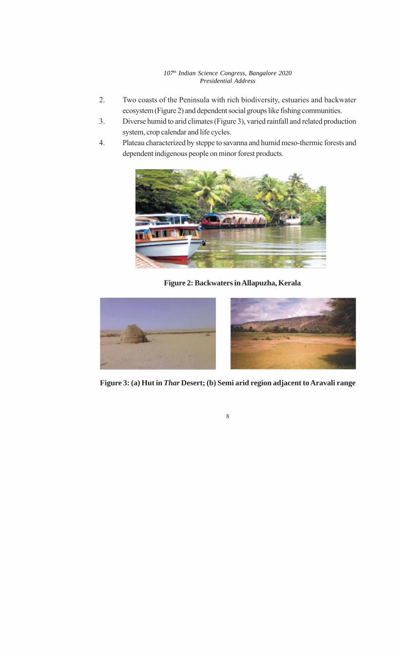
2. Two coasts of the Peninsula with rich biodiversity, estuaries and backwaterecosystem (Figure 2) and dependent social groups like fishing communities.
3. Diverse humid to arid climates (Figure 3), varied rainfall and related productionsystem, crop calendar and life cycles.
4. Plateau characterized by steppe to savanna and humid meso-thermic forests anddependent indigenous people on minor forest products.
Figure 2: Backwaters in Allapuzha, Kerala
Figure 3: (a) Hut in Thar Desert; (b) Semi arid region adjacent to Aravali range
107th Indian Science Congress, Bangalore 2020Presidential Address

Section V : Earth System Sciences
9
5. Indus-Ganga-Brahmputra alluvial plains (Figure 4) in the north exhibitingcontinuation of traditional unique socio-economic interaction such as Jajmanisystem.
Figure 4: Kaziranga National Park
6. Rising million-cities like Delhi, Agra, Kolkata, Mumbai and Bangalore containingwithin them, most modern to cultural heritage and most traditional land uses togetherwith worst form of visible poverty in the form of slums.
7. Delta in coastal regions of the eastern sea with typical mangroves and wetlands.
Biodiversity for Sustaining Future Earth
Great variation in climatic conditions has given appearance to variety of forest types includingtropical and sub-tropical forests in the Western Ghats and Eastern Himalaya, temperateand alpine forests in central and western Himalaya and desert forests in the arid and semi-arid regions of the country. According to Forests Survey of India (2019), about 7, 08,273km2 constituting 21.54 per cent of its geographical area is under forest cover in the country.Very Dense Forest (VDF), however, accounts for only 2.5 per cent while the ModeratelyDense Forest (MDF) and open forest account about 10 per cent and 9 per cent respectively.The total forest and tree cover of the country is estimated to account for 24.16 per cent ofthe country’s land. India is well endowed with great wealth of biodiversity in its forests,wetlands and marine areas. The country has 7 per cent of the mammals, 12.6 per cent

10
birds, 6.2 per cent reptiles, 4.4 per cent amphibians, 11.7 per cent fishes and 6 per centflowing plants of the world.
Transforming Human Resources
About 68 % of the population of India lives in rural areas. The north-eastern region hasthe lowest density of population. The southern region has had highest density consistentlyuntil 1991 census, after that eastern region occupied the highest density in the country. Thedecadal growth rate of population has declined from 25% in 1971-81 to 17.6% in 2001-2011. Regional variations in demographic transition is very prominent as southern stateslike Kerala, Karnataka, Tamil Nadu, Andhra Pradesh which are ahead compared tomany northern states namely Bihar, Uttar Pradesh, Rajasthan and Madhya Pradesh. NFHSreport of Himachal Pradesh has shown a faster decline in Total Fertility Rate (TFR) inrecent years as compared to its neighbouring states of Punjab and Haryana.
The population density of India is 382 persons per sq. Km, in comparison of 117 personsper sq. Km. in 1951. With 356 million people between age of 10-24 year, India has theworld’s largest young populationn below 24 years age comprising 46 % of total population,despite having a smaller population than China. With 269 million young people, China hasthe second largest young population followed by Indonesia (67 million), USA (65 million),Pakistan (59 million), Nigeria (57 million), Brazil (51 million), and Bangladesh (48 million)as per the United Nations Population Fund’s (UNFPA) State of the World’s Populationreport. India should commit for utilizing vast young population for transforming towardsHealthy India particularly focusing on family planning. India is trying to convert the youngpopulation as a qualitative asset. There is need for an initiative to bring this youth populationinto mainstream workforce so that they become asset for the country by linking variousdevelopmental schemes like Make in India, Skill India, Start-up, Stand-up, etc.
Influence of Monsoon on Development and Disasters
Though described as a tropical country, India experiences varied climatic conditions indifferent regions. The north is affected by a continental climate while the south has maritime
107th Indian Science Congress, Bangalore 2020Presidential Address

Section V : Earth System Sciences
11
influence due to Arabian Sea, Bay of Bengal and Indian Ocean. Much of the rain is a giftof the monsoon and is primarily orographic in nature. The annual rainfall of 116 cms is onlymarginally higher than the global mean of 99 cms. The spatial distribution of rainfall in Indiais characterized by great unevenness. Mawsynram, located in the southern face ofMeghalaya plateau, receives the highest annual rainfall in the world. India also has one ofthe driest regions of world i.e. Jaisalmer, located in the western part of the country. Generally,rainfall decreases from east to west. India is rich in terms of surface water wealth. It hasfew of the largest rivers of the world e.g. the Brahmaputra (2900 kms), the Indus (2810kms) and the Ganga (2525 kms). Besides, there are many other large river basins, withbasin area of more than 20,000 km2. Rainfall is the main source of surface water in India.Few of its lakes are named as Chilka, Wular, Sambhar, etc. are valuable sources of water.It receives about 4000 BCM of water from precipitation. Of this, monsoon rainfall accountsfor about 3000 BCM while the total utilizable water is about 690 BCM. Indian agricultureis at the mercy of monsoon and is termed as “Gamble of Monsoon”. Among the non-foodcrops; oilseeds, fiber crops, several plantation crops and forage crops are important. Riceand wheat are the principal food crops grown over the large tract (about 70 per cent ofagricultural land).
India is one of the most disaster-prone countries in the world. Nearly 57 per cent of theland is prone to earthquakes and is included in the seismic zones III-IV. About 8 per centof the land is vulnerable to cyclones of varying intensities. About 68 per cent of the netsown area and 5 per cent of the total land are vulnerable to droughts and floods (40 millionha). India alone accounts for 20 per cent of the deaths caused by floods in the world.
Challenges for Future Earth Sustainability in India
Land use change is required to be controlled and the local habitats of the wild animalsshould be preserved for over all ecological development for the nation. Better implementationis required to improve the availability of basic infrastructure. Participatory forest managementapproach should be implemented throughout the country. Marketing cooperatives of fruits,

12
off-season vegetables and flower growing farmers need to be encouraged. Sustainabletourism and medical tourism need to be promoted. In order to increase income andassets, enhance capabilities and access to entitlements is required. Various measures shouldbe promoted to ensure proper development in the agricultural sector like crop diversificationand weather based crop insurance schemes by understanding earth systems sciences.Challenges for sustainable development in India have linkages with resource limitations.Land management continues to be an important strategy for future sustainable vision ofIndia (Figure 5).
Figure 5: Land Degradation in India based on Government of India
107th Indian Science Congress, Bangalore 2020Presidential Address

Section V : Earth System Sciences
13
Impending Climate Change in India
• Understanding Climate Variability and Change
Climate is “average” weather for a given place or a region. It defines typical weatherconditions for a given area based on long-term averages, typically 30 years, as defined bythe World Meteorological Organization. Although a region’s climate is always changing,the changes do not usually occur on a small-time scale. We can observe how weatherchanges day to day but subtle climate changes are not readily detectable. Weather andclimate take similar elements into account, including air temperature, precipitation, humidity,type and amount of cloudiness, air pressure, wind speed and direction. A change in oneweather element can produce changes in the climate. If these changes occur over a longperiod, the average climate values for these elements will change and follow an increasingor decreasing trend, termed as ‘Climate Change’.
Whereas, ‘Climate Variability’ refers to the climatic parameter of a region varying from itslong-term mean. Every year in a specific time period the climate of a location is different.The knowledge of climate variability over the period of instrumental records and beyondon different temporal and spatial scale is important to understand the nature of differentclimate systems. Variability may be due to natural internal processes within the climatesystem (internal variability), or to variations in natural or anthropogenic external forcing(external variability) (Figure 6).
According to the 2007 Fourth Assessment Report by IPCC, global surface temperatureincreased 0.74 ± 0.18 °C (1.33 ± 0.32 °F) during the 20th century. Most of the observedtemperature increase since the middle of the 20th century was caused by increasingconcentrations of greenhouse gases, which results from human activity such as fossilfuel burning and deforestation. Climate model projections summarized in the latest IPCCreport indicate that the global surface temperature is likely to rise a further 1.1°C to6.4°C (2.0°F to 11.5°F) during the 21st century. A gradual decreasing trend in meanannual temperature for the region of northwest India has been observed (Pant and Hingane,

14
1988). The maximum contribution to this decrease is during the southwest monsoon (-0.52oC/100 years). An assessment on extreme weather events over India for the last 100years has been done by De et al., (2005). After Jammu and Kashmir, Rajasthan is thesecond state where maximum number of cold waves has been reported. On the otherside, Alwar in Rajasthan (East) holds the record for the highest maximum temperature of50.6oC (123oF) on 10 May 1956 (De et al., 2005).
• Issues and Challenges
The global climate is changing at rates that are unprecedented in recent human history andfaster than the ability of natural system to adapt. Climate change is increasingly recognizedas a critical challenge to ecological health, human well-being, livelihood security and futuredevelopment (Singh and Heitala, 2014), as understood by the award of the Nobel PeacePrize for 2007 to the IPCC (Leary et al., 2008). The risks of climate change and extremeevents such as drought and flood have substantial impacts on economy and natural systems.Agriculture, livestock and water resources are among the most vulnerable systems.According to Sen Roy and Singh, 2002, changing climate elements and their extremes willsignificantly alter productivity in agriculture and forest ecosystem, which in turn will affectthe socio-economic conditions of many societies. Climate change is expected to increasethe frequency and intensity of current hazards and the probability of extreme events, andalso to spur the emergence of new hazards (Nicholls and Lowe, 2006). Extreme eventswithin the variability of the climate system are, by far, the largest cause of natural disastersworldwide each year (Kininmonth, 2004). Therefore, resilience and adaptive capacity oftraditional networks and land use systems to cope with climate variability/extremes areweakening, while frequency and magnitude of climate variability and land use intensity areon rise. Thus, it is important to understand the phenomenon of climate change and associatedvulnerability of different sectors, regions and people.
107th Indian Science Congress, Bangalore 2020Presidential Address

Section V : Earth System Sciences
15
• Drivers of Climate Change
Both internal and external forces induce change in climate. External forces refer to processesexternal to the climate system that influence climate. Climate responds to several types ofexternal forcing, such as radiative forcing due to changes in atmospheric composition(mainly greenhouse gas concentrations), changes in solar luminosity, volcanic eruptions,and variations in Earth’s orbit around the Sun (Hegerl et al., 2007). Attribution of recentclimate change focuses on the first three types of forcing. Orbital cycles vary slowly overtens of thousands of years and thus, are too gradual to have caused the temperaturechanges observed in the past century (Figure 6).
Source: IPCC, 2007: Figure 6: Radiative forcing of climate during 1750 to 2005

16
Human Induced climate change
Human activities contribute to climate change by causing changes in Earth’s atmospherereleasing amounts of greenhouse gases, aerosols (small particles), and cloudiness. Thelargest known contribution comes from the burning of fossil fuels releasing carbon dioxidegas to the atmosphere. Since the start of the industrial era (about 1750), the overall effectof human activities on climate has been a warming influence. Human activities result inemissions of four principal greenhouse gases i.e. carbon dioxide (CO2), methane (CH4),nitrous oxide (N2O) and the halocarbons (a group of gases containing fluorine, chlorineand bromine). These gases accumulate in the atmosphere, causing concentrations to increasewith time. Methane which is produced by the burning of fossil fuels, the raising of livestock,the decay of landfill wastes, the production and transport of natural gas, and other activities,increased sharply through the 1980s before starting to level off at about two-and-a-halftimes its preindustrial level (Figure 7).
Source: IPCC, 2007: Figure 7: Atmospheric concentrations of important long-lived green-house gases over the last 2,000 years.
107th Indian Science Congress, Bangalore 2020Presidential Address

Section V : Earth System Sciences
17
Land use change
The combustion of fossil fuels is not the only anthropogenic source of carbon dioxide.When ecosystems are altered and vegetation is either burned or removed, the carbonstored in them is released to the atmosphere as carbon dioxide. The principal reasons fordeforestation are agriculture and urban growth, and harvesting timber for fuel, construction,and paper. Currently, up to a quarter of the carbon dioxide emissions to the atmospherecan be attributed to land use change (Singh, Singh and Hassan, 2014).
Sulfate aerosols and black carbon
Sulfate aerosols and black carbon are two important additional examples of anthropogenicforcing. Sulfate aerosols, which enter the atmosphere naturally during volcanic eruptions,are tiny airborne particles that reflect sunlight back to space. Industrial activity has recentlyincreased their concentration in the atmosphere primarily through the burning of fossil fuelscontaining sulfur. Anthropogenic emissions of sulfate aerosols have been associated with anet cooling effect. Black carbon is soot generated from industrial pollution, traffic, outdoorfires, and the burning of coal and biomass fuels (Singh, 2015). Black carbon is formed byincomplete combustion especially of coal, diesel fuels, biofuels and outdoor biomass burning.Soot particles absorb sunlight, both heating the air and reducing the amount of sunlightreaching the ground.
• Green House Effect and Global Warming
Greenhouse gases effectively absorb thermal infrared radiation, emitted by the Earth’ssurface by the atmosphere itself due to the gases like CO2, CH4, N2O, and by clouds. TheGreenhouse gases trap heat within the surface-troposphere system. This is called thegreenhouse effect. Thermal infrared radiation in the troposphere is strongly coupled to thetemperature of the atmosphere at the altitude at which it is emitted. An increase in theconcentration of greenhouse gases leads to an increased infrared opacity of the atmosphere,and therefore to an effective radiation into space from a higher altitude at a lower temperature.This causes a radiative forcing that leads to an enhancement of the greenhouse effect,called enhanced greenhouse effect (Figure 8).

18
Source: Government of Australia Climate Change Action Plan (http://www.climatechangeinaustralia.gov.au)Figure 8: The Greenhouse gas effect
• Evidences of Climate Change
A variety of sources can be used to reconstruct past climates. Reasonably completeglobal records of surface temperature are available beginning from the mid-late 19th century.For earlier periods, most of the evidences are indirect—climatic changes are inferred fromchanges in proxies, indicators that reflect climate such as vegetation, ice cores, dendro-chronology, sea level change, and glacial geology (Figure 9).
107th Indian Science Congress, Bangalore 2020Presidential Address

Section V : Earth System Sciences
19
Source: U.S. National Science Foundation.
Figure 9: Comparisons between Asian Monsoons, Northern Hemispheretemperature, Alpine glacier extent and human history.
Temperature measurements and proxies
The instrumental temperature record from surface stations was supplemented by radiosondeballoons, extensive atmospheric monitoring by the mid-20th century, and from the 1970son with global satellite data as well The 18O/16O ratio in calcite and ice core samples usedto deduce ocean temperature in the distant past is an example of a temperature proxymethod as are other climate metrics noted in subsequent categories (Figure 10).

20
Historical and archaeological evidence
Climate change in the recent past may be detected by corresponding changes insettlement and agricultural patterns. Archaeological evidence, oral history and historicaldocuments can offer insights into past changes in the climate. Climate change effectshave been linked to the collapse of various civilizations (Demenocal, 2001).
Source: IMD, 2010
Figure 10: All India annual mean temperature anomalies for the period 1901-2009.
107th Indian Science Congress, Bangalore 2020Presidential Address

Section V : Earth System Sciences
21
Glaciers
Glaciers are considered among the most sensitive indicators of climate change (Seiz andFoppa, 2007). Their size is determined by a mass balance between snow input and meltoutput. As temperatures warm, glaciers retreat. Glaciers grow and shrink due to both,natural variability and external forcing. Variability in temperature, precipitation, and englacialand subglacial hydrology can strongly determine the evolution of a glacier in a particularseason. The compilation of glaciers tracks more than 1,00,000 glaciers covering a totalarea of approximately 2,40,000 km2, and preliminary estimates indicate that the remainingice cover is around 4,45,000 km2. The World Glacier Monitoring Service have found theglaciers to be shrinking significantly, with strong glacier retreats in the 1940s, stable orgrowing conditions during the 1920s and 1970s, and again retreating from the mid-1980sto present (Zemp, et al., 2008). Glaciers leave behind moraines that contain a wealth ofmaterial—including organic matter, quartz, and potassium that may be dated—recordingthe periods in which a glacier advanced and retreated. Similarly,by tephrochronological techniques (Lowe, 2011), the lack of glacier cover can be identifiedby the presence of soil or volcanic tephra horizons whose date of deposit may also beascertained.
Arctic sea ice loss
The decline in Arctic sea ice, both in extent and thickness, over the last several decades isanother evidence. Sea ice is frozen seawater that floats on the ocean surface. It coversmillions of square miles in the Polar Regions, varying with the seasons. In the Arctic, somesea ice remains year after year, whereas almost all Southern Ocean or Antarctic sea icemelts away and reforms annually. Satellite observations show that Arctic sea ice is nowdeclining at a rate of 13.3 percent per decade, relative to the 1981 to 2010 average(Shaftel, 2015).

22
Vegetation
A change in the type, distribution and coverage of vegetation may occur given a change inthe climate. Some changes in climate may result in increased precipitation and warmth,resulting in improved plant growth and the subsequent sequestration of airborne CO2. DuringCarboniferous Rainforest Collapse (CRC), an extinction event 300 million years ago, vastrainforests covered the equatorial region of Europe and America. Climate change devastatedthese tropical rainforests, abruptly fragmenting the habitat into isolated ‘islands’ and causingthe extinction of many plant and animal species. (Kinver, 2011; Sahney, Benton, and Falcon-Lang, 2010; Bachelet, Neilson, Lenihan and Drapek, 2001).
Pollen analysis
Different groups of plants have pollen with distinctive shapes and surface textures, andsince the outer surface of pollen is composed of a very resilient material, they resist decay.Changes in the type of pollen found in different layers of sediment in lakes, bogs, or riverdeltas indicate changes in plant communities. These changes are often a sign of a changingclimate. (Langdon, Barber and Lomas-Clarke, 2004; Birks, 2003).
Dendro-climatology
It is the analysis of tree ring growth patterns to determine past climate variations. Wideand thick rings indicate a fertile, well-watered growing period, whilst thin, narrow ringsindicate a time of lower rainfall and less-than-ideal growing conditions (Hughes, Swetnamand Diaz, 2010).
Ice cores
Analysis of ice in a core drilled from an ice sheet such as the Antarctic ice sheet, can beused to show a link between temperature and global sea level variations. The air trappedin bubbles in the ice can also reveal the CO2 variations of the atmosphere from the distantpast, well before modern environmental influences.
107th Indian Science Congress, Bangalore 2020Presidential Address

Section V : Earth System Sciences
23
Sea level change
Global sea level change for much of the last century has generally been estimated using tidegauge measurements collated over long periods of time to give a long-term average. Morerecently, altimeter measurements in combination with accurately determined satellite orbits have provided an improved measurement of global sea level change. To measure sealevels prior to instrumental measurements, scientists have dated coral reefs that grow nearthe surface of the ocean, coastal sediments, marine terraces, ooids in limestones, andnearshore archaeological remains. The predominant dating methods used are uraniumseries and radiocarbon, with cosmogenic radio-nuclides being sometimes used to dateterraces that have experienced relative sea level fall. In the early Pliocene, global temperatureswere 1–2ÚC warmer than the present temperature, yet sea level was 15–25 meters higherthan today (Hansen, 2013).
• Climate Change Impact is more Visible through Glacial Shrinking inducedFloods
The warming in past decades has been found to be progressively higher at the higherelevations and the warming in this region is having profound impacts on the glacial melting.It has been observed that, in the high mountains (4,500 to 5,500 m) the frequency andoccurrence of Glacial Lake Outburst Flood (GLOF) events has been increasing in thesecond half of the 20th century. There is an urgent need to monitor high altitude glaciatedregion to understand the natural processes and to reduce the magnitude of flood hazards indownstream regions. Awareness of glacial lake outburst ûoods in the Himalayan region isderived from the memories of local people and from incidentally documented evidence.There are more than eight thousand glacial lakes in the greater Himalaya and about twohundred lakes are potentially dangerous. Most of the glacial lakes in the Himalayan regionare known to have formed within the last 5 decades, and increased numbers of GLOFevents have been reported in this region. On an average, in every 3 to 10 years one GLOFevent was recorded in the Himalayan region. These GLOF events have resulted in the loss

24
of many lives, as well as the destruction of houses, bridges, fields, forests roads andlivelihoods (Figure 11).
Figure 11: Spatial Distribution of Avalanches in Part of NDBR (VoFNP, AmritGanga Valley, Nakthani Valley and Lower Saraswati Valley) as Mapped onLandsat 5 TM Satellite Images (3-11-2009 and 6-11-2010) based on Field
Survey of June 2010 (Background-ASTER GDEM2 Image)
107th Indian Science Congress, Bangalore 2020Presidential Address

Section V : Earth System Sciences
25
• Climate Change Impact and Induced Disaster Risks
Climate has always been linked with disasters, hitherto, through climate variability manifestingin extreme weather events such as cyclones, storms, floods, droughts, heat waves,windstorms, etc. with potential to accelerate the catastrophic loss of human lives, damageto infrastructure and environment. These short-term climate fluctuations and extremeweather events have been the most frequently occurring hazards and in combination withsocial vulnerability have been responsible for the vast majority of disaster losses worldwide.The Centre for Research on the Epidemiology of Disaster (CRED) categorizes thesedisasters resulting from climatic variability and other climatic and meteorological causes ashydro-meteorological disasters (floods, landslides, mudflows, avalanches, tidal waves,windstorms, including typhoons, cyclones, hurricanes, storms, winter storms, tropical stormsand tornadoes, droughts, extreme temperatures, and complex disasters associated withdrought) as distinct from geological disasters (earthquakes, volcanic eruptions and tsunamis)(CRED, 2007).
In the 21st century over the past three decades, climate related natural disasters occurredfive times as frequently, killed or affected seventy times as many people, and caused twiceas much damage worldwide as did earthquakes and volcanoes. In the past decade, weather-related natural hazards have been the cause of 90% of natural disasters and 60% ofrelated deaths, and have been responsible for 98% of the impacts on disaster-affectedpopulations, the majority in areas of developing countries (IFRC, 2005). Between 2000and 2004, an average of 326 climate disasters was reported each year. Some 262 millionpeople were affected annually for 2000-2004, more than double the level in the first half ofthe 1980 (UNDP, 2007). The impacts of climate change are likely to be considerable intropical regions. Overall, crop yields may fall by 10 to 20 per cent by 2050 because of warmingand drying, but there are places where yield losses may be much more severe (Jones andThornton, 2003). The most serious climate change risk to the Indian economy and its people isthe increased intensity, frequency and geographical coverage of drought. Drought typicallymakes up one half to two-thirds of the natural hazard risk exposure (GSDMA/TARU, 2005).

26
Its primary impact is in rural areas, where agriculture, animal husbandry and, to a lesser extentforestry are significantly affected, leading to cycles of seasonal and distress migration and increasingrural debt, and a spate of farmer suicides across much of semi-arid India over the last few years(Sainath, 2002; GSDMA/TARU, 2005).
• Observed Variations in Climate over Rajasthan
In Rajasthan, during 1951-2010 the temperature has shown a great variability with anaverage rise of about 0.168oC for winter season, 0.240oC in summer season and 0.304oCin autumn season. The highest rise in temperature is observed in agro-climatic zone IVBwith an average rise of 0.428oC and 0.754oC during winter and autumn seasons respectively(Table 1).
The high change can be attributed to land use land cover change in the region. In summerand monsoon season, more prominent rise in temperature is observed after 1990 and2003 respectively. For winter season, the maximum change noticed is of 1.0 oC to 1.2oC andminimum of 0.2oC to 0.4oC. The trend of temperature rise in winter months is just reverse ofwhat we found in summer season. The rise in temperature if grouped in five classes viz, veryhigh (1.0 oC – 1.2oC), high (0.8oC – 1.0oC), moderate (0.6 oC – 0.8oC), low (0.4oC – 0.6oC)and very low (0.2oC – 0.4oC). Very high temperature rise has occurred in southern Jhunjhunu,eastern Nagaur, western Barmer and western Jalore. High change has occurred in northernJhunjhunu, southern Churu, western Nagaur, eastern Jodhpur, eastern Pali, western Jaisalmer,central Barmer and central Jalore. Moderate change in temperature has been observed insouthern Sikar, Central Churu, southeastern Bikaner, central Jodhpur, central Jaisalmer, easternBarmer, eastern Jalore and western Pali. The northern Sikar, north central Churu, northernGanganagar, western Hanumangarh, central Bikaner, northern Jodhpur and eastern Jaisalmerhave experienced a low change in temperature. Very low change in temperature can be seen insouthern Ganganagar, eastern Hanumangarh, northern Churu and western Bikaner. The monthof March shows similar trends with little rise in temperature over the districts of Dungarpur andBanswara. The overall temperature over the state rose for the month of April with maximum
107th Indian Science Congress, Bangalore 2020Presidential Address

Section V : Earth System Sciences
27
change observed over the western part of the state. For the month of May, there are contrastingresults as temperature rose over the western part and shows decrease in the eastern part. Themaximum rise has been observed over the district of Ganganagar. In the month of May, adecrease in temperature has been observed in the eastern part of the state. The temperaturerose in the south-western part of the state. The changes in temperature are not so prominentduring monsoon period. The temperature shows increasing trend over the state during theautumn season especially in the southern districts of Rajasthan.
Table 1: Agro-Climatic zone wise change in temperature (oC) during different seasons
(1951-2010)
Zones Winter Spring Summer Monsoon Autumn
Arid Western (IA) 0.277 0.109 -0.114 0.053 0.345 Irrigated North Western Plain (IB) 0.242 -0.198 -0.193 -0.354 -0.045 Hyper Arid Partial Irrigated Zone (IC) 0.299 0.008 -0.073 -0.138 0.169 Internal Drainage Dry Zone (IIA) 0.015 -0.098 -0.318 -0.189 0.065 Transitional Plain of Luni Basin (IIB) 0.268 0.101 -0.089 0.152 0.443 Semi Arid Eastern Plain (IIIA) -0.131 -0.167 -0.417 -0.051 0.197 Flood Prone Eastern Zone (IIIB) -0.122 -0.273 -0.638 -0.188 0.055 Sub-Humid Southern Plain (IVA) 0.355 -0.008 -0.098 0.233 0.558 Humid Southern Hilly and Plain region (IVB) 0.428 0.197 0.123 0.363 0.754 Humid South Eastern Plain (V) 0.367 -0.057 -0.187 0.207 0.559
Source: Calculated by researcher based on data from IMD
A decrease in rainfall has been observed over the state during 1951-2010. The maximumdecrease has been observed in the zone IVB followed by zone V and IIIB. The decline inrainfall is also accompanied with the decrease in the frequency of wet days. The zone IB alongwith zone IC has least decline in the rainfall during 1951-2010 (Table 2).
Spatially, maximum change in precipitation has been observed during the month of July andAugust in eastern Rajasthan. It has increased in the eastern apart of the state in the month ofJune. An increase has also been observed in the north-western and south-western part of

28
Rajasthan during the months of July and August respectively. Highest increase of 40-60 mm inprecipitation can be noticed in north-eastern region comprising Alwar, Baharatpur, Dausa,Karauli and Ajmer districts. The districts of Ganganagar, Hanumangarh, Churu and Bikanerregister an increase of 30 to 40 mm in precipitation during the month of July. The districts ofSirohi, Jalore and Pali also show increase in rainfall by 30-40 mm during the month of August.Further decrease of 5 mm in rainfall can be seen over Jaisalmer during the month of June. Thedistrict of Dhaulpur experienced heavy decrease in rainfall of about 70 mm during the month ofJuly and August. Eastern part including the Hadoti region and south-western part have observeda decline of about 60 mm of rainfall during the month of July.
Table 2: Agro-Climatic zone wise changes in monsoonal rainfall pattern during 1951-2010
Source: Calculated by researcher based on data from IMD
• Observed Variations in Climate over Western Himalaya in Uttarakhand
Mountain ecosystems are very sensitive to the habitat and climate change due to the interactionof tectonic, geomorphic, environmental and climate agents (Singh et al., 2013; Singh, 1998).Beyond their common characteristics of high relative relief and steep slopes, mountains areremarkably diverse and globally important as centers of biological diversity (Ives et al., 2004;
107th Indian Science Congress, Bangalore 2020Presidential Address

Section V : Earth System Sciences
29
Rizzo and Wiken, 1992; Halpin, 1994) and societal systems (Price, 1990). The retreat of glaciersand the thawing permafrost is an indication of the increase in the average temperature in themountain region during past three decades. On an average, surface air temperatures in theHimalayan region have gone up by one degree in last decade (Srinivasan et al., 2006).Recent studies over the Himalaya Glaciers using ground-based and space-based observationsand computer models indicate a long-term trend of climate variability and change mayaccelerate melting of the Himalayan Glaciers (Lau et al., 2010). Other studies also suggest adecreasing trend in snowfall, which has historically served as a main source of precipitationfor maintaining the glaciers and fresh water resources in this region. In the Himalaya, naturedetermined environmental fragility scores high (Sen Roy and Singh, 2002).
Pindari region has been taken as a case of study from Himalayan region. It is geographicallylocated in the southern side of greater Himalaya in Uttarakhand. The geographical area ofthe Pindari region is 593.5 km2. The Pindari region represents clusters of glaciers comprisingthe main Pindari glacier as trunk part. The annual temperature trend of Bageshwarmeteorological station is showing substantial increase of around 1°C from 1901 to 2010.In the year 1977 the mean maximum temperature was 25.31° C while it was 26.65°C in2007. The range of maximum temperature for the same period is 2.46°C. The highestmaximum temperature for the station has been recorded 31.36°C in the year 2007. Theincrease in the temperature over a period of 110 year for which the data has been procuredfrom India Meteorological Department is alarming. At about 1°C increase in the meanmaximum temperature has been calculated. The trend line plotted shows that in the year1901 the initial point of trend line was around 23.1°C while in the year 2007 it is at around24.2°C. The range of the minimum and maximum recorded temperature comes out to be2.85°C. The annual maximum temperature has shown rapid increase from 1990 onward.For Pindari region as a whole, season wise annual maximum temperature shows a gradualincreasing trend during all the three seasons: winter, summer and monsoon season over theperiod 1901–2010. On the seasonal level, the trends in the frequency of occurrence oftemperature extremes are slightly different. The homogeneous trend shows in monsoonseason but winter and summer seasons show a significant fluctuating trend in frequency of

30
hot days. The winter season show comparatively highest increasing trend in the annualmaximum temperature. The total annual rainfall in the state is maximum over the Pindariregion of Bageshwar district. The total annual rainfall for the region is 149 cm and the totalannual number of rainy days is 65. The rainfall over the region increases towards southernregion during winter and monsoon. The southwest monsoon season is the principal rainyseason over the region. Of the total annual rainfall, about 73 per cent is received in thesouthwest monsoon season (June to September), about 9 per cent is received in thewinter season (January and February), about 11 per cent is received in the pre-monsoonseason (March to May) and about 6 per cent is received in the post-monsoon season(October to December). The percentage of the seasonal number of rainy days with respectto the annual number of rainy days is 63 per cent for the southwest monsoon season, 16per cent for the pre-monsoon season, 7 per cent for the post monsoon season and 13 percent for the winter season.
The annual mean rainfall trend plotted for winter, summer and monsoon is not showing anyclear picture of either decreasing or increasing trend. In winter season, mean rainfall trendis showing decreasing trend with high fluctuation but summer and monsoon seasons showingconstant trend in precipitation but also showing high degree of variability from the meanrainfall. All seasons in the Pindari region indicate significant increase in rainfall. The annualmean of heaviest rainfall in 24 hours is showing a decreasing trend over the period.Bageshwar meteorological station data is showing a decreasing trend but with varyingdegree.
The annual average number of snow day’s data is available only for Bageshwarmeteorological stations. Analysis of the data reveals the fact that average days with snowin a year is also showing decreasing trend. The decrease is of around 3.4 days in a periodof 23 years. Less number of snow days in the region is going to give less amount of snowfall.The decreasing snow will affect the volume and thickness of a snow area; thus, glaciers willbecome more vulnerable as the mean minimum temperature is showing an overall increase. Thiswill result in gradual decline of total snow area in the region in coming decades. The decrease in
107th Indian Science Congress, Bangalore 2020Presidential Address

Section V : Earth System Sciences
31
the number of days with snow is alarming after the year 1995. The recent studies highlight thechanging climate in Himalayan ecosystems and increase in related challenges. Results fromdifferent sets of climate models predicting long-term scenarios from 1970 to 2100 suggestedfurther rise in extreme weather events in the region (Dimri, 2014).
In view of the climate change in Himalaya, micro level studies produced evidence tostrengthen the case for community’s adaptive capacities and resilience to combat the menaceof climate change. Emphasis is laid on the fact that local communities need to be mobilizedand capacity building must be initiated urgently to generate alternative modes of livelihoodfor sustainable progress of societies. Studies from Kangra, Lahul-Spiti (Himachal Himalaya)and Pindari Glacier (Uttarakhand Himalaya) confirm the evidence of climate change atmicro level. These studies found that climatic stress on agriculture/horticulture relatedlivelihood practices (smaller duration of cropping season and fall in yields per hectare) inthe region have increased. Furthermore, role of anthropogenic activities resulting intoexploitation of natural ecosystem services in Himalayan Region were also cautioned.
• Mitigating Climate Change: India’s Climate Action on Earth Environment
The need of the hour is to bring all various segments of our society and stakeholderstogether to act timely and coherently, and to mitigate the impacts of climate change, whichis likely to affect every sphere, and may make livelihood of poor people more vulnerableand less resilient.
Given the lack of resources, and access to technology and finances, India has limitedcapacity to develop and adopt strategies to reduce its vulnerability to changes in climate.To manage the climate change-disasters-security nexus, the country needs to have improvedscientific understanding, capacity building, networking and broad consultation processesacross every section of the society.
India, the world’s fourth-largest carbon emitter with a population of 1.3 billion people,ratified the Paris Agreement on climate change. The Paris Agreement requires the member

32
countries to make binding commitments to curtail CO2 emissions in order to balance globalaverage temperatures from rising above 1.5°C as compared to the pre-industrial years. Inthe coming years, India is aiming to develop sustainable model of economic developmentby harnessing the available and potential clean energy sources. India also plans to reduceits carbon emission intensity - emission per unit of GDP - by 33-35% from 2005 levelsover 15 years. It aims at producing 40% of its installed electricity capacity by 2030 fromnon-fossil fuels with the development of clean sources of energy. This signifies thecommitment of India to shift significantly from coal-based power generation to renewableenergy sources to reduce the emissions of carbon, vulnerability of global warming and tocombat climate change ill effects (Figure 12).
Figure 12: Various Climate Action Plans to combat Climate Change in India
107th Indian Science Congress, Bangalore 2020Presidential Address

Section V : Earth System Sciences
33
• Evolving multi-Dimensional Approaches
No group, society, sector or country is untouched by this problem, though the vulnerability to itdiffers with income level, state of environment and their relationship with the environment.Actions that could diminish the threats posed by climate change to society and ecosystemsinclude substantial emissions cuts to reduce the magnitude of climate change, as well aspreparing for changes that are now unavoidable. The community of scientists hasresponsibilities to improve overall understanding of climate change and its impacts.Improvements will come from pursuing the research needed to understand climate change,working with stakeholders to identify relevant information, and conveying understandingclearly and accurately, both to decision makers and to the general public.
Recent scientific innovations need to be used to tackle growing environmental problemssuch as climate change. Paris climate negotiation is helping us to understand that natural lifesupport systems for our own prosperity and well-being. After USA withdrawal from Parisagreement, response of European Union, India, China and Canada for continuing withtreaty is appropriate sign for our commitment towards nature. These Includes:
• Multi-level Approaches
• Cross-sectoral Approaches
• Multi-stakeholder Approaches
• MAPS (Mainstreaming, Acceleration and Policy Support) Approach
Disaster Risk Reduction (DRR) and Sustainable Development
• Global Initiatives
Disaster risk reduction is the key to achieve sustainability. According to recent WorldDisaster Reports, the percentage of occurrences of flood is highest (43 per cent) with

34
3062 occurrences of the total disasters during 1995-2015 followed by storms (28 percent) with 2018 occurrences (Southgate et al., 2013). The volcanic activities have thelowest occurrence of only 111 events (2 per cent). Others include earthquake (8 percent), extreme temperature (6 per cent), landslide (5 per cent), drought (5 per cent) andwildfire (4 per cent). According to EM-DAT CRED, the hydrological and meteorologicaldisasters are causing loss of about USD 250 million every year. The analysis of losses dueto natural disasters shows that the losses due to hydrological and meteorological haveincreased sharply after 1990’s. The floods have caused agriculture losses in India amountingUSD 5.3 billion during 2009-2013.
For mitigating disasters, global scientific communities are preparing for important initiativesi.e. the Sendai Framework for Disaster Risk Reduction 2015-2030, which is anoutcome of inter-governmental. Recently, UN has passed resolution to implementSustainable Development Goals in 2015 adopted by the 193 countries. COP - 21brought problems related to climate induced disasters together with opportunity to initiatemitigation and adaptation. Geographers and other scientific and social science communitiesare preparing to contribute towards these global and UN initiatives (UNISDR, 2004;2011; 2015).
“A resilient community is a community that knows what it could so, because the scienceand data is there for it to have,” said Professor Virginia Murray, Chair of the conferenceorganizing committee, Vice-chair of the STAG and Consultant in Global Disaster RiskReduction for Public Health England. Apart from the focuses of the partnership , howtechnology such as earth observation from space or geographical information systems, aswell as methods such as cloud-sourcing to helpful to assess vulnerability – the overall goalbeing to improve risk assessment, strengthening of standards, collection of data and thedeployment of efficient early warning systems together with emergency response. In addition,it brings together a vast range of disciplines, from the ultra-hi-tech through to social workresearch. “Implementation of the Sendai Framework will rely on integrated and multi-disciplinary research that bridges social and natural sciences and uses both quantitative
107th Indian Science Congress, Bangalore 2020Presidential Address

Section V : Earth System Sciences
35
and qualitative data. It will rely on applied science that connects the macro to the micro,”said Dr. Glasser, ex-UN Secretary General Representative at UNISDR. Dr. Robert Glassermentioned out that the Partnership will be the key for achieving the targets of the SendaiFramework by 2030. He underlined that reducing disaster risk was part of the widerglobal agenda of making sustainable development and tackling the impacts of climatechange. Over 100 million people are affected by disasters every year, with extreme weatherand climate-related events accounting for 90 per cent of natural hazards (Singh and Singh,2014; Sahu et al., 2006).
• Disasters in India
The Himalaya is considered to be highly sensitive to climate change and is one of theyoungest mountain ranges on earth. It is characterized by a high energy environment due tohigh relief, steep slopes, complex geological structures with active tectonic process andcontinued seismic activities and weak folded structure. Climate variability in this region isvery prominent phenomenon due to its topography and monsoon climate together withincreasing population pressure, overgrazing, deforestation, road construction, damconstruction and agriculture/horticulture in high slope regions. The mountain regions areprone to multiple hazards viz. earthquake, landslides, flash floods, etc.
In recent time, the problems have accentuated due to increased tourism, urbanization andclimate change. The recent flood furies at Leh (2010), Uttarakhand (2013), Jammu andKashmir (2014) and Nepal/India earthquake have showed the significant vulnerability ofHimalaya. The nature and mechanism of all the three events was different due to varyinggeographical factors but all three caused huge loss of life and property. Both the Leh andKedarnath floods were induced by cloud burst, but the spatial impact varied. The impactvaries between flat land topography and high hill region. Leh being a flat land, the impactwas confined to local areas only but in the case of Kedarnath, due to ridge and valleytopography the impact was carried to downstream area that caused massive devastation.The number of occurrence and the trend of these cloud burst event have been continuously

36
increasing. In 1908, one cloud burst was reported. After a span of 62 years, another cloudburst occurred in July 1970 at Uttarakhand. Since 1990s, 17 cloudbursts have happenedcausing massive damage to lives and properties. Of these, atleast 11 cloudbursts occurredonly in the three hilly states of Uttarakhand, Himachal Pradesh and Jammu and Kashmir.In fact, now this phenomenon seems to be highly frequent: 11 out of the 17 cloud burstsoccurred only during 2010-2013. One can say that the increase in frequency of suchincidences is because of changing climate (Table 3).
In recent time, the Jammu and Kashmir flood (Figure 13) was not triggered by a cloudburst. But it was due to the intense rainfall of more than 450 mm in just 3 days (Annualaverage rainfall of Jammu and Kashmir is 100mm). The huge amount of rainwater wasbeyond the Jhelum’s catchment capacity, which was also limited by chocking of drainagesystem due to extensive soil erosion during the event. The soil erosion increased due tobareness of land surface caused by human activities. As per the past records, Jammuregion has experienced such huge rainfall in 1903, 1908, 1926, 1942 and 1988, whereasin the Kashmir valley such intensity rainfall was observed in 1903, 1911, 1917, 1928 and1992. Above experiences compel us to think that at least we have to cope with the disasters.
107th Indian Science Congress, Bangalore 2020Presidential Address

Section V : Earth System Sciences
37
Table 3: Major Disasters in India since 2011
• Source: Various Reports

38
Source: NRSA
Figure 13: Pre and Post flood satellite images of J&K Flood
107th Indian Science Congress, Bangalore 2020Presidential Address

Section V : Earth System Sciences
39
Recently the major disasters viz. Uttarakhand and Srinagar Flash Flood, Earthquake inNepal, Phailin Cyclone in Orissa and Drought in Marathwada caused serious disruption ofactivities in India (Figure 13), but the calamities were drastically reduced during Phailinevent due to better forecasting and communication. In 2004, the losses incurred duringTsunami were high due to lack of technological use (Table 4).
Table 4: Causalities due to disasters in India
Year Live Lost human (in No.) Cattle Lost (in No.) Houses damaged (in No.) Cropped areas affected (in million
2001-02 834 21,269 3,46,878 1.872 2002-03 898 3,729 4,62,700 2.100 2003-04 1,992 25,393 6,82,209 3.198 2004-05 1,995 12,389 16,03,300 3.253 2005-06 2,698 1,10,997 21,20,012 3.552 2006-07 2,402 4,55,619 19,34,680 7.087 2007-08 3,764 1,19,218 35,27,041 8.513 2008-09 3,405 53,833 16,46,905 3.556 2009-10 1,677 1,28,452 13,59,726 4.713 2010-11 2,310 48,778 13,38,619 4.625
According to an estimate by the World Bank, direct losses from natural disaster are up to2% of the India’s GDP. More importantly, the impact of most of the disasters isdisproportionately high on the poor (Kumar, 2012) (Table 5). In this context there is anurgent need to recognize natural disasters in a comprehensive manner and take effectivesteps for prevention, mitigation and management (Figure 14 and Figure 15).

40
Figure 14: Incidences of Natural Disasters
107th Indian Science Congress, Bangalore 2020Presidential Address

Section V : Earth System Sciences
41
Table 5: Ten most deadly natural disasters of South Asia
Source: Ministry of Home Affairs, 2012

42
Figure 15: Flood vulnerability in Assam
107th Indian Science Congress, Bangalore 2020Presidential Address

Section V : Earth System Sciences
43
• Recent Earthquake Experiences in India
Dangers from earthquakes in the Himalayan region in general and South Asian mega-citiesin particular are very high. This is exacerbated due to the dense clusters of population, lackof awareness and prevalent poverty. Recently, occurrence of frequent tremors poses agreat challenge. As recent earthquakes in Nepal and India caused large scale loss ofhuman life and damage to properties through direct and indirect impacts like faulting, cracks,upheaval, subsidence and dislocation, etc., it is high time to foremost importance of disasterprediction, monitoring and mitigation. With the help of super-imposed images of populationdistribution, population density, seismic activities and vulnerability, it is reflected that themaximum areas of Himalayan region are most susceptible to earthquakes. Multiple minorplate boundaries in the region can be traced. During 2015 Nepal earthquake, the districtsof Sindhupal chowk, Kathmandu, Nuwakot, Dhading, Bhaktapur, Gorkha, Kavre, Lalitpurand Rasuwa were most affected areas. UNICEF announced that close to 1 million childrenwere “severely affected” by the disaster. The death toll in Nepal crossed 7,000. The UNAgencies argued that the earthquake affected about 8 million people out of 28 millionpeople of Nepal. Thus, we have to learn to live with Earthquake in South Asia whereMulti-pronged Strategy required for Preparedness, Prediction, Surveillance, StructuralReinforcement and Insurance must be adopted and implemented.
• Mechanisms of Earthquakes in Himalayan Zone
About 80 per cent of the world’s seismic energy for shallow earthquakes as well as mostof the energy in intermediate and deep focus earthquake are released at the plate boundaries.The Himalayan mountain range dramatically demonstrates one of the most visible andspectacular consequences of plate tectonics. This is known as convergent plate motions,where crust is destroyed as one plate subducts under another. The recent Nepal Earthquakeis also a result of denser Indian plate subduction under lighter Eurasian Plate.

44
• More people die from Building Collapse than the Tremors
It is necessary to co-ordinate the relief and aid packages amongst different countries.Cracks and damaged runway also hindered relief efforts at the Kathmandu airport. Armedforces, para-military, medicine, government and self-help groups should work in anintegrated manner for response, rescue, resettlement and rehabilitation of disaster victims.Nepal was shaken by around 70 aftershocks that time. Indian Government Response wasquick and effective for rescue and relief. Other countries like China and internationalcommunities joined immediately. Multi-dimensional livelihood framework can play aninstrumental role for rehabilitation beyond rescue and relief. Each Himalayan thrust linelike High Himalayan Crust Line sequence and India –Tsangpo Suture Zone should bedealt with consideration of Main Boundary Thrust, Main Central thrust and Sarchu Faultto study Himalayan micro vulnerability, mapping and monitoring. Earthquake Processesand Modeling (EPM) and Analyses of data sets could greatly help in improving theunderstanding about the earthquake processes in the inter-plate and intra-plate seismicregimes structure in susceptible regions for further enhancing preparedness.
• Mapping Vulnerable Structures and Materials Using Remote Sensing andGIS
The historical locations and zone of influence of the earthquakes can be mapped usingremote sensing and geographical information system to understand the trend and patternsof the disasters. The fault lines and lineaments can be monitored through Ground PenetratingRadar (GPR) for micro-zonation mapping. This preliminary exercise along with theearthquake prone maps can be effectively utilized for disaster preparedness and mitigation.It is well-known fact that more people die from building collapse than the tremors (Singh2005; 2006). It is said that mud houses own by poor people kill more people and cementhouses owned by rich people save people. This fact is applicable for all the developingcountries like India and Nepal. Strict rules regarding construction locations, material andtechnology are needed for reducing the deaths from building collapse.
107th Indian Science Congress, Bangalore 2020Presidential Address

Section V : Earth System Sciences
45
• Techniques for Earthquake Prediction
Scientific: Many scientists of France, Japan and few other developed countries haveused satellites data for earthquake prediction. We must use and explore the viability ofSynthetic Aperture Radar (SAR) sensor data. The actual imaging of the earthquake withthe help of ERS-1 satellite can also be done. Another technique is the morpho-structuredzoning map preparation of the entire country through Geodetic Very Long BaselineInterferometry (VLBI). Pattern Mapping of Earthquake cycle may be also useful. Frenchscholars are exploring earthquake prediction based on gravitational study.
Cultural- Due to movement and change in behavior of animals, ants and birds, earthquakewere predicted in some countries and loss of human lives were reduced. It is pertinent tomention that unusual behaviors were noticed among elephants in Sri Lanka during lastIndian Ocean Tsunami.
• Earthquake Surveillance
This system helps a better understanding of the location and interaction of seismogenicstructures, which allow targeting in a more proficient way the routine activities of seismicmonitoring. Selection of appropriate seismogenic zones based on regional tectonic, geologicand physiographic features and the regional historical seismicity patterns (Singh,1994). Monitoring fault zone is also promising approach in order to improve ourunderstanding about earthquake surveillance.
• Refining the Seismic Micro-zonation
Earthquake Hazard and Risk Assessment (EHRA) unit is currently engaged in refining theseismic micro-zonation in India particularly in NCT of Delhi on 1:10,000 scale. Action hasalso been initiated for taking up micro-zonation of other important cities of South Asiaunder Bureau of Indian Standards IS-1893 – part – 1: 2002. It is important to incorporatesocio-economic indicators like education, level of poverty and awareness in this process.

46
• Earthquake Preparedness: Agenda before Government and Communities
Many people believe that energy released through these tremors reduces the risk forearthquake but this assumption is not based on definite proposition. Based on assessmentof poor status of earthquake preparedness and delaying in response of the government indealing with rescue and relief operations in past earthquakes, the need of the hour is toreview the vulnerability maps of the city. Delhi is in Zone IV of seismic zones of India. Themagnitude of the probable earthquake will range between 5 to 6 Richter scale which couldbe extremely devastating in the present state of preparedness. The loopholes are both inthe physical structures like houses, buildings, old bridges, heritage monuments etc. andhuman awareness is extremely poor in view of evacuation, prevention, emotionaldevelopment, etc.
Following do’s should be kept in mind while preparing an earthquake preparedness plansand policies
(i) Monitoring epicenter of the East regularly: Considering existence of Fault Zone inEastern Side of the Delhi and Dadri in UP, it is necessary that these are monitored regularly.
(ii) Retrofitting of old buildings: It is difficult and expensive to build all new structures inplace of old buildings, so it is important to incorporate safety measures by incorporatingpillar and beam support in present buildings by providing with the fire safety measures andsuitable protection fittings.
(iii) Installation of Isolator like Japanese Buildings: On the pattern of JapaneseTechniques, Isolator should be installed between building and ground to reduce vibrationin order to reduce loss during earthquake.
(iv) Strict implementation of building codes: All new houses that are being constructedor will be constructed should follow earthquake resistant Building codes. Clearancecertificate should be only issued when the buildings are safe from any kind of disaster.
107th Indian Science Congress, Bangalore 2020Presidential Address

Section V : Earth System Sciences
47
Special care relating to earthquake resistant building should be made while constructinghospitals, schools, etc.
(v) Assessment of landscape synthesis for building construction in trans-YamunaAreas: Land suitability evaluation should be done before construction of high risingbuildings and housing complexes particularly in trans-Yamuna areas. Flood plains, reclaimedwaterlogged areas, geologically weak areas should be avoided for construction of highrising built up structures, instead.
(vi) Development of open spaces for safe shelter: Parks, green tracks, broad roadsshould be made which could act as refuge zones particularly in Old Delhi, Paharganj,Karol Bag, Jahangir Puri, Shahdara, etc. In Delhi, there are many such localities, whererescue work is very difficult due to narrow and congested streets in case of accidents. Insuch situation, a building can be demolished for making safe shelter and displaced peopleshould be rehabilitated adequately.
• Earthquake Mitigation
Earthquake mitigation includes structural and non-structural measures. Structural measuresare those that strengthen the home and make it more resilient to earthquake damage. Non-structural measures include household preparedness or make the contents of the houseless susceptible to damage. This also includes the purchase of earthquake insurance. InIndia, we have not focused so far on this issue.
1. Well-connected Network of Lifelines and Communication:
Telecommunication networks are first to be affected by earthquake so, it is very importantto provide satellite telephones to the district collectors so that a link with the affected areacan be made instantly in case of a disaster. Mobile hospitals should be installed in threatprone areas.

48
2. Securing Underground Urban Facilities:
Underground urban facilities like underground metro rails, shopping malls are vulnerableand require special attention.
3. Use of Solar and Wind Energy during Emergency:
On the pattern of Japanese Tsunami affected areas, solar energy may be useful on the timeof earthquake emergency.
4. Keeping Disaster Management Team equipped with suitableinfrastructures for Mega Cities:
Infrastructures in form of trained manpower and instruments to detect live humans andlivestock who are buried beneath the debris of fallen buildings, are needed. Trained dogswho can sniff living human beings and animals under the debris, may be increased.
5. Animal Safety together with Special Needs of Vulnerable Groups:
Animals are often ignored during rescue and relief operation. Special task force should beestablished under National Disaster Response Force (NDRF) for animal safety togetherwith tackling special needs of vulnerable groups like old age group, child, women anddisable groups.
6. Earthquake Insurance:
On the pattern of developed countries like USA and Japan, insurance is considered asimportant mitigation measures.
7. Political Leaders/VIPs should not visit the area within few days ofearthquake:
107th Indian Science Congress, Bangalore 2020Presidential Address

Section V : Earth System Sciences
49
They should not visit affected areas immediately after the disaster so that rescue and reliefoperations are not hampered in order to prepare for VIPs visits.
8. Curriculum Development and Role of Educational Institutions, PolicyMakers and Community Leaders
These include:
a. Appropriate, Indigenous and solution-oriented research for sustainability andsurvivability to fulfill human needs for food, water, shelter, energy, health and livelihood.
b. Accessible effective interdisciplinary collaboration within the arena ofhuman geosciences with physical, natural and social sciences, humanities, geography,economics, and available technological development, to find the suitable scientific solutionsto multi-faceted problems.
c. Available and timely information relating to disaster for decision/policy-makers by generating the knowledge that will support existing and new global and regionalintegrated assessments for future needs.
d. Increased capacity building through participation of policy-makers,academicians, industrial establishment and other sectors of civil society in science,technology and innovation, especially in developing countries and engagement of a newgeneration of scientists.
9. Teaching realistic ways of disaster preparedness Students should be trainedas relief personnel. It should be made compulsory for all students to learn the technique ofpreparation of first aid box. Involvement of NSS and NCC will be very effective.
• Need for Science Advice during Emergency Situation like Kerala Fire Tragedy
Emergencies arising during disaster events like Kerala fire emergency where more than110 people died, need to be managed efficiently in order to minimize losses, particularly in

50
developing regions, religious places, slums and informal settlements which generally lackscientific knowledge. Management systems for fire emergency situations includecommunication, procedures, manpower, materials, transportation, recovery, evacuationplans and shelter. Various scientific measures can be taken for pre, post and during fireemergency situations with the use of GPS and GIS, especially for assessing vulnerabilities,risks of various groups.
NDRF/NDMA should locate important centres and institutions responding to the emergencysituation such as locating important and alternate routes, etc. Technology also helps inensuring appropriate, evidence and needs-based approach to the emergency situation.Rescue teams with appropriate scientific training facilities are necessary to cope withemergency situations. There is a need to have a local and low-cost early warning system indisaster prone areas. “Map My Neighbourhood” culture should be developed for particulartragedy involving communities, in order to support decision making. Mobile applications,Geo-based information and communication technology and radio frequency communicationcould be used to spread awareness amongst the general public. Along with technologicaladvancement, it is necessary to harness local knowledge and traditional mitigation techniquesfor better results.
Also, these technologies could be used to ensure the participation of various stakeholders,particularly the science community in preparing emergency mitigation and preparednessplans. The role media can play during emergency situations is also crucial for disaster riskreduction (Basher, 2013). A robust vulnerability and risk database and resource inventorywould be a great asset in dealing with emergency situations. These scientific practicestogether with local knowledge should be learnt and adapted to suit local conditions. Suchinnovative measures will bring the responses of all stakeholders, particularly youth, in aneffective and responsible way. For quick emergency management, measures include:
i. Mapping My Neighborhood for fire risk should be taken up by NCC, NSS,RWAs, etc.
107th Indian Science Congress, Bangalore 2020Presidential Address

Section V : Earth System Sciences
51
ii. Special focus on underdeveloped regions, religious places, slums and informalsettlements, industries and nuclear establishments.
iii. Development of Community based Early Warning System like Fire IndicationSystem
iv. Promoting Self Sufficient Tools and Training
v. Reappraisal of Religious/Industrial Infrastructure adapted to fire Disaster mitigation
vi. Special needs of vulnerable groups like child, disable, old age people and women
• Integrated Risk Management Framework
The possibility of climate change and natural disaster imposes imperatives for acomprehensive integrated risk management framework. In India, disaster management isbeing addressed by the National Disaster Management Authority (NDMA) as the apexbody for addressing policy issues and guidelines. There is an urgent need to bring climatechange and disaster communities on a common platform, and develop an integrated risksmanagement framework or model for the challenges of climate change and increasingdisasters, which are intrinsically linked through societal vulnerability.
Adaptation and Mitigation
Both adaptation and mitigation have been key levers in disaster risk reduction and climatechange strategies. An integrated risk management framework needs to build on these twovital strategies. However, adaptation, in comparison to mitigation has been the neglectedmainly due to the complexity of separating adaptation from other socio economic,environment and development issues. The key levers of adaptation include povertyreduction, progressive change in economic structures, shifting away from primary livelihoodsinto secondary and tertiary knowledge-based economic activities that are less vulnerableto direct impacts of risks, changes in land use and cropping patterns, etc. and enhancingthe resilience of people.

52
From Structural to Non-Structural Mitigation
The Ninth Five-year Plan (1997- 2002) of India saw the beginning of a gradual shift awayfrom purely structural measures toward other forms of non-structural mitigation. In theNinth Plan, it was observed that in addition to the progress made in implementing structuralflood protection measures, flood forecasting and warning systems had played a great rolein mitigating the loss of life and enabling the protection of movable property. However,notwithstanding the growing understanding, the response of governments to floods anddroughts reveal that investment strategies focus on structures and other physical interventionsdesigned to increase control over water availability and flow. Structural actions often increaselong-term vulnerability.
Future Climate Change-Disaster Scenarios- Impact Assessment
The globally averaged combined land and ocean surface temperature data as calculatedby the linear trend, showed significant warming of 0.85 oC (0.65 to 1.06 oC), over theperiod 1880 to 2012. The total average increase between 1850-1900 and the 2003-2012 period is 0.78 oC (0.72 to 0.85 oC), as per IPCC. The empirical observations showthat human activity is the dominant cause of observed warming since the mid-20th century.The IPCC 2013, report confirms that warming is unequivocal, with many of the observedchanges were unprecedented over decades to millennia: warming, diminishing snow andice, rising sea levels and increasing concentrations of greenhouse gases. Each of the lastthree decades has been successively warmer than any preceding decade since 1850s.Monsoon water cycle is the lifeline to over 60 per cent of the world’s population. Throughouthistory, the monsoon-related calamities of droughts and floods have determined the lifepattern of people. The association of Green House Gases (GHGs) particularly Carbondioxide (CO2) with monsoon has been greatly debated amongst the scientific communityin the past. The effect of CO2 on the monsoon rainfall over the Indian–Indonesian regionis being investigated using satellite data. The inter-annual anomalies of CO2 are identifiedfor playing a secondary role to influencing monsoon while other phenomenon like ENSOmight be exerting a much greater influence (Singh et al., 2015).
107th Indian Science Congress, Bangalore 2020Presidential Address

Section V : Earth System Sciences
53
Practical strategies in an integrated framework risk management would require reliableimpact assessment of future risk scenarios. Impact assessment of climate change -disaster– security nexus is complex as it includes geophysical, and socio-economic aspects.However, tools used for these assessments need to be continuously evolved. The preliminaryassessments are mostly sectoral in dimension, which do not explicitly look at inter sectoralconnection. Identifying and using appropriate tools for integrated assessment with adequatedata inputs can lead to improved projections with reduced uncertainties. There is a needto enhance technical and institutional capacity.
Climate Change/ Disaster Risk Indices (CCDRI)
UNDP has developed a Disaster Risk Index (DRI) with a global level of observation anda national level of resolution allowing comparison between countries with respect to threetypes of hazards, viz, earthquakes, cyclones and floods (India ranks highest risk prone tofloods with China a close second; for cyclones India ranks second with China leading, andfor earthquakes India is ranked 10th) (UNDP, 2007). With the confluence of climatechange with disasters, development of climate change induced disaster risks indices needsto be initiated.
Climate Change Modeling
India has presently evaluated the outputs of 10 General Circulation Models (GCMs), andonly one regional model, viz, HadRM2 with a resolution of 50 X 50 Km. Regional climatemodeling has to be strengthened and it is desirable to acquire /develop and set up moreRegional Climate Models (RCM) to ascertain their simulation accuracy of the currentIndia climate, and then use the appropriate RCM for more robust projections.
Vulnerability Atlas
A vulnerability map of India has been developed by the Building Material Council andTechnology Promotion (BMCTP) showing multi-hazard zones based on earthquakes,wind and cyclones, and floods. This aids in preparedness, quick risk assessment and

54
action. It is an invaluable tool for proactive planning and has given enough warning regardingpossible hazards. The vulnerability atlas needs to be revised in the context of the climatechange projections and extreme weather events that India has faced in the last few yearsand also in the past on intermittent basis (Figure 16).
Figure 16: Multiple hazard mapping of India using GIS
Climate Change to ‘Climate Affairs’- a Multi-Disciplinary Approach
There is a need to make climate science usable by the public as well as the policy makersat all levels of social organization. This can be done by fostering a multidisciplinary approachto climate issues for purposes of awareness. ‘Climate Affairs’ and not climate changeshould be the way to educate how climate knowledge can improve the quality of climatesensitive decisions. Climate affairs encompasses climate science, climate policies, andlaws, climate economics, and climate ethics and equity.
107th Indian Science Congress, Bangalore 2020Presidential Address

Section V : Earth System Sciences
55
• Human Dimension of disasters: Key to Local Level Preparedness
Disaster Management is Key to Sustainability
The world is becoming increasingly vulnerable to natural disasters. Nearly three millionpeople worldwide may have been killed in past 20 years due to natural disasters. Ninetyper cent of the natural disasters and ninety-five per cent of the total disaster related deathsworldwide occur in developing countries in which India has the second largest share.Dangers from earthquakes and other multiple hazards in the Himalayan region in generaland Indian mega-cities in particular are very high. This is exacerbated due to the denseclusters of population, lack of awareness and prevalent poverty. In present time the magnitudeof disasters is increasing due to changes in climate. As recent earthquakes in Nepal andIndia and Floods in India caused large scale loss of human life and damage to propertiesthrough direct and indirect impacts, it is high time to give foremost importance of establishinginterdisciplinary courses on Disaster Management at School, College and University levelsincorporating disaster prediction, monitoring and mitigation (Figure 17).
Figure 17: Remote Sensing and GIS based Flood Monitoring

56
Need for Community based Disaster Management
Emphasis need to be given on the identification of exposure, vulnerability and risk at locallevel taking into consideration the social structures. Special attention needs to be given forwomen, children, elderly, differently abled people and animals (Singh, 2000; Kumar andSingh, 2003). Resource inventory at local level should be promoted along with mapping ofresources, zonation of vulnerable areas at micro level viz. panchayat or ward level.Strengthening the local level decision making institutions and decisions should be based onlocal knowledge, local resources and technology (Kumaran and Swaminathan, 2015).
Changes occurring in personal relation are key points that have been held responsible forthe present scenario. In this context, it is important to attach people with nature and createawareness through Panchayati Raj (local level governance) institutions. Better forwardand backward linkages need to be established to facilitate entrepreneurial development.Efforts and initiatives should be taken to promote traditional knowledge and wisdom. Duecare should be taken to preserve tribal traditions and culture. Institutions of social sectorlike health and education should be qualitatively developed and proper awareness onhealth and hygiene among the people living in remote area must be created.
• Health and Wellbeing as an Indicator of Disaster Risk Reduction
Health is a very dynamic phenomenon where it varies from person to person and fromregion to region. The problem regarding health in Himalaya varies with those in the plainareas. Wellbeing is a combination of all sort of requirement that a person is needed interms of basic needs, housing, livelihood sources, availability of water sources at theirvicinities, source of education and many more. The issues and challenges for the researchersare to study the health problems separately at the lower part of the mountains in comparisonto that of the upper parts. Traditional medicine and related industries in Himalaya shouldbe promoted where participation of local communities is required. Indicator of health andwellbeing should be matched or collaborated with those of the social and economic indicator
107th Indian Science Congress, Bangalore 2020Presidential Address

Section V : Earth System Sciences
57
so that better management could be practiced. Air lifting and implementation of sometechnologies should be used as secure measures to those of the more vulnerable areas.
• Science-Policy Interface (SPI) for Planning Sustainable Human Settlements
Disaster Risk Reduction is emerging as an important tool to promote sustainable development(Singh, 2016). The sustainable settlement programme needs to initiate public discussionon Science/Social Science-Policy Interface in order to achieve full success as there existswide gaps between academic communities and policy making institutions in the form ofless interaction and lack of common sharing platforms. The academicians may have theirrole in achieving the broader aim of smart city and village through assesing the feasibility ofground reality by providing scientific knowledge on thrust areas, where the policy makersare needed for their approval. Inclusion of public health concerns, sustainable developmentgoals and disaster risk reduction are needed in designing human settlements. Spatial planformulation includes policy guidelines, qualitative and quantitative assessments of vulnerability,exposure and risks.
• Mobilizing Youth for Disaster Risk Reduction
The role of young scientist in strengthening the evidence-based implementation of DRR iscrucial. UN Major Group on Children and Youth (UNMGCY) launched platform whichwill narrow the gap between DRR-related science and policy. Furthermore, it aims topromote capacity building through mentoring programs, as well as providing opportunitiesfor young experts to showcase their research and valuable contributions. The platform isdesigned to trigger international, inter-disciplinary, and inter-generational collaboration withinyoung scientists themselves, as well as with other institutions and experts working in thefield of DRR in order to achieve better contribution of science towards policy making andimplementation of SFDRR.

58
• Drought Vulnerability Assessment in Arid and Semi-Arid Regions
The dryland covers more than 60 per cent of India’s geographical area and they are frequentlyaffected by drought. Every year hectares of agriculture land are being damaged by variabilityof rainfall. In some instances, like in 2009 there occurred flood in Barmer causing widespreaddamage due to lack of preparedness. The vulnerability of dry regions to climate change iscontinuously increasing due to decreasing rainfall and increasing temperatures causing decreasein moisture content and thereby increasing the aridity. In summer and monsoon season, moreprominent rise in temperature is observed after 1990 respectively. The problem ofdesertification is also increasing and new areas are being engulfed by shifting sand dunes. Ithas been observed through various studies that the climatic belts have shifted eastwards byabout 100 km. The water conservation techniques in the drylands of India are the bestmanagement practices to be undertaken along with agriculture practices. Risk AssessmentFactors for Drought Prone Area include;Monsoon Rainfall Variability, Total Annual RainfallVariability, Land use, Soil Fertility, Land Capability, Slope, Surface Water Availability, GroundWater Availability, Irrigation and Vegetation, etc.
• Coastal Environmental Vulnerability to Tropical Cyclones
The country is mainly characterized by two cyclonic seasons corresponding to the SWand NE monsoon season that occur at its 7,516 km long coastline. The Bay of Bengalarea is having more frequent cyclones than in Arabian Sea. The changing SSTs in mosttropical cyclone formation regions have increased by several tenths of a degree Celsiusduring the past several decades. The observed and simulated results showed the tropicalcyclones occurrence remained steady with 46 per cent significant increase over times butthe frequency of severe cyclonic storms activity have increased with 99 per cent confidenceinterval. Almost 120 years (1892-2012) observation data indicate that out of the totalnumber of cyclones that crossed different maritime states of India, the highest have crossedthrough the Odisha coast in eastern coastal part (Figure 18). The future projection throughdynamic modeling have revealed in toddler form that the intensity of tropical cyclonesmight increase fast and may be 2 per cent to 11 per cent stronger by 2080.
107th Indian Science Congress, Bangalore 2020Presidential Address

Section V : Earth System Sciences
59
Source: Singh and Sahu, 2014
Figure 18: Predicting the Phalin cyclone using early warning systems
• Investing Today for a Safer Tomorrow
The geospatial techniques are very useful tools in predicting the hazards. The landslide andflood zonation can be used in the mountains to measure the regional and local susceptibility.Use of geo-spatial technology for land use/land cover change monitoring can provideinput in order to mitigate and strengthen the preparedness efforts. The monitoring of GlacialLake Outburst Flood (GLOF) through the use of geo-spatial technique has also been

60
utilized at many instances and the predictability of Indian Summer Monsoon together withflood forecasting need to be improved. In recent time under initiative “National MonsoonMission” improved prediction of rainfall over India is possible in short time framework.
• Disaster Risk Reduction through Education and Curriculum Development
Through education the Disaster Risk Reduction can be promoted and there is a need tostart teaching programs of varied duration of 2-3 weeks; six-months certificate courses,one year diploma courses, M.Phil. and Ph.D. programs on various specific-disciplines aswell as multi-disciplinary programs in the universities to impart skill on various facets ofdisaster management, disaster mitigation and disaster risk reduction. The Ministry of HumanResource Development of the Government of India in collaboration with support fromStates for incorporation of disaster and climate change in School and University curriculumthrough development of innovative methodologies, equipment and research programs.The University Grant Commission should identify and support at least one university fromeach state of India to create a multi-disciplinary research and teaching at Centre for DisasterMitigation combining expertise in the subjects of Geography, Geology, Anthropology,Psychology, Social Work and Management. The existing infrastructure of National CadetCorps (NCC), National Service Scheme (NSS) and environment clubs that exist in theuniversities and colleges could be trained into disaster response skills through the army,paramilitary forces and the NDRF.
• Livelihoods Security for Achieving Disaster Risk Reduction andSustainable Rural Development
The concept of livelihood security should incorporate regional dimension of livelihoodsecurity with spatial diversity or regional diversity in Himalaya. The important questions tobe answered are that what regional part one wants to get as each area is having differentkind of environment (Singh, 1996). The basic question comes with what is livelihood? Andhow are they related meaning thereby, how disaster or hazard is impacting livelihood? Arethey showing any general trend? It is not livelihood security of human being but food to
107th Indian Science Congress, Bangalore 2020Presidential Address

Section V : Earth System Sciences
61
livelihood? The local people work on their land resources and never leave the area. Asone goes on north to south Himalaya, the livelihood security differs along with the level ofeducation. Out-migration should be stopped or minimized, and the original livelihood shouldbe strengthened. The spatial variation in occurrence of disasters needs to be consideredfor livelihood security.
Increasing resilience is very important, where alternative livelihood will strengthen theircommunity security. Livelihood in the Himalaya is based on livestock, farming and tourism.The local people work on their land resources and never leave the area. As one goes fromnorth to south Himalaya, the livelihood security differs along with the level of education.Out-migration should be stopped or minimized, and the original livelihood should bestrengthened. The spatial variation in occurrence of disasters, needs to be considered forlivelihood security.
Socio-Economic Challenges and Need for Inclusive Development
India is facing many challenges i.e. large size population, poverty, etc. which further resultedinto economic challenges like low investment in research and development, high cost ofproduction of green technology, lack of easy availability of non-conventional and its highcost. It also influences the consumption behavior following different socio-cultural andpolitical factors like social status, religion, beliefs, education, low literacy rates, laws andinfrastructure, economic and social policies of the government. India is developing in amuch faster pace now than in the past years. But the development is not even, as disparitiesare observed among various regions/states and sections of the country. This means thatwhile the more urban areas have been improved, the poorer sections are inadequatelyparticipating in the transformation process. To get the inclusive development, it is essentialthat the rural and urban poor should get adequate attention in the development process.

62
Banana Shape Type Development for Sustainable Regional Planning
Most of the industrial development started from Punjab, Haryana, Gujarat, Maharashtra,Karnataka and Tamil Nadu and on map these resemble Banana shape. It is important toexamine such development.
The country, however, has made considerable progress in achieving rapid development ofits industrial base from traditional iron & steel, cotton, jute and sugar to engineering, computer,information technology, communication and biotech industries. However, poverty continuesto be a major hurdle in faster socio-economic transformation. The National Sample Surveyfor 2011-12 estimates total poverty at 21.9 per cent, rural poor at 25.7 per cent andurban poor at 13.7 per cent of the respective population. The Five-Year Plans and severalother developmental schemes are geared for the upliftment of poor and weaker sectionsof the society. Since 1991, the liberalization of the economy and the increasing integrationof India with the global economy have helped GDP to grow at 7.5 per cent or more at thepresent (2015-16). According to Census of India (2011), 74 per cent of Indian populationis literate. There exists, however, a huge disparity in literacy attainment between the genderas also among other social groups particularly more among scheduled castes and thescheduled tribes. Various programs such as National Literacy Mission, Sarva ShikshaAbhiyan and non-formal education etc. have been launched with a view to achieve totalliteracy in the years to come. Improvement in health has been an important agenda indeveloping the overall strategy through the planning period. Sustained efforts at improvingthe health of people has borne some results in bringing down the crude death rate to 7.3per thousand (2016) and increasing life expectancy up to 68 years (2015).
Foreign Direct Investment (FDI) is emerging as economic instruments. The economicdeterminants towards FDI includes i) Resource/Asset-seeking, ii) Raw materials, iii) Lowcost unskilled labour vs. skilled labour, iv) Technology and Innovation, v) Asset (e.g.brand name as embodied in dividable, firms and clusters) and vi) Physical infrastructure(Ports, roads, power and telecommunication). The allocation of scarce resources is neededtowards an improved quality of life for all people. Globalisation brought out significant
107th Indian Science Congress, Bangalore 2020Presidential Address

Section V : Earth System Sciences
63
impacts on agriculture sector through improving living standards, alleviating poverty, assuringfood security, generating market for expansion of industry and services and makingsubstantial contribution to the national economic growth.
Smart Villages: Supportive of Sustainable Cities
The counter argument of smart city for an inclusive development in Indian scenario couldbe the concept of smart village incorporated with smart agriculture. Both the concept ofsmart city and smart village are very much supportive to each other. The in-migration ofpeople from the villages poses a great threat as the existing city structure does not providethem the basic infrastructure in the form of shelter and work participation which needswider consideration from a sustainable village point of view (Figure 19).
Figure 19: Korzok Village with Lake Tsomoriri and the designated tourist camps
in the background. (Photo by Anupam Anand)

64
Therefore, the need of the hour is to inculcate the idea of smart village which comprises ofbetter communication facilities in the form of improved infrastructure, market availability,storage facilities; better health and education to the farmers as well as to the village people;smart agriculture where the use of non-convention energy resources could be an importantsources of energy i.e., the solar energy, etc. (Figure 20).
Figure 20: Local women receiving training in a homestay at Korzok. (Photo byPankaj Chandan)
107th Indian Science Congress, Bangalore 2020Presidential Address

Section V : Earth System Sciences
65
Modern facilities which include tele-medicine, remote health diagnosis, application basedremote education and improvement of panchayat functionaries through education andtraining could be some of the inputs in this regards that might be implemented with an eyeto achieve inclusive smart village (Figure 21).
Figure 21: Typical homestays named after local birds. (Photo by Anupam Anand)
Sixth Industry based Smart Rural Development
Sustainable rural development in India vision requires mobilizing resources for revitalizingvillage India as smart through promoting the Sixth Industry. The “Sixth Industry,” meansthe multiplication of primary (1), secondary (2), and tertiary (3) industries. It requires theparticipation at three levels involving Government, Private Sector Industry and People’sefforts by mobilizing local community engaged in specialized primary activities likeagriculture/lumbering/animal husbandry/forestry/fishing specific to the region. Government

66
can facilitate the inputs required for the development of processing units, outlets anddistribution of the processed products by connecting the manufacturer farmers directlywith consumers. For example, it would make it impossible for a poor medicine growingfarmers to go for marketing of its products. The task needs the active role of Government-People Participation (GPP) for the development of efficient system in producing raw tofinal products for assisting in Make in India Programme. These kinds of innovative activitiesif linked with National Skill Development Programme can bring employment of more than30 people in one unit and improve prosperity of rural India by making villages as SmartVillages. This type of productive system could enhance the benefits of agriculture and helpin developing rural resources in order to reduce the pressure of rural-urban migration. Wehave to take lessons from best practices promoting decent work and economic growth inmany developed countries like Japan. India is having huge potential in development ofMilk Unit Farms at local level. With Business, cattle farming and allied activities togetherwith products like; milk, cakes, cookies, ice cream, fruit juices, sauces and tourism involvingmedical tourism, Ayurveda, village tourism. Moreover, visitors can view our traditionalpractices and can enjoy eating meals in the local restaurant. This is a typical example of theSixth industry: an integration of primary, secondary, and tertiary industries (Figure 22).
Figure 22: Guests enjoying traditional butter tea at a homestay. (Photo by Pankaj Chandan)
107th Indian Science Congress, Bangalore 2020Presidential Address

Section V : Earth System Sciences
67
Such approach is a desire to build a mutual relationship with local people by developing anetwork. This network consists of local farmers and local business owners. There may bemany members in the network; the goals of this network are to make the areas in which theeconomic practices are based more attractive for outsiders and to revitalize the localeconomy. Involving interaction between human and nature, the center promotes exchangebetween urban area and farming village (Figure 23).
Figure 23: Resource map of Korzok. (Map by Anupam Anand)

68
Sustainable Rural India Through Food Technology, Value Addition and Nutrition
Food technology and Sustainable Development Goals are closely linked. Food consumptionand its drivers are changing at national scale with profound implications for food production.Linking SDGs with food production and consumption is important to understandconsumption trends and their implications in India. Drivers of food and nutrition securityshould make the link between sustainable food production, nutrition security and balancedrural development. The question of affordability, availability and accessibility of the foodfor the people of every physical region of India posed a serious challenge. Resilientagricultural practices can promote holistic principles of food security together with healthand nutritional security in India. A number of technologies can play an important role inaddressing concerns related to the various dimensions of food security. New and existingtechnologies to raise crop and livestock productivity may improve soil fertility and makewater available and can potentially increase the amount of food produced. Finally, ScienceTechnology Interface (STI) for food production, including precision agriculture, index-based insurance and early warning systems, can address challenges related to food instability.
Future food technology research and development programmes may focus on value additionof local products, regional requirements like grain, millet and nut based roasted healthysnacks, machines for sugarcane peeling and corn shelling, enhancing traditional foods inmodern/catchy format. Food technology, national challenges and societal needs could beaddressed through developing mobile food processing units at different geographic locations,dissemination of new food related technologies through smart applications (Mobile Apps).The effort of Aspirational Districts Programme of NITI Aayog in 117 selected districtsfrom 28 states since January 2018 should be linked with most recent initiatives of CSIR-Central Food Technology Research Institute.. The agenda identifies four regions: NorthEastern Region (NER), Coastal Areas and Islands, North Himalayan States, and Desertand Drought Prone areas. Encouraging PPP (Public Private Partnership) to meet the highperformance standards of the Indian industry rather than conform to minimum food safetypractices for reducing the risk of food instability could prove fruitful in enhancing visibility
107th Indian Science Congress, Bangalore 2020Presidential Address

Section V : Earth System Sciences
69
and outreach of CFTRI products. For sustaining food production and technology, weneed to focus on value addition of products through Sixth industry together with empoweringcommunities through four Es: Enable, Engage, Exemplify, and Encourage. The initiativeslike to start School of Open Learning, certificate/diploma courses for skill development,enhancement of employability skills and for maintaining standards could strengthen theinterdisciplinary academic linkages.
Strategies include:
1. Ensuring sustainable production, consumption and marketing at local level mightmitigate health risk and diseases together with income to farming community.
2. Sustainable agriculture should work with SDGs with active participation of industry.
3. Effective utilization of untapped regional and local resources, new technologiesand innovations, global competitiveness, value addition, creating clusters forencouraging micro-entrepreneurs for finding pragmatic solution.
4. Societal intervention in terms of advising farmers for value addition to the Agri-commodities.
5. Setting up incubation centers for nurturing startups and innovative ideas.
6. Focus should be to conserve, preserve, stabilize, design, fabricate and engineer avast array of food products to make them shelf stable and nutritious.
7. Nutritional security through the wisdom of Indian Traditional Food.
8. Incorporating processed foods in to PDS and subsidy schemes for enhancing thehealth and nutrition status of women and children.
9. Food fortification is a process of enriching or enhancing the concentration of nutritionthrough technology.

70
10. Use of microbiology detection technology.
11. Application of non-thermal technology, electro-magnetic waves and Ultra-violettechnology in food preservation and development.
12. Food machinery and food safety.
13. Farmers-Industry-Startups-Academia interface. Industrial and commercialapproach for food technology, for example, start-ups and human resource trainingfor agriculture and food industry.
14. Designing of skill curriculum for all categories of farmers.
15. Alternate livelihood options like medical tourism particularly Indian Medicine onthe basis of experiences of Southern States and Himalayan States can bedisseminated for rural sustainability.
16. Green space and green buildings with herbal gardens should be promoted.
Such bio-physical and human geo-sciences linkages should be promoted and theroles of Earth Scientists are to be provided with the necessary cultural linkages by connectingthe social sciences and sciences in order to achieve livelihood security and sustainablerural development.
Need for Vertical and Horizontal Integration
The emphasis of the approach is on integration of issues and priorities with knowlegdegeneration. It aims to understand the effects of global environmental change and resourcecrunch on the people. Along with this, it also tries to contribute to resolve the nexus betweenbasic needs of rural people, human well-being, urbansiation, and governance for naturalresource management. It is also important to initiate discussion on Social Science-Policyinterface. There exists wide gaps between academic communities and policy making bodies.Researchers have to play an important role in bridging such gaps. The thrust areas of the
107th Indian Science Congress, Bangalore 2020Presidential Address

Section V : Earth System Sciences
71
policy addresses the critical knowledge gaps in diverse societal set-ups. It helps to identifythe socio-cultural, economic, institutional, political barriers and opportunities, andmechanisms to promote balance between needs, desires, growth, resource developmentand management. It is appropriate to analyze horizontal and vertical interactions andcoherence relationships.
These include:
1. Sectoral coherence- from one policy sector to another2. Governance coherence- from one set of interventions to another3. Multilevel coherence- from global/international agreements to national and local
policy4. Implementation coherence- from policy objective through instrument design to
practice5. Transnational coherence- from one jurisdiction to another
Science-Policy Interface (SPI) for Bridging Gaps between Academic and PolicyCommunities
In developing countries like India, there exists big gap between scientists’ communitiesand policy makers. Inter-professional communication between policy makers, scientists,researchers and community actors may help policymakers to establish evidence-basedbest practice suggestions on policy implementation, monitoring and review; identify emergingchallenges and approaches in order to link Disaster Risk Reduction with COP 21 andsustainable development goals. The Science-Policy Interface (SPI) has become an importantinstrument of sustainable development. It provides the foundation for informed decisionmaking and participatory policies. It may facilitate the use of science as an enabler inpolicy implementation for NITI Aayog. Subsequently, National Disaster ManagementAuthority (NDMA) may implement identified priorities, thematic issues, and devisingsolutions spatially (Figure 24).

72
Source: United Nations and ISCFigure 24: Multidimensional Perspective of Sustainable Development
Conclusion
India covers 2.4 percent of world geographical area with 17.5 per cent of world human populationand almost the same numbers of cattle population. 2015 being the hottest year and that too dueto increased emission of greenhouse gases puts impetus to intensify the actions needed tomitigate climate change and in this direction the step by Government of India to broaden thearea of MoEF to include climate change is praiseworthy. Following suggestions can beincorporated for reduction of GHG emission and increase the carbon sink:
107th Indian Science Congress, Bangalore 2020Presidential Address

Section V : Earth System Sciences
73
1. Promoting awareness about the seriousness of the climate change and its drivingfactors through formal and informal education system. Involving Panchayat andlocal bodies for creating awareness about energy efficiency, saving, water harvestingetc. will be most effective.
2. Promotion of clean fuel driven public transport and dedicated lane for car poolvehicles.
3. The regression analysis between LST and NDVI proves that Delhi has a largerarea under green cover, and hence, the Urban Heat Island effect is diminished. InMumbai, the absence of tree cover along with other factors has led to increasedLST. Strict implementation of Air Pollution Control Act on industrial units is required.
4. Methane emission from paddy fields can be reduced through hybrid and less waterintensive paddy crops.
5. Research needs to be accelerated in order to produce low cost solar cells in orderto harvest huge amount of untapped solar energy with storage.
6. Promotion of private investment in wind farms especially in arid and coastal regions.
7. Rejuvenation of the concept of Social forestry in order to increase the carbonsink.
8. A new curriculum based on LOCF needs to be introduced.
9. Network of meteorological stations should be established in collaboration with allUniversities and educational institutions. Promoting awareness about climate changeand its driving factors through formal and informal education system, curriculaneed to be introduced at universities on Climate Change and its Mitigation strategy.
74
Of the total geographical area, 85 per cent of India’s land is prone to various kinds ofdisasters. Of this, nearly 59 per cent of the Indian land mass is susceptible to seismichazard (moderate, high and very high zone). Around 68% of cultivable area is proneto drought and 8.5% of land is vulnerable to cyclones i.e. 570 kms out of 7516 kms ofcoastline. Millions of people are rendered homeless almost every year due to floodsand about 15% of area is prone to landslides. In the present national context, thedisaster risk reduction actions should include: a) a systematic survey, record and publiclyaccount for all disaster loss and economic and social impact, taking into account genderand age specific data, b) Periodically assess disaster risks, exposure and vulnerabilityalong with the characteristics of hazards, c) Strengthen networks among academics,disaster experts, managers and planners across sectors and between regions; and d)Promote and improve dialogue and cooperation among scientific communities, includingsocial and economic sciences, and practitioners working on disaster risk management.The disaster risk reduction measures therefore should aim to create model for disasterrisk mitigation through use of spatial information technology. Therefore, it is suggestedthat disaster management should become household activity and incorporated as anintegral activity of our everyday life.
Science for Sustainable Rural Development depends on:
• Trans-disciplinarity (Interdisciplinarity and Participatory Approaches).
• Sectoral, Spatial and Sectional Integration of Rural Resources.
• Science-Policy Interface for Sustainable Development.
• Policy Relevant Analysis.
• Community Relevant Analysis.
107th Indian Science Congress, Bangalore 2020Presidential Address

Section V : Earth System Sciences
75
The platform for sustainable rural development could be dialogue with youth and womenfrom 40,000 colleges, 800 Universities. If 100 important institutions like the Delhi University,JNU and IISc can take up responsibility to communicate with policy makers, we can bringsubstantial change for food security, water security, energy security, livelihood security,housing security, and nature security, etc.
SELECTED REFERENCES
Anand, Gopagani and Bhole, Vijaya. (2009), Rainfall Variability and its Impact onUnderground Water Levels of Hyderabad, Journal of Spatial Science, 3 (1), 82-91
Ansari, Humaira and Doshi, Riddhi (2016), Living on the edge. Indian Daily NewspaperHindustan Times, 03 April 2016, 13.
Bachelet, D; R.Neilson,J.M.Lenihan,R.J.Drapek (2001). Climate Change Effects onVegetation Distribution and Carbon Budget in the United States. Ecosystems 4 (3):164–185.
Basher, Reid (2013) Science and Technology for Disaster Risk Reduction: A review ofapplication and coordination needs. United Nations Office for Disaster RiskReduction (UNISDR), Geneva
Becker, A. et al., (1997) Predicting Global Change Impacts on Mountain Hydrology andEcology: Integrated Catchment Hydrology/ Altitudinal Gradient Studies, (Togetherwith others including R.B.Singh), IGBP Report 43, Royal Swedish Academy ofSciences, Stockholm, Pages 61.
Birks, HH (2003). The importance of plant macrofossils in the reconstruction of Lateglacialvegetation and climate: examples from Scotland, western Norway, and Minnesota,USA”. Quaternary Science Reviews 22 (5–7): 453–473.

76
Centre for Science and Environment (2013). Sustainable Building. http://www.cseindia.org/node/5244
Chatterjee, K., Kumar, V. and Chatterjee, A. (2014) Promoting Renewable Energy inIndia Climate Change Centre Development Alternatives. http://www.climatechangecentre.net/pdf/renewableenergy.pdf
CRED (2007). Annual Disaster Statistical Review: Numbers and Trends 2006. Report bythe Centre for Research on the Epidemiology of Disasters (CRED), School ofPublic Health, Catholic University of Louvain, Brussels, Belgium.
De, U.S., Dube, R.K. and Prakasa Rao, G.S. (2005), Extreme weather events over India inthe last 100 years, J. Ind. Geophys. Union, 9(3): 173-187
Demenocal, P. B. (2001). Cultural Responses to Climate Change During the LateHolocene”. Science 292 (5517): 667–673.
Dey, B. and Singh, R.B. (2006) Natural Hazards and Disaster Management, CBSE,Delhi, pages 45. www.cbse.nic.in/natural%20hazards%20&%20disaster%20management.pdf (Internet Pub.)
Dimri, V.P. (2014) Challenges in Earth Science in the Next Decade. Proc Indian NationalScience Academy, 80, pp. 21-22
FAO (2008) Biofuels: Prospects, Risks and Opportunities, The State of Food andAgriculture, Food and Agricultural Organisation, Rome.
Future Earth Programme (2015). Future Earth 2025 Vision sets the framework for theprogramme’s contribution to global sustainable development, http://www.futureearth.org/
107th Indian Science Congress, Bangalore 2020Presidential Address

Section V : Earth System Sciences
77
Gardner, James, Pandey, B.W. and Singh, R.B.(1997) Risk from Natural Hazards in theManali Area, in Sustainability of Mountain Environments in India and Canada,eds. F.Berkes and J.S.Gardner, Winnipeg, Univ. of Manitoba, pp. 237-254.
Goel, A. and Singh, R.B. (2006) Climate Variability and Drought in Rajasthan, in Advancesof Geosciences: Vol. 4: Hydrological Sciences (HS), Ed., World Scientific PublishingCo., Singapore, pp. 57-68.
Grace Angelene, J. Rosy, and Lakshmi (2009). Growth of Madurai City – an Overview,Journal of Spatial Science, 2 (2): 32-42.
Gritzner, Charles F. et al. (2008) The World Atlas-Earth Concise (Jointly with severalother Contributors including R.B. Singh), Millennium House Ltd., NSW, Australia,pages 576.
GSDMA/TARU (2005). Gujarat vulnerability and risk atlas. Gandhinagar.
Guha, Swapna Banerjee (2010) Accumulation By Dispossession: Transformative Cities inthe New Global Order, Tata Institute of Social Sciences, Mumbai.
Halpin PN (1994). Latitudinal variation in montane ecosystem response to potential climaticchange. In: Mountain Ecosystems in Changing Climates [Beniston M (ed.)].Routledge Publishing Company, London and New York, pp.180-203.
Hegerl, Gabriele C., et al. (2007). Understanding and attributing climate change. In ClimateChange 2007: The Physical Science Basis. Contribution of Working Group I to theFourth Assessment Report of the Intergovernmental Panel on Climate Change. IPCC.
Hughes, Malcolm K., Swetnam, Thomas W., Diaz, Henry (2010) Dendroclimatology :progress and prospect. New York: Springer.
IFRC (International Federation of Red Cross and Red Crescent Societies) (2005). WorldDisasters Report 2005: Focus on information in disasters. IFRC, Geneva

78
IPCC (2001). Climate Change 2001: Impacts, Adaptation, and Vulnerability: The Contributionof Working Group II to the Third Scientific Assessment of the Intergovernmental Panelon Climate Change. Cambridge University Press.
IPCC (2007) Climate Change 2007: The Physical Science Basis. Contribution ofWorking Group I to the Fourth Assessment Report of the IntergovernmentalPanel on Climate Change [Solomon, S., D. Qin, M. Manning, Z. Chen, M.Marquis, K.B. Averyt, M.Tignor and H.L. Miller (eds.)]. Cambridge UniversityPress, Cambridge, United Kingdom and New York, NY, USA.
Jones, P.G. and Thornton, P.K. (2003). The potential impacts of climate change in tropicalagriculture: the case of maize in Africa and Latin America in 2055. Global EnvironmentalChange 13: 51-59.
Kininmonth, W. (2004). Climate change: A natural hazard. Multi Science Publishing Co. Ltd.,Essesx.
Kinver, Mark (2011). UK trees’ fruit ripening ’18 days earlier. BBC.
Kumar, D. Singh, R.B. and Kaur, R. (2019), Spatial Information Technology for SustainableDevelopment Goals, Springer.
Kumar, Jitendra. 2011, Mapping and Analysis of Land Use/ Land Cover of Kanpur Cityusing Remote Sensing and GIS Technique, 2006, Transactions, 33(1): 43-54
Kumar, TN (2012) Managing disasters in India, Yojana, vol. 56, pp. 5-10
Kundu, Debolina. (2015) “ICT Preparedness of Indian Cities: Can we become smart?,”Shelter, HUDCO-HSMI Publication, 1-16.
Langdon, PG; Barber KE; , Lomas-Clarke SH (2004). Reconstructing climate andenvironmental change in northern England through chironomid and pollen analyses:evidence from Talkin Tarn, Cumbria. Journal of Paleolimnology 32 (2): 197–213.
107th Indian Science Congress, Bangalore 2020Presidential Address

Section V : Earth System Sciences
79
Lau KM, Ramanathan V, Wu GX, Li Z, Tsay SC, Hsu C, Siika R, Holben B, Lu D,Tartari G, Chin M, Koudelova P, Chen H, Ma Y, Huang J, Taniguchi K, Zhang R(2008). The Joint Aerosol-Monsoon Experiment: A New Challenge in MonsoonClimate Research, Bull. Am. Meteor. Soc., 89, pp 369-383.
Leary, N., Conde, C., Kulkarni, J., Nyong A., and Pulhin J., (2008). Climate change andvulnerability. Earthscan, London, UK.
Licht, FO. (2009). World Ethanol and Biofuels Report, 7(18): 365, 26 May.
Lowe, DJ (2011). Tephrochronology and its application: A review. Quaternary Geochronology,6(2), 107-153.
Mal, Suraj and Singh, R.B. (2014). Changing glacial lakes and associated outburst floodsrisks in nanda Devi Biosphere reserve, Indian Himalaya, IAHS Publ. 364, 255-260.
Mal, Suraj and Singh, R.B. (2013). Differential Recession of Glaciers in Nanda DeviBiosphere Reserve, India, IAHS Red Book 360, pp. 71-76.
Mal, Suraj, Singh, R.B. and Huggel, C.Eds. (2018) Climate Change, Extreme Events andDisaster Risk Reduction, Springer.
Ministry of Home Affairs (2005) National Report on Disaster Management in India.Government of India.
Nicholls, R. J. and Lowe, J. A. (2006). Climate stabilization and impacts of sea-level rise. InH.J. Schellnhuber, W. Cramer, N. Nakicenovic, T. Wigley and G. Yohe (eds). AvoidingDangerous Climate Change, Cambridge University Press: 195-202.
Pant, G.B. and Hingane, L.S. (1988), Climatic Changes in and around the Rajasthan desertduring the 20th century, Journal of Climatology, 8: 291 – 401

80
Parasuraman, S. (2016) On the Margins in a City of Dreams, Indian Daily Newspaper-TheHindu, March 31.
Price, MF (1990). Temperate mountain forests: common-pool resources with changing,multiple outputs for changing communities. Natural Resources Journal, 30, pp.685-707.
R.B.Singh, B.P.Singh and Pram Jit (2013). Drought Monitoring using StandarizedPrecipitation Index: Indian Experience, SLUAS Science Report, Asahikawa, pp.59-70.
Raju, S.S., Shinoj, P. and Joshi, P.K. (2009) Sustainable Development of Biofuels:Prospects and Challeneges, Economic and Political Weekely, XLIV (52).
Rizzo B., Wiken E, (1992). Assessing the sensitivity of Canada’s ecosystems to climaticchange, Climatic Change; 21, pp: 37-54.
Sahney, S., Benton, M.J. and Falcon-Lang, H.J. (2010). Rainforest collapse triggeredPennsylvanian tetrapod diversification in Euramerica. Geology 38 (12): 1079–1082.
Sahu, N., Behera, S.K., Ratnam, J.V., Da Silva, R.V., Parhi, P., Duan, W., Takara, K.,Singh, R.B. and Yamagata (2014) El Nino Modoki Connection to Extremely-LowStreamflow of the Paranaiba River of Brazil, Climate Dynamics, DOI 10.1007/s00382-013-2006-3.
Sahu, N., Behera, S.K., Ratnam, J.V., Da Silva, R.V., Parhi, P., Duan, W., Takara, K.,Singh, R.B. and Yamagata, T. (2014) El Nino Modoki Connection to Extremely-Low Streamflow of the Paranaiba River of Brazil, Climate Dynamics, DOI 10.1007/s00382-013-2006-3.
107th Indian Science Congress, Bangalore 2020Presidential Address

Section V : Earth System Sciences
81
Sahu, N., Singh, R.B., Kumar, Pankaj, Da Silva, R.V. and Behera, S.K (2013). La NinaImpacts on Austral Summer Extremely High-Streamflow Events in the ParanaibaRiver in Brazil, Advances in Meteorology DX. DOI.org/10.1155/2013/461693.
Sahu, Netranand, Yamashiki, Y, Takara, Kaoru and Singh, R.B. (2011) An Observationon the Relationship between Climate Variability Modes and River Discharges ofthe Citarum Basin, Indonesia, Annuals of Disas.Prev.Res. Inst., Kyoto University(Online Jl.), No.54B, pp. 49-55.
Sainath, S. (2002). Everybody loves a good drought: stories from India’s poorest districts.Penguin, New Delhi.
Seiz, G.; N. Foppa (2007). The activities of the World Glacier Monitoring Service(WGMS) .
Sen Roy, S, Singh, R. B. and Kumar, M. (2011). An analysis of local spatial temperaturepatterns in the Delhi metropolitian area. Physical Geography. 32(2): 114-138.
Sen Roy, S. and Singh, R.B. (2002) Climate Variability, Extreme Events and AgriculturalProductivity in Mountain Regions, Oxford & IBH Pub., New Delhi, pages 232.
Shaftel, Holly (2015). Arctic Sea Ice Minimum. NASA Global Climate Change. EarthScience Communications Team at NASA’s Jet Propulsion Laboratory.
Singh R.B. (1998). Landuse/cover changes, extreme events and eco-hydrological responsesin the Himalayan region in R. B. Singh (ed.) Sustainable Development of MountainEnvironment in India and Canada-CIDA-SICI Project Experience, New Delhi:Oxford and IBH Publishing Co., pp.53-67.
Singh R.B. (2016) “Disaster Risk Reduction – Agenda before academics, policy makers”World Focus, 37(5): 5-11.

82
Singh, Mehtab, Kumar, Suresh, Singh, R.B. and Prasad, J. (2007). Estimation of SoilErosion by Using RUSLE and GIS for a Himalayan Sub-Watershed in India, Annalsof the Nat. Ass. Of Geographers, India (NAGI), Vol. 27, No. 2, December, pp.1-11
Singh, Mehtab, Singh, R.B. and M.I.Hasan (2014). Climate Change and Biodiversity,Springer, Tokyo.
Singh, R.B. & Kumar, A. (2103). Impact of changing monsoon pattern on dryland agriculturein India: a case of Nagaur district, Rajasthan, Journal of water and land usemanagement, 13(1),1-14.
Singh, R.B. (2014) Emerging frontiers, challenges and changing professional avenues forgeographers in the contemporary world. Geographica Polonica, 87(2), 555-568,DOI: 10.7163/GPol.2014.12
Singh, R.B. and Bortamuly, M. (2005) Impact of Floods on Biodiversity in the BrahmputraValley, in Proceedings of the International Conference on Monitoring, Predictionand Mitigation of Water-Related Disasters, Eds Takara, K et al., Kyoto University,Kyoto, Japan, pp. 599-606.
Singh, R.B. and Gurjar, A.K. (2011). Climate change Vulnerability of Agriculture in AridRegion of Rajasthan, India, Annals of NAGI, 30 (1), pp. 22-38.
Singh, R.B. and Heitala, R. (Eds.)(2014) Livelihood Security in Northwestern Himalaya,Springer, Tokyo, Pages 258.
Singh, R.B. and Kumar, Ajay (2012) Climate Variability in Dry Regions of India: CaseStudy of Rajasthan, Scientific Annals of Alexandru IOAN CUZA University ofIASI, Vol.L VIII, pp.59-76.
107th Indian Science Congress, Bangalore 2020Presidential Address
Section V : Earth System Sciences
83
Singh, R.B. and Kumar, Dilip (2004). Monitoring, Mapping and Mitigation of Flood Disasterin India Using Remote sensing and GIS: A Case Study, Pub. In Monitoring, Predictionand Mitigation of Disasters by Satellite Remote Sensing, Eds. K.Takara et al.,DPRI, Kyoto University, pp. 53- 59.
Singh, R.B. and Kumar, Rajesh (2011). Assessment of Climate Variability in the DryRegions of Haryana, Journal of Landscape Systems and Ecological Studies, Vol.34 (2), pp.23-32.
Singh, R.B. and Kumar, Subodh: Hazard Risk Assessment and Disaster ManagementStrategies in Mountains, World Focus, Vol. 32, No.3, pp.143-52, 2011.
Singh, R.B. and Kumar, Subodh (2011). Mountain Risks in Downstream Water ResourceManagement in Upper Bhagirathi Basin, Indian Himalayas, IAHS Red Book Pub.347, pp. 49-54.
Singh, R.B. and Pandey, B.W.(1996) Landslide Hazard in Indian Himalaya and CanadianRockies: A ComparativeAnalysis, Proceedings of the Eighth Int.Conf.onLanslides.Eds. J.Chacon et al. Rotterdam: A.A Balkema, pp.63-69.
Singh, R.B. and Prokop, P., (eds.) (2015), Environmental Geography of South Asia:Springer, Japan.
Singh, R.B. and Shi, C. (2014). Advances in Observation and Estimation of Land UseImpact on Climate Changes: Improved Data, Upgraded Models and Case Studies,Advances in Meteorology DX. DOI.org/10.1155/2014/748169.
Singh, R.B. and Suraj Mal (2014). Trends and Variability of Monsoon and other RainfallSeasons in Western Himalaya, Atmospheric Science Letters, DOI: 10.1002/asl2.494.

84
Singh, R.B., Pandey, B.W. & Prasad, Abhay Shankar (2014) Adaptation strategies forflood risk mitigation in lower Brahmaputra river basin, Assam through integratedriver basin management, Transactions (Journal of the Institute of IndianGeographers), 36(2), 159-170.
Singh, R.B., Pandey, B.W. & Prasad, Abhay Shankar (2014). Extent and Magnitude ofFlood due to Soil Erosion in Lower Brahmaputra River Basin Assam. Annals of theNational Association of Geographers India (NAGI), 34 (2), 162-179.
Singh, R.B., Pandey, B.W. & Prasad, Abhay Shankar (2014). Living With Flood andSustainable Livelihood Development in Lower Brahmaputra River Basin Assam.Golden Research Thoughts 3(10), 1-10.
Singh, R.B.(1995). Global Environmental Change-Perspectives on Remote Sensing andGIS, New Delhi, Oxford & IBH Pub.Pages 321.
Singh, R.B.(2006). Disaster Management, Rawat Pub., Jaipur, pages 333.
Singh, R.B.(1996). Disasters, Environment and Development, New Delhi, Oxford &IBH Pub., Pages 600.
Singh, R.B.(1998). Ecological Techniques and Approaches to Vulnerable Environment,New Delhi, Oxford & IBH Pub., pages 255.
Singh, R.B.(2001). Hazard-induced Hydrological problems in Himalayan Watershed-Astudy of an Indian Hot Spot., Pub. In Hydrological Challenges in TransboundaryWater Resources Management, Unesco-IHP/OHP Secretariat, Koblenz, pp. 75-80.
Singh, R.B. (2006). Hydroinformatics for Integrated Watershed Management-CombiningScience and Community Participation, Indian National Geographer, Vol.21, No. 1& 2,. 59-66, 2006.
107th Indian Science Congress, Bangalore 2020Presidential Address

Section V : Earth System Sciences
85
Singh, R.B.(2004). Impact of Climate Change on Water Resources Sustainability in theHimalayan-Gangetic Region, in Annals of the National Association of Geographers,India, Vol XXIV, No 1, pp.32-39.
Singh, R.B. (2009) Integrated Water Resources Management in the Vulnerable IndianEnvironment, IAHS Red Book 330, pp. 187-93.
Singh, R.B.(2001). Management of Water Related Disasters in the Context of the HimalayanMountain Region of India, Annals of the National Asso. Of Geographers, India(NAGI), Vol. 21, No. 2, pp. 41-46.
Singh, R.B.(2008) Mitigating Natural Disasters for Achieving Inclusive Development andHuman Security in India, In Journal of Social Science, Vol. 10, No.2, July-December,pp 258-72.
Singh, R.B.(2006) Natural Hazards and Disaster Management, Rawat Pub., Jaipur, Pages352.
Singh, R.B.(2004) Prediction in Ungauged Basins (PUB): Hydrological Challenges forIndia, Annals of NAGI, Vol. 22, No.1, June 2002, pp. 89-98. Also Pub. In PUBas Disaster Mitigation Tool in the Himalayan River Basin, Proceeding of the WorldCongress on Natural Disaster Mitigation, Vol. 2, The institution of Engineers (India),New Delhi, pp.256-64.
Singh, R.B.(2005) Risk Assessment and Vulnerability Analysis, IGNOU PG Diploma inDisaster Management- MPA-003, New Delhi., pages 355.
Singh, R.B.(1994) Space Technology for Disaster Monitoring and Mitigation in India,INCEDE, Inst. Of Industrial Science, University of Tokyo, Pages 58.

86
Singh, RB., Janmaijaya, M., Dhaka, S.K. and Kumar, V (2015). Study on the associationof green house gas (CO2) with monsoon rainfall using AIRS and TRMM satelliteobservations. Physics and Chemistry of the Earth, Parts A/B/C, 89, pp.65-72.
Singh,R.B. and Kumar, Dilip (2014). Water Scarcity, handbook of Engineering Hydrology:Environmental Hydrology and Water Management, Taylor & Francis Group, 519-544.
Singh. R.B., (2016) “Climate, Disasters and Livelihood Security – Contribution towardsSendai Framework of Disaster Risk Reduction”, NAM Today, 55(2) 2-4.
Singh. R.B., (2016) Progress in Indian Geography, Indian National Science Academy,New Delhi.
Southgate RJ, Roth C, Schneider J, Ship, Onishi T, Wenger D, Amman W, Ogallo L,Beddington J, Murray V.(2013). Using Science for Disaster Risk Reductionwww.preventionweb.net/go/scitech.
Srinivasan J, Chakraborty A, Nanjundiah RS (2006) Theoretical aspects of the onset ofIndian summer monsoon from perturbed orography simulations in a GCM, AnnalesGeophysical, 24 (8), 2075-2089.
Thakur, Swati and Singh, R.B. (2014). Climate variability in the foothills of Indian CentralHimalayan Region, Regional Symbiosis, Vol.22, 51-64.
Thornton P.K., Jones P.G., Owiyo T., Kruska R.L., Herrero M., Krisjtjanson P., NotenbaertA., Bekele N., Omollo A., Orindi V., Ochieng A., Otiende B., Bhadwal S., AnantramK., Nair S., Kumar V. and Kelkar U. (2006). Mapping climate vulnerability and povertyin Africa. Report to the Department of International Development, ILRI, Nairobi, Kenya.Online at http://www.dfid.gov. uk/reserach/mapping-climate.pdf
107th Indian Science Congress, Bangalore 2020Presidential Address

Section V : Earth System Sciences
87
UNDP, (2007). Human Development Report 2007/2008. Palgrave Macmillan, New York.
UNISDR (2004), UNISDR Terminology on Disaster Risk Reduction. Based on the 2004Terminology: Basic terms of disaster risk reduction: http://www.unisdr.org/eng/library/lib-terminology-eng%20home.htm
UNISDR (2011) Chair’s Summary of the third Session of the Global platform for DisasterRisk Reduction and World Reconstruction conference Geneva, 8-13 May 2011“Invest today for a Safer tomorrow – Increase Investment in local action”. 2011.Available at:http://www.preventionweb.net/files/20102_gp2011chairssummary.pdf[accessed 8 April 2013].
UNISDR (2015) Sendai Framework for Disaster Risk Reduction 2015 – 2030, Geneva
World Health Organization (WHO) and United Nations Children’s Fund (UNICEF) (2017)Safely Managed Drinking Water—Thematic Report on Drinking Water; WHO:Geneva, Switzerland.www.cbse.nic.in/natural% 20hazards% 20&% 20disaster%20management.pdf (Internet Pub.)
Zemp, M.; I.Roer; A.Kääb; M.Hoelzle; F.Paul; W. Haeberli (2008). United NationsEnvironment Programme – Global Glacier Changes: facts and figures
Web References
www.resilientcity.orgwww.resilientcity.org
http://www.futureearth.org/sites/default/files/future-earth_10-year-vision_web.pdfhttp://www.geni.org/globalenergy/library/renewable-energy-resources/world/asia/wind-asia/wind-india.shtmlhttp://www.geosyndicate.com/dchandra/geoenergyresource.htmlhttp://www.tnsea.in/solar-information.html

88

Section V : Earth System Sciences
89
107TH INDIAN SCIENCE CONGRESS
January 3-7, 2020
BANGALORE
II
ABSTRACTS OF
PLATINUM JUBILEE LECTURE/ AWARD
LECTURES

90

Section V : Earth System Sciences
91
PLATINUM JUBILEE LECTURE
QUANTIFYING HYDROLOGICAL FLUXES FOR WATERMANAGEMENT AND DECISION
V.M. Tiwari
Director-CSIR-National Geophysical Research Institute, Hyderabad
Globally, water plays an important role in the sustenance of life, environment and growthof economy. In general, major portion of the fresh water, approximately 70%, is utilizedfor agriculture purposes. Indiscriminate water exploitation compounded with the climatechange, has made the scarcity of quality water a serious environmental issue for severalcountries in the world. As the climate changes, precipitation regimes shift towards theextremes, and water storage variability vis-a-vis its relation to precipitation, other climaticparameters and anthropogenic impact is an important science issue. In recent time,management of limited water resources has become one of the biggest challenges due toregional differences in water availability and demand, depletion and pollution/contaminationof aquifers and climate-change induced water stresses.
India is a traditionally agrarian society and more than 75 % of water is consumed forirrigation. Groundwater management plans are being often discussed involving variousfactors such as the use of groundwater, regulations, annual groundwater recharge, streambase flow etc. Therefore, sustained availability of water resources is an area requiringinnovative management plans, implementation and monitoring in the coming decades. Theseplans should be based a suitable understanding of the hydrologic components otherwisemight eventually lead to complications and inaccurate predictions. The discussion wouldfocus on quantifying the various components of the hydrological cycle on watershed scaleto basin scale with an emphasis on terrestrial water budget and management plans.
Keywords: Hydrological Cycle; Climate Change; Ground Water Management; WaterStress; India.

92
Dr. VM Tiwari
Dr. V M. Tiwari is Director of CSIR-National Geophysical Research Institute, (CSIR-NGRI), Hyderabad. Previously, he has served as Director, National Centre for EarthScience Studies (MoES), Thiruvananthapuram. He took up a scientific career at CSIR-NGRI, after receiving a PhD in Geophysics from NGRI-BHU. He has worked as ResearchAssociate at Department of Physics, University of Colorado, USA, Post-Doctoral Fellow,IPGP, Paris and LEGOS, CNES, Toulouse, France and Visiting Scientist at CAU andGEOMAR, Kiel, Germany. His research interests primarily focus on deciphering subsurfacemass distribution and mass transport relevant to a wide range of scientific and societalapplications such as elucidating structure and dynamics of different geological settings inIndian lithosphere, variation in water storage over Indian subcontinent and mapping ofsub-basaltic sediments. He is a recipient of National Merit Scholarship; ONGC-AEGBest Thesis Award; Young Scientist Awards from INSA, CSIR, UP S&T; IGU KrishnanGold Medal, National Mineral Award by Ministry of Mines, GoI and Fellowship of NationalAcademy of Sciences, India.
107th Indian Science Congress, Bangalore 2020Abstracts of Platinum Jubilee Lecture / Award Lectures

Section V : Earth System Sciences
93
Prof.William Dixon West Memorial Award: 2019 - 2020
The Dharwar Craton, India:A time window to thermo-tectonictransition of Precambrian Earth
Manikyamba, C
National Geophysical Research Institute (Council of Scientific and Industrial Research),Uppal Road, Hyderabad 500 007, India
The Dharwar Craton of southern peninsular India, one of the largest Archean Cratons ofthe world, preserves variably metamorphosed igneous and sedimentary remnants of ancientproto-continents and ocean basins. The geological, geochemical and geochronologicalevidence from the granite-greenstone terranes of Dharwar Craton potentially recordsepisodic crustal growth, crustal recycling, continental outbuilding and cratonization eventsspanning Paleoarchean to Neoproterozoic. The TTG basement gneisses, volcano-sedimentary supracrustals and potassicgranitoid plutons exposed in western (WDC) andeastern (EDC) sectors of the Dharwar Craton yield important insights on mantle hydrationand differentiation, lithospheric evolution and mineralization in diverse tectonic environments.The komatiite-tholeiites of WDC ranging in age from 3.3-2.5 Ga and picrite-boninite-Nb-enriched basalt-high Mg-andesite and adakites of EDC with an age of ~2.7 Ga provideimprints of plume-arc accretion processes. Komatiites, picrites, OIBs, shoshonites andleucitites present in Sigegudda, Bababudan, Sandur and Penakacherla belts; boninites,arc basalts, Nb-enriched basalts, Mg andesites, sodic and potassicadakites combinedwith andesite-dacite-rhyolites of Gadwal, Hutti, Jonnagiri and Kadiri belts collectivelyendorse a spatio-temporal record of plume-driven vertical tectonics and lateral accretionof crust through amalgamation of arcs, arc-continent collision and subduction-accretiontectonics. The iron-manganese formations of WDC with Stromatolitic carbonates andcarbonaceous shales provide important clues to understand the Archean biogeochemicalprocesses, redox potential of proto-oceans and lithosphere-hydrosphere-atmosphere-biosphere interactions. The Dharwar Craton is a potential archive of polychrononous

94
accretionary and collisional orogens that can be equated with the ancient orogenic recordsof worldwide Archean Cratons in terms of global tectonic evolution. These altogetheroffer the most conspicuous and sustainable paradigms fingerprinting the validity of theuniformitarian principle endorsing modern style subduction tectonics in Archean andtransitional evolution of early Earth from Hadean-stage stagnant lid convection to short-term episodic style of subduction tectonics concurrent with gradual cooling of mantle andthickening of lithosphere.
Keywords: Archean, Dharwar Craton, Granite-Greenstone Terrane, Tectonics, CrustalGrowth, Subduction

Section V : Earth System Sciences
95
107TH INDIAN SCIENCE CONGRESS
January 3-7, 2020
BANGALORE
III
ABSTRACTS OF
SYMPOSIUM/ INVITED LECTURES

96
Section V : Earth System Sciences
97
Symposium Inaugural Address
DEVELOPING AN EARTHQUAKE AND TSUNAMIRESILIENT SOCIETY
Harsh K. Gupta
Member, Atomic Energy Regulatory BoardPresident, Geological Society of India
National Geophysical Research Institute,Hyderabad 500007, India
e-mail: [email protected]
Earthquakes and resultant tsunamis are one of the worst natural calamities. The talk focuseson the recent efforts made for developing earthquake scenarios as to what would happenif one of the past major earthquake repeats today and educating /training citizens to copeup with them. Mega mock drills were conducted for the repeat of 1905 Kangra and 1897Shillong earthquakes. Deployment of the Indian Tsunami Early Warning System (ITEWS)for the Indian Ocean is classical example of developing a tsunami resilient society, not onlyfor India and all the Indian Ocean rim countries.
Keywords: Earthquakes, Tsunamis, Early warning system, Ocean bottom pressurerecorders, Scenarios.

98
HOW TO LIVE IN AN AGING SOCIETY: LESSONS FROMRURAL JAPAN?
Kazuo Tomozawa
Professor, Graduate School of Letters, Hiroshima University1-2-3 Kagamiyama, Higashi-hiroshima, Hiroshima, 739-8522, Japan
Email: [email protected]
Japan’s rural areas are now entering the era of the super-aging. On an individual level,aging itself is not a problem. However, an aging society, usually accompanied by severedepopulation and a dwindling workforce, faces many difficulties in terms of subsistence.This presentation aims to demonstrate the following three topics: 1) the actual situation ofthe aging in Japan; 2) the lack of agricultural successors and farmland abandonment; and3) the emergence of new businesses in rural areas, mainly focusing on Hiroshima Prefecture.Through these topics, I do not intend to focus on the negative aspects of aging but thepotential of Japan’s rural areas, along with the role of migrants from urban areas.
Keywords: Aging, Farmland abandonment, New rural businesses, Migrants
VAGARIES IN MONSOON: ROLE OF OCEANATMOSPHERIC PROCESS
M.R.Ramesh Kumar
Chief Scientist (Retired), Physical Oceanography Division, National Institute ofOceanography, Dona Paula, Goa – 403004.
Email: [email protected]
The Indian economy is primarily dependent upon agriculture and hence spatial distributionof rainfall over the Indian subcontinent is a matter of grave concern. Most of themeteorological sub divisions of the subcontinent receive over 75–90% of the mean annual
107th Indian Science Congress, Bangalore 2020Abstract of Symposium / Invited Lectures

Section V : Earth System Sciences
99
rainfall during the summer monsoon season (June–September). The south east peninsularIndia receives a reasonable amount of rainfall during the post monsoon season (October-December). In addition to the large inter-annual variability in the amount of monsoonrainfall, there is large intra-seasonal variability, which determines the capacity of the monsoonto provide a water resource useful for agriculture. A study of tracks of the convectivesystems formed over the Western Pacific region showed a significant change in the tracksduring the El Nino years as compared to Neutral and La Nina years, indicating theirpredominant role on the monsoon activity over the Indian subcontinent.
Keywords: Monsoon, Rainfall, El Nina, La nina, Atmospheric process
HIGH RESOLUTION ELECTRICAL TOMOGRAPHYMAPPING FOR GROUNDWATER EXPLORATION,
PROSPECTING AND DEVELOPMENT IN A DIFFERENTGEOLOGICAL SETTINGS
Dewashish Kumar
CSIR-National Geophysical Research Institute, Hyderabad, IndiaEmail: [email protected]
High resolution electrical tomography is the state-of-the-art geophysical technique tounderstand, conceptualize, delineate and demarcate the subsurface geological rock strataand the associated geological structure(s) in terms of prospect and potential groundwaterscenario, its availability, sustainability and subsequent development of the groundwaterresources. Two dimensional high resolution electrical resistivity and induced polarization isone of the unique electrical tomography techniques in electrical geophysics for exploringand mapping the subsurface natural resources up to a maximum depth 250 m mainly forgroundwater availability in different geological settings of the country. This technique isscientifically verified and proved in a number of scientific studies conducted for groundwaterstudies for exploration, prospecting and development of the natural resources. This paper

100
highlights the applied research work and their outcome on groundwater resources in theareas of exploration, prospecting and development in a varied geological setting of ourcountry.
Keywords: Electrical Resistivity & Induced Polarization Tomography, Groundwater,Exploration, Prospecting & Development, India
TEACHING INTERACTIVE EARTH SCIENCE IN SCHOOLSACROSS THE WORLD
Chris King
Emeritus Professor of Earth Science Education, Keele University, UK.Home: 36 Portway, Wells, Somerset, BA5 2BN, UK, [email protected]
The International Union of Geological Sciences (IUGS), International Geoscience EducationOrganisation (IGEO) and European Geosciences Union (EGU) are working together tosupport and develop school-level geoscience education globally.
A strategy has been developed of devising a recommended curriculum and providingmaterials for the training and support of school teachers to teach that curriculum. Thecurriculum can be found at: http://www.igeoscied.org/activities/international-geoscience-syllabus/, the textbook to support the curriculum, free-to-download and freely translatableinto any language, is at: http://www.igeoscied.org/teaching-resources/geoscience-text-books/ and the interactive teaching materials are at: https://www.earthlearningidea.com/index.html. The teaching activities include practical demonstrations, experiments, deepquestions and other strategies intended to build knowledge and understanding, whilstdeveloping critical thinking skills in students.
Meanwhile, Field Officers have been appointed and trained in countries across the worldto offer workshop training in the use of these materials. This is proving to be highly successful– encouraging the development of these approaches in future years.
Keywords: geoscience, education, interactive activities, Field Officers
107th Indian Science Congress, Bangalore 2020Abstract of Symposium / Invited Lectures

Section V : Earth System Sciences
101
EARTH SCIENCE EDUCATION IN HIGH SCHOOLS IN INDIA
R. SHANKAR
Past Chair, International Geoscience Education OrganizationEmail: [email protected]
Earth Sciences play vital role in the day-to-day lives of humans. Be it, minerals or maps,rocks or resources, eruptions or erosion, water or metals and minerals, energy or reservoirs,foundation or pollution, natural hazards or climate change, ocean surveys or planetaryexploration – it is crucial to have an understanding of how the Earth System functions, ofhow the internal and surficial processes of Planet Earth operate etc. A good knowledge ofall such aspects is essential both for a professional earth scientist and an earth scienceteacher. However, school students and the general public must also have a basicunderstanding of the afore-mentioned issues in order to have a responsible and earthscience literate citizenry in the world. When all sections of the society are earth scienceliterate, it is hoped that there would be conservation of resources, appreciation of thefragility of Earth system, reduction / mitigation of hazards etc. Here lies the need to impartEarth Science education and bring about awareness about Earth processes among schoolstudents and common people (including politicians, policy makers, and bureaucrats).
Keywords: Earth Sciences, fragility, Education, Schools.

102
APPLIED MINERALOGY FOR ENVIRONMENTAL ANDSUSTAINABLE DEVELOPMENT
G. Parthasarathy
INSA Senior Scientist, School of Natural and Engineering Sciences, IndianInstitute of Science Campus, Bengaluru-560012, Karnataka
In this invited talk, application of phyllosilicates and other select hydrous minerals in solvingsome of the environmentally hazardous materials like water soluble chromium and arsenic.The study related to relatively a new field called - Environmental Mineralogy , whichrequires the adaptation of the most modern nano-scale analytical experimental methodsin understanding the role of different molecular species in improving environmentalsustainability . This is a trans- disciplinary research with immense applications involvingoverlapping research fields such as Geochemistry, Environmental Geology, andGeomicrobiology . There is an increase in anthropogenic inputs of toxic elements andpollutants into our environments, and the role of minerals in the biogeochemical cycling oftoxic elements, natural nanoparticles, are most important in sustainable development. Weshall discuss the role of naturally occurring phyllosilicates and other select hydrous mineralsin environmental applications with a specific reference to hazardous chromium and arsenicmanagement.
I thank Indian National Science Academy and NIAS for the support.
Keywords: Environmental management, Earth sciences, Water future, Future Earth,Sustainable development, Mineralogy, Deccan Trap.
107th Indian Science Congress, Bangalore 2020Abstract of Symposium / Invited Lectures

Section V : Earth System Sciences
103
Connecting Hydrogeological Socioeconomic dots towardsResilient Groundwater system in Dry region of Western India
A.K.Sinha
Vice-Chancellor,Chhatrapati Shivaji Maharaj University
Pavel-Navi Mumbai-410206, Maharashtra
Water Scarcity is becoming more and more global. Coupled with the growing scarcity achanging climate is already affecting water supplies so much so that resilient watermanagement has become a critical message today. Water –centric climate adaptation isthe emerging new practice of resilient water management This paper, on the basis of studiescarried out in falling in arid to semi region of Rajasthan western India attempts to connectthe dots exploring the additional sources and storages for water particularly groundwaterto meet the challenges posed by reducing availability of freshwater mainly owing to growingdemand and to consequences of climate change .The flood water, Rain water, and Salinewater are being looked upon as the alternative sources of water. The study was undertakenin this part of the world shows that additional storage in palaeochannels as well as interdunal depression / ephemeral river basin may be developed which may act as suitablehabitat to host the storm rain water to be used during the drought. Further only 16% of thesaline water is used for one or the other purpose. This saline water may also be blendedwith rain water harvesting mechanism to enhance its freshness and thereafter its acceptabilityfor domestic, Irrigation as well as industrial purposes. The outcome of the presentinvestigation may be replicated in similar agro-climatic and litho-tectonic setup. Paper alsoemphasizes the role of community participation and a strong water science educationsystem in developing a sound resilient water management system.
Key words: Resilientwater, Rainwater, Salinewater, Palaeochannel, Communityparticipation , Water Education

104
ESTIMATING THE IMPACT OF CLIMATE CHANGE ONFRESHWATER AVAILABILITY IN THE DHANSIRI
WATERSHED
Pankaj Kumar1 and Narayani Gogoi2
1Delhi School of Economics, University of Delhi2Indian Institute of Technology Guwahati
Email: [email protected]
With reference to the present scenario of globalization variability in temperature and rainfalltrends remains a global threat to biodiversity and humans worldwide. The global averagesurface temperature is expected to increase between 1.8 and 4.0 °C and precipitation by5 to 20 % from 1990 to 2100. Understanding potential hydrologic influences of projectedclimate change is important for management of water resources. The objective of thisstudy is to examine hydro-climatological processes to benefit water resources managementand prediction, especially at the basin scale. The Soil and Water Assessment Tool (SWAT)has been applied to estimate stream flows in the Dhansiri River Basin, India, based onclimate change scenarios. Dhansiri is a south bank tributary of the mighty Brahmaputra.The watershed extends over some parts of the three states of Assam, Nagaland andManipur.
Keywords: Climate Change; Rainfall; Temperature; Soil and Water Assessment Tool(SWAT); Dhansiri Watershed
107th Indian Science Congress, Bangalore 2020Abstract of Symposium / Invited Lectures

Section V : Earth System Sciences
105
ENCLOSING THE EARTH – PROTECTED INDIA
Koichi Kimoto
Kwansei Gakuin University, Japan
Since the 1970s, the placement of “protected areas (PAs)” such as national parks andwildlife sanctuaries has accelerated in India. In addition, social forestry in the 1980s andjoint forest management from the 1990s sought to find its social meaning in forest“management”, and to seek the participation of residents in the “management”. Enclosingand protecting precious nature and entrusting proper management to the residents wereregarded as the best mix of environmental issues.
However, in the peripheral of the PAs, the situation of being left unregulated like the suburbsof the city has appeared, and the possibility of regional governance in the surrounding areahas become an important issue for the peripheral region of PAs management by “Residents”.
In this report, I would like to introduce the current situation of “PAs” in India, thecharacteristics and problems around “PAs” based on the intensive fieldwork and examinethe possibility of regional governance around “PAs”.
Keywords: Protected Areas, Social Forestry; Joint Forest Management.
106
TRACING THE PATHS OF PALEO CHANNELS OFSOUTHERN KABINI RIVER BASIN: A SIGNATURE OF
CHANGING CLIMATE.
Nagarjun kumar S M and Arun Das S
1Department of Studies in Geography, University of Mysore.2DoS in Geography, University of Mysore.
As the river basin gives the primary knowledge of the terrain and the location of the basinarea. Streams and rivers are the most important life lines of the mankind and all the livingorganisms of the earth. The pattern and flow of the streams and rivers determines varietyof activities. The study of streams and rivers showcase the political, social and economicand also climatic variations. The river network has a well-defined spatial boundary. Therivers and streams leave the geomorphological signatures along their course on the earthwhich is the clear indicators of the past existing climate of a particular region. Andunderstanding and analyzing these networks give the clear cut information of the past andexisting climatic conditions. The stream networks are very useful in understanding theintensity of climate change.
Keywords: Geomorphology, paleo channels, signatures, Streams climate change
107th Indian Science Congress, Bangalore 2020Abstract of Symposium / Invited Lectures

Section V : Earth System Sciences
107
METAMORPHIC FACETS OF THE COALS FROM THEHIMALAYAN FOLD-THRUST BELTS OF SIKKIM, INDIA
Santanu Ghosh and Atul Kumar Varma
Coal Geology and Organic Petrology Laboratory, Department of AppliedGeology, Indian Institute of Technology (Indian School of Mines) Dhanbad-
826004, Jharkhand, IndiaEmail: [email protected]
A set of coal samples from the Himalayan fold-thrust belts has been investigated in termsof microstructural properties and associated mineral framework. The maximum reflectanceaxis values (RMAX) place the samples in anthracite A rank and RMAX>RINT>>RMIN alongwith the RIS style values may indicate the biaxial negative optical characteristics of thevitrinites common in the tectonically deformed strata. A modified microlithotype study andRaman spectroscopy reveal the influences of the Himalayan tectonic deformation events.Further, plot of these samples near to the illite field in the A-CN-K diagram may indicatethe epigenetic K-metasomatic influence in these samples.
Keywords: Himalayan fold-thrust belts; anthracite A; Raman spectroscopy; illite;K-metasomatism

108

Section V : Earth System Sciences
109
107TH INDIAN SCIENCE CONGRESS
January 3-7, 2020
BANGALORE
IV
ABSTRACTS OF
ORAL PRESENTATIONS

110

Section V : Earth System Sciences
111
LINKAGES BETWEEN MICROORGANISMS ANDCLIMATE CHANGE: FRONTIER AREAS OF RESEARCH
Ramanathan Baskar 1 and Sushmitha Baskar 2
1Department of Environmental Science and Engineering, Guru JambheshwarUniversity of Science and Technology, Hisar–125001, Haryana
2Environmental Studies, School of Interdisciplinary and TransdisciplinaryStudies, Indira Gandhi National Open University (IGNOU), New Delhi – 110068
Email: [email protected]
Microbes act as geochemical agents but generally are not considered in the core areasassociated with climate change issues. Microbes influence elemental cycles. They recyclekey nutrients. They also degrade organic as well as inorganic matter. They carry outgeochemical transformations in diverse and extreme geological environments. Thedecomposers complete the carbon cycle as they break down organic matter and releasecarbon dioxide back into the atmosphere. In the nitrogen cycle, nitrogen-fixing bacteriasuch as Rhizobium fix nitrogen and they convert atmospheric nitrogen into biologicalnitrogen. Photosynthetic algae and cyanobacteria form a major component of the oceanecosystem, which form the basis of food chains in the oceans and is a sink for carbondioxide. The microbial processes have a definite role in the global fluxes of greenhousegases.
Keywords: Microbes, climate change, Microorganisms

112
CLIMATE CHANGE AND ITS INFLUENCES ON THECOASTAL LANDFORMS OF TAMIL NADU, SOUTH INDIA
K. Kumaraswamy-
Department of Geography, Bharathidasan UniversityTiruchirappalli - 620 024 Tamil Nadu
E mail: [email protected]
The human-induced greenhouse effect and the consequent atmospheric warming lead tothe expansion of volume of near surface water and melting of snow fields, and therebyglobal sea level rise. Increasing atmospheric temperature may increase the precipitationlevel, increasing number and frequency of tropical cyclones, river flows, sediments transportand related consequences. The Indian coast has witnessed several episodes ofsubmergence/emergence phenomena in the long historical past. It witnesses severalcatastrophes at present mainly because of human-induced effects. During the last glacialmaximum (l8,000 Years Before Present) the sea level of India was prograded severalkilometres beyond the present shoreline, and subsequently several erosional anddepositional features got formed all around.
Based on palaeo and present day characteristics observed through satellite images,toposheets and field data, Tamil Nadu coast can be divided into seven distinct zones:highly-eroded Chennai coast; submerging/highly eroded Puducherry coast; fluvio-marinedeposit dominated Cauvery delta, highly calm and fluvial deposit dominated Palk baycoast; marine deposit dominated Rameswaram island tract; fluvio-marine-aeolian depositdominated Tambraparani delta and submerging landmass of Kanyakumari coast. Formerriver courses, low-lying ridges, terraces and ports that are found located in the continentalshelf of the country between 20 and 200 m express the progradation process. Further,beach ridges, strandlines, marine terraces, emerged coral reefs, etc. along the coastlineexplain the emergence of coast or dropping of sea level in the study area.
Keywords: Climate change, coastal landforms, satellite images, sea level
107th Indian Science Congress, Bangalore 2020Abstract of Oral Presentations

Section V : Earth System Sciences
113
DECENTRALIZED WATER GOVERNANCE: MOBILISINGCOMMUNITY TOWARDS SUSTAINABLE DEVELOPMENT
GOAL-6 BY 2030
Debasri Mukherjee1 and M N Roy2
1Senior Research Officer, Sigma Foundation, Kolkata, India2President, Sigma Foundation, Kolkata, India
Email: [email protected] [email protected]
To fulfil the Goal 6 of the SDG, India needs to pay much attention on security and safety ofdrinking water, optimal Operation & Maintenance, decentralization of management ofpiped water supply system with improved governance, surveillance of the water qualityand strong community engagement. The goal is far from being fulfilled and with climatechange the problem is getting worse. This paper shows the inter linkage of relevant factors,which hang together and suggest a convergent approach for ensuring water security andsafety through a scientific assessment with decentralized management and strong engagementof the people.
Keywords: Convergence; Decentralization; Governance; Water security, Waterquality

114
CORRELATION BETWEEN LEVEL OF WATER FLUORIDEAND FLUOROSIS: A CASE STUDY OF MAHENDERGARH
DISTRICT, HARYANA- INDIA
Sucheta Yadav1, Sudhir Kumar Bansal2 and Sunil Kumar3
1Department of Geography, Pt. N.R.S. Govt. College, Rohtak-124001, India2Department of Geography, M.D. University, Rohtak-124001, India
3Department of Environmental Sciences, M.D. University, Rohtak-124001, India
Fluoride is very valuable for health, if it is used in a small amount within the allowable limit.According to WHO recommendation in 2011, fluoride level in drinking water is 1.5 mg/l.In everyday life, drinking water is considered as major source of fluoride. Its excessivenesscauses a number of side effects for human health such as fluorosis. Most of the residentsof Mahendergarh district of Haryana in India depend on ground water for their drinkingpurposes. This study has been conducted to find out correlation between water fluorideand fluorosis. The fluorosis data were collected from different blocks of Mahendergarhdistrict from school going children aged between 6 to 11 years old. A face to face interviewof school children from class-3rd to class-5th has been carried out. A total of 43 villageswere selected for dental fluorosis analysis. 25 villages were selected where the fluoridelevel is more than 1.5 mg/l and 18 villages were chosen where fluoride level was less than1.5 mg/l. A survey was carried out among 1196 school going children for oral examinationof dental fluorosis. School children were examined with the help of an expert of dentalfluorosis. The study revealed that children of Sihma, Mahendergarh, Narnaul and NangalChaudhary blocks are the most affected with dental fluorosis. It was found that 33.3%children were affected with dental fluorosis in high fluoride zone, while only 7.36% childrenwere suffering from dental fluorosis below permissible area (below 1.5mg/l).
Keywords: Fluoride, Mahendergarh, Dental fluorosis, Correlation
107th Indian Science Congress, Bangalore 2020Abstract of Oral Presentations

Section V : Earth System Sciences
115
GEO-CHEMISTRY AND NUTRIENT CONCENTRATIONSOF THE PAMPA RIVER SEDIMENT DURING KERALA
FLOOD OF 2018
Ajoy Saha1*, Sibina Mol S.1, Deepa Sudheesan2, V. R. Suresh 3, S. K. Nag3, T.T. Paul2, R. Palaniswamy2, and B. K.Das
1Bangalore Research Centre of ICAR-Central Inland Fisheries Research Institute,Bangalore - 560 089
2Kochi Research Station of ICAR-Central Inland Fisheries Research Institute,Kochi–682018
3ICAR-Central Inland Fisheries Research Institute, Barrackpore, Kolkata - 700 120Email: [email protected]
In August 2018, the state of Kerala (India) witnessed large-scale flooding, affecting millionsof people. The aim of this paper was to study the impacts of this flood on geochemistry(grain size, heavy metal content, surface morphology, and mineralogy) and nutrient content(organic carbon, total and available nitrogen and phosphorus) of sediment of flood affectedPampariver, Kerala. The results indicate that the high-magnitude flood caused a considerablereduction in the average concentration of heavy metals and nutrients. The cluster analysissuggested that there were some similar migration characteristics and similar origins amongthese metals and nutrients.
Keywords: Sediment geochemistry, Nutrient concentrations, Kerala flood, PampaRiver

116
WETLANDS: ENVIRONMENTAL ROLE, ISSUES ANDCHALLENGES
Malabika Biswas Roy
Department of Geography, Women’s College, Calcutta, Kolkata-700 003, India
Wetland is an important natural and manmade resources which plays partially benefit theenvironment and society and also to abate the pollution load through qualitative andquantitative measures. The methodology is adopted based on collection of primary,secondary data and questionnaire based socio-economic survey at grass root level for lastfifteen years with application of some case studies at field and laboratory scale. Water andsoil quality issues throughout the year are monitored to assess the health impact of existingcondition of wetlands. The results also depicted that available carbon dioxide in theatmosphere due to high rate of anthropogenic activities may be fixed with floating algaeand plants (herbs and shrubs) which can be used as carbon-sink to minimize greenhouseeffect in a holistic manner. Participatory Rural Appraisal technique through constant drivenapproach, awareness programme with sustainable social and economic viability conceptcould been applied for alternative solution to minimize the problems for the society. Healthissues related to wetland based activities could be improved which may uplift the daily lifestyle of poor of the poorest peoples.
Keywords: Wetlands, Pollution, Health Impacts
107th Indian Science Congress, Bangalore 2020Abstract of Oral Presentations

Section V : Earth System Sciences
117
IMPACT OF CYCLONE DISASTERS AND THEIRMANAGEMENT IN ODISHA
D. Panda1 and M. Devi2
P.G. Department of Geography, Utkal University, BhubaneswarDepartment of Physics, School of Applied Sciences, KiiT University, Bhubaneswar.
Odisha located on the eastern coast of India is experiencing cyclonic storms of variousintensities. The state suffers heavily due to the impact of the storms in the highly populatedand economically developed coastal districts. Huge loss of life, property, infrastructureand environmental degradation due to the impact of the cyclonic storms. As part of thecyclone disaster management the state government has initiated a lot of measures to reducethe impact of the storms. Both structural and nonstructural measures are being taken fromthe village level to the state level. The recent very severe cyclonic storms affected the stateare the super cyclone, the phailin, the hudhud, the titli and the fani. Most of the disastermanagement plans are confined in the warning, rescue, relief and rehabilitation. Due to thetimely action taken by the government, the loss of life could be reduced but the loss oflivelihood and the property is increasing in each occasion. The infrastructure developed inthe cyclone prone areas are not sustaining during the storms. Hence the need of the hour isthe long term storm preventive development plans to prevent loss of any kind.
Keywords: Disaster, cyclones, prevention, relief, rehabilitations

118
VEGETATION AREA ESTIMATION OF MICROWAVE LBAND SIR-C SAR DATASET USING CLASSIFICATION
TECHNIQUES: AN AGRICULTURAL STUDY
M. A. Shaikh1, S. C. Karle1, S. M. Anpat2, S. S. Dubal3 and S. B. Sayyad4
1Post Graduate Department of Electronic Science, New Arts, Commerce andScience College, Ahmednagar, Affliated to Savitribai Phule Pune University,
Pune, India
2Department of Computer Science, Marathwada Mitramandal College ofCommerce, Pune, India
3Department of Physics, Balbhim Arts, Science and Commerce College, Beed, India
4Department of Physics, Milliya Arts, Science & Management Science College,Beed, India.
The classification of microwave Synthetic Aperture Radar (SAR) image has become avery important task after availability of data from satellites. In this paper L-band quadpolarized SIR-C satellite SAR image of Kolkata, West Bengal, India is used. Hereunsupervised and supervised classification techniques applied on the dataset used. Theunsupervised classification techniques include like H-alpha, Wishart H-alpha and WishartH-A-alpha, whereas in supervised classification classes can be made manually usingclustering process. The aim of this work finds the vegetation area present in the selectedSAR images using above mentioned classification techniques. This paper presents thecomparison of the results of both classification techniques for the analysis of area coverageby vegetation. In supervised classification, it is observed that the classified image is betterthan all above unsupervised classification techniques.
Keywords: SAR, SIR-C, Unsupervised and Supervised Classification, AgriculturalStudy.
107th Indian Science Congress, Bangalore 2020Abstract of Oral Presentations

Section V : Earth System Sciences
119
BIOFUELS IMPACT ON THE WATER AND FOODSECURITIES
P.M. Natarajan1 and Shambu Kallolikar2
12020, Canopy Lane, La Verne City, California State, USA. Former Director –Centre for Climate Change, Periyar Maniammai University
2IAS, Principal Secretary, Environment and Forest and Pollution Control Board, Chennai
Prior to Industrial Revolution - wood, charcoal and edible oils were the only main sourcesof energy for household uses like cooking, heating, and lighting. Of course, solar energywas used for drying clothes and for the processing of food grains to store and use it infuture. The first Edison hydroelectric power plant, the Vulcan Street Plant, began operatingSeptember 30, 1882, in Appleton, Wisconsin, with an output of about 12.5 kilowatts. By1886 there were 45 hydroelectric power plants in the U.S. and Canada. So, hydropowerbecame a very important source of energy only after 1850 the year of the commencementof the Industrial Revolution. Subsequently, fossil fuels such as coal, oil and natural gaseshave become the world’s dominant sources of energy. Therefore, this paper aims at tothrow light on the impact of biofuels such as ethanol, biodiesel and biogas on water andfood securities of the people.
Keywords: Green energy, Biofuels, Ethanol, Biodiesel, Biogas, Energy security, Waterand food security

120
USE OF GOOGLE EARTH ENGINE IN RUSLE BASED SOILLOSS ESTIMATION IN PARBATI RIVER BASIN
Rohit Kumar1 and Benidhar Deshmukh2
1Discipline of Geology, School of Sciences, Indira Gandhi National OpenUniversity, New Delhi, 110068.
2Associate Professor in Geology, School of Sciences, Indira Gandhi National OpenUniversity, New Delhi, 110068.
Email: [email protected]
Google Earth Engine (GEE) is a platform that combines host of geospatial datasets andcomputation power for running user algorithms (Python and JavaScript based) for cloudbased data processing making planetary scale geospatial analysis possible. The dataprocessing is rapid because it does not require any software and work in a cloud computingplatform and is particularly useful in the analysis that involve large geospatial datasets. Inthe present study, GEE platform is used to estimate soil loss in Parbati river, a tributary ofriver Chambal. This study helped in estimating soil loss for the study area in a computerwith moderate hardware specifications, which is otherwise either time consuming orimpossible in such a computer. The result reveals that annual rate of soil loss and its spatialpattern in the study area.
Keywords: Google Earth Engine, Parbati river, GIS, River Chambal, RUSLE, Soilerosion, Random forest.
107th Indian Science Congress, Bangalore 2020Abstract of Oral Presentations

Section V : Earth System Sciences
121
GEOSPATIAL DATABASE OF GEOGRAPHICALINDICATIONS OF INDIA
Poompavai V1, Manjula VB1,Nagajothi K1, Ganesha Raj K1 Prashanth KumarB2,Chinnaraja Naidu2
1 Regional Remote Sensing Centre – South, NRSC, ISRO, Bengaluru2 Geographical Indications Registry, Chennai
E-mail: [email protected]
A Geographical Indication (GI) is an indication which identifies products as originatingfrom a specific geographical region, where a given quality, reputation and othercharacteristics of the product are essentially attributable to its geographical origin. (e.g.Darjeeling Tea grown in Darjeeling District of West Bengal). The present workprovides‘Spatial Dimension’ to the existing inventory of Geographical Indicationsthroughthematic maps and interactive Web-based visualization platform for display and search ofGeographical Indications with Satellite Imagery. The Spatialdata representing geographiclocation (Latitude, Longitude) and area of production(Village, Town, City, Taluk, District,State) along with attributes containing photograph, logo, classificationof goods, applicantand registration details, has been developed using Geographic Information System (GIS).Thegeospatial database helps in spatial visualization and query-based analysis, assistingtheadministrators in spatial monitoring of GeographicalIndications in addition to creatingawareness among rural community, especially farmers and artisans.
Keywords: Geospatial Technology, Geographical Indications, GIS, Database
122
Geoscience Education, Sustainable Development and Future Earth
ESTIMATION OF LAND SURFACE TEMPERATURE USINGLANDSAT 7 (ETM+) AND LANDSAT 8 (OLI) THERMAL
INFRARED SENSOR, OVER DELHI CITY, INDIA
Pawan Kumar Thakur1*, Jagdish Chandra Kuniyal2, Renu Lata3 and B. D. Bharath4
1Senior Research Fellow; G. B. Pant National Institute of HimalayanEnvironmental & Sustainable Development, Himachal Regional Centre, Mohal-
Kullu, 175 126 (H.P). India.
2Scientist – F; G. B. Pant National Institute of Himalayan Environmental &Sustainable Development, Kosi-Katarmal, Almora Uttarakhand, 263643. India.
3Scientist – C; G. B. Pant National Institute of Himalayan Environmental &Sustainable Development, Himachal Regional Centre, Mohal-Kullu, 175 126 (H.P). India
4Scientist; National Remote Sensing Centre, Hyderabad, Andhra Pradesh, India.Email: [email protected]
Global Warming, glacier melting, soil moisture, surface temperature, and vegetation arevariables that play an important role in our environment which in turn increases the demandfor accurate estimation of certain geophysical parameters such as weather, flooding, heavyrainfall and land classification. The estimation of Land Surface Temperature using Landsat-8 OLI (Operational Land Imager), through Split-Window (SW) algorithm and Landsat 7Enhanced Thematic Mapper + & Thermal Infrared Sensor (ETM+ & TIRS) for May2003 using Single-Window algorithm. The supervised classification technique using SupportVector Machine (SVM) was used in this present study for detection of Land Use/LandCover (LULC) categories. The spatial distribution of LST of Landsat-7 of 10th May 2003ranged from minimum 21.87°C to maximum 47.65°C; whereas, for Landsat-8 (OLI), of16th May 2014 ranged from minimum 24.83°C to maximum 44.00°C. Analysis showed
107th Indian Science Congress, Bangalore 2020Abstract of Oral Presentations

Section V : Earth System Sciences
123
that agricultural cropland, dense and sparse vegetation are conducive in lowering the surfacetemperature, whereas, fallow land, bare land/soil and industrial area exhibits higher surfacetemperature. For validation, the standard daily LST product of MODIS has been used forboth algorithms.
Keywords: Land Surface Temperature, SVM, Landsat 8, MODIS, Split -Window,
PETROGRAPHIC AND GEO-CHEMICAL STUDY OFPODIFORM CHROMITE FROM PARTS OF THE MANIPUR
OPHIOLITE BELT, NORTHEAST INDIA AND THEIRIMPLICATIONS
L. Romendro Singh and Ch. Mangi Khuman
Department of Geology, Nagaland University, Kohima-797004, IndiaEmail: [email protected]
There are a number of sporadic pockets of chromite bodies in the host of the serpentinisedmetamorphic lherzolite and harzburgite of the ophiolite belt in Manipur. They are generallyfound in the form of blocks, lenses and pods.The chromite bodies generally range in sizefrom small ones - tens of centimeters in length, breath and thickness to large ones – withone to two-meter-long dimensions in space. Most of the chromite samples are heavilyfractured and contain silicate inclusions. The triangular compositional proportions of themain three groups of spinels of the host rocks are found respectively to be (i) spinel =79%, chromite = 14%, magnetite = 07%; (ii) spinel = 46%, chromite = 42%, magnetite =12% and (iii) spinel = 27%, chromite = 21%, magnetite = 52%. The Cr# value range from0.140 to 0.478 and the Mg# values spread from 0.566 to 0.780 for the three kinds ofspinels. The chromites have almost similar compositions except some minor variations incertain oxides. The triangular proportion of the mean composition of the representativechromite samples is found to be spinel = 26.50%, chromite = 70.25%, magnetite = 3.25%.The Cr# value range from 0.66 to 0.79 and the Mg# values spread from 0.68 to 0.72 for

124
the chromite samples. From the analysis of the petrographic and mineral chemistry data ofthe host rocks as well as of the associated chromite, it is established that the chromitebodies of the ophiolite belt in Manipur were originally formed in the upper mantle environmentand originally associated with metamorphic lherzolitic source rock.
Keywords: Metamorphic lherzolite, Harzburgite, Ophiolite, Spinels.
AN ASSESSMENT OF INLAND FISHERY RESOURCES ANDFISH PRODUCTION IN PUNJAB IN THE LIGHT OF
PHYSICAL CONDITIONS AND RAINFALL
Sanjeev K Sahu, Manisha Bhor, Moumita Pal and Basanta K Das
ICAR-Central Inland Fisheries Research Institute, Monirampore, Barrackpore,Kolkata
The paper attempts to bring to perspective and discuss inland fishery resources of Punjab,India, in the light of their spatial spread, existing topography, rainfall and fish productionthrough the application of GIS and remote sensing. The discussion trails through anintroduction of the study area, preparation of satellite imagery for processing, physical andclimatic data to understand general environment of the state. The background preparedleads to an analytical discussion on various singular and combined aspects of studiedvariables. Remote Sensing and GIS used as tools for the study emerges as a strong supportfor an interdisciplinary approach made in the study. Observations from the study show thattotal fishery resources for the state stands at 6391 with a water spread of 7261.32 ha.That is why the paper attempts to develop an inventory of fishery resources, fish production,physical features and rainfall for Punjab. This may be an initiation towards structured datamaintenance with respect to aquaculture and fisheries addressing their problems withsustainable planning, management and research.
Keywords: GIS, Remote Sensing, inland fishery resource, Punjab fish production.
107th Indian Science Congress, Bangalore 2020Abstract of Oral Presentations

Section V : Earth System Sciences
125
INDIA AS A SUPER SOFT POWER: PROSPECTS OFGEOSCIENCE CITY. CREATING A GLOBAL BRAND of
MINI PLANET WHICH WILL BE A GLOBAL CITY. AGLOBAL UNIVERSITY TO TAKE INDIA TOWARDS VISHWA
GURU & CREATING A BILLION DOLLAR INDUSTRY
K. Siddhartha
A research concept and project conceived and perfected to simulate the whole Earth andits processes, Mini planet, will be spatial manifestation of amalgamation of creativeresearches in the form of science City, a smart city, an educational centre an entertainmentcentre, a museum, and all integrated in a manner to showcase India’s natural wealth,heritage and hidden treasures of the Geological past and present configuration to not onlyspread awareness and information but in such an entertaining manner that the visitor/receiversustains it in his mental map for a long time, and becomes a medium of diffusing thisinformation and knowledge. The Mini Planet as a spatial manifestation and a KnowledgeMap of the World. The basic theme is Exhibition-Entertainment-Education.
Keywords: Geoscience City, Mini Planet, Palaeogeographic reconstruction, IndianSoft power, Earth simulation, Crystal museum, Fossil museum, DTM, DEM

126
EFFECT OF VISCOSITY AND ANISOTROPY ONPROPAGATION OF RAYLEIGH SURFACE WAVE
Snehamoy Pramanik
Department of Applied Mathematics, Indian Institute of Technology (IndianSchool of Mines)
Dhanbad-826004, IndiaEmail: [email protected]
The present paper is incorporated with a mathematical model of Rayleigh wave propagationin an anisotropic layer lying over a viscoelastic half space. The displacement componentsof viscoelastic and anisotropic media is deduced separately. The phase velocity has beencalculated numerically subjected to appropriate boundary conditions. The effect of variousparameter on phase velocity as well as dispersion equation are illustrated through graphsusing “Mathematica”.
Keywords: Viscosity, Anisotropy, Propagation, Rayleigh surface wave
NATM TECHNOLOGY IN TUPUL-IMPHAL SECTION OFJIRIBAM-TUPUL-IMPHAL RAILWAY LINE IN MANIPUR, INDIA
Thingujam Dolendro1 and Arun Kumar2
1Geoconsult India2Northeast Frontier Railway
NFR is constructing a new Broadgauge line in between the Jiribam and Imphal of Manipurfor better communication and transportation where Tunnels are constructed using NATMmethod, the most suitable method for soft rock where tunnelling is made sequentially arecoming up in the fractured and jointed tertiary rocks of varying bed thickness with wateringress in some locations, Tunnel no 12 of Tupul-Imphal section is made as per UIC and
107th Indian Science Congress, Bangalore 2020Abstract of Oral Presentations

Section V : Earth System Sciences
127
TSI SRT Guidelines is having a length of 10.28Km with varying overburden and manylocalised faults and shear zones where tunnelling will be done in poor soil condition withgas pockets in the valley portion.
Keywords: NATM, Railway, Tunnel, Water ingress, Methane, Escape Tunnel.
GEOSPATIAL TECHNOLOGY EDUCATION FOR ASUSTAINABLE PLANET
N. Chendrayudu
Department of Geography, S.V. University, Tirupati, Andhra Pradesh, India.Email: [email protected]
Geospatial technologies now play a key role in our everyday lives. They help us oblige.They help us employment. They help us find critical services nearby. Indeed, geospatialtechnologies are now an integral part of the information and communication technology(ICT) sector that fuels today’s digital economy. In geosciences, very particularly ingeographical teaching tremendous changes has taken place starting with Quantitativerevolution to geospatial technologies. Depending on how you determine the starting pointfor the technology driving geographic information systems (GIS) and remote sensing it iswell over fifty years old now. The access to the higher-end professional software spelled achange in focus of the pedagogy from theory to application. Disciplines outside geographyalso began to teach how to use the software. The present paper is intended to visualisehow best the geospatial technology education can endeavour the attainment of sustainabledevelopment so as to achieve the sustainable planet.
Keywords: Geospatial technologies, Quantitative revolution, Remote sensing, GIS,Sustainable development

128
ASSESSMENT OF LANDSCAPE DYNAMICS IN BELGAUMDISTRICT
Ramachandra TV1,2, Karthik Naik1, Bharath S1 and Vinay S1
1Energy and Wetlands Research Group, TE 15, CES, Indian Institute of Science2 Centre for Sustainable Studies (astra), Indian Institute of Science, Bengaluru, 560012.
3Department of Civil Engineering, MAHE, Manipal, Udupi, KarnatakaEmail: [email protected];
Landscape refers to an area of land, the visible features, its landforms, and consists of thediverse elements integrating the natural or man-made features. Landscape dynamics refersto the changes in the biotic and abiotic assets of a landscape. The spatiotemporal LULCchanges in Belgaum District were assessed for 1989, 1999, 2009 and 2019 using Landsatseries data along with ancillary data such as google earth & French institute topo sheet.Spatial patterns of land use showed a forest degradation rate of 2.01% (1989 to 2019), adecline in interior forest cover from 12% (1989) to 10% (2019), with non-forest typecover increasing from 77.44 % (1989) to 86.08 % (2019). Prediction for the next decadewas done using CA-MARKOV technique, which reveals the likely decline of forest cover19 to 23% with increase in non-forest cover, built-up area. Understanding the landscapedynamics of ecologically fragile regions aids in evolving appropriate land use policies tosustain the natural resources in the region.
Keywords: Land Use Land Cover [LULC]; Markov-CA Modeling; Natural ResourceManagement; Karnataka
107th Indian Science Congress, Bangalore 2020Abstract of Oral Presentations

Section V : Earth System Sciences
129
INFORMATION SESSION ON FULBRIGHT-NEHRU,FULBRIGHT-KALAM AND OTHER FULBRIGHT
FELLOWSHIP OPPORTUNITIES
S. Lalitha Nagesvari
Program Manager, United States-India Educational Foundation, FulbrightCommission in India, Chennai
Email: [email protected]
The 15 minute presentation will provide an overview on Fulbright-Nehru, Fulbright-Kalamand other Fulbright Fellowship, jointly funded by the Governments of India and the UnitedStates through the United States-India Educational Foundation (USIEF), the FulbrightCommission in India. The Fulbright Fellowships provide fully-funded opportunities forIndian academics, students and professionals to visit the United States for study, researchor to teach, and provides opportunities for American citizens to visit India for similarprofessional development purposes. The presentation will discuss the various grantcategories, disciplines offered, eligibility criteria and requirements of the fellowships.
Keywords: Fulbright-Nehru, Fulbright-Kalam, Fellowship,Students

130
EVIDENCES OF BIOLOGICALLY INFLUENCEDSPELEOTHEMS IN SOME INDIAN CAVES IN JAINTIA AND
GARO HILLS, MEGHALAYA
Sushmitha Baskar 1 and Ramanathan Baskar 2
1Environmental Studies, School of Interdisciplinary and Transdisciplinary studies,Indira Gandhi National Open University (IGNOU), New Delhi – 110 068
2Department of Environmental Science and Engineering, Guru JambheshwarUniversity of Science and Technology, Hisar- 125 001, Haryana
E-mail: [email protected]
Biologically influenced speleothems are speleothems which are distinctly characterized/influenced by biological organisms especially microorganisms. These changes are evidentin the speleothem morphology, internal structure and composition. Experimental workincluding mineralogy, geochemistry and microbiology in some caves in Jaintia and GaroHills, Meghalaya shows complex interactions between inorganic and microbiologicalprocesses inûuencing the speleothem formations. These deposits were characterized byenormous fiber-calcites. Upon characterizing the microbial diversity using moleculartechniques, the speleothems revealed high microbial numbers and hosted diverse strainsincluding Deinococcus sp. with potential environmental applications. Some strainsprecipitated bio-minerals in vitro with similar morphologies observed in the speleothemsin situ. The observed results support their possible biogenic origins.
Keywords: Speleothems, Biogenesis, Microbial diversity.
107th Indian Science Congress, Bangalore 2020Abstract of Oral Presentations

Section V : Earth System Sciences
131
THE SIGNIFICANCE OF GROUNDWATER FLOWMODELLING IN THE MINING AREAS USING MODFLOW
Rukaiya Kausher and Anand Kumar Sinha
Civil and Environmental Engineering, Birla Institute of Technology, Mesra,Ranchi 835215, India
Groundwater inflow plays a significant role in open pit mines and underground mines forboth the active and abandoned phase. In the present time many developing countries areworking towards the problems in mining areas such as water pollution, reclamation, mineclosure and its impacts on environment but very few research has been done in the area ofdynamic disturbance of groundwater due to mining. Various analytical and numericalapproaches have been developed for the mine water influx forecast, evaluation and propermanagement of water resources. However, it not only requires periodical verification oflatest data on the aquifer response to the mine influx but also the updated mine closure anddeposit extraction is also essential. The main aim of the study is to emphasize on theapplication of various groundwater flow models for the mine dewatering program withcomplex hydrogeological scenarios, drainage measures and their impacts on theenvironment.
Keywords: Numerical modelling, Dewatering, Mining, Ground water, MODFLOW

132
LAND USE DYNAMICS IN MYSORE, THE CULTURALCAPITAL OF KARNATAKA
Ramachandra TV1, 2*, Vinayaka Bhatta G1, 3, Vinay S1, Bharath S1
1Energy and Wetlands Research Group, CES TE15, Indian Institute of Science2 Centre for Sustainable Studies (astra), Indian Institute of Science, Bengaluru, 560012.
3Department of Civil Engineering, MAHE, Manipal, Udupi, KarnatakaEmail: [email protected]
Land cover [LC] refers to the physical and biological cover over the surface of the land,while land use refers to functional role of land for economic activities. Land use [LU]dynamics is a consequence of transforming the natural landscape by anthropogenic activities,Large scale land use land cover changes due to the unplanned developmental activitieshave been impairing the ecosystem functions evident from the barren hilltops, conversionof perennial streams to the seasonal ones, etc. Current research analyses the land usedynamics in the Mysore district using spatial data through free and open-source softwaresuch as QGIS and GRASS. The results highlight a loss of forest cover 17-19% with anincrease in built-up area from 0.4-4% during 1989-2019. Predication of likely LU throughMARKOV-CA reveal of further loss of agriculture and forest cover with increase in built-up area from 0.4 to 5% (1989-2029). This helps the decision-makers to frame appropriateland use policies and mitigate deforestation as well as human-animal conflicts.
Keywords: Land Use Land Cover; Markov-CA Modeling; Rule-based Modelling;Mysore; Karnataka
107th Indian Science Congress, Bangalore 2020Abstract of Oral Presentations
Section V : Earth System Sciences
133
INFLUENCE OF STRESS FREE BASE ON PROPAGATIONOF RAYLEIGH TYPE WAVE IN VOIGT-TYPE
VISCOELASTIC LAYER
S. Saha , A. Chattopadhyay, A.K. Singh
Indian Institute of Technology (ISM), Dhanbad- 826004.IndiaEmail: [email protected]
In the present work, the propagation of Rayleigh-type wave in isotropic viscoelastic layerof Voigt-type has been studied. The closed form of dispersion and damping equation hasbeen deduced with the help of certain boundary condition. Numerical calculation andgraphical illustration have been accomplished to study the effect of dimensionless shearviscoelastic parameter, volume viscoelastic parameter and wavelength. A sound influenceof each affecting parameter has been noted. As a particular case of the problem, the resulthas also been derived in absence of viscoelasticity associated with the considered layer.
Keywords: Rayleigh-type wave, layer, Voigt-type, viscoelasticity, stress-free.
THE STUDY OF RECENT BENTHIC FORAMINIFERA INTHE CHILIKA LAKE, ODISHA
Sucheta Das and Anupam Ghosh
Department of Geological Sciences, Jadavpur University, Kolkata -700032Email: [email protected]
Chilika Lake is one of the largest brackish water system of Asia along the eastern coast ofIndia. A micropaleontological investigation i.e. benthic foraminifera study was carried outin the central sector of the lake during the pre- and post- monsoon months. Surface sedimentsamples (10cm X 10cm X 1cm) from different locations within the lake have been collectedand stained with buffered rose Bengal solution. The preliminary observations of pre-
134
monsoon samples show high abundance of calcareous hyaline foraminifera over theagglutinated ones. A dominance of Ammonia spp. was recorded throughout the studyarea indicative of sand-enriched environment.
Keywords: Foraminifera, Chilika lake, Brackish Water, Lagoon, East coast
ENVIRONMENTAL VULNERABILITY ASSESSMENT INPOMBAR WATERSHED, PONNAIYAR BASIN: A
SUSTAINABLE MANAGEMENT OF ECO-ENVIRONMENT
Venkatesh R* Abdul Rahaman S** Thilagaraj P***
M.Tech., Geoinformatics* Guest Faculty** Research Scholar***Department of Geography, Bharathidasan University, Tiruchirappalli – 620 024
E-mail Id: - [email protected]
Eco-environmental vulnerability assessment is vital for environment and society for managinga sustainable ecology. However, estimation of eco-environmental vulnerability, the influencingvariables are hydro-meteorological, topographical, land resources, and human activities.Thus, in Pombar watershed and it’s environment needs a social-economic development.An estimation of vulnerable eco-environment zone in association with 12 variables, whichare extracted from Satellite data. Each variable were evaluated by analytical hierarchyprocess (AHP) and spatially mapped. An eco-environmental vulnerability is assorted intofive vulnerability levels consisting of potential, slight, medium, high, and very highvulnerabilities. Based on the results, three eco-protection zones were delineated, whichrequired various development and protection methods are proposed to restore the localeco-environment toward sustainable development without hindering natural environmentand proper planning for making better biodiversity in future to bring a sustainable environment.
Keywords: Eco-environmental, Pombar Watershed, RS, GIS, AHP.
107th Indian Science Congress, Bangalore 2020Abstract of Oral Presentations

Section V : Earth System Sciences
135
AGRICULTURE DEVELOPMENT AND ITS PROBLEM OFTRIBAL REGION OF JHARKHAND
Janardan Bhagat
Dean of Social Science, P.G. Dept. of Geography, V.B.U. Hazaribag
In India the economic progress is based on the agricultural system and production. Theagriculture is India always fulfill the human needs from primitive time. The human civilizationstarted with cultivation. My paper consists of an analyses of the agriculture developmentand problems in Jharkhand state. In India five primary activities are recognized. They are(-) Agriculture (2) Cattle Grazing (3) Forest production (4) Hunting and fishing (5) Mining.In Jharkhand most of the rural people are still dependent upon agriculture. Agriculture inthe backbones of the tribal society. The development of the tribal by supporting activitieslike animal husbandry, fisheries, horticulture, scriculture and poultry etc. In Jharkhandagricultural farmer which happens to belong to the lowest rung of social and economicladder. In Jharkhand the farmers who possess very little hand and has to devote most oftheir time working on the lands as a labour.
Key words :Grazing, Primitive posses. Hunting, activities.

136
NEED TO PREVENT THE LAND DEGRADATION FORSUSTAINABLE DEVELOPMENT OF AGRICULTURESECTOR : A CASE STUDY OF KARNATAKA STATE
S.S. Hangaragi
Associate Professor, Dept. of GeographySRN arts and MBS Commerce College, Bagalkot-587101, Karnataka State
Email: [email protected]
Land is the most basic natural resource. It is a dynamic and complex combination ofgeology, topography, hydrology, soil and flora and fauna and influences every sphere ofhuman activity. Different sectors including agriculture, industries, infrastructure, and powerprojects put forth competing demand for land. Subsistence farming practices, acceleratedsoil and water erosion, erratic rainfall, increasing population and high density of livelihoodpopulation have all contributed to unsustainable land use that has lead to degradation ofthis valuable resource, in Karnataka. The main objective of this paper are to study thepresent scenario of degraded land and to analyse the controlling measures to reduce theland degradation. The necessary data has been collected from various published reportsof Govt. and private Sectors to analyse the data based on results and simple statisticalmethods were applied for data analysis.
Keywords: Land Degradation, Sustainable Development, Soil health, CropCombination.
107th Indian Science Congress, Bangalore 2020Abstract of Oral Presentations

Section V : Earth System Sciences
137
PROPAGATION OF SH WAVE IN A CORRUGATEDELASTIC MEDIUM WITH VOID PORES: CASE WISE
ANALYSIS
Soumik Das1 , Shishir Gupta2, Rachaita Dutta3
Dept. of Maths and Computing, IIT(ISM), Dhanbad
A comparative analysis between the impact of double and simple porosity on shear wavepropagation has been portrayed in this study. Corrugated layer having void pores is situatedon top of the heterogenous and anisotropic half space which is fractured porous in firstcase and single porous in second case. By using separate variable method, complexfrequency equation in each case is obtained which is later associated in to real and imaginarypart associated with two distinct wave fronts. First wave depends upon void parameterswhereas SH propagation in elastic medium without void pores is represented by secondwave front.
Keywords: SH wave, void pore, heterogeneity, anisotropy, double porosity, singleporosity.

138

Section V : Earth System Sciences
139
107TH INDIAN SCIENCE CONGRESS
January 3-7, 2020
BANGALORE
V
ABSTRACTS OF
POSTER PRESENTATIONS

140

Section V : Earth System Sciences
141
Concurrent Poster Session –I
1. Earth System Science for Resilience and Disaster Risk Reduction
‘HIFLO-DAT’: INDIAN HIMALAYAN FLOOD DATABASE,FOR DISASTER RISK REDUCTION IN THE KULLU
DISTRICT
Johnson, Richard (1); Chand, Kesar (2); Edwards, Esther (1); Edwards, Debra(1); Jeffers, James (1); King, Kieran (1); Kuniyal, Jagdish Chandra (2); Mishra,Himanshu (3); Pandey, Bindy Wasini (3); Phillips, Victoria (4); Roy, Nikhil (3);Seviour, Jessica (1); Sharma, Dev Dutt (5); Sharma, Pushpanjali (5); Sharma,
Vivek (6); Singh, Harkanchan (7); and Singh, Ram Babu (3).
(1) Hazard, Risk & Disaster Research Group, Bath Spa University, U.K.(2) G.B. Pant National Institute of Himalayan Environment & Sustainable
Development, Almora, Uttarakhand, India.(3) Department of Geography, University of Delhi, India.
(4) Department of Geography, Durham University, U.K. (up to Sept. 2019)(5) Department of Geography, Himachal Pradesh University, India.
(6) Himachal Pradesh State Disaster Management Authority, Shimla, India.(7) Formerly, Kullu District Disaster Management Authority, Kullu, India.
Email: [email protected]
‘HiFlo-DAT’ focuses on historical floods in the Kullu District, Himachal Pradesh, IndianHimalaya, to develop a new flood-hazard database as a foundation for improved disasterrisk management, since current management relies on incomplete knowledge of past floodevents. The database draws on extensive (1835 to present) archive materials (newspapers,government reports/ registers, diaries, books, academic articles etc.) held in private andpublic collections in India, UK and USA.

142
Database architecture follows best practice as evidenced in the literature and initial analysesfocus on event spatial/ temporal/ impact signatures and the relationship between floodoccurrence and rainfall conditions. The latter makes use of a unique long-term daily rainfallseries for Naggar Farm, (1891-1950) and current IARI data (1962 to present).
HiFlo-DAT is designed with capacity for future updating, and will be open access via theBathSPAdata repository and HPSDMA [Himachal Pradesh State Disaster ManagementAuthority] website.
Keywords: Flood-database; Disaster Risk Reduction; Indian Himalayas;
INTEGRATED LAND AND WATER RESOURCESMANAGEMENT FOR SUSTAINABLE AGRICULTUREDEVELOPMENT IN KALLAR WATERSHED, USING
GEOSPATIAL TECHNOLOGY
S. Abdul Rahaman
Department of Geography, Bharathidasan University, Tiruchirappalli – [email protected]
It is essential to evolve a system for the integrated land and water resources managementand also to design integrated policies while considering the micro watershed as a basic unitto attain the sustainable development of watershed in a holistic way. Keeping this in view,the Kallar watershed has been chosen which is a part of Bhavani river basin and it hasbeen divided into 22 micro watersheds. Land and water related 16 bio-physiochemicalparameters were considered. By super imposing these parameters, the study area hasbroken into 5031 land resource units and assessed the strength and weaknesses of eachland resource unit through various models, Decision Support System along with GeospatialTechnology. This research is helpful to farmers, planners, administrators, policy makers,and government authorities at local to global level.
Keywords: Land and Water Resources, Sustainability, Watershed
107th Indian Science Congress, Bangalore 2020Abstract of Poster Presentations

Section V : Earth System Sciences
143
DISTRICT DISASTER RISK MANAGEMENT PLAN FORKARUR DISTRICT, TAMIL NADU
Kumaraswamy K. 1 Balasubramani K.2, and Balasundareshwaran A.2
1 Department of Geography, Bharathidasan University, Thiruchirappalli, INDIA2Department of Geography, Central University of Tamil Nadu, Thiruvarur, INDIA
Disaster risk management involves assessment and mapping of hazards, identification ofelements at risk and vulnerabilities of the community to a specific hazard and suggestingrisk-reduction as well as implementing measures. In this paper, an attempt is made toprepare disaster risk management plan for Karur District of Tamil Nadu. The methodologyinvolves applying of geoinformatics to map each disaster risks in the District, evaluate theassociated vulnerability, visualise the multi-hazards scenario at village level and also toformulate centralised decision support mechanism. The study uses toposheets, censusportal, crowd sourcing such as open street map and Google maps, geospatial portals suchas Bhuvan and ArcGIS online, conventional data, satellite images, field data and publications.The results revealed that the District is more susceptible to droughts followed by floods,epidemics and man-made accidents.
Keywords: Multi-Hazards, Risk Reduction, Disaster Management Plan

144
GLOBAL WARMING AND CLIMATE CHANGE
Radhashyam Muduli
Ex.Addl.GM/NTPC LtdEmail: [email protected]
Climate change is the outcome of global warming. A continuous warming of environmenton daily basis over last mere 500 years has resulted in this disaster out of excess humanactivities upon nature with technological advancements. The major factor that is responsiblemore than 50% of the net effect is a direct method and that is waste heat coming out ofdifferent industrial processes at factories and at home. This waste heat being rejected fromthe process find no way but enters the atmosphere and warms the ambient air directly byraising its temperature. Since scientist have not considered these effects for global warming,at present the warming rate is far more than it was predicted by them. Since global warmingis man made with unlimited industrial activities and power generation from fossil fuel sources,this can be reversed and for this the modern man has to cooperate and sacrifice a lot oftheir luxuries.
Keywords: Climate change, environment, global warming.
107th Indian Science Congress, Bangalore 2020Abstract of Poster Presentations

Section V : Earth System Sciences
145
RURAL UPLIFTMENT FOR SUSTAINABLEDEVELOPMENT RELATED TO CATER MORE EARTH
SCIENCE NEWS: AN EPISTEMOLOGICAL CASE STUDY ININDIAN MASS MEDIA
Ratul Datta
Department of Journalism and Mass Communication, University of CalcuttaEmail: [email protected]
In the era of globalization, the paramount role of communication for sustainable developmentthrough mass media is to educate people about the vicious nature and the stifling dependencyrelationship and helps to shift to a dynamic, industrialized, centralized planning society.Development communication, starting from Wilber Schramm’s early work, has tended tofocus more on economic issues than on social and cultural issues. Developmentcommunication for earth sciences share several assumptions and methodologies. The studyperiod was from 2001 to 2010. Multiple findings from various dimension shows that mostof the newspaper were very reluctant to publish any news on earth science and thispercentage of space share is only 0.4. Special terminology and correct translation are alsomajor issue. The movement of public understanding of science has already arrived in theWest, but India will have to go long at least to the break-even point.
Keywords: Mass Media, Sustainable Development, communication, Rural

146
GEOGRAPHY, ONE TIME USE PLASTIC IS TERROR OFWATER AND CLIMATIC CHANGE OF ENVIROLMENT
Mamta Kumari Verma
Department of Geography. Adhikari College, Aurangabad (Bihar) 824101 M.U.Bodhgaya
Our scientific research unary day irregular rain dui to one time use plastic.Sure in governmental panel on climatic change (IPCC) some plastic use on time and otherhand out of the house non-biodegradable things. Than mostly causes of unused one timeplastic in effect earth surface and start soil erosion. That all in one time use plastic carrymostly water and work terror of water, immediately liquid state water convert in to gaseousform in environment than return flood and erosion. Trees are most important at earthscience System at random water flow than tree in take in high quantity of water and bandthe earth soil erosion.
Keywords: Irregular, Rain, IPCC, Non-biodegradable, Soil erosion, Greenhouse gases.
USE OF WASTE PAPERS & SURGICAL BANDAGES ALONGWITH WASTE PLANT FIBERS TO MAKE HANDMADE
PAPERS AND EMPLOYMENT GENERATION FOR RURAL
Rohit Shukla and Anupam Dikshit
Centre of Science and Society, IIDS, University of Allahabad, Prayagraj - 211002Email: [email protected]
Waste paper, industrial waste surgical bandage and waste plant fibers is one of the utmosttypes of solid waste that are dumped in huge quantities in rural area of India per year. Thiswaste material become a saddle of Indian rural areas and creates environmental hazards.On the other hand, the waste management system is not so strong in Indian rural areas.
107th Indian Science Congress, Bangalore 2020Abstract of Poster Presentations

Section V : Earth System Sciences
147
However, there are a few small papers recycling options and factories in rural area of Indiaand they linger as an informal sector because of high cost and lack of investment. On basisof thickness other characteristics or parameters of produced handmade paper such asGSM, burst index and tensile index are varied. GSM of this produced handmade paper isranged from 250 to 350; burst index is ranged from 2.7 to 4 kPam²/g and tensile index isranged from 55.13 to 65.53 Nm/g. It is also pointed that this method is very cost effective.On the basis of its production cost estimation; this method of handmade paper productionrequires low investment than the traditional paper making methods
Keywords: hazards, saddle, waste into wealth, lack of investment, eco-friendlyhandmade paper, low cost method, economical, GSM, environmental benefits.

148
Concurrent Poster Session –II
2. Geoscience Education, Sustainable Development and FutureEarth
ASSESSMENT OF PHYSICAL AND SOCIAL VULNERABILITYOF TIGER HABITAT: A CASE STUDY OF RANTHAMBHORE
TIGER CORRIDOR, INDIA
Bhanwar Vishvendra Raj Singh
Department of Geography, Faculty of Earth Sciences , Mohanlal SukhadiaUniversity, Udaipur, India 313001
Biodiversity is very rapidly diminishing from all over the globe due to unsustainable practicesand anthropogenic activities, which is unhealthy for ecosystem services. In biodiversity,tiger is at the apex of food chain system. The paper will be focussed on micro-level studyof Ranthambhore tiger habitat and based on primary and secondary data sources throughhabitat mapping, habitat ranking and habitat blocks. The study comes out with, the situationof physical and social vulnerability, which would be alarming for biodiversity of tiger corridorin buffer areas due to the high pressure of encroachments and other activities.
Key Words: Tiger Corridor, Physical and Social Vulnerability, Tiger conservation,Tiger Corridor
107th Indian Science Congress, Bangalore 2020Abstract of Poster Presentations

Section V : Earth System Sciences
149
ZEALANDIA THE NEW CONTINENT RESERVED FORREFUGEES
M. H. Ranebennur
Senior Scientist ISC Kolkata, Astronomer, Founder the Astro Divine Science,Research Centre, Gadag, Karnataka State, India.
Email : [email protected]
The inclining Under Water unstoppable Volcanic Eruptions on oceanic beds and extremeEarth Quakes causes to change the geographical maps of the world, the ill fiat people ofmany nations who lost their women, children and family members lost, their homes, Cities,Countries run for their survivals, the situations forced them to become beggars, suchWorld’s Refugees God will make them the Citizens of Zealandia Continent, which is Fivemillion sq. Kms in area raising from the oceanic bed near Australia. The world’s InhumanPoliticians, War Criminals, Communal Leaders, Terrorists are the root reasons to convertour Earth into a Live Hell. The Geo Disasters around the earth born by Fracking Shell Gasand excess Exploration of Oil and Gas technologies make our Earth weak and sick enteredinto the Era of End of our Days. Many Geologists joined hands with American Geologistsinvested huge money to earn Dollars in the Fracking Shell Gas Companies on the cost ofkilling our Earth and its Human being.
Keywords: Volcanic Eruptions, Zealandia, Continent, Geo Disasters.

150
ORALLY ADMINISTERED DICLOFENAC ALONE ANDDICLOFENAC-BETAINE MIXTURE ON RATS: EFFECT ON
HISTOPATHOLOGICAL CHANGES IN RENAL TISSUES
Mohd. Basheeruddin1 and Shazia Jamal1*
School of Life Sciences, B.S. Abdur Rahman Crescent institute of Science &Technology, Vandalur, Chennai-48
Email: [email protected]
The diclofenac concentration in many organism is organism is sufficiently high to destabilize(inhibit) many proteins, yet organism survive and function. The generally accepted explanationis the counteracting hypothesis, which holds that betaine stabilize proteins and oppose thedeleterious effect of diclofenac. The one Osmolytes are typically found at 2M concentrationstabilize the all three model proteins [ Ribonuclease-A (RNase-A). Lysozyme and á-lactalbumin (á-LA) more in the presence of different concentration of diclofenac underphysiological conditions in in-vitro study. It could be concluded that administration ofdiclofenac sodium at high dose induced some adverse effects and the combination ofdiclofenac with betaine induced compensation effect on hematological and biochemical aswell as histology of liver, lungs and kidney. That could be attributed to oxidative stressinduced by the drug. However, we can conclude that diclofenac effects are reversible.
Keywords: Diclofenac Sodium. RNase-A. Lysozyme. á-LA. Betaine. Liver. Lungs.Kidney. Histopathology
107th Indian Science Congress, Bangalore 2020Abstract of Poster Presentations

Section V : Earth System Sciences
151
EARTHQUAKE IN URBAN AREAS
Rameshwar Prasad Singh
Department of Geography, A.B.S. Mahavidyalaya, Lalganj, Vaishali, BiharEmail: [email protected]
Earthquake is one of the nature’s greatest hazards to life. It is a natural phenomenon andoccurs suddenly. Its occurrence and fury are difficult to predict. It is the least understoodof all natural hazards widely impacts human life and property. Earthquake cannot becontrolled or eliminated through mankind. Urban areas in world’s countries are developingvery fast. In most of cities large influx of populations from the surrounding areas mostly insearch of employment and better living conditions creates huge pressure on cities. Theurban areas of the developing nations are at high risk of impacts of earthquakes. In thispaper attempt has been made to analyze the impacts of earthquake in different cities of theworld.
Keywords: earthquake, urban, hazards, fury, property, mankind, population, world
ANALYSIS OF TORSIONAL SURFACE WAVES IN A NON-HOMOGENEOUS LAYER LYING OVER AN ANISOTROPIC
POROUS HALF SPACE
Shishir Gupta, Smita and Sandip Kumar Das
Department of Mathematics and Computing, Indian Institute of Technology(Indian School of Mines), Dhanbad-826004, India.
The current study incorporates the propagation of torsional surface wave in a nonhomogeneous medium resting over an anisotropic porous substratum. The heterogeneityfor rigidity and density is considered as a quadratic function for the anisotropic half spacewhile the variations for layer is considered as an exponential function. The dispersion
152
equation of specified model is computed assuming the boundary conditions thatdisplacement and stress components are continuous at the interface and displacementvanishes as the upper surface is assumed to be rigid. It is observed from current analysisthat dispersion equation and phase velocity are highly influenced by heterogeneousparameters and porosity. The dispersion equation is derived for some special case whichreduce to the standard equation of Love wave which is in well agreement with the pre-established results.
Keywords: Torsional wave, Anisotropic, Porosity, Phase velocity.
PATTERN OF VEGETABLE FARMING AND ITSCHALLENGES IN DALGAON-SIALMARI BLOCK OF
DARRANG DISTRICT, ASSAM
Mukut Sarma
Department of Geography,Mangaldai CollegeEmail: [email protected]
Farming pattern often reflects the agricultural scenario of an area in terms of appliedmethodology, farm size, input and technology used in agricultural development. By studyingpattern of particular crop it can be assumed different aspects of an area like distribution andquality of soil, socio-economic status, market value, environmental issues etc. In recentdecades a large acre of agricultural land of Dalgaon –Sialmari blocks has devoted to vegetablefarming. The marginal farmers along with agricultural labourer of the area is mainly consists ofminority Muslim, who are basically hard working and interested to vegetable farming. Inmethod of vegetable farming, double cropping, and multiple cropping are found commonthat are applied extensively in this area. This group of people are faced a nos.of challenges inthis practice. In this paper an analysis is made about the pattern of vegetable farming in theDalgaon –Sialmari block and the challenges faced by the vegetable growers are highlighted.
Keywords: Farming pattern, marginal farmers, challenges of vegetable grower.
107th Indian Science Congress, Bangalore 2020Abstract of Poster Presentations

Section V : Earth System Sciences
153
A TEREDOLITE REPORTED AT SEDIMENTS OF KAPURDIFORMATION, BARMER DISTRICT, WESTERN
RAJASTHAN, INDIA
G S Rathore, M K Goyal and S.L. Nama
Department of Zoology, Jai Narain Vyas University, JodhpurEmail: [email protected]
Trace fossil provide us with indirect evidence of life in the past, such as the footprints,tracks, burrows, boring and faces left behind by animals, rather than preserved remains ofthe body of the actual animal itself. Teredolite is an ichnogenus of trace fossil, characterizedby boring in wood. Trace fossil teredolite are reported from Fuller’s Earth of KapurdiFormation of the Barmer district. The present investigation area is located 20 km far fromBarmer district on Jaisalmer highway. Teredolite are boring formed by exclusively marinebivalve of families Pholadidae and Teredinidae that are closely related to clams and oystersbut specialized for wood boring. Clusters to elongate to short, clavate-shaped (club-like)to flask-shaped tubes in wood ground, evenly tapers from base of primary chamber toaperture; neck region is not separate from chamber, with circular – sub circular crosssection. Teredolite ichnofacies is identified by the presence of boring in wood, especiallythose produced by marine bivalves such as the modern ship worm, Teredo. Behaviour ofteredolites are dwelling and feeding trace mode by wood boring bivalves or suspensionfeeders.
Keywords: teredolite, Trace fossil, wood boring, Kapurdi formation.

154
KARGIL RANGE LEADS TO EARTH’S AXIS TILT
Krishna Mohan Agrawal
Superintending Engineer (Retd.), Irrigation Department, UPEmail: [email protected]
All space masses rotate and revolve, so does Earth. So do all masses on its surface with it,as inertia of motion. So a lava mass, spewing from a volcano on Earth, remains under theinfluence of this anti-clockwise rotation. It thus moves on the surface of the Earth, anti-clockwise, depositing on the way, forming long, tall mountain ranges, slowly moving orconverging east-westwards towards the axis, in the Himalayas. It thus forms Mt. Everest,8848M, along its southern ridge. Thus fast moving lava masses do not find easy to rotatearound the axis but deposit, forming a very long, tall straight radial line- ridge, north-westward, along Kargil, Pamir. More lava mass deposits forming the tall ridge and theKarakoram ranges, putting brakes to rotation of Earth, uprooting and tilting the axis ofrotation to the one along the North-South Poles, seen today.
Keywords: Anti-clockwise, axis, brakes, converging, depositing, Earth, east-westwards,
ANALYTICAL STUDY ON PROPAGATION OF LOVE-TYPEWAVE IN COMPOSITE STRUCTURE
Pooja Singh, Amares Chattopadhyay and Abhishek Kumar Singh
Department of Mathematics and Computing, Indian Institute of Technology(Indian School of Mines), Dhanbad-826004, Jharkhand, India
The present article aims to unravel the propagation characteristic of Love-type wave in acomposite structure. The geometric configuration of the composite structure is comprisedof two distinct functionally graded pre-stressed magneto-elastic fiber-reinforced media as
107th Indian Science Congress, Bangalore 2020Abstract of Poster Presentations

Section V : Earth System Sciences
155
stratum and substrate. Assuming the sinusoidal nature of uppermost surface and the commoninterface lying between the stratum and the substrate, the closed form expressions hasbeen obtained for displacement components with the help of perturbation technique. Theeffect of the sinusoidal type of curved boundaries, functional gradient, initial stress, andmagneto-elasticity parameters on the displacement components have been illustratedgraphically.
Keywords: Love-type wave, magneto-elasticity, initial stress, fiber-reinforced medium.
TRI-HYBRID ENERGY GENERATION METHOD OFMICROBIAL FUEL CELL, SOLAR AND WIND ENERGY
Sunil Magan More, Pawandeepsingh Dhingra and Shubham Shelke
Guru Gobind Singh Foundation Nashik,Maharashtra, India 422010Email: sunil.more@ggsf,edu.in
This paper reviews Microbial Fuel cell. First objective is to discuss microbial fuel cell.Second objective is to put forth various experiments done by me in generating electricitythrough microbial fuel cell. Till now majority of Microbial Fuel cell are using graphite asanode and cathode separated by Proton exchange membrane. I have used Graphite andMagnesium as electrodes for generating electricity in single chamber without any membrane.This MFC can be used for various applications. Microbial cell is a very easy and simplemethod to get energy from soil. This battery generates voltage of 1.5 to 1.8 volts. It istotally green and renewable. This energy can be used to turn on led lights, buzzers,calculators, digital watches etc. This paper is a result of 5 years of research and development,trial and error and infinite ideas.
Keywords: Microbial fuel cell, Renewable energy, Free energy, perpetual energy,non-conventional energy

156
ADVANCED SPECTROSCOPIC STUDIES OF METAL IONSDETECTION FROM INDUSTRIAL SURFACE WATER
SAMPLES TIRUPATI, ANDHRA PRADESH, INDIA.
Katepogu Raju1 and Goda Maheswaramma2
1*Asst.Professor, Dept.of Science and Humanities, S.V.College of Engineering,Tirupati-517507, A.P
2JRF Key Laboratory of Environmental Science, S.V.College of Engineering,Tirupati-517507, A.P
1*E-mail:[email protected], Mob: 9989778762
Toxic heavy metals and especially lead (Pb), cadmium (Cd) and mercury (Hg) can easilytransmit to humans through consumption of contaminated water around the studied areas.The present research was done to the concentrations of Pb, Cd and Hg in different locationof industrial samples. To determine toxicity of metal concentrations of Pb, Cd and Hg bya spectrometric method. The mean analytical methods were 88%, 93%, and 96%, for Hg,Cd and Pb, respectively. The mean Cd, Pb and Hg contents obtained from samples were3.62±0.35 ppb (range: 0.06-14.03 ppb), 11.73±1.09 ppb (range: 0.12-33.62 ppb) and4.35±0.42 ppb (range: 1.03-10.38 ppb), respectively. The highest concentrations of Cd,Pb and Hg were found in raw effluent water samples (4.05±0.38, 12.36±1.21 and5.76±0.53 ppb, respectively), while raw water samples the lowest concentrations of heavymetal toxicity on diversity changes around the living organisms. The highest concentrationsof Cd, Pb and Hg. All samples were collected an industrial out let period and the highestconcentrations of Cd, Pb and Hg heavy metals (P<0.05). The mean concentrations of Cdand Hg heavy metals were lower than the allowed limits announced by the standardorganizations, while those of Pb were higher. These results highlight the importance ofperiodically monitoring levels of Cd, Pb and Hg heavy metals in various analyzed dataconclude that to reduce the source reduction by the rule of 3R concept and BIS Standards.
Key Words: Cadmium, Lead. Mercury, UV-VIS Spectrophotometer, etc.
107th Indian Science Congress, Bangalore 2020Abstract of Poster Presentations

Section V : Earth System Sciences
157
A PARTICULAR SURFACE WAVE PROPAGATION IN A PRE-STRESSED PIEZOELECTRIC STRATUM INFLUENCED BY
RIGID BOUNDARY.
Rachaita Dutta1 Shishir Gupta2, Soumik Das3 ,
Dept. of Maths and Computing, IIT(ISM), Dhanbad
Propagation of love type wave in a pre-stressed layer comprising of piezoelectricity hasbeen investigated in this paper. Effects of rigid surface, overlying dual porous layer andunderlying initially stressed fiber-reinforced half-space have been discussed intensely.Electrically open and short circuits have been dealt separately. Technique of variableseparation method is used to acquire displacement components. Complex frequencyequation in each case are obtained which leads to dispersion and attenuation relationsregarding love-type wave propagation. This mathematical model has been validated byapplying particular conditions.
Keywords: Love-type, dual porous, initial stress, piezoelectricity, fiber-reinforcement
STUDY OF IONOSPHERIC FOF2 OVER LOW, MID ANDHIGH LATITUDES AND ITS COMPARISON WITH IRI 2016
FOR LOW SOLAR ACTIVITY YEAR 2016
Rafi Ahmad1, Azad A. Mansoori2, Soumi Chatterjee3, Roshni Atulkar1, P. K. Purohit1
1National Institute of Technical Teachers’ Training and Research, Bhopal, 462002, MP, India2Govt. P.G. College, Bina- 472013 Sagar, M.P., India
3Indian Institute of Information Technology, Bhopal, M.P., India
In the present investigation, we have studied the ionospheric F layer critical frequency(foF2) which is an important parameter of ionosphere. To accomplish this study we havetaken the foF2 data from Global Ionospheric Radio Observatory (GIRO) site (http://

158
giro.uml.edu/didbase/scaled.php) which is accessible to public that provides Digisondedata of ionospheric electron density. Three stations were selected at different latitudessuch that, SANYA, CHINA (18.340 N 109.420 E) at low latitude, ATHENS, GREECE(38.00 N 23.50 E) at middle latitude and YAKUTSK, RUSSIA (62.000 N 129.600 E) athigh latitude. The data used in this investigation was taken in the duration from January2016 to December 2016 which is considered as the declining phase of solar cycle 24.Monthly and seasonal variability of ionospheric foF2 over all three latitudes were examinedin our investigation which is then correlated with the IRI-2016 model. From our analysis,we found that the monthly values of observed foF2 were maximum during the month ofMarch at low latitude, during the month of May at mid-latitude and during the month ofJune at high latitude. However minimum values were observed during the month ofDecember for all the three latitudes. For seasonal analysis, we found that the highestvalues of foF2 were observed during the winter season while the lowest values wereobtained in the equinox seasons of all the three stations. From the correlative study betweenobserved values of foF2 and IRI-2016 model values of foF2 we found that the IRI-2016model is most suitable for mid-latitudes.
107th Indian Science Congress, Bangalore 2020Abstract of Poster Presentations

Section V : Earth System Sciences
159
107TH INDIAN SCIENCE CONGRESS
January 3-7, 2020
BANGALORE
V
LIST OF
PAST SECTIONAL PRESIDENTS

160

Section V : Earth System Sciences
161
PAST SECTIONAL PRESIDENTSEarth System Sciences
J. P. Shrivastava 2019
Devesh Wlaia 2018
Onkar Singh Chauhan 2017
Tejender Nath Jowhar 2016
K L Shrivastava 2015
Amarrendra K. Sinha 2014
Ajay 2013
Pramod K. Verma 2012
Arun Kumar 2011
H S Sharma 2010
Hari B Srivastava 2009
V P Dimri 2008
M P Singh 2007
Ravendra Kumar 2006
B Satyanarayana 2005
S S Thigale 2004
Pramod Kumar Verma 2003
Anshu Kumar Sinha 2002
B Thakur 2001
S Acharya 2000
S M Casshyap 1999
P S Saklani 1998
V C Chavadi 1997
A C Chatterjee 1996
B G Deshpande 1971
G C Chatterji 1970
R C Misra 1969
K L Bhola 1968

162
R L Singh 1967
S P Nautiyal 1966
S Deb 1965-1964
P R J Naidu 1963
K P Rode 1962
W B Metre 1961
V S Dubey 1960
S C Chatterjee 1959
A G Jhingran 1958
Bhabesh Chandra Roy 1957
A M N Ghosh 1956
V P Sondhi 1955
H L Chibber 1954
N L Sharma 1953
L A N Iyer 1952
J B Auden 1951
J Coates 1950
C Mahadevan 1949
P K Ghosh 1948
C S Pichamuthu 1947
H Crookshank 1946
N N Chatterjee 1945
A S kalapesi 1944
J A Dunn 1943
V P Sondhi 1942
Geology
N Subrahmanyam 1939
V C Thakur 1995
Harsh K Gupta 1994
D R Gadekar 1993
N K Mukherjee 1992
C Naganna 1991
107th Indian Science Congress, Bangalore 2020List of Past Sectional Presidents

Section V : Earth System Sciences
163
Geology & Geography
B D Pathak 1990
M N Mehrotra 1989
S L Kayastha 1988
K B Power 1987
P Verma 1986
V K Verma 1985
P G Adyalkar 1984
M N Viswanathiah 1983
G W Chiplonkar 1982
S M Mathur 1981
S S Merh 1980
R. S. Mithal 1979
A B Das Gupta 1978
P Dayal 1977
F Fahad 1976
I C Pande 1975
Mukti Nath 1974
M S Balasundram 1973
Hari Narain 1972
M R Shani 1941
L Rama Rao 1940
S K Roy 1939
D N Wadia 1938
Geology and Geography
W D West 1937
B Rama Rao 1936
M S Krishnan 1935
K K Mathur 1934
N P Gandhi 1933
P Evans 1932
G de P Cotter 1931

164
David Penman 1930
Cyril S Fox 1929
H C Dasgupta 1928
L Dudley Stamp 1927
B Sahni 1926
G E Pilgrim 1925
W F Smeeth 1924
G H Tipper 1922
D N Wadia 1921
P Samiat Iyengar 1920
L Leigh Fermor 1919
E S Pinfold 1918
C S Middlemiss 1917
W F Smeeth 1915
H H Hayden 1914
Geography and Geology
S M Tahir Rizvi 1941
Shibaprasad Chatterjee 1940
A H Heron 1938
107th Indian Science Congress, Bangalore 2020List of Past Sectional Presidents
Copyright © 2022 FDOKUMEN