UNIVERSE, EARTH AND THE SOLAR SYSTEM - Athiyaman ...
125
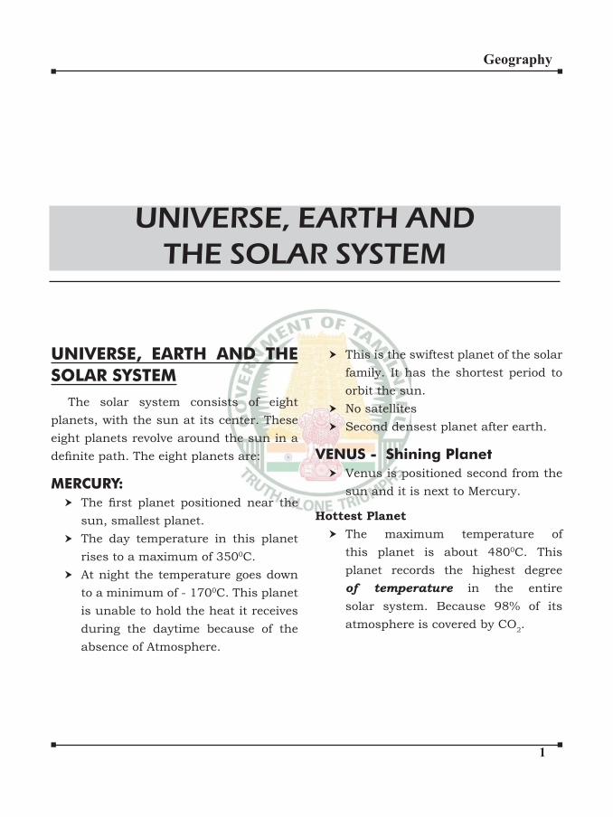
Geography UNIVERSE, EARTH AND THE SOLAR SYSTEM The solar system consists of eight planets, with the sun at its center. These eight planets revolve around the sun in a defnite path. The eight planets are: MERCURY: The frst planet positioned near the sun, smallest planet. The day temperature in this planet rises to a maximum of 350 0 C. At night the temperature goes down to a minimum of - 170 0 C. This planet is unable to hold the heat it receives during the daytime because of the absence of Atmosphere. UNIVERSE, EARTH AND THE SOLAR SYSTEM This is the swiftest planet of the solar family. It has the shortest period to orbit the sun. No satellites Second densest planet after earth. VENUS - Shining Planet Venus is positioned second from the sun and it is next to Mercury. Hottest Planet The maximum temperature of this planet is about 480 0 C. This planet records the highest degree of temperature in the entire solar system. Because 98% of its atmosphere is covered by CO 2 .
-
Upload
khangminh22 -
Category
Documents
-
view
2 -
download
0
Transcript of UNIVERSE, EARTH AND THE SOLAR SYSTEM - Athiyaman ...
�
Geography
UNIVERSE, EARTH AND THE
SOLAR SYSTEM
The solar system consists of eight
planets, with the sun at its center. These
eight planets revolve around the sun in a
definite path. The eight planets are:
MERCURY:
The first planet positioned near the sun, smallest planet.
The day temperature in this planet
rises to a maximum of 3500C.
At night the temperature goes down
to a minimum of - 1700C. This planet
is unable to hold the heat it receives
during the daytime because of the
absence of Atmosphere.
UNIVERSE, EARTH AND
THE SOLAR SYSTEM
This is the swiftest planet of the solar
family. It has the shortest period to
orbit the sun.
No satellites
Second densest planet after earth.
VENUS - Shining Planet
Venus is positioned second from the
sun and it is next to Mercury.
Hottest Planet
The maximum temperature of
this planet is about 4800C. This
planet records the highest degree
of temperature in the entire
solar system. Because 98% of its
atmosphere is covered by CO2.
�
Geography
Because of its proximity to the earth
Venus can usually be seen, before
down as the ‘Morning Star’ in the
eastern sky. Likewise, the after
sunset the same planet shines as
brightly as an ‘Evening Star’ in the
western sky.
This is the only planet of the solar
family that rotates from east to
west.
No Satellites
It is also called as earth’s twin
(similar to earth in radius, mass &
density)
Nearest planet to earth.
EARTH
Earth is positioned third from the
sun.
Water accounts for 71% and land
29% of the total area of the earth.
There are seven continents and four
oceans on the surface of earth.
Seven Continents:
(Areawise descending order)
1. Asia (Largest)
2. Africa
3. North America
4. South America
5. Europe
6. Antarctica
7. Australia (Smallest)
OCEANS:
1. Pacific Ocean 2. Atlantic Ocean
3. Indian Ocean
4. Arctic Ocean
The land, water, air and the favourable
climate facilitate the origin of life
in the Earth. Thus the earth is also
known as Living planet.
No other planet of the solar family
has life like that of the earth.
Its only satellite is Moon. It take
365.25 days to around the sun.
From radio active dating, the earth’s
age is estimated to be 4.6 × 10⁹ grs.
The moon keeps the same face turned
towards us:
Because the moon’s axial rotation period
is the same as that of the period of
revolution round the earth i.e. about 27
days 7¾ hrs.
Seasonal Changes are due to:
(i) Revolution of the earth
(ii) Direction of the Earth’s tilt changes
in relation to earth.
Rotation :
Mean solar day: time interval from one noon to the next, about 24hrs.
Sidereal day : time it takes for earth to make one complete (3600) rotation
with respect to a star other than the
sun 23 hrs, 56 min, 4 seconds.
Full moon - 14¾ day.
New Moon again → 29½ day based
on the cycle of the moon’s phases
(synodic month)
Day 27 ⅓ → Earth, Moon and distant
�
Geography
star are once again aligned
(sidereal month)
↓ True period of the moon’s revolution
around earth
MARS - (Red planet)
230C temperature prevails during
day time and about - 1010C during
night.
Dry rivers, extinct volcanoes, stormy
deserts, snow covered poles are
discovered on the surface of this
planet. Though these features look
similar to these of the earth, they do
not possess greenery like the earth.
Only dry landscape is present all over
this planet.
High amount of iron oxides (fenic
oxides) are found in the soils and
the rocks of this planet. It appears
Reddish. Hence called as Red planet.
There are stormy winds with a speed
of 270 km/hr that blow for months
together. They create a dusty layer
making the planet appearing red.
Satellite : Deimos, phobos - It is
smaller than the earth. Has very thin
atmosphere and a very small amount
of oxygen.
JUPITER
One special feacture of Jupiter is the
great ‘Redspot’. Satellites: Ganemade,
IO, Europa, Callisto - Ganymade dis the
Largest satellite in the solar system.
It is very cold because of its distance
from the sun.
Biggest planet of the solar family. 10th
of the size of the sun.
It has almost perpendicular axis. It
rotates on its axis with an inclination
of about only 2O and hence the planet
does not have any season like the
Earth.
It has highest number of satellites in
the solar system.
Its upper cloud layers seem to
have ammonia & methane, both
poisonous gases.
Fastest rotating planet
It is interesting to astromers because
it sends strong burst of Radiowaves
which may be the result of tremondous
storm on its surface.
SATURN (6th Planet from the sun)
Second largest planet.
There are seven rings around this
planet. This planet, with its 7 multi
coloured rings, appears very elegant.
Cyclonic winds of 1500 km/hr blow
on this planet.
It is the least dense planet in our
solar system.
�
Geography
Its specific gravity is less than. Water (0.7) If a large ocean where
available Saturn would float in it.Statellite - Titan, Tethys
URANUS
It is positioned seventh from the sun.
Its axis is tilted about 98O to the
vertical plane.
It rolls on its sides while revolving
around the sun but it does not spin
at a top like other planets.
It occurs in this planet.
Rotates from east to west.
Satellites : Miranda, Ariel, Titania, Oberon.
NEPTUNE
Dark - It takes almost 165 earth years
to orbit our sun. Very cold and whipped by
supersonic winds.
Neptune and Pluto are much bigger in
size than the earth. They appear in blue
because of the presence of methane gas
in their atmosphere
It is positioned eight from the sun.
This planet has not completed a
single orbit of the sun since it was
identified in the year 1846.
It appears blue in colour because
of presence the methane gas in the
atmosphere.
Satellite - Triton
Among the planets of the solar system,
except for Mercury and Venus the
rest have satellites of their own.
Jupiter is the swiftest rotating
planet and the slowest is Venus.
Mercury is the swiftest revolving
planet while the slowest is Pluto.
Pulto, Eris and the astenoid ceres
became the first dwarf planets. Unlike planets, dwarf planets lack
the gravitation muscle to sweep up or
scatter objects near their orbits.
S.No. Planet Period
of
Rotation
Period of
Revolution
1. Mercury 58 ½
Days
88 days
2. Venus 243 days 224 days
3. Earth 24 hrs 365 ¼
days
4. Mars 24 ½
days
687 days
5. Jupiter 10 hrs 12 years
6. Saturn 10 ¾ hrs 29 ½ yrs
7. Uranus 17 ¼ hrs 84 years
8. Neptune 16 hrs 165 yrs
9. Pluto 6.4 days 248 yrs
There are millions of stars visible from
the Earth. The closest star is the Sun. The
closest to the Earth, after the Sun, is Alpha
centuria. The main difference between a
planet and a star is that, a star twinkles
and a planet will glow without any flicker.
�
Geography
Planets:
The eight planets are classified in to Solid planets and Gaseous planets
SOLID PLANETS Mercury, Venus,
Earth, Mars
GASEOUS
PLANETS
Jupiter, Saturn,
Uranus, Neptune
Planets like Mercury, Venus, Mars,
Jupiter and Saturn can be seen with the
naked eye, whereas Uranus and Neptune
can be seen only through a telescope.
Venus and Mercury can be seen before
sunrise and sunset for a few hours. Mars,
Jupiter and Saturn can be seen during the
night either in the east or overhead or in
the west.
During the formation of the Universe, the
planets closes to the Sun experienced
greater solar winds. Due to this the
gaseous contents in these planets got
blown away. On the contrary, the planets
away from the sun did not experience
the solar winds and thus, they’re called
gaseous planets
Venus rises a few hours before
sunrise and therefore it is called as The
Morning Star.
Planet Earth is the known planet to
support different forms of life. This is due
to the earth’s atmosphere, which contains
Oxygen. All other planets have no oxygen
and have large amount of other gases
and have hence life is not found on other
planets. Every planet revolves in an anti-
clockwise direction if you take a bird’s eye
view from the north pole of the sun, but
the duration of their revolution around the
Sun differs from one another. All planets
revolve in an elliptical path in definite paths called Orbits.
Dwarf Planets: (Grouped in 2006)
They also revolve around the Sun.
They are very small in size. Their size is
very smaller than our moon.
Pluto, Charon, Eris, Ceres belong to
this group.
Sun:
The sun is the head of the solar family.
It is the large gaseous ball of fire. The gravity of the sun holds the solar system
together. It is the source of heat and light
to the entire solar family. The Earth is
approximately 150 million Kms away from
the Sun. The Sun is the only celestial body
that emits light in the solar system.
�
Geography
Eclipses:
When the visibility of a celestial body is
prevented by the passage of a second
body, the occurrence is called as
an eclipse.
Lunar Eclipses:
At the time of full moon, the moon
may pass through the long shadow
cast by the earth in space.
The lunar eclipse can last as long as
3hrs and 40 min. Totality may be upto
1 hr and 40 minutes. If the moon is
nearer the earth (perigee) the eclipse
will last longer. At apogee, the eclipse
will be of a shorter duration.
The eclipse of the moon can occur only
at the time of the full moon, When the
earth comes in between the moon and
the sun.
But the eclipse does not occur at every
full moon. The moon usually passes
above or below the earth’s shadow
because the path it follows is at a slight
angle of about 50 to the ecliptic.
If the moon revolved around the earth
the same plane as that in which the
earth revolves around the sun, there
would be a lunar eclipse every full
moon day.
Solar Eclipse
On New Moon day, the moon comes in
between the sun and the earth. If their
centres are is one line, the moon’s
shadow is cast on the earth.
To an observer the disc of the sun will
appear completely covered by the disc
of the moon.
The solar eclipse lasts for a few minutes
and is seen over a small area.
Total eclipse rarely lasts over 7
minutes and never last more than 8
minutes at any place on the earth.
During the brief period of the total
solar eclipse all direct sunlight is cut
off from the earth. There is
complete darkness in the area of
totality.
The moon’s orbit is inclined at an
angle of 50 9’to the ecliptic. An eclipse
does not occur at every new
moon. Generally the lunar shadow
passes above or below the earth.
Asteroids:
Asteroids are clusters of celestial
bodies which includes tiny stones and big
rocks which can measure upto 300 to 400
Kms in diameter. Thousands of asteroids
are found between Mars and Jupiter.
Asteroids with Tamil name: VynuPappu,
Sarabai, Ramanuja
Moon:
The Moon does not revolve around the
Sun. It revolves around the Earth. Hence,
it is a satellite. The Moon measures the
�
Geography
quarter of the Earth’s diameter. It revolves
around the Earth at approximately at a
distance of 3,84,401Kms. It takes 27.3
days for the Moon to revolve around the
Earth and to rotate on its axis. Other
planets also have their respective natural
satellites.
Planets Mercury Venus Earth
No. of
Satellites
0 0 1
Planets Mars Jupiter Saturn
No. of
Satellites
2 63 60
Planets Uranus Neptune
No. of
Satellites
27 13
The Moon does not have an atmosphere
as Earth. Water is not explicitly present
in the Moon, but water is available in
the form of moisture. Landforms such as
mountains, plateaus and valleys are found
in the surface of the Moon. Craters are
another special feature of the Moon. Few
craters are volcanic in origin and few are
made due to the impact of the meteorites
on the landscape of the Moon.
The Moon is similar to the earth; it just
reflects the light energy obtained from the Sun. Only a part of the Moon is visible to
the Earth. During the revolution of the
Moon around the Earth, the dark side of
the Moon that faces the Earth is called
the New Moon. The side of the Moon that
shines brightly is called the Full Moon.
Meteoroids and Meteors:
The remains of some rocky asteroids
make their way towards the Earth. The
particles which are burnt by the friction
caused in the atmosphere are called
meteorites. Some particles withstand
the friction of the atmosphere and reach
the surface of the Earth. They are called
meteors.
Comet:
A comet is not a star. It is a rock made
of dust and ice. The comet has a long
reflective tail.How the tail appears? Minute particles
from the Sun strike the gaseous part
emitted from the comet.
What makes the tail reflective? As
the comet comes near the Sun and the ice
melts and reflects the light of the Sun.
Universe:
Millions of constellation of stars seen in
the sky is called the Galaxy. Thousands of
galaxies form a Universe. The Universe is
vast and ever expanding.
There are so many stars seen in the
sky, they are too far from us. These stars
are thousand times bigger than our sun. A
white streak of light can be seen on a clear
night. Our ancestors called it “Akash
Ganga.”
�
Geography
WEATHER AND CLIMATE:
Weather and Climate are two terms
which are are used in day-to-day life. This
is because our daily routine is based on
the prevailing weather conditions. Human
activity of any region is determined by
weather and climate. Our food habits,
customs, traditions and even most of our
common celebrations are associated with
weather and climate.
Weather:
Weather refers to the physical state of
the atmosphere within 24 hours, described
by weather elements such as temperature,
atmospheric pressure, humidity, rainfall,
cloudiness, wind speed and wind direction.
These differences are the outcome of the
angle of the sun at any particular spot,
which vary by latitude of the tropics.
Climate:The word climate is defined as the
weather averaged over a long period of
time and over a large area. The standing
average period is 30 years.
Factors determining Weather and
Climate:
Day-to-day factors affect the weather
element. The following factors affect the
climate of the place.
1. Latitude: The equator receives vertical
rays which fall over a small area. In
contrast, the polar regions receive
slanting sunrays and they fall over a
CLIMATOLOGY

�
Geography
wide area. As a result of this, places
near the equator are hotter than the
poles.
Normal Lapse Rate:
Temperature decreases as altitude
increases.This occurs at a rate of 1
degree Celsius/ 165 meters, which is
6.5 degree Celsius per kilometer.
2. Altitude: The places located on high
altitudes are always colder than their
counter parts in the lower altitudes.
This is because the air becomes
thinner as altitude increases and they
absorb only less heat.
3. Distance from the sea: The
Sea absorbs and retains heat for
long duration. The coastal areas
experience the cool, wet air from
the sea throughout the year along
the coast to have uniform weather
both in the winter and summer this
condition is said to be an equtable
climate or maritime climate. On the
other hand, the land absorbs and
loses heat quickly. The interior land
areas experience warm dry air. They
are very hot in summer and very cold
in winter. This condition is said to be
continental climate.
4. Ocean currents: Based on
temperature, the ocean currents are
classified as warm ocean currents and cold ocean currents. Warm currents
make the coastal area warm, wet, and
free from ice. On the contrary, cold
current makes the coastal area cool,
dry and bring in icebergs.
5. Direction of prevailing winds: The
winds that blow from the sea to land
contain more moisture so they are cool
and wet. On the other hand, the winds
blowing from land are warm and dry.
6. El Nino effect: El Nino is formed
during Christmas time and continues
for a few months. During this
period, once in five or six years, the
temperature raises rapidly and
a low pressure system is formed
along the coast of Peru and
Ecuador. This low pressure system
attracts the winds from all directions.
So, the trade winds become weak over
the Indian ocean and the Pacific ocean and these winds are deflected causing a prolonged dry periods in many parts
of the world.
7. Human influence: As a result of
Industrial revolution, forest areas
have been cleared and we have many
types of transport facilities, concrete
buildings and many industries. All
these developments made our life
easy and comfortable. On the other
hand, their effects are felt in the name
of global warming, greenhouse effect
and pollution, which have increased
the amount of CO2. Creation of
urabn heat island is also an effect
of human influence. These islands occur in metropolitan areas, which
are significantly warmer than their surrounding areas.
�
Geography
ATMOSPHERE
Air is essential to the survival of all
organisms. Some organisms like humans
can survive without the food and water but
not without breathing the air. Atmosphere
is a mixture of gases and it envelopes the
earth all around. It contains life giving
gases. The air is an integral part of the
mass of the earth and 99% of the total
mass of the atmosphere is confined to 32 Km from the earth’s surface.
Composition of the atmosphere:
The atmosphere is a mixture of gases,
water vapour and dust particles. The
proportion of gases changes in higher
layers of the atmosphere. The quantity of
oxygen is negligible as we go to the higher
layers and similarly carbon dioxide and
water is found only upto 90 km from the
surface of the earth.
Constituent Percentage by
volume
Nitrogen 78.08
Oxygen 20.95
Argon 0.93
Carbon dioxide 0.036
Neon 0.002
Helium 0.0005
Krypton 0.001
Xenon 0.00009
Hydrogen 0.00005
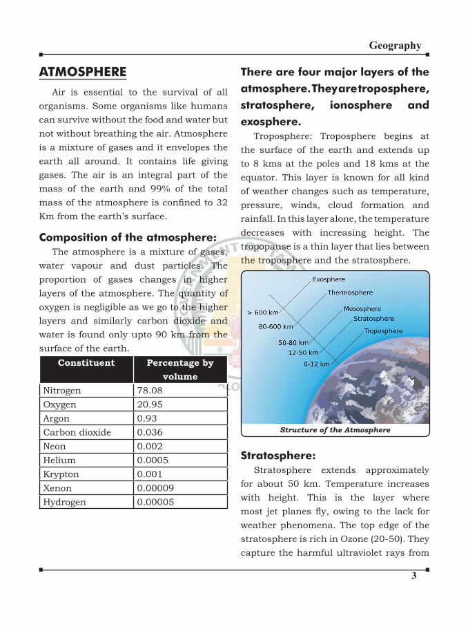
There are four major layers of the
atmosphere. They are troposphere,
stratosphere, ionosphere and
exosphere.
Troposphere: Troposphere begins at
the surface of the earth and extends up
to 8 kms at the poles and 18 kms at the
equator. This layer is known for all kind
of weather changes such as temperature,
pressure, winds, cloud formation and
rainfall. In this layer alone, the temperature
decreases with increasing height. The
tropopause is a thin layer that lies between
the troposphere and the stratosphere.
Structure of the Atmosphere
Stratosphere:
Stratosphere extends approximately
for about 50 km. Temperature increases
with height. This is the layer where
most jet planes fly, owing to the lack for weather phenomena. The top edge of the
stratosphere is rich in Ozone (20-50). They
capture the harmful ultraviolet rays from

�
Geography
the sun, making the light reaching the
earth’s surface harmless. Since unfiltered radiation from the sun can destroy all
animal tissue, Ozone is very important
to all living things on earth. This zone
is also called as isothermal layer and
ozonosphere. After the stratosphere, there
is again a buffer layer called stratopause.
Mesosphere: It extends approximately
for about 80 km.
Ionosphere: Ionosphere stretched from
80 kms- 500 kms. It is called ionosphere
because in this part of the atmosphere
the sun’s radiations gets ionized. It
reflects the radio waves back to the earth which help in modern communications.
The colorful display of auroras are called
the northern lights or aurora borealis
in the northern hemisphere and southern
lights or aurora australis in the
southern hemisphere.
Exosphere: The exosphere is the
uppermost layer of the atmosphere. The
main gases within the exosphere are the
lighter gases, mainly hydrogen and helium.
The exosphere is sometimes considered a
part of outer space.
TEMPERATURE
DISTRIBUTION
The sun is the source of light and
heat to the earth. Earth receives only a
small amount of solar radiation which
takes eight minutes to reach the earth’s
surface. Incoming solar radiation is
called insolation. Heat energy from solar
radiation is received by Earth through
three mechanisms. They are: i) radiation
in the atmosphere ii) Conduction over
land and iii) Convection in the water
bodies. The Earth’s atmosphere is heated
more by terrestrial radiation than by the
insolation.
Factors controlling the temperature
distribution:
a) The latitude: The temperature of
a place depends on the insolation
received. Insolation varies
according to the latitude of the
place hence temperature also varies
accordingly.
b) The Altitude: The atmosphere
is indirectly heated by terrestrial
radiation from below. Therefore,
the places near sea level record
higher temperature than the places
situated in higher altitudes. In other
words, temperature decreases with
increase in height. This is called
Normal Lapse Rate. It is 6.5 degree
Celsius per 1000 meters.
c) Distance from the sea:
Another factor that influences the temperature is the location
of a place with respect to the sea.
Compared to land, the sea gets
heated slowly. Land heats up and
cools down quickly. Therefore, the
variation in temperature over the

�
Geography
sea is less compared to land. The
places situated near the sea come
under the moderating influencing of the sea and land breeze which
moderate temperature.
d) Air-mass and ocean currents:
Like the land and sea breezes,
the passage of air masses also
influences the temperature of a land mass. The places which come under
the influence of warm air mass experience high temperatures and
the places which come under the
influence of cold air mass experience low temperatures. Similarly, the
places located on the coast where
the warm ocean currents flow records higher temperature than
the places located on the coast
where cold currents flow. e) Direction of Prevailing winds :
The winds that blow from the sea
contain more moisture so they are
cool and wet and cause rainfall
Ex - Southwest Monson
The winds that blow from the
land areas are warm and dry
(No Rainfall)
Ex - North East Monsoon
f) ELNINO Effect : It is warm
oceanic current.
g) HumanInfluence: Deforestation
and human development are felt in
the name of Global warming. Green
house effect, and pollution, which
have increased the amount of Co2.
Distribution of Temperature:
The global distribution of temperature
can well be understood by studying the
temperature distribution in January
and July. The temperature distribution
is generally shown on the map with the
help of isotherms. The Isotherms are lines
joining places having equal temperature.
The above figures show the distribution of surface air temperature in the
Month of January and July.
In general the effect of the latitude
on temperature is well pronounced on
the map, as the isotherms are generally
parallel to the latitude. The deviation from
this general trend is more pronounced in
�
Geography
January than in July, especially in the
northern hemisphere. In the northern
hemisphere the land surface area is much
larger than in the southern hemisphere.
Hence, the effects of land mass and the
ocean currents are well pronounced.
In January the isotherms deviate to
the north over the ocean and to the
south over the continent.
Daily range of temperature:
The differences between the maximum
and minimum temperatures of a
day is called the diurnal range of
temperature.
It is Low in Equator. It is high in
Desert Areas and tropical interior
land during summer.
Mar 21 - Vernal Equinox
June 22 - Summer Solstice
Sep 23 - Autumnal Equinox
Dec 22 - Winter Solstice
Annual range of temperature:
The differences between Mean
temperature of the hottest and
coldest months of the year is known
as annual range of temperature.
It is very less in equatorial region.
The range is increases from Equator
to subpolar region.
It is high in Desert regions.
Inversion of Temperature:
Normally, temperature decreases with
increase in elevation. It is called normal
lapse rate. At times, the situation is reversed
and the normal lapse rate is inverted. It is
called inversion of temperature. Inversion
is usually of short duration.
A long winter night with clear skies
and still air is ideal situation of inversion.
The heat of the day is radiated off during
the nights and by early morning hours,
the earth is cooler than the air above.
Over polar areas, temperature inversion is
normal throughout the year.
Surface inversion promotes stability in
the lower layers of the atmosphere. Smoke
and dust particles get collected beneath
the inversion layer and spread horizontally
to fill the lower strata of the atmosphere. Dense fogs in the mornings are common
occurrences during the winter season.
This lasts till the sun comes up and warms
up the earth.
The inversion which takes place in hills
and mountains is due to air drainage. Cold
air at the hills and mountains, produced
during night, flow under the influence of gravity. Being heavy and dense, the cold
air moves down and piles up in the pockets
and valley bottoms with warm air above.
This is called air drainage. It protects
plants from frost damages.
�
Geography
PRESSURE BELTS
Air pressure is defined as the pressure thrust by the weight of the air on the
earth’s surface. The average air pressure
at the sea level is 1,013 millibars. The
horizontal distribution of the air pressure
is highly influenced by the temperature of a given place. The atmospheric pressure is
always inversely related to the atmospheric
temperature. The high pressure belts are
formed in the areas of low temperature.
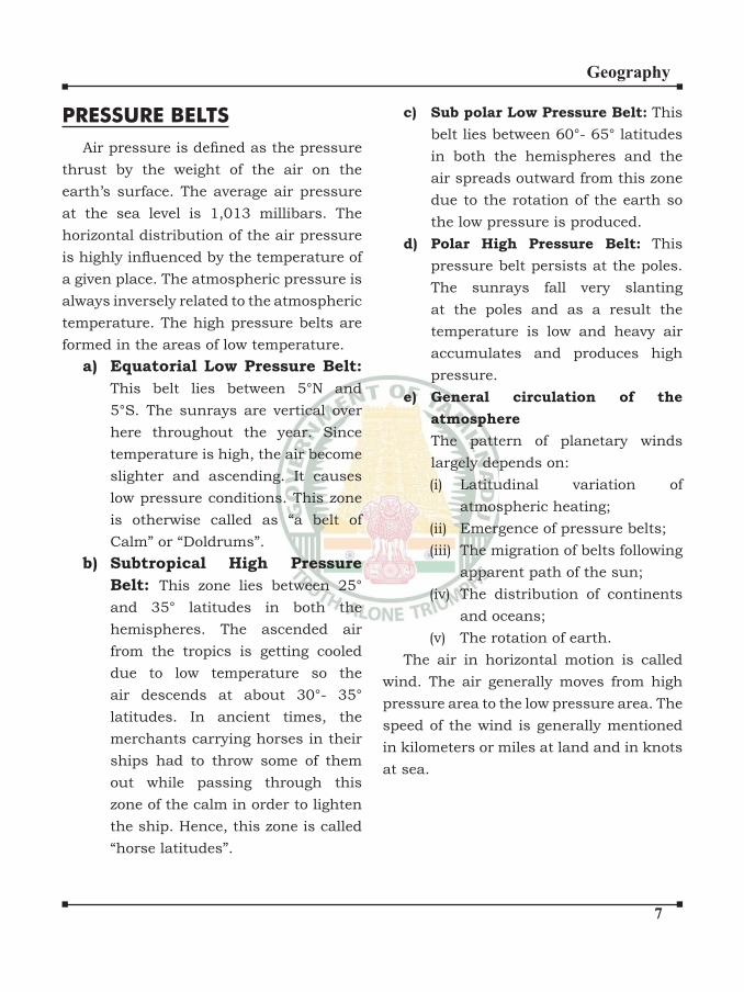
a) Equatorial Low Pressure Belt:
This belt lies between 5°N and
5°S. The sunrays are vertical over
here throughout the year. Since
temperature is high, the air become
slighter and ascending. It causes
low pressure conditions. This zone
is otherwise called as “a belt of
Calm” or “Doldrums”.
b) Subtropical High Pressure
Belt: This zone lies between 25°
and 35° latitudes in both the
hemispheres. The ascended air
from the tropics is getting cooled
due to low temperature so the
air descends at about 30°- 35°
latitudes. In ancient times, the
merchants carrying horses in their
ships had to throw some of them
out while passing through this
zone of the calm in order to lighten
the ship. Hence, this zone is called
“horse latitudes”.
c) Sub polar Low Pressure Belt: This
belt lies between 60°- 65° latitudes
in both the hemispheres and the
air spreads outward from this zone
due to the rotation of the earth so
the low pressure is produced.
d) Polar High Pressure Belt: This
pressure belt persists at the poles.
The sunrays fall very slanting
at the poles and as a result the
temperature is low and heavy air
accumulates and produces high
pressure.
e) General circulation of the
atmosphere
The pattern of planetary winds
largely depends on:
(i) Latitudinal variation of
atmospheric heating;
(ii) Emergence of pressure belts;
(iii) The migration of belts following
apparent path of the sun;
(iv) The distribution of continents
and oceans;
(v) The rotation of earth.
The air in horizontal motion is called
wind. The air generally moves from high
pressure area to the low pressure area. The
speed of the wind is generally mentioned
in kilometers or miles at land and in knots
at sea.
�
Geography
WINDS: CYCLONES AND
ANTI CYCLONES:
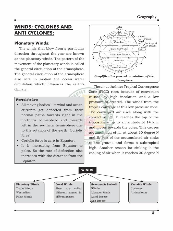
Planetary Winds:
The winds that blow from a particular
direction throughout the year are known
as the planetary winds. The pattern of the
movement of the planetary winds is called
the general circulation of the atmosphere.
The general circulation of the atmosphere
also sets in motion the ocean water
circulation which influences the earth’s climate.
Ferrels’s law
All moving bodies like wind and ocean
currents get deflected from their normal paths towards right in the
northern hemisphere and towards
left in the southern hemisphere due
to the rotation of the earth. (coriolis
force)
Coriolis force is zero in Equator.
It is increasing from Equator to
poles. So the rate of deflection also increases with the distance from the
Equator.
WINDS
Planetary Winds
Trade Winds
Westerlies
Polar Winds
Seasonal & Periodic
Winds
Monsoon Winds
Land Breeze
Sea Breeze
Local Winds
They are called
different names in
different places.
Variable Winds
Cyclones
Anticyclones
Simplification general circulation of the atmosphere
The air at the Inter Tropical Convergence
Zone (ITCZ) rises because of convection
caused by high insolation and a low
pressure is created. The winds from the
tropics converge at this low pressure zone.
The converged air rises along with the
convective cell. It reaches the top of the
troposphere up to an altitude of 14 km.
and moves towards the poles. This causes
accumulation of air at about 30 degree N
and S. Part of the accumulated air sinks
to the ground and forms a subtropical
high. Another reason for sinking is the
cooling of air when it reaches 30 degree N
�
Geography
and S latitudes. Down below near the land
surface the air flows towards the equator as the easterlies. The easterlies from either
side of the equator converge in the Inter
Tropical Convergence Zone (ITCZ). Such
circulations from the surface upwards and
vice-versa are called cells. Such a cell in
the tropics is called Hadley Cell.
In the middle latitudes the circulation
is that of sinking cold air that comes from
the poles and the rising warm air that
blows from the subtropical high. At the
surface these winds are called westerlies
and the cell is known as the Ferrel cell.
At polar latitudes the cold dense air
subsides near the poles and blows towards
middle latitudes as the polar easterlies.
This cell is called the Polar cell.
These there cells set the pattern for the
general circulation of the atmosphere.
The transfer of heat energy from lower
latitudes to higher latitudes maintains
the general circulation.
The general circulation of the
atmosphere also affects the oceans. The
large-scale winds of the atmosphere
initiate large and slow moving currents
of the ocean. Oceans in turn provide
input of energy and water vapour into the
air. These interactions take place rather
slowly over a large part of the ocean.
Seasonal and Periodic Winds:
Differences in the heating and cooling
of earth surfaces and the cycles those
develop daily or annually can create
several common, local or regional winds.
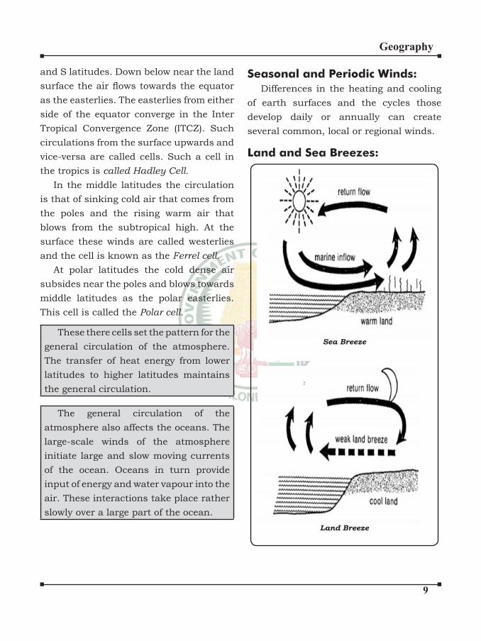
Land and Sea Breezes:
Sea Breeze
Land Breeze
�0
Geography
The land and sea absorb and transfer
heat differently. During the day the land
heats up faster and becomes warmer than
the sea. Therefore, over the land the air
raises giving rise to a low pressure area,
whereas the sea is relatively cool and the
pressure over sea is relatively high. Thus,
pressure gradient from sea to land is
created and the wind blows from the sea
to the land as the sea breeze. In the night
the reversal of this condition takes place.
The land loses heat faster and gets cooler
than the sea. The pressure gradient is
from the land to the sea and hence land
breeze results.
Mountain and Valley Winds:
In mountainous regions, during the
day the slopes get heated up and air
moves upslope and to fill the resulting gap the air from the valley blows up the
valley. This wind is known as the valley
breeze. During the night the slopes get
cooled and the dense air descends into the
valley as the mountain wind. The cool air,
of the high plateaus and ice fields draining into the valley is called katabatic wind.
Another type of warm wind occurs on the
leeward side of the mountain ranges. The
moisture in these winds, while crossing
the mountain ranges condenses and
precipitates. When it descends down the
leeward side of the slope the dry air gets
warmed up by adiabatic process. This dry
air may melt the snow in a short time.
Anemometer: It is an instrument
used to measure the velocity and
direction of wind.
Wind Vane: It is used to indicate the
direction of the wind.
Monsoon Winds:
They are like land and sea breezes on
a large scale. They are periodic seasonal
winds that are characterized by a seasonal
reversal of winds. They blow from land to
sea in winter and sea to land in summer.
They prevail in the regions of the Indian
sub-continent, South East Asia and
Northern Australia. The term ‘monsoon’,
meaning season, is derived from the Arabic
word Mausim. The South-west monsoon
brings heavy to moderate rain to the Indian
landmass from June to September. In
winter, the monsoon receives its direction
so that winds blow out of the continent as
the North-east monsoon towards the Bay
of Bengal and Indian Ocean.
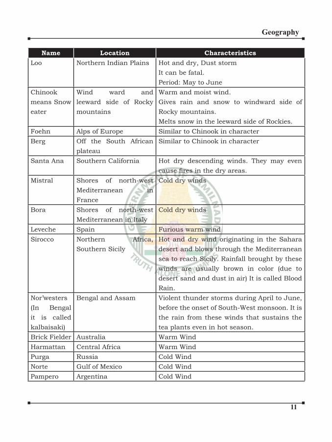
Local Winds:
These winds blow with some special
characteristics over a small area and last
for a short period. All these winds are
mostly seasonal and given local names.
��
Geography
Name Location Characteristics
Loo Northern Indian Plains Hot and dry, Dust storm
It can be fatal.
Period: May to June
Chinook
means Snow
eater
Wind ward and
leeward side of Rocky
mountains
Warm and moist wind.
Gives rain and snow to windward side of
Rocky mountains.
Melts snow in the leeward side of Rockies.
Foehn Alps of Europe Similar to Chinook in character
Berg Off the South African
plateau
Similar to Chinook in character
Santa Ana Southern California Hot dry descending winds. They may even
cause fires in the dry areas.Mistral Shores of north-west
Mediterranean in
France
Cold dry winds
Bora Shores of north-west
Mediterranean in Italy
Cold dry winds
Leveche Spain Furious warm wind
Sirocco Northern Africa,
Southern Sicily
Hot and dry wind originating in the Sahara
desert and blows through the Mediterranean
sea to reach Sicily. Rainfall brought by these
winds are usually brown in color (due to
desert sand and dust in air) It is called Blood
Rain.
Nor’westers
(In Bengal
it is called
kalbaisaki)
Bengal and Assam Violent thunder storms during April to June,
before the onset of South-West monsoon. It is
the rain from these winds that sustains the
tea plants even in hot season.
Brick Fielder Australia Warm Wind
Harmattan Central Africa Warm Wind
Purga Russia Cold Wind
Norte Gulf of Mexico Cold Wind
Pampero Argentina Cold Wind

��
Geography
Variable Winds:They are known as Cyclones in the
Indian Ocean, Hurricanes in the Atlantic,
Typhoons in the Western Pacific and South China Sea, and Willy-willies in the
Western Australia.
The variable winds have no definite location or direction. These winds are
getting fluctuated by means of its direction and speed. Cyclones and anti-cyclones
are included in this category. They affect
limited areas for a few days only.
Cyclone: Tropical cyclones are violent storms
that originate over oceans in tropical
areas and move over to the coastal areas
bringing about large scale destruction
caused by violent winds, very heavy rainfall
and storm surges. This is one of the most
devastating natural calamities.
Favourable Conditions:Tropical cyclones originate and
intensify over warm tropical oceans. The
conditions favourable for the formation
and intensification of tropical storms are: 1. Large sea surface with temperature
higher than 27°C;
2. Presence of the Coriolis force;
3. Small variations in the vertical wind
speed;
4. A pre-existing weak low- pressure
area or low-level-cyclonic
circulation;
5. Upper divergence above the sea level
system.
List of Tropical Cyclones that affected India
S.I No Year Name Affected State Named Country
1. 17th Oct 1999 Orissa,
Super Cyclone
- -
2. 2008 Nisha Tamil Nadu -
3. 2008 Laila Andra Pradesh -
4. 29th Dec, 2011 Thane - -
5. 2012 Nilam Andra Pradesh &
Tamil Nadu
-
6. 2013 Lehar & Helan Andra Pradesh
7. 2013 Phailin Odisha -
8. 2013 Madi Tamil Nadu -
9. 12 Oct, 2014 Hudhud Odish & Andra
Pradesh
Oman (It is Hoope
Bird which is called
Hudhud in Arabic)
10. Oct 2014 Nilofar - Gujarat - Pakistan
��
Geography
The energy that intensifies the storm comes from the condensation process
in the towering cumulonimbus clouds,
surrounding the centre of the storm. With
continuous supply of moisture from the
sea, the storm is further strengthened.
On reaching the land the moisture supply
is cut off and the storm dissipates. The
place where a tropical cyclone crosses the
coast is called the landfall of the cyclone.
The cyclones, which cross 200N latitude
generally, recurve and they are more
destructive.
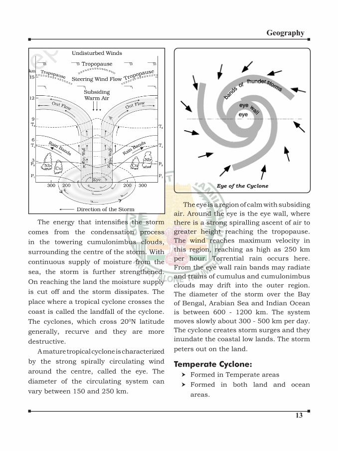
A mature tropical cyclone is characterized
by the strong spirally circulating wind
around the centre, called the eye. The
diameter of the circulating system can
vary between 150 and 250 km.
Eye of the Cyclone
The eye is a region of calm with subsiding
air. Around the eye is the eye wall, where
there is a strong spiralling ascent of air to
greater height reaching the tropopause.
The wind reaches maximum velocity in
this region, reaching as high as 250 km
per hour. Torrential rain occurs here.
From the eye wall rain bands may radiate
and trains of cumulus and cumulonimbus
clouds may drift into the outer region.
The diameter of the storm over the Bay
of Bengal, Arabian Sea and Indian Ocean
is between 600 - 1200 km. The system
moves slowly about 300 - 500 km per day.
The cyclone creates storm surges and they
inundate the coastal low lands. The storm
peters out on the land.
Temperate Cyclone:
Formed in Temperate areas
Formed in both land and ocean
areas.

��
Geography
Formed due to frontal development.
Anti-Cyclone: The anticyclones are the
centres of the high pressure systems from
which the wind movement takes place
outward. These winds are associated with
clear weather and no rainfall. The anti-
cyclones move clock wise in the northern
hemisphere and anti-clock wise in the
southern hemisphere. They are mostly
formed over the land so they are dry.
HUMIDITY, CONDENSATION
AND PRECIPITATION
Water vapour present in the air is known
as humidity. It is expressed quantitatively
in different ways.
Absolute Humidity: The actual
amount of the water vapour present in
the atmosphere is known as the absolute
humidity. It is the weight of water vapour
per unit volume of air and is expressed in
terms of grams per cubic metre. The ability
of the air to hold water vapour depends
entirely on its temperature. The absolute
humidity differs from place to place on the
surface of the earth.
Relative Humidity: The percentage
of moisture present in the atmosphere
as compared to its full capacity at a
given temperature is known as the
relative humidity. With the change of
air temperature,the capacity to retain
moisture increases or decreases and the
relative humidity is also affected. It is
greater over the oceans and least over the
continents.
The air containing moisture to its full
capacity at a given temperature is said to
be saturated. It means that the air at the
given temperature is incapable of holding
any additional amount of moisture at that
stage. The temperature at which saturation
occurs in a given sample of air is known as
dew point.
Evaporation And Condensation:
The amount of water vapour in the
atmosphere is added or withdrawn
due to evaporation and condensation
respectively.
Evaporation is a process by which water
is transformed from liquid to gaseous state.
Heat is the main cause for evaporation.
The temperature at which the water
starts evaporating is referred to as the
latent heat of vapourisation. Increase
in temperature increases water absorption
and retention capacity of the given parcel
of air. Similarly, if the moisture content
is low, air has a potentiality of absorbing
and retaining moisture. Movement of
air replaces the saturated layer with the
unsaturated layer. Hence, the greater
the movement of air, the greater is the
evaporation.
The transformation of water vapour into
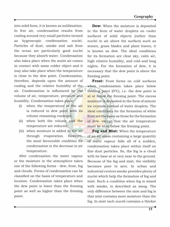
water is called condensation. Condensation
is caused by the loss of heat. When moist
air is cooled, it may reach a level when
its capacity to hold water vapour ceases.
Then, the excess water vapour condenses
into liquid form. If it directly condenses
��
Geography
into solid form, it is known as sublimation.
In free air, condensation results from
cooling around very small particles termed
as hygroscopic condensation nuclei.
Particles of dust, smoke and salt from
the ocean are particularly good nuclei
because they absorb water. Condensation
also takes place when the moist air comes
in contact with some colder object and it
may also take place when the temperature
is close to the dew point. Condensation,
therefore, depends upon the amount of
cooling and the relative humidity of the
air. Condensation is influenced by the volume of air, temperature, pressure and
humidity. Condensation takes place:
(i) when the temperature of the air
is reduced to dew point with its
volume remaining constant;
(ii) when both the volume and the
temperature are reduced;
(iii) when moisture is added to the air
through evaporation. However,
the most favourable condition for
condensation is the decrease in air
temperature.
After condensation the water vapour
or the moisture in the atmosphere takes
one of the following forms - dew, frost, fog
and clouds. Forms of condensation can be
classified on the basis of temperature and location. Condensation takes place when
the dew point is lower than the freezing
point as well as higher than the freezing
point.
Dew: When the moisture is deposited
in the form of water droplets on cooler
surfaces of solid objects (rather than
nuclei in air above the surface) such as
stones, grass blades and plant leaves, it
is known as dew. The ideal conditions
for its formation are clear sky, calm air,
high relative humidity, and cold and long
nights. For the formation of dew, it is
necessary that the dew point is above the
freezing point.
Frost: Frost forms on cold surfaces
when condensation takes place below
freezing point (00C), i.e. the dew point is
at or below the freezing point. The excess
moisture is deposited in the form of minute
ice crystals instead of water droplets. The
ideal conditions for the formation of white
frost are the same as those for the formation
of dew, except that the air temperature
must be at or below the freezing point.
Fog and Mist: When the temperature
of an air mass containing a large quantity
of water vapour falls all of a sudden,
condensation takes place within itself on
fine dust particles. So, the fog is a cloud with its base at or very near to the ground.
Because of the fog and mist, the visibility
becomes poor to zero. In urban and
industrial centres smoke provides plenty of
nuclei which help the formation of fog and
mist. Such a condition when fog is mixed
with smoke, is described as smog. The
only difference between the mist and fog is
that mist contains more moisture than the
fog. In mist each nuceli contains a thicker
��
Geography
layer of moisture. Mists are frequent over
mountains as the rising warm air up the
slopes meets a cold surface. Fogs are drier
than mist and they are prevalent where
warm currents of air come in contact with
cold currents. Fogs are mini clouds in
which condensation takes place around
nuclei provided by the dust, smoke, and
the salt particles.
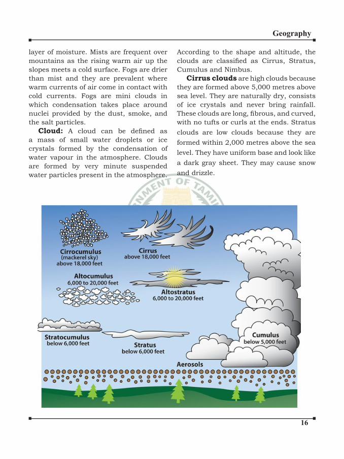
Cloud: A cloud can be defined as a mass of small water droplets or ice
crystals formed by the condensation of
water vapour in the atmosphere. Clouds
are formed by very minute suspended
water particles present in the atmosphere.
According to the shape and altitude, the
clouds are classified as Cirrus, Stratus, Cumulus and Nimbus.
Cirrus clouds are high clouds because
they are formed above 5,000 metres above
sea level. They are naturally dry, consists
of ice crystals and never bring rainfall.
These clouds are long, fibrous, and curved, with no tufts or curls at the ends. Stratus
clouds are low clouds because they are
formed within 2,000 metres above the sea
level. They have uniform base and look like
a dark gray sheet. They may cause snow
and drizzle.
��
Geography
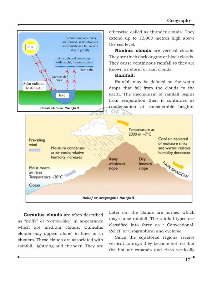
Conventional Rainfall
Sun
lake
Solar radiation
heats water
Cumulo-nimbus clouds
are formed. Water droplets
accumulate and fall as rain
due to gravity
Air cools and condenses
with height, forming clouds
----------------------------------Dew point
Warmer airrises
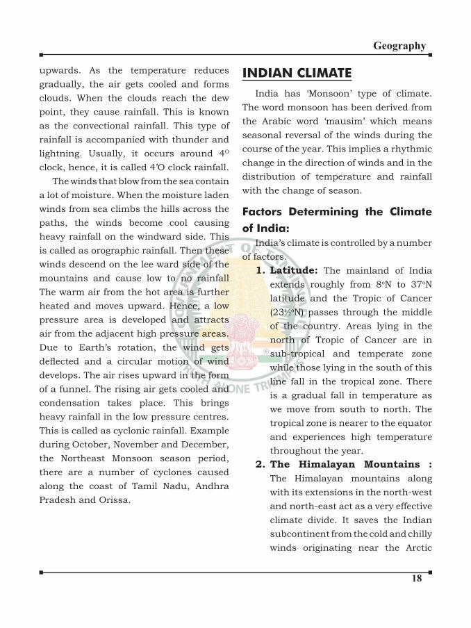
Relief or Orographic Rainfall
Cumulus clouds are often described
as “puffy” or “cotton-like” in appearance
which are medium clouds. Cumulus
clouds may appear alone, in lines or in
clusters. These clouds are associated with
rainfall, lightning and thunder. They are
otherwise called as thunder clouds. They
extend up to 12,000 metres high above
the sea level.
Nimbus clouds are vertical clouds.
They are thick dark or gray or black clouds.
They cause continuous rainfall so they are
known as storm or rain clouds.
Rainfall:
Rainfall may be defined as the water drops that fall from the clouds to the
earth. The mechanism of rainfall begins
from evaporation then it continues as
condensation at considerable heights.
Later on, the clouds are formed which
may cause rainfall. The rainfall types are
classified into three as : Convectional, Relief or Orographical and cyclonic.
Since the equatorial regions receive
vertical sunrays they become hot, so that
the hot air expands and rises vertically
��
Geography
upwards. As the temperature reduces
gradually, the air gets cooled and forms
clouds. When the clouds reach the dew
point, they cause rainfall. This is known
as the convectional rainfall. This type of
rainfall is accompanied with thunder and
lightning. Usually, it occurs around 4O
clock, hence, it is called 4’O clock rainfall.
The winds that blow from the sea contain
a lot of moisture. When the moisture laden
winds from sea climbs the hills across the
paths, the winds become cool causing
heavy rainfall on the windward side. This
is called as orographic rainfall. Then these
winds descend on the lee ward side of the
mountains and cause low to no rainfall
The warm air from the hot area is further
heated and moves upward. Hence, a low
pressure area is developed and attracts
air from the adjacent high pressure areas.
Due to Earth’s rotation, the wind gets
deflected and a circular motion of wind develops. The air rises upward in the form
of a funnel. The rising air gets cooled and
condensation takes place. This brings
heavy rainfall in the low pressure centres.
This is called as cyclonic rainfall. Example
during October, November and December,
the Northeast Monsoon season period,
there are a number of cyclones caused
along the coast of Tamil Nadu, Andhra
Pradesh and Orissa.
INDIAN CLIMATE
India has ‘Monsoon’ type of climate.
The word monsoon has been derived from
the Arabic word ‘mausim’ which means
seasonal reversal of the winds during the
course of the year. This implies a rhythmic
change in the direction of winds and in the
distribution of temperature and rainfall
with the change of season.
Factors Determining the Climate
of India:
India’s climate is controlled by a number
of factors.
1. Latitude: The mainland of India
extends roughly from 8oN to 37oN
latitude and the Tropic of Cancer
(23½oN) passes through the middle
of the country. Areas lying in the
north of Tropic of Cancer are in
sub-tropical and temperate zone
while those lying in the south of this
line fall in the tropical zone. There
is a gradual fall in temperature as
we move from south to north. The
tropical zone is nearer to the equator
and experiences high temperature
throughout the year.
2. The Himalayan Mountains :
The Himalayan mountains along
with its extensions in the north-west
and north-east act as a very effective
climate divide. It saves the Indian
subcontinent from the cold and chilly
winds originating near the Arctic
��
Geography
Circle and blowing across central
and eastern Asia. The Himalayan
wall also traps the monsoon winds
from the Bay of Bengal and Arabian
Sea and cause widespread rainfall
in the sub-continent.
3. Distribution of Land and Water:
India is flanked by the Indian Ocean on three sides in the south and
girdled by a high and continuous
mountain wall in the north.
4. Distance from Sea: As mentioned
above, landmasses heat up and cool
down more quickly than water. As
such coastal areas enjoy equable
climate while areas located in the
interior i.e.,far away from the sea
experience extremes of climate.
5. Altitude: There is a gradual fall of
temperature with increasing altitude
at an average rate of 10C for 165
metres (or 0.650C per 100 metres).
Consequently places located in
mountains are cooler than places
located in plains. For example, Agra
and Darjiling are located on the
same latitude, but temperature of
January in Agra is 160C whereas it
is only 40C in Darjiling.
6. Relief: India has great
physiographic variations including
lofty mountains, vast plains and
extensive plateaus. These aspects
of relief have a great bearing on
temperature, air pressure, direction
and speed of wind and amount
and distribution of rainfall. The
windward sides of Western Ghats
and Assam receive high rainfall
during June-September whereas
the southern plateau remains dry
due to its leeward situation along
the Western Ghats.
a) Winter Season: Indian weather in
the winter season is generally influenced by the presence of high atmospheric
pressure in Central and West Asia. This
causes the flow of surface winds from the north to the Indian sub-continent. These
winds form a dry continental air-mass.
This air mass comes in contact with the
Indian trade winds.
b) Summer Season
i. With the onset of summer season,
the sun shifts towards the north
and there is a complete reversal
of pressure conditions and wind
circulation both in the lower and the
upper layers of the atmosphere.
ii. With the northwards shift of the
ITCZ, the westerly jet stream
withdraws from the Indian plain.
This low pressure ITCZ, attracts
winds from different directions.
The maritime tropical air (MT) from
southern hemisphere rushes to this
low pressure zone after crossing the
equator between 400 and 600 east
longitudes. This is known as the
south-west monsoon.
iii. The Retreat of the Monsoon.
The south-west monsoon starts
�0
Geography
retreating by 1st September from
the western strip of Rajasthan and,
by 15th September, it retreats from
most parts of Punjab, Haryana,
Rajasthan and Gujarat. It retreats
from most parts of India by mid-
October, except the southern
peninsula. The retreating monsoon
picks up moisture from the Bay of
Bengal and establishes itself over
Tamilnadu coast in the month
of December and causes rainfall
there.
El-Nino and the Indian Monsoon
El-Nino is a narrow warm current
which appears off the coast of Peru in
December. In Spanish, it means The
Child Christ because it appears around
Christmas. It is a temporary replacement
of the cold Peruvian or Humbolt current
which normally flows along the coast. It appears once in every three to seven years
and is responsible for wide spread floods and droughts in the tropical regions of
the world. Sometimes it becomes more
intense and increases the surface water
temperatures of the sea by 100C. This
warming of tropical Pacific water affects the global pattern of pressure and wind
system including the monsoon winds in
the Indian Ocean. The El Nino phenomena,
which influence the Indian monsoon, reveals that when the surface temperature
goes up in the southern Pacific Ocean, India receives deficient rainfall.
El Nino has a great impact on the
Indian monsoon and is used in India for
forecasting long range monsoon rainfall.
Meteorologists believe that the severe
drought of 1987 was caused by El Nino. In
1990-91, there was a wild El-Nino event
and the onset of southwest monsoon was
delayed over most parts of the country
ranging from five to twelve days.
La Nina
After El Nino, weather conditions return
to normal. However, sometimes trade
winds become so strong that they cause
abnormal accumulation of cold water in
the central and eastern Pacific region. This event is called La Nina, which in effect
is the complete opposition of El Nino. A
La Nino also marks an active hurricane
season. But In India, the presence of La
Nina portends exceptionally good news. It
is the harbinger of heavy monsoon showers
in India.
Southern Oscillation (S.O.) is the
name ascribed to the curious phenomenon
of sea saw pattern of meteorological
changes observed between the Pacific and the Indian Oceans. It has been noticed
that whenever the surface level pressure
is high over the Indian Ocean, there is low
pressure over the Pacific Ocean and vice-versa. When the winter pressure is high
over the Pacific Ocean and low over the Indian Ocean, the south-west monsoons
in India tend to be stronger. In the reverse
case, the monsoons are most likely to be
weaker.
��
Geography
Some Famous Local Storms of Hot
Weather Season
i. Mango Shower, Towards the end
of summer, there are pre-mensoon
showers which are a common
phenomena in Kerala and coastal
areas of Karnataka. Locally, they
are known as mango showers since
they help in the early ripening of
mangoes.
ii. Blossom Shower. With this shower
coffee flowers blossom in Kerala and nearby areas.
iii. Nor Westers. These are dreaded
evening thunderstorms in Bengal
and Assam. Their notorious nature
can be understood from the local
nomenclature of ‘Kalbaisakhi’, a
calamity of the month of Baisakh.
These showers are useful for tea,
jute and rice cultivation. In Assam,
these storms are known as “Bardoli
Chheerha”.
iv. Loo. Hot, dry and oppressing winds
blowing in the Northern plains
from Punjab to Bihar with higher
intensity between Delhi and Patna.
••••••
�
Geography
OCEAN RELIEF
Continents and ocean basins are
the first order relief features of the earth. The ocean floors are not flat or uniform. The floor of the oceans is as irregular as the surface of the continents.
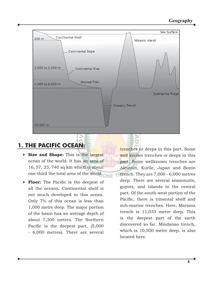
Ocean basins, platforms, trenches, submarine ridges.
1.1 Configuration of Ocean Floor1. Continental Shelf2. Continental Slope3. Continental Rise
OCEANOGRAPHY
4. Trench (or) Ocean Deep
5. Deep Sea Plain
Continental Shelf1. This is the coastal part of the ocean,
the slope of the bottom is very gentle, with a gradient of 1-20.
2. Generally this part extends upto a depth of about 100 fathoms. (180mt)
3. They occupy 7.6% of the oceans area.
4. Generally the shelf is broader along the coast lines of submergence and narrower along the coastlines of emergence.
�
Geography
5. It is a relatively narrow platform where the mountain ranges occur close to the coast of continents. Ex. Andes Mountain - Eastern
Pacific OceanExcept India - The breadth of the
shelf is lesser along the Bay of Bengal than along the Arabian Sea Coast.
6. Banks, Reefs are generally found here.
7. The shallowness of the shelf enables the sunlight to penetrate through the water. This fosters growth of minute plants and microorganisms which provide food for the other marine life.
8. This is one of the reasons why the world’s Chief fishing grounds are found in the shallow waters.
Ex. North Sea, Grand Bank of New foundland Island.
9. Many of them are dissected by Valleys and troughs. (Submarine Canyons)
Continental Slope1. The steep slope which descends from
the edge of the continental shelf to the deep ocean bed is known as the continental slope.
2. It has a gradient ranging between
20 and 50. It spreads from 200m to 2500m deep.
3. It constitutes about 8.5% of the ocean floor.
4. It is cut through by submarine Canyons. Some of these appear to be continuations of river valleys while the others seem to be a result of faulting.
Continental Rise:1. It may be up to several hundred km
in width and has very low gradients of less than 10.
2. At the foot of the continental slope is found an area slightly rising due to the accumulation of the debris transported over the continental slope.
3. Large accumulations of the deposited rock material are found here and usually this part is rich in minerals found in the sedimentary rocks.
4. Some of the oil deposits of the oceanic areas occur in this zone
Trench:1. Considerable depth on the deep sea
plain of the ocean floor. 2. They occur either in association
with island arcs or along the coasts bounded by high mountain ranges.
�
Geography
The ocean deep is often associated with the subduction zone at the margins of two tectonic plates. (Plate Tectonics)Ex. The deepest is the (Challenger Deep) Mariana Trench in the west Pacific,
about 10,800m below sea level. Aleutian Trench - near Aleutian Island-North Pacific Ocean Kuril Trench - near Kuril Island - West Pacific Mindanoa Deep - Phillippines Trench (Galathea deep) – West Pacific
Ocean.
Romanchee deep - Atlantic ocean in equator (break in the continuity of mid Atlantic Ridges)
Tonga Trench - South Pacific Ocean - 2nd deepest Trench in the World.
Kermadec trench - South Pacific Ocean Puerto Rico Trench - Deepest trench in Atlantic Ocean. (Milwaukee Deep) Java Trench - Indian Ocean
The Abyssal plain or the Deep or
the Deep sea plain1. This is the deepest and the most
extensive part of the ocean floor.2. It is occupied by raised ridges or
submarine mountains and by the very deep trenches.
3. A number of volcanic mountains are found.
4. Ridge - Ex. Mid-Atlantic Ridge - central part of the A.O. 900 E ridge - Indian Ocean.
5. Volcanic Islands - some parts of the ridges may reach the surface of the oceans and may thus form islands. Ex. Hawaiian Island.
6. Sea mount - Volcanic peaks which remain under water
7. Guyots: Some of these peaks are much higher and reach close to the surface. The top of such peaks eroded through the wave action to make them almost flat topped.
Submarine ReliefsOceans:
In all there are five oceans on the earth. They are:
1. The Pacific Ocean 2. The Atlantic Ocean 3. The Indian Ocean
4. The Arctic Ocean
5. The Antarctic Ocean
First three oceans are more important and the relief of their floor is briefly discussed here.
�
Geography
1. THE PACIFIC OCEAN:Size and Shape: This is the largest ocean of the world. It has an area of 16, 57, 23, 740 sq km which is about one-third the total area of the world.
Floor: The Pacific is the deepest of all the oceans. Continental shelf is not much developed in this ocean. Only 7% of this ocean is less than 1,000 metre deep. The major portion of the basin has an average depth of about 7,300 metres. The Northern Pacific is the deepest part, (5,000 - 6,000 metres). There are several
trenches or deeps in this part. Some well known trenches or deeps in this part. Some wellknown trenches are Aleutain, Kurile, Japan and Bonin trench. They are 7,000 - 6,000 metres deep. There are several seamounts, guyots, and islands in the central part. Of the south-west portion of the Pacific, there is trinental shelf and sub-marine trenches. Here, Mariana trench is 11,033 metre deep. This is the deepest part of the earth discovered so far. Mindanao trench, which is 10,500 metre deep, is also located here.
�
Geography
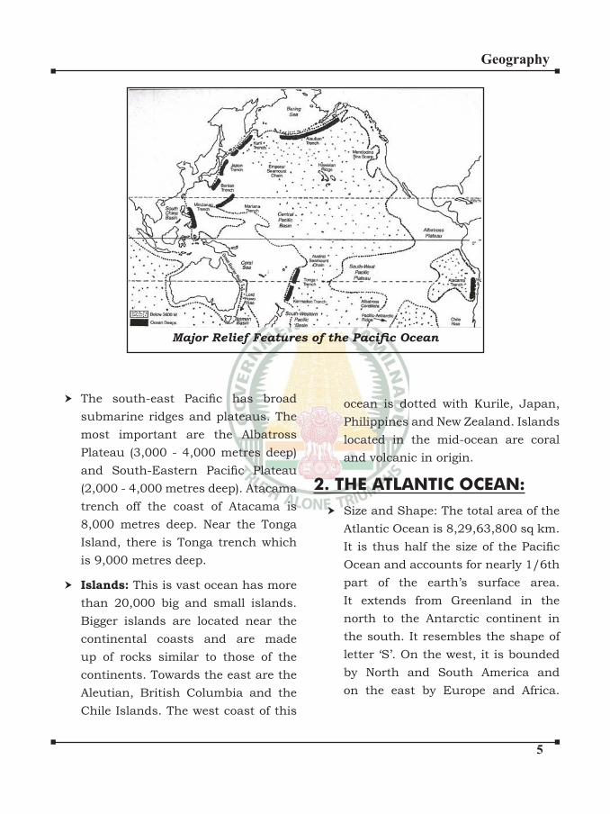
Major Relief Features of the Pacific Ocean
The south-east Pacific has broad submarine ridges and plateaus. The most important are the Albatross Plateau (3,000 - 4,000 metres deep) and South-Eastern Pacific Plateau (2,000 - 4,000 metres deep). Atacama trench off the coast of Atacama is 8,000 metres deep. Near the Tonga Island, there is Tonga trench which is 9,000 metres deep.
Islands: This is vast ocean has more than 20,000 big and small islands. Bigger islands are located near the continental coasts and are made up of rocks similar to those of the continents. Towards the east are the
Aleutian, British Columbia and the Chile Islands. The west coast of this
ocean is dotted with Kurile, Japan, Philippines and New Zealand. Islands located in the mid-ocean are coral and volcanic in origin.
2. THE ATLANTIC OCEAN:Size and Shape: The total area of the Atlantic Ocean is 8,29,63,800 sq km. It is thus half the size of the Pacific Ocean and accounts for nearly 1/6th part of the earth’s surface area. It extends from Greenland in the north to the Antarctic continent in
the south. It resembles the shape of letter ‘S’. On the west, it is bounded by North and South America and on the east by Europe and Africa.
�
Geography
In the south, it is open and may be considered to extend upto the continent of Antarctica.
Floor: The most striking feature of the Atlantic Ocean is the presence of the mid-Atlantic Ridge. It extends from Iceland in the north to Bouvet Island in the south paralleling the ‘S’ shape of the ocean itself. It becomes quite broad at 550 N and is known as Telegraph Plateau. Romanche deep near the equator divides this ridge into two parts. The northern part is
known as Dolphin Range while the southern part is called Challenger Ridge.
Although it is a submarine ridge, yet some of its peaks project out of water in the form of islands. Azores, Pico and Cape Verde islands are its main examples. St. Paul near the equator has very sharp peak. Ascension Tristan -da- Cunha, St. Helena and Gough and Bauvet islands in the south Atlantic are of volcanic origin. Bermuda is a coral island.
Islands: The Atlantic Ocean lacks in islands. In the North Atlantic, there are Newfoundland, British Isles and West Indies. In south Atlantic only Falkland islands are worth mentioning. Some smaller islands appear on the Mid-Atlantic Ridge which have already been discussed.
Troughs and Trenches: The Atlantic Ocean also lacks in troughs and trenches. According to Murray, there are 19 deeps with depth exceeding 5,500 metres. Only two are more than 7,000 metres deep. North Cayman Romanche and South Sandwich are the two trenches in the Atlantic Ocean.
3. THE INDIAN OCEAN:Floor: Continental shelf in this ocean is much less as compared to Atlantic Ocean. Its average depth is 4,000 metres and its 60% part is 4,000 to 6,000 metres deep sea plain. The floor of the Indian Ocean has fewer irregularities in comparison to the other two oceans. Linear deeps are
almost absent. The only exception is the Sunda Trench, which lies south of the island of Java and runs parallel to it.
Ridges: There are a number of broad submarine ridges on the floor of the Indian Ocean. The most important submarine ridge runs from Kannyakumari continuously southward to Antarctica. It is situated in the middle and divides the ocean into two basins on either side. It is
called the Lakshdweep - Chagos Ridge in the north, the ChagosSt. Paul Ridge in the middle and the Amsterdam St. Paul Plateau in the south, where it widens out considerably.
�
Geography
The central ridge is bifurcated into many small ridges which reach the coasts of Africa and India. Two minor and parallel ridges run north-westward. These are known as the Socotra - Chagos Ridge and the Seychelles Ridge.
Another ridge, known as the South Madagascar Ridge, runs southward from the Madagascar Island. It widens in the south, where it is called the Prince Edward Crozet Ridge. In the Bay of Bengal, another ridge called the Andaman Nicobar extends from the mouth of the Ayeyarwadi (Irrawaddy) to the Nicobar Islands. Beyond this towards the south, a very important ridge runs along the 900 E longitude and is known as Ninety East Ridge. The Carlsberg Ridge has been discovered by recent surveys and it divides the Arabian Sea into two parts.
Islands: Most of the islands near the coast of the Indian Ocean are detached parts of the continental blocks. The Andaman and Nicobar, Sri Lanka, Madagascar and Zanzibar are important examples of this group. The Lakshdweep and Maldives Islands are coral islands. The Mauritius and Reunion islands to the east of Madagascar are of volcanic origin. The eastern section of the Indian Ocean is almost devoid of islands.
OCEAN RESOURCESOceans cover about 71% of the earth’s
surface area and are great source of a large variety of resources. Oceans contain huge amounts of minerals, food resources and energy resources.
Mineral Oil: Mineral oil is the most important mineral obtained from the sea bed so far, as the value is concerned. Most of the oil resources are found on the continental shelves but borings for deeper oil wells have been done in the recent past. At present, more than 75 countries are extracting mineral oil from the sea bed. The main producers are the Middle East countries, U.S.A., Britian, Norway, the Netherlands, Ireland, Ukraine, Indonesia, Ghana, Australia and New Zealand. In India, Mumbai High, Bassein, Aliabet product oil and Krishna-Godawari off-shore basin produces natural gas.
Oceans and Food Resources: Two
most important items of food obtained from the oceans are fisheries and aquaculture. Most of the fish varities are found on the continental shelves upto the depth of 100 fathoms because this zone provides suitable conditions for the growth of different varieties of fishes. The major fishing grounds of the world are found in
�
Geography
the temperate zone of the northern hemisphere.
This zone contains the following four major fishing grounds:
1. The North-West Pacific Fishing Ground
2. The North-West Atlantic Fishing Ground
3. The North-East Atlantic Fishing Ground
4. The North-East Pacific Fishing Ground
Potential of Tidal energy in India
1. Gulf of Khambhat (7000 Mw)2. Gulf of Kutch (1000 Mw)3. Sunderbans (100 Mw)
In addition to fish, other sea organisms such as mussels, lobsters, molluscs, and squard crastacanas oyster are also used as important items of food.
Aqua cultural products include finfish, shellfish, oyester, mussel, milkfish, seaweeds etc. About two thirds of the total aquacultural products are accounted for by finfish.
Seaweeds are found in almost all the seas although a large amount of seaweeds grow in tropical and temperate zones. Seaweeds are used as food in China, Taiwan and Japan. In Western Europe, seaweeds were used as fodder for animals and fertilizer in earlier days; but now they are used for a large variety of purposes such as in medicines, milk industry, confectionery and textile industry.
Oceans and Power Resources:Tidal Energy: Tides occur in the oceans twice a day and they can yield a lot of energy. A tidal range of over 3 metres is sufficient to produce electricity. Two areas in the world offer great potential for generating tidal electricity. They are (i) Bay of Fundy in Canada and (ii) Severn Estuary in Britain. India also holds vast potential for harnessing tidal energy. The most suitable conditions are provided by the gulf of Khambhat and Gulf of Kachchh. Here the maximum and average tidal ranges are 8-11 and 5-23 metres respectively. Sunderban also holds great potential. These three projects can produce 800-900 megawatt electricity. National Power Corporation has set up a 900 MW tidal energy power plant in Gulf of Kuchchh, Gujarat.
Wave Energy: Waves of sea water have enormous energy which can be harnessed for the ben efit of mankind. Japan, Norway and U.S.A have done pioneer work in this regard. In India, a plant at Vizhinjam, 26 km away from Thiruvananthapuram has been installed to harness the wave energy.
Sea Thermal Power (OTEC): If the minimum difference of temperature of the surface water and that at the

�
Geography
depths varying from 1000 to 3000 metres is 200C, then sea thermal energy can be produced. Such a situation prevails in the tropical zone where the surface water temperature is 250 - 300C and the
water temperature at greater depths in about 50C. Floating generators to harness this energy have been set up in Cuba, near Miami coast and Hawaii Island in the U.S.A. and in Japan.
Geothermal Energy: This energy is obtained from the volcanic eruptions occurring on the sea floor. Successful attempts have been made in New Zealand and the U.S.A. to harness this energy.
There are several hundred hot springs in India.
They can be used to generate electricity.
Two experimental projects have been set up in India to harness geothermal energy. One them is located in Parvati
valley near Manikaran in Himachal Pradesh
The other project is located in the Puga valley of Ladakh region in Jammu & Kashmir.
TEMPERATURE OF OCEANSThe Major source of temperature of the oceanic water is the sun.
Factors affecting distribution of
Temperature
1. Latitude2. Unequal distribution of Land water3. Prevailing winds4. Ocean Currents5. Submarine ridges6. Shape and size of the Sea.
Horizontal Distribution:1. The surface temperature of ocean
decreases gradually from the equator to the poles.
2. The oceans in the N.H. (19.40C)
record relatively high average temperature than in the S.H. (16.10 C)
because of unequal distribution of land & ocean water.
3. The highest temperature is not recorded at the equator.
4. Highest temperature recorded in tropical region. (23 to 270C)
5. The average annual temperature of all the oceans is 17.20C.
6. The average annual temperature of the pacific ocean is slightly higher than the Atlantic (16.90C) and
Indian Ocean (170 C)
7. But enclosed seas of the Indian Ocean is recorded highest
temperature. Arabian Sea have high temperature than Bay of Bengal.
�0
Geography
Vertical Distribution1. Temperature of ocean water changes
with increasing depth.
2. The temperature remains almost equal to that on the surface up to a depth of about 100mts.
3. The rate of fall of temperature with increasing depth varies with latitude also. This rate is higher at the equator than at the poles.
Temperature - Vertical
DistributionFirst Layer
Top layer of warm oceanic water and it is about 500m thick with temperature ranging between 200
and 250 C.
This layer with in the tropics is present throughout the year but in mid latitudes it develops only during summer.
Summer Layer: (Thermocline Layer)
(500-1000m Thick)
It is characterised by rapid decrease in temperature with increasing depth.
Third Layer:
It is very cold and extends up to the deep ocean floor.
Arctic and Antarctic:
The surface water temperatures are close to O0C and so the temperature change with depth is very slight. Here only one layer of cold water exists.
SALINITY OF OCEANSThe salinity of water is the total weight
of dissolved salts to the weight of water. It is expressed as the number of parts of salt dissolved in 1000 parts of water.
Isohalines: The lines join the places of equal salinity at the sea surface.
Factors affecting distribution of
Salinity
1. Rate of evaporation2. Precipitation3. Discharge of rivers4. Atmospheric Pressure5. Wind direction6. Circulation of Oceanic Water
Salt in Sea Water
1. Sodium Chloride - 78%2. Magnesium Chloride3. Magnesium Sulphate4. Calcium Sulphate5. Potasium Sulphate
Distribution
1. The average salinity of oceans is 35 parts per thousand. (35%)
2. It varies from place to place.3. The greatest salinity is not found on
the Equator. The temperature here are high but the rate of evaporation is not high because of high humidity and frequent rain.
4. Tropical: (Trade wind belt) Maximum salinity is found in the tropical areas where the sun’s heat is greatest and the rainfall is lowest.
��
Geography
5. Polar Regions: (Minimum salinity) the effects of low temperature and water melted from glaciers reduce the salinity.
Arctic Ocean :
20 parts per thousandBaltic sea :
Baltic Sea - Salinity is very low. Only 11%. Because of slow rate of evaporation and many streams and rivers which add their fresh water. It, therefore, freezes rapidly.Arabian Sea :
38% - There is higher rate of evaporation due to relatively less humid conditions and low influx of freshwater as compared to Bay of Bengal.Bay of Bengal :
Only 30%, in Ganga delta only 20%.Red Sea :
37- 41% (no river flows)Dead Sea :
240% - evaporation high - very little rainfall. few stream flows. Lake van :
Turkey - 330% - highest.Great Salt Lake : 220%.
Vertical Distribution of Salinity:1. Surface Layer:
A shallow surface layer of uniformly high salinity. (35 to 36.5%)2. Halocline:
1. A zone of rapid decrease in salinity.2. It corresponds with the
thermocline.3. Below it, differences in salinity are
very small.
Polar Areas:
1. In high latitude areas the salinity tends to increase with increasing
depth.
2. In mid latitude areas, the salinity tends to increase with increasing
depth upto 400 mt and then tends to decrease again.
3. In equatorial regions, the salinity has slight increase with increasing depth initially but then starts decreasing again.
THE TIDESThe alternate rise and fall in the waters of the ocean that occurs twice in about 24hrs are known as tides.
Tides:Tides are caused by the gravitational pull of the moon and to some extent by the pull of the sun.The water of the earth nearest to the moon will be pulled by the moon’s gravitational force.The moon is directly over one side and its attraction causes the water to pile up towards the same side causing an ordinary high tide at that place.
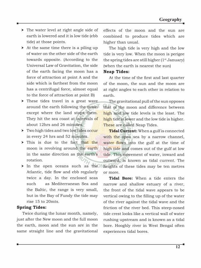
��
Geography
The water level at right angle side of earth is lowered and it is low tide (ebb tide) at those points.
At the same time there is a piling up of water on the other side of the earth towards opposite. (According to the
Universal Law of Gravitation, the side of the earth facing the moon has a force of attraction at point A and the side which is farthest from the moon has a centrifugal force, almost equal to the force of attraction at point B)These tides travel in a great wave around the earth following the moon except where the land stops them. They hit the sea coast at intervals of about 12hrs and 26 minutes.Two high tides and two low tides occur in every 24 hrs and 52 minutes.This is due to the fact that the moon is revolving around the earth in the same direction as the earth’s rotation.
In the open oceans such as the Atlantic, tide flow and ebb regularly twice a day. In the enclosed seas such as Mediterranean Sea and the Baltic, the range is very small, but in the Bay of Fundy the tide may rise 15 to 20mts.
Spring Tides:
Twice during the lunar month, namely, just after the New moon and the full moon the earth, moon and the sun are in the same straight line and the gravitational
effects of the moon and the sun are combined to produce tides which are higher than usual.
The high tide is very high and the low tide is very low. When the moon is perigee the spring tides are still higher (1st January) (when the earth is nearest the sun)Neap Tides:
At the time of the first and last quarter of the moon, the sun and the moon are at right angles to each other in relation to earth.
The gravitational pull of the sun opposes that of the moon and difference between high and low tide levels is the least. The high tide is lower and the low tide is higher. These are called Neap Tides.
Tidal Current: When a gulf is connected with the open sea by a narrow channel, water flows into the gulf at the time of high tide and comes out of the gulf at low tide. This movement of water, inward and outward, is known as tidal current. The heights of these tides may be ten metres or more.
Tidal Bore: When a tide enters the narrow and shallow estuary of a river, the front of the tidal wave appears to be vertical owing to the filling up of the water of the river against the tidal wave and the friction of the river bed. This steep-nosed tide crest looks like a vertical wall of water rushing upstream and is known as a tidal bore. Hooghly river in West Bengal often experiences tidal bores.
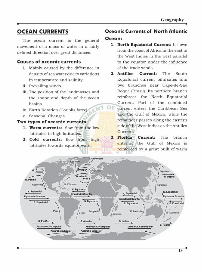
��
Geography
OCEAN CURRENTSThe ocean current is the general
movement of a mass of water in a fairly defined direction over great distances.
Causes of oceanic currentsi. Mainly caused by the difference in
density of sea water due to variations in temperature and salinity.
ii. Prevailing winds.iii. The position of the landmasses and
the shape and depth of the ocean basins.
iv. Earth Rotation (Coriolis force)v. Seasonal Changes
Two types of oceanic currents
1. Warm currents: flow from the low latitudes to high latitudes.
2. Cold currents: flow from high latitudes towards equator ward.
Oceanic Currents of North Atlantic
Ocean:1. North Equatorial Current: It flows
from the coast of Africa in the east to the West Indies in the west parallel to the equator under the influence of the trade winds.
2. Antilles Current: The South Equatorial current bifurcates into two branches near Cape-de-Sao Roque (Brazil). Its northern branch reinforces the North Equatorial Current. Part of the combined current enters the Caribbean Sea and the Gulf of Mexico, while the remainder passes along the eastern side of the West Indies as the Antilles Current.
3. Florida Current: The branch
entering the Gulf of Mexico is reinforced by a great bulk of warm
��
Geography
ocean water driven by the trade winds and by the water brought by the Mississippi river. As a result, the water level in the Gulf rises as compared to that of the Atlantic Ocean. This difference in water level is compensated for by the current flowing out through the Strait of Florida and this branch is joined by the Antilles current. From the Cape of Florida, the combined current moves along the south-eastern coast of the United States and is known as the Florida Current upto the Cape-Hatteras.
4. Gulf Stream: Beyond the Cape Hatteras upto the Grand Banks off Newfoundland, it is known as the Gulf Stream. The Gulf Stream receives plenty of warm water from the Gulf of Mexico and carries it to cold areas.
5. North Atlantic Drift: From the Grand Banks, the Gulf Stream flows eastward across the Atlantic under the influence of the prevailing westerly winds. Here it is known as North Atlantic Drift. Its speed is quite large in the open ocean.
6. Norwegian Current: The North Atlantic Drift is divided into two branches when it reaches the
European Coast. The northern branch reaches the British Isles from where it flows along the coast of Norway as the Norwegian current and enters the Arctic Ocean.
7. Canaries Current: The second
branch of the North Atlantic Drift takes a southerly turn and flows between Spain and Azores as the cold Canaries Current. This current finally joins the North Equatorial Current Completing the circuit in the North Atlantic.
8. East Greenland Current: This
current flows from north to south along the eastern coast of Greenland.
9. Labrador Current: This current starts from the Baffin Bay and Davis Strait and flows along the coast of Labrador. It brings a large number of icebergs from the Baffin Bay. The East Greenland Current joins it at the southern tip of Greenland. The joint current moves further southwards and joins with the Gulf Stream. The confluences of warm Gulf Stream and cold Labrador current produces thick fog near Newfoundland. Sargasso Sea: It is the calm sea
lying within the circuit of North Atlantic Current, Gulf Stream, North Atlantic Drift and Canaries Currents. It is full of seaweeds known as sargassum in the Portuguese language. Hence, it is known as Sargasso Sea.

��
Geography
Oceanic Currents of South Atlantic
Ocean:1. South Equatorial Current: It lies
in the south of equator and flows almost parallel to it from east to west.
2. Brazil Current: The South Atlantic current splits into two branches near Cape-de-Sao Roque (Brazil). The northern branch joins the North Equatorial current, whereas the southern branch turns southward and flows along the South American coast as the Brazil Current.
3. South Atlantic Current: The Brazil current swings eastward at about latitude 350 S to join the West-wind Drift flowing from west to east.
4. Benguela Current: Near the Cape of Good Hope, a branch of the South Atlantic current flows northward along the west coast of South Afirca. It is a cold current and is known as the Benguela Current. It finally joins the south Equatorial Current, thus completing the circuit.
5. Falkland Current: Another cold current, known as the Falkland Current, flows along the south-eastern coast of South America from south to north. This brings huge icebergs from the Antarctic region and creates thick fog when it joins the warm water.
Oceanic Currents of Indian
Ocean:The characteristics of the currents of
the Indian Ocean are quite different from those of Pacific and Atlantic Oceans. This is due to the fact that it is just half an ocean and is completely land-locked in the north. The currents of the northern Indian Ocean change their direction due to seasonal change in the direction of the monsoons. The current affected by monsoons is known as the ‘Monsoon Drift’.
The southern part of the Indian Ocean extends right upto the Antarctic Coast and is not influenced by seasonal changes. The general pattern of circulation is simple and is anti-clockwise like that of the other southern oceans.
North Indian Ocean:1. Winter Conditions: In winter, the
north equatorial current is under the influence of north-east monsoon and blows from east to west. This is known as North-East Monsoon Drift. It starts from the Strait of Malacca and flows along the coast of Bay of Bengal. After crossing Sri Lanka, it flows along the coast of Arabian Sea and turns southwards. From there it travels from west to east as counter Equatorial Current and completes the anticlockwise circulation.
2. Summer Season: During summer, a strong current flows from west to
��
Geography
east which completely obliterates the North Equatorial Current during this season. It is due to the effects of the strong south-west monsoon and the absence of the North-East Trades. There is no counter Equatorial Current at this time of the year. Thus, the circulation of water in the northern part of the ocean is clockwise during this season.
South Indian Ocean:The circulation of currents of South
Indian Ocean is similar to that of South Pacific and South Atlantic Oceans. Following scheme explains these currents:
1. South Equatorial Current: Like other oceans, Indian Ocean has
south equatorial current flowing parallel to the equator from east to west.
2. Mozambique Current: The South Equatorial Current divides itself into two branches on reaching
Madagascar. One of them flows through the Mozambique channel between Mozambique and Madagascar coasts. This is a warm current and is known as warm Mozambique Current.
3. Madagascar Current: The other
branch of the South Equatorial Current flows along the east coast of Madagascar and is known as Madagascar Current.
4. Agulhas Current: In the south of Madagascar Island, the Mozambique and the Madagascar currents join with each other. After the confluence of these two streams, it is known as the Agulhas Current. It still continues to be a warm current till it merges with the west wind drift.
5. The West Wind Drift: The west
wind drift is a cold current which flows from west to east and reach the southern tip of the west coast of Australia.
6. West Australian Current: On
reaching Australia, the west wind drift is divided into two branches. One of the branches moves northwards along the west coast of Australia and is known as West Australian Current. It ultimately joins the south equatorial current and completes the counter clockwise circuit in the South Indian Ocean.
Oceanic Currents of Pacific
Ocean:From the point of view of study of ocean
currents, the Pacific Ocean is divided into North Pacific and South Pacific.
North Pacific Ocean:1. North Equatorial Current: It
flows across the ocean from east to west. Starting from the west coast of Central America, it reaches the Philippine Islands in the Western Pacific Ocean.
2. Kuroshio Current: On reaching
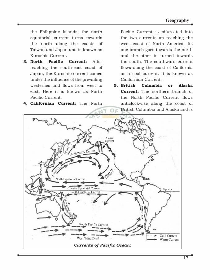
��
Geography
the Philippine Islands, the north equatorial current turns towards the north along the coasts of Taiwan and Japan and is known as Kuroshio Current.
3. North Pacific Current: After reaching the south-east coast of Japan, the Kuroshio current comes under the influence of the prevailing westerlies and flows from west to east. Here it is known as North Pacific Current.
4. Californian Current: The North
Pacific Current is bifurcated into the two currents on reaching the west coast of North America. Its one branch goes towards the north
and the other is turned towards the south. The southward current flows along the coast of California as a cool current. It is known as Californian Current.
5. British Columbia or Alaska
Current: The northern branch of the North Pacific Current flows anticlockwise along the coast of British Columbia and Alaska and is
Cold Current
Warm CurrentWest Wind Draft
South Pacific Current
South Equatorial Current
Counter Equatorial Current
North Equatorial Current Cal
abria
C.
North Pacific Current
Oya
shio
C.
Alaska Current
Equator
Per
u C
urr
ent
Currents of Pacific Ocean:
Kur
oshi
o C.
Eas
t Aust
rali
an
Okhots
k C
��
Geography
known as the Alaska Current. The water of this current is relatively warm as compared to that of the sea in this zone.
6. Oya Shio Cold Current: It starts
from Bering Strait and flows southwards as a cold current along the east coast of Kamchatka peninsula.
7. Okhotsk Current: Another cold current in the North Pacific is the Okhotsk Current which flows past Sakhalin to merge with the OyaShio Current off Hokkaido. The OyaShio finally merges with and sinks beneath the warmer water of the Kuroshio.
Due to the meeting of Kuroshio warm current from the equator and the OyaShio cold current from the polar region meets at the east coastal region of Japan.
South Pacific Ocean:1. South Equatorial Current: It is a
warm current which flows almost parallel to the equator from the coast of Central America towards the east coast of Australia.
2. East Australian Current: The south equatorial current turns towards the south on reaching the coast of New Guinea under the influence of Coriolis force. It is a warm current which flows along the east coast of Australia. Hence, it is known as East Australian Warm Current.
3. South Pacific Current: The East Australian current turns towards to east under the influence of the westerlies and is known as South Pacific Current.
4. Peru Current: On reaching the
south-western coast of South America, the South Pacific current turns northward and flows along the Peru Coast as the Peru Current. It is a cold current which finally feeds the South Equatorial Current, completing the great circuit. Counter Equatorial Current:
Between the North and the South Equatorial Currents, a current flows from west to east which is known as the Counter Equatorial Current. The North and the South Equatorial Currents cause accumulation of water in the western parts which
disturbs the surface level. This difference in the level makes the Counter Equatorial current flow eastward.
CORAL REEFS AND ATOLLS:1. Coral reefs and atolls are formed
due to accumulation of skeletons of lime secreting organisms known as coral polyps.
2. Coral Polyps thrive in the tropical oceans. They live, at a place, in groups in the form of colony and
��
Geography
form calcareous shells around them.
3. Coral reefs are formed due to formation of one shell upon another shell along submarine platforms at suitable depth. So it is always found either upto sealevel or below it.
4. Coral reefs are more diverse than the tropical rain forests because it has about 10 lakhs species. This is why these are called as rainforests of the oceans.
Conditions for the Growth of coral
polyps:1. Tropical oceans and seas – require
high mean annual temperature.2. Clean sediment free water but not
fresh water3. Ocean currents and waves are
favourable because they bring food supply for the polyps. (so grows only in open seas oceans)
4. It do not live in deeper waters because of lack of sunlight and oxygen.
Types of coral Reefs:1. Fringing Reef:
Coral reefs developed along the continental margins or along the Islands. Ex. Lakshadweep Island
2. Barrier Reef:
Largest coral reefs off the coastal platforms but parallel to them.
Largest, most extensive, highest &
widest reef.
3. Great Barrier Reef:
Australia has the largest of all the barrier reefs of the world.
Atoll:
A ring of narrow growing corals of horseshoe shape and crowned with
palm trees
It is generally found around an Island.
Coral bleaching:It refers to loss of algae from the corals
resulting into the white colour which is indicative of death of corals.
Causes of coral bleaching:1. Globalwarming has been reported as
the major factor of coral bleaching.2. Phenomenal increase is coral
bleaching- 1983, 1987, 1998 – associated with strong ELNINO.
3. Coral diseases, black band diseases, coral plague
Coral Bleaching aspergillosis and white band diseases cause coral death.
4. Siltation of sea, water pollution of sea water
5. Collection of rare coral species.6. Destructive fishing practices7. Mining of coralrocks.
Coral Reefs in IndiaLakshadweep, Andman Nicobar Island,
small patches of coral reefs in Gulf of
�0
Geography
Kutch& Gulf of Mannar.Ex. Coral bleaching Andaman & Nicobar
Island – This bleaching is related to rise in temperature from the normal temperature in the Andaman Sea in 1997-98.
National Institute of Oceanography
- GoaEx. The coral reefs of Lakshadweep
have suffered great damage due to bacterial diseases and warmer sea temperature.
Ex. The corals in the Gulf of Kutch have been bleached due to siltation.
Arabian sea have a coral origin and are surrounded by fringing reefs (over the volcanic peak)
Car Nicobar – coral Island chowra – Nicobar Island
1. Catastrophic bleaching – adversely affecting 95% of corals Bahrain, Maldives, Srilanka, Singapore, Tanzania.
2. Severe bleaching – 50 – 70% - Kenya, Seychelles, Japan, Thailand, Vietnam
3. Moderate bleaching – 20 – 50% - coral monality with quick recovery.
4. No bleaching.
Deserts
Sahara desert - AfricaGobi desert - China – coldKalahari - BotswanaTaklamakan - ChinaSonoran (Arizona) - USA, MexicoMojave - USA, MexicoNamib - NamibiaKarakum - Turmenistan- coldAtacama - peru – chileOnly cold desert in India - Ladakh.
Marine Resources
India – Western coast areas more than east – less fish catch due to tropical climate
Food Resources
Fish – Grand Bank near New found land, Dogger Bank in North sea
Crabs, shrimps, zoo plankton
Plant Resources
Phyto Planktons, sea grass etc. (primary producer) or autotrophs.
Mineral ResourcesCommon salt – Gujarat, M.H, Tamilnadu.
Gujarat alone produces 50% of total salt.
Tropical regions with high temperature are the ideal areas for the production of salt from sea.
��
Geography
Chlorine, bromine, iodine, uranium
Fresh water – Reverse osmosis technique is used to obtain potable water from oceans.
Petroleum of Natural gas – Bombay High in India. Bassein – South of Mumbai High, Gulf of Khambat.
Energy Resources
Waves and tidal energy
Kutch region of Gujarat – tidal energy plant gulf of Khambat.
Wave energy – vizhinjam near Tiruvanathapuram in Kerala Coast. (150KW)
OTEC – Ocean thermal energy conversion.
Tuticorin – Tamil Nadu.
Potential of tidal energy
1. Gulf of Khambhat (7000MW)2. Gulf of Kutch (1000MW)3. Sunderbans (100MW)
Important Terms:Bay : An open, curving indentation made
by the sea or a lake into a coastline.
Gulf : An inlet of the sea of large areal proportions more indented than a bay and generally more enclosed. Elongated steepsided and flat floored Valley.
Isthmus : A narrow tract of land separating two bodies of water and connecting two large bodies of land e.g. Isthmus of Panama.
Strait : A relatively narrow waterway linking two larger bodies of water e.g. Dover strait – links the North sea with the English Channel.
Peninsula : A narrow neck of land projecting into a body of water.
TNPSC FACTS
ENVIRONMENTAL LAWS
Air (Prevention and control of pollution) Act, 1981. It was amended in 1987.
Biological Diversity Act, 2002 National Biodiversity Authority (NBA) is a statutory autonomous body, headquartered in Chennai, under the Ministry of Environment and Forests, GOI established in 2003 to implement the provisions under the Act.
Environment Protection Act, 1986. Forest (conservation) Act, 1980.
••••••

�
Geography
INTERNAL STRUCTURE OF
THE EARTH
The Universe was formed due to a cosmic
explosion approximately 10 to 20 billion
years ago. This is explained as “The Big
Bang Theory.” The land and water bodies
were not distributed as it is now. All the
continents were clustered together around
the South Pole. This super continent was
called Pangea, which means All Earth (in
Greek). The Pangea was surrounded by
a Mega Ocean called Panthalassa which
means All Ocean (in Greek). The Pangea
was broken in to a number of plates called
the Lithosphere plates. These plates move
around very slowly from a few millimeters
to a centimeter a year.
By analyzing the seismograph of various
Earthquakes, scientists have discovered
that three main layers exist within
the earth. Isaac Newton was the first scientist to theorize about the structure of
the Earth. The layer which we live in is a
relatively very thin layer when compared
GEOMORPHOLOGY (LITHOSPHERE)
to the other two layers. The interior of
the earth is divided into three layers
depending on the Chemical composition
and characteristics. They are:
1. Crust 2. Mantle 3. Core
Crust:
The uppermost layer of the earth’s crust
is called the crust.
Continental Crust Oceanic Crust
SIAL (Silica +
Aluminium)
SIMA (Silica +
Magnesium)
Mantle:
Mantle lies between the crust and the
core. It comprises about 83% of the earth’s
volume. It is made up of plates that move
and create continental drift. Beyond 900
Kms, this layer is completely homogenous.
Upper mantle is known as Asthenosphere.
It extends up to 700 Kms. Lower mantle is
semi solid and is plastic in nature. The
average density of the mantle is 8.
Core:
The innermost layer of the earth is called
core or the barysphere. It is otherwise

�
Geography
known as NIFE (Nickel + Ferrous). This
layer is responsible for earth’s magnetic
field. There are two main divisions: the
outer core and the inner core. The particles
present here resemble a liquid. It may be
in a solid state due to excessive pressure
of the surrounding. The density of the
core is 12.
Forces Of Earth Movement:
The crust of the earth is not stable.
Several areas of the present land masses
were once beneath the sea. Continuous
changes are taking place on the surface of
the earth. Once upon a time, the Himalayas
were the Tethys Sea. A few of the changes
are gradual and slow, some of them are
sudden. These changes are brought about
by two forces:
1. Endogenic or internal forces
2. Exogenic or external forces
Endogenic forces:
It originates from within the crust. It
gives rise to deformation and irregularities
on the crust of the earth. The earth
movements which bring about large
amount of change on the crust is called
Endogenetic Force. These movements are
of two types:
Diastrophism/ Slow Movement
Sudden Movement
Slow Movements or Diastrophism:
It is the general term applied to slow
bending, folding, warping and fracturing.
This can be classified into two types:Orogenic/ Vertical Movement
Epirogenic/ Horizontal Movement
Epirogenic Movement:
It is also called the Continental
Movement. The vertical movement either
leads to uplift or subsidence of the earth’s
crust, along lines of weakness called
FAULTS. Displacement of the earth’s
crust takes place along the fault line.
When displacement takes place along two
adjoining fault lines, a portion between
them may get uplifted to form Block
mountains or plateaus, or subside to form
a basin of Rift valley.
Orogenic Movement:
It is also called Mountain building
Movements. Horizontal movements of the
earth’s crust are responsible for folding
and displacement of layer of rocks. Simple
folding consists of alternating upfolds
called Anticlines and downfolds called
Synclines. Such simple folds rarely occur.
More often, folds get displaced to such
an extent that the layer of the rock gets
displaced to a greater distance. They
are responsible for the formation of Fold
Mountains of the world.
Sudden Movements:
These movements bring sudden
changes on and below the crust. These
movements are destructive in nature. The
major destructions are happened due to
Earthquakes and Volcanic activities.
EARTHQUAKES AND
EARTHQUAKES IN INDIA
An earthquake is a sudden shaking
or trembling of a part of the earth’s
crust which results in tremors and
vibrations. An earthquake can be either
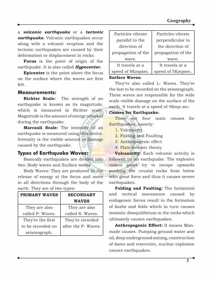
�
Geography
a volcanic earthquake or a tectonic
earthquake. Volcanic earthquakes occur
along with a volcanic eruption and the
tectonic earthquakes are caused by their
deformation or displacement in rocks.
Focus is the point of origin of the
earthquake. It is also called Hypocenter.
Epicenter is the point above the focus
on the surface where the waves are first felt.
Measurements:Richter Scale: The strength of an
earthquake is known as its magnitude,
which is measured in Richter scale.
Magnitude is the amount of energy released
during the earthquake.
Marcauli Scale: The intensity of an
earthquake is measured using this device.
Intensity is the visible amount of damage
caused by the earthquake.
Types of Earthquake Waves:Basically earthquakes are divided into
two: Body waves and Surface waves
Body Waves: They are produced by the
release of energy at the focus and move
in all directions through the body of the
earth. They are of two types:
PRIMARY WAVES SECONDARY
WAVES
They are also
called P- Waves.
They are also
called S- Waves.
They’re the first to be recorded on
seismograph.
They’re recorded
after the P- Waves.
Particles vibrate
parallel to the
direction of
propagation of the
wave.
Particles vibrate
perpendicular to
the direction of
propagation of the
wave.
It travels at a
speed of 8Kmpsec.
It travels at a
speed of 5Kmpsec.
Surface Waves:
They’re also called L- Waves. They’re
the last to be recorded on the seismograph.
These waves are responsible for the wide
scale visible damage on the surface of the
earth. It travels at a speed of 4Kmp sec.
Causes for Earthquake:
There are four main causes for
Earthquakes, namely:
1. Volcanicity
2. Folding and Faulting
3. Anthropogenic effect
4. Plate tectonic theory
Volcanicity: Each volcanic activity is
followed by an earthquake. The explosive
violent gases try to escape upwards
pushing the crustal rocks from below
with great force and thus it causes severe
earthquakes.
Folding and Faulting: The horizontal
and vertical movements caused by
endogeneic forces result in the formation
of faults and folds which in turn causes
isostatic disequilibrium in the rocks which
ultimately causes earthquakes.
Anthropogenic Effect: It means Man-
made causes. Pumping ground water and
oil, deep underground mining, construction
of dams and reservoirs, nuclear explosion
causes earthquakes.
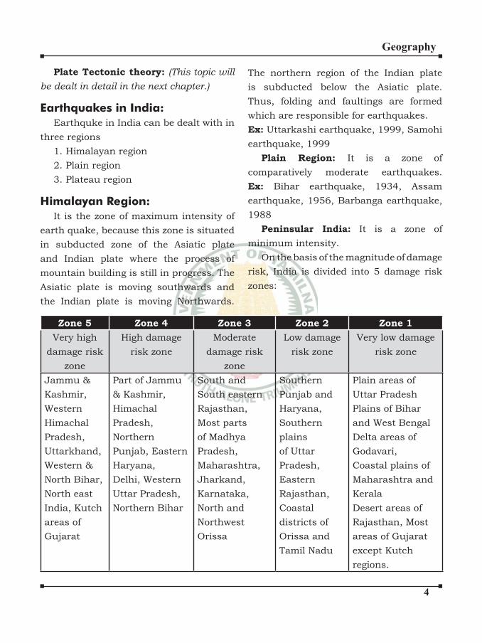
�
Geography
Plate Tectonic theory: (This topic will
be dealt in detail in the next chapter.)
Earthquakes in India:
Earthquke in India can be dealt with in
three regions
1. Himalayan region
2. Plain region
3. Plateau region
Himalayan Region:
It is the zone of maximum intensity of
earth quake, because this zone is situated
in subducted zone of the Asiatic plate
and Indian plate where the process of
mountain building is still in progress. The
Asiatic plate is moving southwards and
the Indian plate is moving Northwards.
The northern region of the Indian plate
is subducted below the Asiatic plate.
Thus, folding and faultings are formed
which are responsible for earthquakes.
Ex: Uttarkashi earthquake, 1999, Samohi
earthquake, 1999
Plain Region: It is a zone of
comparatively moderate earthquakes.
Ex: Bihar earthquake, 1934, Assam
earthquake, 1956, Barbanga earthquake,
1988
Peninsular India: It is a zone of
minimum intensity.
On the basis of the magnitude of damage
risk, India is divided into 5 damage risk
zones:
Zone 5 Zone 4 Zone 3 Zone 2 Zone 1
Very high
damage risk
zone
High damage
risk zone
Moderate
damage risk
zone
Low damage
risk zone
Very low damage
risk zone
Jammu &
Kashmir,
Western
Himachal
Pradesh,
Uttarkhand,
Western &
North Bihar,
North east
India, Kutch
areas of
Gujarat
Part of Jammu
& Kashmir,
Himachal
Pradesh,
Northern
Punjab, Eastern
Haryana,
Delhi, Western
Uttar Pradesh,
Northern Bihar
South and
South eastern
Rajasthan,
Most parts
of Madhya
Pradesh,
Maharashtra,
Jharkand,
Karnataka,
North and
Northwest
Orissa
Southern
Punjab and
Haryana,
Southern
plains
of Uttar
Pradesh,
Eastern
Rajasthan,
Coastal
districts of
Orissa and
Tamil Nadu
Plain areas of
Uttar Pradesh
Plains of Bihar
and West Bengal
Delta areas of
Godavari,
Coastal plains of
Maharashtra and
Kerala
Desert areas of
Rajasthan, Most
areas of Gujarat
except Kutch
regions.
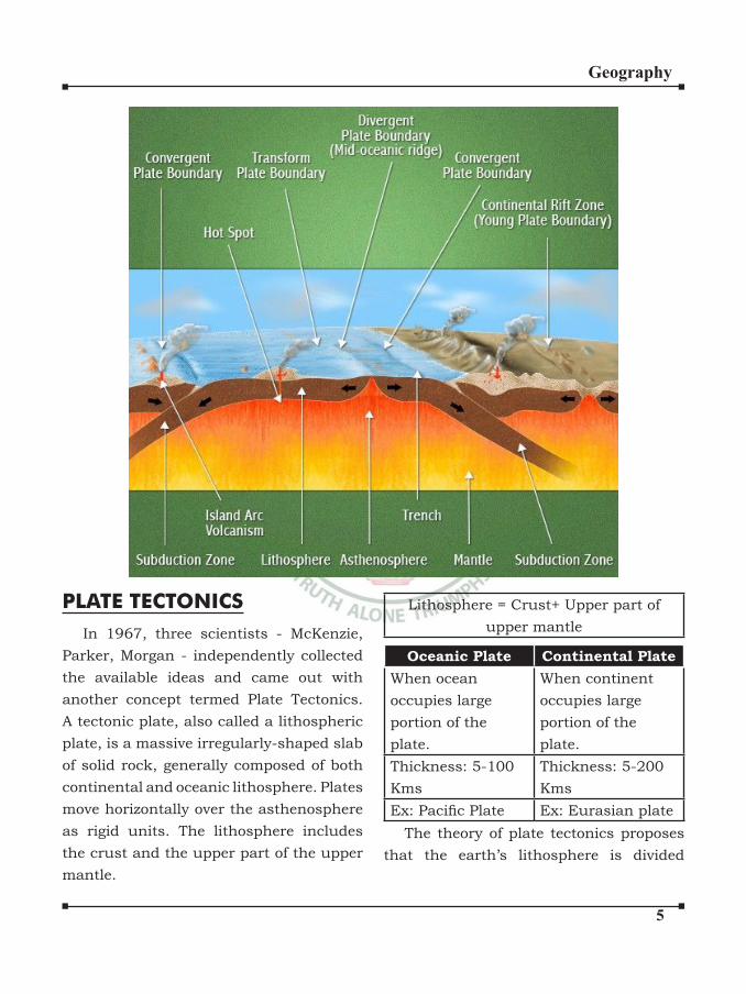
�
Geography
Lithosphere = Crust+ Upper part of
upper mantle
Oceanic Plate Continental Plate
When ocean
occupies large
portion of the
plate.
When continent
occupies large
portion of the
plate.
Thickness: 5-100
Kms
Thickness: 5-200
Kms
Ex: Pacific Plate Ex: Eurasian plate
The theory of plate tectonics proposes
that the earth’s lithosphere is divided
PLATE TECTONICS
In 1967, three scientists - McKenzie,
Parker, Morgan - independently collected
the available ideas and came out with
another concept termed Plate Tectonics.
A tectonic plate, also called a lithospheric
plate, is a massive irregularly-shaped slab
of solid rock, generally composed of both
continental and oceanic lithosphere. Plates
move horizontally over the asthenosphere
as rigid units. The lithosphere includes
the crust and the upper part of the upper
mantle.

�
Geography
into seven major plates and several minor
plates. The seven major plates are:
1. Antartic plate
2. Pacific plate3. North American plate
4. South American plate
5. India- Australia- New Zealand plate
6. African plate
7. Eurasian plate
These plates have been constantly
moving over the globe throughout the
history of the earth. It is not the continent
that moves as believed earlier. Continents
are part of a plate and what moves is the
plate. Moreover, it may be noted that all
the plates, without exception, have moved
in the geological past, and shall continue
to move in the future period as well. There
are three types of plate boundaries:
Divergent Boundaries:
It is where new crust is generated as
the plates pull away from each other. The
sites where the plates move away from
each other are called spreading sites.
Most of the active volcanoes are found
along the mid oceanic ridges. The depth of
‘focus’ ranges between 25 km to 35 km. So
moderate earthquakes are caused in these
plate boundaries. The best-known example
of divergent boundaries is the Mid-Atlantic
Ridge. At this, the American Plate(s) is/are
separated from the Eurasian and African
Plates.
Convergent Boundaries:
Where the crust is destroyed as one
plate dived under another. The location
where sinking of a plate occurs is called
subduction zone. There are three ways in
which convergence can occur.
(i) Between an oceanic and continental
plate
(ii) Between two oceanic plates and
(iii) Between two continental plates
Earth quakes of high magnitude and
deep focus are caused along the convergent
plate boundaries.
These boundaries are associated with
explosive type of volcanic eruptions. ex.
Volcanoes of circum pacific belt
Transform Boundaries:
It is where the crust is neither
produced nor destroyed as the plates slide
horizontally past each other. Transform
faults are the planes of separation generally
perpendicular to the mid-oceanic ridges.
As the eruptions do not take all along the
entire crust at the same time, there is a
differential movement of a portion of the
plate away from the axis of the earth. Also,
the rotation of the earth has its effect on the
separated blocks of the plate portions.
Ex : Earthquakes of California.
Force for the Plate Movement:
When the theory of continental drift was
proposed, most scientists believed that
the earth was a solid, motionless body.
However, concepts of sea floor spreading
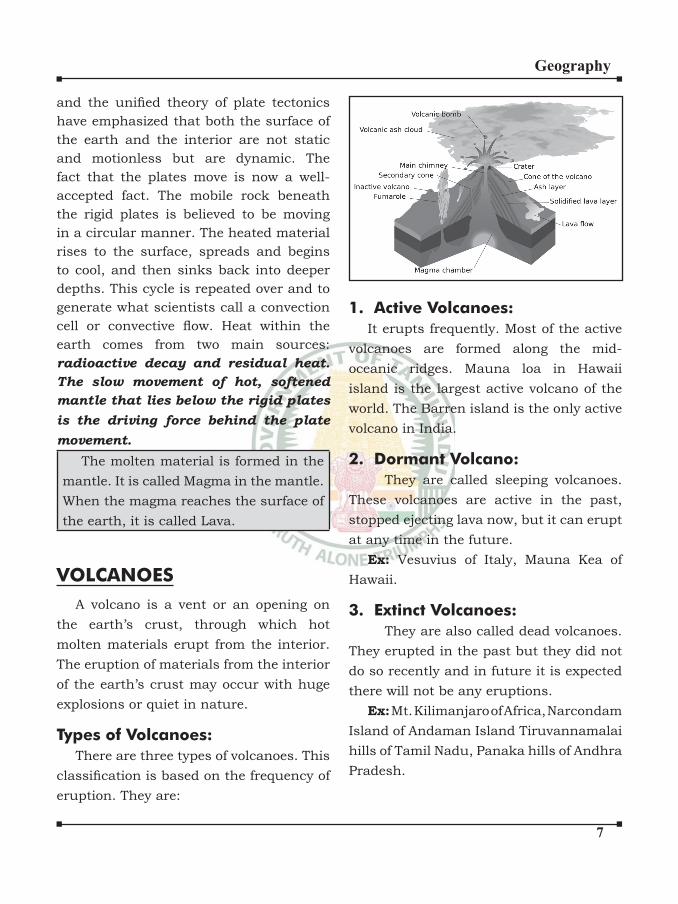
�
Geography
and the unified theory of plate tectonics have emphasized that both the surface of
the earth and the interior are not static
and motionless but are dynamic. The
fact that the plates move is now a well-
accepted fact. The mobile rock beneath
the rigid plates is believed to be moving
in a circular manner. The heated material
rises to the surface, spreads and begins
to cool, and then sinks back into deeper
depths. This cycle is repeated over and to
generate what scientists call a convection
cell or convective flow. Heat within the earth comes from two main sources:
radioactive decay and residual heat.
The slow movement of hot, softened
mantle that lies below the rigid plates
is the driving force behind the plate
movement.
The molten material is formed in the
mantle. It is called Magma in the mantle.
When the magma reaches the surface of
the earth, it is called Lava.
VOLCANOES
A volcano is a vent or an opening on
the earth’s crust, through which hot
molten materials erupt from the interior.
The eruption of materials from the interior
of the earth’s crust may occur with huge
explosions or quiet in nature.
Types of Volcanoes:
There are three types of volcanoes. This
classification is based on the frequency of eruption. They are:
1. Active Volcanoes:
It erupts frequently. Most of the active
volcanoes are formed along the mid-
oceanic ridges. Mauna loa in Hawaii
island is the largest active volcano of the
world. The Barren island is the only active
volcano in India.
2. Dormant Volcano:
They are called sleeping volcanoes.
These volcanoes are active in the past,
stopped ejecting lava now, but it can erupt
at any time in the future.
Ex: Vesuvius of Italy, Mauna Kea of
Hawaii.
3. Extinct Volcanoes:
They are also called dead volcanoes.
They erupted in the past but they did not
do so recently and in future it is expected
there will not be any eruptions.
Ex: Mt. Kilimanjaro of Africa, Narcondam
Island of Andaman Island Tiruvannamalai
hills of Tamil Nadu, Panaka hills of Andhra
Pradesh.
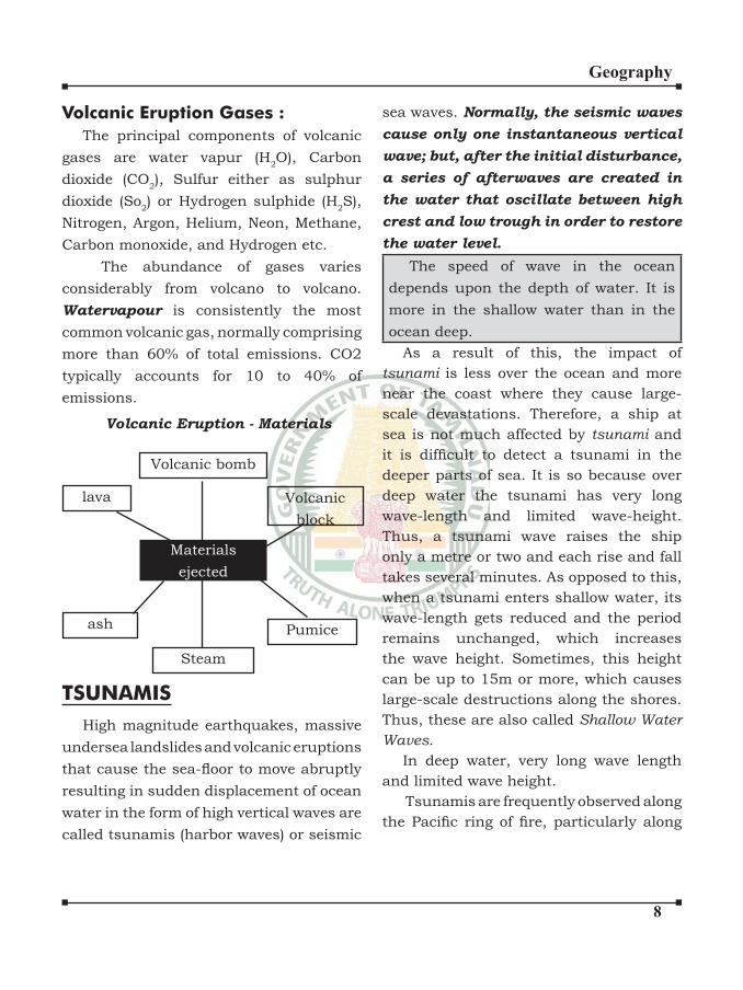
�
Geography
Volcanic Eruption Gases :
The principal components of volcanic
gases are water vapur (H2O), Carbon
dioxide (CO2), Sulfur either as sulphur
dioxide (So2) or Hydrogen sulphide (H
2S),
Nitrogen, Argon, Helium, Neon, Methane,
Carbon monoxide, and Hydrogen etc.
The abundance of gases varies
considerably from volcano to volcano.
Watervapour is consistently the most
common volcanic gas, normally comprising
more than 60% of total emissions. CO2
typically accounts for 10 to 40% of
emissions.
Volcanic bomb
Steam
Volcanic
block
Pumice
lava
ash
Materials
ejected
Volcanic Eruption - Materials
TSUNAMIS
High magnitude earthquakes, massive
undersea landslides and volcanic eruptions
that cause the sea-floor to move abruptly resulting in sudden displacement of ocean
water in the form of high vertical waves are
called tsunamis (harbor waves) or seismic
sea waves. Normally, the seismic waves
cause only one instantaneous vertical
wave; but, after the initial disturbance,
a series of afterwaves are created in
the water that oscillate between high
crest and low trough in order to restore
the water level.
The speed of wave in the ocean
depends upon the depth of water. It is
more in the shallow water than in the
ocean deep.
As a result of this, the impact of
tsunami is less over the ocean and more
near the coast where they cause large-
scale devastations. Therefore, a ship at
sea is not much affected by tsunami and
it is difficult to detect a tsunami in the deeper parts of sea. It is so because over
deep water the tsunami has very long
wave-length and limited wave-height.
Thus, a tsunami wave raises the ship
only a metre or two and each rise and fall
takes several minutes. As opposed to this,
when a tsunami enters shallow water, its
wave-length gets reduced and the period
remains unchanged, which increases
the wave height. Sometimes, this height
can be up to 15m or more, which causes
large-scale destructions along the shores.
Thus, these are also called Shallow Water
Waves.
In deep water, very long wave length
and limited wave height.
Tsunamis are frequently observed along
the Pacific ring of fire, particularly along
�
Geography
the coast of Alaska, Japan, Philippines,
and other islands of Southeast Asia,
Indonesia, Malaysia, Myanmar, SriLanka,
and India etc. After reaching the coast, the
tsunami waves release enormous energy
stored in them and water flows turbulently onto the land destroying port-cities and
towns, structures, buildings and other
settlements. Since the coastal areas are
densely populated the world and these are
also centres of intense human activity, the
loss of life and property is likely to be much
higher by a tsunami as compared to other
natural hazards in the coastal areas.
Unlike other natural hazards, the
mitigation of hazards created by tsunami
is difficult, mainly because of the fact that losses are on a much larger scale. It is
beyond the capacity of individual state or
government to mitigate the damage.
Hence, combined efforts at the
international levels are the possible ways
of dealing with these disasters as has been
in the case of the tsunami that occurred
on 26th December 2004 in which more
than 300,000 people lost their lives. India
has volunteered to join the International
Tsunami Warning System after the
December 2004 tsunami disaster.
Petrology is science of rocks. A
petrologist studies rocks in all their
aspects viz., mineral composition,
texture, structure, origin, occurrence,
alteration and relationship with other
rocks. As there is a close relation between
rocks and landforms, rocks and soils, a
geographer requires basic knowledge of
rocks
ROCKS
Rocks are formed by many biological,
physical, chemical activities of the earth.
The earth’s crust is composed of rocks.
A rock is an aggregate of one or more
minerals. Rock may be hard or soft and in
varied colours. Rocks do not have definite composition of mineral constituents.
Feldspar and quartz are the most
common minerals found in rocks.
There are many different kinds of rocks
which are grouped under three families on
the basis of their mode of formation. They
are: (i) Igneous Rocks (ii) Sedimentary
Rocks (iii) Metamorphic Rocks.
Igneous RocksIgneous rocks form out of magma and
lava from the interior of the earth, they
are known as primary rocks. The igneous
rocks (Ignis – in Latin means ‘Fire’) are
formed when magma cools and solidifies. When magma in its upward movement
cools and turns into solid form it is called
igneous rock. The process of cooling and
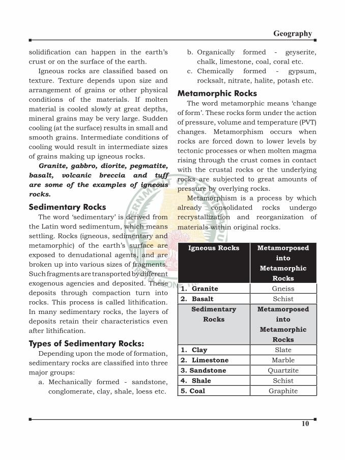
�0
Geography
solidification can happen in the earth’s crust or on the surface of the earth.
Igneous rocks are classified based on texture. Texture depends upon size and
arrangement of grains or other physical
conditions of the materials. If molten
material is cooled slowly at great depths,
mineral grains may be very large. Sudden
cooling (at the surface) results in small and
smooth grains. Intermediate conditions of
cooling would result in intermediate sizes
of grains making up igneous rocks.
Granite, gabbro, diorite, pegmatite,
basalt, volcanic breccia and tuff
are some of the examples of igneous
rocks.
Sedimentary RocksThe word ‘sedimentary’ is derived from
the Latin word sedimentum, which means
settling. Rocks (igneous, sedimentary and
metamorphic) of the earth’s surface are
exposed to denudational agents, and are
broken up into various sizes of fragments.
Such fragments are transported by different
exogenous agencies and deposited. These
deposits through compaction turn into
rocks. This process is called lithification. In many sedimentary rocks, the layers of
deposits retain their characteristics even
after lithification.
Types of Sedimentary Rocks:Depending upon the mode of formation,
sedimentary rocks are classified into three major groups:
a. Mechanically formed - sandstone,
conglomerate, clay, shale, loess etc.
b. Organically formed - geyserite,
chalk, limestone, coal, coral etc.
c. Chemically formed - gypsum,
rocksalt, nitrate, halite, potash etc.
Metamorphic RocksThe word metamorphic means ‘change
of form’. These rocks form under the action
of pressure, volume and temperature (PVT)
changes. Metamorphism occurs when
rocks are forced down to lower levels by
tectonic processes or when molten magma
rising through the crust comes in contact
with the crustal rocks or the underlying
rocks are subjected to great amounts of
pressure by overlying rocks.
Metamorphism is a process by which
already consolidated rocks undergo
recrystallization and reorganization of
materials within original rocks.
Igneous Rocks Metamorposed
into
Metamorphic
Rocks
1. Granite Gneiss
2. Basalt Schist
Sedimentary
Rocks
Metamorposed
into
Metamorphic
Rocks
1. Clay Slate
2. Limestone Marble
3. Sandstone Quartzite
4. Shale Schist
5. Coal Graphite
�
Geography
INTRODUCTION:
India Location
India lies in the northern and eastern
hemispheres of the globe between
8O4’N and 37O6’N - Latitudes and
68O7’E and 97O25’E longitudes.
Tropic of Cancer (23½o) passes
through middle of the country
dividing India into two equal halves.
There is a maritime boundary of
6100 kms along the mainland.
Total coastlines including Is lands is
- 7516 kms
IndIa Water resources -
IndIa physIcal &
rIvers In IndIa
Durand Line - India - Afghanistan and
Pakistan - Afghanistan International
boundary.
McMohanline - India China Eastern
boundary (1140 km) (1913-14 - Shimla
convention)
Radcliff line- India - Pakistan - at the
time of partition (1947)
Size and Shape:
Total Geographical area - 32, 87, 263
sq.km. Which is 2.4% of the total
area of world land.
India is the seventh largest country
in the world.
In population size India occupies
second place in the world after
China.
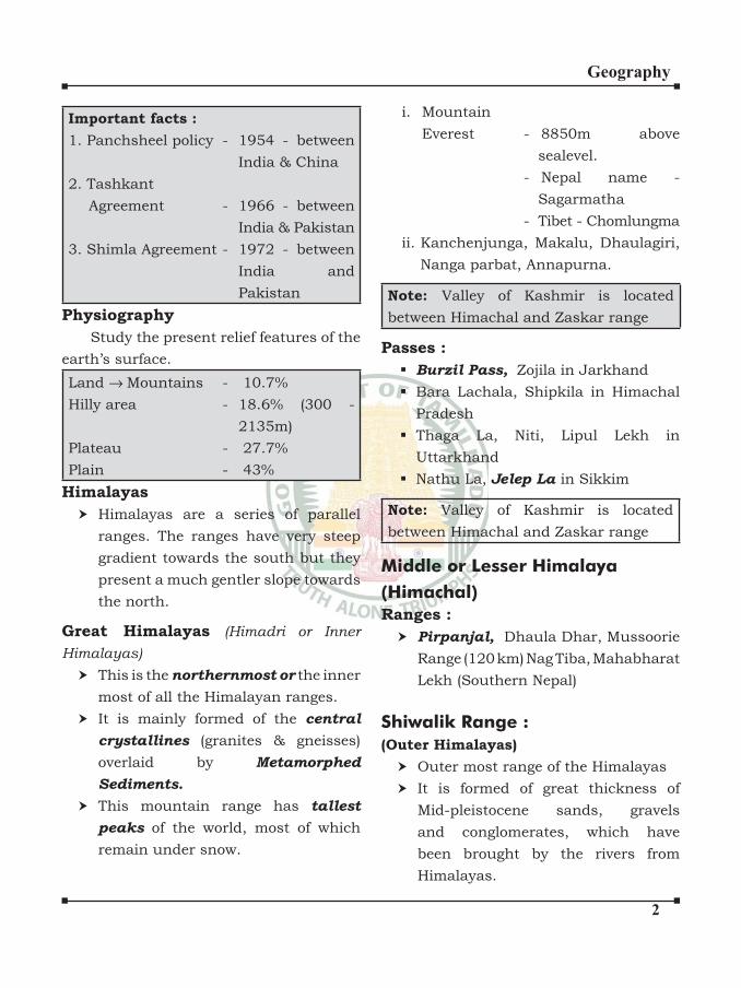
�
Geography
Important facts :
1. Panchsheel policy - 1954 - between
India & China
2. Tashkant
Agreement - 1966 - between
India & Pakistan
3. Shimla Agreement - 1972 - between
India and
Pakistan
Physiography
Study the present relief features of the
earth’s surface.
Land →Mountains - 10.7%
Hilly area - 18.6% (300 -
2135m)
Plateau - 27.7%
Plain - 43%
Himalayas
Himalayas are a series of parallel
ranges. The ranges have very steep
gradient towards the south but they
present a much gentler slope towards
the north.
Great Himalayas (Himadri or Inner
Himalayas)
This is the northernmost or the inner
most of all the Himalayan ranges.
It is mainly formed of the central
crystallines (granites & gneisses)
overlaid by Metamorphed
Sediments.
This mountain range has tallest
peaks of the world, most of which
remain under snow.
i. Mountain
Everest - 8850m above
sealevel.
- Nepal name -
Sagarmatha
- Tibet - Chomlungma
ii. Kanchenjunga, Makalu, Dhaulagiri,
Nanga parbat, Annapurna.
Note: Valley of Kashmir is located
between Himachal and Zaskar range
Passes :
Burzil Pass, Zojila in Jarkhand
Bara Lachala, Shipkila in Himachal
Pradesh
Thaga La, Niti, Lipul Lekh in
Uttarkhand
Nathu La, in Sikkim
Note: Valley of Kashmir is located
between Himachal and Zaskar range
Middle or Lesser Himalaya
(Himachal)
Ranges :
Pirpanjal, Dhaula Dhar, Mussoorie
Range (120 km) Nag Tiba, Mahabharat
Lekh (Southern Nepal)
Shiwalik Range :
(Outer Himalayas)
Outer most range of the Himalayas
It is formed of great thickness of
Mid-pleistocene sands, gravels
and conglomerates, which have
been brought by the rivers from
Himalayas.
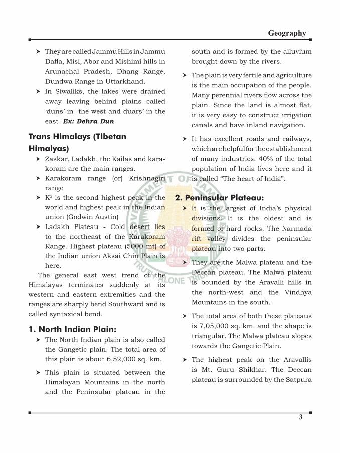
�
Geography
They are called Jammu Hills in Jammu
Dafla, Misi, Abor and Mishimi hills in Arunachal Pradesh, Dhang Range,
Dundwa Range in Uttarkhand.
In Siwaliks, the lakes were drained
away leaving behind plains called
‘duns’ in the west and duars’ in the
east Ex: Dehra Dun
Trans Himalays (Tibetan
Himalyas)
Zaskar, Ladakh, the Kailas and kara-
koram are the main ranges.
Karakoram range (or) Krishnagiri
range
K2 is the second highest peak in the
world and highest peak in the Indian
union (Godwin Austin)
Ladakh Plateau - Cold desert lies
to the northeast of the Karakoram
Range. Highest plateau (5000 mt) of
the Indian union Aksai Chin Plain is
here.
The general east west trend of the
Himalayas terminates suddenly at its
western and eastern extremities and the
ranges are sharply bend Southward and is
called syntaxical bend.
1. North Indian Plain:
The North Indian plain is also called
the Gangetic plain. The total area of
this plain is about 6,52,000 sq. km.
This plain is situated between the
Himalayan Mountains in the north
and the Peninsular plateau in the
south and is formed by the alluvium
brought down by the rivers.
The plain is very fertile and agriculture
is the main occupation of the people.
Many perennial rivers flow across the plain. Since the land is almost flat, it is very easy to construct irrigation
canals and have inland navigation.
It has excellent roads and railways,
which are helpful for the establishment
of many industries. 40% of the total
population of India lives here and it
is called “The heart of India”.
2. Peninsular Plateau:
It is the largest of India’s physical
divisions. It is the oldest and is
formed of hard rocks. The Narmada
rift valley divides the peninsular
plateau into two parts.
They are the Malwa plateau and the
Deccan plateau. The Malwa plateau
is bounded by the Aravalli hills in
the north-west and the Vindhya
Mountains in the south.
The total area of both these plateaus
is 7,05,000 sq. km. and the shape is
triangular. The Malwa plateau slopes
towards the Gangetic Plain.
The highest peak on the Aravallis
is Mt. Guru Shikhar. The Deccan
plateau is surrounded by the Satpura
�
Geography
hills, the Mahadeo hills, the Maikala
range, the Amarkantak hills and the
Rajmahal hills in the north and the
Western Ghats in the west and the
Eastern Ghats in the east.
The Western Ghats are called
Sahyadris in Maharashtra and
Karnataka and further south they
are called Nilgiris in Kerala and
Annamalai range, Cardamom and
Palani hills in Tamilnadu.
Anaimudi in Annamalai range (2,695
mts.) is the highest peak in South
India. The Western Ghats and the
Eastern Ghats meet in the Nilgiri
hills.
The Peninsular plateau has economic
importance because of its rich mineral
resources and many rivers, which
have waterfalls. They help in the
generation of hydroelectric power.
The plateau is also suitable for the
cultivation of cotton and the dense
forests are the home of many wild
animals.
3. Coastal Plains and Islands:
Excluding the islands, the mainland
of India has 6,100 kms length of
coastline. It extends from Kachchh in
Gujarat in the west to the Gangetic
delta in the east.
The coast of India is divided into
western coast and eastern coastal
plains. The western coastal plain
lies between the Western Ghats
and the Arabian Sea and from the
Gulf of Kachchh in the north upto
Cape Comorin (Kanyakumari) in the
south, with a length of about 1,500
km. It is divided into Malabar coast,
Karnataka coast(Canara), Konkan
coast, Gujarat coast and Kachchh
and Kathiawad peninsulas.
The coast is straight and affected by
the South-West Monsoon winds over
a period of six months. So, there are
only a few good harbours Mumbai,
Marmagoa, Cochin, Mangalore,
Karwar, Nhava-Sheva and Kandla
are the important ports on the West
Coast.
The eastern coast extends from
Kanyakumari to the Gangetic delta
and between the Eastern Ghats and
the Bay of Bengal. It consists of the
deltas of rivers Mahanadi, Godavari,
Krishna and Kaveri. It is a broad and
flat land.
There are some salt water lakes or
lagoons. Chilka Lake of Orissa and
Pulicat Lake of Tamilnadu are the
best examples. The Eastern Coast is
divided into Coromandel coast in the
south and Utkal coast in the north.
�
Geography
The coastal regions of India are noted
for agriculture, trade, industrial
centres, tourist centres, fishing and salt making. They provide important
hinterlands for the ports. These
coastal plains play a very important
role in the economic development of
India.
4. Islands of India:
There are 247 islands in India, out
of which there are 204 islands in the
Bay of Bengal and 43 islands in the
Arabian Sea.
There are a few coral islands in the
Gulf of Mannar also. The Andaman
and Nicobar Islands in the Bay of
Bengal consist of hard volcanic
rocks.
The middle Andaman and Great
Nicobar Islands are the largest islands
of India. Lakshadweep islands in the
Arabian Sea are formed by corals.
The southern - most point of India
is in the Greater Nicobar Island.
It is called Indira Point (formerly
it was called Pigmalion Point),now
submerged after 2004 Tsunami.
Majuli Island - Largest River Island in
the world is in Manipur.
WATER RESOURCES
Three-fourth of the earth is surface is
covered with water. But only a small
proportion of it accounts for fresh
water that can be put to use.
96.5% of the total volume of water
in the world is estimated to exist in
oceans.
Only 2.5% exist as fresh water. Nearly
76% of this fresh water is confined in ice sheets and glaciers in Antarctica,
Greenland and the mountainous
regions of the world.
A little less than 30% is stored as
ground water in the world’s aquifers.
India receives nearly 4% of the global
precipitation. India ranks 133 in the
world in terms of water availability
per person, per annum.
RIVERS OF INDIA
The Drainage System:
The drainage system is an integrated
system of tributaries and a trunk
stream which collect and funnel
surface water to the sea, lake or some
other body of water.
The total area that contributes water
to a single drainage system is known
as a drainage basin.
A geometric arrangement of streams
in a region, determined by slope,
�
Geography
differing rock resistance to weathering
and erosion, climate, hydrologic
variability, and structural controls of
the landscape is known as a drainage
pattern.
Thus, drainage pattern refers to a
design which a river and its tributaries
form together, from its source to its
mouth.
India has the following drainage
patterns:
The Antecedent or Inconsequent
Drainage: The rivers that existed
before the upheaval of the Himalayas
and cut their courses southward by
making gorges in the mountains are
known as the antecedent rivers.
Consequent Rivers: The rivers which
follow the general direction of slope
are known as the consequent rivers.
Most of the rivers of peninsular India
are consequent rivers.
Subsequent Rivers: A tributary
stream that is eroded along an
underlying belt of non-resistant
rock after the main drainage
pattern (consequent river) has been
established is known as a subsequent
river. Due to the northward slope
of the Peninsula towards the Great
Plains, the rivers originating from the
Vindhyan and the Satpura ranges flow northward into the Ganga system.
The Chambal, Sind, Ken, Betwa, Tons
and Son meet the Yamuna and the
Ganga at right angles. They are the
subsequent drainage of the Ganga
drainage system.
Superimposed Epigenetic
(Discordant) or Superinduced
Drainage :It is formed when a stream
with a course originally established
on a cover of rock now removed by
erosion, so that the stream or drainage
system is independent of the newly
exposed rocks and structures.
Dendritic Drainage: A term used for
drainage which is branching thereby
giving the appearance of a tree. Most
of the rivers of the Indo-Gangetic
Plains are of dendritic type
Trellis Drainage: Trellis is a
rectangular pattern formed where
two sets of structural controls occurs
at right angles. In a trellis pattern,
the river forms a net like system and
the tributaries flow roughly parallel to each other.
Barbed Pattern: A pattern of drainage
in which the confluence of a tributary with the main river is characterized
by a discordant junction-as if the
tributary intends to flow upstream and not downstream.
Rectangular Drainage: The drainage
pattern marked by right-angled bends
and right-angled junctions between
tributaries and the main stream is
known as rectangular drainage.
�
Geography
Radial Pattern: It is a pattern
characterised by outflowing rivers, away from a central point, analogous
with the spokes of a wheel. It tends to
develop on the flanks of a dome or a volcanic cone.
Annular Pattern: In this drainage
pattern, the subsequent streams
follow curving or arcuate courses
prior to joining the consequent
stream.
Parallel Drainage: The drainage
pattern in which the rivers flow almost parallel to each other is known
as parallel drainage.
Deranged Pattern: This is an
uncoordinated pattern of drainage
characteristic of a region recently
vacated by an ice-sheet.
Indian rivers are of two categories:
Northern rivers and Peninsular
rivers.
Northern rivers:
Indus:
It has 5 tributaries Chenab, Ravi, Beas,
Satluj and Jhelum. Chenab is the largest.
The Indus is one of the most important
drainage systems of the subcontinent of
India. It has a length of 2880 km, of which
709 km lies in India. The catchment area
of the Indus is about 1,165,000 sq km, out
of which about 321,284 sq km is in India.
Satluj is the only one that doesn’t origi-
nate in India.
Ravi, Beas, Satluj, Chenab and Yamuna
flow through Himachal Pradesh.Jhelum (Vitasta):
1. Srinagar is on banks of Jhelum. It
is the most important river of Kash-
mir.
2. Rises at Verinag
Chenab (Asikni):
1. Two headward tributaries: Chandra
and Bhaga
Ravi (Parushni or Irawati):
1. Source near Rohtang pass in Himach-
al Pradesh
Beas (Vipasa or Argikiya):
1. Source near Rohtang pass in Himach-
al Pradesh
2. Entirely within India.
Satluj (Satadru or Satudri):
1. Originates near Mansarovar.
Narmada Bachao Andolan:
Narmada Bachao Andolan is non-
government organisation (NGO).
It has mobilised tribal people,
farmers, environmentalist against
the Sardar Sarovar Dam built across
the Narmada river in Gujarat.
It is originally focussed on the
environmental issues related to
trees that would be submerged
under the dam water.
Now it has re-focussed the aim to
enable the poor citizens (displaced
people) to get full rehabilitation
facilities from the government.
�
Geography
Multi – purpose river projects
and integrated water resources
management:
Sophisticated hydraulic structures
like dams built of stone rubble, res-
ervoirs or lakes, embankments and
canals for irrigation have been con-
structed from ancient times in India
to conserve and manage water.
Dams are a barrier across flowing water that obstructs, directs or re-
tards the flow, often creating a reser-voir, lake or impoundment.
Earlier dams were built to impound
rivers and rainwater for irrigation.
RIVER SYSTEMS IN INDIA
Types of Rivers
Antecedent- Himalayan Rivers
which existed before upheaval of
Himalayas. Eg. Indus, Ganga, Tista,
Brahmaputra etc
Consequent - Follows direction of
slope. Eg Peninsular Rivers
Subsequent - Carve out their own
path over a weak layer of rock. Meet
other rivers at right angles. Eg.
Central Highland Rivers.
Himalayan Rivers
1. Indus River System
Origin - Bokhar Chu glacier, Lake
Mansarovar, Tibet
Enters India through Ladakh
Upper tributaries - Zaskar, Shyok,
Hunza, Nubra, Shigar, Gasting and
Dras
Important tributaries -
Jhelum - Verinag, Pir Panjal
Range
Chenab - largest tributary , called
Chandrabhaga, originates near
Bara Lacha Pass
Ravi - Rohtang Pass , flows through Chamba Valley and Kullu
Hills
Beas - Beas Kund, Rohtang Pass,
meets Satluj at Harike Lake -
Indira Gandhi Canal
Satluj - Rakas Lake , Mansarovar
Range , passes through Shipki La
pass
2. Ganga River System
Origin - Gangotri glacier in
Uttarkashi
Starts as Bhagirathi , meets
Alaknanda at Devprayag
Left Bank tributaries
Ramganga - Gahrwal Hills
Sarda (Kali) - Milam Glacier, Nepal
- UK boundary
Gomati - Pilbit , UP [Pilbit Tiger
Reserve]
Ghagra - Mapchachungo glacier,
Tibet
Gandak - Nepal Himalayas
�
Geography
Kosi - Gosainath peak, Tibet ,
forms Saptkosi after joining Arun
Right Bank tributaries
Yamuna - Yamnotri Glacier ,
Banderpunch peak , Garhwal
Chambal - Mhow, Malwa Plateau,
Gandhi Sagar dam , famous for
Chambal Ravines , meets Yamuna
Sind - tributary of Yamuna
Betwa - Vindhyanchal , joins
Yamuna
Ken - Yamuna
Son - Amarkantak Plateau (a
famous tributary is Rihand) ,
directly meets Ganga
Damodar - Chota Nagpur Plateau
(known for the Damodar Valley
Cooperation) (Like Narmada flows through a rift)
3. Mahananda river (Darjeeling
Hills) is other major tributary
In WB it bifurcates - a tributary
‘Bhagirati and Hugli’ fall southwards in
WB itself. The mainstream ‘Padma’ goes
into Bangladesh and meets Brahmaputra
to form river Meghna. The delta region of
this river are the Sunderbans.
4. Brahmaputra River System
Origin - Chemayungdung glacier,
Kailash Range, East of Mansarovar
Lake
Enters India by making a U turn at
Namcha Barwa peak in Arunachal
Pradesh
Called Dihang in AP - joined by
Dibang and Lohit
Rivers through AP - Kameng, Suban-
siri, Siang, Tirap and Lohit
Sankosh and Manas river (comes
from Bhutan to Assam) is also a trib-
utary
Barak River - rises in Manipur Hills
North Tributaries - Subansiri, Ka-
meng, Belsari, Manas, Sankosh and
Teesta
South Tributaries - Dibru, Dihing,
Barak, Dhansari
In Bangladesh - Merges with Teesta
= Jamuna + Ganga = Padma + Barak
= Meghna
Peninsular Rivers
1. Narmada Basin
Origin - Amarkantak Hills, MP
Flows between Vindhyas and
Satpuras
Notable feature - Dhuandhar Fall ,
Marble Rocks (Jabalpur) , Kapildhara
Fall
Sardar Sarovar dam
Note - Luni river rising in Pushkar
Valley is lost in the marshy Rann of
Katchch and doesn’t fall into sea
�0
Geography
2. Tapi Basin
Origin - Satpuras, MP
Purna is a major tributary
Note - Other main west flowing rivers are:
Sabarmati - Mewar, Aravalli Hills
Mahi - Vindhyas (both drain into
Gulf of Khmbat)
Periyar - Kerala
3. Mahanadi
Origin - Dandakaranya near Sihawa
(Raipur), Chhattisgarh
Flows through Odisha
Other important river in the region is
Brahmani river
4. Godavari
Origin - Trimbuk Plateau, Nashik, MH
Longest River in the South - called
Dakshin Ganga
Major tributaries - Wenganga,
Penganga, Wardha, Manjri, Pranhita,
Indravati
5. Krishna
Origin - Mahabaleshwar, MH
Major tributaries - Tungbhadra, Koyana,
Musi, Bhima
6. Kaveri
Origin - Brahmgiri Range, KN,
Western Ghats
Major tributary - Amravati, Hemvati,
Bhavani
Makes the second biggest waterfall in
India - Sivasamudram
It is a perennial river
Other important river is Vaigai in TN
7. Others
Longest river of Kerala - Bharathpuza,
rises near Annamalai Hills
Shravati river in KN makes Jog or
Gersoppe Falls - highest in India
Two major rivers of Goa - Mandovi
and Juari
Most small rivers in Kerala flow westwards, but Bhavani flows eastwards
GEOGRAPHY OF TAMILNADU
Tamil Nadu is the eleventh largest
state in India and covers an area of
130,058 square kilometres (50,216
sq mi).
It is bordered by Kerala to the west,
Karnataka to the northwest, Andhra
Pradesh to the north, the Bay of
Bengal to the east and the Indian
Ocean to the south.
Cape Comorin (Kanyakumari), the
southernmost tip of the Indian
Peninsula which is the meeting point
of the Arabian Sea, the Bay of Bengal,
and the Indian Ocean.
��
Geography
Seasons of Tamilnadu
Summer
The summer in Tamil Nadu runs
throughout March,April and May and is
characterized by intense heat and scant
rainfall across the state.
Winter
The cold weather commences early in
December and comes to an end in the
middle of March. The climate in the cold
weather is pleasant. The days are bright
and sunny the sun is not too hot.
As soon as the sun sets the temperature
falls and the heat of the day yields place to
cooler weather.
Monsoon
The state has three distinct periods of
rainfall: advance rainfall ; rainfall from
the tropical cyclones emerging in the
neighbourhood of the Andaman islands
during the Retreat of Monsoons(October–
November); and the North East monsoon
during the months of October–December,
with dominant northeast monsoon winds
from the western disturbances emerging
over the Mediterranean Sea. The dry
season is from February to early June.
Tamil Nadu has rain during the
monsoon season due to the southwest
trade winds which blow towards the
northern hemisphere. Tamil Nadu receives
rainfall in the winter season due to
northeast trade winds. The normal annual
rainfall of the state is about 945 mm (37.2
in) of which 48% is through the North East
monsoon,and 32% through the South
West monsoon. Since the state is entirely
dependent on rains for recharging its water
resources, monsoon failures lead to acute
water scarcity and severe drought.
Tamil Nadu is classified into seven aggro-climatic zones: north-east, north-
west, west, southern, high rainfall, high
altitude hilly,and Cauvery Delta (the most
fertile agricultural zone).
Coastline of Tamil Nadu
The Coastline of Tamil Nadu is located
on the southeast coast of Indian Peninsula,
and forms a part of Coromandel Coast
of Bay of Bengal and Indian Ocean. It
is 1,076 km (669 mi) long and is the
second-longest coastline in the country
after Gujarat.Chennai, the capital of the
state and an important commercial and
industrial center in the country is located
in the northern part of the coast with
Kanniyakumari, forming the southern
tip where Indian Ocean, Bay of Bengal
and Arabian Sea meet. It also shares
maritime border with Sri Lanka across the
Palk strait in Gulf of Mannar. The coastal
corridor consists of 13 districts with 15
major ports and harbors, sandy beaches,
lakes and river estuaries.
The coastal stretch extends for 1,076
km (669 mi) from Pazhaverkadu of
Thiruvallur district to Ezhudesam of
��
Geography
Kanniyakumari district. Kanniyakumari,
forms the southernmost tip of the Indian
subcontinent where Indian Ocean, Bay of
Bengal and Arabian Sea meet. Pamban
Islandforms part of Ramanathapuram
district separating Gulf of Mannar and
Palk strait with the Ram Setu connecting
it with Sri Lanka.
There are 13 districts that share the
coastline namely Thiruvallur, Chennai,
Kanchipuram, Villupuram, Cuddalore,
Thiruvarur, Nagapattinam, Thanjavur,
Pudukottai, Ramanathapuram,
Thoothukudi, Tirunelveli and
Kanyakumari.
••••••

�
Geography
The bulk of our food and much of our
clothing is derived from land-based crops
that grow in the soil. The soil on which we
depend so much for our day-to-day needs
has evolved over thousands of years. The
various agents of weathering and gradation
have acted upon the parent rock material
to produce a thin layer of soil.
Soil is the mixture of rock debris
and organic materials which develop on
the earth’s surface. The major factors
affecting the formation of soil are relief,
parent material, climate, vegetation and
other life-forms and time. Besides these,
human activities also influence it to a large extent. Components of the soil are mineral
SOIL ReSOuRceS
particles, humus, water and air. The actual
amount of each of these depends upon the
type of soil. Some soils are deficient in one or more of these, while there are some
others that have varied combinations.
Soil Profile:If we dig a pit on land and look at the
soil, we find that it consists of three layers which are called horizons.
This arrangement of layers is known as
the soil profile. Underneath these three horizons is the rock which is also known
as the parent rock or the bedrock.
‘Horizon A’ is the topmost zone, where
organic materials have got incorporated
with the mineral matter, nutrients and
�
Geography
water, which are necessary for the growth
of plants.
‘Horizon B’ is a transition zone
between the ‘horizon A’ and ‘horizon C’,
and contains matter derived from below
as well as from above. It has some organic
matter in it, although the mineral matter
is noticeably weathered.
‘Horizon C’ is composed of the loose
parent material. This layer is the first stage in the soil formation process and
eventually forms the above two layers.
Classification of Soils: On the basis of genesis, colour,
composition and location, the soils of India
have been classified into:(i) Alluvial soils
(ii) Black soils
Forest Soils
Alluvial Soils
Red & Yellow Soils
Block Soils
Laterite Soils
Arid Soils
ICAR has classified the soils of India into the following order as per the USDA soil
taxonomySl.
No
Order Area
(in Thousand
Hectares)
Percent-
age
1. Inceptisols 130372.90 39.74
2. Entosils 92131.71 28.08
3. Alfosols 44448.68 13.55
4. Vertisols 27960.00 8.52
5. Aridisols 14069.00 4.28
6. Ultisols 8250.00 2.51
7. Mollisols 1320.00 0.40
8. Others 9503.10 2.92
Total 100
Sourse : Soils of India. National Bureau of Soil Survey and Land Use Planning. Publication
Number 94
(iii) Red and Yellow soils
(iv) Laterite soils
(v) Arid soils
(vi) Saline soils
(vii) Peaty soils
(viii) Forest soils
Alluvial Soils:Areas of Occurrence: Alluvial soils are
widespread in the northern plains and the
river valleys. These soils cover about 40
per cent of the total area of the country.
Through a narrow corridor in Rajasthan,
they extend into the plains of Gujarat. In
the Peninsular region, they are found in
deltas of the east coast and in the river
valleys. The alluvial soils vary in nature
from sandy loam to clay.

�
Geography
In the Upper and Middle Ganga plain, two different types of alluvial soils have
developed, viz. Khadar and Bhangar.
Khadar is the new alluvium and is
deposited by floods annually, which enriches the soil by depositing fine silts. Bhangar represents a system of older
alluvium, deposited away from the flood plains. Both the Khadar and Bhangar soils
contain calcareous concretions (Kankars).
Characteristics: They are depositional soils,
transported and deposited by rivers and streams. They are generally rich in
potash but poor in phosphorous.
These soils are more loamy and clayey
in the lower and middle Ganga plain
and the Brahamaputra valley. The sand
content decreases from the west to east.
The colour of the alluvial soils varies
from the light grey to ash grey. Its shades depend on the depth of the deposition, the texture of the materials, and the time
taken for attaining maturity. Alluvial soils
are intensively cultivated.
Black Soil:Areas of Occurrence: Black soil covers
most of the Deccan Plateau which includes
parts of Maharashtra, Madhya Pradesh,
Gujarat, Andhra Pradesh and some parts
of Tamil Nadu. In the upper reaches of the
Godavari and the Krishna, and the north
western part of the Deccan Plateau, the
black soil is very deep.
Characteristics: These soils are also
known as the ‘Regur Soil’ or the ‘Black
Cotton Soil’. The black soils are generally
clayey, deep and impermeable.
They swell and become sticky when
wet and shrink when dried. So, during
the dry season, these soil develop wide
cracks. Thus, there occurs a kind of ‘self
ploughing’. Because of this character of
slow absorption and loss of moisture,
the black soil retains the moisture for a
very long time, which helps the crops,
especially, the rain fed ones, to sustain
even during the dry season.
Chemically, the black soils are rich in lime, iron, magnesia and alumina. They also contain pot-ash. But they lack in phosphorous, nitrogen and organic matter. The
colour of the soil ranges from deep
black to grey.
Red and Yellow Soil:Areas of Occurrence:
RED SOIL YELLOW SOIL
Eastern and
Southern part
of the Deccan
Plateau. Along the
piedmont zone of
the Western Ghat,
long stretch of area
is occupied by red
loamy soil.
Yellow and red
soils are also
found in parts
of Orissa and
Chattisgarh and
in the southern
parts of the middle
Ganga plain.
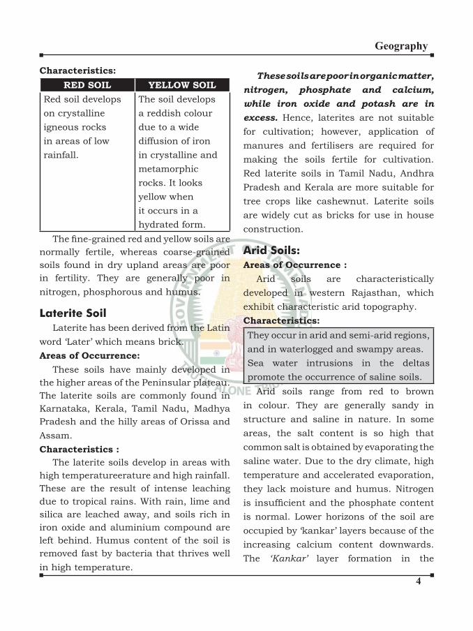
�
Geography
Characteristics:
RED SOIL YELLOW SOIL
Red soil develops
on crystalline
igneous rocks
in areas of low
rainfall.
The soil develops
a reddish colour
due to a wide
diffusion of iron
in crystalline and
metamorphic
rocks. It looks
yellow when
it occurs in a
hydrated form.
The fine-grained red and yellow soils are
normally fertile, whereas coarse-grained
soils found in dry upland areas are poor
in fertility. They are generally poor in
nitrogen, phosphorous and humus.
Laterite SoilLaterite has been derived from the Latin
word ‘Later’ which means brick.
Areas of Occurrence:
These soils have mainly developed in
the higher areas of the Peninsular plateau.
The laterite soils are commonly found in
Karnataka, Kerala, Tamil Nadu, Madhya
Pradesh and the hilly areas of Orissa and
Assam.
Characteristics :
The laterite soils develop in areas with
high temperatureerature and high rainfall.
These are the result of intense leaching
due to tropical rains. With rain, lime and
silica are leached away, and soils rich in
iron oxide and aluminium compound are
left behind. Humus content of the soil is
removed fast by bacteria that thrives well
in high temperature.
These soils are poor in organic matter, nitrogen, phosphate and calcium, while iron oxide and potash are in excess. Hence, laterites are not suitable
for cultivation; however, application of
manures and fertilisers are required for
making the soils fertile for cultivation.
Red laterite soils in Tamil Nadu, Andhra
Pradesh and Kerala are more suitable for
tree crops like cashewnut. Laterite soils
are widely cut as bricks for use in house
construction.
Arid Soils:Areas of Occurrence :
Arid soils are characteristically
developed in western Rajasthan, which
exhibit characteristic arid topography.
Characteristics:
They occur in arid and semi-arid regions,
and in waterlogged and swampy areas.
Sea water intrusions in the deltas
promote the occurrence of saline soils.
Arid soils range from red to brown
in colour. They are generally sandy in
structure and saline in nature. In some
areas, the salt content is so high that
common salt is obtained by evaporating the
saline water. Due to the dry climate, high
temperature and accelerated evaporation,
they lack moisture and humus. Nitrogen
is insufficient and the phosphate content is normal. Lower horizons of the soil are
occupied by ‘kankar’ layers because of the
increasing calcium content downwards.
The ‘Kankar’ layer formation in the
�
Geography
bottom horizons restricts the infiltration of water, and as such when irrigation is made available, the soilmoisture is readily available for a sustainable plant growth. These soils are poor and contain little humus and organic matter.
Saline Soils:Areas of Occurrence :
Saline soils are more widespread in
western Gujarat, deltas of the eastern
coast and in Sunderban areas of West
Bengal. In the Rann of Kuchchh, the
Southwest Monsoon brings salt particles
and deposits there as a crust.
Characteristics:
Saline soils contain a larger proportion of sodium, potassium and magnesium, and thus, they are infertile, and do not support any vegetative growth. They have more salts,
largely because of dry climate and poor
drainage. Their structure ranges from
sandy to loamy. They lack in nitrogen and calcium.
In the areas of intensive cultivation
with excessive use of irrigation, especially
in areas of green revolution, the fertile
alluvial soils are becoming saline. Excessive
irrigation with dry climatic conditions
promotes capillary action, which results
in the deposition of salt on the top layer of
the soil. In such areas, especially in Punjab
and Haryana, farmers are advised to add
gypsum to solve the problem of salinity in
the soil.
Peaty Soils:Areas of Occurrence
It occurs widely in the northern part of
Bihar, southern part of Uttaranchal and the coastal areas of West Bengal, Orissa
and Tamil Nadu.
Characteristics
They are found in the areas of heavy
rainfall and high humidity, where there
is a good growth of vegetation. Thus,
large quantity of dead organic matter
accumulates in these areas, and this gives
a rich humus and organic content to the
soil. Organic matter in these soils may go
even up to 40-50 per cent. These soils are
normally heavy and black in colour. At
many places, they are alkaline also.
Forest Soils
As the name suggests, forest soils are
formed in the forest areas where sufficient rainfall is available. The soils vary in
structure and texture depending on the
mountain environment where they are
formed. They are loamy and silty on valley
sides and coarse-grained in the upper
slopes. In the snow-bound areas of the
Himalayas, they experience denudation,
and are acidic with low humus content. The
soils found in the lower valleys are fertile.
It is evident from the foregoing discussions
that soils, their texture, quality and nature
are vital for the germination and growth
of plant and vegetation including crops.
Soils are living systems. Like any other
organism, they too develop and decay, get
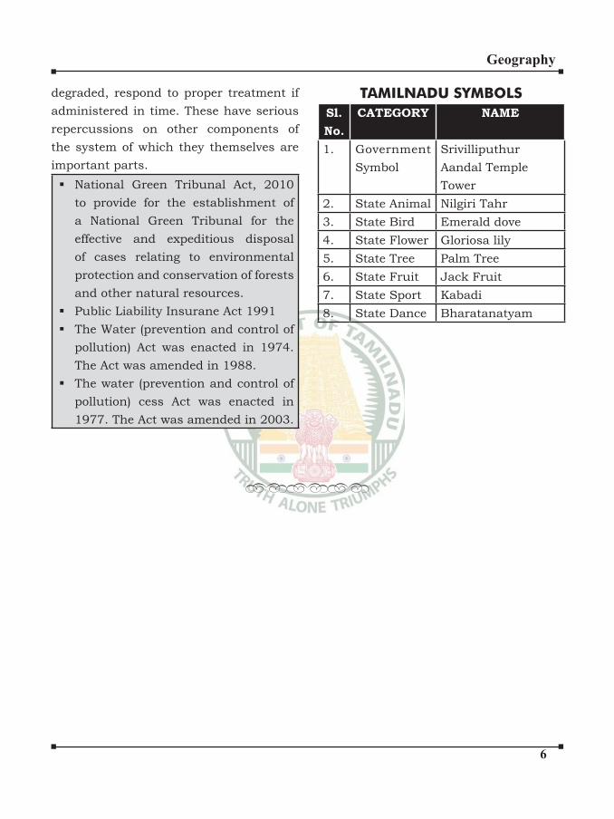
�
Geography
degraded, respond to proper treatment if
administered in time. These have serious
repercussions on other components of
the system of which they themselves are
important parts.
National Green Tribunal Act, 2010
to provide for the establishment of
a National Green Tribunal for the
effective and expeditious disposal
of cases relating to environmental
protection and conservation of forests
and other natural resources.
Public Liability Insurane Act 1991
The Water (prevention and control of
pollution) Act was enacted in 1974.
The Act was amended in 1988.
The water (prevention and control of
pollution) cess Act was enacted in
1977. The Act was amended in 2003.
TAMILNADU SYMBOLSSl.
No.
CATEGORY NAME
1. Government
Symbol
Srivilliputhur
Aandal Temple
Tower
2. State Animal Nilgiri Tahr
3. State Bird Emerald dove
4. State Flower Gloriosa lily
5. State Tree Palm Tree
6. State Fruit Jack Fruit
7. State Sport Kabadi
8. State Dance Bharatanatyam
••••••
�
Geography
A mineral is a natural substance of
organic or inorganic origin with definite chemical and physical properties. A
rock which has large concentration of a
particular mineral is called the ore of that
mineral.
Characteristics of minerals:
1. They are unevenly distributed over
the surface of the Earth.
2. No country in the world is self-
sufficient in all the minerals.3. Most of the minerals have
impurities.
4. Minerals are exhaustible.
MINERALS IN INDIA
Various stages of development
have been named after minerals,
such as:
1. The Stone Age: Man made weapons
and implements from stones.
2. Copper was probably the first metal that man learnt to mine and with its
use started the Copper Age.
3. The Bronze Age started when man
developed a stronger and more
durable metal by mixing copper
and tin.
4. About 3000 years ago, the Bronze
Age was replaced by the lron Age.
5. Iron Age came to be replaced by the
Steel Age in the modern times.
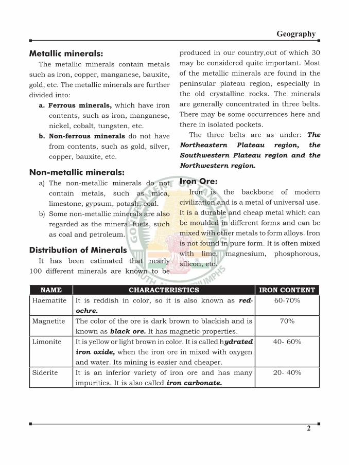
�
Geography
Metallic minerals:
The metallic minerals contain metals
such as iron, copper, manganese, bauxite,
gold, etc. The metallic minerals are further
divided into:
a. Ferrous minerals, which have iron
contents, such as iron, manganese,
nickel, cobalt, tungsten, etc.
b. Non-ferrous minerals do not have
from contents, such as gold, silver,
copper, bauxite, etc.
Non-metallic minerals:
a) The non-metallic minerals do not
contain metals, such as mica,
limestone, gypsum, potash, coal.
b) Some non-metallic minerals are also
regarded as the mineral fuels, such
as coal and petroleum.
Distribution of Minerals
It has been estimated that nearly
100 different minerals are known to be
produced in our country,out of which 30
may be considered quite important. Most
of the metallic minerals are found in the
peninsular plateau region, especially in
the old crystalline rocks. The minerals
are generally concentrated in three belts.
There may be some occurrences here and
there in isolated pockets.
The three belts are as under: The
Northeastern Plateau region, the
Southwestern Plateau region and the
Northwestern region.
Iron Ore:
Iron is the backbone of modern
civilization and is a metal of universal use.
It is a durable and cheap metal which can
be moulded in different forms and can be
mixed with other metals to form alloys. Iron
is not found in pure form. It is often mixed
with lime, magnesium, phosphorous,
silicon, etc.
NAME CHARACTERISTICS IRON CONTENT
Haematite It is reddish in color, so it is also known as red-
ochre.
60-70%
Magnetite The color of the ore is dark brown to blackish and is
known as black ore. It has magnetic properties.
70%
Limonite It is yellow or light brown in color. It is called hydrated
iron oxide, when the iron ore in mixed with oxygen
and water. Its mining is easier and cheaper.
40- 60%
Siderite It is an inferior variety of iron ore and has many
impurities. It is also called iron carbonate.
20- 40%
�
Geography
Reserves of Iron Ore
India has about 20 per cent of the
world’s total reserves of iron ore. About 75
per cent of the total reserves of the iron ore
in India are of haematite grade.
Jharkhand, Orissa, Karnataka, Madhya
Pradesh, Chattisgarh and Goa, have about
97 per cent of the total iron ore reserves of
India.
State/Area Percentage of the
Reserves
1. Jharkhand 25.7
2. Orissa 21.6
3. Karnataka 20.7
4. MP-Chattisgarh 18.5
5. Goa 10.5
6. Maharashtra 1.8
7. Others 1.2
AREAS OF IRON ORE
PRODUCTION
Today India is the largest producer
of iron ore in Asia and seventh largest
producer in the world. Most of the iron
ore mined in India are of Haematite and
Magnetite varieties. These ores have
high percentage of iron contents and low
sulphur contents.
Madhya Pradesh-Chattisgarh: Durg,
Bastar and Jabalpur districts. Bailadila
range in Bastar and Dhalli-Raihara range
in Durg are the main producing regions.
Raigarh, Bilaspur, Mandla, Balagat and
Surguja districts.
Jharkhand: PurviSinghbhum, Paschimi
Singhbhum and Palamau districts, at
Charia in Singhbhum district. A major
part of the iron ore production goes to
Rourkela, Bokaro, and IISCO steel plants.
The exports are mainly through Haldia
port.
Karnataka: The bulk of the production
(more than 90 per cent) comes from
Bellary district, followed by Chitradurga,
Chikmagalur, Bijapur, Tumkur, etc. The
state is the second largest producer of iron
ore in India.
Goa: It is the third largest producer
of iron ore and most of the production
comes from the mines in North Goa.
The ore is of inferior quality. Almost the
entire production from Goa is exported to
Japan.
Orissa: The high grade haematite variety
of iron ore is found in the Mayurbhanj,
Keonjhar and Sundargarh districts. The
other producing districts or areas are
Sambalpur, Cuttack and Korapur.
Andhra Pradesh: The main iron ore
producing centres are in the districts
of Anantapur, Khammam, Kurnool,
Cuddapah, Krishna and Nellore.
Tamil Nadu: Most of iron ore with 35
to 50 per cent of iron contents are found
in Salem, North Arcot, Tiruchchirappalli,
Coimbatore and Madurai districts.
Others:
Some production of iron ore is from
Ratnagiri, Chandrapur, Satara and Bandara
districts in Maharashtra; Bhilwara and
�
Geography
Udaipur districts in Rajasthan; Junagarh
and Bhavnagar districts in Gujarat;
Mahendragarh district in Haryana;
Rajauri, Jammu and Udhampur districts
in Jammu and Kashmir; and in some
parts of Uttarakhand, Uttar Pradesh, and
Himachal Pradesh.
Trade of Iron Ore:Exported to Japan, South Korea, East
European Countries and the Gulf region.
The main ports handing the export are
Marmugao, Vishakhapatanam, Paradip,
Mangalore, Haldia and Chennai.
Manganese:
Manganese is a black hard and iron-like
metal, which is widely used in the making
of iron and steel and in the manufacture
of ferro-manganese alloys. It is also used
in the manufacture of bleaching powder,
dry cell batteries, enamel, insecticides,
plastics, glazed potteries, matches, glass
and chemical industries.
Occurrence and Reserves of Manganese
In India
The highest occurrence of manganese
ore in India is found in the Dhawar system
of rocks. India has 20 per cent of the total
known reserves in the world. The main
reserves are in Karnataka, Orissa, Madhya
Pradesh, Maharashtra and Goa. Some
reserves also occur in Andhra Pradesh,
Jharkhand, Gujarat, Rajasthan and West
Bengal.
Areas of Manganese Production in
India
India is the fifth largest producer of manganese in the world, after Brazil,
Gabon, South Africa and Australia.
There are three main areas of manganese
production in our country.
1. The northeastern region,
comprising Orissa and Jharkhand.
The reserves are about 19 per cent
and the production is about 33 per
cent.
2. The central region, comprising
Madhya Pradesh and north
Maharashtra. The reserves are about
15 per cent and the production is
about 39 per cent.
3. The peninsular region, comprising
Karnataka, Andhra Pradesh, Goa
and south Maharashtra. The
reserves are about 45 per cent and
the production is about 30 per cent.
Orissa:
It is the largest producer (33 per cent)
of manganese in the country. The ore has
high iron and low phosphorus contents.
Districts: Keonjhar, Sundargarth,
Korapur, Kalahandi, Mayurbhanj, Talcher
and Bolangir districts.
Madhya Pradesh:
It is the third largest producer (20 per
cent) of manganese in the country. The
main producing districts are Balaghat,
Chhindwara, Jabalpur and Jhabua. Small
deposits are also found in Dewas, Sehore
and Nimar districts.
Karnataka:
With largest reserves of manganese, the
state is the fourth largest producer (14 per
cent) in the country.
Districts: Bellary is the most important
producer followed by Shimoga, Chitradurga,
Tumkur and Belgaum districts.
�
Geography
Others:
The other producing states are Andhra
Pradesh (Srikakulam and Vishakhapatnam
districts), Rajasthan, Goa, Gujarat,
Jharkhand, Tamil Nadu and West Bengal.
Bauxite:
Bauxite, a clay-like substance, is the
ore of aluminium. Due to its lightness,
strength, malleability, ductility, heat and
electrical conductivity and resistance to
atmospheric corrosion, aluminium has
become one of the most useful metals in
the present age. Converting bauxite into
aluminium, depends on the availability of
cheap and enough electricity.
Reserves of Bauxite in India:
The Indian reserves of bauxite are the
fifth largest in the world after Guinea, Australia, Brazil and Vietnam. More than
half of India’s bauxite reserves are in
Orissa and Andhra Pradesh states.
Recently extensive deposits of bauxite
have been discovered in the Jammu and
Poonch areas of the Jammu and Kashmir
state. The other states which have rich
reserves of bauxite are Jharkhand,
Madhya Pradesh, Gujarat, Maharashtra,
Karnataka, Tamil Nadu, Kerala, Goa and
Uttar Pradesh.
Areas of Bauxite Production
About 90 per cent of bauxite in our
country is of metallic grade. There has been
a significant progress in the production of bauxite in India.
Orissa, Jharkhand, Bihar, Gujarat,
Maharashtra, Madhya Pradesh,
Chattisgarh and Tamil Nadu.
Limestone
Limestone (calcium carbonate) is
associated with rocks composed of
carbonate of calcium and magnesium or
mixture of the two. Limestone deposits are
of sedimentary origin and exist in almost
all geological formations except in the
Gondwana region.Of the total consumption,
75 per cent is used in cement industry, 16
per cent in iron and steel industry, 4 per
cent in chemical industry and the rest in
paper, sugar, fertilizers, ferro-manganese,
glass and rubber industries.
Areas of Limestone Production
Almost all the states in India produce
some quantities of limestone, but about
75 per cent of the total production comes
from Madhya Pradesh, Chattisgarh,
Andhra Pradesh, Rajasthan, Gujarat and
Karnataka
Coal:
Coal, a mineral fuel, is the main
source of energy in India. Coal is an
organic substance, composed mainly of
hydrocarbons, found in the sedimentary
rocks. In the geological past, large areas
under thick forests were buried under
the sediments. The heat and pressure of
the overlying sediments together with the
earth movement led to the formation of
coal. Coal’s capacity to give energy depends
upon its carbon content.
Types of Coal
Coal can be grouped in four types,
such as peat, lignite, bituminous and
anthracite.
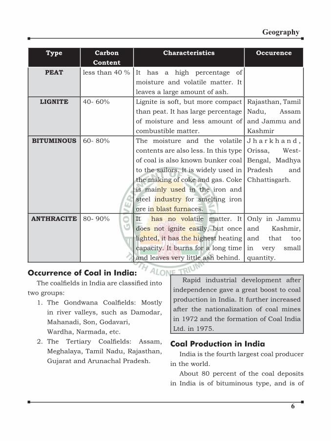
�
Geography
Type Carbon
Content
Characteristics Occurence
PEAT less than 40 % It has a high percentage of
moisture and volatile matter. It
leaves a large amount of ash.
LIGNITE 40- 60% Lignite is soft, but more compact
than peat. It has large percentage
of moisture and less amount of
combustible matter.
Rajasthan, Tamil
Nadu, Assam
and Jammu and
Kashmir
BITUMINOUS 60- 80% The moisture and the volatile
contents are also less. In this type
of coal is also known bunker coal
to the sailors. It is widely used in
the making of coke and gas. Coke
is mainly used in the iron and
steel industry for smelting iron
ore in blast furnaces.
J h a r k h a n d ,
Orissa, West-
Bengal, Madhya
Pradesh and
Chhattisgarh.
ANTHRACITE 80- 90% It has no volatile matter. It
does not ignite easily, but once
lighted, it has the highest heating
capacity. It burns for a long time
and leaves very little ash behind.
Only in Jammu
and Kashmir,
and that too
in very small
quantity.
Occurrence of Coal in India:
The coalfields in India are classified into two groups:
1. The Gondwana Coalfields: Mostly in river valleys, such as Damodar,
Mahanadi, Son, Godavari,
Wardha, Narmada, etc.
2. The Tertiary Coalfields: Assam, Meghalaya, Tamil Nadu, Rajasthan,
Gujarat and Arunachal Pradesh.
Rapid industrial development after
independence gave a great boost to coal
production in India. It further increased
after the nationalization of coal mines
in 1972 and the formation of Coal India
Ltd. in 1975.
Coal Production in India
India is the fourth largest coal producer
in the world.
About 80 percent of the coal deposits
in India is of bituminous type, and is of
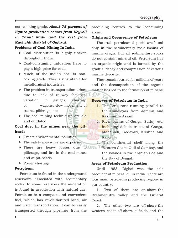
�
Geography
non-cooking grade. About 75 percent of
lignite production comes from Neyveli
in Tamil Nadu and the rest from
Kachchh district of Gujarat.
Problems of Coal Mining In India
Coal distribution is highly uneven
throughout India.
Coal-consuming industries have to
pay a high price for coal.
Much of the Indian coal is non-
coking grade. This is unsuitable for
metallurgical industries.
The problem in transportation arises
due to lack of railway facilities,
variation in gauges, shortage
of wagons, slow movement of
trains, pilferage, etc.
The coal mining techniques are old
and outdated.
Coal dust in the mines near the pit-
heads
Create environmental pollution.
The safety measures are expensive.
There are heavy losses due to
pilferage, and fire in the coal mines and at pit-heads.
Power shortage.
Petroleum
Petroleum is found in the underground
reservoirs associated with sedimentary
rocks. In some reservoirs the mineral oil
is found in association with natural gas.
Petroleum is a compact and convenient
fuel, which has revolutionized land, air
and water transportation. It can be easily
transported through pipelines from the
producing centres to the consuming
areas.
Origin and Occurrence of Petroleum
The crude petroleum deposits are found
only in the sedimentary rock basins of
marine origin. But all sedimentary rocks
do not contain mineral oil. Petroleum has
an organic origin and is formed by the
gradual decay and compression of various
marine deposits.
They remain buried for millions of years
and the decomposition of the organic
matter has led to the formation of mineral
oil.
Reserves of Petroleum in India
1. The Terai zone running parallel to
the Himalayas from Jammu and
Kashmir to Assam.
2. River basins of Ganga, Satluj, etc.
including deltaic tracts of Ganga,
Mahanadi, Godavari, Krishna and
Kaveri.
3. The continental shelf along the
Western Coast, Gulf of Cambay, and
the islands in the Arabian Sea and
the Bay of Bengal.
Areas of Petroleum Production
Until 1953, Digboi was the sole
producer of mineral oil in India. There are
four main petroleum producing regions in
our country.
1. Two of them are on-shore-the
Brahmaputra valley and the Gujarat
Coast.
2. The other two are off-shore-the
western coast off-shore oilfields and the
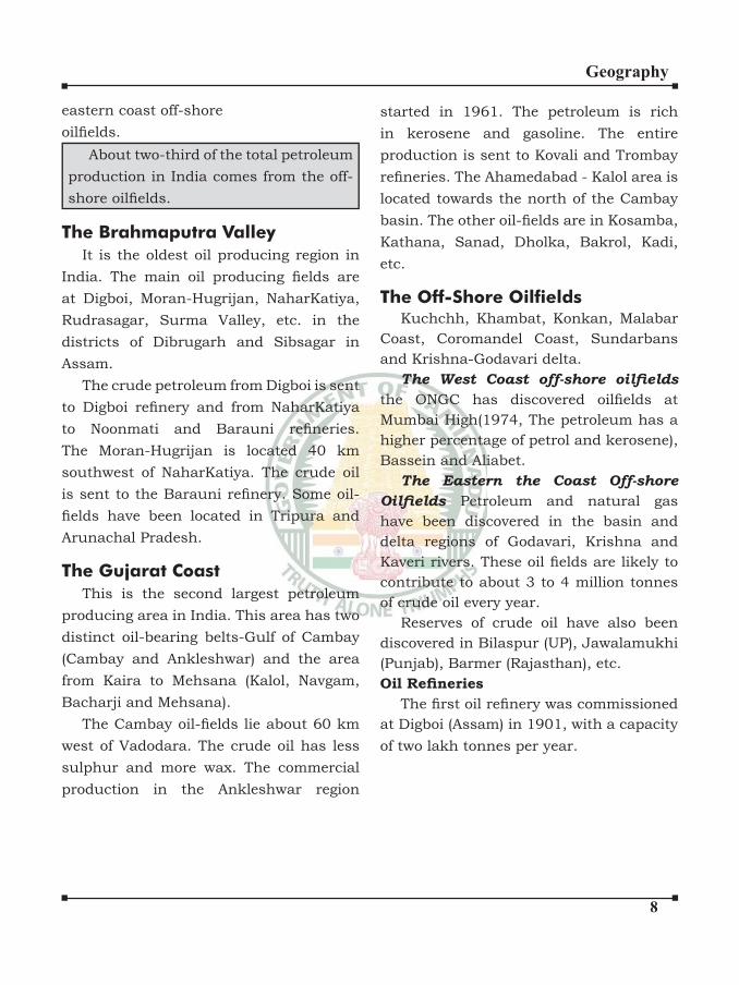
�
Geography
eastern coast off-shore
oilfields. About two-third of the total petroleum
production in India comes from the off-
shore oilfields.
The Brahmaputra Valley
It is the oldest oil producing region in
India. The main oil producing fields are at Digboi, Moran-Hugrijan, NaharKatiya,
Rudrasagar, Surma Valley, etc. in the
districts of Dibrugarh and Sibsagar in
Assam.
The crude petroleum from Digboi is sent
to Digboi refinery and from NaharKatiya to Noonmati and Barauni refineries. The Moran-Hugrijan is located 40 km
southwest of NaharKatiya. The crude oil
is sent to the Barauni refinery. Some oil-fields have been located in Tripura and Arunachal Pradesh.
The Gujarat Coast
This is the second largest petroleum
producing area in India. This area has two
distinct oil-bearing belts-Gulf of Cambay
(Cambay and Ankleshwar) and the area
from Kaira to Mehsana (Kalol, Navgam,
Bacharji and Mehsana).
The Cambay oil-fields lie about 60 km west of Vadodara. The crude oil has less
sulphur and more wax. The commercial
production in the Ankleshwar region
started in 1961. The petroleum is rich
in kerosene and gasoline. The entire
production is sent to Kovali and Trombay
refineries. The Ahamedabad - Kalol area is located towards the north of the Cambay
basin. The other oil-fields are in Kosamba, Kathana, Sanad, Dholka, Bakrol, Kadi,
etc.
The Off-Shore OilfieldsKuchchh, Khambat, Konkan, Malabar
Coast, Coromandel Coast, Sundarbans
and Krishna-Godavari delta.
The West Coast off-shore oilfields
the ONGC has discovered oilfields at Mumbai High(1974, The petroleum has a
higher percentage of petrol and kerosene),
Bassein and Aliabet.
The Eastern the Coast Off-shore
Oilfields Petroleum and natural gas
have been discovered in the basin and
delta regions of Godavari, Krishna and
Kaveri rivers. These oil fields are likely to contribute to about 3 to 4 million tonnes
of crude oil every year.
Reserves of crude oil have also been
discovered in Bilaspur (UP), Jawalamukhi
(Punjab), Barmer (Rajasthan), etc.
Oil RefineriesThe first oil refinery was commissioned
at Digboi (Assam) in 1901, with a capacity
of two lakh tonnes per year.
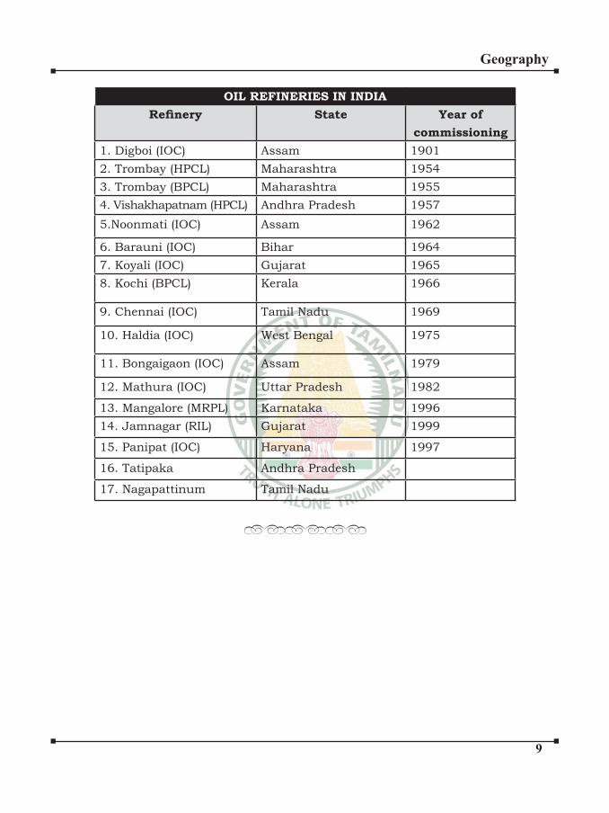
�
Geography
OIL REFINERIES IN INDIA
Refinery State Year of
commissioning
1. Digboi (IOC) Assam 1901
2. Trombay (HPCL) Maharashtra 1954
3. Trombay (BPCL) Maharashtra 1955
4. Vishakhapatnam (HPCL) Andhra Pradesh 1957
5.Noonmati (IOC) Assam 1962
6. Barauni (IOC) Bihar 1964
7. Koyali (IOC) Gujarat 1965
8. Kochi (BPCL) Kerala 1966
9. Chennai (IOC) Tamil Nadu 1969
10. Haldia (IOC) West Bengal 1975
11. Bongaigaon (IOC) Assam 1979
12. Mathura (IOC) Uttar Pradesh 1982
13. Mangalore (MRPL) Karnataka 1996
14. Jamnagar (RIL) Gujarat 1999
15. Panipat (IOC) Haryana 1997
16. Tatipaka Andhra Pradesh
17. Nagapattinum Tamil Nadu
••••••

�
Geography
Resources are a function of human
activities. Human beings themselves
are essential components of resources.
They transform material available in
our environment into resources and use
them.
These resources can be classified in the following ways –
(a) On the basis of origin – biotic and
abiotic
(b) On the basis of exhaustibility –
renewable and non-renewable
(c) On the basis of ownership –
individual, community, national
and international
(d) On the basis of status of
development – potential, developed
stock and reserves.
TYPES OF RESOURCES
On the Basis of Origin
Biotic Resources: These are obtained
from biosphere and have life such as
human beings, flora and fauna, fisheries, livestock etc.
NATURAL RESOURCES
Abiotic Resources: All those things
which are composed of non-living things
are called abiotic resources. For example,
rocks and metals.
On the Basis of Exhaustibility
Renewable Resources: The resources
which can be renewed or reproduced by
physical, chemical or mechanical processes
are known as renewable or replenishable
resources. For example, solar and wind
energy, water, forests and wildlife, etc. The
renewable resource may further be divided
into continuous or flow . Non-Renewable Resources: These occur
over a very long geological time. Minerals
and fossil fuels are examples of such
resources. These resources take millions
of years in their formation. Some of the
resources like metals are recyclable and
some like fossil fuels cannot be recycled
and get exhausted with their use.
On the Basis of Ownership
Individual Resources: These are also
owned privately by individuals. Many
�
Geography
farmers own land which is allotted to
them by government against the payment
of revenue. In villages there are people
with land ownership but there are many
who are landless. Urban people own plots,
houses and other property. Plantation,
pasture lands, ponds, water in wells etc.
are some of the examples of resources
ownership by individuals.
Community Owned Resources: There
are resources which are accessible to all
the members of the community. Village
commons (grazing grounds, burial
grounds, village ponds, etc.) public parks,
picnic spots, playgrounds in urban areas
are de facto accessible to all the people
living there.
Natural Resources in India
India is endowed with different types
of natural Resources such as fertile
soil, forests, minerals and water. These
resources are unevenly distributed.
The various types of different Natural
Resources of India is discussed below:
Soil Resource:
India has a large proportion of well
watered fertile lands. In the alluvial soil
of the Northern Great Plains of the Sutlej-
Ganga plains and Brahmaputra Valley
wheat, rice, maize, sugarcane, jute, cotton,
rapeseed, mustard, sesumum, linseed,
etc. are grown in abundance.
In the black soil of Maharashtra, Andhra
Pradesh, Tamil Nadu, Gujarat cotton and
sugarcane are grown.
The improper use of soil destroys
its composition, texture and structure
Unscientific irrigation causes capillary action making soil alkaline and unsuitable
for cultivation. The proper management of
soil is important for soil conservation in
India.
Mineral Resource:
India is quite rich in some minerals
like iron, coal, mineral oil, manganese,
bauxite, chromite, copper, tungsten,
gypsum, limestone, mica and so on.
A number of organizations like Geological
Survey of India, Indian Bureau of Mines,
etc. are engaged in the exploration and
development of mineral resource in India.
Livestock Resource:
Hills, mountains and less fertile lands
are put under pasture. Scientific methods are followed in rearing cattle. India
maintains rich domestic animal diversity.
India has a good population of goat,
sheep, poultry, cattle, buffalo, etc. Indian
livestock plays a vital role in improving
the socio-economic status of the rural
masses.
Reduce: This means that you use
less. You save electricity by switching off
unnecessary lights and fans. You save
water by repairing leaky taps. You do
not waste food.

�
Geography
Recycle: This means that you collect
plastic, paper, glass and metal items
and recycle these materials to make
required things instead of synthesising
or extracting fresh plastic, paper, glass
or metal. In order to recycle, we first need to segregate our wastes so that
the material that can be recycled is not
dumped along with other wastes.
Reuse: This is actually even better
than recycling because the process of
recycling uses some energy. In the ‘reuse’
strategy, you simply use things again
and again. Instead of throwing away
used envelopes, you can reverse it and
use it again. The plastic bottles in which
you buy various food-items like jam or
pickle can be used for storing things in
the kitchen.
Horticulture:
Diverse agro-climatic conditions in India
facilitate cultivation of a large number of
horticulture crops such as vegetables,
fruits, flower, medicinal and aromatic plant, mushroom, etc. and plantation
corps like tea, coffee and rubber.
They provide opportunities for growing
spices.
Fisheries:
Fish production has been showing
increasing trend. India is one of the leading
fish producer.
Forest Resource:
India possesses a variety of natural
vegetation since the country has a varied
relief and climate. These forests are confined to the plateaus and hilly mountainous
areas. India has a great variety of fauna.
There are many national parks and
hundreds of wild life sanctuaries.
Forests are called ‘green gold’. They
are renewable resources. They provide
quality environment. They eat up CO2, the
poisons of urbanization, industrialization,
explosion of population, etc. They regulate
climate as they act as natural ‘sponge’.
Arresting soil erosion, increasing soil
fertility growing forest based industries,
providing medicinal herbs, animal habitats,
cattle fodder, domestic fuel and foreign
exchange they contribute substantially to
Indian economy.
Unfortunately India’s forest cover is
diminishing at an alarming rate. So,
various measures for afforestation have
been introduced.
The forest (conservation) Act 1980 was
made in India. No forest can be diverted
for non-forest purpose.
The Forest Research Institute was
established at Dehradun for research
in forestry development. Cutting trees
selectively, planting new trees, protecting
trees, observing world Forestry Day every
March 21 by planting trees, etc. are the
schemes of afforestation.
�
Geography
Natural vegetation refers to a plant
community that has been left undisturbed
over a long time, so as to allow its
individual species to adjust themselves
to climate and soil conditions as fully as
possible. India is a land of great variety
of natural vegetation. Himalayan heights
are marked with temperate vegetation;
the Western Ghats and the Andaman
Nicobar Islands have tropical rain forests,
the deltaic regions have tropical forests
and mangroves; the desert and semi
desert areas of Rajasthan are known for
cactii, a wide variety of bushes and thorny
vegetation. Depending upon the variations
NATURAL VEGETATION
in the climate and the soil, the vegetation of
India changes from one region to another.
On the basis of certain common features
such as predominant vegetation type and
climatic regions, Indian forests can be
divided into the following groups:
Types of forests
(i) Tropical Evergreen and Semi
Evergreen forests
(ii) Tropical Deciduous forests
(iii) Tropical Thorn forests
(iv) Montane forests
(v) Littoral and Swamp forests.
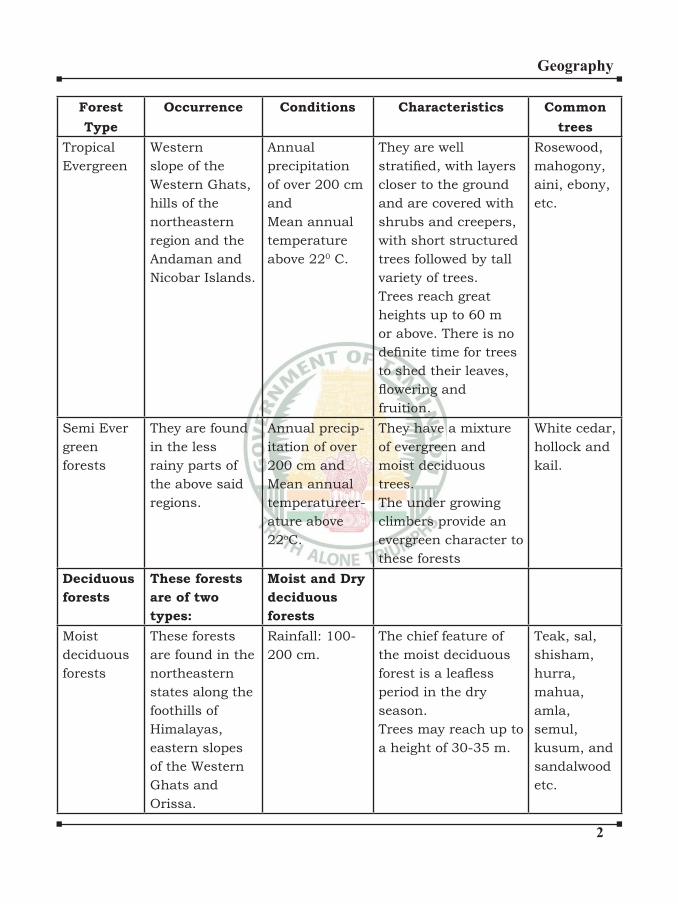
�
Geography
Forest
Type
Occurrence Conditions Characteristics Common
trees
Tropical
Evergreen
Western
slope of the
Western Ghats,
hills of the
northeastern
region and the
Andaman and
Nicobar Islands.
Annual
precipitation
of over 200 cm
and
Mean annual
temperature
above 220 C.
They are well
stratified, with layers closer to the ground
and are covered with
shrubs and creepers,
with short structured
trees followed by tall
variety of trees.
Trees reach great
heights up to 60 m
or above. There is no
definite time for trees to shed their leaves,
flowering andfruition.
Rosewood,
mahogony,
aini, ebony,
etc.
Semi Ever
green
forests
They are found
in the less
rainy parts of
the above said
regions.
Annual precip-
itation of over
200 cm and
Mean annual
temperatureer-
ature above
22oC.
They have a mixture
of evergreen and
moist deciduous
trees.
The under growing
climbers provide an
evergreen character to
these forests
White cedar,
hollock and
kail.
Deciduous
forests
These forests
are of two
types:
Moist and Dry
deciduous
forests
Moist
deciduous
forests
These forests
are found in the
northeastern
states along the
foothills of
Himalayas,
eastern slopes
of the Western
Ghats and
Orissa.
Rainfall: 100-
200 cm.
The chief feature of
the moist deciduous
forest is a leafless period in the dry
season.
Trees may reach up to
a height of 30-35 m.
Teak, sal,
shisham,
hurra,
mahua,
amla,
semul,
kusum, and
sandalwood
etc.
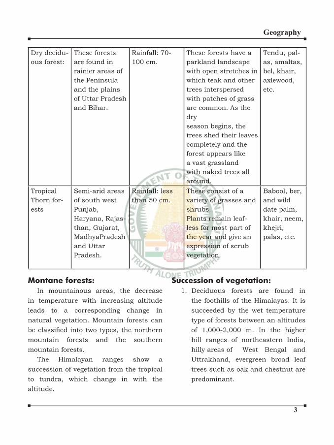
�
Geography
Dry decidu-
ous forest:
These forests
are found in
rainier areas of
the Peninsula
and the plains
of Uttar Pradesh
and Bihar.
Rainfall: 70-
100 cm.
These forests have a
parkland landscape
with open stretches in
which teak and other
trees interspersed
with patches of grass
are common. As the
dry
season begins, the
trees shed their leaves
completely and the
forest appears like
a vast grassland
with naked trees all
around.
Tendu, pal-
as, amaltas,
bel, khair,
axlewood,
etc.
Tropical
Thorn for-
ests
Semi-arid areas
of south west
Punjab,
Haryana, Rajas-
than, Gujarat,
MadhyaPradesh
and Uttar
Pradesh.
Rainfall: less
than 50 cm.
These consist of a
variety of grasses and
shrubs.
Plants remain leaf-
less for most part of
the year and give an
expression of scrub
vegetation.
Babool, ber,
and wild
date palm,
khair, neem,
khejri,
palas, etc.
Montane forests:
In mountainous areas, the decrease
in temperature with increasing altitude
leads to a corresponding change in
natural vegetation. Mountain forests can
be classified into two types, the northern mountain forests and the southern
mountain forests.
The Himalayan ranges show a
succession of vegetation from the tropical
to tundra, which change in with the
altitude.
Succession of vegetation:
1. Deciduous forests are found in
the foothills of the Himalayas. It is
succeeded by the wet temperature
type of forests between an altitudes
of 1,000-2,000 m. In the higher
hill ranges of northeastern India,
hilly areas of West Bengal and
Uttrakhand, evergreen broad leaf
trees such as oak and chestnut are
predominant.

�
Geography
2. Between 1,500-1,750m, pine
forests are also well-developed in
this zone, with chir pine as a very
useful commercial tree. Deodar,
a highly valued endemic species
grows mainly in the western part of
the Himalayan range
3. At many places in this zone,
temperature grasslands are also
found.
4. But in the higher reaches there is
a transition to Alpine forests and
pastures. Silver firs, junipers, pines, birch and rhododendrons, etc. occur
between 3,000 - 4,000m. However,
these pastures are used extensively
for transhumance by tribes like
the Gujjars, the Bakarwals, the
Bhotiyas and the Gaddis.
The southern slopes of the Himalayas
carry a thicker vegetation cover because
of relatively higher precipitation than
the drier north-facing slopes. At higher
altitudes, mosses and lichens form part of
the tundra vegetation.
The southern mountain forests
include the forests found in three distinct
areas of Peninsular India viz; the Western
Ghats, theVindhyas and the Nilgiris. As
they are closer to the tropics, and only
1,500 m above the sea level, vegetation
is temperature in the higher regions, and
subtropical on the lower regions of the
Western Ghats, especially in Kerala, Tamil
Nadu and Karnataka. The temperature
forests are called Sholas in the Nilgiris,
Anaimalai and Palani hills. Some of the
other trees of this forest of economic
significance include magnolia, laurel, cinchona and wattle. Such forests are
also found in the Satpura and the Maikal
ranges.
Littoral and Swamp forests:
The country’s wetlands have been
grouped into eight categories,
(i) the reservoirs of the Deccan
Plateau in the south together with
the lagoons and other wetlands of
the southern west coast;
(ii) the vast saline expanses of
Rajasthan, Gujarat and the Gulf
of Kachchh;
(iii) freshwater lakes and reservoirs
from Gujarat eastwards through
Rajasthan (Keoladeo National
Park) and Madhya Pradesh;
(iv) the delta wetlands and lagoons of
India’s east coast (Chilka Lake);
(v) the freshwater marshes of the
Gangetic Plain;
(vi) the flood plains of the Brahmaputra; the marshes and swamps in the
hills of northeast India and the
Himalayan foothills;
(vii) the lakes and rivers of the
montane region of Kashmir and
Ladakh; and
(viii) the mangrove forest and other
wetlands of the island arcs of the
Andaman and Nicobar Islands.
�
Geography
Mangroves grow along the coasts in the
salt marshes, tidal creeks, mud flats and estuaries. They consist of a number of salt-
tolerant species of plants. Crisscrossed by
creeks of stagnant water and tidal flows, these forests give shelter to a wide variety
of birds. In India, the mangrove forests
spread over 6,740 sq. km which is 7 per
cent of the world’s mangrove forests. They
are highly developed in the Andaman and
Nicobar Islands and the Sunderbans of
West Bengal. Other areas of significance are the Mahanadi, the Godavari and the
Krishna deltas. These forests too, are
being encroached upon, and hence, need
conservation.
Forest And Wild Life
Technical Terms:
National Parks: National Parks are
the reserved forests where natural
vegetation, natural beauty and
wildlife are preserved in their natural
environment.
Wildlife Sanctuaries: Wildlife
sanctuaries are the portion of the
natural forests where hunting and
poaching of wild animals and birds
are prohibited.
Endangered Species: Species in
danger of extinction are known as
endangered species. Ex: Asiatic
elephant.
Endemic Species: Species which
are found in some specific areas are known as endemic species. Ex:
Andaman wild pig.
Bio-diversity or Biological Diversity
is immensely rich in wildlife and
cultivated species, diverse in form
and function but closely integrated in
a system through multiple network of
interdependencies. Various organism
play different roles of producer,
consumer and decomposers. The
existence of other organism along
with humans depends on these roles.
The existence of millions of living
being simultaneously termed as bio-
diversity.
Flora and Fauna in India: India is
one of the world’s richest countries in
terms of vast range of bio-diversity.
It has about 8% of the total number
of species in the world (estimated
to be 1.6 million). India has 81000
species of fauna and 47000 species
of flora. About 15000 species of flowering plant in fauna are endemic (indigenous) to India.
Acts implemented for Conservation
of Wildlife:
The Indian Wildlife Protection Act
1972: The aim of the programme was
towards protecting the remaining
endangered species by banning
hunting, giving legal protection to
their habitat and restricting wildlife
�
Geography
trade. Central and many state
governments established national
parks and sanctuaries.
Notification under Wildlife Act 1980 and 1986: Several hundred
butterflies, moths, beetles, and one dragonfly have been added to the list of protected species.
Wildlife Act 1990: Plants were added
to the list, starting with six species
for the first time.Project Tiger:
“Project Tiger” was launched in 1973.
At present there are Tiger Reserves in
the country.
Some of the major tiger reserves are:
Corbett National Park,
Uttarakhand
Sundarbans National Park, West
Bengal
Bhandhavgarh National Park,
Madhya Pradesh
Manas Tiger Reserve, Assam
Periyar Tiger Reserve, Kerala
Kanha National Park, Madhya
Pradesh.
Types of Forest and Wildlife Resources:
Reserved Forests: These forests are
regarded as the most valuable from
the point of conservation forests and
wildlife resources concerned.
Protected Forests: These forests
lands are protected from any further
depletion
Unclassed Forests: These are other
forests and westelands. They belong
to both government and private
individuals and communities.
Reserved Forests : 54.4% total
forests land
Protected Forests : 29.2% total
forests land
Unclassed Forests: 16.4% total
forests land
Reserved and Protected forests are
termed as permanent forests.
Involvement of Local Communities
‘Natural Resource’ Management
• Chipko Andolan in Himalayas
successfully resisted deforestation
and encourage Afforestation.
• Beej Bachao Andolan in Tehri and
Navdanya proved adequate levels of
diversified crop production without use of synthetic chemicals.
• In India Joint Forest Management
(JFM) involves local communities
in management and restoration of
degraded forests.
Distribution of Forests:
Madhya Pradesh has the largest
area under permanent forests.
Other states Jammu and Kashmir,
Andhra Pradesh, Uttarakhand,
Kerala, Tamil Nadu, West Bengal and
Maharashtra.
Unclassed forests are situated in
north-eastern states of India and
Gujarat.
�
Geography
Dense forests are found in north-
eastern states, Andaman and Nicobar
Island and Uttarkhand.
Open forests are found in Punjab,
Haryana, M.P., Maharashtra,
Karnataka, Tamil Nadu, Kerala,
Bihar, Chhattisgarh, Jharkhand and
Orissa.
Mangrove forests are found in
Sundarbans Delta and Deltas of
east flowing rivers of the peninsular plateau.
Now dams were built for power
generation, water supply for domestic
and industrial use, flood control, recreation, inland navigation and
fish breeding.Hence dams are called multi-purpose
projects.
Examples: Bhakra Nangal Project,
Hirakud Project.
Multi-purpose projects were launched
after independence.
These were proclaimed as ‘temples of
modern India’.
••••••
�
Geography
Net sown area: 46%
Forest: 23%
Area not available for cultivation: 14%
Fallow land (Land out of cultivation for
1 to 5 years): 8%
Agricultural land (net sown area+ fallow
land): 54%
Waste land: 5%
Pastures and tree crops: 5%
Intensity of cropping = (Total cropped
area/ Net sown area)* 100
It refers to the number of crops raised on a
field during an agricultural year.
STATE INTENSITY OF
CROPPING
Punjab 189%
Uttar Pradesh 180%
Himachal Pradesh 170%
AGRICULTURE
Haryana 168%
West Bengal 166%
Mizoram 100%
CROP SEASON MAJOR CROPS
Kharif (June-
September)
Rice, Jute, Maize,
Cotton,Bajra,
Jowar, Ragi,
Ground nut.Rabi (October-
March)
Wheat, Gram,
Rapeseeds,
Mustard, Barley,
Jowar.Zaide (April- June) Fruits, Vegetables
and fodder crops.

�
Geography
CROP REQUIREMENTS AREAS OF
PRODUCTION
RICE
India is the 2nd largest
producer and consumer.One-quarter of the net
sown area of the eastern
and western part of the
country is rice.
High heat and humidity.Temperature: 20- 30oc
Annual Rainfall: 150 cms
Soil: clayey soil.
West Bengal, Punjab,
Uttar Pradesh
WHEAT
Sown in the beginning of
winter and harvested in the
beginning of summer.India is the fourth largest
producer in the world
They’re mid-latitude
grasslands.Temperature: (10- 15)oc
Annual Rainfall: 100 cm
Soil: loamy and clayey soil.
Uttar Pradesh, Punjab
and Haryana
MAIZE
It can be used as food,
fodder and manure.
Temperature: (21- 27)o c
Annual Rainfall: (50- 100)
cm
Soil: Alluvial soil/ Red soil
Karnataka, Andhra
Pradesh, Maharashtra
MILLETS (Jowar, Ragi, Bajra, Barley)
JOWAR Temperature: (16- 30)oC
Annual Rainfall: (30-100) cm
Maharashtra, Karnataka
BAJRA Dry and warm climate
Temperature: (25- 30)oC
Annual Rainfall: (40-50) cm
Maharashtra, Gujarat
RAGI (Finger millet or Buck
Wheat)
Temperature: (20- 30)oC
Annual Rainfall: (50-100) cm
Tamil Nadu, Karnataka,
Uttarkand, Maharashtra
BARLEY It cannot tolerate high heat
and humidity
Temperature: (10-15)oC
Annual Rainfall: (75-100) cm
Uttar Pradesh, Rajasthan
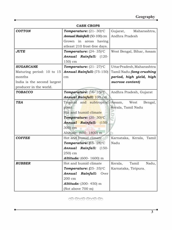
�
Geography
CASH CROPS
COTTON Temperature: (21- 30)oC
Annual Rainfall: (50-100) cm
Grown in areas having
atleast 210 frost-free days.
Gujarat, Maharashtra,
Andhra Pradesh
JUTE Temperature: (24- 35)oC
Annual Rainfall: (120-
150) cm
West Bengal, Bihar, Assam
SUGARCANE
Maturing period: 10 to 15
months
India is the second largest
producer in the world.
Temperature: (21- 27)oC
Annual Rainfall: (75-150)
cm
Uttar Pradesh, Maharashtra
Tamil Nadu (long crushing
period, high yield, high
sucrose content)
TOBACCO Temperature: (16- 35)oC
Annual Rainfall: 100 cm
Andhra Pradesh, Gujarat
TEA Tropical and subtropical
plant
Hot and humid climate
Temperature: (20- 30)oC
Annual Rainfall: (150-
300) cm
Altitude: (600- 1800) m
Assam, West Bengal,
Kerala, Tamil Nadu
COFFEE Hot and humid climate
Temperature: (15- 28)oC
Annual Rainfall: (150-
250) cm
Altitude: (600- 1600) m
Karnataka, Kerala, Tamil
Nadu
RUBBER Hot and humid climate
Temperature: (25- 35)oC
Annual Rainfall: Over
200 cm
Altitude: (300- 450) m
(Not above 700 m)
Kerala, Tamil Nadu,
Karnataka, Tiripura.
••••••

�
Geography
Livestock census
Livestock census started in the
country in the year 1919. So far 18 such censuses have been conducted. The livestock census in 2012 is 19th
in the series of Livestock censuses.
The total livestock population
consisting of cattle, Buffalo, sheep,
Goat, Pig, Horses & Ponies, Mules,
Donkeys, Camels, Mithun and Yak
in the country is 512.05 million number in 2012. The total livestock population has decreased by about
3.33% over the previous census.
LIVESTOCK AND
FISHERIES
SL. No Distribution of Livestock
1. Cattle 37.28%2. Goat 26.40%3. Buffalo 21.23%4. Sheep 12.71%5. Pigs 2.01%6. Others 0.37%
SL.
No
Largest
Population
State
1. Buffalo Uttarpradesh
2. Cattle Madhya Pradesh
3. Sheep Andhra Pradesh
4. Goat Rajasthan
5. Pig Assam
6. Camel Rajasthan
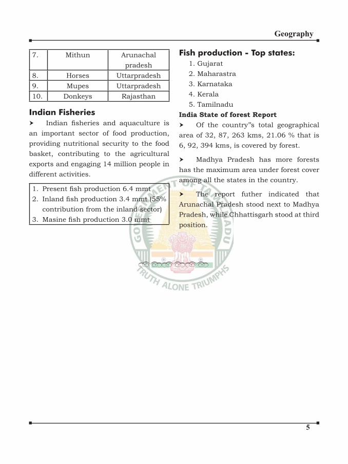
�
Geography
7. Mithun Arunachal
pradesh
8. Horses Uttarpradesh
9. Mupes Uttarpradesh
10. Donkeys Rajasthan
Indian Fisheries
Indian fisheries and aquaculture is an important sector of food production,
providing nutritional security to the food
basket, contributing to the agricultural
exports and engaging 14 million people in
different activities.
1. Present fish production 6.4 mmt2. Inland fish production 3.4 mmt (55%
contribution from the inland sector)
3. Masine fish production 3.0 mmt
Fish production - Top states:
1. Gujarat 2. Maharastra 3. Karnataka 4. Kerala 5. Tamilnadu
India State of forest Report
Of the country’’s total geographical
area of 32, 87, 263 kms, 21.06 % that is 6, 92, 394 kms, is covered by forest.
Madhya Pradesh has more forests
has the maximum area under forest cover
among all the states in the country.
The report futher indicated that
Arunachal Pradesh stood next to Madhya
Pradesh, while Chhattisgarh stood at third
position.
••••••

IRCLEGeography
Page 1
POPULATION DENSITY AND DISTRIBUTION
POPULATION:
India is the second most populous country in the world after China. The first all India census, though
not taken synchronously, was completed in 1872. Since 1881, the census has been taken every decade, the
latest having been completed in 2011. According to the 2011 Census the total population of India was about
121.02 crore (1.21 billion) having registered a growth of 17.64 per cent over the 2001 figure. This total of 1.21
billion comprises about 623.7 million males and about 586.5 million females. Prersently India represents
about 17.31 per cent of the total population of the world.
POPULATION DENSITY:
Average density of population as per 2011 census is 382 persons per sq.km. the however, the density
is not uniform throughout the country. The highest density is in the NCT of Delhi – 11297 persons per sq.km.
Among the states, Bihar has the highest density – 1102 persons per sq.km. The lowest density is in Arunachal
Pradesh- 17 persons per sq.km.
One state in the country that has witnessed a negative growth in population, namely Nagaland, has
also witnessed a decline in density, from 120 persons per sq.km to 119 persons per sq.km.
SEX RATIO
The sex ratio in India is negative, i.e. there are fewer females than males in the country. The average
sex ratio according to 2011 Census is 940 females per thousand males. This figure shows a growth over the
figures for 2001 census, when the average sex ratio was 933 females per 1000 males. Kerala is the only state
with more females than males – 1084 females per 1000 males. Among Union Territories only Puducherry has
a positive sex ratio – 1038 females per 1000 males. Among states, Haryana has the lowest sex ratio – 877
females per 1000 males. The state of Tamil Nadu has the most even sex ratio among states – 995 females per
1000 males.
LITERACY:
Literacy rate is another important characteristic of population. Average rate of literacy according to
2011 Census is 74.04 per cent. Literacy is higher among males (82.14 per cent) than among female (65.91 per
cent). The highest literacy rate is among females (93.91 per cent). Kerala also has the distinction of having a
female literacy rate of more than 90 per cent. The lowest female literacy rate is in Bihar (63.82 per cent). The
lowest female literacy rate is also in Bihar (53.33 per cent). Among the Union Territories Lakshadweep has
the highest literacy rate (92.28 per cent) while Dadra and Nagar Haveli has the lowest literacy rate (77.65 per
cent) among them.
TREND OF GROWTH:
Population in India has been continuously growing since 1921 and the decade 1911-21 was the only
period of negative growth in population. The decadal growth rate showed a rising trend till 1971 when it
reached 24.80 per cent. This trend of rising growth rate has since been reversed and has come down to 17.64
per cent during 2001-11. However the growth rate in some parts of the country is still high. Dadra and Nagar
Haveli had the some parts of the country is still high. Dadra and Nagar Haveli had the highest growth rate of
55.50 per cent while Daman and Diu followed it closely with 53.54 per cent. The highest growth rate among
states has been in Meghalaya (27.82 per cent), Andhra Pradesh (25.92 per cent), Bihar (25.07 per cent),
Jammu and Kashmir (23.71 per cent), Mizoram (22.78 per cent), Chhattisgarh (25.59 per cent), Jharkhand
(22.34 per cent), Rajasthan (21. 44 per cent), Madhya Pradesh (20.30 per cent) and Uttar Pradesh (20.09
per cent). Among the larger states Kerala has the lowest growth rate (4.86 per cent). Nagaland is the only
state in the country to have shown a negative growth rate (-0.47 per cent).
TRIBAL GROUPS
SL.NO.
1. Abhors People of Mongoloid stock living in the north-easter parts of India
2. Adivasis Tribals of Bastar district, Chhattisgarh
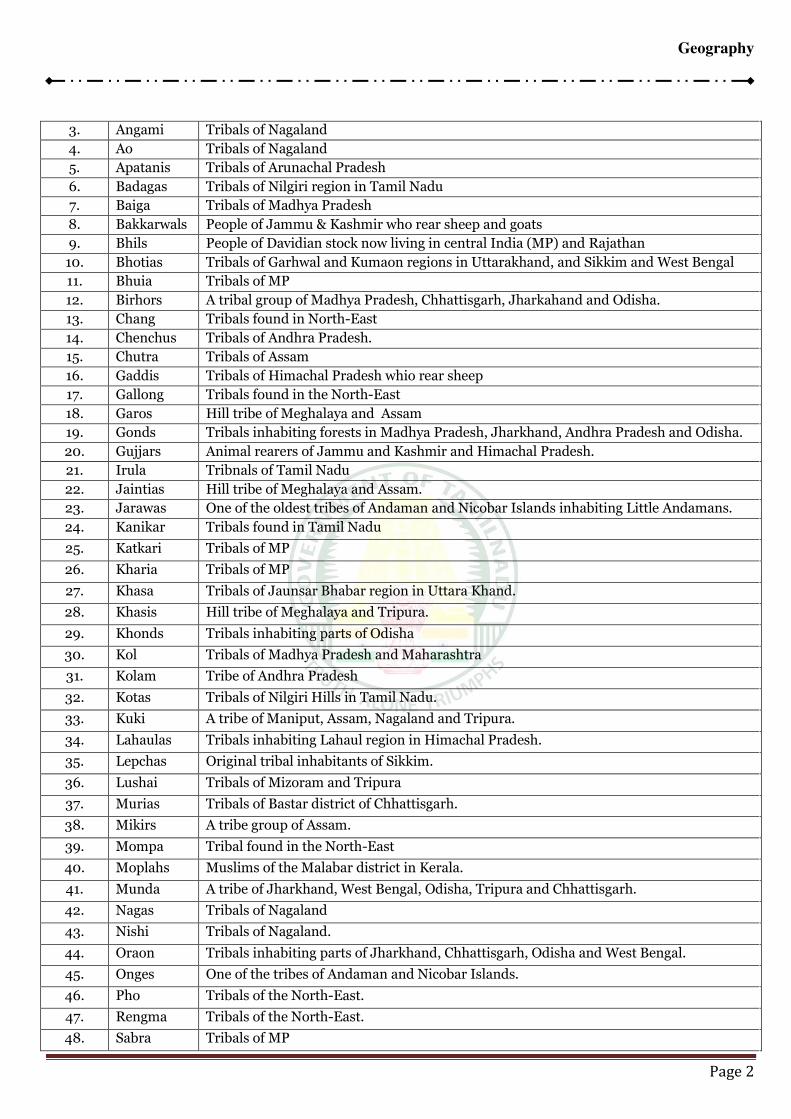
IRCLEGeography
Page 2
3. Angami Tribals of Nagaland
4. Ao Tribals of Nagaland
5. Apatanis Tribals of Arunachal Pradesh
6. Badagas Tribals of Nilgiri region in Tamil Nadu
7. Baiga Tribals of Madhya Pradesh
8. Bakkarwals People of Jammu & Kashmir who rear sheep and goats
9. Bhils People of Davidian stock now living in central India (MP) and Rajathan
10. Bhotias Tribals of Garhwal and Kumaon regions in Uttarakhand, and Sikkim and West Bengal
11. Bhuia Tribals of MP
12. Birhors A tribal group of Madhya Pradesh, Chhattisgarh, Jharkahand and Odisha.
13. Chang Tribals found in North-East
14. Chenchus Tribals of Andhra Pradesh.
15. Chutra Tribals of Assam
16. Gaddis Tribals of Himachal Pradesh whio rear sheep
17. Gallong Tribals found in the North-East
18. Garos Hill tribe of Meghalaya and Assam
19. Gonds Tribals inhabiting forests in Madhya Pradesh, Jharkhand, Andhra Pradesh and Odisha.
20. Gujjars Animal rearers of Jammu and Kashmir and Himachal Pradesh.
21. Irula Tribnals of Tamil Nadu
22. Jaintias Hill tribe of Meghalaya and Assam.
23. Jarawas One of the oldest tribes of Andaman and Nicobar Islands inhabiting Little Andamans.
24. Kanikar Tribals found in Tamil Nadu
25. Katkari Tribals of MP
26. Kharia Tribals of MP
27. Khasa Tribals of Jaunsar Bhabar region in Uttara Khand.
28. Khasis Hill tribe of Meghalaya and Tripura.
29. Khonds Tribals inhabiting parts of Odisha
30. Kol Tribals of Madhya Pradesh and Maharashtra
31. Kolam Tribe of Andhra Pradesh
32. Kotas Tribals of Nilgiri Hills in Tamil Nadu.
33. Kuki A tribe of Maniput, Assam, Nagaland and Tripura.
34. Lahaulas Tribals inhabiting Lahaul region in Himachal Pradesh.
35. Lepchas Original tribal inhabitants of Sikkim.
36. Lushai Tribals of Mizoram and Tripura
37. Murias Tribals of Bastar district of Chhattisgarh.
38. Mikirs A tribe group of Assam.
39. Mompa Tribal found in the North-East
40. Moplahs Muslims of the Malabar district in Kerala.
41. Munda A tribe of Jharkhand, West Bengal, Odisha, Tripura and Chhattisgarh.
42. Nagas Tribals of Nagaland
43. Nishi Tribals of Nagaland.
44. Oraon Tribals inhabiting parts of Jharkhand, Chhattisgarh, Odisha and West Bengal.
45. Onges One of the tribes of Andaman and Nicobar Islands.
46. Pho Tribals of the North-East.
47. Rengma Tribals of the North-East.
48. Sabra Tribals of MP
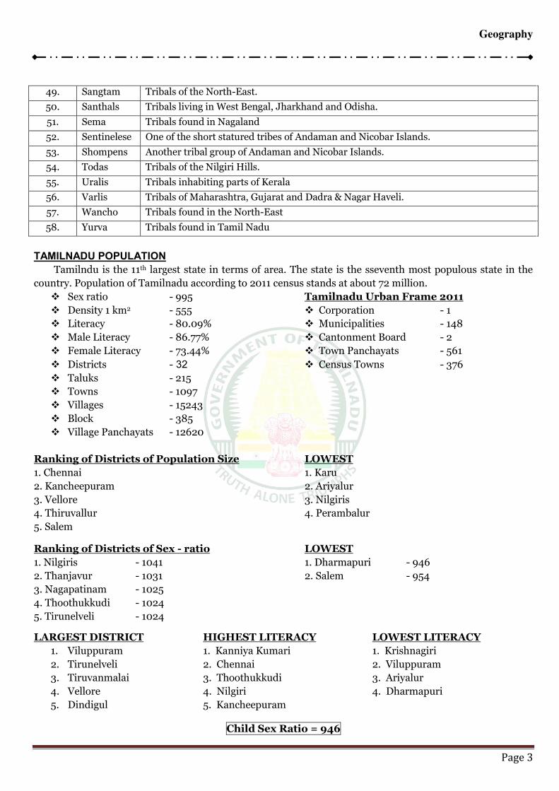
IRCLEGeography
Page 3
49. Sangtam Tribals of the North-East.
50. Santhals Tribals living in West Bengal, Jharkhand and Odisha.
51. Sema Tribals found in Nagaland
52. Sentinelese One of the short statured tribes of Andaman and Nicobar Islands.
53. Shompens Another tribal group of Andaman and Nicobar Islands.
54. Todas Tribals of the Nilgiri Hills.
55. Uralis Tribals inhabiting parts of Kerala
56. Varlis Tribals of Maharashtra, Gujarat and Dadra & Nagar Haveli.
57. Wancho Tribals found in the North-East
58. Yurva Tribals found in Tamil Nadu
TAMILNADU POPULATION
Tamilndu is the 11th largest state in terms of area. The state is the sseventh most populous state in the
country. Population of Tamilnadu according to 2011 census stands at about 72 million.
Sex ratio - 995 Tamilnadu Urban Frame 2011
Density 1 km2 - 555 Corporation - 1
Literacy - 80.09% Municipalities - 148
Male Literacy - 86.77% Cantonment Board - 2
Female Literacy - 73.44% Town Panchayats - 561
Districts - 32 Census Towns - 376
Taluks - 215
Towns - 1097
Villages - 15243
Block - 385
Village Panchayats - 12620
Ranking of Districts of Population Size LOWEST
1. Chennai 1. Karu
2. Kancheepuram 2. Ariyalur
3. Vellore 3. Nilgiris
4. Thiruvallur 4. Perambalur
5. Salem
Ranking of Districts of Sex - ratio LOWEST
1. Nilgiris - 1041 1. Dharmapuri - 946
2. Thanjavur - 1031 2. Salem - 954
3. Nagapatinam - 1025
4. Thoothukkudi - 1024
5. Tirunelveli - 1024
LARGEST DISTRICT HIGHEST LITERACY LOWEST LITERACY
1. Viluppuram 1. Kanniya Kumari 1. Krishnagiri
2. Tirunelveli 2. Chennai 2. Viluppuram
3. Tiruvanmalai 3. Thoothukkudi 3. Ariyalur
4. Vellore 4. Nilgiri 4. Dharmapuri
5. Dindigul 5. Kancheepuram
Child Sex Ratio = 946
IRCLEGeography
Page 1
POPULATION DENSITY AND DISTRIBUTION
POPULATION:
India is the second most populous country in the world after China. The first all India census, though
not taken synchronously, was completed in 1872. Since 1881, the census has been taken every decade, the
latest having been completed in 2011. According to the 2011 Census the total population of India was about
121.02 crore (1.21 billion) having registered a growth of 17.64 per cent over the 2001 figure. This total of 1.21
billion comprises about 623.7 million males and about 586.5 million females. Prersently India represents
about 17.31 per cent of the total population of the world.
POPULATION DENSITY:
Average density of population as per 2011 census is 382 persons per sq.km. the however, the density
is not uniform throughout the country. The highest density is in the NCT of Delhi – 11297 persons per sq.km.
Among the states, Bihar has the highest density – 1102 persons per sq.km. The lowest density is in Arunachal
Pradesh- 17 persons per sq.km.
One state in the country that has witnessed a negative growth in population, namely Nagaland, has
also witnessed a decline in density, from 120 persons per sq.km to 119 persons per sq.km.
SEX RATIO
The sex ratio in India is negative, i.e. there are fewer females than males in the country. The average
sex ratio according to 2011 Census is 940 females per thousand males. This figure shows a growth over the
figures for 2001 census, when the average sex ratio was 933 females per 1000 males. Kerala is the only state
with more females than males – 1084 females per 1000 males. Among Union Territories only Puducherry has
a positive sex ratio – 1038 females per 1000 males. Among states, Haryana has the lowest sex ratio – 877
females per 1000 males. The state of Tamil Nadu has the most even sex ratio among states – 995 females per
1000 males.
LITERACY:
Literacy rate is another important characteristic of population. Average rate of literacy according to
2011 Census is 74.04 per cent. Literacy is higher among males (82.14 per cent) than among female (65.91 per
cent). The highest literacy rate is among females (93.91 per cent). Kerala also has the distinction of having a
female literacy rate of more than 90 per cent. The lowest female literacy rate is in Bihar (63.82 per cent). The
lowest female literacy rate is also in Bihar (53.33 per cent). Among the Union Territories Lakshadweep has
the highest literacy rate (92.28 per cent) while Dadra and Nagar Haveli has the lowest literacy rate (77.65 per
cent) among them.
TREND OF GROWTH:
Population in India has been continuously growing since 1921 and the decade 1911-21 was the only
period of negative growth in population. The decadal growth rate showed a rising trend till 1971 when it
reached 24.80 per cent. This trend of rising growth rate has since been reversed and has come down to 17.64
per cent during 2001-11. However the growth rate in some parts of the country is still high. Dadra and Nagar
Haveli had the some parts of the country is still high. Dadra and Nagar Haveli had the highest growth rate of
55.50 per cent while Daman and Diu followed it closely with 53.54 per cent. The highest growth rate among
states has been in Meghalaya (27.82 per cent), Andhra Pradesh (25.92 per cent), Bihar (25.07 per cent),
Jammu and Kashmir (23.71 per cent), Mizoram (22.78 per cent), Chhattisgarh (25.59 per cent), Jharkhand
(22.34 per cent), Rajasthan (21. 44 per cent), Madhya Pradesh (20.30 per cent) and Uttar Pradesh (20.09
per cent). Among the larger states Kerala has the lowest growth rate (4.86 per cent). Nagaland is the only
state in the country to have shown a negative growth rate (-0.47 per cent).
TRIBAL GROUPS
SL.NO.
1. Abhors People of Mongoloid stock living in the north-easter parts of India
2. Adivasis Tribals of Bastar district, Chhattisgarh

IRCLEGeography
Page 2
3. Angami Tribals of Nagaland
4. Ao Tribals of Nagaland
5. Apatanis Tribals of Arunachal Pradesh
6. Badagas Tribals of Nilgiri region in Tamil Nadu
7. Baiga Tribals of Madhya Pradesh
8. Bakkarwals People of Jammu & Kashmir who rear sheep and goats
9. Bhils People of Davidian stock now living in central India (MP) and Rajathan
10. Bhotias Tribals of Garhwal and Kumaon regions in Uttarakhand, and Sikkim and West Bengal
11. Bhuia Tribals of MP
12. Birhors A tribal group of Madhya Pradesh, Chhattisgarh, Jharkahand and Odisha.
13. Chang Tribals found in North-East
14. Chenchus Tribals of Andhra Pradesh.
15. Chutra Tribals of Assam
16. Gaddis Tribals of Himachal Pradesh whio rear sheep
17. Gallong Tribals found in the North-East
18. Garos Hill tribe of Meghalaya and Assam
19. Gonds Tribals inhabiting forests in Madhya Pradesh, Jharkhand, Andhra Pradesh and Odisha.
20. Gujjars Animal rearers of Jammu and Kashmir and Himachal Pradesh.
21. Irula Tribnals of Tamil Nadu
22. Jaintias Hill tribe of Meghalaya and Assam.
23. Jarawas One of the oldest tribes of Andaman and Nicobar Islands inhabiting Little Andamans.
24. Kanikar Tribals found in Tamil Nadu
25. Katkari Tribals of MP
26. Kharia Tribals of MP
27. Khasa Tribals of Jaunsar Bhabar region in Uttara Khand.
28. Khasis Hill tribe of Meghalaya and Tripura.
29. Khonds Tribals inhabiting parts of Odisha
30. Kol Tribals of Madhya Pradesh and Maharashtra
31. Kolam Tribe of Andhra Pradesh
32. Kotas Tribals of Nilgiri Hills in Tamil Nadu.
33. Kuki A tribe of Maniput, Assam, Nagaland and Tripura.
34. Lahaulas Tribals inhabiting Lahaul region in Himachal Pradesh.
35. Lepchas Original tribal inhabitants of Sikkim.
36. Lushai Tribals of Mizoram and Tripura
37. Murias Tribals of Bastar district of Chhattisgarh.
38. Mikirs A tribe group of Assam.
39. Mompa Tribal found in the North-East
40. Moplahs Muslims of the Malabar district in Kerala.
41. Munda A tribe of Jharkhand, West Bengal, Odisha, Tripura and Chhattisgarh.
42. Nagas Tribals of Nagaland
43. Nishi Tribals of Nagaland.
44. Oraon Tribals inhabiting parts of Jharkhand, Chhattisgarh, Odisha and West Bengal.
45. Onges One of the tribes of Andaman and Nicobar Islands.
46. Pho Tribals of the North-East.
47. Rengma Tribals of the North-East.
48. Sabra Tribals of MP

IRCLEGeography
Page 3
49. Sangtam Tribals of the North-East.
50. Santhals Tribals living in West Bengal, Jharkhand and Odisha.
51. Sema Tribals found in Nagaland
52. Sentinelese One of the short statured tribes of Andaman and Nicobar Islands.
53. Shompens Another tribal group of Andaman and Nicobar Islands.
54. Todas Tribals of the Nilgiri Hills.
55. Uralis Tribals inhabiting parts of Kerala
56. Varlis Tribals of Maharashtra, Gujarat and Dadra & Nagar Haveli.
57. Wancho Tribals found in the North-East
58. Yurva Tribals found in Tamil Nadu
TAMILNADU POPULATION
Tamilndu is the 11th largest state in terms of area. The state is the sseventh most populous state in the
country. Population of Tamilnadu according to 2011 census stands at about 72 million.
Sex ratio - 995 Tamilnadu Urban Frame 2011
Density 1 km2 - 555 Corporation - 1
Literacy - 80.09% Municipalities - 148
Male Literacy - 86.77% Cantonment Board - 2
Female Literacy - 73.44% Town Panchayats - 561
Districts - 32 Census Towns - 376
Taluks - 215
Towns - 1097
Villages - 15243
Block - 385
Village Panchayats - 12620
Ranking of Districts of Population Size LOWEST
1. Chennai 1. Karu
2. Kancheepuram 2. Ariyalur
3. Vellore 3. Nilgiris
4. Thiruvallur 4. Perambalur
5. Salem
Ranking of Districts of Sex - ratio LOWEST
1. Nilgiris - 1041 1. Dharmapuri - 946
2. Thanjavur - 1031 2. Salem - 954
3. Nagapatinam - 1025
4. Thoothukkudi - 1024
5. Tirunelveli - 1024
LARGEST DISTRICT HIGHEST LITERACY LOWEST LITERACY
1. Viluppuram 1. Kanniya Kumari 1. Krishnagiri
2. Tirunelveli 2. Chennai 2. Viluppuram
3. Tiruvanmalai 3. Thoothukkudi 3. Ariyalur
4. Vellore 4. Nilgiri 4. Dharmapuri
5. Dindigul 5. Kancheepuram
Child Sex Ratio = 946
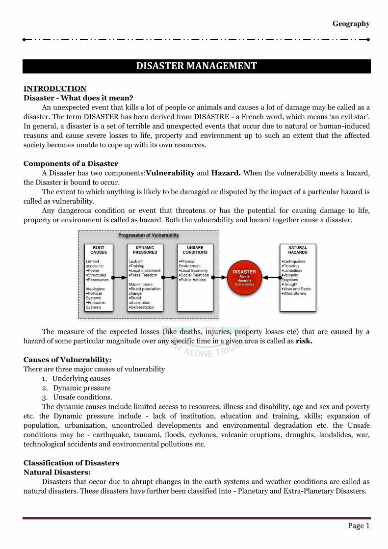
IRCLEGeography
Page 1
DISASTER MANAGEMENT
INTRODUCTION
Disaster - What does it mean?
An unexpected event that kills a lot of people or animals and causes a lot of damage may be called as a
disaster. The term DISASTER has been derived from DISASTRE - a French word, which means ‘an evil star’. In general, a disaster is a set of terrible and unexpected events that occur due to natural or human-induced
reasons and cause severe losses to life, property and environment up to such an extent that the affected
society becomes unable to cope up with its own resources.
Components of a Disaster
A Disaster has two components:Vulnerability and Hazard. When the vulnerability meets a hazard,
the Disaster is bound to occur.
The extent to which anything is likely to be damaged or disputed by the impact of a particular hazard is
called as vulnerability.
Any dangerous condition or event that threatens or has the potential for causing damage to life,
property or environment is called as hazard. Both the vulnerability and hazard together cause a disaster.
The measure of the expected losses (like deaths, injuries, property losses etc) that are caused by a
hazard of some particular magnitude over any specific time in a given area is called as risk.
Causes of Vulnerability:
There are three major causes of vulnerability
1. Underlying causes
2. Dynamic pressure
3. Unsafe conditions.
The dynamic causes include limited access to resources, illness and disability, age and sex and poverty
etc. the Dynamic pressure include - lack of institution, education and training, skills; expansion of
population, urbanization, uncontrolled developments and environmental degradation etc. the Unsafe
conditions may be - earthquake, tsunami, floods, cyclones, volcanic eruptions, droughts, landslides, war,
technological accidents and environmental pollutions etc.
Classification of Disasters
Natural Disasters:
Disasters that occur due to abrupt changes in the earth systems and weather conditions are called as
natural disasters. These disasters have further been classified into - Planetary and Extra-Planetary Disasters.
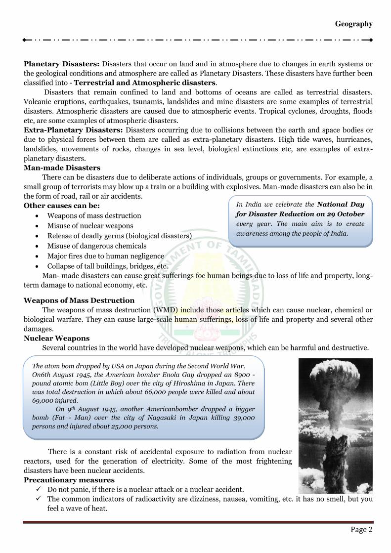
IRCLEGeography
Page 2
Planetary Disasters: Disasters that occur on land and in atmosphere due to changes in earth systems or
the geological conditions and atmosphere are called as Planetary Disasters. These disasters have further been
classified into - Terrestrial and Atmospheric disasters.
Disasters that remain confined to land and bottoms of oceans are called as terrestrial disasters.
Volcanic eruptions, earthquakes, tsunamis, landslides and mine disasters are some examples of terrestrial
disasters. Atmospheric disasters are caused due to atmospheric events. Tropical cyclones, droughts, floods
etc, are some examples of atmospheric disasters.
Extra-Planetary Disasters: Disasters occurring due to collisions between the earth and space bodies or
due to physical forces between them are called as extra-planetary disasters. High tide waves, hurricanes,
landslides, movements of rocks, changes in sea level, biological extinctions etc, are examples of extra-
planetary disasters.
Man-made Disasters
There can be disasters due to deliberate actions of individuals, groups or governments. For example, a
small group of terrorists may blow up a train or a building with explosives. Man-made disasters can also be in
the form of road, rail or air accidents.
Other causes can be:
Weapons of mass destruction
Misuse of nuclear weapons
Release of deadly germs (biological disasters)
Misuse of dangerous chemicals
Major fires due to human negligence
Collapse of tall buildings, bridges, etc.
Man- made disasters can cause great sufferings foe human beings due to loss of life and property, long-
term damage to national economy, etc.
Weapons of Mass Destruction
The weapons of mass destruction (WMD) include those articles which can cause nuclear, chemical or
biological warfare. They can cause large-scale human sufferings, loss of life and property and several other
damages.
Nuclear Weapons
Several countries in the world have developed nuclear weapons, which can be harmful and destructive.
There is a constant risk of accidental exposure to radiation from nuclear
reactors, used for the generation of electricity. Some of the most frightening
disasters have been nuclear accidents.
Precautionary measures
Do not panic, if there is a nuclear attack or a nuclear accident.
The common indicators of radioactivity are dizziness, nausea, vomiting, etc. it has no smell, but you
feel a wave of heat.
In India we celebrate the National Day
for Disaster Reduction on 29 October
every year. The main aim is to create
awareness among the people of India.
The atom bom dropped by USA on Japan during the Second World War.
On6th August 1945, the American bomber Enola Gay dropped an 8900 -
pound atomic bom (Little Boy) over the city of Hiroshima in Japan. There
was total destruction in which about 66,000 people were killed and about
69,000 injured.
On 9th August 1945, another Americanbomber dropped a bigger
bomb (Fat - Man) over the city of Nagasaki in Japan killing 39,000
persons and injured about 25,000 persons.
IRCLEGeography
Page 3
A nuclear explosion is followed by a blast. If viewed,
it can cause instant blindness.
Stay indoors and close the doors and windows of
your house, as the radiation cannot penetrate solid
structures.
Chemical Disasters
The chemical disasters are caused by industrial
accidents, irresponsible handling of chemicals or by
deliberate misuse of chemicals for destructive purposes.
The leakage of poisonous gases can cause wide spread
devastation. The gases spread quickly and affect large
areas.
The material needed in the making of chemical
weapons of mass destruction (WMD) is easily available in
the markets. The manufacturing technique is also very
simple. It is difficult to detect such weapons, as the
chemical weapons of mass destruction are colourless and odourless.
Precautionary measures
Check whether the industrial units close to your city use any hazardous chemicals or not.
Find out the emergency plan to deal with such industrial accidents.
Find out the availability of the antidotes needed in case of poisoning of people, animals, water
resources, etc.
Find out from the hospitals in your city, if they are capable of handling cases of chemical disaster.
Keep a chart of Dos and Don’ts for chemical disasters. This information is either gathered from or
supplied by the industrial units.
Biological Disasters
The biological weapons of mass destruction are called the “poor man’s nuclear bomb”. The biological weapons can be made and used easily. These weapons have the potential to kill or injure lakhs of people.
In comparison to other weapons of mass destruction, the biological weapons can work instantly, but the
symptoms may not become visible initially. Sometimes it is difficult to diagnose the cause of sickness, as the
biological agents or germs take time to manifest. The biological weapons can infect even the attending
medical and para-medical staff.
A biological attack means the release of germs or other biological substances. The biological substance
can enter the body through inhalation, cuts in the skin and the food and make one sick.
Precautionary measures
A biological attack may not be known in advance. It’ll be learnt through an announcement on the radio or TV.
If we are aware of any unknown substance nearby, we must protect
our self first.
Inform others and public authorities about the possibility of any
such substance.
Move away immediately from the place, where the unknown substance is sighted.
Cover your mouth and nose with some cloth that can permit easy breathing.
The Bhopal Gas Tragedy on 3rd
December 1984, has no parallel in the
industrial accidents in the world. About 40
tonnes of Methyl Isocyanate (MIC) gas
leaked from the Union Carbide plant in
Bhopal (Madhya Pradesh). About 3000
people died and about 3,00,000 people
suffered from the disastrous effects of
massive gas poisoning.
When thousands of people reached
hospitals after the Bhopal tragedy in 1984,
most of them were breathless and blind.
The doctors did not know how to treat
them. The emergency antidotes were
neither known nor available.
It is estimated that about
100 gm of anthrax, if
released over a big
metropolitan city, can kill
about 30,00,000 people.
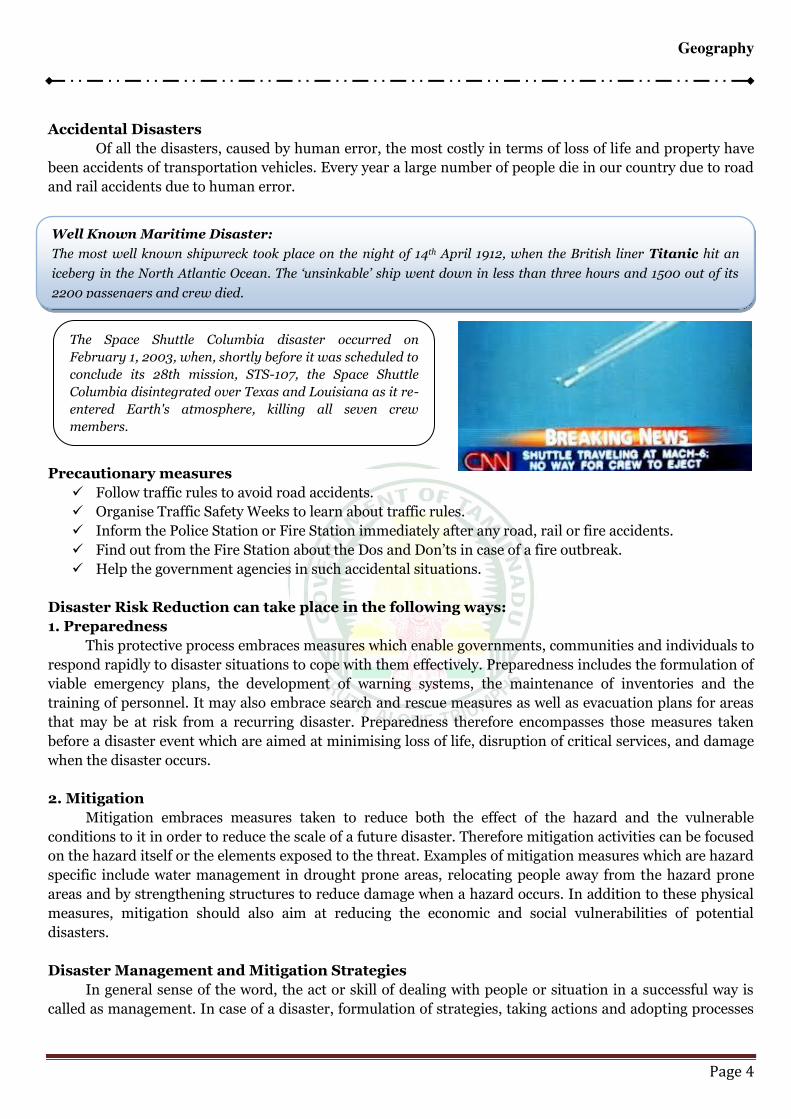
IRCLEGeography
Page 4
Accidental Disasters
Of all the disasters, caused by human error, the most costly in terms of loss of life and property have
been accidents of transportation vehicles. Every year a large number of people die in our country due to road
and rail accidents due to human error.
Precautionary measures
Follow traffic rules to avoid road accidents.
Organise Traffic Safety Weeks to learn about traffic rules.
Inform the Police Station or Fire Station immediately after any road, rail or fire accidents.
Find out from the Fire Station about the Dos and Don’ts in case of a fire outbreak. Help the government agencies in such accidental situations.
Disaster Risk Reduction can take place in the following ways:
1. Preparedness
This protective process embraces measures which enable governments, communities and individuals to
respond rapidly to disaster situations to cope with them effectively. Preparedness includes the formulation of
viable emergency plans, the development of warning systems, the maintenance of inventories and the
training of personnel. It may also embrace search and rescue measures as well as evacuation plans for areas
that may be at risk from a recurring disaster. Preparedness therefore encompasses those measures taken
before a disaster event which are aimed at minimising loss of life, disruption of critical services, and damage
when the disaster occurs.
2. Mitigation
Mitigation embraces measures taken to reduce both the effect of the hazard and the vulnerable
conditions to it in order to reduce the scale of a future disaster. Therefore mitigation activities can be focused
on the hazard itself or the elements exposed to the threat. Examples of mitigation measures which are hazard
specific include water management in drought prone areas, relocating people away from the hazard prone
areas and by strengthening structures to reduce damage when a hazard occurs. In addition to these physical
measures, mitigation should also aim at reducing the economic and social vulnerabilities of potential
disasters.
Disaster Management and Mitigation Strategies
In general sense of the word, the act or skill of dealing with people or situation in a successful way is
called as management. In case of a disaster, formulation of strategies, taking actions and adopting processes
Well Known Maritime Disaster:
The most well known shipwreck took place on the night of 14th April 1912, when the British liner Titanic hit an
iceberg in the North Atlantic Ocean. The ‘unsinkable’ ship went down in less than three hours and 1500 out of its 2200 passengers and crew died.
The Space Shuttle Columbia disaster occurred on
February 1, 2003, when, shortly before it was scheduled to
conclude its 28th mission, STS-107, the Space Shuttle
Columbia disintegrated over Texas and Louisiana as it re-
entered Earth's atmosphere, killing all seven crew
members.
IRCLEGeography
Page 5
to prevent, minimize or control the adverse impacts of a disaster at all the stages (before and after) of its
occurrence, is called as disaster management.
According to National Disaster Management Division, Ministry of Home Affairs, Government of India.
“disaster management can be defined as the body of policy and administrative decisions and
operational activities which pertain to the various stages of a disaster at all levels”.
Policies and measures designed and adopted to minimize impacts of a disaster, whether natural or
man-induced, is called as disaster mitigation. For a successful mitigation of a disaster, it is important for the
people to understand causes, seriousness, impacts and need of relief measures. Mitigation relates to the
reduction of the effects of hazards and conditions vulnerable to it. Hence, mitigation activities are focused on
both the hazard and elements exposed to the threats of the hazard concerned. The mitigation strategies are so
devised that they can modify the occurrence of a particular hazard. Here is an example- the proper
management of water, reduction of impacts and strengthening of the structures so as to reduce damage, can
be the mitigation strategies for a drought prone area. Mitigation also relates to physical, economic and social
vulnerability to a particular hazard and under lying causes of the vulnerability.
Strategies for the Management and Mitigation of Disasters
The disaster management strategies can be divided into three parts
Pre- Disaster Management Strategies or Preparedness
Disaster Occurrence Management Strategies
Post Disaster Management Strategies
Pre- Disaster Management Strategies or Preparedness
We can neither prevent nor avoid a disaster. However, we can reduce the extent of a disaster by making
advanced preparations. This incorporates four components – Awareness, Planning, Monitoring and
Development of Early Warning Systems. In fact, preparedness is a protective process. It includes such
measures which enables governments, communities and individuals to respond rapidly to the disaster
situations so as to cope with them effectively.
Awareness: Making people aware of vulnerability, hazard and extent of risk of a hazard can enable them to
protect themselves and their properties up to considerable extent. This can be done by either of the following
measures – information, education and communication (IEC). Disaster awareness help the people in
following ways –
i. It will ensure unity, co-operation and participation to fight against a particular disaster. This is due to
awareness that people may remain ready to co-operate to agencies that come forward to help them.
ii. Through awareness, people become able to protect themselves on their own against a disaster.
iii. Disaster awareness develops a sense of service among people and they remain ready to help their
fellow citizens caught in the hazard.
iv. This enables people to know legal aspects of disaster control, management and mitigation.
Planning: It is the most important component of disaster preparedness. Planning is necessary for getting
success in every sphere of life. As for a disaster, vulnerability, extent of risk, preventive measures, safety
measures, recovery options etc. are planned in advance so as to avert disaster risk carry on rescue operations.
Monitoring: Proper care and knowledge of changing conditions and operations done during Awareness
building and planning is necessary. All programmes and plans under preparations need to be monitored
carefully so as to avoid any possible mistake.
Early Warning System: Early Warning Systems are developed in disaster-prone areas to inform public to
take up necessary actions soon after a hazard is suspected. For this, warning stations are established near sea
IRCLEGeography
Page 6
coasts, river banks, in industries etc. warning related to abrupt weather fluctuations are regularly transmitted
to people through communication channels. India has established various disaster warning stations in
different parts of the country. As much as 250 cyclone-warning Dissemination centres have been established
along the eastern and western sea-coasts that send early warning through communication satellites. In
modern times, remote sensing satellites are effectively employed for monitoring as well as sending data and
photographs of weather conditions. Special automatic aircrafts are also being employed for collecting
information about the changing weather.
Preparedness also includes maintenance of inventories, training of personnel, search and rescue
measures and evacuation plans. The preparedness planning needs to be supported by appropriate legislation
with clear allocation of responsibilities and budgetary provisions.
Disaster Occurrence Management Strategies
At the time when a hazard strikes, the service groups, government agencies or social organizations
should take up all possible rescue measures to protect people and their properties. At that time, activities are
taken to ensure that needs and provisions of victims are met properly and their suffering is minimized. These
strategies are called as Emergency Response Strategies.
Post Disaster Management Strategies
These strategies include – Damage Assessment, Relief Measurement and Rehabilitation. Strategies
adopted at this stage are called as Response and Recovery Strategies. Under these strategies, activities are
taken to achieve early recovery and removal of earlier vulnerable conditions. An assessment of damage is
done through surveys and baseline data collection etc. the relief and Rehabilitation measures are done on the
basis of these activities. Other activities covered under these strategies are
Empowerment of women,
Coping with post disaster situations, restoration of livelihood with overall purpose of sustainable
environment, and
A coherent mechanism should be designed for meeting the needs of children following disasters. The
rehabilitation of children should be priority, but in some cases their future outside the village might
be preferable.
Management and Mitigation of Disasters
Management and Mitigation of Natural Disasters
EARTHQUAKES
Sudden release of stresses built up in the earth’s crust shaking of the earth surface. It is called as earthquake. The intensity of an earthquake is measured on Richter Scale, which was devised in 1935 by
Charles Richter of California Institute of Technology, U.S.A. an earthquake measuring more than 5 on
Richter Scale (usually 7 and above ) causes great damage. The place of origin of an earthquake is called as its
focus or the hypocentre where as the point on the earth surface vertically above the Focus is called as
Epicentre. Earthquakes cause physical, biological, economic and environmental damages.
Management and Mitigation (Control Measures)
These strategies comprise main and community based activities mentioned below –
Contractors and developers of building constructions must follow norms fixed for buildings. Building
constructions should be done on soft soils.
Buildings should not be constructed in vulnerable areas and those that have already been built in such
areas should be strengthened properly.
Use of standard quality building materials and following Indian Standard Codes for building
constructions should be kept on priority.
IRCLEGeography
Page 7
Human habitations at high risk zones should be shifted elsewhere.
People should be made aware of dos and don’ts about earthquakes and important lifeline buildings should be strengthened to accommodate people after the earthquake. Hospitals and fire services
should be upgraded.
Community should be prepared and educated for mitigating impacts of earthquakes.
Community based Earthquake Risk Management Projects should be developed. Retrofitting of school
buildings and other important buildings purchased of Emergency Response Equipment etc., should
be the principal activities of such projects.
CYCLONES
Cyclones are extremely disastrous hazards that originate in seawater. These are usually followed by
wind of very high speed. These are atmospheric disasters occurring in tropical and coastal regions in
Bangladesh and India. Cyclones of eastern U.S.A. and Caribbean region are called as hurricanes and the same
in the North Pacific Oceans are called typhoons. Local storms are called tornados. Cyclones usually extend
vertically up to 12 – 14 km and horizontally up to 150 – 1000 km.
Management and Mitigation:
Disasters due to cyclones can be prevented by adopting safety measures and by constructing barriers.
Some important measures for mitigation of cyclones are mentioned below.
Wide buffer zones of forests should be managed properly along the coastal line so that cyclone may not
run freely to penetrate inland.
Meteorological records of wind speed and directions should be kept properly so as to predict for
future cyclones and to make advanced preparations. In this regard horizontal mapping is very
important.
Policies should be made to regulate land use and enforcement of building codes. Vulnerable areas
should be reserved for parks, grazing grounds or play grounds.
Buildings in coastal areas should have high engineering inputs. Traditional homes should be
improved by building in disaster resistant features so that they can withstand cyclones with moderate
speed.
Building meant for storing food supply should be protected against winds and water.
Arrangement of early warning systems, construction of concrete walls along coast line, organization of
action groups and rescue squads etc. are some other important measures to mitigate cyclones.
Environmental facts
There is an ocean current that flows along the Peruvian Coast. It is called as Humboldt Current, after
the Prussian Explorer Alexander von Humboldt. This ocean current serves as a classical example of an
eastern boundary current and features a typically wide and slow equator ward transport of cold water along
the coast of South America.
The Peruvian current is the largest upwelling system among the eastern boundary currents. Upwelling
is a process in which cold-nutrient rich water rises to the surface from the ocean depths.
The North-western alignment of the Andes Mountain along the Peruvian Coast forces the south-east
trade winds to blow northwards. This condition causes an offshore flow in the surface layers of the marine
water. This makes it one of the most productive upwelling systems in the world causing the cold nutrient
water to appear along the coast. It supports an extra-ordinary abundance of marine life. The Peruvian ocean
current system accounts for approximately 18 to 20 percent of the tidal fish catch worldwide. The weakening
of the Peruvian current system allows the counter current to move southwards. It disrupts the coastal
upwelling which normally occurs along the coast and creating a condition known as El-Nino. El-Nino is the

IRCLEGeography
Page 8
warming of sea surface temperatureeratures in the equatorial Pacific Ocean which influences atmospheric
circulation and consequently rainfall and temperatureerature in specific areas around the world.
El-Nino is a Spanish word which means Christ Child. It indicates the appearance of a warm ocean
current of the South American Coast around the Christmas. Approximately 14 El-Nino events affected the
world between 1950 and 2003. On the reverse side, is La-Nina which is the cooling of sea surface
temperatureerature in the equatorial Pacific Ocean, and which influences the atmospheric circulation, and
consequently the rainfall and temperatureerature in specific areas around the world. It is the opposite of El-
Nino.
DROUGHTS
Failure of rains cause prolonged periods of dryness which results into crop-failures. This condition is
called as drought. Drought causes deaths of human and cattle as they cannot withstand dry weather. Drought
enforces many populations to mitigate elsewhere which creates further problems of rehabilitation.
Management and Mitigation
Drought can be managed and mitigated in following ways –
Management of watersheds, water-harvesting structures and other measures should be undertaken to
ensure water supplies in the area.
Drought resisting crops or crops demanding less water should be cultivated in drought prone areas to
ensure food supply.
Afforestation and other forestry measures should be undertaken so as to retain humidity in the
atmosphere and promote precipitation.
Cutting of trees and clearing of forests should be banned.
Roof top water harvesting in house should be adopted in every house so as to retain water for
different uses.
LAND SLIDES
The downhill movement of large amounts of soil, mud, rocks, debris is called as landslide. It causes
flooding of rivers due to deposit of silt and aggravates floods. Landslides cause maximum fatalities depending
on the place and time of occurrence. Landslides may kill many thousands of people. The landslide in Peru in
1970 killed 18000 people.
Management and Mitigation
The Management and Mitigation of disasters due to landslides can be done by adopting following measures.
Clearing of forests on hill slopes must be stopped.
Proper monitoring and warning systems should be developed in landslide prone areas so as to
facilitate the activities of evacuation before the disaster.
Search and rescue operations should be done by special rescue squads.
The assessment of damage, financial assistance to the affected people and rehabilitation should be
done in time.
Retaining walls should be built to stop land from slipping.
The surface drainage control works should be implemented to control the movement of soil
accompanied by infiltration of rain water and spring flows.
Increasing vegetation cover, building engineering structures and insurance of people are other
measures to mitigate the disasters due to landslides.
TSUNAMIS
IRCLEGeography
Page 9
Tsunamis are towering walls of marine water having great powers of destruction. These are usually
caused due to undersea earthquakes or undersea “volcanic eruptions. Tsunami is a Japanese word which
means harbour waves. These may also be caused by undersea landslides and force of an asteroid crashing
into ocean.
Management and Mitigation
The management and mitigation of tsunami hazards need specific preparedness measures like
Hazard mapping, arrangement of early warning systems and community participation. Main tsunami
mitigation strategies should include site planning, land management and evacuation of public living
in coastal areas.
Residents of coastal areas should shift their houses far beyond the coast line and they should
construct houses on high ground levels.
Water breakers should be constructed to reduce the reduce the velocity of waves. For construction,
water resistant and corrosion resistant materials should be used.
Community halls should be constructed at higher locations that may act as shelters during the
disasters.
Sea walls should be constructed to stop the gushing water.
FLOODS
Floods cause great losses to life and property every year. Occurrence of floods is a cumulative condition
which appears as accumulation of huge volumes of water in a vast area.
Management and Mitigation
Following are the measures usually adopted for the management of disasters due to floods
Arrangement of proper warning systems to relocate people,
Construction of embankments to restrict water against entering into human habitations,
Ban on cutting trees on hill slopes and on other areas as well and checking soil erosion so as to avoid
the Siltation of rivers,
Proper rescue and relief operations,
Mass scale tree plantation in flood prone areas.
Management and Mitigation of Man-made Disasters
Man-made disasters can be managed and mitigated through following general measures
The spread of epidemics can be managed by keeping healthy living conditions, proper storage of food
materials, proper storage of water, proper disposal of wastes, checking pollutions of resources at all
levels,
Nuclear hazards can be prevented by proper handling and disposal of nuclear wastes,
Traffic accidents can be avoided by obeying traffic rules,
Biological, chemical and industrial disasters can be prevented by strict legislations, increasing moral
values in societies, upgrading medical facilities, building up public awareness, proper education etc.
GOVERNMENT’S ROLE IN DISASTER MANAGEMENT AND MITIGATION
Though the institutional and policy mechanisms for carrying out response, relief and rehabilitation
have been established in India. Since Independence, the Ministry of Home affairs. (The Government of India)
created a National Disaster Management Division (NDM) on June 2002 and restructured various Disaster
Management committees on state District and Block levels.
IRCLEGeography
Page 10
1. The central government has taken up various step to strengthen management a and mitigation
instruments in the country. In case of major disasters, the Central Government is inclined to provide
financial and organizations. The apex body is the cabinet committee on national calamities (NCMC)
2. The NCMC gives directions to the crisis management Groups. The chairman of the crisis management
group is the central relief commissioner, Ministry of Home Affairs. This group reviews contingency
plans formulated by various ministries, departments of organizations and measures required for
dealing with a natural disaster and co-ordinates functions of Central Ministries and State
Governments in relation to disaster preparedness and relief.
3. The government of India has proposed the organization of National Emergency Management
Authority on the national and state levels. States have been directed to set up Disaster Management
Authorities under the Chief Minister with Ministers of different departments as members.
4. The Central Government has directed state governments to reorganize the Department of Disaster
Management and to form four functional groups and to assign those four functional groups their
functions below
Hazard Mitigation - Functional Group One
Preparedness and Capacity Building - Functional Group Two
Relief and Response - Functional Group Three
Administration and Finance - Functional Group Four
5. At district level the District Magistrate is the Chief Co-ordinator of all those activities related to
prevention, mitigation and preparedness. The District Committee is reconstituted as Disaster
Management Committee and Disaster Management Teams are to be constituted to work under it.
6. Different institutes have been established I different parts of India to impart training for the
development of skilled citizens for a better management and mitigation of disasters. Names of some
important institutes are mentioned below.
Centre for Disaster Management, Mussoorie,
National Institute of Disaster management, New Delhi
National Fire Service College, Nagpur,
CHERNOBYL DISASTER
The Chernobyl nuclear power plant in the Ukraine exploded on April 26; 1986. The effects of the
explosion was felt for thousands of kilometres. The plant is located 14.5 km northwest of Chernobyl. A
number of things caused the disaster at Chernobyl. First, the plant was not properly designed, and could only
be run with very specific instructions. Second, the operators of the plant failed to properly follow instructions
and some scientists conducted a highly risky experiment that led to the explosion. The scientists decided to
conduct the experiment and had to remove safety and cooling equipment in order to do so. Eventually,
pressure on the reactor’s roof blew it away. Everything inside, including molten uranium, burning graphite and radioactive ashes were emitted into the atmosphere.
This was not a nuclear explosion. There was no chain reaction or explosion like that in an atomic bomb.
However, the amount of radioactive material released was ten times that caused by the US atomic bombing of
Hiroshima. Radioactive fallout spread throughout Europe. It hit Poland, Germany, Belgium, France and
Holland and then shifted towards the Balkans and Italy.
It is hard to predict just how many people were affected by the Chernobyl explosion. A British report
estimated that the radioactivity will give 2300 people cancer, though others think the number is much
higher. It was an important lesson for us that maximum care, skill and safety measures are essential while
working with nuclear plants and devices.
IRCLEGeography
Page 11
International organizations involved in disaster management
International Association of Emergency Managers
The International Association! of Emergency Managers (IAEM) is a non-profit educational
organization dedicated to promoting the goals of saving lives and protecting properly during emergencies and
disasters. The mission of IAEM is to serve its members by providing information, networking and
professional opportunities, and to advance the emergency management profession. It currently has seven
Councils around the World: Asia, Canada, Europa, International, Oceania, Student and USA.
International Recovery Platform
The International Recovery Platform CI.RP) was conceived at the World Conference on Disaster
Reduction (WCDR) in Kobe, Hyogo, Japan in January 2005. As a thematic platform of the International
Strategy for Disaster Reduction (lSDR) system, IRP is a key pillar for the implementation of the Hyogo
Framework for Action (HF A) 2005-2015: Building the Resilience of Nations and Communities to Disasters, a
global plan for disaster risk reduction for the decade adopted by 168 governments at the WCDR.
The key role of IRP is to identify gaps and constraints experienced in post disaster recovery and to serve
as a catalyst for the development of tools, resources, and capacity for resilient recovery. IRP aims to be an
international source of knowledge on good recovery practice.
Red Cross/Red Crescent
National Reel Cross/Red Crescent societies often have pivotal roles in responding to emergencies.
Additionally,· the International Federation of Red Cross and Red Crescent Societies (If-RC, or "The
Federation") may deploy assessment teams, e.g. Field Assessment and Coordination Team - (FACT) to the
affected country if requested by the national Red Cross or Red Crescent Society. After having assessed the
needs Emergency Response Units (ERUs) may be deployed to the affected country or region. They are
specialized in the response component of the emergency management framework.
United Nations
Within the United Nations system responsibility for emergency response rests with the Resident
Coordinator within the affected country. However, in practice international response will be coordinated, if
requested by the affected country's government, by the UN Office for the Coordination of Humanitarian
Affairs (UN-OCHA), by deploying a UN Disaster Assessment and Coordination (UNDAC) team.
World Bank
Since 1980, the World Bank has approved more than 500 operations related to disaster management,
amounting to more than US$40 billion. "These include post-disaster reconstruction projects, as well as
projects with components aimed at preventing and mitigating disaster impacts in countries such as
Argentina, Bangladesh, Colombia, Haiti, India, Mexico, Turkey and Vietnam to name only a few.
Common areas of focus for prevention and mitigation projects include forest fire prevention measures,
such as early warning measures 'and education campaigns to discourage farmers' from slash and burn
agriculture that ignites forest fires; early-warning systems or hurricanes; flood prevention mechanisms,
ranging from shore protection and terracing in rural areas to adaptation of production; and earthquake-
prone construction.
In a joint venture with Columbia University under the umbrella of the Prevention Consortium the
World Bank has established a Global Risk Analysis of Natural Disaster Hotspots. in Jun: 2006, the World
Bank established the Global Facility for Disaster Reduction and Recovery (GFDRR), a longer term
partnership with other aid donors to reduce disaster losses by mainstreaming disaster "risk reduction in
development, in support of the Hyogo Framework of Action. The facility helps developing countries fund
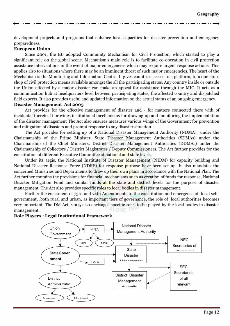
IRCLEGeography
Page 12
development projects and programs that enhance local capacities for disaster prevention and emergency
preparedness.
European Union
Since 2001, the EU adopted Community Mechanism for Civil Protection, which started to play a
significant role on the global scene. Mechanism's main role is to facilitate co-operation in civil protection
assistance interventions in the event of major emergencies which may require urgent response actions. This
applies also to situations where there may be an imminent threat of such major emergencies. The heart of the
Mechanism is the Monitoring and Information Centre. It gives countries access to a platform, to a one-stop-
shop of civil protection means available amongst the all the participating states. Any country inside or outside
the Union affected by a major disaster can make an appeal for assistance through the MIC. It acts as a
communication hub at headquarters level between participating states, the affected country and dispatched
field experts. It also provides useful and updated information on the actual status of an on going emergency.
Disaster Management Act 2005
Act provides for the effective management of disaster and - for matters connected there with of
incidental thereto. It provides institutional mechanisms for drawing up and monitoring the implementation
of the disaster management The Act also ensures measures various wings of the Government for prevention
and mitigation of disasters and prompt response to any disaster situation
The Act provides for setting up of a National Disaster Management Authority (NDMA) under the
Chairmanship of the Prime Minister, State Disaster Management Authorities (SDMAs) under the
Chairmanship of the Chief Ministers, District Disaster Management Authorities (DDMAs) under the
Chairmanship of Collectors / District Magistrates / Deputy Commissioners. The Act further provides for the
constitution of different Executive Committee at national and state levels.
Under its aegis, the National Institute of Disaster Management (NIDM) for capacity building and
National Disaster Response Force (NDRF) for response purpose have been set up. It also mandates the
concerned Ministries and Departments to draw up their own plans in accordance with the National Plan. The
Act further contains the provisions for financial mechanisms such as creation of funds for response, National
Disaster Mitigation Fund and similar funds at the state and district levels for the purpose of disaster
management. The Act also provides specific roles to local bodies in disaster management.
Further the enactment of 73rd and 74th Amendments to the constitution and emergence of local self-
government, .both rural and urban, as important tiers of governance, the role of local authorities becomes
very important. The DM Act, 2005 also envisages specific roles to be played by the local bodies in disaster
management.
Role Players : Legal Institutional Framework
Union
Government
StateGover
nment
District
Administratio
Panchaya Municipali
MHA
NID
National Disaster
Management Authority
State
Disaster
Management
District Disaster
Management
Authority
NEC
Secretaries of
all relevant
SEC
Secretaries
of all
relevant
Ministries
DMA
NDR
IRCLEGeography
Page 13
National policy on disaster management 2009
This policy aims at: (i) Promoting a culture of prevention, preparedness and resilience at all levels
through knowledge, innovation and education; (ii) Encouraging mitigation measures based. on technology,
traditional wisdom and environmental sustainability; (iii) Mainstreaming disaster management into the
developmental planning process; (iv) Establishing institutional and technological frameworks to create an
enabling regulatory environment and a compliance regime; (v) Ensuring efficient mechanism for
identification, assessment and monitoring of disaster risks; (vi) Developing contemperatureorary forecasting
and early warning systems backed by responsive and fail-safe communication with information technology
support; (vii) Ensuring. efficient response and relief with a caring approach towards the needs of the
vulnerable sections of the society; (viii) Undertaking reconstruction as an opportunity to build disaster
resilient structures and habitat for ensuring safer living; and (ix) Promoting a productive and proactive
partnership with the media for disaster management.
Traditionally, relief in the wake of natural calamities has been treated as the primary responsibility of
the States. Successive Finance Commissions have also reiterated this position:· Even though the States are
primarily responsible for relief activities, the Central Government associates itself with measures aimed at
ameliorating the sufferings of the people on account of natural calamities. Towards this end, the Central
Government, with its resources, physical and financial does provide the needed help and assistance to
buttress relief efforts in the wake of major natural calamities. The dimensions of the response at the level of
National Government are determined in accordance with the existing policy of financing the relief
expenditure and keeping in view the factors like (i) the gravity of a natural calamity, (ii) the scale of the relief
operation necessary and (iii) the requirements of Central assistance for augmenting the financial resources
at the disposal of the State Government.
Types of Response:
The Central response can be:
(i) Policy response, and
(ii) Administrative response.
Policy response:
The policy response to a natural calamity would be provided by the Prime Minister, Cabinet
Committees and the Agriculture Minister. The objectives of policy response would be:
a. To empathise with the sufferings of the people affected by natural calamity, and
b. To sub-serve long term and short term policy objectives of the government.
Administrative response:
The response of the administration to a situation arising out of a natural calamity can be on account of:
i. a follow-up of a policy objective of the Government;
ii. the need or an assessment of the situation and for a central response;
iii. States' requests for central assistance; and
iv. the need for information as a governance objective.
Central response: Central Government's response, at the policy level, to a natural calamity would lead to
Central initiatives in the form of.-
i. visits of the calamity affected areas by President, Prime Minister and other dignitaries;
ii. activating the administrative machinery for assisting in relief measures; and
iii. setting up a machinery for implementing, reviewing and monitoring of relief measures.
The administrative response at the Central Government level would broadly relate to:-
i. operational requirements; and
IRCLEGeography
Page 14
ii. provision of Central assistance as per existing policy.
The operational aspects of the administrative response could, further, be classified into
i.Primary relief functions, and
ii. Secondary relief functions.
The primary relief functions of the Central Government would relate to:
i. Forecasting and operation of warning system;
ii Maintenance of uninterrupted communication;
iii. Wide publicity to warnings of impending calamity, disaster preparedness and relief measures
through TV, AIR and Newspapers;
iv. Transport with particular reference to evacuation and movement of essential commodities and
petroleum products;
v. Ensuring availability of essential commodities at reasonable prices particularly the commodities
through the Public Distribution System;
vi. Ensuring availability of medicines, vaccine and drugs;
vii. Preservation and restoration of physical communication links;
viii. Investments in infrastructure; and
ix. Mobilisation of financial resources.
The secondary functions of the Central Government which supplement the States' relief efforts, would
relate to.
i. Flood/inflow forecasts from the Central Water-Commission; .
ii. Relief, rehabilitation and restoration through military aid to civic authorities;
iii. Contingency plans for crops, cattle preservation nutrition and health measures;
iv. Technical and technological inputs for provision of drinking water;
v. Technical assistance in the water budgeting and water management for various uses; and .
vi. Coordination of tile activities of the State agencies and voluntary agencies.
National Disaster Management Authority
Over the centuries, local communities have developed their 'own indigenous survival mechanisms. This
rich storehouse of knowledge is a part of our country's legacy. The Arthashastra, (a treatise on public
administration by Chanakya in the 4th century RC), devoted a section to mitigation measures to combat
famines. Modern methods of crisis management began to be applied from the late 1870s when the first
Famine Commission suggested formulation of Famine Codes and establishment of Agriculture Departments
in the provinces to improve agricultural production as a safeguard against famines as well as preparatory
measure to deal with acute scarcities occasioned by frequent failure of rains.
NDMA Policy
This Policy framework is also in conformity with the International Strategy for Disaster Reduction, the
Rio Declaration, the Millennium Development Goals and the Hyogo Framework 200S-201 S. The themes
underpinning this policy are:- (Five "C" as a memory aid)
Community-based disaster management, including last mile integration of the policy,
plans and execution.
Capacity development in all related areas.
Consolidation of past initiatives and best practices.
Cooperation with agencies at national, regional and international levels.
Compliance and coordination to generate a multi-sectoral synergy.
From the national vision and aforementioned theme, the objectives guiding the policy formulation have
evolved to include:
IRCLEGeography
Page 15
Promoting a culture of prevention and preparedness - by centre-staging DM as an overriding priority
at all levels and at all times.
Encouraging mitigation measures based on state-of-the-art technology and environmental
sustainability.
Mainstreaming DM concerns into the development planning process.
Putting in place a streamlined institutional techno-legal framework in order to create and preserve the
integrity of an enabling regulatory environment and a compliance regime.
Developing contemperatureorary forecasting and early warning systems backed by responsive and
fail-safe communications and Information Technologv.
Promoting a productive partnership with the Media, NGOs and the Corporate Sector in the areas of
awareness generation and capacity development.
Ensuring efficient response and relief with a caring humane approach towards the vulnerable sections
of the society.
Making reconstruction an opportunity to build back better an construct disaster-resilient structures
and habitats.
Roles and Responsibilities
NDMA as the apex body is mandated to lay down the policies, plans and guidelines for Disaster
Management to ensure timely and effective response to disasters: Towards this it has the following
responsibilities:- .
Lay down policies on cl Disaster management
Approve the National Plan;
Approve plans prepared by the Ministries or Departments of the Government of India in accordance
with the National Plan;
Lay down guidelines to be followed by the State Authorities in drawing up the State Plan;
Lay down guidelines to be followed by the different Ministries or Department of the Government of
India for the purpose of integrating the measures for prevention of disaster or the mitigation of its
effects in their development plans and projects
Coordinate the enforcement and implementation of the policy and plan for disaster management.
Recommend provision of funds for the purpose of mitigation
Provide such support to other countries affected by major disasters as may be determined by the
Central Government
Take such other measures for the prevention of disaster, or the mitigation or preparedness and
capacity building for dealing with the threatening disaster situation or disaster as it may consider
necessary
Lay down broad policies and guidelines for the functioning of the National Institute of Disaster
Management.
Organisation
National Disaster Management Authority has been constituted with the prime Minister of India a its
Chairman, a Vice Chairman with the status of Cabinet Minister and eight members with the status of
Ministers of State.
The Concept of the organization is based on a disaster divisions – cum secretariat system. Each
member of the Authority heads disaster – specific divisions for specific disaster and functional domains.
Each member has also been given the responsibility of specified states and UTs for close interaction and
coordination
IRCLEGeography
Page 16
The NDMA Secretariat headed by a Secretary is responsible to provide secretarial support and
continuity.
National Executive Committee (NEC)
National Executive Committee is constituted under section 8 of DM Act, 2005 to assist the National
Authority in the performance of its functions. NEC consists of Home Secretary as its Chairperson, ex – officio
with other secretaries to the Government of India in the Ministries of Departments having administrative
control of the agriculture, atomic energy, defence drinking water supply, environment and forest, finance
(expenditure), health, power, rural development science and technology, space, telecommunication, urban
development, water resources. The Chief of Integrated Defence Staff of the Chiefs of Staff Committee, ex
officio is also its members.
NEC may as and when it considers necessary constitute one or more sub – committees for the efficient
discharge of its functions. For the conduct of NEC, Disaster Management National Executive Committee
(Procedure and Allowances) Rules, 2006 has been issued NEC has been given the responsibility to act as the
coordinating and monitoring body for disaster management, to prepare a National Plan, monitor the
implementation of National policy etc. Vide section 10 of the DM Act.
State level Institutions
State Disaster Management Authority (SDMA)
The DM Act, 2005 provides for constitution of SDMAs and DDMAs in all the states and UTs. As per the
information received from the states and UTs except Gujarat has constituted its SDMA under its Gujarat
State Disaster Management Act, 2003 Daman & Diu have also established SDMAs prior to enactment of DM
Act 2005.
State Executive Committee (SEC)
The Act envisages establishment of State Executive Committee under Section 20 of the Act to be headed
by Chief Secretary of the state Government with four other Secretaries of such departments as the state
Government may think fit. It has the responsibility for coordinating and monitorinig the implementation of
the National policy, the National Plan and the state Plans as provided under section 22 of the Act.
District level Institutions
District Disaster Management Authority (DDMA)
Section 25 of the DM Act provides for constitution of DDMA for every district of a state. The District
Magistrate / District collector / Deputy commissioner heads the Authority as chairperson besides an elected
representative of the local authority as Co- chairperson except in the tribal areas where the chief Executive.
Further in district , where Zila parishad exist, its Chairperson shall be the Co – Chairperson of DDMA. Other
members of these authority included the CEO of the District Authority, superintendent of police, chief
Medical officer of the District and other two district level officers are designated by the state Government.
The District Authority is responsible for planning, Coordination and implementation of disaster
management and to take such measures for disaster management as provided in the guidelines. The District
Authority also has the power to examine the construction in any area in the district to enforce the safety
standards and also to arrange for relief measures and respond to the disaster at the district level.
Institutional Framework for Metropolitan Cities
In the larger cities (say, with population exceeding 2.5 million) the recommendation of the second
Administrative Reforms Commission has suggested that the Mayor assisted by the Commissioner of the
Municipal Corporation and the police Commissioner to be directly responsible for Crisis Management. It has
now been accepted by the Government.
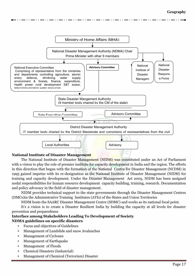
IRCLEGeography
Page 17
National Institute of Disaster Management
The National Institute of Disaster Management (NIDM) was constituted under an Act of Parliament
with a vision to play the role of premier institute for capacity development in India and the region. The efforts
in this direction that began with the formation of the National Centre for Disaster Management (NCDM) in
1995 gained impetus with its re-designation as the National Institute of Disaster Management (NIDM) for
training and capacity development. Under the Disaster Management Act 2005, NIDM has been assigned
nodal responsibilities for human resource development capacity building, training, research. Documentation
and policy advocacy in the field of disaster management.
NIDM provides technical support to the state governments through the Disaster Management Centres
(DMCs)in the Administrative Training Institutes (ATIs) of the States and Union Territories
NIDM hosts the SAARC Disaster Management Centre (SDMC) and works as its national focal point.
It’s a vision is to create a Disaster Resilient India by building the capacity at all levels for disaster prevention and preparedness
Interface among Stakeholders Leading To Development of Society
NDMA guidelines on specific disasters
Focus and objectives of Guidelines
Management of Landslide and snow Avalanches
Management of Cyclones
Management of Earthquake
Management of Floods
Chemical Disasters (Industrial)
Management of Chemical (Terrorism) Disaster
Ministry of Home Affairs (MHA)
National Disaster Management Authority (NDMA) Chair
Prime Minister with other 9 members
National Executive Committee Comprising of representative from the ministries and departments controlling agriculture, atomic enery defence, dirnikning water supply environment & forests, finance, expenditure, health power rural development S&T soace, telecommunication water resources
Advisory Committee National
Institute of
Disaster
Managem
National
Disaster
Respons
e Force
State Disaster Mangement Authority (9 member body chaired by the CM of the state)
Sate Execultive Committee Advisory Committee
District Disaster Management Authority
(7 member body charied by the District Magistrate and comprising of representatives from the civil
Local Authorities Advisory
IRCLEGeography
Page 18
Preparation of State Disaster Management Plans
Psycho – Socio support and Mental Health services in Disasters
Medical Preparedness and Mass casualty Management
Management of Nuclear and Radiological Emergencies
Incident Responses System
Strengthening of Safety and Security for Transportation of tankers
Management of Biological Disaster, Management of Tsunami
Role of NGOs in Disaster Management, Urban Flooding
Management of Dead in the Aftermath of Disaster
Plan to counter threats to Municipal water supply and water Reservoirs
Disasters Agencies
Cyclone Indian Meteorological Department Tsunami Indian National Centre for Oceanic information Service Floods Central Water Commission Landslides Geological Survery of India Avalanches Snow and Avalanche Study Establishment Heat & Cold Waves Indian Meteorological Department
TOWARDS A BETTER ENVIRONMENT
The Government of India has given special emphasis on the management and mitigation of disasters in
the country. Accordingly, a number of special attemperaturets have been taken in different sectors.
A Disaster Risk Management Programme has been started with the assistance of United Nations
Development Programme. The programme covers 169 Districts of 17 hazard prone states of India. The
Government has also joined hands with a number of International agencies for co-operations in the field of
Training and Capacity Building for Disaster Management and Mitigation. Asia Disaster Reduction Centre
(ADRC) Japan, Indo-Swiss Agreement for co-operation and Asian Disaster Management Centre are some
names of such organizations.