Early Paleogene Isolation of the Guf of Mexico from the World Ocean.
15
Early Paleogene Isolation of the Gulf of Mexico from the World’s Oceans? Implications for Hydrocarbon Exploration and Eustasy Joshua Rosenfeld Yax Balam, Inc., Granbury, Texas, U.S.A. James Pindell Tectonic Analysis Ltd., West Sussex, U.K. ABSTRACT D eeply incised and backfilled paleocanyons in early Paleogene shelf strata along the western and northern Gulf of Mexico margin attest to large relative sea-level fluctuations, but they predate the accepted age for onset of Cenozoic continental glaciation. Using Pleistocene canyons as a crude yardstick, the scale of these paleocanyons suggests relative sea-level changes at least as large as Pleistocene fluctuations. Therefore, we speculate that water level in the Gulf of Mexico was drawn down while the Gulf was isolated from the world’s oceans during the late Paleocene/early Eocene interval. We suggest that the cause for isolation was the progressive collision of the Cuban arc with the Yucata ´n and Bahamas carbonate platforms, which temporarily closed off the southeastern Gulf of Mexico. In Miocene Mediterranean and Holocene Black Sea examples of marine-basin isolation, evaporation greatly exceeded rainfall and runoff, and our examination of the Gulf of Mexico case suggests that water level may have dropped below the level of the world’s oceans at least once by several hundred meters, and possibly much more. Implications for geology and hydrocarbon exploration in the Gulf may include: bypass of enormous quantities of coarse detritus into the deep basin seaward collapse of exposed clastic shelf margins triggering and/or acceleration of salt evacuation (basinward ‘‘squeegee’’ effect of slumping sediments) 4 Rosenfeld, J., and J. Pindell, 2003, Early paleogene isolation of the Gulf of Mexico from the world’s oceans? Implications for hydrocarbon exploration and eustasy, in C. Bartolini, R. T. Buffler, and J. Blickwede, eds., The Circum-Gulf of Mexico and the Caribbean: Hydrocarbon habitats, basin formation, and plate tectonics: AAPG Memoir 79, p. 89 – 103. 89
-
Upload
independent -
Category
Documents
-
view
5 -
download
0
Transcript of Early Paleogene Isolation of the Guf of Mexico from the World Ocean.

Early Paleogene Isolation ofthe Gulf of Mexico from theWorld’s Oceans? Implicationsfor Hydrocarbon Explorationand EustasyJoshua RosenfeldYax Balam, Inc., Granbury, Texas, U.S.A.
James PindellTectonic Analysis Ltd., West Sussex, U.K.
ABSTRACT
Deeply incised and backfilled paleocanyons in early Paleogene shelf strataalong the western and northern Gulf of Mexico margin attest to largerelative sea-level fluctuations, but they predate the accepted age for
onset of Cenozoic continental glaciation. Using Pleistocene canyons as a crudeyardstick, the scale of these paleocanyons suggests relative sea-level changes atleast as large as Pleistocene fluctuations. Therefore, we speculate that water levelin the Gulf of Mexico was drawn down while the Gulf was isolated from theworld’s oceans during the late Paleocene/early Eocene interval. We suggest thatthe cause for isolation was the progressive collision of the Cuban arc with theYucatan and Bahamas carbonate platforms, which temporarily closed off thesoutheastern Gulf of Mexico. In Miocene Mediterranean and Holocene Black Seaexamples of marine-basin isolation, evaporation greatly exceeded rainfall andrunoff, and our examination of the Gulf of Mexico case suggests that water levelmay have dropped below the level of the world’s oceans at least once by severalhundred meters, and possibly much more.
Implications for geology and hydrocarbon exploration in the Gulf mayinclude:
! bypass of enormous quantities of coarse detritus into the deep basin! seaward collapse of exposed clastic shelf margins! triggering and/or acceleration of salt evacuation (basinward ‘‘squeegee’’
effect of slumping sediments)
4Rosenfeld, J., and J. Pindell, 2003, Early paleogene isolation of the Gulf
of Mexico from the world’s oceans? Implications for hydrocarbonexploration and eustasy, in C. Bartolini, R. T. Buffler, and J. Blickwede,eds., The Circum-Gulf of Mexico and the Caribbean: Hydrocarbonhabitats, basin formation, and plate tectonics: AAPG Memoir 79,p. 89–103.
89

! release of gas hydrates from sediments under shallower and warmer water,thereby contributing to the "100,000-year-long worldwide Paleocene/Eoceneboundary heating event
! development of secondary porosity in both platform and deep-water car-bonate sections by dissolution and phreatic diagenesis, e.g., in the GoldenLane/Poza Rica area of Mexico
! hypersalinity and possible sea-bottom stagnation with source-rock deposi-tion in areas that remained marine
! deposition of fine-grained condensed sections (seal and source rock) duringflooding period(s) when connection with the world’s oceans was reestab-lished, creating stratigraphic traps at canyon flanks and turbidite reservoirs inthe canyons.
Recognition that early Paleogene relative sea-level changes seen in the Gulfmay pertain to basin isolation is grounds for treating ‘‘eustatic’’ curves derivedfor or from the Gulf with suspicion. In addition, catastrophic basinward transferand collapse of mass near the shelf edges would have caused isostatic unloading(rebound) of shelf margins that was proportional to the mass transfer. In thecase of a discreet slumping event, such as the Lavaca ‘‘Megaslump’’ event ofsouth Texas, this effect may have caused uplift of several to a few tens of metersof footwall areas within about 100 km from the slump. Larger downslopemovements such as those related to the collective Wilcox fault province wouldhave caused far larger isostatic rebounds on the shelf, perhaps in excess of 100 mif sedimentation did not keep pace with faulting.
A body of circumstantial evidence continues to grow in support of thishypothesis; its potential implications, both academic and commercial, meritfurther investigation. Integration of information from Cuba, Mexico, the UnitedStates, and the Bahamas will be required to fully test the hypothesis.
INTRODUCTION
The margins of the Gulf of Mexico lie in the ter-ritorial waters ofMexico, Cuba, and theUnited States(Figure 1). For political and economic reasons,unified study of circum-Gulf geology and identifica-tion of the interrelationships of one subregion withanother have been impeded by restrictions on thefree flow of data and ideas in the geoscience com-munity. Therefore, there are grounds for proposingnew regional hypotheses to explain contemporane-ous developments in the Gulf that otherwise mightbe considered local phenomena only. If a regional,rather than a local, cause for a given phenomenonis supported by existing data, then the implicationsof the regional cause can be extended to other partsof the Gulf where such developments have not yetbeen identified.
In this paper, we consider a hypothesis involvingphysical isolation and drawdown of water level inthe Gulf of Mexico (Rosenfeld and Pindell, 2002)that will require the integration of data and ideas
from Mexico, Cuba, and the United States to testfully. The existence of late Paleocene/middle Eocenetransgressive-regressive cycles and associated enor-mous incised and backfilled paleocanyons in thenorthern and western Gulf of Mexico’s shelf andslope strata (e.g.,Wilcox andChicontepec Formations)attests to very large-magnitude/short-term relativesea-level fluctuations. However, features approach-ing this magnitude did not develop again in the Gulfuntil the Pliocene-Pleistocene, not even at the mid-dle Oligocene eustatic low, and that these featuresdeveloped prior to the accepted (late Eocene) onsetof Cenozoic continental glaciation (Markwick andRowley, 1998) leads us to hypothesize that waterlevel in the Gulf was drawn down, perhaps inter-mittently, during period(s) of physical isolation fromthe world’s oceans. We propose that the cause of theisolation was the collision of the Cuban arc with theYucatan and Bahamas carbonate platforms, whichclosed off the southeastern Gulf of Mexico/FloridaStraits connection in the late Paleocene to early ormiddle Eocene. In other documented examples of
90 / Rosenfeld and Pindell

marine-basin isolation (the Miocene of the Mediter-ranean and the Pleistocene/Holocene of the BlackSea), evaporation greatly exceeded fluvial/pluvialinput; therefore, drawdown could have been expectedin the Gulf of Mexico setting as well.
Two examples of a local phenomenon in the west-ern and northern margins of the Gulf with poten-tially regional implications are the Chicontepec andYoakum paleocanyons (Figure 1), where erosion hasdeeply excavated preexisting Paleocene and olderGulfmargin strata. In both these cases, basin-margin strataare incised over distances of 80 km to depths of 1 kmor more, while the width of the canyons is only 10 to15 km. At Yoakum, the incised Paleocene section(lower Wilcox) is sand-rich and was deposited in ashelf rather than slope environment. In contrast, atChicontepec the pre-canyon Paleocene (turbidites)and older section comprised the continental slope
landward of the isolated Tuxpan (Golden Lane) car-bonate platform. This canyon was eroded throughthe entire slope turbidite sequence down into theunderlying, already lithified Cretaceous and Jurassicbasinal carbonates. The scale and setting of these andother canyons and unconformities suggest to us thatthe erosive power of subaerial (fluvial) rather thansubmarine systems was responsible for these remark-able late Paleocene or early Eocene canyons.
Both canyons are backfilled with deep-water sed-iments (mainly siltstones in Yoakum and turbiditesincluding some channelized sandstones in Chicon-tepec), which suggests rapid return of the sea thatdelayed resumption of coarse-grained sedimentationinto the canyons. If so, either (1) the entire marginwould have had to be uplifted and then lowered rap-idly (geologically instantaneously) by as much as 1km, or (2) hydrologic base level in the Gulf of Mexico
Figure 1. General map of the tectonic setting of the Gulf of Mexico region at the time of the Paleocene-Eoceneboundary ("56 Ma, after Pindell and Kennan, 2001), showing localities noted in the text. Note the way in which theCuban Orogen blocked the entrance to the Gulf of Mexico.
Early Paleogene Isolation of the Gulf of Mexico from the World’s Oceans? / 91

fell by perhaps 1 km or more and then rapidly re-turned to its original level. There is no tectonic rea-son to suspect, or structural evidence to suggest, thatthere was uplift along the Texas shelf of anywherenear this magnitude at that time. Similarly, the east-ern Mexican Gulf coastal plain and slope were situ-ated in the tectonically loaded Sierra Madre foredeepbasin rather than the Sierra Madre hanging wall, andthey should have been subsiding rather than rising atthat time. Thus, we have examined and compiledcircum-Gulf evidence to build a case for one or morerapid and large Paleogene drawdown/flooding cyclesin the Gulf through intermittent isolation from theworld’s oceans when the Cuban Orogen spanned thequasi-oceanic gap between Yucatan and the Baha-mas, as outlined below.
CHICONTEPEC PALEOCANYON
Although contested byCantu-Chapa (1985, 2001),the existence of the Chicontepec paleocanyon in the
Tampico-Misantla Basin of east-central Mexico (Fig-ure 1) has been described by Busch and Govela (1978),Carillo-Bravo (1980), Busch (1992), and Bitter (1993).The Chicontepec Formation comprises three mem-bers: ‘‘Lower,’’ ‘‘Middle,’’ and ‘‘Upper’’ of Paleocene–lower Eocene age. The Lower and Middle Chiconte-pec members roughly span the Paleocene and formdepositional units in a foreland basinal setting be-tween the Tuxpan (Golden Lane) carbonate platformand the Sierra Madre Oriental thrust front (Figures 1and 2). Deposition at this time occurred in outerneritic to upper bathyal water depths andwasmainlyturbiditic in nature. Cut into these, and into deep-water marine carbonate units as old as Jurassic, is apaleocanyon filled with turbiditic sediments of theUpper Chicontepec member. The Upper Chiconte-pec canyon fill is roughly of Paleocene-Eocene bound-ary age, but faunal zonation is apparently lacking(Busch and Govela, 1978; Bitter, 1993) as might beexpected during rapid infilling after the Gulf re-flooded. Overlying this member are the prograding
Figure 2. Isopach map and cross section of part of the Chicontepec Canyon area, east-central Mexico, modified afterBusch and Govela (1978) to show the canyon fill and overspill deposits as the same age (early Eocene). See Figure 1 forgeneral locality.
92 / Rosenfeld and Pindell

littoral and neritic Guayabal and Tantoyuca Forma-tions of middle and upper Eocene age, which rep-resent the first truly shelf setting in the area.
The Chicontepec paleocanyon has relief of atleast 1 km, and cuts down to the Late Jurassic SanAndres Formation. Isopachs of the canyon fill in-crease westward toward the Sierra Madre Orientalthrust front (Figure 2). On this basis, Busch andGovela (1978) considered that current direction waseast-to-west during canyon formation. However, ifthe original surface of the basinal trough dippedeastward on the continental slope as the canyon wascut into it, the same isopach would be producedwith west-to-east flow, and we find that this is morein line with regional geology, as did both Cantu-Chapa (1985) and Carillo-Bravo (1980).
Slightly to the south, at the Nautla paleocanyon(also known as San Andres Canyon, as acknowl-edged by Cantu-Chapa, 2001), 2 km of Chicontepeccanyon-fill rests unconformably on Jurassic red beds(Figures 1 and 2; Cantu-Chapa, 2001; Viniegra-O,
1966), suggesting that the canyon cut through theentire marine section above the Santa Ana Massif,which defines basement here. If canyon cutting isthe primary reason for the missing Cretaceous andJurassic section, then the Nautla example would sug-gest a larger water-level drop in the Gulf than pres-ently documented in Chicontepec. Both canyons cutthrough the entire Cretaceous section of carbonatesand marls. These lithologies are prone to rapid ce-mentation and may have been nearly or fully lith-ified at the time of late Paleocene or early Eocene ofdowncutting. Thus, the erosional forces must havebeen strong and may have taken several tens or hun-dreds of thousands of years to accomplish.
Offshore, seismic lines show the deep stratal geom-etry illustrated in Figure 3. A deep, well-bedded, pre-sumed Mesozoic section is overlain by a discontinu-ously bedded section of probable Paleogene age thatunderlies the detachment for theMexican Ridges FoldBelt. The detachment links extensional gravity-drivenfaults at the top of the slope with compressional folds
Figure 3. Schematic seismic section of the eastern Mexican deep-water margin east of the Chicontepec Canyon, drawnfrom memory of sections presented in presentations at the 2001 Asociacion Mexicana de Geologos Petroleros /AAPGmeeting, Veracruz, Mexico.
Early Paleogene Isolation of the Gulf of Mexico from the World’s Oceans? / 93

and thrusts toward the slope-to-basin transition. Themiddle (subdetachment) section may comprise fans,orperhapsdeltas, built of bothexcavatedandbypassedsediment transported into theGulf ofMexico throughthe Chicontepec Canyon. The age of this section ispoorly constrained at present, but late Paleocene/earlyEocene fits the existing constraints, and the great vol-ume of missing Chicontepec strata removed to formthe canyon must have been deposited in this area.
Additional anecdotal evidence for large water-level fluctuations in this area is the developmentof cavernous and other secondary porosities in theCretaceous reef carbonates of the Golden Lane andbasinal carbonate debris in Poza Rica Field that wasderived from theGolden Lane reefs. Textures in thesestrata apparently required flushing bymeteoric waterdownward to depths of at least 2 km, or to about thebase of the Chicontepec Canyon (Enos, 1988; DanCox, personal communication, 2001). The caverns andfiner-scale secondary porosity development may berelated to a drastic lowering of the water table, asproposed here, rather than to the very special set ofconditions outlined by Enos (1988), who, judgingfromhis comments,maynot have been satisfied fullywith existing models for understanding this porositydevelopment. Enos (1988) cites Halley et al. (1984) asdescribing similar circumstances at Deep Sea DrillingProject (DSDP site 536 off northeastern Campeche(Figures 1 and 5A), the location of which also mayhave been subaerial, or nearly so, for part(s) of theearly Paleogene. (Note: Eocene is missing at thislocality, according to revised ODSN [Ocean DrillingStratigraphic Network] range charts.) Like the can-yon itself, development of such secondary porosityin the Golden Lane/Poza Rica carbonates may haverequired a significant time period to develop.
From the above, we envisage the following: At theend of Middle Chicontepec time, water level in theGulf was drastically lowered by more than the pre-existing water depth of the Chicontepec Trough, pos-sibly by up to 1 km or more, for a significant periodof time. One or more rivers flowing either out ofor along the front of the growing Sierra Madre Ori-ental flowed toward the Gulf and excavated theChicontepec and Nautla Canyons throughout thePaleocene-age Lower and Middle Chicontepec clas-tics, Cretaceous carbonates, and, ultimately, Jurassicstrata (Figure 2). This was accomplished by fluvialerosion rather than by submarine processes, as otherstudies have assumed. The river(s) carried clastic de-tritus from the rising Sierra Madre out onto the slopeof the Gulf of Mexico, probably into a deltaic and
ultimately a submarine fan depositional environment(Figure 3). At about the Paleocene-Eocene boundary,or perhaps just into the lower Eocene, water level inthe Gulf returned to normal, presumably by breach-ing of the land barrier at the Cuban Orogen (seeClimate, Regional Drainage Patterns, and Gulf–World’s Oceans Connections), and the Upper Chi-contepec was deposited rapidly as canyon fill derivedfrom the adjacent Sierra Madre Oriental. This en-vironment of rapid deposition involved much re-working of existing material, hence the irresolvablefaunal zonation.
YOAKUM AND SOUTHEASTERN TEXAS/NORTHEASTERN MEXICO MARGIN
Both megaslumps and canyons are associatedwith the Wilcox Formation in southern Texas andnorthernmost Mexico (Figures 1 and 4). The Loboand Lavaca megaslumps formed in the late Paleo-cene mainly in areas of thick, prograded clastic del-taic deposits of Paleocene age (e.g., Houston Delta;Galloway et al., 1991, 2000). The slumps likely com-prise material from the poorly consolidated shelf-slope break.
Downcutting into the Lavaca megaslump, as wellas headward into the shelf for some 80 km north-west of the slumped zone, is the Yoakum paleocan-yon (Figure 4). The Yoakum Canyon is similar to theChicontepec Canyon in that it has about 1 km ofrelief, has sides sloping up to 308, and has canyonfill of fine-grained sediment that spilled over thecanyon limits (Figure 4). It is potentially importantthat this canyon cuts through other than basinal(trough) strata because it strongly suggests that thecanyon-forming process was subaerial rather thansubmarine. Indeed, Galloway et al. (1991, p. 263)write: "Wilcox canyon fills include (1) a lower onlapfill, which consists largely of disorganized slump anddebris-flow deposits, but locally contains sandy chan-nel fills and turbidite mounds. . .’’ We suggest thatthe debris-flow and sandy channel fills may indicatea subaerially eroding canyon with slumping wallsand a river in the thalweg. We further speculate thata major paleocanyon also may exist under the lowerRıo GrandeValley, with the Lobo megaslump repre-senting slides that formed along its walls or at itsheadward extremity.
Other examples of canyons in the world with thismagnitude of incision and distance of headward ero-sion across a shelf are rare; not even the QuaternaryHudson, Mississippi, or La Jolla Canyons reach this
94 / Rosenfeld and Pindell

scale on the shelf. The Hudson Canyon, formedduring an obvious and significant glacial drawdown,has a length of only 15 km on the shelf in contrastto 80 km for Yoakum. The Mississippi Canyon issomewhat wider than Yoakum Canyon, in a pre-dominantly slope setting, and is more clearly of asubmarine slump origin (Prather et al., 1998). The LaJolla Canyon lies in an active strike-slip setting andprobably should not be used in such comparisons. Inthe case of the Nile and Rhone Rivers, gullies andcanyons incising the shelf and even more landwardsections (Ryan and Cita, 1978; Barber, 1981) devel-oped during the Messinian salinity crisis when waterlevel in the Mediterranean fell by more than 2 km(Butler et al., 1995). We believe that current strengthin the marine environment would be insufficient tocause such magnitudes of incision on the shelf , andwe find it difficult to envision how canyon flanks in
unconsolidated material could approach 308 slopesin an active-marine environment known otherwiseto be a site of longshore drift.
HYPOTHESIS
We hypothesize the following: A significant low-ering of the Gulf’s base level at about the Paleocene-Eocene boundary was responsible for developmentof the canyon and megaslump features. However,dating uncertainties allow that the numerous can-yons (Figure 1) may not be of exactly the same age;thus, more than one cycle of drawdown affectingdifferent places may have occurred. As initial draw-down took place, the shelf became exposed, and thefirst event was the primarily subaqueous failure oflarge segments of the basin margin, represented by
Figure 4. Isopach map and cross section of the Lavaca megaslump and Yoakum paleocanyon area, Texas, modifiedafter Busch (1974). See Figure 1 for general locality. Note that the paleocanyon cuts into shelf strata northwest of theLavaca megaslumps, such that the isopach here approximates a paleostructure map and attests to the fact that thecanyon was nearly flat with little gradient at its base.
Early Paleogene Isolation of the Gulf of Mexico from the World’s Oceans? / 95

the Lavaca and other megaslumps. As water levelwas drawn down farther, either in the same or in sub-sequent events, the original fluvial systems responsi-ble for the deltas at which the slumping took placecut more deeply through the shelf and upper slopestrata and, in the case of Lavaca, through materialthat had already slumped basinward (Figure 4). Weconsider the apparent lack of significant gradientin the floors of both the Chicontepec and Yoakumpaleocanyons (Figures 2 and 4) to support the fluvialinterpretation of their origin, in contrast to subma-rine canyons cut by relatively dense turbidity cur-rents that normally require a relatively steep gradientin order to gain the necessary energy to become andremain erosive. As water level rose again, the can-yons were backfilled with generally fine-grained sed-iments that eventually overtopped the original can-yon walls. Concerning the backfilling, we pose thequestion: What could have caused the change fromsuch drastic canyon erosion to such rapid canyoninfilling if the margin had remained submarine theentire time? The answer does not appear to be anaccelerated influx of sediment, as the canyon fill isvery fine to silty; we suggest that a rapid return toa submarine environment was responsible.
Following the first episode of infilling, furtherlarge basinward shifts in facies with notably rapiddowncutting and incision of various magnitudes, allfollowed by rapid flooding events (fine-grainedtransgressive tongues), are recorded in the UpperWilcox, Queen City, Sparta, and Yegua Formations(Galloway et al., 1991). Because their ages pre-datethe accepted time of initial Tertiary continentalglaciation (Markwick and Rowley, 1998), we specu-late that these cycles of very large relative sea-levelchange may have been driven by at least one periodof isolation (evaporative drawdown of hundreds ofmeters) and reconnection (rapid flooding) of theGulf with the world’s oceans as topographic relief inthe Cuban Orogen was breached (see the followingsection), rather than being caused by worldwide eu-static cycles.
CLIMATE, REGIONAL DRAINAGE PATTERNS,AND GULF–WORLD’S OCEANS CONNECTIONS
In order for water level in the Gulf to fall belowglobal eustatic levels, the Gulf must have been phys-ically isolated from the world’s oceans, and evap-oration must have exceeded total river input andprecipitation. Although the Gulf was linked during
the Late Cretaceous to the world’s oceans across epi-continental and deeper channel systems via theWest-ern Interior Seaway, the Suwannee Straits of northernFlorida, the Isthmus of Tehuantepec of southernMex-ico, and the southeastern Gulf of Mexico/FloridaStraits, by the Late Paleocene, all of these connections,except for the southeastern Gulf/Florida Straits, hadbeen interrupted as a result of long-term eustatic falland local tectonic developments (Ziegler and Row-ley, 1998; Galloway et al., 2000; Pindell, 1993; John-son and Barros, 1993). Thus, if Cuba blocked the Flor-ida Straits and Yucatan Channel in the Paleogene, assuggested here, then the potential exists for the Gulfto have been isolated at about the late Paleocene.In this event, we note that the paleolatitude of theGulf has remained within the latitudinal band of158–258N since the Paleocene, certainly in a zoneof high evaporation potential. Further, relief in theSierra Madre Oriental probably reached its maximumin the late Paleocene–middle Eocene (Suter, 1987),possibly causing a rain-shadow effect along the west-ern margin of the Gulf. Major late Paleocene–middleEocene rivers did enter the Gulf of Mexico from theLaramide foreland (Galloway et al., 2000) but, inour opinion, would not have been able to replacethe water lost to evaporation. In Mexico, catchmentareas were limited by the rising Sierra Madre Orien-tal. Given this high evaporation potential, and usingthe Mediterranean Messinian crisis as an analogue(where rivers such as the Rhone andNile were unableto overcome evaporation), we are confident that thelate Paleocene–middle Eocene setting for the Gulfof Mexico at the time of the Cuban blockage of thesoutheastern Gulf was generally conducive to evap-orative drawdown.
With regard to Cuba and the southeastern Gulf,the Cuban island arc is understood to have collidedwith the northeastern Yucatan and Bahamas pas-sive margins in the late Paleocene to middle Eocene(Iturralde-Vinent, 1994), such that the Cuban Oro-gen (and the adjacent Bahamas and Yucatan plat-forms) is capped by a strong middle Eocene subaerialunconformity (Pardo, 1975; Pzolzyckowski, 1999;Ball et al., 1985). However, it is unclear whether thearc collision and subjacent imbrication of shelf stratafrom Yucatan to the Bahamas across the southeast-ern Gulf of Mexico gap attained sufficient and con-tinuous bathymetric/topographic statement to closeoff the Gulf of Mexico during and, possibly, for sometime after the collision. We believe that the obser-vations at the Chicontepec and Yoakum Canyonsprovide evidence that the Cuban thrust belt did, in
96 / Rosenfeld and Pindell
fact, seal off the Gulf, as depicted in Figure 1. Further,there is no reason to assume that the Gulf was notsealed off, perhaps intermittently, during the pro-gressive collision.
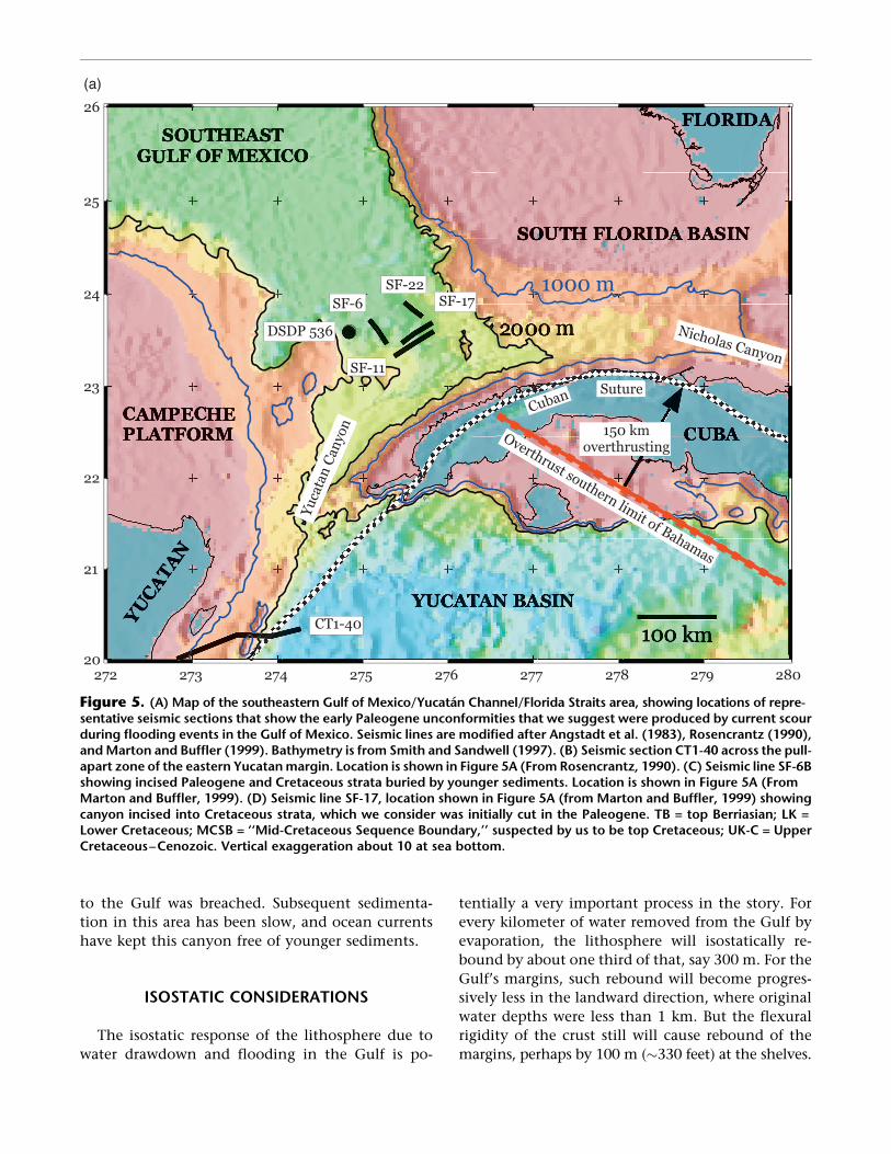
More direct evidence that the Cuban Orogenclosed off the mouth of the Gulf comes from seismicsections in this area (Figure 5A) that show late Eocenestrata commonly resting above a strongly erosionalhiatus that often cuts down to middle Cretaceouslevels and, along the northeastern Yucatan margin,to deformed basement. Although the basement is notwell defined here, Figure 5B shows that an unde-formed late Eocene and younger section rests on adeformed substratum (Rosencrantz, 1990). We envi-sion that at least one, and possibly several post-drawdown flooding episode(s) in the Gulf createdthis scoured surface and that the late Eocene andyounger age of the overlying section defines theperiod following the activity of strong, erosive cur-rents. Similarly, Figures 5C, 5D, and 5E also show theeffect of severely erosive bottom currents. In thesesections and others, hiati at the Paleocene-Eoceneboundary, as well as within the late middle to lateEocene, have been noted (Angstadt et al., 1983;ODSN, 2001).
Finally, we note the existence of a deep-sea fanlocated to the northwest of the Florida Straits (Figure1; ‘‘Eocene Plume’’). We suggest that the fan com-prises material eroded from the Cuban Orogen andthe Paleogene unconformities in the Florida Straits.It would be surprising if such a fan did not exist inthis location, given the volume of material that ap-parently was eroded from the Straits during poten-tially catastrophic refilling of the Gulf once the bar-rier was breached.
The sequence of events during arc collision in theFlorida Straits/Yucatan Channel is as follows (afterPindell and Kennan, 2001). The Cuban forearc mi-grated with sinistral transpression to the north-northeast along the eastern Yucatan margin duringthe Maastrichtian to middle Eocene (Figure 1). Dur-ing this transpression, the western Cuban fold-thrustbelt of the Sierra Guaniguanico (Jurassic-Paleoceneshelf and slope strata derived from the eastern Yu-catan margin) was imbricated ahead of the Cubanarc rocks and was carried toward the Bahamas forultimate collision (Pindell, 1985; Hutson et al., 1998;Iturralde-Vinent, 1994). Likewise, a southern Baha-mian slope-and-shelf section was imbricated aheadof the arc as it converged upon the Bahamas (Hemp-ton and Barros, 1993). Figure 1 suggests that the im-bricated fold belt spanned and blocked the Florida
Straits and Yucatan Channel starting in the late Pa-leocene, precisely when the Chicontepec and Yoa-kum Canyons were cut, and just before the culmi-nation of the Cuban convergence with the Bahamas(note the final middle Eocene position of the north-ern Cuban coastline in Figure 1). However, uponthat culmination, Pindell and Kennan (2001) arguethat the collision was accompanied by the droppingoff of the subducted, south-dipping proto-Caribbeanslab beneath Cuba, which predictably should haveled to 1 or 2 km of early or early–middle Eocene iso-static rebound of the entire CubanOrogen, operatingover a flexural wavelength of about 300 kmacross theorogen. This development either could have en-hanced the original late Paleocene blockage of themouth of the Gulf or caused additional blockagesinto the Eocene.
We make no attempt to define the number orduration of times when the Gulf was isolated fromthe world’s oceans, but judging from the geology ofthe Florida Straits, we are confident that by the lateEocene, the Cuban Orogen had been downcut inone or more places (e.g., Yucatan and/or NicholasChannels) to a sufficient depth that the marineconnection probably was never broken again. Angs-tadt et al. (1983) make the point that the Eoceneunconformity west of Cuba and in the NicholasChannel seems to be unique and cannot be relatedto the ‘‘normal’’ range of sea-level fluctuations. TheEocene erosional event is obvious, while a suppos-edly much larger Oligocene eustatic sea-level fall isnot represented by an unconformity. Today, waterdepths in the Yucatan and Nicholas Channels areabout 2 km and just less than 1 km, respectively, andwe find that the present structural levels of theEocene unconformities in these areas are in line withexpected amounts of subsidence since the Eocene,given the various aspects of the setting. Further, thearea between western Cuba and Yucatan (YucatanChannel) was transtensionally widened and deep-ened toward the end of Cuba’s migration toward theBahamas (Rosencrantz, 1990; Pindell and Kennan,2001), subsequent to the period of canyon cutting(and proposed marine isolation) in the Gulf.
The strongest single piece of evidence for rapidrefilling of a lowered Gulf of Mexico is the canyon inthe Straits of Florida whose thalweg presently lies3,000 m below sea level (Figure 5D). This canyonwas cut through Paleocene strata into Lower Cre-taceous rocks. The likely mechanism for this event isthe flow of ocean water into a drawn down Gulf ofMexico on one or more occasions when the barrier
Early Paleogene Isolation of the Gulf of Mexico from the World’s Oceans? / 97
to the Gulf was breached. Subsequent sedimenta-tion in this area has been slow, and ocean currentshave kept this canyon free of younger sediments.
ISOSTATIC CONSIDERATIONS
The isostatic response of the lithosphere due towater drawdown and flooding in the Gulf is po-
tentially a very important process in the story. Forevery kilometer of water removed from the Gulf byevaporation, the lithosphere will isostatically re-bound by about one third of that, say 300 m. For theGulf’s margins, such rebound will become progres-sively less in the landward direction, where originalwater depths were less than 1 km. But the flexuralrigidity of the crust still will cause rebound of themargins, perhaps by 100 m ("330 feet) at the shelves.
Figure 5. (A) Map of the southeastern Gulf of Mexico/Yucatan Channel/Florida Straits area, showing locations of repre-sentative seismic sections that show the early Paleogene unconformities that we suggest were produced by current scourduring flooding events in the Gulf of Mexico. Seismic lines are modified after Angstadt et al. (1983), Rosencrantz (1990),andMarton and Buffler (1999). Bathymetry is from Smith and Sandwell (1997). (B) Seismic section CT1-40 across the pull-apart zone of the eastern Yucatanmargin. Location is shown in Figure 5A (From Rosencrantz, 1990). (C) Seismic line SF-6Bshowing incised Paleogene and Cretaceous strata buried by younger sediments. Location is shown in Figure 5A (FromMarton and Buffler, 1999). (D) Seismic line SF-17, location shown in Figure 5A (from Marton and Buffler, 1999) showingcanyon incised into Cretaceous strata, which we consider was initially cut in the Paleogene. TB = top Berriasian; LK =Lower Cretaceous; MCSB = ‘‘Mid-Cretaceous Sequence Boundary,’’ suspected by us to be top Cretaceous; UK-C = UpperCretaceous–Cenozoic. Vertical exaggeration about 10 at sea bottom.
98 / Rosenfeld and Pindell

This carries some implications. First, once started,evaporation would tend to enhance the isolationof the Gulf by uplift of the Gulf’s margins, makingthem less likely to be breached. Second, existing
rivers in the northern and western Gulf floodplainwould respond to this marginal uplift by incising theouter shelf on their way to the lowered Gulf. Third, ifthe Gulf was isolated from the world’s oceans, the
Figure 5. (cont.).
Early Paleogene Isolation of the Gulf of Mexico from the World’s Oceans? / 99

remaining water itself would rebound with the lith-osphere, and the net lowering of the Gulf’s waterlevel relative to the world’s oceans would be one-third less than the actual amount of water lost inthe Gulf. Finally, all of these considerations wouldhave been reversed once water began to reflood theGulf: specifically, the floor and margins of the basinwould have subsided under the load of additionalwater, leading to pronounced marine transgressionacross the formerly exposed and incised shelves.Such onlap sections (mostly shale) include the BigShale, Yoakum, Reklaw, Weches, Cook Mountain,and Moody’s Branch Formations (Galloway et al.,2000).
DISCUSSION
Our hypothesis provides a unifying mechanismfor diverse phenomena of Paleogene age that eitheralready have been observed, or are as yet unexam-ined, in Cuban, Mexican, and U.S. waters. These in-clude (1) the subaerial(?) exposure of circum-Gulfcontinental shelves and upper slopes; (2) severe can-yon incision into shelves and slopes (Yoakum andChicontepec); (3) massive slumping of clastic conti-
nental shelf/slope sections (Lavaca) on a scale notapproached again in the Gulf until the Pleistocene;(4) transfer of load by mass wasting and deposition,possibly driving massive salt evacuation ahead ofthe migrating clastic wedge; (5) deep karsting andporosity development in exposed carbonate mar-gins; (6) high volumes of sediment bypass and pro-gradation into the deep Gulf basin, including thepossibility of deltaic deposition on the Paleogene con-tinental slope; and (7) severe deep-sea scour along theflank of the Cuban Orogen.
Flooding episode(s) in the basin would have re-sulted in rapid backfilling of the canyonswith ‘‘trans-gressive’’ fine-grained, seal- and locally source-pronesediments, which would logically spill beyond thecanyon walls due to the isostatic loading effect of theflood on the shelves (Upper Chicontepec Formationin Chicontepec Canyon, and Big Shale/Middle Wil-cox [not exactly clear, in our opinion] in YoakumCanyon). Also, severe erosion along the paths of sea-water reentry (Nicholas and Yucatan Channels, Flor-ida Straits) is expected, with the associated trans-portation of southerly-derived clastic detritus intothe deep southeastern Gulf of Mexico.
It might be expected that progressive Cuban upliftwould block the Gulf and that the eventual breaching
Figure 5. (cont.).
100 / Rosenfeld and Pindell
of the barrier would lead to only a single isolationevent that was perhaps prolonged. However, thetiming of the drawdown episode(s) (late Paleocene–early Eocene) preceded the culmination of theCubanOrogeny (middle Eocene). Thus, the Cuban Orogenwas dynamically growing during drawdowns; there-fore, it is possible that multiple barriers were createdand breached during final suturing, thereby produc-ing repeated isolation events in the Gulf. Ultimately,the two key parameters that mattered most were (1)the continuity of the orogen from the Bahamian tothe Yucatan ‘‘Eocene’’ unconformities, and (2) theelevation of this growing orogen relative to eustaticsea level on its southeastern side. Considering thatboth thrust-belt development as well as the droppingoff of the proto-Caribbean slab during suturingprobably caused kilometric magnitudes of uplift,the creation of a land bridge from the Bahamas toYucatan would not be surprising. Subsidence anderosion along the transcurrent fault system betweenthe Yucatan Block and Cuba in the Yucatan Channelprobably led to permanent barrier failure in thelatest (early to middle Eocene) stages of the CubanOrogeny.
Concerning eustasy, possible intermittent Paleo-gene isolation of the Gulf ofMexicomay have causedcyclical transgressive-regressive cycles in the Gulf thathave previously been interpreted as large-magnitudeworldwide eustatic fluctuations. Because these large-magnitude/short-term cycles predate the acceptedonset of Cenozoic continental glaciation in the lateEocene, we would treat Paleocene–middle Eocenerelative sea-level histories derived for or from theGulf margins with a high degree of suspicion. Po-tential drawdown/flood cycles include Lower Wil-cox/Big Shale; MiddleWilcox?/Yoakum Shale; UpperWilcox/Reklaw Shale; Queen City/Weches forma-tions; Sparta/CookMountain formations; andYegua-Cockfield/Moodys Branch formations. Thus, theGulf of Mexico should not be used as a laboratoryfor defining global eustatic changes for early Paleo-gene. Since at least late Eocene deposition of theJackson Formation and equivalent units, the Gulfappears to us to have remained connected to world’soceans. As continental glaciation is known to haveoperated since the late Eocene, we accept that theJackson and subsequent progradational sand wedges(such as the Frio Formation) in the Gulf may relategenetically to glacioeustasy. The large volume of Friosandstones is presumably related to erosion of theEocene Laramide uplifts, after the subjacent Lara-mide foredeep basins were filled, and to the onset of
basin and range tectonics in the U.S. and MexicanCordillera.
We propose a mechanism similar to the Messi-nian desiccation of the Mediterranean for large,short-term, early Paleogene relative water-level fluc-tuations in the Gulf of Mexico, a basin that has beenused extensively in the determination of Cenozoicrelative sea-level charts. In Pindell (1998, p. v) thequestion was posed: ‘‘Why don’t relative sea levelcharts change in style as we go back beyond the LateEocene earliest onset of Cenozoic continental glaci-ation?’’ Are there two primary drivers for large,short-term fluctuations operating today, one ofwhich is unknown but that operated alone prior tothe late Eocene? If our drawdown/flood hypothesisfor the early Paleogene of the Gulf of Mexico iscorrect, we will need to ignore the Gulf of Mexico forcalibration of eustatic charts for the early Paleogene.
If the relative fall(s) in the Gulf’s water level pro-posed in this paper exceeded typical post-middle Eo-cene eustatic falls, our hypothesis, if correct, carries thefollowing implications for hydrocarbon exploration:
! one or more ubiquitous circum-Gulf unconform-ities matching the time(s) of lowered water level,with Paleocene to middle Eocene paleosols onthe shelves and upper continental slopes
! exposure and karsting of exposed carbonate plat-forms (Florida, Yucatan, Cordoba, Tuxpan, Tama-ulipas Arch, etc.)
! deeply incised, silt and fine-grained turbidite-filled canyons with stratigraphic trapping po-tential cut along other river systems feeding theGulf that are not yet well documented (Tyler,Bleakwood, St. Landry, Nautla; Figure 1), and pos-sibly in the Rio Grande Embayment
! slumping and landsliding of exposed canyonwalls and poorly consolidated upper-slope depos-its in areas other than the documented Lavacamegaslump
! fluvial thalweg deposits comprising braidedchannels and sandbars on the floors of subaer-ially eroded canyons during periods of loweredwater level.
! a major paleocanyon analogous to the Nile paleo-canyon of the Mediterranean Sea should existunder the present day Rio Grande. In this case,the anomalous block faulting of Paleocene stratawithin a narrow strip along the U.S.–Mexicanborder (the Lobo trend) would be due to gravita-tional failure along the canyon’s rapidly propa-gating headwall. The downdip paleocanyonmay
Early Paleogene Isolation of the Gulf of Mexico from the World’s Oceans? / 101

have been large enough to nucleate the Eoceneto Oligocene Vickburg Embayment depocenter.
! extensive Paleocene tomiddle Eocene sandy low-stand deltas and basin slope, and floor fans ba-sinward of the subaerial canyon systems. Suchdeposits could provide important hydrocarbonreservoirs and migration pathways from deepmaturation ‘‘kitchens.’’ We note that the Chicon-tepec Formation is saturated with hydrocarbons(Bitter, 1993), possibly due to its physical contactwith the Upper Jurassic source rocks at the baseof the canyon.
! deposition and preservation of both algal- andland plant–dominated organic debris (oil andgas–prone) during the lowstand interval in basin-al deposits laid down under a stratified column ofhypersaline brine, and accumulation of oil-pronesource material in the condensed section(s)following reconnection with the world’s oceans.
ACKNOWLEDGMENTS
We are grateful to Lorcan Kennan for discussionsand compilations of information included in thefigures, Dan Cox for discussions on porosity devel-opment in Mexican carbonates, Bill Galloway forinsights on Paleogene depositional history in theGulf, and to Arthur Berman, Jon Blickwede, LouisLiro, and Walter Pitman for discussions pertainingto the proposed hypothesis.
REFERENCES CITED
Angstadt, D. M., J. A. Austin Jr., and R. T. Buffler, 1983,Deep-sea erosional unconformity in the southeasternGulf of Mexico: Geology, v. 11, p. 215–218.
Ball, M. M., R. M. Martin, W. D. Bock, R. E. Sylvester, R. M.Bowles, D. Taylor, E. L. Coward, J. E. Dodd, and L.Gilbert, 1985, Seismic structure and stratigraphy ofnorthern edge of Bahaman-Cuban collision zone: AAPGBulletin, v. 69, p. 1275–1294.
Barber, P. M., 1981, Messinian subaerial erosion of theproto-Nile Delta: Marine Geology, v. 44, p. 253–272.
Bitter, M. R., 1993, Sedimentation and provenance ofChicontepec sandstones with implications for upliftof the SierraMadre Oriental and TezuitlanMassif, East-Central Mexico, in J. L. Pindell and R. F. Perkins, eds.,Mesozoic and Early Cenozoic Development of the Gulfof Mexico and Caribbean Region: A Context forHydrocarbon Exploration: Transactions, 13th AnnualGulf Coast Section of Society for Sedimentary Geology(GCSSEPM) Research Conference, p. 155–172.
Busch, D. A., 1974, Stratigraphic traps in sandstones—exploration techniques: AAPG Memoir 21, 157 p.
Busch, D. A., 1992, Chicontepec Field, Mexico, Tampico-Misantla Basin, in N. H. Foster and E. A. Beaumont,compilers, Stratigraphic traps III: AAPG Treatise of Pe-troleumGeology, Atlas of oil and gas fields, p. 113–128.
Busch, D. A., and A. S. Govela, 1978, Stratigraphy andstructure of the Chicontepec Turbidites, southeasternTampico–Misantla Basin, Mexico: AAPG Bulletin,v. 62, p. 235–246.
Butler, R. W. H., W. H. Lickorish, M. Grasso, H. M. Pedley,and L. Ramberti, 1995, Tectonics and sequencestratigraphy in Messinian basins, Sicily: Constraintson the initiation and termination of the Mediterra-nean "salinity crisis": Geological Society of AmericaBulletin, v. 107, p. 425–439.
Cantu-Chapa, A., 1985, Is there a Chicontepec paleocan-yon in the Paleocene of eastern Mexico?: Journal ofPetroleum Geology, v. 8, p. 423–434.
Cantu-Chapa, A., 2001, Paleocanyons in the subsurfaceof Eastern Mexico: Facts and uncertainties, in C. Bar-tolini, R. Buffler, and A. Cantu-Chapa, eds., The West-ern Gulf of Mexico Basin: AAPG Memoir 75, p. 421–432.
Carillo-Bravo, J., 1980, Paleocanones terciarios de la plan-icie costera del Golfo de Mexico: Asociacıon Mexicanade Geologos Petroleros Boletın, v. 32, p. 27–55.
Enos, P., 1988, Evolution of pore space in the Poza Ricatrend (mid-Cretaceous),Mexico: Sedimentology, v. 35,p. 287–325.
Galloway,W. E., D. G. Bebout,W. L. Fisher, J. B. Dunlap Jr.,R. Cabrera-Castro, J. E. Rivera, and T. M. Scott, 1991,Cenozoic, inA. Salvador, ed., TheGulf ofMexico Basin,TheGeology ofNorthAmerica, v. J: Boulder, Colorado,Geological Society of America, p. 245–324.
Galloway, W. E., P. Ganey-Curry, X. Li, and R. T. Buffler,2000, Cenozoic depositional evolution of the Gulf ofMexico Basin: AAPG Bulletin, v. 84, p. 1743–1774.
Halley, R. B., B. J. Pierson, and W. Schlager, 1984, Alter-native diageneticmodels for Cretaceous talus deposits,DSDP site 536, Gulf of Mexico, Initial Reports of theDeep Sea Drilling Project:Washington, D.C., U.S. Gov-ernment Printing Office, v. 77, p. 397–408.
Hempton, M. R., and J. A. Barros, 1993, Mesozoic stra-tigraphy of Cuba: Depositional architecture of a south-east facing continental margin, in J. L. Pindell and R. F.Perkins, eds., Mesozoic and Early Cenozoic develop-ment of the Gulf of Mexico and Caribbean region: Acontext for hydrocarbon exploration: Gulf Coast Sec-tion of Society for Sedimentary Geology (SEPM) Foun-dation, p. 193–209.
Hutson, F., P. Mann, and P. Renne, 1998, 40Ar/39Ar datingof single muscovite grains in Jurassic siliciclastic rocks(San Cayetano Formation): Constraints on the paleo-position of western Cuba: Geology, v. 26, no. 1, p. 83–86.
Iturralde-Vinent, M. A., 1994, Cuban geology: A new platetectonic synthesis: Journal of PetroleumGeology, v. 17,no. 1, p. 39–70.
Johnson, C. A., and J. A. Barros, 1993, Tertiary tectonics
102 / Rosenfeld and Pindell

and margin truncation in southern Mexico, in J. L.Pindell and R. F. Perkins, eds., Mesozoic and EarlyCenozoic development of the Gulf of Mexico andCaribbean region: A context for hydrocarbon explo-ration: Gulf Coast Section of Society for SedimentaryGeology (SEPM) Foundation, p. 181–191.
Markwick, P. J., and D. B. Rowley, 1998, The geologicalevidence for Triassic to Pleistocene glaciations: Impli-cations for eustasy, in J. Pindell and C. L. Drake, eds.,Peleogeographic evolution and non-glacial eustasy,northern South America: Society for SedimentaryGeology (SEPM) Special Publication 58, p. 17–43.
Marton, G., and R. T. Buffler, 1999, Jurassic–EarlyCretaceous tectono-paleogeographic evolution of thesoutheastern Gulf of Mexico Basin, in P. Mann, ed.,Caribbean Basins: Sedimentary basins of the world:Amsterdam, Elsevier Science, p. 63–92.
Ocean Drilling Stratigraphic Network, 2001, http://www.ODSN.DE/ODSN/services/rangecharts/leg77_rc.htmland http://www.NGDC.NOAA.gov/mgg/geology/DSDP/data/77/540/index.html.
Pardo, G., 1975, Geology of Cuba, in A. E. Nairn and F. G.Stehli, eds., The Gulf of Mexico and the Caribbean,the ocean basins and margins: New York, PlenumPress, v. 3, p. 553–615.
Pindell, J., 1985, Alleghenian reconstruction and the sub-sequent evolution of theGulf ofMexico, Bahamas, andProto-Caribbean Sea: Tectonics, v. 4, p. 1–39.
Pindell, J., 1993, Regional synopsis of Gulf of Mexico andCaribbean Evolution, in J. Pindell and R. Perkins, eds.,Mesozoic and Early Cenozoic Development of theGulf of Mexico and Caribbean Region: A Context forHydrocarbon Exploration: Transactions, 13th AnnualGulf Coast Section of Society for Sedimentary Geol-ogy (GCSSEPM) Research Conference, p. 251–274.
Pindell, J., 1998, Preface, in J. L. Pindell, and C. L. Drake,eds., Paleogeographic evolution and non-glacial eusta-sy, northern South America: Society for SedimentaryGeology (SEPM) Special Publication 58, p. v–viii.
Pindell, J. L., and L. J. Kennan, 2001, Kinematic evolution
of the Gulf of Mexico and Caribbean: Proceedings of21st Annual Research Conference, Gulf Coast SectionSociety for Sedimentary Geology (SEPM), PetroleumSystems of Deep-water Basins, p. 193–220.
Prather, B. E., J. R. Booth, G. S. Steffens, and P. A. Craig,1998, Classification, lithologic calibration, and strati-graphic succession of the seismic facies of intraslopebasins, deepwater Gulf of Mexico: AAPG Bulletin,v. 82, p. 701–728.
Pzolzyckowski, A., 1999, The exposed passive margin ofnorth America in western Cuba, in P. Mann, ed.,Caribbean basins: Sedimentary basins of the world,v. 4: Amsterdam, Elsevier Science, p. 93–122.
Rosencrantz, E., 1990, Structure and tectonics of the Yu-catan Basin, Caribbean Sea, as determined from seis-mic reflection studies: Tectonics, v. 9, p. 1037–1059.
Rosenfeld, J. H., and J. Pindell, 2002: US Gulf’s early iso-lation from ocean hypothesis for steep base level fall:Offshore Magazine, International Edition, v. 62, no. 1,p. 26–27 and 76.
Ryan, W. B. F., and M. B. Cita, 1978, The nature and dis-tribution of Messinian erosional surfaces: Indicatorsof a several-kilometer-deep Mediterranean in the Mio-cene: Marine Geology, v. 27, p. 193–230.
Smith, W. H. F., and D. T. Sandwell, 1997, Global seafloortopography from satellite altimetry and ship depthsoundings: Science, v. 277, p. 1957–1962.
Suter, M., 1987, Structural traverse across the Sierra MadreOriental fold and thrust belt in east-central Mexico:Geological Society of America Bulletin, v. 98, p. 249–264.
Viniegra-O, F., 1966, Paleogeografıa y tectonica delMesozoico en la provincia de la Sierra Madre y macizode Tezuitlan: Asociacion Mexicana de Geologos Petro-leros Boletın, v. 18, p. 145–171.
Ziegler, A.M., andD. B. Rowley, 1998. The vanishing recordof epeiric seas with emphasis on the Late Cretaceous‘‘Hudson Seaway,’’ in T. J. Crowley and K. Burke, eds.,Tectonic boundary conditions for climate reconstruc-tions: Oxford, Oxford University Press, p. 147–165.
Early Paleogene Isolation of the Gulf of Mexico from the World’s Oceans? / 103