E1 584 - World Bank Documents
206
E1 584 VOL. 4 k7-d PM7- II IiEngineers Group Ltd. E.12,Mojl C*la, MaIya Napr Jaipur - 302017 (INDA) Tel 0141-220899 2521899252065 - 8Fx 1 2521348 E-mail: cegOaindiacom URL wwwIcgindla.com Public Disclosure Authorized Public Disclosure Authorized Public Disclosure Authorized Public Disclosure Authorized Public Disclosure Authorized Public Disclosure Authorized Public Disclosure Authorized Public Disclosure Authorized
-
Upload
khangminh22 -
Category
Documents
-
view
5 -
download
0
Transcript of E1 584 - World Bank Documents

E1 584VOL. 4
k7-d
PM7-
II
IiEngineers Group Ltd.E.12,Mojl C*la, MaIya Napr Jaipur - 302017 (INDA)Tel 0141-220899 2521899252065 -8Fx 1 2521348E-mail: cegOaindiacom URL wwwIcgindla.com
Pub
lic D
iscl
osur
e A
utho
rized
Pub
lic D
iscl
osur
e A
utho
rized
Pub
lic D
iscl
osur
e A
utho
rized
Pub
lic D
iscl
osur
e A
utho
rized
Pub
lic D
iscl
osur
e A
utho
rized
Pub
lic D
iscl
osur
e A
utho
rized
Pub
lic D
iscl
osur
e A
utho
rized
Pub
lic D
iscl
osur
e A
utho
rized

I
Consulting Enzineers Group Ltd.. Jaipur Biodiversity Assessment & Manag-ement Plan
CONTENTSPAGE NOS.
LIST OF ANNEXIURES iii
PREFACE iv
EXECUTIVE SUMMARY v-xii
CHAPTER-I 1-16INTRODUCTION 1PAST HISTORY 1OBJECTIVES 2TRACT DEALT WITH 4ADMINISTRATIVE JURISDICTION 6GEOLOGY ROCK AND SOIL 7TYPICAL SOILS IN PROJECT INFLUENCE AREA 8LOCATIONS PRONE TO SOIL EROSION 8CLIMATE 8VEGETATION 9FOREST TYPES 10THE FLORA 10THE FAUNA 13
CHAPTER- IH 17-27THE PROJECT BACKGROUND 17DESCRIPTION OF THE ROAD PROJECT 20ROAD CORRIDORS
CHAPTER - III 28-36REGULATIONS AND POLICIES 28INTRODUCTION 28KEY ENVIRONMENTAL LAWS 28THE LEGAL REQUIREMENT 31LEGAL PROVISIONS 31ELEMENT OF SCHEME FOR COMPENSATORY 33AFFORESTATIONLANDS (NON FOREST LAND) 33TIME LIMIT 34
CHAPTER -IV 37-38METHODOLOGY TO ASSESS THE 37THREATS TO WILDLIFEPREAMBLE 37IDENTIFICATION OF PROJECT CORRIDORS 37FOR WILDLIFE SURVEYINSTITUTION LEVEL SURVEY 37ROAD USER LEVEL SURVEY 38LOCAL HABITAT LEVEL SURVEY 38TRAINING TO SURVEY TEAM 38TYPE OF SURVEY PLANNED 38
Consultancy Service for Feasibility Study and DetailedProject Preparation for Proposed Orissa State Road Project

Consulting Engineers Group Ltd.. Jaipur Biodiversity Assessment & Management Plan
CHAPTER - V 39-51WILDLIFE MOVEMENT 39THE PROTECTED AREAS 46THE CENTRAL INDIAN POPULATION OF ELEPHANTS 47WHY BIODIVERSITY ACTION PLANS 47
CHAPTER - VI 52-55THREATS TO WILDLIFE 52
GENERAL THREATS 52SPECIFIC THREATS TO WILDLIFE 53
CHAPTER - VII 56-75MANAGEMENT PLAN 56IDENTIFICATION OF VALUED BIODIVERSITY COMPONENTS 56THE NATURAL ENVIRONMENT 56
ECOLOGICAL DIVERSITY DUE TO GEOGRAPHIC FACTORS 57
PROTECTED AREAS 57
BREEDING GROUND AND FRAGILE RESIDENTS IN PIA 57THE MITIGATION MEASURES 58
NATURAL WATER SOURCES 59MOVEMENT CORRIDOR OF WILDLIFE 59
HABITAT DEVELOPMENT 60
GENERAL ACTIVITY ON WILD LIFE CORRIDORS IN 60BIODIVERSITY ACTION PLANDISPOSAL OF EXCAVATED EARTH BETWEEN ANANDAPUR 61TO CHANDBALIBIOSPHERE RESERVE AND TREATMENT 62MEDICINAL PLANTS 64
SPECIAL MEASURE FOR WILDLIFE MOVEMENT IN 65
DIFFERENT ROAD CORRIDORSFUTURE DEVELOPMENT STRATEGY 74
INFRASTRUCTURE DEVELOPMENT FOR MONITORING 75FUTURE MONITORING STRATEGY 75
REFERENCES 76
ANNEXURES
Consultancy Service for Feasibility Study and Detailed ii
Project Preparation for Proposed Orissa State Road Project

Consultinz Engineers Group Ltd.. Jaipur Biodiversity Assessment & Management Plan
LIST OF ANNEXURESANNEXURE TITLE
I List of Important Tree SpeciesII Medicinal Plants
III Fauna (Mammals, Reptiles, Aviary & Amphibians)IV The Protected AreasV Map of South Orissa Elephant Reserve
VI Map of Mahanadi Elephant ReserveVII Map of Bhitarkanika Wildlife Sanctuary & National Park
VIII Map of Satkosia & Baisipalli SanctuaryIX Map of Mayurbhanj Elephant ReserveX Map of Similipal Biosphere Reserve, National Park & Wildlife Sanctuary
XI Network of Phase-I RoadsXII Cost Norm for Plantation in Eroded Areas
XIII Corridors as per Threat PerceptionXIV Corridors SH - 53 & 49XV Corridor SH - 9 (A)
XVI Corridor SH - 9XVII Corridor Bhadrak - Anandpur SH - 53 Part
XVIII Corridor SH - 16XIX Corridor SH -7XX Corridors SH - 17
XXI Corridors SH- 17 & 4XXII Corridor SH- 5
XXIII Corridor SH - 6XXIV Corridors SH 65 (A) - 64 (B)
XXV Engineering Intervention Measures on Year-s Corridors with list ofAbbreviations.XXV (A) SH -D9XXV (B) SH - 53 - PartXXV (C) SH - 17 -PartXXV (D) SHg- 16XXPVn Design Specifications of Wildlife Underpass:
XXVI (A) Desiu Box Culverts with Earth Cushion- (Single & Double)XXVI (B) Box Culverts without Earth Cushion - (Single & Double)XXVI (C) Pipe Culverts.- (Single & Double)XXVI (D) Trap DrainsXXVI (E) -Via DuctXXVI (F) BarricadeXXVI (G) Road Sinage & MarkingXXVII Road Signages Suggested
CXX viII Designs for soil and water conservation measuresP PXIX Plantino in Eroded area and hill slopesXXX Plantation technique along avenue / approaches to wildlife underpass
XXXI Surplus land plantationXXXII Specific list of rare and endangered flora and fauna in different corridors
XXXIII Biodiversity Survcy QuestionnaireXXXIV Flow ChartXXXV Giant trees likely to be sacrificed along the year-1 roads
XXXIVI Plantation Design and NormsXXXVII Cyclone and Flood Shelters
Consultancy Service for Feasibility Study and DetailedjjProject Preparation for Proposed Orissa State Road Project

Consulting Engineers Group Ltd.. JaiRur Biodiversitv Assessment & Manazement Plan
S.K. Patnaik, IFS (Retd.)PREFACE
India can take pride, in being one of the twelve mega biodiversity regions of the world, but
the speed of loosing its biodiversity has been quite fast mainly due to its population
explosion and consequent needfor more landfor agriculture, habitation, irrigation, roads,
railways, power and industries. While development process cannot be stopped or reversed
totally, prudent and judicious planning can certainly reduce the pace of destruction.
It is heartening that the World Bank assisted State Road Project, which is taking up
development of more than 3000 kms. of state highways is very keen to prepare a
"Biodiversity Action Plan" for the road corridors. Many of the road stretches do pass
through eco-sensitive regions or close to them thereby impacting them. This document
aims at mitigating these adverse impacts to the extent possible. Considerable effort has
gone into locating such critical stretches and suggesting remedial measures.
I shall be happy if the recommendations of this report are implemented in letter and spirit
in order to provide a better environment to the wildlife despite the speedy traffic and other
developments along the road corridors.
I am thankful to Ms. Neha Vyas Expert, World Bank for her intuition to generate a
separate standalone report on Biodiversity Assessment and Management. I am also
thankful to Shri J. Nayak, Chief Engineer & Shri P.C. Samal former Chief Engineer,
Orissa State Road Project and all other officers of the Project for their support. My thanks
are due to Sri Sukesh Gupta, Team leader, Dr. MK. Jain Environment and all others of
the CEG but for whose active involvement preparation of this document would not have
been possible. My special thanks are due to Sri G.P.Mohanty, O.F.S. (I) [Retd], but for
whose support this plan would not have been possible.
BhubaneswarDecember 20, 2006 (S.K. Pattnaik)
Consultancy Service for Feasibility Study and Detailed iV
Project Preparation for Proposed Orissa State Road Project

Consulting Engineers Group Ltd., Jaipur Executive Summary
EXECUTIVE SUMIWARY
1.0 Govt. of Orissa through its Works Department (OWD) has with the intention of providingquality road communication system to all these regions of the state has embarked upon ahighly ambitious project. "The Orissa State Road Project (OSRP) to improve existingprospective State Highways (SH), Major district Roads (MDR), Other District roads (ODRs)and Rural Development Roads in to 2-lane State Highways so that places of economicimportance and areasto develop in future will be well connected by modem two lane StateHighways, through World Bank assistance.
Based on Techno Economic evaluation the OSRP of Orissa Works Department (OWD) hveidentified 825km of state highways under phase-I programme for development.
The following roads are proposed to be taken up for improvement under the I' phaseprogramme:
1. Bramhapur- Mohana- Bangi Jn. -J.K.Pur-- Raygada, 202 kms (150+52)2. Chandbali - Bhadrak, 51 kms -3. Bhadrak- Anandapur, 57.4 kms. (up to Godabhanga) to4. Anandapur - Karanjia - Tongabila (Jashipur), 80 kms.(65+15)5. Aska - Bhanjanagar, 39 kms6. J.K.Pur - Muniguda - Bhawanipatna, 118 kms (50+68)7. Bhawanipatna - Khariar, 70 kms8. Daspalla-Gania-Sidhamula-Narsingpur-Hindol-Mhidharpur-Nuahat(Banarpal), 102kms9. Jagatpur - Kendrapada - Patamundai-Aul- Baitarani Bridge (Chandbali), 99 kms
The following roads are proposed to be under year-I programme of OSRP for upgradation outof the 825 kms selected under phase-I corridors for development. The roads are:
Si. RoadNo. Name of the Corridor Identification Length (in Km.)1. Berhampur- Mohana - (Bangi Jn) SH-17 41.00-Oto4lKm
2. Khariar-Bhawanipatna SH- 16 68.00-2.Oto7OKms3. Chandbali -Bhadrak SH-9 45.00-Oto45Kms 14. Bhadrak-Anandapur SH-53 48.00-Oto 48Kms iI_Total 202.00
To provide input under environmental impact and mitigation measures is prepared which shallThe Biodiversity Assesment and Management Plan will provide in depth analysis of theindividual problems on each road corridor and based on its recommended parameters makeprovisions for preserving and protecting the wild flora and fauna by suitable change in thedesign structure that will be blended at the project formulation stage and effective monitoringmeasures shall be continued there after.
2.0 THE TRACT DEALT WITH:
The State has about three quarters of its area covered by hilly land and a limited area of lowerelevation or flat land. Thirty seven percent (37%) of the state land mass is covered with forestof various category covering an area of 58,135.47sq kms.
The total geographical area of the State is 1,55,707 sq.kms. The actual forest cover is48,366sq.kms of different densities according to to the satellite imagery data published by theForest Survey of India, Dehra Doon.
Consultancy Service for Feasibility Study and Detailed viProject Preparation for Proposed Orissa State Road Project

Consulting Engineers Group Ltd., Jaipur Executive Summary
The climate of the state is tropical and has mainly 'Tropical Dry Deciduous Forests' and'Tropical Moist Deciduous Forests' with flora and fauna belonging to tropical region. While
Sal, Asan, Piasal (Bija),Sisoo,Teak,Mahul, Gambhar, Bamboo are main tree species; tiger,
elephant, leopard, gaur, sambar, cheetal, python, peafowl, three species of crocodiles and
many water birds constitute fauna. It is also rich in medicinal plants.
3.0 PROTECTED AREAS:
There are 18 sanctuaries, 2 National Parks, 2 Ramsar sites, 1 Biosphere Reserve, I Tiger
Reserve and 5 Elehant Reserves in the state for preserving its flora & fauna. Another Tiger
Reserve, Satkosia is awaiting notification by the state govemment.
4.0 THE PROJECT BACKGROUND:
The Orissa Works Department (OWD) desires to upgrade 825 kms of State Highway under
Phase -1 for economic development based on techno economic evaluation and detail project
preparation has been initiated through on site data collection, traffic studies, existing
pavement conditions in terms of roughness and design aided by computer based package and
ground truething.
The project preparation also includes the cost estimate, preparation of bid documents and
addressing social and environmental issues as required under the World Bank guide lines,
statutory requirements of the state and Govt. of India. The project also includes network
analysis of remaining 3700 kms of State Highways based on techno economic approach to
select 1600 kms of project routes for feasibility studies to plan their development.
The project road corridors of 825 km now proposed for development or improvement will
mainly consist of:
1. Raising the formation level.2. Widening to two-lane from existing single lane and intermediate lane width.3. Strengthening of the pavement.4. Up grading to 4 laning in urban areas with provision for drainage, side walks, parking bay
etc.5. To make the top carriage way width of 7 mtrs with provision of soft and hard shoulders of
2.5 mtr on either side.6. To improve the road geometry on highways.
The roads cover the civil districts of Bhadrak, Keonjhar, Mayurbhanj, Ganjam, Gajapati,Rayagada, Kalahandi, Nuapada, Nayagarh, Cuttack, Dhenkanal and Angul.
The road corridors pass through 22 Reserved Forests in Rayagada, Gajapati and Ganjam
districts and four recognized wild life movement corridors for Sloth bear, and elephants on
Berhampur-Bangi Jn - Rayagada route. This passes within 10 kms from Lakhary Valley
Sanctuary of Gajapati district.
On Anandapur Karanjia-Jashipur route the road cuts across 18 Reserved Forests, MayurbhanjElephant reserve, Similpal Biosphere reserve (buffer, additional buffer and transition zone), 7
elephant passages in Mayurbhanj and Keonjhar districts and within the 10 kms impact zone of
Similpal Wildlife Sanctuary. Bhadrakh to Anandpur portion of this corridor passes within 3
Km from the Hadgarh Wildlife sanctuary.
On Daspalla-Banarpal route the road passes through 5 elephant movement passages and 5
reserved forests (running across or running adjacent to) in Cuttack, Dhenkanal and Nayagarh
Consultancy Service for Feasibility Study and Detailed viiProject Preparation for Proposed Orissa State Road Project

Consulting Engineers Group Ltd., Jaipur Executive Summary
districts. This also meets the NH-42 near Banarpal which is within 10 kms from the pollutionhot spots of Talcher and NTPC as declared by the Central Pollution Control Board (CPCB).
Jagat pur-Kendrapada-Aul-Chandbali and Chandbali-Bhadrak route passes within the 10 kmsimpact zone of the Bhitarkanika Wildlife Sanctuary, habitat of estaurian crocodile, horseshoecrab, various wetland breeding areas of fish, shrimps, crabs, molluscs, amphibians andreptiles. It also crosses some inter-tidal flood plains of river Brahmani and Baitarani.
The J.K.Pur- Muniguda -Bhawanipatna route passes through dense reserved forests ofRayagada and Kalahandi districts besides several Wildlife Crossing points.
5.0 FOREST AND ENVIRONMENTAL REGULATIONS AND POLICIES:The increase of environmental concern also necessitated appropriate tools to protect theenvironment. After the Stockholm Conference, the first exclusive Wildlife (Protection) Act,1972 was enacted by Government of India in 1972 and two years after this, the first exclusiveenvironmental act, Water (Pollution Prevention and Control) Act was enacted in 1974. Inaccordance with this act Central and State Boards for Prevention and Control of WaterPollution were set up. Later these boards were renamed into Central Pollution ControlBoard(CPCB) and State Pollution Control Boards(SPCB). Department of Environment wasset up in 1980. Subsequently in 1985, it was upgraded to a full-fledged Ministry ofEnvironment and Forests to serve as the focal point in the administrative structure forplanning, promotion and coordination of environmental and forestry programmes. TheMinistry of Environment and Forests (MoEF) has overall authority for the administration andimplementation of government policies, laws and regulations.
For sustainable development and pollution control, MoEF identifies the need to enact newlaws and amend existing environmental legislations when required, in order to continue toconserve and protect the environment. At the state level, the Department of the Environmentand the Department of Forest implement the authority MoEF.
In 1976, the 42 nd Constitutional Amendment created Article 48A & 51A, placing anobligation on every citizen of the country to attempt to conserve the environment. As a result,a number of laws related to environmental conservation were passed to strengthen existinglegislation. Environment (Protection) Act, 1986 is the landmark legislation as it provides forthe protection of environment and aims at plugging the loopholes in the other related acts.
The Indian forest Act 1927 was replaced by Orissa forest Act 1972. Wildlife protection Act1972 was adopted in Orissa from 14t August 1974. The wildlife protection act empoweredthe Gol & GoO to constitute the advisory boards for wildlife with definite responsibilities andduties. It also provided separate provisions under chapter III on ban on hunting, collection ofplants and specimens, trading, stock declaration, Plants being the property of Govt. besidesprotection of animal and plants through declaration of schedule animals and restricted plants.Settlement of sanctuaries and national parks regulations on entry in to them and activitiesinside sanctuaries and national parks was also provided for.
The state government has also issued Wildlife (Protection) Rules in 1974. Of course thisneeds amendment with amendments to the act. In order to prevent diversion of forest land fornon-forest use Forest (Conservation) Act, 1980 has been enacted and several guidelinesprovided for its implementation. This is being scrupulously followed by the Government ofOrissa.
The plan gives a detailed description of the procedure to be followed to meet the requirementof different legislations.
Consultancy Service for Feasibility Study and Detailed viiiProject Preparation for Proposed Orissa State Road Project

Consulting Engineers Group Ltd., Jaipur Executive Summary
The corridors most affected will be the reserved forest and protected forest stretches wherethe roads pass along or within them. Such roads in order of their presence or absences ofP.A.'s have been listed below under category A and Category B under revised environmentalguide lines issued by MoEF, Gol onl4.09.2006
1. Bhadrak-Anandapur-Karanjia-Jashipur -SH -53&49 A2. Bhadrak-Chandbali-S.H.-9 A3. Bramhapur-Mohana-Bangi Jn.- Rayagada- SH -17&4 A4. Daspalla - Gania -Baghdhariya -Narasingpur Jn.-Hindol-
Mahidharpur-Nuahata (Banarpall)-SH - 65A&B,65, 64, 64A&B A
5. Jagatpur-Chandbali-S.H.9A A6. J.K.Pur-Muniguda - Bhawanipatna B7. Aska-Bhanjnagar - S.H.-7 B
8. Bhawanipatna - Khariar B
6.0 METHODOLOGY OF ASSESSING THREATS TO BIODIVERSITY:
In order to assess the threats to biodiversity along different road corridors three types ofsurveys namely institutional level survey involving field forest staffs, road user level surveyinvolving the drivers and local inhabitants shopkeepers and general public and habitat levelsurvey was conducted in consulting local field forest and wildlife officials. The teamconstituted of four personnel who were trainined and given a questionnaire along withpictures of animals and plants for conducting this survey on all road corridors.
7.0 GENERAL THREATS:
The wildlife, wild animals and biodiversity of the region may suffer due to any roaddevelopment. Some perceived threats are enumerated below:
Removal of road side trees either avenue or naturally occurring for widening shall deprive thebirds, animals, reptiles, orchids, mosses, lizards and insects of their habitat and totally wipeaway their population.
Cutting of hill scopes for road making without proper protection may lead to soil erosion andaffect moisture retention, thus creating arid condition and loss of food.
The construction work involving, blasting of rocks, crushers, mixers, lighting, road-makingmachines shall destroy wildlife habitat along the road corridors.
Fast moving traffic and increase in movement of vehicles during the day and night shallobstruct natural passages and corridors of long ranging animals, either by affecting theirforaging or causing genetic isolation of small herds.
Due to fragmentation and reduction of natural habitat, animals will enter crop fields andhabitation, thereby increasing man-elephant conflict to detriment of both the humanpopulation and wild animals.
Many species of plants, which are common to road sides, may vanish if adequate step is nottaken to save them. These plants which often host many other plant and animal species maysuffer irrepairable loss, including those which find 'niches' on them.
Opening and improvement of roads also facilitate poaching of wild animals and collection ofparts or whole of endangered vulnerable plants, thereby endangering them further or evenresulting in their extinction.
Consultancy Service for Feasibility Study and Detailed ixProject Preparation for Proposed Orissa State Road Project

Consulting Engineers Group Ltd., Jaipur Executive Summary
Labour camps in side the forest areas, may not only disturb their habitat, but may alsoincrease forest fire hazard, particularly in summer months, thereby killing the groundvegetation and small animals, birds and others.
Unchecked dumping of solid wastes both by road workers and road users may create problemnot only for regeneration, but also for wild animals, who may injest them.
8.0 THE SPECIFIC THREATS TO WILDLIFE:
The plan clearly indicates specific threats to wildlife and biodiversity in each road corridor.
9.0 BREEDING GROUND AND FRAGILE RESIDENTS IN PIA:
Breeding of natural life forms is not like the breeding we see in domesticated insects, dogs,domesticated cattle and human beings. The natural law has a major role to play in thebreeding of plants and wildlife through sexual conditions. The other two factors are very verystrong.
The conditions required for this natural selection is unbridled movement of the animals, andtranquility of the forests to fight, win and enter into courtship before procreation. All thesewill be a daydream for wildlife as forests are under threat of shifting cultivation, Maoistmovement and illegal settlements along all corridors. The road improvement activity whichwill continue for more than 3 years if not more will lead to noise, pollution, hectic activity,soil erosion, movement of heavy machinery adding more constraints as a result of whichritual fight and ritual display of plumage, colour, statures and prowess against the adversaryand female species in the wild along the corridors will not be there during this period. Thestressed wildlife will go without the natural selection in some cases and inbreeding willtakeover to weaken the next generations. The valuable plants of timber, ornamental, food andmedicinal value or commercial importance may be smuggled along with its seeds and flowersbefore they mature to earn a few bucks. There is possibility of the leaves, barks, twigs, rootsof commercial importance being smuggled and exported outside reducing most of them. Thecorridors are therefore to be more strictly watched by strengthening check gates during andafter the proposed improvement along with monitoring device to follow up the effects andprovide further safeguards.
There are several movement corridors across the road by elephants, bears, bisons (gaur), tiger,leopard, ungulates, fishes, amphibians, birds etc. The corridor of roads during developmentand after will be a formidable barrier for the wildlife and wild flora. However, this documenttries to address these issues in a holistic manner.
10.0 MITIGATION MEASURES:
Conflict does arise when we have to address the problems of flora and fauna, while goingahead with development of road corridors for fast moving traffic in order to achievedevelopment.
All these are to be addressed in a holistic manner. It may appear unrealistic to allow freemovement of wild fauna across the roads but the barricades will not provide them free accessto other part of the habitat. When we forget to find our path in a small town or in a changedlandscape we were familiar with, can we expect the wildlife to find out the few under pass weare proposing to provide for them at locations of maximum concentration. Therefore we mayhave to provide safe passage at more than one place and prevent wild animals to cross over atother places besides, make these passages as closely resemble wilderness as possible. Whereit is either not possible to provide safe passeage or crossings are too infrequent, awareness
Consultancy Service for Feasibility Study and Detailed xProject Preparation for Proposed Orissa State Road Project

Consulting Engineers Group Ltd., Jaipur Executive Summary
should be created among drivers and other road users to drive slow, watch for wild animalmovements to prevent any accident involving them.
The damage to the aquifers, springs, nalas, river basins and river beds, wetlands can beminimized by left or right centric improvement in which case only one side of the trees,shrubs, herbs, Common Property Resources (CPR) Project Affected Persons (PAPS),Rehabilitation & Resettlement Activities (R&RA), habitat loss and habitat improvement willbe limited, where the carriageway and ROW is narrow (below 20 mtrs). This may also beeconomically sound proposition as only one side shall be affected.
The corridor camouflaging for wildlife under pass in such cases can be taken upsimultaneously on the undisturbed side and by the time the other side is complete there willbe some cover on the undisturbed side with mitigation measures like development of habitat,water holes, salt licks, gully plugging, check damming, improvement of food sources etc.The aviary and roadside micro climax colonies of vegetation and wildlife will not be totallydisturbed as one side is still there to shelter and feed them or sustain them.
The erosion on account of diversion, dumping of construction materials, road fills will bemuch less in phased manner and the progress will be rather faster this way.
The green tunnels are to be spared to the extent possible and in case of compulsions atleastthe eastern side of the tunnel has to be retained as a safeguard against perenecious problemsof cyclone damage where its character will remain intact as a shelter belt.
Forest fire and communicable diseases are most dangerous for the wildlife. The massimmunization of domestic cattle within 10 kms of the corridor alongwith workshops toprevent forest fire at any cost has to be taken up for the benefit of domestic cattle, forest andwildlife.
11.0 NATURAL WATER SOURCES:
Many wild animals, love to have a bath or swim across large water bodies like river, rivuletand nala during summer. This is more pronounced in case of elephants, large cats andamphibians.
Therefore while developing the under pass care has to be taken to locate the same on theapproaches to water sources. But at times failure of rains makes things more difficult forwildlife. Hence alternate artificial water harvesting structures or waterholes may be createdon the nala beds to aid in percolation of water under ground and recharge the aquifers in theupper catchments by gully plugging, vegetative and random rubble stone check dams and lowmasonry check dams down below across the road so that the fear of washout and flash floodsis minimised. Within two to three years these nalas will become perennial sources of water atdepressions and many of the distressed wildlife can be saved because the improvement inwater regime will give a boost to vegetation around with same water availability even duringthe pinch period.
Few salt licks and guly plugging measures can be taken up in the difficult podu affected areasfrom day one of starting the project work to ensure this. The local staffs and the DFO of thearea has to take up the initiative for planning and execution, while the nala beds outside theforest area will be treated by OWD contractors.
12.0 MOVEMENT CORRIDOR OF WILDLIFE:
As many wild animals move through same passages (wildlife track), unchanged even aftergenerations, this factor has to be borne in mind while providing passage for them across road
Consultancy Service for Feasibility Study and Detailed xiProject Preparation for Proposed Orissa State Road Project
Consulting Engineers Group Ltd., Jaipur Executive Summary
corridors. Therefore while developing the roads the exact spots where the wild animals weremoving across has to be retained so that the wild animals will not be disoriented.
When on account of limiting the estimated cost on each project we are putting barriers onmovement of the animals on these tracks, the nearest culvert or bridge in the vicinity of thatarea has to be expanded with one extra span and the approach to that place is developed byplanting indigenous shrubs and bushes properly during rains and planting them in large pitswith sufficient manuring so that the wild animals accept them and easily pass under theculvert. In this case 50m to 150m wide camouflage corridor on either side of the opening hasto be planted up with the same species prescribed for the under pass corridors.
13.0 HABITAT DEVELOPMENT:
While developing proper habitat for wild animals besides water availability, availability offood should be looked in to. The most viable and effective alternative is to go for planting ofedible plant species which will provide fruits, leaf litter, flowers for the wildlife to consumeand provide some intensive protection of the habitat. The trees are indigenus, utility orientedand yield edible fruits such as Kusum, Mahula, Kendu, Jamun, Bahada, Katrang, Mango, Bel,Kaitha, Ficus etc. on the route, Edible grasses should be planted up in sheltered blanks freefrom grazing by live stock.
14.0 FuTURE DEVELOPMENT STRATEGY:
As the wildlife issues are complex in nature the effect of the habitat improvement, waterharvesting, wildlife under pass and movement across the corridors are required to bemonitored and evaluated. For this preparation Pug Impression Pads(P.I.P). and taking plastercastings on the under pass route, pug markings at the water holes, nesting and perching on theavenues and closing in or opening of the canopy has to be recorded periodically so that thebeneficial effects of the pre-discussed programme of action is examined thoroughly andfurther improvement and mitigation measures are adopted or corrective measures are initiatedbefore it is too late.
The wildlife wing of Forest department, the local NGOs, VSS units, the tribals andresearchers on wildlife from the universities may be invited to take up such project works sothat the effects are documented, remedial & further improvement measures are suggested andinbuilt into the FDA (Forest Development agency action plan of the area). The workshops oftribals and target group may be roped in to share their part of the story. The SHG, stakeholders and financing institutions to local entrepreneur and farmers may be invited to monitorand evaluate the results of change in crop pattern and yield there from so that the successstory of one corridor can be replicated in another where man animal conflict was ruining theinhabitants along forest boundaries, new wildlife conflict zones along the road or where thehabitat fragmentation has caused. The monitoring cell has to be with the forest departmentwildlife and territorial wing under the main banner of the administrative officer or D.F.O whoshould gather data and furnish reports on each of the indicators:
I. Movement of wildlife.2. Movement of aviary along the corridor.3. Situation of procreation and movement across the corridor of road.4. Water regime and water holes.5. Any threat from encroaches, squatters and land owners.
A quarterly or half yearly report will suffice to gather informnation for replacement if any andsuch reports to be compiled by the forest department jointlywith the OWD and researchers.
Consultancy Service for Feasibility Study and Detailed xiiProject Preparation for Proposed Orissa State Road Project

Consulting Engineers Group Ltd., Jaipur Executive Summary
Funding for future strategy may not be from the budget allocation but from the F.D.A activityonly by preparation of the micro plan. There should be liberal plantation of species and landowners given free access to sale their timber, fuel wood etc. direct from the field with removalof restrictions in the name of Timber and Other Forest Produce Transit rules 1980.
Legislation for preventing development of habitation along the road corridors encroachingGovt. land and building housing enclaves in such areas has to be prohibited so as to retain thebiodiversity that is still there to be protected.
The enumeration of birds along the corridor, increase or decrease in agricultural output,incidence of diseases and pastes, the crop damage by all and sundry has to be evaluated for 5years during and after the corridor improvement which will show the effects of modemdevelopment.
Number of accidents with wild fauna on the corridor due to non-provision of barricade atplaces will be recorded and brought to the notice of the W/L wing of F/D for remedialmeasures jointly with O.W.D by inbuilt mechanism in the conditions SH for stage 1 and stageII clearance.
Monitoring of impact of measures taken:
1. Monitoring of wildlife movement by periodic installation of infrared cameras, collectpugmarks etc in association with research scholars and WWF, WIl, local forestadministration----FD/- Pr. CCF (WL)/ P.CCF (Gen)/ OWD/ OSRP.
2. Monitoring of forest growth and loss or gain of density of forests or forest cover by FSI,GOI and,
3. Evaluation of periodic wildlife survey made by forest department before and after thecorridor development to use it in growth index parameters.
4. Results of habitat development, barricades at yearly interval.
The existing field staff will adequate for the job demand and only the research scholars maybe introduced from academic institutions to evaluate the activities along with contractualsurveyors.
Consultancy Service for Feasibility Study and Detailed xiiiProject Preparation for Proposed Orissa State Road Project

Consulting Engineers Group Ltd.. Jaipur Biodiversity Assessment & Management Plan
CHAPTER-IINTRODUCTION
Orissa state lies between 170-15' to 200 -30'N latitude and 80°-27' to 870-29'E Longitudecovering 1,55707 Sq kms of geographical area, on the eastern coast of India along Bay ofBengal, with a long coast line of about 480 kms.
1.1 PAST HISTORY:
The state has a historic past of rich tradition of cultural heritage and architectural wonders inthe form of temples, stone carvings, sculptures, rock cut edicts, rock cut caves, palm leafinscriptions and paintings, patta paintings, handloom designs and use of exquisite colours inhandloom clothes, indicating love of nature and its bounties in the from of plants and wildlife.
The temple architecture indicates this, as all the edifices of old temples contain engravings &statues of wild as well as domestic animals serpents including exotic animals from Africaindicating contact with that continent in the past. The inhabitants had developed trade andcommerce with Indonesia, (Java, Sumatra, Borneo), Indochina, China, Japan, Ceylone,Singapore, Malayasia and Cambodia across the sea and over the land for centuries spreadingreligion, culture, temple architecture (Angkarwatt in Cambodia) to all these parts of the world.
The modern Orissa however has remained poverty stricken because of decline in river andocean navigation systems, difficult hilly terrain of southwest and wetlands of the coastal tractsbesides lack of high ways connecting the economic hotspots with rest of the country. Thislack of infrastructure has been a stumbling block in development of industry, trade andcommerce and resultant low economic growth after the independence of India. The vastpotential of mineral resources, like coal, iron ore, bauxite, chromite, tin, manganese, dolomite,monazite to platinum, gemstones like Emrald, Aquamarine, Tourmaline, Garnets, Ruby,Almondine, Topaz, Smokey Quartz, Amethyst, Beryl, Cat's eye, pure Quartz crystals,Sapphire, diamond and Tiger's eye of excellent quality are there to be tapped to fullestpotential.
1.2 The vast stretch of sea beach, marine and fresh water resources and reservoirs, are idealtourist destinations for pleasure, knowledge and recreation. The rich diversity of wild floraand fauna, the numerous migratory and resident water birds, the fresh and salt watercrocodiles, rare and endangered Olive ridley turtles, horse shoe crabs, elephants tigers,orchids and medicinal plants are assets of the state. Thick forests, tiger and elephant reserves,wetlands, biosphere reserve are unique tourism destinations. But they have remained lessexplored and in-adequately connected to attract domestic as well as international tourists. Thehistoric sites of Budhism, Jainism, Sanatan Hindu religion and the famous temple architectureof Konark, Khiching, Lord Jagannath in Puri, Lord Lingaraj temple, Mukteswar and Rajaranitemple of Bhubaneswar are the epitome of our ancient sculpture and heritage.
Consultancy Service for Feasibility Study and Detailed -Project Preparation for Proposed Orissa State Road Project

Consultinz Engineers Group Ltd.. Jaipur Biodiversitv Assessment & Management Plan
1.3 OBJECTIVES:1.3.0 The Govt. of Orissa through its Works Department (OWD) has with the intention of
providing quality road communication system to all these regions of the state has embarked
upon a highly ambitious project. "The Orissa State Road Project (OSRP)' to improve existing
State Highways (SH), Major district Roads(MDR), Other District roads (ODRs) and Rural
Development Roads so that places of economic importance and those to develop in future will
be well connected by modem two/four lane State Highways, through World Bank assistance.
1.3.1 As stated above infrastructure development within a state especially faster movement of
modem traffic and transport of goods is a crucial factor for economic development. The
Orissa Works Department (OWD) has the ambitious objective to upgrade, strengthen/widen
such arterial roads with World Bank assistance and have identified 825km of state highways
under Year-I Projects for economic viability based on Techno Economic evaluation. Detailed
project preparation has been initiated through onsite data collection, traffic study, existing
condition of pavements, designing of the structures through computer based package,
preparation of cost estimate and tender documents, social environmental, forestry and bio-
diversity studies and preparation of Biodiversity Action Plan. The project also includes
network analysis of remaining 3700km of State High ways based on techno-economic
approach to select 1600 km of project routes for feasibility studies for subsequent phases.
The OSRP thus aims to provide faster mode of transport leading to economic growth of the
state. The indirect benefits of the project will be on account of cost savings in terms of travel
time and fuel consumption of vehicles, development and expansion of indigenous knowledge
base on arts and crafts, agro practices and agro products, tourism and development of sea
ports etc.
1.3.2 The improvement works will consist of raising the formation level, widening to two-lanes
from exiting single lane to intermediate lane width and, strengthening of pavements in urban
areas with four laning cross section and provision for drainage, side walks and project specific
social and environmental, biodiversity action plan. The top carriageway width will be 7mtr
with provision of soft and hard shoulder having a width of 2.5mtr on either side to tally to a
formation width of 12mtrs for improvement of high way-geometry as per IRC (Indian Road
Congress) guidelines.
1.3.3 The following roads are proposed to be taken up for improvement under the 1s phase
programme- The details are in Table-1.1. Bramhapur- Mohana - Bangi Jn. -J.K.Pur- Raygada, 202 kms (150+51)2. Chandbali - Bhadrak, 51 kms3. Bhadrak - Anandapur, 57.4 kms (up to Godabhanga).4. Anandapur - Karanjia - Tongabila (Jashipur), 80 kms.5. Aska - Bhanjanagar, 39 kms6. J.K.Pur (Bangi Jn.) - Muniguda - Bhawanipatna, 118 kms (50+68)7. Bhawanipatna - Khariar, 70 kms8. Daspalla - Gania - Sidhamula - Narsingpur - Hindol - Mahidharpur - Nuahat
(Banarpal Jn), 102 kms9. Jagatpur - Kendrapada - Patamundai - Aul - Baitarani Bridge (Chandbali), 99 kms
1.3.4 The following roads are proposed to be under year-I programme of OSRP for up gradationout of the 825kms selected under phase-I corridors for development.
Consultancy Service for Feasibility Study and Detailed 2Project Preparation for Proposed Orissa State Road Project

Consulting Engineers Group Ltd.. Jaipur Biodiversitv Assessment & Management Plan
Table-1.1
No. Name of the Corridor Road Length (in Km.)1. Bramhapur- Mohana - (Bangi Jn)-Bangi Jn SH-17 41.00
J.K.Pur - Rayagada SH-4 41.002. Khariar- Bhawanipatna SH-16 68.003. Chandbali - Bhadrak SH-9 46.004. Bhadrak-Anandapur(upto Godabhanga) SH-53 45.40
Total 241.40
1.3.5 The funding and experience gained from various State Road Projects by World Bank in Indiahas been to a great advantage for the OSRP for utilizing the accumulated experience of theWorld Bank in adopting the world wide expertise and experience to cater to the modern roadmanagement practices and financing. The Biodiversity Report and action plan are all the morenecessary in the State of Orissa as roads are either passing through or close to large stretchesof forests, wet lands, sanctuaries and Biosphere reserve, hot water spring, elephant reserves,established wildlife corridors of elephant or the upper reaches of the habitat of endangeredsalt water crocodile, olive ridley sea turtle, horse -shoe crabs, various threatened marine fishbreeding habitat or highland sweet water streams.
1.3.6 It is a fact that roads passing through reserved and protected forests hinder the movement ofwild life and their reproduction, adversely affecting the status of particular species in thatlocality. The cutting away of roadside avenues and hills for easing the gradient and roadgeometry accelerates erosion and use of heavy machinery along with asphalt mixing unitsreleases toxic fumes. The effluents from labour camps, vehicle parking and maintenancesites, quarries and borrow areas all individually and combinedly become the cause of declineof birds, stress to amphibians, reptiles, medicinal herbs, shrubs, trees and beneficial life formsbesides organisms like dragonfly, butterfly, fruit bats, land monitor lizards, water monitorlizards, otters, pangolin, frogs, beetles etc. On account of cutting and removal of avenue treesthere is loss of green cover and impairment of carbon synthesis. Loss of the food sources,perches and resting ground, feeding and breeding habitats of various wildlife are to be preassessed and the mitigation measures initiated at the time of design, estimation andimplementation of the project to provide the best possible alternative or remedial action plan.The wild life corridors are the passage routes of big animals like elephants, tigers, leopards,sambar, cheetal, nilgai, barking deer, bear etc. in search of food, water and cover duringsummer, winter and lean months. Due to road widening and movement of heavy and fasttraffic the survival strategies of the wildlife will get disturbed, leading to accidents destructionof crop and houses, vegetable gardens of local inhabitants, killing of human beings etc. Inother words this may cause more man - animal conflict all along the road corridors and farflung areas to detriment of both.
Consultancy Service for Feasibility Study and Detailed 3Project Preparation for Proposed Orissa State Road Project

Consulting Engineers Group Ltd.. Jaipur Biodiversitv Assessment & Management Plan
13.7 The Biodiversity Action Plan will provide in depth analysis of the individual problems on
each road corridor and based on its recommended parameters make provisions for preserving
and protecting the wild flora and fauna by suitable change in the design structure that will be
blended at the project formulation stage and effective monitoring measures shall be continued
there after.
1.4 THE TRACT DEALT WITH:
1.4.0 The State has about three quarters of its area covered by hilly land and a limited area of lower
elevation or flat land. Thirty seven percent (37%) of the state land mass is covered by forest
as against minimum 33% average forest land targeted to be retained under National Forest
Policy.
1.4.1 The whole State lie in the tropical zone and has tropical vegetation. The details of land,
drainage and forest types are described in Para 4 sub Para 1.4.4 & 1.4.5 below. The major
rivers are Mahanadi, Branihani, Baitarani, Submarekha, Budhabalanga, Rusikulya,
Vansadhara and their tributaries, which run from west to east and drain into Bay of Bengal.
1.4.2 The total geographical area of the State is 1,55,707 sq kms out of which forest land is
58135.47 sq. kmby legal status.
1.4.3 The Forest Survey of India (FSI), Ministry of Environment and Forest (MoEF) in their State
of Forest Report for the year 2003 have assessed the forest area by crown cover to be 48366
Sq km. with the break up of the area as under:
(a) Very dense forest - 288 km2
(b) Moderately dense forest - 27882 km2
(c) Open forest - 20196 km2
Total 48366 km2
The detail of the F.S.I. report is reflected in the state map at Page-5.
Consultancy Service for Feasibility Study and Detailed 4Project Preparation for Proposed Orissa State Road Project

Consultine Eneineers Grout Ltd.. Jaipur Biodiversity Assessment & Management Plan
DISTRIBUTION OF FoRESTS OF ORISSA
1.4.4 The forest area as per the legal status according to the statistical data published by thePrincipal Chief Conservator of Forests, Orissa for the year 2004 shows
(a) Reserved Forests (RFs) 26329.12 Sq. Km.(b) Demarcated Protected 11685.65 Sq. Km.
Forests (DPFs)(c) Undemarcated 3838.78 Sq. Km.
Protected Forests (UDPFs)(d) Unclassed Forests (UCFs) 20.55 Sq. Km.
Total 41874.13 Sq. Km.(e) Forest land under Rev. Department 16261.34 Sq. Km.
58135.47 Sq. Km.
1.4.5 The forests are the major repositories of various flora and fauna, which would have otherwisebeen destroyed, manipulated, mutated, made extinct or genetically altered and endangered outside its natural domain.
In other words forests are our safe deposit areas where genetic diversity are safely preservedunder indigenous conditions without influence of chemicals, fertilizers, systemic and non-systemic poisons, genetically engineered life forms and undergoing evolutionarytransformation in natural way.
Consultancy Service for Feasibility Study and Detailed 5Project Preparation for Proposed Orissa State Road Project

Consulting Eneineers Groutp Ltd.. Jaipur Biodiversitv Assessment & Manaeement Plan
Many organisms of flora have been missing from our surrounding outside the natural dense
forests. Therefore our activities in and around forests and protected areas warrants very very
careful analysis and deep insight into short and long term effects of our activities. Sometime
the effects become irreversible. This also leads to destruction or wiping out of several plant
and animal life from the earth before their presence and their contribution to our life system
and economy is understood, evaluated and appreciated.
Alternatively the diversity of life formns existing under a complex natural eco-system
unaffected or little affected by anthropogenic pressure is biodiversity in its pristine form.
1.4.6 For the growth and development, wildlife, its habitat and forest resources have diminished to
great extent due to non-appreciation of the valuable contribution of nature and its bounties of
forests, wild flora and fauna, water sources like rivers, streams, springs and the sea. The effect
of forest on atmosphere, on rainfall, controlling of climate, diseases pastes and vast reservoir
of genetic resources etc. have been under estimated.
The rail and road projects, hydro electrical projects or vast reservoirs of water, deep mining
activities or release of chemically charged effluents into the natural aquifers and drainage
basins all have fragmented the habitat and the ultimate sufferer is the biodiversity of the
immediate locality and non perceptible long term effects hundreds of kilometers away up
stream and down stream.
Highway and transport are the main source of a developing and developed economy but
unbridled activity of highway expansion /construction and non-assessment of its impact and
non-formulation of suitable alternative plans with mitigation measures only results in a much
severe loss.
Therefore the road improvement projects of Orissa State Roads Project (OSRP) of the Orissa
Works Department (OWD) as per the advice of World Bank have gone for the Biodiversity
impact assessment and mitigation measures study to maintain reasonable balance in its road
improvement activity and maintaining natural balance of flora, fauna, and their habitat.
1.5 ADMINISTRATIVE JURISDICTIONS:1.5.0 The civil districts covered under the proposed road improvement activity are:
1. Angul2. Bhadrak3. Bolangir4. Cuttack5. Dhenkanal6. Ganjam7. Gajapati8. Kendrapada9. Kalahandi10. Keonjhar11. Mayurbhanj12. Nayagarh13 Nuapada14 Rayagada
Consultancy Service for Feasibility Study and Detailed 6Project Preparation for Proposed Orissa State Road Project

Consultine Engineers Group Ltd., Jaipur Biodiversity Assessment & Manazement Plan
Table-1.2The Forest Divisions covered are in the table below
Statutory authority of the state toSI. Name of the Forest/Wildlife Head Quarters comment on the project. (CCFNo. Division (Nodal officer)
I. Bhadrakh Wildlife Chandbali DCF.W, C.F, PCCF Wildlife cun2. Mangrove Forest Division Rajnagar - do -
(Wildlife), Rajnagar3. Athagarh forest Athagarh - do -4. Dhenkanal forest Dhenkanal - do -5. Berhampur forest Bramhapur - do -6. Parlakhemundi forest Parlakhemundi - do -7. Bhawanipatna South forest Bhawanipatna - do -8. Bhawanipatna North forest Bhawanipatna - do -9. Keonjhar forest Keonjhar - do -10. Karanjia forest Karanjia - do -11. Nayagarh forest Nayagarh - do -12. Rayagada forest Rayagada - do -13. Khariar forest Nuapada -do-
1.5.1 The Physiographic regions through which the proposed road corridors pass through are:
(a) Central Table Lands(b) Coastal Plains(c) Eastern Ghats(d) Northern Plateau
1.5.2 Parts of Ganjam, Gajapati, Raygada, Kalahandi, Nuapada come under the Eastern ghats.Similarly the coastal areas of Ganjam, Gajapati, Cuttack, Kendrapada, Bhadrak, parts ofNayagarh come under coastal plains.
The Mayurbhanj district and parts of Keonjhar district come under the Northern platue.
The other part of Keonjhar, Dhenkanal, Angul, Nuapada and part of Kalahandi come underthe central tableland.
1.6 THE GEOLOGY ROCK AND SOIL OF PROJECT INFLUENCE AREA (PIU):
1.6.0 The heavy mineral deposits are mostly confined to Mayurbhanj, Keonjhar Sambalpur,Sundergardh, Jajpur, Kalahandi and Angul districts of Northem platue and central table land.Iron ore, Chromites, Manganese, Graphite mines are in the central table land zone as wellasNorthern Plateau.
The most fertile and thickly populated are the coastal plains.
The Soils are mostly alluvial in coastal plains, clay and black cotton in Northern platue andcentral table land mixed with murrum and lateritic soil. Alluvial flood plain with lateritic soilis encountered with old alluvial formations in coastal tracts. The foothills of Eastern Ghatsand the hill portions contain granites, schists and sedimentary deposits, conglomerates,laterite and gravel.
Consultancy Service for Feasibility Study and Detailed 7Project Preparation for Proposed Orissa State Road Project

Consulting Engineers Group Ltd.. Jaivur Biodiversitv Assessment & Manatement Plan
1.6.1 TYPICAL SOILS IN PROJECT INFLUENCE AREA:
Two categories of soils arefound in different regions:
a) Ultisols soils are found in Sambalpur, Sundergarh, Keonjhar, Mayurbhanj, Koraput,Ganjam, Puri and Cuttack Districts. Essentially, these are laterite, lateritic red andyellow in nature. These soils are poor in Nitrogen, Phosphate, Potassium and Organicmatter. The pH content of the soils ranges between 5.0 to 6.5.
b) Altisol soils can be further sub-divided into Mixed Red and Black soils, Red earth,Red Loamy soils, Red sandy soils, Red gravelly soils, Older alluvial soils and Deltaicalluvial soils which are restricted to parts of Mayurbhanj, Boudh, Khandmal,Keonjhar, Sambalpur, Sundergarh, Bolangir, Koraput, Cuttack, Puri and Dhenkanaldistricts. The red soils are light textured, usually devoid of lime and free ofcarbonates. Sandy clays are common. These are usually deficient in Nitrogen,Phosphate, organic matter and lime.
Both soils are suitable for cultivation of paddy and other crops. The agriculturalproperties and fertility of the soil of the region are suitable for growth of variouskinds of crops. Major crop in the region are, Cereals (Maize and Rice) Pulses(Moong, Black gram and Arhar), Oil seeds (Mustard, Niger and Groundnut), CashCrops (Sugarcane), Horticultured Crops (mainly Mango, Cashew nut and Guava) andVegetables.
1.6.2 LOCATIONS PRONE TO SOIL EROSION:
During public consultations, discussion with OWD and reconnaissance survey, locationsprone to soil erosion have been identified. These are given below in Table-13.
Table-1.3Locations Prone to Soil Erosion
No. Project Route Locations Prone to Soil Erosion Length (km)
1. Jagatpur - Kendrapada - Approaches of bridge Baitarani, 12.5Chandbali Kharasrota & Bramhani
2. Chandbali - Bhadrak - Km 61 to 63.8 SH-53 and Km45 2.8Karanjia to 58-SH.53
3. Karanjia - Jashipur None4. Raygada- Bhawanipatna Km 21 to 38 of SH-6 17.05. Bhawanipatna - Khariar None 06. Berhampur - Rayagada Km 41.0 to 60.0 of SH-17 and Km 33
141.0 to 127.0 of SH-47. Aska - Bhanjanagar None 08. Daspalla-Nuahat(Banarpal) Hindol - Narsinghpur Ghat section 6.0
(6 km)-SH-64
1.6.3 CLIMATE:
The average annual rainfall in centimeters and mean annual temperature in Celsius is
furnished on the Table-1.4 below for the districts through which the road corridors
pass.
Consultancy Service for Feasibility Study and Detailed 8Project Preparation for Proposed Orissa State Road Project

Consulting Engineers Group Ltd.. Jaipur Biodiversity Assessment & Manasement Plan
Table-1.4Si. am Average Mean annualName of the District annual ClimateNo. ranal TemperatureClmt1. Angul 140cm 280c Hot and dry2. Bhadrak 157cm 26uc Warm and humid3. Bolangir 144cm 28%c Hot and dry4. Cuttack 150cm 28°c Warn and humid5. Dhenkanal 141cm 280c Hot and dry6. Gajapati 130cm 27°c Hot and humid7. Ganjam 130cm 27%c Hot and humid8. Kalahandi 138cm 260c Hot and dry9. Keonihar 154cm 26 0c Hot and dry10. Kendrapada 150cm 280c Hot and dry11. Mayurbhanj - 165cm 1 8c Cool and humid12. Nayagarh 145cm 27 0c Hot and dry13. Nuapada 138cm 280c Hot and dry14. Raygada 152cm 270c Hot and dry
The rainfall and temperature indicates a tropical climate. The precipitation is on account ofsouthwest monsoon and retreating southwest i.e. between 10th June to 15* August and 25tSeptember to 15 November. The rainfall is also most of the time caused by depressions(cyclonic storm) in Bay of Bengal, which brings summer rains or pre-monsoon showers andheavy to very heavy rainfall during monsoon period even though monsoon fails.
The cyclone and resultant rainfall at times turns into catastrophe by flash floods, tidal wavesand high wind velocity or tornado with hail storms and lightening. Much damage to life,property and agriculture is caused every year due to this resulting in disruptions in roadcommunication, power supply on account of submergence, road surface damage, damage tobridges, culverts and drainage channels and avenue plantations and vital installations besideshouses, agriculture and horticulture. Most such cyclones take place during winter months,particularly October.
1.6.4 THE VEGETATION:
The rainfall pattern is more pronounced in the coastal plains, northern platue and easternghats, where as the central tableland gets less rainfall. This has been reflected in the patternof natural vegetation, the floristic and faunal composition of the region.
The heavy rainfall in Similipal hills and Eastern Ghats has been the cause of more moist typeof forests along the coast and on these hills. According to Champion and Seth's classificationof forests the vegetation along these road corridors is:
Consultancy Service for Feasibility Study and Detailed 9Project Preparation for Proposed Orissa State Road Project

Consultina Engineers Group Ltd.. Jaipur Biodiversit! Assessment & Management Plan
1.6.5 FOREST TYPES:
1. D-3-C North Indian moist deciduous forests.2. 3C/c-2E (ii) moist peninsular sal forests.3. 5B-C2 Northern Tropical mixed deciduous forests.4. C-3/E moist Bamboo brakes.5. 5B/E-9 Dry Bamboo brakes.6. 5B/DS-I-Dry deciduous scrub.7. 3-C/C-2-(e)(1) moist peninsular high level sal forests.8. Mangroves.9. 3-C/D-S-1 -moist sal savannah.
1.6.6 THE FLORA:
The list of common plants found in the forests of Orissa is in Annexure-I. The list ofmedicinal plants is also in Annexure-IH.
-, -
4-4 .
P7 s2.- '1+ , ' i' eutl"-.-,
WPi
PPALIIBANAPiPPALi (PIPER LONGUM)
Consultancy Service for Feasibility Study and Detailed I 0Project Preparation for Proposed Orissa State Road Project

Consultine Engineers Group Ltd.. Jaipur Biodiversity Assessment & Manseement Plan
.' 444 -{ -
- 4-.% i --
"' -tw ,* .
.3 , - - -
- .4 . s- . w Yk- o., p ,
&~ ~ *.
COLEUS FRESHCOHALI
.4-.-
V- .t. v
* :7 U:.* ,- .4 . 4
. 4 . .
BARADA/ RAKTA KANCHANBAUHINIA PURPUREA
Consultancy Service for Feasibility Study and DetailedProject Preparation for Proposed Orissa State Road Project

Consulting Engineers Group Ltd.. Jaipur Biodiversitv Assessment & Management Plan
' -W
BIDANGA / EMBELIA RIBES
aw
I 4-.
COSTUS SPECIOSUS (KEU)
Consultancy Service for Feasibility Study and Detailed 12Project Preparation for Proposed Orissa State Road Project

Consulting Engineers Group Ltd.. Jaipur Biodiversity Assessment & Management Plan
44ft4
IPOMEA NIL (KANIKHAND)
These are commnon to the road cor-ridors with few exceptions on account of geo climatic andedaphic factors. The commnon species are Sal, Bija, Asan, Arjun, Haldu, Teak (Planted),Sisoo, Kasi, Moi, Dhaura, Kangada, Hinjala, Harida, Bahada, Am-la, Mahula, Bhalia, Jamun,Asan, Kusum,Tamarind,Phasi, Siris,Karanja, Dharanja, Suam etc.
1.6.7 THE FAUNA:
T'hough there are many animals common to the moist and dry deciduous forests, like elephant,gaur, tiger, leopard, sloth bear etc. samnbar, cheetal, python, cobra, monitor lizard, grey andmalbar pied hombill, peafowl etc are most common. There are some species like thechousingha (4 homed antelope) and neelgai etc. confined to only drier regions. The elusivemouse deer, flying squirrel, giant squirrel are only found in thick forests and pockets ofundisturbed or little disturbed areas with tigers, leopards and gaur.
Consultancy Service for Feasibility Study and Detailed 13Project Preparation for Proposed Orissa State Road Project

Consulting Engineers Group Ltd.. JaiPur Biodiversity Assessment & Manageement Plan
TIGER FORMS THE APEX OF BIOLOGICAL PYRAMID OF ORISSA FORESTS
The coastal plains and tidal swamps, estuarine landscape and wetlands contain amphibian andaquatic fauna quite uncommon in other habitat. The swamps, wetlands are the breedinghabitats of many varieties of fish, shrimps, crabs, mollusks, frogs, toads, spiders, dragon fly
and butterfly. The lizards, civets, otters, water fowls, cormorants always find suitable sites to
breed nearby.
A -- '
ORISSA HAS A RICH AVIAN DIVERSITY
Consultancy Service for Feasibility Study and Detailed 14Project Preparation for Proposed Orissa State Road Project

Consultine Engineers Group Ltd.. Jaipur Biodiversitv Assessment & Management Plan
Bats, egrets, herons, king fishers, rollers, eagles, kites, owls, Owlets, brahminy kites, geckos,water snakes, sweet water turtles, horse shoe crabs and mud skippers all proliferate in thesecoastal zone nearer to tidal swamps, mangroves and wetlands.
The list of common fauna found in the state is at Annexure-III. Photos of some of the wildanimals, birds and reptiles are enclosed in Annexure-IV.
In addition to the local fauna the wetlands and large irrigation tanks, MIPs & reservoirs arevisited by thousands of migratory birds from different countries and different provincesduring winter and dry season.
We come across them in the wetland habitats of the road corridor from Jagatpur to Chandbali,(Baitarani Bridge) and Chandbali to Bhadrak SH-9 as well as in several ponds and wetlandsalong canal irrigated areas through which the different road corridors pass.
* ., , ;
.4.
~i BLARGEST POPULATION OF CENTRAL INDIAN ELEPHANTS
IS FOUND IN ORISSA
"Baga-gahana" of Bhitar Kanika wildlife sanctuary is one such place where birds inthousands nest during rains and fly away with their young ones at the end of the season. Onthe road sides nearer to water bodies and wetlands several Mango, Arjun, Hinjala, Aswatha
Consultancy Service for Feasibility Study and Detailed 1 5Project Preparation for Proposed Orissa State Road Project

Consulting Engineers Group Ltd.. Jaipur Biodiversity Assessment & Management Plan
and Bara trees can be seen having the nests of these water birds along with the conmnon
Mynah.
The crows, vultures, kites, hawks, eagles, cormorants, however don't nest in niixed groups
and seek separate, solitary tall trees for nesting along the avenues and nearer to habitations or
their food source. The parakeets, pheasants and owls nest in the hollowed out old tree trunks.
, 7
1 . ^ ' !;- *
. *. ; ;-; *
KING COBRA OF BHITARKANIKA
Consultancy Service for Feasibility Study and Detailed 16Project Preparation for Proposed Orissa State Road Project

Consulting Engineers Group Ltd.. Jaipur Biodiversity Assessment & Management Plan
CHAPTER - IITHE PROJECT BACKGROUND
2.0 The Orissa Works Department (OWD) desires to upgrade 825 kms of State Highway underPhase -1 for economic development based on techno economic evaluation and detail projectpreparation has been initiated through on site data collection, traffic studies, existingpavement conditions in terms of roughness and design aided by computer based package andground true thing.
The project preparation also includes the cost estimate, preparation of bid documents andaddressing social and environmental issues as required under the World Bank guide lines,statutory requirements of the state and Govt. of India. The project also includes networkanalysis of remaining 3700 kms of State Highways based on techno economic approach toselect 1600 km of project routes for feasibility studies to plan their development.- ' L
BANGI NALA ON CORRIDOR SH 17
The project road corridors of 825 km now proposed for development or improvement willmainly consist of:(l) Raising the formation level.(2) Widening to two-lane from existing single lane and intermediate lane width.(3) Strengthening of the pavement.(4) Up grading to 4 laning in urban areas with provision for drainage, side walks, parking
bay etc.(5) To make the top carriage way width of 7 mtrs with provision of soft and hard
shoulders of 2.5 mtr on either side.(6) To improve the road geometry on highways.
The detail network of different roads in Orissa and the Phase I ORSP Roads to be taken up fordevelopment / improvement under World Bank funding is at Anexure -XI.
Consultancy Service for Feasibility Study and Detailed 17Project Preparation for Proposed Orissa State Road Project

Consulting Eneineers Group Ltd., Jaipur Biodiversity Assessment & Management Plan
The roads in thick blue colour indicates the phase-I roads and the importance of each road asper the forest environment, ecology and biodiversity point of view is assigned withEnvironmental and Biodiversity Sensitivity Grading as indicated in the.Table-2.1 belowwhich is also reflected on the map.
Table-2.1Si. Corridor Environmental &No. Biodiversity Grading
Aska-Bhanijanagyar Medium2 Banarpal-Hindol -Narasinghpur -Gania -Daspalla High3 Chandbali Bhadrak High4 Bhadrak-Anandapur Medium
5 Anandapur-Karanj ia High6 Karanjia- Jashipur Medium7 Bramhapur-Mohana - Bangi -.(J.K.Pur)-' High
-Rayagada8 J.K.Pur-Muniguda-Bhawanipatna High9 Bhawanipatna-*Khariar Low
Depending on the Ministry of Environment and Forests guidelines and the World BankCategorization of the project road corridors as category 'A' the roads have been chosen asyear-1 and year-2 projects on the basis of protected areas such as reserved forests, sanctuaries,national parks, elephant reserves and biosphere reserve coming within the project or itsimpact zone of 7 kms.
*b S F! -V! ' *-
'In
GHODA NADI SH 17
The project corridors pass through or adjacent to several reserved, protected and village forestlands, protected areas, such as elephant reserves, elephant corridors, wildlife movementzones, ecologically important wetland and tidal inundated habitats, buffer and transition zoneof Biosphere Reserve, within 7 km imnpact zones of wildlife sanctuaries, many rivulets,streams, nallahs, rivers and water spread areas. These are repository of vast natural flora and
fauna of Orissa and require special attention under the prevailing central and state acts anid
Consultancy Service for Feasibility Study and D)etailed 1 8Project Preparation for Proposed Orissa State Road Project

Consulting Engineers Group Ltd., Jaipur Biodiversity Assessment & Management Plan
rules, guidelines and executive instructions issued by the Ministry of environment and forest(MoEF) Govt. of India, National Board for Wildlife, State Board for Wildlife, State PollutionControl Board, Chief Wildlife Warden and Principal Chief Conservator of Forests. Theroadside avenues and green tunnels also require specific study and action plan.
2.1 The Biodiversity action plan therefore is a detail documentation of the individual project roadcorridors, the description of habitats of wild flora and fauna, wildlife movement corridors,threatened or endangered species of plants, animals and crustaceans, their nesting, perchingand breeding ground, habitat development plans, soil erosion, soil conservation, wetlandmanagement, green tunnels and road side avenue, management of feeding and breedinghabitats, man animal conflict with under laying factors. Impact of the corridor developmenton the environment, forests, wild flora and fauna and detail long term and short-termmitigation measures on visualized direct and indirect negative effects are incorporated in thisplan.
F -u
BANSADHARA BRIDGET'he action plan deals with threat perceptions, avoidance, amelioration and minumizationmeasures, altemate habitat improvement and management principles, animal under pass orover pass corridors to prevent fragmentation of the corridors, prevention of pollution andenvironmental as well as ecological degradation, removal of man animal conflict by judiciousfarming and agricultural practice, Organic fanning, development of food parks, sacred groves,commnon property assets and wildlife assets like large ponds, water holes, salt licks, moundsof dismantled debris, treatment of wetlands, creeks, nala and river beds while going forconstruction of bridges, culverts and diversion of roads etc.
To formulate the above action plans within the frame work of relevant environment acts andguide lines, Forest Conservation Acts, rules, Wildlife (Protection) Act and Rules, biospherereserve management principles the individual road corridors are classified under high,medium or low risk zones from the above considerations and Biodiversity impact points (themaximum number allotted being 10 points). (Table - 2.2). Network of phase-I roads inAnexure -XI.
Consultancy Service for Feasibility Study and Detailed 19Project Preparation for Proposed Orissa State Road Project

Consulting Engineers Group Ltd.. Jaipur Biodiversity Assessment & Management Plan
The statements of chainage in road corridor, location indicating of the reserved forests,
sanctuary, deer park, reservoir, elephant corridor, causeways, flood zones, submergible areas,wetland and green tunnel locations, soil erosion sites, sloth bear and wild animal crossings,proposed road under pass/over pass, via ducts, fencing and barricading zones, road signage
and design of road side drains to prevent rodents, small animals, amphibians and frogs,
reptiles getting killed under the wheels are recorded.
A biodiversity survey is conducted for the above said purposes for recording the views offorest officials, road users, villagers and other stake holders and the analyzed data has been
used for planning, execution of preventive measures and monitoring activity for future
development and action plan.
2.2 DESCRIPTION OF THE ROAD PROJECT:
The roads cover the civil districts of Bhadrak, Kendujhar, Mayurbhanj, Ganjam, Gajapati,Rayagada, Kalahandi, Nuapada, Nayagarh, Cuttack, Dhenkanal, and Angul.
-'- - Ja
*r-a
*RoAD wiTH OLD AvENuE PLANTING
The road corridors pass through 22 Reserved Forests in Rayagada, Gajapati and Ganjam
Districts and three recognized wild life mbvement corridors for Sloth bear, and elephants on
Berhanipur-Bangi Jn - Rayagada route. This passes within 7km from Lakhary valley Elephant
sanctuary of Gajapati district. Anexure-V.
Consultancy Service for Feasibility Study and Detailed 20Project Preparation for Proposed Orissa State Road Project

Consulting Engineers Group Ltd.. Jaipur Biodiversity Assessment & Management Plan
Table - 2.2
No. Name of the Corridor Length Identification Districts Environment1. Chandbali - Bhadrak 51 km SH-9 A Bhadrak A2. Bhadrak-Anandapur- 46 km SH-53 Bhadrak A3. -Anandapur-Karanjia 76 kmn SH-53 Kendujhar A4. Karanjia-Jashipur() 15 km SH49 Mayurbhanj A5. Bramnhapur-Mohana-Bangi 150 km SH-17 Ganjam AJunction(J.K.Pur) -
6. -Bangi-Rayagada 51 km SH4 J Gajapati, ARavaeada
Daspalla-Gania-Baghdharia- 102 km SH-65A-23 krmi Nayagarh,SH-65B-18 krm Cuttack
-Narasinghpur Jn. -Hindol- SH-65-6.3 km Cuttack,7. -Hindol-MMahidharpur -- SH-64-25.0 km Dhenkanal, A
Dhenkanal-Mahidharpur-Nuahat (Banarpal) SH-64A12.0 km Angul
SH-64B 18.0 km _ _
8. Aska Bhanjanagar 39 km SH-7 Ganjam B9. Khariar- Bhawanipatna 70 km SH-16 Kalahandi, BNuapada
10. J.K.Pur-Muniguda-Bhawanipatna 50 km- SH-5 Rayagada, A68km SH-6 Kalahandi
11. Jagatpur-Patamundei-Chndbali 99Km SH-9 Cuttack, AKendrapada
On Anandapur Karanjia-Jashipur route the road cuts across 17 Reserved Forests, MayurbhanjElephant reserve, Similpal Biosphere reserve (buffer, additional buffer zone and transitionzone), 6 elephant passages in Mayurbhanj and Keonjhar Districts and within the Skms impactzone of Hadgarh Sanctuary and 10Kms of Similpal sanctuary. Refer Annexure - XII.
On Daspalla-Banarpal route the road passes through 5 elephant movement passages and 5reserved forests (running across or running adjacent to) in Cuttack, Dhenkanal and NayagarhDistricts and requires acquisition of land in R.F.s and in private land.
The Chandbali-Bhadrak route passes within the 10km. impact zone of the Bhitarkanikawildlife Sanctuary, habitat of estaurian crocodile, horseshoe crab, various wetland breedingareas of fish, shrimps, crabs, molluscs, amphibians, and reptiles.
The J.K.Pur- Muniguda -Bhawanipatna route passes through dense reserved forests ofRayagada and Kalahandi districts besides several Wildlife Crossing points.
Therefore the year-I roads were chosen on the basis of least environmental impact zones as inTable - 2.3.
Table-23
No. Project Corridor Specific Reasons1. Khariar-Bhawanipatna-68Kms No Reserved forest or protected area2. Chandbali-Bhadrak upto 45t Km No Reserved forest or protected area3. Bhadrak-Anandapur up to 48"' Km No Reserved forest or protected area4. Bramhapur-Bangi JN- Rayagada Reserved forest, ghats, and wildlife crossing
_ -41Kms points.
Consultancy Service for Feasibility Study and Detailed 21Project Preparation for Proposed Orissa State Road Project

Consulting Engineers Group Ltd.. Jaipur Biodiversity Assessment & Management Plan
Table - 2.4The year - II roads
1. Anandapur-Karanjia-Jashipur Elephant passes or corridor, reserved48th-86" Km forests, biosphere reserve, (additional buffer
and transaction area), elephant reserve, wildlife passage.
2. JKPur- Muniguda - Wild life crossing pointsand diversion dueBhawanipatna to level crossings
3. Daspalla-Gania-Narsinghpur-Hi Reserved forests, wild life crossing pointsndol-Malidharpur-Nuahat. and elephant passages.(Banarpal)
4. Jagatpur-Kendrapada-Potamundai Heavy built up area, wetland ecosystem,to Baitarini-Chandbali Bridge- close proximity to Bhitarakanika wildlifeSH-9A Sanctuary.
5. Bhadrak-Chandbali-45t1 -5 lKm Estuarian crocodile habitat.
The Joint biodiversity action plan for all the phase I roads (irrespective of the year I & year 2)was to be prepared along with environment impact and treatment action plan for appraisal ofWorld Bank and for obtaining Environment and Forest Clearance from the statutoryauthorities under ministry of Environment and Forests (MOEF) Govt. of India and StatePollution Control Board, (SPCB, Orissa) State Board for Wildlife, National Board for Wildlife and Chief Wild Life Warden-cum-Principal. C.C.F Wild life and Pr. C.C.F. (General) etc.
VIEW OF DASPALLA - BANARPAL RoAD CORRIDOR
2.2.1 JAGATPUR- CHANDBALI - RouTE - 9A -99 Kms.
T'his corridor originates from NH-5 at Jagatpur on the banks of river Mahanadi in Cuttackdistrict and has not yet been connected properly by road up to Chandbali. The starting pointis at Km 28 on 4-lane NH-5 at Jagatpur. This road passes through the densely populated
fertile alluvial plains connecting NH-5A at Kendrapada which is a 4 lane track connectingNH-5 and Paradeep port. The industrial park at Jagatpur and the up comiing port facility atDhamara will make this route more prominent for freight as well as passenger traffic. It alsotouches the tourist destinations of Budhist ruins in Lalitgiri, Udaigiri and Languhi Pahad, theBaldevjew temple at Kendrapada, the Bhitar kaniaka wildlife sanctuary (WLS), (esturiancrocodile breeding, horse shoe crab breeding ground and wintering ground of migratory birds.
Consultancy Service for Feasibility Study and Detailed 22Project Preparation for Proposed Orissa State Road Project

Consulting Engineers Group Ltd.. Jaipur Biodiversity Assessment & Management Plan
The portion of the road between Jagatpur to Pattamundai is quite old with sufficient ROW fora two-lane road. There are very old avenue trees and some new additions of multi row avenueplants. One or two rows of these young avenues may be required to be removed during roadimprovement. There has been two rows of old avenue plants of cocoanut 1.2 km long whichis at chainage 95.8 km to 97 km dating back to the thirties of last century. This being alandmark of the area is needed to be retained and one row can serve as the road dividerbetween the two lanes.
There is a large water-logged area or wetland on the western side of the road before BramhaniBridge and few more at other places. Their connectivity with the river system anlnter- tidalswamps is more important from the biodiversity point of view.
There are no reserved or protected forests within the impact zone of the project corridor. Thearea is however prone to flood damages by river Baitarani, Kharasrota and Bramhani. Thishas been aggravated by new roads (NH-5A) and railway line (now being developed). Thelevel being very very low water logging and flood damage is a routine affair. Annexure -XV& XVI.
2.2.2. CHANDBALI - BHADRAK- SH-9 -51 KMS:
This road passes through the congested market and residential areas of Chandbali after therecently constructed Baitarani Bridge. The road will require to be realigned near Chandbali toavoid the congested area along the river Baitarani. This is one of the oldest roads. There aregood number of sound and healthy avenue trees and multiple rows of avenue trees raisedwithin last 20-25 years or so. The road double-laning can be easily carried out with minimumsacrifice of tree growth if carefully planned. However the old hollowand rotten trees mayneed removal for road safety. There are several places on this road between Tihidi to motto,0 which are submerged during floods. The river Baitarani is a tidal river and inundates vaststretches of fields on either side of the road connected by several culverts, drainage cuts,creeks and nallas. Several long stretches of wetland system has developed over the yearsalong this stretch. The flood water carries rich topsoil, humus and essential mineral whichsettle down on the flat agricultural lands, ponds and wetland enriching the soil. The tidebrings fishes, crustaceans, mollusks to lay eggs and breed in this biomass rich shallowwetlands.
The crabs, fishes, shrimps, mollusks etc. breed here along with predators like water snakes,owls, kites, falcon, frogs, monitor lizards, water monitor lizard, etc.
The road construction and improvement is supposed to be on raised road base, which willfurther require cutting of the avenue trees which serve as food source, nesting, and perchinggrounds. Some portion of the project road corridor is within 10 km of impact zone of thesanctuary. There are no reserved or protected forests along the road. All most all theculverts, bridges, are to be reconstructed on account of raising of the road surface andwidening for double laning meaning soil erosion, silting up the creeks and wetlands. Thisneeds careful planning. Annexure -XVI.
2.2.3 BHADRAK - ANANDAPUR - SH-53(PART) -57.4 KM.( UP TO GODABHANGA)
This road crosses Chennai - Kolkata railway line after the NH-5 from where it originates. Arailway over bridge is under construction. There are good and young avenue trees along thisroute and most of them have formed excellent green tunnels. Road improvement, parkingbays at village junctions and market areas, diversion of road to reconstruct bridges andculverts will lead to air and water pollution, soil erosion and cutting down of green tunnelsand young avenues as wel as giant trees between railway overbridge up to 12dh Km on the
Consultancy Service for Feasibility Study and Detailed 23Project Preparation for Proposed Orissa State Road Project

Consulting Engineers Group Ltd.. Jaipur Biodiversity Assessment & Management Plan
right side. There are very little wetland and ponds along this road and no reserved orprotected forests along this road up to Anandapur bypass.
The Hadagarh wildlife sanctuary is within the impact zone of 10 kms but negligible wildlifemovement on the road is noticed due to the openness of the agricultural fields without anycover for the wild animals. Annexure -XVII.
2.2.4 ANANDAPUR TO KARANJIA - JASHIPUR (TONGABILLA) 65KM TO 0KM SH-53 SH 49-15.4KM =80.4 KM.
The road passes through several Reserved forests of Karanjia forest division, Mayurbhanjelephant reserve and additional buffer and transitional area of Similipal Biosphere Reserve.There are several causeways and vented causeways along the route. The road corridorintersects 6 elephant passages and passes within the 10 km impact zone of the Similpalwildlife sanctuary. There are ghat portions and plateus, hills and flat lands, several avenueplantations between Anandapur to Godvanga (Keonjhar - Mayurbhanj border) and Karanjiato Jashipur. The right of way between Godabhanga to Karanjia and Karanjia to Jashipur issufficient enough for the double laning except requiring some occasional felling of trees forproviding free ROW and to facilitate road diversion for improving road geometry..
The wildlife corridors and habitats as well as the buffer zone of Biosphere reserve needfurther investigation and evaluation for proper planning.
Man animal conflict exists in this area from Anandapur to Karanjia, which is another priorityconcern to be attended to during road improvement. Annexure -XIV.
2.2.5 KHARIAR- BHAWANIPATNA - SH-16 -68KM.(02-70)
This corridor originates from NH-217 at Khariar in Nuapada district and terminates inBhawanipatna SH-6. There are no reserved forests or protected areas along this corridor. Aportion of the road runs within Bolangir district. This corridor also connects NH-201 andNH-217 through Bhawanipatna - J.K.Pur - Raygada corridor. There are old avenues alongthe road and most of them are likely to be sacrificed for improvement of the road. The roaddoes not cover any hilly tract, rather runs through plain rolling terrain, agricultural land andbuilt up areas Khariar and Bhawanipatna towns. Annexure -XVIII.
2.2.6 BHAWANIPATNA - MUNIGUDA - J.K.PuR - SH-6 - 68 KMS, SH-5 -49.5 KMs.
Major portion of the road passes through agricultural land or built up areas except chainage21 km to 38 km where it passes through dense reserved forests. There are several stretches ofprotected forests occurring intermittently. Built up areas like J.K.Pur, Theruvalli, Bisam-katak, Ambadola and Bhawanipatna etc lie on this route. There are 5 railway level crossings,at 49.3, 46.2 of SH-5 and 25.6, 26.8 64.4 km of SH-6 respectively with a narrow road overbridge at 26.8 km. There are Reserved Forests between Muniguda to J.K.Pur. There areseveral wildlife crossings on this route.The road requires realignment to avoid the levelcrossings between Bisam-katak to Muniguda and Muniguda to Bhawanipatna. Annexure -
XXII & XXIII.
Consultancy Service for Feasibility Study and Detailed 24Project Preparation for Proposed Orissa State Road Project

Consultina Engineers Group Ltd., Jaipur Biodiversity Assessment & Management Plan
'F_7
- !- .- -
4
IF R. Hr,ti'
- - . . ,. ,-K . - ,. .. : .< . , i . , -.
-.. -F.v0^,, , C
ROAD SIDE MEDICINAL PLANT GARDEN ON J.K.PUR-BHAWANIPATNA ROAD
There are green tunnels and forest growth, some of which are to be sacrificed for theimprovement of road. But this should be done judicially to minimize felling.
2.2.7 BRAMHAPuR-MOHANA-BANGI JUNCTION-J.K.PUR-RAYGADA
This corridor is in two links:
i) Branihapur - Bangi Junction SH- 17 - 150 km.ii) Bangi Junction --J.K.Pur-- - Raygada - SH-4 - 52 Km.
The road corridor starts from NH-2 17 at the first gate point of Berharnpurjunction and runs onflat agricultural terrain up to Podamari after which it enters into forested and hilly area from40 km.
There are reserved forests, proposed reserved forests, protected forests, jungle blocks, cashewplantations etc. There are thickly populated built up areas all along the route from Bramhapurto Podamari through which the road passes. There are town ships like Digaphandi,Dengausta, Mohana, Adava, Raipanka, Kenduguda, Gumuda, Antarjhula, Bangi and J.K.Pur.There is a deer park at Taptapani at 48 km and hot water spring at 49 km. The SH-17 passesthrough two medium irrigation dams named Harabhangi and Badanala in Gajapati andRaygada districts respectively. The road crosses Vansadhara River and again entersMakundpur ghat beyond Bangi on Bangi - J.K.Pur link where leopards and other wildanimals cross the road till the ends of the ghat.
There are dense forests as well as podu cultivation on steep hills, which accelerates sheeterosion. The entire corridor from Podamari to J.K.Pur is now threatened with Nuxalitemovement and there have been brutal killing of government officials and police informers inthis zone between Luhagudi, R.Udaigiri to Adava police stations and there has beenkidnapping of officials and workers enroute. The Ganupur-Gumda belt faces more brutal
Consultancy Service for Feasibility Study and Detailed 25Project Preparation for Proposed Orissa State Road Project

Consulting Engineers Group Ltd.. Jaipur Biodiversity Assessment & Management Plan
killing of landowners and looting of property. Land mines have been used to kill armed
police, CRPF jawans and civilians and state govt. officials in this belt. Therefore any activity
relating to cutting of trees, acquiring Pvt. Land, demolishing commercial establishments and
settlements for ROW will be problematic unless the public and stakeholders are taken into
confidence and adequately compensated.
Provisions for wildlife crossing points, road under pass, habitat development in podu ravaged
barren and bald hill tops will have to be carried out most carefully without depriving the
tribals of their freedom of movement, settlement and commercial activity.
There is severe crop damage every year within this corridor on account of elephants, wild
boar, deer and sambar as well as sloth bear. The stakeholders are to be organized and
provided support for change over from paddy, sugar cane and maize cultivation to raising of
mixed crop of non browsable species in the periphery and browsable species away from forest
fringe to reduce chances of loss. There are several link roads from this corridor connecting
Aska, Surada, Chikiti, Badagada Parlakhemundi, Daringbadi, Simanbadi, Phulbani, Gudari,
Gunupur etc. The Taptapani ghat needs geometric correction from46th to 53rd Km due to steep
gradient. Annexure -XX.
Bangi Junction to Raygada - S.H.4 - 51 Km.
The dense reserved forests are between km 154 to 128 with steep ghats and sharp curves, for
which some new alignment is proposed over ^Kms abandoning the old road. requiring
additional R.F. land. There are wildlife movements across this route but no permanent
established wildlife crossing in this stretch. Annexure -XXI.
2.2.8 DASPALLA - GANIA - SIDHAMULA - BAGHDHARIA - NARSINGHPUR - BUDHABUDHI GHAT
- NUAGADA - HINDOL - MAHIDHARPUR - NUAHATA (BANARPAL)
This road is a fragmented road as the approaches to the bridge across river Mohanadi at
Sidhamula on Khandpada side and Baghdharia on Narsinghpur side are yet to be connected
with proper approach roads.Several MDRs and ODRs have been regarded as SH as indicated
below:
These links are:(a) Daspalla to Gania - 0 to 23 Km-SH-65A.(b) Gania to Kanasinghi or Sidhamula -15.2 Km -- SH-65B.
(c) Sidhamula to Baghdhariya. The 1.6 Km river bridge and 1.2 km approach road
on both sides.-SH--65 B(d) Baghdhariya to Narsinghpur Panchmundia Junction.- 6.3 Km--- SH-65-6.3 KM
(e) Panchmundia (Narsinghpur Jn.) to Hindol -25 Km-- SH--64
(f) Hindol to Mahidharpur--1 1.7 km---SH-64 A(g) Mahidharpur to Nuahata (Banarpal)-1 8 Km---SH-64B-
The road originates from NH-224 at Daspalla and terminates at 92.5 km on NH-42 near
Banarpal. The project corridor passes through to hitherto unconnected portion between Gania
to Narsinghpur and Narsinghpur to Angul as a vital linkage across Mahanadi.
The corridor from Daspalla to Gania and Gania to Sidhamula runs along the boundary of
Reserve forests and protected forests on left or right side for some distance and wildlife such
as deer, sambar, sloth bear, hare, porcupine, wild boar mostly damage the crops. Except wild
boar other animals are few as these were degraded areas recently developed into some
moderately dense forests of Sal and miscellaneous species with the involvement of Vana
Samrakhyana Samitis (V.S.S).
Consultancy Service for Feasibility Study and Detailed 26Project Preparation for Proposed Orissa State Road Project

Consulting Engineers Group Ltd.. Jaipur Biodiversitv Assessment & Management Plan
On the other side of the river Mahanadi the road runs along social forestry plantations invillage forest and protected forest blocks with little presence of wildlife.
The real wildlife zone starts beyond the Deobhumi RF boundary from Budhabudhi ghat onNuagarh hills upto Hindol town. There are elephants, gaur and leopards in this zone withother wildlife, like deer, sambar, nilgai, and python in this tract. The road is running on asteep ghat portion and fragments the elephant and other animal habitat.The easing of the ghatis problematic tht may require a long detour involving additional RF land.
Beyond Hindol - Mahidharpur is the 2nd largest village in the whole country followed byTalamula another big village through which the road passes. There are some congestedportions, which need realignmentof the road from Mahidharpur to Banarpal for avoidingnumber of sharp curves.
There are palm avenues, scattered roadside tree growth in the forest portion and open areasbetween Daspalla to Gania, Patanda to Mahakana, Panchmundia to Ranasinghpur, etc. butmost of these are likely to be felled for road improvement and double laning.
There may be fewer requirements for tree felling except in the zones where road section willbe in high embankment for avoiding submergence or providing elephant under pass,diversions for erecting culverts and bridges and realignment needed in ghats for easing thegradient. Annexure -XXIV.
2.2.9 BHANJANAGAR - ASKA - SH-7 -39.2 KM.
The link originates from Bhanjanagar and culminates near Aska on NH-217 within Ganjamdistrict between Km 46.8 to 86.0 (SH-7). There are thickly populated villages & TownslikeGobara, Gangapur, Kendupada and Zilundi.
At Places the road corridor is narrowed by commercial structures and there are very old treesalong this route. There are no reserved forests affected along this corridor, As most of theadjacent areas are agricultural land amphibians, reptiles, birds and small animals like jackals,hyenas, will be affected by the corridor development. Birds and rodents will be affected onaccount of cutting down of avenues for improvement of road width and ROW.
But the road passes along 3.5km stretch of Kaliamba R.F boundary on its south. Elephants,gaurs, cheetals, wild boars and barking deer, do cross the road during crop season to forage inthe crop fields. Annexure -XIX.
Consultancy Service for Feasibility Study and Detailed 27Project Preparation for Proposed Orissa State Road Project

Consulting En4ineers Group Ltd., JaiRur Biodiversitv Assessment & Management Plan
CHAPTER - III
R:EGULLATIONS AND POLICIES
3.0 INTRODUCTION:
The increase in environmental concern also necessitated appropriate tools to protect the
environment. After the Stockholm Conference exclusive Wildlife (Protection) Act, 1972 was
enacted by Government of India and two years after this , the first exclusive environmentalact, Water (Pollution Prevention and Control) Act was enacted in 1974. In accordance with
this act Central and State Boards for Prevention and Control of Water Pollution were set up.
Later these boards were renamed as Central Pollution Control Board and State Pollution
Control Boards. Department of Environment was set up in 1980. Subsequently in 1985, it wasupgraded to a full-fledged Ministry of Environment and Forests to serve as the focal point in
the administrative structure for planning, promotion and coordination of environmental and
forestry programmes. The Ministry of Environment and Forests (MoEF) has overall authority
for the administration and implementation of government policies, laws and regulations.
For sustainable development and pollution control, MoEF identifies the need to enact new
laws and amend existing environmental legislations when required, in order to continue to
conserve and protect the environment. At the state level, the Department of the Environmentand the Department of Forest implement the authority MoEF.
In 1976, the 42nd Constitutional Amendment created Article 48A and 51A, placing an
obligation on every citizen of the country to attempt to conserve the environment. As a result,a number of laws related to environmental conservation were passed to strengthen existing
legislation. Environment (Protection) Act, 1986 is the landmark legislation as it provides for
the protection of environment and aims at plugging the loopholes in the other related acts. The
recent replacement of 1996 notification with a comprehensive impact assessment format in
SO No 1533/14.9.2006 by MOEF, Gol a mile stone in environmental protection has been
reached.
The Indian forest Act 1927 was replaced by Orissa Forest Act 1972. Wildlife protection Act
1972 was adopted in Orissa from 14th August 1974. This act empowered the GoO to
constitute the advisory board for wildlife with definite responsibilities and duties. It also
provided separate provisions under chapter III on ban on hunting, collection of plants and
specimens, trading, stock declaration, Plants being the property of Govt. besides protection ofanimal and plants through declaration of schedule animals and restricted plants. Settlement of
sanctuaries and national parks regulations on entry in to them and activities inside sanctuaries
and national parks was also provided for.
The state govt. has also issued wildlife (Protection) Rules in 1974 of course, this need
amendment with amendment to the act. In order to prevent diversion of forest land for non-
forest use Forest (conservation) Act, 1980 has been enacted and several guidelines provided
for its implementation. This is being scrupulously followed by the Government of Orissa.
3.1 KEY ENVIRONMENTAL LAWS AND REGULATIONS:
Environmental regulations and legislations relevant to Orissa State Road Project, is the
responsibility of a number of government agencies. Table-3.1 presents summery of different
legislations.
Consultancy Service for Feasibility Study and Detailed 28Project Preparation for Proposed Orissa State Road Project

Consulting Eneineers Group Ltd.. Jaipur Biodiversitv Assessment & Manasement Plan
Table-3.1Summary of Relevant Forest and Environmental Legislations
Name of the Act, Rule, ResponsiblePolicy, Notification enactant Objective Agency
etc.encatAey
MoEF. Gol; DoE,Environmental 1986 To protect and improve the GoO; CPCB;(Protection) Act overall environment. OSPCB
Environment nimpact To provide environmentalAssessment clearance to new MoEF. Gol,Notification No SO 2006 development activities CEIAA; SEIAA,1533/14.9.2006 following environmental CPCB ,OSPCBimpact assessment
Forest Department,The Forest 1980 GoO (for land(Conservation) Act 2003 To check deforestation by conversion below 5The Forest restricting use of forested hectare & 40%(Conservation) Rules 1972 land for non-forest use. density).and MoEFThe Orissa Forest Act for area exceeding
5haWild Life (Protection) To protect wildlife and Chief WildlifeAct 1972 contitute National Parks Warden, ForestWildlife (Protection) 1974 and Sanctuaries. Department, GoO.O rissa, Rules__
_ _ _ _ _ _ _ _ _ _ _ _ _ _ _ _ _ _ _ _
National Forest Policy To maintain ecologicalNational Forest Policy 1952 stability through Forest Department,(Revised) 1988 preservation and restoration Gol and GoO
of biological diversity.Water (Prevention and To control water pollutionControl of Pollution) 1974 by controlling discharge of OSPCBAt pollutants as per the
ct_prescribed standards.
Air (Prevention and To control air pollution by OSPCB &Control of Pollution) 1981 controlling emission of air TransportAct pollutants as per the Department.Act ~~~prescribed standards.Deatn.Central Motor VehicleAct 1988 To check vehicular air and Motor VehicleCentral Motor Vehicle 1989 noise pollution. Department,Rules
ArchaeologicalDept. GOI, Indian
Ancient Monuments Conservation of cultural Heritage Societyand Archaeological 1958 and historical remains and Indian NationalSites and Remains Act found in India. Trust for Art and
Cultural Heritage1894_ (INTACH).
The Land Acquisition 1894 Set out rule for acquisition RevenueAct 9n89 of land by government. Department. GoO.
Hazardous waste Controlled handling, MoEF. GoC ; DoE,management and 1989 storage, transportation and OSPCB
* handling rules disposal of solid waste
Consultancy Service for Feasibility Study and Detailed 29Project Preparation for Proposed Orissa State Road Project

Consulting Engineers Group Ltd.. Jaipur Biodiversitv Assessment & Management Plan
Name of the Act, Rule,Policy, Notification Year of Objective Responsible
etc. enactant Agency
Minor Mineral Leases for mining of Department ofConcession Rules 2004 construction materials and Mines and Geology
STP for borrow pits Govt. of Orissa.
Noise pollution (control 2000 Control of noise pollution CEIAA/SEIAAand regulation) Act
Payment of minimum Department ofLabour Act 1986 wages and incentives to Labour Government
laborers of Orissa
Rehabilitation and 2006 R&R Guideline Revenueresettlement policy Department
Clearance from SPCB is needed for setting up of crusher units bitumen and concrete mixingunits, stone and morrom quarries, road grading and paving equipment etc. Proposal for all theroad corridors are to submitted to OSPCB for for issue of public notice on behalf of theCollector for public hearing on the design and impact on each project corridor and videorecord theproceedings. Separate applications are to be submitted in Form No-I for category-A& B projects separately to the State Environment Impact Asssesment Authority. For category-A projects this application is to be submitted to the EIAA of MoEF, GoI to get it examined bySEAC and EAC for examination and acceptance of the terms of refrence and pre feasibilityreport and subsequent submission of the EIA report after screening and scoping.
Wild Life Protection Act: Under the Wildlife Protection Act, 1972 the government hasestablished a number of National Parks and Sanctuaries over the past 25 years, to protect andconserve the flora and fauna of the state.
In the present case this act will be applicable for all the roads irrespective of the presence or
absence of reserved or protected forest along the road corridors as per the prevailing legalpositions. But some of the roads pass within 10Km impact zone of wildlife sanctuary,elephant reserve and Biosphere Reserve buffer and transition zone as well as across theelephant corridors / passages for which the Wildlife (Protection) Act, rules and executiveorders becomes mandatory to the followed.
The Water (Prevention and Control of Pollution) Act, 1974 resulted in the establishmentof the Central and State Pollution Control Boards whose responsibilities include managingwater quality and effluent standards, as well as monitoring water quality, prosecutingoffenders and issuing licenses for construction and operation of any facility. This will includegeneration of liquid effluent during construction of road from civil engineering activities orfrom domestic activities in workers' camps.
The Air (Prevention and Control of Pollution) Act, 1981 empowers Central and StatePollution Control Boards for maintaining air quality and emission standards, as well asmonitoring air quality, prosecuting offenders and issuing licenses for construction andoperation of any facility. Air quality includes noise level standards. There are specificpenalties for violation, which include imprisonment for responsible officials. This act hasnotified National Ambient Air Quality Standard for different regions e.g. Industrial,Residential and Sensitive Zones. Air quality during construction and operation phases will beguided by this specific act.
Consultancy Service for Feasibility Study and Detailed 30Project Preparation for Proposed Orissa State Road Project

Consulting Engineers Group Ltd.. Jaipur Biodiversitv Assessment & Manaeement Plan
3.2 THE LEGAL REQUIREMENT:
The Forest (conservation) Act 1980 was promulgated by GOI to regulate indiscriminatediversion, acquisition and destruction of forested land for various projects, which are non-forest uses by agencies of state and central govtas well as private or corporate agencies. TheSilent valley irrigation dam project of Kerala was the basis of such promulgation where thepristine biodiversity rich area was about to be drowned by the reservoir, closing the eyes tothe wonton destruction of genetic diversity and ecological wonder of this vast valley whichwas also the main source of sustenance for local tribals, was one of the modulators ofmonsoon flow and was the main habitat of endangered lion-tailed macaque.
The Act has undergone several changes the latest being in the year 1988. The Forest(Conservation) Rules 1981 was amended in 2003 and 2004. Few amendments out of which2004 has been challenged in the Apex court and its operation has been stayed.
Various PILS and litigations before the Apex court has been responsible for several executiveinstructions and guidelines issued by the MOEF, GOI to interpret, regulate and stream line theoperation of various provisions of the Act from time to time.
The Act prohibits diversion of any forest land for any non-forestry purpose and certainactivities in the forestry operations by even forest department. As regards forest landoccurring in section - 2 will not only include forest as understood in the dictionary sense, butany area recorded as forest in the Govt. record irrespective of its ownership. This is how ithas to be understood for the purpose of section - 2 of the Act. The provisions enacted in theforest conservation Act 1980 for the conservation of forests and the matters connected therewhich shall apply clearly to all forests so understood irrespective of the ownership orclassification there of.
Rule -6 deals with submission of proposals for seeking approval of central Govt. undersection -2 of the Act.
Rule -7 and 8 elaborates the powers of the advisory committee and action to be taken by theGOI on the advice of the committee.
The Appendix under Rule -6 Form No. A provides the detail application format in part - I, II,III and general instructions.
Several executive instructions have been issued on this act, which need the studied.
3.3 LEGAL PROVISIONS (FOREST & WILDLIFE) FOR CLEARANCE OF PROJECT UNDERFOREST (CONSERVATION) ACT -1980:
The definition of Forest as furnished in Part-C chapter I -Para I of the hand book of Forestconservation Act 1980 and Forest (Conservation) Rules 2003 issued by G.O.I. MoEF NewDelhi.
(i) The term "Forest land" mentioned in section 2 of the Act refers to Govt. ReservedForest, Protected forest or any area recorded as forest in the Govt. records. Lands which arenotified under section 4 of Indian Forest Act would also come within the preview of the Act(Supreme courts Judgment in NTPC's case). It would also include 'forest' as understood inthe dictionary sense (Supreme Courts order dt 12.12.1996 in WP No.202/1995). All proposalsfor diversion of such areas for any non-forestry purpose, irrespective of its ownership wouldrequire prior approval of the Central Govt.
Consultancy Service for Feasibility Study and Detailed 31Project Preparation for Proposed Orissa State Road Project

Consulting Engineers Grouo Ltd.. Jaipur Biodiversitv Assessment & Manasement Plan
(ii) Boulders, bajri, stone etc. in the river beds located within forest areas would constitute a partof the forest land and their removal would require prior approval of Central Govemment.
A) Chapter 2 Submission of proposal as described in the Handbook:2-1-VII-1
Diversion of Forestland within Reserved Forest
Any proposal for diversion of Reserved Forest should be very carefully examined anddetailed justification after exhausting all altematives for locating the project in this forest areashould be given while forwarding the proposal.
Chapter-2 Para-l-VII4
It is essential to have the opinion of the local people whenever the project is coming up in thearea. Therefore any proposal for diversion of forest land should be accompanied by aresolution of the "Aam Sava" of the Gram Panchayat or local body of the area endorsing theproposal that the project is in the interest of the people.
Chapter2-Para-2.22.2-(I)
Map of the forest area required showing boundary of adjoining forests etc. is to be fumishedalong with the prescribed form No. 'A'
This should normally be on 1:50000 scale original Survey of India topo sheets.
2.2-(II)
Species wise, diameter class wise abstracts of trees to be felled should be furnished in theprescribed form. Total enumeration of such trees is necessary only up to 10 ha. For largerareas species wise and diameter class wise abstract of trees may be computed either from theWorking plans or by standard sampling methods.
B) Chapter-3 Compensatory Afforestation:
The guidelines under chapter-3-Para-l- Sub para I specifies that compensatory aforestation isone of the most important conditions stipulated by the Central Govt. while approvingproposal for diversion of forest land for non forest use. It is essential that a comprehensivescheme for compensatory afforestation is formulated and submitted to the Central Govt.
The scheme should include details of non forest land or degraded forest land identified forcompensatory afforestation, map of the areas to be taken up for compensatory afforestation,year wise phased forestry operations, details of species to be planted and suitability certificatefrom afforestation / management point of view along with cost structure of various operationsto be furnished.
The compensatory afforestation schemes must have technical and administrative approvals,from the competent authority and should be in confirmity with cost norms based on species,type of forestland and site conditions.
Where non forest land for compensatory afforestation is not available compensatory,afforestation may be carried out over twice the area of degraded forests subject to productionof certificate of non availability of non forest land within the entire state for compensatoryafforestation from the Chief Secretary of the state.
Consultancy Service for Feasibility Study and Detailed 32Project Preparation for Proposed Orissa State Road Project

Consulting Engineers Group Ltd.. Jaipur Biodiversity Assessment & Management Plan
3.4 ELEMENTS OF SCHEME FOR COMPENSATORY AFFORESTATION:
a) Details of equivalent non-forest or degraded forestland identified forraising compensatory afforestation.
b) Delinition of Proposed area on a suitable mapc) Agency responsible for afforestation.d) Details of work schedule proposed for compensatory afforestation.e) Cost structure of Plantations, provision of funds and mechanism to
ensure that the funds will be utilized for raising afforestion.f) Details of proper monitoring mechanism.
3.5 LANDs (NON FOREST LAND):
Non-forestlands identified for compensatory afforestation are being transferred to the Forestdepartment and declared as Reserved or Protected forests so that the plantation raised can bemaintained permanently. The transfer and notification must take prior to the commencementof the project. (This has been modified later by MoEF) to ensure notification under IndianForest Act under section 4 or 26 as Proposed Reserved Forest or Reserved Forest. The Nodalofficer is to ensure final notification as RF within 6 months. The honorable Supreme Court ofIndia in their orders on 30.10.2002 in IA No.566 writ petition (Civil) No. 202 of 1995 havedirected regarding the creation of a body for "Compensatory Afforeststation Management andPlanning Agency" to be constituted in each state. This body will look after the receipt of suchcompensatory afforestation fund from the user agency, the net present value of forest land(NPV) fund, the catchment area treatment fund, the wild life management plan fund etc. forthe conditions stipulated by the Central Govt. Compensatory Afforestation fund Managementand Planning Authority (CAMPA) has been notified in the official gazeltee on 2 3rd April-2004 by GOI.
A) Chapter-4-Para4-1
The MOEF have delegated the powers as under for clearance of proposals under ForestConservation Act. 1980 as amended up to date.
4-1-1All proposals involving diversion of forest land upto 40 ha and proposals for clearance ofnaturally grown trees in forest area or portion there of shall be forwarded by the concernedState/ U.T. Govt. to the concerned Regional office of the MoEF.
4-1-1IThe Chief Conservator of forest of the concerned Regional office shall be competent to finallydispose of all proposals (including decision regarding violations of the Act) involvingdiversion/ de-reservation of forest land upto 5 hectare except in respect of proposals forregularization of encroachments and mining (renewal of mining leases). Similarly proposalsinvolving clearing of naturally grown trees in the forest area or portion there of for reforestationshall also be finally disposed off by the C.C.F. of the concerned Regional office subject toguidelines/ instructions issued from time to time.
4-1-(V)In respect of proposal involving diversion of forest area above 5 hectares and up to 40 hectaresand all proposals for regularization of encroachments and mining up to 40 hectares, theproposal shall be examined by the Regional C.C.F. in consultation with an advisory groupconsisting of representatives of the State Govt. from Revenue Department, Forest Departmentand user agency whose proposal is being examined. The views of the advisory group shall berecorded by the Regional C.C.F. With the same the proposal has to be sent to the Secretary
Consultancy Service for Feasibility Study and Detailed 33Project Preparation for Proposed Orissa State Road Project

Consultine Engineers Groun Ltd.. Jaipur Biodiversity Assessment & Manazement Plan
MoEF for consideration and final decision. The views of the advisory group are not binding
while deciding the proposal. The proposal shall however not be deffered for want of quorum in
the advisory group meetings.
4.2. Two stage clearance
Forestry clearance will be given in two stages:
Stage I clearance: If the proposal is agreed to in principle in which usually the conditions
relating to transformation, and declaration as RF/PF (under the Indian Forest Act 1927 or
relevant State Forest Act) of equivalent non forest land for compensatory afforestation and
funds for raising compensatory, afforestation there of are stipulated and after receipt of
compliance report from the State Govt. in respect of the stipulated conditions, formal approval
under the Act shall be issued. The compliance can be sent by the nodal officer of the Forest
Department in certain cases.
43. Anticipatory action by State Govt. is not legal and permissible and attracts penal
action by State Govt. or Central Govt. The Regional C.C.F. of MoEF is the competent
authority in this case on behalf of the Central Govt.
4.4. Project works can't be started on forest land until project clearance for forestland
portion is issued by GOI. This does not empower any one to start work on Non-forest
land in anticipation of clearance on forestland.
4.5. Labour Camps:
There shall be no labour camp in the forest area.
3.6 TIME LIMIT:
The MoEF G.O.I, vide their letter in F, No.2-1/2003-FC dated 20.10.2003 have specified
vide para-IV that while formulating a project in tribal area like power, roads, railways etc.
such cases should be given priority and forwarded by the State Govt. in the prescribed
time frame to the concerned Regional Office or Central Government as the case may be for
consideration.
During the execution the user agency/State Government shall ensure maximum emplovment for
the local tribals.
Para (VI) stipulates that for all projects in a tribal area, the user agency shall earmark 5%
of the total project cost for the development of indigenous skill of tribals, basic amenities,
education, health, sports facilities for children, youths etc in the area. The detailed plan
should be enclosed along with the project proposal. The funds for these components shall be
deposited with CAMPA.
In Letter No. F, No.12-3/2004-PC-dated 24.11.2004 G.O.I. Ministry of Environment and
Forest have requested the Regional C.C.Fs (Central) to consider the infrastructure develonment
Consultancy Service for Feasibility Study and Detailed 34Project Preparation for Proposed Orissa State Road Project
Consulting Engineers Group Ltd.. Jaipur Biodiversity Assessment & Manasement Plan
projects to be executed in Naxal affected areas on priority basis and decisions on the proiect asprescribed in the Forest Conservation Rules 2003.
In F.No.5-1/98 FC (Pt-II) dated 17/18 sept.2003 the MoEF Govt. of India have Clarified theN.P.V. (Net Present Value) of forests to be assessed and realized @ Rs.5.80 Lakh/per hectare toRs.9.30 lakhs / hectare depending on the quality and density of forest on the land in questionwhich is converted for non forestry use and state and U/Ts have to charge NPV within themonetary limit depending up on the quality of the forest and density and type of species in thearea. These funds will be transferred to the Compensatory Afforestation Management andPlanning Agency (CAMPA) under chapter 2 for submission of proposals.
In para2-2(VI); it is declared by G.O.I. MoEF to be mandatory for all proposal on diversion offorest land for non forest purposes to submit.
(a) Extent of forest cover in the concerned sate /district
(b) Extent of forestland diverted so far under forest conservation Act 1980 in theconcerned district/state.
(c) Extent of forestland diverted for same/similar project so far in the district / state.(d) Progress of compensatory afforestation in the concerned district/state under earlier
forest clearances.
This data is to be furnished by the state Nodal Officer, in the office of the Pr.C.C.F. Orissa and theOrissa State Forest Department.
0Consultancy Service for Feasibility Study and Detailed 35Project Preparation for Proposed Orissa State Road Project

Consulting Engineers Group Ltd.. Jaipur Biodiversity Assessment & Management Plan
FLOW CHART - UNDER F©) ACT - 1980
User Agency
| Seeks views of corresponding DFOs requests the
IO day District Collector to identify & CFS havingPr. CCF. WL) junsdiction and after their written reports examines
Officer them and submit to Pr. CCF for his views andNoda Of icerrecommendation for consideration of State Govt.
With in 9 days of receipt from N.O.
30 days Examines the report and views of field officersalong with the recommendation of Pr. CCF WL
p State Govt. - forwards with recommendations from Ministry offorest and environment to Regional CCF (C)
ER/Ministry of environment MoEF as the case
may be. With in 60 days.
However in Naxalite Regional CCF With in 45 days If it exceeds 40 Ha the report
affected areas this (If area involved is within 40 ha of Forest land) submitted to the MOEF. Directly
time limit shall be (fwith a copy to the RCCF which is
limited to total 60 Or examined by the RCCF (C) E.R. or
daysterom th atal of MOEF as the case may be b MOEF and State/National advisorydaysfro thedat ofboards on ForestlW.L. and
submission till its accepted/rejected/for stage I
submission to Govt. With in 45 days clearance with stipulation of
India. conditions to be fulfilled or retumedto be resubmitted after compliance
State Govt. with Stage I clearance ofthe deficiencies returned forresubmission with deviations orimprovement suggested along withstage I clearance containinginstructions to deposit cost
fl t compensatory aforestation.
Nodal Officer for implementation c t a
Resubmits after compliance User agency for implementing conditionsof conditions | Stipulated in stage I and for obtaining stage II clearance
After scrutiny in the field and Idocuments submits through PCCF Nodal Offrecommendahion for Stage 11 clearance. - a O cerThe recommendation of PCCF WL if
there is a precondition is also furnished + Recommends to RCCF
to the state government. State Govt. 7 (ER/MoEF) after scrutiny of
stage 1-compliance reports.
Examines and after field visits sa c
considers and issues Stage II clearance 4 RCCF (ER)/MoEFfor the Project which is the finalclearance within 40 Ha through MoEF
State Government
Nodal Officer
User agency intimated about the stage 11Iclearance if any or may require further User agency starts the work in full swingmodifications.
Consultancy Service for Feasibility Study and Detailed 36
Project Preparation for Proposed Orissa State Road Project

Consulting Engineers Grouo Ltd.. Jaipur Biodiversity Assessment & Management Plan
CHAPTER - IV*METHODOLOGY OF SURVEY TO ASSESS THE
THREATS TO WILDLIFE
4.1 PREAMBLE:
Orissa is rich in biodiversity. It is dotted with National parks, sanctuaries, reserved andprotected forests. Some of the project routes under consideration for improvement underOSRP project are located close to or running through the wildlife habitats and reserved/protected forests. There is a Biosphere reserve and one of the roads Anandapur - Karanjia -Tongabila (Jashipur) runs through the buffer and transition zone of this biosphere reserve.There are several elephant reserves and out of that the Mayurbhanj E.R, Lakhary valley ER,Raygada - Kalahandi ER, come under or in the project impact area (PIA) of the corridordevelopment progreamme.
There are several ecologically sensitive zones along the corridors where the effect of corridordevelopment will be prominent such as from Chandbali to Bhadrak and Bhadrak toAnandapur, Anandapur to Jashipur, Daspalla to Hindol, Bramhapur to Raygada,Bhawanipatna to Bangi Junction corridors. Effective mitigatory measures in the projectdesign along with wildlife survey is planned by the consultants. This wildlife survey isintended to cover movement of wildlife around project corridors, species of prevailingwildlife and frequency of spotting wildlife on project corridors. The data related to floralspecies in PIA of project corridors was also planned to be collected through this survey.
The methodology of the wildlife survey is explained in the following sub sections:
4.2 IDENTIFICATION OF PROJECT CORRIDORS FOR WILDLIFE SURVEY:
The specific project corridors, out of all project routes under consideration in OSRP,identified for wildlife survey are as given below:
1. J.K.Pur - Muniguda - Bhawanipata SH - 5 & SH - 6 118 Km2. Berhampur- Bangi Jn. Via -Mohana SH - 17 150 Km3. Bangi Junction - J.K.Pur - Rayagada SH -4 51 Km4. Bhawanipatna - Khariar SH- 16 68 Km5. Chandbali - Bhadrak SH1-9 51 Km6.Bhadrak - Anandpur - Karanjia - Jashipur SH - 53, SH - 49 137 Km(Tongabila)7. Daspalla to Banarpal SH-65A&B, 65, 64, 102 Km
64A&B8. Aska- Bhanjanagar SH -7 39 Km
4.3 INSTITUTION LEVEL SURVEY:
The institutional level survey was be done by interviewing and contacting Divisional ForestOfficer (DFO) / Range Officers / Forester & Forest Guards along the identified project routes.A structured questionnaire was used for collecting the informations. The collection ofinformation included species wise faunal inventory, locations of water holes, road crossings,etc. The detailed questionnaire is enclosed in the comnputed data.
Consultancy Service for Feasibility Study and Detailed 37Project Preparation for Proposed Orissa State Road Project

Consulting Engineers Grouo Ltd.. Jaipur Biodiversity Assessment & Management Plan
4.4 ROAD USER LEVEL SURVEY:
A structured questionnaire was formulated for road user level survey. This questionnaire wasused to record the views and information given by road users at predetermined location whenthe survey teams of consultants were on the move. The road users were explained thesignificance of survey and requested for cooperation. The answers given on the questionnairewere collected by survey team and compiled to assess the biodiversity of the corridor.
In case of survey the survey terms held discussion with local people at vintage points on thecorridor for collection of in depth reaction of the public, which are reflected in the corridorstrip field maps.
4.5 LOCAL HABITAT LEVEL SURVEYS:
The above routes have been finalized based on reconnaissance survey, environmentalscreening output, local level consultations during screening, and discussion with State Forest/Wildlife department.
Constitution of Survey Teams:
The consultants have constituted three wildlife survey teams. The wildlife survey teamsconsist of following members:
0 Retired Divisional Forest Officer (one)> Two Graduates Male/Female surveyors with Graduation in Science.> Each survey team consisted of three members.
All the survey team members could communicate in local language as they hail from Orissa tointeract with the local people.
4.6 TRAiNING TO SURVEY TEAM:
Necessary training to survey team for the proposed wildlife survey was imparted atBhubaneswar project office by Mr.S.K.Pattanaik, Ex-Chief Wildlife warden, Govt., of Orissa.List of wildlife species with local name was given to survey team members for easycomprehension. The survey team members were explained procedure for interaction withpeople for extraction of relevant information during the survey. They were also suppliedpictures of different wild animals to show them to the respondents, as many species haddifferent local names in different regions of the State.
4.7 TYPE OF SURVEY PLANNED:
Following type of survey was planned:> Institutional Level survey> Road users Level survey> Local inhabitant level survey
Consultancy Service for Feasibility Study and Detailed 38Project Preparation for Proposed Orissa State Road Project

Consulting Engineers Grout) Ltd.. Jaipur Biodiversity Assessment & Management Plan
CHAPTER - vWILIDILIFE MOVEEMENT
5.1. As already discussed there is unbridled movement of wild life across the road at present dueto the following factors where.
1. Density of the forest is high.2. Density of population and vehicular traffic is relatively low.3. Road corridor is not causing much hindrance for the wild life to cross over as there are nobarricade, few high embankments, no crash barriers at turnings, approach to bridges andculverts, at road junctions or at wild life crossing points, at dams, reservoirs and canals
etc.4. The roadside trees, farm lands and grasslands are more or less intact and unobstructed.
7' - ,-I -
ELEPHANT CORRIDORS MAP ...so 0 -- .00 -, Iorter/C odo.
22 r8t ati/Sanct, j aryl'J tiona Park
2 BAR DK OARH 2 WAR raR
% ~ ~ ~ ~ ~ ~ / .Habita- X " - 9 -t BHunADRyK,'KNOR j NI C < KKNRPR
Si'P4p 82' or* 8. ' t -86w . .-- "
n fuur yas during th impovmet of the roa crio, culer and bURidg cntuio,i .....
,, lACDA.|-2t:. J
19 I OR PU ; A CorrdorE
soloring raisn of fomto leel digin of fonainand dumpifng ofdearskwa
fro te oa srfce
ofradt imrv th roa gemer an spee reu ation,tot neotidatecry sadlo
, MALKBOLANI
zones ftor yavoi H.T.ringte ipovermead low clearing ec.rwilldistrb thler naturalg landsbcapendcethe hod inde rane.swl ermvdaogwtaofaecvrouhsadgassdet
Thewokn, asigo formation ofclel n rdevl casting, road compdactiong and layping of grdebis, aw.B.0Tlaer adign asphaltaybers, withnoisy hteavymahier and workr for ce,uvet road drivgersos, allin3en
Consultancy Service for Feasibility Study and Detailed 39Project Preparation for Proposed Orissa State Road Project

Consulting Engineers Group Ltd.. Jaipur Biodiversity Assessment & Management Plan
will affect the tranquility of the wild habitat more than enough to prompt the animals, birds,amphibians and reptiles scurry for cover away into the interiors of the forest, or get killed orinjured while in distress to cross the road.
During maximum stress period for the wild life in search of food and water i.e. the winter andsummer the road will become a formidable barrier agog with construction activity or
movement during day and night. The animals will suffer most at least for over 3 to 4 yearsbecause of such activity. The present scenario may not return even after the road expansionand improvement is over due to the crash barriers, other abstract modulation andtransformation of the landscape, which will puzzle the wildlife for venturing on to the road.The increased traffic and speed shall also create problem for wild animals.
Each road corridor shall have a different story all together depending on the location of theroad with reference to the forest, water source and human settlement.
The topography, road formation materials, haulage of quarry materials and operation ofquarry and crusher units shall have the negative impact on movement of wild fauna in severalother sectors within a span of 30 kms or more away from the road corridor too.
Thus there will be unforeseen problem for the wild life (all living organisms in the zone) ifthe entire roadwork is taken up in each corridor simultaneously. Among the wild animals inOrissa, elephants do move over long distances for foraging, as their food need is very highand with the reduction, depletion and fragmentation of their habitat they have to cover longdistance to meet their food requirement. Hence they migrate crossing roads, rivers, hill locksand cultivated land. They tend to create havoc if their corridor is obstructed. The conflict withpeople escalates. This corridor development also may isolate small herds, thereby causinginbreeding with ultimate result of decimation of the population. Hence even after theimprovement of road corridors the movement of these large mammals should not beobstructed across the road even though there are uder pass for elephants.
The corridors most affected will be the reserved forest and protected forest stretches wherethe corridors pass along or within. Such roads are in order of their presence or absence ofP.A's grouped below where maximum/minimum impact will be visualized on wildlife.
1. Anandapur - Karanjia - Jashipur - SH -53 & 492. Bramhapur - Mohana - Bangi Jn. - J.K.Pur- Rayagada - SH--17 & 4
3. J.K.Pur - Muniguda - Bhawanipatna- SH- 5 & 64. Duspalla-Gania-Sidhamula-Baghdhariya-Narasingpur Jn. - Nuagarh - Hindol -
Mahidharpur - Nuahata (Banarpall) - SH - 65A&B, 65, 64, 64A&B5. Chandbali - Bhadrak - SH-96. Bhadrak - Anandapur - SH-537. Aska - Bhanjanagar8. Bhawanipatna - Khariar
The movement of Wildlife in respet of each road is indicated in the table below with chainageand species commonly found crossing the road as ascertained from Biodiversity survey.
Consultancy Service for Feasibility Study and Detailed 40Project Preparation for Proposed Orissa State Road Project

Consulting Engineers Group Ltd.. Jaipur Biodiversity Assessment & Manaaement Plan
Table No. 5.1: Wildlife Movement - Compilation of Biodiversity SurveyChainage of
NSo. Project Corridor Status of Length in wildlife Species crossing the road Important stretches whch speciesN.the Road Km. movement in Seiscointhrodmainly crossKm.12 3 4 5 6 7Anandapur - Karanjia - Jashipur SH-53 77.4 km 09.3 km Elephant pass The most prominent corridors areTaking Anandpur bi-pass as 0- SH-49 15.0 km 20.7 km Elephant corridor that of the elephants in herds of 15km upto Tongabilla as 92-km. 92.4 km 25.5 km Elephant pass to 20 regularly cross at chainage
26.3 km Elephant corridor 20.7-km and 56.5-km.55.9 km Elephant pass56.5 km Elephant corridor17 to 22 km Movement of bears, sambar, deer, rattel, The most prominent movement35 to 37 km barking dear, snakes, jackls, hyena, fox areas are at chainage 18-km, 21-km,41 to 42 km and wild dogs; hares, monitor lizards, 36-km, 41.5-km.45 to 46 km civets, tiger, leopard, pangolins etc.50 to 53 km62.5 to 63 km72 to 74 km
2 Bramhapur - Mohana - Bangi Jn SH- 17 150km 26.1 km Slouth bear - 26.1 The prominent movement is Bear- J.K.Pur - Rayagada SH-4 51 km 118 km Elephant pass corridor at 26.1 (Moulabhanja),121 to 123 km Elephant pass 118.0 & 121.0 Goibandha elephant41.0 km corridor which is regular crossing.53.0 km For other wild life out of the total56.0 to 56.5 km length spots located under column 666.5 to 67.0 kin, the frequented spots are at chainage73.0 km 53, 56, 66.5, 91, 96, 107, 118, 17178.0 to 79.0 km andl76 kms.91.0 km,93.0 km,96.0 km,102km107km,
- 174 km,176 km
Consultancy Service for Feasibility Study and Detailed 41Project Preparation for Proposed Orissa State Road Project

Consulting Engineers Group Ltd., Jaipur Biodiversity Assessment & Management Plan
Chainage ofSN. Project Corridor Status of Length in wildlife Important stretches which speciesNo. the Road Km. movement in Species crossing the road mainly cross
Km.12 3 4 5 6 7
3 J.K.Pur - Muniguda - SH-5 49.5 Km 12, No specific elephant pass information The Railway road in between the
- Bhawanipatna SH-6 68.0 Km 18, available. There are several wild life road and forest creates a formidable
117.5 Km 19.5, movement zones for tiger, leopard, sloth barrier in restricting the movement23.3, bear, sambar, deer, wild boar etc. of large animals across the corridor
29.0, upto Sikerkupa30.0,36.2 km
4 Bhawanipatna - Khariar SH-6 0.2-68 km 4.1, Hayenas, wolves fox, python, snakes rats, There is no important stretch70.0 Km 18.85, mongoose, civets, amphibians, monitor
22.15, lizards and gekos.23.35,54.35,65.1,67.85 km
5 Duspalla - Gania - Sidhamula - SH-65-A 23 Km 68.4 Elephant corridor Two recognized elephant corridors
Baghdhriya - Narsinghpur - SH-65-B 18 km 75.1 Elephant pass are there. Wild life crossing points
Nuagarh - Hindol Mahidharpur - (Mhanadi 75.6 Elephant corridor are many during winter and
Nuahat. - (Banarpal) Bridge & 77.6 Elephant pass summer. The most prominent
Approach) 79.8 Elephant pass deer sambar, sloth bear, crossovers are located near the
SH-65 6.3 km 55 to 56 rattle, barking deer, python, king cobra, Budha Budhi ghat temple where
SH-64 25 km 57.5 to 59 gaur, cross the road. Leopards and Hyena, elephants drink water from one
SH-64-A 12 km 63 to 65 Jackals, civet pangolins, land monitors well. 53.0 km (Budha Budhi Teple)
SH-64-B 18 km 68 to 69 km Lizards, rhesus monkeys and langurs. & Forest check gate 55.2, 56, 58,63.6, 68 km
6 Chandbali - Bhadrak SH-9 51 km 26. Im These are the wetlands and creeks, There are canals and rivulets which28.8, drainage channels etc. which serve as a serve as the conduit in the30.05, food source for aviary, amphibian and biodiversity chain to generate,31.6, reptilian fauna as well as the vital disperse and regroup the different
36.005 km breeding ground of sweet and brakish species for reproduction in intertidal
water fish, shrimp, molluscs, amphibians, areas and flood plains of riverreptiles, rodents and millions of micro Baitarani.organism, common crabs, Crustacean anddragon fly etc.
Consultancy Service for Feasibility Study and Detailed 42
Project Preparation for Proposed Orissa State Road Project

C l Engineers Group Ltd., Jaipur Biodiversity Assessment & Management Plan
Chainage ofSi. Prjc ordrStatus of Length in wildlife SeiscointhradImportant stretches which speciesNo. Project Corridor the Road Km. movementi Species crossing the road mainly crossKm.
1 2 3 4 5 6 77 Bhanjanagar - Aska SH-7 39km 40.95, There are no perceptible wild animal No underpass is provided to prevent45.2 km movement corridors due to absence of public resentment for allowing
forest. But the road passes along a R.F. wildlife to damage cropsKaliamba from Ch. 4.5 to 7.5 andelephant, gaur, wild boar, crags the roadfor foraging in the crop fields. Nowmostly Barking deer, mouse deer, wildbear, Hayena, Jackals, Panthor, Bear,Porcupine, Snacks cross over during Nov-
______________Dec for foraging and hunting8 Bhadrak - Anandapur SH-53 46km 12.2, Hyena, R babbit, Frog, Lizard, Snakes,
13.8, Jackal move across the road17.2,21.75,23.5, Check gate34.0, Check gate
-_ _ _ _ _ _ _ _ _ _ _ _ _ _ _ _ _ _ _ _ _ _ 41.1 km_ _ _ _ _ _ _ _ _ _ _ _ _ _ _ _ _ _ _ _ _ _ _ _ _ _ _ _ _ _
Consultancy Service for Feasibility Study and Detailed 43Project Preparation for Proposed Orissa State Road Project
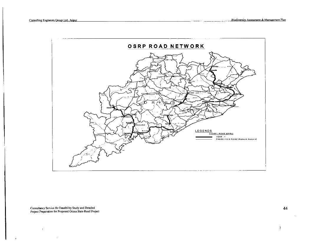
Consulting Engineers Group Ltd., Jaipur Biodiversitv Assessment & Management Plan
OSRP ROAD NETWORK
> Y t L j )LEGENDS<;) PHASE.I ROAD (DPR.)
- t 4 7 > \ 4 !PHASE-11 & 111 ROAD (N.t..,k A-1ly.l.)
Consultancy Service for Feasibility Study and Detailed 44Project Preparation for Proposed Orissa State Road Project

Consulting Engineers Group Ltd.. Jaipur Biodiversity Assessment & Management Plan
The list of protected areas with their maps and other basic location details are in the tablebelow at para-1.4.4.
Si. Established LocationNo. Name of the protected area in the year1. Lakhary valley Elephant sanctuary 08.02.1985 840-16' to 840-25'(E) Longitude
190-15' to 190-25' NorthLatitude
2. Hadagarh WL Sanctuary 06.12.1978 860-1 ' to 860-25'(E) Longitude210-11 to 210-25' NorthLatitude
3. Bhitarkanika WL Sanctuary 22.01.1975 86°-30' to 870-06'(E) Longitude200-30' to 200-50' NorthLatitude
4. Similpal WL Sanctuary 03.12.1977 860-04' to 860-37'(E) Longitude21°-28' to 220-8' NorthLatitude
5. Baisipally WL Sanctuary 07.11.1981 84°-35' to 850-50'(E) Longitude200-23' to 200-33' NorthLatitude
6. Satkoshia George WL Sanctuary 19.05.1976 85 -35' to 86 0-05'(E) Longitude200-30' to 20°-45' NorthLatitude
7. Karlapata WL Sanctuary 15.10.1992 82 -45' to 83 0-15'(E) Longitude190-30' to 190-50' NorthLatitude
8. Similpal Biosphere Reserve 22.06.1994 86°-05' to 860-37'(E) Longitude(Declared by Govt. of India) 210-30' to 220-08' North
Latitude
What is a corridor-? (1) It is interpreted that the facilitated movement function of a linearlandscape element is the most commonly assumed distinguishing characteristic of a corridor.(2) The corridors as a matter of fact allow the inter mixing of the genetic pool of one areawith the other to permit the continuance of the race without which the growth in isolation willlead to in breeding and self destruction of the species within the confines due to lack ofgenetic variation and recessive genes becoming stronger to weaken the progenies.
The wild life habitats, its fragmentation and obstruction of corridors has to be viewed fromthe above angle to appreciate and recognise the vital role played by inter connectivity andisolation that may happen on account of fragmentation of corridors and habitats, indeveloping the roads passing through any wildlife habitat and across any wildlife corridor.
One such isolated habitat of elephants exists in Rayagada District and Gajpati district ieMahendragiri hill & Lakhary valley. Lakharv has no inter connectivity but Mahendragiriwhich has an escape corridor at Goibandha to cross over and mix with the other herds ofelephants in forests across Vansadhara and along Vansadhara will be fragmented on accountof the development of Bramhapur - Bangi Junction - Raygada road i.e. SH-17 and SH4.This elephant movement is on SH-1 7 at 117 km. to 123 kms and maximum movement at thisplace near 118 kim stone adjacent to the culvert. 8 to 15 elephants cross the road every day at4.30 to 6 pm.
Similar is the importance of Elephant Corridor at Satkoshia R.F. in Mayurbhanj district whichlinks Similpal with Jharkhand on one side and Hadagarh- Kuldiha WLS on the other side ofthe habitat. The importance of this corridor is ecologically prioratised as high and
Consultancy Service for Feasibility Study and Detailed 45Project Preparation for Proposed Orissa State Road Project

Consulting Engineers Group Ltd., Jaipur Biodiversity Assessment & Manaeement Plan
conservation feasibility as medium. The width of this corridor is 3 to 4 kms and on chainage
21 km to 25 km and length is around 15 to 16 km.
5.2 THLE PROTECTED AREAS:
The protected areas in the State of Orissa are indicated in the accompanying map given below
showing the sanctuaries, national park, elephant reserves, biosphere reserve, etc. Movement
corridors of elephants in Orissa and part of Bihar (undivided) as published by GoO in the
book "Project Elephant" is furnished at protected areas in Annexure - IV.
-_ _ _ _ _ _ _ _ _ _ _ __ r . oIndex map of*__r_A__ _ _ _ _ 1_ _ _ __U Wildlife Sanctuaries &
National parks
4,
SUWDEENGAARrm '- fr , > f 30 o 30 80Kr.
C H N A T T I 6HoAR H . OGArH , AAALA!lE 2
- SOEPUt1O . ANGUL E R,HARK MS
BOUDH ODEI4A'AL JAJPUR - *; b=BOLEANGIR riNPR
-- -- CUtAHHCV< -< <P4 141 lO2 9, ,*4 ap * -io F1 K Wa LOPARA PNULIATI / 8 t1AS5s1a1
GAll JAGTBIDNPU ee.mbr.*" w
aALAMNADI-12 Nsd.'*k.8.1dwy
3 B*~% -K.- Sdu
AWRAOPRGANJAM 13'A*60~.'.
WAAm P HDH A 14A A A5Su60-j 1HALEAVA8WAdI
KORAFUT is OF ORISSA
t )
82' BT*54 8451.1 87'
PROTECED AREAS OF ORISSA
Out of the above-protected areas the Phase-i road corridors pass through none of the
sanctuaries or National Parks or core area of Biosphere Reserve. But the SH-53 & 49 pass
through the buffer and transition zone of Similpal Biosphere Reserve and Mayurbhanj
Elephant Reserve. The roads also run across various Reserved and Proposed Reserved
Forests, Elephant corridors, sloth bear track and other wildlife movement path. The project
influence area (PIA) has been extended up to a radial distance of 10 km from the periphery of
the road corridor on either side of the centerline. This is also similarly extended across 10 km
from the center of the haulage road and quary area for impact study on biodiversity and action
plan.
The elephant habitat and its distribution in India is delt in detail in the book "RiRht of Passage
Elephant Corridors of India" publishd by Wildlife Trust of India 2005. The definition of
Corridor and the high priority assigned to one such elephant corridor from Similpal to
Satkoshia connecting the Hadagarh W.L.S, Kuldiha W.L.S. and the adjacent forests of
Satkoshia is mentioned to emphasize on the importance of corridor for elephants and other
wildlife.
Consultancy Service for Feasibility Study and Detailed 46Project Preparation for Proposed Orissa State Road Project

Consultine Engineers Group Ltd.. JaiRur Biodiversity Assessment & Management Plan
An Elephant corridor is defined as line of patches of natural vegetation providing habitat forspecies that are not adapted to surrounding habitat as temporary use areas or as a permanent* part of their home ranges.
5.3 THE CENTRAL INDIAN POPULATION OF ELEPHANTS:
The elephant habitats in central India extend over 17000 km2 in the states of Orissa,Jharkhand and southern West Bengal and hold a population of about 2400-2700 elephants(Chowdhury, unpublished draft action plan). Biogeographically, this region falls in theChhota Nagpur plateau in the north of the Eastern Ghats (Rodgers and Panwar, 1988). Amajor portion of the forests of Jharkhand, southern West Bengal and north-western portionsof Orissa is deciduous. To the north of the Mahanadi River, elephants are distributed inBaripada, Karanjia, Keonjhar, Bamra, Rairakhol, Angul, Dhenkanal, Athamalik and AthgarhForest Divisions in Orissa. Eastern Ghats extending from the south of the Mohanadi Riverupto Mahendragiri, Boudh, Nayagarh, Phulbani, Baliguda, Kalahandi, Rayagada,Parlakhemundi and Ghumsur North Forest Divisions in Orissa form the elephant habitat in thearea. Singh (1989), Datya (1995), Tiwari (2000), Nigam (2002), Swain and Patnaik (2002),Sar and Lahiri Choudhury (2002) and Singh et al. (2002) have dealt with elephants of thearea.
Orissa has about 57% of the elephant habitat in central India with 1800-2000 elephants spreadover about 11,000 km2 (Swain and Patnaik, 2002). Nearly 44% of the elephant habitat fallswithin eleven Protected Area, viz. Similpal National Park, Similpal Wildlife Sanctuary,Hadgarh, Kuldiha, Satkosia gorge, Baisipali, Chandaka-Dampara, Kotgarh, Lakhari,Khalasuni and Badarma. Three Elephant Reserves, viz. Mayurbhanj, Mahanadi andSambalpur have also been declared. Maps enclosed in Annexure -VI & VIII.
The first, including Similpal Tiger Reserve and Kuldiha and Hadgarh Wildlife Sanctuaries,has an area of 3200 km2 with an estimated population of about 491 (Prusty and Singh, 1994).This zone along with the adjacent forests of Noto and Garsahi could be an ideal habitat for thelong-term conservation of elephants. The Satkosia-Baisipalli zone, situated in the centralOrissa, has the Satkosia gorge and Baispalli Wildlife Sanctuaries. This with the adjacent 800km2 Reserve Forests could form a larger landscape of about 1760 km2 (Chowdhury,unpublished draft Action Plan). This area has been cleared by GOI, MOEF recently as the 2ndTiger Reserve of Orissa.
The south Keonjhar Plateau, with about 2600 km2 is spread over Deogan, Ghatgan and TelkoiRanges of Keonjhar Forest Divisions and Kamkhya nagar east and west Ranges of DhenkanalDivision is believed to have about 200-250 elephatns. Madanpur-Rampur-Kotgarh-Chandrapur zone in the Eastern Ghats have about 800km2 , of which about 80% is fragmenteddue to shifting cultivation. About 300-400 elephants are estimated to be present in this area.These constitute the South Orissa elephant reserve as at Annexure -V.
5.4 WHY BIODIVERSITY ACTION PLAN:
The MOEF, Govt. of India has formed and adopted fresh National wild life action plan(NWAP) in 1983, which is still in vogue. To mitigate the constraints noticed at the time ofimplementing the action plan for wild life conservation on account of demographic presence,development activities, consumption pattern on account of population increase in human andlivestock, increased commercial use of natural resources etc which are to be addressedproperly.
Habitat loss is always associated with developmental projects like dams, mines, Industries,roads, road expansion, Rly expansion and new railway line.
Consultancy Service for Feasibility Study and Detailed 47Project Preparation for Proposed Orissa State Road Project

Consulting Eneineers Group Ltd., Jaipur Biodiversity Assessment & Management Plan
Effective ecosystem conservation is the foundation of Long term ecological and economicstability. The term wild life encompasses all uncultivated flora and underestimated fauna.Every species has the right to live and every threatened species must be protected to preventits extinction.
Water wilderness and wild life are irrevocably interlinked. The natural processes in forestand wild habitats, the impact of floods, cyclones, draughts, ensuring food security on accountof shrinkage and degradation of wilderness has witnessed the erosion of our heritage i.e.rivers, aquifers, forests, grass lands, mountains, reducing territory of wild life andgeomorphologic features.
For all these factors i.e. Ecological security, priority to conservation, National land use policy,Primacy for water as sustenance, wildlife conservation with peoples support, man, animal,conflict etc. the new National wildlife policy of the MOEF was inaugurated on January 21st,2002 by the Prime minister of India in the XXI meeting of the Indian Board for wild life. Afew of the Expert committees' observation and recommendations are cited for betterappreciation.
(A) The National Planning has not adequately taken into account the Ecological andeconomic consequences of extracting short-term commercial gains from wild lifehabitats. It is therefore necessary to engage national decision making bodies in directdiscussion on the Board to protect our Natural Treasury which is comprised of rivers,aquifers, forests, grass lands, mountains, wetlands, coast lines, marine habitats,deserts and various species that inhabit them.
(B) Decision makers need to recognize that natural ecosystems reduce the frequency andintensity of "Natural" disasters including floods, drought, cyclones, land slides andare the life line for hundreds of millions of rural people. Protecting the environmentis rather in the nation's economic health and human interests, apart from being amoral imperative.
(C) Ministry of Surface Transport and ministry of Railway to plan roads in such amanner that all National parks and sanctuaries are by passed and integrity ofP.A. is maintained. Wild life corridors also need to be avoided or mitigativemeasures (such as restricting night traffic) need to be employed.
Keeping these factors in view and aiming at development of existing infrastructure it is mostnecessary and appropriate to go for the assessment of Biodiversity components, threat,corridors and breeding habitats of wild flora and fauna, balancing and protecting the aquifers,springs, wet lands, wet land ecosystems, riverine and marine habitats of threatened and threatperceptions on account of the project activity, prevention and mitigation measures tominimize the risks involved and suggest corrective habitat development plans, thebiodiversity study and action plan for the project corridors of OSRP was under taken.
The table of contents below shows the road corridors and wild life areas directly or indirectlygoing to be affected by such improvements:
Consultancy Service for Feasibility Study and Detailed 48Project Preparation for Proposed Orissa State Road Project

Consultin z Enyineers Group Ltd.. Jaipur Biodiversity Assessment & Management Plan
Table-5.2: Evaluation of threat erception along road corridors for biodiversityNo. Name of the corridor Status Length affected Wild fauna likely to be affected Threat perceptions WeightageI Berhampur - Bangi Jn. SH-17 150 Avenue plants, Green The aviary, rodents and Loss of forests in RF & PF, within impact zone of 10Link tunnels of many amphibian fauna, reptiles km. loss of breeding, nesting, perching and scavengingBangi Jn. to Raygada SH-4 52 established trees, micro dwelling on the avenues and habitat loss of biodiversity in mini and micro climaxhabitats developed over along the avenues. The micro zones along the corridor leading to destruction of severalyears containing habitats developed over years, organisms and plants beneficial for agriculture andconglomeration of corridors of wildlife movement in environment as they were the hosts to beneficial insects,several plants of search of food and water getting rodents, birds, amphibians, reptiles. Fragmentation ofmedicinal value and frag mented and disrupted putting habitat leading to starvation or falling an easy pray to 8.5ecological importance. old, young, pregnant and infant camivore or human beings, serious pollution, soilLoss of landmark trees wildlife at risk of pursuers and erosion, alteration in the physical features of the habitatand vegetation. predators, blockade of elephant, puzzling the wildlife. Plants at the risk of adaptation
bear, ungulates path as rise in weed growth of toxic types and rise incamouflage disappears along the temperature affecting procreation. Bears, elephants,road wildlife is precariously snakes, frogs and birds are to be worst hit. Soil erosion,prevented from moving and land slides, silting up of the water bodies, pollution ofgrazing in the vicinity. aquifers.2 Daspalla - Gania - SH -65-A 25 km Avenues trees, Green The wetland aviary species, Several reserved and protected forests and forest growthGania - Sidhamula - SH-65-B 18 km tunnels, established amphibians, reptiles, monkeys, affected, loss of avenue trees, green tunnels, soilSidhamula - Kamaladeipur - SH-65 6.3 km land mark trees, micro apes, aquatic fauna, breeding erosion, release of toxic chemicals, vapors, loss ofKamaladeipur - Narsinghpur SH-64 25 km habitats of many plants habitats, foraging wildlife and biodiversity and micro climatic climax of the area. Loss-Narsinghpur - Hindol - SH-64-A 12 km medicinal and aesthetic their corridors of movement. The of food source for aviary, scavengers, (owls, vulturesHindol - Nuahat SH-64-A 18 km value plants, wild fruit micro habitats along the road and crow) water birds on account of corridorbearing (edible) corridor, removal of camouflage development. Fragmentation of wildlife habitat, due to 8.5species, loss of forest cover for large and small animals, erection of embankments and crash guard, quarry andgrowth. rodents, birds. Amphibian fish borrow areas further stressing the animals and plant life.and crustacean will be killed or Weed invasion will cause insurmountable difficultieseliminated. during road improvement activity due to air water, noise
pollution and soil erosion for old, infant and pregnantwildlife. Aquifers will be badly affected in ghatcutting.3. Chandbali - Bhadrak SH-9 51 km Avenue trees, aquatic Intertidal wetland and breeding Total loss of marine/ estuarine fish and shrimpplants and medicinal area of aquatic life and associate production as aquatic life forms breeding and nestingherbs, micro habitat of fauna will be seriously at risk. habitat will be lost. The aquatic plants and insectsseveral conglomerate of The aviary and aquatic fish and breeding on these will be threatened to extinction; theinterdependant plants, amphibian will be deprived of estuarine habitat of Bhitarkanika WLS Annexure -VII, 9fruit bearing and land their source of sustenance and will be upset due to decrease in population of variousmark trees, green destroyed. fish, crab, shrimp mollusks on account of effluents andtunnels will be lost. soil erosion. There will be silting up and flooding, lossHeritage trees more of agricultural production and fish catch. Traditionalthan 100 year old shall occupation of local inhabitants will be seriously
Consultancy Service for Feasibility Study and Detailed 49Project Preparation for Proposed Orissa State Road Project

Consulting Engineers Grout, Ltd.. Jaipur Biodiversitv Assessment & Management Plan
if. Name of the corridor Status Length affected Wild fauna likely to be affected Threat perceptions Weightage
be lost. affected. Many endangered turtles, fish, Shrimp, crabs,mollusks, beetles, and birds, will perish never to be seenagain in the area. Rise in summer temperature. Loss ofcyclone preventing shelter belt
4 Bhadrak - Anandapur SH-53 45 km Avenue trees, green The aviary, the amphibian and Increase in summer temperature, loss of food source for
(Upto Bypass) tunnels, landmark trees, reptilian flora, the aquatic fish, aviary. Nesting, resting and perches will be lost. The
fruit bearing trees crustacean, beetles will perish or wetland life down below the chain will be at risk of
micro climax affected locally and down stream. depletion. Comes within the impact zone of Hadagarh 6
conglomeration of The food chain will be seriously WL 3 to 7 kms, soil erosion plugging of drainage
medicinal, aromatic and threatened. channels during and after road improvement causing
geoclimetic plants drainage problem, loss of cyclone shelter belt.
colony will be lost.
S. Anandapur - Karanjia SH-53 77.4 Avenue trees forest Elephants, tigers, cheetah, Loss of aviary food along the corridor, loss of green
Karanjia - Jashipur SH-49 15 growth, medicinal panther, gaur, king cobra, flying tunnel, fragmentation of corridor putting old, young,
(Tongabilla) plants, microhabitat of squirrels, giant squirrels, infant and pregnant animals at high risk in search of
plant colonies, rare mahaseer, shrimps of Similpal food, water and shelter, more exposure to predators and
aquatic plants and fish springs and river systems down hunters, stress on procreation and territorial conflicts,
within the impact zone below, breeding zone of various limited scope of cross under or cross over points along
of the corridor; fish up stream and down stream, the corridor will be leading to loss of agriculture and
landmark vegetation food source of aviary and rodents man animal conflict. Tigers and panthers will be at
will be lost. Orchids will be seriously affected during greater risk of being killed, so also elephants.
and ferns will be and after the project work. Smuggling of forest and wildlife will increase.
affected by the corridor Wildlife will be seriously Biodiversity buffer and transition zone will be adversely
development. stressed. Hunting, shooting and impacted to rapid commercialization of road corridor on 9
snaring will increase. Toxic account of land development and encroachment, illicit
effluents will damage several life felling and poaching will be more as more people settle
forms. down in these villages after communication improves.Soil erosion, release of effluents, litters of polyethylene,polyurethane foam, discarded auto disposables andlubricants will flow into the river and drainage systems,upsetting the equilibrium. Elephant Reserve corridorswill be greatly affected restricting flow of the wildlife atspecific points making them vulnerable to hunters, sharpshooters and antisocials. Corridors will be more hot and
-_ exposed to weeds6. J.K.Pur - Muniguda SH-5 50km Loss of avenue trees, There are several wildlife There are no protected area nearby within project impact
Muniguda - Bhawanipatna green tunnels, forest movement across the road near zone. The loss of avenues will adversely affect the
SH-6 68km growth, land mark, Chatikona and else, where. The aviary fauna in the corridor; the fragmentation of habitat 8
micro climax tiger, panther, cheetah, gour and will put the wild fauna under stress and risk of life and
association of plant deer, sambar will be affected by food resources. The increase in traffic during road
colonies, medicinal corridor improvement due to development and after will lead to flood and
Consultancy Service for Feasibility Study and Detailed 50Project Preparation for Proposed Orissa State Road Project

Consulting Eneineers Group Ltd., Jaipur Biodiversity Assessment & Management Plan
Li. Name of the corridor Status Length Wild flora likely to be Wild fauna likely to be affected Threat perceptions assignedNo. in km affected
asgeplants along the increased night traffic. The submergence owing to embankment and diversions, soilcorridor, grazing aviary and rodent population erosion. Hunting, poaching, disforestation andgrounds, food supply along the avenues will be hard hit encroachment will increase with rise in settlement andchain of avenues will due to tree felling and loss of food population during and after the corridor development.vanish, realignment of source, the soil erosion, ghat The wildlife genetic diversity will be at risk of furtherthe road to avoid cutting will be detrimental for localization on account of multiple fragmentationsRailway level crossings aquatic fauna down stream. already made by the Railway line and industrial ventureswill cause further loss coming up in Kalahandi and Raygada districts besidesof forest and tree Podu and olicit felling in highhills. The Aquifers andgrowth. nala beds will be further raised due to erosion upsettingthe river flow causing flash flood damage to bridge andculverts.7. Bhawanipatna - Khariar SH- 16 68 km The loss of avenue and There are no forests worth the There are no RF/PF or P.A. Aviary, rodent and02 to 70 green tunnels for the name along the corridor. The loss amphibian species will be at risk of starvation stress andkm ROW will lead to loss of avenue trees will disadvantage devoid of nesting and breeding area. The groundof of trees and damage the aviary and rodents due to loss moving species will be killed and exposed by roadto the micro climax of nesting perching and foraging expansion and destructions of habitat. The complexvegetation along the facility. The micro fauna residing ecological balance of the area will be lost as all most allcorridor. Many along the road within the micro bridges and culverts except the Tel and sunder rivermedicinal, aromatic and climax vegetation will be lost. bridge all others will be either demolished or 6beneficial plants will be Wildlife will be devoid of rehabilitated afresh along with digging out the road basedestroyed; land mark camouflage cover to some extent at many places for new formation heritage and giantgiant trees will be as land is mostly avoid of natural trees will be removed from the corridor.sacrificed. Food chain forests either side like hayena,
will be lost. jackal, mongoose, birds, rodents,amhibians, reptiles will be morestressed.8. Bhanjanagar - Aska SH-7 39 The avenues and green The common wildlife in the Loss of biodiversity, loss of food source to aviary andtunnels of many countryside like fox, jackal, rodents, loss of habitat for aviary, rodents, andestablished trees, micro hyena, mongoose, rodents, owls, fragmentation of movement corridors, loss of minihabitats of several birds nesting, perching and climax areas, invasion of weeds, rise in summerplants developed over feeding on the fruits of avenue temperature. 6years along the route, plants, the monkeys and apes,
medicinal plants, along amphibians, reptiles etc. will be atthe corridor will be lost. stress. The wildlife crossings
from Kaliamba reserve forestblock to agricultural fields andback yards will be disrupted.
Consultancy Service for Feasibility Study and Detailed 51Project Preparation for Proposed Orissa State Road Project

Consulting Eneineers Group Ltd.. Jaipur Biodiversitv Assessment & Manaeement Plan
CHAPTER - VI
THREATS TO WILD:LIFE
6.0.1. 'Wildlife' refers to uncultivated or undomesticated life forms, while biodiversity
of any area refers to all life forns and their diversity within the species and
between the species and their habitats. This is dynamic and undergoes changeswith time due to natural causes or human induced pressure. Of course, we are
basically concerned here about wild biodiversity rather than agro-diversity.
6.0.2. Every one of more than 1.7 million organisms in the world, so far known to
science, has some role to play in the ecosystem, some of which are known and
many are yet to be known. But we have no right to destroy any of them before we
clearly know as to what role it plays in the entire ecosystem. This is specific
reason as to why there is concern about protecting all life forms occurring in the
wild. Protected areas, Tiger Projects, Elephant Projects, Biosphere Reserves,
Ramsar sites, World Heritage sites, etc. have all been set up with that objective in
view.
6.0.2. Hence, while taking up the corridor development under the Orissa State Road
Project, it has been decided to assess the threats that the road project is likely to
the local bio-diversity, due to various actions needed for such development.
6.1. GENERAL THREATS:
The Wildlife, wild animals and biodiversity of the region may suffer due to any
road development. Some perceived threats are enumerated below.
6.1.1. Removal of road side trees either avenue or naturally occurring ones for widening
shall deprive the birds, animals, reptiles, orchids, mosses, lizards and insects of
their habitat and totally wipe away their population.
6.1.2. Cutting of hill scopes for road making without proper protection may lead to soil
erosion and affect moisture retention, thus creating arid condition and loss of
food.
6.1.3. The construction work involving, blasting of rocks, crushers, mixers, light, road
making machines shall destroy wildlife habitat along the road corridors.
6.1.4. Fast moving traffic and increase in movement of vehicles during the day and
night shall obstruct natural passages and corridors of long ranging animals, either
by affecting their foraging or cause genetic isolation of small herds.
6.1.5. Due to fragmentation and reduction of natural habitat, animals will enter crop
fields and habitation, thereby increasing man-elephant conflict to detriment of
both the human population and wild animals.
6.1.6. Many species of plants, which are common to road sides, may vanish if adequatestep is not taken to save them. These plants which often host many other plant
and animal species may suffer irrepairable loss, including those which find'niches' on them.
Consultancy Service for Feasibility Study and Detailed 52Project Preparation for Proposed Orissa State Road Project

Consulting Engineers Growp Ltd., Jaipur Biodiversity Assessment & Managernent Plan
6.1.7. Opening and improvement of roads also facilitate poaching of wild animals andcollection of parts or whole of endangered vulnerable plants, thereby endangeringthem further or even resulting in their extinction.
6.1.8. Labour camps in side the forest areas, may not only disturb their habitat, but mayalso increase forest fire hazard, particularly in summer months, thereby killing theground vegetation and small animals, birds and others.
6.1.9. Unchecked dumping of solid wastes both by road workers and road users maycreate problem not only for regeneration, but also for wild animals, who mayinjest them.
6.2 SPECIFIC THREATS TO WILDLIFE:
These threats are either site specific or species specific. The site specific threatsto Biodiversity are:
1. Avenue plants along the road: - These will be cut away never to bereplaced by the same species again. For example one pepal tree (Aswath)or one Neem tree or Arjun tree generates more oxygen at night andreleases more moisture to the ambient air around it compared to all otherplants of similar size and shape. Rather it is 4 times stronger than otherin longivity, carbon synthesis and carbon cycle, oxygen generation andcooling of the atmosphere. It also provides fruits for wild fauna.Because of excess oxygen generation at night it is prohibited to sleepunder pippal trees at night and this tree was selected to be a place ofworship and meditation. Thus the ambient air along the road corridorwill be missing after removal of these trees.
2. The coastal areas of the state are prone to cyclone and hurricanes causingwide spread damage to human life, property and agriculture. Theseavenues located like a green and thick wall across the path of wind flowand deflect the cyclone direction upwards 10 times the height of trees.Thus the effective zone of movement and destruction gets diverted andthe hinter land is protected from catastrophic damage. Once the avenuetrees and green tunnels are cut down for the ROW the lee ward side ofthe corridor & cyclonic flow will be directly affecting the agriculture andhabitation with full force killing and destroying infrastructure, humanbeings and wildlife as well as domesticated animals. To recreate anothershelter belt or wind break will take many years and the magnitude of suchthreat over a period of 25 to 30 years and the loss accruing out of it canbe well imagined and appreciated.
3. The road corridors pass through reserved and protected forest and thewildlife residing in these areas are moving across the road in their day today movement for territorial marking, procreation, foraging, breeding,rearing the young etc. Once the road corridor development starts thewildlife will be disturbed and separated from the groups and habitat.
The flora of the area will be depleted as pollinating birds, bats, squirrels,will disappear, as trees, shrubs, bushes and herbs are cut away and manyunder ground and terrestrial life forms crushed to death. This will be adirect loss of flora and fauna which may not come up there again becauseconditions after road corridor improvement will be more hostile for them.There the Biodiversity loss can't be quantified in monetary terns or
Consultancy Service for Feasibility Study and Detailed 53Project Preparation for Proposed Orissa State Road Project
Consulting Engineers Group Ltd., Jaipur Biodiversity Assessment & Management Plan
number of species lost evaluated because no one has minutely evaluatedthe complex biodiversity scenario nor it is possible within a short span of30 to 60 days or so to get a comprehensive data when nil data base onthese tracts of roads concerned with biodiversity is confronted.
The barricading and embankment formation, the fast moving vehicles,day and night, movement of heavy machineries and human beings willscare away the animals. The water course, movement track will bedisturbed along with loss of landmark vegetation, water bodies, culvertsetc. This will confuse the human beings what to speak of wildlife onlocating their source of food, water and shelter on account of aforementioned factors.
The distressed flora of orchids, ferns, herbs, shrubs and trees will besuppressed by exotic weeds and will fail to overcome them. The wildelephants will be at a loss to negotiate its way out of the habitat due tobarricading and over crowding etc. The territorial male tiger, leopard,panther, civets, otters, will not find space for marking territory andfrequent infighting of adult and sub adults will be there, for limited spaceand food source. There will be inbreeding on account of this and wildlifewill become a sitting duck for the predator and sharpshooter along theroad under pas or barricades. The pregnant, infant and old will be moredisadvantaged in finding their way and escape route.
4. The wetland ecosystems along Chandbali to Bhadrak, within buffer andtransition zone of Similpal Biosphere reserve, the elephant corridors ofMayurbhanj elephant reserve, Kalahandi elephant corridors, Berhampur -Raygada bear and elephant corridors are zones of vulnerability andcareful handling as the threats of adverse impact are far reaching aboveand below the corridor and that may lead to serious law and order oreconomic issues in latter years.
The irrecoverable loss that may accrue has to be visualized well aheadand treatment of mitigation befitting to the local conditions has to befound out.
5. The rat race for earning quick bucks and acquiring land along up comingroad corridors every where has brought all the planning to hay wire insubsequent years after completion of the project. Some of theprescriptions may therefore appear quite irrelevant, costly andinappropriate when looked at generally but the same are to be assessedand evaluated from our day to day experience in the field.
6. The threats of man animal conflict is to be given more importance asspecific threats, where the crop pattern, the exposure to wildlife needsand habitat protection is paramount and that warrants retention of greentunnels and avenues partially if not wholly as specific threat perceptionshave been evaluated for the same above.
7. The introduction of hybreeds, genetically engineered crops, exotic fish,bees, birds, goats, cattle, sheep and biotic control measures within thebuffer and transition zone of biosphere reserve has to be seen withdevastating threats to the biodiversity as else where in our country andother countries, catastrophic damage to indigenous fish population,indigenous bee population, increase in foreign crop pastes have happened
Consultancy Service for Feasibility Study and Detailed 54Project Preparation for Proposed Orissa State Road Project

Consuhine Engineers Group Ltd.. Jaipur Biodiversity Assessment & Management Plan
on account of introduction of imported crop seeds, food stuffs, cattle,poultry, pigs, rabbits, koil, bees, tilapea, catfish etc. in the name ofimproving the lot of tribals and farmers in the impact zone. The lantana,eupatorium shrub and climbers, the parthenium, and ipomea, the wattlesand eucalyptus, the teak all have ruined the wetland and dry land habitatof indigenous flora and fauna and such follies should be our eye openerwhen we are assessing the impact and mitigation on specific areas.
The cutting of trees inside forest, widening of ghat sections to correct the roadgeometry, the quarry sites and borrow areas are specific threat zones for thebiodiversity as geo climatic variations allows specific plants and wildlife toproliferate in an area.
The occurrence of plants like xylia xylocarpa is one such species found inDaspalla to Nuahat (Banarpal) and Taptapani to Kenduguda. The occurrence ofEmbelia ribes, Embelia tsjeriam along Ganjam to Raygada corridor, streblustaxoides (Jhumpudi), vitex peduncularis along Daspalla to Nuahat (Banarpal),and Anandapur to Karanjia Solanum khasianum and Solanum trilobatum alongthe Bramhapur - Raygada corridor, indicates the unique influence of climate onplant and animals.
The orchids are also unique in Gajapati and Mayurbhanj districts in particular.These species will gradually become extinct if not properly protected duringcorridor development.
The detail treatment plan of the road corridors is dealt with separately andaccordingly the mitigation measures will be worked out.
Consultancy Service for Feasibility Study and Detailed 55Project Preparation for Proposed Orissa State Road Project

Consultine Engineers Grout Ltd., Jaipur Biodiversitv Assessment & Management Plan
CHAPTER - VIIMVANAGElAIENT PLAN FOPR
41IITIGATING MJEASURES
7.0 Though survey was conducted on all road corridors, it was not possible in greatdetail as planed particularly in the months of July to September due to incessantrain, flood and disruption of roads in many parts of the state. Despite that surveyswere conducted, in the approachable stretches in 3 visits.
The road users, shopkeepers local people, senior citizens and OFD staff wereinterviewed according to prepared questionnaire, to elicit information onmovement of wild animals, death or injury due to accidents, cause of crossing,waterholes, feature responsible for species found in the locality and time of theyear they use the road most, presence of any endangered fauna and other relevantinformation.
7.1 IDENTIFICATION OF VALUED BIODIVERsITY COMPONENTS:
The parameters that evaluate the Biodiversity component of an area are:
a. Natural environment sustaining various life forms.b. Ecological diversity due to geological and edaphic factors.c. Protected area involved containing endangered flora and fauna.d. Breeding ground of endangered species in PIA zone and the impact
assessment.e. The mitigation measures needed to be taken by stake holders.f. Natural water sources along the corridor and present habitat conditions
and future development strategy.g. Infrastructure development, monitoring devices.
7.1.1 THE NATURAL ENVIRONMENT:
This is a short of equilibrium or edaphic climax that has been established in theregion for more than 50 years or so with gradual changes of the scenario to whichthe present proposal will make inroads and may upset the equilibrium attainedover the corridor even after the effect of biotic interference along with air andwater pollution, soil erosion in the area. Rainfall, humidity & run off withtemperature determines the land to support a particular type of vegetation and selfsustaining life forms of plants, animals, reptiles, amphibians and birds withbacteria's and fungus etc. The food habits, food varieties and quantity of foodand cover under natural environment determine the continuation of a particularspecies depending on the topography and drainage. The terrain required for theelephants is more or less stable and flat ground or moderately rolling ground withplenty of grass, bamboo, palatable fruit bearing trees, and Ficus trees, deep moistvalleys to move about without interference and plenty of water. The tiger preferssuch a space but more hilly than plain forest for its shelter and cover orcamouflage while stalking, plenty of prey animals for hunting and for rearing itsyoung ones. The aquatic and land based flora contains specific vegetation whichonce disturbed fails to come up again due to modifications naturally or forciblybrought about by such action. The inroads made into such natural habitat affectsthe movement, foraging, grazing, hunting, breeding and resting pattern of thewildlife and upsets the pristine character of the area. Pollutants in shape of noise,toxic fumes and effluents, diseases and pastes transmitted through transported
Consultancy Service for Feasibility Study and Detailed 56Project Preparation for Proposed Orissa State Road Project

Consulting Eneineers Group Ltd.. Jaipur Biodiversitv Assessment & Manazement Plan
cattle moving on the corridor. They spread rindrapest, foot and mouth disease(FMD), tuberculosis and septicemia etc. The roads those are planned to bedeveloped now were there since long and therefore the weight age has to be onthe basis of disturbance proposed for cutting of ghats, new realignments, quarriesand burrow pits, removal of tree growth through micro climatic climax vegetationand wildlife area, springs, drainage channels, rivulets, rivers, reservoirs, wetland,wildlife movement corridors and migration routes, valuable and rare plants andwildlife located within the project impact area (PIA).
7.1.2 ECOLOGICAL DIVERSITY DUE TO GEOGRAPHIC FACTORS:
There are certain pockets of forests, which provide well-distributed rainfallthrough out the year with specific range of temperature, humidity and foodproduction. Once the forests are cut, vehicles move about, nalas and rivulets dugup for new structures, borrow areas and GSB quarries operate with ghat cuttingfor the road fill, the situation drastically changes decimating the vegetation andlife forms due to imbalance in the habitat and pollution on account of excavation,dumping of debris, inflow of pollutants. The toxic substances released to thestreams and nalas adds to the problem during and after the project operation isover and the ecological balance between the plants and wild animals and a bioticfactor becomes incompatible. The forest types identified in the zone of thecorridor will mismatch along with wildlife because of the conglomeration ofadverse factors like tree cutting, poaching, encroachment, increase in settlers,squatters, commercial activity, illicit felling, release of toxic wastes and diseasesto the hither to unspoilt area.
7.13 PROTECTED AREAS:
The purpose of declaring protected areas were to conserve nature and itsinhabitants within their location with little change or non-interference. Suchareas were declared legally as wildlife sanctuaries, and national parks. Elephantreserves, biosphere reserves, eco-sensitive and parts or entire eco-fragile zones,reserved forests, breeding habitats etc are often included in P.A's. and no entryzones. Stoppage of commercial non forest working and removal of trees fromsuch areas (not even the dead, dying and diseased or dry ones), and prevention ofplanting of exotics in these areas were legally adopted on principle. Stringent andingenious steps were prescribed for development of alternate livelihood for thedependent tribals through eco-development within and outside the perimeters(core and buffer) of such P.A's.
7.1.4 BREEDING GROUND AND FRAGILE RESIDENTS IN PIA:
Breeding of natural life forms is not like the breeding we see in domesticatedinsects, dogs, domesticated cattle and human beings. The natural law has a majorrole to play in the breeding of plants and wildlife through sexual conditions. Theother two factors are very very strong.
The conditions required for this natural selection is unbridled movement of theanimals, and tranquility of the forests to fight, win and enter into courtship beforeprocreation. All these will be a daydream for wildlife as forests are under threatof shifting cultivation, Maoist movement and illegal settlements along allcorridors. The road improvement activity which will continue for more than 3years if not more will lead to noise, pollution, hectic activity, soil erosion,movement of heavy machinery adding more constraints as a result of which ritualfight and ritual display of plumage, colour, statures and prowess against the
Consultancy Service for Feasibility Study and Detailed 57Project Preparation for Proposed Orissa State Road Project

Consulting Engineers Grouo Ltd.. Jaipur Biodiversitv Assessment & Management Plan
adversary and female species in the wild along the corridors will not be thereduring this period. The stressed wildlife will go without the natural selection insome cases and inbreeding will takeover to weaken the next generations. Thevaluable plants of timber, ornamental, food and medicinal value or commercialimportance may be smuggled along with its seeds and flowers before they matureto earn a few bucks. There is possibility of the leaves, barks, twigs, roots ofcommercial importance being smuggled and exported outside reducing most ofthem as we have lost the Bija, Rose wood, Sandal wood, Haldu, Faldu, Teak,Asan, Fanfana, Lodha, Medha, Kasi, Red sanders, Bandhana, Kangada, Dhaura,Fasi, Patuli, Katrong, Giringa timber species of exploitable girth and bamboos allover the state by unscrupulous traders and smugglers. The corridors are thereforeto be more strictly watched during and after the proposed improvement alongwith monitoring device to follow up the effects and provide further safeguards.
With the improvement of road condition and plying of speedy vehicles, it will bedifficult to check poaching and smuggling of wild animals and their body partswithout proper staff, check gates and modern equipments.
There are several movement corridors across the road by elephants, bears, bisons(gaur), tiger, leopard, ungulates, fishes, amphibians, birds etc. The corridor ofroads during development and after will be a formidable barrier for the wildlifeand wild flora. It may be tragic if birds suffer due to scarcity of food andwetland, infants, pregnant mothers and old animals may suffer without food andwater or get killed by poachers, or predators, or may not be able to swim acrossthe barriers and barricades to safer area during flash floods. The forest fire maykill many as they will be unable to cross the roads in frenzy and while trying hardto escape and may get either killed or move into habitations to get killed. Hencesuch disaster may occur along PIA in the days to come if remedial measures arenot taken. So far general consciousness is lacking regarding these factors.However, this document tries to address these issues in a holistic manner.
7.1.5 THE MITIGATION MEASURES:
Conflict does arise when we have to address the problems of flora and fauna,while taking up development of road corridors for fast moving traffic in order toachieve economic growth.
All these are to be addressed in a holistic manner. It may appear unrealistic toallow free movement of wild fauna across the roads. But the barricades will notprovide them free access to other parts of the habitat. When we forget to find ourpath in a small town or in a changed landscape we were familiar with, can weexpect the wildlife to find out the few under passes we are proposing to providefor them at locations of maximum concentration of wild animals. Therefore wemay have to provide safe passege at more than one place and prevent wildanimals to cross over at other places, besides making these passeges as closelyresemble wilderness areas as possible. Where it is either not possible to providesafe passages or crossings at frequent intervals, awareness should be createdamong drivers or other road uses to drive slow, and watch for wild animalmovements to prevent any accident involving them.
The damage to the aquifers, springs, nalas, river basins and river beds, wetlandscan be minimized by left or right centric improvement in which case only oneside of the trees, shrubs, herbs, common property resources (CPR) of projectaffected persons (PAPS), rehabilitation and resettlement activities (R&RA),habitat loss and habitat improvement will be limited. Where the carriageway and
Consultancy Service for Feasibility Study and Detailed 58Project Preparation for Proposed Orissa State Road Project

Consulting Engineers Grout Ltd.. Jaipur Biodiversitv Assessment & Manazement Plan
ROW is narrow (below 20 mtrs) this may also be economically sound propositionas only one side shall be affected.
The corridor camouflaging for wildlife under pass in such cases can be taken upsimultaneously on the undisturbed side and by the time the other side is completethere will be some cover on the undisturbed side with mitigation measures likedevelopment of habitat, water holes, salt licks, gully plugging, check damming,improvement of food sources etc. The wild animal niches established overseveral years will not be totally disturbed as one side is still there to sustain them.
The erosion on account of diversion, dumping of construction materials, road fillswill be much less and the progress of construction work will be faster.
7.1.6 NATURAL WATER SOURCES:
Many wild animals, love to have a bath or swim across large water bodies likeriver, rivulet and nala during summer or wallow in mud . This is morepronounced in case of elephants, sambers large cats and amphibians.
Therefore while developing the under pass care has to be taken to locate the sameon the approaches to water sources. But at times failure of rains makes thingsmore difficult for wildlife. Hence alternate artificial water harvesting structuresor waterholes may be created on the nala beds to aid in percolation of water underground and recharge the aquifers in the upper catchments by gully plugging,vegetative and random rubble stone check dams and low masonry check dams onthe lower slopes across the road so that the fear of washout and flash floods isminimised. Within two to three years these nalas will become perennial sourcesof water at depressions and many of the distressed wildlife can be saved as theimprovement in water regime will give a boost to vegetation and improve wateravailability even during the pinch period.
Few salt licks and guly plugging measures can be taken up in the difficult poduaffected areas from day one of starting the project work to ensure this. The localstaffs and the DFO of the area has to take up the initiative for planning andexecution, while the nala beds outside the forest area will be treated by OWDcontractors.
7.1.7 MOVEMENT CORRIDOR OF WILDLIFE:
As many wild animals move through same wildlife track unchanged even aftergenerations, this factor has to be borne in mind while providing passage for themacross road corridors. Therefore while developing the roads the exact spotswhere the wild animals were moving across may be retained so that the wildanimals will not be disoriented.
When on account of limiting the estimated cost on each stretch, it may not bepossible to provide separate under passes, it will be prudent to add an extra spanin the existing culverts for the purpose. The approach to that span which shall beof proper specification is to be developed by planting indigenous shrubs andbushes properly during rains. They should be planted in large pits with sufficientmanuring for fast growth,so that the wild animals accept them and easily passunder the culvert. In this case 50m to 150m wide camouflage corridor on eitherside of the opening may be provided with the same species prescribed for theunder pass corridors. Annexure - XXVI (A to G)
Consultancy Service for Feasibility Study and Detailed 59Project Preparation for Proposed Orissa State Road Project

Consulting Engineers Group Ltd.. Jaipur Biodiversitv Assessment & Management Plan
7.1.8 HABITAT DEVELOPMENT:
While developing proper habitat for wild animals, besides water availability,
availability of food should be looked in to. The most viable and effective
alternative is to go for planting of edible plant species which will provide fruits,
leaves,branches, flowers for the wildlife to consume and provide cover for their
movement. The trees should be indigenous, utility oriented such as Kusum,
Mahula, Kendu, Jamun, Bahada, Katrang, Mango, Bel, Kaitha, Ficus etc. on the
route, Edible grasses should be planted up in sheltered blanks, free from grazing
by domestic live stock. Annexure - XXVIII, XXIX & XXX.
7.1.9 GENERAL AcrivITY ON WILD LIFE CORRIDORS IN BIODIVERSITY ACTION
PLAN:
Apart from providing road under pass for elephants and other wild animals, via
duct and side trenches for reptiles and amphibian fauna, grills and side guards for
preventing vehicles triple down the road will prevent domestic cattle as well as
wild life to come over to the road. Provision of chain link mesh barricade may be
detrimental to free movement of wild animals, as it will prevent their intermixing
resulting in isolation and inbreeding depression. Annexure - XXVI D&F.
i) On all ghat roads while cutting of ghat is taken up the nalas and springs are to
be saved by diverting the runoff away form the nala so as to avoid the
aquifers being poisoned polluted and blocked by soil erosion and the flow
getting blocked rendering the lower reaches of these water sources dry. This
will distress the dependent wildlife of the area.
ii) On all roads passing through the Reserved forests & thick forest cover other
than R.Fs, the earth work in excavation and disposal of excavated material
from the road surface and foundation of culverts and bridges should not be
dumped on either side of the road and should be dumped at specific sites for
development of parking Islands enroute where the vehicles and commuters
park and rest. These should be on non-forest Govt. or Pvt. Land acquired for
the road and not within the Reserved Forest or protected forest. This will
prevent silting up of drainage channels, nalas, rivulets, rivers and river
mouths down below including reservoirs, water harvesting structures and
save avoidable investment that otherwise would have been made in
mitigating measures like flood control, relief and other calamities. This will
also improve the aesthetic appeal of the road corridor once the development
is complete.
iii) The avenues on all road corridors are to be retained where green tunnels exist
by right or left centric expansion so as to retain at least one row of the tree,
which will provide food, shelter, breeding ground and commanding perch for
hunting mating and retention of biodiversity. Retension of the eastern side
avenue need be ensured in the Jagatpur-Bhadrak portion of the road which is
prone to cyclone. This will serve as windbreak to save life and property in the
area.
iv) Fly ash should not be used in the formation areas of the road which drains
directly into an ecologically sensitive and fragile biotic habitat as it will
pollute the ground water & surface water; poison, destroy and silt up the nala,
river, estuaries and confluence of river thereby affecting many endangered
flora and fauna if there is any negligence breach or mishap besides surface
cuts, unloading escapes etc.
Consultancy Service for Feasibility Study and Detailed 60
Project Preparation for Proposed Orissa State Road Project

Consulting Engineers Group Ltd., Jaipur Biodiversitv Assessment & Manayement Plan
v) Green tunnels along the roads which run for more than 0.25 km should beretained by right or left centric widening so as to retain a multiple or singleline of trees,unless unavoidable to serve as perch, nesting zone, living habitatand breeding site for birds, lesser mammals, Rohdents, (Bandicoots, Shrews),Owls, Snakes, Bats, fruit bats, chemenias etc.
vi) All fruit bearing trees to be preserved in advance by preparing advancenurseries through Forest department and self help groups by rooting offsets ofsuch avenue plants which can be planted in habitat development programmesand avenue planting as soon as the road improvement work starts, so thatsupervisions and maintenance becomes less costly.
vii) The notified forest check gates existing on the roads are to be retained witheither side parking bay checking Island for checking and detention of anywild life or forest offence and provision for the storage of seized materials,vehicles, and living accommodation for the checking staff and culprits etc.like the tool gates now operating. This may be combined /unified gates in thebeginning and later used by the department exclusively. A standard plan andC.S. is to be developed by Forest Department for such structures. Annexure- XXVI (E).
viii) Where the road passes through P.As. (Protected Areas) like sanctuariesNational Parks, Biosphere Reserves, Elephant Reserves, eco-sensitive andeco-fragile corridors parking of vehicles at night near the check posts afterjourney through the forest area for a through check up to retrieve/detectplants, specimens, animals, animal parts/trophies collected, if any, withoutproper authority. In blanks along the avenue, species of trees which yieldnon timber forest products such as Sal seed, flower and seed, Harida, Mahua,Bahada and Amla (Myroabolans), Kamila dye, Lodha, Medha, Fenfena,Gamhar, Indrajaba, Jamun, Mango, Ritha Bel, Bidanga etc. can be planted inmultiple rows and maintained by VSS/SHG/GPs of the locality to earn aliving and pay users fee to the OWD.
ix) Leaflets/ broachers and signges mentioning dos and don'ts for road userspassing through P.As, wild life corridors and eco-fragile zones shall help toprevent disturbance to wildlife.
x) The local people and contractor's employees should be educated about thedos and don'ts on specified project corridors and all reserved /proposedreserved forest boundaries to be clearly indicated departmentally.
xi) Light reflector boards with fluorescent reflectors should be posted in such away that when ever any vehicle passes on the road the reflected light will fallon either side of the road towards the forests at 1' to 5' eye level so that allanimals can sense the approaching vehicles from the reflected light and stayback from crossing over till such vehicular traffic passes by. This should beon prestressed cement posts of 2mtrs height with pedestal at the base 30cmlong 10cmxlOcm thick embedded 60cm deep into ground. Annexure -XXVI (G).
7.1.10 DISPOsAL OF EXCAVATED EARTH BETWEEN ANANDAPUR TO CHANDBALI:
There should be cyclone and flood calamity shelters on this route and theexcavated earth can be dumped in shape of small mounds 100' wide at the baseand 40' wide at top raised to a height of around 30' above G.L. where sacredgroves can be created with planting of different medicinal, aromatic, sacred plantsof all faiths in mixed /pure patches at close spacing. On top of the mound one
Consultancy Service for Feasibility Study and Detailed 61Project Preparation for Proposed Orissa State Road Project

Consulting Eneineers Group Ltd.. Jaipur Biodiversity Assessment & Management Plan
shelter of 30' x 30' can be built for community use as cyclone shelter, floodshelter and the like. This can be managed by the local self-help groups of thevillage, Panchayat or commnittee formed for such management and this should belocated adjacent to the road. One tube wells be provided for each of these sacredgroves. There shall be 6 such sacred grove cum cyclone/flood shelters 3 each inflood zones of these roads between Mirzapur to Chandbali and Randia toAmbagadia Fakirpur by placing signage on road side trees and R.F. boundarypillars showing name of R.F. P.R.F., pillar number direction of the R.F.boundary. Similar boards for forest blocks or jungle blocks, protected forests tobe fixed by Forest Department for avoiding unnecessary confrontation tress passand unauthorized tree felling, camping querry etc.
The plants selected for such groves may include Champa, Kadamba, Mango,Neem, Pulango, Karaja, Arjun, Asan, Sal, Harida, Bahada, Amla, Jack fruit, Bel,Barun, Bija, Chandan, Rakta chandan, Dhataki, Sugandhi, Tulsi, Durlava,Apamarga, Pippali, Long pepper, Talamuli, Bacha, Mahaghora bacha, Kalihaldi,Ramkedar, Kurubelli, Poodina, Mint, Golmaricha, Katha champa, Narguni,Hingu, Nageswar, Nagmallika, Ashok, Muchukanda, Udumbar, Palasa,Gandhana, Babul, Gohira, Gangasiuli (Har singar), Bidanga, Paluo (Arrow root)Gandhasunthi, Gunja, Kaniar, Gheekuar, Dalchini, Tajpatta, Guggul, Jatropha,Rudrakshya, Indrajaba, Lodha, Medha, Fan fana, Kamalagundi Anona reticulata,Anona squamosa, Zizyphus, Mahula, Tala, Tamala, Casuarina, Tagar, Tarat,Mallika, Jasmine, Kunda, Hatia creper, Ritha, Khus grass, Sabai grass, Lemongrass, Periwinkle, Sarpagandha, Hadjoda, Bamboo, Cassia fistula, Narkoli,Muturi, Salaparni, Krushna purni, Tihudi, Vasak, Chiller, Inga dulsis, Sirisa,Eucalyptus, Akashmalli, Hinjala, Achhu, Pome granet, Arka, Bakul, Paladhua,Semul, Kanchan, Rakta kanchan etc. spider lily and Tube rose mayalso beintroduced in this zone. At least malati, madhu malati, Henna may be planted forfragrance. The location of such groves may be nearer market places, importantroad junctions, Block offices, Colleges and such other institutions as they willpovide recreation and shelter from calamity. They shall also provide venue forsocio religious community activity without spoiling the nature. The sacredgrooves will later on become hot spots for conservation and education of localpeople and students to know about each plant and its use. The top will be for thevehicles and a small shed for religious activity. A formal plan is enclosedshowing the detail layout at Annexure-XXXVII.
7.2 BIoSPHERE RESERVE AND TREATMENT:
7.2.0 Biosphere Reserve is an international designation assigned by UNESCO forrepresentative parts of natural and cultural landscapes extending over large areasof terrestrial or coastal marine eco-systems or combination thereof. These areintended to promote conservation of biodiversity and also to promote alternatelivelihood for man and preserve cultural values. The Biosphere Reserves aredifferent from wildlife sanctuary and National Parks in the following aspects:
(i) Its emphasis is on overall biodiversity and landscape rather thansome specific flagship species.
(ii) It lays importance on research activities.(iii) It takes into account the overall developmental activities and resolves
conflict between development and conservation.(iv) It ensures increased and broad' based participation of the local people
by special attention given on different components of BiosphereReserves like landscape, habits, species and land races.
Consultancy Service for Feasibility Study and Detailed 62Project Preparation for Proposed Orissa State Road Project
Consulting Eneineers Group Ltd.. Jaipur Biodiversitv Assessment & Manaeement Plan
7.2.1 The Biosphere Reserves are not substitute or alternative to, but re-enforcement ofthe existing protected areas. The Ministry of Environment and Forests launchedthe Biosphere reserves Programme in 1986 with these aspects in mind. Thespecific objectives of this programme are:
(i) To conserve the diversity and integrity of plants animals within thenatural eco-systems.
(ii) To safeguard the genetic diversity of species on which their continuingevolution depends.
(iii) To provide areas for multi-faceted research and training and(iv) To ensure sustainable use of natural resources through most appropriate
technology for improvement of economy and living standard of localpeople.
In order to undertake activities relating to biodiversity conservation anddevelopment of sustainable management aspects, BRs are demarcated into threezones. The core area of the BR is absolutely undisturbed and secured under legalprotection, management and research activities. In this zone, management andresearch activities that do not affect natural process and wildlife are allowed. Thecore zone is to be kept free from all human pressures external to the system. Thebuffer zone adjoins the core zone. In this zone, only those activities, whichprotect the core zone, are allowed. The activities allowed include limitedrecreation, tourism, and fishing, grazing which are permitted to reduce its effecton core zone. Research and educational activities are to be encouraged. Thetransition zone is the outer most part of BR. This is a zone of collaboration whereconservation knowledge and management skills are applied primarily to fosteralternate livelihood and reduce dependence on consumptive use of the forest.
7.2.2 SIMILPAL BIOSPHERE RESERVE:
The Similpal Biosphere Reserve has been notified by Government of India on the22nd June, 1994. It comprises of the entire Similpal sanctuary (core and buffertogether), the adjoining Nato and Satkoshia Reserve Forests forming additionalbuffer and a belt of approximately 10 KM width all around the entire bufferdesignated as the 'transition zone' The total area of this BR is 5569 Sq KMs. Apart of Similpal hill ranges (845 sq kms), a densely forested area constitute thecore which is also proposed National Park and rest of Similpal and othercontiguous fonts constitute buffer zone of the BR. There are also 65 villageswithin these two zones including four in the core zone. Similpal is in the eastemend of the Eastern Ghats also called as Garjat Hills and classified in theChhotanagpur biotic province of the Mahanadian bio-geographical region. Thetransition zone of the Reserve has 1200 villages whose total population is about4.5 lakhs. The tribals constitute about 73% of this population. The forests and thebiodiversity resources to a great extent sustain the livelihood of these people. Theforest and wild life in the sanctuary, and the human population and cattle living inclose proximity impact on each other. The Management Action Plan for the BRseeks to put emphasis on suitable programmes of eco-development in thetransition zone and also to a limited extent in buffer zone, to promote variousalternative livelihood options, and thereby to reduce people's pressure on theforests. The significant features of Similpal include:
* Relatively higher annual precipitation of over 200 cm spread over about135 days. Attitude ranging from 40mts to 1168 mts (Khairiburu andMeghasini hills)
Consultancy Service for Feasibility Study and Detailed 63Project Preparation for Proposed Orissa State Road Project

Consulting Engineers Group Ltd.. Jaipur Biodiversity Assessment & Management Plan
* Numerous water courses and two permanent waterfalls namely Barehipani(400 mts) and Joranda (150 mts)
* Occurrence of frost valleys in central and south Similpal. A degree ofresemblance of floral and faunal composition with those of the WestemGhats and north-east India, while being a representative eco-system withinthe Mahanadian bio-geographic region.
* Marked variation of temperature range between the central and southemregions.
* Similpal is the abode of 94 species of orchids and about 3000 species ofother plants. These include 2 species of orchids which are endemic, 8plants which are endangered, 8 species whose status is vulnerable and 34other rare species of plants. Similpal is also the abode of the black andmelanistic tiger, which is very rare. The identified species of fauna include12 species of amphibians, 29 species of reptiles, 264 species of birds and42 species of mammals, all of which collectively highlight the biodiversityrichness of Similpal, Endemism in Similpal is not fully explored, yet it isexpected to be very high particularly in sectors like tree fems, orchids,medicinal plants and insect fauna. The checklist of flora and fauna has beenupdated at intervals with new additions. Paradoxurus jorndensis, anendemic civet was located by the Zoological Survey of India in Similpalduring 1980 and subsequently recorded from all zones of Siniilpal.Philiautus Similpalensis, a frog located near Chahala in 1975 has beenidentified from other locations from Similpal. Eria -meghasaniensis andTyna hookeriena are two endemic orchids of Similpal. The former is foundnear Megahsini in South Similpal and the latter is seen near Pakaladihanalla of Jenabil. Another rare orchid, Bulbophyllum panigrahianum, is alsoseen in Similpal. A species of paddy known from Kerala was firstcollected in Orissa from Similpal near Khejuri hills in the late 1980. Up to2003-2004 Govt. of India assistance of Rs.207.3194 Lakh has beenreceived and spent in Similpal B.R. 343 ECO DEVELOPMENTCommittees have been formed. One committee is chaired by the DirectorSimilpal Biosphere Reserve. Two NGOS of Mayurbhanj district areinvolved to formulate suitable action programme. So far till 2004-36 nos.of water harvesting structures and improvement of irrigation systemsrenovation of ponds, pisciculture has been carried out. Leaf plate andsabairope making units supplied to villagers. Training in sericulture,sabairope making improved agricultural technique, bee keeping has beenimparted to more than 100 persons.
* There are several roads joining the SH-53 and SH-49 from both sides andthe movements on the roads are to be checked by barriers at the point ofintersection to prevent smuggling and poaching which is to be decided bythe forest department.
* Treatment for Biosphere Reserve - water holes and salt licks are to bedeveloped along the route where wild life movement is restricted due toroad embankment. This site has to be selected by forest department for theabove spots. Annexure - XIV & XXV (B)
7.3 MEDICINAL PLANTS:
73.0 The state boasts of number of wild medicinal plants. Some of them are found
close to proposed road corridors. A list of such plants have been given in
Consultancy Service for Feasibility Study and Detailed 64
Project Preparation for Proposed Orissa State Road Project

Consulting Eneineers Group Ltd.. Jaipur Biodiversitv Assessment & Management Plan
Annexure-1I. Efforts should be made to conserve them in the process of roaddevelopment. Sress may also be given for planting of these plants in the avenues,mounds, and as compensatory afforestation.
7.4 SPECIAL MEASURE FOR WILDLIFE MOVEMENT IN DiFFERENT ROADCORRIDORS:
7.4.1 ANANDAPUR - KARANJIA - JASHIPUR (SH-53, SH-49):
There are confirmed and established elephant crossing on this road at 9.3 kmi,20.7 km, 25.5, 26.3, 55.9 and 56.5 km of this route. Other wild animals like slothbear, wild boar and cheetals do cross the road at the 1'V pass at 9.3 km chainage.Similarly between 17dt and 29'b km chainage many species of wildlife keep onmoving from one side of the road to the other and there is regular wildlife activityon either side of the road. Assuming bypass point as '0' km at Anandpur towardsKaranjia the chainage is indicated above.
i) Strategy:
In the first animal crossing close to 9 km chainage the movement takes placefrom forest side Mayurbhanj district hills to flood plains of Baitarani at Bankhidion the right to left of the flood plains of river Baitarani where added to theperennial river flow there is cultivation of early paddy, sugar cane, maize, millets,jawar and summer vegetables like pumpkin, watermelon, cucumber. This notonly attracts the elephants but also other herbivore and bears.
Hence there is heavy crop depredation by different wild animals and even humancasualties. This can be handled by improving the fodder and water availability onthe forest side and cultivation of non-edible or repelling species on the riversidetill the movement is completely stopped.
An under pass be provided with barrier on either side of the road up to certainlength on. This will be supplemented with planting of fodder trees on the routetaken by the animals up to the river and planting of non edible species on eitherside of the passage and along the river bank.
ii) Details of Measures:
A 4.5 mtr high under pass with an opening of 8 mtrs be provided at the point ofcrossing to the forest. At least 1.5 mtr thick earth cushion and road surfacingmaterial be put above the passage slab to minimize vibration due to vehiculartraffic. The approach on either side should be planted with edible species oftrees, shrubs and grasses including bamboo to make the passage natural andinviting for the wild animals. B.G. rail barrier on BG rail posts of Imtr hight canbe provided on either side of the road to prevent straying of wild animals,particularly elephants to cross over the road surface. Annexure - XXVI (A).
A 100 mtr wide passage may be acquired if it is not govt. land and planted upwith trees shrubs, and grasses to provide a camouflaged passage for wild animals.On either side of the passage the land owners be persuaded with the support ofV.S.S (Vana Samrakshyana Samiti) to plant species like Bel, Amla, Bahada, Gilo,Agave, Vasak, Begunia Bidanga, baibidanga, Teak, Tamarind, along with cashcrops like owned paddy, sunflower, colocacia, ginger, turmeric, mango zinger,arrowroot, amarphophalus, Onion, garlic, chilli, ridge guard, bitter gourd, potol,snake gourd, aswagandha, sunamukhi, kalamegh, arhar, marigold, yam,
Consultancy Service for Feasibility Study and Detailed 65Project Preparation for Proposed Orissa State Road Project
Consulting Engineers Group Ltd., Jaipur Biodiversitv Assessment & Management Plan
chrysanthemum, rajanigandha (Tube rose), roses, tabaco and tapioca etc whichare not liked by herbivores depending on preference of people and marketability.Annexure - XXX.
Some of the above species will have ready market owing to the road connectivitywith Kolkata and other cities. This may be raised in a strip of 100 mtrs on allsides of the agricultural fields so as to douse the smell and the view of paddy andother edible crops. They should cooperate as they have already started switchingover to many such other cash crops. Like jute and brinjal which are labourintensive but less paying compared to the crops suggested above.
Proper signages be provided along the road corridor alerting drivers /pedestriansabout movement of wild animals and need for caution. At least 100 mtrs beforethe underpass on either side. The base of the under pass will have a soil cushionof 1 mtr i.e. (6x8mtr with 1 mtr) cushion on the base and 1.5 mtr cushion on topof the box culvert. Annexure - XXVI-G & XXVII.
A similar passage way should also link the under pass to the forest where the cropneed be supplemented by edible species, water holes and check dams be erectedon the forest based nala beds and valleys. Artificial salt licks and prevention offorest fire are also required to make conditions congenial for wild animals. Theseare to be developed by the forest and wildlife wing inside the forest land.
Similar measures are to be taken up near other two elephant road under passbridges at 20.7 and 56.5 km chainage where both side there are govt. forest andnala near by. At chainage 20.7 there is a culvert existing and another under passhas to be erected along the same where either side there is Satkoshia RF between17 km to 20.69 km and Pvt. land beyond 20.7 km. The elephants cross over oneither side of the culvert and because the Pvt. land side is lower than the RFacquisition of the land for culvert at 20.7 km to 20.8 km and beyond will berequired as the existing culvert is in good condition. In such a case minimum 20-mtr wide passages for over 100 mtrs length on either side has to be acquired anddeveloped into forested corridor or passage. The species raised on either side ofthe under pass shall be grasses, bamboos, edible shrubs, and some tree specieswhich will provide camouflage to wild animals and the elephant to move acrossthe passage. The cushioning of minimum 1 mtr GSB and road surfacing materialover the passage slab has to be provided for absorbing vibration and moise ofpassing vehicular traffic above wild and grass turfmg of the ground to be done forgiving it a natural look. Spacing of trees should be wide enough to allowunhinded passage of large animals like elephant. The blanks and open forestcanopy has to be treated with habitat development with under storey planting ofbamboo and shrubs like Karada, Dhatuki etc. besides edible fruit and flowerbearing species like Mahula, Bel, Zizyphus, Kaitha, Mango, Ficus etc. Theperipheral agricultural lands will be treated as was prescribed for the 9.3 kmunderpass.
The next elephant road under pass at chainage 56.5 km will be similarly treatedfor camouflage cover on both side as there is Charatangar RF on either side andthere is a depression where the under pass is proposed. Most likely the movementpath for the underpass will be on the R.F. boundary line. Here there is enoughtree growth for the elephants on either side only 20 mtrs away from the roadcentre line and the same will be supplemented with relocating some of the shrubsand bushes to be removed for ROW through mechanical means for betterutilization and quick coverage of the camouflage. Annexure -XXV-B.
Consultancy Service for Feasibility Study and Detailed 66Project Preparation for Proposed Orissa State Road Project

Consultin2 Engineers Group Ltd.. Jaipur Biodiversitv Assessment & Mananement Plan
The barricading will be provided on either side of the road up to 100 mtrs and thepassage to be planted on one side connected to private agricultural lands withdensity plantation of species which are non browable with strong odour so as tomask the smell of paddy and other cereals. The land owners be taken toconfidence and persuaded to take up peripheral cultivation of tubers, vegetables,rabi crops and kharif crops as was suggested for land near 9.3 km chainage.
The other three elephant movement across the road will be prevented except at26.3 km with B.G.rail barriers mounted on B.G rail posts while the salt lick andwater holes are to be artificially developed near Mahuldiha MIP on the left sideof the road and another created in the nala basin on the right side of the road toKaranjia from Anandapur behind Mahuldiha which will prevent the elephantstrying to cross the road at these points near the habitation bordering Satkoshia RFand Chheratangar RF etc. The chainage point at 55.9 and 56.5 being very nearlike 25.5 km and 26.3 km no separate provision for salt lick and waterhole isconsidered necessary at 25.5 and 55.9 kms. At 26.3 km the elephants will beallowed to cross the road as a precautionary measure to avoid man-animalconflict. Annexure XIV & XXV-B, XXVI-A.
The other wildlife road under pass points on this corridor will be in shape of boxculverts along the nalas where culverts are being built afresh, by adding one spanextra to the culvert which shall be on higher ground. To negotiate the nala oneither side, the approach has to be eased by bulldozing and paving the sites so asto allow the wildlife to negotiate the nala and come under the under pass to crossthe road under it. The height of the culvert shall not be less than 2.0 mtrs andmay be more to maintain level with the main nala bridge height design based onhydrological data. The easing out of the nala bank on either side to allow wildlifemovement has to be made keeping in mind the HFL of the nala so that the banksare not cut away to cause flooding of the sides and damage to the road surface.
The second span of the culvert for wildlife will be provided with I mtr GSBcushioning above to absorb the noise of moving traffic and therefore care has tobe taken to keep minimum clearance of required 5.5 mtr gap between top of theloaded vehicles and power transmission lines prescribed while executing theproject work at such underpass locations. The box culverts shall be either doublecell or triple cell 2 x 2 or 3 x 2 size.
As has been prescribed earlier all wildlife passage points and passages are to betreated by planting the local edible grasses, shrubs, trees etc which are relished byherbivore so that the wildlife will be at ease to use the corridor. The speciesplanned to be planted on elephant pass will be the same for other animal passwith more dense planting of bushes, shrubs, trees etc. where private agriculturalland borders such culverts the land owners to be persuaded to avoid the regularare cropping pattem and raise species as prescribed for the 100 mtr wideperipheral cultivation of non browsable species like sunflower, jute, castor,colocacia, ginger, turmeric, arrow root, chili, garlic, onion etc. As discussedearlier the planting shall be made by uprooting and relocating shrubs and bushesfrom ROW to these camouflage corridors mechanically for early effectivecoverage.
The details of chainage and engineering structures are available road corridorwise (Annexure XXV & XXVI), which may be seen to appreciate the locationand design of the structures.
Consultancy Service for Feasibility Study and Detailed 67Project Preparation for Proposed Orissa State Road Project

Consulting Engineers Group Ltd.. Jaipur Biodiversity Assessment & Management Plan
iii) Signage:
As the entire road from Godabhanga to Karanjia SH-53, Karanjia to TongabillaSH-4 comes under the transition and buffer zone of Similpal Biosphere reserve it
has to be very very specific for the, visitors, transport operators/ drivers and
tourists. They are to be cautioned about unauthorized entry into forests,
unauthorized collection of species, unauthorized collection of stones, boulders,
sand, metal, pollution of water bodies, destruction of habitat and any act
detrimental to ecology, environment and forest to be an offense and advise them
not to venture and collet materials. No wild animals, animal trophy and plants or
parts of plants be collected without prior permission. Signage to bring down
speed at animal crossing points to be displayed. Annexure - XXVI G &
XxviI.
7.4.2 BRAMHAPUR - MOHANA - BANGI JN.- J.K.PUR - SH - 17 J.K.PuR -
RAYGADA - SH -04:
The road passes through flood plains and coastal plains of Ganjam, Gajapati and
Raygada districts. There are certain platue and valley conditions too on the
Eastern Ghats. The reserved forests or proposed RFs start from 42.3 kms
approximate chainage on right side of the road center line beyond Pudamari. The
ghat road starts from 40'h km and there are several ghat sections on this route i.e.
4 0th km to 60&h km 63 to 75, 79 to 83, 117 to 125, 154 to 160 km 162 to 167 km
etc. The two major ghat portions are near Taptapani and Mukundpur.
There is one bear pass, four elephant passes and several wildlife pass other than
elephants. A few of the wildlife crossing points have been left as such and
nearby passage point has been designed for development of masonry under pass
having contiguity with the forest either side if there are no culverts near by within
the zone of movement.
The bear pass at chainage 26.1 from left to right and return trip from right to left
before Moulabhanja has one side a public road on left that is used by the bear.
The other side a road to Sundipally (right side) runs at 26.05 km. The issue of
providing an under pass culvert is a tricky one here as the road to Dherendi via.
Changudidei hills are used by the bear and human beings. The bear usually uses
it at night or early morning.
The culvert will be provided at 26.1 km with a vent of 2.5 mtrs X 2.0 mtrs. with a
cushioning thickness of I mtr of GSB materials over the culvert slab to reduce the
noise of passing vehicles. On the left side separate approach excluding the road
has to be developed at least 500 mtrs into the hill side on Govt. land or acquiring
private land (minimum 20 mtr wide). This 50 mtrs approach corridor may be
barricaded and planted with bear friendly vegetation like Zizyphus, mahul, Ficus,
Bengal almond, Capparis horida, Carissa, jack fruit with grasses in density
planting near the culvert on road side. The other side of the (Culvert) bear under
pass opens to Pvt. land and the owner may be persuaded to develop this land with
bear friendly species of trees and some bamboos, so that comoufledge will be
easy and the land owner gets revenue from sale of bamboo. The under pass
approach may be developed up to 50 mtrs with aforestation /rehabilitation
measures undertaken on the bouldery out crop of Changudidei.The plants should
be liked by bears and other herbivores. They may be of species like Madhuca
indica, Terminalia chebulla, Tbelarica, jamun, Karounda, Cashew, Palms,
Mango, Bengal almond, Zizyphus oenoplea, Z.mauritiana etc. with an inter
mixing of grasses.
Consultancy Service for Feasibility Study and Detailed 68
Project Preparation for Proposed Orissa State Road Project

Consultinz Engineers Group Ltd.. Jaipur Biodiversitv Assessment & Management Plan
The road side approach should be provided with 1.5m high, 200m long RCCvertical wall to prevent bears climbing up and crossing the road. There are hillson both sides of the road one on left very close and the other on the right is faroff, 8 km to 10 km away. Both of them need to be rehabilitated with planting ofherbivore friendly species and fruit, flower bearing species, to provide cover andfood for the bear etc.
There shall be habitat development to contain the bear on Changudidei hill bywater hole and vegetative cover. Signage are to be fixed to warn the private landowers and road users. These are to be fixed at prominent locations cautioning themotorist, the passers by pedestrians about bear at least 50 mtrs & 20 mtrs awayfrom the bear pass.
The chainage 42.6 km and 118, 121.1, 123 km are passages of elephants on thiscorridor. At 42.6 km no road under pass is required to be constructed but theapproach to the nala at this point is to be eased out on the side from which theelephants come to cross the road for water available in the Guharikhol MIP. Theapproach from right side to left side and right embankment of the nala has to beeased out, paved with concrete/laterite blocks so as to develop the nala overbridge as an elephant under pass. There shall be planting of grasses, fruit bearingtrees and bushes as camouflage cover for wildlife in Govindpur PRF.On rightside a stretch of 500 mtrs from the road side out words and up to 500 mtrs on leftside including the minor irrigation project Gohirakhol. The species chosen are asspecified for elephant passes of Anandapur - Karanjia stretch.
The habitat development including improvement of food availability in this zoneshall have to be taken up for other wildlife that uses the MIP as the source ofwater. There shall be check dams and gully plugging measures on the nala upstream to make it perennial and provide succer to the wildlife up and downstream by providing 1 to 1.5 met high wire mesh covered boulder gabion barriersacross the nala bed. With same methodology for planting bushes, shrubs, smalltrees uprooted from one location planted in this zone.
The elephant pass at 118, 121.1, 123 km chainage after Goibandha and beforeMilkapanga is on the boundary of Saradhapur RF of Raygada forest division.This is the only elephant group having a limited corridor of movement toKalahandi and Phulbani side across the Badanala and Vamsadhara River, afterBadanal irrigation project was constructed. This corridor continuity has to bemaintained for genetic improvement and prevention of inbreeding.
The location of 121.1 km and 123 km are not suitable for elephant pass as one isright on the road to Panderigudu village and the other is milk a Panga village. TheH.T. line overhead is another negative feature. The only frequented passage leftbeing 118 km, where a culvert exists and required to be replaced with a boxculvert of 4.5mtr x 8 mtrs with 1.5mtr top cushion and bottom cushioning tofacilitate absorption of noise and vibration and to make it elephant friendly. Thedetail design is at Annexure-XXVI (A) for cushioned box culvert elephant underpass.
There shall be an opening of 5.0 mtrs height x 8 mtrs wide on the embedding theconcrete base of the channel with 1.5 mtr GSB and cushioning the top slab withminimum 1.5 mtr GSB and carriage away hard surface in such a way that the roleis not unusually high at the stretch.
Consultancy Service for Feasibility Study and Detailed 69Project Preparation for Proposed Orissa State Road Project

Consultine Eneineers Group Ltd.. Jaipur Biodiversity Assessment & Management Plan
On either side of the there should be habitat development by planting of foddergrass and fruit bearing trees, with shrubs and bushes to serve as camouflage. Inboth the under pass impact zone and round about the agricultural activity has tobe changed by persuading the land owners to change the cropping pattern frompaddy and millets or maize to non elephant friendly non browsable crops ofOnion, Garlic, Ginger, Colocacia, Amarphophalus, Yam, Sunflower, Tobaco,Tapioca, Arhar, Green and Black gram, Turmeric, Anla, Bahada, Harida, Chiller,Chilies, bitter gourds, Patol, lemon, lemon grass, palmarosa, Bhuin neem etc,which will douse the smell of the paddy and maize etc. planted inside with the100 mtr wide peripheral planting of above species.
The produce from these species have good food value and market value in kharifand rabi seasons along with Brinjal, cows itch, Aswagantha, Pudina, Pepper mint.As transport will improve, better price will be available to the growers for theirproduce in markets around Gunapur, Gadari, Parlakhemundi, Berhampur,Gumuda, Parvatipur, J.K.Pur, Raygada and other areas.
There are several places along the road where wild animals other then theelephants cross the road. At present most of these places are near a water source,nala or reservoir or grazing zone. Due to rampant podu cultivation also thewildlife is compelled to abandon the areas on the south western to move across tothe north east. For this reasons where ever any culvert is existing and to bereplaced by a new one, one wildlife under pass provision may be made byextending the span of the culvert to double span or widening the span from 2.5mtr to 5 mtr or so. As a result some part of the culvert may run on the dry groundthrough which the wildlife can pass during all seasons. In all such cases detaillocation of the provision made is indicated in annexure in a tabular form for eachcorridor combinedly. Showing detail chainage and type of structure provided.These will be cushioned culverts.
The provision of ushioning to reduce noise and vibration and habitat /camouflagedevelopment of the approach on either side is the same as is provided for otherelephant passes. The agricultural land has to be protected by change of croppingpattern and shifting for value added crops as indicated above and any other cropthat the tribals have experimented and found to be effective. It is sure to enhancetheir income than the low outturn out of maize or paddy they are getting nowafter the same is saved from the wild-boar, deer, porcupines and elephants etc.
Treatment of avenue trees and land mark trees / Giant trees.
As far as possible all large sound trees along the road from Bramhapur toRaygada where birds are nesting and which signify the identity of the place are tobe retained by right or left centric improvement to provide safeguard to such rarehabitat which can't be replenished once destroyed along with the micro climaxvegetation under neath such locations harboring scores of different plants andwild fauna. Some of them, even though they are exotics to the locality, but somehow been carried by birds, transport vehicles, rodents to these places to germinateand establish. Preservation of these will preserve the genetic diversity and hostplants of many beneficial life forms and medicinal plants.
7.4.3 CHANDBALI - BHADRAK (SH - 9):
The road passes through the flood plains of river Batarani along the coastal tractwhere drainage is very very stow and difficult on account of the river mouthbeing influenced by tide kilometers upstream.
Consultancy Service for Feasibility Study and Detailed 70Project Preparation for Proposed Orissa State Road Project

Consulting Engineers Group Ltd.. Jaipur Biodiversitv Assessment & Manasement Plan
This character has developed into several ponds, wetlands, and drainage channels,canals on either side of the road and across. The flood plains get inundated andrecharged by sediments of floodwater rich in humus and other organic andinorganic salts good for agriculture and aquatic fauna. The saline surge duringhigh tide enhances its value by bringing in fish, shrimp, crab, rare horse shoecrab and common crab, several endangered fish, crustacean, salt and brackishwater and sweet water fish, turtles, amphibians and reptilian species to breed andrear their young ones in these nurseries, which do not appear so important to thecommon man. The avenues and green tunnels harbor the birds of pray andprovide free service in keeping down the rats, insects and pastes. Here therecommendations are to retain one side of the road side avenue at any cost toprevent the cyclone damage and retain the shelter belt character of the avenuewhich is another free service provided by this road corridor.
The wetlands and drainage basins are to be retained as such in order to preservethe breeding nurseries of fish, crustacean, mollusks, birds, amphibians reptiles sothat the Bhitar kanika WL sanctuary, a salt water crocodile breeding habitat, the"Baga gahan", a vast heronay is also protected far away down stream.
The area is prone to flooding, which infact is a blessing in disguise. Withoutflooding the entire land mass shall become sterile salt pan devoid of the nurseriesor rich agriculture return. The number of culverts, height and width of theculverts, bridges are to be raised for avoding submergence of the road on theentire road.
Here fly ash is one proposition to be used to shore up the road surface. Thisshould not be used as it is highly toxic for the wetlands, under ground subsoilwater, the estuarine ecology and sanctuary downstream. The high fluoride alkaliand ash content with several toxic chemicals in the ash shall be detrimental foruse as a road fill.
The borrow areas along the road in an alluvial flood plain can't meet the standardof road fill. The best option is to dredge sand from the beds of Baitarani and useit in the road fill upstream of Baitarani Bridge so that neither the wetlands nor theecosystem down below will be affected.
The box culverts here will have a ledge chuija projection 30 to 40 cm below theroof slab of the road way and 60 cm wide with a raised edge on both supportabutment walls. These chuija will be connected to the side drains on either sideof the road so that the sankes, monitor lizards, frogs, bandicoots, mangoes,shrews, can cross over to the other side of the road without crossing over to theroad surface. The drains so erected on either side of the road will be higher up toprevent its submergence and silting up with debris brought by the flood and willbe used as utility structures too. The road side drain wall shall be vertical and Imtr in RCC and the lower side wall will be sloping at 300 so as to make the entryand escape of the land amphibian fauna and reptilian fauna cross over under thebridge without getting crushed on the road. We have to think 10/20 years aheadwhen the concentration of vehicles will increase to wipeout the entire snake andfrog population along the corridor.
The detail locations of the drains and via duct are enclosed in Annexure -XXVAEngineering Interventions.
Consultancy Service for Feasibility Study and Detailed 71Project Preparation for Proposed Orissa State Road Project

Consulting Engineers Groui, Ltd.. Jaipur Biodiversity Assessment & Management Plan
The giant Arjun, Kadamba, Aswath and Bara trees due to be removed on eitherside will be limited to one side and hollow, cankered dry trees may have to be cutdown for road safety.
7.4A BHANJANAGAR- ASKA (SH-16):
This is one of the oldest roads and there will be little requirement for expansionor cutting of green tunnels and avenues except at turnings and habitations wheregeometric correction is required to attain the recommended curvature and speed.
There is only one reserved forest along this corridor nearer to Bhanjanagar,named Kaliamba Reserved Forest. The wildlife like Cheetal (occasionally),Jackals, Hayena, Panther, Wild boar, Hare, Civets, Pangolins, Otters, Cats (wild)barking deer etc cross over the road during kharif season to feed & haunt onagricultural fields. Here only roadside barricading with B.G. rail and chain linkmesh fencing will be provided on the forest side of the road to prevent the crossover. No wildlife pass is required in this zone. This is aimed at minimizing theman animal conflict.
7.4.5 DASPALLA - GANIA - SIDHAMULA - BAGHDHARIA- NARSINGHPUR - HINDOL
- MAHIDHARPUR - NUAHAT (BANARPAL)
The corridor is a newly developed corridor of several MDRs now developed intoSH in fragments. The corridor passes over river Mahanadi at Sidhmula inNayagarh district and enters Cuttack district at Ekdal. There are few villageforests, protected forests and reserved forests along this road from Daspalla toSidhamula and Sidhamula to Ranasinghpur via Baghdraria - Panchmundiacrossing etc. These forests were decimated to open forests 10 to 15 years back.Now with the village protection committees these rooted wastes have beendeveloping into young even aged forest of Sal, Bija, Sisoo, Arjun, Asan etc.supplemented in some case with plantation by social forestry and RDF activity.
Tree growth has attracted and activated the wild fauna to bred and inhabit theforests and come to cross over the roads for consuming paddy and other cashcrops beyond Ranasinghpur up to Hindol and from Hindol up to Baunsa pokharivillage & pokhari or "Kia" RF. The presence of wildlife can be felt on the hillswhich cormect the Satkoshia WL Sanctuary now nominated as2nd Tiger reserve ofOrissa with Baisipally sanctuary of Nayagarh and Baudh districts.
There are 5 elephant crossing points on this road and several wild life-crossingpoints other than elephants. The area between Budhabudhi ghat to Hindol alsoharbours the gaur, leopard, panther and migrating tigers from the Satkoshia.
The crossing points are between 19 to 20, 21 to 22, 58 to 56, 57 to 58, 63 to 64,68.4, 75.1, 75.6, 77.6, 79.8, 86, kms chainage. Out of these 68.4, 75.6, 77.6, 79.8,86 km chainage points are elephant and other animal crossing on the road.
Except the last two locations at 79.8 & 86 km the corridor is intact inside thereserved forests of Athagada and Dhenkanal forest divisions. There are provisionof the road under pass at 75.1 & 77.6 km in Athagarh divison and 79.8 km inDhankanal division. The size of the under pass will be 6 x 8 mtr with boxculverts with cushioning at the top and bottom. Since the entire location is withinRF and thick-forested track, only few habitat development works may be takenup on the approaches besides creation of two water holes on Athgarh divisionside and one on Hindol side of Dhenkanal Forest Divn for the elephants and other
Consultancy Service for Feasibility Study and Detailed 72Project Preparation for Proposed Orissa State Road Project

Consulting Engineers Grogp Ltd.. Jaipur Biodiversitv Assessment & Management Plan
wildlife. The other wildlife will be moving through the same under pass except atthe culverts to be erected at 22.2 km (Daspalla Range), 55 km in Narsinghpurrange and the general culverts on the forested tract. Annexure - XXIV.
The site development, culvert size and the species shall be the same for all thesestructures except that the agricultural lands around forests have to adopt a changein cropping pattem on the periphery of the forest area or under pass approachzone. This will be carried out jointly by the PIU, local DFO(Wildlife)/(Territorial) and the VSS units in a joint activity to mobilize thecultivators for change in cropping pattem.
7.4.6 BHAWANIPATNA - KHARIAR (SH -16):
The forest lands are mostly dry and open. The area gets less rainfall. Most of thevegetation in scrub forest and hence camouflage cover is missing. Wildlife suchas Hayena, Jackals, Bear, Rattel, Civets, Otters, Mongoose, Frogs, Snakes, Ratscross the road and the culverts at chainage 4.150, 23.350, 54.350, 65.100, 67.850earmarked as cross over concentration points. Annexure - XVIII.
7.4.7 MAKING UP FOR LOST AVENUE TREES:
Despite all efforts likely to be made to protect existing avenue trees, some fellingshall be unavoidable. Replacement in the form of new planting shall certainly notbe able to compensate for the loss as old trees had established and had createdniches for biodiversity during their long life and had adapted to local factors.Hence, it is suggested that at least 10 times the number of trees to be felled shouldbe planted both in new avenues and outside on OWLD land and in the degradedforest land. The planting beyond the ROW should be handled by the ForestDepartment at project cost. Cost norm applicable for 'compensatory plantations'shall be applicable for these plantations which appended to this report atAnnexure-XXXVI.
A table indicating number of avenue trees likely to be felled in the processs ofroad improvement and widening is given below with the green tunnels to be cuton one side / both side.
SL No. of Trees Length of Green Giant TreesNo. Project Route likely to be Tunnel likely to be above 2400. removed affected mm girth
I Jagatpur-Kendrapara- 5000 Nos. 2.2 km out of 12 kms 160 Nos.Chandbali
2 Chandbali- Bhadrak 2975 Nos. 3 km out of 10 kms 99 Nos.3 Bhadrak-Anandpur- 7563 Nos. 12 km out of 20 kms 265 Nos.
Karanjia4 Karanjia-Jasipur 1523 Nos. 2 km out of 4 km 63 Nos.5 Berhampur-Bangi Jn. 3895 Nos. 5 km out of 12 kms 233 Nos.6 Bangi Jn - Rayagada 1120 Nos. 0.8 Kms. 25 Nos.7 J.K.Pur-Muniguda- 3600 Nos. 8 km out of 13 kms. 193 Nos.
Bhawanipatna
8 Aska-Bhanja Nagar 1120 Nos. I km out of 10 kms. 110 Nos.9 Daspalla - Banarpal 3853 Nos. 1.2 km out of 8 kms. 128 Nos.10 Bhawanipatna - 4095 3.5 km out of 4 km 104Khariar
Consultancy Service for Feasibility Study and Detailed 73Project Preparation for Proposed Orissa State Road Project

Consulting Engineers Grouip Ltd., Jaipur Biodiversitv Assessment & Management Plan
The road between Jagatpur and Bhadrak lies in the coastal belt. Hence the avenuetrees, particularly those where multi row planting has been done serves as a windbreak against cyclonic storms which is frequent in the region. While taking upwidening it should be borne in mind that the avenue row in the eastern side playsthis role quite well and can save life and property in case of such disasters.Hence, all effort should be made to protect this avenue row while taking up roadimprovement.
7.5 FUTURE DEVELOPMENT STRATEGY:
7.5.0 As the wildlife issues are complex in nature the effect of the habitatimprovement, water harvesting, wildlife under pass and movement across thecorridors are required to be monitored and evaluated. For this purpose 'pugimpression pads' may be created for taking plaster casts on the under pass route.Recording pug mark imprssions at the water holes, nesting and perching ofanimals and birds on the avenues and closing in or opening of the canopy has tobe recorded periodically so that the beneficial effects of the previously discussedprogramme of action is examined thoroughly and further improvement andmitigation measures are adopted or corrective measures are initiated before it istoo late.
The wildlife wing of Forest department, the local NGOs, VSS units, the tribalsand researchers on wildlife may provide unbiased feedback. The universities maybe invited to take up such project works so that the effects are documented,remedial & further improvement measures are suggested and inbuilt into the FDA(Forest Development agency action plan of the area). The tribals and other targetgroups may be roped in to share their part of the story. The SHG, stake holdersand financing institutions to local entrepreneur and farmers may be invited tomonitor and evaluate the results of change in crop pattern and yield therefrom sothat the success story of one corridor can be replicated in other places where mananimal conflict was ruining the inhabitants along forest boundaries along the roador where the habitat fragmentation is causing man-animal conflict.
7.5.1 The monitoring cell has to be with the Forest Department, Wildlife and Territorialwing under the main banner of the administrative officer or D.F.O who shouldgather data and furnish reports on each of the indicators:
1. Movement of wildlife.2. Movement of aviary along the corridor.3. Situation of procreation and movement across the corridor of specific road.4. Water regime and water holes.5. Any threat from encroachers, squatters and land owners.
A quarterly or half yearly report will suffice to gather information forreplacement if any and such reports to be compiled by the forest departmentjointly with OWD and research groups.
Funding for future strategy may not be from the budget allocation but from theF.D.A activity only by preparation of the micro plan. There should be liberalplantation of species and land owners given free access to sale their timber, firewood etc. direct from the field with removal of restrictions in the name of timberand other forest produce transit rules 1980.
Consultancy Service for Feasibility Study and Detailed 74Project Preparation for Proposed Orissa State Road Project

Consulting Engineers Group Ltd.. Jaipur Biodiversitv Assessment & Management Plan
Legislation for preventing development of habitation along the road corridorsencroaching Govt. land and building housing enclaves in such areas may beconsidered so as to retain the biodiversity that is still there to be protected.
The sighting of birds along the corridor, increase or decrease in agriculturaloutput, pest, and incidence of diseasess has to be evaluated for 5 years during andafter the corridor improvement which will show the effects of corridordevelopment and resultant anthropogenic pressures.
Number of accidents with wild fauna on the corridor due to non-provision ofbarricade at places need be recorded and brought to the notice of the WAL wing ofF/D for remedial measures jointly with O.W.D by inbuilt mechanism in theconditions for stage I and stage II clearance.
7.6 INFRASTRUCTURE DEVELOPMENT FOR MONITORING:
I. Monitoring of wildlife movement by periodic installation of infraredcameras in association with research scholars and W.W.F., W.I.I. localforest administration----FD / [Pr. CCF (WL) / P.CCF (Gen)] / OWD /OSRP.
2. Monitoring of forest growth and loss or gain of density of forests orforest cover by FSI, GOI and,
3. Evaluation of periodic wildlife survey made by forest department beforeand after the corridor development to use it in growth index parameters.
4. Results of habitat development, barricades at yearly interval.
The existing information of field staffs will suffice the job demand and only theresearch scholars may be introduced from academic institutions to evaluate theactivities along with contractual surveyors.
All giant trees, landmark trees are listed and to be maintained in the form of aresistrar for future monitoring and recording there removal if any.
7.7 FUTuRE MONITORING STRATEGY:
Any human induced action in any wildlife habitat is likely to bring in manyunforeseen changes, which can be either beneficial or detrimental to wild life. Allthe recommended measures need be monitored keeping this in view. If requiredsuitable course correction be done, when certain action does not achieve thedesired result or is counter productive. Hence suitable mechanism should beinbuilt in the programme to monitor different changes in habitat conditions,animal movement, nesting and breeding, water availability, encroachment, forestfire, increase or decrease in human-animal conflict, accidents involving wildanimals crossing or moving on the road, awareness among local community, useof new passages by different wild animals. The Divisional Forest Officersconcemed through whose jurisdiction the corridor passes on half yearly basis cantake up this monitoring.
The OWD has to appoint one Environmental Specialist cum ForestOfficial/Wildlife Expert to supervise and monitor as well as co-ordinate theimplementation and research on temporary basis utilizingFreelancers/Consultants/Retired Personal /Researchers as it may deem suitablefor its activity.
Consultancy Service for Feasibility Study and Detailed 75Project Preparation for Proposed Orissa State Road Project

Consulting Eneineers Grout Ltd., Jaipur Biodiversity Assessment & Management Plan
References
1. Wildlife wealth of Orissa.
2. Orissa wildlife at a glance.
3. Wildlife map of Orissa.
4. State of Indian forest report - 2003
5. Statistical handbook of Orissa - 2004.
6. Elephant habitat of Orissa - ORSAC.
7. Right of Passage - Elephant corridors.
8. Forest statistics - Orissa.
9. Similipal biosphere reserve.
10. Wild Orissa - 2004.
11. Road map of Orissa.
12. WB report on road projects of India.
13. District Gazetteers of the district.
14. WL (P) Act. - 1972.
15. Orissa forest Act. - 1972.
16. Forest (conservation) Act. - 1980 (ammend with latest guidelines)
17. Environment (protection) Act. - 1986 as amended up to September 2006
with latest guidelines.
18. Reference Orissa (Millennium Edition) A.N.Tiwari.
19. Untamed Orissa by wild Orissa.
20. Notification of Similipal and South Orissa Elephant Reserve.
21. Man - Elephant conflict Similipal, Baripada. Karanjia divisions - Sar &
Ray Choudhary.
Consultancy Service for Feasibility Study and Detailed 76Project Preparation for Proposed Orissa State Road Project

Consulting Engineers Group Ltd., Jaipur Biodiversity Action Report
Compliance to para 35 of draft aide memoir of World Bank mission29th January to 9g" February 2007.
Additional empirical data
Wildlife movement is not predictable to specific points in general unless these areconstrained with limited openings and induced environment for movement. Suchinductions are for migration to breed, feed, hibernate, escape or find new territory.
In case of inter tidal swamps, wet land habitats, flood plains this movement is widespread during rainy season and high flood and limited to few inter tidal plainsdrainage channels, canals and ponds & wet land habitat. Therefore the direction ofmovement in coastal plains in multifaceted and scattered compared to the hills andupland forested habitat.
In forested habitat the movement is due to water, salt lick, pasture, hunting ground,agricultural crops, forest fire, illicit felling, haunting, encroachment, mining andmovement of heavy machinery. Here also movement can't be predicted for certainthrough a particular opening round the year as rapid changes are taking place onaccount of population explosion, PMGSY, rural roads development, destruction ofvital food source of birds, rodents, amphibians, reptiles, and herbivorous animalsthoughtlessly in the name of development of Industry, road connectivity, SEZ, ports,Railways, settlements within forest areas& non provision of relocating the displacedPAPS in and around project sites(which were the cause of their losing foot hold andencroaching into govt. forests )for habitat destruction.
Keeping these factors in mind it appears totally futile to predict the movementdirection and purpose as the wildlife is threatened at all corners from above activities.
The movement is therefore a hypothecated assessment and not empirical to remainconfined to specific locations predicted in this report. Off late Orissa has beenexperiencing this again and again. We have seen panthers entering into Cuttack,Berhampur, and other populated area. Elephants moving into Bhubaneswar, Delanga,Badabil, Dhenkanal, NH-5, Joshipur, Barunei, etc. during the last 5 years. Even kingcobra and pangolins, civets have now entered households in Bhubaneswar. This is anominous sign of distress to wildlife and it appears to be more pronounced in the daysto come.
The writings are clear on the walls. As more and more roads are built, SEZS,Factories, Thermals, open cast mines, Irrigation canals and ports develop, morepeople from out side come and settle in the areas ignorant about the typical balancebetween the nature & the wildlife habitat, there will be wide spread loss of forest,vegetation, food source leading to this catastrophe. Orissa has to pay very heavily forthis where the sufferer most unfortunately will be the poor tribal or settlers on thefringe of forests or animal territory. Therefore action plan to help wild life habitatsremain intact and highly developed in a holistic manner has become more essential.
Orissa was a rich maritime country having river navigation the main mode oftransport, trade and commerce with hinterland. These silted up drainage channelscriss crossing the flood plains of Orissa's East coast especially the confluence of
Consultancy Service for Feasibility Study and DetailedProject Preparation for Proposed Orissa State Road Project 76

Consulting Engineers Group Ltd., Jaipur Biodiversity Action Report
rivers and the sea are open to wide spread flood during rains and tidal inundationduring rest of the year. These drainage basins developed for navigating country boatshave latter on transformed into wet land habitat supporting the migration, breeding,spawning, nesting and hunting of aquatic, amphibian and reptilian species. These arethe streams through which the tidal surge of the sea influences the river mouthecosystem by creating lagoons and inter tidal swamps, mangroves, mud flats etc.
We are only concerned with the inter tidal flood plains far away from the river mouthwhere water becomes murky and salty during high tide and flood in rainy season andafter ebb. Thus the movement of aquatic life forms with amphibians, reptiles, birds,rodents, occurs with clock like precision. In rainy season the movement is from rightto left of the road on SH-9 (Bhadrak to Chandbali) and vise versa, synchronized withthe flow of flood water from right to left and reverse flow during ebb.
The tendency of mating, spawning upstream in a rapidly flowing water currentattracts the fish, crustacean and mollusks to move across from left to right and right toleft spread out in the inundated flat terrain of this zone in search of new colonies, newfood source and mates continues throughout the year .The predatory birds, snakes,other reptiles, mongoose, monitor lizards, bandicoots, rats, fishing cats, jackals allcongregate to haunt and survive in this zone during rains and their nesting, restingperching feeding habitat is thus on both sides of the road can be seen especially inrainy season.
This is reversed in areas affected by inter tidal inundation through out the year andcontinues as such through out the year, more so during full moon and new moon daysor 2 to 3 days before and after when tidal surge inundates the ditches, drainagechannels, navigation paths, through the culverts and bridges bringing in fish, shrimp,crustaceans, mollusks, and their predators on land and sky for proliferation andgrowth. When the ebb comes these channels become shallow and the men livingaround have contrived ditches & ponds to harbor the aquatic life and earn a living outof these bounties of nature besides agriculture.
The flood water moves from left to right in Bhadrak - Anandpur (SH-53part) in caseof Bramhapur - Taptapani (SH-17) and Bhawanipatna - Khariar (SH-16) promptingaquatic life moving with flood waters to flood plains and vice versa, their predatorylife forms moving to and fro on either side of the corridor in search of food. Only inextreme summer there is movement towards water sources on either side of thesecorridors at places. The details of each wildlife underpass has been indicated in thecorridor strip maps (Annexure-XXV-A to D.)
Consultancy Service for Feasibility Study and Detailed 77Project Preparation for Proposed Orissa State Road Project

Consulting Engineers Group Ltd., Jaipur Biodiversity Action Report
Table showing location specific movement of wildlife along SH-9, SH-53 (Part), SH-16 and SH-17 (Part), of OSRP Phase-I Year-I roadswith reason of movement. With reference to strip map.
Concentration Movement details with reasons1 of WL Location of
Corridor Name of the Road Lingt Study area package movement underpass /via duct Species found most commonlyin km recorded along in km Left Right
survey
SH-9 Chandbali - Bhadrak 52.6 0 to 53 0 to 45 25 to 29 26.4 and 28.8 Fish, Shrimp, Mollusk, Land Baitarani on the right. Flood inundates Flood discharge from NH-5 up landbeyond monitor lizard yellow monitor both side and the road facilitating flows to left. Small animals amphibians,
Chandbali box culvert with lizard, Civets, Water snakes, Rat movement of fresh water species of fish, reptiles rodents washed ashore due tobridge additional hume pipe snake, Fishing cats, Bull frog, crustacean, mollusk, amphibians and flood during rainy season.vents and trap drains Water skippers. reptiles to spawn migrate feed and
connected to via develop on the fertile humus rich ditches,duct. ponds, creeks and canals. In winter and
summer movement of jackles, hayena,snakes, civets, otters, fishing cats from
left to right and right to left takes place insearch of food and water.
30 to 32 km 30.05 and 31.6 box Fish, Shrimp, Mollusk, Land Baitarani on the right. Flood and tide Flood discharge from NH-5 up landculvert with monitor lizard yellow monitor inundates both side of the road flows to left. Small animals amphibians,
additional hume pipe lizard, Civets, Water snakes, Rat facilitating movement of fresh water and reptiles rodents washed ashore duringvents and trap drains snake, Fishing cats, Bull frog, brackish water species of fish, flood in rainy season. Rest of the year
connected to via Water skippers, Turtles, crustacean, mollusk, amphibians and the inter tidal inundation occurs fromduct. Terrapins. reptiles to spawn migrate feed and right to left every fort night bringing
develop on the fertile humus rich ditches, aquatic creatures to spawn, breed andponds, creeks and canals. In winter and grow, hatchlings which restocks the riversummer movement ofjackals, hyena, basin with fish, shrimp and mollusks for
snakes, civets, otters, fishing cats from 10 thousand fisherman along the corridorleft to right and right to left takes place in and beyond up to the sea and Bhitarsearch of food and water in the inter tidal Kanika sanctuary and national park.
zone through out the year.
35 to 46 km 36.05, 40.95, 45.20 Fish, Shrimp, Mollusk, L. Baitarani on the right. Flood and tide Flood discharge from NH-5 up landmonitor lizard yellow monitor inundates both side of the road flows to left to right and vice versa.
lizard, Civets, Water snakes, Rat facilitating movement of fresh water and Small animals amphibians, reptilessnake, jackals, Hyena, Reticulate brackish water species of fish, rodents washed ashore due to flood
python, Kraits, Fishing cats, crustacean, mollusk, amphibians and during rainy season. Rest of the year theBanded kraits, Vipers, reptiles to spawn, migrate feed and inter tidal inundation occurs from right to
Mongoose, Water monitor develop on the fertile humus rich ditches, left every fort night bringing aquaticlizard, Terrapin, Turtles, Rats, ponds, creeks and canals. In winter and creatures to spawn, breed and grow,
Consultancy Service for Feasibility Study and Detailed 78Project Preparation for Proposed Orissa State Road Project

Consulting Engineers Group Ltd., Jaipur Biodiversity Action Report
Otters and Palm civets etc. summer movement of jackals, hyena, hatchlings which restocks the river basinsnakes, civets, otters, fishing cats from with fish, shrimp and mollusks for
left to right and right to left takes place in thousands of fishermen along thesearch of food and water in the inter tidal corridor and beyond up to the sea and
zone through out the year. Bhitar Kanika sanctuary.
SH-53 Bhadrak - Anandapur - 57.6 57.6+65 0 to 50 12 to 14 12.2 Jackals, Languor, Apes, Civets, From left to right during monsoon Right to left during winter for food,Karanjia +65 Water snake, Reticulate python, months along the flood plains of fodder, and nesting, hunting along the
Viper, Rana, Rat snake, Cobra, Baitarani and canals of Salandi irrigation area.Kauthia, Fresh water turtle, Bull system. There are the lower catchments
frogs, Rats, Mongoose. of Salandi connecting the out flow of Summer movement is negligible exceptBaitarani. for hunting and predating.
13 to 15 17.2 Small animals like Jackals, From left to right during rains only in From right to left for spawning and newHyena, Mongoose, Gray search of new pasture and by the seer colonization though no permanent
21.75 monitor, Civets, Palm civets, Rat force of water with one small drainage wetland exists here except only roadsidesnakes, Water snakes, cut nala. wetland drainage area with ponds in
Reticulate, Python, Naga, Cobra, between.Viper, Russels viper, Krait &banded krat, Rats, Bandicots,
Bull frogs, Fish & crustacean. Regular movement of Snakes, Lizards,
Rats and frogs rest of the year for foodonly.
23 to 34 23.5 The check gate at 34(' km is Unified check gate of Bhadrak, Keonjhar To cut down cost and repetition of delayshifted to the road from Forest (WL) Divisions and Toll gate of on account of several check gates within
34.0 Hadagarh sanctuary to SH-53. OWD combined together at the Toll a short span of 8 kms. with lot ofPlaza. infrastructure that would have been
required to be built up includingadditional land acquisition.
38 to 41 41.1 Wild cats, Rattles, Boars & The flood waters of Baitarani crosses the The flood water from left enters the nalasPorcupines, Civets, Palm civets, road at Ambagadia and inundates vast and river in spate bringing in fish, snake,
Jackal, Hyena, Mongoose, stretches both side. Movement of rodents, amphibians and they take shelterHares, Rat snakes, Cobra, aquatic creatures, rodents, amphibians, in the shrubs, bashes and field bunds
Python, Krait, Banded krait, reptiles from left to right with flood around.Keoutia, Bull frog. water during rainy season flow into the
paddy fields and villages during rainsand entering the lower catchments ofSalandi on the right side of the road. Resident rodents, Snakes, borrow
animals come out and move to wards the
Consultancy Service for Feasibility Study and Detailed 79Project Preparation for Proposed Orissa State Road Project

Consulting Engineers Group Ltd., Jaipur Biodiversity Action Report
river Baitarani during Summer nightswhen other sources are dry.
Left to right movement only duringflood. Seasonal movement during the
summer towards river from right side insearch of water and garbage along
habitations by scavenging animals andbirds.
SH-16 Bhawanipatna - Khariar 70 02 to 70 = 4 to 5 4.1 Civets, Jackals, Hyena, From Brahmani RF seasonal and winter Movement to and from Dumla PF during68km Pangolin, Mongoose, Reticulate movement for food, water and monsoon, winter and summer months byPython and Python, Cobra, procreation mostly left to right during rodents, hyena, jackals, mongoose occursViper, Russell's viper, Rat pre monsoon, winter & summer, crossing some of which are the resident animalssnakes, Water snake Hares, Field the nala running parallel between the RF of the R.F Brahmani other side.mouse. and road.
18 to 20 18.85 The existing culvert was the Move out of the Brahmani RF for food, Seasonal cross over during winter andconduit between Brahmani RF water and hunting along the periphery of summer by mainly Hyena, Bear and& Adhamunda Hill lock on left habitation. Concentration of wildlife is Python in search of water and food.& right. Hares, Jackals, sloth low on hills on left with scrub forests and Concentration is low on hills both sidebears, Rattle, Mouse, Bandi water harvesting structure for irrigation on right and left with exposed boulders.koot, Python, Cobra, Mongoose, across the road on the right.Water snakes, Monitor lizards
Pangolin.
21.5 to 23 22.15 The existing culvert was the Kumkot RF with Kandalijhar seasonal Chhagaon PF on right side of the roadconduit between Brahmani RF spring, Siyaljhudingi PF on left and river and low hills on the left. Both side& Adhamunda Hill lock on left Tel parallel to the road crossed for food movement is a daily affair for Hyena,& right. Hares, Jackals, sloth during summer months on the right. Jackals, Bears in winter and summer.bears, Rattle, Mouse, Bandikoot, Python, Cobra, Mongoose,
Water snakes, Monitor lizardsPangolin.
4 to 5 4.1 Hyena, Jackals, Bear, Pangolin, Choura RF on left. Open Scrub forest on hill locks on rightMongoose, Snakes, Python, with semi Perennial nala and Sunder17.5 to 20 18.85 Porcupine, Hares, Rats, Jungle The animals move during late rains, river.cats winter and summer months in search of21.5 to 23 22.15 food and water from left to right. The Scavengers have no limits of
movement. They cover long distance in53.5 to 55 54.35 search of food and occasional mahulatree, mango & ficus, attracts bears,porcupine, rodents, alike. Snakes like64.5 to 66
reticulate Python and Python arecommon which cross over, cobra and
Keoutia are rare to confront other then at
Consultancy Service for Feasibility Study and Detailed 80Project Preparation for Proposed Orissa State Road Project

Consulting Engineers Group Ltd., Jaipur Biodiversity Action Report
waterfronts, water harvesting structure.66 to 68
65.1 Jackals, Hyena, Mongoose, RF on left near Lachhipur. Animals Only agricultural fields and rodents,Snakes. cross over to the ponds, on either side of frogs, land monitor lizard, rat snakes,
the road between Risigam to Dohelpada cobra abound which move towards waterduring summer for water and scavenging spots on both side of the road left and
for food. right. Reticulate python and Russell'sviper-s on exposed boulder out crops onthe right and agricultural fields on the
left.
67.85 Jackals, Hyena, Mongoose, RF on left near Lachhipur. Animals Only agricultural fields and rodents,Snakes. cross over to the ponds, on either side of frogs, land monitor lizard, rat snakes,
the road between Risigam to Dohelpada cobra abound which move towards waterduring summer for water and scavenging spots on both side of the road letl and
for food, right. Reticulate python and Russell'svipers on exposed boulder out crops onthe right and agricultural fields on the
left.
SH-17 Berhampur to Bangi Jn. 201. 0 to 41 150 1.5 to 2.5 2.140 Rodents, Rattle, Snakes (Python, Ramaguda RF and hill from which Water harvesting miner irrigation tank& SH- 6 Viper, Cobra, Russell's, Krait, animals cross over to the MIP across the adjacent to road and agricultural land,
4 Bangi Jn. to Rayagada Branded krait, Rat snakes) Wild road in winter and summer for food and Rusikulya canal system. The animalscats, Jackal (occasional) water. from left come over for food and water.
reticulate python, civets, Bullfrog, Otter Hyena, Hare.
9 to II 9.810 Wild boar, Porcupine, Mahughara hills on the right and open Animals come over from MahugharaBandicoot, Bears, Rattle, fields on the left with scrub forest and hills on this side and cross over to the left
Pangolin, Cobra, Viper, Kraits, small hillock. during crop season for foraging andBanded kraits, Rats, occasional hunting and in summer for water insloth bear, python, all types of several ponds. Mostly at night time.
snakes, other than water snakes.
25.0 25.0 Forest check gate at Punji kayan. Road junction at Digapahandi with A bus Truck lay bye with check gateChikiti connecting NH-5 and with Aska barrier prior to the road crossing pre
on the other side. existing here, which has to be developedfor checking removal of forest productsalong with the Toll plaza at this juction.
26 to 28 26.1 Sloth bear track. Bears move from Changudidei hills Adult and sub adult males only cross500mtrs to 1.5km away from road on left over the long distance from Changudidei
side and cross over the road towards hill on the left and retum fromJagannathpur PF on the right km 6 to 8 Jagannathpur hills (PF) during early rains
away across Ghodahada river, traversing or late summer after pre monsoon
Consultancy Service for Feasibility Study and Detailed 81Project Preparation for Proposed Orissa State Road Project

Consulting Engineers Group Ltd., Jaipur Biodiversity Action Report
area during winter mating season. sowers.Female bears are seen moving around atright in paddy and peanut fields, scrub
forests, around water spots, ponds, smallsprings in search of food and water on
left and right side of the road after cropcutting in winter till harvest of pea nuts.
30.72 Hyena, Jackal, Civets, Wild Chandragiri RF block 1.5kms to 2kms Wildlife move from Gobindpur PRF sideboar, Porcupine, Python, Cobra, away with shrubby under growth and to Taptapani PRF side and retum back
41.35 Keutia, Rat snake, Mongoose, agricultural land in between over a thin across the road. Both side to beoccasional deers bears and sloth strip, a semi perennial nala runs at this barricaded at this tuming after the nalabear are encountered in this zone location. Elephants rarely come to this bridge to facilitate road crossing under
with mouse deer and barking area during summer for water in the the bridge by easing out the leftdeer. nearby Guharikhol MIP. embankment of the nala either side of the
bridge.
Consultancy Service for Feasibility Study and DetailedProject Preparation for Proposed Orissa State Road Project 82

Consulting Engineers Group Ltd., Jaipur Biodiversity Action Report
Relocation of the young avenue trees, shrubs and bushes'all along the corridorand cost of such activity.
Trees below 30 cm dia, all shrubs yielding NTFP or evergreen and flowering typerequiring removal from ROW are to be uprooted with roots and ball of earth intactthrough Shovel operators, pruning the lower branches up to 2mtrs and relocated inidentified locations nearby for animal under pass, site enhancement and such otheractivity on all corridors .The Tree species which can be successfully relocated areAcacia, Eucalyptus, Sisoo, Strebulus asper, Crateva nurula, Terminalia arjuna,T.tomentossa, T.belerica, T.chebula, Phyllanthus emblica, Azadirachta indica, Ficusspecies, Albizia lebeck, Shorea robusta, Mimosops elengi, Feronea liminea,Tamarindus indica, Cizygium cumini, Bombax ceiba, Ceiba patendra, Peltoferumferuginum, Acacia nilotica, A.leocophlea, Aegle marmelus, Butea frondosa,Holoptilia integrifolia, Annogessus acuminata, Alstonea scholaris, Mytragynaparviflora, Adina cardifolia, Spathodia companulata, Putranjiva roxburghi, Mangiferaindica, Ingadulsis, Buchnania lanjan, Madhuca latifolia etc.
The medium trees, shrubs, bushes are Nictanthes arbortistis, Soyimida fabrifoga,Cassiaria tomentosa, Delonix regia, Pongamea pinnata, Samania saman, Cleistanthescolinus Schleichera oleosa, Wood fordia fruiticosa, Embelia tsjeriam, E.ribes,Tabemamentana coronaria, Hibiscus rosasinensi, Hollarhaena antidysemterica,Combretum decandrum, Ixora, Gardenia gummifera, Lanea grandis, Murayya coingii,Muraya exotica, Messua farrea, Zizyphus, Cypedesa fruiticasa.
Bushes and Grass
Eulaliopsis binata, Vetiver zizanoides, Sacchrum munj, Broom grass, Flaucortiacatafracta, F.romantai, Randia dumetorum, R.tetrasperma, Adhatoda vasica orJustacea adhatoda, Jatropha curcas, Glycosmis pentaphylla etc.
Method of Plantinz.
Pits of lm3 at 1mtr interval from edge to edge or 2 mtr interval from centre to centrein the area to be vegetated on the nala & river banks, water harvesting structures, baseof embankments in a single or multiple row are dug up by shovel operator and theTop soil on one side and bottom soil on another side.
The trees shrubs, bushes and clumps of grass to be relocated by removal fromRoWare to be selected close to the planting site by peg marks with red flags on thetrees at BH.. The shovel operator has to dig up the marked tree/shrub/clump onlyafter marking its surrounding ground with shovel while keeping a ball of earth(minimum 0.33 mtr wide) at the base so that when the tree /shrub is lifted the ball ofearth remains intact. The ball of earth with the plant are then lifted and covered witha thin Hessian cloth (onion bags) or similar material and tied to the stem of the plantat collar and lifted to haulages vehicle. For easy carriage except the top ends many ofthe larger side branches at times have to be pruned to reduce the volume of biomassand reduce loss of moisture and stored food.
These plants with ball of earth are then unloaded at the planting site and transferred to thepit manually or through crane or shovel and the topsoil is then pushed into the pit. Thepit is thus half filled and then watering done. The bottom soil heap together with compost
Consultancy Service for Feasibility Study and Detailed 83Project Preparation for Proposed Orissa State Road Project

Consulting Engineers Group Ltd., Jaipur Biodiversity Action Report
/cowdung manure one basket, Carbendazim and Mancozeb 5gms /pit, Chloropyrophos 50gms per pit mixed together and filled into the pit and spread around the plant. The soilaround the plant is then pressed by toe so as to make a depression and firm the base0 around the plant and balance spread out like the shape of a saucer to promote wateraccumulation in hilly and draught prone area..The relocated plants are then wateredadequately .The exposed roots out side the ball of earth are pruned with sharp seckatureor bill hook and smeared with anti fungal paint or coal tar.
Regular planting of one clump of grass alternating with shrub and bushes has to bedone and then the 2nd and 3rd row in succession. The work should be taken up in earlyrainy season ISt of July to end and once the tree starts showing secondary growth(after 20 to 30 days of planting) well digested slurry containing 20 kg cow dung, 20kg. Bhuin neem fermented in an open vat mixed with 2000 liters of water is appliedat the base of each plant @ 2 litre per plant twice a month up to end of October,followed by summer watering from mid February onwards at fort nightly interval (toencourage rapid growth) up to end of 15th June next year during the I " year ofplanting.
Un -wide, bent, deformed, damaged, diseased plants should not be selected forrelocation.
In areas affected by high velocity wind the relocated trees /shrubs/bushes are to beprovided with forked bamboo" stay" to prevent up rooting in the first year.
No up rooted plant for relocation be kept under direct sunlight or dry condition fordays together. It has to be planted the same day in the field or in case of delay keptunder shade with sprinkling of water and covering of wet Jute gunny bags/wet paddystraw at least for a day only. The ball of earth with covered gunny bag is to besprinkled with water so as to keep it moist.
Though it is best to uproot plants when these are leafless to have minimum food andtranspiration loss and stress to the plant, on account of summer heat ahead, this is notrecommended.
Per plant cost will come down to Rs.500/-(Rs.150/-per clump for shrubs and bushes)minimum including the cost of shovel operation, carriage and after care for 3 yearsonly. Other incidental charges can be worked out depending on the site condition anddistance to be covered from the site of removal up to site of planting if it is more than10 Kms.
Compared to a 10 year waiting period and uncertainty over actual growth therelocation of lower girth trees, shrubs and bushes, grass clumps along the side of theexisting road using the existing corridor wise vegetation makes it more impressiveand eco-friendly without the ugly sign of destruction and denudation besides savingtime and environmental requirements.
While the work is in progress at least the site enhancement near Temples, Marketplaces, Hospitals, River &, nala banks, approaches of feeder roads, schools, colleges,hostels can be under taken in the first phase. Improvement of barren, eroded patchescan also be achieved in such manner to get an extra facelift of the area.
Consultancy Service for Feasibility Study and DetailedProject Preparation for Proposed Orissa State Road Project 84

Consulting Engineers Group Ltd., Jaipur Biodiversity Action Report
There should be some gaps left intermittently on each line of planting (re location) tointroduce bamboo rhizomes / rooted bamboo off sets put inside earth filled gunnybags (Dwarf thorny bamboos of Bambusa arundinacea, Cephalostachium, Salia,)Narium oleander, Bignonea, Adanthera pavonina, Bauhinia variegata, B.racemosa,B.purpuria, B.retusa, Lagerstromea indica, L.parviflora, Michelia champaka,Mangifera indica, Mallotus phillipinensis, Madhuca indica, Nyctanthus, Schleichera,Alstonea pot plants as site enhancers.These plants flower at different time of the yearto add beauty to the corridor.
These works are to be taken up simultaneously through independent agency except onforestland where MoU for speedy implementation of habitat development inconsultation with the Environment supervision consultant and local DFOs.may bearranged.
Relocation of Streospermum acerifolium, Sterculia urens, Cyzigium cumini,Putranjiva can be planted in the 2 row and long bamboo, Semul, Mango, Palmyrapalm, Caryota urens, Terminalia arjuna, T.alata, T.catappa, T.belerica, T.chebula, canbe raised on the 3rd row of avenue planting where land is available beyond the 16mtrwidth for planting.
No planting or relocation activity to be undertaken below any power transmissionline or over the Fiber optic cable routes.
No relocation should be carried out in shallow soil and rocky out crops or dry landareas other than near water sources and water bodies. In all such cases the surplussoil can be spread in layers and plantation can be taken up with shrubs and grasses.
Guide Lines for Tree Felling and Removal
1. All trees above 30 cm girth at Breast height (measured 1.35 mtr) above groundlevel on the down hill side.
2. Trees which are finally selected to be felled as per offset from centre line shall begiven a blaze mark at BH (1.015 mtr.) and at the base of the tree (blaze size15X15 cm) cutting away and removing the bark portion. The blaze marked treesare then branded with a property hammer duly registered with the local DivisionalForest Office for such purpose as per Orissa Timber and other Forest ProduceTransit Rules 1982 to identify such trees as the trees to be felled.
3. Any tree, which is forked below the BH (1.35 mtr.) shall be having blazes on asmany numbers of trunks for branding each trunk separately as a separate tree.
4. All such blaze marks shall be painted with coal tar or black paint on the border ofthe blaze.
5. All trees marked for felling and removal shall be enumerated jointly byrepresentatives of the P1U, Local Range Staff of Forest Deptt, local divisionalfield staffs of Orissa Forest Development Corporation Ltd. and entered in aregister of trees in Triplicate as per the Performa given below duly countersignedby the enumerators and their superior supervising officer who are to counter check
Consultancy Service for Feasibility Study and Detailed 85Project Preparation for Proposed Orissa State Road Project

Consulting Engineers Group Ltd., Jaipur Biodiversity Action Report
some of the measurements and other details at random not below 1% of the totaltrees so marked.
6. The serial number as per the enumeration list shall be continuous and separatelymaintained for left and right side of the road from starting point of each(Territorial /wild life) divisional jurisdiction (Forest Division wise) as the casemay be. The blazes at BH and base of the tree shall be branded with digit hammerto impress the serial number of the tree trunk (Digit hammers from 0 to 9) andsound unsound nature of the tree trunk (S/D).
7. The species of tree to be felled shall be mentioned.
The enumeration list shall contain the following information. Chainage details km tokm, Tree Sl. No., species, Girth class 30-60, 60-90, 90-120, 120-150, 150-180, 180-210, 210-240 >240 in Cm., approximate length of clear bole, Hollow, sound /unsound(H/S/D) condition of tree trunk. To determine the sound and unsound nature of treesto be felled the following procedure to be followed.
(a) If there is any cavity or hollow visible at the base, middle or cutaway portionof the clear bole or forked branches. ----------------------H
(b) If the tree trunk when struck with axe or hammer gives a hollow sound ormuffled sound. ------------------------------------------------ H
(c) If the sound is like a drum -------------------------------- H
(d) If the timber is rotten and visible to naked eye. ---------- D
(e) If it is buttressed, ridged and furrowed with irregular protuberances andepichromic branches or cancerous out growths like warts on the tree at severalplaces. ---------------------------------------------------------- D
(f) If mushroom fruit bodies or out growths are visible at several places on thetree trunk locally known as a "Chhatu" or Sambar eye in shape of Black orbrown /dark brown colour.---------------------------------D
(g) If the trunk is split, half burnt or half cut and removed. --D
At the end of the enumeration list there shall be an abstract of total trees to be felled ineach girth class.
The enumeration of trees to be removed from forestland has to be made separatelyirrespective of its location indicating the name of the forest (as per Govt. recordssubmitted for forest clearance maintaining separate serial for each separate forest block ofvillage forest, protected forest, Reserved Forest, proposed reserved forest). In all suchcases forest department marking hammer shall be used to brand the identified trees to befelled and the work has to be carried out meticulously taking only those trees comingwithin the Ro W including diversion for traffic at identified places. Other than thesetrees, other natural growth to be felled within hilly and forested track beyond the existingROW recorded in the same format as was previously explained in clause 1 to 7 stating the5 chainage detail.
Consultancy Service for Feasibility Study and DetailedProject Preparation for Proposed Orissa State Road Project 86
Consulting Engineers Group Ltd., Jaipur Biodiversity Action Report
All the copies of the enumeration list shall be compiled together on the Register oftrees to be felled and jointly signed in each page of original, duplicate and triplicateby the respective field staffs of Forest Dept., OFDC Ltd & PIU and supervisingofficer who has checked the same. After enumeration the trees are to be handed overto the OFDC and proper receipt obtained to that effect from the designated officerreceiving the trees for removal in such cases the Sub Divisional manager and sectionsupervisor of OFDC Ltd.
Felling and Removal
Felling of trees shall commence in forest and non forest land in phased manner so asnot to obstruct the entire traffic flow. After the overhead transmission andentertainment cables are removed the trees shall be felled. The forest corporationshall engage dozer /poclain or such other machines for the removal of heavy treetrunks from the work area and ROW including diversion to facilitate easy flow oftraffic and use devices so as to control the direction of felling to avoid damaging othertrees, buildings and other infrastructure along the road those are to be retained.
In case of trees to be felled which are adjacent to Temples, schools, residential orcommunity /Govt. structures the felling has to be controlled and executed after duecompensation has been paid by PIU for the damages/acquisition and the site vacatedby the occupiers. Till that time such trees shall not be felled. In all such Pvt.Property, the values of the trees are to be evaluated and compensation paid prior tofelling. No private sale of any tree allowed in favor of anyindividual/institution/community/group/club etc. to avoid pilferage, duplication andmisappropriation.
In all the cases after felling the trees are to be converted into log sections and firewood stacks of lmX4mXlmtr. size on level ground and all logs are to be seriallynumbered with branding of tree No, log No., one end of each log. The log serialnumber of the total lot worked out by OFDC has to be written on the cut end of eachlog in black /blue paint which should tally with the entries in the conversion register.The tree number log serial numbers and log section numbers are to be written inEnglish on the cut surface of the stump and the log ends. The same has to be copiedinto 4 spare copies and one original for passing by designated forest officer as decidedby the concerned Divisional Forest Officer having jurisdiction when an application tothat effect is made to him as per Orissa Timber and other Forest Produce TransitRules etc by OFDC. The fire wood stacks should be serially numbered and stackssize lmXlmXmtr made near stamp sites. All logs and fire wood billets which aremore than lmrtr girth to be branded with the property hammerer mark of OFDCregistered for the purpose and the conversion list submitted to the officer for passing.The conversion register should also contain the list of firewood stacks obtain from agroup of trees adjacent to each other on either side.
The passing has to be carried out by the designated officer of Forest Dept. on Toppriority so as to facilitate road construction activity, by branding all the firewoodabove one mtr girth and up to 1 mtr. length by passing hammer and all the logs andbillets branded with the property hammer of OFDC Ltd.
After passing is made permits shall have to be issued by the concerned OFDC officialor an officer of forest department specially engaged for this purpose for passing and
Consultancy Service for Feasibility Study and Detailed 87Project Preparation for Proposed Orissa State Road Project

Consulting Engineers Group Ltd., Jaipur Biodiversity Action Report
issue of perennial for immediate removal of the converted and passed material. Onlyafter removal of the passed materials from the stump site the contractor for goingahead with the roadwork can uproot the stumps. Such stumps can be sold in publicauction by the PIU /OFDC as the case may be, or some such stumps may be preservedon cemented platforms as showpiece for the road users and posterity to appreciate thecolossal nature of the trees those were existing on the avenue.
Heavy cranes may be required for lifting and loading the huge logs to trucks fortransport and OFDC shall be responsible for arranging the same and removing thelogs within a fort night to one month from the site after the materials are passed.Felling operation has to be started in order of preference near bridges, culverts, opencountry with sufficient scope for diversion of traffic and one side of the road wherethe site Engineer, Contractor and Supervision Consultant decide to start the work first.However instead of continuous stretch of many kms 1 km stretches with 2 km gap hasto be considered while phasing out cutting operation and after completing one reachthe other reach is taken up. All young below 30cm girth plants, which can berelocated at approach to bridge, culvert and animal under, passes are to be shifted firstof all during early rains when there are frequent showers by using shovel operatorsand removals from the proposed ROW for unloading at relocation sites. In all suchcases the heavy side and lower branches of such trees are to be cut /pruned for easyremoval. Such trees which could not be felled due to constraints of damaging life andproperty has to be removed in dismembering, the top branches if it is so required andthen main tree truck felled and removed.
The OFDC shall be responsible for timely felling, logging and removal of logsfirewood from the work place where as the Forest Deptt shall be solely responsible forpassing of timber and the fine wood and issue of permits to that effect. Any unduedelay or stoppage of passing and issue of permits for transport is likely to escalate theproject cost and the forest department should be held responsible for such additionalexpenditure to state exchequer.
The expenses may differ from place to place and depending on number of higher girthclass trees. Estimate of working cost shall have to be submitted by the OFDC to thePIU after taking delivery of stock of trees to be felled and the same may be examinedby the PIU for sanction of approval and release of funds to remove the trees. Wheresuch funds are not released by PIU the royalty value of the trees calculated on unitbasis has to be assessed and deducted from the total working cost of the estimate andbalance released in phased manner on the basis of progress of work. Only royalty forthe trees to be removed from forestland has to be assessed along with natural treegrowth beyond the old ROW in forested areas. All other trees which are growingwithin the existing ROW and which are compensated, for being the property of OWDshould not be levied with any royalty by forest department. Therefore separate treeserial, separate conversion and passing list has to be made for calculation of royalty offorest trees and natural growth outside ROW within forested tracts, Jungle blocks etc.
The royalty of the growing stock on acquired forest land to be removed is to becalculated by the PIU with the help of the D.F.O having jurisdiction to settle theroyalty and the same should be based on prevailing royalty levied on OFDC for NHwidening activity within a year or so. The sale proceeds of the converted materialsobtained from the trees minus the working cost as decided divided by the PIUl andOFDC on 50% share basis as would be decided by the respective departments of
Consultancy Service for Feasibility Study and Detailed 88Project Preparation for Proposed Orissa State Road Project

Consulting Engineers Group Ltd., Jaipur Biodiversity Action Report
Works, Forest and OFDC management has to be settled before felling operation takesplaces and the final royalty should be calculated on the basis of actual passing ofsaleable materials in the field.
The OFDC shall be held responsible for theft of trees or felled materials and shouldemploy watch and ward to ensure safety and security besides stock piling of suchmaterials at strategic location or its depot.
The un salable trees /felled materials if any shall be finally inspected by a joint teamof officers from OFDC, Forest Department and PIUJ after passing at the time of fieldinspection and recorded on the conversion register & passing list for reference andrecord.
All uprooting of stumps shall be so done that it goes 60 cm to Imtr deep below theformation level or 30cm below the sub grade level which ever is lower.
The OFDC ltd. shall remove the materials to nearest depots for disposal and depositthe royalty as will be agreed upon by the respective authorities or as in vogue for suchother projects.
The trees on Pvt. land and Govt. forest land are to be worked out separately as someare purchased by the OWD and handed over to the OFDC for felling and some arecompensated by depositing the NPV with forest Deptt. In both the cases the saleproceeds minus the handling charges to be shared by 70:30 between PIU and OFDCltd. respectively after accounting for the cost of the trees in addition to working costapproved for such trees to be removed.
The uprooted stumps can be dumped /stock piled at a place in heaps and sold in publicauction for use as ornamental structures or fire wood as the case may be which shallbe the responsibility of the PIU as uprooting has to be only carried out after theremoval of staked materials of fire wood and timber from work site.
Tripartite discussion has to be made between OWD /PIU, Forest Deptt. OFDC ltd forsetting the nity gritty of the operational details at high level so as to avoid delay andcommunication gaps, official red tapisim and beurocratic mishandling at all level andfacilitate smooth removal of tree growth.
All trees those are retained shall have to be serially numbered from chainage 0 to endof the road and register maintained to that effect for reference, follow up action anddisposal when any one is required to be removed etc. by maintaining separate serialnumber for the left and right side of road centre line.
For this all trees are to be provided with Aluminum foil punch marked numbers fixedto each tree by nailing at a height above 1/2 mtrs. from down hill side visible to theroad.
The record keeping shall be in the following manner, while carrying out theenumeration of trees to be retained.
Consultancy Service for Feasibility Study and Detailed 89Project Preparation for Proposed Orissa State Road Project

Consulting Engineers Group Ltd., Jaipur Biodiversity Action Report
Condition ofSl. No. Girth at BH on Height of the tree Estimated
of Species the date of clear bole Hollow quantity of fire Remarkstrees enumeration /Unsound wood
/sound
The pits formed due to removal of stumps shall be filled up with 20 cm layers ofsuitable Granular sub-base material and compacted.
All trees which have lost their major root system due to excavation of the road basefor relaying if giant and old standing opposite to wind flow from North West or SouthEast shall have to be carefully retained as there is a tendency of these old treestoppling down during local whirl winds or cyclone. The site Engineer and theEnvironment and Biodiversity supervision consultant shall decide the cause of actionin such cases when removal of any such retained tree is considered imminent.
In all such cases a joint list of such trees are to be made again by local Forest, OFDCand site Engineer to obtain cutting and removal permission from the Forest Deptt. andPlant adequate number of avenue plants in lieu there of.
Felling of Ficus Kadamba, Mango, Arjun trees having birds nesting area may bedelayed to wards the end of winter when the new borns are ready to fly out so as notto destroy the wild life concentration along the corridor.
Branch cuttings and offsets of all types of Ficus, Bamboo, Mango, Tamarind, Jackfruit etc. has to be taken for bud grafting in the nursery to retain the genetic diversityand to treat the cuttings directly with rooting hormone and grow rooted offsets in thenursery under mist chamber so that replica of the existing, vegetation can be recreatedin the adjacent degraded forest lands and waste lands along the corridor for the wildlife and site enhancement.
Precaution during felling and conversion of trees.
*: All workers must wear safety helmet or "hard hat" (miners helmet).
* Traffic movement should be restricted when posting Traffic control operators withred flags so that they can warn the moving traffic to stop instantly is cutting downtrees.
* No tree felling during rains and windy days to prevent accidental fall.
: There should be ropes tied to the Tree trunk at reasonable ht. in order to controlthe fall by operating through chain pully combination anchored to another stabletree or farm structure like pillars, posts, rock out crop crow bars as iron pegspushed into the ground at 30 incline.
* One centry is posted near the felling site to sought with a mouthpiece so thatothers at the traffic signal stop the traffic momentarily and the tree is broughtdown.
*: The supervisor, hand sawer, axe or power chain saw operator should be sopositioned that in case of sudden fall of the tree or any eventuality they can leave
Consultancy Service for Feasibility Study and Detailed 9Project Preparation for Proposed Orissa State Road Project °

Consulting Engineers Group Ltd., Jaipur Biodiversity Action Report
the site for safety and the leaning direction, probable fall directions are wellestimated ahead of cutting to locate the vintage points of cutters position and
escape route ahead of cutting.
*: Cleavages, Sun hemp or, HDPE ropes of required size depending on the girth and
height of the tree with sufficient spare length have to be used for safety and
reliability.
* The flying splinters and broken branches are widow makers and therefore should
be watched out at the time of felling of trees so that workers, passers by and on
looks are at safe distance.
*: As soon as the tree falls, the side branches must be cut down with power chain
saw or axe and billhook and removed from the road. Portable generators and
power chain saw, wedge and axe, raker tooth saw, Bow saw should be kept ready
at the work site for immediate action to clear the road with sufficient spare blades,
chains, pulley and P.O.L.
Rescue and first aid kits, gumboots, tight fitting gloves are to be used at the worksiteby the organization for safety and to avoid freak accidents.
Planting pattern at site enhancement locations
Bhawanipatna - Khariar road
There are changes in the alignment of the road at sharp curves and accident spots at
37/650, 54/630, 58/275 chainage besides the approach to the new proposed Tel river
bridge on Bhawanipatna side. On account of these there are some surplus land within
the loop so formed which are to be developed into site enhancement structures by
providing concretes walls 1 V2 mtr high around with entry points for road users. Here
some flowering shrubs, trees, palms, ornamental hedges shall be planted after the loop
is filled up with surplus excavated materials, road demolition wastes at the bottom and
good soil on top of it, leveled properly with landscaping befitting to the rolling terrain.
The borders are to be provided with Duranta plumerai /Justacia (black leaf) trimmed
to the level of the concrete wall. The centre shall have Pongamea pinnata, Putranjiva
roxburghai, Michelia champaka, Muraya coingi, Mimosops elengi, Ficus variegeta,Ficus benjamina, Ficus vulgaris, Ficus glomerata, Ficus comosa so that the area
becomes a resting place with prefabricated R.C.C. benches fixed in position (Like inold railway stations) and paved with pebbles and boulders excavated from the road
and river beds and river beds, and broken to rectangular or square shapes and
embedded on C.C. (m-15).
Provision for locating sweet scented flowering plants and attractive floweringcreepers such as Begunia, Lavender, Quiscalis indica, Cana, (near water fronts),
Ipomea hederacia, on the out skirts on rocky and waste ground or pre welded G.I.
domes can be made with sowing of Vinca rosea seeds on embankment slopes and
leveled up areas to get round the year flower.
It has been decided to provide for a truck lay bye at 57 km to 58.3 km location where
a loop is available for changing the road alignment near a nala bridge and thereforethe site enhancement shall be modified as per the requirements of a truck lay bye and
Consultancy Service for Feasibility Study and Detailed 91Project Preparation for Proposed Orissa State Road Project

Consulting Engineers Group Ltd., Jaipur Biodiversity Action Report
as far as possible the villagers loosing their land in the area have to be givenpreference for earning, with the option of commercial activity.
Detail designs are enclosed as drawing no. OSRP/CEG /SH /ENV /01 to 12 for siteenhancement, Bus and Truck lay bye, Toll plaza, hospitals, temples, village road intersections, schools, market places (weekly) etc., which may be referred to.
Hexagonal or round and tapering pillars 1 '/2mtr long are to be fabricated in R.C.C. (m-20) and fixed in position in C.C., (m-15) with name of the village, market place,school, Hospital, College, Temple, monument, Rest house etc. written in Oriya andEnglish language on all road corridors. Such R.C.C. boards as per IRC standard canbe manufactured on site and installed. The location shall be as per the road strip map.
The fixing of metal boards or fiberboards or Reflector boards are prone to damage byhooligans, are stolen or damaged due to vandalism and target practice by nuxals andyoung groups. Therefore the cement concrete frame works of such boards as per IRCdesign are proposed to be constructed on site. The writings can be painted with glowpaints to dazzle during right. The pillars are to be painted with black and whitereflector paint with the name boards containing the names in Black over Whiteflourscent paint letters.
Sequencing of Works of Biodiversity Action Plan and Environmental Miti2ationMeasures
At the outset maximum care has to be taken not to dig up and disturb the entire areabefore actual work starts.
* Especially the wildlife under passes and length of road before and after suchlocation has to be left un-worked till the under pass is completed with all detailsso that the wildlife movement continues unabated in the adjoining area withoutdistress.
* The biodiversity corridor development for elephants and approach plantations forall wildlife under pass can be taken up in advance excluding 15mtrs. from thecentre line of SH outwards for construction activity, diversion and stock piling ordumping of materials. The areas beyond this for another 35mtrs for elephants and20mtrs for other animals can be planted up with trees, shrubs and bushes,bamboos as per the action plan design on either side of the water channel oropening as the case may be.
* If such lands are Govt. land, the planting should be carried out along the nalatowards the forest or water sources either side using rooted offsets, uprootedand to be relocated young saplings and small trees, bushes etc. as has beenprescribed in the proposal for relocating young trees, so that the banks ofdrainage channels are camouflaged before the road work is complete.
* The gully plugging and check damming of such drainage channels as per designhas to be taken up simultaneously so that the run off is reduced improving groundwater recharge.
Consultancy Service for Feasibility Study and Detailed 92Project Preparation for Proposed Orissa State Road Project

Consulting Engineers Group Ltd., Jaipur Biodiversity Action Report
* The sequencing of the Bear under pass beyond Digapahandi between 26.5 to 27.2km may be taken up now at chainage km 27.02 avoiding the feeder road as meanwhile the OWD has built one new box culvert at previous locations on SH-17 (asseen during World Bank mission verification of the bear pass locality on 315January - I't February 2007). This culvert has no earth cushion or requiredopening to facilitate movement of Bears and no retaining walls provided forpreventing the bear from coming over the State Highway - 17. There is no needof second bear pass after the proposed bear pass now suggested at 27.020 kmchainage. As vast stretch Ghodahada river basin and bridge is there to provide thedesired passage.
The sequencing of all wildlife under pass should be in alternate 2km chainage pointsi.e. there should be minimum 2km gap between two under pass while constructionwork is taken up including the road construction and under pass. When the gap islower than 2km both should be taken up simultaneously after erecting one waterstorage tank down hill and uphill each side artificially away from the road for storingdrinking water for the wildlife in lined Polly euro thane sheets built up as artificialponds raised 50cm above ground and 20cm deep below. The contractor in non-forestGovt. land should carry this out through the local forest department in forested areasor small ponds at a level ground, so that summer distress on either side of the underpasses can be prevented. Minimum size of the structure should be around 2000 litrescapacity in the shape of an irregular ditch with earthen bunds and polythene sheetlining at the bottom as well as top of the embankment. The thickness of suchstructures shall be minimum lmtr and maximum 3.25mtr at the bottom and lmtr atthe top at a maximum cost of Rs.3,000 each. These structures will serve as the watersource for local cattle and wildlife for several years till they venture to cross over theroad though the under pass. This will also help reduce the distress of wildlife duringsummer after a year when the road construction activity starts in full swing. Howeverthe storage capacity of tanks up hill should be limited to 1000 ltrs. for preventingdrowning and flash flood, which may impact road construction activity.
* The gully plugging on high hills and RFs, PFs to be done by the forest departmentunder the guidance of Supervision Consultant much before Tree felling andwildlife under pass activity starts.
* In acute water scarcity areas these make shift ponds may be filled with waterfrom near by water sources through tankers and the wildlife is saved fromdistress owing to construction activity. These structures are to be erected atthose nalas where wildlife under pass has been provided in each corridor onhills, forested areas and plains.
* In inter tidal zones there should not be any provision for providing linedrains on the down stream to prevent the damage to agricultural land nearthe culvert opening as this will obstruct tidal water flow to the other sidepermanently and thus result in water logging and salinity of the fields.
The result will be disastrous for breeding of aquatic, amphibian, reptilian aswell as aviary fauna. In non inter tidal zone between 20 to 28 km stretch ofBhadrak - Chandbali SH-9 this will also create a head of water on the rightside as build up of water level up to the height of the lined drain will be there
Consultancy Service for Feasibility Study and Detailed 93Project Preparation for Proposed Orissa State Road Project

Consulting Engineers Group Ltd., Jaipur Biodiversity Action Report
causing more flood damage than was previously occurring distressing morepeople including the land owner at bridge or culvert opening.
* Such structures to reduce the velocity of flow can be provided in the exit points ofnew culverts on SH-53, SH-17, and SH-16 where the right side is higher than theleft or vice versa (as the case may be).
* There should be Trap drains for all under passes in Bhadrak - Chandbali,Bhadrak - Anandapur, Berhampur - Taptapani corridor under passes,where amphibians, reptiles and rodents move across the road near wet landsand water bodies early in the pre monsoon and monsoon season so as toprevent the death of agro friendly frogs, Bandicoots, Snakes, Monitor lizardsunder the wheels of moving traffic. These wildlife can be diverted to moveunder the culverts or through the via duct 600mm dia cement pipes asprovided in the drawing no. OSRP/ CEG /SH/Bio /Reptile pass.
The chainage locations are in the corridor strip map and Table of impact mitigationdesigns in Annexure -XXV (A) to (D) of Biodiversity report.
The Barricading, planting on the islands created at road junctions, site enhancementplantations along Temples, Hospitals, Market places, Bathing ghats, Water bodyembankments, river banks, nala banks, Bus and Truck lay bye are to be taken up withtree guards for single row plants and barbed wire fencing over long stretches forwhich separate cost and design of Tree guard has been provided in AnnexureXXXVIII which is to be only provided for ornamental brows able species. Care hasto be taken to plant all non brows able species to the extent possible like Kaner,Karbir, Kamini, Karanj, Collophyllum, Nictanthes, (Hara singar), Karada(cleistanthes), Acacia nilotica, A.leocophlea, Neem, Mahaneem, Mahala (Ailanthusexcellsa), Bougainville, Premna tomentosa etc.
The costing will be at the same rate applicable for plantation ( of 1600 plants /hawithout the cost of barbed wire or tree guard fencing i.e. @10/- per plant for threeyears including casualty replacement.
The cost per tree guard (square mesh to be embedded in c.c. on the ground level asper design drawing and specification is enclosed in Annexure - XXXVIII.Corresponding to drawing no. OSRP /CEG /SH /ENV /08.
Tree cutting and removal from the RoW with up rooting of stumps and filling upof depression layer by layer as per instructions
No. Items of work Unit Rate No. Amount
Cutting of Trees, including Cutting of Trunks,Branches and Removal (Cutting of trees, including
I cutting of trunks, branches and removal of stumps, roots,stacking of serviceable material with all lifts and up to alead of 1000 mtrs and earth filling in the depression/pit)
i) Girth from 300 mm to 600 mm each 80.00* 80 6400
Consultancy Service for Feasibility Study and Detailed 94Project Preparation for Proposed Orissa State Road Project
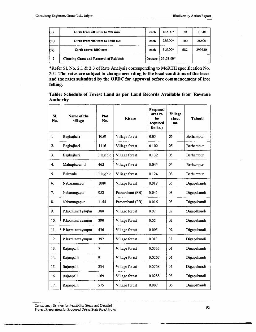
Consulting Engineers Group Ltd., Jaipur Biodiversity Action Report
ii) Girth from 600 mm to 900 mm each 162.00* 70 11340
(iii) Girth from 900 mm to 1800 mm each 285.00* 100 28500
iv) Girth above 1800 mm each 515.00* 582 299730
2 Clearing Grass and Removal of Rubbish hectare 29138.00* ==
*Refer SI. No. 2.1 & 2.3 of Rate Analysis corresponding to MoRTH specification No.201. The rates are subject to change according to the local conditions of the treesand the rates submitted by the OFDC for approval before commencement of treefelling.
Table: Schedule of Forest Land as per Land Records Available from RevenueAuthority
Proposed
SI. Name of the Plot area to VillageN. vlaeN.Kisam be sheet Tahasil
No. village No.acquired no.
(in ha.)
I Baghajhari 1059 Village forest 0.05 05 Berhampur
2. Baghajhari 1116 Village forest 0.102 05 Berhampur
3. Baghajhari Illegible Village forest 0.132 05 Berhampur
4. Mahugharahill 463 Village forest 0.043 04 Berhampur
5. Balipada Illegible Village forest 0.124 03 Berhampur
6. Nabarangapur 1080 Village forest 0.018 03 Digapahandi
7. Nabarangapur 952 Patharabani (PB) 0.045 03 Digapahandi
8. Nabarangapur 1154 Patharabani (PB) 0.016 03 Digapahandi
9. P.laxminarayanpur 388 Village forest 0.07 02 Digapahandi
10. P.laxminarayanpur 390 Village forest 0.02 02 Digapahandi
11. P.laxminarayanpur 436 Village forest 0.005 02 Digapahandi
12. P.laxminarayanpur 392 Village forest 0.013 02 Digapahandi
13. Rajanpalli 7 Village forest 0.0333 01 Digapahandi
14. Rajanpalli 9 Village forest 0.0267 01 Digapahandi
15. Rajanpalli 234 Village forest 0.0768 04 Digapahandi
16. Rajanpalli 169 Village forest 0.0288 03 Digapahandi
17. Rajanpalli 575 Village forest 0.007 06 Digapahandi
Consultancy Service for Feasibility Study and Detailed 95Project Preparation for Proposed Orissa State Road Project

Consulting Engineers Group Ltd., Jaipur Biodiversity Action Report
18. Rajanpalli 617 Village forest 0.0648 06 Digapahandi
19. Rajanpalli 92 Village forest 0.0152 06 Digapahandi
20. Rajanpalli 90 Village forest 0.0164 03 Digapahandi
21. Rajanpalli 230 Village forest 0.0044 04 Digapahandi
22. Rajanpalli 1161 Village forest 0.0044 01 Digapahandi
23. Rajanpalli 1160 Village forest 0.0164 01 Digapahandi
24. Rajanpalli 1159 Village forest 0.026 01 Digapahandi
25. Daseipur 39 Village forest 0.0552 03 Digapahandi
Berhampur-5 plots
Total 25 Plots 23 VF & 2 PB 1.0134 9Digapahandi
-20 plots
The maps of Mahugharahill, the hills at Tikarpada and Balipada on the left and rightalong with the forest land on the left opposite the Padarbali village and Mahurikaluaroad junction have not been accounted for as the detail map corresponding to the landschedule of the villages were not available. This will be added after the publishedmaps are made available by Survey and Map publication Govt. of Orissa. This showsthe total forest land affected comes within 1.0134ha. which is within the power ofState Govt. under forest conservation act guideline to be release for road improvementactivity.
Table showing abstract of biodiversity survey conducted on Phase-I road July toSeptember 2007
Particulars of stake holders interviewedSN. SH Name of the SHNo. No. E oeest Residents Commercial Pedestrians Ao Total
Employees establishment mobiles
1 SH-9 Bhadrak - 5 30 10 5 15 65Chandbali
2 SH- Bhadrak - 5 45 15 15 10 9053 Anandapur -
Karanjia
3 SH- Karanjia - 1 5 3 5 10 2449 Tangabila
(Jashipur)
4 SH- Berhampur - 11 65 20 45 25 16617 Bangi Jn.
5 SH-4 Bangi- 4 18 11 10 8 51Rayagada
Consultancy Service for Feasibility Study and Detailed 96Project Preparation for Proposed Orissa State Road Project

Consulting Engineers Group Ltd., Jaipur Biodiversity Action Report
6 SH-5 JKPur - 8 12 10 10 10 50&6 Muniguda -
Bhawanipatna
7 SH- Bhawanipatna - 4 15 9 27 8 6316 Khariar
8 SH- Daspalla - 6 20 12 35 5 78
65A Gania -to 64 Nuagada -
Hindol -Mahidharpur -
Angul
9 SH-7 Aska - 4 12 10 7 8 41Bhanjanagar
Total 48 222 100 159 99 628
* The result of the survey conducted involving 628 personalities of diversebackground and views on wildlife indicated that many persons are havingrudimentary ideas on need of wildlife and environment other than opining forprotection of forest and preventing wildlife to come out of forest. Many personsdeclined to sign the documents and did not answer the forms given to them. Insuch cases their statement only recorded on the forms and it was reflected on thecorridor strip map for wildlife survey.
* The survey could not provide specific information on accident of wildlife on theroad, though lots of frogs, lizards, snakes, birds and small mammals reportedlycome under the wheels near wet land habitat, water body, culverts, agriculturalfields. The common man does not consider these creatures wildlife.
* The movement of tiger was not reported from any quarter through panthers werereported to be present in Satkosia RF and Chheratangara RF of Karanjia, nala ghatof Parelekhemundi, Saradhapur RF and Makundapur ghat of Rayagada forestdivisions. Similarly movement of elephants, gaur, sambar, dear and Nilgai werereported from Taptapani to Bangi, Bangi to Rayagada, Bhawanipatna to JKPur,Narsinghpur to Hindol, Anandapur to Karanjia.
* The presence of civets, pythons, palm civets, fishing cats, otters, turtles, crabs,monitor lizard, yellow monitor and gray monitor, cobra, rat snake, jungle cat,jackals were reported from Chandbali - Bhadrak - Anandapur zone.
* Bears were singularly reported to be a threat for human beings betweenDigapahandi to Maulabhanja Bridge on SH-17, Anandapur to Kodapada on SH-53.
* The man animal conflict has been very severely affecting the economy of farmersand tribals within the forest and on the out skirts of forest where entire paddy cropand vegetable gardens of Potato, pumpkin, water melon, musk melon, cluster bin,asparagus bins, tomatoes, cauliflowers were devastated along with destruction oftheir house and store harvested paddy in Ganjam, Gajapati, Rayagada, Keonjhar,Mayurbhanj, Cuttack, Dhenkanal and Angul district. The steps to provide wildlife
Consultancy Service for Feasibility Study and Detailed 97Project Preparation for Proposed Orissa State Road Project

Consulting Engineers Group Ltd., Jaipur Biodiversity Action Report
underpass at specific points is therefore likely to influence adverse public opinionin elephant and bear menace sites along the corridor.
Number of Medium and Giant trees likely to be removed from the RoW as perproposed centre line of the SH-17 (Part) from O/Okm to 41/0 km
TREE COUNTING (KM 0-41)
BERHAMPUR-TAPTAPANI(0.Okm TO 41.0km)
Si No. CHAINAGE LEFT RIGHT TOTAL
1 0.0-1.0km 1 0 1
2 1.0-2.0kmn 3 0 3
3 2.0-3.0km 4 4 8
4 3.0-4.0km 8 11 19
5 4.0-5.0km 2 6 8
6 5.0-6.0km 13 18 31
7 6.0-7.0km 11 12 23
8 7.0-8.0km 10 8 18
9 8.0-9.Okm 7 7 14
10 9.0-1 0.0km 4 8 12
11 10.0-1 1.Okm 3 4 7
12 11.0-12.0km 1 2 3
13 12.0-13.0km 0 4 4
14 13.0-14.0km 3 1 4
15 14.0-15.0kmn 1 1 2
16 15.0-16.0km 1 2 3
17 16.0-17.0km 4 7 11
18 17.0-18.0km 1 7 8
19 18.0-19.Okm 8 4 12
20 19.0-20.0km 4 3 7
Consultancy Service for Feasibility Study and Detailed 98Project.Preparation for Proposed Orissa State Road Project

Consulting Engineers Group Ltd., Jaipur Biodiversity Action Report
21 20.0-21.Okm 3 4 7
22 21.0-22.0km 2 7 9
23 22.0-23.0km 5 2 7
24 23.0-24.0km 8 3 11
25 24.0-25.0km 9 15 24
26 25.0-26.0km 7 2 9
27 26.0-27.0km 14 7 21
28 27.0-28.Okm 9 7 16
29 28.0-29.0km 6 3 9
30 29.0-30.0km 2 6 8
31 30.0-31.0km 17 29 46
32 31.0-32.0km 34 27 61
33 32.0-33.Okm 34 8 42
34 33.0-34.0km 15 29 44
35 34.0-35.0km 8 10 18
36 35.0-36.0km 21 16 37
37 36.0-37.0km 23 14 37
38 37.0-38.0km 36 10 46
39 38.0-39.0km 5 10 15
40 39.0-40.0km 16 13 29
41 40.0-41.0km 22 24 46
Total 385 355 740
Total no. of plants 2220 to be planted @1,84,900/- per 400 plants per km =Rs.10,26,195/-
There are 740 no. of trees about to be sacrificed on account of road improvement asper the final layout plan showing the proposed centre line. The left side of thecorridor contains 385 such trees and the right side 355 trees. The actual number oftrees may vary depending on the additional survey of tree growth that will be acquiredand compensated for being the property of private parties, which has not been
Consultancy Service for Feasibility Study and Detailed 99Project-Preparation for Proposed Orissa State Road Project

Consulting Engineers Group Ltd., Jaipur Biodiversity Action Report
evaluated and the trees over forest land, which has not been identified and enumerateddue to want of Sabik, Kisam and plot numbers as per Sabik RoR corresponding to theHal RoR. The above table shows the km wise number of trees belonging to the OWDwith a girth at BH (breast height) ranging from 1000 mm to 2400 mm and above.Compensatory plantation of 3 times the total number of trees (740X 3) or 2220 plantsshall be taken up along the corridor including site enhancement plantations, so as toimprove the environment.
The cost of such plantation shall be as per the cost norm furnished in accordance to inAnnexure - XXXVI (A) to (F) of this report and the cost of fencing with paintedwire mesh gabions @500/- per gabion as per design details in drawing no. OSRP/CEG /SH /ENV /08. (Cost norm details are in the DPR, which includes thematerials, with cost of fabrication, painting, carriage and embedding in cementconcrete M- 15 at the planting site in a circular shape)
SL ITEM Unit No Length Width Area in Rate At ount Total Cost inN.sqm. ISqm. no. lakdi
Tree Guard includingcost of fabrication,
I carniage, painting, Kg I 2. I mtr 0.75 mtr 4.95 150.00 743.00 2496 18.55installation & embeddingin cement concrete
NO OF TREES FROM CH.2.000km TO 69.400km
BHAWANIPATNA-KHARIAR
(As per proposed centre line)
SI No. CHAINAGE LEFT RIGHT TOTAL
I 2.0-3.0km 32 14 46
2 3.0-4.0km 33 22 55
3 4.0-5.0knm 23 20 43
4 5.0-6.0nm 51 28 79
5 6.0-7.0km 46 33 79
6 7.0-8.0kn 58 14 72
7 8.0-9.0km 54 30 84
8 9.0-10.0km 29 22 51
9 10.0-1 1.0km 17 23 40
10 11.0-12.0km 31 32 63
I I 12.0-13.0km 35 34 69
12 13.0-14.0km 22 25 47
Consultancy Service for Feasibility Study and Detailed 100Project Preparation for Proposed Orissa State Road Project

Consulting Engineers Group Ltd., Jaipur Biodiversity Action Report
13 14.0-15.Okrn 34 37 71
14 15.0-16.0km 33 39 72
15 16.0-17.0krn 41 38 79
16 17.0-18.0krm 19 27 46
17 18.0-19.0km 35 27 62
18 19.0-20.0km 38 32 70
19 20.0-21.01an 37 18 55
20 21.0-22.0km 34 17 51
21 22.0-23.Okmn 41 36 77
22 23.0-24.0km 33 38 71
23 24.0-25.0km 17 14 31
24 25.0-26.0km 31 30 61
25 26.0-27.0km 23 12 35
26 27.0-28.0km 3 4 7
27 28.0-29.0km 0 0 0
28 29.0-30.0km 0 2 2
29 30.0-31.Okm 2 9 11
30 31.0-32.0km I 1 2
3 1 32.0-33.0km 8 6 14
32 33.0-34.0km 7 5 12
33 34.0-35.Okm 3 2 5
34 35.0-36.0km 6 5 11
35 36.0-37.0km 3 4 7
36 37.0-38.0km 11 11 22
37 38.0-39.0km 23 24 47
38 39.0-40.0km 21 22 43
39 40.0-41.0km 9 13 22
40 41.0-42.0km 4 2 6
Consultancy Service for Feasibility Study and Detailed 101Project Preparation for Proposed Orissa State Road Project

Consulting Engineers Group Ltd., Jaipur Biodiversity Action Report
41 42.0-43.0km 5 4 9
42 43.0-44.0km 7 7 14
43 44.0-45.Okm 24 1 0 34
44 45.0-46.0km 6 10 16
45 46.0-47.0km 12 13 25
46 47.0-48.0krn 7 5 12
47 49.0-50.0km 2 5 7
48 50.0-51.Okm I 1 9 20
49 51.0-52.0km 17 26 43
50 52.0-53.0km 23 15 38
51 53.0-54.0km 7 6 13
52 54.0-55.0km 8 10 18
53 55.0-56.0km 14 7 21
54 56.0-57.0km 15 7 22
55 57.0-58.0km 90 31 121
56 58.0-59.0km 0 1 1
57 59.0-60.0km 5 1 6
58 60.0-61.0kn 4 6 10
59 61.0-62.0km 27 25 52
60 62.0-63.0kn 6 7 13
61 63.0-64.0kn 8 5 13
62 64.0-64.4km 6 3 9
63 65.0-66.0km I10 8 18
64 66.0-67.0km 2 2 4
65 67.0-68.0kn 9 15 24
66 68.0-69.0km 0 4 4
67 69.0-69.41kn 2 3
Consultancy Service for Feasibility Study and Detailed 102Project Preparation for Proposed Orissa State Road Project

Consulting Engineers Group Ltd., Jaipur Biodiversity Action Report
Total no. of plants 6870 to be planted @1,84,900/- per 400 plants per km =Rs.31,75,6571/- or31.75lakhs
There are 2290 no. of trees about to be sacrificed on account of road improvement asper the final layout plan showing the proposed centre line. The left side of thecorridor contains 1274 such trees and the right side 1016 trees. The actual number oftrees may vary depending on the additional survey of tree growth that will be acquiredand compensated for being the property of private parties, which has not beenevaluated and the trees over forest land, which has not been identified and enumerateddue to want of Sabik, Kisam and plot numbers as per Sabik RoR corresponding to theHal RoR. The above table shows the km wise number of trees belonging to the OWDwith a girth at BH (breast height) ranging from 1000 mm to 2400 mm and above.Compensatory plantation of 3 times the total number of trees (2290X3) or 6870 plantsshall be taken up along the corridor including site enhancement plantations, so as toimprove the environment.
The cost of such plantation shall be as per the cost norm furnished in accordance to inAnnexure - XXXVI (A) to (F) of this report and the cost of fencing with paintedwire mesh gabions @500/- per gabion as per design details in drawing no. OSRP/CEG /SH /ENV /08. (Cost norm details are in the DPR, which includes thematerials, with cost of fabrication, painting, carriage and embedding in cementconcrete M-1 5 at the planting site in a circular shape)
Formation of Monitoring committee to Stream line and facilitate speedyimplementation of the corridor development through inter and intradepartmental coordination.
The inter agency coordination to oversee the environment and biodiversity relatedmatter may be tackled by formation of committee under the;
* Chairmanship of local Conservator Forest
* Executive Engineer of the project as convener cum members secretary.
* Divisional Forest officer, wildlife /territorial division.
* Zonal manager OFDC ltd.
* Divisional Manager (commercial) OFDC ltd.
* Local Tahasildar
* Supervision Consultant of OWD
This committee will look after the identification of forestland, speedy enumeration oftree growth over such land, preparation of a register to record the number of trees tobe retained along the corridor.
The committee will fix up modalities for early issue of felling, logging and passingorders by the concerned Divisional Forest Officer having jurisdiction over the area assoon as the clearance under forest (conservation) act is obtained from the competentauthority and the enumeration list jointly prepared by the local forest department,. PIU
Consultancy Service for Feasibility Study and Detailed 103Project Preparation for Proposed Orissa State Road Project

Consulting Engineers Group Ltd., Jaipur Biodiversity Action Report
of OWD and divisional staff of OFDC entrusted with the job of tree felling andremoval.
The committee will take necessary steps for appointment of a specific officer of forestdepartment not below the rank of a Range Officer to take up passing of convertedtrees within the acquired forest and non forest land from time to time.
The committee will fix up the modalities of passing at regular interval of 15 days andissue of permits by the passing officer, where the logs and fire wood is removed fromthe forest land, revenue land and other Govt. of private land.
The committee will assign specific tasks and agency to local Divisional Forest officer/Bana Samrakshayana Samiti to take up activities like plantation in degraded forestland adjacent to the corridor of wildlife movement, camouflage corridor planting oneither opening of wildlife underpass, gully plugging and check damming other soiland water conservation measures in forest land and Podu ravaged areas, which shallbe open to inspection and monitoring by the supervision consultant /environmentexpert of the OWD and the site engineer of OWD.
The committee will deliberate on difficulties and draw backs in the implementationand settling of all differences and bottlenecks in the field and office level.
The other invited member may be the contractor of the package, who has beeninterested with the job of avenue plantation and corridor soil and water conservationmeasure, habitat development as well as site enhancement activities within the RoWand up to the boundary of forest land beyond RoW.
The committee will entrust the job of monitoring the movement of wildlife after theproject work is completed through the local range officer and the assistant engineer ofthe OWD together with any environment and Wildlife Expert /NGO active in the fieldof monitoring wildlife issues for evaluation of various biodiversity an environmentalstructures proposed to be erected as mitigation measures.
There shall be a district level committee under the Chairmanship of district Collectorfor monitoring and speedy implementation of activities relating to:
* Shifting of utilities
* Relocation of tube wells, stand posts, statues, religious structures.
* Shifting of the boundary walls, gates and other utilities of schools, colleges,hospitals, old age homes, burial grounds, water bodies, diversions etc.
* Monitoring the activities related to removal of trees and plantation activitiesalong the corridor.
* Establishment of check posts on the proposed road.
The members of the committee shall be all the district level heads of authority relatingto forest, wildlife, electric supply, water supply, health, community development,endowments, labour welfare, regional transport authority, police, panchayatraj
Consultancy Service for Feasibility Study and Detailed 104Project Preparation for Proposed Orissa State Road Project

Consulting Engineers Group Ltd., Jaipur Biodiversity Action Report
institution, education, tourism, district level disaster mitigation authority, prominentenvironment experts, non govt. agencies active in health and sanitation, socioeconomic development of rural areas. The sitting of both the committee shall be onceevery month to review the activities, progress and bottleneck for finding out theexpeditious solutions for early disposal of the activities.
Schedule of plantation to be raised along the water bodies by relocating trees from theavenue and planting on the embankment of ponds, rivers, streams and wildlifeunderpass
Table showing right and left side Avenue planting
No. of No. of shrubsSL Left Chainage Total Right Chainage plants at /small trees at
No. length Total length 5mt 5mtrX5mtrFrom To (in mtr) From To X5mtr spacing
1 0.120 0.150 30 0.140 0.250 110 28 282 0.270 0.450 180 0.600 1.000 400 116 1163 2.200 2.500 300 1.000 1.605 605 181 1814 2.600 2.930 330 1.600 2.100 500 166 1665 3.440 4.000 560 2.180 2.340 160 144 1446 4.000 4.300 300 3.500 4.000 500 160 1607 5.000 5.220 220 4.000 4.300 300 104 1048 5.000 5.400 400 4.440 4.542 102 100 1009 6.200 6.900 700 5.000 5.950 950 330 33010 7.400 7.700 300 6.000 6.750 750 210 21011 8.000 8.200 200 7.300 7.350 50 50 5012 8.400 9.800 400 7.450 7.700 250 130 13013 10.600 11.000 400 8.000 8.300 300 140 14014 11.000 11.200 200 8.350 9.800 450 130 13015 11.350 11.600 250 10.670 11.000 330 116 11616 11.900 12.000 100 11.000 11.200 200 60 6017 12.000 12.700 700 11.350 11.630 280 196 19618 13.000 13.100 100 11.900 12.700 800 180 18019 13.700 14.000 300 13.000 13.050 50 70 7020 14.000 15.000 1000 13.700 14.000 300 260 26021 15.300 15.600 300 14.000 14.100 100 80 8022 16.000 17.000 1000 14.200 14.800 600 320 32023 17.480 17.800 320 15.300 15.620 320 128 12824 17.950 18.150 200 16.000 17.000 1000 240 24025 19.150 20.000 850 17.450 17.800 350 240 24026 20.000 20.400 400 17.950 18.150 200 120 12027 21.100 21.600 500 19.180 19.250 70 114 11428 22.000 22.200 200 19.900 20.000 100 60 6029 22.250 22.525 275 20.390 20.590 200 95 9530 24.800 24.900 100 21.100 21.650 550 130 13031 25.500 25.900 400 21.800 21.900 100 100 10032 26.000 26.350 350 22.000 22.200 200 110 11033 26.550 26.800 250 22.250 22.700 450 140 14034 27.000 28.000 1000 23.000 23.100 100 220 22035 28.500 29.000 500 25.550 25.700 150 130 13036 29.000 29.250 500 26.000 26.100 100 120 12037 29.700 30.000 300 26.475 26.700 225 105 10538 30.200 30.900 700 27.000 28.000 1000 340 34039 31.550 32.000 450 28.500 29.000 500 190 19040 32.500 32.230 270 29.000 29.250 250 104 10441 32.230 32.300 70 29.600 30.100 500 114 11442 33.333 33.700 377 30.200 30.295 95 94 9443 33.700 34.050 350 31.550 32.000 450 160 16044 34.900 35.700 800 32.050 32.230 180 196 19645 36.145 36.204 59 32.300 32.350 50 22 2246 36.400 36.600 200 33.350 33.700 350 110 110
Consultancy Service for Feasibility Study and Detailed 105Project Preparation for Proposed Orissa State Road Project

Consulting Engineers Group Ltd., Jaipur Biodiversity Action Report
47 36.800 36.950 150 33.700 33.960 360 102 10248 36.210 38.200 1990 34.950 35.650 700 538 53849 39.000 39.140 140 36.145 36.200 55 39 3950 39.400 40.000 600 36.450 36.630 180 156 15651 40.300 40.400 100 36.850 36.900 50 30 3052 40.525 41.000 475 36.210 38.500 2290 553 55353 - - - 38.600 38.800 200 40 4054 - - 40.300 40.500 200 40 4055 - - 40.700 40.890 190 38 38
Cost of planting with relocation of species brought from the avenues with 3-yearmaintenance@500/- each 8189 no. of trees= Rs.40,94,500@ 150/- each 8189 no. of shrubs & bushes = Rs.12,28,350
The costing for corridor camouflage plantation shall be as per the cost norms ofplantation furnished at Annexure XXXVI (C) @15900/- per ha. which shall becalculated as below for wildlife underpass in forested areas plantation of lOmtr X50mtr on either side will be carried out leaving the culvert and streams open, so as toallow free movement of wildlife. There are all total 20 such locations as per the tableno. XXV (B) to (D) for year-I roads excluding the underpasses on Chandbali -Bhadrak and Bhadrak - Anandapur corridor, where there will be 1 wildlife underpassplantation at 40.242km chainage before Anandapur
Consultancy Service for Feasibility Study and Detailed 106Project Preparation for Proposed Orissa State Road Project

A
I
i
I

Consulting Engineers Group Ltd., Jaipur Biodiversity Action Report
Annexure 1: Questionnaire for Wild Life Survey (Discussion at Institutional Level)
The Foresters, Rangers and Forest Officers will be requested to provide specific informationabout the floral and faunal inventory in the area, location of water holes, location of roadcrossing, etc.
I Do you know about OSRP? Yes / No Yes2 Which are the predominant wildlife species present in your area and Elephant, Tiger, Panther,
provide species wise inventory. Bear, Sambar, Dear,Barking dear, Monkey,Rattle, Hare, Snake,Mongoose, Monitor lizardetc.
3 Which are the identified wildlife corridor in the range under your Only 1 bear pass at 27kmjurisdiction? What is periodicity of movement of wildlife in these and occasional elephantcorridors? crossing at 41km to 42km
Movement during yearlywinter up to end of summeri.e. mid September to midJune.
4 Which floral species are available in your range? Trees like Sal, Sisoo, Biza,Tik, Arjun, Kadamba, Fasi,Asan, Pipal, Banion, Mahul,Mango, Tamarind etc.There are climbers, shrubsand herbs of many varieties.
5 What are the medicinal plants species available in your area? Bel, Neem, Amla, Sandalwood, Ankula, Asperagus,Bridhadarak, Raulvolfia,Apamarga.
6 Kindly mark locations of water holes on a sketch with approx. There are no specific waterdistance from project road and size of the water hole. holes except the river basins
and ponds on either side ofthe road from Olam to 41kma,which are used as waterhole during sumnmer by thewildlife.
7 Please give your suggestions for protection of wildlife and forests. People participation inforest management,allowing farmn forestry inpodu cultivation areas,encouraging privateplantations and removingrestrictions on felling andtransport of private growntimber and fire wood.
8 What are reasons of wildlife crossing in your opinion? Search for mate, food andfodder, search for shelterand water, running awayfrom forest fire, hunter,mining explosion, highwaydevelopment andfragmentation of corridor.
9 Have you noticed any change in wildlife behavior, movement, Yes, Wildlife is enteringI multiplication in the past? In case yes, what are possible reasons for into habitations and
- Consultancy Service for Feasibility Study and DetailedProject Preparation for Proposed Orissa State Road Project 107

Consulting Engineers Group Ltd., Jaipur Biodiversity Action Report
these changes? agricultural area morefrequently even thoughthere is no food source inthe field, because of the lossof habitat and biotic
-_ interference.
Details official contacted
Name: Desi nation: Date:S.C.Behera Range officer Mohana July 27 2006R.C.Mohapatra Range officer Digapahandi July 27 2006Suresh Mishra Range officer Podamari July 29 2006
Consultancy Service for Feasibility Study and Detailed 108Project Preparation for Proposed Orissa State Road Project

Consulting Engineers Group Ltd., Jaipur Biodiversity Action Report
Biodiversity Survey of Different CorridorsBerhampur Range
1. A. What are the wild life found in the area Elephant, Bear, Rattel, Jackal, Hyena, Civet,Otter, Hare, Porcupine, Fox, Snakes, Bull frogs,Toad, Monitor lizard, Fresh water fish etc.
B. Timing of sighting animal Night/Late Night, Dawn/Early Morning
occasionally in the evening.
C. Where mostly found crossing of road Chainage 1.52km to 2.5km, 9.0km to 10.0km,
13.0km to 17.0km
D. Season of crossing Winter/Summer/ Rainy season
E. Reasons of Wild life movement Mating, Feeding, Hunting, Nesting, Scavenging,
escaping.
1. Traditional or Sporadic /Specific Less Traditional more Sporadic or Specific at
places
a. Annual migration Seasonalb. Seasonal Migration2. Summer movement for food /water. Summer
3. Winter movement for crops foraging and Yesfeeding or hunting.4. Under threat:
a. Forest Fire Yes
b. Podu Cultivation Yes
c. Chased by hunters/ Predators Yes
d. Man animal conflict. Yes
5. For Salt lick and water holes. For water holes.
6. Destruction of habitat / Stone quarry/ Yes, Stone quarry, Destruction of habitatMovement of heavy machinery/ destructions ofhabitat.Development project work/ any other factor N.A.
F. Location of Perennial /Seasonal water source/ Dakhinapur MIP and Rusikulya canal system.Waterholes/Salt licks/ponds/Marsh land ..
a. Name of River/ Nallah / Lanjia ponds, Tikarpada MI,Spring / Pond / Artificial Within the corridor limits.departmental water holes/ saltlicks etc.
b. Distance from the road.
Consultancy Service for Feasibility Study and Detailed 109Project Preparation for Proposed Orissa State Road Project

Consulting Engineers Group Ltd., Jaipur Biodiversity Action Report
G. What are the preventive measures to be takento Prevent Wild life crossing the road and torecord their causative factors of movementmore precisely
a. Departmental Community No commentsoriented/ signage etc.
b. Protection measures like Food Development of habitat through protection ofand Water source development. natural forest growth
c. Development of the saltlick with Not requiredwater source in the forest.
d. Optical illusion effects /Reflector It will have no effect./holographic reflectors.
H. From which area to which area across the road From Ramaguda RF on the left and water bodiesannual movement is noticed on the right at Dakhinapur /Lanjia /Tikarpada
Name of forest blocks/ Rev. Village/ Chainage to /Padar bali.be furnished as per the corridor length.1. Any damage to life and property by wild Elephants have done damaged property and life
animals during last 3 years? of human beings in Dakhinapur during the past 2year and current year 2006.
2. Are there Forest fire? Yes /No Yes, Hardly any vegetation worth the name to beReasons Time of fire Month destroyed other than the rooted wastes of natural
forest.1. Do forest fires occur frequently? Yes /No No,When / How Forest fire during winter and early summer for
collection of fire wood, hunting of small animalslike hare, porcupine, fox and civets for collectionof mahua flower and seeds, mangoes.
Month of fire February to Aprila. Accidental _b. Naturalc. By food gathers _d. Podu cultivatorse. Hunters/NTFP gatherers Yesf. Tourist and local vandalismg. Lightning effect 03. Dependence on forest as a source of lively hood1. Food/Fodder/Fire wood Yes, Fire woodMFP/NTFP Yes, NTFP2. Eco tourism NoProtection measures suggested1. Creation of water holes on site of corridor There are number of natural water holes.2. Creation of barriers/Vertical retaining walls on Not requiredroad sidea. Reflectors mounted on roadside. Yesb. Raising of food parks It will not be effective due to grazing.
Consultancy Service for Feasibility Study and Detailed 110Project Preparation for Proposed Orissa State Road Project

Consulting Engineers Group Ltd., Jaipur Biodiversity Action Report
c. Road under bridge for free passage with Yesvertical wing walls.d. Formation of village committees to prevent Yeshunting and destruction of habitat/forest fire.e. Voluntary conservation of rooted wastes to Yesallow forest growth and restockingf. Supplement gaps with source of food chain By conservation of natural growth with soil andspecific plantation of species, which are the water conservation measures in the nala andsource of food for wild life by educating the stream beds, creeks, prevention of erosion.locals and residents alike on importance of wildlife habitat and wild life for socio-economic andaesthetic consideration.g. Creation of medows. Not applicable.h. A gave planting in staggered manner along Not requiredwith tribulus territories herbal seed sowing toprevent elephant crossing.i. Changing over to other crop Not required
Name and address of the: Ramchandra Gouda, Dakhinapur, GanjamPratam Kumar Ratha, ChecknakaguardBrundabana Gouda, Tikarpada, Po.Balipada, GanjamMinaketan Das, Lanjia, Po.Lanjia, Ganjam27/09/2006
Consultancy Service for Feasibility Study and DetailedProject Preparation for Proposed Orissa State Road Project
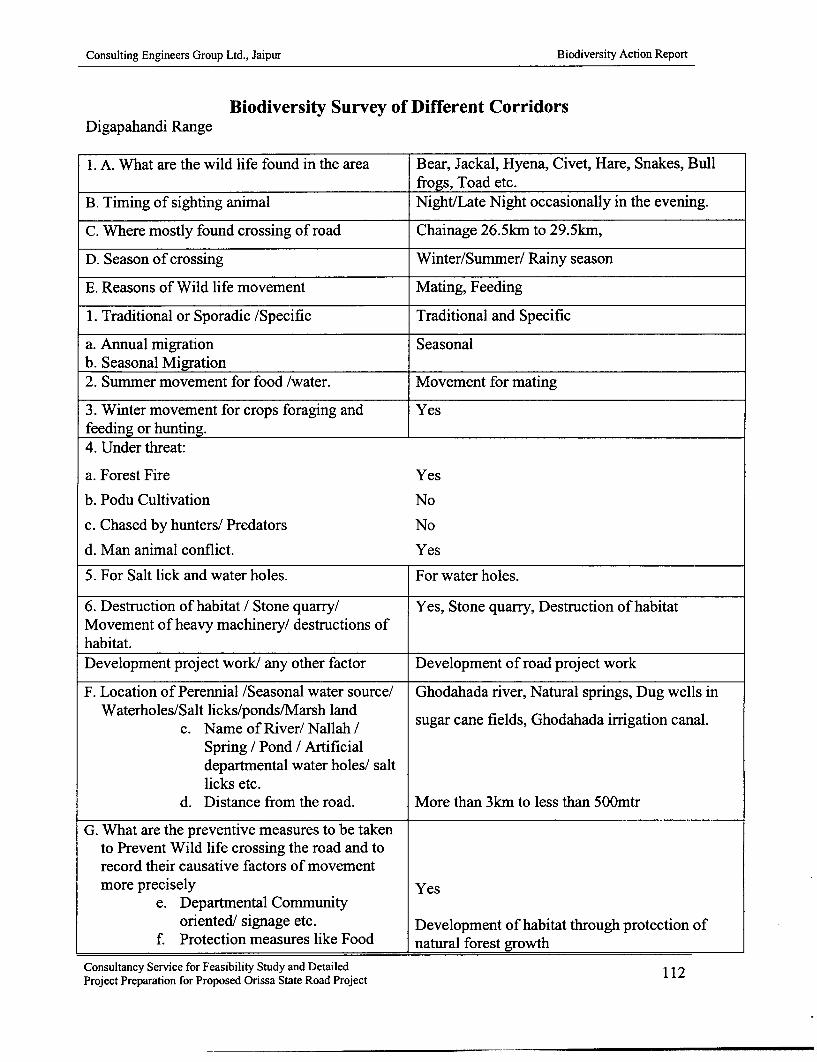
Consulting Engineers Group Ltd., Jaipur Biodiversity Action Report
Biodiversity Survey of Different CorridorsDigapahandi Range
1. A. What are the wild life found in the area Bear, Jackal, Hyena, Civet, Hare, Snakes, Bullfrogs, Toad etc.
B. Timing of sighting animal Night/Late Night occasionally in the evening.
C. Where mostly found crossing of road Chainage 26.5km to 29.5km,
D. Season of crossing Winter/Summer/ Rainy season
E. Reasons of Wild life movement Mating, Feeding
1. Traditional or Sporadic /Specific Traditional and Specific
a. Annual migration Seasonalb. Seasonal Migration2. Summer movement for food /water. Movement for mating
3. Winter movement for crops foraging and Yesfeeding or hunting.4. Under threat:
a. Forest Fire Yes
b. Podu Cultivation No
c. Chased by hunters/ Predators No
d. Man animal conflict. Yes
5. For Salt lick and water holes. For water holes.
6. Destruction of habitat / Stone quarry/ Yes, Stone quarry, Destruction of habitatMovement of heavy machinery/ destructions ofhabitat.Development project work/ any other factor Development of road project work
F. Location of Perennial /Seasonal water source/ Ghodahada river, Natural springs, Dug wells inWaterholes/Salt licks/ponds/Marsh land
c. Name of River/ Nallah / sugar cane fields, Ghodahada irrigation canal.Spring / Pond / Artificialdepartmental water holes/ saltlicks etc.
d. Distance from the road. More than 3km to less than 5OOmtr
G. What are the preventive measures to be takento Prevent Wild life crossing the road and torecord their causative factors of movementmore precisely Yes
e. Departmental Communityoriented/ signage etc. Development of habitat through protection of
f. Protection measures like Food natural forest growth
Consultancy Service for Feasibility Study and Detailed 112Project Preparation for Proposed Orissa State Road Project

Consulting Engineers Group Ltd., Jaipur Biodiversity Action Report
and Water source development.g. Development of the saltlick with Not required0 water source in the forest.h. Optical illusion effects /Reflector Yes, It will have effect.
/holographic reflectors.
H. From which area to which area across the road From Changudidei hills (PF) on the left andannual movement is noticed Jagannathpur PF on the right 6km away acrossName of forest blocks/ Rev. Village/ Chainage to river and agricultural land.be furnished as per the corridor length.1. Any damage to life and property by wild Bears have damaged sugar cane, pea nut, water
animals during last 3 years? melon, cucumber, crops as well as maimed localvillagers all around.
2. Are there Forest fire? Yes /No Yes, this is a rocky exposure of boulders on eitherReasons Time of fire Month side hills (PF) with spa race vegetation, forest
fires are rare.1. Do forest fires occur frequently? Yes /No No,When / How Forest fire during early summer rarely for
collection of fire wood, hunting of small animalslike hare.
Month of fire Marcha. Accidentalb. Natural. c. By food gathersd. Podu cultivatorse. Hunters/NTFP gatherersf Tourist and local vandalismg. Lightning effect3. Dependence on forest as a source of lively hood1. Food/Fodder/Fire wood Yes, Fire woodMFP/NTFP2. Eco tourism NoProtection measures suggested1. Creation of water holes on site of corridor There are number of natural water holes.2. Creation of barriers/Vertical retaining walls on Not requiredroad sidea. Reflectors mounted on roadside. Yesb. Raising of food parks It will not be effective due to grazing.c. Road under bridge for free passage with Yesvertical wing walls.d. Forination of village committees to prevent Yeshunting and destruction of habitat/forest fire.e. Voluntary conservation of rooted wastes to Yesallow forest growth and restocking
Consultancy Service for Feasibility Study and Detailed 113Project Preparation for Proposed Orissa State Road Project

Consulting Engineers Group Ltd., Jaipur Biodiversity Action Report
f. Supplement gaps with source of food chain By conservation of natural growth with soil andspecific plantation of species, which are the water conservation measures in the nala andsource of food for wild life by educating the streambeds, creeks, prevention of erosion. Alonglocals and residents alike on importance of wild with approach corridor development at either endlife habitat and wild life for socio-economic and of the underpass.aesthetic consideration.g. Creation of medows. Not applicable.h. A gave planting in staggered manner along Not requiredwith tribulus territories herbal seed sowing toprevent elephant crossing.i. Changing over to other crop Not possible
Name and address of the: P.Narsingh Reddy, Moulabhanja, Po. Digapahandi, Dist-GanjamC.S. Rajababu, Dherendi, Po. Digapahandi, Dist-GanjamSambaru Sabara, Indrabasa Po. Digapahandi, Dist-GanjamLaxmi Reddy, Moulabhanja, Po. Digapahandi, Dist-GanjamP.R.K. Patra, shopkeeper, Moulabhanja, Po. Digapahandi, Dist-Ganjam
Consultancy Service for Feasibility Study and Detailed 114Project Preparation for Proposed Orissa State Road Project

Consulting Engineers Group Ltd., Jaipur Biodiversity Action Report
Biodiversity Survey of Different CorridorsPodamari Range
1. A. What are the wild life found in the area Bear, Jackal, Hyena, Civet, Hare, Snakes, Bullfrogs, Toad, Fresh water fish, Turtles, Otters etc.
B. Timing of sighting animal Night/Late Night occasionally in the evening.
C. Where mostly found crossing of road Chainage 28km to 3 1km
D. Season of crossing Winter/Summer/ Rainy season
E. Reasons of Wild life movement Mating, Feeding
1. Traditional or Sporadic /Specific Traditional and Specific
a. Annual migration Seasonalb. Seasonal Migration2. Summer movement for food /water. Movement for mating and feeding
3. Winter movement for crops foraging and Yesfeeding or hunting.4. Under threat:
a. Forest Fire Yesb. Podu Cultivation Noc. Chased by hunters/ Predators Nod. Man animal conflict. Yes5. For Salt lick and water holes. For water holes.
6. Destruction of habitat / Stone quarry/ Yes, Stone quarry, Destruction of habitatMovement of heavy machinery/ destructions ofhabitat.Development project work/ any other factor Development of road project work
F. Location of Perennial /Seasonal water source/ Ghodahada river, Natural springs, Dug wells inWaterholes/Salt licks/ponds/Marsh land
e. Name of River/ Nallah / sugar cane fields, Ghodahada irrigation canal.Spring / Pond / Artificialdepartmental water holes/ saltlicks etc.
f. Distance from the road. More than 3km to less than 5OOmtr
G. What are the preventive measures to be takento Prevent Wild life crossing the road and torecord their causative factors of movementmore precisely Yes
i. Departmental Communityoriented/ signage etc. Development of habitat through protection of
j. Protection measures like Food natural forest growthConsultancy Service for Feasibility Study and DetailedProject Preparation for Proposed Orissa State Road Project 115

Consulting Engineers Group Ltd., Jaipur Biodiversity Action Report
and Water source development.k. Development of the saltlick with Not required
water source in the forest.1. Optical illusion effects /Reflector Yes, It will have effect.
/holographic reflectors.
H. From which area to which area across the road From Changudidei hills (PF) on the left andannual movement is noticed Jagannathpur PF on the right 6km away acrossName of forest blocks/ Rev. Village/ Chainage to river and agricultural land.be furnished as per the corridor length.1. Any damage to life and property by wild Bears have damaged sugar cane, pea nut, water
animals during last 3 years? melon, cucumber, crops as well as maimed localvillagers all around.
2. Are there Forest fire? Yes /No Yes, this is a rocky exposure of boulders on eitherReasons Time of fire Month side hills (PF) with spa race vegetation, forest
fires are rare.1. Do forest fires occur frequently? Yes /No No,When / How Forest fire during early summer rarely for
collection of fire wood, hunting of small animalslike hare.
Month of fire Marcha. Accidental 0b. Natural 0c. By food gathers 0d. Podu cultivators 0
e. Hunters/NTFP gatherersf. Tourist and local vandalism 0g. Lightning effect3. Dependence on forest as a source of lively hood 01. Food/Fodder/Fire wood Yes, Fire woodMFP/NTFP2. Eco tourism NoProtection measures suggested1. Creation of water holes on site of corridor There are number of natural water holes.2. Creation of barriers/Vertical retaining walls on Not requiredroad sidea. Reflectors mounted on roadside. Yesb. Raising of food parks It will not be effective due to grazing.c. Road under bridge for free passage with Yesvertical wing walls.d. Formation of village committees to prevent Yeshunting and destruction of habitat/forest fire.e. Voluntary conservation of rooted wastes to Yesallow forest growth and restocking
Consultancy Service for Feasibility Study and Detailed 116Project Preparation for Proposed Orissa State Road Project

Consulting Engineers Group Ltd., Jaipur Biodiversity Action Report
f. Supplement gaps with source of food chain By conservation of natural growth with soil and. specific plantation of species, which are the water conservation measures in the nala andsource of food for wild life by educating the streambeds, creeks, prevention of erosion. Alonglocals and residents alike on importance of wild with approach corridor development at either endlife habitat and wild life for socio-economic and of the underpass.aesthetic consideration.g. Creation of medows. Not applicable.h. A gave planting in staggered manner along Not requiredwith tribulus territories herbal seed sowing toprevent elephant crossing.i. Changing over to other crop Not possible
Name and address of the: Ghanshyam Tripathy, Dengaosta, Po.Dengaosta, GanjamRabindranath Patra, Dengaosta, Po.Dengaosta, GanjamnRarayan Gouda, Kansamari, Po.Podamari, GanjamN.Balkrushna Reddy, Podamari, Po.Podamari, Ganjam
Consultancy Service for Feasibility Study and Detailed 117Project Preparation for Proposed Orissa State Road Project

Consulting Engineers Group Ltd., Jaipur Biodiversity Action Report
List of Biodiversity Structures and Signage as mitigation and management plan.Name of the road: SH -17 (Part), Berhampur to Taptapani 0 to 41km
No. Chainage Structures Dimensions Reference drawings no. Remarks1 2.137 Box Culvert with 1/23/0 - 600mm hume Annex.XXV C,
reptile pass viaduct pipe, lmtr /0.75 /lmtr trap OSRP /CEG /SH /Bio /REP-1 Drain &either side and trap drain 1 Omtr from the viaductdrain culvert either side.
2.117 to 2.136, 2.144 to ER /BC /S/B/WC /XXVI B-1 Culvert2.164 viaduct at 2.127 and2.154
2 9.780 Box Culvert with 1/23/0 - 600mm hume Annex.XXV C,reptile pass viaduct pipe, lmtr /0.75 /lmtr trap OSRP /CEG /SH /Bio /REP-I Drain &either side and trap drain 1Omtr from the viaductdrain culvert either side.
Drain at 9.806 to 9.786, ER /BC /S/B/WC /XXVI B-I Culvert9.814 to 9.834 viaduct at9.816 and 9.824.
3 24.700 Forest check gate Barrier across the road As will be designed and fixed To checkwith check naka relocated from 24.350km by the forest department movementshed and lay bye to 24.7kmn on account of of forestfor parking Punjikayan junction, and
Digapahandi wildlifeproducts
4 27.026 Sloth bear 1 /22 /0 new culvert with Annex.XXV C,underpass high retaining wall and ER /BC /S/B/WC /XXVI B-I Culvert
barricade to prevent bearmovement over road.Barricade 26.975 to27.005, 27.031 to27.06 1km both side
5 36.750 Reptile and small 1 /22 /0 Box culvert ER /BC /S/BIWC /XXVI B-I Culvertanimal underpass
6 36.900 Forest check gate Relocated from 36.800 to As will be required and ForPodamari 36.900km on account of decided by forest department checking
acquisition of land and movementbuilding of forest of forestdepartment and
wildlifeproducts
7 26.976 Left Wildlife signage SP - 36 Trafficsignage
8 26.996 Left Wildlife signage SP - 37 Traffic-_ signage
9 27.076 Right Wildlife signage SP - 36 Trafficsignage
10 27.056 Right Wildlife signage SP -37 Trafficsignage
11 27.006 Left Wildlife signage SP - 47 Trafficsignage
12 27.046 Right Wildlife signage SP - 47 Trafficsignage
13 2.130 Left Wildlife signage SP -49 Traffic
Consultancy Service for Feasibility Study and Detailed 118Project Preparation for Proposed Orissa State Road Project
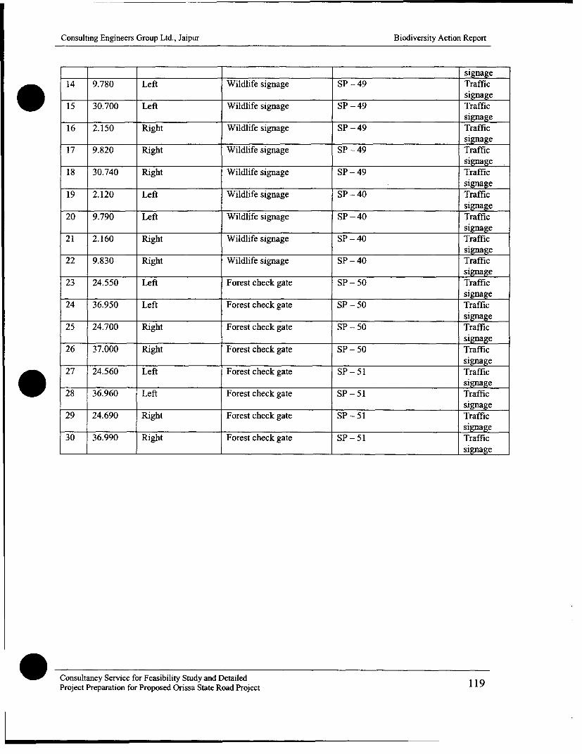
Consulting Engineers Group Ltd., Jaipur Biodiversity Action Report
signage14 9.780 Left Wildlife signage SP - 49 Traffic
____ ____ ____ ___signage
15 30.700 Left Wildlife signage SP - 49 Traffic16_ 2.5 ihWllfinaeS 9signage
16 2.150 Right Wildlife signage SP -49 TrafficI_ _ __ _ _ _ signage
17 9.820 Right Wildlife signage SP -49 Trafficsignage
18 30.740 Right Wildlife signage SP - 49 Traffic20______________ _ 9esignage
19 2.120 Left Wildlife signage SP -40 TrafficI_ _ __ _ _ __ _ _signage
20 9.790 Left Wildlife signage SP -40 Trafficsignage
21 2.160 Right Wildlife signage SP -40 Trafficsignage
22 9.830 Right Wildlife signage SP -40 Traffic____ ____ ____ ___signage
23 24.550 Left Forest check gate SP - 50 Trafficsignage
24 36.950 Left Forest check gate SP - 50 Trafficsignage
25 24.700 Right Forest check gate SP - 50 Trafficsignage
26 37.000 Right Forest check gate SP - 50 Trafficsignage
27 24.560 Left Forest check gate SP - 51 Trafficsignage
28 36.960 Left Forest check gate SP - 51 Trafficsignage
29 24.690 Right Forest check gate SP - 51 Trafficsignage
30 36.990 Right Forest check gate SP - 51 Traffic_ _ _ _ _ _ _ _ _ _ _ _ _ _ __ ____ ___ ___ ____ _ _ _ _ _ _ _ _ _ _ _ _ _ _ _ _ _ _ _ _ _ _ _ _ _ _ _ _ _ _ _ _ _ _ _ _ _ _ _ _ _sig n a gena g
Consultancy Service for Feasibility Study and Detailed 119Project Preparation for Proposed Orissa State Road Project

i1
1
Iii
i
f

Consulting Engineers Group Ltd., Jaipur Biodiversity Action Report
Form No. FCA- 1
. SH No. Name Chainage from to
Name of Plot No. Kisam Proposed Village. the ar e sheet Tahasil DistrictNo. village Hal Sabik Hal Sabik acquired no.
(in h. o
The Sabik classification of all lands has to be verify as per the position of RoR entry prier to1980 and those land, which were recorded as forest kisam of any description shall be broughtunder Sabik forest area going to be acquired in the project.
Form No. FCA - 2
Abstract of total forest land proposed to be acquired.
SH No. Name Chainage from to
SI. | Name of District Area under different Kisam of forest land TotalNo. I Tahasil RF PRF | PF | VF/GJ B ea
Form No. FCA - 3
Difference between Hal and Sabik forest area to be acquired.
Type Nameof Area under different Kisam of forest land Total
data. Tahasil Dstrict F PRF PF VF /GJ JB PB areaHal
Sabik
RF - Reserved Forest, PRF - Proposed Reserved Forest, PF - Protected Forest, VF /GJ - VillageForest /Gramya Jungle, JB - Jungle Block, PB - Pathara Bani.
Consultancy Service for Feasibility Study and Detailed 120Project Preparation for Proposed Orissa State Road Project

Consulting Engineers Group Ltd., Jaipur Biodiversity Action Report
Form No. FCA - 4
Enumeration of growing stock on forestland to be acquired.
Table - 1 for Sample enumeration in case of areas more than 5 ha.*Name of the forest block , Range Division From Chainage to SH No.Left / Right side of the road.
No. of plants under different category of girth class Length Condition
S1. Location Plot ]30 - 60 240 2 - 10- - 20of soundNo. chainage size Species ui 0 0 2- 10 8- 20 clear /unsound
N 60cm U/90cm U/20cm U/150cm U/180cm U/210cm U/240 and bole /others
*Note -The percentage of enumeration will decide the approximate number of trees per ha. which shall be 1% for a vast stretch of area, 5% for areas up to lOha. and 10%for areas up to 5ha.and the figures multiplied after taking average of the enumerating results with total area. In case of areas 5ha.and below the total enumeration of treeshas to be recorded. Separate enumeration list for separate type offorest land such as reserved forest /Proposed reservedforest /Protectedforest /Village forest /Naturalforest growth over non forest government land /plantation raised by forest department on any non forest land has to be prepared.
Similar exercise for avenue plantations along the corridor has to be made for left and right side of the road separately as per the range Idivisional jurisdiction offorestdepartment.
Form No. FCA - 5
Species wise abstract of trees to be felled
Si. Class I /11 Name of the Girth ClassNo. /111 species 30 - U/ 60cm 60 - U/90cm 90 -U/20cm U/0Oc U/-80cm U/2lOcm 210 - U/240 240 - and up |
Note - This should be for all types of enumeration carried out over all types of land shown separately as per the enumeration list and appendedto the enumeration list.
Consultancy Service for Feasibility Study and Detailed 121Project Preparation for Proposed Orissa State Road Project

Consulting Engineers Group Ltd., Jaipur Biodiversity Action Report
Form No. FCA -6
Estimation of NPV (Net Present Value) of the forest land for the total forest area to be acquired as per the Forest conservation act guidelineF.No.5-1/98-FC(PT-II) MOEF Govt. FC division dated 17/18 September 2003(a)Rs.5.8 lakh to Rs. 9.2 lakh per ha. depending upon the quantityand density of land in question to be converted for non-forest use (as ordered by the Honorable Supreme Court of India)
Rate of Gross totalSl. No. Density of NPV cost (netof the Kisam of Area No. of plants of the crop assessed to presentland enumerated value of thePlot (per ha.) begrwn
applicable stock)
List of Wildlife underpass in the corridor to facilitate movement of wildlife through sequencing of operation in such a manner that, the fauna isnot over stressed or starved due to the fragmentation of the corridor.
Construction activitySI. Name of Package Is Phase 2 nd Phase 3rd Phase
No. corridor No. Chaige Structure Chairge Structure ChaJng Structure_____Existing Proposed Existing Proposed_____ Existing Proposed_____
I (Pa) 1 26.400 26.430 1/B2o2 / 28.800 28.837 3B33x0 40.95 40.974 1Bo2x0
30.050 30.154 tri3/33B0x 45.200 45.202 B2o3x0 31.600 31.700 1B4o0x
36.005 35.825 Box _ _____
SH-53 IlMtr dia 1/22 /0 I1MT dia2 (Pa1) l 13.800 13.507 Pia 17.200 17.002 Box 12.200 11.869 single(Part) Pip Boxpipe
Consultancy Service for Feasibility Study and Detailed 122Project Preparation for Proposed Orissa State Road Project

Consulting Engineers Group Ltd., Jaipur Biodiversity Action Report
Forest Unifiedcheck frs
21.750 21.024 1/22/0 34.040 34.040 gatetobe 23 050 23.390 checkBox shifted togaet
feeder gatoel ataroad
- 40.200 40.242 1/43/0_ _ _ _ _ _ _ _ _ _ _ _B ox
Forest
2 (Pt)7 1 2.140 2.137 B2o3x0 9.810 9.786 B2o3x0 39.930 39.935 check(Par) Bo Boxgate with
____ ___ __ ____ _ _ ___ ___barrier
Forestcheck
gate with
24.600 24.634 barrier 26.850 27.020 1/22/0and Box
checkingstation
building
1/34/0 M/M 1/34/03 SH-16 1 18.850 Box 4.100 Single 22.150 Box
I I _ _ _ _ _ _ _ _ _ _ _ _ _ _ _ _ _ p ip e I _ _I_I
54.350 1B34x0 65.100 64.900 Bo3x30 67.850 1Bo2x0
Detail design of box culvert as per MOST specifications as per the Detail design furnished in the plan and profile of bridges and culvert drawings for each corridor. Thespecial provision for wildlife shall be made as per the details of the drawings appended to Biodiversity Action Plan and Drawings of Bridges and Culverts.
Consultancy Service for Feasibility Study and DetailedProject Preparation for Proposed Orissa State Road Project 123

Consulting Engineers Group Ltd., Jaipur Biodiversity Action Report
Monitoring Form No.-1
Record of site enhancement to develop camouflage corridor on either side of wildlifeunderpass structure in Phase-I roads. Progress of activity
Name Size TotalSH ofIthe Total Locatio of the Specie Spacin No. Date of Date ofNo corrido chainag n Area s g of plantin completio
r e plante plant g nr d s
Monitoring Form No.-2Progress of cultural operations
SH No. , Name, Annual maintenanceInspected by DesignationDate and time of visit
Observations1. Survival % on the date of Inspection.................................................2. Progress of expenditure................................................................3. Progress of activity...................................................................4. Deviation made if any ...................................................................5. Minimum and maximum height of plants .........................6.. Name of the promising species ........................................................
attaining maximum growth.7. Incidence of paste and diseases........................................................8. Control measures taken.................................................................9. Any damage by wildlife /cattle /human being......................................10. Cause and preventing measures under taken........................................11. Recommendation /suggestion /modification /proposed..............................
Signature date and time
Monitoring Form No.-3
Relocation of plants below 300mm girth at breast height at embankments, recreation sites,bus stop, water bodies, religious places, burial ground, weekly market, eroded and barrenlandscape degraded areas.
SH No. , Name, Annual maintenanceInspected by Designation-Date and time of visitLocation of the plantation_
Consultancy Service for Feasibility Study and DetailedProject Preparation for Proposed Orissa State Road Project 124

Consulting Engineers Group Ltd., Jaipur Biodiversity Action Report
Observations1. Date of planting ..........................................................................2. Survival % on the date of Inspection................................................3. Progress of expenditure................................................................4. Progress of activity........................................................................5. Deviation made if any ....................................................................6. Minimum and maximum height of plants...........................................7. Name of the promising species ........................................................
attaining maximum growth.8. Incidence of paste and diseases.........................................................9. Control measures taken................................................................10. Any damage by wildlife /cattle /human being....................................11. Cause and preventing measures under taken........................................12. Recommendation /suggestion /modification /proposed.............................
Signature date and time
Monitoring Form No.4
Plantation in degraded /eroded sides /avenue plantations
SH No. , Name, Annual maintenance-Inspected by Designation-Date and time of visit sLocation of the plantation_
Name Size TotalSH of the Total Locatio of the Specie Spacin No. Date of Date ofNo corrido chainag n Area s p of plantin completio
e plante g plant g nrd
Observations1. Survival % on the date of Inspection..................................................2. Progress of expenditure..................................................................3. Progress of activity........................................................................4. Deviation made if any ....................................................................5. Minimum and maximum height of plants.............................................6. Name of the promising species .........................................................7. attaining maximum growth.8. Incidence of paste and diseases.....................................................9. Control measures taken................................................................10. Any damage by wildlife /cattle /human being....................................11. Cause and preventing measures under taken........................................12. Recommendation /suggestion /modification /proposed.............................
Consultancy Service for Feasibility Study and Detailed 125Project Preparation for Proposed Orissa State Road Project

Consulting Engineers Group Ltd., Jaipur Biodiversity Action Report
Signature date and timeMonitoring Form No.-5
Study of biodiversity structures during construction
SH No. and Name Total chainage Referencebiodiversity structure No._ Date and time of inspection_ Nameof the inspecting officerName of the executive agency_ _ _
Observation Details:1. Whether location is as per the plan and design.2. Date of commencement of work.3. Progress made so far. (date of inspection)4. Whether works are up to the specification and location specific.5. Whether any temporary water holes have been erected on either side of the corridor to
prevent stress of animals during pre and construction state.6. Any modifications suggested in the design /location.7. Recommendation /suggestion for improvement.8. Probable date of completion.
Signature date and time
Consultancy Service for Feasibility Study and Detailed 126Project Preparation for Proposed Orissa State Road Project
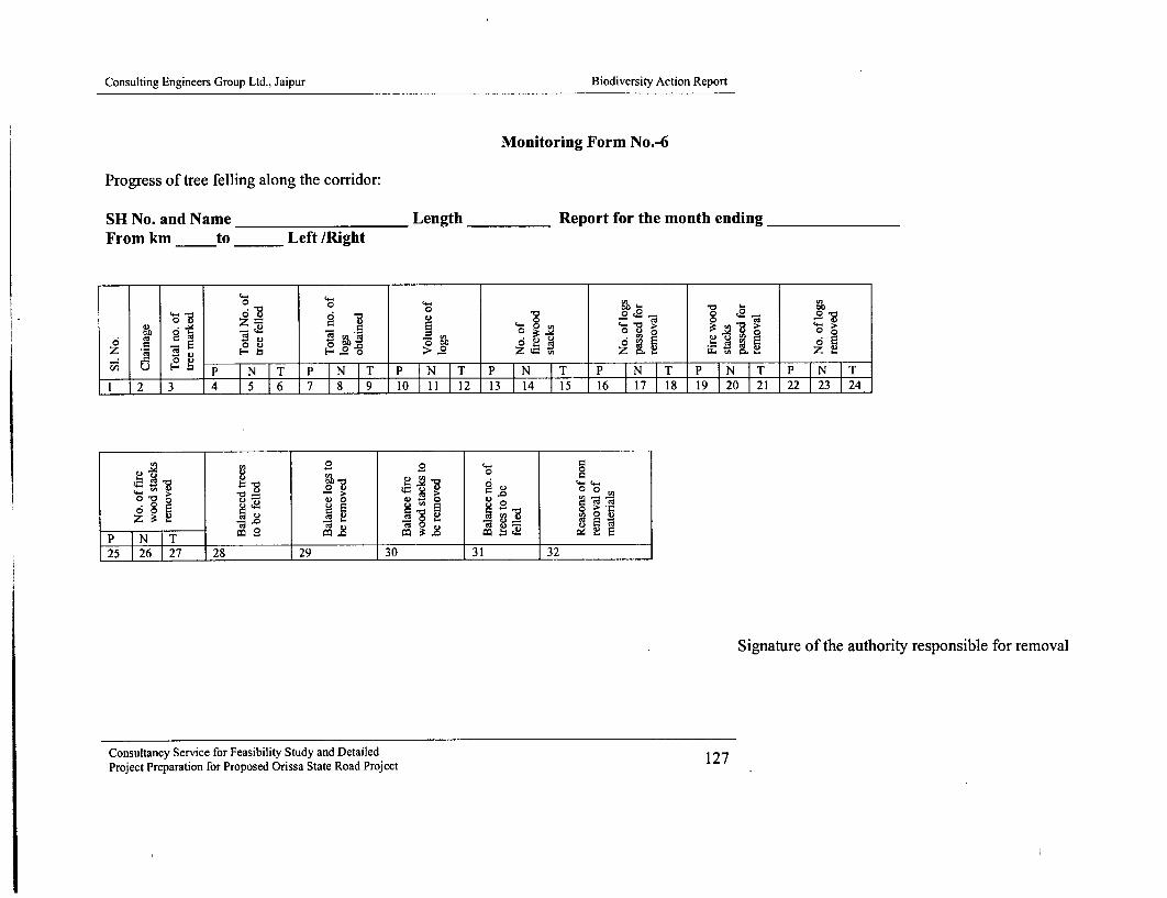
Consulting Engineers Group Ltd., Jaipur Biodiversity Action Report
Monitoring Form No.-6
Progress of tree felling along the corridor:
SH No. and Name ___________Length ______Report for the month ending________
From km -__to ____Left /Ri ght
0 U
0 I Z > 4
o 0 5 R2 .
z4 Cu F 00 0 %zCZ
12 3 4 01 2513 1 5 17 1 0212
0 >o
z ~:i .- C.-
25 26 27 28 29 _ 3_0 -f31 32
Signature of the authority responsible for removal
Consultancy Service for Feasibility Study and Detailed 127Project Preparation for Proposed Orissa State Road Project

Consulting Engineers Group Ltd., Jaipur Biodiversity Action Report
Monitoring Form No.-7
For soil and water conservation measures including check dams, spurs gully plugging andembankment plantation along in the nala and gullies.
SH No. Name Date of inspection
0. 4-
-= E - .o -° - ° yU
- - * 0 U, o.U,
-~ no-~-~ .0
c uZ~ - [ -. Z.~ 0~0 -Z
The report has to be submitted quarterly by the implementing agency to the resident engineerof PIU /Supervision consultant for inspection and recording of his observation in a registermaintained in the field for such purposes.
Signature of the authority responsible for execution/Inspecting authority
Monitoring Form No.-8
Post construction monitoring of wildlife movement
SH No. Name Date of inspection
Name of the officer recording the observationsName of the inspection officer supervising the documentation
0 40. - -U u 0E2 o v a- r- .C E
> . E . 2S 000 -. .
E co ,9 .
o ') 0 020EI.. UZ 0 0. .0 0 0) .0 50 2Z J=0 M. U, (L
* 0 co E 2 0 n Z - 0a 0 ) :E ~Z Z Z4.2
Signature of the Inspecting authority /enumerator
Consultancy Service for Feasibility Study and Detailed 128Project Preparation for Proposed Orissa State Road Project

Consulting Engineers Group Ltd., Jaipur Biodiversity Action Report
Monitoring Form No. - 9
Study of corridor development and alternate cropping to avoid elephant and other wildlifemenace near wildlife underpass locations.
SH No. Name For the qr. endingBiodiversity structure no. Location chainageOfficer monitoring the effect_Period of study Designation
0 co)
E E-0 0
Eo , ~ 0 c,- E*8 g o fz |
unior cop patern so as to repel teavneowidfeothraeauigtecopi- g
C.)~c 0 0 .x0 -0
The date and period of collection of above data has to coincide with the season of movementof specific animal and period of previous damage pattern. The improvements suggested afterminimum 3 years comprehensive study by motivating all the villagers /land owners to adoptuniform crop pattern, so as to repel the advance of wildlife to their area during the croppingseason. The crops which were more susceptible to damage are to be identified out of thealternate crops recommended for introduction as a deterrent.
Signature of the reporting officer/search scholar /study group
Consultancy Service for Feasibility Study and Detailed 129Project Preparation for Proposed Orissa State Road Project

Consulting Engineers Group Ltd., Jaipur Biodiversity Action Report
References
1. Wildlife wealth of Orissa.
2. Orissa wildlife at a glance.
3. Wildlife map of Orissa.
4. State of Indian forest report - 2003
5. Statistical handbook of Orissa - 2004.
6. Elephant habitat of Orissa - ORSAC.
7. Right of Passage - Elephant corridors.
8. Forest statistics - Orissa.
9. Similipal biosphere reserve.
10. Wild Orissa - 2004.
11. Road map of Orissa.
12. WB report on road projects of India.
13. District Gazetteers of the district.
14. WL (P) Act. - 1972.
15. Orissa forest Act. - 1972.
16. Forest (conservation) Act. - 1980 (amend with latest guidelines)
17. Environment (protection) Act. - 1986 as amended up to September 2006 with latestguidelines.
18. Reference Orissa (Millennium Edition) A.N.Tiwari.
19. Untamed Orissa by wild Orissa.
20. Notification of Similipal and South Orissa Elephant Reserve.
21. Man- Elephant conflict Similipal, Baripada. Karanjia divisions - Sar & RayChoudhary.
Consultancy Service for Feasibility Study and DetailedProject Preparation for Proposed Orissa State Road Project 130

I

Consulting Engineers Group Ltd., Jaipur Biodiversity Action Report
PHOTOS OF WILDLIFE MOVEMENT CORRIDORS ON YEAR-I PHASE-IROADS.
1.4
/ --- -
r
> - Fo
Effect of inter tidal channel and Wet land with sources ofincome for villagers at chainage 30.5 SH-9
Consultancy Service for Feasibility Study and DetailedProject Preparation for Proposed Orissa State Road Project

Consulting Engineers Group Ltd., Jaipur Biodiversity Action Report
3."
A44
' . ~ -. q.' }'\\. t Z +,,', e ' *
Flood plains and escape route at Chainage 26.4 km on SH-9
2' -
I
Flood plains and escape route at Chainage 28.8 km on SH-9
Consultancy Service for Feasibility Study and DetailedProject Preparation for Proposed Orissa State Road Project

Consulting Engineers Group Ltd., Jaipur Biodiversity Action Report
Giant Peppal tree at Dhamara - Chandbali road Junctionnear Ichhapur to be retained for Nesting Herons on SH-9
Submerged road near Ambagadia on SH-53
Consultancy Service for Feasibility Study and DetailedProject Preparation for Proposed Orissa State Road Project

Consulting Engineers Group Ltd., Jaipur Biodiversity Action Report
* - | -4
Puja Mandap within ROW at Bantho Bazar on SH-53
ff"rA -,
Giant Ficus tree in Bantho bazar within ROW after General postoffice on SH-53
Consultancy Service for Feasibility Study and DetailedProject Preparation for Proposed Orissa State Road Project

Consulting Engineers Group Ltd., Jaipur Biodiversity Action Report
Pond coming within proposed ROW in BanthoBazar near Girls school.
X
-h I
Ralol; terpyl Meiia pln aln SH5 at2g;h
Prjc rprtio o Prpoe Oiss Stt Roa PTojec''t;,,', ,-. .' ,9
/ . ' ~ .1/ . s-,' . A' I
- t - ''' f
Ralofi erahla eiialpat ln S-3a/hiae 54k
Consultancy ~ ~ ~ ~~~1/ Sevc oresbltySuyadDtie
Project ~ ~ ~ ~ ~ ~ ~ .. Prprto fo.rpsdO isaSaeRa rjc

Consulting Engineers Group Ltd., Jaipur Biodiversity Action Report
-R 9A6
Sivalingi (Diplocycles palmatus) a Medicinal creeper at Chainage 26.9 kmon SH-53
4
- .- ~ - ^--. -
.- ~ . v . t ir}
* 7.-- e:.,,-
Wet land at Jamkhunta nala turning an ideal wildlife movementzone on SH-16
Consultancy Service for Feasibility Study and DetailedProject Preparation for Proposed Orissa State Road Project

Consulting Engineers Group Ltd., Jaipur Biodiversity Action Report
1!
Herons and Large egrets feeding at Chainage 36 kmon SH-9
I ~I
Discussion with Mr. Binayam Reja and Mrs.Neha Vyas on ElephantUnderpass at Bankhedi Chainage 52.800km on SH-53 (Keonjhar District)
Consultancy Service for Feasibility Study and DetailedProject Preparation for Proposed Orissa State Road Project

Consulting Engineers Group Ltd., Jaipur Biodiversity Action Report
\A
VV
Study of Habitat and Elephant Corridor at Chainage 52.800km on SH-53 withWorld Bank Team
5- ,.,.__._,_'__'' _..__
;q.
Negotiating Giant Trees and Green Tunnels between Bhadrak to Railway overbride on SH-53 with World Bank Team at Chainage 0.1km (Satsang Vihar)
Consultancy Service for Feasibility Study and DetailedProject Preparation for Proposed Orissa State Road Project

Consulting Engineers Group Ltd., Jaipur Biodiversity Action Report
- 2r. ,L 1
S* *1 , IJ- ~ ~ , -;rt
- . - fCs
-".- - , ,
Old culvert and Elephant corridor photographed at Chainage 52.8km onSH-53 between Anandapur to Godabhanga Forest check gate. This passage is
a traditional migratory route from Hadagada sanctuary to other parts ofKeonjhar district across River Baitarani
-- - -
..- - --
-- -
-< - .y -
Elephant movement corridor in Chheratangar RF of Karanjia Forest division
Elephant movement path across SH-53 in Chheratangara RF in betweenkm24/0 and km25/0 (km24.900) Mayurbhanj district
P'roject Preparation for Proposed Orissa State Road Project

Consulting Engineers Group Ltd., Jaipur Biodiversity Action Report
Consultancy Service for Feasibility Study and DetailedProject Preparation for Proposed Orissa State Road Project

Consulting Engineers Group Ltd.. Jaipur Biodiversity Assessment & Management Plan
ANNEXURE TITLE
I List of Important Tree Species
II Medicinal Plants
III Fauna (Mammals, Reptiles, Aviary & Amphibians)
IV The Protected Areas
V Map of South Orissa Elephant Reserve
VI Map of Mahanadi Elephant Reserve
VIl Map of Bhitarkanika Wildlife Sanctuary & National Park
Vill Map of Satkosia & Baisipalli Sanctuary
IX Map of Mayurbhanj Elephant Reserve
X Map of Similipal Biosphere Reserve, National Park & Wildlife Sanctuary
Xi Network of Phase-I Roads
XII Cost Norm for Plantation in Eroded Areas
XIII Corridors as per Threat Perception
XIV Corridors SH - 53 & 49
XV Corridor SH - 9 (A)
XVI Corridor SH - 9
XVII Coridor Bhadrak - Anandpur SH - 53 Part
XVIII Corridor SH - 16
XIX Corridor SH -7
XX Corridors SH - 17
XXI Corridors SH- 17 & 4
XXII Corridor SH - 5
XXIII Corridor SH - 6
XXIV Corridors SH 65 (A) - 64 (B)
XXV Engineering Intervention Measures on Year-I Corridors with list of Abbreviations.
XXV (A) SH -9
XXV (B) SH - 53 - Part
XXV (C) SH- 17 - Part
XXV (D) SH- 16
XXVI Design Specifications of Wildlife Underpass:
XXVI (A) Design Box Culverts with Earth Cushion - (Single & Double)
XXVI (B) Box Culverts without Earth Cushion - (Single & Double)
XXVI (C) Pipe Culverts - (Single & Double)
XXVI (D) Trap Drains
XXVI (E) Via Duct
XXVI (F) Barricade
Consultancy Service for Feasibility Study and DetailedProject Preparation for Proposed Orissa State Road Project

Consulting Engineers Group Ltd.. Jaipur Biodiversitv Assessment & Management Plan
XXVI (G) Road Signage & Marking
XXVII Road Signages Suggested
XXVIII Designs for soil and water conservation measures
XXIX Planting in Eroded area and hill slopes
XXX Plantation technique along avenue / approaches to wildlife underpass
XXXI Surplus land plantation
XXXII Specific list of rare and endangered flora and fauna in different corridors
XXXIII Biodiversity Survey Questionnaire
XXXIV Flow Chart
XXXV Giant trees likely to be sacrificed along the year-I roads
XXXVI Plantation Design and Norms
XXXVII Toe wall at Water bodies and Pond
XXXVIII Tree guard
Consultancy Service for Feasibility Study and DetailedProject Preparation for Proposed Orissa State Road Project

Consulting Engineers Group Ltd.. Jaipur Biodiversity Assessment & Manazement Plan
ANNEXURE-I
LIST OF IMPORTANT TREE SPECIES
Local Name Scientific NameSal - Shorea robustaBiza Sal- Pterocarpus marsupiumAsan- Tenninalia tomentossaMundi or Haldu or Kurum- Adina cordifliaSisam- Sisu - Rose Wood- Dalbergia latifoliaSisso- Bali Sisu- Dalbergia sisooDhaura- Anogeisus latifoliaPhasi- Anogeisus acuminataHinjala- Barringtonnia acutangulaMahul- Madhuca indicaJamun- Syzigium cuminiiBela - Aegle marmelusAionla / Amla- Emblica officinalisAr.una- Terminalia arjunaMango- Mangifera indicaChandan- Santalum albumUdumbar- Ficus glumerataBara- Ficus bengalensisAswath- Ficus religiosaTamarind / Tentuli - Tamarindus indicaKangada- Xylia xylocarpaMoi- Lannea coromandalicaGiringa- Pterospermum canescensSaguan- Tectona grandisNeem- Azadirachta indicaRohini- SoymidafabrifugaJhau- Casuarina equisatifoliaKasi- Bridelia retusaChadheigodi - Vitex peduncularisBahada- Terminalia bellericaHarida - Terminalia chebulaTala - BorassusflabeliferKarada - Cleistanthus collinusBarakoli - Zizyphus oenopleaBhumi barkoli - Zizyphus mauritianaMahala - Ailanthus excelssaPatuli - Stereospermum swaveolenseAchhu - Morinda tinctoriaChhatian - Alstonia scholarisKainalagundi - Malotus philippinensisFanfana - Oroxylon indicumLodha - Symplocas racemosaMedha - Listea pollyantha
Consultancy Service for Feasibility Study and DetailedProject Preparation for Proposed Orissa State Road Project

Consulting Engineers Group Ltd., Jaipur Biodiversity Assessment & Management Plan
ANNEXURE-II
MEDICINAL PLANTS
Local Name Scientific / Botanical Name1. Puruni (Ghodapuruni) Boerhovia diffusa2. Apamarga Achyranthes aspera3. Bhui neem Andrographis paniculata4. Ayyapan Aristolochea indica5. Tihudi Operculina turpethum6. Muturi Smilax macrophylla7. Sugandhi Hemidesmus indicus8. Arka Calatropis gigantia9. Pippali / Banapipali Piper longum10. Gunja / Kaincha Abrus precatorius11. Chain katha Piper triocum12. Chitaparu (Rakta chitapru) Plumbago rosea (Red Flower)13. (Sweta) Chitaparu P.zeylanica (Whiteflower)14. Pasaruni Pederiafoetida15. Mersunga Muraya koengii16. Banatulasi Ocimum gratissimum17. Kateri/Chakadabheji Solanum xanthocarpum18. Bala Sida cordifolia19. Dengabheji Soalanum torvum20. Bahada Terminalia belerica21. Harida Terminalia chebula22. Arjun Terminalia arjuna23. Kamalagundi Malotus philippinensis24. Fanafana Oroxylon indicum25. Bidanga Embelia ribes26. Baibidanga Embelia tsjeriam27. Guduchi Tinospora cordifolia28. Salaparni Desmodium ganjeticum29. Bankulthi Tephrosia purpuria30. Talamuli Curculigo orchoides31. Arrow root Curcuma aungostifolia32. Kachura or Sati Curcuma zedoria33. Karpura haldi Curcuma aromatica34. Daskerenta Barleria cristata35. Dahidahika Cocculus hirsutus36. Sunari Cassiafistula37. Satabari Asparagus racemosus38. Baidanka Muccuna Pruriens39. Ashoka Saraca asoca40. Bridhadaraka Argyreia nervosa41. Chhatian Alstonea scholaris42. Gokshura (Bada) Pedalium murex43. Sangokshura Tribulus terrestris44. Gangasiuli Nyctanthes arbortristis
Harsingar -
45. Patalgaruda Rauvolfia serpentina46. Dhataki Woodforidafruticosa47. Pitakeruan Wrightia tinctoria48. Keruan Holarhena antidysenterica49. Baruna Creteva religiosa IC. nurvula
Consultancy Service for Feasibility Study and DetailedProject Preparation for Proposed Orissa State Road Project

Consulting Engineers Group Ltd.. Jaipur Biodiversity Assessment & Management Plan
Local Name Scientific / Botanical Name50. Puruni/Atikapudi Trianthema portulacastrum
51. Karanja Derris indica /Pongamea pinnata
52. Bana Govi Elephanatapus scabber
53. Bel Aegle marmelus
54. Narguni Atlantia manophylla
55. Nagarmatha Cyperus rotundus
56. Kochila Strychnus nuxvomica
57. Krushnaparni Uraria picta
58. Sankaijata 'Urenia lagopoides
59. Bana Piaz Urgenia indica
60. Mendi or Anantamula Tylophora indica61. Keu Costus speciosus
63. Gaigobra / Langalangalia Gloriosa superba
64. Sankhapuspi Clitorea ternatia
65. Gugul Comiphera caudata
66. Bacha Achorous calamus
67. Bhuini amla Phyllanthusfraternus
68. Atibala Abutilon indicum
69. Bala Sida cordifolia
70. Chiller Caesalpinea sappan
71. Gillo Caesalpinea cristata
72. Bajradanti Barbaria crista
73. Bakuchi Psoralia corrylifolia
74. Sweta sorisha Cleome gynandra
75. Sweta tila Digitalis purpurea
76. Gohira Acacia leucophloea
77. Babul Acacia nilotica
78. Pasanabhedi (Paunsa paunsia) Erva lanata
79. Keshdura or Bhringaraj Eclipta prostrata /E.erecta
80. Keshranjani Wadellia chinensis
81. Bana alu Dioscorea digitalis
82. Mundi Speranthus indicus
83. Pokasunga Baliospernum montanum
84. Pasanabhedi Colliusfrescohli
85. Bidarikand Pruraria tuberosa
86. Gudmari Gymnema silvestre
87. Bada Pokasunga Cineraria versicolour / Cineraria maritime
88. Indramarisha Acalypha indica
89. Indrayan Citrallus colocynthis
90. Uturudi Pergularia damea
Consultancy Service for Feasibility Study and DetailedProject Preparation for Proposed Orssa State Road Project

Consulting Engineers Group Ltd., Jaipur Biodiversity Assessment & Management Plan
Local Name Scientific / Botanical Name
91. Sivalingi Diplocyclos palmatus
92. Asadhua Caparis horrida
93. Guduchi Tinospora cordifolia
94. Baigoba Jatropha curcas
95. Nalibaigoba Jatropha gossypifolia
96. Gandhana Premna tomentosa
97. Modafal Helectris isora
98. Tundapoda Todalia asiatica
99. Sunsunia Oxalis Corniculata
100. Pita saga Malugopentahyla
101. Lahanga Cellosia arjenta
102. Monsa rohini Soymidafebrifuga
103. Basanga Justacia adhatoda lAdhatoda vasica
104. Bramhi Bacopa monieri
105. Thalkudi Centella asiatica
106. Kani khanda Ipomea haderacia /Ipomea nil
Consultancy Service for Feasibility Study and DetailedProject Preparation for Proposed Orssa State Road Project

Consulting Engineers Group Ltd.. Jaipur Biodiversity Assessment & Management Plan
ANNEXURE-III
FAUNA - MAMMALS, REPTILES, AVIARY & AMPHIBIANS
List of animals with their scientific names:
1. Mammalia:Common Name Scientific Name
1. Wolf Canis lepus2. Wild Dog Cuon alpinus3. Sloth Bear Melurses ursinus4. Rattle (small Bear) Mellivora capensis5. Wild Boar Sus crfa auristatus6. Elephant Elephus mximus indicus7. Gaur Bos gaurus8. Sambar deer Cervus unicolor
9. Spotted Dear Axis axis10. Mouse Deer Tragulus meminna11. Chausinga Tetracerus quadriconis12. Barking Buck Deer Muntiacus munt jack13. Monkey Rheses macague IMacaca mulata14. Hanuman Presbytis entellus15. Porcupine Hystrix indica16. Pangoline Manis crassicaudata
17. Mongoose Herpestes edwardsii
18. Small mongoose Herpestersjavanicus19. Giant squirrel Ratufa indica
20. Flying squirrel Petaurista magnificuls21. Bat Cynopterus sphinum22. Jungle cat Fellis chans affinis23. Jackle Canis aureus24. Hyaena Hyaena hyaena
25. Small squirrel Funambuluspenanti
26. Tody cat Paradoxurus hermaphroditius27. Fox Vulpes bengalensis
28. Nilgai Boselaphus tragocamelus29. Otter Lutra perspicillata30. Civet Viverricula indica31. Hare Lepus nigricollis32. Rat(Wild) Ratus ratus
33. Leopard Panthera pardus*34. Tiger Panthera tigris*
* Rarely occurring
II Amphibia
I Toad Bufo melanostictus
2 Bull frog Rana tigrina
Consultancy Service for Feasibility Study and DetailedProject Preparation for Proposed Orissa State Road Project

Consulting Engineers Group Ltd.. Jaipur Biodiversity Assessment & Management Plan
Common Name Scientific Name
III Reptilia
1. Chameleon Chameleon calcuratus2. Calotis Calotis vercicolar3. Mabuya Mabuya bibro4. Lizard Hemidactylusflaviviridis5. Varanus Varanus salvator6. Cobra Naja naja naja7. Keutia (Naga) Naja naja Kaouthia8. Krait Bungarus caeruleus9. Green snake Dryophis nasutus10. Rat snake Ptyas mucosus11. Water snake Natrix piscator12. Blind snake Typhlops brahminus13. Sand Boa Eryx stolata14. Indian python Python molurus15. Saw scaled viper Echis carinatus16. Russell's viper Vipera russelli russelliIV Aves1. Snake bird Anhinga rufa2. Pond Heron Ardela i3. Pea fowl Pavo cristatus4. Brown dove Streptopilia senegalensis5. Parakeet Psittacual eupatria6. Crow pheasant Centopus sinensis7. King fisher Alcedo atthis8. Wood pecker Dinopium bengalense
9. Myna Acridotheres tristis10. Bulbul Pycnonotus cafer11. Sparrow Passer domesticus12. Crow Carvus spelendens13. Grey Harnbill Tockus birostris14. Pied hornbill Anthracocerous coronatus15. White belliled drongo Discrurus caerulescens16. Sun bird Nectarinia asiatica17. Little egret Egretta garzetta18. Median egret Mesophoryx intermedia19. Cattle egret Bubulcus ibis20. Large egret Casmerodius albus21. Corrnorants Phbalacroco raxniger22. Indian roller or Blue Jay Coracias bengalensis
Consultancy Service for Feasibility Study and DetailedProject Preparation for Proposed Orssa State Road Project

Consulting Engineers Group Ltd.. Jaipur -Biodiversity Assessment & Management Plan
ANNEXURE-IV
THE PROTECTED AREAS
. . Index map ot* PT W- n A If ^ Wlidlde Sanctuaries &
National parks
SIJN"DEROAftH ; y +30 0 3C O0Km
RARSUOTA ..
- KEONJHAR 2 Bz%*imsrEy&NtIX
CHHAYTrI*HOA H D.EOGARH , ^ALAIORE 3wtM mm
R GARH .$AVIIALPIO t ; ,, t Kshcm
A , ..NPUNR- AHGUL -GDuK SapS
OLAHIR G - HENKANAL JAJPU
?UAPLA PHULBANI UYAGAR ' "HPUR'
t- > . KALAHLAIANDIt - P U I11 t S
AWARAkGPUR., ( - GANJAM IpJ 01 G tlB KimRAYAGADA it ,. 1i kW
eGAJAPA TI ° - is KdkSW
KORAPUT S18K*dUy .
UoAIKANGIRC ANDHUA PRADUIN
82 83 84- 85' 86. 87'
Consultancy Service for Feasibility Study and DetailedProject Preparation for Proposed Orissa State Road Project

Consulting Engineers Group Ltd., Jaipur Biodiversity Assessment & Management Plan
ANNEXURE- V
MAP OF SOUTH ORISSA ELEPHANT RESERVE
83'0Y 83'30 84"00.
BhaN Rsr **-,.'" ':
O , 7 n ;*: GHLBlAJAPAT '
A: . s- 'tr 0%N- t
800 8 pp8apana0
KALAHANDJ - Soutb --- k i ,, --Een Rv BElephant Rbserve .
pihc onatry
e Do oa 1 0 1Bamuniangar RF
c..-RAYAGARH q*~..5.
< . , GAJAPATI 5
Proeo Prosd ss Statorad P purr
83'00' 33-30, 84- o °
Reference I-
* Important locationh'
0 Wildite Division Headquaitel < -, .
Hephant Reserve boundary J,
... .Disticst Boundary 1 >r
- Whiklile Division Boundary 10 ° 10 201<rn i
Consultancy Service for Feasibility Study and DetailedProject Preparation for Proposed Orissa State Road Project

Consulting Engineers Group Ltd.. Jaipur Biodiversitv Assessment & Management Plan
ANNEXURE-VI
MAP OF MAHANADI ELEPHANT RESERVE
84'30' 8 08
. I r Loc.-. . hion,,,
o ' ~ C da -s,DHENKANAL ,
- EBOUDH neserve Boundary
- -}1NAY AGAR Hai ,,, ):
IHnwnda RF-t-ound<> ,- \ R~~~da RF :.hw / i'
84'30_ 85s0o 85,30'
Rteference 4* Important LocationN
* VAIdife Division Headquater W
- BEephant Rteserve Boundary s
-- - -- Dishiict boundary
- Wildlife Division Boundary 10 0 10 20Grn
Sanctuary
Consultancy Service for Feasibility Study and DetailedProject Preparation for Proposed Orissa State Road Project

Consulting Engineers Gr6up Ltd.. Jaipur Biodiversity Assessment & Management Plan
ANNEXURE- VII
MAP OF BHITARKANIKA WILDLIFE SANCTUARYAND NATIONAL PARK
- 40- 97'00 7
-^- h3ndb-ili - DhalC ra
-- 2ci)
K ) B ~ f~I... -w ',''.*" ".'
ei - .-; ,c'/. . .;i
- - GAIIRTHA*; @ ~MAINE; ,wSeANSCTUAl
,: ~~ - ,JI , ir
(N 'f/ t . .Kajalpata *,-1
.- -- ,
-8s50 87- 87-10t
Reference
* imnportant LOCtbOn;
* uWildlit* Division Heodquartel 9 -
-- - District lotundaoy es.i-
wildi*e Division goundars k J
- ahonal rork .
Wncttary .
Consultancy Service for Feasibility Study and DetailedProject Preparation for Proposed Orissa State Road Project

Consulting Engineers Group Ltd.. Jaipur Biodiversity Assessment & Management Plan
ANNEXURE- VIII
MAP OF SATKOSIA & BAISIPALLI SANCTUARY
84-40' 84'0 85,00'
\W,, -5, S / \ f XTo Anugul
m C | ; ,,In kan fl rr
~ NJ
CD
_ 77 Narasiwnqhpur
94-40 84-5fJ 86500
Reference rr".9>-~ -- -
* impodant LocOlIflnr A
* wudidb oiv ision Headquarter 4Br-^: *'
- - - D9l0Ct Woun dary
wildlife Division oeandar tr 5 0 f Kmir
sanctuorv
Consultancy Service for Feasibility Study and DetailedProject Preparation for Proposed Orssa State Road Project

Consulting Engineers Group Ltd., Jaipur Biodiversity Assessment & Management Plan
ANNEXURE-IX
MAP OF MAYURBHANJ ELEPHANT RESERVE
I'..
1/*--
Reference* bImportant Location
<3 Wildlife Division Headquader
- lephant Reserve boundary --
District Boundary
WilAlNe Division Boundary -
Nalonal Pauk 10 0 10 20<m.|
Sanctuary
Consultancy Service for Feasibility Study and DetailedProject Preparation for Proposed Orissa State Road Project

Consulting Engineers Group Ltd.. Jaipur Biodiversity Assessment & Management Plan
ANNEXURE-X
MAP OF SIMILIPAL BIOSPHERE RESERVE
81086 2C se Jr
/TO Barpada
L-L
166
Reference* mportont Location
W*dWe Diviion Hceadquore -Ff,.. ... , ..... -
- lsbct Ooundary
Wlldw* Division lSoudr
-Nadonal Park-
San~~~chaf..r.'
Consultancy Service for Feasibility Study and DetailedProject Preparation for Proposed Orissa State Road Project

Consulting Engineers Group Ltd.. Jaipur Biodiversity Assessment & Management Plan
ANNEXURE-XI
OSR RFAD NETVYO
NETWORK OF PHASE-I ROADS
Consultancy Service for Feasibility Study and DetailedProject Preparation for Proposed Orssa State Road Project

Consulting Engineers Group Ltd.. Jaipur Biodiversity Assessment & Management Plan
ANNEXURE-XII
COST NORM FOR PLANTING IN ERODED AREAS
Mandays Rates Cost Per HectareNo. Items No. of R Labour Material Totallabour only Cost etc.
I Survey, Demarcation and pillar 2 70 140.00 R.C.C. posts 1040.00posting at 5.5mtr interval 10cm Xapproximately 10posts/ha 10cm X
180cm@90/-900.00
2. Preparation of contour marks and 6 70 420.00 420.00pegging with water level usingtransparent PVC pipe filled withwater - 50mtr long (contour interval0.5mtrs - Pipe dia 10mm)
3. Stacking along the countour line 2 70 140.00 140.004. Digging of pits 30cm cube at 2mtr 50 70 3500.00 3500.00
interval on the contour line,supplemented with intermediatetrench bonding 200mm high alongthe contour during early rains fordibbling sowing of grass,Periwinkle, Cassia tora, Tephrosiapurpurea, Cassia occidentalis,Chiller, Acacia nilotica, Cassiafistula, Alstonea scholaris, Jatrophagossypifolia chistanthes collinus,Nictanthes arbortristis, Bhuineemseeds on the Trench bunds (2500pits/ha)
5. Nursery cost for 18month old (Part) 4200.00 4200.00seedlings of (Part) Khair, Soyimidafabrifuga, Madhuca latifolia, Sal,Terminalia arjuna, Azadirachtaindica, Alangium lemarkii,Cleistanthes collinus, Zizyphuzzozoba, Z.rugosa, Z.muritiana,Z.oenoplea, Shorea robusta,Buchnania Lanjan, Albizia lebec,Nictanthes, Aegle marmelus,Feronea limonea, Ficus glumerata,Ficus hispida, F.bengalensis,F.religiosa, Bamboo, Chiller(Caesalpinea sappan), Embelia ribes,Pungumea pinnata, Dalbergia sisoo,Malotus phillipinensis, Acacianilotica, A.leocophlea, Alstoneascholaris, Schleichera oleosa, Aeglemarmelus
6. Over head charges 191.00 191.00Total 60 4200.00 5291.00 9491.00
Consultancy Service for Feasibility Study and DetailedProject Preparation for Proposed Orissa State Road Project

Consulting Engineers Group Ltd.. Jaipur Biodiversity Assessment & Management Plan
B/F 60 4200.00 5291.00 9491.007. Cost of pipe, stacks, seeds, for 500.00 500.00
dibbling sowing on the countourlines.
0th Year cost Total 60 4200.00 5791.00 9991.00I" Year Operation
8. Nursery cost (18 months seedlings) 3892.00 3892.00balance
9. Carriage and Planting 30 70 2100.00 1980.00 4080.0010. Birth watering insecticide, fertilizer 5 70 350.00 350.00
application before planting.11. Bucket weeding near planted 5 70 350.00 350.00
seedlings only and no weeding elsewhere other than removal of climberon natural vegetation, planting ofgrass slips in crow bar holesintermittently between 2 rows ofplants at places of scouring and openpatches (Grass slips of Eulaliopsis,Sacahrum, Palmarosa,Cymbopogon, Citronella, Elephanta,Vetiver along the contour only(across the slope)
12. Manu ring - only a decoction of 5 70 350.00 500.00 850.00Cow dung manure, Neem oil seedcake, urea and Potash, Super mixedin the ratio of 20kg + 20kg + 2kg +5kg + 5kg mixed with 2000 liters ofwater fermented over a week andthen carried in pots to irrigate theplants after soil working aroundeach plant. No other fertilizer orpasticide is itecessary.Andrographis (Bhuneem) plants willbe fermented in the vat with abovesubstances /Bhuineem 10kg per vatof 2000 litres). This will keep downfugues and white ant damage whileproviding organic and inorganicnutrient to the plants.
13. Soil working to improve the cup 10 70 700.00 700.00saucer type water harvesting aroundeach plant on the slopes anddegraded patches and providingmulching with loose clods No. 2nd
weeding is necessary in eroded areaswhat ever growth comes that is abooster for soil conservation efforts.
Total 115 8050.00 12163.00 20213.00
Consultancy Service for Feasibility Study and DetailedProject Preparation for Proposed Orissa State Road Project

Consulting Engineers Group Ltd., Jaipur Biodiversity Assessment & Management Plan
B/F 115 8050.00 12163.00 20213.0014. Gully plugging with empty cement begs 7 70 490.00 450.00 940.00
i filled with soil and used as check dammingslabs or brushwood check dams with twigsand brunches of Justaca adhatoda, Durantaplumcrai, Vitex negundo, Dodonea,Jatraphacurcas, Grauga, Cypedesa, Woodfordia, bamboo rhizomes on erodedpatches, brush wood and split bamboogabions, random stone check dams onlyCost of cement bags (empty), bamboos,brush wood collective carriage and stock
I pilling in appropriate locations.15. Cost of cemented vat of 5X5Xlmtr. lined 2000.00 2000.00
with stone or bricks, (which is easilyavailable in the locality) and can serve as asource of water (for wild life latter on)plastered and punning done to preservewater to be used in fermenting cow dungand Neem seed cake with Bhuineem.(Structure will be only 30cm aboveground). The bottom will be randombroken brick khoa and stone rammedtogether or epidomite material with cementand sand 1:4:6 and the side walls inrandom stone or brick in cm 1:4:6 withplaster & punning.
16. Watch and ward. 65 70 4550.00 4550.0015t Year Cost Total 187 13090.00 14613.00 27703.00
i __ 2' Year Operation _17. Soil conservation measures like repair to 3 70 210.00 290.00 500.00
damaged dams, spurs, gabions l18. Material cost like empty gunny bags, 450.00 450.00
collection of sand morrum, soil for filling,bamboo, brush wood and fixing in positionafter stock piling (cost up to stock piling)
Total 190 13300.00 15353.00 28653.00
Consultancy Service for Feasibility Study and DetailedProject Preparation for Proposed Orissa State Road Project

Consulting Engineers Group Ltd.. Jaipur Biodiversity Assessment & Management Plan
B/F 190 13300.00 15353.00 28653.0019. Casualty replacement all casualty 12 70 840.00 840.00
replacement shall be with mahula &Kusum plants only or with Tamarind andBahada, Amla and Harida Plants forshrubs and bushes only bamboo andAdhatoda, Jatropha only.
20 Bucket weeding around each plant in pits 6 70 420.00 420.00and singling out of all prominent treespecies that have germinated and survivedby providing earthen saucer around ondown hill side for moisture retaliation andthus creating a pit on up hill side near theplant for arresting water flow.
21 Manuring as per Is" year operation 7 70 490.00 700.00 1190.00including all established seedling andgrasses, branch cutting etc.
22 Sowing of seeds collected from last years 7 490.00 490.00planting and mulching with earthen clodscollected form staggered trenches dug upat places to allow collection andpercolation of water (after early rains)trench size lmtrX30cmX30cm
23 Watch and ward 15 70 1050.00 1050.00
2 Id Year cost Total 237 16590.00 16053.00 32643.003rd year operation
24 Soil conservation repair of spurs check 4 70 280.00 280.00dams and brushwood gabions
25. Application of fertilizer on all plant with 7 70 490.00 490.00weeding around the tree species only.
Total 248 17360.00 16053.00 33413.00
Consultancy Service for Feasibility Study and DetailedProject Preparation for Proposed Orissa State Road Project

Consulting Engineers Group Ltd.. Jaipur Biodiversity Assessment & Management Plan
B/F 248 17360.00 16053.00 33413.0026. Cost of fertilizer 1000.00 1000.00
(Same methodology except the quantity isireased to cow dung 50kg, Neem sad oilcacke-30kg, urea-5kg, Bhuineem-40kg,Potash- 1Okg phosphate 1Okg, mixed in twodoses and fermented in 4000 liters of waterand applied on the plants, grasses shrubsand bushes like watering. This has to bedone after the materials for over a week.Before application there should bemoisture on the soil so that plants utilizethe petrified mixture, which repels insectsand browsing animals have fullyfermented in the vat. Additional water canbe added to be added to the petrifiedmixture for dilution till the entire mixtureis exhausted from the vat.
27. Sowing of the seeds of Bhuineem grasses 5 70 350.00 350.00and shrubs, zizy phus, Ficus in ploughedup beds irrigated with fermented water atblanks to cover up the eroded land duringearly monsoon.
28. Watch and ward 15 70 1050.00 1050.00Total 268 18760 17053 35813
Consultancy Service for Feasibility Study and DetailedProject Preparation for Proposed Orssa State Road Project

Consulting Engineers Group Ltd., Jaipur Biodiversity Assessment & Management Plan
ANNEXURE-XIII
Corridors as per Threat Perception (Environment Impact)
OSRP ROAD NETWORK
l g t*-; -LEGENDS
YEAR -I ROAD WITHOUT PROTECTED AREA / INTER STATE BOUNDARY / POLLUTION HOT SPOTI HERITAGE SITE AND MONUMENT ETC,
YEAR - 1 ROAD WITHIN 10Km IMPACT ZONE OF PROTECTED AREAS / INTERSTATE BOUNDARYHOT SPOT/HERITAGE SITE AND MONUMENT ETC
Consultancy Service for Feasibility Study and DetailedProject Preparation for Proposed Orissa State Road Project

ting Engineers Group Ltd.. Jaipur Biodiversity Asse & Management Plan
ANNEXURE-XV(Jagatpur-Chandbali SH-9 (A)
t A 8I N A RP P U, ,-
R f*.pI -- - R,' A K
A N I Ff Z, fy v, ., *,<
-- (4- -5. .r EriA U nt*J
AA
; / ; :*DR /s'^ <i<'A; '.r
: FiL. . . - * - . MARAKALAP4
,-, C ., E, I f- D;l A
. -j M AR S1 A 1H AKA P .-.
K,AN TA PA ____P Ir
-L I
PROJECT:- PROJECT ROAD LOCATION MAPc 0 N S U L T I N 0i CONSULTANCY SERVICES FOR FEASIBILITY STUDY AND JAGATPUR-KENDRAPADA-CNANDBALI (SH-)E ENGINEERS GROUP LTD. DETAILED PROJECT PREPARATION OF PHASE - (I) ROADS -G Tw: +91-141-2520899.252i899.2520556 FOR ORISSA STATE ROAD PROJECT UNDER WORLD BANK I RES kRFax: 2521348. er-solf: [email protected], AS
rTA C-fHfJ RR ~ S
Consultancy Service for Feasibility Study and DetailedProject Preparation for Proposed Orissa State Road Project
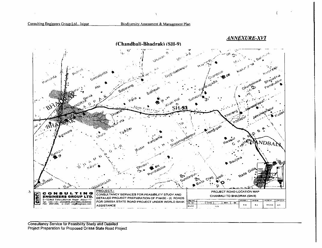
Consulting Engineers Group Ltd.. Jaipur Biodiversity Assessment & Management Plan
ANNEXURE-XVI(Chandbali-Bhadrak) (SH-9)
. n 5238 -rol egcgnlecr SSSAC - - St. - . -- RJ R.K|S
Cos c SProec P n oar
j p-a . ~
k // 0
7'C
C 0D N1 a U L- Tr N 0 CONSULTANCY SERVICES FOR FEASIBILITY STUDY AND CABL OBARK(H9
Consultancy Service for Feasibility Study and DetailedProject Preparation for Proposed Orissa State Road Project

Iting Engineers Group Ltd., Jaipur Biodiversity Assc & Management Plan
ANNEXURE-XVII(Bhadrak-AnandDur) (SH-53)
v . .
At ,' *':S " |,eM'r~
V 01\,
V.-~
PROJECT:- -PROJECT ROAD LOCATION MAPC 0 N S U L. -vIN CONSULTANCY SERVICES FOR FEASIBILITY' STUDY AND BHADRAK TO ANADPUR (SH-53)
Tel +9-4-2281 2528. 5ziSz20556 FOR ORISSA STATE ROAD PROJECT UNDER WRLD ABHDTOANADUK -Fo:2238 -n:cgcgni.onASSISTANCE -SCAI F. | DSH . RJ R Fi
Consultancy Service for Feasibility Study and DetailedProject Preparation for Proposed Orissa State Road Project

Consulting Engineers Group Ltd.. Jaipur Biodiversity Assessment & Management Plan
ANNEXURE-XVII(i)(Bhawaninatna-Khariar) (SH-16)
4 ',
4 4,
,V O' 1 -. . V-
iew_ - PROJECT:- P R
I_____ 25148 _-mi___coidicr ASSISTANCE .SCALE N1S B - RlSS
Consultancy Service for Feasibility Study and DetailedProject Preparation for Proposed Orissa State Road Project

JoIting Engineers Group Ltd., Jaipur Biodiversity Ass- & Management Plan
ANNEXURE-XVlll(ii)(Bhawaninatna-Khariar) (SH-16)
-/ ! ., v' t / i< -t
7 41~
/ . j,j , ./'rs ; -~ r .
a. * . . - s.i.> =
4'1
A'2
f. ~' ' i-: ->;!.,J
J , .' - .
/ i <. -S.. . I.
..;
P E Thi.T .- ,22182 O RS- E RD P T UR R AK t R L O
-'. 00 Su- IL ir . Wm %a CONSULTANC,''; Y SERIE FO FESBLT STD AND BHWNIAN TO KHIRA ?SH*1
* Ni' s-ES, GRU LTD. DEAIE PRJC PRPRTO OF PHS -} () '' RO'AD-'S .
FOD, 2521348. e-n0oll cegOceqirdlo c- , Rti FtR 1)I SO
ASSISTANCE ,' '- . NSi
-- o./ __ .- . _ -- , , * _ _ _ - s - , -- ,, I _ __ _ - _ _ J _
Consultancy Service for Feasibility Study and DetailedProject Preparation for Proposed Orissa State Road Project

Consulting Engineers Group Ltd.. Jaipur Biodiversity Assessment & Management Plan
ANNEXURE-XIX(Bhanjanagar-Aska) (SH-7)
m
< @ . . * ,a,, ; ; -, *'
* 40
* 03
o C ' * )-'
C C
\S -S v**5 > Str* ;~4V
----- e. \ z0-. -- , s.s,; S
,-, .- S
Pd 9 -4 -5 0 9 ,5 1 9 .5 5 FROJEC A T AT ROA PROJECT ROAER LOCATIO MAP -
= Fosr: 2521348. e-mol [email protected] ASSISTANCE -- ................................................ -X-JtI - RRK 1.#
Consultancy Service for Feasibility Study and DetailedProject Preparation for Proposed Orissa State Road Project

Iting Engineers Group Ltd., JaiDur Biodiversity Ass. & Management Plan
ANNEXURE-XX(i)(Berhampur-Tapatapani) (SH-17)
44
4 . .\
9-+ -& PJ
!F -, C *. :
t~ ~~~~~~~\ , * A ;'i 1/X
PAN) A0.
w~~~~~-
.' .;t ' .,--*J
-f-t 9 a>
PROJECT.- PROJECT ROAD LOCATION MAPc 4S LO IL Tr I N4 0 CONSULTANCY SERVICES FOR FEASIBILITY STUDY ANDBEHMUTOAPPNIGT S17ENGINEERS GROUP LTD. DETAILED PROJECT PREPARATON OF PHASE - () ROADS BERHAMPUR TO TAPTAPANI GHAT (SH-17)
E E-12.Xto) Calcny.M.Aya Nclqr Jetpu-17..-Tel +91-141-25.2O899.252 899.252O556 FOR ORISSA STATE ROAD PROJECT UNDER WORLO BANK TR
Consultancy Service for Feasibility Study and DetailedProject Preparation for Proposed Orissa State Road Project

Consulting Engineers Group Ltd., Jaipur Biodiversity Assessment & Management Plan
ANNEXURE-XX (ii)(Taptapani - Bangi Junction)) (SH-17)
*CS V - D \l;sF #- f-; .ar'i1
-It
co
- iLTINaPROJECT:- PROJECT ROAD LOCATION MAPC ENIER GROU LT TID. CONSULTANC-Y SERVICES FOR FEASIBiLITY STUDY AND TAPTAPANI GHAT TO BANGi JUNCTION (SH-17)
EGNE R GROUPMo LTD.dwy rJ0 Ipr1 DETAILED PROJECT PREPARATION OF PHASE - (I) ROADS-GTel: g1491-25820So89W9,25.291o9.N25d20556m FOR ORISSA STATE ROAD PROJECT UNDER WORLD BANK oi A ] R1K3
Consultancy Service for Feasibility Study and DetailedProject Preparation for Proposed Orissa State Road Project

ting Engineers Group Ltd., Jaipur Biodiversity Asse & Management Plan
ANNEXURE-XXI(Bangi Junction- J.K. Pur) (SH-17)
0 It , . I , , -
.,, ' " ;t ' '-- '" - ;a I ° , '' ' , ,'" * '
8 ~ ~~~ - * t\ *\;g.!;
Us'310t' iy\5\|) , o
y-* r4 - .W
CON2ULT NGPROJECT:- PROJECT ROAD LOCATION MAPC 0 EONER G ROU Pi LT CONSULTANCY SERVICES FOR FEASIBILITY STUDY AND BANGI JUNCTION TO J K PUR (SH-4)ENGINEERS GROryUPly Na JLTD.- DETAILED PROJECT PREPARATION OF PHASE - (I) ROADS. i -.. ,r.,.......
ATd +I1-141-2520899.25299,2520556 FORORISSASTATEROADPROJECTUNDERWORLDBANK
Consultancy Service for Feasibility Study and DetailedProject Preparation for Proposed Orissa State Road Project

Consulting Engineers GrouR Ltd.. Jaipur Biodiversity Assessment & Management Plan
ANNEXURE-XXII(Muniguda-JK Pur) (SH-5)
c -- ,
,~. '- * ,,t: I $ t .
Yr I' ' '
PRZ P
Consultancy Service for Feasibiiity Study and DetailedProject Preparation for Proposed Orissa State Road Project

. in Engzineers Group Ltd.. Jaipur Biodiversity Asse& ManaEzement Plan
ANNEXURE-XXIII(Bhawanipatna-Muniguda) (SH-6)
X .. 0 . 4 * . .' ' - 4
'PROJECT:-
C ENGI S G P C
PROJUJCooyUip oo opu-7DTIECTO PROJECT PREARAIO LOAFO PHSMAt)RADP - -
G re +9-!4t-2520899,2521899,2520556 FOR ORISSA STATE ROAD PROJECT UNDER WORLD IAKslNz|- DATi --- l IR
Consultancy Service for Feasibility Study and DetailedProject Preparation for Proposed Orissa State Road Project

i
Ii
i

Consulting Engineers Group Ltd.. Jaipur Biodiversity Assessment & Management Plan
Annexure - XXV
O Abbreviations used for Engineering Interventions for Biodiversity Action Plan
1. WC - Without Earth Cushion
2. EC - With Earth Cushion
3. B - Biodiversity Under Pass
4. PC - Pipe Culvert
5. BC - Box Culvert
6. PC/S - Pipe Culvert Single Cell
7. PC/D - Pipe Culvert Double Cell
8. BC/S - Box Culvert Single Cell
9. BC/S/WC - Box Culvert Single Cell Without Cushion
10. BC/D/WC - Box Culvert Double Cell Without Cushion
11. BC/S/EC - Box Culvert Single Cell With Earth Cushion
12. V - Viaduct. 13. TR - Trap Drain
14. ER - Existing / Now to be Reconstructed
15. C/W - Carriage Way
16. ROW - Right of Way
17. WL/S - Wild life Sanctuary
18. B/R - Biosphere Reserve
. Consultancy Service for Feasibility Study and DetailedProject Preparation tor Proposed Orissa State Road Project

Consulting Engineers Group Ltd., Jaipur Biodiversity Assessment & Management Plan
Name of Corridor: Bhadrak - Chandbali SH-9 Annexure-XXV-AEngineering Details of Interventions
Si. Chainage Species Structures Technical DetailsNo. Scientific Name Local Name (Existing/New) Type Dimension Drawing No.
Hemidoctilous flavivirdis Land monitor Existing pipe 1/22/0 box With ER/BC/B/S/XXVI B 11 26.430 Varanus bengalensis Water monitor culvert Proposed box culvert trap drain and OSRP/CEG/SH/ENV/12Vviaduct connectivityVaranus flavescens Yellow monitorLutra perspicillata Otter
2 28.837 Felis viverina Fishing cat Existing Reconstruction 3/33/0 Triple ER/BC/BWC/T/ XXVI Bl8.837 Vivericula indica Civet 6.0X2.5x0 Triple cell box OSRP/CEG/SH/ENV/12
305 Paradoxurus hermaphroditus Palm civet Exsig12 Reconstruction (RC) ER/BC/B/WC/T/XXVI B 13 30.154CnsuesJca Existing 10x2.0 Rcntuio(C)3/33/0 Triple cell OS1 [@H;vCanis aureus Jackal x 0 Triple cell box 3/30Til el OSRP/CEG/SHIENV/12Existing arch New single cell box ER/BC/B/WC/S/XXVI B I
4 31.700 Hyaena hyaena Hyaena culvert at at 31.700km 1/43/0 single cell ER/C/SW ENV/12_ _ _ _ _ _ _ _ _ _ _ _ _ _ _ _ _ _ _ _ _ _ _ _ _ _ _ _ _ _ _ _3 1.6 0 0 kmat 3 . 0 kO S P C G H ! N / 2
5 35.825 Rheses macaque Monkey Existing 10x2.1 Reconstruction (RC) 3/33/0 Triple cell ER/BC/B/WC/T/XXVI B IPresbitis entelus Langur Triple cell box box OSRP/CEG/SH/ENV/12
6 40.974 oco piscator Water snake Existing Reconstruction (RC) I /23 /0 single cell ERIBC/B/S/XXVI B I________Ptyas mucosus Rat snake box OR/E/HEV1
Python molurus Boda/PythonNaja naja Gokhar
7 45.20 2 Naja naja kaouthia Kolathia naga Existing RC box single cell 1/23 /0 single cell ER/BC/B/WC/S/XXVI B 1Bungarus caeruleus Chiti bo igecl 0snl elOSRP/CEG/SHIENV/ 12Bungarus fasciatus RanaAthaetulla nasutus LaudankiyaVipera russeli Russels viperFelis chauls Jungle catHerpestes edwardsi Mongoose_Rana tigrina Bull frog I
Rana cyanophlyctis Toad
ER/BC/B/S/XXVI Bl - Existing/ Reconstructed/ Box culvert/ Biodiversity/Single cell/Triple cell/ Drawing No.XXVI BI &OSRP/CEG/SH/ENV/I 2
Consultancy Service for Feasibility Study and DetailedProject Preparation tor Proposed Orissa State Road Project

0 0 0Consulting Engineers Group Ltd., Jaipur Biodiversity Assessment & Management Plan
Name of Corridor: Bhadrak - Anandapur SH-53 (Part) Km 0 to Km48 Annexure-XXV-BEngineering Details of Interventions
Si. No. Chainage Species Structures Technical DetailsScientific Name Local Name (Existing/New) Type Dimension Drawing No.
I 11.869 Canis aureus Jackal ER Single pipe LOM. Dia Single ER/PC/B/S/XXV-CIPresbytis entellus Langur pipe OSRP/CEG/SH/ENV/12
2 13.507 Rheses macaque Apes ER Single pipe LOM Dia single ER/PC/B/S/XXV-CIVivericula indica Civet pipe OSRP/CEG/SH/ENV/12
3 17.002 Varanus bengalensis Land monitor ER Single cell box 1/22/0 Box ER/BC/B/S/WC/XXV-BIVaranus flavescens Yellow monitor culvert OSRP/CEG/SH/ENV/12
4 21.024 Herpestes edwardsi Mongoose ER Double pipe 1.0 m dia double ER/PCIB/D/WC/XXV-C2pipe OSRP/CEG/SH/ENV/12
Echis carinatus Water snakesVipera-russeli ChandrabodaNaja naja kaouthia Kolathia nagaNaja naja GokharaPtyas mucosus DhamanaBungarus fasciatus RanaXenochrophis piscator Pani dhandaPython molurus AjgaraBungarus caefuleus ChitiLissemis punctata Turtle
5 23.500 Rana tigrina Bull frog Forest check gate Unified forest With lay bye for Relocation of existingHystrics indica Porcupine check gate & Toll checking vehicles structures at Urali Jn.
plaza.6 34.000 Ratus ratus Rats Forest check gate Forest check gate Barrier type To be shifted to the feeder
shifted to feeder road from Hadagada atroad from Bancho Jn. on the right withHadagada WLS. check gate shed.
7 40.246 Suscrfa auristatus Wild boar Hyena ER Single cell box 1/43/0 ER/BC/B/S/WC/XXV-BIHyena hyaena culvert OSRP/CEG/SH/ENV/12Felis chansaffinis Jungle cat I ILutra perspicillata otter I I
ER/PC/B/S/XXV-CI- Existing to be reconstructed /Single pipe /Biodiversity drawing No.XXV-CIER/PC/B/S/XXV-C2- Existing to be reconstructed /Double pipe /Biodiversity drawing No.XXV-C2ER/BC/B/SIWC/XXV-BI- Existing to be reconstructed /Single cell box /Biodiversity/With out cushion drawing No.XXV-BI
Consultancy Service for Feasibility Study and DetailedProject lreparation tor Proposed Orissa State Road Project

Consulting Engineers Group Ltd.. Jaipur Biodiversity Assessment & Management Plan
Name of Corridor: Bramhapur to Bangi Jn. (SH-17) Annexure-XX V-CEngineering Details of Interventions
Si. . Species Structures Technical DetailsNo. Scientific Name Local Name (Existing/ New) Type Dimension Drawing No.
1 2.137 Hemidoctilous flavivirdis Monitor lizard E/R Box 1/23/0 ER/BC/S/B/WC/ XXVI___________BI1OSRP/CEG/SH/ENV/12
Rana tigrina Bull frogs ER/BC/S/B/WC/ XXVI B 12 9.786 Rana cyanophlyctis Water skipper E/R Box 1/23/0 OSRP/CEG/SH/ENV/12
Herpestes edwardsi Mongoose3 24.700 Vivericula indica Civets Forest check gate Cross bar barricade Vehicle parking E/R with Lay bye & bus stand due to
relocated with check Lay bye expansion for road Jn. andgate shed new dismantling the existing structure.construction
Bear under pass Sloth Bear Melursus urcinus New Bear pass Box culvert with 1/22/0 New/BC/S/B/WC/ XXVI BI
4 27.020 baricad beyond retaining wall either OSRP/CEG/S H/EN V/I12barricade beyond sidretaining wall side
Lutra perspicillata OttersFelis chaus Jungle cats
Varanus flavescens Snakes
Felis viverina Fishing cat- Vivericula indica Civet
Paradoxurus hermaphroditus Palm civetsCanis aureus JackalHyaena hyaena HyenaRheses macaque ApePresbitis entelus LangurXenochrophis piscator Water snakePtyas mucosus Rat snakePython molurus PythonNaja naja GokharaNaja naja kaouthia Kolathia nagaBungarus caeruleus ChitiBungarus fasciatus RanaAthaetulla nasutus Laudankiya
Consultancy Service for Feasibility Study and DetailedProject Preparation tor Proposed Orissa State Road Project

ConsultiEngineers Group Ltd., Jaiur Biodiversity Assessment & Management Plan
Vipera russeli Chandra bodaFelis chauls Jungle catHerpestes edwarsi MongoosRana tigrina Bull frogRana cyanophlyctis Skiping frog
5 36.900 Sauscraea auristatus Wild boar Existing cross bar Cross bar Forest check Dismantled and E/New cross bar forest check gatecheck gate gate at new location acquired old check with shed at new locations, as perPodamari shifted with check gate shed gate shifted to new forest department design.
.______ .location.6 41.350 Muntiacus muntijak Barking Deer E Bridge 1/105/0 Only approach improvement
7 56.350 Melursus urcinus Slouth bear E/R Box 1/22/1.5 EC ER/BC/S/B/EC/ XXVI AlCervus unicolor Sambar
8 66.050 Axis axis Spotted deer E/R Double pipe 1.5 o x EC ER/PC/D/B/EC/ XXVI C2
9 75.300 E/R Single pipe 1.5 o x EC ER/PC/S/B/EC/ XXVI Cl10 80.000 Forest check gate E/R Cross bar check gate Vehicle parking
Lay bye11 91.300 Tragulus memina Mouse deer E/R Box 1/22/1.5 EC ER/BC/S/B/EC/ XXVI Al12 93.000 New Box 1/22/1.5 EC New/BC/B/EC/XXVI Al13 96.020 Ratus ratus Rats E/R Box 1/22/1.5 EC ER/BC/S/B/EC/ XXVI Al14 105.900 Canislupus pallipes Wolf E/R Box 1/22/1.5 EC ER/BC/S/B/EC/ XXVI Al
Cuon alpinus Wild dog ER_BC_S_B_EC _XXVI_AI
15 118.005 Elephas maximus Elephant E/New Box with EC 1/58/1.5EC ER/BC/S/B/EC/ XXVI Al16 121.800 Bos gaurus Gayala E/R Box 1/22/1.5 EC ER/BC/S/B/EC/ XXVI Al
Panthera pardus Cheeta/ PendraPanthera tigris Mohabala/ Bagha
New/BC/S/B/EC/ XXVI A I New construction/Box culvert/single cell/Biodiversity/Earth cushion/drawing no. XXVI A 1New/BC/S/B/EC/ XXVI B 1 -Existing /Reconstruction /Box culvert/single cell/Biodiversity/Earth cushion/drawing no. XXVIB IER/BC/B/S/WC/XXVI B 1 -Existing/ Reconstructed/ Box culvert/ Biodiversity/single cell! without cushion/ ER/BC/B/S/WC/XXVI B IER/PC/B/S/XXVI C I -Existing/ Reconstructed/ Pipe culvert/ Biodiversity/double cell/ ER/PC/B/S/XXVI C 1ER/PC/B/D/XXVI C 2 -Existing/ Reconstructed/ Pipe culvert/ Biodiversity/double cell! ER/PC/B/D/XXVI C 2
Consultancy Service for Feasibility Study and DetailedProject P'reparatlon tor l'roposed ()nssa State Road Project

Consulting Engineers Group Ltd.. Jaipur Biodiversity Assessment & Management Plan
Annexure-XXV-DName of Corridor: Bhawanipatna to Khariar (SH-16) Km 2 to Km7O
Engineering Details of InterventionsSi. Species Structures Technical DetailsNo. Chainag Scientiflc Name Local Name (Existing/New) Type Dimension Drawing No.
I 4.10( Canis aureus Jackal EX txO.6m single pipe IxO.6m single pipe2 185 Varanus flavescens Yellow monitor ER8. Lutra perspicillata Otter Box Culvert 1/34/0 ER/BC/B/S/WC/XXVI- Bl
Vivericula indica Civet
ERIBC/B/WC/S/ XXVI-3 22.150 Paradoxurus hermaphroditus Palm civet ER Single cell box 1/34/0 BI
Manis crassicaudata Pangolin4 54.350 Hyaena hyaena Hyaena ER Single cell box 1/34/0 ER/BC/B/WC/S/XXVI BI
R 64.900 Rheses macaque Monkey ER Single cell box 1/33/0 ER/BC/B/WC/S/XXVI B 16490Presbitis entelus Langur
67.85 Xenochrophis piscator Water snake ER Single cell box 1/23/0 ER/BC/B/WC/S/XXVI B IPtyas mucosus Rat snakePython molurus Boda/PythonNaja naja GokharNaja naja kaouthia Kolathia nagaBungarus caeruleus ChitiBungarus fasciatus RanaHystrix Indica Porcupine
Vipera russeli Russels viperFelis chauls Jungle catHerpestes edwardsi MongooseRana tigrina Bull frogRana cyanophlyctis Toad
ER/BC/B/S/WC/XXVI Bl -Existing/ Reconstructed/ Box culvert/ Biodiversity/single cell/ without cushion/Drawing No.XXVI Bl
Consultancy Service for Feasibility Study and DetailedProject Preparation tor Proposed Orissa State Road Project

Iting Engineers Group Ltd., Jaipur Bio - Assessment & Management Plan
ANNEXURE- XXVI (A-1)
A7.0 C^RRIAG t!!
rOPROCECT:-
TYPE1 X N X-
1.]eI UP-4-509.51992256 FROIS STTERODPJECTUDRWRDBN S O DAE RE ; =- R.J-
COWD - E ce ASSISTANC E SAES E
E EPHANTE P SR SEOU N L GINEERING 0.NTE X 4R5 High wiN th HAS-Cushi on
Consultancy Service for Feasibility Study and DetailedProject Freparation for Froposed Onssa State Road Project

Consulting Engineers Group Ltd., Jaipur Biodiversity Assessment & Management Plan
ANNEXURE- XXVI (A-2)
7 CRA. NAY.
4 0 THI FLCONLAK NC S
COMPACTED EAR)
L C=TI WALL CUYPEW--t
A
EARTR VL rRCC PFRECASTA M 1g n QL.Imflo ...
SECTION AA
PROJECT:-:-C O N S U L T I N G CONSULTANCY SERVICES FOR FEASIBILITY STUDY AND TYPICAL ANIMAL PASSENGINEERS GROUP LTD. DETAILED PROJECT PREPARATION OF PHASE - (I) ROADSE-12.MoTi Colon~yllolviyo Nagar Joipur-17 OGH. c.~ w . aom(Tel: +91-141-2520899,2521899,2520556 FOR ORISSA STATE ROAD PROJECT UNDER WORLD BANK NN00 I DATE I I REV I RDOFox 2521348, e-mail: ceg&egindio.cm ASSISTANCE SCALE NTS R. R.J R.R.D.K S.G
ANIMAL PASS-ENGINEERING INTERVENTION (2m Wide X2 m High with cushion)
Consultancy Service for Feasibility Study and DetailedProject Preparation tor Proposed Vrnssa State Road Project

Iting Engineers Group Ltd., Jaipur Bict v Assessment & Management Plan
CARRIAGEWAY A ANNEXURE- XXVI- (B I)| CL OF SYMMETRY RAILING
2. 27.
UP STREAM SIDE WAL/EI |DOWN STREAM SIDEICOMPACTED EARTH I
N 3 FLOOR APRON FLOOR APRON
- FOUNDING LVL . 11
4 0 THICK FLOOR APRON
COMPACTED EARTCURTAIN WALL CURTAIN WALL-TA YPE-I
LONGITUDINAL SECTION
SECTION A-A
c CONSULTINGPrT ROJECT:-
C ENGIEES GROU Ir TD. CONSULTANCY SERVICES FOR FEASIBILITY STUDY AND TYPICAL ANIMAL PASS
Li[ SR~CS~CV< * I IS CCWCI I.RW 1C-CIlll lENINER GROUP HOETDI2.m I
E-12.Moji Coloy.M.,iy. N.., r Jaipv-7 DETAILED PROJECT PREPARATION OF PHASE - (|) ROADS _RG N _.__S ___CEG_E_ __ _ __(A)_IGTel: I91-141-2520899,25218992520556 FOR ORISSA STATE ROAD PROJECT UNDER WORLD BANKSi Fa.C 2521348, e-,oil..geqOCgi.diC.CCn, [H O 1 1DT E -~-
I I II.M RSERRD.KS-0
Af OSSISTANCE EVCSFRFASBLT TD N |AL NTYPCLAIMLPS
ANIMAL PASS - ENGINEERING INTERVENTION (2 M.x2 M. SINGLE CELL BOX WITHOUT CUSHION)
Consultancy Service for Feasibility Study and DetailedProject Preparation tor Proposed Onssa State Road Project

Consulting Engineers Group Ltd., Jaipur Biodiversity Assessment & Management Plan
CARRIAGEWAY A ANNEXURE- XXVI- (B2)TL OF SYMMETRY RILINC
UP STREAM SI1DE
EDOWN TRA SIDECOMPACTED EARTH
NTRL5 \2. FLOOR APRON FONIGLL 0.1 % 11FLOOR APRON
4OTIK FLOOR APR
CMATED ERH
[- NWALL -ACURTAIN WALL-_A TYPE-1
LONGITUDINAL SECTION
-~~~ -- RAD LVL.
SECTION A-A
PROJECT:-C1 ENGINEERS GROUP LTD. CONSULTANCY SERVICES FOR FEASIBILITY STUDY AND TYPICAL ANIMAL PASSE E-12,Moji Colony,MoIviya Nagor Joipur-17 DETAILED PROJECT PREPARATION OF PHASE - (I) ROADSGi Tel: +91-141-25208S992521899S2520556
DRO NO, -SP/CEG/E-04'~P2 00000 01 00-010 COC 1--009010Fa xe 2521348, e-mail cegOeginrdioa.com FOR ORISSA STATE ROAD PROJECT UNDER WORLD BANK SH. NO. 1 DATE REV R(ASSISTANCE SCALE NTS B.M
A T- r A TTTl A flflT rnoT-T -- T TC Ttt-t - . .- ,,-.,
Consultancy Service for Feasibility Study and DetailedProject Preparation tor Proposed (Onssa State Road Project

. Iting Engineers Group Ltd.. Jaipur Bi Yv Assessment & Management Plan
ANNEXURE- XXVI (C)(i)
'VI >:.I .i ,
HEA C HIGHWAY t ' IL
BRICK UASONRY IN CMl 1 3 OR Y 1 COM4PACTED GRANULAR B 1400 150MM TH1 ___________________________COURSED RUBBLE MASiONRY IN 1400 IAATERIAL OR PC.C. PCC UIA-5S'^ 1C US 3 OR 2CC M-1S U-S
SECTION A-A ,
SYMMETRY l l . ra
300 MM YR. DRY STONE/BRICK --WNlT R :n L;
R EVEM D LEVERLTE STONEBRIC REVYMEN
GRNL AR A TERIA MARN \ -V E wwN t l. OVzERFILTER GRANULAR ' CLSRC3 o__% I 0 _ I DS
COURSEDRUBBLE ASONRYINATEALOR CC 300 Ml TH . DRYPCC B-BD
CM = OR OR.C Pl C..M 15M1300 M TA.DRY TRUCURE OMBE IN ECTINMB-EU-I
ONE/8RBRICK30MASONRY ORSTO T/RIC PITCHINGRCOURSED RUBBL
3P LR A
SMALL ANIMALS AND AMPHIBIANS-ENGINEERING INTERVENTION (SINGLE PIPE)
Consultancy Service for Feasibility Study and DetailedProject Preparation tor Proposed Onissa State Road Project
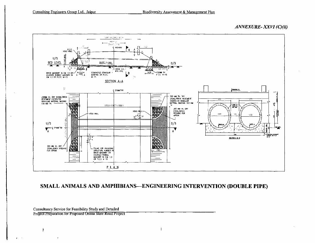
Consulting Engineers Group Ltd., Jaipur Biodiversity Assessment & Management Plan
ANNEXURE- XXVI (C)(ii)
t - iq HIGHWAY
EED LIEVEL D/S
BRICK MASONRY IN CM 1:3 OR COMPACTED GRANULAR B 1400 5IMM THCOURSED RUBBLE MASONRY IN I40 MATERIAL OR P.C.C. PCC M-15CM 1:3 OR P.C.C. M-15 M-15
SECTION A-A
SYMMETRY __HF]B~A
300MM TH. DRY STONE/BRICK |_- ___________- ___300 MM TH. DRY_______n__REVETMENT OVERFILTER STONE/BRICK REVETMENTGRANULAR MATERLAL1 BACKING OVERFTLTER GRANIULARJK MISO MM TH. MATERIAL BACKING 150 MM
300 MM TH. DRYSTONE/BRICK PSTCHIN PILLAR FOR NSCRIBINGFOR APRON LSTRUCTURE NUMBER IN
BRICK MASONRY ORCOURSED RUBBLEMASONRY IN CjM. 1:3OR P'C.C N 15
SMALL ANIMALS AND AMPHIBIANS-ENGINEERING INTERVENTION (DOUBLE PIPE)
Consultancy Service for Feasibility Study and DetailedProject Preparation tor Proposed (Orissa State Road Project
I-

0
0

I
. I