E-247 - World Bank Documents & Reports
12
E-247 VOL.4 ANNEX D ENVIRONMENTAL ASSESMENT BRU4 & BRK4 Public Disclosure Authorized Public Disclosure Authorized Public Disclosure Authorized Public Disclosure Authorized Public Disclosure Authorized Public Disclosure Authorized Public Disclosure Authorized Public Disclosure Authorized
-
Upload
khangminh22 -
Category
Documents
-
view
6 -
download
0
Transcript of E-247 - World Bank Documents & Reports

E-247VOL. 4
ANNEX D
ENVIRONMENTAL ASSESMENT
BRU4 & BRK4
Pub
lic D
iscl
osur
e A
utho
rized
Pub
lic D
iscl
osur
e A
utho
rized
Pub
lic D
iscl
osur
e A
utho
rized
Pub
lic D
iscl
osur
e A
utho
rized
Pub
lic D
iscl
osur
e A
utho
rized
Pub
lic D
iscl
osur
e A
utho
rized
Pub
lic D
iscl
osur
e A
utho
rized
Pub
lic D
iscl
osur
e A
utho
rized

ANNEX D Environmental Assessment
D.1 Introduction
Environmental aspects covered here include firstly the relatively narrow environmentalimpact of the proposed rehabilitation. Secondly, the wider impact of the surroundingenvironment on the sub-project is analysed, as this may have a more important long-term impact on the viability of the sub-project.
An Environmental Assessment Summary for the sub-project is presented as Table D.2.
Monitoring and mitigation measures necessary to overcome any identified problemsare discussed in the final section.
D.2 Description of the Proposed Sub-Project
The sub-project BRU4 is located in the Berat District in the south-central part of thecountry, approximately 20-25km to the SSE of Lushnje City along a reasonably goodsurfaced road. It is some 30km inland from the Adriatic coast, and lies in the eastempart of the wide alluvial plain on the south bank of the Seman River, some 5kmdownstream of the lowest part of the BRU3 sub-project BRU4 lies below, and to thenorth-west of the Shpirag Goricani Hills (rising eventually to 1100m elevation). Thesub-project is some 6km NS and 4km EW at its widest parts. The elevation of most ofthe sub-project varies from some 7-20m amsl. Soils in the commanded areas are all ofalluvial or colluvial origin, and are deep, of high to moderate nutrient and waterretenton capacities.
The BRU4 sub-project area totals some 1,290ha and comprises four main areas:
* SOOha supplied by the U3 canal from either the Fier or the Goricani pumpingstation;
* 290ha supplied by the U3-1 canal from either the Fier or the Goricani pumpingstation;
* 100ha supplied from the Goricani reservoir (originally pumped by the Goricanipumping station);
* 400ha supplied by the Korjani reservoir which received water pumped first by theFier pumping staffon and then by the Koliani pumping station.
Both U3 and US1- canals are supplied by some 10m of pumping from the SemaniRiver. Kurjani pumping station pumps through a head of 60m. Pumping to the GorcaniReservoir involves a head of 26m.
The 1290ha BRK4 drainage system drains mainly into the Roskovecit collector, exceptfor K57 which drains directly into the Semani River. Although design of the system isgood, poor maintenance and no cleaning have left system in poor condition.
The BRU4/BRK4 scheme is centred on the town of Drenovica and also includesSamatica, Goricani, Clirimi and Rrere-Kumaraku villages. With better road access anda warmer winter climate, agriculture in the area tends to be somewhat more intensivethan average in the areas benefiting from good irrigation and drainage.

Figure D.1 shows a location map for the main features of the project. Locations of soilprofile pits, and water samples for analysis, are also shown in this figure.
Full details of the sub-project's location, resources, agriculture, irrigation and drainage,and proposed rehabilitation activities are presented in Chapters 2 to 6 of this sub-project feasibility study.
D.3 Conclusions
As the proposed project essentially comprises the rehabilitation of deterioratedirrigation and drainage facilities its impacts are generally positive in nature. Inparticular, the rehabilitation will restore efficient irrigation and increase farm incomeswhich will benefit the rural population, amongst whom there is considerable poverty.Drainage rehabilitation will facilitate growth in the cooler and wetter months, and willreduce surface run-off of fertliser nutrients and agro-chemicals. The improveddistribution of irrigation water will increase social equity, removing the disparitybetween those at the head of the system and those without water at the tail.
However, a major environmental issue which will significantly impact on the sub-projectis soil erosion and flash run-off from surrounding areas of land. Most of these areas arefarmed by land owners of the sub-project. This issue is expected to be addressed by aproposed watershed management component of SIDRP. Other issues, somewhat lessserious, include soil fertility, soil structure breakdown, and water quality, and these areincluded in a proposed monitorng programme.
In the following sections D.4 to D.7 the environmental aspects of the sub-project arereviewed in more detail. In the final section, D.8, a monitoring programme is proposed.
0.4 Irrigation Water Quality for BRU4
The original source of water for the BRU4 sub-project is the Semani River, which isdownstream of the BRU3 sub-project and the confluence of the Osumi and the DevolliRivers. The Devolli tributary in turn drains water from the KOUl and adjacent irrigatonareas, and includes significant areas of ultrabasic rock materials. However thesubstantial Banje dam and reservoir trap the water and any sediment. The DevolliRiver drains some 270,000 ha.
The Osumi tributary drains water from most of the BRU31BRK1&2 sub-projects and hasa large watershed of some 225,000 ha upstream of the schemes. This watersheddrains mainly limestone country, with only a small area of ultrabasic materials andvirtually no industry or mining. Three lowermost pump schemes in the BRU3 sub-project are below the confluence of the Osumi and Devolli Rivers.
Sediment levels observed in the source water and the rivers in September, 1998, werevery low, but the eroded surrounding hillsides suggested that current erosion rates arehigh in places, and much of the eroded material is accumulating in the main canals.The problem is most acute in the hill areas to the east of BRU4, as these includeunstable Pliocene marine clay parent materials which are highly erodible. Watershedmanagement in the main watershed and the local watersheds above the main canalsthus is of great importance.

Ten water samples were taken on 27th September, 1998 to represent irrigation anddrainage water qualities for the scheme. Locations of these samples are shown inFigures D.1 and D.2. Samples were analysed at the laboratory of the Soils Institute,and results were analysed by the Consultants' Irrigation Water Quality Analysisspreadsheet.
Both Irrigation and Drainage water quality is extremely good, with very low EC (0.3-0.6dSMm), TDS (240-400 mgAl) and SAR (0.1-0.9) values. According to the FAO (1985)irrigation water classffication, this water would have no problems for most parametersof salinity. However, with bicarbonate being the dominant anion, there may be someproblem over a long period with carbonate incrustation for sprinkler or drip irrigation.Also, with very low ECw values, there may be a tendency for soil structure breakdownand dispersion of clays. However, with well structured soils of high carbonate andorganic matter content, this tendency should be very small. Nevertheless, soil structureand yields should be monitored over a long period to verify that this is so.
Comment Monitoring requirements are included in the monitoring programme.
D.5 Drainage Water Quality from BRKI and BRK2
D.5.1 Drainage Water which may be re-used for inigation
The above water quality values also covered drainage water, and no significantproblems would be experienced. The 'worst' drainage water sample analysed showedlan EC value of 0.6dS/m, TDS of 410mg/i, and SAR of 1.0, which would still beconsidered as excellent quality water.
D.5.2 Drainage Water passing through the sub-project areas
No problem waters were encountered. Even sample 4, covering effluent from a textile!factory, showed very good quality water.
D.5.3 Drainage water passing out of the sub-project areas
The net increase of salinity of waters passing out of the BRKI and BRK2 sub-projectareas is extremely small, and no downstream problems should be encountered whichcould be attributed to the sub-projects.
D.6 Soil SalinKy
No saline soils are present in the Berat area, and the immediate sub-project areascontain no significant extents of 'problem soils'. However, the adjacent slopingwatersheds, particuladly in fte BRU4/BRK4 area, show areas of Pliocene marine clays.These show high levels of exchangeable sodium and are highly erodible.

D.7 Long-term Impacts of the Wider Environment on the ProposedDevelopment
D.7.1 Erosion and flash run-off
Of greatest concem to the sustainability of these, and other sub-projects, is the verysevere problem of erosion and flash run-off from surrounding upland areas which arethe immediate watershed areas to the sub-projects. The problem is threefold:
* due to a high run-off coefficient of these upland areas, excessive run-off water flowsinto the sub-projects areas, particularly during the months when it is not wanted(October to March); this run-off flows into the main canals, which also act as highlevel interceptors found on many other sub-projects;
* with the run-off water considerable quantities of eroded soil and rock are taken intothese canals, the reservoirs and the drainage lines; this material needs periodicremoval from the canals, at considerable cost;
* much of the resulting sediment ends up in the major rivers.
The surrounding upland areas above the sub-projects show very variable standards ofland use management, with an estimated current rate of erosion varying from3tonneshalyear (c.0.2mm depth of soil removal),with the best land management, tosome 300tonnesihalyear (c 2cm depth) in the worst. Nationally, average rates of neterosion have been placed at some 30tonnes I ha I year over the entfre landsurface ofthe country (Korvaci, 1998). The best land uses are natural forest and well-establishedtreecrop plantations, with complete canopy cover and dense understorey vegetation.The worst land uses under the communist period used to be cultivation on slopingland: the current problem is more one of uncontrolled grazing by villagers on anyavailable adjacent land. The most worrying cases of this involve grazing in terracedareas, where full-scale destruction of terraces in now occurring due to stabilising grassand bush vegetation being eaten out, and animals and people forming pathways in aslopewise direction which rapidly lead to gullying. This problem is particularly severe inthe land to the east of the BRU4 area.
The severity of this problem varies enormously from area to area, but is closely relatedto distance from settlements, and to nature of parent materials. The worst problemareas appear to be those of Pliocene marne clays: many ultrabasic soil areas are alsobad. Pliocene marne materals occur in the watersheds to the East of the BRU4 sub-project
A high proportion of erosion may be associated with extreme rainfall events - forexample 1-in 5 24-hour rainfall amounts, which vary from about 80mm to 190mm overthe country, and are at the middle to upper part of this range within the sub-projectwatersheds.
A programme urgently needs to be instigated in integrated watershed management,which together with the existing irrigation and drainage rehabilitation programmes,should promote long-term sustainability of agriculture in these districts. The main thrustof such a programme would embrace six components:

i) undertake studies on run-off/erosion, existing land use, and land tenure withinthe sub-project watershed, and, based on these studies, devise a long-termland zoning plan for the watersheds.
ii) undertake reafforestation activities on publicly-owned land.
iii) promote security of tenure on a long-term basis for all other appropriate uplandland areas. Ideally the same families farming land in scheme areas would alsohave plots in adjacent upland areas. Granting of ftile could be conditional on thefollowing three measures being carTied out by the prospective land owners;
iv) promote planting and management of perennial vegetation, with excellentgroundcover (olives, timber and fuelwood plantations etc);
v) impose strct controls on grazing animals, particularly on areas which had beenpreviously terraced, and on steeper slopes and more erodible parent materials;
vi) promote further active soil and water conservation measures, particularlycontour grass strips and hedges, tied contour drains, check dams and gullyplugs etc.
Comment A watershed management component for SIDRP has been proposed.
D.7.2 Flooding
Flooding may be a seasonal problem in both areas, due to both local flooding and mainrivers bursting their banks. The velocity of water passing through the BRU3 area wouldsuggest that a considerable amount of scouring could occur in the worst years, with atendency for the river bed to change course. This problem may worsen if upstreamwatershed management issues are not tackled.
D.7.3 Under-use of Agricultural Chemicals, particularly Fertilisers
Under the excellent soils of the scheme areas, and provision of drainage and irrigation,yield potential should be considerable: 6-7 tonnes J ha for wheat, and 8-9 tonnes I hafor maize should be achievable. Actual yields, which are currently well under half ofthese, are being constrained by several interacting factors. On removal of drainage,flooding, and irrigation supply constraints, it is then increasingly important that yieldsare not allowed to be limited by fertility constraints or outbreaks of pests and diseases.Overall use of fertilisers are well under half of what they were under communist times,and soil fertility is being 'mined' in most areas.
Increased use of fertilisers and pesticides, up to recommended levels, and according torecommended practices, will enormously increase income and long-term sustainabilityof the scheme, at relaUvely little environmental cost By making the economics of theschemes more attractive, they will relieve pressure on the uplands, the problems ofwhich are more severe by a very large factor (see discussion above).

D.8 Monitoring Programme
The monitoring programme should be undertaken by a technical staff member withagronomic experience. This could be an agronomist or technical person attached to theWE or federation of WUAs, or a member of the Soils Institute.
D.8.1 Irrigation and Drainage Water
Monitoring of irrigation water flows in the main canal needs to be undertaken in relationto local rainfall. This is expected to be a routine responsibility of the WE.
Irigation and drainage water quality needs to be monitored on an annual basis (latesummer) at the end of the first complete year of sub-project operation, with analysesundertaken for all major anions and catons. A total of eight samples would be required:three for irrigation water and five for drainage. This analysis would serve as usefulbaseline data for the scheme. Thereafter only EC needs to be mnonitored, ideally by atechnical staff member from the WE or federation of WUAs.
The same drainage water samples need to be monitored for pestcide residues, withthe first year being taken as baseline data. On confirmation of any problems arisingdownstream (eg fish kills, algal blooms) further monitoring of these sites should beundertaken.
D.8.2 Soil Fertility Monitoring
Routine soil fertility testing needs to be undertaken both as essenrtal baserine data forthe project, and also on a 2-yearly basis as the project progresses in order to followfertility changes in relation to yield levels and applications of fertiriser and manure.These sites can also be used to follow soil structure changes, including possibledeterioration of surface structure as a result of long-term use of low-EC irrigation water,and tendencies of soils to show sub-soil pan formation, resticting root growth andwater movement.
A minimum of six farmers fields should be selected within the sub-project area,representative of he best (most intensive) and worst (least intensive) farmingmanagemnent Cropping history of these fields should be recorded, including cropsgrown, rainfall (local station), irrigation water, pesticides, fertilisers, manure, and otherameliorants used, and yields obtained. Composite soil samples should be taken torepresent topsoil (0-20cm) and subsoil (20-60cm) of each field.
Samples should be analysed at the Soils Insite laboratory for full fertiliy analyses,including exchangeable cations and pH(H20).Plant tissue samples should be taken for trace-element analysis, including Fe, Mn, Zn,Cu, Co, Mo, and B.
Soil pits to 2m depth should be excavated at each of the sites and routine descriptionsmade. These should also include detailed description of soil structure, pore space andcontinuity, and root density and continuity. This should also be related to water tableand drainage features.

D.8.3 Watershed Management
Monitoring of soil erosion and watershed management issues are extremely importantbut need to be considered more as a separate project rather than a monitonngrequirement for this sub-project.
Advantages of inclusion of this sub-project in such a programme include: * mostupstream areas are managed by those farmers with irrigated land in the sub-project;
* with upland areas showing areas of Pliocene marine cday parent materials, theerosion problem is particularly severe in this area;
* areas of degraded, acid soils could be improved by applications of fine, calcareoussit matedals cleared from drains and canals downslope.
Apart from implementation activities on soil conservation measures, monitoringactivities would include:
* accumulation of materials in canals and drains. This would be undertaken as aroutine activity by WE staff, and a map compiled showing the relative severity of theproblem in different areas;
* studies on small plots on run-off and erosion, determining terminal sprinklerinfiltration rates and soil erodibility factors for the major soil types.
- studies on land use and land use changes in the upper watershed areas.
The last two studies should ideally be undertaken as MS-level thesis projects, butunder supervision from experienced land use and watershed management staff underthe SIRDP watershed management component
D.8.4 Equipment Needs
Standard soil and water monitoring equipment only is required for most analyses andthis is readily available in Albania. A maximum of US$200 per year would be needed toundertake this routine analysis for this sub-project.
Analysis of pestcide residues requires more sophisticated (gas chromatography)equipment, but this is available in the laboratores of the Institute of Public Health. Itwould be advantageous to undertake some duplicate sampling (say 10% of the total)and correlate results with those obtained from an experienced laboratory elsewhere inEurope. This work would be undertaken as part of a country-wide programme: some 50local samples at $50 per sample and 5 duplicate (foreign-lab) test samples at $200 persample would be required. (This would total $2500 for local costs and some $1000 forforeign costs for a national programme.)
Sprinkler infiltration rate testing and soil erodibility testing, also undertaken in othersub-project areas, would need supervisory assistance which would form part of thewatershed management component of SIDRP.

LEGEND DELISUFAJ
MAIN DRAIN .
SECONDARY DRAIN .
IRRIGATnON CAU4AL * TOSHKE*
SCHEME OCUNDARY ._.e_*GIMI
ROAD -~KUCI *
E~, IRRIGATION PUMPING STATION
AREA LIABLE TO FLOOD
-~~~~~~~~~~~
AREA IRRIGATED BY RESERVOIRS
Q~~~~~~~~~~
SoCI P;,, Pies and N e .
FIG.D.2: LOCATION OF WATER SAMPLES: BRU4IBRK4GORICAI RES
, ,: VP024 --:.! K394__'2' ,,_ y / / /-
SUKU I SIPERm > 7 , v 7¢ / es1 - S39 2 _ -_ _ we iX /39/
/ ~~~~~SUKU i POSHTEM KU* .i K5 t - § UI ALL /
--- ~ ~ ~ ~ w <g ~~~~SCALE
StRU M \>: LEGEND:
>~~~~~~~~~ .~~~~~~~Area of erodlble sloping land 1KURJANI PS K ILIHT
T - , ~~~~~~~~~~~~~~~Wader samples and rumbers: 3 m- - . ~~~~~~~~~~~~~SolPrcfls Pitsand Numnb: PO:K
~~ KURJANI RES.
FIG.D.2: LOCATION OF WATER SAMPLES: BRU4/BRK4

rABLE D.2: ENVIRONMENTAL ASSESSMENT SUMMARY: BERAT BRU3 (BRK1&2); BRU4(BRK4)WMBECT EXISTING SITUATION _________PROPOSED REHA~BIUTATI0N
BEFflowNiEiwuw utMurEore WACTWNh, epcr mueAi.,n MoINuIM ~ IEUAKSIWACT 'EHABMhJTNAilWS:
WERRItESOURMESNtae: kMWWDhocl.dowesr vvmw CswxIR. f22ow)Ou~R 2.Wq
Vhtsr O~~~mIfty ~DsON oi A A Oa*sDs&M (27U WCqV D'evoJIR A asVms D (R7tmwWoqSedtmerA tiveree w ___ topped by cri-s -"togwtdd Watershed si t s r
L hmg"mut Po"s W ta=Wg lsues need considerationby fwther prolecLSalt Lam EC / nadmu cuhon Long--r mol
-othrwle milent quality. L chwe.hAdus canhumts NoinsantproblermDomestic cantsmlz Ib No sinift prblem
Cm MPc"ln Use. dY .rUp*sm cwetplon NopbmthoggtmhedDomisheem oeeponqn Noproblh:tugewmtsr shed
8.drnent ~~~~~Fksh-flood rmg-oNfxf*(o*sdtea - Secdbmenitllon fUsacleanig ofcanas - ebeJin..S8s LrEC / mod cwbm ~SSo luL EC I h -wbabute
-otlcaeumerqmmliy.AgrichasibaI dim Uln*tsbnw connaminatingcanalsDomesd coentaints Gnral nkbbh-smoe Bak Reof c As to be exten-
-ded to cover this problem.
Sedmnt Fbeh-floodriunin-oEfrma sid -- Sedhen W user* dag on -- Rehob.in dy p rdm Cu-kI to rein sedimentwoatom hbgh to low hI local armaremssproad * dkner- ver yeidi
Salt No ptablemAgrcul t nua hn*atin s ihmldsd s_*nal aokn ln _ _g Hghor pstiide e: more reidus -- Rsiduus need roerd
h sindmirgwmte -Ing.Higher reir us.: more klun -- 1 Residue d rcoord
DC-esml nonluf uchsh general tabbish and - - h nnsegwc b r -hg Role of WUJAs to bo xdtn-
-ded tocove this problem.fERLMOGWN AND FLOODINWts 8wilssm Wr*e tladg / high Wl'. -- Drainago desind to lop Wr bcbw
120cm hI sumr, 0cm rwhiter:-tirnely eultlvjhghs crop yld +++
Rlr baonk ewo nbl erlj beds - P- 'lmtinpwrenrlvw bwrk ++ ... R &rerre os.eesh Covered by thershods OmbW Spllmd Flooding In or _bBRU4 Flge--ti -mF bed pled x hfrtingn.to torasp
UO G t oap ndrx. d Watershed Manmt.Prog.
Pliccene Cl Unstable,high-Nm ta d wodon --- Eroion rates hineroby tershed Md nmtProg.Pomne Mwkw Cko m~~~~~~~~~~~~~~~~~~~~~~~~~~~~~~~~~~~~atemshed areas.,1)6R IMACIS bt.mhsd emwtifonrmes Wu- Increased production doodder & ++Le grdng prestre on-Ing ab.r" onacdactsepareas aresidues hi brigRtln areas. upnd areas lkely.WAJA ablishment ... Role enlarged to Inchade
'___-! r~d2: h __ _ d ( & hib r nuirinl +++1-- Ad .rch ad wntershed menagementLi. -w to u--rft ____ dnoremedcib dfetsr nutrIe-t .+ 4/--Adcbtivaresearnchb and hii, bnd Fj ________________ j~~~use L!i. .. XesIoon on SAtlgeahifarmer le Isnd claofrmsWed.
-- _ee- - -- mod-v; - mml-v hv + v.++ omod. +vw +cm lV*I+4v Ict. BSk_ik spae denre no srw* hnpKc pt or hMat not reAwFia:4IAMEwka

lATER QUALITY INTERPRETATION FOR IRRIGATION: BERAT BRU41BRK4; BRU3/BRK1&2 TABLE D.1CHEMICAL ANALYSIS OF IRRIGATION & DRAINAGE WATERS CRITERIA FOR WATER QUALITY INTERPRETATION
b-Prteel NOJLOCAlION DAlE pH SaeIy Ca Mg N K Cl 804 H10OS NO$ SA adj PROBLtEM & REA1D CONSTIlUENr WATER OUtY ¢UIDGIEINESECw _ _ _ _ q/l) RN. No Incrming Sevet--(dShn) Problem Polm Problerm
arat: BR13 I MahnCoeOr Drain t1Sep06 # 8.0 0.64 22 1.2 1,0 0.2 0.8 0.4 3.2 0.01 0.8 0.8 ECwd klgn water,mS/cm < o.7 0.7 -3.0 > 3.0matB,RU3 2 Main Colctr Ofain I118ep98 J 8.4 0.41 2.0 0.4 . 0.5 0.2 0.4 0.4 3.1 0.02 0.4 0.5vat 611W 3 OumRLi 11Sep96 * 8.3 0.48 2.0 1.1 0.9 0.1 0.8 0.4 2.6 0.03 0.7 0.7 inrialtlon __EOwolrigationWate,dSIm_eratBRW3 4Mainlrnhg.Col-textl.hc 11Sep96 0 8.2 0.46 2.0 1.2 1.1 0.1 0. 0.4 2.8 0.03 0.9 1.0 BAR - 0 - 3 and ECw- > 0.7 0.7-0.2 < 0.2wet:BRUS3 SMainrrlgatlonCaeu 11Sep968 8.3 0.64 2.4 1.8 0.9 0.2 0.6 0.4 3.4 0.01 0.6 0.7 BAR > 3 - 6 and ECw- > 1.2 1.2 -0,3 c 0.3alt:BRU3 OlktgalonCa'I 11Sep96 # 8.1 0.32 2.0 0.6 0.1 0.1 0.4 0.4 2.5 0.02 0.1 0.1 SAR > a - 12 and ECw - > 1.9 1.9-0.5 < 0.5wat:BRWS 7LapwdklcR. (Drain) 11Sep90 # 8.5 0.63 2.1 2.0 1.3 0.1 1.0 0.6 3.9 0.03 0.9 1.0 SAR > 12 - 20 and ECw- > 2.9 2.9-1.3 c 1.3rat: BRW13 a kgatlonCwnl 11Sp9S # 8.2 0.44 1.6 0.8 0.4 0.2 0.6 0.4 3.4 0.01 0.4 0.4 SAR > 20 - 40 and ECw > 5.0 5.0-2.9 < 2.9vat: BRU4 9 bgatlon Canal-V3 11Sep98 # 6.3 0.41 2.1 1.0 0.4 0.2 0.6 0.6 2.4 0.01 0.3 0.4rat:BRU4 10ainDrain 11Sep98 P 8.2 Q02 1J 1.1 0.4 0.2 0.7 0.6 3.8 0.0e 0.4 0.4 Sp-cllbon To*8pFrom root absortlon
Fomum (No ) (SAR) < 3.0 3.0 -9.0 > 9.0chlerWd (CI) (ma/I < 4 4 -10 > 10boron (B) (mig) < 0.7 0.7 -3.0 > 3.0
From flol absortlon(eprhleur)eodlu(No) (meIM < 3 3 +chloride (CO (Me c 3 3 +
Mbc.Ianeousn Effects (effects susceptible crops)nifrate N03) (mg,) < 5 -30 > 30bicarbonate(H1C03)(meiO)
(overheand prlnlding ely) c 1.5 1.5 -8.5 > 8.5
WATER QUAUITY INTERPRETAllON'b-Prtoect NO.LOCATION DATE pH lTS Ca Mg Na K Cl 804 HC03 iN03 B giUiti rw SSpecf Ion Toalol Se. f Spai--frat Surface kngation Sprb*lat, Crops -kie-lon N Cl B Na e c iN03 1 CO3
eratBAS3 I MainColectoDrain 11Sep9 0# 6.0 335 44 15 23 9.6 28 19 196 0.8 1 - * - - - . - - - *Iaat: BRU3 2 MahnCo CtOrDraln 11Sep08 # 8.4 287 40 a 10 7.3 16 19 189 1.1 2 - * - - - - - -eratdORU3 30sumRiwr 11SepO8 # 8.3 285 40 14 20 3,6 28 19 159 1.7 3 - - - - _ - - *3ratBRU3 4MAhdnfrig.Cl-teOIIfcir I11Sp98 # 8.2 295 40 Id 26 3,1 21 t9 170 0.6 4 - - - - _ _ _3at:BRU3 SMahnMl"aitlon Camil 11Ssp98 # 8.3 344 48 22 21 7.3 21 19 204 1.1 5 - - - _ _ _ -3ra:dBRiJ3 OikrlgonCna 11Sep98 # 6.1 239 41 7 3 2.3 14 19 151 1.6 6 - ^ - - - - - -t,BR-J:8113 7LapWdie R. (I> h) 11Sep96 # 8.6 405 42 24 30 4.8 30 29 239 0.8 I - * - - _ _ _ -era-tBBRU3 $klmon Cgana_ 119sepoe # 8.2 305 32 10 10 a.6 21 19 205 0.8 8 -Seat:BRt4 9 k,lgtlonCanal-V3 11Sep06 E 6.8 266 43 12 10 7.0 21 29 143 0.6 9 -3eratMUBI.4 lOAManDmrah IlepwS 8 .2 339 32 13 10 9.6 26 29 219 1.1 10 - - - - - - - *
*p kdicae voter source r atwkipb dowstream odhwwe _ter tcha1wM Irto agoof (E: -no problem;: *kwanqg prob1eia; *aev problerrs; +.xc.s. SR)X|rz It t0V111DoUots@iptrito*0rit^tibhbsi"iiP 19^i bli Ai"O tL-.rQ"imIrtroir it;rA". DKV FJiwW1tRQt6EwL
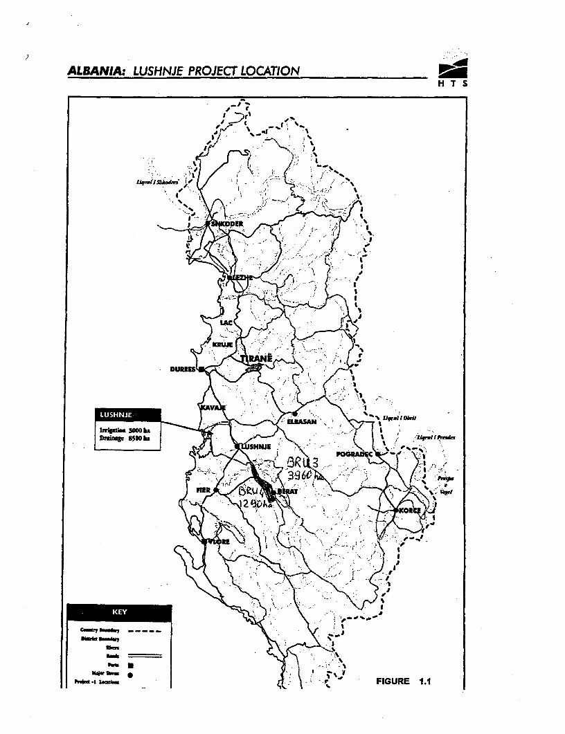
ALBANIA: LUSHNJE PROJECT LOCATION
, 'm_ '"' '1"
,,,Pi~~~~~~~~~~~~ ,qx I, a; .,,\
. . IX 8 g ' -^
~~- SHNJE (,..,,{ as
Dhf J } g * ' A ''
HER e,_< tsu -
A-- ;? fE5i
L.mtlsas \~~~~~ r~~' FIGURE 1.1