Dual-polarized C- and Ku-band ocean backscatter response to hurricane-force winds
17
Dual-polarized C- and Ku-band ocean backscatter response to hurricane-force winds D. Esteban Fernandez, 1,2 J. R. Carswell, 3 S. Frasier, 1 P. S. Chang, 4 P. G. Black, 5 and F. D. Marks 5 Received 9 May 2005; revised 13 March 2006; accepted 15 April 2006; published 9 August 2006. [1] Airborne ocean backscatter measurements at C- and Ku-band wavelengths and H and V polarizations at multiple incidence angles obtained in moderate to very high wind speed conditions (25 – 65 m s 1 ) during missions through several tropical cyclones are presented. These measurements clearly show that the normalized radar cross sections (NRCS) response stops increasing at hurricane-force winds for both frequency bands and polarizations except for high incidence angles at C-band and H polarization. The results also show the mean NRCS departing from a power law behavior for all the presented frequency bands, polarizations, and incidence angles, suggesting a reduction in the drag coefficient. The overall flattening of the azimuthal response of the NRCS is also very apparent in all cases. A new set of geophysical model functions (GMFs) at C- and Ku- band are developed from these direct ocean backscatter observations for ocean surface winds ranging from 25 to 65 m s 1 . The developed GMFs provide a much more accurate characterization of the NRCS versus wind speed and direction, and their implementation in operational retrieval algorithms from satellite-based scatterometer observations would result in better wind fields. The differences between these measurements and other currently available GMFs, such as QuikSCAT, NSCAT2, CMOD4, and CMOD5, are reported. The implementation of these GMFs in retrieval algorithms will result in better wind fields from satellite-based scatterometers measurements. Citation: Fernandez, D. E., J. R. Carswell, S. Frasier, P. S. Chang, P. G. Black, and F. D. Marks (2006), Dual-polarized C- and Ku-band ocean backscatter response to hurricane-force winds, J. Geophys. Res., 111, C08013, doi:10.1029/2005JC003048. 1. Introduction [2] Tropical cyclones (TCs) pose more of a threat to the United States than ever before. Millions of people live and vacation along the coastline, and the construction of homes and businesses in coastal areas is on the increase. In many of these communities, evacuation routes are limited, requir- ing more time to prepare. Over the last 2 decades, our ability to predict the track of TCs has improved at approximately one percent a year [McAdie and Lawrence, 1993], while the population in areas that are most prone to landfalling TCs has increased at three to four percent a year [Sheets, 1990]. The accuracy and lead time of track and intensity forecasts for these storms must improve to significantly reduce the threat to lives and property. [3] To improve the forecasts and analyses of the pattern, extent, track and intensity of TCs, a variety of research programs have focused on improving observations of sev- eral key parameters [Marks and Shay , 1998]. One of these parameters is the surface wind field. Airborne and space- borne wind scatterometry may provide a means to measure the ocean surface wind field within TCs. Katsaros et al. [2000] demonstrated improved skill in detecting TC devel- opment using scatterometer winds from QuikSCAT. Isaksen and Stoffelen [2000] showed that ERS scatterometer winds had a positive impact on TC analyses and forecasts at the European Centre for Medium-Range Weather Forecasts (ECMWF). Quilfen et al. [1998] showed the potential of C-band scatterometry to aid in monitoring and forecasting of TCs, but pointed out that the winds were underestimated within the TC owing to CMOD4 [Stoffelen and Anderson, 1997] overestimating the normalized radar cross section (NRCS) of the ocean surface for high wind speeds. Others have also found the scatterometer winds to be anomalously low and have developed new ocean surface NRCS geo- physical model functions (GMFs) for high wind speeds using satellite-based scatterometer NRCS measurements and surface wind fields predicted by TC models [Jones et al., 1999; Yueh et al., 2000]. Yueh et al. [2001] used QuikSCAT observations together with collocated SMM/I rain rate estimates to derive a modified NSCAT2 GMF and applied it to the particular case of Hurricane Floyd. Further work by Yueh et al. [2003] used Holland’s model to improve wind retrievals for tropical cyclones from QuikSCAT obser- vations at Ku-band. Though retrievals using these new JOURNAL OF GEOPHYSICAL RESEARCH, VOL. 111, C08013, doi:10.1029/2005JC003048, 2006 Click Here for Full Articl e 1 University of Massachusetts, Amherst, Massachusetts, USA. 2 Now at Office of Research and Applications, NOAA/NESDIS, Camp Springs, Maryland, USA. 3 Remote Sensing Solutions, Barnstable, Massachusetts, USA. 4 Office of Research and Applications, NOAA/NESDIS, Camp Springs, Maryland, USA. 5 Hurricane Research Division, NOAA/AOML, Miami, Florida, USA. Copyright 2006 by the American Geophysical Union. 0148-0227/06/2005JC003048$09.00 C08013 1 of 17
-
Upload
independent -
Category
Documents
-
view
0 -
download
0
Transcript of Dual-polarized C- and Ku-band ocean backscatter response to hurricane-force winds

Dual-polarized C- and Ku-band ocean backscatter
response to hurricane-force winds
D. Esteban Fernandez,1,2 J. R. Carswell,3 S. Frasier,1 P. S. Chang,4 P. G. Black,5
and F. D. Marks5
Received 9 May 2005; revised 13 March 2006; accepted 15 April 2006; published 9 August 2006.
[1] Airborne ocean backscatter measurements at C- and Ku-band wavelengths and H andV polarizations at multiple incidence angles obtained in moderate to very high wind speedconditions (25–65 m s�1) during missions through several tropical cyclones are presented.These measurements clearly show that the normalized radar cross sections (NRCS)response stops increasing at hurricane-force winds for both frequency bands andpolarizations except for high incidence angles at C-band and H polarization. The resultsalso show the mean NRCS departing from a power law behavior for all the presentedfrequency bands, polarizations, and incidence angles, suggesting a reduction in the dragcoefficient. The overall flattening of the azimuthal response of the NRCS is also veryapparent in all cases. A new set of geophysical model functions (GMFs) at C- and Ku-band are developed from these direct ocean backscatter observations for ocean surfacewinds ranging from 25 to 65 m s�1. The developed GMFs provide a much more accuratecharacterization of the NRCS versus wind speed and direction, and their implementationin operational retrieval algorithms from satellite-based scatterometer observations wouldresult in better wind fields. The differences between these measurements and othercurrently available GMFs, such as QuikSCAT, NSCAT2, CMOD4, and CMOD5, arereported. The implementation of these GMFs in retrieval algorithms will result in betterwind fields from satellite-based scatterometers measurements.
Citation: Fernandez, D. E., J. R. Carswell, S. Frasier, P. S. Chang, P. G. Black, and F. D. Marks (2006), Dual-polarized C- and
Ku-band ocean backscatter response to hurricane-force winds, J. Geophys. Res., 111, C08013, doi:10.1029/2005JC003048.
1. Introduction
[2] Tropical cyclones (TCs) pose more of a threat to theUnited States than ever before. Millions of people live andvacation along the coastline, and the construction of homesand businesses in coastal areas is on the increase. In manyof these communities, evacuation routes are limited, requir-ing more time to prepare. Over the last 2 decades, our abilityto predict the track of TCs has improved at approximatelyone percent a year [McAdie and Lawrence, 1993], while thepopulation in areas that are most prone to landfalling TCshas increased at three to four percent a year [Sheets, 1990].The accuracy and lead time of track and intensity forecastsfor these storms must improve to significantly reduce thethreat to lives and property.[3] To improve the forecasts and analyses of the pattern,
extent, track and intensity of TCs, a variety of researchprograms have focused on improving observations of sev-
eral key parameters [Marks and Shay, 1998]. One of theseparameters is the surface wind field. Airborne and space-borne wind scatterometry may provide a means to measurethe ocean surface wind field within TCs. Katsaros et al.[2000] demonstrated improved skill in detecting TC devel-opment using scatterometer winds from QuikSCAT. Isaksenand Stoffelen [2000] showed that ERS scatterometer windshad a positive impact on TC analyses and forecasts at theEuropean Centre for Medium-Range Weather Forecasts(ECMWF). Quilfen et al. [1998] showed the potential ofC-band scatterometry to aid in monitoring and forecastingof TCs, but pointed out that the winds were underestimatedwithin the TC owing to CMOD4 [Stoffelen and Anderson,1997] overestimating the normalized radar cross section(NRCS) of the ocean surface for high wind speeds. Othershave also found the scatterometer winds to be anomalouslylow and have developed new ocean surface NRCS geo-physical model functions (GMFs) for high wind speedsusing satellite-based scatterometer NRCS measurementsand surface wind fields predicted by TC models [Jones etal., 1999; Yueh et al., 2000]. Yueh et al. [2001] usedQuikSCAT observations together with collocated SMM/Irain rate estimates to derive a modified NSCAT2 GMF andapplied it to the particular case of Hurricane Floyd. Furtherwork by Yueh et al. [2003] used Holland’s model to improvewind retrievals for tropical cyclones from QuikSCAT obser-vations at Ku-band. Though retrievals using these new
JOURNAL OF GEOPHYSICAL RESEARCH, VOL. 111, C08013, doi:10.1029/2005JC003048, 2006ClickHere
for
FullArticle
1University of Massachusetts, Amherst, Massachusetts, USA.2Now at Office of Research and Applications, NOAA/NESDIS, Camp
Springs, Maryland, USA.3Remote Sensing Solutions, Barnstable, Massachusetts, USA.4Office of Research and Applications, NOAA/NESDIS, Camp Springs,
Maryland, USA.5Hurricane Research Division, NOAA/AOML, Miami, Florida, USA.
Copyright 2006 by the American Geophysical Union.0148-0227/06/2005JC003048$09.00
C08013 1 of 17

GMFs provide higher wind speeds, more work is needed tofully define the relationship between the NRCS and theocean surface wind vector at high wind speeds to clarify thelimitations of wind scatterometry.[4] The first successful airborne scatterometer measure-
ments in hurricane wind conditions were probably acquiredthrough Hurricane Tina in 1992 by the University ofMassachusetts’ (UMass) C-band scatterometer [Carswellet al., 1994]. A GMF valid up to moderate wind conditionswas derived from the vertically polarized C-band measure-ments. Dual-polarized Ku-band airborne measurements upto 35 m s�1 were successfully acquired by the JPL NUS-CAT scatterometer during a field campaign in 1997. Fromthese observations, a new Ku-band GMF modified from theNSCAT-2 GMF was presented by Yueh et al. [2000]. Workby Donnelly et al. [1999] presented C- and Ku-band NRCSobservations at V polarization for wind speeds as high as45 m s�1 and 32 m s�1, respectively. The authors showedthat the C-band NRCS sensitivity to wind speed decreasesfor wind speeds greater than 20 m s�1. The CMOD4 GMFdoes not account for this change in sensitivity, and thereforeit overpredicts the NRCS at high winds. As a result, theERS Active Microwave Instrument (AMI) derived windsthat use this GMF are too low for high wind speeds.Donnelly et al. [1999] developed a new model,CMOD4HW, which incorporates this reduction in sensitiv-ity, and these results were used in the derivation of thecurrently operational CMOD5 GMF [Hersbach, 2003]. TheKu-band NRCS measurements presented by Donnelly et al.[1999] also showed sensitivity differences compared withNSCAT1 [Wentz and Smith, 1999], but the data set waslimited to 32 m s�1 so that the results could not be extendedto hurricane-force winds (>35 m s�1).[5] New GMFs were presented by Carswell et al. [2000]
at C- and Ku-band and V polarization for wind speedsranging from 15 to 55 m s�1. These GMFs were derivedfrom measurements acquired with the University ofMassachusetts (UMass) C- and Ku-band scatterometers,hereafter CSCAT and KUSCAT, during flights throughHurricanes Brett, Dennis, and Floyd. These measurementsindicated a decreased sensitivity at both frequency bandsabove 45 m s�1.[6] UMass participated in several research/reconnais-
sance flights in 2002 and 2003 through Hurricanes Lili(2002), Fabian, and Isabel (2003). For the first time, dual-polarized C- and Ku-band (roughly 5.3 and 13.5 GHz,respectively) ocean surface NRCS measurements weresimultaneously collected with the UMass Imaging Windand Rain Airborne Profiler (IWRAP), a high-resolutiondual-band dual-polarized conically scanning airborne Dopp-ler radar. This radar was designed to study the ocean surfacebackscatter at low to extreme wind conditions, to analyzethe impact of rain on the backscatter measurements, and tostudy the inner core of TCs [Fernandez et al., 2005]. In thispaper we present coincident vertical and horizontal polar-ized, high-resolution C- and Ku-band NRCS observationsof ocean surface wind speed events from 25 to 65 m s�1 inabsolutely precipitation free areas and at several incidenceangles. Contrary to other airborne systems, IWRAP directlyprofiles the Doppler and reflectivity from precipitationvolume backscatter. This ensures that the precipitation andocean backscatter observations are coincident and simulta-
neous, which is critical since precipitation varies signifi-cantly both spatially and temporally and even small amountof precipitation will bias the results, particularly at Ku-band.[7] From all these measurements, a new set of GMFs that
cover the complete range of angles used by satellite oceanwind scatterometry has been developed. These results showthat the ocean NRCS at Ku-band wavelengths saturates andbegins to decrease with wind speed at both polarizationsand all incidence angles. The C-band vertically polarizedGMFs show the same saturation effect. The C-band hori-zontally polarized GMF, which constitutes the first modelavailable at this frequency band and polarization, revealsinstead a virtually nonsaturating behavior at high incidenceangles and for wind speeds as high as 65 m s�1.[8] The paper is organized as follows: The experiments,
instruments, and processing methods are described in sec-tion 2. Section 3 presents the NRCS measurements andreports differences between them and current GMFsCMOD5, NSCAT2 and QuikSCAT. New C- and Ku-bandGMFs are developed for high wind speeds in section 4. Theimpact that these results have on satellite-based windscatterometry for observing TCs and severe ocean stormsis addressed in the conclusions.
2. Instrumentation and Processing Methods
[9] During the 2002 and 2003 hurricane seasons, IWRAPand the UMass Simultaneous multi-Frequency MicrowaveRadiometer (SFMR) were installed on the NOAA WP-3Daircraft for the Office of Naval Research (ONR) CBLASTProgram and the National Oceanic and Atmospheric Ad-ministration (NOAA/NESDIS) Hurricane Ocean Winds andRain Experiment. A total of 10 missions were flownthrough Hurricanes Lili (2002), Fabian and Isabel (2003).Eight of the 10 missions were over open ocean and includedseveral passes directly through the hurricane eye duringvarious phases of these systems (Table 1 summarizes theseflights). Wind speeds as high as 74 m s�1 were sampled,with wind speeds reaching 65 m s�1 in rain-free conditions.Summaries of these flights can be found at the HRD website (http://www.aoml.noaa.gov/hrd/cblast/index.html).
2.1. SFMR
[10] The SFMR is a C-band nadir viewing radiometer thatmeasures the emission from the ocean surface and atmo-sphere simultaneously at six separate frequencies: 4.63, 5.5,5.915, 6.344, 6.6 and 7.05 GHz [Knapp et al., 2000]. The
Table 1. Hurricane Flight Summaries
Date HurricaneSaffir-Simpson Scale
(Maximum Wind Speed)
30 September 2002 Lili Cat. 2 (45 m s�1)2 October 2002 Lili Cat. 4 (67 m s�1)2 September 2003 Fabian Cat. 3 (50 m s�1)3 September 2003 Fabian Cat. 4 (55 m s�1)4 September 2003 Fabian Cat. 3 (57 m s�1)12 September 2003 Isabel Cat. 5 (72 m s�1)13 September 2003 Isabel Cat. 5 (67 m s�1)14 September 2003 Isabel Cat. 5 (61 m s�1)16 September 2003 Isabel Cat. 4 (41 m s�1)18 September 2003 Isabel Cat. 2 (64 m s�1)
C08013 FERNANDEZ ET AL.: OCEAN BACKSCATTER RESPONSE TO HIGH WIND SPEEDS
2 of 17
C08013

SFMR measurement precision (DT) is approximately 0.4 Kfor a 50-ms integration time. Since the 1980s, this type ofinstrument has been used during hurricane season to re-motely sense the surface wind speed and the column rainrate within the instrument’s field of view [Jones et al.,1981]. The winds reported by these instruments are equiv-alent to a 10-m 10-min averaged neutral stability windspeed (U10N) [Uhlhorn and Black, 2003]. In 1999, theHRD Stepped Frequency Microwave Radiometer becamean operational instrument providing real-time wind speedand rain-rate measurements that were telemetered via theGOES Aircraft Satellite Data-Link (ASDL) to the NationalHurricane Center (NHC) during the hurricane researchflights. Note that the only difference between the HRDSFMR and the UMass SFMR is that the UMass systemacquires its measurements from all six channels simulta-neously rather than time multiplexing through the frequen-cies. For the 2000 hurricane season, NHC declared theSFMR a national need. On the basis of its performance in1999, the UMass SFMR, which also reports real-time windspeeds and rain rates, was incorporated operationally intothe ASDL system.[11] The SFMR brightness temperature (TB) measure-
ments are sampled at 20 Hz and averaged to 1 Hz, resultingin a DT < 0.1 K. At the nominal aircraft speed of 125 m s�1,this results in a spatial resolution of roughly 1 km. For agiven sea surface temperature (SST), the change in emis-sivity is directly related to TB. The dependence of micro-wave attenuation from rainfall with frequency provides ameans of retrieving the quantity of liquid precipitation in theatmospheric column below the aircraft as well. The sixsimultaneous measurements at different frequencies of thescene provide an overdeterminated system which is used toinfer the best wind speed and rain rate estimates in the leastmean square sense. The U10N and rain rates (Rr) are derived
from the 1-Hz averaged TB measurements. The accuracy ofthe SFMR U10N estimates is better than ±1.5 m s�1 for windspeeds as high as 70 m s�1 [Jones et al., 1981]. All U10N
estimates used to develop the GMFs from IWRAP NRCSmeasurements in this paper are derived from SFMR.
2.2. IWRAP
[12] IWRAP is a conically scanning dual-polarized (Hand V polarizations) dual-frequency (C- and Ku-band)airborne Doppler radar that measures Doppler velocityand reflectivity profiles from precipitation as well as oceansurface backscatter at 15- to 150-m resolution simultaneouslyat four different incidence angles (approximately 30, 35, 40and 50 degrees) [Fernandez et al., 2005]. Figure 1 illustratesthemeasurement technique employed by this instrument. At anominal conical scanning rate of 60 RPM, IWRAP measuresthe full azimuthal backscatter response at four incidenceangles, two frequencies and two polarizations every second.Both instruments employ internal calibration loops to mea-sure and correct fluctuations in the transmitter and receivergain to within 0.1 dB.[13] IWRAP’s digital acquisition system incorporates a
pulse-pair processor, implemented as a magnitude andcovariance estimate of the demodulated echo for each rangegate (the covariance estimate uses the range gate from theprevious profile), and the result is summed on a per-rangegate basis. Among other functions, the pulse-pair processorprovides the averaged magnitude (Sxx), expressed as
Sxx ¼1
M
XM�1
m¼0
Vxxmj j2; ð1Þ
where Vxxm = Ixxm + Qxxm is the complex signal with the xxsubscript denoting the transmit and receive polarization, andM giving the number of profiles to average. The pulse-pair
Figure 1. Measurement geometry for the IWRAP instrument.
C08013 FERNANDEZ ET AL.: OCEAN BACKSCATTER RESPONSE TO HIGH WIND SPEEDS
3 of 17
C08013

processor also provides the real (DIxx) and imaginary (DQxx)parts of the complex covariance estimate (i.e., theautocorrelation function, Rxx). At a given range gate rg,Rxx is given by [see Doviak and Zrnic, 1984]
Rxx rg� �
¼ DIxx rg� �
þ jDQxx rg� �
¼ 1
M
XM�1
m¼0
Vxxm* rg� �
Vxxmþ1rg� �
; ð2Þ
where * denotes complex conjugate.[14] The NRCS can thus be derived from the IWRAP
measurements of the magnitude by applying the radar rangeequation,
so ¼ 4pð Þ3KcSxx
Ptl2RAill
G2=R4ð ÞdA; ð3Þ
where so is the NRCS, Kc is a calibration constant thatconverts the magnitude estimate Sxx to actual absolutereceive power, Aill is the area illuminated by the antennafootprint, Pt is the transmit power, G is the antenna gain, lis the radar wavelength and R is the distance to the surface.The NRCS values are then separated by frequency band,polarization and incidence angle. For each one, thefollowing processing is performed.[15] The NRCS measurements from each conical scan are
separated by incidence angle and then averaged into thirty-two 11.25 degree azimuth bins. A total of 62 consecutivesamples (i.e., M = 62 in equations (1) and (2)) are used bythe pulse-pair processor to derive the amplitude and covari-ance estimates for each bin. The averaged measurements arethen corrected for gain drifts, and the receiver noise poweris subtracted. The aircraft attitude data are used to referenceeach azimuthal bin to true north and to calculate theinstantaneous incidence angle for computation ofthe NRCS. Pitch and roll motions of the aircraft cause theinstantaneous incidence angle to vary around the nominalpointing angles; the NRCS measurements are thus alsobinned by instantaneous incidence angle in one-degreesteps.[16] To evaluate the NRCS azimuth modulation depen-
dence on the ocean surface wind speed, the following proce-dures are performed. First, the ocean surface wind direction isdetermined using the scatterometer data and using flight-levelwind direction and SFMR wind speed estimates. For thispurpose, all the NRCS azimuth bins are mapped onto 0.5-kmalong-track cells based upon GPS latitude and longitude dataand the measurement geometry. For each azimuth bin, allpixels acquired within each 0.5-km along-track cell acquiredat the same incidence angle are averaged together. This resultsin 32 azimuth bins per incidence angle containing 0.5-kmaveraged NRCS values. Figure 2 illustrates this binningscheme. The three-term Fourier series given below is fit tothe 0.5-km NRCS along-track cell values,
s� q;cð Þ ¼ A0 qð Þ þ A1 qð Þ cos cð Þ þ B1 qð Þ sin cð Þ þ A2 qð Þ cos 2cð Þþ B2 qð Þ sin 2cð Þ; ð4Þ
where q is the incidence angle and c is the azimuth lookdirection relative to true North. In most cases, there are two
maxima in the NRCS, one in the upwind direction and onein the downwind direction. At moderate incidence angles(roughly 30 to 55 degrees), there is a well-knownasymmetry between these upwind and downwind maxima[Plant, 1986], with a higher maximum in the upwinddirection, which is consistent with the predictions of thecombined tilt and hydrodynamic modulation of the Bragg-resonant small-scale waves by the large-scale waves. Thisasymmetry persists even in high wind regimes, as will bediscussed in section 3. For the IWRAP measurements, theazimuth locations of the these maxima are determinedfrom this fit. To select which maxima represents theupwind direction, a rough estimate of the ocean surfacewind direction is first determined from the flight levelwind direction, which is measured by onboard sensors attypical flying altitudes of 1.5 to 2 km. The maxima closestto the estimated surface wind direction is chosen as theupwind direction (cup). Note that meteorological definitionfor upwind direction is used. This approach will maintainthe phase of the first harmonic (A1 in equation (4)) in casethis term becomes negative at the high wind speeds (i.e.,maximum in the downwind rather than upwind direction).The SFMR wind speed estimates are used to identify andcorrect cases where the hurricane eye at flight altitude isoffset from the eye at the surface. In these cases, wherethere could be a large discrepancy between the flight leveland the surface level wind directions, the IWRAPmeasurements are not used in the development ofempirical GMFs.[17] The 0.5-km NRCS along-track values are only used
to determine the surface wind direction. Given cup, theoriginal single-scan NRCS measurements are further binnedby SFMR U10N estimates. During hurricane eye-wall pen-etrations, where wind gradients can be large, the SFMRU10N estimates closest in distance rather than in time were
Figure 2. Simplified scheme of the binning procedure.The conical scan is divided into 32 bins, and for eachincidence angle, all the looks from all conical scansacquired within a given 0.5-km along-track cell that fallin each azimuth bin are averaged together.
C08013 FERNANDEZ ET AL.: OCEAN BACKSCATTER RESPONSE TO HIGH WIND SPEEDS
4 of 17
C08013

used. At any given instant and for each azimuth bin, thecorresponding along-track distance (ahead or behind theaircraft position) was calculated, and the SFMR U10N forthe projected position was used in the binning.
[18] In this way, and for each frequency band, polari-zation and incidence angle, a final NRCS table isobtained for every conical scan with the followingdimensions: s� (q, U10N, c). This allows us to retrieve
Figure 3. Measured C-band NRCS measurements at two of the incidence angles (30 and 50 degreesapproximately) for both V and H (solid circles) plotted versus azimuth at U10N ranging from 25 to60 m s�1 in 5 m s�1 steps. The vertical and horizontal bars represent the standard deviation of the NRCSmeasurements and of the azimuth positions for each azimuth bin, respectively. The CMOD-5 (solid blueline) and CSCAT (dashed red line) GMFs are overlaid at V polarization. There is currently no other GMFavailable at H polarization.
C08013 FERNANDEZ ET AL.: OCEAN BACKSCATTER RESPONSE TO HIGH WIND SPEEDS
5 of 17
C08013

the full azimuthal response of the ocean backscatter at allwind speeds. The real coefficients of the three-termFourier cosine series,
s� q;U10N ;cð Þ ¼ A0 þ A1 � cos cup � c� �
þ A2
� cos 2 cup � c� �� �
; ð5Þ
can be calculated from the expressions
A0 ¼1
N
XNn¼1
s� cnð Þ ð6Þ
Ai¼ 1;2f g ¼2
N
XNn¼1
s� cnð Þ � cos icnð Þ½ �; ð7Þ
where N is the number of azimuth bins. A0, A1, and A2 arefunctions of q and U10N.
2.3. Rain Flagging
[19] The presence of precipitation can contaminate thebackscatter measurements in three different ways: (1) themicrowave signal is attenuated by the rain drops resulting inan underestimate of the NRCS; (2) part of the radar signal isscattered by the rain drops resulting in an overestimate ofthe NRCS due to volume backscatter; and (3) the oceansurface roughness is perturbed by the impinging rain drops,thereby influencing the surface backscatter measurements.These effects must be either removed before evaluating thesensitivity of the mean NRCS (A0) measurements on U10N,or the rain contaminated samples need to not be consideredin the analysis. Since IWRAP provides reflectivity andDoppler profiles of precipitation volume backscatter, thepresence of rain can easily be checked together with everyocean NRCS measurement. The filtering is implemented bymeans of a threshold on the range-gate averaged normalizedspectral width �svn (i.e., the second moment of the DopplerSpectrum),
�svnxx ¼1
pffiffiffi2
prg
Xrgi¼1
lnPxx ið ÞjRxx ið Þj
!1=2
; ð8Þ
where rg is the total number of range gates in the profilebefore reaching the ocean surface and Pxx(i) is the signalpower estimate after noise removal at range gate i. Whenrain is not present, the ratio inside the logarithmapproaches unity, and therefore the normalized spectralwidth tends to very small values. The presence of rainresults in smaller values of the autocorrelation function,and therefore to larger values of the spectral width. Thespectral widening increases with an increasing rainfallrate. Therefore this parameter is well suited for thedetection of rain in a profile, and shows a bettersensitivity than the magnitude measurements alone. Thevariance in the spectral width estimator is furtherimproved by averaging the single range gate estimatesfor the entire profile before reaching the ocean surface,thus resulting in an increased sensitivity to rain. For the
analysis in this paper, all rain flagged ocean NRCSmeasurements have been excluded.
3. Ocean Surface NRCS Observations ofTropical Cyclones
3.1. NRCS
[20] The C- and Ku-band NRCS measurements are rainflagged and averaged into 3 m s�1 wind speed bins based onU10N measurements. Figure 3 shows the averaged C- andKu-band NRCS measurements versus azimuth for both Vand H polarizations at wind speed ranging from 25 to65 m s�1 in steps of 5 m s�1. The CMOD5, CSCAT,KUSCAT, NSCAT2 and QuikSCAT GMFs are overlaid. Adiscussion of the mean NRCS levels among the GMFsshown in these figures will be left for the next section,where conclusions will be drawn on the basis of the A0
measurements. In this section we will only discuss thegeneral behavior (i.e., the modulation) of the GMFs versusazimuth at different wind speeds.[21] These figures show primarily two different and
important features: (1) There is a significant flattening ofthe central part of the azimuthal response (roughly from 90to 270 degrees from upwind direction) for most frequenciesand polarizations at high wind speeds. This implies the lossof the different backscatter response (or signature) in thedownwind and crosswind directions. This characteristic isnot captured by any of the GMFs used in this analysis, andit cannot be easily represented by the first two harmonics ofthe NRCS since there remains a very clear upwind versusdownwind and crosswind signature (while the downwindversus crosswind ratio approaches unity, the upwind versuscrosswind is still large); and (2) in most cases the downwindsignature reappears after the azimuthal response has flat-tened. This will be discussed further with the A0 results,where we will support the concept of a decoupling betweenthe wind and the ocean surface (i.e., suggesting a reductionin the drag coefficient).[22] A more detailed inspection of these figures also
reveals other important features. At C-Band and Vpolarization, as shown in Figure 3, there is a goodagreement between the IWRAP measurements and theCSCAT GMF for the lower wind speeds. The CMOD5GMF overestimates the azimuthal modulation at thelowest incidence angle as well as for the lower windspeeds, but in all other cases the modulation greatlyresembles the CSCAT behavior. Above 50 m s�1, boththe CSCAT GMF and the CMOD5 stop behaving prop-erly and become virtually flat for all azimuth directions.As anticipated, our measurements start showing the flat-tening of the downwind signature above approximately45 m s�1, and also after that the upwind/downwinddifference increases in most cases. The H polarizedmeasurements present an ever earlier loss of the down-wind signature, and a highly increased upwind/downwindratio after that. At Ku-band and V polarization, as shownin Figure 4, the NSCAT2 GMF overpredicts the azimuth-al modulation in most cases, and above 35 m s�1 thedifference is very large in all cases. There is an excellentagreement with the KUSCAT GMF up to 45 m s�1, andthe QuikSCAT GMF (shown at a different incidenceangle since this model function is only available for 51
C08013 FERNANDEZ ET AL.: OCEAN BACKSCATTER RESPONSE TO HIGH WIND SPEEDS
6 of 17
C08013

to 60 degrees incidence at this polarization) seems tooverpredict the modulation as well and fails to estimatethe downwind flattening. Our measurements show that thedownwind signature reappears above 55 m s�1. At H
polarization, the NSCAT2 GMF manifests a good agree-ment with the IWRAP measurements only at the lowestwind speeds, and it does not decrease its modulation afterthat. The QuikSCAT GMF follows the same behavior,
Figure 4. Measured Ku-band NRCS measurements at two of the incidence angles (30 and 50 degreesapproximately) for both V and H (solid circles) plotted versus azimuth at U10N ranging from 25 to60 m s�1 in 5 m s�1 steps. The vertical and horizontal bars represent the standard deviation of the NRCSmeasurements and of the azimuth positions for each azimuth bin, respectively. The NSCAT2 (solid blueline), KUSCAT (red dashed line), and QuikSCAT (dash-dotted green line) GMFs are overlaid. Note thatat V polarization, the QuikSCAT GMF is only available from 51 to 60 degrees incidence, and so it isshown at 51 degrees incidence. This introduces a bias associated to the different incidence angle butshows nevertheless the nonsaturating trend with an increasing wind speed.
C08013 FERNANDEZ ET AL.: OCEAN BACKSCATTER RESPONSE TO HIGH WIND SPEEDS
7 of 17
C08013

and fails to flatten the downwind signature above 40 m s�1.Again, the downwind response enhances above 50 m s�1.
3.2. Mean NRCS (A0)
[23] The C- and Ku-band A0 measurements are rainflagged and averaged into 2 m s�1 wind speed bins onthe basis of the U10N measurements. For each bin, the meanU10N value is also calculated. Figures 5 through 8 plot theaveraged C- and Ku-band A0 measurements versus the meanU10N measurements. The CMOD4, CMOD5, CSCAT,KUSCAT, NSCAT2 and QuikSCAT GMFs are overlaid.The high wind speed model that will be developed insection 4 is plotted as solid lines.[24] The figures show that the NSCAT2 GMFs signifi-
cantly overestimates the A0 measurements for wind speedsexceeding 45 m s�1, and the CMOD4 GMF significantlyoverpredicts the A0 measurements for wind speeds exceed-ing 25 m s�1. Furthermore, these figures clearly show thatthe C- and Ku-band A0 measurements saturate. That is, theA0 measurements stop increasing with U10N. In fact, the C-band A0 measurements acquired at 29.0 and 34.0 degreesincidence (Figures 5 and 6) and the Ku-band V-polarized A0
measurements acquired at all four incidence angles(Figure 7) actually start decreasing with higher wind speeds.[25] The saturation effect and decrease in A0 is predicted
by the composite surface model (DP87) presented byDonelan and Pierson [1987]. The wave number spectrum
used in the DP87 model saturates at high wind speeds forBragg resonant wavelengths. The DP87 model predicts thatthis saturation occurs first at the smaller wavelengths,occurring at approximately 35 m s�1 for Ku-band and45 m s�1 for C-band. This trend is consistent with the A0
measurements presented in this paper, although at higherwind speeds (around 45 m s�1 for Ku-band and 55 m s�1 atC-band and V polarization). The only difference is that theDP87 model predicts the saturation wind speed decreases asthe incidence angle increases. This is in contrast to ourmeasurements (but in agreement with the observations usedin the derivation of the CSCAT GMF). However, it is thespecular backscatter contribution within the DP87 modelthat causes the lower incidence angles not to saturate asquickly and may be incorrectly modeled. The Bragg back-scatter contribution in the DP87 model actually predicts thesaturation to occur first at the lower incidence angles similarto this data set. The H polarized measurements present ahigher-saturation wind speed, and a decrease in the A0 isonly present at the lowest incidence angle.[26] The observed saturation effect is also in accordance
with the results presented by Powell et al. [2003], where theauthors show that the momentum transfer between atmo-sphere and ocean stops increasing with sea surface rough-ness and wind speed as the latter increases above hurricaneforce. The authors used more than 300 GPS dropwind-sonde measurements launched from reconnaissance or re-
Figure 5. Averaged IWRAP A0 measurements at C-band and V polarization (solid circles) plottedversus the mean U10N estimates. Standard deviations of the A0 measurements within each 2 m s�1 windspeed bin are shown by the vertical lines. From these measurements, the derived high wind speedIWRAP GMF (discussed in section 4) is also plotted (solid black line). The CMOD-5 (dash-dotted line)and CSCAT (dashed line) GMFs are overlaid.
C08013 FERNANDEZ ET AL.: OCEAN BACKSCATTER RESPONSE TO HIGH WIND SPEEDS
8 of 17
C08013

search aircrafts during missions through tropical cyclonesover the span of 3 years. Work by Donelan et al. [2004]uses water tank observations to show that the drag coeffi-cient stops increasing linearly in high winds, and offers anexplanation based on separation of the air flow from thecrests of steep storm waves. Our set of direct measurementsof ocean backscatter constitutes, to our knowledge, the firstdirect observations in support of the saturation effect at bothfrequency bands and polarizations.
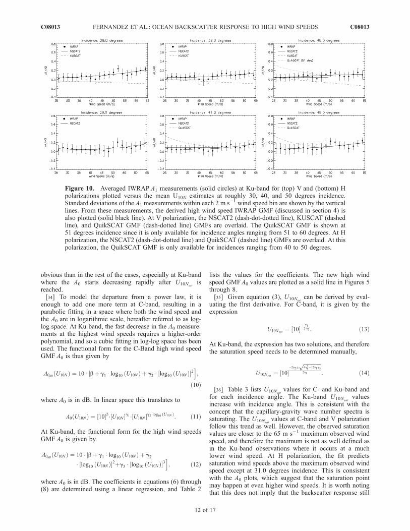
3.3. Normalized First Harmonic (a1)
[27] The C- and Ku-band A1 measurements are normal-ized by the mean NRCS (a1 = A1/A0) and averaged into2 m s�1 wind speed bins on the basis of the coincident U10N
measurements. Figure 9 plots the averaged a1 measurementsversus the mean U10N measurements. The CMOD4,CMOD5, CSCAT, KUSCAT, NSCAT2 and QuikSCATGMFs are overlaid. The high wind speed model that willbe developed in section 4 is plotted as solid lines.[28] As Figure 9 shows, the C-band a1 measurements
seem to slightly increase with increasing wind speed. TheCMOD4 GMF predicts a similar trend, and while it is invery good agreement at 29.0 degrees incidence, it presents alarge positive bias after that. Both the CMOD5 and theCSCAT GMFs present a decreasing trend with increasingwind speed. At Ku-band (Figure 10), the NSCAT2 GMFpredicts a constant value for a1, but is close in magnitude to
the measurements at V polarization, while at H polarizationthe agreement is excellent. In general, the C- and Ku-banda1 measurements approach zero at around 40 to 45 m s�1
wind speed, in agreement with the concept of a saturation.However, while the saturation in the A0 measurementsindicates a saturation in the wind speed, the fact that thea1 values approach zero supports rather the concept of asaturation in the wind direction. In other words, the upwindand downwind directions become almost impossible todiscriminate from these values.[29] It is worth noting that especially at Ku-band the first
harmonic seems to increase again after having approachedzero, reaching a high peak at around 50 to 55 m s�1 windspeed. This is followed by a new decay, only to startincreasing again. This is in agreement with the reappearanceof the downwind signature with respect to the upwinddirection discussed in the previous section. This kind ofbehavior has been observed as well in the measurementsused to derive the CSCAT and KUSCAT GMFs. Theparabolic fitting that will be used in section 4 to derive amodel from the a1 measurements will overlook this feature,as happened with the CSCAT and KUSCAT GMFs.
3.4. Normalized Second Harmonic (a2)
[30] The C- and Ku-band A2 measurements are normal-ized by the mean NRCS (a2 = A2/A0) and averaged into2 m s�1 wind speed bins on the basis of the coincident U10N
Figure 6. Averaged IWRAP A0 measurements at C-band and H polarization (solid circles) plottedversus the mean U10N estimates. Standard deviations of the A0 measurements within each 2 m s�1 windspeed bin are shown by the vertical lines. From these measurements, the derived high wind speedIWRAP GMF (discussed in section 4) is also plotted (solid black line). There is currently no other GMFfor this frequency band and polarization.
C08013 FERNANDEZ ET AL.: OCEAN BACKSCATTER RESPONSE TO HIGH WIND SPEEDS
9 of 17
C08013

measurements. Figure 11 plots the averaged a2 measure-ments versus the mean U10N measurements. The CMOD4,CMOD5, CSCAT, KUSCAT, NSCAT2 and QuikSCATGMFs are overlaid. The high wind speed model that willbe developed in section 4 is plotted as solid lines.[31] The C- and Ku-band a2 measurements decrease to
very small values (<0.1) for wind speeds above 45 m s�1,further supporting the concept of a full saturation: Togetherwith a saturation in the wind speed and the upwind/downwind directions, as discussed before from the resultson the mean NRCS and the first harmonic, the secondharmonic suggests that the crosswind signature in the winddirection becomes almost negligible as well. In other words,the crosswind NRCS is approaching the upwind NRCSvalues as the wind speed approaches the saturation windspeed.[32] However, as Figure 12 shows, at Ku-band the a2
measurements start to increase again above 55 m s�1. Thesame behavior is present in the a1 measurements, where apeak at around 50 to 55 m s�1 appears in the a2 measure-ments as well. This is also consistent with the reappearanceof the downwind signature with respect to the crosswinddirection. Again in this case, the parabolic fitting willremove this feature. All the GMFs also predict a decreasinga2 with increasing wind speed, with the exception of theNSCAT2 GMF, where the values are too high and constant
for all wind speeds shown. The CMOD4 GMF in Figure 11follows the decreasing trend but shows large values incomparison to the rest of GMFs. None of the availableGMFs predicts an increase of the a2 values above 50 m s�1.
4. High Wind Speed GMF
[33] C- and Ku-band high wind speed GMFs are devel-oped by adding additional terms to a conventional powerlaw. These terms permit a slow roll-off in the power lawwind exponent and allows the saturation wind speed(U10Nsat
) to be determined. U10Nsatis defined as the wind
speed where A0 reaches its maximum value, i.e.,
@A0
@U10N
U10N¼U10Nsat
¼ 0: ð9Þ
Note that this value does not necessarily reflect the windspeed at which the measurements start to deviate from apower law behavior (the maximum in the A0 will happen ata higher U10N), but rather suggests the wind speed afterwhich the A0 response will start decreasing. In fact, at C-band and V polarization the A0 response is virtually flat(within a few tenths of a dB) for more than 15 m s�1 above40 m s�1, and the meaning of the defined U10Nsat
is less
Figure 7. Averaged IWRAP A0 measurements at Ku-band and V polarization (solid circles) plottedversus the mean U10N estimates. The error bars show the standard deviations of the A0 measurementswithin each 2 m s�1 wind speed bin. From these measurements, the derived high wind speed IWRAPGMF (discussed in section 4) is also plotted (solid black line). The NSCAT2 (dashed line) and KUSCAT(solid line) GMFs are overlaid.
C08013 FERNANDEZ ET AL.: OCEAN BACKSCATTER RESPONSE TO HIGH WIND SPEEDS
10 of 17
C08013

Figure 8. Averaged IWRAP A0 measurements at Ku-band and H polarization (solid circles) plottedversus the mean U10N estimates. The error bars show the standard deviations of the A0 measurementswithin each 2 m s�1 wind speed bin. From these measurements, the derived high wind speed IWRAPGMF (discussed in section 4) is also plotted (solid black line). The NSCAT2 (dash-dot-dotted line) andQuikSCAT (dashed line) GMFs are overlaid. The QuikSCAT GMF is only available for incidencesranging from 40 to 50 degrees.
Figure 9. Averaged IWRAP A1 measurements (solid circles) at C-band for V (top) and H (bottom)polarizations plotted versus the mean U10N estimates at roughly 30, 40, and 50 degrees incidence.Standard deviations of the A1 measurements within each 2 m s�1 wind speed bin are shown by the verticallines. From these measurements, the derived high wind speed IWRAP GMF (discussed in section 4) isalso plotted (solid black line). The CMOD-5 (dash-dotted line) and CSCAT (dashed line) GMFs areoverlaid at V polarization. There is currently no other GMF for this frequency band at H polarization.
C08013 FERNANDEZ ET AL.: OCEAN BACKSCATTER RESPONSE TO HIGH WIND SPEEDS
11 of 17
C08013
obvious than in the rest of the cases, especially at Ku-bandwhere the A0 starts decreasing rapidly after U10Nsat
isreached.[34] To model the departure from a power law, it is
enough to add one more term at C-band, resulting in aparabolic fitting in a space where both the wind speed andthe A0 are in logarithmic scale, hereafter referred to as log-log space. At Ku-band, the fast decrease in the A0 measure-ments at the highest wind speeds requires a higher-orderpolynomial, and so a cubic fitting in log-log space has beenused. The functional form for the C-Band high wind speedGMF A0 is thus given by
A0dB U10Nð Þ ¼ 10 � bþ g1 � log10 U10Nð Þ½ þ g2 � log10 U10Nð Þ½ �2i;
ð10Þ
where A0 is in dB. In linear space this translates to
A0 U10Nð Þ ¼ 10½ �b� U10N½ �g1 � U10N½ �g2�log10 U10Nð Þ: ð11Þ
At Ku-band, the functional form for the high wind speedsGMF A0 is given by
A0dB U10Nð Þ ¼ 10 � bþ g1 � log10 U10Nð Þ½ þ g2
� log10 U10Nð Þ½ �2þg3 � log10 U10Nð Þ½ �3i; ð12Þ
where A0 is in dB. The coefficients in equations (6) through(8) are determined using a linear regression, and Table 2
lists the values for the coefficients. The new high windspeed GMFA0 values are plotted as a solid line in Figures 5through 8.[35] Given equation (3), U10Nsat
can be derived by eval-uating the first derivative. For C-band, it is given by theexpression
U10Nsat¼ 10½ ��
g12�g2 : ð13Þ
At Ku-band, the expression has two solutions, and thereforethe saturation speed needs to be determined manually,
U10Nsat¼ 10½ �
�2g2�ffiffiffiffiffiffiffiffiffiffiffiffiffiffi4g2
2�12g1g3
p2g1 : ð14Þ
[36] Table 3 lists U10Nsatvalues for C- and Ku-band and
for each incidence angle. The Ku-band U10Nsatvalues
increase with incidence angle. This is consistent with theconcept that the capillary-gravity wave number spectra issaturating. The U10Nsat
values at C-band and V polarizationfollow this trend as well. However, the observed saturationvalues are closer to the 65 m s�1 maximum observed windspeed, and therefore the maximum is not as well defined asin the Ku-band observations where it occurs at a muchlower wind speed. At H polarization, the fit predictssaturation wind speeds above the maximum observed windspeed except at 31.0 degrees incidence. This is consistentwith the A0 plots, which suggest that the saturation pointmay happen at even higher wind speeds. It is worth notingthat this does not imply that the backscatter response still
Figure 10. Averaged IWRAP A1 measurements (solid circles) at Ku-band for (top) V and (bottom) Hpolarizations plotted versus the mean U10N estimates at roughly 30, 40, and 50 degrees incidence.Standard deviations of the A1 measurements within each 2 m s�1 wind speed bin are shown by the verticallines. From these measurements, the derived high wind speed IWRAP GMF (discussed in section 4) isalso plotted (solid black line). At V polarization, the NSCAT2 (dash-dot-dotted line), KUSCAT (dashedline), and QuikSCAT GMF (dash-dotted line) GMFs are overlaid. The QuikSCAT GMF is shown at51 degrees incidence since it is only available for incidence angles ranging from 51 to 60 degrees. At Hpolarization, the NSCAT2 (dash-dot-dotted line) and QuikSCAT (dashed line) GMFs are overlaid. At thispolarization, the QuikSCAT GMF is only available for incidences ranging from 40 to 50 degrees.
C08013 FERNANDEZ ET AL.: OCEAN BACKSCATTER RESPONSE TO HIGH WIND SPEEDS
12 of 17
C08013

follows a power law and that no saturation is present; theresponse is saturated with respect to a power law, but thesaturation happens to be much slower; that is, the departurefrom a power law response is not as strong as at Vpolarization, and the A0 response does not hint a decreasingtrend within the measured range of wind speeds. To makethis clear, Figure 13 shows the fitted A0 models, normalizedin linear space with respect to the mean NRCS at 25 m s�1,i.e., A0/A0(U10N = 25 m s�1), for both frequency bands, bothpolarizations and all incidence angles, versus the windspeed in log scale. If the A0 response follows a powerlaw, in log-log space it should appear as a straight line.However, we can see how this is not true for any of thecases, and the departure from a power law happens soonerfor smaller incidence angles, as already discussed.[37] The high wind speed GMF must also include the
wind directional signature in the NRCS. The functionalform for the full high wind speed GMF is modeled using aform similar to the CMOD4, CSCAT and KUSCAT models,given by the expression
s� q;U10N ;cð Þ ¼ A0 q;U10Nð Þ 1½ þ a1 q;U10Nð Þ cos crelð Þ ð15Þ
þa2 q;U10Nð Þ cos 2crelð Þ�; ð16Þ
where crel = cup � c and
a1 q;U10Nð Þ ¼ c0 q;U10Nð Þ þ c1 q;U10Nð ÞU10N ð17Þ
þc2 q;U10Nð ÞU210N ; ð18Þ
a2 q;U10Nð Þ ¼ d0 q;U10Nð Þ þ d1 q;U10Nð ÞU10N þ d2 q;U10Nð Þ tanh
� U10N
d3 qð Þ
� U10N ; ð19Þ
and s� is the NRCS. The first harmonic is thus modeled bya second-order polynomial and the second harmonic by alinear relationship plus a hyperbolic tangent to capture thesaturation at high wind speeds. Setting the d3 values to thoseof Donnelly et al. [1999], the other coefficients can bederived using a linear regression. For more discussion oncoefficient d3, the reader is referred to Donnelly et al.[1999]. Tables 4 and 5 list the fit coefficients. The predicteda1 and a2 values using the above fits are plotted in Figures 9through 12 as solid lines.[38] The new GMFs presented in this paper correspond to
the particular incidence angles at which the radar instrumentoperates (roughly 30, 35, 40 and 50 degrees incidence). It is
Figure 11. Averaged IWRAP A2 measurements (solid circles) at C-band and (top) V and (bottom) Hpolarizations are plotted versus the mean U10N estimates. Standard deviations of the A2 measurementswithin each 2 m s�1 wind speed bin are shown by the vertical lines. From these measurements, thederived high wind speed IWRAP GMF (discussed in section 4) is also plotted (solid black line). At Vpolarization, the CMOD-5 (dash-dotted line) and CSCAT (dashed line) GMFs are overlaid. At V-polarization, there is currently no other GMF for this frequency band.
C08013 FERNANDEZ ET AL.: OCEAN BACKSCATTER RESPONSE TO HIGH WIND SPEEDS
13 of 17
C08013

important to note that it is possible to interpolate the modelsoffered here anywhere within the range of these observa-tions in order to derive models at different incidence anglesof particular interest. Given the wide range of possibilitiesin terms of interpolation techniques, the choice of thetechnique is best left to the reader. On the other hand,interpolation in frequency (e.g., as to derive a GMF at X-Band) may not yield entirely satisfactory results given thefact that the physics behind the backscattering processes aredifferent at different wavelengths. However, this could beimproved if measurements at least within the frequencybands where there are fundamental changes in the physicalprocesses involved are incorporated into the interpolationprocess.
5. Conclusions
[39] Airborne C- and Ku-band ocean surface NRCSmeasurements, obtained with the IWRAP instrument insurface wind conditions from 25 to 65 m s�1, werepresented. These measurements clearly show that the oceansurface NRCS saturates at hurricane force winds. It has also
been shown how the mean NRCS response clearly departsfrom a power law for all frequency bands, polarizations andincidence angles. The observed saturation wind speeddepends on the electromagnetic wavelength, polarization
Figure 12. Averaged IWRAP A2 measurements (solid circles) at Ku-band and (top) V and (bottom) Hpolarizations are plotted versus the mean U10N estimates. Standard deviations of the A2 measurementswithin each 2 m s�1 wind speed bin are shown by the vertical lines. From these measurements, thederived high wind speed IWRAP GMF (discussed in section 4) is also plotted (solid black line). At Vpolarization, the NSCAT2 (dash-dot-dotted line), KUSCAT (dashed line), and QuikSCAT (dash-dottedline) GMFs are overlaid. The V-polarized QuikSCAT GMF is shown at 51 degrees incidence since it isonly available for incidences ranging from 51 to 60 degrees. At H polarization the NSCAT2 (dash-dot-dotted line) and QuikSCAT (dashed line) GMFs are overlaid. The H-polarized QuikSCAT GMF is onlyavailable for incidences ranging from 40 to 50 degrees.
Table 2. New High Wind Speed GMF: A0 Coefficients
Band PolarizationIncidence,degrees b g1 g2 g3
C V 29.0 �3.807 4.064 �1.185C V 34.0 �4.631 4.641 �1.300C V 40.0 �5.081 4.784 �1.266C V 50.0 �6.931 6.808 �1.903C H 31.0 �4.892 4.7275 �1.3598C H 36.0 �5.689 5.2932 �1.4401C H 42.0 �5.570 4.6925 �1.1496C H 49.0 �5.886 4.5876 �1.0355Ku V 29.0 56.624 �110.1 70.504 �14.95Ku V 34.0 22.714 �47.25 31.540 �6.905Ku V 39.0 30.943 �64.01 42.585 �9.304Ku V 48.0 6.344 �17.90 13.439 �3.162Ku H 29.0 12.602 �26.929 18.342 �4.086Ku H 35.0 12.640 �28.401 19.673 �4.409Ku H 41.0 17.347 �38.006 25.731 �5.646Ku H 48.0 23.317 �50.369 33.627 �7.269
C08013 FERNANDEZ ET AL.: OCEAN BACKSCATTER RESPONSE TO HIGH WIND SPEEDS
14 of 17
C08013

and incidence angle. Besides the saturation in the windspeed suggested by the A0 measurements, there is anequivalent saturation in the wind direction which is man-ifested through the small values indicated by first andsecond harmonics.
[40] The observations also show a higher sensitivity withthe wind speed at H polarization for both frequency bandsthan at V polarization. On the other hand, at Ku-band and Vpolarization, the mean NRCS starts decreasing more rapidlythan any of the other frequency bands or polarization. Thiscan therefore result in a more complex scenario for windvector retrieval algorithms due to the ambiguity of theNRCS values after certain wind speed.[41] The saturation in the azimuthal response of the
NRCS is also very apparent in all cases, resulting in anoverall flattening of the response around the downwinddirection. This introduces serious limitations in the attain-able accuracy of the wind direction at the highest windspeeds. In most cases, however, the signature reappearsabove 50 to 55 m s�1. On the other hand, the upwindsignature is always present.[42] The CMOD4, CMOD5, NSCAT2 and QuikSCAT
GMFs do not capture this saturation, nor do they adequatelypredict the reduced NRCS sensitivity to the wind speed anddirection prior to the saturation. Thus these models over-predict the NRCS for wind speeds over 35 m s�1. NewC- and Ku-band high wind speed GMFs, developed in
Table 3. Saturation Wind Speeds
Band Polarization Incidence, degrees U10Nsat, m s�1
C V 29.0 51.9C V 34.0 60.9C V 40.0 61.0C V 50.0 61.5C H 31.0 54.7C H 36.0 >65C H 42.0 >65C H 49.0 >65Ku V 29.0 50.5Ku V 34.0 51.8Ku V 39.0 51.4Ku V 48.0 57.9Ku H 29.0 50.3Ku H 35.5 55.2Ku H 41.0 58.8Ku H 48.0 63.5
Figure 13. Fitted A0 models for all frequency bands, polarizations, and incidence angles versus thewind speed in log scale. For each case, the particular A0 offset at 25 m s�1 has been removed to normalizeall the curves to a common starting point. This figure clearly illustrates the saturating behavior of themean NRCS for all cases, as well as the deviation from a power law model (manifested as a departurefrom a straight line).
C08013 FERNANDEZ ET AL.: OCEAN BACKSCATTER RESPONSE TO HIGH WIND SPEEDS
15 of 17
C08013

section 4, model the saturation in the NRCS. These resultsare in good agreement at the lower wind speeds with theCSCAT and KUSCAT GMFs developed from measure-ments acquired with the UMass C- and Ku-band scatter-ometers. Note that both these instruments, as well as thedata sets from which the corresponding GMFs were de-rived, are totally different from the IWRAP instrument andthe data sets used in this paper, therefore constituting atotally independent source for comparisons. Disagreementsat the higher wind speeds are attributed to the presence ofrain contaminated measurements in the derivation of theCSCAT and KUSCAT GMFs. While the scatterometerssampled only the ocean backscatter, IWRAP providescollocated measurements of the volume backscatter fromrain from the aircraft down to the ocean surface every 30 mtogether with every NRCS measurement. The presence ofrain can therefore be checked, and the rain flagged measure-ments have been removed for this analysis.[43] As a result of these observations, complex scenarios
can arise when retrieving hurricane-force winds from themeasurements owing to the reduced sensitivity or saturationin the NRCS. C-band measurements, particularly at Hpolarization and high incidence angles, seem more suitablegiven that the saturation in the NRCS occurs at a higher
wind speed than at Ku-band. In fact, the saturation in thewind speed is not reached even at wind speeds as high as65 m s�1 and the departure of the A0 response from a powerlaw is not as significant as in the rest of the cases. On theother hand, the wind direction shows clear signs of satura-tion, thereby imposing difficulties in the retrieval of oceansurface wind directions at very high wind speeds.[44] However, both C- and Ku-band satellite-based scat-
terometers are capable of measuring the hurricane-forcewind radii thanks to the large scale of these systems.Improving the spatial resolution of the satellite-based scat-terometer measurements will not necessarily result in higherwind speeds being retrieved owing to the saturation effect.In fact, the retrieved wind speeds will actually show a largerdifference when compared to the true wind speed forsmaller spatial scales. Again, high incidence angles at C-band and H polarization seem to be the best option forfuture high-resolution satellite-based scatterometers, since atleast the saturation in the wind speed is not as significant.Moreover, it should be noted that higher-resolution mea-surements will aid in seeing through precipitation eventsthat often occur on the scales of a couple of kilometers, aswell as reduce biases introduced by sampling over windspeed gradients.
Table 4. New High Wind Speed GMF: A1 Coefficients
Band Polarization Incidence, degrees c0 c1 c2
C V 29.0 1.500 � 10�2 3.917 � 10�3 �1.6595 � 10�5
C V 34.0 �1.080 � 10�2 7.046 � 10�3 �4.6334 � 10�5
C V 40.0 �1.757 � 10�1 1.515 � 10�2 �14.830 � 10�5
C V 50.0 �5.453 � 10�1 2.710 � 10�2 �28.064 � 10�5
C H 31.0 7.030 � 10�2 3.093 � 10�3 �1.8011 � 10�5
C H 36.0 �1.083 � 10�1 1.354 � 10�2 �13.004 � 10�5
C H 42.0 8.060 � 10�2 4.091 � 10�3 �3.5243 � 10�5
C H 49.0 �1.053 � 10�1 1.289 � 10�2 �14.723 � 10�5
Ku V 29.0 9.332 � 10�2 �4.844 � 10�3 10.399 � 10�5
Ku V 34.0 3.097 � 10�1 �1.482 � 10�2 20.363 � 10�5
Ku V 39.0 1.028 � 10�1 �4.123 � 10�3 7.221 � 10�5
Ku V 48.0 �5.388 � 10�2 3.959 � 10�3 �2.092 � 10�5
Ku H 29.0 2.556 � 10�1 �1.156 � 10�2 15.821 � 10�5
Ku H 35.0 3.349 � 10�1 �1.454 � 10�2 19.262 � 10�5
Ku H 41.0 2.177 � 10�1 �9.540 � 10�3 13.495 � 10�5
Ku H 48.0 7.829 � 10�2 �2.835 � 10�3 7.192 � 10�5
Table 5. New High Wind Speed GMF: A2 Coefficients
Band Polarization Incidence, degrees d0 d1 d2 d3
C V 29.0 6.021 � 10�2 1.904 � 10�2 �2.026 � 10�2 30.0C V 34.0 �4.288 � 10�2 6.199 � 10�2 �6.066 � 10�2 20.0C V 40.0 1.972 � 10�1 2.561 � 10�2 �2.837 � 10�2 18.0C V 50.0 1.291 � 10�1 3.551 � 10�2 �3.714 � 10�2 19.0C H 31.0 1.337 � 10�1 8.883 � 10�3 �1.121 � 10�2 30.0C H 36.0 �2.461 � 10�1 8.731 � 10�2 �8.289 � 10�2 20.0C H 42.0 2.864 � 10�1 �1.006 � 10�3 �3.737 � 10�3 18.0C H 49.0 1.534 � 10�1 3.223 � 10�2 �3.438 � 10�2 19.0Ku V 29.0 �8.451 � 10�1 1.472 � 10�1 �1.326 � 10�1 23.0Ku V 34.0 �8.396 � 10�1 2.065 � 10�1 �1.895 � 10�1 20.0Ku V 39.0 �1.941 � 10�1 4.710 � 10�1 �4.658 � 10�1 12.0Ku V 48.0 1.496 � 10�1 5.652 � 10�1 �5.608 � 10�1 11.0Ku H 29.0 �5.048 � 10�1 1.153 � 10�1 �1.048 � 10�1 23.0Ku H 35.0 �6.197 � 10�1 1.489 � 10�1 �1.355 � 10�1 20.0Ku H 41.0 �7.876 � 10�2 3.780 � 10�1 �3.742 � 10�1 12.0Ku H 48.0 �1.586 � 10�1 5.455 � 10�1 �5.401 � 10�1 11.0
C08013 FERNANDEZ ET AL.: OCEAN BACKSCATTER RESPONSE TO HIGH WIND SPEEDS
16 of 17
C08013

[45] The new GMFs presented in this paper should beincorporated into current retrieval algorithms. Their im-proved characterization of the NRCS dependence on windspeed and direction will result in better retrieved wind fieldsusing satellite-based scatterometers. Finally, more informa-tion and measurements of the ocean surface drag coefficientare needed to better understand why the NRCS is saturating.This paper suggests that the capillary-gravity wave spectrasaturates in hurricane-force conditions, and that the decreasein the NRCS at the very high wind speeds might be causedby a decoupling of the surface winds and the ocean surfacewhich results in reduced small-scale roughness. In thatscenario, after a certain saturation wind speed is reached,the transfer of momentum from the wind forcing into theocean surface stops increasing with an increasing windspeed, and actually decreases as if the real wind forcingapplied was due to a smaller wind speed.
[46] Acknowledgments. The authors wish to thank Beth Kerr fromUMass for her support during the 2003 hurricane season, as well asJ. McFadden, J. Barr, and S. McMillan, along with the technicians, flightengineers, machinists, pilots, and crew of NOAA N42RF for their countlesshours of support. This investigation was funded by NASA/JPL grant1217185, JPL grant 1201304, USWRP/NASA grant NAG8-1490,NOAA/NESDIS Ocean Remote Sensing Program (contract 40-AA-NE-00598), NOAA/NESDIS grant NA17EC1348, and ONR (Remote Sensing)grant N00014-01-1-0923.
ReferencesCarswell, J. R., S. C. Carson, R. E. McIntosh, F. K. Li, G. Neumann,D. McLaughlin, J. C. Wilkerson, P. G. Black, and S. V. Nghiem(1994), Airborne scatterometers: Investigating ocean backscatter underlow- and high-wind conditions, Proc. IEEE, 82(12), 1835–1860.
Carswell, J., E. J. Knapp, P. S. Chang, P. D. Black, and F. D. Marks (2000),Limitations of scatterometry high wind speed retrieval, paper presented atInternational Geoscience and Remote Sensing Symposium, Inst. ofElectr. and Electron. Eng., New York.
Donelan, M., and W. Pierson (1987), Radar scattering and equilibriumranges in wind-generated waves with application to scatterometry,J. Geophys. Res., 92(C5), 4971–5029.
Donelan, M. A., B. K. Haus, N. Reul, W. J. Plant, M. Stiassne, H. C.Graber, O. B. Brown, and E. S. Saltzman (2004), On the limiting aero-dynamic roughness of the ocean in very strong winds, Geophys. Res.Lett., 31, L18306, doi:10.1029/2004GL019460.
Donnelly, W., J. Carswell, R. McIntosh, P. S. Chang, J. Wilkerson, P. Black,and F. Marks (1999), Revised ocean backscatter models at c and ku-band under high wind conditions, J. Geophy. Res., 104(C5), 11,485–11,497.
Doviak, R. J., and D. S. Zrnic (1984), Doppler Radar and Weather Ob-servations, 2nd ed., Elsevier, New York.
Fernandez, D. E., E. Kerr, A. Castells, S. Frasier, J. Carswell, P. S. Chang,P. Black, and F. Marks (2005), IWRAP: The Imaging Wind and RainAirborne Profiler for remote sensing of the ocean and the atmosphericboundary layer within tropical cyclones, IEEE Trans. Geosci. RemoteSens., 43(8), doi:10.1109/TGRS.2005.851640.
Hersbach, H. (2003), An improved geophysical model function for ERS C-band scatterometry, Tech. Memo 395, Eur. Cent. for Medium-RangeWeather Forecast., Reading, U. K.
Isaksen, L., and A. Stoffelen (2000), ERS scatterometer wind data impacton ECMWF’s tropical cyclone forecasts, IEEE Trans. Geosci. RemoteSens., 38(4), doi:10.1109/36.851771.
Jones, W. L., P. Black, V. Delnore, and C. Swift (1981), Airborne microwaveremote sensing measurement of Hurricane Allen, Science, 214, 274–280.
Jones, W., V. Cardone, W. Pierson, J. Zec, L. Rice, A. Cox, and W. Sylvester(1999), NSCAT high-resolution surface wind measurements in typhoonviolet, J. Geophys. Res., 104(C5), 11,247–11,260.
Katsaros, K., E. Forde, P. Chang, and W. Liu (2000), QuikSCAT facilitatesearly identification of tropical depressions in 1999 hurricane season,Geophys. Res. Lett., 28(6), 1043–1046.
Knapp, E., J. Carswell, and C. Swift (2000), A dual polarization multi-frequency microwave radiometer, paper presented at InternationalGeoscience and Remote Sensing Symposium, Inst. of Electr. and Elec-tron. Eng., New York.
Marks, F., and L. Shay (1998), Landfalling tropical cyclones: Forecastproblems and associated research opportunities: Report of the fifth pro-spectus Development team to the U.S. Weather Research Program, Bull.Am. Meteorol. Soc., 79, 305–323.
McAdie, C., and M. Lawrence (1993), Long-term trends in National Hur-ricane Center track forecast errors in the Atlantic basin, paper presented atConference on Hurricanes and Tropical Meteorology, Am. Meteorol.Soc., Miami, Fla.
Plant, W. J. (1986), A two-scale model of short wind-generated waves andscatterometry, J. Geophys. Res., 91(C9), 735–749.
Powell, M. D., P. J. Vickery, and T. A. Reinhold (2003), Reduced dragcoefficient for high wind speeds in tropical cyclones, Nature, 422(6929),doi:10.1038/nature01481.
Quilfen, Y., B. Chapron, T. Elfouhaily, K. Katsaros, and J. Tournadre(1998), Observation of tropical cyclones by high-resolution scatterome-try, J. Geophys. Res., 103(C4), 7767–7786.
Sheets, R. C. (1990), The National Hurricane Center—Past, present, andfuture, Weather Forecast., 5(2), doi:10.1175/1520-0434.
Stoffelen, A., and D. Anderson (1997), Scatterometer data interpretation:Estimation and validation of the transfer function CMOD4, J. Geophys.Res., 102(C3), 5767–5780.
Uhlhorn, E. W., and P. G. Black (2003), Verification of remotely sensed seasurface winds in hurricanes, J. Atmos. Oceanic Technol., 20(1),doi:10.1175/1520-0426.
Wentz, F., and D. Smith (1999), A model function for the ocean-normalizedradar cross section at 14 GHz derived from NSCAT1, J. Geophys. Res.,104(C5), 11,499–11,514.
Yueh, S., R. West, F. Li, W. Tsai, and R. Lay (2000), Dual-polarized ku-band backscatter signatures of hurricane ocean winds, IEEE Trans. Geos-ci. Remote Sens., 38(1), doi:10.1175/1520-0426.
Yueh, S. H., B. W. Stiles, W. Y. Tsai, H. Hu, and W. T. Liu (2001),QuikSCAT geophysical model function for tropical cyclones and appli-cation to Hurricane Floyd, IEEE Trans. Geosci. and Remote Sens.,39(12), 2601–2612.
Yueh, S. H., B. W. Stiles, and W. T. Liu (2003), QuikSCAT wind retrievalsfor tropical cyclones, IEEE Trans.Geosci. and Remote Sens., 41(11),doi:10.1109/TGRS.2003.814913.
�����������������������P. G. Black and F. M. Marks, Hurricane Research Division, NOAA/
AOML, 4301 Rickenbacker Causeway, Miami, FL 33149, USA.([email protected]; [email protected])J. R. Carswell, Remote Sensing Solutions, Barnstable, MA 02630, USA.
([email protected])P. S. Chang and D. E. Fernandez, NOAA/NESDIS/ORA, World Weather
Building, Room 102A, 5200 Auth Road, Camp Springs, MD 20746, USA.([email protected]; [email protected])S. Frasier, University of Massachusetts, Knowles Engineering Building,
Amherst, MA 01003, USA. ([email protected])
C08013 FERNANDEZ ET AL.: OCEAN BACKSCATTER RESPONSE TO HIGH WIND SPEEDS
17 of 17
C08013