Dr Sangeeta Sachan , India Geography , MA Semester 4 ...
33
DR SANGEETA SACHAN GEOGRAPHY OF INDIA MA SEMESTER 4 PAPER 1 INDIA : LOCATION SHAPE AND SIZE GEOLOGY OF INDIA MAIN PHYSIOGRAPHIC REGIONS DRAINAGE SYSTEMS CLIMATE AND CLIMATIC REGIONS
-
Upload
khangminh22 -
Category
Documents
-
view
1 -
download
0
Transcript of Dr Sangeeta Sachan , India Geography , MA Semester 4 ...

DR SANGEETA SACHAN
GEOGRAPHY OF INDIA
MA SEMESTER 4
PAPER 1
INDIA : LOCATION SHAPE AND SIZE
GEOLOGY OF INDIA
MAIN PHYSIOGRAPHIC REGIONS
DRAINAGE SYSTEMS
CLIMATE AND CLIMATIC REGIONS

Dr Sangeeta Sachan , India Geography , MA Semester 4 , Paper 1
INDIA
India has a unique culture and is one of the oldest and
greatest civilizations of the world. It stretches from the
snow-capped Himalayas in the north to Sun drenched
coastal villages of the south and the humid tropical
forests on the south-west coast, from the fertile
Brahmaputra valley in its east to the Thar Desert in the
west.
LOCATION
India is located latitudinally in the Northern Hemisphere
and longitudinally in the Eastern Hemisphere. It extends
from 8°4 north and 37°6 North in length (latitudes). And′ ′between 68°7 East and 97°25 East in width (longitudes).′ ′Because of this great longitudinal extent, the difference
in local time between eastern and western extremes of
our country is about two hours.The local time along 82°
30’ E longitudes is taken as standard time of India
i.e. Indian Standard Time (IST).This meridian is known as
the Standard Meridian of India. It has an area of 3.28

Dr Sangeeta Sachan, India Geography, MA Semester 4 , Paper 1
million square km. It is the seventh largest country in the
world. It accounts for nearly 2% of the world’s total area.
It is situated in the northern hemisphere.
SHAPE AND SIZE
India has a coastline of 7516.6 km of total land frontier
15200 km and Tropic of Cancer passes almost middle
through its crossing over the states of Gujarat,
Rajasthan, Madhya Pradesh, Chhattisgarh, Jharkhand,
Paschim Bangal, Tripura and Mizoram.
The country can be divided into six zones mainly North,
South, East, West, and Central and Northeast zone. It has
29 states and seven union territories.
INDIA : BORDERS
McMahon LineNamed after the British Indian Army officer Lieutenant Colonel Sir Arthur Henry McMahon, who was also an administrator in British India, the McMahon line is a demarcation that separates

Tibet and the north-east India. Colonel McMahon had Dr Sangeeta Sachan, India Geography, MA Semester 4 , Paper 1
proposed this line as the boundary between Tibet,China, and India at the Shimla Convention of 1914. It was accepted by Tibetan authorities and British India, and is now acknowledged by the Republic of India as the official boundary. China, however, disputes the validity of the McMahon line. It claimsthat Tibet isn’t a sovereign government, and therefore any treaty made with Tibet stands invalid.Radcliffe LineRadcliffe Line divided British India into India and Pakistan. It is named after the architect of this line, Sir Cyril Radcliffe, who was also the chairman of the Boundary Commissions. The Radcliffe Line was drawn between West Pakistan (now Pakistan) and India on the western side and between India and East Pakistan (now Bangladesh) on the eastern side of the subcontinent.Durand LineBoundary line between India and Afghanistan demarcated by Sir Mortimer Durand, a British diplomat in the year 1896 is known as the Durand Line. It separated British India and Afghanistan.

After partition, Pakistan inherited this line. However, a short section of the Afghanistan border
Dr Sangeeta Sachan, India Geography, MA Semester 4 , Paper 1
is shared with the Indian state of Jammu and Kashmir.Line of Actual Control (LAC)Line of Actual Control is the demarcation line between India and China which separates the India controlled territory from the China-controlled territory in the former princely state of Jammu and Kashmir. In 1962, the two countries were embroiled in a war. China attacked India and captured the Aksai Chin area. In 1963, China declared ceasefire but did not leave the area. Now, the ceasefire line is known as the LAC. This line is not actually recognised as international boundary, as by virtue of Instrument of Accession, entire state of Jammu and Kashmir legally and constitutionally became an integral part of India.Line of Control (LOC)The military controlled line between India and Pakistan in the former princely state of Jammu and Kashmir is named as the Line of Control (LOC).It was originally known as the Ceasefire Line. After

the Simla Agreement signed on July 3, 1972, the Ceasefire Line was renamed as the LOC. This line is not actually recognised as international boundary, as by virtue of Instrument of Accession, entire state
Dr Sangeeta Sachan, India Geography, MA Semester 4 , Paper 1
of Jammu and Kashmir legally and constitutionallybecame an integral part of India.


Dr Sangeeta Sachan, India Geography, MA Semester 4 , Paper 1

Dr Sangeeta Sachan, India Geography, MA Semester 4, Paper 1
GEOLOGY OF INDIAI
Indian Rock SystemGeologically India is divided into multiple rockstrata which were formed at different stages ofIndia's geological history.
Rock System of IndiaThe rock system of India is broadly divided intothe systems mentioned below:
Archean rock system
Dharwar rock system
Cuddapah rock system
Vindhyan rock system
Dravidian rock system
Aryan rock system
Carboniferous rock system
Jurassic rock system

Cretaceous rock system
Tertiary rock system
Quarternary rock system
Archean rock system
This is the oldest rock system of Indiansubcontinent dating back to about 4 billionyears. (pre-Cambrian rocks)
They serve as the basement complex or thefoundation rocks for other rock systems.
They are found in the Aravalli hills, Deccanplateau and the northeast of India.
They mostly contain gneisses (granite, gabbroetc.) and schists (crystalline rocks such asmica, chlorite, talc etc.)
These rocks are formed when magmaunderneath the earth's surface solidified andhence they are devoid of any fossils (Azoic)
Because of their volcanic origin, they arecrystalline and consist of sheet-like layers(foliated).

These rocks are abundant in metallic as wellas non-metallic minerals such as iron,manganese, copper, bauxite, gold, lead, mica,graphite etc.
Dharwar rock system
Formed between 2.5 billion to 1.8 billionyears, these are the oldest metamorphic rocksof India.
They are formed due to the metamorphosisof the sediments formed out of the Archeanrocks.
Since they were first studied in the Dharwarregion of Karnataka, they were named so.They are mainly found in the Aravallis,Chotanagpur plateau, Meghalaya and TamilNadu
They are rich in metallic minerals such as iron,manganese, gold, copper etc. They areconsidered to be the storehouses of metallicminerals and hence have a high economicsignificance.

Dharwar rocks are divided into various seriesbased on the region in which they are foundand the type of metal contained in them. Forinstance, Champions series (Kolar - gold),Champaner series (Baroda - marble), Chilpiseries (Balaghat - copper) etc.
Cuddapah rock system
Mainly found in the Cuddapah region ofAndhra Pradesh, they are also found in Delhi,Rajasthan, Chhattisgarh, the lesser Himalayasetc.
They were formed when sedimentary rockslike sandstone, limestone etc., and clay weredeposited in synclinal folds (between twomountain ranges)
They are rich in metamorphic rocks such asshale, slate, quartzite etc. Even thoughmetallic minerals like iron ore were found,they were of poor quality.

Vindhyan rock system
comprises of very old sedimentary rocks,hence are devoid of metallic minerals.
They are mainly found in the Vindhyanmountain ranges, extending from Rajasthanto Bihar.
They are diamond-bearing regions with Pannaand Golconda diamonds being mined here.
Though they are devoid of metallic minerals,they are abundant in building materials suchas red sandstone, limestone, glassmaking sandetc.
The Cuddapah and Vindhyan rock systems aretogether known as the Purana rock system. Theyare formed by the erosion and deposition ofArchean and Dharwar rocks, the process isbelieved to have taken place between 1400-600million years ago. They are mostly sedimentary innature.

Dravidian rock system
It was formed during the Paleozoic era i.e.,600-300 million years ago. Also known as theCarboniferous rocks, these are found in theextra-Peninsular regions of the Himalayas andthe Gangetic plain
They are abundant in fossils, and this periodsaw the beginning of coal formation.
Carboniferous coal is of a higher quality,though it is not found abundantly in India.
Aryan rock system
They began to be formed since theCarboniferous period. From the Gondwanarock system, Jurassic system, Deccan trap andTertiary period, this rock system is made up ofdiverse kinds of rocks.
Gondwana rock system
This system is named after the huge carbondeposits contained within them. This makesthem the largest source of coal in India,

containing up to 98 percent of our coaldeposits.
The Gondwana rocks are mainly found inRanigunj, Jharia regions of Jharkhand,Damodar valley, Pench valley in Chhattisgarhand Madhya Pradesh, Godavari valley inTelangana and the Rajmahal hills of WestBengal.
They are divided into two main series of rocksviz., Damuda and Panchet.
Apart from coal, they are also a source ofmetallic minerals such as iron, manganese,antimony, uranium etc.
They are named after the Gond tribe(indigenous people mainly found in theTelangana and Andhra Pradesh regions).
These are sedimentary deposits which wereaccumulated in the synclinal troughs on anolder plateau surface.
The process began during the Permian periodi.e., 250 million years ago

Jurassic rock system
This period witnessed marine transgressionson both west and east coasts. This led toshallow water deposits in Rajasthan and theKutchch region on the west and Guntur andRajahmundry areas of Andhra Pradesh.
Prominent deposits in this rock systeminclude limestone, shale, sandstone etc.
Cretaceous rock system
This was formed when the Indian plate cameover the Reunion hotspot in the Indian Oceanwhile travelling north towards the Eurasianplate, after breaking up from the Gondwanaplate.
The continuous outpouring of magma, fromthe fissures over the Indian plate led to theformation of a layered structure called theDeccan Traps. These are formed by the flowof magma over the solidified rocksystems/cooled magma in layers.

Basaltic lava covered an area of 5 lakh sq.km.encompassing the regions like Kutchch,Saurashtra, Maharashtra, Malwa plateau andnorth Karnataka.
The thickness of the Deccan traps decreasesfrom west to east, with around 3000m in thewest to just 150m in the east, and around800m in the south.
Due to the forces of weathering and erosion,this rock system gave birth to a new soilvariety known as the Black Cotton soil orRegur.
Tertiary rock system
These rocks belong to the Cenozoic era,formed around 60 million years ago
The Himalayan uplift took place at around thesame town
Important rock systems include Karewas ofKashmir, Bhangra and Khadar of the Gangeticplains etc.

Quarternary rock system
They were formed during the Pleistocene andthe process continued in the Eocene.
Since they are of recent origin, they have goodorganic content (fossils)
These are largely found in the plains of northIndia (Satluj-Ganga-Brahmaputra plains) andalso in the Karewas of Kashmir valley.

Dr Sangeeta Sachan, India Geography, MA Semester 4 ,
Paper 1

Dr Sangeeta Sachan India Geography, MA Semester 4,Paper 1
MAIN PHYSIOGRAPHIC REGIONS OFINDIAConsidering all its features, the sub-continent is classified
into the following regions:
The Northern Mountains
The northern boundary of India is created by the
northern mountain ranges known as Himalayas that form
the natural border between India and Tibet. The
Himalayan range is divided into Pir Panjal Range, Zanskar
Range, Ladakh Range, Dhaula Dhar Range and East
Karakoram Range. Apart from the Himalayan, other
ranges are Siwalik Range lying in the outer Himalayas,
Karakom Range, Patkai Range lying at the eastern part of
India at the Burma border, Vindhya Range covering parts
of central India, Satpura Range covering parts of central
India being parallel to Vindhya Range, Aravalli Range

covering areas of Haryana and Rajasthan states, the
Western Ghats and the Eastern Ghats.
The Indo-Gangetic Plains
The plains named after the rivers flowing through them -
Indus and Ganges, cover northern and eastern parts of
India, stretching to cover some parts of Pakistan, Nepal
and Bangladesh also. These rivers form tributaries that
network the entire region. These tributaries are Yamuna,
Chambal, Gomti, Sutlej, Kosi, Ravi, Beas, Chenab,
Ghaghara and Tista. These rivers make the soil fertile and
apt for farming which is widely practiced all over. This
has led to tremendous increase in population with time.
The plains are divided into four belts namely, the Bhabar
belt, the Terai belt, the Bangar belt and the Khadar belt.
The crops produced in these belts are wheat, rice,
cotton, sugarcane, and maize.

The Thar Desert
It is ranked as the seventh biggest desert in the world
that covers most of the Rajasthan and neighboring states
of Haryana, Punjab and Gujarat. It also crosses the
borders to touch Pakistan where it is known as Cholistan
desert. Its some parts are attributed by sand dunes and
some have rocks. The area receives very little rainfall and
just one river that flows through it is known as Luni. The
vegetation in the area includes small trees, herb and
shrubs. The sandy nature of the soil makes it get eroded
quite often, due to speedy winds that blow with full force
in the region. Understanding the need of plantation in
the region to avoid erosion, the Indira Gandhi Canal
scheme was started in 1965 to irrigate the land. The
common source of income for the people here is animal
husbandry and agroforestry.
The Central Highlands
The highlands of central India are divided into three
plateaus, the Deccan Plateau located between the
western and eastern ghats, the Malwa Plateau at the
western parts of India including states like Rajasthan,

Gujarat and Madhya Pradesh, and the Chota Nagpur
Plateau covering eastern states of India like Bihar,
Jharkhand, Chattisgarh and Odisha. The Chota Nagour
Plateau is rich in coal and metal ores and is divided into
Ranchi plateau, Hazaribagh plateau and Koderma
plateau. The Ranchi plateau is characterized by
numerous falls. The Hazaribagh plateau is a part of
Hazaribagh region, the lower part of which is known as
Koderma plateau.
The Eastern and Western Coastal Plains
These plains lie at the eastern parts of India spreading
from the state Tamil Nadu to West Bengal. With rivers
like Mahanadi, Kaveri , Krishna and Godavari flowing
through them, Chilika Lake runs alongside them. The
plains are divided into six regions – Coromandel Coast of
Tamil Nadu, Kanyakumari Coast at the southern-tip of
India, Krishna-Godavari delta at southeast of Vijaywada,
Mahanadi delta in Odisha, and the south Andhra Pradesh
coastal plain that covers the major parts of Eastern Ghat
and Bay of Bengal. These coastal regions normally stay
humid with frequent rainfall. Tall coconut palms adorn

the eastern coastline, apart from the crops grown here.
Fishing is the major occupation of the locals here.
As the name suggests, they lie at the areas of Western
Ghats forming the coastal parts of that are flanked by the
Arabian Sea. They cover Gujarat, Maharashtra, Goa,
Karnataka and Kerala. Narmada, Zuari, Tapi and Mandovi
are rivers that flux through them. The plains are divided
into Konkan and Malabar Coasts. The Konkan coast runs
through 700 kms, covering parts of the Karnataka, Goa
and Maharashtra. The Malabar coast covers 845 kms,
stretching from Karnataka to the extreme south tip
Kanyakumari through Kerala. All of the Malabar coast
receives heavy rainfall that makes it suitably irrigated
enough for farming.
The Islands
There are two main groups of islands – Andaman and
Nicobar islands and Lakshadweep islands that are
recognized as Union Territories (UT). Apart from them,
Daman and Diu are also known as UT; they almost touch
the mainland unlike Andaman and Nicobar and

Lakshadweep. Andaman islands are composed of 572
tiny islands that serve as a great tourist attraction. The
Nicobar islands are not accessible for the tourists.
Inhabited by native tribes, their beaches stay deserted
yet beautiful owing to lovely colors added to the waters
by a variety of corals. The Lakshadweep islands comprise
of 35 tiny islands that stand in the Laccadive Sea, just 200
to 400 kms from Kerala, the southwestern coast of India.
All these natural wonders make India, the most gifted
land on Earth. The inquisitive nature of man led to him to
explore all these physiographic features of the sub-
continent, understanding and praising their explicit
beauty.
Dr Sangeeta Sachan, India Geography, MA Semester 4 , Paper 1

DRAINAGE SYSTEM
The flow of water through channels is called drainage. The network of such
channels is known as drainage system. On the basis of origin, Indian drainage
system is divided into – Himalayan rivers and Peninsular rivers.
I. HIMALAYAN RIVERS
The major Himalayan rivers are the Ganga, the Indus and the
Brahmaputra.
These rivers are very long compared to the rivers of South India.
A. INDUS RIVER SYSTEM
It is also known as Sindhu river.
Total length is 2880 km.
Source – Kailash Range, Tibet near Mansarovar Lake.
Destination – Arabian Sea.
Panchnad – Jhelum (Vitasta), Chenab (Chandrabhaga), Ravi (Iravati),
Beas (Bipasha) and Sutlej (Satadru).
B. GANGA RIVER SYSTEM
Source – Gangotri glacier near Gomukh, Uttrakhand in the Kumaon
Himalaya.
It is named as Bhagirathi here. At Devprayag, Alakananda joins
Bhagirathi and becomes Ganga.

In Allahabad it is joined by the Yamuna, the largest tributary of Ganga,
rising from Yamunotri glacier.
Left bank tributaries – Ramganga, Gandak, Kosi, Gharghara, Gomati.
Right bank tributaries – Son.
Kosi, a tributary, is flood prone. So it is known as “Sorrow of Bihar”.
Ganga flows through Uttrakhand, UP, MP, Chattisgarh, Bihar,
Jharkhand and WB.
It bifurcates into Bhagirathi and Hooghly in WB and Padma-Meghna in
Bangladesh.
Ganga-Brahmaputra delta is the largest delta in the world.
Total length of Ganga – 2530 km.
Ganga Basin area is 9,51,600 sq. km.
The plain area from Haridwar to Ganga’s mouth is fertile with alluvial
soil.
C. BRAHMAPUTRA
1. Source – Chemayung-Dung glacier near Mansarovar in Tibet.
2. In Tibet it is known as Tsangpo.
3. It turns SW near Namcha Barwa in Arunachal Pradesh and enters India
as Dihang
4. Near Sadiya, Dihang enters into India where Dibang and Lohit join it to
make Brahmaputra.
5. Finally it enters into Bangladesh as Jamuna and meets Padma to drain
into Bay of Bengal.
6. Right bank tributaries – Subansiri, Kameng, Manas.
7. Left bank tributaries – Buri Dihang, Kameng.
8. Majuli is a large riverine island of Brahmaputra.
9. Total length of Brahmaputra is 2900 km.
II. PENINSULAR RIVER SYSTEM
Peninsular rivers are both west and east flowing.

Narmada and Tapi drain into Arabian Sea where Mahanadi, Godavari,
Cauvery and Krishna drain into Bay of Bengal.
East flowing rivers form delta where west flowing rivers don’t form
delta.
Narmada and Tapi are rift valleys.

Dr Sangeeta Sachan, India Geography, MA Semester 4 , Paper 1

Dr Sangeeta Sachan, India Geography, MA Semester 4,Paper 1
CLIMATIC CLASSIFICATION OF INDIA
Koeppen’s Classification of Climatic Regions of India is an empirical classification based on mean annual and mean monthly temperature and precipitation data.
Koeppen identified a close relationship between the distribution of vegetation and climate.
He selected certain values of temperature and precipitation and related them to the distribution of vegetation and used these values for classifying the climates.
Koeppen recognized five major climatic groups, four of them are based on temperature and one on precipitation.
The capital letters:
A, C, D and E delineate humid climates and B dry climates.
The climatic groups are subdivided into types, designated by small letters, based on seasonality of precipitation and temperature characteristics.
The seasons of dryness are indicated by the small letters : f, m, w and s, where
f – no dry season, m – monsoon climate, w – winter dry season and s – summer dry season.
10. The above mentioned major climatic types are further subdivided depending upon the seasonal distribution of rainfall or degree of dryness or cold.
a: hot summer, average temperature of the warmest month over 22°C
c: cool summer, average temperature of the warmest month under 22°C
f: no dry season
w: dry season in winter
s: dry season in summer
g: Ganges type of annual march of temperature; hottest month comes before the solstice and the summer rainy season.
h: average annual temperature under 18°C
m (monsoon): short dry season.
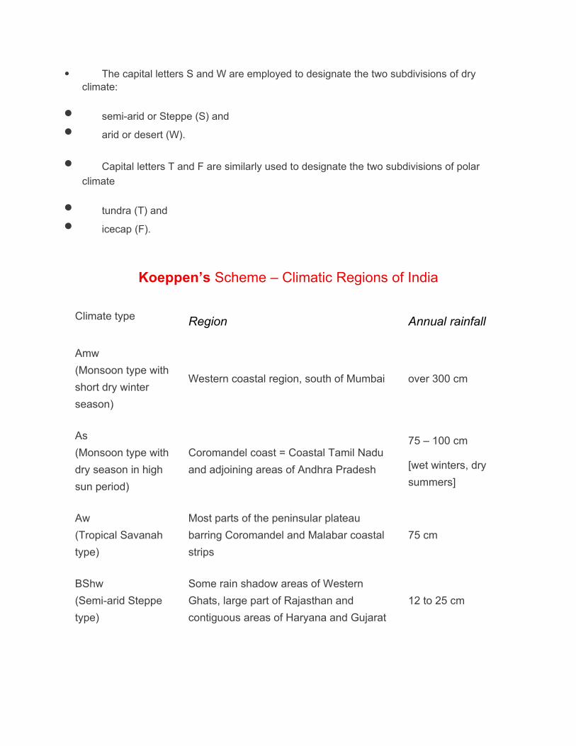
The capital letters S and W are employed to designate the two subdivisions of dry climate:
semi-arid or Steppe (S) and
arid or desert (W).
Capital letters T and F are similarly used to designate the two subdivisions of polar
climate
tundra (T) and
icecap (F).
Koeppen’s Scheme – Climatic Regions of India
Climate type Region Annual rainfall
Amw
(Monsoon type with
short dry winter
season)
Western coastal region, south of Mumbai over 300 cm
As
(Monsoon type with
dry season in high
sun period)
Coromandel coast = Coastal Tamil Nadu
and adjoining areas of Andhra Pradesh
75 – 100 cm
[wet winters, dry
summers]
Aw
(Tropical Savanah
type)
Most parts of the peninsular plateau
barring Coromandel and Malabar coastal
strips
75 cm
BShw
(Semi-arid Steppe
type)
Some rain shadow areas of Western
Ghats, large part of Rajasthan and
contiguous areas of Haryana and Gujarat
12 to 25 cm

BWhw
(Hot desert type)Most of western Rajasthan less than 12 cm
Cwg
(Monsoon type with
dry winters)
Most parts of the Ganga Plain, eastern
Rajasthan, Assam and in Malwa Plateau100 – 200 cm
Dfc
(Cold, Humid
winters type with
shorter summer)
Sikkim, Arunachal Pradesh and parts of
Assam~200 cm
Et
(Tundra Type)
Mountain areas of Uttarakhand
The average temperature varies from 0 to
10°C
Rainfall varies from
year to year.
E
(Polar Type)
Higher areas of Jammu & Kashmir and
Himachal Pradesh in which the
temperature of the warmest month varies
from 0° to 10°C
Precipitation
occurs in the form
of snow

Dr Sangeeta Sachan, India Geography, MA Semester 4, Paper 1