DPR Forms and Historic Evaluation Sheets - Mayor's Office of ...
50
Attachment D DPR Forms and Historic Evaluation Sheets
-
Upload
khangminh22 -
Category
Documents
-
view
0 -
download
0
Transcript of DPR Forms and Historic Evaluation Sheets - Mayor's Office of ...
Attachment DDPR Forms and Historic Evaluation Sheets

State of California ⎯ The Resources Agency Primary # DEPARTMENT OF PARKS AND RECREATION HRI# CONTINUATION SHEET Trinomial Page 1 of Several *Resource Name or # (Assigned by recorder) See attached pages *Recorded by: Matt Weintraub, San Francisco Planning Dept. *Date: April 2011 Continuation ⌧ Update
DPR 523L (1/95) *Required information
*NRHP Status Code (Update): 3CS (CHRSC) This property is assigned a California Historical Resource Status Codes (CHRSC) rating of “3CS – Appears eligible for CR as an individual property through survey evaluation”. This CHRSC rating supercedes the previously adopted CHRSC rating that is indicated on the attached previously completed survey form. The previously adopted CHRSC rating was assigned using limited research and information. Since that time, additional research and information-gathering has been conducted that provides a more complete perspective of properties that meet eligibility standards for federal and State registers as individual historic resources and/or as historic district contributors, of areas that qualify for consideration as historic districts, and of properties that do not qualify for historic status. Consequently, the previously adopted findings of the Inner Mission North Survey have been revised in the following ways: 1) The areas that were previously designated as the Mission Reconstruction Historic District and the Inner Mission Commercial Corridor Historic District were reevaluated as thematic geographic areas, which contain individual historic buildings and historic districts that are related to the thematic contexts, but that do not constitute historic districts in and of themselves. The previous documentation for these areas did not include finite boundaries or fully defined contributing components, which are necessary components of historic districts. 2) Historic district boundaries were redrawn to encompass only those groupings of qualified contributors that constitute historic districts that meet federal and State eligibility requirements, which resulted in replacement of the previously adopted Mission Reconstruction Historic District and the Inner Mission Commercial Corridor Historic District with several finitely bound and well-defined historic districts. Specifically, the redrawn historic districts conform to State and federal guidelines that address requirements for thematic and visual connectivity between elements of historic districts, and requirements for retention of all or most aspects of integrity for the overall historic district and for the majority of individual contributing properties. 3) Properties that were previously identified as contributors to the Mission Reconstruction Historic District and/or the Inner Mission Commercial Corridor Historic District, and that are located outside of the redrawn boundaries of the historic disticts, were reevaluated as potential individual historic resources. Properties that were reevaluated, and that were determined to meet federal and/or State elgibility standards, were reassigned CHRSC ratings that corresponded to their eligibility levels as historic resources. Similarly, properties that were reevaluated, and that were determined not to meet federal and/or State elgibility standards, were reassigned CHRSC ratings indicating non-historical status. These reevaluations were conducted using adopted historical contexts, property types, and registration requirements for the Mission District. 4) Some properties that were previously identified as individual historic resources, and some properties that were previously identified as non-resources, were reevaluated, based on additional research and information-gathering that was conducted. Properties that were reevaluated, and that were determined to meet federal and/or State elgibility standards, were reassigned CHRSC ratings that corresponded to their eligibility levels as historic resources. Similarly, properties that were reevaluated, and that were determined not to meet federal and/or State elgibility standards, were reassigned CHRSC ratings indicating non-historical status. These reevaluations were conducted using adopted historical contexts, property types, and registration requirements for the Mission District. 5) Previously adopted CHRSC ratings of “5S3”, “5D3”, and “5B”, which indicate eligibility for local listing or designation through survey evaluation, were converted to CHRSC ratings that reference eligibility for listing in the California Register of Historical Resources and/or the National Register of Historic Places. Determination of eligibility for local Landmark and Historic District designations under Article 10 of the Planning Code was beyond the scope of the survey and was not performed. For more information, see the additional documentation that is available for the Inner Mission North Survey, including: DPR 523-series forms (Primary Records; Building, Structure, and Object Records; District Records); National Register Multiple Property Documentation Form; and historic context statements for the Mission District.
State of California The Resources Agency
DEPARTMENT OF PARKS AND RECREATION
PRIMARY RECORD
Primary #
HRI#
Trinomial
CHR Status Code
P2. Location:
*P3b. Resources Attributes:
Attachments:
*P4. Resources Present:
Other Listings
Review Code Reveiwer Date
Not for Publication Unrestricted
Date: 1995*b. USGS 7.5' Quad San Francisco North
c. Address 25 City San Francisco Zip 94103
e. Other Locational Data: 3553 036
Page 1 of
Building Structure Object Site District Element of District Other
None Location Map Sketch Map Continuation Sheet
Linear Feature Recor Milling Station RecordArchaeological Record District Record Rock Art Record
Artifact Record Photograph Record Other (list)
Building, Structure, and Object Record
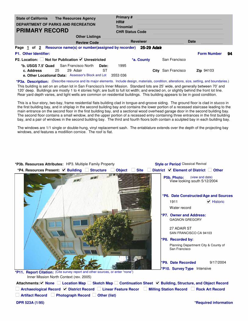
2 Resource name(s) or number(assigned by recorder) 25-29 Adair25-29 Adair25-29 Adair25-29 Adair
P1. Other Identifier:
*P3a. Description:
This building is set on an urban lot in San Francisco's Inner Mission. Standard lots are 25’ wide, and generally between 70’ and 120’ deep. Buildings are mostly 1 to 4 stories high; are built to full lot width; and erected on, or slightly behind the front lot line. Rear yard depth varies, and light wells are common on residential buildings. This building appears to be in good condition.
This is a four-story, two-bay, frame residential flats building clad in tongue-and-groove siding. The ground floor is clad in stucco in the first building bay, and in shiplap in the second building bay and contains the lower portion of a recessed staircase leading to the main entrance on the second floor in the first building bay, and a sectional wood overhead garage door in the second building bay. The second floor contains a small window, and the upper portion of a recessed entry containing three entrances in the first building bay, and a pair of windows in the second building bay. The third and fourth floors both contain a sculpted bay in each building bay.
The windows are 1/1 single or double-hung, vinyl replacement sash. The entablature extends over the depth of the projecting bay windows, and features a modillion cornice. The roof is flat.
(Describe resource and its major elements. Include design, materials, condition, alterations, size, setting, and boundaries.)
DPR 523A (1/95) *Required information
*P11. Report Citation:
Inner Mission North Context (rev. 2005)
(Cite survey report and other sources, or enter “none”)
P5b. Photo: View looking south 5/12/2004
(view and date)
*P7. Owner and Address:
27 ADAIR ST
*P8. Recorded by:
Planning Department City & County of San Francisco
*P9. Date Recorded 9/17/2004
*P10. Survey Type Intensive
*P6. Date Constructed/Age and Sources
Historic1911
Water record
GAGNON GREGORY
HP3. Multiple Family Property
29 Adair ST
SAN FRANCISCO CA 94103
*a. County San Francisco
Style or Period Classical Revival
Form Number 94949494
Assessor's Block and Lot

State of California The Resources Agency
DEPARTMENT OF PARKS AND RECREATION
BUILDING, STRUCTURE, AND OBJECT RECORD
Primary #
HRI#
B11. Addl. Resource Attributes
Area: San Francisco 1906 fire-zoneTheme Post-1906 reconstruction
Period of Significance 1906-1913 Property Type Flats
B9a. Architect: unknown
Page 2 of 2 *Resource name(s) or number 25-29 Adair25-29 Adair25-29 Adair25-29 Adair
*B10. Significance:
CONTEXT: This residential flats building is a representative of the Classical Revival style, and dates from the reconstruction period of development (May 1906-1913). Residential flats are a popular housing type in most of San Francisco’s older neighborhoods. There is typically one residence per floor, each independently accessible from the street. The overwhelming majority of flats are built above a soft story or raised basement, with an open stair leading from the sidewalk up to an elevated entry. Most flats constructed after the mid 1910s were built with a garage at the ground floor, others have had garages added since originally built. This property dates from a significant period, and displays the necessary features of its type to convey its context. It is a contributor to the context, and not individually significant.ASSESSMENT: (Individual / district eligibility is assessed using National Register (NR) Criteria A, B, C & D; and California Register (CR) Criteria 1, 2, 3, & 4. Local significance is assessed using the NR Criteria. See also: http://www.cr.nps.gov/nr/ or http://ohp.parks.ca.gov/) This property is associated with a locally significant area based on the Reconstruction of San Francisco following the earthquake and fire of 1906, where many square miles of dense neighborhoods were rebuilt between 1906 and 1914. Contributory properties have a common range of architectural style, period and pattern of development, and method of construction, per NR Criterion C. Refer to the Mission Reconstruction District form (DPR 523D) for further descriptions, boundaries, and significance. NR and CR eligibility has not been established for this area. There is no evidence that the history of this property is associated with any persons or events of recognized significance in National, California, or San Francisco’s history, nor is the architect, designer, or builder identified in association with its construction, to qualify per Criteria A/1 or B/2. This property was not fully assessed for its potential to yield information important in prehistory or history, per Criterion D/4.INTEGRITY: The building appears to be in good structural and material condition. Materially little changed from the time it was erected in a dense urban fabric, this property retains integrity of location, design, setting, workmanship, feeling, and association. Inappropriate vinyl replacement sash has resulted in a diminished integrity of materials. FEATURES: Character-defining features that should be preserved include, but may not be limited to: the cladding materials and fenestration pattern on the street façade(s); open, recessed entry; projecting bay windows; projecting modillion cornice.
(Discuss importance in terms of historical or architectural context as defined by theme, period, and geographic scope. Also address integrity)
DPR 523B (1/95) *Required information
*B14 Evaluator: N. Moses Corrette
San Francisco Planning Department
1660 Mission Street, San Francisco, CA 94103
(This space reserved for official comments)
Date: 0
*B12. References:City Directories: 1906, 1911, 1920, 1939. Sanborn maps: 1886, 1899, 1915, 1920 (Planning Dept), 1950, 1998. WPA land use maps 1940-1965 (Planning Dept.). Block Books: 1894, 1901, 1906, 1914, 1920, 1935, 1946, 1965. Water Department Tap Records, Building Permit Applications.
* Date of Evaluation: 8/19/2005
Multiple Family Property
*B5 Architectural Style: Classical Revival
Form Number 94949494
CHR Status Code: 5D35D35D35D3
Applicable Criteria National or California Register:
NR C
Multiple Family Property
B1. Historic Name: B2. Common Name:
B3. Original Use: B4. Present Use:
*B6 Construction History:In 1889, the site of this building was occupied by a wagon shed. By 1889, there was a building with two flats on the site. From 1894 to at least 1909, it was owned by C. Randall. The present building was erected in 1911. In 1935, it was owned by Hirth Paul & Lena, and in 1946 by Yohannan N. In 1969, the fire damage to the building was repaired (a note on a water record attached to this permit said the structure was built in 1911).
*B7. Moved? Original Location
*B8. Related Features: Post-1906 reconstruction area
B9b. Builder: unknown
B13. Remarks:
(Sketch Map with north arrow required)
No
N
O
R
T
H
State of California The Resources Agency Primary # DEPARTMENT OF PARKS AND RECREATION HRI#
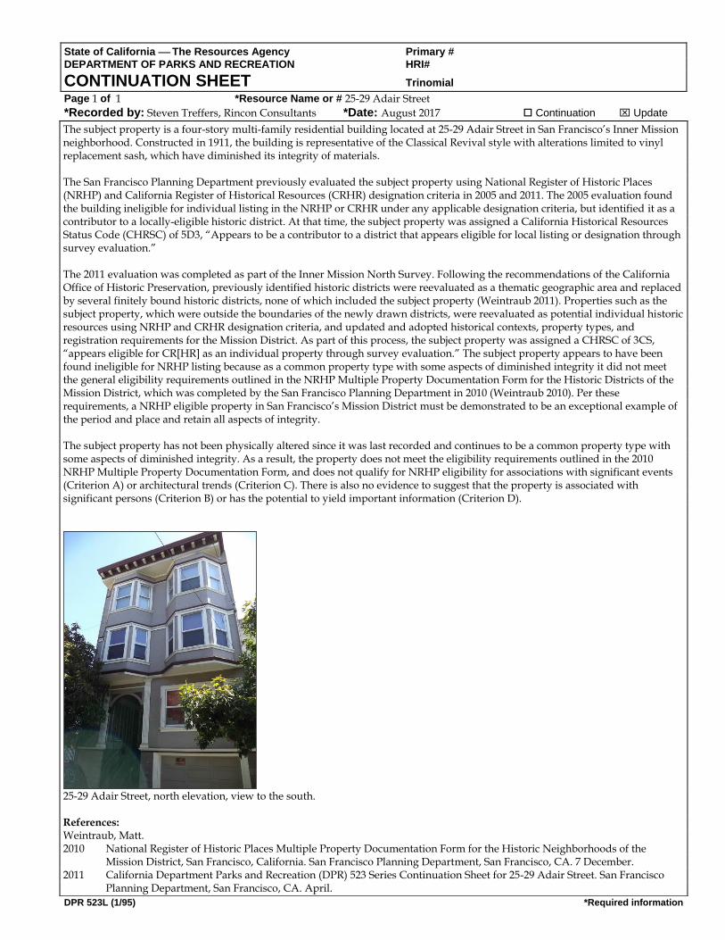
CONTINUATION SHEET Trinomial Page 1 of 1 *Resource Name or # 25-29 Adair Street
*Recorded by: Steven Treffers, Rincon Consultants *Date: August 2017 Continuation Update
DPR 523L (1/95) *Required information
The subject property is a four-story multi-family residential building located at 25-29 Adair Street in San Francisco’s Inner Mission neighborhood. Constructed in 1911, the building is representative of the Classical Revival style with alterations limited to vinyl replacement sash, which have diminished its integrity of materials. The San Francisco Planning Department previously evaluated the subject property using National Register of Historic Places (NRHP) and California Register of Historical Resources (CRHR) designation criteria in 2005 and 2011. The 2005 evaluation found the building ineligible for individual listing in the NRHP or CRHR under any applicable designation criteria, but identified it as a contributor to a locally-eligible historic district. At that time, the subject property was assigned a California Historical Resources Status Code (CHRSC) of 5D3, “Appears to be a contributor to a district that appears eligible for local listing or designation through survey evaluation.” The 2011 evaluation was completed as part of the Inner Mission North Survey. Following the recommendations of the California Office of Historic Preservation, previously identified historic districts were reevaluated as a thematic geographic area and replaced by several finitely bound historic districts, none of which included the subject property (Weintraub 2011). Properties such as the subject property, which were outside the boundaries of the newly drawn districts, were reevaluated as potential individual historic resources using NRHP and CRHR designation criteria, and updated and adopted historical contexts, property types, and registration requirements for the Mission District. As part of this process, the subject property was assigned a CHRSC of 3CS, “appears eligible for CR[HR] as an individual property through survey evaluation.” The subject property appears to have been found ineligible for NRHP listing because as a common property type with some aspects of diminished integrity it did not meet the general eligibility requirements outlined in the NRHP Multiple Property Documentation Form for the Historic Districts of the Mission District, which was completed by the San Francisco Planning Department in 2010 (Weintraub 2010). Per these requirements, a NRHP eligible property in San Francisco’s Mission District must be demonstrated to be an exceptional example of the period and place and retain all aspects of integrity. The subject property has not been physically altered since it was last recorded and continues to be a common property type with some aspects of diminished integrity. As a result, the property does not meet the eligibility requirements outlined in the 2010 NRHP Multiple Property Documentation Form, and does not qualify for NRHP eligibility for associations with significant events (Criterion A) or architectural trends (Criterion C). There is also no evidence to suggest that the property is associated with significant persons (Criterion B) or has the potential to yield important information (Criterion D).
25-29 Adair Street, north elevation, view to the south. References: Weintraub, Matt. 2010 National Register of Historic Places Multiple Property Documentation Form for the Historic Neighborhoods of the
Mission District, San Francisco, California. San Francisco Planning Department, San Francisco, CA. 7 December. 2011 California Department Parks and Recreation (DPR) 523 Series Continuation Sheet for 25-29 Adair Street. San Francisco
Planning Department, San Francisco, CA. April.
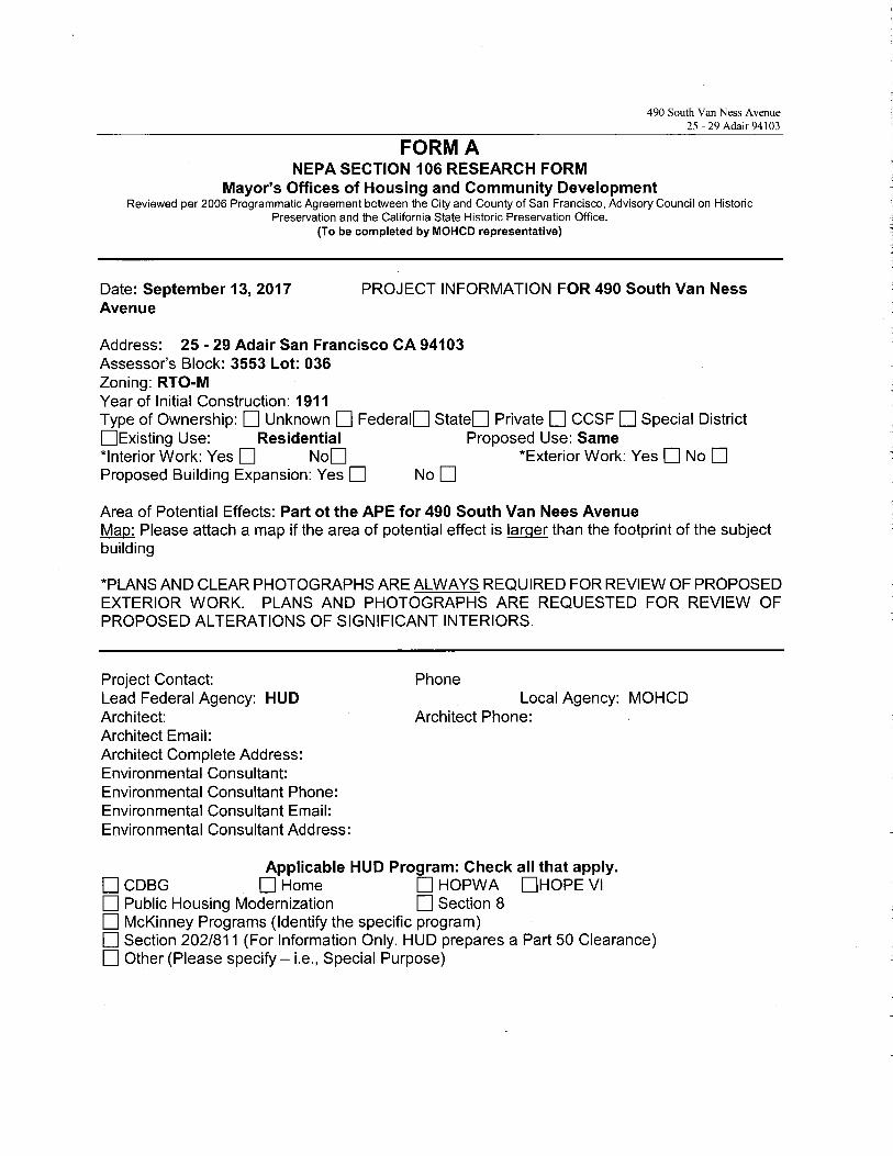
490 South Van Ness Avenue25 - 29 Adair 94103
FORM ANEPA SECTION 106 RESEARCH FORM
Mayor's Offices of Housing and Community DevelopmentReviewed per 2006 Programmatic Agreement between the City and County of San Francisco, Advisory Council on Historic
Preservation and the California State Historic Preservation Office.(To be completed by MOHCD representative)
Date: September 13, 2017 PROJECT INFORMATION FOR 490 South Van NessAvenue
Address: 25 - 29 Adair San Francisco CA 94103Assessor's Block: 3553 Lot: 036Zoning: RTO-MYear of Initial Construction: 1911Type of Ownership: ❑Unknown ❑Federal❑ State❑ Private ❑ CCSF ❑Special District❑Existing Use: Residential Proposed Use: Same'̀Interior Work: Yes ❑ No❑ '`Exterior Work: Yes ❑ No ❑Proposed Building Expansion: Yes ❑ No ❑
Area of Potential Effects: Part of the APE for 490 South Van Nees AvenueMap: Please attach a map if the area of potential effect is larger than the footprint of the subjectbuilding
*PLANS AND CLEAR PHOTOGRAPHS ARE ALWAYS REQUIRED FOR REVIEW OF PROPOSEDEXTERIOR WORK. PLANS AND PHOTOGRAPHS ARE REQUESTED FOR REVIEW OFPROPOSED ALTERATIONS OF SIGNIFICANT INTERIORS.
Project Contact:Lead Federal Agency: HUDArchitect:Architect Email:Architect Complete Address:Environmental Consultant:Environmental Consultant Phone:Environmental Consultant Email:Environmental Consultant Address:
Phone
Architect Phone:Local Agency: MOHCD
Applicable HUD Program: Check all that apply.❑ CDBG ❑Home ❑ HOPWA ❑HOPE VI❑ Public Housing Modernization ❑Section 8❑ McKinney Programs (Identify the specific program)❑ Section 202/811 (For Information Only. HUD prepares a Part 50 Clearance)❑ Other (Please specify — i.e., Special Purpose)
490 South Van Ness Avenue25 - 29 Adair 94103
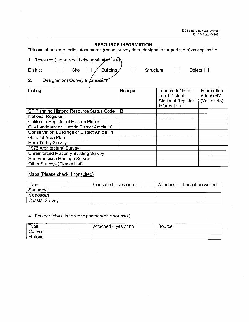
RESOURCE INFORMATION*Please attach supporting documents (maps, survey data, designation reports, etc) as applicable.
1. Resource (the subject being evaluate is a
District ❑ Site ❑ ~ Building ❑ Structure ❑ Object ❑
2. Designations/Survey
Listing Ratings Landmark No. orLocal District/National RegisterInformation
InformationAttached?(Yes or No)
SF Plannin Historic Resource Status Code BNational Re isterCalifornia Re ister of Historic PlacesCit Landmark or Historic District Article 10Conservation Buildin s or District Article 11General Area PlanHere Toda Surve1976 Architectural SurveUnreinforced Mason Buildin SurveSan Francisco Herita e SurveOther. Surve s Please List
Maps (Please check if consulted)
T pe Consulted — es or no Attached —attach if consultedSanborneMetroscanCoastal Surve
4. Photographs (List historic photographic sources)
T e Attached — es or no SourceCurrentHistoric

490 South Van Ness Avenue25 - 29 Adau
San Francisco, CA 941033553- 036
FORM B
NEPA SECTION 106 REVIEW FORMPlanning Department, City and County of San Francisco
Reviewed per 20072 Programmatic Agreement among the Ciry and County of San Francisco, the ACHP and the SHPO.
Subject Address: 25 - 29 Adair 94103 ❑ District
Assessor's Block: 3553 Lot: 036 ❑ Site
Case Number 7~~~~ ~`ti1?~fb~in7 ~ Building
Date Review Completed ~~ ❑ Structure
❑ Object
National Register Status
Note on Source of Determination: If the State Office of Historic Preservation has made no previousdetermination of eligibility for the resource, the Planning Department should make a determination ofeligibility for the purposes of this Section 106 review. In this case, the planner should put his or herinitials under source for the status code chosen. If there is a determination made by the State OfficeHistoric Preservation Office (OHP), please put OHP under source for the status code. Use item 3on page 2 of this review form to show the Planning Department's application of the National RegisterCriteria for eligibility.
a. Source Determination (indicates the status generally):
1 Listed in the National Register2 Determined eligible for the Register in a formal
process involving federal agencies3 Appears eligible for listing in the National Register in
the judgment of the persons) completing or reviewingthe form. (In this case the form is either an attachedsurvey or nomination form, not the Section 106 reviewform. )
4 Might become eligible for listing5 Ineligible for the Register but still of local interest~6 Determined ineligible for National Register listing
7 Not evaluated
b. The subject status (indicates why the registration status was given to the property):
D Part of DistrictIndividual Property
B Both of the above
490 South Van Ness Avenue25 - 29 Adair
San Francisco, CA 941033553- 036
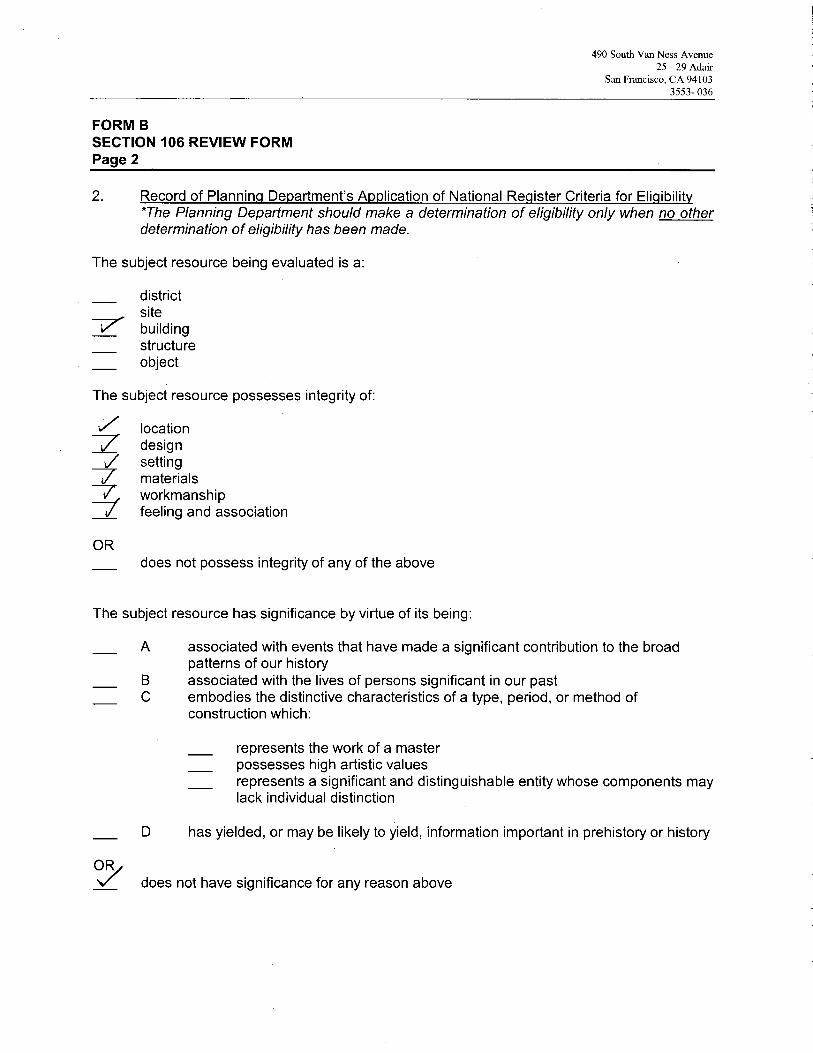
FORM BSECTION 106 REVIEW FORMPage 2
2. Record of Planning Department's Application of National Register Criteria for Eligibility*The Planning Department should make a determination of eligibility only when no otherdetermination of eligibility has been made.
The subject resource being evaluated is a:
districtsitebuildingstructureobject
The subject resource possesses integrity of:
~ locationdesignsettingmaterials
~i workmanshipfeeling and association
ORdoes not possess integrity of any of the above
The subject resource has significance by virtue of its being:
A associated with events that have made a significant contribution to the broadpatterns of our history
B associated with the lives of persons significant in our pastC embodies the distinctive characteristics of a type, period, or method of
construction which:
represents the work of a masterpossesses high artistic valuesrepresents a significant and distinguishable entity whose components maylack individual distinction
D has yielded, or may be likely to yield, information important in prehistory or history
ORdoes not have significance for any reason above

490 South Van Ness Avenue25 - 29 Adair
San Francisco, CA 941033553- 036
FORM BSECTION 106 REVIEW FORMPage 3
3. Record of Proposed Projects and Required Approvals (check and complete items thatapply):
The proposed project is shown in plans labeled ~ I 1 ~~ ~ .s ,~ that areincluded in the project file.
There is no active active Building Permit Application (BPA) at the time of Section 106 review.
Associated active BPA's at time of Section 106 review include:BPA no. Assigned planner
A notation was placed in Parcel Tracking to notify planners of the need to review futureBPAs with the associated section 106 review. This is required if a project was reviewedand approved under Section 106 but had no active BPA.
A Certificate of Appropriateness is required for the proposal. Case No. and Date reviewedby Landmarks Preservation Advisory Board:
4. Findings
Finding of no adverse effect
yes no unknown ✓ not applicable
Comments:
Finding of no adverse effect with mitigations
yes no unknown ✓ not applicable
Comments:
Proposed activity causes an adverse effect:
yes v no
Comments:
PlannerSan Francisco Planning Department1650 Mission Street, Fourth FloorSan Francisco, CA 94103
i~Date

State of California The Resources Agency
DEPARTMENT OF PARKS AND RECREATION
PRIMARY RECORD
Primary #
HRI#
Trinomial
CHR Status Code
P2. Location:
*P3b. Resources Attributes:
Attachments:
*P4. Resources Present:
Other Listings
Review Code Reveiwer Date
Not for Publication Unrestricted
Date: 1995*b. USGS 7.5' Quad San Francisco North
c. Address 460 City San Francisco Zip 94103
e. Other Locational Data: 3553 007
Page 1 of
Building Structure Object Site District Element of District Other
None Location Map Sketch Map Continuation Sheet
Linear Feature Recor Milling Station RecordArchaeological Record District Record Rock Art Record
Artifact Record Photograph Record Other (list)
Building, Structure, and Object Record
2 Resource name(s) or number(assigned by recorder) 460 South Van Ness460 South Van Ness460 South Van Ness460 South Van Ness
P1. Other Identifier:
*P3a. Description:
This building is set on an urban lot in San Francisco's Inner Mission. Standard lots are 25’ wide, and generally between 70’ and 120’ deep. Buildings are mostly 1 to 4 stories high; are built to full lot width; and erected on, or slightly behind the front lot line. Rear yard depth varies, and light wells are common on residential buildings. This building appears to be in good condition.
This is a four story apartment building at the corner of South Van Ness and Adair Streets. There are three building bays on South Van Ness Avenue and five building bays on Adair Street. The brick-clad ground floor features small windows in the first and third building bays on South Van Ness Avenue, and five garage doors and a service door on Adair Street. The second, third, and fourth floors each contain a projecting bay window in the first and third building bays on South Van Ness Avenue, the first, third, and fifth bays on Adair Street, and four windows in the central bay on South Van Ness Avenue, and the second building bay on Adair. The fourth building bay on Adair contains two single windows.
The windows are single-light wood casements with fixed transoms. The tops of the bay windows above the fourth floor are covered in Spanish clay tile. There is a simple projecting cornice. The roof is flat.
(Describe resource and its major elements. Include design, materials, condition, alterations, size, setting, and boundaries.)
DPR 523A (1/95) *Required information
*P11. Report Citation:
Inner Mission North Context (rev. 2005)
(Cite survey report and other sources, or enter “none”)
P5b. Photo: View looking west 8/16/2004
(view and date)
*P7. Owner and Address:
1740 MARKET ST
*P8. Recorded by:
Planning Department City & County of San Francisco
*P9. Date Recorded 9/17/2004
*P10. Survey Type Intensive
*P6. Date Constructed/Age and Sources
Historic1926
Assessor
CARRICO TIM
HP3. Multiple Family Property
0 South Van Ness AV
SAN FRANCISCO CA 94103
*a. County San Francisco
Style or Period Mediterranean Eclectic
Form Number 87878787
Assessor's Block and Lot

State of California The Resources Agency
DEPARTMENT OF PARKS AND RECREATION
BUILDING, STRUCTURE, AND OBJECT RECORD
Primary #
HRI#
B11. Addl. Resource Attributes
Area: San Francisco 1906 fire-zoneTheme Early Infill Development
Period of Significance 1914-1930 Property Type Apartments
B9a. Architect: unknown
Page 2 of 2 *Resource name(s) or number 460 South Van Ness460 South Van Ness460 South Van Ness460 South Van Ness
*B10. Significance:
CONTEXT: This Apartment building is a representative of a Mediterranean Eclectic style, and dates from the early infill period of development (1914-1930). Apartment buildings are differentiated from other residential property types by the way the buildings are accessed. Apartment buildings feature a common main entrance to the building, with interior corridors leading to individual apartment entrances. They are most often found in compact, pedestrian-oriented neighborhoods and on corner lots. It is a standard in its context but is not important because its context lacks cultural or architectural significance.ASSESSMENT: (Individual / district eligibility is assessed using National Register (NR) Criteria A, B, C & D; and California Register (CR) Criteria 1, 2, 3, & 4. Local significance is assessed using the NR Criteria. See also: http://www.cr.nps.gov/nr/ or http://ohp.parks.ca.gov/) There is no evidence that the history of this property is associated with any persons or events of recognized significance in National, California, or San Francisco’s history, nor is the architect, designer, or builder identified in association with its construction, to qualify per Criteria A/1 or B/2. This property is not the work of a master, but is typical of modest structures of similar vintage in the Mission in its design and construction method. It does not possess high artistic values, is not distinctive, nor does it belong to distinguishable entity whose components may lack individual distinction per criterion C/3. This property was not fully assessed for its potential to yield information important in prehistory or history, per Criterion D/4. For these reasons, this property is determined ineligible for the National, or California Registers, or local listing or designation through local government review process; however, it retains sufficient design integrity to warrant special consideration in local planning.INTEGRITY: The building appears to be in good structural and material condition. This property retains integrity of location, design, setting, materials, workmanship, feeling, and association.FEATURES Character defining features that should be preserved include but may not be limited to: the surface treatment, fenestration pattern, size and location of the garage entries, projecting bays with clay tile roof, casement windows, and simple projecting cornice.
(Discuss importance in terms of historical or architectural context as defined by theme, period, and geographic scope. Also address integrity)
DPR 523B (1/95) *Required information
*B14 Evaluator: N. Moses Corrette
San Francisco Planning Department
1660 Mission Street, San Francisco, CA 94103
(This space reserved for official comments)
Date: 0
*B12. References:City Directories: 1906, 1911, 1920, 1939. Sanborn maps: 1886, 1899, 1915, 1920 (Planning Dept), 1950, 1998. WPA land use maps 1940-1965 (Planning Dept.). Block Books: 1894, 1901, 1906, 1914, 1920, 1935, 1946, 1965. Apartment House Directory, 1962 Ed., Donaldson, Paul L. Water Department Tap Records, Building Permit Applications.
* Date of Evaluation: 8/19/2005
Multiple Family Property
*B5 Architectural Style: Mediterranean Eclectic
Form Number 87878787
CHR Status Code: 6L6L6L6L
Applicable Criteria National or California Register:
none
Multiple Family Property
B1. Historic Name: B2. Common Name:
B3. Original Use: B4. Present Use:
*B6 Construction History:The site of this building was vacant in 1889, but was occupied by a two story wood and coal warehouse by 1899, owned by Charles S. and Mary Healey in 1894. The lot remained vacant until the Healey family had the present building erected in 1926. They maintained ownership to at least 1935. In 1946, it was owned by Patrick J. Morrow. In 1970, five replacement overhead garage doors were installed on the ground floor.
*B7. Moved? Original Location
*B8. Related Features:
B9b. Builder: unknown
B13. Remarks:
(Sketch Map with north arrow required)
No
N
O
R
T
H
State of California The Resources Agency Primary # DEPARTMENT OF PARKS AND RECREATION HRI#
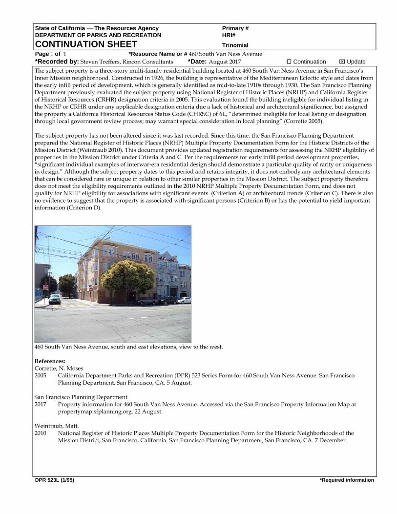
CONTINUATION SHEET Trinomial Page 1 of 1 *Resource Name or # 460 South Van Ness Avenue
*Recorded by: Steven Treffers, Rincon Consultants *Date: August 2017 Continuation Update
DPR 523L (1/95) *Required information
The subject property is a three-story multi-family residential building located at 460 South Van Ness Avenue in San Francisco’s Inner Mission neighborhood. Constructed in 1926, the building is representative of the Mediterranean Eclectic style and dates from the early infill period of development, which is generally identified as mid-to-late 1910s through 1930. The San Francisco Planning Department previously evaluated the subject property using National Register of Historic Places (NRHP) and California Register of Historical Resources (CRHR) designation criteria in 2005. This evaluation found the building ineligible for individual listing in the NRHP or CRHR under any applicable designation criteria due a lack of historical and architectural significance, but assigned the property a California Historical Resources Status Code (CHRSC) of 6L, “determined ineligible for local listing or designation through local government review process; may warrant special consideration in local planning” (Corrette 2005). The subject property has not been altered since it was last recorded. Since this time, the San Francisco Planning Department prepared the National Register of Historic Places (NRHP) Multiple Property Documentation Form for the Historic Districts of the Mission District (Weintraub 2010). This document provides updated registration requirements for assessing the NRHP eligibility of properties in the Mission District under Criteria A and C. Per the requirements for early infill period development properties, “significant individual examples of interwar‐era residential design should demonstrate a particular quality of rarity or uniqueness in design.” Although the subject property dates to this period and retains integrity, it does not embody any architectural elements that can be considered rare or unique in relation to other similar properties in the Mission District. The subject property therefore does not meet the eligibility requirements outlined in the 2010 NRHP Multiple Property Documentation Form, and does not qualify for NRHP eligibility for associations with significant events (Criterion A) or architectural trends (Criterion C). There is also no evidence to suggest that the property is associated with significant persons (Criterion B) or has the potential to yield important information (Criterion D).
460 South Van Ness Avenue, south and east elevations, view to the west. References: Corrette, N. Moses 2005 California Department Parks and Recreation (DPR) 523 Series Form for 460 South Van Ness Avenue. San Francisco
Planning Department, San Francisco, CA. 5 August. San Francisco Planning Department 2017 Property information for 460 South Van Ness Avenue. Accessed via the San Francisco Property Information Map at
propertymap.sfplanning.org. 22 August. Weintraub, Matt. 2010 National Register of Historic Places Multiple Property Documentation Form for the Historic Neighborhoods of the
Mission District, San Francisco, California. San Francisco Planning Department, San Francisco, CA. 7 December.

490 South Van Ness Avenue460 South Van Ness 94103
FORM ANEPA SECTION 106 RESEARCH FORM
Mayor's Offices of Housing and Community DevelopmentReviewed per 2006 Programmatic Agreement between the City and County of San Francisco, Advisory Council on Historic
Preservation and the California State Historic Preservation Office.(To be completed by MOHCD representative)
Date: September 13, 2017 PROJECT INFORMATION FOR 490 South Van NessAvenue
Address: 460 South Van Ness San Francisco CA 94103Assessor's Block: 3553 Lot: 007Zoning: RTO-MYear of Initial Construction: 1926Type of Ownership: ❑Unknown ❑Federal❑ State❑ Private ❑ CCSF ❑Special District❑Existing Use: Residential Proposed Use: Same*Interior Work: Yes ❑ No❑ *Exterior Work: Yes ❑ No ❑Proposed Building Expansion: Yes ❑ No ❑
Area of Potential Effects: Part of the APE for 490 South Van Nees AvenueMap: Please attach a map if the area of potential effect is larger than the footprint of the subjectbuilding
*PLANS AND CLEAR PHOTOGRAPHS ARE ALWAYS REQUIRED FOR REVIEW OF PROPOSEDEXTERIOR WORK. PLANS AND PHOTOGRAPHS ARE REQUESTED FOR REVIEW OFPROPOSED ALTERATIONS OF SIGNIFICANT INTERIORS.
Project Contact:Lead Federal Agency: HUDArchitect:Architect Email:Architect Complete Address:Environmental Consultant:Environmental Consultant Phone:Environmental Consultant Email:Environmental Consultant Address:
Phone
Architect Phone:Local Agency: MOHCD
Applicable HUD Program: Check all that apply.❑ CDBG ❑Home ❑ HOPWA ❑HOPE VI❑ Public Housing Modernization ❑Section 8❑ McKinney Programs (Identify the specific program)❑ Section 202/811 (For Information Only. HUD prepares a Part 50 Clearance)❑ Other (Please specify — i.e., Special Purpose)

490 South Van Ness Avenue460 South Van Ness 94103
RESOURCE INFORMATION*Please attach supporting documents (maps, survey data, designation reports, etc) as applicable.
1. Resource (the subject being evaluateyYis a):
District ❑ Site ❑ ~uilding / ❑ Structure ❑ Object ❑
2. Designations/Survey Inforrf~ation
Listing Ratings Landmark No. orLocal District/National RegisterInformation
InformationAttached?(Yes or No)
SF Plannin Historic Resource Status Code CNational Re isterCalifornia Re ister of Historic PlacesCit Landmark or Historic District Article 10Conservation Buildin s or District Article 11General Area PlanHere Toda Surve1976 Architectural SurveUnreinforced Mason Buildin SurveSan Francisco Herita e SurveOther Surve s Please List
Maps (Please check if consulted)
T e Consulted — es or no Attached —attach if consultedSanborneMetroscanCoastal Surve
4. Photographs (List historic photographic sources)
T e Attached — es or no SourceCurrentHistoric

490 South Van Ness Avenue460 South Van Ness
San Francisco, CA 941033553-007
FORM B
NEPA SECTION 106 REVIEW FORMPlanning Department, City and County of San Francisco
Reviewed per 20072 Programmatic Agreement among the City and County of San Francisco, the ACHP and the SHPO.
Subject Address: 460 South Van Ness 94103
Assessor's Block: 3553 Lot: 007
Case Number '1~(~ 11- ~~ ~ Z~~1 r-r,Date Review Completed 11~'hr 1~1 '
❑ District
❑ Site
~ Building
❑ Structure
❑ Object
National Register Status
Note on Source of Determination: If the State Office of Historic Preservation has made no previousdetermination of eligibility for the resource, the Planning Department should make a determination ofeligibility for the purposes of this Section 106 review. In this case, the planner should put his or herinitials under source for the status code chosen. If there is a determination made by the State OfficeHistoric Preservation Office (OHP), please put OHP under source for the status code. Use item 3on page 2 of this review form to show the Planning Departments application of the National RegisterCriteria for eligibility.
L7
Source
~~ ~
Determination (indicates the status generally):
1 Listed in the National Register2 Determined eligible for the Register in a formal
process involving federal agencies3 Appears eligible for listing in the National Register in
the judgment of the persons) completing or reviewingthe form. (In this case the form is either an attachedsurvey or nomination form, not the Section 106 reviewform.)
4 Might become eligible for listing5 Ineligible for the Register but still of local interest~'~6 Determined ineligible for National Register listing
7 Not evaluated
The subiect status (indicates why the registration status was given to the property):
D Part of DistrictIndividual Property
B Both of the above

490 South Van Ness Avenue460 South Van Ness
San Francisco, CA 941033553- 007
FORM BSECTION 106 REVIEW FORMPage 2
2. Record of Planning Department's Application of National Register Criteria for Eligibility*The Planning Department should make a determination of eligibility only when no otherdetermination of eligibility has been made.
The subject resource being evaluated is a:
districtsite
~ buildingstructureobject
The subject resource possesses integrity of:
.~ location~/ design~/ setting
materialsworkmanshipfeeling and association
ORdoes not possess integrity of any of the above
The subject resource has significance by virtue of its being:
A associated with events that have made a significant contribution to the broadpatterns of our history
B associated with the lives of persons significant in our pastC embodies the distinctive characteristics of a type, period, or method of
construction which:
represents the work of a masterpossesses high artistic valuesrepresents a significant and distinguishable entity whose components maylack individual distinction
D has yielded., or may be likely to yield, information important in prehistory or history
ORdoes not have significance for any reason above

490 South Van Ness Avenue460 South Van Ness
San Francisco, CA 941033553-007
FORM BSECTION 106 REVIEW FORMPage 3
3. Record of Proposed Projects and Required Approvals (check and complete items thatapply):
~/ The proposed project is shown in plans labeled °~ I ~ ~ I'1 ~J P~a~~ ~'~„r►,~~that areincluded in the project file.There is no active active Building Permit Application (BPA) at the time of Section 106 review.Associated active BPA's at time of Section 106 review include:BPA no. Assigned plannerA notation was placed in Parcel Tracking to notify planners of the need to review futureBPAs with the associated section 106 review. This is required if a project was reviewedand approved under Section 106 but had no active BPA.A Certificate of Appropriateness is required for the proposal. Case No. and Date reviewedby Landmarks Preservation Advisory Board:
4. Findings
Finding of no adverse effect
yes no
Comments:
unknown
Finding of no adverse effect with mitigations
yes no unknown
Comments:
Proposed activity causes an adverse effect:
yes 'V no
Comments:
PlannerSan Francisco Planning. Department1650 Mission Street, Fourth FloorSan Francisco, CA 94103
v not applicable
~' not applicable
1~ 3Date
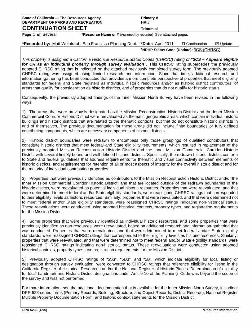
State of California ⎯ The Resources Agency Primary # DEPARTMENT OF PARKS AND RECREATION HRI# CONTINUATION SHEET Trinomial Page 1 of Several *Resource Name or # (Assigned by recorder) See attached pages *Recorded by: Matt Weintraub, San Francisco Planning Dept. *Date: April 2011 Continuation ⌧ Update
DPR 523L (1/95) *Required information
*NRHP Status Code (Update): 3CS (CHRSC) This property is assigned a California Historical Resource Status Codes (CHRSC) rating of “3CS – Appears eligible for CR as an individual property through survey evaluation”. This CHRSC rating supercedes the previously adopted CHRSC rating that is indicated on the attached previously completed survey form. The previously adopted CHRSC rating was assigned using limited research and information. Since that time, additional research and information-gathering has been conducted that provides a more complete perspective of properties that meet eligibility standards for federal and State registers as individual historic resources and/or as historic district contributors, of areas that qualify for consideration as historic districts, and of properties that do not qualify for historic status. Consequently, the previously adopted findings of the Inner Mission North Survey have been revised in the following ways: 1) The areas that were previously designated as the Mission Reconstruction Historic District and the Inner Mission Commercial Corridor Historic District were reevaluated as thematic geographic areas, which contain individual historic buildings and historic districts that are related to the thematic contexts, but that do not constitute historic districts in and of themselves. The previous documentation for these areas did not include finite boundaries or fully defined contributing components, which are necessary components of historic districts. 2) Historic district boundaries were redrawn to encompass only those groupings of qualified contributors that constitute historic districts that meet federal and State eligibility requirements, which resulted in replacement of the previously adopted Mission Reconstruction Historic District and the Inner Mission Commercial Corridor Historic District with several finitely bound and well-defined historic districts. Specifically, the redrawn historic districts conform to State and federal guidelines that address requirements for thematic and visual connectivity between elements of historic districts, and requirements for retention of all or most aspects of integrity for the overall historic district and for the majority of individual contributing properties. 3) Properties that were previously identified as contributors to the Mission Reconstruction Historic District and/or the Inner Mission Commercial Corridor Historic District, and that are located outside of the redrawn boundaries of the historic disticts, were reevaluated as potential individual historic resources. Properties that were reevaluated, and that were determined to meet federal and/or State elgibility standards, were reassigned CHRSC ratings that corresponded to their eligibility levels as historic resources. Similarly, properties that were reevaluated, and that were determined not to meet federal and/or State elgibility standards, were reassigned CHRSC ratings indicating non-historical status. These reevaluations were conducted using adopted historical contexts, property types, and registration requirements for the Mission District. 4) Some properties that were previously identified as individual historic resources, and some properties that were previously identified as non-resources, were reevaluated, based on additional research and information-gathering that was conducted. Properties that were reevaluated, and that were determined to meet federal and/or State elgibility standards, were reassigned CHRSC ratings that corresponded to their eligibility levels as historic resources. Similarly, properties that were reevaluated, and that were determined not to meet federal and/or State elgibility standards, were reassigned CHRSC ratings indicating non-historical status. These reevaluations were conducted using adopted historical contexts, property types, and registration requirements for the Mission District. 5) Previously adopted CHRSC ratings of “5S3”, “5D3”, and “5B”, which indicate eligibility for local listing or designation through survey evaluation, were converted to CHRSC ratings that reference eligibility for listing in the California Register of Historical Resources and/or the National Register of Historic Places. Determination of eligibility for local Landmark and Historic District designations under Article 10 of the Planning Code was beyond the scope of the survey and was not performed. For more information, see the additional documentation that is available for the Inner Mission North Survey, including: DPR 523-series forms (Primary Records; Building, Structure, and Object Records; District Records); National Register Multiple Property Documentation Form; and historic context statements for the Mission District.

State of California The Resources Agency
DEPARTMENT OF PARKS AND RECREATION
PRIMARY RECORD
Primary #
HRI#
Trinomial
CHR Status Code
P2. Location:
*P3b. Resources Attributes:
Attachments:
*P4. Resources Present:
Other Listings
Review Code Reveiwer Date
Not for Publication Unrestricted
Date: 1995*b. USGS 7.5' Quad San Francisco North
c. Address 469 City San Francisco Zip 94103
e. Other Locational Data: 3552 018
Page 1 of
Building Structure Object Site District Element of District Other
None Location Map Sketch Map Continuation Sheet
Linear Feature Recor Milling Station RecordArchaeological Record District Record Rock Art Record
Artifact Record Photograph Record Other (list)
Building, Structure, and Object Record
2 Resource name(s) or number(assigned by recorder) 469-473 South Van Ness469-473 South Van Ness469-473 South Van Ness469-473 South Van Ness
P1. Other Identifier:
*P3a. Description:
This building is set on an urban lot in San Francisco's Inner Mission. Standard lots are 25’ wide, and generally between 70’ and 120’ deep. Buildings are mostly 1 to 4 stories high; are built to full lot width; and erected on, or slightly behind the front lot line. Rear yard depth varies, and light wells are common on residential buildings. This building appears to be in good condition.
This is a three-story, free-standing, frame, residential flats building clad in tongue-and-groove wood siding. A raised basement is clad in stucco scored to represent coursed ashlar contains the base of a projecting bay window in the first building bay, with a small single window in the forward face, and a set of stairs in the second building bay. The first, second, and third floors contain a sculpted bay window in the first building bay. This bay is articulated from the basement to the parapet. Each of the windows on the first and second floors is flanked by pilasters capped with cast plaster Ionic capitols. The base of the bay at each floor contains a banded window sill, and a paneled spandrel, although the applied ornament there is largely missing. Above each level of windows on the bay is an entablature that becomes a belt course across the façade. On the first floor, it is ornamented with dentil molding, on the second, with egg-and-dart, while it is banded on the third floor. The windows of the third floor have Grecian window surrounds. The second building bay contains a recessed entry on the first floor containing three sash doors, and in plan a rounded portico supported by four Corinthian columns. Above the portico on the second and third floors is a smaller sculpted bay window with similar ornament to that of the bay window on the corresponding floor. The second and third floors are linked vertically at the outer edges of the façade by two-story paneled pilasters capped by Corinthian capitols. The entablature contains a cast plaster frieze, dentil band and a modillion cornice. The whole entablature returns on the secondary facades to a depth of about two feet. The secondary facades are clad in wood shiplap siding. The windows on the secondary facades have surrounds with heavy lintels. The windows are 1/1 double-hung wood sash. The roof is gabled behind the parapets.
(Describe resource and its major elements. Include design, materials, condition, alterations, size, setting, and boundaries.)
DPR 523A (1/95) *Required information
*P11. Report Citation:
Inner Mission North Context (rev. 2005)
(Cite survey report and other sources, or enter “none”)
P5b. Photo: View looking east 2/5/2004
(view and date)
*P7. Owner and Address:
2660 GREENWICH ST
*P8. Recorded by:
Planning Department City & County of San Francisco
*P9. Date Recorded 6/10/2004
*P10. Survey Type Intensive
*P6. Date Constructed/Age and Sources
Historic1899
Water Record
JEONG TONY
HP3. Multiple Family Property
473 South Van Ness AV
SAN FRANCISCO CA 94123
*a. County San Francisco
Style or Period Classical Revival
Form Number 68686868
Assessor's Block and Lot

State of California The Resources Agency
DEPARTMENT OF PARKS AND RECREATION
BUILDING, STRUCTURE, AND OBJECT RECORD
Primary #
HRI#
B11. Addl. Resource Attributes
Area: San Francisco’s Inner MissionTheme Pre-April 1906 construction
Period of Significance 1850-1906 Property Type Flats
B9a. Architect: unknown
Page 2 of 2 *Resource name(s) or number 469-473 South Van Ness469-473 South Van Ness469-473 South Van Ness469-473 South Van Ness
1969 Howard
*B10. Significance:
CONTEXT: This residential flats building is a representative of the Classical Revival style, and dates from the first generation construction period of development (c.1850- April 1906). Residential flats are a popular housing type in most of San Francisco’s older neighborhoods. There is typically one residence per floor, each independently accessible from the street. The overwhelming majority of flats are built above a soft story or raised basement, with an open stair leading from the sidewalk up to an elevated entry. Most flats constructed after the mid 1910s were built with a garage at the ground floor, others have had garages added since originally built. This property dates from a significant period, and displays the necessary features of its type to convey its context. It is a contributor to the context, and not individually significant.ASSESSMENT: (Individual / district eligibility is assessed using National Register (NR) Criteria A, B, C & D; and California Register (CR) Criteria 1, 2, 3, & 4. Local significance is assessed using the NR Criteria. See also: http://www.cr.nps.gov/nr/ or http://ohp.parks.ca.gov/) The context of dense residential and commercial expansion is represented under Criterion 1 by historic districts or buildings that reflect population growth, and development patterns from 1850 to 1906. Under Criterion 3, the context is represented by properties whose architectural treatments reflect their residential and/or commercial functions, both practically and symbolically. This district is not eligible for the National Register because other districts such as the Liberty Hill National Register District are better examples of this context. Persons associated with this building do not appear to have made significant contributions to our history to qualify per Criterion B/2. This property was not fully assessed for its potential to yield information important in prehistory or history, per Criterion D/4. INTEGRITY: The building appears to be in good structural and material condition. Materially little changed from the time it was erected in a dense urban fabric, this property retains integrity of location, design, setting, workmanship, materials, feeling and association.FEATURES: Character-defining features that should be preserved include, but may not be limited to: the façade cladding materials; fenestration pattern on the front facade; projecting bay windows, with double-hung wood windows; cast plaster and wood ornament.
(Discuss importance in terms of historical or architectural context as defined by theme, period, and geographic scope. Also address integrity)
DPR 523B (1/95) *Required information
*B14 Evaluator: N. Moses Corrette
San Francisco Planning Department
1660 Mission Street, San Francisco, CA 94103
(This space reserved for official comments)
Date: 0
*B12. References:
* Date of Evaluation: 8/19/2005
Multiple Family Property
*B5 Architectural Style: Classical Revival
Form Number 68686868
CHR Status Code: 3CD3CD3CD3CD
Applicable Criteria National or California Register:
CR 1, 3
Multiple Family Property
B1. Historic Name: B2. Common Name:
B3. Original Use: B4. Present Use:
*B6 Construction History:In 1881, F. C. Wagner had a water tap connected to this site to a pork packaging warehouse and a two-family dwelling on a larger lot. The present building was built in 1899 for Mrs. R.C. Wagner and was first occupied as a single-family dwelling and three roomers. It was soon fully three flats. Water tap August 29, 1899. No relevant records at DBI. By 1935, it was owned by the Wagner children: Wagner, Frank P, Lawrence A, Adolph P, Herbert R, Hilda R, and in 1946 by Leach Arthur & Florence C.
*B7. Moved? Original Location
*B8. Related Features: IMN pre-4/18/06 earthquake district
B9b. Builder: unknown
B13. Remarks:
(Sketch Map with north arrow required)
No
N
O
R
T
H
State of California The Resources Agency Primary # DEPARTMENT OF PARKS AND RECREATION HRI#
CONTINUATION SHEET Trinomial Page 1 of 1 *Resource Name or # 469-473 South Van Ness Avenue
*Recorded by: Steven Treffers, Rincon Consultants *Date: August 2017 Continuation Update
DPR 523L (1/95) *Required information
The subject property is a three-story multi-family residential building located at 469-473 South Van Ness Avenue in San Francisco’s Inner Mission neighborhood. Constructed in 1899, the building is representative of the Classical Revival style. The San Francisco Planning Department previously evaluated the subject property using National Register of Historic Places (NRHP) and California Register of Historical Resources (CRHR) designation criteria in 2005 and 2011. The 2005 evaluation found the building ineligible for individual listing in the NRHP or CRHR under any applicable designation criteria, but identified it as a contributor to a CRHR-eligible historic district. At that time, the subject property was assigned a California Historical Resources Status Code (CHRSC) of 3CD, “Appears eligible for CR[HR] as a contributor to a CR[HR] eligible district through a survey evaluation.” The 2011 evaluation was completed as part of the Inner Mission North Survey. Following the recommendations of the California Office of Historic Preservation, previously-identified historic districts were reevaluated as a thematic geographic area and replaced by several finitely bound historic districts, none of which included the subject property (Weintraub 2011). Properties such as the subject property, which were outside the boundaries of the newly drawn districts, were reevaluated as potential individual historic resources using NRHP and CRHR designation criteria, and updated and adopted historical contexts, property types, and registration requirements for the Mission District. As part of this process, the subject property was assigned a CHRSC of 3CS “appears eligible for CR[HR] as an individual property through survey evaluation.” Following its initial recordation, the building’s original windows were replaced in kind in 2007, resulting in a partial diminishment of its integrity of materials (San Francisco Planning Department 2017). Both this and the fact that the subject property is a common property type in the Mission District appear to be the reason that the subject property was found ineligible for NRHP listing per the requirements of the NRHP Multiple Property Documentation Form for the Historic Districts of the Mission District (Weintraub 2010). These requirements indicate that a NRHP eligible property in San Francisco’s Mission District must be demonstrated to be an exceptional example of the period and place and retain all aspects of integrity The subject property has not been physically altered since it was last recorded and continues to be a common property type with some aspects of diminished integrity. As a result, the property does not meet the eligibility requirements outlined in the 2010 NRHP Multiple Property Documentation Form, and does not qualify for NRHP eligibility for associations with significant events (Criterion A) or architectural trends (Criterion C). There is also no evidence to suggest that the property is associated with significant persons (Criterion B) or has the potential to yield important information (Criterion D).
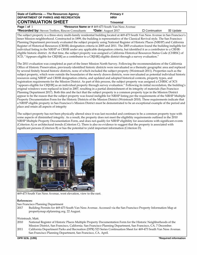
469-473 South Van Ness Avenue, west elevation, view to the east. References: San Francisco Planning Department 2017 Building Permits for 469-473 South Van Ness Avenue. Accessed via the San Francisco Property Information Map at
propertymap.sfplanning.org. 22 August. Weintraub, Matt. 2010 National Register of Historic Places Multiple Property Documentation Form for the Historic Neighborhoods of the
Mission District, San Francisco, California. San Francisco Planning Department, San Francisco, CA. 7 December. 2011 California Department Parks and Recreation (DPR) 523 Series Continuation Sheet for 469-473 South Van Ness Avenue.
San Francisco Planning Department, San Francisco, CA. April.
490 South Van Ness Avenue469 -473 South Van Ness 94103
FORM ANEPA SECTION 106 RESEARCH FORM
Mayor's OfFices of Housing and Community DevelopmentReviewed per 2006 Programmatic Agreement between the City and County of San Francisco, Advisory Council on Historic
Preservation and the California State Historic Preservation Office.(To be completed by MOHCD representative)
Date: September 13, 2017 PROJECT INFORMATION FOR 490 South Van NessAvenue
Address: 469 -473 South Van Ness San Francisco CA 94103Assessor's Block: 3552 Lot: 018Zoning: UMUYear of Initial Construction: 1899Type of Ownership: ❑Unknown ❑Federal❑ State❑ Private ❑ CCSF ❑Special District❑Existing Use:. Residential Proposed Use: Same*Interior Work: Yes ❑ No❑ *Exterior Work: Yes ❑ No ❑Proposed Building Expansion: Yes ❑ No ❑
Area of Potential Effects: Part of the APE for 490 South Van Nees AvenueMap: Please attach a map if the area of potential effect is larger than the footprint of the subjectbuilding
*PLANS AND CLEAR PHOTOGRAPHS ARE ALWAYS REQUIRED FOR REVIEW OF PROPOSEDEXTERIOR WORK. PLANS AND PHOTOGRAPHS ARE REQUESTED FOR REVIEW OFPROPOSED ALTERATIONS OF SIGNIFICANT INTERIORS.
Project Contact:Lead Federal Agency: HUDArchitect:Architect Email:Architect Complete Address:Environmental Consultant:Environmental Consultant Phone:Environmental Consultant Email:Environmental Consultant Address:
Phone
Architect Phone:Local Agency: MOHCD
Applicable HUD Program: Check all that apply.❑ CDBG ❑Home ❑ HOPWA ❑HOPE VI❑ Public Housing Modernization ❑Section 8❑ McKinney Programs (Identify the specific program)❑ Section 2A2/811 (For Information Only. HUD prepares a Part 50 Clearance)❑ Other (Please specify — i.e., Special Purpose)

490 South Van Ness Avenue469 -473 South Van Ness 94103
RESOURCE INFORMATION*Please attach supporting documents (maps, survey data, designation reports, etc) as applicable.
1. Resource (the subject being evaluate ~ a):
District ❑ Site ❑ uilding ❑ Structure ❑ Object ❑
2. Designations/Survey Informa 'on
Listing Ratings Landmark No. or.Local District/National RegisterInformation
InformationAttached?(Yes or No)
SF Plannin Historic Resource Status Code ANational Re isterCalifornia Re ister of Historic PlacesCit Landmark or Historic District Article 10Conservation Buildin s or District Article 11General Area PlanHere Toda Surve1976 Architectural SurveUnreinforced Mason Buildin SurveSan Francisco Herita e SurveOther Surve s Please List
Maps (Please check if consulted)
T e Consulted — es or no Attached —attach if consultedSanborneMetroscanCoastal Surve
4. Photographs (List historic photographic sources)
T e Attached — es or no SourceCurrentHistoric
490 South Van Ness Avenue469 -473 South Van NessSan Francisco, CA 94103
3552- 018
FORM B
NEPA SECTION 106 REVIEW FORMPlanning Department, City and County of San Francisco
Reviewed per 20072 Programmatic Agreement among the City and County of San Francisco, the ACHP and the SHPO.
Subject Address: 469 -473 South Van Ness 94103 ❑ District
Assessor's Block: 3552 Lot: 018 ❑ Site
Case Number Zv ~`~ ~ (~ ~ ~ q (o ~ ~ Building
Date Review Completed ~'~ ~ \'~ ❑ Structure
❑ Object
National Register Status
Note on Source of Determination: If the State Office of Historic Preservation has made no previousdetermination of eligibility for the resource, the Planning Department should make a determination ofeligibility for the purposes of this Section 106 review. In this case, the planner should gut his or herinitials under source for the status code chosen. If there is a determination made by the State OfficeHistoric Preservation Office (OHP), please put OHP under source for the status code. Use item 3on page 2 of this review form to show the Planning Department's application of the National RegisterCriteria for eligibility.
a. Source Determination (indicates the status generally):
1 Listed in the National Register2 Determined eligible for the Register in a formal
process involving federal agencies3 Appears eligible for listing in the National Register in
the judgment of the persons) completing or reviewingthe form. (In this case the form is either an attachedsurvey or nomination form, not the Section 106 reviewform.)
4 Might become eligible for listing5 Ineligible for the Register but still of local interest
_ t~~ 6 Determined ineligible for National Register listing7 Not evaluated
b. The subject status (indicates why the registration status was given to the property):
D Part of DistrictI ndividual Property
B Both of the above

490 South Van Ness Avenue469 -473 South Van NessSan Francisco, CA 94103
3552-018
FORM BSECTION 106 REVIEW FORMPage 2
2. Record of Planning Department's Application of National Register Criteria for EligibilitY*The Planning Department should make a determination of eligibility only when no otherdetermination of eligibility has been made.
The subject resource being evaluated is a:
districtsitebuildingstructureobject
The subject resource possesses integrity of:
locationdesignsettingmaterialsworkmanshipfeeling and association
ORdoes not possess integrity of any of the above
The subject resource has significance by virtue of its being:
_ A associated with events that have made a significant contribution to the broadpatterns of our history
B associated with the lives of persons significant in our pastC embodies the distinctive characteristics of a type, period, or method of
construction which:
represents the work of a masterpossesses high artistic valuesrepresents a significant and distinguishable entity whose components maylack individual distinction
D has yielded, or may be likely to yield, information important in prehistory or history
ORdoes not have significance for any reason above

490 South Van Ness Avenue469 -473 South Van NessSan Francisco, CA 94103
3552-018
FORM BSECTION 106 REVIEW FORMPage 3
3. Record of Proposed Projects and Required Approvals (check and complete items thatapply):
The proposed project is shown in plans labeled ~ ~ ~~ ~ ~ that areincluded in the project file.
There is no active active Building Permit Application (SPA) at the time of Section 106 review.
Associated active BPA's at time of Section 106 review include:BPA no. Assigned planner
A notation was placed in Parcel Tracking to notify planners of the need to review futureBPAs with the associated section 106 review. This is required if a project was. reviewedand approved under Section 106 but had no active BPA.
A Certificate of Appropriateness is required for the proposal. Case No. and Date reviewedby Landmarks Preservation Advisory Board:
4. Findings
Finding of no adverse effect
yes no unknown ✓ not applicable
Comments:
Finding of no adverse effect with mitigations
yes no unknown ✓ not applicable
Comments:
Proposed activity causes an adverse effect:
yes ~ no
Comments:
i ~ ~ '`~ ~~~~ Planner DateSan Francisco Planning Department1650 Mission Street, Fourth FloorSan Francisco, CA 94103

State of California The Resources Agency Primary # DEPARTMENT OF PARKS AND RECREATION HRI #
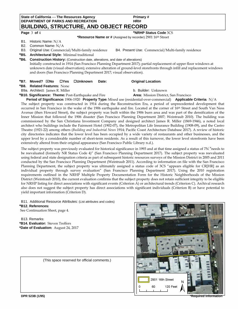
PRIMARY RECORD Trinomial NRHP Status Code Other Listings Review Code Reviewer Date Page 1 of 4. *Resource Name or #: 2901 16th Street P1. Other Identifier: *P2. Location: Not for Publication Unrestricted *a. County: Ventura
and (P2b and P2c or P2d. Attach a Location Map as necessary.) *b. USGS 7.5' Quad: San Francisco North Date: 1995 T 2S; R 5W; ¼ of ¼ of Sec ; S.B. B.M. c. Address: 2901-2929 16th Street City: San Francisco Zip: 94110 d. UTM: Zone: ; mE/ mN (G.P.S.) e. Other Locational Data: (e.g., parcel #, directions to resource, elevation, etc., as appropriate) Elevation: Parcels (Block/Lot) 3570/001
*P3a. Description: (Describe resource and its major elements. Include design, materials, condition, alterations, size, setting, and boundaries) Located at the southwest corner of 16th Street and South Van Ness Avenue, the subject property is a two-part commercial building that is four stories and rectangular in plan with a large lightwell on the south side. A flat roof caps the building and features a short decorative cornice that extends around the primary north and east elevations. Representative of its Edwardian-era architecture, the building is sheathed Scottish bond brick on the upper three floors with a decorative brick motif ribbon located underneath the parapet. Other notable design features include decorative metal window balustrades and fire escapes on the primary elevations. Upper level windows are primarily original, wood divided light and double-hung, with some aluminum replacements. Although the upper levels are largely intact, the ground level storefronts have been substantially altered either through infill and/or the application of non-original materials. There are no original bulkheads and nearly all of the original transom windows have been removed and/or covered. Similarly, the primary entry for the upper-levels on 16th Street features a replacement aluminum and glass door, which is located behind a metal security gate. Although the building appears to be in good overall condition, the lower-level alterations have negatively affected some aspects of its integrity.
*P3b. Resource Attributes: (List attributes and codes) HP3. Multiple family property; HP7. 3+ story commercial building *P4. Resources Present: Building Structure Object Site District Element of District Other (Isolates, etc.
P5b. Description of Photo: North elevation, view to the west, July 18, 2017.
*P6. Date Constructed/Age and Sources: Historic Prehistoric Both 1914 (San Francisco Planning Department 2017)
*P7. Owner and Address: Unknown
*P8. Recorded by: (Name, affiliation, and address) Steven Treffers Rincon Consultants, Inc. 449 15th Street #303. Oakland, CA 94612
*P9. Date Recorded: April 3, 2017 *P10. Survey Type: Intensive
*P11. Report Citation: None
*Attachments: NONE Location Map Sketch Map Continuation Sheet Building, Structure, and Object Record Archaeological Record District Record Linear Feature Record Milling Station Record Rock Art Record Artifact Record Photograph Record Other (List):
DPR 523A (1/95) *Required information

State of California The Resources Agency Primary # DEPARTMENT OF PARKS AND RECREATION HRI# LOCATION MAP Trinomial Page 2 of 4 *Resource Name or #: 2901 16th Street *Map Name: USGS San Francisco North Quadrangle *Scale: 1:24,000 *Date of Map: 1995
DPR 523J (1/95) *Required information
DPR 523B (1/95) *Required information
State of California The Resources Agency Primary # DEPARTMENT OF PARKS AND RECREATION HRI# BUILDING, STRUCTURE, AND OBJECT RECORD Page 3 of 4 *NRHP Status Code 3CS *Resource Name or # (Assigned by recorder) 2901 16th Street B1. Historic Name: N/A B2. Common Name: N/A B3. Original Use: Commercial/Multi-family residence B4. Present Use: Commercial/Multi-family residence
*B5. Architectural Style: Minimal traditional *B6. Construction History: (Construction date, alterations, and date of alterations)
Initially constructed in 1914 (San Francisco Planning Department 2017); partial replacement of upper floor windows at unknown date (visual observation); extensive alteration of ground-level storefronts through infill and replacement windows and doors (San Francisco Planning Department 2017; visual observation).
*B7. Moved? No Yes Unknown Date: Original Location: *B8. Related Features: None B9a. Architect: James R. Miller b. Builder: Unknown
*B10. Significance: Theme: Post-Earthquake and Fire Area: Mission District, San Francisco Period of Significance: 1906-1920 Property Type: Mixed use (residential‐over‐commercial) Applicable Criteria: N/A
The subject property was constructed in 1914 during the Reconstruction Era, a period of unprecedented development that occurred in San Francisco in the wake of the 1906 earthquake and fire. Located at the corner of 16th Street and South Van Ness Avenue (then Howard Street), the subject property was built within the 1906 burn area and was part of the densification of the Inner Mission that followed the 1906 disaster (San Francisco Planning Department 2007; Weintraub 2010). The building was commissioned by the San Christiana Investment Company and designed architect James R. Miller (1869-1946), a noted local architect who buildings include the Fairmont Hotel (1902-07), the Metropolitan Life Insurance Building (1908-09), and the Castro Theatre (1921-22) among others (Building and Industrial News 1914; Pacific Coast Architecture Database 2017). A review of historic city directories indicates that the lower level has been occupied by a wide variety of restaurants and other businesses, and the upper level by a considerable number of short-term residents. As a result of this turnover, the lower level storefronts have been extensively altered from their original appearance (San Francisco Public Library n.d.).
The subject property was previously evaluated for historical significance in 1993 and at that time assigned a status of 7N “needs to be reevaluated (formerly NR Status Code 4)” (San Francisco Planning Department 2017). The subject property was reevaluated using federal and state designation criteria as part of subsequent historic resources surveys of the Mission District in 2005 and 2011 conducted by the San Francisco Planning Department (Weintraub 2011). According to information on file with the San Francisco Planning Department, the subject property was ultimately assigned a status code of 3CS “appears eligible for CR[HR] as an individual property through survey evaluation” (San Francisco Planning Department 2017). Using the 2010 registration requirements outlined in the NRHP Multiple Property Documentation Form for the Historic Neighborhoods of the Mission District (Weintraub 2010), the current evaluation confirms that the subject property does not retain sufficient integrity to be eligible for NRHP listing for direct associations with significant events (Criterion A) or architectural trends (Criterion C). Archival research also does not suggest the subject property has direct associations with significant individuals (Criterion B) or have potential to yield important information (Criterion D). B11. Additional Resource Attributes: (List attributes and codes)
*B12. References: See Continuation Sheet, page 4. B13. Remarks:
*B14. Evaluator: Steven Treffers *Date of Evaluation: August 24, 2017
(This space reserved for official comments.)

State of California The Resources Agency Primary # DEPARTMENT OF PARKS AND RECREATION HRI# CONTINUATION SHEET Trinomial Page 4 of 4 *Resource Name or # 2901 16th Street *Recorded by: Steven Treffers, Rincon Consultants *Date: August 2017 Continuation Update
DPR 523L (1/95) *Required information
References: Building and Industrial News 1914 “Apartment House,” Building and Industrial News, Fourteenth Year No. 6, p. 23. 11 February 1914, Pacific Coast Architecture Database. 2017 James Rupert Muller (Architect). Pacific Coast Architecture Database. Accessed via
http://pcad.lib.washington.edu/person/90/. 22 August 2017. San Francisco Planning Department 2007 City Within a City: Historic Context Statement for San Francisco’s Mission District. Prepared by City and County of San
Francisco Planning Department. November. 2017 Property Information for 2901-2929 16th Street. Accessed via the San Francisco Property Information Map at
propertymap.sfplanning.org. 22 August. San Francisco Public Library n.d. San Francisco City Directories, various years. Accessed via https://sfpl.org/index.php?pg=2000540401. 22 August 2017. Weintraub, Matt. 2010 National Register of Historic Places Multiple Property Documentation Form for the Historic Neighborhoods of the
Mission District, San Francisco, California. San Francisco Planning Department, San Francisco, CA. 7 December. 2011 California Department Parks and Recreation (DPR) 523 Series Continuation Sheet for 469-473 South Van Ness Avenue.
San Francisco Planning Department, San Francisco, CA. April.
1927 view of subject building on right (San Francisco Public Library) 1951 view of subject building on left (San
Francisco Public Library)
1914 rendering of the subject building (San Francisco Chronicle April 18, 1914)

490 South Van Ness Avenue2901 - 2929 16th 94103
FORM ANEPA SECTION 106 RESEARCH FORM
Mayor's Offices of Housing and Community DevelopmentReviewed per 2006 Programmatic Agreement between the City and County of San Francisco, Advisory Council on Historic
Preservation and the California State Historic Preservation Office.(To be completed by MOHCD representative)
Date: September 13, 2017 PROJECT INFORMATION FOR 490 South Van NessAvenue
Address: 2901 - 2929 16th San Francisco CA 94103Assessor's Block: 3570 Lot: 001Zoning: UMUYear of Initial Construction: 1914Type of Ownership: ❑Unknown ❑Federal❑ State❑ Private ❑ CCSF ❑Special District❑Existing Use: Mixed Proposed Use: Same'"Interior Work: Yes ❑ No❑ *Exterior Work: Yes ❑ No ❑Proposed Building Expansion: Yes ❑ No ❑
Area of Potential Effects: Part of the APE for 490 South Van Nees AvenueMap: Please attach a map if the area of potential effect is larger than the footprint of the subjectbuilding
*PLANS AND CLEAR PHOTOGRAPHS ARE ALWAYS REQUIRED FOR REVIEW OF PROPOSEDEXTERIOR WORK. PLANS AND PHOTOGRAPHS ARE REQUESTED FOR REVIEW OFPROPOSED ALTERATIONS OF SIGNIFICANT INTERIORS.
Project Contact:Lead Federal Agency: HUDArchitect:Architect Email:Architect Complete Address:Environmental Consultant:Environmental Consultant Phone:Environmental Consultant Email:Environmental Consultant Address:
Phone
Architect Phone:Local Agency: MOHCD
Applicable HUD Program: Check all that apply.❑ CDBG ❑Home ❑ HOPWA ❑HOPE VI❑ Public Housing Modernization ❑Section 8❑ McKinney Programs (Identify the specific program) _❑ Section 202/811 (For Information Only. HUD prepares a Part 50 Clearance)❑ Other (Please specify — i.e., Special Purpose)

490 South Van Ness Avenue2901 - 2929 16th 94103
RESOURCE INFORMATION'"Please attach supporting documents (maps, survey data, designation reports, etc) as applicable.
1. Resource (the subject being evalu~afed is
District ❑ Site ❑ ~ Buildiry~ ❑ Structure ❑ Object ❑
2. Designations/Survey Infc(rmation
Listing Ratings Landmark No. orLocal District/National RegisterInformation
InformationAttached?(Yes or No)
SF Plannin Historic Resource Status Code ANational Re isterCalifornia Re ister of Historic PlacesCit Landmark or Historic District Article 10Conservation Buildin s or District Article 11General Area PlanHere Toda Surve1976 Architectural SurveUnreinforced Mason Buildin SurveSan Francisco Herita e SurveOther Surve s Please List
Maps (Please check if consulted)
T e Consulted — es or no Attached —attach if consultedSanborneMetroscanCoastal Surve
4. Photographs (List historic photographic sources)
T pe Attached — es or no SourceCurrentHistoric

490 South Van Ness Avenue2901 - 2929 16th
San Francisco, CA 941033570- 001
FORM B
NEPA SECTION 106 REVIEW FORMPlanning Department, City and County of San Francisco
Reviewed per 20072 Programmatic Agreement among the City and County of San Francisco, the ACHP and the SHPO.
Subject Address: 2901 - 2929 16th 94103 ❑ District
Assessor's Block: 3570 Lot: 001 ❑ Site
Case Number o~D(1 ' b (~-~ ~~ ~~~_ ~ Building
Date Review Completed ~?,~ ~'"( ❑ ~ Structure
❑ Object
National Register Status
Note on Source of Determination: If the State Office of Historic Preservation has made no previousdetermination of eligibility for the resource, the Planning Department should make a determination of
eligibility for the purposes of this Section 106 review. In this case, the planner should put his or her
initials under source for the status code chosen. If there is a determination made by the State OfficeHistoric Preservation Office (OHP), please put OHP under source for the status code. Use item 3on page 2 of this review form to show the Planning Department's application of the National RegisterCriteria for eligibility.
a. Source Determination (indicates the status generally):
1 Listed in the National Register2 Determined eligible for the Register in a formal
process involving federal agencies3 Appears eligible for listing in the National Register in
the judgment of the persons) completing or reviewingthe form. (In this case the form is either an attachedsurvey or nomination form, not the Section 106 reviewform. )
4 Might become eligible for listing5 Ineligible for the Register but still of local interest
Jl~~ ~ 6 Determined ineligible for National Register listing7 Not evaluated
b. The subject status (indicates why the registration status was given to theproperty):
D Part of DistrictIndividual Property
B Both of the above
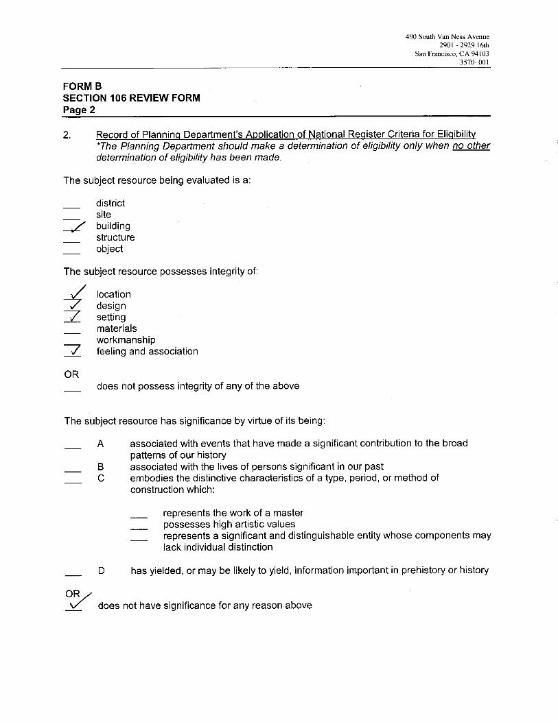
490 South Van Ness Avenue2901 - 2929 16th
San Francisco, CA 941033570- 001
FORM BSECTION 106 REVIEW FORMPage 2
2. Record of Planning Department's Application of National Register Criteria for Eligibility*The Planning Department should make a determination of eligibility only when no otherdetermination of eligibility has been made.
The subject resource being evaluated is a:
districtsitebuildingstructureobject
The subject resource possesses integrity of:
locationdesign
~ settingmaterialsworkmanship
~ feeling and association
does not possess integrity of any of the above
The subject resource has significance by virtue of its being:
A associated with events that have made a significant contribution to the broadpatterns of our history
B associated with the lives of persons significant in our pastC embodies the distinctive characteristics of a type, period, or method of
construction which:
represents the work of a master_ possesses high artistic values
represents a significant and distinguishable entity whose components maylack individual distinction
D has yielded, or may be likely to yield, information important in prehistory or history
OR/~/ does not have significance for any reason above
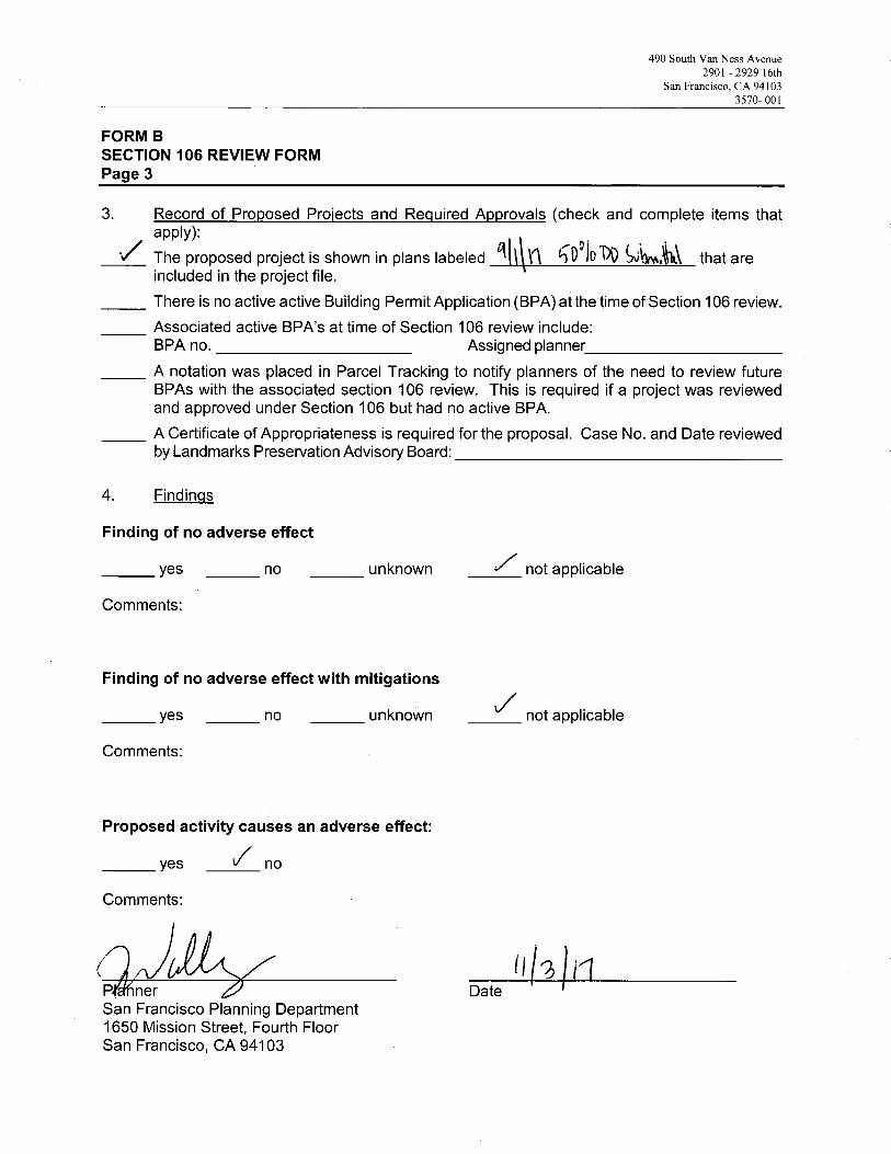
490 South Van Ness Avenue2901 - 2929 16th
San Francisco, CA 941033570- OOl
FORM BSECTION 106 REVIEW FORMPage 3
3. Record of Proposed Projects and Required Approvals (check and complete items thataPp~Y)~ i
The proposed project is shown in plans labeled ~ ~1~i D91G 1~ ~v~,w„~1~` that areincluded in the project file.
There is no active active Building Permit Application (BPA) at the time of Section 106 review.
Associated active BPA's at time of Section 106 review include:BPA no. Assigned planner
A notation was placed in Parcel Tracking to notify planners of the need to review futureBPAs with the associated section 106 review. This is required if a project was reviewedand approved under Section 106 but had no active BPA.
A Certificate of Appropriateness is required for the proposal. Case No. and Date reviewedby Landmarks Preservation Advisory Board:
4. Findings
Finding of no adverse effect
yes no unknown ,not applicable
Comments:
Finding of no adverse effect with mitigations
yes no unknown ~ not applicable
Comments:
Proposed activity causes an adverse effect:
yes ✓ no
Comments:
P nerSan Francisco Planning Department1650 Mission Street, Fourth FloorSan Francisco, CA 94103
j ~Date
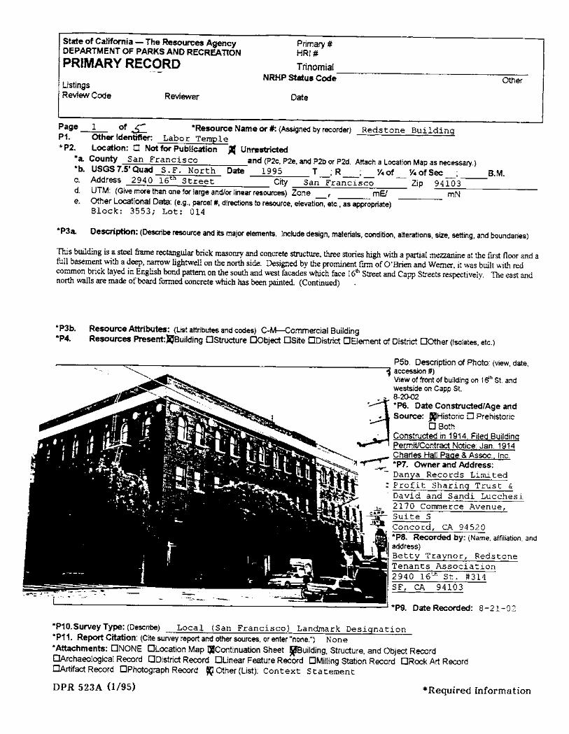
State of California - The Resources AgencyDEPARTMENT OF PARKS AND RECREATION
PRIMARY RECORD
Primary #HRI#
TrinomialNRHP Stus Code Ot er
ListingsReview Code Reviewer Date
Page -L of £ *Resource Name or #: (Assigned by recorder) Reds tone Bui ldingP1. Other Identifer: Labor Temple* P2. Location: 0 Not for Publication Ø(' Unrestcted
*a. County San Francisco and (P2c, P2e, and P2b or P2d. Attach a Location Map as necesary,)*b. USGS7.5'Quad S.F. North Dat 1995 T;R, Y.of Y.ofSec, 8.M.c. Address 2940 16th Street Cit San Fra~seO Zip 94iO3-d. UTM: (Give more than one for large and/or linear resources) Zone _, mE! mNe. Other Locional Dat: (e.g., parcel #, direcions to resource, elevation, etc., as appropriate)
Block: 3553; Lot: 014
*P3a Description: (Descbe resurce and its major elements. Include design, materials, condition, alteraions, size, setting, and boundaries)
Ths buidig is a steel fre rectagular brick masonr and concrete stctu. the stories high with a paral meze at the first floor and afull basment with a dee, naow lightwell on the nort side. Designed by the promient finn of O'Brien and Werner, it was built with redconuon brick layed in English bond pater on the south and west facades which face 16th Stret and Capp Streets respectively. The east andnort walls are made of board fonned concrete whch has been pated. (Continued)
*P3b. Resource Attributes: (List attributes and codes) C-M-ommercial Building*P4. Resources Present:liSuilding DStructure DObjec DSite DDistrict DElement of District DOther (Isolates, etc.)
P5b. Description of Photo: (view, date,
1 accession #)View of front of building on 16" SI. andwestside on Capp SI.
_ 8-202
J. *P6. Date Constucted/Age and
.. Source: lHistoric D Prehistoric
D Both, " Constructed in 1914, Filed Buildina
" PermitContrac Notice: Jan. 1914-:~.~ .~ Charles Hall Paae & Asso, fnc. ., ~ .'l..- _.: *P7. Owner and Address:
,~. ., - Danya Records Limi ted~,d~ ; : Profit Sharing Trust &'~ David and Sandi Lucchesi
""I."~ .J 2170 Commerce Avenue,: " 11 eAPP Suite S. -~ ~ Concord, CA 94520. or *P8. Recorded by: (Name, affliation, and
address)Betty Traynor, RedstoneTenants Association2940 16th St. #314SF, CA 94103
*P9. Date Recorded: 8-21-02
*P10.SurveyType: (Describe) Local (San Francisco) Landmark Designation*P11. Repo Citation: (Cite survey report and other sources, or enter "none.") None*Attachments: DNONE DLocation Map IJContinuation Sheet ~uilding, Structure, and Objec RecrdOArchaeological Recrd DDistrict Recrd DLinear Feaure Record DMillng Station Record DRock Art Record
OArtifac Record DPhotograph Recrd KJ Other (List): Context Statement
DPR 523A 0/95) *Required Information

Ste of Califoria - The Resources Agecy Primary #DEPARTMENT OF PARKS AND RECREA nON HRI#BUilDING, ST~~CTUREJ AND OBJECT RECORD
*NRHP Status CodePage ~ of 5 *Resource Name or # (Assigned by recorder) Redstone. Building81. Historic Name: Labor Temple
82. Common Name: Redstone Building83. Original Use: Labor hall and offices84. Present Use: Office, commercial, art spaces, theaters*85. Arhitural Stye: Office*86. Constuction Histor: (Construion date, alterations, and date of alterations)
Built in 1914, east wing added in 1939.
*87. Move? ørNo Dyes DUnknown Dat:*88. Relat Feature: NA
Onginal Location:
89a. Archiec: 0' Brien and Werner b. 8uilder:*810. Significance: Theme Labor History Area: San Francisco
Perod of Signifcance 1914-1934 (Primary) Propert Typ: Office/CommercialApplicable Criera: ~ (Discuss importance in terms of historical or architectural context as defined by theme, period, and geographicscope. Also address integri.)
The Labor Temple was bult in 1914 by the San Fracisco Labor Council to be its new headquarers and a center of union activityin Sa Fracisco. There were over 130 member unons in the council at tht time. The weekly union newspaper, The LaborClarion, proclaimed it opened to the public Febru 26, 1915 with a fist page arcle. The arcle heraded ths "splendid newhome of the Labor Council" with its large auditorium and assembly hall, jin halls, seen lodge halls, and 24 offces. It stted
tht "the openig of the new Labor Temple will add new life to Sixteenth steet, as it will brg thousds of men and womendaily into the distct who fonnerly gathered in their headquers and meetings elsewhere in the city." (Cont.)
811. Additional Resource Attributes: (Listallributes and codes) C-M -- Commercial Building
*812. Refnces: A Terrble Anaer: The 1934 Waterfront and General
Strike in San Francisco, David F. Selvin (1996) and The 1934 SanFrancisco Waterlnt and Generl Strikes, Context Staement, adopted byThe SF Landmarks Advisory 8oard, May 16, 2001, plus labor historianArchie Green and labor librarian Susan Sherwd.
(Sketch Map with north arrow required.)
*814. Evaluator:*Date of Evaluation:
.!/a ~ f' 'S ~.
N
r813. Remarks: Today the exterior of the building looks much the sameas it appeared when built in 1914 with the addition of 1939.
(This space reserved for official comments.) *'~l .. i /' /-s i1(ed #lriu781 :Ji :'- .. / / I.
I ~.-f 5hø+
/
'l~~
~~~
DPR 523B 0/95) *Requil'ed Information
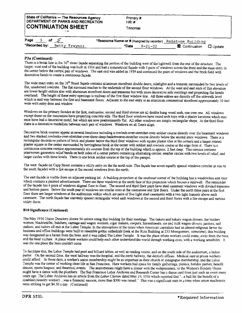
State of California - The Resources AgencyDEPARTMENT OF PARKS AND RECREATION
CONTINUATION SHEET
Primary #HRI#
Trinomial
--Page -i of .2*Recded by: Betty Traynor
*Resource Name or # (Assigned by recorder) Redstone Building*Date 8-21-02 II Continuation 0 Update
PJa (Continued)
Th\:re is a bæak line in the 1611 street façad\: separating the portion of th\: buidig west of the lightwell from the rest of the strctue. 'Ill\:
larger, west end of the buildig was built in 1914 and had a symmetrcal façade with 5 pai of windows across th\: lront and th\: mai entry inthe c\:nter below the central pair of widows. The east \:nd was added in 1939 and continued the pai of windows and the brck field withdecorative bands to create a continuous façade.
The wide mai entr on the 1611 Street façade contains alwnum storefront doubl\: doors, sidelights and a tranom suounded by two levels offlat, unadorned concrete. The flat slJound reaches to the undeside of the second floor widows. At the west and east ends of ths el\:vationare lower height l:tres also with alwnum storefront doors and trsoms but with more decorative sid\: moldings and projectig flat lintelsoverhead. The height of these entr opegs is midway of the firs floor widow lie. Al thee entres are diectly otTthe sidewal levelwhich is mid way between the first and bament floors. Adjacent to the east entr is an alwnum commercial storefront approxiately 10 feetwide with entr door and widow.
Windows on the prmar facades at the fist mez\:, second an thd stories are al double hung woo sash, one over one. All windows
except those on the mezzan\: have projecting concrete sills. The thd floor windows have round arch tops with a plaster keystone whch mayonce have had a decorative motif, but whch are now predomitly flat. Al other widows are simpl\: rectagular shape. At the thd floor
there is a decorative medllon beteen each pair of widows. Windows on all floors align.
Decorative brck courses appe in several locations includig a rowlock-over-strtcher-over-soldier course directly over the baseent windowsand two stacked rowlocks-over-stretcher-over-thee..p-basketweave-stretcher course directly below th\: second story windows. There is aæctanguar decorative pattern of brick and plaster below the thd Hoor windows with squaæ plaster tili: at the comers and a larg\:r rotatedplaster squae in the center slJunded by herngbone brick in the center with soldier and rowlock course at th\: edge from it. There is acontinuous concrete cornce approxiately six courses from the top of the buidig which is approx. 2 fed dee. 11s cornice contains
interwoven geometrc reliefbads on both sides of a Cl:ter pattern contairg alteratig circli:; smaller circles with two levels of relii:, andlarger circles with thee levels. There is one brick soldia course at the top of the parapet.
The west façade on Capp Street conta a utility \:ntr on the far nort side. 11s façade has seven equaly spaced widows (similar in size toth\: south façade) with a fie escape at the second widows from the nort
Th\: east façade is visibl\: from an adjacent parking lot. A buildig projection at the southeast comer of the building ha a \Vindowless east lac\:which contains a paited adv\:rtsement. There are thn:e windows in the nort face of ths projection which housi: a stairwelL. The remainderof the taçade has 4 pai of widows aligned floor to floor. The second and thd !loor pai have steel casement windows with divided tranomsand bottom pan\:s. Below the south pai of widows ar similar ones at the meze and first floors. Unde the nort the pais at the first
floor there ar larger windows at the auditorium withn whch are pair of five light steel casements with a two light tranom abov\: eachcasement. The nort façade ha uneveiy spaced rectagular woo sash widows at the second and thd Hoors with a tire escape and varousutility ducts.
810 Significance (Continued)
The May i 916 Union Directory shows 54 uions using th buildi tor th\:ir meetings. The baker and baki: wagon drivers, the binder\!woml:, blacksmith, butchers, carage and wagon workers, cigar maker, coop\:rs, horseshoet."ls, ice and milk wagon drivers, janitors, salmakers, and taiors all md at the Labor Temple. In the atmosphere of the times when Ain\:rican capitalists had an almost religious tenor torbusiness and offce buidigs wee buit to resemble gothic cathedrs (look at the Russ Buiding at 235 Montgom\:ry, sometime), this buildingwas d\:signated as a haven from the boss, and it was called The Labor Temple. It was the place whae workers could come, away trom th\: hoss,and the boss' cultue. A place where worker could help each otha understd the world though workig ey\:s, with a workig sesibilit\!. Itwas the one place the boss couldn't come.
To facilitate ths, the Labor T \:mple had pol and billiard tables, as well as reading rooms, and on the south side of the auditoriwn a ladi\:sparlor. On the second noor, the west hallway was the hospita, and the nort hallway, the dl:tist's offces. Medical care at prces workerscould atford. In those days, a workers uion membership might be as important as their church or s)'agogue m\:mbership, and the Labor
Teniple was the center of workig clas life in San Francisco. Hae work\:rs had space tor famly gathergs, picnics, holiday parties, beetitdaces, sport leagues, and theatrcal events. The seamstesses might have a dinner \Vith the webpressmen, or the Women's Bindi: Unionmight have a dace with the plumbe. The San Francisco Labor Archives and Research Center has a dace card trom just such an \:Vl:t manyyears ago. The Labor Archives has an aricle from the Labor C/arimi dated May 19, 1916 which reported that "...a ball tor tlie ben\:fil of adisabled (laundr work\:r) ...was a financial success, more than $300 was raised." 11s wa~ a significat sum in a time when union machinistswere strng to get $4.50 a day. (Continued)
DPR 523L *Required Information
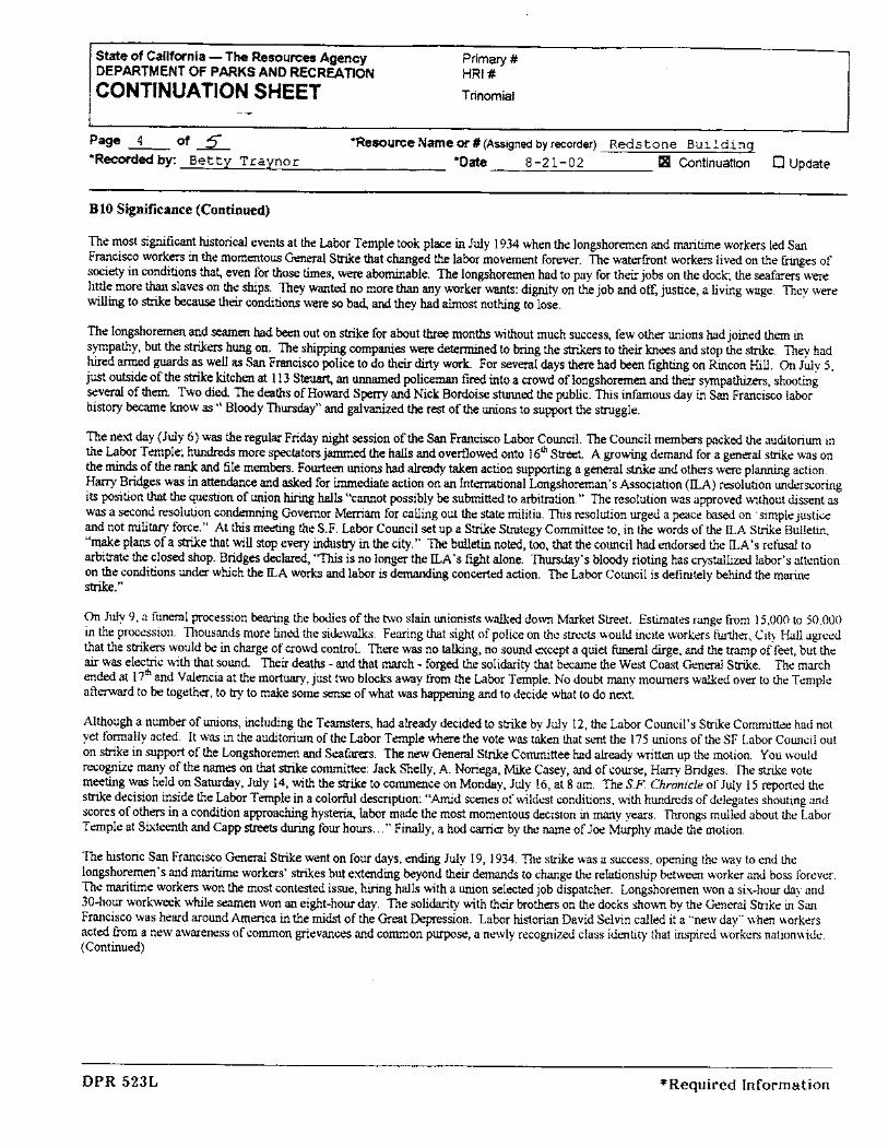
State of California - The Resources AgencyDEPARTMENT OF PARKS AND RECREATION
CONTINUATION SHEET
Primary #HRI#
Trinomial
Page ~ of ~*Recorded by: Betty Traynor
.Resource Name or # (Assigned by recorder) Redstone Building*Date 8 -21-02 æi Continuation 0 Update
B10 Significance (Continued)
The most signficat historical events at the Labor Temple took plac in July 1934 when the longshoremen and matie workers led SanFrancisco workers in the momentous Geeral Stre tht chaged the labor movement forever. The waterfront workers lived on the frges ofsociety in conditions that, even for those ties, wer abomiable. The longshoremen had to pay for thei jobs on the dock; the seafarers werelitte more th slaves on the ships. They wated no more th any worker wats: dignty on the job and off, justice, a living wage. They werewilling to ste becaus thei conditions were so bad, an they had almost nothg to lose.
The longshoremen and seen had be out on stre for about thee month without much success, few other unons had joined them insympathy, but the st hung on. The shipp compares wer detenned to brg the sters to their knees and stop the ste. They hadhid ared guds as well as Sa Fracisco police to do thei di work. For sever days there had been fightig on Rincon Hill. On July 5,
jus outsde of the ste kitchen at i i 3 Steua an uned policem fir into a crowd of longshoremen and thei sypaths, shootigsevera of them. Two died The deaths of Howard Spe and Nick Bordoise stued the public. Ths inamous day in San Francisco laborhistory became know as" Blooy Thursday" and galvaned th res of the unons to supprt the strggle.
The next day (July 6) was the reguar Friday night session of the Sa Francisco Labor CounciL. The Council membe packed the auditoriwn inthe Labor Temple; hundrds more spetators janed the hals and overflowed onto 16iJ Street A growig demand for a general stre was onthe mids of the ran and fie membe. Foureen unons ha aleady taen action supprting a generl ste and others wer plang action.Har Bridges wa in attdace and ased for inedate action on an intemtional Longshoreman's Association (!LA) resolution undescorig
its position tht the queston of unon hig hals "caiot possibly be submtted to aritrtion." The resolution was approved without dissent as
was a second resolut.ion condeg Goveror Merram for calling out the state militia. Ths resolution urged a pece ba on . simple Justiceand not milita force." At ths meeg the S.F. Labor Council set up a Stre Strtegy Commttee to, in the word" of the !LA Stre Bulleti,"make plan of a ste tht will stop ever industr in the city." The buletin note, too, tht the council had endorsed the ILA' s refu toarbitrate the close shop. Bridges declard, "Ths is no longer the !LA's fight alone. Thurday's blooy rioting has crystalied labor's attentionon the conditions under which the ILA works and labor is demding conceed action. The Labor Cowicil is definitely behid the marestre. "
On July 9, a funerl procession beng the boes of the two slai unionists waled do\'ff Market Street. Estiates range from i 5,000 to 50,000
in the procession. TIlOusands more lined the sidewals. Fearng tht sight of police on the strcts would incite workers furer, City Hall agreedthat the strer would be in charge of crowd control. There was no talkg, no sound except a quiet fuera dige, and the trp of feet, but the
ai was electrc with that sound. Their death - and that mach - forged the solidaty tht beame the West Coast General Stre. The marchended at 17iJ and Valencia at the mort, just two blocks away from the Labor Temple. No doubt may mourers waled over to the Templeafterd to be together, to tr to make some sese of what wa hapg and to decide what to do nex.
Although a nwnber of unons, includig the Teamters, had already decided to stre by July 12, the Labor Council's Strike Commttee had notyet formally acted. It was in the auditoriwn of the Labor Temple where the vote was taken that sent the 175 unons of the SF Labor Council outon strke in support of the Longshoremen and Seafarers. The new Geer Stre Conuittee had already \\tten up the motion. You wouldrecognize many of the names on tht ste commttee: Jack Shelly, A. Noriega, Mie Casey, and of course, Har Bridges. The ste vote
meetig was held on Satuday, July 14, with the ste to conuence on Monday, July 16, at 8 am. The s.F. Chronicle of July 15 reported thestre decision inside the Labor Temple in a colorfl description: "Amd scenes of wildest conditions, with hundrds of delegates shouting and
scores of other in a condition appoachig hystera, labor made the most momentous decision in many yeas. 'Thongs mulled about the LaborTemple at Sixteeth and Capp stts durg four hours..." Finally, a hod carer by the nae of Joe Murhy made the motion.
The historic San Francisco Geer Stre went on four days, ending July 19, 1934. The stre was a success, opeg the way to end the
longshoremen's and martie workers' stres but extending beyond their demands to change the relationship between worker and boss forever.The matime worker won the most contested issue, hig halls with a unon selected job dispatcher. Longshoremen won a six-hour day and3D-hour workweek whle seen won an eight-hour day. The solidaty with their brothers on the docks shown by the General Strke in SanFrancisco was heard around Amerca in the mids of the Great Deession. Labor historian David Selvin called it a "new day" when workersacted from a new awareness of conuon grevances and conuon purose, a newly recognized class identity that inspired workers nationwide.(Continued)
DPR 523L *Required Information

State of California - The Resources AgencyDEPARTMENT OF PARKS AND RECREATIONCONTNUATION SHEET Trinoia
Primary #HRI#
Page ~ of ~*Recded by: Betty Traynor
"Resourc Name or # (Assigned by recrder) Redstone Building*Date 8-21-02 JQ Continuation 0 Update
BI0 Significance (Continued)
As Wlions got larger, stronger and more nwnerous, the Labor Temple expde to meet the need, and in i 939 the building got an addition,reaching its curent size with room for 40 wúon offces. But as ties chaged, the cultue changed. The ver moment that seemed to presge agolden age for wúons was siultaeously sowig the seds of disaer for the Labor Temple. As unions got richer, it became fashionable forthem to build their own - searate -lUon hall. In the '50's, offces in the Labor Temple went vacat and even though the Labor Councilrenovated it in 1959, the buidig had become a financial drai. With Oiuy io lUOns still in residence, the Labor Temple was sold in 1968 torepay ban loans and other bills. Although the new owners rened the buildig the Redone, most old timers in San Francisco still remembeit as the Labor Temple.
The labor history with the Redone Buidig wil always be preset th to a few Sa Francisco arts. In 1997 the Claron Alley MurlProject, naed for the Labor Claron Newspe, spt six month doing reseah whch culmated in the murals seen in the lobby and firstfloor of the Labor Temple/edone Buidig. Murst Aaon Nobles led the project which includes soe of the finest labor murals in SanFrancisco. Susa Greee's mural over the elevator on the groWld floor celebrates the Binde Women's lUon founded in 1902. Going up thesta and into the mai hal you'll se the 1948 Emporiwn stre by the saesomen of Local 1100, and the Chinese women's ganent workersstre in 1938, markig thei entrce into organed labor in San Fracisco.
In the mai porton of the lobby is the dramatic depiction by Aaron Noble ofÐÐw Wilson thwig out the c"orrpt Secreta of the PaiterslUon in 1966. Unfortely that wasn't the end of th story: next to Dow is the newspe arcle, dated AprlS, reprting Dow's murder justaroWld the corner on Sout Van Ness days later. The inide front wall honors the origin Native Amerca inabitats of ths area, the
Ohlones, \\ith a bone haoon tip being uncovered by a constrction worker as he digs the foundation of this buiding. You know he was aunon worker.
The most promient labor mural as you walk by on the stet is in the man entrance to the buiding paited by illusttor and muralist ChuckSpe. It depicts sces from the 1934 Geerl Stre describe above, paricularly the ste vote meeting. Har Bridges and other membeof the Stre Commttee are there as well as workers whose naes we'll never know. An in repoduces a pictue of the two men shot atSteua and Mission Streets on Blooy Thursdy. Ths mur brgs you back imediately to that day in July 1934 when a few hundred workersmade labor history at the buidig they called the Labor Temple.
DPR 523L *Required Information

levyd
Typewritten Text
P-38-005056
levyd
Typewritten Text
S-26000
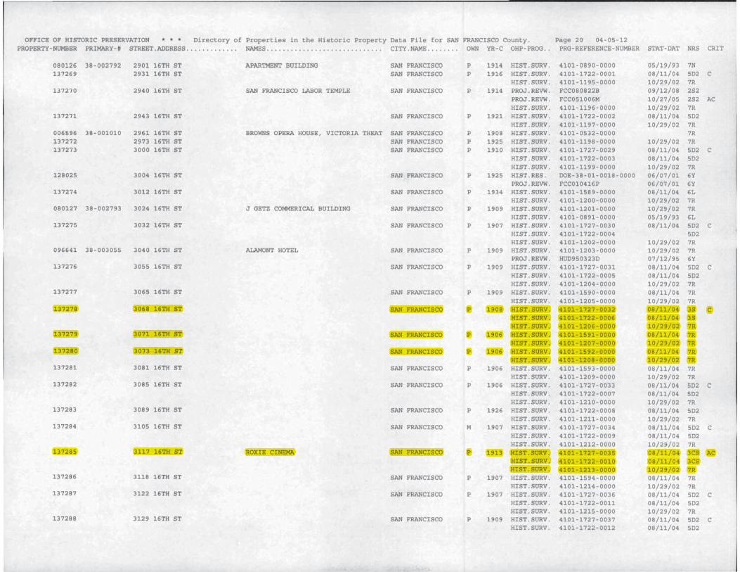
neala
Typewritten Text
P-38-004943
streffers
Rectangle
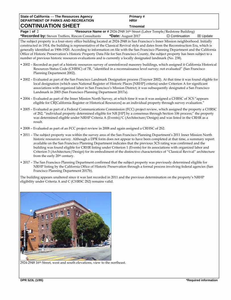
State of California The Resources Agency Primary # DEPARTMENT OF PARKS AND RECREATION HRI# CONTINUATION SHEET Trinomial Page 1 of 2 *Resource Name or # 2924-2948 16th Street (Labor Temple/Redstone Building) *Recorded by: Steven Treffers, Rincon Consultants *Date: August 2017 Continuation Update
DPR 523L (1/95) *Required information
The subject property is a four-story office building located at 2924-2948 in San Francisco’s Inner Mission neighborhood. Initially constructed in 1914, the building is representative of the Classical Revival style and dates from the Reconstruction Era, which is generally identified as 1906-1920. According to information on file with the San Francisco Planning Department and the California Office of Historic Preservation’s Historic Property Data File for San Francisco County, the subject property has been subject to a number of previous historic resources evaluations and is currently a locally designated landmark (No. 238).
• 2002 – Recorded as part of a historic resources survey of unreinforced masonry buildings, which assigned it California Historical Resources Status Code (CHRSC) of 7R, “identified in a reconnaissance level survey; not evaluated” (San Francisco Planning Department 2002).
• 2002 – Evaluated as part of the San Francisco Landmark Designation process (Traynor 2002). At that time it was found eligible for local designation (which uses National Register of Historic Places [NRHP] criteria) under Criterion A for significant associations with organized labor in San Francisco’s Mission District; it was subsequently designated a San Francisco Landmark in 2003 (San Francisco Planning Department 2017a).
• 2004 – Evaluated as part of the Inner Mission North Survey, at which time it was it was assigned a CHRSC of 3CS “appears eligible for CR[California Register or Historical Resources] as an individual property through survey evaluation.”
• 2005 – Evaluated as part of a Federal Communications Commission (FCC) project review, which assigned the property a CHRSC of 2S2, “individual property determined eligible for NR [HP] by a consensus through Section 106 process;” the property was determined eligible under NRHP Criteria A (Events)/C (Architecture/Design) and was listed in the CRHR as a result.
• 2008 – Evaluated as part of an FCC project review in 2008 and again assigned a CRHSC of 2S2.
• 2011 – The subject property was within the survey area of the San Francisco Planning Department’s 2011 Inner Mission North historic resources survey. Although a DPR form does not appear to have been completed at that time, a summary report available on the San Francisco Planning Department indicates that the previous 3CS rating was confirmed and the building was found eligible for CRHR listing under Criterion 1 (Events) for its associations with organized labor and Criterion 3 (Architecture/Design) for its embodiment of the distinctive characteristics of “Classical Revival” architecture from the early 20th century.
• 2017 – The San Francisco Planning Department confirmed that the subject property was previously determined eligible for NRHP listing by the California Office of Historic Preservation through a formal process involving federal agencies (San Francisco Planning Department 2017b).
The building appears unaltered since it was last recorded in 2011 and the previous determination on the property’s NRHP eligibility under Criteria A and C (CHRSC 2S2) remains valid.
2924-2948 16th Street, west and south elevations, view to the northeast.

State of California The Resources Agency Primary # DEPARTMENT OF PARKS AND RECREATION HRI# CONTINUATION SHEET Trinomial Page 2 of 2 *Resource Name or # 2924-2948 16th Street (Labor Temple/Redstone Building) *Recorded by: Steven Treffers, Rincon Consultants *Date: August 2017 Continuation Update
DPR 523L (1/95) *Required information
References: California Office of Historic Preservation 2012 Directory of Properties in the Historic Property Data File for San Francisco County. Available at the Northwest
Information Center at Sonoma State University, Sonoma. Graves, Donna J. and Shayne E. Watson Citywide Historic Context Statement for LGBTQ History in San Francisco. Prepared for the City and County of San Francisco.
October. San Francisco Planning Department 2017a Property information for 2924-2948 16th Street. Accessed via the San Francisco Property Information Map at
propertymap.sfplanning.org. 22 August. 2017b Forms A and B, NEPA Section 106 Research Forms. Mayor’s Office of Housing and Community Development, San
Francisco, California. 3 November. Traynor, Betty 2002 California Department of Parks and Recreation (DPR) 523 Series Form for the Redstone Building. Accessed via Accessed
via the San Francisco Property Information Map at propertymap.sfplanning.org. 22 August.

490 South Van Ness Avenue2940 16th 94103
FORM ANEPA SECTION 106 RESEARCH FORM
Mayor's Offices of Housing and Community DevelopmentReviewed per 2006 Programmatic Agreement between the City and County of San Francisco, Advisory Council on Historic
Preservation and the California State Historic Preservation Office.(To be completed by MOHCD representative)
Date: September 13, 2017 PROJECT INFORMATION FOR 490 South Van NessAvenue
Address: 2940 16th San Francisco CA 94103Assessor's Block: 3553 Lot: 014Zoning: PDR-1-GYear of Initial Construction: 1914Type of Ownership: ❑Unknown ❑Federal❑ State❑ Private ❑ CCSF ❑Special District❑Existing Use: Commercial Proposed Use: Same*Interior Work: Yes ❑ No❑ *Exterior Work: Yes ❑ No ❑Proposed Building Expansion: Yes ❑ No ❑
Area of Potential Effects: Part of the APE for 490 South Van Nees AvenueMap: Please attach a map if the area of potential effect is larger than the footprint of the subjectbuilding
*PLANS AND CLEAR PHOTOGRAPHS ARE ALWAYS REQUIRED FOR REVIEW OF PROPOSEDEXTERIOR WORK. PLANS AND PHOTOGRAPHS ARE REQUESTED FOR REVIEW OFPROPOSED ALTERATIONS OF SIGNIFICANT INTERIORS.
Project Contact:Lead Federal Agency: HUDArchitect:Architect Email:Architect Complete Address:Environmental Consultant:Environmental Consultant Phone:Environmental Consultant Email:Environmental Consultant Address:
Phone
Architect Phone:Local Agency: MOHCD
Applicable HUD Program: Check all that apply.❑ CDBG ❑Home ❑ HOPWA ❑HOPE VI❑ Public Housing Modernization ❑Section 8❑ McKinney Programs (Identify the specific program)❑ Section 202/811 (For Information Only. HUD prepares a Part 50 Clearance)❑ Other (Please specify — i.e., Special Purpose)
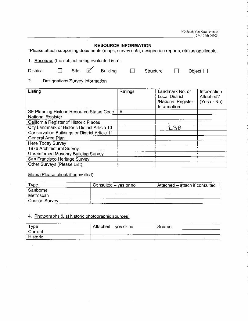
490 South Van Ness Avenue2940 16th 94103
RESOURCE INFORMATION'Please attach supporting documents (maps, survey data, designation reports, etc) as applicable.
1. Resource (the subject being evaluated is a):
District ❑ Site [~ Building ❑ Structure ❑ Object ❑
2. Designations/Survey Information
Listing Ratings Landmark No. orLocal District/National RegisterInformation
InformationAttached?(Yes or No)
SF Plannin Historic Resource Status Code ANational Re isterCalifornia Re ister of Historic PlacesCit Landmark or Historic District Article 10 ~Conservation Buildin s or District Article 11General Area PlanHere Toda Surve1976 Architectural SurveUnreinforced Mason Buildin SurveSan Francisco Herita e SurveOther Surve s Please List
Maps (Please check if consulted)
T e Consulted — es or no Attached —attach if consultedSanborneMetroscanCoastal Surve
4. Photographs (List historic photographic sources)
T pe Attached — es or no SourceCurrentHistoric
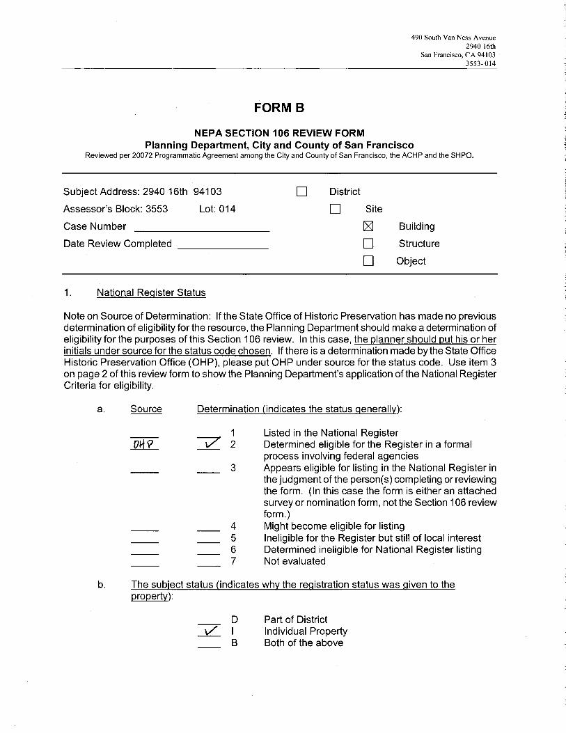
490 South Van Ness Avenue2940 16th
San Francisco, CA 941033553- 014
~ ~~~:~1~1~:7
NEPA SECTION 106 REVIEW FORMPlanning Department, City and County of San Francisco
Reviewed per 20072 Programmatic Agreement among the City and County of San Francisco, the ACHP and the SHPO.
Subject Address: 2940 16th 94103
Assessor's Block: 3553 Lot: 014
Case Number
Date Review Completed
National Register Status
~ Building
❑ Structure
❑ Object
Note on Source of Determination: If the State Office of Historic Preservation has made no previousdetermination of eligibility for the resource, the Planning Department should make a determination ofeligibility for the purposes of this Section 106 review. In this case, the planner should put his or herinitials under source for the status code chosen. If there is a determination made by the State OfficeHistoric Preservation Office (OHP), please put OHP under source for the status code. Use item 3on page 2 of this review form to show the Planning Departments application of the National RegisterCriteria for eligibility.
a. Source Determination (indicates the status generallv):
1 Listed in the National RegisterDI~Q ~ 2 Determined eligible for the Register in a formal
process involving federal agencies3 Appears eligible for listing in the National Register in
the judgment of the persons) completing or reviewingthe form. (In this case the form is either an attachedsurvey or nomination form, not the Section 106 reviewform.)
4 Might become eligible for listing5 Ineligible for the Register but still of local interest6 Determined ineligible for National Register listing7 Not evaluated
b. The subject status (indicates why the reaistration status was aiven to the property):
❑ ~IStfICt
❑ Site
D Part of Districtti/ I Individual Property
B Both of the above

490 South Van Ness Avenue2940 16th
San Francisco, CA 941033553- 014
FORM BSECTION 106 REVIEW FORMPage 2
2. Record of Planning Department's Application of National Register Criteria for Eligibility*The Planning Department should make a determination of eligibility only when no ofherdetermination of eligibility has been made.
The subject resource being evaluated is a:
districtsitebuildingstructureobject
The subject resource possesses integrity of:
locationdesignsettingmaterialsworkmanshipfeeling and association
does not possess integrity of any of the above
The subject resource has significance by virtue of its being:
A associated with events that have made a significant contribution to the broadpatterns of our history
B associated with the lives of persons significant in our pastC embodies the distinctive characteristics of a type, period, or method of
construction which:
represents the work of a masterpossesses high artistic valuesrepresents a significant and distinguishable entity whose components maylack individual distinction
D has yielded, or may be likely to yield, information important in prehistory or history
mdoes not have significance for any reason above

490 South Van Ness Avenue2940 16th
San Francisco, CA 941033553- 014
FORM BSECTION 106 REVIEW FORMPage 3
3. Record of Proposed Projects and Required Approvals (check and complete items thatapP~Y)~
The proposed project is shown in plans labeled ~ ►~ v ~~ Sv~rn~~,lthat areincluded in the project file.There is no active active Building Permit Application (BPA) at the time of Section 106 review.Associated active BPA's at time of Section 106 review include:BPA no. Assigned plannerA notation was placed in Parcel Tracking to notify planners of the need to review futureBPAs with the associated section 106 review. This is required if a project was reviewedand approved under Section 106 but had no active BPA:A Certificate of Appropriateness is required for the proposal. Case No. and Date reviewedby Landmarks Preservation Advisory Board:
4. Findings
Finding of no adverse effect
yes no unknown not applicable
Comments:
Finding of no adverse effect with mitigations
yes ~ no unknown not applicable
Comments:
Proposed activity causes an adverse effect:
yes ~ no
Comments:
PlannerSan Francisco Planning Department1650 Mission Street, Fourth FloorSan Francisco, CA 94103
~ 3 /7Date