Download / view pdf - Canterbury Archaeological Trust
92
-
Upload
khangminh22 -
Category
Documents
-
view
1 -
download
0
Transcript of Download / view pdf - Canterbury Archaeological Trust


i
Canterbury Archaeological Trust Ltd92a Broad Street • Canterbury
Kent • CT1 2LUTelephone: 01227 462 062
Fax: 01227 784 724Email: [email protected]
The Canterbury Archaeological Trust is an independent charity formed in 1975 to undertake rescue excavation, research, publication and the presentation
of the results of its work for the benefit of the public.
Further copies of Canterbury’s Archaeology can be obtained from our offices at 92a Broad Street, Canterbury, Kent, CT1 2LU.
© 1996 Canterbury Archaeological Trust
No part of this publication may be reproduced, stored in any retrieval system, or transmitted, in any form or by any means electronic, mechanical, photocopying, recording or otherwise without the prior written permission of the copyright owner.
Printed by Whitstable Litho Printers Ltd

ii

iii
Contents
Foreword............v Introduction.......vi
PART ONEFieldworkI Canterbury City Sites 1 Northgate Car Park ...................................................................... 2 2 Greyfriars Gate ............................................................................ 3 3 Adelaide Place ............................................................................ 8 4 Hospital Lane ............................................................................ 10 5 Nos 33–36A North Lane ........................................................... 10 6 Pound Lane Car Park ................................................................. 11 7 St Radigund’s Bridge ................................................................ 11 8 Magistrate’s Court Car Park, Broad Street ................................. 12 9 No. 8 Vernon Place ................................................................... 13 10 St Gregory’s Priory Development, Northgate ............................. 14 11 No. 54 London Road ................................................................. 14 12 No. 30 St Lawrence Forstal ....................................................... 15 13 Westgate Gardens ..................................................................... 15II Canterbury District Sites 14 Herne Bay Waste Water Pipeline ............................................... 16 15 Horsebridge, Whitstable ........................................................... 19III Kent Sites 16 Monkton to Mount Pleasant (A253 Dualling) ............................ 20 17 Buckland Anglo-Saxon Cemetery ............................................. 27 18 Royal Victoria Hospital, Dover ................................................... 31 19 Granville Street, Dover .............................................................. 32 20 No. 22 Knights Templars, Dover ................................................ 32 21 Castle Street, Dover .................................................................. 33 22 Ladywell Car Park, Dover ..........................................................33 23 Harvey Grammar School, Folkestone ........................................33 24 Loop Street, Sandwich ..............................................................34 25 Mill Wall, Sandwich ..................................................................35 26 Moat Sole, Sandwich ................................................................35 27 Manwood Road, Sandwich ........................................................36 28 No. 14 Knightrider Street, Sandwich .........................................36 29 Park Farm, Ashford ................................................................... 37 30 Waterbrook Farm, Ashford ........................................................38 31 Ball Lane, Kennington ............................................................... 39 32 Ospringe Brickworks .................................................................40 33 West Street, Faversham ............................................................40 34 Court Street, Faversham ........................................................... 41 35 Main Road, Longfield ................................................................ 41 36 Medway Tunnel ......................................................................... 41
PART TWOBuilding Recording A Artichoke Public House, Chartham............................................43 B Detling Tudor Gateway ..............................................................44 C No. 41 High Street, Canterbury .................................................46 D No. 1 Lady Wootton’s Green, Canterbury .................................. 47 E The Mint Yard Gate, Canterbury................................................. 49 F Nettlestead Gatehouse .............................................................. 49 G No. 19 The Precincts, Canterbury .............................................. 52 H Wye Water Mill ..........................................................................54
PART THREEPost Excavation and ResearchI The Dover Boat 1 Primary Recording .................................................................... 59 2 Research and Analysis .............................................................. 59 3 Conservation .............................................................................60II Pottery Studies 1 Earlier Prehistoric ceramics from the Monkton A253 project .... 62 2 A Tudor kiln-site? A postscript on the pottery from Kirby’s Lane ...........................66 3 Which bottle? What pub? A note on two unusual stoneware pots from Northgate .............. 67III Human Bone Studies 1 Buckland, Dover ........................................................................ 69 2 Monkton, Thanet ....................................................................... 69 3 St Lawrence Forstal, Canterbury ............................................... 70 4 No. 8 Vernon Place, Canterbury ................................................ 70 5 St Gregory’s Cemetery, Canterbury ........................................... 70
PART FOUREducation ........................................................................................ 72
PART FIVEThe FriendsThe Friends of the Canterbury Archaeological Trust .............................. 75
PART SIXAccounts .......................................................................................... 76
PART SEVENMembers of the Trust Council and Staff I The Trust Council ...................................................................... 79 II The Trust staff ...........................................................................80
Bibliography............81


v
Foreword
The C.A.T. continues to flourish and to produce exciting results in all areas of work. In addition to the many items of field activity, the painstaking detective work in building recording uncovers hitherto unknown medieval structures buried in commercial properties such as No. 5 Sun Street; post-excavation studies and researches will yield over the next few years important publications about (inter alia) St Georges Church, Maidstone Roman Villa, St Gregory’s Priory and the Dover Bronze Age Boat; pottery studies, particularly from the Monkton A253 project are helping to throw new light on Neolithic and Bronze Age settlements in Thanet; work on bone remains from a variety of sites add to our knowledge of our ancestors; the Trust continues its valuable work in concert with the Kent County Council and the Kent Archaeological Society in education, particularly in assisting teachers to deliver the National Curriculum History; and the Friends continue to supply their overall support and encouragement; altogether, a good year.
It is worth noting that C.A.T.’s investigations in the field in 1994–95, as recorded in this report, clearly illustrate the changing pattern of work initiated by the implementation of English Heritage’s guidance document, PPG16, for the safeguarding or investigation of possible archaeological sites under threat from development of one type or another.
Of the three dozen sites investigated, more than two dozen were evaluations, mostly small scale sampling digs, or were watching briefs during development. Eight sites only were funded for fuller scale archaeological investigation in advance of development and only two of these were really large scale excavations.
The advantages and disadvantages of this pattern of work to archaeology in general and to Archaeological Trusts in particular have yet to be fully experienced, though it is possible already to perceive where the balance may be.
On the one hand, PPG16 and its implementation provide a framework for the safeguarding of the archaeological resource and for the funding of archaeological investigations country wide, where no such framework existed (outside the flve Areas of Exceptional Archaeological Interest, of which Canterbury conservation area is one). There is a logic in proceeding by evaluation to identify the prohabilitv of sites being at risk on a proposed development, and from
such evaluations to decide what combination of amendment of design may be possible to leave the archaeological resource undisturbed by the development, or have the deposits preserved by record in advance of destruction. Then too, the concept that the planning authority should ensure that the archaeological aspects of a planning proposal are taken care of before the development is implemented, and that the developer should pay the archaeological costs, is a valuable part of the PPG16 logic. Such procedures more than adequately replace the hit and miss approach which rescue archaeology had to suffer in the recent past.
On the other hand, PPG16 has an underlying assumption that the emphasis must be on preserving the archaeological resource for future generations to investigate, rather than on investigation now. The danger in this is that the resource which it may be thought may not be harmed by, or can be protected from, development, may in the event, for one reason or another, be materially damaged or even obliterated, by modern building methods in practice. Then, too, evaluation of large sites by sampling may not reveal the full archaeological potential of the site, with the consequential damage to or destruction of, a valuable resource.
A further disadvantage is that the commercial approach to the undertaking of archaeological work which PPG16 engenders may have unfortunate consequences. A special feature of an organisation such as the C.A.T. is that over the years it has built up a body of expertise and knowledge of the area in which it operates – Canterbury and East Kent – which outside archaeological units cannot attempt to match. It is difficult to expect a developer to take this factor into consideration when choosing between competitive bids from various archaeological units. Additionally, the commercial approach forces units to rely more and more on a full-time professional staff. Opportunities for amateur archaeologists to gain practical experience become increasingly rare, to the detriment of archaeology generally.
Perhaps the time is ripe to re-examine PPG16 to see if modifications could be made to it which would soften the disadvantages caused by possible over-emphasis on preservation rather than investigation, and by a commercialism which may stifle broad participation in archaeology by non-professionals.
F. H. PantonChairman, Management Committee
vi
Introduction
The pages of this report present a record of Trust activities spanning a twelve month period ending in April 1995. The results of a wide range of activities are reported upon and include the full gamut of desk assessments, watching/recording briefs, evaluations, minor and major excavations and building recording surveys undertaken in Canterbury City, District and the County of Kent. Additional articles on the progress of post-excavation studies are to be found herein together with reports on activities and initiatives undertaken by our Eduction Officer and the Friends of the Canterbury Archaeological Trust.
The reports are presented as interim statements of work in progress or works completed. In most cases more detailed studies will be prepared or are in preparation for publication elsewhere.
A considerable number of fieldwork projects were undertaken by field staff in this period. Although many of the projects have been small scale and of short duration, some have produced significant results. A number of larger projects are reported on below and 1 would particularly draw the readers attention to accounts of our work at Monkton in Thanet and at Buckland on the outskirts of Dover. Both sites have produced discoveries of regional and national significance and rank high in a growing list of extraordinary excavations undertaken by the Trust.
This review, the nineteenth Annual Report, summarises the results of a huge body of work undertaken by a dedicated team of professionals. 1 would wish to thank each and every one of the Trust’s
staff for their hard work and unstinting efforts in the field and post-excavation offices over the past year.
As an organisation we continue to work closely with the County Archaeologist, Dr John Williams and his staff. A significant number of the projects recorded here were initiated, organised and monitored by the County Archaeological Section (Kent County Council Heritage Group) and 1 would wish to not only register our thanks for their help and guidance, but congratulate them for the considerable changes they have brought about for the betterment of archaeology within the county.
Closer to home, we are equally indebted to the members and officers of Canterbury City Council who continue to support our work in the City and District. The implementation of PPG16 has had a dramatic effect on the amount of fieldwork undertaken in Canterbury District and we are particularly grateful to the City Council planning staff for the assistance they have given in the development of archaeological planning controls.
Finally, I would wish to extend thanks to the Trust Management Committee who under the wise guidance of our Chairman, Frank Panton; Secretary, Lawrence Lyle and Treasurer, Nigel Taylor continue to ensure the smooth running of the organisation.
1 hope the reader will find articles in these pages that may promote a deeper personal interest in the subject of archaeology or locality, and perhaps as a consequence will be encouraged to join the Friends of the Canterbury Archaeological Trust.
Paul Bennett

1
PART ONE
Fieldwork
I Canterbury City Sites
1 Northgate Car Park2 Greyfriars Gate3 Adelaide Place4 Hospital Lane5 Nos 33–36A North Lane6 Pound Lane Car Park
7 St Radigund’s Bridge8 Magistrates Court Car Park, Broad Street9 No. 8 Vernon Place10 St Gregory’s Priory Development, Northgate11 No. 54 London Road12 No. 30 St Lawrence Forstal
13 Westgate Gardens
C No. 41 High StreetD No. 1 Lady Wootton’s GreenE The Mint Yard GateG YNo. 19 The Precincts
Canterbury city sites: Excavation, watching brief and building recording projects discussed in this year’s report.

Fieldwork: I Canterbury City Sites
2
1 Northgate Car ParkMartin Herdman
During August and September 1993 a series of evaluation trenches was cut in open ground presently used as a car park on the corner of Northgate street and Kingsmead Road. The work was commissioned by Canterbury City Council in order to assess the archaeological potential of the site prior to its sale for redevelopment.
A total of eight trenches, located against the site frontage and to the site rear (A–H on the accompanying plan), were opened by machine and excavated by hand to the uppermost archaeological horizon. An underlying stratum of orange brown brickearth was located in all trenches and in each case was covered by an accumulation of soil approaching an average depth of 1.50 m. The soil sequence across the site was fairly uniform and comprised garden loams in the trenches to the rear, with traces of a sequence of buildings in trenches closest to the Northgate frontage.
The earliest feature recorded in Trench E against Northgate street was a substantial ditch, recut on more than one occasion. It yielded second and third century pottery and was probably the remains of a side drain for the Roman road which ran from the North Gate of Canterbury to the Saxon Shore fort at Reculver. No other evidence for Roman occupation was recovered during the evaluation. No trace was seen of the Roman cemetery thought likely to exist adjacent to the street beyond the town’s defences.
Trenches A, E and F (those closest to Northgate) all yielded remains of buildings which appeared to be of thirteenth century date. Building remains comprised fragments of chalk and flint dwarf
walls which once supported timber framing. The buildings had internal floors of beaten earth and clay. Patches of burning observed on the floors indicated hearths, which in every case were outside the excavated area.
Pits located in trenches towards the rear of the site (G and H) may, on ceramic evidence, be associated with road frontage buildings. A large V shaped ditch located in Trench H was taken to represent an early boundary defining the rear of the property plots.
A gravel metalling which sealed a pit containing twelfth century pottery, located at the south east end of Trench A, was thought to mark the verge of early medieval Northgate street.
The thirteenth century structures in Trenches A, E and F had probably been demolished by the fifteenth century. Overlying loams suggested a protracted period of abandonment up to the late fifteenth century. The first sign of renewed activity in the area was observed in Trench E in the form of a building dating to the fifteenth century erected against the street. Constructed on flint and mortar dwarf walls, it appeared to have been a two roomed timber framed structure. A well defined sequence of clay floors indicated the building may have continued in use until it was replaced in the nineteenth century by a brick built cottage, part of a row shown on the first edition Ordnance Survey. One interesting discovery in the upper sequence of floors was an intact seventeenth century stoneware bottle which contained eight bent iron nails and a broken copper alloy pin. This discovery has been interpreted as a ‘witch bottle’, perhaps deliberately buried beneath the floor to
ward off evil spirits. A report on this discovery appears below.
The only other building activity recorded was in Trench A where a metalled sequence for a yard or thoroughfare set well back from the street frontage was found. This may date to the eighteenth century and be connected with establishment of the smithy shown on the first edition Ordnance Survey for 1874.
Also shown on the survey is a flint wall, the remains of which were recorded in Trench H on the same alignment as the earlier boundary ditch. This discovery illustrates a phenomenum often seen in Canterbury, where early medieval property boundaries become fossilised in the later topography of the city.
By the nineteenth century the area was heavily developed with artisan’s dwellings, a smithy yard and a public house. By then Northgate Place, lined by two terraces of small houses, had been built and in 1890 the Canterbury Corporation Municipal Electricity Works was established to the north east of the area. These works were amongst the first of their kind in the county of Kent.
Most of the buildings in the development zone, save for an isolated row of cottages fronting Northgate were swept away in the 1960s during slum clearance after which the area became a car park.
Location plan showing evaluation trenches. Based on the Ordnance Survey of 1874.
Trench E, looking north-west.

Fieldwork: I Canterbury City Sites
3
2 Greyfriars GatePaul Bennett and Rupert Austin
Plan of Greyfriars based on first edition Ordnance Survey for 1874.

Fieldwork: I Canterbury City Sites
4
An unusual campaign of work was undertaken by the Trust for the Dean and Chapter of Canterbury Cathedral between November 1993 and March 1994. Our work here took the form of a three phase operation to record and assist with the stabilisation of a post Dissolution period gateway at Greyfriars, located on the northern bank of the Stour a short way north east of the surviving Greyfriars refectory.
Although the Trust was to have provided only a survey of the gateway to assist with repair work, in the event all works were undertaken by members of Trust staff other than sub surface stabilisation of gateway fabric for which specialist contractors were employed. The team was led by Mr John Boulden who had been engaged on the conversion and restoration of our premises at 92A Broad Street. John had recently left our employ to take up a post with the Cathedral’s conservation team and the Greyfriars Gate project was his first major undertaking for the Dean and Chapter. John was assisted by Mr Alan Pope, a seasoned member of staff. For Alan this project represented his last for the Trust before retirement.
Canterbury Greyfriars was established on a small island north of the Great Stour opposite the grounds of the Poor Priests’ Hospital. Initially the island (Binnewith island), formerly the garden of the Poor Priests, may have contained the early houses of the friars together with a small cemetery. By 1267 the friars had acquired land to the north of the island and it was here that the conventual buildings were constructed. This larger northern annexe was surrounded by a drainage dyke effectively forming a second island. Friary buildings, which were in the southern half of this new area, comprised at least the friary church, a bell tower, dormitory and refectory. Other buildings almost certainly existed and the disposition of the known principal ranges, set at right angles to one another, would suggest an irregular, but claustral, layout.
Access to the southern island was by a ford adjacent to the Poor Priests’ Hospital at the end of Water Lane – a continuation of Beer Cart Lane and Watling Street. Prior to the establishment of Greyfriars this was one of the main routes through the city giving onto the London road. The southern island may have been used as an outer service court from the late thirteenth century and other buildings may have been constructed here. Evaluation trenching on the island prior to the construction of a new bridge and riverside walk in 1988 revealed the footings of a post medieval building set immediately north of the Water Lane ford (Canterbury’s Archaeology 1988–89, 5–7) together with rough metallings laid for a track continuing the line of Water Lane across the island. As other points of access to Greyfriars were pedestrian, a service court to the south approached by the ford seems to be a logical interpretation. General view showing the gate and the refectory at Greyfriars.
View of Greyfriars Bridge.
Detail from 1640 map showing the former Greyfriars precinct.

Fieldwork: I Canterbury City Sites
5
However, no trace of medieval buildings for such a service court has yet been found.
The islands were also connected to Stour Street by at least two bridges further north. One arch forming part of the northernmost bridge, built in 1309, still survives and has been the subject of a recent photographic survey by the Trust prior to proposed refurbishment and repair. The original bridge was provided with two arches, one broad and one narrow. The broad span, formed to allow for the passage of boats, was taken down in 1589 and was rebuilt probably in the eighteenth century.
Access to the northern island from St Peter’s Street was afforded by a passage which approached the north door of Greyfriars church. The position of the north door almost certainly marked a separation between the nave and chancel of the church. That the passage continued as a ‘walking place’ or through passage, physically separating nave and chancel is also likely. North of the church and west of the passage was the lay cemetery. A number of burials associated with the cemetery were located during evaluation trenching in the grounds of St Peter’s Methodist School in 1990 (Canterbury’s Archaeology 1989–90, 8–11).
In its final form Canterbury Greyfriars covered a substantial part of the south western quarter of the walled city. In addition to the two islands, extensive parcels of land were acquired to the north west and south west, forming a large outer precinct which is likely to have been used almost exclusively for horticulture and orchards.
The Canterbury Greyfriars were eventually suppressed by Henry VIII and their holdings surrendered to the crown in 1538. The property was first let to Thomas Spylman in February 1539 and sold to him in July the same year. In 1544 the property was sold to Thomas Rolf and details
of the sale indicate that at that time it comprised ‘two messuages, two orchards, two gardens, three acres of [arable] land, ten acres of meadow and four acres of pasture in the parishes of St Peter, St Mildred and St Margaret’. Rolf reduced the width of Greyfriars Passage and subdivided the estate during his period of ownership, eventually selling off substantial parcels to William Lovelace and others in 1565–6. The reduction in passage width was achieved by the construction of flanking walls of dry bonded masonry taken from demolished buildings within Greyfriars. It is quite likely that Greyfriars church was taken down soon after 1544; passage masonry may have derived from the church. Sections of passage walling still survive though dilapidated and in places in peril of collapse. The passage itself was closed about ten years ago and is now much overgrown.
The bulk of the property remained in the hands of the Lovelace family until 1629. The 1640 coloured map of Canterbury clearly shows that much of the south western part of the northern precinct Plan of gate, underlying church and boundary wall.
Detail showing south-east corner of church under gate, with ashlared Caen. Scale 1.0 m.
Detail showing boundary wall and north buttress. Scale 1.0 m.

Fieldwork: I Canterbury City Sites
6
had been separated from the original holding by that time. The core of the former establishment, however, comprising both islands and the north western part of the outer precinct appear to form one property. Two large and a number of small buildings are shown in the south western corner of the northern island. The ground formerly covered
by the church and land either side of Greyfriars Passage are depicted as elaborate gardens. Orchards are shown covering the southern island and the north western part of the former precinct. Much of this arrangement, which is reflected in the details of sale of 1544, may have remained intact until the mid nineteenth century.
The surviving gateway and associated garden walls almost certainly relate to the post Dissolution history of the site and may have been built by the Lovelace family. Although later brickwork is present together with a number of recent garden features formed in the wall, the gate and wall brickwork are contemporary with bricks of identical size and
Greyfriars Gate: Sections A–A, B–B, C–C and D–D.

Fieldwork: I Canterbury City Sites
7
comparable bonding mortars. The door jambs of Kentish Ragstone are of fifteenth century date and are clearly re used. The garden wall, extending parallel to the river, is undoubtedly that shown in the 1640 survey defining the south side of the elaborate garden. The gateway also shown in the survey gives onto the principal residence south west of the garden.
Consolidation works undertaken by the Trust comprised the repointing of surviving gate fabric and the cutting of trenches to allow for the construction of subsurface ground anchors to stabilise the structure. Trenches cut either side of the gateway and north of the adjoining garden wall, revealed the well preserved and substantial foundations of a previous building upon which the gateway and garden walls had been formed. The gateway in particular was found to have been constructed only partially over earlier fabric and unequal loadings of gate fabric over substantial buried masonry was considered to be the principal cause of subsidence.
Following removal of recent garden loams and rubble the trenches were cut to a maximum depth of 1 m. below the contemporary ground surface. The north eastern jamb of the gateway was found to sit on the south east corner of an earlier building. The foundations of this early structure were massively built in chalk and flint rubble externally dressed with good quality Caen ashlar and flintwork. The walls, 0.85 m. wide, were battered and provided with contemporary 1.02 m. long corner buttresses. The buttresses were externally faced with at least four courses of Caen ashlar forming two offsets each dressed with a 45° chamfer. The internal corner was provided with quoins of Caen merging with a battered face of knapped flintwork, resting upon an offset foundation of rubble chalk blockwork. All trenches contained only recent fills; internal floors or more ancient horizons were not in evidence. Quantities of china and bottle glass recovered from the excavated soils clearly indicated recent disturbance and it is considered likely that the walls may have been uncovered during earthworks associated with the renovation of the nearby refectory building in 1920.
The masonry for a building aligned north west to south east almost certainly formed the south east corner of Greyfriars church. The location of this exceptionally well built fragment of the church, together with masonry fossilised in the surviving walls of Greyfriars Passage (Annual Report 1981–82, 35 ) allows for the first time an accurate plotting of the chancel of the church, and represents an important addition to our knowledge of this little known establishment.
Abutting the south east buttress was a separate and later 0.50 m. wide foundation of mortared flintwork, which had probably supported a boundary wall closing the gap between the east
end of the church and the river. Aligned roughly north north west by south south east, it extended to the river and from there returned to the south west parallel to the stream. It continued to the south west to form an early riverside wall which was taken up above contemporary ground level. A fragment of this upstanding riverside wall survived in the gate (section D–D). The internal face of the wall was also exposed during gate repair (section A–A). The riverside wall was later refaced with ashlared Kentish Ragstone (section D–D).
On completion of the trenching, specialist contractors were employed to bore holes carefully
through the early fabric to install horizontal and vertical metal ground anchors to support the overlying gateway. The standing fabric of the gateway was then repointed, stitched and repaired by John Boulden and Alan Pope.
Our thanks are extended to the Dean and Chapter of Canterbury Cathedral and English Heritage who jointly funded the archaeological work. We would also wish to extend our best wishes to John Boulden for his future employment with the Dean and Chapter and to Alan Pope for a long and happy retirement.
Greyfriars Gate: Works in progress (John Boulden and Alan Pope).

Fieldwork: I Canterbury City Sites
8
3 Adelaide PlaceTim Allen and Paul Bennett
In April 1994 an archaeological evaluation of part of the Adelaide Place frontage of St James’s Car Park was undertaken prior to an application being made to Canterbury City Council for redevelopment of the site. The evaluation took the form of a single machine excavated north south aligned trench cut across the eastern end of the footprint of the proposed new building.
The temple precinct of the Roman town is known to lie immediately north of Adelaide Place. Past excavations in the area have uncovered courtyard metallings, parts of a covered walkway (portico) and a small associated shrine (Bennett 1976, 238–40). The proposed development lies over the extended line of the portico, a structure which is known to have had a substantial masonry temenos wall and a stylobate of large blockwork supporting a colonnade. The line of Roman Watling Street also crosses the area. Other interesting post Roman archaeological discoveries have been made in the
vicinity, perhaps the most intriguing being a fifth century multiple burial containing both Roman and Anglo Saxon artefacts which was discovered in 1980 (Bennett 1980, 406–10).
In the event the only Roman remains identified during the evaluation were the rammed gravel metallings of Roman Watling Street. These were observed in the sides of a fourteenth century rubbish pit excavated at the base of the evaluation trench. The surface of the street was located 2.95 m. below existing; the full depth of the road was not established and natural brickearth was not encountered.
The road metalling was covered by a layer of dark loam, a soil which accumulated during the late Roman and early post Roman period, possibly during a period of abandonment. Above this deposit was a thick layer of loose textured brown loam which may have accumulated over a considerable period as a result of horticultural
activity within the back gardens of adjacent street frontage properties.
At the south west end of the trench a chalk block wall, surviving to a height of 0.53 m., overlay the agricultural soil. Forming part of a building underlying Adelaide Place, the wall was associated with a series of courtyard layers to the north. Wall and courtyard were sealed by a demolition deposit of chalk and flint rubble. The building, probably constructed in the fourteenth century, and set some way from the contemporary street frontage may well have been a service structure, possibly a detached kitchen.
Capping demolition deposits was a further layer of agricultural loam. Cartographical surveys dating from the mid sixteenth century indicate that the block of land flanked by Castle Street, Stour Street and Hospital Lane contained large gardens behind road frontage properties. Indeed by 1640 many of the individual gardens may have been combined
Location plan showing the Adelaide Place and Hospital Lane sites together with known Roman streets and public buildings.

Fieldwork: I Canterbury City Sites
9
Detail taken from a coloured survey of c. 1640 (Cathedral archives map 123).
Detail taken from the Goad insurance map of 1938.
into one large open area, a situation which appears to have prevailed until the mid nineteenth century. The loam may therefore relate to this period when much of the area north of Adelaide Place was open ground.
Development of the open area may not have occurred until the late eighteenth century, perhaps soon after after the formation of Adelaide Place as a lane connecting Castle Street and Stour Street. Adelaide Place was never officially adopted or paved, and survives today as an unregistered and roughly paved thoroughfare giving access to a small number of domestic and retail properties.
The possible garden levels were sealed by a sequence of roughly paved surfaces, surmounted by two successive buildings and associated courtyards. The first building was entirely brick built and contained two equal sized rooms separated by a partition wall. It was flanked to the north by a rubble courtyard and to the west by heavily compacted laminated deposits of clay, sand, ash, crushed brick and mortar, which may also have represented successive courtyard surfaces. This structure, which occupied the southern third of the trench, immediately adjacent to Adelaide Place, may have been constructed soon after the roadway was established in the late eighteenth century.
The primary brick building was sealed by layers of demolition rubble, soil and hardcore prior to the construction of another building on the same site, probably in the nineteenth century. This later structure, which also appears to have been built against Adelaide Place, contained a single room at ground floor level, possibly provided with a sprung floor. As with the earlier structure, courtyard metallings existed to the north and east. This one room structure may have formed part of a much larger building shown on the first edition Ordnance Survey of 1874 and which by 1938 was in use as an army recruiting office.
Both 1874 and 1938 surveys show a lane extending north of the building to a large brewery yard with an island of open ground, probably hard standing, immediately east of the structure. The metallings to the north almost certainly formed part of the lane leading to the yard; rammed deposits east of the building probably represented accumulated soils associated with the hard standing.
A large cellar subdivided by a partition wall was exposed in the northern section of the trench. Both the 1874 and 1938 surveys show a pair of buildings in this position and it would appear that the cellar belonged to one or both of these.
The building against Adelaide Place and the adjacent cellared structures were probably all destroyed during air raids in 1942. Although there is some cartographical evidence to suggest that a post war building occupied the site until the 1960s, no evidence for this structure was located.

Fieldwork: I Canterbury City Sites
10
In May 1994 the Trust was commissioned by GKN Kwikform Ltd to undertake an evaluation of their scaffolding yard in Hospital Lane, in advance of proposed sale of the land for redevelopment.
There were two reasons to believe that this site was of potentially high archaeological importance. First, two substantial Roman wall foundations were discovered beneath Hospital Lane close to the scaffolding yard entrance by James Pilbrow, City Engineer, during the installation of the city’s main drainage system in 1868. They were found in association with a quantity of smoke blackened box flue tiles of a type associated with hypocaust construction (Pilbrow 1871, 156). This strongly suggests the presence of a large and perhaps important Roman building under the frontage of the present site.
Secondly, early maps show the scaffolders’ site to have been open ground for a considerable period. Land behind Maynard and Cotton’s Spital (which adjoins the site) and behind houses
4 Hospital LaneTim Allen
In Hospital Lane, at 70 feet from the top, a foundation of rubble and flints and strong thick concrete 4 feet wide; 12 feet further down the lane another wall or foundation 12 feet through with Roman tiles laid flat, and some thus: [laid herringbone fashion] and well-made angle tiles so that when two were laid together they formed a square flue or drain; in these tiles was a circular hole about the centre of one of the sides: as they appeared blackened by fire inside no doubt this was portion of a Roman house and hypocaust (84).
Excerpt from Pilbrow ‘Discoveries made at Canterbury in 1868’, Archaeologia xliii (1871), 151–64.
fronting Castle Street, was given over to gardens from at least 1640 until 1843. Later plans show only small outhouses to have been built in the area. Significant archaeological remains might therefore remain undisturbed in the area to be investigated.
Three evaluation pits (identified as Trenches A–C on the plan) were excavated within the scaffolding yard. It proved impossible to excavate reasonable size trenches as much of the area is presently covered with buildings and with stockpiled scaffolding. In the event, the pits exposed a sequence of Roman and early post Roman deposits extending across the site at a depth of approximately 1.45 m. below existing.
In Trench A located in the north eastern part of the site, a medieval wall (probably part of a cess pit) cut 1.95 m. deep into earlier deposits. Substantial quantities of Roman building material appeared to have been removed and dumped on the adjacent ground when this wall was constructed. Amongst this material were fragments of smoke blackened flue tiles, Roman floor tiles, roof tiles, mortar (opus signinum) and large quantities of Roman pottery. This residual material, together with similar in situ deposits noted in the sides of the construction trench for the cess pit, provided strong confirmation of Pilbrow’s evidence for the existence of a substantial Roman building in this position.
In the western part of the site Trench C showed the stratigraphic sequence had been subject to only minimal disturbance. Here a 1.13 m. thick band of garden loam overlay ‘dark earth’ (a layer deposited during the Late Roman and early post Roman periods). Two features, a large post hole and a partially exposed steep sided cut, were associated with the development of the dark loam.
These yielded a small corpus of seventh century pot sherds, as evidence of early Anglo Saxon occupation on the site. The base of the steep sided cut (possibly a sunken featured building) was a well compacted band of gravels and flints. Lying flat on the upper surface of this was a scatter of Roman roof tile fragments. The metalling probably formed part of a Roman courtyard, possibly associated with the Roman building discussed above.
The third trench (Trench B) provided only brickwork and rubble for a recent backfilled cellar.
In sum, evaluation at Hospital Lane confirmed the high archaeological potential of the area. A substantial Roman building almost certainly survives in the north east part of the present site and beneath Hospital Lane. The building probably possessed a courtyard, located in the south west part of the yard. In addition the south west part of the site yielded evidence suggesting early Anglo Saxon occupation which may have terminated in the late seventh century after which time the area became cultivated ground and remained as such until well into the nineteenth century.
Simplified section drawing showing the sequence of deposits and features in the evaluation pit ‘Trench C’.
5 Nos 33–36A North LanePaul Bennett
In April 1994 two trenches were mechanically opened in the former builder’s yard to the rear of nos 33–36A North Lane in advance of plans to redevelop the yard and the former sites of Nos 31 and 32 North Lane. The first trench was located in the north west corner of the yard, aligned roughly north east to south west and approximately parallel to North Lane. The second was set at right angles to North Lane, extending between the flank wall of No. 33 and an adjacent lean to shed to the west.
Past excavations and observations in the area have highlighted the presence of important palaeoenvironmental and archaeological deposits. The earliest levels overlying natural brickearth and gravel relate to sediments laid down in
palaeochannels of the River Stour (earlier courses of the river) or silt deposits laid down by successive episodes of flooding, perhaps over a protracted period (flood plain silts). The deposits encountered at depths greater than 2 m. below existing appear to have been laid down prior to the establishment of a settled community at Canterbury and may date from 8500–2000 years ago. Little work has been undertaken on these levels in the past and every opportunity to examine them in detail must be taken to acheive a full understanding of the nature and chronology of the water course and its implications for the local topography and settlement in this part of Canterbury.
Pre Roman and Roman period occupation has been located within the immediate vicinity of the evaluation. The evidence for pre Roman occupation, though relatively sparse, appears to indicate agricultural activity, perhaps associated with arable farming against the western edge of the flood plain, from the last quarter of the first century A.D. onwards. Worn and abraded pottery from a reworked brickearth topsoil together with cultural material derived from a small number of shallow cut pits testify to this phase of occupation.
Considerably more evidence derives from the Roman period. A number of narrow gravel paved roads appear to have been laid out in a regular grid iron pattern on the western bank of the Stour and

Fieldwork: I Canterbury City Sites
11
beyond from the mid to late first century onwards. Although few contemporary occupation traces have been located it is currently believed that an early attempt to develop the western flood plain was abandoned in favour of the present site of Canterbury. The street pattern was largely abandoned, but certain parts of it were utilised to facilitate access to an industrial suburb which flourished from the late first to the late second century A.D. Ironworking, pottery, tile and brick manufacture appear to have been the principal products of the suburb. Traces of at least two second century pottery kilns were found to the rear of 16–21 North Lane. By the early third century parts of the former suburb appear to have been used for burials. Cremation and inhumation burials have been located nearby (16–21 North Lane: Bennett 1978, 165–91; 30 North Lane: Leggatt 1991, 5–6) with the latest inhumation dating into the fourth century A.D.
Although evidence for Anglo Saxon occupation has yet to be discovered, North Lane was probably established as an extra mural suburb in this period, and perhaps by at least the tenth century.
Continuity of occupation against the North Lane frontage may have begun at that time although occupation may not have been particularly dense. By the twelfth century the rentals of Christ Church Priory indicate that most of the frontage was occupied and that continuity of domestic and retail properties against the frontage is certain from that time. Only one site (16–21 North Lane) has provided evidence for this.
Roman levels were encountered at the present site 1.25 m. below existing. Although the earliest deposits may have been laid down by water action, they are more likely to have been deliberately dumped to infill low lying ground subject to flooding. One other possibility is that the deposits may have formed the basal component of a riverside embankment. It must be stated that the evidence from this restricted cutting is difficult to interpret and only larger scale excavation will allow a definitive explanation of the soil sequence.
A well developed sequence of garden loams dating from the twelfth century sealed the Roman levels. The development of the loam which undoubtedly
accumulated to the rear of road frontage properties, was interrupted by a band of mortar and loam which may signal an episode of nearby construction activity. This horizon, associated with at least one pit, was sealed by further deposits of post medieval and modern loam and topsoil.
Against the road frontage an entirely different picture emerged. Here intact floors and foundations for a nineteenth century cottage, and a lower sequence of earlier building remains, survive just below the existing ground surface. The earliest building remains, set less than 0.5 m. below existing, were only observed in the sides and base of a number of disturbances cutting the floor of the later building.
As the Roman sequence at the rear of the site is deeply buried redevelopment processes are unlikely to provide further information. Should redevelopment of the frontage occur a well preserved sequence of modern post medieval and perhaps medieval buildings will require further examination.
6 Pound Lane Car ParkAdrian Murphy
Between March and May 1994, a watching brief was undertaken in the former Pound Lane car park, during the cutting of foundation and service trenches for a new terrace of houses fronting St Peters Lane. An archaeological evaluation of the site had taken place during September of the previous year (Parfitt 1995, 7–8).
Most of the trenches did not exceed a depth of 1.30 m. and their stratigraphy was generally consistent with that observed in 1993. The shallow nature of the trenches, combined with a high watertable and a large amount of modern concrete and brick rubble, meant that only a narrow band of deposits was visible. The occasional small patch of chalk or clay flooring was detected, concentrated along the St Peter’s Lane road
frontage. Here, flint walls, which by their profile and composition could have been the remains of the dwarf walls of a timber framed building, were observed. Associated floor levels were recorded, but there was no dating evidence other than peg tile fragments beneath the floors.
The evidence gleaned from the shallow trenches observed during the watching brief would seem largely to substantiate the findings of the former evaluation, namely that due to serious waterlogging in the past, complex archaeological deposits are generally deeply buried in this part of the city.
During January 1995 an intermittent watching brief was maintained during arch strengthening and parapet repairs to St Radigund’s Bridge. The work was funded by Kent County Council (Highways and Transportation).
The bridge forms part of the line of the city’s defences, several short sections of which have been recorded in this area (Blockley 1984, 30; Anderson & Bennett 1991, 13–14; McKenna 1992, 9). It is known that the medieval defensive wall crossed the Stour at this point over three, apparently portcullised, arches. Indeed, according
to Gostling (1825, 14) up until they were demolished in 1769, these arches supported the only river crossing inside the city whenever the Kings Bridge was flooded. Gostling further reports that part of one of the portcullis grooves was still visible in 1821 (ibid., 16 note 13).
It seems that there was no road crossing at the site of St Radigund’s Bridge until the mid nineteenth century when a bridge is shown on Collard’s map of 1843. A date stone survives on the northern parapet of the present bridge, but no inscription other than an Ordnance Survey bench mark is visible today.
7 St Radigund’s BridgeAlan Ward
St Radigund’s Bridge looking west.
Watching brief in progress.

Fieldwork: I Canterbury City Sites
12
The 1995 repair works involved stripping back the modern road surface on the western half of the bridge and the replacement of the northern parapet. It was hoped that parts of the city wall and possibly remnants of the fourteenth century bridge might be observed during the work. In the event nothing of the early bridge was found.
However, a considerable length (c. 6 m.) of the city wall was observed and recorded at the western end of the bridge when the modern pavement was removed and a trench cut for the re routing of electricity cables.
Our thanks are extended to Kent County Council and the contractors whose ready co operation greatly assisted the progress of this watching brief.
Location plan for St Radigund’s Bridge and other observed parts of the northern city wall.
‘Arches in the Town Wall’ (detail). The medieval predecessor of Radigund’s
Bridge, engraved by R. Godfrey shortly before demolition in 1769.
8 Magistrates Court Car Park, Broad StreetPaul Bennett
On Saturday, 14th May an archaeological evaluation trench was cut in the car park to the rear of the present Magistrates Court, Broad Street, Canterbury in advance of proposed redevelopment.
A single trench (5.75 m. x 2.5 m.) was opened by machine and excavated to a maximum depth of 2.25 m. An intact archaeological sequence
together with a small number of features was located slightly above the level of natural brickearth at approximately 1.65 m. below the present car park surface. The largest of these features was of later medieval date and may have been a brickearth quarry or a rubbish pit of substantial size. This feature had almost completely removed
an earlier pit which was arguably of Roman date. Two possible post holes observed as soil stains at the level of natural brickearth may have also been of Roman origin.
The car park lies in the immediate eastern environs of the Roman town. Roman burials are known approximately 50 m. north and north east

Fieldwork: I Canterbury City Sites
13
of the site in Lady Wootton’s Green. A Roman road extending south east from Queningate runs immediately north of the site.
In the early medieval period the area became a suburb of Canterbury occupying a position between the defences of the town and the western boundary of St Augustine’s Abbey. The present line of Broad Street, Lady Wootton’s Green, Monastery Street and Church Street St Paul’s, roads respectively west, north, east and south
of the proposal are of late Anglo Saxon or early medieval origin. It is considered likely that all frontages were fully occupied by buildings from at least the early medieval period. In c. 1200 much of the land here was owned by St Martin’s Church, leased by Geoffrey de Settinge (Urry 1967, Map 1, Sheet 4). An early sub division of this block of land into burghage plots is considered likely and the land under consideration may have formed the rear ‘garden’ area of one or more plots.
It was not anticipated that the proposal to underpin the building at 8 Vernon Place, Canterbury (TR15175738), would disturb much of archaeological significance. However, a large enigmatic feature and inhumation burials, all of probable Roman date, were discovered during the course of a watching brief maintained at that address.
The large feature covered an area measuring roughly 5.50 m. square. It cut the naturally occurring deposits of orange brown brickearth, and was in turn, along with the brickearth, truncated by the cellar floor. The feature was also cut by a burial (SK 1), tentatively identified as Roman (see below) and thereby giving it a possible Roman attribution. The sides of the feature consisted of in situ brickearth burnt to a depth of approximately 0.15 m. Although the burning had produced a hard red surface no signs of vitrification were observed. The backfill of the feature consisted of grey, silty, soil mixed with occasional quantities of chalk flecks.
Unfortunately it has not been possible to offer an interpretation for the function of the feature for three principal reasons. No finds were recovered from the fill; the feature was not bottomed (in fact only a very small proportion of its estimated total area was examined); and the sides of the feature
Successive cartographical surveys from 1540 onwards indicate the presence of large domestic buildings against all of the streets defining the block, with the area in question shown as open ground. By 1874 the first edition Ordnance Survey indicates that much of the land currently occupied by the Magistrates Court formed part of an extensive brewery. Some of the brewery buildings may have been re used when the site later became a dairy.
9 No. 8 Vernon PlaceMark Houliston
showed no signs of vitrification, so ruling out many of the industrial interpretations which might otherwise have been made.
It was the Roman custom to establish cemeteries alongside roads outside towns and settlements, and at Canterbury burials have been found along all the major roads leading from the town. Along the Old Dover Road (Roman Watling Street) a number of burials have been found over the years, though unfortunately very few of these have been accurately located. Hasted (1799) records burial urns from ‘ground east of the Nunnery (St Sepulchre’s) and from a nearby orchard’, while in 1860 burials were discovered during the building of houses ‘in the area of the Nunnery cemetery’ (Brent 1861). ‘At least three amphorae burials, and a number of other pots and finds’ were excavated ‘parallel to the Old Dover Road and inside the Nunnery boundary wall’ during the following year (ibid.). A burnt clay feature was interpreted at this time as part of an ustrinum or funerary pyre, though the later discovery of pottery in the area suggests this may have been a kiln (Andrews 1985). A further possible cremation vessel was noted during the construction of Canterbury’s sewer system in the nineteenth century: ‘Proceeding up the Old Dover Road, little was found except
an urn ...’ (Pilbrow 1871). More recently the late Frank Jenkins observed Roman cremation vessels during construction work in the garden of Vernon House near the junction of Vernon Place and Old Dover Road (Andrews 1985).
Three articulated adult human skeletons were discovered at 8 Vernon Place. Because of their proximity to Roman Watling Street and their distance from the ground of St Sepulchre’s Nunnery, they have been tentatively identified as Roman. Unfortunately no associated artefacts were discovered. The limited area available for excavation meant that only a small proportion of each skeleton could be recorded in situ and removed for osteological analysis. The results of this analysis are described elsewhere in this report (p. 70).
The discovery of these archaeological features beneath Vernon Place has significant consequences for our understanding of the depth of archaeological deposits outside the town and is likely to influence our response to development proposals in the area in the future.
Thanks are extended to Abbott Construction who gave us every assistance during a difficult and somewhat complicated project.
Location map and plan showing the extent of the archaeological feature.

Fieldwork: I Canterbury City Sites
14
10 St Gregory’s Priory Development, NorthgateMartin Hicks
From October to December 1994, an archaeological watching brief was maintained at the former site of St Gregory’s Priory, Northgate during the cutting of foundations for the wholesale redevelopment of the area.
Between 1988 and 1990 large scale excavations on this site, the former GPO sorting office, uncovered a complex sequence of medieval buildings. The earliest identified was a church founded by the Norman archbishop Lanfranc in 1086. This was rebuilt in the twelfth century and a complex of claustral buildings formed at the same time to the north of the new church. The institution for Augustinian canons was dissolved between 1536 and 1537. Only a single range of buildings fronting the Northgate road survived the Dissolution, and this was converted into a private house and elaborate garden. The building and garden survived until 1800 when it was sold for redevelopment. New roads subdivididng the area were built (High Street St Gregory, Victoria Row and Union Street) with houses formed against these streets, to service the artillery and cavalry barracks located nearby. The west range survived
as a semi derelict dwelling until 1848 when it was finally demolished.
Following the 1988 1990 archaeological excavation the site remained open as a casualty of the recession until redevelopment for student accommodation for Christ Church College was begun in September 1994. Consultations between the landowners, the architects and the Trust resulted in the new development being based on piled foundations. A survey of the known archaeological remains was utilised by the developers to determine new non destructive pile positions.
The foundation design consisted of a mixture of driven and augured piles, linked by a network of trench built ring beams. The depth of the ring beam trenches was set 1 m. below existing. There was some concern that the construction of the trenches might damage previously unrecorded archaeological levels. This anxiety was heightened when the development area was extended into parts of the site not previously archaeologically excavated.
During the piling activity no significant damage to the priory remains was observed. One pile (along
the east frontage) hit an obstruction, but following investigation using a mechanical digger it became apparent that it had clipped the northern side of the chapter house wall and the damage was mitigated by repositioning of the pile. Elsewhere all obstructions investigated proved to be the remains of modern concrete foundations. A soft spot discovered in the extended area at the junction of High Street St Gregory and Victoria Row, proved to be an infilled wartime bomb crater.
In the extended development area several archaeological features were revealed. In the area formerly under the pavement of High Street St Gregory a flint wall on a chalk foundation was uncovered. This footing probably formed part of a post Dissolution boundary wall and may be that built shortly after 1573 when Sir John Boys, the then tenant of the west range, enclosed his grounds.
The eastern extremity of the extended development was the main area for archaeological concern. It was not investigated during the 1988–90 excavations and lay over the choir of the twelfth century church. When a large section of concrete was broken up and removed, it became clear that it had been rafted over a series of deep, brick built basements, which had removed all traces of the choir. The basements presumably belonged to structures built in the 1800s and had been backfilled following bomb damage during the 1940s.
In conclusion, the close liaison between the Trust and all those involved in the new development resulted in damage to known archaeological remains being avoided. When new elements of historical interest were revealed, they were recorded swiftly causing no interference with the construction work programme, and the resulting impact on the archaeological material was minimal.
Our thanks are extended to W. Taylor, Bursar of Christ Church College for unstinting support and Pentangle Design Group for their ready co operation during the project.
Construction work in progress.
11 No. 54 London RoadJon Rady and Grant Shand
At the beginning of November 1993 an archaeological evaluation was carried out to the rear of 54 London Road (TR 1386 5818) in advance of the construction of an adolescent residential and day treatment centre.
The site lies immediately north of the main Roman road to London and Rochester, which is bounded, to the south at least, by an extensive
Roman cemetery containing both cremations and inhumations. At least nine sites have previously been examined in this area, most significantly that at Cranmer House to the south of London Road in 1982, where a large number of Roman cremation burials and some early Anglo Saxon finds, including a very fine early seventh century gold pendant, were recovered (Frere et al. 1987, 56–73).
Two machine cut trenches were excavated down to the level of natural brickearth. Both were void of archaeological features or artefacts.
A few months later, an intermittent watching brief was carried out during the preliminary stages of construction work. Groundworks involved the removal of overburden to well below the top of natural soils over much of the west and north

Fieldwork: I Canterbury City Sites
15
west area of the site and the cutting of a network of foundation trenches, primarily over the north eastern half of the area.
Although most of the work was carried out by machines using toothed buckets, which did not leave any clean horizontal surfaces, enough
clean sections were cut through all the deposits to confirm the total absence of archaeological levels suggested by earlier work. The absence of archaeological features and artefacts, although determined from a relatively small sample area, strongly suggests either that the Roman cemetery
does not extend this far north and east, or that it did not extend north of the Roman road in this area.
Thanks are due to Canterbury and Thanet Health Authority for funding the archaeological works.
12 No. 30 St Lawrence ForstalMark Houliston
In December 1994 the Trust was called to 30 St Lawrence Forstal where a human skull and other bones had been uncovered during the construction of a rear extension. The skeletal remains were recorded in situ and then removed for study (see report, p. 70). The burial seems to have been made in some haste, with the body flexed to fit into a pit. There was no sign of weapon injury and cause of death could not be ascertained from the bones. A medieval lace tag was found in association with the burial.
The bones seem to represent an isolated burial, undertaken quickly in unconsecrated ground. No other burials have been found in the area despite the location of the leper hospital of St Laurence, founded in 1137, 200 m. to the north east of the present site (Woodruff 1938). The bones showed no sign of leprosy.
Above: Detail of the skull.
Left: The burial.
13 Westgate GardensAlan Ward
In March a watching brief was maintained during the cutting of a soakaway in the yard behind The Umbrella Centre, St Peter’s Place. The sides of the pit cut an interesting section through waterlogged deposits. A large corpus of Late Iron Age and early Roman pottery, including imports from Gaul, was recovered from alluvial clay close to the bottom of the pit whilst an organic peat deposit above this contained well preserved, but fragmentary, wooden stakes, Roman pottery and a few Late Saxon or Early Medieval sherds dating to c. 900–1200. Alluvial deposits, probably laid down during flooding of the area, lay above this and immediately beneath the modern brick rubble make up for the yard.
The glimpse of archaeology recorded during the watching brief corresponds well with what is known about the early history of the area. The defensive walls around the Roman town were not constructed until the late third century. These pass close to the site of the soakaway and might suggest that the area was comparatively dry at that time (Bennett 1984, 50). The lack of later Roman pottery might support the view that by the fourth century the area was becoming uninhabitable. Studies elsewhere (Waddelove 1990, 256–9)
have shown that the sea level around south east England rose by a few feet during the period of Roman rule and has risen by several feet since then. This would probably have been reflected further inland in higher local watertables and slower flowing rivers. The observed thick peat deposit probably formed during the Anglo Saxon period. Similar deposits have been seen elsewhere
in Canterbury overlying Roman levels (Rady 1986, 15). The area was apparently still subject to flooding in the early medieval period; there is a notable absence of rentals for the area (Urry 1967). Successive surveys from the seventeenth century onwards all show this part of Canterbury as open land or gardens.

Fieldwork: II Canterbury District Sites
16
II Canterbury District Sites
Canterbury District: Excavation and building recording projects discussed in this year’s report.
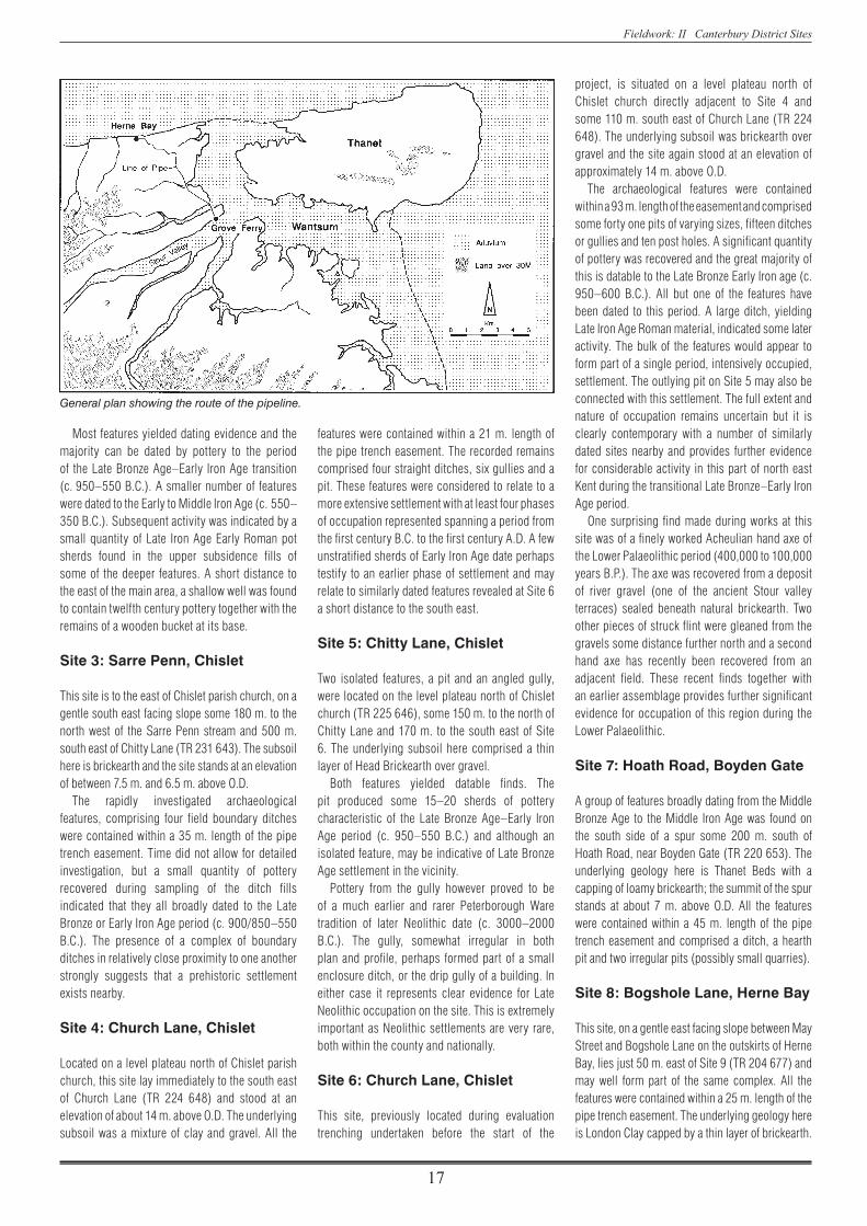
The construction of a cross country pipeline associated with a waste water treatment scheme for Southern Water Services was the subject of a detailed watching brief by the Trust during the first six months of 1994. Running inland from Herne Bay to the Great Stour, the pipe trench cut across an area considered to be of archaeological potential. Skirting the western edge of the former Wantsum Channel, which once separated the Isle of Thanet from mainland Kent, the route crossed the line of two Roman roads and passed through one previously recorded major site, the prehistoric and Roman settlement complex at Highstead, near Chislet, extensively examined by the Trust in 1976 (Annual Report 1975–76, 2–3).
The pipe line ran for a total distance of about 8 km. From the sea front at Herne Bay to Beltinge, the route ran eastwards along the cliff top, then turned inland to the south east towards the May Street treatment works. From here the pipe passed by Highstead, Boyden Gate and Chislet to reach the banks of the Great Stour just east of Grove Ferry.
In topographical terms, the pipe line crossed
a series of high ridges and plateaux, separated by valleys often containing areas of low lying marshland. These features represent former promontories set between ancient inlets of the Wantsum Channel. Geologically, the route extends across Thanet Beds and London Clay of the Eocene period, capped by peri glacial deposits of brickearth or gravel laid down during the Pleistocene period. One of the most important contributory factors in the development of these drift formations was the ever shifting course of the ancient River Stour. The marshlands associated with the Wantsum mainly comprise recent alluvial clays. These later deposits, particularly across the valley of the Sarre Penn, were the subject of episodes of sampling for palaeo environmental evidence by the Geoarchaeological Service Facility of the London Institute of Archaeology.
The pipe line passed through no less than ten separate sites. Only two of these (No. 6, Church Lane, Chislet and No. 10, Highstead) were known prior to the trenching operations and one of these (Site 6) had, in fact, first been located during
the initial evaluation work for the project (see Canterbury’s Archaeology 1993–94, 32). Overall, a surprising number of archaeological discoveries were made during the construction works and the general density of ancient remains was found to be higher than expected. There was a particularly surprising amount of evidence for prehistoric settlement along the route, mainly restricted to the promontories above the Wantsum. Of special note was rare evidence for two separate Neolithic settlement areas (c. 4000–2000 B.C).
Site 1: Hawthorn Corner, May Street
Between the Thanet Way and main railway line were two separate unrelated features. These comprised a pit just to the north of the Thanet Way, near Hawthorn Corner (TR 2134 6720) and an ancient stream channel south of the railway (TR 2126 6742). The pit, probably dating to the early Iron Age (c. 600–200 B.C.) on the evidence of the small quantity of pottery it contained, appeared to be an isolated feature but is perhaps suggestive of a settlement nearby.
The ancient stream channel located some distance away was of a later date; the pottery from the silt within it dates to the thirteenth to fourteenth century indicating that it was filled during the medieval period.
Site 2: Beacon Hill, Beltinge
This extensive site is on the clifftop at Beltinge, just to the north of Beacon Hill Road (TR 4168 6810 to TR 4188 6810). The archaeological features were contained within a 70 m. length of the 12 m. wide pipe trench easement. The site stands at an elevation of about 36 m. above O.D., the underlying geology here being London Clay capped by brickearth. The archaeological remains included eight ditches, three gullies, two pits, eight post holes and a well. A substantial part of the site had probably been destroyed by coastal erosion and its landward continuation is now largely obscured by modern housing.
14 Herne Bay Waste Water Pipeline 15 Horsebridge, Whitstable A The Artichoke Public House, Chartham
14 Herne Bay Waste Water Pipeline Keith Parfitt
View of the Beltinge site.
Fieldwork: II Canterbury District Sites
17
Most features yielded dating evidence and the majority can be dated by pottery to the period of the Late Bronze Age–Early Iron Age transition (c. 950–550 B.C.). A smaller number of features were dated to the Early to Middle Iron Age (c. 550–350 B.C.). Subsequent activity was indicated by a small quantity of Late Iron Age Early Roman pot sherds found in the upper subsidence fills of some of the deeper features. A short distance to the east of the main area, a shallow well was found to contain twelfth century pottery together with the remains of a wooden bucket at its base.
Site 3: Sarre Penn, Chislet
This site is to the east of Chislet parish church, on a gentle south east facing slope some 180 m. to the north west of the Sarre Penn stream and 500 m. south east of Chitty Lane (TR 231 643). The subsoil here is brickearth and the site stands at an elevation of between 7.5 m. and 6.5 m. above O.D.
The rapidly investigated archaeological features, comprising four field boundary ditches were contained within a 35 m. length of the pipe trench easement. Time did not allow for detailed investigation, but a small quantity of pottery recovered during sampling of the ditch fills indicated that they all broadly dated to the Late Bronze or Early Iron Age period (c. 900/850–550 B.C.). The presence of a complex of boundary ditches in relatively close proximity to one another strongly suggests that a prehistoric settlement exists nearby.
Site 4: Church Lane, Chislet
Located on a level plateau north of Chislet parish church, this site lay immediately to the south east of Church Lane (TR 224 648) and stood at an elevation of about 14 m. above O.D. The underlying subsoil was a mixture of clay and gravel. All the
features were contained within a 21 m. length of the pipe trench easement. The recorded remains comprised four straight ditches, six gullies and a pit. These features were considered to relate to a more extensive settlement with at least four phases of occupation represented spanning a period from the first century B.C. to the first century A.D. A few unstratified sherds of Early Iron Age date perhaps testify to an earlier phase of settlement and may relate to similarly dated features revealed at Site 6 a short distance to the south east.
Site 5: Chitty Lane, Chislet
Two isolated features, a pit and an angled gully, were located on the level plateau north of Chislet church (TR 225 646), some 150 m. to the north of Chitty Lane and 170 m. to the south east of Site 6. The underlying subsoil here comprised a thin layer of Head Brickearth over gravel.
Both features yielded datable finds. The pit produced some 15–20 sherds of pottery characteristic of the Late Bronze Age–Early Iron Age period (c. 950–550 B.C.) and although an isolated feature, may be indicative of Late Bronze Age settlement in the vicinity.
Pottery from the gully however proved to be of a much earlier and rarer Peterborough Ware tradition of later Neolithic date (c. 3000–2000 B.C.). The gully, somewhat irregular in both plan and profile, perhaps formed part of a small enclosure ditch, or the drip gully of a building. In either case it represents clear evidence for Late Neolithic occupation on the site. This is extremely important as Neolithic settlements are very rare, both within the county and nationally.
Site 6: Church Lane, Chislet
This site, previously located during evaluation trenching undertaken before the start of the
project, is situated on a level plateau north of Chislet church directly adjacent to Site 4 and some 110 m. south east of Church Lane (TR 224 648). The underlying subsoil was brickearth over gravel and the site again stood at an elevation of approximately 14 m. above O.D.
The archaeological features were contained within a 93 m. length of the easement and comprised some forty one pits of varying sizes, fifteen ditches or gullies and ten post holes. A significant quantity of pottery was recovered and the great majority of this is datable to the Late Bronze Early Iron age (c. 950–600 B.C.). All but one of the features have been dated to this period. A large ditch, yielding Late Iron Age Roman material, indicated some later activity. The bulk of the features would appear to form part of a single period, intensively occupied, settlement. The outlying pit on Site 5 may also be connected with this settlement. The full extent and nature of occupation remains uncertain but it is clearly contemporary with a number of similarly dated sites nearby and provides further evidence for considerable activity in this part of north east Kent during the transitional Late Bronze–Early Iron Age period.
One surprising find made during works at this site was of a finely worked Acheulian hand axe of the Lower Palaeolithic period (400,000 to 100,000 years B.P.). The axe was recovered from a deposit of river gravel (one of the ancient Stour valley terraces) sealed beneath natural brickearth. Two other pieces of struck flint were gleaned from the gravels some distance further north and a second hand axe has recently been recovered from an adjacent field. These recent finds together with an earlier assemblage provides further significant evidence for occupation of this region during the Lower Palaeolithic.
Site 7: Hoath Road, Boyden Gate
A group of features broadly dating from the Middle Bronze Age to the Middle Iron Age was found on the south side of a spur some 200 m. south of Hoath Road, near Boyden Gate (TR 220 653). The underlying geology here is Thanet Beds with a capping of loamy brickearth; the summit of the spur stands at about 7 m. above O.D. All the features were contained within a 45 m. length of the pipe trench easement and comprised a ditch, a hearth pit and two irregular pits (possibly small quarries).
Site 8: Bogshole Lane, Herne Bay
This site, on a gentle east facing slope between May Street and Bogshole Lane on the outskirts of Herne Bay, lies just 50 m. east of Site 9 (TR 204 677) and may well form part of the same complex. All the features were contained within a 25 m. length of the pipe trench easement. The underlying geology here is London Clay capped by a thin layer of brickearth.
General plan showing the route of the pipeline.

Fieldwork: II Canterbury District Sites
18
The elevation is about 35 m. above O.D. The natural watertable was found to be fairly shallow and was reached in several deep excavations.
The recorded archaeological features comprised eleven pits, four ditches, a gully and a post hole. The ditches and gully were aligned either north east by south west or north west by south east and may well be connected with a more extensive group of similar ditches revealed on Site 9. Both sets of ditches seem to relate to a rectilinear field system dating from the Late Iron Age and early Roman periods.
Of the remaining features, one pit yielded approximately fifty sherds of Early Neolithic pottery, but this appeared to be an isolated feature pre dating the other recorded remains. Another massive pit may represent a quarry or water hole; it yielded only a few small fragments of somewhat nondescript prehistoric pottery and a quantity of burnt flint fragments. With the exception of the Neolithic material, only a small quantity of datable pottery was found on this site; most appears to be broadly datable to the later Bronze Age–Iron Age period.
Site 9: Bogshole Lane, Herne Bay
This site was located on a level plateau on either side of Bogshole Lane, on the outskirts of Herne Bay, some 50 m. to the west of Site 8 (TR 201 677). It stands at an elevation of about 37 m. above O.D. The underlying geology here is London Clay with some Head Gravel, capped by a thin layer of brickearth. The natural watertable was again found to be fairly shallow.
The pipe trench changed alignment at Bogshole Lane and provided a 10–12 m. wide, L shaped transect across part of an extensive, multi period complex of archaeological features covering an area at least 50 m. (north south) by 56 m. (east west). Approximately 150 individual features were recorded in total comprising some twenty five pits, three pit complexes, nineteen ditches and gullies and 105 post holes. At least two buildings were defined by post holes. One group, within a shallow circular gully, possibly related to a round house; a rectangular setting of four post holes was taken to represent a four poster granary.
Most of the ditches investigated were later than the settlement features and seemed to form part of an extensive field system also recorded at Site 8.
The finds recovered from this site, which included over 2000 sherds of pottery, clearly indicated occupation spanning a considerable period. A scatter of struck flints, together with a few abraded, residual pot sherds may be of Neolithic date, c. 4000–2000 B.C. (a more certain Neolithic pit was excavated on Site 8, a short distance to the east). The fabrics of a small group of other sherds, also residual, are reminiscent of Deverel Rimbury type products, c. 1400–1000 B.C., although there are unfortunately no diagnostic decorated pieces and their dating must remain uncertain. Another small quantity of residual material might belong to the Late Bronze Age–Early Iron Age transition period, c. 1000–800 B.C, but the great bulk of the prehistoric pottery recovered can be assigned to the Early to Middle Iron Age period, c. 500–300 B.C.
It seems likely that many of the features located at Site 9 are of Early to Middle Iron Age date and clearly indicate the presence of a major settlement. Continued occupation of the area is represented by a smaller quantity of Late Iron Age pottery, whilst the rectilinear ditch system is associated with pottery of Belgic and early Roman date. More or less continuous settlement from c. 600 B.C. to A.D. 200 thus seems to be implied, with a peak of activity during the first three or four centuries of this period.
The site seems to have gone out of use during the third century A.D. No subsequent activity in the area is indicated, apart from a few finds and features of medieval and post medieval date apparently connected with the former course of Bogshole Lane.
Site 10: Highstead, Chislet
This site immediately to the east of the hamlet of Highstead, near Chislet (TR 2151 6626), lay on gravel at an elevation of about 30 m. above O.D. and immediately adjacent to a multi period prehistoric site extensively examined in 1975–6. Contrary to initial expectations, only a small number of features was recorded on the line of the pipe trench in this area, consisting of three pits,
five post holes and two large quarry pits. The two quarry pits produced small quantities of peg tile and pottery indicating a later medieval date for these cuttings.
Of the other features, datable finds were recovered from just one pit and one post hole both containing Late Bronze–Early Iron Age pot sherds (900/850–600 B.C.). It seems likely that the other, undated features were contemporary. Collectively they must be connected with the other remains of this period previously excavated to the south and east. The paucity of features here, however, clearly indicates that this site is peripheral.
Conclusion
This 8 km. transect across a key region of north east Kent, adjacent to the former Wantsum Channel, has produced a significant number of important archaeological discoveries. A number of these new sites may collectively indicate the presence of single settlements covering a large area. Sites 4, 5 and 6, all located between Church Lane and Chitty Lane at Chislet, probably represent different parts of a single extensive multi period site. A second larger settlement may also be represented by discoveries at Sites 8 and 9 adjacent to Bogshole Lane on the outskirts of Herne Bay. Site 10 clearly forms part of the prehistoric remains previously excavated at Highstead.
Three major new settlement sites, in use over many centuries throughout the prehistoric and early Roman period are thus represented by the complexes of features revealed during the watching brief. Sites 4, 5 and 6 have provided evidence for a Late Bronze Age–Early Iron Age settlement. An Early to Middle Iron Age occupation site at Bogshole Lane (Sites 8 and 9) has been discovered and a separate Iron Age settlement has been located at Beltinge (Site 2).
The earliest discoveries were made at Site 6, comprising a few ancient Palaeolithic worked flints. Sites 5 (Chislet) and 8 (Bogshole Lane) have yielded rare and important evidence for Neolithic occupation. Of particular note is the density of Late Bronze Age to Early/Middle Iron Age (c. 800–300 B.C.) settlement evidence recorded along the route.
Site 9: Plan of excavated features.

Fieldwork: II Canterbury District Sites
19
Although several significant individual sites, worthy of further study in their own right, have been recorded it is the combined evidence for the density of ancient settlement discovered along this 8 km. pipe line which constitutes the most significant contribution to archaeological
knowledge. The Herne Bay pipeline scheme together with other recent linear developments in East Kent is collectively producing a large volume of new information which clearly indicates a greater density of prehistoric settlement in the region than was hitherto considered likely. As a
consequence of these and other discoveries we are now approaching a stage where statements concerning such topics as land division and social structure in the prehistoric period can be tentatively put forward.
In February 1995 the Trust undertook an archaeological evaluation of an area east of Reeves Beach in Whitstable for Canterbury City Council. Four evaluation trenches were excavated, two in Browning’s Yard east of the Royal Native Oyster Stores, one against Terry’s Lane and one west of Horsebridge Road next to the old ambulance station. These sites, in the ownership of Canterbury City Council, are presently being considered for redevelopment. The sites are close to the historic centre of the present town, originally called `Whitstapel Street’, the old settlement of Whitstable being situated to the east on higher ground above the coastal plain.
Two of the trenches (B and C) were situated adjacent to Sea Wall, which along with Middle Wall comprise the remains of the first recorded sea defences for the town, built in 1583 `for the better defense of certain houses and grounds lying on the level’ (Bowler 1983, 32), i.e. west of the High Street. The sea wall was of sufficient size for a road and houses to be built on it. The only buildings of any great age, however, are now located on the seaward side of the wall.
The trenches cut adjacent to Sea Wall exposed a rubbish filled ditch, the full dimensions of which were not ascertained, but must have been at least 5 m. wide and in excess of 1.5 m. deep. This previously unknown feature may have been originally cut to
15 Horsebridge, Whitstable Paul Bennett
Location plan with position of Trenches A–D.
provide clay during the construction of the sea embankment and subsequently used as a drainage dyke to canalise sea water during exceptionally high tides. The later fills of the dyke clearly indicated that the feature was later used as a common sewer, being re cut on at least two occasions in order to re establish flow. That the dyke was also used as a sewer was indicated by a mid nineteenth century brick conduit, leading directly into it from the cesspit of an adjacent house. The ditch was probably designed to discharge in the vicinity of the `Outletts’, a marshland to the north in the area now occupied by the harbour and the Gorell Tank. By the later nineteenth century, the dyke appears to have been used exclusively as a rubbish tip and was gradually allowed to fill up.
Capping the sequence of ditches to the rear of Sea Wall in Trench B were rammed deposits of gravel and crushed chalk forming the basis of an open yard or perhaps even the floors of a large workshop. Localised areas of burning where chalk deposits had been fired to an orange colouration may indicate that an overlying building had been destroyed by fire. A disastrous fire is known to have taken place in this area in 1869.
Rammed chalk deposits similar to those exposed to the rear or the Sea Wall in Trench B were present against Sea Street within Browning’s Yard in Trench A. Burnt chalk here was sealed by charcoal and was in turn capped by a brick on edge floor forming part of a recent courtyard. Occupation against Sea Street may have commenced shortly after construction of the sea defences. The earliest deposits exposed in Trench A, overlying storm beach gravels, comprised a layer of domestic rubbish including pottery of sixteenth and early seventeenth century date. Capping this deposit was a sequence of at least two clay floors, possibly associated with the first buildings in the area. Demolition deposits overlying the final floor provided a small number of late eighteenth century pot sherds. The demolition deposit may relate to another natural disaster, the great flood of 1779 when the old sea wall was breached in this area and a number of properties inundated (Kentish Gazette, January 1779). This part of Sea Street appears not to have been built upon for some time after this, but a number of small pits together with gravels perhaps associated with yard surfaces, may testify to continuous occupation of the site until the laying of rammed chalk surfaces in the nineteenth century.
Trenches C and D provided evidence for late eighteenth and early nineteenth century building activity, in the form of brick walls, brick floors, clay floors and chalk and gravel levellings, which were probably part of the post flood redevelopment of the area. These horizons underlay an extensive sequence of gravel and rubble make up deposits which appears to extend under the greater part of the Assembly Rooms site. Although deposits associated with the sea wall and dyke were encountered in Trench C these were so deeply buried that further excavation may have become hazardous.
Although evaluation of the Browning’s Yard and Assembly Rooms sites was of a limited scale, some significant discoveries were made. The present line of Sea Wall can be seen to follow and incorporate a large earthwork formed in 1583. Additionally, the sea wall can now be seen to have originally been supplemented by a substantial dyke which was later used as a common sewer. Sampling of deposits within the dyke has provided organic remains in an excellent state of preservation with wood, seeds, fruit stones, leather and textiles represented. These soils also contain a wide range of fish and animal bones, including the remains of frog or toad. Overall the contents of the various phases of ditch fill may contain evidence for the changing diet and sanitary conditions of those living in the immediate vicinity from the late sixteenth to the eighteenth century. Moreover, and for the first time, we have archaeological evidence for some of the earliest buildings constructed after the establishment of sea defences for Whitstable and by inference the development of some of the first elements of Whitstable’s street grid. In addition to this early evidence the evaluations have provided some details for the later history of this part of the town including disasters of fire and flood.
Cartographic evidence shows that the evaluated areas were occupied primarily by boat yards and warehouses in the period following the great fire of 1869. Traces of these buildings were located in Browning’s Yard, adjacent to Horsebridge Road (Trench D) and adjoining Terry’s Lane (Trench C).
It is hoped that this evaluation, which has extended our understanding of Whitstable origins and development over a four hundred year period will lead to further more detailed archaeological work prior to any major redevelopment of the area.

Fieldwork: III Kent Sites
20
III Kent Sites
16 Monkton to Mount Pleasant (A253 Dualling) Paul Bennett with Jon Rady, Simon Pratt, Martin Smoothy, Ian Stewart and David Perkins
On 20th June 1994 work began on a large scale archaeological investigation in advance of the construction of a new dual carriageway along the line of the present A253 between the Monkton and Mount Pleasant roundabouts on the Isle of Thanet. The proposed road scheme is one of a number of improvements to the ‘Thanet Way’ and conjoining routes by Kent County Council Highways and the Department of Transport in recent years. The project, which was completed early in 1995, proved to be one of the largest and most complex rural operations that the Trust has been involved with. The scheme also marks a new and exciting advance in the development of strategies by the County Archaeologist for archaeological
investigation in advance of road construction schemes in Kent.
The Isle of Thanet is widely recognised as one of the richest archaeological areas in Kent. Chance discoveries over the last century or so together with recent fieldwork and the plotting of sites from aerial photographs indicate that the island possesses an extremely high density of ancient sites spanning five millennia.The course of the new road, about 2.5 km. long, runs east–west along the island’s south side on a false crest of chalk downland escarpment, at a level of between 25 and 45 m. above O.D. The crest overlooks low lying marshland, once open water of the Wantsum Channel, which separated Thanet from the mainland until later medieval times. The
section of the A253 from Sarre to Ramsgate roughly follows the line of ancient ‘Dunstrete’ (the road over the down). Although this name would perhaps
Kent sites: Excavation, watching brief and building recording projects discussed in this year’s report.
16 Monkton to Mount Pleasant (A253 Dualling)17 Buckland Anglo-Saxon Cemetery18 Royal Victoria Hospital, Dover19 Granville Street, Dover20 22 Knights Templars, Dover21 Castle Street, Dover22 Ladywell Car Park, Dover23 Harvey Grammar School, Folkestone
24 Loop Street, Sandwich25 Mill Wall, Sandwich26 Moat Sole, Sandwich27 Manwood Road, Sandwich28 14 Knightrider Street, Sandwich29 Park Farm, Ashford30 Waterbrook Farm, Ashford31 Ball Lane, Kennington
32 Ospringe Brickworks33 West Street, Faversham34 Court Street, Faversham35 Main Road, Longfield36 Medway TunnelB Detling Tudor GatewayF Nettlestead GatehouseH Wye Water Mill
General view looking east towards Mount Pleasant with Monkton in the foreground.

Fieldwork: III Kent Sites
21
indicate a possible Roman origin (supported by the location of a number of adjacent Romano British cemeteries), the presence of barrow cemeteries and other prehistoric remains in the immediate vicinity suggests that the route may date from an earlier period.
A desk assessment of all known archaeological data for the new road was compiled by the Trust for Thanet Archaeology for Kent County Council Highways. This study, which indicated that a number of sites existed on line, was further
supplemented by a geophysical survey of the route. The survey provided additional evidence for previously unknown sites. In 1992 and 1993 the County Archaeologist commissioned an evaluation of some of the sites identified by the earlier studies. This phase of work confirmed the presence of archaeological remains which included a large double ring ditch or enclosure; a system of linear ditches or structures; a group of rectangular sunken buildings; and a rare Beaker period double inhumation.
On the basis of this accumulated knowledge, the County Archaeologist decided that the most effective way of dealing with the archaeology was to strip the topsoil along the entire route, well in advance of construction works. A specification was drawn up to ensure that all earthworks were under the strict direction and continual supervision of the archaeological team, and in addition that all archaeological features so exposed were immediately mapped and recorded, thus ensuring a record of the entire archaeological resource prior to excavation. A number of preparatory works were necessary before the topsoil strip could commence. These included the surveying of a site grid, the erection of fencing around the entire easement, the formation of site entrances and compounds and the protection of existing services which included a British Telecom fibre optic cable.
The contract for the archaeological works at Monkton was let by competitive tender and awarded to the Canterbury Archaeological Trust, in association with the Trust for Thanet Archaeology.
The topsoil strip commenced at the eastern end of the route on 11th July 1994. Mapping of the area, on average 35–40 m. wide, was carried out close behind the machinery whenever possible. Just over two weeks later the entire available length of the easement had been stripped to some degree and most archaeological features had been identified. Preliminary works involved the removal of about 25,000 cubic metres of topsoil or colluvium, revealing an exposed area of chalk subsoil in excess of 62,000 square metres. During six months of excavation, over 1,200 individual archaeological features were identified, mapped and excavated. These comprised a number of dispersed Neolithic and Beaker inhumation burials; parts of three prehistoric barrow cemeteries; a unique Roman settlement or village; a small Anglo Saxon cemetery; a twelfth century farmstead; and numerous isolated features of various dates. Included in the latter was a sequence of ancient hollow ways or trackways which extended over most of the route and a number of Second World War trenches sited at the western end of the easement.
At an early stage of the fieldwork the route was subdivided into ten areas numbered from east to west. These areas are referred to in the text to assist the reader locate sites or individual features.
• • •The earliest features appeared to be connected with a Neolithic to Late Bronze Age ritual landscape associated with burial of the dead. The earliest of these comprised at least seven widely dispersed Neolithic and Beaker period graves, all unmarked by funerary mounds. Two high status burials, set closely together, were located in Area 9 at the centre of a later complex of burial mounds. Finds from these graves included a fine Beaker, a necklace of 217 minute jet beads and a copper
Location plan showing Roman coastline and the Wantsum Channel.
The topsoil strip in progress with exposed features being defined prior to mapping. Area 4 looking east.

Fieldwork: III Kent Sites
22
alloy bracelet. Some 500 m. east of these was a third grave, probably of Neolithic date, containing a crouched inhumation, a pottery vessel and a flint knife. Further east and underlying a later Romano British settlement in Area 4 was a group of three graves, one containing two human skeletons. All of these graves contained a Beaker. The double inhumation also yielded a copper alloy bracelet.
A short way east of this group was a final grave containing a well preserved skeleton and, unusually, the stains of a rotted wooden coffin.
Of the six Early Bronze Age graves, four yielded Beakers, a very high percentage when the national average is one Beaker to every ten graves. In addition to this, fragments of at least another nine vessels were recovered from later ring ditch fills. The thirteen vessels recovered from the excavations have increased the number of Early Bronze Age Beakers found in Kent by 25 per cent.
No burial mounds were located during the excavation. These had all been removed by a long history of ploughing. Some ten individual ring ditches, originally surrounding burial mounds, were however located in three separate groups perhaps representing individual cemeteries at different locations along the route. The earliest of the ring ditches, comprising a ring of
interconnecting pits possibly formed in the Late Neolithic or Early Bronze Age, was located in Area 9. Perhaps associated with this early mound was an east–west alignment of eighteen equidistant post pits. The post pits, perhaps marking a sacred row, were interrupted close to the barrow by
Overall plan of the excavations.
Area 9: Two Beaker burials. Scale 1m.
Jet beads from the Beaker necklace.

Fieldwork: III Kent Sites
23
two Beaker inhumation burials. At this point the alignment of the row was found to change and a relationship between the mound, Beaker burials and post pit alignment is suspected.
These early features almost certainly encouraged the gradual development of a cemetery. The early barrow was provided with an outer ring ditch creating one of the largest Bronze Age barrows known in Kent and at least four additional burial mounds were constructed nearby.
Most of the mounds exposed in Areas 9, 7 and 3 were of Mid to Late Bronze Age date. Only three ring ditches produced internal cremations or burials; all were severely plough damaged. Four satellite cremations contained in pots of Deveril Rimbury type, were found immediately outside the ring ditches of the barrow group in Area 7.
An isolated ring ditch in Area 3 marked the easternmost cemetery (at least two further ring ditches are indicated by cropmarks nearby). Excavation of the entire ring ditch (within the easement) produced a jet bead, a copper alloy bead and an almost complete, but fragmented, pottery vessel found lying in the base of the ditch. The vessel, broken soon after the burial mound had been constructed in the Mid to Late Bronze Age, was of Trevisker cordoned ware, a pottery type from the Lizard peninsula in Cornwall and until now only found in south west England. The discovery has presented us with a new set of questions relating to trade and mechanisms of transport in the prehistoric period and is particularly relevant given the recent discovery in Dover of a Bronze Age boat.
That this part of Thanet appears to have been open rolling downland, punctuated only by prominent and visible cemeteries seems to be indicated by the excavated evidence. There is no indication of settlement in the Neolithic and Bronze Age periods and this situation seems to have continued into the Iron Age. Although there is some small evidence of short term settlement in the form of two hut circles in Areas 1 and 9 and a small group of rubbish pits in Areas 7 and 8, overall, the landscape here seems to have been open and only sporadically occupied until the first century A.D.
• • •One of the most surprising discoveries made during this project was evidence for hollow ways extending along the eastern half of the easement. The hollow ways for a minor road were formed by the constant passage of men, animals and carts during the Roman period. Although numerous hollows existed, these primarily formed one east–west route now partially beneath the existing line of the A253. A T junction was located at the eastern end of Area 6. Here the east–west road met a much deeper and broader hollow for a north east to south west aligned route. An earlier version of the T junction was observed to the west of the intersection.
Associated with the east–west route in Areas 4 and 5 was a Romano British settlement of the late first to second century A.D. The settlement, of which about 1 hectare (10,000 square metres) was examined, overlooked the former Wantsum Channel, c. 1.5 km. to the south. The bulk of the settlement extended for about 320 m. along the northern edge of the contemporary hollow way,
The early barrow in Area 9 under excavation, looking west.
Plan of Areas 4 & 5.

Fieldwork: III Kent Sites
24
thus defining in all probability its east, west and southern limits. The northern boundary was outside the excavated area and remains to be determined, although recent air photographs have suggested that only about a quarter to a third of the settlement, at most, was exposed.
In addition to the usual suite of features commonly encountered on chalk downland sites (such as enclosure ditches, storage and rubbish pits and post hole structures), perhaps the most remarkable aspect of this site was that twenty two sunken floored or cellared structures, representing an unusual building type for this period, were present.
Most of the structures, though quite variable in form, shared a number of common details. The buildings were generally rectangular in plan with their long axis aligned at 900 to the Roman road at the southern edge of the site. They were cut, on average, about 30 cm. into the chalk bedrock with steep sides and flat bottoms. Some of the structures contained hearths or scorched areas, post and stake holes (occasionally in great number), internal partitions and made up rammed chalk floors, though others were virtually featureless internally. The existence of the hearths and floor surfaces in particular, demonstrated that the occupied floor level was actually on the base of the sunken area. In addition, many had well defined entrances, occasionally marked by post settings for door jambs and provided with ramps or steps cut into the chalk, descending to floor level. These entrances were nearly always positioned on the west or south sides of the buildings.
Although a number of the buildings contained obvious structural elements, either longitudinally aligned post settings or post pits around the edges of the cellared area, generally little evidence for the form of the superstructure survived. This suggests that the main walls of
the buildings were often outside the sunken area, and may have been formed of turf or alternatively supported by timber plates laid directly on the ground surface. It is likely that some of these buildings were used as dwelling houses (many contained querns), but generally their function is still open to question.
In addition to sunken buildings, other building types are represented. Two deeply cut sub rectangular structures located in Area 4, were probably storage cellars. Both possessed roughly cut steps leading down to cellar floor level. Two other curious and virtually identical features, were located toward the eastern end of Area 4. These square ‘tank like’ structures, each set within a surrounding circular hollow, may have been industrial features. At the western end of Area 4 was a group of six large post pits describing a rectangular building, possibly a granary.
Most of the structures forming this settlement are very unusual in a first to second century Romano British context. At present it is not possible to cite any close parallels in Britain. A continental origin for the building type has been suggested, based largely on their superficial
Part of Area 4 under excavation, looking east. Area 4: One of the square ‘tank- like’ structures, partially excavated. Scale 2 m.
One of the sunken-floored structures in Area 4. Scale 2 m.
Deep-cellared structure with steps at the far end, in Area 4, looking east. Scale 2 m.
Plan of one of the sunken-floored structures excavated in Area 5.

Fieldwork: III Kent Sites
25
resemblance to sunken featured buildings of the Anglo Saxon period, but none of the finds appear to suggest a continental connection. It is possible therefore that the buildings represent a previously unrecorded local development.
Late in the life of the settlement a ditched enclosure was formed in Area 5. The rectangular enclosure, measuring some 40 m. east–west and in excess of 25 m. north–south, was provided with a chalk causeway entrance, flanked by a pair of post holes that might represent a gate. A separate enclosure located some 60 m. further west may have also been constructed at this time.
Perhaps contemporary with the formation of the eastern enclosure was the construction of a surface built structure, represented by a series of linear foundation trenches. The building of unknown function, located immediately south east of the enclosure, appeared to be associated with a rectangular well and adjacent clay lined water trough. Although safety considerations only allowed the excavation of the upper few metres of the fill of the well, subsequent bore holing showed this feature to be some 40 m. deep.
On the western fringes of the settlement in Area 5 a more usual type of Romano British building was located. This 6 m. square cill beam structure, found lying adjacent and parallel to the road, has been interpreted as a roadside shrine. A ‘ritual’ pit, excavated within the building, yielded a votive offering of a Rhenish ‘hunt cup’ decorated with a relief of hunting dogs and a stag.
The road extended from the settlement to Area 6 where a T junction with a north east to south west aligned hollow way was encountered. Between the settlement and the junction a prolific number of hollows had been formed, these representing short and long term tracks following the same route, but effectively joining with the north east to south west aligned road to the north of the main
junction. Located against the main junction and to the north east of it was a second possible shrine of cill beam construction. This building may have been associated with a number of inhumation burials located nearby.
At least one chalk quarry was cut within the Area 4 settlement late in the occupation phase and filled with domestic rubbish. This feature, containing pottery of c. A.D. 175–225, appears to provide the latest possible date for occupation on this part of the settlement. A small number of other similarly dated pits were found cutting earlier buildings and overall the main Romano British settlement appears to have been abandoned in the late second or early third century.
A resumption of occupation following the abandonment of the settlement appears to have occurred in the fourth century this being represented by the cutting of a number of ditches associated with late Roman field systems and possibly enclosures, most of which lay north of the excavated area.
Post excavation analysis of this apparently unique site is still at a very early stage and the information given above is at best a simplified version of a complex story. What is clear however, is that this site at Monkton represents one of the largest and most thoroughly investigated Roman period rural settlements in East Kent and presents a possibly unique and certainly unusual corpus of Roman structures.
• • •Area 2 provided the next chronological link with the discovery of a small Anglo Saxon cemetery comprising some eighteen graves. A possibly contemporary north west to south east aligned hollow way flanked the east side of the cemetery with all but one grave being grouped in an area some 18 m. by 10 m. to the west of the track. The remaining grave lay at some distance from the others to the east of the hollow. The hollow way itself appeared to be aligned to approach Minster Abbey at the foot of the ridge approximately 1 km. away. The burials were almost certainly those of local people, perhaps members of an extended farming family or community working the land nearby.
Of the eighteen interments, few were accompanied by grave goods; two graves contained spearheads,
Area 5: Showing enclosures and hollow ways. Cropmarks of these and ring ditches can be seen in the adjacent field.
Rhenish ‘hunt cup’ from the roadside shrine in Area 5.
A selection of some of the small finds from the Roman settlement. Scale 5 cm.

Fieldwork: III Kent Sites
26
three had knives, one a pot probably made in northern France in c. A.D. 650–75 and one burial was provided with a zoomorphic buckle of c. A.D. 670–700.
Although other perhaps earlier burials may exist beneath the present road and further to the south, on the basis of excavated evidence burial appears to have commenced at this cemetery in the second half of the seventh century, perhaps shortly before Minster Abbey was founded in c. A.D. 670. The latest burial, that containing a wolf’s head buckle, dated at the latest to A.D. 700 indicates that the cemetery was open for only 30–40 years and was perhaps in use for a generation or so.
Some of the richest Anglo Saxon cemeteries in Kent (all earlier than the present site) exist nearby at Sarre and Monkton with others only a few kilometres to the east at Ozengell near Ramsgate and St Peter’s and Bradstowe School at Broadstairs. Despite its size, date and artefact poor nature, the present site is arguably of comparable importance. The cemetery may represent one of the last downland ridge sites in Thanet to have been used for traditional burial practices following gradual conversion to Christianity and a change in burial practice to interment around churches and chapels.
A group of seven post holes found at the eastern edge of the cemetery probably post dated the use of the place for burials and may represent some sort of structure.
Also of possible Anglo Saxon origin but located 1200 m. west of the cemetery was a large north–south aligned ditch. The ditch coincides almost exactly with the boundary between Monkton and Minster parishes and may mark that boundary. The bounds of Minster in Thanet were established by Domneva the first Abbess of Minster in the late seventh century.
• • •A rare twelfth century farmstead fell within the excavated area just by the tenth milestone from Canterbury in Area 8. Most of the settlement lay within a pair of adjoining enclosures with each enclosure containing buildings defined by post holes or posts in slots. Three separate north–south
aligned rectangular buildings were identified in the western enclosure and at least one in the eastern.
The westernmost building, possibly a byre or barn appeared to have been of two phase build, with both phases using a post in slot technique of construction. Insufficient evidence was obtained to determine which was the earlier. A short way east was a separate building, possibly a domestic residence. The surviving remains indicated a principal hall with a narrower annexe at its northern end and a lean to structure set against the north west end of the hall. Large opposed post holes against the walls about half way down the hall’s length may have held principal posts. Major post settings were also found in the slots at the angles and beside both of the principal posts. Chalk packing in the post slots indicated that the bulk of the walls consisted of split logs set upright with their flat sides facing inwards.
In the eastern enclosure a fourth building also sported a northern annexe. The main room was divided into two, probably about halfway along, by a transverse post slot. Unfortunately a modern service trench crossed the building at this point, leaving only tantalising indications of framing.
The third and fourth buildings had end walls set between projecting side walls. One possible interpretation for the framing of the Monkton buildings, based on the archaeological evidence, is that they may have been primitive forms of
Anglo-Saxon zoomorphic buckle from the Area 2 cemetery. Length: 63 mm.
Area 8. Farmstead enclosures and buildings. Scales 2 m.
Plan of Area 8.

Fieldwork: III Kent Sites
27
earthfast crucks or base crucks. Although this interpretation has yet to stand up to detailed scrutiny, if this is the case they are arguably the most easterly and potentially amongst the very earliest post Anglo Saxon examples of this type of building yet identified in Britain.
A cruck frame building employs pairs of curved timbers usually of large cross section that rise from or near ground level to meet at or near the apex of a roof. The timbers effectively form a bowed A frame which supports the roof of the building independently of the walls. The structural remains at Monkton are reminiscent of an early medieval building tradition sometimes employing crucks (James, Marshall & Millett 1984). However, the buildings of this tradition, which appear to have
died out around A.D. 800, are characterised by opposed doors in the long sides. These are quite lacking at Monkton and their absence not only implies significant differences in structural terms but suggests that, at this social level anyway, the days of humans and livestock occupying opposite ends of a longhouse were over.
In addition to the main buildings, the enclosures contained an unbottomed well or chalk pit and various fence lines and internal ditches. A large cess pit containing well preserved organic deposits lay just north of the domestic building with a smaller pissoir draining into it.
• • •Stripping of the western end of the new road revealed some of the most recent features; three
lengths of military ditch cut during World War II for the protection of the nearby Manston air base.
The archaeological strategy devised by Kent County Council for this section of the new Thanet Way proved to be immensely succesful. More Beaker period burials and barrows were excavated during this single project than in a century of excavation across the entire county. In addition the discovery of a unique Roman settlement with a road system, a hitherto unknown Anglo Saxon cemetery and the first twelfth century farmstead excavated in Kent (arguably containing buildings of rare type), combine to endorse the unusual decision to strip the entire section of new road well in advance of construction.
17 Buckland Anglo Saxon Cemetery Keith Parfitt and Cathy Haith
During the summer of 1994 the Canterbury Archaeological Trust conducted extensive excavations covering some 1.3 hectares of ground on the old Shatterlocks allotments site above Mayfield Avenue at Long Hill, Buckland, on the outskirts of Dover. This work, necessitated by plans to terrace and build over the entire area, un expectedly revealed a large portion of a pagan Anglo Saxon cemetery already known from major excavations conducted nearby by Professor Vera Evison in the 1950s. Extensive evidence for both pre and post cemetery agricultural terracing of the hillside was also recorded.
An earlier evaluation of this site indicated the presence of a small number of burials set against the northern boundary of the development and this led the excavators to believe that these were an outlying group of inhumations associated with the Buckland Cemetery to the north. A specification for the excavation of this supposed satellite group of burials was prepared by the County Archaeologist and a contract, let for competitive tender, was awarded to the Trust.
Funded by the developers, Orbit Housing Association, and working in close co operation with the contractors, Denne Builders of Canterbury, it was soon found that the site was considerably larger and more complex than the initial evaluation work had suggested. Notwithstanding the terms of the original contract, Orbit Housing agreed to provide additional time and finance to ensure that the archaeological remains were fully recorded. Moreover, as the excavation progressed and the extraordinary quality of many grave goods was
revealed, the developers generously agreed to donate the finds to the Nation.
Despite an extended excavation period the project required a considerable amount of very hard work by the core team. The team was assisted throughout by an Anglo Saxon specialist from the British Museum, Miss Cathy Haith, and a number of enthusiastic and very competent local volunteers including members of the Dover Archaeological Group. On completion of the thirteen week excavation the team had excavated some 244 individual graves.
The excavation area lies on the steep chalk hillslope which forms the lower part of Long Hill, a broad spur on the north eastern side of the Dour valley, some 1.75 kms inland from Dover’s historic town centre. Professor Evison’s excavations of 1951–53 were to the north east, above a railway cutting and revealed a series of 170 Anglo Saxon graves dated to the period c. A.D. 475–750 (Evison 1987).
Aerial view of the excavations, looking north.
Location plan.

Fieldwork: III Kent Sites
28
In addition to the Anglo Saxon graves, it was found that the steep hillside had been cut by a series of cultivation terraces sealed with thick deposits of colluvium. The terraces appeared to be of differing dates, with some earlier than the Anglo Saxon graves probably belonging to the Iron Age period and others of medieval date. The down washed soil masking the terraces contained large quantities of prehistoric flints and some pottery, implying earlier occupation further up the slope.
The 244 Anglo Saxon graves excavated in 1994 lay below the railway cutting, between the 33 and 44 m. contours. The distribution of the burials across the site was uneven and various discrete
groupings could be discerned. The positions of the graves within the cemetery must have been carefully marked in some way as they were generally respected by later grave diggers. All the burials were broadly aligned north west by south east, following the contour of the hillslope and the head of each interment was generally placed at the western end of the grave. Some thirteen graves contained evidence for the presence of a double burial and one was apparently a triple. About a fifth of the graves produced some evidence to show that they had contained a coffin or bier. Of particular interest were two rows of clench nails found under a skeleton in one grave, indicating
Plan of the excavated cemetery showing both the 1951 and 1994 discoveries.
Garnet-inlaid gold plate brooch. Actual size: 30 mm.

Fieldwork: III Kent Sites
29
that the body had been laid on some sort of wide board, possibly part of a boat. Two graves were enclosed by small ring ditches implying that they were originally covered by earthen mounds, which had subsequently been ploughed away.
It was clear that most of the bodies had been interred fully clothed and most were equipped for the journey into the ‘after life’. Just over two thirds of the burials contained grave goods and a significant number were richly furnished. The available dating evidence suggests that all the graves belong to the general period c. A.D. 475–625.
Recovery and analysis of the skeletal material from the site was conducted by Trevor Anderson, the Trust’s resident palaeo osteologist and a report on some of his findings appears below (p. 69). Bone preservation was variable and although a number of moderately complete skeletons were recovered, many graves contained very poorly
preserved human remains; in twenty six graves no human bone whatever had survived. The size of these empty graves suggested that they had been cut for the burial of children. A cross section of the community appeared to be represented with men, women and children of all ages present. Very rarely is it possible to identify the cause of death but sword injuries to the skulls of two separate adult male burials were recorded together with a very rare case of bone cancer.
Seven male graves each contained an iron sword, which indicates that the occupants were of a high social status. Other male burials were provided with a spear and sometimes a shield. The number of graves with weapons recorded was fairly small, totalling just twenty eight individual burials. Of the sword graves, one contained an iron axe head and another produced a large iron ‘bill hook’. The burials of high status women were accompanied by fine
brooches, beads of coloured glass and amber, and a variety of other fittings and personal equipment.
A total of some seventy five brooches was recovered. This included a range of well known types including square and radiate headed forms; button and annular brooches; Kentish and Frankish disc brooches; occasional cruciform and small long types; and several pieces of more unusual form. The number of brooches present in any one grave varied from one to five, groups of two or three being most common. The majority of the brooches were found in the area of the neck, chest and lower body, suggesting that they were
General view of the excavation, looking east towards Dover.
Grave 250: One of the rich female burials. A gold bracteate lies on the chest, an ivory ring for a purse by the left wrist and glass vessels lie at the feet. Scale 10 cms.
Glass vessels from Grave 250: a Kempton-type cone beaker, two bowls and two bell beakers.
Glass claw beaker.

Fieldwork: III Kent Sites
30
being worn as clothes fasteners. A few were found in positions that suggest that they were not being worn but were probably contained within a small purse at the waist.
Well over 2,000 beads were recovered. The bulk of these were found in the area of the neck and chest and must represent the remains of necklaces. Occasionally single beads and small groups of beads were found in the area of the waist and upper legs indicating that they had been suspended from the belt or contained within a purse at the side. The majority of beads recovered were of amber or glass (monochrome, polychrome and segmented types), together with a few of amethyst and white chalk like material. There were also three gold bracteates and several small pendants. Other personal equipment recovered included buckles; finger rings; keys; tweezers; spindlewhorls; two rock crystal balls in bronze slings; a rock crystal pendant; a set of scales and weights; eighteen pottery vessels; thirteen glass vessels; and a small bronze bound wooden bucket. The glass vessels included examples of cone beakers, claw beakers and bowls. Other interments were poorer, sometimes containing just a small iron
knife and a considerable number of people were seemingly buried with no grave goods.
Although all traces of fur, leather, fabric and other organic material had long since rotted, the various metal fittings on brooches, belts and fastenings occasionally preserved traces of decayed organics amongst the corrosion products. Detailed analysis of these products in the British Museum laboratories should hopefully provide some useful clues concerning Anglo Saxon clothing.
There can be no doubt that the Anglo Saxon burials recorded in 1994 belong to the same cemetery as that excavated in the 1950s and it is now clear that a very considerable number of graves must have been destroyed during the construction of the Dover–Deal railway line cut through Long Hill between 1879 and 1880. The complete cemetery might once have contained well in excess of 500 graves.
The cemetery represents the traditional burial place of a peaceful, well established, local community which included some individuals of a high status. It seems likely that several Anglo Saxon villages had been established within
the Dour valley by the sixth century. These are mainly represented by their cemeteries located on the valley sides. Although some significant occupational evidence has been recorded in the old Roman town, a separate settlement would appear to be represented by the large cemetery at Buckland. The location of this settlement is unknown, but presumably lies somewhere below the cemetery, perhaps adjacent to the Roman road and the River Dour, an area now engulfed by the suburbs of modern Dover.
The richness and importance of the Anglo Saxon burials makes the Buckland site now one of the most important post Roman cemeteries to be excavated anywhere in southern Britain. Detailed research on the finds recovered will be undertaken in conjunction with the British Museum. An assessment report has been sent to English Heritage and a second monograph on the cemetery is planned for the future.
During the course of the work programme it was possible to organise three public open days over the August Bank Holiday weekend and well over 1,000 people visited the site. Amongst many visitors we
Set of scales and weights. Scale in cms. Elaborate radiate and square-headed brooches. Scale in cms.
A collection of jewellery, including square-headed, radiate and garnet-inlaid disc brooches, bracteates and animal-form brooches. Scale in cms.
Grave 297: glass cone beaker, iron spear- head, shield boss and fittings. Scale in cms.

Fieldwork: III Kent Sites
31
were pleased to entertain was Professor Evison and Dovorian Mr William Lachem, a member of the 1950s excavation team. We were most grateful to the Friends of the Canterbury Archaeological Trust, Friends of Dover Museum and Dover Museum staff for assisting us during the open days.
On completion of the excavation an open lecture was given at Dover Museum at which Orbit Housing and Dennes Builders presented the author, Trevor Anderson and Mike Halliwell (the project conservator) with engraved glass tankards in acknowledgement of a job well done and to mark the excellent working relationship that prevailed between the developers, contractors and the Trust team. More recently, with the housing estate nearing completion, the developers have named two of the new roads Evison Close and Parfitt Close.
For our part we would wish to thank Orbit Housing Association and Denne Builders of Canterbury for all the assistance they gave us during this exceptional excavation and for their generosity in donating the Buckland finds to the Nation.
A watching brief begun early in 1994 (Canterbury’s Archaeology 1993–94, 20–21) continued throughout the year during groundworks for the redevelopment of the former Royal Victoria Hospital. The drilling of ninety two piles (including piles for a temporary concrete base for a tower crane) and the cutting of ground beam and service
trenches by mechanical excavator was regularly monitored by members of Trust staff.
A sequence of pits, possibly of Roman date, was located immediately behind the main hospital buildings (formerly an important town house) and a deposit containing Anglo Saxon pottery, was encountered in an adjacent trench. These
discoveries, together with other deposits and features predominantly of medieval date, largely confirmed the sequences previously recorded. By April 1995 the groundworks were substantially complete.
Gold bracteates with schematic, interlaced human and animal designs.
18 Royal Victoria Hospital, Dover Barry Corke
Location map for excavations and watching briefs carried out in Dover.

Fieldwork: III Kent Sites
32
In the summer of 1994 the Trust was commissioned to conduct an evaluation of the archaeological and palaeo environmental potential of a site off Granville Street in advance of the construction of a new Royal Mail delivery office.
Two evaluation trenches were cut by machine and two boreholes were drilled by the Geoarchaeological Service Facility, Institute of Archaeology, London, subcontracted by the Trust to undertake the palaeoenvironmental work.
The site lies on the floor of the Dour valley, approximately 70 m. south west of the River Dour, at an elevation of between 8.5 and 9.0 m. O.D. Located within the historic parish of Charlton, almost immediately opposite the former site of the medieval parish church, the area investigated stands
a short distance to the north west of Bridge Street thought to represent the line of the Roman road from Richborough (Margary 100: Margary 1955, 34). Roman cremations were discovered nearby in the last century and the site must lie close to the position of the Roman crossing of the River Dour.
Although significant archaeological features were not encountered and despite considerable areas of damage caused by earlier cellars, the evaluation trenches revealed an interesting sequence of palaeoenvironmental deposits. These comprised a broadly continuous series of waterlaid deposits across the site. Natural flint river gravel lay at a depth of just over 1 m. below existing and was sealed by layers of well bedded, carbonate rich sediments, including an upper
sequence of silts containing tufa pellet gravel and a lower fine grained carbonate rich silt containing molluscs and organics. Analysis of these well defined deposits by our subcontractors has demonstrated that they are important in furthering our understanding of the changing environment of the Dour valley from prehistoric times onwards. It is hoped to undertake further work on the samples recovered once funding has been arranged.
A watching brief was maintained during construction activity early in 1995 and we acknowledge the help and assistance of Coombs builders, the main contractors, in obtaining further information pertaining to the palaeoenvironmental sequence.
19 Monkton to Mount Pleasant (A253 Dualling) Andrew Linklater and Barry Corke
20 No. 22 Knights Templars, Dover Barry Corke and Keith Parfitt
In April 1994 a watching recording brief was maintained during the construction of an extension to 22 Knights Templars off Citadel Road. The building of this new extension involved the excavation of a 1 m. deep pit extending across an area measuring some 9 m. by 6 m.
The Knights Templars housing estate was constructed on the Western Heights during the 1960s on land formerly occupied by a series of nineteenth century military structures situated between the Drop Redoubt and the Citadel.
These included the Old Garrison Church, Officers Quarters, Infants School and stores. More importantly, the site lies just 70 m. to the north east of the ruins of a twelfth century, round naved chapel (NGR TR 3128 4071), traditionally associated with the Knights Templar (Scheduled Ancient Monument, Kent 65), but more probably relating to the lost medieval village of Bradden.
Although visible on sixteenth century prints of the port and town of Dover, it would seem that all visible traces of the Knights Templar chapel had disappeared by the eighteenth century. Its precise location was lost until military engineers of the nineteenth century uncovered it. The structure seems to have been first exposed and partially
destroyed in 1806, although it was not until 1877 that a short description and plan was published in Archaeologia Cantiana by Edward Knocker.
The remains of the chapel now stand above a great cutting made to carry the South Military Road to the nineteenth century fortress. The ruined walls are presently about 2 m. below the present road level and are enclosed within a small fenced compound, maintained by English Heritage. A new plan, drawn by Keith Parfitt in 1985, is published here for the first time.
The watching brief provided little of interest. No evidence of any nineteenth century military structures was noted nor any trace of medieval occupation, even though the chapel is unlikely
Location plan.
Plan of the Knights Templar Chapel on the Western Heights.

Fieldwork: III Kent Sites
33
to have been an isolated structure. A thorough inspection of the sides of the pit revealed only an undulating surface of natural upper chalk at a
depth of between 0.3–0.9 m. below existing with this overlain by an undisturbed deposit of natural clay with flints.
Thanks are extended to Mr and Mrs D. Terry.
In October 1994 a narrow gas pipe trench being excavated at the south western end of Castle Street unexpectedly cut through the vaulted roof of a small medieval structure buried at a depth of 1 m. under the road immediately adjacent to the Market Square. This interesting discovery was rapidly recorded following a message received from Dover Museum.
The chamber was rectangular in shape and measured approximately 2.20 m. by 1.45 m. It had a barrel vaulted roof, some 0.50 m. high, made from neatly shaped chalk blocks set in a cream gritty mortar typical of the type associated with medieval Dover. The north and south side walls were mainly of mortared greensand with some flint and chalk and stood to a minimum height of 0.50 m. The western wall, at least 1.0 m. high, was more complex and appeared to be a later insert abutting both the north and south walls and the vaulted roof. It was not of one build. The central part, consisting of large mortared chalk blocks, appeared to represent the later blocking of an original opening, perhaps a narrow door, window light or waste chute. The walling on either side of
21 Castle Street, Dover Keith Parfitt and Barry Corke
this was of mortared greensand, but the character of the blockwork was very different, making it clear that each side had been built independently and seemingly before the central chalk blocking was added. The lower part of the structure was filled with loose rubble and soil and the level of the floor could not be ascertained. No datable finds were recovered during these limited investigations.
The structure was clearly of medieval date and its occurrence under the middle of a well established street initially appeared curious. However, Castle Street is a nineteenth century creation and before its construction in 1836 the yard and stables of the Antwerp Hotel closed this side of the Market Square. The present structure formed part of an even earlier building on the site, perhaps that shown on a map of the town of Dover of 1737 and may have been an annexe to a larger cellar or undercroft to the west. Alternatively, the structure may have been a garderobe shaft or cess tank. It is not an unusual find as similar structures have been recorded in nearby areas of the medieval town.
22 Ladywell Car Park, Dover Keith Parfitt
During March and April of 1995 Trust members observed the installation of a new surface water drainage system at the Ladywell car park. This work was undertaken at the request of IMPACT, the joint environmental initiative of Kent County Council and Dover District Council. The site lies adjacent to the River Dour a short distance to the north east of the medieval Maison Dieu hospital (now the town hall). It covers an area known to have been previously occupied by outbuildings associated with the medieval hospital complex and later post medieval structures associated with the naval victualling yard.
In addition to traces of early post medieval work noted in the extant riverside wall, six fragments
of stone walling were recorded in the trenches on the north east side of the site. There were few associated floor or occupation deposits, although two areas of post medieval courtyard metalling were recorded. The dating of the walls is based solely on their general construction and the mortar types used. From this it would seem that all but one belong to the earlier post medieval period. Re used medieval building stone noted in at least two walls probably implied a post Dissolution date for their construction. Two others included fragments of early brick in their construction. The earliest wall, aligned north east by south west and constructed of mortared chalk and flint, appeared to be medieval and may not be connected with the other walls.
Although the remit allowed only limited archaeological investigation, it seems clear that the walls located must relate to a range of buildings running along the riverside. As such they represent a useful addition to our limited knowledge of the outbuildings of the Maison Dieu complex. The varying characters of the walls suggests that the range may contain more than one phase of construction. Plans of the area for 1677 and 1834 suggest that at least two phases of post medieval structures should exist here and earlier medieval structural remains could lie buried below these or have been incorporated into the later buildings.
23 Harvey Grammar School, Folkestone Martin Hicks
Two archaeological watching briefs were conducted in the grounds of the Harvey Grammar School in 1994, the first in April in an area designated for a new car park and playground and the second
in June during the cutting of foundations for a new art room and extension to the Science and Technology building. The Trust has maintained an archaeological presence during previous building
works at the school (Canterbury’s Archaeology 1992–93, 34).
The first watching brief of the year recorded nothing of historical or archaeological merit.
Location of the chamber, based on the ‘Plan of the Town, Harbour and Fortifications of Dover, 1737’.

Fieldwork: III Kent Sites
34
However, during the cutting of the foundation trenches in June a hitherto unknown section of wartime air raid shelter was uncovered. During the Second World War the school was evacuated and the buildings used as a training centre for the Home Guard and police. An extensive complex of
interconnecting tunnels and air raid shelters was constructed beneath the tennis courts and football ground to the east of the school and the playing fields to the north, with access shafts within the school buildings. The shelters and connecting passageways uncovered in 1994 were all found
to be dry and in good order. A brief survey and record of them was made before the network was permanently sealed and infilled with concrete as part of the foundation works.
Following archaeological evaluation of this site by the Trust in 1993 (Canterbury’s Archaeology 1993–94, 53), a watching brief was maintained during groundworks for the new development in April 1994.
The accompanying plan shows that the site sub divides into three parcels of land separated by man made branches of the Delf stream. Phases I and II of the construction work, the subject of this brief, took place in the northernmost sector where the 1993 work had confirmed the presence of fragmentary remains of buildings dating from the fourteenth to seventeenth centuries.
Prior to building work, buried settling tanks of the former tannery were removed to avoid contamination from residual chemicals. This operation resulted in the destruction of the archaeological soil sequence over a large part of the site. In addition, spoil from the construction of a site access road was dumped at the northern end of the site, before piling operations began and a 2.5 m. deep modern sewer trench was cut across the area. The scope for recording intact archaeological levels was therefore very limited.
Piling operations began in April 1994. In total some 209 piles were drilled over a two
24 Loop Street, Sandwich Barry Corke
week period. An intermittent watching brief was maintained during this phase of the works, but no significant archaeological evidence was located.
Excavation of the ground beam trenches showed that very little archaeology had survived the earlier disturbances. However, along the Loop Street frontage on the north west side of the site, traces of a pre tannery wall foundation, probably of eighteenth century date, indicated the survival of at least some earlier deposits.
At the extreme north east corner of the site an interesting sequence of deposits was recorded although the levels here were badly disturbed and only isolated islands of intact stratigraphy survived. Natural alluvium was located at a depth of about 1.00 m. below present ground surface and overlying this a series of silty clay layers probably represented the earliest archaeological soil deposits recorded on the site. These layers yielded one sherd of roulette decorated Andenne type ware of early thirteenth century date.
Traces of two, or possibly three, successive road frontage masonry buildings of medieval date capped the early deposits. Though badly disturbed by later features the earliest building
was represented by two contemporary walls of mortared flint with associated clay floors and occupation layers. The later building was provided with larger masonry walls aligned south west to north east, one of which was surmounted by large greensand blocks. A contemporary floor and possible occupation deposits provided fifteenth century pottery and a coin of Henry VI (1427–1430). A separate foundation of mortared flint located to the south east of the earlier walls and set at 90° to them may have formed part of a medieval property boundary. The adjacent modern site boundary follows a similar line.
Despite considerable disturbance and the fragmentary nature of the surviving evidence, it was clear that significant medieval timber framed structures had occupied the Loop Street frontage in the northern part of the site.
Loop Street is situated in the north western quadrant of the walled town in a low lying area which seems to have been largely undeveloped until recent centuries. The earliest reference to Loop Street is in 1566 when it is described as ‘leading to a sluice near the Butts’ (Water loop: sluice; SLHS 2). In 1625 four dwellings ‘near the Loop over against the Beagrams’ were given for the use of four poor tradesmen (SLHS 1976). Another undated reference refers to ‘the regular clearing of public latrines’, ‘the privy at Pillory Gate, at Davy’s Gate, at the Loop ...’ (SLHS 1976). With the poor
Location plan for sites in Sandwich.
Location plan.

Fieldwork: III Kent Sites
35
dwellings, the often foul smelling Delf, the sluice and a public latrine, it is probably safe to assume that this was never a salubrious part of town.
Although little documentation appears to survive, it seems likely that the position of the Delf played an important part in the siting of certain industries here, well away from harbour orientated trades and services. William Boys’ map of 1787 (Boys 1792) shows that the site was then occupied by two structures, which were still standing in 1865. During the nineteenth century an extensive tannery works stood on the south eastern side of Loop Street. This comprised store houses and workshops adjacent to a series of large timber framed or concrete lined settling tanks set into the ground.
The earliest documentary reference to a tannery on the site dates from 1832 when it was owned by one of the Dorman family. In 1865, only a portion of the present site was occupied by tannery buildings, whilst the remainder appeared as gardens and allotments. The tannery subsequently expanded southwards towards the town wall (the Butts) whilst a coachworks occupied the original buildings at the northern end, fronting Delf Street.
Ownership passed through several hands up to 1930 when the tannery became Sandwich Tannery Ltd which traded for around ten years before being sold to Mr Simmonds and Mr & Mrs Roper who used if for the storage of pickling materials. Around 1950 it was sold to Murgatroyd who again operated the site as a tannery with a button factory sub letting part of the site (C. Wanostrocht, pers. comm.). The tannery buildings were demolished in the 1980s in preparation for redevelopment.
Sandwich has a long established association with the leather trade. Early documents record Nicholas the tanner before 1227, William the tanner in 1294, William Chapman, tanner within the parish of St Peter, in 1423, John Horolff, tanner, in 1419, Thomas Clerk, skinner, in 1458 and others (SLHS 1).
The Delf was intended to provide a continuous supply of fresh water into the town; it no doubt also acted as a means of flushing away materials derived from industrial processes and general waste products. An abattoir and malthouse had also been established nearby, forming a concentration of noxious industries in this part of the town.
A small corpus of pottery was recovered during the two seasons of work on the site. Although limited in quantity, it is considered to be of some significance because little is known about the general wares traded through Sandwich during its busiest period or how much of them remained in the town. Trade from the continent is well documented, but it is not generally understood whether this was through trade to Canterbury or London or for a more local market. The finds from the Loop Street site suggest that whilst some foreign wares (c. 12 per cent) are present in the assemblage, the majority are locally produced Tyler Hill or Wealden types. Of the imported material the most notable include North Italian maiolica (c. 1400–1475); Spanish (Malaga) amphora (c. 1475–1525); North French/ Saintonge whiteware (fourteenth century) and Flemish, roulette decorated Andenne type ware (c. 1125–1175). A substantial number of Dutch imports dating from the mid sixteenth century onwards were amongst the assemblage and their presence correlates directly with documentary evidence for the arrival in Sandwich of Dutch and Flemish immigrants at that time.
The installation of new public lighting along the Mill Wall at Sandwich required the excavation of six pits for lamp standards and a continuous trench for the power cable. Since the Mill Wall forms part of the town’s medieval defences which are scheduled as an Ancient Monument an archaeological watching brief on these works was requested by Dover District Council in January 1995.
The town wall of Sandwich was constructed during the late fourteenth century following the issue of a royal order in 1385 by Richard II. The area enclosed was roughly D shaped in plan and
covered a substantial area. The straight riverside wall was built of masonry, whilst the landward defences comprised a wet moat below earthen ramparts surmounted by a wooden palisade (Parkin 1984). Traces of almost the complete circuit of the town wall survive today.
The cable trench ran along the top of the town ramparts from the south end of Knightrider Street westwards to within 8 m. of New Street, a distance of approximately 170 m. A sequence of mixed green grey clays (the uppermost portion of the rampart dumps) overlain by a pea gravel pathway
and modern tarmac was observed in the trench. Similar sequences were observed in the holes cut for the six lamp standards spaced at regular intervals along the ramparts.
This limited information gleaned during the watching brief largely confirms previous work on the town’s defences which has indicated that they were constructed from dumps of local alluvial clay (see Philp 1980). No evidence for any contemporary structures surmounting the rampart was noted.
25 Mill Wall, Sandwich Barry Corke
In February 1995 an archaeological evaluation took place on a site destined for redevelopment in the west of the town, just inside the medieval defences. The triangular parcel of land is bordered on one side by the defences (the Butts), one by Moat Sole and the third boundary adjoined the former tannery site evaluated by the Trust and described above. The site was considered to be of potential archaeological interest due to its close proximity to two medieval hospitals, (St John’s to
the east and St Thomas’s to the south) and the Butts.
Eight evaluation trenches were opened and the drilling of a series of geo technical test pits and boreholes was monitored. One trench, on the Moat Sole frontage, yielded a limited sequence of deposits and masonry, suggestive of at least two phases of buildings probably of medieval date. Most of the other archaeological features recorded related to various cuttings and infillings either
associated with the system of leats which crossed the area or with attempts to raise the ground level of this wet area. Industrial debris from the nearby tannery on Loop Street and a foundry which once stood on part of the site was also encountered.
The greater part of the area proposed for redevelopment was found to be void of archaeological features, almost certainly the result of the consistently high water table and the susceptibility of the area to flooding.
26 Moat Sole, Sandwich Martin Herdman

Fieldwork: III Kent Sites
36
During February an archaeological evaluation of a small plot of land on the edge of Sandwich was undertaken prior to residential development. The site lies south east of the town, just outside the late fourteenth century town ramparts, and close to the site of the Sandown Gate. Opposite the site, ‘Castle Field’ contains an earthwork thought to be the remains of a medieval castle (Tatton Brown 1983). Excavations in the field (Bennett & Blockley 1983) confirmed the presence of a large ditch enclosing a mound. Beneath the mound material dating to the eleventh or twelfth century and a number of Mesolithic and Neolithic flints were found. Although this focal point has received some archaeological attention, the castle has yet to be traced and may be much more extensive .
A trench 1.5 m. wide and 27.8 m. long was cut across the development site, through topsoil deposits down to natural clay. Three large features were revealed. The earliest, a 3.2 m. wide steep sided ditch, produced a small but interesting assemblage of local and continental ceramics dating to c. 1150–1200. The second feature, probably another ditch, was excavated to a depth
no more than 0.3 m. due to waterlogging. Only brick and Kent peg tile fragments were recovered from it. The third feature was located at the north west end of the trench and was sealed by a layer of rounded flints, occasional nodules of ironstone, Kentish Rag and fragments of Roman tile, perhaps material from the demolition of the castle. The two latter features were not fully defined in terms of depth or width, but their recorded contours would suggest they were of considerable size.
If the present dating of Sandwich Castle is correct then the earliest feature located at Manwood Road would pre date the earthwork and could represent pre castle activity in the area, perhaps an agricultural field boundary. However there is no definitive date for the construction of the castle. Absence of documentary evidence and the suggested motte and bailey form might favour a date well before the end of the twelfth century. If this is the case, the twelfth century ceramics from the evaluation could be associated with the development of the nearby fortification.
A watching brief and further excavation will take place when the site is developed and this may
provide sufficient information to identify and date the features exposed during the evaluation.
27 Manwood Road, Sandwich Martin Herdman
28 No. 14 Knightrider Street, Sandwich Mark Houliston
A watching brief was maintained during the construction of wall foundations for a garage at 14 Knightrider Street, Sandwich (TR33005808). The sides of four trenches were cleaned and examined, similar sequences being observed in each, and the northern side of the northern trench was fully recorded.
The site lies close to the medieval waterfront of Sandwich, and even closer to a postulated Strand Street waterfront of the Anglo Saxon town (see Parkin 1985 and Tatton Brown 1984). Overlying
natural brickearth was a deposit of blue grey silt which may have been waterlain and accumulated throughout the Anglo Saxon and medieval periods.
A series of clay floors and floor repairs interspersed with occupation/make up material overlay the clayey silt deposit. The floors were made from redeposited brickearth, and a number of the earliest of them showed signs of having been burnt. The date of the building defined by these floors is unlikely to have been earlier than the thirteenth century. The front and back walls of the structure were generally defined by shallow slots identified by features located on both sides of the northern and southern trenches. On the northern side of the northern trench, however, the front wall of the building was defined by a ragstone post pad, indicating the position of a timber upright.
The abandonment of the building is represented by a dump deposit overlying the floor sequence. This may date to the later medieval period when
the town’s importance as a port was in decline. The presence of a loam layer above this deposit appears to indicate that land use in the area latterly became one of cultivation.
Although no Anglo Saxon or Norman layers or features were identified during the evaluation the identification of an early building against Knightrider Street would suggest that the street marked the western limit of the Norman suburb of St Clements and may perhaps have been on the periphery of the Anglo Saxon town. A large pit located at the eastern end of the northern trench, pre dating the early building, may just be of Anglo Saxon or Norman date.
The watching brief demonstrated that archaeological deposits in this part of Sandwich survive in a good state of preservation. It is hoped that any future opportunities for controlled excavation will be fruitfully exploited.
Location of the evaluation trench in relation to the postulated castle mound.
Location of watching brief.
Section A–A, looking north.

Fieldwork: III Kent Sites
37
Throughout July and August of 1994, an excavation at Park Farm, Ashford, (TR 0204085), recovered extensive evidence of Mesolithic occupation from low lying colluvial deposits at the edge of the flood plain of the River Stour. In addition, the team recovered artefacts of Palaeolithic date, together with flints and pottery from the Late Iron Age and Roman periods.
Plans to build a housing estate at Park Farm had led to an evaluation of the area by Martin Hicks in 1992 (Canterbury’s Archaeology 1992 93, 41 2). He found a scatter of flint artefacts lying on what appeared to be natural brickearth. The date of the flints was surprising; several artefacts appeared to be of Upper Palaeolithic date (up to 28,000 years old), and included a rare tanged point. This material was accompanied by many flint artefacts of the Mesolithic period. Sites of both periods are uncommon in this part of Kent, and the Palaeolithic material in particular was most exciting. The developers, Park Farm Ashford Ltd, therefore agreed to fund an excavation on the site, and a large area some 56 m. by 51 m. was stripped of overburden by machine. A small team of archaeologists from the Trust was assisted by students from Leicester University as part of their undergraduate studies.
It quickly became clear that the site was far more substantial than originally envisaged. Initial cleaning of the area recovered some 3,000 artefacts, mostly Mesolithic flints which were individually plotted and bagged separately.
29 Park Farm, Ashford Peter Clark
A small 1 m.2 sondage was dug into the site to examine the deposit formation processes, and it was in this hole that we discovered that we were not simply examining a surface scatter, but that flint artefacts were present for up to 0.8 m. down through the stratigraphic profile. It was clear that the methodology for excavating the site would have to be changed; to excavate the entire area could mean removing some 2,000 cubic metres of sediment, with potentially 800,000 artefacts to be plotted and retrieved. This was clearly impossible with our small team and in the few weeks available.
The thrust of our research objectives therefore changed from studying the spatial distribution of a surface scatter of flint artefacts (i.e. the horizontal dimension) to an understanding of the nature of the sequence, essentially by studying the vertical dimension of the site. To this end we started excavating a series of 1 m2 sondages, twenty three in all, positioned across the site to allow us to sample the whole area and identify any differences in the nature of the flint assemblages and deposit profiles. This proved a highly successful strategy; by the end of the excavation, though we only sampled 1 per cent of the total area, we had recovered over 10,000 flint artefacts and had a much better understanding of the nature of the site.
The vast majority of material was of Mesolithic date. The few pieces of Palaeolithic material were probably derived from further upslope, to the south of the excavation area. In the north eastern part of the site, several ditches and other cut features of Romano British date were found in the sondages completely sealed by deposits containing exclusively Mesolithic material. Other cut features were buried by up to 0.6 m. of colluvium, and these may be of later prehistoric date. The sections revealed in the sondages suggested that the colluvial stratum had not moved very far, perhaps only 20 or 30 m. from a low lying alluvial ‘terrace’ in the southern part of the site onto the flood plain of the River Stour. The boundary of the flood plain ran roughly east–west across the
excavation area. Interestingly, the distribution of the artefact concentrations appeared to correlate with underlying cut features, suggesting that material was accumulating in the upper parts of already largely infilled features. The reasons for this colluviation on a site with such low relief will hopefully become clear during post excavation study of the many soil samples and monoliths recovered from the sondages.
Study of a sample of the flints from Park Farm reveals a heavy emphasis on tool production and knapping processes. It seems likely that the site was a tool production site, in use some time during the seventh millennium B.C. The assemblage is dominated by flint chips, spalls and unretouched flakes, whilst only 2 per cent of the sample were of completed (i.e. retouched) tools. That so few tools entered the archaeological record suggests either a very short period of use (which seems unlikely) or very good tool curation, most being held on to and eventually removed from the production site. Another possibility is that the people working at the Park Farm site some 9,000 years ago were simply making use of a localised flint source for the production of ‘blank’ flakes and blades, perhaps for conversion into tools at a later date and at a different site. The technique most commonly used for the production of flakes and blades was ‘hard hammer’ percussion, identified through the presence of plain striking platforms, present on 88 per cent of the flakes and blades with platforms present. Only 12 per cent displayed evidence for possible ‘soft hammer’ percussion in the form of prepared or faceted platforms.
There is much still to do before we can tell the full story of the discoveries at Park Farm. The ten thousand flints will be studied by Dr Rob Young and his students at Leicester University. The sediments and profiles will be studied by Dr Tony Brown and his students at Exeter University. It is only when we have the results of their detailed scientific analyses that we shall be able to shed more light on the lives of these early inhabitants of Kent.
General view of the Park Farm excavations.
Dr Tony Brown inspecting a sondage at Park Farm. Collecting soil samples from one of the sondages.

Fieldwork: III Kent Sites
38
30 Waterbrook Farm, Ashford Jon Rady
Waterbrook Farm, Site A and location map.

Fieldwork: III Kent Sites
39
During 1992 a large block of countryside owned by Eurotunnel Developments Ltd around Waterbrook Farm, to the south east of Ashford, was evaluated to determine its archaeological potential prior to large scale development (Canterbury’s Archaeology 1991–92, 32–4). This evaluation located two major areas of prehistoric occupation on the site, one to the north of Late Bronze Age and Early Iron Age date (Site B) and a larger area to the south (Site A) primarily of ‘Belgic’ or Romano British date.
Site A, the main subject of this report, was situated on a low mound within the flood plain of the River Stour, and appeared to extend over an area of at least 20,000 square metres. About a year after the initial work the site was directly affected by the first phase of new development, which was destined to impact upon the ancient settlement’s south and east quadrants. Consequently an investigation of that part of the site took place in advance of the construction of a lorry park, access road and associated buildings. The work, funded by Eurotunnel Developments Limited, was carried out to a specification drawn up by the County Archaeologist, Dr John Williams.
The limits of the excavated area were primarily determined by the extent of the development combined with the results of the previous year’s work, though in the event it was found that archaeological deposits extended further east than was anticipated. In addition, a concurrent watching brief on construction works was carried out. This included some excavation work on features relating to Site B, exposed during the construction of a re aligned access road from the Southern Orbital Road which bounds the development area to the west.
The area excavation, some c. 7,500 m2 in extent, revealed parts of an extensive occupation site, located on both banks of an ancient watercourse, possibly an ancient alignment of the present East Stour. This feature bisected the area north to south and was between 17–25 m. wide. It was only sample excavated. A complex sequence of deposits was found to have completely filled the channel. Some of this material was natural in origin, but other layers contained rubbish from the settlement including large quantities of pottery. There is also evidence to suggest that attempts were made to canalize the watercourse late in its life.
The main area of excavation lay west of the river bed, where features concentrated in the northern half of the exposed area. These comprised a complex system of enclosure and drainage ditches of more than one phase, some of which discharged directly into the old river course. Various other features, including pits and cremation burials were also encountered. Only at the very northern limits of the excavation was evidence for buildings encountered. Here traces of a roundhouse of two phases were discovered, defined by post holes and eaves drip gullies.
The subsoil in the southern part of the western excavated area was markedly different to that elsewhere, consisting of an intractable, heavy and impervious Wealden Clay. Although numerous soil stains were evident here, most of these were natural features, possibly formed by water action.
The area examined to the east of the ancient watercourse was much smaller in extent, and was lower lying. Archaeological deposits in this area were sealed by a layer of flood silts. Features unexpectedly exposed in this area were far more concentrated than to the west, and consisted of drainage and boundary ditches. However a large number of post holes and post pits were also recorded. Some of these appeared to represent a rectangular structure, perhaps with internal partitions and associated fence lines. The structure
was set centrally between two boundary ditches located to the north and south, the southern of which possessed a causeway flanked by two large post pits possibly representing a gate.
A large proportion of this area was not examined as the archaeological horizon lay below formation for the new development. Much of the archaeological resource hopefully still survives with minimal disturbance under the present development. A number of features in this area, including the watercourse, were examined and recorded during the cutting of a balancing lake and associated drainage ditches for the development.
The cultural materials recovered during the course of the excavations comprised mainly of pottery with more than 25,000 sherds being recovered. The bulk of this corpus probably dates to the mid–late first century A.D., with much smaller quantities of later material present, suggesting perhaps that the settlement as a whole was relatively short lived. Prehistoric pottery, recovered from a small number of features, indicated an earlier period of occupation of the site.
Thanks are extended to Eurotunnel Developments Ltd for funding the archaeological work, and to the small band of excavators who coped with very unfavourable site conditions. The remaining part of Site A and all of Site B await excavation.
In December 1994 a series of ten evaluation trenches were machine cut in a field along the south side of Ball Lane, Kennington near Ashford (TR 02454520) in advance of a housing development. It was considered likely that the development might encounter Roman remains
since the course of a known Roman road linking Canterbury and Ashford crosses the site.
In the event few archaeological features were located during the evaluation. The most significant feature consisted of a massive disturbance some 50 m. in diameter, filled with redeposited clay
and weathered pottery dating c. 1150–1200. The feature, probably a backfilled quarry or pond, was associated with a small platform formed from green sandstone blocks and gravel. Pottery from beneath the platform dated to the thirteenth century.
31 Ball Lane, Kennington Martin Hicks
The south-eastern part of the site, looking east, with construction activity in the background.

Fieldwork: III Kent Sites
40
In September 1994 a series of evaluation trenches was excavated in advance of brickearth extraction in a large field adjacent to the B2045 east of Ospringe (NGR TQ 9960/6125 centred).
Excavations and observations since the late eighteenth century has proved this area to be rich in Roman remains. Indeed, it is considered by some that the earthworks south of Watling Street on Judd’s Hill mark the Roman station of Durolevum mentioned in both the Peutinger Table and the Antonine Itinerary. The chapel or church of Stone by Faversham located nearby is a rare example of a Roman building (a mausoleum or temple) incorporated into an early Christian church.
In the late eighteenth century the stone chapel in the valley and the ditched earthwork on the summit of Judd’s Hill are mentioned by Hasted (1782, vol ii, 800). The first excavation in the area took place in 1872 when the Kent Archaeological Society carried out excavations at Stone Chapel. Further work took place at the chapel in 1926, 1967–8 and 1971–2 (Fletcher & Meates 1969; 1977). In 1981
Taylor and Yonge published a summary of these excavations and reassessment of the results in the light of some and previously unpublished material (Taylor & Yonge 1981, 118–46).
In 1920–5 excavations immediately to the east of Ospringe revealed one of the largest Roman cemeteries excavated in Kent (Whiting et al. 1931). The same campaign of excavations uncovered remnants of structures in the Syndale valley to the south of Stone Chapel (H2 on the figure) and Syndale Park (H1). Extensive trenching immediately to the north of Watling Street, within the field recently evaluated, produced Roman pottery and a single inhumation burial (Whiting et al. 1931, 2; F on the figure). This single inhumation presumably represents the ‘Roman burial ground’ marked 100 m. to the east of this point on the modern Ordnance Survey 1:250 map.
Observations along the line of a gas pipe trench along the north side of Watling Street in 1965 (Philp 1967; 1976) recorded some Romano British occupation material and structural remains in Syndale Bottom. A series of test pits extending
from close to the chapel south eastwards towards Watling Street were dug at that time and revealed more stratified deposits the extent of which led the excavator to postulate that a settlement of about 4 acres might exist stretching north and south of the road. Later excavation south of the road revealed similar occupation (Rose 1967, 6) and the theory was put forward that Durolevum might be sited in Syndale Bottom (Philp 1976, 64).
During the evaluation nineteen 10 x 2 m. trenches, covering 2 per cent of the proposed quarry area, were opened by machine. Eighteen of these trenches were archaeologically sterile; the nineteenth (Trench 3) contained two features, one either a clay quarry or tree root and the second a small man made depression of unknown date or function. Apart from residual finds of a Roman tile and a sherd of second or third century pottery, no artefacts were recovered. This lack of occupation evidence was disappointing, but probably indicates that the quarry area lies safely beyond settlement limits.
32 Ospringe Brickworks Alan Ward
Location of the brickworks evaluation together with past observations and excavations mentioned in the text.
33 West Street, Faversham Adrian Murphy
In late October 1994, a watching brief was undertaken at the former Invicta Motors site, West Street, Faversham during the removal of below ground petrol tanks and structures associated with the former garage. Observations made during the brief, in particular a number of rubbish pits and areas of flint metalling possibly associated with medieval or post medieval West Street, were
considered to warrant further archaeological investigation and consequently a number of evaluation trenches were cut during November.
Four trenches and one test pit were machine excavated; two were found to contain modern cellars and though the remaining trenches were excavated down to the natural brickearth, no trace of the thick deposits of flint and gravel recorded
during the watching brief was observed at the appropriate depth in section, though similar flints were detected at a much greater depth in the bases of Trench 2 and 4. The isolated and truncated remains of a chalk block wall were recorded in Trench 4, but no related dating evidence was retrieved.

Fieldwork: III Kent Sites
41
34 Court Street, Faversham Adrian Murphy
A watching brief was undertaken in November during the excavation of foundations prior to the installation of new fermenting tanks at Shepherd Neame’s brewery in Court Street. Despite the close proximity of the site to the historic centre of Faversham, no intact medieval or post medieval deposits were observed. The ground had been considerably disturbed, probably during the construction of the adjacent building at 12–15 Court Street in 1899.
Location of the two watching briefs maintained in Faversham.
A watching brief was conducted during the cutting of foundation trenches for five new houses at Main Road, Longfield in December 1994. Nothing of
35 Main Road, Longfield Adrian Murphy
archaeological interest was observed in the sides of the trenches, these cutting ‘made ground’, probably formed by dumping. Natural gravel and
chalk was noted beneath the ‘made ground’ at a general depth of 2.75 m. beneath ground surface.
Excavations on the eastern approach of the Medway Tunnel resumed in January 1995 following an extensive programme of archaeological works undertaken jointly by the Trust and the Geoarchaeological Services Facility in 1993. The earlier work had revealed beneath alluvial sediments an 11 m. high gravel capped chalk cliff which once overlooked the ancient Medway
flood plain to the west (Canterbury’s Archaeology 1993–94, 30–31).
The results of the 1993 excavation can be summarised as follows. An extended period of prehistoric occupation on the cliff top site, during which preparatory flint working took place, was terminated by a sudden and long lasting rise in water levels. This covered the site with a thick band of alluvial sediments (clay and silt). Occupation resumed in the Late Iron Age when a circular hut was constructed on the surface of the now dry alluvial silts. This hut was dated by associated ceramic evidence to c. 75 B.C. to A.D. 50. Settlement on the cliff top, now showing only as a low bank, continued into the Roman period although in considerably changed form. A series of intercutting ditches and a substantial gravel consolidation layer pointed to the existence of a Romano British settlement, probably ditch enclosed, east of the excavated area. This settlement appeared to have been abandoned in the early to mid third century A.D. when water again engulfed the site, and covered the area with alluvial clay silts. The site continued to be more or less waterlogged until the construction of Chatham sea wall prior to the northward extension of the dockyard in 1863.
The 1995 excavation added substantially to the already detailed story. Eight test trenches were
cut, four some 15 m. north of the 1993 excavation, and four approximately 20 m. to the north.
The trenches to the south confirmed that the previously identified pattern of settlement terminated by flooding also prevailed 15 m. to the south and beyond. In addition, the most westerly of these trenches revealed that the sloping cliff face was abutted and covered by the highest of
36 Medway Tunnel Tim Allen
Pre-excavation aerial view, looking east.
Aerial view, looking west.

Fieldwork: III Kent Sites
42
the continuous peat layers. This contained large quantities of Belgic and Romano British pottery, confirming earlier evidence that the Late Iron Age and Romano British cliff top occupation coincided with a regression in the water levels. The ceramic evidence suggested that this regression was of approximately three hundred years duration (c. 50 B.C. to A.D. 250). Whether this was a local or more widespread phenomenon is unknown.
The four trenches to the north provided evidence which pushed the story back into early prehistory. Here an extensive 1 m. deep depression in the gravels was exposed in section. This was filled by a series of increasingly finely sorted sandy silt bands. In the upper part of this a hand axe of bout coupé type was discovered. This very distinctive tool type which dates from the early Devensian (the last glaciation) is thought to have been manufactured by pre modern humans about 60,000 B.C. The good condition of this artefact, along with signs of frost damage on its surface, suggested it was a residual object, which in turn suggested that the sandy silts and gravels in which it lay had been exposed for many thousands of years. It is thought that the gravels capping the chalk cliff in the area may be of pre Devensian origin (before c. 70,000 B.C.).
Four localized charcoal spreads, probably fire sites, a substantial quantity of worked flints including blades, scrapers and a massive core along with the general debitage of flint working, were exposed within the sandy silts overlying the bout coupé hand axe. Two apparently deliberately cut gullies were also present. However, none of this evidence could be assumed to derive from a single period of occupation. One of the fire sites provided a radiocarbon date of 1800 B.C. indicating Middle Bronze Age activity in the area, whereas preliminary specialist examination of the worked flints identified a preponderance of Late Upper Palaeolithic and Mesolithic forms. This, along with the evidence of the bout coupé hand axe, appeared to confirm that the gravels and sandy silts had formed part of an exposed land surface for an extremely long time.
The sandy silts which filled the depression in the gravels were sealed by a discontinuous peat accumulation. This peat was found by radiocarbon testing to have accumulated between c. 1600 and 1400 B.C. After 1400 B.C. a continuous clay silt layer was deposited over the entire cliff top during a period of protracted inundation. This lasted until the Late Iron Age.
Episodic re occupation of what was now the flood plain margin was indicated by two fire sites represented by charcoal spreads with associated ceramic material. These fire sites were situated within the upper part of the clay silts about 10 cm. from their surface. This suggested that fires were built here when the estuarine mud flats were temporarily exposed. The fire sites provided a radiocarbon date of c. 100 B.C.
The complete skull of a horse was recovered from the clay silts immediately underlying the fire sites. Such a well preserved specimen from a datable context is a rarity and may provide important information about the evolution of the domestic horse. The skull is at present the subject of specialist analysis at the Institute of Archaeology.
The fire sites discussed above probably represent evidence of incursions onto the mud flats in order to exploit the rich food resources (fish, shell fish, wild fowl) of the estuarine environment. Such opportunistic incursion appears to have taken advantage of an incipient regression in water levels. As this regression continued a substantial peat layer formed over the alluvial clay silts indicating that drier conditions then prevailed. Ceramic evidence within the peat showed this to have coincided with the establishment of the Late Iron Age settlement discussed previously, and its continuation, in changed form, into the Romano British period. The ceramic evidence also suggested that this regression ceased about A.D. 250 when the cliff top site was again flooded. This period of flooding apparently continued into the modern period.
A systematic programme of environmental sampling was maintained during the three major
phases of archaeological works on the Medway Tunnel site. This programme, again under the direction of Chris Pine of the Geoarchaeological Services Facility, led to the compilation of a comprehensive sample collection, now held at the Institute of Archaeology. These samples will be studied and the results correlated to the cultural evidence for human colonisation of this part of the Medway estuary.
The possibility of setting evidence for long term human settlement patterns against a detailed description of environmental changes during the formation of the Medway estuary is exciting indeed. In recognition of this fact the Department of Heritage Conservation, Kent County Council, has provided further funding for a comprehensive integrated report.
This flint bout coupé hand-axe is one of several examples from the South of England and France. Three examples have been recovered from Canterbury alone. The dating of this type of hand-axe falls within the Middle Palaeolithic before the Devensian glacial maximum of the last Ice Age, at about 18,000 BP.
The horse skull. Scale 60 cms.The site, looking north.

43
PART TWO
Building Recording
A Artichoke Public House, CharthamRupert Austin
This building, owned by Shepherd Neame for over three hundred years, is almost certainly one of their oldest public houses. Repairs began in the summer of 1994 with the removal of a thick layer of cement render from the exterior of the property. Considerably more than expected of the timber frame was then revealed. Two distinct phases of historic work were uncovered. The first, the remains of an early hall house, lies within the centre of the property whilst the second, a later three bay cross wing, has been built against the south east end of the building.
It was discovered that much of the framing was severely decayed and needed urgent renewal and repair. Taking into account the extent and expense of the necessary works to the oak frame, it was suggested, that with a little more effort the medieval facade could be restored and left exposed. Missing timbers could be reinstated and the building brought back to its original appearance, a considerably more attractive proposition than another dull layer of render. With this in mind an archaeological survey of the fabric was undertaken. The information gathered proved essential to the accurate and sympathetic restoration of the building.
Only one bay of the former hall house survives within the present building. Much of the facade of this bay remained, enabling the details of its framing to be reconstructed on paper, and eventually reinstated. A large four light window, once illuminating the open hall, was uncovered behind the later rendering. Rebates on the jambs of this window indicate that shutters (usually
hinged in the upper lights) were used to secure the opening against the weather. Fenestration such as this is nearly always found in both the front and rear elevations of medieval hall houses. An early alteration to the hall window is indicated by the squinted mortices on each jamb. These suggest that a projecting bay window, perhaps of seventeenth century date, was added and subsequently removed from the opening.
One principal post, located in the frontage, is all that remains of the cross frame which once spanned the centre of the open hall. A mortice on the inside face of this post indicates where one of a pair of large curved arch braces rose to meet the tie beam. The presence of this cross frame confirms that the hall originally comprised two bays, the missing bay located to the north west. It seems likely that floored wings adjoined the open hall on one or perhaps both sides. Any evidence for these has long since been removed. However the presence of a deep well located in the modern north west end of the building suggests that a service wing once occupied this position.
As with most of these buildings, the open hall has been floored and the tiled hearth replaced
by a brick chimney stack. Deep ogee mouldings, terminated by attractive stops, embellish the principal joists of the inserted floor frame. The secondary joists, as intended, remain ceiled by a lath and plaster ceiling. Unfortunately most hall houses, including this one, were only a storey and a half in height. Without further alteration, the roof structure and tie beams of the hall would interfere with the newly formed first floor. In order to avoid this the entire roof has been raised by approximately 4 ft and the tie beams removed.
Birdsmouths atop the former eaves plate, which now lies approximately 4 ft below the present roof line, indicate where the rafters were once located. Many of these rafters, which are heavily soot blackened, have been re used in the new arrangement. In addition to the roof it was also essential to modify the fenestration. Only the bottom half of the hall window was retained, thereby illuminating the new ground floor room. The inserted chimney stack has been altered considerably over the years. It probably began life as a large inglenook, supported by a substantial timber bressumer. One or two small bread ovens were perhaps incorporated to the side or rear,
Exposed framing before reinstatement.
Exposed framing of former open hall before reinstatement.
Crown post in roof space over cross-wing.

Building Recording
44
whilst a smaller fireplace almost certainly heated the upper rooms.
A sizeable two storey, three bay cross wing has been built against the south east end of the hall. The style and construction of this wing, which is jettied on three sides, indicates that it was built before the open hall was floored and converted. It seems likely that this new wing replaces an earlier one associated with the open hall. A large chamber, perhaps the principal bedroom or solar, occupies the first two bays of the cross wing, whilst a smaller chamber occupies the rear bay. Both rooms were originally open to roof, but a ceiling has now been inserted into the principal
chamber. An attractive crown post with octagonal shaft and moulded base and capital can still be seen in the roof space above.
The wing has been altered considerably at ground floor level. Brickwork now underpins the jetty along the south east elevation, but the substantial dragon posts and much of the front and rear elevations have survived. Evidence for decorative windows, which incorporated some form of gothic window head, was uncovered on the soffit of the jetty plates along the north east and south east elevations. This fenestration is considerably more elaborate than the plain mullioned windows of the first floor. Shutter grooves are once again visible
over these windows. Scars can be seen on the jetty brackets of the street frontage, indicating that a bay window, similar to one added to the front of the hall, replaced the gothic fenestration along the front of the cross wing.
Restoration of the Artichoke is now virtually complete. It proved possible, due to the limited nature of later alterations and the survival of so much original framing, to reinstate the entire facade of both hall and later cross wing. Traditional limewash has been applied to the completed ‘medieval’ elevations, providing Chartham with a unique glimpse of past times.
B Detling Tudor Gateway Rupert Austin
This small but attractive brick gateway lies to the south of Detling village at the intersection of the Pilgrims Way with The Street. A survey of the gate, funded by English Heritage, was undertaken during the autumn of 1994 in anticipation of remedial repairs. The gateway almost certainly dates from the second half of the sixteenth century
and is an interesting and typical example of the Tudor period.
Soft red bricks, now severely weathered and eroded, were employed using English bond for the construction of the gate. The front face, with its four centred doorway, is embellished by a simple hoodmould and plain semi circular gable.
Moulded bricks, comprising hollow chamfers and ovolo mouldings, finish the jambs and hoodmould of the doorway in a manner typical of the period. The rear face of the gate is plain with little or no embellishment. Unfortunately the ground level behind the gate has risen slightly, preventing the existing doors from opening.

Building Recording
45
Apart from some minor repairs, the brickwork has survived the last four hundred years with few alterations.
A short length of boundary wall, through which the gate affords access, still survives. This is of roughly coursed flint, with a large quantity of Kentish ragstone in the offset base. Brick coping, with a dentilated lower course, protects the top of the wall from the weather. A mounting block, cut from a large piece of ragstone, can be seen outside the gate.
The door which presently secures the gate is unlikely to be an original feature. Its large single leaf, which is flush panelled and secured by strap
hinges, dates perhaps from the eighteenth century. A smaller wicket opening forms the central part of the door, affording access without the need to open the main gate. A selection of wrought iron strap hinges, latches and sliding bolts are still in use on the gate.
Unfortunately it was not possible within the remit of this survey, to delve into the historical background of the site but it seems likely that the gate and boundary wall once enclosed a residence or establishment associated with the Manor of East Court. A modern bungalow now occupies the property behind the wall.

Building Recording
46
The unpromising facade of this building, with its modern fake timber framing, conceals a considerably older and genuine structure. Renovation of the building, used until recently as a shoe shop, provided an opportunity to examine the historic fabric in more detail.
The three storey structure, originally double jettied towards the street, is box framed in the usual manner. A clasped side purlin roof, with windbraces, survives largely intact over the two bay structure. This roof, now twisted and deformed by time and decay, terminates in a gable both to the
front and rear of the building. An original window and close studding, now only visible internally, can still be seen in the front gable.
It seems likely, given the presence of an attic window, that the loft was originally floored. Unfortunately this garret space, which may have
C No. 41 High Street, Canterbury Rupert Austin

Building Recording
47
been used for storage or sleeping, was removed in order to gain headroom at second floor level. A new ceiling was inserted into the roof space following these alterations.
Very little of the original frontage survives. The 1826 Sidney Cooper print of the High Street clearly shows the original double jettied frontage of this building. Whilst the first floor fenestration has been modernised by this time, replaced by a bay window with sash frames, the second floor appears to retain its original leaded windows. Four lights with square panes are placed centrally within the elevation. Close studding noted during the survey appears, by this time, to have been covered by a layer of lath and plaster. Further inspection of the print reveals that the gable was finished with moulded barge boards and a decorative finial. These features, common to
many buildings of this period, are almost certainly contemporary with the timber frame.
The rear elevation, away from the street and the public gaze, featured light studding rather than the more expensive close studding. The only interesting feature observed on this elevation is a small door at first floor level. This must have afforded access to a stairwell located against the rear of the building. Presumably these stairs led down to the adjacent passage. Only one notable feature, a small two light window at second floor level along the west elevation, was observed in the side elevations. A horizontally sliding frame, complete with early blown glass panes, has been inserted into this opening at a later date. This feature, although of eighteenth century date, is still an interesting survival.
Only six common joists and one bridging beam remain at first floor level. These joists, which occupy the rear bay of the building, are all finely moulded. The principal bridging beam is embellished with a chamfer, a pair of ogee mouldings and finally two rolls on the soffit of the
timber; the common joists are decorated with a cavetto, ogee and single roll on the soffit.
A second timber framed building, now almost entirely demolished, was built against the rear of the frontage property. Only a few fragments of this structure survive. The principal corner posts of the two buildings can be seen abutting each other along the east elevation at ground floor level. The extant light well has been inserted at the junction of the two structures.
Numerous alterations have occurred since the building was first constructed. However, considerably more of the historic fabric of 41 High Street survives than was first thought. The building, which was probably constructed in the mid to late sixteenth century, represents a typical example of one of Canterbury’s many timber framed buildings. Although the structure was not framed to the highest of standards, it was still embellished with decorative features. These details, in particular the close studding and moulded joists, would have been expensive additions to any building.
Although it was known that the former St Augustine’s Almonry once occupied this site, it had been thought until now that this had been almost entirely replaced by the present eighteenth century structure. Refurbishment of this building, undertaken in the
autumn of 1994, necessitated the removal of its external render together with much of the internal plasterwork. Once this had been stripped it was immediately apparent that a considerable part of the earlier Almonry had survived, incorporated within the present building.
Externally it is clear that early fabric, comprising roughly coursed flint, still forms the majority of the frontage elevation at ground floor level. The only major alterations to this flintwork, which is approximately 80 cm. thick, are the inserted bay windows and pedimented doorcase associated with the eighteenth century rebuild. The coursed flintwork now terminates in a fairly neat horizon at the level of the first floor. Later brickwork has been added above this to form the second floor of the eighteenth century building.
The chamfered jamb of an original opening can be seen immediately to the right of the extant front door. This jamb, which is formed from well cut blocks of Caen stone, continues through to the inside face of the wall where it can be seen as a splayed reveal. A second jamb, located internally to the east of the first, was also discovered once plaster had been removed. This disappears into the fabric of the wall in a similarly splayed manner to the first. Unfortunately the south east corner of the building, where the reveal would have emerged, has been repaired externally in modern brickwork. It seems, from the splayed reveals, that these two features were perhaps window openings.
The rear wall of the Almonry building also survives, albeit a little more fragmented than
D No. 1 Lady Wootton’s Green, Canterbury Rupert Austin
Frontage during refurbishment.
Ground floor during works showing exposed medieval joists.
Frontage during refurbishment.

Building Recording
48
the frontage. Most of what remains is below the present ground level, now only visible from within the basement, but some flintwork can still be seen behind the extant staircase at ground floor level. A crude jamb, comprising both Reigate and Caen stone blocks can be seen here. Further Reigate blocks terminate the early fabric in the north east corner of this elevation. Unlike the frontage elevation, which appears to be of one build, the rear elevation seems a little more complicated with at least two phases of early work visible.
Another early detail, the chamfered jambs of a blocked opening, can be seen in the west wall of the basement. This feature, which starts approximately 4 ft above the existing basement floor level, presumably continued above the present ground floor. Its square reveal suggests that it was probably a door. It is clear that the floor levels within the building have been altered over the years. The ragged offset foundations of both the front and rear Almonry walls can be seen in the present cellar, indicating that it was created by lowering the floor. Headroom was further improved by raising the ground floor of the eighteenth century building. It seems likely that the Almonry floor was positioned a little above the height of the cellar offset. This position, slightly below the present outside ground level, ties in with the early door visible in the west wall of the basement, its threshold clearly below the existing ground floor.
It seems, from documentary evidence, that the Almonry was originally longer. The suggested door in the west wall of the basement indicates, albeit tentatively, that the building started here. It
is clear however that the structure once extended further to the west. Monastery Street is a relatively new thoroughfare and its construction resulted in the loss of the east end of the building. A scar can still be seen in the extant boundary wall adjoining Christ Church College, indicating the original extent of the former Almonry. Once the east end of the building had been demolished it was obviously necessary to build a new end wall. This wall, which now terminates the building, has been constructed in a roughly coursed manner using re used ashlar. The buttress which extends around the north west corner of the building also seems to be of the same build.
The quantity of Almonry fabric surviving within the present structure, albeit fragmentary, was certainly more than expected. Our knowledge of this building, which probably dates from the late thirteenth or early fourteenth century, has increased considerably as a result of these recent observations. The position of the building, some of its proportions, floor levels and the location of several features are now known with greater certainty. This knowledge will contribute to a more accurate reconstruction of this area of Canterbury to be undertaken in the future.
Ground floor, east end, after stripping out.

Building Recording
49
The remains of the Mint Yard Gate, one of the few surviving examples of Tudor brickwork in Canterbury, can be seen along the east side of Northgate in the wall of the former King’s School Gymnasium. Detailed drawings of the gate were prepared by the Trust during the summer of 1993, before the gymnasium was converted into classrooms (Canterbury’s Archaeology 1993–94, 38–40).
Further work has subsequently been undertaken on the interior after exploratory holes were cut through the modern wall behind the gate in the course of investigations by the King’s School into the feasibility of unblocking the gate to illuminate the room behind. Much of the rear of the gate was uncovered as a result of this investigation, giving some tentative indications of the sixteenth century arrangement.
A wear pattern, created by the constant opening and closing of heavy oak doors, can be seen on the rear face of the gate. Several ridges are visible suggesting that the doors were perhaps replaced, rehung or simply moved a little on their pins over the centuries. A rebate, which once accommodated the doors, still survives behind the south west jamb.
However, no fabric survives beyond that contained within the frontage of the present nineteenth century building. Any suggestions about the gateway’s original form can therefore only be speculative. It is possible that an oak floor once ceiled the carriageway, with perhaps a chamber above. Perhaps the gate was part of a larger building. But we can only guess as to the possibilities.
E The Mint Yard Gate, Canterbury Rupert Austin
F Nettlestead Gatehouse Rupert Austin
An archaeological survey of this unusual structure was undertaken during the summer of 1994, in advance of a proposed conversion to form an office. Measured drawings were prepared, with the aid of rectified photographs, to a scale of 1:20. The project was funded by English Heritage.
The gatehouse, which is presently unused, leads to Nettlestead Manor House, a country house containing much historic fabric. Although the manor of Nettlestead is first mentioned in the Domesday Book, the earliest fabric visible is the vaulted thirteenth century undercroft. Many alterations to the manor house were undertaken over the years. Reginald de Pympe, who died in 1438, remodelled most of the building in the
new Perpendicular style during the early fifteenth century. Further work was undertaken in the late sixteenth century when the manor was acquired by the Scotts. The final restorations and additions were completed in the 1920s.
It is likely that those responsible for the works on the manor house had a hand in many of the alterations to the gatehouse. On 18th April 1962, a devastating fire which totally destroyed an adjoining eight bay barn, caused some damage to the gatehouse.
The building measures approximately 86 x 52 m. at its base and nearly 11 m. in height and comprises a timber framed upper storey and a stone lower storey. A narrow carriageway passes beneath its south end, whilst a small chamber lies to north. This chamber, entered via a small door from the road, was presumably occupied by a gatekeeper or porter.
The masonry walls of the lower storey, built from roughly coursed local ragstone, measure a little over 80 cm. thick. The walls appear to have been constructed using a crude clay based mortar and are externally relatively plain. Apart from the narrow shouldered arch to the chamber, the only worked stone of note is restricted to the jambs on the outside west elevation of the gate. The battered plinth beneath each jamb gives way to a wide but shallow wave moulded chamfer. This moulding, which starts from a simple broach stop, rises to a large shouldered block beneath the timber framing above. Several of the original iron hinge pins survive in the rebates behind these jambs. Not surprisingly the original doors that once hung on these pins have long since disappeared. The
positions of three blocked windows can be seen, albeit with difficulty, in the external fabric of the gate. Only those in the front and rear elevations at ground level appear to be original.
Two buttresses are located against the corners of the rear, east elevation. Only the northern buttress appears to be original. The fabric around the south buttress shows that it has been stitched in at a later date. The hollowed soffit beneath the lower edge of each chamfer block on the northern buttress is a feature not repeated on the later inserted buttress.
Most of the north elevation, apart from the corner buttress, is a modern rebuild. The two windows,
Tentative reconstruction of interior face.
View of rear elevation.
Interior of timber-framed upper chamber.

Building Recording
50
and surrounding stonework (which is merely a thin skin applied to a conventional brick wall), are clearly of nineteenth century date, though a small section of earlier masonry can be seen beneath
the ground floor window. This masonry may well be an early rebuild of the north wall following the partial demolition of the gatehouse in the sixteenth or seventeenth century.
A narrow doorway with shouldered arch and splayed reveals in the north wall of the carriageway, affords access to the interior of the chamber. The shallow indent in the side of the west jamb (which

Building Recording
51
presumably made a door handle or latch more accessible) and a hole for a pin in the east jamb, show that a door once secured the chamber. Once inside, the blocked windows observed externally
are more easily seen. They originally had splayed reveals and chamfered timber lintels and have been modified over the years. A floor has been inserted into the chamber at a later date and a third window
punched through the front wall of the gatehouse in order to illuminate the upper chamber.
A small and relatively recent break in the joists above the upper room of the chamber affords access to the upper storey of the gatehouse. This structure, which is entirely timber framed, comprises three bays with a crown post roof. Both internal cross frames are open indicating that the upper storey has always been a single room. The fire of 1962 damaged much of the framing; many of the timbers, in particular the studs and rafters, are missing whilst those remaining are severely charred.
Only the two crown posts, their braces and the collar purlin survive in the roof space. The octagonal shafts of the crown posts give way to moulded capitals and bases of square section. Many of the original birdsmouths are visible on the surviving eaves plates, locating the positions of former rafters. Unfortunately the south and north plates are missing or obscured. It is therefore not possible to tell whether the roof originally terminated in a hip, a gable, or whether the structure continued further in either direction. Mortices and peg holes on the heavily cambered tie beams beneath the crown posts suggest that a ceiling was once inserted beneath the roof space.
A double light window, complete with decorative tracery window head, still survives in the central bay of the west elevation. A groove, intended to take a sliding wooden shutter, runs the length of this bay beneath the eaves plate. A similar window once occupied the same bay in the opposite elevation, but this was replaced in the seventeenth century by a glazed three light window. A sequence of peg holes and a faint weathering pattern on the external faces of the principal posts suggests that a mid rail was once attached to the outside of the chamber. It seems that this mid rail also functioned as a cill for the fenestration. The cills of both windows have since been replaced by new timbers.
The joists of the floor frame oversail the carriageway and adjacent chamber beneath. Two substantial bressumers support the common joists along with the framing of the upper storey as it spans the roadway beneath. A centrally located bridging beam provides additional mid span support for the joists which oversail the front bressumer to form the jetty.
Smaller wall plates and joists continue the floor frame over the adjoining chamber. A short trimmer truncates four of these joists, forming an opening for a ladder or stairs against the west wall of the chamber. This original opening appears to have been blocked following the construction of the upper room in the chamber below. It seems that until recently, when the extant hole was cut, no access was provided between the lower masonry storey and the upper timber framed storey of the gatehouse. Perhaps access to the upper storey,

Building Recording
52
before the fire in 1962, was through the adjacent fourteenth century barn. The two structures may have been open to one another, with the three bays of the gatehouse functioning as a ‘loft’ for the barn.
Although it is difficult to place any precise dates on the construction and subsequent modifications to the gatehouse, some general ideas have
certainly emerged as a result of the survey. It was initially assumed, when recording began, that the upper and lower storeys of the gatehouse were of the same date. With the survey complete it is questioned whether the two components are in fact of different dates, the structure as it stands certainly looks a little incongruous. The shouldered arch to the chamber and the shallow
wave moulding of the main gate jambs suggests a date from the early to mid fourteenth century. The typical Kentish framing above, with its decorated octagonal crown posts and tracery window heads, seems better suited to the fifteenth. However, it is still possible that the two belong to the late fourteenth century.
This small house, which stands alone at the south east corner of the Green Court, was recently stripped out prior to refurbishment. A considerable amount is already known about the development of
this building which was studied by the Trust some years ago. However, previously unseen fabric was revealed during the present works, in particular, a fine fifteenth century roof over the gatehouse and an early thirteenth century floor over the former necessarium drain.
Externally the building seems relatively straightforward with only two obvious phases of construction visible. A nineteenth century house, its exterior walls constructed in a suitably ‘medieval’ style, seems to have been built against an earlier fifteenth century gatehouse to the east. This gatehouse, known as Prior’s Gate, is now an integral part of the property. Once inside however, it is clear that the building has a considerably more complicated history.
The present building sits above the ruins of a twelfth century necessarium. Fragments of this monastic building can still be seen above ground to the west of No. 19, where they adjoin a ruined dormitory known as the Great Dorter. The remains of the vaulted drain beneath this necessarium have been incorporated into the basement room of the present house. Elements of the south wall of the necessarium have also survived, now fossilised in the south elevation of the house. Extensive alterations to the necessarium were undertaken by Prior Henry of Eastry in the late thirteenth century. A passage connecting the Green Court to the cloisters, now called the Dark Entry, was cut through the east end of the building during these works. Two trusses and other fragments
G No. 19 The Precincts, Canterbury Rupert Austin
View to south west.

Building Recording
53
of an early scissor braced roof, almost certainly associated with these alterations, still survive within the present nineteenth century roof space. These timbers rest on the surviving section of the necessarium wall along the south elevation of the present building.
The present gatehouse, which remains largely unaltered, was almost certainly built by Prior Chillenden in the early fifteenth century. The roof and associated corbels of this gatehouse match closely work known to have been undertaken by Chillenden on the night passage. Above the gateway, which now forms part of the adjoining house, lies a small chamber. This chamber, which may have been used as a private study, contains an attractive fireplace with decorative lintel.
Considerable alterations to this area of the precincts were undertaken in the sixteenth century following the Dissolution. What remained of the necessarium was divided into smaller houses. Many alterations, in particular the construction of timber partitions and new roofs must have been undertaken in order to convert the old twelfth century necessarium into separate lodgings. When the Parliamentary survey of 1650 was undertaken all these lodgings were still in use, the easternmost house, now No. 19, was occupied by a Mr Lambe. Most of these dwellings were demolished in the nineteenth century; only the easternmost structure remained. This was tidied up and converted into the building standing today.
Two areas of early fabric were uncovered during the recent campaign of refurbishment. Once the modern softwood floorboards at first floor level in the entrance hall were lifted, wide oak floorboards were discovered beneath. These boards, which were in an advanced state of decay, were pegged to the oak joists beneath. This floor effectively ceils the remains of the vaulted necessarium drain in the basement beneath. In its original arrangement a row of stalls would have been positioned over the vault allowing excrement to fall into the drain below. Clearly the extant oak floor, which contains no openings or apertures would not allow this to happen. It seems unlikely therefore that this floor is contemporary with the original twelfth century necessarium. It is suggested that this floor belongs to the thirteenth century alterations undertaken by Prior Henry of Eastry. With the newly formed ‘Dark Entry’ passage cut through this end of the building, the former drain had surely ceased to function. It seems reasonable that the stalls above and adjacent to the passage were removed and the vaulting ceiled with a new floor at this time.
Timber framing was also discovered beneath lathe and plaster in the west wall of No. 19. It was originally thought that this entire wall was of nineteenth century date, but the framing appears to be of a late medieval date and is clearly part of the post Dissolution alterations. It is almost certainly one of the party walls dividing the former The fifteenth-century gatehouse roof.

Building Recording
54
necessarium into separate lodgings. The exterior face of this wall is now clad with a thin skin of nineteenth century flintwork.
Once the lead had been removed it was clear that the original fifteenth century gatehouse roof had survived. It comprises three gently ‘pitched’ tie beams housed atop the principal wall plates. Two ridge beams, which in turn support the common rafters, are tenoned between the tie beams at their apex. Secondary inner wall plates support the lower ends of the common rafters. Cogged housings atop these secondary plates prevent any outward movement of the rafters and subsequent sag in the roof. Grooves for thin boards can be seen on the sides of the rafters. These boards, now missing, prevented the weather from entering beneath the eaves and filled the gaps between the rafters in a visually pleasing manner. Short posts, located on decorative corbels, support the roof structure from below. Curved brackets rise from each of these posts to the tie beams above. Cavetto mouldings, which rise from broach stops on the bases of the posts before running contiguously
along the wall plates and tie beams, embellish the principal timbers of the roof.
Considerably more historic fabric survives within the walls of No. 19 than was previously thought, dating from the twelfth right through to the nineteenth century. The fifteenth century
roof was certainly the most interesting element uncovered and recorded. Its value as a piece of medieval carpentry is further enhanced by a fairly confident association with Prior Chillenden and subsequent date.
The remains of the water mill at Wye form just one part of a large and complex building. Many phases of fabric, the earliest may date from the fifteenth century, survive within the present building. The mill, which is located on the east bank of the River Stour, lies between the village centre and
the railway station to the west and it is intended to convert the building into a youth hostel. An archaeological assessment of the building was undertaken during the month of September 1994, in advance of proposed repair and restoration. No measured survey was undertaken, but the location
and arrangement of historic fabric identified during our inspection was indicated on plans and elevations prepared by the architects.
The earliest component of the property, now fossilised within the centre of the building, seems to be the remains of a medieval hall house. The
H Wye Water Mill Rupert Austin
Above: Corbel detail. Right: Fifteenth-century gatehouse roof.

Building Recording
55
diminutive size of the surviving bay suggests a modest structure rather than an elaborate and substantial Wealden.
A second two storey timber framed structure, dating perhaps to the seventeenth century, is located to the north of the hall. Its roof, best seen from the second floor of the mill, survives almost unaltered beneath the later Georgian building. Much of this has been constructed from re used medieval fabric.
A third timber framed building, dating perhaps to the early eighteenth century, lies to the west of the earlier hall house. This barn like structure, which clearly predates the existing nineteenth century mill, was perhaps associated with an earlier mill on the site. Whatever its former use, it certainly continued life as an ancillary mill building following the construction of the new mill in the nineteenth century.
The building is covered with a sizeable Mansard roof (named after Francois Mansart 1598–1666). It is an unusual form for a timber framed structure in this region and may well prove to be an early example. The use of a Mansard, designed to give
better headroom within the roof space, suggests that the first floor, which lies close to the eaves, is a contemporary feature.
Although it is difficult, with all the equipment and most of the fittings removed, to ascertain the former arrangements within the building, a few general observations can be made. Clearly most of what remains relates to the final arrangement of the mill before it fell into disuse. A sack hoist, which rises through the trimmed joists of both floors, was located in the front bay. Once hauled
to second floor level the grain was either dragged into the adjoining mill through an opening let into the end wall or fed through to ancillary machinery located on the first floor. This equipment would have been fairly lightweight as the joists beneath are not sufficiently sturdy to support large millstones. The positions of driveshafts, transmitting power from the wheel to this equipment, can be determined by scars and fittings on the first floor joists. Further hoppers and chutes at first floor level fed the processed material through to the ground floor.
A substantial Georgian building, built in brick around the existing structures, constitutes the fourth major building phase on the site. Its period details suggest a date in the third quarter of the eighteenth century.
Externally the symmetrical frontage suggests nothing unusual. Once inside it is clear that only the eastern half of the building is in fact of new build. The existing timber framed structures on the site have in fact been concealed behind the western half of the Georgian facade. The difference in level between the old and new floors has, not surprisingly, caused complications. The windows of the new facade run, rather awkwardly, across both the first and attic floor joists of the earlier timber framed building behind.
Despite many later alterations, much of the original Georgian interior survives. A pleasant dog leg staircase, lit by a round headed window, leads from the ground floor hall up to the first floor. Its slender balusters with urn or vase bases rest on the shaped brackets of each step. An elaborate pedimented doorcase, with cupboard behind, is
View of frontage.
Ground floor plan.
Mansard roof over ancillary mill building.

Building Recording
56
positioned at the head of these stairs. The front room at first floor level contains perhaps the only original fireplace in the building. The dentilated moulding beneath the mantel shelf matches closely that of the room cornices. The reeded frieze below the shelf with applied motif all look typically Georgian. Many of the original mouldings and six panel doors survive throughout the building.
The fifth and last major addition to the site was the construction of a new three storey mill. Its upper storeys are timber framed whilst the ground floor has been built in brick, presumably for strength. Weatherboarding seems to have clad the external faces of the framing from the outset. This nineteenth century structure, which presumably replaces an earlier mill, was built against the ancillary timber framed building behind. The workings of the two structures, which are connected at each level, were clearly linked.
All the machinery, including the millstones, has long since been removed from the interior. However, the undershot water wheel, now missing its buckets, still survives in the west end of the
building. This wheel comprises three cast iron frames, each with eight tapered radial arms bolted to a central hub. The penstock, used to control the amount of water entering the wheel, also remains. Sluice gates (built by W. Weeks & Son, Maidstone 1869) positioned upstream of the mill, channel water into the head race which runs beneath the ancillary building behind the mill before entering the wheel chamber. The tail race leaves the mill through an arched brick opening in the front wall before rejoining the Stour a few yards downstream. Several millstones, all approximately 45 inches in diameter, can be seen incorporated into paving behind the building.
A single storey extension, located to the south and slightly offset from the earlier hall, seems to have been built at similar time as the nineteenth century mill. Its brickwork, in Flemish bond, clearly butts the mathematical tile applied to the south west corner of the earlier Georgian building. A large open fireplace, located against the south wall, suggests that the extension was used as a kitchen.
Rear of mill with sluice gears in foreground.
Remains of cast iron water wheel.

Building Recording
57
This illustration was prepared, at the request of Canterbury City Council, following a survey of the
building last year (Canterbury’s Archaeology 1993–94, 40–43). It shows two medieval structures
discovered within the property during refitting and refurbishment. The earliest building, to the front,
probably dates from the second half of the fifteenth century, the second is slightly later. A narrow lane,
now completely enclosed by later fabric, once passed between the two buildings. It is hoped this
drawing, which will eventually be displayed on the premises, will aid the public in their understanding
of the timber framing that has been exposed and restored as a result of the works.

58
PART THREE
Post Excavation and Research
Introduction Peter Clark
After some years of assessing the results of our major field projects, and re organising our procedures and methodologies, the post excavation team are now involved in a major campaign of analysis that will result in a series of publications over the next few years. Work on the St George’s Clocktower, Maidstone Roman Villa and St Gregory’s Priory projects are all well advanced, and already substantial elements of the analysis of the Monkton excavations are complete. Academic study of the Dover boat is underway, and the fruits of this research are beginning to emerge; work on the Roman settlement at Each End, Ash and the cathedral nave excavations is largely complete, whilst reports on the Pound Lane kiln, Spital Street, Dartford, and the Highstead excavations are ready for publication. The publication of the Marlowe volumes in 1995 was a major achievement by the post excavation team, making the Trust one of the foremost units in the country in terms of its publication record.
Many other projects, both large and small, are also underway. The remarkable discoveries at Buckland, Dover, are being assessed jointly by the Trust and the British Museum. Work is also well advanced on the assessment of the three Roman watermills found at Ickham in 1974. They were excavated by the Ashford Archaeological Society and the Department of the Environment, and the Trust has taken on the responsibility for their study and publication. This small rural excavation produced a number of late Roman coins comparable to all those found within the city of Canterbury, in addition to a remarkable assemblage of late Roman artefacts.
The reports presented in the pages of Canterbury’s Archaeology are often interim statements based on field interpretations. To properly unlock the full potential of our discoveries, formal academic analysis is essential, not only to test our field interpretations, but also to discover new perceptions of the data and to document the rationale of our interpretations for our colleagues and future scholars. We are most fortunate in these increasingly commercial times
that the need for detailed study of archaeological data is recognised by our colleagues at English Heritage, the planning department at Canterbury City Council, and the county archaeologist and his team at Kent County Council. We hope to maintain our programme of academic study and publication, and indeed to expand our purview to include more synthetic studies of the archaeology of Canterbury and Kent.
One exciting possibility, which will prove pivotal in the synthetic study of Canterbury’s archaeology, is the prospect of establishing an Urban Archaeological Database for the city. English Heritage have commissioned us, in collaboration with the city council, to prepare a proposal for compiling a computerised database of all the archaeology of Canterbury, possibly linked to a system of computerised maps. This would not only revolutionise the speed and efficiency with which we could advise and inform the council planning department on archaeological matters, but also mobilise the vast store of information in our archives into a format easy to interrogate and study. Such a scheme will provide a firm foundation for continuing the management of Canterbury’s archaeology well into the next century.
Our busy programme of research and analysis has required us to expand our resources in both human and material terms. We are very happy to welcome Ian Riddler to the post excavation team, an expert in finds analysis who will be responsible for co ordinating and directing all aspects of finds study at the Trust. In addition, Dr Enid Allison is taking an increasingly important role in co ordinating the palaeoenvironmental aspects of our work.
The Trust’s computing services continue to grow; we now have sixteen workstations connected to the network, including a powerful machine dedicated to Desk Top Publication purchased with the help of the Friends of the Trust. We continue to review and develop our methodologies of analysis; we have recently designed a new pottery computer database using Microsoft Access software, which is being tested and refined on the St George’s, Monkton and Ickham projects. The Integrated Archaeological Database has proved very successful in the analysis of the St
George’s Clocktower site, and will continue to be a useful tool in our studies of urban stratification. In addition, the Trust has acquired an electronic distance measurer (EDM), which will allow us to automatically produce survey drawings quickly and easily on our computers.
Although there is still some way to go, and there will inevitably be challenges of integration and staff training, we are making good progress in developing a suite of computing services available to the post excavation team. Already the computers are indispensable, and we have gone a long way towards our goal of freeing post excavation staff from much of the drudgery of data analysis, focusing their skills on interpretation and explanation, integrating different avenues of study, and expediting publication.
Our ultimate goal is not just academic rigour in our research, but the communication of our findings to the community in which we live. The publication of the Marlowe volumes was a landmark event for the Canterbury Archaeological Trust; we fully expect this to be followed by a series of important articles and monographs in the next few years. In the meantime, however, we present here some short notes on the progress of the Dover Boat project, some thoughts on the prehistoric pottery from Monkton, a discussion of several interesting post medieval vessels from Canterbury, and a progress report from the Bone Department.
Roman chariot fitting from Ickham Villa. Scale 1:2.

Post Excavation and Research
59
1 Primary RecordingBarry Corke
During the assessment phase each boat piece was recorded in detail, both photographically and by 1:1 drawings including plans, sections and profiles. The drawings constitute the main archive record of the boat and will be used by many specialists in their research.
The timbers had to be placed in their correct position, as they were found at the time of excavation. The original base boards, whilst proving an excellent support during the retrieval of the boat, did not adequately support or follow the profile of the pieces and consequently the timbers had moved or had been dislodged. A system of shaped wooden supports, foam covered wedges, jiffy foam and new sandbags was therefore used to prop each piece into position.
The system for recording the boat pieces depended on the size and shape of the timbers. The large base planks, being generally flat, required the simplest method; a wooden frame was constructed over the boat piece, (as near as possible to the surface of the timbers), onto which a piece of thin perspex sheet was laid. Mylar film was laid on top of the perspex, allowing the detail to be drawn from above. Small plumb lines and a spirit level aided accurate recording in the vertical plane. Section drawings were made at each end of the boat piece as well as selected profiles using a profile gauge at several points along its length.
The curved side planks presented more of a problem. If the timbers were recorded in their upright position — as they were in the ground — the detail of the upper side would have been invisible due to its near vertical position. Also, the detail below the side cleats would be obscured.
I The Dover Boat
Another view had therefore to be attained, in addition to the upright version, to allow the full detail to be drawn. The ile pieces were propped in a rotated position such that both the upper and lower edges were approximately at the same height forming a U shaped profile.
The recording time for each boat piece varied enormously – from a matter of hours to about five days for the most complicated sections. If the drawing extended beyond a day’s work it had to be ‘re propped’ to the same position the following day for work to continue. It was not possible to leave the timbers exposed overnight as they had
to be returned to the water tanks to prevent drying out and decay.
In addition to the main drawings, contact drawings were made. This involved laying smaller pieces of Mylar film against the boat in hard to reach areas or areas containing specific detail that could not be recorded in the normal way. This information was then transferred to the main drawings. Over 750 individual contacts were made during this stage.
Once the inboard surfaces had been drawn, the boat pieces were inverted (Corke 1994), and a detailed record of the outboard surfaces made.
Recording the curved side planks.
2 Research and AnalysisPeter Clark
The formal assessment of the Dover Boat has now been completed and a programme of study agreed with English Heritage that will result in the publication of an academic monograph in 1999. The research programme may be divided into three main areas; first, the study of the boat itself; secondly, the study of the environment in which the boat was abandoned; and thirdly a study of the implications of the find for our understanding of Bronze Age society.
The boat
Each of the thirty boat pieces was recorded in great detail during the assessment phase. Our first job is to realise the original shape of the boat, so that we may then hypothesise about the nature of its missing elements, the waters it could travel in, the cargo it could carry, and the crew it would require.
First, therefore, we must understand how the boat was made. To do this, each component timber
must be ‘reconstructed’ from the detailed records of the composite boat pieces. This complex and difficult task is being undertaken by Peter Marsden and Caroline Caldwell. The product of this work will be a set of 1:5 drawings of each component of the boat, together with details of jointing and the withy stitches that held the timbers together. This in itself has proved an exciting exercise. The boat was excavated in two separate trenches, and then cut into pieces; for the first time we now can see

Post Excavation and Research
60
the entire vessel, particularly the outboard surfaces which we had never seen in their entirety before.
During assessment, the boat pieces were inverted, cleaned, and the outboard of each piece recorded. During this process we noticed narrow grooves running lengthways along the bottom planks. These toolmarks puzzled us; why had they survived if the boat had been in regular use? Were they evidence of repair or cleaning? If so, how could Bronze Age shipwrights have got access to the bottom of the boat, which would have been far too heavy to invert when complete? Now that we can see the whole of the bottom of the boat, it has become clear that the outboard was deliberately decorated with grooving running along the length of the vessel. Whether this grooving was symbolic or functional is not yet clear, but the signs of differential wear on this decoration have also given us clues about the shape of the boat when afloat.
Whilst this work is continuing, Richard Darrah has been carrying out some pioneering research into the degree of distortion and compression that the boat timbers suffered during their long burial beneath the streets of Dover. Because the boat was cut into pieces when it was excavated, cross
sections through the timbers of the vessel were exposed. In these cross sections, we could see the rays and rings of the trees from which the planks were fashioned. Careful study showed that the rays in the planks had been bent, and that in some areas the rings of the wood had been squashed together, evidence of the differential compression of the timbers. Mr Darrah has been studying the drawings of the rays and rings in these cross sections, and has devised a technique of compensating for this distortion, ‘straightening out’ the bent rays and thereby calculating the original thickness and shape of the planks before compression. Even at this early stage, it is clear that the bottom planks were up to 50 per cent thicker than they are now. This important data will help us in understanding the original shape and form of the boat.
The study of the records of the boat can only take us so far; one important aspect of the research project will be to reconstruct a mid section of the vessel, transforming a huge oak log into planks with facsimiles of Bronze Age tools, using the plans of the component timbers, adjusted for compression, as our blueprints. This will provide us with invaluable data about the techniques of
construction and the practicalities of building such a large craft. This will take place in about a year’s time, and we look forward to reporting on this work in a future Canterbury’s Archaeology.
Following this, we will be able to hypothesise about the parts of the vessel not recovered during excavation; how was the end of the boat originally closed; how many side strakes did it possess? A range of alternative reconstructions will present themselves, which will allow hydrological analysis of their hull forms, model testing in water tanks and so on, which will suggest the sea going capabilities, cargo capacity and crew levels of the original vessel.
The environment
Whilst this work is going on, the many soil samples collected during excavation will be processed and studied. Analysis of the biological material preserved in the sediments surrounding the boat will give us clues to the environment of the boat; the remains of insects, molluscs, plants, pollen and animal bone will allow us to reconstruct the environment in which the Bronze Age boatbuilders and seamen lived. Sedimentology will offer information about the nature of the river valley and the proximity of the sea, and may also explain why the boat was buried and preserved for so long.
Bronze Age society
Lastly, the analysis team will consider the implications of the boat for our understanding of Bronze Age society; who were the boatbuilders? What was their way of life, and with whom did they have contact in their boats? This will require the team to look further afield, and consider discoveries of similar date both in Britain and abroad to synthesise and postulate a richer view of Bronze Age life.
The results of these studies will be published in a major academic monograph by English Heritage. Because of the enormous international significance and interest in the discovery, it has been suggested that the detailed archive data also be published, either on an accompanying CD ROM or perhaps as a World Wide Web site on the Internet. This academic monograph will be the resource for the production of popular accounts and education initiatives from 1999.
Even during the recovery of the boat, we always hoped to display this remarkable artefact in Dover. Lengthy consideration was given to the methods by which this goal could be achieved.
Scientific tests on the timber planks showed us that much of the wood’s natural cellulose had been
replaced by water during the boat’s long burial. In some cases, the timbers proved to be 90 per cent water; if they were allowed to dry out, the wood cells would collapse and the timbers crumble. A process of replacing the water with another substance was required to preserve the individual cell structure,
and thus the timbers themselves. This was achieved by soaking the boat first in a solution of polyethylene glycol (PEG), a soluble wax, followed by a process of controlled freeze drying.
The boat was moved to new storage premises at Whitfield, near Dover, in May 1994 for its
3 ConservationBarry Corke
Inspecting the complex end of the boat. Cross-sections through the timbers revealed the extent of compression and distortion of the wood.

Post Excavation and Research
61
preservation treatment. With the assistance of the Dover Harbour Board carpenters, a new, much larger storage tank was constructed to accommodate all of the boat sections on their newly constructed cradles, enabling them each to be treated at the same time. This tank was insulated with polystyrene sheeting to help keep the water at a suitable temperature.
English Heritage conservators advised us to soak the boat in two types of PEG (400 and 4000) at fairly low concentrations for twelve months. The absorption of PEG from a low level solution would not clog the outer wood cells thereby allowing the PEG to penetrate into the heart of each timber.
The first priority was to procure the relevant chemicals; polyethylene glycol is not often used in large quantities in this country. The PEG 400, a relatively low concentrate liquid form, was acquired and kindly donated by Pfizers of Sandwich. The PEG 4000, a more concentrated dry flake form, was slightly more difficult to find. Eventually 3 tonnes were located in Holland. This was shipped over in 25 kg. bags and subsequently donated by ICI Surfactants.
The volume of water in the tank, including the boat, was calculated at about 14 tonnes. To this was added 1.4 tonnes of PEG 400. To prevent localised PEG concentrations forming in corners
of the tank, a submersible pump was used to circulate the water very gently. Although highly corrosive to metals, the solution provided an ideal breeding ground for algae and bacteria. To help counteract this, a layer of polystyrene sheeting was laid on the surface of the water to exclude light from the timbers. The mixture was left for seven weeks allowing the PEG to penetrate deeply into the wood. The PEG 4000 flake was then added in two 750 kg. (5 per cent) and four 375 kg. (2.5 per cent) batches at intervals of four weeks and two weeks respectively until a maximum concentration of 30 per cent was attained. The additions were completed by the end of 1994 and, except for periodic checking, was allowed to stand with only gentle circulation of the water.
Allowing members of the public to witness the preservation treatment of the timbers offered the opportunity to install a well lit glass tank containing a piece of the boat, soaking in PEG, at Dover Museum. This formed part of a small exhibition and aroused a great deal of interest. A side effect of using PEG is a slightly unpleasant aroma formed by the slow discharge of a methane like gas, the production of which apparently increased proportionally to a rise in temperature. When working directly on the boat in a large building this smell was not particularly apparent but in a warm, confined public area the odour was considerably more noticeable. This piece was returned to the main tank in April.
The timbers are due to be transported to Portsmouth for freeze drying in August. They will be freeze dried, under vacuum, in batches and stored under controlled conditions until return to Dover in early 1996.
Moving the boat to its new storage tank at Whitfield.
English Heritage conservators studying the boat pieces.
Adding the PEG 400.
A boat timber on display in Dover Museum.

Post Excavation and Research
62
1 Earlier prehistoric ceramics from the Monkton A253 projectNigel Macpherson Grant
II Pottery Studies
The narrow 2.5 km. long strip associated with this road widening project cut through the southern edge of an earlier prehistoric ceremonial and funerary landscape at the western end of Thanet’s main east–west chalk downland ridge. This may have originated during the earlier–mid Neolithic, developed during the later Neolithic and Early Bronze Age as a local centre for both ceremony and burial, followed by a principally funerary phase during the rest of the second millennium B.C., with possibly family or community based strings and clusters of barrows spreading across the downland.<$&p2>
Most of the pottery was of Beaker or Late Bronze Age date. Over eighteen Beakers (sherds or complete vessels) were recovered from Area 9 and the Area 4 flat cemetery, and up to fifteen Late Bronze Age urns (mostly representing plough damaged or redeposited cremation vessels), from the Area 7 barrow cemetery. The quantity of Beakers (and some of their associations or contexts) are unusual; equally unusual, and indeed exceptional, is the recovery of a virtually complete Cornish Trevisker type storage jar from the primary ditch fills of the Late Bronze Age Barrow X (Area 3). The Beakers and the Trevisker jar are still being studied, but some aspects can be usefully highlighted at this stage.
The Beaker period ceramics
Most of the Beaker pottery recovered is fragmentary and principally from Area 9, with one decorated sherd from Barrow I and the rest from Barrow III, mostly represented by two discrete assemblages, one clustered in the upper fill of the Outer Ditch, another from a small pit probably cutting the Inner Ditch. The Barrow III assemblages contained both decorated fineware and ‘rusticated’ coarseware Beaker types, the latter including coarsely flint tempered examples, as opposed to the finely grog tempered vessels traditionally associated with Beaker finewares. This mixed bag of fragmentary fine and coarse vessels would, in a settlement context, automatically be classed as a simple refuse deposit but here we may raise a different set of questions. Since there is no associated evidence for occupation, they are more likely to be associated with ceremonial events, seasonal celebrations or ancestor worship rites, but if so, why are the vessels incomplete? Admittedly, this may be due to partial excavation or to loss
Reconstructions of Late Neolithic / Early Bronze Age Beaker pottery from Monkton. Scale in cms.
by ploughing, but the recovery of three or four sherds from the same Beaker in a small pit from a similar sub ceremonial enclosure context at Lord of the Manor 1 (Gibson forthcoming), suggests that the partial deposition of fragments from one or more vessels was deliberate. If so, what are we looking at? Intentional breakage following on site ceremonial or celebratory use with the deliberate selection of part of a vessel(s) for burial and the remainder left unburied or dispersed? Or the deliberate but ad hoc gathering of convenient to hand rubbish, within the settlement, which is then taken for burial during such occasions? Either explanation may be valid.
The above point has been raised because within the same broadly contemporary essentially non secular social context, there is a clear and interesting distinction between the burial of pottery fragments in pits and the burial of complete vessels in graves. There are standard and acceptable explanations for the latter, but not yet the former. Whilst no more than post wake clearance may be indicated by these fragments, the aspects of partial selection and burial suggests that something more fundamental was in mind. If so, the evidence indicates that the answer lies in how we interpret four clearly defined original intentions: breakage, partial selection, burial below ground and choice of context. One further clue may lie in the realisation that these four intentions have one thing in common: they all technically represent acts at the interface between what was once complete and tangible, and then was not, between what was visible and then was
not. What is still not so readily signposted, despite the common social context, is any explanation for what governed the marked difference in choice between the placement of whole pots with burials and pottery fragments in pits.
These are aspects related to the definition of prehistoric belief (a tantalising and difficult subject), and any attempt to examine this has to be accompanied by a clear minded examination of the data. This is too big a subject to discuss here, but the points raised underline the possibility that if we objectively examine the evidence we might accurately perceive the original intentions. These intentions can be accurately named, and via these names we can at least begin to approach the core of the issue, definition of the symbolic or practical meaning that lay behind those intentions.
In a similar manner we can approach the decoration of the four complete Beakers from Monkton, not the potential symbolism of their decoration, but the method of application. Three of these came from the same Area 4 flat grave cemetery; the fourth was recovered from a grave immediately adjacent to the Area 9 post alignment. The Beaker from Area 9 and two of the Area 4 examples are decorated in the complex visually stimulating manner traditionally associated with fineware Beakers. Their comb tip impressed decoration appears well ordered and carefully executed, particularly the general symmetry of the lower body decoration applied to the Beaker from Area 9 (see photograph). For most vessels, at least two different combs were used: broad ones (with sizes varying between 22–33 mm.)

Post Excavation and Research
63
used mostly for plain bands or motif outlines, and narrow ones (with sizes varying between 12–17 mm.) for motif or narrow band infill work. Several Beakers are additionally burnished in the plain undecorated zones between individual design elements. Overall, these points reflect a genuine degree of care and attention, an aspect amplified by the absence of obvious smudge marks as the pot was handled during decoration. However, closer inspection reveals something else. During application, comb teeth were not regularly cleaned, individual impressions often appearing coarse or blurred as wet clay gathered around comb tips. There is also a marked trend, particularly amongst the Area 4 Beakers (including the exceptionally crude example from Grave 751), for a variation in the quality of decoration: generally (but not always) neat, precise and clear at rim and upper body, becoming coarser and less exact towards the base and part of the lower body with impressions missing or overlapping.
So what do these aspects suggest? The carefully finished base of the Area 9 Beaker indicates that this trend amongst the Area 4 Beakers is not simply a case of handling problems. Neither is it simply
a chronological trend; a base sherd from Pit 7356 possibly cutting Barrow III’s Inner Ditch, shows the same cruder basal finish. The crude Beaker from Area 4 Grave 751 probably provides the clue, even though its decoration is exceptionally poor, it is still clear that relatively greater care was applied to the upper body decoration than below. This implies (at least here) that despite the tradition for technically all over treatment, it was normally that part of a pot most visible to its user, i.e. the upper body and lip, that received the greatest level of attention during decoration, the rest being ‘invisible’ and obscured by the hand(s). Conversely, the decoration on the Beaker associated with the Area 9 post alignment is visually most effective when viewed from below, or ‘up ended’ whilst in use, which suggests visibility to the onlooker rather than the user. These points suggest the need to impress the eye in some way. A key feature of fineware Beaker decoration is the visual stimulation provided by the rhythm of alternating plain and infilled zones, minor imperfections in application being lost in the dominant vibrancy of the overall design. Irrespective of effects conveyed by any potential symbolism in the motifs employed, better decorated Beakers exhibit a considerable degree of care, but application is not pernickety, greater
Beaker from Area 9, grave 3035. Detail of decoration: note variable quality of comb impressions. Scale: Approx 1:1.
Beaker from Area 4, grave 751. Note crudeness of comb-decoration. Scale in cms.
Neck of beaker from Area 4, grave 6409. Detail of comb-decorated neck panel. A compositor’s nightmare! Scale: Approx 1:1.
Detail of beaker from Area 4, grave 6409. Cross-hatch in the middle row should be continuous. Scale: Approx 1:1.
Beaker from Area 9, grave 3035. View of base and neatly arranged lower-body decoration. Scale: 1:2.
Base of beaker from Area 9, pit7356. Detail of decoration. Scale in cms.

Post Excavation and Research
64
attention apparently being given to the effective presentation of contrast and rhythm.
This vigorous tradition of complex decoration not only applied to vessels accompanying the dead, but was regularly employed on vessels made for domestic use, which is why the crudity of the Grave 571 Beaker is all the more interesting. What does it signify? Deliberate hasty production for burial? Socially inferior production? — and is this why there should be a separate visually less significant flat grave cemetery over 1,300 m. away from the (apparently) main ceremonial focus in Area 9? Or is its crude style an indicator of it being a later creation? The two burials associated with this Beaker have already received specialist assessment and calibrated Carbon 14 dating which provide a mean of c. 2150–1975 B.C. for this vessel (Jay 1994). It possibly belongs with Clarke’s Primary Southern British Group of Beakers (Clarke 1970), broadly equivalent to Steps 3–4 in Lanting and van der Waal’s scheme (1972, 20–46).
The academic value of these finds should not be underrated; the artefactual and contextual associations of the complete Area 9 and Area 4 Beakers are regionally unique. In addition, Beaker flat grave cemeteries are nationally relatively rare. Any dating applied to, and via, the Beakers from Area 9 will complement that already applied typologically to the material from Lord of the Manor sites 1 and 2D, another focus of ceremonial or funerary activity, with up to six relatively closely clustered small hengi form enclosures. Regionally, these enclosures appear to be confined to the island of Thanet, most with probable mid–later Neolithic inception dates and (where present) a Beaker presence that is consistently secondary. For a single excavation the quantity of Beakers from Monkton is unusually high, at least for a non secular location, and adds to the already high Thanet total for Beakers from burials (Jay 1994). Indeed, seen in terms of individual sites, over 95 per cent of eastern Kent’s Beakers are derived from non domestic contexts. This marked imbalance between Beakers from burial and settlement sites has recently been remedied by the 1987–88 excavations in advance of Channel Tunnel engineering works where, within a 2.5 km. stretch beneath the North Downs, up to ten Beaker domestic sites were recorded, of which one very partially excavated example (Holywell Coombe) produced approximately 300 sherds of Beaker, representing (at a very conservative estimate) upwards of 75–100 vessels (Gibson forthcoming). Exceptional circumstances may have governed the location of these sites, including only a limited zone of suitable land along the spring line at the base of the Downs and (possibly) their proximity to a focus of social or ceremonial activity on Castle Hill (Rady 1989, 41–2), but these finds do suggest that systematic fieldwork in areas already known for their high concentration of Neolithic–
earlier Bronze Age artefacts might produce similar results.
The Late Bronze Age ceramics
Regional ceramics of this date are characterised by coarsely flint tempered Deverel Rimbury type vessels with a limited range of (mostly) bucket shaped coarseware forms, large storage jars or urns, medium sized jars and small tub types. Larger coarseware vessels often receive minimal decoration, with high set applied horizontal cordons or single or multiple horizontal rows of finger tip impressions, the latter sometimes mimicking examples with a single row of below rim perforations (for tying on cloth or leather covers). The coarse fabric and simplicity of these vessels is in marked contrast to the highly decorated and sometimes complex moulded forms of mid later Neolithic and earlier Bronze Age pottery. Only very recently was it realised that globular fineware bowls were also produced during this period, like the incised and stamp decorated bowl containing the Birchington Hoard (Macpherson Grant 1992, and also for examples of regional Deverel Rimbury coarsewares).
Pottery of this type was principally recovered from the Area 7 barrow cemetery, represented by the frequently rather fragmentary plough damaged or redeposited (via barrow mound erosion) remains of a number of primary and secondary cremation vessels; all are coarseware types similar to those described above, dating to c. 1500–1000 B.C. The regional dating applied so far is primarily typological, derived from a study of ceramic types and associated Late Bronze Age metalwork. Despite the limitations of the latter some significant linkages have been made which are added to, and under pinned by, the Area 7 cremation vessels. The key aspects are summarised below:
a. A cordoned urn from an external secondary cremation burial can be broadly stylistically linked to Bridge Barrow 2, Cremation 8 and thus to the calibrated Carbon 14 date of 1380–930 B.C. for Cremation 7 from the same barrow (Macpherson Grant 1980, 1992).
b. The same Area 7 vessel and fragments of others from Barrow VII are all internally linked by similar form and decoration. These are in turn stylistically linked to Deverel Rimbury occupation ceramics from Reculver, Netherhale Farm, Thanet and South Dumpton Downs, Thanet.
c. The material from Netherhale Farm included a stamp decorated fineware sherd which has been tentatively but reasonably linked to the stamp decorated fineware Birchington Hoard bowl, which contained a bronze hoard dated to c. 1300–1000 B.C. Recent comparative research (D. Perkins, pers. comm.) indicates that there is a considerable degree of overlap between
this hoard and the St Mildred’s Bay (Westgate) and South Dumpton bronze hoards, with axes from all three produced in the same or virtually identical moulds. All these have been dated to c. 1300–1000 B.C. on typological grounds and this chronological linkage is further strengthened by the likely production evidence.
d. The ditch of the South Dumpton Downs enclosure (Perkins et al., forthcoming) produced a bronze quoit headed pin (again typologically dated to c. 1300–1000 B.C.) and a small quantity of contemporary ceramics.
e. The pottery from the South Dumpton enclosure (though not identical) is stylistically linked to the material from Reculver, Netherhale Farm, Monkton Area 7 and, indirectly, to the Bridge cremation vessels.
The above points represent a significant contribution to regional studies. Even though the full academic benefit of this rather tightly linked data set has still to be assessed, the primary implication is that the chronological emphasis for all this material is c. 1300–1000 B.C., though the Carbon 14 and typological evidence from Bridge could suggest that some elements of the Area 7 assemblage might be better placed between c. 1400–1200 B.C. The Monkton cemetery is likely to have come out of use between c. 1200–1000 B.C.
The Area 3 Cornish Trevisker Ware jar
Excavation of the primary ditch silts on the eastern side of Barrow X uncovered the compactly distributed remains of an imported storage jar or cooking pot, its large and small sherds virtually unworn and in excellent condition. Approximately 75 per cent of the vessel was present. Originally, the vessel was almost immediately sealed by
Late Bronze Age Cornish Trevisker Ware jar, from Area 3, Barrow X. Note bold applied cordon and characteristic incised decoration. Scale in cms.

Post Excavation and Research
65
chalk, weathering from the ditch sides and the settling of the freshly constructed barrow mound. Mid upper fills of the ditch and a heavily truncated, possibly secondary, cremation just inside the enclosing ring ditch, produced fragments of Late Bronze Age Deverel Rimbury type cremation urns. Again, an unmodified c. 1500–1000 B.C. date can be applied to the latter. The imported jar is contemporary with the construction of the barrow and can be similarly dated.
This is a truly exceptional find, made during a stimulating period of regional research. There is no doubt as to its origin; its competent well made form, deep inner rim bevel, boldly incised herring bone decoration and traces of applied internal basal strips are well paralleled amongst the pottery from the Trevisker Round settlement at St Eval, northern Cornwall (ApSimon and Greenfield 1972). Its fabric is totally atypical of local products, the hard fired compact ware containing fairly profuse grits of angular black stone. The fabric has still to receive thin section analysis but these grits are likely to be derived from gabbroic rocks in the Lizard peninsula and a common ingredient in Trevisker pottery (ibid., 341).
Trevisker ware products were widely distributed throughout the south west and the Scilly Isles. The original 1972 article by Apsimon and Greenfield published a map of Trevisker ware find spots, principally in the south west but spreading eastwards along the coast as far as the Isle of Wight. In addition they refer to a Trevisker jar tempered with gabbroic grits from Hardelot, Pas de Calais, northern France (ibid., 356). Though the present Monkton find spot is technically inland, its location is only a short distance upslope from the original shoreline of the Wantsum seaway. All these locations indicate distribution along probably well travelled trade routes and it is very tempting to see the Monkton jar arriving at a sheltered southern Thanet anchorage on a boat (perhaps similar to the Dover boat), possibly carrying a cargo of scrap bronze or tin ingots.
Excavation of the Bronze Age levels at Trevisker Round produced one Carbon 14 date, which was calibrated to 1490–1310 B.C. This is well within the broad dating suggested for eastern Kent’s Deverel Rimbury ceramic phase (c. 1500–1000 B.C.) and close to the hoard associated lower end date indicated for the later phases of this tradition (c. 1300–1000 B.C.). A useful contribution will be supplied by the radiocarbon analysis of samples of ‘cooking soot’ taken from the exterior of the Monkton jar. It may be tempting fate, but some elements of the associated Barrow X Deverel Rimbury material initially suggest a date between c. 1400–1200 B.C. It would be exceptionally convenient if the scientific date returned fell within this bracket!
It is undeniable that this jar is an unusual find, and its presence begs many questions. Was it a
container for tradeable perishables or other, non organic materials. If so what might these have been? Was it no more than an on board storage jar for food supplies during the boat’s journey from the south west? It was clearly used for cooking at some stage. Were its soot stains acquired at landing places during the coastal journey or were they acquired once the jar arrived in Thanet? Some of these questions are unanswerable, but sherds from the vessel are to be submitted for residue analysis and a clue may emerge.
It is also difficult to explain its unusual context. Most of the sherds were clustered in a flat heap at the base of the ditch, with a few scattered relatively
closely to one side. They lay on top of a thin seam of primary silt and chalk rubble, rainwashed, windblown or gravity led material that gathers within a few days or weeks of a ditch being dug. This means the jar arrived in its position shortly after the primary construction of the barrow. The freshness of the pot, with a total absence of surface wear means that it was exposed to the elements for no more than a few weeks, perhaps a month or two at most, before it was buried (one assumes) by chalk rubble from the settling burial mound. However there are some odd aspects. Most of the base and part of the lower body is missing, and there were no traces of an accompanying cremation.
Late Bronze Age Trevisker Ware jar, Monkton Area 3. From primary fills ring-ditch X, initial reconstruction. Note ‘cruciform’ applied ?base strengtheners. Scale in cms.

Post Excavation and Research
66
One interpretation suggested by the position of this pot is that it was a late burial only superficially buried within the freshly constructed mound and that as the mound settled, the jar became exposed and tumbled, spilling any ashes (or a leather or cloth bag containing them). However this scenario would require the collapse of the jar into the ditch to be accompanied by a significant fall of chalk rubble both under as well as over it, and the record shows that this is definitely not the case. Alternatively either the jar toppled from an exposed (unburied) position high on the mound, cracked, spilt its contents and tumbled into the ditch, or it was placed at the lip of the ditch possibly with perishable contents and was tumbled into the ditch by the thrust of the settling mound behind it. Not implausible, but in the latter case one would expect a much more compact heap of sherds, not some scattered over 4–5 ft away. Further, the other alternative requires that the spread of sherds could only happen if the pot tumbled from a steeply inclined mound (and if so, all the more puzzling that the base is not present). The diameter of the ditch and its depth suggests that this was unlikely.
Another explanation proffered is that the jar was accidentally dropped prior to burial, but then (if a cremation urn) where are the traces of its contents? This is unlikely since all the evidence indicates that
any primary burials had already been placed, sealed and covered by chalk excavated from the ditch, before the event represented by the jar took place.
Most of the above are valid surmises, but none quite fit. So what is the nature of this event, and why this particular pot anyway? If redeposition from a mound position is excluded, we are left (since parts of the jar are missing) with deliberate breakage, deliberate partial collection and deliberate discard (rather than careful placement). Again, as with the earlier assemblages of incomplete Beakers from Area 9, breaking, incompleteness and disposal into the ground are the likely intentions. Here again, the recorded act may represent the end product of wake ceremonies, but if this act was a regular part of contemporary burial ceremony, why have no other similar primary ditch deposits been recorded? Perhaps this is a function of our current excavation strategies.
Why is Barrow X not with the other broadly contemporary Area 7 cluster? Does its isolation represent a separate community or family burial ground, and if the latter, perhaps the boat was local and the south western pot was placed by a seaman relative of the dead person buried in the barrow? Maybe he arrived too late to join the traditional ceremonies and wanted to offer his grief with a pot exchanged in a south western
village. But why this particular pot? It would be wrong to assume that because contemporary local pottery was comparatively crude and simple that there was no appreciation of the art of potting or of quality work. This vessel was well made, well fired, boldly decorated and well finished, certainly a suitable vehicle for an expression of familial linkage. Besides, it was different, of ‘foreign’ man’s making, from far away, and imbued with something a little ‘other’.
One final curiosity. Competent potters are skilled craftsmen and skilled craftsmen are automatically economic in actions and usage of materials. If a potter feels that the base of the pot he is making is too thin, there is nothing simpler than to quickly strengthen it with an externally or internally applied pad of extra clay. So why does the Monkton pot and several of those from Trevisker Round have strips of clay applied across base interiors? Not only does it mean reaching down into the pot to apply them, but each are carefully and evenly moulded. There appears to be very little published comment about this seemingly impractical phenomenon other than that they represent base strengtheners (ApSimon 1953, 41). But do they? Is there an alternative, possibly symbolic, explanation?
Last year’s Canterbury’s Archaeology carried a short report on the results of evaluation trenching carried out between Kirby’s Lane and North Lane around the site of the former East Kent Road Car Depot. A thorough examination of the medieval pottery from the site has since taken place which, together with some initial documentary research, has led to the interesting conclusion that a small pottery making community may have existed in the area in the late medieval or early post medieval period. The material evidence for this is, admittedly, rather scanty and not visually very impressive but it seems worthwhile to record its existence here and to hope that more evidence will come to light at some future date.
Pottery from the site includes a few sherds of flint tempered Iron Age pottery, some Roman pottery and a larger collection of medieval and later wares. The medieval pottery suggests occupation of the North Lane frontage from c. 1175–1200. Among the later pottery recovered from pits on the site dating to c. 1490–1550 were six sherds from over fired ‘waster’ or reject vessels. The finding of a single waster in domestic contexts such as this would be unusual but could be dismissed on the grounds that it had been present in soil or rubbish brought from outside and dumped on the site. The discovery of half a dozen wasters from such
a small site however is definitely significant and strongly hints at nearby pottery production during the early Tudor period.
Two late medieval or early post medieval fabrics are present as wasters. One is a pale grey sandy coarseware with an oxidised (orange) outer surface and splashes of clear greenish glaze (corresponding to Fabric LM1/2 in the Canterbury series). The vessel represented is probably a large beer brewing jar (cistern) or a jug bearing a distinct scar from the rim of a glazed vessel stacked upon it in the kiln. The other fabric is a finer sandy ware (probably Fabric LM2) over fired to a dark grey throughout and with vertical or diagonal lines of white (slip )painted decoration under a lustrous dark grey green or black glaze. These last sherds, one of which is intensely warped, probably come from jugs.
For around four centuries (c. 1150 to 1550) the vast bulk of Canterbury’s medieval pottery was supplied by the Tyler Hill kilns only a mile or two north of the town. Around 1500 or slightly earlier a number of transitional pottery types appear on the local scene which bridge the gap between coarse Tyler Hill products and the finer wares produced during the post medieval period at other (mostly unlocated) kiln sites. The Kirby’s Lane wasters are of this transitional type and are therefore highly significant in that they imply either that Tyler Hill
potters moved down to Canterbury’s West Gate/St Dunstan’s suburb after c. 1500 or that a smaller parallel industry had existed in this area for some time previously. Vessels with white painted decoration, as at Kirby’s Lane, have not previously been noted in these fabrics before now and perhaps such decoration was a short lived experiment.
The area immediately outside the city’s West Gate has a long history as an industrial suburb. There were Roman tile and pottery kilns in St Dunstan’s and a Roman pottery kiln was found in 1978 at 16–22 North Lane less than a hundred yards east of the recent trenching. Just inside the West Gate a twelfth century pottery kiln was found at Pound Lane in 1986. The extensive brickearth deposits in this suburb are ideally suited to tile/pottery production and the industry detected at Kirby’s Lane would appear simply to be the post medieval continuation of this activity.
Scattered documentary references also point to later pottery production in this area. It is hoped to present this evidence in full in a more detailed study, but for the moment a few key references should be sufficient to support these claims. Perhaps most telling of all is the original name of Kirby’s Lane itself. The registers of the parish of Holy Cross West Gate first record the name of this lane as ‘Crockers Lane’ in 1485 and it was variously
2 A Tudor kiln site? A Postscript on the pottery from Kirby’s Lane John Cotter

Post Excavation and Research
67
known as this or ‘Crockery Lane’ until the present name replaced it c. 1830. The same registers and other sources including the Canterbury Marriage Licences testify that potting families, notably the Palmer family, were active in the parishes of Holy Cross and St Dunstan’s in the seventeenth century. A ‘French potter’ is referred to in the Overseer’s Accounts of Holy Cross dated 1698–1707 and the
area is known to have been home to a high number of Walloon or French Huguenot refugees at the end of the seventeenth century.
The Kirby’s Lane pottery wasters, though few in number, are the first tangible archaeological evidence to bear out the documentary references. Recently (1995) very extensive redevelopment of the area at the northern end of Kirby’s Lane
(Station Road West) has revealed extensive deposits of brickearth but no traces of pottery production. This would suggest that if any other trace of the pottery industry has survived then it should be looked for in the area south and west of the recent trenching, an area which will be closely monitored for such evidence in the future.
Over the last year or so countless thousands of broken pots of all shapes, sizes and dates have found their way to the pottery department from the Trust’s excavations in Canterbury and further afield. These have all been dutifully identified and catalogued and selected items illustrated for the various excavation reports currently in preparation.
Although the date, source, original shape and likely function of the pots can usually be inferred, it is only in very special cases that we are allowed a glimpse of something more intimate about the owner of the vessel and his or her daily concerns. Two such pots are the subject of this note. It is hoped that a more detailed description of these and their archaeological contexts will appear alongside the final excavation reports, but as publication of these could be more than a year or two away the interest value of the pots themselves warrants a short interim note.
Both pots are from the Northgate area of Canterbury and occur in grey post medieval stoneware fabrics with mottled brown salt glaze.
The small complete jug or bottle from the Northgate car park (p. 2) is the older of the two vessels (see photograph) and probably dates to around c. 1650. It is of Frechen stoneware made
near Cologne in Germany. Bottles of this shape, generally known as ‘Bellarmines’ were imported in their millions during the sixteenth and seventeenth centuries until production of English stoneware bottles from the 1670s gradually displaced them. However the Northgate bottle is unusual both for its small size (only 121 mm. high as opposed to the usual 220–30 mm.), its unusually plain rim and the complete absence of any decoration whatsoever. It is quite unusual for an imported stoneware bottle of this shape not to have the usual grimacing ‘Bellarmine’ mask applied to the neck, and usually a circular medallion applied to the body.
Another notable point is that the bottle is a kiln ‘second’, a faulty product deformed and distorted by the weight of other vessels in the kiln stack and badly scarred in places by contact with these. The rim opposite the handle is severely flawed and the oval mouth would have made sealing a problem unless a rag stopper was used. It is difficult to imagine such a small and faulty vessel being of much practical use (e.g. for holding wine, etc) and the circumstances of its disposal could suggest that it was never purchased with a normal domestic function in mind.
When cleaned, the bottle was found to contain eight corroded iron nails, at least three of which had been deliberately bent, together with a broken brass pin. Bent, broken or ‘killed’ nails and pins, together sometimes with human hair, fingernail clippings, heart shaped pieces of textile and even human urine are all typical of the contents of seventeenth– and eighteenth century ‘Witch Bottles’ as was the use of Bellarmine bottles normally stoppered with rag or cork. In his study of ‘Witch Bottles’ Ralph Merrifield (1987) has shown that their use was a form of sympathetic magic usually the antidote against the evil spells of witches (real or imagined). Breaking or ‘killing’ the nails and pins would hopefully kill the witch’s power (and hopefully the witch). This was followed by burial of the bottle under the hearth or threshold of the victim, though some bottles have been found in water courses. This was a fairly widespread superstitious practice particularly in the second half of the seventeenth century.
Unfortunately, the Northgate bottle does not come from a secure archaeological context as it was brought to light by a mechanical
excavator during an evaluation exercise. It can be established, however, that it did not come from the frontage (i.e. the threshold) of the post medieval house and the Victorian building that succeeded it, but rather it came from the central or rear area of the building and close to the boundary wall. It was thus more likely to have been buried under a hearth (removed in the Victorian period) or under a floor in one of the back rooms of the house.
Most south eastern counties have produced one or two dozen examples of witch bottles (there are lots in East Anglia). Merrifield illustrated a small witch bottle from London which is exactly like our example (Merrifield 1987, pl. 54) and which he dates to c. 1650. As far as can be ascertained the Northgate car park witch bottle is the only certain example reported from the city of Canterbury.
An inverted witch bottle was found beneath a hearth at Hoath near Herne Bay and another from a depth of 5 feet beneath the Thames mud at Gravesend was found to contain human hair, urine and a variety of bent pins and other oddments (Merrifield 1987, 174 and 163 respectively). Although there must be other unreported examples from Kent the number of witch bottles for the county is still considerably less than those counties north of the Thames. Could it be that Kentish folk were less superstitious than their northern neighbours or did their superstitious customs leave less tangible evidence than witch bottles? Seventeenth century Kent did not witness anything like the spectacular witch trials that took place in Essex and East Anglia, so it may perhaps be that the lack of witch bottles from this county reflects a more sceptical attitude towards the power of witchcraft and the efficacy of ‘hocus pocus’ remedies.
The second pot is from the former Duck Lane car park, St Radigund’s, where a sequence of late medieval and post medieval buildings was recently excavated (Canterbury’s Archaeology 1993–94, 10–13). Unfortunately this vessel, a London stoneware tankard, is incomplete but the six joining sherds recovered (from directly below the tarmac) are all fresh and fit together allowing the profile to be reconstructed. The tankard is 128 mm. high and has a rim diameter of 88–90 mm. Like most London stoneware tankards it has a pale grey fabric covered with a transparent salt glaze
3 Witch bottle? What pub? A note on two unusual stoneware pots from Northgate John Cotter
Northgate, Sainsbury’s car park: ‘Witch bottle’ with bent iron nails found inside c. 1650 (height 121 mm.).

Post Excavation and Research
68
Duck Lane: London Stoneware Tankard, 1754. Scale 1:2. Top left: stamp at 1:1.
and the upper half has been dipped in a light brown iron wash. The floor of the base and most of the handle are missing and the rim is quite chipped (probably post disposal) but apart from this the vessel is in good condition and could not have been very old when it was broken or discarded.
One of the nice things about eighteenth century London tankards is that they sometimes bear their owner’s name and the date. Fortunately on this tankard the entire inscription has survived. This is in a neat cursive (free hand) style and gives the owner’s name as ‘Jno [John] Devine’ and the date 1754. The inscription is arranged around an applied decorative plaque bearing a scene of ships entering a harbour and, although it bears no legend, the view on the plaque is almost certainly copied from a contemporary engraving showing Admiral Vernon’s heroic capture of Portobello in 1739. Admiral Vernon was one of the most celebrated figures in British naval history. His boast was that with only six ships of the line he could capture the troublesome Spanish port of Portobello, on the Isthmus of Darien (South America). On November 21st 1739 Vernon lived up to his word and took Portobello and in March the following year he also took the port of Chagres (Panama). In England Vernon and his exploits became an instant legend; medals were struck and commemorative delftware dishes and punchbowls were made in his honour (Ray 1968, 124–5). One such commemorative Portobello medal was found by the Trust in Canterbury’s Westgate Tower in 1988 (Canterbury’s Archaeology 1987–88, 15). It is a testimony to Vernon’s fame that images of his naval victories were still being depicted on pottery made fifteen years after the events they commemorate.
Apart from just being an attractive object, the Duck Lane tankard is important for at least two other reasons. While the Portobello victory was commemorated on vessels in English delftware and a few Staffordshire white stoneware teapots, according to Robin Hildyard of the Victoria & Albert Museum, the Duck Lane tankard is, so far, only the third known example of this event being commemorated on a London stoneware product. The other two vessels, one a puzzle jug and the other a tankard, have oval rather than square
plaques and both are dated 1741. In the Hanley Museum, Stoke on Trent, is preserved one of the original plaster block moulds for making white stoneware teapots with Admiral Vernon shown on one side and Portobello and Chagres on the other. Although the moulded details on the latter are both larger and more detailed, Mr Hildyard is fairly certain that the Duck Lane plaque must have been copied by a London potter who had seen one of the Staffordshire teapots, even if he failed to understand all the details (e.g. the confused gun batteries at the harbour entrance). Though a copy, the design on the Duck Lane tankard is the only example of its type to have survived. This fact makes the tankard unique and the influence from contemporary Staffordshire wares also make it an object of considerable art historical interest.
To the left of the handle the tankard carries an obligatory crowned ‘WR’ excise mark in a sunken oval stamp. The William III ‘WR’ mark was introduced in 1700 and was still sometimes used as late as 1800 and so is not much use for dating. Although excise marks can sometimes be used to assign London tankards to individual stoneware factories along the Thames, the mark on this tankard is just a typical mid eighteenth century mark and cannot be ascribed to any particular factory (Oswald et al. 1982, fig. III).
The other points of interest about the tankard are of more local significance. Mr Hildyard has suggested that the John Devine named on the tankard was probably the landlord of a local tavern and that the ‘Portobello’ plaque must be a tavern sign for either the ‘Portobello’ or ‘Admiral Vernon’ tavern. Records show that a certain John Devine, a woolcomber of Holy Cross parish, was admitted (by marriage) as a freeman of the City of Canterbury in 1754. The tally with the date on the tankard can hardly be mere coincidence. Freemanship granted the right to trade in the city and it appears likely that Devine needed to obtain this before changing his trade in 1754 from woolcomber to tavern landlord. The only problem, however, is that (as far as we have been able to determine) there is no record of a tavern in eighteenth century Canterbury called the ‘Portobello’ or ‘Vernon’. There was however a tavern in Watling Street called the ‘Ship and Sailor’ which is mentioned in the Kentish Post in 1753 — could this be our tavern? We do not know (at present) if any of the houses excavated at Duck Lane ever served as a tavern. Certainly it remains a possibility. Taverns did change name from time to time or ceased to be taverns altogether. Hopefully further documentary research will tell us where Devine’s tavern stood or even whether it existed at all.

Post Excavation and Research
69
III Human bone studies
During the Summer of 1994, 243 graves, dating to the early Anglo Saxon period, were discovered at Buckland (see pp. 27 31). Almost 70 per cent of the recovered skeletons are over half complete, with sixteen individuals practically entire. The overall standard of bone preservation, however, is poor. The majority (c. 85 per cent) of skeletons are represented by eroded, and fragmented bones. The articular surfaces of the long bones; the ribs; the vertebrae and the hands and feet were particularly prone to erosion. In comparison, the dentition is well preserved and teeth have been recovered from 168 individuals.
In twenty eight graves no bone was recovered and, judging by their size, about a third of these originally contained children. Fourteen graves contained two skeletons and three individuals had been buried in Grave 249. Thus, the number of skeletons available for examination is 231. Preliminary examination demonstrates that the assemblage contains men and women of all ages, although young adults appear to outnumber older individuals. Also, children ranging in age from new born to juvenile were discovered.
Since the publication of last year’s annual report the Trust has been involved with a number of major projects which have produced human remains. At Buckland, Dover, a major Anglo-Saxon cemetery was excavated, whilst an important collection of inhumations and cremations, ranging in date from Bronze Age to the Roman period, were discovered at Monkton, Thanet. In addition, we have been called upon to excavate and record human remains found unexpectedly
during building work. The funding provided by the Bioanthropology Foundation permits us to continue detailed research on the huge corpus of material from St Gregory’s, Northgate, and in addition a wide range of short academic papers on human bone studies have been published (Anderson 1995a–d; Anderson & Andrews 1995; Anderson & Carter 1995a–d; Anderson & Fell 1995; Wakely et al. 1995).
1 Buckland, Dover Trevor Anderson
Two individuals, both adult males, displayed evidence of cranial weapon injury (Anderson 1995b). In one case (SK 348), the sharp, clean cut, edges of the wound suggest that the lesion was inflicted by a sword . There is no evidence of healing and the injury was probably fatal. The absent portion of the skull was not present; no doubt it was detached at the site of the injury.
In SK 303b, a sinuous cleft (78 mm. long; with a width of 6–10 mm.) is present on the cranial vault. The depressed nature of the surrounding bone and peripheral microfracture suggests that the injury was caused by a heavier weapon, possibly a small axe. There are signs of bone remodelling, which indicates that the individual survived the trauma.
It would be unusual for the high status weapons found in the cemetery to be used in a minor brawl (Hawkes 1990). Rather, the evidence suggests that the victims were people injured or killed in a local skirmish (there is no documentary evidence for a major battle at Dover in the sixth century). Neither skeleton was buried with weapons.
SK303b: Cranium, displaying a partially- healed weapon injury.
SK348: Cranium, displaying unhealed weapon injury.
SK5010: Right femur, anterior view, re-united but mal-aligned fracture.
SK5010: X-ray of the fractured femur, note the marked overlap and mal-alignment of the bones (horizontal fracture line is a post mortem break).
2 Monkton, Thanet Trevor Anderson
Human bones were recovered from ten Bronze Age graves. The size of the sample and the poor bone preservation limit the value of the material for analysis. However, in all but two graves, elements of the skull and teeth are present. As such, despite the poor preservation, an accurate age and sex estimation will be possible for the majority of the burials.
In addition to standard of adult oral health, the dentition will hopefully provide evidence for childhood disease (by studying enamel hypoplasia) and possible familial groupings (congenital abnormalities). The paucity of published prehistoric burials from Kent greatly enhances the value and importance of our assemblage. Indeed, the material from Monkton exceeds the total of published Bronze Age burials from the whole of Kent (Mays & Anderson 1994).
Cremated human bone was recovered from five Bronze Age graves. In each case the bones had been placed in a pottery vessel. However, all of these were fragmentary and the majority have suffered from plough damage. The size of the sample and the incomplete nature of the cremations limit the value of the material for detailed analysis. However, only about fifty Bronze Age cremations (for the most part unpublished) are known to exist in the south of England (Mays & Anderson 1994).
A single Roman inhumation, that of a foetus or neonate, was discovered in the north east corner of a building in Area 4. Examination of the remains in situ showed that fragmented skull, ribs and
limb bones were present. The latter were not fully articulated and apparently had been disturbed post mortem. All the grave fill soil was collected for sieving. The location of the burial, outside a formal cemetery, and the age of skeleton mean that the bones deserve detailed examination. It may prove possible to determine if we are dealing with a foetus or still born; infanticide or a perinatal death.
Human bones were recovered from fifteen of the Anglo Saxon graves. As with the prehistoric remains, the overall standard of preservation is poor. However, in all but one grave, elements of the

Post Excavation and Research
70
skull and dentition are present and an accurate age and sex estimation will be possible for each burial. The paucity of published material from Anglo Saxon Kent increases the value of the sample.
In one case, the mid shaft of a right upper leg bone (femur) had been broken and re united, with marked overlap and resultant shortening. The bone was badly damaged and eroded in the ground. It appears that the injury, a spiral fracture,
was the result of a twisting force. Unfortunately, due to the soil conditions, the knee joint and the feet bones had not survived. It is probable that the abnormal angulation of the femur would have led to degenerative changes at the knee.
Such fractures are notoriously unstable and without the aid of modern techniques (adequate traction and possibly the need for internal fixation) it had not been possible to re unite the broken bone
in the correct anatomical position. Despite the incorrect alignment and overlap, the broken bone had firmly re united, with marked callus formation. Adequate supplies of vitamin D are required for the successful generation of callus. No doubt, this Anglo Saxon, an agriculturist, eating a good amount of dairy produce and exposed to hours of sunlight was not lacking in vitamin D.
A single inhumation, probably dating to the medieval period, was discovered during building work in the back garden of a house at St Lawrence Forstal (see p. 15). The skeleton is represented by incomplete long bones, skull and pelvis; ribs and spine are highly fragmented. Very few hand bones survived. The majority of the bones were eroded and damaged.
The remains are those of a male, probably aged 30–40 years. The only complete long bone, the
left femur, provides a stature estimation of 1.746 m. (5 ft 9 in.). The teeth were free from caries and exhibited only minor deposits of calculus. The right mandibular third molar was congenitally absent. One anatomical variant was noted; mandibular tori (bony swellings on the lingual surface of the mandible). Two weakly-expressed tori are located at the left premolar region. Various authors have suggested that mandibular tori are genetically controlled (Drennan 1937; Sawyer et
al. 1979; Suzuki & Saki 1960). Other studies have related their expression to environmental factors, including masticatory stress (Hrdlicka 1940; Johnson 1959; Ossenberg 1980).
The position of the body in the ground, the torso flexed to the left so as to fit into the pit, suggests a hasty burial. Apart from minor spinal joint degeneration, there was no evidence of pathology on the bones. There were no signs of weapon injury and cause of death could not be ascertained.
3 St Lawrence Forstal Trevor Anderson
Three articulated adult skeletons, dating to the Roman period, were discovered during underpinning work in the basement of the property (p. 13). The limited area of excavation (within the builders’ trenches) meant that only a small proportion of each skeleton could be recorded in situ and removed for analysis. Despite the incomplete and fragmented nature of the remains, the presence of skull and teeth permitted an age and sex diagnosis to be made for each burial.
The most significant find is the widespread mottling of the dentition in SK 1, a young adult female. Such an appearance is suggestive of mild fluorosis (Murray & Rugg Gunn 1982). In the absence of discoloration and pitting of the teeth as well as skeletal changes a firm diagnosis is not possible. Mottling due to the ingestation of excess fluoride can only occur while the teeth are developing. The presence of enamel defects (lines of hypoplasia), point to three episodes of growth disturbance during
childhood. Unfortunately, the remains are too poorly preserved to calculate stature attainment.
If this is a case of mild fluorosis, the individual was not a native of Kent; the low fluoride content of the local water would not have caused these changes. Mottled teeth, due to high levels of naturally occurring fluoride, were reported from Maldon, Essex (Ainsworth 1933). It is a possibility that this Roman lady had grown up in that region before coming to live (and die) in Canterbury.
4 8 Vernon Place Trevor Anderson
5 St Gregory’s Cemetery Trevor Anderson
Generous grant aid from the Bioanthropology Foundation, Switzerland has enabled the Trust to continue its work on the vast corpus of material from St Gregory’s cemetery. The following paragraphs summarise some of the most interesting discoveries which have been, or are about to be, published as specialist articles.
A medieval hand injuryA male c. 50–60 years old (SK 519) presented with a rather unusual fracture of the right hand. The head of the little finger (the fifth metacarpal) has been pulled off (avulsed) by a strongly contracting muscle and subsequently fused to the shaft of the bone. The mid shaft of the ring finger (the fourth metacarpal) presents with a bone spur, which is probably related to the trauma of the adjacent bone.
The neck of the fifth metacarpal is one of the most common sites for fracture in the hand. However, in this case the fracture is slightly nearer
the growth zone (epiphyseal plate) of the bone. The fractured bone is of normal length, which suggests the injury was sustained once growth had been completed. It is possible that the trauma took place while the epiphysis was in the process of fusing, at which stage it would be more prone to displacement. If this is correct, we are viewing the end result of epiphyseal trauma which remained untreated for thirty to forty years.
A medieval tumourAn adult male (SK 633) presented with swelling and angulation of the left fifth metacarpal. Indeed, a faint fracture line can be demonstrated internally. In addition, an area of increased transparency on X ray with expansion of the bone and thinning of the cortex is apparent. Such an appearance, at this
SK 519: Avulsion and subsequent fusion of the head of the fifth metacarpal (left). A normal fifth metacarpal on the right.

Post Excavation and Research
71
location, is typical of a benign cartilage forming tumour, an enchondroma.
In modern medicine, solitary enchondroma of the hand is not uncommon (Dahlin 1957, figs 3.1, 3.2). As far as I am aware, this is the first archaeological example of this condition. Our findings stress the necessity of radiological interpretation for the most accurate interpretation of dry bone lesions.
Paracondylar process
SK 633: Radiograph of the left fifth metacarpal. Such an appearance at this site is typical of a benign tumour, an enchondroma.
SK 188: Fragment of cranial base, posterior view displaying the foramen magnum and the occipital condyles. A large paracondylar process is present on the left side (arrowed). During life it articulated with the transverse process of the atlas.
A young adult female, (SK 188), displays a rare anatomical variant, a paracondylar process. The maximum height is 9 mm.; the tip of the process, presents as an ovoid sloping articular surface. During life the overgrowth would have been in contact with the uppermost cervical vertebra (the atlas). The variant has rarely been reported in modern clinical practise. The rarity of reported archaeological cases suggests that manifestation was equally rare in earlier populations.
A bipartite parietal bone
An adult skull is formed by the fusion of various flat bones; the ‘parietal’ bones form the sides and roof of the skull. The areas where the various bones
fuse when growth is complete are called ‘sutures’. An adult female (SK 513) displays an additional suture located on the rear of the right parietal bone. The anomalous suture has divided the parietal bone into two unequal parts. Complete bipartition of the parietal bone is extremely rare; examination of 25,000 radiographs revealed only three cases (Shapiro 1972). Due to the rarity of the condition, no inheritance studies have been reported. The cause is not certain, though it has been suggested that mechanical strain and excess pressure may play an important role (Shapiro 1972).
Cleft neural arch and spinous process aplasia
SK 513: Posterior view of the skull. An additional suture (arrowed) has divided the parietal bone into two unequal parts.
An adult female (SK 505) displays a congenital spinal anomaly. The twelfth thoracic vertebra presents with a mid line division of its arch (Plate 9). In addition, the spinous process of the adjacent bone (the eleventh thoracic vertebra) is congenitally absent. Division or clefting of the neural arch, (which forms the tunnel for the spinal chord), so called spina bifida, is most frequently found in the sacrum and also at the atlas. Examples at other sites are uncommon in both modern and archaeological samples. Absence of the spinous process of the eleventh thoracic vertebra has rarely been reported (Willis 1923). Apparently, only one other case of lower thoracic neural arch cleft has been published in dry bone material (Barnes 1994, fig 3.42). The presented condition would have been asymptomatic.
Congenital absence of second upper molarsTwo children were observed to have a congenital absence of the second permanent mandibular molar. Radiography of SK 1244 (aged 4–6 years) confirms the absence of a right mandibular second molar; an incidental finding is the absence of the second premolar. Tooth formation on the left side of the mouth was perfectly normal. Calcified cusp fragments of the unerupted left second molar were
excavated from the soil filled crypt. Radiography of SK 21, a 6–8 year old buried within the church, confirms absence of the left mandibular second molar. The right side was damaged post mortem and could not be assessed.
Third molars, the wisdom teeth, are frequently absent, but non development of second molars has rarely been reported. In a survey of 6,000 British patients requiring orthodontic treatment only two presented with congenital absence of a second permanent molar, an incidence of 0.033 per cent (Eagland 1970). As far as I am aware this is only the second report of congenital absence of this tooth in archaeological material. The previous case involves the skeleton of a medieval child c. 10 years old recovered during excavations at Elcho Nunnery, Perth. The radiograph confirms the absence of a crypt for the second right mandibular molar (Lunt 1975).
AcknowledgementsI would like to extend my thanks to the following for their support and assistance over the past year:
Jon Andrews, Dental Surgeon, Sittingbourne; Stuart Capel, Senior Lecturer, Department of Radiography, Christ Church College; Dr Adrian Carter, Consultant Radiologist, Kent & Canterbury Hospital; Dr Don Ortner, Director Natural History Department, Smithsonian Institution, Washington; Dr Jennifer Wakely, Department of Anatomy, Leicester University; Roxie Walker, President of the Bioanthropology Foundation, Switzerland; and volunteers Miss Bryony Black, Mrs Lynne Bowdon, Miss Margaret Doe, Mrs Valerie Durrell, Miss Stella O’Mara, Mr Peter Waltho and Mrs Diana Whiting.
SK 505: Twelfth thoracic vertebra, displaying cleft of neural arch (spina bifida).
SK 21: Left mandible: Radiograph displaying congenital absence of the left second molar.
SK 1244: Radiograph of the normal left mandible for comparison
SK 1244: Right mandible: Radiograph displaying congenital absence of the second premolar and the second molar.

72
PART FOUR
Education
Helping to Meet National Curriculum Needs in Primary School
During the past year we have maintained our usual service and in addition provided input for a number of specific projects initiated by schools and which have been designed to accord with the curriculum.
Schools Adopt Monuments (SAM)
The Trust is assisting in setting up a project in Canterbury known as ‘Schools Adopt Monuments’ and has membership of an advisory committee (composed largely of representatives from local educational bodies) to help oversee the project.
The initiative for the project began in Naples where local school children chose ‘monuments’ of cultural interest (statues, streets, houses, churches, gardens...). They researched the monuments and in some cases carried out physical maintenance. There was ample opportunity for this on many of the churches in Naples. The children were encouraged to develop a sense of responsibility towards their heritage and to promote their chosen monuments amongst other children, parents and the local community through various media.
The concept of raising awareness of cultural heritage attracted the interest of the Pegasus Foundation, a European cultural association founded in 1991 by Members of the European Parliament from all countries of the Community and all political groups within the Parliament. Its aim is to show a commitment to the concept of a united Europe by ‘promoting, disseminating and sponsoring any action intended to develop the
Marion Green, Education Officer
Our key concern continues to be how best to assist Kent teachers to deliver National Curriculum History programmes to their pupils. One of the most effective ways to reach numbers of teachers is through in-service training (INSET) and as a result of our discussions with lan Coulson, considerable time last year was devoted to the planning of a one day course for Key Stage 2 teachers needing to deliver the study unit then known as Invaders and Settlers (now Romans, Anglo-Saxons and Vikings in Britain). At the time of writing this event has just taken place and was very well received; more in next year’s report.
Appropriate written resources are of course essential to an education programme. Our publication Roman Canterbury was a sell out and we have now reprinted it with the aid of a generous donation from Land Securities Properties Ltd. Their show of generous support demonstrates Land Securities’ continuous commitment to the archaeology of the city of Canterbury and to education in archaeology more generally. I would like to thank Mike McGuinness of Land Securities for his part in the negotiations.
perception of the European cultural identity, in its complex and rich diversity’.
To promote and co-ordinate SAM, Pegasus established a network of non-governmental organisations from participating EU member states. These numbered twelve at the start of the project. The Education Service of English Heritage agreed to be the ‘correspondent organisation’ for England and it proposed Canterbury as a suitable city to take part in the project.
To date nineteen Canterbury district schools have signed up to the project and others may well join at a later date. Schools are being encouraged to choose monuments which have previously received relatively little attention rather than high profile sites. There are plans for an international exchange of children’s work (in the form of
exhibitions, presentations and perhaps pupils themselves) at the end of the three year period in 1997.
This is potentially an inspiring endeavour and the Trust is very keen to help it develop in Canterbury.
A Development Proposal for Canterbury’s Tannery Site (see also Canterbury’s Archaeology 1993–94,57)
Last spring we were involved in a project with 10 and 11 year old pupils at St Peter’s Methodist Primary School in Canterbury. The aim was to allow children to research the Tannery site (currently owned by Connolly Leather) and its environs to
The Tannery Project, St Peter’s Methodist School: Children hosting the presentation explain to guests the phases of their work.

Education
73
establish its redevelopment potential and then submit proposals to the Planning Department of Canterbury City Council. The Tannery is a site already designated for redevelopment and so this was a ,real’ project. Two of St Peter’s teachers, together with specialist architects from Arch. Ed. (Architecture in Education) and English Heritage Education Service, worked to plan the project and then asked for the help of local planners, builders, architects, local interest groups, Canterbury Urban Studies Centre and archaeologists from the Trust in order to consider all aspects before producing a development plan.
Mark Houliston has been closely involved with the Tannery excavations and joined forces with me to brief the children on the archaeology of the site. We began with a short session with the project teachers giving them some background about the site, going on to spend a morning at St Peter’s talking to the children about the work of archaeologists, the aims and techniques employed, and then more specifically about our investigations and discoveries at the site. Next the children visited a working excavation where they could see archaeological techniques in operation and think about how their study site might be affected. The children went back to school keen to try things out for themselves and set about laying a grid in the grounds and plotting finds from a shallow ‘dig’.
The project had clearly been planned very well by the school and every possible subject in the National Curriculum was catered for. At the end of the school term Mark and 1 were invited with other guests to see the results of their work, presented by the pupils themselves. The children had obviously enjoyed the exercise and gained much from it. A feature by Jonathan Barnes (Head Teacher) appeared in Heritage Learning (English
Heritage journal for teachers), September 1994, Issue 1.
Visits to Schools
• Ashford School (Juniors) (the Romans)• Herne Bay County Junior School (Tudors and Stuarts; the Romans)• Brabourne C of E Primary School (the Romans)• Wingham County Primary School (the Romans) • Sturry County Primary School (the Romans)
Site Visits to Buckland Anglo-Saxon Cemetery
The extraordinary site at Buckland, Dover is reported on pp. 27–31. The Anglo-Saxon period is taught specifically at Key Stage 2 in National Curriculum History (7 to 11 years) but can also
be introduced to younger children at Key Stage 1 when investigating 1 aspects of the way of life of people in Britain in the past beyond living memory’ (History in the National Curriculum, DFE 1995).
Buckland was such a visually exciting site that it couldn’t fail to captivate young people. The archaeology of the cemetery was in itself very simple to explain and children could clearly see the processes of trowelling, planning, and lifting of bones and finds at very close range.
We took the opportunity to invite a number of local Dover primary schools to visit the site on selected days at the end of the summer term.
Mark Houliston assisted in co-ordinating the visits. We split the groups so that some could see the site while others handled artefacts on display in one of the building contractors site huts. It was not possible for children to handle finds from
The Tannery Project, St Peter’s Methodist School: Model of the site’s layered history topped by the proposed development.
Herne Bay Junior School: Recording evidence of the past.
Buckland cemetery: Young Dover school children try out reproduction armour.
Buckland cemetery: The excitement of skeletons at close range.
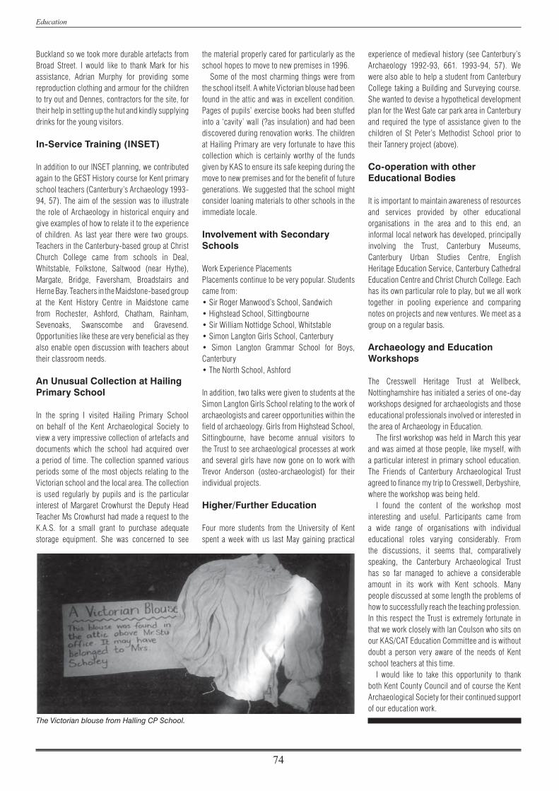
Education
74
Buckland so we took more durable artefacts from Broad Street. I would like to thank Mark for his assistance, Adrian Murphy for providing some reproduction clothing and armour for the children to try out and Dennes, contractors for the site, for their help in setting up the hut and kindly supplying drinks for the young visitors.
In-Service Training (INSET)
In addition to our INSET planning, we contributed again to the GEST History course for Kent primary school teachers (Canterbury’s Archaeology 1993-94, 57). The aim of the session was to illustrate the role of Archaeology in historical enquiry and give examples of how to relate it to the experience of children. As last year there were two groups. Teachers in the Canterbury-based group at Christ Church College came from schools in Deal, Whitstable, Folkstone, Saltwood (near Hythe), Margate, Bridge, Faversham, Broadstairs and Herne Bay. Teachers in the Maidstone-based group at the Kent History Centre in Maidstone came from Rochester, Ashford, Chatham, Rainham, Sevenoaks, Swanscombe and Gravesend. Opportunities like these are very beneficial as they also enable open discussion with teachers about their classroom needs.
An Unusual Collection at Hailing Primary School
In the spring I visited Hailing Primary School on behalf of the Kent Archaeological Society to view a very impressive collection of artefacts and documents which the school had acquired over a period of time. The collection spanned various periods some of the most objects relating to the Victorian school and the local area. The collection is used regularly by pupils and is the particular interest of Margaret Crowhurst the Deputy Head Teacher Ms Crowhurst had made a request to the K.A.S. for a small grant to purchase adequate storage equipment. She was concerned to see
the material properly cared for particularly as the school hopes to move to new premises in 1996.
Some of the most charming things were from the school itself. A white Victorian blouse had been found in the attic and was in excellent condition. Pages of pupils’ exercise books had been stuffed into a ‘cavity’ wall (?as insulation) and had been discovered during renovation works. The children at Hailing Primary are very fortunate to have this collection which is certainly worthy of the funds given by KAS to ensure its safe keeping during the move to new premises and for the benefit of future generations. We suggested that the school might consider loaning materials to other schools in the immediate locale.
Involvement with Secondary Schools
Work Experience PlacementsPlacements continue to be very popular. Students came from:• Sir Roger Manwood’s School, Sandwich• Highstead School, Sittingbourne • Sir William Nottidge School, Whitstable• Simon Langton Girls School, Canterbury • Simon Langton Grammar School for Boys, Canterbury • The North School, Ashford
In addition, two talks were given to students at the Simon Langton Girls School relating to the work of archaeologists and career opportunities within the field of archaeology. Girls from Highstead School, Sittingbourne, have become annual visitors to the Trust to see archaeological processes at work and several girls have now gone on to work with Trevor Anderson (osteo-archaeologist) for their individual projects.
Higher/Further Education
Four more students from the University of Kent spent a week with us last May gaining practical
experience of medieval history (see Canterbury’s Archaeology 1992-93, 661. 1993-94, 57). We were also able to help a student from Canterbury College taking a Building and Surveying course. She wanted to devise a hypothetical development plan for the West Gate car park area in Canterbury and required the type of assistance given to the children of St Peter’s Methodist School prior to their Tannery project (above).
Co-operation with other Educational Bodies
It is important to maintain awareness of resources and services provided by other educational organisations in the area and to this end, an informal local network has developed, principally involving the Trust, Canterbury Museums, Canterbury Urban Studies Centre, English Heritage Education Service, Canterbury Cathedral Education Centre and Christ Church College. Each has its own particular role to play, but we all work together in pooling experience and comparing notes on projects and new ventures. We meet as a group on a regular basis.
Archaeology and Education Workshops
The Cresswell Heritage Trust at Wellbeck, Nottinghamshire has initiated a series of one-day workshops designed for archaeologists and those educational professionals involved or interested in the area of Archaeology in Education.
The first workshop was held in March this year and was aimed at those people, like myself, with a particular interest in primary school education. The Friends of Canterbury Archaeological Trust agreed to finance my trip to Cresswell, Derbyshire, where the workshop was being held.
I found the content of the workshop most interesting and useful. Participants came from a wide range of organisations with individual educational roles varying considerably. From the discussions, it seems that, comparatively speaking, the Canterbury Archaeological Trust has so far managed to achieve a considerable amount in its work with Kent schools. Many people discussed at some length the problems of how to successfully reach the teaching profession. In this respect the Trust is extremely fortunate in that we work closely with lan Coulson who sits on our KAS/CAT Education Committee and is without doubt a person very aware of the needs of Kent school teachers at this time.
I would like to take this opportunity to thank both Kent County Council and of course the Kent Archaeological Society for their continued support of our education work.
The Victorian blouse from Halling CP School.

75
PART FIVE
The Friends
The Friends of the Canterbury Archaeological TrustLawrence Lyle
Our numbers hover around 350, with about 260 members covenanting their subscriptions. At the beginning of the year (1st April 1994) the minimum subscription was raised to £15, the first increase in ten years, made necessary by rising costs not least of Newsletters and the Annual Report. So far numbers have held up well and some generous members subscribe more than the minimum. As we come under the charitable umbrella of the main Trust, we do not have an Annual Meeting but held an Open Forum in march to provide members with an opportunity to air their views; the Committee is acting on some of the suggestions made at that meeting.
Two excavations dominated this year. We paid two visits to the multi-period site at Monkton, the second in November in pouring rain. A very interesting tour of the Buckland Anglo-Saxon cemetery by Paul Bennett was followed later in the year by a talk by Trevor Anderson on his preliminary findings on the bones. Two visits, conducted by Mr Kenneth Reedie, were paid to the new Roman Museum under the Longmarket, Friends are entitled to free admission on production of a pass which will be printed in each January issue of the Newsletter.
Two major grants were made during the year, both for computer equipment; one was to help
to update the desktop publishing facility at 92a, the other to Kevin Blockley to assist with the preparation of his report on the excavations in the nave of the cathedral. Other smaller grants were made to enable Peter Clark to attend the inaugural meeting in Ljubliana of the Association of European Archaeologists at which he read a paper, and to Martin and Alison Hicks to attend a conference in Oxford on the archaeology of monasteries. We have also bought a number of books for the library.
The short break was at Gloucester, organised by Laurence Fisher, assisted by Elizabeth Williamson, Meriel Connor, Anthea Bryant and myself. Accommodated in three hotels, we had most enjoyable visits to Chedworth Roman Villa, the Cathedral, Deerhurst Church, Tewkesbury Abbey, the Severn Wildlife Trust, Berkeley Castle and Painswick. There was a stop at Oxford on the way back. In June Bridget Russell organised a fascinating day at Gilbert White’s Selbourne and the Butser Ancient Farm Project in Hampshire,
providing improving weather and ending with tea in a replica Iron Age hut. Bob Dunnett organised an ambitious and successful series of walks during the Canterbury Festival, covering Dover, Whitstable and Faversham as well as Canterbury.
Three members of staff have lectured to us. Apart from Trevor Anderson, mentioned above, Peter Clark described the research design for the Dover Bronze Age boat and Paul Bennett held two hundred people entranced for nearly two hours by his review of the year’s work in the Frank Jenkins Memorial Lecture in January. This is a joint lecture with the Canterbury Archaeological Society.
The Christmas Party was held in the Eastbridge Hospital, by kind permission of the Master. Laurence Fisher organised the drinks and Elizabeth Rothwell-Eyre the refreshments including a Tenth Anniversary Birthday cake. The Lord Mayor (Clir Bill Hornsby), accompanied by the Lady Mayoress, attended and reminisced about his archaeological experiences as a schoolboy.
The Newsletters, circulated every four months, are an essential way of keeping in touch with our members. This link depends upon the co-operation of the Trust staff and our team of distributors. To them and all who help to run the Friends my grateful thanks.

76
PART SIX
Accounts

Accounts
77

Accounts
78

79
PART SEVEN
Members of the Trust Council and Staff
I The Trust Council
Patron: His Grace the Lord Archbishop of Canterbury (DrGeorge Carey)Vice-Presidents: Mr H.J. Alexander Cllr Bernard Collins Mrs Margaret Collins Mrs Margaret Scott-Knight, B.A.Chairman: The Lord Mayor of CanterburyVice-Chairman: Dr Frank Panton, M.B.E., Ph.D., C.Chem., F.R.S.C., .R.Ae.S., F.R.S.A.Honorary Secretary: Mr Lawrence Lyle, M.A.Honorary Treasurer: Mr Nigel TaylorCanterbury Museums Officer: Mr K.G.H. Reedie, M.A., F.S.A. (Scot.), A.M.A.
Mr David Anning, F.C.A. Dr T.F.C. Blagg, M.A., F.S.A. Professor B.W. Cunliffe, C.B.E., M.k Ph.D., Litt.D., F.B.A., F.S.A. Professor S.S. Frere, C.B.E., M.A., Litt.D., F.B.A., F.S.A. Mr Michael Nightingale, O.B.E., B.Litt., F.S.A. Mrs Caroline Simpson, B.A. The Dean of Canterbury (Very Rev. Dr John Simpson, M.A.) Professor Alfred Smyth, M.A., Ph.D., F.S.A., F.R.G.S. Mrs Margaret Sparks, M.A. Professor John Wacher, B.Sc., F.S.A. Mr Bruce Webster, M.k F.R.Hist.S. Mr Michael Bridgeford, F.A.S.I.
Management Committee: Mr Michael Bridgeford, F.A.S.I. Cllr Bernard Collins Mr Lawrence Lyle, M.A. Dr Frank Panton, M.B.E., Ph.D., C.Chem., F.R.S.C., R.Ae.S., F.R.S.A. Mr K.G.H. Reedie, M.A., F.S.A. (Scot.), A.M.A. Mr David Rose Mrs Margaret Sparks, M.A. Mr Nigel Taylor Mr Bruce Webster, M.k F.R.Hist.S.
One person appointed from each of the following bodies:The Dean & Chapter of Canterbury Cathedral:Mr John Burton, Dip. Arch., R.I.B.A.Council for British Archaeology:Mr Tom Hassall, M.k F.S.A., M.i.F.A.University of Kent at Canterbury:Mr Andrew Butcher, M.A.Canterbury Archaeological Society: Mrs P. GarrardKent County Council: Clir Terry PearsThe British Museum:Dr Leslie Webster, B.A., F.S.A.Royal Archaeological Institute:Mr Geoffrey Beresford, F.S.A.British Archaeological Association:Mr Brian Davison, F.S.A.Kent Archaeological Society: Mr Arthur Harrison, B.A., F.S.A.Heritage Projects Limited: Dr Peter Addyman, M.A., F.S.A., M.I.F.A.Four members of Canterbury City Council: Cllr Alex Perkins Clir Mrs Hazel McCabe, M.B.E. Clir Mrs P.A. Watling Clir Peter Wales
Non-voting members: Mr Christopher Gay, L.L.B. (City Chief Executive) Mr Mansell Jagger, M.A., Dip.T.P., M.R.T.P.l. (Director of Planning) Mr Roger Thomas, B.A. (Historic Buildings and Monuments Commission (England))
Honorary Legal Advisors: Furley Page Fielding & Barton (Mr Nigel Jones)
Auditors: Chantrey Vellacott (Mr David Anning)

Members of the Trust Council and Staff
80
II The Trust Staff
* indicates no longer in Trust employ

81
Bibliography
Ainsworth, N.J. 1933, ‘Mottled teeth’, British Dental Journal 60, 233–50.
Anderson, I. & Bennett, P. 1991, ‘North Lane: the riverside wall’, Canterbury’s Archaeology 1989–90, 13–14.
Anderson, T 1995a, ‘The human bones’, in K. Parfitt, The Iron Age Burials from Mill Hill, Deal, Kent, (British Museum Press, London).
Anderson, T. 1995b, ’Cranial weapon injuries from Anglo-Saxon Dover’, International Journal of Osteoarchaeology (in press).
Anderson, T. 1995c, ’Comment on accelerator radiocarbon date of human skeleton from St Margaret’s at Cliffe’, Archaeometry 37, 418–9.
Anderson T. 1 995d, ‘Paracondylar process: manifestation of an occipital vertebra’, International Journal of Osteoarchaeology (in press).
Anderson T. & Andrews, J. 1995, ‘Congenital absence of second mandibular molars from medieval Canterbury’, British Dental Journal (in press).
Anderson, T & Carter, A. 1995a, ’The first archaeological evidence for Madelung deformity?’, International Journal of Osteoarchaeology (in press).
Anderson, T. & Carter, A. 1995b, ‘An unusual osteitic reaction in a young medieval child’, International Journal of Osteoarchaeology (in press).
Anderson, T. & Carter, A. 1995c, ‘An archaeological example of medieval trauma’, Journal of Paleopathology (in press).
Anderson, T. & Carter, A. 1 995d, ‘Freiberg’s infraction: a case from medieval Kent’, The Foot 5, 202–3.
Anderson, T & Fell, C. 1995, ’Analysis of Roman cremation vessels by computerised tomography’, Journal of Archaeological Science 22, 609–17.
Andrews, J. 1985, The Archaeology of Canterbury, an Assessment, (H.B.M.C., London).
Barnes, E. 1994, Developmental Defects of the Axial Skeleton in Paleopathology, (University of Colorado Press), 11725.
Bennett, P. 1976, ‘Excavations at 78–9 Castle Street’, Archaeologia Cantiana xcii, 238–40.
Bennett, P. 1978, ‘Excavations at 16–21 North Lane, Canterbury’, Archaeologia Cantiana xciv, 165–91.
Bennett, P. 1980, ‘68–69A Stour Street’ in Interim Report 1980, Archaeologia Cantiana xcvi, 406–410.
Bennett, P. 1984,7he topography of Roman Canterbury: a brief re-assessment’, Archaeologia Cantiana c, 47–56.
Bennett, P. & Blockley, P. 1983,1nterim Report’ Archaeologia Cantiana xcix, 1983, 245–7.
Blockley, P. 1984, ‘The Wool Store, Butterfly Garden and St Radigund’s Bridge’, Annual Report 1983–84, 30.
Bowler, E. 1983, A Survey of the Works of the Sewer Commission, Studies in Modern Kentish History.
Boys, W. 1792, Collections for a History of Sandwich.
Brent, J. 186MRoman Cemeteries in Canterbury, with some conjectures concerning its earliest inhabitants, Archaeologia Cantiana iv, 28–33.
Corke, B. 1994,7he Dover Boat: The Inversion Process’, Canterbury’s Archaeology 1993–94, 48–50.
Dahlin, D.C. 1957, Bone Tumours General Aspects and an Analysis of 2,276 Cases (Springf ield, Illinois).
Drennan, M.H. 1937,’The torus mandibularis in the Bushman’, Journal of Anatomy 72, 66–70.
Eagland, M.C. 1970, ‘Congenital absence of the second permanent molar’, British Dental Journal 128 (5), 247–8.
Evison, V. 1987, Dover: Buckland Anglo-Saxon Cemetery, H.B.M.C. Archaeological Report 3 (London).
Fletcher, E. & Meates, G.W. 1969,7he Ruined Church of Stone-by-Faversham’, Antiquaries Journal xlix, 273–94.
Fletcher, E. & Meates, G.W. 1977,7he Ruined Church of Slone-by-Faversham’, Antiquaries Journal Ivii, 67–72.
Frere, S.S., Bennett, R, Rady, J. & Stow, S. 1987, Canterbury Excavations Intra- and Extra-mural Sites 1949–55 and 1980–84, The Archaeology of Canterbury VIII, (Maidstone).
Gostling, W. 1825, A Walk in and about the City of Canterbury.
Hasted, E. 1799, The History and Topographical Survey of the County of Kent, Volume Xl, (Canterbury).
Hasted, E. 1782, The History and Topographical Survey of the County of Kent, Volume II, (Canterbury).
Hawkes, S.C. 1990, `Warrior Graves’? The background of the Anglo-Saxon weapon burial rite’, Past& Present 126, 2243.
Hrdlika, A. 1940, ‘Mandibular and maxillary hyperostoses’, American Journal of Physical Anthropology 27, 1–55.
James, S., Marshall, A. & Millett, M. 1984, ‘An early medieval building tradition’, Archaeological Journal 141, 182–215.
Johnson, O.M. 1959, ‘The tori and masticatory stress’, Journal of Prosthetic Dentistry 9, 975–7.
Keller, P. 1987, ‘Investigation on the site of the tannery, Loop Street, Sandwich 1987’, Kent Archaeological Review 90, 237–8.
Leggatt, G. 1991, ‘No. 30 North Lane’, Canterbury’s Archaeology 1989–90, 5–6.
Lunt, D.A. 1975, ‘Unusual dental conditions in archaeological material. (3) Congenital absence of second permanent molar. British Dental Journal 139 (12), 477.
Bibliography
82
Macpherson-Grant, N. forthcoming, Excavations at Highstead, near Chislet, Kent: 1975–77.
Margary, LID. 1955, Roman Roads in Britain, (London).
Mays, S. & Anderson, T. 1994, Archaeological Research Priorities for Human Remains from south-east England (Kent, East and West Sussex and Surrey), Ancient Monuments Laboratory Report 56/94.
McKenna, K. 1992, 71he Woolstore, Pound Lane’, Canterbury’s Archaeology 1991–92, 9.
Murray, JJ. & Rugg-Gunn, AA. 1982, Fluorides in Caries Prevention (Bristol).
Ossenberg, N.S. 1980, ‘Mandibular torus: a synthesis of new and previously reported data and a discussion of its cause’, American Journal of Physical Anthropology 52, 264 (abstract).
Parfitt, K. 1995, ‘Pound Lane Car Park’, Canterbury’s Archaeology 1993–94, 7–8.
Parkin, E.W. 1984,7he Ancient Cinque Port of Sandwich’, Archaeologia Cantiana c, 189–216.
Philp, B.I 1967, ‘The Romano-British Settlement of Durolevum’, Kent Archaeological Review, No. 7, 20–21.
Philp, B.J. 1976, ‘The Probable Site of Durolevum’, Kent Archaeological Review, No. 43, 62–4.
Philp, B.J. 1980, Note in Vedieval Britain 1979’, Medieval Archaeology xxiv, 253.
Pilbrow, J. 1871, ‘Discoveries made at Canterbury in 186T, Archaeologia xiiii, 151–164.
Rady, J. 1986, ‘Nos 33–37 Stour Street’, Annual Report 1985–86,15–16.
Rose, J.A. 1967, Report from Faversham Archaeological Research Group, Kent Archaeological Review, No. 9, 6.
Sawyer, D.R., Ailison, M.J., Eizay, R.P. & Pezzia, A. 1979, ’A study of torus palatinus and mandibularis in pre Columbian Peruvians’, American Journal of Physical Anthropology 50, 525–6.
Shapiro, R. 1972, ‘Anomalous parietal sutures and the bipartite parietal bone’, American Journal of Roentgenol 115, 569–77.
SLHS 1976, Sandwich Local History Society: Occasional Paper No. 3.
SLHS 1, Sandwich Local History Society: Occupations of the People of Sandwich, Occasional Paper No. 6, n.d.
SLHS 2, Sandwich Local History Society: Sandwich Street Names – A Brief History, n.d.
Suzuki, M & Saki, T. 1960, ‘A familial study of torus palatinus and torus mandibularis’, American Journal of Physical Anthropology 18, 263–71.
Tatton-Brown, T. 11983, Interim Report’, Archaeologia Cantiana xcix, 243–5.
Tatton-Brown, T. 1984, ‘The Towns of Kent, in J. Haslam, Anglo-Saxon Towns in Southern England, 1–36.
Taylor, H.M. & Yonge, D.D. 1981,7he Ruined Church at Stone-by-Faversham’, Archaeological Journal cxxxviii, 11846.
Tester, R.J. ‘A Re-assessment of some features of the medieval house in the Joyden’s Wood square earthwork’, Archaeologia Cantiana xcv, 289.
Tester, P.J. & Caiger, J.E.L. 1958,Veclieval Buildings in the Joyden’s Wood Square Earthwork’, Archaeologia Cantiana lxxii, 18–40.
Urry, W. 1967, Canterbury under the Angevin Kings (London).
Waddelove, A.C. & E. 1990, ‘Archaeology and research into sea-level during the Roman era: towards a methodology based on highest astronomical tide’, Britannia xxi, 253–266.
Wakely, J., Anderson, T. & Carter, A. 1995,’A m u ltidiscipli nary case study of prostatic(?) carcinoma from medieval Canterbury’, Journal of Archaeological Science 22, 469–77.
Whiting, W., Hawley, W. & May, T. 193 1, Report on the Excavation of the Roman Cemetery at Ospringe, Kent, Society of Antiquaries of London Research Report, Vill.
Willis, T.A. (1923),’The lumbo-sacral vertebral column in man, its stability of form and function’, American Journal of Anatomy 32, 95–123.
Woodruff, Rev. C. 1938, ‘The Register and Cartulary of the Hospital of St Laurence, Canterbury’, Archaeologia Cantiana 1, 33–49.