Do Traditional Calendars Forecast Vegetation Changes in ...
30
People and Culture in Oceania, 35: 1-30, 2019 Do Traditional Calendars Forecast Vegetation Changes in Western Sumba, Indonesia? Analyses of Indigenous Intercalation Methods and Satellite Time-Series Data Takuro Furusawa, * and Rikson Siburian ** This study examines the role of traditional calendars in regulating agriculture in a tropical monsoon climate in Western Sumba Island, Indonesia. Our findings indicate that Podu, which marks the end of the dry season and the start of land crop agriculture, and Nyale, which marks the late rainy season and the start of rice planting, are cardinal points at which local calendars are synchronized to the luni-solar cycle. Analyses of 391 normalized difference vegetation index (NDVI) images that were issued every 16 days from 2000 to 2017 revealed that the timing of Podu and Nyale did not correspond with specific vegetation levels across different years due to fluctuations influenced by extreme weather events. However, time-series analyses of the same images disclosed that Podu and Nyale represented the bottom and the peak of “standard” seasonal vegetation changes, respectively, suggesting that these calendars represent Western Sumbanese adaptations to the unstable monsoon climate. Keywords: traditional calendars, synchronicity, sea worms, MODIS, NDVI 1. Introduction Traditional societies have long used locally developed traditional calendars for decision making in subsistence activities and in resource management, and scholars widely recognize such calendars as an adaptive measure for dealing with weather and other conditions in the surrounding environment (Kassam et al., 2018). For example, forecasting seasonal changes is necessary in subsistence activities such as agriculture and foraging (Mondragón, 2004; Ichwandi and Shinohara, 2007; Prober et al., 2011; Hirose, 2015; Fowler, 2016). In addition, traditional calendars often have periodically expressed ritual functions that have been linked to natural and astronomical events (Malinowski, 1922; Hoskins, 1993; Fowler, 2016). Recent studies have * Graduate School of Asian and African Area Studies, Kyoto University. [e-mail: [email protected]] ** Faculty of Mathematics and Natural Sciences, Universitas Sumatera Utara. [e-mail: [email protected]]
-
Upload
khangminh22 -
Category
Documents
-
view
0 -
download
0
Transcript of Do Traditional Calendars Forecast Vegetation Changes in ...

People and Culture in Oceania, 35: 1-30, 2019
Do Traditional Calendars Forecast Vegetation Changes in Western Sumba, Indonesia? Analyses of Indigenous
Intercalation Methods and Satellite Time-Series Data
Takuro Furusawa,* and Rikson Siburian**
This study examines the role of traditional calendars in regulating agriculture in a tropical monsoon climate in Western Sumba Island, Indonesia. Our findings indicate that Podu, which marks the end of the dry season and the start of land crop agriculture, and Nyale, which marks the late rainy season and the start of rice planting, are cardinal points at which local calendars are synchronized to the luni-solar cycle. Analyses of 391 normalized difference vegetation index (NDVI) images that were issued every 16 days from 2000 to 2017 revealed that the timing of Podu and Nyale did not correspond with specific vegetation levels across different years due to fluctuations influenced by extreme weather events. However, time-series analyses of the same images disclosed that Podu and Nyale represented the bottom and the peak of “standard” seasonal vegetation changes, respectively, suggesting that these calendars represent Western Sumbanese adaptations to the unstable monsoon climate.
Keywords: traditional calendars, synchronicity, sea worms, MODIS, NDVI
1. Introduction
Traditional societies have long used locally developed traditional calendars for decision
making in subsistence activities and in resource management, and scholars widely recognize
such calendars as an adaptive measure for dealing with weather and other conditions in the
surrounding environment (Kassam et al., 2018). For example, forecasting seasonal changes is
necessary in subsistence activities such as agriculture and foraging (Mondragón, 2004; Ichwandi
and Shinohara, 2007; Prober et al., 2011; Hirose, 2015; Fowler, 2016). In addition, traditional
calendars often have periodically expressed ritual functions that have been linked to natural and
astronomical events (Malinowski, 1922; Hoskins, 1993; Fowler, 2016). Recent studies have
* Graduate School of Asian and African Area Studies, Kyoto University. [e-mail: [email protected]]** Faculty of Mathematics and Natural Sciences, Universitas Sumatera Utara. [e-mail: [email protected]]

2 T. Furusawa, and R. Siburian
also suggested that many traditional calendars have been used to build anticipatory capacity in
resource management under climate change (Franco, 2015; Hiwasaki et al., 2015; Kassam et al.,
2018).
The mechanisms of traditional calendars can be classified by their cycles, such as lunar,
solar, or celestial cycles and cycles of other natural phenomena (Yoshida, 1980). Some widely
known, highly standardized traditional calendars that are still in use today were developed
several centuries, or perhaps millennia ago based on detailed astronomical observation and
mathematics, and were matched with the solar cycle at an accuracy that was very high. Examples
of these include the Chinese and Hindu calendars and several calendars in Indonesia, such as the
Bali Saka calendar, a widely used luni-solar calendar with important days (e.g. Nyepi, the “Day
of Silence”) marking official holidays of local government and public services in Bali Province
(Igarashi, 1997). Similarly, the Pranatamangsa of Java is based on a solar cycle of 365 days (366
days in leap year) and comprises 12 months of varying lengths, from 23 to 43 days, which have
been correlated with agricultural cycles (Daldjoeni, 1984; Retnowati et al., 2014).
However, in the Lesser Sunda Islands (also known as Nusa Tenggara), many local
indigenous calendars have traditionally determined the “new year” by manually observing the
heliacal rising of specific stars (e.g. the Pleiades, Antares), and cross-checking them with various
natural phenomena (Fox, 1979; Forth, 1983; Hoskins, 1993; Igarashi, 1997; Furusawa, 2017).
Such calendars raise questions concerning the accuracy of human observations and how people
cope with the consequences of errors in observing astronomical phenomena. However, few
studies have investigated how accurate such local traditional calendars actually are, why people
continue to use such calendars even after the introduction of first the Hindu calendar and later
the Gregorian calendar, and how such calendars can be adaptive under recent conditions derived
from climate change.
Sumba Island is characterized by traditions of living such as megalithic burials and the well-
documented Pasola ritual—a group jousting event in which hundreds of horse riders do ritual
battle with spears (Hoskins, 2002), and the local traditional calendars have been recognized as
being particularly unique (Fowler, 2016; Hoskins, 1993; Geirnart-Martin , 1992). The climate of
Sumba Island is divided between tropical monsoon on the western part and savanna in the eastern
part and is characterized by dramatic shifts between dry and rainy seasons and large fluctuations
of rainfall pattern from year to year (Fox, 1977; Russell-Smith et al., 2007). The climate is also
influenced by irregular and extreme weather events such as El Niño-southern oscillation (ENSO).
Such climatic instability implies that the solar cycle is insufficient for prediction of the onsets
and endings of dry and rainy seasons, and local people must also take irregularities in the climate
into consideration. Among the various studies on traditional calendars conducted to date (e.g.

3Calendar and Vegetation Changes in Western Sumba
Forth, 1981; Hoskins, 1993; Fowler, 2016), none has clarified their adaptive functions in terms of
agriculture, and neither scholars have examined whether such flexible calendars can be used to
facilitate adaptations to climate change.
This study aimed at linking traditional calendars and periodic rituals to subsistence and
seasonal changes in Western Sumba, Lesser Sunda Islands, Indonesia based on previous literature
and data collected in fieldwork conducted between 2015 and 2017 and data on ecological
changes as monitored and recorded from 2000 to 2017 by a satellite. The Moderate Resolution
Imaging Spectroradiometer (MODIS) observes every part of the earth on a near-daily basis and
provides 16-day composite data of the vegetation index, thus showing continuous vegetation
changes (Stefanov and Netzband, 2005; Lunetta et al., 2006; Furusawa et al., 2014).1 Examining
the MODIS data combined with analyses of the traditional calendar can show correlations
between traditional calendars and vegetation changes, and special attention was paid to analyzing
the timing of agricultural rituals in relation to seasonal patterns.
2. Ecological and Cultural Context of West Sumba
2.1 Geography of West Sumba
This study was conducted in the subdistricts of Lamboya, Lolina, and Wanokaka
(kecamatan) in West Sumba Regency (kabupaten) (Figure 1). Sumba Island is located in East
Nusa Tenggara Province (Badan Pusat Statistik, 2010 ).2 Today’s subdistricts represent former
swapraja (territorial kingdoms that became self-governing regions under the Dutch system), and
thus are occupied by different linguistic and cultural groups, such that 19 languages are spoken in
these 3 regencies in the Western Sumba (Kuipers, 1998). Accordingly, this particular subdistrict
was used as the basic unit of analysis.
The climate of the Western Sumba Island is characterized by a clear distinction between
rainy and dry seasons. Figure 2 shows available rainfall totals in the West Sumba Regency from
January 2010 through December 2017 (Badan Pusat Statistik Kabupaten Sumba Barat, 2016;
Badan Pusat Statistik Provinsi Nusa Tenggara Timur, 2017, 2018). The rainy season begins
between September and November, and peak rainfall occurs in December, January, or February
before the rainy season ends sometime between April and June. Figure 2 also shows that the
annual precipitation and the start and end of the rainy season differed from year to year; for
1 The MODIS is a sensor on board the Terra satellite that was launched by the United States National Aeronautics and Space Administration (NASA).
2 With an area of 11,150 km2 and 686,113 people, this island was divided into the East and West Sumba Regency until 2006, and the West Sumba Regency was further divided into southwest, central, and west regencies.

4 T. Furusawa, and R. Siburian
example, the monthly rainfall peaked at about 800 mm in 2013 and 2014, whereas the peak was
only slightly over 400 mm in 2015 and less than 350 mm in 2010 and 2011. Rainfall continued
even in the dry season in 2016 and 2017.
According to analyses of Japan Meteorological Agency (2018a), extremely low precipitation
was recorded in the eastern part of Indonesia (including Sumba Island) in 2014 and 2015, and
Figure 1. Locations of Lamboya, Lolina, and Wanokaka Subdistricts (Kecamatan) in West Sumba
Regency, East Nusa Tenggara Province, Indonesia (Map Compiled from Data Provided by the Indonesia Geospatial Portal (http://portal.ina-sdi.or.id) and ASTER GDEM2 (METI/NASA))
Figure 2. Monthly Rainfall (mm) in West Sumba Regency from 2010 to 2015

5Calendar and Vegetation Changes in Western Sumba
extremely high precipitation was documented in Indonesia in 2016. In global-level analyses,
the ENSO was observed in 3 seasons between summer (in the northern hemisphere) 2002
and winter 2002/2003, in 4 seasons between summer 2009 and spring 2010, and in 8 seasons
between summer 2014 and spring 2016. La Niña was observed in 3 seasons between autumn
2005 and spring 2006, in 5 seasons between spring 2007 and spring 2008, in 4 seasons between
summer 2010 and spring 2011, and in 3 seasons between autumn 2017 and spring 2018 (Japan
Meteorological Agency, 2018b).
2.2 Livelihood and Society of West Sumba
Sumba is among the economically poorest areas in Indonesia. Most residents depend on
agriculture for subsistence; dry land agriculture is observed throughout the island, and the rice
paddy agriculture is run in limited areas of the western and southern zones (Furukawa, 1991;
Russell-Smith et al., 2007). Dryland agriculture is based on grass burning (Monk et al., 2013),
and although no data is available for West Sumba, 29% of savanna grassland is burned in East
Sumba annually (Fisher et al., 2006).3 People prepare land for farming according to several
steps. When the end of the dry season is forecast, people burn the grasses and then dig and turn
over the blocks of dried soil to bring the fertile subsoils to the surface. Then people wait for the
first rainfall of the season, which breaks up the blocks of dried soil to provide fertile soils for
agriculture (Furukawa, 1991), at which point they plant the first seeds of maize. Alternatively,
traditional rice cultivation begins following certain natural phenomena. West Sumba peoples fill
paddies with water after the start of the rains; however, they do not actually start planting rice
until the end of heavy rains (or the peak of rainfall). Such planted rice is tended and is finally
harvested around the middle of the dry season.
Representing one of the rare cases of continuing pagan religion in Indonesia, most residents
of Sumba Island, particularly of Western Sumba, are followers of Marapu, the traditional religion
of ancestral worship (Hoskins, 2002; Badan Pusat Statistik, 2010 ). In Western Sumba, the rato is
the priest of Marapu as well as the traditional social leader of the clan or “house” (uma).4
3 Traditionally, various kinds of millets formed the main crops of the dryland agricultural system; however, after its introduction in the 20th century, the millets were displaced by maize, which was adopted as the main crop because of its high productivity and its protective qualities against birds.
4 In contrast to the hierarchical social system of Eastern Sumba, the traditional society of Western Sumba was not centralized, but was rather based on divisions of labor and responsibility. Thus, different priests play varying political, religious, spiritual, and other roles in each community, such that the supervising priest differs from one ritual to another and multiple priests fulfill different roles—such as determining dates, fortune-telling, preparing placeseven within a single ritual.

6 T. Furusawa, and R. Siburian
2.3 Fieldwork
One of the authors (TF) stayed at the house of priests or with villagers and observed the
community’s decision-making process. When allowed by the priests, TF also participated in
certain rituals. Information was also collected from interviews and daily conversations with the
priests and villagers. Extensive interviews were conducted with priests who managed important
roles in the organization of rituals and calendars.5 The authors consulted ethnographies written
by Hoskins (1993) and Geirnaert-Martin (1992) as well as papers by Mithcell and Gunawan-
Mithcell (1981, 2008). To guarantee comparability with these previous studies, TF conducted in-
depth interviews with elders (60 years or above). The Research Permit for this study was given
by the Ministry of Research, Technology and Higher Education of the Republic of Indonesia
(RISTEK) (416/SIP/FRP/E5/Dit.KIX/2015).6
3. Mechanisms and Functions of Traditional Calendars in Western Sumba
3.1 Comparisons of Traditional Calendars in Three Subdistricts
This study began with analyzing and understanding traditional calendars in Western Sumba.
Tables 1 through 3 illustrate the order and names of months in the traditional calendars of
subdistricts of Lamboya, Lolina, and Wanokaka, respectively. These Tables were compiled from
previous ethnographic research (Gunawan-Mitchell, 1981; Geirnaert-Martin, 1992; Hoskins,
1993; Mitchell and Gunawan, 2008), as well as from the authors’ interviews with the priests
and the villagers (the initial version of the calendrical interpretation was published in Japanese
(Furusawa, 2017)). As no official orthography has been developed for these languages, spellings
may differ from one source to another. In these tables, the names of months are presented in the
appropriate local language and English translations are shown in footnotes. Note that in principle,
a month begins with a new moon and ends the night before the next new moon.
Most of the priests recognized that the traditional year ends in a month called Podu (Padu,
Pidu), literally meaning “bitterness,” and begins in the month of Kabba (Kobba, Ka’a), which
literally means “being free from taboos.” The month of Kabba is followed by Mangata, which is
marked by the flowering of Pecteilis sp. However, several priests in Wanokaka have recognized
that the year starts in the month of Hi’u, literally meaning “nesting” (of wild pigs). After the Hi’u
5 The fieldwork was conducted in 6 visits between February 2015 and March 2017. Additionally, TF befriended some priests and villagers on Facebook and requested that they inform him about events that occurred in his absence by uploading photographs or sending messages.
6 Participation was confirmed and interviews were conducted after oral consent from each individual was obtained and the purpose and method of the research explained. The interviewees were also informed that non-participation or withdrawal from agreement would not cause them any disadvantage.

7Calendar and Vegetation Changes in Western Sumba
Table 1 Names and Order of Months Recognized in Lamboya District Based on 2 Previous Ethnographies and 1 Priest Informant*
Order 1st 2nd 3rd 4th 5th 6th
Approximate Time in Gregorian CalendarSource Nov–Dec Dec–Jan Jan–Feb Feb–Mar Mar–Apr Apr–MayHoskins (1993) Kaba Mangata Nale Nale Gouru Nale Moro Ro Huli
Geirnaert-Martin (1992)
Kabba Ro Yayu Mangata
(1st half)Nyale
Laboya
(2nd half)Nyale Renga
Nyale Wanokaka
orNyale Gaura
Nyale Ngura Nyale Ngihi
HA (Male priest/70 yrs old)
Kabba Ro Yayu Mangata Nyale
Lamboya
Nyale Wanokaka
orNyale Gaura
Mahera Makahi Kari
Limaor
no name
7th 8th 9th 10th 11th 12th
Approximate Time in Gregorian CalendarMay–Jun Jun–Jul Jul–Aug Aug–Sep Sep–Oct Oct–Nov
Nale Ngisi Nale Mabu Kaba Ro Yayu
Kaba Pari Biru
Podu Lamboya
Padu Patialla
(1st half)Magowo
Wulu Hura
(2nd half)Nyale Tu Kabba Pare
Biru Nyale Mabu Patina Mahi Padu Laboya
Padu Patyala
Wolu Hura Kabba Pari Beru Kuru Tanah Siwa (Bani
Diha)* Podu Podu Lolina
Note: Names that are related to Podu and Nyale (see text) are marked in bold
* Kabba (Kaba) means “bland month” and “free from taboos of Podu (bitterness)”; Mangata means “blossom of the white flower of Pecteilis sp.”; Nale (Nyale) means “sea worms,” such that Nyale Laboya (Lamboya), Nyale Renga, Nale Gouru (Nyale Gaura), and Nyale Wanokaka denote “sea worms” for Lamboya, Renga, Gaura, and Wanokaka regions, respectively; Nale Moro means “raw sea worms”; Nyale Ngura means “young tubers,” Nyale Ngihi (Nale Ngisi) means “to bear fruit” (Hoskins, 1993); Mahera Makahi Kari means “buffaloes (kari) resting after working in rice paddy field”; Lima means “five”; Magowo Wulu Hura (Wolu Hura) literally means “fishing feathers of a cock’s tail” and refers to “rice ears grown to be bending”; Nyale Tu means “old” and relates to crops ripe enough for harvest; Nale (Nyale) Mabu means “mature or dissolving fruits”; Kabba Pare Beru (Kaba Pari Biru) means “free from taboos and starting to eat new harvest of rice”; Kaba Ro Yayu means “free from taboos and trees starting to have leaves”; Kuru Tanah means “closing land” for making salt from sea water; Patina Mahi means “cooking salt”; Siwa (Bani Diha) means “nine”; Podu (Padu) means “bitterness,” such that Podu Lamboya (Padu Laboya), Padu Patialla (Patyala), and Podu Lolina denote “bitterness” for Lamboya, Patyala, and Lolina regions, respectively.

8 T. Furusawa, and R. Siburian
Table 2 Names and Order of Months Recognized in Lolina District asDerived from 1 Ethnographic Study and 4 Informants*
Order 1st 2nd 3rd 4th 5th 6th
Approximate time in Gregorian CalendarSource Nov–Dec Dec–Jan Jan–Feb Feb–Mar Mar–Apr Apr–May
Hoskins (1993) Koba Mangata Nale Lamboya
Nale Wanokaka Nale Mubbu Ngura
TB (Male priest/60s yrs old) Koba Mangata Nale Laboya Wanokaka Nale Mobu Ngura
TC (Male priest/40s yrs old) Koba Mangata Nale Laboya Nale
Wanokaka Nale Mobu Ngura
TE (Female villager/80s yrs old) Koba Mangata Nale Laboya Nale
Wanokaka
Nale Mobu or
NguraTua
TF (Male villager/70 yrs old) Koba Mangata Nale Laboya Nale
Wanokaka Nale Mobu Ngura
7th 8th 9th 10th 11th 12th
Approximate time in Gregorian CalendarMay–Jun Jun–Jul Jun–Aug Aug–Sep Sep–Oct Oct–Nov
Boda Rara Meting Katiku Menamo Pattina Mesi Podu
Lamboya Podu Lolina
Tua Meting Katiku Manamo
Kadekaraor
Tai Na MesiPodu Laboya
Podu Lolina or
Podu Touma Dangu
Tua Badi Rara
Meting Katiku
or Sarubu
Kadekara
Podu Laboya or
Podu Baliledo
Podu Lolina
Badi Rara Meting Katiku Kadekara Taina Maesi Podu Laboya Podu Lolina
Tua or
Badi Rara
Sarobu or
Meting Katiku
Manamo KadekaraTaina Mesi
or Podu Laboya
Podu Touma Dangu
Note: Names that are related to Podu and Nyale (see text) are marked in bold.* Koba means “bland month” and “free from taboo of Podu (bitterness)”; Mangata means “blossom of white
flower of Pecteilis sp.”; Nale means “sea worms,” and Nyale Lamboya (Laboya) and Nyale Wanokaka denote “sea worms” for Lamboya and Wanokaka, respectively; Nale Mubbu (Mobu) means “dissolving sea worms”; Ngura means “young tubers”; Tua means “old” and relates to crops ripe enough for harvest; Boda Rara (Badi Rara) means “red rice” and refers to color changes denoting ripened rice; Menamo (Manomo) means “threshing rice” with feet; Meting Katiku means “black heads” and refers to the appearance of people crowded in the rice fields as they bend to harvest rice; Sarobu (Sarubu) means “rice harvest”; Kadekara means “plowing”; Pattina Mesi means “cooking salt”; Tai Na Mesi (Taina Maesi) means “boiling salt”; Podu means “bitterness,” whereby Podu Lamboya (Padu Laboya), Padu Baliledo, and Podu Lolina denote “bitterness” for Lamboya, Patyala, and Lolina regions, respectively, and Podu Touma Dangu means “bitterness for all people.”

9Calendar and Vegetation Changes in Western Sumba
Table 3 Names and Order of Months Recognized in Wanokaka District that are Derived from 2 Ethnographic Studies and 2 Priest Informants*
Order 1st 2nd 3rd 4th 5th 6th
Approximate time in Gregorian CalendarSource Dec–Jan Jan–Feb Feb–Mar Mar–Apr Apr–May May–Jun
Hoskins (1993) Hi’u Nyale Laboya
Nyale Wanokaka Ngura Tua Bada Rara
Gunawan-Mitchell (1981) Hi’u Nyale
LaboyaNyale
Wanukaka Ngurra Oting Mahing Tuwa
WA (Male priest/60s yrs old) Hi’u Nyale
LaboyaNyale
Wanokaka Ngura Meting Katiku Bada Rara
WB (Male priest/60 yrs old) Hi’u Nyale
Lamboya
Nyale Wanokaka
or Biha
Ngura Meting Katiku Bada Rara
7th 8th 9th 10th 11th 12th
Approximate time in Gregorian CalendarJun–Jul Jul–Aug Aug–Sep Sep–Oct Oct–Nov Nov–Dec
Metingo Katiku
Oting Mahing
Dapangara or
Pidu Tou Dangu
Pidu Laboya Kabba Mangata
Bada Rara Dapa Ngara Metingu Katiku Pidu Laboya
Pidu Tou Dangu
orKalangu
Ka’a
Tua Oting Mahing Pidu Laboya Pidu Laboya
WawaPidu Tou Dangu Ka’a
Oting Mahing Palu Dong Podu Laboya
BawaPodu Tou
DanguPodu Tarung
Waitabar
Mangata or
Ka’a
Note: Names that are related to Podu and Nyale (see text) are marked in bold.* Koba means “bland month” and “free from taboo of Podu (bitterness)”; Mangata means “blossom of white
flower of Pecteilis sp.”; Nale means “sea worms,” and Nyale Lamboya (Laboya) and Nyale Wanokaka denote “sea worms” for Lamboya and Wanokaka, respectively; Nale Mubbu (Mobu) means “dissolving sea worms”; Ngura means “young tubers”; Tua means “old” and relates to crops ripe enough for harvest; Boda Rara (Badi Rara) means “red rice” and refers to color changes denoting ripened rice; Menamo (Manomo) means “threshing rice” with feet; Meting Katiku means “black heads” and refers to the appearance of people crowded in the rice fields as they bend to harvest rice; Sarobu (Sarubu) means “rice harvest”; Kadekara means “plowing”; Pattina Mesi means “cooking salt”; Tai Na Mesi (Taina Maesi) means “boiling salt”; Podu means “bitterness,” whereby Podu Lamboya (Padu Laboya), Padu Baliledo, and Podu Lolina denote “bitterness” for Lamboya, Patyala, and Lolina regions, respectively, and Podu Touma Dangu means “bitterness for all people.”

10 T. Furusawa, and R. Siburian
months, 2 or 3 months of Nyale (Nale), literally meaning “sacred sea worms,” range from around
January to March. Each subdistrict has at least 2 months of Podu as well as at least 2 months
of Nyale, and, in normal years, the rainy season corresponds with the period between Podu and
Nyale.
Month names following Nyale reflect agriculture and other livelihoods. Ngura (“young
tubers”) and Tua (“old (matured)”) respectively refer to immature tubers and tubers ripe for
harvest, whereas Boda Rara/Badi Rara (“red rice”), Magowo Wulu Hura/Wolu Hura (“fishing
feathers of a cock’s tail”), Meting Katiku (“black heads”) and Menamo/Manomo (“threshing
rice” with feet) all refer to different stages of rice cultivation. The latter part of the dry season is
marked by Pattina Mesi (“cooking salt” from sea water, which refers to land that is dried up and
unsuitable for agriculture), whereas the preparation period is marked by the “plowing” period of
Kadekara.
There are a few exceptional cases in which the month did not have an original name or the
interviewees did not know the names, such as Siwa, which is simply called “nine” because it is
the 9th month, or Dapangara (“name unknown”); these months were positioned just before the
month of Podu.
3.2 Implications of Differences in Sources’ Information
As the Tables illustrate, the names and orders of months differed from one information
source to another, and such differences were especially manifested in the dry season. For
example, in Wanokaka (Table 3), Hoskins (1993) recorded month names in order from
Tua (April–May), Bada Rara (May–June), Metingo Katiku (June–July), and Oting Mahing
(July–August), whereas Mitchell and Gunawan (2008) recorded them in their study as Oting
Mahing (April–May), Tuwa (May–June), Bada Rara (June–July), and Metingu Katiku (August–
September), and one of the priests in this study named them as Meting Katiku (April–May), Bada
Rara (May–June), Tua (June–July), and Oting Mahing (July–August).
Notably, however, month names in all 3 subdistricts are almost identical in the rainy season
(starting in Podu and ending in Nyale).7 These results imply that 2 calendrical systems exist in
a single calendar. The names and orders of months are fixed during the rainy seasons, whereas
during the dry seasons they are more flexibly based on phenomenological observations. Podu and
Nyale served as important cardinal points in this system.
7 Hoskins (1993: 345) also recorded that people in Kodi subdistrict in Southwestern Sumba Regency became aware of what lunar month they were in after Podu; however, counting and naming of months of most informants became inconsistent in the dry season.

11Calendar and Vegetation Changes in Western Sumba
3.3 Synchronicity between Subdistricts
Three of the subdistricts were found to synchronize their calendars across boundaries
through the mechanisms of Podu and Kabba (Hoskins, 1993; Fowler, 2016). For example, Podu
starts in Lamboya (Podu Lamboya) and then shifts to Lolina (Podu Lolina) and other areas (e.g.
Podu Patialla). In Lolina subdistrict (Table 2), Podu Lolina, or “month of bitterness in Lolina
Subdistrict,” was also called Podu Touma Dangu, which means “month of bitterness for all
people.” A priest in Lolina said that their subdistrict celebrated the last Podu ritual in Western
Sumba, which was widely known and was attended not only by Lolina residents but also by
others throughout the region. Accordingly, all 3 subdistricts enter the month of Kabba directly
following Podu Lolina. Similarly, Nyale starts in Lamboya (Nale Lamboya) and then moves to
Wanokaka (Nyale Wanokaka), and the ritual Pasola ceremony is first held in Lamboya in the
month Nale Lamboya and then again in Wanokaka (Nyale Wanokaka) after an interval of one
lunar cycle. This implies that Lamboya subdistrict has a role in determining the timing of Podu
and Nyale for both areas.
Hoskins (1993) suggested that coastal populations historically experienced chronic conflict,
which limited direct communication between them until modern times. During the authors’
fieldwork, several pieces of information were collected that were informative on the mechanisms
of synchronicity among subdistricts. For example, during the Podu Festival, Lamboya people
ritually burn a large area of grassland in the mountains. The smoke from this burning is visible
in Lolina, and thus their priests are aware that they can have their Podu from the coming new
moon. The Podu of Lolina, which is a mountain society, traditionally hold the grandest ritual
festivals in the region, which last for an entire lunar cycle. During that period, 15 rituals are
organized in various local communities, including the main village of Tarung, which is located
near Waikabubak, the capital and communication hub of West Sumba Regency. Wanokaka
priests reported that their coastal community did not even celebrate Podu in the same manner
as that of others in the region; however, they always knew the time of Podu Lolina because its
festival was so large and well-known that they received information through Waikabubak. These
reports are consistent with speculation by Hoskins (1993: 357–358) that Lolina and other inland
communities had played roles in synchronizing local calendars throughout the region. Pasola
is another large festival that is celebrated in both Lamboya and Wanokaka subdistricts with
participation from neighboring societies. Residents of Lolina have no tradition of celebrating
Nale/Nyale; however, their priests are invited to join the festivals of Nyale Lamboya and Nyale
Wanokaka. The significance of Lamboya, which has both inner mountain zones and coastal
communities, is reflected in the couplet by which it is locally known: Tana Podu, Tana Nyale, the
“land of Podu, land of Nyale” (Geirnaert-Martin, 1992: 11).

12 T. Furusawa, and R. Siburian
3.4 A Traditional Intercalation System
The authors conducted further research to address a gap in previous studies, which did not
achieve any consensus regarding when and how Western Sumba societies adjust their calendars
within the solar cycle. One of the traditional priests of the mountainous area of Lamboya
reported that he followed the calendar by routinely observing the sunrise. It was by this means
that he determined the onset of Podu, which always begins in the next new moon following
the day that the sun rises from a certain direction; the author confirmed that the direction was
due east by using a compass, i.e., in the new moon following the autumnal equinox (Furusawa,
2017). Similarly, the same priest of Lamboya reported that the sun rose from a particular east-
southeast direction just before the month of Nale Lamboya. The authors speculated that the time
would be Winter Equinox or slightly after that, but could not confirm this because the outsiders
were not allowed to view details of how the priest observed the sun due to customary rules. This
information suggests that the intercalations can be made twice in a year.
Human observations of the sun can be biased based on weather conditions such as cloudy
weather as well as by our limited abilities of perception. Therefore, in order to accurately
regulate agricultural activities, traditional societies need to integrate a certain degree of flexibility
into their calendars, because there is no room to adjust for any errors in calculations if all of the
months are rigidly fixed (Igarashi, 1997, 2018; Hoskins, 1993). It is therefore reasonable that the
month prior to intercalation (Podu) is not synchronized among all members of the society, as is
reflected in the inability of several interviewees to provide a name for the month as well as in
other claims that there the month was not even named. Although the names and orders of rainy
season months were almost identical among the interviewees, the authors observed that during
this period too a month was virtually skipped. According to priests in Wanokaka, that community
celebrated their Hi’u Pa’ana (“nesting of wild pigs”) ritual in the month of Hi’u, from January
to the beginning of February 2016; however, because they had heard the news that the Lamboya
would be organizing their Pasola festival on 2 February 2016, they simultaneously recognized
that they were in the month of Nale Lamboya. Thus, the next month was identified as the
month of Nyale Wanokaka. This case suggests that an intercalation-based synchronicity is also
implemented during the process of Nyale.
The use of intercalation to determine the month of Nyale was also confirmed post hoc by the
information that designated priests (Rato Nale/Nyale) observe whether or not the Nyale sea worms
swarm on the day that has previously been predicted as the day of Pasola, which is usually 6 to
9 days after the full moon. In reality, Pasola is a ritual held for celebrating the appearance of the
Nyale in Wanokaka. For example, in 2017, the Wanokaka priests and community gathered at the
coast 6 days after the full moon (18 March), where they observed the Nyale appearance in the early

13Calendar and Vegetation Changes in Western Sumba
morning and celebrated Pasola from morning to afternoon. Conversely—and significantly—people
in Lamboya recognized that the Nyale should not be swarming on the day of Pasola (Geirnaert-
Martin, 1992; Hoskins, 1993: 352). In 2017, Lamboya people gathered at the beach 7 days after
the full moon in February (18 February), and confirmed the “non-swarming” of Nyale so as to start
celebrating their Pasola. Priests of both subdistricts agreed that the non-appearance of Nyale during
Nyale Wanokaka was a sign of the anger of their ancestor god Marapu at their behaviors, whereas,
conversely, their appearance in Nale Lamboya also marked a negative sign. The periodic swarming
of the polychaete species follows both solar and lunar cycles (Fong, 1991; Sato, 2004), and charting
this natural phenomenon can be interpreted as a form of synchronization. However, as described
above, humans can make mistakes in their observations of the sun. These 2 subdistricts cross-check
the non-appearance and appearance of the Nyale within the period of a single lunar cycle interval
every year. By this cross-check, people in different communities can confirm whether they are in
correct alignment with the luni-solar cycle.8
Intercalation mechanisms (i.e., synchronicity with solar cycle) in which the names of
months are not fixed a month before the new year have also been reported from other Lesser
Sunda Islands such as Bali and Lombok, where communities begin their traditional new year
after observing the heliacal rising of Pleiades or Antares (Forth, 1983; Igarashi, 1997, 2018).
The phenomenon of the sea worm swarming has been used as identification of the start of the
traditional new year in Samoa (A Member of the Samoan Society, 1928), Trobriand Islands
(Malinowski, 1927; Leach, 1950), and Lesser Sunda Islands (Yoshida, 1980; Mondragón, 2004;
Odani et al., 2016). The Sumba calendar integrated both of these mechanisms, which were
common in Austronesian-speaking populations.9
Figures 3 and 4 show how the months of Podu and Nyale, respectively, are determined and
become known by the peoples through transmissions of signals from the sun, moon, and nature,
as well as communication across the subdistrict boundaries.
8 It should be noted that these traditional rituals were not totally free from the influences of modernization and globalization. Many Western Sumba communities, such as in Kodi of Southwestern Sumba Regency, have been subject to pressure from governmental authorities to decide the date of Pasola according to the convenience of overseas tourists, whereas Christian authorities have been urging them to avoid conducting prayers or even to stop organizing these traditional rituals altogether (Hoskins, 1993). However, these 3 subdistricts still place a high priority on conducting the rituals in the traditional manner and pay the strictest attention to its synchronicity.
9 Previous studies have suggested the possibility that some Sumba communities might use observations of celestial cycles as an intercalation method (Geirnaert-Martin, 1992; Hoskins, 1993); however, we are unaware of any studies to date that have clearly identified any specific celestial phenomenon used in Western Sumba. During the authors’ fieldwork, none of the priests reported having observed celestial phenomena as calendrical mechanisms; however, research did suggest that some priests have observed the position of the moon relative to specific stars as a means of determining the starting day and hour of rituals for Pasola (Boro, 1995). This suggests that the stars are used indirectly to identify at least one specific day rather than a month.

14 T. Furusawa, and R. Siburian
3.5 Importance of Podu and Nyale in Local Subsistence
Podu and Nyale are positioned at what can be called cardinal time points for subsistence.
Forecasting the start of the rainy season is of the utmost importance for Sumba dryland
agriculture crops, and any failures would lead to difficulty in preparing soils for crops. Similarly,
rice agricultural cycles impact the coordination of Nyale across subdistricts. According to our
interviewees, rice cultivation should begin after the season of heavy rainfall and strong winds
but before water sources become unavailable. In the traditional belief system, if Nyale appear
during Nale Lamboya, that is an ominous sign that the rainy season will end soon and new rice
cultivation will fail; however, if the Nyale have not appeared by the time of Nyale Wanokaka,
Figure 3. Schematic Diagram of Transmission of Signals from Sun, Moon, and Natural Phenomena and Information Communication across 3 districts for Determining the Months of Podu
Figure 4. Schematic Diagram of Transmission of Signals from Sun, Moon, and Natural Phenomena and Information Communication across 3 Districts for Determining the Months of Pasola

15Calendar and Vegetation Changes in Western Sumba
then heavy rainfall will kill the rice crops. In this manner, the cross-checking of the appearance
of Nyale amounts to a form of coordinated observation of an annual ecological phenomenon and
presents a reasonable, empirically-based means of confirming the best time of rice planting.
4. Seasonal Vegetation Changes Analyzed from MODIS Satellite Data
4.1 Analytical Methods for MODIS Data
Based on the findings about traditional calendars that are summarized in the previous
section, the authors devised 2 additional research questions:
(1) Are Podu and Nyale coordinated with the appearance of seasonal vegetational changes?
In other words, do seasonal vegetational changes first appear in Lamboya before manifesting in
other subdistricts?
(2) Does the timing of Podu and Nyale rituals correspond with specific points in seasonal
changes of vegetation?
To address these questions, the authors analyzed time-series data of the normalized
difference vegetation index (NDVI) as a product of the MODIS Terra Program operated by
NASA (product name: MOD13Q1 (Vegetation Indices 16-Day L3 Global 250m)) (Huete et
al., 1999; Furusawa et al., 2014). This program provides data products of 16-day intervals and
at a 250 m spatial resolution, after atmospheric correction and minimizing influence of daily
cloud covers, for consistent spatial and temporal comparisons of vegetation biomass; the NDVI
is calculated from the visible and near-infrared light reflected by the amount (biomass) and/or
composition of vegetation and ranges from - 1 to +1 (valid range for the NDVI of the MODIS
ranging from - 0.2 to +1).
The authors analyzed data of MODIS version 6.0 acquired over the 17-year period from
8 May 2000 to 27 April 2017, starting approximately with the dry season of Western Sumba:
391 images in total.10 Every image was broken down into subdistricts and pixel reliability (−1:
No Data, 0: Good Data, 1: Marginal Data, 2: Snow/Ice, 3: Cloudy). Pixel reliability with −1
(No Data) occurred in coastal areas where the pixels had captured water cover, and these cases
were excluded from further analyses. None of the pixels were categorized as level 2 (Snow/
Ice). No NDVI was available for pixels, which was covered by cloud (pixel reliability=3). Thus,
the average NDVI was calculated for areas with pixel reliability in the 0 or 1 range in each
subdistrict at each time point. Throughout these processes, the percentage of cloud cover (pixel
10 All of the total 391 images were downloaded from USGS Earth Explorer (U.S. Department of the Interior and U.S. Geological Survey, 2018). The same shapefile polygons used by the Indonesian Government served to define the boundaries of the subdistricts (Badan Informasi Geospasial, 2016).

16 T. Furusawa, and R. Siburian
reliability=3) was also calculated for each subdistrict at each time point. These analyses were
performed using ERDAS IMAGINE 2013 software (Hexagon Geospatial, USA).
Time-series analyses based on state-space modelling (SSM) were made in 2 steps
(Commandeur and Koopman, 2007): first, NDVI values were averaged for each subdistrict,
excluding time points at which cloud cover exceeded 30%, then stochastic level and deterministic
seasonal models using the NDVI were applied for both analyses as a means of creating the
best fitted model by smoothing spikes caused by noises. In this model, time-series change is
decomposed into trends and cycles, both slopes and levels of which are determined in stochastic
process, seasonal changes (annual cycle), and irregular changes with interpolation of missing data
and smoothing by Kalman filter.11 All statistical analyses were conducted by using R Software
version 3.4.3 with the package “dlm” (The R Project for Statistical Computing).
4.2 Results of Time-Series Analyses
Figure 5 shows the NDVI in the 3 subdistricts from 8 May 2000 to 27 April 2017, whereby
circles and lines represent observed NDVIs and expected NDVIs (as outputs of the SSM
analysis), respectively.12
Figure 6 illustrates expected fluctuations of NDVI in all 3 subdistricts, which fluctuations
showed a similar cycle with the lowest vegetation around October and the peak vegetation
(highest vegetation) between January and May. Although the months Podu and Nyale started in
Lamboya subdistrict according to the local traditional calendars, the vegetation change did not
in fact begin earlier in Lamboya subdistrict than in other subdistricts. This Figure also shows
differences in patterns of vegetation change over the years. For instance, unlike other years,
vegetation did not decrease in the dry seasons of years 2010 and 2016, and thus there was more
11 Maximum likelihood estimation was made for the following equations: t yt = μt+ γt + εt, εt ~ NID (0,σε2) μt+1 = μt + ξt, ξt ~ NID (0,σ_ξ2) γ1,t+1 = -γ1,t -γ2,t -γ3,t+ ωt, ωt ~ NID (0,σ_ω2) γ2,t+1, = γ1,t … γ22,t+1, = γ21,t for t =1, . . . . n, where yt is the observation (NDVI) at time t, μt is the unobserved level at time t, γt =γ1,t
denotes the seasonal component, εt is the observation disturbance at time t, and ξt is called the level disturbance at time t. The level μt is allowed to vary over time while the disturbances ωt is fixed to zero in stochastic level and deterministic seasonal (Commandeur and Koopman, 2007). In this paper, γt, μt, and εt represent seasonal changes, trends, and irregular changes, respectively.
12 In the field of remote sensing, cloud cover at the level of 30% has been frequently used as a criterion for reliable data because higher cloud cover reduces reliability of observation (Asner, 2001); however, the exclusion of high cloud cover may result in biases in the rainy season. The authors compared time-series NDVIs that were produced from all data with those time-series NDVIs predicted from data with <30% cloud cover and found a strong degree of matching (Pearson’s correlation coefficient=0.980, P < 0.0001).

17Calendar and Vegetation Changes in Western Sumba
vegetation in the rainy seasons. Figure 7 shows seasonal changes and trends plus irregular
changes of vegetation changes separately for each of the subdistricts. When the seasonal cycles
(lines) were removed from vegetation changes, abnormal vegetation changes caused by extreme
weather events (Figure 2 and associated text) became manifest, such as increased vegetation
during ENSO in 2010, excessive rainfall in 2016, and decreased vegetation during La Niñas in
Figure 5. NDVIs at Lamboya, Lolina, and Wanokaka Subdistricts from 8 May 2000 to 23 April 2017 with <30% Cloud Cover. Circles and Gray Areas Represent Actual Values of MODIS Data with <30% Cloud
Cover and Expected Values by Kalman Filter Method of State-space Model Analyses, Respectively

18 T. Furusawa, and R. Siburian
2004 and 2006. These analyses suggested that seasonal changes are not identical among years
and that people need to adapt to the instability of the seasonal changes.
5. Integration of MODIS Satellite Data with Traditional Calendars
Finally, analyses were made to integrate ritual cycles and changes in vegetation. During
our field observations, communities celebrated the Pasola festival in the month of Nyale on 12
February and 12 March in 2015, on 2 February and 29 February in 2016, and on 18 February
and 18 March in 2017 in Lamboya and Wanokaka, respectively. The Podu rituals of the Lolina
subdistrict lasted from 16 October to 9 November in 2015 and from 3 November to 28 November
in 2016; these dates indicate the first and the last rituals, rather than the start and end of the
months. No precise dates were identified for Podu rituals in Lamboya; however, the priests in
the 2 subdistricts confirmed that the Podu of the Lamboya was celebrated within the lunar month
prior to the Podu of Lolina.
Figure 8 shows the NDVI changes over 3 years correlated with the periods of the Podu and
the Pasola. According to Figure 6, the amount of vegetation differed greatly at the times of Podu
in 2015 (NDVI=around 0.5) and 2016 (around 0.75). NDVI was at a similar level at the time of
Pasola throughout the 3 years.
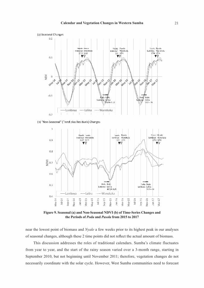
In Figure 9, the expected NDVI changes were separated into seasonal (annual cycle) and
non-seasonal changes (trend plus irregular changes). According to the seasonal cycles (Figure
9(a)), Podu Lamboya was held precisely at the lowest point of NDVI and vegetation began to
Figure 6. Expected NDVI Changes of the 3 Subdistricts Analyzed by Space-State Model of MODIS Data

19Calendar and Vegetation Changes in Western Sumba
rapidly increase before the end of Podu in Lolina, whereas Pasola was held well after the onset
of the rains when the vegetation had recovered. Non-seasonal vegetation levels were similar
during Pasola over the years (Figure 9(b)); however, variations were associated with the month
of Podu, when the amount of vegetation is dependent on the amount of rainfall occurring during
the preceding dry season. In summary, the ritual periods were consistently dated in calculated
seasonal cycles (i.e., seasonal changes averaged for the years), even though real vegetation
changes are grossed over by year-by-year differences and extreme weather events.
Figure 7. Seasonal Changes and “Non-Seasonal Changes” (Trends Plus Irregular Changes) of NDVI of the 3 Subdistricts Analyzed by State-Space Model of MODIS Data

20 T. Furusawa, and R. Siburian
Finally, these patterns were analyzed in relation with frequency distributions of the NDVI.
Figures 10 and 11 show frequency distribution of the expected NDVI and that of the seasonal
changes of the NDVI, respectively; the values at the times of Podu and Pasola are also shown.
These Figures also confirmed that the NDVI at the times of Pasola were among the top of the
frequency distributions with a small variation. As shown in Figure 10, variation of the NDVI at
the times of both Podu Lamboya and Podu Lolina was very high. On the other hand, as shown
in Figure 11, the seasonal changes of the NDVI at the time of Podu Lamboya were among the
lowest of the frequency distributions, but those at the time of Podu Lolina were slightly higher
than the former, showing seasonal vegetation increase and year-to-year variation happening
during 2 consecutive months of Podu.
6. General Discussion
This discussion starts by addressing the 2 research questions raised from our analyses of
the local calendars. The first question, “Are Podu and Nyale coordinated with the appearance of
seasonal vegetational changes? In other words, do seasonal vegetational changes first appear in
Lamboya before manifesting in other subdistricts?” can be answered negatively, as Figures 5–11
show that seasonal changes did not appear first in Lamboya, and rather manifested later than
those in Lolina or Wanokaka. Some Lamboya villages were located atop mountains facing the
ocean, and this geographic condition gave an advantage to this area in observing the solar cycle.
The second question, “Does the timing of Podu and Nyale rituals correspond with specific points
in seasonal changes of vegetation?” can be answered affirmatively, as Podu Lamboya was located
Figure 8. Expected Time-Series NDVI Changes and the Periods of Podu and Pasola from 2015 to 2017
21Calendar and Vegetation Changes in Western Sumba
near the lowest point of biomass and Nyale a few weeks prior to its highest peak in our analyses
of seasonal changes, although these 2 time points did not reflect the actual amount of biomass.
This discussion addresses the roles of traditional calendars. Sumba’s climate fluctuates
from year to year, and the start of the rainy season varied over a 3-month range, starting in
September 2010, but not beginning until November 2011; therefore, vegetation changes do not
necessarily coordinate with the solar cycle. However, West Sumba communities need to forecast
Figure 9. Seasonal (a) and Non-Seasonal NDVI (b) of Time-Series Changes and the Periods of Podu and Pasola from 2015 to 2017

22 T. Furusawa, and R. Siburian
the start of the rainy season and prepare fields for cultivation in advance. In addition, people
need to plant rice in the paddy fields during the rainy season, which requires them to forecast the
passing of heavy rains. Therefore, the times of Podu and Nyale were not based on forecasts of
real vegetation changes (Figure 8). The significance of these 2 time points is that communities
forecast the weather of a given year by comparing the normal seasonal cycle (Figure 9(a)) with
what they are experiencing. In this manner, they can know whether or not the given year will be
characterized by extreme weather events (for example, if the rains have not begun by the end of
Podu).
The seasonality can be rephrased as the averaged seasonal changes or the changes of
this area occurring in “standard/normal” years. This standard is useful as a means of adapting
agricultural activities to the unique conditions of each year. For instance, if the rains and
subsequent increase of vegetation have not begun by the end of Podu, people understand that the
onset of the rainy season will be delayed and they will need to adjust their processes of dry land
agriculture accordingly. The mismatch of natural phenomena with Podu can be attributed to 2
possible reasons: (1) extreme weather events and/or (2) human error in observations of the sun or
the operation of the traditional calendar. However, appropriate actions to ameliorate these issues
are the same, i.e., adjusting agricultural activities accordingly based on differences from the
standard normal pattern. The same can be said for rice cultivation and Nyale. The roles of Podu
Figure 10. Frequency Distribution of the NDVI (Bar Chart) and the NDVI Values at the Times of Podu and Pasola (Circle: Lamboya, Triangle: Lolina, Square: Wanokaka)

23Calendar and Vegetation Changes in Western Sumba
and Nyale are thus the checkpoints of the year’s weather and its resulting adaptations.
Scholars have posited that (1) traditional calendars offer a framework to organize and
communicate traditional ecological knowledge within and across cultures; (2) ecological
calendars can link the seasonal cycles with ecological, cultural, and spiritual aspects of traditional
life; (3) ecological calendars are simple but integrated representations of natural resource
management systems, which elucidate some advantages of indigenous models over European
systems; and (4) traditional calendars provide a time-tested framework for environment-related
decision-making (Ichwandi and Shinohara, 2007; Prober et al., 2011). These characteristics
were also observed in relation to Sumba calendrical systems. The traditional calendar was used
in decision-making primarily during Podu and Nyale and was less utilized in other months,
particularly during the dry season. In dry seasons, natural phenomena such as the onset of rains
and the cultivation of crops differed according to local experience. Even during Podu and Nyale,
agricultural activities can be influenced by natural phenomena such as sea worm swarming.
Therefore, the relation of the calendars to environmental management does not occur in a one-
way direction in Sumba, as natural phenomena influence such decisions directly or indirectly
through the arrangement of the traditional calendar.
Generally speaking, people can easily recognize the lunar cycle by observing the shape of
the moon of the day, while it is hard to know the solar cycle without detailed observation and
Figure 11. Frequency Distribution of the Seasonal Changes of the NDVI (Bar Chart) and the Seasonal Changes of the NDVI at the Times of Podu and Pasola
(Circle: Lamboya, Triangle: Lolina, Square: Wanokaka)

24 T. Furusawa, and R. Siburian
mathematical calculations. The luni-solar calendars contain advantages of both the lunar and the
solar calendars, but alternatively have disadvantages in that a day on the calendar can range with
a variation for one lunar cycle from one year to another according to when a full moon—the start
of a month—is located in the solar cycle. However, as long as the traditional calendar is used
for subsistence purposes, the synchronicity with the solar cycle is less important than that with
the weather of the year and/or the natural ecological cycles. The Sumba calendar of this study
was adaptive to the environment because of this calendar and the ritual events provided people
with checkpoints to observe the natural phenomena at the time and compare them with those in
normal years or with people’s past experience. Such observation and comparison can help people
to forecast the ecological changes for subsistence in the next few months. These features of the
Sumba calendar indicate that the Gregorian calendar—in perfect synchronicity with the solar
cycle—is not always more advantageous than the traditional calendars and does not completely
displace the traditional calendars.
According to the Intergovernmental Panel on Climate Change (IPCC) report, annual total
wet-day rainfall has increased by more than 25 mm per decade in Eastern Indonesia, including
Sumba, but decrease of rainfall, which may lead to drought and loss of agricultural production, is
generally expected by the mid-21st century for this region, while increase of heavy precipitation
in the rainy season is also expected in the future in other parts of Southeast Asia (IPCC, 2014).
As a previous study suggested, East Sumba people recognized phenomenological experiences
such as shade, moisture, dew, heat, fire, and sunlight as explanations for extreme weather
events such as drought, and even about global climate change (Orr et al., 2012), dependence on
experience has been a characteristic of people’s perception of natural phenomena even in West
Sumba. The mechanisms of Sumba calendars of this study indicated the possibility that this
system is adaptive even in this time of rapid climate change. However, this kind of adaptation
might not be effective even for dealing with the long-term and often irreversible nature of
ecological shifts wrought by climate change. Several studies have pointed out the potentiality
of traditional calendars made in accordance with strict rules of synchronization with the solar
cycle as adaptations to climate change by checking real ecological changes with those written in
traditional calendars as a reference (Franco, 2015; Hiwasaki et al., 2015). The Sumba systems
differ from those calendars in their lack of solar synchronization; however, their functions are
the same in this sense. However, if gaps between the reality and the standard became longer or
greater than previously experienced, the system’s efficiency as adaptive measure will become
severely limited.
Finally, this study addresses the significance of the flexibility of local traditional calendars.
Researchers tend to assume that the length of months is fixed in indigenous systems and that

25Calendar and Vegetation Changes in Western Sumba
number of months in a year is counted similarly to the Gregorian calendar. However, the Sumba
calendar differs greatly from such a “fixed” calendar. Once a priest in Lamboya receives a
signal from the sun, the priest “transforms” the solar signal to a cultural signal through the Podu
ritual, and that cultural signal is received by Lolina people to conduct their Podu (Figure 3).
Similarly, solar, lunar, cultural, and natural signals are “transmitted” within and across subdistrict
boundaries during Nyale (Figure 4) (Furusawa, 2017). The lengths and order of months were
decided flexibly according to various types of signals. The presence of an intercalation system
in West Sumba has been a topic of significant debate (Fowler, 2016; Hoskins, 1993; Geirnaert-
Martin, 1992); however, this study revealed that the synchronization of Sumba calendars across
communities is made through signal transmissions twice in a year and based on a more flexible
system during other times. This perspective of the Sumba calendrical system as a form of signal
transmission can inform interpretations of other traditional calendars.
7. Conclusion
This study revealed that traditional Western Sumba calendars identify time points for
agricultural rituals by means of synchronization to the solar cycle, coordinated time reckoning
among neighboring communities, and observation of natural phenomena. Satellite data analyses
disclosed that these time points are advantageous for forecasting weather patterns of a given
year by comparing the actual vegetation changes to the “standard” seasonal changes occurring
in normal years. This study concluded that the Western Sumba people operate such complex
traditional calendars based on flexibility and signal transmission for synchronization as a means
of predicting the need for adaptive agricultural actions in the absence of modern meteorological
technologies. This mechanism is highly adaptive in Sumba’s tropical monsoon climate with its
classic extreme weather events; however, its application to climate change adaptations appears to
be limited.
Acknowledgments
We sincerely thank the priests (rato) and the residents of West Sumba for their kind approval
and support of our research. This study was conducted with the support of a Research Permit
from Indonesian Government through Foreign Research Permit Unit of Ministry of Research,
Technology, and Higher Education (RISTEK) (416/SIP/FRP/E5/Dit.KIX/2015). We are also
grateful to the late Mr. Tadataka Igarashi (Kyoto University) for providing academic materials on
traditional calendars in Indonesia, a research project of the Center for Southeast Asian Studies,

26 T. Furusawa, and R. Siburian
Kyoto University, entitled “Large Scale Investigation of Socio-economic Situation in Indonesian
Villages Using Village Potential Data (Podes) and Census Data” (leader: Dr. Fumiko Furukawa,
Kobe University) and for providing shapefile polygon data, and PASCO Corporation for technical
assistance for satellite data analyses. This study was financially supported by the Japan Society
for the Promotion of Sciences as KAKENHI Grant-in-aid for Challenging Exploratory Research
(15K12783 and 19K21663) and Topic-Setting Program to Advance Cutting-Edge Humanities
and Social Sciences Research (Area Cultivation Program) “Strengthening the Disaster Resilience
of Local Communities through Interactive Real-Time Area Studies using SNS and Cloud GIS
Methodologies” (leader: Takuro Furusawa).
References
A Member of the Samoan Society (1928) The Samoan division of time. Journal of the Polynesian
Society 37: 228–240.
Asner, G. P. (2001) Cloud cover in Landsat observations of the Brazilian Amazon. International
Journal of Remote Sensing 22(18): 3855–3862.
Badan Informasi Geospasial (2016) Data spatial dalam satu portal: Geospatial untuk Negeri. Pusat
Pengelolaan dan Penyebarluasan Informasi Geospasial 2016. Available from http://portal.ina-
sdi.or.id/
Badan Pusat Statistik (2017) Sunsus Penduduk 2010. Badan Pusat Statistik 2010. Available from
http://sp2010.bps.go.id/
Badan Pusat Statistik Kabupaten Sumba Barat (2016) Iklim. BPS Kabupaten Sumba Barat 2016.
Available from https://sumbabaratkab.bps.go.id/
Badan Pusat Statistik Provinsi Nusa Tenggara Timur (2017) Provinsi Nusa Tenggara Timur Dalam
Angka 2017. Kupang: BPS Provinsi Nusa Tenggara Timur.
Badan Pusat Statistik Provinsi Nusa Tenggara Timur (2018) Provinsi Nusa Tenggara Timur Dalam
Angka 2018. Kupang: BPS Provinsi Nusa Tenggara Timur.
Boro, P. L. (1995) Pasola, Permainan Ketangkasan Berkuda Lelaki Sumba, Nusa Tenggara Timur,
Indonesia. Jakarta: Obor.
Commandeur, J. J. F., and S. J. Koopman (2007) An Introduction to State Space Time Series
Analysis. Oxford: Oxford University Press.
Daldjoeni, N. (1984) Pranatamangsa, the Javanese agricultural calendar: Its bioclimatological and
sociocultural function in developing rural life. Environmentalist 4(7): 15–18.
Fisher, R., E. B. Wilfrida, A. Rawambaku, G. J. E. Hill, and J. Russell-Smith (2006) Remote
sensing of fire regimes in semi-arid Nusa Tenggara Timur, Eastern Indonesia: Current patterns,

27Calendar and Vegetation Changes in Western Sumba
future prospects. International Journal of Wildland Fire 15(3): 307–317.
Fong, P. P. (1991) The effects of salinity, temperature, and photoperiod on epitokal metamorphosis
in Neanthes succinea (Frey et Leuckart) from San Francisco Bay. Journal of Experimental
Marine Biology and Ecology 149(2): 177–190.
Forth, G. L. (1981) Rindi: An Ethnographic Study of a Traditional Domain in Eastern Sumba.
Verhandelingen van het Koninklijk Instituut voor Taal-, Land- en Volkenkunde 93. The Hague:
Martinus Nijhoff.
Forth, G. L. (1983) Time and temporal classification in Rindi, Eastern Sumba. Bijdragen tot de
Taal-, Land- en Volkenkunde 139(1): 46–80.
Fowler, C. T. (2016) Biosocial Synchrony on Sumba: Multispecies Relationships and Environmental
Variations in Indonesia. Lanham: Lexington Books.
Fox, J. J. (1977) Harvest of the Palm: Ecological Change in Eastern Indonesia. Cambridge:
Harvard University Press.
Fox, J. J. (1979) The ceremonial system of Savu. In A. L. Becker and A. A. Yengoyan (eds.), The
Imagination of Reality: Essays in Southeast Asian Coherence Systems, pp. 145–173. Norwood:
Ablex.
Franco, F. M. (2015) Calendars and ecosystem management: Some observations. Human Ecology
43(2): 355–359.
Furukawa, H. (1991) Genealogy of agriculture in Malaisia. Tonan Ajia Kenkyu 29(3): 235–305. (in
Japanese)
Furusawa, T. (2017) Indigenous calendar system in Western Sumba Island, Indonesia: Analyses of
inter-area signal transmissions for the month of bitterness and the month of sea worms. Asian
and African Area Studies 17(1): 1–38. (in Japanese)
Furusawa, T., Y. Fuchigami, S. Kobayashi, and M. Yokota (2014) Evaluation of mangrove biomass
changes due to different human activities in Batam Island, Indonesia, determined using
MODIS EVI and ASTER Data. People and Culture in Oceania 29: 35–50.
Geirnaert-Martin , D. C. (1992) The Woven Land of Laboya: Socio-cosmic Ideas and Values in West
Sumba, Eastern Indonesia. Leiden: Centre of Non-Western Studies, Leiden University.
Gunawan-Mitchell, I. (1981) Hierarchy and balance: A study of Wanokaka social organization.
Ph.D. dissertation, Monash University.
Hirose, T. (2015) Survival strategies of a society dependent on Borassus flabellifer during the dry
season in Raijua Island, Eastern Indonesia: Analysis of diet, livelihood, and society. People
and Culture in Oceania 30: 57–72.
Hiwasaki, L., E. Luna, and J. A. Marçal (2015) Local and indigenous knowledge on climate-
related hazards of coastal and small island communities in Southeast Asia. Climatic Change

28 T. Furusawa, and R. Siburian
128(1–2): 35–56.
Hoskins, J. (1993) The Play of Time: Kodi Perspectives on Calendars, History, and Exchange.
Berkeley: University of California Press.
Hoskins, J. (2002) Predatory voyeurs: Tourists and “tribal violence” in remote Indonesia. American
Ethnologist 29(4): 797–828.
Huete, A., C. Justice, and W. van Leeuwen (1999) MODIS vegetation index (MOD13): Algorithm
theoretical basis document, version 3. NASA. Available from https://modis.gsfc.nasa.gov/data/
atbd/atbd_mod13.pdf
Ichwandi, I., and T. Shinohara (2007) Indigenous practices for use of and managing tropical natural
resources: A case study on Baduy community in Banten, Indonesia. Tropics 16(2): 87–102.
Igarashi, T. (1997) Sidereal-lunar time reckoning in Nusantara: A brief comparison. In T. Kato (ed.),
Studies on the Dynamics of the Frontier World in Insular Southeast Asia, pp. 119–136. Kyoto:
Center for Southeast Asian Studies.
Igarashi, T. (2018) Palolo swarming, celestial cycles, and indigenous calendrical systems in
Indonesia. Tonan Ajia Kenkyu 55: 111–138. (in Japanese)
Intergovernmental Panel on Climate Change (IPCC) (2014) Climate change 2014: Impacts,
adaptation, and vulnerability. Part B: Regional aspects. Contribution of Working Group II to
the 5th Assessment Report of the Intergovernmental Panel on Climate Change. V. R. Barros,
C. B. Field, D. J. Dokken, M. D. Mastrandrea, K. J. Mach, T. E. Bilir, M. Chatterjee, K. L.
Ebi, Y. O. Estrada, R. C. Genova, B. Girma, E. S. Kissel, A. N. Levy, S. MacCracken, P. R.
Mastrandrea, and L. L.White (eds.). Cambridge: Cambridge University Press.
Japan Meteorological Agency (2018a) Frequency of extremely high/low precipitation, Japan
Meteorological Agency, Tokyo. Available from
https://www.data.jma.go.jp/gmd/cpd/monitor/extfig/extindex.html?tm=annual&el=clmprec
Japan Meteorological Agency (2018b) El Nino and La Nina, Japan Meteorological Agency, Tokyo.
Available from https://www.data.jma.go.jp/gmd/cpd/data/elnino/learning/faq/elnino_table.html
Kassam, K. S., M. L. Ruelle, C. Samimi, A. Trabucco, and J. Xu (2018) Anticipating climatic
variability: The potential of ecological calendars. Human Ecology 46(2): 249–257.
Kuipers, J. C. (1998) Language, Identity, and Marginality in Indonesia: The Changing Nature of
Ritual Speech on the Island of Sumba. Cambridge: Cambridge University Press.
Leach, E. R. (1950) Primitive calendars. Oceania 20(4): 245–262.
Lunetta, R. S., J. F. Knight, J. Ediriwickrema, J. G. Lyon, and L. D. Worthy (2006) Land-cover
change detection using multi-temporal MODIS NDVI data. Remote Sensing of Environment
105(2): 142–154.
Malinowski, B. (1922) Argonauts of the Western Pacific: An Account of Native Enterprise and

29Calendar and Vegetation Changes in Western Sumba
Adventure in the Archipelagoes of Melanesian New Guinea. London: Routledge.
Malinowski, B. (1927) Lunar and seasonal calendar in the Trobriands. The Journal of the Royal
Anthropological Institute of Great Britain and Ireland 57: 203–215.
Mitchell , D., and T. Gunawan (2008) Wanukaka Lunar Calendar [cited 9 June 2017]. Available
from http://www.wanukaka.com/Home/lunar-months
Mondragón, C. (2004) Of winds, worms and mana: The traditional calendar of the Torres Islands,
Vanuatu. Oceania 74(4): 289–308.
Monk, K., Y. de Fretes, and G. Reksodiharjo-Lilley (2013) Ecology of Nusa Tenggara and Maluku.
Singapore: Periplus Editions.
Nugrohowardhani, R. L. K. R. (2018) The unwanted harvest: Large-scale agricultural investment
and social environmental issue in Sumba, Indonesia. Workshop on People, Culture, and Nature
in Indonesia. 19 January 2018. Kyoto, Japan.
Odani, S., T. Furusawa, M. Sato, and H. Shimizu-Furusawa (2016) How foraging for nyale worms
on the island of Lombok relates to the Sasak calendar system. Marine Biosystems Research
30: 12–18.
Ono , A. (1976) Clan and village in Western Sumba. Minzokugaku Kenkyu 40: 299–326. (in
Japanese)
Orr, Y., R. Schimmer, and R. Geerken (2012) Ethno-ecology in the shadow of rain and light of
experience: Local perceptions of drought and climate change in East Sumba, Indonesia.
In A. P. Castro, D. Taylor, and D. W. Brokensha (eds.), Climate Change and Threatened
Communities Vulnerability, Capacity, and Action, pp. 175–184. Rugby: Practical Action
Publishing.
Prober, S. M., M. H. O’Connor, and F. J. Walsh (2011) Australian aboriginal peoples’ seasonal
knowledge: A potential basis for shared understanding in environmental management. Ecology
and Society 16(2): 12.
Retnowati, A., E. Anantasari, M. A. Marfai, and A. Dittmann (2014) Environmental ethics in local
knowledge responding to climate change: An understanding of seasonal traditional calendar
Pranotomongso and its phenology in karst area of Gunungkidul, Yogyakarta, Indonesia.
Procedia Environmental Sciences 20: 785–794.
Russell-Smith, J., S. Djoeroemana, J. Maan, and P. Pandanga (2007) Rural livelihoods and burning
practices in savanna landscapes of Nusa Tenggara Timur, Eastern Indonesia. Human Ecology
35(3): 345–359.
Sato, M. (2004) Diversity of polychaetes and environments in tidal flats: A study on the Hediste
species group (Nereididae). Fossils 76: 122–133. (in Japanese)
Stefanov, W. L., and M. Netzband (2005) Assessment of ASTER land cover and MODIS NDVI

30 T. Furusawa, and R. Siburian
Data at multiple scales for ecological characterization of an arid urban center. Remote Sensing
of Environment 99(1–2): 31–43.
U.S. Department of the Interior and U.S. Geological Survey (2018) USGS earth explorer. Available
from https://earthexplorer.usgs.gov
Yoshida, S. (1980) Time reckoning. Senri Ethnological Studies 7: 89–107.