DIVERSITY, USE PATTERN AND MANAGEMENT OF FOREST RESOURCES IN THE EASTERN HIMALAYA: A CASE STUDY OF...
10
Journal of Forests, 2014, 1(1): 1-10 1 DIVERSITY, USE PATTERN AND MANAGEMENT OF FOREST RESOURCES IN THE EASTERN HIMALAYA: A CASE STUDY OF MIZORAM, INDIA Vishwambhar Prasad Sati Department of Geography and Resource Management, School of Earth Sciences, Mizoram University, Aizawl, Mizoram, India P. Rinawma Department of Geography and Resource Management, School of Earth Sciences, Mizoram University, Aizawl, Mizoram, India N. Bobby Singh Department of Geography and Resource Management, School of Earth Sciences, Mizoram University, Aizawl, Mizoram, India C. Uday Bhaskara Rao Department of Geography and Resource Management, School of Earth Sciences, Mizoram University, Aizawl, Mizoram, India ABSTRACT This paper examines forests diversity, their use pattern and management in the Eastern Himalaya with a case study of Mizoram state. The Eastern Himalaya is one of the bio-diversity hotspots of the world where the forest diversity varies from the tropical rainforest to temperate and alpine types because of the altitudes. In the case study area i.e. Mizoram, forest types vary from tropical evergreen forests to montane and temperate with rich biodiversity. Forests are lifeline for livelihoods sustainability in Mizoram as it is the second largest source of income after agriculture. Total forestland is 90.68%. They are conserved by the community people and the state forest department. Even, the whole country received decrease in forestland; Mizoram has registered about 1.4% increase. A study on forest cover and changes in the eight sister states of the Eastern Himalaya during the last decades was carried out to penetrate the current status of forest. Data from the secondary sources were gathered largely from the Forest Survey of India (FSI) 1991, 2001 and 2011. Similarly, data from the Department of Environment and Forest, Government of Mizoram on forest diversity and their distribution were also collected. Further, wide range of discussion was made with the officials working in the forest department and with the local people to elaborate the other aspects of forest resources such as use pattern of forest products. Personal Journal of Forests journal homepage: http://www.pakinsight.com/?ic=journal&journal=101
Transcript of DIVERSITY, USE PATTERN AND MANAGEMENT OF FOREST RESOURCES IN THE EASTERN HIMALAYA: A CASE STUDY OF...

Journal of Forests, 2014, 1(1): 1-10
1
DIVERSITY, USE PATTERN AND MANAGEMENT OF FOREST RESOURCES
IN THE EASTERN HIMALAYA: A CASE STUDY OF MIZORAM, INDIA
Vishwambhar Prasad Sati
Department of Geography and Resource Management, School of Earth Sciences, Mizoram University, Aizawl,
Mizoram, India
P. Rinawma
Department of Geography and Resource Management, School of Earth Sciences, Mizoram University, Aizawl,
Mizoram, India
N. Bobby Singh
Department of Geography and Resource Management, School of Earth Sciences, Mizoram University, Aizawl,
Mizoram, India
C. Uday Bhaskara Rao
Department of Geography and Resource Management, School of Earth Sciences, Mizoram University, Aizawl,
Mizoram, India
ABSTRACT
This paper examines forests diversity, their use pattern and management in the Eastern Himalaya
with a case study of Mizoram state. The Eastern Himalaya is one of the bio-diversity hotspots of the
world where the forest diversity varies from the tropical rainforest to temperate and alpine types
because of the altitudes. In the case study area i.e. Mizoram, forest types vary from tropical
evergreen forests to montane and temperate with rich biodiversity. Forests are lifeline for
livelihoods sustainability in Mizoram as it is the second largest source of income after agriculture.
Total forestland is 90.68%. They are conserved by the community people and the state forest
department. Even, the whole country received decrease in forestland; Mizoram has registered
about 1.4% increase. A study on forest cover and changes in the eight sister states of the Eastern
Himalaya during the last decades was carried out to penetrate the current status of forest. Data
from the secondary sources were gathered largely from the Forest Survey of India (FSI) 1991,
2001 and 2011. Similarly, data from the Department of Environment and Forest, Government of
Mizoram on forest diversity and their distribution were also collected. Further, wide range of
discussion was made with the officials working in the forest department and with the local people
to elaborate the other aspects of forest resources such as use pattern of forest products. Personal
Journal of Forests
journal homepage: http://www.pakinsight.com/?ic=journal&journal=101
Journal of Forests, 2014, 1(1): 1-10
2
observations on forest diversity use pattern and management of forest resources in Aizawl district
was also carried out.
© 2014 Pak Publishing Group. All Rights Reserved.
Keywords: Diversity, Forest resource, Tropical rainforest, Forest management, Eastern
Himalaya, Mizoram.
Contribution/ Originality
This study contributes the existing literature of forest resources in the Eastern Himalaya with
special reference to Mizoram state.
1. INTRODUCTION
India obtains great altitudinal variations, diverse soil types and varying climatic conditions
with rainfall variations, have been blessed with sixteen forest types ranging from tropical
rainforests to dry thorn forests based on species composition and plant functional types [1]. Out of
the total forest cover in India (19.7%), approximately a quarter of forest cover is found in the
Eastern Himalaya with an area of 637,293 km2 and within the reserved, protected and unclassified
forests. The eastern Himalaya, comprises of the eight sister states namely, Sikkim, Arunachal
Pradesh, Assam, Manipur, Meghalaya, Mizoram, Nagaland and Tripura, is considered as one of the
global biodiversity hotspots [2] with varied climate ranging from humid tropical to sub-alpine type
[3]. These states are also known for obtaining high ethnic and biological diversity and occupied
part of the Indo-Burma biodiversity hotspots [2]. They obtain some of the largest reserves of
tropical and sub-tropical forests of wet evergreen, semi- evergreen, moist deciduous, coniferous
forests, mixed forest and shrub land [3, 4]. The two states of the Eastern Himalaya – Sikkim and
Arunachal Pradesh – are characterized by the presence of coniferous forests in the higher reaches of
the Himalaya (1600-2800 m). These forests include pine, oak, deodar, fir and spruce trees. The
state of Mizoram has the diversity in forest types and these forests are distributed according to an
elevation from tropical evergreen to montane and temperate forests.
Climatic factors mainly rainfall influence the forest types in the Eastern Himalaya. Several
studies related to vegetation-climatic factors (rainfall) have been extensively documented in arid
and semi-arid environments, there has been relatively limited research on such a link between
vegetation activity and rainfall in high precipitation belts of the world, for instance the Eastern
Himalaya [5-7]. The tropical forest of the Eastern Himalaya is the least water stressed region of all
the tropical forests due to heavy rainfall [8]. Here, the rainfall trend follows an uneven and
continuity throughout the year. The longest wettest period between May and September was
witnessed during 1990-2000 [5].
2. GEO-ENVIRONMENTAL AND SOCIO-ECONOMIC CONDITIONS
Mizoram, literary known as the „land of highlanders‟ lies in the eastern extension of the
Himalaya, as a part of Arakan-Yoma mountain ranges of Myanmar. Its international boundary is

Journal of Forests, 2014, 1(1): 1-10
3
delimited by Bangladesh in the west and Myanmar in the east and south. It obtains 21081 km2 area
and shares 0.64% of the country‟s geographical area. The state lies between 21o 56‟ N and 24
o 31‟
N and 92o 16‟ E and 93
o 26‟ E (Figure 1). The average altitude ranges from 500 m to 800 m with
the maximum elevation 2157 m is found in Blue Mountain (Phawngpui) [9]. Climatic conditions
vary from the moist tropical to the moist sub-tropical, not very warm in the summer season and not
very cold in the winter season. During the winter, the temperature varies from 09oC to 18
oC and in
summer, it varies between 18oC and 30
oC. Presence of regular monsoon tremendously influences
this area. Heavy downpour occurs during the monsoon season from May to September and the
average annual rainfall ranges from 2160 mm to 3500 mm. The high velocity of wind,
characterized by turbulence storms blow during the two months of March and April. The direction
of winds is cyclonic and the monsoon rain is also characterized by cyclones. The winters in
Mizoram are normally rain free and sky remains almost clear during the four months – November,
December, January and February. High rainfall and moist climate provide high base for the rich
biodiversity consequently the total land under vegetation is 90.68%. The actual tree cover area is
about 75%. Forest is a lifeline of the populace of Mizoram as the large numbers of people are
directly dependent on forest resources for running their livelihoods [10]. Agriculture, dominated by
shifting cultivation, runs parallel and constitutes a major source of livelihoods. It covers about 50%
area of the total sown area (4.5%). Industrially, this state is lagging behind as there are no major
industries established till now. Forest based industries have the high potentials. Tourism may be the
important industry as climatic conditions are very feasible throughout the year. Further, the
panoramic landscape and evergreen forest are quite attractive and they will accelerate the tourism
practices [11]. The population of the state was 1.09 million [12] which constituted 0.09% of the
country‟s population. Of this, rural population was 48.49% and urban population was 51.51%. The
population density was 52 persons per km2. The livestock population of the state was 0.33 million
[13].
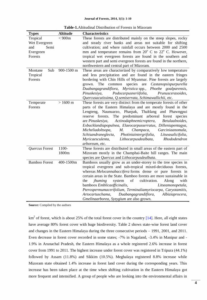
3. FOREST DIVERSITY IN MIZORAM
Mizoram state has very high forest diversity. It forms a part of the Indo-Burma Global
Biodiversity Hotspot. Forests diversity is characterized mainly by tropical rain forests; as most of
the part of the state lies in the tropical regime. Meanwhile, montane and temperate forests are also
found above 900m and 1600m, respectively. Bamboo forests are found almost in all altitudinal
zones but restricted upto 1500m. In Mizoram, diversity in forests is found according to altitude,
rainfall and dominant species composition. Table 1 shows altitudinal distribution of forests and
their characteristics in Mizoram state.
4. FOREST COVER AND CHANGES IN THE EASTERN HIMALAYA
According to the latest satellite-based survey report of FSI, the Eastern Himalaya has 163 799
Journal of Forests, 2014, 1(1): 1-10
4
Table-1.Altitudinal Distribution of Forests in Mizoram
Types Altitude Characteristics
Tropical
Wet Evergreen
and Semi
Evergreen
Forests
< 900m These forests are distributed mainly on the steep slopes, rocky
and steady river banks and areas not suitable for shifting
cultivation; and where rainfall occurs between 2000 and 2500
mm and temperature remains from 20o C to 22
o C. However,
tropical wet evergreen forests are found in the southern and
western part and semi evergreen forests are found in the northern,
northwestern and central part of Mizoram.
Montane Sub
Tropical
Forests
900-1500 m These areas are characterized by comparatively low temperature
and less precipitation and are found in the eastern fringes
bordering with Chin Hills of Myanmar. Pine forests are largely
grown. The common species are Castanopsispurpurella
Duabangagrandiflora, Myristica spp., Phoebe goalparensis,
Pinuskesiya, Podocarpusneriifolia, Prunuscerasoides,
Quercusacutissima, Q.semiserrata, Schimawallichii, etc.
Temperate
Forests
> 1600 m These forests are very distinct from the temperate forests of other
parts of the Eastern Himalaya and are mostly found in the
Lengteng, Naunuarzo, Pharpak, Thaltlang and Phawngpui
reserve forests. The predominant arboreal forest species
are Pinuskesiya, Actinodaphnemicroptera, Betulaalnoides,
Exbucklandiapopulnea, Elaeocarpusserratus, Dilleniapentagya,
Micheliadoltsopa, M. Champaca, Garciniaanomala,
Schisandraneglecta, Photiniaintergrifolia, Litseasalicifolia,
Myricaesculenta, Lithocarpusdealbata, Rhododendron
arboreum, etc.
Quercus Forest
1100-
1800m
These forests are distributed in small areas of the eastern part of
Mizoram mostly in the Champhai-Baite hill ranges. The main
species are Quercus and Lithocarpusdealbata.
Bamboo Forest 400-1500m Bamboos usually grow as an under-storey to the tree species in
tropical evergreen and sub-tropical mixed-deciduous forests,
whereas Melocannabaccifera forms dense or pure forests in
certain areas in the State. Bamboo forests are more sustainable in
the jhuming system of cultivation. Along with
bamboos Emblicaofficinalis, Litseamonopetala,
Pterospermumacerifolium, Terminaliamyriocarpa, Caryotamitis,
Artocartuschama, Duabangagrandiflora, Albiziaprocera,
Gmelinaarborea, Syzygium are also grown.
Source: Compiled by the authors
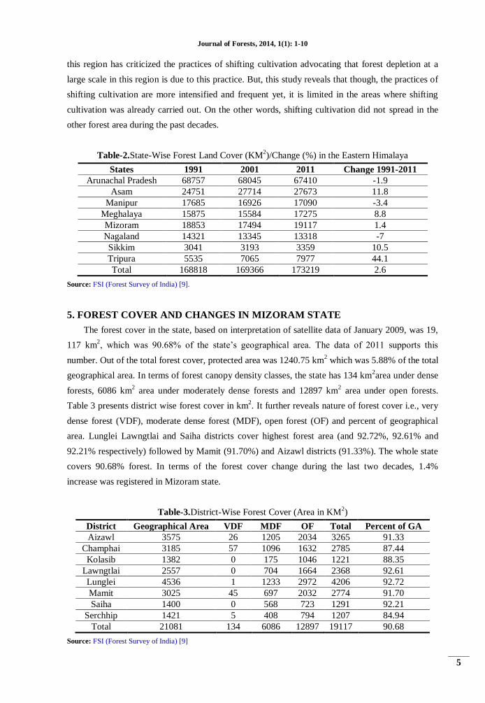
km2 of forest, which is about 25% of the total forest cover in the country [14]. Here, all eight states
have average 80% forest cover with huge biodiversity. Table 2 shows state-wise forest land cover
and changes in the Eastern Himalaya during the three consecutive periods – 1991, 2001, and 2011.
Even decrease in forest cover recorded in some states; -7% in Nagaland, -3.4% in Manipur and -
1.9% in Arunachal Pradesh, the Eastern Himalaya as a whole registered 2.6% increase in forest
cover from 1991 to 2011. The highest increase under forest cover was registered in Tripura (44.1%)
followed by Assam (11.8%) and Sikkim (10.5%). Meghalaya registered 8.8% increase while
Mizoram state obtained 1.4% increase in forest land cover during the corresponding years. This
increase has been taken place at the time when shifting cultivation in the Eastern Himalaya got
more frequent and intensified. A group of people who are looking into the environmental affairs in
Journal of Forests, 2014, 1(1): 1-10
5
this region has criticized the practices of shifting cultivation advocating that forest depletion at a
large scale in this region is due to this practice. But, this study reveals that though, the practices of
shifting cultivation are more intensified and frequent yet, it is limited in the areas where shifting
cultivation was already carried out. On the other words, shifting cultivation did not spread in the
other forest area during the past decades.
Table-2.State-Wise Forest Land Cover (KM2)/Change (%) in the Eastern Himalaya
States 1991 2001 2011 Change 1991-2011
Arunachal Pradesh 68757 68045 67410 -1.9
Asam 24751 27714 27673 11.8
Manipur 17685 16926 17090 -3.4
Meghalaya 15875 15584 17275 8.8
Mizoram 18853 17494 19117 1.4
Nagaland 14321 13345 13318 -7
Sikkim 3041 3193 3359 10.5
Tripura 5535 7065 7977 44.1
Total 168818 169366 173219 2.6
Source: FSI (Forest Survey of India) [9].
5. FOREST COVER AND CHANGES IN MIZORAM STATE
The forest cover in the state, based on interpretation of satellite data of January 2009, was 19,
117 km2, which was 90.68% of the state‟s geographical area. The data of 2011 supports this
number. Out of the total forest cover, protected area was 1240.75 km2 which was 5.88% of the total
geographical area. In terms of forest canopy density classes, the state has 134 km2area under dense
forests, 6086 km2 area under moderately dense forests and 12897 km
2 area under open forests.
Table 3 presents district wise forest cover in km2. It further reveals nature of forest cover i.e., very
dense forest (VDF), moderate dense forest (MDF), open forest (OF) and percent of geographical
area. Lunglei Lawngtlai and Saiha districts cover highest forest area (and 92.72%, 92.61% and
92.21% respectively) followed by Mamit (91.70%) and Aizawl districts (91.33%). The whole state
covers 90.68% forest. In terms of the forest cover change during the last two decades, 1.4%
increase was registered in Mizoram state.
Table-3.District-Wise Forest Cover (Area in KM2)
District Geographical Area VDF MDF OF Total Percent of GA
Aizawl 3575 26 1205 2034 3265 91.33
Champhai 3185 57 1096 1632 2785 87.44
Kolasib 1382 0 175 1046 1221 88.35
Lawngtlai 2557 0 704 1664 2368 92.61
Lunglei 4536 1 1233 2972 4206 92.72
Mamit 3025 45 697 2032 2774 91.70
Saiha 1400 0 568 723 1291 92.21
Serchhip 1421 5 408 794 1207 84.94
Total 21081 134 6086 12897 19117 90.68
Source: FSI (Forest Survey of India) [9]
Journal of Forests, 2014, 1(1): 1-10
6
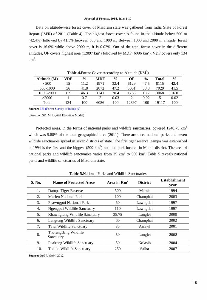
Data on altitude-wise forest cover of Mizoram state was gathered from India State of Forest
Report (ISFR) of 2011 (Table 4). The highest forest cover is found in the altitude below 500 m
(42.4%) followed by 41.5% between 500 and 1000 m. Between 1000 and 2000 m altitude, forest
cover is 16.0% while above 2000 m, it is 0.02%. Out of the total forest cover in the different
altitudes, OF covers highest area (12897 km2) followed by MDF (6086 km
2). VDF covers only 134
km2.
Table-4.Forest Cover According to Altitude (KM2)
Altitude (M) VDF % MDF % OF % Total %
<500 15 11.2 1971 32.4 6129 47.5 8115 42.4
500-1000 56 41.8 2872 47.2 5001 38.8 7929 41.5
1000-2000 62 46.3 1241 20.4 1765 13.7 3068 16.0
>2000 1 0.7 2 0.03 2 0.02 5 0.02
Total 134 100 6086 100 12897 100 19117 100
Source: FSI (Forest Survey of India) [9]
(Based on SRTM, Digital Elevation Model)
Protected areas, in the forms of national parks and wildlife sanctuaries, covered 1240.75 km2
which was 5.88% of the total geographical area (2011). There are three national parks and seven
wildlife sanctuaries spread in seven districts of state. The first tiger reserve Dampa was established
in 1994 is the first and the biggest (500 km2) national park located in Mamit district. The area of
national parks and wildlife sanctuaries varies from 35 km2 to 500 km
2. Table 5 reveals national
parks and wildlife sanctuaries of Mizoram state.
Table-5.National Parks and Wildlife Sanctuaries
S. No. Name of Protected Areas Area in Km2 District
Establishment
year
1. Dampa Tiger Reserve 500 Mamit 1994
2. Murlen National Park 100 Champhai 2003
3. Phawngpui National Park 50 Lawngtlai 1997
4. Ngengpui Wildlife Sanctuary 110 Lawngtlai 1997
5. Khawnglung Wildlife Sanctuary 35.75 Lunglei 2000
6. Lengteng Wildlife Sanctuary 60 Champhai 2002
7. Tawi Wildlife Sanctuary 35 Aizawl 2001
8. Thorangtlang Wildlife
Sanctuary 50 Lunglei 2002
9. Pualreng Wildlife Sanctuary 50 Kolasib 2004
10. Tokalo Wildlife Sanctuary 250 Saiha 2007
Source: DoEF, GoM, 2012
Journal of Forests, 2014, 1(1): 1-10
7
6. FOREST RESOURCES USE PATTERN
The forest resources have multiple uses in the Eastern Himalaya. As this region is
economically backward, agricultural practices are the main occupation of the people. Thus, the
populace of the region is more relied on the forest resources as collection of timber and non-timber
forest products. For instance bamboo is the major source of livelihood as it is used for food and
household items. Here, bamboo practices have become an economic activity and a part of major
industry.
A large proportion of population in the Eastern Himalaya is vitally dependent on forest
products and services for running their livelihoods. This dependency leads to challenges for forest
resource management mostly in and around of the forest protected areas. The major use pattern of
forests is large-scale use of timber for constructing houses. A large number of houses are made of
timber. In the rural area, 100% houses are constructed by timber. As the economy of the region is
primitive, the rural people are completely dependent on forests for firewood and fodder. Use of
non-timber forest products (NTFP) is tremendously high and they are used to meet daily
households need even to meet food requirement.
The tribal communities of the Eastern Himalaya occupy an integral part in the forest regions.
They live isolated and meet their firewood, fodder and food needs from the forests as it is the main
source of their livelihoods. The United Nations report on „Development of Tribes‟ states that
“tribal people derive either directly or indirectly a substantial amount of their livelihood from the
forests. They subsist on edible leaves and roots, honey, wild game and fish. They build their homes
with timber and bamboo and practice cottage crafts with the help of local raw materials. They use
herbs and medicinal plants to cure their diseases and even their religious and folk-lore and woven
round the spirits of the forests. Commercial transformations are predominantly by barter, trade
being left mostly to the outsiders who controlled the money economy.”
Bamboos and their products are most important food substances to the people of Mizoram as a
large proportion of population has full dependency on them. Bamboos are edible and bamboo
shoots are very popular amongst the Mizo community. Bamboos are also used for constructing
houses in both rural and urban areas. Mizoram state has abundant natural Bamboo resources. About
57% of the geographical area of Mizoram is under Bamboo cover found at heights ranging from
400 m to 1500 m. Bamboo forests are found mainly along the river banks and abandoned jhumland
as a dominant secondary vegetation.
7. FOREST RESOURCE MANAGEMENT
The tribal people of the Eastern Himalaya have spiritual, cultural, social and economic
relationship with forest resources. During the past, these people followed animism that means
everything on the surface of earth has a soul. They lived in balance and harmony with the nature.
All natural things were sacred for them and they offered worship of plants and used them during
the customary ceremony. In due course of time, there has been a transformation of culture and
traditional belief on forests and nature but its pace is quite slow.
Journal of Forests, 2014, 1(1): 1-10
8
Forest resource management is practiced in different forms in Mizoram. Community forests
are conserved by the local people based on the principles of providing opportunities for extraction
of goods for legitimate needs and ensuring the continued existence of forest resources for future
[15]. The extent of forests under community control in Mizoram was 31.35% [16]. There is great
variability in management practice, which has evolved under different biophysical and cultural
environments [17]. However, scientific research on the forest management practices of traditional
and tribal societies is lagging behind but a few studies have investigated that sacred grove, home
gardens and agro-forestry is practiced here scientifically [18].
In Mizoram state, forest resource management has been carried on by the two institutions – the
forest department (state owned) and community people. About 66% forest land is directly under the
state forest department. The state forest department is structured from the state level to the village
level where the department meets the various needs of the local people and also implements the
rules related to forest conservation. The state forest department has divided the state forests into
reserved forests and protected forests; and there are 10 national parks and wild life sanctuaries
established from 1994 to 2007. All these initiatives were taken to conserve the economically viable
forest resources of Mizoram. Owing to various steps forwarded to conserve the forests by the state
government, there is a slight increase in the forest land from the last three decades.
Role of the community people towards forest management is also noteworthy as the
community people owned about one/third forest area for their different households need. According
to Tiwari, et al. [19], traditional forest management in Mizoram was administered by the
„chieftain‟. The Chief is called „Lal‟ (now „chairman‟ Act of 1956) had absolute decision-making
authority. There is pyramidal structure of the village office bearers; those are involved in the
management of forest. The councilor and youth commander (Val Upa) are the members of the
council and the council is responsible to Village Assembly. This traditional institution is no longer
existed and it has taken over by the Young Mizo Association. The new organization is doing so
promptly towards management of forests.
The conservation of forest is very peculiar [20]. There are two forest areas in the surrounding
of village. In the one forest area, the villager can go and collect the forest products and in the other
forest area nobody can go insight and nothing can be taken outside without the permission of the
conservators. These forest protected areas are called „closures‟ in Africa [21]. All these traditional
concepts are practiced today. The community people have created recreational forests and village
reserved forest where from they can collect the forest products.
8. CONCLUSIONS
Diversity, utilization pattern and management of forest resources in the Eastern Himalaya with
special reference to Mizoram, India were widely discussed in this paper. It was penetrated from the
fact that forest products are lifeline of the people of the Eastern Himalaya and are most important
source of livelihoods after shifting cultivation practices. Forest diversity is high, ranging from
tropical wet and dry forest to subtropical, montane and temperate. Therefore, it is one of the
Journal of Forests, 2014, 1(1): 1-10
9
biodiversity hotspots of the world. This study shows that even a tremendous use of forests is
carried on; forest cover has been increased 2.6% in the Eastern Himalaya and 1.4% in Mizoram,
during the last decades. Sustainable use of NTFPs that include Bamboo shoots, jack fruits,
pineapples, medicinal plants (all grow wild) and many more can enhance livelihoods as the
prospects of NTFPs in development process is high as they are grown tremendously in the Eastern
Himalaya in general and Mizoram in particular.
REFERENCES
[1] H. G. Champion and S. K. Seth, A revised survey of forest types of India. New Delhi: Delhi Govt
Publication, 1968.
[2] N. Myers, R. Mittermeier, C. Mittermeier, G. Da Fonseca, and J. Kent, "Biodiversity hotspots for
conservation priorities," Nature, vol. 403, p. 853−858, 2000.
[3] P. S. Roy and P. K. Joshi, "Forest cover assessment in North-East India- The potential of temporal
wide swath satellite sensor data (IRS-1C WiFS)," International Journal of Remote Sensing, vol. 23,
pp. 4881- 4896, 2002.
[4] Globcover, "Products description and validation report 12.1 version:" Available
www.postel.mediasfrance.org, 2008.
[5] V. K. Prasad, E. Anuradha, and K. V. S. Badarinath, "Climatic controls of vegetation vigor in four
contrasting forest types of India- evaluation from national oceanic and atmospheric administration‟s
advanced very high resolution radiometer datasets (1990-2000)," International Journal of
Biometeorology, vol. 50, pp. 6-16, 2005.
[6] A. K. Prasad, S. Sarkar, R. P. Singh, and M. Kafatos, "Inter-annual variability of vegetation cover
and rainfall over India," Advances in Space Research, vol. 39, pp. 79-87, 2007.
[7] A. Saikia, "NDVI variability in Eastern Himalaya," Scottish Geographical Journal, vol. 125, pp.
195-213, 2009.
[8] Y. Malhi and J. Wright, "Spatial patterns and recent trends in the climate of tropical rainforest
regions. Philosophical transactions of royal society B," Biological Sciences, vol. 359, pp. 311-329,
2004.
[9] FSI (Forest Survey of India), "India state of forest report," Dehradun2011.
[10] V. P. Sati, "Forest products for livelihood sustainability in mizoram," Highlanders, Aizawl, vol. 41,
p. 171, 2013.
[11] V. P. Sati, "Potentials of tourism development in mizoram," Highlanders, Aizawl, vol. 41, p. 161,
2013.
[12] Census of India, Registrar publication. New Delhi: Government of India, 2011.
[13] Livestock Census, Department of animal husbandry. Aizawl: Government of Mizoram, 2007.
[14] Forest Survey of India, "State of forest report 2000," Forest Survey of India, New Delhi2000.
[15] S. Chatterjee, S. Dey, R. Rana, and A. Sastry, Conservation and sustainable use of natural
bioresources: A case study on Apanati in Arunachal Pradesh. New Delhi: World Wide Fund for
Nature-India, 2000.
Journal of Forests, 2014, 1(1): 1-10
10
[16] FSI (Forest Survey of India), "State of the forest report," Dehradun: FSI2009.
[17] A. Nongkynrih, "Ka shnong: The microcosm of hynniewtrep society," Ind Horizon, vol. 48, pp. 121-
151, 2001.
[18] B. Tiwari and K. Shahi, Land ownership pattern in Meghalaya. In: Ecorestoration of degraded hills.
Shillong: Kaushal Publication, 1995.
[19] B. K. Tiwari, H. Tynsong, M. M. Lynrah, E. Lapasam, S. Deb, and D. Sharma, "Institutional
arrangement and typology of community forests of Meghalaya, Mizoram and Nagaland of North-
East India," Journal of Forestry Research, vol. 24, p. 179−186, 2013.
[20] B. Tiwari, S. Barik, and R. Tripathi, "Biodiversity value, status, and strategies for conservation of
sacred groves of Meghalaya, India," Ecosystem Health, vol. 4, pp. 20–32, 1998.
[21] V. P. Sati, "Closures: A peculiar system to conserve biodiversity through people‟s participation in
the Highlands of Eritrea," MF Bulletin. Available: www.mtnforum.org, vol. 7, 2007.
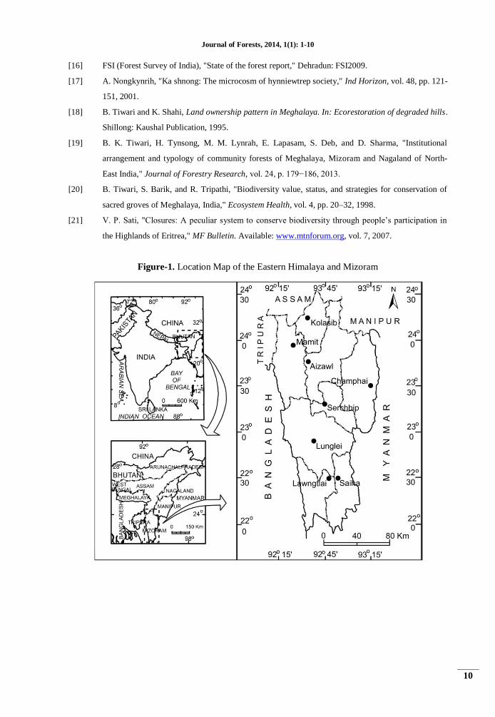
Figure-1. Location Map of the Eastern Himalaya and Mizoram