Diurnal cycle of precipitation amount and frequency in Sweden: observation versus model simulation
11
Tellus (2011), 63A, 664–674 C 2011 The Authors Tellus A C 2011 John Wiley & Sons A/S Printed in Singapore. All rights reserved TELLUS Diurnal cycle of precipitation amount and frequency in Sweden: observation versus model simulation By JEE-HOON JEONG 1 ∗ ,ALEXANDER WALTHER 1 ,GRIGORY NIKULIN 2 , DELIANG CHEN 1, † andCOLIN JONES 2 , 1 Department of Earth Sciences, University of Gothenburg, Box 460, SE-405 30 Gothenburg, Sweden; 2 Rossby Centre, SMHI, SE-601 76 Norrk¨ oping, Sweden (Manuscript received 31 July 2010; in final form 26 January 2011) ABSTRACT This study investigated the diurnal cycle of precipitation in Sweden using hourly ground observations for 1996–2008. General characteristics of phase and amplitude for the diurnal cycle of precipitation, both in amount and frequency, were identified. In the warm season (April–September), the ‘typical’ afternoon (14–16 LST) peaks are dominant over inland Sweden, whereas late night to early morning (04–06 LST) peaks with relatively weak amplitude are discernable in the east coast along the Baltic Sea. The diurnal variation is almost negligible in the cold season (October–March), due to the weak solar radiation at high latitudes. The variations of convective activity forced by solar heating and modulated by geographical characteristics were suggested as primarily factors to invoke the cycles and spatial variation identified. The observed cycle was compared with the cycle simulated by a regional climate model. The model fairly well captures the spatial pattern of the phase of the diurnal cycle. However, the warm season afternoon peak is simulated too early and too uniformly across the stations, associated with too frequent occurrences of convective rainfall events with relatively light intensity. These discrepancies point to the need to improve the convection parametrization and geographic representation of the model. 1. Introduction The diurnal variation of precipitation is one of the pronounced natural cycles found in the Earth’s climate. Basically arisen from the punctual variation of solar radiation, the associated variations of pressure, wind, temperature and many other climatic factors determine the characteristics of the diurnal cycle of precipita- tion. In order to identify this cycle, extensive studies have been carried out for various regions in the world through in situ and satellite observations (e.g. Wallace, 1975; Dai, 2001; Dai et al., 2007; and many references therein). A variety of physical mecha- nisms were suggested to explain its physical mechanisms: wind convergence, terrain uplift, coastal land–sea breeze and tidal- variation of pressure (e.g. Brier and Simpson, 1969; Wallace, 1975; Dai and Deser, 1999; Dai and Wang, 1999). Overall, the afternoon peak caused by convective rainfall in the continental regions versus a nighttime peak caused by relatively light rain- fall in regions with maritime climates was a commonly found feature. The detailed regional characteristics and mechanisms of ∗ Corresponding author. e-mail: [email protected] †Currently on leave. DOI: 10.1111/j.1600-0870.2011.00517.x the diurnal cycle vary greatly depending on location and season (e.g. Yin et al., 2009), and still remain quite uncertain. Although it is a fundamental cycle in weather and climate, sophisticated climate models—global (GCM), regional (RCM) and even finer scale cloud resolving models—still have large deficiencies in reproducing its exact nature (Guichard et al., 2004; Shin et al., 2007; Lenderink and van Meijgaard, 2008; Samuelsson et al., 2011; Rio et al., 2009). Therefore the realistic simulation of the diurnal cycle is one of the important metrics to evaluate the reliability of a climate model, and an important task in order to improve the performance of weather forecasts and climate simulations. Difficulties in the examination of the diurnal precipitation cycle mostly arise from the lack of reliable subdaily precipita- tion observations. Owing to many practical reasons, the obser- vation network of automatic rain gauge sensors has been the most feasible way to collect hourly precipitation data cover- ing a spatial domain of interest. However, the number of data sets with sufficiently long timespan and high spatial density for quantifying the much localized nature of the cycle is rather limited. A possible alternative could be the precipitation estima- tion from polar-orbiting satellites. Particularly, precipitation data retrieved from the satellite-borne radar of the Tropical Rainfall Measuring Mission (TRMM, Kummerow et al., 1998) have been 664 Tellus 63A (2011), 4 PUBLISHED BY THE INTERNATIONAL METEOROLOGICAL INSTITUTE IN STOCKHOLM SERIES A DYNAMIC METEOROLOGY AND OCEANOGRAPHY
Transcript of Diurnal cycle of precipitation amount and frequency in Sweden: observation versus model simulation
Tellus (2011), 63A, 664–674 C© 2011 The AuthorsTellus A C© 2011 John Wiley & Sons A/S
Printed in Singapore. All rights reserved
T E L L U S
Diurnal cycle of precipitation amount and frequencyin Sweden: observation versus model simulation
By JEE-H O O N JEO N G 1∗, A LEX A N D ER WA LTH ER 1, G R IG O RY N IK U LIN 2,D ELIA N G C H EN 1,† and C O LIN JO N ES 2, 1Department of Earth Sciences, University of Gothenburg,
Box 460, SE-405 30 Gothenburg, Sweden; 2Rossby Centre, SMHI, SE-601 76 Norrkoping, Sweden
(Manuscript received 31 July 2010; in final form 26 January 2011)
A B S T R A C TThis study investigated the diurnal cycle of precipitation in Sweden using hourly ground observations for 1996–2008.General characteristics of phase and amplitude for the diurnal cycle of precipitation, both in amount and frequency,were identified. In the warm season (April–September), the ‘typical’ afternoon (14–16 LST) peaks are dominant overinland Sweden, whereas late night to early morning (04–06 LST) peaks with relatively weak amplitude are discernablein the east coast along the Baltic Sea. The diurnal variation is almost negligible in the cold season (October–March),due to the weak solar radiation at high latitudes. The variations of convective activity forced by solar heating andmodulated by geographical characteristics were suggested as primarily factors to invoke the cycles and spatial variationidentified. The observed cycle was compared with the cycle simulated by a regional climate model. The model fairlywell captures the spatial pattern of the phase of the diurnal cycle. However, the warm season afternoon peak is simulatedtoo early and too uniformly across the stations, associated with too frequent occurrences of convective rainfall eventswith relatively light intensity. These discrepancies point to the need to improve the convection parametrization andgeographic representation of the model.
1. Introduction
The diurnal variation of precipitation is one of the pronouncednatural cycles found in the Earth’s climate. Basically arisen fromthe punctual variation of solar radiation, the associated variationsof pressure, wind, temperature and many other climatic factorsdetermine the characteristics of the diurnal cycle of precipita-tion. In order to identify this cycle, extensive studies have beencarried out for various regions in the world through in situ andsatellite observations (e.g. Wallace, 1975; Dai, 2001; Dai et al.,2007; and many references therein). A variety of physical mecha-nisms were suggested to explain its physical mechanisms: windconvergence, terrain uplift, coastal land–sea breeze and tidal-variation of pressure (e.g. Brier and Simpson, 1969; Wallace,1975; Dai and Deser, 1999; Dai and Wang, 1999). Overall, theafternoon peak caused by convective rainfall in the continentalregions versus a nighttime peak caused by relatively light rain-fall in regions with maritime climates was a commonly foundfeature. The detailed regional characteristics and mechanisms of
∗Corresponding author.e-mail: [email protected]†Currently on leave.DOI: 10.1111/j.1600-0870.2011.00517.x
the diurnal cycle vary greatly depending on location and season(e.g. Yin et al., 2009), and still remain quite uncertain.
Although it is a fundamental cycle in weather and climate,sophisticated climate models—global (GCM), regional (RCM)and even finer scale cloud resolving models—still have largedeficiencies in reproducing its exact nature (Guichard et al.,2004; Shin et al., 2007; Lenderink and van Meijgaard, 2008;Samuelsson et al., 2011; Rio et al., 2009). Therefore the realisticsimulation of the diurnal cycle is one of the important metricsto evaluate the reliability of a climate model, and an importanttask in order to improve the performance of weather forecastsand climate simulations.
Difficulties in the examination of the diurnal precipitationcycle mostly arise from the lack of reliable subdaily precipita-tion observations. Owing to many practical reasons, the obser-vation network of automatic rain gauge sensors has been themost feasible way to collect hourly precipitation data cover-ing a spatial domain of interest. However, the number of datasets with sufficiently long timespan and high spatial densityfor quantifying the much localized nature of the cycle is ratherlimited. A possible alternative could be the precipitation estima-tion from polar-orbiting satellites. Particularly, precipitation dataretrieved from the satellite-borne radar of the Tropical RainfallMeasuring Mission (TRMM, Kummerow et al., 1998) have been
664 Tellus 63A (2011), 4
P U B L I S H E D B Y T H E I N T E R N A T I O N A L M E T E O R O L O G I C A L I N S T I T U T E I N S T O C K H O L M
SERIES ADYNAMIC METEOROLOGYAND OCEANOGRAPHY
DIURNAL CYCLE OF PRECIPITATION AMOUNT AND FREQUENCY IN SWEDEN 665
extensively utilized to infer the diurnal cycle of precipitation inthe tropics (Sorooshian et al., 2002; Takayabu, 2002; Nesbitt andZipser, 2003). However, the satellite-derived rainfall data overland are still uncertain, and the spatial coverage for sufficientdata acquisition is mostly confined to tropical and subtropicallatitudes.
So far, only a few studies have investigated the diurnal vari-ation in Sweden and Northern Europe based on ground-basedrain-gauge observations. Andersson (1969) examined the diur-nal variation of precipitation in Sweden by utilizing twice perday (daytime and nighttime) precipitation records for 39 sta-tions. Despite of the limitation of the sparse temporal sampling,the afternoon peak distinct in summer and its seasonality wereidentified. Wern and German (2009) and Dahlstrom (2006) havestudied the duration and intensity of rainfall events in Swedensuggesting its possible connection to the diurnal precipitationcycle. This study also aims at quantifying the general char-acteristics of the diurnal variation of precipitation in Sweden,but a more extensive analysis was done by taking advantage ofdata obtained from the well-designed hourly precipitation obser-vation network in Sweden. The general features of the diurnalprecipitation cycle—phase and amplitude with geographical andseasonal distinction—were identified from reliable records withsufficient spatial and temporal coverage. Additionally the iden-tified features were compared with those simulated by a high-resolution RCM. While such a comparison can help validate cli-mate model simulations (Dai and Trenberth, 2004), the verifiedclimate models are the ultimate tools to understand mechanismsthat cause precipitation diurnal cycles (Zhang, 2003; Woolnoughet al., 2004).
The paper is organized as follows. Data and methods usedare described in Section 2. In Section 3 the observed generalfeatures of the diurnal precipitation cycle in Sweden are pre-sented, and compared with the results with the RCM simulationin Section 4. We conclude with a summary and discussion inSection 5.
2. Data and methods
2.1. Hourly precipitation observations
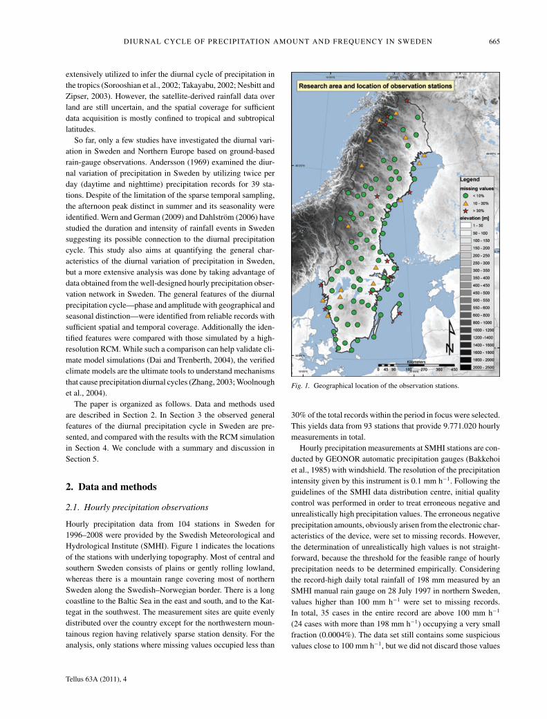
Hourly precipitation data from 104 stations in Sweden for1996–2008 were provided by the Swedish Meteorological andHydrological Institute (SMHI). Figure 1 indicates the locationsof the stations with underlying topography. Most of central andsouthern Sweden consists of plains or gently rolling lowland,whereas there is a mountain range covering most of northernSweden along the Swedish–Norwegian border. There is a longcoastline to the Baltic Sea in the east and south, and to the Kat-tegat in the southwest. The measurement sites are quite evenlydistributed over the country except for the northwestern moun-tainous region having relatively sparse station density. For theanalysis, only stations where missing values occupied less than
Fig. 1. Geographical location of the observation stations.
30% of the total records within the period in focus were selected.This yields data from 93 stations that provide 9.771.020 hourlymeasurements in total.
Hourly precipitation measurements at SMHI stations are con-ducted by GEONOR automatic precipitation gauges (Bakkehoiet al., 1985) with windshield. The resolution of the precipitationintensity given by this instrument is 0.1 mm h−1. Following theguidelines of the SMHI data distribution centre, initial qualitycontrol was performed in order to treat erroneous negative andunrealistically high precipitation values. The erroneous negativeprecipitation amounts, obviously arisen from the electronic char-acteristics of the device, were set to missing records. However,the determination of unrealistically high values is not straight-forward, because the threshold for the feasible range of hourlyprecipitation needs to be determined empirically. Consideringthe record-high daily total rainfall of 198 mm measured by anSMHI manual rain gauge on 28 July 1997 in northern Sweden,values higher than 100 mm h−1 were set to missing records.In total, 35 cases in the entire record are above 100 mm h−1
(24 cases with more than 198 mm h−1) occupying a very smallfraction (0.0004%). The data set still contains some suspiciousvalues close to 100 mm h−1, but we did not discard those values
Tellus 63A (2011), 4
666 J.-H. JEONG ET AL.
in order to conserve the possibility of extreme rainfall, whichcould happen locally. However, the influence of such extremelyhigh values on the analysis results is thought to be insignificant,as 99.9% of the precipitation records finally utilized are below4.7 mm h−1. Despite some suspicious values arisen from mea-surement techniques the database was found to have very highquality which was also well documented by Wern and German(2009).
2.2. Regional climate model simulation
We have compared the diurnal cycle of precipitation esti-mated from the observation data with that simulated by a high-resolution regional climate model. We used a long-term simula-tion of the Rossby Centre Atmospheric Model version 3 (RCA3)driven by the ERA40 re-analysis data set (Uppala et al., 2005).Simulation data for the same period as covered by the observa-tions were utilized. The model domain of the simulation coversmost of Europe using a rotated latitude–longitude coordinatesystem; the latitude range is about 26–72◦N, and the correspond-ing longitude range is about 4◦W–34◦E and 33◦W–57◦E at thesouthern and northern boundary, respectively. The horizontalresolution is 50 km × 50 km approximately (about 0.44◦ spac-ing), and the atmospheric layers are discretized by 24 unequallyspaced hybrid terrain-following levels.
RCA3 is known to be one of the best models in simulatingweather and climate in Sweden and Scandinavia (Kjellstromet al., 2005) and has been utilized in a wide range of climateimpact studies (Jones et al., 2011). Initially developed basedupon the numerical weather prediction model HIRLAM (Undenet al., 2002), RCA3 builds on the previous version RCA2 (Joneset al., 2004) with significant updates in the land surface schemeand atmospheric parametrizations (Samuelsson et al., 2011).Physical parametrizations of RCA3 include large-scale cloudsand microphysics (Rasch and Kristjansson, 1998), convection(Kain and Fritsch, 1993), turbulence (Cuxart et al., 2000) andradiation (Savijarvi, 1990; Sass et al., 1994), and land surfaceprocesses with a tiled surface representation (Samuelsson et al.,2006). More details are described in Samuelsson et al. (2008).
2.3. Estimating the diurnal cycle
In order to examine the general characteristics of the diurnal cy-cle of precipitation, first, a long-term average of the hourly pre-cipitation amount (Pa) and precipitation occurrence frequency(Pf) at each station for the entire analysis period were calculatedfrom the raw data.
The Pa and Pf are defined as;
Pa(h) =∑N
d=1 P(h, d)
N, (1)
Pf(h) =∑N
d=1 O(h, d)
N, (2)
O(h, d) ={
1 P(h, d) ≥ 0.1 mm h−1
0 P(h, d) < 0.1 mm h−1, (3)
where h and d are the chosen hour (i.e. 1–24) and day (amongdays for the entire analysis period) and N is the total number ofdays. P(h,d) is the precipitation at a given h and d, that is, anhourly accumulated amount before a designated hour (h) both forobservation and model. O(h,d) is a rainfall occurrence counter.The threshold for the precipitation rate of 0.1 mm h−1 was usedunder the specification of the GEONOR sensor.
In order to determine the peak time (phase) and amplitudeof the diurnal cycle, smoothed Pa and Pf at each station werecalculated by using the harmonic analysis technique (Angelisand McGregor, 2004; Wilks, 2006). A modelled diurnal variationof a chosen station (P) at hour h can be represented by thesummation of sinusoidal harmonics as
P(h) = ¯P +∑
k
Ck cos
(2πkh
24− θk
)+ residual, (4)
where ¯P is the 24-h mean of P, k is the harmonic number (i.e.1 for the 24-h cycle), and Ck and θ k are the amplitude and thephase of the given k-th harmonic. More details of the mathemat-ical representations are in Wilks (2006) and Yin et al. (2009).In this study, the summation of the first (24-h frequency; k =1) and second (12-h frequency; k = 2) part of the harmonicswas defined as mean (smoothed) diurnal cycle. The amplitudeof this smoothed diurnal cycle was determined as half the differ-ence between maximum and minimum value within the average24-h cycle, and the peak timing as the time when the maximumvalue is found. Those calculations were performed for the warmseason (April–September) and cold season (October–March)separately considering the seasonality of precipitationcharacteristics.
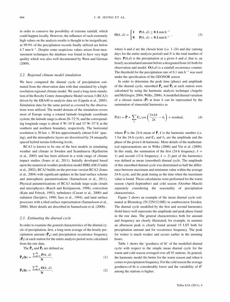
Figure 2 shows an example of the mean diurnal cycle esti-mated at Blomskog (59.22N/12.08E) in southwestern Sweden.The diurnal cycle modelled by the first and second harmonics(bold lines) well represents the amplitude and peak phase foundin the raw data. The general characteristics both for amountand frequency are clearly illustrated; for example, in summeran afternoon peak is clearly found around 15 LST both forprecipitation amount and for occurrence frequency. The peakfor winter is much weaker and occurs earlier in the morninghours.
Table 1 shows the ‘goodness of fit’ of the modelled diurnalcycle with respect to the simple mean diurnal cycle for thewarm and cold season averaged over all 93 stations. In general,the harmonic model fits better for the warm season and when itcomes to precipitation frequency. For the cold season the averagegoodness-of-fit is considerably lower and the variability of R2
among the stations is higher.
Tellus 63A (2011), 4
DIURNAL CYCLE OF PRECIPITATION AMOUNT AND FREQUENCY IN SWEDEN 667
Fig. 2. Average diurnal cycle of observedprecipitation at Blomskog station (indicatedas red square in the right figure). Blue, solidlines: precipitation amount; dashed lines:frequency of precipitation. Thick lineindicates the summation of the first twoharmonics (diurnal and semidiurnal) of theraw diurnal cycle, thin line. The variance ofthe raw diurnal cycle explained by theharmonics is indicated in each panel (blue:amount, black: frequency).
Table 1. Explained variance (R2) of the mean diurnal cycle of amountand occurrence frequency of precipitation by the modelled diurnalcycle averaged for all 93 stations
24 h + 12 h(first and second
harmonic) 24 h (first harmonic)
R2 Amount Frequency Amount Frequency
Warm season 0.59 0.72 0.41 0.49Cold season 0.46 0.50 0.32 0.37
3. Spatial patterns in peak timing andamplitude in observed diurnal variations
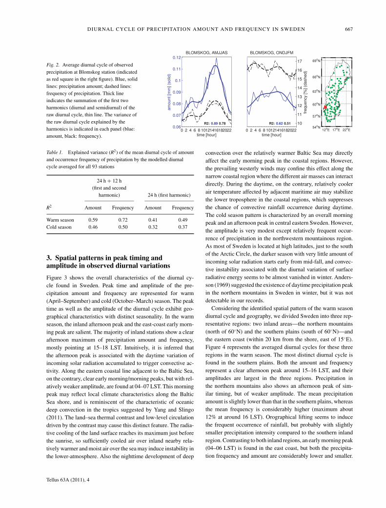
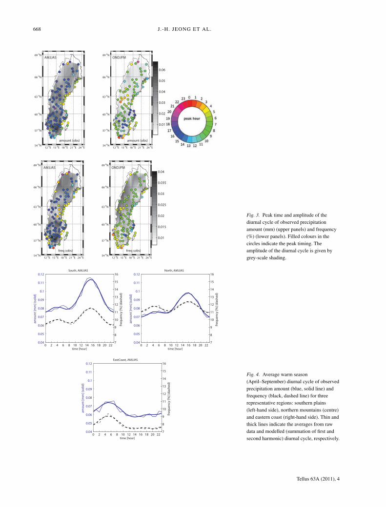
Figure 3 shows the overall characteristics of the diurnal cy-cle found in Sweden. Peak time and amplitude of the pre-cipitation amount and frequency are represented for warm(April–September) and cold (October–March) season. The peaktime as well as the amplitude of the diurnal cycle exhibit geo-graphical characteristics with distinct seasonality. In the warmseason, the inland afternoon peak and the east-coast early morn-ing peak are salient. The majority of inland stations show a clearafternoon maximum of precipitation amount and frequency,mostly pointing at 15–18 LST. Intuitively, it is inferred thatthe afternoon peak is associated with the daytime variation ofincoming solar radiation accumulated to trigger convective ac-tivity. Along the eastern coastal line adjacent to the Baltic Sea,on the contrary, clear early morning/morning peaks, but with rel-atively weaker amplitude, are found at 04–07 LST. This morningpeak may reflect local climate characteristics along the BalticSea shore, and is reminiscent of the characteristic of oceanicdeep convection in the tropics suggested by Yang and Slingo(2011). The land–sea thermal contrast and low-level circulationdriven by the contrast may cause this distinct feature. The radia-tive cooling of the land surface reaches its maximum just beforethe sunrise, so sufficiently cooled air over inland nearby rela-tively warmer and moist air over the sea may induce instability inthe lower-atmosphere. Also the nighttime development of deep
convection over the relatively warmer Baltic Sea may directlyaffect the early morning peak in the coastal regions. However,the prevailing westerly winds may confine this effect along thenarrow coastal region where the different air masses can interactdirectly. During the daytime, on the contrary, relatively coolerair temperature affected by adjacent maritime air may stabilizethe lower troposphere in the coastal regions, which suppressesthe chance of convective rainfall occurrence during daytime.The cold season pattern is characterized by an overall morningpeak and an afternoon peak in central eastern Sweden. However,the amplitude is very modest except relatively frequent occur-rence of precipitation in the northwestern mountainous region.As most of Sweden is located at high latitudes, just to the southof the Arctic Circle, the darker season with very little amount ofincoming solar radiation starts early from mid-fall, and convec-tive instability associated with the diurnal variation of surfaceradiative energy seems to be almost vanished in winter. Anders-son (1969) suggested the existence of daytime precipitation peakin the northern mountains in Sweden in winter, but it was notdetectable in our records.
Considering the identified spatial pattern of the warm seasondiurnal cycle and geography, we divided Sweden into three rep-resentative regions: two inland areas—the northern mountains(north of 60◦N) and the southern plains (south of 60◦N)—andthe eastern coast (within 20 km from the shore, east of 15◦E).Figure 4 represents the averaged diurnal cycles for these threeregions in the warm season. The most distinct diurnal cycle isfound in the southern plains. Both the amount and frequencyrepresent a clear afternoon peak around 15–16 LST, and theiramplitudes are largest in the three regions. Precipitation inthe northern mountains also shows an afternoon peak of sim-ilar timing, but of weaker amplitude. The mean precipitationamount is slightly lower than that in the southern plains, whereasthe mean frequency is considerably higher (maximum about12% at around 16 LST). Orographical lifting seems to inducethe frequent occurrence of rainfall, but probably with slightlysmaller precipitation intensity compared to the southern inlandregion. Contrasting to both inland regions, an early morning peak(04–06 LST) is found in the east coast, but both the precipita-tion frequency and amount are considerably lower and smaller.
Tellus 63A (2011), 4
668 J.-H. JEONG ET AL.
Fig. 3. Peak time and amplitude of thediurnal cycle of observed precipitationamount (mm) (upper panels) and frequency(%) (lower panels). Filled colours in thecircles indicate the peak timing. Theamplitude of the diurnal cycle is given bygrey-scale shading.
Fig. 4. Average warm season(April–September) diurnal cycle of observedprecipitation amount (blue, solid line) andfrequency (black, dashed line) for threerepresentative regions: southern plains(left-hand side), northern mountains (centre)and eastern coast (right-hand side). Thin andthick lines indicate the averages from rawdata and modelled (summation of first andsecond harmonic) diurnal cycle, respectively.
Tellus 63A (2011), 4
DIURNAL CYCLE OF PRECIPITATION AMOUNT AND FREQUENCY IN SWEDEN 669
Considering the peak timing and geographical location, it canbe inferred that the afternoon and early morning peak are con-tributed by precipitation of different type. Although this depen-dency to the precipitation types on the diurnal cycle could not bedirectly examined by our data set; the results from Dai (2001)suggest that the inland afternoon peak is mostly contributedby showery precipitation, while the early morning peak in theeastern coast rather matches with the peak of drizzle type ofprecipitation (see their figs 2 and 4).
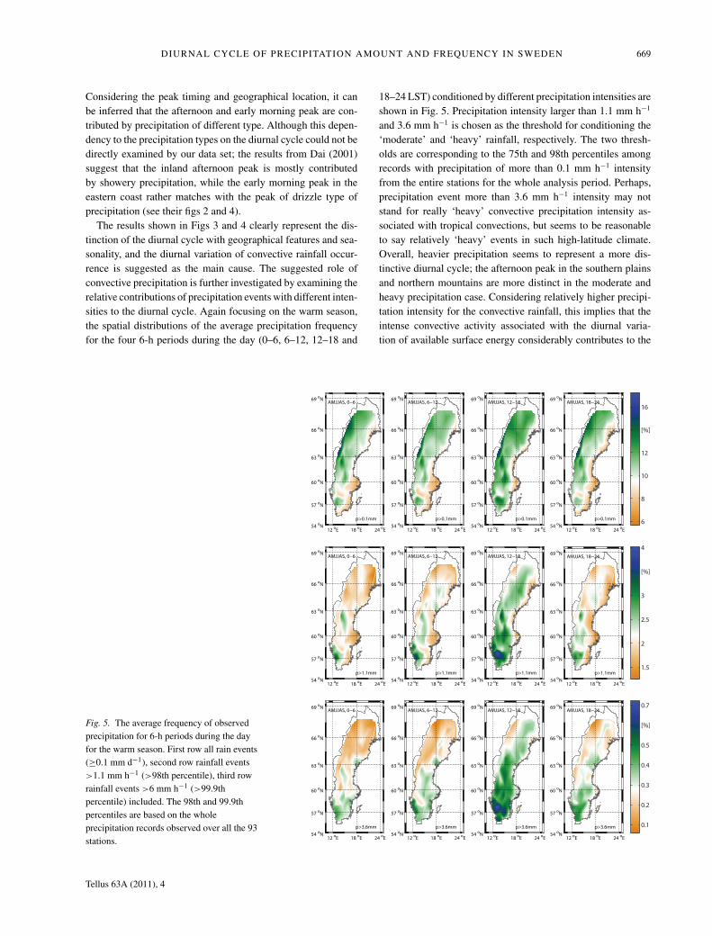
The results shown in Figs 3 and 4 clearly represent the dis-tinction of the diurnal cycle with geographical features and sea-sonality, and the diurnal variation of convective rainfall occur-rence is suggested as the main cause. The suggested role ofconvective precipitation is further investigated by examining therelative contributions of precipitation events with different inten-sities to the diurnal cycle. Again focusing on the warm season,the spatial distributions of the average precipitation frequencyfor the four 6-h periods during the day (0–6, 6–12, 12–18 and
18–24 LST) conditioned by different precipitation intensities areshown in Fig. 5. Precipitation intensity larger than 1.1 mm h−1
and 3.6 mm h−1 is chosen as the threshold for conditioning the‘moderate’ and ‘heavy’ rainfall, respectively. The two thresh-olds are corresponding to the 75th and 98th percentiles amongrecords with precipitation of more than 0.1 mm h−1 intensityfrom the entire stations for the whole analysis period. Perhaps,precipitation event more than 3.6 mm h−1 intensity may notstand for really ‘heavy’ convective precipitation intensity as-sociated with tropical convections, but seems to be reasonableto say relatively ‘heavy’ events in such high-latitude climate.Overall, heavier precipitation seems to represent a more dis-tinctive diurnal cycle; the afternoon peak in the southern plainsand northern mountains are more distinct in the moderate andheavy precipitation case. Considering relatively higher precipi-tation intensity for the convective rainfall, this implies that theintense convective activity associated with the diurnal varia-tion of available surface energy considerably contributes to the
Fig. 5. The average frequency of observedprecipitation for 6-h periods during the dayfor the warm season. First row all rain events(≥0.1 mm d−1), second row rainfall events>1.1 mm h−1 (>98th percentile), third rowrainfall events >6 mm h−1 (>99.9thpercentile) included. The 98th and 99.9thpercentiles are based on the wholeprecipitation records observed over all the 93stations.
Tellus 63A (2011), 4
670 J.-H. JEONG ET AL.
diurnal cycle identified. In the east coast, however, the contribu-tion of moderate and heavy precipitation on the morning peak isnot clearly discernable. Thus, the morning peak seems to be notso much contributed by intense convective precipitation events,but the shallow convective instability in the lower tropospheremay be mostly responsible for it.
4. Simulated diurnal cycle by the regionalclimate model (RCA3)
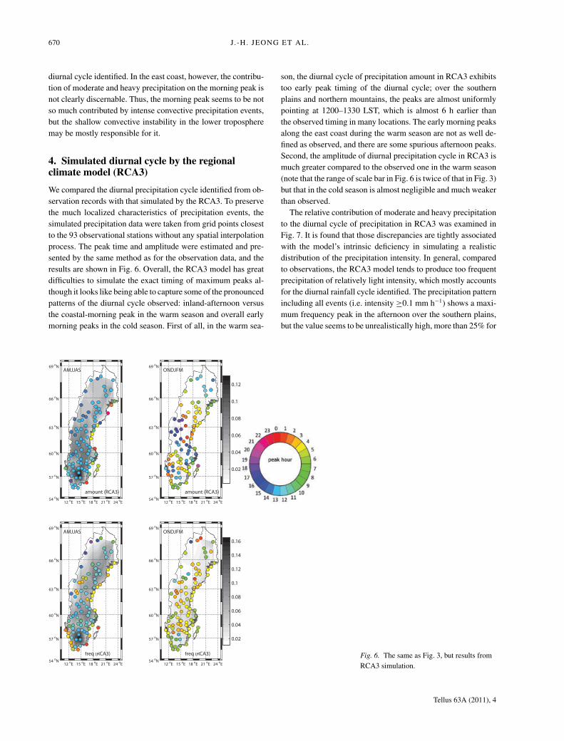
We compared the diurnal precipitation cycle identified from ob-servation records with that simulated by the RCA3. To preservethe much localized characteristics of precipitation events, thesimulated precipitation data were taken from grid points closestto the 93 observational stations without any spatial interpolationprocess. The peak time and amplitude were estimated and pre-sented by the same method as for the observation data, and theresults are shown in Fig. 6. Overall, the RCA3 model has greatdifficulties to simulate the exact timing of maximum peaks al-though it looks like being able to capture some of the pronouncedpatterns of the diurnal cycle observed: inland-afternoon versusthe coastal-morning peak in the warm season and overall earlymorning peaks in the cold season. First of all, in the warm sea-
son, the diurnal cycle of precipitation amount in RCA3 exhibitstoo early peak timing of the diurnal cycle; over the southernplains and northern mountains, the peaks are almost uniformlypointing at 1200–1330 LST, which is almost 6 h earlier thanthe observed timing in many locations. The early morning peaksalong the east coast during the warm season are not as well de-fined as observed, and there are some spurious afternoon peaks.Second, the amplitude of diurnal precipitation cycle in RCA3 ismuch greater compared to the observed one in the warm season(note that the range of scale bar in Fig. 6 is twice of that in Fig. 3)but that in the cold season is almost negligible and much weakerthan observed.
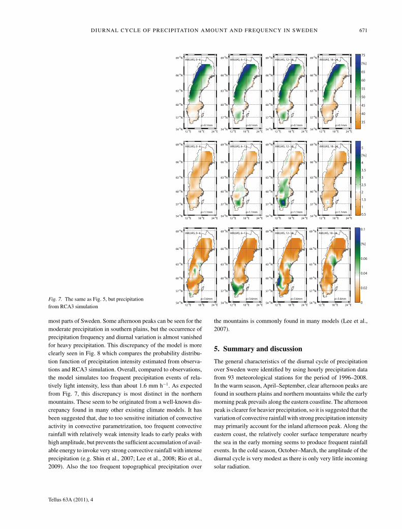
The relative contribution of moderate and heavy precipitationto the diurnal cycle of precipitation in RCA3 was examined inFig. 7. It is found that those discrepancies are tightly associatedwith the model’s intrinsic deficiency in simulating a realisticdistribution of the precipitation intensity. In general, comparedto observations, the RCA3 model tends to produce too frequentprecipitation of relatively light intensity, which mostly accountsfor the diurnal rainfall cycle identified. The precipitation patternincluding all events (i.e. intensity ≥0.1 mm h−1) shows a maxi-mum frequency peak in the afternoon over the southern plains,but the value seems to be unrealistically high, more than 25% for
Fig. 6. The same as Fig. 3, but results fromRCA3 simulation.
Tellus 63A (2011), 4
DIURNAL CYCLE OF PRECIPITATION AMOUNT AND FREQUENCY IN SWEDEN 671
Fig. 7. The same as Fig. 5, but precipitationfrom RCA3 simulation
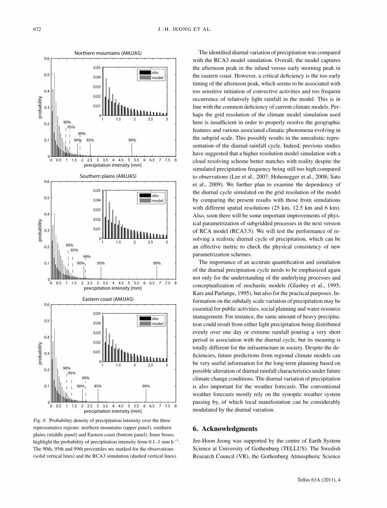
most parts of Sweden. Some afternoon peaks can be seen for themoderate precipitation in southern plains, but the occurrence ofprecipitation frequency and diurnal variation is almost vanishedfor heavy precipitation. This discrepancy of the model is moreclearly seen in Fig. 8 which compares the probability distribu-tion function of precipitation intensity estimated from observa-tions and RCA3 simulation. Overall, compared to observations,the model simulates too frequent precipitation events of rela-tively light intensity, less than about 1.6 mm h−1. As expectedfrom Fig. 7, this discrepancy is most distinct in the northernmountains. These seem to be originated from a well-known dis-crepancy found in many other existing climate models. It hasbeen suggested that, due to too sensitive initiation of convectiveactivity in convective parametrization, too frequent convectiverainfall with relatively weak intensity leads to early peaks withhigh amplitude, but prevents the sufficient accumulation of avail-able energy to invoke very strong convective rainfall with intenseprecipitation (e.g. Shin et al., 2007; Lee et al., 2008; Rio et al.,2009). Also the too frequent topographical precipitation over
the mountains is commonly found in many models (Lee et al.,2007).
5. Summary and discussion
The general characteristics of the diurnal cycle of precipitationover Sweden were identified by using hourly precipitation datafrom 93 meteorological stations for the period of 1996–2008.In the warm season, April–September, clear afternoon peaks arefound in southern plains and northern mountains while the earlymorning peak prevails along the eastern coastline. The afternoonpeak is clearer for heavier precipitation, so it is suggested that thevariation of convective rainfall with strong precipitation intensitymay primarily account for the inland afternoon peak. Along theeastern coast, the relatively cooler surface temperature nearbythe sea in the early morning seems to produce frequent rainfallevents. In the cold season, October–March, the amplitude of thediurnal cycle is very modest as there is only very little incomingsolar radiation.
Tellus 63A (2011), 4
672 J.-H. JEONG ET AL.
Fig. 8. Probability density of precipitation intensity over the threerepresentative regions: northern mountains (upper panel), southernplains (middle panel) and Eastern coast (bottom panel). Inner boxeshighlight the probability of precipitation intensity from 0.1–1 mm h−1.The 90th, 95th and 99th percentiles are marked for the observations(solid vertical lines) and the RCA3 simulation (dashed vertical lines).
The identified diurnal variation of precipitation was comparedwith the RCA3 model simulation. Overall, the model capturesthe afternoon peak in the inland versus early morning peak inthe eastern coast. However, a critical deficiency is the too earlytiming of the afternoon peak, which seems to be associated withtoo sensitive initiation of convective activities and too frequentoccurrence of relatively light rainfall in the model. This is inline with the common deficiency of current climate models. Per-haps the grid resolution of the climate model simulation usedhere is insufficient in order to properly resolve the geographicfeatures and various associated climatic phenomena evolving inthe subgrid scale. This possibly results in the unrealistic repre-sentation of the diurnal rainfall cycle. Indeed, previous studieshave suggested that a higher resolution model simulation with acloud resolving scheme better matches with reality despite thesimulated precipitation frequency being still too high comparedto observations (Lee et al., 2007; Hohenegger et al., 2008; Satoet al., 2009). We further plan to examine the dependency ofthe diurnal cycle simulated on the grid resolution of the modelby comparing the present results with those from simulationswith different spatial resolutions (25 km, 12.5 km and 6 km).Also, soon there will be some important improvements of phys-ical parametrization of subgridded processes in the next versionof RCA model (RCA3.5). We will test the performance of re-solving a realistic diurnal cycle of precipitation, which can bean effective metric to check the physical consistency of newparametrization schemes.
The importance of an accurate quantification and simulationof the diurnal precipitation cycle needs to be emphasized againnot only for the understanding of the underlying processes andconceptualization of stochastic models (Glasbey et al., 1995;Katz and Parlange, 1995), but also for the practical purposes. In-formation on the subdaily scale variation of precipitation may beessential for public activities, social planning and water resourcemanagement. For instance, the same amount of heavy precipita-tion could result from either light precipitation being distributedevenly over one day or extreme rainfall pouring a very shortperiod in association with the diurnal cycle, but its meaning istotally different for the infrastructure in society. Despite the de-ficiencies, future predictions from regional climate models canbe very useful information for the long-term planning based onpossible alteration of diurnal rainfall characteristics under futureclimate change conditions. The diurnal variation of precipitationis also important for the weather forecasts. The conventionalweather forecasts mostly rely on the synoptic weather systempassing by, of which local manifestation can be considerablymodulated by the diurnal variation.
6. Acknowledgments
Jee-Hoon Jeong was supported by the centre of Earth SystemScience at University of Gothenburg (TELLUS). The SwedishResearch Council (VR), the Gothenburg Atmospheric Science
Tellus 63A (2011), 4
DIURNAL CYCLE OF PRECIPITATION AMOUNT AND FREQUENCY IN SWEDEN 673
Centre (GAC) and FORMAS (grant #2007-1048-8700∗51) arethanked for support to Deliang Chen and Alexander Walther.We thank the data service at SMHI for providing the hourlyprecipitation measurements being the base for this study. Partof this work has been performed under the Swedish Mistra-SWECIA programme. Thanks are also due to David Rayner fortechnical support. We thank the two anonymous reviewers forhelpful comments and suggestions.
References
Andersson, T. 1969. The diurnal variation of precipitation in Sweden.Geografiska Annaler. Series A, Physical Geography. 51, 176–184.
Angelis, C. F. and McGregor, G. R. 2004. Diurnal cycle of rainfall overthe Brazilian Amazon. Climate Res. 26, 139–149.
Bakkehoi, S., Oien, K. and Forland, E. J. 1985. An automatic precipita-tion gauge based on vibrating-wire strain gauges. Nordic Hydrology
16, 193–202.Brier, G. W. and Simpson, J. 1969. Tropical cloudiness and rainfall
related to pressure and tidal variations. Q. J. R. Meteorol. Soc. 95,120–147.
Cuxart, J., Bougeault, P. and Redelsperger, J. L. 2000. A turbulencescheme allowing for mesoscale and large-eddy simulations. Q. J. R.
Meteorol. Soc. 126, 1–30.Dahlstrom, B. 2006. Regnintensitet i Sverige-en klimatologisk analys
(Storm intensities in Sweden – a climatological analysis). VA-Forsk,Nr 2006-26, 1–69.
Dai, A. and Deser, C. 1999. Diurnal and semidiurnal variations inglobal surface wind and divergence fields. J. Geophys. Res. 104,31 109–31 125.
Dai, A. and Wang, J. 1999. Diurnal and semidiurnal tides in globalsurface pressure fields. J. Atmos. Sci. 56, 3874–3891.
Dai, A. 2001. Global precipitation and thunderstorm frequencies, PartII: diurnal variations. J. Clim. 14, 1112–1128.
Dai, A. and Trenberth, K. E. 2004. The diurnal cycle and its depictionin the community climate system model. J. Clim. 17, 930–951.
Dai, A., Lin, X. and Hsu, K.-L. 2007. The frequency, intensity, anddiurnal cycle of precipitation in surface and satellite observationsover low- and mid-latitudes. Clim. Dyn. 29, 727–744.
Glasbey, C. A., Cooper, G. and McGechan, M. B. 1995. Disaggregationof daily rainfall by conditional simulation from a point-process model.J. Hydrol. 165, 1–9.
Guichard, F., Petch, J. C., Redelsperger, J. L., Bechtold, P., Chaboureau,J. P. and co-authors. 2004. Modelling the diurnal cycle of deep precip-itating convection over land with cloud-resolving models and single-column models. Q. J. R. Meteorol. Soc. 130C, 3139–3172.
Hohenegger, C., Brockhaus, P. and Schar, C. 2008. Towards cli-mate simulations at cloud-resolving scales. Meteorol. Z. 17, 383–394.
Jones, C. G., Willen, U., Ullerstig, A. and Hansson, U. 2004. The RossbyCentre Regional Atmospheric Climate Model Part I: Model Clima-tology and Performance for the Present Climate over Europe. Ambio
33, 199–210.Jones, C. G., Samuelsson, P. and Kjellstrom, E. 2011. Regional climate
modelling at Rossby Centre. Tellus 63A, 1–3.Kain, J. S. and Fritsch, J. M. 1993. Convective parameterizations for
mesoscale models: the Kain–Fritsch scheme. In: The Representation
of Cumulus Convection in Numerical Models (eds. Emanuel, K. A.and Raymond, D. J.). American Meteorological Society Monograph,Boston, USA, 246 pp.
Katz, R. W. and Parlange, M. B. 1995. Generalizations of chain-dependent processes: application to hourly precipitation. Water Re-
sour. Res. 31, 1331–1341.Kjellstrom, E., Barring, L., Gollvik, S., Hansson, U., Jones, C. and co-
authors. 2005. A 140-year simulation of European climate with thenew version of the Rossby Centre regional atmospheric climate model(RCA3). In: SMHI Reports Meteorology and Climatology No. 108,54 pp.
Kummerow, C., Barnes, W., Kozu, T., Shiue, J. and Simpson, J. 1998.The tropical rainfall measuring mission (TRMM) sensor package. J.Atmos. Ocean. Technol. 15, 809–817.
Lee, M. I., Schubert, S. D., Suarez, M. J., Held, I. M., Kumar, A.and co-authors. 2007. Sensitivity of horizontal resolution in theAGCM simulations of warm season diurnal cycle of precipitationover the United States and Northern Mexico. J. Clim. 20, 1862–1881.
Lee, M. I., Schubert, S. D., Suarez, M. J., Schemm, J. K. E., Pan, H. L.and co-authors. 2008. Role of convection triggers in the simulation ofthe diurnal cycle of precipitation over the United States Great Plains ina general circulation model. J. Geophys. Res. D: Atmos., 113, D02111,doi:10.1029/2007JD008984.
Lenderink, G. and van Meijgaard, E. 2008. Increase in hourly precipi-tation extremes beyond expectations from temperature changes. Nat.
Geosci. 1, 511–514.Nesbitt, S. W. and Zipser, E. J. 2003. The diurnal cycle of rainfall and
convective intensity according to three years of TRMM measure-ments. J. Clim. 16, 1456–1475.
Rasch, P. J. and Kristjansson, J. E. 1998. A comparison of the CCM3model climate using diagnosed and predicted condensate parameter-izations. J. Clim. 11, 1587–1614.
Rio, C., Hourdin, F., Grandpeix, J. Y. and Lafore, J. P. 2009. Shifting thediurnal cycle of parameterized deep convection over land. Geophys.
Res. Letters. 36, L07809, doi:10.1029/2008GL036779.Samuelsson, P., Gollvik, S. and Ullerstig, A. 2006. The land-
surface scheme of the Rossby Centre regional atmospheric climatemodel (RCA3). In: Report in Meteorology 122. SMHI, SE-60176Norrkoping, Sweden, 25 pp.
Samuelsson, P., Jones, C. G., Willen, U., Ullerstig, A., Gollvik, S. andco-authors. 2011. The Rossby Centre Regional Climate model RCA3:model description and performance. Tellus A 63, 4–23.
Sass, B. H., Rontu, L., Savijarvi, H. and Raisanen, P. 1994. HIRLAM-2Radiation scheme: documentation and tests. In: HIRLAM-2 RadiationScheme: Documentation and Tests. SMHI, SE-60176 Norrkoping,Sweden 43 pp.
Sato, T., Miura, H., Satoh, M., Takayabu, Y. N. and Wang, Y. 2009.Diurnal cycle of precipitation in the tropics simulated in a globalcloud-resolving model. J. Clim. 22, 4809–4826.
Savijarvi, H. 1990. Fast radiation parameterization schemes formesoscale and short-range forecast models. J. Appl. Meteorol. 29,437–447.
Shin, D. W., Cocke, S. and LaRow, T. E. 2007. Diurnal cycle of precip-itation in a climate model. J. Geophys. Res. D: Atmos. 112, D13109doi:10.1029/2006JD008333.
Tellus 63A (2011), 4
674 J.-H. JEONG ET AL.
Sorooshian, S., Gao, X., Hsu, K., Maddox, R. A., Hong, Y. and co-authors. 2002. Diurnal variability of tropical rainfall retrieved fromcombined GOES and TRMM satellite information. J. Clim. 15,983–1001.
Takayabu, Y. N. 2002. Spectral representation of rain profiles and di-urnal variations observed with TRMM PR over the equatorial area.Geophys. Res. Lett. 29, 1584, doi:10.1029/2001GL014113.
Unden, P., Rontu, L., Jarvinen, H., Lynch, P., Calvo, J. and co-authors.2002. HIRLAM-5 scientific documentation. In: HIRLAM Report.SMHI, SE-60176 Norrkoping, Sweden, 144 pp.
Uppala, S. M., Kallberg, P. W., Simmons, A. J., Andrae, U., Bechtold,V. D. C. and co-authors. 2005. The ERA-40 re-analysis. Q. J. R.
Meteorol. Soc. 131, 2961–3211.Wallace, J. M. 1975. Diurnal-Variations in precipitation and thunder-
storm frequency over conterminous United States. Mon. Weather Rev.
103, 406–419.Wern, L. and German, J. 2009. Korttidsnederbord i Sverige 1995–2008.
In: Meteorologi, 139/9002. SMHI.Wilks, D. S. 2006. Statistical Methods in the Atmospheric Sciences.
Academic Press, Burlington, MA.Woolnough, S. J., Slingo, J. M. and Hoskins, B. J. 2004. The diurnal
cycle of convection and atmospheric tides in an aquaplanet GCM. J.Atmos. Sci. 61, 2559–2573.
Yin, S., Chen, D. and Xie, Y. 2009. Diurnal variations of precipitationduring the warm season over China. Int. J. Climatol. 29, 1154–1170.
Zhang, G. J. 2003. Roles of tropospheric and boundary layer forcingin the diurnal cycle of convection in the U.S. southern great plains.Geophys. Res. Lett. 30, 2281, doi:10.1029/2003GL018554.
Tellus 63A (2011), 4