Dandyism as Monumental-Political ethos: Van Deyssel and the Walking Utopia
Proceedings of the 38th Annual Conference on Computer Applications and Quantitative Methods in Archaeology, CAA2010 F. Contreras, M. Farjas and F.J. Melero (eds.)
Digital Mediation in the Transition from a Discrete Model to Large-scale Archaeological Survey:
Survey of the Archaeological Site of Merida
Inglese, C.1, Pizzo, A.2, Senatore, L.J.1
1 Dpto. RADAAr Università di Roma “Sapienza”, Italy2 Istituto de Arqueologia (CSIC, Junta de Extremadura, Consorcio de Mérida), Spain
{carlo.inglese; luca.senatore}@uniroma1.it ; [email protected]
Architectural survey applied to the archaeological research. The research applied to the archaeological site of Merida, trys to define a methodological and practical“Protocol“ for the survey applied to large-scale archaeological sites. The digital way for the surveying and survey.
Keywords: 3D Survey; 3D modelling; Architecture/Archaeology.
1. History of the theatre and amphitheatre
There are two important reasons why buildings used for performances in Merida (the theatre, amphitheatre and circus) are part of one of the most emblematic archaeological complexes of Spain’s archaeological heritage: their historical importance and excellent state of conservation, which during the 20th century made it possible to identify and bring to light the almost complete plan of the three buildings.
Architects from the Department of Survey, Analysis, Drawing of the Environment and Architecture (RADAAR) of the University of Rome “Sapienza” and archaeologists of the Instituto de Arquelogìa de Mérida collaborated in the study presented here. The joint work focused on two research projects ( “El teatro y anfiteatro de Augusta Emerita. Documentación, investigación y presentación de dos edificios de espectáculo de época romana” Ref. 3PR 05 A 104. and “ATHENA proyect. Ancient Theatres Enhancement for New Actualities-Athena.” Euromed Heritage IV Programme Ref. EuropeAid/126266/C/ACT/Multi).
The theatre and the amphitheatre are located in the east sector of the ancient colony of Augusta Emerita in an area, which during the Augustan Age, was outside the main city wall. In 1956 Marcos Pous carried out an archaeological survey in the south sector of the amphitheatre and discovered a furnace dating to the Claudian period. This made it possible to chronologically place the monumental complex at
around the mid-1st century A.D. (BENDALA and DURÁN, 1995: 256). The enlargement of the outer city walls to incorporate the theatre and amphitheatre was apparently due to important topological changes in this area which, according to recent excavations, took place during the Flavian Age (BENDALA and DURÁN, 1995: 258) (MATEOS, 2001: 187-188).The changes required a new town plan of the east area and the restructuring of the entrances to the theatre and the addition of porticoes (MATEOS and MÁRQUEZ, 1999) (MATEOS, 2001: 199).
The history of research on these buildings in Mérida almost always coincides with the history of the city, as well as with the history of an important part of Spanish archaeology. Given the historical importance of these constructions, traditionally considered as symbols of the city and proof of the Romanisation of the provinces, several studies were carried out in the past. These studies can now be combined with the methods and technologies used in our research and will help to understand the historical and construction dynamics of the buildings and their role in the urban history of the Roman city.
The amphitheatre East of the theatre rests on a hill and faces in a East-West direction; the eastern part of the building was partially built underground, while the central and North-East sector were built above ground (DURÁN, 2004:58). The building has 16 gates, three of which are main gates: two at either end of the longitudinal axis and one at the monumental West
3D Scanning Case Studies 99
C. Inglese et al. / Digital Mediation in the Transition from a Discrete Model to Large-scale Archaeological Survey of Merida
entrance. The cavea is divided into: ima, media and summa cavea. Inauguration of the original amphitheatre dates to 8 B.C. (MENÉNDEZ- PIDAL, 1957-58; RAMÍREZ SÁDABA, 1995). During the Flavian age the building was modified and made monumental, as we see it today. This was a period in which the city spread towards the South-East when a new section of city walls was built just in front of the large amphitheatre. The town-planning problem posed by this urban development influenced the construction of the amphitheatre (BENDALA and DURÁN, 1995: 256) and created multiple technical and construction problems. The new survey using 3D scanning focused on these problems.
As far as the construction is concerned, the harena is the central element of the building’s entire design. The geometric form of the construction is one of the new objectives of our study and will be presented in another monograph written by architects and archaeologists. The monograph will be based on our survey and the new problems associated with its architectural development and building processes and dynamics. The arena is divided from the tiered seating by a podium of opus quadratum, built over a period of several years. The building’s main characteristic is a big, wide central ditch along the longitudinal axis. In the middle it widens to become a large square space linked to three chanals for supplies and the removal of water: two run along the main axis and one along the minor axis (MATEOS et al., 2002: 84-85).
The topography of the land affected the construction of the entrances to various parts of the tiered seating. For example, it is possible to enter directly from the east side into the praecinctio of the medio cavea; instead to the west, several fights of steps are required to overcome the difference in level with the east side. The amphitheatre had three main entrances to the North, South and West. Once again, the fact there is no entrance on the East side depends on the problem of the building’s proximity to the city walls. As mentioned above, this problem affected many technical and building decisions as well as the architectural solutions adopted in the entire east area.
2. Methodology
The methodology used in this survey is based on studies and research carried out by the Department of Survey, Analysis, Drawing of the Environment and Architecture (RADAAR) of the University of Rome “Sapienza,” tested and developed over the years on countless objects. Apart from creating different survey scales, the study’s ultimate goal and objective is to establish a “protocol” applicable and with appropriate changes and in many different fields. The study carried out in Mérida allowed us to verify and implement the results obtained so far, taking into account the specific problems of urban/territorial survey, in other words, of the survey of a large structure.
CAA2010 Fusion of Cultures
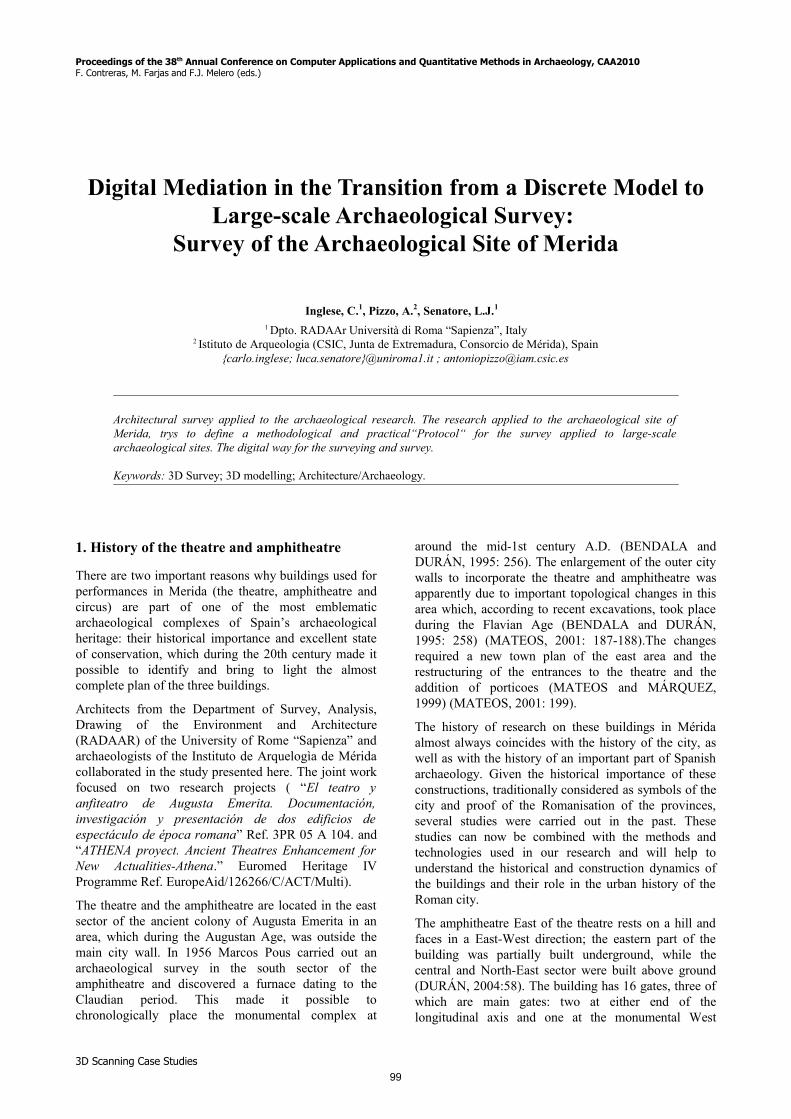
Figure 1: The monumental site.
100
F. Contreras, M. Farjas & F.J. Melero (eds.) / Proceedings of CAA'2010 Fusion of Cultures
The participation of the archaeologists of the Institute also allowed us to test these procedures according to their specific needs, in particular to try and optimise the final results (elaboration types). It is important to emphasise how establishing a protocol will not make the survey process mechanical, but will act as a support and critical reference for the technician involved in optimising the entire surveying and survey process. This will make it possible to choose a procedure compatible with what we could call the “scale of the model” to be studied and reproduced using different techniques.
The procedural protocol is divided into three important but separate stages: analysis and definition of the objectives; surveying; elaboration.
2.1. Analysis and definition of the objectives
The archaeologists’ specific request involved the possibility of creating models which would allow an in-depth study of stratigraphic and historiographic problems as well as making the entire architectural object easier to understand.
By its very nature, the Mérida complex was an important part of the entire urban fabric. The first important problem to be solved to optimise the final result was the size of the object to be surveyed and certain logistical complications. The entire survey campaign therefore focused on general issues and dealt only briefly with more detailed issues. Our decision was based on the fact that the models would be on a territorial scale, in other words, no large than a 1:100 architectural scale.
This statement is important not so much because it modifies a classified and standardised data acquisition procedure, but because it can establish the quality of the data to be surveyed.
Surveying
Having studied the object to be surveyed, we developed a survey project according to what we could call complex surveying. The latter indicates a series of procedures to integrate/combine various methodologies, techniques, and tools: topographic survey, 3D laser scanner survey and photographic survey. Given their very specific characteristics, we preferred to use the latter to obtain integrated, comprehensive data compared to the final objectives. In detail, the topographic survey was used as a reference grid to control the uncertainties in the overall registration of the laser scanner data (points clouds), while photography provided additional and more detailed information.
Each procedure was used in combination with the others, exploiting each procedure’s potential and optimising the results.
This survey allowed us to produce a “numerical model” capable of objectively depicting the entire architectural complex. The technicians were also able to use it as the
first piece of information on which to base their work. The TruView technique is the best way to obtain this kind of data. Using a web browser this technique can provide all sorts of information concerning the size and the surveyed object.
Survey
Having obtained the raw data (metadata), we used it to create the graphic and visual tools required to portray the architectural, urban, and territorial aspects of the object in question.
Because of the size of the object to be surveyed, we paid careful attention when treating the scan data. In this case, the amount of information was important when deciding on procedures and the ensuing results.
Study and definition of the objectives
The work required to draft the survey project was based on a study of the history of the complex and careful evaluation of all survey material to date.
To truly comprehend and appreciate an architectural object, in particular an object to be surveyed, it is important to understand the problems it has faced in the past. In this case, the size of the object to be surveyed presented both an operational limitation and a challenge. As a result, after studying several of its past problems we preferred to adopt an approach which would, as far as possible, be new and comprehensive not only for the interiors, but also for those parts of the structure in direct contact with other urban elements close to or adjacent to the monumental complex. It is important to emphasise how in this case in particular, we considered it essential to survey all the areas surrounding the complex, in particular the perimeters of the two objects. Our aim was to clarify for scholars the relationship between the urban fabric and these important monuments which can only be interpreted on a general and urban scale. In particular, we focused directly on the point of contact between the amphitheatre and the remains of the city walls insofar as it is a critical point, not only historically, but also because it plays a key role in the historiographical and interpretative development of the entire monumental complex.
We reviewed existing documents carefully, in particular the geometric survey of the area. This document was the basic document which helped us identify critical areas, as well as other areas of interest not fully incorporated into an overall vision of the entire complex. Complex surveys can provide important additional information in cases such as these because they can provide the same accuracy and precision when surveying large, complex architectural objects which otherwise are difficult to examine with traditional survey tools.
2.2. Surveying
The surveying of the monumental complex was carried out using two 3D Laser Scanners, HDS 3000 and a
3D Scanning Case Studies 101
C. Inglese et al. / Digital Mediation in the Transition from a Discrete Model to Large-scale Archaeological Survey of Merida
Leica Scanstation 2, together with topographic readings using a Leica TCR 1201 R300 Total Station.
We first defined, a priori, a Shot Project focusing on the logistical and operational problems we might have encountered on the site because of the size of the complex. Our aim was to optimise the survey operations, in particular to find the best way to make use of the tools.
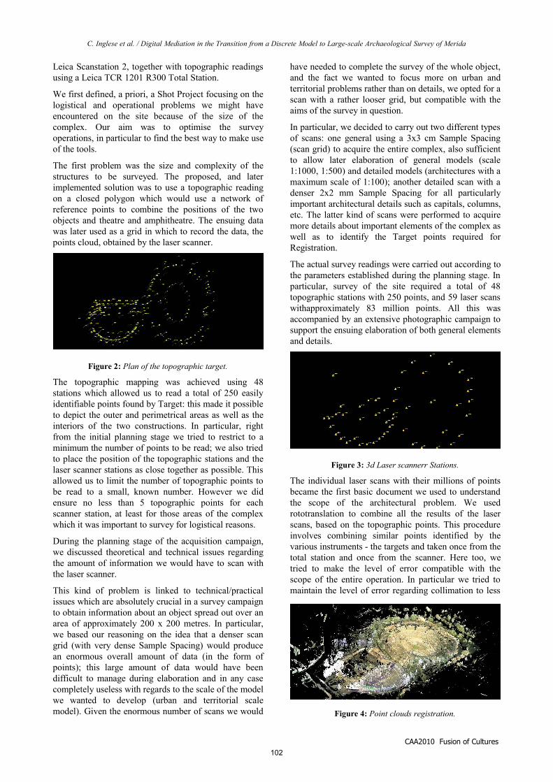
The first problem was the size and complexity of the structures to be surveyed. The proposed, and later implemented solution was to use a topographic reading on a closed polygon which would use a network of reference points to combine the positions of the two objects and theatre and amphitheatre. The ensuing data was later used as a grid in which to record the data, the points cloud, obtained by the laser scanner.
The topographic mapping was achieved using 48 stations which allowed us to read a total of 250 easily identifiable points found by Target: this made it possible to depict the outer and perimetrical areas as well as the interiors of the two constructions. In particular, right from the initial planning stage we tried to restrict to a minimum the number of points to be read; we also tried to place the position of the topographic stations and the laser scanner stations as close together as possible. This allowed us to limit the number of topographic points to be read to a small, known number. However we did ensure no less than 5 topographic points for each scanner station, at least for those areas of the complex which it was important to survey for logistical reasons.
During the planning stage of the acquisition campaign, we discussed theoretical and technical issues regarding the amount of information we would have to scan with the laser scanner.
This kind of problem is linked to technical/practical issues which are absolutely crucial in a survey campaign to obtain information about an object spread out over an area of approximately 200 x 200 metres. In particular, we based our reasoning on the idea that a denser scan grid (with very dense Sample Spacing) would produce an enormous overall amount of data (in the form of points); this large amount of data would have been difficult to manage during elaboration and in any case completely useless with regards to the scale of the model we wanted to develop (urban and territorial scale model). Given the enormous number of scans we would
have needed to complete the survey of the whole object, and the fact we wanted to focus more on urban and territorial problems rather than on details, we opted for a scan with a rather looser grid, but compatible with the aims of the survey in question.
In particular, we decided to carry out two different types of scans: one general using a 3x3 cm Sample Spacing (scan grid) to acquire the entire complex, also sufficient to allow later elaboration of general models (scale 1:1000, 1:500) and detailed models (architectures with a maximum scale of 1:100); another detailed scan with a denser 2x2 mm Sample Spacing for all particularly important architectural details such as capitals, columns, etc. The latter kind of scans were performed to acquire more details about important elements of the complex as well as to identify the Target points required for Registration.
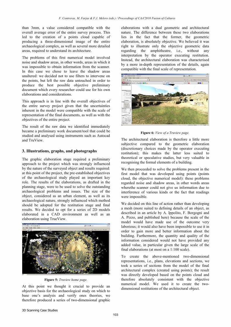
The actual survey readings were carried out according to the parameters established during the planning stage. In particular, survey of the site required a total of 48 topographic stations with 250 points, and 59 laser scans withapproximately 83 million points. All this was accompanied by an extensive photographic campaign to support the ensuing elaboration of both general elements and details.
The individual laser scans with their millions of points became the first basic document we used to understand the scope of the architectural problem. We used rototranslation to combine all the results of the laser scans, based on the topographic points. This procedure involves combining similar points identified by the various instruments - the targets and taken once from the total station and once from the scanner. Here too, we tried to make the level of error compatible with the scope of the entire operation. In particular we tried to maintain the level of error regarding collimation to less
CAA2010 Fusion of Cultures
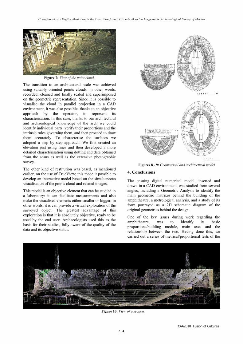
Figure 4: Point clouds registration.
Figure 2: Plan of the topographic target.
Figure 3: 3d Laser scannerr Stations.
102
F. Contreras, M. Farjas & F.J. Melero (eds.) / Proceedings of CAA'2010 Fusion of Cultures
than 3mm, a value considered compatible with the overall average error of the entire survey process. This led to the creation of a points cloud capable of producing a three-dimensional image of the entire archaeological complex, as well as several more detailed areas, required to understand its architecture.
The problems of this first numerical model involved noise and shadow areas, in other words, areas in which it was impossible to obtain information from the scanner. In this case we chose to leave the shadow areas unaltered: we decided not to use filters to intervene on the points, but left the raw data untouched in order to produce the best possible objective preliminary document which every researcher could use for his own elaborations and considerations.
This approach is in line with the overall objectives of the entire survey project given that the uncertainties inherent in the model were compatible with the scale of representation of the final documents, as well as with the objectives of the entire project.
The result of the raw data we identified immediately became a preliminary work document/tool that could be studied and analysed using instruments such as Autocad and TruView.
3. Illustrations, graphs, and photographs
The graphic elaboration stage required a preliminary approach to the project which was strongly influenced by the nature of the surveyed object and results required: at this point of the project, the pre-established objectives of the archaeological study played an important key role. The results of the elaborations, as drafted in the planning stage, were to be used to solve the outstanding archaeological problems and issues. The size of the object, considered as an urban element, as well as its archaeological nature, strongly influenced which method should be adopted for the restitution stage and final results. We decided to opt for a series of 2D models elaborated in a CAD environment as well as an elaboration using TrueView.
At this point we thought it crucial to provide an objective basis for the archaeological study on which to base one’s analysis and verify ones theories, we therefore produced a series of two-dimensional graphic
elaborations with a dual geometric and architectural nature. The difference between these two elaborations lies in the fact that the former, the geometric elaboration, is absolutely objective. We believed it was right to illustrate only the objective geometric data regarding the amphitheatre, i.e., without any interpretation by the operator executing restitution. Instead, the architectural elaboration was characterised by a more in-depth representation of the details, again compatible with the final scale of representation.
The architectural elaboration is therefore a little more subjective compared to the geometric elaboration (discretionary choices made by the operator executing restitution); this makes the latter less suited to theoretical or speculative studies, but very valuable in recognising the formal elements of a building.
We then proceeded to solve the problems present in the first model that was developed using points (points cloud, the objective numerical model): these problems regarded noise and shadow areas, in other words areas wherethe scanner could not give us information due to interference of various kinds or the fact that readings were impossible.
We decided on this line of action rather than developing a mesh (more suited to defining details of an object, as described in an article by A. Ippolito, F. Borgogni and A. Pizzo, and published here) because the scale of the model would have made use of the outcome very laborious; it would also have been impossible to use it in order to gain more and better information about the building. Furthermore, the quantity and quality of the information considered would not have provided any added value, in particular given the large scale of the final elaborations (at most on a 1:100 scale).
To create the above-mentioned two-dimensional representations, i.e., plans, elevations and sections, we took a series of sections from the model of the final architectural complex (created using points); the result was directly developed based on the points cloud and therefore absolutely consistent with the objective numerical model. We used it to create the two-dimensional restitutions of the architectural object.
3D Scanning Case Studies
Figure 5: Truview home page.
Figure 6: View of a Truview page.
103
C. Inglese et al. / Digital Mediation in the Transition from a Discrete Model to Large-scale Archaeological Survey of Merida
The transition to an architectural scale was achieved using suitably oriented points clouds, in other words, recorded, cleaned and finally scaled and superimposed on the geometric representation. Since it is possible to visualise the cloud in parallel projection in a CAD environment, it was also possible, thanks to an objective approach by the operator, to represent its characterisation. In this case, thanks to our architectural and archaeological knowledge of the arch we could identify individual parts, verify their proportions and the intrinsic rules governing them, and then proceed to draw them accurately. To characterise the surfaces we adopted a step by step approach. We first created an elevation just using lines and then developed a more detailed characterisation using dotting and data obtained from the scans as well as the extensive photographic survey.
The other kind of restitution was based, as mentioned earlier, on the use of TrueView; this made it possible to develop an interactive model based on the simultaneous visualisation of the points cloud and related images.
This model is an objective element that can be studied in a laboratory: it can facilitate measurements and also make the visualised elements either smaller or bigger, in other words, it is can provide a virtual exploration of the surveyed object. The greatest advantage of this exploration is that it is absolutely objective, ready to be used by the end user. Archaeologists used this as the basis for their studies, fully aware of the quality of the data and its objective status.
4. Conclusions
The ensuing digital numerical model, inserted and drawn in a CAD environment, was studied from several angles, including a Geometric Analysis to identify the main geometric matrixes behind the building of the amphitheatre, a metrological analysis, and a study of its form portrayed as a 2D schematic diagram of the original geometries behind the design.
One of the key issues during work regarding the amphitheatre, was to identify its basic proportions/building module, main axes and the relationship between the two. Having done this, we carried out a series of metrical/proportional tests of the
CAA2010 Fusion of Cultures
Figure 7: View of the point cloud.
Figures 8 - 9: Geometrical and architectural model.
Figure 10: View of a section.
104
F. Contreras, M. Farjas & F.J. Melero (eds.) / Proceedings of CAA'2010 Fusion of Cultures
elements of the amphitheatre considered as a building type.
The methodology and survey procedure - developed jointly by archaeologists from the IAM and architects from the RADAAR - for the archaeological study of the urban complex of Mérida was crucial in the elaboration of the graphic representation and overall understanding of the building, above all with regard to the stratigraphic study considered as representative of the historical and morphological characteristics associated with the site of the complex in the urban topography of the city of Mérida during a certain historical period.
The position of the buildings and their importance in the city’s topography and urban layout prove that numerous changes were made over the years; some parts were destroyed, abandoned and demolished, while other have been restored in recent years.
The use of the 3D scanning technique and associated elaborations are essential in this kind of stratigraphic archaeological analysis. The accuracy of the graphic restitutions and architectural details makes it possible to carry out an ad hoc study on structural elements traditionally neglected by general historiography.
In particular, as regards the information these techniques can input into the stratigraphic analysis of entertainment buildings, these monuments have several very special archaeological and architectural features. In fact the history of their construction is very complex, and several details of the actual building and detailed finish using a variety of building materials are so unique they would have remained undetected without the support of a high precision survey.
References
AA.VV, 2009. Nuove ricerche sulla Gran Cupola del Tempio Vaticano, Preprogetti, Roma.
BIANCHINI, C., 2007. From reality to virtuality (and back): the wooden model by Antonio da Sangallo for the new St. Peter’s in Vatican. Disegnare idee immagini 34, Gangemi editore, Roma; pp: 36-49.
BENDALA, M. and DURÁN, R.M. 1995. El anfiteatro de Augusta Emerita: rasgos arquitectónicos y problemática urbanística y cronológica. El Anfiteatro en la Hispania Romana (Mérida, 1992), 1995, pp. 247- 264.
DOCCI, M. ET AL., 2007. Metodi e tecniche integrate di rilevamento per la realizzazione di modelli virtuali dell’architettura e della città, Gangemi editore, Roma.
DURÁN, R.M. 2004. Edificios de espectáculos, Las capitales provinciales de Hispania. Tomo II Mérida. Colonia Augusta Emerita, Roma, 2004, pp. 55-66.
IPPOLITO, A., 2009. La modellazione delle superfici murarie del Tempio del Divo Claudio a Roma Disegnare idee immagini n°38, Gangemi editore, Roma; pp: 53-6.
MATEOS, P. 2001. Augusta Emerita. La investigación arqueológica en una ciudad de época romana. AespA, 74, 2001, pp. 183-208.
MATEOS, P., MÁRQUEZ, J. 1999. Nuevas estructuras urbanas relacionadas con el Teatro Romano de Mérida: el pórtico de acceso. Memoria. Excavaciones arqueológicas en Mérida 1997, Mérida, 1999, pp. 301- 320.
MATEOS, P.; AYERBE, R.; BARRIENTOS, T.; FEIJOO, S. 2002. La gestión del agua en Augusta Emerita. Empúries, 53, Barcelona, 2002, pp. 67-88.
MENÉNDEZ-PIDAL, J. 1957-1958. Restitución del texto y dimensiones de las inscripciones históricas del anfiteatro de Mérida. AespA 30-31, Madrid, 1958, pp. 205-217.
RAMÍREZ SABADA, J. L. 1995. Epígrafía del anfiteatro romano de Mérida. El Anfiteatro en la Hispania Romana (Mérida, 1992), 1995, pp. 285- 299.
3D Scanning Case Studies 105

106
Copyright © 2022 FDOKUMEN