Analyzing the Relocation Process of the Indonesian ... - Transformasi
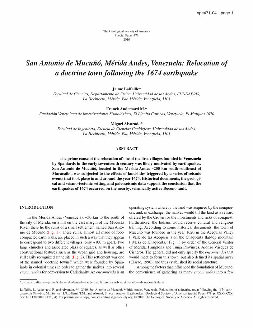
spe471-04 page 1
INTRODUCTION
In the Mérida Andes (Venezuela), ~30 km to the south of the city of Merida, on a hill on the east margin of the Mucusás River, there lie the ruins of a small settlement named San Anto-nio de Mucuñó (Fig. 1). These ruins, almost all made of foot-compacted earth walls, are placed in such a way that they appear to correspond to two different villages, only ~100 m apart. Two large churches and associated plaza or squares, as well as other constructional features such as the urban grid and housing, are still easily recognized at the site (Fig. 2). This settlement was one of the named “doctrine towns,” which were founded by Span-iards in colonial times in order to gather the natives into several encomiendas for conversion to Christianity. An encomienda is an
operating system whereby the land was acquired by the conquer-ors, and, in exchange, the natives would till the land as a reward offered by the Crown for the investments and risks of conquest. Furthermore, the Indians would receive cultural and religious training. According to some historical documents, the town of Mucuñó was founded in the year 1620 in the Acequias Valley (“Valle de las Acequias”) on the Chaquentá flat-top mountain (“Mesa de Chaquentá,” Fig. 1) by order of the General Visitor of Mérida, Pamplona and Tunja Provinces, Alonso Vásquez de Cisneros. The general did not only specify the encomiendas that would meet to form this town, but also defined its spatial array (Clarac, 1990), and thus established its social structure.
Among the factors that influenced the foundation of Mucuñó, the convenience of gathering as many encomiendas into a few
1
The Geological Society of America Special Paper 471
2010
San Antonio de Mucuñó, Mérida Andes, Venezuela: Relocation of a doctrine town following the 1674 earthquake
Jaime Laffaille*Facultad de Ciencias, Departamento de Física, Universidad de los Andes, FUNDAPRIS,
La Hechicera, Mérida, Edo Mérida, Venezuela, 5101
Franck Audemard M.* Fundación Venezolana de Investigaciones Sismológicas, El Llanito Caracas, Venezuela, El Marqués 1070
Miguel Alvarado*Facultad de Ingeniería, Escuela de Ciencias Geológicas, Universidad de los Andes,
La Hechicera, Mérida, Edo Mérida, Venezuela, 5101
ABSTRACT
The prime cause of the relocation of one of the first villages founded in Venezuela by Spaniards in the early seventeenth century was likely motivated by earthquakes. San Antonio de Mucuñó, located in the Merida Andes ~200 km south-southeast of Maracaibo, was subjected to the effects of landslides triggered by a series of seismic events that took place in and around the year 1674. Historical documents, the geologi-cal and seismo-tectonic setting, and paleoseismic data support the conclusion that the earthquakes of 1674 occurred on the nearby, seismically active Bocono fault.
*E-mails: Laffaille—[email protected]; Audemard—[email protected]; Alvarado—[email protected].
Laffaille, J., Audemard, F., and Alvarado, M., 2010, San Antonio de Mucuñó, Mérida Andes, Venezuela: Relocation of a doctrine town following the 1674 earth-quake, in Sintubin, M., Stewart, I.S., Niemi, T.M., and Altunel, E., eds., Ancient Earthquakes: Geological Society of America Special Paper 471, p. XXX–XXX, doi: 10.1130/2010.2471(04). For permission to copy, contact [email protected]. © 2010 The Geological Society of America. All rights reserved.
2 Laffaille et al.
spe471-04 page 2
towns along the basin of Nuestra Señora River (22 encomien-das) as possible stands out. This plan facilitated the conversion of natives and allowed the Spanish Crown to exert the political-economic control on the population, as well as to control the doc-trinaires and the heads of each encomienda (“encomenderos”; Clarac, 1990). Acosta (1982) pointed out that another factor was the excellent natural conditions for agricultural production, since this land was good for cultivation of wheat (which led Merida to become one of the main production areas of this cereal), corn, celery and, in general, those vegetables that natives usually con-sumed. However, in a series of documents and letters dating from
1672 archived at the Merida State Historical Files (“Archivo Histórico del Estado Mérida”; Nadal and Villafañe, 2004), the residents of Mucuñó claimed that new land had to be assigned for the town relocation. This request was supported by two major arguments. These included the ongoing water shortage for land irrigation and the threat to the residents’ safety due to frequent “bolcanes.” Bolcán is the word the natives of the Mérida Andes use for a mudflow and/or debris flow that are well known for their great destructive power. It is equivalent to the Peruvian term “Huayco.” The bolcanes problem was severe due to the intense rains of the year 1672 that were so strong as to activate several
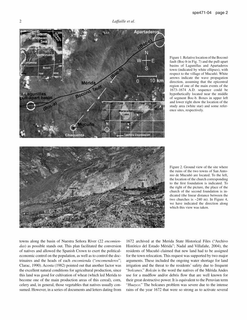
Figure 1. Relative location of the Boconó fault (Boc-b in Fig. 7) and the pull-apart basins of Lagunillas and Apartaderos town (indicated by white ellipses), with respect to the village of Mucuñó. White arrows indicate the wave propagation direction, assuming that the epicentral region of one of the main events of the 1673–1674 A.D. sequence could be hypothetically located near the middle of segment Boc-b. Boxes in upper left and lower right show the location of the study area (white star) and some refer-ence sites, respectively.
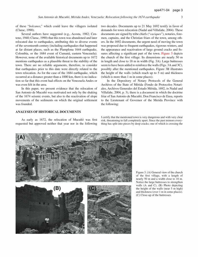
Figure 2. Ground view of the site where the ruins of the two towns of San Anto-nio de Mucuñó are located. To the left, the location of the church corresponding to the first foundation is indicated. To the right of the picture, the place of the church of the second foundation is in-dicated (the linear distance between the two churches is ~240 m). In Figure 4, we have indicated the direction along which this view was taken.
San Antonio de Mucuñó, Mérida Andes, Venezuela: Relocation following the 1674 earthquake 3
spe471-04 page 3
of these “bolcanes,” which could leave the villagers isolated (Clarac, 1990).
Several authors have suggested (e.g., Acosta, 1982; Cen-teno, 1940; Clarac, 1990) that this town was abandoned and later relocated due to earthquakes, attributing this to diverse events of the seventeenth century (including earthquakes that happened at far distant places, such as the Plamplona 1644 earthquake, Colombia, or the 1684 event of Cumaná, eastern Venezuela). However, none of the available historical documents up to 1672 mentions earthquakes as a plausible threat to the stability of the town. There are no reliable arguments, therefore, to consider that earthquakes prior to this date were directly related to the town relocation. As for the case of the 1684 earthquake, which occurred at a distance greater than a 1000 km, there is no indica-tion so far that this event had effects on the Venezuela Andes or was even felt in the area.
In this paper, we present evidence that the relocation of San Antonio de Mucuñó was motivated not only by the shaking of the 1674 seismic events, but also to the reactivation of slope movements of the sediments on which the original settlement was founded.
ANALYSES OF HISTORICAL DOCUMENTS
As early as 1672, the relocation of Mucuñó was first requested but approved neither that year nor in the following
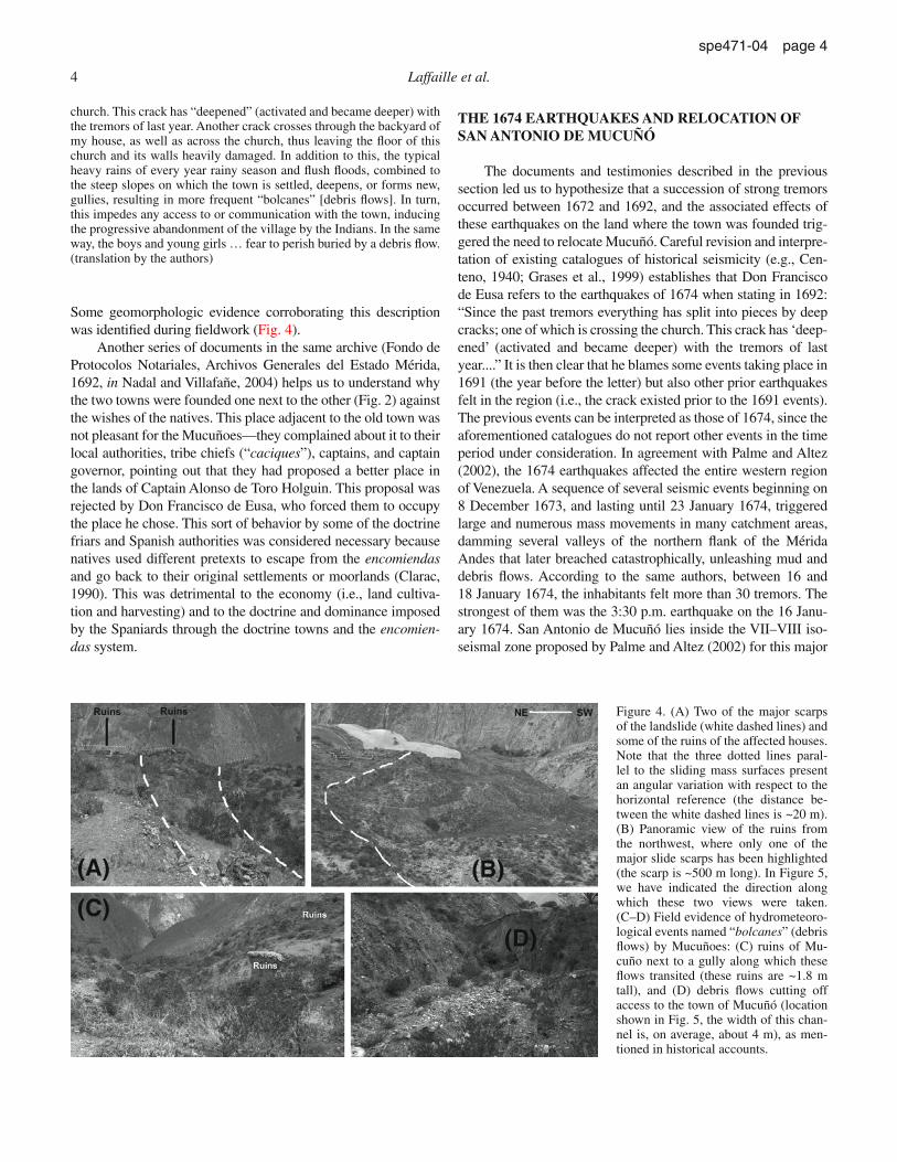
two decades. Documents up to 21 May 1692 testify in favor of demands for town relocation (Nadal and Villafañe, 2004). These documents are signed by tribe chiefs (“caciques”), notaries, fore-men, captains, and the Christian friars of the town, among oth-ers. In the 1692 documents, the urgent need of moving the town was proposed due to frequent earthquakes, rigorous winters, and the appearance and reactivation of large ground cracks and fis-sures affecting a significant part of the town. Figure 3 depicts the church of the first village. Its dimensions are nearly 50 m in length and close to 18 m in width (Fig. 3A). Large buttresses seem to have been added to reinforce the walls (Figs. 3A and 3C), possibly after the mentioned earthquakes. Figure 3B illustrates the height of the walls (which reach up to 5 m) and thickness (which is more than 1 m in some places).
In the Depository of Notary Protocols of the General Archives of the State of Mérida (Fondo de Protocolos Notari-ales, Archivos Generales del Estado Mérida, 1692, in Nadal and Villafañe, 2004, p. 3), there is a document in which the doctrine friar of San Antonio de Mucuñó, Don Francisco de Eusa, reports to the Lieutenant of Governor of the Merida Province with the following:
I certify that the mentioned town is very dangerous and with very clear risk, threatening to fall completely apart. Since the past tremors every-thing has split into pieces by deep cracks; one of which is crossing the
(A)
(B) (C)
Figure 3. (A) General view of the church of the first village, with a length of nearly 50 m and a width close to 18 m. Notice the large buttresses to strengthen walls (A and C). (B) Photo depicting the height of the walls (near 5 m high) and thickness (over 1 m in some places). (C) Close-up of the buttresses.
4 Laffaille et al.
spe471-04 page 4
church. This crack has “deepened” (activated and became deeper) with the tremors of last year. Another crack crosses through the backyard of my house, as well as across the church, thus leaving the floor of this church and its walls heavily damaged. In addition to this, the typical heavy rains of every year rainy season and flush floods, combined to the steep slopes on which the town is settled, deepens, or forms new, gullies, resulting in more frequent “bolcanes” [debris flows]. In turn, this impedes any access to or communication with the town, inducing the progressive abandonment of the village by the Indians. In the same way, the boys and young girls … fear to perish buried by a debris flow. (translation by the authors)
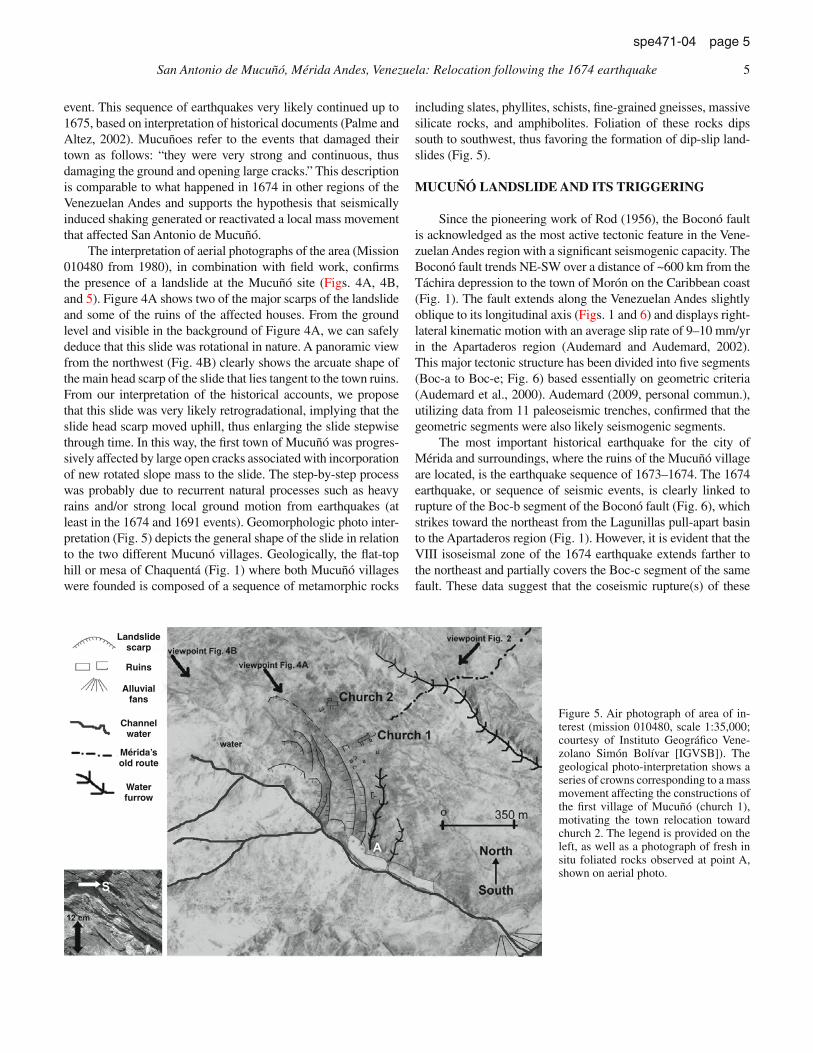
Some geomorphologic evidence corroborating this description was identified during fieldwork (Fig. 4).
Another series of documents in the same archive (Fondo de Protocolos Notariales, Archivos Generales del Estado Mérida, 1692, in Nadal and Villafañe, 2004) helps us to understand why the two towns were founded one next to the other (Fig. 2) against the wishes of the natives. This place adjacent to the old town was not pleasant for the Mucuñoes—they complained about it to their local authorities, tribe chiefs (“caciques”), captains, and captain governor, pointing out that they had proposed a better place in the lands of Captain Alonso de Toro Holguin. This proposal was rejected by Don Francisco de Eusa, who forced them to occupy the place he chose. This sort of behavior by some of the doctrine friars and Spanish authorities was considered necessary because natives used different pretexts to escape from the encomiendas and go back to their original settlements or moorlands (Clarac, 1990). This was detrimental to the economy (i.e., land cultiva-tion and harvesting) and to the doctrine and dominance imposed by the Spaniards through the doctrine towns and the encomien-das system.
THE 1674 EARTHQUAKES AND RELOCATION OF SAN ANTONIO DE MUCUÑÓ
The documents and testimonies described in the previous section led us to hypothesize that a succession of strong tremors occurred between 1672 and 1692, and the associated effects of these earthquakes on the land where the town was founded trig-gered the need to relocate Mucuñó. Careful revision and interpre-tation of existing catalogues of historical seismicity (e.g., Cen-teno, 1940; Grases et al., 1999) establishes that Don Francisco de Eusa refers to the earthquakes of 1674 when stating in 1692: “Since the past tremors everything has split into pieces by deep cracks; one of which is crossing the church. This crack has ‘deep-ened’ (activated and became deeper) with the tremors of last year....” It is then clear that he blames some events taking place in 1691 (the year before the letter) but also other prior earthquakes felt in the region (i.e., the crack existed prior to the 1691 events). The previous events can be interpreted as those of 1674, since the aforementioned catalogues do not report other events in the time period under consideration. In agreement with Palme and Altez (2002), the 1674 earthquakes affected the entire western region of Venezuela. A sequence of several seismic events beginning on 8 December 1673, and lasting until 23 January 1674, triggered large and numerous mass movements in many catchment areas, damming several valleys of the northern flank of the Mérida Andes that later breached catastrophically, unleashing mud and debris flows. According to the same authors, between 16 and 18 January 1674, the inhabitants felt more than 30 tremors. The strongest of them was the 3:30 p.m. earthquake on the 16 Janu-ary 1674. San Antonio de Mucuñó lies inside the VII–VIII iso-seismal zone proposed by Palme and Altez (2002) for this major
(A) (B)
(C)(D)
Figure 4. (A) Two of the major scarps of the landslide (white dashed lines) and some of the ruins of the affected houses. Note that the three dotted lines paral-lel to the sliding mass surfaces present an angular variation with respect to the horizontal reference (the distance be-tween the white dashed lines is ~20 m). (B) Panoramic view of the ruins from the northwest, where only one of the major slide scarps has been highlighted (the scarp is ~500 m long). In Figure 5, we have indicated the direction along which these two views were taken. (C–D) Field evidence of hydrometeoro-logical events named “bolcanes” (debris flows) by Mucuñoes: (C) ruins of Mu-cuño next to a gully along which these flows transited (these ruins are ~1.8 m tall), and (D) debris flows cutting off access to the town of Mucuñó (location shown in Fig. 5, the width of this chan-nel is, on average, about 4 m), as men-tioned in historical accounts.
San Antonio de Mucuñó, Mérida Andes, Venezuela: Relocation following the 1674 earthquake 5
spe471-04 page 5
event. This sequence of earthquakes very likely continued up to 1675, based on interpretation of historical documents (Palme and Altez, 2002). Mucuñoes refer to the events that damaged their town as follows: “they were very strong and continuous, thus damaging the ground and opening large cracks.” This description is comparable to what happened in 1674 in other regions of the Venezuelan Andes and supports the hypothesis that seismically induced shaking generated or reactivated a local mass movement that affected San Antonio de Mucuñó.
The interpretation of aerial photographs of the area (Mission 010480 from 1980), in combination with field work, confirms the presence of a landslide at the Mucuñó site (Figs. 4A, 4B, and 5). Figure 4A shows two of the major scarps of the landslide and some of the ruins of the affected houses. From the ground level and visible in the background of Figure 4A, we can safely deduce that this slide was rotational in nature. A panoramic view from the northwest (Fig. 4B) clearly shows the arcuate shape of the main head scarp of the slide that lies tangent to the town ruins. From our interpretation of the historical accounts, we propose that this slide was very likely retrogradational, implying that the slide head scarp moved uphill, thus enlarging the slide stepwise through time. In this way, the first town of Mucuñó was progres-sively affected by large open cracks associated with incorporation of new rotated slope mass to the slide. The step-by-step process was probably due to recurrent natural processes such as heavy rains and/or strong local ground motion from earthquakes (at least in the 1674 and 1691 events). Geomorphologic photo inter-pretation (Fig. 5) depicts the general shape of the slide in relation to the two different Mucunó villages. Geologically, the flat-top hill or mesa of Chaquentá (Fig. 1) where both Mucuñó villages were founded is composed of a sequence of metamorphic rocks
including slates, phyllites, schists, fine-grained gneisses, massive silicate rocks, and amphibolites. Foliation of these rocks dips south to southwest, thus favoring the formation of dip-slip land-slides (Fig. 5).
MUCUÑÓ LANDSLIDE AND ITS TRIGGERING
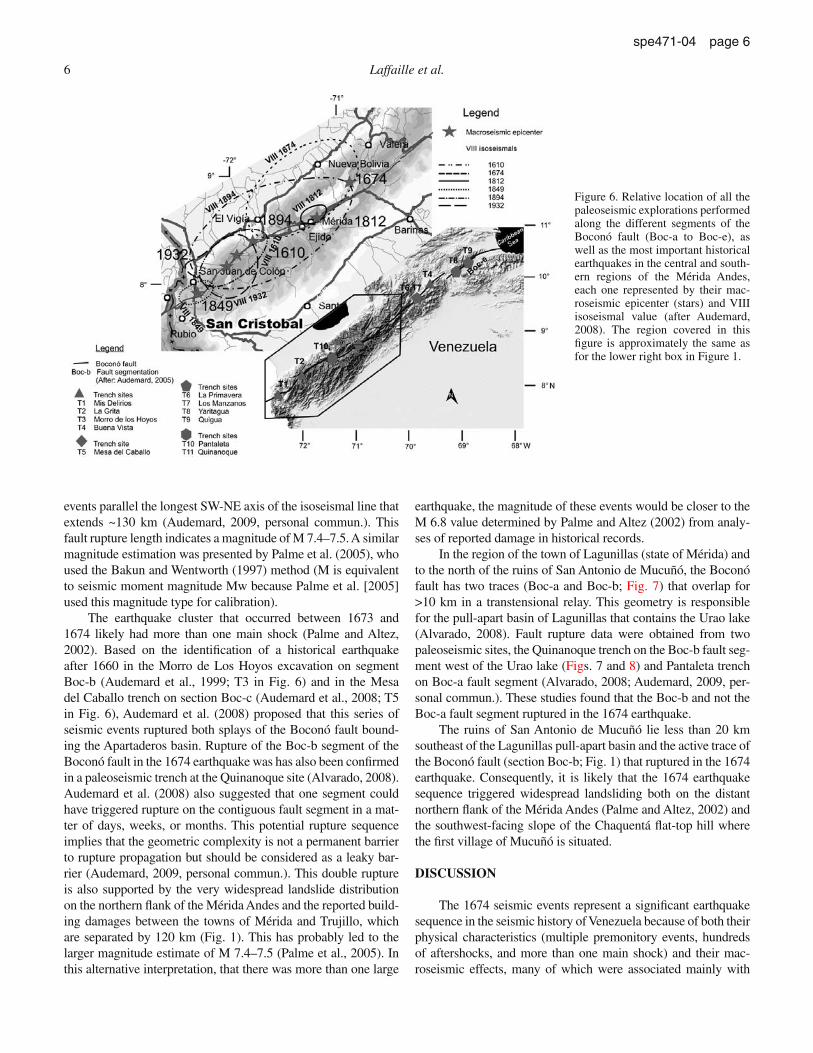
Since the pioneering work of Rod (1956), the Boconó fault is acknowledged as the most active tectonic feature in the Vene-zuelan Andes region with a significant seismogenic capacity. The Boconó fault trends NE-SW over a distance of ~600 km from the Táchira depression to the town of Morón on the Caribbean coast (Fig. 1). The fault extends along the Venezuelan Andes slightly oblique to its longitudinal axis (Figs. 1 and 6) and displays right-lateral kinematic motion with an average slip rate of 9–10 mm/yr in the Apartaderos region (Audemard and Audemard, 2002). This major tectonic structure has been divided into five segments (Boc-a to Boc-e; Fig. 6) based essentially on geometric criteria (Audemard et al., 2000). Audemard (2009, personal commun.), utilizing data from 11 paleoseismic trenches, confirmed that the geometric segments were also likely seismogenic segments.
The most important historical earthquake for the city of Mérida and surroundings, where the ruins of the Mucuñó village are located, is the earthquake sequence of 1673–1674. The 1674 earthquake, or sequence of seismic events, is clearly linked to rupture of the Boc-b segment of the Boconó fault (Fig. 6), which strikes toward the northeast from the Lagunillas pull-apart basin to the Apartaderos region (Fig. 1). However, it is evident that the VIII isoseismal zone of the 1674 earthquake extends farther to the northeast and partially covers the Boc-c segment of the same fault. These data suggest that the coseismic rupture(s) of these
Landslidescarp
Ruins
Alluvial fans
Channelwater
Mérida’sold route
Waterfurrow
Figure 5. Air photograph of area of in-terest (mission 010480, scale 1:35,000; courtesy of Instituto Geográfico Vene-zolano Simón Bolívar [IGVSB]). The geological photo-interpretation shows a series of crowns corresponding to a mass movement affecting the constructions of the first village of Mucuñó (church 1), motivating the town relocation toward church 2. The legend is provided on the left, as well as a photograph of fresh in situ foliated rocks observed at point A, shown on aerial photo.
6 Laffaille et al.
spe471-04 page 6
events parallel the longest SW-NE axis of the isoseismal line that extends ~130 km (Audemard, 2009, personal commun.). This fault rupture length indicates a magnitude of M 7.4–7.5. A similar magnitude estimation was presented by Palme et al. (2005), who used the Bakun and Wentworth (1997) method (M is equivalent to seismic moment magnitude Mw because Palme et al. [2005] used this magnitude type for calibration).
The earthquake cluster that occurred between 1673 and 1674 likely had more than one main shock (Palme and Altez, 2002). Based on the identification of a historical earthquake after 1660 in the Morro de Los Hoyos excavation on segment Boc-b (Audemard et al., 1999; T3 in Fig. 6) and in the Mesa del Caballo trench on section Boc-c (Audemard et al., 2008; T5 in Fig. 6), Audemard et al. (2008) proposed that this series of seismic events ruptured both splays of the Boconó fault bound-ing the Apartaderos basin. Rupture of the Boc-b segment of the Boconó fault in the 1674 earthquake was has also been confirmed in a paleoseismic trench at the Quinanoque site (Alvarado, 2008). Audemard et al. (2008) also suggested that one segment could have triggered rupture on the contiguous fault segment in a mat-ter of days, weeks, or months. This potential rupture sequence implies that the geometric complexity is not a permanent barrier to rupture propagation but should be considered as a leaky bar-rier (Audemard, 2009, personal commun.). This double rupture is also supported by the very widespread landslide distribution on the northern flank of the Mérida Andes and the reported build-ing damages between the towns of Mérida and Trujillo, which are separated by 120 km (Fig. 1). This has probably led to the larger magnitude estimate of M 7.4–7.5 (Palme et al., 2005). In this alternative interpretation, that there was more than one large
earthquake, the magnitude of these events would be closer to the M 6.8 value determined by Palme and Altez (2002) from analy-ses of reported damage in historical records.
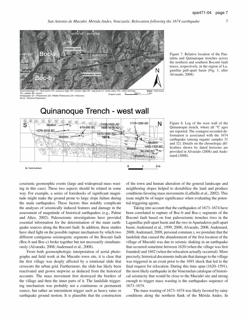
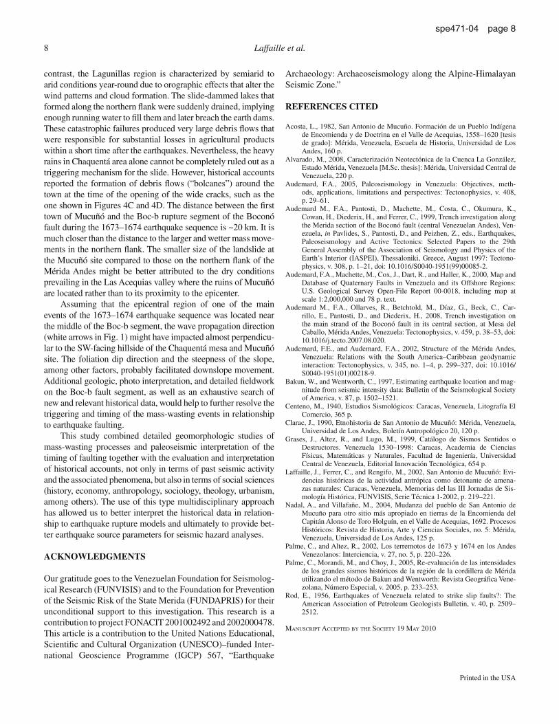
In the region of the town of Lagunillas (state of Mérida) and to the north of the ruins of San Antonio de Mucuñó, the Boconó fault has two traces (Boc-a and Boc-b; Fig. 7) that overlap for >10 km in a transtensional relay. This geometry is responsible for the pull-apart basin of Lagunillas that contains the Urao lake (Alvarado, 2008). Fault rupture data were obtained from two paleoseismic sites, the Quinanoque trench on the Boc-b fault seg-ment west of the Urao lake (Figs. 7 and 8) and Pantaleta trench on Boc-a fault segment (Alvarado, 2008; Audemard, 2009, per-sonal commun.). These studies found that the Boc-b and not the Boc-a fault segment ruptured in the 1674 earthquake.
The ruins of San Antonio de Mucuñó lie less than 20 km southeast of the Lagunillas pull-apart basin and the active trace of the Boconó fault (section Boc-b; Fig. 1) that ruptured in the 1674 earthquake. Consequently, it is likely that the 1674 earthquake sequence triggered widespread landsliding both on the distant northern flank of the Mérida Andes (Palme and Altez, 2002) and the southwest-facing slope of the Chaquentá flat-top hill where the first village of Mucuñó is situated.
DISCUSSION
The 1674 seismic events represent a significant earthquake sequence in the seismic history of Venezuela because of both their physical characteristics (multiple premonitory events, hundreds of aftershocks, and more than one main shock) and their mac-roseismic effects, many of which were associated mainly with
Figure 6. Relative location of all the paleoseismic explorations performed along the different segments of the Boconó fault (Boc-a to Boc-e), as well as the most important historical earthquakes in the central and south-ern regions of the Mérida Andes, each one represented by their mac-roseismic epicenter (stars) and VIII isoseismal value (after Audemard, 2008). The region covered in this figure is approximately the same as for the lower right box in Figure 1.
San Antonio de Mucuñó, Mérida Andes, Venezuela: Relocation following the 1674 earthquake 7
spe471-04 page 7
coseismic geomorphic events (large and widespread mass wast-ing in this case). These two aspects should be related in some way. For example, a series of foreshocks of significant magni-tude might make the ground prone to large slope failure during the main earthquakes. These factors thus notably complicate the analyses of seismically induced features and damage in the assessment of magnitude of historical earthquakes (e.g., Palme and Altez, 2002). Paleoseismic investigations have provided essential information for the determination of the main earth-quake sources along the Boconó fault. In addition, these studies have shed light on the possible rupture mechanism by which two different contiguous seismogenic segments of the Boconó fault (Boc-b and Boc-c) broke together but not necessarily simultane-ously (Alvarado, 2008; Audemard et al., 2008).
From both geomorphologic interpretation of aerial photo-graphs and field work at the Mucuño town site, it is clear that the first village was deeply affected by a rotational slide that crosscuts the urban grid. Furthermore, the slide has likely been reactivated and grown stepwise as deduced from the historical accounts. The mass movement first destroyed the borders of the village and then the inner parts of it. The landslide trigger-ing mechanism was probably not a continuous or permanent source, but rather an intermittent trigger such as heavy rains or earthquake ground motion. It is plausible that the construction
of the town and human alteration of the general landscape and neighboring slopes helped to destabilize the land and produce conditions favoring mass movements (Laffaille et al., 2002). This issue might be of major significance when evaluating the poten-tial triggering agents.
Taking into account that the earthquakes of 1673–1674 have been correlated to rupture of Boc-b and Boc-c segments of the Boconó fault based on four paleoseismic trenches (two in the Lagunillas pull-apart basin and the two in Apartaderos pull-apart basin; Audemard et al., 1999, 2008; Alvarado, 2008; Audemard, 2008; Audemard, 2009, personal commun.), we postulate that the landslide that caused the abandonment of the first location of the village of Mucuñó was due to seismic shaking in an earthquake that occurred sometime between 1620 (when the village was first founded) and 1692 (when the relocation actually occurred). More precisely, historical documents indicate that damage to the village was triggered in an event prior to the 1691 shock that led to the final request for relocation. During this time span (1620–1591), the most likely earthquake in the Venezuelan catalogue of histori-cal seismicity that would be close to the Mucuñó site and strong enough to trigger mass wasting is the earthquakes sequence of 1673–1674.
The mass wasting of 1673–1674 was likely favored by rainy conditions along the northern flank of the Mérida Andes. In
Figure 8. Log of the west wall of the Quinanoque trench, where all 14C ages are reported. The youngest recorded de-formation is associated with the 1674 earthquake (among organic samples 31 and 32). Details on the chronologic dif-ficulties shown by dated horizons are provided in Alvarado (2008) and Aude-mard (2008).
Geomorphologic: FT—fault trench; PR—pressure ridge, SR—shutter ridge; SP—sag pond; LV—lineal valley; OD—offset drainage, TH—saddle, BE—bench;Stratigraphy: Q1—Pleistocene; Q2—Middle Pleistocene; Q4—Holocene; N2-Q—Pilocene-Pleistocene
—fault scarp
Graphic scale 0 500 m 1 Km
Figure 7. Relative location of the Pan-taleta and Quinanoque trenches across the northern and southern Boconó fault traces, respectively, in the region of La-gunillas pull-apart basin (Fig. 1; after Alvarado, 2008).
8 Laffaille et al.
spe471-04 page 8
contrast, the Lagunillas region is characterized by semiarid to arid conditions year-round due to orographic effects that alter the wind patterns and cloud formation. The slide-dammed lakes that formed along the northern flank were suddenly drained, implying enough running water to fill them and later breach the earth dams. These catastrophic failures produced very large debris flows that were responsible for substantial losses in agricultural products within a short time after the earthquakes. Nevertheless, the heavy rains in Chaquentá area alone cannot be completely ruled out as a triggering mechanism for the slide. However, historical accounts reported the formation of debris flows (“bolcanes”) around the town at the time of the opening of the wide cracks, such as the one shown in Figures 4C and 4D. The distance between the first town of Mucuñó and the Boc-b rupture segment of the Boconó fault during the 1673–1674 earthquake sequence is ~20 km. It is much closer than the distance to the larger and wetter mass move-ments in the northern flank. The smaller size of the landslide at the Mucuñó site compared to those on the northern flank of the Mérida Andes might be better attributed to the dry conditions prevailing in the Las Acequias valley where the ruins of Mucuñó are located rather than to its proximity to the epicenter.
Assuming that the epicentral region of one of the main events of the 1673–1674 earthquake sequence was located near the middle of the Boc-b segment, the wave propagation direction (white arrows in Fig. 1) might have impacted almost perpendicu-lar to the SW-facing hillside of the Chaquentá mesa and Mucuñó site. The foliation dip direction and the steepness of the slope, among other factors, probably facilitated downslope movement. Additional geologic, photo interpretation, and detailed fieldwork on the Boc-b fault segment, as well as an exhaustive search of new and relevant historical data, would help to further resolve the triggering and timing of the mass-wasting events in relationship to earthquake faulting.
This study combined detailed geomorphologic studies of mass-wasting processes and paleoseismic interpretation of the timing of faulting together with the evaluation and interpretation of historical accounts, not only in terms of past seismic activity and the associated phenomena, but also in terms of social sciences (history, economy, anthropology, sociology, theology, urbanism, among others). The use of this type multidisciplinary approach has allowed us to better interpret the historical data in relation-ship to earthquake rupture models and ultimately to provide bet-ter earthquake source parameters for seismic hazard analyses.
ACKNOWLEDGMENTS
Our gratitude goes to the Venezuelan Foundation for Seismolog-ical Research (FUNVISIS) and to the Foundation for Prevention of the Seismic Risk of the State Merida (FUNDAPRIS) for their unconditional support to this investigation. This research is a contribution to project FONACIT 2001002492 and 2002000478. This article is a contribution to the United Nations Educational, Scientific and Cultural Organization (UNESCO)–funded Inter-national Geoscience Programme (IGCP) 567, “Earthquake
Archaeology: Archaeoseismology along the Alpine-Himalayan Seismic Zone.”
REFERENCES CITED
Acosta, L., 1982, San Antonio de Mucuño. Formación de un Pueblo Indígena de Encomienda y de Doctrina en el Valle de Acequias, 1558–1620 [tesis de grado]: Mérida, Venezuela, Escuela de Historia, Universidad de Los Andes, 160 p.
Alvarado, M., 2008, Caracterización Neotectónica de la Cuenca La González, Estado Mérida, Venezuela [M.Sc. thesis]: Mérida, Universidad Central de Venezuela, 220 p.
Audemard, F.A., 2005, Paleoseismology in Venezuela: Objectives, meth-ods, applications, limitations and perspectives: Tectonophysics, v. 408, p. 29–61.
Audemard M., F.A., Pantosti, D., Machette, M., Costa, C., Okumura, K., Cowan, H., Diederix, H., and Ferrer, C., 1999, Trench investigation along the Merida section of the Boconó fault (central Venezuelan Andes), Ven-ezuela, in Pavlides, S., Pantosti, D., and Peizhen, Z., eds., Earthquakes, Paleoseismology and Active Tectonics: Selected Papers to the 29th General Assembly of the Association of Seismology and Physics of the Earth’s Interior (IASPEI), Thessaloniki, Greece, August 1997: Tectono-physics, v. 308, p. 1–21, doi: 10.1016/S0040-1951(99)00085-2.
Audemard, F.A., Machette, M., Cox, J., Dart, R., and Haller, K., 2000, Map and Database of Quaternary Faults in Venezuela and its Offshore Regions: U.S. Geological Survey Open-File Report 00-0018, including map at scale 1:2,000,000 and 78 p. text.
Audemard M., F.A., Ollarves, R., Betchtold, M., Díaz, G., Beck, C., Car-rillo, E., Pantosti, D., and Diederix, H., 2008, Trench investigation on the main strand of the Boconó fault in its central section, at Mesa del Caballo, Mérida Andes, Venezuela: Tectonophysics, v. 459, p. 38–53, doi: 10.1016/j.tecto.2007.08.020.
Audemard, F.E., and Audemard, F.A., 2002, Structure of the Mérida Andes, Venezuela: Relations with the South America–Caribbean geodynamic interaction: Tectonophysics, v. 345, no. 1–4, p. 299–327, doi: 10.1016/S0040-1951(01)00218-9.
Bakun, W., and Wentworth, C., 1997, Estimating earthquake location and mag-nitude from seismic intensity data: Bulletin of the Seismological Society of America, v. 87, p. 1502–1521.
Centeno, M., 1940, Estudios Sismológicos: Caracas, Venezuela, Litografía El Comercio, 365 p.
Clarac, J., 1990, Etnohistoria de San Antonio de Mucuñó: Mérida, Venezuela, Universidad de Los Andes, Boletín Antropológico 20, 120 p.
Grases, J., Altez, R., and Lugo, M., 1999, Catálogo de Sismos Sentidos o Destructores. Venezuela 1530–1998: Caracas, Academia de Ciencias Físicas, Matemáticas y Naturales, Facultad de Ingeniería, Universidad Central de Venezuela, Editorial Innovación Tecnológica, 654 p.
Laffaille, J., Ferrer, C., and Rengifo, M., 2002, San Antonio de Mucuñó: Evi-dencias históricas de la actividad antrópica como detonante de amena-zas naturales: Caracas, Venezuela, Memorias del las III Jornadas de Sis-mología Histórica, FUNVISIS, Serie Técnica 1-2002, p. 219–221.
Nadal, A., and Villafañe, M., 2004, Mudanza del pueblo de San Antonio de Mucuño para otro sitio más apropiado en tierras de la Encomienda del Capitán Alonso de Toro Holguín, en el Valle de Acequias, 1692. Procesos Históricos: Revista de Historia, Arte y Ciencias Sociales, no. 5: Mérida, Venezuela, Universidad de Los Andes, 125 p.
Palme, C., and Altez, R., 2002, Los terremotos de 1673 y 1674 en los Andes Venezolanos: Interciencia, v. 27, no. 5, p. 220–226.
Palme, C., Morandi, M., and Choy, J., 2005, Re-evaluación de las intensidades de los grandes sismos históricos de la región de la cordillera de Mérida utilizando el método de Bakun and Wentworth: Revista Geográfica Vene-zolana, Número Especial, v. 2005, p. 233–253.
Rod, E., 1956, Earthquakes of Venezuela related to strike slip faults?: The American Association of Petroleum Geologists Bulletin, v. 40, p. 2509–2512.
Manuscript accepted by the society 19 May 2010
Printed in the USA
Copyright © 2022 FDOKUMEN