Carbonate mound development in contrasting settings on the Irish margin
Upload
independentCategory
view
1download
0
Development of small carbonate banks on the south Floridaplatform margin: response to sea level and climate change
David Mallinson a;�, Albert Hine b, Pamela Hallock b, Stanley Locker b,Eugene Shinn c, David Naar b, Brian Donahue b, Douglas Weaver d
a Department of Geology, East Carolina University, Greenville, NC 27858, USAb College of Marine Science, University of South Florida, 140 7th Avenue S., St. Petersburg, FL 33701, USA
c United States Geological Survey, Center for Coastal Geology, 600 4th Street S., St. Petersburg, FL 33701, USAd Department of Fisheries and Aquatic Sciences, University of Florida, 7922 NW 71st Street, Gainesville, FL 32653, USA
Received 10 June 2002; accepted 1 May 2003
Abstract
Geophysical and coring data from the Dry Tortugas, Tortugas Bank, and Riley’s Hump on the southwestFlorida margin reveal the stratigraphic framework and growth history of these carbonate banks. The Holocene reefsof the Dry Tortugas and Tortugas Bank are approximately 14 and 10 m thick, respectively, and are situated uponPleistocene reefal edifices. Tortugas Bank consists of the oldest Holocene corals in the Florida Keys with earliest coralrecruitment occurring atV9.6 cal ka. Growth curves for the Tortugas Bank reveal slow growth (6 1 mm/yr) until 6.2cal ka, then a rapid increase to 3.4 mm/yr, until shallow reef demise at V4.2 cal ka. Coral reef development at theDry Tortugas began at V6.4 cal ka. Aggradation at the Dry Tortugas was linear, and rapid (V3.7 mm/yr) and keptpace with sea-level change. The increase in aggradation rate of Tortugas Bank at 6.2 cal ka is attributed to the growthof the Dry Tortugas reefs, which formed a barrier to inimical shelf water. Termination of shallow (6 15 m below sealevel) reef growth at Tortugas Bank at V4.2 cal ka is attributed to paleoclimate change in the North Americaninterior that increased precipitation and fluvial discharge. Reef growth rates and characteristics are related to the rateof sea-level rise relative to the position of the reef on the shelf margin, and are additionally modified by hydrographicconditions related to climate change.< 2003 Elsevier Science B.V. All rights reserved.
Keywords: carbonate bank; reefs; Dry Tortugas; Florida Keys; multibeam bathymetry; coral reef growth; Holocene climate
1. Introduction
A complex framework of modern and relict car-bonate geomorphic features dominates the southFlorida margin (Fig. 1). The Holocene reef tract in
the Florida Keys is represented by a thin (6 6 m)veneer of active (‘keep-up’) reef that was initiallyrecruited upon Pleistocene reef rock (Enos andPerkins, 1977). The islands comprising the upperFlorida Keys (Fig. 1B) are constructed of MarineIsotope Stage (MIS) 5 reef deposits (V110^125ka; Shinn et al., 1989). Recently, outlier reefswere identi¢ed seaward of the main reef tract,which grew during MIS 5a, at approximately 80
0025-3227 / 03 / $ ^ see front matter < 2003 Elsevier Science B.V. All rights reserved.doi:10.1016/S0025-3227(03)00141-5
* Corresponding author. Fax: 252-328-4391.E-mail address: [email protected] (D. Mallinson).
MARGO 3333 7-7-03 Cyaan Magenta Geel Zwart
Marine Geology 199 (2003) 45^63
R
Available online at www.sciencedirect.com
www.elsevier.com/locate/margeo
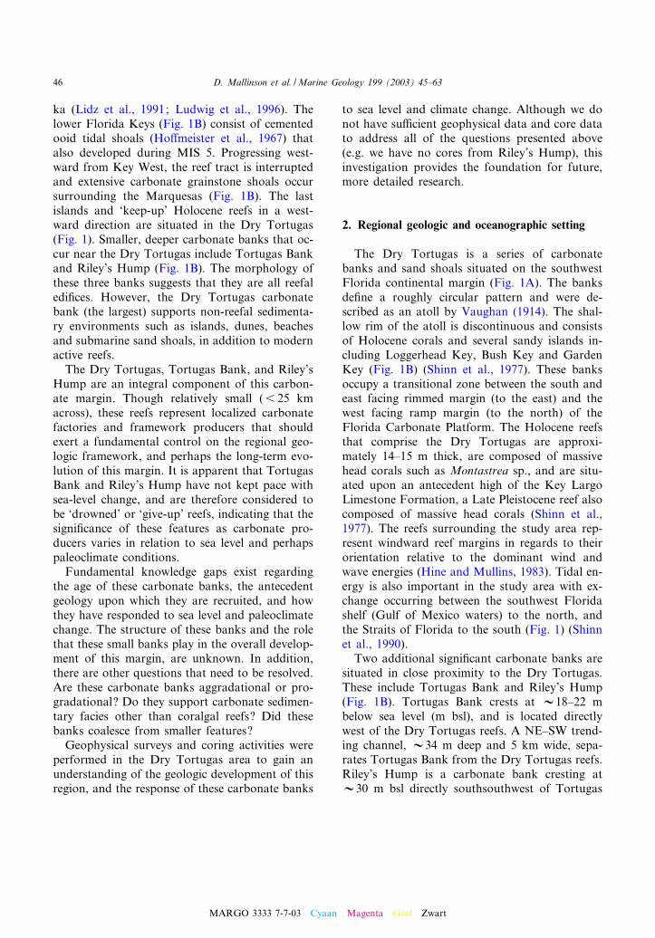
ka (Lidz et al., 1991; Ludwig et al., 1996). Thelower Florida Keys (Fig. 1B) consist of cementedooid tidal shoals (Ho¡meister et al., 1967) thatalso developed during MIS 5. Progressing west-ward from Key West, the reef tract is interruptedand extensive carbonate grainstone shoals occursurrounding the Marquesas (Fig. 1B). The lastislands and ‘keep-up’ Holocene reefs in a west-ward direction are situated in the Dry Tortugas(Fig. 1). Smaller, deeper carbonate banks that oc-cur near the Dry Tortugas include Tortugas Bankand Riley’s Hump (Fig. 1B). The morphology ofthese three banks suggests that they are all reefaledi¢ces. However, the Dry Tortugas carbonatebank (the largest) supports non-reefal sedimenta-ry environments such as islands, dunes, beachesand submarine sand shoals, in addition to modernactive reefs.The Dry Tortugas, Tortugas Bank, and Riley’s
Hump are an integral component of this carbon-ate margin. Though relatively small (6 25 kmacross), these reefs represent localized carbonatefactories and framework producers that shouldexert a fundamental control on the regional geo-logic framework, and perhaps the long-term evo-lution of this margin. It is apparent that TortugasBank and Riley’s Hump have not kept pace withsea-level change, and are therefore considered tobe ‘drowned’ or ‘give-up’ reefs, indicating that thesigni¢cance of these features as carbonate pro-ducers varies in relation to sea level and perhapspaleoclimate conditions.Fundamental knowledge gaps exist regarding
the age of these carbonate banks, the antecedentgeology upon which they are recruited, and howthey have responded to sea level and paleoclimatechange. The structure of these banks and the rolethat these small banks play in the overall develop-ment of this margin, are unknown. In addition,there are other questions that need to be resolved.Are these carbonate banks aggradational or pro-gradational? Do they support carbonate sedimen-tary facies other than coralgal reefs? Did thesebanks coalesce from smaller features?Geophysical surveys and coring activities were
performed in the Dry Tortugas area to gain anunderstanding of the geologic development of thisregion, and the response of these carbonate banks
to sea level and climate change. Although we donot have su⁄cient geophysical data and core datato address all of the questions presented above(e.g. we have no cores from Riley’s Hump), thisinvestigation provides the foundation for future,more detailed research.
2. Regional geologic and oceanographic setting
The Dry Tortugas is a series of carbonatebanks and sand shoals situated on the southwestFlorida continental margin (Fig. 1A). The banksde¢ne a roughly circular pattern and were de-scribed as an atoll by Vaughan (1914). The shal-low rim of the atoll is discontinuous and consistsof Holocene corals and several sandy islands in-cluding Loggerhead Key, Bush Key and GardenKey (Fig. 1B) (Shinn et al., 1977). These banksoccupy a transitional zone between the south andeast facing rimmed margin (to the east) and thewest facing ramp margin (to the north) of theFlorida Carbonate Platform. The Holocene reefsthat comprise the Dry Tortugas are approxi-mately 14^15 m thick, are composed of massivehead corals such as Montastrea sp., and are situ-ated upon an antecedent high of the Key LargoLimestone Formation, a Late Pleistocene reef alsocomposed of massive head corals (Shinn et al.,1977). The reefs surrounding the study area rep-resent windward reef margins in regards to theirorientation relative to the dominant wind andwave energies (Hine and Mullins, 1983). Tidal en-ergy is also important in the study area with ex-change occurring between the southwest Floridashelf (Gulf of Mexico waters) to the north, andthe Straits of Florida to the south (Fig. 1) (Shinnet al., 1990).Two additional signi¢cant carbonate banks are
situated in close proximity to the Dry Tortugas.These include Tortugas Bank and Riley’s Hump(Fig. 1B). Tortugas Bank crests at V18^22 mbelow sea level (m bsl), and is located directlywest of the Dry Tortugas reefs. A NE^SW trend-ing channel, V34 m deep and 5 km wide, sepa-rates Tortugas Bank from the Dry Tortugas reefs.Riley’s Hump is a carbonate bank cresting atV30 m bsl directly southsouthwest of Tortugas
MARGO 3333 7-7-03 Cyaan Magenta Geel Zwart
D. Mallinson et al. /Marine Geology 199 (2003) 45^6346

Fig. 1. (A) Maps showing the location of the Gulf of Mexico and Florida Keys, and illustrating the general Pleistocene frame-work. (B) Maps showing the location of the Dry Tortugas and associated Florida Keys, Tortugas Bank, and Riley’s Hump onthe southwest Florida margin. Locations of seismic pro¢les and side-scan sonar data presented in this manuscript are alsoshown.
MARGO 3333 7-7-03 Cyaan Magenta Geel Zwart
D. Mallinson et al. /Marine Geology 199 (2003) 45^63 47

Bank (Fig. 1B). The southern face of the bankexhibits a 20-m escarpment situated at the shelf/slope break. Thick sedimentary deposits ¢ll atrough separating Riley’s Hump from TortugasBank to the north.Water mass characteristics in the vicinity of the
Dry Tortugas are controlled by interactions of theLoop Current and west Florida shelf water (Fig.1A). The Yucatan Current emerges from the Yu-catan Channel and enters the eastern Gulf ofMexico as a narrow boundary current constrainedby the Campeche Bank (Fig. 1A) (Fratantoni,2001). The current then turns northwest and as-sumes a clockwise circulation, becoming the LoopCurrent, to £ow southward along the steep es-carpment of the west Florida shelf before enteringthe southern Straits of Florida near the Dry Tor-tugas, and becoming the Florida Current (Maul,
1977; Vukovich, 1988; Molinari and Morrison,1988). The Florida Current ultimately becomesthe Gulf Stream in the North Atlantic.The Gulf of Mexico is unique in that it is a
tropical to subtropical basin with direct links totemperate, high latitude climate conditions via £u-vial conduits. This position places carbonate en-vironments on the west and south Florida shelfdirectly in the path of e¥uent from the Mississip-pi River, via entrainment in the Loop Current(Gilbert et al., 1996). It is likely that the e¡ectsof Mississippi River discharge, consisting of highnutrient, low salinity waters, are largely to blamefor the lack of actively aggrading reefs on thiscarbonate ramp (Hallock, 1988). The e¡ects of£uvial discharge are diminished southward suchthat extensive coralgal reefs are encountered onthe south margin.
Fig. 2. Uniboom seismic pro¢le with interpretation, of a portion of the Dry Tortugas carbonate bank in Northwest Channel (seeFig. 1B for the location).
MARGO 3333 7-7-03 Cyaan Magenta Geel Zwart
D. Mallinson et al. /Marine Geology 199 (2003) 45^6348

Seasonal variability in sea surface temperatureand salinity (SST and SSS, respectively) at theDry Tortugas has been monitored since 1991 byan enhanced National Data Buoy Center C-MANinstrument package. SST at the Dry Tortugasvaries from a low of V22‡C in winter to a highof V30‡C in summer. Seasonal variability of SSSin the Dry Tortugas is large, with maximum val-ues reaching 36^37 psu and minimum valuesreaching 32^33 psu. This large range in surfacesalinity results from signi¢cant dilution by Missis-sippi River discharge into the northeastern Gulfof Mexico (Ortner et al., 1995; Gilbert et al.,1996).
3. Methods
Side-scan sonar data (100 kHz) were acquiredalong seismic pro¢le lines using an EGpG Model272 TD side-scan sonar tow¢sh and DelphSonaracquisition system. High-resolution single-channelseismic data were acquired using a Huntec uni-boom sled, ITI 10-channel streamer, and Delph-Seismic acquisition system (Figs. 2^6). Multibeam
bathymetry data (300 kHz) were acquired using aKongsberg Simrad EM 3000 multibeam sonarmounted on a pole on the port side of the R/VSuncoaster at V9 knots aided by a TSS (nowApplanix) POS/MV 320 attitude and positioningsystem that provided submeter accuracy in posi-tions. A SeaBird (SBE-19) CTD was cast in thedeep area of the survey to obtain sound velocityin the water column, but slight variations of thesound velocity structure appear to exist in theshallower waters causing slight track-parallel arti-facts that run NW^SE (Fig. 7). Data were post-processed using the Kongsberg Simrad Neptunesoftware to £ag out bad pings using an automatedstandard deviation method with a grid cell size of4 m. Sea-level height was predicted using a globaltidal and hindcast wind program (He and Weis-berg, 2002), which uses mean sea level as the chartdatum. The post-processed bathymetry data werethen gridded at a 5-m cell size in a visual displayprogram called Fledermaus (IVS) which was usedto generate plan (Fig. 7A) and perspective (Fig.7B) views and to generate ESRI ARC ¢les thatare being used by biologists for ¢sh habitat stud-ies.
Fig. 3. Uniboom seismic pro¢le and side-scan sonar data with interpretation, from the Dry Tortugas carbonate bank in South-west Channel (see Fig. 1B for the location). Dark shades on the side-scan data represent low acoustic backscatter correspondingto muddy sands. Lighter shades represent high acoustic backscatter and correspond to live-bottom communities, sand, exposedrock, or seagrass beds.
MARGO 3333 7-7-03 Cyaan Magenta Geel Zwart
D. Mallinson et al. /Marine Geology 199 (2003) 45^63 49

Coring sites were chosen to target re£ectorsbased on seismic data (Fig. 4). Five sites werecored on Southeast Reef in the Dry Tortugas in1976 (Shinn et al., 1977). Three sites (TB1A,TB1B, and TB2) were cored on Tortugas Bankusing a diver-deployed rotary rock drill providedby the USGS-Center for Coastal Geology, withsupport by the National Undersea Research Cen-ter, Wilmington. Underwater drilling of this typeis based on the principle of the hydraulic under-water coring device pioneered by Ian MacIntyreand is described in Shinn et al. (1977), and Miller
(1979). The drill uses an 18-hp Briggs and Strat-ton engine as a power source to run an Eatonhydraulic drill head. Sites TB1A and TB1B weredrilled at 24 m water depth. Site TB2 was drilledat 19 m water depth.Cores were logged and sampled at the College
of Marine Science, University of South Florida,and the Center for Coastal Studies, United StatesGeological Survey, St. Petersburg, FL. X-ray dif-fraction analyses to determine mineralogy wereperformed on bulk powder samples using a Scin-tag XDS-2000. These data were used to assess the
Fig. 4. Uniboom seismic pro¢le of Tortugas Bank with interpretation and location of drill sites TB1 and TB2 (see Fig. 1B for lo-cations). Also presented are selected 100-kHz side-scan sonar data (A, B, and C). Side-scan sonar data locations are indicated onthe seismic pro¢le as gray boxes. Dark shades on the side-scan data represent low acoustic backscatter corresponding to muddysands. Lighter shades represent high acoustic backscatter and correspond to live-bottom communities, sand, or exposed rock.
MARGO 3333 7-7-03 Cyaan Magenta Geel Zwart
D. Mallinson et al. /Marine Geology 199 (2003) 45^6350

degree of recrystallization of the samples. Ura-nium-series analyses (K-spectrometer) were per-formed on unaltered coral samples by Dr. Law-rence Edwards at the University of Minnesota.AMS 14C analyses were performed on unalteredcoral samples and one organic sample by the Na-tional Ocean Sciences AMS facility at WoodsHole, MS, and by Beta Analytic Laboratories.Conventional radiocarbon dates were acquiredon samples from the Dry Tortugas (Shinn et al.,1977) at the University of Miami 14C laboratory.Radiocarbon dates were corrected for reservoire¡ect and calibrated using the CALIB rev.4.3software (copyright Stuiver and Reimer, 2000)and the INTCAL98 calibration curve of Stuiveret al. (1998).
4. Results
4.1. Geophysical framework
Seismic data reveal the stratigraphic framework
and acoustic facies of the Dry Tortugas, TortugasBank and Riley’s Hump (Figs. 2^6). The DryTortugas exhibits a zone of high signal attenua-tion characteristic of reef framework facies (Figs.2 and 3). This reef facies occurs at a water depthof 15 m in the channels between the Holocenereefs (Northwest Channel, Southwest Channel ;Fig. 1). The seaward side of the reef facies ischaracterized by seismic sequences bounded byhigh amplitude, continuous horizontal re£ectors(re£ectors K and L ; Figs. 2 and 3). These sequen-ces consist of multiple low-amplitude, discontinu-ous to continuous, subhorizontal, parallel re£ec-tors that onlap the reef facies (Fig. 2). In theNorthwest Channel (Fig. 2), a terrace is presentin the subsurface associated with the reef facies, ata depth of V32 m bsl. The back-reef facies arecharacterized by seismic sequences similar tothose found on the seaward side, but containsteeply inclined clinoforms that downlap ontothe underlying sequence boundary (L), and pro-grade away from the reef facies.Tortugas Bank has a 30-m escarpment on the
Fig. 5. Uniboom seismic pro¢le of Tortugas Bank with interpretation (see Fig. 1B for the location).
MARGO 3333 7-7-03 Cyaan Magenta Geel Zwart
D. Mallinson et al. /Marine Geology 199 (2003) 45^63 51

west side and a 15-m face on the east side (Figs. 4and 5). Sediment aprons drape the £anks of thebank and small patch reefs occur on top of thebank. Seismic data reveal the presence of someinternal structure within Tortugas Bank. A highamplitude re£ector (L) is intermittently observedand occurs at a depth of approximately 10 mbelow the top of the bank (V30 m bsl) and inadjacent sedimentary deposits, and a subtle re£ec-tor occurs in the shallow subsurface (V1 m) nearthe edge of the bank where TB1A and TB1B weredrilled. Re£ector L slopes seaward and may cor-relate with a terrace, buried under drape sedi-ments, on the seaward face of the carbonatebank (Fig. 4).Seismic data from Riley’s Hump appear more
chaotic, and exhibit higher attenuation than datafrom Tortugas Bank or the Dry Tortugas (Fig. 6).No internal structure is evident within the bank.The bank top is relatively £at; however, there isvariable relief of up to 5 m associated withNNW^SSE trending linear bathymetric features(Fig. 7). There is a V20-m escarpment (from 30to 50+ m bsl) on the south £ank, where reefallimestone appears to be exposed (Fig. 6). A sedi-ment apron, with seaward dipping internal re£ec-tors, extends southward from V50 to V60 m bsl.
Sedimentary deposits exhibiting poorly resolved,chaotic stratigraphy occur to the north of Riley’sHump in the trough adjacent to Tortugas Bank(Fig. 6). Multibeam bathymetry data also revealNE^SW trending bedforms in both the NE andSE corners of Fig. 7A. The bedforms in the SEcorner have large amplitudes and range in depthfrom 40 to 55 m.Side-scan sonar data reveal distinctive acoustic
backscatter facies that have been interpreted forthe Dry Tortugas and Tortugas Bank (Figs. 3 and4). Some of these acoustic facies have also beenground-truthed by diver observations. The DryTortugas back-reef environment is characterizedby low backscatter areas with intermittent highbackscatter patches (Fig. 3). The seabed in chan-nels (i.e. the Northwest and Southwest Channel)(Fig. 1B) is characterized by high backscatter(Fig. 3). In general, the eastern margin of Tor-tugas Bank is characterized by high uniformbackscatter (Fig. 4C); the western margin of Tor-tugas Bank is characterized by high backscatterwith a dimpled pattern (Fig. 4A); and the major-ity of Tortugas Bank is characterized by com-plex, high contrast backscatter patterns withnumerous spherical returns and lineations (Fig.4B).
Fig. 6. Uniboom seismic pro¢le of Riley’s Hump (see Fig. 1B for the location).
MARGO 3333 7-7-03 Cyaan Magenta Geel Zwart
D. Mallinson et al. /Marine Geology 199 (2003) 45^6352

Fig. 7. (A) Plan view of high-resolution 300-kHz multibeam bathymetry over Riley’s Hump with shading resulting from an arti¢-cial light source from the southeast. (B) 3-D perspective view of the same data looking towards N55E with 10U vertical exagger-ation.
MARGO 3333 7-7-03 Cyaan Magenta Geel Zwart
D. Mallinson et al. /Marine Geology 199 (2003) 45^63 53

4.2. Cores
Cores from Tortugas Bank were acquired at5-foot intervals to subsurface depths of 1.52,7.62 and 10.67 m. These subsurface depths corre-
spond to absolute depths of 25.3, 31.4 and 29.9 mbsl, respectively. Cores from these sites yieldedcoral reef framework sediments (various generaand species of coral ; Fig. 8), coralline algae, andcarbonate intraclasts and cements. A paleosol ho-
Fig. 8. Generalized logs of the Tortugas Bank cores, TB1A, TB1B, and TB2, with selected photographs and ages.
MARGO 3333 7-7-03 Cyaan Magenta Geel Zwart
D. Mallinson et al. /Marine Geology 199 (2003) 45^6354

rizon was penetrated at 26^31 m bsl and corre-sponds to the position of the prominent re£ectorin seismic data. Several voids were encounteredand were noted based on the rapid advance ofthe drill and zero recovery in at least one core.Cores acquired at Southeast Reef (Fig. 1B) aresimilar in composition to the Tortugas Bankcores. These cores are described in Shinn et al.(1977) and a pro¢le of the coring transect is illus-trated in Fig. 9.
4.3. Ages
Age data are presented in Table 1 and Figs. 7^9. All ages are presented as calibrated years Be-fore Present (yr BP), or calibrated thousands ofyears Before Present (cal ka). The earliest age thatwas acquired from the core material is a radio-carbon date of peat associated with the paleosol.This organic material provides an age of approx-imately 10.7 cal ka (Fig. 8). 230Th and radiocar-bon dates of the corals indicate initial coral re-cruitment occurred on the Pleistocene paleosolat V9.6 cal ka. Minimum coral ages are 265 (un-calibrated) yr BP (at the 324-m site) and V4.2
cal ka (at the 319-m site). The maximum averagegrowth rate for this relict reef is 3.6 mm/yr. Reefaggradation rates were quite low at both sites be-tween 9.6 and 6.2 cal ka (0.6^1.2 mm/yr), butincreased three-fold between 6.2 and 4.2 cal ka.It is interesting to note that the seabed at theshallow site is a hiatal surface representing some4200 years, whereas the deeper site continued ag-grading until recently. There may be a disconti-nuity in the deep site record between approxi-mately 430 and 2096 yr BP. A discontinuity isalso indicated in the seismic data (Fig. 4).Five radiocarbon dates were acquired from cor-
als in cores from Southeast Reef in the Dry Tor-tugas (Shinn et al., 1977) (Fig. 9). Dates presentedin Shinn et al. (1977) are conventional radiocar-bon dates without any corrections. Newly cali-brated dates are presented as DT samples in Ta-ble 1 and Fig. 8. The oldest age is from thePleistocene substrate and is not considered reli-able. The ¢rst Holocene corals in these coresdate at 6.4 cal ka. Although the tops of thesecores were not dated, we assume that they wouldyield modern ages as they were taken in an activereef environment.
Fig. 9. Cross-section of Southeast Reef in the Dry Tortugas with calibrated radiocarbon ages (modi¢ed from Shinn et al., 1977).See Fig. 1B for the location of the transect.
MARGO 3333 7-7-03 Cyaan Magenta Geel Zwart
D. Mallinson et al. /Marine Geology 199 (2003) 45^63 55

5. Discussion
5.1. Sur¢cial geology
The Dry Tortugas back-reef environment ischaracterized by muddy sands with intermittentseagrass beds (Fig. 3). The seabed in channels(i.e. Northwest and Southwest Channel ; Fig. 1)is characterized by exposed Pleistocene limestonehardbottom, with scattered Holocene patch reefs(Fig. 3).Side-scan sonar data and diver observations in-
dicate that the western margin of Tortugas Bank(Fig. 4A) is dominated by an extensive cover ofhead corals (Montastrea spp., Siderastrea spp.,Diploria spp.) with infrequent sand patches rang-ing in size from 5 to 10 m in diameter. Headcorals rise approximately 1^2 m above the sandpatch areas. Site TB1 was drilled in one of thesepatches. Coralgal patch reefs with up to 5 m ofrelief occur primarily in the central regions of thebank (Fig. 4B). The eastern margin (Fig. 4C) ischaracterized by a coarse carbonate sand sheetwith widely scattered soft corals and sponges.
Multibeam bathymetry data and ROV data(Jarrett, 2003) reveal Riley’s Hump to be arimmed bank with a shallow depression in thecenter, which contains NNW^SSE trending bio-hermal structures (Fig. 7). These structures arealigned approximately perpendicular to the £owof the Florida Current that sweeps the outer shelfin this area. Deep (40^55 m bsl) bedforms to theeast and south of Riley’s Hump also indicate acurrent-swept environment, and are oriented ap-proximately parallel or oblique to the prevailingcurrent.These data reveal a gradation of environments,
from sandy back-reef type facies on the east sideof Tortugas Bank and within the Dry Tortugascentral basin, to scattered, high-relief patch reefsat the crest of Tortugas Bank, to proli¢c headcorals on the west margin of Tortugas Bank.
5.2. Stratigraphic framework
5.2.1. Depositional sequencesSeismic re£ectors that bound sequences sur-
rounding the carbonate banks appear to be un-
Table 1Age data from corals and organic matter in the Tortugas Bank (TB) and Dry Tortugas (DT) cores
Core m bsf m bsl Method Laboratory/Number 14C age cal yr BPa 2c range
TB1A 0.10 24.2 Conv. Beta Analytic/134665 590U 80 265 420^0TB1B 0.20 24.3 Th/U U. Minn. 430 U 5TB1B 0.62 24.7 AMS NOSAMS/OS26083 2450U 30 2096 2152^1999TB1B 3.05 27.2 AMS NOSAMS/OS26084 4790U 35 5035 5222^4940TB1B 4.64 28.7 AMS NOSAMS/OS26085 5640U 35 5996 6158^5927TB1B 5.30 29.4 AMS NOSAMS/OS26086 6530U 35 7015 7151^6935TB1B 7.05 31.2 Th/U U. Minn. 9631 U 30TB1Bb 7.60 31.7 AMS Beta Analytic/134405 9430U 60 10670 11045^10970
10760^10515TB2 0.10 18.7 Th/U U. Minn. 4158 U 21TB2 0.10 18.7 Th/U U. Minn. 4169 U 18TB2 1.82 20.4 AMS NOSAMS/OS26142 4780U 35 5028 5207^4907TB2 4.69 23.3 AMS NOSAMS/OS26400 5580U 45 5937 6099^5881TB2 5.29 23.9 AMS NOSAMS/OS26401 5730U 60 6163 6272^5979TB2 6.15 24.8 AMS NOSAMS/OS26402 6830U 80 7356 7480^7207TB2 7.85 26.4 Th/U U. Minn. 8299 U 28DT2 5.3 5.3 Conv. U. of Miami 14C lab 6017U 90 6418 6639^6263DT2 9.8 9.8 Conv. U. of Miami 14C lab 5883U 224 6285 6779^5837DT2 13.4 13.4 Conv. U. of Miami 14C lab 4762U 85 4990 5281^4814DT2 14.3 14.3 Conv. U. of Miami 14C lab 3593U 88 3466 3687^3305
a Radiocarbon ages were calibrated using CALIB rev.4.3 software (copyright Stuiver and Reimer, 2000; and Stuiver et al.,1998). All samples (except TB1B-7.60) include a 400-yr reservoir correction.
b Organic matter.
MARGO 3333 7-7-03 Cyaan Magenta Geel Zwart
D. Mallinson et al. /Marine Geology 199 (2003) 45^6356

conformable surfaces and probably represent ero-sion and cementation during sea-level lowstandscorresponding to glacial periods. These sequencesmay be equivalent to the Pleistocene Q sequencesde¢ned by Enos and Perkins (1977). Ground-truth data for the upper sequence (Mallinson etal., 1997) indicate that sequences consist of car-bonate sandy muds and muddy sands. In the re-gion to the southeast of the Dry Tortugas, thesediments are, on average, approximately 97%carbonate, with quartz, biogenic silica, and organ-ic matter comprising the remainder. Sediments aredominated by aragonite and high-Mg calcite(HMC), with lesser amounts of low-Mg calcite(LMC) and trace amounts of dolomite withinthe silt fraction. Scanning electron microscopeobservations reveal the composition of the mudas primarily aragonite needles from green algalsources such as Penicillus and Halimeda, andfrom coral and mollusk shells. Aragonite chipsfrom the bioerosion of coral by Clionid spongesare also apparent. HMC from the degradation offoraminiferal tests, coralline red algae, and per-haps from direct precipitation is abundantthroughout. LMC is present in the form of coc-coliths. Sands are primarily composed of benthicand planktonic foraminifera, pelecypod, gastro-pod, echinoderm, coral, bryozoan, and Halimedaplate fragments, worm tubes, nondescript skeletalmaterial, and carbonate lithoclasts (Mallinson etal., 1997).
5.2.2. Reef frameworkBased upon the depth to the prominent re£ec-
tor (L) noted in seismic data from Tortugas Bank(Figs. 3 and 4), and the depth of the paleosolencountered in cores, it is clear that this re£ectorrepresents a subaerial exposure surface. This sur-face occurs at approximately 30 m bsl (29^31 inthe cores) at Tortugas Bank, and 14 m bsl at theDry Tortugas (Shinn et al., 1977).Although no ages of the recrystallized coral at
the base of the Tortugas Bank cores were ob-tained, the presence of iron staining and meteoricdiagenetic properties, including recrystallizationto LMC and formation of a calcrete, provideclear evidence that this is Pleistocene substratethat was altered during subaerial exposure associ-
ated with a sea-level lowstand. The extent of re-crystallization precludes a reliable date by ura-nium-series or radiocarbon methods.The Holocene reef was recruited upon the Pleis-
tocene substrate beginning at V9.6 cal ka. Bycomparison to sea level proxy data (Acropora pal-mata stands) from Barbados (Fairbanks, 1989),initial coral growth at TB1 (the deeper site) oc-curred immediately upon inundation in very shal-low water depths. This coral is a Montastrea ca-vernosa with several lithophaga borings (Fig. 8).The oldest coral at TB2 (the shallow site) is aPorites sp. with an age of V8.3 cal ka, suggestinginitial coral recruitment in approximately 5 m ofwater (Fig. 10).Tortugas Bank exhibits a structure character-
ized by extensive development of reef framework,interspersed with zones of unconsolidated sedi-ment. Coralgal patch reefs exhibiting high acous-tic attenuation rise vertically from re£ector L, thePleistocene substrate (Figs. 4 and 5). Acoustic fa-cies with lesser attenuation and poorly resolvedminor re£ectors are characteristic of the sedimentaccumulation zones between patch reefs (Figs. 4and 5). The overall framework represents a histo-ry of vertical patch reef growth and sediment ¢llwithin intrabank lows, to produce the present car-bonate bank.A similar situation occurs in the Dry Tortugas.
However, reef growth is limited to the rim of theDry Tortugas. Unconsolidated sediment ¢lls theback-reef basin of the Dry Tortugas and aggradesas a succession of depositional sequences (Figs. 2and 3). Limestone hardbottom exposed at 15 mbsl within the Dry Tortugas channels (e.g. North-west and Southwest Channels) is estimated to bethe Pleistocene substrate upon which the adjacentHolocene reefs have developed. Holocene patchreefs and live-bottom communities have alsobeen recruited upon the Pleistocene substratewithin the channels.Seismic data suggest that Riley’s Hump consists
of reef framework sediments with no apparentsigni¢cant intrabank depositional basins alongthe seismic transect. The antecedent substrate isnot resolved as a result of the high signal attenu-ation. The high attenuation and chaotic nature ofsedimentary deposits surrounding the bank sug-
MARGO 3333 7-7-03 Cyaan Magenta Geel Zwart
D. Mallinson et al. /Marine Geology 199 (2003) 45^63 57

gest that these deposits consist of poorly bedded,coarse sediments.
5.2.3. Chronostratigraphic framework and growthhistoryThe earliest date (10.7 cal ka) within the core
sediments from Tortugas Bank comes from theorganic material associated with a recrystallizedcoral from TB1B (Fig. 8; Table 1). This organicmaterial has a N
13C value of 322.4 per mil ; char-acteristic of marginal marine, marsh organics(Sackett, 1964; Middelburg and Nieuwenhuize,1998). It is unlikely that marsh sediments woulddevelop on this carbonate bank unless the depo-sitional horizon was at or very near sea level. Theoccurrence of these organic sediments at thisdepth and time suggests that sea level was approx-imately 5 m higher at 10.7 cal ka than indicatedby coral positions from Barbados, Tahiti, andNew Guinea (Fairbanks, 1989; Bard et al.,1996). However, it is di⁄cult to assess the truesigni¢cance of this single data point as a resultof possible calibration errors associated withmarsh peats, and the uncertainty of the verticalposition of this peat relative to sea level at thetime of formation.By comparison of the position of corals in our
cores to the sea-level curves of Fairbanks (1989)and Bard et al. (1996) (Fig. 10), water depth var-iations over the banks, and the general style ofreef aggradation may be inferred (Schlager,1981; Neumann and Macintyre, 1985). Reefgrowth at the deep site (TB1) appears to havebegun immediately upon inundation of the preex-isting reef edi¢ce (Fig. 10). Initial coral growth atthe shallow site (TB2) appears to have lagged sea-level rise, such that corals began growing inV5 mof water. However, prior to 6.2 cal ka, both siteson Tortugas Bank were in ‘start-up’ mode, withsea-level rise signi¢cantly outpacing reef aggrada-tion (Fig. 10). In general, sea level was rising atV8^9 mm/yr prior to 6.2 cal ka, while reef ag-gradation occurred at 0.6^0.7 mm/yr. Following6.2 cal ka, sea-level rise slowed to an average rateof V1.5 mm/yr (Fairbanks, 1989; Bard et al.,1996), and reef aggradation at the shallow siteincreased signi¢cantly to approximately 3.2 mm/yr (Fig. 10). This increase in aggradation, and
decrease in sea-level rise, resulted in a brief‘catch-up’ mode on Tortugas Bank. Given therate of sea-level rise vs. reef aggradation, the shal-low reef could have aggraded another 12.8 m over4000 years, bringing the reef to a present waterdepth of 5.8 m, as opposed to the actual depth of18.6 m. At 6.4 cal ka, reef growth was initiated atSoutheast Reef at 3^7 m bsl, and aggradationoccurred at a constant rate of 3.5 mm/yr. At ap-proximately 4.2 cal ka, the shallow site (TB2) onTortugas Bank gave up completely, while thedeeper site maintained very slow aggradationrates (0.6 mm/yr). Overall, Tortugas Bank maybe characterized as a ‘give-up’ reef, while South-east Reef may be considered a ‘catch-up’ to ‘keep-up’ reef.The sudden increase in aggradation rate at Tor-
tugas Bank at 6.2 cal ka could not have been aresponse to the decrease in the rate of sea-levelchange, as the water depth over the bank wasalready approximately 15^22 m, and the slowestaggradation rates correspond to the shallowestwater over the reef. A possible explanation forthis increase in aggradation rates may be the con-
Fig. 10. Graphs illustrating carbonate bank aggradation rela-tive to sea level for sites TB1 and TB2 on Tortugas Bank,and site 2 (DT) on Southeast Reef in the Dry Tortugas(Shinn et al., 1977). The sea-level curves are from Fairbanks(1989) and Bard et al. (1996), and are based on coral reefsfrom Barbados, Tahiti, and New Guinea.
MARGO 3333 7-7-03 Cyaan Magenta Geel Zwart
D. Mallinson et al. /Marine Geology 199 (2003) 45^6358

temporaneous recruitment of coral reefs at a morelandward position on the Dry Tortugas edi¢ce at6.4 cal ka (Shinn et al., 1977) (Figs. 8 and 9). Asthe Dry Tortugas reefs grew, they would likelyhave formed a barrier to the e¡ects of inimicalshelf waters that suppressed reef growth on Tor-tugas Bank. However, given the topographicallyhigher position of the Dry Tortugas reefs, and thecorrespondingly slower rate of sea-level rise fol-lowing V6 cal ka, the Dry Tortugas reefs wereable to maintain high aggradation rates and catchup with sea level (Fig. 10).It is notable that the Tortugas Bank reef gave
up suddenly at approximately 4.2 cal ka at theshallow water site while experiencing high ratesof growth. Concurrently, the deep-water sitemaintained steady but slow aggradation rates.This indicates that the demise at V4.2 cal kawas not a function of sea-level change, but musthave been in response to a sudden change inwater quality, or disease, expressed over a verticalgradient. Likely candidates include an increase inthe frequency of low salinity water incursions, oran increase in nutrients, or both. Nutrient resour-ces are at least as important as temperature inlimiting coral-reef development (Margalef, 1968;Kinsey and Davies, 1979; Wiebe et al., 1981; Hal-lock and Schlager, 1986). Hallock (1988, p. 281)proposed that ‘suppression of reef developmentand stimulation of bioerosion by excess nutrients’might explain the lack of modern coral reefs onthe west Florida shelf. On the Nicaraguan Rise,the reef turn-on/turn-o¡ transition appears to oc-cur over a narrow range of chlorophyll concen-trations (V0.15^0.20 mg Chlor a/m3) (Hallock etal., 1988).Recent work on Holocene marine deposits in
the Gulf of Mexico has led to the developmentof a proxy (peaks in siliciclastic grain size, plank-tonic faunal turnover and negative N
13C excur-sions) for the identi¢cation of North Americanmega£oods during the Mid- to Late Holocene(Brown et al., 1999). Multidecadal episodes ofhigh continental precipitation and large Mississip-pi River £oods have been identi¢ed using thissignature at V4.7^4.2, 3.5, 3.0, 2.5, 2.0, 1.2, and0.3 cal ka (Brown et al., 1999). Holocene alluvialrecords in the Upper Mississippi Valley indicate
an increase in overbank £ooding at V3.3 cal ka(Knox, 2000). Generally, the climate pictureemerging for the North American interior is oneof aridity from V10 cal ka to V4 cal ka (Knox,2000; Forman et al., 2001). The Mississippi Riveris known to be a major source of fresh water tothe Gulf of Mexico, and ultimately to the GulfStream (Gilbert et al., 1996). Several processesare responsible for the production and transportof large volumes of low salinity water to the Flor-ida Straits. Meteorological conditions are respon-sible for producing overbank £ooding in the Mis-sissippi River valley. Favorable winds may thendrive the out£ow to the southeast to be entrainedin the Loop Current and advected to the vicinityof the Dry Tortugas (Gilbert et al., 1996).The concurrence of the demise of the shallow
reef, and the increase in precipitation and mega-£ood events atV4 cal ka suggests that the demiseof the shallow reef was a result of intermittent lowsalinity, mesotrophic waters bathing TortugasBank; a process that continues today (Ortner etal., 1995; Gilbert et al., 1996). A well-documentedmega£ood event occurred in 1993 and a¡ected theTortugas area. The average position of the halo-cline separating low salinity, mesotrophic e¥uentfrom high salinity, oligotrophic marine watermust have been such that the deeper reef wasnot as severely a¡ected. The respective depths ofthe deep and shallow reefs at 4 cal ka were V23m and 13 m (Fig. 10). Salinity data from o¡shoreLooe Key (40 km east of Key West; Fig. 1) in-dicate that the steepest salinity gradient associatedwith the 1993 £ood occurred at a depth of 10^15m (Gilbert et al., 1996). A similar plume of freshwater occurring at 4 cal ka would have placed thedeep reef under full marine conditions (psu of 35^36) while bathing the shallow reef with mesotro-phic waters with salinities of 32^33 psu. Thesedata suggest that continental-scale paleoclimatechange and mega£ood events (both past and fu-ture) play a critical role in the health and demiseof coral reefs on the south and west Florida shelf.More arid conditions with less £uvial discharge tothe Gulf of Mexico prior to 4 cal ka may haveallowed the development of the Florida MiddleGround relict reefs in the northeast Gulf of Mex-ico as well.
MARGO 3333 7-7-03 Cyaan Magenta Geel Zwart
D. Mallinson et al. /Marine Geology 199 (2003) 45^63 59

5.3. Implications for carbonate margin evolution
The age data and seismic data support a modelof stepwise margin aggradation and progradationin response to Milankovitch-scale sea-level cycles
(Fig. 11), modi¢ed by local and regional changesin hydrographic conditions. This model may onlyapply where trophic conditions are such that reefsare near the turn-on/turn-o¡ threshold. Undermore oligotrophic conditions reef aggradation
Fig. 11. Cross-section of Tortugas Bank, Dry Tortugas and Riley’s Hump with the chronostratigraphic framework indicated(framework is speculative for Riley’s Hump). The cross-section illustrates the successive phases of development of this margin inresponse to sea-level £uctuations. Each bank aggrades incrementally during successive sea-level events. Upon failure of the topo-graphically lower bank (Riley’s Hump and Tortugas Bank) corresponding to high rates of sea-level rise, the reef back-stepped toan available edi¢ce occurring at an elevation commensurate with slower sea-level rise (the Dry Tortugas). Tortugas Bank is alsomodi¢ed by the incursion of mesotrophic water from Mississippi River discharge.
MARGO 3333 7-7-03 Cyaan Magenta Geel Zwart
D. Mallinson et al. /Marine Geology 199 (2003) 45^6360

may not necessarily be limited by high rates ofsea-level rise.During initial £ooding of the margin associated
with a Pleistocene sea-level rise, reef growth oc-curred on existing edi¢ces, but failed to keep pacewith the rapid rise due to marginal trophic con-ditions. This resulted in a series of give-up reefs(e.g. the Pleistocene morphology; Fig. 11A). Dur-ing the subsequent Holocene rise, reef growth oc-curred once again on the now more elevated edi-¢ces. However, the lower edi¢ce (Riley’s Hump)corresponded to high rates of sea-level rise, andgave up. The reef back-stepped to the topograph-ically higher edi¢ce of Tortugas Bank and the DryTortugas (Fig. 11B^C). Aggradation at TortugasBank was further modi¢ed by paleoclimatechange and the ephemeral incursions of low salin-ity mesotrophic waters from the Mississippi Riverdischarge (Fig. 11C), causing the shallow reef togive up.During successive rises, each reef edi¢ce ag-
grades incrementally, until it reaches a level com-mensurate with slow sea-level change associatedwith the peak of an interglacial highstand (Fig.11D). At such a point, the bank may be able tokeep-up with the sea-level rise (the modern DryTortugas), and o¡-bank shedding may begin aprogradational phase with deposition occurringin surrounding topographic depressions. Aggrada-tion of a bank may be easily suppressed, inter-rupted, or terminated by adverse water columnconditions from inimical shelf waters, or low sa-linity/nutrient enriched water masses from mega-£ood events. This model results in a series ofback-stepping carbonate banks (Schlager, 1992)re£ecting the combined impact of sea-level riserates and trophic conditions. Given multiple suc-cessive sea-level events, as each bank eventuallyaggrades to a highstand level, progradation mayensue causing the banks to coalesce and step themargin seaward. Thus, the back-stepping providesthe multiple reefal edi¢ces that allow aggradationof individual carbonate banks, and eventual pro-gradation of the margin. However, margin pro-gradation seaward of Riley’s Hump is probablyseverely limited by the occurrence of the FloridaCurrent, which actively transports o¡-bank sedi-ments toward the east.
Eberli and Ginsburg (1989) proposed a similar,but larger-scale mechanism for margin prograda-tion and bank coalescence in the Bahamas. Theyfound the Bahama Banks aggrading and prograd-ing in response to sea-level change on scales ofmillions of years (third-order cyclicity) duringthe Cenozoic. Our observations are on a smallerspatial and temporal scale, and incorporate highfrequency sea level and hydrographic changes.Lidz et al. (1991) developed a similar interpreta-tion for margin progradation by ¢lling of troughsbehind the MIS 5a outlier reefs in the lower Keys.Lighty (1985) de¢ned the growth and demiseof Holocene reefs on the southeast Florida shelf.These reefs grew rapidly betweenV9.4 and 7.1 ka(uncalibrated radiocarbon years), then abruptly‘gave up’ in response to sea-level rise and the de-velopment of back-reef inimical waters (turbid,cool water) that were episodically advected acrossthe reef during storm events. Our ¢ndings onthe southwest Florida margin reveal that the mar-gin morphology re£ects the response to all ofthese processes (i.e. sea-level driven carbonateproduction and margin progradation and aggra-dation; coalescence of small carbonate banks;reef responses to inimical waters) in combinationwith climate change and boundary current pro-cesses.Our interpretations indicate that carbonate se-
quence stratigraphic and sea-level models usingreef step-back as an indicator of very rapid sea-level change may be oversimpli¢ed. It is impor-tant to consider the interregional relationship ofthe carbonate system, £uvial systems, boundarycurrents, and paleoclimate change at scales wellbeyond the local level.
6. Summary and conclusions
This investigation reveals the development ofsmall, back-stepping carbonate banks on thesouth Florida margin. Small carbonate banksform on preexisting coralgal reef edi¢ces duringrising sea level. Banks are the product of the coa-lescence of smaller patch reefs by sediment ¢llwithin lows between reef framework areas. Tortu-gas Bank represents the oldest known Holocene
MARGO 3333 7-7-03 Cyaan Magenta Geel Zwart
D. Mallinson et al. /Marine Geology 199 (2003) 45^63 61

reef in the Florida Keys, with initial coral recruit-ment occurring at 9.6 cal ka. Coral reef growthbegan in the Dry Tortugas at V6.4 cal ka. Accel-erated aggradation of Tortugas Bank at 6.2 cal kais likely the result of reef growth at the Dry Tor-tugas, which blocked inimical shelf waters. Thegeneral demise of the shallow reef at TortugasBank at 4.2 cal ka may have been related to apaleoclimate transition over North America thatwas manifested in the Dry Tortugas area as anincrease in exposure to low salinity, high nutrientwaters. The Dry Tortugas reefs were able to keepup with the late Holocene sea-level rise simplybecause of their topographically higher elevationthat coincided with the slow rate of rise followingV6 cal ka.Our data indicate that under conditions of mar-
ginal reef range, the morphology of the margin iscontrolled by a diverse and far-ranging combina-tion of factors. These factors include the initialrate of sea-level rise as the margin is £ooded,changes in the rate of sea-level rise, the depth ofthe initial substrate, the position with respect tothe trophic resource continuum (Hallock andSchlager, 1986; Hallock, 1988; Hallock et al.,1988), ephemeral adverse water column condi-tions, and the presence of a boundary current.
Acknowledgements
The authors appreciate the constructive reviewsof David Piper and Conrad Neumann. Theywould like to acknowledge the contributions ofthe captains and crews of the R/V Suncoasterand M/V Spree, and the analytical contributionof Dr. Lawrence Edwards at the University ofMinnesota. We would also like to acknowledgethe diving and drilling expertise of C. Reich, D.Hickey, L. Horn, G. Taylor, M. Barnette, W.Dent, D. English, and J. Schijf. We also thankBen Haskell and the Florida Keys National Ma-rine Sanctuary. This investigation was supportedwith funding from NURC-Wilmington, GrantNo. UNCW 9911, and the National Fish andWildlife Foundation. D.F.N. acknowledges gener-ous assistance from the Naval Oceanographic Of-¢ce and ¢nancial support from the USGS,
NOAA, and ONR regarding the multibeam sur-vey.
References
Bard, E., Hamelin, B., Arnold, M., Montaggioni, L., Cabioch,G., Faure, G., Rougerie, F., 1996. Deglacial sea-level recordfrom Tahiti corals and the timing of global meltwater dis-charge. Nature 382, 241^244.
Brown, P., Kennett, J.P., Ingram, B.L., 1999. Marine evidencefor episodic Holocene mega£oods in North America and thenorthern Gulf of Mexico. Paleoceanography 14, 498^510.
Eberli, G.P., Ginsburg, R.N., 1989. Cenozoic progradation ofnorthwestern Great Bahama Bank, a record of lateral plat-form growth and sea-level £uctuations. In: Controls on Car-bonate Platform and Basin Development. SEPM Spec. Publ.44, pp. 339^351.
Enos, P., Perkins, R., 1977. Quaternary sedimentation inSouth Florida. Geol. Soc. Am. Mem. 147, 1^198.
Fairbanks, R.G., 1989. A 17,000 year glacio-eustatic sea levelrecord: In£uence of glacial melting rates on Younger Dryasevent and deep ocean circulation. Nature 342, 637^642.
Forman, S.L., Oglesby, R., Webb, R.S., 2001. Temporal andspatial patterns of Holocene dune activity on the GreatPlains of North America: Megadroughts and climate links.Glob. Planet. Change 29, 1^29.
Fratantoni, D.M., 2001. North Atlantic surface circulationduring the 1990’s observed with satellite-tracked drifters.J. Geophys. Res. 106, 22067^22093.
Gilbert, P.S., Lee, T.N., Podesta, G., 1996. Transport ofanomalous low-salinity waters from the Mississippi river£ood of 1993 to the Straits of Florida. Cont. Shelf Res.16, 1065^1085.
Hallock, P., 1988. The role of nutrient availability in bioero-sion: Consequences to carbonate buildups. Palaeogeogr. Pa-laeoclimatol. Palaeoecol. 63, 275^291.
Hallock, P., Schlager, W., 1986. Nutrient excess and the de-mise of coral reefs and carbonate platforms. Palaios 1, 389^398.
Hallock, P., Hine, A.C., Vargo, G.A., Elrod, J.A., Jaap, W.C.,1988. Platforms of the Nicaraguan Rise: Examples of thesensitivity of carbonate sedimentation to excess trophic re-sources. Geology 16, 1104^1107.
He, R., Weisberg, R.H., 2002. Tides on the West Florida Shelf.J. Phys. Oceanogr. 32, 3455^3473.
Hine, A.C., Mullins, H.T., 1983. Modern carbonate shelf-slopebreaks. Soc. Econ. Paleontol. Mineral. Spec. Publ. 33, pp.169^188.
Ho¡meister, J.E., Stockman, K.W., Multer, H.G., 1967. Mi-ami Limestone of Florida and its Recent Bahamian counter-part. GSA Bull. 78, 175^190.
Jarrett, B., 2003. Late Quaternary Carbonate Sediments andFacies Distribution Patterns Across a Ramp to Rim Tran-sition: A New Depositional Model for the Southwest Flor-ida Platform. Unpubl. Ph.D. Thesis, University of SouthFlorida, St. Petersburg, FL, 400 pp.
MARGO 3333 7-7-03 Cyaan Magenta Geel Zwart
D. Mallinson et al. /Marine Geology 199 (2003) 45^6362

Kinsey, D.W., Davies, P.J., 1979. E¡ects of elevated nitrogenand phosphorus on coral reef growth. Limnol. Oceanogr.24, 935^940.
Knox, J.C., 2000. Sensitivity of modern and Holocene £oodsto climate change. Quat. Sci. Rev. 19, 439^458.
Lidz, B.H., Hine, A.C., Shinn, E.A., Kindinger, J.L., 1991.Multiple outer-reef tracts along the south Florida bank mar-gin: Outlier reefs, a new windward model. Geology 19, 115^118.
Lighty, R., 1985. Preservation of internal reef porosity anddiagenetic sealing of a submerged early Holocene barrierreef, southeast Florida shelf. In: Schneidermann, N., Harris,P.M. (Eds.), Carbonate Cements. SEPM Spec. Publ. 36, pp.123^151.
Ludwig, K.R., Muhs, D.R., Simmons, K.R., Halley, R.B.,Shinn, E.A., 1996. Sea-level records atV80 ka from tectoni-cally stable platforms: Florida and Bermuda. Geology 24,211^214.
Mallinson, D., Hine, A., Lavoie, D., Naar, D., 1997. A highresolution geological and geophysical investigation of theDry Tortugas carbonate depositional environment. Geo-Mar. Lett. 17, 237^245.
Margalef, R., 1968. The pelagic ecosystem of the CaribbeanSea. In: Symp. Investigations and Resources of the Carib-bean Sea and Adjacent Regions. UNESCO, Paris, pp. 484^498.
Maul, G.A., 1977. The annual cycle of the loop current, Part1. Observations during a one-year time series. J. Mar. Res.35, 29^47.
Middelburg, J.J., Nieuwenhuize, J., 1998. Carbon and nitrogenstable isotopes in suspended matter and sediments from theSchelde Estuary. Mar. Chem. 60, 217^225.
Miller, J.W. (Ed.), 1979. NOAA Diving Manual. Diving forScience and Technology, 2nd ed., pp. 8^30.
Molinari, R.L., Morrison, J., 1988. The separation of the Yu-catan Current from the Campeche Bank and the intrusion ofthe loop current into the Gulf of Mexico. J. Geophys. Res.93, 10645^10654.
Neumann, A.C., Macintyre, I., 1985. Reef response to sea levelrise: Keep-up, catch-up, or give-up. Proceedings Fifth Inter-national Coral Reef Congress, Tahiti, 3, pp. 105^110.
Ortner, P., Lee, T., Milne, P., Zika, R., Clarke, M., Podesta,G., Stewart, P., Tester, P., Atkinson, L., Johnson, W., 1995.Mississippi River £ood waters that reached the Gulf Stream.J. Geophys. Res. 100, 13595^13601.
Sackett, W.M., 1964. The depositional history and isotopicorganic carbon composition of marine sediments. Mar.Geol. 2, 173^185.
Schlager, W., 1992. Sedimentology and Sequence Stratigraphyof Reefs and Carbonate Platforms. American Association ofPetroleum Geologists, Continuing Education Course NoteSeries 34, 71 pp.
Schlager, W., 1981. The paradox of drowned reefs and carbon-ate platforms. GSA Bull. 92, 197^211.
Shinn, E.A., Lidz, B.H., Holmes, C.W., 1990. High-energycarbonate-sand accumulation, the Quicksands, southwestFlorida Keys. J. Sediment. Petrol. 60, 952^967.
Shinn, E.A., Lidz, B.H., Kindinger, J.L., Hudson, J.H., Hal-ley, R.B., 1989. Reefs of Florida and the Dry Tortugas.American Geophysical Union Field Guide T176, 53 pp.
Shinn, E.A., Hudson, J.H., Halley, R.B., Lidz, B., 1977. Topo-graphic control and accumulation rate of some Holocenecoral reefs, South Florida and Dry Tortugas. ProceedingsThird International Coral Reef Symposium 2, Miami, FL,pp. 1^7.
Stuiver, M., Reimer, P.J., Bard, E., Beck, J.W., Burr, G.S.,Hughen, K.A., Kromer, B., McCormac, F.G., van derPlicht, J., Spurk, M., 1998. INTCAL98 Radiocarbon AgeCalibration, 24,000^0 cal BP. Radiocarbon 40, 1041^1083.
Vaughan, T.W., 1914. Building of the Marquesas and Tortu-gas atolls and a sketch of the geologic history of the Floridareef tract. Carnegie Inst. Washington Publ. 182, Papers ofthe Dept. of Marine Biology 5, 55-67.
Vukovich, F.M., 1988. Loop current boundary variations.J. Phys. Ocean. 18, 15585^15591.
Wiebe, W.J., Crossland, C.J., Johannes, R.E., Kimmer, D.W.,Smith, S.V., 1981. High latitude (Abrolhos Islands) reefcommunity metabolism: What sets latitudinal limits on cor-al reef development? Proc. 4th Int. Corla Reef Symp., Ma-nila, 1, p. 721.
MARGO 3333 7-7-03 Cyaan Magenta Geel Zwart
D. Mallinson et al. /Marine Geology 199 (2003) 45^63 63
Copyright © 2022 FDOKUMEN