Developing an Architectural Sequence for a Portion of the Mound A Enclosure at the Carson Mound...
120
DEVELOPING AN ARCHITECTURAL SEQUENCE FOR A PORTION OF THE MOUND A ENCLOSURE AT THE CARSON MOUND GROUP, COAHOMA COUNTY, MISSISSIPPI A Thesis presented in partial fulfillment of requirements for the degree of Master of Arts in the Department of Sociology and Anthropology The University of Mississippi by TODD BRYAN MCLEOD August 2015
Transcript of Developing an Architectural Sequence for a Portion of the Mound A Enclosure at the Carson Mound...

DEVELOPING AN ARCHITECTURAL SEQUENCE FOR A PORTION OF
THE MOUND A ENCLOSURE AT THE CARSON MOUND GROUP,
COAHOMA COUNTY, MISSISSIPPI
A Thesis
presented in partial fulfillment of requirements
for the degree of Master of Arts
in the Department of Sociology and Anthropology
The University of Mississippi
by
TODD BRYAN MCLEOD
August 2015

Copyright © 2015 by Todd Bryan McLeod
All rights reserved
ii
ABSTRACT
The Mound A Enclosure area is an approximately 100-meter by 100-meter square tract of
land just east of and adjacent to Mound A at the Carson Mound Group, a Mississippian mound
complex, located in Coahoma County, Mississippi. Excavations at this site over the past seven
years have yielded an abundance of information regarding the use and development of this site
over the course of its occupation. Furthermore, new and existing architectural data were used for
this research in order to develop a temporal sequence and help understand the evolution of this
site over the span of approximately 500 years of use. A GIS of the site was developed and used
as a basis for this architectural and temporal analysis. In addition, the construction of an
architectural grammar and focused space syntax analysis also aided in the development of this
research.

iii
ACKNOWLEDGEMENTS
There are numerous people that I would like to thank for their assistance in helping me
complete this research. I will begin by thanking my major professor, Dr. Jay Johnson, for his
faith in me that I would get the job done. Without his steadfast guidance and support I would
have never accomplished this task, and with which, I gained, not only a mentor, but also a friend.
Thank you to my committee members, Dr. Maureen Meyers and Dr. Matthew Murray,
for sitting with me on numerous occasions and providing me with direction when I was not
always sure where to go.
Thank you to John Connaway at the Mississippi Department of Archives and History for
allowing me to participate in such a terrific field project, one that he has poured his heart and
soul into for the past seven years. I would also like to thank John for providing me with
mountains of data, maps, and input, without which, this thesis project would have never been
possible.
Thank you to Bennie Roberts for his help in this project. If it were not for his endless
hours of GIS work, and his willingness to provide me with these data, this project would have
been exponentially more difficult.
Thank you to the members of my graduate cohort, Sam Butz, Gabby Coggin, Spencer
Oliver, Jacob Walk, and Arlissa Whisenant, for providing both friendship and support while we
traveled this journey together.

iv
Thank you to my mother and aunt, Jean McLeod and Wilyne Laughlin, for their
unwavering support, late-night proofreading, and grammatical expertise. Without this assistance,
this entire venture could have never been possible.
Thank you to my dear friend, Courtney West, without whose persistent help and
emotional backing I might not have ever taken on the challenge of graduate school in the first
place.
Finally, I would like to thank the rest of my friends and family who always gave their
support and provided encouraging words just when I needed them most.

v
TABLE OF CONTENTS
ABSTRACT .................................................................................................................................... ii
ACKNOWLEDGEMENTS ........................................................................................................... iii
INTRODUCTION .......................................................................................................................... 1
The Remaining Mounds at Carson .............................................................................................. 3
The Mound A Enclosure Area .................................................................................................... 7
REVIEW OF LITERATURE ....................................................................................................... 11
Settlement Patterns .................................................................................................................... 20
Cahokia...................................................................................................................................... 23
Moundville ................................................................................................................................ 26
Town Creek ............................................................................................................................... 27
Yazoo Basin Mississippian Settlement ..................................................................................... 28
Mississippian Household........................................................................................................... 32
Mississippian Grammar – Mound, Plaza, and House ............................................................... 33
Space Syntax Analysis .............................................................................................................. 37
Mississippian Period at the Carson Mound Group.................................................................... 38
METHODS ................................................................................................................................... 42
Field Methodology .................................................................................................................... 42

vi
Laboratory Analysis .................................................................................................................. 44
Areas of Interest ........................................................................................................................ 46
RESULTS ..................................................................................................................................... 47
Carson Grid ............................................................................................................................... 47
Architectural styles present at the Mound A Enclosure ............................................................ 48
Square Houses with Wall Trenches ....................................................................................... 48
Single-set post houses (square) .............................................................................................. 49
Sunken Floor houses .............................................................................................................. 49
Single-set circular structures ................................................................................................. 49
Platform Structures ................................................................................................................ 50
Large single-set post rectangular structure ............................................................................ 50
Wall trench Palisades ............................................................................................................. 51
Single-set Palisade ................................................................................................................. 51
Burial Pits .............................................................................................................................. 52
Berms ..................................................................................................................................... 52
Intersections of dissimilar architectural styles .......................................................................... 52
Structure 5 and Structure 6 .................................................................................................... 54
Structure 26 and Structure 27 ................................................................................................ 55
Structure 17............................................................................................................................ 56
Burial Pit 48 ........................................................................................................................... 58

vii
Structure 2 and Structure 23 .................................................................................................. 59
Structure 27 and Structure 35 ................................................................................................ 60
Structure 13 and Structure 20 ................................................................................................ 61
Structure 8 and Burial Pit 17 ................................................................................................. 63
Structure 9, Structure 11, Burial Pit 18, and Burial Pit 34 .................................................... 64
Structure 21 and Structure 33 ................................................................................................ 66
Structure 15 and Burial Pit 47 ............................................................................................... 67
Burial Pit 50 and the Inner Palisade ...................................................................................... 67
Burial Pit 57 and the Inner Palisade ...................................................................................... 69
Radiocarbon dates collected from throughout the Enclosure.................................................... 71
DISCUSSIONS AND CONCLUSIONS ...................................................................................... 74
A Sequence for Carson .............................................................................................................. 74
Architectural Grammar for the Mound A Enclosure Area ........................................................ 79
Space Syntax Analysis of the Mound A Enclosure Area .......................................................... 82
Carson and the Mississippian World ......................................................................................... 83
Final Thoughts........................................................................................................................... 92
BIBLIOGRAPHY ......................................................................................................................... 96
VITA ........................................................................................................................................... 103

viii
LIST OF TABLES
Table Page
Table 1: Chronological Chart of the Later Neo-Indian Periods, Cultures, and Phases in the Yazoo
and Tensas Basins (Kidder 1998:127) .......................................................................................... 29
Table 2: Architectural and Ceramic Comparison at Moundville (Laquement 2007:66) .............. 35
Table 3: Types of Architecture within the Mound A Enclosure ................................................... 48
Table 4: Radiocarbon Dates Collected from within the Mound A Enclosure (John Connaway,
MDAH and Jayur Mehta, Tulane University) .............................................................................. 72
Table 5: Sequence of Intersection within the Mound A Enclosure .............................................. 77

ix
LIST OF FIGURES
Figure Page
Figure 1: Location of Coahoma County, Mississippi within the southeastern United States ......... 2
Figure 2: Yazoo River Basin in Western Mississippi (Phillips 1970: fig. 447) ............................. 4
Figure 3: Cyrus Thomas's Map of the Carson Mound Group (1894) ............................................. 5
Figure 4: Aerial Image of the Mound A Enclosure Area, Carson Mound Group, Coahoma
County, Mississippi......................................................................................................................... 8
Figure 5: Feature Map of the Mound A Enclosure Area at the Carson Mound Group .................. 9
Figure 6: Intersection of Features (Example) ............................................................................... 53
Figure 7: Feature Map of Structure 5 and Structure 6 .................................................................. 54
Figure 8: Feature Map of Structure 26 and Structure 27 .............................................................. 56
Figure 9: Feature Map of Structure 17 .......................................................................................... 57
Figure 10: Feature Map of Burial Pit 48 ....................................................................................... 58
Figure 11: Feature Map of Structure 2 and Structure 23 .............................................................. 59
Figure 12: Feature Map of Structure 27 and Structure 35 ............................................................ 61
Figure 13: Feature Map of Structure 13 and Structure 20 ............................................................ 62
Figure 14: Feature Map of Structure 8 and Burial Pit 17 ............................................................. 63
Figure 15: Feature Map of Structure 9, Structure 11, Burial Pit 18, and Burial Pit 34 ................ 65
Figure 16: Feature Map of Structure 21 and Structure 33 ............................................................ 66
Figure 17: Feature Map of Structure 15 and Burial Pit 47 ........................................................... 68
Figure 18: Feature Map of Burial Pit 50 and Inner Palisade ........................................................ 69

x
Figure 19: Feature Map of Burial Pit 57 and Inner Palisade ........................................................ 70
Figure 20: Map of Collected Radiocarbon Samples from the Mound A Enclosure ..................... 72
Figure 21: Map of Sites within the Upper Yazoo Basin (Phillips 1970: fig. 447) ....................... 85

1
CHAPTER 1
INTRODUCTION
The Carson Mound Group is a large prehistoric mound complex located in Coahoma
County, Mississippi, about 10 miles northwest of the town of Clarksdale (Fig. 1). It is situated in
the Upper Yazoo River Basin (Fig. 2) and, in area, it is one of the largest mound groups in the
Lower Mississippi Valley (LMV), spanning approximately one mile across in a general west to
east direction and roughly one-half mile from north to south (Lansdell 2009:1). The site is
situated within the Mississippi River flood plain on alluvial soils, and this dynamic environment,
driven primarily by frequent flooding, has contributed much to the site’s makeup over its long
history. While there is evidence of a Woodland component at Carson, it is considered by most to
be primarily a Mississippian site with the vast majority of the overall artifact assemblage dating
to the Mississippian Period roughly between A.D. 1200 and 1600. In addition to the six mounds
currently comprising the Carson site, there is also an area enclosed by a series of palisades just
east of and adjacent to Mound A. This parcel is familiarly known as the “Mound A Enclosure
Area” and is the focus of this research project.
While there are numerous avenues of potential research associated with the Mound A
Enclosure at Carson, the most important questions, initially at least, pertain to the potential it has
to add to our understanding of an increase over time in complexity in the Southeast and the
power dynamics in this region. The Mound A Enclosure area is the space which was occupied by
the residents of the site before, during, and after the construction and use of the large earthworks

2
Figure 1: Location of Coahoma County, Mississippi within the southeastern United States
such as the mounds. Therefore, the componential makeup of the enclosure area is critical to
understanding how, why, and where the Carson Mound Group as a whole fits into these broader
theoretical questions.
In order to answer these questions, a number of tools will be used and criteria evaluated.
The architecture of the enclosure area will be analyzed, and any areas of intersection, especially
between different types of architecture, will be of particular interest as well. An area of
intersection is the location where two different archaeological features meet, and by observing
how these features relate to one another, a sequence of events for the appearance of these
features can be obtained. In addition, available radiocarbon dates collected from across the site

3
will be used to support the findings and an architectural grammar of the site will be developed in
order to illustrate how the use of the site likely changed within its environment over time. Using
these data and synthesizing all of the findings, a temporal sequence of the site will be explored
and developed in order to weave this important site into the fabric of these broader theoretical
concepts and into the fabric of the Mississippian world, as well.
First recorded in 1891 by William Henry Holmes (1894) for the Bureau of American
Ethnology’s 12th Annual Report and later surveyed and recorded by Cyrus Thomas in 1894 (Fig.
3), Carson at one time totaled over 80 mounds. However, as a result of both natural erosion and
modern agricultural development, it is presently made up of six major mounds. These six
remaining mounds, beginning with Mound A on the westernmost edge of the site, are designated
as A through F in a general west-to-east direction with the exception of Mound F which is
situated just south of Mound C. In terms of morphology and inferred function, Carson is
typically considered to be comprised of two primary mound types, platform mounds and “twin
mounds.” The first, flat-topped platform mounds, are comprised of Mounds A, C, D, and F, and
the “twin mounds” include Mounds B and E. According to Thomas (1894:253-254), the majority
of the other mounds that no longer exist were relatively small, not over six feet high, and were
probably “house mounds.” Some could have been Woodland burial mounds, but that is
speculation based on the presence of Woodland pottery on the site. None were excavated.
The Remaining Mounds at Carson
Mound A, standing approximately 15 feet high and roughly 66 feet across the top, lies at
the westernmost boundary of the site. Nineteenth century investigations on the summit and
throughout Mound A revealed evidence of fire pits, burnt clay, pottery, and lithic debitage.
Unfortunately, considerable damage has been done to the mound including the construction of a

4
Figure 2: Yazoo River Basin in Western Mississippi (Phillips 1970: fig. 447)

5
large historic home which included a basement dug into the mound. In addition, Mound A is also
surrounded by a berm and includes several smaller mounds located slightly to the south (Thomas
1894:Fig. 3).
Figure 3: Cyrus Thomas's Map of the Carson Mound Group (1894)
Mound B, located just south of McWilliams Road and to the east of Mound A, stands
approximately 25 feet tall and extends for nearly 240 feet in a southwest to northeast direction.
First described by Thomas (1894) and later by Lansdell (2009:9) as a double conical mound, it
has received very little archaeological attention and, as a result, yielded relatively few artifacts
except for burned clay, lithics, and scattered sherds of pottery. Recently, however, new research
at Mound B supports the hypothesis that it is actually a ridge-top mound similar to those found at
Cahokia in west central Illinois. What was originally thought to be twin conical mounds actually
6
may be a saddle extending across the top, the result of constant erosional forces being exerted on
the mound over the years (Butz 2015).
Mound C, also considered to be a platform mound, stands approximately 16 feet high and
extends for nearly 200 feet across the base. It was originally described by Thomas (1894) to
contain burned clay, lithics, pottery, and the remnants of “fire beds” which, according to Erica
Carpenter (2013:90), suggests the presence at one time of “burned floors, daub fall, and
middens.” Unfortunately, no evidence of such features were recovered during her 2012 field
excavations. She did however find the remnants of palisades along the edge of the top of the
mound which possibly suggests an exclusionary or elite usage of the mound at some point.
Investigations at Mound C were hindered by the effects of the construction and demolition of a
historic residence that was once located on the summit of the mound.
Mound D is pentagonal in shape, stands nearly 25 feet tall and spans a diameter of just
over 300 feet at its base. Extensive construction on top of the mound has revealed “beds of
burned clay” which may be interpreted as evidence of public architecture at one point in the
mound’s history. Additionally, in 2012, Jayur Mehta’s (Mehta 2015) excavations on the western
edge of the summit of Mound D revealed the floor of a Mississippian Period structure. His
research into its use as a public space is ongoing. Also of note is the orientation of the southern
side of the mound which lies at 108 degrees east of magnetic north, an orientation known as the
“Carson Grid” and common throughout the site (Johnson n. d.: 2).
Mound E is a double conical mound that rises approximately 15 feet above the natural
surface and extends for roughly 120 feet in length in a southwest-to-northeast direction. With the
exception of the remains of one individual recovered from beneath a “bed of burnt clay” in the
late 19th century, relatively little prehistoric evidence had been recovered at this location until

7
recently. In 2009, Brent Lansdell excavated a trench at the base of Mound E and revealed the
presence of shell-tempered pottery sherds in the mound fill, suggesting a Mississippian Period
construction (Lansdell 2009). In addition to prehistoric use, the Carson/Pelegrin family cemetery
is currently located in the saddle between the two cones. Some historic disturbance was also
identified and is likely associated with the presence of the historic cemetery.
Mound F, which is the final mound in the platform type, was approximately six feet tall
and measured 150 feet in length. Cyrus Thomas (1894) described Mound F as containing
“irregular” stratigraphic layers, some of which were primarily comprised of burnt clay and noted
the presence of casts of burned cane and wood which suggested to him the presence of daub-
walled buildings sometime in the past.
The Mound A Enclosure Area
In the spring of 2007, mechanical land leveling in the agricultural field just east of and
adjacent to Mound A (Fig. 4) uncovered a number of subsurface features including “several
truncated burials” that still remained in the field (Lansdell 2009:127). As a result, John
Connaway of the Mississippi Department of Archives and History (MDAH) was consulted and,
with permission from the landowners, began salvage excavations at that location in the fall of
that same year in an effort to mitigate any adverse impacts to the remaining site from future
agricultural development.
Since that time, ongoing excavations have been conducted across the area, now referred
to as the “Mound A Enclosure area” (Fig. 5) in reference to the fact that it was once enclosed
within a long rectangular berm which shows on the Thomas (1894) map but has since been
plowed down. To date, much of the original negotiated easement space has been excavated.
What has emerged is a complex array of house, pit, palisade, and burial features which now
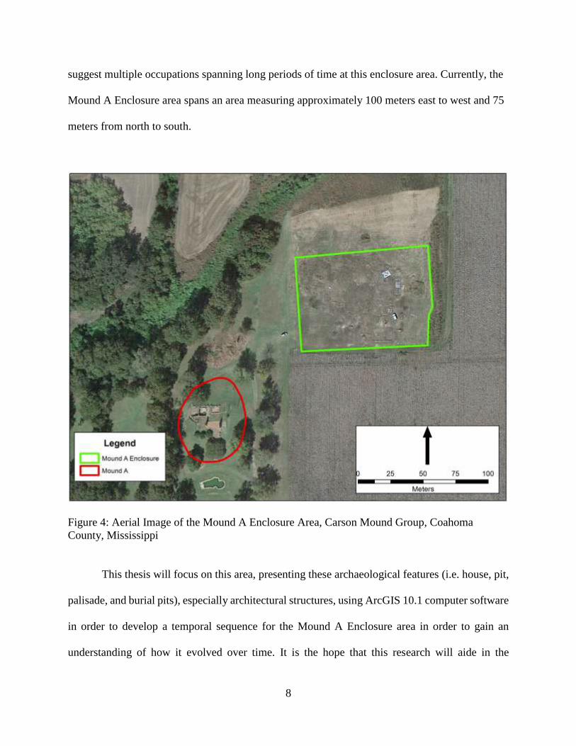
8
suggest multiple occupations spanning long periods of time at this enclosure area. Currently, the
Mound A Enclosure area spans an area measuring approximately 100 meters east to west and 75
meters from north to south.
Figure 4: Aerial Image of the Mound A Enclosure Area, Carson Mound Group, Coahoma
County, Mississippi
This thesis will focus on this area, presenting these archaeological features (i.e. house, pit,
palisade, and burial pits), especially architectural structures, using ArcGIS 10.1 computer software
in order to develop a temporal sequence for the Mound A Enclosure area in order to gain an
understanding of how it evolved over time. It is the hope that this research will aide in the

9
development of an overall understanding of the Carson Mound Group, help piece together both
how the entire mound site developed through time, and place it within the complex mosaic of the
broader Mississippian world.
Figure 5: Feature Map of the Mound A Enclosure Area at the Carson Mound Group
I will begin with a review of selected literature that explores the characteristics of
chiefdoms and their emergence in the southeastern United States, followed by a brief explanation
of a few iconic mound centers such as Cahokia, Moundville, Etowah, and Town Creek. Settlement
patterns in the Upper Yazoo Basin are then examined and a review of Mississippian architecture

10
is provided as well. Finally, a brief introduction to the Carson Mound Group in Coahoma County,
Mississippi, is presented as well as a review of past research at the site.
The third chapter provides a brief examination of the methods that were developed and
utilized for the completion of this project. The methods discussed include those developed for use
in the field such as targeted excavations of identified architectural features, and the methods used
in the laboratory such as GIS analysis or statistical analysis.
The fourth chapter presents the results of these analyses. These results included the array
of the various architectural features that were identified at the Mound A Enclosure, as well as a
discussion of a selected number of architectural intersections that were chosen based on their
significance to the development of the temporal sequence.
The final chapter includes a discussion of the fundamental concepts from the previous
chapters and some conclusions about the project’s findings. An architectural grammar for the
Carson Mound Group and the Mound A Enclosure area and a focused space syntax analysis of the
Enclosure are presented in this chapter as well. In addition, the findings from this project are also
woven into the fabric of both the Upper Yazoo Basin and the broader Mississippian world beyond.

11
CHAPTER 2
REVIEW OF LITERATURE
The review of selected literature presented here begins with a review of the
archaeological literature of concepts such as complexity, power, and the emergence of chiefdoms
followed by an examination of how these topics articulate into the southeastern United States. I
will then present a description of Mississippian architecture and landscape (or spatial) use in
order to explain the tools which will be used to determine where the Carson Mound Group fits
into the Mississippian world.
The evolution of human society has been one of the most fundamental and dynamic areas
of research within both anthropology and archaeology for a very long time (Anderson 1996;
Feinman and Manzanilla 2000; Service 1962; and Wright 2000). The development, over time, of
primarily egalitarian-based societies into more complex hierarchical societies is an integral part
of this discussion and elucidates such concepts of increased societal complexity, power
dynamics, and the emergence of chiefdom societies (Pauketat 2000:35). Furthermore, ongoing
debate surrounding these issues is important when viewed as a means to further understand how
such chiefdoms originally developed and subsequently interacted with one another and inhabited
the cultural and archaeological landscape.
Before any examination of the emergence of complex societies can be conducted, it is
first important to understand the nature of human society just prior to this revolutionary change.
Elman Service (1962) represents this gradual change in human social development in a rather

12
linear fashion beginning with the band, progressing to the tribe, and then finally developing into
chiefdom-level societies and, while anthropological theory has moved well past this view of
human cultural change, it is still important to have a general picture of what earlier human
society may have looked like. Service (1962:27-35) described earlier human social networks as
having been primarily comprised of relatively local kin-based bands that relied heavily on inter-
band reciprocity in order to establish successful working relationships. These bands, according to
Service (1962:31-32), placed a high value on marriage partners and, as such, these exogamous
marriage arrangements built ties between different bands and solidified a broader base of
survival strategies.
One limiting factor of band societies is that they were relatively small in size, and Service
(1962:100) stated that once a band, or a number of bands, surpassed the limit of their ability for
efficient management, the tribal society emerged in response to this need. According to Service
(1962:103), a tribe, like its predecessor the band, was generally an egalitarian society; however,
it was also “… composed of economically self-sufficient residential groups which because of the
absence of higher authority take unto themselves the private right to protect themselves.”
Eventually, according to Service (1962:133), tribes evolved in both internal social
structure and population to such a degree that they no longer functioned in the same manner that
can be considered a tribe. He (1962:133) stated that an increase in population density and
societal complexity to where “centers which coordinate economic, social, and religious
activities” developed gave rise to a “chiefdom”-level society.
In recent years, however, some of the fundamental hypotheses of Service’s arguments on
the factors that contributed to the emergence of chiefdoms have been challenged or at least built
upon. According to Earle (1997:5-6), the four primary sources from which emerging chiefs

13
derived their power were social relationships, economy, military might, and ideology. Moreover,
the position in society of a potential or ascending chief depended on his/her skills to assume
more power and an ability to maintain that power. Therefore, if an emerging chief distinguished
himself/herself in power acquisition and maintenance working within one or more of these four
sources, he/she would have ascended the hierarchical ladder to the top, at least temporarily.
According to Earle (1997:5), one of the more important sources from which chiefdom
power could have derived was “social relationships.” He stated that “Chiefdoms are normally
characterized as kin-based societies, meaning that a person’s place in a kinship system
determines his or her social status and political position.” Furthermore, an individual’s rank in
society was dependent on the “genealogical distance from a senior line of descent” and, as such,
determines who was entitled to challenge for political power. Earle (1997:5) states that typically
the highest ranking male within a particular kin-group would retain his father’s position, and it is
from this position that he had opportunities to manipulate the additional three sources of power.
Earle (1997:6; Anderson 1996:240) also posited that of the four primary sources of power, social
relationships are the weakest one because each person in a “kindred network” could be
considered the center of that network and could potentially argue for his/her claim to political
office. This led Earle (1997:6) to conclude that while kinship may not have served as a “major
medium” for the acquisition of social power, it was a fundamental component of society and
everyone, including chiefs, worked within this system to garner support.
The next major source of power that Earle discusses is “economy” (1997:68). By
controlling key sectors of the group economy, a chief was then able to control the economy
itself, thereby putting himself/herself in a more desirable position to ascend and maintain this
elevated status. He also states that when understanding past economies there are typically two

14
opposing models with which to view economic change over time. The first model is called
“voluntarist, adaptationist theory,” which according to Earle (1997:68), “follows an ancient
rationalist tradition in western thought” and, essentially, can be thought of as the gradual
evolution of social systems stimulated primarily by a society’s adapting its toolkit in response to
changing environmental factors. This voluntarist approach to past economies can be attributed to
the cultural ecology anthropology of which Elman Service was himself a proponent.
The second political theory, of which Earle himself is a proponent, is called “coercive,
political theory” and is derived from the historical materialism of Ricardo (1821) and Marx
(1867). Essentially, this theoretical approach takes as a fundamental understanding that people
do not typically relinquish autonomy unless the exertion of force by a “compelling power” forces
them to do so (Earle 1997:70). In addition, the control of modes of production, distribution, or
consumption affords the “mechanism” for power acquisition and thereby provides a means to
control people’s lives. Earle (1997:70) firmly argued the applicability of this approach by stating:
“…the model developed by Marx and Engels may in fact have general applicability to the
emergence of social complexity. The basic principle from which their analysis derives can,
I argue, extend to the emergence of leadership in ‘tribal society,’ that is, among Big Man
societies and chiefdoms.”
One of the fundamental problems with which “centrally organized and socially stratified
societies” were confronted is the development of a “political economy” that can adequately
finance the undertakings of new governing bodies (Earle 1997:70). In order to conceptualize this
problem, Earle suggested two varying models to help understand this process: 1) “staple finance”
and 2) “wealth finance.” Staple finance can be loosely defined and understood as consisting of
payments made to the state by individuals and/or commoners for access to resources of
subsistence. An example of a staple finance economy would be a system in which farmers give
their harvested produce to the state in exchange for access to irrigation canals. Wealth finance,

15
on the other hand, can be understood as when a leader distributes goods or prestige items to other
elites under his/her rule as payment for compliance. In return, the lesser elites keep order among
their subjects, thus maintaining the power/authority of the primary leader. Wright (2000:207-
209) proposes a third model called “labor tribute” which includes the transportation of people
and labor to the center, and, usually, in this case, land is abundant, but transport is difficult. Earle
(1997:74-75) also noted that the benefits of this political model is that prestige items can be
transported over greater distances and more efficiently; however, the value of these prestige
items can fluctuate when the value of staple goods remains constant.
Another major source of chiefdom power was derived from warfare which, taken in
conjunction with economic control, served as a very effective tool to maintain control. Earle
(1997:105) states that warfare was typically the initial stage of chiefdom control, and it was so
effective a tool that it is surprising that it wasn’t utilized as the exclusive means of subordination.
Furthermore, chiefdoms were war-like states that were created through conflict over land, but it
remains to be seen if they were war-like by design or due to a failure to establish a successful
“stable regional system” (Earle 1997:108-109). Anderson (1996:238) notes that wide-spread
chiefdom emergence was likely a defensive response to the rise of a single powerful polity. In
other words, the rise of this single powerful polity led to other regional polities’ engaging in an
arms race, so to speak, in order to better protect themselves. Finally, Earle (1997:110) noted that
warfare was essentially an attempt by chiefdoms to control staples and wealth; however, this
alone was problematic because 1) warfare was very expensive and 2) warriors can turn on you
very quickly.
The final source of chiefdom power according to Earle (1997:143), is ideology which he
defines as “meaningful symbolic phenomena to establish and sustain relations of domination.”

16
He added though that multiple segments of society are capable of having their own ideologies,
making them worldviews associated with certain social segments. Therefore, in order to be used
strategically, they must be solidified as communal, typically as ceremonies, symbols, and/or
monuments (Earle 1997:143). This has the effect of placing things in a “cosmic order” for those
who are being ruled, or in other words, “things are the way they are because the gods want them
this way.” In this way, ideologies establish and legitimize institutional patterns of knowledge and
meaning as a means of power and control (Earle 1997:143-144). Moreover, this
“materialization” typically manifests itself in three ways: 1) “public shared events” which give a
sense of common experience to the people, 2) “symbolic objects” which hold a certain meaning,
prestige, and limited access, and 3) the “cultural landscape” which consists of monuments or
landscape alteration to convey messages of power (Earle 1997:153-158).
Once chiefdoms establish themselves in their environments, Anderson (1996:233-234)
states that the logistical challenges of transporting goods and other items to and from the center
results in the total area under direct control of the center rarely exceeding a radius of 40
kilometers (km); however, he also noted that the area under indirect control of the center could
extend for much larger distances.
According to Anderson (1996:231-232), chiefdoms were multi-community political units
with control spread across a number of villages and hamlets which were directed by a “decision
making” group or “elite” living in a central community. Additionally, “lesser” leaders resided in
communities dispersed throughout the polity. The size and power could, therefore, be measured
by the number of lesser communities that were included within the center’s control. Also,
Feinman and Manzanilla (2000:143) argued that “…the settlement patterns of complex
chiefdoms vary depending on the nature of the economy and whether tribute was paid primarily

17
in labor or goods.” They also stated that chiefdom societies are typically broken down into two
categories, simple or complex; however, determining which one applies is often difficult since
each type was often in control of more than one subsidiary community (Anderson 1996:232).
Furthermore, “three-level chiefdoms” could also occur, and this happened when one complex
chiefdom acknowledged the authority of another to rule. Often, this is referred to as a
“paramount chiefdom” (Anderson 1996:232).
According to Anderson (1996:231-232), once chiefdoms were in place, this contributed
to a phenomenon often associated with chiefdom-level polities known as “cycling.” As defined
by Anderson (1996:234), cycling can be thought of as fluctuations of a polity between simple
and complex status. He (1996:234) also noted that, apparently, this was quite common and that
evidence of this can be observed often and, therefore, can be considered a basic characteristic of
chiefdom-level societies. In addition, while many things contributed to this societal cycling, he
(1996:236) said that the primary cause seemed to have been “factional instability.” Anderson
(1996:240-241) also listed kinship systems (or lack thereof), environmental factors, and chiefly
decision making or informational processing as additional contributing factors.
Another factor that many feel plays a major role in the development of complex chiefdom
societies, especially political economic areas where concepts such as kinship systems and tribute
were concerned was the act of the “feast” or feasting rituals. According to Dietler and Herbich
(2001:246), feasts were one of the most important components of an agrarian-based economy.
They served to reinforce the “inter-household labor flows” that kept the community together.
They also may have served to provide motivation to organize labor as well. Therefore, when
considering the move from egalitarian societies to more complex social structures, the role of the
feast must not be underestimated either. It would have served as an excellent tool for an

18
upcoming chief or “big man” to mobilize the necessary labor for large public works projects or
other public projects. Kelly (2001:354-355) added that feasts are an important part of a tribute
system which also served to establish or reinforce one’s position in society and clearly exhibited
a connection to the gods.
Chiefdom-level polities emerged during the Late Prehistoric period in the southeastern
United States, marking the beginning of what essentially would be 400 years of the rise and fall
of such chiefdom polities (Scarry 1999:59). This is observed within the archaeological record by
the presence of the “construction and abandonment of mound centers and the occupation and
abandonment of large regions” (Scarry 1999:59). However, Scarry (1999:59) also noted that
while specific polities would emerge only to disappear, on a regional scale Mississippian
societies would dominate.
Mississippian societies were initially defined by Griffin (1946) as the people associated
with the Middle Mississippian pottery family; ultimately this was changed to include all those
people who shared a limited number of material traits such as shell-tempered pottery, rectangular
wall-trench houses, and flat-topped pyramidal mounds. However, more recent definitions move
beyond material culture to include all those in the Southeast that shared similar traditions of
economy, political organization, and ideology. For example, Scarry (1996:13-14) noted that
Mississippian culture consisted of cleared-field agricultural traditions, the acquisition of
household surpluses of crops, and the production of surpluses of exotic trade goods such as
copper plates and shell pendants for the purpose of establishing trade relations with other polities
and legitimizing political authority.
In order to gain a comprehensive understanding of the Mississippian world, it is first
important to establish a little background information and explore how the Mississippian

19
chiefdom political structure emerged. According to Pauketat (2000:17), there currently exists
two broad and conflicting models which explain the emergence of Mississippian societies. The
first model is an evolutionary track or a “building blocks” model that incorporates the acquisition
of surpluses and good decision-making which results in the rise of certain ambitious leaders
(eventually chiefs) who are able to effectively control these surpluses for their own benefit. The
second model places the transition in historical terms and explains it as a more holistic
movement, or “Mississippianization,” that stresses the increased role of agency and the
transmission of human ideas as those that constrained social change.
Pauketat rejects the likelihood that the first model is a more appropriate understanding of
the emergence of these Mississippian chiefdoms. He (2000:21) stated that the “parameters” of
pre-Mississippian domestic life were altered as groups were Mississippianized. This process
transformed the identity and social actions of impacted communities, one example of which is
that the pre-Mississippian communalism was the antithesis of Mississippian communalism. He
also argued that Cahokia and communities downriver such as those in the Yazoo Basin
(discussed later) share a common history and, therefore, share political and social similarities, as
well (2000:34).
Mississippian political and social organization, on the other hand, as described by
Anderson (1999:222-224), was heavily influenced by an increased reliance upon intensified
agriculture, resulting in an increased agrarian economy. Anderson (1999:222) noted that the
adoption of a maize economy spread more rapidly than the Mississippian political organization
itself, and it was this increased reliance that led ultimately to a decline in the harvesting of game
animals as a result of the labor intensiveness of maize agriculture. In addition to the emergence
of maize agriculture, there was also a trend toward an increased use of prestige goods (i.e. shell,

20
copper, or other exotic material items) exchange and craft specialization (Anderson 1999:223).
The distribution of these prestige goods suggests large interaction spheres throughout the region
and, essentially, a top-down distributional preference. In other words, prestige-goods were
primarily given to those in the larger more central locations and seem to have been withheld
from those in the smaller locales. However, it has also been noted (Anderson 1999:223; Marcoux
2007; Welch 1991) that the maintenance of these prestige goods systems does not seem to have
had much impact on the success or failure of many of these Mississippian polities.
Settlement Patterns
Hally (2008:9) stated that Mississippian chiefdoms were politically centralized societies
with each particular chiefdom consisting of multiple towns, farmsteads, and hamlets. Each was
also under the control of a polity chief and subordinate village chiefs. He (2008:15) noted that
there is some evidence to suggest that polity chiefs were not the sole source of power or
authority within a chiefdom. For instance, some suggest that a chief may have had a council
which advised him/her, thereby limiting his/her power.
In addition, another approach not too dissimilar from the first one that Pauketat identified
and that was argued against by Blitz (1999) and Cobb (2003:63-64), is the one referred to as the
“simple-complex chiefdom cycle” (Anderson 1996:232) which became popular several decades
ago and is a well-used model for understanding Mississippian political and social organization
(Blitz 1999:578). Blitz (1999:578) states:
“In the simple-complex chiefdom model, chiefdom size and power is measured by the number of
subordinate communities under the direct political control of the chiefly center…. The emphasis
on ‘administrative hierarchy’ is the basis for a classification of chiefdoms. Simple chiefdoms have
one decision-making level above the household or local community level; complex chiefdoms have
two decision-making levels.”

21
The model to which Blitz referred is essentially the one that Smith used when describing the
emergence of the Coosa Chiefdom located in northwest Georgia. Smith (2000:16-19) described
the Coosa as a kin-based paramount chiefdom with an inherited power structure.
In response to the simple-complex model presented by Anderson, Blitz (1999:583)
provided an alternative model, the “fission-fusion model” which refuted the previous approach
as having been too simplistic. Blitz states that the inter-site relationships between Mississippian
mound centers remains unknown and, as a result, labeling a site that consists of a single mound
as a simple chiefdom or a two-mound site as complex may be misleading because he argued that
it may not be as simple as a one-to-one ratio of mound and site since not all mound centers
served the same function. The application of the fission-fusion model and Hally’s 40 km
diameter shows the relationship between contemporaneous mound sites to be much more
complex. Blitz (1999:583) says centralized power was the most complex when “coeval” mounds
were grouped in close proximity and less so when they were dispersed. Blitz (1999:589) adds
that complex chiefdoms which dominated a region and drew resources into the center were not
always the norm. It was much more common, he said, for the resource flow to be localized
primarily by moving from households to individual centers.
Cobb (2003:66), on the other hand, posited that Mississippian complexity naturally
gravitated toward physical mound center size, geographic reach, and population. He said that
physical size was often used by archaeologists as a “proxy” for that site’s influence in the region;
however, he also noted that population estimates are often “exceedingly” difficult to derive. He
(2003:68) continued to say that while not all Mississippian sites have mounds, mounds are the
typical metric by which to assess site complexity.

22
Furthermore, another important area to consider when trying to understand the
complexity and emergence of chiefdoms within the southeastern United States is the role that
warfare played in local or regional political centers. To this end, Anderson (1999:234) states that
there is evidence to suggest that warfare was used in a multitude of ways as the Woodland Period
evolved into the Mississippian. In some areas, it appears that there was a notable drop in the
prevalence of violence, whereas in other locales there seems to have been a drastic increase in
the amount of warfare. According to Anderson (1999:224), this can be seen by an increase in the
number of palisades at various mound centers throughout the region. In addition, there also exists
evidence to support the notion that in some areas there was increased population convergence,
and that in some situations populations only converged within fortified centers during periods of
conflict. Some additional research shows that stored food surpluses were also maintained during
these periods of violence. Anderson (1999:224) posited that one potential explanation for
regional variation in violence was the decline of region-wide prestige goods exchange during the
Middle Mississippian period. In other words, the prestige-goods exchange would have
encouraged greater cooperation between polities, and, as it collapsed, inter-polity communication
and cooperation likely declined. Anderson (1999:224) also notes that during the Late
Mississippian period mound construction declined in favor of an increased focus on the
construction of defensive structures.
In addition to warfare, another area in which much research has been conducted is the
ideology of the Southeastern Mississippian polities and what that ideology both says about that
culture and how it relates to the emergence and power acquisition of local “big men.” Knight and
Steponaitis (1998:18) suggests that much of the iconography of the period can be attributed to

23
the classic “Southern Cult,” a compilation of iconographic images displayed on ceramic and
other artifact specimens often characterized by specific motifs. He said:
“…images found in chiefly cult paraphernalia contain possible references to warfare,
either literal or figurative, emphasizing trophy heads, scalps forms, and weapons”
(1998:20). In addition, these motifs accompany cosmological images, including a number
of “center symbols and supernatural creatures,”
and, lastly, engraved pottery exhibiting similar art can also be attributed to chiefly cult
symbolism observed in other “media” (Knight and Steponaitis 1998:20). What this represents is
that Mississippian societies undoubtedly had ideological belief systems, often very closely
related to the world around them (as noticed in common motifs) that played a central role in their
day-to-day lives. It is also likely that these ideological symbols were either created or utilized by
leaders in order to obtain and reinforce their authority.
Cahokia
When one considers emerging complexity in the Mississippian world, one of the most
important sites that must be examined is Cahokia. Located on the eastern side of the Mississippi
River, just across from the modern-day city of St. Louis, Cahokia has been a focus of
archaeological research for a very long time (Milner 2006). According to Milner, Cahokia is
comprised of at least 104 mounds (2006:144), and population estimates for the site at one time
could have been as high as 10,000 inhabitants (2006:121). In addition, there are also a number of
diagnostic features or artifacts that were potentially unique to Cahokia at one time, and the
presence of such items in outlying areas throughout the American Bottom or the Southeast may
lend insight into Cahokian cultural influence over time. These features and/or artifacts include,
among other things: ridge-top mounds, Burlington chert material, sunken floor structures,
Cahokia microliths, Cahokia cord-marked ceramics, and Cahokia projectile points.
24
One unique characteristic of Cahokia is the presence of ridge-top mounds. According to
Demel and Hall (1998:207), while conical mounds or platform mounds can be found throughout
the Mississippian world, ridge-top mounds were, at that time, only found at Cahokia. In total,
there are seven ridge-top-style mounds there, and they “may contain mortuary facilities of the
elite, charnel houses, large posts, and perhaps sacrificial victims and sumptuous grave offerings”
(Demel and Hall 1998: 207).
It is well known that chert material can be traced to the specific quarry from which it was
procured, and, therefore, this same chert material often becomes diagnostic of one particular
area. One example of this is Burlington chert, which Milner (2006:81) states was easily worked
and widely available at Cahokia and its immediate vicinity. According to Johnson (1987:188),
this particular variety of chert is of rather high quality and derives from the Burlington formation
in the Midwestern United States. In addition to the Burlington formation, much of the material
from Cahokia can also be traced to outcrops of that formation at the Crescent quarries in eastern
Missouri.
A certain architectural style is also considered to be unique to Cahokia, at least in one
case with a style referred to as “sunken floor” or “basin style” structures. According to Milner
(2006:91), houses that had sunken floors approximately 50 cm below the ground surface were
common in the American Bottom in order to make harsh winters a little more bearable. Alt and
Pauketat (2011:112-115) elaborate by stating that there are typically three different types of
sunken floor structures that can be found at Cahokia: rectilinear single-set post structures, and
small rectilinear and curvilinear wall-trench buildings. Furthermore, each of these architectural
styles were constructed using either the simple flexed-pole, rigid-post technique, or a “curtain
wall” construction technique (Alt and Pauketat 2011:116).

25
In addition to the aforementioned Burlington chert variety common at Cahokian sites, a
unique tool type known as “Cahokian microdrills” or “Cahokian microblades” are also
characteristic of Cahokian influence. These blades are short and narrow burin-like tools that are
commonly manufactured from high quality chert material (Milner 2006:86). According to
Yerkes (1983:502), Cahokian microliths are “narrower and thicker than typical examples of
Illinois and Ohio Hopewell blades and Poverty Point microblades.” This particular tool type has
also been recovered from the Zebree site located in Northeast Arkansas (Morse and Morse
1990:58). As a result, the presence of such microliths suggests that, potentially, at some point in
the past there was contact with Cahokia or a Cahokian influence of some kind.
A second tool variety that is indicative of the Cahokia area has been referred to as the
“Cahokia point.” This particular projectile point is identified as a triangular, side-notched point
that also may contain a notch in the center of the base. According to Emerson and Lewis
(1991:20), “… the side-notched triangular point is important for the archaeological identity of
the Cahokian Mississippian tradition, but points of this type are not characteristic of Tennessee-
Cumberland or other more southerly varieties of Mississippian. They are characteristic of
Cahokia and Cahokia-related sites…”.
Supplementary to the two lithic tool types that are considered indicative of the Cahokian
area, ceramics are diagnostic of this area as well. Specifically, a ceramic type named “Cahokia
Cordmarked” is characterized by shell tempering, a technique that seems to have replaced earlier
grog or sand/grit tempered varieties during the Moorehead (A.D. 1200-1275) and Sand Prairie
(A.D. 1275-1350) phases at Cahokia (Emerson 1997:53). Milner (2006:153) suggests that
Cahokia cordmarked jars were not as widely dispersed as other varieties such as Ramey Incised

26
or Powell Plain jars. Therefore, the presence of this particular type of ceramic may be useful in
identifying a Cahokian influence in some cases.
Moundville
When considering chiefdom polities within the southeastern United States, few are as
important or have been more heavily researched than the Moundville site in northern Alabama.
Located on the southern banks of the Black Warrior River and situated on a terrace within its
floodplain, Moundville is crucial to understanding prehistoric populations during the early to late
Mississippian period. According to Knight and Steponaitis (1998:2-3), in total the Moundville
site is comprised of 29 truncated earthen mounds and spans an area of approximately 185 acres
which was enclosed by a palisade line.
Knight and Steponaitis state (1998:12-17) that Moundville began to emerge as a cultural
center during the 11th to 14th centuries A.D. During this time, nearby populations of people
began to converge on the area, and it was also during this period that most of the major mounds
at the site were constructed. After this initial emergence, from around A.D. 1300-1450 the
population at Moundville declined dramatically, and, according to Knight and Steponaitis
(1998:18-19), one potential explanation for this was that it was a purposeful decision by local
elites to distance themselves from the day-to-day activities of common people. Whatever the
cause, during this period Moundville transitioned from a living space occupied by both elites and
commoners alike to a necropolis where cemeteries were constructed filling the space once used
by the living residents (Knight and Steponaitis 1998:19). Moving from the late 15th century into
the 16th century, Moundville continued to decline in overall population to a point where only a
few mounds show any evidence of construction or occupation. Knight and Steponaitis note
(1998:22-23) that, by this time, most people had migrated to secondary mound centers
27
throughout the nearby region, but even most of these centers would eventually be abandoned for
more rural settings by the middle of the 16th century.
Town Creek
The Town Creek site is located in the southern Piedmont of North Carolina and situated
opposite a bend in the Little River (Boudreaux 2007:8-12) and shows evidence of continued
activity and/or occupation from approximately the Early Archaic Period (8000-6000 B.C.)
through the Protohistoric Period (A.D. 1500-1700) (2007:106). Moreover, according to
Boudreaux (2007:106-112), a ceramic chronology for the site has been established and shows
strong Mississippian ties from the early Teal phase (A.D. 900-1050) through the Leak phase
(A.D. 1350-1550).
Boudreaux also stated (2007:106) that while there is evidence that suggests occupation of
the site during the Teal phase, based primarily on the discovery of a number of architectural
elements including a palisade line, the Mississippian tradition did not emerge until the town itself
was established during the early Town Creek phase (A.D. 1050-1250). In addition, it was also
during this phase that a number of pre-mound rectangular public structures were constructed.
During the late Town Creek phase (A.D. 1250-1300), the construction of a low platform mound
on the western edge of the plaza clearly marks a notable change at the site as well as a switch
from a large circular public structure to that of a large rectangular structure clearly associated
with the mound. The axis upon which town construction was aligned during the early Town
Creek phase continued to be used into the late Town Creek Phase, as well (Boudreaux
2007:107). Boudreaux (2007:108-109) identified two new architectural structures that appear
during the Late Town Creek phase: a large rectangular type and a large circular enclosure type.
He states that these two types of structure do not seem to overlap and, therefore, were likely

28
combined to form a “functional unit.” Also (2007:109) during the late Town Creek phase,
cemeteries became associated with many of these structures; this suggests that kin groups who
had previously occupied these structures continued to utilize the same space. Boudreaux
(2007:109-110) states that while there are many differences between Town Creek and the
Moundville site in Alabama (i.e. site size and number of mounds), one primary similarity, aside
from both being occupied for long periods of time, is that the two sites show a general trend from
spaces that were initially used for domestic purposes to locations whose use assumed a more
ceremonial role.
Yazoo Basin Mississippian Settlement
Changing social complexity and the emergence of chiefdom-level polities within the
greater southeastern United States is well researched, and, therefore, it is also important to
briefly examine the nature of this phenomenon within the Lower Yazoo Basin in Mississippi.
According to Kidder (1998:132), communities containing mound-plaza features in the
Mississippi Valley, of which the most well-known is the Poverty Point site located in West
Carroll Parish in northeastern Louisiana, date as far back as the Late Archaic. Additionally,
subsequent mound-plaza sites in the region include the Pinson site and the Marksville site, both
dating to the Middle Woodland Period. Furthermore, Kidder (1998:132) states that mound plaza
construction markedly decreased between the Marksville and Baytown periods with the
exception of the Thornton site in the Yazoo Basin, the Indian Bayou site in Tensas, the Lake St.
Agnes site and maybe the Baptiste site in the Lower Red River area. In addition, there does not
seem to be evidence of community-wide planning at non-mound sites. Most settlements appear
to be relatively small, and habitation features consist primarily of hearths and fire pits with no

29
houses or other construction features having been excavated at any of these communities (Kidder
1998:132).
Table 1: Chronological Chart of the Later Neo-Indian Periods, Cultures, and Phases in the Yazoo
and Tensas Basins (Kidder 1998:127)
Date (A.D.) Period Culture
Southern
Yazoo Basin
Phase
Tensas Basin
Phase
1700
Mississippian
Mississippian
Russell Taensa
1600 Wasp Lake II Transylvania &
Fitzhugh 1500 Wasp Lake I
1400
Plaquemine
Lake George
1300 Winterville Routh
1200
1100
Coles Creek
Crippen Point Preston
1000 Kings Crossing Balmoral
900
Coles Creek
Aden Saranac
800 Bayland Sundown
700 Deasonville Deasonville
Mount Nebo
600
Baytown Troyville
Marsden
500 Little
Sunflower Indian Bayou
However, Kidder states that it was not until the Baytown period (approximately A.D.
400-700) that a clear transition to mound-plaza centers occurred (Table 1). He notes that there
were two primary manifestations of Baytown period sites, and these were small, highly dispersed
hamlets, and larger settlements or communities which contained mounds. In some cases these
mound structures were constructed as living platforms and were also frequently used for
interment of the dead. The Troyville site is an example of one such mound which contained
bundle burials and included virtually all status levels within the population (1998:133). He also
noted that not all Troyville sites were burials; some were small and likely seasonal occupations
(1998:134). According to Kidder (1998:135), mounds during this period were constructed for the
first time, and then burials were placed in them, as opposed to having been constructed on top of
the burials. There is also evidence during this time of more emphasis on status as burials

30
changed, and, based on social differentiation in the burials, high-ranking individuals or lineages
may have occupied sacred places in order to maintain status. The burials during this period were
found in some cases to include a higher ranking individual accompanied by one or more
presumed lower ranking individuals (1998:136). Kidder (1998:128) admitted that while data
regarding the Baytown period subsistence practices are limited, it is likely that these people
primarily lived in an egalitarian society and used a hunter-collector subsistence strategy.
Following the Baytown period was the Coles Creek period (A.D. 750-1050) which
exhibited an even greater incidence of social complexity and wide-ranging population growth
(Kidder 1998:129). Furthermore, Kidder (1998:130) posited that “the typical Coles Creek site
plan, consisting of at least two, and more commonly three, mounds arranged around a central
plaza, begins around A.D. 800.” He (1998:130) also noted that while Coles Creek remained for
the most part an egalitarian-based society, several Coles Creek mound sites were constructed
directly on top of previous mounds which suggests to some that emerging chiefs or “big men”
were both physically and symbolically “appropriating” past ancestors to assert and emphasize
their authority. Also, the size and complexity of Coles Creek mounds increased, which seems to
suggest a change in function from public ritual to an accommodation of more restricted segments
of society (1998:137). By A.D. 900-1000, Kidder (1998:139) notes that mound communities
were more bounded than ever before with more people residing on the mounds themselves.
Moreover, local subsistence strategies are thought to have remained primarily as hunter-collector
strategies since evidence of collectibles (i.e. acorns, persimmons, palmetto, and grape) is high,
and the evidence of cultigens such as maize is sparse (Kidder 1998:129).
After the Coles Creek Period comes the Mississippian period (A.D. 1050-1500) which,
according to Kidder (1998:131), is typically divided into two sub-categories and often thought of

31
as two different cultural traditions: Plaquemine and Mississippian. Often times the Plaquemine
culture is referred to as Mississippianized Coles Creek because it is not uncommon for Late
Coles Creek artifacts to “intrude” into the Mississippi period (Kidder 1998:131). This may have
been the result of diffusion or contact with Mississippian cultures such as Cahokia. Also, during
this time there seems to be a clear trend toward Mississippian cultural traits such as shell-
tempered pottery and domestic architecture. Kidder (1998:131) also noted that, typically, crushed
shell used as a tempering agent is often viewed as the Plaquemine to Mississippian break and,
interestingly, seems to have occurred earlier in the north, appearing later in the sequence as it
moved down the Mississippi River over time.
According to Kidder (1998:142), the basic mound pattern for the Mississippian period
was established several hundred years prior to the arbitrary A.D. 1000 break from Coles Creek,
and, during this transition, there seems to have been political “centralization and consolidation.”
There is evidence during this time of the emergence of two opposing patterns. They are: 1) the
appearance of large mound sites which became larger and fewer in number and 2) the
appearance of non-mound settlements which got smaller and more numerous. This, according to
Kidder (1998:143), is evidence of the emergence of strongly ranked and centralized chiefdom-
level polities. Moreover, Mississippian mound site plans increased in exclusionary characteristics
such as palisades, and subsidiary mounds were added in order to increase the distance from the
central mound plaza and the outside world (Kidder 1998:146).
Although useful, Kidder’s (1998) summary refers primarily to the southern Yazoo Basin
where a Coles Creek influence is strongest. In particular, there are relatively few clearly dated
Late Woodland mounds in the northern Yazoo Basin, the region in which the Carson Mounds are
located. Therefore, while the mound building tradition in the Tensas and southern Yazoo Basin

32
builds on the Coles Creek precedent, in the northern Yazoo Basin, Mississippian mound building
rests on an entirely different antecedent (Johnson, personal communication 2015)
Mississippian Household
The emergence of chiefdom-level polities in the southeastern United States during the
Mississippian period clearly signaled a major divergence in lifeways from those of either the
Archaic or Woodland periods. In addition, this cultural transition also brought with it a number
of lifestyle changes, both public and domestic, utilitarian and ritualistic, which, from an
archaeological perspective, can be used in order to differentiate and understand cultural change
over time. Through the identification of these unique or diagnostic phenomena, a better grasp of
the characteristics of the emergence of chiefdoms unique to the Upper Yazoo Basin, or even
more broadly the Lower Mississippi Valley, can be obtained. Furthermore, one of the most
useful cultural features in classifying or understanding a culture is through the architecture
typically constructed by a particular people, and, in the Mississippian region of the Upper Yazoo
Basin, this no different. Architectural analysis can yield much information on the nature of
chiefdoms and increased complexity during this period. Therefore, this forms the basis for this
project--the identification and analysis of disparate architectural styles identified at the Carson
mound group. However, first a brief exploration of the role that architecture played throughout
the Mississippian region and an examination of some of the most common architectural styles
must be conducted.
According to Lewis et al. (1998:2), “…architectural grammar focuses on the rules by
which elements were combined in architectural expression, while an architectural style
emphasizes the classification of compositions by their shared expressions.” In addition, it comes
as no surprise that societies and cultures typically assign meaning to the space around them and,

33
likewise, through the construction of architecture, convey the meaning attached to that space.
Essentially, we view or study architecture, either modern or prehistoric, in order to ascertain
what meaning a particular space may have had for its occupants, in this case the Mississippian
culture people. There is no doubt that over the last several decades research into Mississippian
architecture has evolved quite a bit, but Lewis et al. (1998:11) noted that while our research
questions have changed over time, one thing that has remained the same is our understanding of
the “essential design elements of Mississippian towns and mound centers.” Similarly, Rogers
(1995:19) states that patterns of architectural continuity can be used to explore a commonly
understood relationship between architectural segmentation and social segmentation or
complexity.
Mississippian Grammar – Mound, Plaza, and House
In order to examine how architectural grammar and style are represented in the
archaeological record of the Mississippian past and how that representation can help identify
increased complexity, it is necessary to break them down into the most common units beginning
with domestic architecture. According to Yaeger and Canuto (2000:10-11; Rogers 1995:10), the
house forms the basic unit of analysis, and it is therefore important to excavate these basic
analytical units in order to shed light on interactions among individuals in the same household
and among individuals and the greater community, as well. Boudreaux (2013:484) explained it
thusly: “…the persistence of household-group spaces and the continued participation of these
groups in integrative ritual activities suggest that regardless of community size, interaction
among discrete social groups within a ritual context was a salient part of being Mississippian.”
Hally (2008:50) designated household architecture by giving the most frequently
occurring manifestations the name Primary Domestic Structures (PDS), and the attributes of this

34
particular style are many. According to Hally (2008:50-106), at the King site, they are typically
characterized as square-shaped structures with rounded corners, single-set posts with exterior
walls, narrow passageways used as entrances, steeply-angled pyramidal roofs, interiors often
divided into two sections, and a clay hearth in the center. They were often burned only to be
reconstructed again. Many times burials were located inside, usually parallel to exterior walls,
and some contained semi-subsurface or depressed floors. There is frequently an “earthring” or
banked dirt berms around the exterior of the house.
Boudreaux (2007:18-23), on the other hand, classified the Mississippian domestic
architecture at the Town Creek site in three different types which are “small circular structures
(SCS),” “enclosed circular structures (ECS),” and “rectilinear structures (RS).” Boudreaux
(2013:489) identified small circular structures as the earlier of the two circular varieties, the most
common at the Town Creek site, consisting of a flexed-pole design approximately 9 meters (m)
in diameter and a single circular post-hole design. By comparison, he (2013:489) described the
enclosed circular structure design as consisting of two concentric patterns of post-holes ranging
between 9 and 18 m in diameter and often containing large burial clusters, leading some to
interpret them as enclosed cemeteries. He (2013:484) also noted that architectural and mortuary
evidence is often used to evaluate the interpretation that some house locations did, in fact, evolve
into cemeteries. Finally, rectilinear structures are characterized as structures of varying size
(large, medium, and small) that generally contain few interior features and often have earth-
embanked walls.
Still more examples of Mississippian architectural variety can be observed at Moundville
in Alabama where Lacquement (2007:60-66) described five separate domestic architectural
structures common to that site: Type I, Type II, Type III, Type IV, and Type V (Table 2). All

35
varieties of these domestic architectural structures are, for the most part, relatively square in
shape. Type I, named the “composite construction form,” is recognized because it employs
individually-set post design and wall-trenches. Type II, labeled the “small pole individually set
form,” consists only of individually-set post design on all four sides. Type III, known as the
“wall trench form,” is characterized as having wall trenches on all four sides. Type IV, referred
to as the “large individually set post form,” consists of larger individually-set posts on all four
sides and also four large interior posts, as well. Finally, the Type IV, or “amorphous post daubed
form,” is distinguished by large, “widely scattered” posts that do not signify any discernable
post-hole pattern (Lacquement (2007:66).
Table 2: Architectural and Ceramic Comparison at Moundville (Laquement 2007:66)
Time Period Floor Plans
AD 1050-1150 Early Moundville I Type I, II, and III
AD 1150-1250 Late Moundville I Type II and III
AD 1250-1400 Moundville II Type III
AD 1400-1550 Moundville III Type IV
AD 1550-1650+ Moundville IV (Protohistoric) Type V
Now that a general examination of domestic architecture has been presented, it is
important to also explore a few of the more common public (non-mound) architectural structures
often associated with Mississippian society. As Boudreaux (2013:484) states “at the intra-
community level, architectural and mortuary patterns at a number of Mississippian centers have
shown that many aspects of these centers and their histories were shaped by cooperation,
competition, and negotiations among the multiple social groups that composed them.” Also, in
order to switch the emphasis away from only looking at mounds, Rogers (1995:25) states that
early on researchers were only focusing on temple-town models which primarily viewed elite
and ceremonial activities such as the aforementioned mounds. Therefore, the public structures
discussed in this review will include plazas, public houses, and palisades.

36
Hally (2008: 123) defined plazas as centrally located spaces with few (or no) domestic
structures, burials, or artifacts but often containing public architecture. Lewis et al. (1998:16)
mentioned that as a result of relatively few structures, features, or artifacts, plazas are often
overlooked as the primary focus of research. In their view, this is a serious oversight because the
plaza was likely the location for meetings, interactions, and exchanges, and, therefore, more
attention needs to be given to these in order to gain more insight into what life was like in a
Mississippian town.
The next area to investigate is public architecture. Boudreaux (2007:2) notes that the
political and economic centralization that occurred during the Mississippian period is likely
reflected in this public architecture and its change over time. He (2007:26) also noted that the
rectilinear structures described earlier likely functioned in some public capacity. For example,
Lafferty (2007:164) described one such feature that is consistent, in his view, with sweat lodges
that have been recorded in historic documents. He said that the structure was the size, shape, and
contained features consistent with sweat lodges from later periods.
Finally, the role of palisades in the Mississippian world needs to be addressed because
the presence or absence of such structures tells us much about the social structure and political
environment of a particular site. According to Lewis et al. (1998:18-19), wooden walls and gates
(i.e. palisades), primarily served to limit access to space and also served as a visual expression of
who had access to elite spaces and who did not. Furthermore, they are visual objects that reify
the social structure of a polity. Hally (2008:163-164) states that there are primarily two different
varieties of palisades located in Mississippian sites and they are characterized as either 1) posts
that are set in trenches or 2) those constructed with individually-set posts. He (2008:167) also
adds that while it is common to find bastions along palisade walls (usually indicative of

37
defensive purposes), it is also common for palisades to have none. In addition, it is common that
defensive ditches parallel palisades, which were likely constructed by using the fill dirt for the
construction of the palisades themselves (Hally 2008:1790180).
Space Syntax Analysis
Another intriguing method that has become increasingly popular over the past several
decades is Space Syntax Analysis, and by applying the fundamental concepts of this technique it
becomes possible to understand a site in a whole new way. According to Stone (2000:200),
“Space Syntax Analysis” was originally used in the field of architecture to understand the
relationship that buildings and communities have with one another. This method has also proven
useful to archaeologists “…attempting to understand architectural design and its relationship to
socio-political organization…” (Stone 2000:200). Furthermore, Van Dyke (1999:462) states that
the two most valuable concepts when space syntax is considered are “symmetry/ asymmetry”
and “distributedness/ nondistributedness.” Essentially, in a symmetrical arrangement, spaces are
equally accessible to each other, and in an asymmetrical type, access to a space is often limited
in that it can only be entered by passing through a separate space. Distributed arrangements are
those when there are numerous access points or routes into a particular space. Conversely,
nondistributed arrangements occur when a space only has a single point of entry or access (Van
Dyke 1999:462).
In operationalizing these concepts, Van Dyke (1999:466) began by constructing a
justified permeability graph in order to illustrate each space’s relationship to one another and
assigning a mean depth (MD) for each space. Next, a mathematical equation was used to assess a
site’s relative asymmetry (RA) and real relative asymmetry (RRA). Essentially, RA is the
quantitative number which represents the access of any particular space, and RRA is simply the

38
RA adjusted for the size of the structure using a separate mathematical equation. Once these
calculations were performed a site’s symmetry or asymmetry and distributedness or
nondistributedness could then be assessed and interpreted. Furthermore, when an individual site
is placed along the scale for these two factors, something can be said about how a site’s planning
and organization was operationalized and how that planning expresses the sociopolitical
dynamics of the people who used that space.
Mississippian Period at the Carson Mound Group
A brief examination of the Carson mound group and some of the previous research
conducted there must also be considered in order to present a clear picture of the nature and
scope of the following analysis. To begin, Mehta et al. (2012:3) described the Carson mound
group as one of the largest of the “multi-mound late prehistoric sites in the Mississippi Delta
region,” but, unlike comparable sites in the region, the amount of research at Carson is relatively
limited. He (2012:6) also noted that archaeological reconnaissance work conducted by John
Connaway of the Mississippi Department of Archives and History (MDAH), David Abbott
(MDAH) and Jayur Mehta revealed a large village site and cemetery adjacent to and associated
with Mound A, the second largest mound at the Carson mound site. He (2012:6) noted that a
radiocarbon date (cal A.D. 1210) extracted from a postmold placed the occupation “squarely
within the early Mississippian period.” Furthermore, two subsequent C14 dates revealed
additional dates of cal A.D. 1450 and cal A.D. 1610, both much later in time and approaching the
limits of what is traditionally considered to be the Mississippian period. What this suggests is
that the Carson mound group was occupied for a long time, spanning the second half of the
Mississippian period.

39
Additional work at Carson includes a chronological sequence developed in a Master’s
(MA) thesis by Brent Lansdell in 2009 based on fieldwork done in 2007. According to Lansdell
(2009:146), through the analysis of both ceramics and lithics recovered primarily from the
Mound A Enclosure, an occupational sequence for the site can be tentatively deemed to span the
Middle Woodland through European contact periods. Another interesting component of
Lansdell’s research was that a number of Burlington chert artifacts were identified, suggesting
that contact between Carson and Cahokia could have been a possibility. As previously
mentioned, Burlington chert is a regional chert variety most commonly found much farther north
along the Mississippi River and most commonly associated with Cahokia (Johnson 1987:188).
He also excavated a trench at the base of Mound E revealing the presence of shell-tempered
pottery sherds in the mound fill, suggesting a Mississippian Period construction (Lansdell 2009).
In 2008, Jenna James excavated a pit containing multiple bundle burials (Burial 4)
located within the Mound A Enclosure area as a part of her MA thesis. The focus of her research
was the investigation of the mortuary practices of people living at Carson during the
Mississippian period in order to draw parallels to historic accounts documenting those practices
in the past (James 2010:2). As part of her research, she studied a burial pit that contained 36
individual bundles. She concluded that the mortuary practices of the Mississippians occupying
the site involved many stages from dismemberment to placement in charnel houses.
Finally, in the summer of 2012, Erika Carpenter conducted a field project as part of her
MA thesis which excavated a number of wall trenches located on Mound C at the Carson site.
Also present were a number of pits, postholes, and historic features. She (2013:1-5) notes that
several of the excavated wall trenches may have been constructed as palisades, suggesting a
restrictive purpose. She added that a possible sequence of the activities at Mound C could be

40
worked out. In addition, her research on the linear wall trench, post-hole features led her to
conclude that if, in fact, they do represent palisades, it supports the hypothesis that Mound C
developed over time from a relatively open public structure to one that became more exclusive
later in the Mississippian period. Of course, this finding has broader implications for the Carson
site as a whole. What it represents is that it is possible that the entire Carson mound group
developed from a society that was more open to one that cordoned off space for those having
elite status, a practice consistent with findings at other mound centers throughout the
Mississippian region.
Finally, John Connaway (n.d.) has recently written a long article in which he summarizes
previous and current research at Carson. He builds on the MA theses written by University of
Mississippi graduate students as well as Metha’s articles. The majority of the article focuses on
his own work, primarily in the Mound A Enclosure.
It is well known that the increase in social complexity and the emergence of chiefdom-
level polities often signify a very important period in the human past, regardless of where the
increases may have occurred. It is often associated with a broad spectrum of social developments
such as agriculture and subsistence change, increasingly complex political and economic models
on a regional or society-wide scale, and a general trend from primarily egalitarian models to a
more stratified and hierarchical social structure. Furthermore, in this general chiefdom view,
including the concepts of increased complexity and chiefdom-level polity, emergence can also be
applied to the Mississippian period in the southeastern United States, specifically, the Carson
mound group in Coahoma County, Mississippi. Research conducted within the Mound A
Enclosure area at Carson has the potential to shed light on these concepts of increasing social
complexity, broadening bases of power, and the emergence of either local or regional chiefdoms.

41
In addition, the main focus of this project will be to view the architectural grammar and style at
Carson in order to gain more insight into the dynamics associated with this critical time period in
the Upper Yazoo Basin. This research at the Carson mound group will produce results that can
be used as an analog for similar sites, not only within the immediate vicinity, but on a much
larger regional scale.
42
CHAPTER 3
METHODS
The focus of this project was to analyze the Mound A Enclosure area where several
different types of architectural features intersected with one another, thereby providing some
insight into how the site developed over time. In order to accomplish this goal, a strategy was
developed in order to maximize analytical coverage of the site in an efficient manner. That is, a
number of intersection areas of disparate architectural features were determined to be good
candidates for analysis, and through the use of GIS and contextual analysis, a temporal sequence
for the site was developed.
Field Methodology
In the fall of 2007, Brent Lansdell from the Department of Sociology and Anthropology
at the University of Mississippi and John Connaway of the Mississippi Department of Archives
and History (MDAH) established a grid system (referred to as the “site grid”) for the Mound A
Enclosure area, in order to correlate all future work at the site. The site was placed on a
north/south 20-meter grid which was then subdivided into 5-meter squares. This site grid
spanned an area approximately 100 meters east/west by 80 meters north/south. Once this grid
had been established, it was possible to begin excavations of the Mound A Enclosure in a
controlled and systematic manner.
All excavations conducted during this project were done within and aligned to this grid.
Furthermore, it was determined early on by John Connaway at MDAH that the most efficient
43
technique for excavation at Carson was shovel shaving and, as a result, this was the primary
technique used while conducting field investigations on this project. This technique served many
functions, but the main reason shovel shaving was used within the Mound A Enclosure was to
expedite the process of removing the upper surface of disturbed fill, thus exposing the underlying
sterile soil matrix and any archaeological features which intruded into the subsoil. This was
particularly effective in the Enclosure because most of the plowzone had been removed during
the land leveling operations. The technique can be understood as simply removing very thin
layers of clay or topsoil with a sharpened shovel until the underlying layer of sterile soil matrix is
exposed.
Once a 5-meter grid square had been shovel scraped, not only had the upper disturbed
layer been removed, but any underlying archaeological features such as postholes, refuse pits,
wall trenches, or burial pits were exposed. These features were identified and recorded by
observing abrupt coloration and soil texture boundaries. The center coordinates and diameter of
each exposed feature within a 5-meter area was recorded for future GIS analysis. This was done
by using standard metric measuring tapes to determine the exact location of the center of each
feature using the already established site grid system. The center of each feature was then
marked with a pin-flag, and the boundaries of the larger features such as refuse pits or palisade
lines were marked as well.
Once archaeological features were exposed, they were identified and assessed, and finally
excavated if the location or potential contents were deemed relevant to the project’s goals. When
excavating archaeological features, the contents were typically removed by excavating by trowel
the pit or feature fill, retaining artifacts within the fill, and recording the relevant stratigraphic
details of each feature. Profiles of each excavated feature were mapped and are currently housed

44
with MDAH. Shovel shaved and exposed areas where two different architectural features
intersected one another were of particular interest to the goals of this research.
While field investigations at the Mound A Enclosure area had been ongoing for the past
seven years by John Connaway and numerous field schools from both Universities of Mississippi
and Tulane, the field component of this thesis project was conducted during the summer of 2015.
As a result, a protocol was developed, and working closely with John Connaway a number of
features within the enclosure area were investigated. Among the features excavated during this
project were Refuse Pit numbers 499 and 446, as well as the Outer Palisade line located in the
northeastern corner of the site. Refuse Pit number 434 situated on the southwestern perimeter of
the site was investigated, and Burial Pit number 66, located on the southern edge of the site, was
partially excavated as well.
Laboratory Analysis
The first step was acquiring all previously recorded archaeological data from John
Connaway. These data were recorded by Connaway in Microsoft Word tables that consisted of
locational coordinates for archaeological features such as postholes, refuse pits, burial pits,
palisade lines, and wall trenches. The data included in these tables were the foundation upon
which this project was built. During the initial stages of building the GIS, an image file of an
earlier GIS constructed by Bennie Roberts using Connaway’s data proved to be tremendously
helpful. This map included most, if not all, archaeological features which had been recorded
prior to March 2015.
Next, the data were prepared for analysis by removing any unnecessary information or
redundancies that were incorporated into the tables (i.e. extraneous measurements or notes).
Once this was completed the tables were then transferred into the Microsoft Excel program and,

45
finally, imported into the ArcGIS 10.1 program. Importing the data into ArcGIS required
converting the unique site grid coordinates that were used in recording the site into a
standardized datum. The datum chosen for this project was the North American Datum 1983
(NAD 83).
Once all of the data were imported into ArcGIS 10.1 and integrated into the same datum,
the already existing map was then georeferenced with the archaeological feature information.
Shapefiles were created for archaeological features, including wall trenches, palisade lines,
refuse pits, and burial pits. When integrated with the posthole point-data a complete picture of
the site, including all previously recorded archaeological features, was created which provided
the base data for the temporal analysis. The posthole point information was imported into
ArcGIS 10.1 and displayed as a single “point” feature as opposed to “polygon” features used to
represent refuse pits, burial pits, palisade trenches, or structure wall trenches.
ArcGIS analysis of the Mound A Enclosure area was done in two phases. First, a review
of any existing and/or previously recorded data was done. This included evaluating hand-written
field notes collected by either John Connaway or other field personnel who worked at the site
and closely examining all of the archaeological feature data which had already been imported
into the ArcGIS 10.1 program. Second, a map of the site containing the archaeological features
relevant to this project was generated. In other words, using the existing data, disparate
architectural features were represented on a map which displayed both the context and
relationship that each feature had to one another. That is, features that intersect apparent early
features were represented by shape files in layers located above the layer containing the
intersected shape files. In this way, the order of the layers in the Table of Contents of the
standard GIS served as a proxy for the construction sequence at the site. Upon completion of

46
these two fundamental tasks, a much closer look at individual locales within the site could then
be conducted, thereby gaining some insight into how the Mound A Enclosure area at the Carson
Mound Group may have evolved over time.
Furthermore, features within the enclosure area were analyzed using the ArcGIS software
and statistical analysis to determine if any patterns in construction technique could be identified.
This was most useful when it came to analyzing posthole diameter as it relates to architectural
structure type. This task was performed by calculating the T-test statistic and comparing different
sample populations of postholes (based on structure association) to determine if there was a
statistically significant difference between postholes of one type of structure compared to
another.
Areas of Interest
The areas of interest that were selected and examined for this project included the
intersections of Structure 5 and Structure 6, Structure 26 and Structure 27, Structure 2 and
Structure 23, Structure 27 and Structure 35, Structure 13 and Structure 20, Structure 8 and Burial
Pit 17, Structure 9 and Structure 11 intersecting with Burial Pit 18 and Burial Pit 34 and ,
Structure 21 and Structure 33, Structure 15 and Burial Pit 47, Structure 17 and Burial Pit 52,
Burial Pit 48 and the Outer Palisade Line, Burial Pit 50 and the Inner Palisade Line, and Burial
Pit 57 and the Inner Palisade Line. These intersections were selected because they were the best
candidates with which to construct a temporal sequence model. Furthermore, these particular
areas were selected because each one is characterized by the intersection of two (or more)
different kinds of structures; therefore, each location was considered to be critical to temporal
analysis. The results of this temporal analysis is discussed below.

47
CHAPTER 4
RESULTS
When assessing the breadth of the architectural or spatial data collected over the past
seven years at the Mound A Enclosure area, it becomes clear that it is possible to develop a
temporal sequence for the site and show how this site developed over time. To do this it is first
necessary to understand the overall layout of the site. The sequence can then be developed by
examining four different criteria that have been collected at Carson: 1) architectural styles
present at this location, 2) intersections of dissimilar architectural styles, 3) orientation of
structures relative to the Carson grid, and 4) radiocarbon dates collected from throughout the site.
Carson Grid
An integral characteristic important to understanding the Carson Mound Group (clearly
illustrated in the Thomas map) is the overall layout or directional orientation of the site as a
whole. Five of the six remaining major mounds (Mounds A, B, C, D, and E) have been
constructed so they are aligned on an orientation that is 18 degrees east of north (referred to as
the “Carson Grid”). Furthermore, not only are these mounds aligned to this grid, many of the
major identified features within the enclosure area at Mound A are aligned on this same axis, as
well; however, not all of the features within the enclosure area are oriented on this grid. In fact,
because a number of features appear to predate the grid and others appear to postdate the grid,
this grid is key to understanding the occupational settlement trajectory at Carson.

48
Architectural styles present at the Mound A Enclosure
The architectural features recorded in the Enclosure were assigned to several different
classes in order to detect potential chronological patterns and assess occupational and/or functional
change over time. There are a number of different architectural styles represented at the Mound A
Enclosure area. It is also important to attempt to determine whether each type served a public or
private purpose. The criteria for distinguishing between public or domestic use, is based largely
on structure size and/or construction method. A total of 11 structural types are defined below.
Table 3: Types of Architecture within the Mound A Enclosure
Type of Architecture Feature Frequency Percentage (approximate)
Wall Trench Structure 18 17.5
Sunken Floor Structure 5 5
Single-Set (Square) Structure 5 5
Single-Set (Circular) Structure 3 3
Platform Structure 2 2
Burial Pit 66 64
Large Single-Set Rectangular Structure 1 1
Wall Trench Palisade 2 2
Single Set Palisade 1 1
Square Houses with Wall Trenches
One of the more frequent examples of domestic architecture that has been identified within
the enclosure area are square wall trench houses. Out of the approximately 39 structures that have
been uncovered, 18 structures (17.5 %) are in this category (structures 2, 4, 5, 7, 9, 10, 11, 12, 13,
14, 16, 18, 19, 21, 27, 28, 29, and 32) and, for the most part, they are relatively similar in size and
shape. Moreover, almost every manifestation of this variety is oriented on the Carson. Nine of the
18 (53%) identified wall trench structures include an opening, or entranceway, at or near one
corner. These structures average 5.53 m in length and 5.64 m in width.
49
Single-set post houses (square)
The second style of domestic architecture found at the site is the single-set posthole variety.
There are currently five house structures (4.9 %) that fall into this category (numbers 15, 33, 34,
35, and 39), most of which are of comparable size and shape, including the size of the postholes
(between 10-18 cm in diameter) that make up the exterior walls of the structures. However, unlike
the wall trench houses, the single set structures are not always oriented on the Carson grid although
they do seem to generally be oriented in a southwest-to-northeast direction with the exception of
Structure 39. These structures average 4.91 m in length and 5.01 m in width.
Sunken Floor houses
Another style of domestic architecture located within enclosure area are sunken floor
houses, of which five (4.9 %) have been identified (House 22, 23, 25, 26, and 31). This style is
characterized by a rectangular-shaped depression with four wall trenches in the floor of the pit up
against the walls of the pit and containing tightly packed narrow diameter post holes (<14 cm in
diameter). Sunken floor structures are generally not oriented on the Carson Grid. Houses 22 and
23, which are located on the western side of the site and are thought to predate any of the other
structures, are approximately on a north/south orientation. These structures average 4.20 m long
and 2.88 m wide. The average depth of the pits is approximately 0.30 m below the surface.
However, this measurement is taken from the current surface of the Mound A Enclosure. There is
no way to determine how much was removed during the land leveling.
Single-set circular structures
The final type of probable domestic structure is the single-set post circular structure design.
Currently there are three (2.9%) such manifestations of this type (Structures 36, 37, and 38) within
the Mound A Enclosure area. Each of these three structures is of similar size, approximately three
50
meters in diameter, and two of them (structure 37 and 38) appear to have two concentric rings of
single-set post holes as a design. Furthermore, the relatively small diameter of these structures
suggests that they may have been used in some sort of storage capacity. These structures average
2.88 m in diameter.
Platform Structures
The first type of public architecture located within the Mound A Enclosure area is the
elevated platform structure; two structures (1.9%) are of this type (structure 8 and 17). The
evidence that these structures are elevated includes: 1) the four wall trenches which make up the
perimeter of the structures are flush with one another at the corners, leaving no space for an
entryway, 2) the interior postholes within the structure are, for the most part, equally spaced,
leaving no room for free movement within the building, 3) each structure contains an elongated
and centrally located sloping pit used for setting a large central support post, and 4) there are rows
of small postholes oriented at a right angle extending off the southeastern side suggesting maybe
ramp or stairway supports. Therefore, it is suggested that these are perimeter and supporting posts
for elevated platform houses, the use of which remains unknown. However, one hypothesis is that
these elevated structures may have functioned as charnel houses, serving as a storage facility for
human remains during an intermittent phase of the burial ritual. These structures average 6.33 m
in width and 7.04 m in length.
Large single-set post rectangular structure
Currently within the enclosure area there is one single large rectangular structure, Structure
20, which is located near the center of the site. Based on the size alone, it is probable that this
structure served in some public capacity. Structure 20 appears to have been constructed with a
51
single-set posthole design and is approximately 11 meters long and 6.5 meters wide. In addition,
there is also a number of large postholes located within the perimeter of Structure 20, and a single
burial pit (Burial Pit 39).
Wall trench Palisades
The Enclosure area is bounded, at least in part, by two separate wall trench palisades
(1.9%), both of which are located on the northern perimeter; one extends southwest along the
eastern perimeter. The inner palisade line extends for approximately 75 meters in a general
northwest-to-southeast direction on the northern side of the site and approximately 40 meters on
the southeastern perimeter of the site. The outer palisade line, by contrast, extends for nearly 70
meters across the extreme northern edge of the site, and its northeastern corner has yet to be
located. It is worth noting that, to date, no bastions, with the possible exception of Structure 15,
have been discovered along either wall trench palisade, which suggests that the function of the
palisades may have been to limit access, either visual or actual, to the interior of the Enclosure for
some non-defensive reason.
Single-set Palisade
In addition to the two trenched palisade lines, there is also one (0.9%) single-set post
palisade line that is situated between the two wall trench palisades on the northern perimeter of the
site, and, while its location is almost adjacent to the Inner Stockade Line, this middle line extends
for approximately 45 meters northwest to southeast. Furthermore, this palisade intersects with
Structure 15 and Burial Pit 47 midway on the northern edge and is also devoid of identified
bastions at this time. There is also an additional section of single-set posts along a portion of the
southeast perimeter, but so far, the two have not yet been connected by excavations.

52
Burial Pits
While typically not thought of as architecture, human burials at the Mound A Enclosure
area are a significant part of the landscape and were intentionally constructed by humans to serve
a function. Most of the identified burial pits within the enclosure area, of which there are currently
66 (64%), contain multiple individuals who were meticulously defleshed, bundled, and placed on
a similar horizontal orientation which does not align with the Carson Grid. Therefore, it is
important to consider these human burial pits as an integral component of the architectural
grammar of the site because they are such an important piece to interpreting how the site developed
over time.
Berms
The final example of public architecture within the enclosure area is a large earthen berm
(0.9%), and while to date, the remains of this earthen berm which once bounded Mound A and its
immediate vicinity including the enclosure area, have not been discovered, we know both from
historic records and maps that it did exist. As such, at one time this earthen berm was an integral
part of the Carson landscape and should be considered as a key component of the architectural
grammar.
Intersections of dissimilar architectural styles
Once an understanding of the multiple architectural structures found within the Mound A
Enclosure area is established, it is critical to provide insight into how these differing structures
relate to one another within the archaeological context of the site. In other words, it is important
to ascertain the order in which architectural features were constructed, and this has been done by
identifying areas of intersection between two features. An intersection is a location where two
distinct features meet. Critically, the feature which is observed to be cutting through the other
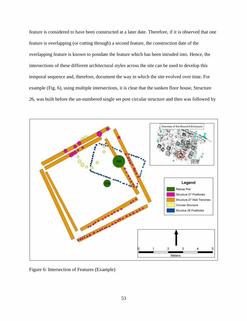
53
feature is considered to have been constructed at a later date. Therefore, if it is observed that one
feature is overlapping (or cutting through) a second feature, the construction date of the
overlapping feature is known to postdate the feature which has been intruded into. Hence, the
intersections of these different architectural styles across the site can be used to develop this
temporal sequence and, therefore, document the way in which the site evolved over time. For
example (Fig. 6), using multiple intersections, it is clear that the sunken floor house, Structure
26, was built before the un-numbered single set post circular structure and then was followed by
Figure 6: Intersection of Features (Example)
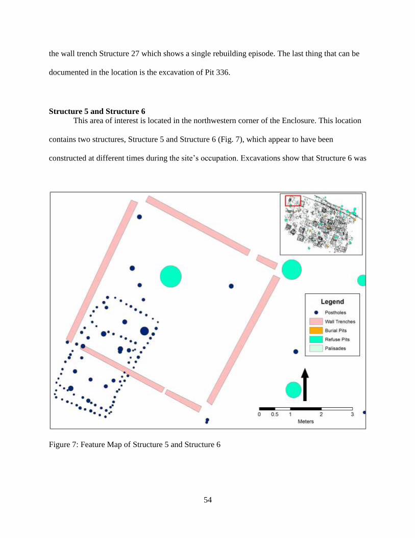
54
the wall trench Structure 27 which shows a single rebuilding episode. The last thing that can be
documented in the location is the excavation of Pit 336.
Structure 5 and Structure 6
This area of interest is located in the northwestern corner of the Enclosure. This location
contains two structures, Structure 5 and Structure 6 (Fig. 7), which appear to have been
constructed at different times during the site’s occupation. Excavations show that Structure 6 was
Figure 7: Feature Map of Structure 5 and Structure 6

55
the first to have been constructed at this location. Furthermore, it was constructed using a single-
set post design, and all of the postholes have diameters measuring less than 10 cm. It is also
interesting to note that this structure appears to be the remains of two separate structures. The
first and smaller of the two measures approximately 2.5 meters (length) x 2 meters (width) and
the second measures 3.5 meters long x 2 meters wide. Next, Structure 5 was built at this locale
and intersects with Structure 6. Structure 5 measures approximately 5.5 meters x 5.5 meters and
was constructed using a wall trench strategy. The original excavation notes clearly show the wall
trench of Structure 5 intersects the single-set post rows of Structure 6. Interestingly, both
structures are aligned on a similar orientation, neither of which appears to align exactly with the
Carson Grid; however, while these structures may not be exactly on this orientation, they are
very close to it.
Structure 26 and Structure 27
As already indicated, this location provides a good deal of temporal data. Structure 26
(Fig. 8), identified as a sunken floor house, was uncovered along with its associated postmolds
and wall trenches sitting within the sterile soil matrix. Next, the eastern side of Structure 27,
including both an inner and outer wall trench (likely due to a reconstruction event), are
superimposed on top of Structure 26. The excavation notes clearly state that the postholes and
wall trenches of Structure 26 were not apparent until the bottom of Structure 27’s eastern wall
trench was fully excavated. Finally, Pit 336 intersects the inner wall trench of Structure 27 on
this same eastern side. Also of note, is what appears to be an unlabeled single-set post circular
structure located within Structure 27. In addition to the superpositioning of these features, a
carbon date of cal A.D. 1640 (Sample 30) was derived from the charred remnants of a post

56
fragment in the sunken house floor fill; however, as will be discussed below, this is a
problematic date.
Figure 8: Feature Map of Structure 26 and Structure 27
Structure 17
The third area that is a prime focus of this research is Structure 17 located in the
southeastern quadrant of the enclosure (Fig. 9). This locale is of particular interest because it has
at least three separate construction stages. The first feature is Pit 210, which contained an
unusual number of lithic artifacts. This is a large rectangular pit measuring approximately 3.5
meters long and 1.75 meters wide and dug into the sterile floor soil matrix. The next architectural

57
phase is what appears to be the construction of an elevated floor structure which consists of four
square sides of rectangular wall trenches, a number of postholes which are somewhat uniform in
their placement within the structure some of which intrude into the fill of Pit 210. Finally, a pit
Figure 9: Feature Map of Structure 17
(Pit 208) which appears, based on its size and shape, to have been excavated in order to hoist a
large central post upright. The burned upper portion of the central post was still in place. The
third stage of construction at this location is the excavation of a large burial pit (Burial Pit 52)
which is located on the western side of the structure and intrudes into Pit 210. Furthermore, none
of the interior posts of Structure 17 intrude into Burial Pit 52, and, therefore, it is clear that this

58
was the final stage of construction at this location. In addition to feature intersections at Structure
17, a carbon sample was collected from the large timber centerpost which remained partially
intact and, after laboratory analysis, yielded an intercept date of cal A.D. 1410 (Sample 4).
Burial Pit 48
One area of particular interest for this research is the immediate vicinity of Burial Pit 48
located on the northern edge of enclosure area (Fig. 10). The first events that can be clearly
Figure 10: Feature Map of Burial Pit 48

59
documented at this location are the excavation and filling of three separate pits (Pits 227, 231,
and 232). These pits are then intersected by the outer palisade line and its associated postholes,
and, finally, Burial Pit 48 is superimposed over the outer palisade line. A number of human
remains were found in Burial 48, including and infant cranium, possibly part of a small bundle.
Structure 2 and Structure 23
Another location which provides insight into the site’s development over time is the
intersection of Structure 2 and Structure 23 located on the western side of the enclosure (Fig. 11).
First, Structure 23 was constructed using a single-set posthole strategy. It measures
Figure 11: Feature Map of Structure 2 and Structure 23

60
approximately 3.5 meters x 2 meters, and the postholes that make up Structure 23 are almost all
less than 14 cm in diameter. Structure 23 was first thought to have been a large refuse pit, but it
was later identified as a sunken floor structure. Excavation notes state that Structure 23 was 20
cmbs deep and likely heavily disturbed by modern land leveling practices. Next in the sequence
is Structure 2 which was constructed using wall trench methods. This building measures
approximately 5 meters x 5 meters and is generally aligned on the Carson Grid. Excavation
records note that the western wall of the structure intrudes into the southern posthole line of
Structure 23, and therefore it becomes obvious that it is later in the sequence.
Structure 27 and Structure 35
Another area of interest is the intersection of Structure 27 and Structure 35 which is
located in the southern portion of the Enclosure (Fig. 12). Structure 27, as previously discussed,
is a square wall trench structure measuring approximately 5.5 meters x 5.5 meters. Postholes
contained within the wall trenches of Structure 27 range from roughly 9-14 cm in diameter.
Moreover, unlike almost every other wall trench structure within the Enclosure, Structure 27 is
not aligned with the Carson Grid. Structure 35, on the other hand, is a square single-set post
structure measuring approximately 4.25 meters x 4.25 meters, and, like Structure 27, Structure
35 does not align with the Carson Grid either. This particular building also has two parallel lines
extending southeast which are likely associated with either an entrance or an entrance ramp.
Furthermore, postholes associated with Structure 35 range anywhere from 9-22 centimeters in
diameter. Structure 35 also contains a hearth near the center of the structure, the presence of
which is extremely rare (3 total) within the Mound A Enclosure Area at this time. Both shovel
scraping and GIS analysis revealed that the southern corner of Structure 27 and the northern
corner of Structure 35 likely intersect one another. However, when a subsequent reconnaissance

61
excavation was conducted, it could not be determined which architectural feature intruded into
the other. Therefore, the relative positioning of each feature could not be determined.
Figure 12: Feature Map of Structure 27 and Structure 35
Structure 13 and Structure 20
One particularly important area is the juncture of Structure 13 and Structure 20 located
near the center of the Enclosure area (Fig. 13). This area provides information on when the only
large single-set public structure at the Enclosure area was constructed. Structure 13 is a square
wall trench structure that measures approximately 6.2 meters x 6.2 meters and is more or less
aligned on the Carson Grid. Structure 20 is a large single-set post rectangular structure that

62
measures approximately 12 meters long x 6.5 meters wide. Like Structure 13, Structure 20 is also
very nearly aligned on the Carson Grid. In addition, Structure 20 is considered to have served as
a public space as suggested by the size of the structure. Essentially, the significance of this
location is that Structure 13, a wall trench structure, was revealed by shovel scraping to intrude
into Structure 20, a large rectangular single-set structure. This can be interpreted as, at least in
this one particular case, that wall trench structures appear later in the sequence than single-set
post structures.
Figure 13: Feature Map of Structure 13 and Structure 20

63
Structure 8 and Burial Pit 17
Another area that is important to look at is the intersection of Structure 8 and Burial Pit
17 which is located near the center of the Enclosure (Fig. 14). This locale, along with the
Structure 17 area intersection, confirms the relative sequence of elevated platform structures and
Figure 14: Feature Map of Structure 8 and Burial Pit 17
burial pits. Structure 8 is a square wall trench structure which measures approximately 7 meters x
7 meters and is oriented on the Carson Grid. This structure appears to have been an elevated
platform structure. This designation is based on the presence of regularly space postholes within
the boundaries of the building, a large sloping pit centrally located within the structure, and two

64
parallel posthole lines extending off the eastern side of the structure to the southeast, possibly
having served as a ramp or stairway. Also, the vast majority (158 postholes) of the postholes that
make up the structure are between 11 and 22 cm in diameter. Burial Pit 17, on the other hand, is
a relatively large burial pit that measures approximately 2.5 meters long x 1.75 meters wide. The
excavation notes revealed that the burial pit contained the remains of 19 bundled individuals, a
painted Avenue Polychrome water bottle, and a limonite celt that was associated with Bundle 12
from within the burial pit. Burial Pit 17, which is nearly aligned on the Carson Grid (an anomaly
when it comes to burial pits within the Mound A Enclosure), was found to intrude into the
northern wall trench of Structure 8. This provides supporting evidence that the burial pits located
within the Mound A Enclosure area postdate most, if not all, wall trench structures.
Structure 9, Structure 11, Burial Pit 18, and Burial Pit 34
Another location that contains multiple intersections and may lend insight into the
development of the site over time is the area in which Structure 9, Structure 11, Burial Pit 18,
and Burial Pit 34 are located (Fig. 15). Here, there are two architectural structures and two burial
intersections. Structure 11 is a square wall trench structure that measures approximately 5.5
meters by 5.5 meters. Like Structure 11, Structure 9 is also a square wall trench building, but it
measures approximately 4.5 meters x 4.0 meters and is completely contained within the
boundaries of Structure 11. John Connaway concluded that since the overall size of the interior
structure was significantly smaller than the outer, it was not a reconstruction of an earlier
structure, and, therefore, the two buildings were mapped and recorded separately. Moreover,
Structure 11 was found to intrude into Structure 9 showing clearly that Structure 11 was built
later during the occupation of the site.

65
Burial Pit 34 is a relatively large ovoid burial pit which measures approximately 2.25
meters long x 1.3 meters wide. Shovel scraping revealed it was superimposed over the northern
wall trenches of both Structure 9 and Structure 11. The pit was excavated to a depth of 18 cm
Figure 15: Feature Map of Structure 9, Structure 11, Burial Pit 18, and Burial Pit 34
and contained one bundle burial and two Bell Plain bowls which are common in the Late
Mississippian period (Phillips et al. 2003:126). Burial Pit 18, is a relatively small ovoid pit
measuring approximately 1.15 meters long x 0.80 meters wide. This pit is also located on the
northern perimeter of the location; however, it was found to intrude into the northern wall trench
of Structure 9 and into Burial Pit 18. This pit was excavated to a depth of 38 cm and contained a

66
single bundled individual and one Bell Plain bowl. Essentially, excavations at this location
revealed that initially Structure 9 was constructed followed by Structure 11. Sometime after that,
Burial Pit 34 was constructed and then Burial Pit 34 came last in the sequence.
Structure 21 and Structure 33
Structure 21 and 33 are located on the eastern side of the Enclosure and pose a challenge
to the general pattern that has been developed so far (Fig. 16). Structure 21 is a square single-set
structure measuring approximately 5.5 meters x 5.5 meters. The postholes that make up Structure
Figure 16: Feature Map of Structure 21 and Structure 33

67
21 measure between 15 and 27 cm in diameter. Moreover, Structure 21 is not aligned on the
Carson Grid. Structure 33, however, is a square wall trench building measuring approximately
5.5 meters x 5.8 meters and is oriented on the Carson Grid. Shovel scraping at this location
revealed that, interestingly, Structure 21 (single-set structure) intersects Structure 33 (wall trench
structure) and, therefore, appeared later in the site’s occupation. In other words, a subsequent
field investigation of Postmold 3313 of Structure 21 revealed that it was, in fact, superimposed
over the western wall trench of Structure 33. This is an anomaly that contradicts the general
trend at the site where single-set architecture predates wall trench architecture in most cases.
Structure 15 and Burial Pit 47
Another locale that has potential to assist in the development of a temporal sequence for
the site is the vicinity of Structure 15 and Burial Pit 47 (Fig. 17). At this location, a single-set
post structure was exposed along with three separate pits (Pits 156, 157, and 159), possibly
associated in some way with this structure. Both the inner and middle palisade lines intrude into
Structure 15, essentially bisecting it and also intruding into Pits 157 and 159. Finally, Burial Pit
47 is superimposed over both the inner and middle palisades and Structure 15 as well. Burial Pit
47 contained the skeletal remains of ten separate bundles as well as three ceramic vessels. These
vessels include one Walls Engraved var. Hull interior engraved bowl, one effigy bowl in the
shape of a frog, and one Bell Plain bowl.
Burial Pit 50 and the Inner Palisade
Burial Pit 50 was discovered near the northeastern perimeter of the Enclosure and adds
important evidence about the late stages of construction within the enclosure area (Fig. 18).

68
Burial Pit 50 and the Inner Palisade line intersect at this location and this is of particular interest
to this research. The Inner Palisade line is located near the northern edge of the Enclosure, and
Figure 17: Feature Map of Structure 15 and Burial Pit 47
extends from the northwest to the southeast at an approximate 68 degrees west of north
trajectory. The palisade trench itself is approximately 17 cm in width where it is intersected by
Burial Pit 50. Furthermore, while the inner palisade trench was being excavated, five postholes
were also revealed under Burial Pit 50. A carbon sample was collected from a charred post
fragment from one of these postholes and after radiocarbon dating analysis, yielded a date of cal

69
A.D. 1420 (Sample 36). Burial Pit 50 is an approximately circular burial pit which measures
approximately 1.30 meters (N/S) x 1.2 meters (E/W). The excavation of Burial Pit 50 resulted in
the recovery of the remains of ten bundled individuals. It was clear that Burial Pit 50 was
intrusive into the Inner Palisade line and, therefore, came at a later period of time in the site’s
occupation.
Figure 18: Feature Map of Burial Pit 50 and Inner Palisade
Burial Pit 57 and the Inner Palisade
Burial Pit 57 is located on the northeastern corner of the site and, together with the Inner
Palisade line, this particular location provides data into how this site may have developed over

70
time (Fig. 19). The inner palisade makes a sharp turn to the south at this location. The Inner
Palisade line at the point of intersection contains nine postholes ranging between 14-27 cm in
diameter, and the palisade trench is approximately 15 cm wide at this spot. A carbon sample was
Figure 19: Feature Map of Burial Pit 57 and Inner Palisade
collected from one of these posts which yielded a radiocarbon date of cal A.D. 1460 (Sample
20). Burial Pit 57 is a rather large ovoid pit (originally designated as Pit 222) which measures
approximately 2.6 meters (N/S) in length x 2.0 meters (E/W) in width and was 39 cm deep.
Burial Pit 57 contained the remains of a single adult male who was found in a flexed position.
This body was oriented such that his head was on the northern end of the pit with his feet to the

71
south. The field notes indicate that his remains were heavily disturbed by modern agricultural
practices, specifically a mechanical subsoiler. The field notes also state that the Inner Palisade
trench could not be discerned until the bottom of Burial Pit 57 had been excavated to
approximately 39 cm. This shows the Inner Palisade was constructed around cal A.D. 1460 and
that at some time after that Burial Pit 57 was dug into the remains of the preexisting palisade
line.
Radiocarbon dates collected from throughout the Enclosure
The fourth primary piece of evidence collected at the Mound A enclosure area are
radiocarbon dates from charcoal samples (Fig. 20). These samples have provided a wealth of
information about, not only an occupation or use period of the site, but also about when specific
architectural features were constructed (Table 4). Fourteen C14 samples have been collected and
analyzed from a number of different locations across the Mound A Enclosure. Specifically,
samples have been collected from sunken floor structures, the inner stockade line, the central
stockade line, the outer stockade line, the centerpost of an elevated platform structure, and
multiple burial pits. This has allowed the dating of many architectural features located within the
enclosure area. Unfortunately, a viable C14 sample has not yet been collected from either a
single-set structure or a wall trench structure.
It is important to note that the calibrated radiocarbon dates used for this research were
calculated by subtracting the “Cal BP” date from A.D. 1950 in the “Conventional Age/Intercept
Age” column of Table 4.

72
Figure 20: Map of Collected Radiocarbon Samples from the Mound A Enclosure
Table 4: Radiocarbon Dates Collected from within the Mound A Enclosure (John Connaway,
MDAH and Jayur Mehta, Tulane University) Sample
No.
Lab
No.
Measured
Age 13C/12C
Conventional
Age/Intercept Age
1-Sigma range
(68% probability)
2-Sigma range
(95% probability) Location
1 260025 840+/-60
BP
-25.1
o/oo
840+/-60 BP
Cal AD 1210 (Cal BP 740)
Cal AD 1160-
1260 (Cal BP 790-690)
Cal AD 1040-1280
(Cal BP 920-670)
St-8 platform,
centerpost fill
2 260026 340+/-50
BP
-25.9
o/oo
330+/-50 BP
Cal AD 1520 (Cal BP 430)
Cal AD 1470-
1640 (Cal BP 480-310)
Cal AD 1450-1660
(Cal BP 500-290)
Unburned cypress bark
covering on Burial 13
3 260027 420+/-50
BP -24.9 o/oo
420+/-50 BP
Cal AD 1450 (Cal
BP 500)
Cal AD 1440-
1480
(Cal BP 510-470)
Cal AD 1420-1530
(Cal BP 530-420)) Cal AD 1560-1630
(Cal BP 390-320)
Large burned N outer stockade post
4 370519 510+/-30
BP -23.4 o/oo
540+/-30 BP
Cal AD 1410 (Cal
BP 540)
Cal AD 1400-
1420
(Cal BP 550-530)
Cal AD 1320-1350
(Cal BP 630-600) Cal AD 1390-1430
(Cal BP 560-520)
Charred centerpost of
St-17 platform (intact
remnant)

73
Sample
No.
Lab
No.
Measured
Age 13C/12C
Conventional
Age/Intercept Age
1-Sigma range
(68% probability)
2-Sigma range
(95% probability) Location
5 370521 350+/-30
BP
-24.2
o/oo
360+/-30 BP Cal AD 1490 (Cal
BP 460)
Cal AD 1460-1520
(Cal BP 490-430)
Cal AD 1570-1590
(Cal BP 280-360)
Cal AD 1590-1630
(Cal BP 360-320)
Cal AD 1450-1640
(Cal BP 500-310)
Charred post in the
floor of St-12 floor
10 n/a 490+/-20
BP n/a Cal AD 1460 n/a Cal AD 1412-1444
Postmold #4823 located in St-31
12 n/a 720+/-20
BP n/a Cal AD 1230 n/a Cal AD 1263-1292
Organic residue found
on pottery in St-31
17 370518 260+/-30
BP
-22.4
o/oo
300+/-30 BP Cal AD 1640 (Cal
BP 310)
Cal AD 1520-1570
(Cal BP 430-380)
Cal AD 1590-1590
(Cal BP 360-360)
Cal AD 1630-1650
(Cal BP 320-300)
Cal AD 1490-1600
(Cal BP 460-350)
Cal AD 1610-1650 (Cal BP 340-300)
Charred post in N
central stockade
20 370520 350+/-30
BP
-22.8
o/oo
390+/-30 BP Cal AD 1460 (Cal
BP 490)
Cal AD 1450-
1490 (Cal BP 500-460)
Cal AD 1600-1610
(Cal BP 350-340)
Cal AD 1440-1520
(Cal BP 510-430) Cal AD 1570-1590
(Cal BP 380-360) Cal AD 1590-1630
(Cal BP 360-320)
Charred post in E inner
stockade trench
22 370517 330+/-30
BP
-23.8
o/oo
350+/-30 BP
Cal AD 1500 (Cal BP 450)
Cal AD 1470-
1520 (Cal BP 480-420)
Cal AD 1560-
1630
(Cal BP 390-320)
Cal AD 1450-1640
(Cal BP 500-310) Charred post in St-8
24 370516 270+/-30
BP
-23.6
o/oo
290+/-30 BP
Cal AD 1640 (Cal BP 310)
Cal AD 1520-
1560 (Cal BP420-390)
Cal AD 1630-
1650 (Cal BP 320-300)
Cal AD 1500-1500
(Cal BP 450-450) Cal AD 1510-1600
(Cal BP 440-350)
Cal AD 1620-1660 (Cal BP 330-290)
Charred wood timbers
at the bottom of BP 60
26 370515 810+/-30
BP -24.3 o/oo
820+/-30 BP
Cal AD 1220 (Cal
BP 730)
Cal AD 1210-
1260
(Cal BP 740-690)
Cal AD 1160-1270 (Cal BP 790-680)
Burned SE corner post in Structure 22
30 370522 310+/-30
BP -26.9 o/oo
290+/-30 BP
Cal AD1640 (Cal
BP 310)
Cal AD 1520-
1560
(Cal BP 420-390) Cal AD 1630-
1650
(Cal BP 320-300)
Cal AD 1500-1500
(Cal BP 450-450)
Cal AD 1510-1600 (Cal BP 440-350)
Cal AD 1620-1660
(Cal BP 330-290)
Charred post fragment
in sunken floor fill of
St-26
36 370523 420+/-30
BP
-21.4
o/oo
480+/-30 BP Cal AD 1430 (Cal
BP 520)
Cal AD 1420-1440
(Cal BP 530-510)
Cal AD 1410-1450
(Cal BP 540-500)
Charred post in N inner stockade trench
under BP-50 bundles

74
CHAPTER 5
DISCUSSIONS AND CONCLUSIONS
A Sequence for Carson
Having considered all of the available data recovered over the past seven years at the
Mound A Enclosure area, it is now possible to construct a temporal sequence of site occupation
and use. Using four different criteria: 1) architectural styles present at this location, 2) intersections
of dissimilar architectural styles, 3) orientation of each structure relative to the Carson grid, and 4)
radiocarbon dates collected from the enclosure area (Table 4). Furthermore, analysis of artifacts
collected from intact context throughout also aid in figuring out the temporal sequence.
The first structures to be built in the enclosure area were the sunken floor structures. These
include Structure 22, Structure 23, Structure 25, and Structure 31 on the western side of the site
and Structure 26 on the southern side of the site. These are probably the earliest structures in the
Mound A Enclosure. Three lines of evidence support this temporal assignment (Table 5). First,
two of these sunken floor structures (Structure 23 and Structure 26) were intersected by other
architectural features which post-date the construction of the sunken floor buildings. The western
wall trench of Structure 2 intrudes into the southern posthole boundary of sunken floor Structure
23, and both of the eastern wall trenches of Structure 27 (likely a reconstruction event) overlap the
eastern posthole border of sunken floor Structure 26. Second, the sunken floor structures are not
aligned with the Carson Grid while the wall trench structures that intersect them are. Third, two
separate carbon samples (collected from Structure 22 and Structure 31) yielded dates of cal A.D.
1220 (Sample 26) and cal A.D. 1230 (Sample 12) respectively. These are the earliest radiocarbon

75
dates from Carson. They also may be associated with Cahokian interaction based on the presence
of Burlington white chert in the pit fill, and their similarity with documented rectilinear basin-style
structures (Alt and Pauketat 2011:112-115) found at Cahokia. These are also the only such
structures to have been excavated in Mississippi at this time (Connaway n.d.:22-23).
At some point, sunken floor structures were replaced by a different style. Single-set
structures begin to appear in the sequence after the sunken floor structures. It has been suggested
that they may have, in some cases, been contemporaneous with the sunken floor structures, but
currently there is no way to tell. Evidence for single-set structures pre-dating wall trench structures
includes their lack of alignment with the Carson Grid. In addition, in several instances a single-set
structure is intersected by a wall trench structure (Structure 27 and Structure 35) or a palisade line
(Structure 15 and Inner and Middle Palisades). However, there is one instance of a wall trench
structure intersected by a single-set structure. Therefore, the evidence suggests that the single-set
structures postdate the sunken floor structures, emerge at some time before the advent of the wall
trench structures, but do seem to extend into the wall trench phase at least for a time.
One of the single-set post structures, Structure 20, is unusually large. Its size and location
near the center of the excavated area suggest that it is an example of public architecture.
Next, it appears that the construction of wall-trench structures took place. This is evidenced
by 1) wall trench structure intersections with the sunken floor structures, 2) the wall-trench
structures appear to be the first architecture at the site oriented on the Carson Grid, and 3) a carbon
sample collected from the centerpost of Structure 17 (elevated platform house) confirms a date of
cal A.D. 1410 (Sample 4). Platform structures, also oriented on the Carson Grid, were constructed
using a wall trench design around this time (Structure 8 and Structure 17).

76
There are a number of examples of wall trench structures intruding into structure types that
appear to predate these wall trench construction periods. Moreover, not only are there several of
these intersections, but they occur across the entirety of the site. There are two examples of such
intrusions on the western side of the site. First, Structure 5, a wall trench structure, intrudes into
Structure 6, which is a rectangular building constructed from a single-set post design. Also on the
western side of the site Structure 2, a wall trench structure, intrudes into the sunken floor Structure
23.
There are also two instances of wall trench buildings superimposed over a different
architectural feature located in the center section of the site. First, the Structure 27 (wall trench
structure) and Structure 26 (sunken floor structure) intersection is located in this area. It is worth
restating that this is another example of a wall trench building overlapping a sunken floor building.
Second, the intersection between Structure 13 (wall trench) and Structure 20 (large single-set post
structure), which has already been discussed, occurs in the central part of the Enclosure.
There is a single example of a wall trench building that intersects with a predating
architectural structure on the eastern side of the Enclosure. Here, Structure 21, a wall trench design
building is superimposed over Structure 33 which was built using a single-set post design. While,
excavation field notes were unclear as to which structure appears first in the sequence, subsequent
field investigation revealed that Structure 21 does in fact intrude into the earlier construction phase
of Structure 33.
The palisades at the enclosure area are also believed to have been contemporaneous with
the wall trench houses because 1) all three palisades are oriented on the Carson Grid and 2) three
collected carbon samples (one from the outer palisade and two from the inner palisade) yielded

77
Table 5: Sequence of Intersection within the Mound A Enclosure
Type Intersects With Intersected By Carson Grid C14 Dates
Sunken Floor
Structure None Wall Trench No
cal A.D. 1220 and
cal A.D. 1230
Single-Set
Structure Wall Trench
Wall Trench
and Palisades Yes and No None
Large
Rectangular
Structure
None Wall Trench Yes None
Wall-Trench
Structure
Sunken Floor
and Large
Rectangular
Single-Set Yes None
Platform
Structure None Burial Pits Yes cal A.D. 1410
Palisades Single-set Burial Pits Yes
cal A.D. 1420, cal
A.D. 1450, cal
A.D. 1460, and cal
A.D. 1640
Burial Pits
Palisades, Wall
Trench, and
Platform
None No cal A.D. 1520 and
1640
dates of cal A.D. 1420, 1450, and 1460 respectively. Finally, the palisades clearly delineate the
area where wall trench structures were built. There are no wall trench structures located outside
the palisade. The importance of the palisade during this period of time is documented by the
multiple rebuilding episodes. Moreover, it appears that the palisades were present at the enclosure
for quite some time, a fourth carbon date collected from the western half of the inner palisade
yielded a date of cal A.D. 1640.
The final event that is clearly documented at the Enclosure is the transformation of the area
into a burial ground. Evidence for this functional change is based primarily on 1) the fact that
burial pits intersect almost all other architectural classes in the Enclosure, 2) none of the burial pits
were intersected by any other features at the site, and 3) two carbon samples collected from the
unburned cypress bark covering Burial Pit 13 and charred wood fragments underlying Burial Pit
60 returned dates of cal A.D. 1520 and 1640 respectively.

78
Currently at the Mound A Enclosure area there have been six identified locations where
burial pits intersect other architectural features. Burial 48, which is located on the northern
perimeter of the site, was excavated and found to overlap the outer palisade line. Burial Pit 47,
also located in the northern region of the site, intersects both single-set post Structure 15 and both
the inner palisade and middle palisade lines. Burial Pit 50, which is located on the northern side of
the site, intersects the inner palisade line. Burial Pit 57, located on the northeastern corner of the
site, intrudes into the inner palisade line, as well. Burial Pit 18 and Burial Pit 34, located near the
center of the site, were superimposed over the northern wall trench of Structure 9 and Structure
11. Finally, Burial Pit 17 which is located in the east central portion of the Enclosure intrudes into
the northern wall trench of elevated platform Structure 8.
Two major observations emerge from all of the data concerning the burial pits and their
associated intersections. First, it becomes clear that during this period of time the Enclosure was
used as a burial space and the Carson Grid was not used. This is evident by the haphazard
alignment of many of the burial pits. The second point is that when the burial pits are in use, the
palisades surrounding the Enclosure area, specifically the Outer Palisade wall, were no longer
delineating the activity area of the occupation. This is supported by Burial Pit 48 intersecting the
Outer Palisade line’s wall trenches and associated postmolds.
Taken collectively, all of the available data such as architectural intersections and
collected radiocarbon dates begin to paint a picture of how the Mound A Enclosure area
developed over time. Therefore, based on these findings, the sequence for the Mound A
Enclosure area at Carson appears to be that, initially, sunken-floor structures were constructed
either along with or followed by single-set structures. These single-set structures appear to
extend into the next period in which the construction of wall-trench structures, platform

79
structures, and the palisade lines emerge. Finally, the use of the enclosure area changed from an
occupational space to one devoted to the interment of human remains when burial pits began
being the only construction going on in this portion of the site.
Architectural Grammar for the Mound A Enclosure Area
The most efficient method to constructing an architectural grammar, as Ramie Gougeon
(2007:146-151) explains, is to work on a scale from large-to-small or, in other words,
hierarchically organize purposefully constructed objects (i.e. architectural structures) in a
descending order from the grandest to the most minute. It is in this spirit, and using this
approach, that an architectural grammar for the Mound A Enclosure at Carson can be developed.
This is by no means a comprehensive grammar for all Mississippian mound centers in the Upper
Yazoo Basin or at the Carson mound group itself. However, it does account for the architecture
currently known at the Mound A Enclosure area. This is an attempt to build a broad framework
of concepts that are applied locally to the site for future analysis.
During the Mississippian Period in the Lower Mississippi River Valley mound building
societies usually constructed mound sites near relatively large navigable waterways. The primary
reason for this was easy access to water, fertile soils, navigation, and more readily available food
sources. Towns were often constructed adjacent to large earthen mounds, or, the reverse, mounds
were constructed adjacent to town centers (Gougeon 2007:146).
At the town level, one or more plazas are common, and these plazas were usually placed
in the center of “habitation zones” or living spaces. To date, a plaza in the traditional sense has
not been located at Carson, but it is possible that at one time a plaza may have existed,
potentially just south of Mound A.

80
Mississippi period towns were often encircled by a palisade or some sort of exclusionary
barrier. Three separate palisade lines have been identified at the Mound A Enclosure area and
they are believed to have encircled the enclosure. The Outer Palisade and the Middle Palisade
both extend across the north side of the site. The Inner Palisade line extends across the north and
east sides of the site. During the Mississippian period these barricades were often used for
protection in times of conflict, but in many cases where bastions are absent, their intended
purpose appears to have been to block access to non-elites. It is likely that this is the case with
palisade lines at the Mound A Enclosure area since, to date, no bastions have been discovered
along any of the northern or eastern palisade boundaries. In addition, at one time there was also a
berm that appears to have surrounded the palisade although this berm has not been uncovered by
excavations.
The habitation zones typically contained two primary types of structures which are
usually classified as being used for either public or domestic purposes. Structures in the Mound
A Enclosure were assigned to these classes on the basis of size. There are three structures that
may have served in some public function: a large rectangular structure (Structure 20) in the
approximate center of the Enclosure, and two elevated structures (Structures 8 and 17) that may
have been used as charnel houses. It is also worth noting that it appears that these public
structures were constructed in a central location surrounded by adjacent domestic structures,
possibly serving in lieu of a traditional plaza.
In addition to the two primary public structure types, a third type, the small circular
structures, can potentially be included in this category. These structures are relatively small in
diameter (approximately 3 meters) and seem to have been constructed (in most cases) in clusters.
It appears that these structures were purposefully positioned in areas of the Enclosure which

81
were devoid of any domestic structures (i.e. wall trench houses), and it appears as if they were
easily accessible by the public. It is possible that these structures were storage facilities in which
cultivated crops or other goods might have been placed.
Domestic structures within the Enclosure can be grouped into three primary categories:
sunken floor structures, single-set post structures, and wall trench structures. It is likely that the
sunken floor structures predated the rest of the structures in the Enclosure. These structures are
generally not aligned on the Carson grid and, except for Structure 31, tend to be small
rectangular structures excavated approximately 30 cm below the surface. There are also two
refuse pits that seem to be associated with these early sunken floor structures, Pit 11 and Pit 24.
The single-set post structures and their associated refuse pits are really too few in number to
draw many conclusions about the intention with regard to their location or how that relates to the
builders’ intended use of space.
After time, the Enclosure appears to have undergone many changes and construction
techniques are certainly a key component to this change. In contrast with the early architecture at
the site, the wall trench structures appear to have been constructed in locations that suggest some
planning with regard to their spatial use. Mainly, they are aligned along the Carson Grid. Clearly
this alignment meant something to the builders, and it was significant as the palisades enclosing
the Enclosure area were also constructed on this alignment. These wall trench structures within
the Enclosure also appear to be arranged from north to south along very rough linear columns
with an area positioned roughly in the center devoid (with the exception of Structure 13) of wall
trench structures. Moreover, all of these structures were purposefully constructed using at least
four wall trenches. At least one of these wall trench structures also includes some type of parallel
wall trench entranceway, and four of these structures have a centrally located hearth.

82
The final construction phase at the Mound A enclosure area consisted of the excavation
of pits to contain multiple human burials. There are sixty-six burial pits identified within the
Mound A Enclosure area. There is no apparent pattern in the distribution of these burial pits.
They are not aligned along the Carson grid although some appear to be aligned with the cardinal
directions. It is apparent the construction during this last stage in the Mound A Enclosure area
was not constrained by the same construction parameters as were followed earlier.
Space Syntax Analysis of the Mound A Enclosure Area
In addition to constructing an architectural grammar of the Mound A Enclosure, the area
was also viewed through the lens of a space syntax analysis in an attempt to gain insight into the
social dynamics underlying the use of the space. This was done by taking concepts outlined by
Van Dyke (1999:462) such as symmetry/ asymmetry and distributedness/ nondistributedness and
applying them directly to the Mound A Enclosure. However, it was determined that it would not
be possible to construct a permeability graph since the spaces, both domestic and public, were
not connected to each other in any physical way. In addition, the quantitative analysis component
of space syntax study is not possible because the numbers used in calculating both RA or RRA
are derived directly from the permeability graph. Therefore, while considered using the
fundamental concepts of space syntax analysis (i.e symmetry/asymmetry and
distributedness/nondistributedness), the Mound A Enclosure area was not analyzed using
quantitative space syntax methods in the strictest sense.
The Mound A Enclosure area is currently comprised of approximately 34 discrete
domestic and public buildings. These include square wall-trench structures (18), sunken-floor
structures (5), square single-set post structures (5), platform structures (2), single-set circular
structures (3), and a large single-set rectangular structure (1). In every single case, these

83
structures have been found to be separate entities which do not appear to have been connected to
each other through construction. Furthermore, access to these structures does not appear to have
been restricted on an individual basis in any way such as through the construction of a palisade
or barrier. The Enclosure area as a whole was encircled by a palisade which would have limited
access giving it a degree of asymmetry during the middle phase of construction at the site.
Incidentally, Mound C at Carson had a palisade surrounding the top of the mound during this
period, limiting access to its summit (Carpenter 2013). Therefore, the architectural structures
located within the Mound A Enclosure area are considered to be symmetrical and distributed. In
other words, each structure at the site has an equal amount of accessibility and each structure
appears to have multiple routes of access but access was limited by palisades during a portion of
the occupation.
Carson and the Mississippian World
When one considers how this site developed over more than 400 years of occupation, it is
important to understand the Carson site in the realm of the larger Mississippian world both
regionally in the Upper Yazoo Basin and more widely in the southeastern United States.
Moreover, it is clear that Carson is distinct from a number of roughly contemporaneous sites in
the Upper Yazoo Basin and is unique in a number of ways. In addition, it also becomes clear
that, in some cases, there are a number of similarities between Carson and other iconic mound
centers located throughout the Southeast such as Cahokia, Moundville, Etowah, and Town
Creek. However, Carson can also be characterized by a number of stark contrasts between itself
and these sites as well.
First, it is important to gain some understanding of how Carson articulates and compares
to sites located within the Upper Yazoo Basin. It is important to note that relatively few

84
excavations have been conducted at sites within this region but, based on preliminary
investigations and/or tightly focused research projects, adequate data does exist to make some
broad regional comparisons. Sites within the Upper Yazoo Basin that can serve as appropriate
regional analogs include: the Hollywood site, Parchman Place, Evansville, Beaverdam, West
Mounds, Salomon, and the Dunn site (Fig. 21).
The Hollywood mound site (22TU500) in Tunica County, Mississippi, is located
approximately 30 miles northeast of the Carson Mound group (Cureton et al. 2014:29-30). This
site covers an area that measures approximately one-third mile (600 m) x 0.18 mile (300 m) and
is comprised of four existing mounds and an additional seven boundary mounds that, based on
previous geophysical investigations, are known to have once been at the site (Johnson et al.
2000:3). Furthermore, at one time, the Hollywood site included a plaza located just south of
Mound A. The presence of a plaza and a few scattered mounds and residences surrounding
Mound A gives it a more traditional Mississippian architectural grammar typically associated
with the Late Mississippian Period.
The Parchman Place Mound (22CO511) site is situated south of a large oxbow lake
approximately 10 miles northeast of the Carson Mound group (Stevens 2006). It spans an area
that is roughly 2.2 miles (350 m)(E/W) by 0.18 miles (300 m)(N/S). The site was described by
Phillips et al. (2003:373) as a village site with both large and small mounds with the large mound
facing a plaza. According to Nelson (2014:50-52), geophysical reconnaissance confirmed that, in
fact, Mounds A, B, and E, and several residential neighborhoods (1, 2, and 4) were all arranged
around a plaza or some “large central space.” This evidence suggests that at this particular site, a
large mound and plaza was encircled by domestic structures, and, like several of the previous
sites, conforms to a Mississippian architectural grammar as well.

85
The Evansville Mound site (22TU502), located on the eastern side of Beaverdam Lake in
Tunica County, Mississippi, consists of one large mound (Mound A), several smaller mounds,
Figure 21: Map of Sites within the Upper Yazoo Basin (Phillips 1970: fig. 447)

86
and a village site. According to Cureton (2014:29-30), Mound A is a rectangular shaped platform
mound measuring approximately 3.5 meters tall and Mound B is a 1-meter tall “circular” mound
approximately 160 m to the northwest. The other two mounds are located to the west of Mound
A and the village location is just east of Mound A. Similar to other mound sites in the area, the
mounds at the Evansville site are arranged in a circular configuration which suggests the
possibility of a plaza.
The Beaverdam site (22TU513), is also located on the eastern side of Beaverdam Lake in
Tunica County, Mississippi. According to Cureton et al. (2014:35-36), this site is currently
comprised of two mounds; Mound A, a two-level rectangular mound measuring approximately
3.4 meters high and Mound B, a much lower mound (0.6m high) located approximately 42m
southwest of Mound A. In addition, there also appear to be two more mounds similar to Mound
B situated approximately 180 m to the south of Mound A. Phillips (1970:928) assigned this
location to the Coahoma phase of the Baytown period and the Kent phase of the Mississippian
period. Like most other mound sites in the Upper Yazoo Basin, Beaverdam and its four mounds
are arranged in a semi-circular (or circular) configuration.
West Mounds (22TU520), located in Tunica County, Mississippi, is comprised of one
large platform mound, two or three smaller mounds, a plaza, and a village site (Cureton et al
2014: 40-41). Mound A is a rectangular mound measuring approximately 2.7 m high, and
Mound B, also a rectangular mound, is situated approximately 32 m east of Mound A and is
roughly 1.5 m high. Mound C is a circular mound situated approximately 337 m south of Mound
A and is 2.25 m high. Mound D, located approximately 118 m southeast of Mound A, is a
“circular feature” and no taller than 1 m. Similar to the previous mound sites, West mounds has a
circular arrangement, surrounding somewhat centrally located plaza.

87
The Salomon site (22CO504), situated on the southern bank of Hull Brake in Coahoma
County, Mississippi, currently consists of a large mound (Mound A) which stands at
approximately 8 m high, and a smaller mound (Mound B) situated immediately to the southwest
which measures approximately 2 m high (Cureton et al. 2014: 53-54). Prior to modern
agricultural disturbance, the Salomon site, at one time, was comprised of three large mounds and
eight smaller mounds arranged in a semicircular configuration around a centrally located plaza
(Cureton et al. 2014:53).
The Dunn Mound site (22CO632) which is situated in Coahoma County, Mississippi, is
approximately 13 miles southeast of the Carson Mound group. The overall area covered by the
site measures approximately 300 meters (E/W) by 200 meters (N/S). This site consists of three
existing mounds the largest of which, Mound A, is a large ovoid shaped mound measuring
approximately 91 meters in length and standing approximately 5 m high. Mound B and Mound C
are much smaller mounds situated to the northeast and are currently little more than slight rises.
While it is possible that a plaza may have existed at some period in the past, to date one has not
been located. The original Lower Mississippi Survey (LMS) map from 1940 notes a daub scatter
sitting just to the southwest of Mound A, but since that time little evidence of house structures
has been recovered.
Moving beyond comparisons to sites located within the Upper Yazoo Basin, Carson has a
number of similarities with sites located throughout the southeastern United States. First, Carson,
like Moundville in Alabama and Town Creek in North Carolina, initially began as a domestic
space. This is shown by the presence of Woodland ceramics, whose range of types suggest
people had been living at Carson for a few hundred years. Sometime around A.D. 1200 there was
contact with a group of people either from Cahokia or that had close ties to Cahokia located
88
some 300 miles upriver in southern Illinois. Evidence for this includes the sunken floor
structures, the presence of a probable ridge-top mound (Butz 2015), Burlington chert, and
Cahokia cordmarked pottery. After this initial Mississippian contact, the site continued to be
occupied as suggested by the change in Mississippian architectural styles of single-set post
design and eventually wall trench design. This change in domestic architecture is consistent with
the architectural change that was occurring to the east in west-central Alabama described by
Cameron Laquement (2007:61), although, at least in the case of single-set post structures, it may
have occurred a little later at Carson.
However, based on radiocarbon dates it can be hypothesized that around A.D. 1500 the
Mound A Enclosure area at Carson changed from a domestic space to one that was primarily
used for the inhumation of human remains. This abandonment and functional change is also
consistent with similar events that occurred at Cahokia around A.D. 1200 (Emerson 1997:253),
Moundville around A.D. 1400 (Knight and Steponaitis 1998:21-24), and Town Creek which
occurred at approximately A.D. 1400 (Boudreax 2007:109).
It appears that Carson, like these other major Mississippian mound centers, was an
important center for the local population, a location where people would gather from miles
around. It has been well documented that sites such as Moundville in Alabama were critically
important to the surrounding areas for a time period spanning approximately 400 years, and
similar conclusions are drawn about sites such as Cahokia, Etowah, and Town Creek as well.
The evidence from Carson, specifically the Mound A enclosure area, suggests that after its initial
occupation, the site developed into a continuously occupied town for approximately 300 years. It
was also during this time that a number of major mounds were constructed across the site,
including Mound B, Mound C, Mound D, and Mound E. The approximate construction period of

89
these mounds is known because they are aligned on the Carson grid. Therefore, it can be
assumed that during this approximate 300-year period (A.D. 1200-1500), similar to Moundville
and other major Mississippian mound centers, the Carson mound group was a vibrant and
important location to the residents in the immediate surrounding vicinity and likely much farther
afield.
Despite the similarities that Carson may have to other Mississippian centers throughout
the Southeast, there are also a number of critical differences that set it apart from these other
sites. First, it appears that Carson, as measured in terms of sheer expanse and number of mounds,
seems to be larger than many of these other regional polities. As previously mentioned, Carson
covers an area of approximately 85.68 hectares, and is roughly one mile long from east to west
and one-half mile long north to south. This area was calculated by importing the Thomas (1894)
map into ArcGIS. It is obviously larger than Moundville, which encompasses an area of
approximately 75 hectares (Knight and Steponaitis 1998:3) and the Etowah site, which covers an
area of approximately 21 hectares (Bigman et al. 2011:38).
In addition to the expanse of the site, the number of mounds that comprised Carson in the
late-prehistoric period is also worth considering. Although Carson is currently made up of only
six surviving mounds, according to Holmes, it was once comprised of over 80 mounds. The
number of mounds at Carson, along with the expanse of the site, makes it an anomaly within the
region, in which it is located and, indeed, much of the Southeast (Payne 1994).
Finally, another aspect of Carson that separates it from many Mississippian mound
centers is that it is not simply a cluster of smaller mounds and/or residential areas arranged
around a single large mound. Mound and residential areas at Carson are dispersed across the
more than one-mile long landscape, and the body of collected information suggests that

90
construction of several of these mounds and residential areas may have occurred at different
times. To date, no plaza has been discovered at Carson; however, one potential location for a
plaza lies just south of Mound A. The Mound A Enclosure area, the residential area which is the
focus of this research, is located just east of Mound A. A second residential space likely exists
north of Mound D, which is actually the largest mound at the site. As previously mentioned, all
six remaining mounds at the Carson site are dispersed in a linear fashion along the Carson Grid
orientation over one-mile long. Thus, it is this linear arrangement of the mounds and residential
spaces at Carson that make it anomalous.
Therefore, in order to draw a distinction between Carson and shed light on the unique
characteristics of this site, it is important to discuss a number of these same characteristics at
comparable mound centers across the greater Mississippian world. For example, Moundville
spans an area of approximately one-third mile (600 m) east to west (E/W) by one-third mile (600
m) north to south(N/S), and contains 29 platform mounds. Obviously, the fact that 29 mounds
are still found at Moundville suggests that this was an enormously important location and that at
one time many smaller mounds would have existed. Additionally, the arrangement of
Moundville is such that the 28 surviving platform mounds form a circle around the large mound
and its associated plazas (Wilson 2008).
The size of Etowah is comparable to Moundville in that it has measurements of
approximately one-third mile (600 m)(E/W) x one-third mile (600 m)(N/S); however, the
number of surviving mounds that are currently at Etowah is six. Once again, the five smaller
mounds (Mounds B, C, D, E, and F) and a single plaza form a crescent around the large mound.
As a result, Etowah is similar to Carson in the number of mounds that are at the location, but

91
when one considers the area that the site encompasses as well as the overall site arrangement, it
becomes clear that there are some stark contrasts.
The Town Creek site in North Carolina contains a single mound and spans an area that is
approximately one-half mile (800 m)(E/W) by one-half mile (800 m)(N/S). The arrangement of
this site can be described as a single mound with an associated plaza, encircled by a number of
separate residential spaces dating to different times. Furthermore, while the number of large
public earthenworks found at Town Creek may pale in comparison to either Moundville or
Etowah, the overall size and arrangement of the site seems to adhere to some of the same rules.
With all of these things in mind, it is important to keep in mind that two additional points
are worth noting here when comparing Carson to these large iconic sites from across the
Mississippian Southeast. First, the Carson site is, not surprisingly, smaller in expanse than
Cahokia in southern Illinois which spans an area approximately 1.25 miles (2,011 m)(E/W) by 1
mile (1,609 m)(N/S) (Pauketat 2007:139). Therefore, the key elements of this argument do not
neatly fit when Carson is evaluated alongside of Cahokia. Second, the six remaining mounds
located at Carson are relatively small in size and, therefore, in terms of metric volume of fill used
for mound construction, sites such as Cahokia, Etowah and Moundville are much greater.
What this all means is that there are a number of conclusions about the Carson Mound
Group that can be drawn from all of the available data that can be used to place it within the
broader Mississippian domain. Moreover, while there are a number of similarities to other
mound centers located throughout the Upper Yazoo Basin and in the southeastern United States,
Carson, at least in the Upper Yazoo Basin, is quite unique. Compared to either the Hollywood
mound site and/or Parchman Place mounds, which are both considered to be short term, Late

92
Mississippian occupations, in terms of site complexity, mound count, the occupational span of
the site, and the overall arrangement of the site, in its region, Carson stands alone.
Final Thoughts
When considering where the Carson Mound site fits into the broader Mississippian
world, it is important not only to have some understanding of the changes that were occurring
across the greater southeastern United States, but to also have a general appreciation of the way
various sites were evolving during this time period. The original focus of this research was to
investigate the concept of Mississippianization and the emergence of chiefdom level polities on a
regional scale, specifically the Upper Yazoo basin region of northern Mississippi. Furthermore, it
was believed that these concepts could be accessed by taking a look at the Mound A Enclosure
area at the Carson Mound group in Coahoma County, Mississippi, and developing a temporal
sequence of how the site developed overtime through the analysis of the architecture local to the
site. By doing this, it is believed that Carson serves, not only as an extremely unique site within
the Upper Yazoo basin, but also as a model for how a chiefdom-level polity may have emerged
in the region, as well. This occurred within a contemporaneous regional context in the Southeast
where similar changes, both political and architectural occurred, suggesting Carson was a part of
the broader sphere of interaction.
Essentially, the story of Carson, at least of the Mound A Enclosure area at Carson, can be
understood as one of early contact of some form with Cahokia, followed by several centuries of
growth and development, and finally an abandonment of the site and its ultimate evolution into a
space used primarily for burial purposes. Moreover, if one were to consider the lifespan of
Carson by only viewing Mound A and its associated adjacent enclosure area, it could be said that
at least a rough understanding of the mound center as a whole might be obtained. In other words,

93
encapsulated within this relatively small area are representations of each stage of the entire
Carson Mound Group’s lifespan.
It appears that initially Mound A was constructed around A.D. 1200 based on its
orientation with the Carson Grid. It is likely that there were already a number of people living at
this location at that time based on the presence of Woodland ceramics. Soon after, some type of
contact with Cahokia occurred based on the presence of artifacts and architecture distinct to
Cahokia at that time.
In the centuries to come, life at Carson would begin to diverge from this Cahokian
influence and take on a life of its own, and this can be seen through changes in architecture such
as the construction of at least three separate palisades, square single-set structures and wall
trench structures, circular structures, and the overall arrangement of the site on the Carson Grid.
That said, many of these architectural styles were not unique to Carson, but were used
throughout the southeastern United States at sites such as Moundville in Alabama, Etowah in
Georgia, and Town Creek in North Carolina.
After nearly two centuries of occupation at the Mound A Enclosure area, it appears that
habitation at the site ceased. There is evidence that a similar trajectory occurred at other mound
center locations throughout the region within approximately the same time period including
Moundville, Etowah, and Town Creek. It is at this point that the architecture within the palisaded
enclosure area at Carson changes to burial pits and the site is no longer oriented on the Carson
Grid. The excavations at the site clearly show that burial pits were the final stage of construction,
and therefore, the use of the site by the population changed from a habitation space to one used
for mortuary purposes. Again, there is precedent for this transition from mainly domestic use to

94
serving a more public or ceremonial purpose. This can be seen and is well documented at both
Moundville and Town Creek.
Therefore, if the information derived from the excavations at the Mound A Enclosure
area is expanded across the site, one comes to the conclusion that the Carson Mound Group was
an enormously important center of human interaction spanning at least five centuries. When
viewed as a whole, the site is a large complex covering an area over one-mile long comprised of
multiple mounds. These mounds (at one time over eighty in number) likely served many
functions. Based on its size and number of mounds it is likely that at its peak Carson was home
to a large number of people. Therefore, if it is assessed next to comparable mound centers, both
in the Upper Yazoo Basin and throughout the southeastern United States, it becomes obvious
that this location was essential to the daily lives of Mississippian people, not only locally, but
potentially much farther afield, as well.
At the outset of this research project, the goal was to explore the implications of
emerging social complexity and the development of chiefdoms within the Upper Yazoo Basin of
Mississippi. The plan was to access these concepts by examining architectural features
uncovered within the Mound A Enclosure area at the Carson Mound Group located in Coahoma
County, Mississippi. As a result, over 6,000 postholes, 400 refuse pits, 66 burial pits, and over 40
architectural structures that have, to date, been identified were analyzed in an attempt to develop
a temporal sequence for this extremely important location. It is believed that a straightforward
and consistent temporal model for this site has been developed and, therefore, a foundation has
been laid that will hopefully be further developed in the future.
This research project has made one thing abundantly clear. The Carson Mound group, for
a period of time spanning some 500 years, was a place that held enormous significance to the

95
occupants of that area and beyond. The mound center emerged, over time, as a location that
served as a center of interaction and ceremony for people in their everyday lives before its
eventual demise. Furthermore, the Mound A enclosure area at Carson serves as a window
through which one can view the evolution of the site at this critical period of time. Fortunately,
all of the hard work that has been conducted at Carson over the past years has enabled us to
glimpse into the past and gain some insight into what everyday life at Carson might have been
like, and there is no doubt that with so many interesting avenues of future research this will
continue be the case for years to come.

96
BIBLIOGRAPHY

97
Alt, Susan M. and Timothy R. Pauketat-
2011 Why Wall Trenches? Southeastern Archaeology 30(1): 108-122.
Anderson, David G.
1996 Fluctuations between Simple and Complex Chiefdoms: Cycling in the Late Prehistoric
Southeast. In Political Structure and Change in the Prehistoric Southeastern United States,
edited by John F. Scarry. Pp. 231-252. University of Florida Press, Gainesville, Florida.
1999 Examining Chiefdoms in the Southeast: An Application of Multiscalar Analysis. In Great
Towns and Regional Polities in the Prehistoric American Southwest and Southeast, edited by
Jill E. Neitzel. Pp. 215-241. University of New Mexico Press, Albuquerque, New Mexico.
Bigman, Daniel P., Adam King, and Chester P. Walker
2011 Recent Geophysical Investigations and New Interpretations of Etowah’s Palisade.
Southeastern Archaeology 30(1): 38-50.
Blitz, John H.
1999 Mississippian Chiefdoms and the Fission-Fusion Process. American Antiquity 64(4): 577-
592.
Blitz, John H. and Karl G. Lorenz
2002 The Early Mississippian Frontier in the Lower Chattahoochee-Apalachicola River Valley.
Southeastern Archaeology 21(2): 117-135.
Boudreaux, III, Edmond A.
2007 The Archaeology of Town Creek. University of Alabama Press, Tuscaloosa, Alabama.
2013 Community and Ritual within the Mississippian Center at Town Creek. American
Antiquity 78(3): 483-501.
Butz, Samuel H.
2015 Excavations of Mound B: A Ridge-Top Mound at the Carson Site, A Mississippian Mound
Center in the Northern Yazoo Basin. M.A. Thesis, Department of Sociology and
Anthropology, University of Mississippi.
Carpenter, Erika
2013 Examination of Architectural Features on Mound C of the Carson Mound Group,
Coahoma County, Mississippi. M.A. Thesis, Department of Sociology and Anthropology,
University of Mississippi.
Cobb, Charles R.
2003 Mississippian Chiefdoms: How Complex? The Annual Review of Anthropology 32: 63-
84.

98
Connaway, John M.
n.d. In the Shadow of Mound A: Seven Years at the Carson Montgomery Mounds, 22-CO-
518 (November 2007-December 2014), Coahoma County, Mississippi. Manuscript submitted
to Mississippi Archaeology.
Cureton, Travis, Stephen Harris, Erica Carpenter, and Jay K. Johnson
2014 Mississippi Mound Trail, Northern Region: Phase I Investigations. Report submitted to
the Mississippi Department of Archives and History. The Center for Archaeological
Research, University of Mississippi, Oxford.
Demel, Scott J. and Robert L Hall
1998 The Mississippian Town Plan and Cultural Landscape of Cahokia, Illinois. In
Mississippian Towns and Sacred Spaces: Searching for an Architectural Grammar, edited by
R. Barry Lewis and Charles Stout. Pp. 200-226. University of Alabama Press, Tuscaloosa,
Alabama.
Dietler, Michael and Ingrid Herbich
2001 Feasts and Labor Mobilization: Dissecting a Fundamental Economic Practice. In Feasts:
Archaeological and Ethnographic Perspectives on Food, Politics, and Power, edited by
Michael Dietler and Brian Hayden. Pp. 240-264. Smithsonian Institution Press, Washington
D.C.
Earle, Timothy
1997 How Chiefs Come to Power: The Political Economy in Prehistory. Stanford, California:
Stanford University Press.
Emerson, Thomas E.
1997 Cahokia and the Archaeology of Power. University of Alabama Press, Tuscaloosa,
Alabama.
Emerson, Thomas E. and R. Barry Lewis
1991 Cahokia and the Hinterlands: Middle Mississippian Cultures of the Midwest. Board of
Trustees of the University of Illinois.
Feinman, Gary M. and Linda Manzanilla
2000 Cultural Evolution: Contemporary Viewpoints. Kluwer Academic/ Plenum Publishers,
New York.
Gougeon, Ramie A.
2007 An Architectural Grammar of Late Mississippian Houses in Northwest Georgia. In
Architectural Variability in the Southeast, edited by Cameron H. Lacquement. Pp.136-152.
The University of Alabama Press, Tuscaloosa, Alabama.
Griffin, James B.
1946 Cultural Change and Continuity in Eastern United States Archaeology. R.S. Peabody
Foundation for Archaeology, Papers, 3: 37-95; 307-48.

99
Hally, David J.
2008 King: The Social Archaeology of a Late Mississippian Town in Northwestern Georgia.
The University of Alabama Press, Tuscaloosa, Alabama.
James, Jenna L.
2010 Modeling Mortuary Behavior Using Secondary Burial Data from the Carson Mound
Group, Coahoma County, Mississippi. M.A. Thesis, Department of Anthropology, University
of Mississippi.
Johnson, Jay K.
1987 Cahokia Core Technology in Mississippi: The View from the South. In The Organization
of Core Technology, edited by Jay K. Johnson and Carol A. Morrow. Pp.187-205. Westview
Press, Boulder, Colorado.
Johnson, Jay K., John M. Connaway, and Jenna L. James
n.d. Sacred Rocks at the Carson Mounds: A Mississippian Ceremonial Center in the Yazoo
Basin of Northwestern Mississippi. Unpublished MS, Department of Sociology and
Anthropology, University of Mississippi.
Kelly, Lucretia S.
2001 A Case of Ritual Feasting at the Cahokia Site. In Feasts: Archaeological and
Ethnographic Perspectives on Food, Politics, and Power, edited by Michael Dietler and Brian
Hayden. Pp. 334-367. Smithsonian Institution Press, Washington D.C.
Kidder, Tristram R.
1998 Mississippi Period Mound Groups and Communities in the Lower Mississippi Valley. In
Mississippian Towns and Sacred Spaces: Searching for an Architectural Grammar, edited by
R. Barry Lewis and Charles Stout. Pp. 123-150. University of Alabama Press, Tuscaloosa,
Alabama.
Knight, Jr, Vernon J. and Vincas P. Steponaitis
1998 A New History of Moundville. In Archaeology of the Moundville Chiefdom, edited by
Vernon J. Knight, Jr. and Vincas P. Steponaitis. Pp. 1-25. University of Alabama Press,
Tuscaloosa, Alabama.
Lacquement, Cameron H.
2007 Introduction to Architectural Variability in the Southeast. In Architectural Variability in
the Southeast, edited by Cameron H. Lacquement. Pp. 1-11. University of Alabama Press,
Tuscaloosa, Alabama.
Lafferty, III, Robert H.
2007 A Mississippian Sweat Lodge. In Architectural Variability in the Southeast, edited by
Cameron H. Lacquement. Pp. 153-165. University of Alabama Press, Tuscaloosa, Alabama.

100
Lansdell, Brent
2009 A Chronological Assessment of the Carson Mound Group, Stovall, Mississippi. M.A.
Thesis, Department of Anthropology, University of Mississippi.
Lewis, R. Barry, Charles Stout, and Cameron B. Wesson
1998 The Design of Mississippian Towns. In Mississippian Towns and Sacred Spaces:
Searching for an Architectural Grammar, edited by R. Barry Lewis and Charles Stout. Pp. 1-
21. University of Alabama Press, Tuscaloosa, Alabama.
Marcoux, Jon B.
2007 On Reconsidering Display Goods Production and Circulation in the Moundville
Chiefdom. Southeastern Archaeology 26(2): 232-245.
Mehta, Jayur M.
2015 Native American Monuments and Landscape in the Lower Mississippi Valley. PhD.
Dissertation, Department of Anthropology, Tulane University.
Mehta, Jayur M., Kelsey M. Lowe, Rachel Stout-Evans, and John Connoway
2012 Moving Earth and Building Monuments at the Carson Mounds Site, Coahoma County,
Mississippi. Journal of Anthropology 2012: 1-21.
Milner, George R.
2006 The Cahokia Chiefdom: The Archaeology of a Mississippian Society. University Press of
Florida, Gainesville, Florida.
Morse, Phyllis and Dan F. Morse
1990 An Emerged Early Mississippian Expression in Northeast Arkansas. In The Mississippian
Emergence, edited by Bruce D. Smith. Pp. 51-66. The University of Alabama Press,
Tuscaloosa, Alabama.
Nelson, Erin Stevens
2014 Intimate Landscapes: the Social Nature of the Spaces Between. Archaeological
Prospection 21(1): 49-57.
Pauketat, Timothy R.
2000 Politicization and Community in the Pre-Columbian Mississippi Valley. In The
Archaeology of Communities: A New World Perspective, edited by Marcello A. Canuto and
Jason Yaeger. Pp. 16-43. Routledge Publishing, New York.
2007 Chiefdoms and Other Archaeological Delusions. AltaMira Press, Lanham, Maryland.
Payne, Claudine
1994 Mississippian Capitals: An Archaeological Investigation of Precolumbian Political
Structure. Unpublished PhD. Dissertation, Department of Anthropology, University of
Florida.
101
Phillips, Philip
1970 Archaeological Survey in the Lower Yazoo Basin, Mississippi, 1949-1955. Peabody
Museum Papers, vol. 60. Harvard University, Cambridge.
Phillips, Philip, James A. Ford, and James B. Griffin
2003 Archaeological Survey in the Lower Mississippi Alluvial Valley, 1940-1947. The
University of Alabama Press, Tuscaloosa. Originally published (1953) by the Peabody
Museum.
Rogers, J. Daniel
1995 The Archaeological Analysis of Domestic Organization. In Mississippian Communities
and Households, edited by J. Daniel Rogers and Bruce D. Smith. Pp. 7-31. University of
Alabama Press.
Scarry, John F.
1996 Political Structure and Change in the Prehistoric Southeastern United States. University
of Florida Press, Gainesville, Florida.
1999 How Great were the Southeastern Polities? In Great Towns and Regional Polities in the
Prehistoric American Southwest and Southeast, edited by Jill E. Neitzel. Pp. 59-74. University
of New Mexico Press, Albuquerque, New Mexico.
Service, Elman R.
1962 Primitive Social Organization: An Evolutionary Perspective, 2nd Edition. New York.
Random House.
Smith, Marvin T.
2000 Coosa: The Rise and Fall of a Southeastern Mississippian Chiefdom. University of
Florida Press, Gainesville, Florida.
Stevens, Erin L.
2006 The Making of a Monument: Investigating Mound Stratigraphy in the Yazoo Basin. M.A.
Thesis. Department of Sociology and Anthropology, University of Mississippi.
Stone, Tammy
2000 Prehistoric Community Integration in the Point of Pines Region of Arizona. Journal of
Field Archaeology 27(2): 197-208.
Thomas, Cyrus
1894 Report on the Mound Explorations of the Bureau of Ethnology. Smithsonian Institution
Press, Washington, D.C.
Van Dyke, Ruth M.
1999 Space Syntax Analysis at the Chacoan Outlier of Guadalupe. American Antiquity 64(3):
461-473.

102
Welch, Paul
1991 Moundville’s Economy. The University of Alabama Press, Tuscaloosa, Alabama.
Wilson, Gregory D.
2008 The Archaeology of Everyday Life at Early Moundville. The University of Alabama
Press, Tuscaloosa, Alabama.
Wright, Henry T.
2000 Modeling Tributary Economies and Hierarchical Polities: A Prologue. In Cultural
Evolution: Contemporary Viewpoints, edited by Gary M. Feinman and Linda Manzanilla. Pp.
197-212. Kluwer Academic/Plenum Publishers, New York.
Yaeger, Jason and Marcello A. Canuto
2000 The Archaeology of Communities. Routledge Publishing.
Yerkes, Richard W.
1983 Microwear, Microdrills, and Mississippian Craft Specializations. American Antiquity
48(3): 499-518.

103
VITA
Todd B. McLeod
Educational Background
2015
The University of Mississippi, P.O. Box 1848, University, MS 38677
Masters of Arts, Anthropology
M.A. Thesis: “Developing an Architectural Sequence for a Portion of the Mound A Enclosure at
the Carson Mound Group, Coahoma County, Mississippi.”
2007
Texas State University, 601 University Drive, San Marcos, TX 78666
Bachelor of Arts
Major: Anthropology; Minor: History
Employment Record
University of Mississippi: Center for Archaeological Research
565 Lamar Hall, University, MS 38677
Telephone: 662-915-7339; Fax: 662-915-5372
January 2014 to August 2015
Jay Johnson, Inc.
October 2014-June 2015
Department of Sociology and Anthropology, University of Mississippi
Research Assistant, Fall and Spring of 2015
Teaching Assistant, Fall and Spring of 2014
Sphere3Environmental, Inc.
1501 Bill Owens Parkway
Longview, Texas 75604
Telephone: 903-297-4673; Fax: 903-297-4675
January 2008 to August 2013

104
Professional Reports
In Press “Developing a Temporal Sequence for a Portion of the Mound A Enclosure Area.” In In
the Shadow of Mound A: Seven Years at the Carson-Montgomery Mounds, 22-Co-505-518,
November 2007-December 2014, Coahoma County, Mississippi. Edited by John Connaway,
Mississippi Archaeology.
2014 Cureton, Travis, Sam Butz, Todd McLeod, and Jay K. Johnson. Archaeological Survey of
Site 22HiXXX: A Historic Pauper Cemetery in Lafayette County, Mississippi, Mississippi
Department of Archives and History.
2013 Tiemann, Marc, and Todd McLeod. Cultural Resources Investigation Report for TGGT
Holdings, LLC’s Proposed BP Harris B-4H North Jumper. Report documents the findings and
recommendations for the 100% intensive archaeological survey of a proposed pipeline corridor in
Harrison County, Texas. Submitted by Sphere3 Environmental, Inc. to TGGT Holdings, LLC.
2013 Tiemann, Marc, and Todd McLeod. Cultural Resources Investigation Report for Centerpoint
Energy Gas Transmission Company, LLC’s Proposed Line AM-62 HDD Pipeline Replacement.
Report documents the findings and recommendations for the 100% intensive archaeological survey
of a proposed pipeline replacement area and associated work spaces in Cass County, Texas.
Submitted by Sphere3 Environmental, Inc. to Centerpoint Energy Gas Transmission, LLC.
2013 Tiemann, Marc, and Todd McLeod. Cultural Resources Investigation Report for Centerpoint
Energy Gas Transmission Company, LLC’s Proposed Line CP – Dugdemona HDD Project.
Report documents the findings and recommendations for the 100% intensive archaeological survey
of a proposed pipeline replacement and associated access road construction locations in Jackson
Parish, Louisiana. Submitted by Sphere3 Environmental, Inc. to the Louisiana Division of
Archaeology.
2013 Tiemann, Marc, Todd McLeod, Matt Franklin, Courtney West, and James Belew. Cultural
Resources Investigation Report for the XTO Energy Inc.’s Proposed Bison DU 2H Pipeline. Report
documents the findings and recommendations for the 100% intensive archaeological survey of a
proposed pipeline installation in San Augustine and Shelby Counties, Texas. The project operated
under a Bureau of Land Management permit; therefore, this report was submitted to both XTO
Energy, Inc and the Bureau of Land Management by Sphere3 Environmental, Inc.
2012 Tiemann, Marc, Todd McLeod, and Matt Franklin. Cultural Resources Investigation Report
for the Jonas – Walker Special Use Permit (SUP) Association’s Proposed Gate Location Along
National Forest Service Road No. 536 on the Davy Crockett National Forest. Report documents
the findings and recommendations for the 100% intensive archaeological survey of a proposed
gate installation project located on Forest Service Road 536 in the Davy Crockett National Forest,
Houston County, Texas. Submitted to the United States Forest Service by Sphere3Environmental,
Inc.
105
2012 Tiemann, Marc, Todd McLeod, and James Belew. Cultural Resources Investigation Report
for 100-Percent Intensive Cultural Resources Survey of 12.2 Acres of Land for the Proposed
Expansion of the Runway Safety Area at the Terminus of Runway No. 4 at the Tyler Pounds
Regional Airport. Report documents the findings and recommendations for the 100% intensive
archaeological survey of 12.2 acres of land at the Tyler Pounds Regional Airport in Smith County,
Texas. Submitted to the Texas Historical Commission by Sphere3Environmental, Inc.
2012 Tiemann, Marc, Todd McLeod, Courtney West, James Belew, and Matt Franklin.
Preliminary Report of Cultural Resources Investigations Conducted for Anadarko E & P
Company, LP’s Proposed Chaparral Wildlife Management Area Initial Phase Facilities, Pipeline,
and Access Road. Preliminary report documents Sphere3’s findings and recommendations from
the initial phase of the 100% intensive archaeological survey conducted on the Chaparral Wildlife
Management Area. Sphere3 recorded 15 newly discovered archaeological sites and revisited 4
previously recorded archaeological sites. Sphere3’s recommendation is that a targeted Phase II
archaeological survey be conducted within the project APE before project construction proceeds.
Submitted to Texas Parks & Wildlife by Sphere3Environmental, Inc.
2012 Tiemann, Marc, Todd McLeod, and James S. Belew. Cultural Resources Investigation
Report for Centerpoint Energy Field Services’ Proposed Line F & H Realignment. Report
documents Sphere3’s findings and recommendations for the 100% intensive archaeological survey
of approximately 1,600 feet of natural gas pipeline in Latimer County, Oklahoma. Submitted to
the Oklahoma Archeological Survey by Sphere3Environmental, Inc.
2012 Tiemann, Marc, James S. Belew, Todd McLeod, and Matt Franklin. Cultural Resources
Investigation Report for Encana Oil & Gas (USA) Inc.’s proposed Pinkston 1H Well Site and
Access Road and Proposed Crain Minerals A 1H Well Site and Access Road in Fort Boggy State
Park. Report documents Sphere3’s findings and recommendations for the 100% intensive
archaeological survey of 2 well pads and 2 access roads within Fort Boggy State Park. Sphere3
recorded 3 newly discovered archaeological sites and revisited 2 previously recorded
archaeological sites. Submitted to Texas Parks & Wildlife by Sphere3Environmental, Inc.
2012 Tiemann, Marc, and Todd McLeod. Cultural Resources Investigation for Enbridge Energy
Company, Inc.’s proposed Tinsley Replacement Pipeline. Letter report submitted to Enbridge
Energy Company, Inc. by Sphere3Enviromental, Inc.
2012 Tiemann, Marc, and Todd McLeod. Cultural Resources Investigation for Centerpoint Energy
Gas Transmission Company, LLC’s proposed Line KM-19 Pipeline Replacement. Report
documents Sphere3’s findings and recommendations for the 100% intensive archaeological survey
conducted for approximately 2,885 feet of natural gas pipeline located in Union County, Arkansas.
Submitted to the Arkansas Archeological Survey by Sphere3Environmental, Inc.
2012 Tiemann, Marc, and Todd McLeod. Cultural Resources Investigation for Centerpoint Energy
Gas Transmission Company, LLC’s Proposed Line KT-1 Pipeline Replacement. Report documents
Sphere3’s findings and recommendations for the 100% intensive archaeological survey of
approximately 1,083 feet of natural gas pipeline located in Union County, Arkansas. Submitted to
the Arkansas Archeological Survey by Sphere3Environmental, Inc.

106
2012 Tiemann, Marc, Todd McLeod, and Matthew Franklin. Cultural Resources Investigation for
Centerpoint Energy’s Proposed Line HM-3 Replacement. Report documents Sphere3’s findings
and recommendations for the 100% intensive archaeological survey of approximately 2,400 feet
of natural gas pipeline located in Union County, Arkansas. Submitted to the Arkansas
Archeological Survey by Sphere3Environmental, Inc.
2012 Tiemann, Marc, Todd McLeod, and Matthew Franklin. Cultural Resources Investigation for
Centerpoint Energy’s Proposed Line HM-3 Loop. Report documents Sphere3’s findings for the
100% intensive archaeological survey of approximately 2,400 feet of natural gas pipeline located
in Union County, Arkansas. Submitted to the Arkansas Archeological Survey by
Sphere3Environmental, Inc.
2012 Tiemann, Marc, James Belew, and Todd McLeod. Cultural Resources Investigation Report
for TGGT Holdings, LLC’s F-2308 Pipeline Reroute. Submitted to TGGT Holdings, LLC by
Sphere3Environmental, Inc.
2012 Tiemann, Marc, James Belew, and Todd McLeod. Cultural Resources Investigation Report
for TGGT Holdings, LLC’s Walker East Lateral Pipeline. Submitted to TGGT Holdings, LLC by
Sphere3Environmental, Inc.
2012 Tiemann, Marc, James Belew, and Todd McLeod. Cultural Resources Investigation Report
for TGGT Holdings, LLC’s NGPL Pipeline. Submitted to TGGT Holdings, LLC by
Sphere3Environmental, Inc.
2011 Tiemann, Marc, James Belew, and Todd McLeod. Cultural Resources Investigation Report
for TGGT Holdings, LLC’s Jebel Spine North Pipeline. Submitted to TGGT Holdings, LLC by
Sphere3Environmental, Inc.
2011 Tiemann, Marc, James Belew, and Todd McLeod. Cultural Resources Investigation Report
for Valence Operating Company’s Poole No. 4 Access Road and Pipeline in the Vicinity of Site
41SM13. Submitted to Valence Operating Company by Sphere3Environmental, Inc.
2011 Tiemann, Marc, James Belew, and Todd McLeod. Cultural Resources Investigation Report
for TGGT Holdings, LLC’s Walker Gomez Lateral Pipeline. Submitted to TGGT Holdings, LLC
by Sphere3Environmental, Inc.
2011 Tiemann, Marc, James Belew, and Todd McLeod. Cultural Resources Investigation Report
for TGGT Holdings, LLC’s Taylor Abney Obanion Pipeline. Submitted to TGGT Holdings, LLC
by Sphere3Environmental, Inc.
2011 Tiemann, Marc, James Belew, Todd McLeod, and Courtney West. Cultural Resources
Investigation Report for Texas Energy Acquisition’s Raven Forest Seismic Project in the Sam
Houston National Forest. Final report documents Sphere3’s findings and recommendations of the
100% intensive archaeological survey encompassing approximately 17,689 square acres in the
Sam Houston National Forest in which we recorded 40 newly discovered archaeological sites and

107
revisited 3 previously recorded archaeological sites. Submitted to the United States Forest Service
by Sphere3Environmental, Inc.
2011 Tiemann, Marc, James Belew, and Todd McLeod. Cultural Resources Investigation Report
for Accent Development’s Proposed Senior Living Facility on Gossett Lane, Sulphur Springs.
Report documents Sphere3’s findings and recommendations for the 100% intensive archaeological
survey of approximately 13.77 acres of land for the construction of a proposed senior living
facility. Submitted to the Texas Historical Commission by Sphere3Environmental, Inc.
2009 Tiemann, Marc, James Belew, and Todd McLeod. Cultural Resources Investigation Report
for Longview Independent School District’s Proposed Elementary School Number 3. Report
documents Sphere3’s findings and recommendations for the 100% intensive archaeological survey
conducted on an approximately 14-acre tract of land for the construction of a proposed elementary
school. Submitted to the Texas Historical Commission by Sphere3Environmental, Inc.
2009 Tiemann, Marc, James Belew, and Todd McLeod. Cultural Resources Investigation Report
for Centerpoint Energy’s Proposed Line 0-1817 Pipeline. Report documents Sphere3’s findings
and recommendations for the 100% intensive archaeological survey conducted in the vicinity of
the Devil’s Backbone Civil War Battlefield in Sebastian County, Arkansas. Submitted to the
Arkansas Historic Preservation Program by Sphere3Environmental, Inc.
Presentations
McLeod, Todd, and John Connaway. “Developing an Architectural Sequence for a Portion of the
Mound A Enclosure at the Carson Mound Group, Coahoma County, Mississippi.” Presented at the
Southeastern Archaeological Conference 71st Annual Meeting in Greenville, South Carolina,
November 12-15, 2014.
Selected Field Projects
Mississippi Mound Trail Project funded by Mississippi Department of Transportation and
Mississippi Department of Archives and History, Geophysical Survey Component. Coahoma,
Sharkey, Tunica, and Washington Counties, Mississippi. October 2014-July 2015.
Site 22HiXXX, Historic Pauper Cemetery in Lafayette County, Mississippi, Mississippi. Center
for Archaeological Rearch, University of Mississippi in Conjunction with the Mississippi
Department of Archives and History. June and July 2014
Cultural Resources Investigation for Anadarko E&P’s proposed Briscoe Cochina West Ranch No.
64H, No. 65H, No. 66H, & No. 67H Well Site and Access Road, Dimmit County, Texas. Project
Field Director. May 14, 2013
Cultural Resources Investigation for Jonas – Walker Special Use Permit (SUP) Association’s
proposed Gate Location in the Davy Crockett National Forest, Houston County, Texas. Co-Project
Field Director. December 10, 2012

108
Cultural Resources Investigation for KSA Engineering’s proposed 12.2-Acre Runway No. 4 Safety
Improvement at the Tyler Pounds Regional Airport, Smith County, Texas. Crew Chief.
December 3, 2012 through December 4, 2012
Cultural Resources Investigation for Enbridge Energy Company, Inc.’s proposed Tinsley
Replacement Pipeline, Yazoo County, Mississippi. Project Field Director. August 13, 2012
through August 18, 2012
Cultural Resources Investigation for Encana Oil & Gas, Inc.’s proposed Crain Minerals Unit B
located within the Fort Boggy State Park, Leon County, Texas. Project Field Director. March 19,
2012
Cultural Resources Investigation for Valence Operating Company’s Poole No. 4 Access Road and
Pipeline in the Vicinity of 41SM135, Smith County, Texas. Project Field Director. October 24,
2011
Cultural Resources Investigation for Anadarko E&P’s proposed Chaparral Wildlife Management
Area Project, Dimmit County and La Salle County, Texas. Project Field Director. June 2011-2013
Cultural Resources Investigation for Texas Energy Acquisition’s proposed Sam Houston National
Forest Seismic Survey, Montgomery County and Walker County, Texas. Project Field Director.
May 2010 through August 2010
Cultural Resources Investigation for Citizens National Bank’s proposed 1-Acre tract, Smith
County, Texas. July 24, 2009
Cultural Resources Investigation for the City of Mineola’s proposed 8-Acre Tract on the Mineola
Nature Preserve, Wood County, Texas. May 18, 2009 through May 19, 2009
Cultural Resources Investigation for Anadarko E&P’s proposed River Crossing Pipeline, Gregg
County and Harrison County, Texas. April 1, 2009 through April 16, 2009
Cultural Resources Investigation for Longview Independent School District’s proposed
Elementary School No. 3, Gregg County, Texas. February 25, 2009 through February 26, 2009
Cultural Resources Investigation for Hallsville ISD proposed 92-Acre Property project, Harrison
County, Texas. May 28, 2008 through June 2, 2008
Field Schools
University of Mississippi Field School
Carson Mound Group, Coahoma County, Mississippi
Field Director
July 2015

109
Texas State University Amarillo Field School
Conducted Phase I and Phase II surveys at 41PT283, located on The Bureau of Land
Management’s Crossbar Ranch
Potter County, Texas
June 4, 2007 through July 11, 2007
Professional Workshops
Current Archeological Prospection Advances for Non-Destructive Investigations in the 21st
Century. U.S. National Park Service workshop, Lyons, Kansas, May 25-30, 2015.
Additional Responsibilities and Qualifications
I have spent the past 7 years working in an interdisciplinary environment in which I work closely
with biologists, geologists, environmental scientists, GIS Specialists, and engineers on a regular
basis. I have steadily progressed in my career and have filled roles such as Field Technician, Crew
Chief, Project Field Director, and Laboratory Director. I have broad experience with numerous
Federal and State regulatory agencies and legislation such as NHPA, NEPA, and Section 106
(NHPA).
I have conducted pipeline monitoring surveys, metal detector surveys, Phase I surveys, Phase II
surveys, and archaeological site impact assessments. I have experience with a wide range of
geophysical equipment such as Bartington Grad 601 magnetic gradiometer, Bartington MS2 and
MS2H Downhole Susceptibility Meter, and the GSSI SIR 2000 Ground Penetrating Radar. I have
experience with a wide range of Geographical Information Systems technology including ArcGIS
10.0, 10.1, and 10.2, Trimble Geo XT and Trimble Pro XRS handheld computer systems, and
Leica and Topcon total stations as well. I have overseen the curation of materials of multiple large
field projects which have been submitted to both state and federal curatorial facilities. I have also
been granted access to the restricted archaeological sites atlases from the historic preservation
commissions of both Texas and Louisiana.