Designing Walsall - Public Art Online
134
Adopted February 2008 Supplementary Planning Document for Urban Design Designing Walsall
-
Upload
khangminh22 -
Category
Documents
-
view
0 -
download
0
Transcript of Designing Walsall - Public Art Online

AdoptedFebruary2008
Supplementary Planning Document for Urban Design
Designing Walsall

Rushall Canal


Hindi
Gujerati
Kurdish
Urdu
Bengali
Turkish
Punjabi
If you have any difficulty in understanding the information provided please telephone 01922 652426 leaving a message in your own language on our telephone recording facility. Also please provide your telephone number and contact address for us to respond to you.
�

�
Title of SPD Designing Walsall: Supplementary Planning Document for Urban Design
Subject This SPD expands on ‘saved’ policies ENV32, ENV33 and ENV3� in the Walsall UDP regarding urban design, landscape design and the provision of public art in the borough of Walsall
Consultation Front loading consultation took place during autumn 2006. Comments could be made on the draft SPD and the Sustainability Appraisal between 12 November and 10 December 2007.
Address Further information may be obtained from:
Urban Design and Built Conservation Team Regeneration – Delivery and Development Walsall Council Civic Centre Darwall St Walsall WS1 1TP
Telephone: 01922 6�36�3 Email: [email protected]
Relevant documents can be inspected on the Council’s website (http://www.walsall.gov.uk/index/environment/planning/local_development_framework.htm), at the First Stop Shop reception at Walsall Civic Centre and at public libraries in the borough of Walsall.
Adoption Anyone could ask to be notified of the adoption of this SPD at a specified address.
Evidence The baseline evidence for the SPD includes information about the character of the townscape, landscape and buildings within the Borough of Walsall, surveys and studies which highlight public perceptions of the area and what makes a good or bad design.
Supplementary Planning Document (SPD) Matters
Walsall Town Centre

01 Introduction 9
02 What is Designing Walsall?
Where does Designing Walsall fit into the planning system? 13 How will we use Designing Walsall? 17 Who is Designing Walsall for? 19
03 National Design Guidance
What is out there? 22
04 Designing in Walsall: The Vision
The Vision 27 Connections 29Spaces and Places 31 Waterways 33 Buildings 3� Homes 37 Skyline and Townscape 39Green Landscape �1Arts, Creativity and the Community �3
05 Urban Design Policies in the Walsall Context
Policy DW1 Sustainability �9Policy DW2 Safe and Welcoming Places �3Policy DW3 Character ��Policy DW� Continuity �7Policy DW� Ease of Movement �9Policy DW6 Legibility 61Policy DW7 Diversity 63Policy DW8 Adaptability 6�Policy DW9 High Quality Public Realm 66
Policy DW9(a) Qualifying development for Public Art contributions 68 Policy DW9(b) Planning Obligations 68 Policy DW9(c) Scale of contributions 69 Policy DW9(d) Use of contributions 69Policy DW10 Well Designed Sustainable Buildings 71
Contents
Contents6

Contents 7
06 Local Character Guidance
Town Centre 7� Central Suburbs 83 East 93 West 103
07 Further Information and Appendices
Guidance on Urban Design in the Planning Process 111
Monitoring and Review 11�
Appendix A 117 Further Guidance
Appendix B 119 Extracts of Key UDP Policies
Appendix C 122 Tables of Relevant UDP Policies
Appendix D 12� Public Art Guidelines
Appendix E 132Numerical Guidelines for Residential Development
Photography: Paul Pickard Photography Mike Hayward Photography

Contents018
Walsall Arboretum

901Introduction
The Local Development Scheme (LDS) for Walsall states that the Council will prepare a Supplementary Planning Document (SPD) on urban and landscape design.
The purpose of this SPD is to set out, with reference to the UDP, more detailed planning policy guidance on the principles of good design for all types of development, and to explain how the UDP policies will be applied in the context of the most recent Government guidance and requirements such as Design and Access Statements. The SPD also sets out the contributions that developers will be required to make towards the provision of public art. It is not intended to be site specific with regards to determining the specific location of art works although it will define the zone within which contributions will be invested and details the scale of contributions.
Accompanying documents
Every SPD must be accompanied by a Sustainability Appraisal, the purpose of which is to assess the likely environmental, social and economic impact of implementing the SPD. In summary the Sustainability Appraisal concludes that the impacts in this case are likely to be significant but positive as the higher quality of design achieved will result in improved environmental conditions.
It is also necessary to prepare a Screening Statement, which explains whether a Strategic Environmental Assessment (SEA) is required in terms of the SEA Directive. It concluded that a SEA is required because the plan or programme is likely to have significant environmental effects.
There is also a Statement on Consultation, which describes how people have been consulted on this SPD in accordance with Walsall Council’s Statement of Community Involvement (SCI) and how respondents’ comments have been taken into account in preparing this SPD. The SPD responds to comments made during consultation to create specific new policies, identify valuable local places and adjust the scale of the developer contributions towards public art.
Consultation
Consultation was undertaken between 12 November and 10 December 2007 when the draft SPD was available for public comment.
The consultation was carried out in accordance with Walsall Council’s SCI which was adopted in June 2006. Consultations included workshops and discussions with interested parties prior to this formal stage. A separate Statement on Consultation describes the consultation processes and responses in detail.
01 Introduction
Detail of residential architecture


02 What is Designing Walsall?
Where does Designing Walsall fit into the planning system?
How will we use Designing Walsall?
Who is Designing Walsall for?

GuidanceonUrbanDesigninthePlanningProcess0112
Walsall Council House

Walsall is its people. It is the vision of people that create the way forward towards an exciting future and it is the lives of people that shape a city of which we can all be proud.
This document has a simple aim. It wants Walsall to be a better place to live, work and play for everyone. Designing the borough in the way we all want it to be, by building comfortable homes, safe and attractive streets, thriving markets and shops and peaceful parks and green landscape, needs us all to demand excellence from the people who shape our environment and design and build our buildings and spaces and for us all to take responsibility for looking after those places that are important to us.
Where does Designing Walsall fit into the planning system?
02WhatisDesigningWalsall? 13
Figure 1: Where does Designing Walsall fit into the planning system?
Local Development Scheme
Supplementary Planning Documents (SPDs) Designing Walsall SPD
Other Local Design Guidance
National Planning Policy
Regional Planning Policy
Saved UDP
Policies
Development Planning
Documents
National Design Guidance

Expanding on UDP Policy
The key UDP urban and landscape design policies that Designing Walsall SPD supports are as follows:
ENV32: Design and Development Proposals ENV33: Landscape Design ENV3�: Public Art
The full text of these policies is reproduced in Appendix B, and the complete UDP Written Statement and Proposals Map are available on the Council’s website at: www.walsall.gov.uk. The tables in Appendix C explain how the guidance in this SPD supports these policies and the relationships with other UDP and RSS policies.
The content of Designing Walsall has also been shaped by the public consultation that took place during autumn 2006. Listening to and working with people who live, work and play in Walsall has provided valuable insights into what local people think about the design of new buildings and spaces and how this affects their local environment and what people’s aspirations are for the future of the borough.
Walsall Council wants to work closely with local people, professionals and partner organisations who share our aspirations for an attractive, safe, vibrant and prosperous Walsall.
Designing Walsall is the basis on which the design of our buildings and spaces will be considered during the development control process in such a way as to meet the themes encompassed in the UDP (Figure 2).
WhatisDesigningWalsall?021�
Designing Walsall is a Supplementary Planning Document (SPD) that has been prepared to specifically support policies ENV32, ENV33 and ENV3� in the Walsall Unitary Development Plan (UDP) 200� which relate to urban design, landscape design and public art respectively. It aims to deliver the following key strategic theme of the UDP:
“Creating, sustaining and enhancing a high quality natural and built environment throughout the Borough, including a high standard of design.”
Designing Walsall will be used together with other local policy documents to guide the design of Walsall’s buildings and spaces. The UDP contains policies aimed at promoting a high quality environment and high standards of urban and landscape design throughout the Borough (see Appendices B and C). New developments are also expected to comply with national policy guidance and with the West Midlands Regional Spatial Strategy (RSS).
Darwall Street

02WhatisDesigningWalsall? 1�
Figure 2: How Designing Walsall will deliver the objectives of the UDP through urban design
The two over-arching themes of the UDP
Sustainable Development Environmental Quality
Making prudent and efficient use of finite and non-renewable resources
Addressing the causes of climate change and adapting to the unavoidable effects
Protecting and enhancing valuable/valued parts of Walsall’s natural and built environment
Creating sustainable communities that are inclusive and cohesive
■
■
■
■
Promoting a positive image of Walsall and encouraging a sense of pride in the borough
Investing in Walsall’s future – buildings and spaces that are fit for purpose and will stand the test of time
Maintaining the overall quality of areas where the environment is already good and improving the parts of the borough where it is less good
Creating attractive new places where people will want to live, work and visit
■
■
■
■
The 10 urban design policies in Designing Walsall
Sustainability Safe and welcoming Places
Character Continuity Ease of movement
simultaneously meeting environmental, economic and community needs without compromising the needs of future generations
creating places that feel safe, secure and welcoming for everyone
a place with its own identity
a place defined by buildings, structures and landscape
a place that is easy to get to and safe to move through
Legibility Diversity Adaptability High quality public realm
Well designed sustainable buildings
a place that has a clear image and identity and is easy to understand
a place that offers a mix of activities to the widest range of possible users
a space that can easily change over time
creating durable places with attractive environmental quality
creating a comfortable, adaptable and sustainable built environment
Putting the policies and vision of Designing Walsall into practice to meet the key themes of the UDP
Connections Spaces and Places
Waterways Buildings
Homes Skyline and Townscape
Green Landscape Arts, Creativity and the Community

GuidanceonUrbanDesigninthePlanningProcess0116
Victorian Arcade, Walsall

How will we use Designing Walsall?
This SPD:
Offers guidance on how to design especially for Walsall
Will build on local distinctiveness and sense of place
Will be the initial point of reference for design advice for developers no matter how large or small the scale of development
The structure of Designing Walsall is:
Introduction Walsall’s commitment to high quality design
National Design Guidance Establishing the framework for urban design that will be applied to new developments across the borough
Designing in Walsall: The Vision Design principles specific to Walsall about the type and quality of development we want to see across the whole borough
Urban Design Policies in the Walsall Context Policies for assessing new development in Walsall
Local Character Guidance Character profiles of local areas across Walsall borough and important design principles to guide design in these areas
Where is more advice available?
The Council’s officers also welcome enquiries from developers, whether by telephone, letter, email or in person. The Council operates a Development Team for major development proposals, as exemplified in Manual for Streets, to provide comprehensive pre-application advice on all development issues including achieving a high quality of design for new development.
■
■
■
■
■
■
■
■
Rural legible signage
02WhatisDesigningWalsall? 17

GuidanceonUrbanDesigninthePlanningProcess011818 GuidanceonUrbanDesigninthePlanningProcess01
Bradford Street

Designing Walsall is for any person or groups of people proposing new developments or changes to buildings and spaces and any other interested parties, for example:
Investors and developers in Walsall
Design teams: architects, planners, landscape architects, engineers, agents and surveyors
Local planning authority
Project delivery organisations
Project appraisers (responsible for assessing and scoring applications)
Local communities (affected by proposed projects in their neighbourhood)
Special interest groups (nature conservation, disability access, local heritage)
Artists
How will it be used?
As a reference source by people with a particular interest in development and regeneration
To engage developers at the earliest stage to ensure suitable development and encourage only the best and appropriate distinctive design for Walsall
As a working tool to facilitate discussion between developers and the council
By development control to assess planning applications
To promote high quality design in Walsall for its people
To complement other objectives set out by Walsall Council
■
■
■
■
■
■
■
■
■
■
■
■
■
■
Who is this document for?
King George V memorial playing fields
02WhatisDesigningWalsall? 19


03 National Design Guidance
What is out there?

The four essential design documents for Walsall
1 – By Design – Urban Design in the Planning System (CABE and DETR)
What is it? Objectives of Urban Design
Character – a place with its own identity
Continuity and enclosure – a place where public and private spaces are clearly distinguished
Quality of the public realm – a place with attractive and successful outdoor areas
Ease of Movement – a place that is easy to get to and move through
Legibility – a place that has a clear image and is easy to understand
Adaptability – a place that can change easily
Diversity – a place with variety and choice
Aspects of development form
Layout: urban structure
Layout: urban grain
Density and mix
Landscape
Scale: height
Scale: massing
Appearance: details
Appearance: materials
2 – Design and Access statements: How to read, write and use them (CABE)
The statement must explain the design process
How the physical characteristics of the scheme have been informed by a rigorous process which should include the following steps:
Assessment
Involvement
Evaluation
Design
The statement should also explain:
Use – What buildings and spaces will be used for
Amount – How much would be built on the site
Layout – How the buildings and public and private spaces will be arranged on the site, and the relationship between them and the buildings and spaces around the site
Scale – How big buildings and spaces would be (their height, width and length)
Landscaping – How open spaces will be treated to enhance and protect the character of a place
Appearance – What the building and spaces will look like, for example, building materials and architectural details
Access – The statement needs to include two potential aspects of access. These are not separate from one another and the statement should demonstrate that all access issues have been considered together
Vehicular and transport links – Why access points and routes have been chosen and how the site responds to road layout and public transport provision
Inclusive access – How everyone can get to and move through the place on equal terms regardless of age, disability, ethnicity or social grouping
■
■
■
■
22 NationalDesignGuidance03
What is out there?When designing in Walsall everyone is expected to be very familiar with four essential design documents and any successors to them.
Design and Access statements should explain how developments comply with local design policies, such as the ones in this SPD and the UDP. Design and Access statements are an important part of explaining how the design merits of a scheme reflect the urban design principles in By Design. The Design and Access scheme should also answer the ‘Building for Life’ questions for all new development.

3 – Building for Life (CABE and House Builders Federation)
Character
1 – Does the scheme feel like a place with a distinctive character?
2 – Do buildings exhibit architectural quality?
3 – Are streets defined by a well-structured building layout?
� – Do the buildings and layout make it easy to find your way around?
� – Does the scheme exploit existing buildings, landscape or topography?
Roads, parking and pedestrianisation
6 – Does the buildings layout take priority over the roads and car parking, so that highways do not dominate?
7 – Are the streets pedestrian, cycle and vehicle friendly?
8 – Is the car parking well integrated and situated so it supports the street scene?
9 – Does the scheme integrate with existing roads, paths and surrounding development?
10 – Are public spaces and pedestrian routes overlooked and do they feel safe?
Design and construction
11 – Is the design specific to the scheme?
12 – Is public space well designed and does it have suitable management arrangements in place?
13 – Do buildings or spaces outperform statutory minima such as building regulations?
1� – Has the scheme made use of advances in construction or technology that enhances its performance, quality and attractiveness?
1� – Do internal spaces and layout allow for adaptation, conversion or extension?
Environment and community
16 – Does the development have easy access to public transport?
17 – Does the development have any features that reduce its environmental impact?
18 – Is there a tenure mix that reflects the needs of the local community?
19 – Is there an accommodation mix that reflects the needs and aspirations of the local community?
20 – Does the development provide (or is it close to) community facilities such as a school, parks, play areas, shops, pubs or cafes?
4 – Designing Walsall SPD
03NationalDesignGuidance 23
Adopted February 2008
Supplementary Planning Document for Urban Design
Designing Walsall


The Vision Connections Spaces and Places
Waterways Buildings
Homes Skyline and Townscape
Green Landscape
Arts, Creativity and the Community
04 Designing in Walsall: The Vision

The Locks, Hollyhedge Lane I D Architects (Midlands) Ltd

2704DesigninginWalsall:TheVision
How will the criteria for achieving good urban design be applied in Walsall? By ensuring that new developments are designed to fulfil the themes below.
Improving Connections across Walsall by: Connecting ‘people to places’ with pedestrian friendly paths Giving preferential treatment to the pedestrian and the cyclist
Spaces and Places must be: Perfect places to play, sit and contemplate Designed to allow urban living to ‘spill out’ in the summer months Designed so that the car is subservient to the pedestrian
Waterways will: Reveal the unique and special opportunities presented by waterside development for the benefit of all the people of Walsall Have the creation of sustainable canalside communities at the heart of new development
Buildings must: Be designed and constructed to the highest environmental standards using materials and details to delight the senses
Homes must: Provide the very best housing to encourage city living for the family now and into the future
Green Landscape must: Provide an excellent natural environment in which to play and relax Continue to reflect Walsall’s biodiversity and native species
Skyline and Townscape must: Explore the variety that tall buildings can ring whilst respecting their immediate environment Sensitively respond to local heritage and historic landmarks
Arts, Creativity and the Community must be: Embedded in our buildings, spaces and places with community involvement at its heart
Designing in Walsall: The Vision
Smith’s Flour Mill

Cycling over the Wyrley and Essington Canal at Brownhills

2904DesigninginWalsall:TheVision
Walsall has important transport routes criss-crossing the borough that provide strategic regional connections across the Black Country and beyond. However, Walsall needs to ensure it has strong infrastructure at a local level to make all parts of the borough fully connected to one another.
The borough of Walsall comprises a town centre and a hierarchy of district and local centres which each contain shops, schools, work places and facilities for recreation and leisure. A strong network of streets and routes is needed to make Walsall a walkable, sustainable place where it is easy for people to move around within and between local neighbourhood areas, connecting communities and offering people a choice of private and public transport.
Streets as places
Traditionally street design has been dominated by concerns for the movement of vehicles. Today we recognise that through good design the street can become a useable space, a place for pedestrian activity and community interaction. Developers must embrace Walsall’s aspiration to enliven our streets and provide an environment that people enjoy, which is appropriate for everyday activities whilst remaining safe. Innovative schemes need not be expensive; they can still be economical by utilising standard, attractive and easily maintained materials.
When designing, this aspiration should be met whilst prioritising road users in the following order of importance:
Pedestrians
Cyclists
Public transport
Commercial access
Private vehicles
Key Issues
Designers and developers should have in mind the following questions to guide the design process in Walsall:
Who will be using the street and how?
What are the potential activities, movement patterns, level of usage and the needs of possible users including children and/or people with disabilities?
How can we make these uses happen in the order of the user hierarchy?
How can traffic be calmed without ‘over-engineering’ the built environment?
How can street clutter, including elements such as excessive signage and the physical dominance of vehicles, be reduced?
Will materials/layout provide visual clues alerting drivers to their surroundings and safeguarding pedestrians?
Will routes through new developments avoid the creation of dead ends that hinder movement for all, especially pedestrians?
■
■
■
■
■
■
■
■
■
■
■
■
Connections

Pelsall

3104DesigninginWalsall:TheVision
A large amount of Walsall borough is open green space, particularly in the east where there is a lot of Green Belt and rural countryside. In the urban parts of the borough there are important green spaces such as the Arboretum and Reedswood Park in Walsall.
The borough of Walsall comprises a town centre and a hierarchy of district and local centres which each contain shops, schools, work places and facilities for recreation and leisure. A strong network of streets and routes is needed to make Walsall a walkable, sustainable place where it is easy for people to move around within and between local neighbourhood areas, connecting communities and offering people a choice of private and public transport.
Key Issues
Development across Walsall borough will be expected to contribute to a varied network of open spaces including:
Green leafy squares and high quality public parks, tree lined streets and boulevards
Pocket parks where people can sit out in the summer months
Countryside and wildlife habitats
Green and walkable streets connections open spaces
Open spaces should be designed with the needs of all users in mind, such as children or the elderly, and natural surveillance must be achieved through the overlooking of high quality buildings with active frontages. Positive micro climates must be designed in, particularly in urban areas where there may be pressure for collections of tall buildings.
■
■
■
■
Spaces and Places
Using open space for sport
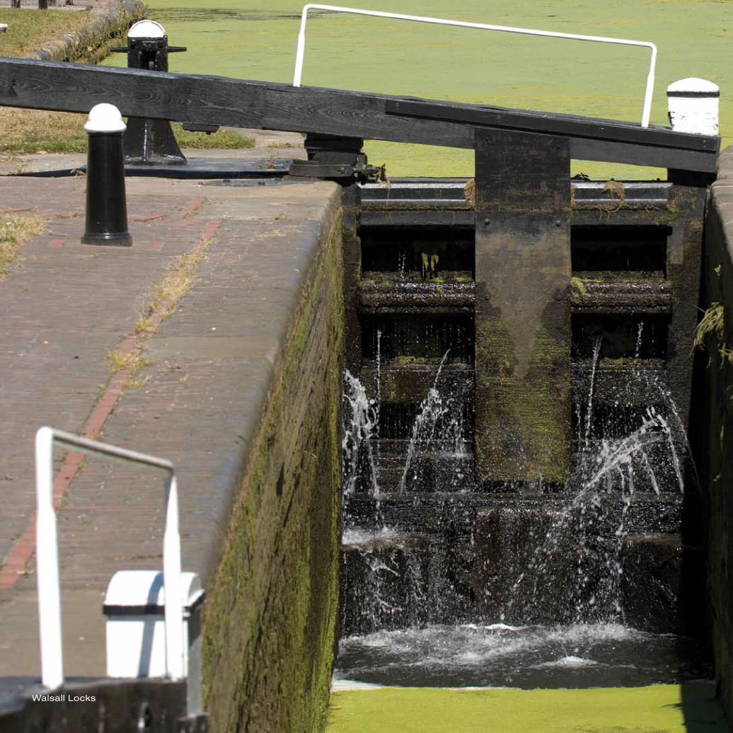
Walsall Locks

3304DesigninginWalsall:TheVision
Walsall has an extensive network of canals due to its prominence as an industrial centre within the 18th and 19th centuries. Waterways are being increasingly recognised as an asset and in urban places they can be exploited to provide a greater variety of environments in the heart of a bustling urban area.
One of the core regeneration themes in Walsall is Canalside Communities highlighting the importance of unlocking the potential of Walsall’s canals to raise the overall quality of the environment. New design along Walsall’s waterside must explore how to sensitively and attractively exploit the special opportunities afforded by these locations.
Key Issues
Development in Walsall, where it is adjacent to the waterway(s) should:
Be of a height and massing appropriate to the width of the waterway and to its surrounding context
Reflect Walsall’s industrial canal heritage where possible in a sensitive and contemporary way through design
Encourage activity on the water where appropriate
Utilise the potential for water-related public art that can engage the community
Be positioned to maximise views of the waterway and allow public access both to and along the waterway with pedestrian routes located along the water’s edge and vehicular or service routes and car parking located away from the water’s edge
Mitigate the development’s impact on the landscape and biodiversity value of the waterway and its setting
Provide effective surveillance of public routes through the location of windows and doors
Take into account the need for any flood control measures required by the Environment Agency
■
■
■
■
■
■
■
■
Waterways
Wildlife corridor

Urban Splash ‘Walsall Waterfront’ © Squint Opera

3�04DesigninginWalsall:TheVision
Walsall seeks buildings that are designed to last, buildings that contribute delight and excitement to the townscape of the borough and provide its occupants with good living, working, social and learning environments. The criteria for achieving good design in the built environment are now well established in architectural and design practice and are set out in national guidance.
Walsall will seek to ensure that new development upholds these criteria to raise the image and urban quality of the Borough for the long term. Sustainable buildings that are robust, durable, fit for purpose and designed to adapt to changes in society, economy, technology and climate change will be an investment in Walsall’s future.
One of the core regeneration themes in Walsall is Canalside Communities highlighting the importance of unlocking the potential of Walsall’s canals to raise the overall quality of the environment. New design along Walsall’s waterside must explore how to sensitively and attractively exploit the special opportunities afforded by these locations.
Key Issues
Respect massing, scale and rhythm of adjacent buildings. These factors are significant particularly where infill development is undertaken in well established residential areas
Avoid the overdevelopment of a site by building to an excessive height or scale compared with its neighbours
Avoid pastiche, particularly in conservation areas, as the result is often poor quality imitation that fails to sensitively capture the special qualities of the original
Use materials that are sympathetic to their context acknowledging the significant materials within a locality
Create built detail that relates to human scale and which provides visual interest to elevations
Explore and demonstrate opportunities for incorporating public art within the overall design
Select materials that are appropriate in terms of quality, robustness, maintenance and ability to weather attractively in an urban environment
Development layout must take into account the opportunity to improve local micro climate and mitigate the effects of solar gain. The benefits of natural light and ventilation should be should be built on wherever possible
■
■
■
■
■
■
■
■
Buildings
Walsall Library and Museum

Sneyd Basin

3704DesigninginWalsall:TheVision
Residential development across Walsall must contribute to the establishment and maintenance of sustainable communities by understanding and addressing the specific housing and related issues that Walsall faces.
To fulfil this vision Walsall Council and its partners require that developers provide:
A range of affordable and appropriately sized properties to cater for all ages, abilities, sizes of households and types of tenure
Homes that are adaptable and provided with good storage provision, including integral bin stores with easy access to the public highway
Private amenity space attached to all residential units, including flats, with appropriately sized garden spaces for family housing
Well designed and located external spaces to allow children to play safely and encourage community interaction
Homes that are well connected to local facilities and their surroundings
All units presented for affordable housing must demonstrate that they comply with Lifetime Homes standards and the Housing Corporations Design and Quality standards, unless acceptable justification can be provided through the Design & Access statement
Key Issues
The entire design process must be underpinned by the principles of environmentally friendly and sustainable design
Plot sizes and built density will relate to their local context. Exploitation of large building plots in residential areas for inappropriately scaled infill will not be permitted
Privacy and aspect distances between dwellings must ensure that all occupants have a satisfactory level of amenity, whilst reflecting the existing and emerging character of the area. This will normally mean designing developments that, as a minimum, meet the guidelines contained in Appendix E of Designing Walsall. However, greater distances may be applicable where it is in the interest of protecting the character of an area. It may also be possible in exceptional circumstances to achieve shorter distances through creative design or in order to protect an area’s character although this must be explained and justified through the design and access statement to the Council’s satisfaction
Ground floor activity and natural surveillance will be maximised and blank walls or solid external security shutters avoided
There will be a clear definition and separation between the private and public realm and building frontages will be designed to overlook the public realm
Common building lines along road frontages must be maintained with buildings having a clear relationship with their neighbours
■
■
■
■
■
■
■
■
■
■
■
■
Homes

Al-Faruq Mosque at sunrise

3904DesigninginWalsall:TheVision
The architectural quality of tall buildings and the skylines they produce is of particular importance because of their visual prominence. In a local context, Walsall town centre has a very distinctive skyline framed between the New Art Gallery and St Matthew’s Church and views from Barr Beacon stretch right across the borough in all directions.
Key Issues
Tall buildings are classed as tall in relation to their surrounding neighbours rather than being of a specified height and as such the appropriateness of a tall building will depend on its relationship to its local context:
Where a number of tall buildings are proposed to be concentrated together or will be seen collectively from a distance, the resulting skyline must avoid presenting a monolithic appearance and instead exploit the potential of a varied profile and silhouette to produce interesting and distinctive skylines as the viewpoint changes
Tall buildings must be capable of being appreciated as a landmark skyline feature and also as buildings within the street context at close inspection. Architectural detailing and materials should reflect this aspiration
The relationship of any tall building to its immediate surroundings at street level must be carefully considered to ensure that any proposed development is not overbearing
Tall buildings have a significant impact upon shadowing and micro climate. The design process must mitigate the potential for unacceptable levels of wind turbulence and loss of sunlight in order to maintain long term appearance and desirability for occupants and users
High quality, long life, low maintenance materials must be specified
Consideration should be given to lighting the building as a landmark, particularly where it is located along one of the borough’s key strategic corridors
■
■
■
■
■
■
Skyline and Townscape
New Art Gallery

Holland Park, Brownhills

�104DesigninginWalsall:TheVision
Over one third of the borough of Walsall is Green Belt with a significant amount of rural landscape and formal parks and gardens throughout the town and district centres, including the famous Victorian Arboretum in Walsall town centre and the proposed Black Country Urban Park which will link Wednesbury through to Walsall with a ‘green bridge’.
Although Walsall is well known for its industrial heritage for most of its history industry and mining have co-existed with farming. Remnants of the heathlands, woodlands, wetlands and hay meadows which once separated the industrial settlements still survive. Industry also created new landscapes of canals, spoil heaps and wetlands and these areas are now important havens for plants and animals which once flourished across the wider Black Country. Many of these sites are visually attractive places where people enjoy contact with wildlife close to their homes. It is vitally important that design takes into account locally distinctive ecology and landscape to ensure that the best sites are protected and new sites created and improved to provide a landscape of the highest quality for everyone to enjoy.
Key Issues
The key issues of Conserving Walsall’s Natural Environment SPD relating to design can be summarised as:
Local ecology must be seen as part of the character of a site and impact studies must inform the design process right from the start with creative and effective mitigation measures being designed in
Opportunities to enhance local distinctiveness and design quality should be maximised where open spaces and landscape can be integrated into new development
Promote the planting of native plants and trees using stock of local provenance wherever possible
Preserve and enhance sensitive and important areas such as conservation areas and sites affecting tree preservation orders
New development must take account of and respond to the biodiversity and geodiversity of the site and its surroundings
■
■
■
■
■
Green Landscape
Horse riding over Barr Beacon

School Art Competition: Palfrey Girls School

�304DesigninginWalsall:TheVision
Creativity within the built environment is evident throughout Walsall from Victorian designers’ decorations and ornaments visible on buildings across the borough, to civic spaces containing statues of historical figures and contemporary community driven pieces of public art.
Artistic creativity adds a lively and memorable dimension to Walsall’s environment enhancing sense of place, civic pride and local distinctiveness. Walsall’s most successful public art commissions have involved community engagement right throughout the process from the very beginning with the result being socially connected and proud communities where people take pride and a sense of ownership over their neighbourhood and the built environment in which they live their daily lives.
To build on these success stories Walsall Council requires Section 106 contributions from developers towards the provision of public art right across the borough in line with our strategic arts framework. The proposals for how this money will be collected and distributed are outlined in Policy DW9 and Appendix D of this document.
Key Issues
Buildings, spaces, places and landscapes can all be potential locations for public art and public art can take the form of a vast array of media (see Appendix D):
Unless otherwise negotiated public art will be funded through Section 106 contributions and will involve the community as well as an artist(s) with experience in community public art
Artists and local community groups will form a central part of the design team throughout the public art process on such projects
Where possible the character of the borough and its people should provide an inspiration behind the design concept
Public art will be encouraged to be functional as well as decorative
■
■
■
■
Arts, Creativity and the Community
Engaging the community in art


05 Urban Design Policies in the Walsall Context
Policy DW1 Sustainability
Policy DW2 Safe and Welcoming Places
Policy DW3 Character
Policy DW4 Continuity
Policy DW5 Ease of Movement
Policy DW6 Legibility
Policy DW7 Diversity
Policy DW8 Adaptability
Policy DW9 High Quality Public Realm
Policy DW10 Well Designed Sustainable Buildings

Crown Lofts, Walsall Waterfront

�705UrbanDesignPoliciesintheWalsallContext
Successful streets, spaces, villages, towns and cities tend to have characteristics in common, which can be summarised and explained under the headings of the Urban Design Policies below. They are useful to establish what qualities should be sought to create a successful place.
There is overlap between the Urban Design Policies and they are mutually reinforcing. These principles have set the basis for Policies DW1-10 contained within Designing Walsall and should be applied to the vision for designing in Walsall.
Urban Design Policies in the Walsall Context
Sustainability
simultaneously meeting environmental, economic and community needs without compromising the needs of future generations
Safe and Welcoming Places
creating places that feel safe, secure and welcoming for everyone
Character
a place with its own identity
Continuity
a place defined by buildings, structures and landscape
High Quality Public Realm
creating places with attractive environmental quality
Ease of Movement
a place that is easy to get to and safe to move through
Legibility
a place that has a clear image and identity and is easy to understand
Diversity
a place that offers a mix of activities to the widest range of possible users
Adaptability
a space that can easily change over time
Well Designed Sustainable Buildings
buildings that contribute positively to a comfortable, adaptable and sustainable built environment

Cycling along Rushall Canal

�905UrbanDesignPoliciesintheWalsallContext
Sustainability lies at the heart of high quality design. It is integral to and underpins all of the other urban design policies in Designing Walsall and this, along with the importance Walsall Council places on achieving sustainable development, is reflected in its position as the first policy in in the document.
The challenge of creating socially, environmentally and economically sustainable neighbourhoods should be seen as an exciting opportunity to produce innovative development and outstanding design quality that will contribute to the mitigation of, and adaptation to, the effects of climate change.
In raising the standard of sustainable development in Walsall, good urban design can deliver safe, attractive and sustainable places of enduring quality that can provide for the needs of today’s population as well as for future generations.
The benefits of adopting a sustainable approach to design are:
A better quality of living and working environment
Reductions in costs and overheads
Improved efficiency in the use of buildings
Reduced fuel costs
Improved marketability
Environmental Sustainability
New development proposals must show how their design maximises energy efficiency in term of layout, orientation and sustainable use of resources.
New development must be designed to provide a percentage of their total predicted energy requirements on site from the sun, water, ground and wind, in that order of preference.
New development proposals are expected to incorporate measures for the conservation of water resources and flood protection.
Walsall Borough is an Air Quality Management Area. Developers will be expected to demonstrate that new development will not adversely affect environmental quality or the health of the borough’s residents.
Development proposals are required to make appropriate provision for the sustainable management and discharge of waste, including facilities for storage and collection of recyclable waste which are integrated into the design of the scheme.
New development must make a positive contribution to the greening of the urban environment and supporting biodiversity.
New development must not cause water pollution and/or flooding and must enhance water habitats.
New development is expected to take account of existing buildings and materials to be used and consider whether the building and/or materials can be re-used and whether materials can be sourced locally.
■
■
■
■
■
■
■
■
■
■
■
■
■
Policy DW1 SustainabilityNewdevelopmentshouldseektosimultaneouslymeetenvironmental,economicandcommunityneedswithoutcompromisingtheneedsoffuturegenerations

UrbanDesignpoliciesintheWalsallContext05�0
Social Sustainability
Walsall Council expects developers to respond to Walsall’s broader social sustainability agenda by designing new development to contain an appropriate housing mix which will promote sustainable, inclusive and mixed communities.
Opportunities for engaging the community in the design process will be encouraged.
Incorporating community-led design, particularly in the evolution of public amenities such as public art and play spaces, will be supported.
Developers are encouraged to make use of social and community enterprises, third sector and charity relationships in designing and constructing new development.
Economic sustainability
Walsall Council is aiming to maximise the economic advantages to the borough that can be derived from larger development programmes by linking developers with key local partners to economic benefits. Developers will be encouraged to make use of local businesses, contractors and suppliers.
Wherever possible the use of locally sourced materials that contribute to enhancing character or reinforcing local distinctiveness should be employed.
■
■
■
■
■
■
“Proposals for affordable housing should reflect the size and type of affordable housing required” (PPS3)

�105UrbanDesignPoliciesintheWalsallContext
Fibbersley Park School, Willenhall

“Developments should create safe and accessible environments where crime and disorder or fear of crime does not undermine quality of life or community cohesion” (PPS1)Town Wharf, Walsall

�305UrbanDesignPoliciesintheWalsallContext
Designing Walsall has been informed by discussions with many people across the borough of Walsall. In response to the question ‘What makes an area a good place to live, work or visit?’ there was overwhelming agreement that a good place has to be a safe place that makes everyone feel welcome.
Residents must feel safe and secure in their homes and going about their daily lives, visitors must feel that places are welcoming and businesses must be able to operate in a safe and secure environment.
New development must be designed in a way that makes routes, streets and spaces as safe, welcoming, attractive and free from crime as possible.
Opportunities for crime against property and the occupants of buildings must be minimised without compromising the visual quality of the townscape and landscape.
■
■
■
Policy DW2 Safe and Welcoming Places Allnewdevelopmentmustcontributetowardscreatingplacesthatfeelsafe,secureandwelcomingforeveryone
“Particularly where family housing is proposed, it will be important to ensure that the needs of children are taken into account and that there is good provision of recreational areas, including private gardens, play area and informal play space. These should be well-designed, safe, secure and stimulating areas with safe pedestrian access” (PPS3)

“Local Planning Authorities should facilitate good design by identifying the distinctive features that define the character of a particular local area” (PPS3)The Fold, Darlaston

��05UrbanDesignPoliciesintheWalsallContext
Walsall has a rich history and this is visible in many of its buildings, streets and spaces. To further improve and enrich the quality and image of the borough, new development must create a positive character with an identity that relates to the specific characteristics of Walsall and its historic context.
The best places are memorable with a character that people can appreciate easily and normally combine positive elements of the past, present and future. Development that responds sensitively to the site and its setting is likely to create a place that is valued and pleasing to the eye and the senses.
Development proposals must evaluate and understand the positive characteristics of the area it is located within to create or contribute to a distinctive sense of place in creating new designs.
Walsall Council expects new development to be informed by the surrounding character and to respond in a positive way to it by reflecting local urban design characteristics such as street patterns, building scale, topography and culture.
■
■
Policy DW3 Character Allnewdevelopmentmustbedesignedtorespectandenhancelocalidentity
“Good design should contribute positively to making places better for people. Design which is inappropriate in its context, or which fails to take the opportunities available for improving the character and quality of an area and the way it functions, should not be accepted” (PPS1)

Chuckery

�705UrbanDesignPoliciesintheWalsallContext
Successful urban space is defined and enclosed by buildings, structures and landscape. Well defined streets with a continuity of built form and high quality are important in creating attractive urban areas that are easy and enjoyable to move around.
There is always scope for variation to add interest or signify importance providing it’s considered to be appropriate or to be in keeping with the character of the area. Buildings should not turn their backs or blank elevations onto streets or public spaces. It is important to define or imply the ownership of buildings and spaces within the built environment. This can help to reduce acts of vandalism and can also encourage a sense of security and safety. A clear definition of what is public and what is private space should be an aim of any new development.
New development proposals must give consideration to common building lines and how the development will give definition to streets and spaces to reinforce the existing urban structure and give significance to important streets and spaces.
A clear distinction between public space and private space should be inherent within all new development.
New development must consider the accessibility of new buildings and spaces, in particular locating entrances in safe places, for both people who are able-bodied and people with impairments.
■
■
■
Policy DW4 Continuity Attractivespaceswithinnewdevelopmentshouldbedefinedorenclosedbybuildings,structuresand/orlandscape

Park St, Walsall
“The quality of the environment is central to the prosperity of the Region and the quality of the life of the people. As part of the drive towards a better environment, our streets and open spaces need to be designed and managed in a way that reinforces the distinctiveness of the West Midlands” (Streets for All, 2005)

�905UrbanDesignPoliciesintheWalsallContext
The convenience, safety and comfort with which people can reach and move through buildings, places and spaces and between key facilities across the borough play a large part in determining how successful Walsall’s regeneration will be.
All towns and cities function on a network of connected routes and spaces which form a movement framework for a variety of users: public, private, bicycle, on foot. Movement networks should form a hierarchy of routes which reflect the nature of the main users and which need to be easy to navigate and safe to use to encourage everyone to use them on a regular basis and at different times of the day or night. A well-designed urban structure has a network of connected spaces and routes for pedestrians, cyclists and vehicles.
People living and working in Walsall need to get easily and safely between the facilities they need for their daily activities and visitors need to be able to find their way around without difficulty. Everyone should find moving about the Borough comfortable and enjoyable, whether over a short or long distance and no matter what form of transport they choose to use. Without easy access that feels safe to use, the range of activities available to everyone is restricted as well as the opportunities for social interaction and the creation of sustainable neighbourhoods.
New development must show how it has prioritised meeting the needs of pedestrians and encouraging sustainable modes of transport such as walking, cycling and public transport usage to reduce reliance on the car.
New development should connect into existing routes and movement patterns to provide easy access and clear permeability through integrating with a network of routes including streets, canals, paths and open spaces to provide visible, safe and attractive connections between destinations.
New development is expected to demonstrate how it helps to establish or reinforce a sustainable movement network through taking account of the location of the nearest public transport facilities, public amenities like schools, shops and parks that are accessible on foot or by bicycle.
Where required, developers are expected to develop robust employer or residential travel plans with sustainable travel initiatives that give the users informed travel choices and encourages them to adopt a more sustainable mode of travel wherever possible.
■
■
■
■
Policy DW5 Ease of Movement Allnewdevelopmentshouldcontributetocreatingplacesthatarewellconnected,easytogettoandsafetomovethrough
“Successful development depends on good access and connections. The connections between a site and its surroundings are important for even the smallest of developments” (Urban Design Compendium, 2000)

The Brownhills Miner

6105UrbanDesignPoliciesintheWalsallContext
A place that is legible will be easy to understand and pleasant to live, work or visit. Development must be designed so that people can find their way around without being confused or feeling lost. If people can find their way around a place easily it helps them to feel safe and at ease in their surroundings.
Places should be linked by clear and visible routes. New development should make use of new and existing physical features to help people orientate themselves whether this is on a townscape scale with a view of a church spire or on a more intimate scale with distinctive public art or street furniture.
Consultation with local communities revealed that legible places with a distinctive identity or memorable character such as Willenhall town centre and Pelsall Common are the most valued.
All new development is expected to make a positive contribution to the identity of the area in which it is located and to contribute to a legible environment, whether the proposal is a single building on an existing street or a large development site.
New development must design a hierarchy of streets and ensure that design proposals give careful consideration to how the built environment is experienced by pedestrians.
New development must maximise its potential to enhance local distinctiveness by making positive visual connections with its surrounding environment, for example key vistas of important buildings and landmarks, memorable pieces of public art and reinforcing visual connections through coherent groups of street furniture such as lighting, benches and signage.
The design of new development should ensure that the functions of buildings and spaces can be easily interpreted and that the entrances to them are appropriately located and visible.
■
■
■
■
Policy DW6 Legibility Newdevelopmentshouldcontributetocreatingaplacethathasaclearimageandidentityandiseasytounderstand

The Bridge, Walsall

6305UrbanDesignPoliciesintheWalsallContext
Diversity is important because it provides choice and adds richness, vitality and activity to the urban environment. Diversity is important not only in terms of achieving a variety of uses within a compact area to create vibrant and active places but also in terms of cultural diversity to support social cohesion, understanding and equal opportunities for all the community.
New development must incorporate an appropriate and balanced mix of uses that add richness and variety to the local area to promote compact sustainable neighbourhoods by mixing uses both vertically within buildings and horizontally along the street.
New development should give thought to how diversity can be added at different times of the day and night by promoting an appropriate night-time economy.
Development proposals are expected to demonstrate how consideration has been given to accommodating all sections of society and, where possible, providing for these diverse needs to add richness to the social and cultural variety of the local area. This includes designing an appropriate range of tenures and housing types to respond to local needs and ensuring that the design quality of buildings and facilities is of an equally high standard for everyone in the community.
New development should be designed to support variety and choice in the public realm for all sections of the local community by providing or sustaining a network of routes, streets and paths that maximises choices for movement, particularly for pedestrians, cyclists and users of public transport and contributing to a range of open spaces to meet the different needs of the local community for active and passive recreation and leisure.
■
■
■
■
Policy DW7 Diversity Allnewdevelopmentshouldcontributetocreatinglivelyplacesthatofferamixofactivitiestothewidestrangeofpossibleusers
“Good design is fundamental to the development of high quality new housing which contributes to the creation of sustainable mixed communities” (PPS3)

Walsall Leather Museum

6�05UrbanDesignPoliciesintheWalsallContext
It is important that buildings and spaces can respond to changes in technology, the environment, market conditions and living circumstances. The most successful places have prospered in changing circumstances.
Some buildings and spaces in Walsall have stood the test of time and have been used in a variety of ways over the years, whereas buildings such as high rise flats or large retail boxes are limited in their flexibility and have a potentially short lifespan. Adaptability enables buildings and spaces to have a long life, creating a flexible and sustainable environment that can also adapt in the face of climate change.
New development proposals and layouts are expected to demonstrate how they will be capable of accommodating changing and future needs, for example allowing for movement and visual connections to be made to adjoining areas in the event of future redevelopment and designing open spaces to be used for different recreational, leisure, cultural and social activities and events.
Development proposals for new buildings or the conversion of existing buildings should demonstrate how they have been designed to allow for their future adaptation to meet the changing needs of their occupants and of the local area, including flexible accommodation space to meet the accommodation and mobility needs of household as they change over time.
■
■
Policy DW8 Adaptability Newdevelopmentshouldcontributetocreatingflexibleandadaptableplacesthatcaneasilychangeovertime
“Good design ensures attractive usable, durable and adaptable places and is a key element in achieving sustainable development. Good design is indivisible from good planning” (PPS1)

Darwall St, Walsall

6705UrbanDesignPoliciesintheWalsallContext
Streets and spaces form the ‘public realm’ – those parts of towns and villages that are available for use by everyone. The public realm is the public ‘face’ of Walsall where people walk, meet, rest and interact.
An attractive public realm enhances people’s quality of life and the perception of a place. Public space includes streets, squares, canals, parks and recreational areas and provides a widely accessible stage for the expression of arts and creativity.
It is an integral part of the urban fabric and should make a positive contribution to reinforcing the local distinctiveness of the built environment of Walsall. Public space should be accessible to all members of the community.
A quality public realm plays a key role in establishing the environmental quality experienced by people within the borough. It is achieved through details, materials, activities and creativity; investment in these key elements can turn public spaces into memorable and enjoyable places. Public space, the way it is enclosed, the activity that takes place round its edges and within it, the choice of surface treatments, the maintenance of the space and its creative input all contribute to its image and quality.
New development should conceptualise public realm and external landscaping works at the outset of a new development as part of the overall design and support an attractive, safe environment which prioritises the comfort of pedestrians and vulnerable transport users and contributes a sense of animation and activity to the street, including an element of on-street car parking where appropriate
Commercial uses, for example supermarkets, retail units, industrial premises, offices, and leisure uses must be designed to make a positive contribution to a sustainable and attractive public realm through maximising the amount of ‘active’ building frontage and omitting blank walls, service areas and other ‘dead’ frontages facing the public realm wherever possible.
The public realm can be enhanced by designing buildings to respect and enhance local distinctiveness by paying regard to the urban structure, scale, form, massing and character of the local area.
High quality materials, public art and landscaping are essential components of a high quality public realm.
New development must support a drive to provide a public realm of streets and spaces that is designed to be visually attractive and engender civic pride and stewardship.
New development is expected to support a comfortable microclimate and provide appropriate protection for pedestrians from inclement weather such as maximising south-facing sunny spaces and avoiding the creation of wind tunnels.
■
■
■
■
■
■
Policy DW9 High Quality Public Realm Newdevelopmentmustseektoensureitcreatesplaceswithattractiveenvironmentalquality
“Analysis of successful communities increasingly points to a quantifiable relationship between economic success and the quality of the public realm. Carefully designed, well-managed streets are not merely a desirable outcome of successful economies; they are an important driver of such success” (Streets for All, 2005)

Developer Contributions towards Public Art through Section 106 agreements
All types of development attract increasing numbers of people into and across the borough, making it ever more important that the public realm, or public face, of Walsall is of the highest quality and reflects Walsall’s own unique character and locally distinctive attributes. Policy DW9 below builds on UDP policy ENV3� and sets out how development will be expected to contribute towards the provision of public art.
Policy DW9(a) Qualifying Development
All types of development that meet the following criteria will be required to contribute towards the provision of all types of open space as set out in the following policies:
Residential development for 15 units or more;
Other full planning applications for non-residential developments of 1,000sqm or more;
0.5 ha and above for outline developments
Policy DW9(b) Planning Obligations
The Council will negotiate Planning Obligations (Section 106 agreements) to secure benefits in line with the UDP and this SPD with respect to developments that meet the criteria outlined in Policy DW9(b).
Table 1: Section 106 contributions towards Public Art
Type of Development Threshold Developer contributions
Residential 1� units and above £3�0.00 per dwelling
Non-residential (for example commercial, leisure, industrial)
1,000sqm and above £� per sqm up to 2,000sqm
£3 per sqm above 2,000sqm
Outline 0.�ha and above As above. Request for a Section 106 contribution with any reserved matters application to be attached to any approval by planning condition
■
■
■
UrbanDesignPoliciesintheWalsallContext0568

6905UrbanDesignPoliciesintheWalsallContext
Policy DW9(c) Scale of Contribution
I. The scale of contribution required from qualifying development will be as set out at Table 1
II. The scale of contribution will be the same in all parts of the borough, subject to the Land Value Adjustment
III. The scale of contributions is set at 2007 house prices and retail prices index and will be subsequently linked to inflation in the average house price in the borough of Walsall as of March 2007: £131,040
IV. On-site provision within a development will be taken into account when calculating any residual off-site contribution that may be required although the Council must be satisfied that any on-site public art provision will fulfil the requirements of Designing Walsall SPD and that the community will be fully engaged throughout the process
Table 2: Use of Public Art contributions within a hierarchy
Hierarchy Range
Public art human resources 8%
Borough-wide significant public art projects 8 – 1�%
Neighbourhood (based on geographical boundaries of the 9 Local Neighbourhood Partnership areas)
10 – 20%
Local scale public art projects �� – 70%
Policy DW9(d) Use of Contributions
I. Contributions will be used according to the proportions set out in Table 2.
II. Funds collected towards set up will be spent as soon as reasonably practicable after receipt by the Council but in any case within 5 years of receipt
III. 8% of the total contribution will be payable on completion of the Section 106 agreement
Openness and Accountability
Government policy regarding Planning Obligations requires that contributions are fairly and reasonably related in scale and kind to the proposed development. To ensure this occurs, records will be kept that will provide a clear audit trail between developments, contributions and spending on projects.
The funds collected will be controlled by a dedicated bank account so that they cannot be confused with any other funds. The timescale of � years takes into account the sometimes lengthy delivery periods arising from pooling resources including commissioning an artist, the community engagement process and then construction or installation.
The council will publish an annual report detailing the contributions received and the ways that they have been used.

The Keys, Willenhall I D Architects (Midlands) Ltd

7105UrbanDesignPoliciesintheWalsallContext
Buildings that are designed to last, that contribute positively to the townscape of Walsall and provide its occupants with good living, working, social and learning environments will help raise the image and urban quality of the Borough. Sustainable buildings that are robust, durable, fit for purpose and designed to adapt to changes in society, economy, technology and climate change will be an investment in Walsall’s future.
The careful design and detailing of buildings must make a positive contribution to their surroundings and the quality of life of their occupants with a strong emphasis on respecting and enhancing local distinctiveness.
New development is expected to contribute to the sustainable use of resources and make prudent and efficient use of finite and non-renewable resources, including optimising natural light and ventilation.
Proposals for new development are expected to meet Code for Sustainable Homes (Level �) or equivalent on residential schemes, Building for Life 12 points out of 20 and BREEAM standards for commercial development, unless otherwise justified.
■
■
■
Policy DW10 Well Designed Sustainable Buildings Newdevelopmentshouldmakeapositivecontributiontocreatingacomfortable,adaptableandsustainablebuiltenvironment

A461
M6
A461
A454
A454
Willenhall
GoscoteLane
Corridor
Pelsall
Aldridge
TownCentre
PalfreyHighgate
Bentley
Birchillsand
Reedswood
NewInvention
Gillity Village, Park Hall
and Pheasey
Delves
Bescot
Darlaston
MellishRoad
Bloxwich
Moxley
TheButts
Brownhills and
Walsall Wood
Streetly
Rushalland
Shellfield
Chuckery
PleckCaldmore
Canal
Canal

06 Local Character Guidance
Town Centre
St Matthew’s Quarter
Station St
Waterfront
Gigaport
Lichfield St, Upper Bridge St and Ablewell St
Bradford Place, Bridge St and Park St
Bradford St
Central Suburbs
Mellish Road
Chuckery
Caldmore
Palfrey
Highgate
Pleck
Bescot
Birchills and Reedswood
The Butts
East
Bloxwich
Goscote Lane Corridor
Brownhills and Walsall Wood
Aldridge
Streetly
Pelsall
Rushall and Shelfield
Gillity Village, Park Hall and Pheasey
Delves
West
Darlaston
Moxley
Willenhall
Bentley
New Invention

LocalCharacterGuidance067�
Town Centre
St Matthews Church

7�06LocalCharacterGuidance:TownCentre
The area around St Matthew’s Church is the heart of the historic town which developed around a cruciform street pattern, the highest point of which is Church Hill.
The market has been held in High St since c.1220 and consequently this quarter is rich in both architectural and social history.
It has a vital role to play in the future of Walsall centred around opportunities for new retail-led regeneration and creating a distinctively excellent public realm.
Existing/emerging character:
Church Hill Conservation Area
Grade II* Listed St Matthew’s Church provides key landmark and characterises town centre’s skyline
Jellicoe Gardens
Walsall market still operates in original medieval location
Medieval street patterns and plot widths evident in built form
Listed buildings include 10-1� High St and The Guildhall
Opportunities to replace 1960s shopping centre
Design Guidance:
Opportunity to modernise historic market to create exciting 21st century offer
New retail development should reflect the rhythm and spacing of medieval plots widths and re-instate the serpentine street along Digbeth
A friendly sense of community and neighbourhood should be encouraged through design
Sustainable residential development should cater for families
Development is expected to be complimentary in height to existing townscape character
There will be an emphasis on high quality public realm and creating a comfortable outdoor environment for pedestrians and shoppers
Important views of St Matthew’s Church must be maintained by new development
Opportunities to include an artistic input in design briefs and masterplans will be encouraged
■
■
■
■
■
■
■
■
■
■
■
■
■
■
■
St Matthew’s Quarter
Market Tavern

LocalCharacterGuidance:TownCentre0676
Station Street has always been an important gateway to the town centre being located adjacent to Walsall train station. Convenient access to the railway network during the Industrial Revolution saw the saddlery and leather goods industry explode originally in this area with the delivery of raw materials and export of heavier goods.
The evolution from cottage industry to factory based industry is exemplified in Station Street with the buildings ranging in a succinct area from compact terraced properties to the Grade II Listed Boak leather working factory.
Existing/emerging character:
Historical reference to evolution of leather industry
Continuous built frontage and high quality traditional architecture enclose the streetscene
Grade II Listed Boak building located at junction of Station Street and Bridgeman Street
Locally distinctive public realm
Architectural details evident throughout the streetscene
Design Guidance:
Aspirations to retain historic and locally distinctive buildings to reflect leatherworking heritage of the town
Opportunities for sensitively designed mixed use regeneration that continue to reflect Walsall’s heritage within the built form
Aspirations for continuation of active street frontage punctuated by multiple doors and windows to new buildings
Public realm enhancements should build on the attractive streetscape improvements already undertaken
Developments must be sensitively designed with importance given to the town-wide views of the Boak building and its place within Walsall town centre’s skyline
■
■
■
■
■
■
■
■
■
■
Station Street
The Boak building and Station Street

7706LocalCharacterGuidance:TownCentre
Waterfront
Walsall Waterfront, Architect: S. P. Faizey, Developer: Jessup
Walsall Waterfront is being regenerated around a rediscovery of the town’s historic canals to restore a valuable sense of place. A wide mix of uses will bring a variety of activities and users to this dynamic area and transformational architecture will create a unique and distinctive setting within Walsall for its people.
Existing/emerging character:
The Locks Conservation Area
New Art Gallery
Exciting contemporary architecture
Mixed use canalside developments
Vibrant public realm and open urban spaces
Strong links to Walsall’s industrial heritage
Key connecting route through town centre to Manor Hospital
Design Guidance:
Maximise canal as an asset to enhance local distinctiveness
Focal point for innovative and iconic architecture
Wide ranges of use to encourage diverse and lively urban environments
Public realm schemes should pay attention to detail at a human scale
Key opportunities for creation and location of public art to engage the community
Waterfront SPD will guide future developments
■
■
■
■
■
■
■
■
■
■
■
■
■

LocalCharacterGuidance:TownCentre0678
The future is here! Lying immediately north of the town centre, the Gigaport is coming to life as a truly entrepreneurial quarter for the 21st century and is looking to re-shape Walsall’s economy for good with the use of fibre-optic communications. Innovative architecture, excellent quality of public realm and artistic creativity will all contribute to forming a unique urban environment.
Existing/emerging character:
Listed buildings include the Leather Museum, Wisemore House and Queen Mary’s High School and locally listed buildings include Jabez Cliff leatherworks
Emerging hi-tech hub with construction of new college and fibre-optic supported office-led regeneration
Lichfield Street Conservation Area
Victorian Arboretum located at eastern end of Gigaport
Traditional rows of terraces in Stafford St including listed buildings
Design Guidance:
Pedestrian connections to the town centre will be critical to the success of redeveloping this area and promoting Walsall as a compact sustainable town centre
Strong focus required on the quality of the public realm and peoples’ enjoyment of outdoor spaces
New developments must consider how to connect to the Arboretum and Green Bridge and/or reflect their proximity through design
New development should relate to the Civic Quarter in terms of scale and massing
Setting of the listed buildings will be important
Designs for sites within the Gigaport must be permeable to encourage the Birchills and Reedswood communities lying to the north to move through it to the town centre
Traditional form of development in Stafford Street should be retained and refurbished as this may form a key vista into any future development of Gallery Square
■
■
■
■
■
■
■
■
■
■
■
■
Gigaport
Architects: Dyers © Walsall College

7906LocalCharacterGuidance:TownCentre
The Bridge Street/Ablewell Street Townscape Heritage Initiative area has a rich built heritage. The interwoven examples of Georgian, Victorian and Edwardian architecture, together with some well preserved 20th century buildings, have resulted in an urban fabric that reflects the development of the town.
Historically and today it forms a key commercial gateway into Walsall town centre. There is the opportunity to revive heritage buildings to create a welcoming gateway and attractive commercial district.
Existing/emerging character:
Lichfield Street Conservation Area, Bridge Street Conservation and Church Hill Conservation Area
Covered by Townscape Heritage Initiative
Variety of buildings dating back to 18th century
Continuous street frontage and enclosure defines the street
Mainly commercial uses with potential for other uses above ground floor
Fine urban grain reflected in width of shop fronts
Massing is typically around 3 storeys with focal buildings at prominent corner locations
Architectural detailing on buildings contributes to richness of the streetscene
Grade II listed buildings at 1��a to 1�7a Lichfield St and 6 to 9 and 11 Lower Rushall Street
Roof top features visible throughout the streetscene
Design Guidance
Replacement and reflection of architectural features, particular brickwork and detail to shop fronts
Reinstatement of appropriate uses above ground floor level will be encouraged
New development must respect the height, massing and materials that give the area its character
New development must respect and reflect the continuity and enclosure of the street through its building line
New development through its appearance and use must add to the overall ambience and character of the street
■
■
■
■
■
■
■
■
■
■
■
■
■
■
■
Lichfield Street, Upper Bridge Street and Ablewell Street
Rich architectural detail on Lichfield Street

LocalCharacterGuidance:TownCentre0680
The main stretch of commercial and retail activity in the town centre. It is centred on the town’s medieval cruciform street pattern and therefore connects St Matthew’s Quarter with the Waterfront. This is hub of activity for residents and tourists alike with aspirations for a high quality public realm to strengthen the town centre’s character and identity.
One of Walsall’s most famous inhabitants, Sister Dora, is honoured by a statue to her memory in The Bridge. Born Dorothy Wyndlow Pattison in 1832, Sister Dora is nationally respected for her pioneering nursing work and developing Walsall Cottage Hospital. Her statue was the first of a woman not of royal birth to ever be erected in Great Britain.
Existing/emerging character:
Bridge Street Conservation Area
Key transport interchange within the town centre and main commercial centre
Modest scale 2-3 storey built development including 1920s architecture and decorative frontages above ground floor
Attractive buildings include the Victorian Arcade and Globe House
The Bridge presents an adaptable, lively and diverse public space within the town centre
Design Guidance:
Bradford Place forms a focal point to the end of a key gateway into the town centre, Bradford Street
Opportunities to regenerate Bradford Place as a key public space
Aspirations to improve Bradford Place’s efficiency as a key transport interchange
Improvements to the public realm must be high quality and coherent, connecting with other town wide public realm initiatives
Great opportunities for public art exist in this part of Walsall town centre
■
■
■
■
■
■
■
■
■
■
Bradford Place, Bridge Street and Park Street
Detail of building on Park Street

8106LocalCharacterGuidance:TownCentre
31-3� Bradford Street
The land running down either side of Bradford Street was formerly owned by the Earl of Bradford and is evident now by the stretch of Victorian villas that align both sides of the street. One famous inhabitant of Walsall, the author Jerome K Jerome, was born here in Belsize House in 1859.
Bradford Street forms an important gateway into the heart of Walsall town centre from the south, from where townscape views of important buildings such as the Boak building in Station Street and the New Art Gallery are clearly visible.
Existing/emerging character:
Bradford Street Conservation Area
Victorian villas built in 1830s and 1870s
Buildings include architectural detailing and decoration in Regency-style render and stucco
Distinct building line
Strategically important approach to Bradford Place and heart of town centre
Listed buildings include Belsize House, Sister Dora Hospital and Henry Boys Almshouses
Design Guidance:
Thoughtful infill development must reflect the scale and massing of neighbouring development and reflect the topography of the street
Attention to detail of architectural detailing, particularly at ground floor level to enhance the richness of the street as experienced by pedestrians
■
■
■
■
■
■
■
■
Bradford St

LocalCharacterGuidance0682
Central Suburbs
Aldridge Road

8306LocalCharacterGuidance:CentralSuburbs
This attractive residential street forms one entrance to Walsall from the north along the strategic A454 route. Mellish Road is rich in architectural and environmental quality featuring mainly mid-Victorian era villa-style properties which collectively produce a sense of visual unity. Overlooking the Grade II listed Arboretum, Mellish Road is framed by mature tre planting which extends and reflects the proximity of the Arboretum.
Existing character:
Arboretum Conservation Area
Strategic A��� and A�61 corridors meet at junction of the former Mellish Road church
Wide tree-lined boulevard-style feel to the street and views over the Arboretum
Large detached Victorian villas set back from the road in spacious plots characterised by mature and plentiful landscaping
Boundary treatments to plot frontages are typically of high quality and add character to the streetscene
Rhythmic spacing of plot widths and spaces between houses
Design Guidance:
Former site of Grade II Listed Mellish Road church requires sensitively designed high quality development befitting of its prominent location at the meeting of two strategic corridors
New development must respect the pattern of plots widths, building line and sense of landscaped spaciousness
High quality streetscene should be preserved and maintained as part of any new development
Use of architectural detailing and features to add interest and variety to the richness and quality of the streetscene
■
■
■
■
■
■
■
■
■
■
Mellish Road
Victorian villa-style houses on Mellish Road

LocalCharacterGuidance:CentralSuburbs068�
Chuckery developed in response to the rapid growth in Walsall during the Industrial Revolution. A denser level of smaller housing is found here than in other suburbs of Walsall due to its later development during the later 19th century and the need to accommodate more workers who were predominantly employed in the town’s leather industry. This has resulted in an intimate sense of enclosure when walking through the area.
Existing character:
Terraced housing defining continuous street frontages and urban grain
Modest scale 2 to 2.� storey development
Identifiable sense of community
Back of pavement housing form creates intimate urban form
Mixed industrial and residential uses in a defined area
Examples of Victorian architectural detailing on houses
Design Guidance:
Family housing to reflect existing pattern of development
New development should reflect the character of massing and scale that contributes to Chuckery’s identity
Residential schemes in particular should reflect the architectural character and details of existing buildings
The continuity of street frontage and sense of enclosure within the street should be maintained with new development unless otherwise successfully justified
■
■
■
■
■
■
■
■
■
■
Chuckery
Terraced properties enclose the streetscene

8�06LocalCharacterGuidance:CentralSuburbs
Caldmore
White Hart Public House
Caldmore was principally the area that became engulfed in the spread of Walsall town centre as it expanded during the 1880s due to rapid industrialisation and the saddlery industry in particular. Today it forms the hub of a multicultural community with a vibrant atmosphere that has the potential to play a more enhanced role in the life of the town centre.
Existing character:
Multicultural community is evident in architecture, arts and mixed uses of buildings
Successful programme of community arts
Strong sense of community spirit
Grade II Listed White Hart Public House
Locally distinctive street furniture
Caldmore Green Conservation Area
Tight knit urban grain
Design Guidance:
New development must reflect the built form of Caldmore in terms of its scale and massing
Opportunities for building on the strong community spirit should be explored where possible through the arts
Solutions to traffic management should be explored through design and not limited to hard engineering
Residential developments that can accommodate families and extended families in particular would benefit the creation of a sustainable neighbourhood in Caldmore
■
■
■
■
■
■
■
■
■
■
■

LocalCharacterGuidance:CentralSuburbs0686
Palfrey’s diverse multicultural population is reflected in its rich character. Palfrey Park provides a valuable community asset in this suburb which was originally designated in the Victorian era. It was shortly following this that Palfrey became integrated with the town of Walsall as it grew in response to the demands of industrialisation and the town’s world famous leather industry.
Existing character:
Primarily residential with some industry
Open space for recreation at Palfrey Park
Community arts projects in Palfrey Park
Vibrant multicultural population expressed in architecture and land uses
Streets are enclosed by buildings give definition to the built form
Design Guidance:
New development must reflect Palfrey’s character through its sense of scale and massing
New housing must provide a high quality living environment both internally and externally
Public spaces and streets must benefit from good surveillance and feel safe
Connectivity to Palfrey Park should be optimised with all new developments
■
■
■
■
■
■
■
■
■
Palfrey
Palfrey Horse

8706LocalCharacterGuidance:CentralSuburbs
Highgate
Highgate Brewery
Highgate is an attractive residential suburb south of Walsall town centre with the Grade II Listed Highgate Brewery at its heart. This area retains its residential quality and future development should respect and retain its valued character.
Existing/emerging character:
Mixed family housing including many large Victorian villas
Residential streets often lined with mature trees
Highgate Conservation Area and Article � directive in place
Distinct identity throughout
Listed buildings of particular note include Grade II Listed Highgate Brewery and Grade II Listed windmill tower at No 7� Highgate Road
Design Guidance:
New development should respect the pattern of plots widths and building line
High quality streetscene should be preserved and maintained as part of any new development
New development should reflect existing architectural detailing and add interest and variety to streetscene
The setting and views of listed buildings must be taken into careful consideration
■
■
■
■
■
■
■
■
■

LocalCharacterGuidance:CentralSuburbs0688
Running south from the town centre on the strategic A461 corridor, Pleck is an area undergoing massive regeneration with a variety of residential, commercial and health schemes, most notably the new Manor Hospital on Pleck Road. Close collaboration with the community has been at the heart of this programme of transformational projects.
Existing/emerging character:
Traditionally characterised by industry
Formed on strategic A�61 transport corridor
Grade II Listed former Board of Guardians on Pleck Road
Community-led public realm regeneration schemes underway
Focus for transformational regeneration projects
New Manor Hospital development
Design Guidance:
Good connections to town centre for access to amenities and local transport
High quality sustainable homes to meet the needs and aspirations of the local community for mixed tenure housing
Environmental and public realm improvements
Opportunities for public art projects to engage the community and promote civic pride
Impact of development upon strategic view southwards from junction of Pleck Road with Wolverhampton Road must be considered with new development
■
■
■
■
■
■
■
■
■
■
■
Pleck
Manor Hospital, Steffian Bradley Architects, Developer: Skanska

8906LocalCharacterGuidance:CentralSuburbs
The out-of-town location of Bescot is reflected in its zoned land use pattern including more land extensive uses such as retail parks, a football stadium and community colleges. Its key transport connections include access to the Walsall Canal, Junction 9 of the M6, strategic A461 corridor and Bescot train station.
Existing/emerging character:
A mix of industrial, commercial, recreational and residential land use zones
All built form dates from the mid to late 20th century
Route of the canal runs from north to south mirroring the route of the railway
Railway station connecting directly to Walsall and Birmingham New Street
M6 motorway lies to the south
Design Guidance:
New housing development must take into account the close relationship with the M6 and motorway and design high quality living environments accordingly
Commercial and industrial developments must demonstrate that they have taken into account any potential impact upon the skyline or views along the M6 which provides a gateway into Walsall
Opportunities to improve the quality of the environment along the canal and its usability as a connecting route should be explored
■
■
■
■
■
■
■
■
Bescot
RAC building

LocalCharacterGuidance:CentralSuburbs0690
The Butts became a suburb of Walsall town centre as the town grew during the Industrial Revolution. It has a compact and intimate quality within its streets created by the scale of housing and enclosed streets. The Victorian influence is still clearly evident in the built form and the materials and details dating from this time give the streetscape a lively and attractive quality that future development in this area should be sensitive to.
The Butts is closely located to the Arboretum, part of it being covered by the Conservation Area of the same name. The most prominent building is Mellish Road Church, located at the junction of Butts Road where it meets the strategic A��� and A�61 corridors. Any future development of this site will require a high quality design that is inherently sensitive to its surroundings.
Existing character:
Site of former Mellish Road Church prominently located on the junction of Butts Road and strategic A��� and A�61 corridors
Arboretum Conservation Area
Tight knit late Victorian terraced housing north of Butts Road
Small front garden define private space within the streetscene
Architectural details on houses add richness to the streetscape
Design Guidance:
Houses should be of a commensurate scale to their existing neighbours and accommodate households of a variety of sizes
Traffic calming should be achieved through design rather than over-engineered solutions
Sensitive high quality design on Mellish Road Church site
Architectural details to add variety and richness to the streetscape should be designed in to new development
■
■
■
■
■
■
■
■
■
The Butts
Continuous terraced housing

9106LocalCharacterGuidance:CentralSuburbs
To the north west of Walsall town centre, Birchills and Reedswood form two communities that lie at the heart of the Canalside Communities regeneration programme. Initially developing as residential suburbs during the Industrial Revolution, today these areas contain a variety of modern housing alongside traditional terraces and a range of retail amenities, all of which are a short walk from the town centre alongside canal towpath.
Regeneration opportunities here are expected to maximise the connections to the surrounding green spaces and canal network to create a high quality, connected place to live.
Existing character:
Multicultural population with community spirit
Areas of tight knit urban grain with grid pattern street layout and also new housing
Terraced housing forms continuous back of pavement frontages
Close proximity to public open green space
Close proximity to the Walsall Canal, Wyrley and Essington Canal and The Locks Conservation Area containing Grade II Listed locks
Grade II Listed Birchills Canal Museum and former Boatmen’s Rest on west side of canal at northern edge of The Locks Conservation Area
Design Guidance:
Assets provided by the canal and green open space should be maximised through legible, safe and easy access for all users
New residential developments must design in local distinctiveness drawing on inspiration from the nearby canal and green open space
Houses should accommodate families with spaces to play and rest that are safe and well maintained
New developments will seek to create a sense of place, using modern design to create distinctive environments
New open spaces will be functional, well maintained and overlooked
■
■
■
■
■
■
■
■
■
■
■
Birchills and Reedswood
Birchills Canal Museum

LocalCharacterGuidance0692
East
Streetly

9306LocalCharacterGuidance:East
Developed on a plateau 500ft above sea level, Bloxwich is the highest point in Walsall Borough. Referred to as ‘Blocheswich’ meaning ‘Bloc’s Village’ in the Domesday Book reflecting the prevalence of the Bloc family in the agricultural community, the town expanded in the 18th century when coal mines were opened leading to cottage industries making awls, nails, needles and saddle blades.
Further expansion was encouraged in the 19th century when the canals were opened. Famous inhabitants of Bloxwich include Pat Collins, ‘King of Showmen’, who held the Bloxwich Wakes here every August. The area has a high provision of valuable open spaces and parks including King George V Memorial Playing Fields, Promenade Gardens and Bloxwich Park
Existing character:
Bloxwich Park, Elmore Green and Bloxwich High Street Conservation Areas
Town centre characterised by strong linear high street
Strong focal points at either end of High Street: All Saint’s Church, Elmore Green and Bloxwich Hall
Bloxwich market is located adjacent to High Street
Surrounding residential areas include a full range of housing styles from Victorian to inter-war and post-war estates. Large areas of social and former social housing in adjoining Mossley, Dudley Field and Blakenall
Previous Townscape Heritage Initiative in 2002 has raised quality of the streetscene
Design Guidance:
Future development must boost the character of the high street
Attention to the detail on shop fronts and commercial properties along High Street in line with Conservation Area status
Coherent improvements to the public realm and environmental quality to make it an enjoyable place to be for pedestrians
Housing schemes must provide high quality environments for families with usable private amenity space
Future development proposals should refer to the Bloxwich Strategic Regeneration Framework
■
■
■
■
■
■
■
■
■
■
■
Bloxwich
Elmore Green

LocalCharacterGuidance:East069�
The Goscote Lane Corridor is approximately 1.5 miles north of Walsall town centre. Goscote Lane forms the spine of the route linking via Livingstone Road to Lichfield Road to the north and to Harden Road and Station Road to the south.
Swannies Field is a significant piece of open space in the south of the Corridor which is connected to the Goscote Valley by the Wyrley and Essington canal. Together these form a substantial network of open space that is a distinctive feature and asset of the area. Communities designed to provide social, economic and environmental sustainability should be at the heart of future development.
With superb links to green open spaces and good connections to Walsall and Bloxwich town centres, the Goscote Lane Corridor has the opportunity to create a great place to live.
Existing/emerging character
Predominantly a residential area which is the subject of an ambitious housing-led regeneration scheme
Goscote Valley provides opportunity for intimate relationship between green landscape and housing area
Large semi-detached properties set around spacious gardens and curved estate roads
Future development sites have been identified under the Strategic Regeneration Framework
Mixed tenure community built to achieve high quality design and a safe environment
Design Guidance:
Improvement of relationship to canal and quality of pedestrian links
Quality residential schemes to add character areas to the estate
Interesting and innovative architecture to add vibrancy to the built environment
Opportunities for community uses and open spaces and bonding the community through public art projects
Thoughtful use of landscaping and planting throughout development schemes
Housing-led developments must provide an appropriate variety of residential units to cater for all members of the community and contribute towards a safe, high quality living environment
Improvements to the public realm must contribute to a positive image to encourage community pride
Creative parking solutions
■
■
■
■
■
■
■
■
■
■
■
■
■
Goscote Lane Corridor
Surestart building, Blakenall Village Centre

9�06LocalCharacterGuidance:East
This area developed as a trading post throughout the Industrial Revolution, first with the opening of the Wyrley and Essington Canal in 1797 in Brownhills and the Daw End Branch Canal in Walsall Wood during the 19th century.
Raw materials found locally such as limestone and coal could be transported to towns across the Black Country and trades in nail making, chain making, brick making and boat building established. Coal mining remained the main industry in this area until the 19�0s and this is commemorated in the public art piece, The Brownhills Miner, found at the northern end of Brownhills High Street.
Existing character:
Mining, canal and railway heritage
Wyrley and Essington Canal provides key local focus for social and recreation activities
Brownhills market located between canal and High Street
Residential suburbs display delicate local vernacular and Victorian architecture
Fine traditional plot pattern along the linear Brownhills High Street and mainly modest scale development throughout at 2-3 storeys
Significant areas of open space including the 100 acre green space of Brownhills Common (formerly part of the Cannock Chase Forest), Birch Coppice (a large area of predominantly oak and birch woodland) and the Clayhangar Common to the south (one of the best wetland sites in the county)
Walsall Wood is located on the strategic A�61 corridor
Design Guidance:
New development adjacent to the canal must address the canal in a positive and creative way
Architecture should be attractive, visually pleasing and sensitive to the scale of its neighbours
New development must contribute to improving the public realm and provide high quality streets and spaces
Houses and apartments should provide well designed and useable private amenity space for future occupants
New development must understand opportunities for improving the connections between Brownhills High Street and the canal
Development along the A�61 corridor must have regard for strategic views towards Walsall town centre from this point due to the topography
■
■
■
■
■
■
■
■
■
■
■
■
■
Brownhills and Walsall Wood
Brownhills Resource Centre

LocalCharacterGuidance:East0696
Aldridge is first mentioned in the Domesday Book in 1086 as ‘Alrewic’, a Saxon word meaning ‘Alder village’ suggesting that by Saxon times people had formed a settlement here in a grove of alder trees.
St Mary’s Church dates back to c.12�0 and is thought to have been founded by Nicholoas de Alrewych. Aldridge was transformed from a medieval agricultural village into an industrial settlement when the canals and railways were opened during the 19th century to serve several local coal mines. Aldridge is surrounded by Green Belt and open landscape and contains a number of parks and green spaces within its urban boundary.
Existing character:
Located on strategic A��� corridor which dissects the settlement
Aldridge Conservation Area lies to the east of the centre containing attractive older property, a central common area and some new development to the south
Original settlement evolved in medieval times around St Anne’s church with attractive older property defining the historic core
Identifiable Art Deco-style properties in the town centre
The tightly constrained 1960s shopping centre provides significant opportunities for refurbishment and high quality design
Important open spaces close to the centre provide valuable opportunities for recreation and creating linkages to public amenity spaces
Design Guidance:
New development should seek to revitalise Aldridge’s local distinctiveness through high quality design
Lighting schemes should be considered and designed-in for prominent and high quality new developments along the A��� as part of the strategic corridors urban design framework
Connections across the A��� to improve linkages within the community should be explored
Improvements to the pedestrian environment and attention to detail at human scale, particularly along the A���, must be demonstrated as part of new development proposals
Links and connections to surrounding green landscape and canal networks should be maximised through new development opportunities
■
■
■
■
■
■
■
■
■
■
■
Aldridge
The Croft

9706LocalCharacterGuidance:East
Streetly takes its name from Ryknield Street, a Roman road whose route can still be followed through Sutton Park and the earliest written record of Streetly is found in an Anglo-Saxon Charter dated 959.
Like Aldridge, the character and population size of Streetly was transformed from a forested medieval village by the opening of a railway station in 1879 on the corner of Foley Road and Thornhill Road. This station has subsequently closed but opportunities exist for it to be opened in the future and provide an additional railway route into Walsall town centre. Streetly possess a sense of affluence and its green, open character is a quality that draws many people to aspire to live within its environment.
Existing character:
Close to relationship to Sutton Park provides a green and spacious sense of place which is echoed throughout the streets through mature tree planting and large plots
Large detached houses, many with attractive architectural detailing and individual character are interspersed with more modern 20th century housing estates
Spacing and rhythm between houses allows for glimpsed views of Sutton Park and mature landscaped rear gardens between properties which contributes significantly to the character with rear and side garden boundaries being typically soft
Primary routes through the area are Chester Road and Foley Road
A high quality living environment that maximises its proximity to Sutton Park
Design Guidance:
All new development must respect the green and spacious character of Streetly. Proposals to develop domestic rear gardens and subdivide plots in a manner that does not reflect this character will not be acceptable
All new residential units must make provision for useable private amenity space that can add to the benefit offered by Sutton Park’s proximity not be replaced by it
New development should seek to reflect the most positive aspects of Streetly’s character such as individual houses with architectural detailing that add variety and vibrancy to the visual qualities of the streetscene
Opportunities for new development should consider the possibilities for connecting to the railway line that runs through Streetly from Sutton towards Walsall and through to Willenhall.
■
■
■
■
■
■
■
■
■
Streetly
Streetly

LocalCharacterGuidance:East0698
Pelsall was first mentioned in a charter in 994 as ‘Peolshalh’ meaning ‘a nook’ or ‘land between two streams belonging to Peol’ when it was amongst lands given to the monastery at Heantune (Wolverhampton) by Wulfrun, a Mercian noblewoman. The Domesday entry of 1086 describes it as waste land, most likely because this part of the Midlands was devastated by King William’s forces when dealing with the uprising following the Norman Conquest.
The cutting of the canal around 179� opened up the area for industrialisation with the mineral and coal deposits being quickly exploited. Nail making and ironworking began as cottage industries but eventually an ironworking factory was established on the North Common in the 19th century. Despite this Pelsall has managed to maintain a rural quality and the presence of Pelsall Common provides a valued and important local landmark.
Existing character:
Heritage of mining and iron working
Pelsall Common Conservation Area and Old Pelsall Conservation Area
Protected open green space of Pelsall Common
Tree lined streets
Vestiges of railway and railway architecture found in terraced cottages in Station Road
Housing is a variety of detached and terraced
Recognised by the community as having a strong local distinctiveness, identity and a high quality environment
Design Guidance:
Careful reflection of existing patterns of residential development, scale and massing
New residential schemes overlooking Pelsall Common must maximise the benefit of this relationship for the benefit of future occupiers
Opportunities to build on and enhance local distinctiveness must be explored and embraced
Appropriate planting of native species where landscaping is required
■
■
■
■
■
■
■
■
■
■
■
Pelsall
Pelsall finger post

9906LocalCharacterGuidance:East
Rushall’s history dates back to Saxon times when a settlement was formed to the north of Rushall Hall. Limestone of high quality lies near the surface at Rushall and this was exploited for both building and agricultural purposes by the Romans. The use of limestone as flux for smelting iron caused great expansion during the Industrial Revolution.
The quarries in Rushall Hall’s park flooded to become Park Lime Pits which is today a nature reserve. The Arboretum lakes, then also in Rushall, were similarly formed by quarrying. The strategic importance of Rushall and Shelfield is evident from its location along the strategic A�61 corridor linking Walsall town centre to Lichfield in the north.
Existing character:
This area is characterised by housing from different periods although mainly 20th century residential estates remain today
Historically development has occurred along the strategic transport routes of the A�61 and Rushall canal
Originally the area consisted of four settlements: Daw End, Rushall, Shelfield and High Heath with Shelfield being mentioned in the Domesday Book in 1086
Character consists mainly of inter war housing estates containing small semi-detached properties providing rhythm and continuity within the streetscene and a sense of low density development
Design Guidance:
New development along the canal and strategic road network must promote a positive image of Walsall being important access routes into the town centre
High quality design along important frontages and at corner locations for all types of development will be sought
Connections between public amenities such as shops and schools must be safe, well lit and benefit from good surveillance
Close relationship to existing green space surrounding the housing areas should be understood and improved where possible
■
■
■
■
■
■
■
■
Lime Pits Nature Reserve
Rushall and Shelfield

LocalCharacterGuidance:East06100
These residential suburbs lie in the east of Walsall borough and display a local vernacular of medium to large sized semi-detached and detached housing mainly dating from the inter war and post war periods. Rushall Canal sweeps through Park Hall providing an attractive environment in parts. Proposals for new development should reflect the quiet residential character of these areas and their communities in their design.
Existing character:
Distinctive oval and rounded street patterns reflecting the planned communities typical of the inter war and post war periods
Housing consists of small semi-detached, detached and terraced houses with a confined element of apartments in the centre. The character of the Pheasey in particular relates closely to the built form of suburbs south of the border in Birmingham
Well served by public services including schools, a university and sports ground,
A3� Birmingham Road has a distinctive character typical of architecture from the early 20th century
Design Guidance:
Future development should respect the spacious and low density form of development
Housing developments must cater for families and provide suitable garden sizes that reflect the character of the area
Connections to public services must be safe, well lit and benefit from good surveillance
■
■
■
■
■
■
■
Gillity Village, Park Hall and Pheasey
Rushall Canal

10106LocalCharacterGuidance:East
Previously the area now known as Delves was a medieval settlement, including its own manor house, the traces of which can still be detected around the area of common land that survives today as Delves Green surrounded by housing, a school and religious community buildings.
Lying to the south of Walsall town centre and sandwiched between The Broadway ring road and M6 Motorway, this residential community has access to some attractive green spaces including the route of Full Brook.
Existing character:
One of Walsall’s residential suburbs containing 20th century housing built during the inter and post war periods
M6 skirts the south of Delves along which is located a strip of industrial land and premises
Close proximity to Full Brook and Rushall Canal
Good connections to Walsall town centre
Design Guidance:
New housing development must take into account the close relationship with the M6 and motorway and design high quality living environments accordingly
Housing developments should reflect the pattern of development for spacious family housing with useable garden spaces for occupants
Commercial and industrial developments must demonstrate that they have taken into account any potential impact upon the skyline or views along the M6 which provides a gateway into Walsall
■
■
■
■
■
■
■
Traditional family housing
Delves

LocalCharacterGuidance06102
West
Willenhall Market Place

10306LocalCharacterGuidance:West
Darlaston developed rapidly in the 18th and 19th centuries from an agricultural village to a town noted for mining and metal working. The historic urban form remains, however, as the main streets of today’s town were also medieval thoroughfares – King Street was, and is, the principal shopping street but it also contained attractive houses where some of Darlaston’s wealthier citizens lived.
Many street names are reminders of the centuries when Darlaston was a rural village. The Green is the location of the old village green and Pinfold Street was the site of the pound where stray animals were kept until their owners collected them and paid a fine. Nearby is the Leys, once a field where animals were grazed.
Existing character:
Historic core covered by Darlaston Conservation Area containing civic buildings such as Town Hall, Police Station and Post Office
Intimate tight knit feel of historic medieval street layout
Listed buildings include Grade II Listed Church of St Lawrence built 1872
Opportunity to refurbish and strengthen character of King Street
Modern shopping premises form the retail core
Located on the strategic A��� corridor
Design Guidance:
New development within the Conservation Area must preserve and enhance the built heritage and architectural detailing that contribute to Darlaston’s character
Improvements to the public realm and environmental quality along King Street are needed
Opportunities exist to raise the quality and promote the use of the canal network
■
■
■
■
■
■
■
■
■
Darlaston Conservation Area
Darlaston

LocalCharacterGuidance:West0610�
Lying to the west of Walsall town centre and located on boundary of Sandwell and Wolves is the local centre of Moxley. Its strategically important location gives it the opportunity to be an excellent gateway to the borough through high quality design.
There are great opportunities to regenerate Moxley into an attractive, sustainable urban centre and to maximise its locally distinctive assets such as the canal network, good transport connections and provision of green open spaces.
Existing/emerging character
Good connections to the M6 and A��� and the only metro station in the borough at Bradley Lane
Major gateway to Walsall borough
Rich industrial heritage which has evolved from mining and metal working
Dominated by residential land uses dating particularly from the inter war and post war periods
Poor permeability and prevalence of cul-de-sacs
Walsall Canal provides a break between residential urban form and the larger grain of industrial uses in the Bull Lane area to the east
Moorcroft Nature Reserve is both a SSSI and SLINC and with the Great Bridge Road playing fields provides an important green space for the area
The High Street, which divides the two housing areas, lacks clear identity
The public realm strategy will connect the open spaces together and provide a linear park for the area structured around Walsall Canal
Design Guidance:
All new developments must be designed within the context of Moxley’s strategic regeneration framework. Large and small sites should be used to knit the urban fabric together into a cohesive whole
Establishment of an enhanced ‘heart’ for the local centre at the intersection of High Street and Burns Road to establish a sense of place for Moxley and serve as a gateway to and from Walsall
Pedestrian and vehicle movements must be legible, well connected and with a sense of hierarchy and must maximise links with Moorcroft Nature reserve, Walsall Canal and the Metro station
■
■
■
■
■
■
■
■
■
■
■
■
Moxley
Moorcroft Nature Reserve

10�06LocalCharacterGuidance:West
The first record of the small settlement of Willenhall is from the 8th century; it remained a modest agricultural village until the growth of industry in the 18th century when coal and iron began to be fully exploited.
The town grew up around the Market Place and Stafford Street with many tiny streets crammed with houses, workshops and pubs. Willenhall is famous for its lock making industry which began in Elizabethan times and there is evidence of this throughout the urban environment. The town’s charm should be protected and enhanced as an integral part of any future development.
Existing character:
Heritage of lock and key making industry reflected throughout the town centre
Willenhall market continues to take place in the medieval market place and provides a focus for the town centre and its community, which has a strong identity
Built form is full of character, in particular small scale tight knit plots around the market place and 1930s brick built factory buildings all characterised by continuous street frontages located at back-of-pavement
Willenhall Conservation Area covers much of the town centre and contains many listed buildings
Townscape Heritage Initiative will provide enhanced and refurbished frontages to historic buildings within the town centre core
Located on the strategic A��� corridor
Surrounding areas include post war housing, limited Victorian terraced housing and large areas of 19�0s industrial building such as Ashmore Lake and Willenhall Trading Estate
Design Guidance:
All new developments must be designed within the context of Willenhall’s strategic regeneration framework (Area Action Plan) and not in isolation
New development must understand and reflect the built character evident in the historic street patterns, massing, architecture and continuity
Housing-led regeneration schemes should focus on providing family housing with quality private amenity areas that can contribute to establishing long term sustainable communities and a sense of neighbourhood
Opportunities to strengthen the connections between Willenhall’s collection of green spaces, such as parks and cemeteries, as well as raising the quality of green routes, such as the culverted canal, must be explored
■
■
■
■
■
■
■
■
■
■
■
Willenhall
Cross St, Willenhall

LocalCharacterGuidance:West06106
Through an exciting regeneration framework and unfolding new investment the aspiration is for Bentley to become a more desirable and attractive place for all members of the community to live in with a thriving local centre at its heart, offering a range of well designed, good quality facilities; set within a distinctive and well cared for environment of streets sand spaces.
Existing/emerging character:
Established housing area, mainly post-war, with a strong sense of community
Well connected and permeable street layout
Pervading sense of spaciousness throughout the area provided by wide streets with houses set back from the road, long gardens and ‘greenness’ – assets which are highly valued by the community
Important archaeological remains on the site of Bentley Cairn dating back to the Jacobean and Victorian eras
Well used shopping parade with established long-term traders serving the community with potential to become more even more vibrant
Design Guidance:
An innovative community library for the 21st century must set the highest standard of quality for the regeneration Bentley in terms of design, facilities and resources; and creates a landmark building that the people of Bentley can be proud of
Improvements to the shopping parade and its immediate surroundings must enhance its vibrancy and make the area more secure and attractive to shoppers
Improvements to the local environment and public realm with careful attention to cleanliness and maintenance of streets and spaces
New development should be focussed on sites that are either derelict or contain underused or long term vacant buildings
Improvements to valued green open spaces must make provision for thoughtfully designed play and recreation areas that are easy to manage and maintain and add a greater range of activities to suit a variety of age groups within the community
New housing must meet the needs of local people and allow the community to grow in a sustainable way that enhancements Bentley’s sense of neighbourhood and community
■
■
■
■
■
■
■
■
■
■
■
Bentley
Bentley library proposal © FAT Ltd

10706LocalCharacterGuidance:West
This primarily residential area lies north of Bentley and Willenhall and west of Bloxwich. Sitting close to the boundary with Wolverhampton and Wednesfield people from New Invention often affirm their identity as being part of Willenhall as workers in the lock industry often lived here.
New developments in this area should connect into the distinctive local assets such as the canal network and green parks in the area to enhance the area’s quality as a place to live.
Existing/emerging character
Wyrley and Essington Canal winds its way through the area
Primarily a residential suburb containing mainly inter war and post war houses
Shopping centre in need of refurbishment and environmental improvements
Close to Rough Wood Country Park and Sneyd Reservoir
Recent residential developments embodying higher design qualities
Design Guidance:
Maximisation of canal in terms of connections, ecological value and high quality of waterside development
Connections to surrounding landscape assets such as parks and reservoirs, especially for cyclists and pedestrians, will be encouraged
All new development must contribute to promoting a positive image and identity of New Invention
Innovative design solutions for residential schemes will be encouraged
Housing developments should cater for families in terms of private amenity and accommodation size
■
■
■
■
■
■
■
■
■
■
Wyrley and Essington canal
New Invention


Who is Designing Walsall for?
Guidance on Urban Design in the Planning Process
Monitoring and Review
07 Further Information and Appendices
Appendix A
Further Guidance
Appendix B
Extracts of Key UDP Policies
Appendix C
Tables of Relevant UDP Policies
Appendix D
Public Art Guidelines
Appendix E
Residential Design Guidelines

FurtherInformationandAppendices07110
Ingenuity Sculpture, The Bridge

07FurtherInformationandAppendices 111
Guidance on Urban Design in the Planning Process
Designing Walsall is intended to substantially aid the improvement of Walsall’s built environment by prescribing qualities for urban form, space, activity and patterns of movement in advance of the detailed design stage of the development.
There are a variety of guidance documents that can be used to steer developers and their designers in planning and designing development, each having their own emphasis. They can be prepared by public, private and other interests although most are prepared by or for local authorities.
Urban Design Frameworks
A document indicating how planning and design policies and principles should be implemented in a clearly defined area where there is a need to control, guide and promote change. Such areas include urban quarters and transport corridors. They are used to co-ordinate more detailed masterplans and development briefs for specific sites. They bring together recommendations on the form of design acceptable within that area and illustrate the visual policies within which urban design qualities are to be co-ordinated and re-enforced. They should include a two dimensional vision of future infrastructure requirements.
Area Action Plans
These documents provide an important mechanism for ensuring development of an appropriate scale, mix and quality for key areas of opportunity, change or conservation. They can be relevant in a wide range of circumstances including areas of significant development opportunity, areas where development is desirable but not forthcoming and areas that are particularly sensitive to change such as sites of ecological or cultural heritage importance.
Masterplans
A document that charts the masterplanning process and explains how a site or series of sites will be developed. They describe how the proposal will be implemented and set out the costs, phasing and timing of development. The spatial masterplan is a synthesis of the design-led approach to urban development, and establishes a three-dimensional framework or visual ‘model’ that allows visualisation of public spaces and shows how they are connected; defines the height and massing of buildings and the relationship between buildings and public spaces; determines the distribution of uses; and influences movement patterns.
Walsall Canal junction

FurtherInformationandAppendices07112
Design Briefs
A document providing clear guidance on how a specific site of significant size or sensitivity should be developed. Development briefs are also one of the most effective means of articulating the design principles for a site and implementing design policies. Whilst not presenting the final solution they should reduce the alternatives to those acceptable in planning and design terms.
Design and Access Statements
Documents that explain the design thinking behind a planning application. They should show that the applicant has thought carefully about integrating the development with its environmental context and how everyone, including disabled people, older people and very young children, will be able to use the places they want to build.
Design Guides
Documents providing general design guidance and sometimes tailored towards particular topics and uses applicable over a wide area, such as canalside development and residential development. They are amongst the most common mechanisms used to influence the design of development.
Design Codes
A set of more prescriptive requirements which may be used to regulate issues such as the dimensioning of blocks and plots, the widths of streets and squares, scale and massing of buildings, access and infrastructure. They may also include detailed palettes of materials that should be used in the construction of new buildings or landscape treatments. Design codes should be exacting in their urban design requirements whilst allowing more design freedom in creating individual buildings or landscapes. Design codes can be adopted as Supplementary Planning Documents and be treated as a material consideration in the planning process
Pre-application discussions
Pre-application discussions are recommended for applicants as they can help expose potential conflicts with Walsall Council’s objectives at an early stage in the development process. The Council operates a Development Team for major development proposals to provide comprehensive pre-application advice on all development issues including achieving a high quality of design for new development.
Format and Content
Every site is unique and each guidance document will be similarly unique. They are necessarily non-standard products. What is included will depend on the scale, sensitivity and complexity of the site, on the type of guidance document proposed and the proposed development itself. Many of the references in this guide provide extensive checklists of possible content, intended as an aid in determining priorities.
Post Office, Darwall Street

07FurtherInformationandAppendices 113
Walsall Locks
Firmness and flexibility
All types of guidance will establish a framework within which the developer/architect may design. The intention is not to restrict creativity but to provide a springboard of general principles as to the form of development that will be appropriate. The minimum amount of control should be applied, and a clear distinction made between firm requirements, indicative suggestions and supporting information. Indicative suggestions and illustrations should be included to show the development opportunity that the local authority would like explored by the developer, but these will not necessarily be the only acceptable solutions. In proposing alternatives, developers should not contradict the principles of urban design set out in this document.
Consultation
Involving key stakeholders and the wider public in the preparation of masterplans and development briefs and planning applications for significant developments is essential. Walsall Council encourages developers to discuss their proposals with neighbours and other interested parties prior to submitting a formal application to enable issues to be discussed and solutions found. The Council would expect applicants to ensure that:
The approach to community involvement conforms to the principles and approaches contained with the Council’s Adopted (June 2006) Statement of Community Involvement (SCI)
Any supporting information is factually correct and addresses all the planning implications of the proposal
The results of any community involvement exercises to be published and made widely available
Planning applications contain a statement of conformity that clearly shows how they have complied with the SCI
Consultation should be done as early as possible in the planning and design stages of a development. This means that issues can be discussed and solutions found, which should reduce conflict and potential delays at the formal planning application stage.
■
■
■
■

FurtherInformationandAppendices0711�
Sister Dora, The Bridge

07FurtherInformationandAppendices 11�
Monitoring and Review
The council will monitor the implementation of this SPD and the public art guidelines and keep under review the need to revise them.
The findings of such monitoring and review will be incorporated into the Annual Monitoring Report, published each December, which is part of the Local Development Framework, as required by the Planning Acts and Regulations.
Willenhall Hardware store

FurtherInformationandAppendices07116
Red Lion Public House, Park Street

07FurtherInformationandAppendices 117
Appendix A: Further guidance
Walsall Council Policy Document
Walsall Unitary Development Plan (Adopted March 200�)
Supplementary Planning Documents
Walsall Statement of Community Involvement (Adopted June 2006)
Conserving Walsall’s Natural Environment SPD (Adopted April 2008)
Affordable Housing SPD (Adopted April 2008)
Urban Open Space SPD (Adopted April 2006)
Waterfront SPD (Adopted November 2006)
Conservation Area Appraisals
Arboretum Conservation Area (2007)
Caldmore Green Conservation Area (2007)
Church Hill Conservation Area (2007)
Darlaston Conservation Area (2007)
Walsall Locks Conservation Area
Bridge Street Conservation Area (2008)
Lichfield Street Conservation Area (2008)
Old Pelsall Conservation Area (2008)
Pelsall Common Conservation Area (2008)
Willenhall Conservation Area (2007)
Local guidance
Walsall Council Black Minority and Ethnic Housing Strategy (Adopted 200�)
Walsall A��� and A�61 Urban Design Framework (August 2006)
St Matthews Urban Design Brief (2008)

FurtherInformationandAppendices07118
National and General Guidance
PPS1 Delivering Sustainable Development (ODPM, 200�)
Supplement to PPS1: Planning and Climate Change (ODPM, 2007)
PPS3 Housing (ODPM, 2006)
PPS12 Local Development Frameworks (ODPM, 200�)
PPG1� Planning and the Historic Environment (ODPM, 199�)
Design and Access Statements: How to Write, Read and Use Them (CABE, 2006)
By Design – Urban Design in the Planning System: Towards Better Practice (CABE and DETR, 2000)
Urban Design Compendium (English Partnerships and Housing Corporation, 2000)
Urban Design Compendium 2: Delivering Quality Places (English Partnerships and Housing Corporation, 2007)
Towards an Urban Renaissance – Final Report of the Urban Task Force Chaired by Lord Rogers of Riverside (DETR, 1999)
Building in Context (English Heritage and CABE, 2001)
Guidance on Tall Buildings (CABE and English Heritage, 2007)
Delivering Great Places to Live: 20 Questions you need to answer, 2nd edition (Building for Life, 2007)
Buildings and Spaces: Why Design Matters (CABE, 2006)
Housing audit: assessing the design quality of new housing in the East Midlands, West Midlands and the South West (CABE, 2007)
Biodiversity by Design: A Guide for Sustainable Communities (TCPA, 200�)
Car Parking: What Works Where? (English Partnerships, 2006)
Manual for Streets (DETR and DCLG, 2007)
Streets for All (English Heritage, 200�)
Planning and Access for Disabled People: A Good Practice Guide (ODPM, 2003)
Design and Quality Standards (Housing Corporation, 2007)

07FurtherInformationandAppendices 119
Appendix B: Extracts of key UDP policies
Policy ENV32: Design and Development Proposals
(a) Poorly designed development or proposals which fail to properly take account of the context or surroundings will not be permitted. This policy will be applied to all development but will be particularly significant in the following locations:
I. Within a Conservation Area.
II. Within a Town, District or Local Centre.
III. On a visually prominent site.
IV. Within or adjacent to transport corridors, including canals, railways, motorways and major roads.
V. Water frontages.
VI. Areas with a special character arising from the homogeneity of existing development in the neighbourhood.
VII. In the vicinity of a Listed Building, Building of Local Interest or Registered Parks and Gardens.
VIII. Within or adjacent to Local Nature Reserves, Sites of Special Scientific Interest, Sites of Importance for Nature Conservation, parks, cemeteries or public open spaces.
IX. Within or adjacent to Green Belt, agricultural or open land.
X. In an priority area for environmental improvement (Policy ENV9).
(b) When assessing the quality of design of any development proposal the Council will use some or all of the following criteria:
I. The appearance of the proposed development.
II. The height, proportion, scale, and mass of proposed buildings/structures.
III. The materials proposed for buildings, external spaces and means of enclosure.
IV. The integration and co-ordination of buildings and external space.
V. Community safety and security.
VI. The visual relationship of the proposed development with adjacent areas, the street and the character of the surrounding neighbourhood.
VII. The effect on the local character of the area.
VIII. The proposed vehicular and pedestrian circulation patterns.
IX. The integration of existing natural and built features of value.
X. The maintenance requirements of the development.

FurtherInformationandAppendices07120
3.116 Good design should be a feature of all development but there are instances where the location of a proposed development requires a higher standard of design. These situations are set out in the policy above together with the criteria which the Council will use to assess the quality of design. Not all the criteria listed will be relevant to every development proposal and the relative importance of each will depend on the nature and location of individual development proposals. Planning applicants are therefore encouraged to discuss their proposals with the Council at a pre-submission stage. The Council will produce a Supplementary Planning Document on Urban and Landscape Design to describe the Council’s requirements in more detail.
Policy ENV33: Landscape Design
(a) Good landscape design is an integral part of urban design and the Council will require, where appropriate, planning applications proposing development in the locations described in policy ENV32 to be supported by full details of external layout and landscape proposals.
(b) In addition, development proposals meeting any of the following criteria will also be required to be supported by full details of external layout and landscape proposals:
I. Land which the Council is expected to adopt.
II. Development sites containing natural and built features the Council requires to be retained or enhanced.
III. Residential/nursing homes where residents would benefit from the sensory stimulation provided by a landscape scheme and who are not in a position to secure it for themselves.
IV. Larger development proposals.
3.117 Landscape design is an integral part of good design and the Council will ensure that development proposals take account of opportunities to create and enhance environmental quality. It involves far more than the planting of trees, hedges, shrubs or grass: it also includes hard surfacing, walls, fencing, water and art features and the shaping of land through earthworks. Landscape design has a number of functions:
Enhancing the visual appearance of the urban and rural environment through a combination of creating new landscapes and retaining or reinforcing the existing visual character of a neighbourhood.
Reducing the visual impact of development by blending it into its surroundings through tree and shrub planting.
Providing attractive and functional environments for people. Planting often creates enclosure whilst providing sensory stimulation and links with the seasons.
Other benefits include the conservation of wildlife through the creation of habitats and pollution reduction.
3.118 This policy will be applied to applications for full planning permission. In outline applications the Council will require the applicant to demonstrate that requirements of policy ENV33 can be met at the reserved matters stage. This will apply particularly in applications where access and layout are not reserved matters.
3.119 The Council will produce a Supplementary Planning Document to set out in greater detail the circumstances in which the submission of a landscape scheme will be necessary and the matters to be included.
■
■
■
■

07FurtherInformationandAppendices 121
Policy ENV34: Public Art
The Council will require the provision of public art to enhance the quality and individuality of existing buildings, spaces or new development especially in the following locations:
I. In public spaces and buildings.
II. In important and prominent locations.
III. In larger scale developments or refurbishments.
3.120 The Council has an adopted Public Art Strategy to promote and ensure the provision of individual art works in appropriate locations throughout the Borough. In this context public art could encompass a wide range of features, such as street furniture, building design or imaginative use of materials. The locations described above are the places where the provision of public art will be a high priority. Town, District and Local Centres will often provide suitable foci for public art works but many other opportunities are available; for example, in relation to transportation nodes and corridors. The Council will continue to seek to work with developers to support the commissioning of public art to enrich the Borough’s environment.
Bloxwich Tardis, Elmore Green

FurtherInformationandAppendices07122
Appendix C: Tables of Relevant UDP Policies
Table 1: Common Types of Development – Key Design Policies and Guidance
Type of Development Key UDP design policy references
Other UDP policies that may affect design, layout and appearance
RSS policies that may affect design, layout and appearance
Housing development ENV32-3� ENV17, ENV23, S8, H1-10, T1, T�, T6, T8-13, LC1-6, LC9, WM�
UR1, UR�, CF1, CF3-�, QE1-�, EN2, WD3, T2, T�, T7
Employment and related development
ENV32-3� ENV10-12, ENV17, ENV23, ENV3�-37, JP�.1-2, JP6, JP8, T1, T8-13, LC1, WM1-�
UR1, UR�, PA1-2, PA�-6, QE1-�, EN2, WD3, T2, T�, T7, T10
Office, retail, leisure/mixed use development
ENV32-3� ENV17, ENV23, ENV3�-37, S3-10, T1, T7-13, LC1, WM�
UR1, UR3, PA11, QE1-�, EN2, WD3, T2, T�, T7
Recreational/community development
ENV32-3� ENV2-3, ENV�, ENV11, ENV17, ENV23, T1, T8-9, T11, T13, LC1-LC11
UR1, UR3-�, QE1-�, QE6, WD3, T2, T�, T7
Utilities/infrastructure development
ENV32-3� ENV38–�0, LC1, WM� UR�, QE3, EN1-2, WD3, T2
Transport development ENV32-3� ENV17, ENV23, T1–T9, LC1, LC�, WM�, WA1�-19
UR1, QE2-3, QE�, WD3, T1-7
Waste management development
ENV32-3� ENV10-12, ENV17, ENV23, JP8, T1, T10, T12-13, LC1, WM1-�
UR1, PA�, QE1-3, EN1, M3, WD3, T10

07FurtherInformationandAppendices 123
Table 2: SPD Urban Design Policies – Relationship to UDP Design Criteria and Other Policy
SPD Urban Design Policies
Key UDP design policy and criteria relating to SPD policies
Other UDP policies relating to SPD policies
RSS policy relating to SPD policies
1. Sustainability ENV32 b) III, IV, IX, X, ENV33
GP1-2, GP�, ENV10–11, ENV17, ENV23-2�, ENV39-�0, H1, H3, H8, LC1, M1, M�
CF1, CF�, PA1, QE1-9, EN1-2, M3, WD3
2. Safe and Welcoming Places
ENV32 b) I, II, IV, V, VIII GP�, GP7, ENV11, S�-S8, H1, H6, H8, H10, T1, T6, T8-9, T11-13, LC1, LC3, LC�
CF1, PA1, QE3-�
3. Character ENV32 b) I, II, III, VI, VII, VIII, ENV33, ENV3�
GP1-2, GP�, ENV7, ENV18, ENV23–30, JP8, S�-S6, H1, H6-10, LC1, LC�, LC6, LC9
UR3, CF1, PA1, QE1, QE3-9
�. Continuity ENV32 b) I, II, IV, VI, ENV33 ENV23-2�, H8, LC1 QE3
�. Ease of Movement ENV32 b) IV, V, VI, VIII GP1-2, GP�, GP7, ENV23-2�, S�-7, H3, H6-10, T1-13, LC1, LC�
UR3, PA1, QE2-3, T1, T�-7
6. Legibility ENV32 b) I, II, IV, VI, IX GP�-6, ENV18, ENV23-30, S�, H10, LC1
UR3, CF1, QE1, QE3-�,
7. Diversity ENV32 b) II, IV, VI, VIII GP1, GP�–6, S3-7, H�-10, T1, T11, LC1, LC3, LC�
CF1, CF�, QE3
8. Adaptability ENV32 b) III, IV, VIII, X GP1, GP�, ENV26-29, S3-7, H1, H6-7
UR3, CF�, QE1-3, QE�

FurtherInformationandAppendices0712�
Introduction
Designing Walsall SPD, along with these guidelines, places responsibility for the promotion of public art as part of the public realm within the work of all parts of the council, its partners and the developers they work with in regenerating Walsall’s communities and built environment.
The public art guidelines are an important and significant milestone in Walsall’s ability to work together to make lasting improvements to the environment and to people’s quality of life. The guidelines are designed to show how Walsall Council and its partners will work with developers in the public and private sectors to make and install public art works of the highest quality in the public realm.
Endorsement
Public art is what all of us who live and work in the borough want to make of it. It is as varied and versatile as our imaginations will allow it to be. Public art is a contemporary expression of how we want our environment to be and how we want to interact with it. It is about us in Walsall expressing ourselves; our hopes, our aspirations, our dreams of our borough in our time.
Councillor Adrian Andrew Regeneration Portfolio Holder
What is public art?
The following can be accepted as a good summary of public art:
‘Public Art is a mirror that reflects the local environment, cultural values, and artistic vitality of a community in which it exists. At its best, public art is more than just art installed in public places. Public Art is any work of visual art or craft produced by an artist or crafts person... It may be new work commissioned specifically for a particular site, or a work sited in a public place but not necessarily created for that location. It may be made by an individual artist or as a result of a collaborative process involving other design professionals, such as architects, urban planners or landscape designers, or members of a local community.’ (Bristol Council Public Art Strategy, 2001)
Bristol Council develops this broad definition further in terms of the public realm:
‘It can incorporate paving, hard and soft landscaping, fencing, brickwork, glass work, grilles, gates, windows, lighting, seating, children’s play areas, carved letter forms and plaques. It may take the form of tapestries, carpets, weaving, textiles, hangings, banners, use of colour, design of spaces, mobiles, ceramics, tiling, interior lighting, signage and flooring. It could be sculpture, photography, prints, paintings, moving images, computer generated images, performance, events and music commissions. It can introduce narrative or text, be decorative or humorous, beautiful, subtle or contentious. It may refer to our heritage or celebrate the future, highlight specific areas and issues, or be conceptual. Work can be permanent or temporary, internal or external, integral or free standing, monumental or domestic, large or small scale, design or ornament. In whatever form, public art has one consistent quality: it is site-specific and relates to the context of that site.’ (Bristol Council Public Art Strategy, 2001)
Appendix D: Public Art Guidelines

07FurtherInformationandAppendices 12�
Definition of public art in Walsall
Although it is difficult to produce a simple short definition of what public art means in the Walsall context it is a given in these guidelines that all public art work will have community consultation and engagement at its core, which will be achieved through a collaborative approach to public art championed by the Public Art Steering Group.
Public art development in Walsall should contribute to all aspects of urban design, whether the urban design be landmarks, paving, street furniture, building design or landscaping;
Public art works should champion local distinctiveness and be specific to the locality in which it sits; it should create and support a clear sense of local identity;
Public art works should be commissioned through a collaborative process which involves local people, working with the support and advice of experienced creative specialists;
Public art works should be of a character and quality which stretches peoples’ perceptions of what art can do and what art can be;
Public art works should be of a technical specification appropriate to its purpose and anticipated lifespan;
Over time, public art works should make a real difference to not only the quality of the built environment in Walsall but also the quality of life here, contributing to a positive image of Walsall and strengthened sense of civic pride.
A short history of public art in Walsall
In Walsall’s history of commissioning public art works some pieces have been more successful than others. Experience has shown that where finished work has been poorly received it has always been when the work created has been without the knowledge, agreement and involvement of local people.
Walsall Council has an existing UDP policy relating to public art, Policy ENV3�, which sets out that new development is required to provide public art to enhance the quality and local distinctiveness of the environment. Designing Walsall SPD’s Policy DW9 High Quality Public Realm reinforces and adds greater detail to Policy ENV3�. Policy DW9 establishes the thresholds for requiring financial contributions from developers towards the provision of public art.
The need to engage local communities
Walsall’s approach to engaging with local communities is influenced by Sir Richard Rogers’ 1999 Urban Task Force Report and reflected in the adopted Statement of Community Involvement. This report sets the government’s agenda for the importance of public art in instigating urban renaissance. The main themes in the Urban Task Force Report are that:
Government departments and agencies and local authorities should work together to the same agenda;
Local government is the prime engine for securing urban renaissance;
Urban renaissance will only succeed if local communities are energised and empowered.
■
■
■
■
■
■
■
■
■

FurtherInformationandAppendices07126
Principal aims of these public art guidelines
The aims and objectives of these public art guidelines are:
To engage local people in the decision making process, to make apt and appropriate pieces of public art in the places they live in by facilitating collaborative working between the Council, its partners, developers, the community and artists;
To embed public art and the Council's adopted UDP Policy ENV3� as part of new private or public sector developments within Walsall borough;
To create opportunities for the best artists, artisans and craftspeople to work in the borough (particularly those who live and work in the borough and the Black Country when appropriate);
To develop and deliver a coherent framework for delivering public art in Walsall borough;
To make Walsall a borough that recognises the enormous potential benefits that high quality public art and creative thinking can bring to social, economic and physical regeneration and in particular civic pride;
To develop, commission and deliver high quality public art through public agencies and the independent and commercial sectors;
To develop and maintain public art, both permanent and temporary as a part of the drive to meet the aims of the Black Country Study;
To evaluate all projects in order to improve future delivery by monitoring their success.
Objectives of the guidelines
To establish the development thresholds for Section 106 contributions and construct a framework to set down how these funds will be allocated to public art projects;
To establish working processes through which local people may work with artists to improve the quality of the visual environment in which they live and work, to enhance locally distinctive identities and to develop a real sense of pride;
To establish working processes through which all relevant Council Departments and related agencies may work together to lead, stimulate and support such a public art programme;
To establish processes for the use of existing Council budgets for creative developments and for the attraction of new funds to the Borough in support of such a public art programme;
To establish processes for encouraging the greater understanding and enjoyment of the role and value of public art in the borough;
To establish appropriate mechanisms for the proper maintenance of all public art in the borough.
The guidelines in the local authority context
In drawing up these guidelines the Council and its partners have agreed to work together using common principles and methods when developing commissioning and making public art works. These common principles are designed to ensure a unified approach to the development and creation of public art works throughout the borough of Walsall.
■
■
■
■
■
■
■
■
■
■
■
■
■
■

07FurtherInformationandAppendices 127
These common principles are:
Artists and craftspeople will be involved in project development from the earliest opportunity;
A Public Art Steering Group (PASG) will oversee the application of these guidelines in all projects that include public art works across the borough of Walsall and through the planning process will be able to advise on the inclusion of public art in major development schemes and the discharge of planning conditions;
Local people will be consulted and involved in decision making around the nature of public art works in their area;
Artists will be appointed to projects after applying to a brief and undergoing interview by the PASG, which will form a collaborative process between the Council, its partners, developers and community representatives;
All artists employed will be under contract to ensure highest standards in their work.
Walsall Council sees the public art programme as a means of improving the quality of the environment in which people live and to provide them with the opportunity to influence directly how that environment takes shape. Local identity and pride in the local environment are important features of Walsall Council’s vision for the future development of the borough.
Public art, as part of a high quality public realm, will assist in promoting a positive and creative image for the borough and will enhance the quality of life for its residents and attract both visitors and investment, thereby contributing to improving the economy of the borough.
Developer Contributions towards Public Art through Section 106 agreements
All types of development attract increasing numbers of people into and across the borough, making it ever more important that the public realm, or public face, of Walsall is of the highest quality and reflects Walsall’s own unique character and locally distinctive attributes. Policy DW9 below sets out how development will be expected to contribute towards the provision of public art.
Policy DW9(a) Qualifying Development
All types of development that meet the following criteria will be required to contribute towards the provison of all types of open space as set out in the following policy:
Residential development for 15 units or more;
Other full planning applications for non-residential developments of 1,000sqm or more;
0.5 ha and above for outline developments
■
■
■
■
■
■
■
■

FurtherInformationandAppendices07128
Policy DW9(b) Planning Obligations
The Council will negotiate Planning Obligations (Section 106 agreements) to secure benefits in line with the UDP and this SPD with respect to developments that meet the criteria outlined in Policy DW9(b).
Table 1: Section 106 contributions towards Public Art
Type of Development Threshold Developer contributions
Residential 1� units and above £3�0.00 per dwelling
Non-residential (for example commercial, leisure, industrial)
1,000sqm and above £� per sqm up to 2,000sqm
£3 per sqm above 2,000sqm
Outline 0.�ha and above As above. Request for a Section 106 contribution with any reserved matters application to be attached to any approval by planning condition
Policy DW9(c) Scale of Contribution
I. The scale of contribution required from qualifying development will be as set out at Table 1
II. The scale of contribution will be the same in all parts of the borough, subject to the Land Value Adjustment
III. The scale of contributions is set at 2007 house prices and retail price index and will be subsequently linked to inflation in the average house price in the borough of Walsall
IV. On-site provision within a development will be taken into account when calculating any residual off-site contribution that may be required although the Council must be satisfied that any on-site public art provision will fulfil the requirements of Designing Walsall SPD and that the community will be fully engaged throughout the process
Table 2: Use of Public Art contributions within a hierarchy
Hierarchy Range
Public art human resources 8%
Borough-scale public art projects 8 – 1�%
Neighbourhood (based on geographical boundaries of the 9 Local Neighbourhood Partnership areas)
10 – 20%
Local scale public art projects �� – 70%

07FurtherInformationandAppendices 129
Policy DW9(d) Use of Contributions
I. Contributions will be used according to the proportions set out in Table 2.
II. Funds collected towards set up will be spent as soon as reasonably practicable after receipt by the Council, but in any case within 5 years of receipt
III. 8% of the total contribution will be payable on completion of the Section 106 agreement
Openness and Accountability
Government policy regarding Planning Obligations requires that contributions are fairly and reasonably related in scale and kind to the proposed development. To ensure this occurs, records will be kept that will provide a clear audit trail between developments, contributions and spending on projects.
The funds collected will be controlled by a dedicated bank account so that they cannot be confused with any other funds.
The timescale of � years takes into account the sometimes lengthy delivery periods arising from pooling resources including commissioning an artist, the community engagement process and then construction or installation.
The council will publish an annual report detailing the contributions received and the ways that they have been used.
Management of public art programmes in Walsall
Any public art management process needs to deal with the following issues:
All the usual Local Authority contractual requirements
Demanding technical and maintenance specifications
The legitimate rights and needs of artists
The legitimate rights and needs of the receiving public
The management of a public art programme is a complex process. It involves not only all the usual commissioning processes that would apply for any public contract (brief preparations, tendering, tender analysis, contracts supervision, etc.) but also a range of aesthetic and emotional issues not easily contained within traditional commissioning approaches.
Art made for public spaces needs to be strong enough physically to resist attack of a kind which few other public facilities will have to endure. Maintenance issues will be significant, especially in an urban environment where graffiti and atmosphere pollution may be a hazard.
Walsall Public Art Steering Group
The Council operates a Public Art Steering Group (PASG) whose primary responsibility will be to provide leadership for the Council’s public art programme which is carried out through engagement with locally based project teams for specific art projects. The PASG also bring together all the specialist skills and resources necessary to support public art project management and will assist the assembly of appropriate funding packages. The PASG’s formal purposes will be:
To review centrally-generated projects and budgets with a view to identifying their potential for locally-generated public art projects;
To determine the route through which local communities may be involved in the projects identified and to ensure that every opportunity is provided for that involvement to take place;
■
■
■
■
■
■

FurtherInformationandAppendices07130
To prepare model briefs, contracts and similar documents for use in public art project management;
To ensure that the quality of both product and process is uniformly high for all public art projects throughout the borough;
To ensure that the practice of public art throughout the borough is consistent with Council policy as a whole;
To prepare and present appropriate reports to Council.
The Commissioning Process
The core of a successful public art programme lies in the commissioning process. When problems arise they can usually be traced back to inadequate thought or care at this stage. The commissioning process has four essential elements:
The assembly of the contractual documentation, including the brief and the artist’s contract
The brief is the crucial document in all public art projects and requires very careful thought about the project’s purpose, and its implications for materials, technical specification and maintenance. It will set out clearly all consultation processes with which the artist will be expected to comply. The artist’s contract must reflect all these aspects of the brief and must also be clear on the sequence and conditions for payments to be made. Particular care must be taken if the artist needs to sub-contract any of the work. Where large sub-contracts are necessary the Council will place and manage these sub contracts directly.
The selection and appointment of the artist
Once the brief has been written it should provide a useful tool for the assembly of a short-list of artists from the long-list of artists invited to tender or from those showing interest in an advertisement. The brief must be used rigorously at the appointment stage if the project is to achieve the purpose for which it is intended. This is a demanding point in the process since it is here that the creative quality of the submissions is also being judged.
The management of the project
Projects can change as they proceed and as artists develop a relationship with their clients. Here again constant reference needs to be made to the project brief and any changes to it should be clearly agreed by the project management group.
Evaluation
Project managers should be required to produce a short report at the completion of each of the stages of the commissioning process outlined above. Attempts should also be made to gather comment from the wider community around the artwork concerned. These evaluation reports should be addressed to the Public Art Steering Group and should form a routine element of their agendas. The PASG should use them as a tool through which to monitor the effectiveness of project management processes throughout the borough and should modify those processes if necessary on the basis of the experience gained.
The commissioning process is a demanding one in terms of the staff time required. The process can be eased by the development of model briefs and contracts which can be used as checklists.
Maintenance of public art works
Arguably one of the greatest weaknesses of public art programmes generally is that insufficient attention has been given to the issue of maintenance. As a result, much work around the country looks dirty and damaged to the detriment of artists, commissioning bodies and the quality of the public realm.
Public art works, once installed, must be maintained. Clear responsibilities, mechanisms and budgets must be established to secure the long term maintenance of all artworks commissioned. Funds from the borough-wide part of the developer contributions will be used, in part, to maintain public art around the borough.
■
■
■
■
■
■
■
■
07FurtherInformationandAppendices 131
Ownership of public art works
In each case a clear decision must be taken on the long term ownership of individual artworks created.
Where an artwork is a freestanding object, ownership will be Walsall Council and will be recorded and curated as part of the Council’s art collections at the New Art Gallery Walsall . Where an artwork is also something else (such as a railing, a seat or paving) ownership will be vested in the Committee controlling the site concerned such as Highways and Green Spaces.
Every project contract should provide for the transfer to the New Art Gallery of final drawings and maquettes no matter who the final owner of the work will be.
Conclusions
There are a number of straightforward conclusions to be drawn from the above guidelines:
1. the involvement of local people is crucial to the work commissioned.
2. such involvement can improve the quality of the artwork.
3. local involvement can influence the character of press coverage.
�. there should be an ongoing process of consultation on local needs (i.e. consultation should not just begin when someone has identified a potential project)
�. commissioners and artists need to have a genuine feel for the needs of the people receiving the work.
6. artists should be commissioned as early as possible in the project.
7. the quality, finish, durability and maintenance specifications must be appropriate to the purpose of the project.
8. close attention needs to be given to the commissioning process in order to ensure that the right people are involved in decisions, including those with specialist professional skills, and that contractual specifications meet the needs of the project concerned.
9. That evaluation of projects takes place and that the results of the recommendations are learnt for future delivery.

The principles of design that Designing Walsall SPD focuses on must be the principal drivers in shaping the design of development proposals and Design and Access statement accompanying planning applications will demonstrate this. Privacy and aspect distances between dwellings must ensure that all occupants have a satisfactory level of amenity, whilst reflecting the existing and emerging character of the area. This will normally mean respecting the minimum distances as outlined below. It is important for developer to note, however, that it may be possible to achieve shorter distances through creative design or in order to protect an area’s character. In the case of the latter, the requirement to design longer rear gardens to reflect as area’s character is also equally applicable and for these purposes the guidelines below should not be understood by developers to mean the maximum achievable distances for development.
2�m separation between habitable windows in two storeys (and above) developments. This standard will be applied more robustly at the rear than across roads at the front
13m separation between habitable windows and blank walls exceeding 3m in height
�� degree code: particularly where new development impacts on existing (details of this code are available on request or can be downloaded from www.walsall.gov.uk)
Garden dimensions: 12m in length or a minimum area of 68 sq m for houses and 20 sq m of useable space per dwelling where communal provision is provided
Terracing: avoid the creation of terracing to existing developments as a result of side extensions where this is not characteristic of the area by retaining a minimum 0.9m gap to the boundary (may be increased in some circumstances), set back first floor extensions by a minimum of 1m (may be increased in some circumstances) and the use of hipped roofs where in keeping with existing character
Provision or retention of boundary walls or fencing at a minimum of 1.8m high for the first �m from the rear of houses or adjacent to areas of public open space or between other land uses to safeguard the amenity of neighbours
■
■
■
■
■
■
Appendix E: Numerical Guidelines for Residential Development
FurtherInformationandAppendices07132

07FurtherInformationandAppendices 133

www.walsall.gov.uk
Urban Design and Built Conservation Team
Regeneration Directorate – Delivery and Development Walsall Council Civic Centre Darwall St Walsall WS1 1TP
Telephone: 01922 6�36�3 Email: [email protected]
Design by Print and Design Services, Walsall Council
3699� SS 0�/08