
Designing a Language for Spatial Computing
18
Designing a Language for Spatial Computing Werner Kuhn and Andrea Ballatore “One of the main reasons why software projects fail is the lack of communication between the business users, who actually know the problem domain, and the developers who design and implement the software model.” (Ghosh 2011). Abstract We present the design rationale underlying a language for spatial com- puting and sketch a prototypical implementation in Python. The goal of this work is to provide a high-level language for spatial computing that is executable on existing commercial and open source spatial computing platforms, particularly Geographic Information Systems (GIS). The key idea of the approach is to target an abstraction level higher than that of GIS commands and data formats, yet meaningful within and across application domains. The paper describes the underlying theory of spatial information and shows its evolving formal specification. An embedding in Python exemplifies access to commonly available implementations of spatial computations. Keywords Spatial computing Á Domain-specific language Á Core concepts 1 Introduction If spatial computing is to realize its often-proclaimed potential across disciplines, geographic information science needs to convey a clearer picture of what GIS and related technologies are good for. This picture must focus on information contents W. Kuhn Center for Spatial Studies, Department of Geography, University of California, Santa Barbara, USA e-mail: [email protected] A. Ballatore Center for Spatial Studies, University of California, Santa Barbara, USA e-mail: [email protected] Author copy Kuhn, W., & Ballatore, A. (2015). Designing a Language for Spatial Computing. AGILE 2015, Lecture Notes in Geoinformation and Cartography. Bacao, F. et al. (Eds.) (pp. 309-326).
Transcript of Designing a Language for Spatial Computing

Designing a Language for SpatialComputing
Werner Kuhn and Andrea Ballatore
“One of the main reasons why software projects fail is the lackof communication between the business users, who actuallyknow the problem domain, and the developers who design andimplement the software model.”
(Ghosh 2011).
Abstract We present the design rationale underlying a language for spatial com-puting and sketch a prototypical implementation in Python. The goal of this work isto provide a high-level language for spatial computing that is executable on existingcommercial and open source spatial computing platforms, particularly GeographicInformation Systems (GIS). The key idea of the approach is to target an abstractionlevel higher than that of GIS commands and data formats, yet meaningful within andacross application domains. The paper describes the underlying theory of spatialinformation and shows its evolving formal specification. An embedding in Pythonexemplifies access to commonly available implementations of spatial computations.
Keywords Spatial computing � Domain-specific language � Core concepts
1 Introduction
If spatial computing is to realize its often-proclaimed potential across disciplines,geographic information science needs to convey a clearer picture of what GIS andrelated technologies are good for. This picture must focus on information contents
W. KuhnCenter for Spatial Studies, Department of Geography, University of California, Santa Barbara, USAe-mail: [email protected]
A. BallatoreCenter for Spatial Studies, University of California, Santa Barbara, USAe-mail: [email protected]
Author copyKuhn, W., & Ballatore, A. (2015). Designing a Language for Spatial Computing. AGILE 2015, Lecture Notes in Geoinformation and Cartography. Bacao, F. et al. (Eds.) (pp. 309-326).

and user questions, rather than on data formats (e.g., raster and vector) and systemcommands, which dominate the current image of GIS. It should be a value prop-osition that is meaningful across application domains, while avoiding overgener-alizations (such as reducing all spatial information to a single form) or obscureterminology (such as abstract ontological terms).
Existing abstractions like the geo-atom (Goodchild et al. 2007) and the notion ofgeneralized fields (Camara et al. 2014) are helpful in generating such a picture, butthey attempt to squeeze all spatial information into a single form, avoiding contentdistinctions. Similarly, spatial analysis reduces spatial information essentially toproducts of random point processes. In the absence of a clear but nuanced picture ofspatial information and computing, many potential users continue to believe thatGIS is primarily used to make and store maps.
The problem of software requiring users to speak a language they may not befamiliar with is as old as computing itself. In the early 1980s, computer scientistsand psychologists started to describe and address it systematically. Don Normancoined the terms “Gulf of Execution” and “Gulf of Evaluation” (Norman 1986) todescribe the gap between how users think and how computers require them to talk(execution) as well as how they talk back to users (evaluation). By the early 1990s,usability engineering had become a much-researched part of system design andimplementation, generally and in the GIS area (Egenhofer and Kuhn 1999). Theuser interfaces of GIS rapidly changed from command line to direct manipulationinterfaces, including visual programming languages (VPL).1
Yet, this re-organization of GIS languages has largely remained syntactic. Thesemantic questions, concerning what contents users want to talk about at a GISinterface, have hardly been addressed. Consequently, there is still no commonlyaccepted classification of the types of spatial or geographic information (as opposedto the data types) that are handled by GIS. Organizing GIS commands bottom-upturned out to be too hard (Albrecht 1998), and ontologists have not yet come upwith a top-down structure capturing what is special about spatial information.Geospatial ontologies, on the other hand, specify application domains likehydrology or land cover, without attempting the generalization sought here. Theprolonged absence of an answer to what spatial or geographic information is aboutis further aggravated by pride in complexity: researchers and practitioners masteringGIS all too often believe that what they have spent so much effort (and money) onlearning is inherently complex and needs to stay that way.
Standardization, meanwhile, has quietly abandoned its original aspiration ofdefining service interfaces for spatial computing at the content level. In the absenceof theories to inform the design of such interfaces, OGC and ISO had to pursue amodern (service-oriented) form of data exchange, based on GML. The idea of asoftware-independent essential model of geospatial computing fell by the wayside,and the language of geographic information standards became one of software
1Industrial products include ModelBuilder in ArcGIS and the Workflow Designer in AutodeskMap 3D.

technologies, rather than of information contents. Sadly, this is mainly a result ofresearchers keeping themselves busy developing and testing industrial softwarespecifications, rather than developing theories of spatial information andcomputing.
Thus, a quarter century into GIScience research and standardization, our fieldstill fails to communicate what GI and GIS are about. Evidence for this can befound in the heterogeneous organization of textbooks and curricula. As a result,teaching GIS tends to default to software training, and attempts to explain thepotential of GIS to, say, an epidemiologist, an economist, or a historian, tend toleave these colleagues with an impression that they better leave GIS to specialists.
Contrast this situation with that in statistics. The two fields play similar cross-disciplinary roles, but statistics has had time and intellectual aspiration to achieve amature self-image and understanding of its tools. Simplifying somewhat (as oneneeds to, for this purpose), the field of statistics comes with a set of core concepts,ranging from random variables through distributions and correlations to statisticaltests. If one wants to do statistics, these concepts provide access to and transferbetween a large and growing variety of statistical computing tools, all of them moreor less understanding and speaking these terms.
This paper presents a novel approach to the problem of describing spatialinformation and computations above the level of GIS data formats and commands.It proposes to use the previously defined core concepts of spatial information(Kuhn 2012) as a vocabulary for a language of spatial computing, supplying a high-level view of operations on these concepts. We first discuss what domain thelanguage should be for (Sect. 2), then recall the core concepts (Sect. 3) and specifythem through their operations (Sect. 4), preparing for a sketch of an ongoingimplementation in Python (Sect. 5). Conclusions and a discussion of future workwrap up the paper (Sect. 6).
2 What Domain?
While it remains to be seen whether “geographic” or “spatial” is the better scope fora language of spatial computing, our work rests on the assumption that mostcomputational techniques developed for geographic applications are applicable toother spaces as well. For example, fields or networks are both useful structuresacross many scales, dimensions, and applications. Therefore, we refrain from anyattempts to limit the application domains, and thus the scope of the domain-specificlanguage, to geographic or other spaces. Still, the spaces considered here primarilyare those of human experience in one to three dimensions. The applications areprimarily geographic (dealing with neighborhoods or river catchments, for exam-ple) or indoor environments (dealing with floors, rooms or hallways), but otherspaces remain in scope. We refer to this broad scope as our domain and to areas likeecology or economics as applications. Figure 1 provides an overview of the con-ceptual and technology layers involved in our proposal.

Originally, we planned to map the core concepts to domain specializations (forexample, translating the core concept of network to the domain specialization ofroad network), but we found it beneficial to preserve the language’s generality andabstraction even within applications. A domain mapping remains a valid option forany specialized domain language in which conceptualizations can be fixed.However, it is a characteristic of spatial computing that different conceptualizationsco-exist, for example, of roads as networks or complex objects. Thus, we envisage ascenario where domain practitioners express their spatial questions in the proposedhigh-level language, specializing their entities when necessary, and operating at across-domain conceptual level.
3 Core Concepts of Spatial Information
This section summarizes the core concepts of spatial information in their latest formof seven concepts—see also (Kuhn 2012). These connect spatial thinking tocomputing and provide a high-level vocabulary with which to ask and answerquestions about phenomena in space and time. Spatial information is spatiotemporalby default in today’s practice, so that the concepts do not distinguish spatiotemporalfrom spatial information.
A remark on the underlying notion of information is in order. Informationanswers questions. It exists only in the minds of people and not in computers, nor inthe world outside of human minds or computers. Spatial information gets generatedby humans observing the world with a reference to location and extent. Concepts ofspatial information are the elements from which humans build mental representa-tions of the world. Computers hold data about the world, recording human ortechnical observations and used to answer questions. It is often convenient to useone and the same term for these three aspects of information. For example, the termobject can be used to refer to something physical in the world (say, a house), its
Fig. 1 Overview of the spatial computing domain

mental representation (your idea of that house), and the data describing it (in acadastral database).
The seven core concepts of spatial information comprise five concepts ofinformation content and two concepts of information quality. The latter can beconsidered meta-information concepts, as they apply to all content concepts.Table 1 shows an overview.
This small set of core concepts of spatial information inevitably misses someideas or relegates them to sub-concepts or non-core status. Other views of what is“core” can be found in (Golledge 1995) or (Janelle and Goodchild 2011). Pickingcore concepts is mainly a terminological and granularity choice with which onedecides on how to talk about spatial information. Their suitability needs to bejudged through applications, for the purpose of which we are designing the domainlanguage around them.
3.1 Location
The concept of location serves to ask and answer where questions. It is the mostfundamental concept of spatial information (Golledge 1995). Location is neither anattribute nor an object, but a relation. We locate something by relating it spatially tosomething else (Donnelly 2005). Thus, there is no absolute location of anything,but there are infinitely many relative ones. When talking about a location, onemeans either a place or a position (see below).
Location information relates figures (being located) to grounds (locating thefigures). What gets located plays the role of figure, what locates it plays the role ofground (Talmy 1983). When we say “Santa Barbara is in California,” Santa Barbarais chosen as the figure and California as the ground. Location information is alwaysthe result of a human judgment, assigning figure and ground roles to states ofentities and relating them spatially. The roles of figure and ground can be assignedto states of objects (e.g., streets) or network elements (e.g., intersections).
Places are commonly used grounds. They often carry names, such as SantaBarbara, California, the Pacific Ocean, or North America. Like all grounds, they areentities in space and time, as the examples demonstrate. A place may start and ceaseto play its role as a ground—consider Yugoslavia, which was a place during a partof the 20th century. Place-based location information is normal for human com-munication and has become a key resource in spatial computing.
Figures get related to grounds through spatial relations. Locating Santa Barbarain California or by the Pacific Ocean uses prepositions to express the qualitative
Table 1 Overview of the core concepts of spatial information
Core content concepts Core quality concepts
Location Field Object Network Event Granularity
Accuracy

relations of containment and contact; locating it by geographic coordinates usesrelations expressed as angular distances from the equator and a meridian.
Positions express spatial relations quantitatively, through distances from thegrounds established by coordinate systems. For example, Wikipedia2 says thatSanta Barbara has the coordinates 34° 25′ 33″N 119° 42′ 51″W, stating angulardistances from the equator and prime meridian of the WGS’84 coordinate system.In the vertical dimension, heights use an ellipsoid or geoid as ground and distancesfrom it as positions. With the grounds conventionalized through coordinate sys-tems, positions appear to be independent entities, but they remain relations, refer-ring to default grounds.
3.2 Field
Field information answers questions about the value of an attribute anywhere in aspace of interest. The field concept is an elegant mathematical idea, originallydeveloped in physics to explain gravity and widely adopted for spatial informationmodels in geography, biomedicine, and other areas. It is, of course, the first of twofundamental views of spatial information, the second being the concept of an object(Couclelis 1992; Galton 2004). Fields capture phenomena that can be described bya property with a single value at any position in a space of interest. Geographicexamples include temperature and wind fields.
Mathematically, every field is characterized by a continuous function frompositions to values, meaning that small changes in positions map to small changesin values. The domain of the field function captures the space of interest. Positionscan be spatio-temporal, although time often gets separated from space and modeledas snapshots. The positions as well as the values can be discrete, still allowing forcontinuous functions between them (Rosenfeld 1986).
In practice, the continuity condition on the function is sometimes ignored,retaining only the functional relationship between positions and values. Land coveror land ownership are examples of phenomena requiring this broader definition, astheir values do not change smoothly. Such a generalized “field” concept has beencaptured in the geo-atom of (Goodchild et al. 2007) and standardized in the cov-erage specification of the Open Geospatial Consortium as “digital spatial infor-mation representing space-time varying phenomena” (Baumann 2010).
3.3 Object
Object information answers questions about properties and relations of objects.Objects provide the second fundamental way, after fields, of understanding spatial
2http://en.wikipedia.org/wiki/Santa_Barbara,_California.

information. They capture individual things extended in space that can be identifiedand described by properties and relations. Typical geographic examples arebuildings and lakes.
The only defining characteristic of all kinds of objects is that they have anidentity. This allows for tracking their properties and relations over time. Changescan occur in all properties and relations, including spatial relations in the case ofmobile objects.
Objects are bounded, i.e., they have finite sizes, although their boundaries arenot always known or even knowable. Many natural objects do not have crispboundaries and are better characterized by transition zones between what clearlybelongs to them and what does not (Burrough and Frank 1996). Consider moun-tains, forests, beaches, or ash clouds; while some positions clearly lie within theseobjects, others clearly lie outside, and the transition zones are often vast.Boundaries, crisp or vague, may or may not be necessary for analysis.
The properties of objects are attributed to them as a whole and relations betweenobjects hold for them as wholes. All properties and relations are either spatial orthematic; temporal aspects of objects (such as their creation) are captured by eventsin which objects participate. The values of an object’s properties and the relations itparticipates in define its state at any time.
Parts of objects can themselves be treated as objects, and complex objects getaggregated from simpler ones. Features are parts of the surfaces of objects and canbe considered special cases of objects. For example, while lakes may be seen asthree-dimensional objects, they are also often treated as two-dimensional parts ofthe earth’s surface.
The large variety of objects in any domain suggests a need to classify them.Object types are typically defined based on shared properties and relations. Forexample, water bodies may be classified into those with standing or flowing water,with lakes as a further subclass of standing water bodies.
3.4 Network
Networks hold information on connections between objects. They are used toanswer a broad range of questions about connectivity, such as whether an object isreachable from another object, what the shortest path is between them, how centralan object is in a network, where the sources and sinks are of something flowingthrough the network, or how fast something will spread and where it will spread to.Network applications benefit from modeling networks as graphs and from the vastchoice of algorithms and implementations coming with this. As a consequence, theconcept of networks is most broadly applied across disciplines.
The objects connected through a network are called its nodes. The variety ofobjects that can play the role of nodes is unlimited. They include physical objects(such as people or places), as well as mental and social ones (such as concepts, webpages, or companies).
Designing a Language for Spatial Computing 315

Nodes get connected by any binary relation of interest, forming a network’sedges. Every pair of nodes participating in the relation is connected by an edge.Edges may have physical realizations, as do roads, or they may be modeled asabstract connections only, as in the case of social relations. Edges, and with themwhole networks, can be directed. For example, a road segment may be seen as adirected connection from one place to another. Applications often use a singleattribute to characterize a relevant property of edges. A numeric attribute is calledthe weight or impedance of the edge, a nominal attribute its color. For example,travel distance (measured by length or time) can serve as weight, with longerconnections having greater weights; colors can express different types of edges,such as travel modalities (walking, driving).
A path in a network is a sequence of nodes where each consecutive pair of nodesis connected by an edge. A node is reachable from another node, if there is a pathconnecting the two. A path returning to its origin is a cycle. Sometimes it is usefulto think of a path as the sequence of edges connecting the nodes. A network isconnected if it has a path between every pair of nodes.
A network can be embedded in a surface or a three-dimensional space, so that itsnodes have positions and its edges shapes. Embeddings on the earth’s surface or ina building are typical geographic examples. Many more network properties aredefined in the literature—see, for example, (Newman 2010).
3.5 Event
Event information answers questions about what has happened, is happening, ormay happen. For example, one might want to know where two people first met,how long it takes to get through a traffic jam, or whether it will rain tomorrow.While static maps show snapshots of unfolding events, computer models and theirvisualizations can now represent events and relationships between them. Events arerapidly becoming an important subject of spatial information, reflecting the fact thatinformation about changes in our dynamic world is increasingly available, even inreal time.
Events are individual portions of processes. For example, considering weatherand traffic as processes, a rainstorm is an individual weather occurrence and a trafficjam is a single, limited occurrence of heavy traffic. All events are temporallybounded, i.e., of finite duration. Their beginnings and endings are not alwaysknown, just like for the spatial boundedness of objects.
Events have an identity and are described by temporal and thematic propertiesand relations. For example, a rainstorm may be named and characterized by itsduration and the accumulated rainfall. Commonly used temporal properties ofevents are their duration or temporal bounds. The main temporal relations betweenevents are precedence, co-occurrence, and posteriority. For example, a rainstormcan precede a traffic jam, co-occur with an electricity blackout, and follow (beposterior to) gusts of wind.

The key relation between events and the other core concepts is that of partic-ipation. Events involve fields, objects, and networks as participants, which often getchanged through their participation. For example, rainstorms change temperatureand humidity in their area, and traffic jams affect the choice of routes through roadnetworks.
Parts of events can themselves be treated as events, and complex events can beaggregated from simpler ones. Part-whole relations are as central to event models asthey are to object models. For example, a particular rainstorm may be part of astorm system sweeping a region and there may be questions about rainfalls ordamages in individual storms as well as about their overall accumulation.
3.6 Granularity
Granularity information answers questions about the amount of detail in spatialinformation. For example, one may want to know how precisely a smart phone canlocate itself, what cell size underlies a global climate model, what the smallestrecorded buildings are on a map, whether gravel roads are included in a roadnetwork, or how long a snow storm must last to be recorded as a blizzard.Granularity characterizes all content concepts of spatial information.
Granularity is a concept of information quality, used to describe informationitself rather than things in the world. Every piece of spatial information comes withsome granularity, implicitly or explicitly, i.e., with a level of detail it captures.While the term granularity is sometimes used in a narrower sense to describe thelevel of detail in conceptualizations (but not in representations external to themind), it is used here to mean the level of detail affecting any stage of producing orusing spatial information—starting with conceptualization, and going throughobservation, representation, integration, and analysis, to visualization.
Commonly used alternative terms for granularity, in addition to level of detail, areresolution and precision. The term scale has so many different and often conflictingmeanings that it is best used as an informal notion only, but it refers primarily togranularity. Other related terms, for instance discrimination or precision (in itssecond sense of repeatability of measurement), refer to measuring instruments, not toinformation, but they impose lower limits on granularity. Finally, the terms spacingand support have more specific technical meanings in measurement processes.
Spatial and temporal granularity are extents in space and time and therefore, inprinciple, measurable quantities. Yet, variations throughout the observation-to-visualization life cycle of information make it hard to come up with a generallyapplicable measure for granularity. Given that all information is rooted in obser-vation, granularity is best understood starting from observations and then definingmeasures for derived information, for example for field or object information. Whentalking about observations, granularity is usually referred to as resolution (Degbeloand Kuhn 2012). It results from the fact that the change observed through obser-vation necessarily has a minimum below which it cannot be detected. Thematic

granularity is considerably harder to formalize. There is not always a clear orderingof thematic classes, nor is there always a numeric measure for thematic granularity.
3.7 Accuracy
Information is accurate if it describes something correctly. Accuracy can only bedetermined for a given granularity and with respect to some reference informationthat is considered (more) accurate. Accuracy has been a long-standing concern for thetheory and practice of spatial information (Burrough and McDonnell 1998). Whilethe emphasis has often been on locational accuracy, the concept of accuracy applies toall information about fields, objects, networks, and events. Accuracy and granularitytogether are the main indicators of the quality (or certainty) of spatial information.
The degree of accuracy is measured by the difference between the referenceinformation and the information in question, either statistically or for individualvalues. For example, one may determine the accuracy of a building footprintobtained from aerial photography by comparing it to ground survey data.Inaccuracy in information results from errors in observation or analysis. Accuracy islimited by observation procedures and gets propagated through analysis.
The difference between the mean of repeated observations and a hypotheticaltrue value is called bias. With adequate measuring equipment, the results ofrepeated measurements or calculations distribute regularly around the true value.This property is a consequence of understanding measurement as a random process.
Accuracy is often associated with the absence of systematic errors, such thatmeasurement is affected only by random errors. Systematic errors get minimized oreliminated by calibration, which should reduce systematic errors to a level belowthe granularity of the information. As a consequence, best practice of reportinginformation requires stating only as many digits after the decimal as the combinedeffect of granularity and (in)accuracy permit.
4 Core Spatial Computations
The ambition behind defining core concepts was to reduce the complexity of spatialinformation to a few powerful notions that are meaningful across applications. Thepractical impact of this idea, however, comes from reducing the complexity ofcomputations to a similarly low number. For this purpose, simply reorganizingexisting GIS commands around the core concepts would not be sufficient. Instead,the approach taken in this work is to define core computations for each coreconcept. These operators constitute the semantic primitives of our language ofspatial computing, which can then be combined to express more complex com-putations. For example, questions about the location of objects get answered bycombining the operators for Location and Object. The operators can take many

syntactic forms, depending on the chosen embedding of the language. This sectionpresents a simplified algebraic specification derived from a Haskell embedding; thenext section presents a Python embedding.
The length of this paper does not allow for a detailed discussion of the operators,but they should be largely self-explanatory for GIScience researchers. For a betterunderstanding, readers should consult the concept descriptions in the previoussection. We present the operator signatures in the form of a table, omitting theHaskell axioms specifying their semantics (see Table 2). The signatures are writtenfollowing a standard practice in software engineering: the name for the operatorfollowed by parameters for the input types (combined as a cross product) and forthe output type (after the arrow). Note that the type parameters are further con-strained in the full specifications. For example, the figure and ground parameterscan be instantiated by objects, nodes, or edges.
The choice and development of the operators is the subject of ongoing research.Specifications for the quality concepts (granularity and accuracy) are still beingdeveloped. The main goal of producing embeddings like those in Haskell andPython is in fact to test the operators for completeness, consistency, and adequacyin practical GIS projects.
5 A Python Embedding
To demonstrate applicability in the current technological context, we outline aPython implementation of the proposed language for spatial computing. Python,created in the 1990s in response to the verbosity and complexity of object-orientedlanguages such as C++, is a mature general-purpose, multi-paradigm programminglanguage used in industry and academia in domains ranging from Web developmentto high-performance scientific computing. Libraries such as SciPy and PySAL3
include spatial computing tools, and well-known spatial libraries such as GDALprovide Python bindings.4 Current GIS display a high degree of interoperability withPython, providing APIs and bindings at multiple levels. Notably, ArcGIS5 andQGIS6 have adopted Python as their principal scripting language, making it asuitable testing ground for the proposed approach to core concepts. More generally,the popularity of Python among researchers and practitioners in many domainslowers the adoption barrier of the proposed approach. The source code is availableonline at http://github.com/spatial-ucsb/ConceptsOfSpatialInformation.
The first building block for our domain-specific language consists of its abstractdata types (ADT). Starting from the Haskell specifications of core concepts, we
3https://pysal.readthedocs.org, http://www.scipy.org.4http://gdal.org/python.5http://resources.arcgis.com/en/communities/python.6http://pyqgis.org.

Tab
le2
Overview
ofcore
compu
tatio
nson
spatialinform
ation
Operators
Com
ments
Location
isAt:figu
re×grou
nd→
Boo
lisIn:figu
re×grou
nd→
Boo
lpo
sitio
n:figu
re→
point
boun
ds:figu
re→
shape
The
contactrelatio
nThe
containm
entrelatio
nA
pointpo
sitio
ning
thefigu
reA
shapebo
unding
thefigu
re
Field
new:[(po
s,val)]×([(pos
×val)]×po
s→
val)→
field
boun
ds:field→
shape
getValue:field×po
s→
val
local:field×(val
→val’)→
field
focal:field×(pos
→val’)→
field
zonal:field×(pos
→val’)→
field
Interpolatingafieldfrom
alistof
values
The
domainof
thefield
The
valueat
apo
sitio
nCom
putin
gnew
values
atallpo
sitio
nsCom
putin
gnew
values
from
neighb
orho
ods
Com
putin
gnew
values
from
zones
Object
get:ob
ject
×(object→
value)
→value
is:ob
ject
×ob
ject
×(object×ob
ject
→Boo
l)→
Boo
lsame:
object
×ob
ject
→Boo
l
Get
thevalueof
aprop
erty
oftheob
ject
Are
thetwoob
jectsin
thegivenrelatio
n?Are
thetwoob
jectsthesame?
Network
nodes:network→
[nod
e]edges:network→
[edg
e]addN
ode:
network×no
de→
network
addE
dge:
network×edge
→network
degree:network→
node
→Int
conn
ected:
network×no
de×no
de→
Boo
lshortestpath:network×no
de×no
de→
[nod
e]distance:network×no
de×no
de→
Int
breadthfi
rst::
network×no
de×Int→
[nod
e]
Allno
desin
anetwork
Alledgesin
anetwork
Add
ano
deto
anetwork
Add
anedge
toanetwork
Degreeof
ano
dein
thenetwork
Are
twono
desconn
ected?
The
shortestpath
betweentwono
des
The
networkdistance
(asnu
mberof
nodes)
Allno
desat
distance
from
ano
de
Event
when:
event→
date
with
in:event→
period
same:
event×event→
Boo
ldu
ring
:event×event→
Boo
lbefore:event×event→
Boo
lafter:event×event→
Boo
lov
erlap:
event×event→
Boo
l
The
timeof
aneventas
adate
The
timeof
aneventas
aperiod
Are
thetwoeventsthesame?
Isthefirsteventhapp
eningdu
ring
thesecond
?Is
thefirsteventhapp
eningbefore
thesecond
?Is
thefirsteventhapp
eningafterthesecond
?Doesthefirsteventov
erlapthesecond
?

defined a set of Python classes, bearing in mind the semantic differences betweenthese two languages. Python is strongly dynamically typed, favors procedural andobject-oriented programming, and does not provide a mechanism for type parame-terization. By contrast, Haskell is a functional language and strongly statically typed,i.e. all types are known and checked at compile-time. In Python, ADTs are notdefinable directly, and have to be embedded in concrete classes, while Haskell typeclasses are abstract interfaces, providing powerful support for type parameterization.
The proposed Python classes are a lower level of abstraction, between theHaskell specifications and the concrete software components that perform thespatial computation. This way, existing software resources can be harnessed anddeployed in the computational workflow, without locking the user into a software-driven conceptualization of their domain knowledge. To provide an illustration ofthe approach, the Python class that defines the field concept is structured as follows(the “Cc” prefix stands for “core concepts”):
This class includes a getter (getValue), and standard Map Algebra operations. AsPython does not provide an explicit mechanism to define abstract classes, we
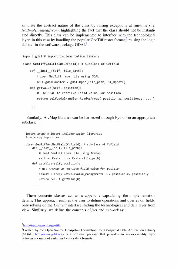
simulate the abstract nature of the class by raising exceptions at run-time (i.e.NotImplementedError), highlighting the fact that the class should not be instanti-ated directly. This class can be implemented to interface with the technologicallayer, in this case by handling the popular GeoTiff raster format,7 reusing the logicdefined in the software package GDAL8:
Similarly, ArcMap libraries can be harnessed through Python in an appropriatesubclass:
These concrete classes act as wrappers, encapsulating the implementationdetails. This approach enables the user to define operations and queries on fields,only relying on the CcField interface, hiding the technological and data layer fromview. Similarly, we define the concepts object and network as:
7http://trac.osgeo.org/geotiff.8Created by the Open Source Geospatial Foundation, the Geospatial Data Abstraction Library(GDAL, http://www.gdal.org) is a software package that provides an interoperability layerbetween a variety of raster and vector data formats.

Existing efficient vector and network data manipulation libraries, such as GDALand NetworkX,9 can be tapped in the corresponding implementations. Once the setof core concepts have been implemented and linked to the technological layer, theuser can perform spatial computations directly in terms of the concepts.
Selecting the analysis of solar energy collection potentials as a test domain ofspatial information, a typical resource consists of Shapefiles with detailed vectordata representing building roofs and other viable areas for the installation of solarpanels. Using the Python core concepts, the user can load these objects and performspatial operations on them. In the following example, the user formulates thequestion: is the roof of the Poultry building located in a viable area?
9https://networkx.github.io.

Because of their foundational nature, the core concepts can be deployed andassembled to represent a wide variety of domain entities, enabling the user toflexibly model their scenarios and even include multiple conceptualizations. Thus,the energy analyst can define a roof type as a field for some purposes (e.g., mod-eling its topography) and as an object for others, formulating spatial questions thatinvolve both perspectives:
As we have shown in this section, the embedding of core concepts in Python canprovide a widely usable and modular conceptual layer to organize domain-specificspatial knowledge. The advantages of this approach will be particularly evident inthe context of information integration from different domains, providing a modelingframework as well as a computing toolkit to facilitate communication between GISpractitioners and domain experts.
6 Conclusions and Outlook
We have outlined the design rationale and an early implementation of a languagefor the “domain” of spatial computing. Our ultimate goal is a high-level languageexecutable on existing commercial and open source spatial computing platforms, inparticular Geographic Information Systems (GIS). So far, we have specified a set ofcore concepts and, for each of them, a set of core computations. These specifica-tions are now being translated (by hand) into Python scripts, as well as into Haskelldata types and foreign function calls, in both cases allowing for calls to commercialor open source GIS platforms.
The paper first described the theory of core concepts of spatial information thatunderpins the language, which includes five core content concepts (location, field,object, network, and event), complemented by two core quality concepts (granu-larity and accuracy). After providing a formal specification of a set of spatialcomputations relying on these concepts, we outlined an ongoing embedding inPython, showing how this package can function as a mediation layer between the

core concepts and existing technological layers that encode the data and perform thecomputations.
More interdisciplinary research is needed to achieve our vision. The Pythonembedding will be stress-tested in more realistic scenarios, providing feedback torevise both the formal specifications and the software embedding, but possibly alsothe concept selection. Use cases set in different domains, ranging from ecology toeconomics and history, will help demonstrate the cross-domain transferability of thecore concepts within and beyond the traditional scope of GIS applications.
A different route to take with this idea is to design and implement ApplicationProgramming Interfaces (API) on top of spatial data repositories and spatial data-base management systems. For example, popular open data like OpenStreetMap orthe US Census TIGER data would benefit from some generic computing layerthrough which to query and analyze them from certain perspectives (for example,seeing them as representing networks or sets of objects).
Acknowledgments We gratefully acknowledge contributions to the Python embedding andtesting from Michel Zimmer, Marc Tim Thiemann, and Eric Ahlgren as well as funding from theUCSB Center for Spatial Studies.
References
Albrecht, J. (1998). Universal analytical GIS operations: A task-oriented systematization of datastructure-independent GIS functionality. In H. Onsrud & M. Craglia (Eds.), Geographicinformation research: Transatlantic perspectives (pp. 577–591). London: Taylor & Francis.
Baumann, P. (2010). The OGC web coverage processing service (WCPS) standard.Geoinformatica, 14(4), 447–479.
Burrough, P. A., & Frank, A. U. (1996). Geographic objects with indeterminate boundaries.London: Taylor & Francis.
Burrough, P. A., & McDonnell, R. (1998). Principles of geographical information systems.Oxford, UK: Oxford University Press.
Camara, G., Egenhofer, M. J., Ferreira, K., Andrade, P., Queiroz, G., Sanchez, A., et al. (2014).Fields as a generic data type for big spatial data. In Geographic Information Science (pp. 159–172). Berlin: Springer.
Couclelis, H. (1992). People manipulate objects (but cultivate fields): Beyond the raster-vectordebate in GIS. In A. U. Frank, I. Campari, & U. Formentini (Eds.), Theories and methods ofspatio-temporal reasoning in geographic space (pp. 65–77). Berlin: Springer.
Degbelo, A., & Kuhn, W. (2012). A Conceptual Analysis of Resolution. In GeoInfo—XIIIBrazilian Symposium on GeoInformatics, November 25–28 2012, Campos do Jordão, Brasil(pp. 11–22).
Donnelly, M. (2005). Relative Places. Applied Ontology, 1, 55–75.Egenhofer, M. J., & Kuhn, W. (1999). Interacting with Geographic Information Systems. In M.
F. Goodchild, D. J. Maguire, D. W. Rhind, & P. Longley (Eds.), Geographical InformationSystems: Principles, techniques, applications, and management (2nd ed., Vol. 1, pp. 401–412).New York: Wiley.
Galton, A. (2004). Fields and objects in space, time, and space-time. Spatial Cognition &Computation, 4(1), 39–68.
Ghosh, D. (2011). DSL for the uninitiated. Communications of the ACM, 54(7), 44.

Golledge, R. G. (1995). Primitives of spatial knowledge. In T. L. Nyerges, D. M. Mark, R. Laurini,& M. J. Egenhofer (Eds.), Cognitive aspects of human-computer interaction for geographicinformation systems (pp. 29–44). Berlin: Springer.
Goodchild, M. F., Yuan, M., & Cova, T. J. (2007). Towards a general theory of geographicrepresentation in GIS. International Journal of Geographical Information Science, 21(3),239–260.
Janelle, D. G., & Goodchild, M. F. (2011). Concepts, principles, tools, and challenges in spatiallyintegrated social science. SAGE Publications: In the SAGE Handbook of GIS and Society.
Kuhn, W. (2012). Core concepts of spatial information for transdisciplinary research. InternationalJournal of Geographical Information Science, 26(12), 2267–2276 (Special Issue in honor ofMichael Goodchild).
Newman, M. E. J. (2010). Networks. Oxford: Oxford University Press.Norman, D. A. (1986). Cognitive Engineering. In D. Norman & S. Draper (Eds.), User centered
system design (pp. 31–61). Hillsdale, NJ: Lawrence Erlbaum Associates.Rosenfeld, A. (1986). “Continuous” functions on digital pictures. Pattern Recognition Letters,
4(3), 177–184.Talmy, L. (1983). How language structures space. In H. L. Pick & L. P. Acredolo (Eds.), Spatial
Orientation (pp. 225–282). New York/London: Plenum Press.