December 16, 2004
96
October 25, 2021 Regional Permit Administrator US Army Corps of Engineers NYS Department of Environmental Buffalo District Office Conservation, Regulatory Services, Region 8 ATTN: Chief, Regulatory Branch 6274 East Avon – Lima Road 1776 Niagara Street Avon, NY 14414-9519 Buffalo, New York 14207-3199 Re: BRIDGE REPLACEMENT PROJECT YATES CARLTON TOWNLINE ROAD OVER JOHNSON CREEK (BIN 3318800) TOWNS of YATES and CARLTON, ORLEANS COUNTY, NY Dear Sirs: The Orleans County Highway Department is requesting a NYSDEC Section 401 Water Quality Certification and UCOE Nationwide #3 and a Section 404 permit for the replacement of BIN 3318800 which conveys Johnson Creek beneath Yates Carlton Townline Road in the Towns of Yates and Carlton, NY (See Location Maps – Attachment 1). A Joint Application for Permit is provided in Attachment 2 and project site photographs are provided in Attachment 3. Project plans are provided in Attachment 4, hydraulics and hydrology in Attachment 6 and other information, pertinent to permit review, is provided in Attachment 5. Johnson Creek is classified as a Class C stream by the New York State Department of Environmental Conservation. It is also listed as a S1/S2 mollusk waterbody. In accordance with mapping provided on the web site for NYS DOS Division of Coastal resources, the project falls within the coastal boundary for Lake Ontario and as such, a Federal Consistency Assessment form has been sent concurrently to the NYS DOS. A copy of the form is included in Attachment 7. The following project information is provided for your review: I. Project Background & Description The existing two-span, jack-arch (concrete-encased steel multi-beam) bridge was constructed in 1933. The existing total bridge length is 86 feet, and the bridge section is comprised of 7 steel rolled beams of unknown section. The deck consists of a variable thickness concrete arch infill and integrally cast parapets supporting non-standard steel pipe railing. The roadway surface over the bridge consists of an asphalt pavement section. The existing clear roadway width over the bridge is 24’-2” and the out-to-out width is 27’-2”. There are overhead telephone lines approximately 10 feet east of the east fascia. The only known repairs to this bridge involved concrete repairs made to the downstream pier face in 2011 as a result of a bridge inspection reg flag. The most recent bridge inspection gave the bridge a General Recommendation of “4”. Due to the concrete encasement, the condition of the beams is mostly unknown. The bottom flange concrete encasement has completely failed along approximately 60% of beams. Where exposed, the bottom flanges are completely rusted and have up to 10% estimated section loss. The remaining 40% of the encasement is cracked with observed efflorescence & rust staining. The bridge is considered scour critical due to the use of spread footings to support both abutments and the center pier, all located within the waterway. Both abutment stem footings are exposed, with up to 2.0 feet exposed at their upstream (west) ends. The entire pier footing is exposed, with up to 2.7 feet exposed at the upstream end. The pier obstructs the flow of Johnson Creek and catches debris which contributes to scour along the footing. No undermining of the existing footings has been observed.
-
Upload
khangminh22 -
Category
Documents
-
view
2 -
download
0
Transcript of December 16, 2004
October 25, 2021
Regional Permit Administrator US Army Corps of Engineers NYS Department of Environmental Buffalo District Office Conservation, Regulatory Services, Region 8 ATTN: Chief, Regulatory Branch 6274 East Avon – Lima Road 1776 Niagara Street Avon, NY 14414-9519 Buffalo, New York 14207-3199 Re: BRIDGE REPLACEMENT PROJECT YATES CARLTON TOWNLINE ROAD OVER JOHNSON CREEK (BIN 3318800) TOWNS of YATES and CARLTON, ORLEANS COUNTY, NY
Dear Sirs: The Orleans County Highway Department is requesting a NYSDEC Section 401 Water Quality Certification and UCOE Nationwide #3 and a Section 404 permit for the replacement of BIN 3318800 which conveys Johnson Creek beneath Yates Carlton Townline Road in the Towns of Yates and Carlton, NY (See Location Maps – Attachment 1). A Joint Application for Permit is provided in Attachment 2 and project site photographs are provided in Attachment 3. Project plans are provided in Attachment 4, hydraulics and hydrology in Attachment 6 and other information, pertinent to permit review, is provided in Attachment 5. Johnson Creek is classified as a Class C stream by the New York State Department of Environmental Conservation. It is also listed as a S1/S2 mollusk waterbody. In accordance with mapping provided on the web site for NYS DOS Division of Coastal resources, the project falls within the coastal boundary for Lake Ontario and as such, a Federal Consistency Assessment form has been sent concurrently to the NYS DOS. A copy of the form is included in Attachment 7. The following project information is provided for your review: I. Project Background & Description
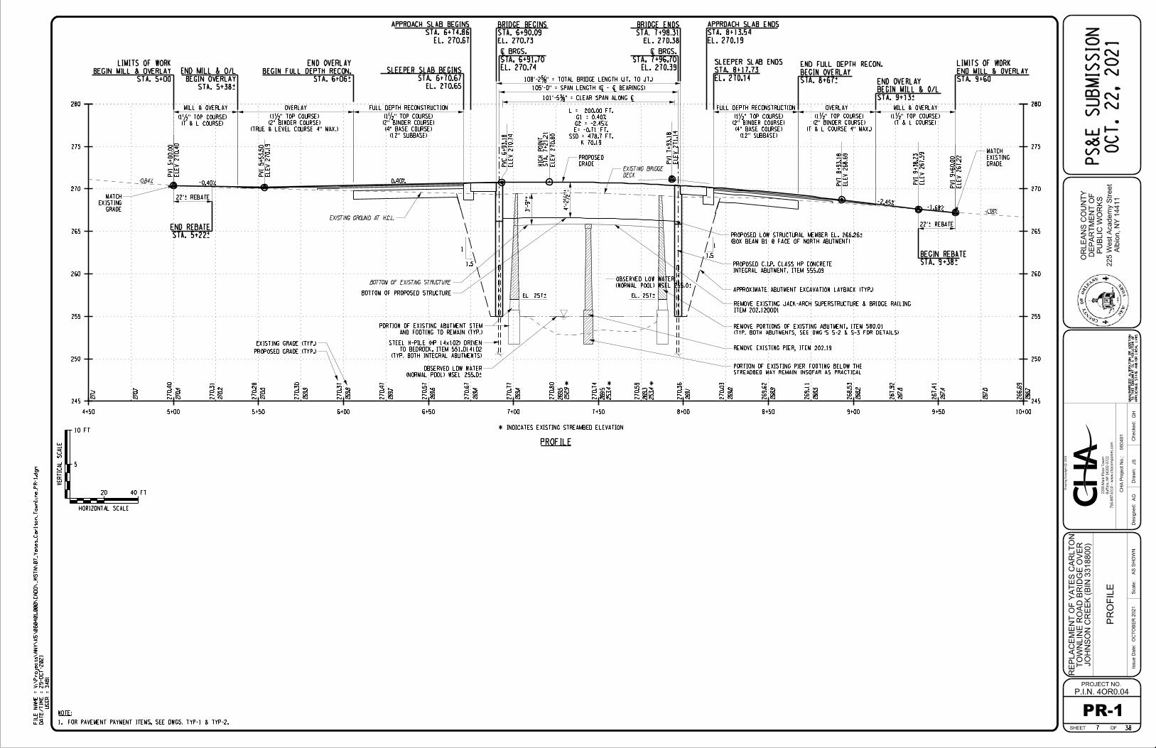
The existing two-span, jack-arch (concrete-encased steel multi-beam) bridge was constructed in 1933. The existing total bridge length is 86 feet, and the bridge section is comprised of 7 steel rolled beams of unknown section. The deck consists of a variable thickness concrete arch infill and integrally cast parapets supporting non-standard steel pipe railing. The roadway surface over the bridge consists of an asphalt pavement section. The existing clear roadway width over the bridge is 24’-2” and the out-to-out width is 27’-2”. There are overhead telephone lines approximately 10 feet east of the east fascia. The only known repairs to this bridge involved concrete repairs made to the downstream pier face in 2011 as a result of a bridge inspection reg flag. The most recent bridge inspection gave the bridge a General Recommendation of “4”. Due to the concrete encasement, the condition of the beams is mostly unknown. The bottom flange concrete encasement has completely failed along approximately 60% of beams. Where exposed, the bottom flanges are completely rusted and have up to 10% estimated section loss. The remaining 40% of the encasement is cracked with observed efflorescence & rust staining. The bridge is considered scour critical due to the use of spread footings to support both abutments and the center pier, all located within the waterway. Both abutment stem footings are exposed, with up to 2.0 feet exposed at their upstream (west) ends. The entire pier footing is exposed, with up to 2.7 feet exposed at the upstream end. The pier obstructs the flow of Johnson Creek and catches debris which contributes to scour along the footing. No undermining of the existing footings has been observed.

Joint Application for Permit October 25, 2021 NYSDEC Region 8 Page 2 of 6 U.S. Army Corps of Engineers
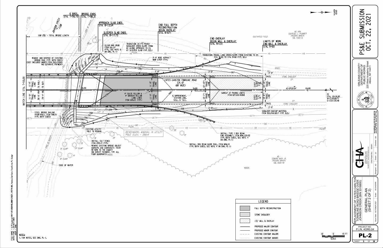
This project intends to replace the existing two-span bridge with a new single span bridge along the current Yates Carlton Townline Road alignment. The profile would be raised by approximately 1.3 feet to accommodate the increased superstructure depth of the single span bridge and to provide sufficient freeboard for ice and debris passage. The bridge roadway width would be widened to provide standard lane and shoulder widths across the structure. The out-to-out width of the bridge would be 29’-4” to accommodate (2) – 11’ travel lanes, (2) – 2’ shoulders and steel bridge railing (4-rail). The new superstructure would consist of (7) – 39” deep adjacent precast prestressed concrete box beams, with an 8” composite reinforced concrete deck. The superstructure would be supported on integral abutments and the roadway embankment would be retained with splayed, independent, cantilevered wingwalls. Both the integral abutment stems and wingwalls would be founded on steel H-piles driven to bedrock. The new abutments would be constructed offset behind the existing abutments and exposed portions of the existing abutments and wingwall stems would be removed. The center pier would be removed down to streambed elevation. New concrete approach slabs with sleeper slabs would be provided at both ends in addition to approximately 115 feet of approach reconstruction and 200 feet of asphalt overlay. New bridge railing will consist of 4-rail, steel bridge rail and the new highway approach railings and bridge railing will meet current NYSDOT and AASHTO standards. Road Closure & Traffic Detour:
A full closure of Yates Carlton Townline Road at the bridge site will be in place during the bridge replacement. Advanced warning signs will be placed north of the bridge at the intersection of NY Route 18 and Yates Carlton Townline Road and to the South of the bridge at the intersection of Stillwater Road and Yates Carlton Townline Road that will notify the public that Yates Carlton Townline Road bridge is closed and to use alternate routes. Directing traffic off-site will minimize the construction duration, thereby also minimizing stream impacts. A summary of the work to be performed at the bridge site includes:
Removal of Existing Bridge:
1. Prior to any excavation or clearing, a silt fence & straw bale barrier will be installed along the top of slope of any embankment disturbance to control sediment transport.
2. Install screening and traps to prevent any asphalt, concrete, rust or dirt from falling in the stream so superstructure removal will have no impact on the streambed. Excavate existing roadway and remove the existing bridge deck, jack arches and concrete encased steel beams.
3. Construct a stone causeway of clean, light to medium stone fill placed on geotextile separation fabric utilizing the southwest bank for access. The geotextile fabric will ensure the stone fill does not get embedded in the streambed and it can be removed. Install a turbidity curtain around the causeway to contain sediment. The volume of stone fill to be installed is 250 CY, all of which is below OHW.
4. Remove the existing concrete pier stem to stream bed elevation. Removal of the pier will be such that the hoe ram/excavator works back toward itself so that the concrete rubble falls on the causeway and not into the stream. The volume of pier stem concrete to be removed is approximately 70 CY, 40 CY of which is below OHW.
5. Remove existing abutments to elevation 257.0, above the normal pool elevation of 255.0. The contractor will sawcut the face of the abutment, prior to demolition and tip the wall over away from the stream. The portions of existing abutment to remain will serve as a cofferdam for the new bridge excavation. The volume of concrete to be removed is approximately 95 CY, 30 CY of which is below OHW.
6. Excavate 1:5H:1V layback slope down to the bottom of the new footings. The volume of excavation is approximately 1570 CY for the abutments and wingwalls, 400 CY of which is below OHW. The overall footprint of the substructure excavation is approximately 5000 SF.

Joint Application for Permit October 25, 2021 NYSDEC Region 8 Page 3 of 6 U.S. Army Corps of Engineers
7. Any excavated fill that is not to be re-used will be transported and disposed off-site. Any excavated material that is temporarily stockpiled for re-use will have silt fence or straw bales installed around the stockpile to protect the creek from transported soil. Any off-site material trucked in will not be stockpiled, but would be immediately placed from the truck into the excavation layback, to backfill wingwalls.
Summary of Construction of Bridge Replacement:
1. The proposed bridge structure will use integral abutments, which are cast-in-place (C.I.P.) concrete abutment footings supported on steel HP 14x102 piles that will be driven to refusal. All C.I.P. concrete will be placed within wood or steel forms to prevent concrete leachate from entering the creek. Integral abutments are beneficial because the abutment stem and footing are cast in the same pour and tend to use far less concrete and require far less excavation than conventional abutments. The volume of cast-in-place concrete required for the abutments and wingwalls is approximately 200 CY, 110 CY of which will be placed below OHW.
2. The abutment will be backfilled with compacted select structural fill up to the roadway’s subgrade elevation. Embankment material will be used to backfill in front of the wingwalls. The volume of select structural fill material is 900 CY, 200 CY of which is below OHW. The volume of embankment material placed in front of the wingwalls is 190 CY, 100 CY of which is below OHW.
3. Prestressed concrete box beams will be set using a 200+ ton crane. Because of the fairly long span and heavy concrete beams that are required, the crane used to erect the new span will be positioned on the causeway constructed for pier removal. Once the prestressed concrete box beams are set, the stone causeway and geotextile separation fabric will be removed.
4. The concrete deck will be placed directly on top of the concrete beams, which are set directly adjacent to each other, eliminating all formwork, thereby minimizing risk of concrete leachate entering the creek below.
5. Place medium stone fill between the existing and proposed abutments as additional scour protection. The approximate volume of stone fill needed is 90 CY all placed below OHW.
6. Reconstruct the roadway embankment, pave the roadway with asphalt, install new guide rail and reopen the road to traffic.
7. Seed and mulch all disturbed areas along the roadway embankment. See drawings in Attachment 4 for further details. II. SEQR This project is classified as a Type II action per 6 NYCRR Part 617, State Environmental Quality Review Act (SEQRA). In accordance with 6NYCRR Part 617.5 (c) (1) “maintenance or repair involving no substantial changes in an existing structure or facility”, and (c) (2) replacement, rehabilitation or reconstruction of a structure or facility, in kind, on the same site”, are identified as actions that will not have a significant impact on the environment, and thus, no further review is required under SEQR. III. Project Need The bridge replacement is necessary for maintaining traffic on Yates Carlton Townline Road which serves as the rural minor collector and for access to nearby residences. Replacement is required to ensure the continued safety of the public. IV. Alternatives Alternatives considered for the bridge include a maintenance only alternative, rehabilitation of existing structure and complete replacement. Under the maintenance alternative, the structural deficiencies are not addressed, and

Joint Application for Permit October 25, 2021 NYSDEC Region 8 Page 4 of 6 U.S. Army Corps of Engineers
further deterioration of the bridge will occur. Maintenance costs would increase as the frequency of inspection and repairs would rise to ensure the safety of the structure, as the bridge continues to deteriorate. Due to the age and condition of the existing jack-arch structure, rehabilitation would involve replacement of the entire bridge superstructure. Additionally, due to the scour critical nature of the bridge, permanent scour protection consisting of heavy stone fill at both abutments and permanent steel sheeting at the center pier would be provided. The construction cost for rehabilitation is estimated at roughly 75% of the replacement alternative. The replacement alternative involves complete replacement of the existing bridge with a prestressed concrete bridge supported on integral abutments supported on steel piles driven to rock. The clear span between abutments will be slightly wider than the existing bridge and the profile will be raised at the new structure to improve the hydraulic opening. Complete replacement is the only cost-effective and technically feasible option for Orleans County. V. Erosion and Sedimentation Control Appropriate erosion and sedimentation control measures will be utilized for the project duration to ensure there are no negative sediment impacts to Johnson Creek. Silt fence will be properly staked and reinforced with straw bales (where warranted) along the length of the downstream bridge embankment, channel banks, as well as any other disturbed areas, and will also be placed surrounding any locations of stockpiled materials. Any erosion and sediment control measures used will be maintained until the roadway embankment is fully vegetated. Any disturbed embankment slopes that are not being lined with stone fill will be properly graded, seeded, mulched and maintained until vegetation is established in order to inhibit erosion. The proposed replacement bridge is 20 feet longer than the existing bridge, thereby allowing the new bridge abutments to be excavated and constructed completely behind the existing abutments, eliminating the need for any cofferdam or waterway diversions. Should dewatering of the excavation be required, all pumps will be discharged into a properly sized settlement basin, with adequate storage to assure the sediment settles out and the water is clear prior to discharging away from disturbed areas and back into the creek, downstream of the excavation. VI. Endangered Species/ Designated Critical Habitat A US Fish and Wildlife Service (USFWS) IPaC Key review was conducted on March 10, 2021 and September 9, 2021 for the project. The review indicated that there are no federally listed, endangered or threatened species identified within the project location. All bridges have the potential of being summer roosting habitat for the NLEB. A BBSF was completed for BIN 3318800 in June 2020. The completed form is included in Attachment 5. The Northern Long-Eared Bat (NLEB) (Myotis septentrionalis) is listed as a Federally and State threatened species. Although the NLEB was not identified within the project limits, this species could be encountered anywhere in New York State. Following NYSDEC’s Best Management Practices, trees or branches 3” diameter breast high or greater and identified as suitable habitat shall not be removed during the pup season which is May 1st to July 31st. A New York Natural Heritage Program (NYNHP) review was conducted in March 2021 and a NYSDEC Environmental Resource Mapper review was conducted in March 2021. The NYSDEC Environmental Resource Mapper indicated the presence of animals listed as endangered or threatened, Redfin Shiner (Lythrurus umbratilis), a species listed as special concrete by NYS within the Yates Carlton Townline Road project area.
Joint Application for Permit October 25, 2021 NYSDEC Region 8 Page 5 of 6 U.S. Army Corps of Engineers
A request for information on rare or state-listed animals or plants, or significant natural heritage within the vicinity of each bridge was sent to NYSDEC, division of New York Natural Heritage Program (NYNHP). A letter dated July 6, 2020 from NYNHP indicated that the Northern Sunfish (Lepomis peltastes), a species listed as threatened by NYS has been documented at the project site. The only proposed in water work for this project will be the demolition of the existing center pier. A temporary stone causeway will be constructed to perform this work and be removed within a month. Johnson Creek is listed as a S1/S2 mollusk waterbody. Coordination with NYSDEC Region 8 determined that there was suitable mussel habitat within the proposed project limits and that an investigation survey was required. Freshwater mussel surveys using a combination of snorkeling and surface supplied air (SSA) were performed by Environmental Solutions & Innovations, Inc. (ESI) encompassing a search area of 0.57 acres on August 3-5, 2021. Survey efforts yielded a collection of 697 live individuals representing 9 species, including state imperiled deertoe (Truncilla truncate) and pink heelsplitter (Potamilus alatus). Fragile papershell (Leptodea fragilis), another imperiled species, was represented by dead material only. No live or dead federally listed species were encountered. ESI submitted their mussel survey report to NYSDEC on August 18, 2021 concluding that mussel salvage and relocation is required on site. ESI submitted a survey relocation plan on September 8, 2021, received approval and was granted a LCP Permit on October 12, 2021. All mussels in the salvage zone were relocated by ESI on October 13, 2021. See correspondence with NYSDEC in Attachment 5.
VII. Cultural Resources The NYSDOT has conducted a review of cultural resources for Yates Carlton Townline Road over Johnson Creek. The project activities have no potential to cause effects on historic properties in accordance with 36 CFR 800.3(a)(1) therefore, there are no further obligations for compliance with Section 106 of the National Historic Preservation Act. A memo documenting this determination is included in Attachment 5.
VIII. Wetlands Encroachment The project site was screened for wetlands using information available online and is summarized herein. State Freshwater Wetlands- A preliminary screening of the NYSDEC Environmental Resource Mapper showed no wetlands within or in close proximity to the project area. Federal Jurisdictional Wetlands- Johnson Creek is mapped on the United States Fish and Wildlife Service’s (USFWS) National Wetland Inventory Maps (NWI) as a riverine wetland (R2UBH) within the project limits. Most stream corridors in general are NWI mapped as riverine wetlands. A site visit was performed to confirm the presence/absence of wetland conditions outside the stream’s ordinary high water level. No wetland indictors were identified.
IX. Hydrology & Hydraulics A hydraulic analysis was performed on the proposed single span of Yates Carlton Townline Road Bridge. The proposed hydraulic opening will be 25% larger than the existing opening, reducing any constrictions, while improving hydraulic efficiency. Water surface profiles and channel velocity were computed using the HEC-RAS computer program, using field surveyed cross-sections and the proposed bridge geometry. There will be a slight increase in water surface elevation through/under the bridge which can be attributed to a reduction in the draw-down effect created by the elimination of the center pier restriction. The new bridge can adequately convey the design flow without causing flooding, while also providing adequate freeboard for ice and debris passage.
See Attachment 6 for a detailed discussion of the hydrology and hydraulics of the bridge.

Yates Carlton Townline Road over Johnson Creek Joint Application for Permit NYSDEC Region 8 & U.S. Army Corps of Engineers October 25, 2021
ATTACHMENT 1
SITE LOCATION MAPS


Yates Carlton Townline Road over Johnson Creek Joint Application for Permit NYSDEC Region 8 & U.S. Army Corps of Engineers October 25, 2021
ATTACHMENT 2
JOINT APPLICATION FOR PERMIT
INCLUDING:
- Supplement WQC-1
- WQC Pre-Filing request form
- WQC Pre-Filing email correspondence

JOINT APPLICATION FORM For Permits for activities activities affecting streams, waterways, waterbodies, wetlands, coastal areas, sources of water, and endangered and threatened species.
You must separately apply for and obtain Permits from each involved agency before starting work. Please read all instructions.
1. Applications To: N S Department of Environmental Conservation Check here to confirm you sent this form to NYSDEC.
Check all permits that apply: Dams and Impound- ment Structures
401 Water Quality Certification
Freshwater Wetlands
Tidal Wetlands
Wild, Scenic and Recreational Rivers
Coastal Erosion Management
Water Withdrawal
Long Island Well
Incidental Take of Endangered / Threatened Species
Stream Disturbance
Excavation and Fill in Navigable Waters
Docks, Moorings or Platforms
US Army Corps of Engineers Check here to confirm you sent this form to USACE.
Check all permits that apply: Section 404 Clean Water Act Section 10 Rivers and Harbors Act
Is the project Federally funded? Yes No
If yes, name of Federal Agency:
General Permit Type(s), if known:
Preconstruction Notification: Yes No
NY Office of General Services Check here to confirm you sent this form to NYSOGS.
Check all permits that apply:State Owned Lands Under Water
Utility Easement (pipelines, conduits, cables, etc.) Docks, Moorings or Platforms
NY Department of State Check here to confirm you sent this form to NYSDOS.
Check if this applies: Coastal Consistency Concurrence
2. Name of Applicant Taxpayer ID (if applicant is NOT an individual)
Mailing Address Post Office / City State Zip
Telephone Email
Applicant Must be (check all that apply): Owner Operator Lessee
3. Name of Property Owner (if different than Applicant)
Mailing Address Post Office / City State Zip
Telephone Email
For Agency Use Only Agency Application Number:
JOINT APPLICATION FORM 0 / Page 1 of 4

JOINT APPLICATION FORM – Continued. Submit this completed page as part of your Application.
4. Name of Contact / Agent
Mailing Address Post Office / City State Zip
Telephone Email
5. Project / Facility Name Property Tax Map Section / Block / Lot Number:
Project Street Address, if applicable Post Office / City State Zip NY
Provide directions and distances to roads, intersections, bridges and bodies of water
Town Village City County Stream/Waterbody Name
Project Location Coordinates: Enter Latitude and Longitude in degrees, minutes, seconds: Latitude: ° ' " Longitude: ° ' "
6. Project Description: Provide the following information about your project. Continue each response and provideany additional information on other pages. Attach plans on separate pages.
a. Purpose of the proposed project:
b. Description of current site conditions:
c. Proposed site changes:
d. Type of structures and fill materials to be installed, and quantity of materials to be used (e.g., square feet ofcoverage, cubic yards of fill material, structures below ordinary/mean high water, etc.):
e. Area of excavation or dredging, volume of material to be removed, location of dredged material placement:
f. Is tree cutting or clearing proposed? Yes If Yes, explain below. No Timing of the proposed cutting or clearing (month/year):
Number of trees to be cut: Acreage of trees to be cleared:
JOINT APPLICATION FORM 0 Page 2 of 4

JOINT APPLICATION FORM – Continued. Submit this completed page as part of your Application.
g. Work methods and type of equipment to be used:
h. Describe the planned sequence of activities:
i. Pollution control methods and other actions proposed to mitigate environmental impacts:
j. Erosion and silt control methods that will be used to prevent water quality impacts:
k. Alternatives considered to avoid regulated areas. If no feasible alternatives exist, explain how the project willminimize impacts:
l. Proposed use: Private Public Commercial
m. Proposed Start Date: Estimated Completion Date:
n. Has work begun on project? Yes If Yes, explain below. No
o. Will project occupy Federal, State, or Municipal Land? Yes If Yes, explain below. No
p. List any previous DEC USACE Permit / Application numbers for activities at this location:
q. Will this project require additional Federal, State, or Local s, including zoning changes?
Yes If Yes, list below. No
JOINT APPLICATION FORM 0 Page 3 of 4


Page 1 of 2 Joint Application Supplement WQC-1
APPLICATION FOR PERMIT FOR SECTION 401 STATE WATER QUALITY CERTIFICATION
Supplement WQC-1
DEC ID (if known):
Applicant Information:
Name of Applicant (from Joint Application Form):
Email: Phone:
Mailing Address: Street: City: State: Zip:
Project Location (from Joint Application Form):
Town (where property taxes paid): County:
Street Address: City: State: NY Zip:
To comply with federal requirements at 40 CFR §121.5(b) for New York State Section 401 Water
Quality Certification, all items below must be completed and the applicant must sign page 2 of this
form.
1. By signing this form, the applicant affirms that the project proponent(s) and a point of contact were accurately identified in the Joint Application for Permit provided with this supplement.
2. By signing this form, the applicant affirms that the proposed project is accurately and completely identified in the Joint Application for Permit provided with this supplement, and in any supporting plans, photos, reports or other project information.
3. Identify here the applicable federal license or permit for this request:
If this request relates to a Section 404 Nationwide Permit administered by the US Army Corps of Engineers, please identify the appropriate Nationwide Permit number(s):
4. Please identify the location and nature of any potential discharge that may result from the proposed project and the location of receiving waters (attached additional information as needed):
5. Please provide a description of any methods and means proposed to monitor the discharge and the equipment or measures planned to treat, control, or manage the discharge (attach additional information as needed):


1
Page, Jennifer
From: Knickmeyer, Frances B (DEC) <[email protected]>Sent: Tuesday, June 8, 2021 3:01 PMTo: Page, JenniferCc: [email protected]: [--EXTERNAL--]: Yates-Carlton TL Rd Bridge (DEC ID 8-3499-00008/00001): CommentsAttachments: 401 WQC Supplement.pdf
Dear Jennifer, NYSDEC staff have reviewed the pre-application materials submitted for the proposed Yates-Carlton TL Rd Bridge project (DEC ID 8-3499-00008/00001). We have determined that a pre-application meeting is not required. However, we do have some comments we would like the applicant to address with their formal permit application.
1. Please revise the project plans to show additional erosion control details. 2. Please submit a better description of the causeway and its construction/removal. 3. Please submit a more detailed drawing for the cofferdam. 4. As previously noted, a mussel survey is required for this project. In response to questions you had regarding the
timing of the mussel survey, I received the following information: a. A separate relocation plan should be submitted to our office for review after a survey has been
completed. A “candidate relocation site survey” can be included during the initial survey to inform a relocation plan (if needed). Staff are not in favor of a simultaneous survey and relocation event.
b. The survey guidelines have criteria for mussel handling, timing, and condition requirements that would be the same for relocations. For example, when relocation is deemed necessary it should happen between May 15 and Sept 30th.
c. Relocation should happen during the same field season as the project and as close to the project as reasonably possibly. However, keeping in mind the survey and relocation season, we would allow a relocation to happen during the previous field season when the project is happening after September 30th but before the following May.
i. With some assurance that the bridge project will be completed before May, relocation could occur the prior season, but as close to September 30 as possible.
ii. NOTE: If the applicant opts to complete relocation in the previous season, but the project is delayed, so that it would not be completed by May, the mussel relocation would need to be redone.
5. Please note the following will be conditions in any permit that may be issued for this project: a. No in-stream work will be allowed from March 1 – June 30. b. Wet concrete must not contact flowing water.
Please submit a completed Water Quality Certification Supplement form (attached) with the completed Joint Application Form (for an Article 15 (Protection of Waters – Excavation and Fill) permit) and revised plans, as noted above. Sincerely, Frances Knickmeyer Environmental Analyst, Division of Environmental Permits Pronouns: She/Her/Hers
New York State Department of Environmental Conservation 6274 E. Avon-Lima Road, Avon, NY 14414 P: 585-226-5382 | F: 585-226-2830 | [email protected]
www.dec.ny.gov | | |

1
Page, Jennifer
From: Page, JenniferSent: Tuesday, April 6, 2021 10:50 AMTo: Knickmeyer, Frances B (DEC)Subject: RE: [--EXTERNAL--]: Johnson Creek (Yates-Carlton TL Rd Bridge; DEC ID
8-3499-00008/00001) & Ganargua Creek (Farmington Rd Bridge; DEC ID 8-5430-00160/00001): Application Process
Attachments: PIN 4OR004_401 WQC Pre-Filing Request.pdf
Hi Frances- Please see attached for the WQC Pre-filing for Yates Carlton Townline Road Bridge. We’ll get Farmington to you as soon as we have a signature from the client. Do you need me to send these to the Region 8 inbox as well? or is it ok to send them to you directly since they’re already been assigned to you? I would assume that any new future requests should be sent directly to Region 8. Thanks Jen Jennifer Page Project Engineer IV CHA Office: (716) 222-1404 [email protected] www.chacompanies.com
Responsibly Improving the World We Live In
From: Knickmeyer, Frances B (DEC) <[email protected]> Sent: Thursday, April 1, 2021 12:24 PM To: Page, Jennifer <[email protected]> Subject: [--EXTERNAL--]: Johnson Creek (Yates-Carlton TL Rd Bridge; DEC ID 8-3499-00008/00001) & Ganargua Creek (Farmington Rd Bridge; DEC ID 8-5430-00160/00001): Application Process Dear Jen, Both the Johnson Creek (Yates-Carlton TL Rd Bridge; DEC ID 8-3499-00008/00001) and the Ganargua Creek (Farmington Rd Bridge; DEC ID 8-5430-00160/00001) projects have been assigned to me. Both projects have concerns with imperiled mussels and will likely need, at a minimum, an Individual Water Quality Certification (WQC). As you may be aware, the process for applying for an Individual WQC changed late last year. All projects requiring an Individual WQC now require a pre-filing application form to be completed and submitted. Please see below for the updated application process.

2
To answer your specific question regarding the necessity of a mussel survey: For Johnson Creek (Yates-Carlton TL Rd Bridge; DEC ID 8-3499-00008/00001): A mussel survey will be required
unless the project can be redesigned to avoid all impacts (including changes in flow) that would result from the proposed temporary causeway.
For Ganargua Creek (Farmington Rd Bridge; DEC ID 8-5430-00160/00001): DEC staff need to visit the site before a determination can be made.
In order to begin the permit application process, please provide the following information:
A. Section 401 Water Quality Certification Pre-Application Process 1. In accordance with Section 401 of the Clean Water Act, applicants for a Federal license or permit for
activities (including but not limited to the construction or operation of facilities that may result in any discharge into waters of the United States) are required to apply for and obtain a Water Quality Certification from the Department of Environmental Conservation (DEC) indicating that the proposed activity will not violate water quality standards.
Please note that as Federal Regulations have recently changed, DEC’s application process has been updated. In order to start the application process, you must submit a Pre-filing Meeting Request Form (attached) and a project location map, along with any other available information (site photos, project plans, etc.) This may be sent electronically to [email protected] (or by mail to the NYSDEC Region 8 Office) and must be done at least 30 days prior to sending in your permit application. The following website describes DEC’s WQC and contains a link to the required form: https://www.dec.ny.gov/permits/6546.html.
DEC will then determine whether a pre-application meeting is required. If a meeting is required, you and the US Army Corps of Engineers (USACE) will be notified. If a meeting is not required, you may be notified by DEC or if you receive no notifications from DEC within 30 days you may proceed with your application.
B. Permit Application Process 1. Joint Application Form: http://www.dec.ny.gov/docs/permits_ej_operations_pdf/jointapp.pdf
a. Instructions for filling out the Joint App Form can be found here: http://www.dec.ny.gov/docs/permits_ej_operations_pdf/jntappinstruc.pdf
2. Application for Permit for Section 401 State Water Quality Certification (attached) 3. Property survey or existing conditions plan 4. Proposed plans, including cross sections, with the limits of construction (i.e., a line on the plans
surrounding all staging, storage, and operations areas).
C. The following items may be required depending on the project: 1. Application fee. More information on fees can be found here: http://www.dec.ny.gov/permits/65153.html 2. NYSOPRHP SHPO determination letter: submit your plans electronically to the NYSOPRHP CRIS
website to receive a SHPO determination letter http://nysparks.com/shpo/online-tools/ 3. Short Environmental Assessment Form:
www.dec.ny.gov/docs/permits_ej_operations_pdf/seafpartone.pdf Submit the application materials to:
Regional Permit Administrator NYSDEC Region 8 6274 E. Avon-Lima Road Avon, NY 14414 [email protected]
When submitting the application materials, please reference the DEC ID that has been assigned to each project. Additionally, it is advised that you also submit your application materials to US Army Corps of Engineers Buffalo District: [email protected].
Once we receive the WQC pre-applications forms and the 30-day review period passes, we can provide more specific comments on these projects. Sincerely,

3
Frances Knickmeyer Environmental Analyst, Division of Environmental Permits Pronouns: She/Her/Hers
New York State Department of Environmental Conservation 6274 E. Avon-Lima Road, Avon, NY 14414 P: 585-226-5382 | F: 585-226-2830 | [email protected]
www.dec.ny.gov | | |

Yates Carlton Townline Road over Johnson Creek Joint Application for Permit NYSDEC Region 8 & U.S. Army Corps of Engineers October 25, 2021
ATTACHMENT 3
SITE PHOTOGRAPHS

FIL
E
NA
ME
=
DA
TE/
TI
ME
=
US
ER
=
V:\
Projects\
AN
Y\
K5\060401.0
00\
Reports\
Design
Report\
PIN 40
R004
Location
Maps.d
gn
12-
MA
R-2021
3481
YA
TE
S
CA
RL
TO
N
TO
WN
LIN
E
RO
AD
FIGURE
DATE: 3/21716.847.6310 www.chacompanies.com
Buffalo, NY 14202-3722
2200 Main Place Tower
Drawing Copyright c 2021
ORLEAN COUNTY, NEW YORK
TOWN OF CARLTON
0 50 100 150 200'
SCALE
GRID
NORTH
GRID
NORTH
OVER JOHNSON CREEK
REPLACEMENT OF BIN 3318800
PHOTO LOCATION MAP
123
4
5 6
798
C

PIN 4OR004 Replacement of Yates Carlton Townline Road
Page 1 of 5
PHOTO 1: Looking South from North of the Bridge
PHOTO 2: Facing South, looking at Southwest Quadrant

PIN 4OR004 Replacement of Yates Carlton Townline Road
Page 2 of 5
PHOTO 3: Facing Southeast Quadrant
PHOTO 4: Facing Southwest, looking at the East Fascia

PIN 4OR004 Replacement of Yates Carlton Townline Road
Page 3 of 5
PHOTO 5: Looking North, facing Northwest Quadrant of Bridge
PHOTO 6: Looking North, facing Northeast Quadrant of Bridge

PIN 4OR004 Replacement of Yates Carlton Townline Road
Page 4 of 5
PHOTO 7: Looking Northeast, facing Center Pier
PHOTO 8: Looking at Jack Arches and Concrete Encased Steel Beams

PIN 4OR004 Replacement of Yates Carlton Townline Road
Page 5 of 5
PHOTO 9: Looking East, facing Downstream
Yates Carlton Townline Road over Johnson Creek Joint Application for Permit NYSDEC Region 8 & U.S. Army Corps of Engineers October 25, 2021
ATTACHMENT 4
PROJECT PLANS & DETAILS

GENERAL NOTES: GENERAL NOTES (CONT.):
ALL CALCULATIONS FOR THE ABOVE WORK SHALL BE INDEPENDENTLY CHECKED.
* SUPERSTRUCTURE ERECTION
* SUPERSTRUCTURE DEMOLITION
PREPARE AND STAMP PLANS AND CALCULATIONS FOR THE FOLLOWING WORK:
THE CONTRACTOR SHALL HAVE AN ENGINEER LICENSED AND REGISTERED IN THE STATE OF NEW YORK 26.
BRIDGE REMOVAL, EXCAVATION & BACKFILL NOTES:
(NYS P.E. REQUIREMENT WAIVED)
25.
24.
22.
21.
20.
19.
18.
17.
16.
15.
14.
13.
12.
11.
10.
9.
8.
7.
6.
5.
4.
3.
2.
1.SUBSTRUCTURE NOTES:
4.
3.
2.
1.
CONTRACTOR PRIOR TO FABRICATION.
REINFORCEMENT BAR SCHEDULES ARE FOR INFORMATION ONLY. ALL BAR SCHEDULES MUST BE VERIFIED BY THE
OTHERWISE NOTED ON THE PLANS.
ALL EXPOSED EDGES OF ABUTMENTS & WINGWALLS SHALL HAVE A MINIMUM CHAMFER OF 1", EXCEPT WHERE
ABUTMENT CONCRETE, ITEM 555.09.
BY THE ENGINEER. THE COST OF THE WIRE MESH SHALL BE INCLUDED IN THE UNIT PRICE BID FOR THE
MESH/SCREENING WITH •"x •" OPENINGS. THE MESH SHALL BE SECURELY ATTACHED IN A MANNER APPROVED
WHERE WEEP HOLES ARE SHOWN IN ABUTMENTS AND WALLS, THE OUTLET SHALL BE COVERED BY GALVANIZED WIRE
VARIOUS ITEMS OF THE CONTRACT UNLESS OTHERWISE SPECIFIED ON THE PLANS.
THE COST OF ALL JOINT MATERIAL & WATERSTOPS IS TO BE INCLUDED IN THE UNIT PRICES BID FOR THE
SUPERSTRUCTURE NOTES:
6.
5.
4.
3.
2.
1.
ROAD CLOSURE RESTRICTIONS
1.
2.
1.
STREAM PROTECTION NOTE:
3.
2.
1.
WORK ZONE TRAFFIC CONTROL:
THE CREEK. PAYMENT FOR ANY WORK REQUIRED BY THESE CONDITIONS SHALL BE INCLUDED IN ITEM 209.13.
EXCAVATION OR ANY STOCKPILED MATERIAL IN WHICH SEDIMENT CAN BE TRANSPORTED BY RAINFALL/STREAM FLOW INTO
STAKED HAYBALES, SILT FENCE AND/OR SILT FENCE CHECK DAMS SHALL BE CONSTRUCTED AROUND ANY OPEN
NO DISCHARGE SHALL BE PERMITTED TO FLOW FROM AN OPEN EXCAVATION DIRECTLY BACK INTO THE STREAM. PROPERLY
AS LONG AS DEBRIS DOES NOT DROP IN THE WATER.
PERFORMED WITHIN THE CREEK. WORK BEHIND EXISTING ABUTMENTS OR ABOVE DECK IS PERMITTED DURING THIS PERIOD
JOHNSON CREEK HAS IN-STREAM DATE RESTRICTIONS FROM MARCH 1 THROUGH JUNE 30, WHERE NO WORK SHALL BE
WITH ALL CONDITIONS AND RESTRICTIONS CONTAINED IN THE PERMITS. THE CONTRACTOR SHALL TAKE NOTE THAT
OF BOTH PERMITS SHALL BE POSTED AT THE BRIDGE SITE IN A CONSPICUOUS LOCATION. THE CONTRACTOR SHALL ABIDE
A COPY OF NYSDEC AND U.S. ARMY CORPS OF ENGINEERS PERMITS WILL BE PROVIDED TO THE CONTRACTOR AND A COPY
TEMPORARY MEASURES SHALL BE REMOVED AND THE AREA RESTORED AT THE COMPLETION OF THE WORK
TEMPORARY DAM REQUIRED TO PROTECT AND MAINTAIN WATER RIGHTS AND TO SUSTAIN FISH LIFE DOWNSTREAM. THESE
IMPURITIES. IF THE CONTRACTOR USES WATER FROM A STREAM, THE CONTRACTOR SHALL CONSTRUCT AN INTAKE OR
OTHER SIMILAR OPERATIONS WHICH CAUSE THIS WATER TO BECOME POLLUTED WITH SAND, SILT, CEMENT, OIL, OR OTHER
CONTRACTOR SHALL NOT RETURN DIRECTLY TO A STREAM ANY WATER WHICH HAS BEEN USED TO WASH PURPOSES OR
FOREIGN MATERIAL, OR FROM MANIPULATION OF EQUIPMENT AND/OR MATERIALS IN OR NEAR SUCH STREAMS. THE
PREVENT OR REDUCE TO A MINIMUM ANY DAMAGE TO ANY STREAM FROM POLLUTION BY DEBRIS, SEDIMENT, OR OTHER
DURING THE COURSE OF CONSTRUCTION, THE CONTRACTOR SHALL CONDUCT OPERATIONS IN SUCH A MANNER AS TO
UTILITY NOTES:
4.
3.
2.
1.
JOHNSON CREEK HAS IN-STREAM DATE RESTRICTIONS FROM MARCH 1 THROUGH JUNE 30
10.
9.
8.
7.
6.
5.
4.
3.
2.
1.
4.
3.
2.
1.
2
GN-1
GE
NE
RA
L N
OT
ES
NO
NE
SECTION 107-08).
SATISFACTORILY REPAIRED OR ITEMS REPLACED AT THE CONTRACTOR'S EXPENSE (STANDARD SPECIFICATIONS
THE CONTRACTOR WILL BE HELD LIABLE FOR ANY DAMAGES DONE. ANY SUCH INJURIES OR DAMAGES SHALL BE
SECTION 105-15).
ANY REASON WITHOUT FIRST SECURING WRITTEN PERMISSION FROM THE PROPERTY OWNER (STANDARD SPECIFICATIONS
CONTRACTOR SHALL NOT INVADE UPON PRIVATE PROPERTIES, LANDS OR BUILDINGS OUTSIDE OF THE RIGHTS-OF-WAY FOR
BE PROVIDED BY THE PROJECT ENGINEER AND IN NO INSTANCE ARE TO BE SECURED BY THE CONTRACTOR. THE
WORK OUTSIDE OF THE EXISTING RIGHTS-OF-WAY, INCLUDING PLANTINGS, LANDSCAPING OR DRIVEWAY ENHANCEMENT, WILL
IN ACCORDANCE WITH SECTION 105-15 OF THE STANDARD SPECIFICATIONS, RELEASES FOR ANY NON-ESSENTIAL CONTRACT
BEFORE ANY WORK MAY BE INITIATED AT THOSE LOCATIONS (STANDARD SPECIFICATIONS SECTIONS 105-10 AND 625).
THOSE VICINITIES, THE CONTRACTOR MUST CONTACT THE PROJECT ENGINEER FOR DEFINITIVE BOUNDARY DETERMINATIONS
IF CONTRACTOR IS UNABLE TO IDENTIFY THE LIMITS OF THE RIGHTS-OF-WAY WHEN THE CONTRACT CALLS FOR WORK IN
INSTALLATION OF TURF; AND THE INSTALLATION OF ANY FENCES OR PROTECTIVE BARRIER.
MATERIALS, DEBRIS AND WASTE; LANDSCAPING; VEGETATION REMOVAL AND MANAGEMENT; GRADING, SEEDING AND THE
BEING PERFORMED WITHIN THE ROW, INCLUDING BUT NOT LIMITED TO VEHICLE ACCESS; STORAGE OF EQUIPMENT,
WITH SECTION 105-15 OF THE STANDARD SPECIFICATIONS. THE CONTRACTOR IS TO ASSURE HIMSELF THAT ALL WORK IS
ALL WORK TO BE PERFORMED UNDER THIS CONTRACT WILL BE WITHIN THE PUBLIC RIGHT-OF-WAY (ROW) IN ACCORDANCE
TO ALLOW SUFFICIENT TIME TO NOTIFY EMERGENCY SERVICES.
PROVIDE 2 WEEKS WRITTEN NOTICE TO THE COUNTY'S PROJECT MANAGER PRIOR TO BEGINNING WORK AT THE BRIDGE
FIRE, POLICE, EMERGENCY SERVICES, SCHOOLS AND OTHER LOCAL OR COUNTY AUTHORITIES. THE CONTRACTOR MUST
NOTIFICATION OF FIRE AND POLICE AUTHORITIES: ORLEANS COUNTY DEPARTMENT OF PUBLIC WORKS WILL NOTIFY THE
ITEM 619.01.
UNLESS OTHERWISE NOTED ON THE DRAWINGS, THE COST OF ALL WORK ZONE TRAFFIC CONTROL WILL BE PAID FOR UNDER
FOR THE YATES CARLTON TOWNLINE ROAD CLOSURE DETAILS & WORK ZONE TRAFFIC CONTROL NOTES, SEE DRAWING WZ-1.
MATERIAL.
ALL METAL REINFORCING BAR CHAIRS AND SUPPORTS SHALL HAVE PLASTIC SHOES OR BE OF A NON-FERROUS
THERE ARE NO AVAILABLE RECORD DRAWINGS FOR THE EXISTING STRUCTURE.
BRIDGE PLAN (DWG. S-1). SEE THE CONTRACT PROPOSAL FOR BORING LOGS.
SUBSURFACE EXPLORATIONS HAVE BEEN MADE FOR THIS PROJECT AT THE LOCATIONS INDICATED ON THE GENERAL
COMMENCING WORK.
STANDARD SPECIFICATIONS AND SHALL SUBMIT A HEALTH AND SAFETY PLAN TO THE ENGINEER PRIOR TO
THE CONTRACTOR IS REQUIRED TO PROTECT HIS WORKERS IN ACCORDANCE WITH SECTION 107-05 OF THE NYSDOT
SUPPLEMENT THE GENERAL NOTES LISTED HEREIN.
CONTRACT PLANS AND SUCH "NOTES", WHILE PERTAINING TO THE SPECIFIC DRAWINGS THEY ARE PLACED ON, ALSO
THE CONTRACTOR IS ADVISED THAT ADDITIONAL "NOTES" WILL BE FOUND ON SUBSEQUENT SHEETS OF THE
AFTER CONSTRUCTION IS COMPLETED. COST INCLUDED IN THE VARIOUS ITEMS OF THE CONTRACT.
THE EXISTING B.I.N. PLATE SHALL BE REMOVED, STORED AND REMOUNTED ON THE NEW BRIDGE SUBSTRUCTURE
N.Y.S.D.E.C., N.Y.S.D.O.L., U.S.E.P.A., AND O.S.H.A REGULATIONS.
UNIT BID PRICES SHALL INCLUDE ANY ADDITIONAL COSTS INCURRED TO MEET U.S. ARMY CORP. OF ENGINEERS,
ITEMS OF THE CONTRACT.
FOR WHICH NO ITEM NUMBER IS INDICATED. THE COST FOR SUCH WORK SHALL BE INCLUDED IN THE VARIOUS
NO DIRECT PAYMENT SHALL BE MADE FOR WORK INDICATED ON THE DRAWINGS OR WITHIN THE SPECIFICATIONS
1-800-962-7962 FOR UTILITY STAKE-OUT PRIOR TO PERFORMING ANY EXCAVATIONS.
SHOW THEIR LOCATIONS EITHER INSIDE OR OUTSIDE THE WORK AREAS. CONTACT "DIG SAFELY NEW YORK",
OWNERS INVOLVED. WORK SHALL NOT COMMENCE UNTIL ALL UNDERGROUND UTILITY LINES HAVE BEEN STAKED TO
INFORMATION FOUND ON THE PLANS AND COORDINATE HIS SCHEDULE OF OPERATIONS WITH THE VARIOUS UTILITY
APPROXIMATE EXISTING LOCATIONS ON THE CONTRACT PLANS. THE CONTRACTOR SHALL VERIFY THE UTILITY
ALL KNOWN PUBLIC AND PRIVATE UTILITIES LINES WITHIN OR ADJACENT TO THE SITE ARE SHOWN IN THEIR
ENSURE THE SATISFACTORY & TIMELY COMPLETION OF THE WORK PRIOR TO THE CONTRACT COMPLETION DATE.
IT WILL BE THE CONTRACTOR'S OBLIGATION AND RESPONSIBILITY TO USE METHODS AND EQUIPMENT WHICH WILL
FOR THOSE ITEMS.
SUPPLYING A DISPOSAL AREA AND TRANSPORTATION TO THAT AREA SHALL BE INCLUDED IN THE UNIT PRICE BID
WHENEVER ITEMS IN THE CONTRACT REQUIRE MATERIALS TO BE REMOVED AND DISPOSED OF, THE COST OF
ALL WORK SHALL BE LIMITED TO WITHIN THE RIGHTS OF WAY, EASEMENTS, OR LIMITS OF RELEASE.
SATISFACTION OF THE ENGINEER, WITHOUT COST TO THE COUNTY.
WHICH ARE NOT PART OF THE INTENDED WORK SHALL BE REPAIRED OR REPLACED BY THE CONTRACTOR TO THE
ROADWAYS WHICH ARE NOT INCLUDED AS PART OF THE INTENDED WORK. ALL DAMAGE TO EXISTING ROADWAYS
THE CONTRACTOR WILL BE HELD RESPONSIBLE FOR ALL DAMAGES CAUSED BY HIS OPERATIONS TO THE EXISTING
THE COUNTY.
MANNER SATISFACTORY TO THE ENGINEER AT THE EXPENSE OF THE CONTRACTOR, WITH NO ADDITIONAL COST TO
REMAIN THE PROPERTY OF THE COUNTY, THE DAMAGED MATERIALS SHALL BE REPAIRED OR REPLACED IN A
BE DAMAGED. IF THE CONTRACTOR DAMAGES ANY MATERIALS WHICH ARE TO REMAIN IN PLACE, OR WHICH ARE TO
ARE TO REMAIN IN PLACE, OR BE RE-USED, OR WHICH ARE TO REMAIN THE PROPERTY OF THE COUNTY WILL NOT
THE CONTRACTOR SHALL EXERCISE CAUTION AND PERFORM ALL WORK WITH CARE SO THAT ANY MATERIALS WHICH
BY THE ENGINEER AND PAYMENT SHALL BE MADE AT THE UNIT BID PRICE FOR THE APPROPRIATE ITEMS.
IS NOT SHOWN OR NOTED ON THE PLANS. THIS WORK SHALL BE PERFORMED BY THE CONTRACTOR AS ORDERED
THE CONTRACTOR SHOULD NOTE THAT ADDITIONAL WORK MAY BE REQUIRED AS THE CONTRACT PROGRESSES WHICH
MATERIALS USED, AS INDICATED BY THE VARIOUS ITEMS IN THE CONTRACT.
CONTRACT PLANS. THE CONTRACTOR WILL BE PAID AT THE UNIT BID PRICE FOR THE ACTUAL QUANTITIES OF
THAT MAY BE REQUIRED DUE TO ANY DIFFERENCE BETWEEN ACTUAL CONDITIONS AND THOSE SHOWN ON THE
THERE SHALL BE NO CLAIM AGAINST THE COUNTY BY THE CONTRACTOR FOR WORK PERTAINING TO MODIFICATIONS
THOSE SHOWN ON THE PLANS AS APPROVED BY THE ENGINEER.
THE CONTRACTOR SHALL USE THE FIELD CONDITIONS & DIMENSIONS AND MAKE THE APPROPRIATE CHANGES TO
THOSE SHOWN ON THE PLANS. IF FIELD CONDITIONS & DIMENSIONS DIFFER FROM THOSE SHOWN ON THE PLANS,
THE CONTRACTOR SHALL EXAMINE AND VERIFY IN THE FIELD, ALL EXISTING CONDITIONS & DIMENSIONS WITH
ALL ITEMS AND MATERIALS WHICH HE IS REQUIRED TO FURNISH IN ACCORDANCE WITH THE CONTRACT DOCUMENTS.
CONTRACT. NO EXTRA COMPENSATION WILL BE ALLOWED HIM BECAUSE OF HIS FAILURE TO INCLUDE IN HIS BID,
CONDITIONS AND TO JUDGE FOR HIMSELF THE EXTENT AND NATURE OF THE WORK TO BE PERFORMED UNDER THIS
THE CONTRACTOR SHALL VISIT THE SITE BEFORE BIDDING TO FAMILIARIZE HIMSELF WITH THE PRESENT
ADDITIONS AND MODIFICATIONS.
RESPONSIBILITY TO PUBLIC," OF THE STANDARD SPECIFICATIONS DATED SEPTEMBER 1, 2021, INCLUDING CURRENT
THE CONTRACTOR'S ATTENTION IS DIRECTED TO THE REQUIREMENTS OF SECTION 107 "LEGAL RELATIONS AND
MATERIAL SPECIFICATION 709-02.
FABRICATED IN ACCORDANCE WITH ASTM A767 AND ASTM A123, AND MEET THE REQUIREMENTS OF NYSDOT
SHALL BE ASTM A1064. NO SUBSTITUTIONS WILL BE ALLOWED. WIRE FABRIC SHALL BE GALVANIZED AND
AND MEET THE REQUIREMENTS OF NYSDOT MATERIAL SPECIFICATION 709-11. ALL WIRE FABRIC REINFORCEMENT
ALLOWED. WHERE INDICATED, BARS SHALL BE GALVANIZED AND FABRICATED IN ACCORDANCE WITH ASTM A767,
REINFORCEMENT: ALL BAR REINFORCEMENT SHALL BE ASTM A615 GRADE 60. NO SUBSTITUTIONS SHALL BE
AIR ENTRAINMENT SHALL BE 5% - 8%.
C.I.P. CONCRETE: THE MINIMUM COMPRESSIVE STRENGTH FOR C.I.P. CONCRETE SHALL BE 4,000 PSI AT 28 DAYS.
RATINGS SHOWN PROVIDE FOR A 25 PSF FUTURE WEARING SURFACE.
EVALUATION - 2018, 3RD EDITION WITH ALL INTERIM REVISIONS IN EFFECT UP TO AND INCLUDING 2020. ALL
HS AND HL-93 LOAD RATINGS WERE COMPUTED IN ACCORDANCE WITH THE AASHTO MANUAL FOR BRIDGE
OPERATING R.F.: 1.88INVENTORY R.F.: 1.45LRFR:
OPERATING RATING: HS-53INVENTORY RATING: HS-26 LFR:
LOAD RATINGS:
DESIGN LOAD: HL-93
THE PROJECT PROPOSAL.
ADVERTISEMENT FOR THIS CONTRACT, EXCEPT AS AMENDED ON THESE PLANS AND/OR IN THE SPECIFICATIONS IN
ENGINEERING BULLETINS, DIRECTIVES OR INSTRUCTIONS BEFORE THE FIRST PUBLISH DATE OF THE
OF ENGINEERING, DATED SEPTEMBER 1, 2021 WITH ALL CURRENT ADDENDA, & ALL REVISIONS ISSUED BY NYSDOT
"STANDARD SPECIFICATIONS" (U.S. CUSTOMARY UNITS), NEW YORK STATE DEPARTMENT OF TRANSPORTATION OFFICE
THESE PLANS AND/OR SPECIFICATIONS AND THE ACCOMPANYING PROPOSAL IS TO BE IN CONFORMITY WITH
CONSTRUCTION AND MATERIAL SPECIFICATIONS: ALL WORK CONTEMPLATED UNDER THIS CONTRACT AS SHOWN ON
OF TRANSPORTATION BRIDGE MANUAL, 2019 U.S. CUSTOMARY EDITION.
NEW YORK STATE DEPARTMENT OF TRANSPORTATION LFRD BLUE PAGES AND THE NEW YORK STATE DEPARTMENT
DESIGN SPECIFICATIONS: AASHTO LFRD BRIDGE DESIGN SPECIFICATIONS (9TH EDITION) 2020, AND AS AMENDED BY
THE PRICE BID FOR THE VARIOUS ITEMS IN THE CONTRACT. NO SEPARATE PAYMENT SHALL BE MADE.
AND SEEDED AS SPECIFIED IN THE STANDARD SEEDING ITEM. THE COST OF THIS WORK SHALL BE INCLUDED IN
THE ENGINEER. ALL DISTURBED GRASS AREAS SHALL BE GRADED IN A MANNER APPROVED BY THE ENGINEER
TO BE PERFORMED UNDER THIS CONTRACT, SHALL BE RESTORED AS SPECIFIED AND TO THE SATISFACTION OF
SHOULDER AREAS DISTURBED BY THE CONTRACTOR, HIS MATERIALS OR HIS EQUIPMENT AS PART OF THE WORK
ENGINEER.
NATURAL GROWTH SHALL BE RESTORED AT THE EXPENSE OF THE CONTRACTOR AS DIRECTED BY THE
THE LIMITS OF CONSTRUCTION, WHICH ARE NOT SCHEDULED FOR REMOVAL. ANY DAMAGE CAUSED TO THIS
CARE SHALL BE TAKEN TO RETAIN NATURAL GROWTH AND PREVENT DAMAGE TO TREES WITHIN AND OUTSIDE
BE MADE.
WATER TO BE INCLUDED IN THE UNIT PRICE BID FOR THE RESPECTIVE ITEM. NO SEPARATE PAYMENT SHALL
SHALL ADD WATER AS REQUIRED TO OBTAIN THE SPECIFIED COMPACTION & DENSITY. THE COST OF ADDING
CONTRACTOR SHALL PROVIDE A STANDARD PROCTOR GRAPH FOR THE SELECT MATERIAL USED. THE CONTRACTOR
SUBBASE COURSE (304.12) SHALL BE COMPACTED TO 95% OF STANDARD PROCTOR MAXIMUM DENSITY. THE
ALL PLACEMENTS OF EMBANKMENT IN PLACE (ITEM 203.03), SELECT STRUCTURAL FILL (ITEM 203.21), AND
AREA WILL BE EMBANKMENT IN PLACE.
LINES WILL BE SELECT STRUCTURAL FILL MATERIAL. OVER-EXCAVATION OF MATERIAL WITHIN THE LACKBACK
PAYMENT LINES WILL BE AT THE CONTRACTOR'S EXPENSE. BACKFILL FROM OVER-EXCAVATION BELOW PAYMENT
ANY OVER-EXCAVATION FOR THE TEMPORARY CAUSEWAY OR ANY UNAUTHORIZED EXCAVATIONS BELOW OR BEYOND
EXCAVATION SHALL BE PERFORMED TO THE PAYMENT LINES SHOWN ON THE PLANS & SECTIONS. BACKFILL FOR
AND UTILITIES. ALL COSTS FOR THIS WORK SHALL BE INCLUDED IN VARIOUS ITEMS IN THE CONTRACT.
OR DIRECTED BY THE ENGINEER TO PROTECT THE SAFETY OF WORKERS, ADJACENT STRUCTURES, ROADWAYS
CONTRACTOR SHALL PROVIDE ALL ADDITIONAL TEMPORARY SUPPORTS, BRACING, AND OTHER DEVICES REQUIRED
IN ADDITION TO THE EXCAVATION PROTECTION SYSTEMS SHOWN IN THE PLANS, (I.E. LAYBACKS), THE
APPROPRIATE ITEMS OF THE CONTRACT.
SCREENS OR OTHER PROTECTIVE DEVICES SHALL BE INCLUDED IN THE UNIT PRICES BID FOR THE
THE COST OF FURNISHING, INSTALLING, MAINTAINING, REMOVING AND DISPOSING OF ALL PLATFORMS, NETS,
OF BY THE CONTRACTOR ON A DAILY BASIS AT NO COST TO THE COUNTY.
MATERIAL FALLS ON THE AREA BELOW AND ADJACENT TO THE BRIDGE, IT SHALL BE REMOVED AND DISPOSED
NOT BEING EMPLOYED, THE WORK SHALL BE SUSPENDED UNTIL ADEQUATE PROTECTION IS PROVIDED. IF
USED TO CATCH THE MATERIAL. IF THE ENGINEER DETERMINES THAT ADEQUATE PROTECTIVE DEVICES ARE
PERMIT THE DROPPING OF MATERIAL. PLATFORMS, NETS, SCREENS OR OTHER PROTECTIVE DEVICES SHALL BE
MATERIAL INTO THE CREEK BELOW THE BRIDGE EXCEPT WHERE THE PLANS OR SPECIFICATIONS SPECIFICALLY
DURING REMOVAL OPERATIONS, THE CONTRACTOR SHALL NOT DROP WASTE CONCRETE, DEBRIS OR OTHER
TO ENTER THE WATER.
SUPERSTRUCTURE REMOVAL MAY BE PERFORMED WITHIN THAT TIMEFRAME ASSUMING EQUIPMENT DOES NOT NEED
COMPLIANCE WITH THE IN-STREAM WORK DATE RESTRICTIONS (SEE STREAM PROTECTION NOTES).
THE TEMPORARY CAUSEWAY AND PIER REMOVAL SHALL BE SCHEDULED FOR AFTER JUNE 30TH, FOR
THE NYS P.E. REQUIREMENT IS WAIVED FOR THE DEMOLITION PLANS.
SUBMITTED TO THE ENGINEER A MINIMUM OF FIFTEEN (15) DAYS PRIOR TO BEGINNING THE DEMOLITION.
PICK RADII, PICK WEIGHTS, ETC. PROPOSED FOR THE SUPERSTRUCTURE DEMOLITION. THIS PLAN SHALL BE
A WORK PLAN CONTAINING ALL DEMOLITION PROCEDURES, CRANE OR EQUIPMENT LOCATIONS, PICK LOCATIONS,
THE EXISTING SUPERSTRUCTURE SHALL BE REMOVED UNDER ITEM 202.120001. THE CONTRACTOR SHALL SUBMIT
UNDER THE UNIT PRICE BID FOR ITEM 580.01 REMOVAL OF STRUCTURAL CONCRETE.
ANY PROTRUDING EXISTING REINFORCEMENT FLUSH WITH THE REMAINING STEM CONCRETE, COST INCLUDED
ABUTMENT STEMS AND/OR FOOTINGS THAT ARE INTENDED TO REMAIN IN PLACE. CONTRACTOR SHALL CUT OFF
REMOVAL. DURING DEMOLITION OPERATIONS, THE CONTRACTOR SHALL MINIMIZE DAMAGE TO THE EXISTING
IT IS SIMPLY DESIRED TO USE SEPARATE REMOVAL ITEMS FOR THE ABUTMENT REMOVAL VERSUS THE PIER
ABUTMENT STEMS AND WINGWALLS TO BE REMOVED USING HAND TOOLS / CHIPPING HAMMERS / JACK HAMMERS.
AS SPECIFIED WITHIN NYSDOT STANDARD SPECIFICATIONS SECTION 202. IT IS NOT INTENDED FOR THE
STEMS AND WINGWALLS USING STANDARD MEANS & METHODS TYPICALLY USED FOR SUBSTRUCTURE DEMOLITION,
REMOVAL OF STRUCTURAL CONCRETE. HOWEVER, THE CONTRACTOR MAY REMOVE THE EXISTING ABUTMENT
THE PARTIAL DEMOLITION OF THE WINGWALLS AND ABUTMENT STEMS WILL BE PAID UNDER ITEM 580.01,
REMOVED UNDER ITEM 202.19. PORTIONS OF SUBSTRUCTURES INDICATED TO REMAIN SHALL NOT BE REMOVED.
WINGWALLS SHALL BE PARTIALLY REMOVED UNDER ITEM 580.01. THE CENTER PIER SHALL BE COMPLETELY
EXISTING SUBSTRUCTURES SHALL BE REMOVED TO THE LIMITS INDICATED ON THE PLANS. ABUTMENTS AND
FOR ADDITIONAL PRESTRESSED CONCRETE BOX BEAM UNIT NOTES, SEE DWG. S-19.
APPROACH SLABS, EXPOSED TOP SURFACES OF SLEEPER SLAB, DECK FASCIA AND THE BOX BEAMS EXPOSED FASCIA.
559.18960118, SHALL BE APPLIED TO ALL EXPOSED CONCRETE SURFACES OF THE NEW STRUCTURAL DECK,
PROTECTIVE SEALING OF STRUCTURAL CONCRETE ON NEW BRIDGE DECKS AND BRIDGE DECK OVERLAYS, ITEM
SUBMIT ALL CRANE LIFT/RADIUS DATA WITH THE ERECTION PLAN.
PLAN SHALL INCLUDE ALL RIGGING, BEAM WEIGHTS, PICK WEIGHTS AND LIMITING RADII FOR THE CRANE USED.
COUNTY. THE CONTRACTOR SHALL SUBMIT ERECTION PLANS FOR THE P.S.C. BOX BEAM ERECTION. THE ERECTION
ALIGNMENT AND PROFILE MUST BE APPROVED BY THE ENGINEER AND WILL BE PERFORMED AT NO COST TO THE
ANY CORRECTIVE WORK NECESSARY TO REPOSITION PREVIOUSLY ERECTED BOX BEAMS TO ACHIEVE ACCEPTABLE
THE COST OF ERECTION SHALL BE INCLUDED IN THE PRICE BID FOR THE PRESTRESSED CONCRETE BOX BEAM ITEM.
TO THE MIX IN ACCORDANCE WITH SECTION 4.1 OF THE P.C.C.M. AIR CONTENT SHALL BE 7% (`2%).
CORROSION INHIBITOR MEETING THE REQUIREMENTS OF NYSDOT MATERIAL SPECIFICATION 711-13 SHALL BE ADDED
10,000 PSI AT 56 DAYS
7,000 PSI AT TRANSFER
CONCRETE USED FOR P.S.C. BOX BEAMS SHALL ACHIEVE AN UNCONFINED COMPRESSIVE STRENGTH OF:
ALL SHOP DRAWINGS SUBMITTED FOR THIS PROJECT SHALL BE IN U.S. CUSTOMARY UNITS.
AS DIRECTED WITHIN THESE PLANS OR AS ORDERED BY ENGINEER.
YORK STATE PRESTRESSED CONCRETE CONSTRUCTION MANUAL (P.C.C.M.), 3RD EDITION ISSUED APRIL 2019, EXCEPT
ALL PRESTRESSED CONCRETE FABRICATION IS GOVERNED BY, AND SHALL MEET THE REQUIREMENTS OF THE NEW
OF THIS WORK SHALL BE INCLUDED UNDER ITEM 625.01.
FEATURES TO PROVIDE THEM WITH SUFFICIENT INFORMATION TO TEMPORARILY RELOCATE THEIR FACILITIES. THE COST
IF NECESSARY, AT THE REQUEST OF CHARTER THE CONTRACTOR SHALL LAY OUT THE PROJECT CENTERLINE AND OTHER
* JERRY MARTIN, [email protected], (585)-756-1795
OVERHEAD FIBEROPTIC CABLE TO BE TEMPORARILY RELOCATED BY CHARTER PRIOR TO PILE DRIVING. CONTACT INFO:
AFFECTED UTILITY COMPANIES:
THE CONTRACTOR SHALL BE RESPONSIBLE FOR COORDINATING HIS CONSTRUCTION OPERATIONS THE FOLLOWING
COMPANIES OR MUNICIPAL FORCES MAY DO THE WORK, AND THE COST THEREOF CHARGED AGAINST THE CONTRACTOR.
THE CONTRACTOR. IF THE CONTRACTOR DOES NOT MAKE IMMEDIATE NECESSARY REPAIRS, THE RESPECTIVE OWNING
UNTIL SERVICE IS RESTORED. ALL COSTS TO REPAIR OR REPLACE DAMAGED UTILITIES SHALL BE AT THE EXPENSE OF
SERVICE, THE CONTRACTOR SHALL IMMEDIATELY COMMENCE WORK TO RESTORE SERVICE AND MAY NOT CEASE WORK
IN THE EVENT THE CONTRACTOR DAMAGES AN EXISTING UTILITY SERVICE, CAUSING THE INTERRUPTION IN SAID
PREVENTED.
INTERFERENCE WITH OR DAMAGE TO THESE OR OTHER FACILITIES DURING THE COURSE OF CONSTRUCTION IS
CONTRACTOR'S RESPONSIBILITY TO CONDUCT HIS OPERATIONS AND TAKE NECESSARY PRECAUTIONS SUCH THAT
RECORDS. ADDITIONAL UTILITY LINES, WHETHER ABANDONED OR IN SERVICE, MAY EXIST AND IT SHALL BE THE
UNDERGROUND UTILITIES SHOWN ARE BASED ON INFORMATION OBTAINED FROM THE UTILITY COMPANIES AND AVAILABLE
CONSTRUCTED ARE APPROXIMATE ONLY. THEIR EXACT LOCATIONS SHALL BE DETERMINED IN THE FIELD. EXISTING
LOCATION OF UTILITIES, PUBLIC AND/OR PRIVATE, INDICATED ON THE PLANS AS EXISTING AND/OR TO BE
RIGHT-OF-WAY NOTES:
Issue D
ate:
Scale:
V:\
Projects\
AN
Y\
K5\060401.0
00\
CA
DD\_
MS
TN\02_
Yates_
Carlton_
To
wnline_
GN-1.d
gn
25-
OC
T-2021
3481
US
ER
=
DA
TE/
TI
ME
=
FIL
E
NA
ME
=
Dra
wn:
Desig
ned:
Checked:
SHEET OF
CH
A Project
No.:
060401
Dra
win
g C
opyright c 2
021
716.8
47.6
310
ww
w.c
haco
mpanies.c
om
Buffalo,
NY 1
4202-3
722
2200 M
ain Place T
ow
er
AO
JS
GH
PROJECT NO.
AP
PLIC
AB
LE
ST
AT
E
AN
D/
OR
LO
CA
L
LA
WS
TO
THIS
DO
CU
ME
NT IS
A
VIO
LA
TIO
N
OF
UN
AU
TH
ORIZ
ED
AL
TE
RA
TIO
N
OR
AD
DITIO
N
38
PU
BLIC W
OR
KS
DE
PA
RT
ME
NT O
F
OR
LE
AN
S C
OU
NT
Y
Albio
n,
NY 1
4411
225 W
est
Acade
my Street
P.I.N. 4OR0.04
JO
HN
SO
N C
RE
EK (
BIN 3
318800)
TO
WN
LIN
E R
OA
D B
RID
GE O
VE
RR
EP
LA
CE
ME
NT O
F Y
AT
ES C
AR
LT
ON
OC
TO
BE
R 2
021
OC
T.
22,
2021
PS
&E
SU
BMIS
SIO
N

16"
18"
SIGN
REF.
REF.
UP
R.O.W.
R.O.W.
DITCH DITCH
WOODSWOODS
WOODSWOODS
GRASS
GRASS
GRASS
STONE SHOULDER
STONE SHOULDER
EP
EP
ED
GE
OF
WATER
SBL 15.00-1-12
(RECORD OWNER)
COURTNEY L. PLUMMER
NO. 1484
SBL 16.00-1-50
(RECORD OWNER)
EDWARD MACK JR.
NO. -
B1
255
255
255
255
260
260
260
265
265
265265
265
265
265265265
270
270
270
ED
GE
OF
WATE
R
EDGE OF
WATER
268 268 268
269 269 269
269 269269
270 270
270
270
270
270
267266
268
267266
265264
265
260
264 263 26
2
261
259
257
258259
263
262
261
260
JOH
NSON CREE
KFLO
W
PC1
(66' WIDE)
C.R. 67
YATES CARLTON TOWNLINE ROAD
5+00 6+00 7+005+00 6+00 7+00
JOH
NSON CREE
KFLO
W
PC1
(66' WIDE)
C.R. 67
YATES CARLTON TOWNLINE ROAD
10'-
9"̀
10'-
6"̀
2'-0"
2'-0"
10 FT010
SCALE
10'-
11"̀
10'-
6"̀
LA
NE
TR
AV
EL
LA
NE
TR
AV
EL
LA
NE
TR
AV
EL
LA
NE
TR
AV
EL
LA
NE
TR
AV
EL
LA
NE
TR
AV
EL
SHLD.
SHLD.
SHLD.
SHLD. SHLD.
SHLD.
MOW STRIP (TYP.)
2'-0" WIDE ASPHALT
11'-
0"
11'-
0"
29'-
4" (O
UT T
O
OUT)
26'-
0" (R
AIL T
O
RAIL)
2'-0"
2'-0"
2'-0"
2'-0"
SEE NOTE 5
NOTES:
5
PL-1
(SH
EE
T 1 O
F 2)
GE
NE
RA
L P
LA
N AS S
HO
WN
MA
TC
H
LIN
E
ST
A.
7+50.0
0
STA. 6+06`
RECONSTRUCTION
BEGIN FULL DEPTH
END OVERLAY
ITEM 209.13 (TYP.)
INSTALL SILT FENCE
STA. 6+90.09
BRIDGE BEGINS
(TYP. BOTH SIDES, SEE NOTE 4)
ITEM 606.10
INSTALL BOX BEAM GUIDE RAIL
(TYP., SEE NOTE 6)
ITEM 201.07
CLEAR AND GRUB
EDGE OF WATER
E=1221128.34
N=1218628.75
STA. 3+16.31
P.I.
POLE TO REMAIN
EXISTING UTILITY
(TYP. BOTH SIDES, SEE NOTE 4)
END ASSEMBLY, ITEM 606.120102
INSTALL TYPE I BOX BEAM
(TYP. B.S.)
TO 2% AT SLEEPER SLAB
FROM 6% ALONG APPROACH
SHOULDER CROSS-SLOPE
TRANSITION 20 FT. PAVED
FULL DEPTH RECONSTRUCTION
EXISTING CONTOUR (MAJOR)
EXISTING CONTOUR (MINOR)
LEGEND
11'-
0"
11'-
0"
LA
NE
TR
AVEL
LA
NE
TR
AVEL
STA. 5+00 TO STA. 5+60 (TYP. BOTH SIDES)
TRANSITION TRAVEL LANE CROSS-SLOPE FROM EXISTING TO 2%
4.6
%
SL
OP
E
EXIS
T.
2.2
%
SL
OP
E
EXIS
T.
6.
5.
4.
3.
2.
1.
NO SEPARATE OR DIRECT PAYMENT SHALL BE MADE.
REMOVED AND DISPOSED OF, WITH THE COST INCLUDED IN THE UNIT PRICE FOR ITEM 201.07.
INTERFERING PORTIONS OF EXISTING FALLEN TREES WITHIN THE PROJECT LIMITS SHALL BE
CONTRACT. NO SEPARATE OR DIRECT PAYMENT WILL BE MADE.
TO REOPENING THE ROAD TO TRAFFIC. COST TO BE INCLUDED UNDER VARIOUS ITEMS IN THE
EXISTING INTERSECTION WARNING SIGN & POST SHALL BE REMOVED, STORED & RESET PRIOR
FOR BRIDGE RAIL AND GUIDE RAIL PLAN & DETAILS, SEE DWGS. GR-1 TO GR-3.
FOR TYPICAL BRIDGE, BRIDGE APPROACH & HIGHWAY SECTIONS, SEE DWGS. TYP-1 & TYP-2.
FOR SURVEY CONTROL AND HORIZONTAL CONTROL LINE INFORMATION, SEE DWG. SC-1.
FOR ROADWAY PROFILE, SEE DWG. PR-1.
STA. 5+00
BEGIN MILL & OVERLAY
LIMITS OF WORK
H.C.L. & T.G.L.
STATION LINE,
< IMPROVEMENT,
STA. 6+74.86
APPROACH SLAB BEGINS
STA. 6+70.67
SLEEPER SLAB BEGINS
(NO DIRECT PAYMENT, TYP. ALL FOUR QUADRANTS)
COORDINATE THEIR RETURN TO THE COUNTY
REMOVE EXISTING BRIDGE OBJECT MARKERS AND
PROPOSED MAJOR CONTOUR
PROPOSED MINOR CONTOUR
STONE SHOULDER
(TYP. BOTH SIDES)
(FOUR-RAIL), ITEM 568.51
STEEL BRIDGE RAILING
108'-2†" = TOTAL BRIDGE LENGTH
(NO SEPARATE PAYMENT)
COST INCLUDED UNDER ITEM 202.120001
BRIDGE RAIL (TYP. BOTH SIDES)
REMOVE AND DISPOSE OF EXISTING
ITEM 640.21 (TYP.)
LANE LINES
4" BROKEN YELLOW
4" SOLID YELLOW &
STA. 6+91.70
< BRGS.
GRID
NO
RT
H
1•" MILL & OVERLAY
STA. 5+38`
BEGIN OVERLAY
END MILL & OVERLAY
ITEM 627.50140008
SAWCUT AT PAVING LIMITS
ITEM 203.24010017 (TYP. B.S.)
SHOULDER BACKUP MATERIAL
Issue D
ate:
Scale:
V:\
Projects\
AN
Y\
K5\060401.0
00\
CA
DD\_
MS
TN\05_
Yates_
Carlton_
To
wnline_P
L-1.d
gn
25-
OC
T-2021
3481
US
ER
=
DA
TE/
TI
ME
=
FIL
E
NA
ME
=
Dra
wn:
Desig
ned:
Checked:
SHEET OF
CH
A Project
No.:
060401
Dra
win
g C
opyright c 2
021
716.8
47.6
310
ww
w.c
haco
mpanies.c
om
Buffalo,
NY 1
4202-3
722
2200 M
ain Place T
ow
er
AO
JS
GH
PROJECT NO.
AP
PLIC
AB
LE
ST
AT
E
AN
D/
OR
LO
CA
L
LA
WS
TO
THIS
DO
CU
ME
NT IS
A
VIO
LA
TIO
N
OF
UN
AU
TH
ORIZ
ED
AL
TE
RA
TIO
N
OR
AD
DITIO
N
38
PU
BLIC W
OR
KS
DE
PA
RT
ME
NT O
F
OR
LE
AN
S C
OU
NT
Y
Albio
n,
NY 1
4411
225 W
est
Acade
my Street
P.I.N. 4OR0.04
JO
HN
SO
N C
RE
EK (
BIN 3
318800)
TO
WN
LIN
E R
OA
D B
RID
GE O
VE
RR
EP
LA
CE
ME
NT O
F Y
AT
ES C
AR
LT
ON
OC
TO
BE
R 2
021
OC
T.
22,
2021
PS
&E
SU
BMIS
SIO
N
CP 2
265.62
265.48
30"
12"
20"
24"18"
10"
24" CLUMP18" CLUMP
18" CLUMP
16"
30"
36"
24"
REF.
REF.
UP
R.O.W.
R.O.W.
R.O.W.
POLE ELEV. = 268.41
BENCHMARK: MAGNAIL IN UTILITY
WOODS
ED
GE
OF
WATE
R
EDGE OF
WATER
STONE
WOODS
CULTIVATED FIELD
GRASS
GRASS
STONE SHOULDER
STONE SHOULDER
EP
EP
SBL 15.00-1-12
(RECORD OWNER)
COURTNEY L. PLUMMER
NO. 1484
SBL 16.00-1-50
(RECORD OWNER)
EDWARD MACK JR.
NO. -
B3
255
255
255
260
260
260
265
265
265
265
265
265
265
265
EDGE
OF
WATER
Issue D
ate:
Scale:
V:\
Projects\
AN
Y\
K5\060401.0
00\
CA
DD\_
MS
TN\06_
Yates_
Carlton_
To
wnline_P
L-2.d
gn
25-
OC
T-2021
3481
US
ER
=
DA
TE/
TI
ME
=
FIL
E
NA
ME
=
Dra
wn:
Desig
ned:
Checked:
SHEET OF
CH
A Project
No.:
060401
Dra
win
g C
opyright c 2
021
716.8
47.6
310
ww
w.c
haco
mpanies.c
om
Buffalo,
NY 1
4202-3
722
2200 M
ain Place T
ow
er
AO
JS
GH
PROJECT NO.
AP
PLIC
AB
LE
ST
AT
E
AN
D/
OR
LO
CA
L
LA
WS
TO
THIS
DO
CU
ME
NT IS
A
VIO
LA
TIO
N
OF
UN
AU
TH
ORIZ
ED
AL
TE
RA
TIO
N
OR
AD
DITIO
N
38
PU
BLIC W
OR
KS
DE
PA
RT
ME
NT O
F
OR
LE
AN
S C
OU
NT
Y
Albio
n,
NY 1
4411
225 W
est
Acade
my Street
P.I.N. 4OR0.04
JO
HN
SO
N C
RE
EK (
BIN 3
318800)
TO
WN
LIN
E R
OA
D B
RID
GE O
VE
RR
EP
LA
CE
ME
NT O
F Y
AT
ES C
AR
LT
ON
OC
TO
BE
R 2
021
OC
T.
22,
2021
PS
&E
SU
BMIS
SIO
N
JOH
NSON CREE
KFLO
W
PC2
(66' WIDE)
C.R. 67
YATES CARLTON TOWNLINE ROAD
8+00 10+009+00
267
268
268
268
269
269
269
270
267
268
267
266265
257
258
259 260
261 262
264263
266
265
264
258
259
2612
60
262
263
10 FT010
SCALE
LA
NE
TR
AV
EL
LA
NE
TR
AV
EL
SHLD.
SHLD.
SHLD.
SHLD.
LA
NE
TR
AV
EL
LA
NE
TR
AV
EL
SHLD.
SHLD.
10'-
10"̀
10'-
8"̀
LA
NE
TR
AV
EL
LA
NE
TR
AV
EL
MOW STRIP (TYP.)
2'-0" WIDE ASPHALT
26'-
0" (R
AIL T
O
RAIL)
29'-
4" (O
UT T
O
OUT)
2'-0"
11'-
0"
11'-
0"
2'-0"
2'-0"
2'-0"
10'-
7"̀
10'-
10"̀
2'-0"
2'-0"
1.
NOTES:
FOR NOTES, SEE DWG. PL-1.
6
PL-2
(SH
EE
T 2 O
F 2)
GE
NE
RA
L P
LA
N AS S
HO
WN
STA. 8+67`
BEGIN OVERLAY
RECONSTRUCTION
END FULL DEPTH M
AT
CH
LIN
E
ST
A.
7+50.0
0
EDGE OF WATER
AT SLEEPER SLAB (TYP. B.S.)
6% ALONG APPROACH TO 2%
SHOULDER CROSS-SLOPE FROM
TRANSITION 20 FT. PAVED
STA. 7+98.31
BRIDGE ENDS
STA. 8+13.54
APPROACH SLAB ENDS
ON DWG. PL-1)
(TYP., SEE NOTE 6
ITEM 201.07
CLEAR AND GRUB
STA. 9+00 TO STA. 9+60 (TYP. B.S.)
TRANSITION TRAVEL LANE CROSS-SLOPE FROM EXISTING TO 2%
ON DWG. PL-1)
(TYP. BOTH SIDES, SEE NOTE 4
END ASSEMBLY, ITEM 606.120102
INSTALL TYPE I BOX BEAM
STA. 9+60
END MILL & OVERLAY
LIMITS OF WORK
E=1221135.48
N=1219328.71
STA. 10+16.30
PI
POLE TO REMAIN
EXISTING UTILITY
11'-
0"
11'-
0"
LA
NE
TR
AVEL
LA
NE
TR
AVEL
1.7
%
SL
OP
E
EXIS
T.
4.5
%
SL
OP
E
EXIS
T.
108'-2†" = TOTAL BRIDGE LENGTH
H.C.L. & T.G.L.
STATION LINE,
< IMPROVEMENT,
STA. 8+17.73
SLEEPER SLAB ENDS
(TYP. BOTH SIDES, SEE NOTE 4 ON DWG. PL-1)
INSTALL BOX BEAM GUIDE RAIL, ITEM 606.10
FOUR QUADRANTS)
(NO DIRECT PAYMENT, TYP. ALL
RETURN TO THE COUNTY
MARKERS AND COORDINATE THEIR
REMOVE EXISTING BRIDGE OBJECT
(TYP. BOTH SIDES)
(FOUR-RAIL), ITEM 568.51
STEEL BRIDGE RAILING
ITEM 640.21 (TYP.)
LANE LINES
4" BROKEN YELLOW
4" SOLID YELLOW &
(NO SEPARATE PAYMENT)
COST INCLUDED UNDER ITEM 202.120001
BRIDGE RAIL (TYP. BOTH SIDES)
REMOVE AND DISPOSE OF EXISTING
STA. 7+96.70
< BRGS.
GRID
NO
RT
H
ITEM 209.13 (TYP.)
INSTALL SILT FENCE
ITEM 203.24010017 (TYP. B.S.)
SHOULDER BACKUP MATERIAL
FULL DEPTH RECONSTRUCTION
EXISTING CONTOUR (MAJOR)
EXISTING CONTOUR (MINOR)
LEGEND
PROPOSED MAJOR CONTOUR
PROPOSED MINOR CONTOUR
STONE SHOULDER
1•" MILL & OVERLAY
STA. 9+13`
BEGIN MILL & OVERLAY
END OVERLAY
ITEM 627.50140008
SAWCUT AT PAVING LIMITS
VE
RTIC
AL
SC
AL
E
20
10 FT
HORIZONTAL SCALE
40 FT
5
MILL & OVERLAY
MILL & OVERLAY
OVERLAY
DECK
EXISTING BRIDGE
1.
NOTE:
245
250
255
260
265
270
275
280280
245
250
255
260
265
270
275
280280
OVERLAY
3'-
9"̀
4'-
2•
"̀
K 70.19
SSD = 478.7 FT.
E= -0.71 FT.
G2 = -2.45%
G1 = 0.40%
L = 200.00 FT.
GRADE
PROPOSED
(TRUE & LEVEL COURSE 4" MAX.)
(2" BINDER COURSE)
(1•" TOP COURSE)
(T & L COURSE 4" MAX.)
(2" BINDER COURSE)
(1•" TOP COURSE)
271.1
270.7
270.4
270.2
270.0
269.9
269.8
269.7
269.6
269.4
269.1
269.0
268.9
268.5
268.2
267.8
267.4
267.0
266.7
270.4
0
270.3
1
270.2
8
270.3
0
270.3
7
270.4
7
270.5
7
270.6
7
270.7
7
270.8
0
270.7
4
270.5
9
270.3
6
270.0
3
269.6
2
269.1
1
268.5
3
267.9
2
267.4
1
266.6
9
BOTTOM OF EXISTING STRUCTURE
BOTTOM OF PROPOSED STRUCTURE
PROPOSED GRADE (TYP.)
EXISTING GRADE (TYP.)
105'-0" = SPAN LENGTH (< - < BEARINGS)
108'-2†" = TOTAL BRIDGE LENGTH (JT. TO JT.)
101'-5…" = CLEAR SPAN ALONG <
EXISTING GROUND AT H.C.L.
1
1.5
1
1.5
GRADE
EXISTING
MATCH
GRADE
EXISTING
MATCH
EL. 257` EL. 257`
269.4
252.9
269.5
253.4
269.5
253.4
269.3
* * *
*INDICATES EXISTING STREAMBED ELEVATION
EL
EV 270.4
0
EL
EV 270.1
9
EL
EV 271.1
4
EL
EV 268.6
9
EL
EV 267.5
9
EL
EV 267.2
2
-0.40% 0.40%
-2.45% -1.68%
EL
EV 270.7
4
EL
EV 270.8
0
-0.84%
-1.38%
4+50 5+00 5+50 6+00 6+50 7+00 7+50 8+00 8+50 9+00 9+50 10+00
STA. 6+06`
BEGIN FULL DEPTH RECON.
END OVERLAY
(T & L COURSE)
(1•" TOP COURSE)
STA. 5+00
BEGIN MILL & OVERLAY
LIMITS OF WORK
STA. 5+22`
END REBATE
EL. 270.67
STA. 6+74.86
APPROACH SLAB BEGINS
EL. 270.73
STA. 6+90.09
BRIDGE BEGINS
EL. 270.74
STA. 6+91.70
< BRGS.
EL. 270.38
STA. 7+98.31
BRIDGE ENDS
EL. 270.39
STA. 7+96.70
< BRGS.
EL. 270.19
STA. 8+13.54
APPROACH SLAB ENDS
STA. 8+67`
BEGIN OVERLAY
END FULL DEPTH RECON.
STA. 9+60
END MILL & OVERLAY
LIMITS OF WORK
STA. 9+38`
BEGIN REBATE
(T & L COURSE)
(1•" TOP COURSE)
APPROXIMATE ABUTMENT EXCAVATION LAYBACK (TYP.)
ITEM 202.120001
REMOVE EXISTING JACK-ARCH SUPERSTRUCTURE & BRIDGE RAILING
FOR PAVEMENT PAYMENT ITEMS, SEE DWGS. TYP-1 & TYP-2.
EL. 270.65
STA. 6+70.67
SLEEPER SLAB BEGINS
AND FOOTING TO REMAIN (TYP.)
PORTION OF EXISTING ABUTMENT STEM
INTEGRAL ABUTMENT, ITEM 555.09
PROPOSED C.I.P. CLASS HP CONCRETE
EL. 270.14
STA. 8+17.73
SLEEPER SLAB ENDS
(BOX BEAM B1 @ FACE OF NORTH ABUTMENT)
PROPOSED LOW STRUCTURAL MEMBER EL. 266.26`
7
PR-1
PR
OFIL
E
AS S
HO
WN
(NORMAL POOL) WSEL 255.0`
OBSERVED LOW WATER
(NORMAL POOL) WSEL 255.0`
OBSERVED LOW WATER
PV
C 6
+93.1
8
ST
A.
7+21.2
1
HIG
H
POIN
T
PVI 7
+93.1
8
PV
T 8
+93.1
8
PVI 9
+38.2
3
PVI 9
+60.0
0
PVI 5
+53.5
0
PVI 5
+00.0
0
PROFILE
22'` REBATE
22'` REBATE
(12" SUBBASE)
(4" BASE COURSE)
(2" BINDER COURSE)
(1•" TOP COURSE)
FULL DEPTH RECONSTRUCTION
(12" SUBBASE)
(4" BASE COURSE)
(2" BINDER COURSE)
(1•" TOP COURSE)
FULL DEPTH RECONSTRUCTION
STA. 5+38`
BEGIN OVERLAY
END MILL & O/L
STA. 9+13`
BEGIN MILL & O/L
END OVERLAY
REMOVE EXISTING PIER, ITEM 202.19
(TYP. BOTH ABUTMENTS, SEE DWG.'S S-2 & S-3 FOR DETAILS)
REMOVE PORTIONS OF EXISTING ABUTMENT, ITEM 580.01
(TYP. BOTH INTEGRAL ABUTMENTS)
TO BEDROCK, ITEM 551.014102
STEEL H-PILE (HP 14x102) DRIVEN
STREADBED MAY REMAIN INSOFAR AS PRACTICAL
PORTION OF EXISTING PIER FOOTING BELOW THE
Issue D
ate:
Scale:
V:\
Projects\
AN
Y\
K5\060401.0
00\
CA
DD\_
MS
TN\07_
Yates_
Carlton_
To
wnline_P
R-1.d
gn
25-
OC
T-2021
3481
US
ER
=
DA
TE/
TI
ME
=
FIL
E
NA
ME
=
Dra
wn:
Desig
ned:
Checked:
SHEET OF
CH
A Project
No.:
060401
Dra
win
g C
opyright c 2
021
716.8
47.6
310
ww
w.c
haco
mpanies.c
om
Buffalo,
NY 1
4202-3
722
2200 M
ain Place T
ow
er
AO
JS
GH
PROJECT NO.
AP
PLIC
AB
LE
ST
AT
E
AN
D/
OR
LO
CA
L
LA
WS
TO
THIS
DO
CU
ME
NT IS
A
VIO
LA
TIO
N
OF
UN
AU
TH
ORIZ
ED
AL
TE
RA
TIO
N
OR
AD
DITIO
N
38
PU
BLIC W
OR
KS
DE
PA
RT
ME
NT O
F
OR
LE
AN
S C
OU
NT
Y
Albio
n,
NY 1
4411
225 W
est
Acade
my Street
P.I.N. 4OR0.04
JO
HN
SO
N C
RE
EK (
BIN 3
318800)
TO
WN
LIN
E R
OA
D B
RID
GE O
VE
RR
EP
LA
CE
ME
NT O
F Y
AT
ES C
AR
LT
ON
OC
TO
BE
R 2
021
OC
T.
22,
2021
PS
&E
SU
BMIS
SIO
N

NOTES:
4.
3.
2.
1.
8
TYP-1
(SH
EE
T 1 O
F 2)
TY
PIC
AL S
EC
TIO
NS
N.T.S.
FOR PROPOSED STRIPING LAYOUT, SEE DWGS. PL-1 & PL-2.
SEE DWGS. S-2 & S-3.
FOR ADDITIONAL SUBSTRUCTURE REMOVAL DETAILS & NOTES,
SUBBASE THICKNESS UNDER SLEEPER SLABS SHALL BE 12".
DETAILS, SEE DWGS. S-2 & S-3.
ITEM 206.01 - STRUCTURE EXCAVATION. FOR EXCAVATION
SLEEPER AND APPROACH SLABS SHALL BE PAID FOR UNDER
ALL EXCAVATION NECESSARY FOR THE INSTALLATION OF THE
Issue D
ate:
Scale:
V:\
Projects\
AN
Y\
K5\060401.0
00\
CA
DD\_
MS
TN\08_
Yates_
Carlton_
To
wnline_
TY
P-1.d
gn
25-
OC
T-2021
3481
US
ER
=
DA
TE/
TI
ME
=
FIL
E
NA
ME
=
Dra
wn:
Desig
ned:
Checked:
SHEET OF
CH
A Project
No.:
060401
Dra
win
g C
opyright c 2
021
716.8
47.6
310
ww
w.c
haco
mpanies.c
om
Buffalo,
NY 1
4202-3
722
2200 M
ain Place T
ow
er
AO
JS
GH
PROJECT NO.
AP
PLIC
AB
LE
ST
AT
E
AN
D/
OR
LO
CA
L
LA
WS
TO
THIS
DO
CU
ME
NT IS
A
VIO
LA
TIO
N
OF
UN
AU
TH
ORIZ
ED
AL
TE
RA
TIO
N
OR
AD
DITIO
N
38
PU
BLIC W
OR
KS
DE
PA
RT
ME
NT O
F
OR
LE
AN
S C
OU
NT
Y
Albio
n,
NY 1
4411
225 W
est
Acade
my Street
P.I.N. 4OR0.04
JO
HN
SO
N C
RE
EK (
BIN 3
318800)
TO
WN
LIN
E R
OA
D B
RID
GE O
VE
RR
EP
LA
CE
ME
NT O
F Y
AT
ES C
AR
LT
ON
OC
TO
BE
R 2
021
OC
T.
22,
2021
PS
&E
SU
BMIS
SIO
N
STA. LINE
< IMPROVEMENT
2%
2%2%
2%
GROOVING - ITEM 558.02
LONGITUDINAL SAWCUT
FINISHED GRADE
TYPICAL APPROACH SLAB SECTION
EXISTING GROUND
(TYP.)
ROUND 4' RADIUS
PROPOSED SUBGRADE
SHOULDER
2'-0"
NORTHBOUND TRAVEL LANE
11'-0"
SOUTHBOUND TRAVEL LANE
11'-0"
SHOULDER
2'-0"
29'-4" OUT-TO-OUT
1'-8"
1'-8"
STA. LINE
< IMPROVEMENT
B1 B2 B3 B4 B5 B6 B7
4‚" (TYP.)
(7 CONCRETE BOX BEAMS @ 4'-0" INCLUDING 6 JOINTS @ 1"`)
OUT-TO-OUT WIDTH OF BEAMS = 28'-6"` (MEAS. @ BOTTOM CORNER OF FASCIA BEAMS)
2% 2%
2'-3"2'-3"
2% 2%
BEYOND SUBBASE DAYLIGHT (TYP.)
FOR RESTORATION OF DISTURBED AREAS
ESTABLISH TURF - ITEM 610.1601
(TY
P.)
12„
"
PROPOSED BRIDGE SECTION
EXISTING BRIDGE SECTION
ITEM 557.4309
BOTTOM FORMWORK NOT REQUIRED
INTEGRAL WEARING SURFACE - HPIC
8" SUPERSTRUCTURE SLAB WITH
ITEM 568.51 (TYP.)
(FOUR-RAIL)
STEEL BRIDGE RAILING
BOX BEAM (TYP.) - ITEM 563.02
39" x 48" PRESTRESSED CONCRETE
27'-2" OUT-TO-OUTLINE
WEST FASCIA LINE
EAST FASCIA
(SEE NOTE 1)
OF APPROACH SLAB, ITEM 206.01
EXCAVATION FOR INSTALLATION
24" SUBBASE - ITEM 304.12 (SEE NOTE 2)
12" APPROACH SLAB - ITEM 557.2009
24'-2" CLEAR WIDTH
21'-0" PAVED WIDTH
SHLDR
1'-7"
NORTHBOUND TRAVEL LANE
10'-6"
SOUTHBOUND TRAVEL LANE
10'-6"
SHLDR
1'-7"
6 SPACES @ 4'-3" = 25'-6"
10"
10"
1'-6"
1'-6"
JACK-ARCH CONCRETE INFILL
(TYP. EACH BAY)
CORRRUGATED METAL FORM
CONCRETE PARAPET (TYP.)
5'-
4" (T
YP.)
(BRIDGE SEAT)
TOP OF PIER
(ABUTMENTS ONLY, TYP. EACH BAY)
BRICK FORMS FOR BACKWALL POUR
POST & HANDRAIL (TYP.)
2" O.D. STEEL PIPE
<
& BRIDGE
EXISTING ROADWAY
OVER STONE BASE
4" ASPHALT PAVEMENT
1 ON 2 MAX. (TYP.)
(TYP.)
ASSUMED SHAPE FOR REF. ONLY
CONCRETE ENCASED BEAM, W30x132
STA. 6+90.09 TO STA. 7+98.31
STA. 7+98.31 TO STA. 8+17.73
STA. 6+70.67 TO STA. 6+90.09
FASCIA LINE
WEST DECK
FASCIA LINE
EAST DECK
26'-0" - TRANSVERSE PAY LIMITS OF ITEM 558.02 - LONGITUDINAL SAWCUT GROOVING OF STRUCTURAL SLAB SURFACE
ITEM 640.21 (SEE NOTE 4)
4" BROKEN YELLOW LANE LINES
4" SOLID YELLOW &
ITEM 640.21 (SEE NOTE 4)
4" BROKEN YELLOW LANE LINES
4" SOLID YELLOW &
H.C.L. & T.G.L.
CROWN,
H.C.L. & T.G.L.
CROWN,
2" - BINDER COURSE - ITEM 402.198904
1•" TOP COURSE - ITEM 402.128204
DILUTED TACK COAT - ITEM 407.0102
ASPHALT MOW STRIP (TYP. BOTH SIDES)
ITEM 568.70 (TYP.)
TRANSITION BRIDGE RAILING
26'-0" - TRANSVERSE PAY LIMITS OF ITEM 558.02 - LONGITUDINAL SAWCUT GROOVING OF STRUCTURAL SLAB SURFACE
MOW STRIP
2'-0"
SHOULDER
2'-0"
SHOULDER
2'-0"
MOW STRIP
2'-0"
SOUTHBOUND TRAVEL LANE
11'-0"
NORTHBOUND TRAVEL LANE
11'-0"
AT BOTH ABUTMENTS, ITEM 202.120001
INCLUDING GIRDER ENCASEMENT & BACKWALL
REMOVE EXISTING SUPERSTRUCTURE,
(ABUTMENT & WINGWALL STEMS ONLY, SEE NOTE 3)
REMOVAL OF STRUCTURAL CONCRETE - ITEM 580.01
ITEM 202.19 (PIER ONLY)
REMOVE EXISTING SUBSTRUCTURES

NOTES:
9
TYP-2
(SH
EE
T 2 O
F 2)
TY
PIC
AL S
EC
TIO
NS
N.T.S.
FOR PROPOSED STRIPING PLAN LAYOUT, SEE DWGS. PL-1 & PL-2.
BOTH THE NORTH AND SOUTH SIDES OF THE BRIDGE.
APPROACH TO 2% AT THE SLEEPER SLAB OVER A 20 FT. LENGTH ON
SHOULDER CROSS-SLOPE SHALL TRANSITION FROM 6% ALONG THE
SUBBASE DAYLIGHT OR AS DEPICTED.
ESTABLISHMENT OF TURF REQUIRED FOR AREAS DISTURBED BEYOND
MOWSTRIP CONTINUOUS WITH BINDER & TOP COURSES WHERE APPLICABLE.
WHERE THE GUIDE RAIL IS PARALLEL WITH THE SHOULDER, PAVE
RAIL, SEE BRIDGE PLAN AND GUIDE RAIL PLAN ON DWG. GR-1.
FOR LOCATIONS AND PAYMENT INFORMATION FOR HIGHWAY & BRIDGE
LIMITED TO 8%.
MAXIMUM ROLLOVER BETWEEN SHOULDER AND TRAVEL LANE SHALL BE
COURSES AND LIFTS.
PROPOSED ASPHALT SURFACES AND BETWEEN ALL PROPOSED ASPHALT
APPLY DILUTED TACK COAT, ITEM 407.0102 BETWEEN ALL EXISTING AND
LIMITS SEE PROFILE ON DWG. PR-1.
LEVELING WILL BE REQUIRED, ITEM 402.018904. FOR APPROXIMATE
IN ORDER TO ACHIEVE DESIRED PROFILE & CROSS-SLOPE, TRUING AND
8.
7.
6.
5.
4.
3.
2.
1.
Issue D
ate:
Scale:
V:\
Projects\
AN
Y\
K5\060401.0
00\
CA
DD\_
MS
TN\09_
Yates_
Carlton_
To
wnline_
TY
P-2.d
gn
25-
OC
T-2021
3481
US
ER
=
DA
TE/
TI
ME
=
FIL
E
NA
ME
=
Dra
wn:
Desig
ned:
Checked:
SHEET OF
CH
A Project
No.:
060401
Dra
win
g C
opyright c 2
021
716.8
47.6
310
ww
w.c
haco
mpanies.c
om
Buffalo,
NY 1
4202-3
722
2200 M
ain Place T
ow
er
AO
JS
GH
PROJECT NO.
AP
PLIC
AB
LE
ST
AT
E
AN
D/
OR
LO
CA
L
LA
WS
TO
THIS
DO
CU
ME
NT IS
A
VIO
LA
TIO
N
OF
UN
AU
TH
ORIZ
ED
AL
TE
RA
TIO
N
OR
AD
DITIO
N
38
PU
BLIC W
OR
KS
DE
PA
RT
ME
NT O
F
OR
LE
AN
S C
OU
NT
Y
Albio
n,
NY 1
4411
225 W
est
Acade
my Street
P.I.N. 4OR0.04
JO
HN
SO
N C
RE
EK (
BIN 3
318800)
TO
WN
LIN
E R
OA
D B
RID
GE O
VE
RR
EP
LA
CE
ME
NT O
F Y
AT
ES C
AR
LT
ON
OC
TO
BE
R 2
021
OC
T.
22,
2021
PS
&E
SU
BMIS
SIO
N
6%
ITEM 203.24010017 (TYP.)
SHOULDER BACKUP MATERIAL
2% 2%
2% 2%
EXISTING GROUND
EXISTING GROUND
EXISTING GROUND
(TYP.)
ROUND 4' RADIUS
1 ON 1.75 MAX. (TYP.)
TYPICAL OVERLAY SECTION
TYPICAL MILL & OVERLAY SECTION
2% 2%6%
6% 6%2% & VARIES2% & VARIES
(TYP.)
ROUND 4' RADIUS
(TYP.)
ROUND 4' RADIUS
ITEM 203.24010017 (TYP.)
SHOULDER BACKUP MATERIAL
1 ON 4 (TYP.)
1 ON 4 (TYP.)
TRUE & LEVELING - ITEM 402.018904
2" - BINDER COURSE - ITEM 402.198904
1•" - TOP COURSE - ITEM 402.128204
STA. 9+13` TO STA. 9+60`
STA. 5+00` TO STA. 5+38`
STA. 8+67` TO STA. 9+13`
STA. 5+38` TO STA. 6+06`
STA. 8+17.73 TO STA. 8+67`
STA. 6+06` TO STA. 6+70.67
25'-5"`
SHOULDER
2'-0"
SHOULDER
2'-0"
25'-5"`
SHOULDER
2'-0"
SHOULDER
2'-0"
H.C.L. & T.G.L.
CROWN,
H.C.L. & T.G.L.
CROWN,
H.C.L. & T.G.L.
CROWN,
26'-0"
2'-3"
2'-3"
SHOULDER
2'-0"
MOW STRIP
2'-0"
MOW STRIP
2'-0"
SHOULDER
2'-0"
NORTHBOUND TRAVEL LANE
11'-0"
SOUTHBOUND TRAVEL LANE
11'-0"
PAVEMENT TO REMAIN
PORTION OF EXISTING
PAVEMENT TO REMAIN
PORTION OF EXISTING
(SEE NOTE 7)
6% & VARIES
(SEE NOTE 7)
6% & VARIES
12" SUBBASE - ITEM 304.12
4" BASE COURSE - ITEM 402.378904
2" BINDER COURSE - ITEM 402.198904
1•" TOP COURSE - ITEM 402.128204
TYPICAL FULL DEPTH RECONSTRUCTION SECTION
SOUTHBOUND TRAVEL LANE
10'-10"` (AVG.)
NORTHBOUND TRAVEL LANE
10'-7"` (AVG.)
SOUTHBOUND TRAVEL LANE
10'-10"` (AVG.)
NORTHBOUND TRAVEL LANE
10'-7"` (AVG.)
ITEM 606.120102
(TYP., SEE NOTE 4)
TYPE I END ASSEMBLY (TYP.)
0' TO 2'-3"
0' TO 2'-3"
ITEM 606.10
(TYP., SEE NOTE 4)
INSTALL BOX BEAM GUIDE RAIL
ITEM 203.02
EXCAVATION
UNCLASSIFIED
2'-3"
2'-3"
(YATES CARLTON TOWNLINE ROAD)
STA. LINE
< IMPROVEMENT
(YATES CARLTON TOWNLINE ROAD)
STA. LINE
< IMPROVEMENT
(YATES CARLTON TOWNLINE ROAD)
STA. LINE
< IMPROVEMENT
(T&L COURSE FOR X-SLOPE TRANSITION)
TRUE & LEVELING - ITEM 402.018904
1•" - TOP COURSE - ITEM 402.128204
ITEM 640.21 (SEE NOTE 8)
4" BROKEN YELLOW LANE LINES
4" SOLID YELLOW &
ITEM 640.21 (SEE NOTE 8)
4" BROKEN YELLOW LANE LINES
4" SOLID YELLOW &
ITEM 640.21 (SEE NOTE 8)
4" BROKEN YELLOW LANE LINES
4" SOLID YELLOW &
(SEE NOTE 6)
ITEM 610.1601
ESTABLISH TURF
1•" (MAX.) MILL - ITEM 490.30
ITEM 203.03
EMBANKMENT IN PLACE
(SEE NOTE 6)
ITEM 610.1601
ESTABLISH TURF
(THICKNESS VARIES 7" TO 10")
ITEM 203.02 - UNCLASSIFIED EXCAVATION & DISPOSAL
EXISTING ASPHALT PAVEMENT TO BE REMOVED UNDER

SBL 16.00-1-50
(RECORD OWNER)
EDWARD MACK JR.
NO. -
SBL 15.00-1-12
(RECORD OWNER)
COURTNEY L. PLUMMER
NO. 1484
POLE ELEV. = 268.41
MAGNAIL IN UTILITY
CPBM-2 BENCHMARK:
OVERHEAD FIBER OPTIC
ELEV: 267.90
E: 1221150.7935
N: 1219123.4343
SET REBAR & CAP
CP 2
CP 2
20"
24"18"
10"
24" CLUMP18" CLUMP
12"
36"
24"
16"
18"
UP
R.O.W.
R.O.W.
R.O.W.
R.O.W.
DITCH
255
255
255
255
260
260
260
260
265
265
265
265
265
265
265
265
SCALE: 1" = 20'
GRID
NO
RT
H
EXISTING HIGHWAY BOUNDARY
REAR FACE OF ABUTMENT STEM (TYP.)
FRONT FACE OF ABUTMENT STEM (TYP.)
< OF BEARINGS AND PILES (TYP.)
(TYP.)
FACE OF RAIL
FASCIA LINE
PROPOSED EAST
SKEW
10°
CREEK
JOHNSON
ITEM 557.2009 (TYP.)
SLEEPER SLAB PAID FOR UNDER
PAVEMENT
ASPHALT APPROACH
EDGE OF WATER
PAVEMENT
ASPHALT APPROACH
EDGE OF WATER
APPR. SLAB
15'-0"
SKEW
10°
STA. 6+70.67
SLEEPER SLAB BEGINS
9 FRICTION, ITEM 557.2009 (TYP.)
INTEGRAL WEARING SURFACE - TYPE
STRUCTURAL APPROACH SLAB WITH
99'-10‡"̀ (CLEAR SPAN)
STA. 6+74.86
APPROACH SLAB BEGINS
STA. 6+90.09
BRIDGE BEGINS
STA. 6+91.70
SOUTH ABUTMENT
< OF BEARINGS
STA. 7+96.70
NORTH ABUTMENT
< OF BEARINGS
STA. 7+98.31
BRIDGE ENDS
STA. 8+13.54
APPROACH SLAB ENDS
STA. 8+17.73
SLEEPER SLAB ENDS
LEGEND
BORING LOGS)
(SEE CONTRACT PROPOSAL FOR
EXISTING BORING LOCATION
SUBSTRUCTURES TO REMAIN
PORTIONS OF EXISTING
NOTES:
1'-
8"
SLEEPER SLAB
6'-0"
APPR. SLAB
15'-0"
13'-
0"
13'-
0"29'-
4"
OU
T-
TO-
OU
T
SLEEPER SLAB
6'-0"
SH
LD
R.
2'-
0"
1'-
8"
SH
LD
R.
2'-
0"
PROPOSED PLAN
PROPOSED ELEVATION
AZ. 0°35'04"
REMAIN (TYP. BOTH ENDS)
STEMS & FOOTING TO
ABUTMENT & WINGWALL
PORTION OF EXISTING
FASCIA LINE
PROPOSED WEST
EXISTING MAJOR CONTOUR (TYP.)
EXISTING MINOR CONTOUR (TYP.)
BOUNDARY
EXISTING HIGHWAY
(SEE NOTE 1)
2020 SURVEY BASELINE
(CR 67)
TOWNLINE ROAD
YATES CARLTON
11
S-1
BRID
GE P
LA
N & E
LE
VA
TIO
N
AS N
OT
ED
EXISTING BORING LOCATION
PROPOSED MAJOR CONTOUR (TYP.)
EXISTING BORING LOCATION
PROPOSED MINOR CONTOUR (TYP.)PIER FOOTING TO REMAIN
PORTION OF EXISTING
TR
AV
EL
LA
NE
11'-
0"
TR
AV
EL
LA
NE
11'-
0"
ITEM 620.04 (TYP.)
MEDIUM STONE FILL,ITEM 568.51 (TYP. B.S.)
STEEL BRIDGE RAILING (FOUR-RAIL)
105'-0" = BOX BEAM SPAN LENGTH (<-< BEARINGS)
FOR ABUTMENT & WINGWALL PILE LAYOUT, SEE DWG. S-16.
FOR BRIDGE RAIL & GUIDE RAIL LAYOUT, SEE DWG. GR-1.
DEMOLITION, SEE DWGS. S-2 & S-3.
DETAILS RELATED TO THE EXISTING ABUTMENT AND PIER
FOR EXCAVATION & EARTHWORK PLAN & DETAILS, AND FOR
FOR PROPOSED ROADWAY & BRIDGE PROFILE, SEE DWG. PR-1.
VICINITY OF THE BRIDGE, SEE DWGS. PL-1 & PL-2.
FOR ADDITIONAL HIGHWAY RECONSTRUCTION WORK IN THE
FOR HORIZONTAL SURVEY CONTROL, SEE DWG. SC-1.
6.
5.
4.
3.
2.
1.
SCALE: 1" = 20'
(LOOKING WEST AT EAST FASCIA)
CARLTON TOWNLINE ROAD (C.R. 67)
H.C.L., T.G.L., AND < YATES
< IMPROVEMENT, STA. LINE,
NOTES 3 & 4 ON DWG. GN-1.
(BY OTHERS). SEE UTILITY
TEMPORARILY RELOCATED
OPTIC CABLE TO BE
EXISTING CHARTER FIBER
B3
B1
ON DWG. PL-1)
& POST (SEE NOTE 5
RESET EXISTING SIGN
108'-2†" = TOTAL BRIDGE LENGTH (BEGIN JOINT TO END JOINT)
6+00 7+00 8+00
Issue D
ate:
Scale:
V:\
Projects\
AN
Y\
K5\060401.0
00\
CA
DD\_
MS
TN\11_
Yates_
Carlton_
To
wnline_S-1.d
gn
25-
OC
T-2021
3481
US
ER
=
DA
TE/
TI
ME
=
FIL
E
NA
ME
=
Dra
wn:
Desig
ned:
Checked:
SHEET OF
CH
A Project
No.:
060401
Dra
win
g C
opyright c 2
021
716.8
47.6
310
ww
w.c
haco
mpanies.c
om
Buffalo,
NY 1
4202-3
722
2200 M
ain Place T
ow
er
AO
JS
GH
PROJECT NO.
UN
AU
TH
ORIZ
ED
AL
TE
RA
TIO
N
OR
AD
DITIO
N
TO
THIS
DO
CU
ME
NT IS
A
VIO
LA
TIO
N
OF
AP
PLIC
AB
LE
ST
AT
E
AN
D/
OR
LO
CA
L
LA
WS
38
OR
LE
AN
S C
OU
NT
Y
DE
PA
RT
ME
NT O
F
PU
BLIC W
OR
KS
225 W
est
Acade
my Street
Albio
n,
NY 1
4411
P.I.N. 4OR0.04
RE
PL
AC
EM
EN
T O
F Y
AT
ES C
AR
LT
ON
TO
WN
LIN
E R
OA
D B
RID
GE O
VE
RJ
OH
NS
ON C
RE
EK (
BIN 3
318800)
OC
TO
BE
R 2
021
PS
&E
SU
BMIS
SIO
N
OC
T.
22,
2021
DATUM EL. 215.00
(JOHNSON CREEK)
EXISTING STREAM BED
STA. 6+91.70
SOUTH ABUTMENT
< OF BEARINGS
STA. 7+96.70
NORTH ABUTMENT
< OF BEARINGS
(TYP.)
EL. 257.0
ITEM 557.2009 ITEM 557.2009
UNDER ITEM 557.2009 (TYP.)
SLEEPER SLAB PAID FOR
105'-0" = BOX BEAM SPAN LENGTH (<-< BEARINGS)
ORDINARY HIGH WATER WSEL 260.0`
100 YEAR WSEL 264.75 50 YEAR WSEL 264.26
2.0' DESIGN FREEBOARD
7+00 7+50 8+00
ITEM 568.51
STEEL BRIDGE RAILING (FOUR-RAIL)
RAILING, ITEM 568.70
RAIL TRANSITION
BOX BEAM TO BRIDGE
ITEM 563.02
39" x 48" PRESTRESSED CONCRETE BOX BEAM UNITS
RAILING, ITEM 568.70
RAIL TRANSITION
BOX BEAM TO BRIDGE
BOT/PROP. WW. FOOTING)
(BOT/PROP. ABUT. STEM =
EL. 255.00`
(NORMAL POOL) WSEL 255.0`
OBSERVED LOW WATER
APPROACH SLAB
15'-2ƒ" ALONG <
APPROACH SLAB
15'-2ƒ" ALONG <
BOT/PROP. WW. FOOTING)
(BOT/PROP. ABUT. STEM =
EL. 255.00`(BOX BEAM B1 @ FACE OF NORTH ABUTMENT)
LOW STRUCTURAL MEMBER EL. 266.26`
(TYP.)
ABUTMENT TO REMAIN
PORTION OF EXISTING
ELEV. 217.18
@ NORTH ABUTMENT
ASSUMED ROCK LINEELEV. 223.95
@ SOUTH ABUTMENT
ASSUMED ROCK LINE
STEM, ITEM 555.09 (TYP.)
ABUTMENT & WINGWALL
C.I.P. CLASS HP CONCRETE
101'-5…" CLEAR SPAN (99'-10‡"` PERP. TO ABUTMENTS)
ITEM 620.04 (TYP.)
MEDIUM STONE FILL,
LIMITS OF PROPOSED SUPERSTRUCTURE SLAB W/ INTEGRAL WEARING SURFACE BOTTOM FORMWORK NOT REQUIRED - ITEM 557.4309
(SEE NOTE 6)
ITEM 551.012053 (TYP. EACH WINGWALL)
STEEL H-PILE (HP 12x53)
ITEM 551.014102 (TYP. EACH ABUT.)
STEEL H-PILE (HP 14x102)
STA. 7+98.31
BRIDGE ENDS
STA. 6+90.09
BRIDGE BEGINS
(WINGWALL PILES OMITTED FOR CLARITY)
ITEM 555.0104 (TYP. ALL 4 WINGWALLS)
C.I.P. CLASS A CONCRETE WINGWALL FOOTING
108'-2†" = TOTAL BRIDGE LENGTH (BEGIN JOINT TO END JOINT)
MAY REMAIN INSOFAR AS PRACTICAL
PORTION OF EXISTING PIER FOOTING
268
268
268
269
269
269
269
269
270
270
270
270
267
268
267
266265
267266
268
267266
265264
265
260
264 263 26
2
261
259
257
257
258
259 260
261 262
264263
266
265
264
258
259
2612
60
262
263
258259
263
262
261
260
Page, Jennifer
Highlight
Page, Jennifer
Callout
Area of stone approx. 65' x 7' = 455 sf
Page, Jennifer
Callout
Area of stone approx. 70' x 7' = 490 sf
Page, Jennifer
Highlight

255
255
255
255
255
260
260
260
260
265
265
265
265
265
R.O.W.
R.O.W.
24" CLUMP18" CLUMP
10"
24"
UP
36"
24"
18"
16"
B1
B3
OVERHEAD FIBER OPTIC
POLE ELEV. = 268.41
BENCHMARK: MAGNAIL IN UTILITY
CPBM-2
SBL 15.00-1-12
(RECORD OWNER)
COURTNEY L. PLUMMER
NO. 1484
SBL 16.00-1-50
(RECORD OWNER)
EDWARD MACK JR.
NO. -
CP#2
ELEV: 267.90
E: 1221150.7935
N: 1219123.4343
SET REBAR & CAP
CP#2
DITCH
255
GRID
NO
RT
H
LEGEND
(ITEM 202.19)
REMOVAL OF SUBSTRUCTURES
(ITEM 206.01)
PAYMENT LINE FOR STRUCTURE EXCAVATION
(ITEM 553.04010109)
TOP SURFACE OF TEMPORARY CAUSEWAY
TURBIDITY CURTAIN (ITEM 209.1501)
SEPARATION, BIAXIAL GEOGRID & STONE)
TOE OF CAUSEWAY (LIMITS OF GEOTEXTILE
CONTRACT PROPOSAL FOR BORING LOGS)
EXISTING BORING LOCATION (SEE
DRAIN (ITEM 207.26)
PREFABRICATED COMPOSITE STRUCTURAL
SCALE: 1" = 15'
EXCAVATION AND EARTHWORK PLANTEMPORARY CAUSEWAY NOTES:
NOTES:
EMBANKMENT IN PLACE (ITEM 203.03)
(ITEM 203.21) (NOTE 5)
SELECT STRUCTURAL FILL
8.
7.
6.
5.
4.
3.
2.
1.
DEWATERING NOTES:
2.
1.
OR DIRECT PAYMENT WILL BE MADE FOR THIS WORK.
UNIT PRICE BID FOR ITEM 206.01 - STRUCTURE EXCAVATION. NO SEPARATE
THE EXCAVATION FOR ABUTMENT CONSTRUCTION SHALL BE INCLUDED IN THE
ANYTHING DEEMED NECESSARY BY THE CONTRACTOR TO SUFFICIENTLY DEWATER
ANY PUMPING, TEMPORARY BARRIERS, SETTLEMENT BASINS, GEOTEXTILES OR
THE COST OF ANY DEWATERING FOR THE ABUTMENT CONSTRUCTION INCLUDING
NECESSARY FOR CONSTRUCTION OF THE PROPOSED ABUTMENTS AND WINGWALLS.
HIMSELF THE NEED FOR, AND EXTENTS OF, ANY DEWATERING DEEMED
CONTRACTOR SHALL VISIT THE SITE PRIOR TO BIDDING TO DETERMINE FOR
12
S-2
PL
AN A
ND N
OT
ES
EX
CA
VA
TIO
N & E
AR
TH
WO
RK
AS N
OT
ED
2'-
6•
" (R
EF.)
44'̀
SHALL BE RESTORED AS INDICATED ON THE PLANS OR A.O.B.E.
AFTER REMOVAL OF THE TEMPORARY CAUSEWAY, LAND AREAS DISTURBED BY THE CONTRACTORS OPERATIONS
WITH REDESIGN, AMENDING ANY PERMITS, ETC. SHALL BE BOURNE BY THE CONTRACTOR.
THE CONTRACTOR ELECT TO UTILIZE THE CAUSEWAY FOR A GREATER PERIOD OF TIME, ALL COSTS ASSOCIATED
THE TEMPORARY CAUSEWAY SHALL NOT BE LEFT IN PLACE FOR MORE THAN ONE CALENDAR MONTHS. SHOULD
REMAIN PLACE UNTIL DISTURBED AREAS ARE RESTORED AND PERMANENTLY STABILIZED.
THE ENGINEER, SHALL BE INSTALLED PRIOR TO CONSTRUCTION OF THE TEMPORARY CAUSEWAY AND SHALL
TURBIDITY CURTAINS, OR ANY OTHER EROSION CONTROL MEASURES REQUIRED OR DEEMED TO BE REQUIRED BY
TO THE ENGINEER FOR APPROVAL PRIOR TO PLACEMENT.
STONE FOR THE TOP LAYER SHALL BE A GRADATION PRECLUDING FINES. THE GRADATION SHALL BE SUBMITTED
COST OF STONE SHALL BE INCLUDED IN THE LUMP SUM PRICE BID FOR THE TEMPORARY CAUSEWAY ITEM.
SHALL MEET THE REQUIREMENTS OF NYSDOT MATERIAL SPECIFICATION 733-2103 - STONE FILLING, MEDIUM.
GRADATION OF STONE FOR THE CAUSEWAY SHALL BE DETERMINED BY THE CONTRACTOR, BUT AT A MINIMUM
OF BIAXIAL GEOGRID SHALL BE INCLUDED IN THE LUMP SUM PRICE BID FOR THE TEMPORARY CAUSEWAY ITEM.
BIAXIAL GEOGRID SHALL MEET THE REQUIREMENTS OF NYSDOT MATERIAL SPECIFICATION SECTION 737-07. COST
LUMP SUM PRICE BID FOR THE TEMPORARY CAUSEWAY ITEM.
AND SHALL BE ON THE NYSDOT APPROVED LIST. COST OF GEOTEXTILE SEPARATION SHALL BE INCLUDED IN THE
GEOTEXTILE SEPARATION SHALL MEET THE REQUIREMENTS OF NYSDOT MATERIAL SPECIFICATION TABLE 737-01B
EQUIPMENT OUT TO THE PIER.
THE WATER. THE CAUSEWAY WIDTH MAY BE AS NARROW AS THE CONTRACTOR DEEMS NECESSARY TO GET
THE PURPOSE OF THE CAUSEWAY IS TO ALLOW EQUIPMENT OUT TO THE PIER AND TO KEEP EQUIPMENT OUT OF
GEOSYNTHETIC BOUNDARY LAYER (GEOTEXTILE SEPARATION UNDER BIAXIAL GEOGRID) AND STONE FILL.
BE DETERMINED BY THE CONTRACTOR. AT A MINIMUM THE TEMPORARY CAUSEWAY SHALL CONSIST OF A
LAYOUT AND DESIGN OF THE CAUSEWAY, AND ACCESS DOWN TO THE CAUSEWAY FROM THE ROADWAY ABOVE, SHALL
THE TEMPORARY CAUSEWAY DETAILS DEPICTED HEREIN ARE SCHEMATIC. THE EXACT SIZE, LENGTH, DEPTH,
8.
7.
6.
5.
4.
3.
2.
1.
THE ENGINEER. PAYMENT FOR THIS WORK WILL BE MADE UNDER ITEM 202.19.
INTERFERING PORTIONS ONLY, WITH ADDITIONAL REMOVAL LIMITS APPROVED BY
AND/OR WINGWALL CONSTRUCTION, THE CONTRACTOR SHALL REMOVE THE
SHOULD THE EXISTING ABUTMENT FOOTING INTERFERE WITH PROPOSED ABUTMENT
AND WINGWALLS IS ASSUMED, DUE TO LIMITED RECORD PLAN INFORMATION.
THE OFFSET BETWEEN EXISTING FOOTING AND THE PROPOSED ABUTMENT STEM
FOR SURVEY CONTROL BASELINE INFORMATION, SEE DWG. SC-1.
(MAXIMUM) LIFTS & COMPACTED TO 95% OF MAXIMUM DENSITY.
ALL PLACEMENTS OF SELECT STRUCTURAL FILL SHALL BE PLACED IN 12"
FOR PLAN LIMITS OF MEDIUM STONE FILLING SCOUR PROTECTION, SEE DWG. S-1.
FOR PILE LAYOUT PLAN, SEE DWG. S-16.
CHARTER, SEE UTILITY NOTES ON DWG. GN-1.
THE CONTRACTOR SHALL COORDINATE THEIR TEMPORARY RELOCATION WITH
PRIOR TO BEGINNING ANY WORK IN THE VICINITY OF EXISTING AERIAL FACILITIES
SUPERSTRUCTURE DEMOLITION PLAN.
202.120001. ALL REMOVAL WORK SHALL BE IN ACCORDANCE WITH THE APPROVED
THE EXISTING TWO-SPAN SUPERSTRUCTURE SHALL BE REMOVED UNDER ITEM
FOR EXCAVATION AND EARTHWORK SECTIONS & ADDITIONAL NOTES, SEE DWG. S-3.
(SEE NOTE 6 DWG. S-3)
(ITEM 580.01)
REMOVAL OF STRUCTURAL CONCRETE
Issue D
ate:
Scale:
V:\
Projects\
AN
Y\
K5\060401.0
00\
CA
DD\_
MS
TN\12_
Yates_
Carlton_
To
wnline_S-2.d
gn
25-
OC
T-2021
3481
US
ER
=
DA
TE/
TI
ME
=
FIL
E
NA
ME
=
Dra
wn:
Desig
ned:
Checked:
SHEET OF
CH
A Project
No.:
060401
Dra
win
g C
opyright c 2
021
716.8
47.6
310
ww
w.c
haco
mpanies.c
om
Buffalo,
NY 1
4202-3
722
2200 M
ain Place T
ow
er
AO
JS
GH
PROJECT NO.
UN
AU
TH
ORIZ
ED
AL
TE
RA
TIO
N
OR
AD
DITIO
N
TO
THIS
DO
CU
ME
NT IS
A
VIO
LA
TIO
N
OF
AP
PLIC
AB
LE
ST
AT
E
AN
D/
OR
LO
CA
L
LA
WS
38
OR
LE
AN
S C
OU
NT
Y
DE
PA
RT
ME
NT O
F
PU
BLIC W
OR
KS
225 W
est
Acade
my Street
Albio
n,
NY 1
4411
P.I.N. 4OR0.04
RE
PL
AC
EM
EN
T O
F Y
AT
ES C
AR
LT
ON
TO
WN
LIN
E R
OA
D B
RID
GE O
VE
RJ
OH
NS
ON C
RE
EK (
BIN 3
318800)
OC
TO
BE
R 2
021
PS
&E
SU
BMIS
SIO
N
OC
T.
22,
2021
ABUT.
4'-0"
STA. 6+91.70
SOUTH ABUTMENT
< OF BEARINGS
SELECT STRUCTURAL FILL
LIMITS OF ITEM 203.21
(WW FTG.)
9'-0"
3'-
0"
(TYP.)
TOE OF CAUSEWAY
1:1 SLOPE
EXIST.
4'-3•"̀
EXISTING
5'-4•"̀
15'-0"
3'-0"
EXCAVATION LAYBACK
OF STRUCTURE
APPROXIMATE LIMITS
BOUNDARY
HIGHWAY
APPROXIMATE
BOUNDARY
HIGHWAY
APPROXIMATE
1:1 SLOPE
ITEM 209.1501
& PIER REMOVAL LIMITS
OUTSIDE TEMPORARY CAUSEWAY
INSTALL TURBIDITY CURTAIN
APPROACH PAVEMENT (TYP.)
EDGE OF EXIST. ASPHALT
CC
15'-0"
3'-0"
3'-0"
3'-0"3'-0"
3'-0"
3'-0" 3'-0"3'-0"
3'-0"
3'-0"
ABUT.
4'-0"
(WW FTG.)
9'-0"
15'-0"
15'-0"
(WW FTG.)
9'-0"
STUCTURE EXCAVATION LAYBACK
APPROXIMATE LIMITS OF
1'-9"`
WITH CHARTER AS NEEDED)
(CONTRACTOR TO COORDINATE
EXISTING UTILITY POLE
WHEN WORKING AROUND
EXERCISE EXTREME CARE
CONTRACTOR SHALL
AA
AA
B
B
B
B
B B
BB
STA. 7+96.70
NORTH ABUTMENT
< OF BEARINGS
3'-
0"
3'-0"
DWG. S-3) (TYP. BOTH ABUTMENTS)
ITEM 580.01 (SEE SECTION A-A ON
WINGWALL STEMS TO ELEV. 257.0,
REMOVE EXISTING ABUTMENT &
EDGE OF WATER
STEMS - ITEM 207.26
DRAIN BEHIND ABUTMENT & WINGWALL
PREFABRICATED COMPOSITE STRUCTURAL
STRUCTURAL FILL, ITEM 203.21
AND WINGWALLS WITH SELECT
LAYBACK BEHIND ABUTMENT STEM
BACKFILL 3'-0" OFFSET AND
BOTTOM OF EXCAVATION
STEMS - ITEM 207.26
ABUTMENT & WINGWALL
STRUCTURAL DRAIN BEHIND
PREFABRICATED COMPOSITE
AND WINGWALL (TYP.)
PROPOSED ABUTMENT
APPROX. OUTLINE OF
EXCAVATION
BOTTOM OF
EDGE OF WATEREDGE OF WATER
(SEE NOTE 7)
2020 SURVEY BASELINE
WW STEM
2'-0"
WW STEM
2'-0"
IN PLACE, ITEM 203.03 (TYP.)
WINGWALLS WITH EMBANKMENT
BACKFILL IN FRONT OF
IN PLACE, ITEM 203.03 (TYP.)
WINGWALLS WITH EMBANKMENT
BACKFILL IN FRONT OF FOR CLARITY, SEE NOTE 5
STONE FILLING NOT SHOWN
AZ. 0°35'04"
(WW FTG.)
9'-0"
STRUCTURAL FILL, ITEM 203.21
AND WINGWALLS WITH SELECT
LAYBACK BEHIND ABUTMENT STEM
BACKFILL 3'-0" OFFSET AND
37'̀
13'-6"̀
WW STEM
2'-0"
WW STEM
2'-0"
(NOTE 8)
5'-1"̀
(NOTE 8)
5'-1"̀
7+00 8+00
CAUSEWAY NOTES)
(SEE TEMPORARY
ITEM 553.04010109
TEMPORARY CAUSEWAY,
TEMPORARY CAUSEWAY NOTES BELOW)
DETERMINED SOLELY BY CONTRACTOR (SEE
EXACT CAUSEWAY LIMITS TO BE
EXISTING BORING LOCATION
EXISTING MINOR CONTOUR (TYP.)
1'-9"
2'-3"
1'-9"̀ (NOTE 8)
< BRGS. & PILES
< BRGS. & PILES
CARLTON TOWNLINE ROAD)
H.C.L., T.G.L., (YATES
< IMPROVEMENT, STA. LINE,
ONLY)
(REF.
STEM
(REF. ONLY)
PIER FTG.
SEE NOTE 3
BE TEMPORARILY RELOCATED (BY OTHERS)
EXISTING CHARTER FIBER OPTIC CABLE TO
EDGE OF WATER
EXISTING BORING LOCATION
29'̀ (R
EF.
ONL
Y)
(REF.
ONL
Y)
33'-
11ƒ
"̀ E
XIS
TIN
G PIE
R F
OOTIN
G
1:1 SLOPE
2'-3"
1'-9"
CONTOUR (TYP.)
EXISTING MAJOR
(NOTE 8)
(TYP. ABUTMENT PILE)
ITEM 551.014102
STEEL H-PILE (HP 14x102)
(TYP. WINGWALL PILE)
ITEM 551.012053
STEEL H-PILE (HP 12x53)
PLACE, ITEM 203.03
LAYBACK WITH EMBANKMENT IN
OFFSET, BACKFILL WINGWALL
OUTSIDE ROADWAY AND 3'-0"
(BEYOND 3 FT OFFSET)
SELECT STRUCTURAL FILL
LIMITS OF ITEM
203.21
PLACE, ITEM 203.03
LAYBACK WITH EMBANKMENT IN
OFFSET, BACKFILL WINGWALL
OUTSIDE ROADWAY AND 3'-0"
24'-
9" (R
EF.
ONL
Y)
12" (TYP.)
CREEK
JOHNSON
(TYP.)
12"
ITEM 202.19
STEM & FOOTING,
REMOVE EXIST. PIER

NOTES:
LEGEND
(ITEM 206.01)
PAYMENT LINE FOR STRUCTURE EXCAVATION
(ITEM 202.19)
REMOVAL OF SUBSTRUCTURES
(ITEM 207.26)
PREFABRICATED COMPOSITE STRUCTURAL DRAIN
(ITEM 304.12)
SUBBASE COURSE
(PAID FOR UNDER TEMPORARY CAUSEWAY ITEM)
GEOTEXTILE FABRIC & BIAXIAL GEOGRID
INCLUDED IN COST OF TEMPORARY CAUSEWAY)
STONE FILLING (MEDIUM) (ITEM 620.04, OR
(ITEM 203.21)
SELECT STRUCTURAL FILL
EMBANKMENT IN PLACE (ITEM 203.03)
SUPERSTRUCTURE COMPLETION (NOTE 2)
LIMITS OF BACKFILL PRIOR TO
13
S-3
SE
CTIO
NS
EX
CA
VA
TIO
N & E
AR
TH
WO
RK
N.T.S.
6.
5.
4.
3.
2.
1.
UNIT PRICE BID FOR ITEM 580.01 - REMOVAL OF STRUCTURAL CONCRETE.
REINFORCEMENT FLUSH WITH THE REMAINING STEM CONCRETE, COST INCLUDED UNDER THE
TO REMAIN IN PLACE. CONTRACTOR SHALL CUT OFF ANY PROTRUDING EXISTING
MINIMIZE DAMAGE TO THE EXISTING ABUTMENT STEMS AND/OR FOOTINGS THAT ARE INTENDED
VERSUS THE PIER REMOVAL. DURING DEMOLITION OPERATIONS, THE CONTRACTOR SHALL
IT IS SIMPLY DESIRED TO USE SEPARATE REMOVAL ITEMS FOR THE ABUTMENT REMOVAL
AND WINGWALLS TO BE REMOVED USING HAND TOOLS / CHIPPING HAMMERS / JACK HAMMERS.
STANDARD SPECIFICATIONS SECTION 202. IT IS NOT INTENDED FOR THE ABUTMENT STEMS
METHODS TYPICALLY USED FOR SUBSTRUCTURE DEMOLITION, AS SPECIFIED WITHIN NYSDOT
MAY REMOVE THE EXISTING ABUTMENT STEMS AND WINGWALLS USING STANDARD MEANS &
UNDER ITEM 580.01, REMOVAL OF STRUCTURAL CONCRETE. HOWEVER, THE CONTRACTOR
EXISTING THE PARTIAL DEMOLITION OF THE WINGWALLS AND ABUTMENT STEMS WILL BE PAID
WINGWALL FACES, SEE ABUTMENT ELEVATIONS ON DWGS. S-4 AND S-10.
FOR ABUTMENT AND WINGWALL ELEVATIONS AND FINISHED GRADE ELEVATIONS ALONG THE
FOR PROPOSED APPROACH SLAB TYPICAL SECTION, SEE DWG. TYP-1.
FOR TEMPORARY CAUSEWAY PLAN AND NOTES, SEE DWG. S-2.
EMBANKMENT MATERIAL AND STONE FILLING IN FRONT OF THE NEW ABUTMENT STEM.
PRIOR TO BACKFILLING BEHIND THE ABUTMENT STEMS, CONTRACTOR SHALL PLACE THE
HAS BEEN ERECTED AND THE DECK/BACKWALL POURS HAVE BEEN COMPLETED. ADDITIONALLY,
CONTRACTOR SHALL NOT BACKFILL ABOVE THE LIMITS DEPICTED UNTIL THE SUPERSTRUCTURE
DEWATERING NOTES, SEE DWG. S-2.
FOR EXCAVATION & EARTHWORK PLAN, LOCATION OF SECTIONS A-A, B-B & C-C AND
(ITEM 580.01) (SEE NOTE 6)
REMOVAL OF STRUCTURAL CONCRETE
ITEM 551.014102
STEEL H-PILE (HP 14x102)
(SEE NOTE 5)
BRIDGE SEAT ELEVATION VARIES
FOOTING TO REMAIN
EXISTING ABUTMENT
SECTION A-A - BACKFILL
1'-
0"
PROPOSED ABUTMENT STEM
3'-0"
STRUCTRAL FILL, ITEM 203.21
ABUTMENT WITH SELECT
BACKFILL LAYBACK BEHIND
1
1.5`
(APPROACH SLAB SECTION)
PROPOSED SUBGRADE
ITEM 207.26
(FULL HEIGHT TO BOTTOM OF APPROACH SLAB)
PREFABRICATED COMPOSITE STRUCTURAL DRAIN
ITEM 557.2009
12" APPROACH SLAB
ITEM 304.12
24" SUBBASE COURSE
EL. 257.0
@ 68°F
1•" JT.
1'-
0"
SECTION (SEE DWG. TYP-2)
PROPOSED PAVEMENT
TOP OF CAUSEWAY
EL. 257.0`
(MA
X.)
2'-
0"
1
1
IN ITEM 553.04010109)
BIAXIAL GEOGRID (COST INCLUDED
GEOTEXTILE SEPARATION UNDER
ITEM 209.1501
TURBIDITY CURTAIN
SECTION C-C - TEMPORARY CAUSEWAY & PIER REMOVAL
VA
RIE
S
EXISTING STREAMBED
40'-0"` (CAUSEWAY)
2'-
0"
(STONE)
VARIES
EXISTING STREAMBED
ELEV. 257.0`
FINISHED GRADE
ABUT. STEM
4'-0"
1
1.5`
EXISTING STREAMBED
PROPOSED ABUTMENT
OUTLINE OF
PILE CUT-OFF
EL. 261.00
ITEM 551.014102
STEEL H-PILE (HP 14x102)
ABUTMENT - ITEM 206.01
EXCAVATION BEHIND EXISTING
LIMITS OF STRUCTURE
EXCAVATION LAYBACK
SLEEPER SLAB
OUTLINE OF PROPOSED
APPROACH SLAB
OUTLINE OF PROPOSED
FOOTING TO REMAIN
EXISTING ABUTMENT
EL. 257.00`
ABUTMENT STEM TO REMAIN
LOWER PORTION OF EXISTING
SECTION A-A - EXCAVATION
ITEM 553.04010109 (SEE NOTE 3)
(TO BE REMOVED UPON COMPLETION)
GEOTEXTILE FABRIC AND BIAXIAL GEOGRID
CRUSHED STONE AND/OR STONE FILL ON
TEMPORARY CAUSEWAY CONSISTING OF
T.B.D. BY
CONTRACTORWSEL 255.0`
OBSERVED LOW WATER(NORMAL POOL)
4
1
EXCAVATION LAYBACK
1
1.5`
3'-0"
EL. 257.00`
WINGWALL STEM TO REMAIN
LOWER PORTION OF EXISTING
SECTION B-B - WINGWALL EXCAVATION
WINGWALL FOOTING
9'-0"
VARIES
TO REMAIN
EXISTING FOOTING
STREAMBED
EXISTING
1'-6"
VARIES
4
1
1
1.5`
EL. 257.00`
WINGWALL FOOTING
9'-0"
VARIES
VARIES
3'-0"
ITEM 304.12
DAYLIGHTED SUBBASE LAYER GRADE
FINISHED
ITEM 207.26
STRUCTURAL DRAIN (FULL HEIGHT)
PREFABRICATED COMPOSITE
ITEM 620.04
STONE FILLING (MEDIUM),
OHW EL. 260.0`
OHW EL. 260.0`
OHW EL. 260.0`
OHW EL. 260.0`
OHW EL. 260.0`
ABUT. STEM
4'-0"
VARIES
1'-9" TO 5'-1"
2'-0"
EXISTING FOOTING TO REMAIN
RE
VE
AL
8"
1'-
0"
PIL
E
EM
BE
DM
EN
T
6'-
0"
BOT./EXCAVATION =
BOT./PROP. ABUT. STEM
EL. 255.00`
6'-8"` (REF ONLY)
<
BEARINGS
& PILES
ITEM 202.120001
SUPERSTRUCTURE UNDER
ALONG WITH JACK ARCH
BACKWALL/ END DIAPHRAGM
REMOVE ENTIRE EXISTING
TOP/EXIST. ABUT. FOOTING
EL. 255.73` (REF ONLY)
(SOUTH ABUTMENT SHOWN, NORTH ABUTMENT SIMILAR)
1'-9"2'-3"
3'-0"
GROUND
EXISTING
CONSTRUCTION JOINT
BRIDGE BEGINS/ENDS
<
BEARINGS
& PILES
APPROACH SLAB BEGINS/ENDS
SLEEPER SLAB BEGINS/ENDS
BOT./EXCAVATION =
BOT./PROP. ABUT. STEM
EL. 255.0`
REMAIN
ABUTMENT STEM TO
PORTION OF EXISTING
(SOUTH ABUTMENT SHOWN, NORTH ABUTMENT SIMILAR, EXCEPT AS NOTED)
EL. 260.0` (SEE NOTE 2)
SUPERSTRUCTURE COMPLETION
LIMITS OF BACKFILL PRIOR TO
SEE NOTE 4)
(APPROACH SLAB SECTION,
PROPOSED SUBGRADE
STRUCTRAL FILL, ITEM 203.21
PROPOSED WINGWALL WITH SELECT
BACKFILL LAYBACK BEHIND
WINGWALL STEM
OUTLINE OF PROPOSED
TOP/WINGWALL STEM
EL. VARIES (SEE NOTE 5)
EL. VARIES (SEE NOTE 5)
FINISHED GRADE
SECTION B-B - WINGWALL BACKFILL
PLACEMENT OF STONE FILLING)
PLACE, ITEM 203.03 (BELOW 2'-0"
WINGWALL WITH EMBANKMENT IN
BACKFILL LAYBACK IN FRONT OF
ITEM 551.012053 (TYP.)
STEEL H-PILE (HP 12x53)
TOP/EXIST. FOOTING
EL. 255.73` (REF. ONLY)
1'-
0"
TOP/WINGWALL STEM
EL. VARIES
TOP/EXIST. FOOTING
EL. 255.73` (REF ONLY)
WINGWALL STEM
OUTLINE OF PROPOSEDEXISTING GROUND
PROPOSED WINGWALLS, ITEM 206.01
EXCAVATION BEHIND EXISTING &
LIMITS OF STRUCTURE
< EXIST.
PIER
VARIES
VARIES
EXISTING STREAMBED
EM
BE
D.
PAVEMENT SECTION)
(FULL DEPTH
PROPOSED SUBGRADE
ITEM 203.02
EXCAVATION
UNCLASSIFIED
2'-3" 1'-9"
ITEM 620.04
STONE FILLING (MEDIUM),
EXISTING ABUTMENT BACKWALL
(SOUTHWEST WINGWALL SHOWN, OTHER WINGWALLS SIMILAR, EXCEPT AS NOTED)
(SOUTHWEST WINGWALL SHOWN, OTHER WINGWALLS SIMILAR, EXCEPT AS NOTED)
7'-0" (HEEL)
WW STEM
2'-0"
FT
G.
3'-
0"
REF. ONLY
3'-11•"`
REF. ONLY
5'-4•"`
(RE
F.
ON
LY)
10'-
2"̀
REF. ONLY
4'-3•"`
REF. ONLY
6"
BOT./EXCAVATION =
BOT./PROP. FOOTING
EL. 255.00`
ITEM 551.012053 (TYP.)
STEEL H-PILE (HP 12x53)
BOT./EXCAVATION =
BOT./PROP. FOOTING
EL. 255.00`
WW STEM TO REMAIN
PORTION OF EXISTING
(SEE NOTE 2)
EL. 260.0` AT ABUTMENT
SUPERSTRUCTURE COMPLETION
LIMITS OF BACKFILL PRIOR TO
REMAIN INSOFAR AS PRACTICAL
FOOTING BELOW STREAM BED MAY
PORTION OF EXISTING PIER
& FOOTING, ITEM 202.19
REMOVE EXISTING PIER
ITEM 580.01 (SEE NOTE 6)
EXISTING ABUTMENT STEM
REMOVE UPPER PORTION OF
ITEM 580.01 (SEE NOTE 6)
EXISTING WINGWALL STEM,
REMOVE UPPER PORTION OF
Issue D
ate:
Scale:
V:\
Projects\
AN
Y\
K5\060401.0
00\
CA
DD\_
MS
TN\13_
Yates_
Carlton_
To
wnline_S-3.d
gn
25-
OC
T-2021
3481
US
ER
=
DA
TE/
TI
ME
=
FIL
E
NA
ME
=
Dra
wn:
Desig
ned:
Checked:
SHEET OF
CH
A Project
No.:
060401
Dra
win
g C
opyright c 2
021
716.8
47.6
310
ww
w.c
haco
mpanies.c
om
Buffalo,
NY 1
4202-3
722
2200 M
ain Place T
ow
er
AO
JS
GH
PROJECT NO.
UN
AU
TH
ORIZ
ED
AL
TE
RA
TIO
N
OR
AD
DITIO
N
TO
THIS
DO
CU
ME
NT IS
A
VIO
LA
TIO
N
OF
AP
PLIC
AB
LE
ST
AT
E
AN
D/
OR
LO
CA
L
LA
WS
38
OR
LE
AN
S C
OU
NT
Y
DE
PA
RT
ME
NT O
F
PU
BLIC W
OR
KS
225 W
est
Acade
my Street
Albio
n,
NY 1
4411
P.I.N. 4OR0.04
RE
PL
AC
EM
EN
T O
F Y
AT
ES C
AR
LT
ON
TO
WN
LIN
E R
OA
D B
RID
GE O
VE
RJ
OH
NS
ON C
RE
EK (
BIN 3
318800)
OC
TO
BE
R 2
021
PS
&E
SU
BMIS
SIO
N
OC
T.
22,
2021
Page, Jennifer
Highlight
Page, Jennifer
Highlight
Page, Jennifer
Highlight
Page, Jennifer
Highlight
Page, Jennifer
Highlight
Yates Carlton Townline Road over Johnson Creek Joint Application for Permit NYSDEC Region 8 & U.S. Army Corps of Engineers October 25, 2021
ATTACHMENT 5
ENVIRONMENTAL INFORMATION
SUMMARY:
- USFWS Official Species List
- Bridge Bat Survey
- Environmental Resource Map and Report
- NY Nature Explorer Map
- NYNHP Response Letter
- Mussel Coordination
- Section 106 Determination

September 09, 2021
United States Department of the InteriorFISH AND WILDLIFE SERVICE
New York Ecological Services Field Office3817 Luker Road
Cortland, NY 13045-9385Phone: (607) 753-9334 Fax: (607) 753-9699
http://www.fws.gov/northeast/nyfo/es/section7.htm
In Reply Refer To: Consultation Code: 05E1NY00-2020-SLI-3051 Event Code: 05E1NY00-2021-E-12737 Project Name: PIN 40R004 Yates Carlton Townline Road over Johnson Creek Bridge Replacement Subject: Updated list of threatened and endangered species that may occur in your proposed
project location or may be affected by your proposed project
To Whom It May Concern:
The enclosed species list identifies threatened, endangered, proposed and candidate species, as well as proposed and final designated critical habitat, that may occur within the boundary of your proposed project and/or may be affected by your proposed project. The species list fulfills the requirements of the U.S. Fish and Wildlife Service (Service) under section 7(c) of the Endangered Species Act (ESA) of 1973, as amended (16 U.S.C. 1531 et seq.). This list can also be used to determine whether listed species may be present for projects without federal agency involvement. New information based on updated surveys, changes in the abundance and distribution of species, changed habitat conditions, or other factors could change this list.
Please feel free to contact us if you need more current information or assistance regarding the potential impacts to federally proposed, listed, and candidate species and federally designated and proposed critical habitat. Please note that under 50 CFR 402.12(e) of the regulations implementing section 7 of the ESA, the accuracy of this species list should be verified after 90 days. This verification can be completed formally or informally as desired. The Service recommends that verification be completed by visiting the ECOS-IPaC site at regular intervals during project planning and implementation for updates to species lists and information. An updated list may be requested through the ECOS-IPaC system by completing the same process used to receive the enclosed list. If listed, proposed, or candidate species were identified as potentially occurring in the project area, coordination with our office is encouraged. Information on the steps involved with assessing potential impacts from projects can be found at: http:// www.fws.gov/northeast/nyfo/es/section7.htm
Please be aware that bald and golden eagles are protected under the Bald and Golden Eagle Protection Act (16 U.S.C. 668 et seq.), and projects affecting these species may require development of an eagle conservation plan (http://www.fws.gov/windenergy/

09/09/2021 Event Code: 05E1NY00-2021-E-12737 2
▪
eagle_guidance.html). Additionally, wind energy projects should follow the Services wind energy guidelines (http://www.fws.gov/windenergy/) for minimizing impacts to migratory birds and bats.
Guidance for minimizing impacts to migratory birds for projects including communications towers (e.g., cellular, digital television, radio, and emergency broadcast) can be found at: http:// www.fws.gov/migratorybirds/CurrentBirdIssues/Hazards/towers/towers.htm; http:// www.towerkill.com; and http://www.fws.gov/migratorybirds/CurrentBirdIssues/Hazards/towers/ comtow.html.
We appreciate your concern for threatened and endangered species. The Service encourages Federal agencies to include conservation of threatened and endangered species into their project planning to further the purposes of the ESA. Please include the Consultation Tracking Number in the header of this letter with any request for consultation or correspondence about your project that you submit to our office.
Attachment(s):
Official Species List

09/09/2021 Event Code: 05E1NY00-2021-E-12737 1
Official Species ListThis list is provided pursuant to Section 7 of the Endangered Species Act, and fulfills the requirement for Federal agencies to "request of the Secretary of the Interior information whether any species which is listed or proposed to be listed may be present in the area of a proposed action".
This species list is provided by:
New York Ecological Services Field Office3817 Luker RoadCortland, NY 13045-9385(607) 753-9334

09/09/2021 Event Code: 05E1NY00-2021-E-12737 2
Project SummaryConsultation Code: 05E1NY00-2020-SLI-3051Event Code: Some(05E1NY00-2021-E-12737)Project Name: PIN 40R004 Yates Carlton Townline Road over Johnson Creek Bridge
ReplacementProject Type:Project Description: Bridge replacement project. Spring 2021.Project Location:
Approximate location of the project can be viewed in Google Maps: https:// www.google.com/maps/@43.34533639410185,-78.30950684083786,14z
Counties: Orleans County, New York

09/09/2021 Event Code: 05E1NY00-2021-E-12737 3
1.
Endangered Species Act SpeciesThere is a total of 1 threatened, endangered, or candidate species on this species list.
Species on this list should be considered in an effects analysis for your project and could include species that exist in another geographic area. For example, certain fish may appear on the species list because a project could affect downstream species.
IPaC does not display listed species or critical habitats under the sole jurisdiction of NOAA Fisheries , as USFWS does not have the authority to speak on behalf of NOAA and the Department of Commerce.
See the "Critical habitats" section below for those critical habitats that lie wholly or partially within your project area under this office's jurisdiction. Please contact the designated FWS office if you have questions.
NOAA Fisheries, also known as the National Marine Fisheries Service (NMFS), is an office of the National Oceanic and Atmospheric Administration within the Department of Commerce.
InsectsNAME STATUS
Monarch Butterfly Danaus plexippusNo critical habitat has been designated for this species.Species profile: https://ecos.fws.gov/ecp/species/9743
Candidate
Critical habitatsTHERE ARE NO CRITICAL HABITATS WITHIN YOUR PROJECT AREA UNDER THIS OFFICE'S JURISDICTION.
1
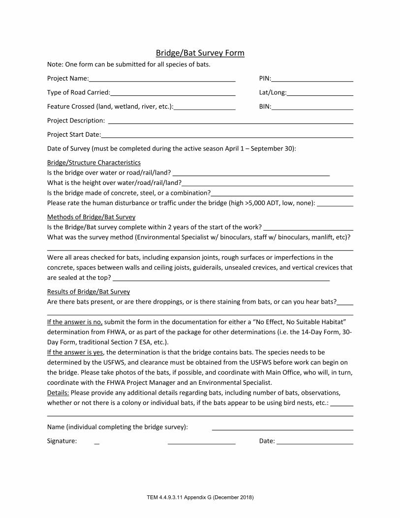
Bridge/Bat Survey Form Note: One form can be submitted for all species of bats.
Project Name: PIN:
Type of Road Carried: Lat/Long:
Feature Crossed (land, wetland, river, etc.): BIN:
Project Description:
Project Start Date:
Date of Survey (must be completed during the active season April 1 – September 30):
Bridge/Structure Characteristics Is the bridge over water or road/rail/land? What is the height over water/road/rail/land? Is the bridge made of concrete, steel, or a combination? Please rate the human disturbance or traffic under the bridge (high >5,000 ADT, low, none):
Methods of Bridge/Bat Survey Is the Bridge/Bat survey complete within 2 years of the start of the work? What was the survey method (Environmental Specialist w/ binoculars, staff w/ binoculars, manlift, etc)? Were all areas checked for bats, including expansion joints, rough surfaces or imperfections in the concrete, spaces between walls and ceiling joists, guiderails, unsealed crevices, and vertical crevices that are sealed at the top?
Results of Bridge/Bat Survey Are there bats present, or are there droppings, or is there staining from bats, or can you hear bats? If the answer is no, submit the form in the documentation for either a “No Effect, No Suitable Habitat” determination from FHWA, or as part of the package for other determinations (i.e. the 14-Day Form, 30-Day Form, traditional Section 7 ESA, etc.). If the answer is yes, the determination is that the bridge contains bats. The species needs to be determined by the USFWS, and clearance must be obtained from the USFWS before work can begin on the bridge. Please take photos of the bats, if possible, and coordinate with Main Office, who will, in turn, coordinate with the FHWA Project Manager and an Environmental Specialist. Details: Please provide any additional details regarding bats, including number of bats, observations, whether or not there is a colony or individual bats, if the bats appear to be using bird nests, etc.:
Name (individual completing the bridge survey):
Signature: Date:
TEM 4.4.9.3.11 Appendix G (December 2018)
3481
Typewriter
4OR0.04
3481
Typewriter
3318800
3481
Typewriter
43.345/-78.309
3481
Typewriter
Yates Carlton Townline Road - Rural Local Road
3481
Typewriter
Creek
3481
Typewriter
Replacement of two span steel multi-girder bridge with a single span precast concrete box beams on CIP abutments
3481
Typewriter
Replacement of Yates Carlton Townline Road Bridge over Johnson Creek
3481
Typewriter
Water
3481
Typewriter
Steel multi-girder bridge with concrete abutments
3481
Typewriter
None
3481
Typewriter
Yes
3481
Typewriter
Work is expected to begin in Spring 2022.
3481
Typewriter
Survey was conducted from the ground below and around the bridge with the use of binoculars.
3481
Typewriter
Yes, all areas of the bridge were closely inspected.
3481
Typewriter
There were no bats of indicators of bats observed.
3481
Typewriter
N/A
3481
Typewriter
Garret Hoffmann, P.E., Senior Structural Engineer, CHA Consulting, Inc.
3481
Typewriter
11' + \ -
3481
Typewriter
June 5, 2020
3481
Typewriter
6/5/2020
3481
Stamp
3481
Line
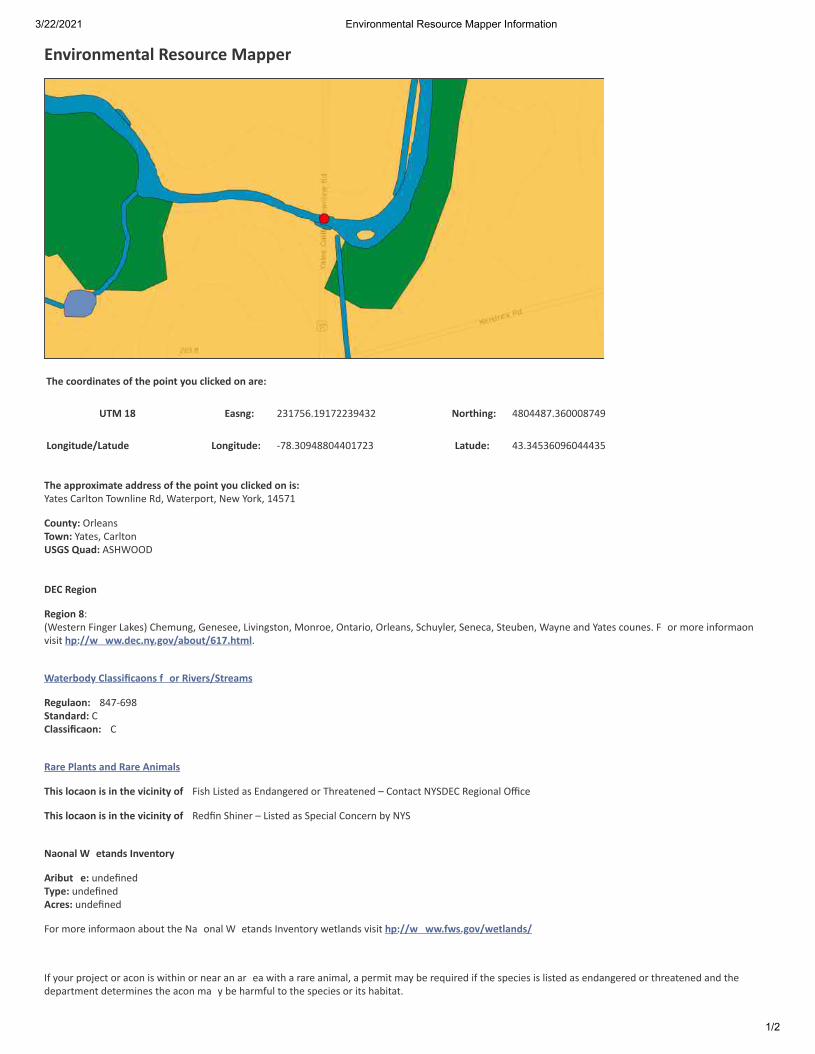
3/22/2021 Environmental Resource Mapper Information
1/2
Environmental Resource Mapper
The coordinates of the point you clicked on are:
UTM 18 Eas�ng: 231756.19172239432 Northing: 4804487.360008749 Longitude/La�tude Longitude: -78.30948804401723 La�tude: 43.34536096044435
The approximate address of the point you clicked on is:Yates Carlton Townline Rd, Waterport, New York, 14571
County: OrleansTown: Yates, CarltonUSGS Quad: ASHWOOD
DEC Region
Region 8:(Western Finger Lakes) Chemung, Genesee, Livingston, Monroe, Ontario, Orleans, Schuyler, Seneca, Steuben, Wayne and Yates coun�es. F or more informa�onvisit h�p://w ww.dec.ny.gov/about/617.html.
Waterbody Classifica�ons f or Rivers/Streams
Regula�on: 847-698Standard: CClassifica�on: C
Rare Plants and Rare Animals
This loca�on is in the vicinity of Fish Listed as Endangered or Threatened – Contact NYSDEC Regional Office
This loca�on is in the vicinity of Redfin Shiner – Listed as Special Concern by NYS
Na�onal W etands Inventory
A�ribut e: undefinedType: undefinedAcres: undefined
For more informa�on about the Na �onal W etands Inventory wetlands visit h�p://w ww.fws.gov/wetlands/
If your project or ac�on is within or near an ar ea with a rare animal, a permit may be required if the species is listed as endangered or threatened and thedepartment determines the ac�on ma y be harmful to the species or its habitat.

3/22/2021 Environmental Resource Mapper Information
2/2
If your project or ac�on is within or near an ar ea with rare plants and/or significant natural communi�es, the en vironmental impacts may need to be addressed.
The presence of a unique geological feature or landform near a project, unto itself, does not trigger a requirement for a NYS DEC permit. Readers are advised,however, that there is the chance that a unique feature may also show in another data layer (ie. a wetland) and thus be subject to permit jurisdic�on.
Please refer to the "Need a Permit?" tab for permit informa�on or other authoriz a�ons r egarding these natural resources.
Disclaimer: If you are considering a project or ac�on in, or near , a wetland or a stream, a NYS DEC permit may be required. The Environmental ResourcesMapper does not show all natural resources which are regulated by NYS DEC, and for which permits from NYS DEC are required. For example, Regulated TidalWetlands, and Wild, Scenic, and Recrea�onal Riv ers, are currently not included on the maps.

User Defined Results ReportCriteria: Selected Map Area
New York Nature Explorerhttp://www.dec.ny.gov/natureexplorer/
Common Name
State
DistributionStatus
Protection Status Conservation RankSubgroup
Federal State Global
Year LastDocumente
Animal: Fish
Redfin ShinerMinnows, Shiners,Suckers
S1S2RecentlyConfirmed
G5Special Concern
2011
Lythrurus umbratilis
New York State Department of Environmental Conservation
3/22/21 7:24 AM
Page 1 of 1
Note: Restricted plants and animals may also have also been documented in one or more of the Towns or Cities in whichyour user-defined area is located, but are not listed in these results. This application does not provide information at the levelof Town or City on state-listed animals and on other sensitive animals and plants. A list of the restricted animals and plantsdocumented at the corresponding county level can be obtained via the County link(s) on the original User Defined SearchResults page. Any individual plant or animal on this county’s restricted list may or may not occur in this particular user-definedarea.
This list only includes records of rare species and significant natural communities from the databases of the NY NaturalHeritage Program. This list is not a definitive statement about the presence or absence of all plants and animals, includingrare or state-listed species, or of all significant natural communities. For most areas, comprehensive field surveys have notbeen conducted, and this list should not be considered a substitute for on-site surveys.

Jennifer PageCHA Consulting, Inc.2200 Main Place TowerBuffalo, NY 14202
PIN 40R0.04 - Yates Carlton Townline Road over Johnson Creek Bridge ReplacementRe:County: Orleans Town/City: Carlton, Yates
Dear Ms. Page:
718
July 6, 2020
In response to your recent request, we have reviewed the New York Natural Heritage Program database with respect to the above project.
Enclosed is a report of rare or state-listed animals and plants, and significant natural communities that our database indicates occur in the vicinity of the project site.
For most sites, comprehensive field surveys have not been conducted; the enclosed report only includes records from our database. We cannot provide a definitive statement as to the presence or absence of all rare or state-listed species or significant natural communities. Depending on the nature of the project and the conditions at the project site, further information from on-site surveys or other sources may be required to fully assess impacts on biological resources.
The presence of the plants and animals identified in the enclosed report may result in this project requiring additional review or permit conditions. For further guidance, and for information regarding other permits that may be required under state law for regulated areas or activities (e.g., regulated wetlands), please contact the NYS DEC Region 8 Office, Division of Environmental Permits, at [email protected].
Heidi KrahlingEnvironmental Review SpecialistNew York Natural Heritage Program
Sincerely,

New York Natural Heritage Program Report on State-listed Animals
The following state-listed animal has been documented at the project site.
The following list includes animals that are listed by NYS as Endangered, Threatened, or Special Concern; and/or that are federally listed or are candidates for federal listing.
For information about any permit considerations for your project, please contact the Permits staff at the NYSDEC Region 8 Office at [email protected], (585) 226-5400.
The following species has been documented at the project site.
SCIENTIFIC NAME FEDERAL LISTINGNY STATE LISTINGCOMMON NAME
Fish
Lepomis peltastes ThreatenedNorthern Sunfish 5572
This report only includes records from the NY Natural Heritage database.
If any rare plants or animals are documented during site visits, we request that information on the observations be provided to the New York Natural Heritage Program so that we may update our database.
Information about many of the listed animals in New York, including habitat, biology, identification, conservation, and management, are available online in Natural Heritage’s Conservation Guides at www.guides.nynhp.org, and from NYSDEC at www.dec.ny.gov/animals/7494.html.
Page 1 of 17/6/2020
hjkrahli
Highlight
hjkrahli
Highlight

Report on Rare Animals, Rare Plants, andSignificant Natural CommunitiesNew York Natural Heritage Program
The following rare animal has been documented at the project site.
HERITAGE CONSERVATION STATUSSCIENTIFIC NAME NY STATE LISTINGCOMMON NAME
We recommend that potential impacts of the proposed project on this species be addressed as part of any environmental assessment or review conducted as part of the planning, permitting and approval process, such as reviews conducted under SEQR. Field surveys of the project site may be necessary to determine the status of a species at the site, particularly for sites that are currently undeveloped and may still contain suitable habitat. Final requirements of the project to avoid, minimize, or mitigate potential impacts are determined by the lead permitting agency or the government body approving the project.
The following animal, while not listed by New York State as Endangered or Threatened, is rare in New York and is of conservation concern.
Fish
Special Concern Critically Imperiled in NYS
11147
Lythrurus umbratilisRedfin Shiner
Documented at the project site. 2011-10-12.
This report only includes records from the NY Natural Heritage database. For most sites, comprehensive field surveys have not been conducted, and we cannot provide a definitive statement as to the presence or absence of all rare or state-listed species. Depending on the nature of the project and the conditions at the project site, further information from on-site surveys or other sources may be required to fully assess impacts on biological resources.
If any rare plants or animals are documented during site visits, we request that information on the observations be provided to the New York Natural Heritage Program so that we may update our database.
Information about many of the rare animals and plants in New York, including habitat, biology, identification, conservation, and management, are available online in Natural Heritage’s Conservation Guides at www.guides.nynhp.org, from NatureServe Explorer at www.natureserve.org/explorer, and from USDA’s Plants Database at http://plants.usda.gov/index.html (for plants).
Page 1 of 17/6/2020
hjkrahli
Highlight
hjkrahli
Highlight

CAYUGA
WAYNE
ORLEANS
GENESEE
WYOMING
ALLEGANY
MONROE
ONTARIO
YATES
STEUBEN
SCHUYLER
CHEMUNG
TOMPKINS
LIVINGSTON
SENECA
National Geographic, Esri, Garmin, HERE, UNEP-WCMC, USGS, NASA, ESA,METI, NRCAN, GEBCO, NOAA, increment P Corp.
Waters with Imperiled MusselsNYSDEC Region 8
Streams with Imperiled Mussels
Ponded Waters with Imperiled Mussels
County Boundary to Shoreline, Moderately Simplified
±
0 10 205 Miles
*Mussel Data is subject to change.This map cannot be used to rule out presence of imperiled mussels discovered after map date.
Date: 10/15/2020
4141
Cloud
4141
Callout
Johnson Creek

NYSDEC Fisheries Index Number (FIN) Stream Name Resource Rank
NJ-1-12 Unnamed Water S1S2 NJ-1-12-2F Unnamed Water S1S2 ONT-1 Kents Creek S1S2 ONT-108-P113-3 Irondequoit Creek S1S2 ONT-108-P113-3-8 Allen Creek S1S2 ONT-117 Genesee River TE ONT-117-14 Red Creek S1S2 ONT-117-148 Black Creek TE ONT-117-19 Black Creek S1S2 ONT-117-19-28 Spring Creek S1S2 ONT-117-19-30 Bigelow Creek S1S2 ONT-117-19-8 Onion Creek S1S2 ONT-117-27 Honeoye Creek S1S2 ONT-117-27-28 Bebee Creek S1S2 ONT-117-40 Conesus Creek S1S2 ONT-117-66 Canaseraga Creek S1S2 ONT-122-P153-2 Larkin Creek S1S2 ONT-125 Salmon Creek S1S2 ONT-125-1 West Creek S1S2 ONT-125-2 Brockport Creek S1S2 ONT-130 Sandy Creek S1S2 ONT-130-1 East Branch Sandy Creek S1S2 ONT-130-2 West Branch Sandy Creek S1S2 ONT-138 Oak Orchard Creek S1S2 ONT-138-15 Unnamed Water S1S2 ONT-139 Johnson Creek S1S2 ONT-148-3 East Branch Eighteenmile Creek S1S2 ONT-152A Twelvemile Creek S1S2 ONT-156 Fourmile Creek S1S2 ONT-158 Niagara River S1S2 ONT-158-12 Tonawanda Creek TE ONT-158-12-1 Ellicott Creek S1S2 ONT-158-12-11 Ledge Creek TE ONT-158-12-11-1 Murder Creek TE ONT-158-12-32 Little Tonawanda Creek S1S2 ONT-158-12-6 Ransom Creek S1S2 ONT-158-12-8 Mud Creek S1S2 ONT-158-12-8-7 Unnamed Water S1S2 ONT-158-12-9 Beeman Creek S1S2 ONT-19-40-3 Black Creek S1S2 ONT-19-45-1 Butler Creek S1S2 ONT-19-57-1 Unnamed Water S1S2 ONT-19-60 Otter Creek S1S2 ONT-19-70 Fish Creek S1S2
4141
Rectangle
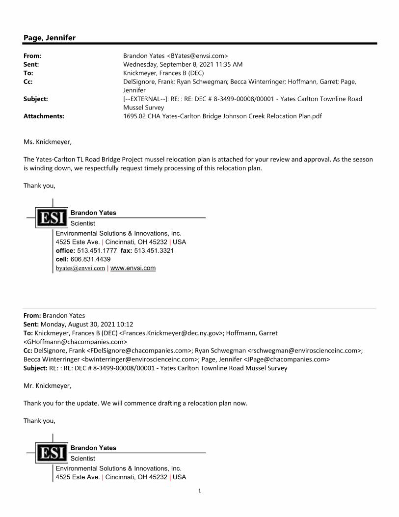
1
Page, Jennifer
From: Brandon Yates <[email protected]>Sent: Wednesday, September 8, 2021 11:35 AMTo: Knickmeyer, Frances B (DEC)Cc: DelSignore, Frank; Ryan Schwegman; Becca Winterringer; Hoffmann, Garret; Page,
JenniferSubject: [--EXTERNAL--]: RE: : RE: DEC # 8-3499-00008/00001 - Yates Carlton Townline Road
Mussel SurveyAttachments: 1695.02 CHA Yates-Carlton Bridge Johnson Creek Relocation Plan.pdf
Ms. Knickmeyer, The Yates-Carlton TL Road Bridge Project mussel relocation plan is attached for your review and approval. As the season is winding down, we respectfully request timely processing of this relocation plan. Thank you,
Brandon Yates
Scientist
Environmental Solutions & Innovations, Inc. 4525 Este Ave. | Cincinnati, OH 45232 | USA office: 513.451.1777 fax: 513.451.3321 cell: 606.831.4439 [email protected] | www.envsi.com
From: Brandon Yates Sent: Monday, August 30, 2021 10:12 To: Knickmeyer, Frances B (DEC) <[email protected]>; Hoffmann, Garret <[email protected]> Cc: DelSignore, Frank <[email protected]>; Ryan Schwegman <[email protected]>; Becca Winterringer <[email protected]>; Page, Jennifer <[email protected]> Subject: RE: : RE: DEC # 8-3499-00008/00001 - Yates Carlton Townline Road Mussel Survey Mr. Knickmeyer, Thank you for the update. We will commence drafting a relocation plan now. Thank you,
Brandon Yates
Scientist
Environmental Solutions & Innovations, Inc. 4525 Este Ave. | Cincinnati, OH 45232 | USA

2
office: 513.451.1777 fax: 513.451.3321 cell: 606.831.4439 [email protected] | www.envsi.com
From: Knickmeyer, Frances B (DEC) <[email protected]> Sent: Monday, August 30, 2021 09:06 To: Hoffmann, Garret <[email protected]>; Brandon Yates <[email protected]> Cc: DelSignore, Frank <[email protected]>; Ryan Schwegman <[email protected]>; Becca Winterringer <[email protected]>; Page, Jennifer <[email protected]> Subject: RE: : RE: DEC # 8-3499-00008/00001 - Yates Carlton Townline Road Mussel Survey CAUTION: This email originated from outside of our organization. DO NOT click links or open attachments unless you recognize the sender and know the content is safe! Dear Garret, DEC staff have reviewed the additional information you sent, with an alternatives analysis and justification for mussel salvage/relocation as part of the Yates-Carlton TL Rd Bridge project. The submitted information is sufficient. You may move forward and submit a relocation plan. Sincerely, Frances Knickmeyer Environmental Analyst, Division of Environmental Permits Pronouns: She/Her/Hers
New York State Department of Environmental Conservation 6274 E. Avon-Lima Road, Avon, NY 14414 P: 585-226-5382 | F: 585-226-2830 | [email protected]
www.dec.ny.gov | | |
From: Hoffmann, Garret <[email protected]> Sent: Tuesday, August 24, 2021 7:56 AM To: Knickmeyer, Frances B (DEC) <[email protected]>; Brandon Yates <[email protected]> Cc: DelSignore, Frank <[email protected]>; Ryan Schwegman <[email protected]>; Becca Winterringer <[email protected]>; Page, Jennifer <[email protected]> Subject: : RE: DEC # 8-3499-00008/00001 - Yates Carlton Townline Road Mussel Survey
ATTENTION: This email came from an external source. Do not open attachments or click on links from unknown senders or unexpected emails.
Frances:

3
See attached file containing further justification /alternatives assessment for why the bridge replacement project cannot avoid stream impacts. I believe we are avoiding or minimizing stream impacts where we can. The bottom line is that we need to remove the center pier for hydraulics and that it catches a lot of timber debris. In order to remove that pier, we need to get equipment close enough, via a clean stone causeway. Should you need additional the information in support of ESI’s Freshwater Mussels Report & subsequent relocation plan, please contact either Brandon Yates or myself. Thank you, Garret Hoffmann, PE Senior Structural Engineer CHA ~ design/construction solutions 2200 Main Place Tower Buffalo, NY 14202 Direct: (716) 221-4172 Cell: (716) 445-3730
From: Knickmeyer, Frances B (DEC) <[email protected]> Sent: Friday, August 20, 2021 8:47 AM To: Brandon Yates <[email protected]> Cc: DelSignore, Frank <[email protected]>; Hoffmann, Garret <[email protected]>; Ryan Schwegman <[email protected]>; Becca Winterringer <[email protected]> Subject: [--EXTERNAL--]: RE: DEC # 8-3499-00008/00001 - Yates Carlton Townline Road Mussel Survey Dear Brandon, DEC staff have reviewed the mussel survey report submitted for the Yates-Carlton TL Rd Bridge (DEC ID 8-3499-00008/00001). However, before the project can proceed with a salvage/relocation effort, we need more in-depth justification – an alternatives analysis – on why the bridge replacement project cannot be adjusted to avoid impacts. DEC requires projects to first avoid impacts, then, if that is not possible, to minimize impacts. Finally, after minimizing impacts to the greatest extent reasonable, mitigation can be considered. Therefore, please submit a brief alternatives analysis, including an explanation as to why a temporary causeway and related disturbance is necessary for the proposed project to be successfully completed. Please note that while DEC acknowledges the time constraints for the applicant, we are now dealing with significant flooding in a large portion of our region from Tropical Storm Fred. We will do our best to review your response quickly, but it may take longer than desired by the applicant. Sincerely, Frances Knickmeyer Environmental Analyst, Division of Environmental Permits Pronouns: She/Her/Hers
New York State Department of Environmental Conservation 6274 E. Avon-Lima Road, Avon, NY 14414 P: 585-226-5382 | F: 585-226-2830 | [email protected]
www.dec.ny.gov | | |

4
From: Brandon Yates <[email protected]> Sent: Wednesday, August 18, 2021 2:39 PM To: dec.sm.DEP.R8 <[email protected]>; Knickmeyer, Frances B (DEC) <[email protected]> Cc: DelSignore, Frank <[email protected]>; Hoffmann, Garret <[email protected]>; Ryan Schwegman <[email protected]>; Becca Winterringer <[email protected]> Subject: DEC # 8-3499-00008/00001 - Yates Carlton Townline Road Mussel Survey
ATTENTION: This email came from an external source. Do not open attachments or click on links from unknown senders or unexpected emails.
Frances and NYSDEC Region 8, Please find attached mussel report number DEC # 8-1802-00106/00001 entitled, “FRESHWATER MUSSEL (UNIONIDAE) SURVEY IN JOHNSON CREEK, FOR THE YATES CARLTON TOWNLINE ROAD BRIDGE REPLACEMENT PROJECT IN ORLEANS COUNTY, NEW YORK” for your review and approval. Based on the presence of deertoe mussel within the Area of Project Impact, mussel salvage and relocation efforts are warranted. Due to construction’s early spring 2022 start date relocation efforts MUST occur this fall, therefore, we request expedited review to provide adequate time for relocation efforts. Thank you,
Brandon Yates
Scientist
Environmental Solutions & Innovations, Inc. 4525 Este Ave. | Cincinnati, OH 45232 | USA office: 513.451.1777 fax: 513.451.3321 cell: 606.831.4439 [email protected] | www.envsi.com

50 Wolf Road, Albany, NY 12232 │ www.dot.ny.gov
TO: Bob Corcimiglia, Regional Local Project Liaison
FROM: Chris Caraccilo, Regional Cultural Resource Coordinator
SUBJECT: PROJECT SUBMITTAL PACKAGE – SECTION 106 RECOMMENDATIONS PIN 4OR0.04, Replacement of Yates Carlton Townline Road Bridge, Town of Carlton Orleans County
DATE: March 17, 2021 As the Regional Cultural Resource Coordinator (RCRC) I have reviewed the Project Submittal Package (PSP) prepared for the above referenced Locally Administered Federal Aid project for an assessment of obligations under Section 106 of the National Historic Preservation Act (36 CFR Part 800). I. Based on review of this PSP, I conclude:
✓ The project activities have no potential to cause effects on historic properties in accordance with 36 CFR 800.3(a)(1) therefore, there are no further obligations for compliance with Section 106 of the National Historic Preservation Act and no determination by the Federal Highway Administration (FHWA) is required. This
assessment should be recorded in the project environmental documentation. If there is any change in the scope of proposed work or project activities, the Sponsor must submit an updated PSP to the NYSDOT for review and reassessment of Section 106 requirement for the project.
The Section 106 Project Submittal Package and RCRC response memo will not be included in
the Design Report/Approval Document. Language (below) is provided to document compliance with Section 106 in the Design Approval Document: This federal-aid project is an undertaking subject to review under Section 106 of the
National Historic Preservation Act and its implementing regulation, 36 CFR Part 800. The
NYSDOT Regional Cultural Resource Coordinator completed a review of the Project
Submittal Package to assess Section 106 obligations for the project.
BIN 331880 has been previously evaluated and determined Not Eligible by the NYSDOT
Historic Bridge Inventory, in consultation with the SHPO. Based on the proposed scope
of work, the project has no potential to cause effects on historic properties in
accordance with 36 CFR 800.3(a)(1). The project will not involve new right-of-way
acquisition, does not result in the disturbance of soils previously undisturbed by recent
construction and is not located within a known or potential historic district.
There are no further obligations under Section 106 of the National Preservation Act.

Yates Carlton Townline Road over Johnson Creek Joint Application for Permit NYSDEC Region 8 & U.S. Army Corps of Engineers October 25, 2021
ATTACHMENT 6
HYDROLOGY & HYDRAULICS

Joint Application for Permit September 2021 NYSDEC Region 9 Hydrology & Hydraulics U.S. Army Corps of Engineers Page 1 of 2 Bridge Hydrology: This bridge carriers Yates Carlton Townline Road over Johnson Creek at the border of the Towns of Yates and Carlton in Orleans County. The creeks headwaters are to the West in Niagara County where its upstream reaches primarily drain the Town of Hartland and the northern half of the Town of Royalton. Within Orleans County its watershed is bounded by the watersheds of Oak Orchard River to the South, and both Marsh Creek and an unnamed stream to the North. Johnson Creek flows through the Town of Yates, including the Village of Lyndonville, continues into the Town of Carlton and ultimately discharges into Lake Ontario approximately 5.5 miles downstream of the bridge. The Johnson Creek watershed upstream of the Yates Carlton Townline Road bridge drains approximately 104 square miles of primarily agricultural land and undeveloped forests. With a main channel length of approximately 31 miles, the upstream watershed ascends from Elevation 253 at the bridge, to Elevation 648 at its source near Royalton Center in Niagara County. The Johnson Creek watershed has an average basin slope of 1.3% and a flat main channel slope of approx. 0.2%. Significant debris accumulation was observed within the channel banks immediately downstream of the bridge. Inspection reports also indicate that debris collects at both the pier and south abutment. No other indications of flooding were noted. A FEMA Flood Insurance Study (FIS) of Johnson Creek within the corporate limits of the Town of Yates, excluding the incorporated area of the Village of Lyndonville, was performed in 1978. The downstream limits of the study were the Town’s eastern corporate limits, where the creek passes through the subject bridge. Pertinent peak discharges measured in cubic feet per second (cfs) for Johnson Creek at the bridge are summarized in the table on the following page for discussion purposes. Also summarized in the table are peak discharges obtained from the U.S.G.S. StreamStats web application. Refer to the following web page site: https://streamstats.usgs.gov/ss/ for the StreamStats (for New York) Program as provided by the United States Geological Survey (USGS). Per the NYSDOT Bridge Manual Section 3.2.3.1, to account for future projected peak flows, current peaks flows in Orleans County (itself being within NYSDOT Region 4) shall be increased by 10%. Water surface elevations from the FIS at the existing bridge illustrate that the roadway embankment to the South of the bridge functions as a dam across the Johnson Creek floodplain. They also illustrate that stream flows will overtop the roadway to the North between the bridge and State Route 18, where the road is in a sag vertical curve. It can be inferred that the bridge constriction has minimal impact on the behavior of the stream in comparison to that of the roadway embankments damming effects. This is typical for situations where a rural roadway embankment crosses portions, or even entire widths, of the wide floodplains of shallowly sloped streams. Due to the age of the FIS, and the refinements in hydrological methods that have been made over the past forty years, its peak discharges will not be used for the existing & proposed bridge hydraulic analyses. Instead the peak discharges from the StreamStats web application, as modified by the NYSDOT, will be used as the basis for the 50-year and 100-year discharges. A detailed hydrologic investigation for the purpose of better pinpointing the volumetric discharge is beyond the scope of this project and does not appear warranted.
Exhibit 2-5 Summary of Peak Discharges at Yates Carlton Townline Road Bridge
Peak Flood Year Peak-Flow (1978 FIS)
Peak-Flow (StreamStats)
Peak-Flow (StreamStats + 10%)
2 Year -- 1,440 cfs 1,585 cfs 10 Year -- 2,470 cfs 2,720 cfs 50 Year 8,200 cfs 3,420 cfs 3,765 cfs 100 Year 9,600 cfs 3,820 cfs 4,205 cfs
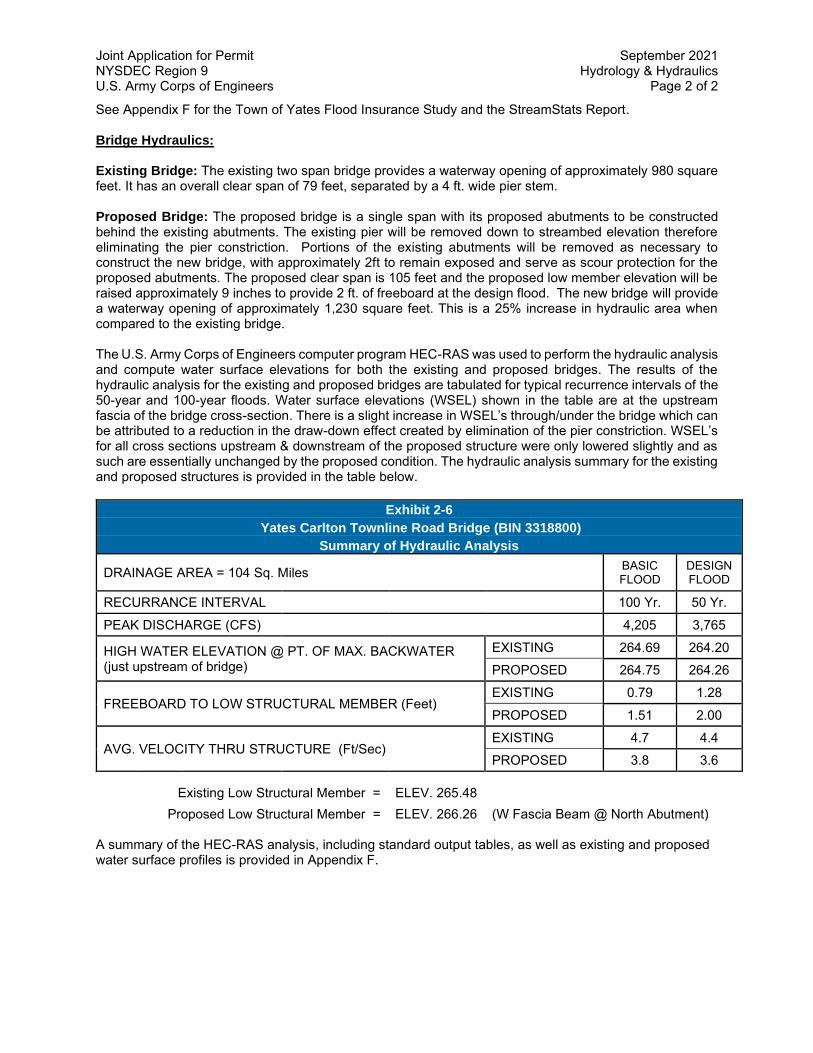
Joint Application for Permit September 2021 NYSDEC Region 9 Hydrology & Hydraulics U.S. Army Corps of Engineers Page 2 of 2
See Appendix F for the Town of Yates Flood Insurance Study and the StreamStats Report. Bridge Hydraulics: Existing Bridge: The existing two span bridge provides a waterway opening of approximately 980 square feet. It has an overall clear span of 79 feet, separated by a 4 ft. wide pier stem. Proposed Bridge: The proposed bridge is a single span with its proposed abutments to be constructed behind the existing abutments. The existing pier will be removed down to streambed elevation therefore eliminating the pier constriction. Portions of the existing abutments will be removed as necessary to construct the new bridge, with approximately 2ft to remain exposed and serve as scour protection for the proposed abutments. The proposed clear span is 105 feet and the proposed low member elevation will be raised approximately 9 inches to provide 2 ft. of freeboard at the design flood. The new bridge will provide a waterway opening of approximately 1,230 square feet. This is a 25% increase in hydraulic area when compared to the existing bridge. The U.S. Army Corps of Engineers computer program HEC-RAS was used to perform the hydraulic analysis and compute water surface elevations for both the existing and proposed bridges. The results of the hydraulic analysis for the existing and proposed bridges are tabulated for typical recurrence intervals of the 50-year and 100-year floods. Water surface elevations (WSEL) shown in the table are at the upstream fascia of the bridge cross-section. There is a slight increase in WSEL’s through/under the bridge which can be attributed to a reduction in the draw-down effect created by elimination of the pier constriction. WSEL’s for all cross sections upstream & downstream of the proposed structure were only lowered slightly and as such are essentially unchanged by the proposed condition. The hydraulic analysis summary for the existing and proposed structures is provided in the table below.
Exhibit 2-6
Yates Carlton Townline Road Bridge (BIN 3318800)
Summary of Hydraulic Analysis
DRAINAGE AREA = 104 Sq. Miles
BASIC FLOOD
DESIGN FLOOD
RECURRANCE INTERVAL 100 Yr. 50 Yr.
PEAK DISCHARGE (CFS) 4,205 3,765
HIGH WATER ELEVATION @ PT. OF MAX. BACKWATER (just upstream of bridge)
EXISTING 264.69 264.20 PROPOSED 264.75 264.26
FREEBOARD TO LOW STRUCTURAL MEMBER (Feet) EXISTING 0.79 1.28
PROPOSED 1.51 2.00
AVG. VELOCITY THRU STRUCTURE (Ft/Sec) EXISTING 4.7 4.4 PROPOSED 3.8 3.6
Existing Low Structural Member = ELEV. 265.48
Proposed Low Structural Member = ELEV. 266.26 (W Fascia Beam @ North Abutment) A summary of the HEC-RAS analysis, including standard output tables, as well as existing and proposed water surface profiles is provided in Appendix F.

Johnson Creek StreamStats Report
Basin Characteristics
Parameter Code Parameter Description Value Unit
DRNAREA Area that drains to a point on a stream 104 square miles
SLOPERATIO Ratio of main channel slope to basin slope as defined in SIR 2006-5112
0.17 dimensionless
EL1200 Percentage of basin at or above 1200 ft elevation
0 percent
Region ID: NYWorkspace ID: NY20191230171637790000Clicked Point (Latitude, Longitude): 43.34531, -78.30948Time: 2019-12-30 12:16:55 -0500
Page 2 of 6StreamStats
12/30/2019https://streamstats.usgs.gov/ss/

Parameter Code Parameter Description Value Unit
STORAGE Percentage of area of storage (lakes ponds reservoirs wetlands)
1.56 percent
MAR Mean annual runoff for the period of record in inches
12.8 inches
BSLOPCM Mean basin slope determined by summing lengths of all contours in basin mulitplying by contour interval and dividing product by drainage area
67.3 feet per mi
CENTROIDX Basin centroid horizontal (x) location in state plane coordinates
218958.1 meters
CENTROIDY Basin centroid vertical (y) location in state plane units
4794656.3 meters
CONTOUR Total length of all elevation contours in drainage area in miles
69.77 miles
CSL1085LO 10-85 slope of lower half of main channel in feet per mile.
5.43 feet per mi
CSL1085UP 10-85 slope of upper half of main channel in feet per mile.
24 feet per mi
CSL10_85 Change in elevation divided by length between points 10 and 85 percent of distance along main channel to basin divide - main channel method not known
11.1 feet per mi
FOREST Percentage of area covered by forest 22.1 percent
JULAVPRE Mean July Precipitation 2.86 inches
JUNAVPRE Mean June Precipitation 3.43 inches
JUNMAXTMP Maximum June Temperature, in degrees F
76.8 degrees F
LAGFACTOR Lag Factor as defined in SIR 2006-5112
2.44 dimensionless
LC11DEV Percentage of developed (urban) land from NLCD 2011 classes 21-24
5.92 percent
Page 3 of 6StreamStats
12/30/2019https://streamstats.usgs.gov/ss/

Parameter Code Parameter Description Value Unit
LC11IMP Average percentage of impervious area determined from NLCD 2011 impervious dataset
1.06 percent
LENGTH Length along the main channel from the measuring location extended to the basin divide
30.9 miles
MAYAVPRE Mean May Precipitation 2.95 inches
MXSNO 50th percentile of seasonal maximum snow depth from Northeast Regional Climate Center atlas by Cember and Wilks, 1993
15.3 inches
OUTLETX Basin outlet horizontal (x) location in state plane coordinates
231755 feet
OUTLETY Basin outlet vertical (y) location in state plane coordinates
4804485 feet
PRECIP Mean Annual Precipitation 32.8 inches
PRJUNAUG00 Basin average mean precip for June to August from PRISM 1971-2000
9.7 inches
SSURGOA Percentage of area of Hydrologic Soil Type A from SSURGO
2.24 percent
SSURGOB Percentage of area of Hydrologic Soil Type B from SSURGO
36.4 percent
Peak-Flow Statistics Parameters[2006 Full Region 6]
Parameter Code Parameter Name Value Units
Min Limit
Max Limit
DRNAREA Drainage Area 104 square miles 0.58 2467
SLOPERATIO Slope Ratio NY 0.17 dimensionless 0.019 0.698
EL1200 Percentage of Basin Above 1200 ft
0 percent 0 100
STORAGE Percent Storage 1.56 percent 0 5.98
Page 4 of 6StreamStats
12/30/2019https://streamstats.usgs.gov/ss/

Parameter Code Parameter Name Value Units
Min Limit
Max Limit
MAR Mean Annual Runoff in inches
12.8 inches 9.49 22.77
Peak-Flow Statistics Flow Report[2006 Full Region 6]
PIl: Prediction Interval-Lower, PIu: Prediction Interval-Upper, SEp: Standard Error of Prediction,
SE: Standard Error (other -- see report)
Statistic Value Unit SE SEp Equiv. Yrs.
1.25 Year Peak Flood 1010 ft^3/s 34.7 34.7 2.3
1.5 Year Peak Flood 1200 ft^3/s 33.3 33.3 2
2 Year Peak Flood 1440 ft^3/s 32.3 32.3 1.9
5 Year Peak Flood 2050 ft^3/s 32.2 32.2 2.4
10 Year Peak Flood 2470 ft^3/s 32.9 32.9 3.1
25 Year Peak Flood 3010 ft^3/s 34.4 34.4 3.9
50 Year Peak Flood 3420 ft^3/s 35.8 35.8 4.5
100 Year Peak Flood 3820 ft^3/s 37.2 37.2 4.9
200 Year Peak Flood 4250 ft^3/s 39 39 5.2
500 Year Peak Flood 4800 ft^3/s 41.4 41.4 5.5
Peak-Flow Statistics Citations
Lumia, Richard, Freehafer, D.A., and Smith, M.J.,2006, Magnitude and Frequency of Floods in New York: U.S. Geological Survey Scientific Investigations Report 2006–5112, 152 p. (http://pubs.usgs.gov/sir/2006/5112/)
USGS Data Disclaimer: Unless otherwise stated, all data, metadata and related materials are considered to
satisfy the quality standards relative to the purpose for which the data were collected. Although these data and
associated metadata have been reviewed for accuracy and completeness and approved for release by the U.S.
Geological Survey (USGS), no warranty expressed or implied is made regarding the display or utility of the data
for other purposes, nor on all computer systems, nor shall the act of distribution constitute any such warranty.
USGS Software Disclaimer: This software has been approved for release by the U.S. Geological Survey (USGS).
Although the software has been subjected to rigorous review, the USGS reserves the right to update the
software as needed pursuant to further analysis and review. No warranty, expressed or implied, is made by the
Page 5 of 6StreamStats
12/30/2019https://streamstats.usgs.gov/ss/

USGS or the U.S. Government as to the functionality of the software and related material nor shall the fact of
release constitute any such warranty. Furthermore, the software is released on condition that neither the USGS
nor the U.S. Government shall be held liable for any damages resulting from its authorized or unauthorized use.
USGS Product Names Disclaimer: Any use of trade, firm, or product names is for descriptive purposes only and
does not imply endorsement by the U.S. Government.
Application Version: 4.3.11
Page 6 of 6StreamStats
12/30/2019https://streamstats.usgs.gov/ss/

EXISTING & PROPOSED BRIDGES
Yates Carlton Townline Road over Johnson CreekProfile Output Table - Six XS BridgeHEC-RAS Plan 1: ExistingBridgeHEC-RAS Plan 2: ProposedBridge105ftRiver: Johnson Creek Reach: Reach 1# Rivers = 1# Hydraulic Reaches = 1# River Stations = 6# Plans = 2# Profiles = 2
Reach River Sta Profile Plan E.G. Elev W.S. Elev Crit W.S. Frctn Loss C & E Loss Top Width Q Left Q Channel Q Right Vel Chnl(ft) (ft) (ft) (ft) (ft) (ft) (cfs) (cfs) (cfs) (ft/s)
1 2069 50 Yr ExistingBridge 264.56 264.38 0.02 0.01 275.98 288.73 3331.07 145.21 3.631 2069 50 Yr Prop100ft 264.50 264.31 0.02 0.01 275.07 282.11 3341.46 141.44 3.671 2069 100 Yr ExistingBridge 265.11 264.91 0.02 0.01 283.29 381.06 3629.89 194.05 3.731 2069 100 Yr Prop100ft 265.02 264.82 0.02 0.01 281.98 370.66 3645.76 188.58 3.79
1 2030 50 Yr ExistingBridge 264.54 264.32 258.02 0.01 0.02 184.25 0.31 3645.38 119.31 3.811 2030 50 Yr Prop100ft 264.47 264.25 258.02 0.00 0.01 183.97 0.24 3649.24 115.51 3.851 2030 100 Yr ExistingBridge 265.07 264.84 258.36 0.01 0.03 186.40 1.23 4038.87 164.90 3.961 2030 100 Yr Prop100ft 264.98 264.74 258.35 0.00 0.01 186.00 1.02 4044.76 159.22 4.01
1 2006 BR U 50 Yr ExistingBridge 264.50 264.20 257.54 0.02 0.01 79.02 3765.00 4.411 2006 BR U 50 Yr Prop100ft 264.46 264.26 257.39 0.01 0.01 101.59 3765.00 3.57
1 2006 BR U 100 Yr ExistingBridge 265.03 264.69 257.84 0.02 0.01 79.01 4205.00 4.711 2006 BR U 100 Yr Prop100ft 264.97 264.75 257.67 0.01 0.01 101.57 4205.00 3.81
1 2006 BR D 50 Yr ExistingBridge 264.47 264.15 257.85 0.01 0.04 79.01 3765.00 4.591 2006 BR D 50 Yr Prop100ft 264.44 264.22 257.83 0.00 0.01 101.60 3765.00 3.74
1 2006 BR D 100 Yr ExistingBridge 265.00 264.63 258.16 0.01 0.05 79.01 4205.00 4.901 2006 BR D 100 Yr Prop100ft 264.95 264.71 258.08 0.00 0.01 101.58 4205.00 3.99
1 1983 50 Yr ExistingBridge 264.42 264.18 0.02 0.01 123.83 3765.00 3.951 1983 50 Yr Prop100ft 264.43 264.18 0.02 0.01 123.85 3765.00 3.951 1983 100 Yr ExistingBridge 264.94 264.67 0.03 0.02 131.00 4205.00 4.141 1983 100 Yr Prop100ft 264.94 264.68 0.03 0.02 131.03 4205.00 4.14
1 1939 50 Yr ExistingBridge 264.39 264.17 0.03 0.03 316.68 42.76 3580.79 141.45 3.831 1939 50 Yr Prop100ft 264.39 264.17 0.03 0.03 316.68 42.81 3580.66 141.53 3.831 1939 100 Yr ExistingBridge 264.90 264.67 0.03 0.03 316.68 72.17 3932.86 199.97 3.971 1939 100 Yr Prop100ft 264.90 264.67 0.03 0.03 316.68 72.26 3932.61 200.13 3.97
Exist & Prop Six Bridge Page 1

EXISTING BRIDGE
Yates Carlton Townline Road over Johnson CreekProfile Output Table - Six XS BridgeHEC-RAS Plan: ExistingBridgeRiver: Johnson Creek Reach: Reach 1# Rivers = 1# Hydraulic Reaches = 1# River Stations = 6# Plans = 1# Profiles = 2
Reach River Sta Profile E.G. Elev W.S. Elev Crit W.S. Frctn Loss C & E Loss Top Width Q Left Q Channel Q Right Vel Chnl(ft) (ft) (ft) (ft) (ft) (ft) (cfs) (cfs) (cfs) (ft/s)
1 2069 50 Yr 264.56 264.38 0.02 0.01 275.98 288.73 3331.07 145.21 3.631 2069 100 Yr 265.11 264.91 0.02 0.01 283.29 381.06 3629.89 194.05 3.73
1 2030 50 Yr 264.54 264.32 258.02 0.01 0.02 184.25 0.31 3645.38 119.31 3.811 2030 100 Yr 265.07 264.84 258.36 0.01 0.03 186.40 1.23 4038.87 164.90 3.96
1 2006 BR U 50 Yr 264.50 264.20 257.54 0.02 0.01 79.02 3765.00 4.411 2006 BR U 100 Yr 265.03 264.69 257.84 0.02 0.01 79.01 4205.00 4.71
Yates Carlton Townline Road Bridge1 2006 BR D 50 Yr 264.47 264.15 257.85 0.01 0.04 79.01 3765.00 4.591 2006 BR D 100 Yr 265.00 264.63 258.16 0.01 0.05 79.01 4205.00 4.90
1 1983 50 Yr 264.42 264.18 0.02 0.01 123.83 3765.00 3.951 1983 100 Yr 264.94 264.67 0.03 0.02 131.00 4205.00 4.14
1 1939 50 Yr 264.39 264.17 0.03 0.03 316.68 42.76 3580.79 141.45 3.831 1939 100 Yr 264.90 264.67 0.03 0.03 316.68 72.17 3932.86 199.97 3.97
Exist Six Bridge Page 1

EXISTING BRIDGE
Yates Carlton Townline Road over Johnson CreekProfile Output Table - Standard Table 1HEC-RAS Plan: ExistingBridgeRiver: Ganargua Reach: Reach 1# Rivers = 1# Hydraulic Reaches = 1# River Stations = 20# Plans = 1# Profiles = 2
Reach River Sta Profile Q Total Min Ch El W.S. Elev Crit W.S. E.G. Elev E.G. Slope Vel Chnl Flow Area Top Width Froude # Chl(cfs) (ft) (ft) (ft) (ft) (ft/ft) (ft/s) (sq ft) (ft)
1 2519 50 Yr 3765 253.61 264.68 264.94 0.000619 4.16 1136.30 209.10 0.251 2519 100 Yr 4205 253.61 265.22 265.49 0.000618 4.31 1248.81 209.17 0.25
1 2330 50 Yr 3765 252.11 264.40 264.79 0.000802 5.26 1040.51 213.22 0.301 2330 100 Yr 4205 252.11 264.92 265.35 0.00081 5.48 1153.59 215.03 0.30
1 2227 50 Yr 3765 251.89 264.53 264.66 0.000344 3.49 1888.59 243.43 0.201 2227 100 Yr 4205 251.89 265.06 265.21 0.000353 3.66 2019.30 244.78 0.20
1 2172 50 Yr 3765 252.53 264.39 264.63 0.000474 4.06 1237.29 248.99 0.231 2172 100 Yr 4205 252.53 264.92 265.18 0.000479 4.24 1369.72 250.36 0.23
1 2124 50 Yr 3765 251.64 264.36 264.61 0.00043 4.13 1227.63 213.78 0.221 2124 100 Yr 4205 251.64 264.88 265.15 0.000445 4.34 1340.03 215.22 0.23
1 2069 50 Yr 3765 251.85 264.38 264.56 0.000414 3.63 1358.94 275.98 0.211 2069 100 Yr 4205 251.85 264.91 265.11 0.000404 3.73 1508.54 283.29 0.21
1 2030 50 Yr 3765 252.00 264.32 258.02 264.54 0.00054 3.81 1098.48 184.25 0.241 2030 100 Yr 4205 252.00 264.84 258.36 265.07 0.000535 3.96 1195.54 186.40 0.24
1 2006 Yates Carlton Townline Road Bridge
1 1983 50 Yr 3765 252.80 264.18 264.42 0.000612 3.95 952.45 123.83 0.251 1983 100 Yr 4205 252.80 264.67 264.94 0.000663 4.14 1015.23 131.00 0.26
1 1939 50 Yr 3765 251.20 264.17 264.39 0.000492 3.83 1307.06 316.68 0.231 1939 100 Yr 4205 251.20 264.67 264.90 0.00049 3.97 1464.59 316.68 0.23
Exist Std Table 1 Page 1

Reach River Sta Profile Q Total Min Ch El W.S. Elev Crit W.S. E.G. Elev E.G. Slope Vel Chnl Flow Area Top Width Froude # Chl(cfs) (ft) (ft) (ft) (ft) (ft/ft) (ft/s) (sq ft) (ft)
1 1892 50 Yr 3765 251.00 264.02 264.33 0.000774 4.60 1143.44 311.11 0.291 1892 100 Yr 4205 251.00 264.52 264.84 0.000757 4.73 1298.67 311.11 0.28
1 1839 50 Yr 3765 252.10 264.03 264.28 0.000542 4.10 1260.21 292.95 0.241 1839 100 Yr 4205 252.10 264.53 264.79 0.000543 4.26 1405.76 292.95 0.25
1 1781 50 Yr 3765 252.00 264.01 264.24 0.000571 4.00 1364.75 333.71 0.251 1781 100 Yr 4205 252.00 264.51 264.75 0.000561 4.12 1531.94 333.71 0.25
1 1663 50 Yr 3765 251.75 263.69 264.13 0.000981 5.47 972.90 260.27 0.321 1663 100 Yr 4205 251.75 264.18 264.64 0.000986 5.68 1099.32 260.27 0.32
1 1552 50 Yr 3765 250.85 263.46 264.00 0.001276 6.07 904.12 284.88 0.361 1552 100 Yr 4205 250.85 263.95 264.51 0.001258 6.25 1044.72 284.88 0.36
1 1452 50 Yr 3765 250.76 263.42 263.85 0.001056 5.54 1082.84 294.45 0.331 1452 100 Yr 4205 250.76 263.92 264.36 0.001034 5.69 1230.02 294.45 0.33
1 1046 50 Yr 3765 250.38 263.13 263.48 0.000694 4.95 1033.05 274.31 0.271 1046 100 Yr 4205 250.38 263.62 264.00 0.000702 5.14 1169.69 276.31 0.27
1 756 50 Yr 3765 252.36 262.50 263.16 0.001557 6.65 738.91 279.91 0.401 756 100 Yr 4205 252.36 262.97 263.68 0.001551 6.88 883.14 308.20 0.41
1 539 50 Yr 3765 252.74 262.04 262.78 0.00197 7.10 747.55 304.94 0.441 539 100 Yr 4205 252.74 262.56 263.30 0.001867 7.21 919.98 341.91 0.44
1 100 50 Yr 3765 250.13 258.30 258.30 260.86 0.011505 12.84 293.25 57.30 1.001 100 100 Yr 4205 250.13 258.73 258.73 261.45 0.011316 13.21 318.30 58.62 1.00
Exist Std Table 1 Page 2

0 500 1000 1500 2000 2500250
255
260
265
270
Yates Carlton Plan: ExistingBridge 3/18/2021 Geom: Existing Flow: JohnsonCreekStreamStatsMod
Main Channel Distance (ft)
Elev
atio
n (ft
)
Legend
EG 100 Yr
EG 50 Yr
WS 100 Yr
Crit 100 Yr
WS 50 Yr
Crit 50 Yr
Ground
Johnson Creek 1

1700 1800 1900 2000 2100
250
255
260
265
Yates Carlton Plan: ExistingBridge 3/18/2021 Geom: Existing Flow: JohnsonCreekStreamStatsMod
Main Channel Distance (ft)
Elev
atio
n (ft
)
Legend
EG 100 Yr
EG 50 Yr
WS 100 Yr
Crit 100 Yr
WS 50 Yr
Crit 50 Yr
Ground
Johnson Creek 1

-200 -150 -100 -50 0 50 100 150250
255
260
265
270
Yates Carlton Plan: ExistingBridge 3/18/2021 Geom: Existing Flow: JohnsonCreekStreamStatsModRiver = Johnson Creek Reach = 1 RS = 2006 BR
Station (ft)
Elev
atio
n (ft
)
Legend
EG 100 Yr
WS 100 Yr
EG 50 Yr
WS 50 Yr
Crit 100 Yr
Crit 50 Yr
Ground
Bank Sta
.07 .035 .07

PROPOSED BRIDGE
Yates Carlton Townline Road over Johnson CreekProfile Output Table - Six XS BridgeHEC-RAS Plan: ProposedBridge105ftRiver: Johnson Creek Reach: Reach 1# Rivers = 1# Hydraulic Reaches = 1# River Stations = 6# Plans = 1# Profiles = 2
Reach River Sta Profile E.G. Elev W.S. Elev Crit W.S. Frctn Loss C & E Loss Top Width Q Left Q Channel Q Right Vel Chnl(ft) (ft) (ft) (ft) (ft) (ft) (cfs) (cfs) (cfs) (ft/s)
1 2069 50 Yr 264.50 264.31 0.02 0.01 275.07 282.11 3341.46 141.44 3.671 2069 100 Yr 265.02 264.82 0.02 0.01 281.98 370.66 3645.76 188.58 3.79
1 2030 50 Yr 264.47 264.25 258.02 0.00 0.01 183.97 0.24 3649.24 115.51 3.851 2030 100 Yr 264.98 264.74 258.35 0.00 0.01 186.00 1.02 4044.76 159.22 4.01
1 2006 BR U 50 Yr 264.46 264.26 257.39 0.01 0.01 101.59 3765.00 3.571 2006 BR U 100 Yr 264.97 264.75 257.67 0.01 0.01 101.57 4205.00 3.81
Yates Carlton Townline Road Bridge1 2006 BR D 50 Yr 264.44 264.22 257.83 0.00 0.01 101.60 3765.00 3.741 2006 BR D 100 Yr 264.95 264.71 258.08 0.00 0.01 101.58 4205.00 3.99
1 1983 50 Yr 264.43 264.18 0.02 0.01 123.85 3765.00 3.951 1983 100 Yr 264.94 264.68 0.03 0.02 131.03 4205.00 4.14
1 1939 50 Yr 264.39 264.17 0.03 0.03 316.68 42.81 3580.66 141.53 3.831 1939 100 Yr 264.90 264.67 0.03 0.03 316.68 72.26 3932.61 200.13 3.97
Prop Six Bridge Page 1

PROPOSED BRIDGE
Yates Carlton Townline Road over Johnson CreekProfile Output Table - Standard Table 1HEC-RAS Plan: ProposedBridge105ftRiver: Ganargua Reach: Reach 1# Rivers = 1# Hydraulic Reaches = 1# River Stations = 20# Plans = 1# Profiles = 2
Reach River Sta Profile Q Total Min Ch El W.S. Elev Crit W.S. E.G. Elev E.G. Slope Vel Chnl Flow Area Top Width Froude # Chl(cfs) (ft) (ft) (ft) (ft) (ft/ft) (ft/s) (sq ft) (ft)
1 2519 50 Yr 3765 253.61 264.63 264.89 0.000635 4.19 1124.14 209.10 0.251 2519 100 Yr 4205 253.61 265.14 265.42 0.000639 4.36 1231.43 209.16 0.26
1 2330 50 Yr 3765 252.11 264.33 264.73 0.000824 5.31 1026.53 212.99 0.301 2330 100 Yr 4205 252.11 264.83 265.26 0.00084 5.54 1133.44 214.71 0.31
1 2227 50 Yr 3765 251.89 264.46 264.60 0.000352 3.52 1873.32 243.27 0.201 2227 100 Yr 4205 251.89 264.97 265.12 0.000365 3.70 1997.40 244.55 0.20
1 2172 50 Yr 3765 252.53 264.32 264.57 0.000487 4.10 1220.81 248.81 0.231 2172 100 Yr 4205 252.53 264.82 265.09 0.000497 4.29 1346.07 250.12 0.24
1 2124 50 Yr 3765 251.64 264.29 264.54 0.00044 4.17 1213.45 213.59 0.231 2124 100 Yr 4205 251.64 264.79 265.06 0.00046 4.39 1319.63 214.96 0.23
1 2069 50 Yr 3765 251.85 264.31 264.50 0.000427 3.67 1340.47 275.07 0.221 2069 100 Yr 4205 251.85 264.82 265.02 0.000422 3.79 1481.54 281.98 0.22
1 2030 50 Yr 3765 252.00 264.25 258.02 264.47 0.000557 3.85 1086.01 183.97 0.241 2030 100 Yr 4205 252.00 264.74 258.35 264.98 0.000557 4.01 1177.56 186.00 0.25
1 2006 Yates Carlton Townline Road Bridge
1 1983 50 Yr 3765 252.80 264.18 264.43 0.000612 3.95 952.57 123.85 0.251 1983 100 Yr 4205 252.80 264.68 264.94 0.000663 4.14 1015.48 131.03 0.26
1 1939 50 Yr 3765 251.20 264.17 264.39 0.000492 3.83 1307.38 316.68 0.231 1939 100 Yr 4205 251.20 264.67 264.90 0.00049 3.97 1465.20 316.68 0.23
Prop Std Table 1 Page 1

Reach River Sta Profile Q Total Min Ch El W.S. Elev Crit W.S. E.G. Elev E.G. Slope Vel Chnl Flow Area Top Width Froude # Chl(cfs) (ft) (ft) (ft) (ft) (ft/ft) (ft/s) (sq ft) (ft)
1 1892 50 Yr 3765 251.00 264.02 264.33 0.000774 4.60 1143.78 311.11 0.291 1892 100 Yr 4205 251.00 264.52 264.84 0.000756 4.73 1299.32 311.11 0.28
1 1839 50 Yr 3765 252.10 264.03 264.28 0.000542 4.10 1260.52 292.95 0.241 1839 100 Yr 4205 252.10 264.53 264.79 0.000543 4.26 1406.38 292.95 0.25
1 1781 50 Yr 3765 252.00 264.01 264.24 0.00057 4.00 1365.11 333.71 0.251 1781 100 Yr 4205 252.00 264.51 264.75 0.00056 4.12 1532.65 333.71 0.25
1 1663 50 Yr 3765 251.75 263.69 264.13 0.000981 5.47 973.22 260.27 0.321 1663 100 Yr 4205 251.75 264.18 264.64 0.000985 5.67 1099.96 260.27 0.32
1 1552 50 Yr 3765 250.85 263.46 264.00 0.001275 6.07 904.53 284.88 0.361 1552 100 Yr 4205 250.85 263.96 264.51 0.001257 6.24 1045.53 284.88 0.36
1 1452 50 Yr 3765 250.76 263.42 263.85 0.001055 5.54 1083.28 294.45 0.331 1452 100 Yr 4205 250.76 263.92 264.36 0.001032 5.68 1230.89 294.45 0.33
1 1046 50 Yr 3765 250.38 263.13 263.49 0.000694 4.95 1033.52 274.32 0.271 1046 100 Yr 4205 250.38 263.63 264.00 0.000701 5.13 1170.63 276.32 0.27
1 756 50 Yr 3765 252.36 262.50 263.17 0.001555 6.65 739.53 280.19 0.401 756 100 Yr 4205 252.36 262.98 263.68 0.001547 6.88 884.63 308.20 0.40
1 539 50 Yr 3765 252.74 262.04 262.78 0.001967 7.10 748.56 305.11 0.441 539 100 Yr 4205 252.74 262.57 263.31 0.00186 7.20 922.34 341.91 0.44
1 100 50 Yr 3765 250.13 258.29 258.29 260.86 0.011576 12.87 292.63 57.27 1.001 100 100 Yr 4205 250.13 258.71 258.71 261.45 0.011463 13.27 316.88 58.54 1.01
Prop Std Table 1 Page 2

0 500 1000 1500 2000 2500250
255
260
265
270
Yates Carlton Plan: ProposedBridge105ft 3/18/2021 Geom: ProposedBridge105ft Flow: JohnsonCreekStreamStatsMod
Main Channel Distance (ft)
Elev
atio
n (ft
)
Legend
EG 100 Yr
EG 50 Yr
WS 100 Yr
Crit 100 Yr
WS 50 Yr
Crit 50 Yr
Ground
Johnson Creek 1

1700 1800 1900 2000 2100
245
250
255
260
265
270
Yates Carlton Plan: ProposedBridge105ft 3/18/2021 Geom: ProposedBridge105ft Flow: JohnsonCreekStreamStatsMod
Main Channel Distance (ft)
Elev
atio
n (ft
)
Legend
EG 100 Yr
EG 50 Yr
WS 100 Yr
Crit 100 Yr
WS 50 Yr
Crit 50 Yr
Ground
Johnson Creek 1

-200 -150 -100 -50 0 50 100 150250
255
260
265
270
275
Yates Carlton Plan: ProposedBridge105ft 3/18/2021 Geom: ProposedBridge105ft Flow: JohnsonCreekStreamStatsMod
River = Johnson Creek Reach = 1 RS = 2006 BR
Station (ft)
Elev
atio
n (ft
)
Legend
EG 100 Yr
WS 100 Yr
EG 50 Yr
WS 50 Yr
Crit 100 Yr
Crit 50 Yr
Ground
Bank Sta
.07 .035 .07

Yates Carlton Townline Road over Johnson Creek Joint Application for Permit NYSDEC Region 8 & U.S. Army Corps of Engineers October 25, 2021
ATTACHMENT 7
FEDERAL CONSISTENCY ASSESSMENT FORM
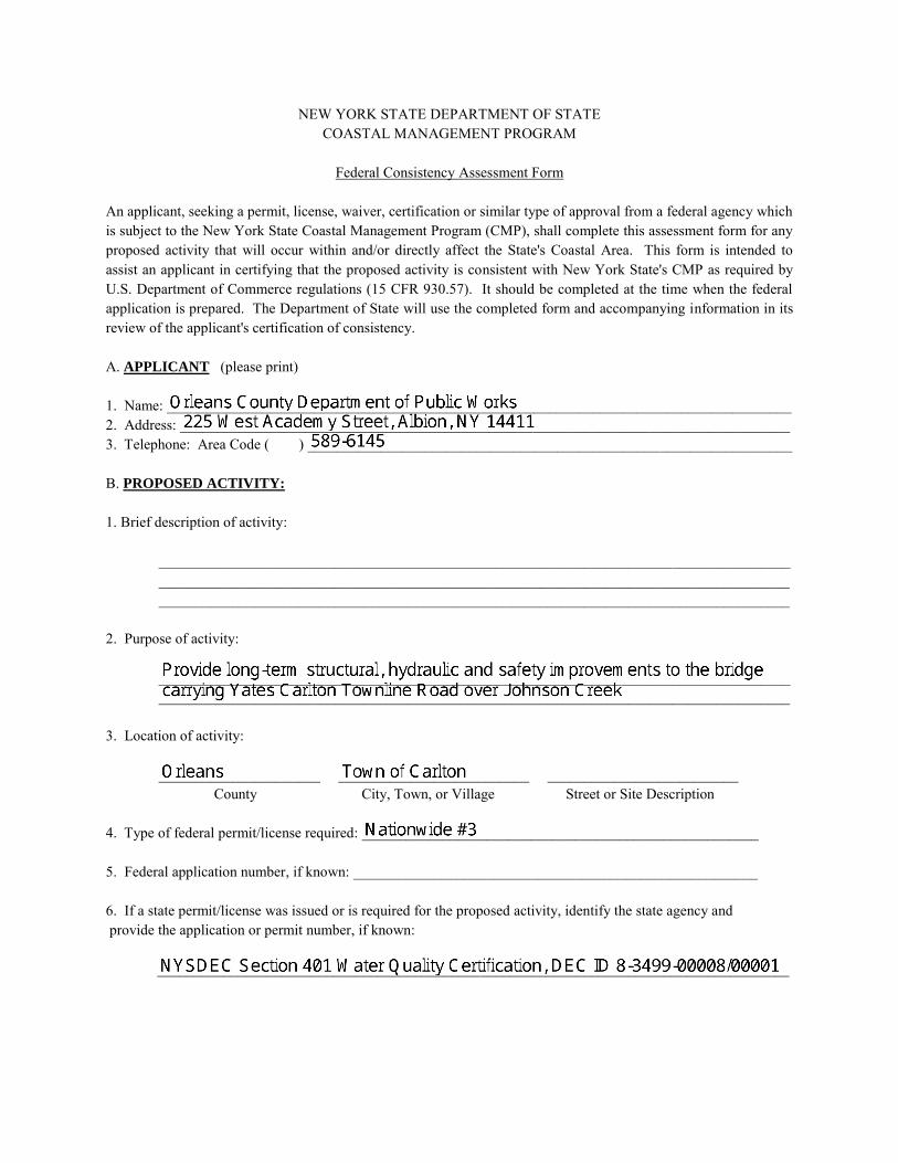
NEW YORK STATE DEPARTMENT OF STATE COASTAL MANAGEMENT PROGRAM
Federal Consistency Assessment Form
An applicant, seeking a permit, license, waiver, certification or similar type of approval from a federal agency which is subject to the New York State Coastal Management Program (CMP), shall complete this assessment form for any proposed activity that will occur within and/or directly affect the State's Coastal Area. This form is intended to assist an applicant in certifying that the proposed activity is consistent with New York State's CMP as required by U.S. Department of Commerce regulations (15 CFR 930.57). It should be completed at the time when the federal application is prepared. The Department of State will use the completed form and accompanying information in its review of the applicant's certification of consistency.
A. APPLICANT (please print)
1. Name: _____________________________________________________________________________________2. Address: ___________________________________________________________________________________3. Telephone: Area Code ( ) __________________________________________________________________
B. PROPOSED ACTIVITY:
1. Brief description of activity:
__________________________________________________________________________________________________________________________________________________________________________________________________________________________________________________________________
2. Purpose of activity:
____________________________________________________________________________________________________________________________________________________________________________
3. Location of activity:
______________________ __________________________ __________________________ County City, Town, or Village Street or Site Description
4. Type of federal permit/license required: ______________________________________________________
5. Federal application number, if known: _______________________________________________________
6. If a state permit/license was issued or is required for the proposed activity, identify the state agency and provide the application or permit number, if known:
______________________________________________________________________________________
3481
Typewriter
585
3481
Typewriter
Yates Carlton Townline Road
3481
Typewriter
This project involves the replacement of the Yates Carlton Townline Road Bridge over
3481
Typewriter
Johnson Creek, new bridge railing and associated roadway reconstruction and mill and
3481
Typewriter
overlay

C. COASTAL ASSESSMENT Check either "YES" or "NO" for each of these questions. The numbers following each question refer to the policies described in the CMP document (see footnote on page 2) which may be affected by the proposed activity.
1. Will the proposed activity result in any of the following: YES/NO
a. Large physical change to a site within the coastal area which will require the preparation of an environmental impact statement? (11, 22, 25, 32, 37, 38, 41, 43) __ __
b. Physical alteration of more than two acres of land along the shoreline, land under water or coastal waters? (2, 11, 12, 20, 28, 35, 44) __ __
c. Revitalization/redevelopment of a deteriorated or underutilized waterfront site? (1) __ __ d. Reduction of existing or potential public access to or along coastal waters? (19, 20) __ __ e. Adverse effect upon the commercial or recreational use of coastal fish resources? (9,10) __ __ f. Siting of a facility essential to the exploration, development and production of energy resources in coastal waters or on the Outer Continental Shelf? (29) __ __ g. Siting of a facility essential to the generation or transmission of energy? (27) __ __ h. Mining, excavation, or dredging activities, or the placement of dredged or fill material in coastal waters? (15, 35) __ __ i. Discharge of toxics, hazardous substances or other pollutants into coastal waters? (8, 15, 35) __ __ j. Draining of stormwater runoff or sewer overflows into coastal waters? (33) __ __ k. Transport, storage, treatment, or disposal of solid wastes or hazardous materials? (36, 39) __ __ l. Adverse effect upon land or water uses within the State's small harbors? (4) __ __ 2. Will the proposed activity affect or be located in, on, or adjacent to any of the following: YES/NO a. State designated freshwater or tidal wetland? (44) __ __ b. Federally designated flood and/or state designated erosion hazard area? (11, 12, 17) __ __ c. State designated significant fish and/or wildlife habitat? (7) __ __ d. State designated significant scenic resource or area? (24) __ __ e. State designated important agricultural lands? (26) __ __ f. Beach, dune or Barrier Island? (12) __ __ g. Major ports of Albany, Buffalo, Ogdensburg, Oswego or New York? (3) __ __ h. State, county, or local park? (19, 20) __ __ i. Historic resource listed on the National or State Register of Historic Places? (23) __ __ 3. Will the proposed activity require any of the following: YES/NO a. Waterfront site? (2, 21, 22) __ __ b. Provision of new public services or infrastructure in undeveloped or sparsely populated sections of the coastal area? (5) __ __ c. Construction or reconstruction of a flood or erosion control structure? (13, 14, 16) __ __ d. State water quality permit or certification? (30, 38, 40) __ __ e. State air quality permit or certification? (41, 43) __ __
4. Will the proposed activity occur within and/or affect an area covered by a State-approved local waterfront revitalization program, or State-approved regional coastal management program? __ __ (see policies in program document*)
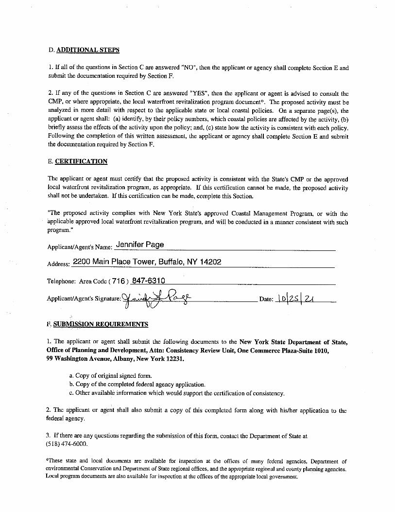

PIN 4OR0.04 – Yates Carlton Road over Johnson Creek Federal Consistency Assessment Form
D. ADDITIONAL STEPS
2. The following coastal policies are affected by the proposed actions: 7, 15, 30, 35, 38, and 40.
Policy 7 Significant coastal fish and wildlife habitats will be protected, preserved, and, where practical, restored so as to
maintain their viability as habitats.
This project will include the construction of a temporary stone causeway on geotextile separation fabric at the southwest bank to facilitate the removal of the center pier. A turbidity curtain will surround the causeway to contain sediment. The causeway will be removed within a month and the streambed restored to its original condition. The proposed activities will not adversely affect the fish and wildlife habitat of Johnson Creek and neither will they destroy or significantly impair the viability of the area as a habitat, thereby conforming to Policy 7.
Policy 15 Mining, excavation or dredging in coastal waters shall not significantly interfere with the natural coastal
processes which supply beach materials to land adjacent to such waters and shall be undertaken in a manner
which will not cause an increase in erosion of such land.
The proposed bridge is 20 feet longer than the existing bridge allowing the new bridge abutments to be excavated and constructed completely behind the existing abutments therefore having no impact on the streambed. Removal of the existing abutments will be performed from behind the existing and/or new abutments, minimizing any disturbance to the stream and banks. The project is not anticipated to cause a reduction of supply or an increase in erosion to shorelands, thereby conforming to Policy 15.
Policy 30 Municipal, industrial, and commercial discharge of pollutants, including but not limited to, toxic and hazardous
substances, into coastal waters will conform to State and National water quality standards.
The proposed bridge construction will produce site runoff that will be controlled by appropriate erosion control methods, including silt fence, straw bales and settlement basins, to prevent discharge to Johnson Creek, thereby conforming to Policy 30.
Policy 35 Dredging and filling in coastal waters and disposal of dredged material will be undertaken in a manner that
meets existing State dredging permit requirements, and protects significant fish and wildlife habitats, scenic
resources, natural protective features, important agricultural lands, and wetlands.
This project will include the construction of a clean stone causeway constructed on geotextile fabric to facilitate the removal of the existing bridge center pier. The center pier is in poor condition and very wide creating a massive hydraulic constriction. The upstream nose of the pier is undermined and since there are no piles, the pier would eventually be vulnerable to falling over and becoming more of an obstruction. The causeway is anticipated to be removed within a month of its construction. Any excavation or fill occurring in Johnson Creek will be performed in a manner that protects the waterway and its features, conforming to Policy 35.
Policy 38 The quality and quantity of surface water and groundwater supplies will be conserved and protected,
particularly where such waters constitute the primary or sole source of water supply.
This project is not located in the area of a sole source aquifer or primary aquifer. The quantity and quality of the surface waters of Johnson Creek will be conserved and protected during the proposed activities, thereby conforming to Policy 38.
Policy 40 Effluent discharged from major steam electric generating and industrial facilities into coastal waters will not be
unduly injurious to fish and wildlife and shall conform to State water quality standards.
The proposed activities do not involve the discharge of effluent from steam electric generating or industrial facilities into Johnson Creek, thereby conforming to Policy 40.

STATE OF NEW YORK DEPARTMENT OF STATE ON E C O M M ER C E P L A Z A 99 W A S H I N G T O N A V E N U E ALBANY, NY 12231-0001 WWW.DOS.NY.GOV
ANDREW M. CUOMO GOVERNOR
R O S SA NA R OS AD O SECRETARY OF STATE
June 8, 2021 CHA Companies Jennifer Page, Project Engineer IV [email protected]
Re: F-2021-0320 (FA) PIN 4OR0.04 - Orleans County Department of Public Works -Federal funding for the replacement of the two-span Yates Carlton Townline Road Bridge over Johnson Creek (BIN 3318800) with a new 105'-0" foot long single span bridge along the current horizontal alignment. Town of Carlton, Orleans County, Lake Ontario General Concurrence - No Objection to Funding
Jennifer Page: The Department of State (DOS) received the information you submitted regarding the above proposed federal financial assistance on {date} and has completed its review. Based on this review, the Department of State has no objection to the release of the Federal Highway Administration funding in support of the proposed project as identified in your e-mail dated March 31, 2021 This concurrence pertains to the federal financial assistance activity or activities for this project only. If certain activities may require a federal permit or other form of federal agency authorization, the Department of State would conduct separate consistency review(s) of permit activities at the time such application(s) may be made to a federal agency. When communicating with us regarding this matter, please contact us at (518) 474-6000 and refer to our file # F-2021-0320 (FA).
Sincerely,
Jennifer L. Street Supervisor, Consistency Review Unit Office of Planning, Development and
Community Infrastructure JS/dm
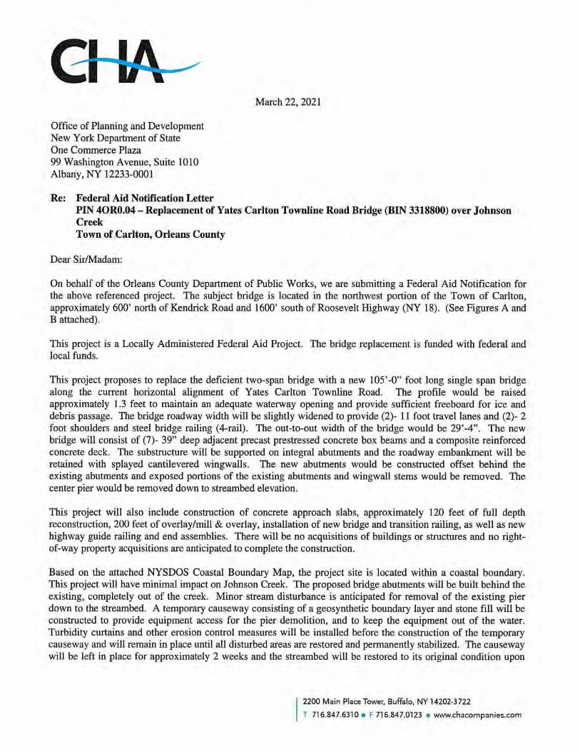

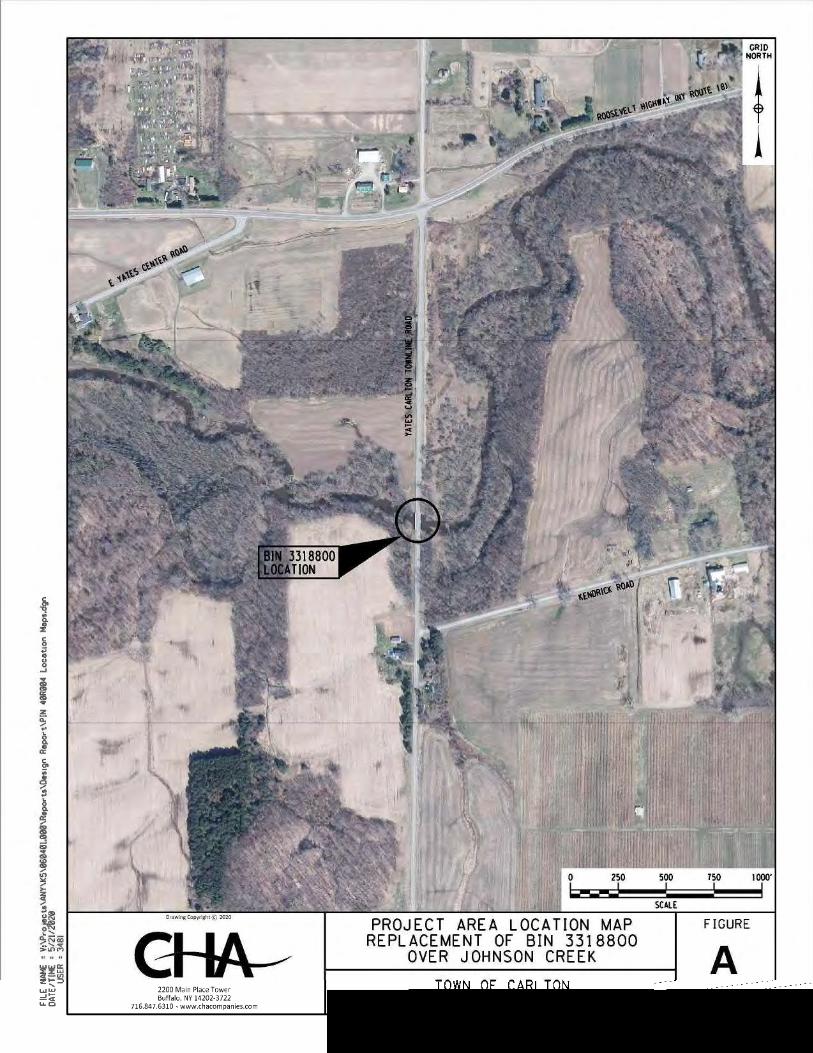


DOS_identified_artificial_canals
Significant coastal fish & wildlife habitats - NYS Dept of State
Coastal_Boundary_Polyline_update
SASS
Local Waterfront Revitalization Program [LWRP] Community Boundaries, Approved
Long_Island_Sound_Program
NativeAmericanLands
FederalLands_NY
CoastalBoundary_Polygon_March2017
0 3 61.5mi
°
The New York Department of State (DOS) gives no warranty, expressed or implied, as to the accuracy, reliability, or completeness of data shown on this map product.DOS does not assume responsibility for the use or application of any information represented on this map nor responsibility for any error, omission or otherdiscrepancy between the electronic and printed versions of documents.
3481
Oval
3481
Callout
Project Area

PU
BLIC W
OR
KS
DE
PA
RT
ME
NT O
F
OR
LE
AN
S C
OU
NT
Y
Albio
n,
NY 1
4411
225 W
est
Acade
my Street
NOTES:
4.
3.
2.
1.
PL-1 & PL-2.
PROPOSED STRIPING LAYOUT TO MATCH EXISTING, SEE DWGS.
DWGS. S-2 & S-3.
FOR ADDITIONAL SUBSTRUCTURE REMOVAL DETAILS, SEE
SUBBASE THICKNESS UNDER SLEEPER SLABS SHALL BE 12".
DETAILS, SEE DWGS. S-2 & S-3.
ITEM 206.01 - STRUCTURE EXCAVATION. FOR EXCAVATION
SLEEPER AND APPROACH SLABS SHALL BE PAID FOR UNDER
ALL EXCAVATION NECESSARY FOR THE INSTALLATION OF THE
X
TYP-1
(SH
EE
T 1 O
F 2)
TY
PIC
AL S
EC
TIO
NS
N.T.S.
Issue D
ate:
Scale:
V:\
Projects\
AN
Y\
K5\060401.0
00\
CA
DD\_
MS
TN\40
R004_fea_h
wy_
TY
P-1.d
gn
19-
MA
R-2021
4141
US
ER
=
DA
TE/
TI
ME
=
FIL
E
NA
ME
=
Dra
wn:
Desig
ned:
Checked:
SHEET OF
CH
A Project
No.:
060401
Dra
win
g C
opyright c 2
021
716.8
47.6
310
ww
w.c
haco
mpanies.c
om
Buffalo,
NY 1
4202-3
722
2200 M
ain Place T
ow
er
GH
JH
GH
PROJECT NO.
AP
PLIC
AB
LE
ST
AT
E
AN
D/
OR
LO
CA
L
LA
WS
TO
THIS
DO
CU
ME
NT IS
A
VIO
LA
TIO
N
OF
UN
AU
TH
ORIZ
ED
AL
TE
RA
TIO
N
OR
AD
DITIO
N
XX
Sub
mittal /
Revisio
nN
o.
Date
By
App'd
BRID
GE R
EP
LA
CE
ME
NT
OV
ER J
OH
NS
ON C
RE
EK
YA
TE
S C
AR
LT
ON T
OW
NL
NE R
OA
D
MA
RC
H 2
021
P.I.N. 4OR0.04
STA. LINE
< IMPROVEMENT
2%
2%2%
2%
GROOVING - ITEM 558.02
LONGITUDINAL SAWCUT
FINISHED GRADE
SHOULDER
2'-0"
SHOULDER
2'-0"
TYPICAL APPROACH SLAB SECTION
EXISTING GROUND
ITEM 568.70 (TYP.)
TRANSITION BRIDGE RAIL
(TYP.)
ROUND 4' RADIUS
PROPOSED SUBGRADE
PAVEMENT TO BE REMOVED
EXISTING 8"` ASPHALT
SHOULDER
2'-0"
NORTHBOUND TRAVEL LANE
11'-0"
SOUTHBOUND TRAVEL LANE
11'-0"
SHOULDER
2'-0"
29'-4" OUT-TO-OUT
1'-8"
1'-8"
STA. LINE
< IMPROVEMENT
H.C.L.
T.G.L. &
B1 B2 B3 B4 B5 B6 B7
4‚" (TYP.)
(7 CONCRETE BOX BEAMS @ 4'-0" INCLUDING 6 JOINTS @ 1"`)
OUT-TO-OUT WIDTH OF BEAMS = 28'-6"` (MEAS. @ BOTTOM CORNER OF FASCIA BEAMS)
2% 2%
& T.G.L.
H.C.L.
2'-3"2'-3"
2% 2%
BEYOND SUBBASE DAYLIGHT (TYP.)
FOR RESTORATION OF DISTURBED AREAS
ESTABLISH TURF - ITEM 610.1601
LINE
WEST FASCIA
LINE
EAST FASCIA
26'-0" - TRANSVERSE PAY LIMITS OF ITEM 558.02 - LONGITUDINAL SAWCUT GROOVING OF STRUCTURAL SLAB SURFACE
SOUTHBOUND TRAVEL LANE
11'-0"
NORTHBOUND TRAVEL LANE
11'-0"
26'-0" - TRANSVERSE PAY LIMITS OF ITEM 558.02 - LONGITUDINAL SAWCUT GROOVING OF STRUCTURAL SLAB SURFACE
MOW STRIP
2'-0"
MOW STRIP
2'-0"
(TY
P.)
12„
"
PROPOSED BRIDGE SECTION
EXISTING BRIDGE SECTION
ITEM 557.4309
BOTTOM FORMWORK NOT REQUIRED
INTEGRAL WEARING SURFACE - HPIC
8" SUPERSTRUCTURE SLAB WITH
ITEM 568.51 (TYP.)
(FOUR-RAIL)
STEEL BRIDGE RAILING
BOX BEAM (TYP.) - ITEM 563.02
39" x 48" PRESTRESSED CONCRETE
27'-2" OUT-TO-OUTLINE
WEST FASCIA LINE
EAST FASCIA
(SEE NOTE 1)
OF APPROACH SLAB, ITEM 206.01
EXCAVATION FOR INSTALLATION
24" SUBBASE - ITEM 304.12 (SEE NOTE 2)
12" APPROACH SLAB - ITEM 557.2009
24'-2" CLEAR WIDTH
21'-0" PAVED WIDTH
SHLDR
1'-7"
NORTHBOUND TRAVEL LANE
10'-6"
SOUTHBOUND TRAVEL LANE
10'-6"
SHLDR
1'-7"
6 SPACES @ 4'-3" = 25'-6"
10"
10"
1'-6"
1'-6"
ITEM 202.120001
REMOVE EXISTING SUPERSTRUCTURE
(ABUTMENT & WINGWALL STEMS ONLY, SEE NOTE 3)
REMOVAL OF STRUCTURAL CONCRETE - ITEM 580.01
ITEM 202.19 (PIER ONLY)
REMOVE EXISTING SUBSTRUCTURE
JACK-ARCH CONCRETE INFILL
(TYP. EACH BAY)
CORRRUGATED METAL FORM
CONCRETE PARAPET (TYP.)
5'-
4" (T
YP.)
(BRIDGE SEAT)
TOP OF PIER
(ABUTMENTS ONLY, TYP. EACH BAY)
BRICK FORMS FOR BACKWALL POUR
POST & HANDRAIL (TYP.)
2" O.D. STEEL PIPE
<
& BRIDGE
EXISTING ROADWAY
OVER STONE BASE
4" ASPHALT PAVEMENT
1 ON 2 MAX. (TYP.)
2" - BINDER COURSE - ITEM 402.198904
1•" TOP COURSE - ITEM 402.098204
DILUTED TACK COAT - ITEM 407.0102
ITEM 685.12 (SEE NOTE 4)
YELLOW LANE LINES
(TYP.)
ASSUMED SHAPE FOR REF. ONLY
CONCRETE ENCASED BEAM, W30x132
STA. 6+90.09 TO STA. 7+98.31
STA. 7+98.31 TO STA. 8+17.73
STA. 6+70.67 TO STA. 6+90.09

PU
BLIC W
OR
KS
DE
PA
RT
ME
NT O
F
OR
LE
AN
S C
OU
NT
Y
Albio
n,
NY 1
4411
225 W
est
Acade
my Street
NOTES:
1.
2.
3.
4.
IN ORDER TO ACHIEVE DESIRED PROFILE & CROSS-SLOPE, TRUING AND
LEVELING WILL BE REQUIRED, ITEM 402.018903. (SEE PROFILE FOR
APPROXIMATE LIMITS)
PLACE TACK COAT, ITEM 407.0102 BETWEEN ALL EXISTING AND PROPOSED
ASPHALT SURFACES.
MAXIMUM ROLLOVER BETWEEN SHOULDER AND TRAVEL LANE SHALL BE
LIMITED TO 8%.
PAVE MOWSTRIP CONTINUOUS WITH BINDER & TOP COURSES WHERE
APPLICABLE.
5. SEE PLAN DWG.'S PL-1 & 2, FOR STRIPING PLAN LAYOUT.
X
TYP-2
TY
PIC
AL S
EC
TIO
NS
AS N
OT
ED
Issue D
ate:
Scale:
V:\
Projects\
AN
Y\
K5\060401.0
00\
CA
DD\_
MS
TN\40
R004_fea_h
wy_
TY
P-2.d
gn
19-
MA
R-2021
4141
US
ER
=
DA
TE/
TI
ME
=
FIL
E
NA
ME
=
Dra
wn:
Desig
ned:
Checked:
SHEET OF
CH
A Project
No.:
060401
Dra
win
g C
opyright c 2
021
716.8
47.6
310
ww
w.c
haco
mpanies.c
om
Buffalo,
NY 1
4202-3
722
2200 M
ain Place T
ow
er
GH
JH
GH
PROJECT NO.
AP
PLIC
AB
LE
ST
AT
E
AN
D/
OR
LO
CA
L
LA
WS
TO
THIS
DO
CU
ME
NT IS
A
VIO
LA
TIO
N
OF
UN
AU
TH
ORIZ
ED
AL
TE
RA
TIO
N
OR
AD
DITIO
N
XX
Sub
mittal /
Revisio
nN
o.
Date
By
App'd
BRID
GE R
EP
LA
CE
ME
NT
OV
ER J
OH
NS
ON C
RE
EK
YA
TE
S C
AR
LT
ON T
OW
NL
NE R
OA
D
MA
RC
H 2
021
P.I.N. 4OR0.04
STA. LINE
< IMPROVEMENT
6% 2% 6%2%
6% 2% 2% 6%
EXISTING GROUND
EXISTING GROUND
EXISTING GROUND
12" MIN. SUBBASE - ITEM 304.12
4" BASE COURSE - ITEM 402.378903
2" BINDER COURSE - ITEM 402.198903
1•" TOP COURSE - ITEM 402.128203
PAVEMENT TO BE REMOVED
EXISTING 8"` ASPHALT
TYPICAL FULL DEPTH SECTION
TRAVEL LANE
11'-0"
TRAVEL LANE
11'-0"
SHOULDER
2'-0"
SHOULDER
2'-0"
26'-0"2'-3" 2'-3"
(TYP.)
ROUND 4' RADIUS
1 ON 1.75 MAX. (TYP.)
ITEM 610.1601 (TYP.)
ESTABLISH TURF
SHOULDER
2'-0"2'-3"
SHOULDER
2'-0" 2'-3"
STA. LINE
< IMPROVEMENT
TYPICAL OVERLAY SECTION
TYPICAL MILL & OVERLAY SECTION
25'-5"`
TRAVEL LANE
10'-7"`
TRAVEL LANE
10'-10"`
2% 2%6% 6%
6% 6%2% & VARIES2% & VARIES
TO REMAIN
EXISTING 8" PAVEMENT
TO REMAIN
EXISTING 8" PAVEMENT
SHOULDER
2'-0" 2'-3"
25'-5"`
TRAVEL LANE
10'-7"`
STA. LINE
< IMPROVEMENT
TRAVEL LANE
10'-10"`
SHOULDER
2'-0"2'-3"
(TYP.)
ROUND 4' RADIUS
(TYP.)
ROUND 4' RADIUS
ITEM 203.24010017 (TYP.)
SHOULDER BACKUP MATERIAL
1 ON 4 (TYP.)
1 ON 4 (TYP.)
& T.G.L.
P.O.R., H.C.L.
& T.G.L.
P.O.R., H.C.L.
& T.G.L.
P.O.R., H.C.L.
ITEM 203.24010017 (TYP.)
SHOULDER BACKUP MATERIAL
OR TYPE I END ASSEMBLY (TYP.)
HIGHWAY BOX BEAM GUIDE RAIL
EXCAVATION
UNCLASSIFIED
(NO SEPARATE PAYMENT)
SUITABLE COMPACTED MATERIAL,
STA. YC 9+13` TO STA. YC 9+60`
STA. YC 5+00` TO STA. YC 5+38`
12" MIN. SUBBASE - ITEM 304.12
4" BASE COURSE - ITEM 402.378903
2" BINDER COURSE - ITEM 402.198903
1•" TOP COURSE - ITEM 402.128203
1 ON 4 (TYP.)
TRUE & LEVELING - ITEM 402.018903
1•" - TOP COURSE - ITEM 402.128203
1•" MILL & OVERLAY (REBATE) - ITEM 490.30
TRUE & LEVELING - ITEM 402.018903
2" - BINDER COURSE - ITEM 402.198903
1•" - TOP COURSE - ITEM 402.128203
ITEM 606.10
OR TYPE I END ASSEMBLY (TYP.)
HIGHWAY BOX BEAM GUIDE RAIL
STA. 8+67` TO STA. YC 9+13`
STA. YC 5+38` TO STA. YC 6+06`
STA. YC 8+17.73 TO STA. YC 8+67`
STA. YC 6+06`` TO STA. YC 6+70.67
ITEM 685.12
4" BROKEN YELLOW
4" SOLID YELLOW &
ITEM 685.12
4" BROKEN YELLOW
4" SOLID YELLOW &
ITEM 685.12
4" BROKEN YELLOW
4" SOLID YELLOW &
MOW STRIP
2'-0"
MOW STRIP
2'-0"
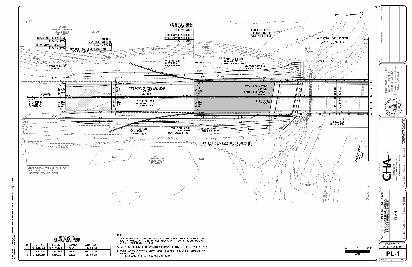
16"
18"
SIGN
REF.
REF.
UP
R.O.W.
R.O.W.
DITCH DITCH
WOODSWOODS
WOODSWOODS
GRASS
GRASS
GRASS
STONE SHOULDER
STONE SHOULDER
EP
EP
ED
GE
OF
WATER
SBL 15.00-1-12
(RECORD OWNER)
COURTNEY L. PLUMMER
NO. 1484
SBL 16.00-1-50
(RECORD OWNER)
EDWARD MACK JR.
NO. -
B1
PC1
255
255
255
255
260
260
260
265
265
265265
265
265
265265265
270
270
270
CP#1
UP
(APPROX. STA. YC 2+52)
POLE ELEV. = 276.41
BENCHMARK: MAGNAIL IN UTILITY
PU
BLIC W
OR
KS
DE
PA
RT
ME
NT O
F
OR
LE
AN
S C
OU
NT
Y
Albio
n,
NY 1
4411
225 W
est
Acade
my Street
268 268 268
269 269 269
269 269269
270 270
270
270
270
270
(66' WIDE)
C.R. 67
YATES-CARLTON TOWN LINE ROAD
JOH
NSON CREE
KFLO
W
YC 5+00 YC 6+00 YC 7+00
E=1221128.34
N=1218628.75
PI YC 3+16.31
P.O.B.
YC 5+00 YC 6+00 YC 7+00
E=1221128.34
N=1218628.75
PI YC 3+16.31
P.O.B.
(66' WIDE)
C.R. 67
YATES-CARLTON TOWN LINE ROAD
JOH
NSON CREE
KFLO
W
GRID
NO
RT
H
10'-
9"̀
10'-
6"̀
2'-0"
2'-0"
MA
TC
H
LIN
E
ST
A.
YC 7
+50.0
0
10 FT010
SCALE
X
PL-1
PL
AN
AS N
OT
ED
108'-3" (TOTAL LENGTH OF BRIDGE)
105'-0" (<-< BEARINGS)
10'-
11"̀
10'-
6"̀
LA
NE
TR
AV
EL
LA
NE
TR
AV
EL
LA
NE
TR
AV
EL
LA
NE
TR
AV
EL
LA
NE
TR
AV
EL
LA
NE
TR
AV
EL
SHLD.
SHLD.
SHLD.
SHLD. SHLD.
STA. YC 5+00
BEGIN MILL & OVERLAY
MATERIAL (TYP.)
SHOULDER BACKUP
SHLD.
MOW STRIP (TYP.)
2'-0" WIDE ASPHALT
11'-
0"
11'-
0"
29'-
4" (O
UT T
O
OUT)
26'-
0" (R
AIL T
O
RAIL)
STA. YC 6+06`
RECONSTRUCTION
BEGIN FULL DEPTH
STA. YC 6+70.67
RECONSTRUCTION
END FULL DEPTH
STA. YC 5+38`
CONTINUE OVERLAY
END MILL
(4- RAIL, TYP.)
BRIDGE RAIL
STA. YC 5+00
BEGIN GRAVEL SHOULDER
STA. YC 6+06`
BEGIN PAVED SHOULDER
END GRAVEL SHOULDER
FROM EXISTING TO 2% (TYP. B.S.)
TRANSITION TRAVEL LANE CROSS-SLOPE
FROM 2% AT SLEEPER SLAB TO 6% (TYP. B.S.)
TRANSITION (18' MIN.) PAVED SHOULDER CROSS-SLOPE
ITEM 685.12 (TYP.)
4" BROKEN YELLOW
4" SOLID YELLOW &
2'-0"
2'-0"
2'-0"
2'-0"
YC 6+70.67
SLEEPER SLAB BEGINS
YC 6+74.67
APPROACH SLAB BEGINS
YC 6+90.09
BRIDGE BEGINS
CP NORTHING EASTING ELEVATION DESCRIPTION
1 1218510.8630 1221144.4670 278.25 REBAR & CAP
2 1219123.4343 1221150.7935 267.90 REBAR & CAP
3 1219656.0168 1221154.0138 265.62 REBAR & CAP
HORIZONTAL DATUM = NAD83
VERTICAL DATUM = NAVD88
SURVEY CONTROL
ITEM 606.120102
END ASSEMBLY
TYPE I BOX BEAM
ITEM 606.120102
END ASSEMBLY
TYPE I BOX BEAM
ITEM 606.10 (TYP.)
BOX BEAM GUIDE RAIL
ITEMS 646.22 & 646.31
PLOW MARKER
DOUBLE GREEN SNOW
ITEMS 646.22 & 646.31
PLOW MARKER
SINGLE GREEN SNOW
SEE NOTE 1
2. FOR TYPICAL BRIDGE, BRIDGE APPROACH & HIGHWAY SECTIONS, SEE DWGS. TYP-1 TO TYP-3.
1.
NOTES:
SEPARATE PAYMENT SHALL BE MADE.
ROAD TO TRAFFIC. COST TO BE INCLUDED UNDER VARIOUS ITEMS IN THE CONTRACT. NO
EXISTING SIGN & POST SHALL BE REMOVED, STORED & RESET PRIOR TO REOPENING THE
3.
SEE NOTE 3 (TYP.)
(TYP. EACH QUAD., 4 TOTAL, NO SEPARATE PAYMENT)
RETURN TO THE COUNTY.
REMOVE AND STORE EXISTING OBJECT MARKER SIGN PANEL & POST AND COORDINATE THE
Issue D
ate:
Scale:
V:\
Projects\
AN
Y\
K5\060401.0
00\
CA
DD\_
MS
TN\40
R004_fea_h
wy_P
L-1.d
gn
19-
MA
R-2021
4141
US
ER
=
DA
TE/
TI
ME
=
FIL
E
NA
ME
=
Dra
wn:
Desig
ned:
Checked:
SHEET OF
CH
A Project
No.:
060401
Dra
win
g C
opyright c 2
021
716.8
47.6
310
ww
w.c
haco
mpanies.c
om
Buffalo,
NY 1
4202-3
722
2200 M
ain Place T
ow
er
GH
JH
GH
PROJECT NO.
AP
PLIC
AB
LE
ST
AT
E
AN
D/
OR
LO
CA
L
LA
WS
TO
THIS
DO
CU
ME
NT IS
A
VIO
LA
TIO
N
OF
UN
AU
TH
ORIZ
ED
AL
TE
RA
TIO
N
OR
AD
DITIO
N
XX
Sub
mittal /
Revisio
nN
o.
Date
By
App'd
BRID
GE R
EP
LA
CE
ME
NT
OV
ER J
OH
NS
ON C
RE
EK
YA
TE
S C
AR
LT
ON T
OW
NL
NE R
OA
D
MA
RC
H 2
021
P.I.N. 4OR0.04

PU
BLIC W
OR
KS
DE
PA
RT
ME
NT O
F
OR
LE
AN
S C
OU
NT
Y
Albio
n,
NY 1
4411
225 W
est
Acade
my Street
CP#2
269.53
269.32
269.28
265.62
265.48
30"
12"
20"
24"18"
10"
24" CLUMP18" CLUMP
18" CLUMP
16"
30"
12"
36"
36"
24"
UP
R.O.W.
R.O.W.
R.O.W.
R.O.W.
POLE ELEV. = 268.41
BENCHMARK: MAGNAIL IN UTILITY
SBL 15.00-1-12
(RECORD OWNER)
COURTNEY L. PLUMMER
NO. 1484
SBL 16.00-1-50
(RECORD OWNER)
EDWARD MACK JR.
NO. -
PC2
B3
255
255
255
260
260
260
265
265
265
265
265
265
265
265
265
265
CP#3
Issue D
ate:
Scale:
V:\
Projects\
AN
Y\
K5\060401.0
00\
CA
DD\_
MS
TN\40
R004_fea_h
wy_P
L-2.d
gn
19-
MA
R-2021
4141
US
ER
=
DA
TE/
TI
ME
=
FIL
E
NA
ME
=
Dra
wn:
Desig
ned:
Checked:
SHEET OF
CH
A Project
No.:
060401
Dra
win
g C
opyright c 2
021
716.8
47.6
310
ww
w.c
haco
mpanies.c
om
Buffalo,
NY 1
4202-3
722
2200 M
ain Place T
ow
er
GH
JH
GH
PROJECT NO.
AP
PLIC
AB
LE
ST
AT
E
AN
D/
OR
LO
CA
L
LA
WS
TO
THIS
DO
CU
ME
NT IS
A
VIO
LA
TIO
N
OF
UN
AU
TH
ORIZ
ED
AL
TE
RA
TIO
N
OR
AD
DITIO
N
XX
Sub
mittal /
Revisio
nN
o.
Date
By
App'd
BRID
GE R
EP
LA
CE
ME
NT
OV
ER J
OH
NS
ON C
RE
EK
YA
TE
S C
AR
LT
ON T
OW
NL
NE R
OA
D
MA
RC
H 2
021
P.I.N. 4OR0.04
(66' WIDE)
C.R. 67
YATES-CARLTON TOWN LINE ROAD
JOH
NSON CREE
KFLO
W
YC 8+00 YC 9+00 YC 10+00
E=1221135.48
N=1219328.71
PI YC 10+16.30
P.O.E.
267
268
268
268
269
269
269
270
GRID
NO
RT
H
MA
TC
H
LIN
E
ST
A.
YC 7
+50.0
0
X
PL-2
PL
AN
AS N
OT
ED
10 FT010
SCALE
STA. YC 9+60
END MILL & OVERLAY
LA
NE
TR
AV
EL
LA
NE
TR
AV
EL
SHLD.
SHLD.
SHLD.
SHLD.
LA
NE
TR
AV
EL
LA
NE
TR
AV
EL
SHLD.
SHLD.
10'-
10"̀
10'-
8"̀
(4- RAIL, TYP.)
BRIDGE RAIL
LA
NE
TR
AV
EL
LA
NE
TR
AV
EL
MOW STRIP (TYP.)
2'-0" WIDE ASPHALT
105'-0" (<-< BEARINGS)
108'-3" (TOTAL LENGTH OF BRIDGE)
26'-
0" (R
AIL T
O
RAIL)
29'-
4" (O
UT T
O
OUT)
STA. YC 8+17.73
RECONSTRUCTION
BEGIN FULL DEPTH
2'-0"
11'-
0"
11'-
0"
2'-0"
2'-0"
2'-0"
10'-
7"̀
10'-
10"̀
STA. YC 8+67`
BEGIN OVERLAY
RECONSTRUCTION
END FULL DEPTH
MATERIAL (TYP.)
SHOULDER BACKUP
STA. YC 8+67`
BEGIN GRAVEL SHOULDER
END PAVED SHOULDER
STA. YC 9+60
END GRAVEL SHOULDER
FROM 2% TO EXISTING (TYP. B.S.)
TRANSITION TRAVEL LANE CROSS-SLOPE
STA. YC 9+13`
CONTINUE OVERLAY
BEGIN MILL
ITEM 685.12 (TYP.)
4" BROKEN YELLOW
4" SOLID YELLOW &
YC 7+98.31
BRIDGE ENDS
YC 8+17.73
SLEEPER SLAB ENDS
YC 8+13.54
APPROACH SLAB ENDS
2'-0"
2'-0"
CP NORTHING EASTING ELEVATION DESCRIPTION
1 1218510.8630 1221144.4670 278.25 REBAR & CAP
2 1219123.4343 1221150.7935 267.90 REBAR & CAP
3 1219656.0168 1221154.0138 265.62 REBAR & CAP
HORIZONTAL DATUM = NAD83
VERTICAL DATUM = NAVD88
SURVEY CONTROL
ITEMS 646.22 & 646.31
PLOW MARKER
SINGLE GREEN SNOW
ITEMS 646.22 & 646.31
PLOW MARKER
DOUBLE GREEN SNOW
TO 6% (TYP. B.S.)
FROM 2% AT SLEEPER SLAB
SHOULDER CROSS-SLOPE
TRANSITION (18' MIN.) PAVED
ITEM 606.120102
END ASSEMBLY
TYPE I BOX BEAM
ITEM 606.120102
END ASSEMBLY
TYPE I BOX BEAM
1.
NOTES:
REFER TO NOTES ON DWG. PL-1 FOR ADDITIONAL INFORMATION.
ON DWG. PL-1
SEE NOTE 3

PU
BLIC W
OR
KS
DE
PA
RT
ME
NT O
F
OR
LE
AN
S C
OU
NT
Y
Albio
n,
NY 1
4411
225 W
est
Acade
my Street
VE
RTIC
AL
SC
AL
E
20
10 FT
HORIZONTAL SCALE
40 FT
5
MILL & OVERLAY
REBATE
(1•" TOP COURSE)
MILL & OVERLAY
REBATE
(1•" TOP COURSE)
OVERLAY
FULL DEPTH
(12" SUBBASE)
(4" BASE COURSE)
(2" BINDER COURSE)
(1•" TOP COURSE)
RECONSTRUCTION
FULL DEPTH
EXISTING GROUND
DECK
EXISTING BRIDGE
1.
NOTE:
DWG'S. TYP-1 & TYP-2.
FOR PAVEMENT PAYMENT ITEMS, SEE TYPICAL SECTIONS,
N.T.S.
X
PR-1
PR
OFIL
E
AS N
OT
ED
245
250
255
260
265
270
275
280280
245
250
255
260
265
270
275
280280
YC 4+50 YC 5+00 YC 5+50 YC 6+00 YC 6+50 YC 7+00 YC 7+50 YC 8+00 YC 8+50 YC 9+00 YC 9+50 YC 10+00
PVI
YC 5
+00.0
0
EL
EV 270.4
0
PV
C
YC 5
+08.5
0
EL
EV 270.3
7
PVI
YC 5
+53.5
0
EL
EV 270.1
9
LO
W
YC 5
+53.5
4
EL
EV 270.2
8
PV
T
YC 5
+98.5
0
EL
EV 270.3
6
PV
C
YC 6
+93.1
8
EL
EV 270.7
4
HIG
H
YC 7
+21.2
1
EL
EV 270.8
0
PVI
YC 7
+93.1
8
EL
EV 271.1
4
PV
T
YC 8
+93.1
8
EL
EV 268.6
9
PV
C
YC 9
+13.7
4
EL
EV 268.1
9
-0.40% 0.40%
-2.45%
OVERLAY
50 YR WSEL 264.22
3'-
9"̀
4'-
2•
"̀
WSEL 260.0`
O.H.W.M.
K 70.19
SSD = 478.7 FT.
E= -0.71 FT.
G2 = -2.45%
G1 = 0.40%
L = 200.00 FT.
EXISTING SURFACE
MATCH INTO
EL
EV 266.4
7
PVI
YC 9
+83.7
4
L = 140.00 FT.
G1 = -2.45%
G2 = -0.15%
E= 0.40 FT.
HSD = 656.4 FT.
K 60.87
GRADE
PROPOSED
FR
EE
BO
AR
D
2'-
0"
LO
W
CH
OR
D
9"̀
AB
OV
E
EXIS
T.
108'-3" TOTAL BRIDGE LENGTH
105'-0" SPAN LENGTH (< - < BEARINGS)
LINE (TYP.)
EXCAVATION LAYBACK
APPROXIMATE
STRUCTURE (LOW CHORD)
BOTTOM OF EXISTING
STRUCTURE (LOW CHORD)
BOTTOM OF PROPOSED
L = 90.00 FT.
G1 = -0.40%
G2 = 0.40%
E= 0.09 FT.
HSD = 486.6 FT.
K 112.59
STA. YC 5+38`
END MILL
STA. YC 5+00`
(REBATE)
BEGIN MILL & OVERLAY
STA. YC 6+06`
BEGIN FULL DEPTH RECON.
END OVERLAY
STA. YC 9+60`
(REBATE)
END MILL & OVERLAY
STA. YC 9+13`
BEGIN MILL
STA. YC 8+67`
END FULL DEPTH RECON.
BEGIN OVERLAY
(TRUE & LEVEL COURSE 4" MAX.)
(2" BINDER COURSE)
(1•" TOP COURSE)
STA. YC 6+74.86
BEGIN APPROACH SLAB
EXISTING SURFACE
MATCH INTO
(12" SUBBASE)
(4" BASE COURSE)
(2" BINDER COURSE)
(1•" TOP COURSE)
RECONSTRUCTION
(T & L COURSE 4" MAX.)
(2" BINDER COURSE)
(1•" TOP COURSE)
STA. YC 6+70.67
END FULL DEPTH RECON.
BEGIN SLEEPER SLAB
STA. YC 8+13.54
END APPROACH SLAB
STA. YC 8+17.73
BEGIN FULL DEPTH RECON.
END SLEEPER SLAB
STA. YC 6+91.70
< BRGS.
STA. YC 7+96.70
< BRGS.
STA. YC 6+90.09
BRIDGE BEGINS
STA. YC 7+98.31
BRIDGE ENDS
269.5 (E
X.
DE
CK)
271.1
270.7
270.4
270.2
270.0
269.9
269.8
269.7
269.6
269.4
269.1
269.0
268.9
268.5
268.2
267.8
267.4
267.0
266.7
270.4
0
270.3
1
270.2
8
270.3
0
270.3
7
270.4
7
270.5
7
270.6
7
270.7
7
270.8
0
270.7
4
270.5
9
270.3
6
270.0
3
269.6
2
269.1
1
268.5
3
267.9
2
267.4
1
266.6
9
269.5 (E
X.
DE
CK)
269.4 (E
X.
DE
CK)
269.3 (E
X.
DE
CK)
OF STREAMBED
REMOVED TO BOT.
FOOTING TO BE
EXISTING PIER &
(TYP. BOTH SIDES)
ELEVATION OF 257.00'
BE REMOVED TO AN
EXISTING ABUTMENT TO
YATES-CARLTON ROAD PROFILE
252.9 (S
TR
EA
MB
ED)
253.4 (S
TR
EA
MB
ED)
253.4 (S
TR
EA
MB
ED)
Issue D
ate:
Scale:
V:\
Projects\
AN
Y\
K5\060401.0
00\
CA
DD\_
MS
TN\40
R004_fea_h
wy_P
R-1.d
gn
19-
MA
R-2021
4141
US
ER
=
DA
TE/
TI
ME
=
FIL
E
NA
ME
=
Dra
wn:
Desig
ned:
Checked:
SHEET OF
CH
A Project
No.:
060401
Dra
win
g C
opyright c 2
021
716.8
47.6
310
ww
w.c
haco
mpanies.c
om
Buffalo,
NY 1
4202-3
722
2200 M
ain Place T
ow
er
GH
JH
GH
PROJECT NO.
AP
PLIC
AB
LE
ST
AT
E
AN
D/
OR
LO
CA
L
LA
WS
TO
THIS
DO
CU
ME
NT IS
A
VIO
LA
TIO
N
OF
UN
AU
TH
ORIZ
ED
AL
TE
RA
TIO
N
OR
AD
DITIO
N
XX
Sub
mittal /
Revisio
nN
o.
Date
By
App'd
BRID
GE R
EP
LA
CE
ME
NT
OV
ER J
OH
NS
ON C
RE
EK
YA
TE
S C
AR
LT
ON T
OW
NL
NE R
OA
D
MA
RC
H 2
021
P.I.N. 4OR0.04