Debris avalanche deposits offshore St. Vincent (West Indies): Impact of flank-collapse events on the...
10
Debris avalanche deposits offshore St. Vincent (West Indies): Impact of flank-collapse events on the morphological evolution of the island Anne Le Friant a, ⁎, Georges Boudon a , Adrien Arnulf a , Richard E.A. Robertson b a Equipe Géologie des Systèmes Volcaniques, Institut de Physique du Globe de Paris, Centre National de la Recherche Scientifique, Paris, France b Seismic Research Unit, University of West Indies, Trinidad, West Indies abstract article info Article history: Received 23 April 2008 Accepted 18 September 2008 Available online 11 October 2008 Keywords: debris avalanche flank-collapse Soufrière volcano evolution St. Vincent Lesser Antilles Major scarp features have been previously identified on Soufrière volcano (St. Vincent, Lesser Antilles) and recently interpreted as flank-collapse structures although no associated debris avalanche deposits were recognized. New offshore high-resolution bathymetry and geophysical data have been collected during the Caraval cruise (N/O L'Atalante, February–March 2002) offshore of St. Vincent. Recent analysis of these data leads us to identify and characterize a debris avalanche deposit on the western flank of Soufrière volcano, which extends down to the Grenada Basin. The origin of the submarine deposit by submarine slump or flank- collapse event is discussed but data analysis tends support the occurrence of a flank-collapse event during the evolution of Soufrière volcano. The collapse volume has been estimated to about 9 km 3 and the age of the event is less than 50,000 years (using marine geophysical constraints). The origin of the flank-collapse can be related to local causes (weakening of the flank by intense hydrothermal alteration, magmatic injections, increase of the load by accumulation of volcanic products) and/or to regional causes (asymmetry of the arc, sea level variations induced by climate change that may have an effect on the stability of the volcano). Taking into account this event, we proposed a model for the evolution of Soufrière volcano including a new estimation of the magma production rate. The estimation indicates that Soufrière volcano is one of the most active volcanoes of the arc. A future flank-collapse event could have catastrophic consequences for the entire area due to the emplacement of voluminous, potentially tsunamigenic, debris avalanches. © 2008 Elsevier B.V. All rights reserved. 1. Introduction Many studies show that flank-collapse is a recurrent process in the evolution of volcanic edifices whatever the geodynamic context in which they occur. In the recent years, numerous flank-collapse events have been identified and studied on land on many volcanoes (e.g. Siebert, 1984; McGuire, 1996; Ui et al., 2000). Flank-collapses generally formed horseshoe-shaped structures (which are sometimes partially preserved) and generated a debris avalanche. Flank-collapse events can be repetitive and can mobilize different volumes of material (tens to hundred of cubic kilometres). The most voluminous events were recognized in oceanic contexts where avalanche deposits are found in the sea: Hawaii (e.g. Lipman et al., 1988; Moore et al., 1989), La Réunion (e.g. Oehler et al., 2004) and the Canary Archipelago (e.g. Krastel et al., 2001). In the Lesser Antilles Arc, a marine geophysical survey was conducted from Montserrat to St. Lucia at the beginning of 1999 (Aguadomar cruise, R/V L'Atalante, Deplus et al., 2001). Based on these offshore data and on numerous on-land studies on several islands, at least 47 flank-collapse events have been recognized on volcanoes from Montserrat to Kick 'em Jenny (Deplus et al., 2001; Le Friant, 2001; Le Friant et al., 2002, 2003; Le Friant et al., 2004; Boudon et al., 2007). Most of them were identified by the presence of at least one of the following elements: horseshoe-shaped structures on land and/or offshore debris avalanche deposits. About 15 events occurred on active volcanoes within the last 12,000 years. In the northern part of the arc, collapsed volumes do not exceed 1 km 3 , contrasting with the south where collapsed volumes can reach tens of km 3 . In this paper, we focus on the island of St. Vincent, which is located in the southern part of the arc. On the north-western flank of Soufrière volcano, Roobol et al. (1983) and Robertson (2005) previously identified at least two major scarp features, which have been interpreted as flank-collapse structures by Boudon et al. (2007), although no associated debris avalanche deposits were recognized at the time (neither on-land, nor offshore). At the beginning of 2002, we conducted a marine geophysical survey offshore St. Vincent (Caraval cruise, R/V L'Ata- lante). Recent analysis of data has revealed evidence of submarine debris avalanche deposits on the western submarine flank of Soufrière Journal of Volcanology and Geothermal Research 179 (2009) 1–10 ⁎ Corresponding author. Institut de Physique du Globe de Paris et CNRS, case 89, Equipe de Géologie des Systèmes Volcaniques, 75252 Paris Cedex 05, France. Tel.: +33 1 44 27 87 11; fax: +33 1 44 27 73 85. E-mail addresses: [email protected] (A. Le Friant), [email protected] (G. Boudon), [email protected] (A. Arnulf), [email protected] (R.E.A. Robertson). 0377-0273/$ – see front matter © 2008 Elsevier B.V. All rights reserved. doi:10.1016/j.jvolgeores.2008.09.022 Contents lists available at ScienceDirect Journal of Volcanology and Geothermal Research journal homepage: www.elsevier.com/locate/jvolgeores
-
Upload
independent -
Category
Documents
-
view
0 -
download
0
Transcript of Debris avalanche deposits offshore St. Vincent (West Indies): Impact of flank-collapse events on the...

Journal of Volcanology and Geothermal Research 179 (2009) 1–10
Contents lists available at ScienceDirect
Journal of Volcanology and Geothermal Research
j ourna l homepage: www.e lsev ie r.com/ locate / jvo lgeores
Debris avalanche deposits offshore St. Vincent (West Indies): Impact of flank-collapseevents on the morphological evolution of the island
Anne Le Friant a,⁎, Georges Boudon a, Adrien Arnulf a, Richard E.A. Robertson b
a Equipe Géologie des Systèmes Volcaniques, Institut de Physique du Globe de Paris, Centre National de la Recherche Scientifique, Paris, Franceb Seismic Research Unit, University of West Indies, Trinidad, West Indies
⁎ Corresponding author. Institut de Physique du GloEquipe de Géologie des Systèmes Volcaniques, 75252 Pa44 27 87 11; fax: +33 1 44 27 73 85.
E-mail addresses: [email protected] (A. Le Frian(G. Boudon), [email protected] (A. Arnulf), richie_ro(R.E.A. Robertson).
0377-0273/$ – see front matter © 2008 Elsevier B.V. Aldoi:10.1016/j.jvolgeores.2008.09.022
a b s t r a c t
a r t i c l e i n f oArticle history:
Major scarp features have b Received 23 April 2008Accepted 18 September 2008Available online 11 October 2008Keywords:debris avalancheflank-collapseSoufrière volcano evolutionSt. VincentLesser Antilles
een previously identified on Soufrière volcano (St. Vincent, Lesser Antilles) andrecently interpreted as flank-collapse structures although no associated debris avalanche deposits wererecognized. New offshore high-resolution bathymetry and geophysical data have been collected during theCaraval cruise (N/O L'Atalante, February–March 2002) offshore of St. Vincent. Recent analysis of these dataleads us to identify and characterize a debris avalanche deposit on the western flank of Soufrière volcano,which extends down to the Grenada Basin. The origin of the submarine deposit by submarine slump or flank-collapse event is discussed but data analysis tends support the occurrence of a flank-collapse event duringthe evolution of Soufrière volcano. The collapse volume has been estimated to about 9 km3 and the age of theevent is less than 50,000 years (using marine geophysical constraints). The origin of the flank-collapse can berelated to local causes (weakening of the flank by intense hydrothermal alteration, magmatic injections,increase of the load by accumulation of volcanic products) and/or to regional causes (asymmetry of the arc,sea level variations induced by climate change that may have an effect on the stability of the volcano). Takinginto account this event, we proposed a model for the evolution of Soufrière volcano including a newestimation of the magma production rate. The estimation indicates that Soufrière volcano is one of the mostactive volcanoes of the arc. A future flank-collapse event could have catastrophic consequences for the entirearea due to the emplacement of voluminous, potentially tsunamigenic, debris avalanches.
© 2008 Elsevier B.V. All rights reserved.
1. Introduction
Many studies show that flank-collapse is a recurrent process in theevolution of volcanic edifices whatever the geodynamic context inwhich they occur. In the recent years, numerous flank-collapse eventshave been identified and studied on land on many volcanoes (e.g.Siebert,1984;McGuire,1996; Ui et al., 2000). Flank-collapses generallyformed horseshoe-shaped structures (which are sometimes partiallypreserved) and generated a debris avalanche. Flank-collapse eventscan be repetitive and can mobilize different volumes of material (tensto hundred of cubic kilometres). The most voluminous events wererecognized in oceanic contexts where avalanche deposits are found inthe sea: Hawaii (e.g. Lipman et al.,1988;Moore et al.,1989), La Réunion(e.g. Oehler et al., 2004) and the Canary Archipelago (e.g. Krastel et al.,2001).
be de Paris et CNRS, case 89,ris Cedex 05, France. Tel.: +33 1
t), [email protected]@uwiseismic.com
l rights reserved.
In the Lesser Antilles Arc, a marine geophysical survey wasconducted from Montserrat to St. Lucia at the beginning of 1999(Aguadomar cruise, R/V L'Atalante, Deplus et al., 2001). Based on theseoffshore data and on numerous on-land studies on several islands, atleast 47 flank-collapse events have been recognized on volcanoes fromMontserrat to Kick 'em Jenny (Deplus et al., 2001; Le Friant, 2001; LeFriant et al., 2002, 2003; Le Friant et al., 2004; Boudon et al., 2007).Most of them were identified by the presence of at least one of thefollowing elements: horseshoe-shaped structures on land and/oroffshore debris avalanche deposits. About 15 events occurred on activevolcanoes within the last 12,000 years. In the northern part of the arc,collapsed volumes do not exceed 1 km3, contrasting with the southwhere collapsed volumes can reach tens of km3. In this paper, wefocus on the island of St. Vincent, which is located in the southern partof the arc. On the north-western flank of Soufrière volcano, Roobolet al. (1983) and Robertson (2005) previously identified at least twomajor scarp features, which have been interpreted as flank-collapsestructures by Boudon et al. (2007), although no associated debrisavalanche deposits were recognized at the time (neither on-land, noroffshore). At the beginning of 2002, we conducted a marinegeophysical survey offshore St. Vincent (Caraval cruise, R/V L'Ata-lante). Recent analysis of data has revealed evidence of submarinedebris avalanche deposits on thewestern submarine flank of Soufrière

2 A. Le Friant et al. / Journal of Volcanology and Geothermal Research 179 (2009) 1–10
volcano. We first present this new data and the detailed character-istics of the submarine debris avalanche deposits. We then discusstheir relationship with horseshoe-shaped structures on-land, theirages and origin, as well as their impact on the magma production rateof the volcano.
2. Geological setting
St. Vincent is located in the southern part of the Lesser Antilles Arc(Fig. 1). The arc results from subduction of the Atlantic oceanic crust
Fig. 1. Geodynamic setting: The Lesser Antilles arc. Predicted bathymetry from Smith and Samajor volcanic massifs of St. Vincent showing the evolution of volcanism from south to north
beneath the Caribbean plate. Arc volcanism is active since 40 Ma(Martin-Kaye, 1969; Bouysse and Guennoc, 1983; Bouysse et al., 1990).To the north of Dominica, the arc is divided into two groups of islands.The outer arc corresponds to the older part where carbonate platformscover the volcanic basement of the islands. The inner arc consists ofvolcanic rocks younger than 20 Ma and includes all the activevolcanoes (Bouysse et al., 1990). South of Dominica, the arc iscomposed of only one string of islands on which the older andyounger parts are superimposed. These islands are bordered to thewest by the back arc Grenada Basin, which is 2900 m deep.
ndwell (1997). Contour interval is 500 mwith 2000 m contours in bold. Inset: the three(map fromRobertson, 2005) and the 3mainmorphological structures (thick black lines).

3A. Le Friant et al. / Journal of Volcanology and Geothermal Research 179 (2009) 1–10
The island of St. Vincent (29 km long and 17.5 km wide) is locatedaround latitude 13°15′ and longitude 61°10′ (Fig.1). St. Vincent consistsof a series of north-south trending stratovolcanic centres that show anorthwardmigration in age from 3Ma, near the south of the island, to0.6Ma to recent at the Soufrière volcano located in the northernpart ofthe island (Rowley, 1978; Heath et al., 1998a; Robertson, 2003, 2005).Southeast Volcanics, the Grand Bonhomme and Morne Garu volcanicCentres represent the pre-Soufrière volcanic edifices of the island(Fig. 2). The Southeast Volcanics have a low topographyand contain theoldest rocks exposed on the island (2.74±0.11 Ma; Briden et al., 1979).The Grand Bonhomme Volcanic Centre is interpreted as a largestratovolcano with a maximum altitude of 1021 m. Briden et al. (1979)gave ages of 1.33±0.09 and 1.16±0.08 for lava flows in this area. TheMorne Garu Volcanic Centre consists of Mount Brisbane to the westand Richmond Peak to the east, both interpreted as the remnants of aneroded Morne Garu crater (supposed to have been 3 km diameter)(Sigurdsson, 1981). Heath et al. (1998b) obtained Ar–Ar ages of 180±20 ka and 11±14 ka suggesting that volcanism may have overlappedwith Soufrière volcano.
Soufrière volcano is the youngest volcanic centre, located on thenorthern part of the island (Fig. 1), and is the active volcano(Robertson, 2005). It has known several historical eruptions: 1718,1784, 1812, 1814, 1880, 1902, 1971, and 1979 (Robertson, 1992). Duringthe past 250 years, the Soufrière volcano was characterized by 2 typesof eruptions of basaltic-andesite magma (Robson, 1965; Aspinall et al.,1973): (1) explosive eruptions: typical “St. Vincent style” eruptionswith rapid rates of magma production and large volumes of newmateriel, (e.g. 1902–1903 and 1979 eruptions), which produced largeamounts of scoria flows; (2) Non-explosive or effusive eruptions:extrusions of viscous lava domes and ejection of less material than forthe first type (e.g: 1971 eruption). The young pyroclastic cone(Soufrière) where all the historical eruptions (post 1700) occurred isabout 1.6 km in diameter and 300–600 m high. Its summit is occupiedby a crater. This cone is formed within an old structure (the Somma)that is limited by a steep arcuate ridge and opens to the south. TheSomma ridge represents the summit part of an older stratoconevolcano (Fig. 2).
Fig. 2. Interpretative map showing the hydrographic system of Soufrière of St. Vincent and tsystem inside and outside the two structures (from Boudon et al., 2007). The line AB is the
3. Data collection and processing
Marine data were gathered during the Caraval cruise, aboard theFrench R/V L'Atalante (February–March 2002). We collected SimradEM12D swath bathymetry and backscatter data, 3.5 kHz echo sounder,gravity, magnetic and 24-channel seismic reflection profiles offshoreseveral islands of the arc from Montserrat to St. Vincent. Previousmarine surveys (from the Aguadomar cruise (Deplus et al., 2001)) havebeen completed around several islands and a new survey has beendone offshore St. Vincent. We also collected some piston cores duringthis cruise. Swath bathymetry and backscatter data were processedusing the CARAIBES software developed by Ifremer. Digital terrainmodels (DTM) have been constructed with resolutions of 100 m. The24 channel seismic reflection data were filtered, stacked and migratedusing seawater velocity with Seismic Unix software (Cohen andStockwell, 1996).
4. On-land morphological structures
On the active volcano of Soufrière (Fig. 2), two morphologicalstructures have been identified by Robertson (2005). These structureshave been interpreted by Robertson (2005) as possible collapse scarsand by Boudon et al. (2007) as horseshoe-shaped structures resultingfrom flank-collapse events, although no debris avalanche depositswere identified on-land.
The first and older one is the Baleine scarp, which cuts a pre-existing primitive volcanic edifice (Robertson, 2005, Boudon et al.,2007). Open to the west towards the Caribbean Sea, only its northernand eastern rims are well preserved. The rim extends from thecoastline to the summit area, forming a cliff up to 300 m, on the rightbank of the Baleine River. The northern rim is clearly defined by thehydrographic system. The valleys north of the rim generally display anorthern directionwhereas south of the rim, inside the structure, theyare mainly directed to the west. The southern rim is masked by theconstruction of a new cone named “Somma” inside the structure or onthe border of it. Concerning the geometry of the preserved rims of thestructure, Boudon et al. (2007) proposed that the southern rim might
he structures of Baleine and Larikaï. Note the different orientations of the hydrographicprofile of the cross-section of Fig. 8.

4 A. Le Friant et al. / Journal of Volcanology and Geothermal Research 179 (2009) 1–10
be located in the direction of the Larikai Bay. The size of the structurewas thus estimated to be 5×3.5 km and themissing volume is perhapsmore than 10 km3. The age of this structure is unknown, but in relationto the voluminous “Somma” cone located inside the structure as wellas the extent of the deposits (mainly lava flows) on-land beyond thepresumed old coastline, Boudon et al. (2007) suggest that thestructure is probably several hundred thousand years old. Thedeposits of this voluminous cone cover probably the debris avalanchedeposits on land.
The Somma cone located in the Baleine structure is cut by a secondstructure interpreted by Boudon et al. (2007) as a possible partiallypreserved horseshoe-shaped structure (Larikai structure), 2.5×3.5 kmin size, open to the southwest (Fig. 2). Its northwest rim is wellpreserved with cliffs up to 250 m whereas its southeastern rimdisappears under the products of the younger pyroclastic cone ofSoufrière located inside the structure. The young age of Soufrière'snew cone means that this structure is probably not older than severalthousand years. Themissing volume in the structure is estimated to beabout 3–5 km3 based on morphological data (Boudon et al., 2007).
In addition, on the Morne Garu volcano, a horseshoe-shapedstructure opened to the northwest (Fig. 1) has been described byRobertson (2005). This structure is poorly constrained because theerosion has largely modified its morphology and no associated debrisavalanche deposits have been described in the area.
5. Submarine observations
5.1. Sea bottom morphology of the western submarine flank of St. Vincent
We present the swath bathymetry of the area in Fig. 3. Thewesternsubmarine flank of St. Vincent is characterized by numerous canyonsand incised steep slopes that contrast with the flat seafloor of theGrenada Basin. We observed that the morphology of the submarineflank from the northern part of the island (above latitude 13°20′N) isrelatively smooth, contrasting with the morphology of the submarineflank of the central and southern part of the island (below latitude13°20′ N) which is deeply incised. A similar contrast is observed onbackscatter data (Fig. 4a), with higher reflectivity south to the 13°20 Nlatitude. In the southern part, flanks close to the coast are incised byclosely-spaced canyons up to 50 m deep (Fig. 3a). In the distal part(around 15 km offshore), these canyons merge to form some largercanyons that lead in the Grenada Basin. The smoother morphology ofthe north-western submarine flank, in the area of Soufrière volcano, isprobably the result of a covering of the flank by more recent volcanicproducts (Fig. 3b, c). Some canyons have been dug in the southernpart. We have identified a small chute extending from Larikai Bay onthe western submarine flank of Soufrière volcano.
Backscatter values depend on the absorption efficiency of theseafloor but also on the incidence of the beam relative to the slope. Onthe northwestern flank (Fig. 4b), we have recognized a faciescharacterized by a speckled pattern typical of chaotic deposits thatwe can interpret as debris avalanche deposits as proposed by Mooreet al. (1989), Watts and Masson (1995) and Le Friant et al. (2002) onother volcanoes. This facies corresponds to irregular hummockyterrain. High reflectivity patches indicate the presence of blocks. Theyare the result both of contrasting acoustic responses of the lava blocks
Fig. 3. Bathymetric map of thewestern flank of St. Vincent (bathymetry from the Caravalcruise, N/O L'Atalante, February–March 2002), using a 100 m resolution digital terrainmodel. a) shaded image of the bathymetry with illumination from the north, the thicklines labelled 30, 35 and 36 correspond to the location of the 3.5 kHz profiles shown onFig. 5a–c, the thin line labelled 30 corresponds to the location of the seismic profileshown on Fig. 6; b) bathymetric map with illumination from the north; c) slopes of thesea bottom in the southwestern part of the survey area deduced from the swathbathymetry and expressed in degrees. Such a representation enhances the areas ofcanyons and submarine deep gullies.

Fig. 4. a) Backscatter image over the western submarine flank off St. Vincent. The imagedisplays the speckled pattern characteristic of large debris avalanche deposits. Black ishigh backscatter and white is low backscatter. b) “zoom” on the speckled pattern:backscatter image over debris avalanche deposits off St. Vincent. Speckled patterns arecontoured in black. The location of the zoom area is shown on Fig. 4a (white rectangle).
5A. Le Friant et al. / Journal of Volcanology and Geothermal Research 179 (2009) 1–10
and the fine products surrounding them and of the angular shapes ofthe blocks which provide slopes facing towards the beam.
5.2. Acoustic facies
We have identified 3 main acoustic facies according to the echocharacter and the reflector geometry on the 3.5 kHz echosounderprofiles (Fig. 5). The ‘stratified’ facies consists of parallel reflectors andpenetration of several tens ofmetres. It indicates the presence of layeredsedimentary deposits (Fig. 5a). We found it in the Grenada Basin. The‘opaque’ facies (Fig. 5b–c) displays a strong echo without penetrationandmay correspond to coarse-grained deposits (Pratson et Laine,1989).The ‘hyperbolic’ facies is characterized by hyperbolic reflections. Thehyperbolic facies can be found on steep submarine slopes of the island inareas where numerous canyons lead to a significant roughness of thetopography as observed on the steep submarine flank close to thecoastline. This hyperbolic facies is also observed on flat-lying slopesindicating the presence of rough and irregular seafloor surfaces. It hasbeen interpreted as indicating the presence of debris avalanche deposits(Lipman et al., 1988;Watts et Masson, 1995; Urgeles et al., 1999; Depluset al., 2001; Le Friant et al., 2003). This ‘hyperbolic’ facies has 3 variants(Fig. 5b–c). ‘Hyperbolic a’ facies has blurred defined hyperbolicreflections below a strong echo (Fig. 5b). ’Hyperbolic b’ facies displaysdeep hyperbolic reflections (Fig. 5c). ‘Hyperbolic c’ facies displaysweekly defined hyperbolic reflections with depth (Fig. 5c).
On the seismic reflection profiles, we have identified at least twoacoustic units (Fig. 6). The first one, ‘sedimentary unit’ displayscontinuous subhorizontal reflectors corresponding to parallel-beddedsedimentary layers. The second unit ‘transparent unit’ consists oftransparent or chaotic reflectors with large energy diffraction and hasbeen interpreted as indicating debris avalanche deposits (Deplus et al.,2001; Le Friant et al., 2003, 2004; Boudon et al., 2007).
5.3. Submarine debris avalanche deposits
The combined analysis of marine geophysical data allows us toidentify at least one debris avalanche deposit on the northwesternflank of the island of St. Vincent (Fig. 7).
The debris avalanche deposit displays 3 morphological lobes. Themain part of the deposit consists of the lobe 1 oriented E–W,constrained by the isobath 2950 m, 52 km offshore. The lobe 2oriented SE–NW stops at the isobath 2950 m, 53 km offshore. Thethird lobe oriented SSE–NNW, is located 36 km from the coast at2750 m depth. The proximal part of the deposit displays the typicalspeckled pattern on backscatter data between isobaths 2250 and2750 m. The deposit covers an area of around 600 km2. It has beendifficult to constrain the extent of the lobe 3 deposits because the3.5 kHz data were missing on the profile in dashed line (technicalproblem during the acquisition, Fig. 7). We did not observe mega-blocks of the debris avalanche deposit on bathymetric data. Frombackscatter data, in areas with hummocky morphologies, we inferredthat the size of the blocks is less than 50 m in diameter (Fig. 4). Theseismic reflection profile 30 (Fig. 6) that cuts the deposit, displays achaotic unit 0.032 s two-way travel time (twt) thick, whichcorresponds to around 30 m using a velocity of 1800 m/s as used byUrgeles et al. (1997), Collot et al. (2001) and Le Friant et al. (2003) fordebris avalanche deposits. However, we observed that the thickness ofthe deposit decreases significantly in the distal parts of the deposits.Using a mean thickness of 15 m (taking into account this observation)and a covered area of 600 km2, the maximum volume of the debrisavalanche is estimated to be about 9 km3.
At the front of the deposit, we observed an opaque faciessurrounding the three lobes on the 3.5 kHz profiles (Figs. 5 b–c and 7).It has been interpreted as perturbated sediments due to the emplace-ment of the debris avalanche or as a cloud of fine particles associatedwith the debris avalanche.
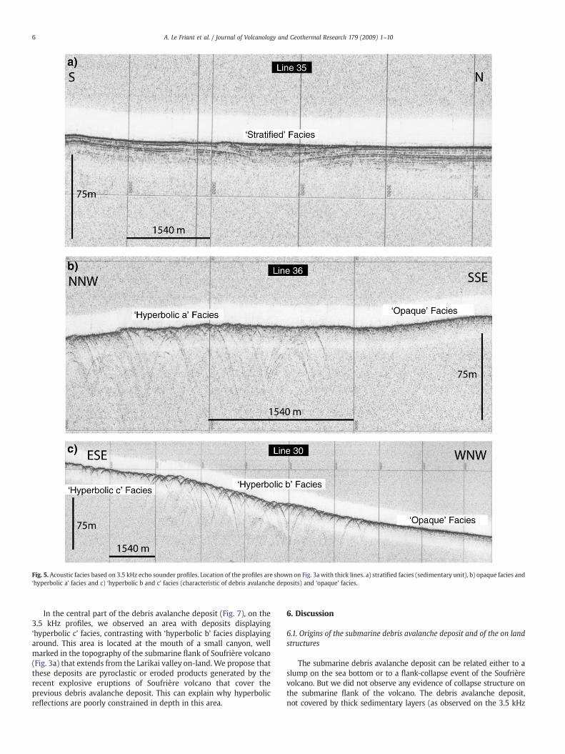
Fig. 5. Acoustic facies based on 3.5 kHz echo sounder profiles. Location of the profiles are shown on Fig. 3a with thick lines. a) stratified facies (sedimentary unit), b) opaque facies and‘hyperbolic a’ facies and c) ‘hyperbolic b and c’ facies (characteristic of debris avalanche deposits) and ‘opaque’ facies.
6 A. Le Friant et al. / Journal of Volcanology and Geothermal Research 179 (2009) 1–10
In the central part of the debris avalanche deposit (Fig. 7), on the3.5 kHz profiles, we observed an area with deposits displaying‘hyperbolic c’ facies, contrasting with ‘hyperbolic b’ facies displayingaround. This area is located at the mouth of a small canyon, wellmarked in the topography of the submarine flank of Soufrière volcano(Fig. 3a) that extends from the Larikai valley on-land. We propose thatthese deposits are pyroclastic or eroded products generated by therecent explosive eruptions of Soufrière volcano that cover theprevious debris avalanche deposit. This can explain why hyperbolicreflections are poorly constrained in depth in this area.
6. Discussion
6.1. Origins of the submarine debris avalanche deposit and of the on landstructures
The submarine debris avalanche deposit can be related either to aslump on the sea bottom or to a flank-collapse event of the Soufrièrevolcano. But we did not observe any evidence of collapse structure onthe submarine flank of the volcano. The debris avalanche deposit,not covered by thick sedimentary layers (as observed on the 3.5 kHz

Fig. 6. Seismic reflection profile 30 crossing the path of the debris avalanche deposit. Location of the profile is shown on Fig. 3a. Debris avalanche deposit is identified by a transparentunit and contrasts with sub-horizontal andwell-bedded sedimentary layers corresponding to normal sedimentation in the Grenada Basin; twt is two-way travel time. The front of thedebris avalanche is defined where the deposit becomes thinner.
7A. Le Friant et al. / Journal of Volcanology and Geothermal Research 179 (2009) 1–10
echosounder and the seismic reflection profiles), has probably arelatively young age and cannot be associated to an older submarinestructure masked by more recent products. If we cannot completelyexclude the existence of a submarine slump, we foundmore argumentsin favour of an on-land flank-collapse event. The submarine deposit islocated in the lengthening of the on-land Baleine structure open to thewest-northwest. Its northern limit could be correlated on-landwith theBaleine scarp, which could be interpreted as the northern rim of an oldflank-collapse structure (Fig. 7). So, we propose that the submarinedebris avalanche could be the result of a flank-collapse of the Soufrièrevolcano. The southern limit of the submarine debris avalanche depositcannot be correlated with any existing scarp on-land. Some volcanicevents and erosion have certainly modified the morphology of thevolcano and we assume that the reconstruction of the Somma hasprobably obscured the southern part of the structure. We observed thatthe coastline between the Baleine scarp and the Larikai River is straight(Figs. 2 and 7). This morphology could correspond to a part of the debrisavalanche which did not flow to the sea or to more recent volcanicdeposits (lava flows and scoria flows observed on-land along thecoastline). This could help to constrain the geometry of the Baleinestructure with a southern scarp probably closed to the Larikai Bay asproposed by Boudon et al. (2007). We named this flank-collapse eventthe ‘Baleine flank-collapse’ and we‘ll use this assumption in the fol-lowing sections of this paper.
The Larikai structure is opened toward the south-southwest. Wedid not recognize any debris avalanche deposits on-land and offshorein the direction of the opening of this structure. With regard to thecircularmorphology of the upper part of the structure, we suggest thatit did not result from a flank-collapse event as proposed by Boudonet al. (2007), but more probably from a vertical collapse associatedwith the draining of a magmatic chamber. The southern rim of thiscaldera is covered by the younger pyroclastic cone of Soufrière. Thescarp on the right part of the Larikai River is the continuation of the
northern rim of the caldera and could just correspond to an erosionalvalley (Fig. 2).
6.2. The Baleine flank-collapse event
6.2.1. Ages and volumesThe age of the Baleine structure is unknown. Briden et al. (1979)
have dated some lava flows from the primitive cone of Soufrière usingthe classic K–Ar method on whole rocks. The more recent age thatthey obtained is 0.31±0.07 Ma. Recently, Samper et al. (2007, 2008)argued that the dates obtained by the classic K–Ar method on wholerocks didn't give correct ages and are generally too old as a lot ofminerals contained in the calc-alkaline rocks have probably crystal-lized in the magma chamber a long time before the eruption. Theyhave dated a lot of lavas from several islands of the Lesser Antilles arc(Guadeloupe, Martinique, Dominica and St. Lucia) by the Cassignol–Gillot K–Ar method, working only on the groundmass of the lavas, andobtained more recent ages, in some cases several hundred thousandyears younger than the ages proposed by Briden et al. (1979).Consequently, we can consider that this age of 0.31±0.07 Ma on thelava flows of the old cone of Soufrière of St. Vincent is probably too oldand can conclude that the maximum age limit for the Baleinestructure is probably younger. Our marine geophysical data puts newconstraints on the age of the event. On seismic reflection profiles and3.5 kHz profiles, we did not observe any sedimentary unit covering thedebris avalanche deposit. The lack of sedimentary cover on thesubmarine debris avalanche suggests the young age of the debrisavalanche and of the flank-collapse event. The thickness of sedimentsthat we could identify on a 3.5 kHz echo sounder profile is about 2 m.Sigurdsson et al. (1980) and Reid et al. (1996) give a range ofsedimentation rates for Lesser Antilles between 4 and 21 cm/ka.Taking into account the low thickness of sediments covering thedebris avalanche deposit (probably b2 m), and using the minimum

Fig. 7. Swath bathymetry collected during the Caraval cruise west of St. Vincent with map of acoustic facies based on 3.5 kHz echo sounder profiles along the ship tracks. Contourinterval is 50 m. The large hyperbolic reflections zone in grey corresponds to the extent of the debris avalanche deposit and relation between on-land structure and debris avalanchedeposit for Soufrière Volcano (St. Vincent) is shown.
8 A. Le Friant et al. / Journal of Volcanology and Geothermal Research 179 (2009) 1–10
sedimentation rate proposed in this area, we can propose that thedebris avalanche emplacement is not older than 50,000 years.
Regarding the morphological constraints on the flank-collapsestructure on land, the missing volume within the structure has beenestimated roughly to ∼10 km3 (Boudon et al., 2007). This volume isthen well correlated with the estimation of the submarine debrisavalanche deposit around 9 km3.
6.2.2. Origin of the Baleine flank-collapse eventFlank-collapses have local causes such as weakening of the flank by
intense hydrothermal alteration and/or magmatic injections, increase ofthe load by accumulation of volcanic products, seismicity and slopedismantling by coastal erosion (Ablay andHürlimann, 2000). Oehler et al.(2004) also suggest that the presence of low strength layers may favourinstabilities of the edifice. TheBaleineflank-collapseeventoccurred to thewest north–western direction. Boudonet al. (2007) observed thatmost oftheflank-collapsesonvolcanoes fromthe southpart of the arc occurred inthe same direction, the debris avalanches flowing into the Caribbean Sea.
Boudon et al. (2007) proposed that flank-collapse of the southern part ofthe arc are mainly related to the structure of the arc showing a markedasymmetry with a well-developed back arc basin, the Grenada Basin, tothewest. Thewesternflankof thevolcano is then steeper than theeasternflank and will be more instable due to overload by volcanic products.
Considering that the debris avalanche emplacement is less than50,000 years old, the flank-collapse could also be related to the sea levelvariations inducedbyclimate change as it occurredduring the last glacialperiod. The rate of temperature decrease was high during the 30–25 to18 ka, associatedwith a rapid sea level lowering from−80mto −140matthe glacial maximum (Bard et al., 1990). Rapid sea level lowering yieldsan important decrease of the hydrostatic pressure at the bottom of thevolcano. If the material is weakly permeable, the pore pressure maybecome larger than the hydrostatic pressure. This effect could decreasethe shear strength favouring flank instability (Hutchinson, 1986).However, the age of the debris avalanche is poorly constrained andshould be improve to clarify this relation between collapse and sea levelvariations.
9A. Le Friant et al. / Journal of Volcanology and Geothermal Research 179 (2009) 1–10
6.3. The volcanic evolution of the Soufrière volcano
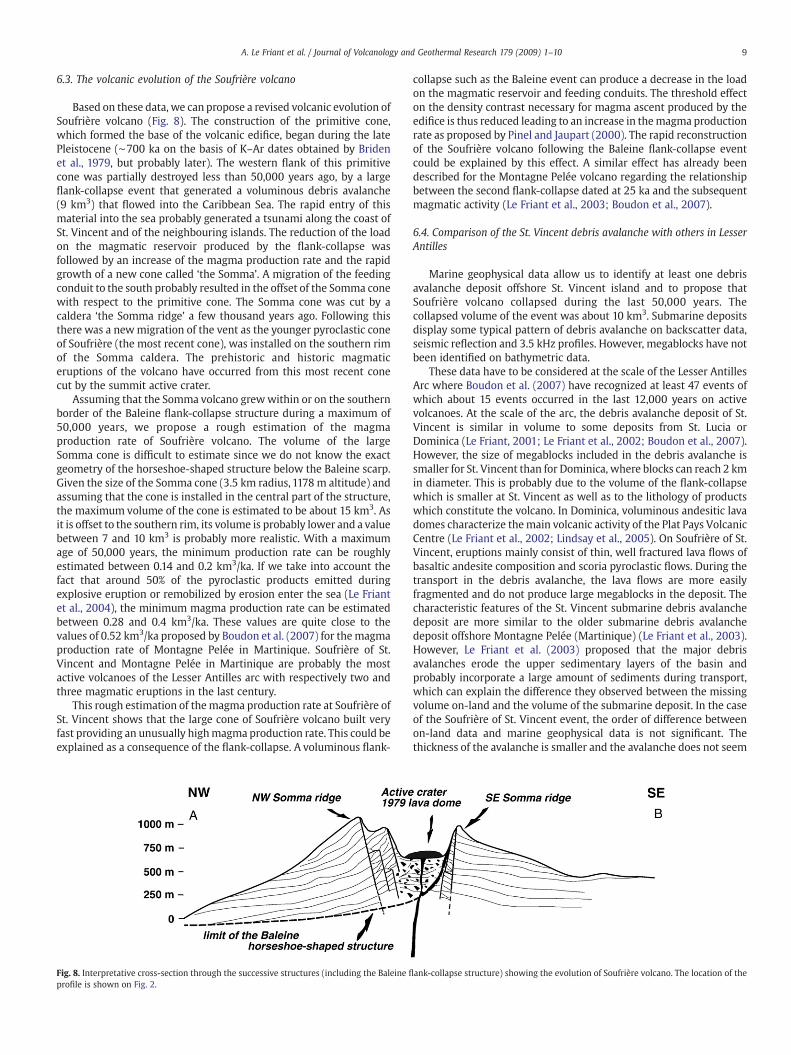
Based on these data, we can propose a revised volcanic evolution ofSoufrière volcano (Fig. 8). The construction of the primitive cone,which formed the base of the volcanic edifice, began during the latePleistocene (∼700 ka on the basis of K–Ar dates obtained by Bridenet al., 1979, but probably later). The western flank of this primitivecone was partially destroyed less than 50,000 years ago, by a largeflank-collapse event that generated a voluminous debris avalanche(9 km3) that flowed into the Caribbean Sea. The rapid entry of thismaterial into the sea probably generated a tsunami along the coast ofSt. Vincent and of the neighbouring islands. The reduction of the loadon the magmatic reservoir produced by the flank-collapse wasfollowed by an increase of the magma production rate and the rapidgrowth of a new cone called ‘the Somma’. A migration of the feedingconduit to the south probably resulted in the offset of the Somma conewith respect to the primitive cone. The Somma cone was cut by acaldera ‘the Somma ridge’ a few thousand years ago. Following thisthere was a newmigration of the vent as the younger pyroclastic coneof Soufrière (the most recent cone), was installed on the southern rimof the Somma caldera. The prehistoric and historic magmaticeruptions of the volcano have occurred from this most recent conecut by the summit active crater.
Assuming that the Somma volcano grewwithin or on the southernborder of the Baleine flank-collapse structure during a maximum of50,000 years, we propose a rough estimation of the magmaproduction rate of Soufrière volcano. The volume of the largeSomma cone is difficult to estimate since we do not know the exactgeometry of the horseshoe-shaped structure below the Baleine scarp.Given the size of the Somma cone (3.5 km radius, 1178 m altitude) andassuming that the cone is installed in the central part of the structure,the maximum volume of the cone is estimated to be about 15 km3. Asit is offset to the southern rim, its volume is probably lower and a valuebetween 7 and 10 km3 is probably more realistic. With a maximumage of 50,000 years, the minimum production rate can be roughlyestimated between 0.14 and 0.2 km3/ka. If we take into account thefact that around 50% of the pyroclastic products emitted duringexplosive eruption or remobilized by erosion enter the sea (Le Friantet al., 2004), the minimum magma production rate can be estimatedbetween 0.28 and 0.4 km3/ka. These values are quite close to thevalues of 0.52 km3/ka proposed by Boudon et al. (2007) for themagmaproduction rate of Montagne Pelée in Martinique. Soufrière of St.Vincent and Montagne Pelée in Martinique are probably the mostactive volcanoes of the Lesser Antilles arc with respectively two andthree magmatic eruptions in the last century.
This rough estimation of themagma production rate at Soufrière ofSt. Vincent shows that the large cone of Soufrière volcano built veryfast providing an unusually highmagma production rate. This could beexplained as a consequence of the flank-collapse. A voluminous flank-
Fig. 8. Interpretative cross-section through the successive structures (including the Baleine fl
profile is shown on Fig. 2.
collapse such as the Baleine event can produce a decrease in the loadon the magmatic reservoir and feeding conduits. The threshold effecton the density contrast necessary for magma ascent produced by theedifice is thus reduced leading to an increase in themagma productionrate as proposed by Pinel and Jaupart (2000). The rapid reconstructionof the Soufrière volcano following the Baleine flank-collapse eventcould be explained by this effect. A similar effect has already beendescribed for the Montagne Pelée volcano regarding the relationshipbetween the second flank-collapse dated at 25 ka and the subsequentmagmatic activity (Le Friant et al., 2003; Boudon et al., 2007).
6.4. Comparison of the St. Vincent debris avalanche with others in LesserAntilles
Marine geophysical data allow us to identify at least one debrisavalanche deposit offshore St. Vincent island and to propose thatSoufrière volcano collapsed during the last 50,000 years. Thecollapsed volume of the event was about 10 km3. Submarine depositsdisplay some typical pattern of debris avalanche on backscatter data,seismic reflection and 3.5 kHz profiles. However, megablocks have notbeen identified on bathymetric data.
These data have to be considered at the scale of the Lesser AntillesArc where Boudon et al. (2007) have recognized at least 47 events ofwhich about 15 events occurred in the last 12,000 years on activevolcanoes. At the scale of the arc, the debris avalanche deposit of St.Vincent is similar in volume to some deposits from St. Lucia orDominica (Le Friant, 2001; Le Friant et al., 2002; Boudon et al., 2007).However, the size of megablocks included in the debris avalanche issmaller for St. Vincent than for Dominica, where blocks can reach 2 kmin diameter. This is probably due to the volume of the flank-collapsewhich is smaller at St. Vincent as well as to the lithology of productswhich constitute the volcano. In Dominica, voluminous andesitic lavadomes characterize themain volcanic activity of the Plat Pays VolcanicCentre (Le Friant et al., 2002; Lindsay et al., 2005). On Soufrière of St.Vincent, eruptions mainly consist of thin, well fractured lava flows ofbasaltic andesite composition and scoria pyroclastic flows. During thetransport in the debris avalanche, the lava flows are more easilyfragmented and do not produce large megablocks in the deposit. Thecharacteristic features of the St. Vincent submarine debris avalanchedeposit are more similar to the older submarine debris avalanchedeposit offshore Montagne Pelée (Martinique) (Le Friant et al., 2003).However, Le Friant et al. (2003) proposed that the major debrisavalanches erode the upper sedimentary layers of the basin andprobably incorporate a large amount of sediments during transport,which can explain the difference they observed between the missingvolume on-land and the volume of the submarine deposit. In the caseof the Soufrière of St. Vincent event, the order of difference betweenon-land data and marine geophysical data is not significant. Thethickness of the avalanche is smaller and the avalanche does not seem
ank-collapse structure) showing the evolution of Soufrière volcano. The location of the

10 A. Le Friant et al. / Journal of Volcanology and Geothermal Research 179 (2009) 1–10
to have a strong erosive character in this area. This is probably due tothe nature and the volume of the avalanche which is considerablysmaller (9 km3 for St. Vincent, several tens of km3 for Martinique, LeFriant et al., 2003).
7. Conclusion: risk of a future flank-collapse event in St. Vincent?
During its evolution, the Soufrière volcano in St. Vincent hasknown at least one flank-collapse event that occurred less than50,000 years ago (volume about ∼10 km3). It is likely that in the pastother flank-collapse events occurred on the primitive volcano.However, neither the geophysical data nor the on-land morphologyallows this to be assessed. The rapid growth of the Somma cone insideand on the southern border of the Baleine horseshoe-shaped structureincreases progressively the load on weak areas represented by thefloor and the rims of the structure. They are probably areas of fluidscirculation (meteorical water and possibly hot fluids) and inconsequence areas of progressive alteration. The main characteristicof the volcanoes of the southern part of the arc (Montagne Pelée inMartinique, Plat Pays Volcanic Centre in Dominica, Soufrière in St.Vincent, Kick’ em Jenny in Grenada) is the presence of a voluminouscone inside horseshoe-shaped structures. Consequently, the impor-tant discontinuities in the volcanic edifice progressively increase theoccurrence of a new flank-collapse event. A future flank-collapse eventon St. Vincent could have catastrophic consequences on land, becauseof the debris avalanche and could generate a tsunami if the debrisavalanche enters the sea. All the coastal areas of St. Vincent as well asthat of neighbouring islands (such as St. Lucia, Barbados and Grenada)would be threatened by such a tsunami.
Acknowledgements
We thank the captains, officers and crew of the Ifremer’s R.V. L'A-talante and the Caraval scientific team for their efficient work at sea.We thank G. Wadge and B. vanWyk de Vries for their careful reviews.This study was supported by the CNRS. IPGP contribution 2430.
References
Ablay, G., Hürlimann, M., 2000. Evolution of the north flank of Tenerife by recurrentgiant landslides. J. Volcanol. Geotherm. Res. 103, 135–159.
Aspinall, W.P., Sigurdsson, H., Shepherd, J.B., 1973. Eruption of the Soufrière Volcano onSt Vincent Island, 1971–1972. Science 181, 117–124.
Bard, E., Hamelin, B., Fairbanks, R.G., 1990. U–Th ages obtained by mass spectrometry incorals from Barbados: sea level during the past 130000 years. Nature 346, 391–456.
Boudon, G., Le Friant, A., Komorowski, J.-C., Deplus, C., Semet, M.P., 2007. Volcano flankinstabilities in the Lesser Antilles arc: diversity of scales, processes and temporalrecurrence. J. Geophys. Res. 112 (B08205). doi:10.1029/2006JB004674.
Bouysse, P., Guennoc, P., 1983. Données sur la structure de l'arc insulaire des petitesAntilles, entre Ste-Lucie et Anguilla. Mar. Geol. 81, 261–287.
Bouysse, P., Westercamp, D., Andreieff, P., 1990. The Lesser Antilles Island Arc. Proc.Ocean Drill. Prog., Sci. Results 110, 29–44.
Briden, J.C., Rex, D.C., Faller, A.M., Tomblin, J.F., 1979. K–Ar geochronology andpaleomagnetism of volcanic rocks in the Lesser Antilles island arc. Philos. Trans. R.Soc. Lond. 291, 485–528.
Cohen, J.K., Stockwell, J.J.W., 1996. CWP/SU: Seismic Unix release 28: a Free Package forSeismic Research and Processing, Golden, Center for Wave Phenomena. ColoradoSchool of Mines. 39 pp.
Collot, J.Y., Lewis, K., Lamarche, G., Lallemand, S., 2001. The giant Ruatoria debrisavalanche on the Northern Hikurangi Margin, New Zealand : result of obliqueseamount subduction. J. Geophys. Res. 106 (B9), 19271–19297.
Deplus, C., Le Friant, A., Boudon, G., Komorowski, J.-C., Villemant, B., Harford, C., Ségoufin,J., Cheminée, J.-L., 2001. Submarine evidence for large-scale debris avalanches in theLesser Antilles Arc. Earth Planet. Sci. Lett. 192 (2), 333–354.
Heath, E.,Macdonald, R., Belkin, H., Hawkesworth, C., Sigurdsson,H.,1998a.Magmagenesisat Soufrière Volcano, St. Vincent, Lesser Antilles Arc. J. Petrol. 39 (10), 1721–1764.
Heath, E., Turner, S.P., Macdonald, R., Hawkesworth, C.J., van Calsteren, P., 1998b. Longmagma residence times at an island Arc volcano (Soufrière, St. Vincent) in theLesser Antilles: evidence from U-238-Th-230 Isochron Dating. Earth Planet. Sci.Lett. 160 (1-2), 49–63.
Hutchinson, J.N.,1986.A sliding-consolidationmodel forflowslides. Can.Geol. J. 23,115–126.Krastel, S., Schmincke, H.U., Jacobs, C.L., Rihm, R., Le Bas, T.M., Alibès, B., 2001. Submarine
landslides around the Canary Islands. J. Geophys. Res. 106 (B3), 3977–3997.Le Friant, A., 2001. Les déstabilisations de flanc des volcans de l’arc des Petites Antilles:
origines et conséquences. University thesis, University of Paris 7, Paris, France. 378 pp.Le Friant, A., Boudon, G., Komorowski, J.-C., Deplus, C., 2002. L'île de la Dominique, à
l'origine des avalanches de débris les plus volumineuses de l'arc des Petites Antilles.C. R. Géosciences 334 (4), 235–243.
Le Friant, A., Boudon, G., Deplus, C., Villemant, B., 2003. Large scale flank collapse eventsduring the activity of Montagne Pelée, Martinique, Lesser Antilles. J. Geophys. Res.108 (B1), 2055. doi:10.1029/2001JB001624.
Le Friant, A., Harford, C.L., Deplus, C., Boudon, G., Sparks, R.S.J., Herd, R.A., Komorowski,J.-C., 2004. Geomorphological evolution of Montserrat (West Indies): importance offlank collapse and erosional processes. London Geol. Soc. 161, 147–160.
Lipman, P.W., Normark, W.R., Moore, J.G., Wilson, J.B., Gutmacher, E., 1988. The giantsubmarine Alika debris slide, Mauna Loa, Hawaii. J. Geophys. Res. 93, 4279–4299.
Lindsay, J.M., Smith, A.L., Roobol, J.M., Stasiuk, M.V., 2005. Dominica. In: Lindsay, J.M.,Robertson, R.E.A., Shepherd, J.B., Ali, S. (Eds.), Volcanic Atlas of the Lesser Antilles.University of the West Indies. Seismic Research Unit, Trinidad, pp. 1–47.
Martin-Kaye, P.H.A., 1969. A summary of the geology of the Lesser Antilles, Overseas.Geol. Miner. Res. 10 (2), 172–206.
McGuire, W.J., 1996. Volcano instability: a review of contemporary themes. In: McGuire,W.J., et al. (Ed.), Volcano Instability on the Earth and Other Planets. Geol. Soc. Spec.Publ., vol. 110, pp. 1–23.
Moore, J.G., Clague, D.A., Holcomb, R.T., Lipman, P.W., Normark, W.R., Torresan, M.E., 1989.Prodigious submarine landslides on the Hawaiian ridge. J. Geophys. Res. 94 (B12),17465–17484.
Oehler, J.F., Labazuy, P., Lénat, J.F., 2004. Recurrence of major flank landslides during thelast 2 Ma-history of Reunion Island. Bull. Volcanol. 66, 585–598.
Pinel, V., Jaupart, C., 2000. The effect of edifice load onmagma ascent beneath a volcano,Philos. Trans. R. Soc. Lond. Ser. 358 (A), 1515–1532.
Pratson, L.F., Laine, E.P., 1989. The relative importance of gravity-induced versuscurrent-controlled sedimentation during the Quaternary along the mideast U.S.outer continental margin revealed by 3.5 kHz echo character. Mar. Geol. 89, 87–126.
Reid, R.P., Carey, S.N., Ross, D.R., 1996. Late Quaternary sedimentation in the LesserAntilles island arc. Geol. Soc. Amer. Bull. 108, 78–100.
Robertson, R.E.A., 1992. Volcanic hazard and risk assessment of the Soufrière Volcano,St. Vincent, West Indies. MPhil Thesis, The University of Leeds, UK.
Robertson, R.E.A., 2003. The volcanic geology of the pre-Soufrière Rocks of the St.Vincent, West Indies. PhD Thesis, University of the West Indies, Trinidad.
Robertson, R.E.A., 2005. St. Vincent. In: Lindsay, J.M., Robertson, R.E.A., Shepherd, J.B.,Ali, S. (Eds.), Volcanic Atlas of the Lesser Antilles. University of the West Indies,Seismic Research Unit, Trinidad, pp. 240–261.
Robson, G.R., 1965. The Volcanic History of the Soufrière of St. Vincent. InternationalReport. Seismic Research Unit, St. Augustine, Trinidad.
Roobol, M.J., Wright, J.V., Smith, A.L., 1983. Calderas or gravoty-slide structures in theLesser Antilles arc? J. Volcanol. Geotherm. Res. 19, 121–134.
Rowley, K., 1978. Stratigraphic and geochemical studies of Soufrière Volcano, St.Vincent, West Indies. PHD Thesis, University of West Indies.
Samper, A., Quidelleur, X., Mollex, D., Lahitte, P., 2007. Timing of effusive volcanismwhithin the whole Basse Terre Island (Guadeloupe, F.W.I.) from new K–ArCassignol–Gillot Ages. Earth Planet. Sci. Lett. 258, 175–191.
Samper, A., Quidelleur, X., Boudon, G., Le Friant, A., Komorowski, J.-C., 2008. Radiometricdating of three large volume flank-collapses in the Lesser Antilles Arc. J. Volcanol.Geortherm. Res. doi:10.1016/j.jvolgeores.2008.02.028.
Siebert, L., 1984. Large volcanic debris avalanches: characteristics of source areas,deposits, and associated eruptions. J. Volcanol. Geotherm. Res. 22, 163–197.
Sigurdsson, 1981. Geological Observations in the Crater of Soufrière Volcano, St Vincent.Internal Report, Seismic Research Unit, St. Augustine, Trinidad.
Sigurdsson, H., Sparks, R.J.S., Carey, S.N., Huang, T.C., 1980. Volcanogenic sedimentationin the Lesser Antilles arc. J. Geology 88, 523–540.
Smith, W.H.F., Sandwell, D.T., 1997. Global sea floor topography from satellite altimetryand ship depth soundings. Science 227, 1956–1962.
Ui, T., Takarada, S., Yoshimoto, M., 2000. Debris avalanches. In: Sigurdsson, H., Houghton,B.F. (Eds.), Encyclopedia of Volcanoes. Academic Press, San Diego.
Urgeles, R., Canals, M., Baraza, J., Alonso, B., Masson, D., 1997. The most recentmegalandslides of the Canary Islands: El Golfo debris avalanche and Canary debrisflow, west El Hierro Island. J. Geophys. Res. 102 (B9), 20305–20323.
Urgeles, R., Masson, D.G., Canals, M., Watts, A.B., Le Bas, T., 1999. Recurrent large-scalelandsliding on the west flank of La Palma, Canary Islands. J. Geophys. Res. 104 (B1),25331–25348.
Watts, A.B., Masson, D.G., 1995. A giant landslide on the north flank of Tenerife, CanaryIslands. J. Geophys. Res. 100 (B12), 24487–24498.