The representation of the West Indies in the early Iberian cartography (ppt)
35
Society for the History of Discoveries 54th Annual Meeting October 31 - November 3, 2013 Tampa, Florida THE REPRESENTATION OF THE WEST INDIES IN THE EARLY IBERIAN CARTOGRAPHY A CARTOMETRIC APPROACH Joaquim Alves Gaspar [email protected] Amazona leucocephala
Transcript of The representation of the West Indies in the early Iberian cartography (ppt)

S o c i e t y f o r t h e H i s t o r y
o f D i s c o v e r i e s
5 4 t h A n n u a l M e e t i n g
O c t o b e r 3 1 - N o v e m b e r 3 ,
2 0 1 3
T a m p a , F l o r i d a
THE REPRESENTATION OF THE
WEST INDIES IN THE EARLY
IBERIAN CARTOGRAPHY
A CARTOMETRIC APPROACH
J o a q u i m A l v e s G a s p a r
a l v e s g a s p a r @ n e t c a b o . p t
Amazona leucocephala

JUAN DE LA COSA, 1500
Juan de la Cosa, 1500. Museo Naval, Madrid 2

Piri Reis, 1513. Topkapi Palace-Museum, Istanbul
J o a q u i m A l v e s G a s p a r
a l v e s g a s p a r @ n e t c a b o . p t
3
S o c i e t y f o r t h e H i s t o r y
o f D i s c o v e r i e s
5 4 t h A n n u a l M e e t i n g
O c t o b e r 3 1 - N o v e m b e r 3 ,
2 0 1 3
T a m p a , F l o r i d a
PIRI REIS, 1513

Piri Reis, 1513. Topkapi Palace-Museum, Istanbul
J o a q u i m A l v e s G a s p a r
a l v e s g a s p a r @ n e t c a b o . p t
4
S o c i e t y f o r t h e H i s t o r y
o f D i s c o v e r i e s
5 4 t h A n n u a l M e e t i n g
O c t o b e r 3 1 - N o v e m b e r 3 ,
2 0 1 3
T a m p a , F l o r i d a

Piri Reis, 1513. Topkapi Palace-Museum, Istanbul
Juan de la Cosa, 1500. Museo Naval, Madrid
PIRI REIS & JUAN DE LA COSA
5
Hispaniola
Puerto Rico
Lesser Antilles
Cuba
Cuba
Hispaniola
Puerto Rico
Lesser Antilles

Piri Reis, 1513. Topkapi Palace-Museum, Istanbul
J o a q u i m A l v e s G a s p a r
a l v e s g a s p a r @ n e t c a b o . p t
6
S o c i e t y f o r t h e H i s t o r y
o f D i s c o v e r i e s
5 4 t h A n n u a l M e e t i n g
O c t o b e r 3 1 - N o v e m b e r 3 ,
2 0 1 3
T a m p a , F l o r i d a

7
S o c i e t y f o r t h e H i s t o r y
o f D i s c o v e r i e s
5 4 t h A n n u a l M e e t i n g
O c t o b e r 3 1 - N o v e m b e r 3 ,
2 0 1 3
T a m p a , F l o r i d a
J o a q u i m A l v e s G a s p a r
a l v e s g a s p a r @ n e t c a b o . p t

THE ARRIVAL OF COLUMBUS TO ASIA
Martellus (Yale), c. 1489
Piri Reis, 1513
Martin Behaim, c. 1492 (facsimile)
Catay
Cipango
Catay ?
Cipango ?
Catay
Cipango
8

Piri Reis, 1513. Topkapi Palace-Museum, Istanbul
J o a q u i m A l v e s G a s p a r
a l v e s g a s p a r @ n e t c a b o . p t
9
S o c i e t y f o r t h e H i s t o r y
o f D i s c o v e r i e s
5 4 t h A n n u a l M e e t i n g
O c t o b e r 3 1 - N o v e m b e r 3 ,
2 0 1 3
T a m p a , F l o r i d a

CANTINO PLANISPHERE, 1502
J o a q u i m A l v e s G a s p a r
a l v e s g a s p a r @ n e t c a b o . p t
10
S o c i e t y f o r t h e H i s t o r y
o f D i s c o v e r i e s
5 4 t h A n n u a l M e e t i n g
O c t o b e r 3 1 - N o v e m b e r 3 ,
2 0 1 3
T a m p a , F l o r i d a

COLUMBUS (c. 1496)
versus JUAN DE LA COSA (1500)
Cuba
Hispaniola Cuba
Hispaniola
11
Piri Reis, 1513 [c. 1496]

CAVERIO PLANISPHERE, c. 1504
J o a q u i m A l v e s G a s p a r
a l v e s g a s p a r @ n e t c a b o . p t
12 Nicolay de Caverio (c. 1504). Bibliothèque nationale de France, Paris
S o c i e t y f o r t h e H i s t o r y
o f D i s c o v e r i e s
5 4 t h A n n u a l M e e t i n g
O c t o b e r 3 1 - N o v e m b e r 3 ,
2 0 1 3
T a m p a , F l o r i d a

13
Martin Waldseemuller (1507). Library of Congress, Washington Martin Waldseemuller (1516). Library of Congress, Washington
Johannes Ruysch (1507-08)

S o c i e t y f o r t h e H i s t o r y
o f D i s c o v e r i e s
5 4 t h A n n u a l M e e t i n g
O c t o b e r 3 1 - N o v e m b e r 3 ,
2 0 1 3
T a m p a , F l o r i d a
CARTOGRAPHIC ACCURACY
AND EVOLUTION
J o a q u i m A l v e s G a s p a r
a l v e s g a s p a r @ n e t c a b o . p t

JUAN DE LA COSA, 1500
Juan de la Cosa, 1500. Museo Naval, Madrid 15
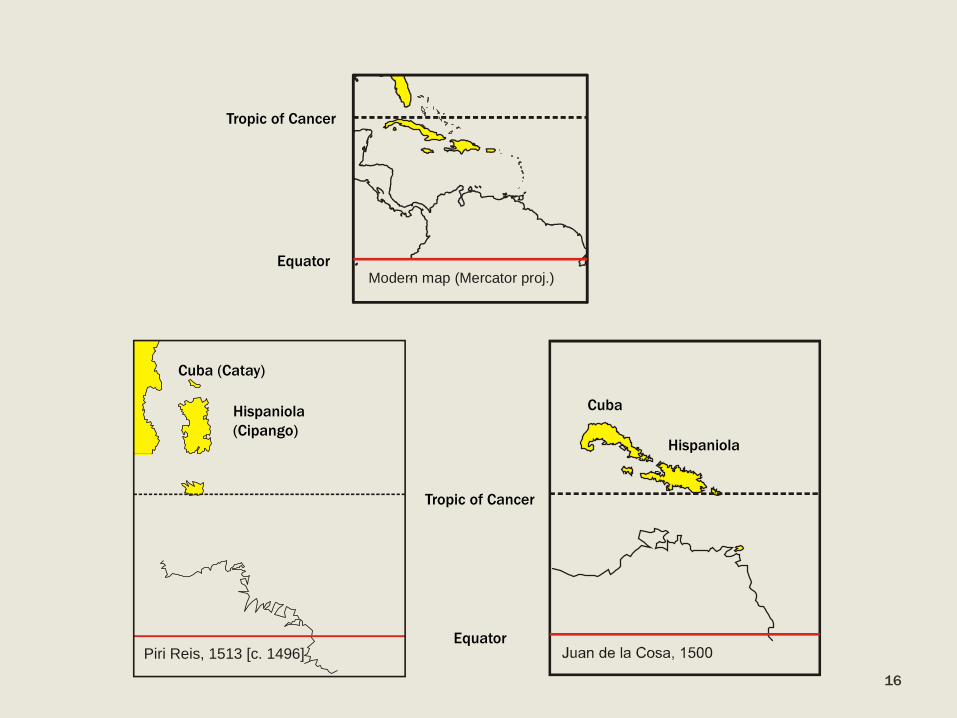
Modern map (Mercator proj.)
Cuba (Catay)
Hispaniola
(Cipango)
Cuba
Hispaniola
Equator
Tropic of Cancer
Tropic of Cancer
Equator
16
Piri Reis, 1513 [c. 1496]

Freducci > 1513
Florida
Anonymous Spanish, 1518 Atlas Miller, c. 1519
17
Cavério, c. 1504
Catay
Cantino, 1502
Catay
Cuba Hispaniola Cuba
Hispaniola
Jorge Reinel, c. 1519 [Kunstmann IV] Anonymous (Turim), 1523 D. Ribeiro, 1525
Cuba
Hispaniola
Cuba
Hispaniola
King-Hamy, c. 1504

Freducci > 1513
Florida
Anonymous Spanish, 1518 Atlas Miller, c. 1519
18
Cavério, c. 1504
Catay
Cantino, 1502
Catay
Cuba Hispaniola Cuba
Hispaniola
Hamy-King, c. 1504
Jorge Reinel, c. 1519 [Kunstmann IV] Anonymous (Turim), 1523 D. Ribeiro, 1525
Cuba
Hispaniola
Cuba
Hispaniola
Cuba

KUNSTMANN IV, c. 1519
Anonymous [Jorge and Pedro Reinel?]. Facsimile (Otto Progel, 1843). Bibliothèque nationale de France 19

Freducci > 1513
Florida
Anonymous Spanish, 1518 Atlas Miller, c. 1519
20
Cavério, c. 1504
Catay
Cantino, 1502
Catay
Cuba Hispaniola Cuba
Hispaniola
Hamy-King, c. 1504
Jorge Reinel, c. 1519 [Kunstmann IV] Anonymous (Turim), 1523 D. Ribeiro, 1525
Cuba
Hispaniola
Cuba
Hispaniola
Cuba

Cuba
Hispaniola
Trinidad
Jamaica Puerto Rico
21
Latitude accuracy
J o a q u i m A l v e s G a s p a r
a l v e s g a s p a r @ n e t c a b o . p t
S o c i e t y f o r t h e H i s t o r y
o f D i s c o v e r i e s
5 4 t h A n n u a l M e e t i n g
O c t o b e r 3 1 - N o v e m b e r 3 ,
2 0 1 3
T a m p a , F l o r i d a

22
-8
-6
-4
-2
0
2
4
6
8
10
12
14
16
10 12 14 16 18 20 22 24
Juan de la Cosa (1500)
C. Maisi
-8
-6
-4
-2
0
2
4
6
8
10
12
14
16
10 12 14 16 18 20 22 24
Cantino (1502)

-8
-6
-4
-2
0
2
4
6
8
10
12
14
16
10 12 14 16 18 20 22 24
Caverio (c. 1504)
-8
-6
-4
-2
0
2
4
6
8
10
12
14
16
10 12 14 16 18 20 22 24
King - Hamy (c. 1504)
23
Cuba
Hispaniola
Cathay
Cuba
Hispaniola

-8
-6
-4
-2
0
2
4
6
8
10
12
14
16
10 12 14 16 18 20 22 24
Maggiolo (c. 1504)
-8
-6
-4
-2
0
2
4
6
8
10
12
14
16
10 12 14 16 18 20 22 24
Anonymous (1518)
24
Florida
Cuba
Hispaniola
Cuba
Hispaniola
10º

-8
-6
-4
-2
0
2
4
6
8
10
12
14
16
10 12 14 16 18 20 22 24
Anonymous Turin (1523)
25
Florida
Cuba
Hispaniola

26
Anonymous [Diogo Ribeiro], 1525. Biblioteca Estense Universitaria, Modena
Anonymous [Nuño Garcia de Toreno?], 1525. Biblioteca Laurenziana, Firenze
Castiglioni Planisphere
Salviati Planisphere

-8
-6
-4
-2
0
2
4
6
8
10
12
14
16
10 12 14 16 18 20 22 24
D. Ribeiro (1525) [Castiglioni]
-8
-6
-4
-2
0
2
4
6
8
10
12
14
16
10 12 14 16 18 20 22 24
Nuño García de Toreno? (1525)
[Salviati]
27

CASA DE CONTRATACIÓN
AND PADRÓN REAL
S o c i e t y f o r t h e H i s t o r y
o f D i s c o v e r i e s
5 4 t h A n n u a l M e e t i n g
O c t o b e r 3 1 - N o v e m b e r 3 ,
2 0 1 3
T a m p a , F l o r i d a
J o a q u i m A l v e s G a s p a r
a l v e s g a s p a r @ n e t c a b o . p t

29
DIOGO RIBEIRO, 1525
Anonymous [Diogo Ribeiro], 1525. Biblioteca Estense Universitaria, Modena

30
Quadrant
Astrolabe
Astronomical
circle

31
WHY SO BIG? S o c i e t y f o r t h e H i s t o r y
o f D i s c o v e r i e s
5 4 t h A n n u a l M e e t i n g
O c t o b e r 3 1 - N o v e m b e r 3 ,
2 0 1 3
T a m p a , F l o r i d a
J o a q u i m A l v e s G a s p a r
a l v e s g a s p a r @ n e t c a b o . p t

Two conflicting geographical models affect the
cartography of the Caribbean Sea in the beginning of
the sixteenth century:
One derived from the navigational practice and
materialized in Juan de la Cosa’s planisphere;
And the other from Columbus conviction of having
reached the Indies
32
CONCLUSIONS (I)

During the first quarter of the sixteenth century the
cartography of the Caribbean Sea was of the
portolan-chart type, reflecting the navigational
methods practiced by the Spanish pilots.
The earliest extant latitude charts of the region are
the planispheres of Salviati and Castiglioni, of 1525.
33
CONCLUSIONS (II)

The cartographic production of the Casa de
Contratación, who appeared to have remained
marginal for a considerable time after its creation,
went through a remarkable qualitative and
quantitative improvement, from about 1518 on.
That was triggered by the preparation of Magellan’s
mission and made possible by the technological
assistance of Portuguese pilots and cartographers.
34
CONCLUSIONS (III)

S o c i e t y f o r t h e H i s t o r y
o f D i s c o v e r i e s
5 4 t h A n n u a l M e e t i n g
O c t o b e r 3 1 - N o v e m b e r 3 ,
2 0 1 3
T a m p a , F l o r i d a
THE REPRESENTATION OF THE
WEST INDIES IN THE EARLY
IBERIAN CARTOGRAPHY
A CARTOMETRIC APPROACH
J o a q u i m A l v e s G a s p a r
a l v e s g a s p a r @ n e t c a b o . p t