RFQ-600-19-19-Professional-Architectural-and-Engineering ...
Upload
khangminh22Category
view
0download
0
Task developed by John Mirosevich, Presbyterian Ladies' College, Perth. 2019
1
STATE
DA VINCI DECATHLON 2019 CELEBRATING THE ACADEMIC GIFTS OF STUDENTS
IN YEARS 7 & 8.
CARTOGRAPHY SOLUTIONS
1 2 3 4 Total
/10 /6 /7 /14 /37
Task developed by John Mirosevich, Presbyterian Ladies' College, Perth. 2019
2
LANDSCAPES
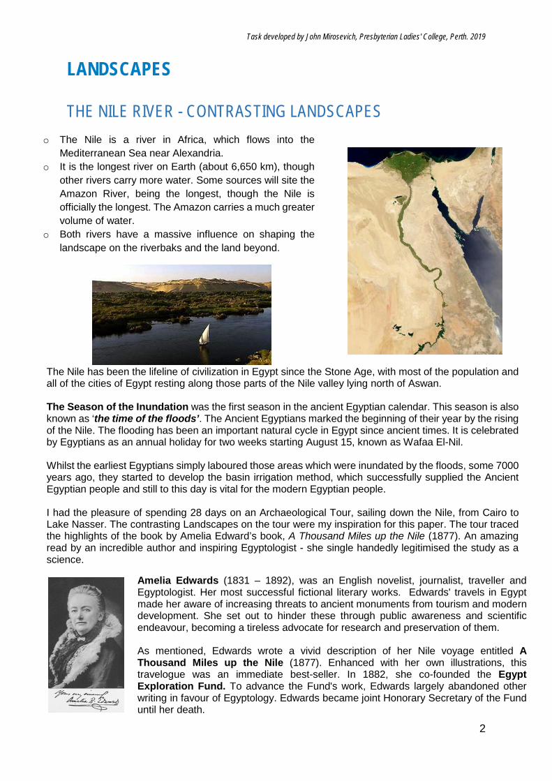
THE NILE RIVER - CONTRASTING LANDSCAPES
o The Nile is a river in Africa, which flows into the Mediterranean Sea near Alexandria.
o It is the longest river on Earth (about 6,650 km), though other rivers carry more water. Some sources will site the Amazon River, being the longest, though the Nile is officially the longest. The Amazon carries a much greater volume of water.
o Both rivers have a massive influence on shaping the landscape on the riverbaks and the land beyond.
The Nile has been the lifeline of civilization in Egypt since the Stone Age, with most of the population and all of the cities of Egypt resting along those parts of the Nile valley lying north of Aswan. The Season of the Inundation was the first season in the ancient Egyptian calendar. This season is also known as ‘the time of the floods’. The Ancient Egyptians marked the beginning of their year by the rising of the Nile. The flooding has been an important natural cycle in Egypt since ancient times. It is celebrated by Egyptians as an annual holiday for two weeks starting August 15, known as Wafaa El-Nil. Whilst the earliest Egyptians simply laboured those areas which were inundated by the floods, some 7000 years ago, they started to develop the basin irrigation method, which successfully supplied the Ancient Egyptian people and still to this day is vital for the modern Egyptian people. I had the pleasure of spending 28 days on an Archaeological Tour, sailing down the Nile, from Cairo to Lake Nasser. The contrasting Landscapes on the tour were my inspiration for this paper. The tour traced the highlights of the book by Amelia Edward’s book, A Thousand Miles up the Nile (1877). An amazing read by an incredible author and inspiring Egyptologist - she single handedly legitimised the study as a science.
Amelia Edwards (1831 – 1892), was an English novelist, journalist, traveller and Egyptologist. Her most successful fictional literary works. Edwards' travels in Egypt made her aware of increasing threats to ancient monuments from tourism and modern development. She set out to hinder these through public awareness and scientific endeavour, becoming a tireless advocate for research and preservation of them. As mentioned, Edwards wrote a vivid description of her Nile voyage entitled A Thousand Miles up the Nile (1877). Enhanced with her own illustrations, this travelogue was an immediate best-seller. In 1882, she co-founded the Egypt Exploration Fund. To advance the Fund's work, Edwards largely abandoned other writing in favour of Egyptology. Edwards became joint Honorary Secretary of the Fund until her death.
Task developed by John Mirosevich, Presbyterian Ladies' College, Perth. 2019
3
Edwards bequeathed her collection of Egyptian antiquities and her library to University College London, together with a sum of £2,500 to found an Edwards Chair of Egyptology, which still stands to this day.
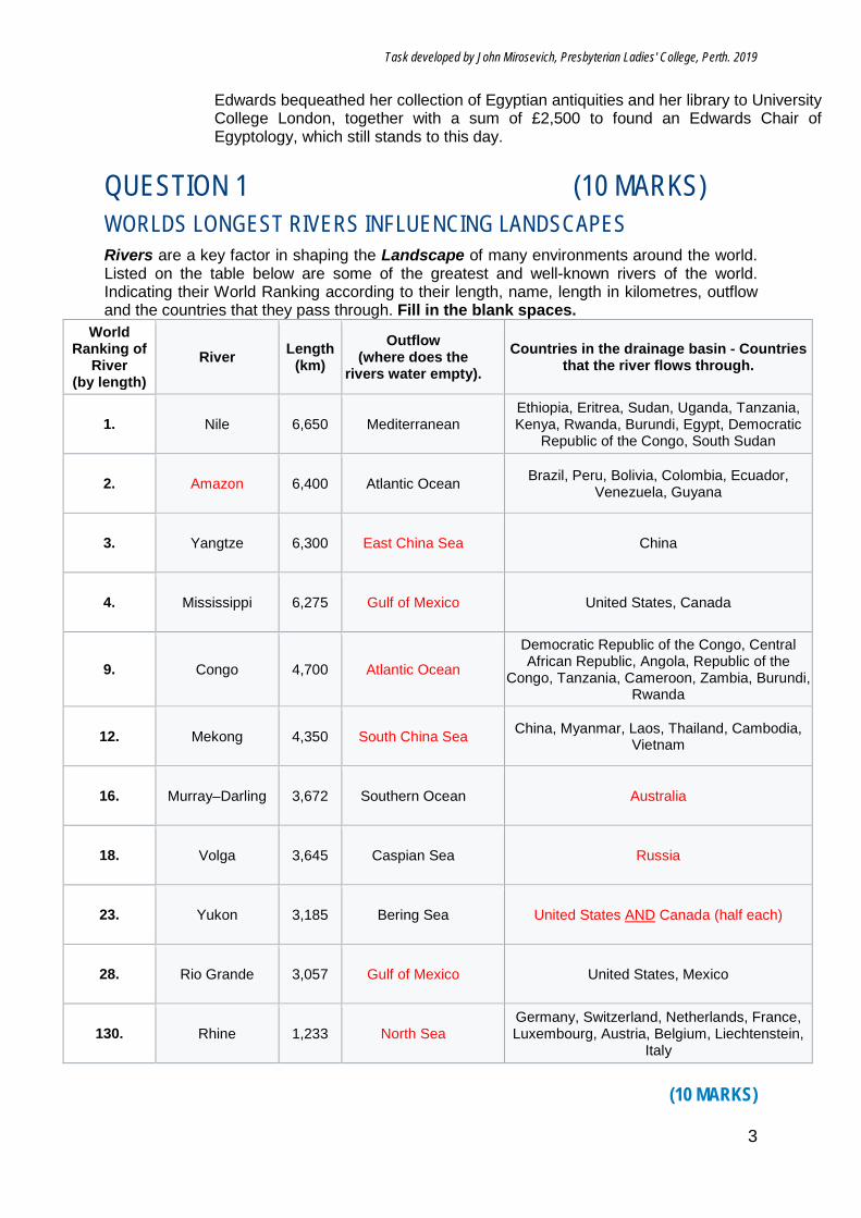
QUESTION 1 (10 MARKS) WORLDS LONGEST RIVERS INFLUENCING LANDSCAPES Rivers are a key factor in shaping the Landscape of many environments around the world. Listed on the table below are some of the greatest and well-known rivers of the world. Indicating their World Ranking according to their length, name, length in kilometres, outflow and the countries that they pass through. Fill in the blank spaces.
World Ranking of
River (by length)
River Length (km)
Outflow (where does the
rivers water empty). Countries in the drainage basin - Countries
that the river flows through.
1. Nile 6,650 Mediterranean Ethiopia, Eritrea, Sudan, Uganda, Tanzania, Kenya, Rwanda, Burundi, Egypt, Democratic
Republic of the Congo, South Sudan
2. Amazon 6,400 Atlantic Ocean Brazil, Peru, Bolivia, Colombia, Ecuador, Venezuela, Guyana
3. Yangtze 6,300 East China Sea China
4. Mississippi 6,275 Gulf of Mexico United States, Canada
9. Congo 4,700 Atlantic Ocean
Democratic Republic of the Congo, Central African Republic, Angola, Republic of the
Congo, Tanzania, Cameroon, Zambia, Burundi, Rwanda
12. Mekong 4,350 South China Sea China, Myanmar, Laos, Thailand, Cambodia, Vietnam
16. Murray–Darling 3,672 Southern Ocean Australia
18. Volga 3,645 Caspian Sea Russia
23. Yukon 3,185 Bering Sea United States AND Canada (half each)
28. Rio Grande 3,057 Gulf of Mexico United States, Mexico
130. Rhine 1,233 North Sea Germany, Switzerland, Netherlands, France, Luxembourg, Austria, Belgium, Liechtenstein,
Italy
(10 MARKS)
Task developed by John Mirosevich, Presbyterian Ladies' College, Perth. 2019
4
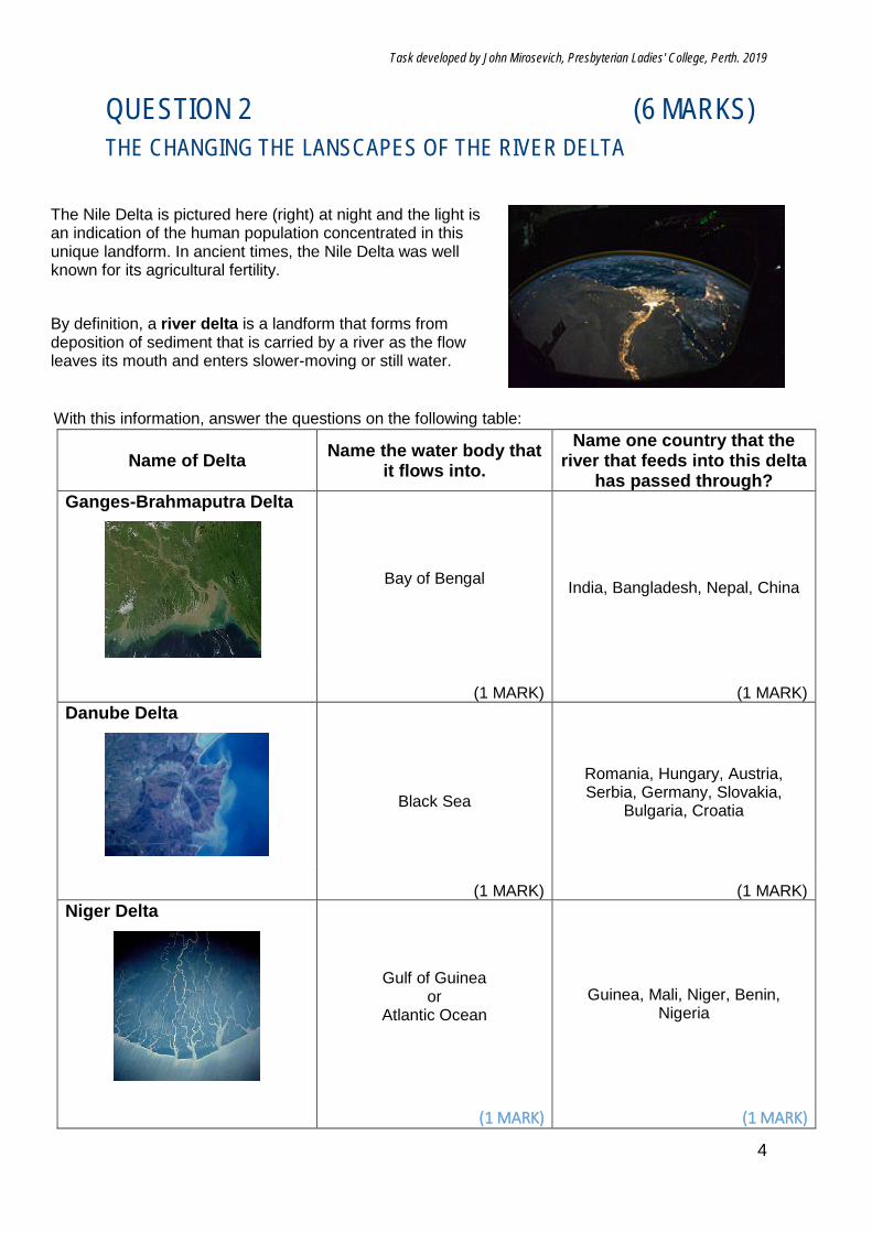
QUESTION 2 (6 MARKS) THE CHANGING THE LANSCAPES OF THE RIVER DELTA
The Nile Delta is pictured here (right) at night and the light is an indication of the human population concentrated in this unique landform. In ancient times, the Nile Delta was well known for its agricultural fertility.
By definition, a river delta is a landform that forms from deposition of sediment that is carried by a river as the flow leaves its mouth and enters slower-moving or still water.
With this information, answer the questions on the following table:
Name of Delta Name the water body that it flows into.
Name one country that the river that feeds into this delta
has passed through? Ganges-Brahmaputra Delta
Bay of Bengal India, Bangladesh, Nepal, China
(1 MARK) (1 MARK)
Danube Delta
Black Sea
Romania, Hungary, Austria, Serbia, Germany, Slovakia,
Bulgaria, Croatia
(1 MARK) (1 MARK)
Niger Delta
Gulf of Guinea or
Atlantic Ocean Guinea, Mali, Niger, Benin,
Nigeria
(1 MARK) (1 MARK)
Task developed by John Mirosevich, Presbyterian Ladies' College, Perth. 2019
5
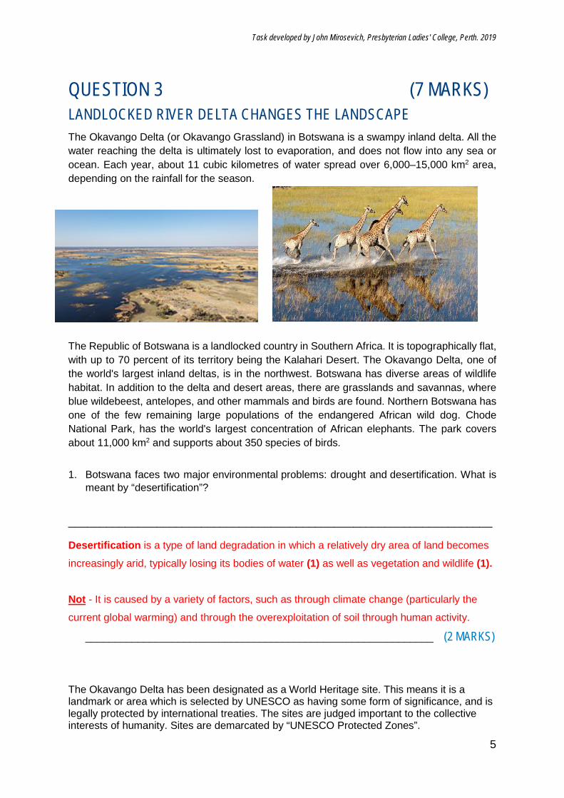
QUESTION 3 (7 MARKS) LANDLOCKED RIVER DELTA CHANGES THE LANDSCAPE
The Okavango Delta (or Okavango Grassland) in Botswana is a swampy inland delta. All the water reaching the delta is ultimately lost to evaporation, and does not flow into any sea or ocean. Each year, about 11 cubic kilometres of water spread over 6,000–15,000 km2 area, depending on the rainfall for the season.
The Republic of Botswana is a landlocked country in Southern Africa. It is topographically flat, with up to 70 percent of its territory being the Kalahari Desert. The Okavango Delta, one of the world's largest inland deltas, is in the northwest. Botswana has diverse areas of wildlife habitat. In addition to the delta and desert areas, there are grasslands and savannas, where blue wildebeest, antelopes, and other mammals and birds are found. Northern Botswana has one of the few remaining large populations of the endangered African wild dog. Chode National Park, has the world's largest concentration of African elephants. The park covers about 11,000 km2 and supports about 350 species of birds.
1. Botswana faces two major environmental problems: drought and desertification. What is meant by “desertification”?
___________________________________________________________________ Desertification is a type of land degradation in which a relatively dry area of land becomes
increasingly arid, typically losing its bodies of water (1) as well as vegetation and wildlife (1). Not - It is caused by a variety of factors, such as through climate change (particularly the
current global warming) and through the overexploitation of soil through human activity.
____________________________________________________________ (2 MARKS)
The Okavango Delta has been designated as a World Heritage site. This means it is a landmark or area which is selected by UNESCO as having some form of significance, and is legally protected by international treaties. The sites are judged important to the collective interests of humanity. Sites are demarcated by “UNESCO Protected Zones”.
Task developed by John Mirosevich, Presbyterian Ladies' College, Perth. 2019
6
The sites are intended for practical conservation for posterity, which otherwise would be subject to risk from human or animal trespassing, or threat from local administrative negligence.
2. What does UNESCO stand for?
_______United Nations Educational, Scientific and Cultural Organization____(1 MARK)
3. Give two reasons why this site was selected as a World Heritage site? Explain this reason. (2 MARKS FOR EACH) One mark for the reason, which should closely match the bold, underlined title of the four World Heritage Criteria for Selection from the 10 criteria used by UNESCO. The second mark for a description or an explaination of what this means; Natural phenomena or beauty (1): to contain superlative natural phenomena or areas
of exceptional natural beauty and aesthetic importance (1) Major stages of Earth's history(1) : to be outstanding examples representing major
stages of Earth's history, including the record of life, significant on-going geological
processes in the development of landforms, or significant geomorphic or physiographic
features (1) Significant ecological and biological processes (1): to be outstanding examples
representing significant on-going ecological and biological processes in the evolution and
development of terrestrial, fresh water, coastal and marine ecosystems and communities
of plants and animals (1) Significant natural habitat for biodiversity(1) : to contain the most important and
significant natural habitats for in-situ conservation of biological diversity, including those
containing threatened species of outstanding universal value from the point of view of
science or conservation. (1)
Task developed by John Mirosevich, Presbyterian Ladies' College, Perth. 2019
7
QUESTION 4 (14 MARKS) CONTROLLING THE NILE RIVER Herodotus (c.484 BC - c. 425 BC), an ancient Greek historian, called the fertile land of Egypt “the Nile’s gift”. The flooding of the Nile is the result of the yearly monsoon between May and August causing enormous precipitations on the Ethiopian Highlands. During this short period, those rivers contribute up to ninety percent of the water of the Nile and most of the sedimentation carried by it, but after the rainy season, dwindle to minor rivers. The Ancient Egyptian year was divided into the three seasons of Akhet (Inundation), Peret (Growth), and Shemu (Harvest). These floods brought high water with natural nutrients and minerals that annually enriched the fertile soil along its floodplain and delta; this predictability had made the Nile valley ideal for farming since ancient times. These facts were unknown to the ancient Egyptians who could only observe the rise and fall of the Nile waters during the Inundation. The flooding as such was foreseeable, though its exact dates and levels could only be forecast on a short-term basis by transmitting the gauge readings at Aswan (Upper Egypt) to the Middle, Lower and Delta regions of the kingdom. What was not foreseeable, of course, was the extent of flooding of the Inundation and its total discharge on Middle, Lower and Delta regions of the Nile Flood Plain.
ANCIENT EGYPT AND THE INUNDATION
1. Name one positive impact that the flooding of the Nile (inundation) had on the
Ancient Egyptian agricultural activities and explain why. The inundation period leaving, rich silt deposits was enough to supply nourishment
(nutrients/fertilisers) for the crops for the next year (full 2 marks)
OR
During the inundation period, water would rise and fill canals made by Egyptian
laborers, which would retain enough water until the next inundation (only 1 mark) (2 MARKS)
2. Name one negative impact that the flooding of the Nile (inundation) had on the
Ancient Egyptian agricultural activities and explain why. During the inundation period, the cycle somewhat reliably repeated every year.
Although sometimes the flooding would rise beyond the expected (1) and damage
crops, fields, dams and agricultural canals (1). (2 MARKS)
3. Name one negative impact that the flooding of the Nile (inundation) had on the
Ancient Egyptian people, other than agriculturally and explain why.
During the inundation period, the cycle somewhat reliably repeated every year.
Although sometimes the flooding would rise beyond the expected, homes and
temples would sustain flood damage (1). When there is Desert Pleatue beyond the
Task developed by John Mirosevich, Presbyterian Ladies' College, Perth. 2019
8
flood plain, then between July and October of the inundation, there would be a
dangerous time - exposure to the desert heat and wind. (1) (2 MARKS)
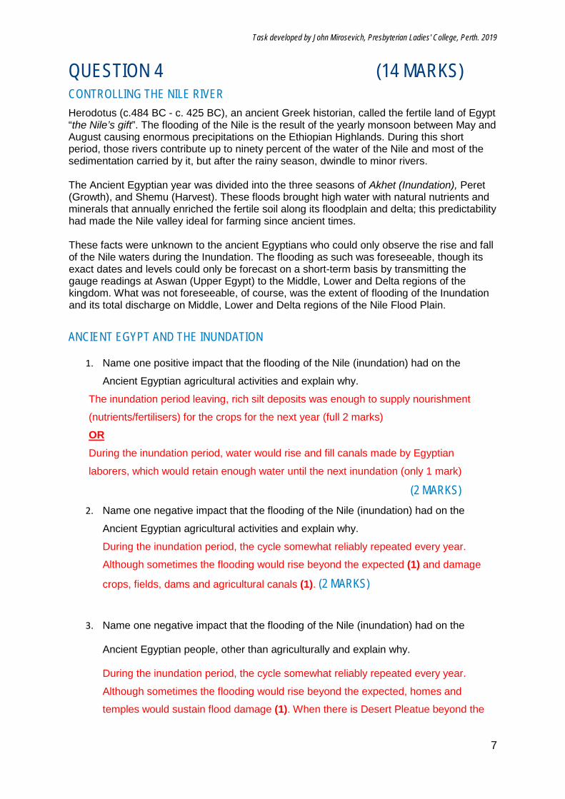
MODERN EGYPT CONTROLLING THE INUNDATION Since ancient times, the people of the Nile have endeavoured to control the waters of the Nile River to aid them in the agricultural exploits. In 1902, the colonial powers at that time, the British, built the Aswan Dam (later to be known as the Aswan Low Dam) to try to control the waters. It had little impact, but was able to create a passage for vessels to sail upstream against the current, safely. Then the Aswan High Dam, an embankment dam was built between 1960 and 1970, significantly eclipsed the previous Aswan Low Dam. With its ability to control the flooding, provide increased water storage for irrigation and generate hydroelectricity, was seen as pivotal to Egypt's planned industrialization. The High Dam has had a significant effect on the economy and culture of Egypt.
4. Name one immediate impacts that the High Dam would have on the agriculture of the
Nile River plain and give an example.
Without the inundation period leavinga rich silt deposits, there won’t be enough
nourishment (nutrients/fertilisers) for the crops (1) and other sources of fertilisers
(which will add cost to the farmers) will be required (1)
(2 MARKS)
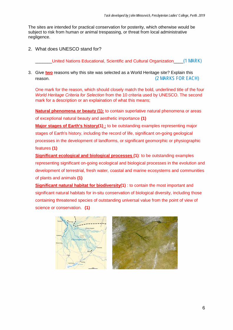
With the High Dam’s construction, Lake Nasser was created. See the difference between these two maps.
Task developed by John Mirosevich, Presbyterian Ladies' College, Perth. 2019
9
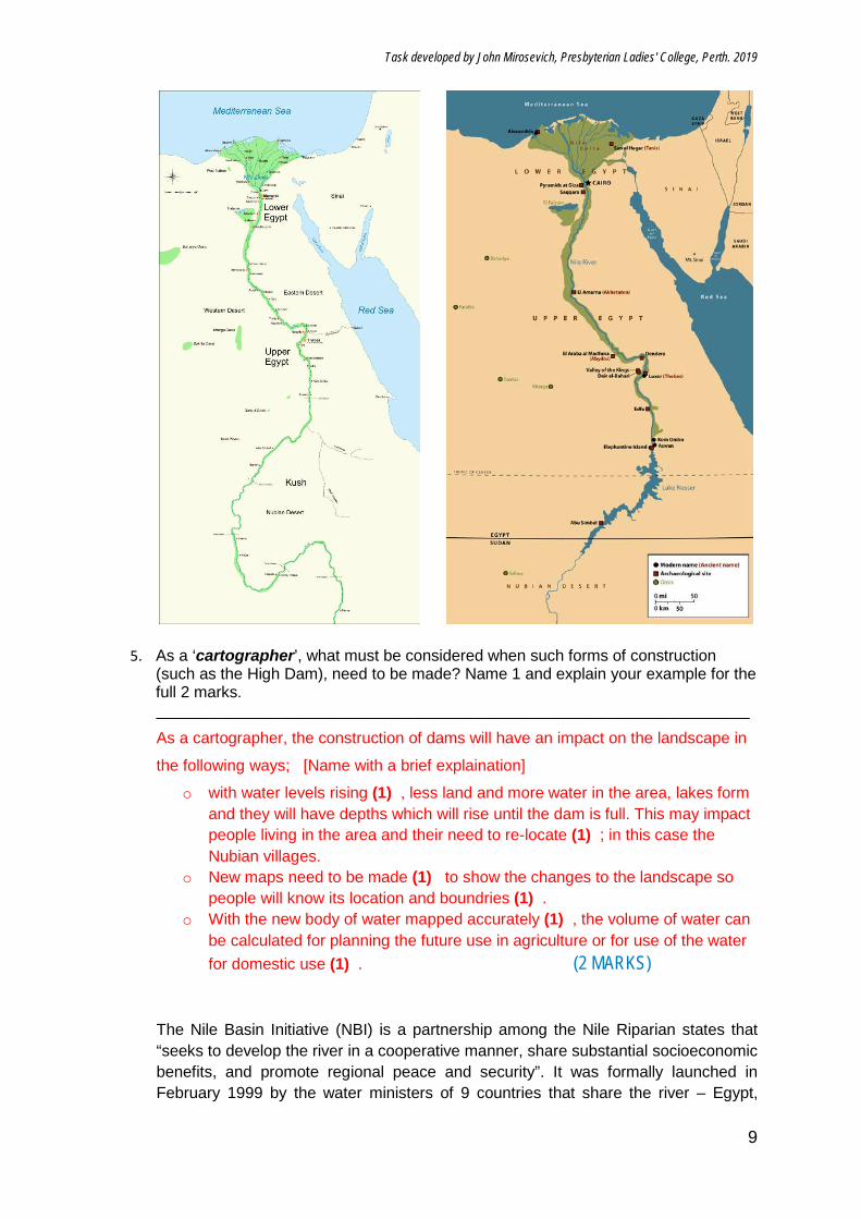
5. As a ‘cartographer’, what must be considered when such forms of construction (such as the High Dam), need to be made? Name 1 and explain your example for the full 2 marks. ___________________________________________________________________
As a cartographer, the construction of dams will have an impact on the landscape in
the following ways; [Name with a brief explaination]
o with water levels rising (1) , less land and more water in the area, lakes form and they will have depths which will rise until the dam is full. This may impact people living in the area and their need to re-locate (1) ; in this case the Nubian villages.
o New maps need to be made (1) to show the changes to the landscape so people will know its location and boundries (1) .
o With the new body of water mapped accurately (1) , the volume of water can be calculated for planning the future use in agriculture or for use of the water for domestic use (1) . (2 MARKS)
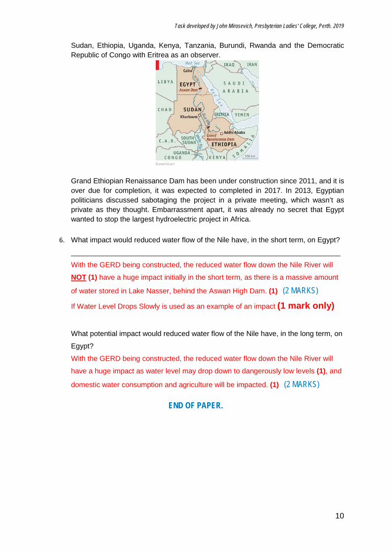
The Nile Basin Initiative (NBI) is a partnership among the Nile Riparian states that “seeks to develop the river in a cooperative manner, share substantial socioeconomic benefits, and promote regional peace and security”. It was formally launched in February 1999 by the water ministers of 9 countries that share the river – Egypt,
Task developed by John Mirosevich, Presbyterian Ladies' College, Perth. 2019
10
Sudan, Ethiopia, Uganda, Kenya, Tanzania, Burundi, Rwanda and the Democratic Republic of Congo with Eritrea as an observer.
Grand Ethiopian Renaissance Dam has been under construction since 2011, and it is over due for completion, it was expected to completed in 2017. In 2013, Egyptian politicians discussed sabotaging the project in a private meeting, which wasn’t as private as they thought. Embarrassment apart, it was already no secret that Egypt wanted to stop the largest hydroelectric project in Africa.
6. What impact would reduced water flow of the Nile have, in the short term, on Egypt? ___________________________________________________________________
With the GERD being constructed, the reduced water flow down the Nile River will
NOT (1) have a huge impact initially in the short term, as there is a massive amount
of water stored in Lake Nasser, behind the Aswan High Dam. (1) (2 MARKS) If Water Level Drops Slowly is used as an example of an impact (1 mark only)
What potential impact would reduced water flow of the Nile have, in the long term, on
Egypt? With the GERD being constructed, the reduced water flow down the Nile River will
have a huge impact as water level may drop down to dangerously low levels (1), and
domestic water consumption and agriculture will be impacted. (1) (2 MARKS)
END OF PAPER.
Copyright © 2022 FDOKUMEN