The National Mapping Act and the Status of Cartography in the Argentine
Upload
khangminh22Category
view
0download
0
Sale 476 Thursday, March 29, 2012
11:00 AM
Americana - Travel & Exploration - Cartography
Tuesday March 27, 9:00 am to 5:00 pmWednesday, March 28, 9:00 am to 5:00 pm Thursday, March 29, 9:00 am to 11:00 am
Other showings by appointment
Auction Preview
133 Kearny Street 4th Floor:San Francisco, CA 94108phone: 415.989.2665 toll free: 1.866.999.7224 fax: 415.989.1664
[email protected]:www.pbagalleries.com

REAL-TIME BIDDING AVAILABLE
PBA Galleries features Real-Time Bidding for its live auctions. This feature allows Internet Users to bid on items instantaneously, as though they were in the room with the auctioneer. If it is an auction day, you may view the Real-Time Bidder at http://www.pbagalleries.com/realtimebidder/ . Instructions for its use can be found by following the link at the top of the Real-Time Bidder page. Please note: you will need to be logged in and have a credit card registered with PBA Galleries to access the Real-Time Bidder area. In addition, we continue to provide provisions for Absentee Bidding by email, fax, regular mail, and telephone prior to the auction, as well as live phone bidding during the auction. Please contact PBA Galleries for more information.
IMAGES AT WWW.PBAGALLERIES.COM
All the items in this catalogue are pictured in the online version of the catalogue at www.pbagalleries.com. Go to Live Auctions, click Browse Catalogues, then click on the link to the Sale.
CONSIGN TO PBA GALLERIES
PBA is always happy to discuss consignments of books, maps, photographs, graphics, autographs and related material. There is no charge for appraisals of items intended for auction, and we accept both individual items, as well as, entire collections and estates. Please contact Bruce MacMakin for more information at [email protected]
BOOK APPRAISALS AT PBA GALLERIES
PBA Galleries now holds regularly scheduled book appraisals at our Kearny Street Gallery.Save the first Tuesday of each month to bring your books, manuscripts, maps, photographs and prints to the PBA Galleries’ Appraisal Events. Though no appointment is necessary, please call to let us know if you will be attending. The verbal appraisals are free. Join us from 11:00 a.m. to 6:00 p.m., at PBA Galleries, 133 Kearny St., Preview & Auction Gallery, Fourth Floor, San Francisco (between Post and Sutter Streets).
GET ON THE PBA EMAIL MAILING LIST
PBA Galleries sends out notices of our auctions, schedule updates, sale highlights and other information via email. To be placed on this mailing list, email us at [email protected]
RECEIVE NOTIFICATION OF YOUR SPECIFIC WANTS
At the PBA Galleries website, you can sign up for CATEGORY WATCH, and receive email notification when books or other items in your areas of interest are coming up for auction, or for individual titles or books by specific authors. Go to www.pbagalleries.com.
PBA WILL PACK AND SHIP YOUR ITEMS TO YOU
PBA Galleries has a full-service shipping department, and will pack and ship items to you that you purchase at auction upon payment. The preferred method of shipping is United Parcel Service, and added charges will apply for use of other services.
NOTE: MOST LOTS OFFERED IN THIS SALE HAVE A MINIMUM RESERVE OF ONE HALF OF THE PRESALE LOW ESTIMATE. SOME LOTS HAVE HIGHER RESERVES, BUT ALWAYS BELOW THE LOW ESTIMATE.

AdministrationRoger Wagner, ChairmanScott Evans, PresidentShannon Kennedy, Vice President, Client ServicesAngela Jarosz, Administrative AssistantMegan Hipsley, Shipping Clerk
Consignments, Appraisals & CataloguingBruce E. MacMakin, Senior Vice PresidentGeorge K. Fox, Vice President, Market Development & Senior AuctioneerGregory Jung, Senior SpecialistErin Escobar, Specialist
MarketingMaureen Gross, Vice President of Marketing
Photography & DesignChad Mueller, Photographer
Spring Auctions, 2012March 29, 2012 - Americana - Travel - Cartography
April 12, 20112 - Fine & Rare Books
April 26, 2012 - Fine Literature
May 10, 2012 - Rare Books & Manuscripts
May 24, 2012 - Fine Americana - Travel & Exploration - Cartography
Schedule is subject to change. Please contact PBA or pbagalleries.com for further information. Consignments are being accepted for the 2012 Auction season. Please contact Bruce MacMakin at [email protected].
Front Cover: Lot 302Back Cover: Clockwise from upper left: Lots 161, 279, 48, 278
Bond # 14425383

Lot 2

Page 1
Section I: Americana, Lots 1-263
Section II: Travel & Exploration, Lots 264-356
Section III: Cartography, Lots 357-423
Section I: Americana 1. (Account Ledger) �Account ledger for Daniel Perkins from 1844-1852. 9 ledger leaves (disbound and loosely held in half morocco and boards) of manuscript account information, dating from 1844-1852. 34x20 cm. (13½x7¾”). Also a few smaller sheets of ledger information laid in, plus 2 pages on blue paper, and half of a letter on blue paper, signed from Bates & Perkins.
1844-1852
Bates & Perkins was a clothing manufacturer in Salem, Massachusetts, and apparently had a lot of dealings with Daniel Perkins (of relation and/or founder?). The half of a letter on blue paper mentions Daniel’s upcoming trip to San Francisco. Daniel also lists an account with California from 1848. Heavily worn exterior; mild to moderate edge wear to leaves; good.
(100/150)
ANSEL ADAMS PHOTOGRAPH OF YOSEMITE 2. AdAms,�Ansel.�Half Dome, Merced River, Winter - Yosemite National Park, California. Gelatin silver photograph. 19x24 cm. (7½x9½”), on original mount. Initialed by Adams’ in pencil at lower right.
No place: before 1980
Original Ansel Adams photograph, part of a special edition of photographs of Yosemite “Printed by Alan Ross from Ansel Adams’ original negatives under his supervision and initialed by him” (rubberstamp on verso). With original envelope of the Ansel Adams Gallery. Several tiny rust spots on mount, image fine.
(1000/1500)
3. AdAms,�Ansel�&�JeAnnette�dyer�spencer.�The Bracebridge Dinner (wrapper title). [20] pp. incl. self-wrappers. Illustrated with engravings by the Walter J. Mann Company. 30.3x22.8 cm. (12x9”), wrappers.
San Francisco: 5 Associates, 1953
Program of the “Bracebridge ceremony” at the Ahwahnee Hotel in Yosemite, with text by Ansel Adams and Jeannette Dyer Spencer. Drawings and layout by Frann Spencer Reynolds. The text and music were created and arranged to give an impression of Christmas dinner in Bracebridge Hall as described by Washington Irving in his Sketchbook. OCLC/WorldCat lists ten copies. Some darkening to wrappers, very good.
(200/300)

Page 2
4. (Alabama) Berney,�sAffold.�Hand Book of Alabama: A Complete Guide to the State, with a Geologic Map and an Index of Useful Tables. (2 copies). Lot of 2 copies. 2 fl, (ix)-xxxix, 338 pp. (8vo) period sheep and marbled boards, morocco lettering pieces. Folding map. First Edition. (With) Hand Book of Alabama, Birmingham, Roberts & Son: 1892. (8vo), original brown cloth, 565 pp. Engraved illustrations, folding map. Second and Revised Edition.
Mobile: Mobile Register, 1878
A comprehensive guide to the state, including the state constitution, description of counties, major cities, laws, institutions, etc. First copy with folding Geologic Map of Alabama printed in colors & published by G.W. & C.B. Colton, 1878; second volume with 2-color General Map of Alabama prepared for the Geological Survey of Alabama, 1891. First volume with general wear to covers, front joint splitting, spine ends chipped; hinges tender; dampstains to endpapers, folding map detached from text block and with splits to folds, else near very good. Second volume with wear to spine ends and corners; hinges tender, map detached, short splits to map folds; else very good.
(150/200)
TWO PHOTOGRAPHS OF ALASKAN ESKIMOS BY BEVERLY DOBBS 5. (Alaska) doBBs,�Beverly�Bennett.�Photograph of an Eskimo girl with braided hair, wearing a cloth dress. Gelatin silver print, with imprint, date and number 184 in the negative. 24x19 cm. (9½x7½”).
Alaska: 1903
Captivating portrait of a young Eskimo girl by the noted photographer of Alaska natives and scenery. Slight damage on verso where previously mounted, corner crease, very good.
(500/800)
6. (Alaska) doBBs,�Beverly�Bennett.�Photograph of an Eskimo Woman dressed in furs, a scarf on her head. Gelatin silver print, with imprint in the negative. 24x19 cm. (9½x7½”).
Nome, Alaska: c.1905
B.B. Dobbs (1868-1937) won a gold medal at the Louisiana Purchase Exposition, and photographed the Seward Peninsula and other Alaska locales extensively. Slight damage on verso where previously mounted, corner crease, very good
(400/600)
7. (Alaska) nowell,�frAnk�H.�“Golden Gate Hotel No. 3.” Nome Alaska Sept. 16th, ‘03. Gelatin silver photograph. 19.5x24.5 cm. (7½x9¾”).
Nome, Alaska: 1903
Two women and about a dozen men stand in front of the hotel; a horse drawn cart is in the street. Frank Newell arrived in Alaska in 1886 and established the first dairy farm in Alaska; he opened his photography studio in Nome around 1900. Some fading, very good.
(300/500)
8. (Alaska) poindexter,�miles.�Typed Letter Signed as US Senator, on stationery of the Senate Committee on Indian Depredations. Typed Letter, signed. 1 pp.
Washington, D.C.: June 8, 1917
To Charles August Sulzer, Alaska Territory’s fourth “Delegate” to the US House of Representatives. Written 2 months after the US entered the World War, supporting “development of Alaska coal fields” as being of “great importance” to the Army and Navy. The Senator from Washington state assures Sulzer that he would be “glad to promote any measure that will encourage private enterprise…in opening up these great resources” – of personal interest to Sulzer, who, while serving only one term in Congress, was partner with his brother William, the former (impeached) Governor of New York, who owned one of the largest mining companies in the Territory. Creased from mailing; near fine.
(100/150)

Page 3
9. (Alaska) �Catholic Prayers & Hymns in the Tinneh Language. [2], 39 pp. [bound with] Tinneh Indian Catechism of Christian Doctrine. [2], 22 pp. 11.5x10 cm. (4½x3¾), original floral colored cloth over stiff paper wrappers. Housed in half dark green morocco and cloth slipcase and folding chemise. First Edition.
Kosoreffski, Alaska: Indian Boys’ Press, Holy Cross Mission, 1897
Rare catechisms in the Tinneh Indian language, crudely printed and bound by three Indian boys at the mission, who give their names Nicholia, Ivan and Aleck at the end of the prefatory notes. Streeter notes that “These two books are the only ones listed in the imprints catalogue at the New York Public Library as printed at Holy Cross, on the west side of the Yukon near the mouth of the Kosoreffski (also Koserefski, Koserefsky) river, and are the earliest listed under any of the towns on the Seward Peninsula. A letter from Frederick R. Goff 12 June 1951 says the order of printing of the two is not known.” The two works were likely printed at the same time and bound together for easy use. Streeter Sale 2569; Wickersham 1046. Sewing threads pulling at front hinge, else fine.
(600/900)
10. (Alaska - Playing Cards) �Set of playing cards issued by The White Pass and Yukon Route, with a different photo on the face of each card. Complete set of 52 cards, plus a joker, a card with a map of the route to the Nome Gold Fields, a card with tables of distances, and a card printed on both sides with description of the route; two-part slipcase, the outer box of which is lettered in gilt on one side “The White Pass and Yukon Route Souvenir Cards”, with a card showing its color pictorial back mounted on the other. 3¾x2¾x¾”.
Seattle: [1900]
Playing cards commemorating the “Scenic Railway of the World,” with photographs of the scenic wonders of Alaska, the rail lines and bridges, railroad cars, towns and stopovers, majestic mountains, etc. On the back of the cards is a design in red, white and blue with depiction of a train crossing a bridge through the mountains. The edges of the cards are gilded. Just a little rubbing and extremity wear to box, very good or better.
(500/800)
EARLY AMERICAN EXPRESS STOCK CERTIFICATE 11. (American Express Stock Certificate) �American Express Company stock certificate, signed by William Fargo, Henry Wells, and Alexander Holland. Two shares (at $500 per share). 21x34 cm. (8x12”) two-toned pictorial engraved and lettered stock certificate issued for James Manning (of Syracuse), January 20, 1864.
New York: J. H. Duyckinck, 1864
Signed by company president Henry Wells, Secretary William Fargo, and countersigned by treasurer Alexander Holland. In 1850, Wells & Company joined with two other express companies to form the American Express Company which covered the eastern sector of the United States, with the western sector being covered by Wells, Fargo and Company. Chips to edges; slightly puckered from old dampstain; near very good.
(500/800)
12. AnBurey,�tHomAs.�Travels Through the Interior Parts of America. 2 volumes. (8vo) green boards, paper spine labels.
Boston: Houghton Mifflin Company, 1923
A handsome reprint of the rare 1789 edition. Thomas Anburey was an officer in the British Army during the American Revolution, serving under Burgoyne. Anburey participated in that General’s ill-fated expedition from Canada, which ended in defeat at Saratoga in 1777. These volumes comprise a series of letters written by Anburey during the march from Saratoga to Charlottesville, VA after the British army’s capture. Howes A226. Some wear to joints, dent to fore edge of boards on first volume; very good.
(100/150)

Page 4
LETTER FROM ONE OF THE CATSKILL’S FLY-TYING PIONEERS 13. (Angling) cone,�williAm�w.�Autograph Letter, signed, by a fly-tying pioneer of the Catskills. Autograph Letter, signed. 2 pp + integral blank leaf.
Masonville, [NY]: August 3, 1885
To M.E. Carter: “… busy fitting out a party for Maine on short notice and did not have time to look over my stock…shall work on your flies this week and will send assortment of large flies on 6,7,8 & 9 hooks…the size most used in your section, they will be 75 cts. per Doz. to you, that gives me but $1.25 per Doz. for my labor as 2 Doz. is a full days work and I employ no help.” William W. Cone (1827-c.1905) was “one of the earliest professional fly tiers in the Catskill region” (Van Put and Merwin, 2007) and one of the first in America; he began tying flies 4 years after the Civil War, though he did not make a business of it until the 1880s. Living near Binghamton, New York, Cone sold some 60 varieties of American and British-pattern ties, aiming, as he wrote in his 1884 price list, “to furnish Anglers with the best fly for the least money and send out only my best work at a price that yields me but moderate wages”. Creased from mailing; near fine.
(150/250)
RARE OVERLAND NARRATIVE 14. ApplegAte,�Jesse.�Recollections of My Boyhood. 99 pp. (8vo), original color pictorial wrappers. First Edition.
Roseburg, OR: Press of Review Pub. Co., 1914
Classic overland narrative, an account of the Oregon emigration of 1843, which the author made when he was but six (or nine, according to some sources). Jesse A. Applegate was the son of Lindsay Applegate and the nephew of Jesse Applegate Applegate. The latter was the leader of the party, and blazed the Applegate Trail. The two Jesse Applegates are often confused, confounded by the incorporation of the present work in the publication of the senior Applegate’s “A Day with the Cow Column” (Chicago: 1934) without any distinction being made between the two. Moreover, some sources indicated the two are father and son (Mintz, quoting John Howell Books). The latter source does state that “they settled in the Willamette Valley, becoming prosperous and influential pioneers in the Territory. His reminiscences provided an interesting, detailed, and perceptive record of the crossing and the first decade of life in the Oregon country, which was still a dangerous and hostile environment for the frontiersman.” Adams Herd 109; Graff 75; Howes A294; Mintz 10. Light wear and soiling to wrappers, small splits to spine; very good.
(1000/1500)
15. (Arizona) �Portrait and Biographical Record of Arizona. [8], 21-1034 pp. Numerous portrait plates from photographs. (4to) 27x22 cm. (10½x8½”) period full brown morocco. First Edition.
Chicago: Chapman Publishing Co., 1901
Portraits and biographies of men of Arizona. Boards detached, spine mostly gone; first gathering detached; poor.
(150/200)
RARE MEZZOTINT PORTRAIT OF JOHN J. AUDUBON 16. (Audubon, John J.) cruicksHAnk,�f[rederick],�After.�Hand-colored engraved portrait of John J. Audubon after the miniature on ivory by Frederick Cruishank. Hand-colored mezzotint portrait. Image size 16.3x12.5 cm. on 22.8x17 cm. sheet of thin paper, mounted to a large stiff paper backing, overall 35.5x28 cm. Facsimile signature in lower margin.
London: Robert Havell, January 12, 1835
Rare engraving by C. Turner after the original miniature by Frederick Cruickshank, published by Robert Havell to promote Audubon’s Birds of America. A touch browned; near fine.
(500/800)
Page 5
17. (Automobiles) �The Gould Top. [16] pp. Illustrated from photographs. 21.5x16.5 cm. (8½x6½”), original wrappers with raised lettering in gold.
San Francisco: F.D. Gould Company,
Rare brochure for the Gould Top, a hardtop that is permanently installed on your open air automobile, turning your drafty roadster into a secure, warm sedan. The tops are “Build over a substantial frame of well seasoned hardwood, covered with imitation leather and embellished with beveled plate glass.” The side windows can be removed for an open-air feel. The company headquarters at 1509 Sutter Street is shown (the building is still there), and the top is shown installed on Packard, Lincoln, National, Cadillac, Studebaker, and Buick automobiles. OCLC/WorldCat lists not copies of this brochure. Paperclip mark to top of front wrapper and earlier leaves, darkened patch to front wrapper where a 1¾x1½” slip of paper was clipped to it, very good or better.
(250/350)
18. (Automobiles) �Three early automobile-themed magazines. Includes: The Automobile Review and Automobile News. 2 issues. Vol. 8, Nos. 5 & 6 (March 1 & 15, 1903). * Motor Age. Vol. VIII, No. 10 (Sept. 7, 1905). Profusely illustrated from photographs & other sources; numerous advertisements. 33.2x24 cm. (13x9½”), original wrappers.
Chicago: 1903 & 1905
Fascinating glimpse at the dawning of the age of the automobile. Some wrapper wear; very good.
(300/500)
19. (Aviation) �Album of approximately 275 original snapshot photographs of aviators and aeronautical training during World War I. Photographs are various sizes, corner-mounted or glued to black album leaves, many with captions in white ink on the leaves. 25.5x32 cm. (10x12½”), flexible morocco.
Canada, Texas, etc.: c.1916-1918
Marvelous group of photographs apparently of an Australian air unit training in Canada and Texas (“Richard W. Kellett, Port Pirie, South Australia, Australia” written on the inside of the album cover), with many of the photographs recording the inevitable crashes, others show planes both in flight and on the ground, aerial shots taken from the air, etc. There are also the camps, numerous fliers and other personnel, and towards the end some girlfriends and non-military activities. Most of the photographs are in very good or better condition.
(400/600)
You can bid absentee directly from the item description in the online version of the catalogue at www.pbagalleries.com.
Or bid during the auction using the Real-Time Bidder.

Page 6
FABULOUS ALBUM OF AVIATION DAREDEVILS AND BARNSTORMERS 20. (Aviation) �Early 20th-Century Aviation Scrapbook. 110 leaves, (folio) 37x33 cm. (14¾x12”) brown cloth with pictorial paper insets on front and rear covers. Each leaf with original mounted news-clippings and news photographs relating to period aviation, aviators, and related subjects.
No place: c.1910-1920
A unique treasure trove of contemporary aviation news reporting featuring dozens of aviators, barnstormers and daredevils - many of them women - of the day, including several whose entire career from first flight to final disastrous crash plays out on these pages. The first several articles are devoted to W. Stanley Atherton, the “Boy Aviator” of Randolph, Mass. in succession are stories about America’s first licensed woman aviator,
Harriet Quimby and her historic flight, on April 16, 1912 she was the first to fly over the English Channel (her tragic death when her Bleriot crashed in Boston Harbor is recorded several pages later); Glenn Curtiss; Earle Ovington; Miss Agnes Firth; Miss Mary Sims “The Flying Widow.” C.W. Rolls’ 1910 fatal crash of his Wright biplane; Arch Hoxsey’s world’s altitude record and subsequent fatal crash; Eugene Ely; Paul Peck; the Wright brothers; Lincoln Beachey; Calbraith Rodgers; Harry Atwood, etc., etc. A remarkable wealth of material. Boards detached; spine lacking; newsprint articles are brittle and some occasional loss of text, good only, sold as-is.
(1000/1500)
21. BAird,�s.f.,�t.m.�Brewer�&�r.�ridgwAy.�A History of North American Birds. 3 Volumes. Illustrated with 64 plates and hundreds of woodcuts. (4to) 10½x7½, original green cloth lettered in gilt. First Edition.
Boston: Little, Brown and Company, 1874
A descriptive account of the Birds of North America with notices of their geographical distribution, habits, methods of nesting, character of eggs, their popular nomenclature and other points connected with their life history. Plates in the scarcer uncolored state. Light wear to cloth, bookplates; very good.
(300/500)
Lot 20

Page 7
22. BArns,�c.[HAncy]�r.,�editor.�The Commonwealth of Missouri: A Centennial Record. xxiv, 936 pp. Illustrated with numerous steel-engraved portrait plates, facsimile bank note, many wood-engraved illustrations in the text. (8vo) 24x16.5 cm. (9¾x6½”) period full red morocco stamped in gilt and blind, all edges gilt. First Edition.
St. Louis: Bryan, Brand & Co., 1877
Text divided into several sections: Archaeology; History; Physical Geography; Material Wealth; Educational Progress; Biographies, each with separate chapter lists. History section includes a lengthy chapter on Missouri in the Civil War. Both boards detached, wear to spine ends, overall scuffing to leather; internally very good and worthy of restoration; good.
(150/200)
23. (Baseball) �1839-1939 Baseball Centennial. Special Exhibition of Baseball Souvenirs. [20] pp. incl. self-wrappers. 22.5x10 cm. (9x4”).
Los Angeles: Marshall & Clampett, [1939]
Listing of “the most colorful and unique assemblage of baseball souvenirs ever bought together at one time.” 188 items are listed, from a baseball signed by Babe Ruth, Hans Wagner, Al Simmons and George Earnshaw, to an “Old glove worn by John Honus Wagner.” The exhibit was held at the Marshall & Clampett DeSoto-Plymouth Headquarters, and one could examine the 1940 car models as well. No copies are listed in OCLC/WorldCat. A few stray fox-marks to wrappers and other slight wear; very good.
(200/300)
24. [BAyArd,� sAmuel� J.].�A Sketch of the Life of Com. Robert F. Stockton; with an Appendix, Comprising His Correspondence with the Navy Department Respecting His Conquest of California; and Extracts from the Defence of Col. J.C. Fremont, in Relation to the Same Subject; Together with His Speeches in the Senate of the United States, and His Political Letters. 210, 131 + [2] ad pp. Steel engraved portrait frontispiece. (8vo), original cloth. First Edition.
New York: Derby & Jackson, 1856
Contains significant source material on both the conquest of California by the Americans and the Fremont fiasco. Howes B259. Spine sunned and soiled, a touch frayed at spine ends and corners; very light and scattered foxing; very good.
(100/150)
25. [Beckett,�williAm�H.�And�rAymond�AlBert�pAtterson].�“Uncle Rufus” and “Ma.” The Story of a Summer Jaunt, with Their Friends, in the New Northwest. 67 pp. 17.5x12.5 cm. (7x5”). Original dark brown cloth stamped in gilt, all edges gilt. First Edition
No place: 1882
Text begins with a dedicatory poem “To Mr. and Mrs. Rufus Hatch” which is signed “William H. Beckett,” followed by “Some Proemial Paragraphs” by “S. J. W.” The principal text consists of letters from the road to the Chicago Tribune recounting the travels of “The Hatch Party.” - traveling from New York to Manitoba and back - these are signed “RAP.” The letters are written by an observant and insightful journalist and likely served to promote rail travel throughout the region. Catalogued in Adams Herd 1010 under “Hatch” - OCLC ascribes the authorship as noted above. Cover title is “A Summer Souvenir, 1882.” Mild wear to spine ends and corners of boards; contemporary bookplate to front pastedown; else very good.
(200/300)

Page 8
26. BeecHey,�f[rederick]�w[illiAm].�An Account of a Visit to California 1826-’27. Introduction by Edith M. Coulter. Illustrated with 4 color reproductions of watercolors by William Smyth and one map of the San Francisco Bay by F.W. Beechey. 12½x9, linen-backed patterned boards, paper spine label. One of 350 copies printed by the Grabhorn Press.
San Francisco: Book Club of California, [1941]
“Interesting account of Monterey and San Francisco before the American Conquest...” - Howes B309; BCC 60. Spine and boards sunned, light wear, bookplate; very good.
(150/250)
27. Bidwell,�JoHn.�Echoes of the Past... [4], 91 pp. 3 full-page illustrations from photographs. 7x5, modern green cloth, original printed wrappers bound in. First Edition in Book Form.
Chico: The Chico Advertiser, [1914]
Reprinting of articles by Bidwell which appeared in the Century Magazine for November and December, 1890 and February 1891. Kurutz notes that “the vast majority of the text is devoted to the famed overland trek and early days in California before the American conquest. The pioneer provided interesting information on pre-Marshall gold discoveries.” Bidwell served as a congressman during Reconstruction. Cowan p.52; Graff 292; Howes B432; Kurutz 55a; Mintz 36; Rocq 1371; Wagner-Camp 88 (note); Wheat Books 18. Paper browned; near fine.
(100/150)
COLLECTION OF BOSTON ALMANACS 28. (Boston) �Eleven issues of the Boston Almanac, 1838-1867. 11 volumes, including annual issues for 1838 (ex-library), 1840 (lacking color printing specimens from endpapers and half of folding map), 1845 (lacking map), 1847 (map tattered and with old repairs), 1851, 1853 (lacking map and a few leaves at front), 1854, 1855, 1862 (without map, as issued?), 1863 (without map, as issued?), 1867. All in original cloth bindings.
Boston: Various publishers, 1838-67
A nice grouping of this popular almanac and city directory. Some general wear and soiling in addition to the defects noted above; overall very good.
(250/350)
29. (Boston Horse Show Poster) �Boston Horse Show, April 18,19, 20, 21, 22, 23, 1904. Color lithographed poster. 56.5x72 cm. (22x28¼”), shrink-wrapped.
Boston: 1904
Two string loops at top edge for hanging; a little creasing and wear, very good.(250/350)
30. (Bottles) �Photographs of the Oakland & Monterey plants of the Owens-Illinois bottle company, with an actual bottle. 12 original photographs, mounted on leaves removed from a binder. Glass bottle 24 cm. (9½”) tall.
No place: c.1943
Photographs of the interior and exterior of the bottle-manufacturing plants at Oakland and Monterey, California, of Owens-Illinois Inc., a Fortune 500 company that specializes in container glass products. It is one of the world’s leading manufacturers of packaging products, holding the position of largest manufacturer of glass containers in North America, South America, Asia-Pacific and Europe. The bottle is a promotional piece, being quite thin (could hold a single rose), and is lettered “Owens-Illinois Quality Beverage Bottles.” Very good or better condition.
(300/500)

Page 9
31. Boynton,�c.B.� And�t.B.�mAson.�A Journey Through Kansas; with Sketches of Nebraska: Describing the Country, Climate, Soil, Mineral, Manufacturing, and Other Resources. x, 216 pp. With a folding map of Nebraska and Kansas by Boynton. 19.7x12 cm. (7¾x4¾”), original printed wrappers. First Edition.
Cincinnati: Moore, Wilstach, Keys, 1855
Rare wrapper-bound issue of this early report on conditions in Kansas after a journey in 1854, commissioned by the American Reform Tract and Book Society, and the Kansas League in Cincinnati. The pictorial advertisement for the publisher on the rear wrapper features a picture of the establishment. “Sixth Thousand!” printed at the top of the front wrapper. Graff 376; Howes B677. Wear to wrappers, spine strip with portions missing at ends, corners chipped; some dampstaining to contents, good, in modern half morocco slipcase and chemise.
(300/500)
SCARCE 18TH CENTURY AMERICAN IMPRINT 32. BrAdy,�n[icHolAs];�n[AHum]�tAte;�isAAc�wAtts.�A New Version of the Psalms of David. Fitted to the Tunes used in Churches. (bound with) A Collection of Hymns from Dr. Watts, &c. 257, 75, [1] pp. (16mo) 19x15 cm. (6x3½”) period plain brown wrappers, hand lettered. Third Edition.
Boston: John Fleeming, 1771
Signed and inscribed on front wrapper by Ebenezer Alden - a descendant of Mayflower passengers John and Priscilla Alden - and on the title page by Eben. Alden’s granddaughter, Louisa Alden Sprague. Dr. Ebenezer Alden, Jr. (1788-1881) was in the seventh generation descended from John Alden of the Mayflower. He entered Harvard University in 1804 and graduated in 1808. He went on to study medicine at Dartmouth and at the University of Pennsylvania where he received his MD degree in 1811. He served as a military surgeon from 1812 to 1821 when he was discharged and began his private practice in Randolph Mass. - continuing until his death in 1881. Alden’s inscription reads: This version was used in the Congregation at Cambridge while I was a member of College - and last under the ministry of Rev. Dr. Holmes in 1808.” A compelling association for this early American imprint. Evans 11990. Front wrapper nearly detached; much of wrapper spine portion perished; leaves browned; upper corners of last several pages creased with some corner tips lost; good to very good.
(1000/1500)
33. Brown,�JoHn�Henry.�Reminiscences and Incidents of Early Days of San Francisco (1845-50). [12], 138 + [5] reader’s guide pp. Introduction and Reader’s Guide by Douglas Sloane Watson. Folding facsimile map of John Henry Brown’s San Francisco in 1846 on blue paper. Chapter-head vignettes from old woodcuts. (8vo), cloth-backed marbled boards, paper spine and cover labels, plain paper jacket. One of 500 copies.
San Francisco: Grabhorn Press, [1933]
Robert J. Woods in Zamorano 80 states: “John Henry Brown was a fur trader, bartender, citizen-soldier, hotel builder, capitalist, man of affairs, and author...Brown observed and told of many happenings here. His reminiscences fill in many gaps in the early history of San Francisco.” Zamorano Eighty 10. Light wear to jacket; endpapers browned, bookplate; near fine.
(150/250)
The Buyer’s Premium will be 20% for bids up to $100,000
and 15% for that portion over $100,000.

Page 10
34. Browne,�J.�ross�&�JAmes�w.�tAylor.�Report Upon the Mineral Resources of the United States. 360 pp. 8vo. Original embossed brown cloth, spine lettered in gilt. First Combined Edition.
Washington: Government Printing Office, 1867
Browne’s important report upon the resources west of the Rocky Mountains--which had been issued separately earlier in 1867--and Taylor’s brief report on the territories east of the Rockies. Cowan p. 79 -80; Paher 223: “indispensable primary source material on early Nevada mining”; Sabin 8664. Light wear to cloth; foxing; very good.
(200/300)
35. BryAnt,�williAm�cullen.�Picturesque America; or, The Land We Live In. A Delineation by Pen and Pencil of the Mountains, Rivers, Lakes, Forests, Water-Falls, Shores, Cañons, Valleys, Cities, and other Picturesque Features of Our Country. 2 volumes. Steel-engraved plates, including frontispieces and additional title pages, with tissue-guards; numerous wood engravings within text. 32.5x25 cm. (12¾x9¾”), later brown half morocco and green cloth, spines lettered in gilt, raised bands.
New York: D. Appleton, [1872-1874]
Noteworthy for the numerous fine steel-engraved plates; the artists represented include Thomas Moran, Harry Fenn, James D. Smillie, J.D. Woodward, Granville Perkins and others. Laid in to first volume is a manuscript copy of a poem by Bryant, in his hand, certificate of authenticity from Charles Hamilton Autographs included. Bindings with some rubbing and light wear; light foxing; very good.
(200/300)
GOVERNOR BROWN ON THE BERKELEY FREE SPEECH MOVEMENT 36. (California) Brown,�edmund�g.�“pAt”.�Typed Letter, signed, as Governor of California on the Berkeley Free Speech Movement. Typed Letter, signed, on Governor’s Office stationery. 1 pp.
Sacramento: December 18, 1964
To Florence Bishop, Oakland: ‘…your recent communication…encouraging me to take action against the student demonstrators on the Berkeley campus. When the situation changed from peaceful demonstrations - which are annoying but legal - to the outright violation of law, I did act and acted speedily. Neither you, nor I, as Governor, nor anyone else in this state can be allowed to violate the laws. The rule of law must be maintained, not only on our campuses but everywhere in the state. As long as I am Governor it will be.” Erupting on the UC Berkeley campus during the Vietnam War, and triggering similar student protests around the country, the Free Speech Movement began in October 1964 when the University administration refused student demands that the University lift a ban on campus political activities, such as fund-raising for Freedom Rides in Mississippi. Several thousand students then occupied the Administration building in protest. With the authority of then Governor “Pat” Brown - father of the current Governor of California - on the night of December 3, police arrested 768 demonstrators who were bussed off to County jail. When Governor Brown wrote this letter, two weeks later, after refusing to grant amnesty to the arrested students, the University Board of Regents had just directed University administrators to take all “necessary steps” to “preserve law and order”. Two years later, Brown was defeated for re-election by Republican Ronald Reagan, who promised to “clean up the mess in Berkeley”. Creased; very good.
(100/150)
Each lot is illustrated in color in the online version of the catalogue.
Go to www.pbagalleries.com

Page 11
37. (California - Contra Costa County) [munro-frAser,�J.�p.].�History of Contra Costa County, California, Including Its Geography, Geology, Topography, Climatography and Description...also, Incidents of Pioneer Life; and Biographical Sketches.... 710 pp. Illustrated with numerous lithographed portrait plates, including frontispiece of pioneer John Marsh. (8vo) original full sheep, morocco lettering pieces, all edges marbled. First Edition.
San Francisco: W. A. Slocum & Co., 1882
Extensive history including early settlement and land grants, and numerous biographical sketches; many of the portraits with facsimile signatures of the subjects. Cowan p.141; Howes C718; Rocq 1490. Moderate scuffing and wear to boards, front joint about half split; front hinge separated, contents shaken with last 2 gatherings pulling away; else very good, original, complete, and worthy of restoration.
(400/600)
RARE SAN FRANCISCO BUSINESS DIRECTORY 38. (California - Directory) lAngley,�Henry�g.�Langley’s San Francisco Business Directory and Metropolitan Guide. (ii)-xlviii, 444, a-c pp. (12mo) original green cloth stamped in gilt. Ad pages at front and rear.
San Francisco: Henry G. Langley, 1877
Rare San Francisco business directory, OCLC/WorldCat locates only a single copy at the Huntington Library. Apparently the only year published under this title. Early bookplate of the Bancroft Library on front pastedown. Bookplate of San Francisco industrialist Milton S. Ray laid in. Light wear at edges, circular label at foot of spine; very good.
(500/800)
39. (California - Directory) polk,� r.l.,� puBlisHer.� California State Gazetteer and Business Directory, 1888. Volume 1. 1734 pp. (Thick 8vo) leather-backed printed cloth, rebacked with original spine leather laid down.
San Francisco: R.L. Polk & Co., 1888
Scarce California directory. Many illustrated advertisements included in pagination, several others inserted, including several chromolithographs. Original spine leather chipped, some light soiling to cloth; very good.
(1000/1500)
40. (California - Fresno, Tulare, and Kern Counties) �A Memorial and Biographical History of the Counties of Fresno, Tulare, and Kern, California. [4], 822 pp. Illus. with photo plates & portraits; (4to) 29x22 cm. (11¼x8¼”) original full embossed morocco with gilt pictorial front cover lettered “Pen Pictures from the Garden of the World,” spine gilt, decorative endpapers, all edges gilt. First Edition.
Chicago: Lewis Publishing Co., [c.1892]
Scarce history of 3 Central Valley counties, none of which were among the 27 original California counties named in 1850. Fresno County was created in 1856 from portions of Mariposa, Merced and Tulare Counties; Kern was organized in 1866 from portions of Los Angeles and Tulare Counties; Tulare was created in 1852 from portions of Mariposa and Los Angeles Counties. Cowan p. 848; Rocq 1839 Covers scuffed, short split to bottom of front joint, wear to spine foot, corners worn with boards exposed; front hinge starting, text block somewhat shaken, else very good.
(400/600)
The auction will be begin at 11:00 a.m.

Page 12
ARCHIVE ON “HOLLYWOODLAND” 41. (California - Hollywoodland & Dana Point Developments) �Archive relating to the land developer E.S. Woodruff and his Hollywoodland and Dana Point developments. Includes: Tract Map Dana Point. S.H. Woodruff Community Developer. 69x87 cm. OCLC/WorldCat lists only 1 copy, at Yale. (Portion slightly darkened, a few small tears at folds.) 1929. * Three brochures for homes in Dana Point. * Letterhead of Dana Point Inn. * Three photographs of E.S. Woodruff, 2 of him in his car. * Photographs of the Hollywood Hills, with billboard advertising Hollywoodland and the unfinished iconic HOLLYWOOD sign on the hillside. * Brochure regarding assessment to residents of Beachwood Drive and Beachwood Terrace for storm sewer improvements, with map laid in. * List of foreclosed property for sale from the Guaranty Building & Loan Association, most in Hollywood. * Unused stock certificate in The Woodruff Co. * Two booklets from the California Lambs Club, of which Woodruff was a director. * By-laws and Membership Roster in the Hollywood Athletic Club, in which Woodruff was a member. * S.H. Woodruff’s business card.
California: 1920s
Interesting little archive relating to the enterprises of S.H. Woodruff. In mid-1926, Los Angeles realtor-builder S.H. (Sidney) Woodruff formed a group of investors as a means to finance the purchase, subdivision, and development of roughly 1,400 acres of coastal property at Dana Point, a town on the Pacific coast in Orange County, California. As the head of this group, known as the Dana Point Syndicate, Woodruff was instrumental in designing the Dana Point development and promoting its coastal amenities through a nationwide publicity campaign. The centerpiece of the development was to be the luxurious cliff-top Dana Point Inn, which was modeled on similar buildings located on the Italian and French Rivieras. Although successful in its early stages, Woodruff’s Dana Point development effort failed in 1930, due primarily to the effects of the 1929 stock market crash upon the finances of the investors. Despite setbacks, Woodruff still hoped that his project would come to fruition throughout the 1930s. His alternative financing methods failed, however, and in February 1939, Woodruff, as president of the Dana Point Corporation, received permission to sell off the syndicate’s interests. In the end, thirty
five houses and a number of commercial buildings were constructed by the Dana Point Syndicate, and the hotel itself never went beyond the foundation stage. Prior to his work with the Dana Point Syndicate, Woodruff was best known for his collaboration on the exclusive subdivision known as
Lot 41

Page 13
“Hollywoodland,” which gained fame as a result of the large metal sign erected in the Hollywood Hills to publicize its location. (1924 - The “Hollywoodland” sign is constructed at a cost of $21,000 atop Mt. Lee. Thirteen 50-foot letters and four thousand 20 watt light bulbs pronouncing, in classic advertising phonics, “Holly”... “wood”... “land”... Hollywoodland.” ) Little is known about Woodruff’s life beyond his work in community real estate development. He was the son of a wealthy Michigan family, and by his own admission, had no thought of working until age nineteen, when his father lost the family fortune and went heavily into debt. He was trained as an architect in Buffalo and erected his first building in York, Maine. At some point, Woodruff moved to the West Coast and was involved in rebuilding portions of San Francisco after the 1906 earthquake, prior to his work in Southern California. Very good or better condition.
(2000/3000)
42. (California - Northern) �A Memorial and Biographical History of Northern California. 637 pp. Illustrated with 34 plates (including 30 steel-engraved portraits, 1 wood-engraved, and 3 from photographs), including frontispiece. 11¼x9, original full decoratively embossed brown morocco, decoratively stamped and lettered in gilt with a gilt-vignette on the front cover, inner gilt dentelles, gilt-patterned endpapers, all edges gilt. First Edition.
Chicago: The Lewis Publishing Co., 1891
Front cover lettered “Pen Pictures from the Garden of the World” and the spine is lettered “Northern California, Illustrated.” Front joint rubbed and partially split, edges rubbed, corners showing, front hinge cracked; else very good.
(300/500)
43. (California - Nevada County) �Nevada County California: The Most Prosperous Mining County of the United States. With 2-page map of Nevada County, plus many photographs within. 17.5x13.4 cm. (6¾x5¼”), purple wrappers, gilt-embossed lettering on front cover.
[Nevada City?]: [Daily Miner-Transcript Print], [c. 1902]
The front cover of this scarce little booklet about mining reads, “Nevada: The Banner Gold County of California.” It was produced “Compliments of Nevada County Promotion Committee.” Many great photographs within of Truckee, Grass Valley, and some mining sites. Within the booklet describes why the area is ideal for mining geographically, etc., and how they are the leading gold mining county in California. OCLC/WorldCat lists only six copies of this 1902 edition. Gilt lettering on front wrapper slightly rubbed, faint fading; very good or better.
(500/800)
MINING IN NEVADA COUNTY 44. (California - Nevada County) prisk,�w.�f.,�intro.�Nevada County Mining Review. 144 + [10] ad pp. Introduction by W. F. Prisk. Illustrated from photographs throughout of various outdoor mining scenes and portraits of prominent people; plus a few wood-engraved tailpieces. (Oblong 4to) 23x30 cm. (9x11-7/8”), original pale green printed wrappers with dark maroon cloth spine, front cover lettered in gilt. First Edition.
Grass Valley, CA: Daily Morning Union, 1895
History and development of the Grass Valley mining area by the Daily Morning Union Review. Printed in the interests of the mining industry of Nevada County by the Upton Brothers Press in San Francisco. Cowan p. 453; Eberstadt 133:224; Norris 2837. Some soiling and staining to wrappers, some neat repairs and restoration; corners of some of the earlier leaves replaced; very good.
(700/1000)

Page 14
45. (California - Plumas, Lassen & Sierra Counties) �Illustrated History of Plumas, Lassen & Sierra Counties, with California from 1513 to 1850. 507 pp. Lithograph general title page and lithograph title page for each county, engraved title page for California section. Illustrated with lithograph map, numerous lithograph views, engraved portrait plates. (4to), later crimson calf and black boards, gilt spine title. First Edition.
San Francisco: Fariss & Smith, 1882
Scarce illustrated history of 3 rural Northern California counties. Cowan p.494; Rocq 6344 Rebound, as noted; minor scuffing to covers; owner name to blank preliminary leaf; slight foxing to first few leaves; a few pencil notations to Sierra County section; a few leaves frayed at fore-edge; else very good.
(500/800)
46. (California - San Benito County) �San Benito County de luxe edition; [supplementary to the] Evening Free Lance and the [Weekly] Free Lance, Hollister, California (wrapper title). [64] pp. incl. wrappers. Profusely illustrated from photographs. 40c28 cm. (15¾x11”), photo pictorial wrappers.
Hollister, CA: 1916
Overview of the people, places, land, industry, commercial promise, farms, fine residences, and local history of the county south of San Jose. Quite scarce: OCLC/WorldCat locates copies at UC Berkeley and Yale only. Minor wear, very good or better.
(500/800)
47. (California - Santa Clara County) foote,�H.s.,� editor.�Pen Pictures from the Garden of the World; or Santa Clara County, California. [8], 17-672 pp. Illustrated with numerous plates including lithographs, engravings, photo plates, etc. (4to) full morocco stamped in blind and gilt, all edges gilt. First Edition.
Chicago: Lewis Publishing Company, 1888
With a general history (including native races, gold discovery, etc.) and numerous biographical sketches of prominent citizens. Uncommon. Cowan p.568; Rocq 13726. Binding well worn, backstrip largely perished, pages uneven, a few worn at edges; fair.
(100/150)
You can bid absentee directly from the item description in
the online version of the catalogue at www.pbagalleries.com.
Or bid during the auction using the Real-Time Bidder.

Page 15
Each lot is illustrated in color in the online version of the catalogue.
Go to www.pbagalleries.com
RARE SANTA CLARA COUNTY ATLAS 48. (California - Santa Clara County) tHompson�&�west.�Historical Atlas Map of Santa Clara County, California. 110 pp. Illustrated with 21 hand-colored maps (some maps in sections, 9 are double-page) and 54 views. (folio) 44x37.5 cm. (17½x14½”), original half-sheep and decoratively gilt cloth. First Edition.
San Francisco: Thompson & West, 1876
Wonderful record of 19th century Santa Clara County, with many hand-colored maps depicted individual plots of land, city maps of San Jose, Gilroy, Mountain View, Los Gatos, and others. The views depict prominent residences, colleges, and civic sites, with a double-page view of the workings at the New Almaden Mine. Cowan p. 567. Front cover detached, rear joint cracking, some other cover wear; some foxing/staining to title-page and following leaves, short tear into one plate, very good, well worthy of repair to the binding.
(2000/3000)
49. (California - Solano County) [munro-frAser,�J.p.].�History of Solano County Comprising an Account of its Geographical Position; the Origin of Its Name; Topography, Geology and Springs...also, A Full and Particular Biography of Its Early Settlers and Principal Inhabitants. [iii]-[xvi], [17]-503 pp. Illus. with 20 lithographed portrait plates, each with facing blank cardstock sheet. (8vo) 25x16 cm. (9½x6¼) later red buckram, gilt spine title. First Edition.
San Francisco: Wood, Alley & Co., 1879
Best early history of the county north of the Carquinez Straits, on the way from San Francisco to Sacramento, and the apricot center of California. Cowan p.597; Howes M897; Rocq 14603. Rebound, as noted, covers clean and unworn; small skinned spot to front blank leaf, some spotting to contents, a few of the card blanks lightly stained; else near fine.
(250/350)
Lot 48

Page 16
50. (California - Sonoma County Mortgage Ledger) �Ledger book recording mortgage agreements in Sonoma County. 640 pp. Printed forms filled out in ink. 45x29.5 cm. (17¾x11½”), leather.
Santa Rosa, CA: 1894-1895
Massive ledger recording mortgage agreements between individuals and some banks for parcels of land in Sonoma County, offering a fascinating and significant description of the heart of the California wine country and its denizens. The locations of the plots are described in detail, along with the grantors and grantees, the amounts paid, interest, and other terms. Some scuffing to the coves, overall in near fine to fine condition.
(1200/1800)
51. (California - Sutter County) �Sutter County and the First National Bank of Yuba City, 1873-1926. [20] pp. Illustrations in sepia by Francis Todhunter(?). 24x15.5 cm. (10x6½”), wrappers.
No place: c.1926
Short history of the bank that began as the Farmer’s Cooperative Union of Sutter County. OCLC/WorldCat lists only one copy, at the California State Library. With blindstamp of Thomas E. Hayden, United States Commissioner of the Northern District of California, to title-page; ink ownership signature of noted collector A.T. Leonard, M.D., 1926, to front flyleaf. Light offsetting within from the illustrations; near fine.
(300/500)
52. (California) �Two home-made scrap books containing dried, pressed California sea moss. Two home-made scrapbooks. One with cover title, “Santa Cruz Sea Moss,” with photograph of the coast, peeking through the hole cut in the front wrapper. 21 leaves, each with a pressed and dried specimen. Each leaf is 11x14”. Disbound. * One with cover title, “California Sea Mosses,” With a photograph of the coastline on front wrapper. 12 leaves, each with a pressed and dried specimen (one with shells), each with tissue-guard. Each leaf is 7x9”, bound with yellow ribbon. Together 2 scrap books.
California: No date
Wear at wrapper and leaf edges; very good.(100/150)
53. (California) tyson,�p[Hilip]�t.�Report of the Secretary of War, Communicating Information in Relation to the Geology and Topography of California. 127, 37 pp. Illustrated with 13 lithographed folding maps, profiles, sections, etc. Comprises Part I & II of Doc. 47, 31st Congress, 1st Session. (8vo) 24.2x15 cm. (9x6”), disbound, custom cloth drop-back box. First Edition.
Washington: 1850
Geology and topography of the area between San Francisco and the gold region, with maps showing how to get to one from the other, based, as noted by Howes, “on a four month’s stay in California.” Cowan p.648; Howes T455. Lightly chipped at fore edge of many leaves, folding maps and charts with some light foxing and edge wear; very good.
(150/250)
1951 CALIFORNIA STATE FAIR PROGRAM 54. (California State Fair) �California State Fair Horse Show 1951. Official Program (wrapper title). [3]-50 pp. Illustrated with sketches of the various types of competing horses (and sulkies), and with diagrams of the courses for the different races; numerous advertisements. 30.5x23 cm. (12x9”), color pictorial wrappers..
Sacramento: News Publishing Co., 1951
Detailed program of the horse show which lasted from August 30 to September 9, with the many events described and scheduled, the horses and their exhibitors named, types of horses described, etc. OCLC/WorldCat lists just three runs of this program (from 1936 to the 1990s) which would include the present issue, at the California State Library, the Sacramento Public Library, and the University of California, Berkeley. A little wear, top corner of front wrapper creased, very good or better.
(100/150)

Page 17
55. (California - University of California) �Scrapbook of a University of California student, c.1925. Approximately 40 leaves, in a period scrapbook album. Overall 29x44.5 cm. (11½x17½”).
Berkeley (mostly): c.1924
The scrapbook of U.C. Berkeley student Stuart R. Ward (1924). Includes memorabilia such as ticket stubs from sporting and entertainment events, numerous dance cards, photographs, clippings, invitations, etc. Ward served as Sophomore Class President, Secretary of the English Club, Secretary and Forensic Commissioner of the Associated Students, Editor and contributor to the California Pelican. Also includes a few items from the Los Angeles campus of U.C. where Ward apparently attended classes in the summer sessions. An interesting time-capsule of life at U.C. in the roaring 20s. Very good.
(250/350)
56. (California) pHelps,�Alonzo.�Contemporary Biography of California’s Representative Men. With Contributions from Distinguished Scholars and Scientists. 2 volumes. [4], 443; [6], 417 pp. Illustrated with numerous steel-engraved portrait plates; tissue guards. 12¾x9½, original full embossed morocco ruled & lettered in gilt, gilt inner dentelles, mottled endpapers, all edges gilt. First Edition.
San Francisco: A. L. Bancroft, 1881 & 1882
Huge compendium of California biographies. The steel-engraved portraits are very fine. Cowan p.482; Rocq 17090 First volume lightly scuffed at edges and corners, else near fine; second volume spine separated at front joint, scuffed at edges and corner; both volumes tissue guards frequently creased; else near fine.
(400/600)
57. (California) �Five volumes of California History. Includes: Giffen, Helen S. California Mining Town Newspapers, 1850-1880. Red cloth. Signed by the author. 1954. * Harte, Bret. A Millionaire of Rough and Ready. Cloth-backed boards. One of 220 copies printed at the Allen Press. Damp stain. 1955. * Holder, Charles Frederick. Life in the Open: Sport with Rod, Gun, Horse and Hound in Southern California. Decorated green cloth. Damp stain. 1906. * Watson, Douglas. S. The Founding of the First California Missions. (4to) boards, dust jacket. One of 1000 copies. 1934. * Wilbur, Marguerite Eyer. A Frenchman in the Gold Rush: The Journal of Ernest de Massey, Argonaut of 1849. Cloth. Dampstain. 1927. Together 5 volumes.
Various places: Various dates
All with some light wear; overall very good.(100/150)
58. (California - Reference) Howell,�JoHn.�California: Catalogue 50: The Library of Jennie Crocker Henderson with Additions - 5 vols. (Parts 1-5). 5 volumes. Illustrations of book covers and title pages. Original wrappers. First printings.
San Francisco: John Howell Books, 1979-1982
Also included are two additional John Howell catalogues: Anniversary Catalogue: One Hundred and Twenty Fine Books...Selected to Commemorate the 70th Anniversary of John Howell Books... Wrappers. With compliments slip and notice slip laid in. 1982. * Catalogue 52: Americana. Wrappers. With compliments slip laid in. 1980. A touch of sunning and/or edge wear to last two catalogues; else fine.
(80/120)

Page 18
59. (Cartography) fielding,�lucAs,�Jr.�Autograph Letter, signed, to his son discussing his work for the Baltimore & Ohio Railroad. Autograph Letter, signed. 4 pp. With original envelope.
Baltimore: November 11, 1848
Long letter to his son, discussing a report he had published for the Baltimore & Ohio Railroad, containing “much valuable information… with regard to the working of engines”; the Army career of his other son, hampered by “flagrant interference” from the outgoing administration of President James Polk; and how the whole Lucas clan was eagerly awaiting the newly-elected Zachary Taylor, whose brother was a family friend. His political involvement in the Baltimore Catholic community long forgotten, Fielding Lucas, Jr. (1781-1854) is instead remembered today as one of the first prominent American cartographic artists and map publishers. After starting the first American stationary firm in 1804, he became involved in book printing, first co-publishing Zebulon Pike’s 1810 account of his expedition to the sources of the Mississippi, then producing his own maps and atlases. By the 1820s, the Lucas colophon was appearing on the finest American atlases as well as outstanding examples of early American color-plate books. His son, George, to whom this letter was written, after graduating from West Point and working as a railroad engineer, expatriated to Paris, where he became European agent for the richest art-collectors in America. Creased from mailing; near fine.
(200/300)
60. (Cherokee Strip) �Opening of the Cherokee Strip. Letter from the Secretary of War, Transmitting, Pursuant to House resolution dated September 28, 1893, information relative to the opening of the Cherokee Strip. 86 pp. Large folding map. 22.5x14.5 cm (9x5¾”), half dark brown morocco and marbled boards. First Edition.
(Washington): 1893
Report contains a documentary record through letters and sworn testimony of the army’s role in regards to events occurring during the opening of the so-called Cherokee Strip of northern Oklahoma to homesteaders in Sept., 1893. More than 100,000 pioneers competed for available lots - not without strife. Accusations of excessive use of force were brought by prospective settlers against the army. Map by E. W. Wiggins published by Wichita Litho. Co., Wichita. Kansas. Some creases to pages, especially those flanking the large folding map; else fine.
(200/300)
61. (Chicago) �A Biographical History, with Portraits, of Prominent Men of the Great West. 720, [3] pp. Illustrated with numerous steel-engraved portrait plates with tissue guards, (folio) 35x26 cm. (13¾x10”), original full morocco, gilt spine, boards stamped in blind. First Edition.
Chicago: Manhattan Publishing Co., 1894
Biographies with fine steel-engraved portraits of more than 300 mostly Chicago and surrounding-area notables. Scarce. Spine detached and laid in (bottom quarter of spine lost), boards nearly detached, boards scuffed at edges and corners, white stains to boards; bookplate to front pastedown; very good internally and fair overall. Sold as-is.
(150/200)
62. (Civil War) �Chromolithographed invitation/announcement of the unveiling of the Robert E. Lee monument in Richmond, VA, May 29, 1890. Two leaves of thin card stock held together with ribbon tie, on the front of the first leaf is a picture of the monument (Lee on horseback), on the two inside pages is lithographed text, on the back a chromolithograph of a Lee medal and the Confederate battle flag and Stars and Bars.
Richmond, VA: 1890
Rare and decorative piece of Confederate ephemera; the statue was sponsored by the Lee Monument Association. At the bottom of the first leaf is overprinted, “Compliments of Weisiger Clothing Co., Richmond, VA.” A few light fox or soil marks; very good.
(300/500)

Page 19
LETTERS FROM A UNION SOLDIER TO HIS FAMILY 63. (Civil War) crAndAll,�roBert.�Collection of 11 letters, 9 of them from Robert Crandall, serving in the Union Army, to his sister Kittie Crandall; 1 from a cousin to Kittie Crandall, and 1 to Kittie’s parents from a nephew. 11 handwritten letters in ink, multiple pages, each with stamped envelope.
Various places: 1862-1866
Robert Crandall writes to his sister in Baraboo, Wisconsin, over a span of more than two years (Dec. 31, 1862, to Jan. 26, 1865), from various points in the western theatre of operations, Arkansas, New Orleans, Tennessee, etc. In December of 1862 he is “In swamp opposite Vicksburg, Miss.” and relates: “One week ago last Sunday we took the boats at Memphis for this place. On the way down we confiscated all kinds of property… We were called in early in the morning and set off with the brigade to destroy a railroad which runs opposite Vicksburg from Louisiana…” On September 4, 1863, he writes of officers resigning, the difficulty of obtaining leave, and a visit by General U.S. Grant: “When Grant appeared on the review ground yesterday the cannon fired and a loud and continuous cheering burst forth from 25000 sturdy veterans… We love Genl. Grant for we know he is a good Genl. and kind to his men….” November 4, 1863: “I will write you a few lines tonight, and the first thing in order, of course, will be our battle of yesterday… We were eating diner and crack, crack, crack went the rifles on our right. We were not anticipating anything more than a picket skirmish, but barely had time to form and move out a short distance from camp before we met them in force… The 23rd had scarcely time to reach the point to which I was ordered when pell mell came the 96th & 83rd running in retreat. Genl. Banbridge was with them and as he neared us called out ‘Col. move forward into the ravine we have to into the hell of a hot place. Now 23rd do your duty.’ …But nearer and nearer they came until they flanked us and Genl. B. ordered us to fall back… The devils came again and again we were ordered to fall back, when hello! the rebs were in our camp having come in on the left: hence we made for the prairie and rallied the 4th and last time. Now comes our turn a Brigade reinforces us. Genl. B. is still with us but Col. Cuppey was wounded when we first fell back and is taken prisoner… the rascals have taken the blankets, coats of all they could lay their hands on…” The letters are well written, and offer keen and colorful observations of military action, camp life, and the concerns of soldiers during the great conflagration that split our nation. The handwriting is neat, even meticulous, though on a few the space-saving technique of writing perpendicularly over previous text causes some legibility problems. The envelopes with some minor wear, some of the stamps are partially torn off from opening; letters generally fine.
(1500/2000)
64. (Civil War) duyckinck,�edwArd�A.�National History of the War for the Union. 3 volumes. Illustrated with steel plate engravings and portraits by Alonzo Chappel and Thomas Nast. (4to), period black half morocco and cloth, spines lettered in gilt.
New York: Johnson, Fry and Company, [c.1865]
A classic history of the American Civil War, numerous engraved plates. Bindings with some wear and deterioration; browning and foxing throughout; good.
(200/300)
65. (Civil War) miles,�nelson�A.�Personal Recollections of General Nelson A. Miles. (v)-(x), 591 pp. Illustrations from photographs and from drawings by Frederick Remington and other. (Large 8vo) 24.7x18.5 cm. (9¾x7¼”) original blue cloth lettered in gilt. Early printing
Chicago: Werner Company, 1897
First published the prior year. Light wear and soiling to cloth, rear hinge cracked, bookplate and evidence of another removed plate on front pastedown; very good.
(150/250)

Page 20
66. (Civil War) moAt,�louis�sHepHeArd.�Frank Leslie’s Illustrated History of the Civil War. 512 pp. Introduction by Joseph B. Carr. Illustrated throughout with wood engravings. (Folio) original gilt-decorated brown cloth.
New York: Mrs. Frank Leslie, [1895]
A popular history of the war, profusely illustrated. Spine ends chipped, corners rubbed, front free endpaper detached, bookplate, good.
(150/200)
67. (Civil War) �Pennsylvania at Gettysburg: Ceremonies at the Dedication of the Monuments Erected by the Commonwealth of Pennsylvania to Mark the Positions of the Pennsylvania Commands Engages in the Battle. 2 volumes. Frontispieces, color map, photograph plates. 9¾x6½, half blue leather with marbled boards and gilt spines.
[Harrisburg, VA]: [E.K. Meyers], 1893
Moderate edge wear, spine tips and corners very worn and starting to fray; hinges tender and starting; else internally very good plus.
(150/200)
FINE COPY OF A RARE OVERLAND NARRATIVE 68. clArke,�A[sA]�B.�Travels in Mexico and California: Comprising a Journal of a Tour from Brazos Santiago, through Central Mexico, by Way of Monterey, Chihuahua, the country of the Apaches, and the River Gila, to the Mining Districts of California. 138 pp. 18.6x11.3 cm. (7½x4½”), original printed wrappers. First Edition.
Boston: Wright & Hasty’s Steam Press, 1852
A remarkable copy of a rare overland. Clarke was employed by the Hampden Mining Company, sailed from New York in January, 1849, and traveled through central Mexico and Arizona before reaching the California gold region in August of that year. His narrative provides the first printed description of the route from Camargo, Mexico through Chihuahua and Sonora to the Gila River of Arizona. The book is also said to contain on page 12, the earliest reference in print to petroleum in Los Angeles. Cowan p. 128; Graff 746; Howes C451; Kurutz 138a; Sabin 13393; Streeter 3169; Wagner-Camp, Becker 210. Faint stain to upper fore-edge corner of front wrapper and first several pages; creases to bottom corner of rear wrapper; else fine - a remarkably clean and crisp copy.
(2000/3000)
Lot 68

Page 21
69. clymer,� george.�Autograph Letter, signed, as Naval Surgeon of the U.S.S. Constitution. Autograph letter, signed. 4 pp including integral stampless address leaf.
U.S.N. Hospital [Balearic Islands, Spain]: March 30-April 1, 1838
To his brother William B. Clymer, Morris-Ville, Bucks County, Pennsylvania, via Le Havre and New York: Written by the Naval Surgeon aboard the USS Constitution, eight years after the legendary warship was poetically immortalized by Oliver Wendell Homes, this letter offers an uncommon defense of controversial Commodore Jesse Elliott (1782-1845) who chose the Constitution as his flagship while commander of the Mediterranean Squadron. Elliott was subsequently court-martialed for filling the ship’s hold with antiquities (like an Egyptian Mummy) and cluttering her gun deck with horses, mules and hogs. Dr. Clymer, socially-prominent grandson of a signer of the Declaration of Independence, did not share the hostility of the junior officers who had brought the charges against Elliott, and, in this long letter, elaborates on the real source of Elliott’s disfavor - the petty enmity of General Lewis Cass, Andrew Jackson’s Secretary of War, newly appointed US ambassador to France, later Secretary of State and a leading presidential contender. When the General had come aboard for an official diplomatic voyage to Greece, Turkey, Cyprus, Egypt, Syria and Palestine, Elliott had gone out of his way to accommodate him, his wife, son, three daughters and six attaches and servants. But Cass had later left the ship in a huff, writing what Clymer calls “a tissue of falsehoods…destroying his character for veracity and independence…” As none of Clymer’s frank account of Cass (“pretty much of a humbug”) and his extravagant, social-climbing daughters (a “poor sample” of American womanhood) appear in histories of the USS Constitution, and even differ sharply from Elliott’s own later defense of his reputation, they are a significant anecdotal contribution to the Naval history of “Old Ironsides”. (Full text of the letter available on request). Creased from mailing; near fine.
(500/800)
70. clymer,�george.�Autograph Letter, signed with initials, written aboard the U.S.S. Cyane after its ‘conquest’ of California. Autograph Letter, signed. 3 pp. + integral stampless address leaf.
U.S.Ship Cyane. Harbour of Valparaiso: April 18, 1844
To his sister, Mary W. Clymer, Morrisville, Pennsylvania: “...I write you a line, by a whaler that is to sail tomorrow… Capt. Stribling has…been left entirely in the dark as Com. Dallas has not favoured him with a line or message on any subject…. our state of ignorance… absolutely no intelligence…. seriously afraid that our worst anticipations will be realized and that we are not to reach home till this time next year… …return by the Cape of Good Hope…reaching Canton in Sept. at the commencement of the N.E.Monsoon…. But Com. Dallas…means to detain us on the Coast… delaying our arrival in the United States till mid-summer of ‘45. Should the ship continue to float so long, for the rigging is now so rotten that it would not be safe to be aught in a gale with it. A radical error in our service is that Commodores have too much power and are nearly irresponsible, and the more so the farther they are from home…” Dr. Clymer, grandson of a signer of the Declaration of Independence and Constitution, was Naval Surgeon aboard the USS Cyane, the flagship of Commodore Thomas Jones’s Pacific Squadron which had prematurely “captured” California in 1842, seizing Monterey from Mexican authorities in the mistaken belief that their countries were at war. The disgraced Jones, while awaiting his recall to Washington, sailed his small squadron to the Hawaiian Islands, where he transferred his pennant to another vessel and left for Tahiti, leaving the Cyane to make its own way back to Mexico and to idle at Acapulco for months without orders or mail from home, unaware that Jones and his successor, Commodore Alexander Dallas, had been locked in an angry dispute. While Dr. Clymer complained about “irresponsible Commodores”, the Cyane finally found Dallas at Callao, Peru – but shortly after, the exasperated new commander grew ill and died. When the Cyane finally returned home, yet another Commodore, John Drake Sloat, took command. When the real war with Mexico began two years later, Sloat sailed back to Monterey, where Marines and sailors from the Cyane again raised the American flag and claimed California territory for the United States – as Jones had done in 1842, but this time, for good. Creased from mailing; near fine.
(400/600)

Page 22
71. coBBett,�williAm.�A Year’s Residence, in the United States of America. [4], 610 pp. (8vo), half calf and marbled boards, gilt-lettered spine. Second Edition.
London: Sherwood, Neely, and Jones, 1819
Spine head chipped, rubbed and bumped corners; very light scattered foxing or other faint marks to margins; else a clean copy; very good.
(200/300)
72. (Colorado) �Eleventh Annual San Luis Valley Ski-Hi Stampede, Presented by the Monte Vista Commercial Club, Monte Vista, Colorado, July 21, August 1-2, 1929... 72 pp. Illustrated throughout with photographs. 22.8x15 cm. (9x5¾”), original pictorial wrappers.
[Monte Vista, CO]: [Monte Vista Tribune], 1929
San Luis Valley Ski-Hi Stampede is Colorado’s oldest pro rodeo, celebrating its 90th year running in 2011. Only 2 institutions holding this yearly publication, according to OCLC / Worldcat. Rubbing to spine and extremities, some creasing; light dampstaining within mostly to top margin and gutter corners but affecting some text; good to very good.
(600/900)
SEVERAL LOTS OF COLORADO VIEW BOOKS 73. (Colorado) �Manitou & Vicinity. (cover title) 12 glossy lithographed plates, with multiple images, folding accordian-style into original green boards with gilt title and ornaments to front, blindstamped rear board. 15x12.8 cm. (6x5”).
Colorado Springs: Thayer & Howbert, [c.1895]
Scarce little view book of Manitou and Colorado Springs Colorado, near the foot of Pike’s Peak. Some tarnishing to gilt border ornaments on front, contents separated from boards at front and rear; else very good.
(300/500)
74. (Colorado) �The Cripple Creek District Gold Fields. 17 card leaves with 18 mounted images from photographs. (Oblong 8vo) 17.5x22.5 cm (7x9”) original red decorative wrappers printed in black, with photo inset on front.
Colorado Springs: Railroad View Publishing Co., 1903
Scarce view book of Colorado gold camps. Cover title is “The World’s Famous Gold Camp: Victor & Cripple Creek.” The photo reproductions measure 12.5x18 cm. except double-page color photo at center measuring 15.5x43.5 cm. Photos flanking the double-page spread are views of Cripple Creek and Victor, the other 15 photos are artful composites with multiple images in each plate. All images depict mining activities. Wrappers separated at spine; slight soiling to wrappers; chip to top of rear wrapper; couple small nicks to image of Victor; else very good.
(300/500)
75. (Colorado) �The Great Western Consolidated M. & M. Co. General Office: Colorado Springs, Colorado. [24] pp. With 10 full-page halftone illustrations from photographs. 16x22 cm. (6¼x8¾”), original printed wrappers.
[Indian Orchard, MA]: [J.A. Daigle, Job Printer], 1909
Well-illustrated prospectus for the Colorado mining company whose property consists of five claims on Badger Mountain, Pulver Mining District, Park County in Colorado, ten miles from Lake George and 33 miles from Cripple Creek. The property, its mineral prospects and development are described in detail, and the pictures show mining activities and infrastructure, a nearly completed hotel, a ranch, etc. Quite rare - no copies listed in OCLC/WorldCat. Small stain to top of front wrapper, scuff to top of rear wrapper, else very good.
(500/800)

Page 23
You can bid absentee directly from the item description in
the online version of the catalogue at www.pbagalleries.com.
Or bid during the auction using the Real-Time Bidder.
76. (Colorado) �Two promotional booklets featuring night-time photographs of Denver, Colorado. Includes: Denver the City of Lights. 32 pp., printed on rectos only, photographs throughout. 12.7x7.5 cm. [Denver]: Published by C.M. Smyth, [c.1912]. * Night in Denver. [14] pp.; photographs throughout by Wiswall. 17x25 cm. New York: T. Newcomb, 1912. Together, two promotional booklets.
Denver & New York: [1912]
The illuminated streets of Denver. Both quite scarce: OCLC/WorldCat lists no copies of the first, and only two copies of the second, at the Denver Public Library and Princeton University. A little wear and creasing to wrappers; very good or better.
(500/800)
77. (Colorado) �Lot of 6 Colorado View Books. Includes: Scenes on the High Drive. North Cheyenne and Bear Creek Cañons. Denver: Tammen Curio Co., 1907, (square 4to) color pictorial wrappers; Over the Rockies to the Top of the World on the Denver & Salt Lake Railroad Moffat Road. Omaha: Barkalow Bros. News Co, circa 1910. (oblong 4to) color pictorial wrappers; Scenic Beauties of the Rockies. Georgetown, CO: Board of Mines and Commerce, circa 1900. (oblong 8vo) pictorial wrappers; Ouray the Gem of the Rockies. Ouray: Board of Trade. circa 1900. (oblong 8vo) pictorial wrappers; Florence Colorado: The Oil City of the Centennial State. Denver: Carson-Harper Co. circa 1910. (4to) printed wrappers; Denver A Glimpse of the City and State. Denver: Chamber of Commerce, circa 1900. (4to) blue wrappers printed in gold. Together 6 volumes, various paginations, all illustrated from photographs.
Various Places: Various Dates
Fine group of Colorado promotional pamphlets. Florence with moderate soiling to wrappers and chips to front wrapper; Denver wrappers detached and quite chipped; others very good or better.
(400/600)

Page 24
RARE BROADSIDE FROM THE GOLD RUSH78. (Columbia Mining Laws) �Columbia Mining Laws: We the Miners of the Columbia Mining District...enact the following Laws for the Government of the mines within said District... Broadside, printed in three columns, signed at the end (in print) by C.H. Chamberlain, president of the
miners’ association. 17.5x20 cm. (10¾x8¼). First Edition.
[Columbia, CA]: [Columbia Gazette], [1853]
Very rare broadside from an important California gold camp, outlining the various laws and agreements by which they regulated their activities. Eberstadt 131:105 describes it as “Crudely printed with newspaper type; a press had been established in the mining camp in 1852. The item is of basic importance, however, not only as the first known separate issue of this press, but as an example of how the California miners - or men beyond the reach of government anywhere else in our States and Territories, for that manner - banded together and enacted and enforced codes of law for their own protection.” There are seventeen articles in all, outlining the boundaries of the district; designating what a claim should exist of (one hundred feet square); methods of marking claims; restrictions on diverting water; the admonition that “none but Americans and Europeans who have or
shall declare their intentions of becoming citizens, shall hold claims in this district...”; that “neither Asiatics nor South Sea Islanders shall be allowed to mine in this district, either for themselves or for others”; methods of choosing a Miners’ Committee; etc. Greenwood 381 locates only three copies - at the California Historical Society, the Bancroft Library, and the Streeter copy, which was sold in the Clifford Sale in 1994 for $2700. OCLC find 8 copies. Very light foxing, couple short tears to fore-edge; else near fine.
(4000/6000)
79. (Crime) mAncHecA,�JosepH�p.�Letter from the founding Godfather of the Mafia in America. Letter Signed, probably Secretarial, on printed stationery as “Commission Merchant, Importer and Wholesale Dealer in Foreign and Domestic Fruits and Nuts”. 1 pp.
New Orleans: March 24, 1880
To John W. Park, Greenville, Georgia, a noted attorney, one-time President of the state Bar Association, accepting his advice to wait 10 more days to collect a $40 debt. The subject of a recently-published biography, Joseph P. Macheca, a New Orleans fruit merchant, was “Godfather” of a criminal gang on the city’s waterfront which became the foundation of the Mafia in America. In 1891, after being acquitted of plotting the murder of the New Orleans Chief of Police, Macheca was lynched by an officially-sanctioned mob of xenophobic vigilantes who broke into the prison where he was being held, killing him and other Italo-Americans accused of the assassination. Most Macheca business and family records were destroyed in a fire a year after his death. Macheca’s biographers located only a dozen commercial notes held by the University of New Orleans, and it’s possible that even those were neither written nor signed by him personally. This letter, dated eleven years before his murder, is the only known example of Macheca correspondence to appear at auction. Creased from mailing; near fine.
(500/800)
Lot 78

Page 25
80. (Crime) pettigrove,� frederick� g.� Autograph Letter Signed as Chairman of the Prison Commissioners of Massachusetts. Autograph Letter, signed. 1 pp.
Boston: Feb. 20, 1905
To George M. Stebbins, City Marshal, Springfield, Mass.: “…I do not share in the feeling that it would be an indignity to subject an arrested person to a proper method of identification…I agree with you that in many instances malefactors who are fugitives from justice might be detected if the provisions of your bill were put into practical operation…” While the first finger-printing of criminals in America is usually attributed to the New York Police Department in 1905, a year earlier, Springfield Police began “taking of impressions by the inky thumb of the person whom it is wished to identify”. The City Marshal, to whom this letter was written, then sponsored a bill in the legislature to make the new practice of criminal fingerprinting state-wide. Creased from mailing; very good.
(100/150)
RARE PINKERTON REWARD POSTER 81. (Crime) pinkerton�nAtionAl�detective�Agency.�Original poster/broadside offering $1,000 Reward for the arrest of a Canadian who had forged a $339 check. Original broadside, 31x24 cm. (12¼x9½”). Woodcut portrait of the wanted forger.
New York: May 14, 1885
Thirty-five years after its founding by Lincoln’s Civil War spy chief, who had died the year before this poster was printed, leaving the organization in the hands of his sons, the Pinkerton Detective Agency was the largest private law enforcement organization in the world, soon to employ more men than the US Army. Original Pinkerton wanted posters are rare. Creased; very good.
(200/300)
82. crockett,�dAvid.�A Narrative of the Life of David Crockett, of the State of Tennessee. 211 pp. 22 page publisher’s catalog at rear dated March, 1834 at rear. (12mo) 18x10.5 cm. (7x4¼”) modern calf-backed boards. First Edition.
Philadelphia: E.L. Carey and A. Hart, 1834
“The authorized biography, probably ghost-written by Thomas Chilton of Kentucky, at Crockett’s dictation; issued to check-mate the spurious publication of [Cincinnati] 1833.”-Howes. “Sabin 17571; Howes C900. Some wear to spine, extremities a touch rubbed; ink stamp of the Zanesville Athenaeum on title page, some foxing; very good.
(700/1000)
83. dArBy,�williAm.�The Emigrant’s Guide to the Western and Southwestern States and Territories: Comprising a Geographical and Statistical Description of the States of Louisiana, Tennessee, Kentucky, and Ohio; the Territories of Alabama, Missouri, Illinois, and Michigan, and the western parts of Virginia, Pennsylvania, and New York. With a complete List of the Road and River Routes, west of the Alleghany Mountains . . . [6], 311, xiii pp. Illustrated 1 full-page and 1 folding map (lacking folding frontispiece map). (8vo) 21.5x13 cm. (8½x5¼”); period full tree calf, morocco lettering piece. First Edition
New York: Kirk & Mercein, 1813
A guide to the Mississippi valley region, including territories acquired in the 1803 Louisiana Purchase. Folding map depicts Mobile, Perdido, and Pensacola Bays; the full page map contains township charts in an unstated region. Howes D-61; Sabin 18527 Joints rubbed, overall scuffing and moderate staining to leather, front joint cracked but holding, boards a bit bowed, rubbing to edges and corners; lacking frontispiece map, foxing to text and maps, folding map torn at lower folds and frayed at fore-edge, else near very good.
(500/800)

Page 26
84. dAvis,�cHArles�H.�Report on Interoceanic Canals and Railroads (spine title). 28 pp. 13 large folding maps. (8vo) original brown cloth, spine lettered in gilt. First Edition.
Washington, D.C.: 1866
An important early study of the various options considered for a Central American canal. 39th Congress, 1st Session; Ex. Doc. No. 62 Spine faded, light wear to cloth; a few maps with stub tears and some wear at folds; very good.
(150/200)
WITH MAP OF CALIFORNIA AS AN ISLAND 85. de�fer,�nicolAs.�Introduction a la Geographie: Avec une Description Historique sur Touttes les Parties de la Terre. [2], 197, [9] pp. With 5 (of 6) folding copper-engraved plates of maps. (8vo) 18.5x12 cm. (7½x4¾”), period calf, spine tooled in gilt, raised bands, morocco lettering pieces. Second Edition.
Paris: Chez le Sr. Danet, 1717
Uncommon little geography with De Fer maps of the world (double-hemisphere, with California an island); three globes (the heavens, an armillary sphere and the world); Europe; Asia; Africa. Lacks the map of North and South America (with California an island). With a note in French written on paper, and pasted to verso of front free endpaper. Chipped spine ends and corners, rubbed at extremities and spine, light soiling to calf; a bit of neat ink writing to top of title page, a few of the maps with stub tears, repaired on verso with tape, yellowing to a few maps; very good.
(1000/1500)
86. deArden,� roBert� r.� &� douglAs� s.� wAtson.�An Original Leaf from the Bible of the Revolution. With an essay concerning the Aitken Bible by Robert R. Dearden, Jr. and Douglas S. Watson. Tipped-in original leaf from the Aitken Bible; 10 facsimiles. 26.5x17 cm. (10¼x7”), original morocco-backed blue paper boards, spine lettered in gilt, slipcase. No. 578 of 580 total copies, of which 515 were produced for this, the Colonial Edition. Printed by Edwin and Robert Grabhorn.
San Francisco: John Howell, 1930
The original leaf from the important early American Bible within this copy is from the Book of Jeremiah. Laid in is a copy of a telegraph from A. Edward Newton to John Howell offering praise for the book; related newspaper clipping also laid in. Spine faded, a few small nicks, bookplate; wear and fading to slipcase; very good.
(200/300)
FRAUD AT THE BONANZA MINES 87. [dewey,�squire�pierce].�The Bonanza Mines and The Bonanza Kings of California. [6], (3)-87 pp. Tables, maps. (8vo) original brown cloth, titled in gilt on front. First Edition.
[San Francisco]: [c. 1879]
Scarce work detailing the stock market manipulations of the owners and principal shareholders of the Consolidated Virginia and California Mining Companies. The controversy pitted Dewey against silver barons J.C. Flood, John W. McKay and James Fair, amid allegations of diversion of company funds for private use and profit. “Some remarkable revelations are made by the author, who has thoroughly exploited the extraordinary history of this great mining deal, that yielded colossal fortunes to a few daring and successful manipulators, and permanent poverty to several thousands of ill-advised and unfortunate dupes.” (Cowan). Howes D311; Paher 476; Cowan (II) p. 168. Edges rubbed, front hinge with tape repair; previous owner’s name on front free endpaper (John Donovan) tape repair to final leaf; very good.
(700/1000)

Page 27
88. (Drake, Sir Francis) �Two volumes on “Drake’s Plate of Brass” - 2 copies each. 2 volumes, including: Drake’s Plate of Brass: Evidence of his Visit to California in 1579. Tan cloth. 1937. * Fink, Colin G. and E.P. Polushkin. Drake’s Plate of Brass Authenticated: The Report on the Plate of Brass. Cloth. Published as a sequel to the preceding volume. 1938.
San Francisco: California Historical Society, 1936-37
2 copies of each title. The story of the discovery and authentication of the historic brass plate purportedly left behind by Sir Francis Drake upon his discovery of California, later determined to have been a hoax. Fine.
(200/300)
89. edwArds,�williAm�H.�The Butterflies of North America - First Series, plus several parts from second series. First Series: 50 hand colored lithograph plates interleaved with descriptive text, 52 pages of text at rear. (4to) half morocco and cloth. Reprint edition, 1879. * Second Series, Parts 7 through 13 and a portion of an eighth part containing 25 hand-colored lithograph plates. (4to), original wrappers, several lacking. Parts published by Hurd & Houghton or Houghton Mifflin, 1877-1885.
Boston: Houghton, Osgood and Company, 1879
A series of beautifully colored plates. “One of the finest contributions to the biology of insects that have come from the United States. Edwards paid great attention to the life histories of the insects treated, every stage being described and discussed.” (DAB) Bound volume is ex-library with stamps on title page, book plate of Children’s Museum of Hartford on front pastedown, plates not marked, binding well worn; Second Series parts with chipped wrappers, some lacking; plates overall very good or better. Offered as a collection of plates, not subject to return.
(800/1200)
The auction will be begin at 11:00 a.m.

Page 28
EMORY’S REPORT ON THE SOUTHERN BOUNDARY 90. emory,�williAm�H.�Report on the United States and Mexican Boundary Survey, Made Under the Direction of the Secretary of the Interior. 2 volumes (4 parts) in 3. xvi, 258, viii, 174; [vi], 270, 78; 62, 32, [2], 35, 85, ii pp. Illustrated with: large folding map; 12 color lithographs of Indians or views; 33 plates with 66 engraved outline sketches; 1 folding profile; 1 folding chart; large folding hand-colored geologic map; 21 steel-engraved paleontological plates; 61 lithographed botanical plates; 75 steel-engraved cactaceae specimen plates & 1 view of cacti; 27 steel-engraved plates of mammals; 25 hand-colored steel-engraved ornithological plates; 41 steel-engraved plates of reptiles; 41 steel-engraved ichthyological plates; and numerous wood-engraved illustrations in text. (4to), rebound in brown buckram. House of Representatives Issue. 34th Congress, 1st Session. Ex. Doc. No. 135.
Washington: Cornelius Wendell, 1857-1859
Report on government explorations in the Southwest, noteworthy for the striking illustrations as well as the text, and with an important map. Wagner-Camp notes that “Emory’s writing style and system of organization lacks the quality of John C. Fremont, but the scientific content of the Report is indeed comparable to Fremont’s earlier Narrative, according to William H. Goetzmann. Although Emory had been a key member of the Commission ever since its beginning, his narrative of his own adventures is sketchy and inadequate, and reflects in it some of his animosity toward John Bartlett. Emory’s own contribution to the Report is cartographic; as the Commission’s chief astronomer, he had made most of the several thousand observations which were incorporated into the maps....” Goetzmann pp. 198-99; Howes E146; Wagner-Camp 291. Rebound, as noted; library markings to spine foot; small excision to each title page, general title page of second volume detached but present; single 6-inch tear to both folding maps in first volume, 3 short strips (about 1-inch by ¼-inch) cut from center of p. 52 in first volume, several plates in first volume foxed; else very good.
(1000/1500)
Lot 90

Page 29
91. ewing,�t[HomAs].�Report of the Secretary of the Interior, in Answer to a resolution of the Senate calling for information in relation to the operations of the commission appointed to run and mark the boundary between the United States and Mexico (with) Part II: . . . Additional correspondence relative to the operations of the commission, etc. 31st Congress, 1st Session. Ex. Doc. No. 34. 53; 22 pp. Illustrated with 2 full-page plans, 1 large folding map. 22.5x14 cm. (8¾x5½”) modern half morocco and marbled boards. First Edition.
(Washington): 1850
The report consists of all the correspondence to date concerning the operations of the boundary survey commission. The survey to establish the boundary between the United States and Mexico according to the terms of the Treaty of Guadalupe Hidalgo was conducted from 1848 to 1855 by William B. Emory, under the direction of acting Secretary of the Interior Thomas Ewing. The large folding map: “Topographical Sketch of the Southernmost Point of the Port of San Diego, and Measurement of the Marine League for determining Initial Point of Boundary between the United States and Mexican Republic as Surveyed by the United States Commission” by John B Weller and Andrew B. Gray is dated 1849. It shows the route followed by the United States Commissioner to Serro de los Pinos, August 1849 beginning near Camp Riley down into Mexico near Achilld’s Ranch. Fine.
(400/600)
EARLY ACCOUNT OF THE WESTWARD MIGRATION TO OREGON 92. fArnHAm,�tHomAs�J[efferson].�Travels in the Great Western Prairies, the Anahuac and Rocky Mountains, and in the Oregon Territory. 197 pp. 8vo, original textured burgundy cloth, leather spine label. First Edition
Poughkeepsie: Killey & Lossing, Printers, 1841
Early account of the westward migration to Oregon. “Farnham was the leader of a group of Oregon-bound settlers, known as the `Peoria Party.’ Leaving Independence on May 20, 1839, the party followed the Santa Fe Trail to Bent’s Fort on the Arkanses River, where they divided. Farnham... traveled up the Arkansas, over the divide to the North Platte River, and on to Brown’s Hole on the Green River.... Farnham continued to Oregon, arriving at Marcus Whitman’s mission on September 23....” - Wagner-Camp, which also quotes Streeter quoting Herschel V. Jones saying “This is the first and most interesting of his [Farnham’s] several books on the West.... It is the best account of the first overland-to-Oregon migration of settlers.” Field 526; Graff 1294; Howes F50; Rittenhouse 201; Smith 2999; Streeter 2249; Tweney 20; Wagner-Camp 85:1 Moderate wear to covers; nicks to cloth at spine head, short splits at ends of joints; usual foxing to text; else very good.
(1200/1800)
93. fessenden,�tHomAs�g.�The New England Farmer, Containing Essays, Original and Selected, Relating to Agriculture and Domestic Economy, with Engravings, and the Prices of Country Produce - Volume I. vii, 416 pp. (4to), 28.6x23.5 cm. (11¼x9¼”), re-backed calf and boards, gilt-lettered morocco spine label.
Boston: Thomas W. Shepard, 1823
Preceded by a title page and an index, this volume contains the weekly newsletter from Vol. 1, No. 1 (August 3, 1822) - Vol. 1, No. 52 (July 26, 1823). Full of information about agriculture and domestic arts of the period. Front cover detached, moderate to heavily worn extremities; period name in ink on front free endpaper; foxed with some large yellow spots within; good.
(80/120)

Page 30
94. field,�stepHen�J.�Personal Reminiscences of Early Days in California, with Other Sketches...to Which is Added the Story of His Attempted Assassination by a Former Associate on the Supreme Bench of the State by Hon. George C. Gorham. 248 pp. 8vo, original dark green cloth, gilt spine title. First Edition.
[San Francisco]: “Not Published. Printed for a Few Friends”, (1880)
An important memoir by an important figure in early California, lawyer Stephen Johnson Field (1816-1899) was variously alcalde of Marysville (Yuba County), state Assemblyman for Yuba County, State Supreme Court Justice and eventual chief justice of the Supreme Court of California (replacing Judge Terry after the Terry-Broderick duel) and ultimately the first Californian to serve as a US Supreme Court justice. His memoir begins with coming to California in 1849 (via Panama). Cowan p. 208; Graff 1815; Howes F117; Kurutz 237a; Rocq 9357; Wheat (Gold Rush) 76. Scarce. Light rubbing and shelf-wear to boards; bookplate to front pastedown; hinges tender; else near fine.
(600/900)
95. (Fire Trucks) �Service Parts List for Seagrave Fire Apparatus. Illustrated with photographs of the parts. 28x22 cm. (11x8½”), brad-bound in flexible cloth with gilt lettering.
Columbus, OH: Seagrave Co., c.1920
Parts list for everything you need to keep your Seagrave fire truck in operation, with sections for the engine, clutch, transmission, steering gear, pump, frame, etc. The engine in question was for the Los Angeles Fire Department. Ownership signature of W.F. Pittman, El Monte, California. Near fine.
(200/300)
96. fisHer,�J.r.�Camping in the Rocky Mountains. Two Lectures Delivered by Rev. J.R. Fisher In The 2D Presbyterian Church, Jersey City, N.J., On the evenings of March 18th and 27th, 1879, before the Ladies’ Aid Society. 112 pp. (16mo), original gilt stamped blue cloth. First Edition.
New York: Holt Brothers, Printers, 1880
A rare little travel account of camping out in Colorado. With elaborate descriptions of Denver in particular. Not in Howes, Graff, Eberstadt, Decker, Reese: Train to Plane, Soliday, Wynar, Streeter Sale, etc. Cloth soiled; separation in gutter at title page; good.
(150/200)
FIRST BOOK IN ENGLISH EXCLUSIVELY ON CALIFORNIA 97. forBes,�AlexAnder.�California: A History of Upper and Lower California from their First Discovery to the Present Time, Comprising an Account of the Climate, Soil, Natural Productions, Agriculture, Commerce, &c... xvi, 352 pp. Lacking errata slip at p.339, ad pages not retained when rebound. Illustrated with 10 lithographed plates including the frontispiece; folding map with some hand-coloring in outline bound in at rear. (8vo) 21.5x13.5 cm. (8½x5¼”), modern brown half morocco and marbled boards, black leather spine label. First Edition.
London: Smith, Elder and Co., 1839
The first book printed in English to relate exclusively to California. The Zamorano 80 notes that, in addition, it “is remarkable for the fact that the author did not see California until long after its publication. The book was written from descriptions furnished by his agents in California... The author of the book was a partner of Barron, Forbes & Company of Tepic, Mexico, owners of the New Almaden mine in California. The publication of the book was supervised by the author’s brother, John, in London. Forbes’ California has always been considered reliable and accurate.” The map, which shows California north & south, Mexico, etc. (including of course Texas, Florida, & most of Western U.S.) and has insets of Bodega Bay, San Francisco Harbour, San Diego, Monterey, Santa Barbara & San Gabriel, was specifically made for this book. Cowan p.217; Graff 1377; Howes F242; Zamorano Eighty 38. Light foxing (heavier to plates), faint remains of an erased library stamp on rear of title page; two short tears to map edges confined to margins; otherwise very good in a fine modern binding.
(1000/1500)

Page 31
98. frémont,�J[oHn]�c[HArles].�Narrative of the Exploring Expedition to the Rocky Mountains in the Year 1842, and to Oregon and North California in the Years 1843-’44. 305, + vi ad pp. (12mo) period full calf with later rebacking.
Syracuse: L.W. Hall, 1846
An early abridged edition of Fremont’s account of his two expeditions. Issued without plates or maps. Wagner-Camp 115:8, Howes F370; Sabin 24841. Edges worn; foxing; very good.
(200/300)
99. frémont,�J[oHn]�c[HArles].�Report of the Exploring Expedition to the Rocky Mountains in the Year 1842, and to Oregon and North California in the Years 1843-’44. 693 pp. Illustrated with 20 lithograph plates; 4 maps (2 folding), lacks loose folding map at rear. 23x14.5 cm. (9x5½”), original blind-stamped cloth, gilt spine. First Edition, Senate Issue.
Washington: Gales and Seaton, 1845
One of the most widely read, popular, and influential accounts of exploration in the American West ever published. The first portion of the work reprints Frémont’s report of 1843, covering his 1842 expedition to the Rocky Mountains, the second portion records his expedition of 1843-1844, delineating the major sections of the route subsequently followed by thousands of Oregon immigrants. This Senate issue contains scientific data not present in the smaller House issue. Howes F370; Wagner Camp 115; Sabin 25845; Graff 1436; Zamorano Eighty 39. Covers and spine detached, but present, moderately worn edges, dust soiling; ink notes and bookplate at front endpapers; foxed; good.
(100/150)
100. frémont,� J[oHn]�c[HArles].�Report of the Exploring Expedition to the Rocky Mountains in the Year 1842, and to Oregon and North California in the Years 1843-’44. 693 pp. With 22 lithograph plates; 5 maps, 3 of them folding (1 loose, originally issued in rear endpaper pocket, now housed in custom cloth folder). (8vo), original cloth, spine lettered in gilt. First Edition, Senate Issue.
Washington: Gales & Seaton, 1845
Frémont’s most important work, chronicling his seminal expeditions that revealed the paths and trails that were to be the highways by which the gold seekers would rush to California beginning in 1849, with his important large map of the West. The first portion of the work reprints Frémont’s report of 1843, covering his 1842 expedition to the Rocky Mountains, the second portion records his expedition of 1843-1844, delineating the major sections of the route subsequently followed by thousands of Oregon immigrants. This Senate issue contains scientific data not present in the smaller House issue. Wheat describes the map at great length, and attaches great importance to it: “The year 1845, however, though otherwise somewhat cartographically barren, because of a single event is in fact one of the towering years in the story of Western Cartography. In that year John C. Frémont’s report of his journey to Oregon and California in 1843-44 was published. This report and the Frémont (Preuss) map which accompanied it, changed the entire picture of the West, and made a lasting contribution to cartography....” Cowan p.223-4; Graff 1436; Howes F370; Wagner-Camp 115:1; Wheat Transmississippi Vol. II, pp.194-200, Map 497; Zamorano Eighty 39. Wear and soiling to cloth, rear joint starting; large folding map with some small splits at corners of folds, foxing and yellowing within; very good.
(700/1000)
101. gArrArd,�lewis�H.�Wah-To-Yah & The Taos Trail: Prairie Travel and Scalp Dances with a Look at Los Rancheros from Muleback and the Rocky Mountain Campfire. Introduction by Carl I. Wheat. Illustrated with color block prints by Mallette Dean. Cloth-backed boards, paper spine label. 1 of 550 copies. Second Edition.
San Francisco: Grabhorn Press, 1936
GB 245; Howes G70. Faint stain at foot of spine; very good.(150/250)

Page 32
102. [gArrison,�wendell�pHillips].�The Benson Family of Newport, Rhode Island. Together with an Appendix Concerning the Benson Families in America of English Descent. 65 pp. 9x5½, original green leather, “Benson Family” in gilt on front cover. First and only Edition.
New York: Nation Press, 1872
Genealogical text elaborating on four generations of the Benson Family of Newport. Cloth faded, spine tips and corners frayed; hinges cracked; pages yellowed; else very good.
(150/200)
103. (Geology) fAircHild,�H.� ler.�Autograph Letter Signed, as American Agent of the Ebell International Academy of Natural Science. Autograph Letter, signed. 2 pp.
New York: April 17, 1877
To Professor of Agriculture Towns[h]end, State Agricultural College, Columbus, Ohio. With original mailing envelope: “The death of Dr. Ebell makes it necessary to dispose of the material in these rooms immediately. And the models will be sold very cheaply and at a sacrifice. Your institution may have the Horse including the Horse’s Foot and Hoof for $350. The Horse alone cost $400 gold in Paris. You may have all of the Botanical models for $225. They cost in Paris $240 gold…Any other specimens you may desire will be proportionately reduced in price…” New York Professor Herman LeRoy Fairchild (1850-1943), later one of America’s pioneering geologists with an expertise on meteorites, was here acting as executor for Dr. Adrian John Ebell, whose vision of the first international science academy for young women had ended with his death –prompting this “fire sale” of models and specimens Ebell had purchased in France. Ohio Professor Norton Strange Townshend, to whom Fairchild offered the specimens, was also a Doctor and a politician, having served as an anti-slavery Congressman and as Medical Inspector of the Union Army during the Civil War. Creased from mailing; near fine.
(100/150)
ONE OF THE EARLIEST DESCRIPTIONS OF THE NEW WORLD 104. gerAldini,� AlexAndri.� Itinerarium ad Regiones sub Aequinoctiali Plaga Constitutas...Opus Antiquitates, Ritus, Mores & Religiones Populor u Aethiopie, Africae, Atlantici Oceani, Indicarumque Regionum Complectens, Nunc Primo Edidit Onuphrius Geraldinus de Catenacciis. [19] (of 20) ff, 284, [36] pp. Lacking the additional engraved title page. (8vo) 16.8x11.5 cm. (6¾x4½”), later stiff paper boards. First Edition.
Rome: Guilelmi Facciotti, 1631
Written in 1524 but not published until 1631, the present work is one of the earliest descriptions of the new world. Geraldini was born at Amerini about 1455, served as Ambassador to the Court of Henry VIII of England and later Bishop of St. Domingo. He was a close friend of Christopher Columbus and instrumental in convincing the court of King Ferdinand to support Columbus’ explorations. “A very scarce and curious volume on the discovery of the West Indies.” - Sabin. Sabin 27116 Light soiling to covers; professional repairs in gutter margin of a few leaves at front; very good.
(4000/7000)
Lot 104

Page 33
105. gerstAcker,�f[riedricH].�Scenes de la Vie Californienne. Translated from the German by Gustave Revilliod. 260, [3] pp. 6 mounted etchings on India paper. (8vo) original blindstamped blue cloth, spine lettered in gilt. First Illustrated Edition and First Edition in French.
Geneve: Jules-Gme. Fick, 1859
Inscribed on the half-title by the translator. “Gerstäcker’s fictionalized California sketches, like his Travels, consists of descriptions of San Francisco and the mines. The French translation is embellished with A. Gandon’s beautiful and sometimes humorous etchings” - Kurutz. Howes G135; Sabin 27188; Kurutz 266b. Bookplate of Roger K. Larson. Spine leaning, light wear to edges; light foxing; very good.
(200/300)
106. glines,� cArroll� v.� The Doolittle Raid: America’s Daring First Strike Against Japan. Illustrations from photographs. Black cloth, dust jacket. First Edition.
West Chester, PA: Schiffer Military History, [1991]
Signed by the author on the title page and by 27 of the raiders (and honorary raiders) in the appendix at rear. Fine.
(400/600)
107. grAy,�Andrew�B.�Report of the Secretary of the Interior...communicating a report and map of A.B. Gray, relative to the Mexican Boundary. 33d Congress, 2d Session. Ex. Doc. No. 55. 50 pp. With 2 folding lithographed maps. 9x5½, modern half dark green morocco & marbled boards. First Edition.
Washington: 1855
Report on the boundary survey primarily “devoted to defending [Gray’s] position in his conflict with John Bartlett, who seems to have trouble with everyone involved,” as noted by Wagner-Camp. The report is perhaps more important for the accompanying maps, “Map of the Portion of the Boundary for the United States and Mexico, from the Pacific Coasts to the Junction of the Gila and Colorado Rivers...and the Rio Gila, from near its Intersection, with the Southern Boundary of New Mexico...” (54.6x124.7 cm.) and “That Part of Disturnell’s Treaty Map in the Vicinity of the Rio Grande and Southern Boundary of New Mexico...” (22x27.5 cm.). The first details the American Southwest from Los Angeles east to the Rio Grande; both are quite important for studying the boundary survey. Graff 1625; Howes G330; Wagner-Camp 254; Wheat Transmississippi 820 & 821. A few short splits to folds of the larger map, else text and maps fine.
(400/600)
108. greeley,�HorAce,� et� Al.�The Great Industries of the United States: Being an Historical Summary of the Origin, Growth, and Perfection of the Chief Industrial Arts of This Country. 1304 pp. 509 wood-engraved illustrations, many full-page including illustrated title-page, (8vo) original maroon cloth, gilt titles to spine and front cover. First Edition.
Hartford: J. B. Burr & Hyde, 1872
A massive compilation of information and graphics on US trades, industries, crafts, and manufacturing. Illustrations include the state seals of the 37 states of the Union. Spine faded, spine ends moderately worn, wear to rear joint, corners worn; internally very good and overall near very good.
(150/200)
109. guppy,�estellA�l.�The Cypress of Monterey - 2 editions. 2 editions. 20 pp. Illustrations from drawings by M. DeNealer Morgan. Brown paper wrappers. First Edition. 1922. * 23 pp. 4 tipped-in photographs. Green paper wrappers. 1925. Together 2 volumes.
San Francisco: Sunset Press, 1922 & 1925
Laid into the second copy is a supplement on the Santa Lucia Fir, single folded sheet with tipped in photo. Light edge wear; very good.
(100/150)

Page 34
110. HArlAn,�JAcoB�wrigHt.�California ‘46 to ‘88. 242 pp. Portrait frontispiece of the author from an engraving. (8vo), original gilt-lettered gray cloth, decorated in black. First Edition.
San Francisco: The Bancroft Company, 1888
“Harlan tells of the discovery of gold and the actions of his uncle, Peter Wimmer. Catching gold fever, he mined on the Middle Fork of the American River, opened a store in Coloma, and wintered at the Fremont Hotel in Santa Clara County....” – Kurutz 312a; Cowan pp. 264-65; Howes H198; Graff 1783. Rubbing to extremities, front hinge starting; several signatures at center of volume sprung, good.
(100/150)
111. HAzArd,�cAroline.�The Yosemite and Other Verse. x, 178 pp. (8vo) original blue cloth stamped in gilt, top edge gilt, dust jacket. First Edition.
Boston: Houghton Mifflin, Company, 1917
Scarce volume of western verse, especially rare in the dust jacket. Some wear and soiling to jacket, splitting along spine fold; drip stain on front of binding; very good.
(250/350)
112. HeitmAn,�f.B.�Historical Register of Officers of the Continental Army During the War of the Revolution, April, 1775, to December, 1783. 525, [11] pp. (8vo), original full leather, spine lettered in gilt, all edges red. First Edition.
Washington, D.C.: 1893
A useful reference for historians and genealogists. Spine chipped, joints split; good only.(150/200)
113. (Hetch-Hetchy) mAnson,�mArsden.� Petition of Marsden Manson...on behalf of the City and County of San Francisco to the Secretary of the Interior Department, Washington, D.C., to re-open the matter of the application of Jas. D. Phelan, for reservoir rights of way in the Hetch-Hetchy Valley and Lake Eleanor sites in the Yosemite National Park. Decision of the Secretary of the Interior Department... granting the City and County of San Francisco, subject to certain conditions, reservoir sites and rights of way at Lake Eleanor and Hetch-Hetchy Valley in the Yosemite National Park. 8 pp. 22.8x15.2 cm. (9x6”), printed self-wrappers, stapled. First Edition.
[San Francisco]: [Recorder Print. and Publ Co., [1908]
Rare booklet establishing some of the legal basis for the damming of the Tuolumne River and creating the Hetch-Hetchy Reservoir to supply water to San Francisco. Vigorously fought by John Muir and others, the dam was nonetheless built, and completed in 1923. Controversial then, it is still controversial today, and the possibility of destroying the dam has been raised. OCLC/WorldCat lists only five copies in institutional libraries. A little browning to the paper, very good.
(400/600)
MINING IN THE PACIFIC NORTHWEST 114. Hodges,�l.k.� (ed.).�Mining in the Pacific Northwest: A Complete Review of the Mineral Resources of Washington and British Columbia. With Maps. i-[xvi], 192, xvii-lvi pp. Illustrated with 28 maps, many folding, and 1 other full page illustration of a chemical blowpipe. 22x14 cm. (8½x5½), original printed card wrappers. First Edition.
Seattle: The Post-Intelligencer, 1897
Printed on fragile newsprint, this volume has become exceedingly difficult to obtain in this original edition with few copies surviving intact. A wealth of information on mining in Washington and Lower British Columbia, including descriptions of the mining camps. Front cover detached and with small area of loss to cover material at upper left; spotting and darkening to covers; dust soiling to top of title page; loss to bottom corner of p. 133 not affecting text; internally very good, but good only overall.
(1000/1500)

Page 35
115. Holmes,�kennetH�l.,�editor.�Covered Wagon Women: Diaries & Letters from the Western Trails, 1840-1890. 11 volumes. Portraits; maps; plates, etc. (8vo), blue-green cloth, spines lettered in gilt. Trade Edition.
Glendale: Arthur H. Clark Company, 1983-93
Diaries and letters of women on the overland trails to the west, reprinted verbatim. A noteworthy compilation making available much hitherto forgotten source material. Fine.
(300/500)
116. (House of Representatives) �Miscellaneous Documents Printed by Order of The House of Representatives, During the Second Session of the Thirty-third Congress, 1854-’55. Complete in One Volume. (8vo), full sheep, gilt-lettered morocco spine labels.
Washington: A.O.P. Nicholson, 1855
Including such reports as, the public debt of Texas, and explorations of America in the years 1853-1854 by various people such as Lieutenant Whipple and Colonel Fremont. Spine heavily chipped, joints cracked, covers nearly detached, some sunning, rubbing and light soiling; foxed; else very good.
(80/120)
117. (House of Representatives) �Reports of Committees of the House of Representatives at the Second Session of the Twenty-First Congress, Begun and Held at the City of Washington, December 6, 1830. (8vo), period sheep, gilt-lettered morocco spine labels.
Washington: Printed by Duff Green, 1831
Various reports, including one on the Creek Indians. Heavily rubbed spine and covers; foxed; good.
(80/120)
118. (Hudson’s Bay Company) �Report from the Select Committee on the Hudson’s Bay Company; Together with the Proceedings of the Committee, Minutes of Evidence, Appendix and Index. 547 pp. 2 (of 3) folding maps. (4to) period cloth with modern rebacking, original spine laid down, endpapers replaced. First Edition.
[London]: Ordered by the House of Commons, 1857
The two maps present are a ‘Map of North America’ and an ‘Aboriginal Map of North America, denoting the Boundaries and the Locations of various Indian Tribes’. Lacking is the ‘Map of the North West Part of Canada, Hudson’s Bay & Indian Territories’, a reduced photographic facsimile of this map is included. Some soiling to cloth; maps splitting along folds; paper a bit browned; good.
(150/250)
A FINE COPY OF DONIPHAN’S EXPEDITION 119. HugHes,�JoHn�t.�Doniphan’s Expedition; Containing an Account of the Conquest of New Mexico; General Kearney’s Overland Expedition to California; Doniphan’s Campaign Against the Navajos; His Unparalleled March Upon Chihuahua and Durango; and the Operations of General Price at Santa Fé: with a Sketch of the Life of Col. Doniphan. 144 pp. Illustrated with 8 wood-engraved vignettes including one on the title page; wood-engraved frontispiece; 3 wood-engraved map plans, including Santa Fé, Battle of Brazito, and Battle of Sacramento. (8vo), original salmon printed wrappers. Housed in a custom chemise and morocco-backed slipcase.
Cincinnati: U. P. James, [1847, but later]
First published in 1847 in a very small edition, of which only a few copies are known; this undated edition was likely published after 1854. “Doniphan’s and Kearney’s conquests gave the United States its claim to New Mexico and Arizona, finally acquired by the Gadsen Purchase” - Howes H769; Streeter Sale 165; Wagner-Camp 134:6. Minor wear; foxing; near fine.
(400/700)
Page 36
120. HutcHings,�J[Ames]�m[Ason].�In the Heart of the Sierras. The Yo Semite Valley both Historical and Descriptive: and Scenes by the Way. Big Tree Groves. The High Sierra... [4], xii, 13-496 pp. Illustrated with 28 “photo-typo” plates by Britton & Rey (including frontispiece “In the Heart of the Sierras”); numerous wood-engravings, including plates after photographs and paintings; plate of a snow plant printed in red; plus 2 maps (1 folding). 23x16.2 cm. (9x6¼”), rebound in sheep, gilt-lettered morocco spine labels. Early reprint.
Yo Semite Valley / Oakland, CA: Old Cabin / Pacific Press, 1888
First published in 1886. Hutchings, a pioneer of the tourist industry in Yosemite and one of the first to visit there in winter, was Guardian to the Valley & the Mariposa Big Tree Grove from 1880-1884. According to Farquhar, In the Heart of the Sierras was Hutchings’ crowning publishing achievement and “...contains a great deal more... than an account of Hutchings’ personal experiences; it covers more fully than any other work of its day every aspect of Yosemite Valley and the Big Trees that could be considered of general interest to visitors.” Cowan p.299: Currey & Kruska 175; Farquhar 18d (all for 1886 edition). Some light rubbing at spine, small nicks to spine labels; very good.
(150/200)
121. (Iowa) �The History of Washington County, Iowa, Containing a History of the County, its Cities, Towns, &c., a Biographical Directory of its Citizens, War Record of its Volunteers in the late Rebellion, General and Local Statistics, Portraits of Early Settlers and Prominent Men, History of the Northwest . . . vi, (7)-702 pp. Illustrated with 6 lithographed portrait plates, 4 wood-engraved views, 2 plans, 1 folding map. (8vo) 23x15 cm. (9¼x6”) publisher ¾ red calf and black cloth, gilt spine and cover titles. First Edition.
Des Moines: Union Historical Co., 1880
Early history of the county, located in the south-east corner of the state. Scuffs to surface of spine, corners worn, cover cloth worn with edges of boards exposed, front cover gilt rubbed, small holes to cover cloth; stain to margin of p. iv and back of folding map, tears to folding map; good.
(200/300)
122. [irving,�wAsHington].�The Crayon Miscellany. 3 volumes, comprising: A Tour on the Prairies. First Edition, Second Printing. * Abbotsford and Newstead Abbey. First Edition, Second Printing. * Legends of the Conquest of Spain. First Edition, State Unknown. All 12mo, rebound in full leather, with new marbled endpapers, boards slipcase.
Philadelphia: Carey, Lea & Blanchard, 1835
BAL 10140, 10142, & 10144. * Also included in the lot: Irving, Washington. A Tour on the Prairies. x, 270 pp. (8vo), decoratively blind-stamped full calf. First Parisian Edition. Lacks endpapers. Baudry’s European Library, 1835. Rubbed and worn; hinges cracked; name in ink on title page of each of the set of 3 volumes; foxing; very good.
(80/120)
123. JAckson,�w[illiAm]�H[enry].�The Cañons of Colorado: From Photographs by W. H. Jackson. Printed and Bound in Denver. Decorative title page printed in purple and 16 plates from photographs by W. H. Jackson mounted accordion style on 9 card leaves folding from rear board. 20x13.5 cm. (8x5¼”), original green cloth portfolio with title in black, photo inset bordered in red, snap closure to hinged flap.
Denver: Frank S. Thayer, c. 1900
Nice views of the various Canyons of Colorado, including Los Pinos, Boulder, Cheyenne, Grand Canyon, Clear Creek, Platte, Eagle River, etc. Moderate rubbing and faint stains to covers; small stains to title page and a few plate margins, else very good.
(400/600)

Page 37
FROM PITTSBURGH TO THE ROCKY MOUNTAINS 124. JAmes,�edwin.�Account of an Expedition from Pittsburgh to the Rocky Mountains Performed in the Years 1819-20. 3 volumes. [2], viii, 344; viii, 356; viii, 347, [1] pp. 8 plates (3 colored); two folding maps (maps linen-backed) (8vo) later three-quarter brown calf and cloth, spines gilt, top edges gilt. First English Edition.
London: Longman, Hurst, Rees, Orme, and Brown, 1823
Account of an important expedition up the Platte and then across the watershed to the Arkansas, thought by Streeter to be the first published account of a journey along that route. The expedition consisted of Major Long, the commander; Captain J.R. Bell, official recorder; Thomas Say, zoologist; Edwin James, botanist, geologist, and surgeon; Titian R. Peale, assistant naturalist; Samuel Seymour, landscape painter; a corporal with six army privates, and assorted interpreters, hunters, and baggage men. James based this compilation on his own records, the brief geological notes of Major Long, and the early journals of Thomas Say. Howes J41; Wagner-Camp 25:2; Field 948; Sabin 35683. Bindings worn, covers detached on first and third volumes; light foxing; very good.
(2000/3000)
125. JoHnson,�edwin�f.�The Navigation of the Lakes and Navigable Communications Therefrom to the Seaboard and to the Mississippi River, and Relation of the Former to the Lines of Railway Leading to the Pacific. 48 pp. 23x15 cm. (9x5¾”), original printed wrappers. First Edition.
Hartford: Case, Lockwood & Co., 1866
An analysis by a civil engineer of navigation from the Great Lakes to the Eastern seaboard as well as to the West. He speculates that the best means of connecting “the Sacramento Valley in California, where most of the population of California is congregated” to the East will be by rail to the Columbia River and thence by existing navigable waterways and proposed canals. Scarce in commerce, with only 1 auction record in 35 years. Howes J-132; Sabin 36206. Faint ink library stamp and notation to top of front wrapper; chips to corners of wrappers; couple short tears to edges; else near fine.
(200/300)
Lot 124

Page 38
MASSIVE VOLUME ON SILVER OF AMERICAN CHURCHES 126. Jones,�e.�Alfred.�The Old Silver of American Churches. lxxxvii, 566 pp. 145 collotype plates, other in-text illustrations. (Thick folio) 38.5x28 cm. (15¼x11¼”), original green cloth lettered in gilt, top edge gilt. Number 3 of 506 copies. First Edition.
Letchworth, England: Arden Press for the Society of Colonial Dames, 1913
“Over two thousand pieces of silver anterior to the year 1825 are described and more than a thousand are illustrated in this book. Of these about one thousand six hundred and forty were made by American silversmiths. The remainder consists chiefly of English plate, which numbers over two hundred and fifty pieces.” - (page xix) A groundbreaking and influential work, beautifully rendered, still unsurpassed. Light wear to cloth, small stain on rear cover; very good.
(500/800)
127. Jowett,�williAm.�Christian Researches in Syria and the Holy Land, in 1823 & 1824. In Furtherance of the Objects of the Church Missionary Society. 364 pp. Engraved folding map frontispiece (bound upside-down); 1 engraved folding plan of Jerusalem. 18x 11.5 cm. (7x4½”), re-bound in library cloth, new endpapers. From the London Edition.
Boston: Crocker and Brewster, et. al., 1826
Ex-library bookplate, pocket, etc. to endpapers, blind embossed stamp to title page, else contents near clean and near fine; very good.
(150/250)
128. (Kansas) sims,�wm.�Kansas: Its Resources and Capabilities, Its Position, Dimensions and Topography. Information Relating to Vacant Lands, Agriculture, Horticulture, and Live Stock. Together with Statements and Statistics Concerning Schools, Churches, Manufactures, Mines and Mining, Etc., Etc. (cover title). 60 pp. Illustrated with wood engravings; folding color frontispiece map of Kansas dated 1883 by Rand McNally, showing the various counties. 23.5x15.5 cm. (9x6”) original light green printed wrappers. First Edition.
Topeka: Kansas Publishing House, 1883
A wealth of data on Kansas for the prospective settler. Author was secretary of the Kansas State Board of Agriculture. Scarce. OCLC locates only the 1884 edition. Howes S510 (citing 1884 German language edition only). Front wrapper detached and with small chips to edges; spotting to front wrapper; old pencil drawing to plain rear wrapper; contemporary ink stamp of “Crippen Lawrence & Co., Salina, Kansas” to first page; text clean and else very good.
(200/300)
129. kelly,�williAm.�A Stroll Through the Diggings of California. 240 pp. 7x4½, original glazed & decorated yellow boards, brown cloth clamshell box.
London: Simms & M’Intyre, 1853
Popular edition of the second volume of Kelly’s two-volume “An Excursion to California over the Prairie, Rocky Mountains, and Great Sierra Nevada.” With a Stroll Through the Diggings and Ranches of that Country, published in 1851; here reprinted as Vol. IV of “The Bookcase” series (Volume I of the Kelly title was the first in the series). Kelly’s wanderings took him to the major districts of the Northern Mines, including the Trinity Mountains, and quicksilver mines near San Jose. Kurutz notes that he “observed the Indians; remnants of the Spanish and Mexican pueblos, ranchos and missions; and the bustling and frenetic life of San Francisco.” Cowan p. 326; Howes K68; Wagner-Camp 200:3. Large chip from head of spine, some scuffing to boards, rear hinge shaken; very good.
(200/300)

Page 39
130. (Klamath Indians) �Letter from the Acting Secretary of the Interior, in Response to Senate resolution of December 13, 1894, transmitting information concerning the survey of the Klamath Indian Reservation, in Oregon, etc. 53rd Congress, 3d Session. Ex. Doc. 62. 21 pp. Illustrated with 2 folding plans and 4 large folding maps printed in colors. 22.5x14.5 cm (9x5¾”). First Edition.
(Washington): 1895
Report submitted by Acting Secretary of the Interior William H. Simms concerns the boundaries of the Klamath Indian Reservation in Oregon. As issue is a dispute as to where the boundaries lay. Text includes the sworn testimonies of officials and persons involved in the original treaty negotiations. Fine.
(200/300)
131. kurutz,� gAry� f.� The California Gold Rush: A Descriptive Bibliography of Books and Pamphlets Covering the Years 1848-1853. xxvii, 771 pp. Illustrated with plates. (8vo), blue cloth, stamped in gilt, plain paper jacket. 1 of 1000 copies, produced by W. Thomas Taylor.
San Francisco: Book Club of California, 1997
The essential reference on the subject. Fine, still in the original shipping box.(100/150)
DIARY OF AN OVERLAND JOURNEY TO CALIFORNIA 132. lAngwortHy,�frAnklin.�Scenery of the Plains, Mountains and Mines: or A Diary Kept Upon the Overland Route to California, by Way of the Great Salt Lake: Travels in the Cities, Mines, and Agricultural Districts - Embracing the Return by the Pacific Ocean and Central America, in the Years 1850, ‘51, ‘52 and ‘53. 324 pp. 9vo (8x4¾), original blindstamped cloth. In custom half morocco slipcase and chemise. First Edition.
Ogdensburgh (NY): J.C. Sprague, 1855
Leaving Council Bluffs on May 14, 1850, Langworthy traveled via Fort Laramie, South Pass, Granite Pass, Salt Lake City, and the Humboldt Sink, crossing the Sierra Nevada by way of Carson Pass, arriving at Ringgold, near Placerville, on October 21. Wagner-Camp notes that “the overland journey occupies the first 180 pages of the book, with the balance devoted to describing California and the return trip via Nicaragua.” Kurutz lauds Langworthy’s “compact, but vividly written description of the mines, mining methods, and mining society. His accounts of thievery and gambling halls painted a sordid picture of the land of gold.” Autographed bookplate of Danish-born Hollywood actor Jean Hersholt to inside of folding chemise. Cowan p.383; Graff 2392; Howes L84; Kurutz 392a; Mintz 284; Rader 2201; Sabin 38904; Streeter 3179; Wagner-Camp 258. Mild rubbing and spotting to boards; nicks to spine ends; some wear to corners; scattered foxing; else very good.
(800/1200)
133. leHmAnn,�HermAn.�Nine Years Among the Indians, 1870-1879: The Story of the Captivity and Life of a Texan Among the Indians. Edited by J. Marvin Hunter. x, 235 pp. Illustrated with photograph plates.18.4x12.5 cm. (7¼x5”), maroon cloth, original dust jacket. First Edition.
Austin, TX: Von Boeckmann-Jones, [1927]
A rather remarkable account of the life among the hostile Indians, and one of the few surviving accounts of life in Texas from an Indian point of view. Howes J232. Tiny hole in jacket spine, light offset to volume endpapers; near fine in like jacket.
(100/150)
Each lot is illustrated in color in the online version of the catalogue.
Go to www.pbagalleries.com

Page 40
134. (Lewis & Clark Expedition) moulton,� gAry� e.,� editor.�Atlas of the Lewis & Clark Expedition. Facsimile maps throughout. 19½x13½, blue cloth lettered in gilt, custom slipcase. First Edition.
Lincoln: University of Nebraska, [1999]
Atlas volume from Moulton’s significant new edition of the Journals of the Lewis and Clark Expedition, presenting in facsimile the many manuscript maps which were produced during the journey, and the finished later derivations from them. Some light wear to cloth; very good.
(400/600)
RARE LINCOLN BIBLIOGRAPHY WITH MOUNTED PHOTOGRAPHS 135. (Lincoln, Abraham) Boyd,� Andrew� &� cHArles� Henry� HArt.� A Memorial Lincoln Bibliography: Being an Account of Books, Eulogies, Sermons, Portraits, Engravings, Medals, etc., Published upon Abraham Lincoln, Sixteenth President of the United States, Assassinated Good Friday, April 14, 1865. Comprising a Collection in Possession of the Compiler, Andrew Boyd. 2 parts in 1. [8], 175 pp. With 3 mounted albumen photographs, of a painting of Abraham Lincoln by William E. Marshall, of the original manuscript of the Emancipation Proclamation, and of a plaster cast of Lincoln’s right hand. (Large 8vo) 26.5x18 cm. (10½x7”), period (original?) cloth. First Edition.
Albany, NY: Andrew Boyd, 1870
Rare, almost legendary, bibliography of Lincolniana, concentrating on eulogies and memorial publications issued shortly after the assassination of the president, but also including wartime speeches, sheet music, portraits, engravings, etc. Finely printed on large paper, with only about 125 copies produced, a money-losing proposition for the compilers, since they were sold for only $3 a copy. Andrew Boyd and Charles Henry Hart were both young admirers of Abraham Lincoln, the former most noted as a compiler and publisher of directories in New York and New England. They spent five, at times acrimonious, years compiling the present work. Boyd contributed the first part, as well as a short “Preliminary Egotism” which was his trademark in his directories and a 6-page eulogy. The second part, comprising pp. 88-175, was the work of Hart, and he also wrote a 16-page biographical introduction on Lincoln. Only a single copy of this work has appeared at auction in more than 30 years. Extremities worn, rear hinge cracked; very good.
(2500/3500)
136. (Lincoln, Abraham) tHomAs,� BenJAmin� p.�Abraham Lincoln. A Biography. Numerous plates from photographs; 4 maps. 9½x6¼, black cloth with red cloth spine gilt, top edges gilt, acetate dust wrapper, slipcase. No. 160 of 500 copies. First Edition.
New York: Alfred A. Knopf, 1952
Signed by the author on limitation-page. Fine condition, largely unopened, in somewhat faded, very good slipcase.
(100/150)
Lot 135

Page 41
137. lincoln,� ABrAm� B.� Autograph Letter, signed, regarding cadet vacancies at West Point. Autograph Letter, signed. 1 pp. + integral stampless address leaf.
West Point: February 7, 1840
To Samuel G. Brown, Henrietta, New York, about Cadet vacancies at the West Point Military Academy: “Of the sixteen that entered last June from the state of N.Y. only about half of them now remain and out of our class of one hundred that presented themselves for admission and of eighty four that were admitted only fifty two now remain. Perhaps before this you have succeeded in getting an appointment.... While his almost-namesake was an obscure young lawyer in Illinois, New Yorker Abram B. Lincoln received an appointment to the West Point Class of 1845, which also included several future Civil War Generals. Lincoln himself, after graduation, served in the Mexican-American War and was severely wounded at the battle of Molino del Rey. He died in Florida in 1852, while on sick leave. The recipient of this letter, Samuel George Brown, who had aspired to a scientific education, never attended West Point; he was to die of tuberculosis three years later But he inspired intellectual curiosity in his younger sister Antoinette, who went on to study Theology at Oberlin College, where she was refused a degree because she was a woman. Nevertheless, in 1853, Antoinette Brown became the first ordained woman Minister in America – a pioneering feminist like her future sister-in-law, Elizabeth Blackwell, who became the first woman medical doctor. Creased from mailing, light wear; near fine.
(200/300)
138. mAcgregor,�JoHn.�Commercial Tariffs and Regulations, Resources, and Trade, of Several States of Europe and America, together with the Commercial Treaties between England and Foreign Countries. Part the Sixteenth, the States of Mexico... [4], 305 pp. [bound with] Commercial Tariffs... Parts XVII, XVIII, XIX. Spanish American Republics. vi, 410 pp. 1847. 28.8x18.5 cm. (11¼x7¼”), half calf & marbled boards.
London: Charles Whiting, 1846
Despite the rather mundane title, the work relates key information on California before the gold rush, including an extensive account of Charles Wilkes’ expedition, his exploration up the Sacramento River, his encounter with Captain Suter [sic], also his explorations in Oregon. Also treated of are Overland Expeditions from the United Sates to Oregon and California, including that of Fremont. A very significant compilation. Front cover detached, very good, internally near fine with just a smattering of foxing.
(200/300)
139. mArcy,�rAndolpH�B.�Exploration of the Red River of Louisiana in the Year 1852. xv, 320 pp. Illus. with 65 plates incl. 12 lithographed views; 10 engraved geological sections incl. 1 hand-colored & folding (numbered 1-11, no No. 2, as issued); 6 lithographed paleontology plates; 18 lithographed zoology plates; & 19 lithographed botany plates (numbed I-XX, no No. XVIII, as issued); 2 large folding maps (lacking folder). 8¾x5½, original blindstamped brown cloth. First Edition, Senate Issue
Washington: Robert Armstrong, 1853
“Contains authentic information regarding the peculiar customs of the Indians of the southern plains. Their mode of warfare, their invariable violation of the chastity of female prisoners, and the condition of their dwellings and villages, are particularly described” - Sabin. Wagner-Camp adds that “Marcy’s report abounds in topographical and geographical detail.” The two maps are Map of the Country Between the Frontiers of Arkansas and New Mexico... (quite large, approx. 59x27”), showing Marcy’s route from Fort Smith to Santa Fe in 1849 and his return east in 1851 in addition to other explorer’s routes, which Wheat calls important, and a smaller Map of the Territory Upon Upper Red River Explored in 1852. This copy complete with all plates issued, although as noted by Graff, “Geology Plate II was not published, nor was Plate XVIII of Botany.” Graff 2675; Howes M276; Rader 2346; Sabin 44512; Wagner-Camp 226:1; Wheat Transmississippi 791. Fading to cloth, some edge wear; foxing, dampstaining to text pages; still very good.
(400/600)

Page 42
140. (mArlette,�s[enecA]�H.).�Annual Report of the Surveyor General of the State of California. Document No. 5. In Assembly. Session 1855. 98 pp. 22x14 cm. (8½x5½”), disbound, pages loose. First Edition
[Sacramento]: B. B. Redding, 1855
Contains a number of reports on activities of the Surveyor General’s office, including northern boundary surveys, surveys of Rancho San Bernardino, Rancho Del Chino and others, letters concerning overland routes to California (including George H. Goddard discussing Ebbets’ Pass). Disbound loose sheets; text clean; good.
(200/300)
141. mccullA,�tHomAs.�History of Cherokee County, Iowa. 2 volumes. 546; 379 pp. Illustrations from photographs. (4to) black half morocco and green cloth, spine gilt. First Edition.
Chicago: S.J. Clarke Publishing Company, 1914
The first volume contains the history of the county and the second is comprised of biographical sketches of its leading citizens. Extremities rubbed, some soiling to bindings; very good.
(300/500)
U.S. MILITARY POSTS IN 1871 142. [meigs,�montgomery�c.].�Outline Description of U.S. Military Posts and Stations in the Year 1871. 271 pp. (4to) 29.5x23.5 cm. (11½x9¼”) original brown cloth, rebacked with title portion of the original spine laid down. First Edition.
Washington: Government Printing Office, 1872
Contains information on the posts, housing, storage buildings, descriptions of the surround country, inhabitants, etc. A number of manuscript annotations in margins and on inserted leaves. Bookplate on front pastedown from the Fourth Infantry Library. The Fourth Infantry was stationed at Ft. Fetterman, Wyoming Territory in the late 1860s and early 1870s. Some light wear and soiling to covers, lower corners bumped, light dampstaining to lower corner; very good.
(2000/3000)
Lot 142

Page 43
143. mercer,�A.s.�The Banditti of the Plains, or the Cattlemen’s Invasion of Wyoming in 1892 - “The Crowning Infamy of the Ages”. Foreword by James Mitchell Clarke. Illustrated by Arvilla Parker. Cloth backed mustard yellow boards with paper spine label, plain paper jacket. One of 1000 copies printed by the Grabhorn Press.
San Francisco: Printed for George Fileds by the Grabhorn Press, 1935
“Basic authority on the Johnson County war [between big cattle interests, supported by Wyoming officials, and independent ranchers]” - Howes. Also notes that of the 1894 first edition, “most copies burned by interested authorities; others were bought up and destroyed by individuals whose relatives were unfavorably mentioned.” Prospectus laid in. Howes M522; GB 226. Light wear to jacket; endpapers browned, bookplate; near fine.
(200/300)
THE CLIFF-DWELLERS OF MESA VERDE 144. (Mesa Verde) nordenskiöld,�g.�(gustAf).�Ruiner af Klippboningar i Mesa Verde’s Cañons. (Ruins of the Cliff Dwellings in Mesa Verde’s Canyons). [6], 193, iv pp. Illustrated with 17 full-page plates, including 9 photogravure plates, 5 lithographed plates, 3 plates from photographs, 1 lithographed map, more than 150 illustrations in the text. (Folio) 36x27 cm. (14x10½”), original ¼ brown morocco and textured green cloth, spine and front board lettered and decorated in gilt, rear board in blind. First Edition.
Stockholm: P. A. Norstedt & Söners Förlag, (1893)
Swedish aristocrat and scholar Gustaf Nordenskiöld (1868-1895) brought the first scientific scrutiny to the ruins of Mesa Verde, which had been discovered in 1888 by local ranchers Richard Wetherill and Charles Mason. The pair tried to interest the Smithsonian Institution in their find, but several letters to the Institution produced no result. Word had spread widely about the extraordinary cliff-dwelling and in 1891 Nordenskiöld aborted a world tour to visit the site. With the aid of Richard Wetherill and family, he photographed and excavated for several months, he also shipped many artifacts back to Europe, which brought considerable controversy to his worthwhile archaeological efforts. His photographs are superb, especially the double-page view of the “Cliff Palace.” Howes N174. Front board detached, spine sunned and brittle; 1 photogravure plate loose; else internally fine and worthy of restoration.
(400/600)
145. (Mexican-American War) �Reports and Despatches[sic] Exhibiting the Operations of the United States Naval Forces, During the War with Mexico. 271 pp. 2 folding maps. (8vo), disbound, in custom cloth drop-back box.
[Washington]: [1848]
At head of title: Part II. From U.S. 30th Cong., 2d sess. Senate. Ex. doc. no. 1, p. [1003]-1275. One map shows the Upper and Lower Mines or Mormon Digging. Some creasing or yellowing to page edges; very good.
(80/120)
You can bid absentee directly from the item description in the online version of the catalogue at www.pbagalleries.com.
Or bid during the auction using the Real-Time Bidder.

Page 44
146. (Mexican-American War) �Ultimas Comunicaciones entre el Gobierno Mexicano y el Enviado Estraordinario y Ministro Plenipotenciario Nombrado por el de los Estados-Unidos, sobre la Question de Tejas y Admision de Dicho Agente. 22 pp. 26.5x16.5 cm (10½x6¾”), original printed green front wrapper and plain rear wrapper, bound into half red morocco and cloth case, gilt title and rules to front board. First Edition.
Mexico: Imprenta de Ignacio Cumplido, 1846
An important document relating to the final stages before the outbreak of the Mexican-American war. Text documents the failed negotiations between United States (represented by John Slidell as US minister plenipotentiary to Mexico) and the Mexican government. Among the issues under consideration were the Texas-Mexico boundary, the US desire to purchase California and other portions of the southwest. Quite scarce in commerce. Palau 212780; Streeter sale 245. Ex libris bookplate of Jose Ramon de Velasco to inside of front board; near fine.
(1200/1800)
PHOTOGRAPHS OF MEXICO BY HUGO BREHME 147. (Mexico) BreHme,�Hugo.�Five photographs of Mexico by Hugo Brehme. Five gelatin silver print images 26.2x34.3 cm on larger mounts (3 heavy card, 2 stiff paper). Overall 35x47.5 cm. 4 of them signed and title in lower margin.
Mexico: No date
Wonderful images of the Mexican landscape by the influential photographer, Hugo Brehme, “the first modern photographer of Mexico” (Olivier Debroise). Views include Popocatepetl and Ixtaccihuatl. Light wear to mounts; near fine.
(600/900)
148. (Mexico) lorenzAnA,� frAncisco� Antonio� And� Antonio� de� sAn� miquel.� Concilios Provinciales Primero, y Segundo [and] Concilium Mexicanum Provinciale III [bound with] Statuta Ordinata a Sancto Concilio Provinciali Mexicano III. Three volumes in two. [x], 396, [12]; [xii], 328, [4]; [ii], 141, [4] pp. Numerous engraved head and tailpiece; 2 engravings in the second volume with hand-coloring. (4to) 27x19 cm. (10½x7½”) period calf, spines gilt. First Edition Thus.
Mexico: Joseph Antonio de Hogal, 1769 & 1770
“The first Council was originally printed in 1556, at Mexico, by Juan Pablos Lombardo. Besides the two Councils, the first volume contains an account of the Prelates of the Mexican Church. “ (Sabin) “Preceding the Constitutions of the councils is the editor’s carta pastorale briefly relating the objects of such councils, and giving the history of those held in Mexico. Next appear the resolutions of the first junta apostolica, and the curious information of Capt. Juan Juarez y Gamboa in 1649 on the coming of the first clergymen to New Spain; Bishop Garces’ letter to Paulus III in favor of the natives and next the Pope’s bull in 1537 declaring the Indians rational beings. After the acts of the two councils, are given biographical sketches of the archbishops of Mexico and bishops of Puebla, Guatemala, Antequera, Michoacan, Guadalajara, Yucatan and Durango. These biographies are ... valuable for the study of Mexican ecclesiastic history . . .”—Bancroft. Palau 142386; Sabin 42063 & 42066. Spine of first volume perished, bindings worn; first volume with worming in the inner margins, heavier at the rear of the volume and affecting a few letters; good
(1500/2000)

Page 45
149. micHAux,�f[rAncois]�A[ndre].�Travels to the Westward of the Allegany Mountains, in the States of the Ohio, Kentucky, and Tennessee, in the Year 1802. 96 pp. Large folding map. (8vo) 8x5¼, period full calf with old rebacking. Third Edition in English.
London: Richard Phillips, 1805
The son of the noted French botanist Andre Michaux, Francois Michaux at age fifteen accompanied his father to America in 1785 when the former was commissioned by the French government to study the forest trees of North America. Returning to France in 1790 for the purpose of education, he came back to the U.S. in 1801 a trained botanist, and embarked upon the travels described in the present work. He was later captured by the British and held on Bermuda (resulting in a scientific study of that island), and went to the States once more upon his release. He is perhaps best known for his three-volume North American Sylva. Sabin 48706; Howes M579. Extremities worn; long tear to map with old tape repair on verso; very good.
(400/700)
150. (Mineralogy) reBello,� Jose� silvestre.�Autograph Letter, signed, regarding mineralogical samples. Autograph Letter, signed. 2 pp.
Rio de Janeiro: November 4, 1831
To Dr. [Joshua] Cohen, Baltimore, by the Brig Mentor: “…The people here cannot comprehend that prosperity is dependent on education and instead of going on, they are retrograding, it is owed in part to European intrigues, we are now by our political situation too much exposed to [rascalous?] influence…. I sent… two small boxes with minerals, one for you and another for the Academy…offer that last in my name and accepting the other for you as a token of my gratitude to your kindness, send me word upon my classifications and upon the merit of the contents. I must remember you to read the labels before you open the packages, the Diamond and Christalline Gold are so small pieces that they can be lost…” With Cohen’s nearly-illegible note at bottom: “Replied…thanks for Academy and self. Label marked Corallines ought to be Quarz Agate. Green Topaz are new. Are you sure that they belong to Topaz…I hope he may be able to obtain some [purple ?] Feeling much interested in crystallization of it…” In 1824, two years after Brazil declared its independence from Portugal, Brazil’s first envoy to the United States arrived at Baltimore. During his five years in America, Jose Silvestre Rebello was warmly welcomed by some of the great men of Washington –Adams, Jefferson, Madison, Monroe and Jackson - but also by Baltimore citizens like Dr. Joshua I. Cohen, pillar of the amateur scientific society soon to be incorporated as the Maryland Academy of Sciences. Cohen, one of the first Jews elected to public office in Maryland, had wide-ranging interests as a wealthy collector, from autograph letters of the Founding Fathers and early American paper money to gems and minerals. It was thanks to his continuing friendship with Rebello that the Baltimore Academy acquired the rare mineral samples described in this letter. Letter separated at all folds, repaired with archival tape, no loss to text; very good.
(200/300)
The Buyer’s Premium will be 20% for bids up to $100,000
and 15% for that portion over $100,000.

Page 46
Each lot is illustrated in color in the online version of the catalogue.
Go to www.pbagalleries.com
PERHAPS THE ONLY COPY EXTANT 151. (Missouri) “A� lABoring�mAn”.�To the Citizens of Marion, Lewis and Shelby Counties. Printed broadside, 39.5x18 cm. (15½x7¼”).
[Missouri]: July 20, 1836
During the 1836 presidential election, retiring incumbent Andrew Jackson was disturbed by multi-million dollar Eastern speculation in Western land sales.. On July 11, Jackson’s Treasury Secretary declared that only gold and silver, not easily-obtained paper currency, would be accepted by the Federal Government as future payment for public lands, an effort to limit land sales to “actual settlers”, rather than monopolistic “speculators and capitalists...” This broadside, dated two weeks later, while lauding the outgoing President, was addressed to voters of Missouri counties on the Mississippi River who had “an abiding interest in promoting the growing prosperity of the west”. The anonymous author hailed Jackson’s Treasury regulation to restrict the “Monopolies” of “a certain class of men, who have access to the vaults of Eastern Banks - can draw almost without limit, and then invest their borrowed funds in western lands, to the prejudice of the actual settler, the honest farmer and the permanent interests of the region in which we live....” Rare, possibly the only existing copy, not found in the Library of Congress or any American institutional collection. Multiple creases, small holes at intersections of folds, edge wear, paper browned; very good.
(400/600)
152. (Montana) sAnders,� JAmes�u.,� editor.�Society of Montana Pioneers - Volume 1. 262 pp. Photographs, portraits, maps (including large folding map at front). (4to) original green cloth stamped in gilt. First Edition.
[Akron, Ohio]: [Society of Montana Pioneers], 1899
Volume 1, containing the constitution, lists of members and officers, etc. Full-page maps of Montana counties. Slight soiling to covers, else about fine.
(100/150)
153. morison,�sAmuel�eliot.�Fullness of Life: A Memoir of Elizabeth Shaw Morison (2 copies). 2 copies. 63, [1] pp. Cloth-backed boards, glassine jackets. Each one of 200 copies printed at the Riverside Press.
Privately Printed: 1945
A biography of Admiral Samuel Eliot Morison’s first wife. Fine(100/150)
154. (Mormon) clAyton,�w[illiAm].�The Latter-Day Saints’ Emigrants’ Guide: Being a Table of Distances, Showing all the Springs, Creeks...From Council Bluffs to the Valley of the Great Salt Lake. 24 pp. (8vo), green gilt-lettered cloth. Later facsimile reprint of the 1848 edition.
Salt Lake City: Republican Steam Power Press, [1921]
Howes C475. A touch rubbed at spine ends and corners; fine.(80/120)

Page 47
ILLUSTRATED GUIDE TO SALT LAKE CITY 155. (Mormon) [reynolds,�george].�The Mormon Metropolis: An Illustrated Guide to Salt lake City and Its Environs. Containing Illustrations and Descriptions of Principal Places of Interest to Tourists. Also interesting Information and Historical data with regard to Utah and its People. 44 pp. + 24 unnumbered pages adverts. Folding frontispiece engraving, 8 engraved illustrations. 19x12.5 cm. (7¼x5”), original gray printed wrappers. First Edition.
Salt Lake City: Jos. Hyrum Parry, 1883
Though 13 editions of this guide were published between 1883 and 1902, all are scarce and this first edition quite rare. With engraved 25x42 cm. birds-eye view of Salt Lake City by John P. Sorenson dated 1878. Flake & Draper 7101 Moderate soiling to wrappers; some chipping to spine; occasional pencil note to text; else text and folding view are fine; overall about very good.
(1500/2500)
156. (Mormon) �Utah Territory: Message of The President of the United States Communicating in Compliance With a Resolution of the House, Copies of Correspondence Relative to the Condition of Affairs in the Territory of Utah. 51 pp. 22.5x14 cm. (8¾x5½”), modern quarter cloth & marbled boards, leather spine label. First Edition.
Washington: 1860
Mostly on Judge Cradlebaugh and his difficulties at Provo. Flake 9222. Some faint foxing within; near fine.
(150/250)
157. morse,� JedidiAH.�The American Geography; Or, A View of the Present Situation of The United States of America. xvi, 528 pp. 2 engraved folding maps, hand-colored in outline; double page table at rear. (8vo) 8¼x5, modern morocco-backed marbled boards. Second Edition.
London: John Stockdale, 1792
First published in Elizabeth Town, New Jersey in 1789. The map of the Southern States includes “The New State of Franklin”. Sabin 50924; Howes M840. Wear to edges; lacking final 8 pages of text; one map with stub tear extending a short way into map, some offsetting; previous owner’s information in pencil on title page; very good.
(700/1000)
Lot 155

Page 48
158. muir,� JoHn,�editor.�Picturesque California and the Region West of the Rocky Mountains from Alaska to Mexico. 2 volumes. [v]-xii, [2], 240; [2], [241]-478 pp. Profusely illustrated with etchings, engravings and photogravures. (40x30 cm. (15¾x11¼”), original half morocco and gilt-pictorial cloth, spines lettered in gilt, marbled endpapers, all edges gilt.
San Francisco and New York: The J. Dewing Company, Publishers, 1888
Superb array of etchings, engravings and photogravures from works by important Western artists, including Thomas Moran, Julian Rix, Frederic Remington, Thomas Hill, and many others. Besides editing the work, Muir provided seven articles. Cowan p.486; Kimes 175. Spines rubbed, ends and corners chipped, joints cracked or cracking, front cover of Vol. II nearly detached; mostly marginal foxing/discoloration to some of the plates; overall very good.
(800/1200)
159. muret,�pierre.�Ceremonies Funebres de Toutes les Nations. [4], 289, [3] pp. (12mo) 13x7 cm. (5¼x2¾”), old vellum.
Paris: Estienne Michallet, 1679
Early, perhaps the second, edition of this overview of funeral rites of all nations through history, beginning with the ancient Egyptians. Chapter VII is “Funerailles des Ameriquains,” pp. 85-108. The first edition was published two years earlier; the first edition in English was published in 1683. Sabin 51442, referring to the first edition. Fine condition.
(300/500)
160. murrAy,�cHArles�Augustus.�Travels in North America During the Years 1834, 1835, & 1836. Including A Summer Residence with the Pawnee Tribe of Indians, in the Remote Prairies of the Missouri, and A Visit to Cuba and the Azore Islands. 2 volumes. xvi, 473; xii, 372 pp. Lithographic frontispieces. (8vo) later half calf and marbled cloth, gilt lettered spine labels. First Edition.
London: Richard Bentley, 1839
Murray offers the last accurate description of the Pawnees before the latter’s decimation by smallpox. The author went to Canada, New York, Washington, Virginia, Ohio, Kentucky, Missouri, New Orleans, and Cuba. Field: “...we follow him with unabated interest in his narration of his adventures...in the Indian territory.” With two tinted lithographic frontispieces depicting Pawnee dances. Field 1111; Graff 2938; Howes M-193; Sabin 51490; Wagner-Camp 77:1 Extremities worn, hinges cracking; light foxing; very good.
(500/800)
You can bid absentee directly from the item description in
the online version of the catalogue at www.pbagalleries.com.
Or bid during the auction using the Real-Time Bidder.

Page 49
WATERCOLOR PAINTINGS OF NATIVE AMERICANS 161. (Native Americans) �Collection of approx. 72 original watercolor paintings of Native Americans. Watercolors on thin board. Each 56x343.6 cm. (22x13¾”) including margins.
No place: c.1940
Anonymous but well-executed watercolors, undoubtedly done for a book, but we have not been able to identify it. Many with captions, some with extensive notes on the versos either in ink or pencil, relating to Native American customs, religion, habits, etc. The paintings depict many different tribes, from the northern plains to the Southwest, and into Mexico and Central America, with chiefs, medicine men, ritual dances, fertility rituals, battles against whites (including one that is apparently Custer’s Last Stand), Indians assimilated into Catholic Church, preparation of food, and much more, detailed and provocative depictions the Native American peoples. Some fairly minor wear and occasional soiling/darkening, very good.
(2000/3000)
162. (Navajo Indians) �Navahoe Indians. 4 pp. (single sheet, folded), 22x14 cm. (8½x5½”), self wrappers. Housed in half dark green morocco and cloth slipcase and folding chemise. First Edition.
No place: (1868)
This circular consists of a petition on the behalf of the Board of Missions of the Presbyterian Church for funds in support of the expenses of a missionary - Rev. Mr. Roberts of Nevada, Ohio and wife - to be sent to the Navajo reservation. Most of the circular is taken up with an account written by an unnamed “wife of an officer in the United States Army” relating her observations during a trip to the Navajo reservation at Bosque Redonda. OCLC locates only 3 copies. Wear to edges of sheet; archival tissue mends at center fold and edge; good.
(200/300)
Lot 161

Page 50
163. (Naval Oceanography) mAury,� lt.� mAttHew.� Petition of Matthew Fontaine Maury to the Senate and House of Representatives… - Signed by Maury. 17 pp. text + 18 pp. appendices. Disbound. (8vo). First Edition.
Naval Observatory, Washington, D.C.: January 1856
Signed by Maury on last page of text, with last letter of signature apparently cut off by marginal trimming. Also included, a Manuscript Legal Document Signed, 1793, by Matthew Maury’s uncle, Fontaine Maury, as Mayor of Fredericksburg, Virginia. At the very moment that Lt. Matthew Maury’s book, Physical Geography of the Sea was being published – destined to become the groundbreaking classic of a new science of Oceanography – the author was being “plucked” from active duty by a Navy Board which could not see why any Naval officer should be excused from service at sea, instead remaining in Washington to develop the US Naval Observatory and Hydrographical Office into a world-renowned scientific institution. In this booklet, intended for distribution on Capitol Hill, Maury – who had never been promoted during 30 years in uniform – protested this injustice on the part of fellow officers who had no understanding of the Navy’s “scientific interests”. It took Maury two years to win vindication and a presidential promotion, but, meanwhile, he had made many enemies in Washington; this may have affected his decision as a loyal Virginian, at the outbreak of the Civil War, to resign his commission and join the Confederacy as Chief of Sea Coast, River and Harbor Defenses. Remnants of prior binding at spine edge; some creasing and light wear to document; very good.
(500/800)
164. (Nebraska) �Nebraska; a sketch of its history, resources and advantages it offers to settlers. By authority of the State Board of Immigration. 32 pp. 20.7x13.5 cm. (8¼x5¼”) original printed wrappers. First Edition.
Nebraska City: Morning Chronicle Print., 1870
Scarce promotional pamphlet encouraging settlement in the then 3-year old state of Nebraska. Text includes compelling descriptions of towns and countryside. The last 7 pages contain advertisements, including 2 ads offering millions of acres of lands for sale by the Union Pacific Railroad and Burlington & Missouri River Railroad Co. Slight darkening to front wrapper, chips to wrapper corners; rear wrapper absent; else very good.
(300/500)
165. (Nebraska) �Portrait and Biographical Album of Gage County, Nebraska. Containing Full Page Portraits and Biographical Sketches of Prominent and Representative Citizens of the County . . . (9)-776, [8] pp. Numerous lithograph views and portraits. (4to) 27x20 cm. (10½x8”) original full brown morocco stamped in blind and gilt, all edges gilt. First Edition.
Chicago: Chapman Brothers, 1888
Scarce history of Gage County, at the southeast corner of Nebraska. Spine stained, front joint splitting, scuffing to leather; cloth hinge at front split, 2 gathering loose, text block shaken; else very good.
(150/200)
166. (Nevada) �Statutes of the State of Nevada. Passed at the Second Session of the Legislature, 1866: begun on Monday, the first day of January, and ended on Thursday, the first day of March. ix, 315 pp. (8vo) period full sheep, morocco lettering pieces. First Edition.
Carson City: John Church, State Printer, 1866
Scarce publication of statutes passed by the state legislature in the second year of statehood. OCLC locates only 2 copies. Not in Paher. Wear to covers, including skinned areas exposing boards at bottom front corner, rear joint splitting, rubbing to edges and joints; inscription dated July 4. 1868 to front pastedown, some spotting to text; else very good.
(200/300)

Page 51
167. (Nevada) �The Silver Districts of Nevada (cover title). 37 pp. Folding frontispiece map. 23.5x15 cm. (19¼x6”) original glossy white printed wrappers. First Edition.
New York: Wm. C. Bryant & Co., 1865
Descriptions of the mining districts and mines, with data on their yields. Text also includes “Extracts from a report on the mineral resources of the Reese River region, by A. Blatchly” on pp. 16-35. Wood engraved “Map of The Washoe, Humboldt and Reese River Silver Mines” measures 20x46cm. Scarce. Not in Paher. Front wrapper detached, loss to corners of wrappers; map split at first fold and cleanly separated from inside of front wrapper where mounted; text clean and else very good.
(200/300)
168. (New Orleans) wAlker,�JAne�t.�Autograph Letter, signed, concerning her being delayed in New Orleans on her way to California. 4 pp., with original stamped mailing envelope.
New Orleans: April 17, 1857
En route to California, a Missouri woman, delayed in New Orleans while waiting for her young son to recover from an illness, writes a friend at home: “...to add to my troubles that trifeling free negro that we brought with us (who has been only a dead expense to us) managed to get exposed to the measels in Memphis and took sick with them on the boat as we came down to N Orleans and we have had her and her child to wait upon. I did not mind waiting upon her so much but to do what I had to for the child was rather condesending and you may know I was not in little vexed because if she had obeyed us, I do not believe she would have got them; our children have not taken them yet but we are still fearful that they will...Our boarding house (Mrs. Grants’) is in a very pretty business part of the city, we have been here one week today and...I am so tired of noise...it is rattle, rattle, both day and night, dreys, carts and minibuses, carriages, hacks, buggies, bells and sometimes some very good music comes along which is very acceptable...played by a brass band near our window...the fashions here - ruffles, flounces and bangles are all the go...black lace collars trimmed with bangles...wide ruffles on the sleeves...I...attend[ed] an orphans [charity[ concert and Fair in the Odd Fellows Hall which was the most magnificent affair that I have ever beheld...beyond comparison (in beauty and splendor) with any thing that I had ever seen before....We expect to leave here Monday morning at 8 oclock on the steam ship Philadelphia Harania where we are to take the steamer Granada for Aspinwall and on the other side of the Isthmus the John L. Stevens for San Francisco....please write to us immediately and direct to Marysville Cal...” Creased from mailing; fine.
(150/250)
169. (New York - View Book) �New York (cover title). 69 (of 70) tipped-in collotype plates from photographs, 2 of them fold-out panoramas. 25.5x31 cm. (10x12¼”), wrappers, photo pictorial cover label.
[New York]: c.1910
The great building, avenues, parks, people, and more of the great city of America. Wrappers worn, stained, chips, tears; lacking a plate; internally very good.
(300/500)
The Buyer’s Premium will be 20% for bids up to $100,000
and 15% for that portion over $100,000.

Page 52
170. newton,�Henry�And�wAlter�p.�Jenney.�Report on the Geology and Resources of the Black Hills of Dakota. [xviii], 566 pp. Illustrated with 19 lithograph plates, including frontispiece; 28 figures, a few full page. (4to) period half red morocco and boards, spine lettered in gilt, (series title on spine reads “U. S. Explorations West of the Mississippi”), marbled endpapers, all edges marbled. Atlas volume not present. First Edition.
Washington: Government Printing Office, 1880
Ex libris Northern Pacific Railway Co. Library with their small ink stamp to verso of front free endpaper and title page, bound for company president Henry Villard (1835-1900) with his name in gilt at spine foot. Villard was a major figure in the transportation industry in the West. He was president of Northern Pacific from 1880-1884 and served on the Board of Directors 1887-93. Text includes Newton’s and Jenney’s reports on the geology and mineral resources of the Black Hills as well as reports on the Paleontology, Petrography and Botany of the region. Moderate scuffing to spine ends, joints, and corners; small library stamps as noted, else fine.
(200/300)
171. niles,�HezekiAH,�editor.�Niles’ Weekly Register - with article on the defeat of and treaty with the Aricara Indians. 1 issue only. 82-96 pp. 25x15.5 cm. (9¾x6”), custom cloth folder, lettered in gilt.
Baltimore: Printed by the Editor, October 11, 1823
With an article titled, “Defeat of the Ricaree Indians.” Lightly foxed, some pencil notes on top margin of first page; very good.
(150/200)
Each lot is illustrated in color in the online version of the catalogue.
Go to www.pbagalleries.com

Page 53
RARE NORTHERN PACIFIC RAILROAD REPORT 172. (Northern Pacific Railroad) rAmsey,�AlexAnder,�edwin�f.�JoHnson,�et�Al.�In the Senate of the United States ... Mr. Ramsey submitted the following Memorial, &c. Northern Pacific Railroad. Memorial of the Board of Directors of the company, communications from Lieutenant General Grant, Brevet Major General Meigs, Q.M.G, and Brevet Major General Ingalls, A.Q.M., and report of the engineer-in-chief, November, 1867. 39 pp. With large folding hand-colored lithographed map. Later plain wrappers, 23x15 cm. (9x5¾”). In half morocco slipcase and folding chemise. First Edition.
Washington: 1867
Rare pamphlet on the proposed Northern Pacific Railroad, construction of which began in 1870, and completed in 1883. The large map, 55x114 cm., is “Map of the Country from Lake Superior to the Pacific Ocean from the Latest Explorations and Surveys. To Accompany the Report of Edwin F. Johnson, Chf. Engr. Northern Pacific R.R. November 1867.” It covers from Detroit west to the Pacific, well into Canada and south to about the 39th parallel and the Great Salt Lake. Features include the Pony Express route, overland mail routes, Fremont’s exploration routes and dates, proposed and existing railroads, wagon roads, forts and much more. Along the top is a profile of the Northern Pacific Route across the country. It was also issued as a separate folding map. Some dust soiling to pages flanking folding map; short tear to 1 fold intersection to map; else fine.
(2000/3000)
173. (Oklahoma) HitcHcock,�e.�A.�Leasing of Grazing Lands in the Ponca, Otoe, and Missouria Indian Reservations, Okla. Letter from the Secretary of the Interior, Transmitting, in Response to Resolution of the Senate of December 19, 1899, Copies of Documents, Correspondence, Reports and Papers Relating to the Leasing of Grazing Lands . . . Since the Commencement of the Year 1897. 56th Congress, 1st Session. Document No. 217. 191 pp. 4 folding maps and charts printed in colors. 22.5x14cm (9x5¾”), modern half dark brown morocco and marbled boards. First Edition.
(Washington): 1900
Interesting documentary record of issues arising from the leasing of grazing rights by the Department of the Interior, Bureau of Indian Affairs. Lower corner tip of first leaf lost, else fine.
(200/300)
Lot 172

Page 54
174. oldroyd,�idA�sHepArd.�The Marine Shells of the West Coast of North America. 2 volumes in 4. With photographic plates of shells at rear of each volume. 25x17.3 cm. (9¾x6¾”), maroon cloth.
[Palo Alto, CA]: Stanford University, 1924-1927
Volume 2 is in 3 parts. From the Stanford University Publication, Geological Sciences. Mild to moderate soiling to cloth (white specks), a bit of edge wear; lightly foxed fore edges of text block; very good.
(100/150)
175. (Pacific Railroad Reports) �Reports of Explorations and Surveys, to Ascertain the most Practicable and Economical Route for a Railroad from the Mississippi River to the Pacific Ocean. Made under the Direction of the Secretary of War, in 1853-4. Volume I. Volume I only. viii, 134, vii, 651 pp. (4to), period half calf and marbled boards. House Issue.
Washington DC: A.O.P. Nicholson, 1855
Inscribed to A. Hayden by Thomas J.D. Fuller, U.S. Representative from Maine. Wagner-Camp 262. Some wear to leather; dampstain to a few leaves at rear; very good.
(100/150)
176. pAtton,�gen.�george�s.,�Jr.�Printed letter, signed in facsimile offering thanks to the Air Force after the Battle of the Bulge. Printed Letter Signed in facsimile, as Commander, 3rd Army. January 26, 1945. To General O.P.Weyland, Commanding General, XIX Tactical Air Command, forwarded by Gen. Hoyt Vandenberg, Commanding 9th Air Force. 2 pp. on front and rear of single leaf.
Headquarters Third United States Army: January 26, 1945
Official bulletin distributed the day after the last major German offensive of World War II ended in enemy defeat, Patton sends “sincere appreciation and admiration...for your magnificent cooperation in the reduction of the Ardennes salient...we feel that the great successes achieved are the result of the unselfish cooperation and comradeship existing between the Air and Ground troops. We look forward to bigger and better victories in the immediate future.” Vandenberg’s note adds “the Air-Ground cooperation demonstrated during the Ardennes action marked a new high in welding together the combined power of the Armed Forces of the United States. In due time this combined power will destroy the enemy.” And Weyland passes on the commendation “with pride” to “the planners, the controllers, the pilots, the mechanics, the cooks, and to every other man of this Command whose combined efforts made this great victory possible” and “defeated a cunning and desperate enemy. All this accomplished under the adverse conditions of a severe and bitter winter.” Some light wear and foxing; small filing and date stamps; very good.
(250/350)
177. peixotto,� ernest� c.� And� roBert� Howe� fletcHer.� Ten Drawings in Chinatown. 10 mounted prints on stiff card, loose in binding (as issued), with text in half cloth and boards portfolio. (Folio), 15x11½. No. 43 of 750 copies. First Edition.
San Francisco: A.M. Robertson, [1898]
Seldom encountered complete. Some light wear and soiling to boards and cloth, ribbon ties lacking; some foxing to prints, several prints with one or two corners torn at mounting points (without loss of image); very good.
(150/250)

Page 55
178. pelzer,�louis.�Marches of the Dragoons in the Mississippi Valley: An Account of Marches and Activities of the First Regiment United States Dragoons in the Mississippi Valley Between the Years 1833 and 1850. x, 282 pp. Edited by Benjamin F. Shambaugh. 8vo. Maroon cloth, stamped and lettered in gilt, edges untrimmed, top edge gilt. First Edition.
Iowa City: State Historical Society of Iowa, 1917
One of the best sources on the early military history of Mississippi Valley and the watershed areas including Iowa. Howes P188; Wagner Camp 59. Some light wear; very good.
(80/120)
FIRST HAND ACCOUNT OF THE PHILIPPINE INSURRECTION 179. (Philippine Insurrection) swAnn,�J.w.�Autograph Letter Signed as a soldier of the US 23rd Infantry giving an account of the Philippine Insurrection. 12 pp. Autograph Letter, signed.
El Pardo, Cebu, Philippine Islands: October 11, 1899
To Dr. Carlin H. McClure, an optician who had just returned home from the Philippines after his Army discharge. American victory in the Spanish-American War was followed by Emilio Aguinaldo’s native insurrection against the US occupation. After taking part in the capture of Manila, most of Swann’s regiment remained for the inglorious task of “pacifying” insurgent Filipinos on the island of Cebu. As the insurgency dragged on, the conflict degenerated into a guerrilla war that saw much ruthless brutality on both sides, this being clear in Swann’s long and frank description of how “hell broke loose here”: American patrols were ambushed in what had so recently been quiet sylvan surroundings (“over in the mountains where we used to make so many trips…near a cross roads and little hamlet”). One squad was “suddenly attacked by about 25 or 35 insurgents and all of them quickly killed with spears and bolos and their bodies horribly mutilated…thirty five cuts and wounds…head nearly severed…stomach ripped open and throat cut…all buried in the same grave and I sounded Taps over them…” The natives also suffered: “Nearly all the houses between here and Cebu are deserted and more than half of them have been burned…Many natives have been shot by detachments passing along the roads…and the usual number of ‘ugly things’ done by the forces here…Last week the natives brought an eleven year old girl into Cebu who had been raped and badly injured by an American…” Even one popular Filipino servant of the regiment was “googed” by an “idiot” soldier who “knocked him down, hit him, walked on him, cursing loudly all the time in monkey language…” Despite all this, John Warren Swann, son of a Texas lawyer, went on to enlist as a ranking officer in the American-run Philippine Constabulary which would battle against equally deadly enemies among the Muslim Moros of the islands. Surviving to retire as a decorated US Army officer, he was more fortunate than his friend Dr. McClure, who later returned to the Philippines, only to die in a Japanese prison camp during World War II. Detailed American narratives of combat during the gruesome Philippine insurrection are uncommon. Creased, some foxing; very good.
(400/600)
180. pHillips,�cAtHerine�coffin.�Portsmouth Plaza: The Cradle of San Francisco. xiv, 464 pp. Errata slip tipped in at rear fly leaves. Profusely illustrated. 10½x7, vellum-backed boards, with gilt-lettered spine, slipcase with paper label. First Edition.
San Francisco: John Henry Nash, 1932
One of 1000 copies printed. Light wear to slipcase, spine sunned; very good.(100/150)

Page 56
181. (Photograph - South Dakota) �Photograph montage of scenes at the Cheyenne Agency in South Dakota. Tinted silver photograph montage. Captions in the negative. 12x17” (4¾x6¾”), on original card mount.
South Dakota: c.1900
Rare vintage photograph of the grounds and buildings at the Cheyenne River Agency (here called the Cheyenne Agency) located on the west bank of the Missouri River below the mouth of the Big Cheyenne River, about six miles from Fort Sully. At center is a circular view of “Government Hospital Cheyenne Agency S. Dak.” It is surrounded with views of school houses, a church, and a street view of the agency. Very good condition.
(300/500)
182. (Photographs) �Photo album of a tour in the American West, 1901. Album containing approximately 116 photographs of various sizes, mostly snapshots but also a few commercial images and clipped images. Also included is a group of 27 postcards with scenes of the American West, many from photographs by F.J. Haynes.
1901
Includes photographs of Pike’s Peak, Salt Lake, San Francisco (including the Cliff House), big trees, Del Monte Hotel, Catalina Island, etc. Some wear to album covers; very good.
(200/300)
183. (Photographs) �Photograph album of sights in Hawaii, Alaska, Washington, Japan, and the Philippines. 94 original silver print photographs, each 10x11.5 cm. (3¾x4½”) and laid in (4 to one page) to framed leaves in a cloth photograph album. Plus 2 larger photographs mounted to inside covers, measuring 17x21.5 cm. (6¾x8½”).
[c.1890]
Includes images of the Oldest Church in Manila, Fort Malala, school children of Honolulu, Unamah Pass, Snoqualmie Falls, dock in Honolulu, Kobe, Osaki and Kabuski, Japan, coaling ship in Nagasaki, Dutch Harbor, Alaska, and much more. Includes mostly landscape scenes such as waterfalls, harbors, etc. Plus many churches, snapshots of boats, docks, and parks. Includes 9 color tinted photographs of Japanese sights. A nice varied collection. Cloth album with heavy wear; most photographs with some degree of fading, generally light; mostly very good.
(150/250)
The auction will be begin at 11:00 a.m.

Page 57
EARLY YUBA CITY PHOTOGRAPHS 184. (Photographs) �Two original photographs of the Cliff House Brewery in Yuba City, California. Includes: Albumen photograph of the Cliff House Yuba City Brewery Beer Depot, with 10 men in front, two on horseback. 21x25 cm. c.1880. * Silver photograph of the Brewery, four men on the porch in front, one in a horse-drawn buggy, with a bicycle propped against a tree. 14x20 cm. c.1900. Together, 2 vintage photographs, on card mounts.
No place: c.1880-1900
Great photographs of the brewery in Yuba City, with a large sign in the roof, a smaller one on the trunk of a nearby tree. Although we can find no direct connection between the Cliff House Brewery in Yuba City and California pioneer Sam Brannan, there must be one: Brannan built the first Cliff House in San Francisco; he founded Yuba City; and he became a brewer in his later years before developing a problem with alcohol. Pencil notes on verso of the larger photo, ink writing on verso of the smaller. Some fading to first photo; 2nd with faint stains in sky portion, a ½” streak of dark residue to the roof of the brewery; both about very good.
(700/1000)
185. pickering,�williAm.�Message of the Governor of the Territory of Washington. House, Dec. 17–Laid on the table and 3,000 copies ordered. 12 pp. 23x16 cm. (9x6¼”), original printed self wrappers. First Edition.
Olympia: George A. Barnes, 1862
William Pickering was Governor of the Territory of Washington from 1862-1866. His state of the territory message includes insights on mining, Indian troubles, divorce laws, and other topical issues. American Imprints, Washington 58. Mild soiling; short tears at fore-edge; first 4 pages unopened; very good.
(200/300)
186. porter,�florence�collins�&�Helen�Brown�trAsk,�editors.�Maine men and women in southern California: A volume regarding the lives of Maine men and women of note and substantial achievement, as well as those of a younger generation whose careers are certain, yet still in the making. 144 pp, Illustrated from photographs, mostly portraits. 26x17 cm. (10¼x6½”), rebound in red leather, with original morocco from the front and rear covers laid on. First Edition.
Los Angeles: Kingsley, Mason & Collins, 1913
The balmy climate of Southern California proved a powerful lure to those who endured the endless winters of Maine. Cowan p.883; Rocq 16355. The original morocco panels are somewhat worn and chipped; owner’s inscription; very good.
(300/500)
Lot 184

Page 58
187. powell,�J[oHn]�w[esley];�stepHen�powers;�cHArles�rAu;�et�Al.�Contributions to North American Ethnology. Volume III: Tribes of California by Stephen Powers [and] Vol. V: Observations on Cup-Shaped and Other Lapidarian Sculptures in the Old World and in America by Charles Rau. 2 volumes. Numerous wood engraved illustrations, Vol. III with 4 chromolithograph plates; Vol. V with large folding map printed in colors laid in. (4to) period half red morocco and boards, spine lettered in gilt, (series title on spine reads “U. S. Explorations West of the Mississippi. Powell’s Ethnology”), marbled endpapers, all edges marbled. First Edition.
Washington: Government Printing Office, 1877 & 1882
Ex libris Northern Pacific Railway Co. Library with their small ink stamp to verso of front free endpaper and title page, bound for company president Henry Villard (1835-1900) with his name in gilt at spine foot. Villard was a major figure in the transportation industry in the West. He was president of Northern Pacific from 1880-1884 and served on the Board of Directors 1887-93. Vol. V also contains reports by Robert Fletcher: “On Prehistoric Trephining and Cranial Amulets” and Cyrus Thomas: “A Study of the Manuscript Troano.” Both volumes with moderate scuffing to joints, spine ends, and corners, folding map in Vol. III with wear and short tears to folds; else very good.
(250/350)
188. (Presidential) �Message from the President of the United States to the Two Houses of Congress... - two editions. Includes: ...At the Commencement of the Second Session of the Thirty-First Congress. 488 pp. With 34 lithograph views, plus 1 folding plan. (8vo), leather-backed boards. Dampstaining and moderate to heavy foxing within. 31st Congress, 2d Session, Ex. Doc. No. 1. 1850. * ...At the Commencement of the Second Session of the Fortieth Congress. Edited by Ben: Perley Poore. 807 pp. With “Jack Palance Collection 2006” bookplate on front free endpaper and on rear pastedown. “Discarded” rubberstamp of Cleveland Public Library on title page. (8vo), full cloth. 1867. Together 2 volumes.
Washington: 1850; 1867
Heavily worn exteriors; foxing and mild to moderate dampstaining within; good.(80/120)
CELEBRATION OF THE FOUNDING OF SAINT LOUIS 189. [primm,�wilson,�et�Al].�Report of the Celebration of the Anniversary of the Founding of St. Louis, on the Fifteenth Day of February, A. D. 1847. Prepared for the Missouri Republican. 32 pp. 9¾x6¾, original tan printed wrappers. In half morocco slipcase and folding chemise. First Edition.
St. Louis (MO): Printed by Chambers & Knapp, 1847
Published to commemorate the 83rd anniversary of St. Louis. The primary address given, by Wilson Primm contains much information on the early history of the Missouri fur trade. and. Appendices include many original documents on the early fur trade and information on the Louisiana Purchase. Quite scarce in commerce. Graff 3644; Howes P606; Sabin 75374. Wrappers moderately worn with some chipping at edges, wrapper fore-edges irregularly trimmed; some foxing and dust-soiling to text, else very good.
(800/1200)
The Buyer’s Premium will be 20% for bids up to $100,000
and 15% for that portion over $100,000.
Page 59
190. putnAm,�BAyArd�t.�Archive of letters, photographs and other material relating to Bayard T. Putnam, his family & heirs, including his patented Chart-Holder and Course Indicator. Includes: Letter from Haven Putnam to Bayard thanking him for his work for G.P. Putnam’s Sons in the summer, but understanding his pursuit of other interests. * Approx. 40 letters written to Bayard Putnam from Raphael Pumpelly and Andrew Blair at the United States Geological Survey, relating various aspects of his employment with the Survey, 1879-1880, plus an 1876 letter from F.V. Hayden to a professor, stating he could not hire “your young friend” because of budget constraints – the professor forwarded the letter to Putnam with pencil notes. * Three small leather notebooks used by Bayard Putnam while engaged in surveys. * Pencil manuscript description by Bayard Putnam of his chart-holder, written on the back of 6 printed census forms. * Approx. 20 letters to Bayard Putnam relating primarily to his patented chart-holder, plus two retained drafts of letters from Putnam relating to the same subject. A number of the letters are from lawyer Roger M. Sherman. * Approx. 12 receipts for items purchased by Bayard Putnam relating to his chart-holder, plus a half-dozen trade cards of vendors. * Patent for Combined Protractor and Chart Holder, signed by the acting Secretary of the Interior and the Commissioner of Patents, with seal. With Official Gazette of the U.S. Patent Office, June 26, 1883, listing the chart holder on p.2507. * Three copies of a printed description of Putnam’s Chart-holder and Course Indicator, plus several copies of Directions for Using the Chart Holder, with prices. * Several legal documents relating to the sale of the patent on the chart-holder following Bayard Putnam’s death. * Approx. 10 letters to Mrs. Grace Putnam, widow of Bayard Putnam, relating to her efforts to market the chart holder both before and after her husband’s death.* Approx. 30 letters to Mrs. Grace Putnam after her husband’s death, relating to her various business and other activities. * Approx. 30 photographs, mostly cabinet cards and cartes-de-visite, of various family members, and several glass-plate negatives of Grace Putnam’s cottage and boat. * Plus approx. 30 or so letters from and to other family members, and other miscellaneous pieces of correspondence.
Various places: c.1875-1935
Interesting archive relating to the youngest of the four of publisher G.P. Putnam’s Sons, who chose not to go into the family business, but instead became a geologist, surveyor, and inventor. He died in 1886 at age thirty, apparently a suicide, leaving a wife, five-year old son, and unborn daughter. Much of his energy over the last half-decade of his life was channeled into a chart-holder he invented, a rather ingenious device useful to both the yachting public and potentially the U.S. Navy. Following his death, his widow continued attempts to market the device. She also had to make ends meet, and rented out summer cottages on her property, and also gave sailing lessons before her own death just twelve years after her husband’s. The archive offers a snapshot into life and business in the last quarter of the 19th century, and into the 20th, in rather poignant fashion. Varying amounts of wear, overall in good to very good condition.
(1000/1500)
191. (Railroad Freight Forwarding Advertisement) �Display advertisement for the Judson Freight Forwarding Company of San Francisco, California, featuring a large color image of a freight car. Color offset lithographic image of a freight car within printed cardboard mat. Overall 34.5x50.5 cm. (13½x20”).
San Francisco: c.1910
Rare advertisement for the Judson Freight Forwarding Company, founded in 1896, with the business plan of a consolidated or pool car arrangement, wherein different shippers would forward their individual shipments with other shipments in a full carload, meaning the goods would be properly stowed at point of origin and would go through to the Pacific Coast without breaking bulk, lessening damage to the goods and getting the benefit of the full carload rate. Mat with some darkening and light dampstains; very good.
(400/600)

Page 60
192. (Railroad) �Southern Pacific: Special Recipes for Guidance of Chefs on Dining Cars. xix, [1], 90 pp. 16.5x11 cm. (6½x4¼”), cloth-backed printed boards.
San Francisco: Southern Pacific, Dining Car, Hotel and Restaurant Department, April 1, 1921
Brief recipes, assuming a good knowledge of cooking. Quite rare - OCLC/WorldCat lists two copies of the 1944 edition, and single copies of the 1914 and 1927 editions, but no copies of this 1921 edition. Some rubbing to boards, owner’s name and address on inside of front board, lower half of rear flyleaf torn off; very good
(200/300)
193. rAmsey,�J.g.m.�The Annals of Tennessee to the End of the Eighteenth Century: Comprising Its Settlement, As the Watauga Association, from 1769 to 1777; a Part of North-Carolina, from 1777 to 1784; the State of Franklin, from 1784 to 1788, etc. viii,744 pp., publisher’s 36-page catalog at rear. Illustrated with 1 folding frontispiece map, 1 full-page plan. (8vo) original green cloth, gilt spine title, blind-stamped boards. First Edition, Second Issue.
Philadelphia: Lippincott, Grambo & Co., 1853
Folding map of “Cumberland & Franklin” and plan of the “Surrender of the Troops” at Kings Mountain engraved by W. Keenan. Howes notes this as “another issue” of the title also published in Charleston, same date and collation. The Philadelphia imprint appears to be the scarcer of the two. Howes R43. Old dampstain with rippling to cover cloth of rear board, some fading and mottling to spine and front cover; text pages with tideline to upper half of sheets, foxing; good.
(150/200)
194. redding,�B[enJAmin]�B.�A Sketch of the Life of Mark Hopkins, of California. 34 pp. (Large 8vo) full black morocco lettered in gilt on front, all edges gilt. First Edition.
San Francisco: A.L. Bancroft & Co., 1881
Pasted to the endpapers and flyleaves are several early bank checks from various California and Nevada banks, a small advertising sheet for a ‘Tug of War’ at the Sutro Baths in San Francisco, several modern wine labels, etc. Some wear to joints and edges, spine ends chipped; lacking frontispiece; good.
(80/120)
THREE LOTS OF ESSENTIAL AMERICANA REFERENCES 195. (Reference) �Eight Americana bibliographies or reference works. Includes: Cowan, Robert Granniss. A Bibliography of the History of California, 1510-1930. Volume IV. [The Author], 1964. * Cowan, Robert G. The Admission of the 31st State by the 31st Congress: An Annotated Bibliography of Congressional Speeches upon the Admission of California. [The Author], 1962. * Cowan, Robert Ernest. A Bibliography of the History of California and the Pacific West, 1510-1906. Martino Reprint limited to 150 copies. * Wagner, Henry R. & Charles L. Camp. The Plains & the Rockies: A Critical Bibliography of Exploration, Adventure and Travel in the American West, 1800-1865. 4th Edition. Front cover and spine detached at front hinge John Howell Books, 1982. * Howes, Wright. U.S.Iana (1650-1950). Later reprint. R.R. Bowker, [1988]. * New Jersey Books, 1801-1860: The Joseph J. Felcone Collection. Inscribed by Joseph J. Felcone on the front free endpaper. Joseph J. Felcone Inc., 1996. * McCorison, Marcus A. The History of Printing in America: With a Biography of Printers... With dj. Weathervane Books, [1970]. * Heard, J. Norman. Bookman’s Guide to America. Scarecrow Press, 1981. Together 8 volumes.
Various places: Various dates
Mostly mild general wear; mostly very good.(150/200)

Page 61
196. (Reference) �Five Americana bibliographies. Includes: The Frank T. Siebert Library of the North American Indian and the American Frontier. Auction Sale 7315 & 7356 by Sotheby’s. 2 volumes. 1999. * Howes, Wright. U.S.Iana (1650-1950). Later reprint. R.R. Bowker, [1985]. * Wagner, Henry R. & Charles L. Camp. The Plains and the Rockies: A Bibliography of Original Narratives of Travel and Adventure, 1800-1865. Grabhorn Press, 1937. * Wright Howes: The Final Edition (of U.S.iana). WHR Books, 1994. * Wagner, Henry R. & Charles L. Camp. The Plains & the Rockies: A Critical Bibliography of Exploration, Adventure and Travel in the American West, 1800-1865. 4th Edition. John Howell Books, 1982. Together 5 titles in 6 volumes.
Various places: Various dates
Light to moderate general wear to each; mostly very good.(150/200)
197. (Reference) �Four Americana auction catalogues. Includes: The Frank T. Siebert Library of the North American Indian and the American Frontier. 2 volumes. Maroon cloth. Sale 7315 and 7356. Prices realized sheet laid in. Sotheby’s, 1999. * The Library of Richard Manney. Blue cloth. Sale 6218. Prices realized sheet laid in. Sotheby’s, 1991. * A Complete Collection of The Zamorano 80...Formed by Daniel G. Volkmann Jr. Wrappers. Auction Catalogue Twelve. Dorothy Sloane-Rare Books, 2003. * Fine Western Americana & Related Pacific Voyages: The Library of Irving Whitmore Robbins, Jr. Maroon cloth. Sale 100. PBA Galleries, 1996. Together 4 works in 5 volumes.
Various places: Various dates
A bit dusty; else fine.(150/200)
198. riggs,�romulus.�Autograph Letter, signed, regarding land holdings in Illinois. Autograph Letter, signed. 1 pp. + integral stampless address leaf.
Philadelphia: May 16, 1836
To W. Welles, Wethersfield, Connecticut: “...I hold a large number of quarter and half Sections of Land in the Military tract Illinois… My lands will be sold when such prices are offd. as meets my views of their value… I had sold some of lots for $2500, a tract of 160 Acres...” Romulus Riggs (1782-1846) was a prominent Philadelphia merchant and partner with George Washington’s grand-nephew in one of the first banking establishments in the District of Columbia - forerunner of the Riggs National Bank, destined to become the largest banking establishment in the nation’s capital, which would later help bankroll Morse’s Telegraph, the Mexican-American War and the US purchase of Alaska. Long before that, Riggs had bought up 40,000 acres in the western Illinois “Military Tract”, Mississippi River lands, on the border of present-day Iowa and Missouri, set aside as bounty payments to volunteer soldiers in the War of 1812, So taken was Riggs with the prospects of the frontier State that he named his daughter “Illinois”. He could not have imagined that, after his death, the future Riggs Bank would one day number President Abraham Lincoln of Illinois among its prized depositors. Creased from mailing; near fine.
(100/150)
Page 62
199. (riley,�B[ennet]).�Message from the President of the United States, in Reply to a resolution of the Senate, and relating to the protection of the trade between Missouri and Mexico. February 8, 1830. Read, and ordered to be referred to the Committee on Military Affairs, and printed. 21st Congress, 1st Session. (Senate Document) 46. 9 pp. 22x14 cm. (8¾x5½”) disbound. First Edition.
[Washington]: 1830
President Andrew Jackson’s “Message” transmitting the “Report of Major Riley of the Sante Fe Expedition. Cantonment, Leavenworth, November 22d, 1829.” Riley was in command of 4 companies of the 6th Regiment of the US Infantry accompanying a caravan of traders en route to Santa Fe. Much of the report concerns skirmishes with Indians. Wagner-Camp 41; Graff 3506; Rittenhouse 486; Streeter sale 155. Disbound; text clean; good.
(300/500)
200. roBinson,�fAyette.�California and its Gold Regions; With a Geographical and Topographical View of the Country, its Mineral and Agricultural Resources. Prepared from Official and other Authentic Documents... 137, [1], [6] ad (including rear wrapper) pp. (8vo), 20.8x14 cm. (8¼x5½”), lacking wrappers, custom cloth drop-back box.
New York: Stringer & Townsend, 1849
Lacks the map of the United States and California. Howes R366; Kurutz, 539b; Norris 3291; Rocq 16029; Sabin 72070; Streeter sale 2595. Lightly chipped with tiny tears to edges of a few early and late leaves, name in ink to title page, plus a few stains; thin dampstain at top edge of most leaves, larger at ad pages at rear; good.
(200/300)
ONE OF 500 COPIES SIGNED BY THEODORE ROOSEVELT 201. roosevelt,�tHeodore.�African Game Trails: An Account of the African Wanderings of an American Hunter-Naturalist. 2 volumes. [xviii], 268; [x], [269]-529 pp. 50 illustrations, including a portrait frontispiece and a map. (8vo) 9¾x6½, original half pigskin and tan boards. No. 404 of 500 copies on Ruisdael paper.
New York: Scribners, 1910
Signed by Theodore Roosevelt at the limitations statement. Shortly after he retired from the presidency in 1909, Roosevelt sailed for Africa, returning a year later. This work is the result of Roosevelt’s ten-month hunting trip through Central and Northern Africa, from Mombasa through the mountain regions of British East Africa, to Victoria Nyanza, through the Congo and Sudan to Khartoum and on to Cairo via the Nile. Spine leather a bit dry, edges rubbed, rear hinge starting in Volume 2; very good.
(4000/6000)
Lot 201

Page 63
202. root,� Henry.� Henry Root; Surveyor, Engineer and Inventor: Personal History and Reminiscences with Personal Opinions on Contemporary Events 1845-1921. [4], 134 pp. 8½x6, original light red cloth, lettered in gilt. First Edition.
San Francisco: Printed for Private Circulation, 1921
Inscribed presentation copy, signed by Henry Root on the frontispiece “For Wm. W. Garthwaite from Henry Root, 1707 Fremont Way, Oakland, Calif., Jan. 6th, 1923.” Apparently, less than 100 copies were printed. Howes notes the book as “informative on early California Railroads”; also, San Francisco earthquake, development of transportation in San Francisco, etc. Cowan p.542; Howes R425. Spine sunned, light wear; very good.
(200/300)
203. ross,�AlexAnder.�The Fur Hunters of the Far West: A Narrative of Adventure in the Oregon and Rocky Mountains. 2 volumes. xv, [1], 333; viii, 262 pp. With 2 lithographed plates (of Fort Nez Perces and Alexander Ross); folding lithographed map. (8vo) later green half calf and cloth, spines gilt, top edges gilt. First Edition.
London: Smith, Elder, 1855
This is a continuation of Ross’ Adventures of the First Settlers on the Oregon or Columbia River. After Astor sold his fur trading post at Astoria, Ross joined the successful buyers, the North West Company. In this work he provides “the only extended account of the operations of the latter company in the Snake River country under Donald Mackenzie.” - Wagner-Camp. Chittenden described his writing as a “valuable contribution” to the history of the fur trade. Wheat says the “skeleton map is interesting since it calls the Cascade Range the ‘Far West Mountains,’ and also calls Mount Shasta ‘Mt. Shasey’ (though its erstwhile neighbor, the ‘Nasty’ River, is absent).” Graff 3578; Howes R449; Sabin 73327; Smith 8785; Streeter 3719; Wagner-Camp 269; Wheat Transmississippi 859. Light wear to extremities, front hinge cracking in Volume 1; some foxing; very good.
(800/1200)
A CHARLES M. RUSSELL RARITY 204. russell,�cHArles�m.�Studies of Western Life by Charles M. Russell, the Cowboy Artist. With Descriptions by Granville Stuart. Title-page and 12 albertype plates from drawings & paintings by Russell; descriptive text for each plate printed on verso of preceding plate. 21x26 cm. (8¼x10½”), original white wrappers with reproduction of photograph of Russell on left side of front wrapper, illustration “Waiting for a Chinook” on right side; green string ties. Third Edition.
Spokane: J. L. Robbins Co., [1919]
A reprint of Russell’s first book. Yost & Renner I:1c; Howes R531. Some spotting to front wrapper, short tears to fore-edge of front wrapper; plain rear wrapper lightly soiled; contents about fine and overall about very good.
(400/600)
205. russell,�osBorne.�Journal of a Trapper, or Nine Years in the Rocky Mountains: 1834-1843. Being a General Description of the Country, Climate, Rivers, Lakes, Mountains, Etc., and a View of the Life Led by a Hunter in those Regions. [iii]-xviii, [5]-149 pp. 21.6x14.5 cm. (8½x5¾”), blue cloth, spine lettered in gilt. Second Edition.
[Boise, ID]: [Syms-York], 1921
Second edition, with the addition of a 20-page appendix on the Indians and animals of the region. At the foot of the title-page is a small rubberstamp, “Copyrighted 1914 Appendix,” above the printed 1921 date. Howes notes that the work covers “The fur trade in its most colorful period.” Graff 3611; Howes R537; Smith 8778. Rubbed edges, gilt on spine rubbed, a few faint marks to covers and spine; very good.
(100/150)

Page 64
SEVERAL LOTS ON SAN FRANCISCO 206. (San Francisco) eldredge,� zoetH� skinner.� The Beginnings of San Francisco from the Expedition of Anza, 1774 to the City Charter of April 15, 1850. 2 vols. Illustrated with folding maps, & plates from various sources; tissue guards. (8vo) 8½x6. original green cloth, gilt lettered spines, top edges gilt. First Edition.
San Francisco: By the author, 1912
“Of great historical value.” Cowan p.193. Spines faded, minor edge wear; very good.(80/120)
A RARITY OF SAN FRANCISCO EPHEMERA 207. (San Francisco) Hess,�frederick,�puBlisHer.�Souvenir [The Rose of San Francisco]. Stiff paper rosette with scalloped edges, approximately 25 cm. in diameter, folded into 8 wedge shaped sections, two of the wedges have die-cut chromolithograph floral bouquets which would make up the exterior of the rose when folded. Printed on both sides with 31 engraved vignettes of San Francisco landmarks.
San Francisco: Frederick Hess, [c. 1875]
A scarce and lovely piece of 19th century San Francisco ephemera. Views include: Masonic Hall, Haye’s [sic] Park Pavilion, Montgomery Block, Globe Hotel, Metropolitan Hotel, Mechanics Hotel, San Francisco [panorama], U.S. Marine Hospital, Customhouse & Post Office, International Hotel, Tucker’s Academy of Music, German General Benevolent Society Hospital, Merchant’s Exchange, Monumental Steam Engine Building, Armory Hall, Alcatraces [sic] Island, Calvary Presbyterian Church, Steamboats, First Unitarian Church, South Park, Congregation Sherith Israel, Battery Street, Jewish Congregation Emanuel, Montgomery Street, St. Francis Church, City Hall, St. Mary’s Cathedral, The Old Mission Church, First Congregational Church, Telegraph Hill, and Trinity Church. OCLC Locates 1 copy at the Bancroft Library. Light wear to edges and folds; foxing; very good.
(1000/1500)
208. (San Francisco) Hittell,�JoHn�s.�A Guide Book to San Francisco. 60 + [6] ad pp. With 7 maps, 1 of them folding. 16.7x10.5 cm. (6½x4¼, original brown cloth, paper cover label. First Edition.
San Francisco: The Bancroft Company, 1888
Scarce little guide to San Francisco, with descriptions of the sights, scenes, points of interest, churches, theaters, clubs, etc., including a section on Chinatown. The folding map covers the downtown area west to Fillmore Street and south to Mariposa; there is also a bird’s-eye view of San Francisco, a map of the North Bay, one of Oakland, south to Monterey Bay, the “densely settled portions” of S.F., and a tinted map of Chinatown showing the joss houses. No copies of this guide have sold at auction since at least 1975, according to American Book Prices Current. We found retail listings for two copies, one from 1964, noting one folding map, and one from 1979, with an additional folding map for a total of 8 maps in all. Our copy has just the one folding map, 7 total, but with no signs of removal. Rocq 9820. Not in Cowan. Ownership signature of E.J. Hawes, 1889, to top of title-page. Cover label a little chipped and soiled; lacking one folding map; very good or better.
(700/1000)
Each lot is illustrated in color in the online version of the catalogue.
Go to www.pbagalleries.com

Page 65
ORIGINAL SKETCHES FOR RAYCLIFF TERRACE 209. (San Francisco) pArr,�AlBert�&�frAncis�wArd,�ArcHitects.�Six architectural renderings of Raycliff Terrace. 6 architectural renderings, various sizes, 29x35.5 cm. to 28x61 cm., 2 with coloring added.
San Francisco: c.1930s
Conceptual drawings for this exclusive enclave of fine homes in San Francisco’s Pacific Heights neighborhood. Views from both the Broadway and Pacific Ave. sides as well as the center court. Some light wear and fading; very good.
(500/800)
210. (San Francisco) soulé,� frAnk,� JoHn�H.�giHon� And� JAmes�nisBet.�The Annals of San Francisco; Containing a Summary of the History of the First Discovery, Settlement, Progress, and Present Condition of California, and a Complete History of all the Important Events Connected with Its Great City: To Which Are Added, Biographical Memoirs of Some Prominent Citizens. 824 pp. Illustrated with numerous wood engravings, 6 steel-engraved plates (including frontispiece); 2 maps (1 folding). (8vo) 9x5½, original blindstamped full black morocco lettered in gilt on front cover, all edges gilt. First Edition.
New York: D. Appleton, 1855
A necessary reference book of San Francisco to the middle fifties, compiled mainly from newspapers and information received from pioneer citizens...” - Zamorano. Also, the work “not only gives an outstanding narrative history of San Francisco, but also supplies much information on mining and its impact on this instant city” – Kurutz 594; Cowan p.601; Graff 3901; Howes S769; Sabin 87268; Zamorano 70. Spine faded a bit, rubbing to ribs and ends, which have a few small chips and splits; foxing to the plates and offset from them; very good or better, nicer than usually seen.
(300/500)
RARE 1931 BLUEPRINT FOR THE GOLDEN GATE BRIDGE 211. (San Francisco - Golden Gate Bridge) strAuss,�JosepH.�Original blueprint for the Golden Gate Bridge from 1931. 30x87 cm. (11¾x34¼”).
San Francisco: 1931
Rare original blueprint for the iconic Golden Gate Bridge. This blueprint is dated April 1931, about four months after the bonds for the project were approved. Construction was not to start until 1933. The design shows the entire bridge, the mean waterline, the floor of the entrance to the bay, etc., with both a side view and overhead view, and an inset vicinity map. It is signed in the plate by Strauss and others. Evenly faded to brown, a few minor stains, good to very good.
(500/800)
212. (San Francisco - Golden Gate Bridge) [strAuss,�JosepH�B.].�Bridging “The Golden Gate” (wrapper title). 15 pp. Illustrated with drawings and designs of the proposed bridge and its components. 20.3x33 cm. (8¼x13”), original wrappers with raised lettering in gilt. First Edition.
[San Francisco]: [M.M. O’Shaughnessy?], [1921]
Rare booklet proposing a bridge to cross the fabled Golden Gate; J.B. Strauss was to be the lead architect on the monumental undertaking, with the ground breaking taking place in 1933. On the final page is printed: “This booklet has been prepared by the designer, J.B. Strauss, in conjunction with San Francisco’s noted City Engineer, M.M. O’Shaughnessy”. OCLC/WorldCat lists only three copies in institutional libraries, at the California State Library, the University of California at Berkeley, and the Water Resources Collections at U.C. Riverside. Only one copy has sold at auction since at least 1975, according to American Book Prices Current. Corners a little bent, very good.
(400/600)
Page 66
213. (San Francisco) �Minutes of the Proceedings of the Legislative Assembly of the District of San Francisco, from March 12th, 1849, to June 4th, 1849, and a Record of the Proceedings of the Ayuntamiento or Town Council of San Francisco, from August 6th, 1849, until May 3d, 1850. With an Appendix, Containing Official Communications and Correspondence... iv, [5]-296 pp. 9½x5¾, period half black morocco & cloth, spine lettered in gilt. First Edition.
San Francisco: Towne & Bacon, 1860
Reprinting of the “Proceedings of the Town Council of San Francisco,” pp. 47-219, first published in four parts, continuously paged, 1849-1850. Called by Cowan, California and Pacific West 201, “A work of great importance, containing with other historical material, the acts of the earliest municipal body after San Francisco had passed out of its village period.” Greenwood 1364. Bookplate and rubberstamp (plus stamps on first three pages and final page) of the Society of California Pioneers, bookplates of Daniel Volkmann and “K.M.J.” (Kenneth M. Johnson?), all on the front endpapers. Joints and edges rubbed; small chip to bottom edge of title page, other light wear; still a very good copy.
(300/500)
214. (San Francisco) �Interior and exterior photographs of the W.S. Ray Manufacturing Co. Panoramic photographs of the W.S. Ray Mfg. Co., interior and exterior views. Each 17.5x48 cm., mounted together on a stiff board backing. Overall 37.5x50 cm. Also included, a trio of photographs of another W.S. Ray company building containing offices, mounted to a similar stiff backing.
San Francisco: 1920s
The Ray Manufacturing Company were producers of industrial and automatic oil burners. Edges worn, very good.
(200/300)
215. (San Francisco) �San Francisco and Its Resources: A Souvenir of the Evening Post. 82 pp. Illustrated from photographs, both portraits and views; numerous advertisements. 35x45 cm. (13¾x18”), gilt-lettered cloth. First Edition.
[San Francisco]: [Evening Post], [1893]
Scarce pictorial overview of San Francisco history and society, with numerous portraits of leading citizens. No copies have sold at auction since at least 1975, according to American Book Prices Current, and there are no retail listings online. Not in Cowan or Rocq. Some minor staining to covers, hinges well cracked with some earlier pages loose; good to very good.
(300/500)
1906 SAN FRANCISCO BLOCK BOOK 216. (San Francisco) �The San Francisco Block Book. Fourth Edition: Comprising Fifty Vara Survey, One Hundred Vara Survey, South Beach, Mission, Horner’s Additions, Potrero, Western Addition, Richmond District, Sunset District, Flint Tract, etc....Size of Lots...Names of Owners. [iv], 897 pp. Fully illustrated from drawings of blocks and streets, numbered and named. (Folio) modern half calf and cloth. “Fourth Edition.”
San Francisco: Hicks-Judd Co., October 1906
Stated “Fourth Edition” in the introduction. With note to subscribers describing the hurried publication of the present volume since the devastating fire (as usual, no mention of the actual quake) in April: “After unusual difficulties in both compiling and manufacture we now present this volume, and hope our efforts will merit your appreciation...The interval required to do actual manufacturing is all that subscribers will have to post.” A greatly expanded edition to meet the expanding city, fresh in its representation of the city’s blocks and streets just after massive destruction. Includes a large “Potrero Nuevo” section not seen in previous editions. The Western Addition is the heaviest residential area as usual, but one will find the Richmond and Sunset districts to be booming in this respect as well. Light wear; internally clean; very good.
(800/1200)

Page 67
217. scAmmon,�cHArles�m.�The Marine Mammals of the North-Western Coast of North America, Described and Illustrated: Together with an Account of the American Whale-Fishery. 319, v pp. Illustrated with 27 plates (26 of them inserted lithographs by Britton & Rey), most from drawings by Scammon. 11¾x9, original cloth, gilt cover vignette. First Edition.
San Francisco: John H. Carmany, 1874
“An elaborate work of much importance. From 1852 onward, Capt. Scammon made an extended study of the mammals of the Northwest Coast, especially the whales, a
department in which but little definite knowledge existed. He gives a full account of their habits” - Soliday. The lithographs are from drawings by the author; the listed Plate XXV is actually a full-page wood-engraving integral to the text block. Cowan p.570; Howes S136; Soliday 4:588; Wickersham 7327. Some spotting to cloth, a few spots of restoration, hinges repaired; perforated library name on title page (no other library markings); Very good, better than typically encountered.
(1000/1500)
218. scHAeffer,�l[utHer]�m.�Sketches of Travels in South America, Mexico and California. 247 pp. (12mo), original blind-stamped brown cloth, spine lettered in gilt. First Edition.
New York: James Egbert, 1860
Presentation from the author on front free endpaper Schaeffer left New York in March, 1849, and sailed around the Horn to San Francisco. Kurutz notes that Schaeffer originally contributed these sketches to a religious newspaper under the pen name of “Quartz,” and says that “Schaeffer’s book has received the praise of many for providing a congenial, yet uninflated account of his three years in California.” Cowan remarks that “nearly the entire work is devoted to California. His narrations are exceedingly interesting.” The book includes an account of the “Gold Lake” expedition and diggings. Norris 3552; Cowan p.570; Graff 3691; Kurutz 558; Rocq 6021; Sabin 77485; Wheat Gold Rush 176. Spine chipped, splitting along front joint, clip to front free endpaper touching inscription; some pencil notes; good.
(100/150)
Lot 217
You can bid absentee directly from the item description in the online version of the catalogue at www.pbagalleries.com.
Or bid during the auction using the Real-Time Bidder.

Page 68
219. scHlesinger,�ArtHur�m.,�Jr.�A Thousand Days: John F. Kennedy in the White House. Blue cloth, dust jacket. First Trade Edition.
Boston: Houghton Mifflin Company, 1965
One of the key studies of the Kennedy presidency. Inscribed by Schlesinger on the front free endpaper to Herman Kahn. Kahn (1922-1983) was among the preeminent futurists of the late 20th century. He was a founder of the Hudson Institute think tank and a military strategist and systems theorist at the RAND Corporation. His theories contributed to the development of the United States nuclear strategy. Jacket with some chipping and short tears at edges, old dampstain to rear panel of jacket and rear cover of volume, margins of a few leaves at rear affected; about very good.
(150/200)
FIRST NOTABLE ACCOUNT OF AMERICA BY A GERMAN TRAVELLER 220. scHöpf�[scHoepf],�JoHAnn�dAvid.�Reise Durch Einige der Mittlern und Sudlichen Vereinigten Nordamerikanischen Staaten. Volume 2 only (of 2). [6], xxxii, 551, [1] errata pp. Engraved vignette on title page. 7¾x4¾, period calf-backed marbled boards. First Edition.
Erlangen: Johann Jacob Palm, 1788
An account Schoepf’s travels from Philadelphia to Charleston, including stays in New Holland, Lancaster, Ephrata, York [PA], Frederick [MD]. He continues on to Leesburg, Fredericksburg, Richmond, Williamsburg and Jamestown [VA]. Also includes a mineralogy of Virginia and further accounts of travels to The Great Dismal Swamp, through North and South Carolina and Florida with much on St. Augustine, and also the Gulf Stream. His travels conclude in Abaco and the Bahama Islands. “First notable account of the United States by a German Traveller.” Howes S176 Some wear to boards; light foxing, one leaf with a long tear; very good.
(1200/1800)
Lot 220

Page 69
221. sierrA,� Just.�Le Mexique: Son Évolution Sociale. 2 parts in 3 volumes. Color illustrated frontispiece in Volume 1, part 1, plus many plates illustrated from photographs, paintings, etc., plus illustrations within text. 41.5x30 cm. (16¼x11¾”), green cloth, lettered in gilt, with gilt embossed decoration on covers, backed with green sheep spines. Magnifique Edition.
Mexico: J. Ballesca, 1900-1902
With contemporary ink inscription on half title page of Volume 1, part 1. Moderate to heavily rubbed spines, light rubbing to gilt of covers, some nicks and other edge wear; with library rubber stamps of all edges of text block, bookplates on front pastedowns, and penciled library number plus small rubberstamp on title pages; else clean within; very good.
(250/350)
222. (South Dakota) �The Black Hills Their Wonderful Mineral Wealth and Products. Rapid City, the Gateway and Distributing Point; Facts and Figures of Interest to All (cover title). 16 pp. 3 wood engraved illustrations in the text, large wood-engraved bird’s-eye view laid in. 21x14.5 cm. (8½x5¾”) original pictorial wrappers.
Chicago: Poole Brothers, [1886]
A promotional pamphlet for the Black Hills and especially Rapid City, apparently issued by the Chicago and North-Western railway to sell their lands to settlers. The 30x51 cm. Bird’s Eye View of Rapid City depicts the city and surrounding hills with insets of Rapid City High School and the Pennington County Court House. Light wear to wrappers, folding view detached and with chip at upper left corner just touching image; inoffensive brown stain to a couple pages; else very good.
(200/300)
223. stenHouse,�t[HomAs]�B.�The Rocky Mountain Saints: A Full and Complete History of the Mormons, from the First Vision of Joseph Smith to the Last Courtship of Brigham Young, Including the Story of the Hand-Cart Emigration, the Mormon War, the Mountain-Meadow Massacre, the Reign of Terror in Utah, the Doctrine of Human Sacrifice . . . xxiv, 761 pp. Wood-engraved plates & illustrations; steel-engraved frontispiece portrait. (8vo) sympathetically rebound in dark green morocco and marbled boards to match original gilt morocco spine laid down. First Edition.
New York: D. Appleton, 1873
Stenhouse was for 25 years a Mormon elder and missionary, and editor and proprietor of the Salt Lake Daily Telegraph, who later turned against the religion and revealed details about polygamy, etc. Flake 8404; Mintz 442. Rebound, as noted, new endpapers and blank leaves front and rear; title page fore-edge guarded on verso, foxing to frontispiece and tissue, else very good.
(150/200)
224. stepHens,�l[orenzo]�dow.�Life Sketches of a Jayhawker of ‘49: Actual Experiences of a Pioneer Told by Himself in His Own Way. 68 pp. 6 plates from photographs reproducing portraits of Jayhawkers, etc. 9¼x5½, rebound in brown cloth, original front and rear wrappers laid down. One of 300 copies. First Edition.
[San Jose]: 1916
Stephens was with Manly in Death Valley, and achieved some success mining for gold along the Merced River; he later joined the mining rushes in British Columbia in 1862 and the Klondike in 1898. Cowan p.613; Graff 3972; Howes S941; Kurutz 601. Crease to front wrapper, slight edge wear; near fine.
(80/120)

Page 70
LIFE AND ADVENTURE IN THE ROCKY MOUNTAINS 225. [stewArt,�williAm�drummond].�Altowan; Or, Incidents of Life and Adventure in the Rocky Mountains by an Amateur Traveler. 2 volumes. Edited by J. Watson Webb. [2], xxix, [1], (25)-255; 240 pp. (8vo) original blindstamped blue cloth with gilt vignette of a buffalo hunt at center of front covers, spines gilt. First Edition.
New York: Harper & Brothers, 1846
The work is based on Stewart’s sporting trips of 1832, 1838 and 1842, though it is widely believed that Webb himself wrote it. Stewart came to America in 1832 and traveled west to the Rockies where he remained for several years. Graff 3986; Howes S991; Sabin 91932; Wagner-Camp 125. Bookplates and ownership signatures of Gardner S. Chapin on endpapers. Cloth spotted and soiled, spines leaning; foxing throughout; very good.
(2000/3000)
226. (Stratobowl Pass) �National Geographic Society Member’s Pass Stratosphere Flight of 1935. Card with photograph of the Explorer high-altitude balloon on one side, text and typed member name on the other. 12x7.5 cm. (4¾x3”).
No place: 1935
Scarce ephemera relating to the Stratobowl in South Dakota, a compact natural depression within the limits of Black Hills National Forest, home of the stratospheric balloon launch site, initially known as Stratocamp, sponsored by the National Geographic Society and the United States Army Air Corps. The first balloon to be launched was the Explorer in 1934, which lost helium and crashed, just missing a new record height; the crew bailed out safely. This ticket is for the 1935 launch. Watched by 20,000 spectators, Explorer II lifted off at 8:00 November 11 and reached a new record height of 72,395 feet (22,066 m). A little wear, very good.
(300/500)
227. sutHerlAnd,�H.� J.�The City of Syracuse and Its Resources, Illustrated. [1], 210, [2] index pp. Profusely illustrated with many portraits and 45 views from photographs, many pages of advertisements. (Oblong 4to) 27x35 cm. (10½x13¾”) original brick-red cloth with decorative gilt title on front. First Edition.
Syracuse, NY: Syracuse News Publishing Co., 1893
Scarce commercial guide to the city of Syracuse. Many full-page views of architectural landmarks, etc. OCLC locates only 10 copies. Both boards detached, spine half gone, wear to corners; endpapers loose and edgeworn, final leaf (index) torn at gutter with parts adhering to rear board, worth restoring, but good only.
(150/200)
Lot 225

Page 71
228. sutter,�JoHn�A.�New Helvetia Diary: A Record of Events Kept by John A. Sutter and His Clerks at New Helvetia, California, from September 9, 1845, to May 25, 1848. Illustrated with 2 color plates from lithographs; facsimile page from diary; facsimile map. 30.5x19.3 cm. (12x7½”), linen-backed patterned boards, paper spine label. One of 950 copies.
San Francisco: The Grabhorn Press with the Society of California Pioneers, 1939
Graff 4041; Howes S1155; Kurutz 612; Rocq 63939; Wheat Gold Rush 202. A hint of wear, bookplate; near fine.
(100/150)
229. tAylor,�BAyArd.�Eldorado, or, Adventures in the Path of Empire. 2 vols. xii, 251; [2], 247 + [12] ad pp. Illustrated with 8 tinted lithograph plates. (8vo) original cloth, spine lettered in gilt. Rebacked with remnants of original cloth spine laid down. Second Edition.
New York: George P. Putnam, 1850
A successful author and correspondent with the New York Tribune, Bayard Taylor went to California specifically to record the Gold Rush. The Zamorano Eighty notes that “This work by an eminent writer and artist is probably the outstanding book on the early gold rush in California. The author’s description of the Constitutional Convention at Monterey is the best we have, as are also the views he gives us of the earliest mining camps. The colored plates are beautifully tinted works of art depicting San Francisco, Monterey, Sacramento, and the mining camps. Bayard Taylor saw everything and recorded everything he saw.” Cowan p.630; Graff 4074; Howes T43; Kurutz 618b; Wheat Gold Rush 204; Zamorano Eighty 73. Original spine cloth chipped, corners rubbed, bookplates; foxing; good.
(150/250)
230. tAylor,�williAm.�Seven Years’ Street Preaching in San Francisco, California; Embracing Incidents, Triumphant Death Scenes, Etc. 394, 4, [6] ad pp. Edited by W. P. Strickland. Steel-engraved frontispiece portrait with tissue-guard. (8vo), original blindstamped brown cloth, spine lettered in gilt. Twenty-second Thousand.
New York: For the Author, [1856]
An early example of one man’s Christian teachings within the notoriously seedy neighborhoods of San Francisco. With the bookplate of Roger K. Larson. Light wear to cloth; some browning within; very good.
(100/150)
231. (Texas) (BucHAnAn,�JAmes�And�JoHn�B.�floyd,�et�Al).�Difficulties on Southwestern Frontier. Message from the President of the United States, Communicating, In compliance with a resolution of the House, information in reference to the difficulties on the southwestern frontier. 36th Congress, 1st Session. Ex. Doc. No. 52. 147 pp. 22.5x15 cm (8¾x5¾”) modern brown cloth, gilt leather spine label. First Edition.
[Washington]: 1860
Text is a compilation of some 96 documents relating to troubles along the border of Texas and Mexico, including formal petitions, letters, newspaper accounts, military correspondence etc. Issues addressed include depredations by Cherokee Indians, Mexican raiders, etc. Last leaf browned at edges, else fine.
(200/300)
232. (Trade Catalog) �John Taylor & Co. Importers, Dealers and Manufacturers of Assayers’ Materials, Mine and Mill Supplies... [4], 234, [8] pp. Woodcut illustrations. (8vo) original printed wrappers. Seventh Edition.
San Francisco: [1899]
Wrappers with some fading and light chipping; staining at rear; very good.(150/250)

Page 72
GUIDE TO THE RESORTS OF CALIFORNIA 233. trumAn,�Ben�c.�Tourists’ Illustrated Guide to the Celebrated Summer and Winter Resorts of California Adjacent to and Upon the Lines of the Central and Southern Pacific Railroads. 240 pp. Including 3 pages of ads at front and 8 pages of ads at rear. 2 maps; numerous woodcut views. 25x17 cm. (10x6¾), original color lithograph pictorial wrappers. First Edition.
San Francisco: H.S. Crocker & Co., 1883
Includes sections on Yosemite Valley, Hetch-Hetchy, The Big Trees, Monterey, Napa, Santa Cruz, etc. Map on inside front cover of shows the routes of the Central & Southern Pacific Railroads in Calif., map on p. 130 is a guide to Monterey and Vicinity. NB: OCLC catalogs copies of the 1883 edition of this title with varying paginations: 183 pp.; 232 pp.; and 256 pp. Advertisements are included in the pagination and it would seem that some copies have more ads than others. Later editions are so designated on their title pages. Cowan p. 645-6; Rocq 17194 (both 256 pp.). Bottom 1” of spine missing; chips to edges; lower front corner of front wrapper crease; some spotting to contents; near very good.
(300/500)
234. tweney,�george�H.�The Washington 89. Cloth-backed linen. One of 890 copies.Sagebrush Press, 1989
Signed by the author on the front free endpaper. Fine.(100/150)
235. tyson,�JAmes�l.�Diary of a Physician in California: Being the Results of Actual Experience including Notes of the Journey by Land and Water and Observations on the Climate, Soil, Resources of the Country, etc. [3]-92 + [4] ad pp. 9x5¼, original front wrapper, bound in later cloth. First Edition.
New York: D. Appleton, 1850
One of the best contemporary accounts of travels to the northern mines of California. Tyson journeyed by way of Panama, and arrived in California on May 18, 1849. Tyson was the first competent professional physician to record for the prospective emigrant information for the preservation of his health both while en route and while in the mines. Kurutz notes that “Tyson’s book is important in that it not only describes his adventures, but also includes advice on how to stay healthy for those crossing the Isthmus or working in the mines. He wrote: ‘I never saw so many broken-down constitutions as during my brief stay in California.’” This copy lacks the title-leaf (pp.1-2), but, as Kurutz notes, the wrapper title is the same save for the addition of “The Land of Promise” above the border. Foxing to contents, some marginal staining, lacks rear wrapper, very good.
(200/300)
236. (Union Pacific Railroad) �Guide to the Union Pacific Railroad Lands: 12,000,000 Acres Best Farming and Mineral Lands in America, for Sale by the Union Pacific Railroad Company, in Tracts to Suit Purchases and at Low Prices. 44 pp. With 3 maps, including large folding map. 23x13.5 cm. (8¾x5¾), original printed wrappers.
Omaha: Republican Steam Printing House, 1870
Scarce pamphlet touting the newly accessible lands of the west, as the Union Pacific sought to turn its great investment into solid profit by selling off the lands granted them by the government in exchange for building the railroad across the continent. The frontispiece map shows the whole U.S. and its major railroad lines, including the Union Pacific and Central Pacific spanning the continent, and planned branches to Oregon and Montana; the folding map after p. 18 shows the grants along the first 200 miles of track in Nebraska; and the map on the rear wrapper show the grants between the Omaha railhead and Promontory Point, where the U.P. joined the C.P. Chips and wear to wrappers with bottom front corner and portions of top edge of front wrapper lost; upper corner and fore-edge of rear wrapper also chipped; vertical crease to entire pamphlet; ink stamp and notation to upper margin of front wrapper; frontispiece map with 2 short tears at upper margin; folding map splitting at folds; good.
(400/600)

Page 73
237. (Union Pacific Railroad) �Union Pacific Railroad: the great national highway between the Missouri River and California. The direct route to Colorado, Idaho, Utah, Montana, Nevada, and California. Open from Omaha to the mountains. 12,[4] pp. (including wrappers). 22x13.5 cm. (8¾x5½”), original printed wrappers, bound in modern quarter morocco & cloth.
Chicago: Horton & Leonard, 1868
There was also an issue the previous year, with variant title, as the Union Pacific had covered less ground; it was not until 1869 that is was finally completed, one of the engineering feats of the 19th century. The map found in some copies is not present here, but no signs of removal. Fine.
(200/300)
238. vAn�trAmp,�JoHn�c.�Prairie and Rocky Mountain Adventures; or Life in the West. To Which will be Added a View of the States and Territorial Regions of Our Western Empire: Embracing History, Statistics and Geography, and Descriptions of the Chief Cities of the West. 649 + [6] pp. Engraved illustrations. (8vo) 8¼x5, modern black half morocco and marbled boards, spine lettered in gilt.
Columbus, O.: Gilmore & Segner, 1866
Reprinted from the edition of 1858. Foxing throughout, some dampstaining to a few pages at rear; very good in fine modern binding.
(100/150)
239. (View Books) �Nine view book with photographic illustrations, many of them tipped in, some color. Includes: Zion, Grand Canyon, Bryce Canyon National Parks. Hand-colored plates. * The Shasta Route along the Southern Pacific - The Road of a Thousand Wonders. * Shasta Route. * Alaska-Yukon-Pacific Exposition, Seattle, Wash, 1909. (Lacking a few tipped-in plates at the beginning.) * Kiser. Oregon Caves (Marble Halls of Oregon). * Views of the White Mountains. * Souvenir Views of the Panama-Pacific International Exposition San Francisco, California...1915. * Another copy of preceding, with variant color wrapper, “The Jewel City, San Francisco.” * A Camera Tour in Full Color: San Francisco and Bay Cities. (Wrappers stained.) Together, 9 volumes. 26x36 cm. or a bit smaller, wrappers.
Various places: Various dates
Generally very good condition.(400/700)
ROCKY MOUNTAIN VIEW BOOKS 240. (View Books - Rocky Mountains) �Four view books with tipped-in color plates of Rocky Mountain Scenery. Includes: Glacier National Park. 11 tipped-in hand-colored plates from photographs by Hileman. c.1925. * Scenes in Glacier National Park: The Switzerland of America. 12 tipped-in hand-colored plates from photographs by Hileman. c.1925.* Rocky Mountain Views on the Rio Grande, “Scenic Line of the World.” 22 tipped-in color plates photographs + color photo-pictorial cover label. 1917. * Variant issue of preceding. 22 tipped-in color plates photographs + color photo-pictorial cover label. 1917. Together, 4 volumes. Approx. 25x32 cm. (10x12½”), wrappers, string tied.
Various places: Various dates
Very good or better condition.(300/500)

Page 74
241. wAlker,�JAmes�B.�Experiences of Pioneer Life in the Early Settlements and Cities of the West. 310 pp. (8vo) 7½x5¼, original brown cloth, spine lettered in gilt. First Edition.
Chicago: Sumner & Co., 1881
James Barr Walker (1805-1887), spent time in various locales in the Ohio River Valley as a student, a printer, a merchant, and finally as a minister and lecturer on theology in Oberlin and Chicago. A gifted writer and poet, he intersperses his religious musings with useful accounts of his experiences. Light wear to cloth, hinges cracking; inked date on title page; else very good.
(100/150)
242. wArner,�m.�m.�Warner’s History of Dakota County, Nebraska. From the Days of the Pioneers and First Settlers to the Present Time, with Biographical Sketches and Anecdotes of Ye Olden Times. [v-xxiv], [31]-387 pp. 22 wood-engraved plates and text illustrations. (8vo) 8¼x5¾, original dark blue cloth, spine & front cover gilt lettered. First Edition.
[Lyons, Nebraska]: Lyons Mirror Job Office, 1893
An exhaustive history of Dakota County, located at the northeast corner of the state. Lewis & Clark passed through in 1804 and the first pioneer settlements were established about 1855. Text includes many interviews with pioneers. Signed by author on front pastedown. Graff 4541; Howes W-111. Minor wear to covers; hinges cracked; pages somewhat browned, else near fine.
(200/300)
243. (War of 1812) dAvis,�sAmuel�(“for�myself,�convers�lilly�And�isAAc�reed”).�Autograph Letter, signed, regarding trade in the British West Indies following the War of 1812. Autograph Letter, signed, plus integral address leaf. Approximately 13½x8¼”.
Bath, [Maine]: July 19, 1815
To Captain Samuel Lilly, commanding the Brig Ant, instructing him to “proceed for the West Indies, but such is the State of the West Indies at the present time we can hardly determine where to advise your calling, but perhaps on your passage out you may find it convenient to call at Bermuda and go on shore and enquire the state of the Markets…if however on calling there you find it will not do and you do not find out that the British ports in the W.I. are open we would recommend your proceeding for the Island of Martinico, where you will sell if you think it advisable, but if on getting to Martinico the markets will not do, you will have the Leeward Islands before you and you must use your own judgment, where to proceed to, stop at and sell. Should you however have good reason to believe when at Bermuda that you will be admitted at the British West Indies we would advise your going directly to Barbados, where if you cannot sell you will have before you all the W.I. Islands...” Vague sailing orders for a New England merchant vessel of the Napoleonic period, written just five months after President Madison proclaimed the Treaty ending the War of 1812 with Britain. The ship-owners could not even be certain that the Brig would be allowed to call at British ports in the West Indies, which had been closed to the Yankee enemies for the past three years. Given this uncertainty, the voyage of the Ant was adventurous and symbolic of the eagerness of Yankee merchants to resume business as usual after a long and (for them) unprofitable conflict. Samuel Davis, who wrote this letter to Captain Lilly on behalf of his partners, was not only a prominent ship-owner, active in the African and West Indian trade, but had also been a US Congressman throughout the politically-unpopular War. Creased from mailing, a few small holes at folds; very good.
(150/250)

Page 75
244. wAseurtz�Af�sAndels,�g.�m.�A Sojourn in California by the King’s Orphan: The Travels and Sketches of G.M. Waseurtz af Sandels, a Swedish gentleman who visited California in 1842-1843. Edited with an Introduction by Helen Putnam Van Sicklen. Illustrated with plates reproducing drawings and sketches by the author, some folding, a few in color. 12¾x9, linen-backed patterned boards, paper spine label, plain paper jacket. One of 300 copies printed by the Grabhorn Press. First Edition.
San Francisco: Book Club of California, 1945
BCC 63; GB 417. Light wear to jacket; endpapers a bit browned, bookplate; near fine.(100/150)
GRABHORN PRINTING OF WASHINGTON’S FAREWELL ADDRESS 245. (Washington, George) �Washington’s Farewell Address to the People of the United States, The XIX Day of September MDCCXCVI - One of 50 copies on vellum. [24] pp. (Folio) 33x21.5 cm. (13x8½”) original full vellum, spine lettered in gilt. Number 4 of 50 copies printed on Inomachi vellum from a total edition of 175 copies (there were also 125 copies on Van Gelder paper).
[San Francisco]: [Grabhorn Press], [1922]
Scarce in either issue, particularly so in this smaller limitation. Bookplate of Aurelia Henry Reinhardt. GB 43. Light soiling to vellum binding; near fine.
(500/800)
246. weBB,�williAm�sewArd.�California and Alaska and Over the Canadian Pacific Railway. 189 pp. Illustrated with 4 etchings and 88 photogravures. Full reddish-brown morocco elaborately tooled in gilt on front board, blind tooled back, gilt-lettered spine. Top edge gilt, deckle fore and bottom edges. No. 477 of 500 copies. First Edition.
New York: G.P. Putnam’s Sons, 1890
The views are magnificent: Yosemite Falls, Mount Shasta, Frasier Canyon, Mission of San Luis Rey, Yosemite Valley, etc. Tourville 4764; Wickersham 6481; Cowan p. 672. Rubbing to spine ends and joints, corners and edges of boards rubbed, boards exposed at corner tips; tear to fore-edge margin of p. 129; else near fine.
(150/200)
247. (Webster, Daniel) BrAgdon,�cApt.�JosiAH.�Autograph Letter, signed, to US Congressman William Burleigh, asking his help in settling a claim against Spain. Autograph Letter, signed. 2 pp.
York, [Maine]: November 1823
To US Congressman William Burleigh, asking his help in settling a claim against Spain for privateers who confiscated his cargo on the voyage of the Brig Jane from New York to Turkey. “I appeared to the High Court of Admiralty in Madrid and appointed Richard W. Meade Esq. Navy Agent at Cadiz my agent to prosecute the appeal…he may be at Washington…The New Hampshire Fire and Marine Insurance Company has a claim for report of the Property…Daniel Webster Esq. is engaged for the affair. Please to let Mr. Webster look at this…” When this letter was written, Daniel Webster was already the leading constitutional lawyer of his generation but his political career – as US Senator, Secretary of State and two-time presidential candidate - was still ahead of him. In 1823, he was merely a junior Congressman asking federal funds for Yankee ship-owners whose vessels had been seized by Spain during the Napoleonic Wars – at the same time that he received large legal fees to represent shipping insurance companies before the Washington Commission set up to process these “Spanish Spoliation” claims. Perhaps, in that capacity, Webster also met with Captain Bragdon’s former Naval Agent in Spain, Richard Meade, whose 8 year-old son, George, would one day become commander of the Union Army during the Civil War. Creased, light wear; very good.
(100/150)

Page 76
The auction will be begin at 11:00 a.m.
248. [weBster,�george�g.].�Around The Horn in ‘49. Journal Of The Hartford Union Mining And Trading Company. Containing The Name, Residence And Occupation Of Each Member, With Incidents Of The Voyage, &c. &c. [18], 252 pp. Illustrated. (8vo) original cloth with gilt sailing ship on front cover, spine lettered in gilt. Second Edition.
[Wethersfield, CT]: [L.J. Hall], [1898]
“The original edition [1849] was largely printed during the voyage and finished in San Francisco harbor. Usually listed under the printer [John Linville Hall], but the journal was actually written by Webster; it was the first printed narrative of a California gold-seeker and the best record of an argonaut expedition by sea” - Howes. The present edition also describes the author’s subsequent adventures in San Francisco and at the gold mines. Cowan p.259; Howes W202. Light wear to extremities; very good.
(150/200)
249. weBster,�kimBAll.�The Gold Seekers of ‘49: A Personal Narrative of the Overland Trail and Adventures in California and Oregon from 1849 to 1854. [5]-240 pp. Illustrated with 16 plates from paintings, old engravings, etc., including 2 photo portraits. (8vo), red cloth, spine lettered in gilt. First Edition
Manchester, NH: Standard Book Co., 1917
A New Hampshire native and member of the Granite State and California Mining & Trading Company, Webster went overland to the gold fields, keeping a diary during the 144 day journey which brought them to the Feather River on October 17, 1849. He spent time seeking gold near Bidwell’s Bar and the Yuba and Feather Rivers, experienced the Sacramento flood of 1850, observed the Gold Lake illusion, and had adventures as a surveyor in Oregon before returning to New England in 1855. Cowan p.673; Graff 4571; Kurutz 667; Mattes 669; Mintz 489; Rocq 16139; Wheat Gold Rush 222. Spine faded, light wear to cloth; very good.
(80/120)
250. (Western Americana) �Ten works of Western Americana printed at the Grabhorn Press. Includes: Briggs, Walter de Blois. James Phillips, Jr. 1935. * Dawson, Nicholas. Narrative of Nicholas “Cheyenne Dawson. 1933. * Derby, George H. Phoenixiana. 1937. * Frank Norris of “The Wave”. 1931. * Gerstacker, Friedrich. Scenes of Life in California. [1942]. * Green, Floride. Some Personal Recollections of Lillie Hitchcock Coit. 1935. * Hammond, George P. The Treaty of Guadalupe Hidalgo. [1949]. * Phillips, Catherine Coffin. Coulterville Chronicle. 1942. * Shirley, Dame. California in 1851. The Letters of Dame Shirley. 2 volumes. 1933. * Traits of American Indian Life & Character. 1933. Together 10 titles in 11 volumes.
San Francisco: Grabhorn Press, Various dates
All limited editions, varying limitations. Some light wear; overall near fine.(250/350)

Page 77
WHEAT’S SEMINAL WORK ON THE MAPS OF THE AMERICAN WEST 251. wHeAt,� cArl� i[rving].�Mapping the Transmississippi West...1540-1861. 5 volumes in 6. Illustrated throughout with facsimile maps, many of which are folding; color frontispieces. 14x10, green cloth-backed beige cloth, spines lettered in gilt. One of 1000 sets, all designed by The Grabhorn Press. First Edition.
San Francisco: Institute for Historical Cartography, 1957-1963
A monumental and exceptionally thorough work detailing our expanding knowledge of the American West, unlikely to be surpassed. Vol. I was printed by the Grabhorn Press; Vols. 2-5 were printed by Taylor & Taylor & James Printing from the Grabhorn design. Vol. I: The Spanish Entrada to the Louisiana Purchase, 1540-1804; Vol. II: From Lewis and Clark to Fremont, 1804-1845; Vol. III: The Mexican War to the Boundary Survey, 1846-1854; Vol. IV: Pacific Railroad Surveys to the onset of the Civil War, 1855-1860; Vol. V (parts 1 & 2): Civil War to the Geological Survey. Minor light wear, some spotting to bottom edges of page blocks; near fine.
(3000/5000)
252. wHeeler,�george�m.�Preliminary Report Concerning Explorations and Surveys Principally in Nevada and Arizona. Prosecuted in Accordance with...Instructions...from Brigadier General A.A. Humphreys, Chief of Engineers. Conducted Under the Immediate Direction of 1st Lieut. George M. Wheeler, Corps of Engineers. 1871. 96 pp. Large folding map at rear. (4to) 29x23 cm. (11½x9”) original brown cloth lettered in gilt on front. First Edition.
Washington: Government Printing Office, 1872
First official exploration of this area, including southern Nevada, the Mojave Desert and Death Valley. Includes much on the mining districts of Nevada and eastern California. Edwards Enduring Desert p.256; Howes W321; Paher 2135. Pencil inscription, “Compliments of Alex Ramsay” on front free endpaper. Light wear and rippling and soiling to cloth; very good.
(150/250)
Lot 251

Page 78
253. wHitney,� J.� pArker.�Reminiscences of a Sportsman. iii, 467 pp. Photographic portrait frontispiece, tissue guard. Title printed in red and black. 9½x6, original charcoal-gray buckram, spine gilt-lettered, top edge gilt, others untrimmed. First Edition.
New York: Forest & Stream Publishing Co., 1906
Inscribed by author on back of frontispiece: “Union League Club, with compliments of J. Parker Whitney.” “An observant angler, the author makes some observations on freezing and resuscitating trout which are worth reading” - Bruns W 101. Covers scuffed, wear to spine foot; front hinge cracked, bookplate to front pastedown, rear hinge loose, ink stamps of Union League Club to rear pastedown; else very good.
(150/200)
254. (Wied-Neuwied, Alexander Philipp Maximilian zu) �Autograph Letter, signed, to explorer Alexander Philipp Maximilian zu Wied-Neuwied. Autograph Letter Signed (in German), from an unknown writer. 2 pp. + integral stampless address leaf. To “Prince Max de Neuwied...Major en Service de S.M. la Roi de Prusse” Neuwied, Germany
Gottingen: July 1, 1814
Written three months after Napoleon’s first defeat and abdication by a fellow soldier to whom the Prince owed “38 Napoleons’ (French gold coins). After conveying greetings from comrades in the “Freiwillige” (Gentleman’s Corps) in which they both had served, the writer says he was “just barely surviving, and I am longing, after the end of my service...to live free of all the causes of our misery.” He was then briefly residing at the home of a Jewish banker in Berlin, but he wrote to the Prince while on a jaunt to Gottingen. A rare Autograph Letter of the Napoleonic Wars to Alexander Philipp Maximilian zu Wied-Neuwied, the 35 year-old German Prince who was about to leave military service - and begin an illustrious life as explorer and naturalist in America. The Prince had already developed his passion as a Naturalist which would eventually move him to explore the wilds of North and South America. The year he received this letter Neuwied led a two-year exploring expedition to Brazil - precursor to his 1832-34 expedition to the Great Plains of America which he recorded in the lavishly produced rare travel classic, Voyage dans l’Interiur de l’Amerique du Nord. Creased from mailing, lower corner lacking but without loss of text, some browning; very good.
(150/250)
255. winsor,� Justin,� editor.�Narrative and Critical History of America. 7 (of 8) volumes, including Volume II-VIII. Many illustrations within text. 26.6x17.5 cm. (10¼x7”), half brown morocco and cloth, gilt-lettered spines, all edges marbled, endpapers marbled.
Boston and New York: Houghton, Mifflin / Riverside Press, [1886]-1889
Handsome set of this respected historical overview, from prehistoric times to the latter half of the 19th century. Moderately rubbed spines and edges, some peeling to morocco and bumping to corners; very good.
(150/200)
256. (Wisconsin) (Butterfield,� c.� w.,� et� Al).� The History of Dodge County, Wisconsin, Containing a History of Dodge County, Its Early Settlement, Growth, Development, Resources, Etc., Etc., and Extensive and Minute Sketch of its Cities, Their Improvements, Industries, Manufactories, Churches, Schools, Societies . . . iv, [1], (19)-766, [1] ad pp. Illustrated with full page map, several lithographed portrait plates. (small 4to) 24x19 cm. (9½x7½”) original ½ morocco and black pebbled cloth, gilt titles to spine and front cover. First Edition.
Chicago: Western Historical Co., 1880
Dodge County is located in the southeast corner of the state. Chips to spine ends, rear joint split about halfway, wear to corners; rear hinge cracked, text quite clean and else very good overall.
(150/200)

Page 79
257. wood,�ellen�lAmont.�George Yount: The Kindly Host of Caymus Rancho. [10], 126 pp. Illustrated with 3 plates; folding genealogical chart. 11x7½, linen backed boards, paper spine label. One of 200 copies.
San Francisco: Grabhorn Press, 1941
GB 347; Howes W624. Minor wear, bookplate; fine.(200/300)
258. (World War I) �Pages of Glory and History: The 91st Division in Argonne and Flanders. 12 text page, gravure plate of portraits with facsimile signatures, and 23 etched plates. 36x25.5 cm. (14¼x10”) original paper portfolio.
Paris, New York, San Francisco: “City of Paris”, c. 1920
Etchings of the sights of the war in France by E. Kufferath and Emile Leroi. Paper portfolio split along spine and with portions of the backstrip lacking; some browning to paper; good, prints fine.
(150/200)
259. (World War II Propaganda Poster) �Japanese Propaganda Poster Appealing to Filipino Anti-American Nationalism. “To The Citizens of the Philippines”. From Commander-in-Chief of the Imperial Japanese Forces. March 10, 1942. Poster, approximately 34x22”. English text. * With: original Filipino loyalty oath to the Japanese Military Administration, undated, circa 1942. Approximately 10¼x14½”. English and Japanese text.
c.1942
“Your sacrifices and efforts to establish a free and independent nation were about to bear fruit when, in 1898, tyrannical actions of the United States of America dashed your long-cherished hopes to the ground. More than two score years have passed since then and all that has been bestowed upon you by America is nothing but racial disdain, political oppression and economic slavery. Even the promises made to you of independence in 1946 conceal economic bondage and military oppression. True independence is an impossibility with American soldiers on your land, American warships in your harbours and high taxes on your products. The true and only purpose of the Japanese Expeditionary Forces in your land is to drive out the American, to relive you of the American yoke, to enable you to establish a free and peaceful nation - The Philippines for the Filipinos.” “This we fully expect you to understand and every effort on your part to co-operate with us in driving out evil American influences will have our whole-hearted support. We are friends. If, however, our good intentions are misunderstood and you give support to the actions of our enemy, you will be held guilty of hostile acts or conspiracy against us, and, therefore, liable to the severest punishment.” Two days before General MacArthur was evacuated from Corregidor Island in Manila Bay, signifying American defeat in the Philippines by the Japanese Army, the invaders printed this appeal to the anti-American nationalism of the Filipinos, highlighting Tokyo’s propaganda theme that all the Asian nations shared with their Japanese conquerors outrage at Yankee “racial disdain”. It wasn’t long before most Filipinos - though, as the loyalty oath testifies, not all – recognized that the Japanese who occupied their country were more dictatorial and disdainfully superior than the Americans. Creased, dampstained, old tape repairs on verso; loyalty oath with 2” tear at left edges; good.
(600/900)
The Buyer’s Premium will be 20% f or bids up to $100,000
and 15% for that portion over $100,000.

Page 80
THREE LOTS ON YOSEMITE 260. (Yosemite) cAdy,� medA.� Yosemite photograph cards - housed in album. 31 halftone photographic cards of Yosemite and Lake Tahoe. Each mounted to black leaf, bound within a leather album. Most with white captions below. Each card is 5.5x 8.8 cm. (2x3½”), the album measures 10x13 cm. (4x5¼”). Housed in a custom cloth and boards box with tie string.
San Francisco: 1928
Compiled and captioned by a Miss Meda Cady of San Francisco, as noted on the final leaf, and is comprised of “Just a few of the wonderful sights I saw while in California,” -final leaf. Light general wear; very good.
(150/200)
261. (Yosemite) �Photo album from a visit to Yosemite in 1910. Approximately 82 snapshot photographs of a 1910 vacation, most captioned on the mount. Various sizes, mounted to the leaves of a period photo album.
Yosemite: 1910
Images of Yosemite including views of North Dome, Mirror Lake, Happy Isles, Bridal Veil Falls, Nevada, Falls, Vernal Falls, Cathedral Spires, Yosemite Falls, Liberty Gap, Agassiz Column, Half Dome, El Capitan, Eagle Peaks, etc. At the rear of the album are approximately a dozen photographs of the Monterey area. Very good.
(300/500)
262. (Yosemite) �Three view books, etc., on Yosemite. Includes: Dunn & Steward. Legends of Yosemite in Song & Story. With musical scores throughout; illustrations from drawings. 1910. * Yosemite National Park. 25 tipped-in collotype plates from photographs. c.1910. *Yosemite National Park California: Hand-Colored. 12 tipped-in hand-colored collotype plates from photographs. c.1910. Together, 3 volumes. Approx. 26x32 cm. (10½x12½”) or reverse, wrappers.
Various places: Various dates
Some soiling and foxing to wrappers, 3rd lacking the pictorial cover label; internally very good or better.
(200/300)
263. youle,�w.e.� Sixty-three Years in the Oilfields. [6], 60 pp plus unpaginated section of biographies at rear. (8vo) full black leather stamped in blind and gilt. First Edition.
No place: Fuller Printing Co., [c. 1926]
An account of the author’s life in the oilfields of the eastern and western United States. Includes biographical sketches of other noted oilmen of the day. Scarce. Front joint cracked, some rubbing; very good.
(200/300)
Each lot is illustrated in color in the online version of the catalogue.
Go to www.pbagalleries.com

Page 81
Section II: Travel & Exploration 264. AdricHom,�cHristiAn�vAn.�Theatrum terrae sanctae et biblicarum historiarum. [xii], 286, [28], [1] pp. Large fold-out copper-engraved plan of Jerusalem; 1 large map of Palestine on 2 sheets joined together; 10 double-page maps; engraved title page. (Folio) 39.5x24.5 cm. (15½x9¾”), early tree sheep.
[Cologne]: [Officina Birckmannica], [1628]
Important description of the Holy Land with maps, including the rare plan of Jerusalem, which is often lacking. Christian Van Adrichom, the son of a noble family from Delft in the Netherlands, is thought to have worked on this atlas for over 30 years and it was not first published until 1590, some five years after his death. This work gives a description of Palestine, of the antiquities of Jerusalem, and a chronology from Adam till the death of John the Apostle, and continuing till 1585. His map and plan of Jerusalem was widely copied and adapted for nearly 200 years. Some scuffing and insect damage to covers, spine faded; some fairly minor foxing and aging to contents, most maps trimmed to the neat lines, 1 darkened, plan of Jerusalem backed with paper repairing some tears with a few short ones not repaired; bookplate; a tall copy in very good condition, rare with the plan of Jerusalem.
(3000/5000)
Lot 264

Page 82
265. (Africa) HoffmAn,�cHArles.�Autograph Letter, signed, regarding Guano from, the Island of Ichaboe. 2 page Autograph Letter, signed + integral stampless address leaf. Approximately 9¾x7¾”.
Salem, Massachusetts: April 4, 1846
Hoffman (1797-1878), Salem sea Captain, merchant and horticulturist, writes to the Hon. William King (first Governor of Maine): “Having learned that you take a great interest in agricultural improvements, I take the liberty to send you my circular respecting the application of Guano in agriculture. The Guano which I offer for sale is the best African Guano, from Ichaboe, and the only cargo of the best which has been imported into the U.S. I was the first person who sent from the U.S. to Ichaboe, for a cargo of Guano, and I obtained the best quality. Soon after, several other vessels were despatched, but before their arrival at Ichaboe, the island had been entirely cleared of the pure Guano by the fleet of ships which had been sent from England. And then for the American vessels, rather than return empty, took cargoes of the refuse, consisting of feathers, sand and wet Guano. Several parcels of this kind are now in Boston market, and offered for sale as genuine Ichaboe Guano...many persons believe that there can be no difference in Guano, and not making any comparison by analysis, pay dear when they think they have bought cheap...” Guano, mostly found in South America, was seabird excrement and Americans had recently discovered its value as fertilizer and in production of gunpowder. Creased from mailing, some small separations along folds; very good.
(150/250)
266. (Agriculture) �The Farming Book 1768 (ms. cover title). [28] pp., with month directives for farming activities handwritten in ink on the rectos of 12 of the leaves, at times going over to the verso, with much of the remaining space used for pencil notes and accounting. 13x10.6 cm. (5¼x4¼”), vellum wrappers made from an old indenture.
[England?]: [c.1767]
Fascinating little manuscript book laying out the monthly tasks, such as for March, “Sow you driest and rich land if clean with Beans, Barley, bigg or Poland oats, your small or common long Barley towards ye latter end of the Month...” Various banks are mention in the accounting portions, including the Bank of England, Lynn & Lincoln, the Wisbech Bank (in Cambridgeshire), and, curiously, the Cambridge & Boston Bank, raising the possibility that this is a New England item. Some staining and wear, good to very good.
(400/600)
267. (Argentina) �Series of 16 maps of Mendoza Province in Argentina. Large folding brownline maps with hand tinting.
Buenos Aires: 1957
With index sheet and cover letter transmitting the maps from Carbometal S.A. to one Joseph Coney at the Plaza Hotel in Buenos Aires. Includes and index map and detail maps the mining districts, large farming districts, etc. Very good to fine.
(200/300)
268. Atkinson,�tHomAs�witlAm.�Oriental and Western Siberia: A Narrative of Seven Years’ Explorations and Adventures in Siberia, Mongolia, the Kirghis Steppes, Chinese Tartary, and Part of Central Asia. 483 + [7]-20 ad pp. Mezzotint frontispiece; wood engravings in the text. 7¾x4¾, original blindstamped cloth, spine lettered in gilt. First American Edition.
Philadelphia: J.W. Bradley, 1859
Though not graced with the color lithographs of the English edition, the frontispiece is a striking example of the mezzotint, depicting a night attack on the Atkinson encampment, with guns blazing. Spine ends chipped, cloth splitting along joints, corner showing as is 1” strip of board at top of front cover; ink name of R.C. Waterston to front free endpaper and top of title-page, a bit of foxing within, else very good.
(80/120)

Page 83
The auction will be begin at 11:00 a.m.
269. Atkinson,�tHomAs�witlAm.�Travels in the Regions of the Upper and Lower Amoor and the Russian Acquisitions on the Confines of India and China. With Adventures Among the Mountain Kirghis; and the Manjours, Manyargs, Toungouz, Touzemtz, Goldi, and Gelyaks; The Hunting and Pastoral Tribes. xii, 448 + [4] ad pp. Illustrated with wood engravings; folding map. 9¼x5½, original cloth, gilt cover vignette, spine decorated and lettered in gilt. First American Edition.
New York: Harper, 1860
Significant for the ethnological observations as well as the marvelous descriptions of the geographic features of the region. The illustrations depict majestic scenery and rousing action scenes. Full page inscription on front free endpaper; partially removed bookplate. Spine torn, chipped at ends and along joints, good to very good.
(80/120)
EARLY FRENCH AVIATION JUVENILE 270. (Aviation) xAudAró,� J[oAquin].�Les péripéties de l’aviation. Half-title, title-page, & 50 pochoir colored plates. 31.5x24 cm. (12½x9½”), original color pictorial cloth. First Edition.
Paris: Garnier Frères, [1911]
Rare work by the Spanish cartoonist, illustrator and caricaturist Joaquín Xaudaró y Echau (1872–1933), chronicling the perils of flight in a humorous manner. OCLC/WorldCat lists only three copies, at Claremont College, Harvard University, and Openbare Bibliotheek Amsterdam. Spine faded with come rubbing, front joint starting to split; front joint tender, near fine.
(800/1200)
271. Boyson,� v.f.� The Falkland Islands. With notes on the Natural History by Rupert Vallentin. xii, (10)-414 pp. Illustrations from photographs, folding map at rear. (8vo) original blue cloth. First Edition.
Oxford: Clarendon Press, 1924
Signed by Rupert Vallentin on the title page. A rare history of the Falkland Islands. Bookplate of San Francisco industrialist and author Milton S. Ray. Spine leaning, light wear; a few penciled notes in margins; very good.
(500/800)
272. Byrd,�ricHArd�e.�Discovery: The Story of the Second Byrd Antarctic Expedition. xxi, [3], 405 pp. Introduction by Claude A. Swanson. Illustrated with plates from photographs; map endpapers. 8vo. Light blue cloth, lettered in gilt, jacket. First Edition.
New York: Putnam’s, 1935
Signed by Richard Byrd on inserted leaf at front. Additionally signed by Byrd on piece of paper laid in, and present is an original photograph of Byrd’s South Pole Ship docked at a harbor. Admiral Byrd (1888-1959) flew expeditions over both poles, and successfully made three Antarctica expeditions. Jacket spine faded, light extremity wear; near fine in like jacket.
(200/300)

Page 84
273. cHesterfield,�pHilip�dormer�stAnHope,�eArl�of,�And�edmund�wAller.�Three pamphlets on the use of Hanover forces in the pay of Great Britain. Includes: The case of the Hanover forces, in the pay of Great-Britain, impartially and freely examined. With some seasonable reflexions on the present conjuncture of affairs. 35, [1] pp. (Hole in final leaf affecting “Finis.”) * A vindication of a late pamphlet, entitled, The case of the Hanover troops considered: with some further observations upon those troops; being a sequel to the said pamphlet. [4], 56 pp. With half-title. Stitched signatures, untrimmed, soiling to outer leaves, marginal chipping & wear.) * Another issue of preceding. 47, [1] pp. (Top corner of final leaf torn off, not affecting text.) Together, 3 pamphlets. 1st and last removed from larger volumes.
London: T. Cooper, 1743
Famous pamphlet and its sequel, objecting to a bill before Parliament proposing to hire 16,000 Hanovarian troops for the service of Britain in Flanders. Prime Minister Robert Walpole was able to obtain the needed votes despite this pamphlet. Some soiling and wear, each with trace from label removed from title-page or half-title, generally very good.
(200/300)
SEVERAL LOTS ON CHINA 274. (China) BArrow,� JoHn.� Travels in China: containing descriptions, observations, and comparisons, made and collected in the course of a short residence at the imperial palace of Yuen-Min-Yuen, and on a subsequent journey through the country from Pekin to Canton. In which it is attempted to appreciate the rank that this extraordinary empire may be considered to hold in the scale of civilized nations. ix, [3], 632 pp. With 5 hand-colored aquatint plates; 3 engraved plates, 2 of them double-page. (4to) 26.7x20.7 cm. (10½x8¼”), period calf. First Edition.
London: T. Cadell and W. Davies, 1804
Important account of travels in China with striking hand-colored plates. “Sir George [Beaumont] recommended [Barrow] to Lord Macartney, who was going on an embassy to China, and he was made comptroller of the household in his suite. His observations of the country and language are recorded in his ‘Autobiography’ (1847), his ‘Travels in China’ (1804), his ‘Life of Lord Macartney’ (1807), and in numerous articles in the ‘Quarterly Review,’ and his advice was asked by government on two subsequent occasions with regard to our dealings with the Chinese empire.” - DNB. Tooley 84; Abbey, Travel 531. Armorial bookplate of Charles Bathurst. Some discoloration to leather, front cover detached; occasional light foxing within including to the title-page, which has light offset from the frontispiece, else very good.
(800/1200)
Lot 274

Page 85
You can bid absentee directly from the item description in the online version of the catalogue at www.pbagalleries.com.
Or bid during the auction using the Real-Time Bidder.
275. (China) �Biographies of Twelve Chinese Great Scholars [Zhongguo xue shi tu]. Portraits of ten (not twelve) Chinese scholars are painted in color on silk. The text is on the facing page written in Chinese and English.20x14 cm. (8x5½”), folding accordion style, cloth with paper cover label in Chinese.
[China?]: c.1900
Some fading and minor wear to covers; very good.(200/300)
276. (China) Breton� [de� lA� mArtinier,� JeAn� BAptiste� JosepH].� China: Its Costume, Arts, Manufactures, &c. Edited Principally from the Originals in the Cabinet of the Late M. Bertin: With Observations, Explanatory, Historical, and Literary by M. Breton. Translated from the French. 4 volumes in 2. [10], [5]-128; [8], [5]-124; [8], [5]-135; [8], [5]-160 pp. With 79 (of 80) hand-colored stipple-engraved plates by A. Freschi, W. Milton & others. (12mo) 15.5x9.5 cm. (6¼x3¾”), period full straight-grain green morocco, gilt roll borders, spines tooled & lettered in gilt, all edges gilt.
London: Printed by Howlett & Brimmer, 1824
Beautiful hand-colored plates showing the Chinese people in various garbs, professions, social status, etc. With presentation inscriptions to Mary Staunton (or Stourton?) from her grandmother dated 1828 to the front flyleaves, small bookplates of M.L.S. [Mary L. Staunton?] to front pastedown. Scuffing to spines and edges, spine ends worn; rear hinge of 2nd volume splitting, front tender, lacking plate 13 in Vol. III, which should face p.1043 (Toyman); very good.
(500/800)
277. (China) cumming,�constAnce�f.�gordon.�Autograph Letter, signed, regarding school for the blind in China. Autograph Letter, signed. 3pp.
College House, Crieff (Scotland): February 24th, 1898
Regarding support for Rev. W.H. Murray’s School for the Blind in China, described in her recently-published book: “…the subject is most pathetic and I trust that this simple record will prove useful in securing new practical helpers to enable Mr. Murray further to develop his beneficent work…at last his brother missionaries are beginning to understand its value…” Lady Gordon-Cumming (1837-1924) was a wealthy Scottish travel writer and landscape painter who often traveled in exotic corners of the world, from a trek to the Himalayas in 1876 to subsequent visits to Australia, New Zealand, Fiji, Ceylon, Egypt, China, Hawaii – and, in 1878, California, including a trip to Yosemite, where her display of her watercolor sketches is considered Yosemite’s first art exhibition. Her concern for education of the blind in China became a passion of her later years. Creased from mailing; near fine.
(100/150)

Page 86
278. (China) ellis,�Henry.�Journal of the Proceedings of the Late Embassy to China... vii, [1], 526, [2] pp. With 7 hand-colored aquatint plates, drawn by Charles Abbott, engraved by J. Clark, with tissue guards; stipple-engraved frontispiece portrait of Lord Amherst; 3 copper-engraved maps, including one large folding map. (4to) 10½x8, period calf First Edition.
London: John Murray, 1817
Account of the events and adventures surrounding the Earl Amherst’s embassy to China in 1816, sent out by King George III to protest ill-treatment of British subjects. Sir Henry Ellis, a noted diplomat and historian, served as the third commissioner, and, as Hill describes, “Unfortunately this honor was short-lived. Amherst and his retinue were sent home in disgrace after he refused to “kow-tow” (nine strikings of the forehead on the ground) at his presentation to the Emperor Khien Lung in Peking. As if this humiliation was not enough, their ship, the Alceste, was wrecked off the coast of Sumatra on the return voyage. Happily, all hands survived, and another ship was found to carry them home again. On the return voyage the ship stopped at St. Helena; included in the text is Sir Henry’s interview with Napoleon Bonaparte. On the journey out, the Alceste had visited Madeira, Rio de Janeiro, Cape Town, Java, and Macao. This edition, with
hand-colored aquatints, is much prized...” These delicately-colored plates include views of the Summer Palace of the Emperor, the bustling anchorage at Tong-Chow, the Temple of Quan-Yin-Mun near Nankin, etc. Abbey, Travel, 536; Hill, Pacific Voyages, p.413; Tooley 208. Armorial bookplate of Charles Bathurst. Rear cover detached, front nearly so, spine scuffed, label lacking; offset/foxing to large map, smaller maps darkened; very good, the plates bright and attractive.
(800/1200)
NAVIGATING THE THREE GORGES OF THE YANGTZE RIVER 279. (China) guo�zHAng.�Chuan Xing Bi Du Xia Jiang Tu Kao (on wrapper-label) [The Essential Chart for Navigating the Three Gorges of the Yangtze River]. 2 volumes. [9 pp. text, 53 pp. of engraved pictorial charts, 4 pp. text; 7 pp. text, 45 pp. of engraved pictorial charts, 5 pp. text]. Printed on double leaves. 19.5x24 cm. (7¾x9½”), blue wrappers, printed paper labels, stitched, cloth chemise with 1 (of 2) bone clasp.
Shanghai (?): Xiu Hai Shan Fang Shu Ju (?), Preface dated 1889
The first complete and systematic navigational chart of the ‘Three Gorges” of the Yang-tze River, showing the map and itinerary of the river Yangtze between Yichang and Chongquing. Volume one contains the chart of the river between Yichang and Kuifu and volume two contains the chart for the section between Kuifu and Chongquing. Both volumes provide detailed information on the gorges, including the names of cities, towns, and residential areas; details of tides; information on hazards; geographical features; and the distances between points along the river. The beginning of each volume gives the up-stream itinerary and the end gives the downstream itinerary. This work is of great impor-tance as the first comprehensive survey of the Three Gorges before the modern surveying technique had been used and its illustrations of the settlements and geological features of the gorges are an important record of a section of the Yangtze which can no longer be sailed through, due to the completion of the Three Gorges Dam in 2008. Some wear to
Lot 278

Page 87
the chemise, lacking a clasp; minor wrapper wear, discoloration to labels; some light fox-ing within, a few of the double-leaves have been opened, very good condition, quite rare.
(3000/5000)
280. (China) lindsAy�&�co.�Printed Letter: “Canton & Hong Kong Opium Market Report” and “Shanghai and Woonsung Opium Markets”. Printed letter. 2 pp.
Hong Kong and Shanghai: July 14-21, 1854
Also included: E.D. Sassoon & Co. Autograph Letter Signed. Hong Kong, August 5, 1868. 1pp. Informing a merchant in Bombay, India that your “your Malwa opium is still unsold because it is of inferior quality…” Details the China-India Opium trade before and after the Second Opium War. Iraqi-born Elias David Sassoon was a prominent Jewish merchant in India and China in the mid-19th century whose brothers became British Baronets. Creased from mailing; near fine.
(300/500)
281. (China) stAples,�J.B.�Autograph Letter, signed, as attorney for Jabez. B. Crook regarding a steam engine model presented to the Chinese Emperor. Autograph Letter, signed. 1 pp + integral stampless address leaf.
New York: December 9, 1843
To Gilbert Thompson, Chief Engineer of US Navy, Washington, D.C. Forwarding a $60 claim for the model of a Steam Engine, made by Crook “to your order last summer, to be taken to China”. Jabez B. Crook is famous among connoisseurs of antique American fishing tackle for the fine bamboo-rods and reels he produced at his sporting goods store in New York from the 1840s until his death in 1884. This letter is testament to his earlier skill as a machinist, producing a model of such quality that it could be presented as a diplomatic gift to the Emperor of China. Technical details of Crook’s model would have been beyond the expertise of the man who was in no rush to pay for the work he had commissioned - lawyer Gilbert Thompson, appointed Chief Navy Engineer only because his father, a Justice of the Supreme Court, had been President Monroe’s Secretary of the Navy, while his father-in-law was Monroe’s Vice President. Still the Crook machine must have passed muster because it was apparently carried across the Pacific in 1842 by Lawrence Kearny, commanding the East India Squadron on a diplomatic mission, after the first Anglo-Chinese Opium War, to “ impress on the Chinese people and government…the friendly disposition of the United States…” Creased from mailing, light soiling; very good.
(200/300)
Lot 279

Page 88
282. (China) wHite�BrotHers.�Romantic China: An album containing forty-two photographic studies of China’s Historic Monuments and Charming Beauty Spots complete with descriptive and historical notes. 41 finescreen gravure plates from photographs. 26.2x22 cm. (10½x8¾”), reddish-brown cloth embossed in gilt & black. First Edition.
Shanghai, China: Browhite Arts, [1930]
Herbert and Henry White went to China in 1922 as missionaries, and as skilled photographers spent much time documenting it. As explained in their Foreword and Postscript, their missionary zeal focused on helping youth of China with artistic talents to be self-supporting by coloring and copying their photos. The brothers established Browhite Arts in Shanghai to market their work. Some rubbing to spine, a patch of white residue; mild darkening to contents, and as usual the last page has pulled away from the text block at the gutter; very good.
(300/500)
283. comte� de� mArcellus.� “Pour le Prospectus, Souvenirs de l’Orient, Par M. Le Comte de Marcellus. Ancient Ministre Plenipotentiare”. French Manuscript draft, unsigned, but undoubtedly in the author’s hand. 2 pp.
[Paris]: [c.1838]
After 14 years of French diplomatic service n Asia Minor and the Middle East, the Comte de Marcellus (1795-1865) retired to a literary life. While the former ambassador published half a dozen books, his most notable was this 1839 autobiographic memoir, Souvenirs de l’Orient, still cited for its now-controversial account of how, in 1820, on the Greek island of Melos, Marcellus, “rescued” one of the most beautiful sculptures of antiquity, the Venus de Milo. Whether Marcellus, son-in-law of the Curator of the Louvre, in his zeal to acquire the masterpiece for France before it could be shipped off to Constantinople, was responsible for the careless mishandling which led to its arms being severed and lost is still hotly debated. But these Souvenirs, never translated into English, remain the starting-point of historical argument, so it’s ironic that Marcellus himself had no notion of their future significance, instead offering the manuscript in this Prospectus, as an insider’s view of French diplomacy in war-torn Greece, Ottoman Turkey, Syria, Palestine and Egypt. With an unsigned French letter of 1855, commenting on Marcellus’ books and mentioning the Venus De Milo. Creased, some light wear and foxing; very good.
(400/600)
284. (Costume) yAdAmsuren,�u.�National Costumes of the M.P.R. [24] pp. text booklet + 100 color plates, loose in a green cloth-backed board portfolio. First Edition.
Ulan Bator: State Publishing House, 1967
The colorful apparel of the Mongolian tribes. Includes seasonal ear, pearl pendants, Hats, ornaments, jewelry, etc. Scarce. Light wear to portfolio; paper a bit browned at edges; very good.
(250/350)
285. (Curzon, George Nathaniel, Lord) ronAldsHAy,� lAwrence,� eArl.� The Life of Lord Curzon. Being the Authorized Biography of George Nathaniel Marquess Curzon of Kedleston, K.G. 3 volumes. Frontispiece portraits, some other plates. 9¼x5¾, original cloth, spines gilt-lettered. First American Edition.
New York: Boni & Liveright, [1928]
A conservative statesman and hereditary peer, Lord Curzon served as Viceroy of India from 1899 to 1905. He traveled extensively in Asia both prior to and during his tenure, including a daring foray into Afghanistan and the Pamirs in 1894. This American edition was printed in Britain, with London publisher Ernest Benn’s imprint on title-page as well as that of Boni & Liveright. A few very faint stains to spine, near fine copies.
(80/120)

Page 89
286. dufferin�&�AvA,�HArriot�(tHe�mArcHioness).�Our Viceregal Life in India. Selections from my Journal 1884-1888. 2 volumes. 10, 344; 8, 346 + 2 ad pp. Collotype frontispiece portrait from photograph by Bourne & Shepherd; folding map. 8x5, original teal cloth gilt. First Edition, second thousand.
London: John Murray, 1889
Insightful observations by the wife of the Viceroy of India; Lady Dufferin and Ava is notable for her support for medical relief for the women of India, organizing in 1885 the National Association for Supplying Female Medical Aid to the Women of India, also known as the Dufferin Fund. With printed labels of Cawthorn, Hutt & Son, Booksellers and Librarians, to front covers, with old paper shelf labels on spine and bookplates of Charles Landers. Some rubbing and wear to covers, spines leaning, Vol. I recased with creasing to spine, ends frayed; generally very good.
(80/120)
287. dulAure,�J.A.�Histoire Civile, Physique et Morale de Paris. 10 volumes. Many engraved plates in most volumes. 16.8x9.6 cm. (6½x3¾”), gilt-lettered and decorated calf backed marbled boards. Third Edition.
Paris: Baudouis Freres, 1825-1826
Each with the bookplate of James Hazen Hyde. Rubbed at extremities; some light foxing to plates; very good.
(200/300)
A COLLECTION OF EARLY VOYAGES 288. (Early Voyages) �The World Displayed; Or, A Curious Collection of Voyages and Travels, Selected from the Writes of all Nations... 18 (of 20) volumes. Volumes 1 & 2 lacking. 3 folding maps (2 hand-colored in outline); numerous engraved plates. (12mo) 5¼x3¼, period calf backed boards.
London: J. Newbery, 1760-61
Notable collection including the voyages of Balboa, Pizarro, Drake, Raleigh, Hudson, Verrazzano, Anson, de Gama, Middleton, Pococke, Cook and others. Bindings well worn; some foxing; overall good. Not comprehensively collated, sold as is.
(400/600)
289. (Europe) �Six pages of handwritten advice for the European traveler. 6 half-pages of handwritten notes. On sheets of approximately 12½x8¼”, the notes on one-half of each page, the remaining half blank, presumably for the new traveler’s comments.
No place: [c. 1830]
Travel notes, possibly for a privileged Englishman on his way to France, Belgium, Germany and Switzerland. Unsigned and undated, circa 1830. Includes general advice, recommendations for fine restaurants, hotels and tourist attractions, such as: “Furnish yourself with a card containing Florins reduced into Francs and vice versa. The Prussian money is a little difficult.... The Apricots in Belgium and also the salad are delicious...There is a pleasant drink in Germany during the warm weather, Seltzer Water...Mix the wine and sugar together, then pour in the water...About the restaurants in Paris...The Cafe de Paris on the Bouleavard des Italiens is a gay summer house to dine at...the Champagne ‘Cordon Rouge’ good...the Hotel de la Russie, the most beautiful hotel I believe in the world...the Promenade around the town is beautiful, the Opera good, the Johannesburger (cachet de la Prince Metternich) better...under the castle in Baden are the famous dungeons...mentioned by Sir Walter Scott in his Anne of Girstein...Go to Court if you can be introduced, these pageants are always worth seeing. You may subscribe also to the balls at the Salle de Reunion, play Rouge et Noir....at Lucerne, you will see the celebrated Lion of Thorwaldsen, commemorative of the Swiss who perished in the first French Revolution, a noble work cut out of the side of a mountain...” Creased, some edge wear, light soiling and browning; very good.
(100/150)

Page 90
290. fAByAn,�roBert.�The New Chronicles of England and France, In Two Parts. xxi, 723 + [72] pp. (4to), tan calf with Greek-key pattern gilt borders, re-backed with modern morocco, spine lettered and decorated in gilt. Reprinted from Pynson’s edition of 1516.
London: F.C. and J. Rivington, et. al., 1811
With the engraved armorial bookplate of Thomas Glazebrook Rylands, and with the morocco booklabel of William A.M. Burden, on front pastedown. Moderate wear at edges, corners exposed, some rubbing and faint marks to early calf; hinges cracked; lightly foxed; very good.
(150/200)
291. fisHer,�H.A.l.�A History of Europe. 3 volumes. Maps. (8vo) 8¾x5½, three-quarter red morocco and cloth, spines ruled and lettered in gilt, top edges gilt. Bound by Bayntun.
London: Eyre and Spottiswoode, 1938
Spines uniformly faded to pink, some light extremity wear; very good.(150/250)
292. fitz-giBBons,� JoHn.�The Reports of Several Cases Argued and Adjudged in the Court of King’s Bench at Westminster; With some Special Cases in the Courts of Chancery, Common Pleas and Exchequer. In the I, II, III, IV, and V Years of his present Majesty King George II. [iv], 321, [15] table pp. (Folio), later morocco-backed marbled boards, new endpapers.
[London]: J. Walthoe, 1732
ESTC T44780. Light scattered foxing, later leaves browned more than earlier, scattered tiny dampstains to edges of some leaves near rear, a few library rubberstamps to margins; very good.
(150/200)
293. flecHiA,�giovAnni.�Storia Delle Indie Orientali. 2 volumes. [6], 674; (675)-1305, [5] pp. 48 lithograph plates; several printed in color or with hand-coloring, others tinted. 11x8, calf-backed cloth.
Torino: Sebastiano Franco E Figli, 1862
Plates include scenes of Buddhist and Hindoo deities, temples, Indian villages and monuments, etc. Backstrips detached along front joints; paper a bit browned; else very good.
(100/150)
294. (France) �War With France! Or, Who Pays the Reckoning? In an Appeal to the People of England!. 41, [1] pp. (8vo) disbound. First Edition.
[London]: James Ridgway, 1793
Goldsmiths-Kress, 15846. Remains of old leather binding along spine, light foxing; very good.
(150/200)
295. grousset,�rené.�De la Grèce a la Chine [&] De la Chine au Japon. Together, 2 volumes. Profusely illustrated with heliogravures, tipped-in color plates, maps, etc. 12¼x9¼, boards, 1st with jacket. Each 1 of 3300 copies. First editions.
Monaco: Les Documents d’Art, 1948 & [1951]
Two renowned studies on the migration of art in Asia, the first emphasizing the meeting of Oriental and Greek civilizations resulting from the Alexandrian conquests, and the development of short-lived Indo-Greek cultures and the rise of Greco-Buddhist Buddhism in Central Asia. Included are views of Bamiyan and Begram in Afghanistan. Some rubbing and wear to jacket, a few tears; 2nd with fading to covers, internal rubberstamps of the Avery Brundage Collection. Both very good.
(80/120)

Page 91
296. HAll,�[edwArd].�Hall’s Chronicle; Containing the History of England, During the Reign of Henry the Fourth, and the Succeeding Monarchs, to the end of the Reign of Henry the Eighth, in Which are Particularly Described the Manners and Customs of those Periods. Carefully Collated with the Editions of 1548 and 1550. vii, [1], 868, [39] pp. (4to), tan calf with Greek-key pattern gilt borders, re-backed with modern morocco, spine lettered and decorated in gilt.
London: J. Johnson, et. al., 1809
With the engraved armorial bookplate of Thomas Glazebrook Rylands, and with the morocco booklabel of William A.M. Burden, on front pastedown. Moderate wear at edges, corners exposed, some rubbing and faint marks to early calf; hinges cracked; lightly foxed; very good.
(150/250)
THREE LOTS OF INDIAN DOCUMENTS 297. (India) Anderson,�JoHn�[vicount�wAverly].�Typed Letter, signed as British Governor of Bengal. Typed Letter, signed. With blue ribbon tie.
Government House, Darjeeling: November 1, 1932
To Sir Stephen Tallents, Secretary to Empire Marketing Board, London: “… We went touring in Sikkim. I had intended to go as far as Phari in Tibet, but…I did not think it right to go so far afield. However, we were able to get to the top of two of the passes leading into Tibet, the Natu La and the Jelap La, and actually to penetrate a few yards into that mysterious country. The Maharaja of Sikkim insisted on our being his guests throughout the trip…The weather unfortunately was not clear so that we did not get any views of the high mountains, but we saw some very magnificent scenery for all that. The highest point we touched was 14,400 ft…. The wild poppy must be a marvelous sight when they are in flower. The withered stems were everywhere, four or five feet high. We ate Yak and Monal Pheasant and drank quantities of chung, a local beer brewed from millet and sucked through a bamboo...” Following his five years in Bengal, British statesman John Anderson (1882-1958) became Home Secretary in Winston Churchill’s Cabinet during World War II. Overseeing Civil Defense during the German Blitz, Anderson became so well known to the beleaguered British public that he was nicknamed the “Home Front Prime Minister”. This letter shows an earlier adventurous side. Travel to Tibet was still a hazardous trek in 1932 - a year before novelist James Hilton used the “mysterious” Himalayas as setting for the mystical “Shangri-La” of Lost Horizon. Creased from mailing; near fine.
(150/250)
You can bid absentee directly from the item description in the online version of the catalogue at www.pbagalleries.com.
Or bid during the auction using the Real-Time Bidder.

Page 92
298. (India) peAcock,�cAptAine�H.B.� “Confidential” Typed Letter, Signed as British Political Agent. Typed Letter, signed. 2 pp.
Kotah & Jhalawar Agency, Rajputana: June 29, 1915
To Chaube Raghunath Das, native administrator of Kotah State: “…Ismail Hakki, who was once a spy of Abdul Hamid, the Ex-Sultan of Turkey, is believed to have left Suez for Goa nine months ago… keep a sharp look out for him in the Kotah State…Hakki has visited India once before in 1907. He is said to be bitterly opposed to the Young Turks, but as he once admitted that he belonged to the Young Turk Party, and he is known to be guided in his actions by mercenary instincts rather than principles, he should not be allowed to move about freely if traced…Age 50 years, height about 5’-6”, complexion fair, well built bluish eyes, long moustache, dresses in European clothes with Turkish fez, speaks Arabic, Turkish, and a little Persian…” As if taken from a John Buchan or E. Phillips Oppenheim novel, this is a testament to the global reach of the British Intelligence Service in the geopolitical labyrinth of World War I. Turkey, led by Enver Pasha, whose Young Turks had overthrown the Sultan two years before, was allied with Germany and battling the Russians but also then fighting the British at Gallipoli. British agents in India were vigilantly keeping an eye on this “mercenary” spy who had served many masters in Constantinople. Small (spindle?) holes at left margin; very good.
(150/250)
299. (India) yAtmAn,�mAttHew.�Autograph Letter, signed, to Thomas Maurice regarding his works on India and Hindustan. Autograph Letter, signed. 3 pp. plus integral stampless address leaf.
Lindsay Row, Chelsea [London]: October 26, 1802
To Rev. [Thomas] Maurice, manuscript curator of the British Museum, praising his 6-volume tome on the Antiquities of India (1792) and his Ancient History of Hindustan (1798), and suggesting how Egyptian hieroglyphics of a Lotus flower and winged Sphinx, which Yatman had found in Scottish artist James Tassie’s wax impressions of ancient gems, related to Maurice’s writing on Oriental “heathen” concepts of a holy Trinity. Maurice, a noted scholar of both Indian and Chinese history, considered the first British writer to “popularize” Asian history and religion, was very generous in bothering to meet with Yatman, an eccentric London Apothecary who later published obscure books on how Electricity could be used in Medicine. Creased from mailing, light wear; very good.
(100/150)
300. (Japan) florenz,�kArl.�Poetical Greetings from the Far East. Japanese Poems. 98 pp., printed on crepe paper. Nearly every page with a color illustration. 19.5x14.8 cm. (7¾x5¾”), wrapper, pictorial chemise.
Tokyo: T. Hasegawa, [c.1896]
A beautiful example of the publisher’s illustrated crepe-paper books. Translated from the German by A. Lloyd. Bookplate of Aurelia Henry Reinhardt inside chemise. Closure pieces lacking from chemise, paper labels on spine and rear panel of chemise; some wrinkling to front wrapper; very good.
(200/300)
301. (Japan) *.�Illustrated album printed on crepe-paper, with title & 36 plates folding accordion-style. 24.5x18 cm. (9¾x7”).
[Japan]: c.1920
Striking album with geisha, samurai warriors, garden scenes, sea demons, and more. Some wear to covers, front detached, internally very good.
(500/800)

Page 93
FABULOUS ALBUM OF HAND-COLORED PHOTOGRAPHS OF JAPAN 302. (Japan - Photographs) �Album with 50 mounted hand-colored albumen photographs of Japan. Images approximately 8x10½” or the reverse, many captioned and numbered in the negative, mounted on both sides of 10¼x13½ card stock leaves, lacquered wood covers with floral motif, gelatin print photograph printed in gold tone inset into front cover, all edges gilt.
Japan: [c. 1880’s]
Images include: Views of Yokohama, Tokyo, Kamakura, Enoshima, Fujiyama, Hakone, Nikko, Kioto, , Kobe, Nagasaki, Matsushima Inland Sea, a Japanese ship, toy shop, shoe shop, Ozashiki, cultivating fields, Sumo wrestlers, acrobats, a tattooed man, rice cart and many more. Photographer not identified. With the ownership signature of San Francisco industrialist Milton S. Ray on front endpaper. Lacquer chipped at lower corners, some light surface wear; mounting leaves with some rippling (as usual); colors still vivid; very good.
(3000/5000)
303. JuAn,�george�And�Antonio�de�ulloA.�A Voyage to South-America: Describing at Large the Spanish Cities, Town, Provinces, &c. on that extensive Continent... 2 volumes. xxiv, 479; [iv], 419, [15], [1] ad pp. 7 folding engraved maps and plates. (8vo), early half calf and marbled boards. Third Edition.
London: Lockyer Davis, 1772
Important scientific and historical researches on South America, first published in 1758. This edition is the first to include an Appendix on Brazil by John Adams. Sabin 36813; Hill 1741 (for 1758 edition). Bindings worn, front cover of Volume 1 detached; map at front of Volume 1 with splits along folds; light foxing; internally very good.
(300/500)
Lot 302

Page 94
304. (Judaica) norris,� edwin.�Autograph Letter, signed, regarding the Jewish Communities of the Caucacus and China. Autograph Letter, signed. 6 pp. + newspaper obituary pasted to rear blank.
Michael’s Grove, Brompton: October 11, 1854
To Rev. Joshua W.Brooks, Vicar of St. Mary’s, Nottingham. The brilliant British linguist Edwin Norris (1795-1872), Secretary of the Royal Asiatic Society and favored official translator for the British Foreign Office, is remembered for his ground-breaking 1868 Dictionary of the Assyrian language and his research on the ancient Cuneiform of Assyria and Babylonia. But he also had a strong interest in Jewish history. In this letter, Norris discusses an 1841 History of the Hebrew Nation which noted “the existence of Jews among the mountaineers of the Caucasus” with a unique language and traditions; Norris hoped to gain more information about that isolated community if “some of our warriors will go among the mountains and bring something home with them” – and also to learn more about the virtually-unknown surviving Jews of China. Creased from mailing; near fine.
(100/150)
305. m’clintock,�cAptAin�[frAncis].�A Narrative of the Discovery of the Fate of Sir John Franklin and His Companions. xxiv, 375 pp. Woodcut illustrations; maps including large folding map at rear. (8vo), original brown cloth with blind-stamped ship cover vignettes and gilt-lettered spine. First Edition.
Boston: Ticknor and Fields, 1860
With the bookplate of Frank Dane on the front pastedown. Rubbed and bumped at edges with a touch of fraying at spine heel; front hinge cracked; frontispiece tissue-guard torn, a few faint spots of soiling to fore edge of some early leaves, one short closed tear to map; very good.
(150/200)
306. [mAlcolm,�sir�JoHn].�Sketches of Persia. From the Journals of a Traveller in the East. [iii]-xii, [13]-316 pp. 7x4, period half calf & boards. First American Edition.
Philadelphia: Carey, Lea & Carey, 1828
American edition of Malcolm’s classic account of his travels through modern Iran, first published in London the preceding year, in two volumes. Malcolm visited Persia twice, in 1800-1 and 10 years later, both times in order to smooth trade negotiations and deal with other political matters. He gives creditable first hand accounts of the pomp and ceremony of the Shah’s court. Stains to covers, particularly at top, which also affects the top margins of the contents; foxing within, author’s name inked on title-page along with initials TC, ink name to top margin of introduction page partially erased causing hole, overall very good.
(80/120)
307. mAlleson,�george�Bruce.�The Russo-Afghan Question and the Invasion of India. 192 pp. Frontispiece map. 7½x4¾, original red cloth lettered in black. Second Edition.
London: George Routledge, 1885
George Bruce Malleson (1825-1898) joined the Bengal infantry in 1842, at the tender age of 17, and spent most of his professional career in India and the Frontier, writing numerous respected works. This second edition is published the same year as the first. Cloth splitting along rear joint, some fraying, old paper spine label; shelf number inked at top of title, pencil ownership signature dated Dec. 1890 to front free endpaper, else very good.
(80/120)

Page 95
308. mArco�polo.�The Book of Ser Marco Polo, the Venetian, concerning the Kingdoms and Marvels of the East. Translated and edited with notes, by Colonel sir Henry Yule. 2 volumes. cii, [2], 144, 462; xxii, 662, [1] pp. Extensive illustrations & plates from photographs, engravings, maps, drawings, and other sources. 23x14.5 cm. (9x5¾”), cloth.
London: John Murray, 1926
Excellent edition of the account which opened the eyes of the West to the mysteries of the Middle Kingdom, with numerous illustrations and scholarly notes. Some rubbing to spines, faint stain to front cover of Vol. II, ink names to endpapers, very good.
(300/500)
MAWSON’S HOME OF THE BLIZZARD EACH VOLUME SIGNED BY HIM 309. mAwson,� sir� douglAs.�The Home of the Blizzard: Being the Story of the Australasian Antarctic Expedition, 1911-1914. 2 volumes. xxx, 349; xiii, [21], 338, [1] pp. 219 plates, including 9 folding and 18 colored, many from photographs; 3 folding maps loose in rear endpaper pocket of Vol. II. (8vo) 24.5x18 cm. (9¾x7”), original blue cloth stamped and lettered in silver, top edge gilt. First American Edition.
Philadelphia: J.B. Lippincott, [1915]
Each volume inscribed on front free endpaper by Douglas Mawson to W.S. McCrea. Mawson “organized and led the noted Australasian Antarctic Expedition of 1911-14. Sailing in the Aurora (Captain J.K. Davis) Mawson left a wireless station at Macquarie Island under G.F. Ainsworth and in the continent established his own main base at Cape Denison in what was later to become George V Land... Davis and the land parties explored nearly 2,000 miles of coastline while sledge parties traversed some 4,000 miles in the coastlands and hinterlands gaining scientific information of great value...” - DNB. Light wear and soiling to cloth, faint staining at bottoms; very good.
(1000/1500)
310. (Melville, James) scott,�george.�The Memoires of Sir James Melvil of Hal-Hill: Containing an Impartial Account of the most Remarkable Affairs of State During the last Age, not mention’d by other Historians: More particularly Relating to the Kingdoms of England and Scotland Under the Reigns of Queen Elizabeth, Mary Queen of Scots, and King James...Now published from the Original Manuscript by George Scott. [16], 204, [28] pp. (4to), full calf, gilt spine, gilt dentelles, all edges gilt. First Edition.
London: Robert Boulter, 1683
Bound by Riviere & Son. Moderately rubbed edges, some small nicks to spine, joints starting; light scattered foxing; very good.
(300/500)
311. murAtori,�lodovico�Antonio.�Dissertazioni Sopra le Antichita Italiane... Translated into Italian by the author’s nephew Gian Francesco Soli Muratori. 5 volumes (of 6). 8x5, vellum. Second Edition.
Rome: 1775
Tomo I, Partes I & II; Tomo II, Partes I & II; Tomo III, Parte II are present (lacking Tomo III, Parte I). Worming to vellum spines, two volumes with spines largely lacking; each title page with two rubber library stamps; good.
(100/150)
Lot 309

Page 96
312. (New Zealand) cowAn,�JAmes.�The Maori. 32 pp. Illustrated from photographs. 31x25 cm. (12¼x10”), color pictorial wrappers, string ties.
Wellington, NZ: Government Tourist Department, c.1935
A cheerful look at aboriginal New Zealanders, their ethnology, social practices, crafts, artistic endeavors, etc. Chip to top corner of front wrapper, other minor wear, very good.
(100/150)
PANORAMA OF A NORWEGIAN FJORD 313. (Norway) röude,�A.e.�Three-panel silver photograph panorama of a fjord in Norway. 11x44 cm. (4¼x17¼”), on original mount with photographer’s imprint, framed under glass.
Rosendal, Norway: c.1920
With a small ship at dry-dock (a whaler?), smaller craft docked at small wharfs, various houses and other buildings nestled at the water’s edge. Minor fading, very good or better.
(400/600)
314. (Pakistan - Swat) inAyAt-ur-rAHmAn.�Folk Tales of Swat. Part 1. xv, 52 pp. in English, with corresponding text in Pashto. With 60 plates from photographs, including 3 folding panoramas; folding map. 13x9½, original wrappers.
Rome: IsMEO, 1968
Notable not only for the text, but for the lovely array of photographs of perhaps the most green valley of the Northern Pakistan, presently the scene of bitter conflict between the Taliban and tribal elements. Issued as Volume XIII of “Reports and Memoirs” edited by Giuseppe Tucci for the Instituto Italiano per il Medio ed Estremo Oriente. Some extremity wear and creasing to wrappers, a few soil marks; internally fine.
(80/120)
315. (Perry, Matthew Calbraith, Commodore) HAwks,�frAncis�l.�Narrative of the Expedition of an American Squadron to the China Seas and Japan, Performed in the Years 1852, 1853, and 1854. Volume 1 only (of 3). xviii, 537 pp. 6 maps (2 folding); 90 lithographic plates, most tinted, 3 colored. (4to) 11½x9, original blindstamped gray cloth, spine lettered in gilt. First Edition, Senate Issue.
Washington: Beverley Tucker, 1856
First volume of the detailed and profusely illustrated account of Perry’s expedition to open Japan to the West; “In January 1852 [Perry] was selected to undertake the most important diplomatic mission ever entrusted to an American naval officer, the negotiation of a treaty with Japan, a country at this time sealed against intercourse with the Occidental powers” (DAB). By March 31, 1854, the treaty granting the U.S. trading rights had been signed by the Japanese. Upon his return to the U.S., his chief duty for the following year was to compile his reports of the expedition, aided by Francis Hawks. The first volume has the account of the voyage and lithographs of the travel. Hill I: 230-1.Sabin 30968. Spine faded, short splits along joints, edges rubbed; some light foxing; very good.
(600/900)
The auction will be begin at 11:00 a.m.

Page 97
316. (Peru) BArrow,�JoHn.�Letter Signed as Secretary of the British Admiralty. Letter, signed. 2 pp.
[London]: August 20, 1834
To Rear Admiral Michael Seymour, Commander-in-Chief of the Royal Navy’s South American Station. Rio Janeiro. Brazil, sending a copy of a letter from British Foreign Secretary Lord Palmerston to the Consul General in Peru , “pointing out the proper course to be pursued by British Subjects resident in Peru to insure that protection from their own Government which events may render necessary”. A decade after winning independence from Spain, much of South America was wracked by political instability which attracted British soldiers and sailors “of fortune” - probably as much a concern as protecting British subjects in the event of war between Peru and neighboring Bolivia and Chile. Events in this region unfolded so much more quickly than contact with London, that the Admiralty was unaware that Admiral Seymour, a hero of the Napoleonic Wars, had died at Rio six weeks before this letter was written. The writer, John Barrow (1764-1848), as Secretary to the Admiralty for 40 years, used his influence to promote British voyages of discovery and exploration, including the Ross, Parry and Franklin expeditions to the Arctic. He was also founder of the Royal Geographic Society and author of lavishly-illustrated narratives of travel to China, Indochina, and South Africa. Creased from mailing; near fine.
(250/350)
PHOTOGRAPHS OF PERU 317. (Peru) �Twenty-five photographs of Peru. 25 pages disbound from a publication (title unknown) each with an original photograph mounted to the page, the page with a lovely gilt border decoration. Each photograph is 6½x8¾. Many pages with a caption (cut from publication?) pasted to margin, identifying the subject of the photograph.
[c.1900]
Lovely views of Peru, including Hacienda ‘San Régis’, Interior de la Iglesia Matriz, Municipalidad, Bodega ‘La Victoria’, Casa de la Señora Filomena vda. de Tori, Hda. ‘San Fernando’ del Sr. Fernando Carrillo, Hacienda ‘Cañapay’, Vista panorámica de Jambo de Mora, and many more. Foxing to pages (not photos); photographs very good to near fine; overall very good.
(700/1000)
318. (Philippines) norton,�m.m.�The Southern Isles: An Illustrated Three Week Trip Among the Many Picturesque Places of Historical Interest in the Southern Philippine Islands. [2], 30, [10] pp. 3 illustrations from photographs. 20x11.4 cm. (7¾x4½”), original wrappers.
Manila: Escolta Press, [c.1900]
Scarce. OCLC/Worldcat locates only a single copy. Some light wear and fading to wrappers; very good.
(150/200)
319. (Photographs - Holy Land) �Twenty-nine albumen photographs of sights and scenes in the Holy Land, Jerusalem, etc., by various photographers. Approx. 18x25 cm. (7x9¾”), mounted on boards, many of which have been neatly split, others still have images on both sides.
Various places: c.1880s & 1890s
Palestine and the Holy Land, Jerusalem, interiors of churches, scenic views, people, etc., by Bonfils, Langaki [Zangaki], Fiorillo, and a few unattributed. Some fading, a few corner chips, generally very good.
(400/600)

Page 98
PORTER’S TRAVELLING SKETCHES – COLOR PLATES 320. porter,�roBert�ker.�Travelling Sketches in Russia and Sweden, during the Years 1805, 1806, 1807, 1808. 2 volumes in 1. xii, 303; (iii)-viii, 296 pp. 39 (of 41) plates, three folding, most hand-colored. (4to) 30x23.5 cm. (11¾x9¼”) period half calf and marbled boards. Second Edition.
London: John Stockdale, 1813
Robert Ker Porter (1777-1842), an artist noted chiefly for his landscapes and battle scenes, was appointed historical painter to the czar of Russia in 1804. The present work catalogues his residence in that country and his subsequent tour of Finland and Sweden, the first of many trips undertaken by an inveterate traveler. Binding worn, front cover detached; two plates lacking; two preface leaves detached and heavily worn; foxing, some offsetting; good.
(1500/2000)
321. poston,�cHArles�d.�The Parsees: A Lecture. 100 pp. Wood-engraved frontispiece. 9½x6, original cloth lettered in gilt. First Edition.
[London]: Privately printed, [c.1870]
Poston, formerly a delegate to the U.S. Congress from the Territory of Arizona, was sent to Asia by William Seward in 1868 and 1869 to study both immigration and irrigation. Accompanied by his friend J. Ross Browne, who had just been appointed Minister to China under the Burlingame Treaty, Poston visited India, China, Japan and Persia, and gathered the material for the lecture. Some rubbing & wear to covers; lacking front free endpaper, inscription dated 1880 to front pastedown, otherwise very good.
(80/120)
322. roosevelt,�tHeodore.�African Game Trails: An Account of the African Wanderings of an American Hunter-Naturalist. Illustrated with over 200 photographs by Kermit Roosevelt and other members of the expedition. 7 color plates from drawings by Philip R. Goodwin. 8vo. Cloth illustrated in black, red, and gilt. Reprint.
New York: Syndicate Publishing Co., [1910]
Classic work on Roosevelt’s post-presidential hunting adventures in Africa. Spine leaning, some loss of color stamping on spine and front, rear hinge shaken; very good.
(200/300)
SEVERAL LOTS ON RUSSIA 323. (Russia) BAring� BrotHers� [BAnkers].�Letter, signed, regarding purchase of shares in the Grand Russian Railway. Letter signed. 1 pp. + integral stampless address leaf.
London: March 12, 1869
To Thomas Winans, c/o Winans Brothers, St. Petersburg, Russia; “…our friends in Amsterdam have purchased 26 Grand Russian Railway shares…we hope to soon hand you an account of this operation…” A son and partner of engineer Ross Winans, who helped construct the first American-built steam locomotive, multi-millionaire inventor Thomas Winans (1820-1878) went to Czarist Russian in the 1840s to build the Imperial railroad from Moscow to St. Petersburg, going on to become a magnate of Russian railway development. When his father was repeatedly jailed during the Civil War for designing guns for the Confederacy, Thomas, with his brothers, emigrated to England; he remained in Europe until 1868, when the Russian Government bought out his interests, making him, at one point, the richest man in America. This letter was probably part of Winans’ settlement of his European affairs before he moved back to his native Maryland with his French wife to built a Russian-style mansion near Baltimore, complete with a stable of magnificent Russian stallions. Creased from mailing; near fine.
(100/150)

Page 99
324. (Russia) gregory,�dudley�s.�Autograph Letter, signed, regarding bribery in Russia. 2 page Autograph Letter, signed, to an unknown recipient, with note in upper corner: “From D.S. Gregory, Esq., Mayor of Jersey City, Member of Congress, &c, &c”.
No place: August 6, 1843
Gregory writes regarding business opportunities in Czarist Russia: “...I think I had better give you a letter of introduction to Mr. Robt. Schuyler, who went to Russia, and who no doubt will give you letters and also give you advise which may be of consequence. If you say so, I will send the papers to him and say that I will be glad to introduce you by letter to him. I shall probably see his brother tomorrow (the Vice Prest. of our RR)...I mentioned that a friend of mine intended to offer his services to the Russians etc. He said that every thing depended on the impression made on the barriers surrounding the powers and much had to be done by bribery! Indeed, he said no other way was effectual...” The Schuylers produced the first American-built warship for Czarist Russia and later sealed their infamy by perpetrating the first great Wall Street stock fraud after the worst railroad disaster in early American history. Creased; near fine.
(150/250)
325. (Russia) �The Russian Koustari. 29, [3] pp. Illustrations from photographs. 18.5x13.5 cm. (7¼x5¼”), original wrappers. First (only?) edition.
[Moscow or Paris]: [Moscow Government Museum of the Koustari], [c. 1906]
Rare Czarist-era pamphlet on “peasant” cottage-industry Arts and Crafts, including toys, furniture and jewelry, a decade before the Bolshevik Revolution. There is no copy cataloged in any American library, and only one in Europe. Pencil inscription on front flyleaf “Museum for Home Industries by Peasants, Moskow”. Front wrapper chipped at upper corner, some soiling to wrappers; very good.
(200/300)
326. (Russia in Asia) �Lot of three volumes on Russian expansion into Asia. Includes: Dacosta, John. A Scientific Frontier; or, The Danger of a Russian Invasion of India. (Paper spine label, shelf label of Charles S. Landers on pastedown.) London: 1891. * Brodhead, J. Milliken Napier. Slav and Moslem: Historical Sketches. (Corners bumped, spine faded, paper label; remnant of review on front free endpaper, shelf label of Charles S. Landers.) Aiken, SC: 1894. * Weale, B. L. Putnam. Manchu and Muscovite: Being Letters from Manchuria written during the Autumn of 1903. Photo plates. (Rubbing to covers, spine faded, internal foxing.) London: 1904. Together, 3 volumes. Cloth, lettered in gilt. First Editions.
Various places: Various dates
Generally very good, 1st 2 a bit better.(100/150)
327. (Russian) mAkArov,�stepAn.� [Reasoning concerning Marine Tactics by Vice-Admiral S.O. Makarov] - in Russian. 2 volumes. [6], vi, 240; 241-432. With 16 folding plates of schematic drawings, diagrams of tactics, etc.; folding table. 23.6x15.6 cm. (9¼x6¼”), lithographed pictorial wrappers.
St. Petersburg: Maritime Ministry, 1916
Admiral Stepan Makarov (1849-1904) was commander of the Imperial Russian Navy, an oceanographer awarded by the Russian Academy of Sciences, and author of several books. In the present work he presents theory regarding the use of or armored ships, and presents the torpedo as an active offensive weapon, foreshadowing its devastating effects in the First World War, making this 1916 publication in touch with the times. A little wear, near fine.
(600/900)

Page 100
328. (Russian) miHnevicH,�n.p.� [History of military science since the ancient times prior to the beginning of the XIX century; with the maps, plans, pictures of types of regimentals and arms of armies and modern pictures of some battles] - in Russian. xviii, 520, [1] pp. Illustrated with line drawings. 26x17.5 cm. (10¼x6¾”), later black cloth, spine lettered in gilt. Second Edition.
St. Petersburg: P.O.Yablonsky, 1896
N.P.Mihnevich (1849-1927) was a Russian general, military writer, and one of the greatest Russian military theorists, the author of historical and theoretical works on military subjects. Some marginal darkening within, very good.
(800/1200)
329. (Russian) vArious�AutHors.�[World Geography - 4 volume set in Russian]. Includes: North America by Emil Dekert. 1896. * Europe by Professor F. Filipson. 1896. * South and Middle America by Professor V. Sivers. 1896. * Africa by Professor F. Gan. 1902. Together, 4 volumes. Profusely illustrated with chromolithographs, maps, photographs, engravings, etc. 25x17 cm. (9¾x6¾”), original quarter morocco & cloth, spine decorated and lettered in gilt.
St. Petersburg: Publisher House Education, 1896 & 1903
Translated from the German, notable for the many illustrations including the fine chromolithographs, some of which, regrettably, have minor adhesion damage from the tissue guards. Near fine.
(1200/1800)
330. (Russian) vegner,�v.�[Ellada. Sketches and pictures of Ancient Greece] - in Russian. [6], 1012, vii,[3] pp. Profusely illustrated including several color plates & 1 chromolithograph; folding map. 23x16 cm. (9x6”), cloth, pictorial cover label.
St. Petersburg: M.O. Wolf publishing house, 1914
Voluminous history of ancient Greece. Joints starting to split, very good.(600/900)
Lot 329

Page 101
331. sidney,�sAmuel.�The Three Colonies of Australia: New South Wales, Victoria, South Australia. Their pastures, copper, and gold fields. 408 pp. Wood-engraved frontispiece. (8vo) Original blindstamped cloth.
Auburn: Derby & Miller, 1854
Samuel Sidney developed an interest in the Australian colony after the emigration of his brother John to New South Wales. Samuel and John established the magazine Sidney’s Emigrant Journal, and worked together on two books concerning Australian emigration. The present work is an excellent description of Australia. Spine damaged, evidently from removal of label, crude tape repair; some foxing within, adhesion damage to rear endpaper, inscription to front endpaper, overall very good.
(80/120)
332. stedmAn,� J[oHn]�g[ABriel].�Narrative of a Five Years’ Expedition Against the Revolted Negroes of Surinam in Guiana on the Wild Coast of South America from the Years 1772 to 1777. Elucidating the History of that Country & Describing Its Productions, viz. Quadrupeds, Birds, Reptiles, Trees, Shrubs, Fruits, & Roots; With an Account of the Indians of Guiana and Negroes of Guinea. 2 volumes. Illustrated with plates reproducing the original copperplates from drawings by the author; folding map. 10½x7¾, half cloth & boards, paper spine labels, slipcase. 1 of 1950 copies printed by Joh. Enschedé en Zonen, Haarlem, Holland.
Barre, MA: Imprint Society, 1971
Fine reprint of this important book, which spans the realms of narrative of adventure and conflict, description of natural history, study of human society, and exposition against slavery. The plates, depict the flora and fauna of the region in great detail, the natives of the region, the ruling Dutch merchants and landowners, the Negroes who revolted against their condition of slavery, the conflicts and atrocities which resulted there from, etc. Minor wear to slipcase and spines; else near fine.
(80/120)
333. strutt,� JosepH.� The Regal and Ecclesiastical Antiquities of England: Containing, in a Compleat Series, The Representation of all the English Monarchs, from Edward the Confessor to Henry the Eight. Together with Many of the Great Persons that were eminent, Under their several Reigns... iv, [3]-39 pp. Engraved plates at rear with tissue-guards. 23.8x18.3 cm. (9¼x7¼”), decorative calf, gilt-decorated spine, gilt-lettered morocco spine label.
London: Published for the Author, by J. Thane, 1773
With the bookplate of the J. William Smith Collection donated to The Syracuse Public Library. Spine ends and corners lightly chipped or rubbed, joints starting; hinges tender; very good.
(150/200)
334. tyrell,�Henry,�et�Al.�The Royal History of England from the Earliest Period to the Present Time. xvi, 780 pp. Steel engraved plates. (4to) publisher’s full black morocco stamped in gilt and blind, all edges gilt.
London: J.G. Murdoch, 1877
An attractive publisher’s deluxe binding. Some wear and scuffing; very good.(200/300)

Page 102
IMPORTANT COLLECTION OF LETTERS & DOCUMENTS RELATING TO THE WHALING SHIP RICHMOND
335. (Whaling) winters,� pHilAnder.�Archive of 17 autograph letters signed, from Philander Winters, Captain of the whaleship Richmond, nearly all to John H. Jones, agent representing the owners of the ship. Most 1 or 2 pages, on stampless lettersheets, most with postmarks of the east coast port where mailed after being delivered by other ships.
Various places and at sea: 1846-1848
Revealing archive of letters from a whaling ship captain to the owners’ agent, describing the progress of a three-year whaling expedition to the Pacific, with stops at Bahia, Ha-waii, Hobart Town (Van Diemen’s Land), etc. The Richmond, Philander Winter’s ship, had a very interesting and significant history, being the focus of a key legal judgment in maritime law. On August 2nd, 1849, still under the command of Captain Winter, she ran aground in dense fog while approaching Bering’s Strait. The hold of the Richmond was full of whale bone and barrels of whale oil, the product of the voyage described in these letters. Luckily, they were close to shore, and the crew had no trouble escaping in their boats. What to do with the cargo was the problem. Three other whaleships were close by, and one of them was under the command of Jonas Winters, younger brother of Philan-
der. Jonas Winters was early into his voyage, and had lots of room in his hold, so Philander sold the bulk of the cargo to Jonas. Upon returning to New York, the cargo was sold, and lawsuits were brought by the owners of the Richmond, claim-ing proper protocol, i.e. an auction of the cargo to the highest bidder, had not been followed. Philander Winter seems to have been exonerated, although there were appeals – the court ruled that, with ice beginning to form in the arctic seas, there really was no choice in what was inevitably a buyer’s market. Excerpts from the letters include: October 7th, 1846, “I set down a few moments to rite you a few lines to
let you know that we are yet alive and well I hav had a very quick passadg to the Islands but hav got no oil yet we saw a ??? of sperm whale yesterday but were going very fast the ship has behaved very well so far… The flour is full of worms and weevils and it is not fit to eat but I shall try to get along with it….” Dec. 2, 1846, “…we hav got two right whales and are now bound east, we have been very unforshent to spring the formast and purty bad but I have fisk it so it yet stands it is very rotten and the ship leaks from a thousen to 1800 hundred strokes in 24 hours… And if the mast gets worse I shal go to hobertown and get another…” Jan. 19, 1847, “…we have bin sum what sucksesful I hav got 500 bbls of oil and the time when we must leave for the NW Cost there is plenty of whales hear… I think that if I shud stay till the 25th of April that I shud make out 1800 or 2000 bbls… but I think I shal leave by the 25th of this month the ship leaks… very much… I think if I go to the NW I shal stop to Hobart town and refit…” March 16, 1847, “I am now in hobert town… I have dis-charged Mr. Boberson the first mate he has not proved a whaleman and has bin the means of five of the men leaving… I shal sail with 32 men I have sold the bone
Lot 335

Page 103
3,297 pounds… I have bot 22 bbls of flour… I have got 500 bbls of oil but sold nun…” Sept. 22, 1847, “I am now on my way to chily or to new zelan it depends on the passadg… We hav got 1200 bbls of whale and 150 of sperm the whaling has been very poor… I hope I shal be abel to get anuf to make up 2000 bbls by February and if I git 2800 I shal come home if not I shal go to the north west again the ship is good and tight…” Dec. 11, 1847, “...We have not dun much hear we hav got two sperm whales and one right the sperm whales were very large they were one hundred bbls each… I have lost george lee a nuther of my boate steerers he dide very suding [suddenly]… Ransler Browne I have made a boat steerer and he is a very smart man…” March 26, 1848, “…the whaling has been very poor this season both in chili and N.Z. If the boat steerers had dun there duty I should had 22 or 23 hundred bbls but I have had to discharge John Bendick he has bin sick all of the season…” Oct. 9, 1848, “…I have shipped 500 bbls of whale oil and 300 of sperm 12547 pounds of bone by the Amir and in good order… the mark on the cask is thus R [within a diamond]… and the cask are all numbered … I shal try and git more sperm before the jappan seson comes on…” Though Winters’ handwriting and spelling can be challenging at times (or at least amusing), the letters are overall quite legible. They are not only of interest for their record of a Whaling voyage, but also for an important period of postal history, being transported on ships, mostly returning whalers, round the Horn to the east coast of the United States, where they were then mailed to their recipient. Some fairly minor wear, one with top margin torn off, very good or better.
(2500/3500)
SHIP’S PAPERS FOR THE RICHMOND SIGNED BY JOHN TYLER & DANIEL WEBSTER 336. (Whaling) �Ship’s Papers for the whaling ship Richmond, signed by John Tyler as President of the United States and Secretary of State Daniel Webster. Four-language ship’s papers for the whaler Monmouth to depart the port of Cold Springs, Long Island, on a whaling voyage. Signed by John Tyler and Daniel Webster, and countersigned by Edw. Curtis as Collector. With 2 paper seals. 41x51 cm. (16x20”).
[Washington]: September, 1841
Passport for safe passage “on paying the usual tolls and expenses... to the end to transact his business... Whereof we shall be willingly indebted.” In French, Spanish, English and Dutch. Two 2” stains at folds, one causing a hole, both well away from Tyler’s and Webster’s signatures; a few other light stains; very good.
(800/1200)
337. (Whaling) �Archive of 19 documents relating to the outfitting and preparation of the whaling ship Richmond for its voyage of 1846-1849. Three are printed documents filled out in ink, the remainder are wholly manuscript.
New York, etc.: 1846
Documents revealing some of the preparation necessary for a whaling voyage in the mid-19th century. The ship Richmond was to gain some fame when she ran aground near the Bering Strait n 1849 under the command of Philander Winters, and her cargo of whale oil and whale bones sold at a bargain price to Winters’ brother. The documents present here include: Three printed forms assigning that portion of a seaman’s share of the profits to owner/agent John H. Jones necessary for repayment of funds advanced for clothing and other supplies (slops) to be used on the voyage. * 4 manuscript lists of supplies in the slop chests in the ship Richmond. * 3 lists of advances made to crew members. * 5 receipts for items bought from A.& S. Willits (pinned together, so counts as 1 document), including rivets, deck lights, cooper’s adze, nails, etc. * Plus various other receipts, letters regarding hiring of seamen, etc. Generally very good.
(400/600)

Page 104
338. (Whaling) Jones.�JoHn�H.�Two letters from John H. Jones, owners’ agent for the whaleship Richmond, giving instructions to two different captains as they embark on whaling voyages to the Pacific. Each 3 pp. or a bit more.
Cold Springs, Long Island: Nov. 27, 1843 & Oct. 1845
Letters laying out the purpose and plan for the voyages, bound for the Pacific in search of whales. The ship Richmond was to gain some fame when she ran aground near the Bering Strait n 1849 under the command of Philander Winters, and her cargo of whale oil and whale bones sold at a bargain price to Winters’ brother. In the earlier of the letters Jones writes to Capt. Jeremiah Ludlow: “The Ship Richmond has been put in order and fitted for a Whaling voyage to the North West Coast and elsewhere…You will proceed with as little delay as possible via Cape Horn…, stopping at Maui one of the Sandwich Islands or elsewhere to recruit. I name Maui in preference to Owhyhee because it is stated by Capt. Soule… to be a much more reasonable place… In visiting different places you will take special care to prevent any infractions of the Revenue Laws or Ports Regulations conforming yourself to the requirements of the authorities of every place you visit… If you do not get nearly full on the North West Coast you will then take such routes as you may… to the southern latitudes in the direction of New Zealand & New Holland endeavoring to get in that vicinity about Nov. so as to have a full season on that coast…” The second letter, to Capt. Eli H. White, is in a neat secretarial hand, and covers much the same ground, including “It is not to be forgotten that the ship is to be a Temperance ship. You are therefore specially instructed to take charge of all spirituous liquors brought on board and to allow not to be used except for strict medicinal purposes…” Fine or nearly so.
(300/500)
339. (Whaling) �Thirteen letters and documents relating to voyages and affairs aboard the whaling ship Richmond prior to her final voyage of 1846-1849. Includes: Whaling Contract, printed form filled out in ink with the name and owners of ship Richmond and the names of five recruits. 1843. * Letter from J.D. Jones to his father regarding sale of whale oil, bone, etc., likely from the 1843 voyage of the Richmond. 1843. * Letter from John H. Jones to his brother regarding shares in the Richmond. 1843. * Letter from William Cooper to agent/owner John Jones regarding incorrect payment made to him for building three boats for the Richmond. 1844. * Letter from Samuel Willets to John H. Jones regarding sale of whale bone sent home by the Richmond. 1845. * Accounting statement headed “Sales of 226 Bundles of whalebone for Ship Richmond,” by the Willets firm. 1845. * Letter from a W. Billings to Philander Winters, captain of the Richmond, telling of his success or lack thereof in whaling in waters that Winters was soon to make for. July 2, 1846. * Letters to John H. Jones requesting payment of a dividend for past voyages now that outfitting was underway for the next one. 1846. * Three discharge paper of seamen, apparently ones seeking employment aboard the Richmond. 1842-44. * Two receipts, purchase of muskets and bayonets from James Godfrey for the Richmond.
Various places: 1842-1846
Documentation of the voyages of the whaling ship Richmond prior to its final one under Captain Philander Winter. The ship was to have a very interesting and significant history, being the focus of a key legal judgment in maritime law. On August 2nd, 1849, still under the command of Captain Winter, she ran aground in dense fog while approaching Bering’s Strait. The hold of the Richmond was full of whale bone and barrels of whale oil, the product of the voyage described in these letters. Luckily, they were close to shore, and the crew had no trouble escaping in their boats. What to do with the cargo was the problem. Three other whaleships were close by, and one of them was under the command of Jonas Winters, younger brother of Philander. Jonas Winters was early into his voyage, and had lots of room in his hold, so Philander sold the bulk of the cargo to Jonas. Upon returning to New York, the cargo was sold, and lawsuits were brought by the owners of the Richmond, claiming proper protocol, i.e. an auction of the cargo to the highest bidder, had not been followed. Generally very good.
(500/800)

Page 105
340. (Whaling) �Two manuscript listings of the crew’s shares from the of oil of the whaling ship Richmond, Jeremiah Ludlow the captain. Two versions of the same list, one a fairly rough draft listing the gross amounts, the second more formalized, neater, and deducting the “ship’s charges” from the amounts due the crew members. 25x20 cm. & 32.5x19.5 cm.
[Cold Harbor, Long Island]: 1846
The total take for the voyage, which commenced Nov. 30, 1843 and ended March 12, 1846, was $50,037.68, of which Captain Ludlow received a 1/17 share, the first mate 1/24, the 2nd mate 1/40, other crew members varying between 1/75 and 1/250 (the latter for a William Washington, who “went a part of the voyage and settled with by the captain.” One crew member, J. Halfpenny, “runaway” and received no share. A fascinating look at the distribution of profits from a whaling voyage. Some wear, very good.
(300/500)
341. (Whaling) �Whalemen’s Shipping List for the Richmond, listing the captain and six others. Single sheet, partially printed, filled out in ink. 52.5x43 cm. (20¾x17”).
Cold Spring, Long Island: June 23-July 2, 1846
The premier recruitment shipping list for the ship Richmond, signing up the captain, Philander Winters (he was to get a 1/19 share of the profits), first mate Henry Robinson, Boat steerers Silvester Griffing and George H. Lee, and three others. Some minor soiling and spotting, very good.
(300/500)
342. (Whaling) �Whaling contract for signing up crew members, with only one person signed up. Partially printed, filled out in ink; with a large woodcut of a whaling ship flying two American flags and a pennant. 30.5x35.5 cm. (12x13¾”).
Cold Springs, Long Island: June 30, 1846
Recruited for service aboard the whaling ship Richmond, bound for the Pacific, is one John Hanager, who signs with an X, and is due a 1/200th share in the proceeds of the voyage (less expenses of course). Hanager was apparently a late addition to the crew - the ship was to sail just two weeks hence. A few slightly discolored spots; very good or better, an attractive display piece.
(200/300)
343. (Whaling) �Seven manuscript accounting statements for the whaling ship Richmond and her captain Philander Winters. Includes: 12-page statement “Capt. Philander Winters in acct. with Ship Richmond.” * 5-page statement with the same title. * 3 account statements of the Ship Richmond with the Lahaina firm of Bush Makee & Co. * 3-page account statement of the Richmond with Makee Anthou & Co. of Honolulu. * Account statement of the Richmond with the U.S. Consulate to the Hawaiian Islands.
Various places: 1846-1848
Account statements revealing the transactions of a whaling ship in the mid-19th century. Very good or better.
(300/500)
You can bid absentee directly from the item description in the online version of the catalogue at www.pbagalleries.com.
Or bid during the auction using the Real-Time Bidder.

Page 106
THE RICHMOND AT BRAZIL AND VAN DIEMEN’S LAND 344. (Whaling) �Small archive of documents relating to the sojourn of the whaling ship Richmond at Bahia, Brazil, in 1846. Includes: 8 documents clipped together, being certificates allowing the Richmond to stay at Bahia, listings of the crew, etc., several signed by U.S. Consul Alexander Lyles. * Bill of charges to the Richmond from the port. * Bill for a number of items, mostly foodstuffs, bought from John Phlabury. * Statement of disbursements and port charges, signed by Consul Lyles. * 2 bills for medicines and a state at the hospital at Bahia. * Bill for “8000 Regalia Segars and 10000 Feimas ditto.” * Letter from Consul Alexander Lyles, dated 1851, to owner/agent of the Richmond John H. Jones, seeking recompense for money expended for the Richmond some five years early for which he was never repaid.
Bahia, Brazil: 1846
Generally very good.(400/600)
345. (Whaling) �Nine documents relating to the stay of the whaling ship Richmond, Philander Winters captain, at Hobart Town, Van Diemen’s Land. Includes: Customs declaration form and clearance for the whaling ship Richmond at Hobart Town, partially printed, filled out in ink, signed by James Simson(?) as Collector, followed by ms. listing of the stores aboard the ship (signed by Simson and Philander Winters), and of the 34 crew members (signed by Winters), the three documents held together with a red wax seal. 32.5x20 cm. * Three ms. statements of the account of Capt. P. Winters of the ship Richmond, with the firm of Boyes & Poynter. * Ms. receipt for monies deposited by Philander Winters with the U.S. Consul at Hobart Town, signed by consul E. Hathaway, Jr. * Four ms. receipts for goods and services purchased by Winters from Hobart businesses (boat hire, 50 casks of water, cleaning a chronometer, and “Bedroom ten nights - 10-”).
Hobart Town, Van Diemen’s Land: 1847
Interesting documentation of the sojourn of an American whaling ship in Hobart Town, Van Diemen’s Land, while refitting. Very good or better.
(400/700)
346. (Whaling) �Three documents that are affixed together, regarding crew members of the whaling ship Richmond, commanded by Capt. Philander Winters. Three partially-printed documents/forms accomplished in ink. Approx. 31x24 cm. (12¼x9½”), glued together at top edge.
Hobart Town, Tasmania & Honolulu, Hawaii: 1847 & 1848
Includes: Manuscript list on form of the Consulate of the United States of America, Hobart Town, Van Diemen’s Land, of 12 crew members hired in Hobart Town to serve aboard the whaling ship Richmond. Ten are U.S. citizens, one British, one Portuguese, with age, height, complexion and hair color of each given. Signed by E. Hathaway, Jr., as consul. March 16, 1847. * Manuscript statement on similar consulate letterhead that Philander Winters, captain of the whale ship Richmond, declares that seaman James Martin was lost overboard, and that six other crew members have deserted. Signed by E. Hathaway, Jr., as consul. March 16, 1847. * Printed document with eagle vignette, of the U.S. Consulate for the Hawaiian Islands, filled out in ink, stating that three crew members have been discharged from the whale ship Richmond. Signed by J. Turrill as Consul. Oct. 27, 1848. Some creasing and other wear, generally very good.
(400/600)

Page 107
RICHMOND REFITS ON MAUI 347. (Whaling) �Four port clearance forms allowing the whaling ship Richmond ingress to and egress from the port of Lahaina, Maui. Printed forms filled out in ink, with two engraved vignettes and woodblock Royal Stamp. Approx. 25.5x20 cm. (10¼x8”).
Lahaina, Maui: 1847-1846
The forms list the ship, its captain Philander Winters, the fees paid, etc. Two signed by port collector J. Henry Swinton, one by L.N. Davis for Swinton, and the last by collector William Paty. Two with some discoloration and staining; good to very good.
(500/800)
THE CREW OF THE RICHMOND IN HAWAII 348. (Whaling) �Four shipping lists of crew members aboard the ship Richmond, 3 of them with additional lists of members added and detracted signed off by the U.S. Consul in Hawaii. Includes: Whalemen’s Shipping list, printed form with ms. entries of entire crew, with additional members on attached extension and on 6 attached sheets, several on letterheads of U.S. Consuls in Honolulu and Lahaina, and signed by the consuls. * List of Persons Comprising the Crew of the Ship Richmond... Engraved and printed form filled out in ink, signed by the U.S. Consuls in Bahia and Cape Verde Islands. * Two listings on forms of the U.S. Consul in Honolulu, with additional sheets from the U.S. Consul in Lahaina, as crew members were added or discharged.
Various places: 1846-1848
The evolving crew of a whaling ship venturing to the Pacific Ocean, with crew members listed, capacity, terms of enlistment, origin, physical descriptions (height, hair, complexion, etc.). Varying amounts of wear, first two more so with tears, some loss, a few tape repairs, etc. Good overall.
(1000/1500)
349. (Whaling) �Approx. 50 receipts for goods and services purchased for the whaling ship Richmond, Philander Winters the captain, in Honolulu and Lahaina, Hawaii. Various sizes, 3 are partially printed, the remainder wholly manuscript.
Honolulu & Lahaina, Hawaii: 1847-1848
Fascinating record of purchases for a whaling ship outfitting in Hawaii in preparation for further adventure at sea. About 23 of the receipts are for Honolulu businesses, the remainder are from Lahaina. Includes: Bill for 13 days stay at the Hawaiian Hotel at Lahaina (partially printed); cleaning a chronometer and repairing three compasses; goods purchases at an auction in Honolulu (partially printed); fort fees at Lahaina, payable to Prefect of Police; repairing a pump and other items at Lahaina; extracting a tooth at Lahaina; 25 barrels of potatoes; supplies for ship’s medicine chest; 2 copper boilers; and more. Generally very good.
(1000/1500)
350. (Whaling) �Recruitment form for seamen at the port of Lahaina, Sandwich Islands, aboard the whaling ship Richmond, partially printed in Hawaiian and English, filled out in ink. 32.5x40.5 cm. (12½x16”).
Port of Lahaina: Sept. 15, 1848
Headed “Whalemen’s Shipping Articles” in large type, below which are parallel texts in Hawaiian and English, 12 lines, each, laying out the terms of three recruitment. Three sailors are signed up, Jim Scovel, John Hall and Jack Crow (possibly not there real names, and the names are in witness L.W. Davis’ hand), with the lay or share of oil for each given as 120, and each was advanced $15. The ship Richmond was to gain some fame when she ran aground near the Bering Strait n 1849 under the command of Philander Winters, and her cargo of whale oil and whale bones sold at a bargain price to Winters’ brother. Old folds with some ill-creasing, wear at right edge, small splits at central fold; very good.
(300/500)

Page 108
351. (Whaling) �Three documents relating to the service of one James E. Mayo (or Emao), a native of the Sandwich Islands, aboard the whaling ship Richmond. Includes: List of goods provided to James E. Mayo, Kanacka, pants, socks, shirts, looking glass, etc., for the voyage, with prices and the total amount ($83.89). * Printed form filled out in ink, that James Emao owes that amount to shipping agent John H. Jones & Son. * Letter to Captain Winters of the Richmond, unsigned but evidently from John H. Jones (perhaps a retained copy), explaining the strange case of James E. Mayo.
New York: 1846
James E. Mayo, a native of Hawaii, is evidently stuck in New York, and to get back to his native islands has signed up for a whaling voyage, but “James E. Mayo has you know, not shipped. He wants very much to go, and it may be he will smuggle himself on board. You will please bear in mind he was fitted out and bills of charges made against him. Should you find this man smuggled on board after you have gone you will treat him humanely. The chest of outfits you will put among the ships slops unless wanted as a necessary to treat him humanely. In that case you will consider him a passenger, treat him as such, and discharge him at the Sandwich islands...” Very good or better condition.
(300/500)
352. (Whaling) �Printed document filled out in ink, regarding deposit of the Register of the whaling ship Richmond with the U.S. Consul at Honolulu. Printed document with engraved vignette of an eagle, filled out in ink. 16x19 cm. (6½x7½”).
Honolulu, Hawaii: April 21, 1848
The document, with secretarial signature of U.S. Consul Joel Turrill “per C.R.B”, affirms that P[hilander] Winters, commander of the whaling ship Richmond, “has deposited in the Office of this Consulate, the Register and other Papers of said Vessel, as is required by the Laws of the United State.” A little edge wear, formerly folded; very good.
(200/300)
353. (Whaling) �Fourteen printed or partially printed documents relating to whaling in general and the ship Richmond in particular. Includes: Printed “Instructions (To be perused frequently during the Voyage)” by the Captain & Mates (this last in ink). 3 pp. Directives from shipping agent John H. Jones for whaling ships, covering nearly every detail, from behavior in foreign ports to shipping back to the home port whale bone and oil. * Customs clearance form, filled out in ink, for the ship Richmond to leave New York Harbor. * Printed form, filled out in ink, attesting that New York, from whence the Richmond is sailing, is free of “plague, or any dangerous or contagious disease...” * Manifest form, made out to “Captain Winters, of the Ship Richmond, bond on a whaling voyage”, but with no entries. * Printed statement that Sandwith Drinker of Philadelphia has joined with William Heyl of Hong Kong to form a general commission business Drinker, Heyl & Co. (Damage to top and bottom margins). * Three certificates of exchange, signed by Philander Winters in Lahaina, March 28, 1848, each for $1234.78. * Bill of lading for 60 barrels of whale oil, shipped by Boyes & Poynter, Hobart Town, Van Diemen’s land, aboard the whaling ship Richmond, marked “Captain’s Copy.” *Three printed circulars stating John T. Fisher in St. Georges, Bermuda, has power of attorney from Underwriters at New York. * Printed circulars stating Sandwith Drinker in Hong Kong has power of attorney from Underwriters at Philadelphia, New York and Boston.
Various places: 1846-1848
Selection of rare printed items relating to the whaling business. Very good.(600/900)

Page 109
THE RICHMOND FOUNDERS IN ARCTIC SEAS 354. (Whaling) �Four documents relating the foundering of the whaling ship Richmond in Arctic seas and the legal aftermath. Includes: Two letters from Charles Brewer to agent/owner John H. Jones, requesting payment for bills rung up by the Richmond, along with copies of the bill and the IOU of Philander Winters, all pinned together. * Affidavit of J. Turrill, signed by him as U.S. Consul at Honolulu, stating that he had “detained in the office of this consulate the Register of the late ship Richmond, with blindstamped seal of the consulate. Oct. 3, 1849. * Letter to John H. Jones from Cunningham Henry, on the back of which Jones has written drafts of two letter, one declining to pay a noted drawn by Philander Winters, since paying interest on notes from another country was “illegal”; and one regarding the turn of the officers and men of the Richmond, and their “very singular account.” The drafts were made May 13, 1850. * Letter from John H. Jones, secretarial, to D.R. Greene & Co., regarding the judgment of the Circuit Court of the United States in the case of the Richmond. Nov. 16, 1855.
Various places: 1849-1855
Traces of the repercussions of the foundering of the Richmond. On August 2nd, 1849, under the command of Captain Winter, she ran aground in dense fog while approaching Bering’s Strait. The hold of the Richmond was full of whale bone and barrels of whale oil, the product of the voyage described in these letters. Luckily, they were close to shore, and the crew had no trouble escaping in their boats. What to do with the cargo was the problem. Three other whale-ships were close by, and one of them was under the command of Jonas Winters, younger brother of Philander. Jonas Winters was early into his voyage, and had lots of room in his hold, so Philander sold the bulk of the cargo to Jonas. Upon returning to New York, the cargo was sold, and lawsuits were brought by the owners of the Richmond, claiming proper protocol, i.e. an auction of the cargo to the highest bidder, had not been followed. Philander Winter seems to have been exonerated, although there were appeals – the court ruled that, with ice beginning to form in the arctic seas, there really was no choice in what was inevitably a buyer’s market. Generally very good.
(400/600)
355. (Whaling) �Collection of approximately 15 letters and other items relating to the whaling ship Richmond and related matters. Includes: Letter from Eli H. White in the Sandwich Islands to John H. Jones stating he is about full of whale oil and will return home, and he has bought some oil from the Richmond. Sept. 14, 1848. * Letter from H.L. Smith aboard the Bark Alice to John H. Jones, regarding whaling, boats being capsized, etc. Oct. 25, 1844. * Bill of lading for items shipped by Philander Winters from Honolulu to Boston, comprising whale bone and oil. Oct. 7, 1848. * Letter from Gorge Schaffer to John H. Jones, who was discharged from the Richmond, regarding his share in the profits. May 15, 1848. * Letter from Martha Winters to John H. Jones, asking for money as her sister is sick. June 12, 1848. * And other items.
Various places: c.1842-56
Interesting little archive relating to the whaling industry and its participants in general and the ship Richmond in particular. Generally very good.
(400/600)
356. wHite,� gilBert.� The Natural History and Antiquities of Selborne, in the County of Southampton. 2 volumes. Steel engraved plates, other illustrations in text. (Large 8vo) 10¼x6½, original green cloth, spines lettered in gilt.
London: John Van Voorst, 1877
Included is a receipt made to Rev. White dated November 1786 “for one year’s subscription for the relief of the sick and lame in the county hospital in Winchester.” Edges rubbed, joints splitting, hinges cracked; good.
(100/150)

Page 110
Section III: Cartography 357. (Atlas) Beers,� f.w.�Atlas of Delaware Co., New York. 22 hand-colored maps engraved by Worley & Bracher of Philadelphia and printed by James McGuigan (12 double page) + 3 pages of lithograph views, map of the State of New York on front endpaper. 40x32.5 cm. (15¾x12¾”), original leather-backed cloth, stamped in gilt on front and in blind on rear.
New York: F.W. Beers, A.D. Ellis & G.G. Soule, 1869
Handsome township maps. Spine largely perished, cloth rippled on rear cover, rear cover detached; short tear to one map, a few pencil markings; very good.
(200/300)
358. (Atlas) [HArdesty,�H.�H.].�Hardesty’s Historical and Geographical Encyclopedia, Illustrated. Containing Large Scale Copper Plate Maps of each State and Territory of the United States and the Provinces of Canada . . . Special History of the Virginias. Maps and Histories of Roane, Calhoun, Jackson and Wirt Counties, West Virginia, (etc.). 329, (267)-348, 34 pp. Illustrated with 42 colored maps in first section (all but 11 are double-page), many engraved illustrations, 4 additional maps in second (“Special State and County Department”) section. (Folio) 38x29 cm (15x11¼”), remnants of original ½ calf and brown cloth, front cover stamped in gilt.
New York: H. H. Hardesty & Co., 1884
Maps include all the states and territories of the United States (4 separate double-page maps of Texas, 3 of California) as well as Cuba, Mexico, “British America” (i.e. Canada) and other places. Inserted 34-page section at rear is headed “Personal History Department of Jackson County” and also includes Wirt and Calhoun Counties. Spine absent, cover cloth peeling away; contents mostly disbound, some staining to text and maps, fraying to edges of pages in last section; good only and sold as-is.
(250/350)
359. (Americas) ArrowsmitH,�J[oHn].�America. Copper-engraved map, hand-colored in outline. 59.5x47.5 cm (23½x18¾”).
London: 1842
Shows both North and South America. Texas represented as a separate nation and Mexico extends north up to the Oregon territory border. A little darkening along centerfold; near fine.
(300/500)
MERCATOR-HONDUIS AMERICA FROM ATLAS MINOR 360. (Americas) mercAtor,�gerArd�-�Jodocus�Hondius.�Americae Descrip. Copper-engraved map, hand-colored (later?). 15x19.5 cm. (6x7¾”).
Amsterdam: 1607-[1621?]
Reduced version of the Americas map Hondius engraved for Gerard Mercator’s folio atlas, published in the Atlas Minor. North America is greatly elongated with a Plancius type depiction of Newfoundland and a protruding Virginian coast. South America is shown with a more or less correct western coastline and there is a large southern continent incorporating New Guinea and Tierra del Fuego. Decorated with sea monsters, sailing ships, and a strapwork title cartouche. Latin text on verso. Burden 153. Paper a little darkened, very good.
(600/900)

Page 111
361. (Asia) lotter,� toBiAs� conrAd.� Asia Concinnata Secundum Observationes Academiae Regalis... Per G. ge L’Isle... Copper-engraved map, hand-colored; uncolored pictorial cartouche. 48.5x57.8 cm. (19x22¾”).
Augsberg: c.1770
Detailed, large-format map of Asia - the northeastern coastline in still largely unknown. Some dust soiling, dampstain to lower 5 inches of the map; about very good.
(600/900)
BIRD’S-EYE VIEW OF BENECIA, CALIFORNIA 362. (California - Benicia) �Lithograph view of Benicia, California. Lithograph print with birds-eye view of Benicia at center and 23 vignettes of various sizes surrounding. Overall 48.3x69.5 cm. (19x27¼”). Linen backing.
Oakland: W.W. Elliott, [1885]
Vignettes include homes, churches, St. Augustine College, Benicia Brewery, Palace Hotel, City Hall, etc. Ink stamp of the California State Library on rear. Reps 62. A few tears (repaired by linen backing) some small areas of loss, pencil markings on rear; good.
(1000/1500)
363. (California) de�vAugondy,�roBert.�Carte de la Californie et des Pays Nord-Ouest separés de l’Asie par le détroit d’Anian... Copper-engraved map with inset; modern hand-coloring. 28.8x35.6 cm. (11¼”x14”).
[Paris]: 1772
Depicts the west coast of the Pacific Northwest, including Baja. Inset showing “Mexicana.” From the atlas volume of Diderot’s Encyclopedie. Wagner NW Coast 632. Very good or better.
(200/300)
RARE REAL ESTATE MAP OF FRESNO 364. (California - Fresno) HArvey,�williAm.�Fresno County, Cal., farms of 20 or 40 acres, for sale in South Washington Colony. Improved or unimproved land in large or small tracts, a specialty. Lithographed cadastral map on sheet with numerous small advertisements, on verso is printed text. Lithographed by H.S. Crocker Co., S.F. 79x56 cm. (31x22”).
Fresno: William Harvey, Land Agent, 1890
Promotional piece for land sales in Fresno, with a map of the areas under consideration, identifying the owners of those plots already bought, with numerous advertisements for local businesses, and much descriptive text on the verso extolling the social and financial benefits of life in Fresno. OCLC/WorldCat lists only four examples, and locates only three of them: At the California State University in Fresno; at the University of California at Berkeley; and at Yale. A few short splits at folds, very good.
(700/1000)
365. (California - Fresno) �Large blueprint map of the Business District of Fresno, California. Large blueprint cadastral map of the downtown business district of Fresno, California. 113x75 cm. (44½x29½”).
c. 1920s
Each block subdivided into lots with the owners, business names, or types of businesses identified. Creased horizontally and vertically, previous owner’s file number in red pencil, minor wear; very good.
(300/500)

Page 112
366. (California - Hollywood) BAiley,�c.e.,�civil�engineer.�Tract No. 3456 - C.E. Toberman Co. Blue-line real-estate map. 25.5x30 cm. (10¼x11¾”).
Hollywood CA: c.1920
Real estate map from the firm of C.E. Toberman Co., the area where Odin Street connects Holly Drive and Cahuenga Boulevard. The plots are delineated, with 12 of them having X’s, evidently indicating they have been sold, the others with pencil prices ranging from 1200 to 4000. Charles E. Toberman (1880-1981) was a real estate developer who was known as “Mr. Hollywood” and the “Father of Hollywood” for his role in developing Hollywood and many of its landmarks, including the Hollywood Bowl, Grauman’s Chinese Theater, El Capitan Theatre, the Roosevelt Hotel, the Grauman’s Egyptian Theatre and the Hollywood Masonic Temple. His address on the map is 6780 Hollywood Boulevard, now the address of Jay Leno, and before him Victor Mature. Vertical folds; very good.
(400/600)
LAND FOR SALE IN LOS ALTOS HILLS 367. (California - Los Altos Heights [Hills]) �Blue line map of Los Altos Heights [Hills]. Large blue-line map on linen of Los Altos Heights [now known as Los Altos Hills], California. 86.5x119 cm. (33¾x46¾”).
1910s
Lot prices or “Sold’ designation added in pencil. Rare early subdivision map of the Sunset Drive neighborhood of what is now one of the most expensive towns in the United States. Creased, light wear; previous owner’s file number in red pencil; very good.
(600/900)
RARE MEXICO CHART OF MONTEREY BAY, 1825 368. (California - Monterey Bay) �Plano de la Bahia de Monterey, situado en la California septentrional en la latitud Norte 36°38 y longitud Ocidental de meridiano de Cadiz 115°29. Copper-engraved map/chart. 33.3x48.7 cm. (13x19¼”).
Mexico City: 1825
Rare Mexican chart of Monterey Bay. OCLC/WorldCat lists only four copies of the chart in institutional libraries; no copies are listed in Antique Map Price Record as having sold at auction or offered retail since 1983; only one copy is listed in American Book Prices Current as having sold at auction since 1975, that in 1985. A few marginal tears, a marginal stain, some faint foxing; very good.
(1000/1500)
Lot 368

Page 113
369. (California - Nevada County) miller,�fred�m.�Map of quartz and placer mine properties, with approximate geology in the Grass Valley-Nevada City and Rough and Ready mining districts in Nevada County, California. Blue-line map. 22x28.5 cm. (8¾x11¼”).
Grass Valley, Cal.: 1933
Includes table of gold quartz mines, with statistics. On verso is “1933 map of Nevada County, the “banner gold county” of California” showing gold mine locations, roads, railroads, and township and section lines. Quite scarce - OCLC/WorldCat lists only three copies, and locates but two of them, at UCLA and UC Davis. Old folds; very good.
(400/600)
WITH BIRD’S-EYE VIEW OF OROVILLE, CALIFORNIA 370. (California - Oroville) reece,�c.w.�Map of the Pleasant Valley tract at Oroville, Butte Co., Cal., comprising portions of sections 8,9, 16 and 17 of township 19, north range 4 east, m.d.m. Containing about 600 acres. Lithographed map showing plots for sale, with inset showing the tract in relation to the city of Oroville; on verso is a bird’s-eye view of the tract and the city or Oroville, below which is descriptive text. 67x50 cm. (26½x19¾”).
San Francisco: Lith. Dakin Pub. Co., 1887
Promotional piece for the sale of land near Oroville in Butte County, southeast of Chico. Clear tape repairs along a number of the map folds; very good.
(700/1000)
REAL ESTATE MAPS OF PALO ALTO 371. (California - Palo Alto) �Archive of 8 real estate maps of the Crescent Park sub-division of Palo Alto, California. 8 maps of various sizes, including one manuscript map (tracing?). From 15x28 cm. to 40.5x60.5 cm.
c. 1930
All with some annotations or additions, penciled names of owners, etc. A unique assemblage of maps of this desirable neighborhood, adjacent to Stanford University. All with some wear, creasing, short tears, chips, pencil markings, etc.; overall very good.
(700/1000)
372. (California - Palo Alto) �Archive of real estate maps of the Stanford Park subdivision of Menlo Park, California. 8 maps real estate maps of the Stanford Park subdivision. 8 are 45x51.5 cm. and 1 is slightly smaller and printed on yellow paper. Also included are 2 21.5x27.8 cm. maps showing the location of Stanford park in relation to Stanford University, Palo Alto, and Menlo Park.
1930s
All annotated in pencil, color pencil, ink and ink stamps with sold lots, prices, etc. An important archive of home sales in this popular neighborhood adjacent to Stanford University. Some creasing, edge wear, usage soiling, etc,; overall very good.
(600/900)
373. (California - Palo Alto) �Map of the Woodland Park subdivision of Palo Alto, California. Real estate map of “Tract No. 52, Woodland Park, Santa Clara County, California.” 40x57 cm.
c. 1920s?
With penciled annotations identifying sold lots. Cup ring stain, file numbers in red pencil in upper margin; very good.
(250/350)
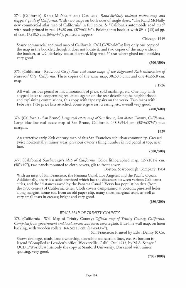
Page 114
374. (California) rAnd� mcnAlly� And� compAny.� Rand-McNally indexed pocket map and shippers’ guide of California. With two maps on both sides of single sheet, “The Rand McNally new commercial atlas map of California” in full color, & “California automobile road map” with roads printed in red. 95x80 cm. (37½x31½”). Folding into booklet with 89 + [13] ad pp. of text, 17x10.5 cm. (6¾x4¼”), printed wrappers.
Chicago: 1919
Scarce commercial and road map of California; OCLC/WorldCat lists only one copy of the map in the booklet, though it does not locate it, and two copies of the map without the booklet, at UC Berkeley and at Harvard. Map with 5” tear where glued into booklet; very good.
(300/500)
375. (California - Redwood City) �Four real estate maps of the Edgewood Park subdivision of Redwood City, California. Three copies of the same map, 38x50.5 cm., and one 46x55.8 cm. map.
c.1926
All with various pencil or ink annotations of price, sold markings, etc. One map with a typed letter to cooperating real estate agents on the rear describing the neighborhood and explaining commissions, this copy with tape repairs on the verso. Two maps with February 1926 price lists attached. Some edge wear, creasing, etc. overall very good.
(400/600)
376. (California - San Bruno) �Large real estate map of San Bruno, San Mateo County, California. Large blue-line real estate map of San Bruno, California. 148.8x94.4 cm. (58½x37¼”) plus margins.
1929
An attractive early 20th century map of this San Francisco suburban community. Creased twice horizontally, minor wear, previous owner’s filing number in red pencil at top; near fine.
(300/500)
377. (California) �Scarborough’s Map of California. Color lithographed map. 127x101½ cm. (50”x40”), two panels mounted to cloth covers, gilt to front cover.
Boston: Scarborough Company, 1904
With an inset of San Francisco, the Panama Canal, Los Angeles, and the Pacific Ocean. Additionally, there is a table provided which has the distances between various California cities, and the “distances saved by the Panama Canal.” Verso has population data (from the 1900 census) of California cities. Cloth covers dampstained at bottom; pin-sized holes along margins, some rust from an old paper clip, many short marginal tears, as well as very small tears in creases; bright and very good.
(150/200)
WALL MAP OF TRINITY COUNTY 378. (California - Wall Map of Trinity County) �Official map of Trinity County, California. Compiled from government and local surveys and forest service plats. Blue-line wall map, on linen backing, with wooden rollers. 166.5x110 cm. (85½x43¼”).
San Francisco: Printed by Edw. Denny & Co.
Shows drainage, roads, land ownership, township and section lines, etc. At bottom is legend “Compiled at Lowden’s office, Weaverville, Calif., Oct. 1915, by M.A. Senger.” OCLC/WorldCat lists only the copy at Stanford University. Darkened with minor spotting, very good.
(700/1000)

Page 115
379. (Canada) Bonne,�rigoBert.�Partie Occidentale du Canada, contenant les cinq Grand Lacs, avec les Pays Circonvoisins. Copper-engraved map, modern hand-coloring. 20.6x31.2 cm. (8½x12½”).
[Paris]: [c.1780]
From Lake Ontario west to “Lac des Bois” and the headwaters of the Mississippi, with various Indian tribes shown. Basically fine.
(200/300)
380. (China) mercAtor,�gerArd,�(tHe�younger?).�What Europe knew of China Three Hundred Years Ago. An early Seventeenth Century map of China attributed to Mercator, 1636; with “The Description of the Kingdom of China” from “A Prospect of the Most Famous Parts of the World” published in London by John Speed, 1627. 2-page text facsimile and double-page color facsimile map, loose in printed paper folder. 14¼x9¼. 1 of 100 copies.
[San Francisco]: [Grabhorn Press], [1936]
Printed for Henry H. Hart by Edwin & Robert Grabhorn. Light wear to wrappers; else near fine.
(200/300)
381. (Egypt - Alexandria) cAlmet,�Augustin.�Ancienne Veue d’Alexandrie. Copper-engraved bird’s-eye view. 29.5x44 cm. (11¾x17¼”).
Paris: 1728
Bird’s-eye view of the port city of Egypt in ancient times, surrounded by walls, with key in lower margin identifying buildings, ports, churches, monuments, and other locations. From Dictionnaire historique, critique, chronologique, geographique et litteral de la Bible. Three tiny wormholes in the image, a few others in margins; near fine.
(250/350)
382. (Europe & North Africa) de�l’isle,�guillAume.�Theatrum Historicum ad Annum Christi Quadringentesimu in quo tum Imperii Romani tu Barbarorum ... pars Occidentalis. Copper-engraved map, hand-colored. 48x65 cm. (19x25½”).
Amsterdam: Covens & Mortier, 1730
Nearly all of Europe, North Africa, the British Isles, etc., in Roman times; with circular Western Hemisphere inset without detail. Tape repairs to centerfold verso at top and bottom; very good or better, coloring bright.
(250/350)
383. (Louisiana Territory) de�vAugondy,�roBert.�Cours du Mississipi et la Louisiane. Copper-engraved map, slight hand-coloring in outline.21.5x16.2 cm. (8½x6½”).
Paris: c.1750
Map of the Mississippi Basin from the Gulf of Mexico to north of Lake Michigan. Pedley 471. Fine.
(200/300)
Page 116
BIRD’S-EYE VIEW OF MALTA, 1728 384. (Malta) cAlmet,�Augustin.�Ancien Plan de l’Isle de Malte, ou S. Paul Aborda apres son Naufrage, Act XXVIII.1. Copper-engraved bird’s-eye view. 29x43 cm. (11½x16¾”).
Paris: 1728
Bird’s-eye view of Malta, oriented to the southwest. With key, at upper right, to 33 locations. From Dictionnaire historique, critique, chronologique, geographique et litteral de la Bible. Two tiny wormholes in lower margin, else fine.
(500/800)
385. (Mediterranean) cAlmet,�Augustin.�Carte Particuliere des Pais que les Apotres ont Parcourus, et des Lieux les Plus Renommez ou ils ont Preche l’Evangile. Copper-engraved map. 32x45 cm. (12½x17½”).
Paris: 1722
The eastern Mediterrranean, with the Black Sea, Greece, part of Italy, the Balkans, Palestine, North Africa, etc., showing the travels of St. Paul. From Dictionnaire historique, critique, chronologique, geographique et litteral de la Bible, Vol. I. Laor 165. Fine, a crisp, clean impression.
(250/350)
386. (Mediterranean - Colossus of Rhodes) cAlmet,�Augustin.�Veue de la Ville, et du Colosse de Rhodes. Copper-engraved bird’s-eye view. 28.5x43.2 cm. (11¼x16¾”).
Paris: 1728
Bird’s-eye view of the port city of Rhodes on island of Rhodes, featuring the giant statue of the Greek Titan Helios erected by Chares of Lindos between 292 and 280 BC, considered one of the Seven Wonders of the Ancient World. From Dictionnaire historique, critique, chronologique, geographique et litteral de la Bible. Four small worm holes in sky portion, two tiny ones in lower margin; 1” faint stain to right of stature; very good.
(150/250)
Lot 384
Page 117
RARE MAP OF MEXICO WITH INDEPENDENT TEXAS 387. (Mexico, Texas & Southwest) ArrowsmitH,�JoHn.�Mexico. Copper-engraved map, hand-colored in outline. 48x59.5 cm. (18¾x23½”).
London: 1842
A rare and desirable map of Mexico with an oversized Texas and the present Southwest to the Oregon border, finely engraved and printed on thick paper, with large inset of the region around Mexico City. A notable depiction of the Southwest during the waning years of Mexican control, with the independent Republic of Texas. Shows states or provinces of Mexico, cities, roads, and areas of Indian habitation; Texas as a separate entity, encompassing Santa Fe. The inset is titled: “Mexico, shewing its connection with the ports of Acapulco, Vera Cruz, & Tampico”; on double scale of the map. From Arrowsmith’s London Atlas, the map is dated 15 February 1842. Fine condition.
(1000/1500)
388. (Middle East - Babylon) cAlmet,�Augustin.�Plan of Babylon and view of the Tower of Babel. Includes: Plan de la Ville de Babylone selon Hérodote, et le P. Kircher. 30.5x43.5 cm. (12x17”). * Elevation de la Tour de Babel. 30.5x19.5 cm. (12x8”). Together, 2 copper-engravings.
Paris: 1722
Bird’s-eye view of the legendary ancient city of Babylon, with the immense Tower of Babel, plus a separate view of the Tower, its upper extremity incomplete. From Dictionnaire historique, critique, chronologique, geographique et litteral de la Bible. Some fairly minor soiling, very good.
(250/350)
389. (Middle East - Garden of Eden) cAlmet,�Augustin.�Carte du Paradis Terrestre Suivant le Systeme de Mr. Huet et Execute par P. Starck-man. Copper-engraved map. 23.7x20.5 cm. (9¼x8”).
Paris: 1722
Eden, or Paridis Terrestre, along the Gehon River, with Mt. Ararat on top of which rests the Arche de Noé, plus the Tigris and Euphrates Rivers, Babylon, Jerusalem, Syria, etc. From Dictionnaire historique, critique, chronologique, geographique et litteral de la Bible, Vol. I. Faint offset, very good.
(100/150)
Lot 387

Page 118
390. (Middle East - Garden of Eden) cAlmet,�Augustin.�Carte du Paradis Terrestre Suivant le Systeme de l’Auteur et Execute par P. Starck-man. Copper-engraved map. 23.7x22 cm. (9¼x8¾”).
Paris: 1722
The Garden of Eden, or Paridis Terrestre, in Armenia, with Mt. Ararat, the Tigris and Euphrates Rivers, Babylonia, etc. From Dictionnaire historique, critique, chronologique, geographique et litteral de la Bible, Vol. I. Left margin trimmed a little unevenly, faint offset to map; very good.
(100/150)
391. (Middle East - Nineveh) cAlmet,�Augustin.�Plan de la Ville de Nineve, selon Diodore de Sicile, et le P. Kircher. Copper-engraved bird’s-eye view. 30.5x43.5 cm. (12x17”).
Paris: 1722
View of the ancient Assyrian city of Nineveh on the eastern bank of the Tigris River, capital of the Neo Assyrian Empire. From Dictionnaire historique, critique, chronologique, geographique et litteral de la Bible. Some marginal soiling, basically fine.
(150/250)
392. (Middle Easts - Sinai Peninsula) cAlmet,�Augustin.�Carte du Voyage et Routes des Israelites dans le Desert Depuis Leur Sortie de l’Egipte Jusqu’au Passage du Jourdain. Copper-engraved map. 33x44 cm. (13x17½”)
Paris: 1722
The route of the Israelites through the Sinai Peninsula, with Egypt, Canaan, the Dead Sea, Arabia Petrie, etc, with the cities of Mozera, Jericho, Memphis, Jerusalem, Bethlehem (Betleem), Hebron. etc. From Dictionnaire historique, critique, chronologique, geographique et litteral de la Bible, Vol. I. Laor 162. Fine condition, a crisp impression.
(200/300)
393. (New Mexico) ABert,�J.w.�&�w.g.�peck.�Map of the Territory of New Mexico, made by order of Brig. Gen. S.W. Kearny, under instructions from Lieut. W.H. Emory, U.S.T.E. Lithographed map. 64.5x49 cm. (25½x19¼”), matted & framed under plexiglass.
[Washington]: [1847]
Detailed mapping along the course of the Rio del Norte [i.e. Rio Grande] and adjacent areas, including Santa Fe, Albuquerque, Taos, the road to Bent’s Fort, Etc. Published in 1847 in “Report of the Secretary of War communicating...a report and map of the examination of New Mexico, made by Lieutenant J.W. Abert, of the Topographical corps” (Senate Ex. Doc. No. 23, 30th Congress, 1st Session), so identified by the lithographer’s imprint of C.B. Graham and a few additional textual notices; there was also an issue, without the imprint and slightly different dimensions, published in W.H. Emory’s “Notes of a Military Reconnoissance...,” 1848. Wheat Transmississippi 532. Some light foxing in upper left, near fine, archivally framed.
(500/800)
394. (North America) ArrowsmitH,�JoHn.�Four maps of areas of Canada and the United States. Includes: British North America. By Permission Dedicated to the Honble. Hudsons Bay Company; Containing the Latest Information which their Documents Furnish. 50x61 cm. * United States [eastern half]. 60x48 cm. * Lower Canada, New Brunswick, Nova Scotia, Prince Edwards Id., Newfoundland, and a Large Portion of the United States. 63x53 cm. * Upper Canada &c. London, Pubd 15 Feby 1842, by J. Arrowsmith, 10 Soho Square. 64x53 cm. Together, 4 copper-engraved maps hand-colored in outline.
London: 1842
Attractive, detailed maps printed on thick paper, from The London Atlas of Universal Geography. Fine or nearly so.
(700/1000)
Page 119
395. (North America) kitcHin,�tHomAs.�North America Drawn from the Latest & Best Authorities. Copper-engraved map, later hand-coloring in outline. 34x36 cm. (13½x14”).
London: c.1770
Attractive map of North America just prior to the Revolution. with the British colonies shown including a mega-Virginia containing much of present Ohio, Indiana, Michigan and Illinois. From Guthrie’s New Geographical Grammar, with old folds. Some offsetting, very good.
(250/350)
TWO MAPS OF CALIFORNIA OIL FIELDS 396. (Oil Map) �Map of Huntington Beach Oil Field, Orange County, California. Blue line map. 123x87 cm. (48x34¼”).
San Francisco: Division of Oil & Gas, 1933
Identifies individual and corporate owners of all parcels; legend explains symbols used to show status of wells. OCLC/WorldCat lists issues of this map from the Division of Oil and Gas for 1944, 1946 and 1955 (all apparently in photocopy format), one of each, two the located at UCLA, one not located; also listed is a 1920 version from the Oil Age Pub. Co., not located. Darkened streak at right side, a few neat repairs on verso; very good.
(400/600)
397. (Oil Map) �Map of Sunset oil field and region to the south, including San Emidio, Kern County, Cal. Blue-line map. 84x86.5 cm. (33x34”).
San Francisco: California Division of Oil and Gas, 1934
Identifies individual and corporate owners of all parcels; legend explains symbols used to show status of wells. OCLC/WorldCat lists single issues of this map from 1920 and 1925, but none from 1934. Very good condition.
(400/600)
398. (Oregon Territory) greenleAf,�JeremiAH.�Oregon Territory. Copper-engraved map, hand-colored 27x32 cm. (10½x12½”).
[Brattleboro, Vt.]: 1842
Based on Burr. Extends east to Rockies and beyond 54 degrees north, where it runs into Russian possessions. Some very faint creasing, near fine.
(300/500)
SEVERAL MAPS OF PALESTINE IN BIBLICAL TIMES 399. (Palestine) cAlmet,�Augustin.�Plan de Mont Carmel. Copper-engraved bird’s-eye view. 29.5x43 cm. (11¾x16¾”).
Paris: 1722
The coastal mountain range in present northern Israel stretching from the Mediterranean Sea towards the southeast, with key in lower margin identifying towns, villages and other locations. From Dictionnaire historique, critique, chronologique, geographique et litteral de la Bible. Faint soiling in lower margin, near fine.
(100/150)
400. (Palestine) cAlmet,� Augustin.�Plan et Distribution de la Terre de Chanaan, Suivant le Vision d’Ezechiel Chap.XLVIII, laquelle ne Fut jamais Executee a la Lettre... Copper-engraved map. 35x19 cm. (14x7½”).
Paris: 1722
The tribes of Israel located in Palestine, with key and text at right. From Dictionnaire historique, critique, chronologique, geographique et litteral de la Bible, Vol. I. Laor 150. Slight soiling at bottom, else near fine.
(100/150)

Page 120
401. (Palestine) cAlmet,�Augutstin).�Carte de la Terre Promise. Copper-engraved map. 47x23.3 cm. (18½x8¼”).
Paris: 1722
The Promised Land, present Israel and Palestine, from Antioch in the north to the mouth of the Nile in the south. From Dictionnaire historique, critique, chronologique, geographique et litteral de la Bible, Vol. I. Fine condition.
(100/150)
402. (Palestine - Jaffa) cAlmet,�Augustin.�Veue de la Ville, et du Port de Joppe, a Present Nommez Jaffa. Copper-engraved bird’s-eye view. 29x43 cm. (11½x17”).
Paris: 1722
Joppa, or Jaffa, is now Tel Aviv [Yafo], a leading city of modern Israel; The view is from the sea. From Dictionnaire historique, critique, chronologique, geographique et litteral de la Bible, Vol. I. A fery faint soilmark, near fine to fine.
(150/250)
TWO PLANS OF JERUSALEM 403. (Palestine - Jerusalem) cAlmet,� Augustin.� Description de l’ancienne Jerusalem selon Villalpand. Copper-engraved map. 30x43.4 cm. (11¾17¼”).
Paris: 1722
Richly detailed bird’s-eye view of ancient Jerusalem, and the bird is directly overhead. Visible are the Temple, Herod’s palace, Citadel of Antioch, Palace of David, etc., with the royal gardens outside the walls. From Dictionnaire historique, critique, chronologique, geographique et litteral de la Bible, Vol. I. Similar to Laor 1153. Tiny wormhole at top of centerfold; near fine.
(250/350)
404. (Palestine - Jerusalem) cAlmet,� Augustin.� Plan Nouveau de l’ancienne Jerusalem selon l’Auteur. Copper-engraved map. 30x43.4 cm. (11¾x17”).
Paris: 1722
Bird’s-eye view of ancient Jerusalem, schematic in format. Visible are the Temple, the “Palais du Roi,” the various walled divisions, etc., all surrounded by hills. From Dictionnaire historique, critique, chronologique, geographique et litteral de la Bible, Vol. I. Laor 975. Fine condition.
(250/350)
405. (Palestine - Siege of Masada) cAlmet,�Augustin.�Siege et Prise de Massada per les Romains. Copper-engraved bird’s-eye view. 29.8x43.5 cm. (11¾x17”).
Paris: 1728
Depiction of Masada during the last stand of the Jewish rebellion, with the legions marching towards the gates with their siege engines. From Dictionnaire historique, critique, chronologique, geographique et litteral de la Bible. Light stain in lower margin, 1 small darkened spot to image, else very good.
(250/350)

Page 121
LARGE FOLDING MAP OF ARABIA AND THE HOLY LAND 406. pAlmer,�ricHArd.�A Map of Arabia Petræa, the Holy Land, and Part of Egypt, Ancient and Modern, exhibiting their Physical Features, accompanied with Geological Notes, Designed chiefly to Illustrate those parts of the Old Testament at which relate to the Exodus and Journeyings of the Israelites, and their settlement in the Land of Promise... Engraved map, hand-colored. 129x95 cm. (50x¾x37½”), backed with linen and sectioned for folding, in original cloth slipcase with paper cover label.
London: Edward Stanford, 1858
Large, detailed map of the Holy Land and adjacent regions - shows the wanderings of the Israelites in the desert. Provenance: Collection of Margaret Gee. Slipcase stained, worn, old in writing on label (“Bought by Dr. Weis...to take to Palestine...”); map fine or nearly so.
(700/1000)
407. tilden,� s.d.�New Map of Connecticut. Lithographed map, hand-colored. 53x69 cm. (21x27”), folding into gilt-lettered cloth covers 16x10.5 cm. (6¼x4¼”).
Hartford, CT: 1886
With tables of population statistics for various counties and towns. Covers rubbed, spine worn; map bright and near fine, with only a few tiny nicks at folds.
(200/300)
408. (United States) ArrowsmitH,� JoHn.�United States. Copper-engraved map, hand-colored (later?). Engraved by E. Jones. 25x31 cm. (10x12”).
London: Longman, Hurst, Rees & Orme, 1805
United States to the Mississippi River, with unsettled (and uncolored) Louisiana beyond. Kentucky and Tennessee have been delineated, Georgia stretches to the Mississippi, with West Florida hugging the coasts south of it to New Orleans; west of Pennsylvania there are many forts and villages, but no territorial boundaries defined. Marginal foxing; very good.
(200/300)
CAREY & LEA’S UNITED STATES BASED ON MELISH 409. (United States) cArey�&� leA.�United States of America. Copper-engraved map, hand-colored. Engraved by B. Tanner. 43.2x54.5 cm. (17x21½”).
[Philadelphia]: [1822]
Important map of the United States, issued in Carey & Lea’s American Atlas, based largely on Melish’s 1818 map but extending westward only to the Rocky Mountains, with northern Mexico including an imaginatively configured Texas. Information from Lewis & Clark, Pike, and Long was used in compiling the map, with that feature noted in the Gulf of Mexico, determining this example of the map to be the first issue. The back of the left-hand portion of the map was formerly used to mount photographs, with slight, barely noticeable splits made in the map to hold the pictures, without any loss of paper, and ink identification on the verso of the map; again, this feature is barely discernible when looking at the recto of the map. Some offsetting, 1” split at lower centerfold; very good.
(500/800)

Page 122
410. (United States) cAse,�tiffAny�&�co.�Map of the United States. Lithographed folding map on banknote paper, hand-colored. 59.5x61.5 cm. (23¼x24¼”).
[Hartford]: [1852]
Folding map of the United States just after the Mexican War, with its newly-won territories, the southwest border being in pre-Gadsden configuration, and the western territories in odd flux. Mexico and Central America are also includes. With vignettes of George Washington and the Capitol building. Lacking the covers. Short tear across neatline at left edge barely into the Pacific, faint darkening along one fold; very good or better.
(400/600)
411. (United States) colton,� J.H.�The United States of America. Lithographed map, hand-colored. 35.5x62 cm. (13¾x24½”) plus decorative border.
New York: 1855
Excellent map showing the odd configurations of the evolving American West in the years following the annexation of Texas, California and the Southwest. Washington and Oregon Territories extend to the huge Nebraska Territory at the continental divide; Nebraska extends to the Missouri River where it borders Minnesota Territory. Utah Territory stretches from California east to Nebraska and Kanzas. The very large New Mexico Territory comprises all of today’s Arizona, the southern tip of Nevada, and part of Colorado. The map shows the exploration routes of Marcy, Kearny, Fremont, etc., and locates the Santa Fe Trail and the Oregon Trail. A few faint fox marks, slight darkening along centerfold, short splits at top and bottom; very good.
(150/250)
412. (United States - Great Plains) colton,�J.H.�Colton’s Map of Kansas, Nebraska, Dakota & Indian Territory. Lithographed map, hand-colored. 67x43 cm. (26½x17”).
New York: c.1866
The land between the Mississippi River and the Rocky Mountains, with the explorers and survey routes shown, emigrant trails, etc. Some faint foxing, darkening at edges and along centerfold, otherwise very good.
(250/350)
413. (United States) lizArs,�w.H.�United States. Copper-engraved map, hand-colored. 41x50 cm. (16x19½”).
Edinburgh: c.1831
The United States to the headwaters of the Missouri River and including present Texas, which is named but still a part of Mexico. Arkansas includes present Oklahoma. Some marginal dampstaining intruding lightly into image at lower right and lower centerfold; very good.
(200/300)
414. (United States - Northeast) Bonne,�rigoBert.�Carte de la Partie Nord, des Etats Unis, de l’Amerique Septentrionale. Copper-engraved map, later hand-coloring. 21x31.5 cm. (8½x12¼”).
Paris: c.1783
The newly minted United States from the Chesapeake north. Some marginal dampstaining, very good.
(120/180)

Page 123
415. (United States - Northeast) �The Air Line: Fastest Motor Route Between New York and Boston. Connecting Routes to and from Washington - Pittsburgh - Cleveland - Montreal - Quebec. Folding map/brochure, printed in red & black. 47x84 cm. 18½x33”) sheet size.
New York?: Mixer’s Motor Maps?, 1927
Rare map of the Air Line highway from New York to Waterbury and on to Boston, with the latter section completed Fall of 1927, with additional maps of connecting routes on both recto and verso, along with pictures and short descriptions of leading hotels along the routes. OCLC/WorldCat lists only one copy, at the New York Public Library, which apparently is a later issue with “1928 route notice” pasted on back panel. Two inch split at main fold; very good or better.
(300/500)
416. (United States - Northwest) colton,� J.H.�Colton’s Map of Oregon, Washington, Idaho, British Columbia & Montana. Lithographed map, hand-colored. 42x67 cm. (16½x26½”).
New York: c.1866
Fairly early map to show a well-defined Idaho and Montana, although Dakota still includes Wyoming. Various explorers and survey routes are shown, as are emigrant trails, and the Pony Express route. Some darkening at edges and along centerfold, else very good.
(300/500)
417. (United States - Southwest) colton,�J.H.�Colton’s Map of California, Nevada, Utah, New Mexico, Colorado, Arizona & New Mexico. Lithographed map, hand-colored. 38.2x62.2 cm. (15x24½”) plus decorative border.
New York: c.1866
Post-Gadsden map of the evolving Southwest, with explorers’ and mail routes shown, Indian tribes located, towns, cities, etc. Some minor soiling, a bit of darkening at edges and along centerfold, else very good.
(200/300)
418. (United States - Southwest) JoHnson�&�wArd.� Johnson’s California, with Territories of Utah, Nevada, Colorado, New Mexico, and Arizona. Hand-colored lithograph map. 43x59.5 cm. (17x23½”), including border.
[New York]: [1864]
Nevada still lacks its lower corner in this map. With the usual good detail and vigilance of Johnson’s maps of the early Southwest. Splitting along centerfold, very good.
(150/250)
419. (United States) tHomAs,�cowpertHwAit�&�co.�A New Map of the United States of America. Engraved map by J.H. Young, hand-colored. 41x72 cm. (16x28½”).
Philadelphia: 1850
The United States at the height of the Gold Rush, with insets of the Gold Region of California and the District of Columbia. Fine condition, printed on thick paper.
(300/500)
420. (World - Ancient) cAlmet,�Augustin.�Carte Geographique du Monde Ancien Suivant le Partage des Enfans de Noe, apres leur Dispersion Arrivee a Babel. Copper-engraved map. 33x44 cm. (13x17½”).
200/300: 1722
Europe, North Afrkica and the Middle East to the Indus. Engraved by P. Starkman. From Dictionnaire historique, critique, chronologique, geographique et litteral de la Bible, Vol. I. Slight soiling in lower left margin; fine condition, nice impression.
(200/300)

Page 124
421. (World) Bellin,�JAcques�nicolAs.�Essay d’une Carte Reduite Contenant les Parties Connues du Globe Terrestre. Copper-engraved map, hand colored (later). 50x69.5 cm. (19¾x27½”).
Paris: 1748
Significant map of the world showing the latest discoveries and based as much as possible on actual observations and knowledge, though some fantasies still persist, such as the fabled River of the West connecting the Great Lakes to the Pacific. This is the “pre-Cook” state of the map, with his discoveries and surveys, such as the definition of the east coast of Australia and his mapping of New Zealand, not shown. Tape repairs on verso at folds, a half-dozen or so tiny wormholes, some darkening and soiling, good to very good.
(500/800)
RARE JAPANESE MAP OF THE BUDDHIST WORLD, 1710422. (World - Japanese) zudA�rokAsHi� [priest�HotAn].�Nansenbushu Bankoku Shoka No Zu [Outline Map of All Countries of the Universe]. Woodcut map. 114.5x141.5 cm. (45x55¾”), folding into wrappers with label.
Kyoto: Bundaiken Uhei, 1710 (Hoei 7 = Year of the Tiger)
The first Buddhist world map printed in Japan and the prototype for all subsequent Buddhist world maps printed in Japan until the late nineteenth century. The map centered on ‘Jambu-Dvipa’, the mythological heart of Buddhist cosmography where Buddha was born in Northern India with the sacred lake of Anavatapta, and the four sacred rivers Ganges, Oxus, Indus, and Tarim flowing from it, the map extending from Ceylon to Siberia, and from Japan to the British Isles ‘Country of the Western Woman’, with Europe as a group of islands, Africa figured as a small island, South America is is an island in the ocean south of Japan on the right side. A land bridge connects China to an unnamed continent in the upper right corner. There are numerous place names, texts placed at lower left and right corners including a list of Sutras and Chinese histories, title in a banner at upper margin. In the center of the map in the Himalayan Mountains is a quadruple helix symbolizing the origins of the four great rivers of the region emanating from the heads of a horse, a lion, an elephant, and an ox. This is the site of the present day Lake Manasarovar, the highest fresh water lake in the world. The author, Hotan (1654-1728), was a scholar-priest and founder of the Kegonji Temple in Kyoto. Hotan’s map was revolutionary in being the first printed Oriental map to introduce detailed Western cartographic information into this traditional Buddhist cosmological view and to attempt to merge the two together into a comprehensible form. Wrappers well rubbed, including title label which is largely illegible; worming across the map, with a few of the holes as much as ¼” across but generally unobtrusive, some light stains at folds; overall very good.
(6000/9000)
Lot 422

Page 125
423. (World) JoHnson,� JosepH.�The world divided into the torrid zone, the temperate & frigid zones, both north & south. Three copper-engraved maps on 1 sheet, hand-colored in outline. On sheet 36x42.5 cm. (14¼x16¾”).
London: I. Johnson, 1791
Double polar projections with a rectangular map of the tropical regions below. The three maps are: Map printed in 3 segments on 1 sheet: The South Pole to the Tropic of Capricorn, in which are traced the several attempts of Capt. Cook to discover a southern continent in 1773, 74 & 75; The North Pole to the Tropic of Cancer, describing the tracts of the Honble. Capt. Phipps (now Ld. Mulgrave) in 1775 & Capts. Cook & Clerke in 1778 & 79; The Torrid Zone or tropical regions of the world, in which are accurately laid down the new discoveries in the Pacific Ocean or South Sea. OCLC/WorldCat lists only one copy, at the New York Public Library. Some minor soiling, staining and discoloration. short tear at lower edge; very good.
(300/500)
Page 126
CONDITIONS OF SALEThe property listed in this catalogue will be sold by PBA Galleries, Inc. (hereinafter Galleries) as agent for others upon the following terms and conditions as may be amended by notice or oral announcement at the sale:
1. All bids are to be per lot as numbered in the catalogue.
2. As used herein the term “bid price” means the price at which a lot is knocked down to the purchaser and the term “purchase price” means the aggregate of (a) the bid price (b) a premium of twenty percent (20%) of the bid price payable by the purchaser, and (c) unless the purchaser is exempt by law from the payment thereof, any California state or local sales tax except where sold to a purchaser outside of California and shipped to the purchaser.The Galleries have been authorized by the consignor to retain, as part of remuneration, the 20% premium payable by the purchaser.
3. Property auctioned by the Galleries is often of some age.Prospective bidders should personally inspect such property to determine its condition and whether it has been repaired or restored.Any information provided by the Galleries or its employees is for the convenience of bidders only and should not be relied upon. ALL PROPERTY IS SOLD “AS IS” AND NEITHER THE GALLERIES NOR THE CONSIGNOR MAKES ANY WARRANTIES OR REPRESENTATIONS OF ANY KIND OR NATURE WITH RESPECT TO THE PROPERTY OR ITS VALUE, MERCHANTABILITY, FITNESS FOR A PARTICULAR PURPOSE, OR WHETHER THE PURCHASER ACQUIRES ANY COPYRIGHTS.IN NO EVENT SHALL THE GALLERIES OR THE CONSIGNOR BE RESPONSIBLE FOR CORRECTNESS OF DESCRIPTION, GENUINENESS, ATTRIBUTION, PROVENANCE, AUTHENTICITY, AUTHORSHIP, COMPLETENESS, CONDITION OF THE PROPERTY OR ESTIMATE OF VALUE.NO STATEMENT (ORAL OR WRITTEN) IN THE CATALOGUE, AT THE SALE, OR ELSEWHERE SHALL BE DEEMED SUCH A WARRANTY OR REPRESENTATION, OR ANY ASSUMPTION OF RESPONSIBILITY.HOWEVER, notwithstanding this condition and subject to the further provisions of this paragraph as set forth below, property may be returned by the purchaser, the sale rescinded and the purchase price refunded under the following conditions: (1) printed books which prove upon collation to be defective in text or illustration (provided such defects are not indicated within the catalogue or at the sale), and (2) autographs which prove not to be genuine (if this can be demonstrated and if not indicated in the catalogue or at the sale).Printed books are not returnable for defects not affecting text and illustration, including, but not limited to, lack of half-titles, lists of plates, binder’s instructions, errata, blanks, or advertisements.No returns will be accepted unless written notice, by registered mail or receipted courier, is received by the Galleries within fourteen (14) days of the sale of the property and the property is returned in the same condition as it was at the time of sale.NO LOT IS RETURNABLE ON ACCOUNT OF PROPERTY INCLUDED BUT NOT SPECIFICALLY NAMED AND DESCRIBED IN SUCH LOT.LOTS CONTAINING THREE OR MORE TITLES, WHETHER NAMED OR UNNAMED, AND SELLING FOR ONE HUNDRED FIFTY ($150) OR LESS, EXCLUSIVE OF BUYER’S PREMIUM, ARE SOLD NOT SUBJECT TO RETURN FOR ANY REASON.
4.Photographs, prints and other fine art multiples are sold in compliance with California law, and the Galleries’ catalogue descriptions of such multiples conform to the applicable provisions of that law.
5. Any right of the purchaser under this agreement or under the law shall not be assignable and shall be enforceable only by the original purchaser and not by any subsequent owner or any person who shall subsequently acquire any interest. No purchaser shall be entitled to any

Page 127
remedy, relief or damages beyond return of the property, recision of the sale and refund of the purchase price; and, without limitation, no purchaser shall be entitled to damages of any kind.
6. If we are prevented by fire, theft or any other reason whatsoever from delivering any property to the purchaser, our liability shall be limited to the sum actually paid by the purchaser.
7. Books and other property purchased are to be removed at the close of each Sale unless shipping instructions are received by the Galleries before such sale.If not removed, property will be held at the sole risk of the purchaser and no responsibility is assumed if such goods are lost, stolen, damaged, or destroyed.The Galleries will facilitate shipment of property to out-of-town purchasers at an additional packing charge plus carriage and insurance, but will not be responsible for any loss or damage resulting from the shipping thereof in excess of the amount of the insurance.
8. Payment terms:All items are to be paid for by (a) cash, (b) cashier’s check, (c)credit card, or (d) personal check with approved credit, and all accounts are due when bills are rendered. MERCHANDISE WILL BE SHIPPED AFTER PAYMENT HAS BEEN RECEIVED.
9. We reserve the right to reject a bid from any bidder.The highest bidder acknowledged by the auctioneer shall be the purchaser.In the event of any dispute between bidders, or in the event the auctioneer doubts the validity of any bid, the auctioneer shall have the sole and final discretion either to determine the successful bidder or to re-offer and resell the article in dispute. If any dispute arises after the sale, our sales records shall be conclusive in every respect.
10. Unless the Sale is advertised as a sale without reserve, each lot is offered subject to a reserve.MOST LOTS OFFERED BY THE GALLERIES HAVE A MINIMUM RESERVE OF ONE-HALF THE PRESALE LOW ESTIMATE .The Galleries do not accept reserves of more than the low estimate nor allow consignors to bid on their own items.
11. To prevent inaccuracy in delivery or inconvenience in the settlement of a purchase, no lot can be transferred.Each buyer must pay for the whole of his purchases before any lot can be removed.
12. As a service to clients unable to attend the Sale, we will accept absentee bids without charge in advance of the sale by telephone, mail, fax, email or in person.All bids must state the highest bid price the bidder is willing to pay.“Buy” bids are not accepted.Please check bid sheets carefully to make sure you have the correct lot numbers and that the sheet is legible.The Galleries reserve the right to refuse to undertake absentee bids, and shall in no event be responsible for failure to execute such bids or for any error that may occur when executing them.Unsuccessful absentee bids will not be acknowledged.
ALL SALES HELD BY PBA GALLERIES ARE CONDUCTED PURSUANT TO SECTION 2328 OF THE COMMERCIAL CODE AND SECTION 535 OF THE PENAL CODE OF THE STATE OF CALIFORNIA
CONSIGNING BOOKS TO PBA GALLERIESThe first step in consigning to PBA is to contact the Galleries, either by phone, fax, email or letter. It can then be determined whether the item or items under consideration would do well at auction. Following this, arrangements can be made for the delivery of the material to PBA. In the case of large consignments or libraries, a member of the staff may be able to view the books on location, and make arrangements for its transportation to PBA Galleries. Because of the costs involved, PBA discourages consignments with a total value of less than $1500.The frequency of auctions, and variety of subject matter, allows PBA Galleries to ensure

Page 128
quick turn-around time for items consigned. Books can appear at auction as quickly as 30 days and generally not more than 90 days following consignment. Commissions vary between 10% and 15%, depending on the selling price of an item.These commissions encompass all related costs including insurance, storage, cataloguing, illustrations, etc., except shipping. Payment is sent within 20 banking days of an auction.

Page 129

Page 130
O f f e r Yo u r B o o k s at A u c t i o nt h r o u g h P B A G a l l e r i e s
133 Kearny Street : San Francisco, CA 94108 : www.pbagalleries.com : 415.989.2665
SPECIALISTS IN EXCEPTIONAL BOOKS & PRIVATE LIBRARIES AT AUCTION
F. Scott Fitzgerald's All the Sad Young Men, an inscribed presentation copy with original sketch by
Fitzgerald, in the first issue dust jacket. Sold for $37,375
History of the Expedition under the Command of Captains Lewis and Clark to the Sources of the Missouri, 1814, the first edition of the official
account of the most famous and most important expedition of exploration in U.S. history.
Sold for $212,000
The Polycronicon of Ranulf Higden, the second edition, printed in 1495 by Wynkyn de Worde, containing the first example of printed musical
notation in an English book.Sold for $33,000
Jonathan Swift’s Gulliver’s Travels,first issue, large paper copy.
Sold for $192,000
Set of John Ogilby’s translations of Nieuhoff’s Embassy to China (1669) and Montanus’ Atlas
Chinensis (1671), handsomely printed with numerous fine engraved plates.
Sold for $42,000
Eadweard Muybridge's stunning Panorama of San Francisco, from California Street Hill, 1877,
the 11 albumen photograph panels framed consecutively to stretch over seven feet wide.
Sold for $51,000
Fine example of William Eddy’s important Official Map of the State of California, 1854, folding into
the original red leather covers, very rare.Sold for $39,000
Original manuscript diary kept by William Willson, recording a journey on the Oregon Trail from Iowa
to the Columbia River in the summer of 1852.Sold for $30,000
First edition of Charles Darwin's On the Origin of Species by Means of Natural Selection.
Sold for $51,000
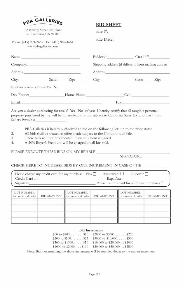
Page 131
LOT NUMBERIn numerical order BID AMOUNT
LOT NUMBERIn numerical order BID AMOUNT
LOT NUMBERIn numerical order BID AMOUNT
Name:_______________________________ Bidder#:______________ Cust Id#___________
Company:____________________________ Shipping address (if different from mailing address)
Address:______________________________ Address:__________________________________
City:________________State:______Zip:______ City:__________________State:______Zip:_____ Is either a new address? Yes No
Day Phone:___________________Home Phone:____________________Cell:____________________
Email:___________________________________________ Fax:_________________________
Are you a dealer purchasing for resale? Yes No (if yes) I hereby certify that all tangible personal property purchased by me will be for resale and is not subject to California Sales Tax, and that I hold Sellers Permit #________________
1. PBA Galleries is hereby authorized to bid on the following lots up to the price stated.2. All bids shall be treated as offers made subject to the Conditions of Sale.3. These bids will not be executed unless this form is signed.4. A 20% Buyer’s Premium will be charged on all lots sold.
PLEASE EXECUTE THESE BIDS ON MY BEHALF. _______________________________________ SIGNATURE
CHECK HERE TO INCREASE BIDS BY ONE INCREMENT IN CASE OF TIE_______________
Bid Increments$00 to $200. . . . . . . . $10 $200 to $500. . . . . . . . $25 $500 to $1000. . . . . . $50 $1000 to $2000. . . . $100
$2000 to $5000. . . . . . . $250$5000 to $10,000. . . . . $500$10,000 to $20,000. . . $1000$20,000 to $50,000. . . $2500
Note: Bids not matching the above increments will be rounded down to the nearest increment.
133 Kearny Street, 4th FloorSan Francisco, CA 94108
Phone: (415) 989-2665 Fax: (415) 989-1664www.pbagalleries.com
BId Sheet
Sale #:_________________
Sale Date:______________________
Please charge my credit card for my purchase: Visa Mastercard DiscoverCredit Card #:____________________________________ Exp. Date:______________________Signature___________________________________ Please use this card for all future purchases

Page 132
Notes
Copyright © 2022 FDOKUMEN