Nature, nationalism and revolutionary regionalism: constructing Soviet Karelia, 1920–1923
Full Terms & Conditions of access and use can be found athttp://www.tandfonline.com/action/journalInformation?journalCode=rimu20
Download by: [Orta Dogu Teknik Universitesi] Date: 21 December 2015, At: 05:34
Imago MundiThe International Journal for the History of Cartography
ISSN: 0308-5694 (Print) 1479-7801 (Online) Journal homepage: http://www.tandfonline.com/loi/rimu20
Regionalism and Nationalism in the RailwayCartography of Mid-Nineteenth Century Germany
Zef Segal
To cite this article: Zef Segal (2016) Regionalism and Nationalism in the Railway Cartography ofMid-Nineteenth Century Germany, Imago Mundi, 68:1, 46-61
To link to this article: http://dx.doi.org/10.1080/03085694.2016.1107374
Published online: 15 Dec 2015.
Submit your article to this journal
Article views: 2
View related articles
View Crossmark data
Regionalism and Nationalism in the Railway Cartography ofMid-Nineteenth Century Germany
ZEF SEGAL
ABSTRACT: This article concerns German railway cartography in the mid-nineteenth century and its effects
on spatio-political perceptions. The evolution of a railway system in Germany, from isolated single routes into
national and ultimately international networks, has been customarily linked to the political issue of unifica-
tion in 1871. The infrastructural changes triggered the introduction of new maps and map signs, which
overshadowed other national and political signs and should not be seen as a simple means to a nationalist
end. By examining the developing iconography of railways and railway networks, I argue that railways were
a cause of deterritorialization for regions and states and for the vision of a unified Germany.
KEYWORDS: Germany, nineteenth century, German states, state railways, national railways, territorialidentity, territorial integration, deterritorialization, national unification, particularism, internationalconnections, mapping railways, route maps, systems maps, segmented maps.
Throughout the nineteenth century, the residentsof the central European German territories wereconfused by the ever-changing borders of theirhomelands. The thousand-year-old Holy RomanEmpire had been dissolved in 1806 by Napoleon,who then amalgamated the hundreds of smallpolitical entities into thirty-seven independentstates. Although these states were recognized inthe 1815 Treaty of Vienna, integration was slow.Meanwhile, a growing national movement wascalling for a more radical territorial reform throughthe unification of all the German states. As a result,Germans were subjected to a multitude of contra-dictory forces that pulled or pushed them into dif-ferent territorial hierarchies, notably sub-statetraditional regional affiliations, state patriotism(also known as particularism) and German nation-alism. Finally, adding to the inhabitants’ spatialdisorientation and the administrative confusion of
deterrioralization, the railways arrived, shrinkingdistances and encouraging mass mobility.In general the railway systems of Europe had a
paradoxical effect on the formation of territorialstates. On the one hand, they were a major factorin the development and consolidation of central-ized modern states; on the other hand, they were acatalyst for the integration of internationalregions.1 Unlike most other European countries,the German lands did not comprise a single statebut existed as thirty-seven autonomous states thatoccasionally cooperated on economic issues. As aresult, the railways’ conflicting effect was particu-larly evident in the German regions, where somehistorians have interpreted the mid-century expan-sion of the railway system as promoting particular-ist state development or as a source for sub-stateregional integration, whereas other historians see
4Dr Zef Segal is a post-doctoral fellow in the Department of Politics and Government, Ben-Gurion University, and
at the Truman Institute and ‘Daat Hamakom’ at the Hebrew University, Jerusalem. Correspondence to: Z. Segal,
Imago Mundi Vol. 68, Part 1: 46–61
© 2015 Imago Mundi Ltd ISSN 0308-5694 print/1479-7801 online
http://dx.doi.org/10.1080/03085694.2016.1107374
Dow
nloa
ded
by [
Ort
a D
ogu
Tek
nik
Uni
vers
itesi
] at
05:
34 2
1 D
ecem
ber
2015
the railways as an inseparable element in thecreation of German nationalism.2
In this article I examine the way the railwaysystems were depicted on contemporary maps inorder to identify the challenges this mode of trans-port posed to local, regional and state societies, andwhy it led sometimes to social integration andsometimes to its disintegration. My premise is thatmaps reflect perceptions of space and that theirsymbology can portray the fundamental changesin the people’s sense of territory brought about bythe arrival of the train.3 It may also be said that bygiving perception a visual shape, the maps playedan active role in the creation of new spatial under-standings, mirroring contemporary society and itsshifting attitudes to the space it inhabited.4
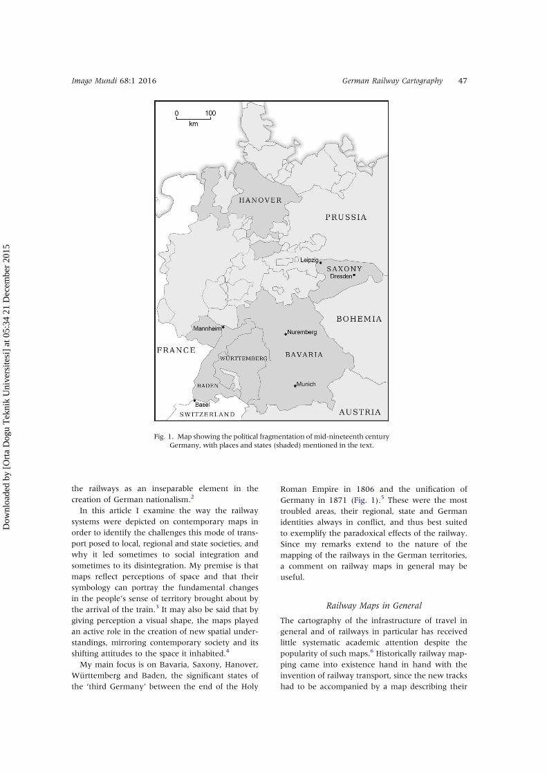
My main focus is on Bavaria, Saxony, Hanover,Württemberg and Baden, the significant states ofthe ‘third Germany’ between the end of the Holy
Roman Empire in 1806 and the unification ofGermany in 1871 (Fig. 1).5 These were the mosttroubled areas, their regional, state and Germanidentities always in conflict, and thus best suitedto exemplify the paradoxical effects of the railway.Since my remarks extend to the nature of themapping of the railways in the German territories,a comment on railway maps in general may beuseful.
Railway Maps in General
The cartography of the infrastructure of travel ingeneral and of railways in particular has receivedlittle systematic academic attention despite thepopularity of such maps.6 Historically railway map-ping came into existence hand in hand with theinvention of railway transport, since the new trackshad to be accompanied by a map describing their
Fig. 1. Map showing the political fragmentation of mid-nineteenth centuryGermany, with places and states (shaded) mentioned in the text.
Imago Mundi 68:1 2016 German Railway Cartography 47
Dow
nloa
ded
by [
Ort
a D
ogu
Tek
nik
Uni
vers
itesi
] at
05:
34 2
1 D
ecem
ber
2015
route. A map was needed at every step, from theinitial planning and public proposal, through theconstruction of the line, to the commercial displayof the route to attract potential users. The import-ance of the map to the railway thus helps toexplain the diversity of early railway maps. Theserange from small to large scale, each level accom-modating the different viewers at each stage ofconstruction and their sponsorship by a varietyof institutions, notably state authorities, traincompanies and travel-guide publishers.The various maps that depicted railways can be
divided into four basic types: (1) ‘segmented maps’that depict the technical details of a limited sectionof a railway, usually for the purpose of constructingtunnels and bridges and for the provision of track-side equipment; (2) ‘route maps’ showing a singleline with its stations, and perhaps some landscapevignettes along the way that served to contextual-ize the line; (3) ‘system maps’, typically on thesmallest scale since they depict a network as awhole, often ignoring local political or geographicaldetails for the sake of a coherent image; (4)‘general maps’ that are not railway maps, per se,since the railroad is just one man-made featureamong many others.System maps form a type of cartography that is
concerned primarily with the operation of the raillines rather than their distribution, and as suchthey tend to be schematic in style.7 General mapsinclude all maps that incorporate the depiction ofrailways within the ordinary topographical per-spective, thus recording the distribution of severallines as part of a broader territorial order andprojecting the social and political perspectives ofthe operators.I am concentrating here on the last three types
listed above as I try to show the connectionbetween the changing style of railway cartographyas both the system and spatial-political perceptionsdeveloped. Although the narrative of this paper ischronological, some of the examples deviate fromthe exact periodization, since each German statehad its own timeline of railway development.Approaching the issue chronologically allows meto challenge the assumption that the contemporarysense of space developed in simple linear fashionfrom localism (the experience of a single route) to aparticularism (the awareness of a total state system)that passed into German nationalism (German railsystems), as is the customary way of portraying theeffect of the growth of railways. My point is thatthe railway networks, at first just single routeswithin a state, were in effect deterritorializing
factors as they crossed accepted borders throughexpansion or contraction; in mid nineteenth-century Germany, the local, the national and thesupra-national existed simultaneously.
German Railway Route Maps
Although most of the early German railway routemaps were produced in conjunction with develop-ment proposals to show an intended track, somewere printed to promote newly constructed trainlines.8 In either case, they had a commercial roleinasmuch as they emphasized new or future con-nections between the places along the route thatpreviously had little to do with each other andwere effectively advertising the advantages of thenew economic, cultural and social connections.Places further away from the tracks, for which thenew line was irrelevant, would be either unmarkedor visually belittled in some way. In contrast, therailway line itself was emphasized by a wider,bolder or coloured line.The vast majority of early route maps that began
to appear in the German lands in the 1830s and1840s were connected first with the planningprocess and then with the initial stages of construc-tion, and were therefore not intended for publicuse. Many remained in manuscript or were printedin small numbers only. Later, however, as enthu-siasm for railway building spread, route mapsbegan to be published in the literally hundreds ofbooks and manuscripts promoting plans for newrailway lines and describing those recentlyconstructed.9 This genre of book, with its map,created a new form of regional identificationbased on route-vicinity, the accentuation of adja-cent villages and the nullifying of distant ones.Typically, all maps showing a continuous single
railway route from start to finish withoutsurrounding features were carrying on a long tradi-tion of road and canal maps. The users of suchmaps, it was assumed, had no need for informationbeyond the area adjacent to the railway line.Accordingly, only a relatively narrow zone tendsto be depicted on these maps.The pronounced local nature of early German
rail initiatives arose in the first place from the factthat the German railways relied until the middle ofthe century on private entrepreneurs who operatedwithin their respective independent states to raisefunding for a specific local line. From his analysis ofthe social and economic background of these entre-preneurs, the German railway historian, VolkerThen, was led to conclude that in Germany
48 Z. Segal Imago Mundi 68:1 2016
Dow
nloa
ded
by [
Ort
a D
ogu
Tek
nik
Uni
vers
itesi
] at
05:
34 2
1 D
ecem
ber
2015
‘railways originated in a region’, by which hemeant that few of the first railways extendedbeyond the entrepreneur’s own city, let aloneacross the state.10 He also noted that the majorityof stockholders were not industrialists, noblemenor landowners with grandiose interests, but rela-tively small-scale merchants, manufacturers andmembers of the urban bourgeoisie.11
Although many railway promoters in the variousGerman states were politically active locally, fewwere involved in state, let alone national, politics.12
The German railways thus arose primarily from theneeds of the urban middle classes as these looked forways to improve their economic environment. As aresult, the first railway-building initiatives wereorganized by city-based groups. In Nuremberg, forexample, this was the Nuremberg Association,which funded the construction of the first Germanrailway line between Nuremberg and Fürth in 1834.Similar alliances were made elsewhere in Germany,in major cities such as Dresden, Leipzig andMunich.13 These initial steps developed alreadyexisting regional ties. Railway lines were notplanned to promote new connections, whetherwithin a region, between regions within a state, orbetween different states, but rather aimed to
supplement existing roads and routes with the newform of transport.14
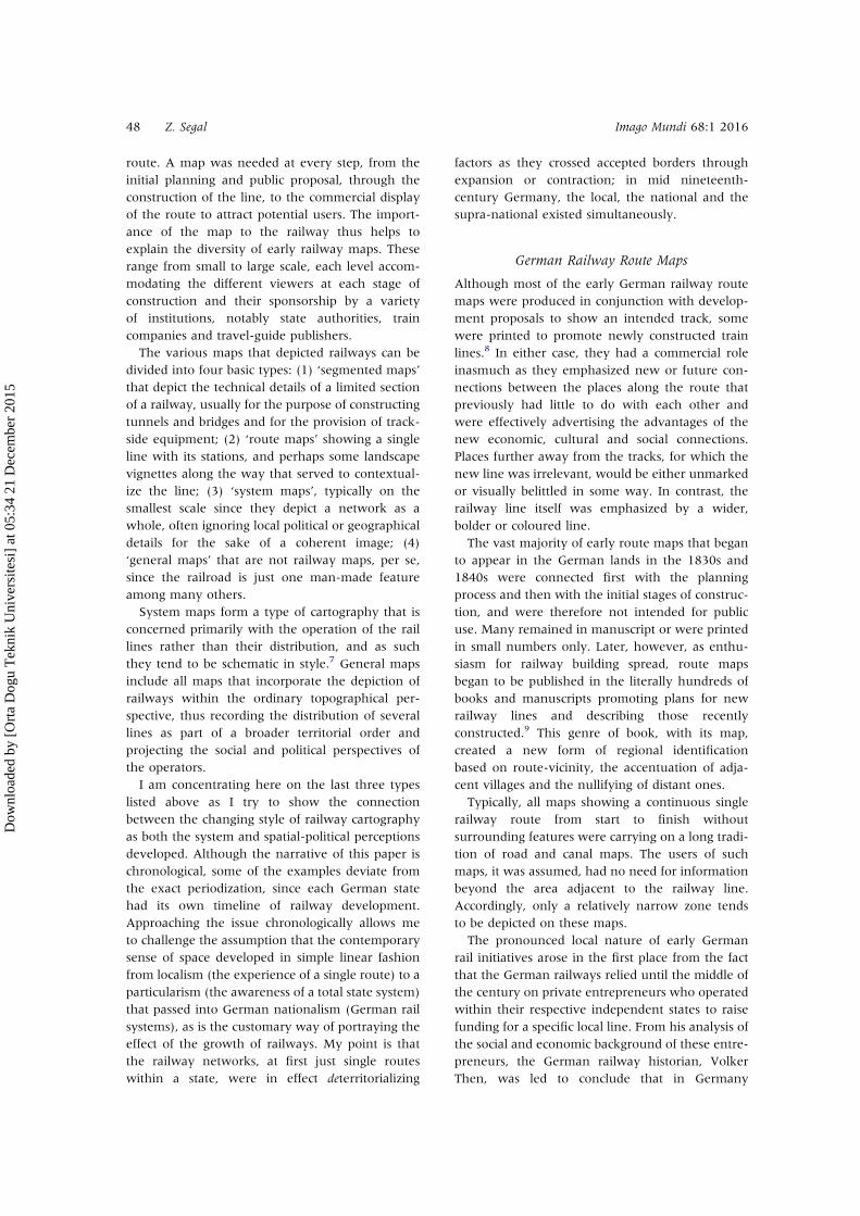
As a result, the earliest railway mapping in theseGerman states was focused on individual routes.The uncoloured map accompanying the plans tolay down the first railway line in the Germanworld, between Nuremberg and Fürth, containsfew details apart from the route, the two cities,contour lines, rivers and, faintly sketched in, someother nucleations lying within the frame of themap (Fig. 2). The emphasis on the projected rail-way line, and the river it follows, creates a strongvisual link between the two cities to the exclusionof the surrounding regions. The minimalism of thisparticular map is perhaps exaggerated because ofthe shortness of the line depicted (6 km), but theobservation holds even for maps with longerroutes.If the Nuremberg–Fürth route map limited the
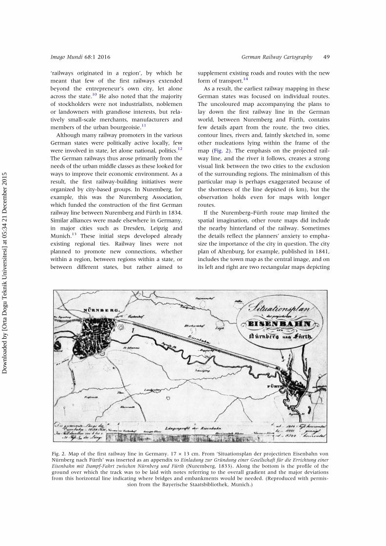
spatial imagination, other route maps did includethe nearby hinterland of the railway. Sometimesthe details reflect the planners’ anxiety to empha-size the importance of the city in question. The cityplan of Altenburg, for example, published in 1841,includes the town map as the central image, and onits left and right are two rectangular maps depicting
Fig. 2. Map of the first railway line in Germany. 17 × 13 cm. From ‘Situationsplan der projectirten Eisenbahn vonNürnberg nach Fürth’ was inserted as an appendix to Einladung zur Gründung einer Gesellschaft für die Errichtung einerEisenbahn mit Dampf-Fahrt zwischen Nürnberg und Fürth (Nuremberg, 1833). Along the bottom is the profile of theground over which the track was to be laid with notes referring to the overall gradient and the major deviationsfrom this horizontal line indicating where bridges and embankments would be needed. (Reproduced with permis-
sion from the Bayerische Staatsbibliothek, Munich.)
Imago Mundi 68:1 2016 German Railway Cartography 49
Dow
nloa
ded
by [
Ort
a D
ogu
Tek
nik
Uni
vers
itesi
] at
05:
34 2
1 D
ecem
ber
2015
the route between Leipzig and Hof, which passedthrough Altenburg (Fig. 3).15 The line of the rail-way is accentuated by the addition of dark bluecolour and, despite its relatively narrow format(2.3 × 10 cm), many villages were packed in toenhance the periphery of the cities along the line.Similarly, maps advertising a projected railway
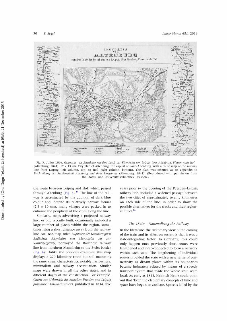
line, or one recently built, occasionally included alarge number of places within the region, some-times lying a short distance away from the railwayline. An 1846 map, titled Zugskarte der Grosherzoglich
Badischen Eisenbahn von Mannheim bis zur
Schweizergrenze, portrayed the Badenese railwayline from northern Mannheim to the Swiss border(Fig. 4). Unlike the previous examples, this mapdisplays a 270 kilometre route but still maintainsthe same visual characteristics, notably narrowness,minimalism and railway accentuation. Similarmaps were drawn in all the other states, and indifferent stages of the construction. For example,Charte zur Uebersicht des zwischen Dresden und Leipzig
projectirten Eisenbahntractes, published in 1834, five
years prior to the opening of the Dresden‒Leipzigrailway line, included a widened passage betweenthe two cities of approximately twenty kilometreson each side of the line, in order to show thepossible alternatives for the tracks and their region-al effect.16
The 1840s—Nationalizing the Railway
In the literature, the customary view of the comingof the train and its effect on society is that it was astate-integrating factor. In Germany, this couldonly happen once previously short routes werelengthened and inter-connected to form a networkwithin each state. The lengthening of individualroutes provided the state with a new sense of con-nectivity as distant places within its boundariesbecame intimately related by means of a speedytransport system that made the whole state seemlocal. As early as 1843, Heinrich Heine could pointout that ‘Even the elementary concepts of time andspace have begun to vacillate. Space is killed by the
Fig. 3. Julius Löbe, Grundriss von Altenburg mit dem Laufe der Eisenbahn von Leipzig über Altenburg. Plauen nach Hof(Altenburg, 1841). 17 × 13 cm. City plan of Altenburg, the capital of Saxe-Altenburg, with a route map of the railwayline from Leipzig (left column, top) to Hof (right column, bottom). The plan was inserted as an appendix toBeschreibung der Residenzstadt Altenburg und ihrer Umgebung (Altenburg, 1841). (Reproduced with permission from
the Staats- und Universitätsbibliothek Dresden.)
50 Z. Segal Imago Mundi 68:1 2016
Dow
nloa
ded
by [
Ort
a D
ogu
Tek
nik
Uni
vers
itesi
] at
05:
34 2
1 D
ecem
ber
2015
railways, and we are left with time alone’.17
Distance had shrunk, and wider contexts, such asthe state, were receiving a new significance.The first railways were not regarded as signifi-
cant in general maps of the state. Maps of theRezat district, for example, which included theNuremberg and Fürth railway, failed to include iteven in the late 1830s.18 Similarly, a map of 1844that portrayed postal stations in Bavaria depictedthe railway line that connected Munich andAugsburg with a delicate, almost invisible, palegrey line.19
The first maps that introduced railway signs tocartography at large did not reflect the same enthu-siasm that Heine had discerned. For example, a mapof Germany from 1845 marked the railway with aline in alternating black and grey, but this was
overshadowed by the thick black marking ofrivers, considered by the mapmaker as far moresignificant.20 The second half of the nineteenthcentury, however, saw the decline of rivers as themain system of transport throughout Europe, andthe rivers ceased to be the dominant linear map sign.However much they operated regionally,
motivated by local interest, German entrepreneursstill had to be licensed by the state government,even when their railway initiatives were entirelyprivate.21 The reluctance of state officials to backthem financially was a consequence not only of theexpense of rail construction but also of a fear ofthe democratic implications of this unfamiliarand fast transport system.22 Their attitude camefrom the top: the Hanoverian king, ErnstAugustus I, objected that ‘I don’t want a train in
Fig. 4. Zugskarte der Grosherzoglich Badischen Eisenbahn von Mannheim bis zur Schweizergrenze (Karlsruhe, 1846). 45 × 33 cm.In the centre the railway line from Mannheim in northern Baden to Basel on the Swiss border in the south is shown on atopographical background. Surrounding it are 17 small plans of the stations along the route. (Reproduced with permission
from the Staats- und Universitätsbibliothek Dresden.)
Imago Mundi 68:1 2016 German Railway Cartography 51
Dow
nloa
ded
by [
Ort
a D
ogu
Tek
nik
Uni
vers
itesi
] at
05:
34 2
1 D
ecem
ber
2015
my lands. I don’t want any cobbler or cutter travel-ling as fast as me’.23
The 1840s saw the greatest transformation ofopinions to the extent that individual states werekeen to acquire the railways for themselves. Thedegree of nationalization varied from state to state,but all the German states began to look at the rail-way system as ‘an iron clamp’ that could hold theirterritories together.24 Trains were now seen as apublic service to be coordinated and planned to anational, not local, agenda. The government ofBaden refused to permit any private funding ofrailways during the 1840s and 1850s, despite thelack of funds for its construction plans.25 An officialin the Hanoverian railway administration claimedthat ‘The use of the train is safest if it is constructedby the state’.26 In Bavaria, all railway personnel,whether working for private or state companies,were considered public employees and had towear state uniforms. The railway was now beingconsidered a state system, with various routes andlines connected under a state umbrella.The railways came to define the state much more
than state governments defined the railroad. If,using the biological metaphor coined by Friedrich
Ratzel, a state’s border is seen as its ‘skin’, itsinternal railway system is analogous to its ‘skele-ton’ in the same way as, in the evolution of cities, ithas been said by Alex Marshall that ‘Every city builthas grown from the spine of its transportation sys-tem, like flesh around bones, whether it be a river,a trail, a railroad, or a highway’.27 In mid nine-teenth-century Germany, the lines of a state’s rail-way system became almost synonymous with theconnections and interrelations between distanttowns and scattered villages within its borders.Sensitive to the conditions of their day, map-
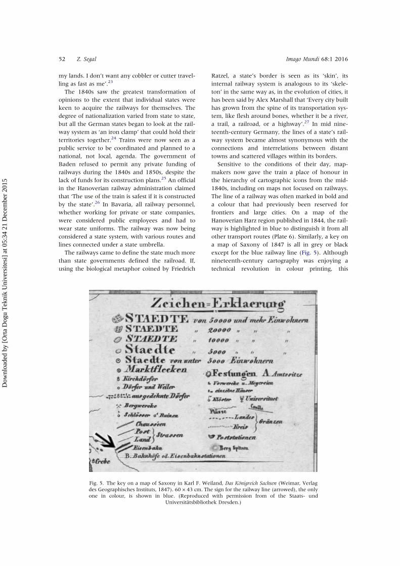
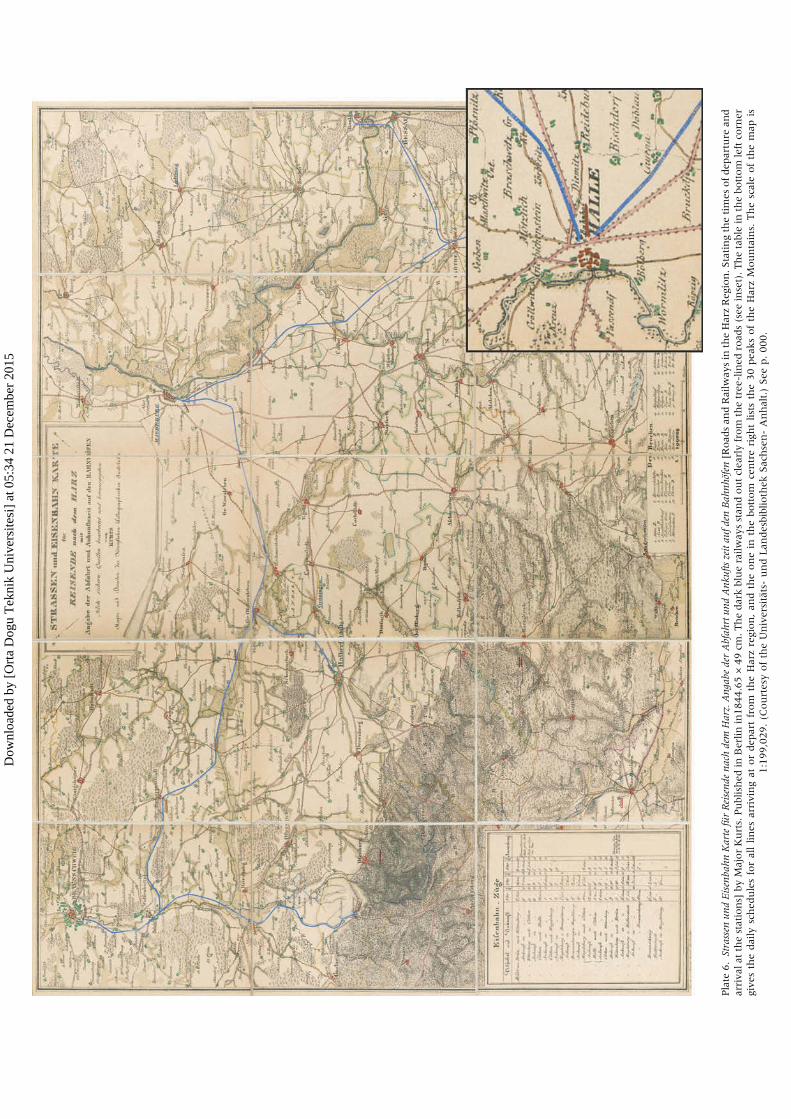
makers now gave the train a place of honour inthe hierarchy of cartographic icons from the mid-1840s, including on maps not focused on railways.The line of a railway was often marked in bold anda colour that had previously been reserved forfrontiers and large cities. On a map of theHanoverian Harz region published in 1844, the rail-way is highlighted in blue to distinguish it from allother transport routes (Plate 6). Similarly, a key ona map of Saxony of 1847 is all in grey or blackexcept for the blue railway line (Fig. 5). Althoughnineteenth-century cartography was enjoying atechnical revolution in colour printing, this
Fig. 5. The key on a map of Saxony in Karl F. Weiland, Das Königreich Sachsen (Weimar, Verlagdes Geographisches Instituts, 1847). 60 × 43 cm. The sign for the railway line (arrowed), the onlyone in colour, is shown in blue. (Reproduced with permission from of the Staats- und
Universitätsbibliothek Dresden.)
52 Z. Segal Imago Mundi 68:1 2016
Dow
nloa
ded
by [
Ort
a D
ogu
Tek
nik
Uni
vers
itesi
] at
05:
34 2
1 D
ecem
ber
2015

development had more effect on thematic mappingthan on general topographical mapping.28 Sincecolour on a topographical map was still kept forexceptional objects, its application to railwaysspoke for their importance in the cartographers’eyes. The choice of blue for railways was not acci-dental, for it is found on map after map as if to givethe railway the appearance of a river, thus ‘natur-alizing’ existence of the steel lines.29
Railways were emphasized in more ways thanjust the addition of colour. In 1846 a travel mapwas given the subtitle of a survey of ‘all the rail-ways and steamship connections throughoutGermany’, implying that trains and steamship hadequal roles.30 However, two words stand out in alarger font; ‘railways’ and ‘Germany’, giving prece-dence to the train. On the map a spider’s web ofthick black lines marking the railways spreads overthe territories of all the German states, whose pol-itical borders are demarcated in colours that standout less strongly than the black railways.By 1850 railways had become significant features
on all state maps. In the topographical atlas of theKingdom of Saxony, published that year, the firstmap was a general map of the whole state designedto function as a table of contents by identifying thedifferent sections of the atlas.31 Apart from the linesof the sections, the map contains little except forthin lines for rivers and exaggeratedly thick blacklines for railways. Somewhat similar is the map ofBavaria printed in 1863 with a title, the ‘legal parti-tion of the Kingdom of Bavaria’, suggesting that theprimary concern of the map was the demarcationof administrative units.32 What we see on themaps, though, are railway lines portrayed aswider and darker than those marking the bordersof the state.Railways were by now part of a country’s physic-
al space. Particularly interesting is a topographicalmap of the Kingdom of Saxony on nine sheets(1851). Because of Saxony’s triangular shape, alarge part of the neighbouring Bohemian kingdomis covered by the southern sheets. In order to avoiddepicting foreign territory on a map of Saxony, thespace on the three southern sheets was filled withinformation about the natural and cultural featuresof Saxony, such as mountains, forests, churchesand ruins. Sheet 6, however, is different; itincludes, among other features, a detailed descrip-tion of the railway from Zittau to Löbau (Fig. 6).33
The profile of the actual line provides detailedinformation on gradients and distances betweenstations and on the bridges, embankments and tun-nels along the line. The numbers under the profile
give horizontal and vertical angles and reflectchanges of direction. The top of the railway’s pro-file echoes the outline of mountainous Saxony thatis portrayed on Sheet 8 and testifies to the extent towhich the railways in Germany had come to beaccepted as part of nature.The cartographic depiction of state railways
across the whole of Germany depended on therate of development in individual states. InSaxony and Bavaria, where the network wasalready quite dense, railways had been predomin-ant features on maps since the early 1840s andtended to be highlighted in colour.34 In contrast,maps of southwestern Germany, especially thosepublished in Baden and Württemberg, did not paymuch attention to the railways until the late 1840s.
The 1850s, an Imagined State Connection
By mid-century, railways had become more than aphysical reality. They were sufficiently embeddedin private and public consciousness to be evoked asmetaphors, as Heinrich Heine did when he contem-plated a future line from Germany to France thatwould arrive at his Parisian door step ‘like a roaringNorth Sea’.35 Heine was prescient. Giving free reinto his imagination he continued: ‘Just imaginewhat will happen when the lines to Belgium andGermany are completed and connected up withtheir railways! I feel as if the mountains and forestsof all countries were advancing on Paris’.36
After the revolutions of 1848 in the Germanstates, the increasing number of railway lines inGermany was regarded as a means of state integra-tion. The heads of the various German states dideverything they could to create new routes andencourage their citizens to travel by train. TheKing of Württemberg turned to marketing tacticsand reduced fares.37 In Bavaria, Baden andHanover lines were extended to peripheral regionsand connectivity improved. The Kingdom ofSaxony had hitherto mostly avoided interferingwith the private railway market, but by 1854 ithad decided to attempt a purchase of the successfulprivate line between Leipzig and Dresden.38
The situation in the field was reflected on themaps, on which the railways were now marked aspart of the landscape and something the public sawas familiar elements in economic and social life.Mapmakers paid as much attention to the states’railway lines as they did to the demarcation of itsborders. Even the prospect of a new line wasenough to ensure map readers were informedabout the course of a planned or unfinished track,
Imago Mundi 68:1 2016 German Railway Cartography 53
Dow
nloa
ded
by [
Ort
a D
ogu
Tek
nik
Uni
vers
itesi
] at
05:
34 2
1 D
ecem
ber
2015
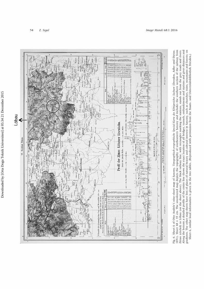
Fig.6.Shee
t6ofOttoAndrée’snine-sh
eetmap
ofSax
ony,Topograph
isch-orograp
hischeSp
ecial-Karte
desKön
igreiches
Sachsen(D
resden
,AdlerundDietze,
1851).
Shee
t48×
35cm
.Theunco
louredmap
dep
icts
thetopograp
hyofsouthea
stern
Sax
onyan
dincludes
thesouthern
section
oftherailway
from
Zittau
(circled
)to
Löbau
(on
thesh
eetab
ove).Theblack
railway
line,
with
rectan
gles
markingthestations,
stan
dsoutfrom
thegrey
road
san
drivers.
Alongthebottom
adetailedprofile
oftheen
tire
linesh
owstheex
actlocationofallbridge
s,tunnels,
emban
kmen
tsan
dstationsan
dgives
distancesan
dgrad
ients.Theother
map
shee
tshav
elistsofplacesofnaturalbea
uty
andcu
lturalinterest
inSax
ony,su
chas
churches,ru
ins,
mountainsan
dforests;
on
Shee
t6,similar
localinform
ation
isgiven
inthetw
otables.
(Rep
roducedwith
permission
from
theStaats-
undUniversitätsbibliothek
Dresden
.)
54 Z. Segal Imago Mundi 68:1 2016
Dow
nloa
ded
by [
Ort
a D
ogu
Tek
nik
Uni
vers
itesi
] at
05:
34 2
1 D
ecem
ber
2015
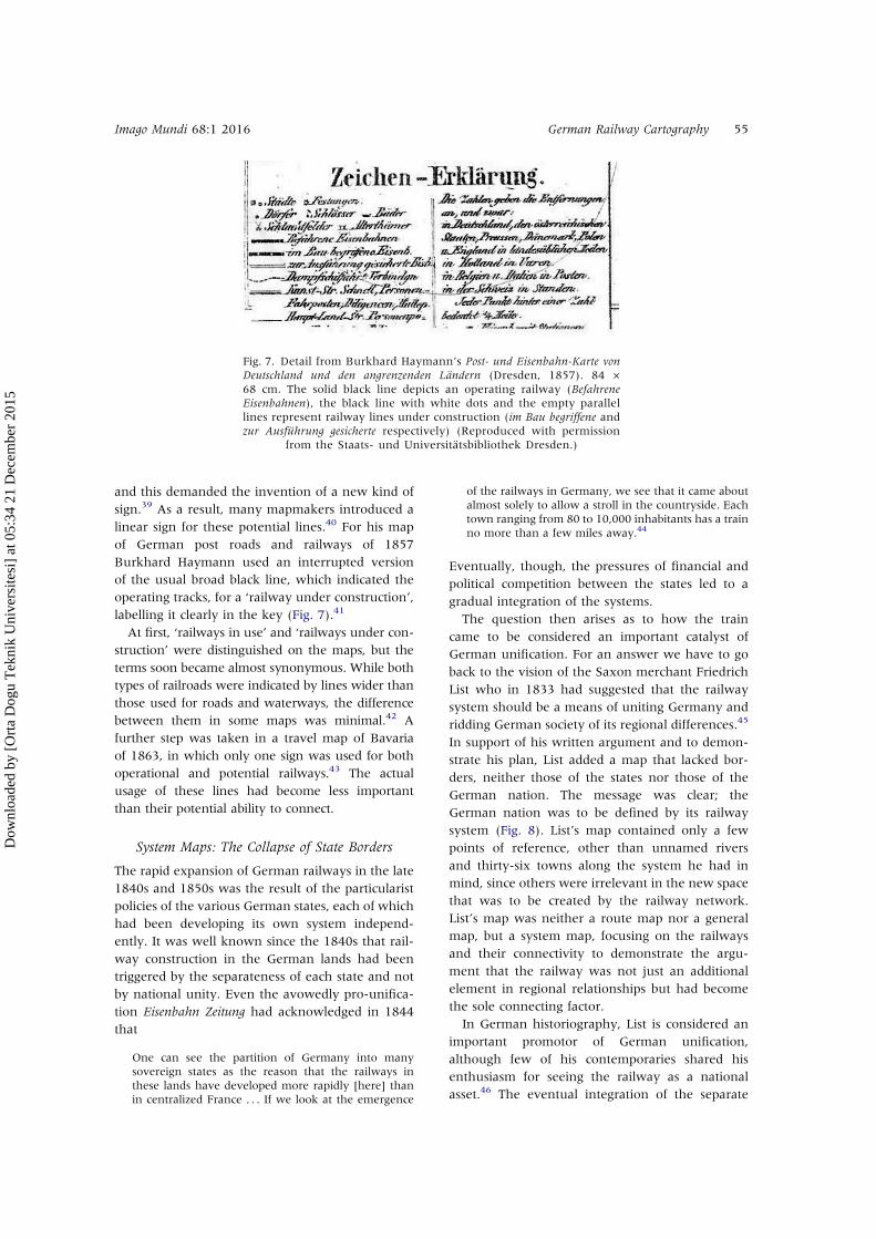
and this demanded the invention of a new kind ofsign.39 As a result, many mapmakers introduced alinear sign for these potential lines.40 For his mapof German post roads and railways of 1857Burkhard Haymann used an interrupted versionof the usual broad black line, which indicated theoperating tracks, for a ‘railway under construction’,labelling it clearly in the key (Fig. 7).41
At first, ‘railways in use’ and ‘railways under con-struction’ were distinguished on the maps, but theterms soon became almost synonymous. While bothtypes of railroads were indicated by lines wider thanthose used for roads and waterways, the differencebetween them in some maps was minimal.42 Afurther step was taken in a travel map of Bavariaof 1863, in which only one sign was used for bothoperational and potential railways.43 The actualusage of these lines had become less importantthan their potential ability to connect.
System Maps: The Collapse of State Borders
The rapid expansion of German railways in the late1840s and 1850s was the result of the particularistpolicies of the various German states, each of whichhad been developing its own system independ-ently. It was well known since the 1840s that rail-way construction in the German lands had beentriggered by the separateness of each state and notby national unity. Even the avowedly pro-unifica-tion Eisenbahn Zeitung had acknowledged in 1844that
One can see the partition of Germany into manysovereign states as the reason that the railways inthese lands have developed more rapidly [here] thanin centralized France . . . If we look at the emergence
of the railways in Germany, we see that it came aboutalmost solely to allow a stroll in the countryside. Eachtown ranging from 80 to 10,000 inhabitants has a trainno more than a few miles away.44
Eventually, though, the pressures of financial andpolitical competition between the states led to agradual integration of the systems.The question then arises as to how the train
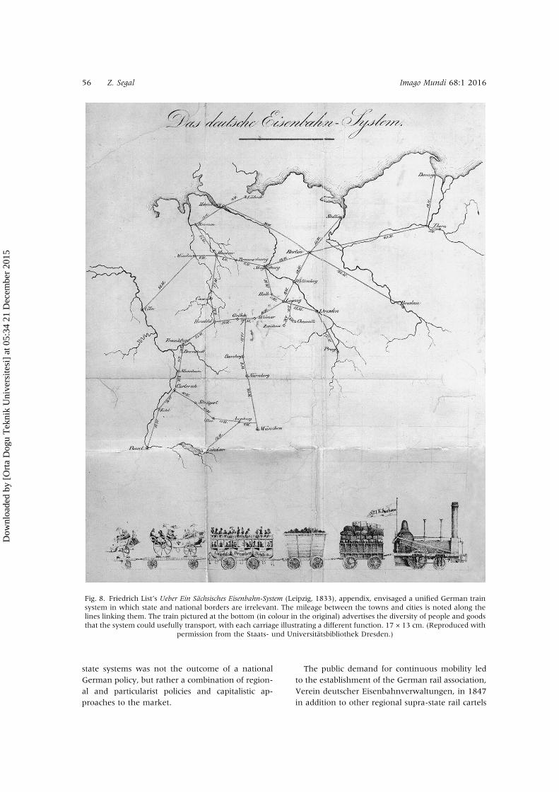
came to be considered an important catalyst ofGerman unification. For an answer we have to goback to the vision of the Saxon merchant FriedrichList who in 1833 had suggested that the railwaysystem should be a means of uniting Germany andridding German society of its regional differences.45
In support of his written argument and to demon-strate his plan, List added a map that lacked bor-ders, neither those of the states nor those of theGerman nation. The message was clear; theGerman nation was to be defined by its railwaysystem (Fig. 8). List’s map contained only a fewpoints of reference, other than unnamed riversand thirty-six towns along the system he had inmind, since others were irrelevant in the new spacethat was to be created by the railway network.List’s map was neither a route map nor a generalmap, but a system map, focusing on the railwaysand their connectivity to demonstrate the argu-ment that the railway was not just an additionalelement in regional relationships but had becomethe sole connecting factor.In German historiography, List is considered an
important promotor of German unification,although few of his contemporaries shared hisenthusiasm for seeing the railway as a nationalasset.46 The eventual integration of the separate
Fig. 7. Detail from Burkhard Haymann’s Post- und Eisenbahn-Karte vonDeutschland und den angrenzenden Ländern (Dresden, 1857). 84 ×68 cm. The solid black line depicts an operating railway (BefahreneEisenbahnen), the black line with white dots and the empty parallellines represent railway lines under construction (im Bau begriffene andzur Ausführung gesicherte respectively) (Reproduced with permission
from the Staats- und Universitätsbibliothek Dresden.)
Imago Mundi 68:1 2016 German Railway Cartography 55
Dow
nloa
ded
by [
Ort
a D
ogu
Tek
nik
Uni
vers
itesi
] at
05:
34 2
1 D
ecem
ber
2015
state systems was not the outcome of a nationalGerman policy, but rather a combination of region-al and particularist policies and capitalistic ap-proaches to the market.
The public demand for continuous mobility ledto the establishment of the German rail association,Verein deutscher Eisenbahnverwaltungen, in 1847in addition to other regional supra-state rail cartels
Fig. 8. Friedrich List’s Ueber Ein Sächsisches Eisenbahn-System (Leipzig, 1833), appendix, envisaged a unified German trainsystem in which state and national borders are irrelevant. The mileage between the towns and cities is noted along thelines linking them. The train pictured at the bottom (in colour in the original) advertises the diversity of people and goodsthat the system could usefully transport, with each carriage illustrating a different function. 17 × 13 cm. (Reproduced with
permission from the Staats- und Universitätsbibliothek Dresden.)
56 Z. Segal Imago Mundi 68:1 2016
Dow
nloa
ded
by [
Ort
a D
ogu
Tek
nik
Uni
vers
itesi
] at
05:
34 2
1 D
ecem
ber
2015
during the 1840s, 1850s and 1860s. Some of thesewere congruent, some were not German at all, butall competed with each other.47 For example, theRhineland railway companies signed agreementswith Belgium in 1848, and Baden signed withSwitzerland in 1852. Württemberg was part ofseventeen different regional associations in1867.48 While the emerging railway systems can-not be considered ‘German’, they still broke downthe traditional particularist state borders.49
The corresponding cartographic model of emer-ging railway networks was the system map,which was often diagrammatic in style in orderto portray the interconnecting lines. This kind ofmap was similar to the route map in its depictionof railways in isolation from other physical andsocial features. The difference between systemmaps and route maps is the shift from a singleroute to a network, which forced the mapmakerto widen the scope and stretch the map bound-aries to the limits of the system. This type of viewwas rare at the early stages of the German rail-way, yet it was prevalent in prophetic visions,such as Friedrich List’s map.Other examples in the 1830s suggested futuristic
images of state networks, and not necessarilyGerman ones, such as an 1832 map of the plannedHanoverian train system.50 Despite the many dif-ferences between this map and List’s map, the stylewas similar. In both maps only potential train sta-tions were depicted, and political borders were dis-regarded as the map reached into neighbouringstates. These were early and unique examples ofsystem maps, drawn before a single route had beenconstructed. In general, this genre was a responseto the formation of operational networks and thuswas a much later evolution of route maps.The first maps depicting operational networks
were not solely dedicated to railways and includedmany other transport modes, such as roads andwaterways.51 An 1842 map of Bavariatitled Uebersichts-Karte . . . von Districts-Strassen auf
Staatskosten dann der Eisebahn-Linie von der
Reichsgränze bey Hof nach Lindau marked mainroads, railways and canals with straight brownlines, straight black lines and curved black linesrespectively.52 The map only included villages situ-ated at major junctions or train stations and wasmostly limited to Bavaria, except for eleven foreigncities located at the ends of Bavarian roads:Wangen, Isny, Ulm, Mergentheim, Salmünster,Coburg Tachau, Follmaul (in Bohemia), Salzburg,Burghausen and Braunau.
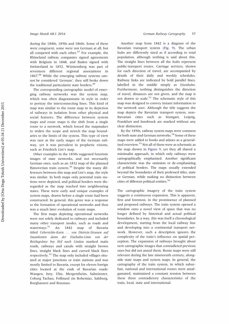
Another map from 1842 is a diagram of theBavarian transport system (Fig. 9). The urbanhubs are differently sized as if according to totalpopulation, although nothing is said about this.The straight lines between all the hubs representpublic-transport routes. Carriage services, shownfor each direction of travel, are accompanied bydetails of their daily and weekly schedules.Railway links are indicated by bold parallel lines,labelled in the middle simply as Eisenbahn.Furthermore, nothing distinguishes the directionof travel, distances are not given, and the map isnot drawn to scale.53 The schematic style of thismap was designed to convey instant information tothe network user. Although the title suggests themap depicts the Bavarian transport system, non-Bavarian cities such as Stuttgart, Leipzig,Frankfurt and Innsbruck are marked without anyclear distinction.By the 1850s, railway system maps were common
for both state and German networks.54 Some of thesemaps were added to books and atlases as a general-ized overview.55 Not all of themwere as schematic asthe map shown in Figure 9, yet they all shared aminimalist approach, in which only railways werecartographically emphasized. Another significantcharacteristic was the omission or de-emphasizingof political borders. The maps usually extendedbeyond the boundaries of their professed titles, stateor German, while making no distinction betweencities of different political entities.56
The cartographic imagery of the train systemsuggests a continuous expansion. This is apparent,first and foremost, in the prominence of plannedand proposed railways. The train system opened awindow onto a novel view of space that was nolonger defined by historical and actual politicalboundaries. In a way, this was itself a chronologicaldevelopment, starting from the local railway lineand developing into a continental transport net-work. However, such a description ignores thecomplexity of the train’s influence on spatial per-ception. The expansion of railways brought aboutnew cartographic images that contradicted previousones but did not annul them. Route maps were stillrelevant during the late nineteenth century, along-side state maps and system maps. In general, thecartography of the train system, in which subur-ban, national and international routes were amal-gamated, maintained a constant tension betweenthese three contradictory characteristics of thetrain, local, state and international.
Imago Mundi 68:1 2016 German Railway Cartography 57
Dow
nloa
ded
by [
Ort
a D
ogu
Tek
nik
Uni
vers
itesi
] at
05:
34 2
1 D
ecem
ber
2015
Fig. 9. A transport map of the kingdom of Bavaria, Uebersicht des Laufes der Eilwägen und der damit in Verbindung stehendenEisenbahnen im Koenigreiche Bayern und einem Theile der angrenzenden Staaten (1842). 61 × 84 cm. The system includes manycities that were situated outside the kingdom, such as Stuttgart, Frankfurt and Leipzig. See text for a detailed description.
(Reproduced with permission from the Bayerische Staatsbibliothek, Munich.)
58 Z. Segal Imago Mundi 68:1 2016
Dow
nloa
ded
by [
Ort
a D
ogu
Tek
nik
Uni
vers
itesi
] at
05:
34 2
1 D
ecem
ber
2015
However, unlike other cartographic images, suchas border signs that accentuated the familiar spatialorganization, the train iconography restructured itssurroundings by emphasizing only the adjacent vil-lages and rail connectivity. Thus the train shatteredthe boundaries of the old space and became theessence of relational and spatial connections, rede-fining them. In this respect, every spatial definition,be it the local region, the particular state, Germanyor Europe, was required to refer to its ‘skeleton’(the train system) that narrowed or expanded theold framework. The end result was an inversion, inwhich the borders were cartographically depictedwith respect to the railway system.
Manuscript submitted January 2014. Revised text receivedFebruary 2015
NOTES AND REFERENCES
1. Eric J. Hobsbawm, Nations and Nationalism since 1870:Programme, Myth, Reality (Cambridge, CambridgeUniversity Press, 1995), 80‒81; Marshall McLuhan,Understanding Media: The Extensions of Man (New York,Signet, 1964), 184.2. On the particularist engagements in railway construc-tion see Abigail Green, Fatherlands: State-Building andNationhood in Nineteenth-Century Germany (Cambridge,Cambridge University Press, 2001), 223‒66. On theGerman national movement and railway constructionsee Hagen Schulze, The Course of German Nationalism:From Frederick the Great to Bismarck 1763−1867(Cambridge, Cambridge University Press, 1991), 77‒80;Manfred Jehle, ed., Zug der Zeit—Zeit der Züge, deutscheEisenbahn 1835‒1985. Das offizielle Werk zur gleichnamigenAusstellung (Berlin, Siedler, 1985).3. J. B. Harley, ‘Cartography, ethics and social theory’,Cartographica 27:2 (1990), 1‒23; Jeremy W. Crampton,‘Maps and social constructions: power, communicationand visualization’, Progress in Human Geography25:2 (2001): 242.4. Martin Bruckner, ‘Lessons in geography: maps, spell-ers, and other grammars of nationalism in the earlyrepublic’, American Quarterly 5:2 (1999): 311‒43; RobertShannan Peckham, ‘Map mania: nationalism and the pol-itics of place in Greece, 1870‒1922’, Political Geography19:1 (2000): 77‒95; John Etherington, ‘Nationalism,National Identity and Territory: The Case of Catalonia’,unpublished doctoral thesis (Bellaterra, UniversitatAutònoma de Barcelona, 2003), 54f.5. Green, Fatherlands (see note 2); Zef Segal, ‘Real,actual, and imagined borders—state construction in the“third Germany”’, in ‘“Die Deutschen”’ als die Anderen:Deutschland in der Imagination seiner Nachbarn, ed. JoséBrunner and Iris Nachum (Göttingen, Wallstein, 2012),21–43.6. As noted by James R. Akerman, ‘Introduction’, inCartographies of Travel and Navigation, ed. James R.Akerman (Chicago, University of Chicago Press, 2006),9, whose book can be said to establish the genre. Seealso, David Milbank Challis and Andy Rush, ‘The railwaysof Britain: an unstudied map corpus’, Imago Mundi61:2 (2009): 186−214.
7. An example is the well-known map of the LondonUnderground designed by Harry Beck in 1931.8. Jerry Musich had defined these early maps as investormaps (Jerry Musich, ‘Mapping a transcontinental nation:nineteenth- and early twentieth-century American railtravel cartography’, in Akerman, Cartographies of Traveland Navigation (see note 6), 98).9. These two books, for example, displayed a much lar-ger array of routes, by decomposing them into dozens ofroute maps. Ulrich Hendschel, Eisenbahn-Atlas vonDeutschland, Belgien und dem Elsass: Mit allen Fahrplänen,Tarifen, Betriebs-Verordnungen und sonst dahin gehörigenNachweisungen sowie den speciellen Karten der bedeutenderenbis jetzt vollendeten Eisenbahnen. Ein Handbuch für Reisendeund für Alle, welche sich dieses grossartigen Transport-Mittelsbedienen (Frankfurt A.M., 1844); Gustav Weng, Königlich-Bayerische Staats-Eisenbahnen (Munich, 1855).10. ‘Eisenbahnen entstanden in einer Region’. VolkerThen, Eisenbahnen und Eisenbahnunternehmer in derIndustriellen Revolution: ein preussisch/deutsch-englischerVergleich (Göttingen, Vandenhoeck & Ruprecht, 1997),58, 165‒66, and 256.11. Ibid, 239.12. Ibid, 277‒89.13. Wilhelm Volkert, ed., Handbuch der bayerischenÄmter, Gemeinden und Gerichte 1799−1980 (Munich, Beck,1983), 257.14. German historiography has tended to highlight therole of individuals such as Friedrich List in Saxony andJosef Baader in Bavaria in promoting the idea of the rail-way system as a network, but the concept of a railwaynetwork does not apply to the situation before the 1840,when lines existed in isolation. On List, see: William O.Henderson, Friedrich List, Economist and Visionary,1789−1846 (London: F. Cass, 1983). On Baader, see:Stephan Deutinger, Bayerns Weg zur Eisenbahn: Joseph vonBaader und die Frühzeit der Eisenbahn in Bayern 1800 bis1835 (St Ottilien, EOS-Verlag, 1997).15. Another example is Friedrich Gotthelf FerdinandRudolph, Plan von Leipzig und Lauf der Eisenbahn (Leipzig,1848).16. Charte zur Uebersicht des zwischen Dresden und Leipzigprojectirten Eisenbahntractes durch Meissen (Dresden, 1834).17. ‘Sogar die Elementarbegriffe von Zeit und Raumsind schwankend geworden. Durch die Eisenbahnenwird der Raum getötet, und es bleibt uns nur noch dieZeit übrig’ (Heinrich Heine, ‘Lutetia II: Berichte überPolitik, Kunst und Volksleben’, in Sämtliche Werke 12, ed.H. Kaufmann (Munich, Kindler, 1964), 65).18. Johann Adam Stein, ‘Rezat-Kreis’, in Atlas vonBayern (Nuremberg, 1836).19. ‘Post Aemter’, in Johann Baptist Pfeiffer, StatistischerAtlas vom Königreich Bayern (Munich, 1844).20. Gustav Hanser and Johann G. Serz, Deutschland undseine Grenzlande (Nuremberg, Serz & Cie, 1845).21. James M. Brophy, Capitalism, Politics, and Railroads inPrussia, 1830−1870 (Ohio, Ohio State University Press,1998), 22−24.22. Green, Fatherlands (see note 2), 240.23. ‘Ich will keine Eisenbahn in meinem Lande. Ich willnicht, daß jeder Schuster und Schneider so scnell reisenkann wie ich’. Quoted in Michael Bahls, Die Hannover−Altenbekener Eisenbahn (Nordhorn, Kenning, 2006), 48.24. ‘Eine Eiserne Klammer’, was a term used by AlbertKuntzemüller, the Badenese historian, with respect to theBaden railway system (Albert Kuntzemüller, Die BadischenEisenbahnen (Karlsruhe, G. Braun, 1853), 6).
Imago Mundi 68:1 2016 German Railway Cartography 59
Dow
nloa
ded
by [
Ort
a D
ogu
Tek
nik
Uni
vers
itesi
] at
05:
34 2
1 D
ecem
ber
2015
25. Hans-Jürgen Enzweiler, Staat und Eisenbahn:Bürokratie, Parlament und Arbeiterschaft beim badischenEisenbahnbau 1833−1855 (Frankfurt am Main, P. Lang,1995), 96.26. ‘Der Nutzen der Eisenbahn wird am sicherstenerreicht, wenn der Staatbaut’ quoted in EberhardLandes, Eisenbahnen in Hannover: eine Chronik (Hannover,Autorenvel, 1991), 28).27. Friedrich Ratezl, ‘Über allgemeine Eigenschaften dergeographischen Grenzen und die politische Grenze’,Berichte über die Verhandlungen der königlich sächsischenGesellschaft der Wissenschaften zu Leipzig 44 (1892),53−104. Alex Marshall, How Cities Work: Suburbs, Sprawls,and the Roads Not Taken (Austin, University of Texas Press,2000), 46.28. Karen S. Pearson, ‘The nineteenth-century colourrevolution: maps in geographical journals’, Imago Mundi32 (1980): 9−20.29. Some examples are Albrecht Platt et al.,Topographische Karte vom Herzogthum Braunschweig undFuerstenthum Oels (Braunschweig, 1845); Friedrich vonBär and Johann Christoph Stülpnagel, Eisenbahn-Atlasvon Deutschland, Belgien, Elsass und dem nördlichsten Theilevon Italien (Gotha, 1849); Hugo von Bose, Eisenbahn-Reise-Handbuch für Europa und Hand-Atlas der Eisenbahn-, Post-und Dampfschiff-Verbindungen in Europa (Leipzig, 1854).Exceptions that coloured railways in red include JohannBaptist Seitz, Postkarte v. Bayern, Württemberg, Baden, Gr. H.Hessen u. Nassau (Munich, 1850); Gustav Wenng, NeuesteEisenbahn-Karte von Bayern und den angrenzenden Ländern(Munich, 1865); Joseph Heyberger, Neueste Reise-Karte fürdas Bayerische Hochland nebst einem Gebirgs-Profil (Munich,1869).30. R. A. Schulz, R. A. Schulz’s neue praktische Reise-Kartemit Angabe der Distanzen: Zum allgemeinen Gebrauche, so wiezur Uebersicht aller Eisenbahnen und der Dampfschiffahrts-Verbindungen in ganz Deutschland mit Einschluss der gesamm-ten Oesterreichischen Kaiserstaaten, ganz Belgien, Holland, derSchweiz und einem Theile von Frankreich, England u. Italien(Vienna, 1846).31. Jakob Andreas Hermann Oberreit, ‘Übersichts-Blattder Sectionseintheilung des topographischen Landes-Atlasses vom Königreiche Sachsen’, in TopographischerAtlas des Königreichs Sachsen (Dresden, 1850).32. Gerichts-Eintheilung des Koenigreichs Bayern seit 1.Juli1862 (Munich, 1863).33. Otto Andrée, Topographisch-orographische Special-Kartedes Königreiches Sachsen (Dresden, Adler und Dietze, 1851).34. For statitsics of railway construction see DeutscheEisenbahn-Statistik: für das Betriebs-Jahr 1856 (Berlin,Vereins Deutscher Eisenbahnverwaltungen, 1857).35. ‘vor meiner Türe brandet die Nordsee’ (HeinrichHeine, Lutetia: Berichte über Politik, Kunst und Volksleben(Berlin, Verlag der Contumax GmbH & Co., 2014), 185).Also quoted in Wolfgang Schivelbusch, The Railway Journey:The Industrialization of Time and Space in the 19th Century(Berkeley, University of California Press, 1986), 37.36. ‘Was wird das erst geben, wenn die Linien nachBelgien und Deutschland ausgeführt und mit den dorti-gen Bahnen verbunden sein werden! Mir ist, als kämendie Berge und Wälder aller Länder auf Paris angerückt’(Heinrich Heine, Lutetia (see note 35), 185).37. Green, Fatherlands (see note 2), 264.38. Erich Preuss and Reiner Preuss, SächsischeStaatseisenbahnen (Berlin, Transpress, 1991), 13−14.39. The novelty of plotting features not yet constructedon maps in the 19th century contradicted the positivistic
ontology of the period. P. I. Azócar Fernández andManfred F. Buchroithner, Paradigms in Cartography: AnEpistemological Review of the 20th and 21st Centuries (Berlin,Springer, 2014), 5−7.40. An early example is Carl Wilhelm Medau,Eisenbahnkarte von Deutschland am Schlusse des Jahres1845 (Prague, 1845). Other examples are FriedrichAugust Clemens Steyer, Post-Karte des KöniglichSächsischen Postbezirkes, umfassend das Königreich Sachsenund das Herzogthum Sachsen–Altenburg (Dresden, 1860);and Karl Ferdinand Weiland, Das Königreich Bayern(Weimar, 1866).41. Burkhard Haymann, Post- und Eisenbahn-Karte vonDeutschland und den angrenzenden Ländern (Dresden,1857). Similarly, Leopold Kraatz, Karte vom PreussischenStaate: mit besonderer Berücksichtigung der Communicationen(Berlin, 1859), differentiates between operating railways,railways under construction and railways in planning.42. In Gustav Wenng, Special- und Administrativ-Kartevom Königreiche Bayern: mit Angabe sämmtlicher Orte,Strassen u. Eisenbahnen, den Bez. Gerichts-, Bezirksamts-,Stadt- und Landgerichts Grenzen und den Sitzen dieserBehörden (Munich, 1860), the only difference was smallrectanglar signs above the lines, which marked the sta-tions of the operating railways.43. Johann Baptist Pfeiffer, Neueste Eisenbahn-Reisekartedurch das Königreich Bayern diesseits des Rheins; ausgedehntbis Innsbruck, Frankfurt, Karlsruhe, Salzburg; mit allenStationen (Augsburg, 1863).44. ‘Man hat eben in der Theillung Deutschland in mehr-ere Souveränetäten den Grund sehen wollen, weshalb dasEisenbahnwesen in diesem Lande eine so viel raschereEntwicklung gefunden hat, als in dem centralisirtenFrankreich . . . Werfen wir einen Blick auf das Entstehender Schienenwege in Deutschland, so sehen wir zu Anfangderen fast nur zum Spazierenfahren angelegt. Jede Stadtvon 80 bis 100,000 Einwhonern vermag einen Bahn,welche nach einem nur wenige Meilen entferntenBelustigungsorte . . . ’ (Eisenbahn Zeitung, 28 April 1844).45. Friedrich List, Ueber ein Sächsisches Eisenbahn-Systemals Grundlage eines allgemeinen Deutschen Eisenbahn-Systems,und insbesondere über die Anlegung einer Eisenbahn vonLeipzig nach Dresden (Leipzig, 1833); Friedrich List, Dasdeutsche Eisenbahnsystem als Mittel zur Vervollkommnung derdeutschen Industrie, des deutschen Zollvereins u. des deutschenNationalverbandes überhaupt (Sttugart and Tübingen,1841).46. Robert Krause, Friedrich List und die erste grosseEisenbahn Deutschlands. Ein Beitrag zur Eisenbahngeschichte(Leipzig, E. Strauch, 1887); Heinrich von Treitschke,Deutsche Geschichte im neunzehnten Jahrhudert (Leipzig: S.Hirzel, 1879–1894); Allan Mitchell, The Great Train Race:Railways and the Franco-German Rivalry, 1815–1914 (NewYork, Berghahn Books, 2000), 71; Green, Fatherlands (seenote 2), 223.47. Then, Eisenbahnen und Eisenbahnunternehmer (seenote 10), 363.48. Mitchell, The Great Train Race (see note 46), 41.49. Ibid., 54.50. The map was added as an appendix to Plan zurAnlegung einer Eisenbahn zwischen Hannover, Braunschweigund den freien Hansestädten (Braunschweig, 1832).51. Some later examples are ‘Angabe der Fahrzeit aufEisenbahnen und Flussdampfschifffahrten’, in JohannGeorg Mayr, Reise- und Übersichts-Karte von Deutschland(Munich,1853); Christian Johann Carl Raab, Special-Karteder Eisenbahnen Mittel-Europa’s mit Angabe aller Eisenbahn-
60 Z. Segal Imago Mundi 68:1 2016
Dow
nloa
ded
by [
Ort
a D
ogu
Tek
nik
Uni
vers
itesi
] at
05:
34 2
1 D
ecem
ber
2015
Post- und Dampfschiff Stationen, Speditionsorten, Zoll- undSteuerämter, Bäder- Mineralquellen und den Grenzen desZollvereins (Glogau, 1857); Carl Vogel,Deutschland und benach-barte Länder zur Übersicht der Eisenbahnen undDampfschiffahrten (Gotha, 1868).52. Uebersichts-Karte der Anträge bey der Kammer derAbgeordneten 1842/43 auf Übernahme und Erbauung vonDistricts-Strassen auf Staatskosten dann der Eisebahn-Linievon der Reichsgränze bey Hof nach Lindau (Munich, 1842).53. Uebersicht des Laufes der Eilwägen und der damit inVerbindung stehenden Eisenbahnen im Koenigreiche Bayernund einem Theile der angrenzenden Staaten (1842).54. Some examples are Eisenbahn-Routen-Karte fürBöhmen und die angrenzenden Länder (Prague, 1850);‘Karte der Eisenbahnen Deutschlands’ (Braunschweig,1857); Julius Michaelis, Eisenbahn-Karte von Central
Europa (Dresden, 1858); A. Böhm, Cours-Karte von Bayern(Munich, 1866); Adolf Moosmeir, Eisenbahn-Karte vomKönigreiche Württemberg (Stuttgart, 1895).55. For example, Johann G. Mayr, Reise- und Übersichts-Karte von Deutschland (Munich, Rieger, 1853); Hugo vonBose, Eisenbahn Reise-Handbuch für Europa (Leipzig,Schäfer, 1854).56. Maps of Germany, such as Gustav Hanser, Post-und Eisenbahn-Reisekarte Deutschland (Nuremberg,1855), extended from southern Sweden to Naples andfrom England to Turkey. Likewise, maps of state net-works, such as Eisenbahn-Routen-Karte für Böhmen unddie angrenzenden Länder (Prague, 1850), depicted thewhole of Saxony, Austria, Poland and Bavaria, in addi-tion to the original intent of displaying the Bohemiannetwork.
Régionalisme et Nationalisme dans la cartographie des chemins de fer de l’Allemagne au milieu du XIXesiècle
Cet article porte sur la cartographie des chemins de fer allemands au milieu du XIXe siècle et son influencesur les perceptions spatio-politiques. L’évolution du système ferroviaire allemand, depuis de simples lignesisolées vers des réseaux nationaux et au final internationaux, a été communément associée à la questionpolitique de l’unification de 1871. Les changements de l’infrastructure provoquèrent l’introduction denouvelles cartes et de nouveaux signes conventionnels, qui éclipsèrent d’autres signes nationaux et politiqueset qui ne doivent pas être considérés comme de simples moyens mis en œuvre dans une optique nationaliste.En examinant le développement de l’iconographie des chemins de fer et des réseaux ferrés, je soutiens queles chemins de fer furent une cause de déterritorialisation pour les régions et les Etats et pour la vision d’uneAllemagne unifiée.
Regionalismus und Nationalismus in der deutschen Eisenbahnkartographie Mitte des 19. Jahrhunderts
Dieser Beitrag beschäftigt sich mit der Eisenbahnkartographie Deutschlands in der Mitte des 19. Jahrhundertssowie mit ihrer Wirkung auf politisch-räumliche Konzepte. Die Entwicklung des deutschen Eisenbahnnetzes,von einzelnen isolierten Routen zu nationalen und schließlich internationalen Systemen, wurde gewöhnlichmit dem politischen Prozess hin zur staatlichen Einheit von 1871 in Verbindung gebracht. DieVeränderungen der Infrastruktur lösten den Einsatz neuer Karten und neuer Kartenzeichen aus, die anderenational und politisch bedeutungsvolle Elemente von den Karten verdrängten, die aber nicht einfach alsMittel auf dem Weg zum Nationalismus verstanden werden sollten. Die Untersuchung der sich entwi-ckelnden Ikonographie der Eisenbahn und des Eisenbahnnetzes legt nahe, dass diese ein Beispiel für dieAuflösung von Regionen oder Staaten darstellte und auf die Vision des geeinten Deutschland verwies.
Regionalismo y nacionalismo en la cartografía ferroviaria de la Alemania de mediados del siglo XIX
Este artículo se centra en la cartografía ferroviaria alemana de mediados del siglo XIX y en su influencia en laspercepciones espacio-políticas. La evolución del sistema ferroviario alemán, desde rutas individuales aisladasa redes nacionales y en última instancia internacionales, ha sido tradicionalmente vinculada a la cuestiónpolítica de la unificación en 1871. Los cambios en infraestructuras provocaron la introducción de nuevosmapas y signos cartográficos que eclipsaron otros signos nacionales y políticos, y no deben ser consideradoscomo simples medios con fines nacionalistas. A partir del examen del desarrollo iconográfico de los ferro-carriles y redes ferroviarias, sostengo que los ferrocarriles fueron una causa de la no territorialización de lasregiones y de los estados, en favor de la visión de una Alemania unificada.
Imago Mundi 68:1 2016 German Railway Cartography 61
Dow
nloa
ded
by [
Ort
a D
ogu
Tek
nik
Uni
vers
itesi
] at
05:
34 2
1 D
ecem
ber
2015
Plate
6.Strassen
undEisenba
hnKartefürReisende
nachdem
Harz.Angabe
derAbfah
rtundAnku
ftszeitau
fden
Bah
nhöfen
[Road
san
dRailw
aysin
theHarzRegion.S
tatingthetimes
ofdep
arture
and
arriva
lat
thestations]
byMajorKurts.Published
inBerlinin1844.65×49cm
.Thedarkbluerailway
sstan
doutclearlyfrom
thetree
-lined
road
s(see
inset).Thetablein
thebo
ttom
leftcorner
give
sthedaily
sched
ulesforalllines
arrivingat
ordep
artfrom
theHarzregion,an
dtheonein
thebo
ttom
centrerigh
tliststhe30pea
ksoftheHarzMountains.
Thescaleofthemap
is1:199,029.(C
ourtesyoftheUniversitäts-undLan
desbibliothek
Sachsen-Anhalt.)See
p.000.
Dow
nloa
ded
by [
Ort
a D
ogu
Tek
nik
Uni
vers
itesi
] at
05:
34 2
1 D
ecem
ber
2015
Copyright © 2022 FDOKUMEN


![Milliyetçilik Milliyetçiliğin Kurdudur: Arap ve Türk Milliyetçilikleri Örneği [Nationalism is the Worm of Nationalism: The Cases of Arabic and Turkish Nationalism]](https://static.fdokumen.com/doc/165x107/6325391d7fd2bfd0cb0359ca/milliyetcilik-milliyetciligin-kurdudur-arap-ve-tuerk-milliyetcilikleri-oernegi.jpg)