CZMP of Mira Bhayandar Municipal Corporation in 1:25000 ...
14
1 CZMP of Mira Bhayandar Municipal Corporation in 1:25000 National Centre for Earth Science Studies, Thiruvananthapuram – 11 Centre for Earth Science Studies, Thiruvananthapuram CZMP of Mira Bhayandar Municipal Corporation in 1:25000 scale 1. Introduction The preparation of the CZMP for Mira Bhayandar Municipal Corporation has been undertaken as part of the CZMP preparation for the coastal zone of Thane and Sindhudurg districts. The approach and methodology followed are the same for all the Municipal Corporations, Municipal Councils and rural areas in the above districts. The damages to the coastal zone and the impact of coastal hazards to communities and properties, to a certain extent, can be controlled by regulating high impact activities in the coastal zone. It was with this objective the Coastal Regulation Zone (CRZ) Notification (MoEF, 2011; 1991) was introduced in the country. 1. 1 Coastal Zone Management Plans The CRZ provides a spatial planning framework for Coastal Zone Management Plans which provide setbacks around sensitive eco-zones restricting development and other activities close to it. Setbacks require specific reference lines and boundaries for its meaningful implementation. The High Tide Line (HTL) forms the cardinal reference line for determining the setbacks for CRZ. The 100, 200 and 500m CRZ lines landward from the HTL are the landward setback lines. The Low Tide Line (LTL) and the Territorial water boundary (12 NM) form the setback lines towards the sea. The Coastal Zone Management Plans are prepared in 2 scales: 1. CZMP consisting of CRZ maps in 1:25000 scale with Survey of toposheets as base maps 2. CZMP consisting of CRZ maps in 1:4000 scale with cadastral maps as base maps The major work components are: i. Generation of data in 1:4000 scale on HTL, LTL and eco-morphological systems relevant for CRZ ii. Demarcation of HTL, LTL, ecosystems and morphology relevant for CRZ in 1:25,000 iii. Demarcation of HTL, LTL, ecosystems and morphology relevant for CRZ in 1:4,000 scale. iv. Preparation of CZMP maps consisting of CRZ maps in 1:25000 scale v. Preparation of Local level CZMP maps in 1:4000 cadastral scale. The CZM/ CRZ maps in 1:25000 scale with Survey of toposheets as base maps which are required for policy decisions. These are to be submitted to MoEF, Govt of India for approval after stakeholder/
-
Upload
khangminh22 -
Category
Documents
-
view
2 -
download
0
Transcript of CZMP of Mira Bhayandar Municipal Corporation in 1:25000 ...

1 CZMP of Mira Bhayandar Municipal Corporation in 1:25000 National Centre for Earth Science Studies, Thiruvananthapuram – 11
Centre for Earth Science Studies, Thiruvananthapuram
CZMP of Mira Bhayandar Municipal Corporation in 1:25000 scale
1. Introduction
The preparation of the CZMP for Mira Bhayandar Municipal Corporation has been
undertaken as part of the CZMP preparation for the coastal zone of Thane and Sindhudurg
districts. The approach and methodology followed are the same for all the Municipal
Corporations, Municipal Councils and rural areas in the above districts.
The damages to the coastal zone and the impact of coastal hazards to communities and
properties, to a certain extent, can be controlled by regulating high impact activities in the
coastal zone. It was with this objective the Coastal Regulation Zone (CRZ) Notification
(MoEF, 2011; 1991) was introduced in the country.
1. 1 Coastal Zone Management Plans
The CRZ provides a spatial planning framework for Coastal Zone Management Plans
which provide setbacks around sensitive eco-zones restricting development and other
activities close to it. Setbacks require specific reference lines and boundaries for its
meaningful implementation. The High Tide Line (HTL) forms the cardinal reference
line for determining the setbacks for CRZ. The 100, 200 and 500m CRZ lines
landward from the HTL are the landward setback lines. The Low Tide Line (LTL)
and the Territorial water boundary (12 NM) form the setback lines towards the sea.
The Coastal Zone Management Plans are prepared in 2 scales:
1. CZMP consisting of CRZ maps in 1:25000 scale with Survey of toposheets as base maps
2. CZMP consisting of CRZ maps in 1:4000 scale with cadastral maps as base maps
The major work components are:
i. Generation of data in 1:4000 scale on HTL, LTL and eco-morphological systems
relevant for CRZ
ii. Demarcation of HTL, LTL, ecosystems and morphology relevant for CRZ in
1:25,000
iii. Demarcation of HTL, LTL, ecosystems and morphology relevant for CRZ in 1:4,000
scale.
iv. Preparation of CZMP maps consisting of CRZ maps in 1:25000 scale
v. Preparation of Local level CZMP maps in 1:4000 cadastral scale.
The CZM/ CRZ maps in 1:25000 scale with Survey of toposheets as base maps which are required for
policy decisions. These are to be submitted to MoEF, Govt of India for approval after stakeholder/

2 CZMP of Mira Bhayandar Municipal Corporation in 1:25000 National Centre for Earth Science Studies, Thiruvananthapuram – 11
public consultations. The local level CRZ/ CZMP are prepared in 1:4000 with cadastral base maps
and based on the approved CZMP. Local level data in cadastral scale was generated initially which is
being used for preparing the 1;25000 CZMP on toposheet base maps. The same is used for local level
CRZ/CZMP maps.
1.2 CZMP in1:25000 scale
The present study and report provide the CZMP in 1:25000 scale.
2. High Tide Line
Different tide levels like Mean High Water Springs, Mean Low Water Springs, Lowest
Astronomical Tide, etc are defined and successfully used for navigational purposes and sea
surveying. The High Tide Level is dependent on lunar cycles. It is normally taken as the
water level at which the high tide intersects with the vertical plane.
The above definition is not in commensurate with the objectives of demarcating the HTL
which is to regulate the activities on the land. The experience of Naval Hydrographer while
demarcating the HTL in Goa way back in 1992-93 brought out the limitations in assigning
the usual definitions for the HTL (Menon, 1993). The HTL demarcated in this case for Goa
was found to be in the sea during the next monsoon.
A functional HTL is defined in the CRZ notification with the sole objective of protecting a
given stretch of coastal strip from environmental degradation. Hence an approach different
from the ones followed for navigational purpose, is necessary for demarcating HTL, in tune
with the definition given in the Notification.
The HTL is defined ‘for the purpose of the notification’ as “the line on the land upto which
the highest waterline reaches during the spring tide” which is different from the well known
and widely accepted definition of High Tide Level. The above definition of HTL takes into
consideration not only the level of inundation due to maximum tide (spring tide) but also the
wave set up (having a seasonal periodicity). The sea level thus formed due to the combined
effect of spring tide and wave set up gives the line of maximum reach of water on the land.
There is a similarity between the HTL thus defined and the High Water Line (HWL) given in
Survey of India (SoI) toposheets. Both are lines drawn on the land. But the HWL and HTL
are different that the former gives the fair season shoreline (because SoI field mapping is
conducted during non-rainy season) during spring tide while the latter accommodates the
rough season (monsoon) shoreline oscillations due to monsoon wave set up in addition to
spring tide inundation.
3. Low Tide Line
Unlike the HTL the Low Tide Line (LTL) has not been defined for CRZ. The HTL required
specific definition since the 100, 200 and 500m setback lines are defined with respect to the
HTL. The conventional definition of lowest low water level and the resultant low water line
during spring tide may be taken as the LTL.

3 CZMP of Mira Bhayandar Municipal Corporation in 1:25000 National Centre for Earth Science Studies, Thiruvananthapuram – 11
4. Setback lines
The 100, 200 and 500m setback lines are drawn landward of the HTL. Once the HTL is well
defined and demarcated, the above 3 setback lines could be drawn without any ambiguity
following planimetric methods.
4.1 Setback line for CRZ II in MBMC
For urban areas like MBMC in which developed areas are eligible to be categorized
as CRZ II, the setback lines are different. Those prohibited activities listed in the CRZ
notification (2011: under para 3) are applicable for the entire CRZ. Other construction
activities are permitted in CRZ II landward of ‘existing’ buildings or ‘existing’ or
‘approved’ roads. The word ‘existing’ and ‘approved’ are specifically defined in the
notification.
5. Influence of Tidal action
The distance up to which CRZ is applicable upstream of estuaries, creeks, backwaters and
lagoons depends on the extent of tidal influence. The distance up to which tidal influence is
experienced is dependent on salinity concentration: if it is 5 ppt or more the water body is
considered to be influenced by tidal action (MoEF, 2011). Salinity measurements are carried
out to determine the limit. Tidal barrages and bunds constructed are also taken as the limit of
tidal influence.
6. Different approaches to demarcate HTL
The highest level horizontal positional and spatial accuracy in mapping and presenting the
HTL becomes necessary for field uses by CRZ implementing agencies. The agencies are
looking for a planimetric accuracy approaching zero error.
The different approaches now practiced in the country to demarcate the HTL are:
tide level projection
using morphological signatures
o field methods
o satellite data
The CESS follows the approach using morphological signatures (CESS, 1995)
6.1 HTL using morphological signatures
Morphological signatures are good indicators of shoreline oscillation and inundation of
coastal waters, which could be used for identifying the HTL. The inundation of coastal
waters on to the land and seasonal shoreline oscillations are dependent on coastal

4 CZMP of Mira Bhayandar Municipal Corporation in 1:25000 National Centre for Earth Science Studies, Thiruvananthapuram – 11
morphology. Shoreline remains stable and would not retreat significantly along cliffy coasts.
The shoreline retreats up to the cliff base along pocket beaches. Artificial morphologies like
seawalls confine the oscillation of shoreline along the line of the structure itself. Sandy
beaches are prone to seasonal and long term shoreline oscillation. Long term stability of the
beach and the position of the stable part of the beach would be evident from morphological
signatures such as berm and berm crest.
This could be done by field methods and using satellite data.
6.1.1 Field method
The HTL has to be fixed with respect to certain reference points on the land. These reference
points at sufficiently close intervals (preferably at least 1 km alongshore) have to be marked
with respect to lat-long and known points in the base map. Geomorphologic features like
berm crest, cliff, headland, line of permanent vegetation, etc are indicators of the reach of sea
water into the land. Stable coastal protective structures like seawall also limit the intrusion of
seawater. Hence High Tide Line (line of maximum reach of seawater into the land during
spring tide) can be fixed in the field, with respect to these features and tied to the reference
points, as detailed below.
Landward (monsoonal) berm crest for beaches
In all the well-formed wide beaches, one or more berms (which are nearly horizontal part of
the beach formed by the deposition of sand by wave action) are usually observed. The
seaward end of the berm, which shows a sudden downward slope is called the berm crest.
When there is only one berm, it normally gets eroded during the monsoon with a berm crest
on the landward side. But when there are two berms the landward berm is the monsoonal
berm, which normally do not get eroded. Or else we can say that the erosion reaches only to
the second berm crest. Since the tidal waters do not reach the coast beyond this landward
berm crest, it is taken as the HTL. The distance to this point from the reference point is
measured using the beach profile to fix the position of the HTL.
Seawall/revetments/embankments
In highly erosion-prone areas, there are no landward second berms. Such locations will be
protected mostly by seawalls. During monsoon season majority of these are devoid of
beaches. The waves impinge upon the seawall during the monsoon season, especially during
the high tide. Thus they are the artificial barriers stopping the waves/tides at the coast. Since
the seaward part of the seawall in most cases is defaced due to erosion, the landward toe is
taken as the HTL boundary in such locations. There are some locations with two or three
lines of seawall, particularly in the accreting areas. The seaward seawall is considered here
for the purpose. On the other extreme, in the case of continuously eroding sites there are lines
of sea wall which are now in the sea. In such cases the landward seawall is taken. In order to
facilitate the demarcation of HTL at seawall locations, the latter has to be clearly marked in
the beach profile during coastal surveys.
Permanent Vegetation Line

5 CZMP of Mira Bhayandar Municipal Corporation in 1:25000 National Centre for Earth Science Studies, Thiruvananthapuram – 11
Permanent vegetation develops on the stable part of the beach. The part of the beach
landward of monsoon berm crest is mostly stable. Hence the line of permanent vegetation
normally follows the line of monsoon berm crest which is the HTL.
Tidal flats and mudflats
Tidal flats and mud flats are formed by fine-grained silts and clays in a medium to large tidal
environment. They have a fairly large intertidal zone fringed by vegetation. In such cases the
landward limit of HTL can be demarcated as the line of permanent vegetation other than salt
marsh vegetation and mangroves of intertidal habitat. Other geomorphic signatures like
changes in land forms & sediment characteristics can also be used.
Rocks, Headlands, Cliffs
At the rock outcrops, headlands and cliffs the water is quite deep that there is virtually no
spatial displacement in the waterline. Hence, the High Water Line available in the
topographical maps (transferred to the base map) can be taken as such (Fig.4). However, at
the eroding laterite cliffs (e.g. Varkala, Paravoor, Thalassery in Kerala), the latest position of
the toe is taken from the cross section measured at the respective sites. This is to be verified
against the satellite imagery and transferred to the base map.
6.2 100, 200 & 500 m lines
Once the reference points and the HTL are available, it is not difficult to draw 100, 200 and
500 m line on the map as required in the Notification.
The distance of 100, 200 and 500 m from the HTL is converted to the map scale at each
reference point and demarcated. The above lines are drawn parallel to the HTL uniformly all
along the coast.
For the use in the field, the distance of LWL, 100, 200 and 500 m line from HTL from all the
reference points can be given as a table. The location details, including place names, latitude,
longitude etc can also be given in these tables.
7. HTL demarcation in the field and CRZ map generation
Since CRZ is applicable to inland water bodies, the influence of tidal action upstream of the
water bodies is determined by verifying the salinity of the water body during the driest month
of the year. If the salinity is 5 ppt or more, then the water body is considered to be influenced
by tidal action. This is assessed from field measurements and indicators like the limit of tidal
influence given in the CZMP (1996) and presence of mangroves.
Field studies are undertaken for fixing ground control points for georeferencing and referring
the position of the HTL. A hybrid approach of field studies supported through information
extracted from satellite imageries and existing maps are relied upon for CRZ mapping to

6 CZMP of Mira Bhayandar Municipal Corporation in 1:25000 National Centre for Earth Science Studies, Thiruvananthapuram – 11
identify the HTL, LTL, eco-geomorphic systems and land use relevant for CRZ. The eco-
geomorphic systems include mangroves, intertidal zone, mudflats, salt pans, etc.
7.1 CRZ/ CZM map in 1:25000
The CRZ map in 1:25000 is prepared with Survey of India topsheets as base maps. These
toposheets being of the coastal area, are restricted and hence have to be procured through
proper channel following specified procedures and after giving statutory undertakings to
ensure authorized use and safe custody. Toposheets of the area of study are georefernced and
the High Water Line (HWL) in the toposheets have been extracted along with other coastal
features like waterbodies, inter tidal zones, mudflats, beaches, mangroves, slat pans, prawn
aqua farms, etc. The HWL is updated with current field measurements and satellite
imageries to get the present HTL. Field measurements were made in 1:4000 scale for better
accuracy and compatibility with large scale local level CZMP.
The variations of present HTL from that of CZMP (1996) is verified and documented. The
probable reasons for the variations are looked into and the details are given wherever
possible.
7.2 CRZ/ CZM map in 1:4000
The base map on which HTL and LTL are demarcated have to be familiar for officials of
local bodies and the public. These have to be of sufficiently large scale with sufficient
number of reference points identifiable on the ground for facilitating field applications.
7.3 Base maps
Cadastral maps available with Revenue/ Survey and Land Records Dept are in 1:4000 or
1:5000 scale. Survey plots and plot boundaries are locatable on the ground. ‘Plot boundary
junction points’ are taken as the reference points. The Centre for earth Science Studies has
successfully used cadastral maps for preparing Panchayat resource maps which are being
widely used by local bodies for local level planning (CESS 2000).
7.4 Field mapping and map generation
Initially cadastral maps of the required area are obtained from the concerned departments
(Revenue/ Survey and Land Records Dept). These are checked for its scale accuracy through
comparing the distance of 2 known points from the map and from the ground. Toposheets
and imageries of the area for which HTL is to be demarcated, are referred to know the
features and available morphological signatures. Information derived from toposheets and
satellite imageries of different coastal ecosystems in the given area is used as baseline

7 CZMP of Mira Bhayandar Municipal Corporation in 1:25000 National Centre for Earth Science Studies, Thiruvananthapuram – 11
information for planning the field investigations. Cadastral maps are rectified with
coordinates of known ground control points (GCP) taken from the field. The datum used is
WGS 84 and the projection is UTM.
Ground features that can be clearly identified both on the ground and on the cadastral map
are used as ground control points (GCP). With precise planimetry of the identified GCPs, the
cadastral maps are geo-referenced with GPS/ DGPS measured geo coordinates. GCPs used
are survey plot boundary junctions or survey stones established at the time of field survey for
the preparation of cadastral maps. These are identified in the field. At least one control point
is identified within 1 km of alongshore length. The coordinates (Latitude; Longitude) of the
identified control points are taken using GPS/DGPS. The signature for the nearest HTL is
identified and distance to the HTL from the control point is measured with distometer
(usually laser distometer). The GPS/ DGPS is moved along the HTL identified through
signatures and the readings are recorded. Wherever possible these are linked to the control
points identified earlier and distance to HTL measured with distometer. The data thus
collected is transferred to cadastral maps and superimposed in GIS platform. Information
from satellite imageries are used to verify the data collected and also to supplement the data
wherever the area is not approachable. Cadastral maps and satellite images are rectified in the
same geographical coordinate system and projection.
The most difficult part is the transferring of information from imageries to unprojected
cadastral maps on which CRZ maps are prepared. This is overcome by using sufficient
number of precise reference/control points spread over the entire study area for
georeferencing and compartmentalizing the maps. One of the major contributors to errors is
those occurring while reproducing the cadastral map from original map through
photocopying and scanning. While photocopying the enlargement or reduction produce the
scale error; also the shrinkage/folding of paper during the process. Another is the scale error
during geo-referencing the map. It may be noted that cadastral maps have no projection while
the images are projected. When overlying cadastral map on image by applying a common
coordinate system, some distortions do occur at edges and in the shape of features such as
road network, plot boundary, etc. The errors in reproduction of cadastral maps can be
minimized by taking proper precautions. The errors in georeferencing could be controlled by
taking precautions through selection of proper field Gorund Control Points (GCPs) and
identifying the field GCPs in the cadastral as well as satellite images precisely. And by
making some finer adjustments, the ecosystem boundaries delineated from satellite images
could be matched with real cadastral boundaries on the ground.
The use of satellite imageries in combination with field mapping provides better results in
cadastral level mapping. At the same time, various location and spatial errors that could get
magnified in large scale maps like cadastral maps require to be contained through appropriate
approach.
7.5 Use of Remote sensing data for HTL
With the availability of precision GPS and high resolution satellite data like Quick Bird,
IKONOS, Resource Sat (P 6) and Cartosat, it is now possible to get a mapping accuracy of
less than one meter for the demarcation of HTL / LTL. It requires georeferencing using
accurate GPS data at precisely locatable Ground Control Points (GCPs) in satellite images to

8 CZMP of Mira Bhayandar Municipal Corporation in 1:25000 National Centre for Earth Science Studies, Thiruvananthapuram – 11
have improved accuracy level in the identification and demarcation of HTL/LTL. Accurately
identifying the positions for HTL with respect to signatures may become difficult when
vegetation like coconuts cover the signatures. PAN merged IRS-1C/1D LISS III, IRS P6
LISS IV and Cartosat 1 (PAN) are mostly used. PAN has a resolution of 5.8 m, whereas
LISS III has 23 m resolution. The IRS P6 LISS IV has a resolution of 5.8 m. Cartosat-1
(PAN) has a spatial resolution of 2.5 m.
8 LTL delineation
The LTL also depends on lunar cycle. The seaward/waterside limit will depend on the width
of tidal flat and beach. An initial assessment of LTL could be made from Hydrographical
charts. While mapping HTL the signatures of LTL could be noted and the distance from HTL
to LTL may be assessed. This is further verified and corrected with the information from
Hydrographical charts and satellite imageries. Information on LTL is derived from satellite
imagery by identifying the seaward limit of beach/ tidal flat during fair season when the
beaches/ intertidal zone have maximum width. The imageries could be selected for a spring
tide low.
9 CZMP/ CRZ map of Mira Bhayandar in 1:25000 scale
The MBMC area is shown in two 1:2500 toposheets:
Sheet No. 47 A15 SW
Sheet No. 47 A15 SE
In addition to MBMC, part of Vasai Virar Municipal Corporation is seen in toposheet No. 47
A15 SW and part of Thane Municipal Corporation and Bhiwandi taluka in toposheet No. 47
A15 SE.
The CRZ field mapping was carried out during March-December 2013. As already discussed
High Water Line (HWL) has been extracted from geo-referenced SOI toposheets following
standard procedures. Field data was generated in 1:4000 scale from 18 villages that
comprises MBMC such as Chowk, Tarandi, Raimrdhe, Murdhe, Uttan, Morva, Dongri,
Bhayandar, Khari, Ghoddev, Ghodbundar, Versave, Chene, Kashi, Mira, Mahajanwadi,
Penkarpada and Pali
The HWL has been appropriately modified with the HTL obtained from field observations
and satellite imageries for preparing the CZMP as per CRZ 2011.
The CZMP (1996) is superimposed on to the above CZMP and the variations of present HTL
from that of CZMP is verified and the reasons for the variations are discussed.
9.1 Data Sources
In addition to field investigations including GPS/DGPS mapping, data sources such as
topographic sheets, hydrographic charts and satellite images have been used. Field mappings
were carried out during March to December 2013. An initial assessment of the morphology

9 CZMP of Mira Bhayandar Municipal Corporation in 1:25000 National Centre for Earth Science Studies, Thiruvananthapuram – 11
and ecosystems is obtained from Google imageries which are mostly QuickBird images.
Google imageries (QuickBird) of 2010 and 2011, available in the public domain, were down
loaded as different scenes with resolution zoomed to the required level. These are then
merged in photoshop and georeferenced.
PAN merged IRS-1C/1D LISS III and IRS P6 LISS IV data were also used wherever
required (Fig. 2). PAN has a resolution of 5.8 m, whereas LISS III has 23 m resolution. The
IRS P6 LISS IV has a resolution of 5.8 m.
10. CRZ categories
The CRZ of Mira Bhayandar consists of CRZ I, CRZ II, CRZ III and CRZ IV. The CRZ IA
are those ecologically sensitive and the geomorphological features which play a role in
maintaining the integrity of the coast as listed under para ‘7(i)A’ such as mangroves, corals,
sand dunes, etc. The CRZ IB is area between Low Tide Line and High Tide Line. The CRZ
II is those developed areas (with more than 50% built up area) in legally designated urban
areas. Mira Bhayandar being a Municipal area, the CRZ in Mira Bhayandar which have more
than 50% built up area, is CRZ II. The CRZ III is undeveloped areas in the CRZ of Mira
Bhayandar Municipal area. The CRZ IV is the nearshore waters, the inland water bodies and
the bed. The details are given in the attached CRZ map (Fig 1) and Table 1 & 2.
Acanthus iliforus, Avicenia officinalis, Exocarria agallocha are the dominant variety of
mangroves. Tidal influence in many low lying areas is regulated by bunds/ sluices to
facilitate agriculture. These sluices/ bunds are constructed and maintained by the Khar Land
Board. Many such sluices has become non-functional because of non maintenance due to
decreasing agricultural uses. Many such areas now remain unused or reclaimed for
construction related development activities. Mangrove vegetation has also spread in such
areas. As suggested by MCZMA, wherever mangrove vegetations are present, those are
shown as CRZ IA irrespective of whether these are landward of bunds or not. In some cases
the bunds have been strengthened or reconstructed blocking or regulating the flow of tidal
waters. These have been considered while demarcating the HTL. The scenario once the Khar
Land Board gets the other bunds/ sluices repaired and made functional has not been
considered.
Salt pans invariably occupy low lying tidal areas. But the continuous use of these low lying
areas as salt pans has changed the terrain characteristics. Functional and ecological features
no longer resemble intertidal zones. Some of the saltpans are completely separated from
streams and creeks through bunds and the salt water required is pumped from adjoining
streams/ creeks. Where bunds are breached and the saltpan remains unused, mangrove
vegetation has come up. Those saltpan areas which have been converted to other
development uses have been considered accordingly. At the same time the distinction
between salt pans into which salt water is pumped and those dependant on natural tidal flow
has not been considered since the details are not readily available. Otherwise saltpan is
shown as an intertidal zone though functional and ecological features no longer resemble that
of intertidal zones.
Mira Bhayandar Municipal Corporation being highly developed with a very high potential
for further development, the Maharashtra Coastal Zone Management Authority took the

10 CZMP of Mira Bhayandar Municipal Corporation in 1:25000 National Centre for Earth Science Studies, Thiruvananthapuram – 11
view that the CRZ in MBMC, other than CRZ I, CRZ IV and open spaces such as parks and
play grounds have built up area more than 50% and hence could be considered as CRZ II.
Accordingly the CRZ in MBMC, other than CRZ I, CRZ IV, are shown as CRZ II.
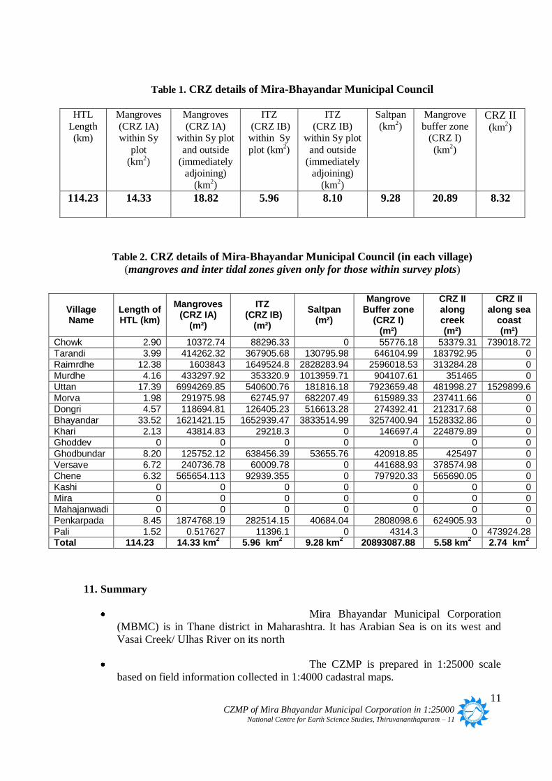
The MBMC has HTL for a length of 114.23 km. The total CRZ area is 65.41 km2
which
includes those areas outside the revenue boundaries in the intertidal zone. Mangrove area
(CRZ IA) is 18.82 km2 with a mangrove buffer zone of 20.89 km
2. The intertidal zone
(which includes seasonal beach on the seacoast and mudflats on the banks of vreek/ river) is
spread over 8.10 km2 while saltpan area is 9.28 km
2.
Fig.1. HTL and coastal ecosystems such as mangroves demarcated in cadastral scale for
Mira Bhayanadar
11 CZMP of Mira Bhayandar Municipal Corporation in 1:25000 National Centre for Earth Science Studies, Thiruvananthapuram – 11
Table 1. CRZ details of Mira-Bhayandar Municipal Council
Table 2. CRZ details of Mira-Bhayandar Municipal Council (in each village)
(mangroves and inter tidal zones given only for those within survey plots)
11. Summary
Mira Bhayandar Municipal Corporation
(MBMC) is in Thane district in Maharashtra. It has Arabian Sea is on its west and
Vasai Creek/ Ulhas River on its north
The CZMP is prepared in 1:25000 scale
based on field information collected in 1:4000 cadastral maps.
HTL
Length (km)
Mangroves
(CRZ IA) within Sy
plot
(km2)
Mangroves
(CRZ IA) within Sy plot
and outside
(immediately adjoining)
(km2)
ITZ
(CRZ IB) within Sy
plot (km2)
ITZ
(CRZ IB) within Sy plot
and outside
(immediately adjoining)
(km2)
Saltpan
(km2)
Mangrove
buffer zone (CRZ I)
(km2)
CRZ II (km
2)
114.23 14.33
18.82
5.96
8.10
9.28 20.89
8.32
Village Name
Length of HTL (km)
Mangroves (CRZ IA)
(m²)
ITZ (CRZ IB)
(m²)
Saltpan (m²)
Mangrove Buffer zone
(CRZ I) (m²)
CRZ II along creek (m²)
CRZ II along sea
coast (m²)
Chowk 2.90 10372.74 88296.33 0 55776.18 53379.31 739018.72
Tarandi 3.99 414262.32 367905.68 130795.98 646104.99 183792.95 0
Raimrdhe 12.38 1603843 1649524.8 2828283.94 2596018.53 313284.28 0
Murdhe 4.16 433297.92 353320.9 1013959.71 904107.61 351465 0
Uttan 17.39 6994269.85 540600.76 181816.18 7923659.48 481998.27 1529899.6
Morva 1.98 291975.98 62745.97 682207.49 615989.33 237411.66 0
Dongri 4.57 118694.81 126405.23 516613.28 274392.41 212317.68 0
Bhayandar 33.52 1621421.15 1652939.47 3833514.99 3257400.94 1528332.86 0
Khari 2.13 43814.83 29218.3 0 146697.4 224879.89 0
Ghoddev 0 0 0 0 0 0 0
Ghodbundar 8.20 125752.12 638456.39 53655.76 420918.85 425497 0
Versave 6.72 240736.78 60009.78 0 441688.93 378574.98 0
Chene 6.32 565654.113 92939.355 0 797920.33 565690.05 0
Kashi 0 0 0 0 0 0 0
Mira 0 0 0 0 0 0 0
Mahajanwadi 0 0 0 0 0 0 0
Penkarpada 8.45 1874768.19 282514.15 40684.04 2808098.6 624905.93 0
Pali 1.52 0.517627 11396.1 0 4314.3 0 473924.28 Total 114.23 14.33 km
2 5.96 km
2 9.28 km
2 20893087.88 5.58 km
2 2.74 km
2

12 CZMP of Mira Bhayandar Municipal Corporation in 1:25000 National Centre for Earth Science Studies, Thiruvananthapuram – 11
MBMC is contained in toposheets No. 47
A15 SW and 47 A15 SE. Parts of Thane Municipal Corporation and Bhiwandi taluka
are also seen in these toposheets.
1:25000 CZMP is prepared based on data
collected on 1:4000 cadastral maps
Acanthus iliforus, Avicenia officinalis,
Exocarria agallocha are the dominant variety of mangroves
Bunds and sluices which have been
strengthened or reconstructed blocking or regulating the flow of tidal waters have
been considered while demarcating the HTL. The scenario once the Khar Land Board
gets the other bunds/ sluices repaired and made functional has not been considered.
Saltpan is shown as an intertidal zone though functional and ecological features no
longer resemble that of intertidal zones
Those saltpan areas which have been converted to other development uses have been
considered accordingly.
Distinction between salt pans into which salt water is pumped and those dependant on
natural tidal flow has not been considered since the details are not readily available.
MBMC being highly developed with a very high potential for further development,
the CRZ in MBMC, other than CRZ I, CRZ IV and open spaces such as parks and
play grounds is considered to have built up area more than 50% and hence
categorized as CRZ II as suggested by the Maharashtra Coastal Zone Management
Authority.
The MBMC has HTL for a length of 114.23 km.
The CRZ of MBMC consists of CRZ I, CRZ II and CRZ IV. Parks, play grounds and
similar open spaces are to be categorized as CRZ III. These are not shown in the
present CZMP.
The total CRZ area is 65.41 km2
which includes those areas outside the revenue
boundaries in the intertidal zone.
Mangrove area (CRZ IA) is 18.82 km2 with a mangrove buffer zone of 20.89 km
2.
Intertidal zone (which includes seasonal beach on the seacoast and mudflats on the
banks of vreek/ river) is is CRZ IB and is spread over 8.10 km2. No distinction is
made between biologically active and not biologically active mudflats.
Saltpan area is 9.28 km2.
(Dr K V Thomas, Centre for Earth Science Studies (CESS))

VA
SA
I
CR
EE
K
CHANDRAPADA
KOPRIPADA
SARJAMORI
JUCHANDRA
BHAYANDAR
SASUNAVGHAR
NAGALE
NAVGHAR
MIRA
KASHI
MAHJANWADI
VERSAVE
CHENA
GAIMUKHOCTROLINAKA
MOGHARPADA
VADAVALI KAVESAR
KOLSHET
PAYE
PAYGAON
KHARDI
KHARBHAV
FIRANGEPADA
GANE89
390
210
206
313
3
240
12372
208
3
241
10
6
45
15
1
54
320
7,8
78
53
91
249
79
90
45
21
1
24
6
4
38
53
41,43
2
4
87
5
155
14
89
7
15
78
266
1
19
98
9
11309
84
65
51/1
121
6
388
8676
27
28
86
79
84
47a
100
85
28
85
46
82
3884
5
8
64
12
83
5
71
75
30
74
204
52
411
128
8873
64
60
32
159
21
81
26
42
5
6
44
35
44
31
37
109
24
17, 15
304
9
83
387
77
16
97
5
37
6
429
79
5
63
30
83
83
142
83
334
43
62
18
13
25 55
143
27
343
66
17
25
48
318
143,144,150
17
13
77
2
371
157
7
120
38
11
46
352
48
57
317
60
127
72
181
70
10
36
18
375
57
Gaothan
303
95
43
77
131
342
86
206
20
85
112
30
96
40
207
49
9
159
22
344
76
63
361
348
333
48
42 36
50
42
252
2
47
2
77
213
45
337
72
74
89
69
96
141
89
134
12
93212
42
69
90
46
10
58
134
141
105
21
184
2324
623
8
30
14
326
54
163
23
336
339
59
48
84
110
50
175
332
349
152
51
259
46
268
53
126
41
70
33
41
71
80
68
42
54
21
156
1161
60
47
1
42
21
351
335
345
20
29
9
203
49
338
32
256
389
99
47
109
161
341
110
64
75
35
25
38
58
4
32
3
95
46
391
136
269
97
45
32
164
116
27
132
29
322
35
28
350
57
8
46
98
47
91
197
76
347
39
34
31219
38
85
64
69
2,3
82
183
184
329
24
65
198
190
39
7078
76
130
122
40
128
56
26
170
79
55
132
144
182
178
6
51
4217
114
126
66
39
37
19
35
26
40
165
18
117
160
39
95
73
47
264
111
40
15
163
26
97
346
29
19
176
59
49
113
67
176
62
540
75
91
44
31
172
98
41
331
45
81
25
192
145
72
75
1
308
29
49
129
79
64
57
204
107
45
36
155
46,52
165
108
73
340
43
194
25 7,9
101
109
202201
16
156
17849
189
74
170
153
179
82 100
11
145
195
169
122
198
153
314
54
24
74
99
108
27
22
154
194
40
178
66
182
217
196
306
124
96
53
249
306
33
2
28
192
136
383
163
102
166
261,262
180
106
23
321
998450
134
51
187
71 36
97
25
169
80
180
191
11912
46
44
60,62
203
54
119
199
46
200
65
28
216
316
59
125
1
57
63
168
21
12
176
162
209A/1
120
69
144
10
175
59
164154
51
128
184
8
168
76
51/8
142
123
263
11
189
102
18315
80
32
218
99
215
72
32
185
146
88
130
63
44
65
164
54
202
61
94
68
140
31
72
49
111
150
214
69
130
195
100
166
125
211
22
9
167
138
193
122
82
41
3161
195
106
324
142
94
108
132
115
123
34
227
58
112
258
55
125
168
252,254
116
177
8
36
105
386
181
230
58
136
52
78
124
350
375
92
32
220
22
113
167
177
170
163
52
61
173
138
127
189
69
174
188
228
171
170
140
208
265
69
107
58
67
36
139
159
53
186
58
223
52
245
68
177,179
130
141
28,29
139
164
423
144
210
10
160
124
62
255
33
185
347
11255
24
243
78
30
380
186
173
182
120
191
130
56
147
107
232
197
34
206
121
20
180
10
7
73
197
175
15
184
54
22
310
37
199
11
177
69
35
45
59
106
236
21
101
260
179
172
174
135
37
18,17
203
117
382
70
11358
70
111
174
7172
28
52
100
45230
56
257
61
119
187
26
170
55
161
162
68
253
161
115
118
170
14
90
14
16
165
146
18
39
148
28
137
34
185
152
174
116
78
143
394
6
36
68
38,39
205
169
51
158
53
27
118
40
89b
172
183
200
100
191
25,26
79
376
13537
30
48
223
167
34
27
146
60
117
19
162
111
159
12
115
228
107
384
14, 12
129
46
171,173
33
60
207
233
157
145
126
234
56
364
196
374
120
229
114
368
225
379
71
26
428
92
28
114
169
19
51/4
201
106
305
87
25
199
53,50
129
93
155
133
Pond
73
112
161
20
427
107
122,363171
57
160
135
114
52
Pada
201
20
370
116
378
115
173
204
121
160,161
91
163
231
187
172
190
188
51/2
381
4
232
51/10
92
78
51/3
22
57
12
67
156
205
110
11819
41/8
136
205C
390
32
336
106
209A2
166
135
80
51/5
175
82,8356
51/7
140
141
149
131138
134
SAVANTPADA
147
16
222
167
104
165
205D
89
101
3
12
10
9
8
99
38
236
8
chk
32
30
15
43 98
7
59
88
3
nn
6
7
2
102
3
217
?90
15
13
187
102
5
11
6
84
9
28
1
7
242
2chk
nn
5
?
8
31
3323
193
3?
1
50
24
7
50
61
38
nn
103
68
74
9
71
24
154
91
42
36
47
chk
58
89
5
87
81
229
40
147
25
116
43
86
148
77
43
55
6
33
34
70
228
72
63
56
46
66
18
20
57
28
60
81
17
233
30
21
39
55
51
27
23
89
36
14
35
43
41
51
11
47
63
91
48
57
10
13
44
16
67
83
7
37
31
38
35
77
17
56
83
19
28
111
185
61
32
88
34
82
6127
95
19
98
9
65
125
46
37
20
54
108
81
140
846
74
26
72
36
18
72
55
84
79
55
71
9
91
29
4073
14
66
92
64
33
38
92
93
61 53
60
66
35
50
65
74
48
133
36
53
63
34
79
42
90
53
12
44
54
67
44
4
69
59
22
8
110
41
57
94
88
94
5
25
56
39
103
51 52
20
39
62
10
15
31
141
4
76
47
29
89
82135
131
86
19
207
85
16
98
91
32
43
87
128
42
462
129
40
83
17
69
73
80
68
61
62
22
105
37
100
49
20132
155
57
73
84
23
37
49
96
86
94
52
180
45
7
90
53
72
1
94
99
41
105
39
24
110
33
60
70
59
143
4
127
87
56
121
97
82
13
72 1
66
104
16
241
127
97
113
60
22
41112
82
87
80
64
104
231
20
26
2
64
67
100
954
115
35
86 chk
130
178
99
77
62
23
15
56
26
145
50
156
170
48
107
53
59
89
171
82
106
12
7
131
157
100
25
32
103
67
84
100
49
109
74
19
106
66
226
85
126
101
56
12
172
144
24
11
64
10
78
51
57
51
11852 69
117
38
45
161
29
2
65
137
9510
58
116
93 97
79
11
54
50
128
13
11
PADA
65
55
29
40
47
130
205
134
22
71
76
63
55
58
163
62
28
96
21
116
28 158
45
99
90
42
142
16
3
63
75
96
230
93 104
58
124
47
78
45
77
55
59
36
94
80
38
74
20
103
47
85
54
52
52
30
13513
4041
59
64
26
33
64
81
33
24
6
98
101
215164
86
44
62
117
54
19
79
41
147
57
120
83
111
136
50
25
107
9
68
92
71
148
118
30
60
48
19
109
117
123
210
54
14
39
102
68
97
67
69
119
11
35
80
23
179
103
35
21
58
78
131
55
80
3999
?
177
1730
15
16
94
53
69
173
84
119
173
112
186
32
43 41
128
96
83
16
16
26
149 12
59
138
37
122
91
46
52
44
43
112
92
73132
56
114
88
162
72
108
60
61
170
220
33
171
34
17
70
93
151
62
115
68
103
36
146
78
139
140
23
133
104
150
66
22
112
181
106
146
53
14
39
125
115
219
143
79
75 180
60
116
21
92
72
32
117
152
42
125
133
105
98
141
129
181
126
13
85
nn
232
97
75
24
224
77
8
121
67
107 m
204
225
52
45
105
85
17
227
114
119
146
83
101
65
61
88
102
79
nn
78
87
89
109
58
31
98
1570
68
234
223
77
2542
159
96
96
35
34
50
65
81
106
126
75
136 49
85
216
27
76
61
84 82
172
114116
105
38
134
107
nn
75
nn
176
76
18
95
132
100
183
123
134139
87
37
48
142
88
76
138
153
101
74
102
49
5154
15021
183
4 166
46
120
51
11?
114
128
139137
100
130
115
141
179
121chk
196
148
71
135
108
145
21395
118
58
123124
221143
49
174
182
109
195
127
165
137
120
144
112
70
102 190
109
119
31
136
147
227
168
142
22
121
129
103
108
27
125 145
113
144
176
160
178
73
98
209
130
124129
14
5
nn
122
197
80
48
238
167
140
46
71
194
218
127
107
14
184
10
191
126
63
152
46
198
110
58
151
175
152
169
169
188
214
113
23
222
120
122
45
106
206
34
75
40
177
208
10445
189
244
239
36
18
90
235
192
149
6
237
211
224
191
103
201
202
nn
101
200
118
115106
175
149
20
4
21
155
68
2316
7
60
93
5
2
3
76
41
78
77
37
5
138129
1
47
91
9
230
123
105
4100
38
7
3
255
6
26
32
83
8
33
146
9
2
147
232
136
225
22
97
3
2
139
81
242
8
135109
19
199
127
45
133
141
58
42
5
30
40
132
8
138
270
23
40
10
29
25
10
294
303
46
18
33
126
312
80
277
131
1
52
315
316
2
14
34
313
302
34
287
24
44
66
103
24
27
12
88
240
11
304
13
129
140
266
296
130
279
137
20
5521
84
27
96
300
37
134
1
311
294
48
126
127
238
86
52
62
28
301
61
64
31
317
298
245
82
98
236
311
297
85
32
28
310
163
7
12
91
10
31
118
90
56
29
272
9 265
298
179
22
295
5629
6
11429
36
67
88
251
247
29
47
200
54
278
137
45
35
306
86
28
95
46
56
55
31
180320
73
32
61
35
83
106
176
15
30
10
104
37
75
54
193
108
69
11
72
262
66
84
99
38
38
43
3
314
82
294
58
174
180
42
13
20
91
58
307
28
5
234
98
44
60
231
40
81
63
186
253
45
198
107
51
35
53
72
189
122
107
222
285
48
214
43
212
260
101
64
27
222
19462
80
176
199
89
117
173
75
59
79
38
213
193124
127
60
182
67
134
152
159183
179
184
89
71
Pond
178
224
174
226
30
4
7
71
66
140
187
11
228
162
218
65
164
161
90
97
213
Park
15
47
226
55
26
165
261
40
47
57
18
20
70
116
229
119
232
74
2555
74
156
6
58
101
36
255
69
111
109
171
94
219
32
33
59
87
52
215
195
41
63
181
9
254239
197
7638
208
73
94
63
57
53
228
58
79
272
125
250
99
185
78
175
190
96
113
19
80
12
47
184
32
41
114
53
215
227
212
105
67
210
9534
138
236
46
97
39
50259
235
54
139
36
33
106
49
168
21
263
43
192
145
103
118
82
188
Wadi
51
70
Gaothan
132
217
166
76
11
172
256
120
187
36
241
44
257
220
196
26
200
108
48
223157
106
298
218
108
252
25
52
64
223
230
201
77
239
131130
249
192
49
110
Pond
127
224
57
238
319
17
299
318
93
85
153
204
300
102
141
Gaothan
133
39
23
47
115
233
177
104
199
232
109
123 237235107
215
210
211
46
181
154
227
27
188
120
99
14
35
37
53
24
27
126
61
131
169
77
130
1798
12
211
186
120
280
140
39
196
65
Wagbil Pada
160
281
65
134
190
248
177
102
122
199
197
27
143
209
136
128
123
220
246
225
26
233
15
50
13
182
16
205
42
144
135
40
237
68
48
28
107
203
183
116
158
195
103
117
122
125
135
167
189
281
231
258
44
198
277
191
175
236
14
140
44
142
100
216
137
243
202
153
174
207
133
183
202
225
191
132
120
121
264
25
384
41
280
121
123
209
279
156
20
64
113 a1a1
17
110
1
181
3
7
189
380
84
9
9
4
15
2
9
49
7
113
97
354
7
77
204
89
70
55
102 77
250
311
100
164
151
184
173
100
196
148
8
14
9
18
117
203
9
204335
88
64
37
7
318
137
6
14
119140
143
69
68
168
58
163
59
102
217
82
76
166
108
73
108
11
28
8
8
5
7
122
138
86
6
178
195
225134
46
8
53
132
4
5
101
4
187
118
83
2
23
157305
138
127
127A
193
27
52
54
1366
4
408
150
1
60
55
77
16
94
24
98
110
41
148
63
35
141
100
86
62
3
78
7
68
200
72
147
104
60
7
20
64
34
24
2
80
42
8
70
4
90
92
31
70
213
205
21
2
72
23
23
84
16
56
123
209
69
75
26
205
22
22
25
70
23
208
69
49
154
69
76
33
91
66
16
138
74
65a
302
70
8
73
2
256
79
4
165
3
22
26
25
5
16
314
70
50
261
64
64
15
61
24
52
98
258
68
133
7
75
15
60
79
12
30
62
54
88
49
46
38
89
8
32
20
58
91
203
112
87
43
33
9
52
401
187
4
2
175
65
55
65
16
56
117
176
66a
105
61
51
40
30
17
81
34
85
97
14
33
71
53
61
201
67
4
22
497
19
100
12
24
219
32
35
21
68
220
46
206
36
18
95
201
313
69
91
122
79
106
36
26
6
79
104
201
94
9
36
9
11
121
67
189
68
58
210
59
14
89
84
65
133
29
177
56212
13
21
71
165
86
1
18
399
35
67
80
33
58
99
185
31
46
35
90
260
17
42
71
181
12
6
160
115
10
24
59
52
97
85
8762
76
21
206
188
73
190
26
48
144
171
85
71
397
19
63
65
143
97
1
118
222
43
207
135
200
74
199
81
79
43
39
92
66
214
69
114
5
193
20
192
52
63
164
8
24
404
5
49
115
50
215
191
29
179
26
111
175
105
93
80
169
17
134
192
103
50
189
54
27
75
11
197
93
41
47
324
66
77
304
35
21
81
88
47
204 307
27
324
19
104,109
139
212
96
32212
24
76
18
38
32
283
32
202
166
90
73
44
194
97
136
255
12
70
95
155
63
53
26
41
54
7
46
20
69
17
141
172
139
54
52
33
29
11
53
56
9
57
41
20
89
14
61
265
196
94
17
53
38
81
62
261
35
51
48
86
246
305
33
11
191
198
95
63
60
78
209
232
195
57
138
49
27
92
50
35
15
97 28
41
45
88
189
111
62
93
3
66
5529
1
64b
215
60
48
28
63
19
86 70
76
105
2291
25
7
36
105
265
37
83
2
75
234
17
55
98
42
91
183
251
22
132
20
124
210
14
88
105
87
259
72
1238
7
74
38157
144
32
64b
30
28
57
102
131
55
62
67
198
6
13
48
121
76
86
93
199
81
39
101
94
134
79
90
7895
230
43
70
218
120
127
27
119
72
74
49
14
90
25
143
78
4214
94
26
244
78
71
47
26
36
20
74
48
98
57
127
42
19
165
54
154
71
11
58
Gaothan
226
31
114
114
16
255
92
55
73
72
25
9
1
24
111
188
137
228
44
178
87
188
155
21
402
400
96
50
2
252
43
64
50
33
16
216
74
30
174
68
128
87
30
107
403
82
138
43
55
128
5
79 27
58
109
3
78
6
176
106
265
84
36
74
41
92
180
113
34
118
87
99
60
49
85
129
50
52
37
113
53
22
130
96
58
81
237
99
66
91
133
266
123
46
11
76
80
116
230
90
89
147
71
81
264
100
47
103
83
92
60
68
11
40
9
202
126
98
40
231
3
165
107
238
2
82
75
247
29
121
9497
157
258
93
76
86
66
13
75
226
124
135
103
166
156
14
67
82
71
68
277
178
224
132
49
12
63
56
38
85
306
137
81
152
63
72
112
170
112
151
20
228
145
72
42
22
18
65
190
141
134
113
5
74
213
84
68
58
85
278
127
16
150
14
51
37
31
29
66
144
120
96
18
84
216
89 37
25
89
134
236
115
208
310
247
145
47
159
122
135
8
24
39
256
176
5
64
308
74
239
4
34
82
41
5
248
45
257
14
152
95
73
128
91
107
28
157
159
140
254
57
18
129
136
83
3
106
6
156
53
19
46
9
245
80
80
40
78
60
62
84
229
143
171
136
23
24
132
103
37
34
79
169
72
122
88
97
82
228
130
153
229
234
17
235
61
17
182
109
47
47
85
225
169
39
101a
2
125
264
63
1
157
303
168
8611
140
106
213
175
163
227
112
142
110
83
99
173
5
32
221
221
110
26
100
87
48
152
71
16449
174
114
11
44
205
96
169
57
58
151
72
152
75
90
70
146
80
70
159
102
53
263
114
13
145
29
131
52
77
151
206
233
1
1
238
66
102
65
19
25
169
85
166
69
59
194
88
83
147
83
144
59
144
23
39
8
12
58
101296
44
122
247
243
24
154
59
3
171
46
127
119
187
262
122
186
224
219
221
34
129
113
69
55
92
170
92
212
236
120
41
113
6
69
140
130
107
203
96
215
103
90
216 30
164
113
59
23
211
260
134
208
53
194
86
7
3
26
231
80
43
6
106
41
213
158
192
34
126
118
78
235
122
159
40
170
59
48
45
45
125
91
120
98
70
120
84
67
165
219
51
87
48
64
15
117
222
204
174
152
128
21
211
155
241
111
101
68
159
173
167
203
52
179
21
2
101
105
75
39
1
220
82
90
270
98
69
163
162 161
230
32
50
160
302
218
154
225
155
215
165
15
164
148
5
59
46
162
80
208
139
264
102
103
239
267
183
102
3
25
82
197
107
67
45
111
164
131
42
191
161
222
196
109
54
135
223
240
122
153
10
96
132
149
38
117
156
166
151
93
63
163
104
166
180
56
163
54
6
229
67
138
194
103
43
77
279
220
36
18
234
150
80
76
87
165
121
30
106
37
175
107
182
89
81
9a
229
214
106
65
64
177
148
53
14
35 57
164
13
201
186
18
93
27
84
107
44
8
31
48
50
207
82
221
89
224
128
239
119
138
235
119
31
133
64
54
260
121
77
181
45
151
147
253
91
94
250
199
128
190
91
196
28
161
67
84
27
62
191
178
252
124
166
157
58
10
45
195
20
42
193
101
211
156
58
198
209
16
172
34
214
177
25
126
129
93
199
104
91
125
111
92
6
217
158
209
121
36
233
71
28
80
88
139
121
37
269
167
61
112
73
51
52
137
23
13
265152
202
128
55
189
58
223
117
81
12
137
162
151
93
188
154
255
211
99
108
135
126
17
17
43
149
142
196
11
115
42
135
129
47106
28
49
219
52
89
23
30
19
106
100
191
86
230
164
100
77
190
12
241
262
123
48
139
160
123
57
79
131
87
17
51
91
133
21
13
271
148
227
150
148
233
86
77
243
82
34
72
90
135
39
236
157
40
136
96
28
210
140
75
79
244
60
63
13
44 46
93
240
71
45
129
84
60
27
36
243
202
107
58
56
125
57
116
105
99
50
91
51
112
94
167
9b
218
83
124
105
136
44
117
114
168
158 34
78
22
153
59
96
90
121
47
145
118
132
132
137
103
155140
160
263
108
62
130
53
116
70
316
11
69
88
38
98
115
118
45
88
108
54
82
12
20
61
98
201
134
13
432
91
214
99
213
55
327
125
108
83
29
258b
151
40
120
8
15
12
156
305
59
233
49
49
39
108
126
79
99
155
19
250
131
1263
172
36
128
49
33
127
205
95
100
42
172
177
299
216
156
51
163
81
133
116
286
135
33
89
223
73
119
249
66
227
232
267
134
232
37
30
25
131
168
147
189
18
131
23
18
198
38
161
10
4
116
129
36
74
54
133
42
60
125
125
61
41
58
227
73
168
143
34
331
64
54
44
131
57
108
353
105
121
133
129
47
170
115
115
281
197
73
19
200
139
59
139
101
300
232
5
119
56
136
92
50
38
298
56
61
90
146
140
167
67
63
190
14921
127
242
110
163
228
100
162
156
103
110
266
6166
48
37
111
190
129
94
114
10
14514
111
133
113
59
186
128
218
144
56
287
65
136
225
104
191
57
75
78
142179
130
94
308
141
12
40
259
51
149
309
230
77
130
114
104
105
150
89
83
121
239
127
35
95
192
139
41
119
83
59
104
10
188
240
132
254
113
246
100
95
35130
110
301
7
12
142
97
5
4
160
207
104
150
150
95
129
261
65
138
143
159
50
97
14
123
87
142
223
31
10
243
1
134
10
75
174
143
130
15
56
237
242
158
180
15
134
161
130
245
137
98
168
137
23
157
17
226
16
33
131
85
102
51
152
44
118
32
132
76
146
124
78
203
96
16
3
107
18
154
71
123
83
246
101
15
136
226
40
146
112
37
251
249
178
328
204
67
19
62
74
193
13
27
131
150
46
11
188
238
193
85
176
57
158
126
251
303
148
108
43
75
237
101
109
123
185
110
44
117
47
127
124
65
39
30
128
116
214
210
224
172
154
159
44
82
116
124
307
227
202
234
51
37
153
169
47
150
175
22
81
48
160
63
268
177
140
142
31
33
259
65
6
253
35
62
156
142
88
39
78
165
112
75
131
169
38
97
120
167
106
45
43
191
41
70
101
191
56
162
146
253
232
160
231
235
94
158
29
4
107
38
84
110
141
207
158
10881
99
146
141
120
87
177
114
130
80
251
187
31
19
245
55
185
206
171
73
179
148
250
161
107
116
238
109
171
147
121
202
132
201
149
85
120
106
77
187
82
193
2
152
113
142
231
138
17
125
249
261
176
4
155
246
71
118
237
63
7
99
59
186
126
15
217
173
10
208
29
231
144
141
102
73
76
16
162
244
20
134
60
247
128
86
79
141
145
213
140
103
85
188
295
5
119
18
125
188
132
76
257
109
280
118
130
160
146
263
44
101
135
254
258k
126
304
117
172
101k
117
113a2113a1b
187
72°57'30"E
72°57'30"E
72°55'0"E
72°55'0"E
19°20'0"N
19°2
0'0"N
19°17'30"N
19°1
7'30"N
±
47A/15SE
C Z M P M a p I n 1 : 2 5 0 0 0
D R A F T M A P
0 500 1,000250Meters
1:25,000
Coastal Zone Management PlanThane District, Maharashtra
Mapped During Scale
Checked by Approved by
R e f e r C R Z r e p o r t f o r d e t a i l s
Centre for Eatrh Science Studies Akkulam, Thuruvikkal P.O Thiruvanathapuram - 11
October 2012 - December 2013
V A S A I - V I R A R M U N I C I P A L C O R P O R A T I O N
INDEX MAP
M I R A - B H AY A N D A R M U N I C I P A L C O R P O R A T I O N
T H A N E M U N I C I P A L C O R P O R A T I O N
B H I W A N D I T A L U K
Legend
RoadRailway lineSeawallMunicipal BoundaryTaluk BoundaryVillage BoundaryHigh Tide LineLow Tide LineCRZ Line for River or Backwater100m CRZ Line200m CRZ Line500m CRZ LineMangroves - CRZ IAMangrove Buffer Zone - CRZ IInter Tidal Zone - CRZ IBSaltpan - CRZ IB (inter tidal zone)CRZ IICRZ IIIWaterbody (sea) - CRZ IV AWaterbody (creek) - CRZ IV BWaterbody (non-tidal)Survey Plots
ShahapurVada
Palghar
Dahanu
Murbad
Jawhar
VasaiBhiwandi
Thane
Mokhada
Kalyan
Talasari
Ulhasnagar
Mokhada
Vasai
47 E3 SE
47 A9 SE
47 E4 NE
47 A9 NE
47 E3 SW
47 E4 NW
47 A13SW
47 A15 SE
47 A14 SE47 A10 SE
47 A11 NE
46 D12 SE
47 A16 NE
47 A14 NE47 A10 NE
47 A15 NE
46 D12 NE
47 A15 SW
47 A14 SW
47 A15 NW
47 A13 NW
47 A14 NW
INDIA
Maharashtra
Karnataka
Andra Pradesh
Gujarat
Arabian Sea
Goa
Thane DistrictThane
Maharastra
Arabian Sea
±
CZMP MAP IN 1:25000
Thane
47 A15 SE
47 A15 SW 47 A15 SE
47 A16 NE
47 A15 NE
DISTRICT MUNICIPAL CORPORATION/COUNCIL/RURAL AREAS
THANE Mira-Bhayandar, Thane, Vasai - Virar, Bhiwandi
Kalyan
Ulhasnagar
Bhiwandi
Mira-Bhayandar
Vasai
Palghar
Dahanu
Jawhar
Vada
Shahapur
Talasari
Mokhada
ThaneMira
Bhayandar
Kalyan
Bhiwandi
Vasai
PUNE
NASHIK
RAYGADMUMBAI CITY
MUMBAI SUB URBAN
AHAMAD NAGAR
Thane
47 E3 SWVasai
MiraBhayandar
Vasai
Bhiwandi

C H O W K
PA L I
TA R A N D I
D O N G R I
U T T A N
U T T A N
U T T A N
M O R V A
R A I M U R D H E
M U R D H E
B H A YA N D A R
B H A YA N D A R
D A H I S A R
G H O D D E V
K H A R I
M I R A
A R A B I A N S E A
V A SA
I
CR E E
K
V A S A I V I R A R M U N I C I P A L C O R P O R A T I O N
P E N K A R P A D A
MAHAJANWADI
MALONDA
VASAI FORT CRZ 1A
DHUVOLISANDOR
KAULAR BHUDRAK
KAULAR KHURB
SANDOR
UMLE
UMLEMAN
MANIK AGARCHIMNEY AGAR
JUCHANDRA
JUCHANDRA
PANCHU
UMOLE
46
69
123
243
124
390
245,246
206
240
73
37
258
80A
40
99
313
12
241
100
77
71
208
122
242
22
80
8,9
104
84
387
127
210
G
244
78
12
37
320
73
2
9
91
1
1
61
35
13
149
5
90
7
209
3
45
3
21
105
8
1
4
1
34
36
G
9
7
2
4
7
4
155
7
5
8
48
5
129
20
7
15
55
1
72
98
79
41
7
6
12
9
121
6
388
8152
5
2
249
28
74
46
7
39
6
91
39
2
82
53
25
2
8
5
1
204
411
66
1
9
96
1
95
159
4
73
2
5
3
87
95
5
26
6
8
41258A
2
58
17
57
287
88
90
16
76
59
8
29
53
54
380112
67
2
129
57
42954
2
2
14
5
36
792
77
6
41
34
4
3
6
9
1
140
83
11
142
42
334
2
6
51
58
33
49
85
8
22
47
189
32
18
13
9425
98
143
4
9827
5
6
5
55
5
17
86
318
31
143,144,150
23
6
19
120
38
63
24
11
132
110
20
352
14,15
93
4
15
60
72
74
36
309
24
52
111
227
14
133
230
67
34
60
102
127
6
81
58
20
34
72
181
70
225
48
9
24
5
61
15
56
52
20
29
20
303
3
86
310
413
77
5
131
45
342
86
9A
103
206
119
85
112
7
115
46
88
6196
131
5
38
13
25
40
4
38
3
30
92
207
11
55
28
42
22
159
2
83
88
3
22
26
348
23
18
95
54
17
28
9
93
48
39
23
52
41A,41E
35
26
50127
73
42
76
35
8
252
57
389
56
10
81
37
11
47
9
94
32
41
16
239
51
26
213
50
40
337
70
79
85
42
70
101
3
3
82,83
89
98
96
267
141
17
12
85
45
93
35
63
68
54
68
45
212
42
516
46
10
53
74
3
134
32
29A
99
56
113
114
44
7A
40
23
18
229
48
24
12
23
57
9
7925
35
23
23
81
8
50
35
30
113
26
42
49
14
326
134
163
21
79
23
96
45
59
109
13
59
48
58
26
24
4
43
32
73
45
110
54
96
43
24
175
69
43
349
55
37
381
53
56
74
82
62
75
105,111
14
38
31
53
126
41
70
90
52
2
33
231
56
263
13
41
30
16
6
31
78
17
22
3 228
156
14
111
21
47
88
92
3712
22
50
77
6160
86
20
66
32
21
351
G
84
69
127
84
10
345
65
24
9
9
17
22
25
136
203
57
70
338
16
43
97
67
39
77
389
10
68
7
116
4
99
47
109
69
135
28
81
341
336
19,66
110
64
68
33
15
43
64
48
40
54
32
24
38
58
17
1
3
79
69
45
21
43
52
46
9
22
115
44
76
15
8413
57
136
32
295
16
78
89
73
97
30
13
19
130
68
53
88
31
37
19
20
8
40
39
344
32
85
99
164
46
116
572
17
27
40
112
359
46
132
357
4647
29
317
46
30
78
6,8
284
35
37
28
55
60,62
62
28
27
350
57
101
6251
77
117
75
186
98
348
41A
13
12 1
197
63
76
39
286
32
38
39
34
258
108
31
28A
44
86
6
14219
38
53
35
64
64
69
8
85
2,3
99
30
18
31
183
347
68
1591
184
329
24
4
22
38
72
29
56
198
11
190
53
6
97
31
58
130
122
75
22
91
38
128
71
56
39
25
5
97
69
110
55
11
72
30
26
170
79
41
33
92
182
64
96
39
178
63
6
61
51
4217
114
68
26
92
126
44
86
39
251
30
80
332
37
19
35
69
64
33
165
59
18
117
12
347
78
92
15
39
95
12
123
129
59
41
16
73
47
4
109
296
47
65
24
346
67
1269
111
83
65
18
40
87
78
14
17
31
70
12
15
24
141
68
97
346
39
148
37
124
37
54
75
81
24
19
48
84
176
59
49
74
25
367
86
113
86
80
67
262
75
176
133
91
23
49
47
70
11
540
83
12
30
91
44
34
7
31
172
19
55
103
27
22
95
41
60
6
351
45
29
25
34
192
49
15
27
145
7
61
13
95
75
90
11
77
49
92
129
22
64
57
89
19
259
204
107
123
45
5
33, 36
19
172
48
23
43
36
4
78
25
155
333
79
293
106
165
71
6
111
108
152
89
43
16
133
67
16
194
85
25
109
49
54
83
62
17
202
47
201
336
178
335
29211
34
107
288
13
49
35
189
18
74
170
93
179
76
82 100
59
10
66
11366
41
43
145
44
22
195
61
169
15
122
110
60
283
12
198
46
153
18
54
19
15
122
8
25
12
32
232
36
108
20
22
89
339
154
67
28
103
21
129
343
194
11
35
20
18
13
50
61
20
81
151
4,5
43
66
9
54
77
8
10 40
178
30
3918
66
44, 43
182
112
21
18
217
62
196
252A
306
131
124
53
30
14, 10
354
43
332,352
33
56
88
68
192
62
47
18
61
70
345
136
19
163
180
14
106
142
22
50
15
55
72
23
363
77
57
30
275
321
79
29
153
67
99
51
80
37
31
39
56
84
6
103
1
50
330
201
66
61
58
49
134
34
51
47
72
18
85
187
8
30
48
126
46
20
309
71
16
265
59
40
106
70
72
30
219
79
36
7
101
76
161
353
169
51
180
191
64
355
360
305
119
76
55
81
13
194
104
94
97 48A
74
25
26
30
73
69
44
297
124
1
366
53
203
186
199
55
46
44
154
235
118
23
34
57
73
44
13
19
200
27
40
97
112
65
30
28
329
67
G
216
60
361
76
59
56
33
125
65
337
59 306
92
29
60
31
1
24
13
14
21
15
45
21
64
12
53
176
17870
42
56A/1/1
68
162
209A/1
365
12
120
120
69
82
144
148
189
226
62
106
133
7A
231
58287
36
58A/3
4a
70
128
36
67
27
66
184
8
168
42
115
98
250
51
278
76
32
School
32142
29
123
70
47
30 38
98
47
41
16
294
266
46
20
11
84
119
102
5
49
31
183
51
23
15368
90
104
24
2
11
83
28
77
28
21
218
99
17
27
215
126
270
102250
12
98
111
29
129
81
11
141
356
104
14
28
185
100
35
135 124
119
64
378
57
16,17
56
30
11
130
63
362
65
13
164
13
11
62 95
259
14
54
164
94
202
27
147
12
94
282
140
173
49
11
29
8260
1934
66
46
261
92
75
31
17
208
49
150
214
10
69
83
130
195
94
45
166
65
52
125
28
211
126
80
28
63
102
138
308
29
85,84
198
254
15
193
82
122
125
65
331
140
62
257
115
187
8A
83
17
264
74
127
193
31
3B
263
62
58
76
54
23
279
61
83
195
106
243
28
66
31
126
6
27
32
120
155
33
101
6
157
46
6
324
108
102
24
142
7
12
71
77
121B2
76
94
118
108
12
122
24
255
2
28
289
31
132
226
72
64
80
61
117
123
82
53
87
62
227
40
122
138
33
112
125
168
44
6454A
115
116
18
7
32
32
21
234
121
11
105
56
177
137A
42
81
36
10
119A
105
181
16
127
44
60
82
12
230
34
102
58
200
45
50
38
123
88
176
40
61 63
52
57
9B
16
340
56
73
268
45
3A-2
274
74
74
112
52 78
64
124
23
386
13
122
118
49
350
375
46
30
24
97
32
220
79
14
99
93
2359
113
163
167
99
177
170
15
256
44
307
114
16
197
6761
52
50
163
52
216
173
58
138
127
158
72
48
349
189
5A
71
97
80
69
85
24
48
16
111A
241
184
14
14
27, 28
119
73
16
225
46
73
214
91
90
71
32
84
188
45
256
188
171
7
11
228
28
39
171
17
27
170
71
208
137
5
86
60
191
76
310
27
114
228
18
281
78
36
124,90
210
34A 34B
47
49
245
128
1
56
67
33
30
50
280
35
139
87
52
42A
269
14
21
43
114
224
223
335,371
31
27A
69
4
52
245
130
15
19
10
177,179
75
113
154
22
21
72
1865
285
141
67
28,29
124
236
164
12
205
215
98
423
31
227
19 18
144
104
75
38
8
11
210
10
32
25
57A
51
160
59
124
62
33
16
185
48
63
347
44
100
127
75
59
46
60
55
60A
26
51
84
21
48
91
138
19
30
41
22, 20A
179
10
186
218
173
182
10
13
86
19
200
191
80130
56
162
147
13A166
51
107
17
232
63
273
24
68
12887
66
16
206
168
112
71
90
121
20
180
17
128
301
136A
248
12
237
197
43
125
13
98
13
175
101
93
276
39
47
185
25
110
36A/2
20
343,379
115
10
265
120
121A
167
26
184
20
85
27
105
132
54
128
2
10
52
18
121
90
104
129
22
103
87
136
33
38
192
22
79
78
217
81
135
199
69
11
52
16
25
26
311
6
233
81
35
60
100
71
120
124
80
106
57
138
43
57
67
115
12
41
2
236
8726
21
92
101
67
179
80
1
128A
27
76
212
14
32
3772a
71
127
172
126
255A
78
175A
38
28
174
29
93
37249
134
45
203
125
174
72
53
15
24
75
84
117
69
20
149A 9B
344
13
4
111
118
61
129
109
187
312
143
174
10927
304
35
43
120
10A/1308
98
84
188
76
88A1
91
113
130
28
42
8
46
63
4
186
94
183
114
248
42
139
131
45
83
46
230
73
78
15
13
59A1
61
23
111
21
165
92
17
121
119
89
46
53
125
91
26
100
106
309
45
230
55
10
96
87
20
162
293,325
44
61
G
139
60
94
80
36
189
26
115
33
73
40
44
26
40
16
53
114
66
121
GAOTHAN
161
114
41145
75
118
277B
64
115
180
25
72
101
54
187 137
76
294
119
17
14
104
9793
109
137
50
17
383
146
47
70
8 18
45
34
28
59
87
5
33
99
24A
46
137
31
26
55
78
106
22
71
78
62
55
41
34
64
350
42
185
35
192
14
2
69
152
174
30
187
116
195
55144
88
116
143
84
50
203
63/A
62
394
21
24039
62
46
90
45
68
23
145
139
242A
205
82
47
75
280
35
15
51
158
131
4
239
15,1642
9
14
29
314,373
19105
40
54
15
83
11
57
218GAOTHAN
54
40
52A1A
28
199
130
52
81
118
114
196
87
89b
86
38
232,221
386
183
116
20
95
48
150
200
231
12
3
48
29
100
88
25,26
90
376
21
65
37
89
160.
67
57
25
207
146
72
41
130
85
155
34
29
13
54
158A
31
223
98
96A
29
26A/1
167
34
177
33
224
88B
44
99
5542A 42B
45
364
146
107 108
61
117
265
12,14
139A
90
51
162
111
159
107 105
246
228
100
65
25
Gaothan
150
154
247
29
53
27
70
335
32
39A
132
2
148A
171,173
33
207
.33
77
107
204
260
93
51A
38A 38B
40
92
45
71
86113 151
233
125
16
157
129
143
126
39
7
24
104b
234
21, 19
144
13
58A
238
80B
364
13
253
196
16118
103
338
120
58
113
59
229
19
94B
114
82
13A
8931
318
14
99
122
74
46
225
254
97
205
25
36
27
9A
92
20
132
58
26
428
102
312
135
305
273
58
110
100
16B
267
105 111
11963
221
114
169
83
124A
96
100
26
201
103A
66
182
120A
87
47
88
222B
8
35
199
68
34
3
129
23
298
GAOTHAN 89
107
79
PADA
261
85
229238
155
32
19
133
199
56B
110
170
32
32b
9045
260
1
161
103
58
20
149102
87
55A1
427
107
8
139B
18
51
9
43
80
122,363
68
171
79
77 57
95B
133
82A
136B
52A
73
160
5A
262
11
36
56C
119
24
115
87
148
279
52
267
100
79
10
273
104b
92
123 85BBARMALA TALAV
248, 245
201
20
67
271
89A
63
390
55
108
7B
378
138
115
16937
54
204
93C277A
108
160,161
101
24B
119B
101A
PADA RANGAON
150
135
258
123
2B
193 93
120
112
29
270
65
26
39B
163
112
231
72
69
187
220
100
172
65
325
154
3
4
232
80
77
225
92
64
95
12
221A
18
11
156
257
205
49
63
58B
78
80
225
3
272
43
233
68
65
94
226
118
41C
19
42
114
5B
23
86
37
205C
45B
35
32
170
9
96
29
336
23
127
138
106
106
154
209A2
10
44
7
37
74
PADA
76
166
33
68
62
M.VADA
135
302175
135
100
34/2 6
56
226
59A2
73
27
66
54A
63
194
10
59
24
140
141
41B
54A
103B
135
130131
102
22
49
24
131
106
60
51
10
179b
School
156A 156B
32
87A
118
5C
138
9102
123A
6660
144
12
14
89B
145
79
3
15
101A
103
25520A1
96B
7B
58A
72
21,22,23
85C
65
147
126A
16
45
91
119
78
20 142
11b26B
222
140
125
26
167
139
197
63
88A2
134
126 119
104
114C
120
10A/2
58A-1A
42
36
58B/1
181B
95A
58B
26C
123
130
165
153
140
132131
78/1
159
213
196
13
10
94B
205D
164A
141133
21
52
21
52A2
20
58A/2
93B
58A-1B
97
78A
104
113
52
111B
64
86
175B
83
114B114A
79B
98
126B
134
20D
79
20B
138
13B
60B60C
55B55C
55D
82B
94A
33
38A
10
98
353
111
12
7?
342
337
147
352
3
19
112
37
nn
146c hk
39
?
172
13
9
338
45
15
38
65
354
63
64
66
21
24
25
113
50
355
236
62
38
229
110
8
44
51
8
49
12
3
3855
15
31
150
1
115
138
16
117
7
chk
26
nn
249 A
16
nn
33
757
65
30
9
14
106
19
199
350
341
40
57
60
36
12
30
144
124
36
24
chk
200
56
15
15
61 148
59
224
7
35
7
59
171
88
203
229
340
114
3
nn
37
285 A
11
2346
26
14
149
378
201
344
52
170
8
61
3
217
?
124
13
187
20
7
206
52
22
102
5
11
94
64
6
30
18
84
9
9
223
1
7
242
2
?
2chk
30
12
310
228
331
nn
5
5
?
27
8
9
30
150
778/1 A 7
3
193
154
57
3?
46
71
4
20
23
25
1
343
22
17
94
24
50
24
76
85
7
24 25
10
65
61
81
6
80
58
50
68
38
74
61
27
97
66
6
57
5
nn
103
68
74
39
14
72
9
11
66
10
79
71
18
45
102
27
6
2
59
24
44
51
10
21
56
77
154
115
8
113
308
5343
169
307
42
19
36
96
120
59
309
chk
8
28
47
2
98
58
327
89
5
3
4
33
2
306
63
3
17
87
360
81
229
147
117
7
13
16
25
43
42
28
93
50
120
300
116376
43
69
148
2
86
29
31
1
99
39
36
77
6343
92
7
55
48
7
6
49
7
41
55
33
34
70
15
228
72
9
114
30
63
311
78
56
46
46
36
66
351
18
20
9
12
6
90
57
33
54
99
9
60
81
17
98
233
50
17930
4
21
72
35
40
39
305
1
184
55
81
28
51
55
28
46
368
95
18
304
13
104
27
23
57
124
76
89
36
14
35
15
43
60
118
38
63
54
41
9
182
51
31
11
100
47
1?
38
19647
63
61
40
42
91
183
48
57
11
63
59
185
10190
62
13
44
39
4 95
16
134
56
67
83
122
7
12147
37
31
38
34
77
195
154
60
131130
6
68
151
32
91
88
193
23
35
153
17
56
39
58
123
50
29
303
32
16
37
7
36
83
32
19
126
94
26
167
125128
28
82
67
24
20
111
288
185
61
32
22367
49
47
127
153
44
156
88
3
85
2
34
82
46
27
105
69
87
95
49
69
54
75
64
39
98
22
103
9
231
34
30
25
73
340
31
16
191
312
18
149
10656
200
32
164
54
16
77
54
57
125
13
66
58
55
27
46
37
40
132
20
3
84
108
81
44
140
10
12
76
42
152
8
47
46
74
26
72
30
57
36
113
18
70
3
72
129
10
75
55
84
102
92
79
48
55
71
71
84
99
38
9
8
57
135
15
40
54
45
91
91
62
10
83
136
72
29
40
96
73
81
14
16
66
73
92
67
96
133
33
34
64
84
11
98
33
19489
152
38
6745
5
89
92
93
92
13
96
61 53
38
60
21
66
35
50
61
9
137
65
74
21
35
48
163
41
158
127
17
133
36
34
166
79
42
38
123
90181
53
12
66
8
44
47
74
54
9
67
86
4
69
75
74
77
54
50
37
39
59
56
14
8
110
247
41
31
57
49
94
13
88
68
15
22
355
52
12
94
93
65
25
58
26
75
34
95
39
103
35
51
353
160
53
223
52
350
20
58
40
7
19
62
1062
92
42
31
165
141
161
313
162
62
46
47
29
23
33
157
89
11
82135
8
221
140
131
86
19
192
88
64
76
46
25
356
47
68
74
207
78
156
178
85
370
48
16
48 42
70
46
98
17
77
205
91
158
70
11
32
67
32
302
190
66
85
29
73128
83
462
129
40
55
14
159
168
83
17
11 A
69
142 B
37
266
7321
235
80
25
274
68
61
18
62
22
38267
37
17
27
49
222
3
132
97
5
31
82
51
155
16
5
27
53
73
84
64
23
119
37
49
21
1
174
96
20
62
237
2
33
83
92
94
52
67
251
78
64
180
41
74
45
7
39
20
690
181
2
121
53
43
72
1
94
276
99
84
299
105
39
5
61
39
24
67
110
33
60
59
86
141A
94
89
60
4
41
59
28
14
143
4
127
87
97
21
26
88
56
162
24
155
1
121
194
97
82
219
185
242? 13
72
85
1
95
104
16
46
163
241
127
90
168
71
97
60
113
60
201
58158
183
22
220
65
41112
184
82
130
261
93
60
192
87
240
54
140
83
52
80
11
165
64
192
46
28
18
151
1
74
23144
53
71
200
2
45
36
2
193
64
145
12
255
nn
14
94
67
100
954
121
72
115
150
86
36
32
35
132
86 chk
16371
10
3527
130
178
173
99
23
45
186
35
194
15
61
84
41
68
26
145
129
41
62
50
190
156
170
107
53
166
52
57
81
208
277
195
19
204
76
6561
59
164
89
171
87
24
32
24
328
59
184
243
106
22
177
6
12
89
48
90
31
12
298
80227
349
63
59
40
7
131
157
92
100
4
52
103
211
25
226
32
33
23
32
36
69
215
130
102
126
54
249
73
2
273
103
196
10
84
198
187
5341
153
100
45
87
180
144
49
359
102
109
74
206
11
81
65
40
19
246
106
66
226
85
248
109
126
77
112
101
101
56
12
83
26
101
172236
47
11
42
17
52
4
63
10
4
15458
207
78
160
49
51
57
169
239
76
176
51
118
22
85
27
75117
38
45
161
21
31
186
52
19
87
230
50
2
29
263
65
71
125?
137
14
3
30
262
61
52
166
53
22
251
67
10
34
116
22
93
110
22
79
11
7
54
58
20
118
79
49
191
50
19
6
34
128
109
79
13188
242
11
185
65
54
66
55
275
43
37
73
89
161
377
130
167
205
218
182
159
165
88
134
22
49
45
72
30
76
79
202
214
63
157
40
31
59
175
157
91
280
352
117
65
151
43
13
9
100
211
198
55
40
163
179
62
70
103
28
96
16171
269
33
53
76
207
177
123
107
116
28 158
78
244
78
101
55
90
23
145
42
170
14222468
195
167
23
162
85
3
106
82
231
75
109
36
80
41
148
230
93
5A
10451 A
73
19
51
58
48
111
120124
188
59
47
19
78
105
58
55
196
59
128
80
203
50
241
56
24
51
39
51
21
233
75
292
235
26
294
119
85
nn
208
14 52
94
73
40
13
55
80
9
chk
26
115
48
293
17
189
85
77
26
55
64
23
172
30
98
101
241
164
188
59
96
17
117
54
81
69
253
79
174
289
20
147
12
57
80
18
225
108
26
34
57
111
18
247
136
210
66
80
122
245
107
63
60
68
9
15
142
779
93
228
71
82
118
256
273
35
119
159
266
108
44
68 171
100
104
252
248
19
109
274
85
39
123
50
358
210
359?
23
48
100
187
99
41
17
43
34
3
69
212
278
71
54
39
176
74
237
102119
68
29
168
28
246
28
100
119
197
88
26429217
170
44
31
245
103
116
34
255
160
90
42
46
57
10
35
243
27
71
8
218
111
215240
146
nn
95
58
78
56
42 25
11
30
57
290
9044
5
54
97
214
215
30
51
244
99
?
97
nn
266
72
30
15
80
219
120
216
2
139
276
nn
74
254
289
69
32
287
37
232
34
17
355
56
29
29
8
112
122
220
186
288
43 41
25
128
96
83
16
72
122
61
50
105
250
62
264
48
199
149
53
67158
267
147
8
43
173
138
37
122
82
268
257
121
91
52
48
44
99
101
76
112
45
58
26
132
193
31
56
51
42
114
141
86
42
162
43
81
84
265
16
22
114
43
16
220
20 A
171
15573
91
82
70
106
69
305
72
115
176
28
110
20
146137
68
132
259
139
58
140
282
357
27
21026
47
150
42
39
139
297
280 29648
45
115
14254
284
250
164
108
219
5
227
16 99
271 134
242
177
75 180
52
60
70
332
272
56
314
86
21
30
52
20
8
199
20
92
82
173
260286
117
43
120
42
98
64
131
12
125
133
105
98
13
275
141
56
129
56
326?
13 A
189
181337
nn
126
34
103
272
29
64
324
nn
nn
48
198
18
232
23
4
27
51
97
28
75
183
24
224
65
152
78
8
86
67
238
773
16
107 m
96
204
21
213
225
270
52
38
105
348
22
76
17
227
351
114
14
60
29
49
102
75
23
104
69
146
77
41
?
27
nn
82
185 B
191
37
70
nn
nn
33
6
346
32
8
9
109
44
102
43
24
277
182
46
41
93
45
68
234
223
98
22577
87
44
44
159
96
31
256
271
79
65
32
136
33106
216
126
75
50
25
136
31
49
23
279
217
76
114
61
202
172114
339
143 A
116
107
3321
25
287
37
nn
239
nn
176
104
18
258
24
263
249
262
40
183
123
134139
43
84
175
55
133
87
48
105
66
88
76
nn
222
83
135
35
179
221
270 153
47
112
101
213
24
291109
331
21
226
32
49
281
4
45
166
46
298
11?
354
257
113
100
5
107
106
199
209336
179253
nn
21
121chk
196
151
148
174
15
135
47 A
197
101330
145
213
95
342
333
95
138
5
107
58
10
77
3
123124
221143
62
335
216
182
195
174
46
53
165
295
137
205
19
325 A
144
261
112
103
70
8
102
265
190
334
232
31
169
53
363
294
260
346
227
168
236
142
296
319
38
142
78
22
77
33
142 A
283
129315
327?
2
103
67?
233
108
131
27
238
293
125
278
155
113
284
144
38
160
178
98
209
130
36
5
72
259
50
371
329
5
122
14
197
80
18
48
75
197
12
32
269
342?
322
67
282
238
?
167
5321 A
202
71
23
722 A
43
194
218
33
18
127
258
141 B
14
128
186
108
10
175
29285
184
2
10
366
292
191
283
63
152
198
107
110
47
186
335
15
58
151
175
234
323
281
169
15
325
212
333
188
214
70
61
173
113
35
116
23
222
10
120
34
4
122
7
206
80
27
328
40
109
611 A
177
30
208
10445
3435
332
2017
334
21
69
13
79
324
181
16
180
338
74
88
70
209
189
339
51
18
244
239
362
1920 B
20
321
360
26
62
19
36
25
143 B
78
49
235
290
63
192
11
4228
6
145 C
22
25
1
102
204
104
111
16
187
119
237
189
211
224
116
252
11
114
191
23
43
103
201
202
nn
29
105
311
101
200
13
118
51 B
108
47 B47 C
115
70
106
15
349 B
14
72°50'0"E
72°50'0"E
72°47'30"E
72°47'30"E
19°20'0"N
19°2
0'0"N
19°17'30"N
19°1
7'30"N
±
47A/15SW
C Z M P M a p I n 1 : 2 5 0 0 0
D R A F T M A P
0 500 1,000250Meters
1:25,000
Coastal Zone Management PlanThane District, Maharashtra
Mapped During Scale
Checked by Approved by
R e f e r C R Z r e p o r t f o r d e t a i l s
Centre for Eatrh Science Studies Akkulam, Thuruvikkal P.O Thiruvanathapuram - 11
October 2012 - December 2013
INDEX MAP
Legend
RoadRailway lineSeawallMunicipal BoundaryTaluk BoundaryVillage BoundaryHigh Tide LineLow Tide LineCRZ Line for River or Backwater100m CRZ Line200m CRZ Line500m CRZ LineMangroves - CRZ IAMangrove Buffer Zone - CRZ IInter Tidal Zone - CRZ IBSaltpan - CRZ IB (inter tidal zone)CRZ IICRZ IIIWaterbody (sea) - CRZ IV AWaterbody (creek) - CRZ IV BWaterbody (non-tidal)Survey Plots
ShahapurVada
Palghar
Dahanu
Murbad
Jawhar
VasaiBhiwandi
Thane
Mokhada
Kalyan
Talasari
Ulhasnagar
Mokhada
Vasai
47 E3 SE
47 A9 SE
47 E4 NE
47 A9 NE
47 E3 SW
47 E4 NW
47 A13SW
47 A15 SE
47 A14 SE47 A10 SE
47 A11 NE
46 D12 SE
47 A16 NE
47 A14 NE47 A10 NE
47 A15 NE
46 D12 NE
47 A15 SW
47 A14 SW
47 A15 NW
47 A13 NW
47 A14 NW
INDIA
Maharashtra
Karnataka
Andra Pradesh
Gujarat
Arabian Sea
Goa
Thane DistrictThane
Maharastra
Arabian Sea
±
CZMP MAP IN 1:25000
Thane
47 A15 SW
47 A15 SW 47 A15 SE
47 A15 NW 47 A15 NE
DISTRICT MUNICIPAL CORPORATION/COUNCIL/RURAL AREAS
THANE Mira -Bhayandar, Vasai - Virar
Kalyan
Ulhasnagar
Bhiwandi
Mira-Bhayandar
Vasai
Palghar
Dahanu
Jawhar
Vada
Shahapur
Talasari
Mokhada
ThaneMira
Bhayandar
Bhiwandi
Vasai
PUNE
NASHIK
RAYGADMUMBAI CITY
MUMBAI SUB URBAN
AHAMAD NAGAR
Vasai
Vasai Vasai