Credit 1 Determinism vs possibilism Introduction
73
Credit 1 Determinism vs possibilism Introduction: The relationship between man and environment has been of increasing interest to geographers throughout its history. One can say that the idea of geography as the study of man- environment Relationship has a long history and has led to a long-standing debate about the position of man in relation to nature. Determinism and possibilism are the two mutually elite philosophies in geography which are centered on a man and his place in nature. Both these doctrines try to place man within the ambit of the environment and deliberate on the issue whether a man should be looked upon as a ‘passive’ agent or an ‘active force’ while interacting with the environment. In this process, he not only adapts to the environment but also brings changes within it. The deterministic point of view states that human activities are controlled by the environment (Lewthwaite, 1966). They propose that man is just a passive force in front of nature as nature determines man’s activities and in no way, man is free to control his life. Possibilism, on the other hand, argues that the relationship between man and nature is not so as human beings have the capacity to choose between a range of possible responses to physical conditions. 2. Historical Background: Since ancient times, determinism has been important notion defining the man-environment relationship. The idea was that man is a product of nature or physical environment moulds the human culture (Glacken, 1967). Most of the early scholars like Aristotle, Eratosthenes, Strabo, and Hippocrates were deterministic in their approach. For Example, Aristotle believed that the worlds climatic zones – frigid, temperate and torrid; determined habitability of man. In medieval time, France scholar Montesquieu in his work The Spirit of the Laws (1748) discusses how climatic conditions govern the degeneration and persistence of cultural traits. This philosophy even dominated the writings of Arab scholars especially Al- Masudi, Ibn- Battuta, and Ibn- Khaldun. In the early modern period, Kant vehemently supported determinism. Ritter, one of the founding fathers of Modern geography also had a tilt towards anthropocentric approach and advocated geographical determinism. Ratzel (1844-1904) also propagated new determinism where he emphasized that man holds a higher position than other organisms; still accepting that determinism is a dominant force in explaining the man-environment relationship. In the second volume of ‘Anthropogeographie’, he analyzes socio-economic activities and culture of man in relation to the physical environment. This concept at the later stage became an inspiration for Vidal de la Blache. Apart from determinism, scientific concepts like deductive approach, Darwin’s theory of evolution, Newtonian cause and effect relationships in the latter half of the ninetieth century and early twentieth century influenced a number of geographers in France. This led to the foundation of the modern school in France (France School of Geographical Thought) which had its roots in the philosophy of possibilism. Vidal de la Blache, Gallois, Brunhes, Demangeon, Emmanuel De Martonne, Blanchard, and all advocated the paradigm of possibilism. This philosophy is in direct contrast to determinism and puts a man in the first place that is a man and no longer the earth or climate influences man’s habitability. Thus, presents man as an active rather than the passive agent.
-
Upload
khangminh22 -
Category
Documents
-
view
0 -
download
0
Transcript of Credit 1 Determinism vs possibilism Introduction
Credit 1 Determinism vs possibilism
Introduction:
The relationship between man and environment has been of increasing interest to geographers throughout its history. One can say that the idea of geography as the study of man-environment Relationship has a long history and has led to a long-standing debate about the position of man in relation to nature. Determinism and possibilism are the two mutually elite philosophies in geography which are centered on a man and his place in nature. Both these doctrines try to place man within the ambit of the environment and deliberate on the issue whether a man should be looked upon as a ‘passive’ agent or an ‘active force’ while interacting with the environment. In this process, he not only adapts to the environment but also brings changes within it.
The deterministic point of view states that human activities are controlled by the environment (Lewthwaite, 1966). They propose that man is just a passive force in front of nature as nature determines man’s activities and in no way, man is free to control his life. Possibilism, on the other hand, argues that the relationship between man and nature is not so as human beings have the capacity to choose between a range of possible responses to physical conditions. 2. Historical Background: Since ancient times, determinism has been important notion defining the man-environment relationship. The idea was that man is a product of nature or physical environment moulds the human culture (Glacken, 1967). Most of the early scholars like Aristotle, Eratosthenes, Strabo, and Hippocrates were deterministic in their approach. For Example, Aristotle believed that the worlds climatic zones – frigid, temperate and torrid; determined habitability of man. In medieval time, France scholar Montesquieu in his work The Spirit of the Laws (1748) discusses how climatic conditions govern the degeneration and persistence of cultural traits.
This philosophy even dominated the writings of Arab scholars especially Al- Masudi, Ibn- Battuta, and Ibn- Khaldun. In the early modern period, Kant vehemently supported determinism. Ritter, one of the founding fathers of Modern geography also had a tilt towards anthropocentric approach and advocated geographical determinism. Ratzel (1844-1904) also propagated new determinism where he emphasized that man holds a higher position than other organisms; still accepting that determinism is a dominant force in explaining the man-environment relationship. In the second volume of ‘Anthropogeographie’, he analyzes socio-economic activities and culture of man in relation to the physical environment. This concept at the later stage became an inspiration for Vidal de la Blache.
Apart from determinism, scientific concepts like deductive approach, Darwin’s theory of evolution, Newtonian cause and effect relationships in the latter half of the ninetieth century and early twentieth century influenced a number of geographers in France. This led to the foundation of the modern school in France (France School of Geographical Thought) which had its roots in the philosophy of possibilism. Vidal de la Blache, Gallois, Brunhes, Demangeon, Emmanuel De Martonne, Blanchard, and all advocated the paradigm of possibilism. This philosophy is in direct contrast to determinism and puts a man in the first place that is a man and no longer the earth or climate influences man’s habitability. Thus, presents man as an active rather than the passive agent.

3. The Rise of Possibilism The doctrine of possibilism tries to explain the relationship of a human being with the environment in a different way; it puts human at a higher level and regards it as an active agent. It is a principle which claims that environment provides opportunities and man being an economic man chooses from those possibilities. Febvre (1932) in ‘A Geographical Introduction to History’ stated ‘there are no necessities, but everywhere possibilities; and man, as the master of these possibilities, is the judge of their use’. The roots of possibilism can be traced back to the works of Plato, who is considered the master of deductive reasoning. Though his idea went into gloom for hundreds of years; the contrasting doctrine of determinism continued to grow and flourished. It got support in the writings of French scholar of the eighteenth century – Montesquieu, who is credited with developing a doctrine analogous to modern paradigm of possibilism. He opined that man possesses free will and has the ability to choose from a series of opportunities. Similar thoughts were also put believed that man was ordered to conquer the earth and even transform it. Their views laid the base for cryto-possibilistic hypothesis (Adhikari, 2010).In the nineteenth century, George Perkins Marsh and Kirchoff made an attempt to put forward a non-deterministic approach to human geography; they focused on the man himself. It was only in the latter half of the nineteenth century that under the leadership of Vidal De la Blache (1845 – 1918), a possibilistic view of man-environment developed. The focus of this philosophy was “Nature has set boundaries and has provided possibilities for human settlement, but the way a person responds to these conditions or adjusts it depends on the traditional way of life." Vidal rejected the concept of material determinism and advocated favorability. He even rejected Durkheim’s opinion of human geography as social morphology rather insisted that man was a partner and not a slave of the environment (Dikshit, 2009). He was critical of Darwinian-Ratzelian heritage which proposed environmental determinism and put forth the concept of possibilism. He sought a scheme for understanding the interaction of nature and culture that eschewed both environmental determinism and radical possibilism to seek answers or solution for the dichotomy between the human and the environment. He vehemently rejected the idea that society and nature stood out as adversaries in the human-nature confrontation. For him, the man was part of nature and therefore, it’s most active Collaborator. To resolve this dichotomy he generated the concept of ‘genre de vie’. ‘Genre devie’ (way of life) includes all activities, practices, and techniques that characterize the adaptation of a human group to the milieu – the natural surroundings of their habitat (Mercier, 2009). Vidal pointed out that the same genre de vie had different interpretations for various human groups. Thus, his works gave a sound methodological as well as a philosophical foundation for the doctrine of possibilism. This growth somewhat weakened the hold of Darwinian Determinism within the geographical thinking. In the twentieth century, possibilism got stronghold after the publication of Blanche’s article in 1913 where he categorically states that geography as a discipline seeks to measure and role of man in modifying the earth surface. This was further strengthened when his book was published in 1921 (English translation in 1926), though posthumously. He observes that nature gives man materials which have their inherent needs as well as limitations thus leading them to limited uses. Possibilism was further flourished by acclaimed historian Lucien Febvre (1878-1956).He puts forward - “Whatever the men do in their own environment, they cannot completely get rid of themselves completely." Febvre emphasized human initiative and motivation against the
environment, destroying the environmental deterministic reasoning and as part of the environment of any group, as well as other humans, because they belong to the next group's cultural surroundings, or the constraints of the environment are influenced by such thinking. He stated that in the view of possibilists, a homogeneous region does not necessarily result in a homogeneous society. This is because people residing in any area have the choice of possibilities time to time and also in the quantity they want.
Bruhnes followed Blache’s ideas and took it to next step, he not only transmitted Blanche’s philosophy in France but also disseminated it to different parts of the world. In 1910, his monumental work La Geographie de L'Histoire was published. His prime focus was on the actualities of exploitation of the earth by man. Commented: "The power that is meant is limited, and it meets in it the bounds of nature that it cannot cross human activity can change within its boundaries and its environment. But it cannot be removed from its environment, it can only modify it, but it can never cross it, and it will always be conditioned by it. “He also stated that -"Nature is not compulsory but the approval. “Futility is also associated with the French school of geography; French geographers saw a series of possibilities for human development in the physical environment, but argued that the development in the real development was related to the culture of related people, perhaps in the field of extremes like deserts and tundra. Criticisms Despite the fact that humans have many possibilities in some physical setting, they cannot go against the instructions set by the physical environment. Many contemporary thinkers have criticized the possibilistic approach. Griffith Taylor, criticizing the possibility, said that the society should elect entirely, and since only one advisory role has been assigned to geography, therefore their work is not "plan of explanatory nature". Taylor was fairly right when he wrote that the work of geography is not the study of all the problems related to natural environment and humans, possibilities do not encourage the study of the physical environment and promote humanism in geography. Geographical determinism forces at least geography to focus on nature, and if the question is asked who is deciding to destroy the geography, then everyone should blame on the doors of the prospects. Thus, imbalance tried to exaggerate the role of culture and to ignore the importance of the natural environment. In essence, the possibilities of probability can be careless as determinism, but there is a possibility that the extent of the work to be done by the environment is recognized, and to avoid great generalization, which is characteristic of their opponents. The Neutrality of Possibilism Certain implications logically follows from this distinction. In the first place, it seems clear that (psychological affinities apart), possibilism has virtually no connection with the philosophical problem of determinism and free will. If the environment alone is considered, it may well be true, as Brunhes insisted, that there are "no necessities but everywhere possibilities,"52 but this leaves unsolved the further question of why one possibility should be selected rather than another. Unless the geographer then follows the chain of causation back and back through space and time and plumbs its very psychological or metaphysical depths (and how many geographers do that?), the problem of freedom and necessity remains unresolved. Nor are other particular determinisms banished: in fact, all that possibilism does or can do is to assert that whether or not human activity is free or determined, it is not determined solely by geographic conditions, a denial that leaves the door wide open to the forceful entry of other controls. Geographers may agree with Tatham that the Danish decision to turn from wheat growing to dairying involved deliberate choice rather than environmental constraint but this leaves the
question unsolved: was the choice free or was it necessitated by some other factor, psychological, political, or economic, per chance? In point of fact, the only form of determinism with which possibilism is incompatible is geographic determinism: the field is left wide open for every other particular determinism as well as the overarching necessitarian principle. It was the realization of this fact which led Platt, involved in a plea for the reality of human choice, to complain that complex "determinism may persist as a false guide in geography even after environmentalism has been banished from the field." Conversely, it is doubtful whether many deterministic philosophers have been sympathetic with their presumed allies working in geography. Freud was a determinist in general and in particular, but he was certainly not a geographical one, whereas Communists, committed both to economic determinism and the transforming power of social revolution, repudiate any theory that the Marxist vision may be frustrated by an environmental veto: it is possibilism which such determinists favour.
THE CONCEPT OF POSITIVISM
The origin of positivism as a well-established philosophy can be accredited to French philosopher August Comte in the 1830s. Positivism as a philosophy was mainly initiated as apolemical instrument against the romantic and speculative tradition that prevailed prior to the French Revolution. Its main purpose was to distinguish science from metaphysics and religion. Thus, positivism may be precisely described as a philosophical movement that emphasized on science and scientific method as the only source of knowledge and, which stood in sharp contrast to religion and metaphysics.
Comte rejected metaphysics for two reasons---- (i) its abstract nature with no grounding in reality; and, (ii) for being more concerned with emotional than with practical questions. He sought for ‘sociocracy’ dominated by scientists for the unity and progress of the entire humanity. Since a lot of social disorder was created following the French Revolution, Comte attempted to establish positivist philosophy as an organizational tool that would lead the society through unorganized development. This was much against the metaphysical principle that sought to change society through utopian solutions to the existing situations. Therefore, Comte argued that philosophy was an ‘immature science’ and metaphysics should hence be replaced by a Scientifically dominated ‘positive’ outlook.
August Comte delivered lectures on positivist philosophy which was published as a book with the title ‘The Course of Positive Philosophy.’ His positivist philosophy included the following five basic guidelines:
All scientific knowledge was to be based on direct and empirically verifiable experience of reality (phenomenology). This was supposed to provide an edge over theoretical conjectures. Scientific methods, he asserted, was to combine both reason and experience—reason to formulate the hypothesis; and, experience to do away with falsifications.
There was to be a unified scientific method or ‘le certitude’ acceptable to all the sciences. This implied that the different branches of knowledge were to be distinguished by their subject matter or the object of study rather than their method of study. In other words, branches of knowledge differed from each other not on the basis of how they studied but on the basis of what studied.

This was possible only when there was ‘le precis’ or a common objective of formulating Scientific theories that could be subjected to empirical testing and utilized for proposing universal laws. This meant that ethical-based value judgements (beliefs, customs, norms etc.) were not to be considered as part of scientific knowledge since they were not based on direct observations and thus, were not capable of empirical verifications.
The empirically verifiable theories so developed were supposed to be based on the tenet of ‘le utile’ meaning that it should have had some utility to serve as an instrument of social engineering.
Finally, the positivist philosophy was supposed to follow the doctrine of ‘le relative’ which implied that scientific knowledge was never complete but rather relative. It kept progressing with time through the unification of scientific theories which increased human awareness about the social arrangements that in turn, required more inclusive theories. The philosophy of positivism challenged several taboos and religious beliefs that existed against empirical investigations. The above five postulates provided some sort of transition from the immediate through the unitary to the universal.
Comte opined that development of the society took place in three stages: theological when everything was described as God’s will; metaphysical; and, Positive when attempts were made to find out some sort of causal relations between the
observed phenomena. Comte advocated that it was true that the social phenomena were more complex than the
natural phenomena, yet, there should have been a science of social relationships to be developed as parallel to and in the same principles as the natural sciences. The purpose of such social sciences would be to explore the laws governing human society through the scientific investigation of social communities. These ideas of Comte were much in tune with the proposition of John Locke that knowledge could only be derived through direct observations of actual situations and whatever were not supported by empirical facts could not considered as knowledge.
In a nutshell the basic tenets of positivism were: Positivism was also described as empiricism (derived from the Greek word ‘empeire’
meaning experience) since it promoted science and scientific methods as a source of knowledge. It averred that science only dealt with ‘empirical questions’ that were based on experiences of real conditions as they existed and that which could be tested through experiments or some other measures. It enabled to discover the causal connections between the facts to arrive into some conclusions that were supposed to be value-free, unbiased and unprejudiced.
The positivist philosophy proved to be anti-idealistic that is, it stood in contrast to anything that was abstract and essentially a mental construct. Therefore, positivist philosophy did not deal with the ‘normative questions’ since they could not be tested empirically and could not be established with scientific evidence. Positivism thus rejected metaphysics for being unscientific.
Since positivism declared anything as unscientific and abstract until it could be verified With empirical evidence and tested through experiments, it did not accept authority just
because it was declared as authority. This brought them in conflict with the Nazi Movement in Germany and positivist philosophy was branded as anti-authoritarian and The term ‘positivism’ was used as an abusive term.
In the 1920s, positivism witnessed some sort of deviation from the classical Comtean ideas when, a group of scientists created the ‘Vienna Circle’ and identified themselves as the ‘logical positivists.’ German philosopher and physicist Moritz Schlick was the founder of this group which also had another German philosopher Rudolf Carnap as a prominent member. They upheld the viewpoint that some knowledge could also be gained without relying on experience, through formal logic and pure mathematics. Hence they distinguished between:
analytical statements which were, a priori propositions whose truth could be verified through tautologies and, which were essentially the domain of the formal sciences like logic and mathematics; and,
Synthetic statements that were supposed to be established empirically through hypothesis testing and these in turn, were supported by the analytical statements. Hence, logical positivism offered a much more authentic basis for scientific investigation. The essence of logical positivism was acquiring knowledge through a combination of both experience and analysis and using such knowledge to alter phenomena so as to yield a desired outcome. This philosophy included three interrelated precepts:
Scientism: This meant that the positive methods alone were the methods of acquiring knowledge.
Scientific Policies: This implied that only positivism was the key to social engineering or modification as it provided rational solutions to all social problems.
Value-Freedom: This implied that scientific judgements derived through positive methods were neutral, unbiased and objective and hence were free from any moral or political binders.
POSITIVISM IN GEOGRAPHY There was a great deal of efforts in the latter half of the 19th century to develop the discipline of geography as a nomothetic science. This was largely the impact of the Darwinian tradition that invigorated the scientists to search for the governing laws of nature and in the same tune, thesocial scientists to explore the laws determining social arrangements. The hypothetic-deductive approach of study that was especially characteristic of the natural sciences, replaced the inductive methods in the social sciences. Thus there was an effort to accommodate social sciences within the framework of positivism. It must be pointed out here that the of empirical data. Once verified, they were validated as laws until their eventual refutation through further research. The logical positivists conceived that some order persisted in the objective world that needed to be explored and discovered through scientific investigation----spatial patterns of variation in geography----that could not be manipulated by the observer. Geography soon became ‘positivist-led.’ The hypothetic-deductive approach led the discipline particularly human geography to develop as a model building and theoretical science since it dealt with phenomena that were familiar with reality both spatially and temporally.
During the 1950s and 1960s, the essence and purpose of Anglo-American geography witnessed a drastic transformation with the replacement of the idiographic approach that focused on areal differentiation with the adoption of the nomothetic methods that sought to explore models of spatial structure. This change was initiated by Schaefer with his critique of Kant’s exceptionalist views that placed history and geography as exceptional and different from the other systematic sciences. Schaefer put forward his ‘spatial organization paradigm’ and conceived geography as a spatial and social science primarily concerned with the formulation of laws that
governed the spatial distribution of any phenomenon as they were found on the earth’s surface. Hence, Schaefer set off a sort of ‘revolution’ in geography that was basically ‘theoretical and quantitative’ in nature. This revolution in geography sought to provide the discipline a scientific approach with the application of mathematical and statistical methodologies. It largely accepted the tenets of positivism of unified scientific methods acceptable to all the sciences----natural and human. The quantitative schools undertook to construct models and theoretical structures within which geographical realities were supposed to be incorporated. The quantitative revolution that geography underwent by adopting the viewpoints of positivism was set off mainly by the mathematicians. It was mainly the outcome of the impact of the non-geographers on geography. As ‘Theoretical Geography’ (1962) went as far as to describe geography as a science of spatial relations and geometry as the mathematics of space. So logically, geometry was supposed to be the language of geography. What followed was the development of the concept of ‘space’ as the basic concept for organizing the subject matter of geography. Two major approaches were identified in the study of geography, namely----
Spatial Analysis: This referred to the application of quantitative or more specifically Statistical methods and techniques in locational analysis.
Spatial Science: This concept was largely akin to the positivist philosophy and presented human geography as a social science with its prime focus on space as the guiding principle behind the organization and operation of the society and the behavior of individual human being.
These two approaches related to space led to the development of the following two aspects of space that became the central theses of geography:
Spatial Interaction: This referred to the interdependence between spatial units and was gratuitous to the interaction between humans and environment within a particular area.
Spatial Structure: This referred to the spatial arrangements or more precisely the geometric pattern of any phenomena on the earth’s surface since geometry was regarded as an important tool in geographical studies.
Inspired by positivist thinking, major advances towards a unified methodological and philosophical basis of the quantitative schools were rendered by Peter Haggett, Richard Chorley and David Harvey in the 1960s. The discipline of geography witnessed major theoretical and methodological developments. A new domain of knowledge emerged that came to be known as regional science. It was basically an assemblage of geography, economics and planning with its main concern for regional problems. The pioneer for this new discipline was Walter Isard (1956).The most important theoretical development that fundamentally incorporated the philosophy positivism was the locational analysis of Peter Haggett. The concept was put forward by him in the book ‘Locational Analysis in Human Geography’ (1965). Following the geometric tradition this approach in human geography, more popularly termed as spatial science concerned itself with, the spatial arrangements of phenomena on the earth’s surface. In addition to this, it also dealt with the interaction between places within a spatial pattern, the dynamics of such patterns as well as the creation of alternative patterns through model building to provide for a better possibility. The Central Place Theory postulated by August Losch (1954), the Gravity Model by Stewart and Warntz (1959) or the Diffusion Theory of Hagerstrand (1953) were all formulated using locational analysis.
Another concept that was intrinsically associated with positivism was the concept of systems. A system was defined as an array of entities that had specific relationship among them as well as with their environment. Richard J. Chorley was the first geographer to introduce
general systems theory in geography. His paper ‘Geomorphology and General Systems Theory’ (1962) was developed within the framework of the systems approach in which he tried to apply the concept of open and closed systems to geomorphology. A major contribution to the positivist theory was made by David Harvey in his ‘Explanation in Geography’ (1969). He opined that reality was a set of complex phenomena particularly so far as. While development meant the changes in the structure and function of the system overtime.
Since geography studied the relationship between humans and the environment, systems analysis was supposed to have a wide range of applications especially in human geography. This was because the systems analysis was based on an implicit assumption of positivist philosophy and drew analogies between human societies on one hand and natural phenomena on the other. This drawing of analogies led to the model and analogue theory that had close connections with positivism. A model was basically a structured conceptualization of reality that represented particular attributes of reality and, analogue theory was the formal theory related to building of models. A model or an analogue ranged from a structured idea to a hypothesis to a law to a theory. Following the positivist outlook, a model could be used as a guide to validate a set of hypothesis through empirical testing and to establish a theory as it contained some resemblances with the reality. Though model building had been used in many sciences since long back but, its use in geography was of comparatively recent origin and could be attributed to positivism. CRITIQUE OF POSITIVISM
The positivist philosophy by rejecting metaphysics provided a sound philosophical, methodological and scientific base to the discipline of geography. Knowledge based on the observations of real situations that could be easily verified empirically was highly objective, unbiased and unprejudiced and could be readily utilized for the formulation of universal laws and theories. Positivism encouraged the use of statistical and mathematical techniques that provided precision to research and enabled to analyse a geographical system in a much more simplified form. It provided a kind of framework within which theoretical statements could be formally presented. However, the critique of positivism was highly intense and convincing. Positivism Was criticized mainly on three fronts:
Empiricism: Positivism recognized the fact that theory building was essentially based on the direct observation of reality which could be subjected to statistical procedures for empirical verification. But this approach proved to be very superficial against which new philosophical and theoretical frameworks were designed and for which alternate methods than statistical techniques much more insightful exposure of human society. In contrast to positivism that concerned Itself with ‘how’, they were concerned with ‘why’ and went beyond the positivist argument to discover the processes that created a particular pattern of physical or social regularities.
Exclusivity: The positivists’ claim that the methods of natural sciences could be extended into the domain of the social sciences including humanities to establish a unified Scientific method was also criticized. Positivism excluded the normative questions like beliefs, values, emotions, attitudes and so on. But in reality, much of human behavior and social arrangements was to be guided by such questions. Hence, it provided a very parochial approach to the study of any domain of social sciences.
Autonomy: The assertion of positivism that knowledge based on direct observation and verified empirically would yield a scientific discipline that would be objective, neutral and unprejudiced was widely challenged.
Among the social sciences, human geography was the one to adopt the positivist doctrine in a great way as it provided a systematic and scientific approach to the discipline and where reality could be verified. This new paradigm was widely accepted particularly in the fields of urban and economic geography. Schafer’s paper on exceptionalism opened the door to the domain of (logical) positivism. The geography that developed by adopting the positivist doctrine emphasized on analyzing spatial data and developing spatial theory based on empirically tested mathematical models. However, in the 1970s and 1980s, there was increasing dissatisfaction among the geographers with over emphasis on spatial views and they sought to explore alternative approaches to geographical problems. They argued that human geography employing the spatial view was actually a sort of ‘fetishism’ that alienated, diverted and obscured the fundamental social questions. For this reason, even David Harvey later deviated from the positivist stand to focus on the question of social distribution. The critique of positivism in geography mainly emanated from two sources:
Its acceptance of statistical techniques for making inferences about reality; and, Its acceptance of the assumption of the methodological unification of the sciences.
Regarding the first criticism, Bennett in 1985, highlighted the following points: Positivism created a false sense of objectivity. The models constructed using statistical techniques that were considered as an effective tool of theory building actually deviated the observer from the observed by giving more prominence to some elements and undermining others. This paved the way for controlling and manipulating society. They were regarded as grossly inadequate for geographical enquiry as well due to no repeatability of experiments and data.
By employing quantitative techniques positivism largely eliminated the social and humanistic concerns and reduced humankind as decision-makers or workers to mere passive agents. Such models mostly turned out to be the result of economic determinism.
Positivism described the existing real situation and thus encouraged status quo in society especially with respect to the distribution of social well-being.
Since it excluded the normative questions thus it deprived human society of the norms and values based on which it should have been organized. With its overenthusiasm with empirical questions, sometimes it overlooked many good qualitative statements that would have otherwise proved to be effective in describing regional entities.
Positivism attempted to construct theories with universal acceptability by moving from particular to the general which had reduced validity in real world owing to the spatial character of geographical data. Hence, this resulted into overgeneralization.
Availability of an extensive and reliable database was an important pre-requisite for the application of statistical techniques in human geography in the absence of which the models or theories developed were supposed to portray an erroneous and distorted picture of reality.
So far as the second criticism was concerned, some geographers like Peet or Slater derided the positivist-spatial science tradition in geography and even challenged its methodological base as a whole. Their rejection of positivism implied a rejection of the concept of space and hence the rejection of the entire subject matter of geography. They argued that spatial science with geometry as its language was not adequate for addressing geographical problems. Though space was regarded as the central theme of the subject, yet the discipline could not be distinguished from
others solely on that ground. The concept of space merely reduced geography to a heterogeneous amalgam of spatial models that yielded no process of understanding or specific theoretical object to geography.
The separate development of physical and human geography also eroded the possibility regarding the unification of the subject. In most situations, human geographers minimized the role of the environment while physical geographers sought to develop theories detached from human and social needs.
The critique of positivism revived the social foundations and responsibilities of social sciences due to which geography went through an anti-positivism and critical revolution in the 1970s. A lot of humanistic approach was proposed to counter and replace the concept of an objective world highlighted upon by the positivist paradigm.
RADICALISM
INTRODUCTION
In the Leftist ideological group, there were two sections – Left-liberal and Left-radical. Both the sections were concerned with inequalities, deprivation etc., i.e. problems pertaining to rich-poor divide. They were against capitalism. They both criticized Positivists because Positivism could not answer the questions of deprivation, dislocation, crime, problems of female issues, class differences etc.
Left-liberals were those people who want minor adjustment in society for the benefits of have nots. But Left-radicals wanted to change the entire social order. II-Context Amid mass demonstrations against government’s social policies, for which people came out on the streets of American cities, political radicalism through the revival of socialist parties happened due to certain reasons, as follows:
1. After the World War-II, there was a steady economic growth for two decades. Then an economic slowdown or slump started to happen. In such a situation, people became conscious of the role of the government – its successful schemes and failed projects. It was widely felt that the fruits of economic growth were not shared equally, and a substantive chunk of society was facing economic hardship. This fueled grievance against the government, and that’s how Civil rights Movements took place in almost all American cities during the late sixties.
2. Another point of discontent was Vietnam War where USA’s aggression was viewed as an imperialist hegemonic pursuit. By and large, it was against the essence of democracy which the USA preached and practiced. It not only led to the destruction of lives and properties of Vietnamese but also led to the death of US soldiers fighting in Vietnam. American people, especially the youth, revolted against the government for Vietnam War. Student protests were not only limited to its place of origin i.e. USA, but it expanded to several European countries also. 3. Problems of Black population, who lived in the shabby physical environment, started to emerge. Such problems pinpointed the failure of economic growth-centric government policies, which was running under the profit maximization policies.
III-Social Relevance Revolution
Given this context, a reassessment of purpose and methodologies of natural as well as
social sciences began. It was felt that human being and their environment as a part of the earth is the most important subject that natural and social sciences should enquire in details. Geographers, Who were working on the themes of “optimum location” of infrastructural facilities, now started to focus on the physical and social environment that surround people. This phase of revolution in geography, after the much-acclaimed quantitative revolution, is known as “radical revolution” or “social relevance revolution”. III A-The Radical Stream of the Relevance Movement:
In fact, “radical revolution” emerged as a critique of quantitative revolution. During the 1950s, the philosophy of positivism and empiricism became very influential. Geographers, while interacting with other disciplines, also started applying various tools and techniques to analyze and explain the spatial variation of man-nature interaction. They got so engrossed in model building that the theoretical approach towards looking at socio-economic problems was Sidelined, and availability of data and application of techniques started to guide research procedures. In such a context, through “radical revolution”, a new discourse started that reminded geographers it is theoretical understanding that shows the path of research through an exploration of suitable dataset and methods, and not the other way round
Radical viewpoint started through William Bunge’s work who wrote about Radicalist ideas in his book Theoretical Geography in 1962 and who founded Society for Human Exploration at Detroit in 1968. This Society urged geographers to undertake fieldwork in areas where poorest people live or the areas which are most backward and depressed. Such expeditions targeted to acquire first hand and unbiased information of these areas so that a collective engagement with local people can bring meaningful inputs and bring about sound policy and planning framework. Few expeditions were carried out in Detroit. For providing training to aspirants who shown interest to participate in such expeditions, a course was opened at the University of Michigan. As university officials did not cooperate at the later stages, such expeditions were stopped in the USA. However, the expeditions continued in Toronto (Canada), Sydney (Australia) and London (England). Moreover, the Union of Socialist Geographers (USG) was established in 1974.Members of USG also participated in special sessions of AAG conventions and IBG annual meeting
Radical ideas flourished in the hands of David Harvey and Richard Peet. Harvey wrote Social Justice and the City where he talked about Black people living in Ghettos. Richard Peet started to publish articles in a famous journal known as Antipode in Clarke University in Massachusetts in 1969. The issues in Antipode were quite revolutionary. They talked about urban poverty, discrimination against Blacks, feminism and cruelty against women, crime, deprivation, Problems pertaining to minorities etc. Therefore, geography again got a breakthrough from its Original systematic or regional approach when it started incorporating new social issues.
Due to increased poverty and inequality, especially poverty among the people of Ghetto and rural areas, Radicalist tried to perceive planning from a new viewpoint i.e. planning with the People rather than planning for the people. According to Harvey, geographers should consider the question as to who is going to control whom, in whose interest the controlling is going to be
exercised and if it is exercised in the interest of people, who is going to take it upon himself to define that public interest. Important features and objectives of the radical stream of relevance movement are following: 1. To expose the issues of discrimination, deprivation, inequalities, crimes, issues pertaining to health and mental degradation in the capitalistic society 2. To pinpoint the weakness of Positivism and Quantitative Revolution in geography which emphasized geography as a spatial science and did not deal with the human issues. 3. To remove regional inequality 4. Radicalists opposed economic and political concentration, imperialism and nationalism. 5. They opposed superiority of a particular race. 6. They also prescribed revolutionary changes in the work order to develop a tension-free peaceful environment for all.
Radicalism was developed as a critique of existing models, because such models especially those adopting a positivist methodology which was supposed to be value-neutral, was helping the imperialistic forces to maintain the status quo. Geography was a tool for imperialists. Radicalism was critical to this system.
Radicalists always talked from the standpoint of those people who were not in control of means of production (land, labour, capital, organization), and they always supported the downtrodden group of society. Radicalist thinking always went against nationalism. Before Radicalist thinking, geography was a science which protected the ideology of majority who owns the means of production. Radicalists criticized this scenario. It also developed as a protest against data. Radicalists thought of a society which is controlled by all. Radicalists like James Blaut (1970) attempted to link the issue of imperialism with capitalism. Imperialism denotes domination and subordination of one country to another – be it in economic or political terms. More developed countries had a tendency to control less developed ones, by exploiting natural resources and setting terms of trades often biased against less developed countries. Capitalistic countries, through this control, created a monopoly situation. Another issue was ethnocentrism, where an ethnic group was considered superior to another group(s).European ethnocentrism pointed towards the superiority of Europe over Asia and Africa, the superiority of Whites over non-Whites. It also showed the world how and why development persists in Europe. Blaut was very critical to this unicentric model and explained how Europe progressed at the cost of disrupting African and Asian countries. Imperialistic hegemony, through colonization of many African and Asian countries, paved the way for European countries to access billions of wealth. This led to the progress of Europe, in terms of expansion of industries, commercial activities, education, and technology. As the entire idea of racial superiority and ethnocentrism was based on certain prejudices, Radicalists opposed it.
Radicalists also opposed the way females were oppressed in developing and developed countries. Females were found to have an unequal role in terms of decision-making in households. They were systematically exploited, as their role was defined from a male perspective. They had relatively less mobility, and their role was defined to be restricted within household – cooking and taking care of children and so on.
To a certain extent, Radicalism was linked with anarchism. Anarchism called for the removal of state, and its replacement by voluntary groups of individuals. These individuals could work without external pressure and maintain social order. In a way, anarchism promoted individual liberalism and socialism. Peter Kroptokin and Elisee Reclus elaborated on the way by which such
social orders can be maintained. Kroptokin attacked capitalism on the ground that it Increased competition and inequalities. He commented that mutual cooperation and support help a community or a society to live peacefully. Cooperation based production, decision-making at grassroots level, the spread of democracy, greater integration of short-distanced workspace and living space were some of the ideals many Radical geographers followed. III B-The Liberal Stream of the Relevance Movement:
Liberalism, although beliefs in democratic capitalism, advocates executive actions for minimizing social and spatial inequalities in the levels of human well-being. It shows a commitment towards ensuring a basic minimum level of standard of living for all. In this context, it prescribes state action in helping less privileged section of the human society. Statistical techniques, involving multiple variables, were applied to map levels of human being (Thompson and associates, 1962). The work done by Smith (1973) and Knox (1975) are often referred in geographical literature. Measurement and mapping of variables related to human well-being became important, and such variables were categorized into three sub-sets- “physical needs” (nutrition, shelter, and health), “cultural needs” (education, leisure, recreation and security), and “higher needs” (through surplus income). Their works show that geographers can play a significant role in informing policy-makers about the spatial implications of inequalities so that better decisions can be taken for improving policies and schemes further. Another part of these works is raising awareness among citizens so that they become better informed on welfare issues. Cox (1973) and Massam (1976) looked at how efficiently public services can be provided, by redrawing of administrative boundaries or changing the location of public facilities. In his seminal book, Human Geography: A Welfare Approach, David Smith (1977) focused on “who gets what, where and how”, and this reoriented the goal of human geography towards making a society where spatial malpractices and injustices are done away with. Therefore the “distribution” of fruits of economic growth emerged as an important issue.
Moreover, this stream of social relevance movement advocates that our surrounding environment should be looked after well. Therefore, issues like environmental degradation-conservation management are often discussed. CRITICISM Social relevance movement, especially radicalism was able to usher in some fruitful changes in the methodological discourse of geographical studies. These are:
From the rhetoric of quantitative technique based analysis of geographical attributes, it reoriented human geography towards prominent social and environmental issues, there by broadening the scope of geography to interact with other disciplines of social sciences.
The classical tradition of fieldwork in a small region was altered in the sense that more in-depth and participatory planning oriented studies were encouraged. This field worken tailed a new pattern where respondents were involved in the process of surveying. One needs to understand that this new pattern was quite challenging. The expeditions, promoted by the Society for Human Exploration, could not go on extensively due to multiple reasons (including existing power structure), even though it received a certain chunk of academic interest.
Some of the limitations or weaknesses of radicalism are:
First criticism came from Russians who claimed themselves as true Communists and Marxists. Radicalism was entirely an American enterprise. Though Radicalists in America talked about the social change they never talked about an armed revolution which is a basic component of Marxist ideology.
The theoretical base of radicalism was very weak. Basically, they were dependent on other social sciences. Whatever Harvey discussed in Social Justice and the City were basically sociological, political or economic analysis.
Though the topic of radicalism was varied, the techniques and methodologies were not very path-breaking.
Radicalism gave over-weight to Marxism. Geography, by virtue of its subject matter, is a spatial science. It cannot be explained totally with the help of Marxist thinking.
The ultimate question was ‘Who will guard the guardians’? Even socialist governments following models of Marx could not solve problems of the oppressed class.
Humanistic geographers criticized Radicalists because the former gave more emphasis on people, not as an ideology like the Radicalists. Humanistic geography says that geography cannot be explained through any generalized theory. It is human-specific.
Positivists criticized radicalism because they don’t take help from any empirical science. After the fall of USSR and East European nations in the end of 1980s, the worldwide impression was that socialism has no value and capitalism has won its final victory. Therefore, geography is essentially a locational science which is based on empirical positivist values, which is the tool of capitalists
BEHAVIOURAL GEOGRAPHY 1. Introduction: By the mid-1960s use of statistical techniques in research for precision has been largely accepted by geographers. The duality of systematic versus regional geography was resolved as both were now accepted as important components of the discipline though interdependent and equally useful. It was increasingly realized by the geographers that the models propounded and tested with the help of quantitative techniques, provided poor descriptions of geographic reality as well as the man-environment relationship. Consequently, predictive powers were weak. Theories such as Central Place Theory, based on statistical and mathematical techniques, were found inadequate to explain the spatial organization of society. The economic rationality of decision-making was also criticized as it does not explain the behavior of man. It was a psychological twist in human geography which emphasized the role of subjective and decision-making processes that mediate the association between environment and spatial behaviour of man. It can be said that the dissatisfaction with the models and theories developed by the positivists, using the statistical techniques which on the ‘economic rationality’ of man led to the development of behavioural approach in geography.
The axiom of ‘economic person’ who always tries to maximize his profit was challenged by Wolpert. In his paper entitled ‘The Decision Process in Spatial Context’, Wolpert (1964)
compared the actual and potential labour productivity of Swedish farmers and came to a conclusion that optimal farming practices were not attainable. He concluded that the farmers were not optimizers but, satisfies. Thus human behavior was seen to be a product of decision-making and it was a human tendency to have incomplete information, to make imperfect choices and even then be satisfied with sub-optimal options. 2. Behaviourialism in Geography Behavioural geography banks heavily on ‘Behaviourialism’. Behaviourialism is an important approach which is largely inductive, aiming to build general statements out of observations of ongoing processes. The essence of behavioural approach in geography lies in the fact that the way in which people behave is mediated by their understanding of the environment in which they live or by the environment itself with which they are confronted. In behavioural geography, an explanation for the man-environment problem is founded upon the premise that environmental cognition and behaviour are intimately related. In other words, the behavioural approach has taken the view that a deeper understanding of man-environment interaction can be achieved by looking at the various psychological processes through which man comes to know the environment in which he lives, and by examining the way in which these processes influence the nature of the resultant behaviour. One of the most interesting and applied aspects of behavioural geography was work examining the human perception of environmental hazards. The pioneering work by Robert Kates (1962) on floodplain management is one of the bases of this approach. He states the manner in which human beings perceive the uncertainty and unpredictability of their environment play a significant role in the process of decision-making. He developed a scheme that had relevance to a wide range of human behaviour. This scheme of Kates was based on four assumptions – 1. Men are rational while taking decisions. 2. Men make choices. 3. Choices are made on the basis of knowledge. 4. Information is evaluated to pre-determined criteria.
Subsequently, Kirk (1952-1963) supplied one of the first behavioural models. In his model, he asserted that in space and time the same information would have different meanings for people of different socio-economic, cultural and ethnic backgrounds living in a similar geographical environment. Each individual of a society reacts differently to a piece of information about the resource, space, and environment. This point may be explained by citing the following example. The highly productive Indo-Gangetic plains have different meanings for different individuals belonging to a various caste, creed and religion. Jats, Gujjars, Ahirs, Sainis, Jhojas and Gadas living in the same village perceive their environment differently. A Jat farmer may like to sow sugarcane in his field, a Gada and a Jhoja may devote his land to sugarcane, wheat and rice, an Ahir may like to grow fodder crops for the milch animals, and a Saini is invariably interested in intensive cultivation, especially that of vegetables. For a Saini(vegetable grower), even five acres of arable land may be a large holding, while a Jat who uses a tractor considers even 25 acres a small holding. The perceived environment of each of these farmers living in the same thus differs from each other both in space and time.
The aspect environment which was most enthusiastically adopted by geographers from behavioural analysis was the concept of mental maps. The paper of Peter Gould (1966) was the

seminal contribution in this regard. He points out that since decisions on location were guided by the manner in which a human being perceives the environment, it becomes essential for a geographer to have a mental image of how one perceives his environment while making decisions. Therefore, mental maps are not just images or maps but an amalgamation of information and interpretation that a person has on a particular thing as well as how he or she perceives that place (Johnston, 1986). This was further developed by Gould (1966), Downs (1970), Downs and Stea (1973), Gould and White (1974) and Saarinen (1979) through their writings. Gould opines that mental maps are not only means of examining a person’s area of a spatial preference but also provides insight into the processes which led to that particular decision. He states that mental maps may provide a key to some of the structures, patterns and processes of man’s work on the earth surface.
During the 1970s, a range of related personality assessments, such as personal construct theory and the semantic differential were employed, and in this work geography and psychology became close neighbours (Aitken, 1991; Kitchin, Blades and Golledge, 1997). In particular, this productive interdisciplinary relationship was developed through the annual meetings of the Environmental Design Research Association and in the pages of the new journal, Environment, and Behavior. Since that period, behavioural geography has continued to diversify, even if its position has been less elevated than in the 1960s and 1970s when many disciplinary leaders worked in this sub-discipline. More recent research has included a learning, spatial search, developmental issues in spatial cognition and cartography and Golledge’s (1993) important work with the disabled and sight-impaired. But some of the lustre has left the field. In part, this may be related to the methodological sensibilities of Post-positivist human geography. In part, it is due to the growing conviction of the inherently socialized nature of geographical knowledge, which challenges the individualism of psychological models. In part, it emanates from a suspicion of the adequacy of an epistemology of observation and measurement that may leave Unexamined non-observable and non-measurable contexts and ideological formations. Nonetheless, behavioural geography has a continuing legacy, comprehensively itemized and integrated into the massive compilation of Golledge and Stimson (1997). 3. The objectives of behavioural approach were: 1. To develop models for a human phenomenon which would provide an alternative to the spatial location theories developed under the influence of positivism. 2. To define the cognitive (subjective) environment that determines the decision-making process of humans; 3. To come up with psychological and social theories of human decision-making and behaviour in a spatial framework; 4. To change the emphasis from aggregate populations to the disaggregate scale of individuals and small group 5. To search for methods other than those popular during the quantitative revolution that could uncover the latent structure in data and decision-making;
6. To emphasize on procession rather than structural explanations of human activity and physical environment; 7. To generate primary data about human behaviour and not to rely heavily on the published data; and 8. To adopt an interdisciplinary approach for theory-building and problem-solving.
The fundamental arguments of the behavioural geography to achieve these objectives are that: (i) People have environmental images; (ii) Those images can be identified accurately by researchers; and (iii) There is a strong relationship between environmental image and actual behaviour or the decision-making process of man.
The behavioural paradigm has been shown in Figure 3. In this paradigm, man has depicted as a thinking individual whose transactions with the environment are mediated by mental processes and cognitive representation of the external environment. In geographical circles, this concept is derived primarily from the work of Boulding (1956) who suggested that over time individuals’ developmental impressions of the world (images) are formed through their everyday contacts with the environment and that these images act as the basis of their behaviour.
4. Salient Features of Behavioural Geography The salient features of behavioural geography are discussed in the following section: 1. The behavioural geographers argued that environmental cognition (perception) upon which people act May well differ markedly from the true nature of the real environment of the real world. Space (environment) thus can be said to have a dual character: (i) As an objective environment—the world of actuality—which may be gauged by some direct means (senses); and (ii) As a behavioural environment—the world of the mind— which can be studied only by indirect means.
1No matter how partial or selective the behavioural environment may be, it is this milieu which is the basis of decision-making and action of man. By behavioural environment, it is meant: reality as is perceived by individuals. In other words, people make choices and the choices are made on the basis of knowledge. Thus, the view of behaviour was rooted in the world as perceived rather than in the world of actuality. The nature of the difference between these two environments and their implications for behaviour was neatly made by Koffka (1935-36) in an allusion to a medieval Swiss tale about a winter travel.
2. Secondly, behavioural geographers give more weight to an individual rather than to groups, or organizations or society. In other words, the focus of the study is the individual, not the group or community. They assert that research must recognize the fact that the individual shapes and response to his physical and social environment. In fact, it is necessary to recognize that the actions of each and every person have an impact on the environment, however, slight or inadvertent that impact may be. Man is a goal-directed animal who influences the environment and in turn, is influenced by it. In brief, an individual rather than a group of people or social group is more important in a man-nature relationship.

3. The behavioural approach in geography postulated a mutually interacting relationship between man and his environment, whereby man shaped the environment and was subsequently shaped by it (Gould, 1980).
4. The fourth important feature of behavioural geography is its multidisciplinary outlook. A behavioural geographer takes the help of ideas, paradigms, and theories produced by psychologists, philosophers, historians, sociologists, anthropologists, ethnologists, and planners. However, the lack of theories of its own is coming in the way of rapid development of behavioural geography.
Therefore, one can say that the behavioural approach in geography is a fruitful one and it
helps in establishing a scientific relationship between man and his environment. The broad scope of behavioural geography is remarkable even by the standards of human geography.
5. Criticisms: There are, however, overall, biases in content towards urban topics and towards developed countries. One of the main weaknesses of behavioural geography is that it lacks in the synthesis of empirical findings, poor communication, inadvertent duplication, and conflicting terminology. In behavioural geography, the terminology and concepts remain loosely defined and poorly integrated, primarily owing to the lack of systematically-organized theoretical basis.
Another shortcoming of behavioural geography lies in the fact that most of its data are generated in laboratory experiments on animals and the findings are applied directly to human behaviour. Koestler (1975) pointed to the danger of this strategy, in that Behaviourialism “has replaced the anthropomorphic fallacy—ascribing to animals human faculties and sentiments—with the opposite fallacy; denying man faculties not found in lower animals; it has substituted for the erstwhile anthropomorphic view of rat, a rato-morphic view of man”. In short, behaviouralist theories are elegant but unhelpful when it comes to understanding the real world man-environment interaction.
Behavioural geography has too often put too much emphasis on ego-centered interpretations of the environment. Specifically, scholars are critical of two assumptions on which a great deal of behavioural research in geography is based. The first assumption is that there exist identifiable environmental images that can be accurately measured. It is not clear whether an environmental image can be extracted without distortion from the totality of mental imagery. Moreover, not enough effort has gone into checking and validating the methods by which images are elicited.
The second critical assumption is that there exists a strong relationship between revealed images or references and actual or real-world behaviour. The main objection to this assumption is that it is an unfounded assumption because extremely little research has been undertaken to examine the congruence between image and behaviour.
Another significant deficiency in behavioural geography has been the gap between theory and practice. This has been most noticeable over the question of public policy. In fact, behavioural geographers remain observers rather than participants. There is a serious lack of knowledge of planning theories and methods amongst behavioural geographers, which is an impediment to more active involvement.
It is a barrier that can be removed only by developing the requisite understanding of the planning processes; it cannot be camouflaged by noble sentiments and moral tone. For instance, it
will be only rarely that a small survey carried out upon a sample of students will supply the basis for far-reaching policy recommendations, yet the final paragraphs of many such works contain this seemingly obligatory element.
Despite several constraints and methodological limitations, behavioural geography is now widely accepted within the positivist orientation. It seeks to account for spatial patterns by establishing generalizations about people-environment interrelationship, which may then be used to stimulate change through environmental planning activities that modify the stimuli which affect the spatial behaviour of us and others.
The research methods of behavioural geography vary substantially but the general orientation—inductive generalization leading to planning for environmental change—remains. Eventually, it is hoped, a ‘powerful new theory’ will emerge. Golledge argued that substantial advances in understanding spatial behaviour have already been made by studying‘individual preferences, opinions, attitudes, cognitions, cognitive maps, perception, and so on—what he terms processes variables.
HUMANISTIC GEOGRAPHY
DEVELOPMENT OF HUMANISTIC GEOGRAPHY Humankind as an agent of change on the earth’s surface was first identified by Comte
deBuffon as early as in the 18th century. Inspired by his ideas, Immanuel Kant developed his physical geography that was essentially ‘anthropocentric’ in nature and content. According to Kant, physical geography not only included the features visible on the earth’s surface created by natural processes but also by human actions. Kant was also of the opinion that empirical knowledge could be obtained in two ways—either (i) through pure reason, or (ii) through the senses. Senses again could be divided into—(i) inner senses and, the (ii) outer senses. The world as perceived by the inner senses was the seele (soul) or mensch (man) while as perceived by the outer senses, was the Nature. The concept of Kant’s anthropocentric geography was subsequently adopted by Carl Ritter. In his famous ‘Erdkunde’, he asserted that the central theme of geography was the element of reciprocity that is believed to have existed between the natural phenomena and humanity. Subsequently, Friedrich Ratzel in his ‘Anthropogeographie’set a framework for the systematic study of human geography and thus set a new trend in the subject. Prior to him, systematic geography only involved physical geography and, human geography was mainly confined within regional studies. His anthropogeographie was essentially a reflection of the Darwinian viewpoints and emphasized on the concept of natural selection that was used in the natural sciences.
The human approach in geography was greatly popularized by the French geographer Paul Vidal de la Blache in 1899 with his introduction of a new dimension to the possibilistic. Blache may rightly be called the father of modern human geography. He advocated ‘philosophy genre de vie’, a concept akin to human culture, inherited and developed over time to convert natural ‘possibilities’ into elements of fulfilment. Nature was conceived as a mere adviser and humanity, an active force of change. Blache’s possibilist philosophy was carried forward by Jean Brunhes throughout France and other parts of the globe. His main emphasis was on the exploitation of the earth by humankind for satiating human needs and desires.
In fact, it was the French historian, Lucien Febvre, who is actually credited for coining the term ‘possibilism.’ In his ‘Geographical Introduction to History’ (1922), Febvre accorded to
the Vidalienne tradition of possibilism. He put forward that humankind emerged as a powerful agent of modifying the earth’s surface through centuries of his accumulated labour and decision making. In 1924, American geographer Carl O. Sauer propounded his ‘landscape paradigm’ in which he highlighted on humans as agent of ‘fashioning’ the natural landscape.
The discipline of geography underwent several paradigm shifts and revolutions over time. The 1920s witnessed the revival of the positivist philosophy after. The concept was however, introduced in the 1830s by August Comte. The aftermath was a theoretical and quantitative revolution in geography in the 1950s. Schafer’s critique of Kant’s exceptionalism and the introduction of his ‘spatial organization paradigm’ opened the door for such revolution. However, in the 1970s there was yet another revolution in geography which was essentially antipositivist in nature. It came to be known as the ‘critical revolution’ as its origin was rooted in the criticism against the positivist-quantitative-spatial tradition of geography. The effort was on replacing the quantitative methods with a variety of humanistic approaches. This was supposed to ascribe a pivotal role to humankind in the subject particularly to ‘human awareness, human consciousness and human creativity’ and freed human beings from geometric determinism. Thus, the modern humanistic geography was mainly an outcome of the growing dissatisfaction against the quantitative revolution. Effort was made to revive the ‘normative statements’ of values, attitudes, beliefs and so on. It aimed at ‘verstehn’, that is, understanding humankind within the surrounding environment in which humankind by using his rationality could improvise on the conditions of their lives. The proponents of humanistic geography asserted that, humanistic geography should not be considered as an earth science in its scope and content. Instead of viewing geography as the study of the earth, it treated geography as the study of the earth as the home of humankind. Hence, the main focus was on how humans perceived the place they inhabited through their thought processes, consciousness and experiences.
Humanistic geography also contained elements of neo-Kantianism and pragmatism in it owing to its emphasis on human consciousness and experience which were reflected in human actions and, which in turn, were directed towards alleviating human problems.
Though humanistic geography started on the same platform as of behavioural geography, the two soon parted ways as, humanistic geography according to Entrikin concerned itself with the ‘subjectivity’ of both the researcher and the reconnoitered. It digressed from the formal structures of Behaviourialism which otherwise was supposed to have a strong connection with the positivist/spatial tradition and was rather considered an outgrowth of that tradition.
One of the first geographers to advocate humanistic geography was the Irish geographer, William Kirk as early as in 1951. He published his ideas in his essay, ‘Historical Geography and the Concept of the Behaviourial Environment.’ But perhaps the time was not appropriate since by then, geography was greatly inspired by the positivist tradition to initiate the quantitative revolution. Later in 1976, it was Yi-Fu Tuan who argued for humanistic geography as concerned with people and their conditions. He opined that humanistic geography sought to achieve an understanding of the world through an insight into the human-nature relationship and the geographical behaviour of humankind as well as their perception about space and place. Geographical activities and phenomena were treated as the manifestation of human awareness and knowledge.
After the 1980s, humanistic geography advanced further from its early position of a critique of positivist philosophy to attack on structuralism. At the same time it developed an insightful methodology for empirical research. Two prominent streams of work were identified in humanistic
geography. One stream tried to connect with the humanities by investigating knowledge that emanated from human feelings and experiences regarding being a human being on this planet. The other stream tried to connect with various philosophies of human and social sciences. APPROACHES TO HUMANISTIC GEOGRAPHY
Humanistic geography was developed as a conceptual perspective that highlighted on the thorough understanding of human-environment relationship particularly on the basis of individual or group awareness and experiences regarding different spatial units and related geographical phenomena. The main emphasis was on humans as rational being with the power to think and perceive rather than as mere responders to stimuli as was presented within the positivist and behavioural framework. According to Ley and Samuels, humanistic geography incorporated a wide range of philosophical approaches within it ranging from idealism, existentialism and hermeneutics to phenomenology; the connection with pragmatism has already been mentioned before. At the same it ascribed a central role to human beings and was a people’s geography with human development as its principal objective.
Humanistic geography imbibed in it the philosophy of existentialism that urged on human quality and subjectivity. It was based on the doctrine of ‘existence before essence’ which implied that humans existed first and, thereafter were responsible for their every action. It stressed upon personal freedom, personal decision-making and personal commitment. In other words, the purpose of humanistic geography in its affinity with existentialism, was to analyse the existential space as occupied by humans and the ways they defined their relationship with their space. This approach was essentially historical in that, it attempted to reconstruct space through the experiences of its denizens
As a counter to the postulates of positivism, Leonard Guelke propounded the philosophy of idealism and urged the human geographers especially the historical geographers to probe into what humans, as decision-makers believed in and not why they believed. Thus, human geographers were not supposed to engage themselves in developing theories as, the pertinent theories that resulted in the geographical activities under study were already extant in human minds. Humanistic geography inspired by the idealist philosophy upheld that reality was basically a mental construct and a pattern of human behaviour actually reflected the underlying ideas. Idealism according to Guelke was based on two propositions--- (i) a metaphysical proposition which asserted that an idea or a mental construct had a particular duration which was however, independent of material things and processes; and, (ii) an epistemological proposition which believed that knowledge was derived indirectly from the subjective human experience of the world and was an outcome of human thoughts and ideas. It upheld that the existence of a ‘real’ world was actually mind-dependent
Idealism was basically a sort of hermeneutics that dealt with the theory of interpretation and clarification of meaning. It developed in the German tradition of ‘geisteswissenchaften’ or human science. The contention between the objectivity and subjectivity of human discourses led to ‘double hermeneutics.’ Hermeneutics was applied in contrast to the positivist-spatial science methods as advocated by humanistic geography through, a presupposition approach directed by social conscience. It provided an epistemology that aided in restructuring regional geography by speaking of the spatio-temporal aspect of a region. At the same time, it expressed its concern regarding any spatial unit with respect to its culture as developed by humans occupying it over time particularly language.
In the 1970s, another philosophy that was more popular among the human geographers than idealism was phenomenology. Though the term was first used by Sauer in the 1920s, it became widespread in the 1970s when Relph tried to introduce the approach within geography. The objective was similar to the above approaches---to present a critique of the positivist tradition. It presented an alternative to positivist philosophy that was based on the premise that there can be no objective world without human existence. Kirk in 1963 identified two different yet mutually dependent environments---- (i) a phenomenal environment that included everything on this planet; and, (ii) the behaviourial environment that was the perceived and experienced part of the former. Phenomenology in geography was concerned with the phenomenal environment the elements of which were considered distinctive for every human since, it was the outcome of individual perception and action. Therefore, the phenomenological approach in geography sought to explore how individual human being structured the environment in a subjective way. THEMES AND METHODS OF HUMANISTIC GEOGRAPHY Humanistic geography originated as a perspective against that form of human geography that was reduced to an abstract study of space and structures. Sometimes, humanistic geography could be used interchangeably with humanism because it accorded central role to humans. But precisely, humanistic geography was mainly concerned with the outcomes of human activities. According to Ley and Samuels, humanistic geography was based on three basic precepts----- (i) anthropocentrism; (ii) subjectivity; and (iii) the concept of place.
Humanistic geography did not consider humans as mere ‘economic man’ but attempted to investigate as to how geographical activities and phenomena were a manifestation of human awareness and creativity. As a propounder of humanistic geography, Tuan identified the following five major themes of humanistic geography:
Geographical knowledge or personal geographies: Humans were to be treated as rational beings with the ability to think and perceive. The main task of the geographers therefore, was to study the ideas and thoughts that emanated from human minds since these ideas constituted geographical knowledge. Each and every human being possessed such knowledge though their perception varied. They utilized their geographical knowledge for their biological survival. Hence, geographical knowledge was conceived as personal.
Role of territory and creation of place identities: As mentioned earlier, sense of place was an intrinsic aspect of humanistic geography. Every human being occupied and utilized some space with which they developed a strong sense of emotional bonding. Much of his biological needs were satiated in that space. Hence, a particular space constituted the territory of humans which was not only confined area but a place with which human beings identified themselves. It was here where humanistic geographers stepped in to analyse how a mere spatial unit turned into a place identity for individual human being.
Crowding and privacy: Crowding of a place resulted in physical as well as psychological tensions which were eased out by cultural, social institutions and infrastructures. In a similar way, privacy and seclusion also influenced the thought processes and actions of humans. Privacy was thought to be required by every individual. Within the private space individuals developed their own personal world.
Role of geographical knowledge in determining livelihood: For sustenance humans engaged themselves in economic activities. They utilized their geographical knowledge to decide their economic activities. Thus, accordingly they planned their action for sustenance which was the essence of pragmatism. In doing so, they were in an position to distinguish between life-sustaining and life-destroying activities
The impact of religion: Religion was supposed to be subjective and associated with the normative elements of values, beliefs or ethics. Religion was conceived as the desire for coherence. The variation in this desire, which differed with individual persons and culture, provided a field of investigation for the humanistic geographers
Four conceptual and methodological themes were identified as inherent of humanistic geography. According to humanistic geographers, human life and experiences were regarded
as dynamic and multivalent that had cognitive, attitudinal and emotional elements attached to them. Humanistic geographers asserted that the task of a comprehensive human geography was to identify these elements and understand how they contributed to human experiences and actions, as well as, how each of these elements were connected to each other in a supportive or contradictory manner. This may be made clear in the words of Tuan that every individual human was at the same time a biological being, a social being and an inimitable personality and all these three aspects were believed to be a function of environmental perceptions, attitudes and values.
Since human experiences were indefinable, humanistic geographers departed from the scientific methods employed under the positivist regime in which everything was to be explicated and verified empirically using statistical techniques. On the contrary, humanistic geographers adopted the ontological-epistemological perspective to encompass a much wider range of experiences; which would have created a framework within which the investigators would be able to study the experiences of their subjects with greater precision.
The humanistic geographers advocated that humanistic geography should have originated from the self-knowledge and first-hand experience of the investigator. At the same time, it should have also incorporated the experiences of the ‘others.’ The others could range from people, places, any natural phenomena or any aspect of human-environment relationship. This approach of humanistic geography brought them in sharp contrast with the objective approach of the quantitative paradigm in which the experiences of the researchers were greatly minimized. With regard to this, Tuan asserted that through an understanding of geographical experiences individuals developed a sense of environmental humility and acted more compassionately towards other humans and the place and the environment they occupied.
Humanistic geography employed the usage of two complimentary research methods----one that involved the explanations of experiences. It was based on a multitude of descriptive sources like first-hand experiences of individuals, archived reports and literature, evidence gathered through photography, films or any other forms of media. Its emphasis was to highlight the commonalities that existed in experiences related to a place or an environment. The other method that involved
the interpretation of the social world was based on philosophical arguments rather than experiential evidences. It involved a wide range of philosophical traditions ranging from existentialism, pragmatism, idealism to post-structural Marxist approach.
CRITICAL APPRAISAL OF HUMANISTIC GEOGRAPHY
Human experience and human actions have always been the focus of humanistic geography. The central thesis of humanistic geography was provided by the criticisms rendered against positivism. It ardently highlighted upon human as ‘living, thinking and acting being’ and insisted that human conditions could only be suggested through humanistic endeavors expressed in human attitudes, impressions and sense of place which otherwise could not be articulated through positivist methods. However, humanistic geography was not free from criticisms.
The first and the basic criticism rendered against the humanistic methods is that the researcher was not in a position to ascertain whether the real and the true explanations had been provided or not. It is true that humanistic explanations could not be established with certitude but this again provided a field of criticism by the positivist-quantitative approaches where everything could be verified empirically and thus had a greater certainty. In fact, the natural sciences whose methods were adopted by the positivist regime were mainly comprised of theories that were abandoned through further research which in turn enhanced the scope of study and resulted in more authentic and powerful theories. But with humanistic methods this was not possible.
Secondly, on methodological grounds humanistic geography differentiated and distinguished between physical and human geography which diluted the core of the subject and gave rise to some sort of dualism in the discipline of geography. This dualism sometimes proved to be detrimental in the development of geography. Physical geography mainly dealt with inanimate objects and so its methods were mainly scientific and mathematically verifiable. On the contrary, since human behaviour was difficult to predict and varied over space and time, such quantitative techniques were not always applicable in human geography. However, humans as the prime focus of humanistic geography and physical environment of physical geography were not mutually exclusive but rather related and, could not be studied independent of the other.
Humanistic geography was criticized as ‘methodologically obscure’ since its main focus was on subjective rather than objective research. Humanistic geography was largely based on the experiences and perceptions of the humans which were mental constructs and were essentially abstract in nature with no practicality as such. Any method was acceptable to interpret the meanings of human experiences. Thus, humanistic geography had no sound or valid methodological base on which the theories developed by it could be successfully and authentically grounded.
This gave rise to another criticism against humanistic geography that it had limited applied aspect. The investigator could have numerous interpretations of reality and in that situation it was really difficult to ascertain reality. Under such circumstances, it was rather
challenging to identify the geographical problems and frame alleviating policies accordingly.
Humanistic geography has been subjected to criticisms and rejection by modern day geographical research due to its unscientific character and its associated gross inability to provide generalizations, laws and theories. However, since any philosophy is largely an outcome of thoughts originating in human minds, the importance of human ideas can in no way be undermined. It is true that post 1990s humanistic geography disappeared as a distinctive sub branch of geography, but interests in humanistic themes still persists particularly among the Phenomenological philosophers regarding the phenomena of space. Interestingly with time Humanistic geography with its continued focus on human action, human beliefs and awareness; human interaction with their place in space and, the interpretation of that place within space, have adopted psychoanalytic theories. The objective behind this has been to do away with the criticisms regarding their obscured methodological and poor theoretical base. It had also started focusing on the increased interaction between human and physical geography particularly in determining the role of individuals’ perception in creating the physical landscape.
CREDIT 2 CONCEPT OF RACE
Race refers to classification of humans into relatively large and distinct population groups
based on appearance through heritable phenotypic characteristics, often influenced by and correlated with culture, ethnicity and socio-economic status. Race is a concept, applied in various senses, even by human biologists. In the present context we are concerned with anthropological or biological concept of race. As a biological term, race denotes genetically divergent human populations that can be marked by common phenotypes.
Among humans, race has no cladistics significance- all human beings belong to the same hominid subspecies, ‘Homo sapiens sapiens’, each differing from other populations in the relative commonness of certain hereditary trait
Hooton (1926) has defined race in essentialist concept as “A great division of mankind, characterized as a group sharing certain combination of features, derived from their common descent, and constitute a vague physical background, usually more or less obscured by individual variations, and realized best in a composite picture.”
In short, the term ‘race’ is applied to a physically distinctive groups of people, on the basis of their difference from other groups in skin color, head shape, hair type and physique. Anthropologists take the word ‘race’ in its zoological sense. “If the people of one race may be distinguished by physical markings, then they constitute a race.” FORMATION OF RACES
Race formation is a complex process where several factors are involved. These may be summarized as:
1) Mutation: The basic mechanism by which genetic variability is introduced is through mutation. Mutation is a sudden change in genes resulting in hereditary variation. As soon as a new mutant gene appears, it multiplies from one generation to another and becomes a distinctive characteristic of the particular population, provided other conditions are favorable. In this sense mutation is an important process through which races are formed.
2) Natural selection: Natural selection is an important factor that operates to pattern and maintain inter and intra specific variability, when applied at the genetic level to the alleles operating at individual loci, as it predicts the behavior of genes under specific conditions. Selection moulds the genotypes of an organism such that they produce phenotypes fitting to the environment in which organism lives. But natural selection does not operate directly on the genotypes; it acts through the phenotypes of the individuals and their gametes. With natural selection advantageous genes are multiplied more rapidly than the disadvantageous genes, as the latter will be eliminated by nature.
3) Genetic Drift: Chance fluctuations of gene frequencies may lead to appreciable genetic differences between completely isolated sub-populations. This effect becomes stronger, if the effective breeding size of population is small. There may be lessened variability owing to the random loss of alleles for a predictable proportion of genes. In this process, increase or decrease of the frequency of a gene in a certain population does not depend upon advantageous or disadvantageous conditions of life in a particular locality, but happens
merely as an accident or chance. The different frequency of or tasting or not tasting PTC in different population’s forms a good example of accidental fluctuation of genes.
4) Migration: Migration plays an important role in racial differentiation. It helps in isolation, hybridization and mixing of different populations with the migrants. Groups of people migrate from mother population to different directions from the common Centre and become isolated from one another and due to endogamy, pressure of natural selection and process of hybridization may cause formation of races
5) Isolation: Isolation may be geographical or social and is considered to be a great race maker. The natural selection and genetic drift, will act effectively only when a particular population is isolated from the neighboring populations. On the other hand, people migrated in groups acquire new traits that appear Racial Classification through mutation. Some of the traits being selected by nature become adaptive to particular sets of conditions, thus forming new gene pools. As isolation increases, the possibility of intermarriages among groups’ decreases, thus introducing new genes transmitted from generation to generation by the process of heredity resulting in new racial strains.
6) Hybridization: Hybridization is a process by which genes within a species are introduced into other populations resulting in genetic combinations which are entirely new. Through hybridization, genetic variation is introduced in a population called as gene flow that leads to the formation of new race. For example, the mingling of Americans and Negroes has produced a new racial population, an ongoing process.
7) Sexual selection: It is a process of selecting mates on the basis of some preferred qualities, as a result of which the sexually preferred type would become the dominant variety of the individuals. For example, in a population where blue eye color was preferred to brown color, the brown colored individuals would brown-eyed. In such case two distinct types of subgroups would be formed.
8) Social Selection: In social selection, breeding is regulated by artificially instituted barriers between socially approved individual and groups within a population, so that mating occurs between individuals preferred by such social standards rather than at random. In such situations strong isolating mechanisms are developed which in due course may produce modifications in a population.
Thus, it may be stated that mutation, natural selection, genetic drift, migration, isolation, hybridization, sexual selection and social selection, etc., are the main processes responsible for the formation of racial strains.
BASIS OF RACIAL CLASSIFICATION
Racial classification is given to a group of individuals, who share a certain number of anthropological traits, which is necessary such that they are not confused with others. There are two aspects to distinguish people based on phenotypic and genotypic traits. Phenotypic Traits: Phenotypic traits are those physical characteristics of an individual, which may be examined: These are of two types:
Indefinite Physical (Phenotypic) Traits and Definite Physical (Phenotypic) Traits

Indefinite Physical (Phenotypic) Traits Those physical traits which are observable but immeasurable to any measurement are called indefinite physical traits, such as the color of skin, hair and eyes. Hence they can only be described. Following are some of the indefinite physical traits:
1) Skin Colour: From the very beginning, anthropologists have used skin color as one of the most important distinguishing characteristic. Usually, on the basis of skin color people differentiate between the white, yellow and black races. Recently Spectrophotometry has been made as the basis of an objective and accurate measurement of the colour of the living human skin. Of the colour of the skin the following distinctions are made:
– White skinned people or Leucoderms, e.g. Caucasian – Yellow skinned people or Xanthoderms, e.g. Mongolian – Black skinned people or Melanoderms, e.g., Negroes 2) Hair: In racial classification, the characteristics of hair, viz., hair form, colour, texture and
abundance have been most frequently observed. Besides, cross section and hair whorls have also been used in certain studies. All these hair traits are well defined and classified by anthropologists.
3) Eye: The characteristics of the eye, particularly the eye opening, eye fold and eye colour have been utilized in distinguishing the racial groups.
4) Nose: Nose is an integral part of the face and an independent entity whose attributes are comparable. Mainly, the descriptive elements of the nose may be observed and recorded in the following manner:
Nasal depression: None, shallow, medium, deep Nasal bridge: Straight, concave, convex, Concave-convex Nasal tip: Sharp, Medium, thick, bulbous Nasal septum: Sloping upward, horizontal and sloping downward. Disposition of the nares: High and narrow, medium broad, broad and flaring.
5) Lips: In humans, lips bind the oral fissure or the mouth opening. This trait is peculiar in man. It is generally observed that changing moods affects the position of the lips in four different ways: open and shut, foreword and backward, up and down, tense and slack on the basis of thickness of the lips, anthropologists distinguished humans into four groups, viz., thin, medium, thick and very thick lips.
6) Face form: Human face has distinguishable characteristics, which help us to identify individuals. On the basis of conformation of the face, predominantly the hair line, the form of the jaw and the forehead, the form of the face may be determined. Poch has distinguished ten facial types, viz., elliptic, oval, reversed oval, round, rectangular, quadratic, rhombic, trapezium, inverted trapezium and pentagonal (quoted by Comas, 1960).
7) Ear: Ears are individually characteristic and have a number of Racial Classification peculiarities in ear forms. The external ear form may be classified into six types, viz., macaques form, cercopithecinae form, Darwinian point, Darwinian tubercle, vestigial Darwinian tubercle and without Darwinian tubercle.
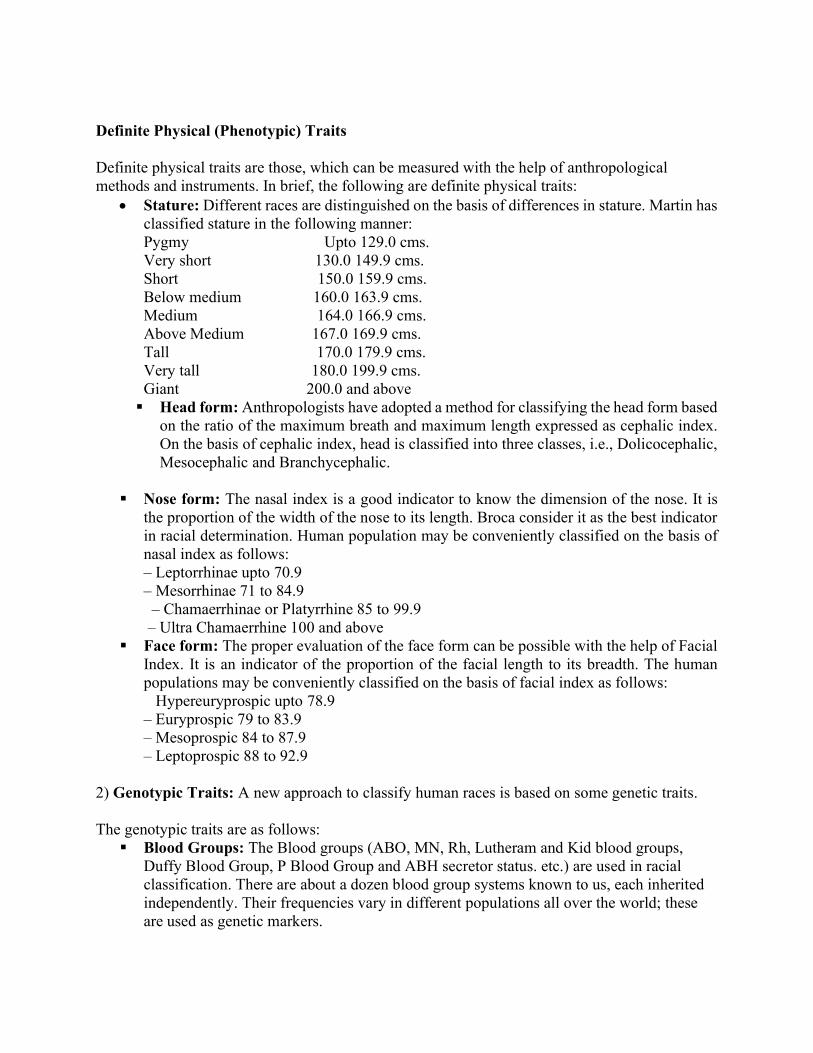
Definite Physical (Phenotypic) Traits Definite physical traits are those, which can be measured with the help of anthropological methods and instruments. In brief, the following are definite physical traits:
Stature: Different races are distinguished on the basis of differences in stature. Martin has classified stature in the following manner: Pygmy Upto 129.0 cms. Very short 130.0 149.9 cms. Short 150.0 159.9 cms. Below medium 160.0 163.9 cms. Medium 164.0 166.9 cms. Above Medium 167.0 169.9 cms. Tall 170.0 179.9 cms. Very tall 180.0 199.9 cms. Giant 200.0 and above Head form: Anthropologists have adopted a method for classifying the head form based
on the ratio of the maximum breath and maximum length expressed as cephalic index. On the basis of cephalic index, head is classified into three classes, i.e., Dolicocephalic, Mesocephalic and Branchycephalic.
Nose form: The nasal index is a good indicator to know the dimension of the nose. It is
the proportion of the width of the nose to its length. Broca consider it as the best indicator in racial determination. Human population may be conveniently classified on the basis of nasal index as follows:
– Leptorrhinae upto 70.9 – Mesorrhinae 71 to 84.9 – Chamaerrhinae or Platyrrhine 85 to 99.9 – Ultra Chamaerrhine 100 and above
Face form: The proper evaluation of the face form can be possible with the help of Facial Index. It is an indicator of the proportion of the facial length to its breadth. The human populations may be conveniently classified on the basis of facial index as follows: Hypereuryprospic upto 78.9 – Euryprospic 79 to 83.9 – Mesoprospic 84 to 87.9 – Leptoprospic 88 to 92.9
2) Genotypic Traits: A new approach to classify human races is based on some genetic traits. The genotypic traits are as follows:
Blood Groups: The Blood groups (ABO, MN, Rh, Lutheram and Kid blood groups, Duffy Blood Group, P Blood Group and ABH secretor status. etc.) are used in racial classification. There are about a dozen blood group systems known to us, each inherited independently. Their frequencies vary in different populations all over the world; these are used as genetic markers.
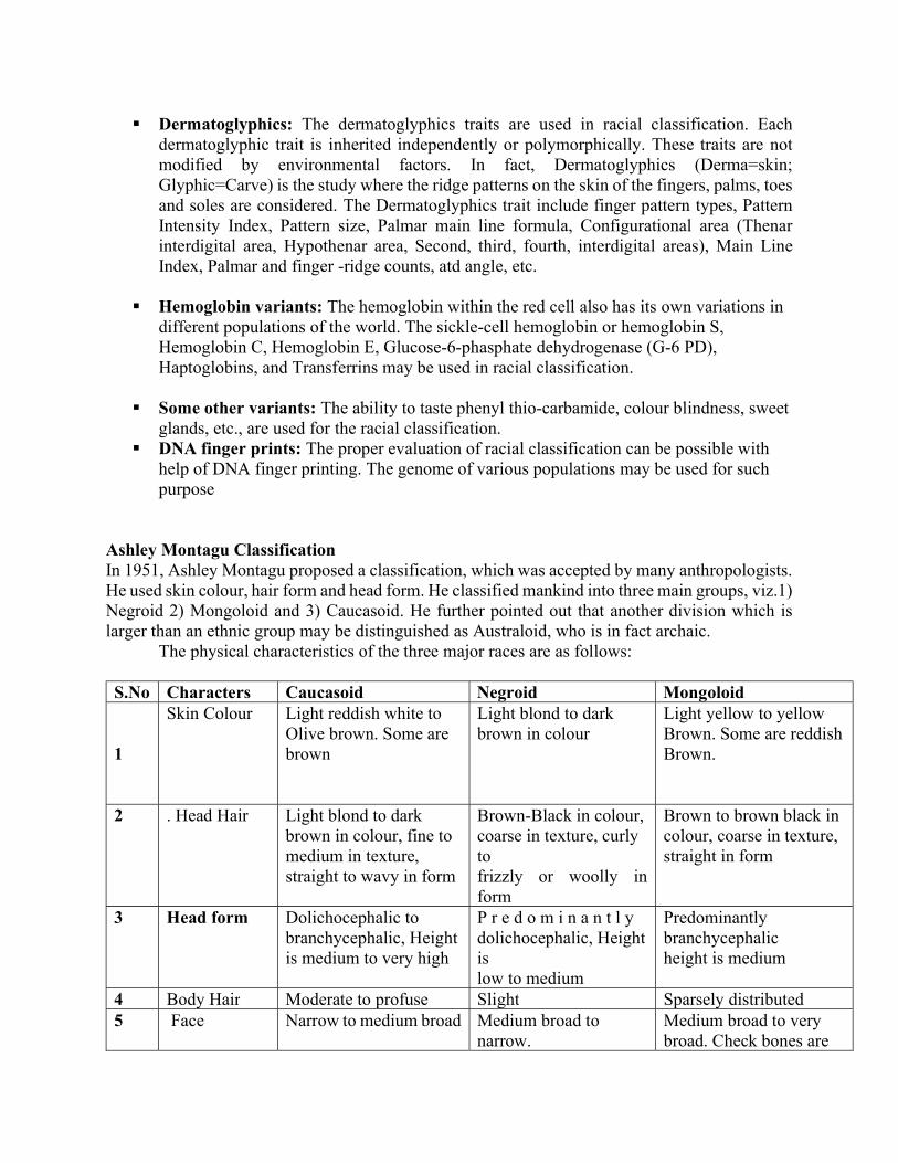
Dermatoglyphics: The dermatoglyphics traits are used in racial classification. Each dermatoglyphic trait is inherited independently or polymorphically. These traits are not modified by environmental factors. In fact, Dermatoglyphics (Derma=skin; Glyphic=Carve) is the study where the ridge patterns on the skin of the fingers, palms, toes and soles are considered. The Dermatoglyphics trait include finger pattern types, Pattern Intensity Index, Pattern size, Palmar main line formula, Configurational area (Thenar interdigital area, Hypothenar area, Second, third, fourth, interdigital areas), Main Line Index, Palmar and finger -ridge counts, atd angle, etc.
Hemoglobin variants: The hemoglobin within the red cell also has its own variations in
different populations of the world. The sickle-cell hemoglobin or hemoglobin S, Hemoglobin C, Hemoglobin E, Glucose-6-phasphate dehydrogenase (G-6 PD), Haptoglobins, and Transferrins may be used in racial classification.
Some other variants: The ability to taste phenyl thio-carbamide, colour blindness, sweet
glands, etc., are used for the racial classification. DNA finger prints: The proper evaluation of racial classification can be possible with
help of DNA finger printing. The genome of various populations may be used for such purpose
Ashley Montagu Classification In 1951, Ashley Montagu proposed a classification, which was accepted by many anthropologists. He used skin colour, hair form and head form. He classified mankind into three main groups, viz.1) Negroid 2) Mongoloid and 3) Caucasoid. He further pointed out that another division which is larger than an ethnic group may be distinguished as Australoid, who is in fact archaic.
The physical characteristics of the three major races are as follows:
S.No Characters Caucasoid Negroid Mongoloid 1
Skin Colour
Light reddish white to Olive brown. Some are brown
Light blond to dark brown in colour
Light yellow to yellow Brown. Some are reddish Brown.
2 . Head Hair Light blond to dark brown in colour, fine to medium in texture, straight to wavy in form
Brown-Black in colour, coarse in texture, curly to frizzly or woolly in form
Brown to brown black in colour, coarse in texture, straight in form
3 Head form Dolichocephalic to branchycephalic, Height is medium to very high
P r e d o m i n a n t l y dolichocephalic, Height is low to medium
Predominantly branchycephalic height is medium
4 Body Hair Moderate to profuse Slight Sparsely distributed 5 Face
Narrow to medium broad Medium broad to
narrow. Medium broad to very broad. Check bones are
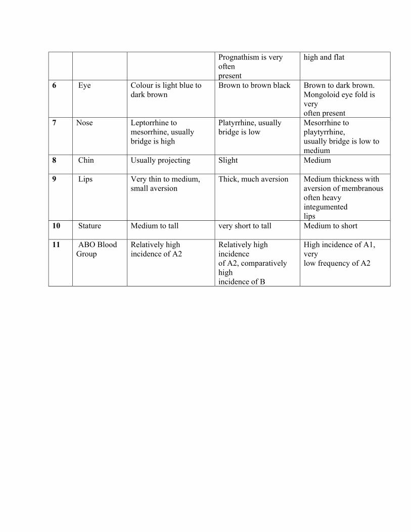
Prognathism is very often present
high and flat
6 Eye
Colour is light blue to dark brown
Brown to brown black Brown to dark brown. Mongoloid eye fold is very often present
7 Nose
Leptorrhine to mesorrhine, usually bridge is high
Platyrrhine, usually bridge is low
Mesorrhine to playtyrrhine, usually bridge is low to medium
8 Chin
Usually projecting Slight Medium
9 Lips
Very thin to medium, small aversion
Thick, much aversion Medium thickness with aversion of membranous often heavy integumented lips
10 Stature
Medium to tall very short to tall Medium to short
11 ABO Blood Group
Relatively high incidence of A2
Relatively high incidence of A2, comparatively high incidence of B
High incidence of A1, very low frequency of A2
RELIGION: TYPES AND DISTRIBUTION:
Religion is more difficult to define, and whilst many writers have offered working definitions, no single one captures the full meaning of the word. American cultural geographer Yi Fu Tuan (1976) posed the rhetorical question "What is the meaning of religion?” He then sought to answer it by reflecting on what people seek in, from or through religion. In his view, "the religious person is one who seeks coherence and meaning in his world, and a religious culture is one that has a clearly structured world view. The religious impulse is to tie things together. ... All human beings are religious if religion is broadly defined as the impulse for coherence and meaning. The strength of the impulse varies enormously from culture to culture, and from person to person."(Tuan 1976 p.271-2).
If it is difficult to agree a simple definition of religion, it is even harder to fit boundaries around its impact on people. As Tyler (1990 p.12) rightly points out, "many of the major religions of the world have become so inextricably linked with particular racial groups, cultures, political systems and lifestyles, that it is difficult to imagine one without the other. It is hard to imagine Thailand without Buddhism, or India without Hinduism, for example. Christianity has become intricately bound up with the lifestyle of Western culture." In essence, religion is so deeply embedded into the matrix of many societies that its boundaries are permeable and its impacts pervasive.
Classification There are various ways of classifying religions, and the most commonly used ones reflect differences in belief. From a geographical perspective it is more useful to distinguish universal and ethnic religions. Universal (or universalising) religions -such as Christianity, Islam and the various forms of Buddhism - seek world-wide acceptance by actively looking for and attracting new members (converts). Ethnic (or cultural) religions, are very different in that they do not seek converts. Each is identified with a particular tribal or ethnic group. Tribal (or traditional) religions involve belief in some power or powers beyond humans, to which they can appeal for help. Examples include the souls of the departed, and spirits living on mountains, in stones, trees or animals. More broad based ethnic religions include Judaism, Shintoism, Hinduism and the Chinese moral-religious system (embracing Confucianism and Taoism), which mainly dominate one particular national culture. Global distribution
Although at the start of the third millennium roughly one in three people on earth is classed as Christian, the spatial distribution is uneven. Thus - according to the 1982 World Christian Encyclopedia - a high percentage of the population in Europe (84 percent), the Americas (91 per cent) and Oceania (84 per cent) is Christian, whereas the figure drops to 8 per cent in Asia Africa. Perhaps not surprisingly both Hinduism and Buddhism (both over 99 per cent) are overwhelmingly confined to Asia. Judaism, by far the smallest (numerically) of the five main world religions, has a much more dispersed pattern than the others. The distinction between the universal and ethnic religions has a strong influence on their spatial distributions. Universal religions - as the name

implies - are widely distributed. The ultimate goal of the three universal religions is to convert all people on earth. Believers are encouraged to share their beliefs with non-believers, and each universal religion engages in missionary activities and admits new members through individual symbolic acts of commitment. Christianity has an almost global pattern at the start of the third millennium, and Islam is dominant through much of Africa and Asia. Although Buddhism transcends cultural and political boundaries, it still has a marked concentration in Southeast and East Asia. Ethnic religions are often confined to particular countries. Thus, for example, Hinduism is particularly strong in India, Confucianism and Taoism are largely confined to China, and Shintoism is concentrated in Japan. Unlike the universal religions - where diffusion is a primary objective - the spread of ethnic religions is limited and takes place only slowly because they do not actively seek converts. Although in the historic past Judaism engaged in missionary activity, in principle (and largely in practice today) membership is reserved for the in-group by inheritance. In other ethnic religions, individuals are not accepted until they are fully assimilated into the community. India and China, for example, gradually absorbed foreign tribes into their dominant culture, which expanded accordingly. Traditional religions still persist in many less developed parts of the world, including much of Africa, South America, parts of Southeast Asia, New Guinea and northern Australia.
DYNAMICS - DIFFUSION AND DISPERSION In this section we consider the general processes involved in spreading ideas spatially between people, examine how the global pattern appears to have evolved, and by means of some small-scale case studies reflect on detailed processes and resultant patterns. Processes
Religion is in many ways like any other set of ideas or values that can be spread among and between groups of people, often separated by considerable distances. This involves processes of diffusion, which rest on two key principles. The first is that anything that moves must be carried in some way. This means that we must understand the processes, speeds and dynamics of this movement if we are to have any chance of understanding how and why diffusion occurs. It is not enough to simply be aware of the outcome (usually the spatial patterns) of the diffusion. The second principle is that the rate at which some things move over geographic space will be influenced by other things that get in the way. As a result, we must recognize the existence and operation of both carriers (which promote diffusion) and barriers (which inhibit diffusion).
There are two basic types of diffusion process – a. Expansion diffusion; in which the number of people who adopt the innovation grows by
direct contact, usually in situ. For example, an idea is communicated by a person who knows about it to one who does not, and through time the total number of knowers increases.
b. Relocation diffusion; this involves the initial group of carriers themselves moving, so they are diffused through time and space to a new set of locations. Migration is a classic relocation diffusion mechanism, because those who migrate take their beliefs, values, attitudes and behaviour with them to new places. Missionaries who deliberately introduce religion into new areas fall into this category.
Expansion diffusion can be further sub-divided into -
I. Contagious diffusion; this is diffusion through a population by direct contact. Diseases spread this way. Such diffusion expands and spreads, and the speed of expansion is strongly influenced by the frictional effect of distance. This operates like a series of concentric waves moving over the surface of a pond after a stone has been thrown in - places close to the points of diffusion normally adopt the innovation first, and more distant places adopt after a time lag during which intervening places have adopted. In human terms, ideas are passed to people close to those who already have them. Much religious diffusion is of this contagious type, and takes place by contact conversion as a product of everyday contact between believers and non-believers.
II. Hierarchical diffusion; here the idea or innovation is implanted at the top of a society and it appears to leap over intervening people and places. Innovations are adopted or received from the top of the hierarchy down. Hierarchical diffusion of religion has occurred through history when missionaries deliberately sought to convert kings or tribal leaders, in the hope that their people would follow.
The most common type of diffusion process for most innovations, including religious ideas and practices, is contagious expansion diffusion. Traditionally this has taken place mainly the physical relocation of people as carriers of the innovation (in this case a new religion). Modern telecommunications has opened up the prospect of using radio and television to spread religious messages across much bigger areas more quickly. Such processes underlie the evolution of televangelism in the United States.
Few innovations are so important or universally embraced that every single person in an area adopts them, and most innovations are voluntarily adopted by a large majority at best. Religion falls into this category, and universal religions engage in diffusion much more readily and deliberately than ethnic religions. This largely explains the significantly larger areas dominated by the universal religions, and the much larger number of followers they have.
Emergence of the global pattern The source areas - or, as some writers call them "cradle lands" - of the main religions are well established through detailed historical and archaeological research. Northern India provides the core area of Hinduism in the Punjab, and Buddhism (an offshoot of Hinduism) in the Ganges Plain. From here both religions spread through the Indian subcontinent, but Hinduism (an ethnic religion) extended little further whilst Buddhism (a universal religion) dispersed across much of central and eastern Asia. Judaism and Christianity originated in Palestine, and Islam (partly based on both Judaism and Christianity) began in western Arabia. Both Christianity and Islam - the great universal monotheistic religions - dispersed widely through the old world. Christianity gained a particular stronghold in Europe and Islam spread through north and east Africa, as well as further east into central and southern Asia.
Geographers describe the two areas where the main religions originated as 'religious hearths' or 'religious heartlands'. The two areas share two important properties. First, they closely match the core locations of the major ancient civilizations in Mesopotamia and the Nile and Indus Valleys. This makes cultural evolution of religion a distinct possibility (although spatial correspondence does not in itself establish cause-effect). Secondly, and equally importantly, the religions emerged on the margins not the centres of the great civilizations. This hints at a more complex interplay between religion and culture, involving factors such as innovation and cultural
diffusion, religious adaptation, and exchanges of ideas, beliefs and values along migration and trade routes.
Whatever the reasons for the emergence of religions within such a small area, the fact remains that many religions have spread far beyond their original homeland. Paradoxically, many religions are stronger today in countries other than their source areas. Many religions have changed a great deal as they have spread and grown, so that the form they display today is often far removed from their original form. Through dispersion the main religions have come into contact with and been influenced by different cultures and customs, some have divided into sub-groups (sects), and many have changed forms of worship and organization. Modern Christianity, for example, is different to what it was like in the first century after Christ. Similarly, Hinduism has evolved a great deal over nearly thirty centuries.
The universal religions have an in-built dynamic towards expansion and diffusion, because they deliberately seek new converts. Thus, missionary zeal and endeavor must also be considered in the search for an explanation of contemporary religious patterns. One of the particular strengths of universal religions, as far as survival and growth are concerned, is their adaptability to local cultures. A religion that is adaptable can be modified to better suit new conditions it encounters, both as it spreads through space and it survives through time. The flourishing universal religion is thus able to assimilate dimensions of ethnic religion, which increases its attractiveness to new converts and promotes its prospects of long-term survival. Religions of the Indo-Gangetic Hearth This important religious source area is based on the lowland plains of the northern edge of the Indian subcontinent that are drained by the Indus and Ganges rivers. Hinduism, Sikhism and Buddhism were born there. Hinduism had no single founder, and the reasons why it emerged here around 2000 BCE remain unclear. Buddhism and Sikhism evolved from Hinduism as reform movements, the former around 500 BC and the latter in the fifteenth century. Once a religion is born, the quickest and easiest way in which it can spread is by diffusion. Throughout history India has been an important cultural cross-roads and a centre from which cultures, beliefs and values were scattered far and wide. Hinduism Hinduism was the earliest major religion to emerge in this area, at least 4,000 years ago. It is known to have originated in the Punjab, in north-west. It later stretched from Afghanistan and Kashmir to Sarayu in the east, followed by a major wave of expansion across the Ganges to occupy the region between the Sutlej and the Jumna.From here it spread eastward down the Ganges and southward into the peninsula, absorbing and adopting other indigenous beliefs and practises as it spread. It was eventually to dominate the whole of the Indian sub-continent. Hindu missionaries later carried the faith overseas, during its major universalising phase, although most of the convert regions were subsequently lost. During the colonial period many hundreds of thousands of Indians were transported to other countries, including East and South Africa, the Caribbean, northern South America, and Pacific islands (particularly Fiji).This relocation diffusion effectively spread Hinduism far beyond its source area.
Buddhism
Buddhism began in the foothills bordering the Ganges Plain about 500 BC, as an offshoot from Hinduism. Its founder was Prince Gautama (born 644 BC), who found Enlightenment while sitting under a pipal (Bodhi) tree. He later decided to make known to others the way of salvation he had found the (Middle Way between the two extremes of self-indulgence and self-mortification), initially in the Deer Park at Isapatana (now called Sarnath, near Benares). Starting with five converts who became disciples (monks), the Buddha soon gathered around him sixty monks who were sent out to preach and teach. During the Buddha's lifetime his preaching activities were confined to northern India and a few small communities in the west of India. During the next two centuries Buddhism spread into other parts of India, although it was to remain confined to the Indian subcontinent for centuries after that. Missionaries and traders later carried Buddhism to China (100 BCE to 200 CE), Korea and Japan (300to 500 CE), Southeast Asia (400 to 600 CE), Tibet (700 CE) and Mongolia (1500CE). As it spread Buddhism developed many regional forms. Ironically, it was subsequently to die out in the very area it had originated, and was re-absorbed into Hinduism in India in the seventh century (although it has survived among the mountain people of the Himalayas and on the island of Sri Lanka). Sikhism
Sikhism originated in Punjab at the end of the fifteenth century in a reform movement initiated by a spiritual leader called Nanak. Before long he was being regarded as a holy man (guru), his ideas found widespread support, and he was preaching to large numbers, many of who had travelled especially to hear him. The new religion was widely adopted in the Punjab because it offered a fresh spiritual idea which people found attractive, particularly its criticism of the caste system that was so central a part of Hinduism. It grew fastest when peaceful conditions prevailed, which was not always the case (especially because of disturbance by Muslim invaders), and its consolidation and expansion were greatly aided by initial political patronage. During the first 2 centuries Sikhism remained confined to its source area in the Punjab, mainly because successive gurus were chosen in accordance with family lines. Between about 1850 and 1971 there was considerable diffusion of Sikhism. Sometimes this occurred by voluntary migration, because the Sikh community was notoriously adventurous. Often the diffusion followed forced migration caused by political unrest. This was so especially with the creation of Pakistan after the partition of India in 1947, which divided the Punjab into an Islamic western half and a dominantly Hindu eastern half. Large numbers of Sikhs embarked on a mass exodus to India from the former West Punjab and other states in Pakistan. Since partition there has been an almost complete shift of the Sikh population from West Pakistan to India. Many of the immigrants settled in Punjab, where nationalism based on both religion and language led to the eventual formation of Punjabi Suba (state) in 1966. Religions of the Semitic Hearth
Judaism, Christianity and Islam - the three great monotheistic religions - all developed first among the Semitic-speaking people in or on the margins of the deserts of southwestern Asia in what is today the Middle East. Like the religions of the Indo-Gangetic Hearth, these three have family ties. Judaism originated about 4,000 years ago, and Christianity emerged from within Judaism 2,000 years ago. Islam was born in western Arabia about 1300 years ago. Many writers have questioned why it should be that the three great monotheistic religions all developed in the
same basic core area but at different times. Environmental factors cannot be ruled out, as the determinists enthusiastically argued before about the 1950s, but it is much too simplistic to seek one single or even one dominant cause or explanation.
Monotheism has spread throughout the world, and between them Christianity and Islam have nearly 2.4 thousand million believers, accounting for half of the world population. Christianity and Islam, two dominant universalising religions, have played key roles in the dispersion of monotheism from their initial Middle East heartland. Judaism, the oldest Semitic religion that does not seek new converts and thus remains an ethnic religion, has played a more minor role, at least numerically. Judaism Judaism developed out of the cultures and beliefs of Bronze Age people who wandered through the deserts of the Middle East nearly 4,000 years ago. Like all major religions, Judaism spread and was quickly dispersed over a wide area. By 586 BC, when King Solomon's Holy Temple was destroyed, the Ten Tribes that constituted the northern kingdom of Israel had already been resettled in northern Assyria for four generations. This diffusion and scattering were to become a prominent feature of Judaism through the rest of its history. The Jewish Diaspora (dispersion) began some time before 550 BC, and it was led by Jewish refugees and immigrants who refused to give up their faith when persecuted by pagan neighbours. Judaism spread into Europe by the forced and voluntary migration of Jews, starting with the forced dispersal from Palestine in Roman times that scattered Jews throughout the Mediterranean Basin. Through time most European Jews became concentrated around the present Russian-Polish border in an area that became known as the "Jewish Pale". In 1939 well over half the world's Jews were living in Europe and the Soviet Union (almost 10 million). Poland housed over 3 million, and there were other concentrations in the Soviet Union, Romania and Germany. Modern Zionism (the political movement for the establishment of a national homeland for Jews in Palestine) has roots in medieval Jewish migrations to the Holy Land. But the most important catalyst was a series of shocks that shattered the life of Jews in Europe, the most prominent of which was the rise of Nazism in 1933 and its attempt to annihilate totally the Jews in its conquered territories from 1939 to 1945 (the Holocaust). Christianity
Christianity began in Jerusalem when disciples of Jesus of Nazareth proclaimed that he was the expected Messiah. The movement spread slowly) while Jesus was alive, but after Jesus' death it spread more rapidly. The diffusion was greatly assisted by Christian preachers and missionaries. It spread first to Samaria (in northern ancient Palestine), then to Phoenicia to the north-west, and south to Gaza and Egypt. Afterwards it was adopted in the Syrian cities of Antioch and Damascus, then subsequently in Cyprus, modern Turkey, modern Greece, Malta and Rome. It spread fast, and numbers quickly grew. Within the first century there were an estimated million Christians, comprising less than one per cent of the total world population. But within 400 years over 40 million people, nearly a quarter of the total population, had adopted Christianity. Imperial sponsorship of Christianity in the fourth century accounted for its rapid increase in influence and membership. The early spread of Christianity through the Roman Empire was achieved mainly by relocation diffusion aided by the well-developed system of imperial roads. Christian missionaries like Paul travelled from town to town spreading the gospel message.
In later centuries the pattern of Christianity reflected hierarchical expansion diffusion; early congregations were largely confined to towns and cities while the countryside remained largely pagan. Once planted in an area, Christianity spread further via contagious diffusion (contact conversion). Christianity diffused through Europe along a number of different routes, mainly via
missionaries initially. Diffusion and adoption were slow during the first 300 years, and most early converts were town dwellers. Progress speeded up after 313 when the Christian Roman Emperor Constantine issued an edict of toleration for Christianity that led eventually to its status as state religion. The Roman Catholic Church emerged in the fifth century, presided over by the bishop of Rome (the Pope). During the fourth and fifth centuries the Roman church spread rapidly in the western Mediterranean. Roman Catholic missionaries introduced Christianity to northern Europe. Between the fifth and seventh centuries Roman Catholicism gained a stronghold throughout Britain. Monks were an important and effective vehicle in the spread of Christianity around Europe, and monasteries were hubs in a network of diffusion points.
While Christianity was winning its battle against paganism in northern Europe, Islam was making inroads into the already Christianized Mediterranean region. In the eighth century North Africa was won by Islam, and has remained Muslim ever since. A sizeable area within the Iberian Peninsula (Spain and Portugal) was under Muslim rule for many centuries.
The world-wide dispersion of Christianity coincides with the era of colonial acquisition by European countries. Roman Catholicism was introduced into Middle and South America by the Spanish, after they had invaded the continent in the mid sixteenth century. Much of Africa and small parts of India were converted by Christian missionaries, who were particularly active there during the nineteenth centuries. The Reformation in the sixteenth century served to intensify rather than diminish the enthusiasm of the Christian church for evangelism. Jesuits introduced Christianity into many areas including Ethiopia, Morocco, Egypt, India, China, Japan, the Philippines, Persia, Tibet, Ceylon, Malaya, Siam, Indochina and the East Indies. Many Protestant refugees from the seventeenth century onwards emigrated to North America to escape conflict and oppression in Europe, taking their Calvinist brand of Christianity with them and planting it firmly there. Christianity has remained a universalising religion, with an abiding commitment to active proselytism (the conversion of non-believers). Distribution of Christianity
Nearly one in three of the world’s population is classed as Christian, and that Christians are found in large numbers in most places. The largest concentrations on Christians are in Europe and Latin America, where over half of the world's 1.5 thousand million Christians live, accounting for around 17 percent of the global population. About one person in seven in North America and Africais classed as Christian, accounting for nearly another half a billion individuals (just under a tenth of the world population).Like all other major religions, Christianity is not monolithic and it is perhaps not surprising that the numerical strength (both absolute and relative) of different Christian sub-groups varies from place to place. The Eastern Orthodox Church is particularly strong in the former Soviet Union, and in parts of Europe and Africa (particularly North Africa). Roman Catholicism - altogether much larger and more widely dispersed than the Orthodox Church - has its strongest presence, at least numerically, in South America and Europe. In South America almost all Christians belong to the Roman Catholic Church; in Europe well over half do. Protestantism remains numerically quite strong in Europe, where it accounts for nearly one in five of all Christians. It has its strongest base in North America, where it accounts for over 40 per cent of Christians. About a quarter of the large and growing number of Christians in Africa is associated with the Protestant churches. The Anglican Communion - representing the Church of England, the Church of Ireland, the Episcopal Church in Scotland, the Church in Wales, the Episcopal Church in the United States, and other churches that are in full communion with each other - has most (70 per cent) of its members in Europe.
Islam
Islam means 'submission to God', and this strict monotheistic religion was founded by Mohammed (SAW) in Medina in 622 (the year taken as the start of the Islamic calendar). By the time Mohammed (SAW) died in 632, he ruled the whole of Arabia (in both religious and political terms). . Within less than a hundred years, Arab Muslims had conquered lands over a vast area - stretching from the Atlantic Ocean in Western Europe to the borders of India, and including Spain, North Africa, Egypt, Syria, Mesopotamia and Persia. Today's distribution of Islam reflects a significant retreat from this early core emirate or territory, although the spread of Islam into India, Central Asia, the Sudan and the margins of East Africa has left an enduring legacy. Islam also has a strong presence in south East Asia. One important factor in the rapid spread of Islam was its emergence at the hub of a series of important trade routes, including caravan trails leading from the Middle East through Central Asia to North China, and across the Sahara to the Sudan. Many Muslim traders were also effective missionaries, acting as multiple diffusion nuclei who travelled widely. Expansion diffusion accounts for the spread of Islam from its Arabian source area, and relocation diffusion accounts for its subsequent dispersal to Malaysia, Indonesia, South Africa and the New World. Unlike Hinduism, Islam attracted converts wherever it took hold. New core areas soon turned into effective source areas for further dispersion, by a combination of contagious and hierarchical diffusion. In recent years Islam has once again started to spread into Europe, caused not by military invasion but by the immigration of dispossessed Muslims from North Africa, the Middle East and southern Asia. Europe now houses an estimated 7.5 million practising or cultural Muslims, many of them in France, Germany and Britain. Muslims constitute the second largest population group within the former Soviet Union, and their numbers are rising at a rate four times as fast as the Soviet population as a whole. Separatist movements quickly emerged in the dying days of Communist rule, and by 1990 the peoples of the Soviet Union's Muslim republics (Azerbaijan, Kazakhstan, Kirgizia, Tajikistan, Turkmenia and Uzbekistan) were seeking to regain control of their own destinies.
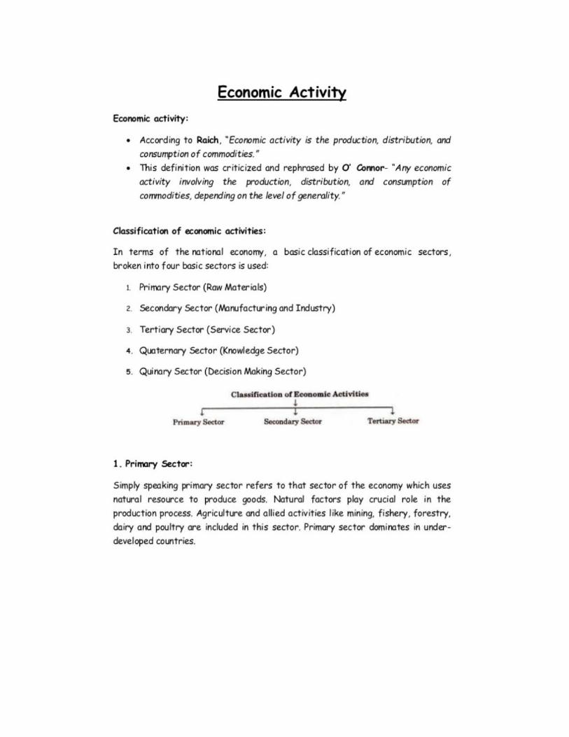

CREDIT III POPULATION: AGE AND SEX STRUCTURE
The distribution of population by age and sex are among the most fundamental demographic characteristics of human populations as well as of demographic statistics. It plays an important role for the development of any society. The economic and cultural life of society critically depends upon the age and sex structure of the population. Moreover, the planning process of any country makes use of this data extensively for the development of the economy and culture as well as for its individual regions.
It is well known that many developed countries and international agencies study the distribution of the population by sex and age across countries as it has significance to the world population trajectory. The future size and structure of the population depend on the current age-sex structure of the population. Moreover, in the current context of global concerns of environmental degradation and climate change, the age-sex structure and its future growth carry an important role in the global Definition
Age is a more complex characteristic than that of the sex. The age is normally defined by a person at his/her last birthday at the time of the survey. Thus, demographically, age is considered as the completed years while many cultures use age with varied other meanings. The definition of sex, on the contrary, does not face many statistical issues. The age-sex distribution conveys the relative numbers of children, young and old as well as the balance between men and women at different ages. Almost all population characteristics vary significantly with different ages. As a component of population analysis, most of the analysis is based on the age-sex structure of the population.
Measuring Age-Sex Structure Age composition: It can be categorized in terms of age groups (e.g., 0-14 years, 15-64 years, and 65 years or above). The changing structure of the population in each of these broader age groups, reveals many possibilities to understand the age composition of the population as well as the sex distribution across these ages. As per Census 2011, India has a moderately significant proportion of the people in the younger age groups in the world. Around 31 % of the population of the country belongs to the age group of 0-14 years according to Census 2011. At the same time, the adult population between the age group of 15-59 years constitute 60.5% of the population. Dependency ratio: Another important way to measure age structure is by computing Dependency ratio. It is a ratio of economically active to the economically inactive population (Srinivasan, 1998). It is important to mention that the composition of a population at a given point in time is of significant interest to the demographers. The age-sex structure of a population is a fundamental determinant of the numbers of demographic events which form the basis of the services that population will require, e.g., schools, care homes, maternity services, etc. 𝐷𝑒𝑝𝑒𝑛𝑑e𝑛𝑐𝑦 𝑟𝑎𝑡𝑖𝑜 = 𝑁𝑢𝑚𝑏𝑒𝑟 𝑜𝑓𝑝𝑒𝑜𝑝𝑙𝑒 𝑎𝑔𝑒𝑑 0-14 𝑎𝑛𝑑 𝑎𝑔𝑒𝑑 60 𝑎𝑛𝑑 𝑜𝑣𝑒𝑟 × 100 𝑁𝑢𝑚𝑏𝑒𝑟 𝑜𝑓 𝑝𝑒𝑜𝑝𝑙𝑒 𝑎𝑔𝑒𝑑 15 − 60
Population pyramid: The population pyramid shows the age-sex structure of a population. Age sex pyramids are also known as population pyramids. The information is graphically displayed to improve understanding and ease of comparison. They are also potentially very informative on the history of a society and its prospects. The importance of the age-sex structure can be understood from a simple fact that it acts
as a starting point for any demographic investigation. A particular method of assessing them through statistical methods can be performed through graphical tools. The depictions of age-sex structures through the horizontal bar diagrams on the both sides of the axis are called population pyramids (Srinivasan, 1998; Shryock and Siegel, 1976). How to read Age-Sex Pyramid? 1. It consists of two histograms placed on their side, and back to back. 2. It shows absolute numbers or percentages, where the X-axis must be labelled accordingly. 3. Itis calculated for each age-sex group from the total population (males and females). 4. The Y-axis represents the age, where the youngest at the bottom and the oldest is the pick. 5. The scale can be in single or five-year age groups depending on the precision needed. 6. It must be of equal width, apart from the final open-ended age group. 7. The statistics for males are plotted on the left, and for females on the right. Types of Population Pyramids: It not only graphically displays long-term trends in the birth and death rates, and migration but also reflects the shorter term of baby-booms, wars, and epidemics. Demographers recognise three prototypical pyramid structures– constrictive, expensive, and stationary. All these structures indicate the conditions of the populations which comprise them. A population pyramid illustrates age and sex structure of a country's residents and may provide better insights into the political, social, as well as economic expansion within a nation.
I. Constrictive pyramid: A constrictive pyramid is the opposite of an expansive pyramid. A constrictive pyramid has fewer people in the younger age categories and has been typical of the U.S. population as baby boom population’s shift to more conservative birth rates with a slight narrowing in its younger age groups. Such type of pyramids is seen in the places with high life expectancy, and healthy living conditions are significantly contributing to a higher number of older people. Notwithstanding this, there is a lesser number of births taking place, which are outnumbered by some deaths and work as a check to the growing population. Also, a rising number of older people than the youth in the country places a burden upon the working-age population to maintain a large number of elderly dependents. The decrease in the number of births indicates that people are moving towards
II. Expansive pyramid: This type of graph has a classic or triangular shape, with a very wide base and pointed apex. It denotes larger numbers of people in the younger age categories and is a reflexion of many developing nations where birth rates are high or stalled, and life expectancy is compact. Each age group presents a bar less wide than that of the age-group before it, showing that more people are dying at the higher group (Shryock and Siegel, 1976). The large base confers to a high birth rate, which is probably due to circumstances like a developing economy, low levels of female education, poverty and less awareness of birth control measures. The tapering top of the pyramid indicates to the prevailing high mortality rates, which signifies for a low level of life expectancy at birth in the country. Determinants like poor living conditions and lack of proper medical amenities may be responsible for high mortality rate among elderly. Such nations have a higher population of children compared to people of working-age and elderly resulting to burden over the population of working age to help the large younger population, making them work in stressful states. Such type of the pyramids corresponds to stage 2 of the demographic transition.
III. Stationary pyramid: It indicates a population which is neither growing nor declining in its size.
This “pyramid” looks more like a column and typically has a relatively static birth and death rates. Countries or areas with population pyramids like this belong to the final stage of the demographic transition. A stationary pyramid explicates approximately equal numbers of people in all age classifications, with a tapering towards the older age categories. Nations as, Sweden show stationary age categories because of relatively low, steady birth rates, and a high standard of life.
Figure 1: Types of Population Pyramids
These are the three population pyramids that pertain to age-sex structures in different phases of demographic transition (Shryock and Siegel, 1976). The age structure of a population can help a country choose the needs of its population in the future so that it is further prepared to face them. It is the cumulative result of past trends in fertility, mortality, and migration. Age and Sex Structure of Population in the World
The age and sex structure of a country’s population can affect gender issues in a variety of ways. Age structure is a process of population ageing that is determined primarily by trends in fertility and mortality. Any population with considerably a long history of high fertility has a “young” age structure ,alike in its general characteristics to the present age structure for the group of least developed nations (see Figure 2).The median age of the population starts to rise when both the fertility and mortality rates decline. By 2015, the world’s population is projected to reach 7.2 billion, of which about two-thirds will be residing in countries at or below replacement fertility (United Nations, 1999c). From Figure 2, projected and estimated age and sex distribution of the population from 2000 and 2050 shows world population moving from expansive growth to constrictive growth rate, followed by less and least developing country. Whereas, more developed country transitions from constructive to stationary stage or as we call towards the older aged population. A situation like this arises when fertility rest below replacement fertility, besides low death rates.

DETERMINANTS OF AGE STRUCTURE WITH SPECIAL REFRENCE TO INDIA
Age structure refers to the distribution of the population in different ages. The age structure constitutes a significant part of the population change. Its significance encompasses several areas like society’s reproduction potential, workforce supply, development needs, mortality pattern, migration history, etc. For these reasons, the age-sex structure has significant policy implications. The processes of fertility, mortality, and migration, together determine not only the current size of the population but also the distribution of age and sex. Conversely, the age structure sets the future pace of population growth through its influence on effective fertility, mortality, and migration. The meaning, measure, impact and dynamics of the age-sex structure of populations have been evaluated exhaustively by Weeks (1999). The impact of the three population processes (migration, mortality, and fertility) on age structure has also been assessed (Russell, 1992; Kim & Shoen, 1997; Preston and Guillot, 1997). Studies on age composition have been carried out by Blacker (2000), Lean (2000), and in charting the progress of populations Bongaarts (2000).
There has been a contrast in the age structure and its transition in the world between the developing countries and their developed counterparts. While the age structure transition was bottom heavy with a large proportion of people in the younger age groups in the developing countries due to high fertility, it was top heavy in the case of developed nations with a higher proportion of the older population. The issues and concerns of age structure are different both for national economic growth and for development due to its varied pattern.
The age structure of India’s population is broad-based (UN Population Prospect, 2015) and has future implications for fertility and migration trends within the country, as well as for socio-economic development. Therefore, any developmental planning process should necessarily take into account the age and sex structure of a population for policy and planning. A lesser attention has been given to the determination of the effects on age-sex composition irrespective of its importance and the determinants of socio-economic implications. The historical development of age structure of the population is a necessary condition for the identification and explanation of demographic events and processes. The most frequently used way of the interpretation of the age structure by sex and age is a graphical presentation called age pyramid. Numerous studies have been carried out on population age structure and other related issues. Measuring Age Structure The age structure can be classified into sub-parts of total population for better understanding. Several measures are developed to assess the age structure in the country are as follows:
Age distribution: The numbers of persons in successive age groups in a given population. Mostly referred to as age composition in demography. A country with prolonged high fertility, for instance, has a large proportion of children and a small proportion of aged persons reflects different scenario than that of the age structure constituting larger old people and fewer population in the young ages (UN Manual, 1955).
Median age: It is defined as the age that divides the entire population into two numerically equal halves. The one section indicates to half the people belongs to younger age while other half constitute of the remaining old people in the population. It is a single index that summarises the age distribution of a population (Shryock and Siegel, 1976).
Dependency ratio: It showing the number of people are dependents, aged 0-14 years and over the age of 65 years, to the total population aged 15 to 64 years. It is also referred to as the "total dependency ratio".
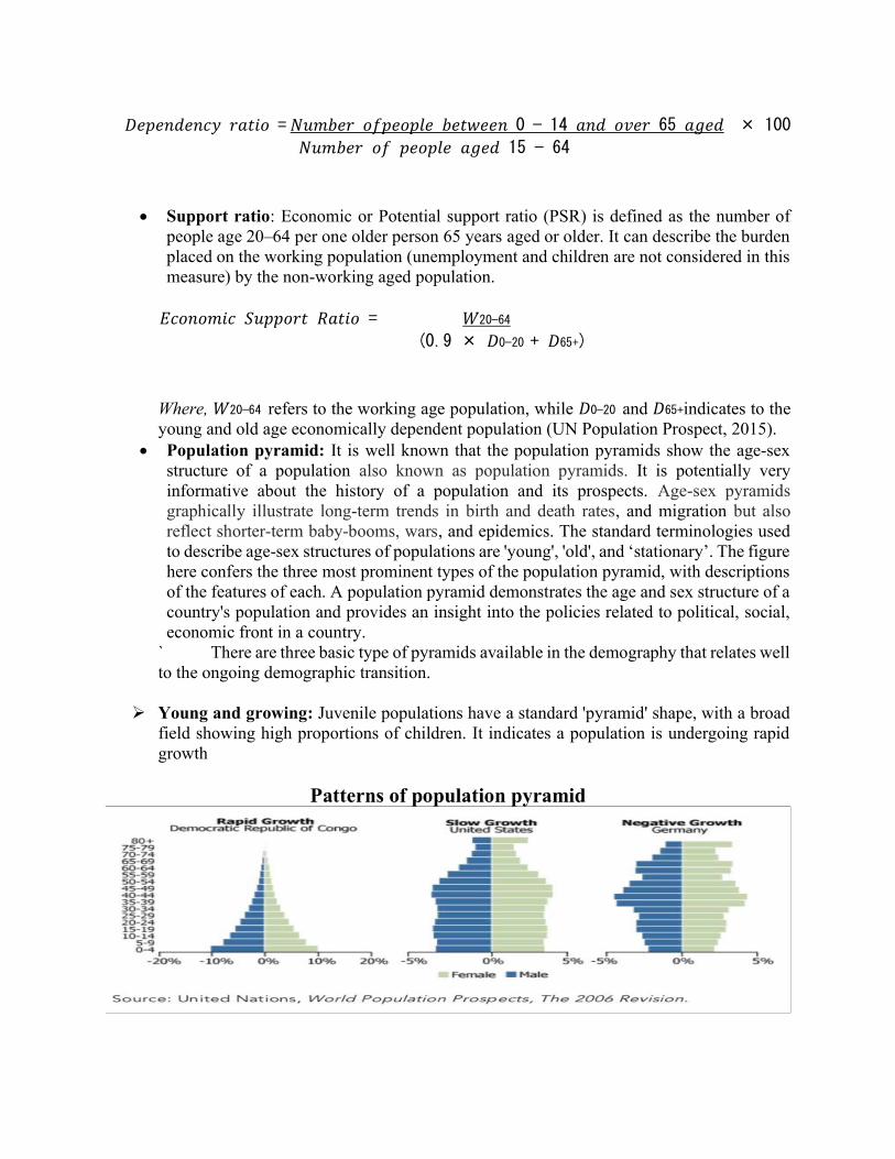
𝐷𝑒𝑝𝑒𝑛𝑑𝑒𝑛𝑐𝑦 𝑟𝑎𝑡𝑖𝑜 = 𝑁𝑢𝑚𝑏𝑒𝑟 𝑜𝑓𝑝𝑒𝑜𝑝𝑙𝑒 𝑏𝑒𝑡𝑤𝑒𝑒𝑛 0 − 14 𝑎𝑛𝑑 𝑜𝑣𝑒𝑟 65 𝑎𝑔𝑒𝑑 × 100
𝑁𝑢𝑚𝑏𝑒𝑟 𝑜𝑓 𝑝𝑒𝑜𝑝𝑙𝑒 𝑎𝑔𝑒𝑑 15 − 64
Support ratio: Economic or Potential support ratio (PSR) is defined as the number of people age 20–64 per one older person 65 years aged or older. It can describe the burden placed on the working population (unemployment and children are not considered in this measure) by the non-working aged population.
𝐸𝑐𝑜𝑛𝑜𝑚𝑖𝑐 𝑆𝑢𝑝𝑝𝑜𝑟𝑡 𝑅𝑎𝑡𝑖𝑜 = 𝑊20−64
(0.9 × 𝐷0−20 + 𝐷65+)
Where, 𝑊20−64 refers to the working age population, while 𝐷0−20 and 𝐷65+indicates to the young and old age economically dependent population (UN Population Prospect, 2015).
Population pyramid: It is well known that the population pyramids show the age-sex structure of a population also known as population pyramids. It is potentially very informative about the history of a population and its prospects. Age-sex pyramids graphically illustrate long-term trends in birth and death rates, and migration but also reflect shorter-term baby-booms, wars, and epidemics. The standard terminologies used to describe age-sex structures of populations are 'young', 'old', and ‘stationary’. The figure here confers the three most prominent types of the population pyramid, with descriptions of the features of each. A population pyramid demonstrates the age and sex structure of a country's population and provides an insight into the policies related to political, social, economic front in a country.
` There are three basic type of pyramids available in the demography that relates well to the ongoing demographic transition.
Young and growing: Juvenile populations have a standard 'pyramid' shape, with a broad field showing high proportions of children. It indicates a population is undergoing rapid growth
Patterns of population pyramid
Old and declining: A top-massive population pyramid with higher proportions of older age groups indicates a declining population. Which may result from a phase of the extended period of below replacement fertility, besides low death rates (The slow Growth: United States age-sex pyramid in Figure 1 nearly corresponds to this) (World Population Prospect, 2006).
Stationary: It indicates the proportion of the population which is neither growing nor sinking. There is a uniform distribution of the population in each age group, apart from at the oldest ages (due to mortality). The population pyramid (Negative Growth: Germany in Figure1) is just an approximation of what a stationary population would seem similar. The small fluctuations in Germany’s age-sex pyramid at age groups 40-59 show that this is nota stationary population (World Population Prospect, 2006).
Stages of Age Structure Transition The number of population by age and sex are among the most fundamental demographic characteristics of human populations as well as of the population statistics. Population classified by the cohort of age group by sex structure play a significant role in all aspects of the economy, society and even, family. There are three types of age structures one can broadly observe across countries. These are:
Type I: Mortality decline particularly in the younger ages resulting in sharp increase in the young population and young dependency ratio: In high-fertility countries of Africa and even some countries in Asia, 45-55 percent of the population are children, and old people constitute only four-eight percent of the total population
Type II: Fertility decline is resulting in a bulge in the working age’s dependency ratio lowest: Many developing countries, including India, are at this stage of the transition now.
Type III: Old age dependency increases: Children constitute less than 30 percent, and elderly population comprise15 per cent or above.
These types of age structure have a direct influence on the future of a nation or region, since both extremes, i.e., old age dependency as well as young age dependency proves to be a burden on the economy. It is important, therefore, to measure the shape of the age structure.
Age Structure transition in India “Age Structural Transition” (AST) is a process and consequence of shifting in age structure from young to old age cohort of the population over a period either by single year or age groups(World Population Prospect, 2006)). It is the proportion of total population undergoes a transition from a higher to a lower or declining (increasing) share in these age groups due to the demographic transition of moving from a high mortality and fertility to a situation of low mortality and fertility.
It is recognized that the age structure changes have significantly contributed by demographic gift or the ‘demographic bonus’ or ‘window of opportunity’ leading to economic growth in many countries of the world. By the changes in age structure, we mean a decline in young aged population and an increase in the proportion of working age group population. This is
suitable for an economic take-off, provided that the other factors such as political stability, adequate savings and investment, human capital and the knowledge economy, required for development are in place (Pool, 2000; Mason, 2005). It is an integral part of the demographic transition.
In India, the share of young aged population (0-14) years seems to decline through 2020 sharply, after that stabilises from the 2030s onwards that cover around 25 percent of the total population. While the share of the prime working aged population increases from 1975s which contributes to a decline in the dependency ratio burden from the 1975s, old aged population begins to grow from 2025s. This is an excellent opportunity to pursue the policies that will help the middle age working population to save more. Between these periods, there is a period called ‘window of opportunity’ for development in age structure transition. India has a potential to improve employment sector, industrialisation, health services, consumption of good and services, and quality of education when the dependency ratio starts declining with improvement in the country’s per capita GDP growth. The size of the prime working-age population is likely to decline sharply from the year 2025s which will ease the unemployment situation. Accessibility of health care and social security care and improvement of life expectancy of the elderly would be a major challenge for their population age. The proportionate share of the aged population (65+) will continue to increase at a higher pace during the phase of age structural transitions from the 2020s in China followed by India. But the share of elderly population stabilises after the 2020s as seen in Figure 3. Therefore, the age structure is a dynamic process of transition over the economic growth as cohort moves from young to the old aged population. The magnitude coined by implemented socio-economic policies and institutional factors immediately to utilise the window of opportunity. That will not be adequate for economic take-off, along with rapid ageing process on which countries went up into a period of demographic turbulence. Determinants of Age Structure People enter or leave in a population cohort through birth, death, and migration. The age structure of a population depends on three fundamental determinants and its consequence of trends in fertility, mortality, and migration. These are interdependent; any change in one may influence the other two. It is through these variables that the socioeconomic conditions affect the age structure. Besides these, there are also some important variables that impact age structure. Effect of e0 (Life expectancy) varies over the transition. For instance, in early transition, increase in e0 leads to even younger population (gains are at young ages) and in later transition, increase in e0 leads to the older population.
Fertility: It determines the proportion of new-born in reproductive age categories. The most of the Asian countries like India, China, Bangladesh, Pakistan and others (except Japan, Singapore, Hong Kong and South Korea), Sub Sharan African and Latin American countries have high fertility. Since the longevity and life expectancy in these countries is short, the proportion of the elderly is also not very high. According to the accessible data for the period 2010, in most of the countries of Europe and North America, about 20 percent of their entire population is under the age of 15 years. While, in India, about 33 percent of its population is under 15 years of age and 5.5 percent above 60 years. On the converse, the European countries, with low fertility rate and long-life expectancy, have only 20 percent of their populations in the younger age group. Moreover, the share of the
population in the older age groups in developed countries is relatively large. Consequently, most of the countries of Anglo- America, Europe, Japan, Australia, and New Zealand have almost completed their demographic transition and are observed to in the Second Demographic Transition state. The age-sex composition in which the proportion of growing population (below 15) is lower than that of the rising old age population (above 65).However, the short-run effects of a fertility decline differ from the long-run effects. From figure-4, it may be seen that the trend of total fertility rate significantly declines from 1950-2010, after that it becomes stagnant till 2030. Reason for fertility decline leads immediately to fall in youth dependency ratio, but the rise in old age dependency does not occur until the large pre-decline cohorts reach old age (World Population Prospect, 2015). During the intermediate period, the entire dependency ratio is provisionally below trend: there is a temporary reduction in the number of dependents (both young and old) per working-age person. This decrease in the dependence can give the economy a transitory boost and is referred to as a “demographic bonus” (World Population Prospect, 2015; Bloom and Williamson 1998).
Mortality: The age structure is also affected by the mortality rate. In general, if the
survival rate during the adolescence improves then the proportion of children is expected to rise, and consequently, the older people will tend to fall. But, if the survival rate improves among the older ages, the share of older population improve, but the number of the children will tend to fall. Likewise, if the mortality is low both among younger and older age groups as in the case of developed countries like Sweden, Netherlands, Germany, Italy, Belgium and Denmark, the fraction of the working aged population will be larger, and the dependency ratio became small. In contrast to this, if the decline in mortality is sharper in lower age group than the older age club, it results in the swelling up of numbers people in younger age group as is the case with most of the populations of the developing nations (World Population Prospect, 2015). However, in India figure 5 shows that the age distribution of deaths in India over a period of 1991 to 2030, which reveals how mortality has determined the shape of age structure transition. The cohort wise deaths show that mortality rate is much higher in a0-4 age group in 1991 in India followed by significant reductions in 2011 and is expected to go down further by 2030. But unfortunately, the conditions are reverse for people in cohorts 70+ among them. Besides, the most important part is that from cohort 5-9 to 65-69 age group death rate looks like the reverse shape of population pyramid where the male mortality rate is much higher than female.
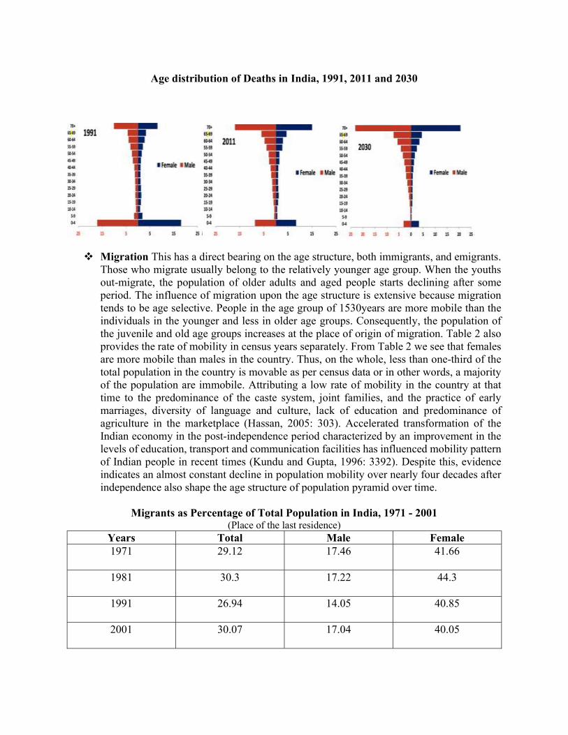
Age distribution of Deaths in India, 1991, 2011 and 2030
Migration This has a direct bearing on the age structure, both immigrants, and emigrants. Those who migrate usually belong to the relatively younger age group. When the youths out-migrate, the population of older adults and aged people starts declining after some period. The influence of migration upon the age structure is extensive because migration tends to be age selective. People in the age group of 1530years are more mobile than the individuals in the younger and less in older age groups. Consequently, the population of the juvenile and old age groups increases at the place of origin of migration. Table 2 also provides the rate of mobility in census years separately. From Table 2 we see that females are more mobile than males in the country. Thus, on the whole, less than one-third of the total population in the country is movable as per census data or in other words, a majority of the population are immobile. Attributing a low rate of mobility in the country at that time to the predominance of the caste system, joint families, and the practice of early marriages, diversity of language and culture, lack of education and predominance of agriculture in the marketplace (Hassan, 2005: 303). Accelerated transformation of the Indian economy in the post-independence period characterized by an improvement in the levels of education, transport and communication facilities has influenced mobility pattern of Indian people in recent times (Kundu and Gupta, 1996: 3392). Despite this, evidence indicates an almost constant decline in population mobility over nearly four decades after independence also shape the age structure of population pyramid over time.
Migrants as Percentage of Total Population in India, 1971 - 2001
(Place of the last residence) Years Total Male Female 1971 29.12 17.46 41.66
1981 30.3 17.22 44.3
1991 26.94 14.05 40.85
2001 30.07 17.04 40.05
Summing up
Age structure plays a critical role in population distribution, in particular through the process of shifting in age structure from young to old age cohort of the population over a period either by single or age groups. It undergoes a transition from a higher to a lower or declining (increasing) share in these age groups due to the interactive effects of mortality and fertility. Apart from fertility, mortality, and migration, the age structure of the population is also influenced significantly by wars (male selective in their casualty), catastrophes, natural calamities and population policies. Above mention, determinants are directly or indirectly affected or influenced by the age structure of a country or a region. Besides, the Task Force of the National Commission on Population (NCP) has already identified the numerous keys on social, economic and demographic indicators for age structure of the population in India
Factors affecting Distribution and density of Population Introduction
Population distribution is the spatial pattern of the dispersal of populations, formation of agglomerations, linear spreads of population, etc. In most countries, there are wide regional variations in the geographic distribution of the population. Population densities are different in various parts of the world. ` The 2015 Revision of World Population Prospects is the twenty-fourth round of the United Nations’ estimates and projections of population. They are prepared by the Population Division of the Department of Economic and Social Affairs of the United Nations (United Nations 2015).
The world’s population reached 7.3 billion in mid-2015, which means that the world has added approximately one billion people in the span of the twelve years. The global population is highly dispersed over the seven continents. Most of the world’s population (about 60 per cent) lives in Asia (4.4 billion), 16 per cent in Africa (1.2 billion), 10 per cent in Europe (738 million), 9 per cent in Latin America and the Caribbean (634 million), and the remaining 5 per cent in Northern America (358 million) and Oceania (39 million). China (1.4 billion) and India (1.3 billion) are the world’s most populous countries and home to19 and 18 per cent respectively of the world’s population. India’s population is expected to continue growing for several decades. It is projected to reach 1.5 billion in 2030 and 1.7 billion in 2050, while that of China is likely to remain constant and then decrease slightly. Therefore, it is projected that India’s population will surpass China in the future.
The ten most populous countries in the world are distributed in all continents: one in Africa (Nigeria), five in Asia (Bangladesh, China, India, Indonesia, and Pakistan), two in Latin America (Brazil and Mexico), one in North America (United States of America), and one in Europe (the Russian Federation). Nigeria’s population, currently the seventh largest in the world, is growing most rapidly. With the present rate of growth, the population of Nigeria is projected to surpass that of the United States by about 2050 at which point it will become the third most populous country in the world. By 2050, six of the ten largest countries in the world are expected to have populations more than 300 million: China, India, Indonesia, Nigeria, Pakistan, and United States of America.
It is estimated that 50.4 per cent of the world’s population is male and 49.6 per cent, female. The median age of the global population, that is, the age at which half the population is older and half younger, is 29.6 years. About one-quarter (26 per cent) of the world’s population is below 15 years of age, 62 per cent are aged 15-59 years, and 12 per cent are 60 years or over.
Populations are not evenly distributed over the earth’s landmass. Physical environments vary from place to place. Hence, it is necessary for demographers to understand how and where populations are
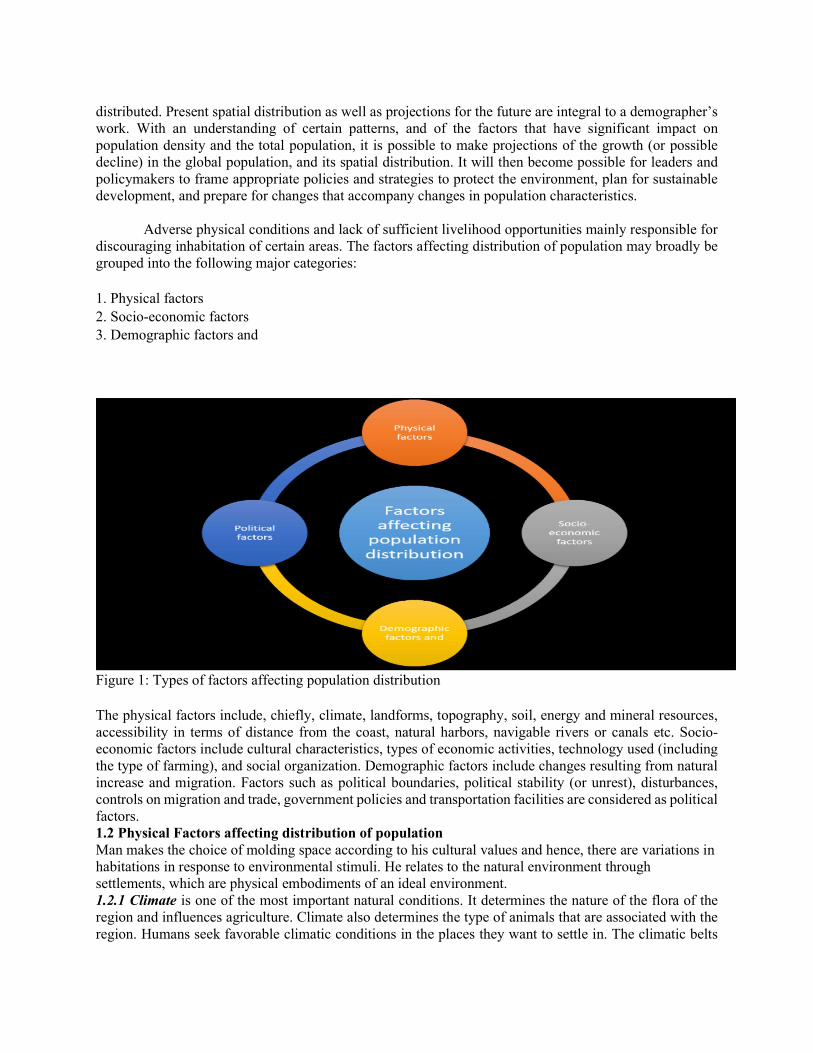
distributed. Present spatial distribution as well as projections for the future are integral to a demographer’s work. With an understanding of certain patterns, and of the factors that have significant impact on population density and the total population, it is possible to make projections of the growth (or possible decline) in the global population, and its spatial distribution. It will then become possible for leaders and policymakers to frame appropriate policies and strategies to protect the environment, plan for sustainable development, and prepare for changes that accompany changes in population characteristics.
Adverse physical conditions and lack of sufficient livelihood opportunities mainly responsible for
discouraging inhabitation of certain areas. The factors affecting distribution of population may broadly be grouped into the following major categories: 1. Physical factors 2. Socio-economic factors 3. Demographic factors and
Figure 1: Types of factors affecting population distribution The physical factors include, chiefly, climate, landforms, topography, soil, energy and mineral resources, accessibility in terms of distance from the coast, natural harbors, navigable rivers or canals etc. Socio-economic factors include cultural characteristics, types of economic activities, technology used (including the type of farming), and social organization. Demographic factors include changes resulting from natural increase and migration. Factors such as political boundaries, political stability (or unrest), disturbances, controls on migration and trade, government policies and transportation facilities are considered as political factors. 1.2 Physical Factors affecting distribution of population Man makes the choice of molding space according to his cultural values and hence, there are variations in habitations in response to environmental stimuli. He relates to the natural environment through settlements, which are physical embodiments of an ideal environment. 1.2.1 Climate is one of the most important natural conditions. It determines the nature of the flora of the region and influences agriculture. Climate also determines the type of animals that are associated with the region. Humans seek favorable climatic conditions in the places they want to settle in. The climatic belts
are the principal areas of most of the human activity. It is evident from the world’s population distribution that the highest populated countries of the world are mostly located in the tropical regions.
A warm, comfortable climate attracts people. Regions with such climates provide favourable conditions for a wide range of fauna to thrive, supporting the life systems in the place. Agriculture and animal husbandry make it possible to provide food for large populations. On the other hand, places with extreme climatic conditions are usually scarcely populated because it is difficult to sustain human life in such places. Countries in the temperate regions are also well populated. The regions are colder than the tropical regions but are hotter than the polar zones. The polar zones of the Arctic and Sub-Arctic regions remain the least populated of all. The extremely low temperature is not favourable for habitation. Vegetation is scarce. Cold winters and very short summers make living difficult. 1.2.2 Topography or terrain. Navigable areas are more populated than rough ones. Mountains are less preferred because of lack of arable land. In addition, the cost of transportation, construction and agriculture are considerably higher in such places. In general, high altitudes also impose a physiological -on humans’ capacity to adapt. This is because of reduced atmospheric pressure and low oxygen content. Higher altitudes, therefore, do not favour population and growth. Low lying plains and coastal areas are more favoured areas for human settlement. The Himalayas are thinly populated, the Ganges valley is one of the densely populated areas of the world. Coastal regions have the advantage of ocean-going trade and transportation and thus, the major cities of the world are mostly located in the coastal areas. 1.2.3 Water is essential for human survival. The ancient civilizations of the world flourished near rivers and the coastal areas. The Nile, Amazon, and Ganges river systems supported rich civilizations on their banks. Adequate rainfall favour vegetation and agriculture which in turn, determine a place’s suitability for habitation. Because of lack of water, vast expanses of deserts are uninhabited. For the same reason, there is less population on the rain-shadow side of a hill or mountain; however, the leeward side is often densely populated. Thus, population is tends to be concentrated in the well-watered river valleys and coastal plains. 1.2.4 Soil quality influences density and distribution of the population. A substantial population of populations earn their livelihood from agriculture which depends on the quality of soil. Food crops are grown on the soil, thus, is one of the most important raw materials required by population. The alluvial regions, deltas and the coastal regions of India support high population densities. On the other hand, mountainous regions, where soil erosion is a problem, such as the Terai region of Uttarakhand, or the sandy soils of the desert of Rajasthan, cannot support dense populations. However, scientific agricultural practices, with the aid of technology, have succeeded in converting low-yield soils to better quality ones. In the past, degradation or overutilization of soil led to the disappearance of flourishing civilizations, such as the Mayan in Central America.
Vast reserves of mineral resources encouraged the establishment of industries, which attracted settlements. The Chhotanagpur plateau is an area rich in mineral resources. The higher population densities in the Chhota Nagpur Plateau of Jharkhand and in the adjoining areas of Orissa are largely due to the availability of minerals. 1.2.5 Location of a place—proximity to major towns and cities—favours concentration of population. Generally, staying within the city limits increases living costs. The city’s periphery or nearby towns provide affordable housing facilities. Cheap and reliable transportation provide convenient means of commuting. 1.2.6 Natural disasters discourage population concentration. Frequent storms, earthquakes, floods, wild fires discourage formation of settlements as people migrate to safer places. There are many examples of destruction of settlements due to the natural disasters. The city of Bichuan, in Sichuan province of China was completely destroyed in 2011 by an earthquake of magnitude 8.0 causing collapse of eighty percent of the buildings and a huge loss of lives. The city was not rebuilt and left abandoned to prevent any further loss of human life in the event of recurrence of the disaster in future. Similar examples could be found in history. On August 24, 79 AD, the volcano Vesuvius erupted, covering the nearby town Pompeii with ash and soil, and subsequently preserving the city in its state from that fateful day. Everything from jars and tables to paintings and people were frozen in time. Pompeii, along with Herculaneum, were abandoned and

eventually their names and locations were forgotten. They were rediscovered as the results of excavations in the 18th century. 1.3 Socio economic factors affecting population distribution
The choice of settlement is generally based on natural processes. However, with time, man has been able to adjust and control the natural processes to some extent. Thus, the factors influencing the choice of a place for settling no longer depends entirely on natural conditions. As needs changed with the evolution of human society, social and economic perspectives gained primacy. 1.3.1 Economic activity is an indicator of employment opportunities. People in the rural areas are largely dependent on agriculture for their livelihood. If the land fails to support the rural population, or with more opportunities available in urban areas, they may choose to migrate to cities. Concentration of population in urban areas is an outcome of diverse economic activities and livelihood options offered by cities. Usually, there is work for almost everyone, which is unlike in villages where there are fewer options. Therefore, population density in the towns and cities tends to be higher than in rural areas, and will continue to increase. By their very nature, cities provide diverse livelihood opportunities in both the formal and the informal sectors. Industries are a large job market, and have attracted cheap labour for several decades. The influx of labour leads to settlements being established, often on otherwise uninhabitable land. For example, hydroelectric power stations in largely uninhabited areas attract migrants to these places, resulting in increase in population. Similarly, due to growing service and tourism industry, a large migrant population have settled in the city of Dubai, making it one of the fastest growing cities in the world due to tourism. 1.3.2 Social Organization of communities in new areas encourages the movement of people and settling in newer lands. Man is a social animal and it becomes essential for him to form a community, creating a
Figure 2: Socio Economic factors affecting population distribution Familiar environment where he stays. People moving out of their native places tend to settle in those areas, or parts of the areas, where there are people with language, culture, food habits and habits that are like their s. It is common to find cities having residential areas which are communal in nature.
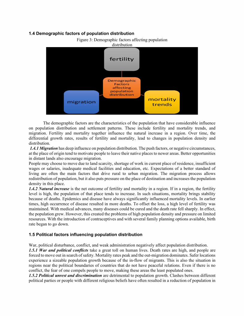
1.4 Demographic factors of population distribution
The demographic factors are the characteristics of the population that have considerable influence on population distribution and settlement patterns. These include fertility and mortality trends, and migration. Fertility and mortality together influence the natural increase in a region. Over time, the differential growth rates, results of fertility and mortality, lead to changes in population density and distribution. 1.4.1 Migration has deep influence on population distribution. The push factors, or negative circumstances, at the place of origin tend to motivate people to leave their native places to newer areas. Better opportunities in distant lands also encourage migration. People may choose to move due to land scarcity, shortage of work in current place of residence, insufficient wages or salaries, inadequate medical facilities and education, etc. Expectations of a better standard of living are often the main factors that drive rural to urban migration. The migration process allows redistribution of population, but it also puts pressure on the place of destination and increases the population density in this place. 1.4.2 Natural increase is the net outcome of fertility and mortality in a region. If in a region, the fertility level is high, the population of that place tends to increase. In such situations, mortality brings stability because of deaths. Epidemics and disease have always significantly influenced mortality levels. In earlier times, high occurrence of disease resulted in more deaths. To offset the loss, a high level of fertility was maintained. With medical advances, many diseases could be cured and the death rate fell sharply. In effect, the population grew. However, this created the problems of high population density and pressure on limited resources. With the introduction of contraceptives and with several family planning options available, birth rate began to go down. 1.5 Political factors influencing population distribution War, political disturbance, conflict, and weak administration negatively affect population distribution. 1.5.1 War and political conflicts take a great toll on human lives. Death rates are high, and people are forced to move out in search of safety. Mortality rates peak and the out-migration dominates. Safer locations experience a sizeable population growth because of the in-flow of migrants. This is also the situation in regions near the political boundaries of countries that do not have peaceful relations. Even if there is no conflict, the fear of one compels people to move, making these areas the least populated ones. 1.5.2 Political unrest and discrimination are detrimental to population growth. Clashes between different political parties or people with different religious beliefs have often resulted in a reduction of population in
Figure 3: Demographic factors affecting population distribution
the affected area. Before settling in a new place permanently, migrant population looks for a place that not only provides economic opportunities but also provides safe and healthy environment for wholesome living. A politically unstable region is unable to provide both these conditions and hence it discourages not only the incoming migrant population but also the already residing population which might be forced to leave the region in search of peaceful locations for settlement. Discrimination faced by migrants because of race, language, food, culture etc., discourages in-migration. This has reduced the population growth on one hand and newer settlements on the other. 1.5.3 Policies encouraging migration have often led to population growth in the destination region. International labour movements take place where rules governing cross-border migration are lenient. Migration helps in the redistribution of population. Policies that promote reduction in fertility levels, banning of infanticide, etc. also influence the population growth in a place. For example, China’s strict enforcement of one-child policy succeeded in curbing fertility levels and controlling population. 1.6 Summing up No single factor can be considered as solely responsible for concentrated or scanty populations, or their distribution and growth. Most of the factors described in this module are interrelated and often act collectively. Advances in technology have helped humans settle in places where it was not possible a few decades ago. The tremendous population growth in the world population has forced many to settle in uninhabitable regions where there is a shortage of adequate natural resources. Often, people do not have the option of choosing where they must live. Earlier, physical factors determined population distribution; however the industrial revolution and accompanying urbanization increased transport and communication networks. These developments influenced population distribution. In this light present density map of population is a cumulative outcome of the past.
Malthusian theory of Population Thomas R. Malthus (1766-1834) propounded his view in his essay on the ‘Principle of
Population’ that is published in 1798. Thomas Malthus and his “An Essay on the Principle of Population”:
Earth’s population today has reached the 7.5 billion mark with predictions suggesting it will be close to 10 billion past the year 2050. While population growth in developed countries has stalled, the majority of world population lives in developing countries struggling within gross inequalities, striking poverty levels but growth aspirations of better living standards like the developed counterparts. Although population growth is slowing down globally, since the population base is huge, it implies that numerically it continues to add pressure on the limited resources that earth supplies putting additional strain on environment, governing institutions and social and economic infrastructures.
This relationship between growing population and finite resources was predicted long back as the industrial revolution was setting in the Great Britain. An English scholar and cleric by the name of Thomas Robert Malthus was writing and distributing pamphlets on population growth with his monumental work published in 1798 in London by the title “An Essay on the Principle of Population”. While the 18th century England was rejoicing optimistically the improvement in the standards of living and future possibilities based on improvements in technological knowledge of the times, Malthus was suggesting a contrary view. The fears he sighted were the exorbitant growth in population, which if left unchecked would add pressures on the limited resources that earth supplies. He argued giving example of the family tree that the population grows exponentially (i.e. it doubles itself by each cycle) while the food supply increases only arithmetically (i.e. the
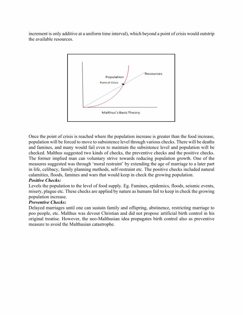
increment is only additive at a uniform time interval), which beyond a point of crisis would outstrip the available resources.
Once the point of crisis is reached where the population increase is greater than the food increase, population will be forced to move to subsistence level through various checks. There will be deaths and famines, and many would fail even to maintain the subsistence level and population will be checked. Malthus suggested two kinds of checks, the preventive checks and the positive checks. The former implied man can voluntary strive towards reducing population growth. One of the measures suggested was through ‘moral restraint’ by extending the age of marriage to a later part in life, celibacy, family planning methods, self-restraint etc. The positive checks included natural calamities, floods, famines and wars that would keep in check the growing population. Positive Checks: Levels the population to the level of food supply. Eg. Famines, epidemics, floods, seismic events, misery, plague etc. These checks are applied by nature as humans fail to keep in check the growing population increase. Preventive Checks: Delayed marriages until one can sustain family and offspring, abstinence, restricting marriage to poo people, etc. Malthus was devout Christian and did not propose artificial birth control in his original treatise. However, the neo-Malthusian idea propagates birth control also as preventive measure to avoid the Malthusian catastrophe.
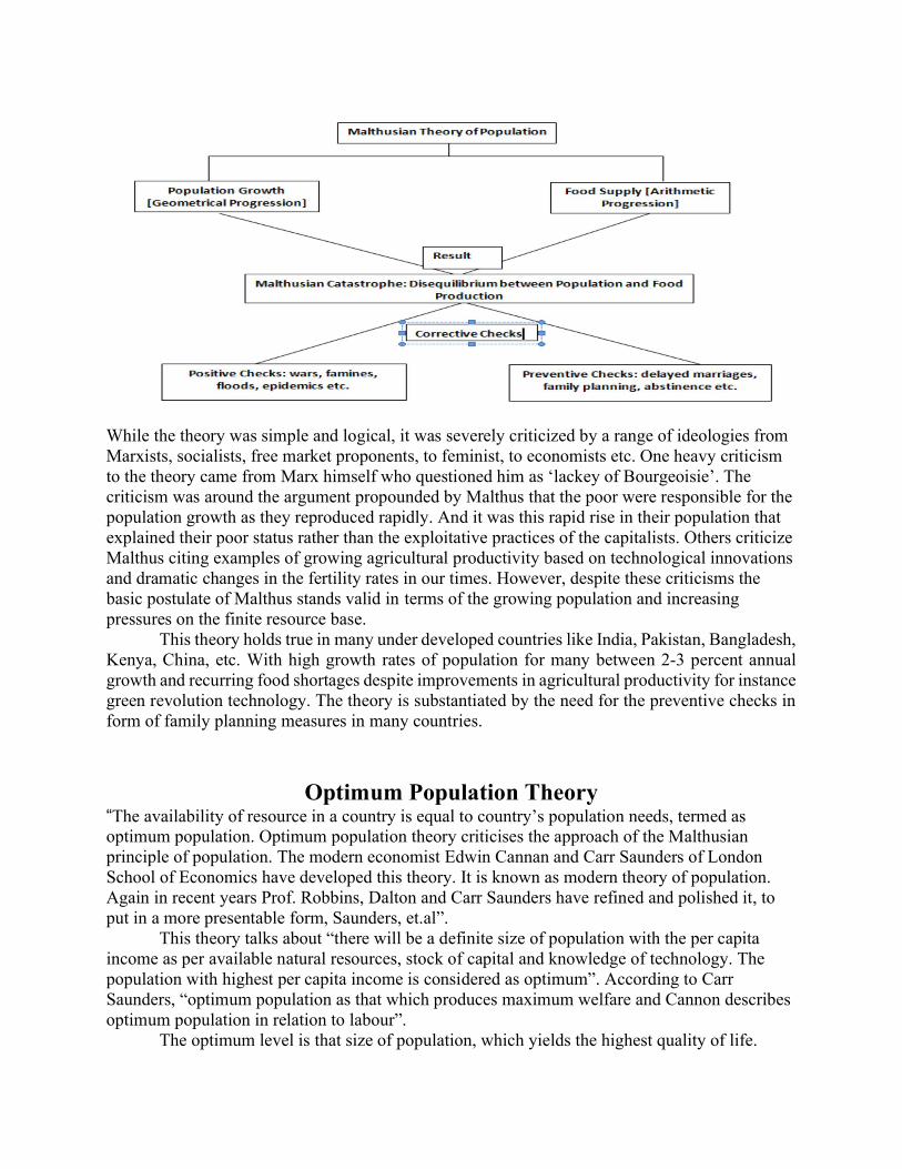
While the theory was simple and logical, it was severely criticized by a range of ideologies from Marxists, socialists, free market proponents, to feminist, to economists etc. One heavy criticism to the theory came from Marx himself who questioned him as ‘lackey of Bourgeoisie’. The criticism was around the argument propounded by Malthus that the poor were responsible for the population growth as they reproduced rapidly. And it was this rapid rise in their population that explained their poor status rather than the exploitative practices of the capitalists. Others criticize Malthus citing examples of growing agricultural productivity based on technological innovations and dramatic changes in the fertility rates in our times. However, despite these criticisms the basic postulate of Malthus stands valid in terms of the growing population and increasing pressures on the finite resource base.
This theory holds true in many under developed countries like India, Pakistan, Bangladesh, Kenya, China, etc. With high growth rates of population for many between 2-3 percent annual growth and recurring food shortages despite improvements in agricultural productivity for instance green revolution technology. The theory is substantiated by the need for the preventive checks in form of family planning measures in many countries.
Optimum Population Theory
“The availability of resource in a country is equal to country’s population needs, termed as optimum population. Optimum population theory criticises the approach of the Malthusian principle of population. The modern economist Edwin Cannan and Carr Saunders of London School of Economics have developed this theory. It is known as modern theory of population. Again in recent years Prof. Robbins, Dalton and Carr Saunders have refined and polished it, to put in a more presentable form, Saunders, et.al”.
This theory talks about “there will be a definite size of population with the per capita income as per available natural resources, stock of capital and knowledge of technology. The population with highest per capita income is considered as optimum”. According to Carr Saunders, “optimum population as that which produces maximum welfare and Cannon describes optimum population in relation to labour”.
The optimum level is that size of population, which yields the highest quality of life.
The quality of life means that: each inhabitant receives adequate amount of food energy, water, and air of high quality; adequate raw material to permit him to make all the things and devices he needs. Perton Cloud defines “optimum population as the one that lies within limits. According to Sauvey, “however the size that helps in achieving the given end of maximization of means to obtain full employment, longevity of life and good health, knowledge and culture. Social harmony and family stability, can be called an optimum size of population”. Assumption of Optimum Population Theory
1. If the population of the country increases, the proportion of working population to total population remains constant.
2. The natural resources, the capital stock and state of technology remains unchanged if the population of a country increases.
The optimum population can be regarded as that state of equilibrium between the population and the resources, which satisfies the well-defined needs of all the members of a community and which varies both in time and space. The measurement of such a population size is extremely difficult because the attributes and characteristics involved in its evaluation defy their precise measurement and mathematical simulation. The basic criteria for assessing optimum population that emerge include per capita production, average standard of living, degree of employment, longevity of life, dependency ratio, social per capita food consumption, proportion of expenditure on food, rationality of land use, balanced demographic structure and rational development of resources. How to achieve the optimum population?
“Changing people’s socio-cultural behaviour, i.e. thinking and attitudes on religion to adjust it into a modern fashion, giving more rights to increase or decrease the family size than following tradition, Saunders,1987”.
In terms of economic, increase the career opportunities it will change the people’s mind set on education and maintain their job. It impact like family planning could be delay.
Through the medical science, “increase the amount of contraception in Less Economically Developed Country (LEDC) i.e. educating adults and children about sexual education, on how to use contraception and the risks involved, Sauer (1989)”.
Over Population
Over population is related with the human population and its environment. Overpopulation take place when development of resources in an area is not in conformity with its population growth. Clarke distinguish between the absolute and the relative overpopulations. The absolute overpopulation is one where the living standards remain low even after the attainment of absolute limit of resource development. Relative overpopulation is the one where the present level of production is inadequate for the populations but greater production is feasible. Relative over population is more common than the absolute overpopulation. Relative population may occur because of the limitations of technology. As the technology advances, the population – resource ration in such overpopulated areas marches towards equilibrium. “Country like Bangladesh, India,
Ethiopia, United States, Nigeria, Sudan, Niger, Haiti, United States, China, Arizona, California, Uganda, and Zimbabwe are overpopulated , Barbara, L. ”.
This also include regional pockets which may be overpopulated, but at national level they may not be. For instance, a country, which on the whole is not overpopulated may have some regions. Which may be suffering from acute overpopulation. It is not uncommon to find islands of overpopulation even in developed countries like japan, Belgium, Italy, Australia, New Zealand etc. Java in Indonesia offers the classic example of regional overpopulation. Regional overpopulation when confined to rural overpopulation and when concerned with industrial regions is known as industrial overpopulation. Rural overpopulation may be attributed:
1. Rapid natural increase of rural population 2. Uneven distribution of agricultural land 3. Mechanization of agriculture 4. Limited development of non-agricultural sector in countryside and 5. Non-resilience of the agricultural sector.
Rural overpopulation is very common in the third world. The resources of the developing world being limited, the problems being enormous, the priorities had to be different. Consequently, the population growth in these countries has been far in excess of their economic growth, particularly in rural areas. Industrial overpopulation, may be attributed to:
The technological advancement that may render the labour or its product redundant and A decline of entries industry or its product.
Clarke considers industrial overpopulation less obvious on the plea that industrial labour is much more resilient than agricultural labour.
Under Population The basic understanding of under population is, population below optimum population. When the population of an area is too small for full utilization of the territory’s resources, it is said to be a situation of under population. The state of under population can also exist when the resources of the areas can support a larger than existing population without lowering the standard of living or creating either unemployment or underemployment. “The relative under population is more common than the absolute under population. Absolute under population is rare and occur only in completely isolated societies where the degree of replacement of population is less than unit. The relative under population on the other hand, shall occur due to insufficiency of resources development, Gersmehl(2005)”. The phenomena of underpopulation may be caused by high mortality rate and could be rectified by improving medical facilities and, thus, reducing the mortality rate.
There will not be enough people to exploit all resources of country when population are below optimum. Due to this the per capita income and population will be lower. Due to outward migration, UK are under population region (South wales and the highlands of Scotland are less densely populated compared to the rest of the country). “On a global scale, when making comparisons there does not seems to be any direct correlation between population density and over or under population. For example Brazil is overpopulated, has the population of 2 persons per square kilometer whereas portions of California may have additional carrying capacity with over 500 people per square kilometers it is related to the amount of available resources, Mathew (2009)”.
THEORY OF DEMOGRAPHIC TRANSITION Introduction The demographic history of the human race makes it evident that it has maintained its existence at a near balance throughout most of the time, characterized by fluctuation about a very gradual rate of natural increase, was maintained generally until two centuries ago. Various levels of fertility and mortality pattern formed a near stability between high rates of birth and high rates of death. Nevertheless, stable population is the outcome of high birth and death rates as well as low birth and death rates. This theory relates the type of population growth to the level of socio-cultural, economic and technological development of the society and examines the periods of stability and periods of different rates of exponential growth.
Even though population growth averaged close to zero, over the extended periods of human history, there were also periods during which population size increased across generations. The population problem in traditional societies was maintaining some sort of rough equilibrium between births and deaths, If population decline could threaten community survival, a long period of increasing population numbers would likely outpace the expansion of food and other resources, often, there were moments of demographic implosion, or mortality due to calamities, that brought population numbers to former subsistence levels. These catastrophes were viewed by Thomas Malthus as positive checks, which he considered as unavoidable, given the tendency for populations to grow faster than the means of subsistence
The demographic history of the human race makes it evident that it has maintained its existence at a near balance throughout most of the time, characterized by fluctuation about a very gradual rate of natural increase, was maintained generally until two centuries ago. Various levels of fertility and mortality pattern formed a near stability between high rates of birth and high rates of death. Nevertheless, stable population is the outcome of high birth and death rates as well as low birth and death rates. This theory relates the type of population growth to the level of socio-cultural, economic and technological development of the society and examines the periods of stability and periods of different rates of exponential growth.
Even though population growth averaged close to zero, over the extended periods of human history, there were also periods during which population size increased across generations. The population problem in traditional societies was maintaining some sort of rough equilibrium between births and deaths, If population decline could threaten community survival, a long period of increasing population numbers would likely outpace the expansion of food and other resources, often, there were moments of demographic implosion, or mortality due to calamities, that brought population numbers to former subsistence levels. These catastrophes were viewed by Thomas Malthus as positive checks, which he considered as unavoidable, given the tendency for populations to grow faster than the means of subsistence
The single method to avert these gloomy cycles of demographic growth and implosion, Malthus argued, for preventive checks, which he considered to be moral restraint that encouraged celibacy and the postponement of marriage. Malthus was pessimistic, however, that moral restraint would be sufficient to avoid positive checks because of the underlying passion between the sexes. Malthus' pessimistic picture of increase and decline typified the population dynamics of many premodern societies even though periods of growth could be accommodated for decades or even centuries, depending on the technology of production, the possibilities for long distance trade, and the size of the frontier. Moreover, plagues, famines, and wars often followed their own dynamics, independent growth. Of population. The center of the demographic transition model is a classification
of populations which are differentiated in terms of their distinct combinations of fertility and mortality. Thompson carried out the first formulation of this typology. Notestien's article is generally regarded as the first acceptable formulation of the demographic transition theory. There are many versions of demographic transition, but there is some agreement over definite stages of variation in death and birth rates and population growth. Development of the Theory
The process of population transition, from a low level growth to an expanding growth and ultimately stabilizing it at an optimum level in European has been analytically classified into different stages by different demographers. They differ in the number of stages in transition. The pioneers of the transition theory i.e., Landry, Notestein and Thompson have attempted to construct a typology to describe the transition from conditions of high mortality and high fertility to conditions of low mortality and low fertility.
The theoretical task of explaining modern fertility transitions as a consequence (or a delayed consequence) of declines in mortality and the socioeconomic changes that have transformed rural agrarian societies into modern industrial has been the central question of the scientific field of demography. Until the 1970s, the theory of the demographic transition was almost universally accepted by demographers and was widely disseminated in introductory textbooks through stylized graphs and an interpretation of declining fertility in response to the modern forces of industrialization, urbanization, and literacy. These processes have occurred in many Western countries during the nineteenth and twentieth centuries and were presumed to be on the near term horizon of many developing countries. The idea emerged as early as 1929, when Warren Thompson gathered data from some countries for the period 1908-27 and showed that the countries fell into three main groups, according to their patterns of population growth. In the first group i.e., Group A (northern and western Europe and the United States). From the latter part of the nineteenth century to 1927 they had moved from having very high rates of natural increase to having very low rates of increase and will shortly become stationary and start to decline in numbers. The second group i.e., Group B (Italy, Spain and the "Slavic" peoples of central Europe): Thompson notices evidence of a decline both birth rates and death rates but predicted that the death rate would decline as rapidly or even more rapidly than the birth rate for some time. The condition in these Group B countries is much the same as existed in the Group A countries thirty to fifty years ago. The third group i.e., Group C (the rest of the world): In the rest of the world Thompson saw little evidence of control over either births or deaths. Thompson observed that the Group C countries (which included about 70 to 75 percent of the population of the world at the time) would continue to have their growth determined largely by the opportunities they have to increase their means of subsistence. Frank W. Notestein presented the theory of demographic transition in a conventional form with explanations for the changes in fertility. In that sense he may be credited with as the expounder of the theory. He advocated that the development of positive forces resulting from modernization contribute to the decline in mortality as seen from the experiences of Western Europe. Modernization involved rising standards of living, rising incomes and advances in sanitation and medical knowledge. Indeed Notestein did not use the term transition for his classification. The first to use this expression was Adolphe Landry and some year’s later Davis in 1943.
The work of Thompson was followed by Landry's which was roughly comparable to
Thompson's classification, although the latter's analysis was much more depth in relation to fertility and mortality rates. Three demographic regimes was put forth by Landry based on the relationship between production and consumer's preference. In the first stage i.e., Primitive regime, population increases with the increase in availability of food and vice-versa. Death rates are directly related to increase and decrease in food supply. Total production form the upper limit of population growth. The second stage is intermediate demographic regime in which production determines the size of
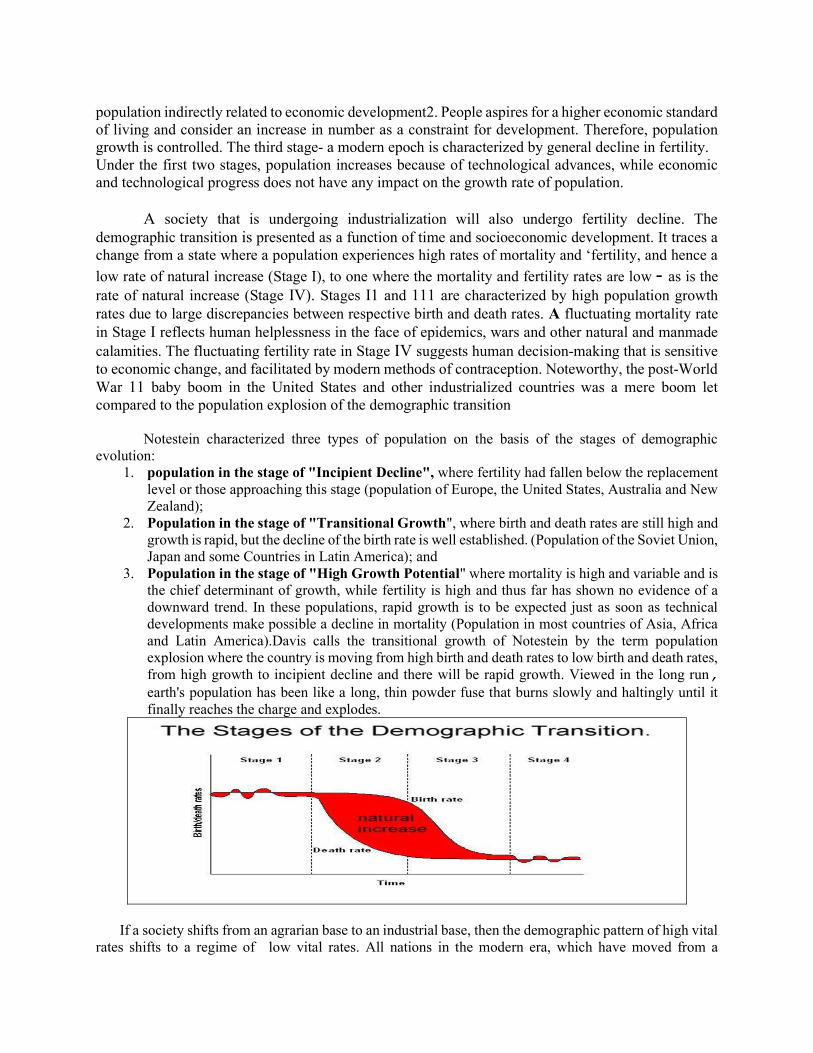
population indirectly related to economic development2. People aspires for a higher economic standard of living and consider an increase in number as a constraint for development. Therefore, population growth is controlled. The third stage- a modern epoch is characterized by general decline in fertility. Under the first two stages, population increases because of technological advances, while economic and technological progress does not have any impact on the growth rate of population.
A society that is undergoing industrialization will also undergo fertility decline. The
demographic transition is presented as a function of time and socioeconomic development. It traces a change from a state where a population experiences high rates of mortality and ‘fertility, and hence a
low rate of natural increase (Stage I), to one where the mortality and fertility rates are low - as is the rate of natural increase (Stage IV). Stages I1 and 111 are characterized by high population growth rates due to large discrepancies between respective birth and death rates. A fluctuating mortality rate in Stage I reflects human helplessness in the face of epidemics, wars and other natural and manmade calamities. The fluctuating fertility rate in Stage IV suggests human decision-making that is sensitive to economic change, and facilitated by modern methods of contraception. Noteworthy, the post-World War 11 baby boom in the United States and other industrialized countries was a mere boom let compared to the population explosion of the demographic transition
Notestein characterized three types of population on the basis of the stages of demographic
evolution: 1. population in the stage of "Incipient Decline", where fertility had fallen below the replacement
level or those approaching this stage (population of Europe, the United States, Australia and New Zealand);
2. Population in the stage of "Transitional Growth", where birth and death rates are still high and growth is rapid, but the decline of the birth rate is well established. (Population of the Soviet Union, Japan and some Countries in Latin America); and
3. Population in the stage of "High Growth Potential" where mortality is high and variable and is the chief determinant of growth, while fertility is high and thus far has shown no evidence of a downward trend. In these populations, rapid growth is to be expected just as soon as technical developments make possible a decline in mortality (Population in most countries of Asia, Africa and Latin America).Davis calls the transitional growth of Notestein by the term population explosion where the country is moving from high birth and death rates to low birth and death rates, from high growth to incipient decline and there will be rapid growth. Viewed in the long run, earth's population has been like a long, thin powder fuse that burns slowly and haltingly until it finally reaches the charge and explodes.
If a society shifts from an agrarian base to an industrial base, then the demographic pattern of high vital rates shifts to a regime of low vital rates. All nations in the modern era, which have moved from a

traditional, agrarian based economic system to a largely industrial, urbanized base, have also moved from a condition of high mortality and fertility. The changing structure of production with a declining importance of the family as a production unit, with the growth of impersonal systems for the allocation of jobs, and with the development of economic roles of women outside of the home, tends to increase the possibility of economic mobility that can better be achieved with small families and tends to decrease the economic advantages of a large family. One of the features of economic development is typically increasing urbanization and children are usually more of a burden and less of an asset in an urban setting than rural. The whole process of economic change, moreover, weakens the force of traditional customs and beliefs. In most countries that have undergone the economic transition from an agrarian to an industrialized, market oriented economy, the custom of the small family has started in the urban groups at the higher end of the socio-economic scale and has spread to smaller cities, lower income groups, and eventually to rural areas. The five phases of the demographic transition was given by C.P. Blacker. They were
1. Stage of high birth rate and high death rate: Population virtually remains stationary in backward economies where both the birth and death rates are high. During the preceding years, the death rates may become higher than the birth rates due to the onset of certain positive checks on the population, the growth rate of the population may be negative and the total population even declines, This is a stage of virtually non-growth of population;
2. Early Expanding Stage: Fall in death rates due to better medical facilities and prevention of epidemics, famines and diseases and there was no corresponding fall in the birth rates of various groups of population and this results in an increase in population (40 per cent population of the world in 1930 was in this stage according to Blacker);
3. Stage of Late Expanding Population: After a time lag, birth rates also start declining and fall in death rate especially of the rates pertaining to infants and children. The higher dependency ratio induces the government to provide family planning facilities (20 percent of the world population was in this stage by 1930);
4. Stage of Low Birth and Death rates: Low birth rates are balanced by low death rates. This is similar to first stage i.e., stage of no growth, However, the population may become large while being stationary (developed European countries had reached this stage by 1930); and
5. Stage of declining population: Death rates exceed the birth rates in this stage. The stage of negative growth rate will bring down the total number. Death rates are low in developed countries but the birth rates may be still lower (France was in this stage).
Notestein pointed out the importance of 'Urban Industrial Society' as a major determinant of demographic transition. "It is difficult to avoid the conclusion that the development of technology lies at the root of the matter”. The theory relates to the stages of population growth with the level of socio-cultural, economic and technological development of the society. The biological determinants of fertility are limited gradually by a process of rational decision-making.

Credit IV Meaning of Resource
Etymologically, “resource refers to two separate words, re, and source, that indicate any
thing or substance that may occur unhindered many more times”. It is only in early part of the twentieth century that the term resource came in forefront and few started writing about it.
Only in 1933, when the eminent professor of economics Erich W. Zimmermann promulgated his famous “Concept of Resource”, the idea became so popular that numerous articles and papers started pouring in the contemporary Economic Geographical literature. Urgent need was felt to identify the new concept as a separate and important branch of study.
“Resource, popularly, signifies a source or possibility of assistance; an expedient; means of support; means to attain given end; capacity to take advantage of opportunities and above all that upon which one relies for aid, support or supply, Zimmerman,1933”.
The above definitions vary markedly and fail miserably to produce any comprehensive universally accepted meaning of resource. However, after critical examinations and analyses all these meanings can be grouped into two, i.e., resources may help us if we are:
a. Taking advantage of opportunity b. Overcoming obstacles or resistances.
The first is a positive approach, the second role of resource is, surely, negative. Resource can be subjective as well as objective. Subjective resource denotes internal resource,
objective resource is external resource. Prof. Zimmermann’s inimitable definition runs: “The word resource does not refer to a thing
or a substance but to a function which a thing or a substance may perform or to an operation in which it may take part, namely, the function or operation of attaining a given end such as satisfying a want. In other words, the word resource is an abstraction reflecting human appraisal and relating to a function or operation”.
A thing or substance is not considered as resource when it fails to give satisfaction to human beings. Proven reserves of petroleum in the midst of inaccessible terrain or in the abyss is not considered resource as they fail to yield any satisfaction to either society or individual.
Geo-thermal energy in this contemporary world is considered to be the most useful resource, but, till recently, this heat-flow was not considered as resource—because man was absolutely ignorant about its uses.
Resource must possess two important properties: Function ability, and Utility.
To define anything or substance as resource, one must critically examine whether it has the property of both utility and function ability. The presence of both utility and function ability is mandatory for resource creation. For example, a bottle of poison has function ability but it has got no utility value as food. The function ability is also the function of space and time. “Any material which is valuable and useful for humans is called a resource”. In fact, “every material has some utility for human beings but its utilisation is possible on the availability of appropriate technology (Culturally driven)”. Only use of each one of them make them a resource. “As Geography developed along nomothetic lines after the 1950s, resource or environmental geography became a specialty subject focused largely on concrete problems and policy responses, Bridge, 2000” (Bridge, 2000: p. 13266).This has been elaborated in many texts published in 1990’s and as stated by Mather and Chapman (1995) and Mitchell (1989) “applied, ecological emphasis on
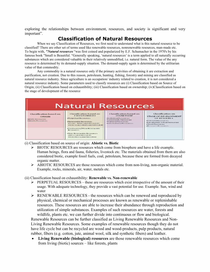
exploring the relationships between environment, resources, and society is significant and very important”.
Classification of Natural Resources When we say Classification of Resources, we first need to understand what is this natural resource to be
classified? There are other set of terms used like renewable resources, nonrenewable resources, man-made etc. To begin with, "Natural resources “was first coined and popularized by E.F. Schumacher in the 1970's by his famous book "Small is Beautiful. “Generally speaking, ‘natural resources’ is a term applied to all naturally occurring substances which are considered valuable in their relatively unmodified, i.e. natural form. The value of the any resource is determined by its demand-supply situation. The demand-supply again is determined by the utilitarian value of that commodity.
Any commodity is a natural resource only if the primary activities of obtaining it are extraction and purification, not creation. Due to this reason, petroleum, hunting, fishing, forestry and mining are classified as natural resource industry. Since agriculture is an occupation/ industry related to creation, it is not considered a natural resource industry. Some parameters used to classify resources are (i) Classification based on Source of Origin; (ii) Classification based on exhaustibility; (iii) Classification based on ownership; (iv)Classification based on the stage of development of the resource
(i) Classification based on source of origin: Abiotic vs. Biotic
BIOTIC RESOURCES are resources which come from biosphere and have a life example. Human beings, flora and fauna, fisheries, livestock etc. The materials obtained from them are also considered biotic, example fossil fuels, coal, petroleum, because these are formed from decayed organic matter.
ABIOTIC RESOURCES are those resources which come from non-living, non-organic material. Example, rocks, minerals, air, water, metals etc.
(ii) Classification based on exhaustibility: Renewable vs. Non-renewable
PERPETUAL RESOURCES – these are resources which exist irrespective of the amount of their usage. With adequate technology, they provide a vast potential for use. Example. Sun, wind and water
RENEWABLE RESOURCES - the resources which can be renewed and reproduced by physical, chemical or mechanical processes are known as renewable or replenishable resources. These resources are able to increase their abundance through reproduction and utilization of simple substances. Examples of such resources are water, forests and wildlife, plants etc. we can further divide into continuous or flow and biological.
Renewable Resources can be further classified as Living Renewable Resources and Non-Living Renewable Resources. Some examples of renewable resources though they do not have life cycle but can be recycled are wood and wood-products, pulp products, natural rubber, fibers (e.g. cotton, jute, animal wool, silk and synthetic fibers) and leather. Living Renewable (biological) resources are those renewable resources which come
from living (biotic) sources – like forests, plants

Non-Living Renewable resources are those that renewable resources which come from non-living (abiotic) sources like land, water, air. Example, metals, minerals, wind, sun etc.
Continuous/ Flow Renewable resources are resources which do not need regeneration. Similar to that of perpetual resources, example wind, tides etc.
NON-RENEWABLE RESOURCES - this process takes place over a long geological time. Examples of such resources are minerals and fossil fuels. This may take millions of years in their formation. Some of the resources like metals are recyclable and some like fossils fuels cannot be recycled and as such they get exhausted with their use. Non-Renewable Resources can be further classified as Recyclable and Non-Recyclable resources.
Recyclable resources are those which can be processed to be used again and again. These are non-renewable resources, which can be collected after they are used and can be recycled. These are mainly the non-energy mineral resources, which occur in the earth's crust (e.g. ores of aluminum, copper, mercury etc.) and deposits of fertilizer nutrients (e.g. phosphate sock and potassium and minerals used in their natural state like asbestos, clay, mica etc.)
Non- Recyclable resources are those which once used perish, example coal. These are non-renewable resources, which cannot be recycled in any way. Examples of these are fossil fuels and uranium, which provide 90 per cent of our energy requirements.
There are a few substances too which can be recycled a few times, before they completely perish or turn non-renewable resources. (iii) Classification based on ownership: Individual vs. Community vs. National vs. International
This classification is inspired from socio-economic demarcation or classification of resources and natural wealth. Interestingly, the resources (metals/ minerals) found on these pieces of land ownership also belong to the concerned owner.
-INDIVIDUAL RESOURCES - these are resources owned by individuals privately. Example, land owned by a farmer allotted to them by government against the payment of revenue. Urban people own plots, houses and other property. Some other examples include plantation, pasture lands, ponds, water in wells etc.
COMMUNITY RESOURCES- these include resources that are accessible to all the members of the community like the village grazing grounds, burial grounds, village ponds, public parks, picnic spots, playgrounds in urban areas are accessible to all the people living there.
NATIONAL RESOURCES- technically speaking all the resources belong to the nation because the country has legal powers to acquire even private property for public good. This we may have seen many times when government take fields owned by private individuals to construct roads, canals, railways. All minerals, water resources, forests, wildlife, land within the political boundaries and oceanic area upto 12 nautical miles from the coast termed as territorial water and resources therein belong to the nation.
INTERNATIONAL RESOURCES - there are also international resources regulating resources. The oceanic resources beyond 200km of the Exclusive Economic Zone belong to open ocean and no individual country can utilize these without the consensus of international institutions.
(iv)Classification based on the stage of development of the resource: Potential vs. Developed vs. Stock vs reserves
Potential resources are those which can be found in a particular region but are yet to be put to use. Example. Regions in states like Rajasthan and Gujarat have huge potential for development of solar, wind and tidal energy, which us yet to be used.
Developed/ Actual resources includes are resources which have been/ are surveyed and their quality and quantity have been determined for utilization. The development of resources however depends on technology and level of their feasibility
Stock - the materials in the environment which have the potential to satisfy human needs but human beings do not have the appropriate technology to access these, are included among stock. Water for example is a compound of two inflammable gases; hydrogen and oxygen which can be used as a source of energy. But we do not know how to use them for this purpose. Therefore it is considered as stock.
Reserves - they are the subset of stock/ actual which are/ can be used with the help of existing technical knowledge. Reserves can be used for meeting future requirements. For example water in lakes, dams, forests etc. is a reserve which can be used in the future .Of the not mentioned ones, one can also say that in classification of resources, man-made resources and natural resources should be put as a category, but well, that is a tricky argument.
WHAT IS LAND DEGRADATION?
Land degradation is a composite term; it has no single readily-identifiable feature, but instead describes how one or more of the land resources (soil, water, vegetation, rocks, air, climate, relief) has changed for the worse. A landslide is often viewed as an example of land degradation in action – it changes the features of the land, causes destruction of houses, and disrupts activities. In the longer term, however, the area of a landslide may regain its productivity. In places such as Jamaica and Papua New Guinea, old landslide scars are noted for supporting better crops and more intensive agricultural possibilities than on the adjacent land not affected by landslides especially when the new soil is derived from less weathered rock materials, such as calcareous mudstones. So, land de/*gradation is far from being a simple process, with clear outcomes. This complexity needs to be appreciated by the field assessor, before any attempt is made either to define land degradation or to measure it. Land degradation generally signifies the temporary or permanent decline in the productive capacity of the land (UN/FAO definition). Another definition describes it as, "the aggregate diminution of the productive potential of the land, including its major uses (rain-fed, arable, irrigated, rangeland, forest), its farming systems (e.g. smallholder subsistence) and its value as an economic resource." This link between degradation (which is often caused by land use practices) and its effect on land use is central to nearly all published definitions of land degradation. The emphasis on land, rather than soil, broadens the focus to include natural resources, such as climate, water, landforms and vegetation. The productivity of grassland and forest resources, in addition to that of cropland, is embodied in this definition. Other definitions differentiate between reversible and irreversible land degradation. While the terms are used here, the degree of reversibility is not a particularly useful measure – given sufficient time all degradation can be reversed, as illustrated
by the landslide example above. So, reversibility depends upon whose perspective is being assessed and what timescale is envisaged. Whilst soil degradation is recognized/ as a major aspect of land degradation, other processes which affect the productive capacity of cropland, rangeland and forests, such as lowering of the water table and deforestation, are captured by the concept of land degradation. Land degradation is, however, difficult to grasp in its totality. The "productive capacity of land" cannot be assessed simply by any single measure. Therefore, we have to use indicators of land degradation. Indicators are variables which may show that land degradation has taken place – they are not necessarily the actual degradation itself. The piling up of sediment against a downslope barrier may be an 'indicator' that land degradation is occurring upslope. Similarly, decline in yields of a crop may be an indicator that soil quality has changed, which in turn may indicate that soil and land degradation are also occurring. The condition of the soil is one of the best indicators of land degradation. The soil integrates a variety of important processes involving vegetation growth, overland flow of water, infiltration, land use and land management. Soil degradation is, in itself, an indicator of land degradation. But, in the field, further variables are used as indicators of the occurrence of soil degradation. This chapter and much of the rest of these Guidelines will, therefore, dwell primarily on the use of evidence from the soil (mainly soil degradation) and from plants growing on the soil (soil productivity). Types of soil degradation include:
1) Soil erosion by water: the removal of soil particles by the action of water. Usually seen as sheet erosion (a more or less uniform removal of a thin layer of topsoil), rill erosion (small channels in the field) or gully erosion (large channels, similar to incised rivers). One important feature of soil erosion by water is the selective removal of the finer and more fertile fraction of the soil.
2) Soil erosion by wind: the removal of soil particles by wind action. Usually this is sheet erosion, where soil is removed in thin layers, but sometimes the effect of the wind can carve out hollows and other features. Wind erosion most easily occurs with fine to medium size sand particles
3) Soil fertility decline: the degradation of soil physical, biological and chemical properties.
Erosion leads to reduced soil productivity, as do: a) Reduction in soil organic matter, with associated decline in soil biological activity; b) Degradation of soil physical properties as a result of reduced organic matter
(structure, aeration and water-holding capacity may be affected); c) Changes in soil nutrient content leading to deficiencies, or toxic levels, of nutrients
essential for healthy plant growth; d) Buildup of toxic substances – e.g. pollution, incorrect application of fertilizers.
4) Waterlogging: caused by a rise in groundwater close to the soil surface or inadequate drainage of surface water, often resulting from poor irrigation management. As a result of waterlogging, water saturates the root zone leading to oxygen deficiency.
5) Increase in salts: this could either be salinization, an increase in salt in the soil water
solution, or sodication, an increase of sodium cations (Na+) on the soil particles.
Salinization often occurs in conjunction with poor irrigation management. Mostly, sodication tends to occur naturally. Areas where the water table fluctuates may be prone to sodication.
6) Sedimentation or 'soil burial': this may occur through flooding, where fertile soil is buried under less fertile sediments; or wind blows, where sand inundates grazing lands; or catastrophic events such as volcanic eruptions.
In addition to these principal types of soil degradation, other common types of land degradation include:
7) Lowering of the water table: this usually occurs where extraction of groundwater has exceeded the natural recharge capacity of the water table.
8) Loss of vegetation cover: vegetation is important in many ways. It protects the soil from erosion by wind and water and it provides organic material to maintain levels of nutrients essential for healthy plant growth. Plant roots help to maintain soil structure and facilitate water infiltration.
9) Increased stoniness and rock cover of the land: this would usually be associated with extreme levels of soil erosion causing exhumation of stones and rock.
Although the foregoing list neatly breaks down the components of soil degradation by cause,
very often these agents of degradation act together. For example, strong winds often occur at the front of a storm, thus wind erosion and water erosion may result from the same event. Additionally, a soil that has suffered some form of degradation may be more likely to be further degraded than another soil similar in all respects except for the level of degradation. One well-accepted indicator of increased erodibility is the level of soil organic matter. Where the organic matter content of a soil falls below 2% the soil is more prone to erosion, because soil aggregates are less strong and individual particles are more likely to be dislodged.
Some environments are naturally more at risk to land degradation than others. Factors such as steep slopes, high intensity rainfall and soil organic matter influence the likelihood of the occurrence of degradation. Identification of these factors allows land users to implement techniques that safeguard against loss of productivity. Management practices also exert a significant influence on the susceptibility of a landscape to degradation. Extensive and poorly managed land use systems are more likely to degrade than intensive, intricately-managed plots. Milder forms of land degradation can be reversed by changes in land management techniques, but more serious forms of degradation may be extremely expensive to reverse (such as salinity) or may be, for practical purposes, irreversible. Soil erosion, when serious and prolonged, is effectively irreversible because, in most circumstances, the rate of soil formation is so slow. In moist, warm climates formation of just a few centimeters of soil may take thousands of years and in cold, dry climates it can take even longer. Soil loss through erosion happens far faster: up to 300 times faster where the ground is bare.
Soil erosion is the most widely recognised and most common form of land degradation and, therefore, a major cause of falling productivity. However, since the effects of soil loss vary depending on the underlying soil type, soil loss, by itself, is not an appropriate proxy measure for productivity decline. For example, a loss of 1 mm from a soil in which the nutrients are concentrated close to the surface will show a greater impact on productivity than the same level of soil loss from a soil in which the nutrients are more widely distributed
Although land degradation is defined by reference to productivity, its effects may include diminished food security, reduced calorie intake, economic stresses and loss of biodiversity. These consequences concern rural land users greatly, Causes of Land Degradation
Although degradation processes do occur without interference by man, these are broadly at a rate which is in balance with the rate of natural rehabilitation. So, for example, water erosion under natural forest corresponds with the subsoil formation rate. Accelerated land degradation is most commonly caused as a result of human intervention in the environment. The effects of this intervention are determined by the natural landscape. The most frequently recognised main causes of land degradation include:
overgrazing of rangeland; over-cultivation of cropland; waterlogging and salinization of irrigated land; deforestation; and Pollution and industrial causes.