Controls on lake level in the early to mid Holocene, Hawes Water, Lancashire, UK
13
http://hol.sagepub.com/ The Holocene http://hol.sagepub.com/content/21/7/1061 The online version of this article can be found at: DOI: 10.1177/0959683611400455 2011 21: 1061 originally published online 25 July 2011 The Holocene R.T. Jones, J.D. Marshall, E. Fisher, J. Hatton, C. Patrick, K. Anderson, B. Lang, A. Bedford and F. Oldfield Controls on lake level in the early to mid Holocene, Hawes Water, Lancashire, UK Published by: http://www.sagepublications.com can be found at: The Holocene Additional services and information for http://hol.sagepub.com/cgi/alerts Email Alerts: http://hol.sagepub.com/subscriptions Subscriptions: http://www.sagepub.com/journalsReprints.nav Reprints: http://www.sagepub.com/journalsPermissions.nav Permissions: http://hol.sagepub.com/content/21/7/1061.refs.html Citations: What is This? - Jul 25, 2011 OnlineFirst Version of Record - Sep 28, 2011 Version of Record >> at University of Liverpool on September 3, 2013 hol.sagepub.com Downloaded from
Transcript of Controls on lake level in the early to mid Holocene, Hawes Water, Lancashire, UK

http://hol.sagepub.com/The Holocene
http://hol.sagepub.com/content/21/7/1061The online version of this article can be found at:
DOI: 10.1177/0959683611400455
2011 21: 1061 originally published online 25 July 2011The HoloceneR.T. Jones, J.D. Marshall, E. Fisher, J. Hatton, C. Patrick, K. Anderson, B. Lang, A. Bedford and F. Oldfield
Controls on lake level in the early to mid Holocene, Hawes Water, Lancashire, UK
Published by:
http://www.sagepublications.com
can be found at:The HoloceneAdditional services and information for
http://hol.sagepub.com/cgi/alertsEmail Alerts:
http://hol.sagepub.com/subscriptionsSubscriptions:
http://www.sagepub.com/journalsReprints.navReprints:
http://www.sagepub.com/journalsPermissions.navPermissions:
http://hol.sagepub.com/content/21/7/1061.refs.htmlCitations:
What is This?
- Jul 25, 2011 OnlineFirst Version of Record
- Sep 28, 2011Version of Record >>
at University of Liverpool on September 3, 2013hol.sagepub.comDownloaded from

Research paper
The Holocene21(7) 1061 –1072© The Author(s) 2011Reprints and permission:sagepub.co.uk/journalsPermissions.navDOI: 10.1177/0959683611400455hol.sagepub.com
Introduction
Patterns of past lake-level change are commonly interpreted in terms of climatically induced changes in water budget but, in many settings, factors other than climate may have an influence on water levels. Uncertainty in future climate, and in particular the necessity to understand the sensitivity of precipitation to cli-mate change, has given impetus to studies of palaeohydrology. Lake-level reconstruction represents an important archive for monitoring such past changes (Harrison and Digerfeldt, 1993; Harrison et al., 1993; Jones and Jordan, 2007; Magny, 2004) and in lake sediments there is the potential for direct comparison of independent climate and lake-level records. Changes in lake level can be affected by a range of non-climatic factors, all of which must be taken into account before a climatic interpretation can be applied to a reconstructed lake-level record. Catchment-specific events can impact significantly on lake level, whilst in-lake pro-cesses such as sediment focusing and current strength variation can alter the sediment record to give the impression of past lake-level change (c.f. Dearing, 1997). Despite this, data on the timing of lake-level change in western Europe apparently show a coher-ent pattern of events, although the direction of change is seen to vary from region to region, indicating that such shifts are driven by climatically induced changes in regional water budgets (Harrison and Digerfeldt, 1993).
A synthesis of UK lake-level data was produced in the early 1990s as part of the European Lake Status Data Base (ELSDB) (e.g. Yu and Harrison, 1995a, b), but this was severely hampered by a lack of constrained information: much of the data available for inclusion in the data base was poorly dated, analysed at a very low temporal resolution and mainly relied on spot determinations of former lake level rather than a well-dated sequence for a given site. Furthermore, the vast majority of UK lakes are open
(exorheic) systems, where run-off dominates and there is typi-cally a clearly defined permanent inflow/outflow to the lake. Such sites are potentially more insensitive to hydrological change par-ticularly over shorter time periods as any positive change in the water balance of the lake may simply result in increased discharge at the outflow and no discernible change in level. Their use in lake-level studies is therefore open to question (e.g. Dearing, 1997). Quantitative techniques have been developed to extract lake-level records from open systems (e.g. Digerfeldt, 1986) although they are not applicable to all sites and have never been applied in the UK.
Numerous studies have shown that sediments from small, temperate, carbonate lakes in Europe can provide excellent archives for palaeo-environmental investigations (e.g. Birks and Ammann, 2000; Diefendorf et al., 2006, 2008; Leng and Marshall, 2004). The rapid reaction of the local hydrological sys-tem to environmental change, coupled with relatively high sedi-ment accumulation rates, facilitate high-resolution stratigraphic studies that can employ a wide range of lithological, chemical and biological proxies (e.g. Ammann and Oldfield, 2000). They are
400455 HOL21710.1177/0959683611400455Jones et al.The Holocene
1University of Exeter, UK2University of Liverpool, UK3University of Lancaster, UK 4Edge Hill University, UK† Retired
Received 20 July 2009; revised manuscript accepted 30 November 2010
Corresponding author:R.T. Jones, Department of Geography, University of Exeter, Exeter EX4 4RJ, UK.Email: [email protected]
Controls on lake level in the early to mid Holocene, Hawes Water, Lancashire, UK
R.T. Jones,1 J.D. Marshall,2 E. Fisher,2 J. Hatton,1 C. Patrick,3† K. Anderson,1 B. Lang,4 A. Bedford4 and F. Oldfield2
AbstractThis study presents a new interpretation of the evidence for Holocene lake-level changes from Hawes Water in NW England constrained by detailed stratigraphic data, radiocarbon chronology and palaeo-environmental evidence. Lake levels are seen to decline gradually from the start of the Holocene through to 9960 cal. yr BP, in response to lake infilling and the prevailing dry climatic conditions. Low lake levels then persist until 6000 cal. yr BP, punctuated by two transgressive phases. Rising sea levels during the Holocene high-level sea stand are thought to be responsible for a major rise in lake level at 6000 cal. yr BP driven by changes in the local water-table. The rise in lake level is coincident with a rise in anthropogenic activity across the site, possibly reflecting the migration of coastal Mesolithic communities inland in response to rising sea levels.
Keywordscarbonate lake, early Holocene, lake level, Morecambe Bay, NW England, sea level
at University of Liverpool on September 3, 2013hol.sagepub.comDownloaded from

1062 The Holocene 21(7)
especially favourable for reconstructing lake-level changes partly because of the ease with which calcareous subaqueous deposits can be distinguished from terrestrial peats formed at and above the groundwater-table. Freshwater lacustrine carbonates are typi-cally precipitated in the upper water column during the summer months, under the influence of the photosynthesis of both macro- and microphytes. Characeae are an important source of carbonate in the littoral zone where they can contribute several hundred grams of fine-grained carbonate per square metre per year (e.g. Dean, 1981; Kelts and Hsu, 1978). Continued littoral deposition often leads to the formation of a shallow submerged ‘carbonate bench’, with a subaerial swamp at the rear (e.g. Murphy and Wilkinson, 1980; Treese and Wilkinson, 1982). The high rates of sediment accumulation (>1.3 m/1000 yr) recorded in these set-tings (Marshall et al., 2007) lead to the lakeward migration of the bench front over time. Changes in lake level should therefore be recorded by significant changes in marginal stratigraphy.
This paper focuses on the stratigraphy of Hawes Water, a hard-water lake in North Lancashire, NW England. Previous strati-graphic work on the site by Oldfield (1960) identified a sequence of interdigitated peat and micrite deposits reflecting a stage of dynamic lake-level change at the site during the early to mid Holocene. A subsequent decline in lake level at some point in the late Holocene led to the terrestrialisation of the bench system and a cessation of any future bench development. The study, however, lacked an absolute chronology and the timing and causes of
lake-level change were not established. Hawes Water has recently been the focus of a programme of work that has constructed quan-titative climate records for the Lateglacial and Holocene (δ18O, chironomid inferred temperatures) (Bedford et al., 2004; Jones et al., 2002; Lang et al., 2010a; Marshall et al., 2002, 2007) so it is timely to reassess the possible controls on lake level and bench development. The study therefore presents new stratigraphic and palaeo-environmental data constrained by targeted radiocarbon dates in order to determine the lake-level history of the site, iden-tify the forcing factors driving these changes and find an explana-tion for the pronounced decline in carbonate preservation in the late Holocene.
The modern lakeHawes Water is a hardwater ‘marl’ lake situated within the Arnside-Silverdale Area of Oustanding Natural Beauty (AONB) adjacent to the Gait Barrows National Nature Reserve (NNR) and 2 km south west of Silverdale village (54°10′58″N, 2°48′10″W, Figure 1). Hawes Water and its smaller sister basin Little Hawes Water to the NE, lie within a catchment of ~1.7 km2. The main lake is ~ 225 m wide and 400 m in length, reaching a maximum depth of 12 m towards the centre. The lake occupies a shallow depression in the local Carboniferous limestone, possibly a doline or polje (Vincent, 1985). The lake is surrounded by limestone out-crops, particularly to the northeast where they form an extensive
Figure 1. Main panel: location map for Hawes Water, Lancashire, NW England. Insert panel: location of the main north field study site, and cores HWD1 and HWLC1
at University of Liverpool on September 3, 2013hol.sagepub.comDownloaded from

Jones et al. 1063
limestone pavement (Figure 1). The catchment is separated from Leighton Moss to the south by a low rock bar. The lake is fed by direct precipitation, subsurface flow from the underlying lime-stone and stream input from Little Hawes Water (Figure 1). The lake drains southward on to Hawes Water Moss and out into Myers Dyke. Outflow occurs erratically at present but before the southern end of the lake became infilled with sediment there would have been a ready outflow into the Dyke when lake levels exceeded 4 m AOD. Monthly lake monitoring data (Crowley, unpublished data, 2009) suggests that the lake acts as a window into local groundwater, with both local groundwater and lake lev-els responding rapidly to rainfall events.
The modern lake is ringed by a terrestrialised carbonate bench system, dated by Oldfield (1960) to be early–mid Holocene in age. There is no modern bench development at the site despite the routine precipitation of carbonate in the lake during the summer months. Preservation rates are low, with the summer precipitates re-dissolved back into the water column during the autumn/winter months when precipitation rates decline in line with falling lake productivity (Fisher et al., 2005). The circumstances that prompted this change are unknown but presumably linked to a significant change in water chemistry at some point in the late Holocene. The modern lake is also silica-deficient and any avail-able silica is normally re-dissolved back into the water column (Fisher et al., 2005). The implications for the palaeo record is that silica-based proxies such as diatoms are rarely preserved. A basic schematic outlining the relationship between the marginal and open-water sediments is presented in Figure 2.
The distribution of terrestrialised carbonate sediments across the catchment pays testament to the existence of a phase of much higher lake levels during the postglacial period. The lake at this time was ~ 1 km long and 400 m wide, extending south onto what is now Hawes Water Moss, whilst to the north it abutted the lime-stone crags that define the northern edge of the catchment. The bench front is defined by a cliff-like edge, reflecting the fact that the modern lake is actually incised into the bench deposits. The drop in lake level that led to the terrestrialisation of the bench is assumed to have resulted in a collapse of the bench front. The bench front is marked on the surface by a narrow submerged reed fringe, capping the bench top. The water depth in the reed fringe is typically less then 1 m, but drops rapidly to 5 m+ as you move
off the reed fringe (Figure 2). The collapse of the bench front is clearly reflected in the chaotic nature of the lake sediment record preserved just off the bench front. Preserved within the bench, the interdigitation of micrite (subaqueous) and peat (terrestrial) deposits preserved within the bench point to several phases of fluctuating lake level over submillennial timescales (Figures 2 and 3). There are thought to be no late-Holocene deposits within the marginal record. These have been removed through peat cut-ting, the start of which is likely to date back several thousand years. The growth of the lime industry in north Lancashire during the eighteenth and nineteenth centuries may also have led to the exploitation of local marl deposits, with a number of lime kilns established in the immediate vicinity of the lake. Within the lake itself, the sediment record is dominated by organic-rich units overlying more carbonate-rich deposits (Figures 2 and 4). This is typical of many hardwater lake systems and reflects the inwash of organic material into the lake centre over the marginal bench (e.g. Murphy and Wilkinson, 1980; Treese and Wilkinson, 1982). Lat-eglacial/Younger Dryas deposits are presumed to extend out under the lake, although they have never been sampled.
MethodologyThe marginal sediment sequence at Hawes Water was mapped using a gouge corer with a network of five coring transects estab-lished (HW-Tr a–e) incorporating 41 individual boreholes (Fig-ures 3 and 5). Each core was initially logged on the basis of colour, texture and visual stratigraphy. This network of boreholes was then surveyed into a local benchmark, the depths converted relative to sea level (m a.s.l.). The underlying sediment stratigra-phy for the study site was then reconstructed. Key cores and spe-cific stratigraphic units were then recovered using a Russian corer and retained for dating and pollen/macrofossil analysis. Particular attention was paid to the peat/carbonate contact, which, stratigraphically, represents the old lake margin, marking the boundary between terrestrial and subaqueous deposits. Pollen samples were routinely taken 1 cm above and below the peat/carbonate contact.
The reconstructed stratigraphic cross-section was dated using an event stratigraphy based on a combination of lithological markers (e.g. Younger Dryas clay) and local pollen zone
Figure 2. Schematic cross-section of the modern-day relationship between marginal and open water sediments at Hawes Water based on data from Transect A and HWD1
at University of Liverpool on September 3, 2013hol.sagepub.comDownloaded from
1064 The Holocene 21(7)
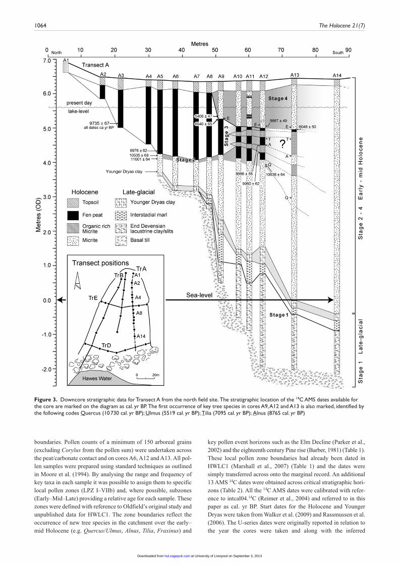
boundaries. Pollen counts of a minimum of 150 arboreal grains (excluding Corylus from the pollen sum) were undertaken across the peat/carbonate contact and on cores A6, A12 and A13. All pol-len samples were prepared using standard techniques as outlined in Moore et al. (1994). By analysing the range and frequency of key taxa in each sample it was possible to assign them to specific local pollen zones (LPZ I–VIIb) and, where possible, subzones (Early–Mid–Late) providing a relative age for each sample. These zones were defined with reference to Oldfield’s original study and unpublished data for HWLC1. The zone boundaries reflect the occurrence of new tree species in the catchment over the early–mid Holocene (e.g. Quercus/Ulmus, Alnus, Tilia, Fraxinus) and
key pollen event horizons such as the Elm Decline (Parker et al., 2002) and the eighteenth century Pine rise (Barber, 1981) (Table 1). These local pollen zone boundaries had already been dated in HWLC1 (Marshall et al., 2007) (Table 1) and the dates were simply transferred across onto the marginal record. An additional 13 AMS 14C dates were obtained across critical stratigraphic hori-zons (Table 2). All the 14C AMS dates were calibrated with refer-ence to intcal04.14C (Reimer et al., 2004) and referred to in this paper as cal. yr BP. Start dates for the Holocene and Younger Dryas were taken from Walker et al. (2009) and Rassmussen et al. (2006). The U-series dates were originally reported in relation to the year the cores were taken and along with the inferred
Figure 3. Downcore stratigraphic data for Transect A from the north field site. The stratigraphic location of the 14C AMS dates available for the core are marked on the diagram as cal. yr BP. The first occurrence of key tree species in cores A9, A12 and A13 is also marked, identified by the following codes Quercus (10 730 cal. yr BP); Ulmus (5519 cal. yr BP); Tilia (7095 cal. yr BP); Alnus (8765 cal. yr BP)
at University of Liverpool on September 3, 2013hol.sagepub.comDownloaded from

Jones et al. 1065
Lateglacial dates have been adjusted to conform to the cal. yr BP 14C timescale.
There are a number advantages to using a multicore approach at Hawes Water for reconstructing past lake-level change rather then relying on a single core. The main benefit is that it provides a mechanism for tracking the spatial and temporal development of the bench system. In hardwater systems such as Hawes Water, where sediment deposition is concentrated in the littoral zone, the ability to examine horizontal sedimentation patterns as well as vertical trends is critical. The ability to map the spatial relation-ship between peat (terrestrial) and subaqueous deposits (micrite, clay) should allow for a much more robust method of lake-level reconstruction then can be gained from a single core. Whilst in-lake processes such as slumping, reworking, that in a single-core study could easily be misinterpreted as evidence for past lake-level change, can be more easily identified and discounted.
Unfortunately it is not possible to quantify the relationship between peat and carbonate deposits in terms of absolute changes in water depth with this methodology because of the problem of differential sediment compaction. No information is currently available dealing with compaction rates for organic and carbonate sediments in the top few metres of burial in a lacustrine setting. Indeed, determining compaction rates in any Holocene sedimen-tary environment is very difficult. Detailed knowledge of subsur-face geotechnical properties are required, coupled with a detailed depositional history. Site-specific monitoring is also unrealistic both in terms of time and cost expenditure. A number of generic models have been developed to constrain the range of possible
compaction rates (e.g. Kooi and de Vries, 1998; Meckel et al., 2006). Unfortunately these models were often designed for large clastic sedimentary basins (e.g. Meckel et al., 2006; Törnqvist et al., 2008) and applying them to basins similar in size to the study area is very problematic. The micrites that form the bench are typically fine-grained carbonate mud supported deposits with a shell component, thus compaction would be expected to have occurred. Compaction of the terrestrial peat deposits would almost certainly have occurred. Despite this, the simple water-depth relationship between terrestrial and subaqueous sediments at Hawes Water is difficult to dismiss. Whether such changes are a reflection of climate change or simple in-lake processes such as hydroseral activity forms the core of this study.
The late Holocene was sampled from the open lake using a 3.0 m Mackareth corer. Although time and finances only allowed for the analysis of one core, two were recovered so the stratigraphy could be compared as a quick and easy method for checking the integrity of the sediment record. HWD1 was subsequently taken from the northern end of the lake, with HWD2 closer to the centre. The stra-tigraphy of both cores was very similar and compared well to previ-ous cores extracted from the lake and the integrity of the cores was sound. HWD1 was chosen for analysis as it provided the longer record and was subsampled for analysis. The core was initially ana-lysed using mineral magnetic susceptibility (χlf) (Walden et al., 1999) and loss-on-ignition analysis (Bengtsson and Enell, 1986) on contiguous 1 cm samples. These results, along with the visual stra-tigraphy, were used to produce a detailed picture of the core lithol-ogy (Figure 4). Pollen analysis was used to provide additional
Figure 4. Summary palaeo-environmental diagram for HWD. Downcore variation in Loss-On-Ignition (OM), mass specific magnetic susceptibility (χlf) and frequency curves for selected pollen taxa are shown. The record is subdivided into eight lithological zones (LZ1–8) based on variation in the lithological proxies. This scheme was determined using ZONE. The key local pollen zones for the early–mid Holocene (LPZ I–VIIb) are shown, along with the palynostratigraphic markers used in the construction of the chronology (See Table 1a and b). The eighteenth century pine rise is also shown. The marginal lake-level record is also included for comparison (Stages S2–S4)
at University of Liverpool on September 3, 2013hol.sagepub.comDownloaded from

1066 The Holocene 21(7)
palynostratigraphic dating points and to provide an initial overview of Holocene vegetation change in the catchment. The core was dated using the local palynostratigraphy supported by three AMS 14C dates and one U-series date (Tables 1 and 2).
The sediment recordA summary of the basic stratigraphic and proxy information available for the marginal sediment record is presented first.
A summary of the evidence for past lake-level change is then out-lined. This process is then repeated for HWD1 in the following section.
The carbonate bench sequence was found to extend some 160 m from the northern edge of the study area to the lake edge, reach-ing a maximum thickness of 9 m+ at the current lake margin. Transect A (Figure 3) provides the most detailed record of the stratigraphic changes and is referred to throughout the text. The Holocene sediments that form the carbonate shelf in the southern
Figure 5. Sediment isochrone maps for the basal peat carbonate contact deposited in Stage 2 (11 663–9960 cal. yr BP) as defined in Transect A, boreholes A1 to A12. Pollen samples were taken above and below the contact and used to provide a relative chronology for the contact based on the local pollen zones originally defined by Oldfield (1960) and the event chronology for the site. Part (a) charts the lakeward development of the carbonate bench during Stage 2, whilst (b) follows the delayed expansion of marginal peat deposits across the top of the bench (see Table 1 for the definition of the Local Pollen Zones)
Table 1. Lateglacial to mid-Holocene local pollen zone for Hawes Water based on the original work of Oldfield (1960), Marshall et al. (2007) and the unpublished pollen record for HWD1. Dates for the LPZ boundaries are taken from 1Barber (1981), 2Marshall et al. (2007) and 3Walker et al. (2009)
Early – Mid Holocene Palyno- stratigraphy
LPZ zone Main characteristics Event horizon Date
VIIb Mixed Oak Woodland / Alnus / Corylus
Pine rise1 18th century
VIIa Mixed Oak Woodland / Pine decline Elm decline2 5519 cal yr BPVIc Mixed Oak Woodland / Alnus Tilia / Fraxinus rise2 7095 cal yr BPVIb Mixed Oak Woodland / low Corylus Alnus rise2 8765 cal yr BPVIa Mixed Woodland - with Pine / Elm /
Birch/ high Corylus
IV - V Birch woodland Quercus / Corylus rise2 10730 cal yr BPI - III Grassland - Birch woodland - Tundra Start of the Holocene3 11700 cal yr b2k
at University of Liverpool on September 3, 2013hol.sagepub.comDownloaded from

Jones et al. 1067
part of the transect (Cores A14–17) are composed principally of fine-grained authigenic micrite (CaCO3 content >98%), rich in shell remains of gastropods and bivalves (Lymnaea peregra and Pisidium nitidum) and capped by a thin soil. Attempts to use car-bonate concretion morphology to reconstruct past lake levels (Magny, 1998) was not possible as the micrites units showed very little morphological difference down core. Characeae oospores are common in the marginal carbonates, attesting to their impor-tance as a source of carbonate to the lake in the early Holocene (Anadón et al., 2000; Moore, 1986). In the modern lake the distri-bution of Characeae is limited to just a few pockets, the density of macrophytes in the littoral zone preventing their expansion because of their high light requirements.
No micritic sediments were found at the northern end of the transect (A2–A4), with fen peat lying directly ontop of thin gla-cial clay deposits. The peat deposits are rich in Phragmites com-munis and Cladium mariscus remains with substantial wood deposits, mainly Alder recorded, reflecting accumulation under reedswamp, fen and carr. The stratigraphy between cores A5 and A8 is relatively simple, with peats overlying increasingly thick micrite deposits. Interdigitated peat/micrite deposits are identified in the upper part of boreholes A10 to A13. Boreholes A14 to A17 yielded no peat deposits because of the loss of the upper sediment record through peat cutting. Desiccation and compaction of the upper layers of peat has also taken place. A thin band of micrite recorded by Oldfield (1960) as running through the upper section (top 20 cm) of the peats is now no longer detectable. The Holo-cene bench is underlain by Lateglacial deposits, averaging 2–2.5 m in thickness. The basal sediments are a fine-grained clast-rich blue grey clay diamict, deposited upon the retreat of the ice from the catchment during the final stages of the Devensian. This diamict is commonly found at sites across Northern England (e.g. Lake Windermere, Pennington, 1947; Esthwaite Water, Franks et al., 1961). This basal clay is found across the catchment and presumably acts as the non-permeable layer retaining the water in the basin. This basal unit is overlain by a thin Interstadial marl deposit ~ 1 m, which in turn is overlain by a thin clay band (~ 0.3–0.7 m thick) deposited during the Younger Dryas Stadial.
HWD1, extending back to ~10 400 cal. yr BP, provides a complete sequence for the mid–late Holocene, absent from the marginal record. The Lateglacial and the very early Holocene was not recovered. The core is characterised by eight lithological units, L1–L8 defined on the basis of fluctuations in the LOI and χlf records (Figure 4). The core lithology is broadly tri-partite in structure, comprising a lower micrite unit (L1–4) (CaCO3 ~50–90%) rich in shell material and characeae oospores, with organic banding at the base. This is overlain by an organic unit (L5–6) (~60–70% OM), rich in plant macrofossils (mainly marginal reed material) and shells but only very limited chara oospores, hinting perhaps at a possible change in the structure of the marginal sub-merged vegetation. This organic unit is in turn overlain by an upper micrite deposit (L7–8), similar in composition and fossil content to the micrite unit recorded in L3 but again with very few oospores observed. The organic matter (OM) content is seen to increase towards the top of the core (Figure 4).
The marginal sediment record of past lake-level change
The marginal sediment record provides evidence for four stages of lake level change (S1–S4) occurring over millennial timescales during the Lateglacial to mid-Holocene period (~13.5–4.5 ka cal. yr BP). The evidence for each stage is briefly outlined below, fol-lowed by a more detailed discussion on the possible driving mechanisms behind the observed changes.
S1 ~13 500–11 650 cal. yr BP (the Lateglacial). The lack of any Lateglacial age deposits at the rear of the bench (Boreholes A1–A4) suggests that lake level over this period did not extend to the very rear of the study site and remained below 4.5 m AOD (Figure 3). Equally the fact that only Younger Dryas age deposits were deposited in this location with no evidence for any preced-ing Interstadial material, suggests that lake levels must have remained below 3.5 m AOD until the onset of the Stadial. At what point lake levels rose during the Stadial is unclear owing to the poor resolution of the Lateglacial deposits in these boreholes.
Table 2. AMS radiocarbon dates obtained on terrestrial macrofossil material from the marginal and open water (HWD1) sediment record from Hawes Water. The single U-series date obtained for HWD1 was based on extracted calcite
AMS 14C and U-series dates
Core Depth Method Dated material Lab code Uncalib Calibrated (mid point – 2s)
HWD 33–34 AMS 14C Birch fruit AA-53013 1780 ± 42 1710 ± 42 101–102 Wood AA-53014 2311 ± 43 2334 ± 43 244–245 Wood AA-53015 9216 ± 64 10383 ± 64 179–180 U-Series CaCO3 JDM0017 – 7878 ± 000
Marginal sediments Transect A BoreholesA3 140–143 AMS 14C Birch Fruit AA-53016 8733 ± 67 9735 ± 67A5 193–194 Birch Fruit AA-53017 8883 ± 62 9976 ± 62 201–202 Birch Fruit AA-53018 9328 ± 68 10535 ± 68 210–211 Birch Fruit AA-53019 9684 ± 84 11001 ± 84A9 111–114 Birch Fruit AA-53020 4595 ± 47 5406 ± 47 126–129 Alder wood AA-53021 5747 ± 65 6540 ± 65A12 133–135 Alder wood AA-53022 4922 ± 49 5667 ± 49 204–206 Wood AA-53023 7852 ± 56 8666 ± 56 218–220 Wood AA-53024 8870 ± 62 9960 ± 62 256–258 Wood AA-53025 9408 ± 64 10638 ± 64A13 151–153 Wood AA-53026 5244 ± 50 6048 ± 50
at University of Liverpool on September 3, 2013hol.sagepub.comDownloaded from

1068 The Holocene 21(7)
S2 11 660– ~ 9960 cal. yr BP. The very early-Holocene period at Hawes Water is characterised by a gradual decline in lake level and rapid bench development. Pollen dates for the upper marl contact in boreholes A1–A12, decrease in age as the contact is traced lakeward (Figure 5a). This characteristic suggests that the bench most likely formed following a stepped model of deposi-tion, with the bench front prograding lakeward over time. Dates for the lower peat contact (Figure 5b) highlight a distinct lag in the expansion of marginal peat deposits across the bench surface, presumably reflecting the rate at which hydroseral encroachment was able to take place.
S3 9960– ~ 6000 cal. yr BP. The interdigitation of very organic-rich deposits (OM 95%+) and pure micrite deposits (~ CaCO3 ~ 97%) that characterize this stage are thought to reflect a period of comparatively low but stable lake levels, with the lake margin in close proximity to the coring site. Within this sequence there are two micrite bands representing possible temporary high lake-level stands (S3a and 3c). The first (S3a) is dated to ~9960–8666 cal. yr BP and the upper contact is coincident with the onset of the Alnus rise. A date for the second highstand (S3c) is unknown but it must have begun with the Tilia/Fraxinus rise at 7095 cal. yr BP, terminating at some point before ~ 6000 cal. yr BP. The interven-ing organic rich units (S3b and d) are classified as fen peat depos-its based on the plant macrofossil and pollen content (including wood fragments), a negligible clastic component and reduced shell material compared with the adjacent micrite layers. What shell material is found is very well preserved, pointing to a low-energy environment of deposition. Peats and organic-rich depos-its are known to experience significant compaction, particularly during the early stages of burial (e.g. Berry and Poskitt, 1972; Kaye and Barghoorn, 1964), so the limited depth of peat com-pared with the age of the deposit is unsurprising.
S4 ~ 6000 cal. yr BP. The deposition of micrite atop the upper peat units in boreholes A9–A13, provides unequivocal evidence for a major rise in lake level ~ 6000 cal. yr BP (Figure 3). The transition to the pure micrite sediments that define this transgres-sion is dated to 6048 ± 50 in A13. It is not possible to determine the duration of this highstand from the marginal record because of the loss of the upper sediment record. Lake levels certainly remained high beyond 5500 cal. yr BP, with an average of 1 m of micrite preserved above the Elm decline in Boreholes A10–A12. Taking the average sedimentation rate for the upper micrite sedi-ments from HWLC1 of ~ 0.2 cm/yr-1 lake level is likely to have remained high until at least 5000 cal. yr BP. The overall rise in lake level must have been in excess of 2 m, with levels rising to >7 m a.s.l., around 1 m above the modern level. The results from the open water core HWD1 are used to provide an overview of late-Holocene hydrological change in the catchment.
The open water record
The open water sediment record at Hawes Water is known to be dominated by a shift from carbonate to organic-rich sediments that occurs in the mid to late Holocene. This shift marks a major change from autochthonous to allochthonous deposition in the lake, which persists for much of the late Holocene. This is clearly reflected in the results from HWD1 (Figure 5), where this shift is recorded in Lithological Zones 5–6 (LZ5–6), beginning with a visible inwash layer (LZ5), centred on the Elm Decline (Figure 4).
This is followed at ~ 4750 cal. yr BP (LZ6), by a shift to organic-rich sediments, dominated by coarse marginal plant material, with an abundance of well preserved shell material. The increased con-tribution of organic matter is paralleled by an equally significant detrital component, as highlighted by the χlf (Figure 4). The strong correlation between χlf and OM suggests that a significant proportion of the OM record is detrital in original. A conclusion supported to an extent by the wealth of marginal plant material preserved in LZ6. The increased input and decay of OM in the lake appears to have resulted in a significant change in trophic level and water chemistry. Diatoms, rarely preserved in the car-bonate sediments because of the silica-deficient nature of the lake are recorded throughout LZ6. The record is dominated by species such as Aulacoseira islandica, Aulacoseira italica, Fragilaria construens and Fragilaria pinnata, pointing to a circumneutral to alkaline environment and an increased trophic status (Van Dam et al., 1994) (J. Jordan unpublished data, 2005).
Within the pollen record, the post 6000 cal. yr BP period is dominated by increased anthropogenic activity in the catchment. This is best exemplified by the total arboreal pollen curve (AP), a proxy for catchment forest cover, values for which decline sharply after 6000 cal. yr BP (Figure 5). Declining tree cover is paralleled by a sharp rise in disturbance taxa, in particular Plantago lanceo-lata, a classic indicator of pastoral agriculture and forest clear-ance (Behre, 1986). The increase in Pteridium and Calluna is also likely to be linked to ongoing deforestation in the catchment at this time (Figure 5). The first evidence for anthropogenic activity in the pollen diagram occurs somewhat earlier ~ 7200 cal. yr BP, with fluctuations in the AP curve paralleled again by the first occurrence of disturbance indicators. The early shift in the pollen record is coincident with the rise in χlf suggesting that even at this early stage, anthropogenic activity at this time was having a destabilising effect on the catchment. Comparison with the pollen and lithological records highlights an obvious link between land use/land cover and sedimentary processes in the lake. The transi-tion back to carbonate-rich sediments at the top of the core (LZ7) occurs against a backdrop of increasing forest cover.
The absence of a late-Holocene marginal record to compare with HWD1, makes any inference on past lake-level change very difficult. A problem exacerbated by the overprinting of the sedi-ment record with an anthropogenic signal. Nevertheless a num-ber of significant insights can still be drawn from the record. The combination of increased clastic input, the dominance of coarse organic marginal plant material that define LZ6, coupled with the change in trophic state all point to a significant drop in lake level (termed Stage 5 (S5)) resulting in the inward displacement of the shoreline. The timing of the event and the magnitude of the shift indicates this is the event that led to the terrestrilisation of the bench system. The continued deposition of organic-rich material through LZ6, could be explained by the rapid development of marginal wetland/swamp atop the exposed bench. This is reflected by the sharp increase in wetland taxa such as Cypera-ceae and to a lesser extent boggy taxa such as Sphagnum (Figure 5). This, along with the destabilisation of the catchment though anthropogenic activity, would have provided a constant source of OM and clastic material to the lake. As well as shifting the tro-phic state of the lake, the increased deposition and decomposi-tion of organic material may have led to the acidification of the sediment–water interface as the result of increased CO2 produc-tion, a byproduct of bacterial decomposition. This would undoubtedly have had an effect on carbonate preservation rates
at University of Liverpool on September 3, 2013hol.sagepub.comDownloaded from

Jones et al. 1069
in the lake. Combined with the apparent decline in Characeae across the lake as noted in the core stratigraphy, these two events may be responsible for the cessation of late-Holocene bench development at the site. Monitoring of the modern lake high-lighted the absence of a direct relationship between carbonate content and water depth (Fisher et al., 2005), as carbonate rou-tinely precipitates in the open water in the modern lake, irrespec-tive of water depth. It is therefore unknown whether the shift back to carbonate deposition at the top of the core (LZ7–8) is a reflection of changing lake levels (Figure 5). The fact the shift occurs at a time of increasing woodland cover hints at a contin-ued link between land use and sedimentation patterns in the lake. Indeed, when woodland cover declines at the very top of the core, the OM and clastic content is seen to rise again.
Drivers and forcing factorsDisentangling and interpreting the set of processes that led to the preservation of a lake level within a sediment record is a complex process. Such complexity arises from the fact that ‘signals’ pre-served within the sedimentary record may reflect a variety of internal and external factors unrelated to climate-driven changes in water balance. At Hawes Water, non-climatic factors could potentially include infilling and hydroseral encroachment, wind and wave action and even tectonic activity. Tectonic activity can be ruled out, although regional uplift certainly occurred with the retreat of the ice at the end of the LGM (Zong and Tooley, 1995). Wind and wave action on the marginal sediments must be consid-ered, particularly when the lake was much larger in size, with a fetch to the SW in the direction of the prevailing wind. Wave effects can be important in limiting deposition and causing sedi-ment redistribution (Dearing, 1997). At Hawes Water the bench front will have borne the brunt of most wave action, whilst the density of submerged macrophytes in the littoral zone would have acted as an effective baffle. The replication of the sediment signal
around the lake margin suggests that wave/wind action had little effect. Anthropogenic activity is clearly a potential factor owing to the long history of land-use change since ~ 7000 cal. yr BP. The close proximity of the lake to the coast and its low-altitude, karstic setting highlights a potential role for sea-level change over mil-lennial to centennial timescales. Numerous local and regional data sets highlight a wide range of climatic events over millennial to multidecadal timescales that could have directly impacted hydrological conditions in the catchment. The reconstructed lake-level profile is illustrated in Figure 6, based on a combination of data points from the marginal sediment record (peat/carbonate contact) and HWD1. The lake-level curve is compared with the δ18O record from HWLC1 (Marshall et al., 2007), the Bog Sur-face Wetness (BSW) record from Walton Fell Moss, Cumbria (Hughes et al., 2000) and the reconstructed relative sea-level curve for Morecambe Bay (Brooks et al., 2008).
The lack of any terrestrial sediments dating to the Lateglacial/Younger Dryas makes it very difficult to provide any insight into lake levels at this time or the factors that may be influencing them. Arid climatic conditions are known to have persisted through the later half of the Younger Dryas in Britain. At Hall-senna Moor, 50 km to the northwest, lake sediment deposits indi-cate that the now-extant lake dried out during the Younger Dryas with arid conditions persisting though into the early Holocene (Walker, 2004). This climatic trend is supported to an extent at Walton Fell Moss, where the early Holocene is characterised by warm, dry climatic conditions. Unlike Hallsenna there is no evi-dence for desiccation in the record at Hawes Water or the much shallower basin Little Hawes Water.
Climatic conditions across the region remained dry and warm for much of the early Holocene. Drier continental climate in the early Holocene is also a common feature of sites in Western Europe, including Ireland, the Netherlands and Germany (e.g. Bohncke and Hoek, 2007; Holmes et al., 2007; Prasad et al., 2006). Mean July temperatures (chironomid inferred) rising from
Figure 6. Reconstructed relative lake-level change curve for Hawes Water (A) based on the marginal sediment record and results from HWD1. The relative water-depth changes identified in the sediment record are defined on the basis of a simple three category scheme, where the status classes are defined as low (1), intermediate (2) and high (3) following Yu and Harrison (1995b). The curve is compared with relative sea-level model predictions for the Morecambe Bay area (Brooks et al., 2008 (B)); the reconstructed bog surface wetness (BSW) record from Walton Moss, Cumbria, England (Hughes et al., 2000 (C)) and the δ18O record from Hawes Water (D), an independent record of palaeotemperature for the site (Marshall et al., 2007)
at University of Liverpool on September 3, 2013hol.sagepub.comDownloaded from

1070 The Holocene 21(7)
a minimum of 7–8°C in the Younger Dryas to a peak of 14–16°C prior to 11.0 ka BP (Bedford et al., 2004; Lang et al., 2010b) were recorded at the site relative to present (1961–1990). In the lake-level record this climatic phase coincides with a period of first declining lake levels (S2) and then low but fluctuating (S3) levels, reflecting in part the prevailing climatic conditions. It is clear, though, from the stratigraphic data that infilling must have also played an important role in lowering lake levels during S2 owing to the rapid expansion of the bench platform and associated hydroseral encroachment.
The fluctuations between peat/marl deposits that occur over millennial timescales in Stage 3, are out of phase with the regional climate record. This is most notable ~ 7800 cal. yr BP, when a major wet shift recorded in the NW England bog surface wetness record is coincident with a low lake-level stand (Stage 3b). The lake-level record appears similarly insensitive to centennial-scale climatic events of the kind that punctuated the climate of NW Europe during the early Holocene owing to meltwater influx into the N Atlantic (e.g. the Preboreal oscillation and the 9.2 ka and 8.2 ka events – see Bohncke and Hoek, 2007; Fleitmann et al., 2008; Marshall et al., 2007; Seppä et al., 2007). The exact nature of the climate shift is unclear but the available evidence points to a shift towards drier climatic conditions (Wiersma and Renssen, 2006). There is no evidence that these events had any effect on the Hawes Water lake-level record. Although interestingly within the mainland European lake-level record, many of these climate shifts have been linked to changing lake levels (Magny et al., 2007). The lack of sensitivity in the lake-level record may simply be a reflection of the poor temporal resolution of the marginal record at times, particularly during Stage 3, when the record is very compressed. More likely, though, the climate shift associated with each event may have been too insignificant to have had any effect.
The timing of the Stage 4 rise in lake level at ~ 6000 cal. yr BP, is coincident with a period of rapid change in the global climate system spanning 6000–5000 cal. yr BP (Barber et al., 2004; Mayewski et al., 2004). In Western Europe this period was char-acterised by a shift to cooler climatic conditions leading to phases of glacial advance and fluctuating alpine treelines (Haas et al., 1998) and predominantly lower lake levels (Magny et al., 2003). Bog records in Britain and Ireland support a shift to drier climatic conditions over this time period (e.g. Barber et al., 1998; Caseldine et al., 2005; Hughes et al., 2000; Turney et al., 2005). The fact that lake levels at Hawes Water are seen to rise at this time suggests the event is again unconnected to the changing climatic conditions. An alternative explanation, based on the timing, may be rising sea level. In Morecambe Bay the peak of the Holocene high level sea-stand is coincident with the Stage 4 lake-level rise at 6000 cal. yr BP (Figure 6) when sea level rose to 2.0–2.5 m above modern (Brooks et al., 2008). There is no evidence that a marine incursion ever occurred in the catchment, despite an extensive investigation of the sediment record. Any link between rising sea level and high lake level is therefore most likely a reflection of a more indirect influence on lake level through its control on the water-table. Although a direct relationship between tide levels, spring flow and water chemistry exists at a number of sites along the coast (e.g. Arnside Tower, Middlebarrow Rise), there is no connection at Hawes Water. During the Holocene high level sea-stand the shoreline would have been much closer to the lake. Rising sea levels were high enough to inundate Arnside, Sil-verdale and Leighton Mosses (Figure 1), which would have
resulted in very short lines of communication from the sea to the Hawes Water. It is therefore suggested that the highstand in lake level was effectively supported by marine highstand – rather than caused by marine inundation.
The influence of anthropogenic activity in the catchment clearly played a significant role in the evolution of the Holocene landscape. Aside from the flux of detrital material into the lake, a more direct control on lake level is unlikely until recent time. It could be hypothesised that extensive peat cutting over time could alter the surface hydrology. Without information on the timing, duration and rate of peat cutting across the catchment though, this scenario will have to remain a working hypothesis. A key feature of the anthropogenic record is the timing of the upsurge in activity at ~ 6000 cal. yr BP, coincident with the Holocene high level sea-stand. This raises the intriguing possibility that changing condi-tions at the coast may have prompted the migration of coastal communities inland; a fact supported by the large number of late Mesolithic/early Neolithic sites located just above the maximum marine transgression limit (Tipping, 1994) in NW England.
ConclusionsThe reassessment of the marginal and open water sediments at Hawes Water provides evidence for significant changes in lake level over the early–mid Holocene. Comparison with existing cli-mate and sea-level records for the Morecambe Bay region pro-vides little evidence that these events were driven by changing climatic conditions over millennial–centennial timescales. Infill-ing and sea-level change are thought to be the main drivers of change. A strong link between land cover/land use and the bal-ance between allochthonous and autochthonous processes in the lake is observed. There is no evidence for human-driven lake-level change. The fact that the timing of the Holocene sea-level rise is coincident with the onset of a major stage of anthropogenic activity in the catchment may reflect the movement of people around the region, as coastal populations move inland.
Acknowledgements
This study was funded in part by the Natural Environment Research Council grants (NERC GR3/11219, NER/T/S/2002/00460, NER/A/S/2002/00885). We thank R. Petley-Jones and the staff at Natural England for site access. 14C AMS dating was undertaken by staff at the NERC radiocarbon laboratory, East Kilbride, whilst the U-series date was run at the Open University Uranium-Series Facility. We would like to thank Alex Wynn, Giles Murray and Kim Deal for assistance in the field and laboratory and Jason Jordan for the unpublished diatom data for HWD1.
ReferencesAmmann B and Oldfield F (2000) Preface. Rapid warming project. Palaeo-
geography, Palaeoclimatology, Palaeoecology 159: v–vii.Anadón P, Utrilla R and Vásquez A (2000) Mineralogy and Sr–Mg geochem-
istry of charophyte carbonates: A new tool for paleolimnological research. Earth and Planetary Science Letters 197: 205–214.
Barber KE (1981) Peat Stratigraphy and Climate Change: A Palaeoecologi-cal Test of the Theory of Cyclic Peat Bog Regeneration. Rotterdam: A.A. Balkema.
Barber KE, Dumayne-Peaty L, Hughes PDM, Mauquoy D and Scaife RG (1998) Replicability and variability of the recent macrofossil and proxy-climate record from raised bogs: Feld stratigraphy and macrofossil data from Bolton Fell Moss and Walton Moss, Cumbria, England. Journal of Quaternary Science 13: 515–528.
Barber KE, Zolitschka B, Tarasov P and Lotter A (2004) Atlantic to Urals – The Holocene climatic record of Mid-Latitude Europe. In: Battarbee RW,
at University of Liverpool on September 3, 2013hol.sagepub.comDownloaded from

Jones et al. 1071
Gasse F and Stickley CE (eds) Past Climate Variability through Europe and Africa. Dordrecht: Kluwer Academic Publishers, 417–442.
Bedford A, Jones RT, Lang B, Brooks S and Marshall JD (2004) A Late-glacial chironomid record from Hawes Water, northwest England. Journal of Quaternary Science 19(3): 281–290.
Behre KE (ed.) (1986) Anthropogenic Indicators in Pollen Diagrams. Rotter-dam: A.A. Balkema, 1–232.
Bengtsson L and Enell M (1986) Chemical analysis. In: Berglund BE (ed.) Handbook of Holocene Palaeoecology and Palaeohydrology. Chichester & New York: John Wiley, 423–454.
Berry PL and Poskitt TJ (1972) The consolidation of peat. Geotech 22: 27–52.
Birks HH and Ammann B (2000) Two terrestrial records of rapid climatic change during the glacial–Holocene transition (14,000–9,000 calendar years B.P.) from Europe. PNAS 97: 1390–1394.
Bohncke SJP and Hoek WZ (2007) Multiple oscillations during the Preboreal as recorded in a calcareous gyttja, Kingbeekdal, The Netherlands. Quater-nary Science Reviews 26: 1965–1974.
Brooks SL, Bradley RJ, Edwards G, Milne A, Horton B and Shennan I (2008) Postglacial relative sea-level observations from Ireland and their role in glacial rebound modeling. Journal of Quaternary Science 23: 175–192.
Caseldine C, Thompson G, Langdon C and Hendon D (2005) Evidence for an extreme climatic event on Achill Island, Co. Mayo, Ireland around 5200–5100 cal. yr BP. Journal of Quaternary Science 20: 169–178.
Dean WE (1981) Carbonate minerals and organic matter in sediments of mod-ern North temperate hard-water lakes. In: Ethridge FG and Flores RM (eds) Recent and Ancient Nonmarine Depositional Environments: Models for Exploration. Society of Economic Paleontologists and Mineralogists, Special Publication 31, 213–231.
Dearing JA (1997) Sedimentary indicators of lake-level changes in the humid temperate zone: A critical review. Journal of Paleolimnology 18: 1–14.
Diefendorf AF, Patterson WP, Holmden C and Mullins HT (2008) Carbon iso-topes of marl and lake sediment organic matter reflect terrestrial landscape change during the late Glacial and early Holocene (16,800 to 5,540 cal yr B.P.): A multiproxy study of lacustrine sediments at Lough Inchiquin, western Ireland. Journal of Paleolimnology 39: 101–115.
Diefendorf AF, Patterson WP, Mullins HT, Tibert N and Martini A (2006) Evi-dence for high-frequency late Glacial to mid-Holocene (16,800 to 5,500 cal yr B.P.) climate variability from oxygen isotope values of Lough Inchi-quin, Ireland. Quaternary Research 65: 78–86.
Digerfeldt G (1986) Studies on past lake-level fluctuations. In: Berglund BE (ed.) Handbook of Holocene Palaeoecology and Palaeohydrology. Chich-ester: John Wiley, 127–143.
Fisher EH, Crowley SF, Barnes S and Marshall JD (2005) The relationship between the isotopic composition of lake and inflow waters and the lim-nology of a small carbonate lake in NW England. In: Isotopes in Envi-ronmental Studies. Proceedings of an International Conference, Monaco, 25–29 October 2004. Vienna: IAEA, vol. IAEA-CSP-26, 134–138.
Fleitmann D, Mudelsee M, Burns SJ, Bradley RS, Kramers J and Matter A (2008) Evidence for a widespread climatic anomaly at around 9.2 ka before present. Paleoceanography 23: PA1102. doi:10.1029/2007PA001519.
Franks JW, Pennington W and Tutin TG (1961) The Late-Glacial and Post-Glacial deposits of the Esthwaite Basin, North Lancashire. New Phytolo-gist 60: 27–42.
Harrison SP and Digerfeldt G (1993) European lakes as paleohydrological and paleoclimatic indicators. Quaternary Science Reviews 12: 233–248.
Harrison SP, Prentice IC and Guiot J (1993) Climatic controls on Holocene lake-level changes in Europe. Climate Dynamics 8: 189–200.
Haas JN, Rischoz I, Tinner W and Wick L (1998) Synchronous Holocene cli-matic oscillations recorded on the Swiss Plateau and at timberline in the Alps. The Holocene 8: 301–309.
Holmes JA, Jones RW, Haas JN, McDermott F, Molloy K and O’Connell M (2007) Multi-proxy evidence for Holocene lake-level and salinity changes at An Loch Mór, a coastal lake on the Aran Islands, western Ireland. Qua-ternary Science Reviews 26: 2438–2462.
Hughes PDM, Mauquoy D, Barber KE and Langdon PG (2000) Mire devel-opment pathways and palaeoclimatic records from a full Holocene peat archive at Walton Moss, Cumbria, England. The Holocene 10: 465–479.
Jones RT and Jordan J (2007) Lake-level studies – Overview. In: Elias SA (ed.) Encyclopedia of Quaternary Science. Oxford: Elsevier, 1319–1336.
Jones RT, Marshall JD, Crowley SF, Bedford A, Richardson N, Bloemendal J et al. (2002) A high resolution, multiproxy Late-glacial record of climate change and intrasystem responses in NW England. Journal of Quaternary Science 17: 329–340.
Kaye CA and Barghoorn ES (1964) Late Quaternary sea-level change and crustal rise at Boston, Massachusetts, with notes on the autocompaction of peat. Geological Society of America Buleltin 75: 63–80.
Kelts K and Hsu KJ (1978) Freshwater carbonate sedimentation. In: Lerman A (ed.) Lakes: Chemistry, Geology and Physics. New York: Springer-Verlag, 295–323.
Kooi H and de Vries JJ (1998) Land subsidence and hydrodynamic compaction of sedimentary basins. Hydrology and Earth System Sciences 2: 159–171.
Lang B, Bedford A, Brooks SJ, Jones RT, Richardson N, Birks HJB et al. (2010a) Early-Holocene temperature variability inferred from chirono-mid assemblages at Hawes Water, northwest England. The Holocene 20: 943–954.
Lang B, Brooks SJ, Bedford A, Jones RT, Birks HJB and Marshall JD (2010b) Regional consistency in Lateglacial chironomid-inferred temperatures from five sites in north-west England. Quaternary Science Reviews 29: 1528–1538.
Leng MJ and Marshall JD (2004) Palaeoclimate interpretation of stable iso-tope data from lake sediment archives. Quaternary Science Reviews 23: 811–831.
Magny M (1998) Reconstruction of Holocene lake-level changes in the Jura (France): Methods and results. In: Harrison SP, Frenzel B, Huckried U and Weis M (eds) Palaeohydrology as Reflected in Lake-Level Changes as Climatic Evidence for Holocene Times. Palaoklimaforschung 25, Stutt-gart: Gustav Fischer Verlag, 67–85.
Magny M (2004) Holocene climate variability as reflected by mid-European lake-level fluctuations and its probable impact on prehistoric human set-tlements. Quaternary International 113: 65–79.
Magny M, Bégeota C, Guiotb J and Peyron O (2003) Contrasting patterns of hydrological changes in Europe in response to Holocene climate cooling Stages. Quaternary Science Reviews 22: 1589–1596.
Magny M, Vannière B, de Beaulieu JL, Bégeot C, Heiri O, Milleta L et al. (2007) Early-Holocene climatic oscillations recorded by lake-level fluctuations in west-central Europe and in central Italy. Quaternary Sci-ence Reviews 26: 1951–1964.
Marshall JD, Jones RT, Crowley SF, Oldfield F, Nash S and Bedford A (2002) A high resolution late glacial isotopic record from Hawes Water North-west England. Climatic oscillations: Calibration and comparison of palaeotemperature proxies. Palaeogeography, Palaeoclimatology, Pal-aeoecology 185: 25–40.
Marshall JD, Lang B, Crowley SF, Weedon GP, van Calsteren P, Fisher EH et al. (2007) Terrestrial impact of abrupt changes in the North Atlantic thermohaline circulation: Early Holocene, UK. Geology 35: 639–642.
Mayewski PA, Rohling E, Stager JC, Karlén W, Maasch KA, Meeker LD et al. (2004) Holocene climate variability. Quaternary Research 62: 243–255.
Meckel TA, ten Brink US and Williams SJ (2006) Current subsidence rates due to compaction of Holocene sediments in southern Louisiana. Geophysical Research Letters 33: L11403, doi:10.1029/2006GL026300.
Moore J (1986) Charophytes of Great Britain and Ireland. BSBI Handbook No. 5, London: Botanical Society of the British Isles.
Moore PD, Webb JA and Collinson ME (1994) Pollen Analysis. London: WileyBlackwell, 216 pp.
Murphy DH and Wilkinson BH (1980) Carbonate deposition and facies distri-bution in a central Michigan marl lake. Sedimentology 27: 123–135.
Oldfield F (1960) Studies in the post-glacial history of British vegetation: Lowland Lonsdale. New Phytologist 59: 192–217.
Parker AG, Goudie AS, Anderson DE and Robinson MA (2002) A review of the mid-Holocene elm decline in the British Isles. Progress in Physical Geography 26: 1–45.
Pennington W (1947) Studies of the post-glacial history of British vegetation. VII. Lake sediments: Pollen diagrams from the bottom deposits of the North Basin of Windermere. Philosophical Transactions of the Royal Society of London. Series B, Biological Sciences 233: 137–175.
Prasad S, Brauer A, Rein B and Negendank JFW (2006) Rapid climate change during the early Holocene in western Europe and Greenland. The Holo-cene 16: 153–158.
Rasmussen SO, Andersen KK, Svensson AM, Steffensen JP, Vinther BM, Clausen HB et al. (2006) A new Greenland ice core chronology for the last glacial termination. Journal of Geophysical Research 111: D06102, doi: 10.1029/2005JD006079.
Reimer PJ, Baillie MGL, Bard E, Bayliss A, Beck JW, Bertrand C et al. (2004) INTCAL04 terrestrial radiocarbon age calibration, 0–26 cal kyr BP. Radiocarbon 46: 1029–1058.
Seppä H, Birks HJB, Giesecke T, Hammarlund D, Alenius T, Antonsson K et al. (2007) Spatial structure of the 8200 cal yr BP event in Northern Europe. Climate of the Past Discussions 3: 165–195.
Tipping R (1994) Williamsons Moss: Palynological evidence for the Meso-lithic-Neolithic transition in Cumbria. In: Boardman J and Walden J (eds) Cumbria Field Guide. Quaternary Research Association, 104–127.
at University of Liverpool on September 3, 2013hol.sagepub.comDownloaded from
1072 The Holocene 21(7)
Törnqvist TE, Wallace DJ, Storms JEA, Wallinga J, Van Dam RL, Blaauw M et al. (2008) Mississippi delta subsidence primarily caused by compaction of Holocene strata. Nature Geoscience 1: 173–176.
Treese KL and Wilkinson BH (1982) Peat-marl deposition in a Holocene palu-dal-lacustrine basin – Sucker Lake, Michigan. Sedimentology 29: 375–390.
Turney C, Baillie M, Clemens S, Brown D, Palmer J, Pilcher J et al. (2005) Testing solar forcing of pervasive Holocene climate cycles. Journal of Quaternary Science 20: 511–518.
Uehara K, Scourse JD, Horsburgh KJ, Lambeck K and Purcell AP (2006) Tidal evolution of the northwest European shelf seas from the Last Glacial Maximum to the present. Journal of Geophysical Research 111: C09025, doi:10.1029/2006JC003531.
Van Dam H, Mertens A and Sinkeldam J (1994) A coded checklist and ecologi-cal indicator values of freshwater diatoms from the Netherlands. Nether-lands Journal of Aquatic Ecology 28: 117–133.
Vincent P (1985) The late and post-glacial history of the Southern Cumbrian Massif and its surrounding lowlands. In: Johnson RH (ed.) The Geomor-phology of North-West England. Manchester University Press, 282–297.
Walden J, Oldfield F and Smith J (eds) (1999) Environmental Magnetism: A Practical Guide. Technical Guide No. 6, London: Quaternary Research Association, 243 pp.
Walker M, Johnsen S, Rasmussen SO, Popp T, Steffensen J-P, Gibbard P et al. (2009) Formal definition and dating of the GSSP (Global Stratotype Sec-tion and Point) for the base of the Holocene using the Greenland NGRIP ice core, and selected auxiliary records. Journal of Quaternary Science 24: 3–17.
Walker MJC (2004) A Lateglacial pollen record from Hallsenna Moor, near Seascale, Cumbria, with evidence for increased aridity during the later Loch Lomond Stadial and early Holocene. Proceedings of the Yorkshire Geological Society 55: 33–42.
Wiersma AP and Renssen H (2006) Model–data comparison for the 8.2 ka BP event: Confirmation of a forcing mechanism by catastrophic drainage of Laurentide Lakes. Quaternary Science Reviews 25: 63–88.
Yu G and Harrison SP (1995a) Holocene changes in atmospheric circulation patterns as shown by lake status changes in northern Europe. Boreas 24: 260–268.
Yu G and Harrison SP (1995b) Lake Status Records from Europe: Data Base Documentation. Paleoclimatology Publications Series. Report #3, Boul-der CO: World Data Center – A for Paleoclimatology, 451 pp.
Zong Y and Tooley MJ (1995) Holocene sea-level changes and crustal movements in Morecambe Bay, northwest England. Journal of Quaternary Science 11: 43–58.
at University of Liverpool on September 3, 2013hol.sagepub.comDownloaded from