CONTRIBUTION OF GEODETIC POSITIONING TO PREVENTING INCIDENTS IN FILL WORKS AND MITIGATION OF THEIR...
10
1 CONTRIBUTION OF GEODETIC POSITIONING TO PREVENTING INCIDENTS IN FILL WORKS AND MITIGATION OF THEIR EFFECTS António VEIGA PINTO and Maria João HENRIQUES National Laboratory for Civil Engineering, Portugal Abstract: The wide range of materials used in the construction of embankments leads to highly differentiated structural behaviours and sometimes to accidents. Therefore, namely in higher hazard works, such as dams, it is necessary to periodically assess their safety. That assessment is done by site visits, to perform visual inspections, and the reading of certain quantities. Those variables are not to exceed certain values, which are related with the behaviour models predicted in the design. Applied Geodesy plays a significant part in the measurement of surface displacements. The visual inspections are a complement to the data obtained in those measurements, as zones of differential settlements, deviation, fissures, cracks, etc. This paper presents the contribution of the Applied Geodesy to detect the causes of accident in two embankment structures, as well as to the decisions adopted for their rehabilitation. 1. INTRODUCTION In fill works, namely in higher risk ones, such as dams, it is necessary to evaluate occasionally their safety. The purpose is to assess if the structure presents a satisfactory performance, i.e., to assess if the behaviour of the prototype does not lead to incidents or accidents, and should these occur, to establish what can be done to minimise their consequences. In order to analyse the behaviour of such structures, devices are placed on carefully selected sites, forming the observation system, to measure certain quantities. When the values of those quantities differ from the expected values, we have to analyse the reason for that divergence and the effects on the safety of the work. The aim is this to avoid the progression of the anomaly or to mitigate its consequences if an accident occurs, which leads sometimes to the need of adopting corrective measures. The surface displacements are one of the most important quantities in the observation of fill works and, therefore, it becomes necessary to use geodetic measurement systems for the purpose. This paper addresses the contribution of Geodetic Positioning to detecting the causes that led to the occurrence of incidents in two fill works, as well to decision-making as regards the adopted corrective measures.
Transcript of CONTRIBUTION OF GEODETIC POSITIONING TO PREVENTING INCIDENTS IN FILL WORKS AND MITIGATION OF THEIR...
1
CONTRIBUTION OF GEODETIC POSITIONING TO PREVENTING INCIDENTS IN FILL WORKS AND MITIGATION OF THEIR EFFECTS
António VEIGA PINTO and Maria João HENRIQUES
National Laboratory for Civil Engineering, Portugal
Abstract: The wide range of materials used in the construction of embankments leads to highly differentiated structural behaviours and sometimes to accidents. Therefore, namely in higher hazard works, such as dams, it is necessary to periodically assess their safety.
That assessment is done by site visits, to perform visual inspections, and the reading of certain quantities. Those variables are not to exceed certain values, which are related with the behaviour models predicted in the design. Applied Geodesy plays a significant part in the measurement of surface displacements. The visual inspections are a complement to the data obtained in those measurements, as zones of differential settlements, deviation, fissures, cracks, etc. This paper presents the contribution of the Applied Geodesy to detect the causes of accident in two embankment structures, as well as to the decisions adopted for their rehabilitation.
1. INTRODUCTION
In fill works, namely in higher risk ones, such as dams, it is necessary to evaluate occasionally their safety. The purpose is to assess if the structure presents a satisfactory performance, i.e., to assess if the behaviour of the prototype does not lead to incidents or accidents, and should these occur, to establish what can be done to minimise their consequences. In order to analyse the behaviour of such structures, devices are placed on carefully selected sites, forming the observation system, to measure certain quantities. When the values of those quantities differ from the expected values, we have to analyse the reason for that divergence and the effects on the safety of the work. The aim is this to avoid the progression of the anomaly or to mitigate its consequences if an accident occurs, which leads sometimes to the need of adopting corrective measures.
The surface displacements are one of the most important quantities in the observation of fill works and, therefore, it becomes necessary to use geodetic measurement systems for the purpose.
This paper addresses the contribution of Geodetic Positioning to detecting the causes that led to the occurrence of incidents in two fill works, as well to decision-making as regards the adopted corrective measures.
2
2. BELICHE DAM
Beliche dam was subject, before construction, to a physical-mechanical characterisation of all its fill materials, of which the results were included in a mathematical modelling using Finite Element Method. That modelling allowed a prediction of displacements and structural stresses (Veiga Pinto, 1983 and Veiga Pinto and Maranha das Neves, E., 1985).
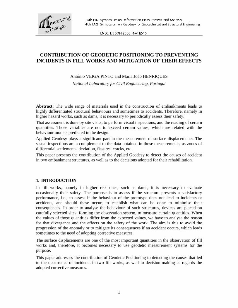
The observation plan was prepared on the basis of that prediction, with instruments being placed on the sites supposed to be the most critical ones. Especially, inclinometers were installed on the maximum cross-section (Figure 1), so as to be possible to draw conclusions about settlements occurred, even during the construction stage.
Figure 1 – Beliche Dam. Devices on the maximum cross-section
After the dam reached about half its height, it was observed that the vertical displacements measured in the inclinometers were fairly higher than the values predicted. Thus, when the dam was at about 70% of its final height (54m), a decision was made to perform a collapse test, in the summer of 1984, so as to prevent the rainfall from interfering with the test. The collapse corresponds to compressive volumetric deformations resulting from the increase in the water content exhibited by some fill materials when subject to stress (Maranha das Neves and Veiga Pinto, 1989).
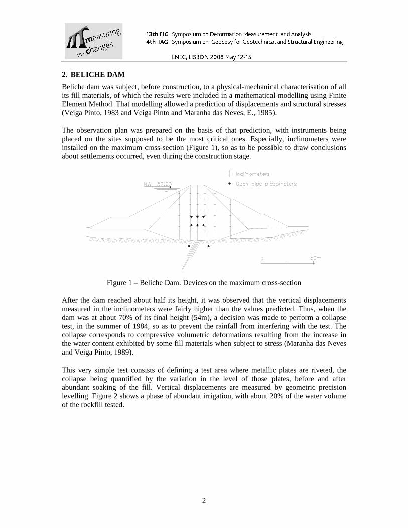
This very simple test consists of defining a test area where metallic plates are riveted, the collapse being quantified by the variation in the level of those plates, before and after abundant soaking of the fill. Vertical displacements are measured by geometric precision levelling. Figure 2 shows a phase of abundant irrigation, with about 20% of the water volume of the rockfill tested.
3
Figure 2 –Beliche Dam. Stage of abundant irrigation in the collapse test
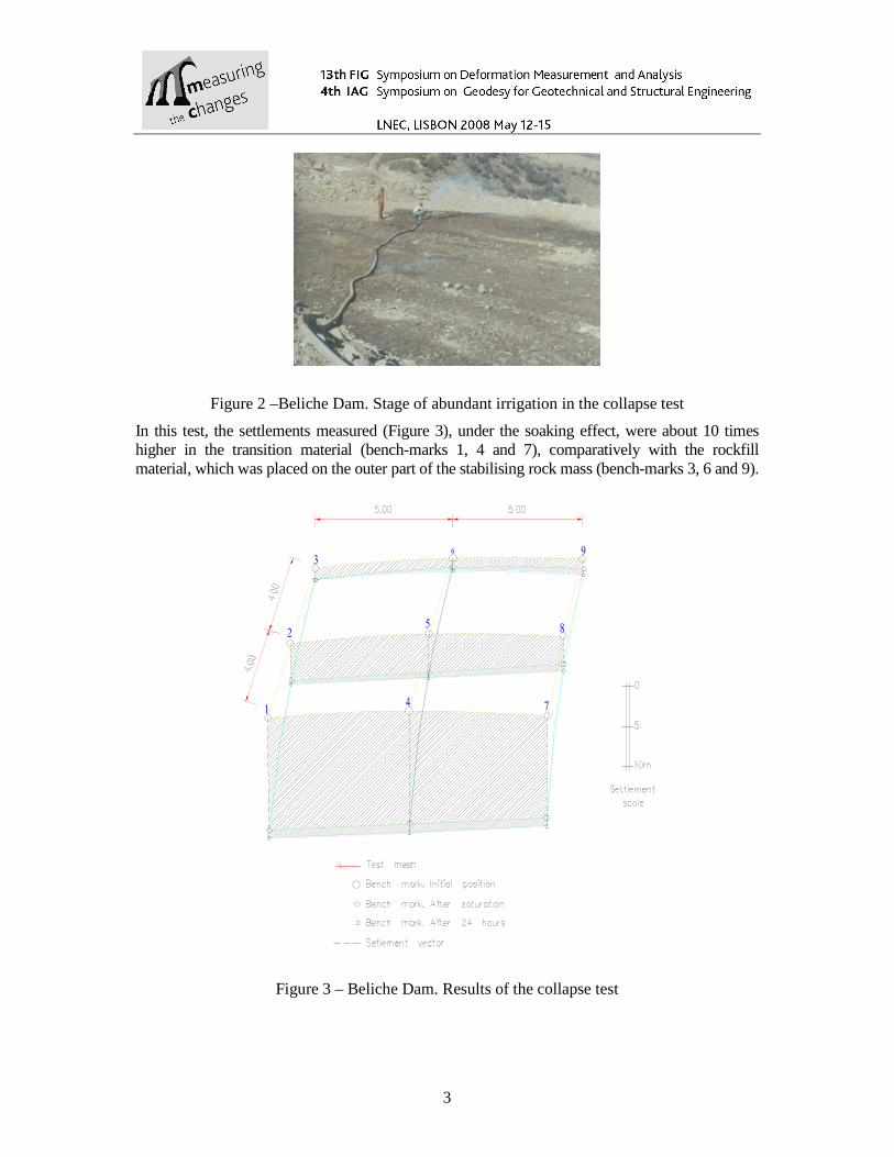
In this test, the settlements measured (Figure 3), under the soaking effect, were about 10 times higher in the transition material (bench-marks 1, 4 and 7), comparatively with the rockfill material, which was placed on the outer part of the stabilising rock mass (bench-marks 3, 6 and 9).
Figure 3 – Beliche Dam. Results of the collapse test
4
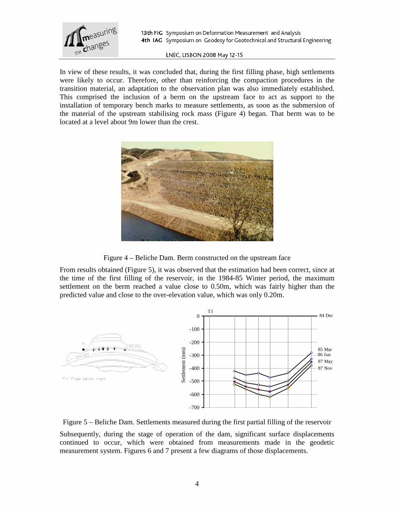
In view of these results, it was concluded that, during the first filling phase, high settlements were likely to occur. Therefore, other than reinforcing the compaction procedures in the transition material, an adaptation to the observation plan was also immediately established. This comprised the inclusion of a berm on the upstream face to act as support to the installation of temporary bench marks to measure settlements, as soon as the submersion of the material of the upstream stabilising rock mass (Figure 4) began. That berm was to be located at a level about 9m lower than the crest.
Figure 4 – Beliche Dam. Berm constructed on the upstream face
From results obtained (Figure 5), it was observed that the estimation had been correct, since at the time of the first filling of the reservoir, in the 1984-85 Winter period, the maximum settlement on the berm reached a value close to 0.50m, which was fairly higher than the predicted value and close to the over-elevation value, which was only 0.20m.
-700
-600
-500
-400
-300
-200
-100
0
Set
tlem
ent (
mm
)
.
T184 Dec
85 Mar
87 Nov
87 May
86 Jun
Figure 5 – Beliche Dam. Settlements measured during the first partial filling of the reservoir
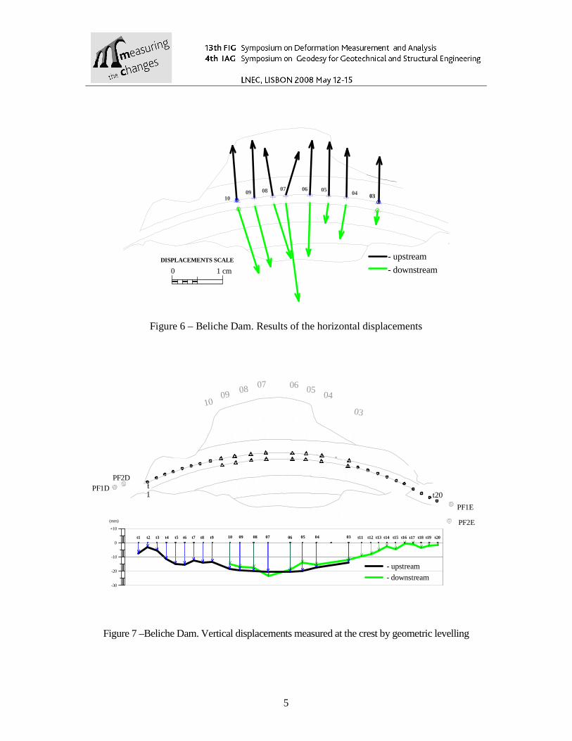
Subsequently, during the stage of operation of the dam, significant surface displacements continued to occur, which were obtained from measurements made in the geodetic measurement system. Figures 6 and 7 present a few diagrams of those displacements.
5
03040506070809
10
1 cm0
DISPLACEMENTS SCALE
- downstream
- upstream
Figure 6 – Beliche Dam. Results of the horizontal displacements
PF1DPF2D
t1 t20
PF1E
PF2E
1009 08 07 06 05
04
03
03050809 07 040610t6t5t4t3t2t1 t7 t8 t9 t20t17 t19t18t15t14t13t12t11 t16
- downstream
- upstream-10
-20
-30
0
+10
(mm)
Figure 7 –Beliche Dam. Vertical displacements measured at the crest by geometric levelling
6
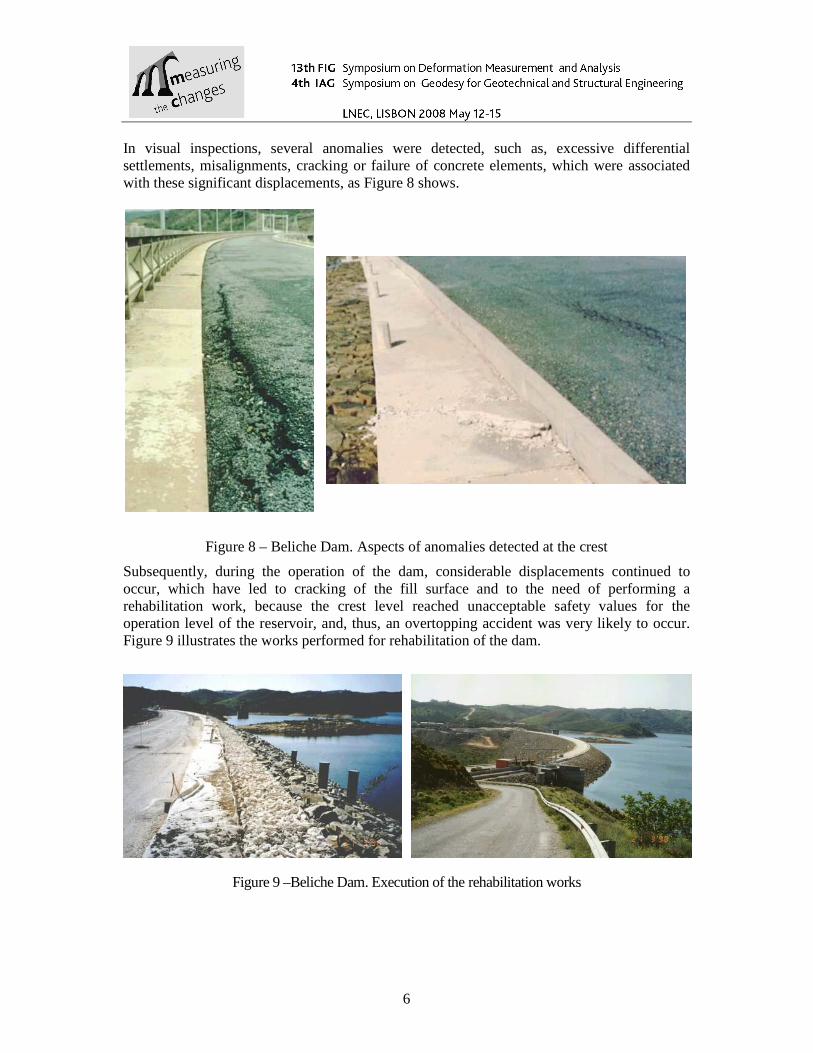
In visual inspections, several anomalies were detected, such as, excessive differential settlements, misalignments, cracking or failure of concrete elements, which were associated with these significant displacements, as Figure 8 shows.
Figure 8 – Beliche Dam. Aspects of anomalies detected at the crest
Subsequently, during the operation of the dam, considerable displacements continued to occur, which have led to cracking of the fill surface and to the need of performing a rehabilitation work, because the crest level reached unacceptable safety values for the operation level of the reservoir, and, thus, an overtopping accident was very likely to occur. Figure 9 illustrates the works performed for rehabilitation of the dam.
Figure 9 –Beliche Dam. Execution of the rehabilitation works
7
3. ABUTMENTS OF RIO SECO BRIDGE
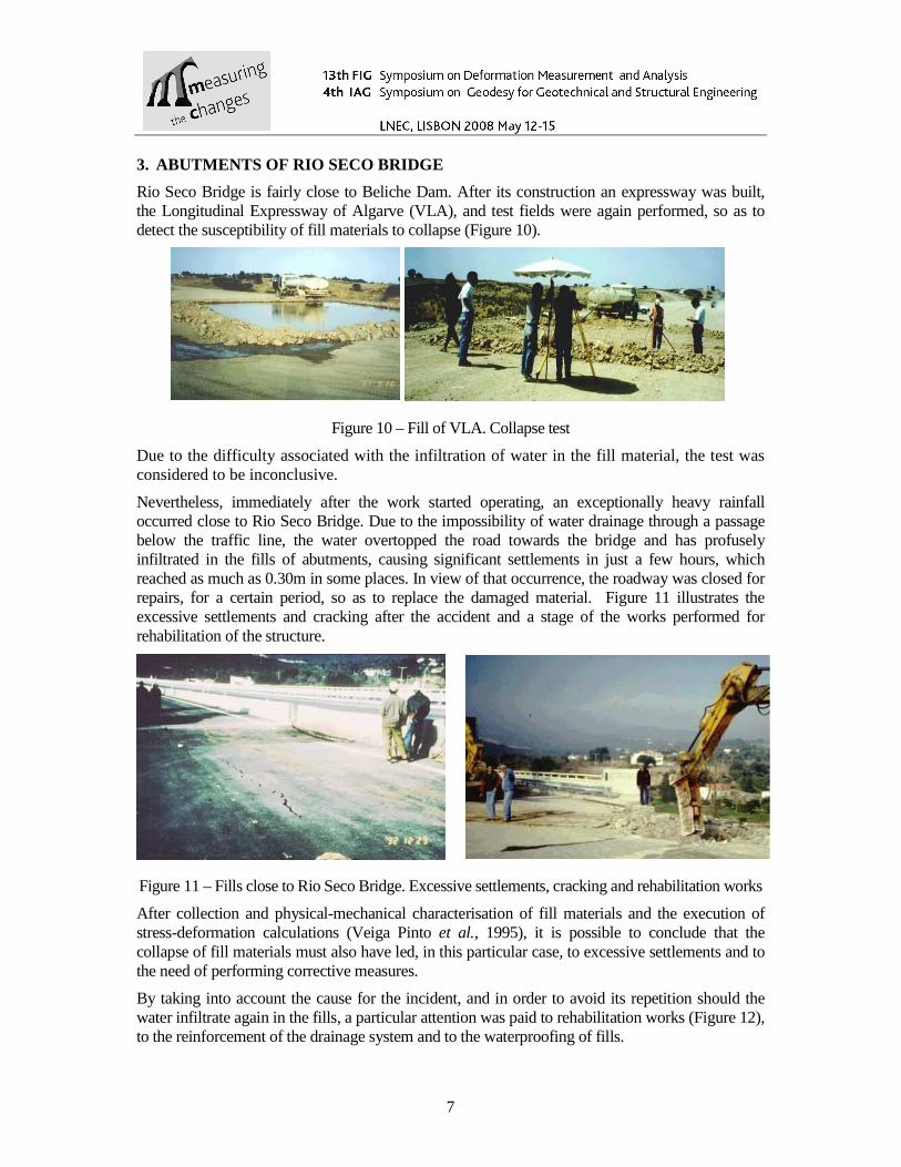
Rio Seco Bridge is fairly close to Beliche Dam. After its construction an expressway was built, the Longitudinal Expressway of Algarve (VLA), and test fields were again performed, so as to detect the susceptibility of fill materials to collapse (Figure 10).
Figure 10 – Fill of VLA. Collapse test
Due to the difficulty associated with the infiltration of water in the fill material, the test was considered to be inconclusive.
Nevertheless, immediately after the work started operating, an exceptionally heavy rainfall occurred close to Rio Seco Bridge. Due to the impossibility of water drainage through a passage below the traffic line, the water overtopped the road towards the bridge and has profusely infiltrated in the fills of abutments, causing significant settlements in just a few hours, which reached as much as 0.30m in some places. In view of that occurrence, the roadway was closed for repairs, for a certain period, so as to replace the damaged material. Figure 11 illustrates the excessive settlements and cracking after the accident and a stage of the works performed for rehabilitation of the structure.
Figure 11 – Fills close to Rio Seco Bridge. Excessive settlements, cracking and rehabilitation works
After collection and physical-mechanical characterisation of fill materials and the execution of stress-deformation calculations (Veiga Pinto et al., 1995), it is possible to conclude that the collapse of fill materials must also have led, in this particular case, to excessive settlements and to the need of performing corrective measures.
By taking into account the cause for the incident, and in order to avoid its repetition should the water infiltrate again in the fills, a particular attention was paid to rehabilitation works (Figure 12), to the reinforcement of the drainage system and to the waterproofing of fills.
8
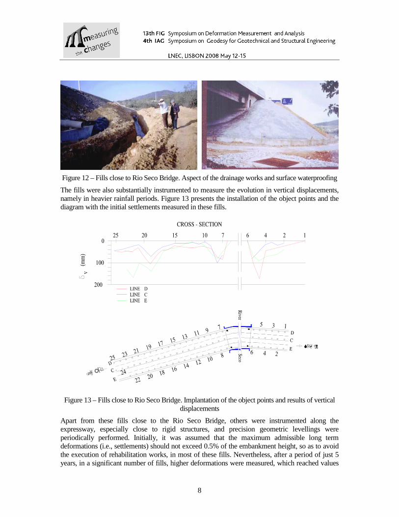
Figure 12 – Fills close to Rio Seco Bridge. Aspect of the drainage works and surface waterproofing
The fills were also substantially instrumented to measure the evolution in vertical displacements, namely in heavier rainfall periods. Figure 13 presents the installation of the object points and the diagram with the initial settlements measured in these fills.
�����
����
Figure 13 – Fills close to Rio Seco Bridge. Implantation of the object points and results of vertical displacements
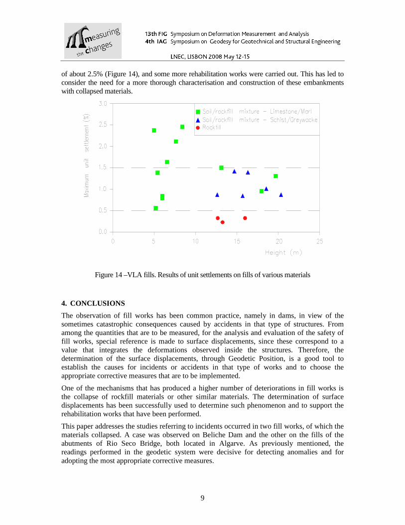
Apart from these fills close to the Rio Seco Bridge, others were instrumented along the expressway, especially close to rigid structures, and precision geometric levellings were periodically performed. Initially, it was assumed that the maximum admissible long term deformations (i.e., settlements) should not exceed 0.5% of the embankment height, so as to avoid the execution of rehabilitation works, in most of these fills. Nevertheless, after a period of just 5 years, in a significant number of fills, higher deformations were measured, which reached values
9
of about 2.5% (Figure 14), and some more rehabilitation works were carried out. This has led to consider the need for a more thorough characterisation and construction of these embankments with collapsed materials.
Figure 14 –VLA fills. Results of unit settlements on fills of various materials
4. CONCLUSIONS
The observation of fill works has been common practice, namely in dams, in view of the sometimes catastrophic consequences caused by accidents in that type of structures. From among the quantities that are to be measured, for the analysis and evaluation of the safety of fill works, special reference is made to surface displacements, since these correspond to a value that integrates the deformations observed inside the structures. Therefore, the determination of the surface displacements, through Geodetic Position, is a good tool to establish the causes for incidents or accidents in that type of works and to choose the appropriate corrective measures that are to be implemented.
One of the mechanisms that has produced a higher number of deteriorations in fill works is the collapse of rockfill materials or other similar materials. The determination of surface displacements has been successfully used to determine such phenomenon and to support the rehabilitation works that have been performed.
This paper addresses the studies referring to incidents occurred in two fill works, of which the materials collapsed. A case was observed on Beliche Dam and the other on the fills of the abutments of Rio Seco Bridge, both located in Algarve. As previously mentioned, the readings performed in the geodetic system were decisive for detecting anomalies and for adopting the most appropriate corrective measures.
10
References
Veiga Pinto, A. (1983). Structural behaviour predictions of rockfill dams, Thesis, LNEC, Lisbon, 1-157 (In Portuguese).
Veiga Pinto, A. and Maranha das Neves, E. (1985). Prediction of Beliche Dam behaviour during reservoir filling, 11th Int. Congress on Soil Mechanics. and Foundations. Engineering, San Francisco, 2021-2024.
Maranha das Neves, E. e Veiga Pinto, A. (1989). Collapse of rockfill, 12th Int. Cong. on Soil Mech. and Found. Eng., Vol. 1, Rio de Janeiro, 735-738.
Veiga Pinto, A.; Papadimitropoulos, I. and Prates, M. (1995). The failure of two approach embankments of the bridge over Rio Seco, Proc. 12º ECSMFE, Vol. 8, Copenhagen, 137-142.
Corresponding author contacts António VEIGA PINTO
[email protected] Geotechnique Department, National Laboratory for Civil Engineering Portugal