CONTENTS - MMR-HCS
61
CONTENTS Introduction 1 Assignment Background Objective Coverage of the assignment Scope of work Ward wise Summary of Heritage Buildings and Precincts 3 Summary of Building Typologies: 4 Task III and Task IV Summary of Architectural styles: 6 Task III and Task IV Summary of Grading: 8 Task III and Task IV Ward wise summary of Grading: 9 Task III and Task IV Ward wise classification: Ward A to Ward G north 26 Brief Note Historical Localities Boundaries Broad Ethnic Composition Economic Composition Important Building Typologies Important Roads Important Railway Stations Architectural styles Highlights of the Ward Criteria for Listing and Grading: 49 emerged during Output III meeting Issues: 50 Emerged during the Listing Process Annexures 52 Grading: Definitions as per Regulation 67 Notes on Architectural styles Notes on Heritage values List of reference books
-
Upload
khangminh22 -
Category
Documents
-
view
0 -
download
0
Transcript of CONTENTS - MMR-HCS
CONTENTS
Introduction 1 Assignment Background Objective Coverage of the assignment Scope of work
Ward wise Summary of Heritage Buildings and Precincts 3
Summary of Building Typologies: 4 Task III and Task IV
Summary of Architectural styles: 6 Task III and Task IV
Summary of Grading: 8 Task III and Task IV
Ward wise summary of Grading: 9 Task III and Task IV
Ward wise classification: Ward A to Ward G north 26 Brief Note Historical Localities Boundaries Broad Ethnic Composition Economic Composition Important Building Typologies Important Roads Important Railway Stations Architectural styles Highlights of the Ward
Criteria for Listing and Grading: 49 emerged during Output III meeting
Issues: 50 Emerged during the Listing Process
Annexures 52 Grading: Definitions as per Regulation 67 Notes on Architectural styles Notes on Heritage values List of reference books
1
FINAL REPORT OF THE FRESH LISTING AND GRADING OF
HERITAGE BUILDINGS IN THE ISLAND CITY
INTRODUCTION:
The city of Mumbai has afforded a strong cultural and architectural mix, due to the historical
process of its development and its geographical location. People moved in from many parts of
the country, and one could say, the world. They brought with them their languages, their
festivals and culture and their architecture. The city never dominated with one strong
language or culture on its multifarious population, and hence it became the cauldron of many
and never the empire of one!
The colonial city of Bombay was marked by planned segregation under the imperial rule. The
southern tip of the land was fortified to create an insulated territory for the Colonial rulers. The
northern part within the fortification included the elite ‘native’ Indians where as the white-collar
workers and the working class lived outside the Fort walls in largely congested areas further
segregated by class and regional identities. A journey from the southern tip of Mumbai, past
the typologies of Gothic monuments, Neo–classical avenues and Art Deco residential
precincts of the prosperous, to the central part of the city where textile mills are located
seems to transport us is into a different city altogether.
One can study or simply walk through the city, where types and types of buildings tell you
about the migration patterns that the city grew with. Initially as a major trading port, the city
flourished as a commercial centre on the strong foundation of industrial base. The industrial
architecture created the skyline of the city by occupying the heart of the city. Towards south
there are buildings that look like havelis from Rajasthan or the pols of Gujarat. While Neo-
Classical elements dot many buildings in Fort and other areas, timber craftsmanship of
Gujarat is distinguishable from very functional working class chawls which proudly display
their road facing facades decorated with Neo–classical ornamentation. Just as the
architecture exemplifies the migrational mix in this city, it also often tells us about the class
associations that existed in the city.
Today as we look at the city it becomes for us a literal historical record. Conservation is not to
nostalgically praise architectural elements or styles but to understand the wealth of
information embedded in the corners of this city. Conservation implies that it is not just the
building as an isolated object but the people and communities that live in and around it, that
need to be recorded and conserved in memory. At present Mumbai is going through
confusing and cataclysmic changes in its drive for recasting itself as a world class metropolis.
However the race towards globalization raises important issues regarding the role of heritage
and history in planning the future of the cities.
2
The Assignment:
The assignment comprises of fresh listing and identifying Buildings / Structures / Sites and
Precincts of Heritage significance in Wards A, B, C, D, E, F north,
F south, G north and G south.
Background:
The Municipal Corporation of Greater Mumbai in 1995 formulated Heritage Regulations for
Greater Bombay, by modifying the draft Development Control Rules no. 67 and 68. A List of
Heritage Buildings and Precincts of historical, aesthetical, architectural and cultural values
was prepared. However, the list is found to be inadequate, qualitatively and quantitatively.
As a result the Mumbai Heritage Conservation Committee of Municipal Corporation of Greater
Mumbai requested the MMR-Heritage Conservation Society to a) Review the existing list and
b) undertake fresh listing in the Island City and Suburbs.
Objective:
The objective of this assignment is to develop a comprehensive and accurate inventory of
Buildings / Structures / Sites and Precincts of heritage significance in Greater Mumbai. This
inventory in the form of the heritage list would be formatted for easy and well-structured
referencing for development permissions. This list will be considered by the Mumbai Heritage
Conservation Committee of the Municipal Corporation of Greater Mumbai.
Coverage of the assignment:
The consultancy assignment shall cover the following ward: Wards A, B, C, D, E, F south, F
north, G south and G north including sites already identified by MMR HCS through its
projects.
Scope of Work:
The scope of work for preparation of additional list of Heritage Buildings and Precincts in the
Island city of Mumbai is as follows:
a) To undertake fresh exercise of listing and identifying buildings / structures / sites and
precincts of heritage significance.
b) To identify areas with cohesive significance or group value worthy of defining as heritage
precincts.
c) To propose designation of heritage precincts with proper demarcation of boundaries,
specifying the nature of existing pattern of buildings therein.
3
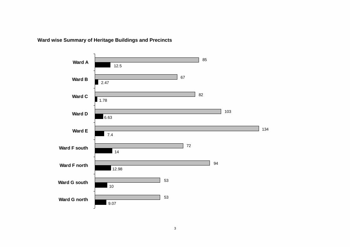
Ward wise Summary of Heritage Buildings and Precincts
12.5
2.47
1.78
6.63
7.4
14
12.98
10
9.07
85
67
82
103
134
72
94
53
53Ward G north
Ward G south
Ward F north
Ward F south
Ward E
Ward D
Ward C
Ward B
Ward A
4
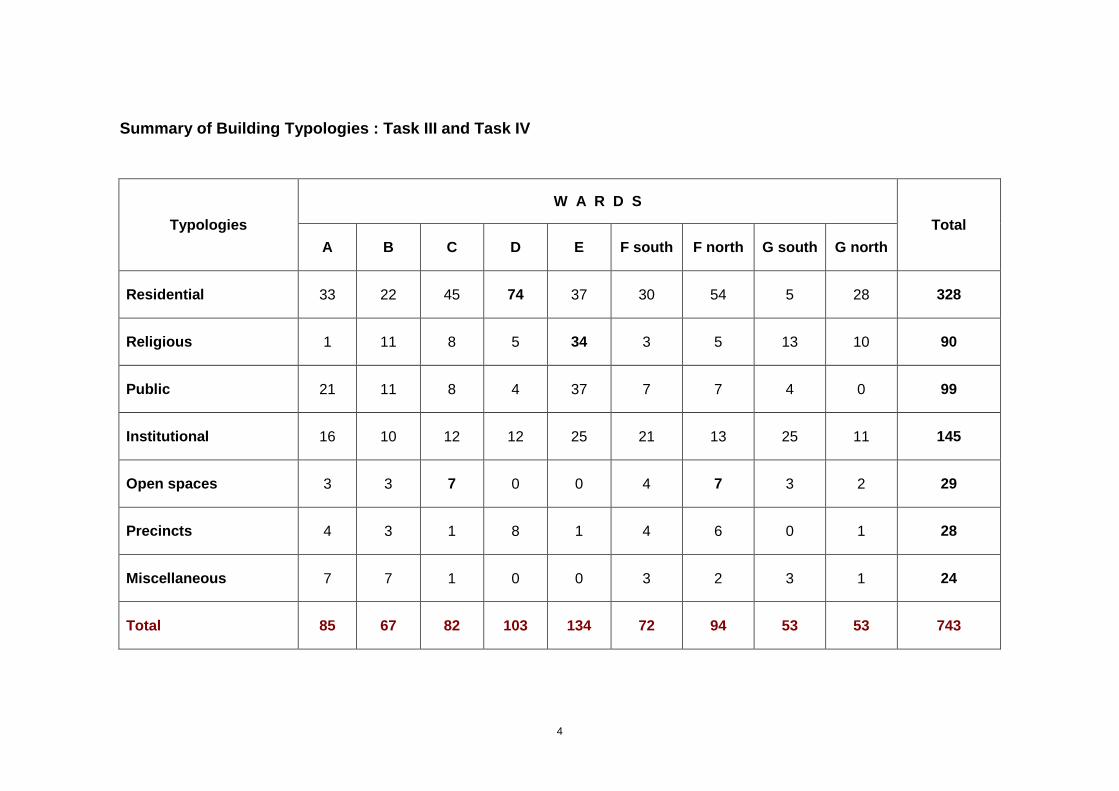
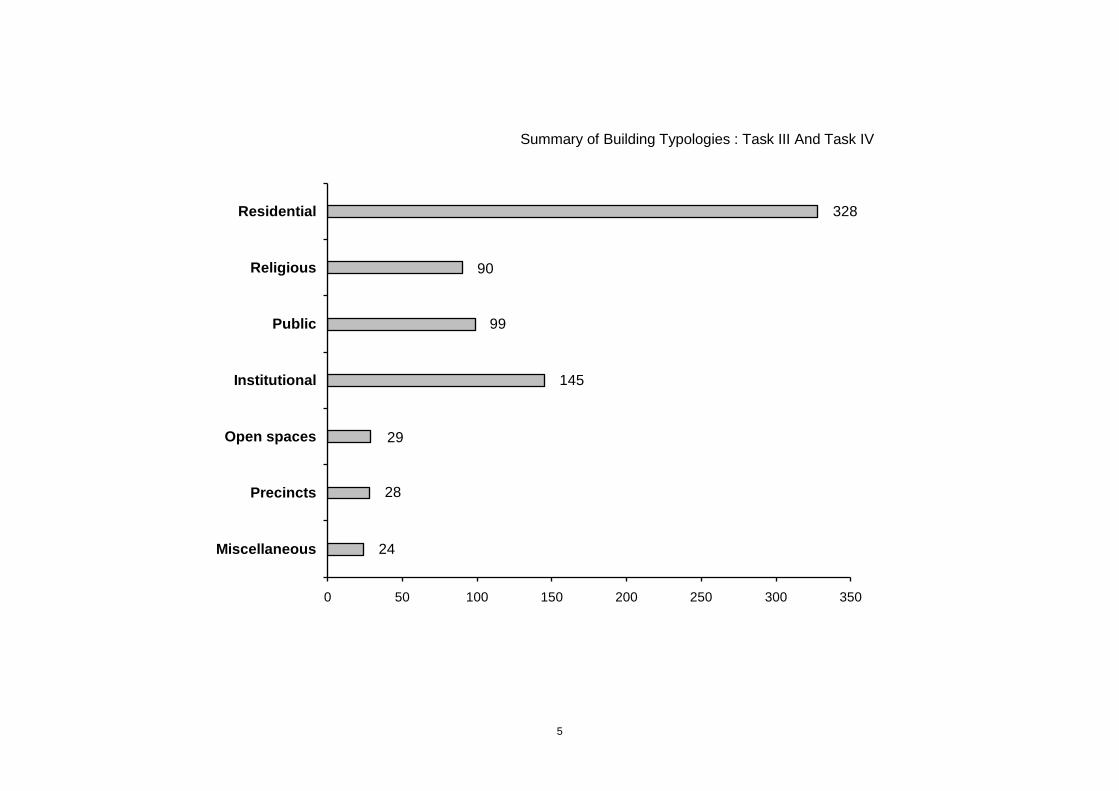
Summary of Building Typologies : Task III and Task IV
Typologies
W A R D S
Total
A B C D E F south F north G south G north
Residential 33 22 45 74 37 30 54 5 28 328
Religious 1 11 8 5 34 3 5 13 10 90
Public 21 11 8 4 37 7 7 4 0 99
Institutional 16 10 12 12 25 21 13 25 11 145
Open spaces 3 3 7 0 0 4 7 3 2 29
Precincts 4 3 1 8 1 4 6 0 1 28
Miscellaneous 7 7 1 0 0 3 2 3 1 24
Total 85 67 82 103 134 72 94 53 53 743
5
Summary of Building Typologies : Task III And Task IV
328
90
99
145
29
28
24
0 50 100 150 200 250 300 350
Miscellaneous
Precincts
Open spaces
Institutional
Public
Religious
Residential
6
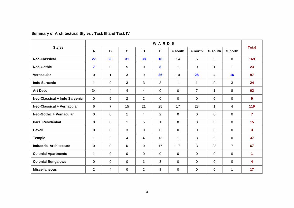
Summary of Architectural Styles : Task III and Task IV
Styles W A R D S
Total A B C D E F south F north G south G north
Neo-Classical 27 23 31 38 18 14 5 5 8 169
Neo-Gothic 7 0 5 0 8 1 0 1 1 23
Vernacular 0 1 3 9 26 10 28 4 16 97
Indo Sarcenic 1 9 3 3 3 1 1 0 3 24
Art Deco 34 4 4 4 0 0 7 1 8 62
Neo-Classical + Indo Sarcenic 0 5 2 2 0 0 0 0 0 9
Neo-Classical + Vernacular 6 7 15 21 25 17 23 1 4 119
Neo-Gothic + Vernacular 0 0 1 4 2 0 0 0 0 7
Parsi Residential 0 0 1 5 1 0 8 0 0 15
Haveli 0 0 3 0 0 0 0 0 0 3
Temple 1 2 4 4 13 1 3 9 0 37
Industrial Architecture 0 0 0 0 17 17 3 23 7 67
Colonial Apartments 1 0 0 0 0 0 0 0 0 1
Colonial Bungalows 0 0 0 1 3 0 0 0 0 4
Miscellaneous 2 4 0 2 8 0 0 0 1 17

7
17
3
2
36
28
3
15
7
119
9
57
18
99
22
168
0 20 40 60 80 100 120 140 160 180
Miscellaneous
Colonial Bungalows
Colonial Apartment
Industrial Architecture
Temple
Haveli
Parsi Residential
Neo-Gothic + Vernacular
Neo-Classical + Vernacular
Neo-Classical + Indo Sarcenic
Art Deco
Indo Sarcenic
Vernacular
Neo-Gothic
Neo-Classical
Summary of Architectural Styles : Task III And Task IV
8
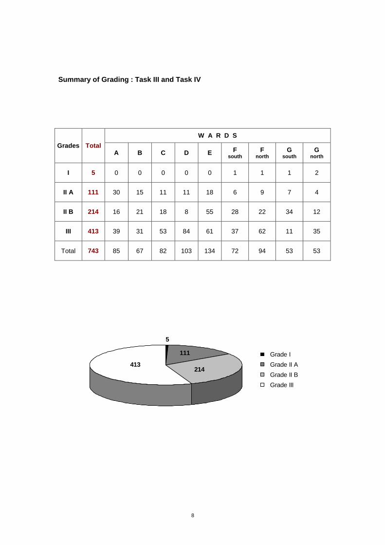
Summary of Grading : Task III and Task IV
Grades Total
W A R D S
A B C D E F south
F north
G south
G north
I 5 0 0 0 0 0 1 1 1 2
II A 111 30 15 11 11 18 6 9 7 4
II B 214 16 21 18 8 55 28 22 34 12
III 413 39 31 53 84 61 37 62 11 35
Total 743 85 67 82 103 134 72 94 53 53
5
111
214413
Grade I
Grade II A
Grade II B
Grade III
9
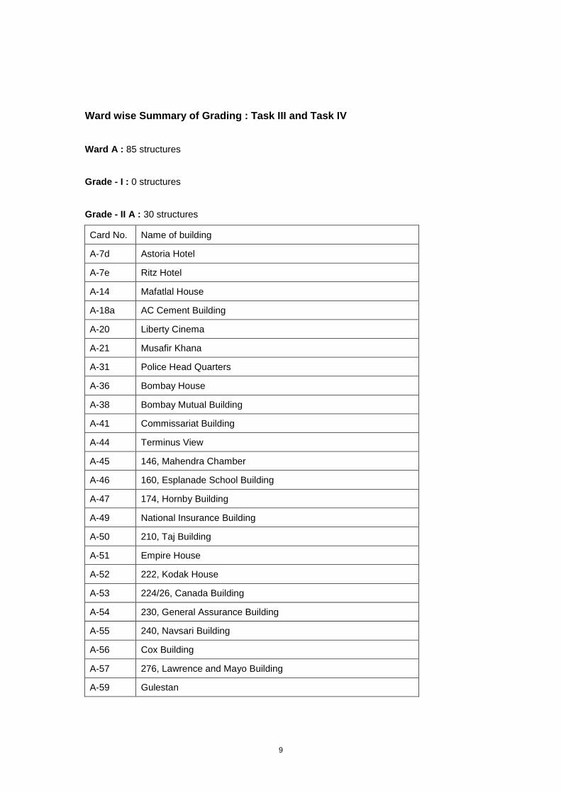
Ward wise Summary of Grading : Task III and Task IV
Ward A : 85 structures
Grade - I : 0 structures
Grade - II A : 30 structures
Card No. Name of building
A-7d Astoria Hotel
A-7e Ritz Hotel
A-14 Mafatlal House
A-18a AC Cement Building
A-20 Liberty Cinema
A-21 Musafir Khana
A-31 Police Head Quarters
A-36 Bombay House
A-38 Bombay Mutual Building
A-41 Commissariat Building
A-44 Terminus View
A-45 146, Mahendra Chamber
A-46 160, Esplanade School Building
A-47 174, Hornby Building
A-49 National Insurance Building
A-50 210, Taj Building
A-51 Empire House
A-52 222, Kodak House
A-53 224/26, Canada Building
A-54 230, General Assurance Building
A-55 240, Navsari Building
A-56 Cox Building
A-57 276, Lawrence and Mayo Building
A-59 Gulestan

10
A-60 9, Wallace Street / Commercial Union House
A-61 Jiji House
A-68 Seth Mancherji Khurshedji Langdana Agiary
A-70 Eros Cinema
A-71 Regal Cinema
A-74 Indira Dock
Grade - II B : 16 structures
Card No. Name of building
A-6 Colaba Vanashree
A-8 Cricket Club Pavilion, Cricket Club of India
A-11 Mantralaya
A-15 Mantralaya Municipal Park
A-17 Sydneham College
A-18c Aaykar Bhavan
A-23 Marine Drive Water front
A-30 Sorabjee Shapurjee Bengalee (CIE)
A-32 Children’s Traffic Training Park
A-58 J.B. Petit School for Girls
A-62 Cross Maidan
A-63 Statue of Mahadev Govind Ranade
A-64 Statue of Sir Jamshedji Jeejeebhoy (First Baronet)
A-65 Statue of Gopal Krishna Gokhale C.I.E.
A-66 Statue of Hormusjee Cawasjee Dinshaw of Aden
A-67 Statue of Sir Dinsha Edulji Wacha
Grade – III : 39 structures
11
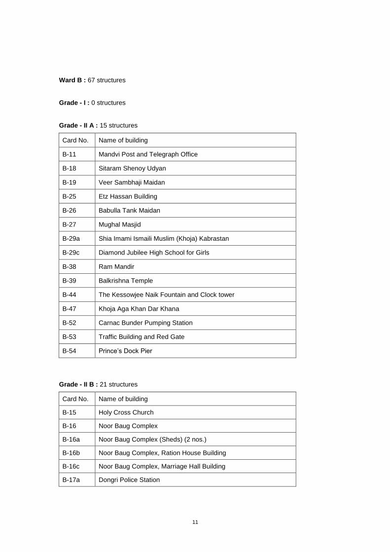
Ward B : 67 structures
Grade - I : 0 structures
Grade - II A : 15 structures
Card No. Name of building
B-11 Mandvi Post and Telegraph Office
B-18 Sitaram Shenoy Udyan
B-19 Veer Sambhaji Maidan
B-25 Etz Hassan Building
B-26 Babulla Tank Maidan
B-27 Mughal Masjid
B-29a Shia Imami Ismaili Muslim (Khoja) Kabrastan
B-29c Diamond Jubilee High School for Girls
B-38 Ram Mandir
B-39 Balkrishna Temple
B-44 The Kessowjee Naik Fountain and Clock tower
B-47 Khoja Aga Khan Dar Khana
B-52 Carnac Bunder Pumping Station
B-53 Traffic Building and Red Gate
B-54 Prince’s Dock Pier
Grade - II B : 21 structures
Card No. Name of building
B-15 Holy Cross Church
B-16 Noor Baug Complex
B-16a Noor Baug Complex (Sheds) (2 nos.)
B-16b Noor Baug Complex, Ration House Building
B-16c Noor Baug Complex, Marriage Hall Building
B-17a Dongri Police Station
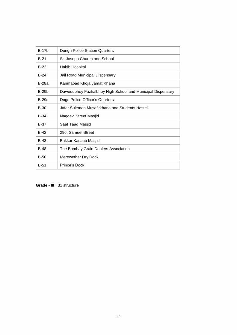
12
B-17b Dongri Police Station Quarters
B-21 St. Joseph Church and School
B-22 Habib Hospital
B-24 Jail Road Municipal Dispensary
B-28a Karimabad Khoja Jamat Khana
B-29b Dawoodbhoy Fazhalbhoy High School and Municipal Dispensary
B-29d Dogri Police Officer’s Quarters
B-30 Jafar Suleman Musafirkhana and Students Hostel
B-34 Nagdevi Street Masjid
B-37 Saat Taad Masjid
B-42 296, Samuel Street
B-43 Bakkar Kasaab Masjid
B-48 The Bombay Grain Dealers Association
B-50 Merewether Dry Dock
B-51 Prince’s Dock
Grade - III : 31 structure
13
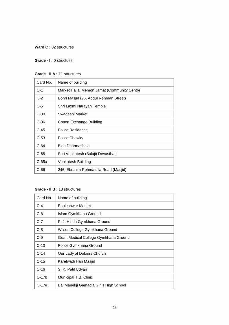
Ward C : 82 structures
Grade - I : 0 structues
Grade - II A : 11 structures
Card No. Name of building
C-1 Market Hallai Memon Jamat (Community Centre)
C-2 Bohri Masjid (96, Abdul Rehman Street)
C-5 Shri Laxmi Narayan Temple
C-30 Swadeshi Market
C-36 Cotton Exchange Building
C-45 Police Residence
C-53 Police Chowky
C-64 Birla Dharmashala
C-65 Shri Venkatesh (Balaji) Devasthan
C-65a Venkatesh Building
C-66 246, Ebrahim Rehmatulla Road (Masjid)
Grade - II B : 18 structures
Card No. Name of building
C-4 Bhuleshwar Market
C-6 Islam Gymkhana Ground
C-7 P. J. Hindu Gymkhana Ground
C-8 Wilson College Gymkhana Ground
C-9 Grant Medical College Gymkhana Ground
C-10 Police Gymkhana Ground
C-14 Our Lady of Dolours Church
C-15 Karelwadi Hari Masjid
C-16 S. K. Patil Udyan
C-17b Municipal T.B. Clinic
C-17e Bai Manekji Gamadia Girl's High School
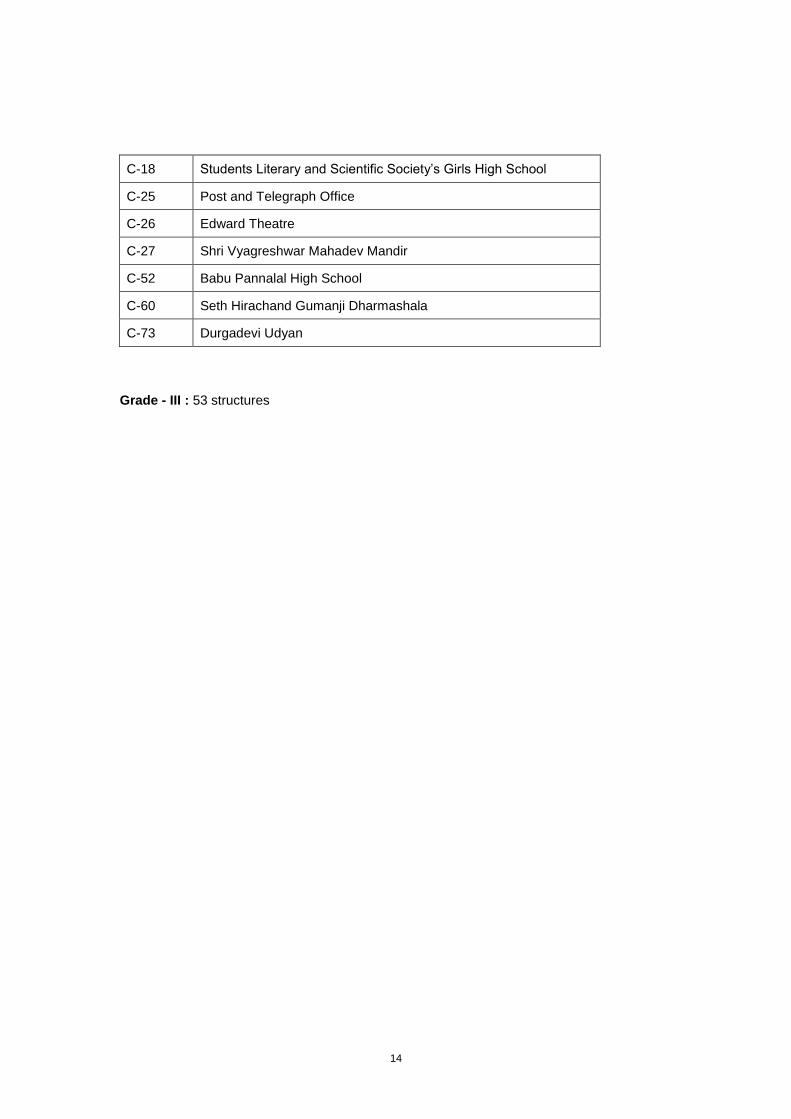
14
C-18 Students Literary and Scientific Society’s Girls High School
C-25 Post and Telegraph Office
C-26 Edward Theatre
C-27 Shri Vyagreshwar Mahadev Mandir
C-52 Babu Pannalal High School
C-60 Seth Hirachand Gumanji Dharmashala
C-73 Durgadevi Udyan
Grade - III : 53 structures
15
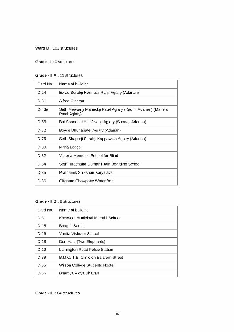
Ward D : 103 structures
Grade - I : 0 structures
Grade - II A : 11 structures
Card No. Name of building
D-24 Evrad Sorabji Hormusji Ranji Agiary (Adarian)
D-31 Alfred Cinema
D-43a Seth Merwanji Maneckji Patel Agiary (Kadmi Adarian) (Mahela Patel Agiary)
D-66 Bai Soonabai Hirji Jivanji Agiary (Soonaji Adarian)
D-72 Boyce Dhunapatel Agiary (Adarian)
D-75 Seth Shapurji Sorabji Kappawala Agairy (Adarian)
D-80 Mitha Lodge
D-82 Victoria Memorial School for Blind
D-84 Seth Hirachand Gumanji Jain Boarding School
D-85 Prathamik Shikshan Karyalaya
D-86 Girgaum Chowpatty Water front
Grade - II B : 8 structures
Card No. Name of building
D-3 Khetwadi Municipal Marathi School
D-15 Bhagini Samaj
D-16 Vanita Vishram School
D-18 Don Hatti (Two Elephants)
D-19 Lamington Road Police Station
D-39 B.M.C. T.B. Clinic on Balaram Street
D-55 Wilson College Students Hostel
D-56 Bhartiya Vidya Bhavan
Grade - III : 84 structures
16
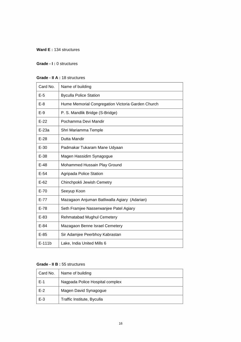
Ward E : 134 structures
Grade - I : 0 structures
Grade - II A : 18 structures
Card No. Name of building
E-5 Byculla Police Station
E-8 Hume Memorial Congregation Victoria Garden Church
E-9 P. S. Mandlik Bridge (S-Bridge)
E-22 Pochamma Devi Mandir
E-23a Shri Mariamma Temple
E-28 Dutta Mandir
E-30 Padmakar Tukaram Mane Udyaan
E-38 Magen Hassidim Synagogue
E-48 Mohammed Hussain Play Ground
E-54 Agripada Police Station
E-62 Chinchpokli Jewish Cemetry
E-70 Seeyup Koon
E-77 Mazagaon Anjuman Batliwalla Agiary (Adarian)
E-78 Seth Framjee Nasserwanjee Patel Agiary
E-83 Rehmatabad Mughul Cemetery
E-84 Mazagaon Benne Israel Cemetery
E-85 Sir Adamjee Peerbhoy Kabrastan
E-111b Lake, India United Mills 6
Grade - II B : 55 structures
Card No. Name of building
E-1 Nagpada Police Hospital complex
E-2 Magen David Synagogue
E-3 Traffic Institute, Byculla
17
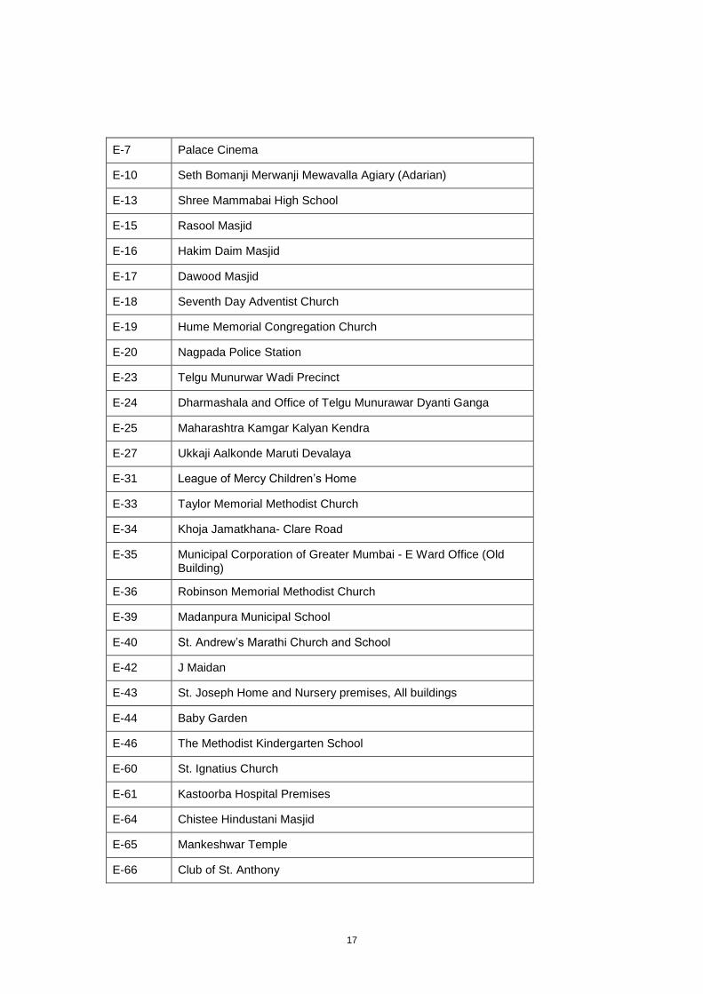
E-7 Palace Cinema
E-10 Seth Bomanji Merwanji Mewavalla Agiary (Adarian)
E-13 Shree Mammabai High School
E-15 Rasool Masjid
E-16 Hakim Daim Masjid
E-17 Dawood Masjid
E-18 Seventh Day Adventist Church
E-19 Hume Memorial Congregation Church
E-20 Nagpada Police Station
E-23 Telgu Munurwar Wadi Precinct
E-24 Dharmashala and Office of Telgu Munurawar Dyanti Ganga
E-25 Maharashtra Kamgar Kalyan Kendra
E-27 Ukkaji Aalkonde Maruti Devalaya
E-31 League of Mercy Children’s Home
E-33 Taylor Memorial Methodist Church
E-34 Khoja Jamatkhana- Clare Road
E-35 Municipal Corporation of Greater Mumbai - E Ward Office (Old Building)
E-36 Robinson Memorial Methodist Church
E-39 Madanpura Municipal School
E-40 St. Andrew’s Marathi Church and School
E-42 J Maidan
E-43 St. Joseph Home and Nursery premises, All buildings
E-44 Baby Garden
E-46 The Methodist Kindergarten School
E-60 St. Ignatius Church
E-61 Kastoorba Hospital Premises
E-64 Chistee Hindustani Masjid
E-65 Mankeshwar Temple
E-66 Club of St. Anthony
18
E-74 Chief Mechanical Engineer Office
E-75 Joseph Baptista Gardens / Bhandarwada Reservoir
E-76 Gramodyog Wadi
E-81 Mankeshwar Temple Precinct
E-82 Matar Pacady Club
E-86 Hasnabad (with Gate)
E-94b St. Mary’s school – North and East wing (St. Anne’s Church, St. Mary’s School premises)
E-94c St. Mary’s school – South wing, Brick building (St. Anne’s Church, St. Mary’s School premises)
E-94d St. Mary’s school – South wing stone building (St. Anne’s Church, St. Mary’s School premises)
E-98 Balaji Hospital
E-105 Ghodapdev Mandir
E-106 Rodef Shalom
E-110 New Hind Textile Mills
E-110a Chimney, New Hind Textile Mills
E-111 India United Mills No. 5
E-111a Chimney, India United Mills 5
E-112 India United Mills No. 4
E-113 India United Mills No. 2 and 3
E-113b Ring Structure, Structure no 14, India United Mills 2 & 3
E-113c Semi Auto loom and Sizing department, Structure no. 16, India United Mills 2 & 3
E-113d Spinning, structure no. 19, India United Mills 2 & 3
E-113e Time office, structure no 17, India United Mills No. 2 and 3
E-114 New City of Bombay Mills
Grade - III : 61 structures
19
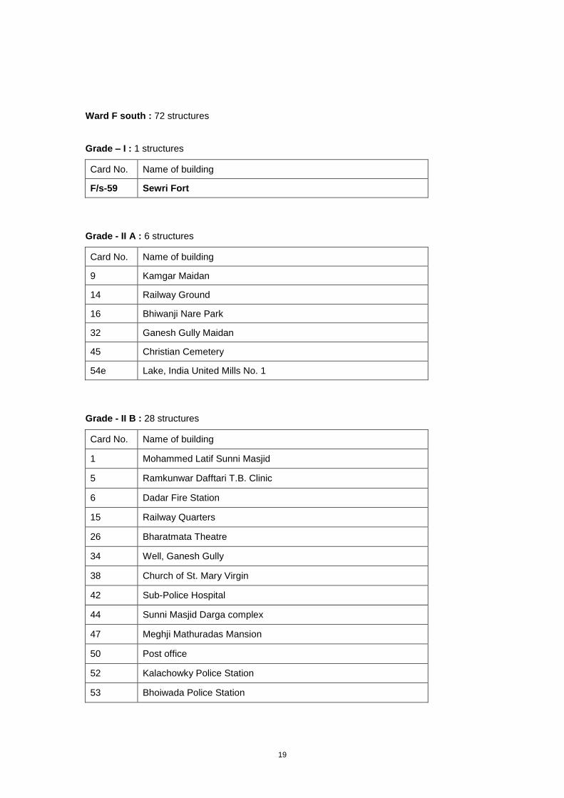
Ward F south : 72 structures
Grade – I : 1 structures
Card No. Name of building
F/s-59 Sewri Fort
Grade - II A : 6 structures
Card No. Name of building
9 Kamgar Maidan
14 Railway Ground
16 Bhiwanji Nare Park
32 Ganesh Gully Maidan
45 Christian Cemetery
54e Lake, India United Mills No. 1
Grade - II B : 28 structures
Card No. Name of building
1 Mohammed Latif Sunni Masjid
5 Ramkunwar Dafftari T.B. Clinic
6 Dadar Fire Station
15 Railway Quarters
26 Bharatmata Theatre
34 Well, Ganesh Gully
38 Church of St. Mary Virgin
42 Sub-Police Hospital
44 Sunni Masjid Darga complex
47 Meghji Mathuradas Mansion
50 Post office
52 Kalachowky Police Station
53 Bhoiwada Police Station
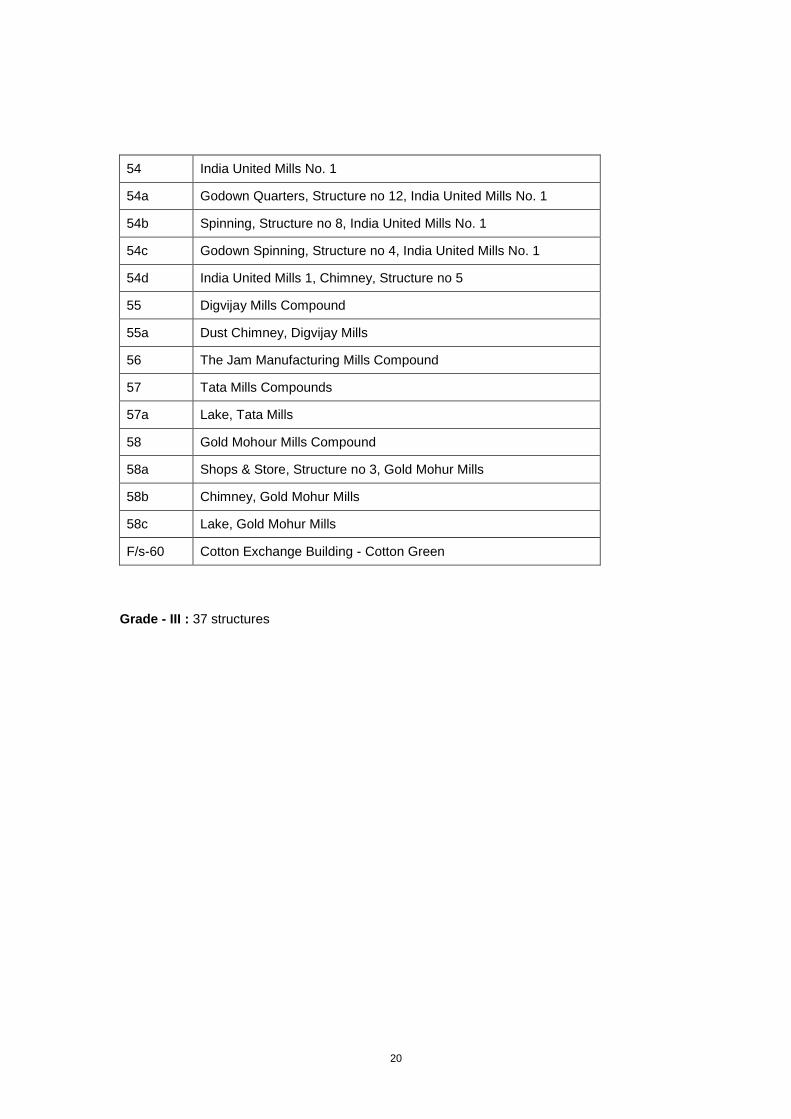
20
54 India United Mills No. 1
54a Godown Quarters, Structure no 12, India United Mills No. 1
54b Spinning, Structure no 8, India United Mills No. 1
54c Godown Spinning, Structure no 4, India United Mills No. 1
54d India United Mills 1, Chimney, Structure no 5
55 Digvijay Mills Compound
55a Dust Chimney, Digvijay Mills
56 The Jam Manufacturing Mills Compound
57 Tata Mills Compounds
57a Lake, Tata Mills
58 Gold Mohour Mills Compound
58a Shops & Store, Structure no 3, Gold Mohur Mills
58b Chimney, Gold Mohur Mills
58c Lake, Gold Mohur Mills
F/s-60 Cotton Exchange Building - Cotton Green
Grade - III : 37 structures
21
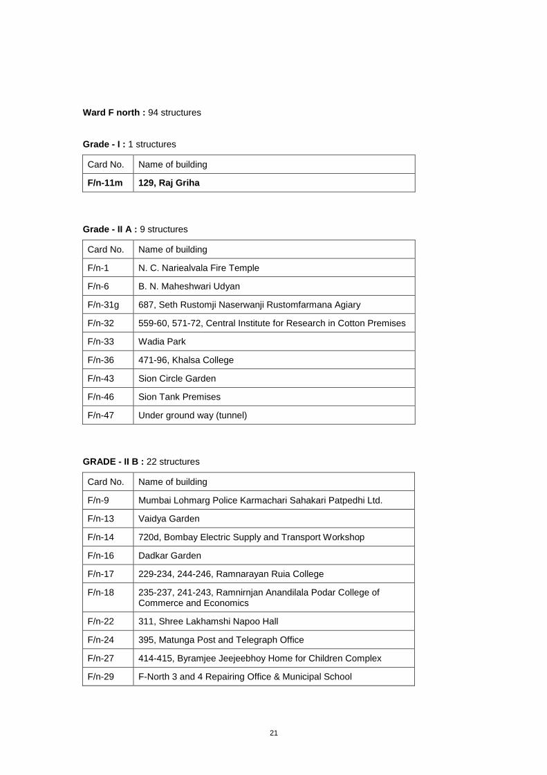
Ward F north : 94 structures
Grade - I : 1 structures
Card No. Name of building
F/n-11m 129, Raj Griha
Grade - II A : 9 structures
Card No. Name of building
F/n-1 N. C. Nariealvala Fire Temple
F/n-6 B. N. Maheshwari Udyan
F/n-31g 687, Seth Rustomji Naserwanji Rustomfarmana Agiary
F/n-32 559-60, 571-72, Central Institute for Research in Cotton Premises
F/n-33 Wadia Park
F/n-36 471-96, Khalsa College
F/n-43 Sion Circle Garden
F/n-46 Sion Tank Premises
F/n-47 Under ground way (tunnel)
GRADE - II B : 22 structures
Card No. Name of building
F/n-9 Mumbai Lohmarg Police Karmachari Sahakari Patpedhi Ltd.
F/n-13 Vaidya Garden
F/n-14 720d, Bombay Electric Supply and Transport Workshop
F/n-16 Dadkar Garden
F/n-17 229-234, 244-246, Ramnarayan Ruia College
F/n-18 235-237, 241-243, Ramnirnjan Anandilala Podar College of Commerce and Economics
F/n-22 311, Shree Lakhamshi Napoo Hall
F/n-24 395, Matunga Post and Telegraph Office
F/n-27 414-415, Byramjee Jeejeebhoy Home for Children Complex
F/n-29 F-North 3 and 4 Repairing Office & Municipal School
22
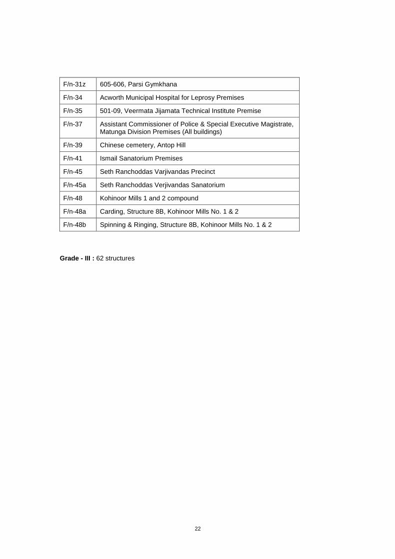
F/n-31z 605-606, Parsi Gymkhana
F/n-34 Acworth Municipal Hospital for Leprosy Premises
F/n-35 501-09, Veermata Jijamata Technical Institute Premise
F/n-37 Assistant Commissioner of Police & Special Executive Magistrate, Matunga Division Premises (All buildings)
F/n-39 Chinese cemetery, Antop Hill
F/n-41 Ismail Sanatorium Premises
F/n-45 Seth Ranchoddas Varjivandas Precinct
F/n-45a Seth Ranchoddas Verjivandas Sanatorium
F/n-48 Kohinoor Mills 1 and 2 compound
F/n-48a Carding, Structure 8B, Kohinoor Mills No. 1 & 2
F/n-48b Spinning & Ringing, Structure 8B, Kohinoor Mills No. 1 & 2
Grade - III : 62 structures
23
Ward G south : 53 structures
Grade - I : 1 structures
Card No. Name of building
G/s-37 Worli Fort
Grade - II A : 7 structures
Card No. Name of building
G/s-1 Lala Lajpatrai Garden
G/s-18 Nipponzan Myohaji Buddhist temple complex
G/s-24 Mahatma Gandhi Maidan
G/s-25 Shree Papvimochan Shankar Mandir
G/s-26 Lal Bahadur Shastri Garden and Reservoir
G/s-31a Processing Unit, Structure No. 3, Sitaram Mills
G/s-31b Chimney, Sitaram Mills
GRADE - II B : 34 structures
Card No. Name of building
G/s-2 Central Jail Premises
G/s-3 Municipal Ambulance Garage
G/s-4 Dhobi Ghat, Mahalaxmi
G/s-5 Anandashram
G/s-6 Worli Sunni cemetery
G/s-7 Worli Bohra cemetery
G/s-8 Worli Catholic Cemetery
G/s-9 Worli Jewish Cemetery
G/s-10 N. M. Joshi Marg Police Station
G/s-11 Haji Saboo Siddick Masjid and Madaresa
24
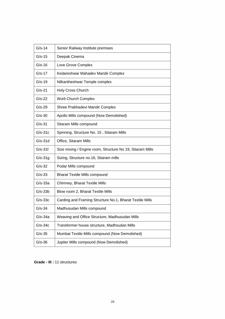
G/s-14 Senior Railway Institute premises
G/s-15 Deepak Cinema
G/s-16 Love Grove Complex
G/s-17 Kedareshwar Mahadev Mandir Complex
G/s-19 Nilkantheshwar Temple complex
G/s-21 Holy Cross Church
G/s-22 Worli Church Complex
G/s-29 Shree Prabhadevi Mandir Complex
G/s-30 Apollo Mills compound (Now Demolished)
G/s-31 Sitaram Mills compound
G/s-31c Spinning, Structure No. 15 , Sitaram Mills
G/s-31d Office, Sitaram Mills
G/s-31f Size mixing / Engine room, Structure No 19, Sitaram Mills
G/s-31g Sizing, Structure no.16, Sitaram mills
G/s-32 Podar Mills compound
G/s-33 Bharat Textile Mills compound
G/s-33a Chimney, Bharat Textile Mills
G/s-33b Blow room 2, Bharat Textile Mills
G/s-33c Carding and Framing Structure No.1, Bharat Textile Mills
G/s-34 Madhusudan Mills compound
G/s-34a Weaving and Office Structure, Madhusudan Mills
G/s-34c Transformer house structure, Madhsudan Mills
G/s-35 Mumbai Textile Mills compound (Now Demolished)
G/s-36 Jupiter Mills compound (Now Demolished)
Grade - III : 11 structures
25
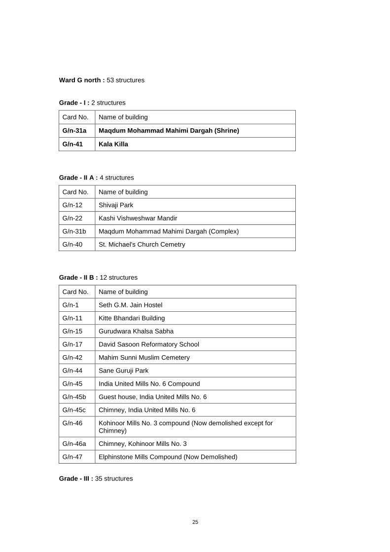
Ward G north : 53 structures
Grade - I : 2 structures
Card No. Name of building
G/n-31a Maqdum Mohammad Mahimi Dargah (Shrine)
G/n-41 Kala Killa
Grade - II A : 4 structures
Card No. Name of building
G/n-12 Shivaji Park
G/n-22 Kashi Vishweshwar Mandir
G/n-31b Maqdum Mohammad Mahimi Dargah (Complex)
G/n-40 St. Michael's Church Cemetry
Grade - II B : 12 structures
Card No. Name of building
G/n-1 Seth G.M. Jain Hostel
G/n-11 Kitte Bhandari Building
G/n-15 Gurudwara Khalsa Sabha
G/n-17 David Sasoon Reformatory School
G/n-42 Mahim Sunni Muslim Cemetery
G/n-44 Sane Guruji Park
G/n-45 India United Mills No. 6 Compound
G/n-45b Guest house, India United Mills No. 6
G/n-45c Chimney, India United Mills No. 6
G/n-46 Kohinoor Mills No. 3 compound (Now demolished except for Chimney)
G/n-46a Chimney, Kohinoor Mills No. 3
G/n-47 Elphinstone Mills Compound (Now Demolished)
Grade - III : 35 structures
26
Wardwise classification of data
Ward A
Ward A occupying the southern tip of the island city was the seat of administration and, Army,
Navy establishments since the colonial period as well and of commercial buildings of Fort and
the Art Deco residential precincts. The existing heritage list (under DCR 67) has covered this
ward extensively. A cosmopolitan ward comprises of a wide typology of buildings, road fronts
open spaces and artefacts.
D.N. road, Sir P. M. road and the Ballard Estate precinct lined with impressive Neo classical
buildings are still awe inspiring. However the famous ‘Queen’s Necklace’ once studded with
stylish Art Deco block of flats has lost its style due to the insensitive alterations like enclosing
the open balconies and due to worn out faded facades.
The eastern waterfront area and the historic dry and wet docks (access and photography was
denied in the dry docks)controlled by the Mumbai Port trust has some of the excellent
buildings associated with the dock typology like clock towers, godowns ballasts and movable
bridges, as well as imposing administrative structures in Neo-classical style.
Historical Localities : Upper Colaba, Lower Colaba, Fort (South), Fort (North),
Esplanade, Ballard Estate, areas around Oval Maidan, Dhobi
Talao, Apollo Bunder, Bora Bazar, are some of the significant
areas.
Area 12.5 sq. km.
Population 2,07,514 (As per census 2001)
No. of properties 4392
No of buildings listed 85
Boundaries :
East Dock Area, Ballard Estate, P. D’Mello Road, Carnac Bridge,
Colaba Military Area, Shahid Bhagatsingh Road
(Colaba Causeway)
West Netaji Subhash Marg (Marine Drive sea front),
‘D’ Road to Navi Nagar
North ‘F’ Road to Carnac Bridge, P. D’Mello Road,
Anandilal Poddar Marg (Marine Street),
27
Lokmanya Tilak Marg (Carnac Road) and ‘F’ Road
South Colaba (Military area)
Broad Ethnic : A Cosmopolitan ward which has a wide range of ethnic
Composition communities and economic classes.
Anglo Indians, Parsi and Catholics in Colaba Fort Market and
areas around Dhobi Talao.
The Hindu trading communities from Gujrat and Rajasthan
around are settled Bazargate and Bora Bazar.
Original Koli (fishermen) settlements are seen along the
coast of Colaba and Cuffe Parade.
Economic :
Composition
Upper Class Cuffe Parade, Colaba and Marine Drive,
Churchgate, Backbay reclamation, Nariman point.
Upper-Middle Class Churchgate, Marine Lines,
New Marine Lines, parts of Colaba.
Lower-Middle Class Bora Bazar, Bazargate, around Carnac
Bunder, Marine street.
Working Class P D’Mello Road, Cuffe Parade south (slums),
Marine street, Colaba market.
Important Building : Elaborate Commercial Buildings, Magnificent Institutional
Typologies buildings, express grandeur in Neo classical, Neo Gothic,
Indo Sarcenic and Art Deco styles.
Dr. Dadabhoy Nowroji Road, Ballard Estate, Planned town
planning schemes by Bombay Improvement Trust – Ballard
Estate, Backbay reclamation scheme, Marine Drive.
Art Deco residential buildings – Churchgate, Marine Lines,
New Marine Lines, Colaba Causeway.
Vernacular high rise high density buildings – Bora Bazar,
Bazargate, Defense quarters and defense structures.
Old churches mainly in Neo- Classical and Neo- Gothic
styles – Colaba coast and around, Bombay Port Trust
structuires, Seafronts and Docks, Churches, Synagogue,
Temples, Agiaries.
28
Recreational Grounds : Cross Maidan,
Mantralaya Municipal Park,
Traffic Training Institute (Park) for Children,
Cooperage Maidan
Important Roads : Dr. Dadabhoy Nowroji Road (Honrby Road),
Mahatma Gandhi Road (Esplanade Road),
Shahid Bhagatsingh Marg (Colaba Causeway),
Maharishi Karve Marg (Queen’s Road),
Netaji Subhash Marg (Marine Drive),
Nathalal Pariekh Marg (Wodehouse Road),
Prakash Pethe Marg (Cuffe Parade Road),
Lokmanya Tilak Marg (Carnac Road)
Important Railway :
Stations
Central / Harbour Railway Chatrapati Shivaji Terminus (Victoria Terminus)
Western Railway Churchgate
Highlights of Ward A : Eros Cinema
Regal Cinema
Sheikh Sariya
Canada Building
Lawrence and Mayo
Police Headquarters
Crawford Market
Bombay Mutaual Insurance
Pandey Sanatorium
Esplanade School
Mancherji Khorshadji Agiary
(Marine Drive corner building)
29
Ward B
This ward is almost totally ignored in the existing heritage list of under DCR 67. It has a wide
range of heritage buildings and precincts belonging to a variety of architectural typologies,
used for variety of functions. This ward has many Mosques, Dargas, Dharmashaalas, and
residential buildings in vernacular, Neo- classical and Art Deco style. Trading areas near
Docks and the streetscape of Mohammed Ali Road display a wide range of architectural
styles.
The road front of Muhammad Ali Road, a major north south artery was constructed in 1905 to
open up an avenue (one of the longest avenues) from Crawford Market to Byculla. New
buildings which came up on this road, then known as Sydeham Road, offeres a journey
through buildings adorned with features from various architectural styles- from Neo classical,
Indo Sarcenic, Traditional Haveli and many variations of Art Deco. The recently built 2.5 km
long J.J. flyover on Muhammad Ali Road however has destroyed the sky line and the vision
line of this interesting this road front. On the west side of this road known as western Nagdevi
are high density residential and trading buildings belonging to majority Hindu trading
community, marked by Vernacular and traditional ornamentations from Gujrath and Rajasthan
The other Gujarati communities were the Banias, who specialized as textile traders and Jains
as bankers and money lenders. The Hindu Merchant class establishments of Gujratis and
Kutchis arriving from the port of Surat, are seen at Dana Bunder, Chinch Bunder and Masjid
Bunder, The minority Bohris and Jewish residences are seen around Issaji Street, where as
in Umarkhadi close to the eastern water front, a very small Christian original fisherfolks who
migrated from Uran across the harbour still have their settlements along with a church and an
educational institute. Kasaab Muslims (Butcher) built their own mosque in Khadak area
known as Bakkar (goats) Kasaab Masjid. Imamwada is identified with Irani Muslims to which
is identified the exquisitely detailed Moghul Masjid. The Muslim Gujaratis were the Bohras
and Khojas, who were involved in retail trade of textiles and many other goods who are
largely located in Southern Dongri where as Maharashtrian Muslims essentially the distinctive
Konkani Muslims,who worked in the docks and ship yards, and as seamen are also in Dongri.
Historical Localities : Umarkhadi, Dongri, Dana Bunder, Chinch Bunder,
Masjid Bunder, Carnac Bunder, Nagdevi, Mandvi, Khadak,
Part of Pydhonie
Area 2.47 sq. km.
Population 1,40,481 (As per census 2001)
No. of properties 3220
No of buildings listed 67

30
Boundaries :
East P. D’Mello Road
West Ibrahim Rahimtulla Road, Abdul Rehman Street
North Ramchandra Bhatt Marg (Babulla Tank Road),
Jivabhai Mulji Rathod Marg
South Lokmanya Tilak Marg (Carnac Road)
Board Ethnic : B ward is a Majority Muslim neighbourhood, Bohris,
Composition Jewish around Issaji Street and a very small Christian
population in Umarkhadi, Hindu Merchant class settlements
(Gujrati and Kutchi) are seen at Dana Bunder, Chinch
Bunder, Masjid Bunder as well as In Western Nagdevi.
Kasaab Muslims (Butcher) are in Khadak where as Irani
Muslims and Khojas are located in Imamwada. Southern
Dongri, Khojas in Nagdevi, Mandvi has Khoja settlements.
Economic :
Composition
Upper Class A Merchant class is scattered in the ward.
Middle Class Umerkhadi, Nagdevi, Mandvi, Chinch Bunder, Imamwada,
Carnac Bunder, Tantanpura, Issaji Street, Samuel Street.
Lower-Middle Class Dongri, Imamwada, Umerkhadi, Masjid Bunder, Bhat Bazar.
Working Class P D’Mello Road, Khadak, around Sandhurst Road Station.
Important Building : Community precincts, Residential Precinct (Khojas),
Typologies Dwelling units (Christians – Umerkhadi) High density
multistoried housing (Muslim, Hindu middle and lower middle
class).
Planned housing schemes - Umerkhadi (Nowroji hill).
Colonial Industrial Housing - BIT chawls,
Sandhurst Road station.
Street fonts - Mohammed Ali Roadfront),
Sardar Vallabhai Patel Roadfront (from Mohammed Ali Road
to Sandhurst Road station junction),
Samanthbhai Nanji Roadfront (Dongri Streetfront).
Cemeteries - Khoja Burial Ground at Dongri.
Temples, Mosques, Synagogues, Churches, Jamatkhanas.
31
Artifacts - Pyav, Stone plaques on bridges.
Bombay Port Trust - Sea fronts, docks, dry docks, Port
administrative buildings.
Recreational Grounds : Babulla Tank Maidan, Sitaram Shenoy Park,
Veer Sambhaji Maidan
Important Roads :
North-South Mohammed Ali Road, Ibrahim Rahimtulla Road,
P D’Mello Road, Keshavji Naik Road (Chinch Bunder Road)
East-West Sardar Vallabhai Patel Road (Sandhurst Road),
Yusuf Meher Ali Road
Important Railway :
Stations
Central Railway Sandhurst Road, Masjid Bunder
(Main and Harbour Line)
Highlights of Ward B : Khoja Aga Khan Dar Khana, Dongri
Karimabad Khoja Jamatkhana
Mughal Masjid
St. Joseph Church and School
Prince’s Dock
Merewether Dry Dock
Kessowjee Naik Fountain and Clock Tower
Etz Hassan Building
Jail Road Municipal Dispensary
Carnac Bunder Pumping Station
32
Ward C
The mixed land use of this ‘Native town’ has resulted in an integrated mix of commercial and
residential development. Although geographically the smallest ward of the entire city, it is one
of the most densely populated areas in the world. Residential precincts called Waadis and
chawls, large market areas and highly decorative temples and shrines are the highlights of
this ward.
Hisorically significant areas in this ward are Dhobi Talao, Phanaswadi, Bhuleshwar,
Kumbharwada, Khara Talao, Girgaum, Lohar Chawl. This ward is marked by one of the
highest density areas of Bhuleshwar and Kalbadevi. The Gujarati communities, the
Banias,and the Bhatias who specialized as textile traders and Jains as bankers and money
lenders settled in the above areas. The predominant architectural styles observed in this area
are Neo classical and Vernacular blended with decorative features from traditional Haveli
style from Gujrath and Rajasthan. This area is broadly separated from the Maharashtrians
areas of Girgaum by the Jagannath Shankarseth road (earlier known as Girgaon Back road).
The street connecting the Girgaon Back road and Kalbadevi road called the Cavell Street
(Now Vegas Street) has a large Catholic settlement along with the educational, religious and
community institutions for the catholic community. The Pope Town (not in existence now) and
Bishop town are elegant residential precincts for the upper class Catholics and unlike the
general hostile attitude of the occupants towards the heritage value of the premises, these
residents expressed their disappointment for not getting listed in the existing heritage list.
Another unique typology of the catholic neighbourhoods were the ‘clubs’ usually including a
chapel as well, which served as the temporary lodging places for the immigrants as well as for
the persons working on the ships found on Cavell street, Dhobi Talao, and Byculla area. The
Trading establishments of Lohar Chawl occupy ground floors of residential buildings which
create a vista characterised with a blend of Vernacular and Neo classical.
Historical Localities : Dhobi Talao, Phanaswadi, Bhuleshwar, Kumbharwada,
Khara Talao, Girgaum, Cavel Street, Lohar Chawl
Area 1.78 sq. km.
Population 1,90,672 (As per census 2001)
No. of properties Private 5510 to Municipal : 164
No of buildings listed 82
Boundaries :
East Ibrahim Rahimtulla Road, Abdul Rehman Street
West Netaji Subhash Road sea front
33
North Maulana Shaukatali Road, Trimbak Parshuram St.,
Ardeshir Dady Jaykar St., Vitthalbhai Patel Road,
Babasaheb J. Marg
South L. T. Marg, Vasudeo Balwant Phadke Marg,
Anandilal Poddar Marg, F-Road Marine Road
Broad Ethnic : Gujratis in Kalbadevi and Bhuleshwar.
Composition Maharashtrians and Gujratis in Girgaum.
Catholics and Marathis in Cavel.
Muslims in Lohar Chawl.
Economic :
Composition
Upper Class None
Middle Class Girgaum, Thakurdwar.
Lower-Middle Class Kalbadevi, Cavel Street.
Working Class Lohar Chawl.
Important Building : Temples with ornamental features, buildings with intricate
Typologies and articulated facades - Kalbadevi and Cavel, Chawls and
Wadis in Kalbadevi.
High rise high density housing around Dhobi Talao,
Commercial and high density residential buildiongs – Abbdul
Rehman Street, Sheikh Memon Street, Lohar Chawl,
Bhuleshwar, Null Bazar.
Markets – Bhuleshwar Market, Mulji Jetha Market, Swadeshi
Market, Mangaldas Market, Cowsaji fountain on Maulana
Shaukat Ali Road (Grant Road).
Important Roads :
North-south Maharishi Karve Road (Queen’s Road),
Netaji Subhash Marg – part (Marine Drive)
East-west Shamaldas Gandhi Marg (Princess Street), Kalbadevi Road,
Jagganath Sunkerset Road (Girgaum Road),
Bhuleshwar Street, Lokmanya Tilak Marg (Carnac Road)
34
Important Railway :
Stations
Western Railway Marine Lines
Highlights of Ward C : Cotton Exchange
Swadeshi Market
Chandabhoy Building
Babu Pannalal High School
Chapsey Building
Police Residence
Venkatesh Devsthan
Devkaran Mansion
128 - 132 Cavel Street
Mulji Jetha Building
35
Ward D
The built environments in this ward cuts across all the economic and ethnic groups. The elite
Neo– classical and Mansions off Nepean sea Road and Walkeshwar Art Deco style
bungalows of Walkeshwar, Altamount Road and Carmichael Road, Edwardian style precincts
of Opera House, upper class residential precincts in vernacular styles of Gamdevi and middle
class Chawl precincts in Girgaum, large number of Parsee and Hindu temples in the densely
populated areas of Khetwadi are just a few examples that speak of the heritage significance
of the D Ward. This ward is poorly represented in the existing heritage listing. There are some
examples of heritage building and precincts already listed but which are already demolished,
The large Edwardian / Neo classical demolished mansion called Samudra Villa is already
demolished, Similarly the Gamdevi precinct, an excellent example of a group of buildings that
appropriately scaled and which shares a cohesive character with the three lined road is
violated.
Historical Localities : Malabar Hill, Teen Batti, Grant Road, Khetwadi,
areas around Opera House, Girgaum, Gamdevi,
Cumball Hill, Girgaum Chowpaty, Babulnath,
Lamington Road, Walkeshwar
Area 6.63 sq. km.
Population 3,78,602 (As per Census 2001)
No. of properties 8480
No of buildings listed 103
Boundaries :
East Sardar Vallabhai Patel Road (Sandhurst Road),
Ardeshir Dadi Street, Trimbak Parshuram Street,
Shukhalaji Street
West Up to Govt. Printing Press, Netaji Subhash Road
(Marine Drive), D. N. Purandare Marg, Band Stand,
Walkeshwar Road, B. Indrajit Road, Bhulabhai Desai Road
(Warden Road) upto Haji Ali
North Jehangir Boman Behram Marg (Bellasis Road),
Sane Guruji Marg (Aurthur Road), Tardeo Road,
Keshavrao Khade Marg
South B. Jaikar Marg upto Bhuleshwar Naka,
Crossing M. K. Road upto Seashore
36
Broad Ethnic : Gujratis at Malabar Hill, Napean Sea Road, Cumballa Hill,
Composition Babulnath, areas around Sardar Vallabhai Patel Road
(Sandhurst Road), areas around August Kranti Marg.
Marathis in Girgaum and Khetwadi, Parsis and Marathis at
Tardeo, Muslims and Gujratis around Maulana Shaukat Ali
Road (Grant Road).
Economic :
Composition
Upper Class Napean Sea Road, Malabar Hill, Walkeshwar, Cumballa Hill,
Carmichael Road, Warden Road, Pedder Road, Huges
Road, Babulnath, Altamount Road.
Middle Class Areas around Sardar Vallabhai Patel Road Sandhurst Road),
Girgaum, Tardeo, Khetwadi.
Lower-Middle Class Khetwadi
Working Class Areas around Maulana Shaukat Ali Road (Grant Road),
Sukhlaji Street, Patthe Bapurao Marg (Falkland Road).
Important Building : Large Bungalows and apartments around Carmichael Road.
Typologies Large Resident apartments around Cumballa Hill,
Napean Sea Road, Warden Road, Huges Road.
Chawls, Wadis and Precincts in Khetwadi, Girgaum,
Grant Road and Tardeo.
Recreational Grounds : Willington Sports club ground,
Kamla Nehru Udyaan (Hanging Gardens),
August Kranti Maidan (All Listed)
Important Roads :
North-South Gopalrao Deshmukh Road (Pedder Road),
Sitaram Patkar Marg (Warden Road),
August Kranti Marg (Gowalia Tank Road),
L. Jagmohandas Marg (Napean Sea Road),
Dadasaheb Bhadkamkar Marg (Lamington Road)
East-West Maulana Shaukat Ali Road (Grant Road),
Sardar Vallabhai Patel Road (Sandhurst Road),
Pnadit Madan Mohan Malviya Marg (Tardeo Road)
37
Important Railway :
Stations
Western Railway Grant Road
Highlights of Ward D : Forjett House
Cassinath Building
Dil Pazir
Mitha Lodge
Victoria Memorial Blind School
Nawroz Building
Sarkar Building
Alfred Cinema
Tardeo Chambers
38
Ward E
Located in the central part of the island city, comprises of Mazgaon and Byculla areas which
were originally part of the residential suburbs used by Colonial rulers. Today it is mixed use
ward, represent ethnic groups like Chinese, Jews, Kamathis. This ward is rich in buildings and
typologies which are unique in their functions and characters.
This list included some of the modest structures which although not architecturally or
historically significant represent the life style of the community. For example an isolated bar
and restaurant building in Mazgaon very close to the docks is a journey into the built forms
and environment as existed in the period just around independence.
Historical Localities : Mazagaon, Ghodapdev, Byculla, part of Kalachowkie,
Nagpada, Agripada, Madanpura, Kamathipura,
part of Kumbharwada, Saatrasta (Jacab Circle), Chichpokli
Area 7.40 sq. km.
Population 4, 39,393 (As per census 2001)
No. of properties 7513
No of buildings listed 134
Boundaries :
East Sea front Barrister Nath Pai Marg (Reay Road)
West Sane Guruji Marg (Arthur Road), Western Railway,
Jahangir Boman Behram Marg (Bellasis Road),
Sukhalaji Street
North Dattaram Lad Path (Kalachowkie Road)
South Ramchandra Bhatt Marg (Babulla Tank Road), Wadi Bunder,
Maulana Shaukatali Road (Lamnigton Road-part)
Broad Ethnic : Majority Christian and Muslim neighbourhoods.
Composition Parsi Baugs and Precincts, Christians, Muslims, Khojas and
Jews in Mazagaon.
Christians in Byculla, Parsi precincts in Byculla.
Lower middle class Parsis near Mumbai Central.
Hindus, Muslims, Christians, Khojas in Agripada.
Working class Muslims in Nagpada, Madanpura.
Hindus in Chinchpokli and around Saatrasta (Jacob Circle).
Kamathis in Kamathipura.
39
Economic :
Composition
Upper Class Mazagoan, Byculla, Agripada, Mumbai Central.
Middle Class Mazagaon, Byculla, Mumbai Central.
Lower middle Class Nagpada, Kalachowkie, Chinchpokli.
Working Class Kamathipura, Madanpura, Areas around Maulan Azad Road
(Rippon Road), Nagpada, Kalachowkie.
Important Building : Sprawling and Modest bungalows in Mazagaon and Byculla
Typologies Clubs in Mazagaon.
Community precincts, Parsi Residential Precincts (Baugs for
upper class, colony for lower middle class, community
housing for Khojas).
Urban village (Christians – Mazagaon), Wadis (Ambawadi at
Mazagaon, Telgu Munurwar Wadi at Kamathipura).
Planned housing schemes – Agripada, Byculla.
Colonial Industrial Housing: BIT chawls, Agripada, N. M.
Joshi Road (Dilisle Road).
Old Telgu and Kamathi settlements with temples at
Kamathipura.
Industries, Textile Mills – Kalachowkie.
Churches and Schools – Mazagaon, Byculla.
Social service and public welfare societies – Byculla,
Nagpada, Madanpura.
Cemeteries - Jewish cemeteries at Byculla and Mazagaon,
Muslim cemeteries at Mazagaon, Catholic cemetery at
Mazagaon.
Temples, Chinese Temple, Mosques, Synagogues,
Churches, Jamatkhanas.
Artifacts - Gates, Bridges, Stone plaques on bridges.
Recreational Grounds : Joseph Baptista Gardens / Bhandarwada Reservoir,
Mohammed Husain Play Ground (Wansi Maidan)

40
Important Roads :
North-South Sir J. J. Road, Dr. Babasaheb Ambedkar Road,
Barrister Nath Pai Marg (Reay Road),
Dr. Mascarenhas Road (Mount Road),
Shivdas Champsi Road (Mazagaon Road),
Maulana Azad Road – north (Rippon Road)
East-West Ramchandra Bhatt Marg (Babulla Tank Road),
Sardar Balvantsingh Dhody Marg (Nesbit Road),
Sant Savta Marg (Victoria Road),
Dataram Lad Path (Kalachowkie Road)
Important Railway :
Stations
Central Railway(Main Line) Byculla
Central Railway (Harbour Line) Dockyard Road, Reay Road
Western Railway Mumbai Central
Highlights of Ward E : Traffic Institute- Byculla
Magen David Synagogue
St. Anne’s Church and St. Mary’s School
Gardens Bridge (S- Bridge)
Rustum Baug
Hasnabad
Gramodyog Wadi
Ambawadi Precincts
Sir Elly Kadoorie School
Clare Road Khoja Jamathkhana and Housing Complex
Taylor Memorial Methodist Church
Hume Memorial Congrigation Victoria Garden Church
Palace Cinema
Telgu Munurwar Wadi
The Retreat
Kastoorba Hospital premises
Chinchpokli Jewish cemetery
Chistee Hindustani Masjid
Chinese Temple
E.E.N.D. office MbPT. (E 73) A neat Vernacular example

41
Ward F south
Parel and Sewri in F-south is basically an industrial and working class district. Comprising of
many textile mills. The residential neighbourhoods of chawls surround these mills, both often
sharing the façade ornamentation style. Although the mills are closed, the industrial
architecture is of high heritage significance associated with the social and political history of
the city. The water bodies and large wooded areas of the mill lands need to be preserved for
the environmental benefits of the city as a whole. The road fronts of Ambedkar road at
Lalbaug, the chawl precinct and – are to be noted specially.
Historical Localities : Eastern Sea front, Sewri, Wadala, Naigaum, Dadar,
Lalbaug, Parel Cotton Green, Parel Gaothan
Area 14 sq. km.
Population 3,95,627 (As per census 2001)
No. of properties 6035
No of buildings listed 72
Boundaries :
East Sewree Sea-Front
West Central Railway
North Mumbai Marathi Granth Sangrahalaya Road, Road N0. 26
South Dattaram Lad Marg, Kalachowky
Broad Ethnic : Majority Maharasrtian Hindus.
Composition Minority Muslim population (shift in population resulted after
the 92, 93 Babri Masjid riots towards majority Muslim areas)
Economic :
Composition
Upper Class Wadala, Dadar, S. S. Rao Road.
Middle Class Sewri, Dr. Ambedkar Road, G. D. Ambekar Road.
Lower-Middle Class Currey Raod, Ganesh Gully, Lalbaug.
Working Class Naigaon, Parel Gaon, Parel Station, Lalbaug.
Important Building : Chawls, Wadis, Precincts (Marathi working class,
Typologies Marathi middle class and Parsi lower middle class).
Colonial Industrial Housing: BIT and BDD chawls,
Private chawl precinct, Industrials (Textile mills).
42
Street fronts - Dr. Ambedkar Road- from ITC to Parel naka
and St. Paul Street front.
Cemeteries - Catholic cemetery at sewri).
Temples, Mosques.
Artifacts - Water fountains, Gas batti, Mile stones.
Recreational Grounds : Kamgar Maidan,
Nare Park,
Railway ground
Important Roads :
North-South Dr. Babasaheb Ambedkar Road, Dadasaheb Phalke Road,
G.D. Ambekar Road, Rafi A. Kidwai Marg
East-West Acharya Donde Marg, Jerbai Wadi Road,
Mumbai Marathi Granth Sanghralaya Road,
Dattaram Lad Path (Kalachowkie Road)
Important Railway :
Stations
Central Railway (Main Line) Parel
Central Railway (Harbour Line) Sewri
Western Railway Lower Parel, Elphinstone
Highlights of : Church of St. Marry The Virgin
Ward F south Railway Board Building
Christian Cemetery
India United Mill no.1
Ganesh Galli
Haji Kasam Chawl Precincts
Cotton Exchange Building
Meghji Mathuradas Mansion
Bharatmata Theatre
Kamgar Maidan
43
Ward F north
Ward F North still has many traces of built and natural environs which can bring alive the
memories of the pre-industrial villages like Sion. The eastern parts of this ward were largely
occupied by the saltpans, many of them either are highly polluted or reclaimed at present.
The largest ward of the island city is occupied by migrants from sindh after the partition,
Matunga till early 19th century had an European artillery – station, later Occupied by Matunga
labour camps. A large area of this ward. Dadar, Matunga and Sion was part of the B I T
suburbs housing scheme in late 19th century and early 20
th century, which was undertaken
with a view to expand the city and create more housing for the increasing migrant population.
Hindu and Parsi colonies in vernacular style at Dadar and Tamil colonies at Matunga
prominent, planned low rise middle class urban settlements, with ample green areas and with
a good network of roads. Hindu and Parsi colonies both highlights of this ward are however
rampantly demolished for high rise reconstruction under DCR 33(7).
Historical Localities : Dadar east of railway line, Dadar Matunga estate which
includes Hindu colony, Parsi colony, Matunga Estate,
Sion Bahndarwada, Koliwada, Earlier Agripada, Sion Fort,
Antop Hill, Wadala Gaothan
Area 12.98 sq. km.
Population 5,26,839 (As per census 2001)
No. of properties 13,470 (As on 31-3-1994)
No of buildings listed 94
Boundaries :
East Thane Creek
West Central Railway
North N. S. Mankikar Marg
South Mumbai Marathi Granth Sangrahalaya Marg and Road No. 26,
Scheme No. 57, There after straight line up to creek.
Broad Ethnic : Hindu middle and upper middle class prominently
Composition Maharastrians (Hindu colony on west of Ambedkar Road).
Parsi on east of Ambedkar Road.
South Indians, Tamilians, Keralites, Gujratis in Matunga.
Kolis and Bhandaris in Koliwada.
Kamatis transit camp in Antop hill.
Sardars and Punjabis beyond Sion.

44
Economic :
Composition
Upper-Middle Class Hindu Colony, Parsi Colony.
Middle Class Matunga
Important Building : Town Planning scheme, Precincts, Hindu Colony,
Typologies Parsi Colony Dadar Matunga Estate, Sanatoria,
Matunga Gymkhana, Parsi Gymkhana.
Open spaces - 5 Gardens, Pockets in Parsi Colonies, Dadkar
Ground, Maheshwari salt pans.
Hill - Antop Hill, Sion Hill, Wadala Hill.
Street Fronts - Ambedkar Road opposite Asiad.
Important Roads :
North-South Ambedkar Road (Vincent Road),
Rani Laxmibai Road (Sion Road), Katrak Road,
Nathabhai Parekh Marg
East-West Mumbai Marathi Granth Sanghralaya Road,
Tilak Road (Road no. 23), Naigaon Road
Important Railway :
Stations
Central Railway Dadar, Matunga, Sion
(Main Line)
Central Railway Wadala, Guru Teg Bahadur Nagar
(Harbour Line)
Highlights of : Raj Griha
Ward F north Dastoor House
Khorshed Villa
Parsi Gymkhana
Chinese Cemetery, Antop Hill
Seth Ranchoddas Verjivandas Sanatorium
Sion Tank Premises
Veermata Jijamata Technical Institute Premise
Seth Rustomji Neserwanji Rustomfarmana Agiary
Philonmena
45
Ward G south
Ward G south is one of the wards in the island city that is vertically divided into two ends of
the economic spectrum by the three north south artery. Comprising of On the east is the
working class belt comprising of industries and industrial housing in the Lower Parel and on
the western sea fronts are the bungalows and apartments of the elites in Worli Sea Face.
Interestingly the “Lower Parel“ area historically associated with the working class culture has
been ‘upgraded to “upper Worli” to change its class character after the real-estate boom of
the mill lands.
This ward boasts of one of the oldest settlements of fisherfolks called worli Koliwada which
also includes a strategically located fort. One of the largest open spaces in the island city, the
Mahalaxmi race course adjoining the causeway Hornby Vellard Road (now Lala Lajpatrai
Marg) had served as a dyke which prevented the flooding of some of the low lying area of the
interior. Dhobi Ghat is a historically and socially significant complex apart from being a tourist
attraction, has been included in the proposed list.
Historical Localities : Worli, Worli Village, Worli Koliwada, part of Prabhadevi,
Lower Parel
Area 10.00 sq. km.
Population 4, 57,095 (As per census 2001)
No. of properties 5801
No of buildings listed 53
Boundaries :
East Central Railway
West Sea front of Worli
North Veer Savarkar Marg (Cadell Road),
Kashinath Dhuru Marg to Kakasaheb Gadgil Marg
South Keshavrao Khadye Marg,
Sane Guruji Marg (Arthur Road) to Western Railway
Broad Ethnic : Marathi speaking Hindus at Worli village and around
Composition Senapati Bapat Marg (Tulsi Pipe Road).
Kolis in Worli Koliwada.
Marathi speaking Muslims and Marathis at Lower Parel.
Marathi speaking Hindus around Sayani Road.
46
Economic :
Composition
Upper Class Worli, Worli Sea face, Prabhadevi, areas around
Mahalaxmi Race course.
Middle Class Areas around Anne Besant Road.
Working Class Worli village, Worli Koliwada, Lower Parel,
Worli B.D.D. Chawls, areas around Sayani Road and Sane
Guruji Marg (Arthur Road).
Important Building : Bungalows along Worli sea face large apartment buildings
Typologies along Worli Sea face and Anne Basent Road.
B.D.D. Chawls at Worli, Vernacular settlements in
Worli village and Koliwada.
Chawls and Government built industrial housing (BDD)
around Sayani Road and N. M. Joshi Marg (Dilisle Road).
Recreational Grounds : Gandhi Maidan (Jamborie Maidan),
Lala Lajpatrai Garden,
Lal Bahaddur Shastri Udyaan
Important Roads :
North-South Anne Basent Road, R. J. Thadani Marg, Veer Savarkar
Marg, N. M. Joshi Marg (Delisle Road)
East-West Sayani Road
Important Railway :
Stations
Central Railway (Main Line) Dadar
Western Railway Lower Parel, Mahalakshmi
Highlights of : Railway Institute Lower Parel
Ward G south Patel Building
Bawla Masjid
Arthur Road Jail
Municipal Ambulance Garage
Deepak Cinema
Paapvimochan Mandir
Worli Church
Dhobi Ghat

47
Ward G north
Situated on the north-west of the island city, this ward is vertically divided by the three north-
south arterial roads and by the Western railway line. The west of the railway line is
predominantly occupied by the middle class population very often reflected in the typology of
Co-operative societies (a complex of 5 – 10 buildings planned a community open ground)
which belonged to different regional / caste communities of Hindu, Catholic, Parsi and
Muslims. Dadar, Matunga and Mahim have many such societies. On the east of the railway
lines however is the low lying and dense slums of Dharavi, amidst is which is hidden a few
remains of the Reva fort. Mahim is the one of the oldest islands of the city (ruled by Rana
Bhimdev before the Portugese) with historically important sites, like the Dargah of Mahim and
(the Mahim Fort which is include in the earlier list).
Historical Localities : Mahim, Shivaji Park, Dadar, Matunga (West),
Prabhadevi (North)
Area 9.07 sq. km.
Population 5,90,609 (As per census 2001)
No. of Properties 5656
No of buildings listed 53
Boundaries :
East Senapati Bapat Marg (Tulsi Pipe Road)to Sion Culvert along
with Dharavi
West Sea-shore
North Mahim Causeway, Mumbai Agra Road
South Kakasaheb Gadgil Marg and Kashinath Dhuru Road
Broad Ethnic : Marathis at Shivaji Park.
Composition Kolis, Muslims and very few Maharashtrian Hindus at Mahim.
Catholics at Mahim.
Economic :
Composition
Upper-Middle Class Prabhadevi
Middle Class Shivaji Park, part of Mahim, Matunga.
Lower-Middle Class Mahim, parts of Dadar.
Working Class Dadar, Dharavi, Matung.
48
Important Building : Middle class apartments at Shivaji Park and Saraswat
Typologies Colony, Mahim, Chawls in Dardar, Mahim, small and mid-
size bungalows belonging to Catholics at Mahim.
Recreational Grounds : Shivaji Park,
Nardulla Tank Maidan
Important Roads :
North-South Veer Savarkar Marg (Cadell Road), Lady Jamshedji Road,
Senapati Bapat Marg (Tulsi Pipe Road), N. M. Gokhale Road
Important Railway :
Stations
Central Railway (Main Line) Dadar
Central Railway (Harbour Line) Mahim
Western Railway Elphinston Road, Dadar, Matunga, Mahim
Highlights of : Seth G. M. Hostel
Ward G north Kitte Bhandari
David Sassoon School and Reformatory
Ferriera Mansion
Maqdum Mohammad Mahimi Dargah
Hearts Ease
Marianella
49
Criteria for Listing and Grading : as emerged during Output III Meeting
In the Output III presentation all the listed buildings were shown to the sub -committee.
Following criteria emerged during the meeting.
a) Buildings in bad structural conditions but with architectural heritage value should be
listed. (e.g. Panday Parsi Sanatorium, Colaba, Imperial Cinema)
b) Buildings in bad structural conditions and poor architectural value but with high historical
/ social value to be included. (e.g. Gramodyogwadi in Ward E, where Tricolour National
Flags were made in the pre-independence period, Building where legendary artiste Bal
Gandharva spent his last days )
c) Monuments / buildings of high historical value and which are in high public use but face
complications due to its congested surroundings, to be graded as II A even if they
otherwise would have deserved Grade I. (e.g. Maqdoomia Dargah at Mahim, Ward G
north)
d) Individual buildings within a precinct can have different grades if necessary. (e.g.
Karimabad Housing, Imamwada in Ward B, which has a Jamatkhana graded II B where
as the surrounding housing is of Grade III)
e) In certain wards, a large number of buildings share similar typology and architectural
style. Instead of listing all such buildings, a broad criterion was followed for the selection
Buildings those abut major roads, those define and those which exceptionally stand out
in the row of similar architectural character were chosen. (e.g. Bye lanes of Mohamad
Aill road, Junction of Parel .)
f) A large number of buildings have lost their heritage character, because of number of
structural or cosmetic interventions. These buildings are not part of the list.
50
Issues: which emerged during the Listing Process
1. Threat of reconstruction under 33 (7) and demolition under 58(1)
The Heritage Conservation Legislation if juxtaposed with the Urban Development
policies, exposes inherent contradictions. Survival of DCR 67 against DCR 33(7) and
DCR 58 is a direct challenge. Nearly 60% of the Grade III buildings in the earlier list
face the threat of reconstruction under DCR 33(7). Similarly in the proposed list of
grade III, a large percentage would be under the category of the Cessed buildings and
are under the direct threat of reconstruction. At present the mill lands have become a
battleground between DCR 67 and DCR 58 a battle between conservation and
demolition. The builder/ mill owners’ nexus is vociferously playing down the heritage
value of the industrial architecture.
2. Apathy of citizens towards heritage protection:
On one hand there is an increasing awareness towards the concept of heritage buildings
that goes beyond the criteria of ‘monumentality’. There is also a concern for the
protection of historically / architecturally valuable buildings. On the other hand, ironically
the concern stops at one’s own doorsteps. Our experience over last 18 months have
shown 99% of people owning personal residences do not want their buildings to be
included in the heritage list. The two important reasons are:
i) Maintenance of such a building is expensive. Lack of the sensitivity of Municipal
Authorities towards the heritage value limits their role to creating barriers even if
the owner wants to undertake the repairs.
ii) The owners feel that they are deprived from ‘exploiting the real estate potential’
which other buildings in their neighbourhood enjoy.
3. Violation of protection guidelines for precincts:
Precincts at Gamdevi (Laburnum Road) in Ward D and Parsi Colony in
Ward G north are two prominent examples where it was observed that the real estate
development is happening in a large scale without any consideration for existing skyline
as well as the scale and footprint of the precinct. Similarly the high profile Marine Drive
has lost its charm because of unscrupulous enclosure of the balconies, there by
destroying its primary (if not only) Art-Deco character.
4. Proactive Actions: There needs to be an awareness created in the citizens groups to
act as watch dogs to report any violation of heritage protection norms.
51
Notes on the important classification in the proforma
Townscape:
Townscape gives geographical context and locational importance with respect to the roads,
junctions, neighbourhood and important landmarks in the close proximity like railway stations,
playgrounds, seafronts, road fronts and significant buildings. The building itself could be a
landmark, historically or by its location (e.g. its scale, forming vista, defining a corner).
Townscape also helps locating the building exactly on a road which could be cutting across
many neighbourhoods.
Architectural Description:
Architectural Description elaborates on the architectural /aesthetic value with respect to the
architectural style, typology and scale. It also highlights the elements that contribute towards
its heritage value. It is to be noted that classification as a ‘style’ is not a comprehensive
categorisation. The various architectural styles as seen in Mumbai are predominantly
expressed mainly as façade vocabulary and rarely an entire built form is conceived in that
particular style. This is truer in the styles like Neo-classical, Neo-Gothic and to a lesser extent
in the Art Deco buildings. Noted exception is public buildings like the Town Hall or University
Libraries and Churches. Very often there is a blend of architectural ornamentation originating
from more than one style.
Road front:
The cohesive appearance of a road front is achieved by the uniform height and uniform
footprint as well as by the permutations of similar elements in different compositions. D. N.
Road in Fort is a rich example. But interestingly, the road front of Dr. Babasaheb Ambedkar
Road in Lalbaug and Parel displays facades with Neo-classical ornamentations behind which
are the modest chawls with one room tenement and common toilets. The industrial facades of
the textile mills in the same vicinity of Parel interestingly also have such ornamentations. This
together gives an architectural cohesiveness to the neighbourhood.
Intrinsic:
The historical, sociological or cultural value of the heritage building is described under this
heading. A long historical account if any is given under the heading ‘notes’, at the end of the
proforma.
52
Annexure 1
GRADING : DEFINITIONS AS PER REGULATION 67
Grade-I
Definition
Heritage Grade-I comprises of buildings and precincts of national or historical importance,
embodying excellent in architectural style, design, technology and material usage, they may
be associated with a great historical event, personality, movement or institution. They have
been and are, the prime landmark of the City.
Objective
Heritage Grade-I richly deserves careful preservation.
Scope of changes
No interventions would be permitted either on the exterior or interior unless it is necessary in
the interest of strengthening, and prolonging, the life of the buildings or precincts or any part
or features thereof. For this purpose, absolutely essential minimal changes would be allowed
and they must be accordance with the original.
Procedure
Development permission for the changes would be given by the planning Authority on the
advice of the Heritage Conservation Committee to be appointed by State Government.
Vistas / Surrounding Development
All development in areas surrounding Heritage Grade-I shall be regulated and controlled,
ensuring that it does not mar the grandeur of or views from, Heritage Grade-I.
53
Grade-II
Definition
Heritage Grade-II (A & B) comprises of buildings, of regional or local importance, possessing
special architectural or esthetical merits, cultural or historical value, though of lower scale
than in Heritage Grade. They are local landmark, contributing to the image and identity of the
city. They may be the work of master craftsmen, or may be model of proposition and
ornamentation or designed to suit particular climate.
Objective
Heritage Grade-II deserves intelligent conservation.
Scope of Changes
Grade-II A
Internal changes, and adaptive reuse will be generally allowed, but external changes will be
subject to scrutiny. Care would be taken to ensure the conservation of all special aspects for
which it is included in Heritage Grade-II.
Grade-II B
In addition to above extension or additional buildings in the same plot or compound could, in
certain circumstances, be allowed provided that the extension/additional building is in
harmony with (and does not detract from) existing Heritage building(s) or precincts especially
in terms of height and facade.
Procedure
Development permission for the changes would be given by the Planning Authority
consultation with a sub-committee of the Heritage Conservation Committee
54
Grade-III
Definition
Heritage Grade-III comprises of buildings and precincts of importance for town scape; they
evoke architectural aesthetic or sociological interest though not as much as in Heritage
Grade-II. These contribute determine the character of the locality, and can be representative
of life style of a particular community or region and, mar also be distinguish by setting on a
street line, or special character of the façade and uniformity of height width and scale.
Objective
Heritage Grade-III deserves protection or unique features and attributes.
Scope of Changes
External and internal changes and adaptive reuse would generally be allowed. Changes can
includes extensions, additional buildings in the same plot or compound provided that
extension / additional building is in harmony with and does not detract from the existing
heritage building / precinct especially in terms of height and / or facade. Reconstruction may
be allowed when the building is structurally weak or unsafe or when it has been affected by
accidental fire or any other calamity or if reconstruction is required to consume the
permissible FSI and no option other than reconstruction is available.
Reconstruction may also be allowed in case of those buildings, which attract the provisions of
Regulations 33(6), 33(7), 33(9) and Appendix II and Appendix III of development Control
Regulations, 1991.
Reconstruction may be allowed in those building being repaired / reconstructed by MHADA.
However, unless essential, nothing should spoil or destroy any special features or attributes
for which it is placed in the Heritage List.
Procedure
Development permission would be given for changes by the Planning Authority itself but in
consonance with guidelines, which are to be laid down by Government in Consultation with
the Heritage Conservation Committee.
55
Annexure 2
ARCHITECTURAL STYLES
It is to be noted that in the proposed list classification of the heritage buildings as a ‘style’ is
not a comprehensive categorisation. The various architectural styles as seen in Mumbai are
predominantly expressed mainly as a façade vocabulary; rarely the built form as a whole
volume is conceived in a particular architectural style. The exceptions are the public
‘monumental’ buildings in the Fort area like CST railway stations or the University library , the
Town Hall and some churches. The styles like Neo-classical and Neo-Gothic are not
historically and culturally evolved in the region, they were imported (influenced by the 19th
century eclecticism in Europe). during the colonial rule for image making and as a symbol of
power. As a result various architectural features associated with these ‘powerful’ styles
were used rampantly as ornamentations in different combinations on the façade particularly
the road facing façade irrespective of what it concealed behind. The working class chawls of
Parel and modest tenements in the bye lanes of Mohammad Ali road are interesting
examples. This has imparted a cohesive character to such road fromts. The Art Deco style to
some extent represented the cultural aspirations of the Nuevo riche in the city in the 30s and
40s
This created the appropriate patronage for the introduction of this new style. and therefore it penetrates the façade to create an Art Deco ambiance in the interiors as well.
The Vernacular style on the other hand is an architectural response to the climate and the
cultural links of the migrants. The Indo Sarcenic style initiated in Bombay by John Begg
(1866-1937) characterized by the synthesis of architectural elements associated with the
Indian monumental structures, were used for the public buildings was an alternative to the
totally imported Neo classical and neo Gothic styles.
The city also displays a blend of architectural ornamentations originating from more than one
style in numerous buildings and precincts. This is a special characteristic of the built
environments of Mumbai.
Main characteristics of various styles as seen in the city:
Neo-Gothic style
Exposed black basalt masonry accentuating the imposing scale of the built form,
Steep sloping roofs often with spires and with Dormer windows.
Delicate, floriated and elaborate sculptural scheme for windows, vaults, capitals and
buttresses.
56
Highly ornamental ironwork, on staircase railing, finial.
Pointed arches often highlighted with bands in white plaster.
Extensively designed tile work
Rose windows
Balustrade for terrace parapets
Neo-Classical style
Constructed in a mixture of brick and rubble work faced with lime stucco.
A range of elements like decorative friezes, Corinthian and Doric column capitals as
façade ornamentations.
Ground floor arcades with rusticated stone bands along.
Semi circular arches with multilayer architraves prominent keystone.
Pediments to highlight the top floors.
Cornice bands defining floors.
Rectangular pilaster with flutings.
Balustrade on the balconies and terraces.
Vernacular style
Low rise, Ground +1 to 3 floors
Sloping roof with Mangalore tiles
Verandahs, balconies with cast iron or wooden railings and weather sheds in wooden
louvers or coloured /stained glass.
Semicircular or segmental arches
Construction load bearing in brick or stone masonry.
Wooden brackets supporting balconies.
Art Deco style
Typologies of apartment , theatres, co operative residential societies, private
residences built in RCC .
flat roofs with high parapets, stucco facades as plain as foolscap paper tightly
stretched, balconies projecting beyond the face of walls.
Painted in one monochromatic colour.
Stepped profiles of the façade at the corners
curved corners defining a junction sometimes in a concave form.

57
Pavilion at the top of the terrace above the staircase block mostly located at the
corner
Large long balconies often curved at the corners with no brackets for support.
Balcony and terrace parapet in masonry or in the typical pattern of metal railing or in
combinations of both.
Long Chajjas (thin concrete weather shades projecting even beyond balcony fronts.)
on the rectangular windows with rectangular divisions of mullions and sash bars.
Motifs in plaster, railings, compound walls and in the interiors, furniture, lighting in the
typical vocabulary of Art Deco.
The Indo-Saracenic style
Mostly public buildings in symmetrical built forms
Imposing scale
Synthesis of Domes, minarets, Moorish arches.
Victorian towers
Traditional brackets as like temples/mosques for the balconies, terraces and chajjas
58
Annexure 3
Notes on Heritage values
1. Value for Architectural, Historical and Cultural reasons : A
Architectural : A(arc)
Historical : A(his)
Cultural : A(cul)
2. The Date and / or Period and / or Design and / or Unique use of the building or Artefact
: B
Period : B(per)
Design : B(des)
Use : B(uu)
3. Relevance to Social or Economical history : C(she)
4. Association with Well-known Persons or Events : D(bio)
5. A building or group of buildings and / or areas of distinct architectural design and / or style, historic period or way of life having sociological interest and / or community value
: E
Style
Historical
6. The Unique Value of a building or Architectural Features or Artifacts and / or being part of a chain of Architectural Development that would be broken if it were lost
: F
7. Its value as a part of a group of buildings : G(grp)
8. Representing forms of Technological Development : H(tec)
9. Vistas of Natural / Scenic Beauty or Interest, including Water front areas, Distinctive and / or Planned Lines of Sight, Street Line, Sky-line or Topographical
: I(sce)
10. Open spaces sometimes Integrally Planned with their associated areas having a distinctive way of life and for which are and have the Potential to be area of recreation
: J
59
Annexure 4
List of reference book
Dwivedi, Sharada Mehrotra Rahul
Bombay The Cities Within
Acharya, Balkrishna Bapu & Shingne, Moro Vinayak
Mumbaicha Vritanta, Bombay 1889.
Dossal, Mariam
Imperial Designs and Indian Realities; the planning of Bombay city 1845-1875, Oxford
University Press, Bombay 1991.
Kosambi, Meera
Bombay in Transition, the Growth and Social Ecology of a Colonial City 1880-1980 Almquist
& Wiksell International, Stockholm 1986.
Mehrotra , R
Responses to a Tradition – A Study of Architectural Attitudes during the British Intervention in
India, unpublished Bachelor of Architecture Thesis, School of Architecture, CEPT,
Ahmedabad, 1985.
Municipal Corporation Of Greater Bombay
Bombay: A Photorama – Photography exhibition about the Rise and Growth of Bombay from
the year 1661 to 1931, Tata Press Ltd. Bombay 1981.
Savant, Sandhya
Conservation Guidelines for Opera House Precinct Mumbai - MMR Heritage Conservation
Society, Mumbai 2002
Tikekar, Arun
Sthal-Kaal Mauj Prakashan Griha, Mumbai 2004
Rohtagi, Pauline Godrej, Pheroza & Mehrotra, Rahul
Bombay to Mumbai – Changing Perspectives, Marg Publications, Mumbai 2001
David, Mohan D
Aik Mumbai Tujhi Kahani, Piyan Prakashan, Thane 1993
60
Raikar, Yashwant
Mumbai Dnyat Adnyat, Rajhans Prakashan Pune 1999
Jacob, Elijah Samuel, Ruben & Ezekiel, Leora
Jewish Landmarks in Bombay & Thane, Jewish Religious Union Youth Group Publication,
Mumbai
Ranade, Pheroz & Ranade, Lashmi
Mahima Mumbaicha, Mumbai 2004
Pinto, Jerry & Fernandes, Naresh
Bombay - Meri Jaan, Penguin Books India 2003
Watkin, David
A History of Western Architecture, Laurence King Publishing London, Great Briton 1992
Curl, James Steven
A Dictionary of Architecture, Oxford University Press, New York 1999
Raghunathji, K.
The Hindu Temples of Bombay, Fort Printing Press, Mumbai 2004
Lambah, Abha Narain
Dr. Dadasaheb Naoroji Road, Mumbai – Design Handbook for a Heritage Streetscape
Guidelines for Street Furniture & Signage MMR Heritage Conservation Society, Mumbai
Feilden, Bernard
Guidelines for Conservation, Raj Press, New Delhi 1989
Municipal Corporation Of Greater Mumbai
Known Your Ward (2002-2003)
Phatak, N.R.
Mumbai Nagari, Bruhanmumbai Mahanagarpalika Shatabdi Prakashan, Mumbai 1981
Iyer, Kamu Buildings that shaped Bombay