Multiscale coupling and multiphysics approaches in earth sciences: Theory
Upload
khangminh22Category
view
0download
0
~~

Contents
Introduction 3
Marine Programmes handled by the Department 4
Surveys for Living and Non-living Resources 9
Des~lination Programme 22
23Deep Seabed Exploration
26Manpower Development
Antarctic Research: Scientific Expeditions 28
Marine Environment- Control of Pollution 44
Underwater T echnology. .Acquisition of a Submersible 45
Harnessing of Wave Energy 46
Ocean Thermal Energy Conversion 48
Organisation and Finance 50
Ocean Policy Statement 54


,w""""y""-",,,,-
Introduction
The Department of Ocean Development, established in July 1981 during the Sixth Five YearPlan period, was entrusted with the following functions:--Promotion of research and development in the marine sector (including fundamental research)
Surveys to locate and map the availability of living and non-living resources of the ExclusiveEconomic Zone and of the continental shelf ( excluding hydrocarbons )
-Development of skills and manpowerProtection of marine environment in the high sea areas
-Survey, exploration and development of deep seabed mining and-Promotion and coordination of Antarctic research.
The protection and preservation of the marine environment on the high seas, policycoordination, legal regime for the oceans and matters not specifically allotted to other Departmentsin the ocean sector were also assigned to the Department.
The United Nations Convention on the Law of the Sea was adopted on 30 April 1982. ThisConvention provides for the establishment of an Exclusive Economic Zone extending upto 200 nauticalmiles and for the rights andjurisdiction of the coastal States over the exploration and exploitation of livingand non-living resources of such a lone. The Convention establishes a comprehensive framework forthe regulation of all ocean space and contains provisions governing, inter alia, the limits of nationaljurisdiction over the ocean space ( such as territorial sea, economic lone and continental shelf), accesstothe seas, navigation, protection and preservation of the marine environment, exploitation of livingresources and conservation, marine scientific research, seabed mining and other exploitation of non-living resources and the settlement of disputes. It also establishes new international bodies to carry outfunctions for the realisation of specific objectives. Having-provided the guidelines for the determinationof the limits of national jurisdiction, the Convention sets out the prjnciples and regulations governing theseabed and the ocean floor beyond those limits. Simultaneously, protections are also granted toqualifying seabed miners to conduct exploratory activities in the international seabed area. India,France, Japan and the Union of Soviet Socialists Republic and four multinational consortia have beenaccorded pioneer status in deep seabed activities.
The basic policy underlying the ocean development has been defined in the Ocea PolicyStatement adopted by both the Houses of Parliament in November 1982, full text ofwhich is given in theAnnexure. The objectives of ocean development include: optimum utilisation of living and non-livingresources of the sea; promotion of research in basic sciences; exploration and exploitation ofpolymetallic nodules from the deep seabed; harnessing of renewable sources of energy; acquisition
strengthening of institutional capabilities; development of requisite manpower, etc.
Accordingly, the major efforts of the Department during the Sixth Five Year Plan period have beendirected towards the promotion of research and development in mari Surveys, mapping,
areas, exploration for polymetallic nodules from the deep seabed, harnessing of renewable sources of, , ,
3

2.
Consiste~ with the objectives of the Sixth and Seventh Five Year Plans and with an emphasis
on the enhancement of capabiJities in marine science and technology, the Department of Ocean
Development has been implementing on a continuing basis the following programmes, which have
a significant impact on the development p~oc:ess:
Surveys for living and non-living resources in the Exclusive Economic Zone and in the
continental shelf "
Systematic survey, detailed mapping-and scientific assessment of the living and non--living resources of the economic zone and of the continental shelf is a pre-requisite for any programme of
effective utilisation and harvesting. More than 2 million square kilometre area of the economic zone
and continental shelf, which extends upto 350 nautical miles, needs to be explored. Two rese'arch
vessels, ORV Sagar Kanya and FORV Sagar Sampada were acquired for this purpose during the
Sixth Five Year Plait period. Th'e"survey of the entire economic zQ!}e is expect~d to continue for a
decade or so. During the year 1985-86, a general survey of the fishery resources in the offshore
areas and oceanographic studies to understand the ~pace and time variability of the oceans and
their correlation with the climate variability was carried out. Intensive efforts were made to map out
the mineral resources of the continental shelf.
India occupies tr"1e eighth position in the world for the total annual catch of fish. Regarding the
need-based futuristic studies, the projected fish requirementsof.Jndia'spopulation by the year 2000
.AD are estimated to be 11.4 million tonnes. At present 56 percent of the tc,tal a.T1nual catch of over
3.5 million tonnes from the Indian Ocean is harvested from the narrow cc~...al zones.
Desalination of brackish water
Oceans form an inexhaustible source of desalinated potable water. There are many areas in
India which Jack 'potable water. In many parts of Kutch, Saurashtra, Rajasthan, Haryana, Andhra
Pradesh,Orissa, Tamil Nadu and Karnataka, people still drink brackish water with salinity ra.nging -,
from 5 to 20%0. BesIdes being saline, this water sometimes contains undesirable chemicaJs.
The desalination programme is intended to develop a Viable technology for converting
brackish water into potable water. In this field, considerable research work has been dorye by the
Centr$l Salt and Marine Chemicals Research lnstitute, Bhavnagar using several technologies
includIng the reverse osmosis. The Institute has already done the necessaryR&D work and has
transferr.ed the technology of reverse osmosis to Bh~rat Heavy Electricals Umited (BHEL) for
setting up desalination plants in i:he country. One such pilot plant, capable of producing 50,000
litres of potable water per day from brackish water has been installed recently near Madras. Work on
the second plant is continuing arid it is expected to be installed in the East Godavari District of
Andhra Pradesh by April 1986.
Deep seabed exploration
Polymetallic nodules form an abundant source of commercially important metals like
manganese, nickel, copper and cobalt and to a lesser extent metals like molybdenum, vanadium,
zinc, lead, cadmium, etc. They are known to be scattered on the ocean floor at a depth of 3500 to
4

,..
~~ -~ -A sample ~ --from the deep, ---, , Cross section of polytnetallic nodule.
6000 metres. The polymetallic nodulesprogldmme COfi5ists of the following components:~ -Survey and exploration"
-T ransportation of material-Extractive metallurgy-Mining and environmental study.
Extensive survey work has been completed within a short time of four years si~ce theDepartment came into existence in July 1981, by utilising the services of the oceanographicreasearch vessel Saga[ Kanya and the research vessel Gaveshani and for some period by charteringother vessels namely Skandi SuNeyO[ and Famella. During the year 1985-86, a vessel Ga Re ay waschartered. The first phase of the survey work has been completed covering an area of more than 3million square kilometres in the central Indian Ocean. As a result of this survey work, two mine sites,each of approximately 1,50,000 square kilometres have been identified in the central Indian Ocean.An application has already been filed by India with the United Nations for registration of one of thesites. Its allotment to India is awaited.
Processing technology (extractive metallurgy) consists of extracting the metals such as nickel,copper, cobalt and manganese from the nodules: Several laboratories in the country, namely, theRegional Research Laboratory, Jamshedpur, Hindustan Zinc Limited, Udaipur and Vizag andHindustan Copper Limited, Khetri are at present engaged in the R&D work. The final selection of thepro~essing route will depend upon the results obtained from full scale pilot plant operations as wellas on the decisions regarding which metals are to be recovered.
Human resources development
In a new frontier area such as the ocean development programme, manpower forms the mostcrucial element. The various projects in the marine sector require technically trained manpower fortheir implementation. Considering the vast ocean resources which need to be fully explored andexploited, the vessels and the infrastructure available for training manpower in the ocean sector areindeed limited. During the coming years, the manpower requirement in the ocean sector is boundto increase and more particularly for the deep sea exploration and for the development oftechnology associated with it, for underwater instrumentation and offshore structures and their, for diving, submersibles, offshore mineral exploitation, ocean data processing,
"'
i
5

~
,);""." """'..'.'"."~",.",."-",-" "."",v",w-"",,,"
To meet the present and future needs of technically trained manpower, the Department isproviding inputs to various academic and trajning institutions. Short-term training programmes,and establishment and upgradation of advanced centres for training in ocean technology at thepost -graduate level in the Instjtutes of T echnology are encouraged through financial assistance and
Fellowship/ Associateship programmes.Antarctic Research Programme
Antarctica has remained an object of sc~ntific curiosity for decades. Its vastness, geophysicalisolation and climatic peculiarities offer unique opportunities for undertaking studies in the pursuitof science. The potential and sJgnificance of sc~ntific researcQiQ.Antarctica, however, is notconfined to the field of academic sciences. The continent and its surrounding seas contain..,--~-resources which are potentia»y of considerable economic value. The objective of the IndianAntarctic Programme, therefore, is to undertake scientific studies on its living and non-living resources.
In pursuance of this objeS:tive, four expeditions were successfully launched between the years 1981
were of significance in scientific and economic terms, and to establish infrastructural facilities and
of the Antarctic Programme has brought many Indian scientific institutions on a common platform andenabled India to participate in international negotiations on Antarctic issues.
During the four expeditions, the required infrastructure for conducting scientific investigationsin Antarctica has been speedily established. A permanent station was set up in Antarctica during theThird Expedition. The station is equipped with essential telecommurucation links with India throughsatellites and HP and also contains a meteorological wing.
The scientific investigations during the past expeditions have beerl primarily in the spheres ofgeology and geophysics, meteorology, oceanography, glaciology and biology. During the year1985...1986, the Fifth Indian Expediti-on wa.$-t~4~cbed.Marine envi,9nment-controlof coastal pollution ,
Due to the increase in population and industrial activities, the estuaries and nearshore watersare being polluted as a result of the disposal of waste materials. Problems of thermal and oilpollution are also becoming common. To develop suitable solution~ to pollution problems,investigations are to be undertaken to study the diffusion and dispersion characteristics of coastalwaters in which waste disposal is being poured in, To deal with the oil pollution problems, researchand development on chemicals and oil cleaning equipment will have to be intensified. Suitable oilbooms and skimmers are to be developed.
After the' Department of Ocean Development was established, planning on the prevention andcontrol of marine pollution was brought within its purview. The Department shares this work with theother related Ministries/Departments/Organisatjons in the country.
During the Seventh Five Year Plan period, some 20 pollution monitoring stations at selectedpoints along the coasts are expected to be established.
anderwater technologySubmersibles are necessary for on-the-spot inspection of the sea bottom, for undertaking
the repair work and for visually verifying the results of surveys made from shipboard. Submersibles
6
I~~j,,(,

.,,. -
studies,e.g., measurement of transparency ofcollection of undisturbed water and s~d!mentsamples, study of livingc
and floracand their habitat (which are difficult toc
the surface), mapping the area of potential scientific and economic value.
potential along the 6,000kil9metrelong Indian coast is 60,000 .
system has other benefits like control of coastal erosion
1 hostile" ...
.Therefore, for successfully hafhessingthe wave energy, carefula suitable system is vital, and this would involve the development of technoJogy not
"\,i;;rb~J6ng-term objectives of the Wave Energy Project is the establishment of wave energy,i, , o generating electricity and also for
.harbour facilities 8ndaquaculture.
~',~,-,gTEC utilisesthe temperature difference which exists between the surface sea water(2~30°C)and the water occurring at a depth of 800-1000 metres (5-7°C) to generate powerthroughthe'medium of a suitable fluid which vaporises at high temperature and condenses at lowt~mperature and in this process turns a special type of turbine. Some of the best potential sites forOT~Care located near the islands of Lakshadweep and Andaman and Nicobar. The OTECpotential around India has been estimat~d to be 50,000 MW.
Investigation on OTEC was taken up during the Sixth Plan through the National Institute ofOceanography and it is now being continued in association with the Department of Non-Conventional Energy Sources. OTEC has a strong oceanographic component. Promotion of R&Dwork in ocean-related problems of the project, such as the study ofbio-fouling in the heat
system on the environment, fall Within the purview of the
With the establishment of a new international ocean regime under the United Nationsin 1982, our existing national laws and regulations are required
updated and strengthened. The process of review and amendment of the Maritime1976 and 1981 was completed and proposals emerging from such a review are under
Organisation of workshops, seminars. etc.During the year the Department offered assistance and support to several academic and
scientific institutions in organising seminars, workshops and exhibitions on ocean-related activities
AS summarised above, the Department is implementing nine major projects. The activities and
each of these projects during the year 1985-86 are given in the following
7

~~,'
~1;~(,:"~' c;~ :,-,-c"' ': :~;:c,: "":", :: ~~,;-:;u¥:;~~~

strategies for realisation of the long-term objectives ofand development in the marine sector ,
The ExclusiveZone which extends upto 200 nautical miles from the baselines and the continental shelf
The northern Indian
The.uniqueness of this region, therefore, lies in the seasonal and inter~annual variationLittle is known about the nature of this variability and lesser still, about the causes
With the acquisition of two sophisticated research vessels ORV Saga[ KanyaSampada during the Sixth Plan p~riod, a beginning has been made for theof the ocean phenomena and the collection of time variable 9~eanographic data.
Saga[ Kanya has been entrusted to the National Institute of Oceanography, Goa andFORV Saga[ Sampada acquired in December 1984 is being used by the Central Marine FisheriesResearch Institute, Cochin.
These two institutions coordinate and implement the scientific programmes on behalf of theDepartment of Ocean Development. By the end of 1984-85, Saga[ Kanyahad completed twelvemulti-disciplinary oceanographic cruises in different parts of the Arabian Sea, Bay of Bengal and thecentral Indian Oceanupto the latitude 20° S. Both these vessels were deployed during the year1985-86 for research and survey work. In addition, RV Gaveshani ( CSIR research vessel) was alsoutilised for various other scientific programmes.
Detailed scientific programmes for the ORV Saga[ Kanya were prepared at the NationalInstitute of Oceanography, Goa and these were reviewed at an inter-agency workshop based on therequests received from different research and development organisations and universities. Scientificresearch and survey programme for the FORV Saga[ Sampada was drawn up by the Central MarineFisheries Research Institute, Cochin.
ORV Saga[ Kanya completed eleven crui$es during the year 1985-86 upto January 1986. Ofthese, three cruises were devoted to meteorology and physical oceanography, four to geology and,geophysics, one was multi-disciplinary and two were for the investigation on tidal power .Duringthese cruises, the ship was utilised for 82.6 percent (including 21 days for the annual dry dockingand refitting).
A brief summary of the nature of work carried out during each one of the Cruises is as follows:
ORV Sagar Kanya
Cruise 13 A (9-14 February 1985: Mormugao to Port Okha)
The cruise was planned for a comprehensive study of tidal level and currents at the edge of thecontinental shelf off the Gulf of Kutch. Field investigations were carried out for the 600 MW tidalpower project proposed{or the Gulf of Kutch. In order to collect data on currents and tides;whichare ;required for the design of the tidal power project, instrumented sl,lb-surface moorings at7 pre-defined locations were deployed during this cruise. The instru;~nts were retrieved during the
9

'\-"",
~\ cruise 13 C. Sixteen scientists from the National Institute of Oceanography, seven from the CentralWater and Power Research Station and two from the Central Electricity Authority participated.
Cruise 13 B ( 14 February-14 March 1985: Port Okha to Mormugao )
The objectives of the cruise were to study the oceanic circulation in relation to wind system, andthe pelagic fisheries and related aspects in the northern Arabian Sea. During the cruise,hydrographic data were collected from 7 stations for diurnal studies. Swarming and abundance ofsalps were noticed in the area off the west coast of India, between 17° and 21° N. Twenty-threescientists from the National Institute of Oceanography, one from the Central Marine FisheriesResearch Institute andct;wo frem-the Annamalai University participated.
This cruise was platmed for the retrieval of the instrumented mooring systems deployed off theGulf of Kutch .durirtg Cruise 13A. The data recorded by the in-situself recording type current metersand tide gauges are analysed,-further at the Central Water and Power Research .5ct~tion, Pune for the
, cengineering parameters. The analysed results are expected1o form inputs for the mathematicalmodel developed at the Central Water and Power Research Station, Pune, related to the study of theeffect of tidal barrier on the tide levels. Eight scientists from the National Institute of Oceanography,seven from the Central Water and Power Research Station and one from the Central Electricity
Authority participated.Cruise 14 (~4 March-30 April 1985: Mormugao to Bombay)
The objectives of this cruise were to study oceanic circulation, ocean boundary layer and heatbudget in the southern Arabian Sea south of 16° N. During the cruise, hydrographic and surface
meteqrologicaJ obseNations at 57 stations and radiosonde observations at 63 stations were carriedout. Nine scientists from the National Institute of Oceanography, five from the India Meteorological
Departmen4 tWQfr.om the Central Marihe Fisheries Researchlnstitute, one from the Centre for EarthSciences Studies and one from the Naval Hydrographic Office participated.
The ship Was laid up at Mazagon Docks, Bombay from 29 April to 24 May for its annual surveyand refit.
Cruise 15 (24 May -I June 1985 : Bombay to Mormugao )
This cruise was planned to collect bathymetric and magnetic data on the shelf and slope areas,off the Saurashtra Peninsula. A total of ~bout 1200 kn1 of underway data was collected along 7 lines.The preJiminary interpretation of the data indicated that this area is characteri$ed by the presence ofwell developed broad wave-length magnetic anomalies. Fourteen scientists from the NationalInstitute of Oceanography and one from the Centre for Earth S<:iences Studies participated.
Cruise 16 (6 June-23 July 1985: Morrnugao to Mormugao )
In the centrat Indian Ocean and Arabian Sea, 370 surface observations and 51 upper airsoundings were carried out for monsoon studies. In the second leg, dredging, coring and
boomerang grab operations were made at 21 stations. Geophysical data. were collected along thetrack covering the inverted 'V' junction of the Somali basin and centrallndian Ocean. During thecruise, pillow lava basalts with hydrotherm~lincrustations were recovered from locations where high
10
--,~:" --~
.0-""""..

,-- ,,~--""~~"
~
heat flow values were reported earlier. Seven scientists from the National Institute of Oceanography,three from the National Geophysical Research Institute, one from the Physical Research Laboratory,fIVe from the India Meteorological Department and three from Jadavpur University participated.
Cruise 17 (26 JuIy-29 August 1985 : Mormugao to Mormugao )
This cruise was devoted to observations in the western Arabian Sea. Although this was amulti-disciplinary cruise, emphasis was given to biological work. The ship covered 9, 7361ine kmand worked at 73 stations between latitude 4° N to 6° S and longitude 48°-58° E. High biologicalproduction and nutrient concentration were noticed in the Somali region. In the surface watersdissolved and particulate hydrocarbon distribution was found to be low. Twenty scientists from theNational Institute of Oceanogr:aphy, fIVe from the India Meteorological pepartment, two from theAnnamalai University and one from the Government Polytechnic, Panaji participated.
Cruise 18 ( 1 September-8 October 1985 : Mormugao to Visakhapatnam)
The objectives of this cruise were to conduct studies relating to the dynamics of monsoon andthe cyclones in the central and northern part of the Bay of BengaL and collection of physicaloceanographic data on the sea surface, waves, temperature, salinity and oxygen. The cruise wasplanned in consultation with India Meteorological Department to cover areas of low pressure systemin the month of September and October, usually formed at the head of the Bay of Bengal and in thecentral region. Six scientists each from the National Institute of Oceanography and the IndiaMeteorological Department, two each from the Naval Physical and Oceanographic Laboratory andthe Andhra University and one from the Indian Institute of Technology , New Delhi participated.
A trial cruise was conducted on 14 September 1985 in which seven scientists from the NationalInstitute of Oceanography, three from the India Meteorological Department and two from theFederal Republic of Germany participated.
Cruise 19 ( 10 October-15 November 1985 : Visakhapatnam to Mormugao )
The objectives of this cruise were to study the meteorological conditions over the Bay of Bengalduring the withdrawal phase of south-west monsoon, to track the monsoon depressions andcyclones when they form over the Bay of Bengal for the study of the dynamics of thesedisturbances, to study the physical oceanographic conditions in the Bay of Bengal along889 meridian or mixed layer dynamics and heat balances at the stationary position, and testing ofgravimeter. During the cruise radiosonde observations, hydrographic observations and surfacemeteorological observations down to a depth of 500 m and exreriments on the measurements ofsolar radiation using multichannel spectro-fluorom~ters,.vertical distribution of atmosphericelectricity, total suspended particulate matter in the atmosphere over the sea, measurement ofcondensation nucleii and aerosol size distribution, chemical composition of rain water during theentire cruise were carried out. Data on the distribution of hydrocarbons, particularly organic matterand chlorophyll at various depths and data relating to biofouling and corrosion were collected. Eightscientists from the National Institute of Oceanography, fIVe from the India MeteorologjcalDepartment, four from the Indian Institute of Tropical Meteorology, two from the Naval Physical &Dceanographic Laboratory and one from the Indian Institute of Technology, New Delhi participated.
1985-9 January 1986 : Mormugao to Morrnugao )
The cruise was planned for 45 days for surveys for polymetallic nodules in the central Indian
11

Ocean basin and for suIVeyfor polymetallic sulphides in the rift valley system at the northern part ofthe inverted 'Y' junction of the central Indian Ridge. During the above cruise 303 operations werecarried out at 53 stations for polymetallic nodules by using boomerang grabs, and at 10 stationssediment samples were collected by using box corer, spade corer and Van Veen grab. Rock sampleswere collected in the rift valley system by using chain bag dredge. Besides 13,588 line kmbathymetric data and 3,822 line km magnetic data were also collected. Twenty scientists from theNational Institute of Oc~anography: two fr9m ~e P~ysic~l Res~a~ch Laboratory and one each fromthe Centre for Earth ScIences StudIes and belhl UnIversIty particIpated.
Cruise 21 14.'~nu~JY 1986: Mormuga9)
At the initial stages of the cruise, the seabed magnetometer of Indian Institute ofGeomagnetism, Bombay, was tried out successfully with three of their scientists and one Japaneseexpert on board along with the National Institute of Oceanography scientists and technicians. Theydisembarked at Mormugao on 18 January 1986.
Four scientists from the Oil..and Natural Gas Commission boarded the vessel at Mormugao on18 January 1986 and the ship went to their survey area bet\veen Ratnagiri and Karwar. On27 January the ship was diverted towards Cochin at the request of the Indian Navy to help them intheir search for the wreck of the Sea King helicopter in the sea.
Research vessel management
T o streamline the proper maintenance and essential selVicing of the instruments on board, asenior tec~1ician of the National Institute of Oceanography has been nominated as T echnicalOfficer for t'1e ship with a technical assistant to help him. The duties of the Technical Officer will aJS(include the :=reparation of a list of essential spares to be kept on ::>oard, maintenance of theinventory of all the existing instruments, furniture and fittings. This officer will arrange a permanentdisplay of these lists i~ aI~-the la~or.atories and cabins and will take charge of all the scientific gearsduring the port calls of the ship within India. 'He wjl1 also be responsible for keeping all the scientificmachinery on the deck in "ship shape". He will maintain a close liaison with the ship's masters forgeneral cleanliness on board. ' .
After the expiry of the warranty period, the Department has signed a selVice and maintenancecontract with the Computer Maintenance Corporation of India for the maintenance and servicing ofthe computers on board ORV Sagar Kanya. Under the contract, the representatives o(the CMCwould be available at the ports of call and would also provide the necessary spares.
A comprehensive list of spares required for the scientific equipment for the next 3 to 5 yearshas been prepared. Some of these spares have recently been received. The Department hasrecently finalised a contract with the suppliers in the Federal Republic of Germany for the supply of
all spares.
An exercise has been initiated for the preparation of a fIVe year cruise profile for the ship. Thisexercise is initially being carried out for the time-variable data which largely include physical, ,
chemical and biological oceanography. The India Meteorological Department have been invited tosuggest their programme for the next fIVe years. This programme at this stage would broadlyindicate only the disciplines and the areas of interest during the various seasons.
12

-=--=
FORV Sagar Sampada!'1 ';
;t ;1
M~!(
~
The Fishery and Oceanographic Research Vessel $agar Sampada left the Port of Arhus inDenmark on 27 November 1984 and reached Bombay on 23 December 1984. Later it arrived inCochin on 30 December 1984, after successful~ com~leting its maiden voyage. After completingthe formalities required as a foreign-going vessel, FORV Sagar Sampada undertook 3 trial cruisesoff Cochin to check rigorously all the scientific and fishing equipment and systems on board.Subsequently, the vessel commenced its regular cruises ona multi-disciplinary theme to assess th~marine fishery resources of the Exclusive Economic Zone of Il}d~a. $ymm.arie~of the variouscruises are given below:
Trial cruises
Three trial cruises were organised from 9 January to 14 January 1985, from 18 January to 25January 1985 and from 29 January to 4 February 1985. All the scientific equipment on board weretested rigorously and defects noted were notified as guarantee claims. The fisttjng systems weretested by carrying out bottom and pelagic trawling operations. Fish freezing and storage facilitieswere also checked. In all, 13 scientists from the Central Marine Fisheries Research Institute (CMFRI:8 scientists from the Central Institute of Fisheries Technology (CIFT) and 1 scientist from the NavalPhysical & Oceanographic Laboratory (NPOL) participated in these exercises. The fishing mastersand fishing hands were drawn from CMFRlA Danish fishing master and'a Danish fishing gearexpert guided the fishing operations. Besides testing the equipment and systems, the trial cruiseswere used for the familiarisation of scientists to FORV Sagar Sampada's laboratories and faciliti~s.
Cruise 1 (9 February-22 February 1985: Cochin to Goa)
The fishery resources assessment programme of FORV Sagar Sampada commenced withCruise 1. The vessel operated off the south-west coast from latitude 11°25' N to 16°30' N upto theouter limit of the Exclusive Economic Zone. The depth zone covered was from 64 m to 4,341 m.Thirty stations were occupied during this cruise. The fishing programme included 10 bottom trawl~and 11 pelagic trawls. The oceanographic programme covered 23 stations for physicaloceanography, 19 stations for zooplankton and 13 stations for the mesopelagicsurvey. Acousticsurvey was also carried out simultaneous~. The scientific component of the team included 6 iromCMFRI,2 from CIFT, 1 from'Fisheries College of Konkan Krishi Vidyapeeth, 1 from Coch,inUniversity and 1 from Fisheries College of University of Agricultural Sciences, Kamataka.
Cruise 2 (26 February-13 March 1985: Goa to Cochin)
The fishery resources assessment programme was continued northwards and the areacoverEwas from latitude 17°30' N to 22°30' N upto the outer limit of the Exclusive Economic Zone. Thedepth zone covered was 47 m to 3,410 m. Twenty-two stations were occupied. Scientificprogramme carried out included 9 bottom trawls, 6 pelagic trawls, 20 stations for physicaloceanography, 20 stations for zooplankton and 18 stations for the mesopelagic survey. 4 scientistsfrom CMFRI, 3 from CIFT, 2 from National Institute of Oceanography (NIO) and 1 from theFisheries' College of Konkan Krishi Vidyapeeth participated in the cruise.
Acoustic trial (20 March-22 March 1985: Cochin to Cochin)
Some defects in the acoustic equipment were rectified by the test engineer from SIMRAD,

Norway and trials were taken to test the scientific and depth echosounders, netsonde and sonar.Three scientists from CMFRI participated in the cruise, besides the Danish fishing gear expert andthe SIMRAD engineer .
Cruise 3 A (25 March-4 April 1985 & 13 April-18 Apri11985: Cochin to Cochin)
Cruise 3 of Sagar Sampada, which was originally planned to cover the Exclusive EconomicZone area along the south-west and sout.~-east coasts (Cochin to Madras), had to be subdividedinto 3 parts due-to major problem of inadequate power and consequent failure of one of the splitwinch~s. ,
Cruise 3 A 6cc~pied 23 stations in the latitudinal section from 10°31. 7J N to 7°24.4' N in thedepth zone ranging from 89 m to 4,340 m. The programme included 3 bottom trawls, 4 pelagictrawls, 19 stations for physical oceanography, 23 stations for zooplankton and 18 stations formesopelagic suJVey. The participation of scientists was 7 scientists from CMFRI, 5 from CIFT, onefrom Andhra University and one from AnriamalaiUniversity.
Cruise 3 8(25 April-l May 1985: Cochin to Cochin)
The objective of the cruise was to study the mesopelagic resource and zooplankton distributionin the area off Cochin between latitude 9°29.5' N and 10°30' N. The depth zone of observations wasfrom 112 m to 2,489 m. In all, 6 stations were worked for the zooplankton and mesopeIagic surveys.Three scientists from CMFRlparticipatedin the cruise.
Cruise 3 C (2 June-13 June 1985: Cochin to Madras )
The multi-disciplinary programme of the aSSeSSrTlent of fishery' resources of the ExclusiveEconomic Zone was the object of this cruise. The area covered was south of Cape Comorin andlatitude 10:;30- N to 13°30' N off the east coast to the margin of the Exclusive Economic Zone. Thedepth zone of this cruise was from 81 m to 3,624 m. Eighteen stations were occupied with 5 bottomtrawls, 3 pelagic trawls, 18 stations for physical oceanography, 18 stations for zooplankton and5 stations for themesopelagic survey. Scientific participation included 9 scientists from CMFRIand 3 from CIFr .
Cruise 4 ( 17June-l OJuly 1 ~85: Madras to Madras )
.The objective of this multi-discip,inary cruise was to assess the fishery resources of theExclU$ive Economic Zone off the east coast in the latitudes from 14°30' N to 20°29.5' N. The depthzone surveyed eXtended from 190 m to 3, 195 m. The work carried out included 3 pelagic trawls,1 bottom trawl, 7 stations for physical oceanograpby, 8 stations for zooplankton and 5 stations for the
mesopelagic survey.and the University of Madraspaiticipated in this cruise.
Cruise 5 ( 15 July-26 July 1985: Madras to Cochin)
This cruise was performed in lieu of the scheduled cruise of Nicobar as the vessel could notundertake this trip due to very bad weather. The vessel surveyed the fishery resources of theExIcusive Economic Zone along south-east and south-west coasts in the latitudinal sections from13°00' N to 06°59.6' N and 07°15' N to 10°00' N. During the cruise, 27 stations in the depth rangeof 42 m to 1 ,571 m were occupied with 7 bQttom trawls, 5 pelagic trawls, 27 stations for physical
14
oceanography, 26 stations for zooplankton and 17 stations for the mesopelagic survey. Scientificparticipation included 7 scientists from CMFRI, 3 from CiFr and 1 each from the Zoological Surveyoflndia and Fisheries College, Tuticorin.
Cruise 6 (31 July-13 August 1985: Cochin to Cochin)
This was a monsoon cruise for the survey of the young fish and meso and bathypelagics.Priacanthus hamrur was the main demersal resource located off Cape Comorin. The oceanic crabChaIYbdis edwardsjj was the important component in the pelagic trawl collections. These includedjuveniles of squids, prawns such as Hymenopenaeus sp. and Pasiphaea sp. Mesopelagics includedfishes such as Diaphus and Myctophum and prawns (family Pasiphaedae) in the southern sectorand tunicates, euphausiids, siphonophores and crustacean larvae in the northern sector .Microbiological studies were also carried out.
The area of operation was in the latitude 05°00' N to 11°00' N and 71°00' E to 77°30' Elongitude. The total area covered by sampling at stations on the cruise tracks was 49,275 sq. n.miles and the line distance covered 1,728 n. miles. The number of stations covered by this cruisewere: multi-disciplinary 27; pelagic fishing 11, demersal fishing 5; physical and chemicaloceanography 27; zooplankton 27; mesopelagic surveys 27; acoustic survey for fish concentrationand biomass estimation at intervals as required.
Cruise 7 ( 18 August-30 August 1985: Cochin to Mormugao )
The objective of this cruise was the survey of young fish and bathy and mesopelagics of theeastern Arabian Sea. The area of operation was in the latitude 12°00' N to 16°00' N and 68°28.5' Eto 74°30' E longitude. The total area covered by sampling at stations on the cruise tracks was46,350 sq. n. miles and the line distance covered 1 ,685 n. miles. The number of stations coveredduring this cruise included: multi-disciplinary 25; demersal fishing 1; physical and chemicaloceanography 25; zooplankton 25; mesopelagic surveys 23; acoustic survey for fish concentrationand biomass estimation at intervals as required.
Large tuna shoals were sighted between 69°00' E and 70°00' E longitude along the 15° Nlatitude. Similarly shoals of flyinggurnards were noticed. Priacahthus hamrurwas caught off Goa inthe bottom trawl. Among the mesopelagics were found juvenile fishes of a number of species,Acetes sp., eel larvae and pelagic crabs.
Cruise 8 ( 10 September-22 September 1985: Mormugao to Bombay)
Survey of young fish and bathy and mesopelagics of the eastern Arabian Sea was the objectiveof the cruise. The area of operation was in the latitude 16°59.8! N to 22°00' N and 65°27.5' E to72°00' E longitude. The total area covered by sampling at stations on cruise tracks was 49, 725 sq.n. miles and the line distance covered 1534 n. miles. During this crujse the number of stationscovered included: multidisciplinary 26; demersal fishing 3; physicat and chemical oceanography 26
fish concentration and biomass
The demersal resources in 88-93 m depths included Saurida sp., Trichiurusspp., Nemipterus
Jellyfish, myctophids, gonostomatids and juvenile squids
15

...
~"
formed the important components in the mesopelagic collections. Fish larvae were present in 75%of the zooplankton samples.
C~ise.9(3,0 Septer:nber-21 October 1985: Bombay to Bombay)
The objective of this cruise was the assessment of fishery resources of the eastern Arabian Sea,with special reference to cephalapods. The area of operation was in the latitude 15°30 I N to23°30' N and 65°00' E to 72°30' E longitude. The total area covered by sampling at stations on thecruise tracks was 89,760 sq. n. miles and'the line distance covered 3,085 n. miles.
The number of stations covered included: multi-disciplinary 44; demersal fishing 2; physicaland chemical oceanography 44; zooplankton 44; mesopelagic surveys 44, acou.~tic survey f9r fi~hconcentration and'biomasseslimatiori-~1ntervals as required.
Presence of oceanic squid Symplectoteuthis oualaniensis (268 min DML, wascontirmed in
hand-jiggingexperiment. The demersal resources identified incl~ded Priacanthus hamrur, sauridatumbiL Nemipterus japonicusand several species of cuttlefish belonging to the genus Sepia. Largenumber of fish larvae and j~v~n,ileswere collected. Tuna shoals, accompanied by flocks of birdswere sighted in the area 15°30"N;72°26' E.
Cruise 9 A (25 October-3 November 1985 : Bombay to Cochin)
The objective of this cruise was to study the oceanography of sheifwaters between Goa andCochin. The area of operation was in the latitude 12"00' N to.16°00' N and 71°44' E to 75°04' Elongitude. The total area covered by sampling .at stations on the cruise tracks was 18,480 sq.n. milesand the line distance covered 1 ,005 n. miles.
During this cruise the stations covered included: multidisciplinary 27; physical and chemicaloceanography 27; zooplankton 27; mesopelagic surveys 27; acoustic survey for fish concentrationand biomass estimation at intervals as required.
Acoustic su.rvey indi~-~tedgqod~Qnc~ntrationoffish shoals at 250.,320 m depth :South-west ofGoa. Tuna shoals were sighted south-west of Mangalore. Biomass was found to be higher in theneretit waters than in the oceanic waters. Thermocline layer extended at 20-120 m in most of thearea surveyed and at some places upto 200 m. Oxygen values as low as 0.5 m 1/1 were recordedbelow thermocline. .
Cruise 10 (29 November-22 December 1985 : Cochin to Mormugao }
The objective of this cruise was the assessment of bathy and mesopelagic resources of theouter con,tinental shelfanQ slope off the west coast of India. The area of operation was in the latitude06°30' N to 21o00' N and 67°40'E to 77°30'E longitude. The total area covered by sampling atstations on the cfuisetracks was 65,040 sq. n. miles and the linecdistance covered 3,090 n. miles.
The number of stations covered during this cruise included: multi-disciplinary 39; pelagicfishing 5; demersal fishing 5; physical and chemical oceanography 39; zooplankton 39;
mesopelagicsurveys 29; acoustic survey for fish concentration and biomass estimatiQn at intervalsas required.
Phyllosoma larv~eQfpalinurid ahd scyll.§rid lobsters were recorded~gtl?Q m.offKerala andKarnataka coasts. Among the pelagic resources, Cubiceps sp.,Psenes indicus and juveniles of
16

FORV Sagar Sampada
7
dominated the demersal catch.
Cruise 11 (26 December 1985 : Mormugao )
This cruise was in progress at the time this report was finalised.

~~
23°
I '.
15°
.
10"
6°
75° 78°
6SO 70"
Area of EEl su/Veyed by FORV Sagar SamMda, West Coast

Major findings of the survey work done by Sagar Sampada
-For the first time a general suIVey of the fishery resources of the Exclusive Economic Zone hasbeen carried out. Greater coverage could be given to the west coast and south-east coast ascompared to the other regions.
-Oceanographic features of different areas upto'a maximum depth of 1,500 m have been studied.
-The acoustic suIVey has provided data on the relative abundance of biomass in different regions.
-The presence of juveniles of Lactarius at lOO m depth off Okha indicated nursery grounds for the
species.-The abundance of fish eggs off the Angria Bank suggests that the area has the spawning
grounds of several species of fish.
-A good catch of the ribbon fish in ripe and running condipons and its juvenile at 47 m depth offVeraval indicated the breeding grounds of these species.
-The first authentic record, in the recent times, of the availability of deep-sea aristeid prawnPlesiopt~naeus edwardsianus at a depth of about 900 m off the south-west coast has beenestablished. Specimens of average weight of 130 g have been collected and this is the largestamong the deep-sea prawns so far recorded in the Indian waters.
-A good resource of trumpet fish (Macrorhamphosidae) with small quantities of pandalid prawnsand deep-sea lobster (Puerulus sewelli) have been located at 200 m depth on the Wadge Bank.
-Juveniles of oceanic squid have been collected along the south-west coast.
-Good collections of the phyUosoma laIVa of lobsters and juveniles of the ribbon fish in the Gulf ofMannar indicated the spawning and nursery grounds of these species.
-Acoustic suIVey indicated the abundance of whitefish (Stolephorus) in the Gulf of Mannar at adepth of 40 m. The resource of the area included the Indian mackerel in ripe and runningcondition, horse-mackerel, leather-jackets (Balistide), large rays, catfish and barracuda.
-Extensive distribution of oceanic crab Charybdis edwardsjj has been noticed at depth zone ofabout 80 m from Cape Comorin to Anjengo along the south-west coast.
-Good pelagic and bottom fish recordings have been obtained off Point Calimere and in theCuddelore-Pondicherry sector at about 65 m depth. The area off Point Calimere is a goodnursery ~Jround for the squids.
-Fishing gear research has been carried out on the behaviour and performance of differentfishing gears available in Sagar Sampada.
-Post-haIVest technology research has been conducted on the conventional and unconventionalfishes caught by the vessel.
-For the first time decapod laIVal rearing work was carried out on board using the aquarium
facility.-Surface temperature profile between Okha and Kasaragod in March showed an increase from
24.2°C in the north to 27.6°C in the south. The area having a lower temperature was associated
19


~
with big swarms of .large tunicates and poor pelagic fish biomass.
-Primary and secondary production rates have been worked out from several sections of the areacovered.
-Diurnal vertical migration of Deep Scattering Layer (DSL) and its components have been studiedin detail in the Lakshadweep area in May 1985. The DSL was mainly composed of euphausiids,mesopelagic fishes including gonostomatids and myctophids, pelagic crabs, siphonophores and
deep-watE~r prawns.-While some of the results of Sagar Sampada 's exploration work have been given above, detailed
analyses of the fishery resources and oceanographic data are in progress.
,~ c

4.
The desalination programme, sponsored and funded by the Department of Ocean
Development is being implemented by the Central Salt and Marine Chemicals Research Institute,
BhaVhagaraf)dthe Bharat Heavy Electricals Umited. When sal( water and pure water are separatedbya sefui-permeap'erhembrane, nature allows pure water to pass through the membrane to bringdown the cof)certta~on of salt water. This p~cess is known as osmosis. This flow can be made tocease by appl~ng a higher balancing pressure on the salt water side and this is known as osmoticc ..; ...pressur~. By~pphc~tion of much hIgher pressure on the salt side, natUralosmotic flow JS reversedaria.w~ter is forced out of the salt solutiorito produce fresh water. This process is called reverseosmosIs.
As a result ofc.onsiderable research and development efforts made by the Central Salt andMarine ChemicaJsResearch Institute, Bhavnagar, desalin~tion technology has been standardised,usihgthe process of reverse osmosis. This technology was made available to the Bharat HeavyElectrical~ Umited forthedesigI'} andconstiuction of plants for desalination of brackish water. Theplant fabncatedby BHEL offers a simple and flexible method of purifying brackish water for drinkingpurposes.ln addition of salt, the sys.tem also removes harmful matter and bacteria from brackishwater. The 'energy saVing in reverse osmosis, as compared to conventional thermal desalinationsystem, also makes this process econoniically Viable. Reverse osmosis systems are designed andfabricated in modular blocks, enabling fast erection and comini~sioning of the plant
A pilot desalination plant capable of producing 50,000 litres of potable water per day wasestablished at Puthagaram in Tamil Nadu during the year. A second plant with identical capacity islikely to be installed and commissioned in East Godavari District of Andhra Pradesh by .A.pril1956.
Diagram of reverse osmosis water desalination process
Reject water
1;:1
Pressure vessJI
Decarbonator
Highp:ressure.pumpthemicBlfeed
Dosing pumpPure water
Blower
Pressure sand filter
22

I ' ,c
'} ~
5. Deep Seabed Exploration
The ocean and, in particular, the -jeep sea floor offers a vast potential for various minerals. Theseinclude polymetallic nodules, metalliferous sediments of hydrothermal origin, phosphorites,uraniferous mud and mineral sands as well as oil and gas. It is now established that manganesenodules, which occur at a depth of 3,500 to 6,000 metres contain copper, nickel, cobalt,manganese, molybdenum, etc. Covered by several hundred metres of water column and what wasonce considered a hostile or even deadly environment, these minerals can be turned into resourcesby applying new technologies for exploration, mining and processing. The total reserves ofpolymetallic nodules in the world oceans is estimated to be several trillion tonnes; It is also knownthat about 15 million sq. kIn of the Indian Ocean contains nodule deposits of different sizes andqualities.
l~~~,
Recent developments in acoustics, hydraulics and material research have led to newexploration equipment and strategies to locate and quantify the minerals in areas of deep oceanfloor. Advances in hydraulics and offshore technologies indicate ways to mine the minerals from thedeep seabed. Similarly, research and development in mineral processing and metallurgy indicatethe possibility of producing and refining the metals from the nodules.
India has been engaged in the survey and exploration of the deep seabed areas during the lastfew years. As a result of intensive surveys in the central Indian Ocean area and site specific activities.India was qualified to become a "Pioneer Investor" in deep seabed mining in terms of the new oceanregime established by the United Nations Convention on the Law of the Sea 1982. India shar.es thisprivilege with three developed countries. viz.. France. Japan and the USSR and four othermultinational consortia. An application for the registration and allotment of a mine site (pioneerarea) in the central Indian Ocean for further exploration and development has been submitted to thePreparatory Commission for the lntemational Seabed Authority. Intensive surv~y work is continuingat lesser grid intervals in the area identified as the application area. During the year 1985-86.detailed surveys were carried out at 10 km sampling interval (phase Ill) and about 0.5 million sq. km.area was surveyed. During this period about 5.5 tonnes of bulk nodule samples were collectedwhich were sent to CSIR laboratories (Regional Research Laboratory. Bhubaneswar and National
Metallurgical Laboratory. Jamshedpur) for metallurgical studies. The bulk sampling was done with achartered vessel Ga Re ay and ORV Sagar Kanya. For the above surveys, ORV Sagar Kanyacompleted 3 cruises of 45 days each. The analyses of polymetallic nodules were carried out in7 different Research & Development laboratories including 3 of the CSIR.
..
~
23
~"
techriq~es like the Deep Sea TV, Deep Tow System and Multi Frequency Exploration System areproposed to be acquired for detailed exploration of the Pioneer Area.
Research and development work on extractive metallurgy was continued in the RegionalR~search Laboratory, Bhubaneswar '. National Metallurgical Laboratory, Jamshedpur , Hindustan-Zinc Limited, Udaipur and Hindustan Copper Umited, Khetri and Ghatsila. After the identification ofdifferent metallurgical process routes, a semi~pilot plant capable of handling 200 kg of nodules perday using hydrometallurgical and ammoni~lleaching-cu.m~s.oIvent extraction method wasinstalled at the Regional Research Laboratory, Bhubaneswarand this was put on trial run. A rotarykiln capable ofhahdling 5 kg of nodules per hour using pirometallurgical sulphation roastingtechnique is being commissioned. The Hindustan Zinc Umited,.Udaipur has undertaken fabricationand modification of the existing zinc plant to suit the handling of manganese nodules. Trial tests onthis plant were undertaken. The Hindustan Copper Limited continued research and developmentwork on the extractive metallurgy by employing the hydrometallurgical and pirometallurgicalprocess routes. Thus, a significant progress in the field of ~xtractive metallurgy was achieved duringthe year 1985~86. -c'
The two dimensional character of the polymetal(ic nodule deposits, their location on anirregular sea floor, morphology of the soft sediments, variatibnin mass and gra'de and the largewater depths are the factors which were earlier regarded as major constraints in the development ofmining technology. It is undoubtedly a high risk and capital intensive venture. The deep seabedmining system will comprise all t'Jree components, viz., collectGr, lead system and surface system.lnsome advanced countries, different types of collector systems have been tested. Their feasibilityfor commercial mining is yet to be established:Continuous transport of ocean minerals from thedeep sea floor to the surface have also been successfully tested by either pumping or air liftingthrough steel pipes. The fina] choice of the method will, however, depend upon the scaJe ofoperation, reliability, maintenance and availability of the components, etc. A techno-economicviability and the feasibility studies of deep seabed mining need to be carried out. This phase of workis expected to betaken up after detailed exploration of the area and a geostatisticalanalysis hasbeen completed.
Progress in the implementation of Resolution II at the Preparatory Commission for theInternational Seabed Authority and for the International Tribunal for the Law of the Sea
The Preparatory Commission for the International Seabed Authority and for the InternationalTribunal fQr the Law of the Sea met in two sessions in Kingston and Geneva. The substantive workof the Commission includes (i) drafting of admInistrative, procedural and technical rules for theworking of the International Seabed Authority required in terms of the ON Convention on the Law ofthe Sea, 1982, {ii) adoption of measures for early entry into the effective operation of the Enterprise,i.e., the business arm of the Authority, (iii) studies on the prob'ems which would be encountered bytheland-based producer states who are likely to be affected by deep seabed mining, and (iv)implementation of 'Pioneer Investors' regime incorporated in the Resolution II adopted on
30 Apri11982.While the Commission has made progress on some of the substantive issues, the progress on
the implementation of Resolution ll, i.e., registration and allotment of pioneer areas has been slow.
24

6.
On the basis of the projections of the Seventh Five Year Plan and after taking into account theexisting and future needs of the ocean sector, the manpower requirement for the next 15 years hasbeen estimated to be about 3500 trained persons in various disciplines of marine sciences. Duringthe coming years', the requirement of technical manpower will increase, particularly for the offshoreand deep sea mining, offshore structures and installations, remote sensing, submarine pipelines,ocean data processing and management of fishing and other marine industries. At present there isno national centre for training manpower in the ocean sector. Some universities have beenimparting training in a few branches of marine science such as physical oceanography, chemicaloceanography, marine biology, marine geology, etc. The Institutes of Technology at Bombay andMadras have introduced courses in ocean engineering and technology. In addition. institutions suchas the National Institute of Oceanography, Central Marine Fisheries Research Institute, CentralInstitute of Fisheries, Central Institute of Fisheries Education, Oil and Natural Gas Commission,Gecrlogical Survey of India and Defence Research and Development Organisation have alsoprogrammes for the development of technical manpower in the ocean sector to meet specificobjectives for the research and development programme. Today, some 30 academic and traininginstitutions are imparting education in marine sciences. On the other hand, there the more than 30organisations having the potential for employing trained manpower in the ocean sector .
For building an adequate manpower of scientists, engineers and technicians in the newer areasof the ocean sector, the establishment of post graduate centres and short-term and long-termlaboratory training and shipboard training will be very necessary. Facilities available in the researchvessels, Sagar Kanya, SagarSampada and Gaveshaniwill be fully utilised. Full support has beenprovided to the academic institutions to participate in the research cruises: In addition, during theyear a sum of Rs. 8 lakhs was spent by the Department on various research projects and fellowshipschemes intended to promote manpower development in marine chemistry, marine biology,marine geology, ocean engineering, etc. 70 Fellowships and 15 Research Associateships in variousUniversities and Research Institutions were funded during the year 1985-86.
Marine Research and Development Fund
A Marine Research and Development Fund (MRDF) has been created in the Department as apart of its effort to encourage meaningful ocean-related activities in different institutions in thecountry. In promoting research and development programmes in the ocean sector, the support ofvarious organisations (universities, scientific institutions, industrial units) is needed. This is being
actively pursued.
R&D projects of relevance are selected by the Department after these are scrutinised by expertsin the field. Recently a high powered committee has been constituted to evaluate the researchproposals and to make appropriate recommendations. Assistance to be provided include grants for
26
"~""*'-~~'1'",.v.~ .,,"
This was mainly due to the fact that there have been overlapping claims for the deep seabed minesites in the Pacific Ocean for which the applications were filed by France, Japan and the USSR.Japan and France have overlapping claims with the USSR The overlap between Japan and theUSSR was provisionally resolved, but France and the USSR were not in a position to do so becauseof the magnitude of the overlap and were unable to fulfil the requirements of Resolution II.Settlement of overlapping claims has involved complex technical, legal and political questions. Thethree pioneer applicant States, viz., France, Japan and the USSR have met several ,times to resolvethe problem and find an acceptable soluti~n. Although India's application area in the Indian Oceanis free from overlappinig claims, the Preparatory Commission is not in a position to register and allotthe pioneer area, since the rules in this respect have not been established. Therefore, a satisfactorysolution to the problem of overlap. is a pre-requisite for the registratiofl of-mining sites. Further ..
efforts in this regard ~re being made by all the pioneer applicants including India and compromisepackage proposals are being evolved. The chairman of the Preparatory Commission is expected tomake a report at its, n.ext session in Kingston.
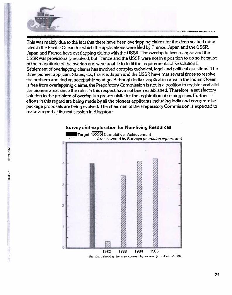
Survey and Exploration for Non-living Resources
-Target ~ CumuJative Achievement, Area covered by Surveys (in million square km)
r",
~~[~,~
!;tf ,;, "'
f!'
1982 1983 1984 1985
Bar chart showing the area covered by SUNeys (in million sq. km.)
25

the purchase of equipment, for holding exhibitions, for organising symposia, conferences,workshops, etc. and for bringing out publications. Financial support of the order of Rs. 53 lakhs hasbeen provided to various organisations in the countly .
The following organisations and institutes have received help during the year 1985-86.
Andhra Pradesh Academy of Sciences, Hyderabad.
Berhampur University, Berhampur(Orissa).Benaras Hindu University, Varanasi.Bureau of Public Enterprises.Central Institute of Fisheries, Nautical & Engineering Training, CoGhin.
Central Institute of Fisheries Education, Bombay.Centre for Advanced Studies, Annamalai University, Porto Novo,DA V Post Graduate College, Muzaffarnagar .Goa University, Goa.Indian Institutes of Technology , Bombay, Madras, Kanpur and Kharagpur .
Indian Institute of Geomagnetism, Bombay.Indian Society of Earth Sciences, Presidency College, Calcutta.Indian Society of Analytical Sciences (BARC), Bombay.Instruments Research & Development Establishment, (DRDO), DehradunIndia Meteorological Department, New Delhi.Indian Fisheries Association, Bombay.Jadavpur University, Calcutta.Karnataka University, Dharwar.
Mangalore University, Mangalore.Marathawada University, Aurangabad.Madurai Kamraj University, Madurai.National Remote Sensing Agency, Hyderabad & Bangalore.Ncitionallnstitute-Q( Oceanography, Goa.National Academy of Sciences of India, Allahabad.National Physical Laboratory, New Delhi.National Geophysical Research Institute (CSIR), Hyderabad.Osmania University, Hyderabad.Physical Research Laboratory, Ahmedabad.Regional Research Laboratory, Bhopal.
Shivaji University, Kolhapur.Surveyor General of India, Dehradun.University of Kerala, Trivandrum.University of Madras, Madras.University of Cochin, Cochin.Vishwabharati University, Shantiniketan.
27
7.
India's Antarctic research activities commenced in 1981 with the launching of the firstsci~ntificexpedition during 1981-82. Since then, scientific expeditions have been sent every year. During theThird Expedition ( 1983-84), India established its first permanently manned station .'DakshinGangotri" an.d the fir$t ~nt~ring t~a~ con~$ting of3 scientists and 9 persons fot logi~~c supp.ortwer~ left behind for continumgsclentific work thro1,1ghout the year. The Fourth ExpedItion, whIchlanded in Antarctica in December 1984, returned to Goa on 25 March 1985. This ~~pedition leftbehind a" 13 member winteriflg team in:Mtarctica'for manning" the permanent station and for. -continuing the scientific work initiated durihg the earlier expeditions.
In organising the Antarctic research programme, the Department of Ocean Development hadbeen drawing ~p the resources and manpowe! from various agenCies in the country. Logisticsupport for the expedition is provided by the three Services. The sci~ntific component is drawn fromdifferent research institutions sp~.ead all over the country ~nd from the Governm~~~pepartments.
The objectives of the Fourth'EXp~dition were two-fold. On the logistic side; construction ofadditional spacelor parking of vehicles and for the storage of equipment, construction of small fieldstations on rockS in the hills near Oakshin Gangotri, the establishment of direct HF communicationlink bet.Neen the L11dian mainland and the Antarctic station and.repair aId maintenance of thepermanent station were planned. On the scientific side the objective of the expedition was to carryout geophysical surveys and further studies in the fields of geology, meteorology, biology,communications, glaciology, oceanography and environment
A su.rnmary report of the scientific work carried out by the first WL'"1:eri:T)g team and by theFourth Expedition is given below:
Work carried out by the first ~nt~ii~gteam i~Antarctica (December 1983-March 1985)The first Indian wintering party, which consisted of 3 scientists, 1 each from Defence Research
and Development Organisation (DRDO ), India Meteorological Department and National Institute ofOceanography and gmaintenance personnel drawn from various branches of Defence Services,stayed in Antarctica for a period of 15 months and thus est~blished a record of their presencethroughout the Antarctic winter. During this period the team carried out scientific research in thefields of glaciology, meteorology andmicro,biology,besides carrying out studies on various aspectsof health arid hygiene, engineering and other problems in extreme conditions of cold and severeblizzards. Laboratory facilities and various instrum~nts and aids for working were proyjd~d in thepermanent station at Dakshin Gangotri. Some of the instruments Installed inside the laboratoryincluded solar radiation recorder ,barograph for re<;ording continuous atmospheric pressure,instruments for recording humidity and daily temperature;-401 MHz ECIL for radiosonde used for
28
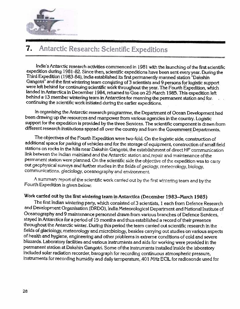
=---;;;;=""'--~-- ~-
Prime Minister, Minister of State and Secretary Deptt of Ocean Development with the Leader of the Third Expedition and members of the FirstWintering T earn.
upper air obselVations, temperature sensors for recording temperature profile of ice-sheet,unconfined compression equipment for recording unconfined compressive strength of snowsamples,pH meter, chemical balance, filtration oven, incubator, light panel for photosynthetic study,etc. and all essential facilities for micro-biological work.
The scientific studies carried out by the scientists rel~tedto the Oakshin Gangotri ice-sheet andthe Schirmacher oasis. The studies involved collection of samples and their preseIVation, testing ofsamples in situ and in the laboratory, analysis of the results based on the work carried out during thepast winters by scientists of different countries in Antarctica. Some of the important obselVationsmade and the results achieved are described b~low.
Glaciology and structural engineering
Continuous obselVations on the increase if1 strength of snow cover of the general area on theice-sheet within a distance of 30-40 km were recorded throughout the year, from the point of view ofdesigning the foundations of the structure as well as for developing compressed snow andice-ruriway for wheel landing of light and heavy weight aircraft. It was noticed that the ice-sheetaround the station is ideally suited for the development of compressed snow and ice-runway for
29

.--
,wheel1anding of light weight aircraft. As a trial measure, a ski-way of dimensions 1500 x 50 m wasdesigned and constructed near the station area for ski~landing of light weight aircraft.
Pattern of snow accumulation caused by blizzards around various objects was studied. Threepatterns, namely creep, saltation and turbulent suspension were identified and the amount of showaccumulated due to these patterns was measured. It was seen that the blizzards having a wind speedof the order of40-1 00 km per hour cause maximum snow accumulation around the objects. Thesestudies will help in de$igning various types of structures and installations on the Antarctic ice-sheetin future. ~
M~teorology
I"'eteorological observations pertaining to solar radiation, wind speed, air temperature, humidityand ozone level in theattnosphere were carried out with the help of conventionally developedinstruments in the coun~. Upper air studies with the help of hydrogen-filled balloons were carriedoutandobservations of temperature, wind direction and humidity for the upper atmosphe!ic layers! "we!ere~orded'on401MHz ECIL set. Stu9ieson the cloud cover in differentseaso~s ~round, " .." .DakSAirtGartgQtristatiotlwe:teals6carriedout. -" -,---~
Antenna and other fixtures for communication link between India and Antarctica and for meteorologicaJ data collection.
30

Itwas noticed that from February till November, almost 15 days in each month have blizzards.The highest wind speed recorded was over 250 km / hour during September 84. July and Augustwere the coldest months when the average temperature was of the order of -40°C on all days andthe minimum recorded was -50.5°C. Most of the blizzards occurred due to katabatic wind with thewind direction varying from 90° to 110°. Polar night was observed from 21 May to 20 J uly when thesun remained below the horizon. Polar day was observed from 21 November 84 to 20 January 85when the sun remained above the horizon throughout. Most of the precipitation occurred during the
days of blizzards.
Microbiological studies
The microbiological work carried out during 1983-85 was a continuatio(l of t,be wq.~k start~Q. -.during 1981-82. During the winterisation of 1984-85, emphasis was on the effect of temperature onmicroflora, with special reference to th~ir habitat, distribution, abundance, type of organisms andtheir ecology in the oasis environment. Samples were collected from Dakshin Gangotri oasis whichis 35 km2 in area, having lakes, lagoons, ponds, water streams, dome shaped hills, gentle slopes,varieties of soil type and typical polar climate. Samples were also collected from the penguin rookerylocated on the ice shelf near sea-shore. Temperature in the area goes down to -50° C in winter and
increases to + 6° C in summer .
Environmental studies on microfloraSamples from different sites were collected at different times of the year to represent summer
microflora (January 84 and December 84), winter microflora (August 84) and spring microflora( early December 84 ). These samples were analysed for moisture content and organic matter in thestation laboratory. Air and soil temperature and pH of soil were measured immediately on collection.Suitable media for population isolation were designed, after trials, and experiments were continuedin the laboratory. Samples were. also collected from the lakes for the estimation of phytoplanktonproductivity in lakes. Three lakes in summer of 1983-84, one in winter 1984 and five in December1984 were studied. petailed collections of samples were also undertaken in J anuary-F ebruary 1985for microbial population and vegetation cover. The data are being processed for the annual variation
in the different components of the ecosystem.
On the basis of the work done during the 15 month period, the following preliminaryconclusions are drawn:
( a) Ecophysiological work showed an interesting adaptation of microorganisms during the
Antarctic winter .(b) Microorganisms maintained their continuity in the oasis ecosystem in aU seasons.
(c) A bacterial specie (still unidentified) isolated in December 1984 produced dark bluepigments at low temperature. This appears to be a protein like substance.
( d) Productivity of the Antarctic lakes seems to be dependent upon the density of microflora
and nannoplankton organisms.
Scientific work carried out during the summer by the team of Fourth Expedition
The summer scientific team consisted of 19 members including one photographer. Scientificwork was carried out on board MS FinnpoJaris, over shelf ice near Dakshin Gangotri station and in
31

-""---;;""~,",'.."""'i".."""";".".",,, ,.,,","',"',"' ,""""'"" "",,'..."',"'
the oasis ofSchirma<:her Hills. While some of the scientific programmes were in continuation of theprevious years e.g. meteorlogy, glaciology, marine biology, radiowave propagation, etc., the FourthExpedition initiated some new scientific programmes, namely reflection seismic work onthe shelf ice, electromagnetic surveys of the shelf ice, geoelectric measurements in oasis, andmolecular biology of microorganisms of Antarctica, development and application of special type offlame proof polymer coating.
Applied geophysics~
The geophysical team carried out a number of useful geophysical experiments over the iceshelf near Dakshih Gangotri station and close'to the lakes in the oasis. Magnetic measurements
~c- --were made. to-iaentiFj the magneticsTgnaTilles of a possibTewarplhg in the basementbelow the-.., ."
ice-shelf and to delineate any tectonic feature possibly occurring in the region between the ice-shelfah d foothills of the oasis. Seismic reflecti9n surveys were carried out on the ice-shelf to study thecharacteristics of elastic wave energy propagation throughout the i<:,e medium constituting theice-shelf. ElectromagnetiG measurements were carried over the ice-shelf to determine its thicknessandgeoelectric investigation we!~ carried out over the rocky terrain.
MeteorologyThe Antarctic weather is likely to have influence on the major meteorological phenomena like
the monsoons. Therefore systematic meteorologicaf investigations in Antarctica are of greatsignificance. Meteorological programme of the expedition was:
(a) On ship
(i) Measurements of meteorological parameters at 3 hourly synoptic observations.
(ii) Reception, on board, of Fax charts from New Delhi. Pictoria (South Africa) and;~olodyozhnaya (Antarctic Meteorological Centre).
(iii) Radiosonde ascents.
(b) Oakshin Gangotri
Installation of new meteorological instruments for detailed study of Antarctic weather, e.g., APT(Automatic Picture Tra~smission) refeiver,potentiafgradientmeas~rementsand data collection by
weather the deck QfFiriii PO1aris.
32

region to forecast weather for helicopter operations.
Molecular biology of microorganisms
Microorganisms of Antarctica are likely to be unusual, being adapted to extreme coldconditions. Hence, it would be of interest to investigate the molecular biology of thesemicroorganisms with a view to understand the molecular mechanism of such adaptation. Further ,microorganisms of Antarctica are likely to be primitive and hence their study and analysis may shedlight on the early evolution. With this in view a collection of microorganisms from Antarctica wasundertaken during the Fourth Expedition~ Study of polymers
Sri Ram Institute of Industrial Research had successfully developed flame proof polymercoating. After successful demonstration of the paint developed, two tonnes of paint were produceqin the pilot plant for its application in Antarctica. The paint has been used in some of the rooms ofthe permanent building.
Different polymers were exposed to the conditions prevailing in Antarctica for a period rangingfrom one month to one year. The samples exposed for one year will be brought back for evaluationof their physical, mechanical, thermal and electrical properties. The rest of the samples will be leftfor exposure in Antarctic~.
Biological studies
(a) Phytoplankton studies and primary productivity
Water samples were collected from different stations to study the distribution andabundance of phytoplankton. Samples were collected from the various stations in polynyaand from the fast ice ecosystem at every 48 hours interval.
(b) Distribution and density of Antarctic krill
In order to understand the role played by the krill in the Southern Ocean and also fordelineating the areas of abundance ofharvestable krill, several stations in the area between58° S to 69° S and 11° E to 18° E were occupied. Shallow hauls were made. Adult krills weresorted out from the total samples and measured for their body length and weight. Somesamples of krills were frozen for biochemical studies.
(c) Studies on the distribution and abundance of zooplankton in the Antarctic water
Zooplankton samples were collected from 30 stations using Heron- Tranter net. Generallythe krill larvae dominated in the sample constituting more than 50% of the total biomass,followed by calanoid copepods, salps, cheatognaths, amphipods and ostracods.
( d) Studies on benthic communities
Benthic samples were collected from 120 m to 1400 m depths. Laboratory analysisshowed that the fauna is very diverse and has a greater abundance near the shelf than in theopen sea. Echinoderms, polychaetes, amphipods, isopods, gastropods and bivalves formedthe main components of the bottom fauna.
33

=-- ~~-
.( e) Biology of fresh water lakes
A complete suIVey of the lake near the permanent station was undertaken to study thebiological productivity during the Antarctic summer. All samples were analysed for primaryand benthic productivity. Physico-chemical factors like salinity, temperature, pH, alkalinity,dissolved oxygen and dissolved nutrients were also studied. Samples of lichens, mossesand algae from different Iqcalities were also collected.
Windmills and solar panels ~
Meteorological data indicate the presef'!,ce of strong incessant katabatic winds around DakshinGangotri station throughout the yeaLSuch a vast pool ofer:lergy existing there, if harnessed, can .yield an abundant and almost cost-free and ready to use energy for the Indian stations at Antarctica.For possible design of a wind generator the following jobs were undertaken:
(i) Data collection of the wind speed, wind direction, surface temperature, cloud cover ,radiation levels, etc.
(ii) Feasibility studies regarding the installation of a renewable energy systemiike the windmillwere made.
Though the sunshine falling on the Antarctic continent is only during the summer, the totalamount of radiation received during this time is quite comparable to the annual amount of radiationreceived in any other parts of the world. By deploying solar panels, water can be heated in summer ,which will be extremely useful in the laboratory for scientific work, for domestic use and also for theroom heating. As the stations are likely to remain inhabited by the summer and winter teams dur'!1!gthe summer periods, such a facility ~'ill be ye::.. important in making alternative sources of energyavailable to the stations.
Radiowave propagation
Studies on V HP and HP communications were continued. These studies were made withspecial reference to unfavourable weather conditions like bliZzards and when exceptionally highmagnetic storms occurred.
The st\,ldy is ofa continuing nature and data over a)ong period of time are required to berecorded to make these studies usefuLThe state of ionosphere keeps on changing at different timesof the day and from season to season. It is, therefore, necessary to predict the state of ionosphere atanytime from the HP communication point of, view. Since the HP communication is in operationbetween Antarctica and India, the present studY will be quite useful.
Glaciology
The work on glaciology was continued. During the period under report, studies wereundertaken in areas adjoining the Dakshin Gangotri station and at glaciers situated south of theSchirmacher oasis. The study was further extended towards the Wholthat mountain ranges;
PhotographyStill and movie photography were undertaken by the member of the Films Division included in
the team.
34
Philately
More than 2500 philately mail covers were cancelled at Dakshin Gangotri station.
Medical
Four doctors belonging to the Services were in charge of the medical needs of the expedition.The doctors established excellent medical facilities on board the ship during the ship's journey toAntarctica. They not only treated the expedition members but provided all possible medicalassistance to the members of the crew of the ship as and when needed.
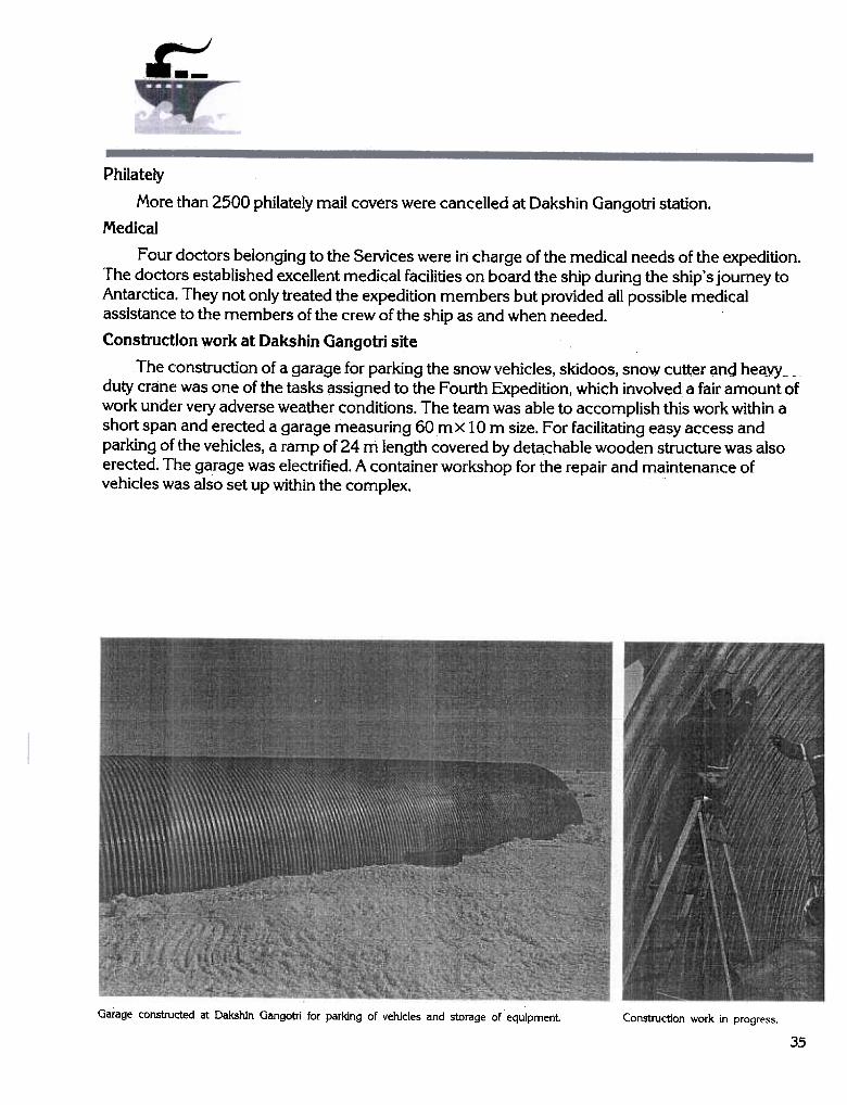
Construction work at Dakshin Gangotri site
The construction of a garage for parking the snow vehicles, skidoos, snow cutt~r ~nd he&yY --duty crane was one of the tasks assigned to the Fourth Expedition, which involved a fair amount ofwork under veIY adverse weather conditions. The team was able to accomplish this work within ashort span and erected a garage measuring 60 m x 10 m size. For facilitating easy access andparking of the vehicles, a ramp of 24 m length covered by detachable wooden structure was alsoerected. The garage was electrified. A container workshop for the repair and maintenance ofvehicles was also setup within the complex.
Garage constructed at Dakshin Gangotri for parking of vehicles and storage of equipment Construction work in progress.
35

-,,",x , -"',,-~.~-.,.., ,
AhQtJler major task of the Fourth Exp.edition was to construct three cottages on rocks in theice-free hill region ofDakshin Gangotri. A site, (coordinates of which are 70° 45'39.4" S,11°44'48.5" E approximately) about four kilometreswest of the eastern edge of the SchirmacherHills was selected. This site is some 60 krh away from Dakshin Gangotri and close to the USSRstation NovolazhalVeskaya. The height of the area is between 0-228m above the level of epishelflakes. The average height of the rolling relief of the area with its dbme-shaped hills is about 100 m.There are two nunatak~s, 2 krh south. The climatological p~ramete!s of the site are: average annualair temperature -11° C. The temperature in JanuaIY is -1.5°C and in July -18.2°C. The windspeed is 10.2 mls in'the east and south easterly direction with precipitation of 309 mmla. Theconstruction of the three cottages, with pref$ricat~d material was accomplished by a team of,8 members. Two double-storeyedhutsmeasuring 7.5 m x 5 mwith sle~ing accommodation for6 persons in each cottage ori the first floor, one timber structure of ~ smaller size to house thegenerator on the ground floor and stores on the left were constructed. These cottages wereelectrified. Kitchen and tqilet facilities and heating arrangements were also provided. The threecottages, with all provisions, medicines and other facilities were handed over to the second winteringteam on 27 February 1985.
A view of one of the cottages built at Schirmacher Hills.
36

-," 11; ,..-,r,-,-~
Pisten b.ulley towing habitat module container built by DRDO Inset Porta cabin (living container)
Alternative accommodation which was designed and fabricated by the Defence Research andDevelopment Organisation was established 200 metres away from the permanent station and asledge mounted garage to house one snow vehicle were also established. This accommodationcontains all facilities like snow melter, water closets, power generators, electricity and heatingsystems. Food and clothing were also stored for use by the wintering team during emergencies.
Communication
The Naval communication team was assigned the task of establishing and subsequentlymaintaining a reliable HF link on RT and CW modes with India. The work was carried out inhazardous conditions and two-way-communications with India were established. The results of theHF communication between Antarctica and India are indeed most encouraging. With a view toreducing the field work at Antarctica, a plan for pre-assembly of various sections of the Rhombicmast was drawn out on board Finnpolaris. Accordingly work was initiated on 22 December 1984 onthe assembly of twelve 5 m long mast s~ctions with their fastening arrangements. This task was
~7

---~,-M",
accomplished in a record time and the materials were subsequently transported to the site byChetakhelicopter. The installation of Rhombic antenna was undertaken from 29 December 1984 to9J~uary 1985. Four long masts each measuring 12.5 m in length have been installed on1.8 m X 1.8 mbase, buried in ice to a depth of about 1.75 m.
The 1 kW Punwire Transreceiver was installed in the radio room while two 5 kW transmitters,BE.LTx and the RS 512 were installed in the transmitter room, on the ground floor of the stationbuilding. The power transformer could not be accommodated in the transmitter room and waslocated under th~ stairway. ~
The entire communicatjon work was completed successfully in record time by a small Naval1eam"assisted-bythe scientist from PunjabWirele5s'System.-. ""-- -, .-, ,
ReturnjQu~yy ,"c" ,',' v, ...;
After completing all the logistic and scientific work assigned to the members, the team leftAntarctica on 1 March 1985 at 14.20 hrs. (17.50hrs.IST) along with the members of the firstwintering team. The ship reached Mauritius on 13 March at 14; 10 hrs (local time ). The team wasre~eiyedby the representative of ~J)dian High Commissioner at Mauritius. The ship- s~iled fromMauritius on 17 March at 08.20hrs. (local time) and reached Goa ori25 March at 09.00 A.M.
Fifth Indjan Expedition to Antarctica 1985-86
The Fifth Indian Expedition to Antarctica sailed from Goa with a team of 88 members on30 November 1985 and landed on Antarctica on 24 December 1985. MY ThuJeland, a Swedishvessel has been chartered for the expedition. The scientific component of the expedition consists of21 members drawn from 12 different institutions and includes two women scientists. The logisticcomponent consists of 67 persons from the three Services. Shri MK Kaul of the Geological Surveyof India haS' been nominated as the leader of the expedition. Shri Pavan Raina. Director in theDepartment of Ocean D-e~~elopment has also been included as a member of the ex-pedition team.
The expedition team also included 14 persons who will constitute the third wintering party. Thisp-artY-Wiil stay in Antarctica till March 1987 ;Dr. V K Dhargalkar otthe National Institute of -,
Oceanography, Goa has been designated as the leader of the wintering team. Two scientists fro.mthe Geological Survey of India, one each from India Meteorological Department and the NationalInstitute of Oceanography will constitute the scientific component of the third wintering party. Tenpersonnel from the Services will provide logistic support.
AgencyName Agency Name
EME
IN
IN
EME
ENGRS
ENGRS
IN
Dhargalkar, Dr. VK LeaderUnni, Maj. RK Deputy Leader
Adya, Maj. CM,Yadav, Lt. PDSingh, Shri RKMukherjee, Dr. SBhaskar Rao, Shri lVP
38
NIOEMEAMCINGSIGSIIMD
Achaya, Nb, Sub~ MUMalwade, Poelr. SRChand, Poelr. MSingh, Hay. SurjitChandra Choodan, Hay
Singh, Nk; ChananDas, LCK (0) PB

Members of the Fifth Scientific Expedition to Antarctica
Name AgencyAgencyName
Pant, Dr. (Miss) AParmar, Shri P PPaste, Nk. D RPatel, Sgt. H SPatil, Shri, P APrasad, Hav. LPrasad, Sgt. RPuri, Sqn.Ldr~ S K SRaina, Shri PavanRaj, Shri. K BRajgopal, PoelrP NRamdass, Lt. Col. T NRamakrishnan, Shri K CRama Rao, Hav. ERavindran, Lt.KReddy, Shri K N SSharma, Sqn. Ldr. A CSharma,Wg. Cdr.VKShingari, Sgt. D KSidhu, Maj. J SSingh, Nk. BalbirSingh JWO Balvinder .Singh, Nk ChananSingh, Nk. GurcharanSingh, Hav. JagarSingh, Shri R KSingh, Nk. SajanSingh, Nk. SewaSingh, Lt. Cdr. SurinderjitSingh, Hav. SurjitSohan Ram, Sgt.Sooch, Maj. K SSrinivasan, Shri JSrivastava, Shri DStone, Wg. Cdr. L BSudhakar, Shri TThankappan, Sgt. KThomas, Nk.Tiwari, HMT. R pT rivedi, Capt. V IUnni, Maj. R KVijaykar, Shri S SViswanadham, WO G KYadav, Lt.(SDC) p D
NIO
Films Dvn
ENGRS
IAF
IN
ENGRS
IAF
IAF
DOD
IN
IN
DRDO
BHEL
ENGRS
IN
NGRI
IAF
IAF
IAF
ENGRS
ENGRS
IAF
ENGRS
ENGRS
ENGRS
GSI
ENGRS
ENGRS
IN
EME
IAF
ENGRS
GSI
GSI
IAF
NIO
IAF
ENGRS
EME
ENGRS
EME
IIT, Bombay.IAF
IN
-~
39
oz---:~.","""'
.rT~sks for the FIft.h Antarctic Expedition
During the Fifth Expedition, suIVeys will be carried out in the S:chirmacher Hill range and in theeastern Wohlthat region. On the basis of the results of such a suIVey a suitable site will be identifiedat the Schirmacher Hill range for the construction of an alternative station during the SixthExpedition. Aerial reconnaissance will be carried out in the adjoining areas. The HE communicationlink will also be upgraded.
On the scjentific side, the expedition is required to carry out the following:
,-(i) ~eo~~~!~~ .'!1~pping o(the eastern Wohlthat regi?n. ,
(ii) Geophysical surveys in the Schirmacher Hills; potential of surface .'shows" ofmineralisation to be established by induced polarisation, electro-magnetic and magnetic
surveys.
(iii) Continuation of meteorological study and collection of meteorological parameters.Installation of a Data Collection Platform.
(iv) Collection of biological's'amples; bioecological studies of the Antarctic environment,studies of phytoplankton, zooplankton, fish and macrophytes.
(v) Collection of meteorites.
(vi) Study of fatigue of metals and other materials exposed,to ,Au'"!tarctic conditions.
(vii) ]nstallation of a solar energy system.
Antarctic Study Centre
The Government of Goa has alloted a site for this centre and have handed it over to theDepartment of Ocean Development. The first phase of the establishment of the Antarctic StudyCentre is expected to be completed during the Seventh Plan period. -
Antarctic Marine Uving Resources
The Convention on the Conservation of Antarctic Marine Living Resources (CCAMLR) wasconcluded in 1980. The objective of the Convention is conservation of the Antarctic marine livingresources. Conservation also includes a rational use of the resources. To implement the objectivesof the Convention, a permanent Commission at Hobart, Tasmania and a Scientific Committee havebeen established. The Commission which is an inter-governmental organisation has beeI) entrustedWith a broadfange of functions which include, inter alia, the facilitation of res~arch, formulation,adoption and revision of conservation measures, and implementation of the system of observational)d inspection. The original signatories to the Convention are the members of the Cgmmission. Anacce~ingState is entitled to membership during such time as it is engagedirrresearch or harvestingactivities of the Antarctic marine living resources.
India acceded to this Convention with effect from 17 July 1985- and participated in the fourthannual meeting of the Commission held in Hobart, Tasmania from 2 to 13 September 1985 as anobserver. At this meeting, guideline$ relevant to the preparation of submissions by the Statesseeking membership of the Commission were formulated. India's application for the membershipof the Commission, in accordance With the guidelines established, is expected to be submitted
40

shortly. Membership of the Commission will entitle India to participate in the decision makingprocess. The present membership of the Commission includes Argentina, Australia, Belgium, Chile,the European Economic Community, France, German Democratic Republic, Federal Republic ofGermany, Japan, New Zealand, Norway, Poland, South Africa, Union of Soviet Socialists Republic,United Kingdom of Great Britain and Northern Ireland and United States of America. Republic ofKorea, Spain, Sweden and Brazil have also acceded to the Convention.
Antarctic mineral resources regime
For a number of reasons, there is an increased interest in the possibility of exploiting mineralresources of Antarctica. As distinct from basic scientific investigation, the question of possibleexploitation of natural resources of Antarctica raises a wide range of questions of legal and politicalnature. The Antarctic Treaty places a special responsibility on the contracting parties to ensure thatno State engages itself in any activity in the Antarctic Treaty area which is contrary to the principlesand purposes of the Treaty.
The knowledge about the mineral potential of Antarctica at present is rather meagre. Althougha large number of mineral occurrences have been reported from Antarctica, the chances of theirrecovery in commercial quantities do not appear to be attractive enough within the next decade.
The prospecting for hydrocarbons in the continental margins around Antarctica is consideredto be a possibility within the foreseeable future but commercial exploitation may take quite sometime. Exploration and exploitation of metals and fossil fuels from the land areas of Antarctica appearmuch less possible; at least in the foreseeable future. Much of the geology of Antarctica hasremained poorly known because almost 98% of the land surface is mantled in ice to some
Survey of Schirmacher Hill and Lake region.
41

1 ,600-4,500 metres in thickness. The depth of the Antarctic continental shelf varies from 400 to 800metres on the seaward edge as compared to world average of 133 metres. The geography, geologyand extreme conditions of cold and ice offer an enormous challenge for carrying out scientificinvestigations, exploration and exploitation activities on the continent and in its surrounding waters.The present ignorance of the structure of much of the Antarctic land and continental margin,coupled with the hostile environment and the thick ice cover, would indicate that the exploratoryphase is likely to be prolonged in most areas before exploratory drilling or exploitation can beconsidered. ~
The primary focus of the Antarctic TreatY of 1959 is on scientific research. However, it neitherdirectly prqhibits nor permits commercial exploration and exploitatioA' of-mifleral resources. In fact,thc;; Treaty does not directly govern the problem of mineral resources. Therefore, the contractingparties have considered it necessary to establish a system to regulate the exploration andexploitation of minerals before such activities commence. During the last few years, a number ofproposals in connection with the possible regulation of the exploration and exploitation of Antarcticmineral resources have been considered. An informal Working Group of the Consultative Partieshas been working on the establishment of a mineral regime for Antarctica. Wh!le-the basic elementsof a mineral regime have been identified, the details of the regulatory framework are yet to beworked out. India has been participating in the meetings of the informal Working Group after itacceded to the Antarctic Treaty in September 1983. During the year 1985-86 two meetings of theWorking Group were held, one in Rio de Jeneiro from 25 F ebruary to 8 March 1985 and the other inParis from 23 September to 4 October 1985. India's paftjcipatibn and contribution were appreciatedby the members of the Treaty.
XIII .~tarctic Treaty Consultative Meeting
The XIII Consultative Meeting of the Antarctic T rear) ?a;-ties was held in Brussels from7 to 18 October 1985. China and Uruguay were admited as Consultative members, thusincreasing,thetotal number of Consultative Parties to eighteen. India, which became a ConsultativeParty at the XII meeting, also participated. The operation of the Antarctic T reatySystem and theimpact of man's activities on the Antarctic environment were among the maj9r issues considered bythe meeting. Sixteen recommendations covering different aspects of scientific research inAntarctica, exchange of information, speciaIly protected areas, historic monuments andappointment of observers, etc. were also adopted.
Antarctica and the OnJted Nations
For the third time in succession the "Question of Antarctica'. was discussed within the UnitedNatiops,.which was reinforced by a compreherlsive, factual and objective study prepared by theSecretary General in response to Resolution 38/77 of 15 December 1983. The study mandated bythe General Assembly reaffirmed that Antarctica should be used for peaceful purposes for thebenefit ofall mankind and should be free from all international discord. It acknowledged thecontributions made by the Antarctic Treaty System.
During discussions some States enumerated series of deficiencies in the Antarctic TreatySyst~m and"emphasised the need for a regime which would ensure equitable distribution of mineral

~j
The Organisation of African Unity through a resolution "sought the: "common heritage of mankind". There was aJso a strong move forc , Treaty set-up. The AhtarCticTreaty Consultative
The1r~aWwas~pen for any member of the United Nations to join. India along with other ,Consult;ativePa~es~~p~sised that any attempt to undermine the Antarctic TreaW System couldlead the working system. It was an evolving syst~~ whichhas worked s~tisf~~orilyand was responsive to the vie~pointsof aQStates. In~ia empha~lsed thatthe TreaW System shoul~ be broadened by the accessIon of more States. In thlS context Itwelcomed the ad~issionof the Republic ofChina and Uruguay as Consultative Parties. India alsoemphasisedthe need to work out modalities to improve upon the TreaWto make it more open andto ofdevelopingcountrles. """.',, ' 'c " i,¥l~iti~..~~t:~ltl;;,'"
43

8.
",~£H~99~~~ry)~rjQ~poPuti pr~le~,~ in the In~~n qce-~n h~ve not yet reached the
coast and TamilN;adu on the east coast,
It has been syggested that the treatrnentof industrial and domestic wastes needs to be
accelerated. There is, therefore, a need to develop monitoring programmes to assess the sources,
levels and facts of pollutants and also there is a need to implement programmes on pollution
abatement and control.
During the last few years, studies on the ?re-~nce of oil and oil slickS have also been carried ou!
along the Indian c9a$tline, Research Vessel Oaveshani carried out obse1Vations along the oil tanker
!9 utesacrq~~ ~eAr~bianSea ~r)d the ~ay of Be:ngal to ~t~qyJ~)oils)icks;((p ) petroleum residues
{far like matefi81)"and ( c ) dissolVed anddis p ersea. h y"ar6'carDon"$j~Fr6m these'studies cohclusions,
were drawn ~atthe Indian s~as an alarming
discharge
p~lnt,for m~;In-q~~~I~'~ffl4~ntsand sewage, Ba~ed on theclnf9r~~ppn~~~ereddu!lngth co~stal-
",""",,C" , " CC " -""'CO""'"' c ' .
monitdtf# g'::!\[~~;e:htirecGul f;6fKutchisan ecologica1ly sel1sitiveareaby;~rty~of itS;being a breedIng!,;",oc,".""~},,c-,., -, ~, , c"c'" ," " "'"""";',c';'ji':;-"';'"'C"""'
and
p r., .ekoJthofilieG :ulf showshi g:h prb'd8~nl,andthe presence of,ry"'c t'"- "'"" , 'c C," " , ""[,,
cbtarreefs~n~~iNbra,~ndother islahdshi!$.added ful:ther signifit~nqe't6 the" area, Ihe coastlinec 'c ,"," , c' c "" , , , " c ' , ,
near MaIVan on: the Maharashtra coast is of speci~l interest. Malvan With its "coral reefs and high
bi()logicafproductiVitjj is also an ecologically sensitiVe area.
44

..Duringth~Sevehth Plan period, the sulVey of the entire coastline of the country with a view to
identifYing pollut!ori$oUrces, ecologically sensitive regions and to assess the impact of pollutants is
expected to becofupleted.
A Marine Pollution Group to deal with all issues related to pollution of the seas has been set upas an Apex Body. All maritime State$ oflndia, Coast Guards, Ministrie$ of Shipping and Transport,Petroleum, AgriGulture,Urban Development, Industry and DepartmentS of Environment and OceanDevelopment constitute the Group, During the year 1985-86 the Group met twice to consider theproblem of pollution. This Group has requested the Coast Guards to prepare plans for combatingpollution from oil spills, mohitoringof pollution and other enforcement aspects. A nationalcontingency plan for meeting an oil pollUtion contingency situation is proposed to be finalised. Tti~question of the review of laws and regulations takingJnto account the relevant internationalconventions haveaJsobeen $ugge$ted. After examining the various issues, the Group has approvedthe contingenq pl~riprepared by the Coast Guards and given further $uggestions for takingeffective mea~ures fotcombatingpollution. The maritime States have also been requested toprepare status reportS on pollution in their regions. Steps are being taken to develop monitoringprogrammes and to acquire suitable equipment for this purpose. Environmental data andinformation are regularly collected on all the cruises of the research v.essels.
9.
Preparatory work for the acquisition of a manned submersible capable of operating at a depthupto 600 metres, with built in transfer of technology terms, were completed during the year1985-86. Design, fabrjcation and the acquisition of a submersible will take about 2 years and it willbe available in 1988. The submersible will not only added to the research capabilities in carrying outstudies on light penetration, plankton, coral reefs and mapping of shallow areas of the sea, it will alsoenable on-the-spot inspection of the offshore installations and structures.
45

1 the system to be u$ed for the absorption of waves." ,
of calm pool of water behind the system
c , the system and their protectibnlhmarineenVironmenlc , c ,
of this projectis brieflysummarisedbelow:
Aftercolleqtjngwave data for more than a year; a spect&lway~ rjderbuQY was deploy~d off the, '", , .c ' ;'Madras :cQ~$tduitng1984-85. thesignaJs monitoted by Witelessin'Strumehtatiofi were recorded" , cc -,.and ~~J~§y1t$were analysed to arrive at the wave spectrum for all the, days and months of the year .The necessaIYcomputer software has been develbped.puring the initial stages of the project,various t)ipes of wave energy devices were considered. Some model experiments were also carriedout on different types of devices and finally it was decided that for the multipurpose wave energysystem required for our coast, a terminator type bottom standing Oscillating Water Column device
(OWC)Is the most suitable one.Various theoretical and experimental studies were undertaken in the laboratory for the
optimisation of the dimensions of me OWC device which will be able to work efficiently near t."1ecoast for a long period. Some of me iatest modifications to the OWC reported in 1984 in Norwaywere incorporated in an experimental study which was completed in November 1985. This deviceknown as 'Harbour concept' is being studIed in depth. .
On the development ofait turbines, advantages of special turbine rotors with small camberedblades are being studied. The theoretical analysis on the flow around turbine blades has alreadybeen completed. One tWin rotor of 150 mm diameter has been successfully fabricated for' "-
demonstration. Based on the theoretical analysis, a few cambered profiles have been selected forexperime~t~1 optimi~~tion.Bl~de and rotor design for the experiments were completed.
AfterjqeriQ~ng A generator with apermapent magnetwith iron-free rotor, a small generator" cc, ' " Ihas been fabricated with the assistance of the Madras Port Trust.(
Allthe!instrument;citiori required for thelaboratolY studies have been chosen/developed andacquired/fabn~ated indigenously .A concept of the instrumentation required for the sea experimentshas been evolved and,various instrumen~s:ystems have been identified. ,
A bottom standing concrete structure with skirts penetrating into the sandy seabed has beendeveloped. This is capable of withstanding the most severe wave conditions like19 to occur off theMadras coast. A <::omplete design fot the structure is in progress.
Concrete has been chosen as the material for the structure with suitable additives/surface
46

1~
treatment, for its marine application For the turbine, the shaft will be of stainless steel and rotorblade of brass with nickel plating. The ducting for the turbine will be in steel, coated with epoxypaints for corrosion protection.
(i) Studies on variation of wave energy
As the waves approach the shallower waters, due to bottom friction and other effects, theirenergy content gets reduced. On the other hand, the cost of a bottom standing wave energy deviceincreases significantly with increasing water depth. In view of this, studies have been carried out tofind the optimum water depth for the device. A theoretical model has been applied for the Madrascoast and predictions were obtained. For the verification of these theoretical results, wavemeasurements are to be taken simultaneously at different water depths. For this purpose additionalwave rider buoys are being procured.
(ii) Wave refraction studies
A refraction study has been conducted for a 25 krn length of the coast near Madras and alocation for the concentration of waves has been identified. This will be verified by actualexperiments after the two additional wave rider buoys have been installed.
(iii) Demonstration model on wave energy
A demonstration model on the wave energy has been developed, designed and fabricated forits installation. This includes a wave maker for a 1.2 m wide flume and an Oscillating Water Columndevice to absorb the waves with a matching turbine and generator to produce electricity.
(iv) Air turbine
Four different types of blade profiles, selected after the theoretical analysis are expected to befabricated,' assembled in a rotor and tested for their efficiency in a test rig of the ThermalTurbomachines Laboratory at IlT, Madras.
The entire system of Oscillating Water Column device with turbine and generator will be testedand proven in the 4 m wave flume of the Ocean Engineering Centre, IlT, Madras, to demonstrate theconv~rsion of wave energy into electricity.
System development and a design for the sea experiment are expected to be completed in thenear future. These will include the design of structure, the methodology of its manufacture, thedesign of turbine with the necessary generator control. An instrumentation system to monitor andevaluate the sea trial will also form a part of this model.
47
11. Ocean
OTEC technology is being developed world-wide over the past 15 years. Major contributions inthis field have been provided by USA, Japan, France, Sweden and Holland. The world-wide OTECpotential is expected to be around 10 million MW.
The first in-itiative on OTEC in India was taken during 1979-80. A Project Cell was formed at theOcean Engineering Centre, Indian Institute o:fTechnology, Madras to look into the various aspectsof o~.~~n ~"~.@~~I)~rgy. &ndJp ~QPrd.n~J.e-the activities on OTEC among a project groupconsisting of the following industrial/research organisations:
(a) National Institute of Oceanography, Goa(b) Bharat Heavy Electricals Limited, Hyderabad(c) Engineers India Limited, New Delhi(d) Mazagon Dock Limited, Bombayand( e) Indian Institute of T echnology , Madras.
A project group consisting of the representatives from the above mentioned institutions wasrequested to study the possibilities of putting up an experimental1 MWOTEC Plant off one of theislands of Lakshadweep. A project team consisting of 8 representatives from the above5 organisations visited t~e islands during August 1982 to study the various possibilities. Only twoislands, namely Kavaratti and Minicoy were found to offer possibilities for installing an OTECPlant From the available bathyrnetry and temperature profiles around the islands, it has been foundthat a depth of 1,000 rneties will be available within a distance of about 3 kIn frorrl the islands and atemperature difference of 20c to 22°C between the surface and 1 ,000 m depth throughout the year.Therefore, it has been consider~d that a shore-based plant is ideally suited for these island siteswhich have big lagoons on the western side. These islands are of coral origin and detailed studiesfor placing the cold water pipeline on the sea slope are necessary. The cold water pipe for this} MWPlant is expected to be about 1.5 metre in diameter and one of the proposals under coQsideration isto provide high density polyethylene (HDPE) pipes, assembled on shore to be floated out in fulllength and sunk.
After a study of the possible site conditions at Kavaratti and Minicoy islands, it was felt that shelland heat exchangers, having a weight of 200 tonnes to 400 tonhes per unit, will not be suitable forthese islands because of the lack of unloading facilities there. Hence the working group hassuggested that plate heat exchangers are to be preferred for Lakshadweep islands.
Detailed bathymetry and temperature surveys of the two sites in Kavaratti and Minicoy weredone. These surveys indicated that the bed slope in Kavaratti is relatively more uniform and issuitable for the installation of cold water pipe when compared to the corresponding bed slope offthe Minicoy island.
48

at a water depth of 650 metres where the temperature of the sea water will be 10°C. Thecorresponding length of the cold water pipe will be about 28 kilometres. This will result In the warmwater intake temperature of 29°C and cold water intake of 10°C, resulting in a temperaturedifference of 19°C. Thus the different parameters have been recalculated and the new componentspecifications have been arrived at
Action has been initiated to get the details connected with the procurement of the majorcomponents like the heat exchangers, cold water pipes, turbo-generators, pumps, etc.
The lIT, Madras, which is implementing this project is continuing with research anddevelopment work connected with the experimental plant
49
~
The Department of Ocean Development was created in July 1981 under the CabinetSecretariat "and from March 1982 as a separate Pepartment The organisational set up is indicatedbelow:
rv1inister
& Electronics
Jo'm ~"etaryFinancial AdviserJoint Secretary
Director IVDirector II Director III
P!lncipalScientific Officer
PrincipalScientific Officer
PrincipalScientific Officar
SeniorScientific Officer Under SecretarySenior
Scientfl1c Officer
II
Section Officers
and
~upporting Ministerial Staff
50

~
OrgariisationThe Department has no scientific laboratories under its control. Its scientific programmes are
implemented through various CSIR/lCAR Laboratories and National facilities. The total staff strengthof the Department in all grades was 82 as on 31 January 1986.
During the year 1985-86, the recruitment to the following posts were made: Group 'C' one,Group 'D' one. Action is under way for filling vacancies in the posts of Director, Senior ScientificOfficer and ~;enior Technical Assistant.
The Department is located in theCGO.Compiex, Lodi Road and occupies 9,032 sq. ft. in BlockNo.12 and ~~,ooo sq. ft. in Block No.9.
BudgetThe budget estimate of the Department of Ocean Development for the year 1985-86 was
Rs. 2,889.60 lakhs. while the figures for revised estimates for 1985-86 are Rs. 2,043.63 lakhs. Abudget estimate of Rs. 2,817.49 lakhs has been made for the year 1986-87. A summary of thefinancial requiremept is given below:
SI.
No
Item RevisedEstimate1985-86
Allocat-ion for
the 7thPlan
BudgetEstimate1986-87
BudgetEstimate1985-86
62 3 4 5
A. Plan(Rs. in lakhs}
100 300
4,500
1.50
2.300400200
3020
350350200
3020
250350100
10
3.216
57554
37045
15060
30050
14550
3030
4.
Oceanographic SurveyOther Research Vessels
Antarctic ResearchExpedition to AntarcticaChartering/running of Ice-breakerResearch Stations in AntarcticaAntarctic Study CentreAcquisition of Ice-breaker
Polymetallic Nodules ProgrammeSurveys & ExplorationMining Research and DevelopmentUnder-water Technology & SubmersiblesMetallurgyContribution to International
Sea-Bed Authority (ISBA)
Researc:h and DevelopmentMarine Research and DevelopmentAssistarlCe for Research Projects,
Seminars, Symposia, etc. 40 3040
51

,.,~"..,-",.""~,,
21 5 63 4
500200100100
152325
5
50251520
50502520
5 1525
20 20 200755.
36 7050
5075 45
10 25306.
~,.,1 !..I-1"1::II,.j
All India Coordinated Projects onRemote Sensing, Telemetry BuoysSystem, Oceanographic T owers, etc.
Marine Pollution ,Desalination and Marine Chemicals ScHemesMarine Instrumentation ,
ocean Eneig,}r ProgrammesStudies on Prevention of Coastal
Erosion and Wave EnergyStudies on Ocean Thermal Energy
Conversion (OTEC)
TrainingManpower Training for Oceiirl'
Research& Management (IncludingShort Term Training Programme)
Assistance to Universities, etc. forPost-graduate Centres
National Oceanographic DataInformation System
~,er Expenditure,A.d.rninistrative Support & InfrastructureExrJbitions & FairsContracts with Industries for Development
International Cooperation
A. T otal
7. 25
1
20
15
252010
20
100100200
100
B. Non-plan
Secretariat 28.90Oceanographic Research Vessel 350.00Fishery & Oceanographic Research
Vessel {f:'ORV)Marin~ Research and Development-
Assistance for Research Projects,,Seminars, Symposia, etc.
Manpower Trainjng for Ocean Researchand Management
Administrative Support and Infrastructure
B.Total
GrandTotalA+B
31.66360.00
28.65350.00
1.2.3.
291.00 250.00316.004.
30.00 40.0060.005.
6.20.0015.83
10.0013.98
20.0014.70
52

Progressi~e use of Hindi
/The progressive use of Hindi in day-to-day official work was encouraged. The meetings of theOfficial Language Implementation Committee ( OUC) of the Department were regularly held. Inorder to provide in-service training to the employees, a workshop was organised from 27 January to7 February 1986. Cash prizes and certificates were given to the members of the staff who obtainedpositions in 'Hindi Nibandh Pratiyogita'. 64 out of 67 officers/staff in the Department have workingknowledge of Hindi. A Hindi Week was also organised. A copy each of "Karyalaya Sahayika" andconsolidated glossary of administrative terms were provided to each officer. Two officials weresponsored for Hindi language training and two for training in Hindi typing.
Though most of the work of the Department is scientific and technical, efforts have been madeto implement the provisions of the Official Language Act, 1963, the Official Language Rules, 1976,and the instructions issued by the Department of Official Languages, Ministry of Home Affairs, fromtime to time regarding progressive use of Hindi for official purposes. The programme regardingprogressive use of Hindi for the current year, recommended by the Department of OfficialLanguage, has been taken up for implementation as appropriate.
The Department's Annual Report, Performance Budget and the detailed demands for grantswere presented in Hindi and English. AIl Gazette notifications were issued bilingually. Agenda Notesfor the meetings of the Parliamentary Consultative Committee and answers to all Parliamentquestions were furnished both in Hindi and in English.
A glossary of ocean science terminology in Hindi is under finalisation in consultation with theCommission for Scientific and Technical Terminology (CSTT). More than one hundred and fiftyHindi books on various subjects were added to the library of the Department.
In February 1986, the second sub-committee of Committee of Parliament on OfficialLanguage reviewed the progress in the use of Hindi in the Department.
Publications
During the year the Scientific Report of Second Indian Expedition to Antarctica consisting oftwenty two papers dealing with geology, geophysics and geomagnetism, glaciology, meteorologyand radio physics was published by the Department.
53

Annexure

~
,,- ,
~.~
Id
"" """'.~~~
~1!%r~,"?ifJ!;":',if"'
ti~alh~ig&~~hqsalirity gradientS and the collection and processing of polymetallic nodules fromthe deeri sea,,~.. .
", ,, , , , , ' "
7., "Ma!i9~ ,~~v~16pment is linked With scientific and technological achievements in other areas.Hehcewhilewedevelop'basic marine science and technology, i.e. technology for marineenVirQnmeht.ourtechnological advances have to pe geared to the utilisation and preservation o~ themarineenvironm~nLThe extension of national frontier~ by an area of 2 million square kilo metres ofoc~aQspa,ce,and,:t6econsequentacces to new sources of energy, minerals and food, requiresgreat strides in bee~nengineering, spec in tasks related to structures, materials,instrurnentatiqr,submersibles"and systems of prop~~sion of ships. The exploitation of natural foodregources such as fish'and seaweeds, and the generation of additionalfoQd re~ources by cultivation,also need scie?tificmethods of aquaculture and mariculture. To survey and predict the oceanenVirormerlt, the main tasks necessary are seafloor mapping, charting, geodesy, ocean dynamics,currents, waves,f!;Yclones, marine fauna, chemistry and phy$ics of theo"oceans and seabed mineralmapping, delineation and assessment. Research in aft these areas must examine the variousprocesses and their origins so as to have aiundamental understanding, ensuring predictivecapabilities, Marine science and technoJogyhas also to look beyond the currenfstate-of-the-arttoachieve major technological break-through in the future.
8. Besides research and development in basic sciences, we should survey the deeper parts of theocean. Simlilarly in the deep sea, detailed survey and sampling in the regions of EEl and theadjacent ocean will be necessary to locate and evaJuate the rich and economically viaDle deposits ofpolymetallic nodules, heavy metals, fossil placers and phosphorite deposits. The gathering of datafrom surveys should be coordinated and a cost-effective system of integrated surveys established.
9. Much more needs to be done for the development of indigenous technology for the exploitationof fish from deeper waters. This also means setting up of infrastructure facilities and services tooperate large-sized fishing vessels.
10. An important component of the development programme should be the acquisition oftechnology. To be self-reliant, such technologies would have to be largely developed, tested andoperated indigenously. Technologies relating to instrumentation, diving systems, position fIXing andposition maintenance, materials development, oceanic data collecting devices, anti-erosioncapabilities, submersibles, energy and energy-saving devices are priority items. Several newtechnologi~~s will have to be commercialised ~nd made cost-effective.
11. Infrastructural support forms an essential prerequisite for ocean development. The variegatedinfrastructure already available in the country will have to be appropriately augmented, and moreparticularly in basic supporting facilities like safety and rescue at sea, navigational chains,communication net-works, development of appropriate maps and' charts, etc. Infrastructuralsupport for providing a complete and reliable information system through a net-work of datacentres on marine resources, processing and marketing systems, advanced technologies andfinancial assistance would also be necessary. this requires a broadening and strengthening ofavailable Infrastructural facilities. Provisions of adequate ports and harbours, ship-building and
'ri7£ ship-repair facilities will be needed in addition to adequate skilled manpower in various sectors of
~'""";i"' development..
55

12. Sul'\ieilf8nce and conservation of the marine environment and its resources call for an,integra~edlegal framework and its concomitant enforcement. Several laws have already beenpr9mcils~t~4xegardirig the maritime lone, fisheries, etc. The Coast Guard Organisation looks afterthe enforcement aspects of several of these legislative measures. The coordinating mechanisms oftheoveraU $ttucture of legislation will have to be suit~bly strengthened under the aegis of theDep~~meht of Oc;ean Development
13. lh'ttie1ightofthis, we must have a data; base to co~rdinate efforts made by diffe~ent agencies.This is alilliemore nece5sarobecause of the rapid gC'C";c"C",~J".. ,tecQri91qgy.A'c~ntfaliseddata system Will be set up by the Department o(OceanDevelopment with" .c , " c ca pi~p~fih~ch~ryj$rn fo!collection, collation and dissemina'tioh of infomiatioh acquired both
iridjg~hous'y~nqfrQtnf6teign sources." ","," .14. base puts a hea.YY4e~anqon fully tramed
mahpoweris to bete9,~ne!9sj~tsapderigjheers Will be encopraged to participateih the pt6~ramme9! oceandev~l:qe~ent~ridstepsWin betaken to induce Indian scientistsftom wjthinthecountrY and abroad
cc 'C,""- ..to p~rtl~Jp~te mJt.
15. ~stin9 ag~ncies will have to be appropriately strengthen~d to meet the demands of thisgrowing challenge. The Department of Ocean Development will function in conjunction with otherconcerned agencies as a focal point to promote institutional cap.ability in areas where sigrIil'ce.ntwork is Jacking. The complex programme that ocean development entails will require well-designedmanagement and institutional extension of the Department of Ocean Development \\1th sufficientpowersvis-a-\is other agencies to heip proper and speedy ocean development, which enables Indiato be in the forefront of the international effort. This would also mean close cooperation with bothdeveloping apd developed countrie5 rr-, ? spirit of understandmg of the concept that the ocear-,5 are acommon heritage of humankind.
56
Copyright © 2022 FDOKUMEN