Contemporary processes in peripheral rural areas in Slovenia
19
CONTEMPORARY PROCESSES IN PERIPHERAL RURAL AREAS IN SLOVENIA Jani Kozina, PhD and Mimi Urbanc, PhD Final draft version, February 2014 Published in: A., Calcatinge, ed. 2014. Critical Spaces: Perspectives in Urban, Spatial and Landscape Studies. Zürich, Münster: LIT‐Verlag, pp. 147‐166. Abstract Rapid technological development, brought on and prompted by processes like industrialization, tertiarisation, urbanization, and globalization, has tended to increase the differences between areas in the Western world in terms of their level of social-economic development. Two groups of areas have formed: central and peripheral areas. These kinds of effects of landscape development are apparent in the demographic structure, the settlement image, land use, infrastructure equipment, etc. Slovenia has been paying considerable attention to peripheral and less developed rural areas for quite a few decades, mostly through research work and the authorities’ endeavours to boost their economic development. The measures for defining these kinds of areas have been altered a few times; however, the same regions were usually classified as the problem areas. One of these is Suha krajina (literal English translation: dry landscape), characterized by its remoteness from the main transport axes and development centres, as well as by its karst terrain with less favourable conditions for agriculture. The article presents some of the main social-economic characteristics of peripheral rural areas in Slovenia. Special emphasis is placed on Suha krajina, where intense field work was carried out to study the demographic and landscape processes that remain poorly documented or wholly unknown to the official statistics. Key words: peripheral rural areas, depopulation, migrations, settlement image, transport accessibility, Suha krajina, Slovenia 1 Introduction Rapid technological development in conjunction with processes such as industrialization, tertiarisation, urbanization, and, in recent times, globalization has largely increased the differences between areas in many countries based on the level of their social-economic
Transcript of Contemporary processes in peripheral rural areas in Slovenia
CONTEMPORARY PROCESSES IN PERIPHERAL RURAL AREAS IN SLOVENIA
Jani Kozina, PhD and Mimi Urbanc, PhD
Final draft version, February 2014
Published in: A., Calcatinge, ed. 2014. Critical Spaces: Perspectives in Urban, Spatial and
Landscape Studies. Zürich, Münster: LIT‐Verlag, pp. 147‐166.
Abstract
Rapid technological development, brought on and prompted by processes like
industrialization, tertiarisation, urbanization, and globalization, has tended to increase the
differences between areas in the Western world in terms of their level of social-economic
development. Two groups of areas have formed: central and peripheral areas. These kinds of
effects of landscape development are apparent in the demographic structure, the settlement
image, land use, infrastructure equipment, etc. Slovenia has been paying considerable
attention to peripheral and less developed rural areas for quite a few decades, mostly through
research work and the authorities’ endeavours to boost their economic development. The
measures for defining these kinds of areas have been altered a few times; however, the same
regions were usually classified as the problem areas. One of these is Suha krajina (literal
English translation: dry landscape), characterized by its remoteness from the main transport
axes and development centres, as well as by its karst terrain with less favourable conditions
for agriculture. The article presents some of the main social-economic characteristics of
peripheral rural areas in Slovenia. Special emphasis is placed on Suha krajina, where intense
field work was carried out to study the demographic and landscape processes that remain
poorly documented or wholly unknown to the official statistics.
Key words: peripheral rural areas, depopulation, migrations, settlement image, transport
accessibility, Suha krajina, Slovenia
1 Introduction
Rapid technological development in conjunction with processes such as industrialization,
tertiarisation, urbanization, and, in recent times, globalization has largely increased the
differences between areas in many countries based on the level of their social-economic
development. Two types of areas have formed: the first are large city regions that are
expanding to neighbouring rural settlements as a consequence of suburbanization; the second
are peripheral rural areas that are seeing a decline in population. The rural drain processes
first began in the late nineteenth century in developed countries as a consequence of
industrialization. The first areas to be affected were the ones burdened by agrarian
overpopulation and areas with less suitable conditions for settlement and economy (Celińska-
Janowicz, et al., 2010).
Bucher and Mai (2005) differentiate between three country types with regard to depopulation
in Europe:
- Countries with large depopulation areas, but small interregional differences (the Baltic
countries, Romania, Bulgaria, the Czech Republic, and Russia);
- Countries with regional bipolarity, which means larger or smaller depopulation areas and
clearly geographically separated areas of population growth (Germany, Spain, Portugal, Italy,
Poland, France, Greece, Finland, Sweden, Switzerland, Slovakia, Slovenia, and Hungary);
- Countries with depopulated regions, but having no depopulation problems in general (Great
Britain, Ireland, Island, Denmark, Norway, Belgium, Holland, Austria, and Macedonia).
According to this typology, Slovenia falls in the larger group of European countries, where a
polarization occurs between the areas that are gaining in population and the areas that are
seeing a decline in this regard. The latter areas are usually categorized as less developed. The
most important factors here are the location and position of the rural areas. The areas with
superior accessibility and connectedness with their surroundings are privileged to a certain
extent, while rural areas, more remote from larger regional centres, less accessible, and closer
to smaller centres, have significantly less opportunities for development (Klemenčič, Lampič,
and Potočnik Slavič, 2008). Good transport accessibility to regional centres that have
concentrated supply and public functions and employment positions remains one of the
fundamental conditions for social-economic development. Improved accessibility namely
reduces the length and need for travel, which contributes to the decrease of numerous negative
effects of transport (time and energy use, over-suburbanization, environment pollution, etc.)
(Kozina, 2010). This also lowers costs for the economy (Polyzos, Sdrolias and Koutseris,
2008; Paez, 2004), ensures greater social equality (Currie and Stanle,y 2008; Stanley and
Vera-Brodrick, 2009), and reduces the negative impacts on the environment (Ewing and
Cervero, 2010; Bertolini, le Clercq and Kapoen, 2005).
The article aims to highlight certain fundamental characteristics of peripheral rural areas in
Slovenia with special emphasis on Suha krajina, one of the most distinctive less developed
areas. It is mainly characterized by its remoteness from the main transport axes and
development centres, as well as a karst terrain with less favourable conditions for agriculture.
The intensive field work, during which the local inhabitants were interviewed and the
buildings were charted, allowed for the study of the current migration flows and the
settlement image in eighteen selected settlements. The migration research focused on the state
and causes that were prevalent after 1990, with both emigration and immigration being factors
in the study. The settlement image section focused mainly on the condition of the buildings as
well as (economic) changes/novelties in the settlements and land use.
2 Peripheral rural areas in Slovenia
In terms of landscape, Slovenia is one of the most diverse countries in Europe (Ciglič and
Perko, 2013), which is supported by numerous geographic, historical, economic, cultural, and
linguistic facts. This country with a surface of merely 20,273 km², inhabited by only two
million people, sees the intertwining of many distinctly different natural and social units.
Slovenia’s territory (in comparison to the broader European area, its miniscule size might
even be deem it a spot) has an expressly transitional character; here, South Europe/the
Mediterranean transitions into Central Europe, and Eastern into Western Europe. Speaking
from the natural aspect, the area is a connecting point to the Alps, the Mediterranean, the
Dinaric Alps, and the Pannonian Basin; socially speaking, as many as four different language
groups share this space: Slavs, Germanic peoples, Latin peoples, and Finno-Ugric peoples
(Hungary). For nearly half a century, this had been the course of the Iron Curtain, which spun
from Szczecin in Poland to Trieste in Italy, in the direct vicinity of Slovenia’s western border.
This places Slovenia in an area, where two fundamental global concepts of social-economic
order once bordered each other not long ago (Kozina, 2013). Though it is a general rule that
areas with diverse landscapes have a better biodiversity in cases of only minor human
interferences, along with a greater economic potential (especially due to the tourism), and a
greater likelihood of using natural resources, it must be acknowledged and noted that the
transfer of good practices is more difficult in these areas, because different cultural and
natural systems react differently to interferences, which also makes regional/rural planning
more difficult (Ciglič and Perko, 2013).
The great differences in Slovenia’s landscapes also generate important differences between
the individual rural areas; these are extensive in terms of surface area as well as in the number
of inhabitants; according to the methodology of the Statistical Office of the Republic of
Slovenia, more than half of all the population resides in non-city settlements (Topole, et al.,

2006). In comparison to other European countries Slovenia is facing an urban gap in its
settlement system (Hočevar, et al., 2005). Slovenian rural areas in general are highly
heterogeneous, distinguished by various natural conditions and obstacles, and diversified
demographic, economic, and social structures. Some rural areas are more successful and more
developed than others as a result of different factors (Perpar and Kovačič, 2002; Klemenčič,
2003; Perpar, Kastelec and Udovč, 2013).
The less developed rural areas have been paid more attention by the Slovenian expert public
since the 1970s. These areas lie on the edge of lively economic activities and consequently
fall behind in development (Klemenčič, 2005). Legislation gave these areas various names
and different criteria were included in their designation (Benkovič, 2003); they can be
chronographically divided into four groups:
1. Less developed areas (demographic, economic, and infrastructure indicators);
2. Demographically vulnerable areas (demographic indicators);
3. Areas with specific developmental problems (economic indicators);
4. Problem bordering areas (economic indicators, geographic location).
Less developed areas in Slovenia became increasingly more apparent after World War II
along with the process of intensive industrialization. At that time, economic, social, and
spatial development was mostly focused on a smaller number of the most developed regions,
distinguished by their superior geographic location and position, tradition, natural resources, a
qualified work force, the presence of research agencies, and other factors. In contrast to these
concentrated areas, numerous areas fell behind in development. Bordering, mountain areas,
and some older industrial centres were particularly affected. Areas lacking in development are
characterized by an inefficient economic structure, low income, a high unemployment level,
depopulation, an aging population, insufficient supply, poorly developed infrastructure, and
limited natural-geographic factors (terrain intensity, extreme climates, barren soil, lack of
natural sources) (Kušar, 2005).
Even though the authors of one of the most thorough studies on peripheral rural areas in
Slovenia claim they are demographically impoverished, socially-economically weak and
financially undernourished, there are said to be occurrences of demographically sound
settlements that have development potential and represent a hope for the future (Klemenčič,
Lampič and Potočnik Slavič, 2008). Despite this fact, they predict that further development
will be expressly selective. The decline of life will lead to the older period’s expiration, along
with a good portion of its heritage: way of life, economy, folk culture, toponyms, etc. The
cultural landscape will become less diverse and increasingly more monotonous. A new,
“island” landscape structure will appear (overgrowth surrounding the settlements), the
inactive and only periodically present inhabitants will become the deciding factor of
“development” (Klemenčič, 2003).
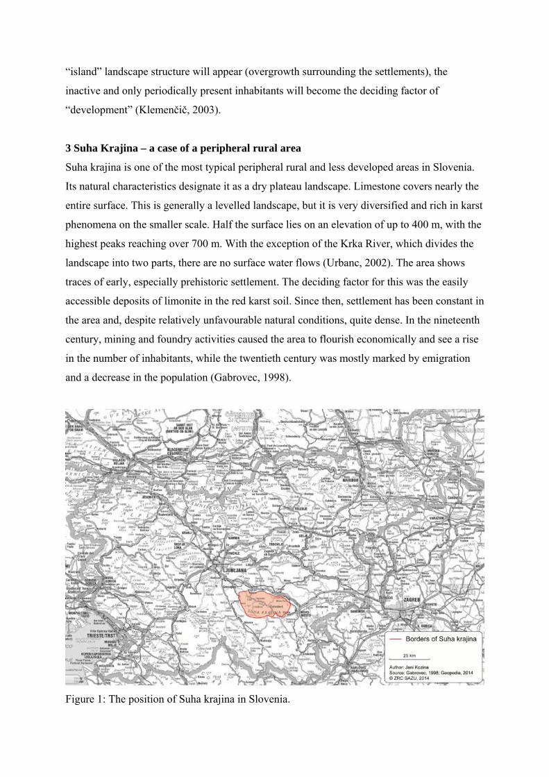
3 Suha Krajina – a case of a peripheral rural area
Suha krajina is one of the most typical peripheral rural and less developed areas in Slovenia.
Its natural characteristics designate it as a dry plateau landscape. Limestone covers nearly the
entire surface. This is generally a levelled landscape, but it is very diversified and rich in karst
phenomena on the smaller scale. Half the surface lies on an elevation of up to 400 m, with the
highest peaks reaching over 700 m. With the exception of the Krka River, which divides the
landscape into two parts, there are no surface water flows (Urbanc, 2002). The area shows
traces of early, especially prehistoric settlement. The deciding factor for this was the easily
accessible deposits of limonite in the red karst soil. Since then, settlement has been constant in
the area and, despite relatively unfavourable natural conditions, quite dense. In the nineteenth
century, mining and foundry activities caused the area to flourish economically and see a rise
in the number of inhabitants, while the twentieth century was mostly marked by emigration
and a decrease in the population (Gabrovec, 1998).
Figure 1: The position of Suha krajina in Slovenia.
The population drain from Suha krajina began as early as in the late nineteenth century. The
main reasons for this were the iron works in Dvor closing and transport routes (railway,
highway) circumventing Suha krajina. This caused the area to become less accessible, despite
its relative proximity to larger centres (Ljubljana: national centre, Novo mesto: regional
centre). Most of the inhabitants emigrated to the US and other more developed European
countries at the break of the century (Valant, 1971). The population was further affected by
both World Wars; after World War II, the area was intentionally neglected by the authorities,
because of the inhabitants’ wartime collaborations with the Slovene Home Guard, who were
opposed to the National Liberation Army and Partisan Detachments of Slovenia.
For some, the inhospitable natural-geographic conditions were reason enough to emigrate.
The rocky plots with shallow soils led to a cease in land cultivation and an agrarian
overpopulation. The lack of water greatly contributed to emigration, as the inhabitants still did
not have proper water supply until a few decades after World War II (in some places this is
still the case today). This is where the area’s name originates from, as Suha krajina literally
translated means “dry landscape”. The poor economic efficiency of agrarian economies is also
a consequence of the extensive property distribution/partition, caused by the diverse terrain
and the inheritance laws, under which the estates are to be divided into smaller plots. A
further influence on emigration was the lack of any central functions in the entire Suha
Krajina area and the dispersed settlement type and with it, the excessive costs for building a
water distribution system, electrical mains, transport connections, and other infrastructure.
There had been no municipal centre in Suha Krajina before 1994, even though the area
measured roughly the same in size as the average Slovenian municipality. Suha krajina
remained on the edges of four large municipalities.
One of the most prominent factors for emigration from Suha Krajina was the country’s
politics after World War II, which neglected the agriculture and searched for work force in the
countryside. Consequently, the share of the population engaged in agriculture halved between
1981 and 1991; at the end of this period, the share of that population amounted to 18% of the
inhabitants of Suha krajina (Gliha, 1997; Gartner, 2002; Volčini, et al,. 2002). During the
industrialization period and the social-demographic transformation after World War II,
especially in the 1960s, the population sought employment in non-agricultural activities; since
employment positions were scarce in Suha krajina, the people would commute daily, usually
to Ljubljana and Novo mesto. Permanent emigration of workers and their families were
curtailed mainly by the construction of a more modern transport infrastructure and an

increased rate of motorization, which enabled daily commuting to work and school. The
younger and educated population mostly emigrated permanently during this period. All the
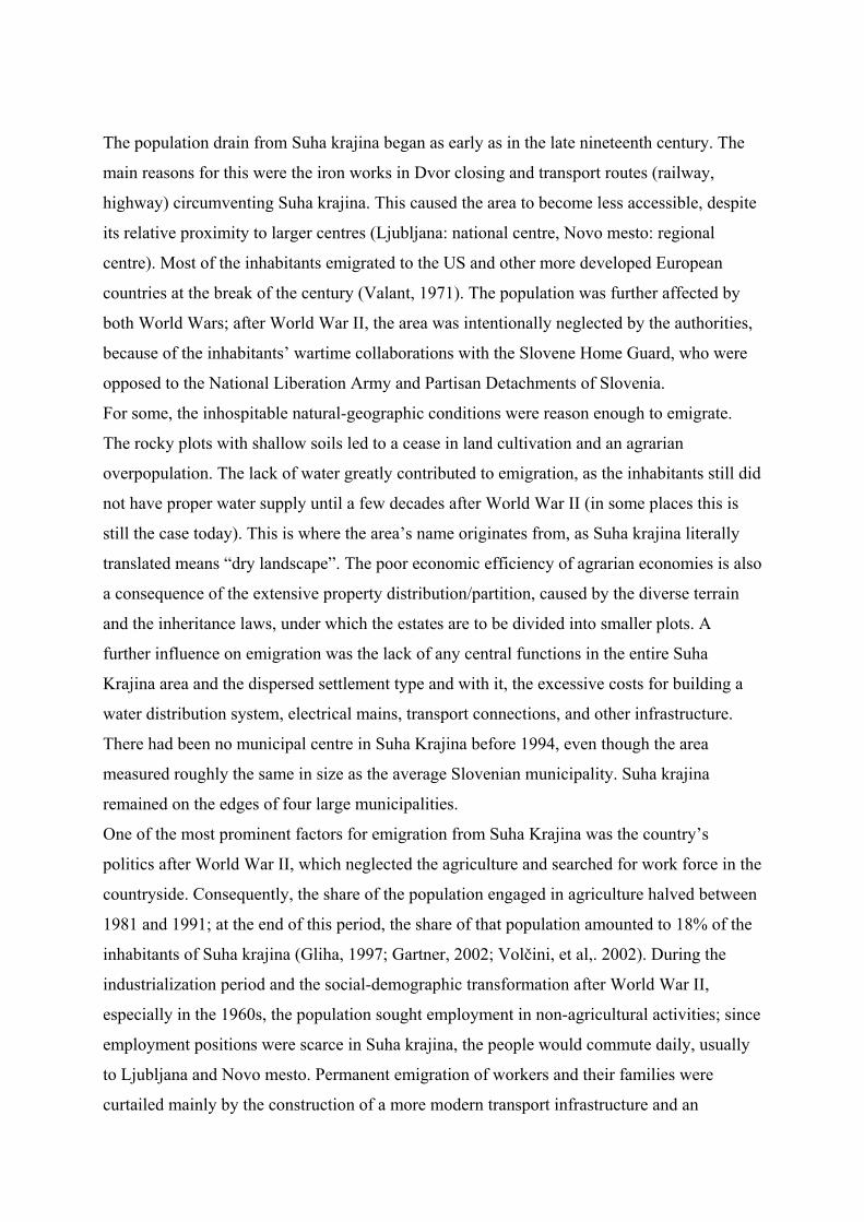
stated factors combined caused the number of inhabitants in Suha Krajina to decrease by as
much as 40% between 1880 and 2011. This process was especially intense in the first half of
the twentieth century, but has somewhat subsided in the second half and has stagnated in
recent times (Figure 2) (Urbanc, 2002).
Figure 2: Population movements in Suha krajina in census years between 1869-2011 (Gliha,
1997; Orožen Adamič, Perko and Kladnik, 1995; SURS, 2013).
4 Current migration flows in Suha krajina
In the last two decades, migration flows have subsided in Suha Krajina. Since the 1990s, a
slight immigration over emigration trend has even been detected in most of the studied
settlements. Even in villages, where the migration balance had been negative the entire time,
the difference was only in one or a few individuals in favour of immigrants. Suha krajina
therefore transformed itself from an area of population decline to an area of population
stagnation or even slight immigration. After a century of population decline and intense
0
1000
2000
3000
4000
5000
6000
7000
8000
1869 1880 1900 1931 1948 1961 1971 1980 1991 2002 2011
nu
mb
er o
f in
hab
itan
ts
census year

emigration, perhaps the time has come for Suha krajina to experience a more favourable
demographic development.
Emigrations
Nearly all the studied villages have seen at least one local emigrate in the past two decades.
The most common reason for emigrating has been marriage or people moving away to their
partner, followed by moving for employment. Among those who left for employment, they
were predominantly young people who studied in larger cities and later gained employment
there; Ljubljana has seen the majority of this, with Novo mesto and Žužemberk (municipal
centre) in a minority of cases. People married away to numerous different settlements;
however, the majority of individuals keep residing within the region. The interviewees stated
discord within their families and a desire for better conditions as further reasons for
emigrating. Interestingly, women moved to a great extent more than men from most
settlements. Consequently, numerous settlements typically express high shares of single,
middle-aged men. For example, the youngest inhabitant of the village Malo Lipje is a 41-
year-old single man. The reason for this phenomenon is said to be more women moving away
when they marry, while men are more tied to their home as the heirs and are therefore less
likely to move (Zupančič 1989). After talking to the locals, it was established that most
women indeed married away, while men or boys, as they were at that time, were more
interested in male company than in settling down. Now, that it is “too late”, they console
themselves with: “What woman would want to move to these rocks?”
Immigrations
There are four reasons for moving to Suha krajina: marriage, inheritance, the quiet
environment, and the partner’s return to their home environment. People immigrate from
larger settlements as well as from other neighbouring villages. Similarly to emigrations, a few
migration flows can be detected within Suha krajina. Some families have opened restaurants
or started companies in the place of their new residence. These cases of young families, who
still see some prospects and development possibilities in these parts, represent the impetus
and hope for a brighter future of Suha krajina.
Returning locals
A special category in studying migration flows are locals who moved from their villages and
are returning for various reasons. They state serene life in the countryside, inheritance, or
peaceful retirement as the reasons for their return. Retirees are the ones moving back to the
countryside the most, because they want to spend their old age enjoying the nature and
peaceful environment. These inhabitants are important for preserving the cultural landscape,
since they are still able to do work around their house and manage smaller gardens to cultivate
some food. The most common cities to emigrate from are Ljubljana and Žužemberk.
Returning families with small children mostly relocate to settlements along the main transport
routes, from where they can easily make their daily commute to work and school into larger
centres.
5 Settlement image in Suha krajina
Most of Suha krajina’s largest settlements lie on the level ground above the Krka River, as its
narrow stream does not offer enough suitable space for settlement. The settlement sizes
generally seem to gradually decrease with distance from the Krka Valley. Settlements near the
Krka River have seen a more intensive development due to numerous advantages in the past.
The Krka River was once the main axis of Suha krajina’s economic development. A number
of industrial plants (mills, saws, iron works, paper factories, etc.) were positioned alongside it.
This was the main transport connection through Suha krajina, with a special emphasis on the
vicinity of drinking water.
Today, the area along the Krka River is still the centre of Suha krajina’s economic activities;
however, it has lost much of its previous significance. The economic sectors that went under
in the late nineteenth century have mostly been replaced by less important tourism. When the
water mains were built after World War II, the settlements on the right bank of the Krka River
were supplied with drinking water, but the water distribution system still circumvented some
settlements on the left bank. The significance of the position along the river has retained its
value, as the main transit route is the same. As a consequence, the settlements along the Krka
River have better accessibility to work, education, services, and other functions, necessary for
the life of an individual.
Condition of the buildings
The condition of the buildings is the best in settlements near the Krka River. Typically, these
have a high share of maintained and adapted buildings (over 70%) and a lower share of
unmaintained and deserted buildings (under 30%). The poorest condition of the buildings was
noted in individual settlements on the right side of the Krka River, where over 50% of the
buildings are deserted and unmaintained. The owners of most of the homes moved away or
passed away, leaving entire settlements to decay.
The rest of the settlements on both banks of the river are somewhat more maintained than
these, but still less well maintained than settlements that lie closer to the river. Some villages
on the left bank are quite remote from the Krka Valley and are one of the few still without a
water distribution system. The land is predominantly limestone, making the soil shallow and
the terrain markedly rocky. This makes the only profitable agricultural direction livestock
breeding. A good example of an adequate adjustment to the natural conditions in such an
environment is a horse breeder in Brezova Reber pri Dvoru, who owns more than a hundred
horses, making him one of the biggest private horse breeders in Slovenia. It is noticeable that
the condition of the buildings is better in settlements along prominent local transport routes.
There are no major distinctions in the share of newly constructed buildings between the
settlements. In most cases, such buildings lie on the outskirts of the settlements, where there is
more space. Particularly owners of secondary dwellings tend to move away from the
condensed settlement center. Aside from building holiday cottages, this kind of construction
can be connected to the processes of suburbanization or periurbanization.
The condition of barns and hayracks is worse compared to residential buildings. There are
practically no newly constructed buildings in these categories. Only a few new outbuildings
have been built in the last two decades. The barns and hayracks are in the best condition in the
settlements along the Krka River and in the village of Reber. These buildings’ condition tends
to deteriorate with distance from the river. This implies that deagrarization also increases in
this direction.
Residential characteristics
Residential characteristics have been closely connected to the migrating dynamics in the past
decades. Similarly to the condition of the buildings, the best conditions can again be found in
the settlements near the Krka River, while the situation gets increasingly worse with distance.
The villages with the worst condition of the buildings on the right bank also have the biggest
share of permanently empty homes. This is largely a consequence of the victims of wartime
and post-wartime events and emigration during the period of intensive industrialization. Most
of the young people moved away because of the poor transport and communal conditions, a
lack of employment opportunities, and a disinterest for farming in unfavourable conditions.
The number of permanently empty homes continues to increase due to the decreasing
numbers of the older population. Today, there are barely any individuals left who could
emigrate. The only people who remain are older individuals who are no longer able to have
children. Because of this, the only revitalization possibility remains entirely new inhabitants
settling. With inheritance, affordable plots, and a wish to live in a calm and clean
environment, this is already happening in some settlements, but the number remains too low.
The country and the local communities will have to lead a much more active policy in the area
for preserving and encouraging settlement in these villages in the future if they want to keep
them afloat.
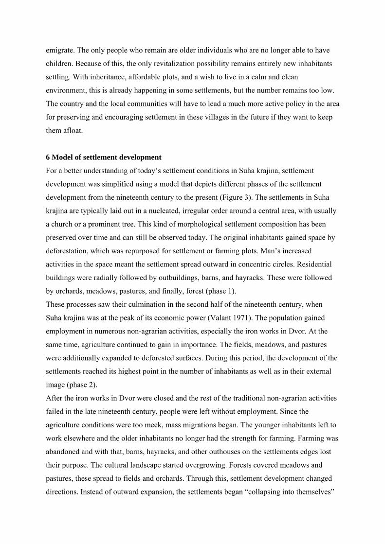
6 Model of settlement development
For a better understanding of today’s settlement conditions in Suha krajina, settlement
development was simplified using a model that depicts different phases of the settlement
development from the nineteenth century to the present (Figure 3). The settlements in Suha
krajina are typically laid out in a nucleated, irregular order around a central area, with usually
a church or a prominent tree. This kind of morphological settlement composition has been
preserved over time and can still be observed today. The original inhabitants gained space by
deforestation, which was repurposed for settlement or farming plots. Man’s increased
activities in the space meant the settlement spread outward in concentric circles. Residential
buildings were radially followed by outbuildings, barns, and hayracks. These were followed
by orchards, meadows, pastures, and finally, forest (phase 1).
These processes saw their culmination in the second half of the nineteenth century, when
Suha krajina was at the peak of its economic power (Valant 1971). The population gained
employment in numerous non-agrarian activities, especially the iron works in Dvor. At the
same time, agriculture continued to gain in importance. The fields, meadows, and pastures
were additionally expanded to deforested surfaces. During this period, the development of the
settlements reached its highest point in the number of inhabitants as well as in their external
image (phase 2).
After the iron works in Dvor were closed and the rest of the traditional non-agrarian activities
failed in the late nineteenth century, people were left without employment. Since the
agriculture conditions were too meek, mass migrations began. The younger inhabitants left to
work elsewhere and the older inhabitants no longer had the strength for farming. Farming was
abandoned and with that, barns, hayracks, and other outhouses on the settlements edges lost
their purpose. The cultural landscape started overgrowing. Forests covered meadows and
pastures, these spread to fields and orchards. Through this, settlement development changed
directions. Instead of outward expansion, the settlements began “collapsing into themselves”

(phase 3). All these processes were additionally strengthened after World War II, when Suha
krajina fell victim to wartime and post-wartime events and intensive emigrating, suffering
further population decrease. Under the influence of intensive industrialization and the state’s
stepmotherly attitude to the countryside, deagrarisation was a constant process, most visible
through further overgrowth and forestation (phase 4).
Today, settlements in Suha krajina could be divided according to two characteristic phases.
Phase 5a is the final phase before the extinction of a settlement in the direction of “introverted
development”. Some dying villages on the right bank of the Krka River could be ascribed this
phase. Here, farming activities have all but ceased and only an old population remains; the
buildings are in disarray and the shrubbery has almost overgrown the centres of the
settlements in some places. On the other hand, the enduring settlements in the vicinity of the
Krka River can be ascribed phase 5b. Typically, these settlements are experiencing a rebirth
in development due to the favourable age structure of the population, returning locals, and
strengthened entrepreneurship. Despite the weak agrarian activities, the cultural landscape is
being maintained. In the village centres, returning locals and immigrants are renovating old
houses or erecting newly constructed buildings on the outskirts. The rest of the settlements on
both sides of the Krka River are stagnant and are somewhere between phases 5a and 5b.
Further development will show whether they will travel the route of re-expansion and
strengthening the population and demographic vitality or the route toward extinction.
Figure 3: Phases in the settlement development in Suha krajina from the nineteenth century to
the present.
7 Conclusion
After a century of emigration, population numbers have started to stagnate in Suha krajina in
the last twenty years. The migration flows have settled: there is even a weak trend of
immigration over emigration. People who come or return to Suha krajina, most often do so for
certain family reasons (marriage, inheritance, partner’s return to their home environment) and
for the serene environment the area has to offer. On the other hand, the departed chose to
move mostly for marriage or moved to their partner, with the second most important reason
being leaving for work. Setting aside family reasons, which are difficult to influence with

developmental policies, the conclusion can be made that Suha krajina is losing its population
(along with a higher mortality because of the older population) because of the lack of
employment possibilities. After more than a hundred years, the economy in these parts still
has not managed to get closer to the state it was in when iron foundry and iron works
flourished here, employing a great share of the local population.
On the other hand, Suha krajina has attractive contents to offer that are high on the wish list of
a considerable number of Slovenians, especially a peaceful and green environment with an
easy route for daily commuting (Hočevar and Uršič, 2007). Even though the main transport
routes circumvented Suha krajina and consequently placed it on the edges of development, it
still boasts a sufficient vicinity to larger employment and supply centres. From now on, the
local authorities should first ensure a complete infrastructure installation (water distribution
system, sewerage system, IT technology, etc.) and village restoration (some of the remoter
villages from the main transport axis in the Krka Valley are in extremely poor condition); the
next step would be to use different approaches to attract especially younger and highly
educated population. A recent research has namely shown that the newer settlement processes
of the most highly qualified work force in Slovenia run in the direction from deconcentration
from more urbanized settlement types to more scarcely settled suburbanized and rural
settlements. For these people, the most important factors are a quality living environment,
adequate infrastructure, identity, workplace and service accessibility, workplace quality, and
transport accessibility (Kozina, 2013). In this sense, Suha krajina should see its opportunity in
being an outskirt area for the national (Ljubljana) and regional centre (Novo mesto), because
it is rich in preserved natural landscape and cultural heritage. The area’s further development
could be based on tourism, which is becoming an increasingly popular form of modernization
and commercialization of the European rural area (Bole, Pipan and Komac, 2013). In this
way, entrepreneurship and the local economy along with regional identity can be strengthened
while looking after the environment and quality living conditions.
Despite certain developmental potentials that Suha krajina possesses as a peripheral rural area,
it still faces some difficult decisions in the future. What to do with the settlements that saw
most of its population emigrate and the rest grown old, while the cultural landscape is
overgrowing? Should they be left to further slow decay or should they receive new
infrastructure furnishing, encourage the younger population to move here and revitalize
themselves in this way? The answer to such questions awaits not only Suha krajina, but also
other peripheral rural areas, because Slovenia does not have clearly defined strategies for
these cases. From the viewpoint of suburbanization and dispersion of the Slovenian settlement
system, it may be sensible to consider concentrated development in the “healthy cores”.
Acknowledgement
The field work in Suha krajina was carried out in 2007 by students in the fourth year of study
at the Department of Geography of the Faculty of Arts in Ljubljana: Helena Ilc, Daniel
Kastelic, Melita Kobol, Jani Kozina, Teja Logar, Andreja Miljevič, Vesna Simonič, Tomaž
Štembergar, andAndrej Trošt, under the mentorship of associate professor Marijan M.
Klemenčič, PhD.
8 References
Benkovič, M., 2003. Strukturni problemi depopulacijskih območij v Sloveniji
[Structural problems of depopulated areas in Slovenia]. MSc. Univerza v Ljubljani.
Bertolini, L., le Clercq, F., Kapoen, L., 2005. Sustainable accessibility: a conceptual
framework to integrate transport and land use plan-making. Two test-applications in
the Netherlands and a reflection on the way forward. Transport Policy, 12(3), pp.207-
220.
Bole, D., Pipan, P. and Komac, B., 2013. Cultural values and sustainable rural
development: A brief introduction. Acta geographica Slovenica, 53(2), pp.367-370.
Bucher, H. and Mai, R., 2005. Depopulation and its consequences for the region of
Europe. Brussels: Council of Europe, Directorate General III – Social cohesion.
Celińska-Janowicz, D., Miszczuk, A., Płoszaj, A. and Smętkowski, M., 2010. Current
Demographical Problems of the Eastern Poland Macroregion. [online] Warsaw:
Centre for European Regional and Local Studies EUROREG. Avilable at:
http://www.euroreg.uw.edu.pl/dane/web_euroreg_publications_files/1617/demografia
_polska_wschodnia_2010_english_fin.pdf [Accessed 9 January 2014].
Ciglič, R. and Perko, D., 2013. Europe's landscape hotspots. Acta geographica
Slovenica, 53(1), pp.117-139.
Currie, G. and Stanley, J., 2008. Investigating Links between Social Capital and
Public Transport. Transport Reviews, 28(4), pp.529-547.
Ewing, R. and Cervero, R., 2010. Travel and the Built Environment: A Meta-Analysis.
Journal of the American Planning Assocoation, 76(3), pp.265-294.

Gabrovec, M., 1998. Suha krajina in Dobrepolje [Suha krajina and Dobrepolje]. In: D.,
Perko, M. and Orožen Adamič, eds. 1998. Slovenija – pokrajine in ljudje. Ljubljana:
Založba Mladinska knjiga, pp.472-483.
Gartner, M., 2002. Demografska, gospodarska in pokrajinska problematika Hinj,
Hriba pri Hinjah in Lazine v Suhi krajini [Demographic, economic and landscape
problems in Hinje, Hrib pri Hinjah and Lazina in Suha krajina]. Seminar paper.
Univerza v Ljubljani.
Geopedia, 2014. Map of Slovenia. [online] Available at:
http://www.geopedia.si/#T105_x496000_y111560_s9_b4n [Accessed 31 January
2014].
Gliha, S., 1997. Gibanje površine kmetijskih zemljišč, števila prebivalstva in števila
živine v Suhi krajini [Changes of agricultural land, number of population and number
of livestock in Suha krajina]. In: M., Legan, ed. 1997. Žužemberški grad –
Suhokranjski zbornik. Žužemberk, Novo mesto: Krajevna skupnost, Dolenjski list,
pp.71-80.
Hočevar, M., Uršič, M., Kos, D. and Trček, F., 2005. Changing of the Slovene urban
system: specific socio-spatial trends and antiurban public values/attitudes. In: F.,
Eckardt, ed. 2005. Paths of urban transformation. Frankfurt am Main: P. Lang,
pp.299-300.
Klemenčič, M.M., 2003. Civilizacijske razvojne stopnje in razvojni problemi obrobnih
območij v Sloveniji [Civilization development stages and development problems of
peripheral areas in slovenia]. Dela, 19, pp.153-164.
Klemenčič, M.M., 2005. Nova razvojna strategija pokrajinsko homogenih obrobnih
območij Slovenije [New development strategy of the peripheral, landscape
homogenious areas in Slovenia]. Dela, 24, pp.185-193.
Klemenčič, M.M., Lampič, B. and Potočnik Slavič, I., 2008. Življenjska (ne)moč
obrobnih podeželskih območij v Sloveniji [The (Non)Vitality of Slovenian Peripheral
Rural Areas]. Ljubljana: Znanstvena založba Filozofske fakultete Univerze v
Ljubljani, Oddelek za geografijo.
Kozina, J., 2010. Transport accessibility to regional centres in Slovenia. Acta
geographica Slovenica, 50(2), pp.231-251.

Kozina, J., 2013. Življenjsko okolje prebivalcev v ustvarjalnih poklicih v Sloveniji
[Living environment of inhabitants in creative occupations in Slovenia]. PhD.
Univerza v Ljubljani.
Kušar, S., 2005. Manj razvita območja kot element politike skladnejšega regionalnega
razvoja v Sloveniji: pretekle izkušnje in prihodnji izzivi [Less developed areas as an
element of balanced regional development policy in Slovenia: past experiences and
future challenges]. Dela, 24, pp.113-124.
Orožen Adamič, M., Perko, D. and Kladnik, D. eds., 1995. Krajevni leksikon
Slovenije. Ljubljana: DZS.
Paez, A., 2004. Network Accessibility and the Spatial Distribution of Economic
Activity in Eastern Asia. Urban Studies, 41(11), pp.2211-2230
Perpar, A. and Kovačič, M., 2002. Typology and development characteristics of rural
areas in Slovenia. In: M.M., Klemenčič, ed. Rural areas at the millennium shift :
challenges and problems. Ljubljana, 19-21 September 2001. Ljubljana: Oddelek za
geografijo Filozofske fakultete.
Perpar, A., Kastelec, D. and Udovč, A., 2013. Situation in Slovenian Rural Areas and
Main Factors of their Economic Development and Performance. In: D., Kovačević, ed.
Fourth International agronomic symposium "Agrosym 2013". Jahorina, 3-6 October
2013. Sarajevo: Faculty of Agriculture, University of East Sarajevo.
Polyzos, S., Sdrolias, L. and Koutseris, E., 2008. Enterprises' locational decisions and
interregional highways: an empiric investigation in Greece. Acta geographica
Slovenica, 44(1), pp.147-168.
SURS, 2013. Population data. [online] Available at:
http://pxweb.stat.si/pxweb/Dialog/varval.asp?ma=05C4002S&ti=&path=../Database/D
em_soc/05_prebivalstvo/10_stevilo_preb/20_05C40_prebivalstvo_obcine/&lang=2
[Accessed 15 December 2013].
Stanley, J. and Vella-Brodrick, D., 2009. The usefulness of social exclusion to inform
social policy in transport. Transport Policy, 16(3), pp.90-96.
Topole, M., Bole, D., Petek, F. and Repolusk, P., 2006. Spatial and functional changes
in built-up areas in selected slovene rural settlements after 1991. Acta geographica
Slovenica, 46(2), pp.189-249.
Urbanc, M., 2002. Kulturne pokrajine v Sloveniji [Cultural landscapes in Slovenia].
Ljubljana: ZRC SAZU.
Uršič, M. and Hočevar, M., 2007. Protiurbanost kot način življenja [Antiurbanity as a
way of life]. Ljubljana: Fakulteta za družbene vede.
Valant, M., 1971. Zgodovina Žužemberka in Krajine [The history of Žužemberk and
Krajina]. 2nd ed. Ljubljana: published by the author.
Volčini, K., Orožen Adamič, T., Kuzmič, B. and Šetina, T., 2002. Razvojni problemi
in možnosti občine Žužemberk [Developmentproblems and possibilities of Žužemberk
municipality]. Dela, 17, pp.238-249.
About the authors:
Jani Kozina, PhD, research fellow, graduated in Ggeography in 2008 from the University of
Ljubljana, Slovenia. He acquired his PhD from the same university with a dissertation entitled
Living environment of inhabitants in creative occupations in Slovenia. His fields of interest
include geography of creativity and human resources, regional and spatial development,
economic geography, transport geography, and geographic information system. He is a
member of the Regional Studies Association, and member of the Ljubljana Geographical
Society executive board. He is also a member of the organization committee of the Regional
development in Slovenia symposium and deputy member of the Statistical advisory
committee of the population statistics at the Statistical Office of the Republic of Slovenia. He
received the Faculty of Arts Prešeren Award for Students (University of Ljubljana, 2008) and
the Award for contribution to sustainable development of society (Slovene Human Resources
and Scholarship Fund, 2009 and 2010) for his research achievements.
Mimi Urbanc, PhD, senior research fellow, graduated in Geography and History in 1996
from the University of Ljubljana, Slovenia. She acquired her master’s degree in 2002 from the
same university and her PhD from the University of Primorska in 2007. Her fields of interest
include: regional geography, environmental protection, agrarian geography, geographical
names, cultural geography, and cultural landscapes. She was the project coordinator for
several European projects. She is currently assisting director for an international cooperation
at the Research Centre of the Slovenian Academy of Sciences and Arts. She is also a member
of the Commission for the Standardization of Geographical Names of the Government of the
Republic of Slovenia, member of two working groups (on exonyms, and toponyimic data files
and gazetteers) at The United Nations Group of Experts on Geographical Names, the national
representative of The Permanent European Conference for the Study of Rural Landscape for

Slovenia, member of the Geografski obzornik editorial board, president of the Commission on
Awards at the Association of Geographers of Slovenia, member of the EUCALAND network
(European Cultural and Agricultural Landscapes), deputy member of ISCAR (International
Scientific Committee on Research in the Alps), and member of EARMA (European
Association of Research Managers and Administrators).