PCA Arbitration Between Slovenia and Croatia - Aceris Law LLC
398
PCA CASE NO. 2012-04 IN THE MATTER OF AN ARBITRATION UNDER THE ARBITRATION AGREEMENT BETWEEN THE GOVERNMENT OF THE REPUBLIC OF CROATIA AND THE GOVERNMENT OF THE REPUBLIC OF SLOVENIA, SIGNED ON 4 NOVEMBER 2009 - between - THE REPUBLIC OF CROATIA - and - THE REPUBLIC OF SLOVENIA (together, the “Parties”) ________________________________________________________ FINAL AWARD 29 June 2017 ________________________________________________________ ARBITRAL TRIBUNAL: Judge Gilbert Guillaume (President) Ambassador Rolf Einar Fife Professor Vaughan Lowe Professor Nicolas Michel Judge Bruno Simma REGISTRAR: Dr. Dirk Pulkowski The Permanent Court of Arbitration
-
Upload
khangminh22 -
Category
Documents
-
view
0 -
download
0
Transcript of PCA Arbitration Between Slovenia and Croatia - Aceris Law LLC

PCA CASE NO. 2012-04
IN THE MATTER OF AN ARBITRATION UNDER THE ARBITRATION AGREEMENT BETWEEN THE GOVERNMENT OF THE REPUBLIC OF CROATIA AND THE
GOVERNMENT OF THE REPUBLIC OF SLOVENIA, SIGNED ON 4 NOVEMBER 2009
- between -
THE REPUBLIC OF CROATIA
- and -
THE REPUBLIC OF SLOVENIA
(together, the “Parties”)
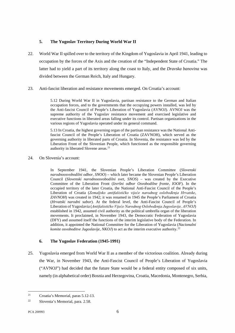
________________________________________________________
FINAL AWARD
29 June 2017 ________________________________________________________
ARBITRAL TRIBUNAL: Judge Gilbert Guillaume (President)
Ambassador Rolf Einar Fife Professor Vaughan Lowe Professor Nicolas Michel
Judge Bruno Simma
REGISTRAR: Dr. Dirk Pulkowski
The Permanent Court of Arbitration


TABLE OF CONTENTS
I. INTRODUCTION ........................................................................................................................ 1
A. GENERAL GEOGRAPHY ...................................................................................................... 1
B. HISTORICAL BACKGROUND ............................................................................................... 3
1. Historical Developments up to the 18th Century ....................................................... 3
2. The Austrian Empire and the Austro-Hungarian Empire (1804-1918) .................. 3
3. The Kingdom of Serbs, Croats and Slovenes (1918-1929) ........................................ 4
4. The Kingdom of Yugoslavia (1929-1941) ................................................................... 5
5. The Yugoslav Territory During World War II.......................................................... 6
6. The Yugoslav Federation (1945-1991) ........................................................................ 6
7. Independence ................................................................................................................ 9
C. EVENTS AFTER 1991 ......................................................................................................... 10
1. The Draft Border Agreement Allegedly Proposed by Slovenia in 1991 ................ 12
2. Negotiations in 1992-1993 .......................................................................................... 13
3. The Parties’ Expert Groups ....................................................................................... 15
4. Slovenia’s 1993 Memorandum on the Bay of Piran and Croatia’s Reaction ........ 16
5. Joint/Mixed Diplomatic Commission and Expert Group ....................................... 18
6. The 1997 Agreement on Local Border Traffic and Cooperation ........................... 23
7. Negotiations in 1998-1999 .......................................................................................... 25
8. The 2001 Drnovšek-Račan Agreement ..................................................................... 27
9. Negotiation of the Arbitration Agreement ............................................................... 29
10. Conclusion and Ratification of the Arbitration Agreement ................................... 42
II. HISTORY OF THE PROCEEDINGS ..................................................................................... 47
III. THE PARTIES’ FORMAL REQUESTS ................................................................................. 59
A. CROATIA’S REQUESTS...................................................................................................... 59
1. The Land Boundary ................................................................................................... 59
2. The Maritime Issues ................................................................................................... 60
3. Reservation of Rights ................................................................................................. 61
B. SLOVENIA’S REQUESTS .................................................................................................... 61
1. The Land Boundary ................................................................................................... 61
2. The Maritime Issues ................................................................................................... 65
3. Objection to the Tribunal’s Jurisdiction .................................................................. 67
IV. DETERMINATIONS IN RESPECT OF THE LAND BOUNDARY ................................... 69
A. THE TASK OF THE TRIBUNAL AND THE APPLICABLE LAW ........................................... 69
1. The Parties’ Positions ................................................................................................. 69
PCA 200993 i

Task of the Tribunal .............................................................................................. 69
i. Croatia’s Position ............................................................................................... 69
ii. Slovenia’s Position ............................................................................................. 74
Applicable Law ...................................................................................................... 79
i. Uti possidetis ...................................................................................................... 79
ii. Domestic Law Governing the Boundaries of the Former Republics on the Critical Date ....................................................................................................... 82
Federal Rules of the FPRY and the SFRY ............................................................... 82
Applicable Rules in Croatia .................................................................................... 84
Applicable Rules in Slovenia ................................................................................... 86
iii. The Parties’ Interpretations of the Legal Framework ......................................... 88
Croatia’s Position ................................................................................................... 88
Slovenia’s Position .................................................................................................. 97
2. The Tribunal’s Analysis ........................................................................................... 108
The Obligation to Follow the Pre-independence Boundary ............................ 108
Areas of the Land Boundary Not in Dispute ..................................................... 111
The Disputed Segments of the Land Boundary ................................................ 112
Limits to the Tribunal’s Determinations ........................................................... 113
B. DISPUTED SEGMENTS OF THE LAND BOUNDARY ......................................................... 114
1. Mura River Region ................................................................................................... 115
Delimitation in the Mura River Region as a Whole ......................................... 124
i. The Parties’ Positions ....................................................................................... 124
ii. The Tribunal’s Analysis ................................................................................... 125
Brezovec-del/Murišće .......................................................................................... 127
i. The Parties’ Positions ....................................................................................... 127
ii. The Tribunal’s Analysis ................................................................................... 131
Podturen/Pince, Novakovec/Pince, and Ferketinec/Pince ................................ 136
i. The Parties’ Positions ....................................................................................... 136
ii. The Tribunal’s Analysis ................................................................................... 140
Mursko Središće and Peklenica.......................................................................... 144
i. The Parties’ Positions ....................................................................................... 145
ii. The Tribunal’s Analysis ................................................................................... 145
2. Central Region .......................................................................................................... 145
Slovenske gorice ................................................................................................... 152
i. Razkrižje ........................................................................................................... 152
The Parties’ Positions ........................................................................................... 153
PCA 200993 ii

The Tribunal’s Analysis ......................................................................................... 154
ii. Robadje/Globoka .............................................................................................. 155
The Parties’ Positions ........................................................................................... 155
The Tribunal’s Analysis ......................................................................................... 156
iii. Santavec River .................................................................................................. 156
iv. Zelena River ..................................................................................................... 158
v. The Remaining Part of the Slovenske gorice ................................................... 158
Drava River .......................................................................................................... 158
i. The Parties’ Positions ....................................................................................... 159
ii. The Tribunal’s Analysis ................................................................................... 161
Haloze-Macelj ...................................................................................................... 162
i. The Parties’ Positions ....................................................................................... 162
ii. The Tribunal’s Analysis ................................................................................... 163
Sotla River ............................................................................................................ 164
i. The Parties’ Positions ....................................................................................... 165
ii. The Tribunal’s Analysis ................................................................................... 168
Sava and Bregana Rivers .................................................................................... 170
i. Area 6.1 ............................................................................................................ 171
The Parties’ Positions ........................................................................................... 171
The Tribunal’s Analysis ......................................................................................... 172
ii. Junction of the Sava and Bregana Rivers ......................................................... 173
The Parties’ Positions ........................................................................................... 173
The Tribunal’s Analysis ......................................................................................... 174
Gorjanci/Žumberak ............................................................................................ 176
i. Brezovica pri Metliki ........................................................................................ 178
The Parties’ Positions ........................................................................................... 179
The Tribunal’s Analysis ......................................................................................... 180
ii. Settlement of Drage (Sekulići/Sekuliči) ........................................................... 183
The Parties’ Positions ........................................................................................... 183
The Tribunal’s Analysis ......................................................................................... 184
iii. Trdinov Vrh/Sveta Gera ................................................................................... 187
The Parties’ Positions ........................................................................................... 187
The Tribunal’s Analysis ......................................................................................... 189
Kamenica, Kupa/Kolpa and Čabranka Rivers ................................................. 190
i. Kamenica River ................................................................................................ 191
The Parties’ Positions ........................................................................................... 191
PCA 200993 iii

The Tribunal’s Analysis ......................................................................................... 192
ii. Kupa/Kolpa River............................................................................................. 194
The Parties’ Positions ........................................................................................... 194
The Tribunal’s Analysis ......................................................................................... 195
iii. Čabranka River ................................................................................................. 195
The Parties’ Positions ........................................................................................... 195
The Tribunal’s Analysis ......................................................................................... 196
Črneča Vas ........................................................................................................... 198
Novi Kot/Prezid, Draga/Prezid, Babno Polje/Prezid ........................................ 201
i. Draga/Prezid and Novi Kot/Prezid ................................................................... 201
The Parties’ Positions ........................................................................................... 201
The Tribunal’s Analysis ......................................................................................... 202
ii. Babno Polje/Prezid ........................................................................................... 202
The Parties’ Positions ........................................................................................... 202
The Tribunal’s Analysis ......................................................................................... 203
3. Istria Region .............................................................................................................. 204
Leskova Dolina and Snežnik/Prezid .................................................................. 209
i. The Parties’ Positions ....................................................................................... 211
ii. The Tribunal’s Analysis ................................................................................... 213
Gomance ............................................................................................................... 216
Klana/Lisac and Zabiče/Sušak as well as Lisac/Sušak ..................................... 219
i. The Parties’ Positions ....................................................................................... 220
ii. The Tribunal’s Analysis ................................................................................... 222
Kućibreg/Topolovec ............................................................................................ 225
i. The Parties’ Positions ....................................................................................... 226
ii. The Tribunal’s Analysis ................................................................................... 227
Merišće and Krkavče as well as Lower Dragonja Region ............................... 229
i. The Parties’ Positions ....................................................................................... 230
ii. The Tribunal’s Analysis ................................................................................... 238
V. DETERMINATIONS IN RESPECT OF THE BAY ............................................................ 243
A. THE PARTIES’ POSITIONS .............................................................................................. 243
1. Status of the Bay Prior to the Dissolution of the SFRY ........................................ 243
2. Effect of the Dissolution of the SFRY ..................................................................... 247
The Concept of “Juridical Bays” by Reference to Article 7 of the 1958 Geneva Convention and UNCLOS Article 10 ................................................................. 248
PCA 200993 iv

Relevance of Article 11 of the Vienna Convention on Succession of States in respect of Treaties ................................................................................................ 250
The Concept of “Historic Bays” ......................................................................... 254
3. Applicable Law with respect to the Delimitation of the Bay ................................ 259
4. Effectivités in the Bay ............................................................................................... 261
5. Regime for the Use of the Bay ................................................................................. 267
B. THE TRIBUNAL’S ANALYSIS .......................................................................................... 267
1. Status of the Bay ....................................................................................................... 267
Status of the Bay Prior to the Dissolution of the SFRY ................................... 268
Effect of the Dissolution of the SFRY ................................................................ 272
2. Delimitation within the Bay ..................................................................................... 273
3. Regime for the Use of the Bay ................................................................................. 281
VI. DETERMINATIONS IN RESPECT OF OTHER MARITIME AREAS .......................... 283
A. TASK OF THE TRIBUNAL AND APPLICABLE LAW ......................................................... 283
1. The Parties’ Positions ............................................................................................... 283
Relationship between Article 3(1) and Article 4 ............................................... 283
Relevance of the Concept of “Vital Interests” .................................................. 288
Applicable Law .................................................................................................... 289
2. The Tribunal’s Analysis ........................................................................................... 291
B. DELIMITATION OF THE TERRITORIAL SEA................................................................... 292
1. The Parties’ Positions ............................................................................................... 293
Applicable Law with respect to the Delimitation of the Territorial Sea......... 293
Existence of Historic Title ................................................................................... 295
Existence of Special Circumstances ................................................................... 298
i. The “Squeezing Effect” .................................................................................... 298
ii. Coastal Concavity............................................................................................. 300
iii. The “Cut-Off Effect” ........................................................................................ 303
iv. Security and Navigational Interests .................................................................. 305
Course of the Maritime Boundary ..................................................................... 306
2. The Tribunal’s Analysis ........................................................................................... 311
C. DETERMINATION OF “SLOVENIA’S JUNCTION TO THE HIGH SEA” ............................ 324
1. The Parties’ Positions ............................................................................................... 324
Meaning of “Junction to the High Sea” ............................................................. 324
i. Croatia’s Position ............................................................................................. 324
ii. Slovenia’s Position ........................................................................................... 329
PCA 200993 v

Circumstances to Be Taken into Account under Article 4(b) of the Arbitration Agreement ............................................................................................................ 331
i. Croatia’s Position ............................................................................................. 331
ii. Slovenia’s Position ........................................................................................... 335
Determination of “Slovenia’s Junction to the High Sea” ................................. 336
i. Croatia’s Position ............................................................................................. 336
ii. Slovenia’s Position ........................................................................................... 337
2. The Tribunal’s Analysis ........................................................................................... 340
“High Sea” ............................................................................................................ 340
“Junction” ............................................................................................................ 342
The Location of “Slovenia’s Junction to the High Sea” ................................... 344
D. DELIMITATION OF THE CONTINENTAL SHELF ............................................................. 348
1. The Parties’ Positions ............................................................................................... 348
Entitlement to a Continental Shelf ..................................................................... 348
i. Slovenia’s Position ........................................................................................... 348
ii. Croatia’s Position ............................................................................................. 349
Applicable Law with respect to the Delimitation of the Continental Shelf .... 350
Proposed Limits of the Continental Shelf .......................................................... 352
2. The Tribunal’s Analysis ........................................................................................... 354
E. DETERMINATION OF THE REGIME FOR THE USE OF THE RELEVANT MARITIME AREAS .............................................................................................................................. 354
1. The Parties’ Positions ............................................................................................... 355
Regime for the Use of the Territorial Sea .......................................................... 355
i. Slovenia’s Position ........................................................................................... 355
ii. Croatia’s Position ............................................................................................. 357
Regime for the Use of the Continental Shelf ..................................................... 358
Regime for the Use of the High Seas .................................................................. 359
2. The Tribunal’s Analysis ........................................................................................... 360
Regime of the Junction Area .............................................................................. 360
i. The Content and Scope of the Freedoms of Communication ........................... 360
ii. Guarantees of, and Limitations to, the Freedoms of Communication .............. 361
iii. Duty of Cooperation and Other Agreements between the Parties .................... 362
Regime for the Use of the Continental Shelf ..................................................... 364
Regime for the Use of the High Seas .................................................................. 364
VII. COSTS OF THE ARBITRATION ......................................................................................... 365
VIII. DISPOSITIF ............................................................................................................................. 367
PCA 200993 vi

AWARD MAPS
Map I: Course of the Boundary South of Brezovec-del/Murišće 135
Map II: Mouth of the Dragonja and the Bay 280
Map III: Equidistance Line 314
Map IV: Claims of the Parties 317
Map V: General Coastal Projections 320
Map VI: Maritime Boundary 323
Map VII: Junction Area 347
PCA 200993 vii


AGENTS, COUNSEL AND OTHER REPRESENTATIVES OF THE PARTIES
Republic of Croatia1 Republic of Slovenia
Professor Maja Seršić Head of the Chair of International Law, Faculty of Law, University of Zagreb
as Agent;
H.E. Ms. Andreja Metelko-Zgombić
Ambassador, Director General for EU Law, International Law and Consular Affairs, Ministry of Foreign and European Affairs of the Republic of Croatia
as Co-Agent;
H.E. Ms. Vesna Pusić
First Deputy Prime Minister and Minister of Foreign and European Affairs of the Republic of Croatia
H.E. Ms. Vesela Mrđen Korać
Ambassador of the Republic of Croatia to the Kingdom of the Netherlands, The Hague
Professor Vladimir Ibler
Professor, Fellow of the Croatian Academy of Sciences and Arts
Mr. Krešo Glavač Chief of Cabinet, Ministry of Foreign and European Affairs of the Republic of Croatia
Ms. Danijela Barišić
Spokesperson, Ministry of Foreign and European Affairs of the Republic of Croatia
Mr. Davor Ljubanović
Counsellor, Embassy of the Republic of Croatia to the Kingdom of the Netherlands
Ms. Nelija Vržina,
Third Secretary, Embassy of the Republic of Croatia to the Kingdom of the Netherlands
as Members of the Delegation;
Professor Mirjam Škrk Head of the Chair of International Law, Faculty of Law, University of Ljubljana, former Judge and Vice-President of the Constitutional Court of the Republic of Slovenia
H.E. Ms. Simona Drenik, LL.M.
Minister Plenipotentiary, Legal Advisor, Cabinet of the Minister, Ministry of Foreign Affairs of the Republic of Slovenia (until 23 July 2015)
as Agents;
H.E. Ms. Nataša Šebenik
Minister Plenipotentiary, Ministry of Foreign Affairs (as of 7 March 2016)
as Co-Agent;
H.E. Mr. Karl Erjavec
Deputy Prime Minister and Minister of Foreign Affairs of the Republic of Slovenia
H.E. Mr. Roman Kirn
Ambassador of the Republic of Slovenia to the Kingdom of the Netherlands and Permanent Representative to the OPCW
H.E. Ms. Vlasta Vivod
Head of Minister’s Office, Ministry of Foreign Affairs of the Republic of Slovenia
as Special Advisors;
Mr. Rodman R. Bundy
Member of the New York Bar, Eversheds LLP, Singapore
1 On 31 July 2015, the Tribunal was informed that “the Government of the Republic of Croatia relieved Maja Seršić and Andreja Metelko-Zgombić of their respective duties as Agent and Co-Agent of the Republic of Croatia in the arbitration proceedings before the Arbitral Tribunal. Counsels and assistants have also been relieved of their engagement in the case.”
PCA 200993 ix

Professor James Crawford, A.C., S.C., F.B.A. Whewell Professor of International Law, University of Cambridge, Member of the Institut de Droit international, Barrister, Matrix Chambers, London (until 5 February 2015)
Professor Philippe Sands, Q.C.
Professor of International Law, University College London, Barrister, Matrix Chambers, London
Mr. Paul S. Reichler
Partner, Foley Hoag, Co-Chair of the International Litigation and Arbitration Department, Washington, D.C.
Mr. Andrew B. Loewenstein
Partner, Foley Hoag, Boston Professor Zachary Douglas
Professor of International Law, Graduate Institute of International and Development Studies, Geneva, Matrix Chambers, London
Professor Davor Vidas
Research Professor, Director of the Law of the Sea and Marine Affairs Programme, FNI, Oslo
as Counsel and Advocates;
Ms. Anjolie Singh
Member of the Indian Bar, Delhi Mr. Trpimir Mihael Šošić
Senior Assistant Lecturer, Faculty of Law, University of Zagreb
Mr. Yuri Parkhomenko
Foley Hoag, Washington, D.C. Mr. Zoran Bradić
Head of the Department for Borders, Ministry of Foreign and European Affairs of the Republic of Croatia
Mr. Sebastian Rogač
Ministry of Foreign and European Affairs of the Republic of Croatia
Mr. Goran Jutriša
Legal Expert
Ms. Alina Miron Researcher, Centre de droit international de Nanterre (CEDIN), Université de Paris Ouest, Nanterre-La Défense
Dr. Daniel Müller
Consultant in International Law, Researcher, Centre de droit international de Nanterre (CEDIN), Université de Paris Ouest, Nanterre-La Défense
Professor Alain Pellet
Université de Paris Ouest, Nanterre-La Défense, Former Chairman of the United Nations International Law Commission, Member of the Institut de Droit International
Mr. Eran Sthoeger, LL.M.
New York University School of Law Sir Michael Wood, K.C.M.G.
Member of the International Law Commission, Member of the English Bar
as Counsel and Advocates;
Ms. Natasha Harrington
Member of the English Bar, Eversheds LLP, Paris
as Assistant to Counsel;
Ms. Héloïse Bajer-Pellet
Avocat, Member of the Paris Bar Ms. Tessa Barsac, LL.M.
Consultant in International Law Dr. Robin Cleverly, C.Geol, F.G.S.
Head, Law of the Sea Group, UK Hydrographic Office
Mr. Branko Dekleva, M.A.
First Secretary, Ministry of Foreign Affairs of the Republic of Slovenia
Mr. Vlado Ekmečič
First Secretary, Ministry of Foreign Affairs of the Republic of Slovenia
PCA 200993 x
as Counsel;
Mr. Ilija Grgić Head of the Department for State Border, State Geodetic Administration of the Republic of Croatia
Mr. Davor Kršulović
State Geodetic Administration of the Republic of Croatia
Ms. Davorka Sarić
Ministry of Foreign and European Affairs of the Republic of Croatia
Mr. Marjan Čuljak
Ministry of Foreign and European Affairs of the Republic of Croatia
Ms. Nancy Lopez
Foley Hoag, Washington, D.C. Ms. Tracy Roosevelt
Foley Hoag, Boston Mr. Pedro Ramirez
Foley Hoag, Washington, D.C.
as Assistants; Ms. Victoria Taylor
International Mapping, Maryland Mr. Alex Tait
International Mapping, Maryland
as Technical Assistants.
Ms. Barbara Granda, LL.M. First Secretary, Ministry of Foreign Affairs of the Republic of Slovenia
Mr. Igor Karničnik, M.Sc.
Head of Hydrography Department, Geodetic Institute of Slovenia
Mr. Primož Kete
Head of field for Cartography and Topography, Geodetic Institute of Slovenia
Ms. Špela Košir
First Secretary, Ministry of Foreign Affairs of the Republic of Slovenia
Mr. Primož Koštrica
Minister Counsellor, Ministry of Foreign Affairs of the Republic of Slovenia
Professor Martin Pratt
International Boundaries Research Unit, Department of Geography, Durham University
Mr. Samo Rus
Adviser, Ministry of Foreign Affairs of the Republic of Slovenia
Ms. Sonja Slovša Končan
Minister Counsellor, Ministry of Foreign Affairs of the Republic of Slovenia
Ms. Mateja Štrumelj Piškur, LL.M.
Minister Counsellor, Ministry of Foreign Affairs of the Republic of Slovenia
Ms. Vesna Žveglič
Senior Adviser, Ministry of Foreign Affairs of the Republic of Slovenia
as Experts and Advisors;
Ms. Diana Podgornik
Administrative Assistant, Ministry of Foreign Affairs of the Republic of Slovenia
as Support Staff.
PCA 200993 xi


I. INTRODUCTION
1. The present arbitration concerns a territorial and maritime dispute between the Republic of
Croatia and the Republic of Slovenia. Both Croatia and Slovenia are successor States to the
Socialist Federal Republic of Yugoslavia (“SFRY”). The dispute was submitted to arbitration in
accordance with an arbitration agreement signed on 4 November 2009 in Stockholm (“Arbitration
Agreement”). 2 Pursuant to the Arbitration Agreement, the course of the maritime and land
boundary between the two States, “Slovenia’s junction to the High Sea”, and the regime for the
use of the relevant maritime areas are to be determined by the Tribunal.
A. GENERAL GEOGRAPHY
2. Croatia shares land borders with Slovenia to the north, Hungary to the north-east, Serbia to the
east, Bosnia and Herzegovina to the south-east and Montenegro to the south. It shares maritime
boundaries in the Adriatic Sea with Slovenia, Italy, Bosnia and Herzegovina, and Montenegro.
3. The largest part of Croatia’s territory consists of lowlands, with hilly areas in central Croatia.
Moreover, the Pannonian Basin, the Dinaric Alps, and the Adriatic Basin constitute major
geomorphological features. The Danube, the Sava, the Drava, the Mura, and the Kupa (Kolpa)
Rivers are amongst Croatia’s main watercourses, forming in some cases part of the boundaries
with neighbouring States. Furthermore, Croatia comprises over a thousand islands and islets.
4. Slovenia shares land borders with Italy to the west, Austria to the north, Hungary to the north-
east, and Croatia to the south-east. It shares maritime boundaries in the Adriatic Sea with Croatia
and Italy.
5. Most of Slovenia’s territory is mountainous, two fifths of it being part of the Alps. In areas
bordering Croatia and Hungary, Slovenia’s territory also includes parts of the Pannonian plain.
The Soča, the Sava, the Drava, the Mura, and the Kolpa (Kupa) Rivers are among Slovenia’s main
watercourses, forming in some cases part of the boundaries with neighbouring States.
6. The land border between Croatia and Slovenia starts east from the tripoint with Hungary (“Land
Boundary Tripoint”), and reaches its terminal point on the coast of the Bay called by Slovenia the
Bay of Piran and by Croatia the Bay of Savudrija/Piran (“the Bay”).
2 Arbitration Agreement between the Government of the Republic of Croatia and the Government of the Republic of Slovenia, done in Stockholm on 4 November 2009, Annex HRLA-75 / Annex SI-395.
PCA 200993 1

7. The disputed maritime area is located in the northernmost part of the Adriatic Sea, which includes
the Gulf of Trieste. The Gulf of Trieste is enclosed by the coasts of Italy, Slovenia, and Croatia.
8. The Bay is an “indentation in the Gulf of Trieste,” representing approximately 3.3 % of the total
area of the Gulf of Trieste.3 The mouth of the Bay is approximately 5 km wide and runs between
Cape Savudrija in Croatia and Cape Madona in Slovenia. While the location of the land boundary
endpoint (and thus the starting point of the maritime boundary) is in dispute between the Parties,
they agree that it is located on the coast of the Bay.
9. Two treaties delimiting the northern part of the Adriatic Sea were concluded by the SFRY and
Italy. The Treaty concluded on 10 November 1975 at Osimo (“Treaty of Osimo”) delimited the
territorial sea between the SFRY and Italy, by an equidistance line that extends for a distance of
25.7 nautical miles (“NM”) and connects five points. 4 Furthermore, an agreement on the
delimitation of the continental shelf between Italy and the SFRY was concluded on 8 January
1968 at Rome (the “1968 Treaty”) defining a line of delimitation with 43 points connected by 40
straight segments and 2 curved segments.5 In accordance with established principles of customary
law reflected in Article 11 of the Vienna Convention on the Succession of States in respect of
Treaties, 6 a succession of States does not as such affect a boundary established by treaty.
Accordingly, and as the Parties have accepted,7 the delimitation lines established pursuant to the
1968 Treaty and the Treaty of Osimo are applicable to Croatia and Slovenia as successor States
to the SFRY. Points on these lines may therefore be utilized by the Tribunal to the extent
necessary.
3 Croatia’s Memorial, para. 2.13. 4 Treaty on the Delimitation of the Frontier for the Part Not Indicated as Such in the Peace Treaty of
10 February 1947 (with annexes, exchanges of letter and final act), done in Osimo on 10 November 1975, 1466 U.N.T.S. 72, Annex HRLA-50.
5 Agreement between the Government of the Socialist Federative Republic of Yugoslavia and the Government of the Italian Republic on the Delimitation of the Continental Shelf between the Two Countries, done in Rome on 8 January 1968 Official Gazette of the Socialist Federal Republic of Yugoslavia (Treaties), No. 28/1970, 7 ILM 547 (1968), Annex HRLA-43.
6 Vienna Convention on the Succession of States in respect of Treaties, done in Vienna on 23 August 1978, 1946 U.N.T.S. 3.
7 Croatia’s Memorial, para. 2.17; Slovenia’s Memorial, paras 9.52-53.
PCA 200993 2

B. HISTORICAL BACKGROUND
1. Historical Developments up to the 18th Century
10. The Marches, or Margraviates, of Carniola (“March of Carniola”) and Styria (“March of Styria”)
were established in the 10th and 12th centuries respectively. Their territories formed part of the
eastern border region of the Holy Roman Empire of the German Nation. They are today part of
Slovenia. The Principality of Croatia had been established in the early 9th century, beyond the
the frontier of what was to become the Holy Roman Empire, south and east of the areas to be
covered by the Marches of Carniola and Styria. The Principality became the Kingdom of Croatia
in 925, which entered into a union with the Kingdom of Hungary in 1102. In 1526-1527, the
Croatian and Hungarian Parliaments elected Ferdinand I of Austria to the throne, uniting both
lands under the House of Habsburg.
11. From the second half of the 18th century, under Maria Theresa and Joseph II, Habsburg Austria
undertook reforms to modernise and unify the State administration. This included the
development of a centralised system of administrative boundaries between kingdoms, duchies,
and provinces.
12. The first detailed land surveys were carried out in the second half of the 18th century. They
resulted in the creation of the first cadastres. Such a comprehensive survey was carried out
between 1763 and 1787 by Habsburg Austria, resulting in the so-called Josephinische
Landesaufnahme (“Josephine Survey”).
2. The Austrian Empire and the Austro-Hungarian Empire (1804-1918)
13. The Napoleonic Wars brought major changes in the region, including the dissolution of the Holy
Roman Empire in 1806. In 1804, King Francis II of Austria had already established the Austrian
Empire and declared himself Emperor of Austria under the name Francis I. The Austrian Empire
lasted in that form up to 1866.
14. A further, detailed land survey was carried out under the Austrian Empire. Commenced under
Francis I and conducted from 1817 to 1861, it resulted in the so-called Franziszeische Kataster
(“Franciscan cadastre”). It served as a basis for taxation, as opposed to military mapping carried
out in a separate Franziszeische Landesaufnahme. This Franciscan cadastre contains detailed
cadastral maps prepared for each cadastral municipality.
PCA 200993 3

15. In 1867, the Austro-Hungarian Compromise transformed the Austrian Empire into the Austro-
Hungarian Empire, which lasted until 1918. Its eastern part, known as “the territories of the holy
Hungarian Crown of Stephan,” or Transleithania, was constituted by the Kingdom of Hungary
and the Kingdom of Croatia-Slavonia. The remaining provinces were included in the western part
of the Empire, officially named “the Kingdoms and Lands represented in the Imperial Council,”
also known as Cisleithania.
16. According to Croatia, the constitutional and political status of the Kingdom of Croatia within
Austria-Hungary was governed by the Croatian-Hungarian Compromise of 1868, which created
a union between the “Kingdom of Croatia, Slavonia and Dalmatia” and the Kingdom of Hungary.8
The territories that now constitute Slovenia were then mainly part of the Austrian Crown Lands
of Styria and Carniola, and of the Austrian Littoral.9
17. Within the Austro-Hungarian Empire, a large part of the territories which later became Slovenia
and those which became part of Croatia were essentially divided by the boundary between
Cisleithania and Transleithania.10
3. The Kingdom of Serbs, Croats and Slovenes (1918-1929)
18. Following the breakup of the Austro-Hungarian Empire in the aftermath of World War I, the
Kingdom of Serbs, Croats and Slovenes was established on 1 December 1918. Its boundary with
Austria was defined by the Treaty of Peace between the Allied and Associated Powers and
Austria, done in Saint-Germain-en-Laye on 10 September 1919 (“Treaty of Saint-Germain”).11
Its boundary with Hungary was defined by the Treaty of Peace between the Allied and Associated
Powers and Hungary, done in Trianon, on 4 June 1920 (“Treaty of Trianon”).12 The new kingdom
relinquished its rights over the Venezia Giulia area (“Julian March”) to Italy under the Treaty
8 Croatia’s Memorial, para. 6.9. 9 Croatia’s Memorial, para. 6.10; Transcript, Day 3, p. 97:20-21. 10 Slovenia’s Memorial, para. 2.46. 11 Treaty of Peace between the Allied and Associated Powers and Austria (Peace Treaty of Saint-Germain-
en-Laye), done in Saint-Germain-en-Laye on 10 September 1919, British and Foreign State Papers, 1919, Vol. CXII (London, HM Stationery Office, 1922), p. 317.
12 Treaty of Peace between the Allied and Associated Powers and Hungary, done in Trianon on 4 June 1920, British and Foreign State Papers, 1919, Vol. CXII (London, HM Stationery Office, 1922), p. 317; 6 L.N.T.S. 187.
PCA 200993 4

between the Kingdom of Italy and the Kingdom of Serbs, Croats and Slovenes, done in Rapallo,
on 12 November 1920 (“Treaty of Rapallo”).13
19. The Kingdom of Serbs, Croats and Slovenes was divided into provinces (oblasti).14 In 1922, a
Decree on the Division of the State into Provinces established 33 such oblasti.15 The current
territory of Slovenia includes areas that at the time were part of Ljubljana oblast and Maribor
oblast, with the addition under the Treaty of Trianon of the areas of Prekmurje and
Medmurje/Medjimurje, which became part of Maribor oblast. 16 According to Slovenia, the
administrative division within the Kingdom of Serbs, Croats and Slovenes into oblasti largely
corresponded to the division into districts used in the Austro-Hungarian Empire.17
4. The Kingdom of Yugoslavia (1929-1941)
20. King Alexander instituted the Kingdom of Yugoslavia in 1929, after a major political crisis. An
Act of 1929 on the Name and Division of the Kingdom into Administrative Territories (the “1929
Act”) replaced the 33 oblasti by nine new provinces called banovine. These were later described
in the 1931 Constitution of the Kingdom of Yugoslavia (“1931 Constitution”).18 The banovine
boundaries largely replicated the boundaries of the Kingdom of Serbs, Croats and Slovenes, and
thus also those within the former Austro-Hungarian Empire.19
21. The Ljubljana and the Maribor oblasti were then merged into a single Dravska banovina, albeit
with some exceptions, including Medmurje/Medjimurje. The relevant parts of the territory of
Croatia were divided into the Savska banovina and the Primorska banovina. In 1939, these
merged, with some other counties, to form the Banovina Hrvatska.20
13 Treaty between the Kingdom of Italy and the Kingdom of the Serbs, Croats and Slovenes, done in Rapallo on 12 November 1920, 18 L.N.T.S. 387.
14 Constitution of the Kingdom of Serbs, Croats and Slovenes, Official Gazette of the Kingdom of Serbs, Croats and Slovenes (Regional Government for Slovenia), No. 87/1921, Article 95, Annex SI-56.
15 Decree on the Division of the State into Provinces (Oblasti), Official Gazette of the Kingdom of Serbs, Croats and Slovenes (Regional Administration for Slovenia), No. 49/1922, Annex SI-57.
16 Slovenia’s Memorial, para. 2.51. 17 Transcript, Day 3, pp. 97:16-22, 125:21-24, 126:1. 18 Constitution of the Kingdom of Yugoslavia, Official Gazette of the Kingdom of Yugoslavia (Dravska
banovina), No. 53/1931, Annex SI-65. 19 Transcript, Day 1, p. 72:10-14; Transcript, Day 3, p. 97:13-22. 20 Decree on the Banovina Hrvatska, Official Gazette of the Kingdom of Yugoslavia, No. 194-A-LXVIII/1939,
Annex SI-70.
PCA 200993 5
5. The Yugoslav Territory During World War II
22. World War II spilled over to the territory of the Kingdom of Yugoslavia in April 1941, leading to
occupation by the forces of the Axis and the creation of the “Independent State of Croatia.” The
latter had to yield a part of its territory along the coast to Italy, and the Dravska banovina was
divided between the German Reich, Italy and Hungary.
23. Anti-fascist liberation and resistance movements emerged. On Croatia’s account:
5.12 During World War II in Yugoslavia, partisan resistance to the German and Italian occupation forces, and to the governments that the occupying powers installed, was led by the Anti-fascist Council of People’s Liberation of Yugoslavia (AVNOJ). AVNOJ was the supreme authority of the Yugoslav resistance movement and exercised legislative and executive functions in liberated areas falling under its control. Partisan organizations in the various regions of Yugoslavia operated under its general command.
5.13 In Croatia, the highest governing organ of the partisan resistance was the National Anti-fascist Council of the People’s Liberation of Croatia (ZAVNOH), which served as the governing authority in liberated parts of Croatia. In Slovenia, the resistance was led by the Liberation Front of the Slovenian People, which functioned as the responsible governing authority in liberated Slovene areas.21
24. On Slovenia’s account:
In September 1941, the Slovenian People’s Liberation Committee (Slovenski narodnoosvobodilni odbor, SNOO) – which later became the Slovenian People’s Liberation Council (Slovenski narodnoosvobodilni svet, SNOS) – was created by the Executive Committee of the Liberation Front (Izvršni odbor Osvobodilne fronte, IOOF). In the occupied territory of the later Croatia, the National Anti-Fascist Council of the People’s Liberation of Croatia (Zemaljsko antifašističko vijeće narodnog oslobođenja Hrvatske, ZAVNOH) was created in 1942; it was renamed in 1945 the People’s Parliament of Croatia (Hrvatski narodni sabor). At the federal level, the Anti-Fascist Council of People’s Liberation of Yugoslavia (Antifašističko Vijeće Narodnog Oslobođenja Jugoslavije, AVNOJ) established in 1942, assumed civil authority as the political umbrella organ of the liberation movements. It proclaimed, in November 1943, the Democratic Federation of Yugoslavia (DFY) and assumed itself the functions of the interim legislative body of the Federation. In addition, it appointed the National Committee for the Liberation of Yugoslavia (Nacionalni komite osvoboditve Jugoslavije, NKOJ) to act as the interim executive authority.22
6. The Yugoslav Federation (1945-1991)
25. Yugoslavia emerged from World War II as a member of the victorious coalition. Already during
the War, in November 1943, the Anti-Fascist Council of People’s Liberation of Yugoslavia
(“AVNOJ”) had decided that the future State would be a federal entity composed of six units,
namely (in alphabetical order) Bosnia and Herzegovina, Croatia, Macedonia, Montenegro, Serbia,
21 Croatia’s Memorial, paras 5.12-13. 22 Slovenia’s Memorial, para. 2.58.
PCA 200993 6
and Slovenia. 23 On 29 November 1945, the Constituent Assembly proclaimed the Federal
People’s Republic of Yugoslavia (“FPRY”).24 The FPRY and its constituent republics were
formally established with the adoption of the Constitution of the Federal People’s Republic of
Yugoslavia on 31 January 1946.25 Croatia and Slovenia were part of the FPRY as two out of six
constituent republics.26
26. The Yugoslav armed forces under the command of Marshal Tito had occupied the Julian March
and the city of Trieste in the last days of World War II.27
27. In the Belgrade Agreement of 9 June 1945 between Yugoslavia, the United Kingdom and the
United States, the provisional partition and administration of the Julian March were agreed upon.
The area west of the so-called Morgan Line, including the northwestern part of the Julian March,
the city of Trieste as well as Pula and anchorages on the Western coast of Istria, became Zone A.
The Yugoslav armed forces left this zone and handed it over to the command and control of the
Supreme Allied Commander. The remaining part of the Julian March became Zone B and subject
to military administration by Yugoslavia.
28. The 1947 Peace Treaty with Italy28 substantially modified the division and administration of the
former Julian March. Article 21 established the Free Territory of Trieste (“FTT”). The FTT was
placed in part under Anglo-American administration and in part under Yugoslav military
administration. The corresponding areas continued to be referred to as Zone A and Zone B and
continued to be divided along the Morgan Line. Zone B of the FTT was composed of the districts
of Koper and Buje.
29. Under Article 3 of the 1947 Peace Treaty, the remaining parts of former Zone A were transferred
to Italian civil administration, and the remaining parts of former Zone B were placed under the
23 Decision of the Second Session of the AVNOJ to Create Yugoslavia on Federal Principle, 29 November 1943, Official Gazette of the DFY, No. 1/1945, Annex SI-75.
24 Declaration Proclaiming the Federal People’s Republic of Yugoslavia, Official Gazette of the Federal People’s Republic of Yugoslavia, No. 93/1945, Annex SI-84.
25 Constitution of the Federal People’s Republic of Yugoslavia, Official Gazette of the Federal People’s Republic of Yugoslavia, No. 10/1946, Annex SI-85.
26 Constitutional Act on the Foundations of the Social and Political System of the Federal People’s Republic of Yugoslavia and on Federal Authorities, Official Gazette of the Federal People’s Republic of Yugoslavia, No. 3/1953, Article 2, Annex SI-126.
27 Slovenia’s Memorial, para. 2.68; Croatia’s Memorial, para. 5.25. 28 Treaty of Peace with Italy, done in Paris on 10 February 1947, 49 U.N.T.S. 3, Annex HRLA-18.
PCA 200993 7

administration of the FPRY. The latter territory was formally integrated into the FPRY’s territory
by an order of the People’s Assembly of the FPRY of 15 September 1947.29
30. In 1954, the FTT was dissolved, pursuant to a Memorandum of Understanding between the
Governments of Italy, the United Kingdom of Great Britain and Northern Ireland, the United
States of America and Yugoslavia regarding the Free Territory of Trieste (“London
Memorandum”). 30 Most of Zone A of the FTT was thereby transferred to Italy, while the
remainder of the FTT was integrated into the FPRY.31 The district of Koper was attributed to
Slovenia and the district of Buje to Croatia. This was done in conformity with the FPRY’s “Act
of 25 October 1954 on the Applicability of the Constitution, Laws and other Federal Legal
Regulations on the Territory, onto which the Civil Administration of the FPRY was extended by
Means of an International Agreement”. 32 After these major modifications, the territories of
Slovenia and Croatia essentially remained unchanged until independence.
31. The Federal People’s Republic of Yugoslavia (FPRY) changed its name to the Socialist Federal
Republic of Yugoslavia (SFRY) in 1963.
32. The three federal constitutions of 1946, 33 1963 34 and 1974, 35 as well as Yugoslavia’s
Constitutional Law on the Social and Political Organization of the Federal People’s Republic of
29 Order to Extend the Applicability of the Constitution, Laws and Other Legal Regulations of the Federal People’s Republic of Yugoslavia that was attached to the Federal People’s Republic of Yugoslavia under the Peace Treaty with Italy, Official Gazette of the Federal People’s Republic of Yugoslavia, No. 80/1947, Annex SI-108; Slovenia’s Memorial, para. 2.73; Croatia’s Memorial, paras 5.29-30.
30 Memorandum of Understanding between the Governments of Italy, the United Kingdom of Great Britain and Northern Ireland, the United States of America and Yugoslavia regarding the Free Territory of Trieste, done in London on 5 October 1954, U.N.T.S., Vol. 235, No. 3297, p. 99, Annex SI-137; Slovenia’s Memorial, para. 2.76; Croatia’s Memorial, para. 5.37.
31 Transcript, Day 2, p. 47:14-16; Transcript, Day 3, p. 91:18-24. 32 Act on the Applicability of the Constitution, Laws, and Other Federal Legal Regulations on the Territory,
onto which the Civil Administration of the Federal People’s Republic of Yugoslavia was extended by means of an International Agreement, 1954, Official Gazette of the Federal People’s Republic of Yugoslavia, No. 45/54, Annex SI-138.
33 Constitution of the Federal People’s Republic of Yugoslavia, 1946, Official Gazette of the Federal People’s Republic of Yugoslavia, No. 10/1946, Annex HRLA-12; Croatia’s Memorial, para. 3.32; Slovenia’s Memorial, para. 5.21.
34 Constitution of the Socialist Federal Republic of Yugoslavia, 1963, Official Gazette of the Socialist Federal Republic of Yugoslavia, No. 14/1963, Annex HRLA-40; Croatia’s Memorial, para. 3.37; Slovenia’s Memorial, para. 5.25.
35 Constitution of the Socialist Federal Republic of Yugoslavia, 1974, Official Gazette of the Socialist Federal Republic of Yugoslavia, No. 9/1974, Annex HRLA-46; Croatia’s Memorial, para. 3.38; Slovenia’s Memorial, para. 5.25.
PCA 200993 8

Yugoslavia, 36 contained provisions as to the boundaries between the republics, but did not
describe or delimit them.37 As detailed further in Section IV below, the Parties disagree regarding
the competence of the republics to determine their own boundaries under the various
constitutional and legislative regimes. Moreover, they disagree as to how these boundaries were
determined.38
33. A border commission was established in 1955 in respect of the parts of the FTT that were
integrated into Slovenia and Croatia in 1954, i.e. the Koper and Buje Districts respectively (“1955
Border Commission”). The Parties disagree as to the legal effect of the 1955 Border
Commission’s proposals.39
7. Independence
34. Both Croatia and Slovenia declared independence on 25 June 1991. On that day, the Parliament
of the Republic of Croatia, the Sabor, adopted the Constitutional Decision on the Sovereignty and
Independence of the Republic of Croatia and the Declaration on the Establishment of the
Sovereign and Independent Republic of Croatia. 40 On that same day, the Assembly of the
Republic of Slovenia adopted the Declaration of Independence and the Basic Constitutional
Charter on the Sovereignty and Independence of the Republic of Slovenia.41
35. On 27 August 1991, the Member States of the then European Community (“EC”) assembled in
Brussels in an extraordinary ministerial meeting to establish the Peace Conference on Yugoslavia
and an arbitration commission. The Commission became known as the “Badinter Commission”
after the name of its chair, the President of the French Constitutional Council, Robert Badinter.
36 Constitutional Law on the Basis of Social and Political Organization of the Federal People’s Republic of Yugoslavia and Federal Authorities, 1953, Official Gazette of the Federal People’s Republic of Yugoslavia, No. 3/1953, Annex HRLA-25; Croatia’s Memorial, para. 3.36; Slovenia’s Memorial, para. 5.24.
37 Slovenia’s Memorial, para. 5.20; Slovenia’s Counter-Memorial, para. 3.66; Croatia’s Memorial, paras 3.33-38; Croatia’s Counter-Memorial, para. 313.
38 Slovenia’s Memorial, para. 5.20; Slovenia’s Counter-Memorial, para. 3.67; Croatia’s Memorial, paras 3.2, 3.33-39; Transcript, Day 3, p. 109:3-9.
39 Slovenia’s Memorial, para. 6.246; Croatia’s Counter-Memorial 4.27-32; Transcript, Day 2, pp. 54:16-25, 57:9-59:12; Transcript, Day 3, pp. 186:1-189:12; Transcript, Day 5, pp. 169:2-176:7; Transcript, Day 8, pp. 139:9-151:17.
40 Constitutional Decision on the Sovereignty and Independence of the Republic of Croatia, Official Gazette of the Republic of Croatia, No. 31/1991, Annex SI-237; Declaration on the Establishment of the Sovereign and Independent Republic of Croatia, 1991, Official Gazette of the Republic of Croatia, No. 31/1991, Annex SI-236.
41 Declaration of Independence [of the Republic of Slovenia], Official Gazette of the Republic of Slovenia, No. 1/91-1, Annex SI-233; Constitutional Act on the Enforcement of the Basic Constitutional Charter of the Republic of Slovenia, Official Gazette of the Republic of Slovenia, Nos. 1-4/91-I and 19/91, Annex SI-235.
PCA 200993 9

Between late 1991 and the middle of 1993, the Badinter Commission handed down fifteen
opinions pertaining to legal issues arising from the fragmentation of Yugoslavia.42
36. By 15 January 1992, the EC and all EC Member States had recognized Slovenia and Croatia.43
Croatia and Slovenia became Members of the United Nations (“UN”) on 22 May 1992.44
C. EVENTS AFTER 1991
37. The Parties emphasise that at the time of independence they both accepted that the legal principle
of uti possidetis applied to the determination of the border.45 Thus they agree that “the border
between them therefore remains the border that existed at the moment of independence between
the two constituent republics of the SFRY.”46 However, they disagree as to the source of the title
of the land boundary (i.e. how the border at that time was defined).
38. Croatia also emphasises that in connection with Slovenia’s request for recognition, the Badinter
Commission took note of the fact that “[t]he Republic of Slovenia also stresses that it has no
territorial disputes with neighbouring States or the neighbouring Republic of Croatia.”47 Croatia
therefore maintains that Slovenia’s position has subsequently changed.48
39. With regard to the maritime boundary, Croatia asserts that “both States adopted the position that
the maritime border between the former republics had not been formally determined.”49 However,
according to Croatia, “there was an understanding . . . that the delimitation of the territorial seas
of Croatia and Slovenia would follow the equidistance method set out in Article 15 of UNCLOS,”
42 See in particular, Conference on Yugoslavia, Arbitration Commission, Opinion No. 5 on the Recognition of the Republic of Croatia by the European Community and its Member States, 11 January 1992, Annex SI-250; Conference on Yugoslavia, Arbitration Commission, Opinion No. 7 on International Recognition of the Republic of Slovenia by the European Community and its Member States, 11 January 1992, Annex SI-251.
43 European Community, Declaration on Yugoslavia, 16 December 1991, United Nations Documents, 16 December 1991, UN Doc. No. A/46/805, Annex SI-242.
44 United Nations, General Assembly, Resolution 46/236, Admission of the Republic of Slovenia to membership in the United Nations, 22 May 1992, UN Doc. No. A/RES/46/236; United Nations, General Assembly, Resolution 46/238, Admission of the Republic of Croatia to membership in the United Nations, 22 May 1992, UN Doc. No. A/RES/46/238.
45 Croatia’s Memorial, para. 2.21; Slovenia’s Memorial, paras 2.105 (iv), 3.05; Transcript, Day 1, p. 56:15-17; Transcript, Day 3, pp. 15:9-11, 68:22-69:4l; Transcript, Day 8, p. 162:22-24.
46 Slovenia’s Memorial, paras 2.105 (iv); see also Transcript, Day 1, pp. 57:17-58:20; Transcript, Day 2, p. 195:17-21; Transcript, Day 4, pp. 182:24-183:7.
47 Croatia’s Memorial, paras 2.22, 3.17-3.18, citing Badinter Commission, Opinion No. 7, pp. 1512, Annex HRLA-61; Transcript, Day 2, p. 96:9-13.
48 Transcript, Day 1, p. 52:7-16. 49 Croatia’s Memorial, para. 2.22; see also Transcript, Day 2, p. 101:16-20.
PCA 200993 10

which Croatia finds confirmed in a map published in Slovenia in 1991,50 as well as in minutes of
initial negotiations.51
40. Following Croatia’s review of the legislation adopted by Slovenia since 2001 regarding maritime
areas, Croatia concludes as follows:
Slovenia’s constant changes of position were accompanied by increasingly exorbitant claims. Its initial position reflected the Parties’ common acceptance of equidistance. Slovenia then claimed that it was a “geographically disadvantaged state” that was not entitled to proclaim an EEZ, but nevertheless claimed the entire Bay of Savudrija/Piran and the right of a “territorial” exit to the high seas in the Adriatic (1993). Next it claimed to have a continental shelf and then purported to declare an ecological zone in front of the Croatian coast (in 2003 and 2005). These acts made a negotiated settlement impossible. Recognizing this, Croatia sought international judicial settlement in accordance with international law.52
41. Slovenia, for its part, draws the following conclusion from the overview of the negotiations
between the Parties:53
- Regarding the land boundary, the initial proposals of Slovenia and Croatia from 1992 reflected the understanding of the boundary as of 25 June 1991. Because of disagreement, compromise proposals were put forward in different forums.
- During the negotiations, Slovenia made clear on several occasions (e.g., in the Memorandum on the Bay of Piran, during negotiations in the framework of the Mixed Diplomatic Commission, in documentation for the Perry mediation, and during the 2001 Drnovšek-Račan Treaty negotiations) that its vital interest is to maintain the territorial contact/access of Slovenia to the high seas54
- Although 2001 Drnovšek-Račan Treaty was not signed by Croatia it was a culmination of nine years of negotiations, aiming to reaching [sic] a fair and just result and to strengthening the good neighbourly relations between the two States.
42. Slovenia further emphasises that “Slovenia’s position has never been that the median line
principle [or equidistance method] would apply to the Bay [of Piran]” and points out that “Croatia
itself notes [this] in the paragraph of its Memorial discussing the 1993 Memorandum on the Bay
of Piran.”55
50 Croatia’s Memorial, para. 2.22, Figure 9.3, Croatia’s Memorial, Vol. III. 51 Croatia’s Memorial, para. 2.22, also referring to a Slovenian document presented to the EU during
Slovenia’s accession negotiations; see Negotiating Position of the Republic of Slovenia, Intergovernmental Conference on the Accession of the Republic of Slovenia to the European Union, Ljubljana, 18 December 1998, Appendix, Annex HR-84; Transcript, Day 2, pp. 90:1-24, 94:21-95:3.
52 Croatia’s Memorial, para. 2.58; see also Croatia’s Memorial, para. 2.85 a.-d. 53 Slovenia’s Memorial, para. 3.68; see also Slovenia’s Memorial, paras 1.10-21. 54 See also Slovenia’s Counter-Memorial, paras 2.41-42. 55 Slovenia’s Counter-Memorial, para. 7.47, citing Croatia’s Memorial para. 9.42; Slovenia’s Reply, paras
1.02-07, 4.05, 4.57; Transcript, Day 3, pp. 25:5-26:15.
PCA 200993 11

43. The negotiations between the Parties concerning the land and maritime boundary in the period
between 1992 and 2001 proceeded in several stages, which will be summarized below.
1. The Draft Border Agreement Allegedly Proposed by Slovenia in 1991
44. According to Croatia, Slovenia presented Croatia with a draft border agreement during an initial
meeting in Ljubljana after the Parties had gained independence. Croatia states that, in the
proposed draft, the border was to be “determined by the present border between the
municipalities,” and lists respective Croatian and Slovenian municipalities in the border region.56
Croatia refers to Article 1 of this draft agreement, which provides:
Along the Dragonja River the border runs about 1 km westwards, where it turns southwestwards and 2 km north of the settlement of Momjan again reaches the Dragonja River. From there the border runs along the Dragonja River up to its mouth into the sea in the Bay of Piran.57
45. Croatia claims that the wording of this provision “is unambiguous” as regards both the land
boundary and Slovenia’s proposal that “the Bay of Savudrija/Piran was to be divided between
Croatia and Slovenia at the 1975 Osimo Treaty line.”58 Croatia therefore concludes that “on the
critical date, there was no material dispute over the boundary along the lower Dragonja River or
on the sea,” and that “Slovenia did not then consider the Bay as having the status of internal waters
or the status of a historic bay.”59
46. Slovenia maintains that it has “no record or recollection of any draft agreement being handed over
at or in connection with the 29 October 1991 meeting” and submits that “[i]f a draft were passed
by anyone to the Croatians, it could not have been any kind of official proposal.”60 In support of
this statement, Slovenia notes that its own contemporaneous record of the meeting “makes no
mention of any draft agreement” and stated instead, inter alia, that “Slovenia and Croatia will
prepare a draft agreement.”61 Slovenia also points out that the text that Croatia contends Slovenia
56 Croatia’s Counter-Memorial, para. 2.12; Transcript, Day 2, p. 90:7-12. 57 Croatia’s Counter-Memorial, para. 2.12, citing Republic of Slovenia, Draft Agreement between the
Republic of Slovenia and the Republic of Croatia on the Common Border, 29 October 1991, along with the Report of the meeting, November 1991, Annex HR-285; Transcript, Day 1, p. 52:3-6.
58 Croatia’s Counter-Memorial, para. 2.14; Transcript, Day 1, pp. 51:17-52:2; Transcript Day 2, pp. 90:15-91:3.
59 Croatia’s Counter-Memorial, para. 2.14. 60 Slovenia’s Reply, para. 1.04; Transcript, Day 3, p. 27:7-8; Transcript, Day 7, pp. 71:23; 72:19-73:4. 61 Slovenia’s Reply, paras 1.04-05; Transcript, Day 3, p. 27:13-16.
PCA 200993 12

presented in 1991 is in Croatian, rather than in Slovenian, and that no map indicating the maritime
boundary is attached to it.62
47. Slovenia therefore disputes Croatia’s conclusion that any draft agreement that was allegedly
presented by Slovenia in 1991 could show that there “was no material dispute over the boundary
along the lower Dragonja River or on the sea.” Slovenia notes that it was only after the October
1991 meeting that Slovenia’s preparations of a draft border agreement commenced.63 Slovenia
recalls that its first proposal for a border agreement was submitted to Croatia on 26 March 1992;
that proposal “reflected the initial view of Slovenia on the land boundary and showed that the
maritime boundary was still to be determined.”64 Furthermore, Slovenia emphasises that the
alleged draft agreement of 1991 does not make any reference to “equidistance” in relation to the
delimitation of the maritime boundary. Hence, the alleged proposal does “not provide evidence
of a ‘common understanding’ between the Parties that their maritime boundary would be
delimited by an equidistance line.”65
2. Negotiations in 1992-1993
48. The Parties both acknowledge that bilateral negotiations in respect of the land and maritime
border took place from 1992 onward.
49. On 26 March 1992, Slovenia had proposed to the Ministry of Foreign Affairs of Croatia a draft
agreement (which Croatia refers to in the present dispute as a “somewhat revised” version of the
draft agreement allegedly presented in October 1991).66 This draft was, later the same year,
referred to by Slovenia’s Foreign Minister as “a distinct political document that does not prejudge
concrete solutions regarding the demarcation” and that “will enable the beginning of expert
work.”67 This draft agreement provided that the border follow the existing boundary, which ran
62 Transcript, Day 3, p. 27:10-11; Transcript, Day 7, pp. 71:25-72:13. 63 Slovenia’s Reply, para. 1.06. 64 Slovenia’s Reply, paras 1.05-07, citing Croatia’s Counter-Memorial, para. 2.14. 65 Slovenia’s Reply, para. 4.05; Transcript, Day 3, p. 27:8-9; Transcript, Day 7, p. 72:14-18. 66 Draft Border Agreement between the Republic of Slovenia and the Republic of Croatia, 26 March 1992,
Article 1, Annex SI-253; Transcript, Day 1, p. 65:26; Transcript, Day 3, pp. 21:10-17, 27:19; Transcript, Day 7, p. 73:4-5; see also Slovenia’s Memorial, paras 3.13-14; Croatia’s Counter-Memorial, para. 2.14; Transcript, Day 5, p. 14:14.
67 Letter of Slovenia’s Foreign Minister, Dr. Dimitrij Rupel, to the Croatian Maritime Minister and President of the Croatian State Committee for Borders, Dr. Davorin Rudolf, 26 May 1992, Annex SI-256; see also Slovenia’s Memorial, para. 3.15; Slovenia’s Counter-Memorial, para. 2.10.
PCA 200993 13

along the border Rivers Mura, Drava, Sotla, Sava, Bregana and Kolpa, the dry channel of the
Dragonja River, and boundaries between the border municipalities.68
50. In Article 2 of the draft agreement, Slovenia proposed that “[t]he Parties . . . study the issue of
lateral delimitation at sea in accordance with the principles and rules of international law.”69
51. On 26 May 1992, at the first meeting of surveying and mapping experts, the attendees agreed that
“the definition of cadastral boundaries” would be “the point of departure for the final decision”
on the land boundary.70
52. On 9 August 1992, Croatia responded with a draft agreement proposing boundaries defined by
the cadastral municipalities according to an initial land survey.71 Croatia stated in its proposed
Article 2 that “[t]he maritime boundary between the Republic of Croatia and the Republic of
Slovenia [run] from the Dragonja’s outfall to the tripoint with Italy in the Gulf of Trieste, which
will be established according to international criteria.”
53. On 30 September 1992, a new draft was submitted by Slovenia. It proposed following the border
defined by the cadastral municipalities “according to original survey,” thus including within
Slovenia territories on the left bank of the Dragonja River.72 Croatia responded with a new draft
Convention, whereby the “[t]he boundary between the Republic of Croatia and the Republic of
Slovenia shall be the boundary that was considered State boundary between the two republics of
the former Socialist Federal Republic of Yugoslavia, notably the boundary between the
municipalities.”73 On 10 November 1992, at a meeting of the two delegations, a provision in
68 Draft Border Agreement between the Republic of Slovenia and the Republic of Croatia, 26 March 1992, Article 1, Annex SI-253; see also Slovenia’s Memorial, para. 3.14; Slovenia’s Counter-Memorial, para. 2.10; Transcript, Day 1, pp. 64:3-65:26.
69 Comparison of the first Slovenian (26 March 1992) and Croatian Proposals (9 August 1992) of the Land and Maritime Boundary, Annex SI-429; Croatia’s Counter-Memorial, para. 2.14.
70 Aide-Mémoire of the Meeting of Surveying and Mapping Expert Delegations of the Republic of Slovenia and the Republic of Croatia for the Definition of the Border, 26 May 1992, Annex SI-257; Transcript, Day 1, pp. 66:1-67:6; see also Slovenia’s Memorial, para. 3.16,
71 Croatia’s Memorial, para. 3.17; Croatia’s Counter-Memorial, para. 2.15; Slovenia’s Counter-Memorial, para. 2.11; Transcript, Day 3, p. 21:12-13.
72 Draft Agreement between the Republic of Slovenia and the Republic of Croatia on the Common State Border adopted by the Government of the Republic of Slovenia, 24 September 1992, Annex SI-262; see also Slovenia’s Memorial, para. 3.19; Croatia’s Counter-Memorial, para. 2.17; Transcript, Day 3, p. 21:13.
73 Convention between the Republic of Croatia and the Republic of Slovenia on Common State Border, Draft, 4 November 1992, Annex SI-264; see also Slovenia’s Memorial, para. 3.20; Croatia’s Counter-Memorial, para. 2.18; Transcript, Day 3, p. 21:14.
PCA 200993 14

Croatia’s draft Convention to the effect that “the boundary of cadastral municipalities of the
original survey is considered as the initial situation” was held by Slovenia to be unclear.74
54. At this second exchange of drafts, Slovenia’s proposal did not contain a provision on the maritime
boundary.75 Croatia proposed for its part, in Article 1, that “the boundary on rivers and at sea . . . be
delineated and demarcated on the basis of international rules and criteria.” 76 At a meeting
following this exchange, Slovenia proposed omitting such a provision.77
55. Contrary to Slovenia’s position, Croatia asserts that “[u]ntil 1993 Slovenia expressed no
disagreement with Croatia that the maritime delimitation should follow an equidistance line from
the land boundary terminus through the Bay seawards to the maritime boundary with Italy,”
referring to the minutes of early negotiations between the Parties, which “contain no Slovene
proposal which differed from this approach.”78
3. The Parties’ Expert Groups
56. Expert groups were established jointly by the Parties (“Parties’ Expert Groups”).79 They held
meetings between December 1992 and June 1993. A meeting of surveying and mapping experts
took place on 15 March 1993 in order to “determine, in broad terms,” discrepancies in the Parties’
“interpretations of the course of the cadastral border” and “merely set up a basis for future
work.”80 The surveying and mapping experts adopted a common report on 2 June 1994 (“1994
Report”81). When comparing the Parties’ data, the experts noted the following:
2.1 Basic facts
- The comparison of the data on the course of the border was carried out on 244 sheets of topographic maps at a scale of 1:5000 containing each side’s interpretation of the course of the border as depicted by their respective surveying and mapping expert groups;
74 Slovenia’s Memorial, para. 3.21. 75 Draft Agreement between the Republic of Slovenia and the Republic of Croatia on the Common State
Border adopted by the Government of the Republic of Slovenia, 24 September 1992, Annex SI-262. 76 Convention between the Republic of Croatia and the Republic of Slovenia on Common State Border, Draft,
4 November 1992, Annex SI-264; Slovenia’s Memorial, para. 3.20. 77 Slovenia’s Memorial, para. 3.21. 78 Croatia’s Memorial, paras 2.22, 2.35, also referring to a Slovenian document presented to the EU during
Slovenia’s accession negotiations; see Negotiating Position of the Republic of Slovenia, Intergovernmental Conference on the Accession of the Republic of Slovenia to the European Union, Ljubljana, 18 December 1998, Appendix, Annex HR-84; Croatia’s Counter-Memorial, para. 2.19.
79 Slovenia’s Memorial, para. 3.22. 80 Slovenia’s Memorial, para. 3.24; see also Croatia’s Counter-Memorial, para. 2.20. 81 Joint Report of the Surveying and Mapping Experts of the Republic of Slovenia and the Republic of Croatia
on the basis of past meetings, 2 June 1994, Annex SI-282.
PCA 200993 15

- There are 166 cadastral communities on the Slovenian side of the border and 161 on the Croatian side;
- The length of the land border between the Republic of Slovenia and the Republic of Croatia, calculated on the basis of digital data, is 670 km.
2.2 The following was established on the basis of the adopted criteria (Item 1.2 of this Joint Report):
- 77%, i.e. approximately 510 km, of the joint border is “in line with the set criteria”;
- 10%, i.e. approximately 70 km, of the joint border has not yet been agreed upon (a discrepancy of up to 2 cm on maps);
- With regard to 13%, i.e. approximately 80 km, of the joint border, significant discrepancies (discrepancies exceeding 2 cm on maps) have been established, namely in the areas along the rivers Mura and Drava, and at the confluence of the rivers Sotla, Sava and Bregana, in the Sekuliči cadastral municipality, along the Čabranka, at Snežnik, in the Topolovec cadastral municipality and along the Dragonja river (between the cadastral municipalities of Raven and Sečovlje on the Slovenian side and the Kaštel cadastral municipality on the Croatian side). The surveying and mapping experts were not able to compare the data regarding the border from Čabar to the sea. Detailed information is contained in the minutes of the meetings of surveying and mapping experts.82
4. Slovenia’s 1993 Memorandum on the Bay of Piran and Croatia’s Reaction
57. In April 1993, Slovenia issued a Memorandum on the Bay of Piran,83 which stated:
The Republic of Slovenia advocated the maintenance of the integrity of the Bay of Piran under its sovereignty and jurisdiction and the exit to the high seas on the basis of admissible criteria of international law and taking into consideration the specific situation of the Republic of Slovenia.
The Republic of Slovenia holds a view that the Bay of Piran is a case sui generis which dictates exclusive regard of the historic title and other special circumstances. Slovenia, therefore, resolutely rejects the application of the criterion of the median line, which would – in the case of the Bay of Piran – represent an unjust and impractical solution for the Republic of Slovenia, entirely contrary to the historical and actual state in the Bay of Piran.84
58. As regards “the maritime boundary with the Republic of Croatia outside [the Bay],” the Slovenian
Memorandum took the following position:
[C]onsidering the specific situation, the principle of equity – implying also the so-called special circumstances deriving from Article 12 of the 1958 Convention on Territorial Waters and Contiguous Zone – also has to be taken into consideration. The Republic of Slovenia undoubtedly meets the requirements for the application of this institute, since it belongs to the group of the so-called geographically disadvantaged States which, due to their geographic position, cannot declare their exclusive economic zone. The vital question of acquisition of sufficient quantities of national resources for the survival of the Slovene nation is also raised
82 Ibid. 83 Memorandum on the Bay of Piran, Ljubljana, 7 April 1993, Annex SI-272; Slovenia’s Memorial, para.
3.06; Letter of Prime Minister of the Republic of Slovenia, Dr. Janez Drnovšek to the Prime Minister of the Republic of Croatia, Nikica Valentić, 5 May 1993, Annex SI-273; see also Slovenia’s Memorial, para. 3.06; Croatia’s Counter-Memorial, para. 2.21.
84 Memorandum on the Bay of Piran, Ljubljana, 7 April 1993, p. 3, Annex SI-272.
PCA 200993 16

here. Therefore, the Republic of Slovenia is of the opinion that it is necessary, in accordance with the principle of equity and considering the institute of special circumstances, to draw the maritime boundary with the Republic of Croatia in such a way as to ensure that the territorial waters of the Republic of Slovenia would, at least at a narrow section, join the high seas of the Adriatic. 85
59. Slovenia argues that in this Memorandum it had made its position clear to Croatia in May 1993,
as regards the Bay of Piran being integrally under Slovenia’s sovereignty and jurisdiction, and
concerning Slovenia’s vital interest in a territorial junction to the high seas of the Adriatic.
Slovenia maintains that its position was made clear on many occasions thereafter.86
60. Croatia alleges that the 1993 Memorandum marks “the first time Slovenia claimed sovereignty
over the entire Bay” and the first time Slovenia “rejected the use of the equidistance method.”87
It notes that this change in Slovenia’s position came “a full two years after independence.”88
Slovenia answers that it “seems rather natural” for it to have “formulated its claim when it realised
that it was challenged by its new neighbour” (Croatia). It notes that a passage of time of two years
from independence until the 1993 Memorandum “is not that long a lapse of time.”89 Slovenia
notes that this also explains why the Slovenian Government had initially indicated to the Badinter
Commission that it had no territorial disputes with its neighbours.90
61. On 26 May 1993, the Committee on International Relations of the National Assembly of the
Republic of Slovenia adopted certain “Standpoints and Conclusions.” As highlighted by Slovenia,
its points VI and VII read as follows:
VI.
The most important criterion for the determination of the land frontier is municipality boundaries and/or boundaries of cadastral municipalities . . .
Should the Republic of Croatia insist on the current territorial claims both at land and at sea, the National Assembly hereby instructs the Government of the Republic of Slovenia to raise claims – based on historic facts – which would ensure respect for the inviolability of our territory and the realisation of Slovenia’s interests.
VII.
As regards the Bay of Piran, the National Assembly of the Republic of Slovenia reiterates the fact that in recent history, the Republic of Slovenia has had indisputable jurisdiction over the Bay of Piran. It has managed it accordingly and provided for its protection and preservation. The Bay of Piran belongs to the Republic of Slovenia also in accordance with the principle of international law of uti possidetis.
85 Memorandum on the Bay of Piran, Ljubljana, 7 April 1993, p. 5, Annex SI-272. 86 Transcript, Day 3, pp. 28:2-29:20. 87 Croatia’s Counter-Memorial, para. 2.22; Transcript, Day 1, p. 50:11-22; Transcript, Day 2, p. 91:6-17. 88 Transcript, Day 5, pp. 14:23-15:3. 89 Transcript, Day 4, pp. 20:16-21:5. 90 Transcript, Day 4, p. 21:6-15.
PCA 200993 17

As regards exit to the high seas, the National Assembly underlines that the Republic of Slovenia, throughout recent history, has indisputably had unhindered exit to the high seas. This is the reason why the National Assembly points out that exit to international waters is an inherent right of the Republic of Slovenia.91
62. On 18 November 1993, the Assembly of Croatia adopted “Standpoints” concerning the frontier
in the Bay and the area of the Dragonja River, which provided, inter alia:
1. Equidistance method to be applied in the Piran Bay, i.e., each point of the borderline should be equally distant from Croatian and Slovenian coasts (centre-line); 2. in the Dragonja river area the borderline runs along the St. Odorik channel by which Dragonja flows into the sea as of 25 June 1991 . . . .92
5. Joint/Mixed Diplomatic Commission and Expert Group
63. On 30 July 1993, the Parties signed an Agreement on the Establishment and the Mandate of Joint
Bodies for the Identification and Demarcation of the State Border.93 A Diplomatic Commission
for the Identification and Demarcation of the State Border between the Republic of Croatia and
the Republic of Slovenia (“Joint/Mixed Diplomatic Commission”)94 was established pursuant to
this Agreement in order to conduct the negotiations on the boundaries.
64. The Joint/Mixed 95 Diplomatic Commission established a subsidiary Joint/Mixed Croatian-
Slovenian Commission for Border Demarcation, Maintenance and Renewal of the State Border
91 Standpoints and Conclusions of the National Assembly of the Republic of Slovenia on the Frontier between the Republic of Slovenia and the Republic of Croatia, 26 May 1993, Annex SI-275; Slovenia’s Memorial, para. 3.09; Croatia’s Counter-Memorial, para. 2.24; Transcript, Day 3, p. 29:8-11.
92 Standpoints of the Republic of Croatia Regarding the Determination of the State Border in the Piran Bay and the Dragonja River Area, Zagreb, 18 November 1993, Annex HR-70; Croatia’s Memorial, para. 2.39; Standpoints of the Republic of Croatia concerning the State Frontier in the Bay of Piran and in the Area of the Dragonja River, 18 November 1993, Annex SI-278; see also Slovenia’s Memorial, para. 3.10; Croatia’s Counter-Memorial, para. 2.26.
93 Agreement between the Governments of the Republic of Croatia and the Republic of Slovenia on the Establishment and the Mandate of Joint Bodies for the Identification and Demarcation of the State Border, 30 July 1993, Official Gazette of the Republic of Croatia (Treaties), No. 1/1997, Annex HRLA-63; Agreement between the Government of the Republic of Slovenia and the Government of the Republic of Croatia on the Establishment and Composition of Joint Bodies for the Establishment and Demarcation of the State Border, Čateške Toplice, 30 July 1993, Official Gazette of the Republic of Slovenia, (International Treaties), No. 16/1993, Annex SI-277; Croatia’s Counter-Memorial, para. 2.27; Transcript, Day 3, p. 22:4-7.
94 Minutes of the 1st Regular Session of the Joint Croatian-Slovenian Commission for Border Demarcation, Maintenance and Renewal of the State Border (Sremič) [Krško], 14 September 1995, Annex II: Rules of Procedure, Annex HR-75, Annex III: Instructions for the Work of the Joint Expert Group for Collating Non-aligned Cadastral District Borders, Sec. 2.1, Annex HR-75; Transcript, Day 3, p. 23:8-24; see also Croatia’s Memorial, paras 1.13, 4.18-26,
95 It is noted that, in relation to the Joint/Mixed Diplomatic Commission and its related Expert Group and Border Demarcation Commission, the Parties have proposed slightly different translations of their names, with Croatia proposing to translate the Croatian term “mješovitu” as “Joint”; and Slovenia proposing to
PCA 200993 18

(“Joint/Mixed Border Demarcation Commission”). At its meeting on 13-14 September 1995, this
subsidiary commission set up an expert group (the “Joint/Mixed Expert Group” or “Expert
Group”) made up of geodetic and technical experts with the task to identify the contested parts of
the land boundary.
65. Within the Joint/Mixed Diplomatic Commission, Slovenia claims that it took the following initial
positions:
- balanced alignment of the land boundary - the integrity of the Bay of Piran, and - territorial access to the high seas . . . .96
66. Slovenia claims that Croatia took the following initial positions:
- to keep all parts it possesses at the land part, - the strict equidistance line in the Bay of Piran and its continuation until the Osimo boundary
in the direction to Gradež, - a territorial contact with Italy that is as long as possible, and, - enabling innocent passage for Slovenia through Croatia’s territorial sea.97
67. Croatia disputes this view of its initial position. While Croatia acknowledges that it sought “to
keep all parts it possess[ed] at the land part,” there was “no particular need for Croatia to insist
on territorial contact with Italy.”98 Croatia believes Slovenia has introduced this position in order
to equate it with Slovenia’s desire for “territorial access to the high seas.”99 Croatia also disputes
Slovenia’s characterization that Croatia was “willing to make big concessions on the Bay during
the negotiations.”100
68. On 15 February 1994, at the first meeting of the Joint/Mixed Diplomatic Commission, Slovenia
proposed the following with respect to the border in the Dragonja River area and the maritime
areas, which was not accepted by Croatia:
Considering the proposal of the Republic of Croatia that after the delimitation a part of the territory and rights of the Republic of Slovenia as at 25 June 1991 (the territory south of the Dragonja River, a half of the Bay of Piran and control over the access to the high seas) belongs to Croatia and considering that the dissolution of the former SFRY has brought about, in certain aspects, a special delimitation case, the Republic of Slovenia suggests that the two states peacefully define in a treaty that the state border runs in Istria from the Sečovlje
translate the Slovenian “mešano” term as “Mixed”. Without prejudice to either Party’s position, the translation “Joint/Mixed” is used in the following sections, except when describing either Party’s position or documents adduced by a Party, in which case each Party’s favoured translation is used.
96 Slovenia’s Memorial, para. 3.31. 97 Slovenia’s Memorial, para. 3.32. 98 Croatia’s Counter-Memorial, paras 2.28-30. 99 Croatia’s Counter-Memorial, para. 2.30. 100 Croatia’s Counter-Memorial, para. 2.31.
PCA 200993 19

III cadastral municipality and along the northern coastal part of the Savudrija Promontory; from there on the maritime boundary will be defined in such a way as to enable the Republic of Slovenia to have free exit to the high seas.101
69. In 1994, Slovenia adopted a law which declared the settlements Škudelin, Bužin and Škrile on
the south bank of the Dragonja River to be part of the Slovenian Municipality of Piran. 102
According to Croatia, this was intended to establish a more favourable position for Slovenia in
relation to a future maritime delimitation.103 In response, the Croatian Parliament adopted a
special Declaration condemning the Slovenian law. 104 Slovenia subsequently amended the
legislation, suspending its application to the above settlements pending the definition of the border
between the Republic of Slovenia and the Republic of Croatia.105
70. On 23 February 1995, at the third meeting of the Joint/Mixed Diplomatic Commission, the Joint
Minutes adopted the following conclusions emphasised by Slovenia:
a) The Mixed Diplomatic Commission expressed optimism regarding further definition of the border line on land. The Slovenian side is of the opinion that the boundaries of cadastral municipalities on the day of the declaration of independence of both countries, 25 June 1991, constitute the basic criterion for the definition of the state border along the entire border between the two countries. By contrast, Croatia is of the opinion that boundaries of cadastral municipalities are only one among the essential criteria in the definition of the border line; however, the factual situation as at 25 June 1991, i.e. on the day of the declaration of independence of both countries, is the prevailing factor in defining the state border. The Croatian side again pointed to the issue of the Trdinov vrh or Sveta Gera.
b) As regards the maritime boundary, both delegations agreed that none of the sides may withdraw from the official positions of the Republic of Slovenia and the Republic of Croatia represented so far and contained in the Memorandum on the Bay of Piran of 7 April 1993 and the positions of the Republic of Croatia on the definition of the state border in the Bay of Piran and in this regard in the basin of the Dragonja River of 18 November 1993. The Diplomatic Commission decided that negotiations on the future course of the border need to be continued.106
101 Draft Conclusions of the Slovenian Delegation of the Mixed Diplomatic Commission for the Border between the Republic of Slovenia and the Republic of Croatia, 4 February 1994, Annex SI-279; see also Slovenia’s Memorial, para. 3.34.
102 Law on the Establishment of Municipalities and the Determination of Their Territories, Official Gazette of the Republic of Slovenia, No. 60/1994, Annex SI-750; see also Croatia’s Memorial, para. 2.30.
103 Croatia maintains these settlements are in Croatia; Croatia’s Memorial, para. 2.30 and Chapter 5. 104 Declaration on the Condemnation of the Unilateral Act of the Parliament of the Republic of Slovenia,
Parliament of the Republic of Croatia, Official Gazette of the Republic of Croatia, No. 71/1994, Annex HR-71. 105 Croatia’s Memorial, para. 2.31, referring to Law on Changes and Amendments to the Law on the
Establishment of Municipalities and the Determination of Their Territories, Official Gazette of the Republic of Slovenia, No. 69/1994, Article 2 and Article 6(a).
106 Joint Minutes of the third meeting of the Mixed Diplomatic Commission for the Establishment and Demarcation of the State Border between the Republic of Slovenia and the Republic of Croatia Otočec (Slovenia), 23 February 1995, Annex SI-285; Slovenia’s Memorial, para. 3.36.
PCA 200993 20
71. Both Parties note that on 20 September 1995, at a meeting of the two Prime Ministers, Slovenia
proposed that “a small part of the Bay of Piran” be allotted to Croatia, a proposal which in
Croatia’s view required that “nearly the entire Bay of Piran be accorded to Slovenia, as well as a
territorial corridor through the territorial sea of Croatia, thus providing Slovenia with territorial
contact with the high seas.”107 The Slovenian proposal was rejected by Croatia. 108 According to
Slovenia, Croatia proposed that Slovenia have two-thirds of the Bay.109
72. In the course of bilateral negotiations between 1993 and 1995, including at Prime Minister level,
the Parties concluded two treaties on Marine Fisheries, in 1994 and 1995, allowing Slovenian
fishermen to fish in Croatian territorial waters under certain conditions.110
73. On 20 December 1996, the Expert Group issued an official report signed by both Parties (“1996
Report”)111 and approved by the Joint/Mixed Border Demarcation Commission.112 This report
concluded that 9% (or 60 km) of the Parties’ common land boundary was “unaligned”, meaning
that “cadastral district boundaries were separated by more than 50 m.”113 The Border Demarcation
Commission also prepared cartographic material which in its view was “sufficient for the
preparation of the agreement on common State boundary.”114
74. In respect of the 1996 Report, Croatia submits that only “[a]long the approximately 60 km where
the Parties’ cadastral district boundaries were found not to be aligned, the international boundary
107 Croatia’s Memorial, para. 2.41. 108 Croatia’s Memorial, para. 2.41, referring to Letter of the Chairman of the State Border Commission of the
Republic of Croatia, Dr. Hrvoje Kačič, to Dr. Iztok Simoniti, No. 50408-95-1, Zagreb, 21 September 1995, Annex HR-76.
109 Slovenia’s Memorial, para. 3.37; Transcript, Day 3, p. 30:9-18. 110 Slovenia’s Memorial, paras 9.127-32. 111 Joint Croatian-Slovenian Expert Group for Collating Unaligned Borders of Cadastral Districts, State
Border, Republic of Croatia – Republic of Slovenia: Joint Report on the Results of the Collation of the Records of Cadastral District Borders in Areas of Greater Discrepancies, 20 December 1996, Annex HR-80; Joint Report of the Mixed Slovene-Croatian Expert Group for the Comparison of Cadastral Boundaries Displaying Discrepancies, Zagreb, 20 December 1996, Annex SI-293; see also Croatia’s Memorial, para. 1.13; Slovenia’s Memorial, para. 3.38.
112 Minutes of the 3rd Regular Session of the Joint Croatian-Slovenian Commission for Demarcation, Maintenance and Renewal of the State Border, Čatež ob Savi, 7 March 1997, Annex HR-81; see also Croatia’s Memorial, paras 2.32, 4.25; Slovenia’s Memorial, para. 3.38; Transcript, Day 1, p. 68:19-23.
113 Mixed Slovenian-Croatian Expert Group for the comparison of cadastral boundaries displaying discrepancies, State Border Republic of Slovenia—Republic of Croatia, Joint Report on the results of the comparison of cadastral boundaries in the areas displaying significant discrepancies, Zagreb, 20 December 1996, point 2, Annex SI-293; Joint Minutes of the third meeting of the Mixed Diplomatic Commission for the Establishment and Demarcation of the State Border between the Republic of Slovenia and the Republic of Croatia (hereinafter referred to as the Diplomatic Commission), Otočec (Slovenia), 23 February 1995, Annex SI-285; Transcript, Day 1, pp. 68:24-69:7; see also Croatia’s Memorial, para. 2.31; Slovenia’s Memorial, paras 3.38, 5.74.
114 Slovenia’s Memorial, para. 3.38.
PCA 200993 21

was disputed.”115 Slovenia objects to Croatia’s reliance upon the 1996 Report. In its view, “this
report, of a technical nature, was merely one step in the efforts to reach political agreement on the
course of the land boundary.”116 According to Slovenia, the Expert Group did not compare the
cadastral records of the entire land boundary.117 Slovenia asserts that the Expert Group’s task was
instead “to identify (only) the cadastral boundary discrepancies,” as the body “had no mandate or
power to identify ‘those parts of the border that, on the date of independence, were agreed, and
those parts that were in dispute’, as Croatia states.”118 Slovenia argues in this regard that “under
the 1993 Agreement the power to determine the boundary remained with the two
governments.”119 Croatia, however, maintains that the 1996 Report resulted from a process in
which “the Parties themselves, following independence, jointly compared their cadastral
boundaries precisely in order to determine the disputed and agreed parts of the boundary.”120
75. At a meeting in March 1997, the Joint/Mixed Diplomatic Commission noted that the remaining
discrepancies “could not be settled solely by the principles of geodetic alignment.”121 Following
an unsuccessful attempt to reach agreement at the Foreign Ministers’ level in October 1997, the
Joint/Mixed Diplomatic Commission met one last time in July 1998.122
76. During this final meeting, the Joint/Mixed Diplomatic Commission adopted minutes with
“Agreed Conclusions”. Slovenia cites those Conclusions as evidence that no agreement on the
boundary resulted from the process. 123 According to Slovenia, “[i]t was envisaged that the
following meeting of the Mixed Diplomatic Commission would be devoted to the maritime
issues,” but “it was not possible even to agree on the agenda of the next meeting of the Mixed
115 Croatia’s Memorial, para. 4.3; Croatia’s Reply, para. 2.18. 116 Slovenia’s Counter-Memorial, paras 2.12, 2.20; Transcript, Day 3, pp. 22:20-23:3, 32:1-23. 117 Transcript, Day 3, p. 89:6-9; Transcript, Day 8, pp. 88:18-91:17. 118 Slovenia’s Counter-Memorial, para. 2.20; Transcript, Day 8, p. 91:14-17. 119 Transcript, Day 3, pp. 31:22-26, 33:5-6. 120 Croatia’s Reply, para. 2.5; Transcript, Day 5, p. 150:5-17. 121 Croatia’s Memorial, para. 2.32; Slovenia’s Counter-Memorial, paras 2.21-23; Transcript, Day 1, pp. 88:26-
89:21. 122 Joint Minutes and Joint Statement of the 4th Meeting of the Mixed Diplomatic Commission for the
Definition and Demarcation of the State Border between the Republic of Croatia and the Republic of Slovenia, 21 July 1998, Zagreb, Annex SI-298; see also Croatia’s Memorial, para. 2.32; Slovenia’s Memorial, para. 3.41.
123 Transcript, Day 2, p. 24:1-5, referring to Joint Minutes and Joint Statement of the 4th meeting of the Mixed Diplomatic Commission for the definition and demarcation of the state border between the Republic of Croatia and the Republic of Slovenia, 21 July 1998, Annex SI-298.
PCA 200993 22

Diplomatic Commission – Croatia cancelled the meeting called by Slovenia just a few hours
before the meeting was due to take place.”124
6. The 1997 Agreement on Local Border Traffic and Cooperation
77. On 28 April 1997, the Parties concluded an Agreement on Local Border Traffic and Cooperation
(“SOPS/LBTA”),125 for a period of three years, to be extended tacitly for each subsequent year.126
The Agreement concerned both the land border and the maritime areas.
78. With respect to those areas, Article 47(1) of the SOPS/LBTA provides as follows:
Each Contracting Party shall, with a view to ensuring unhindered continued cooperation and development in border sea fishing, reciprocally facilitate fishing in its border area in the sea, as provided for in Article 1, Paragraph 4, for fishers having permanent residence or the seat of a company in the border area of the other Contracting Party.127
79. Pursuant to Articles 1(3) and 1(4) of SOPS/LBTA, the SOPS/LBTA applies to the following area:
3. The border area at sea under this Agreement shall be the sea area under sovereignty of each of the Contracting Parties, situated to the north of the 45 degrees and 10 minutes parallel north latitude along the west Istrian coast, from the outer limit of the territorial sea of the Republic of Croatia, where this parallel touches the land of the west Istrian coast (the cape Grgatov rt Funtana).
4. The border area at sea for sea fishing in the border area shall be limited to the respective territorial seas of the Contracting Parties within the border area at sea under Paragraph 3 hereof. The sea fishing area provided for under the SOPS, of approximately 1,200 sq km.128
80. Article 59 of the SOPS/LBTA provides:
The provisions of this Agreement do not in any way prejudice the determination and demarcation of the state border between the Contracting Parties.129
124 Slovenia’s Counter-Memorial, para. 2.32. 125 Agreement between the Republic of Croatia and the Republic of Slovenia on Local Border Traffic and
Cooperation (LBTA), done in Ljubljana on 28 April 1997, Official Gazette of the Republic of Croatia (Treaties), No. 15/1997, Annex HRLA-64; Agreement between the Republic of Slovenia and the Republic of Croatia on Border Traffic and Cooperation (SOPS), Annex SI-295; Croatia’s Counter-Memorial, para. 2.36; Transcript, Day 4, p. 33:1-3.
126 Slovenia’s Memorial, para. 9.135, referring to SOPS, Article 60. 127 Transcript, Day 4, p. 33:6-9. 128 Croatia’s Memorial, para. 2.42; Slovenia’s Memorial, para. 9.137 (Slovenia’s translation quoted);
Transcript, Day 4, p. 33:9-15. 129 Agreement between the Republic of Slovenia and the Republic of Croatia on Border Traffic and
Cooperation, 28 April 1997, Article 59, Annex SI-259.
PCA 200993 23

81. Slovenia argues that the SOPS/LBTA nevertheless remains relevant in the present dispute on the
basis of its recognition of a Croatian-Slovenian “border area at sea.”130 Slovenia asserts that it
“sheds light on what the parties considered to be the relevant coasts for their maritime
activities.”131 Croatia objects to Slovenia’s reliance on the SOPS/LBTA to establish the area
relevant to delimitation. This objection is based on the fact that Article 59 of the SOPS/LBTA
provides that the agreement “is expressly without prejudice to delimitation.”132
82. The SOPS/LBTA provisions on land were swiftly implemented.133 However, the Parties faced
difficulties in implementing the fisheries provisions.134 As a result of those difficulties, incidents
occurred in July, August and September 2002.135 In an effort to remedy the situation, the Parties
managed to agree on a provisional implementation of the SOPS/LBTA (Arrangement on the
Temporary Implementation of Articles 47 and 52 of SOPS/LBTA).136 This arrangement applied
until 30 April 2004.137
83. In 2004, following Slovenia’s accession to the European Union (“EU”), the EU informed Slovenia
that the EU had competence over the fishing provisions of SOPS/LBTA. 138 The Parties’
discussions over implementation of the SOPS/LBTA thereafter continued with the European
Commission. In 2005-2006, the European Commission proposed draft implementing rules.139 In
2007, it appointed two fisheries experts to present recommendations on the implementation.140
130 Slovenia’s Counter-Memorial, para. 2.59. 131 Transcript, Day 4, p. 33. 132 Transcript, Day 5, p. 110:1-8. 133 Slovenia’s Memorial, para. 9.140. 134 Croatia’s Memorial, para. 2.44; Slovenia’s Memorial, paras 9.140 et seq. 135 Slovenia’s Memorial, para. 9.141. 136 Arrangement on the temporary regime for the implementation of provisions under Articles 47 to 52 of the
Agreement on Border Traffic and Cooperation, 10 September 2002, Annex SI-328; Background Paper on the Fisheries Aspects of the Agreement between the Republic of Croatia and the Republic of Slovenia on Local Border Traffic and Co-operation (LBTA), Croatian Paper (September 2007), Annex HR-113; see also Croatia’s Memorial, para. 2.44; Slovenia’s Memorial, para. 9.142.
137 Croatia’s Memorial, para. 2.44 (stating May 2004 as the relevant date); Slovenia’s Memorial, para. 9.145; Transcript, Day 8, p. 53:6-11.
138 Letter from the Directorate-General for Fisheries of the European Commission to the Ministry of Agriculture, Forestry and Food of Slovenia, No. FISH.B.3/MC/geD(2004)13677, 26 August 2004, Annex SI-348.
139 Slovenia’s Memorial, para. 9.150. 140 Recommendation on Implementation of the Fisheries Provisions of the Agreement between the Republic
of Slovenia and the Republic of Croatia on Border Traffic and Cooperation (LBTA) by Mr. Stefan de Maré and Mr. Olu Poulsen, Brussels, 14 March 2008, Annex HR-114.
PCA 200993 24

84. Finally, according to Croatia, it was agreed during its EU accession negotiations that the fishing
rights of the Parties under the SOPS/LBTA, would be included in the relevant EU fisheries
regulations and that they would be implemented as of the date the Award delivered by this
Tribunal enters into force. 141 Slovenia, however, “does not agree that the SOPS fisheries
provisions have been subsumed in Croatia’s EU Accession Treaty,” and asserts that “they are
separate legal instruments which provide separate legal bases for the protection of the parties’
mutual fishing rights.”142
85. As to the further relevance of the SOPS/LBTA to the present dispute, Slovenia disputes Croatia’s
characterization of the SOPS/LBTA as an agreement dividing fishing areas using a median line.143
Slovenia instead argues that it “never agreed to the application of equidistance, whether in the
context of the SOPS Agreement or otherwise.”144
7. Negotiations in 1998-1999
86. Between 1998 and 1999, the Parties resumed bilateral negotiations at the Foreign Ministers’ level.
According to Slovenia, the Ministers had by November 1998 “agreed that 91.1% of the land
boundary was coordinated.”145 At the meetings, the Parties maintained their diverging views as
regards the Dragonja River area and the maritime issues.146 Moreover, Slovenia asserts that it
“clearly expressed” that its territorial access to the high seas was “of utmost importance to
Slovenia.”147 According to Slovenia, the outcome of these negotiations was “inconclusive.”148
87. Croatia asserts that during the 1998-1999 negotiation period, “Slovenia staged various political
events in the vicinity of the common border with Croatia along the Dragonja River.”149 Croatia
141 Transcript, Day 5, p. 111:5-8; Croatia’s Memorial, para. 2.46, referring to Treaty between the Member States of the European Union and the Republic of Croatia Concerning the Accession of the Republic of Croatia to the European Union, Official Gazette of the Republic of Croatia (Treaties), No. 2/2012, Annex III, 5. Fisheries, Annex HRLA-78.
142 Transcript, Day 8, pp. 52:3-53:5; Slovenia’s Memorial, para. 9.153, referring to Common Position, CONF/HR-10/11, 6 June 2011, Chapter 13 – Fisheries, pp. 3, 14, Annex SI-424; Annex III, Point 5 to the Accession Treaty concerning the accession of the Republic of Croatia to the European Union, Annex SI-428.
143 Slovenia’s Counter-Memorial, para. 2.57, citing Croatia’s Memorial, para. 2.44. 144 Slovenia’s Counter-Memorial, para. 2.57. 145 Slovenia’s Memorial, para. 3.42; Transcript, Day 1, p. 69:8-12. 146 Slovenia’s Memorial, paras 3.42-44. 147 Slovenia’s Memorial, para. 3.45. 148 Transcript, Day 3, p. 24:9-13. 149 Croatia’s Counter-Memorial, para. 2.33.
PCA 200993 25

characterizes this as an attempt to “promote a ‘historical’ justification for the novel expansion of
its territorial claims.”150
88. On 26 March 1999, the Croatian Parliament adopted a Declaration on the Inter-State Relations
between Croatia and Slovenia.151 This set out possible solutions for the Dragonja River area and
the delimitation of the Bay and required the Croatian Government to submit to parliamentary
approval, prior to signature, any final draft border agreement with Slovenia.152
89. These negotiations produced no agreement on the land boundary. According to Croatia, “the
territorial disputes identified by the Joint Expert Report remain unsettled.”153
90. Nor was agreement achieved on the maritime issues. The Croatian side successively proposed to
divide the Bay in a ratio 1/3:2/3, and then 1/4:3/4, in favour of Slovenia. Both proposals were
rejected by the Slovenian side.154 Similarly, no agreement was reached on Slovenia’s territorial
access to high seas. In the course of these meetings, the Croatian Foreign Minister took the view
that the dispute should be submitted to third-party dispute settlement.
91. In 1999, the Parties agreed to mediation of the disagreement over the delimitation of the territorial
sea by Dr. William Perry, former U.S. Secretary of Defence. 155 The Parties did not reach
agreement and no further meetings were held in this format after exchanges in July and November
1999.156 Slovenia notes that on 7 June 1999, in the context of the mediation, Croatia had submitted
a document pursuant to which it was prepared to adjust its claim as regards an equidistance line
in the Bay. According to Slovenia, Croatia had recognized special circumstances within the
150 Ibid. 151 Declaration on the Inter-State Relations between the Republic of Croatia and the Republic of Slovenia,
Croatian State Parliament, Official Gazette of the Republic of Croatia, No. 32/1999, Article 11, Annex HR-85; Croatia’s Counter-Memorial, para. 2.33.
152 Croatia’s Memorial, para. 2.33; Para. 11 of the Declaration reads: “11. Before signing a maritime and land border agreement the Croatian Government shall submit to the House of Representatives of the Croatian Parliament the final draft of the agreement for approval”; Transcript, Day 5, p. 16:8-18.
153 Croatia’s Memorial, para. 4.26. 154 Slovenia’s Memorial, paras 3.42-45; Transcript, Day 3, pp. 30:9-31:7; Transcript, Day 5, pp. 14:23-15:21. 155 Croatia’s Memorial, para. 2.47; Slovenia’s Memorial, paras 3.46-54; Croatia’s Counter-Memorial,
para. 2.35; Transcript, Day 3, p. 24:14-18. 156 Croatia’s Memorial, para. 2.47; Slovenia’s Memorial, para. 3.53; see also Reply of the Republic of Croatia
to the “Positions of the Republic of Slovenia on the Delimitation of the Maritime Boundary between the Republic of Slovenia and the Republic of Croatia”, 27 July 1999, Annex SI-308; Reply of the Republic of Slovenia to the “Reply of the Republic of Croatia to the ‘Positions of the Republic of Slovenia on the Delimitation of the Maritime Boundary between the Republic of Slovenia and the Republic of Croatia’”, 8 November 1999, Annex SI-309.
PCA 200993 26

meaning of Article 15 of the UN Convention on the Law of the Sea (“UNCLOS”157),158 and
proposed as an alternative to delimitation the joint use and management of the Bay. In this
document, according to Slovenia, Croatia also argued that a corridor to the high seas was not
founded in international law. 159 Slovenia further notes that Croatia had offered a regime
substantially closer to that of the high seas.160 Slovenia considered that the Bay retained the status
of internal waters and, because the previously federal territorial sea had not been divided between
the republics, remained a maritime area held in common by the two newly independent States
until they agreed on its division.161
8. The 2001 Drnovšek-Račan Agreement
92. Negotiations at Prime Ministers’ level intensified in 2001. On 20 July 2001, the Parties initialled
the Draft Drnovšek-Račan Agreement on the Common State Border (2001) (“Drnovšek-Račan
Agreement”). 162 The Committee on International Relations of the National Assembly of the
Slovenia approved the Drnovšek-Račan Agreement on 19 July 2001. 163 However, Croatia
emphasises that the draft text was rejected by the Foreign Affairs Committee of the Parliament of
Croatia164 even before it had been submitted to the Croatian Parliament for approval.165
93. According to Slovenia, the Drnovšek-Račan Agreement “has considerable importance” as “the
most highly developed effort of the Parties to achieve a ‘comprehensive’ solution.”166 Slovenia
emphasises that the Drnovšek-Račan Agreement “did not reflect the status quo (uti possidetis) as
of 25 June 1991; instead, it represented a negotiated compromise, which took into account and
157 United Nations Convention on the Law of the Sea, done in Montego Bay on 10 December 1982, 1833 U.N.T.S. 3.
158 Positions of the Republic of Croatia on the Delimitation at Sea with the Republic of Slovenia, 7 June 1999, Annex SI-306; Slovenia’s Memorial, para. 3.50.
159 Ibid. 160 Ibid. 161 Positions of the Republic of Slovenia on the Delimitation of the Maritime Boundary between the Republic
of Slovenia and Republic of Croatia, 11 June 1999, Annex SI-307; Slovenia’s Memorial, para. 3.51. 162 Draft Agreement between the Republic of Croatia and the Republic of Slovenia on the Common State
Border, 2001, Annex HR-86; Croatia’s Memorial, para. 2.48; Treaty between the Republic of Slovenia and the Republic of Croatia on the Common State Border, Annex SI-316; Slovenia’s Memorial, para. 3.57; see also Croatia’s Counter-Memorial, para. 2.37; Slovenia’s Counter-Memorial, paras 2.33-35.
163 Decision by the Committee on International Relations of the National Assembly, No. 212-08/92-5/59, 25 July 2001, Annex SI-317; Slovenia’s Memorial, para. 3.58.
164 Croatia’s Memorial, para. 2.49. 165 Declaration on Inter-State Relations between the Republic of Croatia and the Republic of Slovenia,
Croatian State Parliament, Official Gazette of the Republic of Croatia, No. 32/1999, Annex HR-85. 166 Slovenia’s Memorial, para. 3.60; Transcript, Day 3, pp. 4:12-15, 34:1-12.
PCA 200993 27

balanced the interests of both States on land as well as at sea.”167 According to Slovenia, the
Drnovšek-Račan Agreement “reflected a global negotiated compromise on land and on sea and
was the definitive treaty text that resulted from nine years of intensive negotiations and that both
States considered as equitable at the time.”168 Slovenia argues that “[w]ith the initialling of the
2001 Treaty, the negotiations were regarded as concluded.”169
94. The Slovenian version of the text of the Drnovšek-Račan Agreement provided, inter alia:
Article 4
Junction of the Territorial Sea of the Republic of Slovenia with the High Seas
[. . .]
(2) The width of the junction of the territorial sea of the Republic of Slovenia with the high seas shall equal the distance from point B referred to in Article 3, paragraph 1, of this Treaty,170 to the Madona promontory.171
95. The Croatian version of the text of the Drnovšek-Račan Agreement provided, inter alia:
Article 4
Link of the Republic of Slovenia’s Territorial Sea with the High Seas
[. . .]
(2) The link of the Republic of Slovenia’s territorial sea with the high seas has a width which equals the distance between point B, as defined in Article 3, paragraph 1 of the present Treaty, and Cape Madona.172
96. Croatia disputes several characterizations made by Slovenia of the Drnovšek-Račan Agreement.
It notes that the Ministerial discussion’s goal was to reach a “package” solution on “bilateral
issues that went beyond just the issue of maritime and land delimitation.”173 It also notes that the
ratification of the SOPS/LBTA was not part of the deal, but rather “a unilateral act of Slovenia
whereby it simply confirmed its readiness to be bound by a treaty from which it benefited.”174
Furthermore, Croatia maintains that the Agreement itself, in addition to not having been approved
167 Slovenia’s Counter-Memorial, para. 2.34; Transcript, Day 3, p. 4:15-21. 168 Slovenia’s Counter-Memorial, para. 2.47. 169 Transcript, Day 3, pp. 33:24-34:3. 170 The Tribunal understands that this is a point one-fourth of the distance between the northernmost points of
the Savudrija and Madona promontories. 171 Treaty between the Republic of Slovenia and the Republic of Croatia on the Common State Border, Article
4 (2), Annex SI-316; Transcript, Day 3, pp. 37:20-38:6. 172 Draft Agreement between the Republic of Slovenia and the Republic of Croatia on the Common State
Border, Article 3(1), Annex HR-86; Transcript, Day 3, pp. 37:20-38:6. The Slovenian term “Stik” in the authentic version was translated into English as “Junction” in the Slovenian version, while the Croatian term “Dodir” was translated into English as “Link” in the Croatian version.
173 Croatia’s Counter-Memorial, para. 2.38; Transcript, Day 5, pp. 18:6-19:7, 21:9-22:8. 174 Croatia’s Counter-Memorial, para. 2.39.
PCA 200993 28

by the Croatian Parliament, was merely a draft text that had not been signed by Croatia, and had
merely been initialled by the head of the Slovenian delegation as a “final working adjustment”
(“končna delovna uskladitev” in Slovenian).175
97. Croatia asserts that “in face of Slovenia’s increasingly extreme positions with regard to the land
and maritime boundary . . . it was not possible to reach agreement,”176 while Slovenia contends
that several incidents took place at sea as a result of Croatia’s efforts “to enforce its own view of
the maritime boundary (an equidistance line).”177 Slovenia asserts that “after 2001, Croatia’s
position was that the dispute should be referred to international adjudication.”178 Croatia asserts
that “for several years [after 1999], bilateral efforts to resolve the dispute over the boundary
continued,” ultimately failing because of the irreconcilable negotiating positions of the Parties.179
According to Slovenia, bilateral discussions after 2001 were devoted to “the possible submission
of the dispute to third party settlement,” and did not constitute substantive negotiations.180 On this
basis, Slovenia asserts that the legislation adopted by the respective Parties after 2001 was
irrelevant to the boundary negotiating process.181
9. Negotiation of the Arbitration Agreement
98. Following negotiations facilitated by the European Commission, Croatia and Slovenia reached a
compromise to submit the dispute to arbitration by concluding the Arbitration Agreement on
4 November 2009.
99. The Parties hold different views on the circumstances of the negotiation of the Arbitration
Agreement. Thus, Croatia takes the following position in its conclusions:
e. Croatia has consistently called for the dispute to be settled by an international judicial body applying international law. Slovenia was reluctant to follow this course, and in 2008 initiated an open blockade of Croatia’s EU accession negotiations, notwithstanding the fact that the bilateral boundary issue had no place in the accession process.
f. The EU supported initiatives to end the Slovenian blockade, to enable the continuation of the Croatian accession process in early 2009.
g. In September 2009 Slovenia agreed to lift its objection to the accession process and negotiations on the settlement of the border dispute by arbitration continued. The Parties
175 Croatia’s Counter-Memorial, paras 2.40-44; Transcript, Day 5, pp. 17:3-7, 20:16-21:8. 176 Croatia’s Memorial, para. 2.34. 177 Slovenia’s Counter-Memorial, para. 2.49; Transcript, Day 3, p. 3:6-12. 178 Slovenia’s Counter-Memorial, para. 2.48, citing Croatia’s Memorial, paras 2.59-60. 179 Croatia’s Memorial, para. 2.34. 180 Slovenia’s Counter-Memorial, para. 2.48. 181 Slovenia’s Counter-Memorial, para. 2.53.
PCA 200993 29

agreed that Croatia would be allowed to make an interpretative declaration to the effect that nothing in the Agreement should be understood by the Tribunal as expressing or implying any consent to Slovenia’s claim to “territorial contact” with the high seas.182
100. Further, in Croatia’s view, the Arbitration Agreement “provides for the removal of Slovenia’s
blockade of Croatia’s EU accession negotiations.”183 It considered that “it has been important for
Croatia to ensure that the conduct of these proceedings, as well as the outcome, should be delinked
from the accession process.”184
101. For its part, Slovenia describes the negotiations of the Arbitration Agreement as follows:
- Both States showed a certain flexibility regarding the form of third party settlement: while Slovenia preferred mediation or conciliation, Croatia preferred to settle the dispute before the International Court of Justice in accordance with Article 38(1) of the ICJ Statute. The compromise was to agree on arbitration but taking into consideration also equity and other grounds, not only international law, to achieve a fair and just result.
- The conclusion of the Arbitration Agreement was the result of a strong commitment of the Slovenian and Croatian Prime Ministers to securing their countries’ vital interests. For Slovenia the vital interest is reflected in Articles 3 and 4 of the Arbitration Agreement as they were proposed by Rehn in June, including Slovenia’s junction to the High Sea. For Croatia the vital interest was that Slovenia consents to the continuation of Croatian EU accession negotiations and that the arbitral award not be delivered before Croatia became a Member of the European Union.185
102. In 2002, Croatian Prime Minister Ivica Račan proposed to Slovenian Prime Minister Janez
Drnovšek binding arbitration as a solution to the border dispute.186 Between 2003 and 2005,
Croatia proposed several times that the dispute be resolved by international adjudication at the
International Court of Justice (“ICJ”),187 whereas Slovenia “referred to Article 33 of the Charter
of the United Nations, and its preference to settle the dispute through diplomatic means, as the
182 Croatia’s Memorial, para. 2.85. 183 Croatia’s Memorial, para. 1.10. 184 Ibid. 185 Slovenia’s Memorial, para. 3.105. 186 Letter from Prime Minister of the Republic of Croatia, Mr. Ivica Račan, to Prime Minister of the Republic
of Slovenia, Dr. Janez Drnovšek, Zagreb, 3 September 2002, Annex HR-88; Croatia’s Memorial, para. 2.59.
187 Letter from the Prime Minister of the Republic of Croatia, Mr. Ivica Račan, to Prime Minister of the Republic of Slovenia, Dr. Janez Drnovšek, Zagreb, 3 September 2002, Annex HR-88; Note verbale No. 5893/03 from the Ministry of Foreign Affairs of the Republic of Croatia to the Embassy of the Republic of Slovenia, Zagreb, 18 November 2003, Annex HR-91; Note verbale from the Ministry of Foreign Affairs and European Integration of the Republic of Croatia to the Embassy of the Republic of Slovenia, No. 170/06, Zagreb, 12 January 2006, Annex HR-104; Note verbale from the Ministry of Foreign Affairs and European Integration of the Republic of Croatia to the Embassy of the Republic of Slovenia, No. 171/06, Zagreb, 12 January 2006, Annex HR-103; see also Croatia’s Memorial, para. 2.60; Slovenia’s Memorial, para. 3.73.
PCA 200993 30

dispute involved Slovenia’s vital interests.”188 In 2006, Croatia repeated its invitation to refer “the
dispute over the state border delimitation at sea to an international judicial body.”189
103. In 2007, the Parties reached agreement in principle that the territorial and maritime disputes
should be referred to the ICJ.190 According to Slovenia, a Mixed Group of Legal Experts was
established in order to conclude a special agreement to that effect, but the three ensuing meetings
between 2008 and 2009 did not result in such an agreement.191 At the first meeting in June 2008,
the Parties exchanged separate drafts of a Special Agreement on the submission of the border
dispute to the ICJ.192 At the two last meetings, Slovenia proposed that because the “applicable
principles [are] broader than the pure application of international law” (invoking Article 38(2) of
the Statute of the International Court of Justice), the dispute should be referred to ad hoc
arbitration; this proposal was rejected by Croatia. 193 In March 2009, Slovenia’s new Prime
Minister, Borut Pahor, “terminated the functions” of the Slovenian members of the Mixed Group
of Legal Experts, because, Slovenia explains, “the report [of the latter group] assessed that under
the given mandate no progress could be achieved.”194
104. In December 2008, Slovenia (a member of the EU since May 2004)195 raised reservations to seven
of the negotiating chapters at the Intergovernmental Accession Conference of the EU with
188 Slovenia’s Memorial, para. 3.73. 189 Note verbale from the Ministry of Foreign Affairs and European Integration of the Republic of Croatia to
the Embassy of the Republic of Slovenia, No. 170/06, Zagreb, 12 January 2006, Annex HR-104; Note verbale from the Ministry of Foreign Affairs and European Integration of the Republic of Croatia to the Embassy of the Republic of Slovenia, No. 171/06, Zagreb, 12 January 2006, Annex HR-103; Croatia’s Memorial, para. 2.60.
190 Croatia’s Memorial, para. 2.62; Slovenia’s Memorial, para. 3.76, Statements by Prime Ministers of the Republic of Croatia, Dr. Ivo Sanader, and the Republic of Slovenia, Mr. Janez Janša, Bled, 26 August 2007, Annex HR-112; Statement of the Prime Minister of the Republic of Slovenia, Janez Janša, after the meeting with the Prime Minister of the Republic of Croatia, Ivo Sanader, Bled, 26 August 2007 (Transcription), Annex SI-366; Croatia’s Counter-Memorial, paras 2.51-52.
191 Slovenia’s Memorial, paras 3.77-79. 192 Slovenia’s Memorial, para. 3.78, referring to Special Agreement between the Government of the Republic
of Croatia and the Government of the Republic of Slovenia on the Submission of the Boundary Dispute between the two States to the International Court of Justice, Draft Slovenian text, Annex SI-371 and Special Agreement between the Government of the Republic of Croatia and the Government of the Republic of Slovenia on the Submission of the Boundary Dispute between the two States to the International Court of Justice, Draft Croatian text, Annex SI-372.
193 Slovenia’s Memorial, para. 3.79. 194 Slovenia’s Memorial, para. 3.79; Croatia’s Memorial, para. 2.62; Croatia’s Counter-Memorial, paras 2.51-
52. 195 Croatia’s Memorial, para. 2.63 n.69: “Croatia supported the Slovene accession process and did not seek a
final delimitation of its borders before Slovenia’s accession. Slovenia thus became a Member State of the EU before any boundary agreement was signed with Croatia and while continuing to reject Croatian proposals to submit the dispute for international adjudication.” See also Slovenia’s Memorial, para. 9.147.
PCA 200993 31

Croatia, on the basis that “in its negotiating positions the Croatian government has been referring
to legal acts which – directly or through implementing regulations – prejudice the definition of
the border between Slovenia and Croatia.”196
105. Croatia expressed readiness to provide “a guarantee that nothing submitted by Croatia to the EU
during the accession process would be used to prejudice the final delimitation between the two
States,”197 and in November-December 2008 responded to the proposal of the French Presidency
of the EU Council that the Parties exchange letters to a similar effect.198 The proposed assurances
were rejected by Slovenia, which considers that the “proposed texts did not meet Slovenian
concerns.”199
106. In January 2009, the European Commissioner for Enlargement, Mr. Olli Rehn (“Commissioner
Rehn”), launched an initiative to facilitate the resolution of the border dispute,200 proposing that
a Senior Experts Group (“SEG”) set up by the Parties resolve the border dispute and make
recommendations that the Parties would be “committed to respect.”201 The proposal was rejected
by Croatia which maintained its position that the dispute be resolved at the ICJ in accordance with
international law and considered that “the task of the SEG should be limited to mediating the
negotiations on a Special Agreement to submit the dispute to the [ICJ].”202
196 Information on Prejudices in Certain Negotiating Chapters of Accession Negotiations for Croatia’s Membership of the EU, Ministry of Foreign Affairs of the Republic of Slovenia, Ljubljana, 18 December 2008, p. 5, Annex HR-119; Croatia’s Memorial, para. 2.63; Slovenia’s Memorial, para. 3.81; Press Release of Slovenian Ministry of Foreign Affairs, available at <www.mzz.gov.si/nc/en/newsroom/news/ article/141/25059/>, Annex SI-374; Information on prejudices in certain negotiating chapters of accession negotiations for Croatia’s membership of the EU (18 December 2008), Annex SI-375.
197 Croatia’s Memorial, para. 2.64. 198 Croatia’s Memorial, para. 2.64; Slovenia’s Memorial, para. 3.81; Draft Letter from the Presidency of the
EU Council to Croatia, and Draft Reply from Croatia to the Presidency of the EU Council, 15 December 2008, Annex HR-118, which read, inter alia: “These Croatian and EU documents and positions produced and submitted in the accession negotiations cannot in any way prejudice the final resolution of the border issue between Slovenia and Croatia.”
199 Slovenia’s Memorial, para. 3.81. 200 Croatia’s Memorial, para. 2.65; Slovenia’s Memorial, para. 3.82; Basic Elements for a Joint Statement on
European Facilitation on the Border Issue between Slovenia and Croatia, 26 January 2009, Annex HR-120; Basic Elements for a Joint Declaration on European Facilitation on the Border Issue between Slovenia and Croatia, 26 January 2009, Annex SI-378.
201 Basic Elements for a Joint Statement on European Facilitation on the Border Issue between Slovenia and Croatia, 26 January 2009, Annex HR-120; Basic Elements for a Joint Declaration on European Facilitation on the Border Issue between Slovenia and Croatia, 26 January 2009, Annex SI-378. See also Slovenia’s Memorial, para. 3.82: “Thus, from the outset of the Rehn process the agreement for arbitration was linked to the lifting of Slovenia’s reservations as regards Croatia’s accession negotiations.”
202 Slovenia’s Memorial, para. 3.83.
PCA 200993 32

107. In February 2009, Commissioner Rehn proposed that the SEG resolve the border issue “based
upon principles of international law.”203 At the second trilateral meeting on 10 March 2009,
Croatia insisted that the SEG have only a procedural role in assisting the Parties to conclude an
agreement to submit the dispute to the ICJ, while Slovenia maintained its view that the role of the
SEG should be to resolve the dispute. 204 According to Slovenia, as the dispute had become
“highly politicized,” the SEG’s final solution must be fair and should take into account “(1) the
territorial status quo as of 25 June 1991; (2) special – including historic – circumstances; (3) vital
interests of the countries concerned; and (4) any significant substantial common achievements
made so far.”205
108. At the third trilateral meeting on 17 March 2009, the Parties agreed in principle to European
facilitation, to be provided by a senior experts’ group, in order to solve the border issue.206
According to Slovenia, the Parties also agreed at the meeting that Article 33 of the Charter of the
United Nations was the basis of the further trilateral discussions, that “unblocking” of Croatia’s
accession negotiations would be a key element in the final agreement, and that the Parties would
sign a joint declaration to the effect that the situation on 25 June 1991 would not be prejudiced.207
In the resulting Draft Agreement on Arbitration (“Third Proposal of Commissioner Rehn”), the
SEG was to arbitrate the dispute.208 At the fourth trilateral meeting, Slovenia stated that it was
open to considering a resolution of the dispute through legal rather than diplomatic means.
However, its main reservation concerned the provision on Applicable Law, taking the position
that the dispute should take into account the Parties’ “vital interests” and “all relevant
circumstances” and that the SEG should decide ex aequo et bono. 209 Croatia maintained its
position that the dispute should be submitted to the ICJ.210
203 Slovenia’s Memorial, para. 3.84; Letter from Commissioner Rehn to the Ministry of Foreign Affairs of the Republic of Slovenia, 20 February 2009, Annex SI-380; Draft Joint Declaration on Mediation on the Border Issue between the Republic of Slovenia and the Republic of Croatia, 20 February 2009, Annex SI-381.
204 Slovenia’s Memorial, para. 3.86. 205 Slovenia’s Memorial, para. 3.86; Slovenia’s Counter-Memorial, para. 2.62. 206 Slovenia’s Memorial, para. 3.87; Commissioner Rehn Press Conference, 17 March 2009, Annex SI-383. 207 Slovenia’s Memorial, para. 3.87. 208 Annex Draft Agreement on Arbitration, 24 March 2009, Annex SI-384. 209 Slovenia’s Memorial, para. 3.89. 210 Ibid.
PCA 200993 33

109. On 22 April 2009, Commissioner Rehn provided the Parties with a Draft Agreement on Dispute
Settlement, whose final draft (“Rehn Draft I”) was submitted to them on 23 April 2009.211 Its
Articles 3 and 4 read:
Article 3: Task of the Arbitral Tribunal
(1) The Arbitral Tribunal shall determine (a) the course of the maritime and land boundary between the Republic of Croatia and the Republic of Slovenia; and (b) the regime for the use of the relevant maritime areas and Slovenia’s contact to the High Sea. (2) The Parties shall specify the details of the subject-matter of the dispute within one month after entry into force of this Agreement. If they fail to do so, the Arbitral Tribunal shall use the submissions of the parties for the determination of the exact scope of the maritime and territorial disputes and claims between the Parties. (3) The Arbitral Tribunal shall render an award on the dispute. (4) The Arbitral Tribunal has the power to interpret the present Agreement.
Article 4: Applicable Law
The Arbitral Tribunal shall apply (a) the rules and principles of international law for the determinations referred to in Article 3(1)(a); (b) international law, equity and the principle of good neighbourly relations in order to achieve a fair and just result for the determination referred to in Article 3(1)(b).212
110. Rehn Draft I proposed a Joint Declaration to replace Article 11(4) of the initial version made on
22 April 2009:
Today, we, the Prime Ministers of Slovenia and Croatia, have signed a bilateral agreement on arbitration, witnessed by the European Commission, France, the Czech Republic and Sweden. According to Article 11 (1) of the Agreement on Dispute Settlement, it shall be ratified expeditiously by both sides in accordance with their respective constitutional requirements. We will therefore submit the signed agreement to our respective Parliaments within one week. We are confident that each parliament will, according to its own constitutional rules, give its consent for ratification by the end of June 2009. In view of this way ahead, reservations as regards opening and closing of negotiation chapters where the obstacle is related to the dispute are lifted so as to resume immediately the accession negotiations within the Intergovernmental Conference.213
211 Croatia’s Memorial, para. 2.66, Draft Agreement on Dispute Settlement, 23 April 2009, Annex HR-122; Slovenia’s Memorial, paras 3.90-91; Fourth proposal of Commissioner Rehn, entitled “Draft Agreement on Dispute Settlement”, 22 April 2009, Annex SI-385; Final version of Commissioner Rehn’s fourth proposal, the “Draft Agreement on Dispute Settlement”, 23 April 2009, Annex SI-386.
212 Draft Agreement on Dispute Settlement, 23 April 2009, Annex HR-122; Final version of Commissioner Rehn’s fourth proposal, the “Draft Agreement on Dispute Settlement”, 23 April 2009, Annex SI-386.
213 See Final version of Commissioner Rehn’s fourth proposal, the “Draft Agreement on Dispute Settlement,” 23 April 2009, Annex SI-386; Fourth proposal of Commissioner Rehn, entitled “Draft Agreement on Dispute Settlement”, 22 April 2009, Annex SI-385, Article 11(4) of which read: “Articles 1, 2, 9, and 10 shall be provisionally applied as of signature.”
PCA 200993 34

111. Croatia accepted Rehn Draft I214 as “it separated the issue of delimitation of the territorial sea,
which would be determined in accordance with international law, from aspects of its use, which
would be determined based on international law, . . . equity and the principle of good neighbourly
relations.”215 Slovenia proposed amendments, notably that the determination in Article 3(1)(a)
include the words “including territorial contact with the High Seas” after the words “the course
of the maritime and land boundary between the Republic of Croatia and the Republic of
Slovenia,”216 and that Article 4 read:
Article 4: Applicable Law
The Arbitral Tribunal shall apply
(a) the rules and principles of international law;
(b) Equity and the principle of good neighbourly relations, taking into account also vital interests of both Parties and all relevant circumstances, in order to achieve a fair and just result;
And should therefore decide ex aequo et bono.217
112. Croatia highlights that Slovenia also “proposed that the blockade on Croatia’s EU accession only
be lifted after the Arbitration Agreement was ratified by both Parliaments, instead of an immediate
lifting of the blockade, as had been proposed by Commissioner Rehn.”218
113. In June 2009, Commissioner Rehn presented a revised Draft Agreement on Dispute Settlement
(“Rehn Draft II”), Articles 3 and 4 of which read:
Article 3: Task of the Arbitral Tribunal
(1) The Arbitral Tribunal shall determine
(a) the course of the maritime and land boundary between the Republic of Croatia and the Republic of Slovenia;
(b) Slovenia’s junction to the High Sea;
(c) the regime for the use of the relevant maritime areas.
(2) The Parties shall specify the details of the subject-matter of the dispute within one month after entry into force of this Agreement. If they fail to do so, the Arbitral Tribunal shall use the submissions of the parties for the determination of the exact scope of the maritime and territorial disputes and claims between the Parties.
(3) The Arbitral Tribunal shall render an award on the dispute.
214 Letter from the Minister of Foreign Affairs and European Integration of the Republic of Croatia, Mr. Gordan Jandrokovič, to the Commissioner for Enlargement and European Neighbourhood Policy, Mr. Olli Rehn, Zagreb, 8 May 2009, Annex HR-124; Decision on Acceptance of the Draft Agreement on Dispute Settlement and the Draft Joint Declaration between Croatia and Slovenia, Croatian Parliament, Zagreb, 8 May 2009, Annex HR-123.
215 Croatia’s Memorial, para. 2.67; Transcript, Day 5, p. 26:6-13. 216 Slovenia’s Memorial, para. 3.93; Transcript, Day 3, pp. 58:13-59:4; Transcript, Day 5, p. 26:14-10. 217 Slovenia’s Memorial, para. 3.93; see also Croatia’s Memorial, para. 2.68. 218 Croatia’s Memorial, para. 2.68; Croatia’s Counter-Memorial, para. 2.56.
PCA 200993 35

(4) The Arbitral Tribunal has the power to interpret the present Agreement.
Article 4: Applicable Law
The Arbitral Tribunal shall apply
(a) the rules and principles of international law for the determinations referred to in Article 3(1)(a);
(b) international law, equity and the principle of good neighbourly relations in order to achieve a fair and just result by taking into account all relevant circumstances for the determinations referred to in Article 3(1)(b) and (c).219
114. With respect to the language of Article 3(1)(b), Croatia submits that it “was not in line with
Slovenia’s proposal, and apparently was added by the European Commission.” Moreover, it holds
that the “exclusion of the notion of ‘territorial contact’ and the separation of the notion of
‘junction’ from the determination of the territorial (land and maritime boundary) issues . . .
clarified that there was no presumption that Slovenia should be granted any such contact.”220
Croatia notes as well that the term “junction” in Rehn Draft II was new, as Rehn Draft I had
instead used the term “contact”,221 and Slovenia’s proposal on 15 May 2009 used the words
“territorial contact”.222
115. Slovenia disputes Croatia’s assertion that its proposed amendments were not accepted and that
Slovenia “did not obtain its red line.”223 Slovenia highlights that a reference to the “vital interests”
of the Parties was added in the Preamble of Rehn Draft II. It adds that “[d]uring the negotiations,
Croatia was fully aware that Slovenia considered its territorial contact with the high seas as its
vital interest,”224 whereas “Croatia’s vital interest was the continuation of the [EU] accession
process with the aim of concluding the accession negotiations as soon as possible.”225 Slovenia
also notes that “the determination of Slovenia’s junction to the high sea was separated into a
219 Draft Agreement on Dispute Settlement, 12 June 2009, Annex HR-125; Draft Agreement on Dispute Settlement, 15 June 2009, Annex SI-389; Transcript, Day 3, p. 59:9-10; Transcript, Day 5, p. 26:19-20. The Tribunal notes that the Parties appear to have submitted different versions of the Draft Agreement, dated 12 June 2009 and 15 June 2009, respectively. However, these versions do not differ in contents. Importantly, the provisions discussed above in both versions are identical.
220 Croatia’s Memorial, para. 2.69; Croatia’s Counter-Memorial, paras 2.64, 2.68. Croatia observes that “[a]lthough Slovenia has described aspects of its proposed amendments, it has chosen not to annex the integral text of that proposal” (footnote omitted), and goes on to state that it therefore “annexes that document with this Reply to allow the Tribunal to form its own view on the basis of the document itself”, Croatia’s Reply, para. 1.12, referring to Amendments proposed by Slovenia on the Draft Agreement on Dispute Settlement of 23 April 2009 (Rehn Draft I) as sent to the EU Commissioner Rehn on 15 May 2009, Annex HR-377; see also Transcript, Day 1, pp. 40:10-19, 45:4-11.
221 Croatia’s Counter-Memorial, para. 2.64. 222 Transcript, Day 5, p. 24:18-27. 223 Transcript, Day 3, p. 59:5-10; Transcript, Day 7, p. 76:17-25. 224 Slovenia’s Memorial, para. 3.94 and paras 1.10-20; Transcript, Day 3, pp. 59:17-60:3. 225 Slovenia’s Memorial, paras 1.10, 1.12, stating that Article 9 of the Arbitration Agreement reflects this.
PCA 200993 36

distinct element of the tribunal’s task under Article 3(1)(b), and was thus differentiated from the
question of the regime for use of the relevant maritime areas,” noting that “[i]n Rehn I they had
been together.”226 Slovenia notes further that the phrase “Slovenia’s contact to the High Sea” that
had been used in Rehn Draft I was changed to “Slovenia’s junction to the High Sea” in Rehn
Draft II,” and that the “applicable law provision was further expanded with respect to the
determination of . . . Slovenia’s junction to the high sea and the regime for use.”227 As such,
Slovenia argues, “Croatia’s understanding of ‘junction’ was clear” and “the ‘vital interests’ quid
pro quo was well understood.”228
116. In particular, Slovenia asserts that its vital interest was “clearly stated several times,”229 including
during the negotiations between 1992 and 2001, during the 2001 Draft Agreement negotiations,
and during the 2009 negotiations of the Arbitration Agreement. It considers that accommodation
of its vital interests was the “the sine qua non condition for any settlement of the maritime
boundary dispute throughout the negotiations, including for the conclusion of the Arbitration
Agreement.”230 Slovenia also highlights that its vital interest is referred to in documents adopted
by its Government and Parliament, such as the Memorandum on the Bay of Piran, 231 the
Standpoints and Conclusions of the National Assembly,232 positions submitted in the context of
the mediation with Dr. William Perry in 1999,233 the Decision on the Protection of the Interest of
the Republic of Slovenia in the Process of Accession of the Republic of Croatia to the North
226 Transcript, Day 3, p. 60:4-12. 227 Transcript, Day 3, p. 60:13-19; Transcript, Day 7, p. 17:12-13. 228 Slovenia’s Reply, paras 1.15-16, referring to Diplomatic Cable from the U.S. Embassy in Zagreb to the
U.S. Department of State, 11 September 2009, para. 7, Annex SI-988, and Diplomatic Cable from the U.S. Embassy in Zagreb to the U.S. Department of State, 28 July 2009, paras 4, 7, Annex SI-987.
229 Slovenia’s Memorial, para. 1.13. 230 Ibid. 231 Slovenia’s Memorial, para. 1.14, citing Memorandum on the Bay of Piran, 7 April 1993, Annex SI-272:
“The vital question of acquisition of sufficient quantities of national resources for the survival of the Slovene nation is also raised here. Therefore, the Republic of Slovenia is of the opinion that it is necessary, in accordance with the principle of equity and considering the institute of special circumstances, to draw the maritime boundary with the Republic of Croatia in such a way as to ensure that the territorial waters of the Republic of Slovenia would, at least at a narrow section, join the high seas of the Adriatic.”
232 Slovenia’s Memorial, para. 1.15, Standpoints and Conclusions of the National Assembly of the Republic of Slovenia on the Frontier between the Republic of Slovenia and the Republic of Croatia, 26 May 1993, Chapt. VII, para. 2, Annex SI-275: “As regards exit to the high seas, the National Assembly underlines that the Republic of Slovenia, throughout recent history, has indisputably had unhindered exit to the high seas. This is the reason why the National Assembly points out that the exit to international waters is an inherent right of the Republic of Slovenia.”
233 Slovenia’s Memorial, para. 1.16, Positions of the Republic of Slovenia on the Delimitation of the Maritime Boundary between the Republic of Slovenia and Republic of Croatia, 11 June 1999, last paragraph, Annex SI-307.
PCA 200993 37

Atlantic Treaty of 18 February 2009,234 and the Resolution on National Strategy adopted on
26 March 2010. 235 Slovenia alleges that “Croatia never protested or objected to such an
understanding of Slovenia’s vital strategic interest.”236
117. For its part, Croatia notes that Slovenia’s proposals that the “vital interests of the parties” be
introduced “as a criterion for the Tribunal’s determinations and to permit the Tribunal to decide
the matter “ex aequo et bono” had been rejected.237
118. Rehn Draft II was rejected by Croatia “a few hours before the meeting”238 for its finalization.
Croatia explains that “as a matter of principle it was unacceptable for Croatia to consider any
further amendments or modifications,” given that it had accepted Rehn Draft I without making
any comments or amendments on the understanding that it had been presented to the Parties on a
“take-it-or-leave-it” basis. 239 The trilateral negotiations with the European Commission were
thereafter suspended.240
119. Croatia characterizes the respective stances of the Parties as equally “unhappy with the Rehn II
proposal”: Slovenia “because none of its substantial amendments were incorporated into it,” and
Croatia “because it had accepted the Rehn I text on a ‘take it or leave it basis’ without proposing
234 Slovenia’s Memorial, para. 1.17, National Assembly of Republic of Slovenia, Decision on the Protection of the Interests of the Republic of Slovenia in the Process of Accession of the Republic of Croatia to the North Atlantic Treaty, 19 February 2009, Annex SI-379.
235 Slovenia’s Memorial, para. 1.19, Resolution on the National Security Strategy of the Republic of Slovenia, Official Gazette of the Republic of Slovenia, No. 27/2010, para. 2.1, Annex SI-403.
236 Slovenia’s Memorial, para. 1.19. 237 Croatia’s Memorial, para. 2.70. 238 Slovenia’s Memorial, para. 3.95. 239 Croatia’s Memorial, para. 2.71, referring to Letter from the Minister of Foreign Affairs of the Republic of
Slovenia, Mr. Dimitrij Rupel, to the Commissioner for Enlargement and European Neighbourhood Policy, Mr. Olli Rehn, Ljubljana, 29 June 2006, Annex HR-105. The letter accepting Rehn Draft I, Annex HR-124 stated: “In regard of the fact that the said Draft Agreement and Joint Declaration have been presented by you and by the Trio to both sides for response on the basis of the ‘take it or leave it principle’, I have the honour to inform you that Croatian side, having fully examined the texts of both documents, has decided to accept them as they are.” See also Preamble to the Decision of Croatian Parliament, Annex HR-123, stating: “Taking into account that the proposed texts of the Agreement . . . were offered to the Republic of Croatia and the Republic of Slovenia on a take-it-or-leave-it basis”; Transcript, Day 5, p. 25:4-6.
240 Slovenia states that “[j]ust before meeting, the Croatian Foreign Minister informed Commissioner Rehn and the Slovenian Foreign Minister that Croatia was not willing to continue negotiations under the auspices of the European Commission”, Slovenia’s Memorial, para. 3.95; Croatia states that “[h]aving received negative responses from both Parties, by the end of June 2009 Commissioner Rehn observed that after several months of negotiations no agreement could be reached between the Parties and further efforts in this respect were suspended”, Croatia’s Memorial, para. 2.72.
PCA 200993 38

any amendments to that Draft.”241 As such, Croatia argues that “Slovenia declined to accept the
Rehn II proposal.”242
120. Slovenia denies that Croatia’s evidence supports the inference that Slovenia was dissatisfied with
Rehn Draft II, submitting that Slovenia’s own evidence “shows that Slovenia was willing to
accept Rehn’s June 2009 proposal [Rehn Draft II] as it was, and that it was Croatia that had
difficulties to accept it.” 243 Slovenia further disputes Croatia’s suggestion that Slovenia’s
proposals were not incorporated into Rehn Draft II, highlighting Rehn Draft II’s reference to “vital
interests” in its Preamble and changes to Articles 3 and 4 of the draft which reflected Slovenia’s
amendments.244
121. On 31 July 2009, the new Croatian Prime Minister, Jadranka Kosor, and her Slovenian
counterpart, Borut Pahor, resumed bilateral negotiations. An “oral arrangement”245 was reached
on the continuation of Croatia’s accession negotiations and the resolution of the border dispute,
relating, according to Slovenia, to the following three points:
- appropriate elimination of Croatian prejudicial references in the EU accession process, - Slovenian consent to the continuation of Croatian EU accession process, and - Agreement on the resolution of border dispute based on [Rehn Draft II]246
241 Croatia’s Counter-Memorial, para. 2.73; Transcript, Day 5, pp. 26:19-27:10. 242 Croatia’s Counter-Memorial, para. 2.72, referring to Letter from the Minister of Foreign Affairs of the Republic
of Slovenia, Mr. Dimitrij Rupel, to the Commissioner for Enlargement and European Neighbourhood Policy, Mr. Olli Rehn, Ljubljana, 29 June 2006, Annex HR-105; Transcript, Day 5, p. 27: 15-16.
243 Slovenia’s Reply, para. 1.12, referring to Diplomatic Cable from the U.S. Embassy in Zagreb to the U.S. Department of State, 11 September 2009, Annex SI-988. The cable stated: “But he [Davorin Stier, Croatian Prime Minister’s Foreign Relations Advisor] was concerned that the Slovene side would push hard to force the Croatians to accept the June 15 document without changes, or at least without any changes to Article 3 describing the tasks of the Tribunal. That would be impossible for Croatia. One necessary change, which Stier claimed Slovenia favored as well, was to amend the language on when the Tribunal should conclude its work, to state that the Tribunal’s award would only be issued after Croatia’s EU Accession Treaty was fully ratified. More controversial, Stier said, was that Article 3 would have to be modified in some way to clarify that the Tribunal did not start its work with a presumption whether or not there should be a ‘chimney’ or other form of direct contact between Slovenia and international waters” (emphasis added by Slovenia); Transcript, Day 3, pp. 60:20-61:7.
244 Slovenia’s Counter-Memorial, paras 2.67, 2.71; Slovenia’s Reply, paras 1.09-16, referring to Diplomatic Cable from the U.S. Embassy in Zagreb to the U.S. Department of State, 16 June 2009, para. 2, Annex SI-986; Diplomatic Cable from the U.S. Embassy in Zagreb to the U.S. Department of State, 11 September 2009, para. 7, Annex SI-988, and Diplomatic Cable from the U.S. Embassy in Zagreb to the U.S. Department of State, 28 July 2009, paras 4 and 7, Annex SI-987; referring also to a Statement of Croatian President, Dr. Ivo Josipović, of February 2010: D. Butković: An Interview with the Third Croatian President, Jutarnji list, 20 February 2010, Annex SI-991; Transcript, Day 3, pp. 60:20-61:7.
245 Slovenia’s Memorial, para. 3.96, also referring to “Kosor and Pahor say solution could be found this year”, Press Release of Croatia’s Ministry of Foreign Affairs and European Integration, 31 July 2009, Annex SI-391; Croatia’s Memorial, para. 2.73; Croatia’s Counter-Memorial, para. 2.74.
246 Slovenia’s Memorial, para. 3.96.
PCA 200993 39
122. With respect to the third aspect, Croatia asserts that the Parties agreed “that nothing in the
Arbitration Agreement would prejudge any specific outcome of the arbitration, but would simply
direct the Tribunal to apply the applicable law to the tasks assigned to it.”247
123. On 11 September 2009, the Croatian Prime Minister informed the Swedish Presidency of the
Council of the European Union of the agreement reached between the Parties, stating, inter alia,
that:
In this context, with the aim of addressing Slovenia’s reservations on several negotiations chapters, on behalf of the Croatian Government, I would like to declare that no document in our accession negotiations with the European Union can prejudge the final resolution of the border dispute between Croatia and Slovenia.
The resolution or the way of resolution of the border dispute will be pursued through the continuation of the talks between Croatia and Slovenia facilitated by the European Union. It was also agreed that both sides will continue negotiations on border dispute settlement with the understanding either to submit the border dispute to the Arbitral Tribunal or to conclude the bilateral agreement on common state border in accordance with the key priorities expressed in the Accession Partnership with Croatia (Council Decision 2008/119/EC) and with the aim to fulfill them. Both sides also agreed that the 25 June 1991 [sic] presents the basis for the resolution of the border dispute and that no document or action undertaken unilaterally by either side after that date shall be accorded legal significance for the task of any arbitral tribunal, or any other procedure relating to the settlement of the border dispute between Croatia and Slovenia and cannot in any way prejudge the outcome of the process.248
124. At a trilateral meeting on 2 October 2009, the Parties discussed the procedural aspects of the
Arbitration Agreement. In particular, it was agreed that Article 7(1) of Rehn Draft II (which read
“[t]he Arbitral Tribunal shall strive to issue its award within one year after its establishment”)
would be eliminated and that a new text was to be negotiated.249
125. On the other hand, Slovenia and Commissioner Rehn opposed the renegotiation of the provisions
in Article 3(1)(b) and Article 4(b), which had been challenged by Croatia on the basis that they
“prejudiced the final resolution of the dispute and were very close to Slovenian positions.”250
126. At meetings between 20 and 26 October 2009, the Parties agreed to the new language of Article
7(1): “the Arbitral Tribunal shall issue its award expeditiously”251 and of Article 11(3): “All
procedural timelines expressed in this Agreement shall start to apply from the date of the signature
247 Croatia’s Memorial, para. 2.75; Croatia’s Counter-Memorial, paras 2.75-77; Transcript, Day 5, p. 28:15-19. 248 Letter from the Prime Minister of the Republic of Croatia, Ms. Jadranka Kosor, to the Prime Minister of
the Kingdom of Sweden, Mr. Fredrik Reinfeldt, Zagreb, 11 September 2009, Annex HR-126; Exchange of letters between the Prime Ministers of Croatia and of Sweden regarding the agreement of Croatia and Slovenia of 11 September 2009, EU Accession Document, 25 September 2009, Annex SI-392.
249 Slovenia’s Memorial, para. 3.98. 250 Slovenia’s Memorial, para. 3.99; Slovenia’s Counter-Memorial, para. 2.69. 251 Slovenia’s Memorial, para. 3.102.
PCA 200993 40

of Croatia’s EU Accession Treaty.” Slovenia summarizes this negotiation as follows: “For
Croatia, it was extremely important that the award of the Tribunal would not be delivered before
Croatian accession to the European Union, while for Slovenia it was of utmost importance that
the language of the two substantive articles (i.e., Articles 3 and 4) would not be changed.”252
127. At a meeting of the two Prime Ministers’ foreign relations advisers on 26 October 2009, the
Parties agreed on the final text of the Arbitration Agreement, which was subsequently
communicated by telefax to the EU Presidency.253
128. According to Croatia, at a meeting in Zagreb on 26 October 2009, Slovenia’s Prime Minister
agreed that “Croatia could issue a statement to the effect that nothing in the Arbitration Agreement
should be understood by the Tribunal as manifesting Croatia’s agreement that Slovenia possesses
(or should be granted) territorial contact with the high seas” and that Croatia “would issue the
Statement after the signature of the Arbitration Agreement, but before ratification by the Croatian
Parliament.”254
129. With respect to such a statement, Slovenia states that it “did not agree to the issue of such
unilateral statement, either at the time of the signature of the Agreement or at any later time.”255
Moreover, it disputes Croatia’s assertion that the Parties “jointly informed the Presidency” that
they had agreed that Croatia could issue a declarative statement.256 Slovenia specifically denies
that the evidence put forth by Croatia “show[s] that Slovenia agreed to the withdrawal of the
clarification of the word ‘junction’ from the text of the Arbitration Agreement in exchange for a
unilateral ‘clarification’ by Croatia.”257 Slovenia asserts that Croatia “reopened the issue of the
252 Ibid. 253 Ibid. 254 Croatia’s Memorial, para. 2.76 and n.81: “Before seeking the approval of the Croatian Parliament to sign
the Arbitration Agreement and the accompanying Statement, Croatia invited both the United States and Sweden to witness the issuance of the Croatian Statement after the signature of the Arbitration Agreement.” Referring to note verbale from the Ministry of Foreign Affairs and European Integration of the Republic of Croatia to the Embassies of the Kingdomof Sweden and of the United States of America, No. 6048/09, Zagreb, 29 October 2009, Annex HR-128. Croatia explains that “[b]oth countries were already aware of the content of the Statement. Croatia received an affirmative response from the United States”, referring to note verbale from the Embassy of the United States of America to the Ministry of Foreign Affairs and European Integration of the Republic of Croatia, No. 047, Zagreb, 30 October 2009, Annex HR-129. In its Counter-Memorial, paras 2.77-79, Croatia reiterates that the Croatian Statement “was adopted as a result of Slovenia’s initiative, as an acceptable alternative to a joint statement,” citing Diplomatic Cable from the U.S. Embassy in Ljubljana to the U.S. Department of State, 3 September 2009, Annex HR-313; and Diplomatic Cable from the U.S. Embassy in Zagreb to the U.S. Department of State, 3 November 2009, Annex HR-314.
255 Slovenia’s Reply, paras 1.18-21. 256 Slovenia’s Memorial, para. 3.103; Slovenia’s Counter-Memorial, paras 2.74-75. 257 Slovenia’s Reply, para. 5.06.
PCA 200993 41

joint statement” after agreement on the final text of the Arbitration Agreement. Slovenia disagreed
with the substance of the proposed statement, which, in its view “was in contradiction of all the
drafting history of the Agreement.”258 According to Slovenia, on the day of the signing ceremony
“it was still uncertain what Croatia’s intentions were and whether Croatia would make a unilateral
declaration at the signing ceremony.”259
130. On 2 November 2009, the Croatian Parliament adopted a “Decision on Giving Consent to the
Government of the Republic of Croatia to sign the Arbitration Agreement between the
Government of the Republic of Croatia and the Government of the Republic of Slovenia and on
giving consent to issuing the Statement on non-prejudice.”260 In its Article 2 it authorized the
Croatian Government to sign “a Statement of non-prejudice . . . as formulated in the text presented
by document of the Government of the Republic of Croatia from 30 October 2009.”
10. Conclusion and Ratification of the Arbitration Agreement
131. On 4 November 2009, the Prime Ministers of the Parties signed the Arbitration Agreement as
well as a Joint Declaration.261 The signature took place at Prime Ministers’ level and in the
presence of the EU presidency, which at the time was held by the Prime Minister of Sweden,
Mr. Fredrik Reinfeldt.262
132. On 9 November 2009, Croatia made the following statement (“Croatia’s Declaration”):
With regard to the Arbitration Agreement between the Government of the Republic of Croatia and the Government of the Republic of Slovenia, signed in Stockholm on 4 November 2009, The Republic of Croatia is issuing the following statement, on the content of which the Croatian and Slovenian side jointly informed the Presidency of the Council of the European Union and the United States of America on 27 October 2009: Nothing in the Arbitration Agreement between the Government of the Republic of Croatia and the Government of the Republic of Slovenia shall be understood as Croatia’s consent to Slovenia’s claim to its territorial contact with the high seas.263
258 Slovenia’s Memorial, para. 3.103. 259 Croatia’s Counter-Memorial, para. 2.82; Slovenia’s Counter-Memorial, para. 2.76; Slovenia’s Reply,
para. 1.21. 260 Decision on Giving Consent to the Government of the Republic of Croatia to sign the Arbitration
Agreement between Croatia and Slovenia and on Giving Consent to Issuing the Statement on Non-Prejudice, Croatian Parliament, Zagreb, 2 November 2009, Annex HR-130.
261 Joint Declaration done in Stockholm on 4 November 2009, Annex SI-398. 262 Croatia’s Memorial, para. 2.78. 263 Statement of the Republic of Croatia to the Arbitration Agreement between the Government of the Republic
of Croatia and the Government of the Republic of Slovenia, 9 November 2009, Annex HRLA-76 (transmitted to Slovenia by diplomatic note on 9 November 2009); Note verbale from the Ministry of
PCA 200993 42
133. Croatia reiterates that the issuance of its Declaration had been “previously agreed” and that its
content had been previously shared with Slovenia, the Presidency of the Council of the EU
(Sweden) and the United States of America.264 Slovenia, on the other hand, repeats that it “did
not agree” to the issuance of the Declaration “either at the time of signature of the [Arbitration]
Agreement or at any later time.”265 Slovenia emphasises that in interviews during the referendum
campaign, representatives in Ljubljana of the Presidency of the Council of the EU and of the
United States denied that Croatia and Slovenia had jointly informed them of the Croatian
statement and the Croatian statement was therefore unilateral. 266 According to Croatia, both
Sweden and the United States had been made aware of the content of its Statement before the
signing of the Arbitration Agreement.267
134. Slovenia asserts that it was informed of Croatia’s Declaration on 9 November 2009 through
diplomatic channels.268 Croatia’s diplomatic note in this regard reads as follows:
The Republic of Croatia is issuing the following statement, on the content of which the Croatian and Slovenian sides jointly informed the Presidency of the Council of the European Union and the United States of America on 27 October 2009;
Nothing in the Arbitration Agreement between the Government of the Republic of Croatia and the Government of the Republic of Slovenia shall be understood as Croatia’s consent to Slovenia’s claim to its territorial contact with the high seas.
As agreed with the Slovenian side, the Republic of Croatia is issuing this Statement after the signature of the Arbitration Agreement and before the ratification of the Arbitration Agreement in the Republic of Croatia and the Republic of Slovenia, in accordance with Article 11, paragraph 1 of the Arbitration Agreement. 269
Foreign Affairs and European Integration of the Republic of Croatia to the Embassy of the Republic of Slovenia, No. 6257/09, 9 November 2009, Annex HR-131; Croatia’s Counter-Memorial, para. 2.84.
264 Croatia’s Memorial, para. 2.81; Croatia’s Counter-Memorial, para. 2.86; Transcript, Day 5, pp. 28:10-29:14.
265 Slovenia’s Reply, paras 1.17-21. 266 Slovenia’s Memorial, para. 4.53, “Sweden Confirms Croatia’s Unilateral Statement”, Slovenian Press
Agency, 26 May 2010, Annex SI-406; “US Says Croatia’s Statement Unilateral in Every Sense”, Slovenian Press Agency, 26 May 2010, Annex SI-407; Croatia’s Counter-Memorial, para. 2.88.
267 Croatia’s Counter-Memorial, para. 2.88, citing note verbale from the Embassy of the United States to the Ministry of Foreign Affairs of the Republic of Croatia, No. 047, Zagreb, 30 October 2009, Annex HR-129.
268 Slovenia’s Memorial, para. 4.44, referring to note verbale from the Ministry of Foreign Affairs and European Integration of the Republic of Croatia to the Embassy of the Republic of Slovenia in Zagreb, and Statement of the Republic of Croatia to the Arbitration Agreement between the Government of the Republic of Croatia and the Government of the Republic of Slovenia, No. 6257, 9 November 2009, Annex SI-399.
269 Note verbale from the Ministry of Foreign Affairs and European Integration of the Republic of Croatia to the Embassy of the Republic of Slovenia, No. 6257/09, Zagreb, 9 November 2009, Annex HR-131; Note verbale from the Ministry of Foreign Affairs and European Integration of the Republic of Croatia to the Embassy of the Republic of Slovenia in Zagreb, No. 6257, and Statement of the Republic of Croatia to the Arbitration Agreement between the Government of the Republic of Croatia and the Government of the Republic of Slovenia, 9 November 2009, Annex SI-399.
PCA 200993 43

135. On 19 November 2009, Slovenia responded to Croatia through diplomatic channels. Its note
enclosed a Declaration issued in response to Croatia’s Declaration, which reads, in part:
With regard to the sovereign right of any State to issue unilateral declarations and while the Republic of Slovenia took note of the intent of the Republic of Croatia to issue a unilateral declaration to the said Arbitration Agreement, the Republic of Slovenia declares that it has not agreed with the Statement of the Republic of Croatia from 9 November 2009 nor with its content;
the Republic of Slovenia declares that in accordance with international law the unilateral statement given with respect to the said Arbitration Agreement cannot affect its substance and considers the Statement of the Republic of Croatia from 9 November 2009 as unacceptable and without any effect for the arbitral proceedings;
the Republic of Slovenia declares that the task of the Arbitral Tribunal shall be to determine the territorial contact of the Republic of Slovenia’s territorial sea with the High Seas (Slovenia’s junction to the High Sea), thus the preservation of the right of Slovenia to the junction to the High Sea as of the day of its independence, 25 June 1991;
the Republic of Slovenia also states that the said Arbitration Agreement shall be interpreted by the Arbitral Tribunal in accordance with the ordinary meaning to be given to the terms of the provisions of the Arbitration Agreement alone.270
136. On 20 November 2009, the Croatian Parliament adopted the Law on the Ratification of the
Arbitration Agreement together with Croatia’s Declaration.271
137. In a diplomatic note of 6 December 2010, Slovenia recalled that “the content of the Croatian
Statement of 9 November 2009 was also rejected by the representatives of the United States of
America and of the Kingdom of Sweden in their public statement in May 2010.”272
138. According to Slovenia, the Arbitration Agreement provoked considerable political interest in its
public opinion, “not least because of the confusion caused by Croatia’s unilateral statement.”273
This made the Slovenian Government request a review by the Constitutional Court of the
constitutionality of the Arbitration Agreement. In an Opinion of 18 March 2010, the
270 Ministry of Foreign Affairs of the Republic of Slovenia, Note No. ZMP 170/09 and Declaration by the Republic of Slovenia with respect to the Arbitration Agreement, 19 November 2009, Annex SI-400; Note verbale of the Ministry of Foreign Affairs of the Republic of Slovenia to the Embassy of the Republic of Croatia in Ljubljana, No. ZMP 170/09, 19 November 2009, Annex HR-132. Croatia observes that the “text of Slovenia’s Statement in its Diplomatic Note differs from the text that was published in Slovenia’s Official Gazette,” Croatia’s Memorial, para. 2.81 n.85. See also Slovenia’s Counter-Memorial, para. 2.79.
271 Law on the Ratification of the Arbitration Agreement between the Government of the Republic of Croatia and the Government of the Republic of Slovenia, Official Gazette of the Republic of Croatia (Treaties), No. 12/2009, Annex HRLA-74; Slovenia’s Memorial, para. 4.50; Act ratifying the Arbitration Agreement, Official Gazette of the Republic of Croatia (Treaties), No. 12/2009, Annex SI-401; Croatia’s Counter-Memorial, para. 2.90.
272 Slovenia’s Memorial, para. 4.58; Note verbale of the Embassy of the Republic of Slovenia in Zagreb to the Ministry of Foreign Affairs and European Integration of the Republic of Croatia, No. 255/10, 6 December 2010, Annex SI-413.
273 Slovenia’s Memorial, para. 4.51.
PCA 200993 44

Constitutional Court ruled that the Arbitration Agreement “was not inconsistent with Slovenian
constitutional order.”274
139. On 19 April 2010, the Slovenian Parliament adopted the Act Ratifying the Arbitration Agreement
together with its Declaration disagreeing with Croatia’s Declaration. 275 The Arbitration
Agreement was narrowly approved in a subsequent “legislative referendum.”276
140. In addition, on 7 October 2010, following a further request for constitutional review, this time in
respect of the Act Ratifying the Arbitration Agreement, the Constitutional Court of Slovenia ruled
that the latter was not inconsistent with the Constitution of Slovenia.277
141. On 25 November 2010, the Parties exchanged diplomatic notes by which they expressed consent
to be bound by the Arbitration Agreement. 278 According to Slovenia, this “exchange of
instruments of ratification . . . did not include any statement, nor was any statement attached to
the Arbitration Agreement upon its joint registration with the United Nations.”279
142. On 29 November 2010, the Arbitration Agreement entered into force.280
274 Slovenia’s Memorial, para. 4.52, referring to Constitutional Court of Slovenia, Opinion Rm 1-09, Arbitration Agreement, 18 March 2010, Operative Part, Official Gazette of the Republic of Slovenia, No. 25/2010, Annex SI-402. Point VI of the Opinion of the Court reads:
VI. Article 3 (1)(a), Article 4(a), and Article 7 (2) and (3) of the Arbitration Agreement between the Government of the Republic of Slovenia and the Government of the Republic of Croatia, which must be interpreted and reviewed as a whole in terms of content, are not inconsistent with Article 4 of the Constitution in conjunction with Section II of the Basic Constitutional Charter on the Sovereignty and Independence of the Republic of Slovenia.
275 Act Ratifying the Arbitration Agreement, Official Gazette of the Republic of Slovenia, (International Treaties), No. 11/2010, Annex SI-404; Croatia’s Counter-Memorial, para. 2.90.
276 Slovenia’s Memorial, para. 4.53 and n.20: “51.54% of those voting voted in favour, with a turnout of 42.66%;” Report regarding the Referendum on the Arbitration Agreement, Official Gazette of the Republic of Slovenia, No. 53/2010, Annex SI-408.
277 Slovenia’s Memorial, para. 4.54; Constitutional Court of the Republic of Slovenia, Decision No. U-I-180/10-13, 7 October 2010, Official Gazette of the Republic of Slovenia, No. 73/2010, Annex SI-409.
278 Slovenia’s Memorial, para. 4.55; Note verbale from the Ministry of Foreign Affairs of the Republic of Slovenia to the Embassy of the Republic of Croatia in Ljubljana, No. ZMP 170/09, 25 November 2010, Annex SI-410; Note verbale from the Ministry of Foreign Affairs and European Integration of the Republic of Croatia to the Embassy of the Republic of Slovenia in Zagreb, No. 6126/10, 25 November 2010, Annex SI-411; Note verbale from the Ministry of Foreign Affairs of the Republic of Slovenia to the Embassy of the Republic of Croatia in Ljubljana, No. ZMP 170/09-1, 25 November 2010, Annex SI-412; Slovenia’s Counter-Memorial, para. 2.80; Slovenia’s Reply, paras 1.22-25; Note verbale from the Ministry of Foreign Affairs and European integration of the Republic of Croatia to the Embassy of the Republic of Slovenia in Zagreb, 6126/10, 25 November 2010, Annex SI-992.
279 Slovenia’s Counter-Memorial, para. 2.80. 280 Croatia’s Counter-Memorial, para. 2.92.
PCA 200993 45

143. On 25 May 2011, the Arbitration Agreement was jointly submitted by the Parties for registration
in accordance with Article 102 of the Charter of the United Nations.281 The Joint Submission of
the Parties to the Secretary-General of the United Nations read in part as follows:
We would like to inform that the joint submission for registration of the Arbitration Agreement, without submission of the respective unilateral interpretative statements done by Croatia and Slovenia, which form an integral part of the acts of ratification approved by the Parliaments in each state and are without attempt to amend the Arbitration Agreement, does not in any way affect their legal status with regard to the Arbitration Agreement.
In addition, we would further like to inform that the Arbitration Agreement is not accompanied by any jointly agreed statement.282
144. A copy of the Arbitration Agreement is annexed to the present Award.
281 Joint Submission of the Republic of Croatia and the Republic of Slovenia to the Secretary-General of the United Nations for the Registration of the Arbitration Agreement, New York, 25 May 2011, Annex HR-134; Registration of the Arbitration Agreement, Letter to United Nations Secretary General, 25 May 2011, Annex SI-421.
282 Ibid.
PCA 200993 46

II. HISTORY OF THE PROCEEDINGS
145. Article 2 of the Arbitration Agreement provides:
Article 2. Composition of the Arbitral Tribunal
(1) Both Parties shall appoint by common agreement the President of the Arbitral Tribunal and two members recognized for their competence in international law within fifteen days drawn from a list of candidates established by the President of the European Commission and the Member responsible for the enlargement of the European Commission. In case that they cannot agree within this delay, the President and the two members of the Arbitral Tribunal shall be appointed by the President of the International Court of Justice from the list.
(2) Each Party shall appoint a further member of the Arbitral Tribunal within fifteen days after the appointments referred to in paragraph 1 have been finalised. In case that no appointment has been made within this delay, the respective member shall be appointed by the President of the Arbitral Tribunal.
(3) If, whether before or after the proceedings have begun, a vacancy should occur on account of death, incapacity or resignation of a member, it shall be filled in accordance with the procedure prescribed for the original appointment.
146. Pursuant to Article 2(1) of the Arbitration Agreement, on 17 January 2012, the Parties agreed to
appoint Judge Gilbert Guillaume as the presiding arbitrator and to appoint Professor Vaughan
Lowe and Judge Bruno Simma as arbitrators. As provided for in the Arbitration Agreement, the
European Commission assisted the Parties in the appointment process.
147. Pursuant to Article 2(2) of the Arbitration Agreement, on 26 January 2012, Slovenia appointed
Dr. Jernej Sekolec as arbitrator, and, on 31 January 2012, Croatia appointed Professor Budislav
Vukas as arbitrator.
148. Following consultation with the Parties, Terms of Appointment were signed on 4 April 2012 by
Croatia and on 12 April 2012 by Slovenia and the President of the Tribunal. By agreement of the
Parties, the Permanent Court of Arbitration (“PCA”) acts as Registry in this arbitration pursuant
to Section 7 of the Terms of Appointment.
149. Pursuant to Section 8 of the Terms of Appointment, a contact point was established with the
European Commission for any matter that the Tribunal would like to bring to the Commission’s
attention. Mr. Joost Korte, Deputy Director-General for Enlargement was appointed for this
purpose by the European Commission on 7 February 2012. On 30 October 2013, the European
Commission notified the Registry that the role of the contact point was taken over by Mr. Lucio
Gussetti, Principal Adviser at the Legal Service of the European Commission.
150. On 13 April 2012, the Tribunal held a First Procedural Meeting with the Parties at the Peace
Palace, in The Hague.
PCA 200993 47

151. On 1 May 2012, the Tribunal, having considered the discussion at the First Procedural Meeting,
issued Procedural Order No. 1, which addressed, among other items, the timetable for the Parties’
written pleadings, the form of written submissions and communications, and the submission of
documentary, witness and expert evidence. The Order also recorded the Parties’ agreement that
the Award of the Tribunal be made public.
152. Pursuant to paragraph 2.1.3 of Procedural Order No. 1, in the event that a Party wished to submit
a Reply in response to the Counter-Memorial of the other Party, it should file a request to that
effect by 30 November 2013. In the event that the Tribunal, having heard the views of the other
Party, granted a further round of written submissions, each Party should have the opportunity to
submit a Reply by 26 March 2014.
153. Under paragraph 2.2 of Procedural Order No. 1, the Tribunal reserved the period from 26 May
2014 to 13 June 2014 for a hearing not exceeding two weeks.
154. In paragraph 8 of Procedural Order No. 1, the Tribunal also reserved any decision on the
desirability of a site visit until after receipt of the Parties’ Memorials and requested the Parties to
reserve the period from 6 May to 12 May 2013.
155. On 7 February 2013, following the Parties’ joint proposal for amendment to Procedural Order
No. 1, the Tribunal issued Procedural Order No. 2, amending certain provisions concerning the
modalities of filing of the Parties’ written submissions.
156. On 11 February 2013, the Parties submitted their Memorials and accompanying documents, in
both electronic and hard copy format (“Croatia’s Memorial” and “Slovenia’s Memorial”).
157. By letter dated 15 April 2013, the Tribunal notified the Parties of its decision not to conduct a site
visit in May 2013. In the same letter, the Tribunal informed the Parties that, given that
consultations of the Registry with the Parties did not result in identifying convenient dates for a
site visit in 2014, the Tribunal had decided to defer any decision on the desirability of a site visit
until its review of the Parties’ Counter-Memorials.
158. On 11 November 2013, the Parties filed their Counter-Memorials and accompanying documents,
in both electronic and hard copy format (“Croatia’s Counter-Memorial” and “Slovenia’s Counter-
Memorial”).
159. On 26 November 2013, Croatia submitted a list correcting certain errata in its Counter-Memorial,
and offered to provide a corrected version of its Counter-Memorial.
PCA 200993 48

160. By letter dated 29 November 2013, Slovenia requested that the Parties be allowed to submit a
Reply to the Counter-Memorials. By letter dated 3 December 2013, Croatia opposed this request.
161. On 2 December 2013, the President of the Tribunal held a telephone conference with the Parties
regarding the organization of the hearing. Among other agenda items, each Party introduced its
proposed schedule of the hearing and presented its view on the desirability of a Reply round of
written submissions.
162. On 23 December 2013, the Tribunal, having considered the Parties’ views expressed during the
2 December 2013 telephone conference, issued Procedural Order No. 3. Paragraph 1 of
Procedural Order No. 3 granted Slovenia’s request of 29 November 2013 that the Parties be
allowed to submit a Reply to the Counter-Memorials.
163. In paragraph 2 of Procedural Order No. 3, the Tribunal set out the hearing schedule for the hearing
to be conducted from Monday, 2 June 2014 to Friday, 13 June 2014. Pursuant to paragraph 3 of
Procedural Order No. 3, no submission of witness evidence or expert opinions would be allowed
on the occasion of the Reply or the hearing. Paragraph 4 of Procedural Order No. 3 related to the
admissibility of new documents after the closure of the written proceedings.
164. On 21 January 2014, following a request from Slovenia, the Tribunal issued Procedural Order
No. 4, which modified the hearing schedule that had been set out in Procedural Order No. 3.
165. On 26 March 2014, the Parties submitted their Replies and accompanying documents in hard copy
(“Croatia’s Reply” and “Slovenia’s Reply”). The Parties also submitted copies in electronic
format on 26 March 2014 (Slovenia) and 27 March 2014 (Croatia) respectively.
166. On 24 April 2014, the Republic of Croatia submitted corrected transparency sheets pertaining to
the maps contained in Volumes III/4 and III/5 of its Reply.
167. On 28 April 2014, the PCA informed the Parties that the Tribunal was considering the
appointment of Mr. Gérard Cosquer as its cartographic expert and Mr. David H. Gray as its
hydrographic expert pursuant to paragraph 7.1 of Procedural Order No. 1, and communicated
their respective curricula vitae and Draft Terms of Reference to the Parties.
168. By letter dated 1 May 2014, the PCA informed the Parties of Mr. Cosquer’s and Mr. Gray’s
responses to the PCA’s request to “disclose any circumstances that the Parties or the Tribunal
should be aware of, although they may not rise to the level of conflict of interest.” Following
indications from the Agents of both Parties to the Registrar that neither Party had any objection
PCA 200993 49

to the appointment of the proposed experts, on 15 May 2014, the Tribunal appointed Mr. Gérard
Cosquer as an independent cartographic expert, and Mr. David Gray as an independent
hydrographic expert.
169. On 26 May 2014, Croatia submitted corrected transparency sheets pertaining to the maps
contained in Volumes III/1 and III/6 of its Reply.
170. On 29 May 2014, the PCA issued a Press Release communicating the hearing schedule to the public.
171. The hearing took place from 2 to 13 June 2014 in the Peace Palace, The Hague, the Netherlands.
The following individuals participated on behalf of the Parties:
Republic of Croatia Republic of Slovenia
Professor Maja Seršić Head of the Chair of International Law, Faculty of Law, University of Zagreb
as Agent;
H.E. Ms. Andreja Metelko-Zgombić
Ambassador, Director General for EU Law, International Law and Consular Affairs, Ministry of Foreign and European Affairs of the Republic of Croatia
as Co-Agent;
H.E. Ms. Vesna Pusić
First Deputy Prime Minister and Minister of Foreign and European Affairs of the Republic of Croatia
H.E. Ms. Vesela Mrđen Korać
Ambassador of the Republic of Croatia to the Kingdom of the Netherlands, The Hague
Professor Vladimir Ibler
Professor, Fellow of the Croatian Academy of Sciences and Arts
Mr. Krešo Glavač Chief of Cabinet, Ministry of Foreign and European Affairs of the Republic of Croatia
Ms. Danijela Barišić
Spokesperson, Ministry of Foreign and European Affairs of the Republic of Croatia
Mr. Davor Ljubanović
Counsellor, Embassy of the Republic of Croatia to the Kingdom of the Netherlands
Professor Mirjam Škrk Head of the Chair of International Law, Faculty of Law, University of Ljubljana, former Judge and Vice-President of the Constitutional Court of the Republic of Slovenia
H.E. Ms. Simona Drenik, LL.M.
Minister Plenipotentiary, Legal Advisor, Cabinet of the Minister, Ministry of Foreign Affairs of the Republic of Slovenia
as Agents;
H.E. Mr. Karl Erjavec
Deputy Prime Minister and Minister of Foreign Affairs of the Republic of Slovenia
H.E. Mr. Roman Kirn
Ambassador of the Republic of Slovenia to the Kingdom of the Netherlands and Permanent Representative to the OPCW
H.E. Ms. Vlasta Vivod
Head of Minister’s Office, Ministry of Foreign Affairs of the Republic of Slovenia
as Special Advisors;
Mr. Rodman R. Bundy
Member of the New York Bar, Eversheds LLP, Singapore
Ms. Alina Miron
Researcher, Centre de droit international de Nanterre (CEDIN), Université de Paris Ouest, Nanterre-La Défense
Dr. Daniel Müller
PCA 200993 50

Ms. Nelija Vržina, Third Secretary, Embassy of the Republic of Croatia to the Kingdom of the Netherlands
as Members of the Delegation; Professor James Crawford, A.C., S.C., F.B.A.
Whewell Professor of International Law, University of Cambridge, Member of the Institut de Droit international, Barrister, Matrix Chambers, London
Professor Philippe Sands, Q.C.
Professor of International Law, University College London, Barrister, Matrix Chambers, London
Mr. Paul S. Reichler
Partner, Foley Hoag, Co-Chair of the International Litigation and Arbitration Department, Washington, D.C.
Mr. Andrew B. Loewenstein
Partner, Foley Hoag, Boston Professor Zachary Douglas
Professor of International Law, Graduate Institute of International and Development Studies, Geneva, Matrix Chambers, London
Professor Davor Vidas
Research Professor, Director of the Law of the Sea and Marine Affairs Programme, FNI, Oslo
as Counsel and Advocates;
Ms. Anjolie Singh
Member of the Indian Bar, Delhi Mr. Trpimir Mihael Šošić
Senior Assistant Lecturer, Faculty of Law, University of Zagreb
Mr. Yuri Parkhomenko
Foley Hoag, Washington, D.C. Mr. Zoran Bradić
Head of the Department for Borders, Ministry of Foreign and European Affairs of the Republic of Croatia
Mr. Sebastian Rogač
Ministry of Foreign and European Affairs of the Republic of Croatia
Mr. Goran Jutriša
Legal Expert
Consultant in International Law, Researcher, Centre de droit international de Nanterre (CEDIN), Université de Paris Ouest, Nanterre-La Défense
Professor Alain Pellet
Université de Paris Ouest, Nanterre-La Défense, Former Chairman of the United Nations International Law Commission, Member of the Institut de Droit International
Mr. Eran Sthoeger, LL.M.
New York University School of Law Sir Michael Wood, K.C.M.G.
Member of the International Law Commission, Member of the English Bar
as Counsel and Advocates;
Ms. Natasha Harrington
Member of the English Bar, Eversheds LLP, Paris
as Assistant to Counsel;
Ms. Héloïse Bajer-Pellet
Avocat, Member of the Paris Bar Ms. Tessa Barsac, LL.M.
Consultant in International Law Dr. Robin Cleverly, C.Geol, F.G.S.
Head, Law of the Sea Group, UK Hydrographic Office
Mr. Branko Dekleva, M.A.
First Secretary, Ministry of Foreign Affairs of the Republic of Slovenia
Mr. Vlado Ekmečič
First Secretary, Ministry of Foreign Affairs of the Republic of Slovenia
Ms. Barbara Granda, LL.M.
First Secretary, Ministry of Foreign Affairs of the Republic of Slovenia
Mr. Igor Karničnik, M.Sc.
Head of Hydrography Department, Geodetic Institute of Slovenia
Mr. Primož Kete
Head of Field for Cartography and Topography, Geodetic Institute of Slovenia
PCA 200993 51
as Counsel; Mr. Ilija Grgić
Head of the Department for State Border, State Geodetic Administration of the Republic of Croatia
Mr. Davor Kršulović
State Geodetic Administration of the Republic of Croatia
Ms. Davorka Sarić
Ministry of Foreign and European Affairs of the Republic of Croatia
Mr. Marjan Čuljak
Ministry of Foreign and European Affairs of the Republic of Croatia
Ms. Nancy Lopez
Foley Hoag, Washington, D.C. Ms. Tracy Roosevelt
Foley Hoag, Boston Mr. Pedro Ramirez
Foley Hoag, Washington, D.C.
as Assistants; Ms. Victoria Taylor
International Mapping, Maryland Mr. Alex Tait
International Mapping, Maryland
as Technical Assistants.
Ms. Špela Košir First Secretary, Ministry of Foreign Affairs of the Republic of Slovenia
Mr. Primož Koštrica
Minister Counsellor, Ministry of Foreign Affairs of the Republic of Slovenia
Professor Martin Pratt
International Boundaries Research Unit, Department of Geography, Durham University
Mr. Samo Rus
Adviser, Ministry of Foreign Affairs of the Republic of Slovenia
Ms. Sonja Slovša Končan
Minister Counsellor, Ministry of Foreign Affairs of the Republic of Slovenia
Ms. Mateja Štrumelj Piškur, LL.M.
Minister Counsellor, Ministry of Foreign Affairs of the Republic of Slovenia
Ms. Vesna Žveglič
Senior Adviser, Ministry of Foreign Affairs of the Republic of Slovenia
as Experts and Advisors;
Ms. Diana Podgornik
Administrative Assistant, Ministry of Foreign Affairs of the Republic of Slovenia
as Support Staff.
172. At the hearing, Members of the Tribunal put questions to the Parties, to which replies were given
orally in the second round of pleadings and, in respect of certain technical questions, in writing.
173. On 17 June 2014, the PCA issued a press release on conclusion of the hearing, including a
summary of both Parties’ positions, the content of which was agreed between the Parties.
174. On 30 April 2015, Croatia forwarded to the Tribunal a letter addressed to Slovenia, in which
Croatia asked Slovenia to explain two statements made by the Slovenian Minister of Foreign
Affairs on Slovenian television on 7 January 2015 and 22 April 2015 concerning the possible
outcome of the arbitration.
175. Slovenia answered on 1 May 2015, submitting “that Slovenia has no information whatsoever
concerning the outcome of the arbitration, nor any ‘informal channel of communication with the
Tribunal’.” It added that Slovenia had not in any way sought to “bring pressure on the Tribunal.”
PCA 200993 52

176. In response to the letters dated 30 April 2015 and 1 May 2015, the Tribunal expressed concerns
over the suggestion that one party might have access to confidential information related to the
Tribunal’s deliberations. It took note of both Parties’ acknowledgement of their obligations under
Article 10(1) of the Arbitration Agreement and affirmed that the arbitrators and the Parties’
representatives were to refrain from ex parte communications.
177. By letter dated 9 July 2015, the Tribunal informed the Parties that the Award would be rendered
on 17 December 2015.
178. On 22 July 2015, Serbian and Croatian newspapers published transcripts and audio files of two
telephone conversations reportedly involving the arbitrator appointed by Slovenia, Dr. Jernej
Sekolec, and Ms. Simona Drenik, then one of two Agents designated by Slovenia. The
conversations were reported to have taken place on 15 November 2014 and 11 July 2015.
179. On 23 July 2015, the Tribunal notified the Parties that Dr. Sekolec had resigned from the Tribunal,
and invited Slovenia to appoint an arbitrator to replace him.
180. Croatia transmitted translated extracts of the reported telephone conversations to the Tribunal on
24 July 2015, and asked that the Tribunal suspend the proceedings. Croatia also invited “the
remaining members of the Tribunal to review the totality of the materials presented, and reflect
on the grave damage that ha[d] been done to the integrity of the entire proceedings, as well as to
the public perceptions of the legitimacy of the process.”
181. On 26 July 2015, Slovenia expressed its “deep regret” about the facts reported in the Croatian
press and informed the Tribunal of Ms. Drenik’s resignation from her position as Agent of
Slovenia. Slovenia however opposed Croatia’s request to suspend the arbitral proceedings, and
communicated this to the Tribunal by letter dated 27 July 2015. The following day, 28 July 2015,
Slovenia appointed Mr. Ronny Abraham, President of the ICJ, to the Tribunal.
182. On 30 July 2015, the Tribunal notified the Parties that Professor Budislav Vukas had resigned
from the Tribunal and, accordingly, invited Croatia to appoint an arbitrator to replace him as
member of the Tribunal.
183. By note verbale of 30 July 2015, Croatia notified Slovenia that it considered Slovenia to have
“engaged in one or more material breaches of the Arbitration Agreement,” entitling Croatia to
terminate the Arbitration Agreement “in accordance with Article 60, paragraph 1 of the Vienna
Convention on the Law of Treaties.” Croatia thus provided Slovenia with “the notification
pursuant to Article 65, paragraph 1 of the Vienna Convention that it proposes to terminate
PCA 200993 53

forthwith the Arbitration Agreement” and added that “from the date of this note the Republic of
Croatia ceases to apply the Arbitration Agreement.”
184. The following day, 31 July 2015, Croatia informed the Tribunal of the content of the note verbale,
and that it could not “further continue the process [of the present arbitration] in good faith.”
185. Slovenia informed Croatia by letter of 31 July 2015 that the action thus taken had, in its opinion,
“no basis in international law” and that the Arbitration Agreement “is and remains the only valid
legal basis for settling the border issue between the two countries.” Slovenia informed the
Tribunal on 13 August 2015 that it objected to Croatia’s notification of the termination of the
Arbitration Agreement, and stated that the Tribunal had the power and the duty to continue the
proceedings.
186. On 3 August 2015, Judge Abraham notified the Tribunal of his resignation. Judge Abraham’s
resignation was communicated to the Parties shortly thereafter. The Tribunal accordingly invited
Slovenia to appoint an arbitrator to replace Judge Abraham as member of the Tribunal.
187. Slovenia informed the Tribunal on 13 August 2015 that “in order to preserve the integrity,
independence and impartiality of the Arbitral Tribunal and the ongoing proceedings, it [would]
refrain from appointing a member of the Tribunal to replace Judge Abraham.” Instead, Slovenia
requested “the President of the Arbitration Tribunal, Judge Gilbert Guillaume, in exercise of his
powers under Article 2, paragraph 2, of the Arbitration Agreement,” to appoint a member of the
Tribunal.
188. On 25 September 2015, the Tribunal informed the Parties that the President, in accordance with
the procedure for the replacement of party-appointed arbitrators in Article 2, paragraphs 2 and 3
of the Arbitration Agreement, had appointed H.E. Ambassador Rolf Einar Fife, a national of
Norway, to succeed Judge Abraham, and Professor Nicolas Michel, a national of Switzerland, to
succeed Professor Vukas. The Parties were provided with a signed Declaration of Acceptance and
Statement of Impartiality and Independence from each of Ambassador Fife and Professor Michel.
189. By letter dated 1 December 2015, the Tribunal fixed a procedural calendar for further written and
oral submissions “concerning the legal implications of the matters set out in Croatia’s letters of
24 July 2015 and 31 July 2015.” The Tribunal directed the Parties to file their written submissions
by 15 January 2016 (Croatia) and 26 February 2016 (Slovenia). In addition, the Tribunal informed
the Parties that it intended to hold a hearing on these matters on 17 March 2016, requesting the
Parties to confirm by 9 December 2015 their availability on that date.
PCA 200993 54

190. By the same letter, the Tribunal released to the Parties two internal documents that Dr. Sekolec
had submitted in the course of the proceedings: a note entitled “personal and confidential notes
regarding the border on or around Dragonja” provided to the Tribunal in January 2015, and a
document entitled “Mura River Sector: Various effectivités by Slovenia” provided to the Registry
in November 2014. The Tribunal also informed the Parties that these were the only documents
provided by Dr. Sekolec to the Tribunal or the Registry.
191. On 7 December 2015, in response to the Tribunal’s letter dated 1 December, Slovenia confirmed
its availability for the hearing on 17 March 2016. Croatia did not respond to the Tribunal’s letter.
192. On 26 December 2015, the Tribunal confirmed to the Parties that the hearing would be held on
17 March 2016.
193. Croatia did not make any submission by the 15 January 2016 deadline stipulated in the Tribunal’s
letter to the Parties dated 1 December 2015.
194. The Written Submission of Slovenia (“Written Submission”), with accompanying documents,
was filed on 26 February 2016. In its Written Submission, Slovenia requested the Tribunal to
adjudge and declare that the “Arbitration Agreement of 4 November 2009 remains in force
between the Parties,” and that the “proceedings pursuant to the Arbitration Agreement shall
continue until the Tribunal issues a final award.” The request was reiterated by Slovenia at the
hearing on 17 March 2016.
195. A hearing concerning the legal implications of the matters set out in Croatia’s letters of
24 July 2015 and 31 July 2015 was held on 17 March 2016 at the Peace Palace, The Hague, the
Netherlands.
196. Croatia did not appear at the hearing. The Tribunal was apprised of a press release of the Croatian
Ministry of Foreign and European Affairs dated 14 March 2016 and of a note verbale from the
Permanent Mission of the Republic of Croatia to the United Nations dated 16 March 2016, in
which Croatia confirmed that it did not intend to participate in the hearing.
197. On 30 June 2016, the Tribunal issued a Partial Award addressing the legal consequences for the
present arbitral proceedings of the contacts between Dr. Sekolec and Ms. Drenik. In its Partial
Award, the Tribunal expressed its regret that Croatia had not availed itself of the opportunity to
present formal pleadings and respond to questions from the Tribunal. The Tribunal noted,
however, that it was a well-established principle of international procedural law that a unilateral
decision to withdraw from dispute settlement proceedings cannot of itself bring such proceedings
PCA 200993 55
to a halt. In the context of the arbitration before it, the Tribunal observed that this principle is set
out in Article 28 of the PCA’s Optional Rules for Arbitrating Disputes between Two States (“PCA
Optional Rules”), which apply in the present proceedings pursuant to Article 6(2) of the
Arbitration Agreement.
198. With respect to the question of jurisdiction, the Tribunal concluded that it “has jurisdiction under
the provisions of the Arbitration Agreement and Article 21, paragraph 1 of the PCA Optional
Rules, and in conformity with Article 65 of the Vienna Convention, to decide whether Croatia,
acting under Article 60 of the Convention ha[d] validly proposed to Slovenia to terminate the
Arbitration Agreement and ha[d] validly ceased to apply it.”
199. With respect to the question of the continuation of the proceedings, the Tribunal affirmed that it
had not only the authority but also the duty to settle the land and maritime dispute which was
submitted to it. The Tribunal emphasised in this regard that it was incumbent on it to safeguard
the integrity of the arbitral process. The Tribunal thus recalled the resignations of Dr. Sekolec as
arbitrator, of Ms. Drenik as Agent for Slovenia, and of Professor Vukas as arbitrator. The Tribunal
also recalled that, pursuant to the relevant provisions of the Arbitration Agreement, the President
of the Tribunal had appointed as new members of the Tribunal H.E. Ambassador Rolf Einar Fife
and Professor Nicolas Michel. The Tribunal stated that no doubt had been expressed on the
impartiality or on the independence of the three remaining arbitrators or of the two new
arbitrators. It was therefore concluded that the Tribunal was properly recomposed.
200. The Tribunal noted, for the avoidance of doubt, that since Dr. Sekolec and Professor Vukas had
resigned as arbitrators, their views expressed in prior deliberation meetings were of no relevance
for the work of the Tribunal in its present composition. Accordingly, no account would be had of
their various deliberation notes, which they had circulated at earlier stages of these proceedings
in their capacity as arbitrators. Further, in the interests of transparency, the two documents
submitted by Dr. Sekolec to the Tribunal had been released to the Parties. The Tribunal observed
in this regard that Dr. Sekolec, through his notes, did not communicate to the Tribunal any new
arguments or facts not already contained in the official record of the Tribunal.
201. The Tribunal decided that Dr. Sekolec and Ms. Drenik acted in violation of provisions of the
Arbitration Agreement and the Terms of Appointment adopted by the Parties and the Tribunal for
the proceedings. The Tribunal then turned to the question as to whether there was a “material
breach” of the Arbitration Agreement by Slovenia entitling Croatia to terminate the Agreement
under Article 60, paragraph 1 of the Vienna Convention on the Law of Treaties. On the basis of
the case law of international courts and tribunals, the Tribunal observed that termination of a
PCA 200993 56

treaty under Article 60, paragraph 1 due to a breach is warranted only if the breach defeats the
object and purpose of the treaty. In this regard, the Tribunal stated:
219. The treaty in question is of a specific kind. It is an arbitration agreement. As stated by the ICJ, “when States sign an arbitration agreement, they are concluding an agreement with a very specific object and purpose: to entrust an arbitration tribunal with the task of settling a dispute in accordance with the terms agreed by the parties, who define in the agreement the jurisdiction of the tribunal and determine its limits”. In the present case, the Arbitration Agreement notes in its preamble that, “through numerous attempts, the Parties have not resolved their territorial and maritime dispute in the course of the past years”. It contemplates the constitution of an arbitral tribunal, fixes its composition and task and determines the applicable law and procedure to be followed. It finally states that “[t]he award shall be binding on the Parties and shall constitute a definitive settlement of the dispute”. The Arbitration Agreement, accordingly, is premised on a desire for the peaceful and definitive settlement of a dispute that had theretofore been incapable of amicable resolution.
202. The Tribunal therefore considered whether the breaches of the Arbitration Agreement by Slovenia
were such as to defeat the object and purpose of the Arbitration Agreement:
223. [. . .]
In its first letter to the Tribunal of 24 July 2015, Croatia took note of the resignation of Ms. Drenik and Dr. Sekolec and, appropriately, invited “the remaining members of the Tribunal to review the totality of the materials presented, and reflect on the grave damage that has been done to the integrity of the entire proceedings, as well as to public perceptions of the legitimacy of the process”.
224. The Tribunal has so proceeded. It has been recomposed, and no doubt has been expressed on the independence and impartiality of the Tribunal in its new composition. The records of the arbitration have been carefully reviewed, and the two documents submitted by Dr. Sekolec to the Tribunal in collaboration with Ms. Drenik have been communicated to the Parties. These documents contained no facts or arguments not already present in the written or oral pleadings. The Parties were provided an opportunity to identify any other breaches of confidentiality in the proceedings of which they were aware, and neither Party raised any further issues. The Tribunal is satisfied that the procedural balance between the Parties is secured.
225. Accordingly, and in view of the remedial action taken, the Tribunal determines that the breaches of the Arbitration Agreement by Slovenia do not render the continuation of the proceedings impossible and, therefore, do not defeat the object and purpose of the Agreement. Accordingly, Croatia was not entitled to terminate the Agreement under Article 60, paragraph 1 of the Vienna Convention. The Arbitration Agreement remains in force.
203. Accordingly, the Tribunal affirmed its jurisdiction and unanimously decided:
(a) Slovenia has violated provisions of the Arbitration Agreement of 4 November 2009;
(b) The Arbitration Agreement remains in force;
(c) The arbitral proceedings pursuant to the Arbitration Agreement shall continue;
(d) After consultation with the Parties, the Tribunal shall determine the further procedural steps in this arbitration; and
(e) The Tribunal reserves any decision in respect of the ultimate allocation of costs until its final award; however, for the time being, Slovenia shall advance the sums
PCA 200993 57

necessary to cover costs that arise as a result of the prolongation of the proceedings beyond the originally envisaged timetable.
204. On 4 November 2016, the Tribunal invited the Parties to indicate, by 18 November 2016, whether
they wished to have an opportunity to make further submissions to the Tribunal in a short oral
hearing. Pursuant to paragraph 231(d) of the Partial Award, the Tribunal would then determine
the further procedure in this arbitration.
205. On 18 November 2016, Slovenia responded to the effect that it did “not itself see the need for a
further hearing.” However, “if the Tribunal or Croatia consider that a further hearing would be
useful, Slovenia would of course assist the Tribunal in any way it deems helpful.” No response to
the Tribunal’s letter of 4 November 2016 was received from Croatia.
206. On 29 March 2017, the Tribunal informed the Parties that it was satisfied that it was not necessary
to request further submissions from the Parties or to put additional questions to the Parties. In
accordance with Article 29 of the PCA Optional Rules, the Tribunal therefore declared the hearing
in the present arbitration closed.
PCA 200993 58

III. THE PARTIES’ FORMAL REQUESTS
A. CROATIA’S REQUESTS
1. The Land Boundary
207. In respect of the land boundary, in its Memorial, Croatia requested that the Tribunal adjudge and
declare that:
(1) Under Article 3(1)(a) of the Arbitration Agreement, the land boundary between the Republic of Croatia and the Republic of Slovenia follows the line as depicted in the map found at Annex HR-A;283
(2) In accordance with that land boundary,
(a) no Slovenian personnel, whether military, civilian, police or security, shall be entitled to remain at the facility located at Sveta Gera in the Croatian Municipality of Ozalj;
(b) Slovenia shall not hinder communication within the Croatian Municipality of Sveti Martin na Muri, including the area of Murišće.284
208. In its Counter-Memorial, Croatia requested that the Tribunal adjudge and declare that:
(1) Under Article 3(1)(a) of the Arbitration Agreement, the land boundary between the Republic of Croatia and the Republic of Slovenia follows the line depicted in the series of maps comprising Volume III of this Reply;285
(2) In accordance with that land boundary,
(i) no Slovenian personnel, whether military, civilian, police or security, shall be entitled to remain at the facility located at Sveta Gera in the Croatian Municipality of Ozalj;
(ii) Slovenia shall not hinder communication within the Croatian Municipality of Sveti Martin na Muri, including the area of Murišće.286
209. In its oral submissions at the hearing, Croatia requested that the Tribunal adjudge and declare
that:
(1) Under Article 3(1)(a) of the Arbitration Agreement, the land boundary between the Republic of Croatia and the Republic of Slovenia follows the line depicted in the series of maps comprising Volume III of the Counter-Memorial of the Republic of Croatia, subject to the technical corrections described in the Republic of Croatia's letters on 24th April 2014 and 26th May 2014. In addition to that, the areas not recorded in
283 An electronic copy of the map exhibited in Annex HR-A, which Croatia has made part of its formal request in the present arbitration, may be consulted on the website of the PCA, acting as Registry in the proceedings.
284 Croatia’s Memorial, p. 237. 285 An electronic copy of the maps comprising Volume III of Croatia’s Counter-Memorial, which Croatia has
made part of its formal request in the present arbitration, may be consulted on the website of the PCA, acting as Registry in the proceedings.
286 Croatia’s Counter-Memorial, p. 373.
PCA 200993 59

either Parties’ [sic] cadastral records (“gaps”) should also be delimited between the Parties as part of the Tribunal's award.
(2) In accordance with that land boundary, (i) no Slovenian personnel, whether military, civilian, police or security, shall be entitled to remain at the facility located at Sveta Gera in the Croatian Municipality of Ozalj; (ii) Slovenia shall not hinder communication within the Croatian Municipality of Sveti Martin na Muri, including the area of Murišće.
2. The Maritime Issues
210. In respect of the maritime issues, in its Memorial and Counter-Memorial, Croatia requested that
the Tribunal adjudge and declare that:
(3) Under Article 3(1)(a) of the Arbitration Agreement, the maritime boundary between the Republic of Croatia and the Republic of Slovenia commences at the land boundary terminus, located at 45°28′42.3ʺN - 13°35′08.5ʺE, and then follows a simplified equidistance line as depicted in Figure 9.7, until it reaches the point located at 45º35′15.48ʺ N - 13º28′18.08ʺE;
(4) Under Article 3(1)(b) of the Arbitration Agreement, Slovenia’s “Junction to the High Sea” does not imply or allow any territorial contact between Slovenia and the High Seas;
and
(5) Under Article 3(1)(b) and (c) of the Arbitration Agreement, Slovenia’s “junction to the High Sea” and the “regime for the use of the relevant maritime areas” shall be, mutatis mutandis, that provided for by the regime of innocent passage through international straits, as set out in Article 45 of the 1982 Convention on the Law of the Sea, and subject to the existing IMO traffic separation scheme as may be modified from time to time. 287
211. In its oral submissions at the hearing, Croatia requested that the Tribunal adjudge and declare
that:
(3) Under Article 3(1)(a) of the Arbitration Agreement, the maritime boundary between the Republic of Croatia and the Republic of Slovenia commences at the land boundary terminus, located at 45°28′42.3ʺN - 13°35′08.5ʺE (ETRS89, GRS80), and then follows a simplified equidistance line as depicted in Figure 9.7 of Croatia’s Memorial, until it reaches the point located at 45°35′15.48ʺN - 13°28′18.08ʺE;
(4) Under Article 3(1)(b) of the Arbitration Agreement, “Slovenia's junction to the High Sea” does not imply or allow any territorial contact between Slovenia and the High Seas;
and
(5) Under Article 3(1)(b) and (c) of the Arbitration Agreement, no “Slovenian junction to the High Sea” is required and the issue of the “regime for the use of the relevant maritime areas” does not arise. If, however, the Tribunal were to hold that such a “junction” is required, then it should be by reference to the regime of passage under Part III of the 1982 Convention on the Law of the Sea, as further particularized in Croatia's written answers to the Tribunal's questions.
287 Croatia’s Memorial, p. 237; Croatia’s Counter-Memorial, Submissions.
PCA 200993 60
3. Reservation of Rights
212. Croatia further noted in its Counter-Memorial that “[h]aving regard to the reservation of rights
made in paragraph 5.60 of its Memorial, and the position adopted by the Slovenian Memorial in
respect of the land boundary, Croatia reiterates its reservation of the right to amend its claims, as
described in paragraphs 4.72 to 4.85 of this Counter Memorial, and as depicted in Figures CM
4.15 and CM 8.03, at a later stage of these proceedings.”288
213. As presented in the second round of oral submissions on this part of the boundary, Croatia ceased
to maintain such a reservation.289
B. SLOVENIA’S REQUESTS
1. The Land Boundary
214. In respect of the land boundary, in its Memorial and Counter-Memorial, Slovenia requested that
the Tribunal adjudge and declare that:
1. The course of the land boundary between the Republic of Slovenia and the Republic of Croatia is as follows:
Mura River Sector
(a) From the confluence of the Rivers Krka and Mura (point B1), the land boundary runs westwards in the middle of the Mura River to a point north-east of Gibina.
(Maps 1, 2 and 3 in Volume 2 [of Slovenia’s Memorial])290
Central Sector
Slovenske gorice
(b) From Gibina to the Presika Stream, the land boundary follows the eastern and southern boundaries of Slovenia’s municipalities reflected in the records of the cadastral municipalities of Gibina, Šafarsko, Razkrižje, Veščica and Globoka, and encompassing 10 houses south of Razkrižje. It then follows the former State boundary between Austria and Hungary, reflected in the boundaries of Slovenia’s municipalities, up to the point where it meets the Drava River to the south-east of Središče ob Dravi. (Maps 4, 5 and 6 in Volume 2 [of Slovenia’s Memorial])
288 Croatia’s Counter-Memorial, p. 373. 289 Transcript, Day 5, p. 180:8-13. 290 An electronic copy of the maps comprising Volume 2 of Slovenia’s Memorial, which Slovenia has made
part of its formal request in the present arbitration, may be consulted on the website of the PCA, acting as Registry in the proceedings.
PCA 200993 61

Drava River
(c) The land boundary then follows the middle of the Drava River from the point south-east of Središče ob Dravi, through the Ormož Lake (Ormoško jezero) to the point north-east of Zavrč where it reaches the municipality of Zavrč. (Maps 6, 7 and 8 in Volume 2 [of Slovenia’s Memorial])
Haloze-Macelj
(d) From the Drava River to the Sotla River, the boundary follows the former State boundary between Austria and Hungary, reflected in the boundaries of Slovenian municipalities and Slovenia’s cadastral records. (Maps 8, 9, 10 and 11 in Volume 2 [of Slovenia’s Memorial])
Sotla River
(e) From the Haloze-Macelj area, the land boundary follows the middle of the Sotla River, passing through Lake Vonarsko (Vonarsko jezero), until it reaches outfall of the Sotla River into the Sava River. (Maps 11, 12, 13, 14, 15, 16, 17 and 18 in Volume 2 [of Slovenia’s Memorial])
Sava and Bregana Rivers
(f) From the mouth of the Sotla River, the land boundary follows the middle of the Sava River up to the mouth of the Bregana River. It then continues in the middle of the Bregana River up to the foot of Gorjanci - Žumberačka gora in the vicinity of the settlement of Gabrovica. (Maps 18 and 19 in Volume 2 [of Slovenia’s Memorial])
Gorjanci/Žumberak
(g) The land boundary then follows the southern and western boundaries of Slovenia’s municipalities, including the military facility and the trigonometric point on Trdinov vrh, the settlement of Drage and the entire settlement of Brezovica pri Metliki, until it reaches the Kamenica River, to the east of the settlement with the same name. (Maps 19, 20, 21, 22 and 23 in Volume 2 [of Slovenia’s Memorial])
Kamenica, Kolpa and Čabranka Rivers
(h) The land boundary continues to run in the middle of the Kamenica River to its outfall into the Kolpa River. From there, it follows the middle of the Kolpa River to the confluence of the Rivers Kolpa and Čabranka, continuing upstream on the latter and on its tributary until the river leaves the land boundary south of Novi Kot. (Maps 23, 24, 25, 26, 27, 28, 29, 30, 31, 32, 33, 34 and 35 in Volume 2 [of Slovenia’s Memorial])
Kras
(i) From the Čabranka River to mount Škodovnik, the land boundary follows the former State boundary between Austria and Hungary, reflected in the boundaries of Slovenian municipalities, the protocol of the 1909 Joint Commission, and boundary markers on the ground. (Maps 35 and 36 in Volume 2 [of Slovenia’s Memorial])
PCA 200993 62

Istria Sector
(j) The land boundary then continues to follow the boundaries of Slovenia’s municipalities as reflected in Slovenia’s cadastral records until it reaches the Bay of Piran. (Maps 35, 36, 37, 38, 39, 40, 41, 42, 43, 44 and 45 in Volume 2 [of Slovenia’s Memorial])
Bay of Piran
(k) Along the Bay of Piran, the boundary follows the coast of the Savudrija peninsula to the most prominent point of the Savudrija promontory. (Map 46 in Volume 2 [of Slovenia’s Memorial])
The course of the land boundary is more precisely depicted on Maps 1 to 46, in a scale 1 : 25,000, contained in Volume 2 of the Memorial.291
215. In its oral submissions at the hearing, Slovenia requested that the Tribunal adjudge and declare
that:
1. The course of the land boundary between the Republic of Slovenia and the Republic of Croatia is as follows: Mura River Sector (a) From the confluence of the Rivers Krka and Mura (point B1), the land boundary runs
westwards in the middle of the Mura River to a point north-east of Gibina. (Maps 1 (as corrected in Slovenia's Counter-Memorial), 2 and 3 in Volume 2 of Slovenia’s Memorial)
Central Sector Slovenske gorice (b) From Gibina to the Presika Stream, the land boundary follows the eastern and southern
boundaries of Slovenia’s municipalities reflected in the records of the cadastral municipalities of Gibina, Šafarsko, Razkrižje, Veščica and Globoka, and encompassing 10 houses south of Razkrižje. It then follows the former State boundary between Austria and Hungary, reflected in the boundaries of Slovenia’s municipalities, up to the point where it meets the Drava River to the south-east of Središče ob Dravi. (Maps 4, 5 and 6 in Volume 2 of Slovenia’s Memorial)
Drava River (c) The land boundary then follows the middle of the Drava River from the point south-
east of Središče ob Dravi, through the Ormož Lake (Ormoško jezero) to the point north-east of Zavrč where it reaches the municipality of Zavrč. (Maps 6, 7 and 8 in Volume 2 of Slovenia’s Memorial)
Haloze-Macelj
291 Slovenia’s Memorial, pp. 617-19; Slovenia’s Counter-Memorial, pp. 529-31.
PCA 200993 63

(d) From the Drava River to the Sotla River, the boundary follows the former State boundary between Austria and Hungary, reflected in the boundaries of Slovenian municipalities and Slovenia’s cadastral records. (Maps 8, 9, 10 (as corrected in Slovenia's Reply) and 11 in Volume 2 of Slovenia’s Memorial)
Sotla River (e) From the Haloze-Macelj area, the land boundary follows the middle of the Sotla River,
passing through Lake Vonarsko (Vonarsko jezero), until it reaches the outfall of the Sotla River into the Sava River. (Maps 11, 12, 13, 14, 15, 16, 17 and 18 in Volume 2 of Slovenia’s Memorial)
Sava and Bregana Rivers (f) From the mouth of the Sotla River, the land boundary follows the middle of the Sava
River up to the mouth of the Bregana River. It then continues in the middle of the Bregana River up to the foot of Gorjanci - Žumberačka gora in the vicinity of the settlement of Gabrovica. (Maps 18 and 19 in Volume 2 of Slovenia’s Memorial)
Gorjanci / Žumberak (g) The land boundary then follows the southern and eastern boundaries of Slovenia’s
municipalities, including the military facility and the trigonometric point on Trdinov vrh, the settlement of Drage and the entire settlement of Brezovica pri Metliki, until it reaches the Kamenica River, to the east of the settlement with the same name. (Maps 19, 20, 21, 22 and 23 in Volume 2 of Slovenia’s Memorial)
Kamenica, Kolpa and Čabranka Rivers (h) The land boundary continues to run in the middle of the Kamenica River to its outfall
into the Kolpa River. From there, it follows the middle of the Kolpa River to the confluence of the Rivers Kolpa and Čabranka, continuing upstream on the latter and on its tributary until the river leaves the land boundary south of Novi Kot. (Maps 23, 24, 25, 26, 27, 28, 29, 30, 31, 32, 33, 34 in Volume 2 of Slovenia’s Memorial and map 35 as corrected in Slovenia's Reply)
Kras (i) The land boundary then continues to follow the boundaries of Slovenia’s
municipalities as reflected in Slovenia’s cadastral records until it reaches the Bay of Piran. (Maps 35, 36, 37, 38, 39, 40, 41, 42, 43 (as corrected in Slovenia's Reply), 44 and 45 in Volume 2 of Slovenia’s Memorial)
Istria Sector (j) The land boundary then continues to follow the boundaries of Slovenia’s
municipalities as reflected in Slovenia’s cadastral records until it reaches the Bay of Piran. (Maps 35, 36, 37, 38, 39, 40, 41, 42, 43 (as corrected in Slovenia's Reply), 44 and 45 in Volume 2 of Slovenia’s Memorial)
Bay of Piran (k) Along the Bay of Piran, the boundary follows the coast of the Savudrija peninsula to
the most prominent point of the Savudrija promontory. (Map 46 in Volume 2 of Slovenia’s Memorial)
PCA 200993 64

The course of the land boundary is more precisely depicted on Maps 1 to 46, in a scale 1 : 25,000, contained in Volume 2 of Slovenia’s Memorial of 11 February 2013 as corrected in Counter-Memorial and Reply.
2. The Maritime Issues
216. In respect of the maritime delimitation, Slovenia requested in its Memorial and Counter-Memorial
that the Tribunal adjudge and declare that:
2. The Bay of Piran has the status of Slovenian internal waters and is closed by a straight baseline connecting the most prominent points on the coasts of the Madona and Savudrija promontories.
3. The course of the maritime boundary between the Republic of Slovenia and the Republic of Croatia is constituted by a series of geodetic lines connecting the following points, as illustrated on Figure 11.1 [of Slovenia’s Memorial]:
(a) Starting at Point P1, which is situated on the low-water line at the point where the closing line across the Bay of Piran meets the coast at the Savudrija Promontory, the maritime boundary proceeds to Point P2, which is the easternmost point of Slovenia’s junction to the High Sea;
(b) From Point P2, the maritime boundary proceeds in a south-westerly direction, at a distance of three nautical miles from the Treaty of Osimo line, until it reaches Point P3, which is located 12 nautical miles from Croatia’s coast;
(c) From Point P3, the maritime boundary follows a line running parallel to, and at a constant distance of three nautical miles from, the 1968 continental shelf boundary between the former Yugoslavia and Italy, until it intersects the 45°10′N parallel of latitude at Point P4.
4. Slovenia’s junction to the High Sea is a geodetic line connecting Point P2, which lies along the southern limits of Slovenia’s territorial sea, with Point T4 bis, which is the point where the southern limits of Slovenia’s territorial sea intersects the 1975 Treaty of Osimo boundary line agreed between the former Yugoslavia and Italy.
5. The regime for the use of the relevant maritime areas comprises the following:
(a) With the exception of the area described in paragraph (b) below, the areas lying within 12 nautical miles of the Parties’ respective baselines and delimited in accordance with paragraph 3 above constitute the territorial seas of Slovenia and Croatia, respectively. Slovenian fishermen will continue to enjoy their historical fishing rights in Croatia’s territorial waters, which are also guaranteed by the Accession Treaty between Croatia and the European Union and by the 1997 Agreement on Border Traffic and Cooperation between the Parties;
PCA 200993 65

(b) The maritime area lying within the corridor circumscribed by the lines connecting Points P2 and T4 bis in the north, the Treaty of Osimo line in the west, and the line connecting Points P2 and P3 in the east constitutes high seas within which Slovenia possesses sovereign rights over the continental shelf (sea bed and sub-soil);
(c) The areas lying south of Slovenia’s junction to the High Sea and beyond the limits of Croatia’s territorial sea are high seas and shall remain so as between the Parties up to the point where the interests of third States are affected.292
217. In its oral submissions at the hearing, Slovenia requested that the Tribunal adjudge and declare
that:
2. The Bay of Piran has the status of Slovenian internal waters and is closed by a straight baseline connecting the most prominent points on the coasts of the Madona and Savudrija promontories.
3. The course of the maritime boundary between the Republic of Slovenia and the Republic of Croatia is constituted by a series of geodetic lines connecting the following points, as illustrated on Figure 11.1 of Slovenia’s Memorial:
(a) Starting at Point P1, which is situated on the low-water line at the point where the closing line across the Bay of Piran meets the coast at the Savudrija Promontory, the maritime boundary proceeds to Point P2, which is the easternmost point of Slovenia’s junction to the High Sea;
(b) From Point P2, the maritime boundary proceeds in a south-westerly direction, at a distance of three nautical miles from the Treaty of Osimo line, until it reaches Point P3, which is located 12 nautical miles from Croatia’s coast;
(c) From Point P3, the maritime boundary follows a line running parallel to, and at a constant distance of three nautical miles from, the 1968 continental shelf boundary between the former Yugoslavia and Italy, until it intersects the 45°10′ N parallel of latitude at Point P4.
4. Slovenia’s junction to the High Sea is a geodetic line connecting Point P2, which lies along the southern limits of Slovenia’s territorial sea, with Point T4 bis, which is the point where the southern limits of Slovenia’s territorial sea intersects the 1975 Treaty of Osimo boundary line agreed between the former Yugoslavia and Italy.
5. The regime for the use of the relevant maritime areas comprises the following:
(a) With the exception of the area described in paragraph (b) below, the areas lying within 12 nautical miles of the Parties’ respective baselines and delimited in accordance with paragraph 3 above constitute the territorial seas of Slovenia and Croatia, respectively. Slovenian fishermen will continue to enjoy their historical fishing rights in Croatia’s territorial waters, which are also guaranteed by the Accession Treaty between Croatia
292 Slovenia’s Memorial, pp. 619-623; Slovenia’s Counter-Memorial, pp. 531-533.
PCA 200993 66

and the European Union and by the 1997 Agreement on Border Traffic and Cooperation between the Parties;
(b) The maritime area lying within the corridor circumscribed by the lines connecting Points P2 and T4 bis in the north, the Treaty of Osimo line in the west, and the line connecting Points P2 and P3 in the east constitutes high seas within which Slovenia possesses sovereign rights over the continental shelf (sea bed and sub-soil);
(c) The areas lying south of Slovenia’s junction to the High Sea and beyond the limits of Croatia’s territorial sea are high seas and shall remain so as between the Parties up to the point where the interests of third States are affected.
3. Objection to the Tribunal’s Jurisdiction
218. In its Counter-Memorial and its oral submissions at the hearing, Slovenia further requested the
Tribunal “to declare that ‘Point 2 of the Submissions made by the Republic of Croatia is not
within the task of the Arbitral Tribunal set out in the Arbitration Agreement’.”293
293 Slovenia’s Counter-Memorial, p. 533; Transcript, Day 8, p. 179:8-12.
PCA 200993 67


IV. DETERMINATIONS IN RESPECT OF THE LAND BOUNDARY
219. The Tribunal first considers the course of the land boundary between Croatia and Slovenia. In
this regard, the Tribunal will address its function under the Arbitration Agreement before
addressing the disputed segments of the land boundary.
A. THE TASK OF THE TRIBUNAL AND THE APPLICABLE LAW
1. The Parties’ Positions
Task of the Tribunal
220. Pursuant to Article 3(1) of the Arbitration Agreement, the Tribunal’s task consists of the
determination of the course of the maritime and land boundary between Croatia and Slovenia,
Slovenia’s junction to the High Sea, and the regime for the use of the relevant maritime areas.
221. In addition, Article 3(2) of the Arbitration Agreement provides:
The Parties shall specify the details of the subject-matter of the dispute within one month. If they fail to do so, the Arbitral Tribunal shall use the submissions of the Parties for the determination of the exact scope of the maritime and territorial disputes and claims between the Parties.294
222. The Parties did not specify the details of the subject-matter of the dispute within one month.
Following consultation with the Parties at the First Procedural Meeting, the Tribunal therefore
noted in its Procedural Order No. 1:
The Arbitral Tribunal takes note of the Parties’ joint view that, pursuant to Article 3(2) of the Agreement, it shall fall to the Arbitral Tribunal to determine the exact scope of the maritime and territorial disputes and claims between the Parties, taking into consideration the entirety of the Parties’ written and oral submissions.295
223. As has become apparent from the Parties’ written and oral submissions, the Parties’ perception of
the Tribunal’s task in relation to the land boundary differs to a certain extent. The Parties’
approaches are described in the following paragraphs.
i. Croatia’s Position
224. Croatia emphasises that the Parties agree that their respective internal legislation, even if it did
not as such delimit the boundary, “constitutes valuable evidence of their respective understanding
294 Arbitration Agreement, Article 3(2). 295 Procedural Order No. 1, para. 1; see also Croatia’s Memorial, para. 4.2; Slovenia’s Memorial, para. 1.05.
PCA 200993 69

and interpretation of the existing boundary” as of the critical date.296 Croatia states that the Parties
further agree that in order to interpret such legislation, “the cadastral records of both republics are
of valuable help” and that “the legislation on territorial organization together with the cadastral
records evidences the ‘view of all the competent authorities of the administration’ concerning the
legal title delimiting their respective boundaries.”297 Thus “in both Croatia and Slovenia, at the
critical date, internal legislation defined the republican territory in terms of specific municipalities
whose precise geographical contours and limits were set forth in cadastral records and maps.”298
By virtue of such legislation, “the republican territory in each of the two republics consisted of
the aggregate of its municipalities” and such municipalities “themselves included one or more
cadastral districts, the geographic limits of which were specifically defined and mapped.”299 For
this reason, Croatia considers the work of the parties between 1992 and 1997 on the comparison
and reconciliation of their respective cadastral district boundaries to be of great relevance to the
task of the Tribunal.300
225. According to Croatia, “[i]t should not be difficult” for the Tribunal to determine the parts of the
land boundary that are disputed.301 Croatia points to the 1996 Report of the Expert Group as a
jointly-prepared document pre-dating the Arbitration Agreement, and identifying the parts of the
boundary that are disputed.302 Relying mainly on the 1996 Report, Croatia considers that the
subject-matter of the dispute with regard to the land boundary corresponds to the areas where,
according to the 1996 Report, the boundaries claimed by the Parties overlap and are separated by
more than 50 m.303
226. In the 1996 Report, the Expert Group identified twenty such areas, extending over approximately
60 km of the land boundary. In its Memorial, “to avoid overburdening the Arbitral Tribunal,”304
Croatia addresses eight such areas, accounting for more than 47 km of the border, and 733.9 of
296 Transcript, Day 1, pp. 58:23-59:9, citing Slovenia’s Memorial, para. 5.19. 297 Slovenia’s Memorial, para. 5.19, citing Case concerning the frontier dispute (Benin/Niger), Judgment,
I.C.J. Reports 2005, p. 90 at p. 148, para. 139. 298 Transcript, Day 1, pp. 59:22-60:1. 299 Transcript, Day 1, p. 60:2-11. 300 Transcript, Day 1, p. 66:19-25. 301 Croatia’s Memorial, para. 4.3; see also Croatia’s Memorial, para. 1.15. 302 Croatia’s Memorial, para. 4.3. 303 Croatia’s Memorial, paras 1.15, 4.6; Croatia’s Counter-Memorial, paras 3.82-83. 304 Croatia’s Memorial, para. 4.7; see also Croatia’s Memorial, para. 1.16.
PCA 200993 70

the 797.9 ha (92%) of the disputed territory.305 It addresses the twelve remaining areas in its
Counter-Memorial.306
227. Croatia notes that “a full and final delimitation of the entire border”307 would also require a
delimitation in a further twelve areas, where the boundaries claimed by the Parties overlap and
are separated by less than 50 m (as well as the few areas not included in a cadastral district of
either State308). Croatia suggests in its Memorial that such “minor discrepancies” be left to the
Parties to resolve after the Tribunal has determined the remainder of the boundary. 309 This
proposition is based on the “impracticality of imposing on the Tribunal the burden of delimiting
every disputed square met[re]” and the likelihood of eventual agreement on minor discrepancies
once the vast majority of the border is delimited.310
228. Croatia proposes that the Tribunal “delimit the land boundary in the same way the parties set out
to do in 1992, that is by alignment of their respective cadastral district boundaries, and by
reconciliation of the discrepancies that exist along the 9% of the boundary that the Parties’ experts
found not to be aligned.” 311 Croatia contends that in most of the cases where there are
discrepancies, such reconciliation would involve no more than technical adjustments, based on
modern geodetic analysis. In other cases, “it would be a matter of comparing the parties’
respective cadastral boundaries with the historic source of title . . . and then determining which
party’s cadastral boundary is more faithful to the proper historic source of title.”312
229. Croatia states that, shortly after independence, the Parties “set out to confirm precisely where the
[land boundary] was agreed and where it was disputed.” 313 It emphasises that Slovenia
“acknowledges” that the definition of cadastral boundaries was to be considered “the point of
departure” for the delimitation of the land boundary.314 Further, Slovenia “accepts” that the Expert
Group aimed at identifying the disputed parts of the land boundary on the basis of cadastral
305 Croatia’s Memorial, para. 4.7; see also Croatia’s Memorial, para. 1.16. 306 Croatia’s Counter-Memorial, para. 1.21. 307 Croatia’s Memorial, para. 4.6; see also Croatia’s Memorial, para. 1.17. 308 Croatia’s Memorial, para. 4.6. 309 Croatia’s Memorial, para. 4.6; see also Croatia’s Memorial, para. 1.17. 310 Croatia’s Memorial, para. 4.6; see also Croatia’s Memorial, para. 1.17; Croatia’s Counter-Memorial,
paras 1.22, 3.82. 311 Transcript, Day 1, pp. 82:22-83:2, pp. 89:22-90:17. 312 Transcript, Day 1, p. 83:8-15. 313 Croatia’s Counter-Memorial, paras 3.27-28. 314 Croatia’s Counter-Memorial, para. 3.28; Slovenia’s Memorial, paras 3.16, 5.73; see also Aide- Mémoire
of the Meeting of Surveying and Mapping Expert Delegations of the Republic of Slovenia and the Republic of Croatia for the Definition of the Border, June 1992, Annex SI-257.
PCA 200993 71

boundaries, and that they did so.315 Croatia finds support in the Minutes from a 15 March 1993
meeting of the Parties’ Expert Groups316 and the Joint Statement of the Parties’ Expert Groups
following their meeting on 7 May 1993.317
230. Croatia notes that these efforts culminated in the 1996 Report.318 Croatia asserts that Slovenia
“accepts” that this report “identified the disputed parts of the boundary.”319 The 1996 Report
identified 32 discrepancies, and Croatia notes that Slovenia refers to a joint statement by the two
Foreign Ministers mentioning “32 unresolved situations”.320
231. Croatia contends that the work of the Expert Group after the completion of their report confirms
that the only disputed areas are the areas where the cadastral boundaries are not aligned.321 Croatia
notes that, between 1996 and 1998, the Expert Group conducted “a series of site visits to certain
of the disputed areas” with the aim of determining the actual border.322 According to Croatia, that
work came to an end in 1998 because Slovenia “unilaterally refused to allow its experts to
participate in any further field work.”323
232. Finally, Croatia notes that Slovenia agrees that, at a ministerial-level meeting of the two States on
30 November 1998, “[t]he Ministers agreed that 91.1% of the land boundary was coordinated.”324
As a result, Croatia concludes, “[i]t was only the uncoordinated remainder that required
resolution. And it is only that part of the boundary that requires resolution in these
proceedings.”325
315 Croatia’s Counter-Memorial, paras 3.29-31, 3.34-35; Slovenia’s Memorial, paras 3.23-24; see Joint Statement of the First Meeting of the Expert Groups of the Republic of Slovenia and the Republic of Croatia on Frontier Issues, held at Otočec, 9 December 1992, Annex SI-266.
316 Croatia’s Counter-Memorial, paras 3.32-33; Minutes of the Meeting of Geodetic Experts from Expert Groups of the State Commissions of the Republic of Croatia and the Republic of Slovenia, Zagreb, 15 March 1993, Annex HR-289.
317 Croatia’s Counter-Memorial, para. 3.36; Slovenia’s Memorial, para. 3.25; Minutes of the Meeting of Geodetic Experts from Expert Groups of the State Commissions of the Republic of Croatia and the Republic of Slovenia, Zagreb, 15 March 1993, Annex HR-289.
318 Croatia’s Counter-Memorial, para. 3.37; Joint Croatian-Slovenian Expert Group for Collating Unaligned Borders of Cadastral Districts, State Border, Republic of Croatia – Republic of Slovenia: Joint Report on the Results of the Collation of the Records of Cadastral District Borders in Areas of Greater Discrepancies, 20 December 1996, Annex HR-80.
319 Croatia’s Counter-Memorial, paras 3.39-40; Slovenia’s Memorial, paras 3.38, 5.74. 320 Croatia’s Counter-Memorial, paras 3.41-42; Slovenia’s Memorial, para. 3.40. 321 Croatia’s Counter-Memorial, para. 3.44. 322 Ibid. 323 Ibid.; Report of the Croatian Members of the Joint Expert Group, 12 October 1998, p. 4, Annex HR-308. 324 Croatia’s Counter-Memorial, para. 3.45; Slovenia’s Memorial, para. 3.42. 325 Croatia’s Counter-Memorial, para. 3.45.
PCA 200993 72

233. In response to Slovenia’s attempt to discount the significance of the 1996 Report, Croatia seeks
to demonstrate that Slovenia’s own annexes confirm that the Parties compared their cadastral
district boundaries in order to identify the parts of the boundary that were agreed and the parts
that were disputed.326
234. Croatia asserts that the minutes of a meeting of the Parties that occurred in March 1997 and where
the 1996 Report was formally adopted confirm that the 1996 Report determined the agreed and
the disputed parts of the boundary.327 Croatia points to the following language:
The border line between the Republic of Slovenia and the Republic of Croatia has been agreed in borders of up to 50 metres and in the length of 610 kilometres, and not yet agreed in the length of 60 kilometres. The surface area of the disputed territory amounts to 828 hectares, 804 hectares of which is land with dual records, and 24 hectares without records.328
235. In response to Slovenia’s suggestion that the 1996 Report was not based on a comparison of all
cadastral districts along the border, Croatia explains that the Parties completed their comparison
of the border in 1994 and presented their results in a report dated 2 June 1994, on which the Expert
Group subsequently relied.329
236. Croatia faults Slovenia for conflating the process of comparing cadastral district boundaries to
determine the agreed and disputed parts of the boundary with subsequent efforts to negotiate a
resolution of the Parties’ boundary disputes.330 Croatia asserts that the course of the cadastral
district boundaries was the only relevant criterion in the former process, but only one of multiple
criteria in the latter process.331 Thus, according to Croatia, the reference to the “future state
border” in the minutes referred to earlier concerns a possible future boundary resulting from a
negotiated settlement.332 Croatia suggests that further attempts at a global negotiated settlement
implied the possibility of modifying parts of the undisputed boundary.333 Croatia states:
326 Croatia’s Reply, paras 2.6-7. 327 Minutes of the Third Regular Meeting of the Mixed Slovenian-Croatian Commission for the Demarcation,
Maintenance and Restoration of the State Border, 4-7 March 1997, Annex SI-762. 328 Ibid.; Croatia’s Reply, para. 2.12. 329 Joint Report of the Surveying and Mapping Experts of the Republic of Slovenia and the Republic of Croatia
on the Basis of Past Meetings, 2 June 1994, Annex SI-282; Croatia’s Reply, para. 2.13. 330 Croatia’s Reply, para. 2.14. 331 Ibid. 332 Minutes of the Third Regular Meeting of the Mixed Slovenian-Croatian Commission for the Demarcation,
Maintenance and Restoration of the State Border, 4-7 March 1997, Annex SI-762; Croatia’s Reply, para. 2.15.
333 See Croatia’s Reply, paras 2.16-17; Criteria for the Determination of the Border Line, 14 May 1997, Annex SI-764; Joint Minutes and Joint Statement of the 4th meeting of the Mixed Diplomatic Commission for the
PCA 200993 73

Proposing a territorial exchange indicates only that a State is willing to give up something that it already has to obtain something that it wants from the other State. It is not an admission by the first State that it does not already possess the territory it seeks to exchange. On the contrary.334
237. In any event, Croatia emphasises that these attempts at a negotiated settlement did not produce an
agreement and that these negotiations did not change the reality as at the critical date.335
238. Addressing Slovenia’s contention that the subject-matter of the present arbitration is the
delimitation of the entire land border, Croatia states in its Counter-Memorial that a full and final
delimitation of the entire land border will also require a delimitation of all the areas where the
Parties’ cadastral district boundaries are separated by less than 50 m.336 Accordingly, should the
Tribunal be minded to do so, Croatia submits in Volume III of its Counter-Memorial a series of
45 maps depicting its representation of the course of the entire land boundary between the
Parties.337 Croatia submits:
Under Article 3(1)(a) of the Arbitration Agreement, the land boundary between the Republic of Croatia and the Republic of Slovenia follows the line depicted in the series of maps comprising Volume III of this Reply.338
Finally, at the hearing, Croatia noted that the task of the Tribunal is to “delimit the entire land
boundary across all three regions, from the tri-point with Hungary in the east to the land boundary
terminus at the mouth of the Dragonja River in the west.”339
ii. Slovenia’s Position
239. Slovenia considers that the subject-matter of the dispute with regard to the land boundary is the
entire land border, and its submissions accordingly contain a description of the course of the entire
land boundary.340 Slovenia characterizes Croatia’s approach to the task of the Tribunal in respect
of the land boundary as “unduly restrictive”.341
Definition and Demarcation of the State Border between the Republic of Croatia and the Republic of Slovenia, 21 July 1998, Annex SI-298.
334 Croatia’s Reply, para. 2.19. 335 Ibid. 336 Croatia’s Counter-Memorial, para. 1.22. 337 Croatia’s Counter-Memorial, para. 1.44. 338 Croatia’s Counter-Memorial, Submissions. 339 Transcript, Day 1, p. 82:14-17. 340 Slovenia’s Memorial, para. 1.27; see also Slovenia’s Memorial, para. 6.261; Slovenia’s Counter-Memorial,
para. 3.02. 341 Slovenia’s Counter-Memorial, para. 3.01.
PCA 200993 74

240. Slovenia recalls that the Arbitration Agreement states that the Tribunal shall determine “the
course of the land boundary between the Republic of Slovenia and the Republic of Croatia.”342 It
asserts that the Parties’ dispute in relation to the land boundary cannot be “reduced to . . . a
comparison of cadastral maps.”343 Quoting language used by Croatia, Slovenia avers that the
Tribunal must make “a full and final delimitation of the entire land boundary.”344 The Arbitration
Agreement, Slovenia points out, provides that the Tribunal’s Award “shall be binding on the
Parties and shall constitute a definitive settlement of the dispute.”345
241. Slovenia specifically notes that the Tribunal must determine the land boundary even in areas not
included in the cadastral districts of either Party.346 The Tribunal “could not simply leave some
parts of the land boundary in limbo.”347 Slovenia refers to the Parties’ extensive negotiations and
their ultimate failure.348 It submits that it is “wishful thinking” to assume an eventual hypothetical
agreement concerning “minor discrepancies”.349
242. Slovenia explains that the Tribunal is not asked to determine “every metre of the land boundary”:
the Tribunal must delimit the land boundary and not demarcate it. 350 A “limited margin of
appreciation” will be left for “the implementation of the Award through the demarcation
process.”351
243. Slovenia also notes that the Arbitration Agreement provides that “[t]he Arbitration Tribunal may
at any stage of the procedure with the consent of both Parties assist them in reaching a friendly
settlement.”352 It contends that such settlement would have to be reached “within the arbitral
process” and with the assistance of the Tribunal, and would have to be part of the Tribunal’s
Award.353 According to Slovenia, in the absence of agreement on the course of the land boundary,
342 Arbitration Agreement, Article 3(1)(a); Slovenia’s Counter-Memorial, para. 3.06. 343 Slovenia’s Counter-Memorial, para. 3.07. 344 Slovenia’s Counter-Memorial, para. 3.11 [emphasis added by Party]; see Croatia’s Memorial, para. 1.17.
Transcript, Day 3, pp. 48:18-49:22. 345 Arbitration Agreement, Article 7(2) [emphasis added]; Slovenia’s Counter-Memorial, para. 3.11. 346 Slovenia’s Counter-Memorial, para. 3.12. 347 Slovenia’s Counter-Memorial, para. 3.12. Slovenia relies on Frontier Dispute (Burkina Faso/Niger),
Judgment, I.C.J. Reports 2013, p. 44 at p. 78, para. 74. 348 Slovenia’s Counter-Memorial, para. 3.15. 349 Ibid. 350 Slovenia’s Counter-Memorial, para. 3.16. 351 Ibid. Slovenia relies on Eritrea-Ethiopia Boundary Commission, Observations of 21 March 2003, R.I.A.A.
Vol. XXV, p. 218, para. 8. 352 Arbitration Agreement, Article 6(8); Slovenia’s Counter-Memorial, para. 3.17. 353 Slovenia’s Counter-Memorial, para. 3.17. Slovenia refers to PCA Optional Rules for Arbitrating Disputes
between two States Article 34(1) and Free Zones of Upper Savoy und the District of Gex, Order of 19
PCA 200993 75

the Tribunal not only has the power but also the duty to resolve the dispute.354 In this regard,
Slovenia refers to a statement by the ICJ to the effect that “[t]he Court must not exceed the
jurisdiction conferred upon it by the Parties, but it must also exercise that jurisdiction to its full
extent.”355
244. Discussing Croatia’s evidence for its land boundary claim, Slovenia submits that Croatia “places
excessive weight” on the 1996 Report. 356 Slovenia contends that the 1996 Report does not
establish any “agreed boundary” and cannot be used to determine the scope of the land boundary
dispute.357
245. First, Slovenia asserts that the Expert Group did not examine the entire length of the land
boundary.358 Rather, the task of the Expert Group was “determined with precision”359 in the
Instructions for Work of the Expert Group adopted by the Mixed Slovenian-Croatian
Commission:
A collation [comparison] of official valid cadastral plans and other documentation from both sides is conducted in office for that area for which the Joint Group of Geodetic Experts established in its minutes that it is “unaligned”, i.e. that there are “greater discrepancies.”360 [emphasis added]
246. Slovenia thus argues that the Expert Group’s mission was limited to a re-examination of the
“greater discrepancies” identified in 1993/1994 by the Parties’ Expert Groups.361 Slovenia asserts
that this is confirmed by the 1996 Report itself.362
August 1929, P.C.I.J., Series A, No. 22, p. 13; Frontier Dispute (Burkina Faso/Republic of Mali), Judgment, I.C.J. Reports 1986, p. 554 at p. 577, para. 46; Passage through the Great Belt (Finland v. Denmark), Provisional Measures, Order of 29 July 1991, I.C.J. Reports 1991, p. 12 at p. 20; Aerial Incident of 10 August 1999 (Pakistan v. India), Jurisdiction of the Court, Judgment, I.C.J. Reports 2000, p. 12 at p. 33, para. 52.
354 Slovenia’s Counter-Memorial, para. 3.18. 355 Continental Shelf (Libyan Arab Jamahiriya/Malta), Judgment, I.C.J. Reports 1985, p. 13 at p. 23, para. 19;
Slovenia’s Counter-Memorial, para. 3.18. 356 Slovenia’s Counter-Memorial, para. 3.21. 357 Slovenia’s Counter-Memorial, para. 3.34. 358 See Slovenia’s Counter-Memorial, paras 3.22-26; but see Croatia’s Memorial, para. 4.3. 359 See Slovenia’s Counter-Memorial, para. 3.22. 360 Minutes of the First Regular Session of the Joint Croatian-Slovenian Commission for Border Demarcation,
Maintenance and Renewal of the State Border, Sremič [Krško], 14 September 1995, Annex III, point 3.1, Annex HR-75.
361 Slovenia’s Counter-Memorial, para. 3.23. 362 Ibid.; see Mixed Slovenian-Croatian Expert Group for the Comparison of Cadastral Boundaries Displaying
Discrepancies, State Border Republic of Slovenia-Republic of Croatia, Joint Report on the Results of the Comparison of Cadastral Boundaries in the Areas Displaying Significant Discrepancies, Zagreb, 20 December 1996, Annex SI-293.
PCA 200993 76

247. Slovenia notes that the members of the Parties’ Expert Groups compared 244 sheets of
topographic maps at a scale of 1:5,000.363 Despite this effort, the 1994 Report “does not contain
a full comparison of the limits of the cadastral municipalities (cadastral maps are at a scale of
1:2,880)” and provides a “limited amount of information . . . concerning the documents actually
used.”364
248. Slovenia claims that, in 1994, Croatia had in several instances presented only “outdated data”,
despite the existence of more recent cadastral records showing different cadastral limits.365 Thus,
the “inaccuracies” in the findings of the Parties’ Expert Groups, as recorded in the 1994 Report,
“give rise to considerable doubts” concerning the totality of their work.366 These doubts remain
until today as the Expert Group did not re-examine the areas where the cadastral boundaries were
considered aligned in the 1994 Report.367
249. Second, Slovenia contends that the 1996 Report was not intended to establish a boundary.368
Slovenia calls the comparison of cadastral records a “technical step, often carried out in the office
and not on the spot, for the delimitation and demarcation of the boundary.”369 Slovenia argues
that the Parties’ Expert Groups confirmed this understanding.370 Slovenia adds that both exercises
“at best” could establish “a match” of the limits of cadastral municipalities but could not establish
“the accuracy” of the cadastral boundary in relation to the land boundary.371
363 Slovenia’s Counter-Memorial, para. 3.25; Joint Report of the Surveying and Mapping Experts of the Republic of Slovenia and the Republic of Croatia on the Basis of Past Meetings, 2 June 1994, Annex SI-282.
364 Slovenia’s Counter-Memorial, para. 3.25. 365 Slovenia’s Counter-Memorial, para. 3.26, citing Section 1, Cases 1, 2 and 3, Mixed Slovenian-Croatian
Commission for the Demarcation, Maintenance and Restoration of the State Border, Comparison of Data on Cadastral Boundaries in the Areas of Significant Discrepancies, 1996, Annexes SI-755, SI-756 and SI-757; Section 3, Cases 1 and 3, Mixed Slovenian-Croatian Commission for the Demarcation, Maintenance and Restoration of the State Border, Comparison of Data on Cadastral Boundaries in the Areas of Significant Discrepancies, Annexes SI-753 and SI-754; Section 4, Case 2, Mixed Slovenian-Croatian Commission for the Demarcation, Maintenance and Restoration of the State Border, Joint Report of the Mixed Slovenian-Croatian Expert Group, 25 October 1995, Annex SI–289.
366 Slovenia’s Counter-Memorial, para. 3.26. 367 Slovenia’s Counter-Memorial, para. 3.26; see Minutes of the First Regular Session of the Joint Croatian-
Slovenian Commission for Border Demarcation, Maintenance and Renewal of the State Border, Sremič [Krško], 14 September 1995, Annex III, point 1.2, Annex HR-75.
368 See Slovenia’s Counter-Memorial, paras 3.27-29. 369 Slovenia’s Counter-Memorial, para. 3.27. 370 Ibid.; see Joint Statement of the First Meeting of the Expert Groups of the Republic of Slovenia and the
Republic of Croatia on Frontier Issues, held at Otočec, 9 December 1992, Annex SI-266; Minutes of the Meeting of Surveying and Mapping Experts, Members of the Expert Groups of the State Commissions of the Republic of Slovenia and the Republic of Croatia, 15 March 1993, Annex SI-740.
371 Slovenia’s Counter-Memorial, para. 3.28; see Joint Statement of the Third Meeting of the Expert Groups of the Republic of Slovenia and the Republic of Croatia on Border Issues, Ljubljana, 7 May 1993,
PCA 200993 77

250. Third, Slovenia submits that the Mixed Diplomatic Commission’s work shows that the
comparison of cadastral records was not the determinative criterion for the delimitation of the
land boundary.372 According to Slovenia, this is confirmed by the practice of the Expert Group
itself, as it decided to re-examine the Prezid/Draga discrepancy in a field survey in July 1997.373
Thus, Slovenia asserts:
An existing discrepancy of the cadastral records does not mean that there is a dispute concerning the course of the State boundary, just as a perfect match of the cadastral limits cannot always be considered to constitute an ‘agreement’ on the State boundary.374
251. Slovenia asserts that the 45 maps newly submitted in Volume III of Croatia’s Counter-Memorial
represent an important change of Croatia’s position concerning the extent of the dispute and the
task of the Tribunal.375 Slovenia notes that Croatia’s maps do not distinguish between the 20
“discrepancies” exceeding 50 m, the 12 “discrepancies” of up to 50 m, and the rest of the
boundary, and that Croatia asks the Tribunal to adjudge and declare that “the land boundary
between the Republic of Croatia and the Republic of Slovenia follows the line depicted in the
series of maps comprising Volume III of this [Counter-Memorial].”376
252. Slovenia states:
Croatia cannot have it both ways: it cannot, on the one hand, absolve the Tribunal from its task of determining the entire land boundary, by only requesting it to decide upon some “cadastral discrepancies” Croatia deems most important and, on the other hand, request the Tribunal to adjudge and declare the course of the entire land boundary as depicted in the 45 maps in Volume III of its Counter-Memorial.377
Slovenia’s Annex SI-274; Joint Minutes of the Third Meeting of the Mixed Diplomatic Commission for the Establishment and Demarcation of the State Border between the Republic of Slovenia and the Republic of Croatia, Otočec (Slovenia), 23 February 1995, Annex SI-285; Minutes of the Third Regular Meeting of the Mixed Slovenian-Croatian Commission for the Demarcation, Maintenance and Restoration of the State Border, Čatež ob Savi, 4-7 March 1997, Annex SI-762; Joint Minutes and Joint Statement of the 4th meeting of the Mixed Diplomatic Commission for the Definition and Demarcation of the State Border between the Republic of Croatia and the Republic of Slovenia (hereinafter: the Mixed Diplomatic Commission), 21 July 1998, Zagreb, Annex SI-298.
372 Slovenia’s Counter-Memorial, para. 3.30; see Joint Minutes and Joint Statement of the 4th Meeting of the Mixed Diplomatic Commission, 21 July 1998, Zagreb, Annex SI-298; Criteria for the Determination of the Border Line, Annex SI-764.
373 Slovenia’s Counter-Memorial, para. 3.31; see Mixed Slovenian-Croatian Expert Group for the Comparison of Discrepancies in the Course of Cadastral Boundaries, Report on the Fieldwork Conducted from 8 to 10 July 1997 in the Area of the Discrepant Boundaries of the Cadastral Municipalities of Draga and Prezid, 11 December 1997, Annex SI-296.
374 Slovenia’s Counter-Memorial, para. 3.32. 375 Slovenia’s Reply, para. 2.25. 376 Slovenia’s Reply, para. 2.26; Croatia’s Counter-Memorial, Submission 1. 377 Slovenia’s Reply, para. 2.27; see ibid., para. 2.28.
PCA 200993 78

253. Slovenia welcomes Croatia’s oral submission that the Tribunal’s task includes delimiting the
entire land boundary, but submits that Croatia’s proposed approach is “untenable” in that the
Tribunal cannot be required to delimit the entire land boundary and leave some issues of
delimitation to the Parties.378
254. Slovenia claims that the lack of conformity between Croatia’s claimed land boundary and the
cadastre further confirms that the 1996 Report did not incorporate a comparison and even less an
agreement on the entire cadastral boundaries between Slovenia and Croatia, and that it was neither
final nor intended to determine an agreed State boundary.379
255. Finally, Slovenia objects to the jurisdiction of the Tribunal in one respect: It argues that point 2
of Croatia’s formal Submissions referring to Sveta Gera and Sveti Martin na Muri is “outside the
Tribunal’s task” and that the Tribunal lacks jurisdiction to address it.380
Applicable Law
i. Uti possidetis
256. The Parties agree that the principle of uti possidetis—a well-established principle of international
law—governs the determination of their land boundary. The Parties also agree on the fundamental
aspects of its application.381 Uti possidetis governs the transformation of administrative borders
into international boundaries following the dissolution of a State. While the principle was
established in the context of decolonization in Latin America in the 19th century382 and was later
applied to decolonization in Africa and Asia in the 20th century,383 its scope of application is
broader. As a Chamber of the ICJ noted, the “application of the principle of uti possidetis result[s]
378 Transcript, Day 3, p. 71:2-21; see Transcript, Day 1, p. 82:9-13. 379 Slovenia’s Reply, paras 2.29-31. 380 Slovenia’s Counter-Memorial, paras 3.47; 3.52; see The Government of Sudan and the Sudan People’s
Liberation Movement/Army (“Abyei Arbitration”), Final Award of 22 July 2009, R.I.A.A. Vol. 30, p. 145, para. 411; see also Certain Questions of Mutual Assistance in Criminal Matters (Djibouti v. France), Judgment, I.C.J. Reports 2008, p. 177 at p. 203, para. 60; Case concerning the Continental Shelf (Libyan Arab Jamahiriya/Malta), Judgment, I.C.J. Reports 1985, p. 13 at p. 23, para. 19.
381 Compare Croatia’s Memorial, para. 3.19 with Slovenia’s Memorial, paras 5.08-10; see Croatia’s Counter-Memorial, para. 3.54; Slovenia’s Counter-Memorial, para. 3.58; Transcript, Day 1, p. 15:1-3; Transcript, Day 3, p. 15:9-11; Transcript, Day 3, p. 68:23-24.
382 See Colombo-Venezuelan Boundaries case (Colombia v. Venezuela), Arbitral Award of 24 March 1922, R.I.A.A., Vol. I, p. 228 (cited at Slovenia’s Memorial, para. 5.02 n.1); see also Croatia’s Memorial, para. 3.6.
383 See Frontier Dispute (Burkina Faso/Republic of Mali), Judgment, I.C.J. Reports 1986, p. 544 at p. 565, para. 21; Frontier Dispute (Benin/Niger), Judgment, I.C.J. Reports 2005, p. 90 at p. 108, para. 23 (cited at Slovenia’s Memorial, para. 5.02 n.2); see also Croatia’s Memorial, para. 3.6.
PCA 200993 79

in administrative boundaries being transformed into international frontiers in the full sense of the
term.”384 The Chamber underlined that the principle is “a general principle, which is logically
connected with the phenomenon of obtaining independence, wherever it occurs.”385 Its effect is
to “freez[e] the territorial title” 386 and to give “pre-eminence” to “legal title over effective
possession as a basis of sovereignty.”387
257. In respect of the former republics of the SFRY, the Badinter Commission found the uti possidetis
principle to be applicable to the determination of the boundaries between the successor States to
the SFRY.388 In its answer to the question: “Can the internal boundaries between Croatia and
Serbia and between Bosnia-Herzegovina and Serbia be regarded as frontiers in terms of public
international law?,”389 it stated: “Except where otherwise agreed, the former boundaries become
frontiers protected by international law.”390
258. Similarly, both Croatia and Slovenia have endorsed the application of the uti possidetis principle
to the determination of their borders.391 As regards Croatia, the Constitutional Decision on the
Sovereignty and Independence of the Republic of Croatia provided:
The state borders of the Republic of Croatia are the internationally recognized state borders of the former SFRY in the part where they relate to the Republic of Croatia and the borders
384 Frontier Dispute (Burkina Faso/Republic of Mali), Judgment, I.C.J. Reports 1986, p. 554 at p. 566, para. 23; see Croatia’s Memorial, para. 3.7; Slovenia’s Memorial, para. 5.07. “The essence of the principle lies in its primary aim of securing respect for the territorial boundaries at the moment when independence is achieved. Such territorial boundaries might be no more than delimitations between different administrative divisions or colonies all subject to the same sovereign. In that case, the application of the principle of uti possidetis resulted in administrative boundaries being transformed into international frontiers in the full sense of the term. . . . Uti possidetis, as a principle which upgraded former administrative delimitations, established during the colonial period, to international frontiers, is therefore a principle of general kind . . . .”
385 Frontier Dispute (Burkina Faso/Republic of Mali), Judgment, I.C.J. Reports 1986, p. 554 at p. 566, para. 20; see Croatia’s Memorial, para. 3.9; Slovenia’s Memorial, para. 5.02; see also Territorial Dispute (Libyan Arab Jamahiriya v. Chad), Separate Opinion of Judge Ajibola, I.C.J. Reports 1994, p. 6, para. 127.
386 Frontier Dispute (Burkina Faso/Republic of Mali), Judgment, I.C.J. Reports 1986, p. 554 at p. 568, para. 30; see Croatia’s Memorial, para. 3.9; Slovenia’s Memorial, para. 5.07.
387 Frontier Dispute (Burkina Faso/Republic of Mali), Judgment, I.C.J. Reports 1986, p. 554 at p. 566, para. 23 (quoted at Croatia’s Memorial, para. 3.7, Slovenia’s Memorial, para. 5.08); see Territorial and Maritime Dispute between Nicaragua and Honduras in the Caribbean Sea (Nicaragua v. Honduras), Judgment, I.C.J. Reports 2007, p. 659 at p. 706, paras 152-53, citing Frontier Dispute (Burkina Faso/Republic of Mali), Judgment, I.C.J. Reports 1986, p. 554; see also Land, Island and Maritime Frontier Dispute (El Salvador/Honduras: Nicaragua intervening), Judgment, I.C.J. Reports 1992, p. 351 at p. 388, para. 45; Frontier Dispute (Benin/Niger), Judgment, I.C.J. Reports 2005, p. 90 at p. 120, para. 47.
388 Transcript, Day 1, p. 14:12-14. 389 Badinter Commission, Opinion No. 3, p. 1499, Annex HRLA-61. 390 Badinter Commission, Opinion No. 3, p. 1500 (quoted at Croatia’s Memorial, para. 3.13, Slovenia’s
Memorial, para. 5.03). The Badinter Commission noted: “This conclusion follows from the principle of respect for the territorial status quo ante and, in particular, from the principle of uti possidetis.” See Croatia’s Counter-Memorial, para. 3.8; Transcript, Day 1, p. 14:16-22.
391 Transcript, Day 1, p. 14:24-15:1.
PCA 200993 80

between the Republic of Croatia and the Republic of Slovenia, Bosnia and Herzegovina, Serbia and Montenegro within the hitherto SFRY.392
259. The Parliament of the Republic of Croatia’s Declaration on the Proclamation of the Sovereign
and Independent Republic of Croatia provided that “[b]y the Constitutional Decision the present
borders of the Republic of Croatia have become State borders with other republics and with the
countries adjoining the former Socialist Federal Republic of Yugoslavia.”393
260. As regards Slovenia, the Basic Constitutional Charter on the Independence and Sovereignty of
the Republic of Slovenia provided that “the frontier with the Republic of Croatia is the frontier
within the hitherto SFRY.” 394 Slovenia’s Constitutional Court stated that “[i]n terms of
international law, at the moment of the creation of the independent and sovereign Slovenia, its
former republican border with Croatia ‘in the framework of the former SFRY’ became its State
border, on the basis of the uti possidetis principle”395 and that the uti possidetis principle is “a
generally recognized principle of international law and is, as such, also binding on Slovenia.”396
261. The uti possidetis principle applies as of the date of independence.397 The Parties are in agreement
that the relevant date is 25 June 1991, when both Parties declared independence.398
262. There is also agreement between the Parties that, pursuant to the uti possidetis principle, evidence
of title includes “all formal acts adopted in the pre-independence era.”399 Effectivités can “support
392 Constitutional Decision on the Sovereignty and Independence of the Republic of Croatia, 25 June 1991, Official Gazette of the Republic of Croatia, No. 31/1991, Article V, Annex HRLA-58 (quoted at Croatia’s Memorial, para. 3.14, Slovenia’s Memorial, para. 5.06).
393 Declaration on the Proclamation of the Sovereign and Independent Republic of Croatia, Official Gazette of the Republic of Croatia, Article IV, No. 31/1991, Annex HRLA-56 (quoted at Croatia’s Memorial, para. 3.15, Slovenia’s Memorial, para. 5.06). See Croatia’s Counter-Memorial, para. 3.6.
394 Basic Constitutional Charter on the Sovereignty and Independence of the Republic of Slovenia, Official Gazette of the Republic of Slovenia, No. 1/91-I, Annex SI-234 (quoted at Croatia’s Memorial, para. 3.16, Slovenia’s Memorial, para. 5.05). See Croatia’s Counter-Memorial, para. 3.7.
395 Opinion Rm-1/00, SOPS Agreement between the Republic of Slovenia and the Republic of Croatia on Border Traffic and Cooperation, 19 April 2001, para. 24, Official Gazette of the Republic of Slovenia, No. 43/2001, Annex SI-312; Opinion Rm-1/09, Arbitration Agreement, 18 March 2010, para. 43, Official Gazette of the Republic of Slovenia, No. 25/2010, Annex SI-402 (quoted at Slovenia’s Memorial, para. 5.05).
396 Opinion Rm-1/00, SOPS Agreement between the Republic of Slovenia and the Republic of Croatia on Border Traffic and Cooperation, 19 April 2001, para. 24, Official Gazette of the Republic of Slovenia, No. 43/2001, Annex SI-312 (quoted at Croatia’s Memorial, para. 5.05). See Croatia’s Counter-Memorial, para. 3.9.
397 See Frontier Dispute (Benin v. Niger), Judgment I.C.J. Reports 2005, p. 90 at p. 120, para. 46 (quoted at Croatia’s Memorial, para. 3.20 n.108); see also Slovenia’s Memorial, para. 5.08.
398 Transcript, Day 1, p. 14:20-23. 399 Croatia’s Memorial, para. 3.22; see Slovenia’s Memorial, para. 5.11. The Parties refer to Frontier Dispute
(Burkina Faso/Republic of Mali), Land, Island and Maritime Frontier Dispute (El Salvador v. Honduras), Judgment, I.C.J. Reports 1992, p. 351, and Frontier Dispute (Benin v. Niger), Judgment, I.C.J. Reports
PCA 200993 81

and detail” title but cannot serve as a substitute for it.400 A “wide range of acts”401—legislative,
executive or judicial—may qualify as effectivités and “[l]egislation is accorded special weight.”402
263. In addition, Slovenia places particular emphasis on “the view of all the competent authorities of
the . . . administration” [a reference to the Frontier Dispute (Burkina Faso/Mali) judgment of the
ICJ] in appreciating legal title and administrative boundaries.403
ii. Domestic Law Governing the Boundaries of the Former Republics on the Critical Date
Federal Rules of the FPRY and the SFRY
264. The Constitution of the Federal People’s Republic of Yugoslavia was adopted in 1946 by the
People’s Assembly of the FPRY and established a federal State. Article 2 stated: “The Federal
People’s Republic of Yugoslavia consists of: the People’s Republic of Serbia, the People’s
2005, p. 90 at p. 114 to substantiate that proposition. Case concerning the Frontier Dispute (Burkina Faso/Republic of Mali), Judgment, I.C.J. Reports 1986, p. 544 at pp. 580-82, paras 51-53 (quoted at Croatia’s Memorial, para. 3.23); see Slovenia’s Memorial, para. 5.11 n.24. Case concerning Land, Island and Maritime Frontier Dispute (El Salvador/Honduras), Judgment, I.C.J. Reports 1992, p. 351 at p. 387, paras 43-45 (quoted at Croatia’s Memorial, para. 3.24). Frontier Dispute (Benin v. Niger), Judgment, I.C.J. Reports 2005, p. 90 at p. 114, para. 38 (quoted at Croatia’s Memorial, para. 3.25); see Slovenia’s Memorial, para. 5.11 n.24.
400 Slovenia’s Memorial, para. 5.12; “[1] Where the act corresponds exactly to law [title], where effective administration is additional to the uti possidetis juris, the only role of effectivité is to confirm the exercise of the right derived from a legal title. [2] Where the act does not correspond to the law, where the territory which is the subject of the dispute is effectively administered by a State other than the one possessing the legal title, preference should be given to the holder of the title. [3] In the event that the effectivité does not co-exist with any legal title, it must invariably be taken into consideration. Finally, [4] there are cases where the legal title is not capable of showing exactly the territorial expanse to which it relates. The effectivités can then play an essential role in showing how the title is interpreted in practice.” Case concerning the Frontier Dispute (Burkina Faso/Republic of Mali), Judgment, I.C.J. Reports 1986, p. 554 at p. 586, para. 63 (quoted at Croatia’s Memorial, para. 3.27); see also Land and Maritime Boundary between Cameroon and Nigeria (Cameroon v. Nigeria: Equatorial Guinea intervening), Judgment, I.C.J. Reports 2002, p. 303 at p. 353, para. 68; Sovereignty over Pulau Ligitan and Pulau Sipadan (Indonesia v. Malaysia), Judgment, I.C.J. Reports 2002, p. 625 at p. 678, para. 127. See Croatia’s Counter-Memorial, para. 3.11.
401 Croatia’s Memorial, para. 3.29. 402 Croatia’s Memorial, para. 3.29; see Denmark v. Norway, 1933 P.C.I.J. Series A/B, No. 53, p. 48,
Sovereignty over Pulau Ligitan and Pulau Sipadan (Indonesia/Malaysia), Judgment, I. C. J. Reports 2002, p. 625 at p. 684, para. 145; see also The Minquiers and Ecrehos Case (France/United Kingdom), Judgment of November 17th, 1953: I.C.J. Reports 1953, p. 47 at pp. 47, 57, 65, 66, Maritime Delimitation and Territorial Questions between Qatar and Bahrain (Qatar v. Bahrain), Judgment, I.C.J. Reports 2001, p. 40 at p. 99, para. 197; Case Concerning the Indo-Pakistan Western Boundary (Rann of Kutch), Award (19 February 1968), 17 R.I.A.A. 1, Vol. 17, p. 1, pp. 557-58, Sovereignty over Pedra Branca/Pulau Batu Puteh, Middle Rocks and South Ledge (Malaysia/Singapore), Judgment, I.C.J. Reports 2008, p. 12 at p. 85, paras 240-43.
403 Slovenia’s Memorial, para. 5.13.
PCA 200993 82

Republic of Croatia, the People’s Republic of Slovenia, the People’s Republic of Bosnia and
Herzegovina, the People’s Republic of Macedonia and the People’s Republic of Montenegro.”404
265. While Article 12(1) of the 1946 Constitution provided that “delimitation of territories of people’s
republics” was within the competence of the People’s Assembly of FPRY, Article 12(2) provided
that the “[b]orders of a people’s republic cannot be altered without its consent.”405
266. In 1953, Yugoslavia adopted the Constitutional Law on the Social and Political Organization of
the Federal People’s Republic of Yugoslavia.406 Article 15 provided that the federation had within
its exclusive competences the “approval of changes of borders between people’s republics which
they propose jointly, and the resolution of disputes over their delimitation.”407
267. In 1963, a new federal Constitution was adopted for Yugoslavia under its new name, Socialist
Federal Republic of Yugoslavia.408 Its Article 109 provided that “[t]he territory of the republic
cannot be changed without the consent of the republic” and that the “[b]orders between republics
can change only on the basis of a decision adopted in agreement by the republican assemblies.”409
268. A third federal Constitution was adopted in 1974.410 It remained in effect until the independence
of Croatia and Slovenia in 1991.411 It provided that “[t]he territory of a republic cannot be altered
404 Constitution of the Federal People’s Republic of Yugoslavia (1946), Official Gazette of the Federal People’s Republic of Yugoslavia, No. 10/1946, Article 2, Annex HRLA-12; Croatia’s Memorial, para. 3.32; Slovenia’s Memorial, para. 5.21.
405 Constitution of the Federal People’s Republic of Yugoslavia (1946), Official Gazette of the Federal People’s Republic of Yugoslavia, No. 10/1946, Article 12, Annex HRLA-12; Croatia’s Memorial, para. 3.34; Slovenia’s Memorial, para. 5.22.
406 Constitutional Law on the Basis of Social and Political Organization of the Federal People’s Republic of Yugoslavia and Federal Authorities (1953), Official Gazette of the Federal People’s Republic of Yugoslavia, No. 3/1953, Annex HRLA-25.
407 Constitutional Law on the Basis of Social and Political Organization of the Federal People’s Republic of Yugoslavia and Federal Authorities (1953), Official Gazette of the Federal People’s Republic of Yugoslavia, No. 3/1953, Article 15, Annex HRLA-25; Croatia’s Memorial, para. 3.36; Slovenia’s Memorial, para. 5.24.
408 Constitution of the Socialist Federal Republic of Yugoslavia (1963), Official Gazette of the Socialist Federal Republic of Yugoslavia, No. 14/1963, Article 109, Annex HRLA-40; Croatia’s Memorial, para. 3.37, Slovenia’s Memorial, para. 5.25.
409 Constitution of the Socialist Federal Republic of Yugoslavia (1963), Official Gazette of the Socialist Federal Republic of Yugoslavia, No. 14/1963, Article 109, Annex HRLA-40; Croatia’s Memorial, para. 3.37.
410 Constitution of the Socialist Federal Republic of Yugoslavia (1974), Official Gazette of the Socialist Federal Republic of Yugoslavia, No. 9/1974, Article 2, Annex HRLA-46; Croatia’s Memorial, para. 3.38; Slovenia’s Memorial, para. 5.25.
411 Croatia’s Memorial, para. 3.41.
PCA 200993 83

without the consent of that republic” and that “[t]he border between the republics can be altered
only on the basis of their agreement.”412
Applicable Rules in Croatia
269. As is common ground between the Parties, Croatia’s constitutions and constitutional acts, all
adopted within the federal framework of Yugoslavia, did not themselves define the boundaries of
Croatia. The People’s Republic of Croatia promulgated its first Constitution in 1947.413 Articles
13 and 46(3) provided that the boundaries of Croatia could not be altered without its consent.414
Article 21(6) of the 1953 Constitutional Act on the Foundations of the Social and Political System
and of the Republic Authorities confirmed the competence of the Croatian Parliament on issues
relating to the modification of the boundaries of Croatia (subject to the approval of the Federal
People’s Assembly).415 Article 5 of the 1963 Croatian Constitution provided: “The borders of the
Republic may only be changed on the basis of a decision made by the Parliament of the Socialist
Republic of Croatia and in accordance with the expressed will of the population affected by the
change.”416 Article 4 of the 1974 Croatian Constitution was virtually identical to Article 5 of the
1963 Constitution.417 Article 8 of the 1990 Croatian Constitution provided that “[t]he borders of
the Republic of Croatia may only be changed by a decision of the Croatian Parliament.”418
270. The 1947 Croatian Constitution provided: “The People’s Republic of Croatia includes the
territory of the present province of Dalmatia and the present districts of Osijek, Slavonski Brod,
Daruvar, Bjelovar, Varaždin, Zagreb, Sisak, Karlovac, Sušak and Gospić, and the area of the City
412 Constitution of the Socialist Federal Republic of Yugoslavia (1974), Official Gazette of the Socialist Federal Republic of Yugoslavia, Articles 5(2), 5(4), No. 9/1974, Article 2, Annex HRLA-46; Croatia’s Memorial, para. 3.39; Slovenia’s Memorial, para. 5.25; Slovenia’s Counter-Memorial, para. 3.13.
413 Constitution of the People’s Republic of Croatia (1947), Official Gazette of the People’s Republic of Croatia, No. 7/1947, Article 3, Annex HRLA-13; Croatia’s Memorial, para. 3.42; Slovenia’s Memorial, para. 5.34.
414 Constitution of the People’s Republic of Croatia (1947), Official Gazette of the People’s Republic of Croatia, No. 7/1947, Article 3, Annex HRLA-13; Slovenia’s Memorial, para. 5.34.
415 Constitutional Act of the People’s Republic of Croatia on the Foundations of the Social and Political System and on the Republic Authorities, Official Gazette of the People’s Republic of Croatia, No. 9/1953, Annex SI-130; Slovenia’s Memorial, para. 5.35.
416 Constitution of the Socialist Republic of Croatia, Official Gazette of the Socialist Republic of Croatia, No. 15/1963, Annex SI-163; Slovenia’s Memorial, para. 5.36.
417 Constitution of the Socialist Republic of Croatia, Official Gazette of the Socialist Republic of Croatia, No. 8/1974, Annex SI-184.
418 Constitution of the Republic of Croatia, Official Gazette of the Republic of Croatia, No. 56/1990, Annex SI-226; Slovenia’s Memorial, para. 5.38.
PCA 200993 84

of Zagreb.” 419 In 1947, Croatia also enacted the Law on Administrative and Territorial
Subdivision of the People’s Republic of Croatia, dividing Croatian territory into administrative
units.420
271. The 1974 Croatian Constitution provided that “the territory of the Socialist Republic of Croatia
consists of the areas of municipalities stipulated by law.” 421 The 1962 Law on Areas of
Municipalities and Districts provided that “[t]he areas of the municipalities and districts, their
names and the seats of the people’s committees shall be determined by law” and that “[t]he
borders of municipalities shall be determined in the statutes of the municipalities.”422 The 1962
Law also listed the districts constituting Croatia, in addition to the municipalities and associated
settlements located in those districts.423
272. The statutes of Croatia’s municipalities enumerated the settlements located within them. Under
Croatia’s 1974 Law on Geodetic Land Survey and Cadastre, each settlement generally had a
corresponding cadastral district, i.e. a territorial unit used for the land registration.424 Article 36
of the 1974 Law provided that the “[c]adastral district is the basic territorial unit for which land
cadastre is set up” and “[a]s a rule it includes one settlement with adjacent land.”425
273. In December 1990, Croatia adopted a new Constitution that changed the laws governing local
administration. However, these changes did not come into effect until 29 December 1992, after
419 Constitution of the People’s Republic of Croatia (1947), Official Gazette of the People’s Republic of Croatia, No. 7/1947, Article 3, Annex HRLA-13; Croatia’s Memorial, para. 3.42.
420 Law on Administrative and Territorial Subdivision of the People’s Republic of Croatia, Official Gazette of the People’s Republic of Croatia, No. 60/1947, Annex HRLA-16; Croatia’s Memorial, para. 3.43. The following districts abutted Slovenia: Delnice, Karlovac, Jastrebarsko, Samobor, Zagreb, Klanjec, Pregrada, Krapina, Ivanec, Varaždin and Čakovec. Croatia’s Memorial, para. 3.43. See also Slovenia’s Memorial, para. 5.52.
421 Constitution of the Socialist Republic of Croatia, Official Gazette of the Socialist Republic of Croatia, No. 8/1974, Article 4(1), Annex HRLA-45; Croatia’s Memorial, para. 3.45; see Slovenia’s Memorial, para. 5.54. See Slovenia’s Counter-Memorial, para. 3.18.
422 Law on Areas of Municipalities and Districts, Official Gazette of the People’s Republic of Croatia, Articles. 1(2), 5, No. 39/1962, Annex HRLA-39; Croatia’s Memorial, para. 3.45. Croatia notes: “None of the subsequent amendments to the 1962 Law (Official Gazette of the People’s Republic of Croatia, Nos. 5/1963, 13/1965, 54/1965, 27/1967, 8/1968, 20/1968, 21/1968, 30/1970, 44/1970, 48/1970, 11/1973, 8/1974, 42/1974, 1/1975, 9/1978, 31/1980, 41/1981, 8/1986, 27/1988, 47/1990) until 25 June 1991 modified the legal framework described above.” Croatia’s Memorial, para. 3.45 n.150.
423 Croatia’s Memorial, para. 3.45; Law on Areas of Municipalities and Districts, Official Gazette of the People’s Republic of Croatia, Article 3, Annex HRLA-39.
424 Croatia’s Memorial, para. 3.46 (footnotes omitted); Law on Geodetic Survey and Land Cadastre, Official Gazette of the Socialist Republic of Croatia, No. 16/1974, Article 36, Annex HRLA-47; see Croatia’s Memorial, paras 3.46 n.154, 7.9-7.11; Slovenia’s Memorial, paras 5.69-72.
425 Law on Geodetic Survey and Land Cadastre, Article 36(1); Croatia’s Memorial, para. 3.46.
PCA 200993 85

the critical date.426 Consequently, on the critical date, the 1974 Croatian Constitution was in force.
On 25 June 1991, the municipalities of Buje, Buzet, Opatija, Rijeka, Čabar, Delnice, Vrbovsko,
Duga Resa, Ozalj, Jastrebarsko, Samobor, Zaprešić, Klanjec, Pregada, Krapina, Ivanec, Varaždin
and Čakovec bordered on Slovenia.427
Applicable Rules in Slovenia
274. Slovenia promulgated its first Constitution in 1947.428 Article 11 provided: “The borders of the
People’s Republic of Slovenia may not be changed without the consent of the People’s Republic
of Slovenia.”429 The 1953 Constitutional Act on the Foundations of the Social and Political
System and on the Authorities of the People’s Republic of Slovenia entrusted the People’s
Assembly with the competence to agree to territorial changes (subject to approval by the Federal
People’s Assembly).430 The 1963 Slovenian Constitution reiterated that the boundaries of the
Republic could not be changed without its consent.431 The 1974 Slovenian Constitution, in force
on 25 June 1991, provided: “The borders of the Socialist Republic of Slovenia may not be changed
without the consent of the Socialist Republic of Slovenia.”432
275. Slovenia’s first Act on Administrative Division,433 adopted in 1945, established the first territorial
division for administrative purposes.434 The Act on the Administrative Division of Slovenia of
3 April 1946, as modified by the Act of 14 September 1946, introduced important modifications
concerning the administrative division.435 The Slovenian territory was divided into counties,
426 Croatia’s Memorial, para. 3.49. 427 Croatia’s Memorial, para. 3.51. 428 Constitution of the People’s Republic of Slovenia, Official Gazette of the People’s Republic of Slovenia,
Special Issue, No. 4A/1947, Annex SI-98; Slovenia’s Memorial, para. 5.28. 429 Constitution of the People’s Republic of Slovenia, Official Gazette of the People’s Republic of Slovenia,
Article 11, Special Issue, No. 4A/1947, Annex SI-98; Slovenia’s Memorial, para. 5.28. 430 Constitutional Act on the Foundations of the Social and Political System and on the Authorities of the
People’s Republic of Slovenia, Official Gazette of the People’s Republic of Slovenia, Article 21(6), No. 3/1953, Annex SI-129; Slovenia’s Memorial, para. 5.30.
431 Ustava Socialistične republike Slovenije [Constitution of the Socialist Republic of Slovenia], Časopisni zavod “Official Gazette SRS”, Ljubljana, 1963, Article 5, pp. 9, 38, 56-58, 63, Annex SI-162; Slovenia’s Memorial, para. 5.31.
432 Slovenia’s Memorial, para. 5.32; Constitution of the Socialist Republic Slovenia, Official Gazette of the Socialist Republic of Slovenia, No. 6/1974, Annex SI-185.
433 Slovenia’s Memorial, para. 5.43; Act on the Administrative Division of the Federal Slovenia, Official Gazette of the Slovenian People’s Liberation Council and the People’s Government of Slovenia, No. 33/1945, Annex SI-80.
434 Slovenia’s Memorial, para. 5.43. 435 Slovenia’s Memorial, para. 5.44 (footnotes omitted); Act on the Administrative Division of the People’s
Republic of Slovenia, 2 April 1946, Official Gazette of the People’s Republic of Slovenia, No. 26/1946,
PCA 200993 86

which were in turn divided into districts, composed of localities; the localities were described by
reference to cadastral municipalities and settlements.436 A new Act on Administrative Division
abolished counties in 1948.437
276. The organization was again modified in 1952, with the Act dividing the People’s Republic of
Slovenia into Towns, Districts and Municipalities.438 Slovenia’s territory was divided into three
towns and 19 districts, composed of municipalities; the municipalities were described by
reference to cadastral municipalities and settlements. 439 Towns as administrative units were
abolished in 1955.440
277. On the critical date, pursuant to the 1980 Act on the Procedure for Establishing, Merging or
Shifting Municipal Boundaries, in its 31 July 1990 version, the territory of the Republic of
Slovenia was divided into 62 municipalities covering the entire territory. 441 The 1980 Act
provided that “[t]he areas of municipalities shall be determined on the basis of cadastral
municipalities.”442
278. On 25 June 1991, the municipalities of Piran, Koper, Sežana, Ilirska Bistrica, Cerknica, Ribnica,
Kočevje, Črnomelj, Metlika, Novo Mesto, Krško, Brežice, Šmarje pri Jelšah, Ptuj, Ormož,
Ljutomer and Lendava, bordered on Croatia.443
Annex SI-86; Act on the Administrative Division of the People’s Republic of Slovenia, 14 September 1946, Official Gazette of the People’s Republic of Slovenia, No. 62/1946, Annex SI-96.
436 Slovenia’s Memorial, para. 5.44. 437 Act on the Administrative Division of the People’s Republic of Slovenia, Official Gazette of the People’s
Republic of Slovenia, No. 9/1948, Annex SI-113; Slovenia’s Memorial, para. 5.46. 438 Act Dividing the People’s Republic of Slovenia into Towns, Districts and Municipalities, Official Gazette
of the People’s Republic of Slovenia, No. 11/1952, Annex SI-120; Slovenia’s Memorial, para. 5.47. 439 Slovenia’s Memorial, para. 5.47. 440 Act on the Geographical Scope of Districts and Municipalities in the People’s Republic of Slovenia, Official
Gazette of the People’s Republic of Slovenia, No. 24/1955, Annex SI-143; Slovenia’s Memorial, para. 5.48. 441 Slovenia’s Memorial, para. 5.49 (footnotes omitted); Act on the Procedure for Establishing, Merging or
Shifting Municipal Boundaries and Municipal Boundaries, Official Gazette of the Socialist Republic of Slovenia, No. 28/1980, Annex SI-203; See Official Gazette of the Socialist Republic of Slovenia, Nos. 9/1982, 27/1984, 38/1989, 30/1990; Slovenia’s Counter-Memorial, para. 3.20.
442 Act on the Procedure for Establishing, Merging or Shifting Municipal Boundaries and Municipal Boundaries, Official Gazette of the Socialist Republic of Slovenia, No. 28/1980, Annex SI-203; Slovenia’s Memorial, para. 5.50; Croatia’s Memorial, para. 3.53.
443 Slovenia’s Memorial, para. 5.72; Croatia’s Memorial, para. 3.55.
PCA 200993 87

iii. The Parties’ Interpretations of the Legal Framework
279. While there is agreement as to the legal instruments that are relevant to the Tribunal’s
determination of the land boundary, each of the Parties presents its own interpretation of this legal
framework.
Croatia’s Position
280. On the basis of the legal framework described above, Croatia concludes that:
[T]he boundary between Croatia and Slovenia at independence was the outer limit of their respective border municipalities. In Croatia, the borders of these municipalities were described most precisely in cadastral records. In Slovenia, they were defined by reference to specific cadastral districts within a municipality. In each republic, cadastral districts were geographically defined, mapped and delimited in the field. Accordingly, the outer boundaries of each republic’s cadastral districts, adjacent to another republic, established where, according to the Parties’ own legislation, their boundaries were located on the critical date. The international boundary between Croatia and Slovenia, therefore, is in principle located along the “line” established by the outer limits of the Croatia cadastral districts bordering Slovenia and the Slovenian cadastral districts bordering Croatia’s as of 25 June 1991.444
281. Croatia notes that the federal 1946 Constitution left it to the individual republics themselves to
determine their own boundaries.445
282. Croatia also points out that Croatia and Slovenia became part of Yugoslavia “with their respective
historic territories.”446 In other words, “Croatia re-established itself in much of the same territory
that had formed the autonomous Kingdom of Croatia, including its historic regions of Slavonia
and Dalmatia, within Austria-Hungary.”447 Therefore, in the corresponding areas, the territorial
limits of the areas and districts that historically comprised the Kingdom of Croatia constituted
Croatia’s borders with Slovenia.448 As Croatia contends:
These limits (some of which had existed for centuries) had been formally established by official Austro-Hungarian surveyors in the 19th and early 20th centuries, and were well known to, and respected by, the authorities on both sides of the border when Croatia and Slovenia became republics within the Yugoslav Federation following World War II.449
444 Croatia’s Memorial, para. 3.56 (emphasis added); see also Croatia’s Memorial, para. 3.3; Croatia’s Counter-Memorial, para. 3.22.
445 Croatia’s Memorial, para. 3.33. 446 Croatia’s Memorial, para. 3.35. 447 Croatia’s Memorial, para. 3.42. 448 Ibid. 449 Croatia’s Memorial, para. 3.42; see also Croatia’s Counter-Memorial, para. 3.71; see also Transcript, Day
1, pp. 69:19-71:5, citing Slovenia’s Counter-Memorial, para. 3.61, Slovenia’s Memorial, paras 5.58, 5.69. Transcript, Day 5, pp. 151:4-154:7. Slovenia disagrees with Croatia’s method of taking “some quasi-
PCA 200993 88

283. Croatia thus contends that there was a border separating their two territories on the date of
independence, and that, 450 by virtue of the principle of uti possidetis, it became a fixed
international boundary.451
284. At the same time, Croatia states:
the Constitution and laws in force in the Republic of Croatia on 25 June 1991 defined its territory as the sum of the territories of its municipalities. The territory of each municipality was defined in its municipal statute as consisting of the territories of its constituent settlements, whose territory was described most precisely in cadastral records. The cadastral records included maps and detailed descriptions of the territorial extension of each cadastral district, the limits of which were in most cases marked in the field. Thus, at independence, Croatia’s boundaries with other Yugoslav republics, including Slovenia, were described most precisely in its cadastral records.452
285. Croatia contends that Parties are in agreement that the cadastre constitutes valuable evidence of
the boundaries as they had been fixed and understood, and that it is evidence of the legal title
underlying these boundaries.453
286. Croatia asserts that Slovenian law provided that the territory of the Slovenian Republic consisted
of the sum of the territory of its municipalities.454 Besides, Slovenian law provided that the
territorial extent of each municipality was determined by its constituent cadastral districts.455
Therefore, at the critical date, the cadastral district borders not only constituted the municipal
borders; when adjacent to other republics, they also constituted the republican borders.456 Croatia
contends that this was agreed between Parties.457
coinciding most faithful cadastral boundary” rather than the historic source of title itself: Transcript, Day 3, p. 127:9-12.
450 Transcript, Day 1, p. 56:15-17, citing Slovenia’s Memorial, para. 5.10; Transcript, Day 5, pp. 143:25-144:3, citing Transcript, Day 3, p. 90:18-19.
451 Transcript, Day 1, p. 57:17-21, citing Annex SI-312 to Slovenia’s Memorial. Transcript, Day 5, p. 144:3-8, citing Transcript, Day 3, p. 19:22-23.
452 Croatia’s Memorial, para. 3.50 (emphasis added); see Croatia’s Reply, para. 2.3; see Transcript, Day 1, pp. 58:23-62:3, citing Slovenia’s Memorial, paras 5.49, 5.50, 5.57; Transcript, Day 5, pp. 144:14-146:16, citing Slovenia’s Memorial, paras 5.49-50, Annex SI-203; Slovenia’s Memorial, para. 5.19. Slovenia disagrees that the precise geographical contours of the municipalities are described in cadastral records and maps: Transcript, Day 3, pp. 78:17-18, 75:9-12, 76:2-3.
453 Transcript, Day 1, pp. 71:6-76:16, citing Slovenia’s Memorial, paras 5.67, 5.77; 1931 Constitution of Kingdom of Yugoslavia, Annex SI-65, Slovenia’s Memorial, para. 6.03; Transcript, Day 5, p. 154:8-16.
454 Croatia’s Memorial, para. 3.53. 455 Croatia’s Memorial, para. 3.53. 456 Croatia’s Memorial, para. 3.53; see Croatia’s Reply, para. 2.3. 457 See Transcript, Day 1, p. 62:4-10, citing Slovenia’s Memorial, paras 3.23, 5.55, 5.73; Constitutional Court
of Slovenia, Opinion Rm 1-09, Arbitration Agreement, 18 March 2010, Operative Part, Official Gazette of the Republic of Slovenia, No. 25/2010, Annex SI-402; Draft Border Agreement between the Republic of Slovenia and the Republic of Croatia, 26 March 1992, Annex SI-253; Surveying, Mapping and Cadastral
PCA 200993 89
287. Croatia argues that the Parties’ joint efforts between 1992 and 1997 to determine the location of
the boundary at independence proceeded on the basis that the land portion of the boundary would
be determined by a comparison and reconciliation of their respective cadastral district boundaries
as at 25 June 1991.458 The Parties’ respective cadastral district boundaries were considered by
them to be “aligned” with each other for 91% of the land border.459
288. For the reasons explained above, Croatia relies on the 1996 Report to identify the parts of the
boundary where the cadastral boundaries are aligned, and where the boundary is agreed. Where
the cadastral boundaries are not aligned, Croatia considers that the boundary is disputed.460
289. In order to resolve the disputes in the 20 areas where the cadastral boundaries diverge, Croatia
contends that one should rely on that Party’s cadastral district boundary which follows an
expressly agreed boundary, or the historic Croatian-Austrian boundary that both Parties
considered authoritative. Where the cadastral district boundaries diverge, in Croatia’s view, legal
title should follow the cadastral boundary that conforms most closely to either an express
agreement or, absent one, to that historic boundary.461
290. Thus, Croatia claims that, to determine the boundary in the disputed areas, the Tribunal should
give effect to agreements between the Parties. It is in the absence of agreements or where title is
“otherwise ambiguous because it cannot be determined which Party’s cadastral records accurately
Authority of Republic of Croatia, Description of the course of the border according to the border cadastres - Preposition of the Republic of Croatia, 1 July 1992, Annex SI-258; Draft Agreement between the Republic of Slovenia and the Republic of Croatia on the Common State Border adopted by the Government of the Republic of Slovenia, 24 September 1992, Annex SI-262; Transcript, Day 5, pp. 146:17-149:15, citing, further, Slovenia’s Memorial, paras 5.73, 5.67; Letter from the Republican Geodetic Administration of the Socialist Republic of Slovenia to the Republican Geodetic Administration of the Socialist Republic of Croatia Concerning the Meeting of the Representatives of the Republican Geodetic Administrations of Croatia and Slovenia, Ljubljana, 26 January 1988, Annex HR-367; Slovenia’s Memorial, paras 5.50-54. Slovenia contests that this point is agreed: Transcript, Day 3, pp. 90:8-11, 89:10-12, 76:21-22, 81:1-3.
458 Transcript, Day 1, p. 66:19-25, citing Slovenia’s Memorial, paras 5.73, 5.74; Joint Statement of the Third Meeting of Expert Groups of the Republic of Slovenia and the Republic of Croatia on Border Issues, Ljubljana, 7 May 1993, Annex SI-274; Transcript, Day 5, pp. 149:16-150:17. Slovenia does not agree that the experts compared the cadastral records for the entire land boundary: Transcript, Day 3, p. 89:8-9.
459 Transcript, Day 1, p. 68:15-18, citing Joint Report of the Mixed Slovene-Croatian Expert Group for the Comparison of Cadastral Boundaries Displaying Discrepancies, Zagreb, 20 December 1996, Annex SI-293; Slovenia’s Memorial, para. 3.42; Transcript, Day 5, pp. 150:18-151:3, citing Minutes of the Third Regular Meeting of the Mixed Slovenian-Croatian Commission for the Demarcation, Maintenance and Restoration of the State Border, 4-7 March 1997, Annex SI-762; Slovenia’s Memorial, para. 3.42.
460 See Croatia’s Counter-Memorial, para. 3.82. 461 Croatia’s Counter-Memorial, para. 3.88.
PCA 200993 90

reflect the boundary” that the Tribunal may consider effectivités.462 Croatia contends that disputed
areas in the Istria Region and in the Mura River Region have been the object of boundary
agreements.463 In the Central Region, Croatia asserts that the Parties agreed that the boundary
between them would follow the historic Croatian-Austrian boundary. According to Croatia, this
is manifest in the remarkable alignment of their cadastral boundaries in that region. This
phenomenon “did not happen by coincidence” and “could have happened only by design,”464 as
confirmed by relevant effectivités.465
291. Turning to its rebuttal of Slovenia’s arguments in respect of the matters in dispute between the
Parties, Croatia asserts:
Slovenia’s Memorial argues that (i) there were border disputes with Croatia, “not unknown in 1991,” that existed in areas where the Parties’ cadastral-based boundaries coincided; (ii) that, notwithstanding Slovenian law on territory and boundaries, in some areas the boundary with Croatia was determined by “geography” rather than cadastral districts; and (iii) that the boundary between Slovenia and Croatia today should be identical to the 1931 boundary between the Sava and Drava Provinces of the late and unlamented Kingdom of Yugoslavia. It is difficult to say which of these three arguments is the most preposterous. It is a tough call.466
292. Croatia addresses, specifically, Slovenia’s contention that there were border disputes not
identified in the Expert Report.467 Croatia calls this statement “cryptic”.468 It underlines that “the
only document Slovenia cites for this assertion is an internal Slovenian memorandum” dated
29 March 1972.469 Croatia avers that the document not only does not support Slovenia’s claim; it
462 Croatia’s Counter-Memorial, para. 3.83; see Sir Robert Jennings & Sir Arthur Watts, Oppenheim’s International Law Vol. 1, pp. 677 et seq (2008); Frontier Dispute (Burkina Faso/Republic of Mali), Judgment, I.C.J. Reports 1986, p. 554 at pp. 586-87, para. 63. See also Croatia’s Memorial, paras 3.26-30.
463 Croatia’s Counter-Memorial, paras 3.84-85. Note that these statements concern the regions as defined by Croatia.
464 Croatia’s Counter-Memorial, para. 3.86. 465 Croatia’s Counter-Memorial, para. 3.87. 466 Croatia’s Counter-Memorial, para. 3.46. 467 Slovenia’s Memorial, para. 5.74 (footnote omitted): “There are nevertheless other, more important
differences, which were not unknown, but which were never remedied comprehensively between Slovenia and Croatia before 1991”; Croatia’s Counter-Memorial, para. 3.47.
468 Croatia’s Counter-Memorial, para. 3.47. 469 Croatia’s Counter-Memorial, para. 3.48; see Surveying and Mapping Authority of the Socialist Republic
of Slovenia, Information on Problems caused by the undefined Boundary with the Socialist Republic of Croatia, No. 45-d-25/25-70, 29 March 1972, Annex SI-181 (cited at Slovenia’s Memorial, para. 5.74 n.100).
PCA 200993 91

“confirms” that disputed areas are determined solely by reference to unaligned cadastral district
boundaries470 by addressing difficulties presented by “undefined cadastral boundaries.”471
293. In response to Slovenia’s assertion that, during the 1970s, the Parties undertook measures that
demonstrate the poor quality of their cadastres, Croatia contends that, on the contrary, when the
Parties attempted to fix their republican boundary in the 1970s, they used “exactly the same
criterion and methodology as they did following independence in the 1990s”: A comparison of
cadastral boundaries.472
294. According to Croatia, the process began with the Parties’ geodetic administrations sending letters
to their respective cadastral officials, directing them on how to conduct the comparison. A letter
sent by Slovenia’s geodetic administration on 2 April 1971 states: “[T]he geodetic administrations
of S.R. Croatia and S.R. Slovenia have decided to compare the entire delineation of the republican
border as represented in official cadastral maps, and then thoroughly examine the inconsistencies
revealed.”473 A letter that Croatia sent to its cadastral officials contains similar language. 474
Croatia submits that the Parties did then compare their cadastral districts.475 According to Croatia,
this is further confirmed by various official documents, some of which were annexed to Slovenia’s
pleadings.476
470 Croatia’s Counter-Memorial, para. 3.48. 471 Croatia’s Counter-Memorial, para. 3.48 (quoting Surveying and Mapping Authority of the Socialist
Republic of Slovenia, Information on Problems caused by the undefined Boundary with the Socialist Republic of Croatia, No. 45-d-25/25-70, 29 March 1972, Annex SI-181).
472 Croatia’s Reply, paras 2.20-21. 473 Letter to the Cadastral Offices from the Surveying and Mapping Authority of Socialist Republic of
Slovenia, 2 April 1971, Annex SI-536. 474 Letters to the Administration of Cadastral and Surveying Affairs from the Surveying and Mapping
Authority of the Socialist Republic of Croatia, 26 March 1971, Annex SI-535; Croatia’s Reply, para. 2.23. 475 Croatia’s Reply, paras 2.24-27; Memorandum from the Geodetic Administration of Socialist Republic of
Slovenia to the Republican Geodetic Administration of Socialist Republic of Croatia Concerning the Draft Information on Problems Caused by the Undefined Boundary with Socialist Republic of Croatia, Ljubljana, 6 March 1972, Annex HR-349; see Graphical Presentation of Disagreements on the Republic Border between SRS and SRC displaying the discrepancies in the cadastral records and boundaries between Slovenia and Croatia (1972), Annex SI-M-57; Minutes on the Comparison of Cadastral District Boundaries between the Municipality of Varaždin (Croatia) and the Municipality of Ptuj, Slovenia, Ptuj, 23 April 1971, Annex HR-348.
476 Croatia’s Reply, paras 2.28-33; Surveying and Mapping Authority of Socialist Republic of Croatia, Information on the Difficulties Arising from the Non-Defined Border of the Socialist Republic of Croatia, 25 January 1972, Annex SI-543; Assembly of the Socialist Republic of Slovenia, Proposal Concerning the Act on the Conditions and the Procedure for the Establishment, the Merger or the Change of the Municipal Boundaries and on the Municipal Boundaries, 12 July 1979 (emphasis added), Annex SI-572; Letter from the Geodetic Administration of Socialist Republic of Slovenia to the Republican Geodetic Administration of the Socialist Republic of Croatia Concerning the Border between Croatia and Slovenia in Prekmurje, Ljubljana, 22 December 1970, Annex HR-345; Letter from the Republican Geodetic Administration of the Socialist Republic of Croatia to the Geodetic Administration of the Socialist Republic of Slovenia
PCA 200993 92

295. Croatia faults Slovenia for suggesting that other types of “districts” were relevant for the
determination of the boundary and for invoking “an eclectic assortment of laws, including those
for managing water resources, fishing, and even the hunting and breeding of wild animals.”477
Croatia asserts that Slovenian law defined its territory solely by reference to cadastral districts
and that, in any event, the laws Slovenia relies upon restrict their application to the territory of
Slovenia, as defined by Slovenia’s cadastral districts.478
296. Croatia takes issue with Slovenia’s treatment of cadastral evidence, as expressed in the Slovenian
Memorial:
[T]he cadastral evidence needs to be interpreted in good faith in order to determine the boundary within the former SFRY, with regard to the relevant geographical circumstances and, in particular, changes that have occurred since the cadastre was established. This i[s] in particular true with regard to natural changes which have not been included in the cadastre and in the course of the boundary shown on the cadastre. The cadastre might, for several reasons, deviate from the legally relevant delimitation irrespective of whether the cadastral records from Slovenia and Croatia actually match or not. The record has to be put in its relevant context in order to identify the course of the boundary.479
297. In response, Croatia argues that the cadastre cannot “deviate from the legally relevant
delimitation” because the cadastre is the “legally relevant delimitation.”480 It adds that, while the
forces of nature may have changed the topography along certain parts of border,481 the laws of
both Parties defined their territorial limits “not by reference to rivers or other natural features, but
to cadastral districts,” many of which were initially determined during the Austro-Hungarian
period.482 Croatia asserts that Slovenia cannot find support in the judgment by a Chamber of the
International Court of Justice in the Gulf of Fonseca case, as the Chamber said in that case that
Concerning the Border between Croatia and Slovenia in Međimurje (manuscript), Zagreb, 3 February 1971, Annex HR-346; Letter from the Republican Geodetic Administration of the Socialist Republic of Slovenia to the Republican Geodetic Administration of the Socialist Republic of Croatia Concerning the Meeting of the Representatives of the Republican Geodetic Administrations of Croatia and Slovenia, Ljubljana, 26 January 1988 (emphasis added), Annex HR-367.
477 Croatia’s Reply, para. 2.34. 478 Croatia’s Reply, paras 2.34-37; Freshwater Fisheries Act, Official Gazette of the Socialist Republic of
Slovenia, No. 25/1976, Annex SI-564; Act Regulating the Protection, Breeding and Hunting of Wild Animals and the Management of Hunting Grounds, Official Gazette of the Socialist Republic of Slovenia, No. 25/1976, Annex SI-563; Water Act, Official Gazette of the Socialist Republic of Slovenia, No. 38/1981, Article 10, Annex SI-596.
479 Slovenia’s Memorial, para. 5.75; Croatia’s Counter-Memorial, para. 3.49. 480 Croatia’s Counter-Memorial, para. 3.50. 481 Croatia’s Counter-Memorial, para. 3.51. 482 Ibid.
PCA 200993 93

“topography” may be considered only if there is “no clear and unambiguous indication” of title.483
Croatia also emphasises that it would be impermissible to disregard the applicable law on
“equitable” grounds, “for geographical or other reasons.”484 Croatia declares that Slovenia’s
“newly minted” topographical argument “suffers from the infirmity of selective application”485
and characterizes Slovenia’s argument in the Istria region as a “singular spasm of apostasy from
riverine boundary orthodoxy.”486 Croatia further criticizes Slovenia’s “newly claimed riverine
boundaries” in respect of the Mura River and Central Regions and submits that there can be no
justification for “updating” the cadastral boundaries to account for changes in the course of a river
in places where neither the 1991 nor the historical cadastral boundaries themselves followed a
river.487
298. Croatia is particularly critical of Slovenia’s statement that “the legal title of the boundary at the
critical date was the 1931 Constitution, which . . . continued to be in effect between the two
banovine in 1931 and the two republics . . . up until the dissolution of Yugoslavia.”488 In relation
to what it perceives to be “Slovenia’s most extreme argument,”489 Croatia first notes that the
critical date is 1991 and not 1931.490 It adds that “[w]hat is claimed to have been the law in 1931
(but in fact was not) is irrelevant.” 491 Second, Croatia argues that all of the legal and
administrative acts of the former Kingdom of Yugoslavia, which both Croats and Slovenes
perceived as “a ruthless and brutal dictatorship,” were “expressly annulled” by the federal
Yugoslav State after the war.” 492 Croatia relies on the Preamble of the November 1945
Proclamation of the Federal People’s Republic of Yugoslavia493 and the June 1946 Law on the
483 Land, Island and Maritime Frontier Dispute (El Salvador v. Honduras: Nicaragua intervening), Judgment, I.C.J. Reports 1992, p. 351 at pp. 389-90, para. 46; see Slovenia’s Memorial, para. 5.75; Croatia’s Counter-Memorial, para. 3.53.
484 Croatia’s Counter-Memorial, para. 3.53; see Case concerning Frontier Dispute (Burkina Faso/Republic of Mali), Judgement, I.C.J. Reports 1986, p. 554 at pp. 567-68 para. 28; Fisheries Jurisdiction (United Kingdom of Great Britain and Northern Ireland v. Iceland), Judgment, I.C.J. Reports 1974, p.3 at pp. 30, 33, paras 69, 78.
485 Croatia’s Counter-Memorial, para. 3.54. 486 Ibid. 487 Transcript, Day 1, p. 94:6-16. 488 Slovenia’s Memorial, para. 6.35. 489 Croatia’s Counter-Memorial, para. 3.55. 490 Croatia’s Counter-Memorial, para. 3.56. 491 Ibid. 492 Croatia’s Counter-Memorial, para. 3.58; see Ben Riley and Rhys J. Davies, The Croats under Yugoslavian
Rule, Annex HR-162 (cited at Croatia’s Counter-Memorial, para. 3.58 n.83). 493 Preamble, Proclamation of the Federal People’s Republic of Yugoslavia, 29 November 1945, Annex
HRLA-79; Croatia’s Counter-Memorial, para. 3.59.
PCA 200993 94

Nullity of Laws and Regulations Adopted prior to 6 April 1941 to support that proposition.494
Further, Croatia claims that the legal divisions adopted by the Kingdom of Yugoslavia “ignor[ed]
historical boundaries” and quotes from an interview where a “senior Slovenian boundary expert”
states that cadastral boundaries are “truly the most reliable basis for the definite determination of
the boundary.”495
299. Croatia also contests the relevance that Slovenia attributes to a 1945 AVNOJ decision in support
of its claim that the title at the critical date was the 1931 Constitution.496 Moreover, Croatia
contends that the Minutes of the session where the “decision” was supposedly made, which
Slovenia does append, show that it concerned elections to the membership of AVNOJ, not
territorial delimitation, and that no “decision” was made.497 According to Croatia, the basis of
Slovenia’s assertion is a proposal by one Mile Peruničić and is to be found in a footnote to a
statistical table concerning a 1931 census. 498 Croatia concludes that the AVNOJ “decision”
simply “does not exist”.499 Croatia underlines that, in any event, the alleged AVNOJ decision pre-
dates the November 1945 Proclamation and the June 1946 Law annulling the former Kingdom’s
1931 Constitution and laws.500
300. In its Memorial, Slovenia also relies on a 1990 letter by the Federal Secretariat for Justice and
Administration to support its claim that title at the critical date was the 1931 Constitution.501
Croatia asserts that Slovenia’s reliance on the letter is “surprising”, given that Slovenia recognizes
that, pursuant to the constitutional framework then in effect, the federal government did not have
the authority to delimit the republican boundaries. 502 Croatia contends that, had the Federal
494 Law on the Nullity of Laws and Regulations Adopted prior to 6 April 1941, 23 October 1946, Official Gazette of the Federal People’s Republic of Yugoslavia, No. 86/1946, 25 October 1946, Annex HRLA-80; Croatia’s Counter-Memorial, para. 3.60.
495 Croatia’s Counter-Memorial, para. 3.61; see Miroslav Stiplovšek, “Abolition of district local self-government and the shaping of the provincial administration of the Drava Province in 1929,” Contributions to Contemporary History: Ferenc Collected Papers, Vol. 2 (1997) (cited at Croatia’s Counter-Memorial, para. 3.61 n.89); see also Croatia’s Counter-Memorial, para. 3.62; “The Southern Border: A border man and border signs [Interview with Jože Rotar],” Mladina, 4 May 1995, Annex HR-294.
496 See Slovenia’s Memorial, paras 5.17-18. 497 Croatia’s Counter-Memorial, para. 3.63; Fifth Meeting of the Antifascist Council of People’s Liberation of
Yugoslavia, Legislative Work of the Presidency of the Provisional People’s Assembly of Democratic Federal Yugoslavia, 24 February 1945, Annex HR-139.
498 Croatia’s Counter-Memorial, paras 3.63-64; Fifth Meeting of the Antifascist Council of People’s Liberation of Yugoslavia, Legislative Work of the Presidency of the Provisional People’s Assembly of Democratic Federal Yugoslavia, 24 February 1945, Annex HR-139.
499 Croatia’s Counter-Memorial, para. 3.65 (emphasis in the original); see Croatia’s Reply, paras 2.40-43. 500 Croatia’s Counter-Memorial, para. 3.66. 501 Slovenia’s Memorial, paras 5.17-18. 502 Croatia’s Counter-Memorial, para. 3.69; Croatia refers to Slovenia’s Memorial, para. 5.25.
PCA 200993 95

Secretariat had the authority to answer the question in the first place, it should have answered that
the boundary was defined by reference to cadastral boundaries.503
301. Further, Croatia submits that Slovenia has failed to provide “reliable evidence” that the 1931
administrative border between the Sava and Drava provinces followed geographic features rather
than cadastral district limits.504 According to Croatia, the very text of the 1931 Constitution—
particularly Article 83 thereof, which describes the borders of the banovine by reference to the
district boundaries, not rivers—disproves Slovenia’s riverine boundary theory.505 In any event,
Croatia asserts that in post-war Yugoslavia and most relevantly on the critical date, the boundaries
between Croatia and Slovenia followed cadastral district boundaries, not rivers, as evidenced inter
alia by Slovenian maps.506
302. Croatia considers that Slovenia’s own Constitutional Court supported Croatia’s position when it
reviewed the constitutionality of the Arbitration Agreement.507 The Constitutional Court found
that the border ran “along the borders of municipalities or cadastral municipalities, as they existed
on the day of the establishment of the new states.”508 Moreover, it found that areas of cadastral
overlap were the “disputable sections” of the boundary.509
303. Croatia concludes that Slovenia’s assertion of territorial claims “that go far beyond the areas that
were ‘disputable’ on the critical date” would lead to an enlargement of the disputed area from the
797.9 ha identified by the Expert Group to over 3,000 ha. At the same time, Slovenia’s claims
would result in shortening the border between the two States to 605 km, although Slovenia itself
considered in its submission that the border runs for 670 km.510
503 Croatia’s Counter-Memorial, para. 3.69. 504 Croatia’s Counter-Memorial, para. 3.72; see also Croatia’s Counter-Memorial, paras 3.73-75. 505 Croatia’s Reply, paras 2.47-49; see Constitution of the Kingdom of Jugoslavia, Official Gazette of the
Kingdom of Yugoslavia (Dravska banovina), No. 53/1931, Annex SI-65. 506 See Croatia’s Reply, paras 2.44-46; Figures R2.1-2.6; Map of Slovenske Gorice, Prekmurje, Dravsko-
ptujsko polje, Haloze, 1955, Annex SI-M-49. 507 Croatia’s Counter-Memorial, para. 3.76; Opinion Rm-1/09, Arbitration Agreement, 18 March 2010, para.
43, Official Gazette of the Republic of Slovenia, No. 25/2010, para. 26, Annex SI-402; see Croatia’s Reply, para. 2.4.
508 Croatia’s Counter-Memorial, para. 3.77, quoting Opinion Rm-1/09, Arbitration Agreement, 18 March 2010, para. 43, Official Gazette of the Republic of Slovenia, No. 25/2010, para. 26, Annex SI-402; see also Slovenia’s Memorial, para. 5.73 n.96.
509 Croatia’s Counter-Memorial, para. 3.77, quoting Opinion Rm-1/09, Arbitration Agreement, 18 March 2010, para. 43, Official Gazette of the Republic of Slovenia, No. 25/2010, para. 26, Annex SI-402.
510 Croatia’s Counter-Memorial, para. 3.80.
PCA 200993 96

304. Concerning the cadastral maps annexed to its Reply, Croatia notes that it submitted its cadastral
maps at this stage only because it was challenged on the accuracy of its representation of the
boundary claim line in its Counter-Memorial on maps at a scale of 1:25,000.511 Croatia suggests
that Slovenia has not submitted its own cadastral maps to the Tribunal for two reasons. The first
is that Slovenia’s claim is based on its “newly invented riverine boundaries” rather than on
cadastral boundaries. The second is that “Slovenia’s actual cadastral maps would coincide very
closely with Croatia’s,” supporting Croatia’s claim in almost all of the 32 areas comprising the
9% of the land boundary where discrepancies remain.512 Croatia invites the Tribunal to infer from
the omission of Slovenia’s cadastral maps from its pleadings that such maps undermine, rather
than support, its boundary claim. Moreover, it submits that in any event, the official maps of
Slovenia’s State Surveying and Mapping Authority “eviscerate” Slovenia’s boundary claim.513
Slovenia’s Position
305. For its part, Slovenia concludes on the basis of the legal framework described above:
The relevant domestic laws of the FPRY and the SFRY did not determine the boundaries of Slovenia and Croatia anew. It [sic] guaranteed existing boundaries, which, in turn, were determined by reference to the legal situation existing before the establishment of the Federation, i.e., under the banovine system of the Kingdom of Yugoslavia. These boundaries were themselves established with reference to the existing boundaries of the former provinces of Austria-Hungary and the Austrian Empire.514
306. Slovenia places considerably less emphasis on cadastral records than Croatia—although it does
not deny their value as evidence. 515 On the relevance of the cadastral records, Slovenia
specifically notes:
The existence and the content of the delimitation resulting from the different legal sources, dating back in time, is reflected to some extent by the territorial legislation and the cadastral records of Slovenia and Croatia, as they existed at the critical date. They constitute valuable evidence concerning the source and the content of the territorial rights of Slovenia and Croatia, at the critical date.516
307. In this regard, Slovenia emphasises the distinction between, on the one hand, evidence which may
establish the existence of legal title and, on the other, the actual source of such legal title.517 It
511 Transcript, Day 5, p. 164:19-20. 512 Transcript, Day 1, pp. 97:2-98:22. 513 Transcript, Day 5, p. 165:8-19. 514 Slovenia’s Memorial, para. 5.77. 515 See Slovenia’s Counter-Memorial, para. 3.60. 516 Slovenia’s Memorial, para. 5.77 (footnote omitted) (emphasis added). 517 Transcript, Day 8, pp. 77:22-79:10.
PCA 200993 97

contends that in this case the cadastres remain only evidence of the Parties’ title, and do not
themselves constitute title, nor are they the only legally relevant criterion.518
308. Slovenia asserts that no general act delimiting the boundary between the Parties has ever been
adopted at the federal level.519 Rather, the republics’ and relevant Yugoslav authorities decided
that the republics would be “established within the existing boundaries of pre-administrative units
under the 1931 Constitution of the Kingdom of Yugoslavia.”520 Slovenia claims that this was still
the understanding of the federal authorities in 1990, as evidenced by a reply of the Federal
Secretariat for Justice and Administration to a parliamentary question concerning the definition
of the inter-republican boundaries. The Federal Secretariat stated:
The territorial delimitation of federal units in the new Yugoslavia is addressed in the reconstructed minutes of the AVNOJ Presidency of 24 February 1945 (Source: a legislative document by the AVNOJ Presidency and the Presidency of the People’s Assembly, from 19 November 1944 to 27 October 1945, Belgrade, Presidency of the People’s Assembly p. 52).
According to these minutes, “Slovenia covers the territory of the former Drava Banate, Croatia the territories of the former Sava Banate and the Dubrovnik District of the former Zeta Banate, Bosnia and Herzegovina the territory defined in accordance with the Berlin Agreement, Serbia the territory within the pre-Balkan wars borders, including the districts gained from Bulgaria with the Treaty of Versailles, Macedonia the territory south of Kačanik and Ristovac, and Montenegro the territory within the pre-Balkan wars borders, including the districts of Berane and Kotor, and Plav and Gusinje.”521
309. Slovenia asserts that the reasons invoked by Croatia to downplay the 1945 AVNOJ Presidency
decision are not convincing.522 In response to Croatia’s argument that the legal acts adopted by
the Kingdom of Yugoslavia, including the territorial reorganization of the Kingdom in 1931, were
criticized for ignoring historical boundaries, Slovenia points out that the AVNOJ Presidency
never intended to preserve the entire territorial organisation of the Kingdom of Yugoslavia but
only determined that Slovenia should be constituted within the territory of the former Dravska
banovina.523 To Croatia’s suggestion that the decision was merely a footnote reference, Slovenia
responds that, whatever the form of the decision, its very existence was never questioned by the
federal authorities or the SFRY, but to the contrary was specifically referred to in 1990, in a reply
to a parliamentary question.524 The fact that the Federal Government did not have, in 1990, the
518 Transcript, Day 8, pp. 79:11-82:8, pp. 84:10-85:22. 519 Slovenia’s Memorial, para. 5.16. 520 Slovenia’s Memorial, para. 5.18. 521 Slovenia’s Memorial, paras 5.17-18; see also Slovenia’s Counter-Memorial, paras 3.62 and 3.103-04; the
decision of the AVNOJ Presidency is recorded in the Reconstructed Minutes of the 5th Session of the AVNOJ Presidency, 24 February 1945, Annex SI-461.
522 Slovenia’s Reply, para. 2.32. 523 Slovenia’s Reply, para. 2.33. 524 Slovenia’s Reply, para. 2.34.
PCA 200993 98

competence to delimit republic boundaries is, according to Slovenia, irrelevant: in responding to
the parliamentary question, the federal authorities did not delimit the boundary, but simply
“explained the basis for the delimitation of the boundary in the first place.” 525 Concerning
Croatia’s reliance on the 1946 Act on Invalidation of Legal Regulations Issued prior to 6 April
1941 and During Enemy Occupation, Slovenia suggests that Croatia’s translation of the Act is
misleading and attaches its own translation; it argues that the Act, properly understood, confirms
Slovenia’s position that the boundaries established through and on the basis of legal regulations
issued well before 1945 continued to be governed by these regulations.526
310. Slovenia submits that Croatian and Slovenian Acts and Decrees are only “the expression of a
unilateral understanding” concerning the course of the boundary. 527 That said, they are
nevertheless important to the extent that they “demonstrate a common understanding of both
Parties” with regard to the course of the boundary.528
311. Using a metaphor borrowed from El Salvador/Honduras,529 Slovenia explains that the respective
territories of Croatia and Slovenia “were composed of municipalities just like pieces of a jigsaw
puzzle.”530 The Croatian and Slovenian Acts only determined which pieces of the jigsaw puzzle
were part of Slovenia and which were part of Croatia; but did not determine “the shape of the
relevant pieces as such.”531 The question of the shape of the pieces leads to the question of the
relevance of the cadastral records.
312. Slovenia recalls that the Slovenian and Croatian cadastres have their origin in the land surveys
carried out under Maria Theresa (from 1748 to 1756), Joseph II (from 1785 to 1789) and the
Franciscan cadastre created under Emperor Francis I in the 19th century.532
313. Slovenia submits that:
The cadastre does not constitute a legal title delimiting the boundaries relevant for the application of the uti possidetis juris principle. It is only an instrument which should, in principle, reflect the legal situation on the ground and, as such[,] an element of proof. It is
525 Slovenia’s Reply, para. 2.34. 526 Slovenia’s Reply, paras 2.35-36. 527 Slovenia’s Memorial, para. 5.41. 528 Slovenia’s Memorial, para. 5.41, quoting Frontier Dispute (Benin v. Niger), Judgment, I.C.J. Reports 2005,
p. 90 at p. 148, para. 139. 529 See Case concerning Land, Island and Maritime Frontier Dispute (El Salvador v. Honduras: Nicaragua
intervening), Judgment, I.C.J. Reports 1992, p. 351 at p. 388, para. 44. 530 Slovenia’s Memorial, para. 5.55. 531 Ibid. 532 Slovenia’s Memorial, para. 5.58; see Slovenia’s Memorial, para. 5.63.
PCA 200993 99

therefore of minor importance in the case the legal source of the boundary between Slovenia and Croatia is readily identifiable. In other cases, however, the cadastre can provide an element of proof for determining the course of the land boundary and the underlying legal source.533
314. Slovenia adds that the cadastre remains relevant as “a valuable element of proof” of legal title.534
Slovenia emphasises two points. First, the cadastre constitutes in principle “a contemporaneous
official description of the existing reality on the ground.”535 Second, despite its quite limited
initial purpose, the cadastre “as a detailed description of the territory” gained in importance for
the administrative division and as an instrument for the determination of boundaries.536 In that
regard, Slovenia asserts that it is “noteworthy” that, at the beginning of the bilateral negotiations
between the Parties, the surveying and mapping experts agreed that the cadastral boundaries
would be “the point of departure” for the final decision on the border.537
315. Slovenia also acknowledges the existence and work of the Expert Group, on which Croatia puts
much emphasis.538 However, Slovenia contends that the Expert Group was just one of a number
of joint bodies established by the Parties, responsible for one part of the work. Moreover, Slovenia
emphasises that the task of the Mixed Expert Group was technical in nature and was not intended
to determine the land boundary based on the uti possidetis principle. Rather, it aimed at examining
one among a number of criteria that could be relevant for identifying the boundary.539 In this
connection, Slovenia disagrees with Croatia concerning the conclusions it draws from the 1996
Expert Report. According to Slovenia, the experts did not actually compare the cadastral records
for the entire land boundary, or even the cadastral maps, but only compared the interpretation of
this evidence by Croatia and Slovenia respectively, and only in the 50 areas where major
discrepancies were established in 1994.540 Slovenia adds that it is because Slovenia does not agree
that the cadastre was the relevant criterion for determining the land boundary that it did not
consider it necessary to submit its entire cadastral records to the Tribunal.541
533 Slovenia’s Memorial, para. 5.76. Slovenia quotes a Chamber of the International Court of Justice: “the concept of title may also, and more generally, comprehend both any evidence which may establish the existence of a right, and the actual source of that right.” Frontier Dispute (Burkina Faso/Republic of Mali), Judgment, I.C.J. Reports 1986, p. 554 at p. 564, para. 18 (quoted at Slovenia’s Memorial, para. 5.76). See also Transcript, Day 8, pp. 94:1-96:6.
534 Slovenia’s Memorial, para. 5.62. 535 Slovenia’s Memorial, para. 5.67. 536 Slovenia’s Memorial, para. 5.68. 537 Slovenia’s Memorial, para. 5.73. 538 Slovenia’s Memorial, paras 5.74-76. Transcript, Day 3, pp. 21:19-22:3. 539 Transcript, Day 3, pp. 31:24-32:4. 540 Transcript, Day 8, pp. 97:14-91:14. 541 Transcript, Day 3, p. 73:17-22.
PCA 200993 100

316. While the Parties agree that the boundaries of the republics of the SFRY were never delimited at
the federal level, Slovenia faults Croatia for asserting that this implies that Croatia and Slovenia
determined themselves their respective boundaries.542
317. Slovenia recalls that, until 1963, the constituent republics were not entitled to delimit their
boundaries by agreement alone.543 Under the 1946 Constitution, the People’s Assembly of the
FPRY had the power to determine the boundaries of a republic, subject to that republic’s
consent.544 From that, Slovenia infers that republican boundaries already existed, and not, as
Croatia does, that they were “left [for] the individual republics themselves to determine.”545 Under
the 1953 Constitutional Act, the Federation had to approve boundary modifications “proposed
consensually” by the republics. 546 Slovenia submits that Croatia ignores that constitutional
framework, in particular when it comes to its analysis in the Mura River Region,547 and it asserts
that the only change concerning the boundary enacted under that framework concerned the Gradin
area in Istria.548
318. As noted above, under the 1963 Constitution, the republics could delimit their boundaries by
agreement alone, and this remained the law until the critical date.549 Slovenia stresses that such
agreement nevertheless remained “legally regulated”: constitutional provisions identified the
bodies with the authority to consent to any boundary modification.550 According to Slovenia, the
boundary between Slovenia and Croatia was never changed after 1963.551 Cadastral authorities
could not consent to any boundary modification because they did not have the authority to do so,
as shown by a 1964 letter from the Federal Surveying and Mapping Authority. 552 Thus, the
542 Slovenia’s Counter-Memorial, para. 3.67; see Croatia’s Memorial, para. 3.31. 543 Slovenia’s Counter-Memorial, para. 3.68. 544 See Constitution of the Federal People’s Republic of Yugoslavia, Official Gazette of the Federal People’s
Republic of Yugoslavia, No. 10/1946, Article 12, Annex SI-85; Slovenia’s Counter-Memorial, para. 3.69. 545 See Croatia’s Memorial, para. 3.34; Slovenia’s Counter-Memorial, para. 3.70. Slovenia refers to Letter to
the General Secretariat of the Federal Executive Council from the Federal Secretariat for Justice and Administration, No. 2/1-010/1-1990-05, 2 June 1990, Annex SI-224.
546 Constitutional Act on the Foundations of the Social and Political System of the Federal People’s Republic of Yugoslavia and on Federal Authorities, Article 15, Official Gazette of the Federal People’s Republic of Yugoslavia, No. 3/1953, Slovenia’s Memorial, Annex SI-126; Slovenia’s Counter-Memorial, para. 3.71.
547 Slovenia’s Counter-Memorial, para. 3.71. 548 Slovenia’s Memorial, paras 6.175-79; Slovenia’s Counter-Memorial, para. 3.71. 549 See Constitution of the Socialist Federal Republic of Yugoslavia, Official Gazette of the Socialist Federal
Republic of Yugoslavia, No. 14/1963, Annex SI-161; Official Gazette of the Socialist Federal Republic of Yugoslavia, No. 9/1974, Annex SI-183; Slovenia’s Counter-Memorial, para. 3.72.
550 See Slovenia’s Memorial, paras 5.27-40; Slovenia’s Counter-Memorial, para. 3.73. 551 Slovenia’s Counter-Memorial, para. 3.73. 552 Slovenia’s Counter-Memorial, para. 3.74; Letter to the Surveying and Mapping Authority of the Socialist
Republic of Croatia from the Federal Surveying and Mapping Authority, 19 June 1964, Annex SI-513.
PCA 200993 101
cadastral authorities could only change the cadastral boundaries “to reflect” the existing
boundaries; 553 conversely, the absence of cadastral change constitutes evidence of boundary
stability.554
319. Slovenia next argues that Croatia misinterprets the role of the republics’ legislation on
administrative division and cadastral records.555 Slovenia says that the republics’ legislation on
administrative division had the “sole purpose” of subdividing the territories into administrative
units. 556 Slovenia points out that there were numerous territorial units created for various
purposes, at the federal level,557 in Slovenia,558 and in Croatia.559 The cadastres and cadastral
municipalities of the Parties were “only one part of these different territorial and spatial divisions
and units.”560 The 1953 Federal Decree on the Land Cadastre provides that the cadastre was used
for “technical, economic and statistical purposes, for creating land registry and as a basis for
taxation of income from land.”561 The cadastre was never intended to fix an “agreed boundary”,
as Croatia asserts in its Memorial.562 Slovenia also underlines that there are various kinds of
553 Slovenia’s Counter-Memorial, para. 3.74. Slovenia provides the settlement of Drage in the Gorjanci/Žumberak area as an example of such change.
554 Slovenia’s Counter-Memorial, para. 3.74. 555 Slovenia’s Counter-Memorial, para. 3.76. 556 Slovenia’s Counter-Memorial, para. 3.77. 557 See Slovenia’s Counter-Memorial, para. 3.78; 1988 Federal Act on the Registry of Spatial Units, Official
Gazette of the Socialist Federal Republic of Yugoslavia, No. 18/1988, Annex SI-659. 558 See Slovenia’s Counter-Memorial, para. 3.78; 1980 Act on the Procedure for Establishing, Merging or
Shifting Municipal Boundaries and Municipal Boundaries, Official Gazette of the Socialist Republic of Slovenia, No. 28/1980, Annex SI-203; 1980 Slovenian Act on the Denomination and the Evidencing of Settlements, Official Gazette of the Socialist Republic of Slovenia, No. 5/1980, Annex SI-581; 1976 Freshwater Fisheries Act, Official Gazette of the Socialist Republic of Slovenia, No. 25/1976, Annexes SI-192 and SI-564; 1959 Decree Establishing Fishing Districts and Fishing Environs, Official Gazette of the People’s Republic of Slovenia, No. 17/1959, Annex SI-156; 1976 Act Regulating the Protection, Breeding and Hunting of Wild Animals and the Management of Hunting Grounds, Official Gazette of the Socialist Republic of Slovenia, No. 25/1976, Annex SI-563; 1981 Waters Act, Official Gazette of the Socialist Republic of Slovenia, No. 38/1981, Annex SI-596; 1975 Decree Defining the Boundaries of River Basin districts, Annex SI-189.
559 See Slovenia’s Counter-Memorial, para. 3.78; 1962 Act on the Territories of the Municipalities and Districts, Official Gazette of the People’s Republic of Croatia, No. 39/1962, Annex SI-160; 1988 Croatian Act on Settlements, Annex SI-665; 1986 Freshwater Fisheries Act, Official Gazette of the Socialist Republic of Croatia, No. 18/1986, Annex SI-637, and 1989 Decree on Fishing Districts in the Open Freshwaters of the Socialist Republic of Croatia, Official Gazette of the Socialist Republic of Croatia, No. 49/1989, Annex SI-677; 1976 Hunting Act, Official Gazette of the Socialist Republic of Croatia, No. 25/1976, Annex SI-561; 1990 Waters Act, Official Gazette of the Socialist Republic of Croatia, No. 53/1990, Annex SI-693.
560 Slovenia’s Counter-Memorial, para. 3.79. 561 Article 3, Official Gazette of the Federal People’s Republic of Yugoslavia, No. 43/1953, Annex SI-133; see
also Article 2 of the Basic Law on the Land Survey and Land Cadastre, Official Gazette of the Socialist Federal Republic of Yugoslavia, No. 15/1965, Annex SI-167, and Slovenia’s Memorial, para. 5.61; Slovenia’s Counter-Memorial, para. 3.79.
562 Croatia’s Memorial, para. 4.3; Slovenia’s Counter-Memorial, para. 3.79.
PCA 200993 102

“cadastres”: land cadastres of course, but also fishing cadastres563 and hunting cadastres.564 In any
event, the cadastral authorities did not have the power to modify the boundaries of the republics.
Slovenia relies on a 1902 arbitral award concerning the course of the boundary between Austria
and Hungary as constituent units of the Austro-Hungarian Empire for its proposition that the
cadastre cannot determine the boundary because it was not established by the authority competent
to modify the boundary.565
320. Slovenia claims that both Parties’ understanding has been that the cadastres are “one element in
order to describe the boundary.”566 Slovenia refers to Croatia’s 1962 Act on the Territories of the
Municipalities and Districts (defining municipalities by listing settlements),567 the 1992 Act on
the Territories of the Counties, Towns and Municipalities in the Republic of Croatia (again
referencing settlements),568 Article 20 of Croatia’s Regulation on the Contents and Means of
Keeping the Records of the State Border of 2000 (stating that the border “shall be determined on
the basis of the data of the land cadastre, the land register, the spatial units records and register,
and other data”). 569 Slovenia also refers to the legislation on territorial division adopted in
Slovenia in 1946,570 1948,571 1952,572 1955,573 and 1964,574 using both cadastral municipalities
563 Freshwater Fisheries Act, Official Gazette of the Socialist Republic of Slovenia, No. 26/1976, Article 35, Annexes SI-125 and SI-564; Freshwater Fisheries Act, Official Gazette of the Socialist Republic of Croatia, No. 18/1986, Article 9, Annex SI-637; Slovenia’s Counter-Memorial, para. 3.79.
564 Act Regulating the Protection, Breeding and Hunting of Wild Animals and the Management of Hunting Grounds, Official Gazette of the Socialist Republic of Slovenia, No. 25/1976, Article 39, Annex SI-563; Croatian Hunting Act, Official Gazette of the Socialist Republic of Croatia, No. 32/1973, Article 8, Annex SI-561; Slovenia’s Counter-Memorial, para. 3.79.
565 Decision of 13 September 1902, R.I.A.A., Vol. 28, pp. 379-96, at p. 388; Slovenia’s Counter-Memorial, para. 3.79.
566 Slovenia’s Counter-Memorial, para. 3.80. Transcript, Day 3, pp. 77:8-90:11. 567 Act on the Territories of the Municipalities and Districts in the People’s Republic of Croatia, Official
Gazette of the People’s Republic of Croatia, No. 39/1962, Article 3, Annex SI-160. 568 Slovenia’s Counter-Memorial, para. 3.80. 569 Regulation on the Contents and Means of Keeping the Records of the State Border, Official Gazette of the
Republic of Croatia, No. 26/2000, Annex SI-772. 570 Act on the Administrative Division of the People’s Republic of Slovenia, 2 April 1946, Official Gazette of
the People’s Republic of Slovenia, No. 26/1946, Annex SI-86, and Act on the Administrative Division of the People’s Republic of Slovenia, 14 September 1946, Official Gazette of the People’s Republic of Slovenia, No. 62/1946, Annex SI-96.
571 Act on the Administrative Division of the People’s Republic of Slovenia, Official Gazette of the People’s Republic of Slovenia, No. 9/1948, Annex SI-113.
572 Act dividing the People’s Republic of Slovenia into Towns, Districts and Municipalities, Official Gazette of the People’s Republic of Slovenia, No. 11/1952, Annex SI-120.
573 Act on the Geographical Scope of Districts and Municipalities in the People’s Republic of Slovenia, Official Gazette of the People’s Republic of Slovenia, No. 24/1955, Annex SI-143.
574 Act defining the Territories of Districts and Municipalities in the Socialist Republic of Slovenia, Official Gazette of the Socialist Republic of Slovenia, No. 35/1964, Annex SI-165.
PCA 200993 103

and settlements.575 While the 1980 legislation defined the municipality with reference to cadastral
municipalities alone,576 the arrangement was based on practical considerations; it was never
understood that the cadastral municipalities would constitute the border.577 The 2006 Slovenian
Real Estate Registration Act also confirms that the State border is not determined exclusively by
the cadastral records.578
321. The understanding of the Parties that cadastres do not define the boundary is further confirmed,
according to Slovenia, by the fact that the competent authorities well knew that their respective
cadastres “were poorly updated and maintained.” 579 Slovenia refers to statements by the
Slovenian Surveying and Mapping Authority580 and the Croatian authorities.581 Slovenia also
notes that its cadastral municipalities bordering Italy do not correspond to the boundary
established under the Treaty of Osimo.582
322. According to Slovenia, “[i]t is the cadastre that has to be aligned to the legally existing boundaries
of the republic. If it is not so aligned, it is not the boundary which has to be changed, but the
cadastre. The cadastre has to follow the boundary, and not vice versa.”583 This, Slovenia claims,
575 Slovenia’s Counter-Memorial, para. 3.81; see Slovenia’s Memorial, para. 5.44. 576 See Act on the Procedure for Establishing, Merging or Shifting Municipal Boundaries and Municipal
Boundaries, Official Gazette of the Socialist Republic of Slovenia, No. 28/1980, Article 7, Annex SI-203. 577 Slovenia’s Counter-Memorial, para. 3.81; Assembly of the Socialist Republic of Slovenia, Proposal
concerning the Act on the Conditions and the Procedure for the Establishment, the Merger or the Change of the Municipal Boundaries and on the Municipal Boundaries, 12 July 1979, Annex SI-572; see also the 1994 Slovenian Act on the Establishment of Municipalities and Municipal Boundaries, Official Gazette of the Republic of Slovenia, No. 60/1994, Annex SI-750.
578 Slovenia’s Counter-Memorial, para. 3.81; Real Estate Registration Act (2006) Official Gazette of the Republic of Slovenia, No. 47/2006, Annex SI-798.
579 Slovenia’s Counter-Memorial, para. 3.82. 580 Surveying and Mapping Authority of the Socialist Republic of Slovenia, Information on Problems Caused
by the Undefined Boundary with the Socialist Republic of Croatia, No. 45-d-25/25-70, 29 March 1972, Annex SI-181; see also the Graphical Presentation of Disagreements on the Republic Border between Socialist Republic of Slovenia and Socialist Republic of Croatia displaying the discrepancies in the cadastral records and boundaries between Slovenia and Croatia, SI-M-57; Letter to the Cadastral Offices from the Surveying and Mapping Authority of Socialist Republic of Slovenia, 2 April 1971, Annex SI-536. See also Letters to the Administration for Cadastral and Surveying Affairs from the Surveying and Mapping Authority of the Socialist Republic of Croatia, 26 March 1971, Annex SI-535.
581 Surveying and Mapping Authority of Socialist Republic of Croatia, Information on the Difficulties Arising from the Non-Defined Border of the Socialist Republic of Croatia, 25 January 1972, Annex SI-543. See also Graphical Presentation of Disagreements on the Republic Border between Socialist Republic of Slovenia and Socialist Republic of Croatia, Annex SI-M-57.
582 Slovenia’s Counter-Memorial, para. 3.85; Treaty on the Delimitation of the Frontier for the Part not Indicated as such in the Peace Treaty of 10 February 1947, done in Osimo on 10 November 1975, U.N.T.S., Vol. 1466, No. 24848, p. 72, Annex SI-190; Letter to the Executive Council of the Assembly of the Socialist Republic of Slovenia, Office for Assembly Affairs from the Surveying and Mapping Authority of the Socialist Republic of Slovenia, 20 January 1982, Annex SI-598.
583 Slovenia’s Counter-Memorial, para. 3.86; Transcript, Day 8, pp. 92:18-94:16.
PCA 200993 104

was the understanding of Yugoslavia’s Federal Surveying and Mapping Authority, 584 is
confirmed by Croatia’s legislation,585 by the Expert Group, and by Croatia’s own position during
the negotiations concerning the land boundary.586 Slovenia therefore asserts:
An unqualified transposition of the cadastral limits evidenced in the cadastral records, which were not updated, ignoring the change of the course of the river or other natural changes would not create an “identifiable and convenient” State boundary and would ignore the intention of those who delimited these boundaries along certain topographical features.587
323. Slovenia further submits that Croatia’s detailed depiction of its claimed land boundary on 45 maps
at the scale of 1:25,000, in Volume III of its Counter-Memorial, actually undermines Croatia’s
argument that its cadastre constitutes the relevant legal title for the determination of the land
boundary on the critical date.588
324. Slovenia notes that Croatia has not provided the full cadastral documentation, records and maps
allegedly relevant for its claim.589 Slovenia has compared Croatia’s claim as depicted on the 45
maps at the scale of 1:25,000 to the “official data of the Republic of Croatia” contained in the
Geoportal of Croatia’s State Surveying and Mapping Authority. 590 According to Slovenia,
Croatia’s claim departs, sometimes extensively, from the cadastral limits in the publicly available
documentation.591 Slovenia points out that Croatia has not submitted a corrected version of the
1:25,000 maps annexed to its Counter-Memorial.592
325. Slovenia asserts that the official data contained on Croatia’s Geoportal in fact confirms Slovenia’s
claimed land boundary.593
584 Letter to the Surveying and Mapping Authority of the Socialist Republic of Croatia from the Federal Surveying and Mapping Authority, 19 June 1964, Annex SI-513; Slovenia’s Counter-Memorial, para. 3.86.
585 Regulation on the Contents and Means of Keeping the Records of the State Border, Official Gazette of the Republic of Croatia, No. 26/2000, Article 19, Annex SI-772.
586 “Croatia is of the opinion that boundaries of cadastral municipalities are only one among the essential criteria in the definition of the border line . . . .” (Joint Minutes of the Third Meeting of the Mixed Diplomatic Commission for the Establishment and Demarcation of the State Border between the Republic of Slovenia and the Republic of Croatia, Otočec, (Slovenia), 23 February 1995, Annex SI-285).
587 Slovenia’s Counter-Memorial, para. 3.88 (quoting Land, Island and Maritime Frontier Dispute (El Salvador/Honduras: Nicaragua intervening), Judgment, I.C.J. Reports 1992, p. 351 at p. 390 at para. 46).
588 Slovenia’s Reply, para. 2.08. 589 Ibid. 590 Slovenia’s Reply, para. 2.09; see Geoportal website, Conditions of use, <http://geoportal.dgu.hr/uvjeti-
koristenja/>, Annex SI-1000. 591 Slovenia’s Reply, paras 2.10-13; see Slovenia’s Reply, Figures 2.1-2.7. 592 Transcript, Day 8, p. 83:19-23. 593 Slovenia’s Reply, para. 2.14; see Slovenia’s Reply, Figures 2.8-15.
PCA 200993 105

326. Slovenia also seeks to counter Croatia’s allegation of a:
[C]ommon understanding between Croatia and Slovenia, since their establishment as republics within Yugoslavia, that their boundary followed the historic border that had been delimited with precision in the 19th century to separate the Kingdom of Croatia (then an autonomous kingdom within Austria-Hungary in state union with Hungary) from the Austrian Crown Lands of Carniola (Krain) and Styria (Steiermark).594
327. Slovenia claims that Croatia’s only support for this proposition is an inference from the alleged
alignment of the cadastral limits of the Parties’ municipalities.595 Slovenia argues that Croatia’s
own claim does not correspond to the 1918 historical boundary between the Austrian Crown
Lands and the Kingdom of Croatia, in particular in the Slovenske gorice.596 Further, the Expert
Group on which Croatia heavily relies confirms that the cadastral records of Croatia “did not
entirely correspond” to the historical boundary.597 Moreover, Slovenia asserts that the entire
boundary had not been delimited and demarcated during the Austro-Hungarian period. 598
Slovenia specifically discusses the Gorjanci/Žumberak region599 and the Mura River Region.600
328. Accordingly, Slovenia rejects Croatia’s assertion that there was a “common understanding” that
the 1946 boundary corresponded to the 1918 historical boundary, for three reasons: first, Croatia’s
own cadastral records do not entirely correspond to the 1918 historical boundary; second, in some
areas, the boundary was not determined until after 1918; third, Croatia fails to explain why the
period of the two Yugoslav kingdoms (1918-1945) should be ignored.601
329. Slovenia further notes that Croatia’s claimed boundary as depicted in the 45 maps submitted in
Volume III of its Counter-Memorial does not conform to the Austro-Hungarian historic boundary,
for instance on the Kolpa river.602
330. Slovenia faults Croatia for reducing the cadastre to a set of maps and ignoring that the outer limits
of a cadastral municipality as depicted on the cadastral map do not necessarily correspond to the
594 Croatia’s Memorial, para. 6.3; see Slovenia’s Counter-Memorial, para. 3.89. 595 Slovenia’s Counter-Memorial, para. 3.89, citing Croatia’s Memorial, para. 4.13. 596 Slovenia’s Counter-Memorial, para. 3.90. 597 Slovenia’s Counter-Memorial, para. 3.91; Mixed Slovenian-Croatian Expert Group for the Comparison of
Discrepancies in the Course of Cadastral Boundaries, Report on the Fieldwork Conducted from 8 to 10 July 1997 in the Area of the Discrepant Boundaries of the Cadastral Municipalities of Draga and Prezid, 11 December 1997, Annex SI-296. In particular, Slovenia refers to plot No. 1648.
598 Slovenia’s Counter-Memorial, para. 3.92. 599 Slovenia’s Counter-Memorial, para. 3.93. 600 Slovenia’s Counter-Memorial, para. 3.94. 601 Slovenia’s Counter-Memorial, para. 3.96. 602 Slovenia’s Reply, para. 2.15.
PCA 200993 106

boundary of that cadastral municipality with its neighbouring cadastral municipality.603 Slovenia
asserts that this mistake is particularly striking where the land boundary runs on rivers or roads.604
It notes that the experts who compared the cadastral records of the Parties in 1993 and 1994
recognized the “necessity of interpreting the cadastral evidence in its entirety, rather than relying
on a simple line on a map.”605
331. Slovenia further criticizes Croatia for including 516 new cadastral maps into the proceedings in
its Reply, on the grounds that Croatia had previously submitted that a third round of pleadings
would be unnecessary, but then proceeded to “overburden” the land boundary case with the
additional maps and to introduce confusion by correcting four out of six volumes.606
332. Reiterating the proposition that the boundary was based on the banovine division established in
1929 and confirmed in 1931, Slovenia proceeds to summarize its analysis of legal title in each of
the three regions.607 In the Mura River Region, the 1931 Constitution establishes the boundary,
which is the Mura River.608 In the Central Region, the legal provisions establishing the banovine
system “referred back” to previous administrative limits from the days of the Austro-Hungarian
Empire. 609 With the exception of the area of the Military Frontier, the entire boundary was
determined with great care, and runs mainly along rivers.610 In the Istria Region, the boundary
was established after 1945, “in two steps”.611 In Eastern Istria, the boundary was fixed through
the implementation of the 1947 Peace Treaty and the incorporation of most of the former Zone B
of the Julian March into Yugoslavia. The course of the boundary is determined by the relevant
cadastral limits of the relevant cadastral municipalities.612 In Western Istria, the boundary was
established in 1954 when the FTT was dissolved and the authority over former Zone B of the FTT
(and some small parts of former Zone A) was transferred to Yugoslavia. The course of the
boundary is determined by the boundary of the districts of Koper and Buje, as evidenced by the
603 Slovenia’s Reply, para. 2.18; Transcript, Day 8, pp. 82:9-84:9. 604 Slovenia’s Reply, para. 2.19. 605 Slovenia’s Reply, para. 2.20. 606 Transcript, Day 3, pp. 14:12-15:15. 607 Slovenia’s Counter-Memorial, paras 3.105-09; Transcript, Day 3, pp. 90:15-99:11. 608 Slovenia’s Counter-Memorial, para. 3.110; Transcript, Day 3, p. 96:7-23; Transcript, Day 8, p. 165:14-17. 609 Slovenia’s Counter-Memorial, para. 3.111; Transcript, Day 3, p. 97:3-12. 610 Slovenia’s Counter-Memorial, paras 3.112-13. 611 Slovenia’s Counter-Memorial, para. 3.116. 612 Slovenia’s Counter-Memorial, para. 3.117; Transcript, Day 3, p. 92:10-17; Transcript, Day 8, pp. 165:26-
166:5.
PCA 200993 107

relevant cadastral limits613 (except in the vicinity of Hrvoji, where a 1956 Federal decree modified
the boundary).614
2. The Tribunal’s Analysis
333. The Tribunal shall now proceed to examine the Parties’ positions as to the Tribunal’s task and the
applicable law in respect of the land boundary.615
The Obligation to Follow the Pre-independence Boundary
334. The Tribunal recalls that the fundamental principle applicable to the establishment of land
boundaries between sovereign States is consent. If the States agree upon the location of the
boundary as a matter of international law, the agreed location is the boundary. Equally, if the
States agree upon the manner in which the boundary is to be determined, the boundary determined
in accordance with that agreement is the boundary, as a matter of international law.
335. In the present case the Parties have agreed, in the Arbitration Agreement, that the boundary should
be determined in accordance with international law. 616 That agreement has immediate
consequences. First, it defines the powers and duties of the Tribunal. The Tribunal has neither the
right nor the legal power to decide upon the course of the boundary except by applying the rules
and principles of international law. Factors that are legally irrelevant, or which the Parties have
expressly decided should be excluded from consideration, must not be taken into account by the
Tribunal in reaching its decision. The Tribunal is required to decide the matter from the legal, and
not from the historical or political or sociological perspective. That is what the two Governments
have chosen and mandated.
336. Furthermore, as discussed in paragraphs 256 et seq., the Parties are agreed upon more specific
elements of the mandate to the Tribunal. They agree that the Tribunal shall apply the principle of
uti possidetis, which stipulates that the present land boundary between the two States is the same
613 Slovenia’s Counter-Memorial, para. 3.119; Transcript, Day 3, pp. 91:15-92:7; Transcript, Day 8, p. 166:6-12. 614 Slovenia’s Counter-Memorial, para. 3.120. 615 The geographical coordinates used in this Award are referenced to the European Terrestrial Reference
System 1989 (“ETRS89”), unless otherwise indicated. The Parties’ current datums (HTRS96 for Croatia and D96 for Slovenia) are ETRS89 realisations. ETRS89 geographic coordinates are determined on the International Association of Geodesy-Geodetic Reference System 1980 ellipsoid (“IAG-GRS80”) with 6 378 137 m semi-major axis and a 1/298.257222101 flattening. For practical purposes, the coordinates provided in this Award may be used on nautical charts drawn up in, or identifying as their datum, the World Geodetic System 1984 (“WGS84”).
616 Arbitration Agreement, Article 4(a).
PCA 200993 108

as the pre-independence boundary between the two Republics when they were constituent
republics of the SFRY. The Parties are also agreed that the Tribunal must determine the course of
that boundary as it existed on 25 June 1991.
337. The Parties are agreed upon two further, and important, principles. The first is that the course of
the pre-independence boundary is the course that was stipulated by the law applicable to that
matter—that is, the municipal law applicable in Croatia and Slovenia as constituent republics of
the SFRY immediately prior to 25 June 1991.617 That legal boundary is not necessarily the same
as what might be called the “practical” boundary. In any particular place, it may have been the
habit to treat that location as part of one or other republic—for example, for the purpose of
allocating postal codes or connecting to public utilities such as gas, electricity, water and
sewage—on the basis of practical convenience or local traditions or preferences, and without
regard to the precise location of the legal boundary.
338. Where such circumstances arise, the two Governments are agreed that the Tribunal must
determine the legal and not the “practical” boundary.618 In other words, Croatia and Slovenia
agreed that it is possible that the boundary determined by the Tribunal may not correspond in
every detail to what persons in some locations treat as the boundary for day-to-day purposes. That
is what has been agreed between the Parties, and the Tribunal will act in accordance with that
instruction.
339. Second, both States are agreed that the course of the boundary should not be determined by the
wishes of the inhabitants of the areas in question.619 The wishes and interests of the inhabitants
were, of course, a matter of concern within the political and legal structure of the SFRY and within
the mechanisms that were provided for taking those wishes and interests into account when
adopting and applying the laws and regulations of the SFRY and of its constituent republics
concerning the drawing of boundaries. It is on the basis of those laws and regulations as they
stood at 25 June 1991 that the Tribunal must decide.
340. It is common ground that legal title takes precedence over effectivités. Where no legal title can be
established, or where legal title is established but not with sufficient precision to establish the
617 See supra, para. 258-262. 618 Croatia’s Memorial, para. 3.9; Slovenia’s Memorial, para. 5.08. 619 Transcript Day 2, pp. 196-97 (Croatia); Transcript Day 6, pp. 18-19 (Croatia); Transcript Day 8, pp. 132-
33 (Slovenia).
PCA 200993 109

exact location of the boundary, the effectivités play a crucial role. It is, however, necessary to
handle the evidence of effectivités with considerable caution.
341. The Permanent Court of International Justice (“PCIJ”) referred in the Eastern Greenland case to
the two elements of effectivités, “the intention and the will to act as sovereign and some actual
exercise of or display of such authority.”620 Those elements “must be appraised in relation to the
legal and political context of the relevant period and of the region concerned.” 621 The rich
historical context in this case includes in particular periods when the Parties were within the
Austrian and Austro-Hungarian Empires, the Kingdom of the Serbs, Croats and Slovenes, the
Kingdom of Yugoslavia, and the Yugoslav Federation. In addition, the implication of the
existence within a federal State of several layers of local, regional, republican and federal
government must be borne in mind.
342. Evaluation of effectivités is not a matter of counting or comparing instances of the exercise or
display of authority à titre de souverain. Each instance—and the number of relevant instances put
before an international tribunal in cases such as this tends to be low—must be examined in order
to identify precisely what can properly be inferred from it. For example, a payment of taxes to an
authority of State A and not of State B may evidence a belief that State A and no other State has
authority over a particular place, or it may evidence no more than the fact that although both State
A and State B maintained claims to the location in question, it was decided that the tax-payer
should not (at least on that occasion) be required to pay twice. To take another example, the
referral of a dispute to a particular court may be based upon the presence of the property in
question or one or both of the litigating parties, or the making of a relevant legal instrument such
as a will, within the jurisdiction of the court; or upon an agreement between the litigating parties.
An exercise of sovereign authority with respect to facts or things at a particular location should
not be assessed in isolation: it does not necessarily evidence the existence of exclusive sovereign
authority at that location.
343. The Tribunal has accordingly taken particular care to look for evidence that points clearly to the
assertion of the public power of the State at the location in question, to the exclusion of the public
power of other States. In doing so, it has been mindful of the fact that some activities, such as the
levying of taxes, the organization of elections, conscription for military service, and law
620 Legal Status of Eastern Greenland, P.C.I.J., Series A/B, No. 53, pp. 45-46. 621 Maritime Delimination and Territorial Questions Between Qatar and Bahrain (Qatar v. Bahrain), I.C.J.
Reports 2001, p. 40 at p. 114, para. 244.
PCA 200993 110

enforcement, are more likely to demonstrate the exercise of authority à titre de souverain than
others, such as the delivery of mail or the provision of telephone or other services.
Areas of the Land Boundary Not in Dispute
344. In their submissions the Parties proceeded on the basis that most of the land boundary is not in
dispute. The two States agree on the location of over 90% of the land boundary between them.
The undisputed segments of the boundary constitute a considerable part of the boundary between
the tripoint with Hungary in the east and the terminus in the mouth of the Dragonja River in the
west.
345. The areas that are not in dispute had been identified by both Parties as those in which the cadastral
limits of neighbouring Croatian and Slovenian districts coincided and were “aligned”. The same
position was taken in the exercise undertaken in 1991-1996 by the Expert Group established by
the Parties.
346. The Tribunal infers from this practice that the Parties were agreed that the cadastral limits in
principle represent the boundaries of the Republics. Accordingly, there is a working presumption
that the boundary of each Republic is the outer limit of the peripheral districts as indicated on the
relevant cadastre.622
347. This approach is consistent with the fact that, under the applicable municipal law, cadastral limits
were required to conform to the boundaries of the republics, so that if a cadastral limit diverged
from the legal limits of the republic it was the cadastral limit, and not the republican boundary,
that had to be adjusted.623 The consistency is secured by the fact that the boundary of each republic
was defined in terms of the boundaries of the constituent municipalities, and the municipalities
were themselves defined in terms of the boundaries of their constituent cadastral districts. It is
well-established in international law that tribunals should presume, in the absence of evidence to
the contrary, that States act consistently with their legal obligations, and that steps that have been
taken, and instruments that have been adopted by States are consistent with those obligations.
This is sometimes expressed in the Latin maxim omnia praesumuntur rite esse acta: all acts are
622 The cadastres include two components: first, the verbal description of the limits of the cadastral district; and second, the map on which those limits are depicted. Those two elements are complementary and must be interpreted together. The Parties did not, however, submit a complete set of cadastral records to the Tribunal.
623 Article 7, Law on the Procedure to Establish, Merge and Change the Area of Municipality, Official Gazette of the Socialist Republic of Slovenia, No. 28/1980, Annex HRLA-52; Decree on the Land Cadastre, 1953, Official Gazette of the Federal People’s Republic of Yugoslavia, No. 43/1953, Annex SI-133.
PCA 200993 111
presumed to have been duly done.624 The Tribunal considers that this principle can and should be
applied to the instruments that establish the cadastral limits relevant to the boundaries between
the two Parties.
348. The cadastres evidence title to land and the location of the boundary: but as a matter of
international law they do not definitively constitute either title or the boundary. The alignment of
the cadastres creates no more than a working presumption, providing a prima facie indication of
the boundary between the two Republics in 1991. The cadastral limits do not have any inherent
special status that entitles them to prevail automatically over any evidence that indicates that the
administrative or “political” boundary of a republic is different from that of a cadastral district.
349. In any case, if the Parties are agreed that the boundary is not disputed in segments where their
cadastral limits are aligned, that agreement is itself sufficient to establish that the aligned limits
constitute the boundary. Whether that agreement is based upon nothing more than an inspection
of cadastral maps, and whether that agreement overlooks or disregards any argument that might
be made that the cadastres are incorrect, is not material. It is the agreement of the two Parties, and
not the cadastres themselves, that constitutes the basis of the determination of the location of the
boundaries of the Parties as a matter of international law.
350. The Tribunal is directed to determine the course of the whole of the land boundary.625 The
Tribunal therefore determines that in the undisputed segments the boundary follows the agreed
course.
The Disputed Segments of the Land Boundary
351. In the segments of the boundary where there is no agreed line, the essential task of the Tribunal
is the same as it is in all other segments of the boundary: To determine the line according to the
criteria stipulated by the two Parties. The Tribunal must, therefore, determine in the disputed areas
the course of the boundary prescribed by the law of the SFRY as at 25 June 1991.
352. It is practically helpful and in accordance both with the legal principles summarized above and
with the position adopted by both Parties in this case to proceed by accepting that the cadastral
limits are a prima facie indication of the boundary between the two Republics in 1991 and
624 See Bin Cheng, General Principles of Law as applied by international courts and tribunals, (1994), pp.304-305, citing the Valentiner Case (1903), R.I.A.A., Vol. X, p. 403 at p. 405, and the Salem case (1932), R.I.A.A., Vol. II, p. 1161 at p. 1186.
625 See supra, paras 238-239.
PCA 200993 112

therefore of the boundary between the two States now, and to consider in respect of each of the
disputed areas whether there are reasons for applying a criterion other than the location of
cadastral limits for the determination of the boundary.
353. The reasons for disagreement over the course of the boundary in the disputed areas are not the
same in every case. In general terms, the following grounds for disagreement can be
distinguished:
a. Cadastral limits depicted on cadastral maps overlap or leave gaps;
b. There is no cadastral limit;
c. The boundary must be determined by the application of some other instrument or
criterion.
Limits to the Tribunal’s Determinations
354. While the Tribunal is mindful of the Parties’ request that it determine the entirety of the land
boundary,626 there are limits as to the degree of detail into which any delimitation decision,
including the following determinations in the present Award, can go.
355. First, both Parties agree that the Tribunal cannot be expected to determine “every metre” of the
land boundary.627 To the extent that the Tribunal determines the course of the land boundary by
reference to evidence submitted by one of the Parties, such as a map or a document containing a
verbal description, the precision of such determination is inherently limited by the scale and
accuracy of the map or the detail and accuracy of the verbal description.628 Accordingly, as with
any delimitation by judicial decision or arbitral award, the implementation of the present Award
will require the Parties to address minor points at the stage of demarcation. The Tribunal is
satisfied that any such remaining points “would be matters . . . which the Parties, with the help of
their experts, can certainly resolve.”629 Such limited flexibility during demarcation is without
prejudice to the comprehensive and binding nature of the delimitation of the land boundary in the
present Award.
626 See supra, paras 238, 239. 627 Slovenia’s Counter-Memorial, para. 3.16; see also, Croatia’s Memorial, para. 1.17. 628 The Tribunal would note, however, that the cartographic materials (including topographic and cadastral
maps) provided by the Parties were generally of good geometric quality. 629 Maritime Delimitation in the Area between Greenland and Jan Mayen (Denmark v. Norway), Judgment,
I.C.J. Reports 1993, p. 38 at p. 78, para. 89.
PCA 200993 113

356. Second, the Tribunal has been limited in its analysis by what the Parties, in their written and oral
submissions and through documentary and cartographic evidence, have brought to the Tribunal’s
attention. While it is generally recognized that an international court or tribunal is vested with
certain inherent powers to investigate the facts, Articles 24 and 25 of the PCA Optional Rules
make it the primary responsibility of the Parties to adduce such evidence that they consider
appropriate. In the present case, the Parties had the opportunity to present evidence in the context
of three rounds of written submissions, including in rebuttal of evidence previously submitted by
the other Party. Both Parties made ample use of this opportunity and submitted to the Tribunal
detailed evidence in respect of the land boundary. The Tribunal further notes that the Parties
agreed that the Tribunal should reach its decision without the Tribunal or its experts conducting
any site visit of the border region. In these circumstances, the Tribunal considers that it ought to
fulfil its task under the Arbitration Agreement by basing itself on the materials submitted by the
Parties, without undertaking any independent investigation of its own.
357. The Tribunal finally notes that in some limited areas (such as the situations described in
paragraphs 565 and 630) the course of the boundary, as it results from an application of the law,
may not be considered the most practical boundary, whether for reasons of physical or human
geography. For the avoidance of doubt, the Tribunal reiterates that, while the present Award fixes
the boundary in such areas with binding effect (as the Parties have requested), the Award does
not preclude the Parties from subsequently reaching agreement between themselves on practical
arrangements concerning the boundary.
358. The Tribunal now proceeds to consider each of the disputed areas in turn.
B. DISPUTED SEGMENTS OF THE LAND BOUNDARY
359. Both Parties divide the land boundary into three regions or sectors—the Mura River Region, the
Central Region and the Istria Region—each of which presents distinct historical characteristics.630
Croatia defines the Istria Region consistently with the limits of historic Istria under the Austro-
Hungarian Monarchy.631 It thus divides the Istria Region from the Central Region at the tripoint
of the border of the historical Kingdom of Croatia with the borders of the Austrian Crown Lands
630 Cf. Croatia’s Memorial, para. 4.8 and Figure 4.2; Slovenia’s Memorial, para. 6.03 and Figure 6.1. Slovenia calls these geographical regions “sectors.” For instance, Croatia discusses the Prezid area as part of the Central Region and Slovenia discusses that same area, calling it the Snežnik area, as part of the Istrian region. See also Transcript, Day 3, p. 15:12-16 (“sectors”). Croatia’s Memorial, paras 6.24-34; Cf. Slovenia’s Memorial, paras 6.180-87; see also Croatia’s Counter-Memorial, paras 3.92-93. For a map illustrating the disagreement, see Slovenia Counter Memorial, Figure 3.5.
631 Croatia’s Counter-Memorial, para. 3.92.
PCA 200993 114

of the Littoral and Carniola.632 The Central Region ends, and the Mura River Region begins,
where Croatia’s historic boundary with Austria ended and its boundary with the Kingdom of
Hungary began.633 Slovenia’s definition of the three regions, on the other hand, is related to
differences in the applicable law (or legal title) in each region.634 Slovenia criticizes Croatia’s
historical approach and asserts that the division used by the Expert Group is more appropriate.635
360. In the following, the Tribunal will for practical reasons employ the division of the three
geographic regions used by the Expert Group.636
361. The Parties have submitted numerous documentary exhibits and maps, and have presented
extensive legal argument, in respect of particular segments of the border. The Tribunal has
carefully considered the Parties’ written and oral pleadings on each segment. In the following, it
will summarise the Parties’ positions only insofar as they are determinative for, or provide useful
context for, the Tribunal’s decisions.
1. Mura River Region
362. The first region in which the Tribunal must determine the course of the land boundary is the Mura
River Region. The Mura River Region is the easternmost segment of the Croatia-Slovenia
boundary, forming the southern border of Slovenia’s Prekmurje region, and the northern border
of Croatia’s Medjimurje region.637 The main geographic feature of the region is the Mura River,
which generally runs from west to east.638
363. To give context to the Parties’ arguments concerning legal title in the Mura River Region, the
Tribunal will briefly recall relevant events in the history of the region. Under the 1920 Treaty of
Trianon, the Mura River Region was incorporated into the Kingdom of Serbs, Croats and
Slovenes.639 It became part of the Maribor oblast.640 After the banovine system replaced the
632 Ibid. 633 Croatia’s Counter-Memorial, para. 3.93. 634 Slovenia’s Counter-Memorial, paras 3.99, 3.105-09; see Slovenia’s Memorial, para. 6.03. 635 Slovenia’s Counter-Memorial, para. 3.100. 636 Mixed Slovenian-Croatian Expert Group for the comparison of cadastral boundaries displaying
discrepancies, State Border Republic of Slovenia – Republic of Croatia, Joint Report on the results of the comparison of cadastral boundaries in the areas displaying significant discrepancies, Zagreb, 20 December 1996, Annex SI-293.
637 Croatia’s Memorial, para. 7.1; Slovenia’s Memorial, para. 6.11. 638 Slovenia’s Memorial, para. 6.07. 639 Croatia’s Memorial, para. 7.5; Slovenia’s Memorial, para. 6.15. 640 Slovenia’s Memorial, para. 6.20.
PCA 200993 115

oblasti system, Prekmurje was included within the Dravska banovina and Medjimurje was
included within the Savska banovina.641
364. Hungary took control of the region during World War II. Pursuant to the 1947 Peace Treaty with
Hungary,642 the region was returned to the FPRY.643
365. According to Slovenia, the Mura River Region was not divided when it was incorporated in the
Kingdom of Serbs, Croats and Slovenes. 644 Under the oblasti administrative system, both
Medjimurje and Prekmurje were part of the Maribor oblast. Slovenia claims that the Mura River
Region was first divided in 1929, with the establishment of the Kingdom of Yugoslavia and the
adoption of the new banovine system. 645 Prekmurje was then included within the Dravska
banovina (later Slovenia). Medjimurje was included in the Savska banovina (later Croatia).646
After World War II, Slovenia was established within the territory of the Dravska banovina, and
the Savska banovina became a part of Croatia. To support this claim, Slovenia relies on a reply
to a parliamentary question by the Federal Secretariat for Justice and Administration, explaining
that the reconstructed minutes of the AVNOJ Presidency of 24 February 1945 indicate that
“Slovenia covers the territory of the former Drava Banate, Croatia the territories of the former
Sava Banate and the Dubrovnik District of the former Zeta Banate.”647
366. This boundary, Slovenia argues, was not subsequently altered.648 Therefore, the legal title of the
boundary at the critical date was the 1931 Constitution, which itself followed the 1929 Act.649
367. Slovenia disputes Croatia’s assertion that “Croats and Slovenes accepted that Međjimurje on the
Croatian side, and Prekmurje on the Slovenian side, would be separated by the same pre-World
War I Austro-Hungarian administrative borders.”650 Slovenia points out that the assertion is not
641 Slovenia’s Memorial, para. 6.21. 642 Peace Treaty between Federal People’s Republic of Yugoslavia and Hungary, done in Paris on 10 February
1947, 41 U.N.T.S. 135. 643 Croatia’s Memorial, para. 7.5. 644 Slovenia’s Memorial, para. 6.19. 645 Slovenia’s Memorial, para. 6.21; Transcript, Day 3, p. 102:23-25. 646 Slovenia’s Memorial, para. 6.21. 647 Letter to the General Secretariat of the Federal Executive Council from the Federal Secretariat for Justice
and Administration, No. 2/1-010/1-1990-05, 2 June 1990, Annex SI-224; Slovenia’s Memorial, paras 5.17-18; see also Slovenia’s Memorial, paras 6.31, 6.65; Transcript, Day 3, p. 101:20-24.
648 Slovenia’s Memorial, para. 6.34. 649 Transcript, Day 3, p. 101:13-16. 650 Croatia’s Memorial, para. 7.6; Slovenia’s Counter-Memorial, para. 4.06.
PCA 200993 116

supported by any evidence. It also denies that the area was “delimited with precision”651 during
the time of the Austro-Hungarian Empire.652 Slovenia claims that no such delimitation took place
and that the surveys carried out as part of the Franciscan land survey concerned cadastral
municipalities, which were not considered political boundaries in the Austro-Hungarian
Empire.653 Moreover, Slovenia faults Croatia for failing to consider in its Memorial the 1920
Treaty of Trianon and the new division of the territory of the Kingdom of Yugoslavia, with its
banovine system.654
368. Slovenia asserts that the boundary in the region is a “natural boundary” formed by the Mura
River.655 Slovenia submits that this boundary begins at Point B1, the Land Boundary Tripoint,
and then follows the middle of the main channel of the Mura River until it reaches the municipality
of Razkrižje and the Central Region in the vicinity of Gibina.656
369. Slovenia first avers that the Land Boundary Tripoint is located where the Lendava (or Krka) River
meets the Mura River.657 The Mura River marks the tripoint where the sectors of the Hungarian
boundary bordering Slovenia and those bordering Croatia meet.658 Slovenia notably relies on
Article 27 of the 1920 Treaty of Trianon659 as well documents relating to the determination of the
border between Yugoslavia and Hungary.660
651 Croatia’s Memorial, para. 7.4. 652 Slovenia’s Counter-Memorial, para. 4.09. 653 Slovenia’s Counter-Memorial, para. 4.09; see Slovenia’s Memorial, paras 2.42-43; see also Decision of the
arbitral tribunal established to settle the dispute concerning the course of the boundary between Austria and Hungary near the lake called the “Meerauge”, 13 September 1902, R.I.A.A., Vol. XXVIII, p. 381 at pp. 379-96.
654 Slovenia’s Counter-Memorial, paras 4.11-12. 655 Slovenia’s Memorial, para. 6.06; see Slovenia’s Memorial, paras 6.44-45. 656 Slovenia’s Memorial, para. 6.44. 657 See Slovenia’s Memorial, paras 6.15-18. Slovenia also observes that “Croatia does not explicitly challenge
this point in its Memorial, yet its reliance on its cadastral maps in its cadastral community of Novakovec may imply disagreement with Slovenia’s position regarding the tripoint with Hungary at Point B1,” Slovenia’s Counter-Memorial, para. 4.23 n.34. Slovenia also disagrees with Croatia’s interpretation that district boundaries means cadastral boundaries; Transcript, Day 3, p. 106:1-3.
658 Transcript, Day 3, p. 106:10-14. 659 Treaty of Peace between the Allied and Associated Powers and Hungary, done in Trianon on 4 June 1920,
British and Foreign State Papers, 1919, Vol. CXII (London, HM Stationery Office, 1922), p. 317, 6 U.N.T.S. 187; Slovenia’s Memorial, para. 6.15.
660 See Agreement between the Government of the Socialist Federal Republic of Yugoslavia and the Government of the Hungarian People’s Republic on the Method of Investigation and Resolution of Violations of the Border Regime on the Yugoslav-Hungarian Border, 2 July 1965, Article 3, Annex SI-170; Plans of the Survey of Border Sections “A”, “B”, “D”, “E” and “F” (prepared in 1921-1922), State Secretariat of Foreign Affairs, Annex SI-55; Decree ratifying the Final Protocol of the Yugoslav-Hungarian Mixed Commission for the Renewal and Marking of Border Markers, 2 April 1958, Article VII, Annex SI-
PCA 200993 117
370. According to Slovenia, the 1929 Act on the Name and Division of the Kingdom to Administrative
Territories created the banovine system and defined the boundaries of the banovine.661 The 1931
Act amending the 1929 Act on the Name and Division of the Kingdom of Yugoslavia 662
“essentially repeated” Section 3 of the 1929 Act when it came to the description of the Dravska
banovina and Savska banovina. 663 The Constitution of the Kingdom of Yugoslavia of
3 September 1931664 likewise “repeated and confirmed” the 1929 Act.665 Slovenia focuses on the
text of Article 83 of the 1931 Constitution:
The Kingdom of Yugoslavia shall comprise nine banovine . . .
The Drava Banovina shall comprise the part of the territory delimited by the boundary running from the point where the northern boundary of the Čabar District intersects the state border and following the state border with Italy, Austria and Hungary all the way to the point where the state border with Hungary meets the Mura river (north-east of Čakovec). From the Mura river the boundary shall follow the east and south boundaries of the districts of Lendava, Ljutomer, Ptuj, Šmarje, Brežice, Krško, Novo mesto, Metlika, Črnomelj, Kočevje, and Logatec, encompassing all these districts.
The Sava Banovina shall be delimited to the north by the above defined boundary of the Drava Banate all the way to the Mura river. The boundary shall then run along the Mura river, continuing along the state border with Hungary to the point where the state border leaves the Drava river. The boundary shall then follow the Drava river and the Danube river all the way to the northern boundary of the Ilok District. . . .666
371. Slovenia interprets this text in the following way:
The two paragraphs containing the descriptions of the Savska banovina and Dravska banovina need to be read together. The northern boundary of Savska banovina is defined by reference to “the above defined boundary of the Drava banovina” (that is, the boundary of the Dravska banovina described in the preceding paragraph) “all the way to the Mura River. The boundary shall then run along the Mura river, continuing along the state border with Hungary . . . .” This sentence is clear […:] the Mura River, from a certain point near Gibina, formed the dividing line between part of Dolnja Lendava District (Dravska banovina, later
154; Description of the Yugoslavian-Hungarian Boundary, State Secretariat of Foreign Affairs, Belgrade, 1958, p. 156, Annex SI-153; Slovenia’s Memorial, paras 6.16-17.
661 Act on the Name and Division of the Kingdom to Administrative Territories, Official Gazette of the Kingdom of Yugoslavia (Dravska banovina), Article 3, No. 100/1929, Annex SI-61; Slovenia’s Memorial, para. 6.21.
662 Act Amending the Act on the Name and Division of the Kingdom to Administrative Territories, 28 August 1931, Official Gazette of the Kingdom of Yugoslavia (Dravska banovina), No. 53/1931, Annex SI-64.
663 Slovenia’s Memorial, para. 6.23; Cf. Act on the Name and Division of the Kingdom to Administrative Territories, Official Gazette of the Kingdom of Yugoslavia (Dravska banovina), Article 3, No. 100/1929, Annex SI-61 with Act Amending the Act on the Name and Division of the Kingdom to Administrative Territories, 28 August 1931, Official Gazette of the Kingdom of Yugoslavia (Dravska banovina), Article 1, No. 53/1931, Annex SI-64.
664 Constitution of the Kingdom of Yugoslavia, Official Gazette of the Kingdom of Yugoslavia (Dravska banovina), No. 53/1931, Annex SI-65.
665 Slovenia’s Memorial, para. 6.24. 666 Constitution of the Kingdom of Jugoslavia, Official Gazette of the Kingdom of Yugoslavia (Dravska
banovina), Article 83, No. 53/1931, Annex SI-65; see also Slovenia’s Counter-Memorial, para. 4.22; Transcript, Day 3, pp. 103:17-22 and 104: 2-7.
PCA 200993 118
Slovenia) and Čakovec District (Savska banovina, later Croatia), until it meets point B1 at the international boundary with Hungary.667
372. That interpretation, according to Slovenia, is confirmed by various subsequent maps and
documents, as well as the effectivités in the region.
373. Slovenia contends that the position of the boundary on the Mura River is confirmed by various
official maps and almanacs.668 Other documents describing the boundary on the Mura include
various exchanges between Yugoslav and Hungarian authorities on the common border, which
demonstrate the shared understanding that Slovenia ends and Croatia begins on the Mura
River.669
374. Slovenia relies on effectivités to reinforce its argument—particularly Slovenian river fishing
regulations 670 and Slovenian and Croatian river management regulations. 671 Other relevant
667 Slovenia’s Memorial, para. 6.25. See also Transcript, Day 3, pp. 104:13-26 and 105:1-13. 668 Slovenia’s Memorial, paras 6.27-29; Transcript, Day 3, pp. 105, 117 and 118; referring to Maps published
by the Military–Geographic Institute of the Kingdom of Yugoslavia (1937-1938), Annex SI-M-26; Water Management Utility Maribor, Revised Plan of Flood Defence for the Lendava Water Management Area, September 1988, Annex SI-218 and Annex SI-M-34; Almanac of the Kingdom of Yugoslavia, General State Administration (Banovine, Districts, Municipalities and Towns), Editorial Board of the Almanac of the Kingdom of Yugoslavia, Zagreb, 1932, Annex SI-67; Map of Prekmurje (1955), Annex SI-M-48; Atlas of Slovenia, Mladinska knjiga and Surveying and Mapping Institute of the Socialist Republic of Slovenia (Ljubljana, 1985), Annex SI-922; Gazetteer of the Drava banovina places (1937), Annex SI-853; Map of Slovenske Gorice, Prekmurje, Dravsko-ptujsko polje, Haloze (1955), Annex SI-M-49.
669 Transcript, Day 3, pp. 117:20-23 and 118:1. 670 Official Gazette of the People’s Republic of Slovenia, No. 17/1959, Article 1(a)(4), Annex SI-156;
Slovenia’s Memorial, paras 6.39-40. 671 See Notification of works on the Mura River, Section Benica-Križovec, Phase 2, by the Water Management
Utility Maribor, No. 125/4-III-88, 28 November 1988, Annex SI-219; Preliminary Water Management Consent of the Republic of Slovenia for the Regulation of Mura River in the Section Miklavec–Mursko Središče, 29 June 1982, 324/A-98/82-KM/KM (consenting to Croatian regulation in accordance with already accepted practice, “regulation of the riverbed to the middle water” of the Mura), Annex SI-208; Republican Secretariat for Water Management of Croatia, Prior Consent to the Drava-Mura Water Management Society of Maribor for the project “Regulation of the Mura River with Canals at Hotiza from km 6 + 500 to km 63 + 700”, 4 March 1967, Annex SI-174; Official Gazette of People’s Republic of Croatia, No. 2/1962 (under item IV), Annex SI-158; see also Official Gazette of the Socialist Republic of Croatia, Nos. 1/1963, 3/1964, 1/1965, 5/1968, Nos. 2/1969, 47/1969, 53/1970, 1/1972, 52/1972 (under item VI), No. 50/1974 (under item VII); No. 2/1975 (under item VIII), Nos. 49/1975, 53/1976, 50/1977 (under item IX); Nos. 50/1978, 52/1979 (under item X); Nos. 51/1980, 55/1981 (under item XI) and No. 54/84 (under item XIII), Annex SI-209; Slovenia’s Memorial, para. 6.41.
PCA 200993 119

effectivités include, according to Slovenia, 672 police jurisdiction, 673 military recruitment, 674
fishing districts, 675 water management and regulation, 676 and permits for gravel works and
672 Slovenia’s Counter-Memorial, paras 4.34-60. 673 See Slovenia’s Counter-Memorial, paras 4.35-39; Slovenia’s Counter-Memorial, Annex SI-584, Articles
25(1) and 37(1); Decision Establishing Public Safety Administrations in the Socialist Republic of Slovenia (extracts) (1979) Official Gazette of the Socialist Republic of Slovenia, No. 34/1979, Annex SI-576; 1991 Croatian Internal Affairs Act, Official Gazette of the Republic of Croatia, No. 55/89, 16/90, 47/90 and 19/91, consolidated text published in the Official Gazette on 17 June 1991, Annex SI-716, and the 1991 Croatian Decree on the Headquarters and Areas of Police Directorates, Official Gazette of the Republic of Croatia, No. 30/1991, Annex SI-717; Internal Affairs Administration Murska Sobota: Plan of Police Action Kamen 1 and Kamen 2, 1991, Annex SI-696; Murska Sobota Internal Affairs Administration, Police Inspectorate, Strategy: Protection of the southern Boundary and Description of the Boundary with the Republic of Croatia, 18 September 1991, Annex SI-721; Internal Affairs Administration Murska Sobota: Plan of Complete Control of the Boundary with the Republic of Croatia, Level II, 1991, Annex SI-697; Murska Sobota Internal Affairs Administration, Strategy: Protection of the Border with the Republic of Croatia and Activities on Control Points, 6 October 1991, Annex SI-725; Murska Sobota Internal Affairs Administration: Duty Roster of the First Platoon – Second Unit on the Control Points Ferry at Benica-Križovec, Ferry at Hotiza and Ferry at Kot, 11 September 1991, Annex SI-719; Murska Sobota Internal Affairs Administration: Work Order for Performing Special Tasks at the Benica–Ferry Border Control Point, 8 October 1991, Annex SI-726; Murska Sobota Internal Affairs Administration: Work Order for Performing Special Tasks at the Hotiza – Ferry Border Control Point, 8 October 1991, Annex SI-727; Murska Sobota Police Station: Plan for the Positioning of Anti-Tank Obstacles in the Murska Sobota and Lendava Municipalities, 16 September 1991, Annex SI-720; Lendava Police Station: Misdemeanour Report on Violation of Mining Act, 7 February 1976, Annex SI-556; Misdemeanour Report by Lendava Police Station regarding excavation of gravel near Mura River, 12 January 1979, Annex SI-569; Police Station Lendava, Suicide Report, 23 October 1983, Annex SI-613; Report of Lendava Police Station regarding the Drowning in Gravel Pit, 7 August 1986, Annex SI-641, and Internal Affairs Administration Murska Sobota, Report on the Incident regarding the Dead Body found in the Mura River, 30 January 1989, Annex SI-666; Minutes of the Meeting between Representatives of the Murska Sobota Internal Affairs Administration and the Međimurje Police Administration from Čakovec concerning Border Issues on the common State Border, 6 October 1993, Annex SI-743.
674 See Slovenia’s Counter-Memorial, paras 4.40-42; Article 39 (1)(3) of the 1971 Slovenian General People’s Resistance Act, Official Gazette of the Socialist Republic of Slovenia, No. 28/1971, Annex SI-538; Article 28(2)(9) of the April 1991 Slovenian Defence and Protection Act, Official Gazette of the Republic of Slovenia, No. 15/1991, Annex SI-711; Article 7 (2) of the April 1991 Slovenian Military Service Act, Official Gazette of the Republic of Slovenia, No. 18/1991, Annex SI-714; Registration cards, evidentiary registers and military identification booklets issued to the residents of Brezovec-del by the Lendava Municipality from 1969 to 1976, Annex SI-554; Yugoslav Military Map – Lendava, Geographic Institute of the Yugoslav Army, Annex SI-M-51.
675 Slovenia’s Counter-Memorial, paras 4.43-45; Slovenia’s Memorial, para. 6.39; Decision of Municipal People’s Committee Lendava on Entrusting of Lendava fishing Environ to the Management of the Lendava Fishing Club, 18 May 1962, Annex SI-509; Agreement on Entrusting the Lendava fishing Environ to the Management of the Lendava Fishing Club, 7 April 1983, Annex SI-609; Fish-Farming Plan for the Fishing Environ Lendava for the 1986 – 1990 Period, prepared by Lendava Fishing club, 24 February 1985, Annex SI-626; Fish-Farming Plan for the Fishing Environ Lendava for the 1991 – 1995 period, prepared by Lendava Fishing club, 3 March 1991, Annex SI-703; see also Slovenia’s Counter-Memorial, paras 3.78-79.
676 Slovenia’s Counter-Memorial, paras 4.46-55; Slovenia’s Memorial, para. 6.41. See also, General Water Community Drava – Mura, Department for Studies and Prevention: Investigation of the appearance and movement of disastrous waters of the Drava and Mura Rivers in the year 1965/66, April 1968, and Water Community of the Drava Basin, Maribor: Drava River Regulation Works Programme, 1962, which was sent to Federal Water Management Committee Belgrade, 26 August 1961 (See also Maps in Volume II, Annex SI-M-55), Annex SI-508; See e.g., Assembly of the Lendava Municipality: Certificate of Announcement of Construction Works, 17 May 1976 and Water management company Maribor: Announcement of works, 30 April 1976, Annex SI-559, Letter from Regional Water Management Society
PCA 200993 120

transmission lines.677 Slovenia submits that all these activities were undertaken or authorized by
Slovenia on the north bank of the Mura River, in toto, and not on the south bank, in disregard of
the cadastral limits.678
375. Croatia disagrees with Slovenia’s assertion that the boundary in the region was determined in
1929-1931 as the boundary between the banovine and refers to pre-World War I Austro-
Hungarian administrative borders instead. Croatia states that the cadastral districts constituting
Mura, regarding limited Pest Control (Muskrats) on the Dykes along the Mura, 20 January 1977 and Letter from Regional Water Management Society Mura, regarding Muskrat Pest Control on the Dykes along the Mura, 4 February 1977, Annex SI-565; Lendava Municipality: Certificate for Maintenance Works on the Dyke along Mura, Section Benica – Petanjci, 14 June 1982 and Water Management Company Maribor: Announcement of Maintenance Works on the Dyke along Mura, Section Benica – Petanjci, 10 June 1982, Annex SI-601; Minutes of the Meeting of the Permanent Inter Republic Croatian – Slovenian Commission for the Drava and Mura Rivers, 19 December 1990, Annex SI-694; Ordinance of the Assembly of the Lendava Municipality on the Protection of Flood Control Dykes and the Definition of Protection Zone Boundary along Dykes, Official Publications of Municipal Assemblies: Gornja Radgona, Lendava, Ljutomer and Murska Sobota, No. 6, Year XXVII, 7 March 1991, Annex SI-706; Municipality Lendava: Decision on the Application for Maintenance Works on the Left-Bank, Dike [sic] Section from the Road Mursko Središče–Lendava to the Kot Settlement, 1 October 1991, Annex SI-724, Lendava Municipality, Decision on the Notification of Construction Work regarding the Maintenance Work on the Dike [sic] along the Mura River in Petišovci, 28 July 1993, Annex SI-742; Environmental Protection and Water Management Directorate, Branch Office Murska Sobota: Report on the Implementation of Agreements of the Slovene-Croatian Working Group for the Drava and Mura Rivers, 14 December 1993, Annex SI-745; Note No. P-1273/97 sent from Embassy of the Republic of Slovenia in Zagreb to the Ministry of Foreign Affairs of the Republic of Croatia, 10 November 1997, Annex SI-767; Ministry of the Interior of the Republic of Slovenia: Information regarding the Stoppage of Dike [sic] Construction Works on the Mura River, 28 July 1997, Annex SI-765; Letter from Mr. Sc. Kolinda Grabar Kitarović, Minister of Foreign Affairs of the Republic of Croatia to Dr. Dimitrij Rupel, Minister of Foreign Affairs of the Republic of Slovenia, 29 June 2006, Annex SI-799; Ministry of the Interior of the Republic of Slovenia, Police: Report on Work Projects at the Hotiza Water Protection Embankment, 28 August 2006, Annex SI-801; Croatia’s Memorial, para. 7.34; Joint Statement of the Prime Minister of the Republic of Slovenia Janez Janša and the Prime Minister of the Republic of Croatia Ivo Sanader, 2 September 2006, Annex SI-802; Decision of the Republic Secretariat for Spatial Planning of Socialist Republic of Slovenia, regarding regulation of Mura River, 17 July 1968, Annex SI-528; Republican Committee for Environmental Protection and Physical Planning, Socialist Republic of Slovenia: Preliminary Water Management Consent to the Regulation of the Mura River in the Section Miklavec – Mursko Središče, 29 June 1982, Point 4, Annex SI-602; Republican Committee for Water Management, Socialist Republic of Croatia: Water Management Consent for Regulation of the Mura River from Miklavec to Mursko Središče, 1 July 1982, Annex SI-603.
677 Slovenia’s Counter-Memorial, paras 4.56-60; Decision of Lendava Municipality regarding excavating gravel near Mura River, 13 September 1968, Annex SI-529; Water Management Consent of the Assembly of the Lendava Municipality regarding gravel pit near Mura, 27 March 1970, Annex SI-533; Decision of the Lendava Municipality regarding the Fee for Excavated Minerals in Mura Gravel Pit, 17 January 1980, Annex SI-580; Decision of the Lendava Municipality regarding the Fee for Excavated Minerals in Mura Gravel Pit, 3 January 1980, Annex SI-579; Republic Committee for Environmental Protection and Spatial Planning, Socialist Republic of Slovenia: Decision and Site Permit issued for Company Elektro Maribor, 18 May 1983 and Republic Committee for Industry and Building and Construction, Socialist Republic of Slovenia: Decision and Construction Permit issued for Company DO Elektro Maribor, DSSS Maribor, 21 May 1984, Annex SI-620; Technical Report with Annexes for Ljutomer – Lendava 110 kV Overhead Power Line, Project Design for Obtaining Construction Permit, and Sketch of Ljutomer – Lendava 110 kV Overhead Power Line, November 1981. See also map in Volume II, Annex SI-M-62.
678 Transcript, Day 3, p. 120:16-20; Transcript, Day 8, p. 114:15-18.
PCA 200993 121

the Mura region on both sides of the present border were acquired by Yugoslavia from Hungary
in the 1920 Treaty.679 Croatia argues:
In the Mura River Region, Croats and Slovenes accepted that Međimurje on the Croatian side, and Prekmurje on the Slovenian side, would be separated by the same pre-World War I Austro-Hungarian administrative borders that had historically divided these two territories. By virtue of those borders, Croatia’s authority extended to some land on the left bank of the Mura River, while Slovenia’s covered some land on the right bank.680
376. Croatia claims that, in the Mura River Region, its cadastral district boundaries as of the critical
date accurately reflect the actual border between Croatia and Slovenia.681 The boundary does not
follow the Mura River, as Slovenia claims, except in those few places where the cadastral
boundaries coincide with the river. On the critical date, both sides defined their territory by
cadastral districts, and the line where their cadastral district boundaries were aligned became the
international boundary by operation of uti possidetis.682 Consistently with its analysis of the scope
of the dispute and the applicable law, Croatia focuses on four683 areas in the region in which the
cadastral district boundaries overlap significantly. 684 Three of these areas are located in the
Croatian cadastral districts of Podturen, Novakovec, and Ferketinec.685 The fourth area is located
in the cadastral districts of Mursko Središće and Peklenica.686
377. In addition to the four areas identified as disputed based on the cadastral record boundaries,
Croatia separately discusses the situation of a settlement north of the Mura River in the district of
Sveti Martin na Muri called by it “ Murišće” and by Slovenia “Brezovec-del”.687 In that area, the
cadastral district boundaries were aligned.688 According to Croatia, Slovenia never objected to
this boundary until 2006, fifteen years after the critical date.689 Croatia therefore invites the
679 Transcript, Day 1, pp. 76:17-78:7, referring to Map of District Boundaries within Zala County, Hungary (1880). Transcript, Day 5, pp. 154:17-155:7.
680 Croatia’s Memorial, para. 7.6 (footnote omitted). Transcript, Day 2, p. 2:11-13. 681 Croatia’s Memorial, para. 7.38; Transcript, Day 2, p. 1:22-23. 682 Transcript, Day 2, pp. 1:23-26 and 2:1-5. 683 Based on its own definition of the Mura River region, Croatia identifies five disputed areas. Considering
the definition of the three regions adopted by the Tribunal, the Tribunal will discuss four disputed areas in the Mura River region section, and will address the fifth one (disputed area 2.1) in the Central Region section.
684 Croatia’s Memorial, para. 7.1. See also Croatia’s Counter-Memorial, para. 6.2; Transcript, Day 2, p. 3:1-7. 685 Croatia’s Memorial, para. 7.13. 686 See Croatia’s Counter-Memorial, para. 6.15. 687 Croatia’s Memorial, para. 7.3. 688 See Croatia’s Memorial, para. 7.29. 689 Ibid.
PCA 200993 122

Tribunal to confirm the finding of the Expert Group that the international border follows the
aligned cadastral district boundaries.690
378. Croatia faults Slovenia for asserting territorial claims “far in excess” of the areas identified in the
1996 Report as disputed, based on cadastral boundaries.691 Croatia emphasises that Slovenia now
“seeks to appropriate” 901 additional ha, shortening the length of the border in this region by
17 km.692 Croatia submits that Slovenia’s “new claim” is contrary to the principle of uti possidetis
and Slovenia’s own laws.693
379. Croatia also underlines that Slovenia’s claim is “belied by its decades of uninterrupted acceptance
of Croatia’s sovereignty” over parts of the Mura’s left bank,694 and refers to the evidence adduced
to support its claim in the Sveti Martin na Muri area.695
380. Croatia criticizes the evidence of effectivités relied on by Slovenia.696 Croatia argues that Slovenia
relies on self-serving documents drafted by Slovenian entities,697 and that in any event Slovenia’s
reliance on alleged effectivités concerning fisheries and river management is “of no assistance”
as international law gives primacy to title over effectivités. 698 Further, Croatia contends that
Slovenia’s alleged effectivités do not support Slovenia’s claim that the boundary is the middle of
the river699 and that numerous documents prepared by Slovenia itself, or in cooperation with
Croatia, show that the boundary does not follow the river.700
381. Finally, Croatia disputes Slovenia’s claim that “[t]here was no boundary in this sector within
Austria-Hungary.” 701 Croatia reiterates that the boundary was surveyed and delimited “with
precision” in 1858-59, when the Empire separated the Kingdom of Croatia from the Kingdom of
Hungary.702
690 Croatia’s Memorial, para. 7.37. 691 Croatia’s Counter-Memorial, para. 6.20. 692 Croatia’s Counter-Memorial, para. 6.20. 693 Croatia’s Counter-Memorial, para. 6.21. 694 Croatia’s Counter-Memorial, para. 6.22. 695 See Croatia’s Counter-Memorial, paras 6.22-25. 696 See Croatia’s Reply, paras 5.15-27. 697 Croatia’s Counter-Memorial, para. 6.26; see Slovenia’s Memorial, para. 6.28. 698 Croatia’s Counter-Memorial, para. 6.27; see Slovenia’s Memorial, paras 6.39-41. 699 Croatia’s Counter-Memorial, para. 6.28; see Slovenia’s Memorial, paras 6.39-40. 700 Croatia’s Counter-Memorial, para. 6.29. 701 Croatia’s Counter-Memorial, para. 6.30; see Slovenia’s Memorial, para. 6.08. 702 Croatia’s Counter-Memorial, para. 6.30.
PCA 200993 123

382. In respect of the delimitation in the Mura River Region as a whole, the Parties disagree on whether
the Mura River constituted the boundary between the Republics.
383. Moreover, the Parties discuss several specific “disputed areas” in the Mura River Region. Croatia
notes that, in that sector, the Joint Expert Group in 1996 identified three main areas (named in the
Expert Group Report as areas 1.14, 1.15 and 1.16)703 where the cadastral limits do not coincide.704
Slovenia discusses the status of the three main disputed areas identified by Croatia and also
addresses a fourth allegedly disputed area (Mursko Središće and Peklenica, area 1.11). A further
disagreement is to be noted for the settlement of Brezovec-del/Murišće.
384. Before turning to those specific disputed areas, the Tribunal will first consider whether, as alleged
by Slovenia, the boundary must be fixed on the Mura River in accordance with the 1931
Constitution and other related legislation.
Delimitation in the Mura River Region as a Whole
i. The Parties’ Positions
385. As noted earlier, Croatia contends that a boundary was fixed between Styria and Hungary in the
region before 1861, the date on which the whole sector became Hungarian. Under Hungarian rule,
this sector was subdivided into districts, namely, Prekmurje and Medjimurje. After 1920, the
limits of the Hungarian districts became the limits of the Drava and Sava provinces (Dravska
banovina and Savska banovina), and subsequent to World War II became the border between
Slovenia and Croatia. This was reflected in the cadastres in both countries. The border thus fixed
does not correspond exactly to the Mura River and gives to Croatia some territories to the north
of the river.705
386. Slovenia agrees with Croatia that the Mura River Region was part of Hungary between 1861 and
World War I and contends that the border was not delimited at that time. The Mura River Region
was transferred to Yugoslavia in 1920. It was then divided in 1929 between Dravska banovina
and Savska banovina. This was confirmed by Article 83 of the 1931 Constitution.706 The limit,
703 Mixed Slovenian-Croatian Expert Group for the comparison of cadastral boundaries displaying discrepancies, State Border Republic of Slovenia – Republic of Croatia, Joint Report on the results of the comparison of cadastral boundaries in the areas displaying significant discrepancies, Zagreb, 20 December 1996, Table 2, Annex SI-293.
704 Croatia’s Memorial, para. 7.13. 705 Croatia’s Counter-Memorial, para. 6.20; Transcript, Day 1, p. 77:13-17. 706 Constitution of the Kingdom of Yugoslavia, Official Gazette of the Kingdom of Yugoslavia (Dravska
banovina), No. 53/1931, Article 83, Annex SI-65.
PCA 200993 124

thus established, became the boundary between Slovenia and Croatia under a decision taken by
the AVNOJ Presidency in 1945.707 The boundary follows the middle of the main channel of the
Mura River.708
ii. The Tribunal’s Analysis
387. The Tribunal recalls that an Act on the Names and Division of the Kingdom of Yugoslavia into
Administrative Territories was enacted on 3 October 1929.709 The Act divided the country into
administrative divisions called banovine, the borders of which it defined.710
388. Article 83 of the Constitution of the Kingdom of Yugoslavia of 3 September 1931 repeated and
confirmed the provision in the 1929 Act. It provided that:
The Kingdom of Yugoslavia shall comprise nine banovine . . .
The Drava Banovina shall comprise the part of the territory delimited by the boundary running from the point where the northern boundary of the Čabar District intersects the state border and following the state border with Italy, Austria and Hungary all the way to the point where the state border with Hungary meets the Mura river (north-east of Čakovec). From the Mura [R]iver the boundary shall follow the east and south boundaries of the districts of Lendava, Ljutomer, Ptuj, Šmarje, Brežice, Krško, Novo mesto, Metlika, Črnomelj, Kočevje, and Logatec, encompassing all these districts.
The Sava Banovina shall be delimited to the north by the above defined boundary of the Drava Banate all the way to the Mura [R]iver. The boundary shall then run along the Mura [R]iver, continuing along the state border with Hungary to the point where the state border leaves the Drava [R]iver. The boundary shall then follow the Drava [R]iver and the Danube [R]iver all the way to the northern boundary of the Ilok District . . . .711
389. In the first quoted paragraph, Article 83 of the 1931 Constitution fixes the eastern and southern
boundaries of the Dravska banovina. It provides that, from the point at which the State border
with Hungary meets the Mura River, that boundary shall follow the eastern and southern
boundaries of the relevant districts. In the Mura River Region, that southern boundary of the
Dravska banovina is necessarily the northern boundary of the Savska banovina. This is made
more explicit at the beginning of the second paragraph, which states that the “Sava Banate shall
be delimited to the north by the above defined boundary of the Drava Banate.” Therefore, the
707 Transcript, Day 3, p. 94:6-9. 708 Slovenia’s Memorial, para. 6.44; Transcript, Day 3, pp. 105:6-109:15. 709 Act on the Name and Division of the Kingdom to Administrative Territories, Official Gazette of the
Kingdom of Yugoslavia (Dravska banovina), No. 100/1929, Annex SI-61. 710 Act on the Name and Division of the Kingdom to Administrative Territories, Official Gazette of the
Kingdom of Yugoslavia (Dravska banovina), No. 100/1929, Annex SI-61. 711 Constitution of the Kingdom of Jugoslavia, Official Gazette of the Kingdom of Yugoslavia (Dravska
banovina), No. 53/1931, Article 83, Annex SI-65.
PCA 200993 125

boundary of the Savska banovina follows the southern limits of the Drava districts mentioned in
paragraph one, above.
390. The second paragraph then specifies that the delimitation thus made between the two banovine
shall run “all the way to the Mura [R]iver,” which means, all the way to the point at which the
boundary between the districts of the two banovine meets the Mura River. Under the first
paragraph, that is the point at which the Hungarian border meets the Mura River. In other words,
it is the tripoint at which that border joins the boundary between the two banovine. Then, as stated
in the second paragraph, the Mura, the Drava and the Danube Rivers constitute the boundary
between Yugoslavia and Hungary and also constitute the eastern limit of the Savska banovina.
391. Thus, contrary to Slovenia’s submissions, the boundary between the two banovine was not
defined as the Mura River. Only where the southern limits of the Dravska banovina districts
coincided with the river did the latter constitute a segment of the boundary.
392. The situation did not change within the SFRY. As already stated, 712 the boundary of each
Republic before independence was the outer limit of its peripheral districts. In principle, the
cadastral limits of these districts represented those outer administrative limits. If the cadastral
limits effectively represented the administrative limits and if they coincided, the aligned line was
the boundary and it remained so after independence.
393. In the Mura River Region, it is generally not disputed that the cadastral limits of the peripheral
Croatian and Slovenian districts represented the administrative limits of those districts. Nor is it
disputed that the cadastral limits were generally aligned at the time of independence. Therefore,
the Tribunal determines that in all areas other than those discussed in the following subsections
the international boundary follows the aligned cadastral limits.
394. It remains for the Tribunal to consider the areas where it is alleged that those conditions have not
been fulfilled.
712 See supra, para. 346
PCA 200993 126

Brezovec-del/Murišće
395. The boundary is specifically in dispute near a settlement called Brezovec-del/Murišće, north of
the Mura River, composed of some five houses713 as well as the surrounding land. It is situated to
the west of the road joining Sveti Martin na Muri (Croatia) to Hotiza (Slovenia).
i. The Parties’ Positions
396. According to Croatia, the cadastral district limits are aligned in its favour in this area. Croatia
contends that two Slovenian maps from the 1980s prove that Brezovec-del/Murišće was
considered to be in Croatia.714
397. Croatia adds that Slovenia did not contest Croatian sovereignty before 2006 (after the critical date
of 25 June 1991). According to Croatia, Slovenia “acknowledged Croatia’s sovereignty”715 in a
letter by its Minister of Foreign Affairs dated 11 May 1999.716 Croatia further relies on various
exchanges of correspondence relating, in particular, to the construction of a joint border control
facility717 and of a bridge.718 Only in 2006, 15 years after the critical date, did Slovenia start to
claim that Croatia was encroaching on Slovenian territory, and to obstruct the road leading to the
bridge.719
713 Letter sent from Surveying and Mapping Authority of the Republic of Slovenia to Ministry of Foreign Affairs of the Republic of Slovenia regarding Recording of Brezovec-del Settlement in Surveying and Mapping Records, 4 January 2011, Annex SI-814.
714 Transcript, Day 6, pp. 4:7-17, 5:12-17, and 6:1-3. 715 Croatia’s Memorial, para. 7.30; Transcript, Day 6, p. 4:12-14. 716 Letter from Mr. Boris Frlec, Foreign Minister of the Republic of Slovenia, to Dr. Franci Steinman, State
Secretary, Ministry of the Environment and Spatial Planning, 11 May 1999, reproduced in The Issue of Hotiza: Where Is the Border?, Delo, 8 September 2006, Annex HR-109; Croatia’s Memorial, para. 7.30.
717 Agreement between the Government of the Republic of Croatia and the Government of the Republic of Slovenia on the Simple Exercise of Border Control in Road and Railway Traffic, Official Gazette of the Republic of Croatia (Treaties), No. 2/2004, Annex HRLA-68; Croatia’s Memorial, paras 7.31-32.
718 Minutes of the 11th Meeting of the Sub-Commission for the Coordination of Traffic Links and the Construction of Local Border Crossings for Local Border Traffic, Rijeka, 3 March 2004, Annex HR-92; Croatia’s Memorial, para. 7.33.
719 Note verbale No. ZDB-190/06 from the Ministry of Foreign Affairs of the Republic of Slovenia to the Embassy of the Republic of Croatia, 3 July 2006, Annex HR-106; Note verbale No. ZDB-198/06 from the Ministry of Foreign Affairs of the Republic of Slovenia to the Embassy of the Republic of Croatia, 6 July 2006, Annex HR-107; Note No. 4488/06 from the Ministry of Foreign Affairs and European Integration of the Republic of Croatia to the Embassy of the Republic of Slovenia, 1 September 2006, Annex HR-108; Croatia’s Memorial, para. 7.34; Transcript, Day 6, p. 6:4-6.
PCA 200993 127

398. Croatia contends that Slovenia’s “volte face”720 is a unilateral act posterior to the critical date,
that should be given no legal significance.721 Croatia asserts, on the other hand, that Slovenia’s
“admissions against interest”,722 continuing beyond 2006,723 may be “highly probative”.724
399. Croatia also invokes effectivités in the sense that Croatia “consistently, and without interruption
or objection by Slovenia, administered the territory.”725 The exclusive jurisdiction of Croatian
courts over the area, it alleges, has been recognized by courts in Slovenia.726 In particular, the
Croatian court in Čakovec exercised jurisdiction over an inheritance proceeding in regard to land
in Murišće.727 Although the matter was first raised before the Slovenian District Court in Lendava,
it had no jurisdiction because the land was in Croatia and the Slovenian court therefore held that
“it was necessary to file for probate proceedings in Croatia.”728
400. For its part, Slovenia contends that the settlement was part of Slovenia in 1991 and was recognized
as such by Croatia. It submits that the only cadastre for this area was and is a Croatian one; hence
there cannot be any cadastral alignment.729 Slovenia emphasises that, if the 1996 Expert Report
does not mention a dispute in the area, it is because the only cadastre in the area was a Croatian
one. Slovenia adduces cartographic evidence showing Brezovec-del/Murišće in Slovenia.730
401. Slovenia refers to a 1997 agreement with Croatia concerning border traffic, emphasising that
Brezovec-del was listed in Annex A (Slovenian settlements) and not Annex B (Croatian
720 Croatia’s Memorial, para. 7.34. 721 Croatia’s Memorial, para. 7.35; Arbitration Agreement, Article 5. 722 Croatia’s Memorial, para. 7.35. 723 See Report from the Međimurje Police Administration to the Ministry of Interior Affairs of the Republic of
Croatia, Directorate for the Border, No. 511-21-11-168/11. GC, 25 January 2011, Annex HR-133; Croatia’s Memorial, para. 7.36.
724 Croatia’s Memorial, para. 7.35; Military and Paramilitary Activities in and against Nicaragua (Nicaragua v. United States of America), Judgment, I.C.J. Reports 1986, p. 14 at p. 41, para. 64; Armed Activities on the Territory of the Congo (Democratic Republic of the Congo v. Uganda), Judgment, I.C.J. Reports 2005, p. 168 at p. 206, para. 77.
725 Croatia’s Memorial, para. 7.29; Transcript, Day 6, p. 7:14. 726 Croatia’s Reply, para. 5.27. 727 Transcript, Day 6, p. 6:16-18. 728 Transcript, Day 6, pp. 6:16-24 and 7:1-4. 729 Slovenia’s Counter-Memorial, para. 4.79. 730 Map of Slovenske Gorice, Prekmurje, Dravsko-ptujsko polje, Haloze, 1955, Annex SI-M-49.
PCA 200993 128

settlements) of that agreement.731 It also demonstrates that the agreement was implemented in
practice.732
402. Slovenia also contests the content and value of the exchanges of correspondence advanced by
Croatia. Addressing the letter dated 11 May 1999 from Slovenia’s Minister of Foreign Affairs, in
which the Minister stated that the embankment of the Mura “lies on the Croatian territory,”733
Slovenia argues that the Minister Frlec was “referring to the cadastre, not the political boundary”
and points out that the letter makes clear that it will not “affect the negotiating positions of the
Republic of Slovenia concerning the definite determination of the border.”734
403. Turning to the agreement to build a joint border crossing on the north bank and the ensuing
exchange of notes,735 Slovenia claims that the agreement was based on the SOPS/LBTA.736
Slovenia, therefore submits that the arrangement was of a provisional nature.737 Slovenia argues
that the Minutes concerning the building of a bridge over the Mura to which Croatia refers738 only
mention a Croatian plan to build a bridge, and do not indicate that both sides of the bridge would
be on Croatian territory.739
731 Slovenia’s Counter-Memorial, para. 4.79; Agreement between the Republic of Slovenia and the Republic of Croatia on Border Traffic and Cooperation, 28 April 1997 (“SOPS Agreement”), Annex SI-295; Annex A and B of Agreement between Slovenia and Croatia on Border Traffic and Cooperation (1997), Annex SI-763.
732 Border Pass issued under the Agreement between the Republic of Slovenia and the Republic of Croatia on Border Traffic and Cooperation for a Resident of Brezovec-part, Annex SI-784.
733 Slovenia’s Counter-Memorial, para. 4.82; see Croatia’s Memorial, para. 7.30; Letter from Mr. Boris Frlec, Foreign Minister of the Republic of Slovenia, to Dr. Franci Steinman, State Secretary, Ministry of the Environment and Spatial Planning, 11 May 1999, The Issue of Hotiza: Where Is the Border?, Delo, 8 September 2006, Annex HR-109.
734 Slovenia’s Counter-Memorial, para. 4.84. 735 See Slovenia’s Counter-Memorial, paras 4.86-87; Croatia’s Memorial, paras 7.31-32. 736 Slovenia’s Counter-Memorial, para. 4.88; see Slovenia’s Memorial, paras 9.133-65; see also Exchange of
Notes Constituting an Arrangement between the Government of the Republic of Croatia and the Government of the Republic of Slovenia on the Designation of a Zone and an Official Location for Conducting Border Control at the Local Border Crossing of Hotiza-Sveti Martin na Mura on the State Territory of the Republic of Croatia (25 January 2005), Annex HRLA-72.
737 Slovenia’s Counter-Memorial, para. 4.89; Exchange of Notes Constituting an Arrangement between the Government of the Republic of Croatia and the Government of the Republic of Slovenia on the Designation of a Zone and an Official Location for Conducting Border Control at the Local Border Crossing of Hotiza-Sveti Martin na Mura on the State Territory of the Republic of Croatia (25 January 2005), Annex HRLA-72; Note verbale No. ZDB-198/06 from the Ministry of Foreign Affairs of the Republic of Slovenia to the Embassy of the Republic of Croatia, 6 July 2006, Annex HR-107.
738 Croatia’s Memorial, para. 7.33. 739 Slovenia’s Counter-Memorial, para. 4.91; see Minutes of the 11th Meeting of the Sub-Commission for the
Coordination of Traffic Links and the Construction of Local Border Crossings for Local Border Traffic, Rijeka, 3 March 2004, Annex HR-92; Joint Minutes and Joint Statement of the 4th meeting of the Mixed
PCA 200993 129

404. Slovenia relies on effectivités to confirm its title,740 including elections and censuses,741 taxes,742
personal documents,743 policing,744 and the Hotiza ferry.745 For instance, Slovenia claims that the
Diplomatic Commission for the Definition and Demarcation of the State Border between the Republic of Croatia and the Republic of Slovenia, 21 July 1998, Annex SI-298.
740 Slovenia’s Counter-Memorial, para. 4.98. This is in addition to the examples referred to at Slovenia’s Memorial, paras 6.38-41.
741 Slovenia’s Counter-Memorial, paras 4.99-100; See e.g., Permanent electoral registers and extracts from the electoral register for residents of Brezovec-del, Annex SI-480. See also the Ordinance on the Termination of Constituencies for the Election of Delegates to the Chambers of the Municipal Assembly of Lendava, Official Gazette of Pomurje, No. 2/1990, Annex SI-682; Electoral Register for Residents of Brezovec/del, 3 April 1990, Annex SI-684; Electoral Register for Lendava Municipality including Settlement Brezovec-del, 1994, Annex SI-747; See e.g., Census of Population, Socialist Republic of Slovenia, 1981, Annex SI-585; Letter sent from Surveying and Mapping Authority of the Republic of Slovenia to Ministry of Foreign Affairs of the Republic of Slovenia Regarding Recording of Brezovec-del Settlement in Surveying and Mapping Records, 4 January 2011, Annex SI-814; Census of Population, Republic of Croatia, 1991, Annex SI-729.
742 Slovenia’s Counter-Memorial, para. 4.101; Hotiza Local People’s Committee: Lists of taxable Persons from Brezovec-del from 1948, 1949, 1950 and 1951, Annex SI-476; Gaberje Local People’s Committee: List of farm holders who produced wine in 1953 and sales tax calculation, 20 November 1953, Annex SI-486; Tax Administration of the Republic of Slovenia, Murska Sobota Tax Office: Decision on the Calculation of Charges for the Year 2004 for the Use of Building Land by Taxpayer from Brezovec-del, 8 July 2004, Annex SI-787; Tax Administration of the Republic of Slovenia, Murska Sobota Tax Office: Decision on the Calculation of Charges for the Year 2002 for the Use of Building Land by Taxpayer from Brezovec-del, 26 July 2002, Annex SI-782; Tax Administration of the Republic of Slovenia, Murska Sobota tax office: Decision of Allocating Compensation for the Use of Land for Taxpayer from Brezovec-del, 23 January 2006, Annex SI-796; Murska Sobota Tax Office: Certificate of Entry into Tax Register of a Person living in Brezovec-del, Annex SI-737.
743 Slovenia’s Counter-Memorial, paras 4.102-10; Applications for Residents from Brezovec-del for entry into the Register of Citizenship of the People’s Republic of Slovenia, 15 April 1948, Annex SI-472; See e.g., Ordinance Defining Register Office Areas in the Lendava Municipality, Official Announcements of the Municipal Assemblies of: Gornja Radgona, Lendava, Ljutomer and Murska Sobota, Vol. XXI, No. 31, 4 December 1986, Annex SI-642; Slovenian Identity Card Act, Official Gazette of the Socialist Republic of Slovenia, No. 16/74, 29/79 and 42/86, Article 3, Annex SI-549; Act on the Takeover of State Functions performed until 31 December 1994 by Municipal Bodies, Official Gazette of the Republic of Slovenia, No. 24/95, Article 3(5)(11), Annex SI-752; Passports of Residents from Brezovec-del issued by Lendava Administrative Unit in 2002, 2004 and 2012, Annex SI-780; Request for Grant from President of the Hotiza Local Community for the Funds for the Reconstruction of the Ferry on the Mura River, 27 February 1991, Annex SI-702; Republic of Slovenia, Ministry of the Interior: Certificate of Citizenship of Republic of Slovenia for a Citizen living in Brezovec-del, 11 September 1992, Annex SI-733; Firearm Permit for Resident of Brezovec-del issued by Lendava Administrative Unit in 2002 and 2012, Annex SI-781; Border Pass issued under the Agreement between the Republic of Slovenia and the Republic of Croatia on Border Traffic and Cooperation for a Resident of Brezovec-part, 2003, Annex SI-784; Identity Card Application Forms and Passport Applications for Residents of Brezovec-del from 1982 to 1997, Annex SI-618; Identity Cards for Residents of Brezovec-del issued by Lendava Administrative Unit in 2002 and 2012, Annex SI-783; Ordinance Defining Register Office Areas in the Lendava Municipality, Official Announcements of the Municipal Assemblies of: Gornja Radgona, Lendava, Ljutomer and Murska Sobota, Vol. XXI, No. 31, 4 December 1986, Annex SI-642; Assembly of the Lendava Municipality: Birth Registration of a Child living in Brezovec-del, 15 October 1987, Annex SI-653; Assembly of the Lendava Municipality: Birth Registration of a Child living in Brezovec-del, 31 March 1987, Annex SI-644; Extracts from Register of Households for Brezovec-del from 1980-2005, Annex SI-578.
744 Slovenia’s Counter-Memorial, para. 4.111; See e.g., Police Directorate Murska Sobota: Record of Interview with Police Officer of 2 November 2012, Annex SI-820.
745 Slovenia’s Counter-Memorial, paras 4.112-17; See Letter from the Murska Sobota District People’s Committee to the Municipal People’s Committee Lendava, 23 December 1958, Annex SI-501; Article 8(5)
PCA 200993 130

investigation following the discovery of the body of an elderly woman near Brezovec-del and the
ensuing investigation by Slovenia demonstrate Slovenian effectivités in the area.746
ii. The Tribunal’s Analysis
405. The Tribunal notes that the Croatian cadastre places Brezovec-del/Murišće on Croatian territory.
It also notes that Croatia contends that the Slovenian cadastral limit is aligned with the Croatian
one and recalls that the Expert Group, which compared the cadastres in the Mura River Region,
did not mention the existence of a gap in the cadastral records. However, according to Slovenia,
there is no Slovenian cadastre in this area and this is the reason why the Expert Group was not
able to find a gap.
406. In support of its submission, Croatia provides two maps. However, the first of these maps is a
Croatian cadastral map747 and the second map was prepared in 1980 by the Yugoslav Bureau of
Statistics on the basis of the Croatian cadastre.748 Croatia further mentions two Slovenian maps.
One of the maps is at a scale that makes it difficult to draw any conclusion from it.749 The second
map places Brezovec-del/Murišće on Croatian territory.750 The Tribunal also notes that the limits
of the Maritime and Inland Waterways Navigation Safety Act, Official Gazette of the Socialist Republic of Slovenia, No. 17/88, Annex SI-660; and Article 3 (1)(7) of the Act on the Takeover of State Functions performed until 31 December 1994 by Municipal Bodies, Official Gazette of the Republic of Slovenia, No. 24/95, Annex SI-752; Lendava Administrative Unit: Certificate of Registry with Navigation Licence for Ferry Hotiza, 17 October 1996, Annex SI-761; The last certificate of registry was issued on 13 April 2006; Administrative Unit Lendava: Certificate of Registry with a Navigation Licence for Ferry Hotiza, 13 April 2006, Annex SI-797; Murska Sobota Internal Affairs Administration, Strategy: Protection of the Border With the Republic of Croatia and Activities on Control Points, 6 October 1991, Annex SI-725; Murska Sobota Internal Affairs Administration: Duty Roster of the First Platoon – Second Unit of the Special Police Forces, 10 September 1991, Annex SI-718; Murska Sobota Internal Affairs Administration: Duty Roster of the First Platoon – Second Unit on the Control Points Ferry at Benica-Križovec, Ferry at Hotiza and Ferry at Kot, 11 September 1991, Annex SI-719; Murska Sobota Internal Affairs Administration, Police Inspectorate, Strategy: Protection of the southern Boundary and Description of the Boundary with the Republic of Croatia, 18 September 1991, Annex SI-721; Official Record of the Meeting between Representatives of the Hotiza and Sveti Martin na Muri Local Communities regarding the Navigation and Operation of the Hotiza Ferry on the Mura River, 2 December 1992, Annex SI-736; Decision of Croatian Navigation Safety Inspector regarding Prohibition of Navigation of Ferry Hotiza, 2 May 2005, Annex SI-792; Minutes of the Meeting of the Representatives of the Hotiza Local Community and the Sveti Martin na Muri Municipality, 8 February 2002, Annex SI-778; Decision of Croatian Navigation Safety Inspector regarding Prohibition of Navigation of Ferry Hotiza, 2 May 2005, Annex SI-792; Protest Note of Ministry of Foreign Affairs of Republic of Slovenia sent to Embassy of the Republic of Croatia in Ljubljana regarding the Removal of Slovenian Ferry in Hotiza, 12 May 2005, Annex SI-793.
746 Slovenia’s Counter-Memorial, paras 4.94-95; see Croatia’s Memorial, para. 7.36. 747 Croatia’s Reply, Figure 5.10. 748 Letter from the Municipal People’s Committee of Lendava to the Municipal People's Committee of
Dekanovec, Lendava, 22 May 1956, Annex HR-355. 749 Map of Slovenske Gorice, Prekmurje, Dravsko-ptujsko polje, Haloze, 1955, Annex SI-M-49. 750 Croatia’s Counter-Memorial, Figure CM 6.11.
PCA 200993 131

drawn on the Geoportals,751 as referred to by the Parties at the hearing in June 2014, do not
coincide with each other.752
407. The Tribunal reviewed the documents provided by the Parties with respect to the administrative
limits of their districts and municipalities. It notes that the statutes of the municipality of Lendava
(Slovenia) of 1964, 1974 and 1981 list Brezovec-del as part of the territory of that municipality.753
The long-term plan of Lendava municipality for the period between 1986 and 2000 also includes
Brezovec-del.754 By contrast, Murišće is not mentioned in the 1955 Law of the Territories of
District and Municipalities of Croatia.755 It is also not mentioned in the 1962 Law on Areas of
Municipalities and Districts of Croatia756 nor in the 1983 Statute of the Municipality of Čakovec
of Croatia.757 In fact it seems not to have been mentioned in any Croatian legislative document of
that kind.
408. The Tribunal further observes that, in 1997, an Agreement was concluded between Slovenia and
Croatia on border traffic and cooperation. Article 59 of that Agreement specifies that its
provisions “do not in any way prejudice the determination and demarcation of the State border
between the Contracting Parties.” However the Agreement provides an indication of the Parties’
understanding of the settlements that belonged to their respective territories. In this regard,
Article 1 provides: “The border area on land under this Agreement shall comprise: In the Republic
of Slovenia the settlements listed in annex A, in the Republic of Croatia the settlements listed in
Annex B.”758
751 See also supra paras 324-325. 752 Transcript, Day 8, p. 117. 753 Statute of Lendava Municipality (extracts), Official Gazette of the Maribor District, Year IX, No. 25, 1964,
Annex SI-514; Statute of Lendava Municipality (extracts), Official Publications of Municipal Assemblies: Gornja Radgona, Lendava, Ljutomer and Murska Sobota, Year VIII, No. 8, 1974, Annex SI-548; Statute of Lendava Municipality (extracts), Official Publication of Municipal Assemblies: Gornja Radgona, Lendava, Ljutomer and Murska Sobota, Year XV, No. 37, 1981, Annex SI-593.
754 Long-term Plan of Lendava Municipality for 1986–2000 Period (extracts), Official publications of Municipal Assemblies: Gornja Radgona, Lendava, Ljutomer and Murska Sobota, Year XXIII, No. 13, 1987; Long-term Plan of Lendava Municipality for 1986–2000 Period (extracts), Official publications of Municipal Assemblies: Gornja Radgona, Lendava, Ljutomer and Murska Sobota, Year XXIII, No. 13, 1987, Annex SI-646.
755 Law on the Territories of Districts and Municipalities in the People’s Republic of Croatia, Official Gazette of the People’s Republic of Croatia, No. 36/1955, 5 August 1955, Annex HR-334.
756 Law on Areas of Municipalities and Districts, Official Gazette of the People’s Republic of Croatia, No. 39/1962, 4 October 1962, Annex HR-340.
757 Statute of the Municipality of Čakovec, 28 December 1983, Annex HRLA-53. 758 Agreement between the Republic of Slovenia and the Republic of Croatia on Border Traffic and
Cooperation, 28 April 1997, Annex SI-295.
PCA 200993 132

409. Annex A includes within the Municipality of Lendava, the settlement of Brezovec-del under
number 059003. Annex B, under number 5711, mentions within the Municipality of Sveti Martin
na Muri, a settlement called Brezovec (which is south of the Mura River and has no relationship
with Brezovec-del). It also mentions the settlement of Jurovec, under number 26859 (without
further specification). It does not refer to Murišće.759
410. In view of such evidence, the Tribunal is not willing to rely on the Expert Group Report in support
of the finding that, in this area, there are cadastral limits and that those limits are aligned. Thus
the Tribunal must turn to the effectivités alleged by the Parties in support of their respective claim
lines.
411. The Parties invoke a great number of effectivités. However most of them do not concern
Brezovec-del/Murišće, but other areas. This is the case, in particular, for the bridge built by
Croatia over the Mura River,760 for the joined control facility established by agreement of the
Parties on the main road from Sveti Martin na Muri to Hotiza761 and for the dyke maintained by
Croatia on the North bank of the Mura River.762 All of these are clearly located further east or
south of the settlement on Croatian territory. Similarly the judgments invoked by Croatia do not
relate to land within the area.763 The Tribunal also notes that many of the effectivités invoked by
Slovenia relate to Hotiza, a Slovenian village north-east of Brezovec-del. Moreover, many alleged
effectivités relied on by the Parties are post-1991.
759 Annex A and B of Agreement between Slovenia and Croatia on Border Traffic and Cooperation (extracts) (1997), Annex SI-763.
760 Minutes of the 11th Meeting of the Sub-Commission for the Coordination of Traffic Links and the Construction of Local Border Crossings for Local Border Traffic, Rijeka, 3 March 2004, Annex HR-92.
761 Agreement between the Republic of Slovenia and the Republic of Croatia on Border Traffic and Cooperation, 28 April 1997, Annex SI-295; Agreement between the Republic of Croatia and the Republic of Slovenia on Using the Joint Facility for Border Control on the Border Crossing for Local Border Traffic, The Minutes of the 10th Session of the Permanent Joint Commission, Vivodina, 23 October 2003, Annex HRLA-67; Agreement between the Government of the Republic of Croatia and the Government of the Republic of Slovenia on the Simple Exercise of Border Control in Road and Railway Traffic, Official Gazette of the Republic of Croatia (Treaties), No. 2/2004, Annex HRLA-68; Exchange of Notes Constituting an Arrangement between the Government of the Republic of Croatia and the Government of the Republic of Slovenia on the Designation of a Zone and an Official Location for Conducting Border Control at the Local Border Crossing of Hotiza-Sveti Martin na Muri on the State Territory of the Republic of Croatia, 25 January 2005, Annex HRLA-72.
762 Letter from Mr. Boris Frlec, Foreign Minister of the Republic of Slovenia, to Dr. Franci Steinman, State Secretary, Ministry of the Environment and Spatial Planning, 11 May 1999, The Issue of Hotiza: Where Is the Border?, Delo, 8 September 2006, Annex HR-109.
763 Decision No. D 64/2009-11, District Court in Lendava, Lendava, 24 March 2009, Annex HR-376; Decision on Inheritance of Late Marija Horvat, Public Notary Ruža Hoblaj, Mursko Središće, 14 March 2011, Annex HR-380.
PCA 200993 133
412. Relevant effectivités are rare, and this is not astonishing for a small settlement such as Brezovec-
del/Murišće. However, it appears that in 1949, 1950 and 1952, inhabitants living in this settlement
were registered on the Slovenian electoral registers. 764 In 1990 Brezovec-del was listed as
participating in the election of delegates to the Chamber of the Municipality of Lendava.765 The
Slovenian police also acted in the area.766 Brezovec-del was included by the Slovenian Surveying
and Mapping Authority on its official record from 1971 onwards.767 Its population was included
within Slovenia in the 1981 census.768 The Lendava administrative unit kept a register of home
owners from 1980 onwards. 769 Taxes were levied by Slovenia on persons living in the
settlement. 770 Residents of Brezovec-del were registered under the recruitment legislation of
Slovenia for military identification from 1971 onwards771 and some were conscripted.772 The only
Croatian document mentioning Murišće is the note from the Yugoslav bureau of statistics of 1980
already referred to.
413. The Tribunal therefore, based on the written and oral submissions of the Parties, determines that
the settlement of Brezovec-del/Murišće, partially depicted in Slovenia’s Counter Memorial,
Figure 4.10, is part of Slovenia and fixes the boundary accordingly. A sketch map of the area
follows for ease of reference.
[Intentionally left blank.]
764 Permanent Electoral Registers and extracts from the Electoral Register for Residents of Brezovec-del from 1949, 1950 and 1952 (extracts), Annex SI-480; Electoral Register for Residents of Brezovec-del (extracts), 3 April 1990, Annex SI-684; Electoral Register for Lendava Municipality including Settlement Brezovec-del (1994), Annex SI-747.
765 Ordinance on the Termination of Constituencies for the Election of Delegates to the Chambers of the Municipal Assembly of Lendava (1990), Official Gazette of Pomurje, No. 2/1990, Annex SI-682.
766 Ordinance on the Termination of Constituencies for the Election of Delegates to the Chambers of the Municipal Assembly of Lendava (1990), Official Gazette of Pomurje, No. 2/1990, Annex SI-682.
767 Letter sent from Surveying and Mapping Authority of the Republic of Slovenia to Ministry of Foreign Affairs of the Republic of Slovenia regarding Recording of Brezovec-del Settlement in Surveying and Mapping Records, 4 January 2011, Annex SI-814.
768 Census of Population, Socialist Republic of Slovenia, 1981, Annex SI-585; Federal Bureau of Statistics, Census 1981: Population, Households, and Dwellings, Index of local communities in Socialist Republics, Socialist Autonomous Provinces and municipalities, and settlements as parts of local communities (extracts), Belgrade, 1983, Annex SI-917.
769 Extracts from Register of Households for Brezovec-del (1980-2005), Annex SI-578. 770 Hotiza Local People’s Committee: Lists of taxable Persons from Brezovec-del from 1948, 1949, 1950 and
1951, Annex SI-476; Gaberje Local People’s Committee: List of farm holders who produced wine in 1953 and sales tax calculation, 20 November 1953, Annex SI-486.
771 General People’s Resistance Act (extracts) (1971), Official Gazette of Socialist Republic of Slovenia, No. 28/1971, Annex SI-538.
772 Registration cards, evidentiary registers and military identification booklets issued to the residents of Brezovec-del by the Lendava Municipality, Annex SI-554.
PCA 200993 134

46° 32’ 33.7”N,16° 20’ 55.1”E
46° 32’ 28.0”N,16° 20’ 38.7”E
Datum:ETRS89Map I
Base aerial image: © 8 December 2016 Esriand its licensors.
This map is for illustrative purposes only.
C O U R S E O F T H E B O U N D A R Y S O U T HO F B R E Z O V E C - D E L / M U R I Š Ć E
Nominal Scale at Latitude 46°32’N - 1:7,900
Miles
0.100.1 0.2 0.3Kilometers
0.1 0.200.1 0.3
16°20’30”E 16°20’40”E 16°20’50”E16°20’10”E 16°20’20”E
46°3
2’40
”N46
°32’
50”N
46°3
2’20
”N46
°32’
30”N
46°32’40”N46°32’30”N
46°32’50”N46°32’20”N
16°20’40”E 16°20’50”E16°20’30”E16°20’20”E16°20’10”E
LegendBoundary between Croatia andSlovenia
N
S
EW

414. The Tribunal therefore determines that Croatia’s request that the Tribunal adjudge and declare
that “Slovenia shall not hinder communication between the Croatian municipality of Sveti Martin
na Muri, including the area of Murišće” is moot, and no decision by the Tribunal is called for.
Podturen/Pince, Novakovec/Pince, and Ferketinec/Pince
415. Three more areas in the Mura River Region are disputed. They were identified by the Expert
Group as area 1.14 (Ferketinec/Pince), area 1.15 (Podturen/Pince), and area 1.16
(Novakovec/Pince). The three areas raise similar questions.
i. The Parties’ Positions
416. Croatia submits that, in the Mura River Region in 1956/1957, “the boundary was jointly surveyed,
described and mapped in Minutes that were executed by authorised representatives of both sides,
acting pursuant to the requirements of federal legislation.”773 Croatia adds that it reflected that
boundary in its cadastral records and that Slovenia did the same, except for the disputed areas
identified by the Joint Expert Group.774 Croatia concludes that in those areas, the boundaries
described in the Minutes were the “authoritative cadastral district boundaries” and “became the
international boundary upon independence by operation of uti possidetis.”775
417. Croatia explains that the cadastral system in Yugoslavia was governed by the 1953 federal
Ordinance on Land Cadastre. 776 Article 2 required that the cadastre be “permanently
maintained”.777 Article 3 required that changes to borders of cadastral districts be implemented in
the cadastral documentation.778 Article 9 provided that the “[b]orders of each cadastral district
have to be established and delimited in the field” and that a description of the border must be set
out in “minutes”.779 Article 10 provided:
773 Transcript, Day 2, pp. 10:22-11:1 (emphasis in original). 774 Croatia’s Memorial, para. 7.28; Croatia’s Counter-Memorial, paras 6.3-4; Croatia’s Reply, para. 5.3;
Transcript, Day 6, p. 1:18-23. 775 Transcript, Day 2, p. 11:2-4. 776 Ordinance on Land Cadastre, Official Gazette of the Federal People’s Republic of Yugoslavia, No. 43/1953,
Annex HRLA-26; Croatia’s Memorial, para. 7.8; see Croatia’s Counter-Memorial, para. 6.6; Transcript, Day 2, p. 3:5-16.
777 Ordinance on Land Cadastre, Official Gazette of the Federal People’s Republic of Yugoslavia, No. 43/1953, Annex HRLA-26; Croatia’s Memorial, para. 7.8.
778 Ibid. 779 Ordinance on Land Cadastre, Official Gazette of the Federal People’s Republic of Yugoslavia, No. 43/1953,
Annex HRLA-26; Croatia’s Memorial, para. 7.9; Transcript, Day 2, p. 3:16-19.
PCA 200993 136
The delimitation of territories of individual cadastral districts is performed by a special commission.
The commission consists of persons from the territory of cadastral districts whose borders are being determined and a representative of the people’s committee of the district (city) who must be a geodetic expert.
[. . .]780
418. Pursuant to this legislation, Croatia explains, joint federally-mandated surveys in the Mura River
Region took place.781 The Croatian and Slovenian Commission members convened to survey the
boundary in the field and described their findings in formal Minutes signed by both parties.782 In
Podturen, Novakovec and Ferketinec, Croatia argues that its cadastral district boundary
corresponds to the Agreed Minutes and corresponding maps.783
419. Croatia disagrees with Slovenia’s argument that the 1953 Ordinance was concerned with
maintaining the cadastre “for economic and tax purposes, not political ones” such that “changes
in the cadastral limits were not understood as changing administrative boundaries.”784 Instead,
Croatia contends that, under the law in force on the critical date of 25 June 1991, the cadastral
borders of the frontier municipalities formed the republican boundaries.785
420. Croatia asserts that the fact that the Minutes on the determination of the boundary in area 1.14786
were signed by only one Slovenian representative does not affect the binding nature of the
agreement, 787 given that the individual who signed the Minutes signed other minutes of
delimitation on Slovenia’s behalf.788 Croatia also takes issue with Slovenia’s argument that the
780 Ordinance on Land Cadastre, Official Gazette of the Federal People’s Republic of Yugoslavia, No. 43/1953, Annex HRLA-26; Croatia’s Memorial, para. 7.9; Transcript, Day 2, p. 3:20-25.
781 Transcript, Day 2, pp. 3:26; 4:1-5. 782 Croatia’s Memorial, para. 7.12; Transcript, Day 2, p. 3:21-25. 783 See Minutes on the Determination of the Borders of the Cadastral District of Podturen, Podturen, 18
September 1956, p. 9, Annex HR-17; Minutes on the Determination of the Borders of the Cadastral District of Novakovec, Novakovec, 25 August 1957, p. 6, Annex HR-18; Minutes on the Determination of the Borders of the Cadastral District of Ferketinec, Ferketinec, 28 May 1956, p. 3, Annex HR-16; Croatia’s Memorial, paras 7.18, 7.23, 7.27; see Croatia’s Counter-Memorial, paras 6.7-10.
784 Transcript, Day 6, p. 3:3-14. 785 Transcript, Day 6, p. 3:15-23. 786 Transcript, Day 2, p. 9:16-20 referring to Tab 5.9 for the Minutes describing the boundary between the
Croatian cadastral district of Ferketinec and the Slovenian cadastral districts of Pince and Petišovci, based on the joint survey of 28 May 1956.
787 Croatia’s Reply, paras 5.4-5; Transcript, Day 2, p. 10:6-12. 788 Croatia’s Reply, para. 5.5; see Minutes on the Determination of the Borders of the Cadastral District Martin
na Muri, Martin na Muri, 21 May 1955, Annex HR-333 (signed by only one representative of the Slovenian cadastral districts of Donja Bistrica, Hotiza and Kot); Minutes on the Determination of the Borders of the Cadastral District of Podturen, Podturen, 18 September 1956, Annex HR-17; Minutes on the Determination of the Borders of the Cadastral District of Novakovec, Novakovec, 25 August 1957, Annex HR-18; Transcript, Day 2, p. 10:13-15.
PCA 200993 137

same Minutes are invalid because certain parts were crossed out and re-written with corrected
information. Croatia asserts that the clarity of the intended course of the boundary is unaffected,
as it is depicted on a map appended to the Minutes. 789 Croatia notes that Slovenia has no
reservations as to the authority of the same document with regard to the determination of the
boundaries of its cadastral district of Petišovci, which was effected in the same Minutes.790
421. Croatia claims that Slovenia’s complaint that part of the Minutes of the delimitation for area
1.15791 are written in handwriting different from most of the text is defeated by the fact that the
accompanying map forms an integral part of the Minutes and provides a detailed depiction of the
boundary’s course.792
422. Croatia considers that Slovenia’s case is even weaker when it comes to the Minutes of delimitation
for area 1.16.793 Slovenia’s objection rests on the fact that question marks were, at some point,
written on the copy of the text in Croatia’s possession. Croatia submits that this in no way calls
into question the final and binding nature of the delimitation.794
423. Croatia takes issue with Slovenia’s contention that the 1953 Federal Ordinance on Land Cadastre
of “could not have allowed for changes or determinations of the republics’ boundaries without
reference” to proper procedures requiring federal approval.795 Croatia argues that both Parties
participated in the survey, determined the boundary’s precise course, and executed the Minutes,
jointly affirming their agreement, and as such, there was no dispute and no federal involvement
was required.796
424. Croatia argues that Slovenia’s alleged effectivités cannot displace Croatia’s title because they only
serve to confirm that the owners of the relevant plots lived in Croatia.797
789 Croatia’s Reply, para. 5.6; Transcript, Day 2, p. 10:18-19. 790 Ibid. 791 Transcript, Day 2, p. 8:15-18 referring to Tab 5.8 for Minutes detailing the boundary between the Croatian
district of Podturen and the Slovenian cadastral district of Pince, based on the joint survey carried out from 14 May to 3 June 1956.
792 Croatia’s Reply, para. 5.7; Transcript, Day 2, p. 9:3-13. 793 Transcript, Day 2, p. 7:9-12 referring to Tab 5.7 for Minutes describing the boundary between the Croatian
cadastral district of Novakovec and the Slovenian cadastral district of Pince, based on the joint survey of 25 August 1957.
794 Croatia’s Reply, para. 5.8; Transcript, Day 2, pp. 7:26; 8:1-9. 795 Transcript, Day 6, p. 2:1-7. 796 Transcript, Day 6, p. 2:16-23. 797 Croatia’s Reply, para. 5.9.
PCA 200993 138

425. Slovenia contends that the land survey made under the Federal Ordinance on Land Cadastre of
1953 “could not have allowed for changes or determinations of the Republics’ boundaries without
reference to [the] proper procedures” 798 established by the Yugoslav and the republics’
Constitutions. The 1953 federal Constitutional Act provided that the Federal Assembly was to
confirm proposed changes in the republics’ boundaries.799 In Slovenia’s view, these constitutional
requirements for modification of the boundary were not met.800
426. Slovenia notes that the October 1953 Decree on the Land Cadastre recalls that Article 1 of the
Decree states that the land cadastre was intended “for technical, economic and statistical purposes,
to establish the land register, and as the basis for the taxation of land revenues”;801 however,
“changes in the cadastral limits were not understood as changing administrative boundaries.”802
Therefore, according to Slovenia, the border has not been fixed in 1956/1957 by the Commissions,
which had no authority to do so.803
427. Moreover, the Minutes invoked by Croatia suffer from a number of irregularities. These could
not and did not modify the boundary.804 In relation to the document entitled “Minutes on the
Determination of the Borders of the Cadastral District of Ferketinec,”805 Slovenia points out that
only one person is listed on the Slovenian side even though the cadastral municipalities were
798 Transcript, Day 3, p. 108:14-16. 799 Slovenia’s Counter-Memorial, para. 4.27; Transcript, Day 3, p. 109:7-9. 800 Slovenia’s Counter-Memorial, paras 4.29-30. 801 Slovenia’s Counter-Memorial, para. 4.28; Transcript, Day 3, p. 110:5-7 and 110:12-16; referring to
Ordinance on Land Cadastre, Official Gazette of the Federal People’s Republic of Yugoslavia, No. 43/1953, Annex HRLA-26.
802 Transcript, Day 6, p. 3:3-14. 803 1946 Constitution, Article 12, Annex SI-85 (providing that: “The People’s Assembly of the SFRY
determines the boundaries between the People’s Republic.”) Those boundaries “cannot be altered without its consent.” However, the Assembly never fixed the boundaries of the Republics. Moreover, in 1953, a Federal Constitutional Act limited the competence of the Federal Assembly to “the confirmation of the changes of the boundaries between the People’s Republics proposed consensually by the People’s Republics, and the settlement of disputes concerning their delimitation.” Finally, under the 1963 and 1974 Constitutions, “boundaries between the Republics may only be changed on the basis of mutual agreement.” Federal consent or confirmation is no longer required.
804 Slovenia’s Counter-Memorial, paras 4.67-75; Slovenia’s Reply, paras 2.48-51; Transcript, Day 3, pp. 108:3-113:26; Transcript, Day 8, p. 113:7-17.
805 Slovenia’s Counter-Memorial, para. 4.67; Minutes on the Determination of the Borders of the Cadastral District of Ferketinec, 28 May 1956, Annex HR-16.
PCA 200993 139

supposed to be represented by two persons.806 Slovenia also points out that there are two different
versions of the text, the one which is unsigned and the other crossed out.807
428. Turning to the document entitled “Minutes on the Determination of the Borders of the Cadastral
District of Podturen,”808 Slovenia notes several additions inserted into the initial text in a different
handwriting. Moreover, the document contains a comment suggesting the need to “correct the
minutes according to subsequent survey.”809
429. Finally, Slovenia points out that, on the document entitled “Minutes on the Determination of the
Borders of the Cadastral District of Novakovec,” there are large question marks in several places,
“with no indication as to what they are questioning.”810
ii. The Tribunal’s Analysis
430. The Tribunal notes that, in the three disputed areas, a cadastral delimitation was made in
1956/1957 under a Federal Ordinance on Land Cadastre of 28 October 1953.811 This Ordinance
specifies in its Article 1 that the “[l]and cadastre is established on the basis of the conducted land
survey and the cadastral classification of land.” It provides in its Article 3 that the “maintenance
of the cadastre involves the implementation, in the cadastral documentation, of the changes that
occurred in land possession, the land’s form, area, cultures and class, as well as borders of
cadastral districts.” The Ordinance adds that “[t]he basic cadastral unit is a cadastral district.”812
431. Article 10 of the 1953 Ordinance provides that “[t]he delimitation of territories of individual
districts is performed by a special commission. The Commission consists of [two] persons from
the territory of cadastral districts whose borders are [to be] determined and a representative of the
people’s committee of the district (city) who must be a geodetic expert. The people’s committee
806 Slovenia’s Counter-Memorial, para. 4.68, referring to Decree on the Land Cadastre, Official Gazette of the Federal People’s Republic of Yugoslavia, No. 43/1953, Article 10, Annex SI-133.
807 Slovenia’s Counter-Memorial, para. 4.69; Comparison of the Minutes on the Determination of the Borders of the Cadastral District of Ferketinec, 28 May 1956, Annex SI-496 (highlighting the discrepancies between them).
808 Minutes on the Determination of the Borders of the Cadastral District of Podturen, Podturen, 18 September 1956, Annex HR-17.
809 See Slovenia’s Counter-Memorial, para. 4.71; Slovenia’s Counter-Memorial, Figure 4.8. 810 Slovenia’s Counter-Memorial, para. 4.72; Minutes on the Determination of the Borders of the Cadastral
District of Novakovec, Novakovec, 25 August 1957, Annex HR-18. 811 Ordinance on Land Cadastre, Official Gazette of the Federal People’s Republic of Yugoslavia, No. 43/1953,
Annex HRLA-26. 812 Ibid.
PCA 200993 140

of the respective municipality designates the persons from the territory of the cadastral
districts.”813
432. In its Article 11, the 1953 Ordinance provides for the resolution of disputes over cadastral
boundary delimitations. It specifies that “if the dispute arises because the border between the two
people’s Republics is disputed, the dispute shall be resolved by the Federal Executive Council.”
433. The Tribunal observes that the 1953 Ordinance gave the commissions, established under its
provisions, authority to fix the limits of the cadastral districts not only within a Republic, but also
when those limits are “the border between two Republics.” In that last case, the Federal Executive
Council is only called upon to act if there is a remaining dispute. The Tribunal thus considers that
the commissions established under the 1953 Ordinance had authority only to fix the limits of
cadastral districts and had no authority to fix the boundary between the Republics. This resulted
both from the terms of the 1953 Ordinance and from the fact that, at the time, any modification
of such boundary was subject to Federal action under the 1946 Constitution and the 1953 Federal
Constitutional Act.
434. This does not mean, however, that the Tribunal may ignore the cadastral limits fixed under the
1953 Ordinance. As already stated (see paragraph 348), cadastral limits of peripheral districts of
two republics do not constitute the boundary, but they give a prima facie indication of that
boundary. They cannot be ignored. Accordingly, the Tribunal will now examine whether or not
the mixed commissions established in 1956/1957 proceeded to an agreed delimitation of the
cadastres in the respective areas. This must be done by considering the three areas, one by one.
435. With respect to Ferketinec/Pince (area 1.14), the Tribunal observes that, according to the Minutes,
only one representative from the Slovenian side was present. 814 However, under the 1953
Ordinance, the mixed commission was to be composed of two persons from the territory of each
of the cadastral municipalities.815 This requirement was not met here and, therefore, the Minutes
cannot be considered as recording an agreement on new cadastral limits. Those limits remained
as they were before.
436. Having reviewed the evidence on the record, the Tribunal notes that the evidence available to it
with regard to the course of the cadastral boundary, before the modifications purportedly
813 Slovenia’s Counter-Memorial, para. 4.68. 814 Minutes on the Determination of the Borders of the Cadastral District of Ferketinec, 28 May 1956,
Annex HR-16. See also Map affixed to the Minutes, Figure 7.5. 815 Slovenia’s Counter-Memorial, para. 4.68; Decree on Land Cadastre, Official Gazette of the Federal
People’s Republic of Yugoslavia, No. 43/1953, Annex SI-133.
PCA 200993 141
introduced in 1956/1957, is fragmentary. However, the evidence available indicates that the limits
depicted in the Slovenian cadastre as of 1991, as they are presented by Croatia in Volume III of
its Reply, are congruent with the pre-1956 cadastral limits.816 The accuracy of the depiction of
the lines plotted on these maps representing Croatia’s and Slovenia’s cadastres has been
undisputed in the proceedings. Neither Party suggested the existence or relevance of any cadastral
limits other than Croatia’s cadastral limits as of 1991 (which the Tribunal understands to reflect
the limits after the purported modification in 1956/1957) and Slovenia’s cadastral limits as of
1991 (which the Tribunal understands to reflect the pre-existing limits without modification in
1956/1957). Accordingly, the Tribunal determines that the boundary in area 1.14 follows
Slovenia’s cadastral limits as of 1991 in the manner explained in paragraph 441 below.
437. With respect to Podturen/Pince (area 1.15), the Minutes of the Commission are signed by two
persons on both sides and by the land surveyor.817 Slovenia, however, submits that on page 2 of
the Minutes, some additions were inserted in the initial text in different handwriting. The Tribunal
does not see any problem in such a presentation. As noted above, Slovenia adds that on the same
page, one person made the following addition: “correct the Minutes according to subsequent
survey.” The Tribunal observes that the signature that is applied after the hand-written comment
does not seem to correspond to any of the four signatures at the end of the Minutes. This
circumstance, and the uncharacteristically casual placement of the comment across four columns
of the Minutes, make it appear possible, if not probable, that the comment was applied after the
adoption of the Minutes by an unknown author, most likely a Croatian official. The Tribunal thus
considers that this addition does not affect the validity of the Minutes of the Commission and of
the cadastral delimitation done on that occasion more generally.
438. With respect to Novakovec/Pince (area 1.16), the Minutes of the Commission are correctly
presented and signed.818 Slovenia, however, observes that markings which could be construed as
question marks are present on two of the pages of the Minutes of the Commission. The Tribunal
notes that those markings appear in blank passages of pages 4 and 5 of the Minutes and are not
easy to identify and to interpret. Moreover, the Tribunal does not consider it established that the
markings were applied contemporaneously, at the time that the Minutes were prepared, rather
than subsequently to the adoption of the Minutes. In any case, in the Tribunal’s opinion, they
816 Croatia’s Reply, Vol. III/1. 817 Minutes on the Determination of the Borders of the Cadastral District of Podturen, 18 September 1956,
Annex HR-17, See also Map affixed to the Minutes, Figure 7.3. 818 Minutes on the Determination of the Borders of the Cadastral District of Novakovec, 25 August 1957,
Annex HR-18, See also Map affixed to the Minutes, Figure 7.4.
PCA 200993 142

cannot be considered as invalidating the Minutes. The cadastral limit was agreed by both Parties
in those Minutes.
439. The Tribunal concludes that the cadastral limits between the Croatian cadastral districts of
Podturen and Novakovec and the neighbouring Slovenian cadastral districts are those fixed by
the Parties’ representatives in the 1956/1957 jointly signed Minutes.
440. Hence, the Tribunal determines that, in the areas of Podturen/Pince and Novakovec/Pince, the
boundary follows the cadastral limits as modified in 1956 and 1957; and in the area of
Ferketinec/Pince, the boundary follows the aligned limits of the cadastres of Croatia and Slovenia
as they stood before the attempted modifications in 1956.
441. On the basis of the evidence on the record, it appears that the cadastral limits of Ferketinec/Pince,
as depicted in the Slovenian cadastre, connect with the cadastral limits of Podturen/Pince, as and
to the extent modified in 1956, at a point on the southern bank of the Mura, at the north-western
limit of Podturen. As explained in paragraph 436 above, the Tribunal notably bases its analysis
on the cadastral maps of Podturen and Ferketinec, submitted by Croatia, onto which Croatia
plotted, by way of transparency sheets, the cadastral limits recorded in Slovenia and the cadastral
limits recorded in Croatia. The most relevant sheets from these cadastral maps are reproduced in
the following figure. The Tribunal’s determination of the boundary in the present Award has been
emphasised, for greater clarity, in the form of a dashed line.
[Intentionally left blank]
PCA 200993 143

(Assembly of cadastral maps from Croatia’s Reply, Volume III/1:
Map 3, Sheets 9, 10, 11, 12; Map 2, Sheets 1, 6)
442. In summary, the Tribunal determines that the land boundary in the area follows the cadastral
limits of Podturen/Pince as modified in 1956 up to the point, on the southern bank of the Mura,
at which the modified cadastral limit of Podturen joins the cadastral limits of Ferketinec/Pince as
depicted in Slovenia’s cadastre. The boundary then follows the cadastral limits of
Ferketinec/Pince as depicted in Slovenia’s cadastre, up to the point at which this line joins the
aligned cadastres of Croatia and Slovenia east of Križovec.
Mursko Središće and Peklenica
443. Area 1.11 is located in the cadastral districts of Mursko Središće and Peklenica (Croatia) and
Petišovci (Slovenia).819 In this small disputed area of 3.7 ha, identified by the Expert Group’s
1996 Report, the discussion centres on cadastral limits.
819 Croatia’s Counter-Memorial, para. 6.15.
Pince
Podturen
Ferketinec
PCA 200993 144

i. The Parties’ Positions
444. Croatia asserts that the cadastral boundaries overlap in the area of Mursko Središće and Peklenica
(area 1.11) as a result of a “cartographic error” that occurred in 1986.820 It recalls that the Joint
Expert Group concluded that the cadastral district boundary between Peklenica and Petišovci
should run “according to the new land survey dated 1956.”821 Croatia agrees with the conclusion
of the Joint Expert Group based on that survey.822
445. Slovenia claims that, as regards disputed area 1.11, the Slovenian cadastre matches the 1956
Minutes endorsed by the Expert Group, and the Croatian cadastre does not. Slovenia agrees with
the boundary endorsed in the 1956 survey, which in this region would follow the Mura River.823
However, Slovenia notes that the maps produced by Croatia do not correspond to this course
because the Croatian cadastral maps are old and erroneous. Slovenia alleges that Croatia’s maps
wrongly depict the 1956 boundary along the Croatian cadastral boundary.824 Slovenia notes that
Croatia recognizes that “its cadastre was at odds with the 1956 survey in this area.”825
ii. The Tribunal’s Analysis
446. In this particular area, the Tribunal notes that the Parties agree on the solution suggested by the
Expert Group to remedy the border discrepancies relating to the cadastral districts. The Tribunal
shall base itself on that agreement. Accordingly, the Tribunal determines that, in the area of
Mursko Središće/Peklenica, the boundary is as recorded in the 1956 Minutes on the Determination
of the Borders of the Cadastral District of Peklenica.826
2. Central Region
447. The Central Region lies between the Mura River Region in the east and the Istria Region in the
west. The Parties disagree as to the definition of the region. According to Croatia, the region
extends from the northwest of the Croatian city of Varaždin (south of the village of Trnovec) to
820 Croatia’s Counter-Memorial, para. 6.18. 821 Minutes of the 3rd Meeting of the Chairman of the Croatian and Slovenian Parts of the Joint Expert Group,
Zagreb, 10 April 1997, Annex HR-305. 822 Croatia’s Counter-Memorial, para. 6.19. 823 Slovenia’s Reply, para. 2.53. 824 Slovenia’s Reply, para. 2.58. 825 Transcript, Day 3, p. 116:1-9. 826 Minutes on the Determination of the Borders of the Cadastral District of Peklenica, 18 August 1956,
Annex HR-169.
PCA 200993 145

Gorski Kotar.827 According to Slovenia, the region starts at the point near Gibina where the
boundary leaves the Mura River, and where the Mura River sector ends, in the east. The boundary
then continues to the west to run through the hilly region of the Slovenske gorice; it follows the
Drava River upstream and continues to cross the Haloze hills, until it meets the Sotla River. The
boundary then follows the Sotla River, and continues downstream along the Sava River and then
along the Bregana River. It then crosses the Gorjanci Mountains, until it reaches the Kamenica
River. It continues to run on to the latter river, the Kolpa River and the Čabranca River, and
finally crosses the Slovenian karst or Kras up to the point at the foot of Mount Škodovnik in
Croatia and Beli vrh in Slovenia. At this point, the land boundary reaches the former border
between Yugoslavia and the Julian March which was partly integrated into the FPRY after
1947.828
448. Within the Habsburg monarchy, the boundary line separated, on the one hand, the Crown lands
of Carniola and Styria, and, on the other, Hungary and Croatia-Slavonia.829 As the boundary line
at the time served to demarcate the two halves of the Dual Monarchy, 830 it was very well
documented.831
449. The establishment of the Kingdom of Serbs, Croats and Slovenes in 1918, with its oblasti
administrative system, generally did not modify the boundary line.832 The southern boundary
formed by the Ljubljana and Maribor oblasti continued to reflect, with limited exceptions, the
former boundary between Carniola and Styria, on the one hand, and Croatia-Slavonia, on the
other.833 The introduction of the banovine system did not alter the boundary line.834
450. According to Slovenia, the extent of the Central Region has not been determined on a
geographical basis but on a legal one.835 The boundary between Slovenia and Croatia in the
Central Region was not delimited anew or altered significantly after the implementation of the
1947 Peace Treaty with Italy and the London Memorandum. It therefore excludes all territories
which in 1946 were not yet part of the FPRY but were part of the occupied zones of the Julian
827 Croatia’s Memorial, para. 6.1. 828 Slovenia’s Memorial, paras 6.03, 6.46; Transcript, Day 3, pp. 123:22-26, 124:1-12. 829 Slovenia’s Memorial, para. 6.50; see Croatia’s Memorial, para. 6.12. 830 Croatia’s Memorial, para. 6.12; Slovenia’s Memorial, para. 6.50. 831 Croatia’s Memorial, para. 6.13; Slovenia’s Memorial, paras 6.51-55. 832 See Slovenia’s Memorial, para. 6.58. 833 Slovenia’s Memorial, para. 6.58. 834 Slovenia’s Memorial, para. 6.59. 835 Transcript, Day 3, p. 124:13-15.
PCA 200993 146

March.836 The boundary line generally did not change until the independence of both Parties in
1991.837
451. Slovenia divides the region into eight segments and addresses the course of the boundary for each
segment in turn.838 Slovenia claims that the boundary in the region “follows mainly geographical
features” and in particular the Drava, Sotla, Sava, Bregana, Kamenica, Kolpa and Čabranka
Rivers.839
452. Slovenia submits:
The latest relevant legal act concerning the boundary was the 1945 AVNOJ decision, as was recognized in 1990 shortly before the critical date. This decision referred back to the banovine and their legal establishment in the Kingdom of Yugoslavia. These legal acts, in turn, determine the boundaries of the relevant Dravska banovina with reference to the existing boundaries of then existing districts. These district boundaries were fixed through the delimitation and demarcation of the boundary between the Austrian and the Hungarian parts of the Austro-Hungarian Empire, i.e., between Carniola and Styria, in Cisleithania, and Croatia-Slavonia and Hungary, in Transleithania, which can be traced back much further in history. Except where the historical title had been modified, it continued to constitute the relevant jus for the application of the uti possidetis juris principle, on the critical date.840
453. Slovenia argues that Croatia is incorrect in asserting that it “re-established itself in much of the
same territory that had formed the autonomous Kingdom of Croatia, including its historic regions
of Slavonia and Dalmatia, within Austria-Hungary,”841 and that Croatia’s reliance on the 1947
Constitution of Croatia is misplaced.842 While the historical Austro-Hungarian boundaries are
relevant, the modifications made during the Yugoslav kingdoms are as well.843 The Kingdom of
Serbs, Croats and Slovenes is not “redundant” and the changes implemented during those times
still apply today. Croatia’s claim confirms that point.844 In particular, Slovenia points out the
following modifications:
– the municipalities of Razkrižje and Štrigova, integrated into Dravska banovina in 1937;
– the Žumberak and Marindol areas, which formed part of the former Military Frontier, where no boundary was determined under the Austro-Hungarian Empire because of
836 Slovenia’s Memorial, para. 6.61; Croatia’s Memorial, paras 6.20-21; Transcript, Day 3, p. 124:16-21. 837 Slovenia’s Memorial, para. 6.62. 838 See Slovenia’s Memorial, para. 6.68. 839 Slovenia’s Memorial, para. 6.47; see Slovenia’s Reply, para. 2.73. 840 Slovenia’s Memorial, para. 6.65; see also Slovenia’s Counter-Memorial, paras 5.02-04. See Transcript, Day
3, pp. 124:21-125:2; Transcript, Day 3, pp. 125:21-126:6; Transcript, Day 3, pp.129:6-9. 841 Croatia’s Memorial, para. 3.42; Slovenia’s Counter-Memorial, para. 5.05. 842 Slovenia’s Counter-Memorial, para. 5.05. 843 Ibid. 844 Transcript, Day 3, p. 13:17.
PCA 200993 147

continuing disputes and mutual claims of Carniola and Croatia, and where a boundary only crystalized after 1922;
– the area in the vicinity of Draga (Kras), which was integrated into Savska banovina in 1931. Before 1918, the Draga area was part of the Duchy of Carniola.845
454. In all other areas of the Central Region, Slovenia contends, the course of the border was “only
slightly modified and corrected after 1945, so as to re-establish historical boundaries and to take
account of the needs and aspirations of the local population.”846 Modifications in the following
areas are relevant:
– the Razkrižje area, where the boundary was modified as a result of the incorporation of the municipality of Štrigova and parts of the municipality of Razkrižje into Croatia […]
– in the western part of the Gorjanci/Žumberak area, where only the settlement of Drage with its surroundings remained in Slovenia, while the remainder of the municipality of Radatoviči was included in Croatia. […]
– the Marindol area, which was also part of the former Military Frontier, and remained part of Savska banovina. The whole of Marindol and its surroundings on the left bank of the Kolpa River were re-integrated into Slovenia. […]
– the area in the vicinity of Draga (Kras), where the former boundary between banovine was modified in 1945. […]847
455. Slovenia underlines that the course of the boundary in the region cannot be determined “simply
by referring to the cadastres” of either Party. 848 Slovenia adds that Croatia’s argument is
inconsistent: while Croatia asserts that the relevant boundary is the 1918 boundary of the
Kingdom of Croatia-Slavonia, its claim does not correspond to the historical boundary, nor do its
own cadastral records.849 According to Slovenia, Croatia has never proposed any explanation for
the continuous relevance of the historic boundary between Carniola, Styria, Croatia-Slavonia and
Hungary.850 In its written pleadings, it has simply inferred a common understanding from the
alleged “alignment of the majority of the cadastral boundary”.851 Slovenia argues that according
to Croatia and its misguided position on the exclusive relevance of the cadastre, it is not the
historic records of the delimitation and demarcation of the Austro-Hungarian boundary which
count, but the cadastral district “which is more faithful to the proper historic source of title.”852
845 Slovenia’s Counter-Memorial, para. 5.05 (footnotes omitted); see Slovenia’s Memorial, paras 6.71, 6.115-21, 6.137.
846 Slovenia’s Counter-Memorial, para. 5.06. 847 Slovenia’s Counter-Memorial, para. 5.06. 848 Slovenia’s Counter-Memorial, paras 5.09-10. 849 Slovenia’s Counter-Memorial, para. 5.09. 850 Transcript, Day 3, p. 126:9-11. 851 Transcript, Day 3, p. 126:11-14. 852 Transcript, Day 3, p. 127:1-7.
PCA 200993 148

456. Slovenia has not submitted its cadastral records. However, Slovenia notes that the records that it
has submitted contain detailed descriptions of the course of the border and are, “for all purposes,
as good as title.”853 In this regard, Slovenia points to evidence regarding the historic boundary
between the Austro-Hungarian provinces from the late 19th and the 20th century. 854 That
boundary continued to be relevant through a complete chain of legal instruments.855 The boundary
largely survived the Kingdom of Serbs, Croats, and Slovenes through the established districts and
the oblasti.856 The Kingdom of Yugoslavia used the same districts to describe the Dravska and
Savska banovine, except in the Mura River Region, where no such historic boundary existed.857
The historic boundary continued to be relevant as the banovine boundary, and became the
boundary of Slovenia and Croatia in accordance with the AVNOJ decision.858 Slovenia underlines
that if the cadastres correspond, this is because they were correctly maintained and updated with
regard to the republic boundary, which in turn still reflected the historic, legally relevant boundary
between Carniola, Styria, Hungary, and Croatia-Slavonia.859 This process of continuous updating
and maintenance of the cadastres was not implemented consistently on the entire land boundary
which created overlaps and even gaps in the records.860 As far as the “dry” part of the boundary
is concerned, Slovenia underlines that the boundary was “materialized on the ground” by
boundary stones, sometimes still present.861 As far as the “wet” part of the boundary is concerned,
Slovenia reiterates that the rivers “in their actual course” reflect the border, even when the
cadastral records describe a common cadastral limit that does not correspond to the river.862
Slovenia refers to freshwater fishing, water management, hunting, and police activities as
evidence of the fact that the rivers are considered to be the boundary.863 According to Slovenia,
this is further confirmed by the criteria adopted by the chairpersons of the 1998 Mixed Diplomatic
Commission.864
853 Slovenia’s Counter-Memorial, para. 5.11; see Frontier Dispute (Burkina Faso/Republic of Mali), Judgment, I.C.J. Reports 1986, p. 554 at p. 564, para. 18; Transcript, Day 3, p. 127:9-12.
854 Transcript, Day 3, p. 127:15-19. 855 Transcript, Day 3, p. 127:20-21. 856 Transcript, Day 3, p. 127:21-23. 857 Transcript, Day 3, pp. 127:23-25, 128:1. 858 Transcript, Day 3, p. 128:2-5. 859 Transcript, Day 3, p. 128:6-12. 860 Transcript, Day 3, p. 128:12-16. 861 Slovenia’s Counter-Memorial, para. 5.12. 862 Slovenia’s Counter-Memorial, para. 5.13. 863 See Slovenia’s Counter-Memorial, para. 5.14. 864 Slovenia’s Counter-Memorial, para. 5.15; see Criteria for the Determination of the Border Line, 14 May
1997, Annex SI-764.
PCA 200993 149

457. As opposed to Slovenia, which divides the region into eight segments and describes the entire
course of the boundary in the region,865 Croatia identifies nine866 significant disputed areas in the
Central Region on the basis of the cadastral district boundaries.867 Croatia discusses separately a
tenth area, the Sveta Gera area, where it claims that, although the cadastral district boundaries
were aligned, Slovenian armed forces continued to occupy a military facility.868
458. Croatia asserts that the alignment of the cadastral district boundaries for nearly the entirety of the
boundary is “not a coincidence”.869 Croatia points to “a common understanding” between the
Parties, since their establishment as republics within Yugoslavia, that their boundary followed
“the historic border that had been delimited with precision in the 19th century” to separate the
Kingdom of Croatia from the Austrian Crown Lands of Carniola and Styria.870 Croatia adds that
the boundary did not change until both States achieved independence on the critical date.871 On
that date, the boundary in the Central Region followed cadastral district boundaries.872 Croatia
argues that the land boundary in the Central Region is established by cadastral records dating
back to the Austro-Hungarian period.873 As with the Mura River Region, the boundary did not
follow rivers, as Slovenia claims, except where cadastral boundaries happened to coincide with
rivers.874 This explained why Slovenia, during the work of the Expert Group, agreed that the
boundary was formed by the outer limits of cadastral districts, and why the joint experts
determined that 95% of the boundary in the Central Region was agreed.875 With respect to areas
9.3 and 9.4, these were located in both the Croatian cadastral district of Prezid and the Slovenian
cadastral districts of Snežnik and Leskova Dolina.876 The Parties agree that Croatia’s claim
865 Slovenia’s Memorial, para. 6.68. 866 Based on its definition of the regions, Croatia identifies ten disputed areas where the divergence is greater
than 50 m. Based on the definition of the regions adopted by the Tribunal, two of these areas (areas 9.3 and 9.4) are located in the Istria region. Additionally, the Tribunal treats as part of the Central Region one area that Croatia treats as part of the Mura River region (area 2.1).
867 Croatia’s Memorial, para. 6.5; Croatia’s Counter-Memorial, paras 5.4-5. 868 Croatia’s Memorial, para. 6.23. 869 Croatia’s Counter-Memorial, para. 5.3; Croatia’s Memorial, para. 6.21. 870 Croatia’s Memorial, para. 6.2; see Croatia’s Counter-Memorial, para. 5.3; Croatia’s Reply, paras 4.1-2. 871 Croatia’s Memorial, para. 6.4. 872 Transcript, Day 2, p. 11:15-16. 873 Transcript, Day 1, pp. 79:5-81:21, citing Slovenia’s Counter-Memorial, paras 3.111, 3.112; Slovenia’s
Memorial, paras 5.63, 5.64, 5.65, 5.66. Transcript, Day 5, pp. 158:23-159:8, citing Transcript, Day 3, p. 126:7-8.
874 Transcript, Day 2, p. 11:17-19. 875 Transcript, Day 2, p. 11:19-24. 876 Transcript, Day 2, p. 12:7-10.
PCA 200993 150

matches the historic boundary between Croatia and Carniola, which was established in 1860, as
shown in the 1881 map by the Military Geographic Institute in Vienna.877
459. Croatia terms Slovenia’s approach “revisionist”, “novel”, and “inherently contradictory”. 878
According to Croatia, Slovenia accepts that the boundary runs along the historic border constantly
recognized since the Habsburg Empire but still asserts “the contrary (and unsupportable)
proposition” that the boundary conforms to the 1931 division.879 Additionally, “[t]o make this
theory serve its purposes,” Slovenia assumes that the 1931 division ran along rivers; this is
Slovenia’s “(incorrect) riverine boundary theory.”880 Croatia adds that when there is no river in
the vicinity of the border, Slovenia “simply departs from what had been at independence mutually
accepted borders.”881 Croatia calls Slovenia’s riverine boundary theory “rather remarkable” and
notes that never before did Slovenia “declare, state, propose, suggest or even whisper that its
border with Croatia was composed of rivers.”882
460. Croatia contends that Slovenia’s claims that “rivers were considered to be the boundary between
both Republics and ultimately the limit of their respective regulatory powers” is “disproven even
by the mélange of laws, decrees, regulations and management activities that Slovenia relies upon
for that assertion.”883
877 Transcript, Day 2, p. 12:10-14. 878 Croatia’s Counter-Memorial, para. 5.7. 879 Croatia’s Counter-Memorial, para. 5.7; see Slovenia’s Memorial, paras 6.63, 5.18. 880 Croatia’s Counter-Memorial, paras 5.7-8; see Croatia’s Reply, para. 4.3. 881 Croatia’s Counter-Memorial, para. 5.8. 882 Croatia’s Reply, para. 4.4. 883 Croatia’s Reply, para. 4.41; see Croatia’s Reply, paras 4.42-49 (discussing Slovenian Decree on the
Determination of the Hunting and Breeding Units in Slovenia, Official Gazette of the Socialist Republic of Slovenia, No. 34/1983, Annex SI-614; Agreement on the Allocation of Hunting Grounds for Management Purposes, concluded between the Assembly of the Ormož Municipality and the Ormož Hunting Club, 24 February 1981, Annex SI-587; Agreement on the Common Fishing Regime on the Borderline Watercourses, October 1965, Annex SI-515; Minutes of the Meeting held in Bregana in relation with regulation problems of the Bregana Stream, 16 March 1974, Annex SI-547; Resolution on the Determination of the Areas for the Breeding or Keeping of Ordinary Deer, Wild Boar and Bear, Official Gazette of the Socialist Republic of Croatia, No. 4/1977, Annex SI-555; Evidence of the Slovenian Fishing Organizations’ Supervision on Drava from 1963 to 1986, Annex SI-640; Police Station Črnomelj: Safety and Security Assessment of the Kolpa Region in the Municipality Of Črnomelj, 7 December 1990 and Internal Affairs Administration Ljubljana okolica, Police Inspection: Assessment of the Security Situation along the Border with the Republic of Croatia, 10 December 1990, Annex SI-691; Police Station Ormož: Aide Memoire for Patrol Work in the Border Area with the Republic of Croatia from Središče ob Dravi up to Ormož, and in the Town Ormož, 4 April 1991 and Police station Ormož: Report on Minor Offence, 3 December 1985, Annex SI-710).
PCA 200993 151

461. Croatia asserts that Slovenia’s “new” claims fail because the principle of uti possidetis precludes
Slovenia from raising them.884 Further, Croatia argues that the 1931 division is “irrelevant to the
present delimitation.”885 Croatia underlines that Slovenia also claims that the banovine boundary
was “substantially identical” to the old historic border886: Slovenia “thus turns full circle”887 but
eventually “got it right”:888 The old historic border, “carefully demarcated” in the 19th and 20th
centuries, formed the boundary on the critical date.889
462. Croatia claims that in the Central Region Slovenia “redraws” 106 km of agreed boundary, seeking
to appropriate 1,373 ha of Croatian territory, thus shortening the boundary by 51 km.890 Croatia
observes that Slovenia divides the Central Region into eight segments. This, however, according
to Croatia, is “just another way of making the same groundless argument on which Slovenia’s
case is based.”891
Slovenske gorice
463. The Slovenske gorice is a “hilly region south of the Mura River.”892 The general course of the
boundary in this area is described by Slovenia as follows:
From the point in the vicinity of Gibina where the land boundary leaves the Mura River, the land boundary follows the eastern and southern boundaries of Slovenia’s municipalities reflected in the records of the cadastral municipalities of Gibina, Šafarsko, Razkrižje, Veščica and Globoka, and encompassing ten houses south of Razkrižje, until it reaches the Presika Stream. It then follows the former State boundary between Austria and Hungary, reflected in [the] south-eastern boundary of the municipality of Ljutomer and the eastern and southern boundaries of the municipalities of Ormož and Središče ob Dravi, up to the point where it meets the Drava River to the south-east of Središče ob Dravi.893
i. Razkrižje
464. In the area of Razkrižje, a dispute arose in 1945 as to whether all or part of the Razkrižje and
Štrigova municipalities should belong to Slovenia or Croatia.894 Multiple bilateral initiatives to
884 Croatia’s Counter-Memorial, para. 5.9. 885 Croatia’s Counter-Memorial, para. 5.10. 886 Croatia’s Counter-Memorial, para. 5.11; Slovenia’s Memorial, para. 6.61. 887 Croatia’s Counter-Memorial, para. 5.11. 888 Croatia’s Counter-Memorial, para. 5.12. 889 Ibid. 890 Croatia’s Counter-Memorial, para. 5.58. 891 Croatia’s Counter-Memorial, para. 5.60. 892 Slovenia’s Memorial, para. 6.69. 893 Slovenia’s Memorial, para. 6.80 (footnote omitted). 894 Slovenia’s Memorial, para. 6.72, Transcript, Day 3, pp. 131:26-132:2.
PCA 200993 152

solve the dispute failed.895 In June 1946, the Federal Control Commission of the FPRY took the
following decision concerning the boundary to be drawn:
a/ The areas of the local people’s committees Razkrižje and Robadje that anyway mainly belong to the former Razkrižje Municipality that was separated from Štrigova shall fall to the People’s Republic of Slovenia, while the remaining parts of the former Štrigova Municipality shall fall to the People’s Republic of Croatia. The exact border line shall be drawn by a joint commission of county people’s committees of Varaždin and Maribor; and since there are villages whose individual hamlets gravitate more to one or the other side, the matter needs to be examined on the spot and the exact data of which house numbers will be on which side must be accurately entered into the proposal.
b/ As soon as at its next session, the Assembly of the Federal People’s Republic of Yugoslavia shall pass a Law on the Delimitation between the People’s Republic of Slovenia and the People’s Republic of Croatia, because only one other dispute exists in the area of Črnomelj and Karlovac districts on which the comrades from Croatia and Slovenia have already reached an agreement.
c/ Until this Law on Permanent Delimitation has been passed, the provisional delimitation shall immediately be notified to the localities concerned and is to be implemented along with the explanation that a definitive solution will be reached at the session of the Federal Assembly.896
465. Following the Federal Control Commission’s statement, a proposal was adopted by the local
authorities and transmitted to the federal authorities, but never endorsed by them.897
The Parties’ Positions
466. Slovenia claims that, unlike the rest of the boundary in the Central Region, this part of the
boundary was only established in the immediate aftermath of World War II and therefore does
not correspond to the former boundary of the Dravska banovina.898 Slovenia contends that the
1946 decision of the Yugoslav Federal Control Commission “still constitutes the most
authoritative statement fixing the relevant elements to be taken into account for delimitation in
this area,” 899 and asks the Tribunal to fix the boundary on the basis of the administrative
boundaries “interpreted in the light of the 1946 decision of the Federal Control Commission.”
467. According to Slovenia:
The land boundary follows mainly the boundaries of the cadastral municipalities in the area as they were in 1991. The boundaries of the respective cadastral municipalities are not
895 See Slovenia’s Memorial, paras 6.72-73. 896 Federal Control Commission, Report regarding the delimitation between the People’s Republic of Slovenia
and the People’s Republic of Croatia in the area of Štrigova Municipality, June 1946, Annex SI-92; Slovenia’s Memorial, para. 6.74; Transcript, Day 3, p. 132:8-16.
897 Slovenia’s Memorial, para. 6.75. 898 Slovenia’s Memorial, para. 6.70. 899 Slovenia’s Memorial, para. 6.77.
PCA 200993 153

disputed between the Parties. The only discrepancy that was established during the comparison of the cadastral records in 1996 concerned overlapping plots in the records of the Globoka cadastral municipality in Slovenia and the Robadje cadastral municipality in Croatia. This discrepancy only arose as a result of a new survey of the area unilaterally carried out by Croatia in 1955 in violation of the legal provisions in force at that time. It follows that only the Slovenian cadastre should be used.900
468. Croatia submits that the decision invoked by Slovenia was never agreed upon. It recalls that the
cadastral limits were aligned in 1991 and adds that “on the critical date Slovenia’s laws did not
include this area in Slovenian territory.”901 The boundary must thus follow the aligned cadastral
limits, according to Croatia.
469. Croatia underlines that the only discrepancy identified in the 1996 Report is area 2.1.902 In
contrast, Slovenia now asserts four “new” claims in its Memorial.903 The first of these four new
areas is located in the Croatia cadastral district of Štrigova,904 where Slovenia “attempts to reopen
a long-settled dispute” over whether all or part of certain municipalities belonged to Slovenia or
Croatia.” 905 As for the three other “new” claims, Croatia dismisses them as lacking any
evidentiary support.906
The Tribunal’s Analysis
470. The Tribunal notes that, in the Razkrižje area, the cadastral limits are aligned. It is not disputed
that the cadastral limits represent the limits of the relevant administrative districts established
under the Acts enacted by Slovenia and Croatia in 1946 and 1947, respectively.907
471. Slovenia, however, submits that “[s]everal hamlets and houses in this area, although formally
listed in the Croatian cadastral records, maintained closer ties to Slovenia than Croatia,” and that
at the time of independence, “several families requested to be re-included into Slovenia.”908
Slovenia emphasises that in 1946, the Federal Control Commission contemplated a delimitation
900 Slovenia’s Memorial, para. 6.78 (footnote omitted); see Slovenia’s Reply, para. 2.76. 901 Croatia’s Counter-Memorial, para. 5.81. 902 Croatia’s Counter-Memorial, para. 5.78; see Slovenia’s Memorial, para. 6.78. 903 Croatia’s Counter-Memorial, para. 5.77. 904 Croatia’s Counter-Memorial, para. 5.79; see Croatia’s Memorial, Figure 5.22. 905 Croatia’s Counter-Memorial, para. 5.79. 906 See Croatia’s Counter-Memorial, paras 5.83-84; see Croatia’s Memorial, Figure 5.23. 907 Act on the Administrative Division of the People’s Republic of Slovenia, 14 September 1946, Annex SI-96;
and Act on the Administrative and Territorial Division of the People’s Republic of Croatia (1947), Annex SI-106.
908 Slovenia’s Memorial, para. 6.76.
PCA 200993 154

taking into account the fact that some “hamlets gravitate more to one or the other side.”909
Slovenia requests the Tribunal to take those elements into consideration.
472. The Tribunal observes that the decisions contemplated in 1946 by the Federal Control
Commission910 were never implemented.911 Moreover, the Tribunal has been asked to proceed to
the land delimitation on the basis of uti possidetis. It, therefore, cannot base its decision on other
elements such as the wishes and the allegiance of the population.912
473. The Tribunal accordingly determines that the boundary shall follow the aligned cadastral limits
in the area.
ii. Robadje/Globoka
474. The Expert Group noticed a discrepancy between the records of the Globoka cadastral
municipality (Slovenia) and the records of the Robadje cadastral municipality (Croatia), which it
identified as area 2.1.913
The Parties’ Positions
475. Slovenia submits that this discrepancy arose as a result of a new survey of the area unilaterally
carried out by Croatia in 1955, and argues that the Slovenian cadastral limits should be used.914
Slovenia criticizes the 1955 Minutes on which Croatia relies. First, it notes that the Minutes were
signed neither by Croatian nor Slovenian authorities. Second, it asserts that the Minutes were
prepared without any involvement of the Slovenian authorities. Third, even if the Minutes
embodied an actual agreement, quod non, that agreement would not be valid under the then
909 Slovenia’s Memorial, para. 6.77. 910 Federal Control Commission, Report regarding the delimitation between the People’s Republic of Slovenia
and the People’s Republic of Croatia in the area of Štrigova Municipality, June 1946, Annex SI-92. 911 Letter to the Presidium of the Government of the People’s Republic of Slovenia, Department for the
Establishment of the People’s Authority from the Secretariat of the Maribor County People’s Committee, 31 July 1946, Annex SI-94; and Letter to the [Federal] Control Commission at the Presidency of the Federal Government of the Federal People’s Republic of Yugoslavia, 26 August 1946, Annex SI-95.
912 See supra, para. 339. 913 Mixed Slovenian-Croatian Commission for the Demarcation, Maintenance and Restoration of the State
Border, Joint Report of the Mixed Slovenian-Croatian Expert Group, Section 2, 11 January 1996, Annex SI-294.
914 Slovenia’s Memorial, para. 6.78.
PCA 200993 155

constitutional order. Finally, Croatian authorities recognized in 1971 that they had no records of
the determination and could not establish whether it had been carried out properly.915
476. Croatia asserts that the boundary was established by a survey conducted in 1955, described in
great detail in attached Minutes.916 Croatia submits that the Tribunal must rely on the 1955
survey. 917 Croatia objects to Slovenia’s claim on the basis that Slovenia’s argument is not
supported by any evidence.918 Croatia believes that area 2.1 is more appropriately treated as part
of the Mura River Region, as it lies east of the former tripoint where the borders of the Kingdom
of Croatia, the Austrian Duchy of Styria and the Kingdom of Hungary intersected.919
The Tribunal’s Analysis
477. The Tribunal notes that the 1955 survey produced by Croatia920 only bears the signature of the
geometer who conducted it. No other person is mentioned in the survey. It appears that, contrary
to the provisions of the 1953 Federal Ordinance on Land Cadastre,921 no representative of the
interested municipalities participated in the survey. In view of this lack of participation, the
Tribunal considers that the 1955 survey cannot be taken into account. As a result, the cadastral
limits remain as they were before the survey. The aligned cadastral limits of 1858 mentioned in
the Expert Group Report must be retained.
478. The Tribunal therefore determines that the boundary follows the limit of the Slovenian cadastre.
iii. Santavec River
479. In addition, Slovenia presented to the Tribunal certain claims in the vicinity of the Santavec River,
in respect of areas that had not been identified as disputed by the Expert Group.922 The claims in
this area relate to two areas of 2.8 ha and 11.2 ha.
915 Slovenia’s Reply, para. 2.75. 916 Croatia’s Counter-Memorial, para. 6.14; Minutes on the Determination of the Borders of the Cadastral
District of Robadje, 21 June 1955, Annex HR-159. 917 Croatia’s Counter-Memorial, para. 6.14. 918 Ibid. 919 Croatia’s Counter-Memorial, para. 6.13. 920 Minutes on the Determination of the Borders of the Cadastral District of Robadje, 21 June 1955,
Annex HR-159. 921 Ordinance on Land Cadastre, Official Gazette of the Federal People’s Republic of Yugoslavia, No. 43/1953,
Annex HRLA-26. 922 Croatia’s Counter-Memorial, Figure 5.23. Slovenia’s claim line is available at Slovenia’s Memorial, Vol
2, Course of the Land Boundary Maps.
PCA 200993 156

480. Slovenia advances two bases for its claim. First, Slovenia states that the “dry part of the boundary
. . . was demarcated on the ground by boundary stones, which are still in existence, in particular
in the Slovenske gorice area (last demarcated in 1754) (Figure 3.8(a)).” 923 An extract of
Slovenia’s claim line based on boundary stones in the region, as set out in its Counter-Memorial
at Figure 3.8(a) is reproduced below.
(Slovenia’s Counter-Memorial, Figure 3.8(a). Black squares represent boundary stones placed in the region.)
481. Second, Slovenia argues that, generally, “the boundary runs along natural features, i.e., creeks,
and the cadastre has to be interpreted accordingly.”924
482. The Tribunal notes that the cadastres in the area are aligned, which constitutes a prima facie
indication of the location of the boundary. On the other hand, the Tribunal does not consider that
the contention that natural features generally determine the course of the boundary to be of any
probative value. The Tribunal might be prepared to give more weight to the presence of historic
boundary stones, as indicated on Figure 3.8 (a) of Slovenia’s Counter-Memorial. However, upon
review of that map, the Tribunal finds that no boundary stone was placed in the specific area
under consideration here. In the absence of any specific evidence in support of Slovenia’s claims
923 Slovenia’s Counter-Memorial, para. 3.113. 924 Slovenia’s Reply, para. 2.7, referring to Josephine Survey, Inner Austrian Provinces, Descriptions, Sections
169, 198 and 13 (extracts) (1763-1787), Annex SI-825.
PCA 200993 157

in the Santavec River area, the Tribunal therefore determines that the boundary follows the
aligned limits of the cadastres of Croatia and Slovenia.
iv. Zelena River
483. Similarly, Slovenia has presented claims in vicinity of the Zelena River, which go beyond the
aligned cadastral limits. According to Croatia, these claims concern an area of approximately
10.7 ha.925
484. As in respect of the areas along the Santavec River, Slovenia states that “the boundary runs along
natural features, i.e., creeks, and the cadastre has to be interpreted accordingly.” 926 More
specifically, Slovenia states that creeks, including the Zelena, constituted the boundary between
Styria and Hungary, as already described in the Josephine Survey.927
485. As indicated earlier, the Tribunal does not attribute any probative value to the contention that
natural features generally determine the course of the boundary in the region. On the other hand,
the cadastres in the area are aligned, which constitutes a prima facie indication of the location of
the boundary. The Tribunal therefore determines that the boundary shall follow the aligned limits
of the cadastres of Croatia and Slovenia.
v. The Remaining Part of the Slovenske gorice
486. The remaining part of the Slovenske gorice is undisputed between the Parties,928 and the boundary
is fixed accordingly.
Drava River
487. The Drava flows in a general easterly direction through Italy, Austria, Slovenia, Croatia and
Hungary until it joins the Danube. In the area, the Drava River has numerous tributaries and forms
several meanders.929
925 Croatia’s Counter-Memorial, Figure 5.23. 926 Slovenia’s Reply, para. 2.78. This is in response to Croatia’s suggestion that there is no evidence justifying
Slovenia’s departure from the agreed boundary in this region (Croatia’s Counter-Memorial, paras 5.83-84). 927 Slovenia’s Reply, para. 2.78, relying on Josephine Survey, Inner Austrian Provinces, Descriptions, Sections
169, 198 and 13 (extracts), (1763-1787), Annex SI-825. 928 Slovenia’s Memorial, para. 6.79. 929 Slovenia’s Memorial, para. 6.81.
PCA 200993 158

i. The Parties’ Positions
488. Both Parties agree that, in this region, the boundary is the historic boundary between Styria and
Croatia which had been delimited before 1918. The Parties, however, disagree on the precise
boundary demarcation in the Drava region.
489. Croatia submits that the boundary follows the aligned limits of the cadastral districts of the Parties.
Croatia notes that Slovenia makes new territorial claims, amounting to 976.1 ha, even though the
1996 Report identified no cadastral discrepancies in the area.930 Croatia asserts that Slovenia’s
claim that the Drava River is the boundary not only is contrary to uti possidetis, but also relies on
a “flawed factual premise”.931 Slovenia relies on maps and surveys from the Josephine Survey,932
even though it recognizes that the Franciscan cadastres replaced the earlier Josephines ones933
and that the Josephine maps “are not up to the current standards of geodetic surveys.”934 The
Josephine materials are “long-superseded”935 and contradicted by later maps. 936 Croatia also
criticizes Slovenia’s reliance on a 1932 Yugoslav Almanac and alleged effectivités.937
490. Slovenia contends that the boundary runs along the middle of the present main channel of the
Drava River. It submits that the Drava River constituted the natural boundary in the region,938
until the end of the Austro-Hungarian Empire and the establishment of the Yugoslav kingdoms.939
Slovenia asserts that it was plain since the Josephine Survey that the Drava constituted the
boundary between Styria and Croatia.940 Slovenia relies on 18th and 19th century maps,941 the
verbal descriptions accompanying these maps, 942 the description contained in the Josephine
930 Croatia’s Counter-Memorial, paras 5.85-86. 931 Croatia’s Counter-Memorial, para. 5.87. 932 See Slovenia’s Memorial, para. 6.82. 933 Slovenia’s Memorial, para. 5.61. 934 Slovenia’s Memorial, para. 6.52; see Croatia’s Counter-Memorial, para. 5.87. 935 Croatia’s Counter-Memorial, para. 5.89. 936 Croatia’s Counter-Memorial, para. 5.88. 937 See Croatia’s Counter-Memorial, para. 5.92 n.108. 938 Slovenia’s Reply, para. 2.79. 939 Transcript, Day 3, p. 136:10-12. 940 Slovenia’s Memorial, para. 6.82 (footnote omitted); see Slovenia’s Reply, para. 2.82. 941 See Joseph II Land Survey, Croatia, Section 3, (1763-1787), Annex SI-M-7; Joseph II Land Survey, Inner
Austrian provinces, Section 197 (1763-1787), Annex SI-M-2; Joseph II Land Survey, Croatia (1763-1787), Annex SI-M-6; Map of the boundary between Styria and Croatia (1811), Annex SI-M-11; Komitat Varaždin in Croatia (1810), Annex SI-M-10; Slovenia’s Memorial, para. 6.82; Transcript, Day 3, p. 136:3.
942 Transcript, Day 3, p. 136:4-5.
PCA 200993 159

Survey of the Croatia village of Dubrava, 943 and the 1932 Yugoslav Almanac, 944 which
demonstrate that the boundary existed and that it ran along the Drava River. According to
Slovenia, this is the relevant evidence, not the line on a cadastral map depicting the Drava where
it no longer flows.945 Slovenia also adduces as effectivités certain Slovenian fishing regulations946
and the construction of a hydroelectric power plant.947
491. Slovenia criticizes Croatia for “manipulat[ing]” an 1882 map by colouring it in blue, when the
original map includes no original colour,948 on the basis of its own “quite partial and subjective
understanding of what the Drava River actually was.”949 Slovenia adds that upon adding a more
coherent and complete colouring, it becomes apparent that the boundary did not run just on land,
but within the numerous meanders, meadows, and arms of the Drava River, indeed on the Drava
River itself. This is why the Austro-Hungarian authorities referred to this part of the Styria-
Croatia-Slavonia boundary as the “wet boundary”.950 It also faults Croatia for relying on a 1904
943 Mirko Valentić, Ivana Horbec and Ivana Jukić (eds), Hrvatska na tajnim zemljovidima 18. i 19. Stoljeća [Secret Maps of Croatia from the 18th and 19th century]: Varaždinska županija [Varaždin County], Vol. 7, Hrvatski institut za povijest, Zagreb p. 125 (2005) (emphasis added), Annex SI-3; Slovenia’s Memorial, para. 6.83; Transcript, Day 3, p. 136:4.
944 Almanac of the Kingdom of Yugoslavia, General State Administration (Banovine, Districts, Municipalities and Towns), Editorial Board of the Almanac of the Kingdom of Yugoslavia, Zagreb, 1932, p. 33, Annex SI-67; Slovenia’s Memorial, para. 6.84; Transcript, Day 3, p. 137:9-12.
945 Transcript, Day 3, p. 136:7-9. 946 Decree Establishing Fishing Areas and Fishing Environs (1959), Official Gazette of the People’s Republic
of Slovenia, No. 17/1959 (Article 1 (c), Lower Drava River Fishing Area), Annex SI-156; Decision No. 324/3-80 of the Ormož Municipal Assembly, 13 June 1982, Annex SI-207; Slovenia’s Memorial, para. 6.85; Transcript, Day 3, p. 137:18-19 citing 1965 Agreement on the Common Fishing Regime on the Borderline Watercourses entered into by Slovenia and Croatia “in the boundary quarters of the two republics at the rivers . . . Mura, Drava, Sotla, Bregana and Kolpa.”
947 Slovenia’s Reply, para. 2.83; Decision No. 324/A-196/74 concerning the water management consent for Srednja Drava 2 Hydroelectric Power Plant – drainage channel, 24 February 1975, Annex SI-897; Socialist Republic of Slovenia, Republic Secretariat for Industry, Decision No. 351/B-27/75-IND/SE permitting the construction of the dam in Markovci, power house in Formin as well as the drainage and water supply channels at “Srednja Drava II” Hydroelectric Power Plant, 28 March 1975, Annex SI-898; Socialist Republic of Slovenia, Republic Secretariat for Industry, Decision No. 351/B-176/75-IND/SE permitting the construction of the grout curtain on the drainage channel at Srednja Drava 2 Hydroelectric Power Plant, 20 August 1975, Annex SI-899; Socialist Republic of Slovenia, Republic Secretariat for Industry, Supplementary Decision No. 351/B-27/75-IND/ŠK Building Permit for the dam in Markovci, a power house in Formin as well as the drainage and water supply channels at “Srednja Drava II” Hydroelectric Power Plant, 23 December 1975, Annex SI-900; Socialist Republic of Slovenia, Republic Committee For Industry And Building & Construction, Ljubljana, Decision No. 351-06/86-8 permitting the operation of the Srednja Drava 2 Hydroelectric Power Plant – Formin, 23 September 1987, Annex SI-948; see Minutes of the ‘ad hoc’ meeting of the Slovenian – Croatian Sub-Commission for the Drava and the Mura – the Drava Part, Ptuj, 27 March 2013, Annex SI-997.
948 Transcript, Day 3, p. 136:12-22 citing Croatia’s Counter-Memorial, Figure 5.25 and Slovenia’s Reply, Figure 2.21.
949 Slovenia’s Reply, para. 2.80. Cf. Slovenia’s Reply, Figure 2.20; Slovenia’s Reply, Figure 2.21. 950 Transcript, Day 3, pp. 136:22-137:7.
PCA 200993 160

Protocol which, as Slovenia emphasises, concerns the “wet boundary”. 951 In any event, the
relevant documents confirm that the cadastral records were not pertinent to the establishment of
the boundary in the area.952
ii. The Tribunal’s Analysis
492. The Tribunal observes, first, that in this region the limits of the cadastral districts are aligned. In
principle, these cadastral limits represent the boundary. Slovenia, nonetheless, submits that this
is in contradiction with the Josephine Survey dating back to the 18th century, and with the
subsequent practice of both Parties.
493. The Tribunal notes that on 23 November 1900, a mixed Commission met for the “determination
and revision” of the boundary between the Kingdom of Croatia and the Duchy of Styria.953 With
respect to the so-called “wet boundary” of the border, the mixed Commission observed that the
existing boundary, as approved by the Imperial authorities, “is depicted in greater detail in the
authorised maps dated 16 August 1830 and 14 October 1838, from the tri-point near Polstrau
[Središće] to the boundary point No. 77 near Sauritsch (Zavrč).”954 On that ground, the mixed
Commission entrusted the performance of the demarcation in the Drava region to a technical
Expert Group.
494. In light of the work performed by the Expert Group, a Protocol was signed by the competent
authorities on 26 November 1904 “on the permanent marking of the Styrian-Croatian-Slavonian
boundary from the tripoint at Središte to Zavrč.”955 The Protocol describes the precise location of
all border stones, ancient and new. Maps showing the boundary are annexed to the Protocol.
Triangulation was performed in 1912 to establish the astronomic coordinates of all the turning
points of the border.956
951 Slovenia’s Reply, para. 2.81. 952 Slovenia’s Reply, para. 2.84. 953 Minutes taken on 15 November 1900 and in the subsequent days on the results of the Determination and
Revision of the boundary between the Kingdom of Croatia and the Duchy of Styria, 23 November 1900, Annex SI-841.
954 Minutes taken on 15 November 1900 and in the subsequent days on the results of the Determination and Revision of the boundary between the Kingdom of Croatia and the Duchy of Styria, 23 November 1900, para. I, Annex SI-84.
955 Protocol on the Permanent Marking of the Styrian-Croatian‒Slavonian Boundary from the Tripoint at Središte to Zavrč, 26 November 1904, p. 1, Annex HR-136.
956 Minutes taken in Polstrau [Središče ob Dravi] and Friedau [Ormož] between the Representatives of Royal Hungarian Triangulation Office, Imperial and Royal Austrian Triangulation and Calculation Bureau, Land Registry of the Royal Croatian-Slavonian-Dalmatian Provincial Government and Imperial and Royal Governorship in Graz, 13 and14 May 1912, Annex SI-849; and Minutes taken in Friedau [Ormož] between
PCA 200993 161

495. Croatia contends that the aligned limits of the cadastres represent the boundary thus fixed.
Slovenia does not adduce any convincing evidence to the contrary. Therefore, the Tribunal
determines that the boundary follows the aligned limits of the cadastres of Croatia and Slovenia.
496. The title having thus been established, the Tribunal does not need to discuss the effectivités
invoked by Slovenia relating to fishing regulation and the construction of the artificial channel of
the Formin hydroelectric power plant.
Haloze-Macelj
497. Disputed area 4.1 is located in the region of Haloze in Slovenia and the region of Macelj in
Croatia. The area is 0.5 ha in size. It is not recorded in the cadastre of either of the relevant border
municipalities, Jesenje in Croatia or Žetale in Slovenia. In addition to area 4.1, Slovenia points
out that there are three other cadastral discrepancies amounting to less than 50 m of the
boundary.957
i. The Parties’ Positions
498. Croatia initially proposed that the problem of the so-called gap between the Parties’ cadastres in
area 4.1 should be resolved between the Parties themselves. 958 Accordingly, Croatia did not
provide any further documentary or cartographic evidence as to where the boundary in this area
should lie. However, at the hearing, Croatia invited the Tribunal to determine the course of the
land boundary in its entirety—a task that should include attributing areas that are not recorded in
either Parties’ cadastre “to one party or the other in accordance with the applicable law.” 959
499. As explained above, Slovenia submits that, in the Haloze-Macelj region between the Drava and
the Sotla, the land boundary follows the “historically established State boundary between Styria
and Croatia demarcated in 1907-1914.”960 Slovenia asserts that this demarcation was accepted by
the Representatives of the Royal Hungarian Triangulation Office, Imperial and Royal Austrian Triangulation and Calculation Office, Land Registry of the Royal Croatian-Slavonian-Dalmatian Provincial Government and Imperial and Royal Governorship in Styria, 3-6 June 1912, Annex SI-850.
957 Slovenia’s Memorial, paras 6.90-92; Slovenia’s Reply, paras 2.86-87. 958 Croatia’s Counter-Memorial, para. 5.57. 959 Transcript, Day 5, p. 186:24-25. 960 Slovenia’s Memorial, para. 6.93.
PCA 200993 162

the respective authorities961 and is reflected in Slovenia’s cadastral records.962 Slovenia submits
maps depicting the results of that demarcation as evidence, and argues that the Slovenian cadastral
map is aligned with the early 20th century demarcation.963
500. Slovenia notes that Croatia simply asserts that the Parties agree on the boundary except for
disputed area 4.1.964 It asserts that only the historic title for the land boundary can resolve the
issue of the gap constituted by that disputed area.965 While Croatian records appear to attribute
the small discrepancy that exists between Croatian and Slovenian cadastral records in area 4.1 to
a possible historical change in the course of the riverbed, Slovenia questions that explanation.
Slovenia points to maps from 1913 and 1914 to demonstrate that the demarcation did not follow
the former riverbed.966
501. Slovenia specifically addresses the bordering cadastral municipalities Formin and Zavrč
(Slovenia) and Dubrava Križovljanska (Croatia).967 Slovenia claims that it was established that
the latest official cadastral maps from Slovenia (1964) and Croatia (1911) of all these cadastral
municipalities established a single boundary in the area, matching the demarcation line
established in the last Austro-Hungarian survey.968
ii. The Tribunal’s Analysis
502. Disputed area 4.1 represents territory in respect of which the Parties’ cadastral limits do not
coincide. It follows that the Tribunal cannot infer any agreement between the Parties at the critical
date as to the location of the boundary of the Republics. The Tribunal shall thus proceed to a
decision based on the limited evidence that it has before it.
961 Slovenia’s Memorial, para. 6.88; Note to the Imperial-Royal Governorship in Graz from the Royal-Imperial Ministry of the Interior (Vienna), 8 January 1915, Annex SI-47; Letter to the Imperial-Royal Ministry of the Interior (Vienna) from the Royal Croatian-Slavonian-Dalmatian Provincial Government (Department for the Interior), 1 March 1915, Annex SI-48.
962 Slovenia’s Memorial, para. 6.93. 963 Slovenia’s Memorial, para. 6.92; See Map No. 18 of the Maps concerning the II. Part of the Boundary
between Styria and Croatia-Slavonia from Sauritsch-Dubrava up to the source of the Sotla River, 1913, Annex SI-M-21; Boundary between Croatia and Styria, Map No. 15 and Detail ad 14, Annex SI-M-22.
964 Slovenia’s Reply, para. 2.85. 965 Transcript, Day 3, p. 139:12-16. 966 Slovenia’s Memorial, para. 6.92. 967 Slovenia’s Memorial, para. 6.91. 968 Slovenia’s Memorial, para. 6.91; see Mixed Slovenian-Croatian Commission for the Demarcation,
Maintenance and Restoration of the State Border, Joint Report of the Mixed Slovenian-Croatian Expert Group, Krapina, 25 October 1995, Section 4, Case 2, Annex SI-289.
PCA 200993 163

503. Having reviewed the historical maps that the Parties have submitted to it, the Tribunal finds that
the maps resulting from the 1912-1913 survey are detailed, and their accuracy (and authenticity)
has not been challenged by Croatia. The boundary drawn on these maps was approved by the
Royal-Imperial Ministry of the Interior and the Royal Croatian-Slavonian-Dalmatian Provincial
Government in 1915.969 According to Slovenia’s uncontested statement, no later survey has been
conducted in the area.970
504. The 1914 maps in particular clearly place the area of what is now described as area 4.1 within the
cadastral municipality of Schiltern (now Žetale).971 No documentary or cartographic evidence
postdating the 1913/1914 maps has been proffered to the Tribunal in support of a different
boundary line.
505. Accordingly, the Tribunal finds that the 1914 maps reflect the boundary in area 4.1 as it still stood
in 1991, and as it is set out in Slovenia’s cadastre. The Tribunal determines that the boundary
shall be fixed accordingly. The same set of maps resulting from the 1912/1913 delimitation shall
also be used to resolve the remaining three discrepancies of less than 50 m in the Haloze-Macelj
region.
506. The Tribunal moreover notes that this reasoning is consistent with the one applied in disputed
areas 5.1 and 5.2 (see paragraphs 520-522 of the present Award).
Sotla River
507. The Sotla/Sutla River has its source in the southern Macelj. It is approximately 90 km long and
flows generally from north to south.972
508. In this sector, the 1996 Expert Report identified two disputed areas: the area around Laduč/Loče
and Velika Dolina, which it identified as area 5.1, and the Gornji Čemehovec/Stara Vas, which it
identified as disputed area 5.2.
969 Letter to the Royal-Imperial Ministry of the Interior (Vienna) from the Royal Croatian-Slavonian-Dalmatian Provincial Government (Department for the Interior), 1 March 1915, Annex SI-48.
970 Slovenia’s Memorial, para. 6.88. 971 Detailed maps concerning the II. Part of the Boundary between Styria and Croatia-Slavonia from Sauritsch-
Dubrava up to the source of the Sotla River, 14 July 1914, Map No. 15 and Detail ad 14, Annex SI-M-22. 972 Slovenia’s Memorial, para. 6.94.
PCA 200993 164

i. The Parties’ Positions
509. As noted above, Croatia contends with respect to the Sotla River sector generally that the
boundary is the historic Austro-Hungarian era boundary, whose course was based on a cadastral
survey carried out in 1862.973 The course of that boundary is, it says, the line indicated by the
border markers that had delimited the Kingdom of Croatia and Slavonia and the Duchy of Styria,
which the Joint Expert Group said corresponded with the cadastral boundary of Laduč.974 Croatia
notes that in 1912-1913 official surveyors from the Kingdom of Croatia and the Duchy of Styria
had demarcated the boundary, matching Croatia’s cadastral limits. Moreover, the surveyors’
Protocol dated 13 July 1912 stated that, in places where the boundary and the river had once
coincided, the boundary should follow the cadastral limits, even if the river had changed course.975
Croatia says that this boundary line also corresponds to Croatia’s effectivités, demonstrated in the
exercise of jurisdiction by a court in Zagreb over matters relating to land in the area.976
510. In response to Slovenia’s claim that the boundary is the middle of the Sotla River, Croatia says
that “[t]he river might have been regarded as a boundary in the middle ages, or even as late as the
Josephine period; but beginning at least as far back as the Franciscan period, these boundaries
were fixed and remained fixed, and no longer followed the changing rivers.”977 As explained
above, Croatia also says that Slovenia’s claims that the boundary follows the middle of the river
do not conform with Slovenia’s own practice during the twentieth century, when Slovenian maps
showed the boundary departing from the course of the river and following the boundaries of
districts making up the banovine of Croatia and Slovenia.978
973 Croatia’s Counter-Memorial , paras 5.50, 5.52. 974 Minutes on Field Works in the Area of Unaligned Borders of Cadastral Districts, Border Sector V, Case 1
(Laduč/Loče), Joint Expert Group (Čatež ob Savi, 25 September 1997), p. 7, Annex HR-306. 975 Protocol on the Determination of Technical Procedures for the Establishment of the Third Part of the
Croatian-Styrian Boundary Alongside the Sutla River, Zagreb, 13 July 1912, Annex HR-137. The Tribunal notes that this Protocol says that “the border points [will be] provisionally marked with strong poles,” but understands this phrase, in the context in which it occurs, to refer to provisional markers, rather than to a provisional boundary.
976 Croatia’s Counter-Memorial, para. 5.55. Cf. Decision of the Municipal Court in Zagreb on Plot 4126/3, Zagreb, 8 May 1978, Annex HR-222; Decision of the Department for Cadastre, Zaprešić on Plot 4126/3, Zaprešić, 26 October 1978, Annex HR-223; Decision of the Municipal Court in Zagreb on Inheritance of Plot 4125/4 , Zagreb, 29 December 1988, Annex HR-258.
977 Transcript, Day 5, pp. 183:24-184:2. 978 Croatia’s Reply, paras 2.44-49.
PCA 200993 165

511. Slovenia contends that the boundary follows the middle of the Sotla River979 in Croatia’s Laduč
cadastral district. As a consequence, a further 164 ha not included within Slovenia’s cadastral
boundaries belong to Slovenia.980
512. Slovenia relies upon the Josephine land surveys,981 and maps and cadastral records from the
period 1811-1825,982 and the description in the 1932 Almanac of the Kingdom of Yugoslavia of
the boundary as running “along the Sotla River.”983 This is confirmed, according to Slovenia, by
Slovenian authorities,984 and the effectivités in the area.985 Slovenia notes that the cadastral limits
“were never comprehensively adapted to the new situation on the ground.”986 Consequently,
while the course of the river departed from the limits in places, the river remained the boundary.
It observes that in the 1960s Croatia had acted unilaterally to align its cadastre with the course of
979 Slovenia’s Memorial, paras 6.95-97. Transcript, Day 3, pp. 140-43. 980 Slovenia’s Reply, para. 2.89, referring to Croatia’s Counter-Memorial, para. 5.50. 981 Joseph II Land Survey, Inner Austrian provinces, sec. 197 (1763-1787), Annex SI-M-2. 982 Slovenia’s Memorial, paras 6.95-101; Annexes SI-M-2; see Mirko Valentić, Ivana Horbec and Ivana Jukić
(eds), Hrvatska na tajnim zemljovidima 18. i 19. Stoljeća [Secret Maps of Croatia from the 18th and 19th century]: Varaždinska županija [Varaždin County], Vol. 7, Hrvatski institut za povijest, Zagreb, 2005, p. 307, Annex SI-3; Map of the boundary between Styria and Croatia (1811), Annex SI-M-11; Cadastral maps of the cadastral municipalities along the Sotla River (1824, 1825, 1828), Annex SI-12.
983 Slovenia’s Memorial, paras 6.95-100. Transcript, Day 3, p. 140:1-5. Almanac of the Kingdom of Yugoslavia, General State Administration (Banovine, Districts, Municipalities and Towns), Editorial Board of the Almanac of the Kingdom of Yugoslavia, Zagreb, 1932, p. 33, Annex SI-67.
984 Slovenia’s Memorial, para. 6.99; Surveying and Mapping Authority of the Socialist Republic of Slovenia, Information on Problems Caused by the Undefined Boundary with the Socialist Republic of Croatia, No. 45-d-25/25-70, 29 March 1972, Annex SI-181; see Letter to the Surveying and Mapping Authority of Socialist Republic of Slovenia from the Šmarje Surveying and Mapping Authority, 16 June 1971, Annex SI-180; Letter to the Secretariat for Justice and General Administration of the Socialist Republic of Croatia, to the Secretariat for Justice, Organisation of Administration and the Budget of the Socialist Republic of Slovenia, 17 May 1978, Annex SI-197.
985 Slovenia’s Memorial, para. 6.100; See Decree on a General Flood Protection Plan for 1954, Official Gazette of the People’s Republic of Croatia, No. 4/54 (item II), Annex SI-136; See also Official Gazette of the People’s Republic of Croatia, Nos. 7/55, 4/56, 1/57, 9/58, 4/59, 2/60, 2/61, 2/62 (item II); Official Gazette of the Socialist Republic of Croatia, Nos. 1/63, 3/64, 1/65 (item II), No. 55/83 (item X). See also Official Gazette of the Socialist Republic of Croatia, No. 54/1984 (item IX), Annex SI-209; Article I (1), Decree Defining the Boundaries of River Basin Districts in the Socialist Republic of Slovenia, Official Gazette of the Socialist Republic of Slovenia, No. 41/1966, Annex SI-171; Article 1 (3), Decree Defining the Boundaries of River Basin Districts in the Socialist Republic of Slovenia, Official Gazette of the Socialist Republic of Slovenia, No. 6/75, Annex SI-189; Article 1 (g), Decree Establishing Fishing Areas, Official Gazette of the People’s Republic of Slovenia, No. 17/59, Annex SI-156; Article 6, Freshwater Fisheries Act, Official Gazette of the People’s Republic of Slovenia, No. 22/1958, Annex SI-155; Article 18, Freshwater Fisheries Act, Official Gazette of the Socialist Republic of Slovenia, No. 25/1976, Annex SI-192. See Agreement between the Assembly of the Brežice Municipality and the Brežice Fishing Club on the granting of the Brežice fishing environ to further management, 17 March 1982, Annex SI-206; Agreement between the Assembly of the Šmarje pri Jelšah Municipality and the “Sotla” Podčetrtek Fishing Club on the granting of the Sotla fishing environ to the management, 3 July 1981, Annex SI-204.
986 Slovenia’s Memorial, para. 6.97.
PCA 200993 166
the Sotla River.987 Slovenia criticizes Croatia’s reliance on the 1912 Protocol and explains that no
final delimitation had been affected then, but only preparatory steps had been undertaken.988
513. Turning specifically to area 5.1, Croatia argues that its cadastral district boundary is based on a
cadastral survey carried out in 1862, as opposed to Slovenia’s claim being based on “several
different maps prepared at different times and for a variety of purposes.”989 Moreover, a 1997
field survey conducted by the Joint Expert Group determined that Croatia’s cadastral boundary
accurately reflected the historic boundary on the critical date.990 Croatia contends that the Joint
Experts determined that the “bilaterally determined border” between the Kingdom of Croatia and
Styria should “continue to be considered a collated cadastral border”, and that the border of
Croatia’s Laduč cadastral district “corresponds” to this boundary.991 In contrast, Croatia argues
that the Joint Expert Group noted “major deviations” from that historic boundary in Slovenia’s
Loče cadastral district.992 In short, Croatia asserts that the cadastral district boundaries are correct
because they follow the historic delimitation between Croatia and Styria.993 The exercise of
jurisdiction by a Croatian court over the area further confirms Croatia’s title, as effectivité.994
514. With respect to area 5.1, Slovenia responds that the 1997 Minutes do not support Croatia’s claim
but indicate that the boundary should be delimited on the basis of documentation for the border
between Croatia and Styria, an area on which the Expert Group had no evidence or knowledge.995
987 Slovenia’s Reply, para. 2.94. 988 Slovenia’s Reply, para. 2.95; Protocol on the Determination of Technical Procedures for the Establishment
of the Third Part of the Croatian-Styrian Boundary Alongside the Sutla River (Zagreb, 13 July 1912), Annex HR-137; cf. Minutes taken in Agram [Zagreb] between the Representatives of the Royal Hungarian Triangulation Office, Imperial and Royal Austrian Triangulation and Calculation Office, Land Registry of the Royal Croatian-Slavonian-Dalmatian Provincial Government and Imperial and Royal Governorship in Graz, 13 July 1912, Annex SI-851.
989 Croatia’s Counter-Memorial, para. 5.52; see Slovenia’s Memorial, paras 6.95-96. 990 Croatia’s Counter-Memorial, paras 5.53-54; see Minutes on Field Works in the Area of Unaligned Borders
of Cadastral Districts, Border Sector V, Case 1 (Laduč/Loče), Joint Expert Group (Čatež ob Savi, 25 September 1997), p. 6, Annex HR-306; Transcript, Day 2, p. 25:16-20.
991 Transcript, Day 2, pp. 25:21-26:3. 992 Transcript, Day 2, p. 26:3-6. 993 Transcript, Day 2, p. 26:17-19. 994 Croatia’s Counter-Memorial, para. 5.55; Decision of the Municipal Court in Zagreb on Plot 4126/3, Zagreb,
8 May 1978, Annex HR-222. On the basis of Decision of the Municipal Court in Zagreb on Plot 4126/3, the Department for Cadastre and Geodetic-Technical Documentation Zaprešić, as part of the Institute for Cadastre and Geodetic Affairs Zagreb, adopted a decision on 26 October 1978 by virtue of which the data in cadastral records were changed accordingly, see Decision of the Department for Cadastre, Zaprešić on Plot 4126/3, Zaprešić, 26 October 1978, Annex HR-223. See also Decision of the Municipal Court in Zagreb on Inheritance of Plot 4125/4, Zagreb, 29 December 1988, Annex HR-258 (The Court decided that Ana Španjol, the late Vlado Španjol’s spouse, would inherit plot 4125/4.); Decision of the Municipal Court in Zagreb on Inheritance of Part of Plot 4125/5, Zagreb, 25 November 1988, Annex HR-256.
995 Slovenia’s Reply, para. 2.90.
PCA 200993 167
Further, Slovenia submits that the exercise of jurisdiction by a Croatian court does not constitute
appropriate evidence, as the exercise of jurisdiction in inheritance disputes is based on the
residence of the deceased at the time of death, not the location of the real property concerned.996
Slovenia adds that other evidence relied on by Croatia is equally unpersuasive: in particular,
Slovenia suggests that the decision of the Croatian cadastral authorities to modify the ownership
data of a given cadastral plot can at best show that Croatian authorities held these cadastral
records.997
515. In relation to area 5.2, Croatia’s claim is based on a 1965 cadastral survey.998 Croatia asserts that
Slovenia’s claim is inconsistent with its cadastral district boundary claim in relation to this area.999
Slovenia responds that Croatia modified its cadastre unilaterally and without any coordination
with the Slovene authorities in order to adapt it to the new course of the river and the Republic’s
boundary. This unilateral change is at the origin of disputed area 5.2.1000 According to Slovenia,
Croatia unilaterally altered its cadastre in the 1960s, without this modifying the perception of the
Sotla as the boundary.1001 Slovenia contends that most of the cadastral maps submitted by Croatia
depict the boundary in the middle of the Sotla River.1002
ii. The Tribunal’s Analysis
516. As has been explained,1003 the Tribunal has decided that where the cadastral limits of Croatia and
Slovenia coincide, the line of the aligned cadastral limits constitutes a prima facie indication of
the boundary between the two States. The Tribunal also applies that approach here.
517. The Tribunal notes that the aligned cadastral boundary ceased in certain places to coincide with
the middle of the river. It was, of course, open to the authorities to amend the cadastral boundaries
from time to time. The Tribunal considers that in circumstances where they did not do so, very
clear evidence would be necessary to justify the redrawing of the boundary now. It would have
to be shown that the authorities were agreed that the cadastral boundaries that remained aligned
996 Slovenia’s Reply, para. 2.91. 997 Slovenia’s Reply, para. 2.92. 998 Croatia’s Counter-Memorial, para. 5.56; Minutes on Collating Unaligned Borders of Cadastral Districts,
Border Sector V, Case 2 (Gornji Čemehovec/Stara Vas) Joint Expert Group, Klanjec, 13 September 1995, p.1, Annex HR-295.
999 Croatia’s Counter-Memorial, para. 5.56. 1000 Transcript, Day 3, p. 141:6-15. 1001 Transcript, Day 2, p.140:19-23. 1002 Slovenia’s Reply, paras 2.93-94; Transcript, Day 3, p. 140:5-21. 1003 See supra, para. 345.
PCA 200993 168

should not be counted as the boundary between Croatia and Slovenia, and that some other agreed
line should count as the boundary.
518. The Tribunal has not found any such evidence. The Tribunal regards the references in the 1932
Almanac to the boundary running “along the Sotla River” 1004 as insufficiently precise and
peremptory to indicate that the boundary was understood to follow the middle of the Sotla River
wherever that might be from time to time, and regardless of its coincidence with the cadastral
limits. That might have been the case if there had been evidence of an agreement between the
Parties that the boundary shall run along the mid point of the main channel of the Sotla River and
shall continue to do so regardless of any changes in the course of the river. But there is no such
evidence.
519. Similarly, Slovenia’s various regulatory measures concerning fishing and river regulation do not
appear to the Tribunal to contain convincing evidence of acceptance that the Slovenia-Croatia
boundary follows the mid-line of the river, regardless of where the aligned cadastral limits lie.1005
Accordingly, the Tribunal confirms the boundary in those parts where the cadastral limits
coincide. In this sector, it therefore only remains for the Tribunal to determine the boundary in
areas 5.1 and 5.2.
520. In area 5.1, the disagreement is between Croatia’s contention that the boundary follows its
cadastral limits, and Slovenia’s contention that it follows the middle of the Sotla River. The
Tribunal considers that there is no compelling evidence in respect of this area that the Parties had
agreed at any stage to disconnect the boundary from the cadastral limits.
1004 See Slovenia’s Memorial, paras 6.99-100. 1005 See e.g., Decree on a General Flood Protection Plan for 1954, Official Gazette of the People’s Republic of
Croatia, No. 4/54 (item II), Annex SI-136; Freshwater Fisheries Act, Article 6, Official Gazette of the People’s Republic of Slovenia, No. 22/1958, Annex SI-155; Decree Establishing Fishing Areas, Article 1 (g), Official Gazette of the People’s Republic of Slovenia, No. 17/59, Annex SI-156; Decree Defining the Boundaries of River Basin Districts in the Socialist Republic of Slovenia, Article I (1), Official Gazette of the Socialist Republic of Slovenia, No. 41/1966, Annex SI-171; Decree Defining the Boundaries of River Basin Districts in the Socialist Republic of Slovenia, Article 1 (3), Official Gazette of the Socialist Republic of Slovenia, No. 6/75, Annex SI-189; Freshwater Fisheries Act, Article 18, Official Gazette of the Socialist Republic of Slovenia, No. 25/1976, Annex SI-192; Krško District People’s Committee’s Decision on Establishing Hunting Grounds and Determining the Borders of the Hunting Grounds in the Krško District, 13 October 1954, Annex SI-491; Water Management Administration of the People’s Republic of Croatia: Sutla river valley – Economic explanation in relation to the regulation of the Sutla River and the construction of the railway line from Savski Marof to Kumrovec (1955); Documentation regarding the “Imensko Polje” Amelioration Project (1955 and 1959), Annex SI-492.
PCA 200993 169

521. As for the precise location of those cadastral limits, Slovenia submitted a cadastral map dated
1825,1006 while Croatia submitted its own cadastral records based on an 1862 survey, 1007 whose
accuracy had allegedly been confirmed by field measurements, conducted in 1912-1913 by
official surveyors.”1008 In these circumstances, the Tribunal considers that preference is to be
given to the line based on the 1862 survey. The Tribunal accordingly determines that, in disputed
area 5.1, the boundary follows the limits of the Croatian cadastral district of Laduč.
522. Also in area 5.2, Slovenia contends that the boundary should follow the middle of the river. It
refers to the record of a meeting of the Mixed Expert Group in 1996, 1009 which noted a
discrepancy between the Croatian and Slovenian cadastral boundaries but observed that “[a]t the
time of the survey, both boundaries run on the middle of channel of the Sotla River.”1010 Croatia’s
cadastral limit follows the course of the Sotla River in this location. The Tribunal finds that there
is in fact no disagreement between the Parties concerning the boundary in area 5.2. The Tribunal
therefore determines that the boundary depicted in Croatia’s cadastral register stands as the agreed
boundary.
Sava and Bregana Rivers
523. The Sava crosses Slovenia in a general south-easterly direction.1011 The Bregana is a small stream
rising on the Croatian side of the Gorjanci (Žumberak, in Croatian), a range of mountains in the
frontier areas between Croatia and Slovenia. It flows through the valleys of the Gorjanci before it
meets the Sava.1012
1006 Cadastral maps of the cadastral municipalities along the Sotla River (1824, 1825, 1828), Annex SI-12. The Tribunal notes that this map does not align with the Slovenian cadastral limits depicted in Croatia’s Reply, Vol. III/3, Map 49-7.
1007 Croatia’s Counter-Memorial, para. 5.52; Croatia’s Reply, Vol. III/3. 1008 Croatia’s Counter-Memorial, para. 5.96-98, citing Protocol on the Determination of Technical Procedures
for the Establishment of the Third Part of the Croatian-Styrian Boundary Alongside the Sutla River (Zagreb, 13 July 1912), Annex HR-137.
1009 Slovenia’s Counter-Memorial, para. 2.94. 1010 Minutes on Field Works in the Area of Unaligned Borders of Cadastral Districts, Border Sector V, Case 1
(Laduč/Loče), Joint Expert Group, Čatež ob Savi, 25 September 1997, Annex HR-306. 1011 Slovenia’s Memorial, para. 6.103. 1012 Slovenia’s Memorial, para. 6.104.
PCA 200993 170

i. Area 6.1
524. In the sector of the Sava and Bregana Rivers, the Expert Group identified a disputed area 6.1 in
which the cadastral limits of the Parties are not aligned. Area 6.1 is located in the Croatian
cadastral district of Laduč and the Slovenian cadastral district of Velika Dolina.
The Parties’ Positions
525. According to Croatia, the boundary in that area follows the right bank of the Sava River, while,
according to Slovenia, it follows the middle of the river. 1013 The disputed area extends over 1 km
of the boundary and encompasses 27.3 ha.
526. Croatia submits that its claim accurately reflects the boundary that delimited Croatia and Austria
at the time of the Austro-Hungarian Empire. In support of that submission, it produces a 1940
reproduction of an official 1862 cadastral map. It also contends that the relevant cadastral plots
are either managed or owned by Croatian public entities.1014
527. Slovenia contests the interpretation given by Croatia of the 1862 map and stresses that the
situation depicted on that map is contradicted by Croatia’s own maps, provided both on its
geoportal and in the present case. It submits that the 1862 map no longer corresponds to the
situation. Slovenia notes that the 1862 map as reproduced in 1940 described the boundary not
between Carniola and Croatia but between the banovine, and simply depicts the riverbed of the
Sava as it was at the time of the survey. Slovenia further points out that the line on the map is
contradicted by the cadastral evidence available on the Geoportal.1015 Furthermore, Slovenia
contends that the 1940 reproduction is contradicted by Croatia’s own topographical maps
provided in Volume III of its Counter-Memorial.1016
528. Slovenia contests both in fact and in law the arguments based by Croatia on the management or
ownership of the relevant plots. Slovenia argues that Croatia relies on “outdated cadastral maps”
and that Croatia’s records do not correspond to the territorial situation on the ground.1017 In
response to Croatia’s argument that land plots in the disputed area are owned by Croatian State
1013 See Croatia’s Counter-Memorial, para. 5.47; see Slovenia’s Memorial, para. 6.113; Transcript, Day 2, p. 24:3-5.
1014 Croatia’s Counter-Memorial, para. 5.49; List of Plots for the Cadastral District of Laduč, Book I, Plots 1-2750, Zagreb, 20 May 1966, Annex HR-191.
1015 See Slovenia’s Reply, para. 2.97. 1016 Slovenia’s Reply, para. 2.98. 1017 Transcript, Day 3, pp. 144:20-145:13.
PCA 200993 171

entities, Slovenia asserts that this does not constitute sufficient proof of title and that the evidence
submitted by Croatia is unreliable.1018
The Tribunal’s Analysis
529. The Tribunal observes that in the present case, the cadastral records established in Carniola in
1824 indicate that the boundary is in the middle of the major arm of the Sava.1019 By contrast, the
Croatian cadastral map of 1862 places the boundary on the right bank. A joint commission met
in 1864 and proposed that the State border be fixed in the middle of the river.1020 In the beginning
of the 20th century, a regulation of the Sava river was contemplated, and a new joint commission
was established in 1909 “for the demarcation of . . . the state border between Cisleithania and
Transleithania.”1021 Except in the vicinity of the junction of the Sava and the Bregana, it proposed
“the axis (the middle) of the newly regulated Sava River—analogously to the decisions of the
commission of 27 July 1864—as the future state border.” 1022 However, the Imperial
Administration in Vienna noted in 1910 that “the regulated course of the Sava River in this area
has not been finally determined yet” and proposed that a new Commission be convened to take
into account “the present situation”.1023 The Hungarian authorities expressed the view that it was
“unnecessary to send a second commission to check the calculations” of the first one, but
reluctantly agreed to do so.1024 No further decision was taken.
530. The Tribunal notes, however, that the 1909 Joint Commission explained that “the newly
established border line [which it proposed] will coincide with the already existing and undisputed
line.”1025 Moreover, in 1910, the Minister of Interior of Hungary expressed the view that the
proposal made by the joint commission:
to take the centre of the Sava river, which is to be regulated, as the border line, is advantageous for both interested countries in all respects, since, regardless of the changes in the project of the regulation of the Sava concerning this section, the future, regulated riverbed, due to the structure of the terrain, still remains in the present, unregulated, very
1018 Slovenia’s Reply, para. 2.99. 1019 Sheet Nos. VII and X of the cadastral municipality of Velika Dolina (1824), Annex SI-13. 1020 Protocol of the Joint Commission, 21 September 1909, p. 4, Annex SI-37. 1021 Protocol of the Joint Commission, 21 September 1909, p. 1, Annex SI-37. 1022 Protocol of the Joint Commission, 21 September 1909, p. 4, Annex SI-37. 1023 Letter to the Imperial-Royal Provincial Government in Laibach [Ljubljana] from the Imperial-Royal
Ministry of the Interior, 17 October 1910, p. 1, Annex SI-41. 1024 Letter to the Imperial-Royal Provincial Government in Laibach [Ljubljana] from the Imperial-Royal
Ministry of the Interior, 6 June 1911, p. 2, Annex SI-42. 1025 Protocol of the Joint Commission, 21 September 1909, p. 4, Annex SI-37.
PCA 200993 172
wide Sava river bed, which has always been regarded as the state border, and therefore cannot be changed to any major disadvantage for the territory of Carniola.1026
531. The Tribunal considers this statement of the 1909 Joint Commission and this recognition by
Hungary to be decisive as far as area 6.1 is concerned. In that area, the Tribunal therefore
determines that the boundary is as indicated by the 1909 Joint Commission, following the middle
of the Sava River.
ii. Junction of the Sava and Bregana Rivers
The Parties’ Positions
532. Slovenia contends that, even outside area 6.1, the boundary between the two countries in that
sector runs “from the mouth of the Sotla in the middle of the Sava River up to the mouth of the
Bregana, and continue[s] on the latter river upstream up to the settlement of Gabrovica”.1027 By
contrast, Croatia submits that, outside area 6.1, the boundary follows the aligned limits of the
Parties’ cadastral districts. At certain points, these differ from the course of the rivers. The dispute
essentially concerns two areas in the vicinity of the junction of the Bregana with the Sava.
533. Slovenia claims that the maps of the Josephine Survey clearly mark the Bregana and Sava Rivers
and the boundary running along both rivers.1028 Slovenia also relies on various 19th century and
early 20th century sources. 1029 Slovenia explains that this is not necessarily reflected in the
1026 Quoted in Letter to the Imperial-Royal Provincial Government in Laibach [Ljubljana] from the Imperial-Royal Ministry of the Interior, 6 June 1911, p. 2, Annex SI-42.
1027 Slovenia’s Memorial, para. 6.113. 1028 Slovenia’s Memorial, para. 6.105; Joseph II Land Survey, Inner Austrian provinces, Section 235 (1763-
1787), Annex SI-M-4. 1029 See Slovenia’s Memorial, paras 6.106-10; Letter to the Government of Carniola from the Imperial-Royal
Governorship of Styria, 2 August 1910, Annex SI-40; See cadastral municipality of Velika dolina, Sheet Nos. Vll and X (1824) (sheet No. 7), Annex SI-13; See Protocol of the Joint Commission, 21 September 1909, Annex SI-37; Letter of the Imperial-Royal District Administration of Neustadt [Novo mesto] to the Imperial-Royal Provincial Government, 20 August 1838, Annex SI-16; cadastral municipality of Bregana, Sheet Nos. I, II, Ill, N, V (1824), Annex SI-14; Cadastral municipality of Koritno, Sheet Nos. VI, VII (1824), Annex SI-15; Protocol of the Joint Commission, 21 September 1909, Annex SI-38; Appendix II (Actual situation of the Works) to the Letter to the Imperial-Royal Provincial Government in Laibach [Ljubljana] from the Imperial-Royal Ministry of the Interior, 17 October 1910, Annex SI-41; Letter to the Imperial-Royal Provincial Government in Laibach [Ljubljana] from the Ministry of the Interior, 9 April 1910, Annex SI-39; Letter to the Imperial-Royal Provincial Government in Laibach [Ljubljana] from the Imperial-Royal Ministry for the Interior, 17 October 1910, Annex SI-41; Letter to the Imperial-Royal Provincial Government in Laibach [Ljubljana] from the Imperial-Royal Ministry of the Interior, 6 June 1911, Annex SI-42; Letter to the Imperial-Royal Provincial Government of Carniola in Laibach [Ljubljana] from the Royal Croatian-Slavonian-Dalmatian Provincial Government, 16 March 1912, Annex SI-44; Letter to the Imperial-Royal Provincial Government in Laibach [Ljubljana] from the Imperial-Royal Ministry of the Interior, 6 June 1911, Annex SI-42; Slovenia faults Croatia for relying on an 1861 unilateral survey. Slovenia’s Reply, para. 2.101.
PCA 200993 173

cadastral records because the survey and demarcation of the boundary on the ground could only
be done once the regulated course of the Sava had been definitely fixed.1030 Slovenia suggests
that, even though the exact demarcation had never been finalized, the middle of the river was
accepted as the boundary. 1031 Slovenia asserts that the boundary was reflected in the 1932
Almanac1032 and remained largely identical, despite several modifications until 1945. During the
early years of Slovenia and Croatia, some further territorial changes were implemented and
reflected in the legislation of the Republics.1033
534. Croatia notes that Slovenia ignores the 1996 Report and makes new claims, seeking to transfer
39.3 ha from Croatia.1034 Croatia argues that the new claims are not only contrary to the principle
uti possidetis and to Slovenia’s own law, but also lack any factual basis.1035 Croatia criticizes
Slovenia’s reliance on “a never-implemented proposal from 1909,”1036 and says that Slovenia’s
reliance on documents from a 1824 survey is also misplaced, as a subsequent 1861 survey
superseded the 1824 one. 1037 Finally, Slovenia’s new claims fail because of Croatia’s
effectivités.1038
The Tribunal’s Analysis
535. The Tribunal first observes that, in the segment considered here, the limits of the cadastral districts
are aligned. These aligned limits constitute a prima facie indication of the boundary.
536. Slovenia, however, submits that this could not be so because “[t]his part of the land boundary has
always been determined with reference to the Sava and the Bregana Rivers.”1039 Nevertheless,
most of the documents submitted to the Tribunal do not provide precise information concerning
1030 Slovenia’s Memorial, para. 6.111; See Letter to the Imperial-Royal Provincial Government in Laibach [Ljubljana] from the Imperial-Royal Ministry for the Interior, 6 March 1913, Annex SI-46; Letters to the Imperial-Royal Provincial Government of Carniola in Laibach [Ljubljana] from the Royal Croatian-Slavonian-Dalmatian Provincial Government of 24 May 1916 and 13 December 1917, Annexes SI-49 and SI-50.
1031 Slovenia’s Reply, para. 2.100. 1032 Slovenia’s Memorial, para. 6.112; Almanac of the Kingdom of Yugoslavia, General State Administration
(Banovine, Districts, Municipalities and Towns), Editorial Board of the Almanac of the Kingdom of Yugoslavia, Zagreb, 1932, p. 33, Annex SI-67.
1033 Transcript, Day 3, p. 143:2-11. 1034 Croatia’s Counter-Memorial, para. 5.101. 1035 Croatia’s Counter-Memorial, para. 5.102. 1036 Croatia’s Counter-Memorial, para. 5.102. 1037 Croatia’s Counter-Memorial, para. 5.103; Transcript, Day 2, p. 24:16-18. 1038 Croatia’s Counter-Memorial, para. 5.104. 1039 Slovenia’s Memorial, para. 6.105.
PCA 200993 174
the area of the junction of the Bregana with the Sava.1040 The only document that provides such
information is the 1824 cadastral map. However, on this outdated map the Sava River is situated
east of its present bed and the map gives to Carniola zones which are not claimed today by
Slovenia.1041 In contrast, Croatia provides an 1861 cadastral map of Podvrh,1042 an 1882 map
created by the Military Geographic Institute of Vienna, 1043 and a 1985 map created by the
Slovenian Geodetic Institute,1044 which reproduce a border similar to the aligned cadastral limits
near the junction.
537. The Tribunal further notes that, in 1909, the joint commission did consider separately the question
of the delimitation of the boundary at the junction of the Sava and the Bregana and proposed a
specific delimitation in that area the course of which would have been similar to the present
aligned cadastral lines.
538. The Tribunal thus concludes that Slovenia cannot point to any agreed decision fixing the boundary
in the Sava River in the vicinity of its junction with the Bregana. Accordingly, the aligned
cadastral lines must be retained.
539. With respect to the Bregana itself, Slovenia refers to an 1824 survey of the cadastral districts of
Velika Dolina, Bregana and Koritno1045 for the premise that the river was considered to be the
border. For its part, Croatia contends that this survey was superseded in 1861 by a survey of the
cadastral district of Podvrh, on which the existing cadastres were based.1046
540. Slovenia has not provided evidence of any title relating to the area in question—from the mouth
of the Sotla in the middle of the Sava River up to the mouth of the Bregana, and continuing on
1040 Sheet Nos. I, II, III, IV and V of the cadastral municipality of Bregana (1824), Annex SI-14; Sheet Nos. VI and VII of the cadastral municipality of Koritno (1824), Annex SI-15; Letter of the Imperial-Royal District Administration of Neustadt [Novo mesto] to the Imperial-Royal Provincial Government, 20 August 1838, Annex SI-16; Official Gazette of the Federal People’s Republic of Yugoslavia, No. 93/1945, Annex SI-84; Letter sent from Imperial and Royal Ministry of Public Works to Imperial and Royal Provincial Government in Ljubljana regarding the Determination of the provincial boundary between Carniola and Croatia from Jessenitz [Jesenice] to Bregana, 21 May 1911, Annex SI-847; Gazetteer of the Drava banovina places (1937), Annex SI-853.
1041 Sheet Nos. VII and X of the cadastral municipality of Velika Dolina (1824), Annex SI-13. 1042 Croatia’s Counter-Memorial, para. 5.103, Figure CM 5.33. 1043 Croatia’s Counter-Memorial, para. 5.103, Figure 5.34. 1044 Croatia’s Counter-Memorial, para. 5.103, Figure 5.35. 1045 Protocol of the Joint Commission, 21 September 1909, Annex SI-37; Sheet Nos. VII and X of the cadastral
municipality of Velika Dolina (1824), Annex SI-13. 1046 Croatia’s Counter-Memorial, para. 5.103, Figure 5.33.
PCA 200993 175

the latter river upstream up to the settlement of Gabrovica—and the Tribunal accordingly
determines that the boundary follows aligned limits of the cadastres of Croatia and Slovenia.
541. The Tribunal adds that Croatian effectivités support this conclusion. It notes in particular that in
the vicinity of the junction of the two rivers, Croatia during the mid-1980s expropriated more than
60 plots of land in the disputed zone, north of the Bregana, and awarded permits for the
construction of an important well field which supplies water to the Croatian cities of Samobor
and Zagreb.
Gorjanci/Žumberak
542. In the Gorjanci/Žumberak area, Croatia submits, the land boundary must follow Croatia’s own
cadastral limits, which, it argues, conform with the historic Austro-Hungarian boundary.
543. Slovenia recalls that this particular area was part of the Military Frontier at the time of the Austro-
Hungarian Empire. The Military Frontier was dissolved in 1881 and it was then placed under
Croatian civil administration on a provisional basis.1047 However, the boundary in the areas of
Žumberak and Marindol had not yet been fixed in 1918. According to Slovenia, the situation
became clear only after World War II, when Marindol was attached to Slovenia and Žumberak to
Croatia, with the exception of some areas which are presently disputed.
544. The Tribunal notes that the history of the Military Frontier is complex. The Military Frontier was
established in the sixteenth century as a buffer zone against Ottoman incursions. It neither formed
part of Carniola nor Croatia, and was directly administered from Vienna.1048
545. An Imperial Law of 8 June 1871 authorised “the transfer of part of the Military Frontier from the
military administration to the civil administration” of Hungary. The district of Sichelburg
(Žumberak) and the Municipality of Mariental (Marindol) were provisionally exempted from the
transfer.1049 It was specified that “during the regulation of the border which had to be carried out
at the same time, the entitlement of the Duchy of Carniola to these parts of the territory is duly to
1047 Slovenia’s Counter-Memorial, para. 5.33. 1048 Slovenia’s Memorial, para. 6.115; Slovenia’s Counter-Memorial, paras 5.30-31 referring to Joseph II Land
Survey, Inner Austrian provinces, 1763-1787, Annex SI-M-1; Joseph II Land Survey, Croatia, 1763-1787, Annex SI-M-6.
1049 Law Authorizing the Ministry of the Kingdoms and Territories Represented in the Council of the Reich to Conclude an Agreement with the Hungarian Ministry Concerning the Contribution to the Common Affairs in Relation to the Transfer of Part of the Military Frontier from the Military Administration to the Civil Administration, 8 June 1871, Reichsgesetzblatt, No. 149/1871, Annex SI-27.
PCA 200993 176
be taken into consideration, and that the regulation of the border will be submitted to the approval
of the Imperial authorities.”1050
546. An Imperial and Royal Decree of 15 July 1881 formalised the transfer of the Military Frontier to
the Kingdom of Croatia and Slavonia. However, the Decree specified that “the frontier issues
regarding the Žumberak District and the Marindol town municipality” had not yet been solved.
The decree further stipulated that “the provincializing of these areas stay[ed] in abeyance” until
the constitutional regulation of the issue but “in order to avoid any disturbance in the
administration of these areas,” that administration was temporarily transferred to the Ban of
Croatia, Slavonia and Dalmatia.1051
547. A first survey was carried out in the disputed areas in 1883. No agreement could be reached.1052
In 1908, a more general survey was contemplated for the settlement of the disputed boundaries
between the Duchy of Carniola and the Kingdom of Croatia and Slavonia. The survey, however,
showed that “[t]he disputed areas at Sichelburg [Žumberak] and Mariental [Marindol] have been
left out of consideration at present, separate negotiations were launched as regarding these areas
with the Royal Hungarian Prime Minister, which have not yet been concluded.” 1053 The
negotiations remained unresolved in 1918.
548. The Tribunal therefore concludes that, in 1918, the land boundary was not yet fixed in these two
then disputed areas. Contrary to what is alleged by Croatia, the Tribunal notes that there was no
“historic Austro-Hungarian boundary” in these areas.
549. Between the two World Wars, the borders of Slovenia and Croatia were modified several
times,1054 first in favour of Croatia, and later in favour of Slovenia. As a result, “the border
1050 Ibid. 1051 Imperial and Royal Decree concerning the Unification of the Croatian-Slavonian Frontier Province with
the Kingdom of Croatia and Slavonia, and thereby with the Countries of My Hungarian Crown, 15 July 1881, Official Gazette for the Croatian-Slavonian Vojna Krajina, Article 26, Annex SI-31.
1052 Minutes taken for the field Notes of the Austro-Hungarian Sub-commission after the Survey that was carried out in the Marienthal [Marindol] municipality and the Sichelburg [Žumberak] District, 15 August 1883, Annex SI-445.
1053 Note to Provincial Council of Carniola from the Imperial-Royal Provincial Government of Carniola, 13 August 1908, Annex SI-34.
1054 Decree on the Division of the State into Provinces (Oblasti), Official Gazette of the Kingdom of Serbs, Croats and Slovenes (Regional Administration for Slovenia), No. 49/122, Annex SI-57; Decree of the Provincial Government for Croatia and Slavonia, Internal Affairs Department in Liquidation, of 22 August 1924, No. 26/481, Proclaiming the Establishment of a New Administrative Municipality in Radatovići, Jastrebarsko District, Zagreb Oblast (1924), Official Gazette of the Kingdom of Serbs-Croats and Slovenes (Regional Administration for Croatia-Slavonia), No. 197/1924, Annex SI-58; Act on the Name and Division of the Kingdom to Administrative Territories (1929), Official Gazette of the Kingdom of Yugoslavia (Dravska banovina), No. 100/1929, Annex SI-61; Act on the Establishment of the New Metlika
PCA 200993 177
between Slovenia and Croatia stabilized under the relevant legislation concerning the territorial
organisation of the Kingdom of Yugoslavia” and large parts of the boundary in the area are now
“undisputed between the Parties [as] is reflected in their matching cadastral boundaries.”1055
550. After 1945, it is not disputed that Marindol was attached to Slovenia, 1056 and most of the
Žumberak area was attached to Croatia. Slovenia however submits that “some part of the former
cadastral municipality of Sekulići in the Radatoviči municipality remained attached to Slovenia.
These are the areas where the boundary is still disputed.”1057
551. The Tribunal shall now consider each disputed area successively, moving from south to north.
Namely: the Brezovica pri Metliki area; the settlement of Drage; and the Trdinov vrh/Sveta Gera
area.
i. Brezovica pri Metliki
552. A first disputed area is located near a village called Brezovica pri Metliki. In this village, the
Expert Group identified area 7.1, which covers 2.4 ha of land and which remains disputed between
the Parties.1058
District with the seat in Metlika, 1931, Official Gazette of the Kingdom of Yugoslavia (Dravska banovina), No. 36/1931, Annex SI-63; Act Amending the Act on the Name and Division of the Kingdom to Administrative Territories, 23 August 1931, Official Gazette of the Kingdom of Yugoslavia (Dravska banovina), No. 53/1931, Annex SI-64; Constitution of the Kingdom of Jugoslavia (1931), Official Gazette of the Kingdom of Yugoslavia (Dravska banovina), No. 53/1931, Annex SI-65; Decree Amending and Supplementing the Decree of the Merger of Municipalities in the Dravska Banovina, 1934, Official Gazette of the Kingdom of Yugoslavia (Dravska banovina), No. 29/1934, Annex SI-68.
1055 Slovenia’s Memorial, para. 6.121. 1056 Article 6 of the 1945 Act on the Administrative division of the Federal Slovenia listed the settlement of
Marindol as part of the district of Črnomelj. A 1952 Slovenian Act confirmed that the cadastral municipality of Marindol was part of Slovenia. By contrast, the Croatian legislation adopted in 1947, 1949, and 1950 included Marindol as part of the district of Karlovac. However, Marindol was no longer listed as part of this district in Croatia after 1952. Slovenia’s Memorial, para. 6.139; Act on the Administrative Division of the Federal Slovenia, Official Gazette of the Slovenian People’s Liberation Council and the People’s Government of Slovenia, No. 33/1945, Annex SI-80; Act on the Administrative and Territorial Division of the People’s Republic of Croatia, Official Gazette of the People’s Republic of Croatia, No. 60/1947, Annex SI-106; Act on the Administrative and Territorial Division of the People’s Republic of Croatia, Official Gazette of the People’s Republic of Croatia, No. 29/1949, Annex SI-117; Act on the Administrative and Territorial Division of the People’s Republic of Croatia, Official Gazette of the People’s Republic of Croatia, No. 27/1950, Annex SI-119; Act dividing the People’s Republics of Slovenia into Towns, Districts and Municipalities (1952), Official Gazette of the People’s Republic of Slovenia, No. 11/1952, Annex SI-12.
1057 Transcript, Day 3, p. 148:10-13. 1058 Minutes on Collating Unaligned Borders of Cadastral Districts, Border Sector VII, Case 1 (Sekulići-Bušinja
Vas), Joint Expert Group, Ozalj, 14 March 1996, Annex HR-301.
PCA 200993 178

553. Slovenia requests the Tribunal to include within its territory not only area 7.1, but also “the entire
settlement of Brezovica pri Metliki.”1059
554. According to Croatia, this very same village is composed of two parts: a Slovenian part bearing
that name and a Croatian part called Brezovica Žumberačka.1060 Slovenia submits that Brezovica
is a single settlement, which is connected with and receives its supplies from Slovenia.1061
The Parties’ Positions
555. Croatia submits that, in this disputed area, the cadastral limits of the two countries coincide and
that the common line corresponds to the historic Austro-Hungarian boundary. To that end, Croatia
invokes an official survey carried out in 1898,1062 and adds that this common line leaves area 7.1
on the Croatian side of the boundary.
556. Slovenia argues that the cadastral boundary, creating numerous enclaves and exclaves, is “the
direct heritage of the Austro-Hungarian Military Frontier and the unresolved issues of its exact
boundaries.”1063
557. Slovenia stresses however that the whole area gravitates to Metlika in Slovenia.1064 It contends
that, taking into account the complexity of the situation, the only “practical solution” for the local
population is to place the entire settlement of Brezovica pri Metliki (including area 7.1) under
Slovenian sovereignty.1065
558. Croatia opposes Slovenia’s claim to the entire settlement of Brezovica Žumberačka, an area of an
additional 132 ha beyond the 2.4 ha that the Expert Group characterized as disputed.1066 Croatia
calls that claim “baseless”.1067
559. Both Parties claim that their respective position is supported by effectivités.
1059 Slovenia’s Memorial, para. 6.127. 1060 Croatia’s Reply, para. 4.33. 1061 Transcript, Day 3, p. 150:2-8. 1062 Croatia’s Counter-Memorial, para. 5.44. 1063 Slovenia’s Memorial, para. 6.127. 1064 Slovenia’s Memorial, para. 6.127; see also Slovenia’s Counter-Memorial, para. 5.39; Slovenia’s Reply,
para. 2.103. 1065 Slovenia’s Memorial, para. 6.127. 1066 Croatia’s Counter-Memorial, para. 5.43. 1067 Croatia’s Counter-Memorial, para. 5.43; see Croatia’s Reply, paras 4.31-32.
PCA 200993 179

The Tribunal’s Analysis
560. The Tribunal first recalls that in this disputed area, there was no historic Austro-Hungarian
boundary.1068 The Tribunal also observes that the cadastral limits coincide (except for area 7.1)
and that they correspond to the administrative limits of the Croatian and Slovenian districts. The
Tribunal considers that the common line must be regarded as representing the boundary. As noted
above, the Tribunal considers that in a situation of matching cadastres, it may be presumed that
the outer limits of the Parties’ cadastres represent the boundaries of the Republics—a presumption
which can be overridden by convincing evidence of title to the contrary, but not by the mere
presence of effectivités. Accordingly, the Tribunal does not have to consider the effectivités
invoked by the Parties.
561. Nonetheless, the Tribunal would add that it has carefully examined the alleged effectivités. It is
established that Slovenia played a major role in providing public utilities in the area, in particular
with respect to roads,1069 telephone services,1070 and water and energy supply.1071 Both police
forces were active in this disputed area.1072 Censuses were conducted by Croatia but they did not
1068 See supra, para. 548. 1069 Report on Inspection and State of Repairs of Roads on the territory of the Assembly of Metlika Municipality
concerning their regular maintenance (1974) and Contract concluded between the Assembly of the Metlika Municipality Roads Fund, therefore, the Assembly of the Metlika Municipality and the Transport and Construction Company TGP Metlika (1974), Annex SI-550; Documentation of the Metlika Municipality regarding the works for the Brezovica-Radovica Road (1978), Annex SI-567; Decision of the Executive Council of the Assembly of the Buje Municipality, 22 November 1983, Annex SI-615; Ordinance on the Designation and Safety of Local Roads in the Area of the Municipality of Metlika (1992), Official Gazette of the Republic of Slovenia, No. 6/1992, Annex SI-730.
1070 Project Documentation No. 371/83-S and No. P-371/83 for Local Telephone Cable Network of Suhor Terminal Telephone Exchange, January and February 1984, Annex SI-617; Municipality of Metlika: Decision regarding the Use of Land for Construction of the Local Telephone Cable Network of the Local Automatic Telephone Exchange Suhor, 16 April 1987, Annex SI-645; Municipality of Metlika: Construction Permit for the Construction of the local Telephone Network of the Local Automatic Telephone Exchange Suhor, 11 February 1988, Annex SI-658; Documentation regarding the Construction of Telephone Network in Brezovica pri Metliki from 1987 to 1988, Annex SI-689.
1071 Project Documentation regarding Reconstruction of Water Pipeline Kuljaji-Glavica-Hrast, June 1987, Annex SI-647; Public Utility Company Metlika Infrastructure of the Metlika Municipality and fixes assets Register, 2011, Annex SI-813; Construction and Transport Company Metlika, Water Consumption Statements for the Settlement Brezovica pri Metliki from 1947 to 1997, Annex SI-680.
1072 For Croatia, see Criminal Application Filed by the Police Station Ozalj to the Municipal Public Prosecutor Karlovac, Karlovac, 16 April 1988, Annex HR-368; Letter from the Municipal Public Prosecutor Karlovac to the Police Station Ozalj, Karlovac, 28 April 1988, Annex HR-369; Correspondence between the Triglav Insurance Company from Novo Mesto (Slovenia), and the Municipal Secretariat for Internal Affairs Ozalj (Croatia), Novo Mesto, Ozalj, 21-22 September 1988, Annex HR-370. For Slovenia, see Police Station Metlika: Official Notice of Policeman regarding the Jurisdiction in the Area of Settlements Drage and Brezovica pri Metliki, 18 September 2012, Annex SI-817; Police Station Metlika: Official Notice of Policeman regarding the Jurisdiction in the Area of Settlements Drage and Brezovica pri Metliki, 19 September 2012, Annex SI-818.
PCA 200993 180
cover the whole population.1073 Building permits were given by the Slovenian authorities,1074
Croatia exercised law enforcement in the area,1075 and land transactions were registered in the
Croatian land registry.1076 If the Tribunal were to rely upon the effectivités, the unavoidable
conclusion would be that neither Party had exclusive jurisdiction in the Brezovica pri Metliki
area. The Tribunal, however, would not have been able to draw any more precise conclusion from
the materials provided by the Parties.
562. The situation is different with respect to area 7.1, where, as noted above, the cadastral limits do
not coincide.1077 No tacit agreement between the Parties as to the course of the land boundary can
therefore be inferred in this area. Croatia’s cadastral limits are consistent with historical
Franciscan maps of the Military Frontier, while Slovenia’s cadastral limits correspond to
historical maps of Carniola.1078 Both historical maps are of high quality and can be superimposed
on the Parties’ respective cadastral limits with precision. Slovenia’s claim in the present
arbitration is also based on considerations of practicality.
563. Between the historical maps that the Parties have adduced, neither is, in the view of the Tribunal,
to be preferred per se as the more authoritative one. In the present area, the historical surveys
forming the basis for cartographic materials were, significantly, accompanied by a specific
acknowledgment that the frontier in the Žumberak area has not been fixed.
1073 Federal Bureau of Statistics, Census Tally Sheet for the Settlement of Brezovica Žumberačka in the Municipality of Ozalj, 3 April 1971, Annex HR-347; Federal Bureau of Statistics, Census Tally Sheet for the Settlement of Brezovica Žumberačka in the Municipality of Ozalj, 10 April 1981, Annex HR-357; Republican Bureau of Statistics, Census Tally Sheet for the Settlement of Brezovica Žumberačka in the Municipality of Ozalj, 12 April 1991, Annex HR-374.
1074 Metlika Municipality, Spatial Planning Department: Building Permit No. 351-155/82, 11 October 1984, Annex SI-622.
1075 Ministry of Foreign Affairs of the Republic of Slovenia, Note No. ZMP-8/08- Declaration to the Protocol on the Integrated Coastal Zone Management of Mediterranean Coastal Zones, 21 January 2008, Annex SI-368; Croatia 2007 Accession Partnership, annexed to Council Decision (20081119/EC), 42/55, 12 February 2008, Annex SI-369; Decision Amending the Decision on the Extension of the Jurisdiction of the Republic of Croatia in the Adriatic Sea (2008), Official Gazette of the Republic of Croatia, No.31/2008, Annex SI-370.
1076 Decision of the Administration for Cadastre and Geodetic Affairs on the Amendment of Cadastral Records Reflecting Change in Ownership of Plot No. 5979 (Karlovac, 19 February 1973), Annex HR-218; Decision of the Municipal Administration for Cadastre and Geodetic Affairs on the Amendment of Cadastral Records Reflecting Reparcelling of Plot No. 5971, Ozalj, 12 December 1988, Annex HR-257; Decision of the Municipal Administration for Cadastre and Geodetic Affairs on the Amendment of Cadastral Records Reflecting Change in Ownership of Plot No. 5960, Ozalj, 17 November 1990, Annex HR-277.
1077 Croatia’s Counter-Memorial, Figure CM 5.12. 1078 Brezovica and Kamenica, Land cadastre limits of the Franciscan survey of 19th century (comparison),
Annex SI-M-66.
PCA 200993 181

564. In the absence of evidence of title, the Tribunal must consider the effectivités relied upon by the
Parties. As noted earlier, most examples of exercise of administrative powers by one of the States
concerned 1079 cannot be related specifically to the narrow area in dispute, area 7.1. The
evidentiary record presented by the Parties in respect of the effective exercise of administrative
authority in this area is very thin, but the Tribunal must make its decision on the basis of the best
available evidence. Area 7.1 appears to consist of a tree-covered area that stretches along the
border. The Tribunal recalls Slovenia’s argument that the various plots in and around Brezovica
pri Metiliki were “consistently perceived as forming a natural, geographical, economic, and social
unit,”1080 with close ties to the village of Metlika, as the name “Brezovica pri Metiliki” already
indicates. Croatia has not disputed such perceived unity, nor has it advanced any contrary
argument suggesting that area 7.1 would form a “natural, geographical, economic, and social unit”
with any Croatian settlement. The Tribunal determines that, in these circumstances, area 7.1 forms
part of the territory of Slovenia, and the boundary runs along Slovenia’s cadastral limits.
565. The Tribunal recognizes that the delimitation thus made on the basis of the cadastral limits is one
of great complexity. The cadastral boundary creates numerous meanders and even enclaves.1081
It cuts the road of the Brezovica pri Metliki settlement several times. This is not without
precedent, 1082 but may well lead to practical problems. While remaining aware of these
difficulties, the Tribunal, in respect of the land boundary, is strictly bound to decide in accordance
with international law, and not on the basis of (its understanding of) what may be practical or
convenient. It will therefore be up to the Parties either to agree on an adjustment or to find other
ways to resolve those problems in a spirit of friendly cooperation.
1079 Croatia has submitted evidence of effectivités over area 7.1 in the form of the administration of cadastral records for specific cadastral plots. Croatia’s Counter-Memorial, para. 5.46, referring to Decision of the Municipal Administration for Cadastre and Geodetic Affairs on the Amendment of Cadastral Records Reflecting Change in Ownership of Plot No. 5960, Ozalj, 17 November 1990, p.1, Annex HR-277; Decision of the Municipal Administration for Cadastre and Geodetic Affairs on the Amendment of Cadastral Records Reflecting Reparcelling of Plot No. 5960, Ozalj, 4 November 1991, p.1, Annex HR-278; Decision of the Municipal Administration for Cadastre and Geodetic Affairs on the Amendment of Cadastral Records Reflecting Reparcelling of Plot No. 5971, Ozalj, 12 December 1988, p.1, Annex HR-257; Decision of the Administration for Cadastre and Geodetic Affairs on the Amendment of Cadastral Records Reflecting Change in Ownership of Plot No. 5979, Karlovac, 19 February 1973, p.1, Annex HR-218.
1080 Slovenia’s Counter-Memorial, para. 5.39. 1081 Slovenia’s Memorial, para. 6.127. 1082 Cf. Baarle-Hertog and Baarle-Nassau in Sovereignty over certain Frontier Land (Belgium/Netherlands),
Judgment of 20 June 1959: I.C.J. Reports 1959, p. 209.
PCA 200993 182
ii. Settlement of Drage (Sekulići/Sekuliči)
566. The second disputed area in the former Military Frontier has been identified by the Expert Group
as area 6.3. In this disputed area, the cadastral district boundaries of the Parties overlap. The
overlapping area covers 337.8 ha. It is heavily forested except for the village of Drage.1083
The Parties’ Positions
567. Croatia submits that this disputed area “which was surveyed in the 19th century, was part of the
Kingdom of Croatia,” 1084 and contends that it remained within Croatia. Its position is that
“Croatia’s cadastral district boundary in this area conforms to the historic Austro-Hungarian
boundary.”1085
568. Croatia relies on cartographic1086 and documentary1087 evidence from the late 19th and early 20th
century.
569. Slovenia challenges the notion of a historic “Austro-Hungarian boundary” in the area.1088 It
claims that the boundary in the area was disputed well before and after the dissolution of the
Military Frontier in 1881.1089 The boundary only “crystalized” within the Kingdom of Serbs,
Croats and Slovenes, and later the Kingdom of Yugoslavia, and was, in some parts, modified after
World War II.1090
570. In any event, Slovenia submits that in 1948 the disputed area was incorporated into the Slovenian
cadastral district of Črnomelj and remained part of Slovenia thereafter. It notes that the settlement
of Drage was not listed in the Slovenian territorial legislation before 1948, but was listed in the
1948 legislation and in all subsequent years. 1091 It adds that “the corresponding Croatian
1083 Croatia’s Memorial, para. 6.35. 1084 Croatia’s Memorial, para. 6.36. 1085 Croatia’s Memorial, para. 6.35. 1086 Croatia’s Memorial, para. 6.36 and Figure 6.13; see Croatia’s Reply, para. 4.14. 1087 Croatia’s Memorial, para. 6.37; Royal Croatian-Slavonian-Dalmatian State Government, Political and
Judicial Division and Repertory of Residence of the Kingdoms of Croatia and Slavonia, Zagreb, 1903, pp. 32-33, Annex HR-1; Royal Croatian-Slavonian-Dalmatian State Government, Political and Judicial Division and Repertory of Residence of the Kingdoms of Croatia and Slavonia, Zagreb, 1913, p. 40, Annex HR-2; Transcript, Day 2, pp. 19:18-21:9.
1088 Slovenia’s Counter-Memorial, para. 5.28. 1089 Ibid. 1090 Ibid. 1091 Act on the Administrative Division of the People’s Republic of Slovenia, Official Gazette of the People’s
Republic of Slovenia, No. 9/1948, Annex SI-113; Act on the Procedure for Establishing, Merging or Shifting Municipal Boundaries and Municipal Boundaries, Official Gazette of the Socialist Republic of
PCA 200993 183

legislation did not include the Drage settlement after 1952.”1092 The cadastral records of Drage
were transferred from Croatia to Slovenia in 1953.1093 Slovenia thus concludes that “its boundary
with Croatia on the critical date followed the eastern boundary of the municipality of Metlika and
includes the settlement of Drage with its surroundings.”1094
571. Croatia, however, contends that “[c]ontrary to Slovenia’s assertion, Croatia never ceded the
disputed area 6.3 to Slovenia.”1095 That area remained within Croatia. In this regard, Croatia
points out that Slovenia does not seem to have submitted any evidence to the Joint Expert Group
to substantiate its claim of cession of the disputed area.1096
572. In support of their submissions, both Parties invoke effectivités relating to the village of Drage
and the neighbouring forest.
The Tribunal’s Analysis
573. The Tribunal first recalls that in this area, the boundary was not fixed at the time of the Austro-
Hungarian Empire.
574. The Tribunal notes that the settlement of Drage permanently appeared on Slovenian cadastres
from 1948 onwards.1097 The settlement was not mentioned on any of the Croatian cadastres
provided to the Tribunal.1098 The Tribunal further observes that “[a]bout 1950 . . . a part of the
Slovenia, No. 28/1980, Annex SI-203; see also Slovenia’s Memorial, para. 6.123; Slovenia’s Counter-Memorial, paras 5.48-50.
1092 Slovenia’s Memorial, para. 6.123. 1093 Letter to the Surveying and Mapping Administration of the People’s Republic of Croatia from the
Surveying, Mapping and Cadastral Administration of the People’s Republic of Slovenia, 31 January 1953 and Letter to the Surveying, Mapping and Cadastral Administration of the People’s Republic of Slovenia from the Surveying and Mapping Administration of the People’s Republic of Croatia, 4 February 1953, Annex SI-128; see also Slovenia’s Memorial, para. 6.123; Slovenia’s Counter-Memorial, paras 5.52-53.
1094 Slovenia’s Counter-Memorial, para. 5.54. 1095 Croatia’s Counter-Memorial, para. 5.30. 1096 Croatia’s Memorial, para. 6.38; Transcript, Day 2, pp. 21:10-22:9. 1097 Act on the Administrative Division of the People’s Republic of Slovenia, 1948, Official Gazette of the
People’s Republic of Slovenia, No. 9/1948, p. 47, Annex SI-113; Act dividing the People’s Republic of Slovenia into Towns, Districts and Municipalities, 1952, Official Gazette of the People’s Republic of Slovenia, No. 11/1952, p. 43, Annex SI-120; Act on the Procedure for Establishing, Merging or Shifting Municipal Boundaries and Municipal Boundaries, 1980, Official Gazette of the Socialist Republic of Slovenia, No. 28/1980, para. 37, Annex SI-203.
1098 Act on the Administrative and Territorial Division of the People’s Republic of Croatia, 1947, Official Gazette of the People’s Republic of Croatia, No. 60/1947, para. 28, Annex SI-106; Act on the Division of the People’s Republic of Croatia into Districts, Towns and Municipalities, 1952, Official Gazette of the People’s Republic of Croatia, No. 16/1952, para. 28, Annex SI-121; Act on the Territories of the Municipalities and Districts in the People’s Republic of Croatia, 1962, Official Gazette of the People’s Republic of Croatia, p. 176, Annex SI-160; Act on the Territories of the Countries, Towns and
PCA 200993 184

cadastral municipality of Sekulići (a wider area of the Drage settlement) was deleted from the
cadastral register of the cadastral municipality Sekulići in the Ozalj [c]adastral [o]ffice” in
Croatia.1099 A new “cadastral municipality Sekulići was started” and was still kept and maintained
in 1996 “in the Črnomelj cadastre” in Slovenia.1100 The corresponding cadastral records were then
transferred from Croatia to Slovenia in 1953,1101 and in 1966, the Ozalj cadastral office informed
the Slovenian forestry administration of Novo Mesto that the register for that area had been
handed over to Črnomelj and that it no longer had competence in that area.1102 On the basis of
those documents, the Tribunal considers prima facie that the limit of the Sekulići/Sekuliči
Slovenian district represents the boundary.
575. The Tribunal further observes that, in several matters, Slovenia acted in the disputed area à titre
de souverain without provoking any protest in Croatia. The Slovenian local authorities delivered
building permits. 1103 The police station in Metliki (Slovenia) exercised its powers in Drage
without interference from the Croatian security bodies.1104 The Novo Mesto basic Court held a
Municipalities in the Republic of Croatia, 1992, Official Gazette of the Republic of Croatia, No. 90/1992, Annex SI-268.
1099 Minutes of the meeting held on 13 March 1996 and dealing with the comparison of uncoordinated boundaries between cadastral municipalities, drawn up on the premises of the Karlovac Office for Cadastral and Geodetic Affairs (Ozalj Branch), Mixed Slovenian-Croatian Commission for the Demarcation, Maintenance and Restoration of the State Border, State Border Republic of Slovenia – Republic of Croatia, Comparison of Data on the Borders of the Cadastral Municipalities in the Areas of Larger Discrepancies, Comparison of data Performed in the Years 1995/1996, Sector 6, Case 3, p. 3, Annex SI-760.
1100 Minutes of the meeting held on 13 March 1996 and dealing with the comparison of uncoordinated boundaries between cadastral municipalities, drawn up on the premises of the Karlovac Office for Cadastral and Geodetic Affairs (Ozalj Branch), Mixed Slovenian-Croatian Commission for the Demarcation, Maintenance and Restoration of the State Border, State Border Republic of Slovenia – Republic of Croatia, Comparison of Data on the Borders of the Cadastral Municipalities in the Areas of Larger Discrepancies, Comparison of data Performed in the Years 1995/1996, Sector 6, Case 3, p. 3, Annex SI-760.
1101 Letter to the Surveying and Mapping Administration of the People’s Republic of Croatia from the Surveying, Mapping and Cadastral Administration of the People’s Republic of Slovenia, 31 January 1953, and Letter to the Surveying, Mapping and Cadastral Administration of the People’s Republic of Slovenia from the Surveying and Mapping Administration of the People’s Republic of Slovenia from the Surveying and Mapping Administration of the People’s Republic of Croatia, 4 February 1953, Annex SI-128.
1102 Letter from the Cadastral Bureau of the Municipal Assembly Ozalj in the Socialist Republic of Croatia to the Department of Forestry Planning of the Forestry Administration of Novo Mesto, 23 September 1996, Annex SI-518.
1103 Assembly of the Metlika Municipality: Building permit for the Construction of a 20 kV branch transmission line and a standard transformer substation, located in the Drage village, 8 November 1973, Annex SI-546; Assembly of the Metlika Municipality: Building Permit issued for Resident from Drage, 4 September 1978, Annex SI-648; Municipality of Metlika: Construction Permit No. 351-53/87 for the Construction of the forest Road Vahta-Kapa, 25 December 1987, Annex SI-655.
1104 Police Station Metlika: Official Notice of Policeman regarding the Jurisdiction in the Area of Settlements Drage and Brezovica pri Metliki, 18 September 2012, Annex SI-817; Police Station Metlika: Official Notice of Policeman regarding the Jurisdiction in the Area of Settlements Drage and Brezovica pri Metliki, 19 September 2012, Annex SI-818; Police Station Metlika: Official Notice of Policeman regarding the Jurisdiction in the Area of Settlements Drage and Brezovica pri Metliki, 19 September 2012, Annex SI-819.
PCA 200993 185
public hearing in Drage in 1979.1105 The population, households and dwelling of Drage were
listed as part of Slovenia on the occasion of the 1981 federal census.1106 The inhabitants seem to
have been registered in the Slovenian electoral list as early as 1947,1107 and they participated in
the plebiscite of 22 December 1990 as part of Slovenia.1108
576. Croatia does not deny those facts but submits a number of documents attesting that the land
registry for the area remained in Ozalj.1109 Consequently, the Croatian local courts handed down
decisions relating to the land ownership in the disputed area which were then transcribed on the
land register. However, the Tribunal observes that even though the land registry was maintained
in Croatia in spite of the change in the limits of the districts, it does not imply that sovereignty
remained Croatian.
577. In support of its submission, Croatia also contends that “[a]pproximately 60% of the disputed
lands and forests in disputed area 6.3 are publicly-owned by the government of Croatia.”1110
Slovenia, on the other hand, submits that it owns around 30% of the same forest. In both cases,
the local Forest Offices held a right of use and those two Offices collaborated in order to manage
1105 Convocation of Court Expert-Interpreter to a Public Hearing on Site in Drage, 3 October 1979, Annex SI-573; Novo Mesto Basic Court, Črnomelj Unit, Convocation of Parties to a Public Hearing on Site in Drage, 11 October 1979, Annex SI-574; Novo Mesto Basic Court, Črnomelj Unit, Protocol of Settlement, 18 October 1979, Annex SI-575.
1106 Federal Bureau of Statistics, Census 1981: Population, Households, and Dwellings, Index of local communities in Socialist Republics, Socialist Autonomous Provinces and municipalities, and settlements as parts of local communities (Belgrade, 1983), Annex SI-917.
1107 Letter by the Radatovići People’s Committee (Croatia) to the Suhor People’s Committee (Slovenia), 27 March 1947, Annex SI-468.
1108 Municipality of Metlika: Record on the Work of the Electoral Committee, Polling Station No. 30 for Settlement Drage, 22 December 1990, Annex SI-695.
1109 Reply from the Municipal Court in Karlovac to the Forest Management Authority in Novo Mesto, 29 October 1968, Annex HRLA-93; Decision of the Municipal Court in Ozalj, 3 February 1987, Annex HRLA-98; Application by the Forest Management Authority in Novo Mesto to the Land Registry in Karlovac, 30 July 1968, Annex HR-198; Judgment on Gaining Ownership by Usucaption over Plot No. 5645 in Drage, Municipal Court in Ozalj, Ozalj, 11 March 1981, Annex HR-356; Decision on Registering Title to Property in Drage to the Benefit of Vladimir Vilfan, Municipal Court in Ozalj, Ozalj, 15 September 1987, Annex HR-365; Contract of Gift Between Zora Badovinac and Janko Petković Regarding Land in Drage, Ozalj, December 1987, Annex HR-366. See also Municipal Court in Črnomelj, Resolution on inheritance, 8 September 1971, Annex SI-539; Letter of Municipality Ozalj, Cadastre and Land Survey Administration to Assembly of the Novo Mesto Municipality, Cadastre Office, 29 September 1971, Annex SI-540; Letter of Municipality Ozalj, Cadastre and Land Survey Administration to Assembly of the Novo Mesto Municipality, Cadastre Office, 29 September 1971, Annex SI-541; Decision of Municipal Court in Ozalj, 20 April 1982, Annex SI-599; Decision of the Municipal Court in Ozalj, 18 April 1986, Annex SI-636; Land Register Excerpt for Land Registry Entry No. 133 from the Ozalj Land Register Department of the Karlovac Municipal Court, 16 July 2013, Annex SI-823; Land Register Excerpt for Land Registry Entry No. 175 from the Ozalj Land Register Department of the Karlovac Municipal Court, 16 July 2013, Annex SI-824.
1110 Croatia’s Counter-Memorial, para. 5.35; Property Register No. 2 for the Cadastral District of Sekulići, 1 January 1898, Annex HR-135.
PCA 200993 186

the area.1111 However, whatever may have been the exact situation in this respect, ownership and
management of property must be distinguished from sovereignty. A State may own and manage
property such as a forest on foreign soil.1112 This argument of Croatia cannot be upheld.
578. In conclusion, the Tribunal notes that, for more than 40 years, this disputed area was part of the
Sekulići/Sekuliči Slovenian cadastral district, without Drage being mentioned in Croatian
cadastral districts. It also observes that Slovenia acted à titre de souverain in the area and in a
number of fields without objection from Croatia. Therefore, the Tribunal determines that the
boundary is the eastern limit of Slovenia’s Sekulići/Sekuliči cadastral district.
iii. Trdinov Vrh/Sveta Gera
579. The third area in the former Military Frontier region is a small area of land that appears to owe
its significance to a television tower, a military facility constructed by the Yugoslav Army, and a
trigonometric reference point used by Slovenia to calculate the positioning of boundaries and
infrastructure.1113
The Parties’ Positions
580. Croatia contends that in Sveta Gera, “the Croatian and Slovenian cadastral district boundaries are
fully aligned”1114 along the historic Austro-Hungarian boundary. Croatia requests the Tribunal to
fix the boundary accordingly.
581. Slovenia submits that the Croatian claim “is based solely on cadastral evidence, the purpose of
which . . . was not to establish . . . a republic boundary.”1115
582. Croatia adds that the area is unlawfully occupied by Slovenian military forces,1116 and requests
the Tribunal to decide that “no Slovenian personnel, whether military, civilian, police or security,
1111 Letter from the Cadastral Bureau of the Municipal Assembly Ozalj in the Socialist Republic of Croatia to the Department of Forestry Planning of the Forestry Administration of Novo Mesto, 17 December 1966, Annex SI-520; Minutes of the 12th Ordinary Meeting of Quadrilateral Commission for the Protection of the Adriatic Sea Waters and Coastal Areas of 27-28 October 2011, Portoroz, section 2.2, 28 October 2011, Annex SI-427.
1112 For example, the Mundat Forest is the property of the French Office national des forêts on German territory; see Jacques Myard, “L’accord du 10 mai 1984 sur le Mundat”, Annuaire Français de Droit International, 31, pp. 884-892 (1985).
1113 Slovenia’s Memorial, Figure 6.23; Croatia’s Reply, Figure R 4.1. 1114 Croatia’s Memorial, para. 6.39. 1115 Slovenia’s Counter-Memorial, para. 5.56. 1116 Croatia’s Counter-Memorial, paras 5.65-75; Croatia’s Reply, para. 4.23.
PCA 200993 187

shall be entitled to remain at the facility located at Sveta Gera in the Croatian municipality of
Ozalj.”1117
583. As noted above, Slovenia requests the Tribunal to declare that the submission of Croatia relating
to the presence of Slovenian personnel in that area “is not within the task of the Arbitral Tribunal
set out in the Arbitration Agreement”1118 and must be rejected for this reason.
584. In any event, Slovenia stresses that “the cadastral records do not entirely reflect the concrete
situation on the ground.”1119 It notes that before 1991, the forces of the Yugoslav Army were
constantly supplied from Novo mesto (Slovenia) through the only access road to the top of
Trdinov Vrh.1120 Slovenia states that, in 1991, the Yugoslav Army “handed over the facility” to
Slovenian forces.1121 Slovenia underlines that Croatia did not object at that time.1122 Slovenia
points out that “[t]he access road to the television tower and the trigonometric reference point on
Trdinov vrh were built and maintained by Slovenia.”1123
585. Croatia calls Slovenia’s statement that “the cadastral records do not entirely reflect the concrete
situation”1124 a “euphemistic way of recognizing that its military forces are unlawfully occupying
Croatian territory.”1125 It recalls that “the alteration of existing frontiers or boundaries by force is
not capable of producing any legal effect.”1126 Croatia also notes that, after the Yugoslav forces
had agreed to withdraw in 1991, Slovenian military units entered the outpost and have not left
1117 Transcript, Day 6, p. 41:4-8. 1118 Transcript, Day 8, p. 179:8-12. 1119 Slovenia’s Memorial, para. 6.125. 1120 Ibid.; Transcript, Day 3, pp. 148:26-149:3. 1121 Slovenia’s Memorial, para. 6.125; see Slovenia’s Counter-Memorial, paras 5.59-60; Transcript, p. 148:18-
20. 1122 Slovenia’s Memorial, para. 6.125; Letter of Janez Janša, former Slovenian Minister of Defence, Delo
[Work], 24 April 1999, Annex SI-304. 1123 Slovenia’s Memorial, para. 6.126; see also Slovenia’s Counter-Memorial, para. 5.58. 1124 Slovenia’s Memorial, para. 6.125. 1125 Croatia’s Counter-Memorial, para. 5.63. 1126 Croatia’s Counter-Memorial, para. 5.66; Conference on Yugoslavia Arbitration Commission [Badinter
Commission], 31 ILM 1488 (1992), p. 1500, Annex HRLA-61 (“According to the well-established principle of international law the alteration of existing frontiers or boundaries by force is not capable of producing any legal effect. This principle is to be found, for instance, in the Declaration of Principles of International Law concerning Friendly Relations and Cooperation among States in accordance with the Charter of the United Nations . . . and in the Helsinki final act.”).
PCA 200993 188

ever since.1127 Croatia refers to notes of diplomatic meetings and diplomatic correspondence to
show that it has protested the presence of Slovenian military forces in the area.1128
The Tribunal’s Analysis
586. The Tribunal first recalls that, in this disputed area, there was no historic Austro-Hungarian
boundary. It also observes that the cadastral limits coincide, and that they correspond to the
administrative limits of the Croatian and Slovenian districts.1129 No contrary evidence of title has
been submitted to the Tribunal. The Tribunal thus determines that the aligned cadastral limits are
the boundary. Accordingly, it does not have to consider the effectivités invoked by Slovenia.1130
587. The common line thus retained leaves the television tower on the Slovenian side, and the military
facility constructed by the Yugoslav Army together with the trigonometric reference point on the
Croatian side of the border.1131
588. However, Slovenia recalls that the military facility was handed over by the Yugoslav Army to the
Slovenian Territorial Defence in October 1991,1132 and submits that, at the time, Croatia had
raised no objection. Slovenia therefore contends that “very shortly after the critical date, the
1127 Croatia’s Memorial, para. 6.40. 1128 Croatia’s Memorial, paras 6.41-43; Note on the Working Meeting of the Foreign Ministers of the Republic
of Croatia and the Republic of Slovenia, Ministry of Foreign Affairs of the Republic of Croatia, Zagreb, 20 January 1998, p. 4, Annex HR-83; Note verbale No. 838/07 from the Ministry of Foreign Affairs and European Integration of the Republic of Croatia to the Embassy of the Republic of Slovenia, Zagreb, 7 February 2007, Annex HR-110; Note verbale No. 1107/09 from the Ministry of Foreign Affairs and European Integration of the Republic of Croatia to the Embassy of the Republic of Slovenia, Zagreb, 11 March 2009, Annex HR-121; Transcript, Day 2, pp. 27:11-28:7, citing note verbale No. 521-0304-92/301 from the Ministry of Foreign Affairs of the Republic of Croatia to the Ministry of Foreign Affairs of the Republic of Slovenia, Zagreb, 27 September 1992, Annex HR-287; Note verbale No. 1107/09 from the Ministry of Foreign Affairs and European Integration of the Republic of Croatia to the Embassy of the Republic of Slovenia, Zagreb, 11 March 2009, Annex HR-121.
1129 Joint Croatian-Slovenian Expert Group for Collating Unaligned Borders of the Cadastral Districts, State Border, Republic of Croatia – Republic of Slovenia: Joint Report on the Results of the Collation of the Records of Cadastral District Borders in Areas of Greater Discrepancies, 20 December 1996, Annex HR-80.
1130 Surveying and Mapping Authority of Republic of Croatia, Request for data on triangulation Station for Gorjanci, 14 December 1951, and answer from Surveying and Mapping Authority of the People’s Republic of Slovenia, 21 December 1951, Annex SI-479; Surveying and Mapping Authority of the Socialist Republic of Slovenia: Geodetic point data for trigonometric point Gorjanci 375, 1959, Annex SI-503; Position and stabilisation of the 375 Gorjanci point, 1963, Annex SI-510; Republic Surveying and Mapping Authority Ljubljana: Letter regarding the Decision on the Protection of Survey Markers and Horizontal Lines of Sight at Geodetic Network Points, 20 February 1984, Annex SI-619.
1131 Slovenia’s Memorial, Figure 6.23; Croatia’s Reply, Figure R 4.1. 1132 Minutes of the Handover of the Facility at Trdinov vrh between Yugoslav Army and Slovenian Territorial
Defense, 23 October 1991, Annex SI-728.
PCA 200993 189

authorities of both Slovenia and Croatia considered that these military facilities were part of
Slovenia.”1133
589. The Tribunal observes that the only document produced in this respect by Slovenia is a letter from
the former Minister of Defence of Slovenia to the newspaper Delo, dated 24 April 1999, stating
that “[t]he day the territorial defence took over the facility from the Yugoslav National Army, I
personally placed a call to the Croatian defence minister [who] . . . did not raise the slightest
objection . . ..”1134 The Tribunal is unable to draw, from such a document, the conclusion that, on
the occasion of the transfer of the military facility to the Slovenian authorities in October 1991,
Croatia recognized Slovenian sovereignty in the area.
590. Croatia has sought a declaration that “no Slovenian personnel, whether military, civilian, police
or security, shall be entitled to remain at the facility located at Sveta Gera in the Croatian
municipality of Ozalj.”1135 The Tribunal has determined that the area south of the boundary line
is part of Croatian territory, but the Tribunal has no jurisdiction to make a declaration as to the
presence of military personnel in that area.
Kamenica, Kupa/Kolpa and Čabranka Rivers
591. For approximately 144 km, the boundary between Croatia and Slovenia broadly follows the
Kamenica, Kupa/Kolpa, and Čabranka Rivers.
592. In most parts, the location of the boundary is agreed between the Parties.
593. In particular, it is not in dispute that Marindol, an enclave which had been transferred
provisionally to the Kingdom of Croatia as part of the former Military Frontier in 1881, was re-
integrated into Slovenia after World War II, and at the critical date was considered by both Parties
to form part of Slovenia.1136
1133 Slovenia’s Memorial, para. 6.125. 1134 Letter of Janez Janša, former Slovenian minister of defence, Delo [Work], 24 April 1999, Annex SI-304. 1135 See supra, paras 207 and 208. 1136 See supra, para. 550; see also Slovenia’s Memorial, para. 6.139; Slovenia’s Counter-Memorial, para. 5.16;
Croatia’s Counter-Memorial, Vol. III, Map 19.
PCA 200993 190

i. Kamenica River
594. The Kamenica is a small river which flows in a generally southerly direction from the former
Žumberak area in Croatia to the Kupa/Kolpa River. The Kamenica River reaches the boundary
between Slovenia and Croatia to the east of a settlement that is also called Kamenica.1137
The Parties’ Positions
595. According to Slovenia, the Kamenica River was established as the boundary between Croatia and
Carniola during the Josephine Survey. Slovenia contends that the maps as well as the textual
descriptions of the Josephine Survey indicate that the boundary between Croatia and Carniola lies
along the Kamenica River.1138
596. According to Slovenia, the 1908-1909 demarcation rejected an alteration that had been made by
Croatia in 1861 and confirmed that the Kamenica River constituted the provincial boundary.1139
597. A change made in 1929 by the Law establishing the banovine1140 was reversed by the 1931
amendments of the territorial division of the Kingdom of Yugoslavia, which moved the southern
boundary of the Dravska banovina to the Kamenica River.1141 In Slovenia’s view, the cadastres
in the present area are in a “chaotic state”, and “the cadastral boundaries in these two settlements
[Brezovica pri Metliki and Kamenica] . . . did not match at the critical date or even at the time of
Franciscan survey.”1142
1137 Slovenia’s Memorial, para. 6.130. 1138 Slovenia’s Memorial, para. 6.133; Joseph II Land Survey, Inner Austrian provinces, Sections 231, 236,
237, 238, 239, 246, 247, and 250, 1763-1787, Annex SI-M-5; see Vincenc Rajšp and Majda Ficko (eds.), Slovenija na vojaškem zemljevidu 1763–1787 [Josephine Landesaufnahme 1763-1787 for the territory of the Republic of Slovenia], Vol. 1, pp. 65, 66, 144 (1995), Annex SI-2. According to Slovenia, the area of Marindol was an exception because it “constituted an exclave of the Military Frontier.” Slovenia’s Memorial, para. 6.133.
1139 Slovenia’s Memorial, para. 6.134; Results of the Comparison of Boundaries with Respect to the Provincial Boundary between Camiola and Croatia from the Sava up to the Boundary with Camiola and the Littoral with Enclosures, October 1908, Annex SI-35; Protocol taken at the Meeting of the Joint Commission for the Demarcation of the Provincial Boundary between Croatia and Carniola or, to put it otherwise, the State border between Cisleithania and Transleithania, held on 17 and 18 September 1909 and the following days in Jesenice (Jesenitz) and Samobor, Continuation on 23 September 1909, 24 September 1909, Annex SI-38.
1140 Slovenia’s Memorial, para. 6.135, Figure 6.26(a); Act on the Name and Division of the Kingdom to Administrative Territories (1929), Official Gazette of the Kingdom of Yugoslavia (Dravska banovina), No. 100/1929, Annex SI-61.
1141 Slovenia’s Memorial, para. 6.136. 1142 Slovenia’s Counter-Memorial, para. 5.38.
PCA 200993 191

598. Croatia submits that the Parties’ cadastral boundaries with respect to the Kamenica River were
aligned at the critical date, as evidenced by the Expert Report.
599. Croatia objects to Slovenia’s reliance on administrative borders established in 1931, given that
the laws and regulations of the Kingdom of Yugoslavia were annulled in 1946.1143
600. Croatia’s claim in this area is depicted at Maps 22 and 23 of Volume III of its Counter-Memorial.
On Map 22, the boundary appears to follow the course of the Kamenica River. On Map 23, the
boundary further coincides with the course of the Kamenica River, beginning at a point to the
north east of the settlement called Kamenica. The maps annexed to Croatia’s Reply, as corrected,
depict the boundary following the Kamenica River from south of the Kamenica settlement until
the Kamenica River reaches the Kupa River,1144 and depict the Kamenica settlement on the
Croatian side in the cadastral district of Brašljevica.1145
601. The only significant difference in the Parties’ respective claims is to the west of the Kamenica
settlement, as illustrated on a map submitted by Slovenia.1146 Accordingly, the Tribunal shall
focus on this difference only.
The Tribunal’s Analysis
602. The Tribunal’s point of departure is the question of whether or not the cadastres in respect of this
part of the boundary are aligned. Since the Tribunal was not provided with complete cadastral
records, it must determine that question on the basis of the evidence put before it. As Croatia
observes, the Expert Group did not consider the area west of Kamenica to be a disputed area, thus
regarding the cadastres as coinciding.1147 Slovenia, however, alleged that the cadastral boundaries
in the Kamenica settlement “did not match at the critical date or even at the time of the Franciscan
survey.”1148 To illustrate the alleged non-alignment of the boundary at the critical date, Slovenia
refers to maps attached to correspondence of 1971 from the local Surveying and Mapping
1143 Croatia’s Reply, para. 4.50. 1144 Croatia’s Reply, Vol. III/4, Maps 60-61. 1145 Croatia’s Reply, Vol. III/4, Map 59/3. 1146 Brezovica and Kamenica, Land cadastre limits of the Franciscan survey of 19th century (comparison),
Annex SI-M-66. 1147 Croatia’s Counter-Memorial, para. 5.114. 1148 Slovenia’s Counter-Memorial, para. 5.38.
PCA 200993 192

Authority.1149 To show the alleged non-alignment in the 19th century, Slovenia adduces maps
produced between 1824 and 1856 (and a further undated 19th century map).1150
603. Having reviewed the various 19th century maps submitted by Slovenia, the Tribunal agrees that
these maps show a degree of variation in the shape of the boundary that is depicted on them. That
said, considering that these maps do not show the area west of Kamenica on a large scale, the
Tribunal hesitates to deduce from this evidence that the Parties’ cadastres were historically non-
aligned. The 1971 map, on the other hand, constitutes significant evidence that the Parties’
cadastres in the area do not coincide. The map contains hand-drawn highlighting to the north of
the village of Vidošiči, approximately where the village of Kamenica must be located, to indicate
an “unaligned boundary”.
604. To shed further light on the situation, the Tribunal has consulted the Geoportals of both Parties,
on which, notably, Croatia had relied repeatedly during the hearing. The cadastral limits on the
Parties’ Geoportals are not aligned. In view of such conflicting evidence, the Tribunal is not
willing to rely on the Expert Report in support of a finding that the cadastres are aligned, and the
Tribunal cannot proceed from a presumption that the cadastral limits designate the boundary
between the Parties. Instead, the Tribunal turns to the evidence submitted by the Parties in support
of their respective claim line.
605. Croatia has not provided any documentation other than the Expert Report in support of its
position. Slovenia has adduced a variety of cartographic materials and other evidence.
606. A number of maps submitted by Slovenia are on such a small scale that it is impossible to draw
any firm conclusions as to the location of the boundary near Kamenica, given the small size of
the disputed area.1151 However, if a choice had to be made on the basis of these materials, it would
be in Croatia’s favour. The boundary line on the maps which the Tribunal has reviewed proceeds
in a northerly direction from the Kamenica River before it bends lightly eastwards. None of the
maps evidence that the boundary line shows the kind of westerly inflection that is characteristic
of Slovenia’s claim lines.
1149 Maps attached to the letter of Črnomelj Surveying and Mapping Authority to the Surveying and Mapping Authority of the Socialist Republic of Slovenia, 6 May 1971, Annex SI-M-56.
1150 See infra, notes 1151-1152. 1151 Joseph II Land Survey, Inner Austrian provinces (1763-1787), Annex SI-M-1; Joseph II, Land Survey,
Inner Austrian provinces, Sections 231, 236, 237, 238, 239, 246, 247, and 250, 1762-1787, Annex SI-M-5; Duchy of Carniola, 1832, Annex SI-M-14; Map of Carniola (1855), Annex SI-M-39. The Tribunal has also reviewed other maps provided by Slovenia, which do not allow for conclusions to be made regarding the shape of the boundary.
PCA 200993 193

607. Among the maps submitted, a map from the Josephine period stands out as the most precise
evidence of the location of the boundary west of Kamenica.1152 The maps, according to Slovenia,
show the “land cadastre limits of the Franciscan survey.” When this Franciscan map is
superimposed on the Parties’ respective claim maps, it is apparent that the territorial limits on this
map correspond with a high degree of precision to Croatia’s claims, which are based on its current
cadastral limits.
608. The Tribunal therefore concludes that the evidence, on balance, supports Croatia’s claim. The
Tribunal determines that the boundary is as shown in Map 23 of Volume III of Croatia’s Counter-
Memorial and in Map 59 of Volume III of Croatia’s Reply.
ii. Kupa/Kolpa River
609. The Kupa/Kolpa River flows in a general easterly direction from Croatia’s Gorski Kotar to the
Sava River.
The Parties’ Positions
610. Croatia’s original claim with respect to the relevant territory is depicted in Volume III of its
Counter-Memorial at Maps 13 to 22. In all these maps, the boundary coincides with the Slovenian
bank of the Kupa River, with the exception of a few small areas.1153
611. Slovenia has consistently taken the view that the boundary runs along the middle of the Kolpa
River. Slovenia contends that the cadastral boundaries are aligned with the middle of the Kolpa
River.1154
612. In the corrected maps annexed to its Reply, Croatia’s claim depicts the boundary running along
the middle of the Kupa River.1155
1152 Brezovica and Kamenica, Land cadastre limits of the Franciscan survey of 19th century (comparison), p. 5, Annex SI-M-66.
1153 See Map 16 in the vicinity of Kavrani; Map 15 in the vicinity of Goršeti and of Planica; Map 14 in the vicinity of Gusti Laz; and Map 13 in the vicinity of Hrvatsko. On Map 13, the departure of the boundary from the river bank appears to show that the boundary cuts across a road on the Slovenian side.
1154 Transcript, Day 3, p. 87:24. 1155 Croatia’s Reply, Vol. III/4, Maps 61/2-76; Croatia’s Reply, Vol. III/5, Maps 77-83, 84/1, 84/3-6, and 85-
88. Map 84/2 depicts the boundary running through the centre of the channel to the Slovenian side of an island in the middle of the Kupa River.
PCA 200993 194

The Tribunal’s Analysis
613. The Tribunal, therefore, observes that not only are the Parties’ cadastral limits identical with
respect to this part of the boundary, but so are their claims in the present proceedings. The
boundary in this area is no longer in dispute.
614. Accordingly, the Tribunal determines that the boundary is as concurrently depicted on the Parties’
claim maps. The Tribunal also notes that it need not address the Parties’ arguments any further,
especially in respect of effectivités in this particular area.
iii. Čabranka River
615. The Čabranka River is a tributary of the Kupa/Kolpa River. It runs south from its principal source
near the Croatian settlement of Čabar to Osilnica, where it joins the Kupa/Kolpa.
The Parties’ Positions
616. Slovenia explains that, similar to the Kamenica and Kolpa Rivers, the Čabranka River was
established as the boundary between Croatia and Carniola during the Josephine Survey and
confirmed in 1908-1909. 1156 In 1930, the municipalities of Draga, Trava and Osilnica were
detached from the Kočevje district and integrated into the Čabar district.1157 In 1931, the Čabar
district was excluded from the Dravska banovina to form part of the Savska banovina.1158 In 1945,
the former river boundary between Croatia and Carniola was established as the boundary between
Croatia and Slovenia.1159
617. Croatia’s claim in respect of this area is depicted in Maps 12 and 13, annexed to its Counter-
Memorial and in Maps 89 to 91, annexed to its Reply. Croatia disputes part of Slovenia’s claim
and argues that, on 25 July 1991, this part of the boundary was undisputed between the Parties as
reflected in their matching cadastral boundaries. Croatia relies on the historic boundary between
1156 Slovenia’s Memorial, paras 6.133-34. 1157 Slovenia’s Memorial, para. 6.137. 1158 Slovenia’s Memorial, para. 6.137, Figure 6.26(b); Act Amending the Act on the Name and Division of the
Kingdom to Administrative Territories, 28 August 1931, Official Gazette of the Kingdom of Yugoslavia (Dravska banovina), No. 53/1931, Annex SI-64.
1159 Slovenia’s Memorial, para. 6.140; Figure 6.28. The Act on the Administrative Division of the Federal Slovenia (1945), Official Gazette of the Slovenian People’s Liberation Council and the People’s Government of Slovenia, No. 33/1945, Annex SI-80, included the municipalities of Draga, Trava, and Osilnica as part of the Kočevje district, while Croatia’s corresponding legislation did not include those settlements after 1947 in the Delnice or Rijeka districts.
PCA 200993 195

the Kingdom of Croatia and Austria, as depicted on a map produced by the Military Geographic
Institute in 1882.1160
The Tribunal’s Analysis
618. The Tribunal notes that the Parties’ positions differ only with respect to two areas: an area of
6.7 ha immediately to the south-west of the settlement of Osilnica; and a smaller area to the east
of the settlement of Plešce. The Parties’ cadastral district limits in both areas are aligned. Slovenia
however asserts title going beyond the aligned cadastral limits to the extent that they do not
coincide with the course of the Čabranka River.
619. In respect of the area south of Osilnica, the discrepancy is readily apparent upon a juxtaposition
of the Parties’ claims, as illustrated in their Memorials:
(Croatia’s Counter-Memorial, Map 13) (Slovenia’s Memorial, Map 33)
620. Given that the cadastral limits in the area of Osilnica are aligned, the Tribunal applies a working
presumption that these aligned cadastral limits—which correspond to Croatia’s claim—represent
the boundary. In view of Slovenia’s claim in the present arbitration, however, the Tribunal will
examine whether there is evidence of legal title, in Slovenia’s favour, to the small area south-west
of the settlement of Osilnica up to the Čabranka River. Slovenia asserts that Osilnica was one of
the settlements named in the internal legislation organising the Parties’ respective territories after
1945 and was not included in Croatian legislation after 1947. While the Tribunal has reviewed
this evidence, it notes that the latter supports Slovenia’s general claim to title only in respect of
the settlement of Osilnica, which however is not in dispute between the Parties. The evidence of
title presented by Slovenia does not support Slovenia’s claim that it has legal title over the specific
1160 Kamenica, Kolpa and Čabranka Map at scale of 1:75,000 produced by the Military Geographic Institute, Vienna, Zone 23, Col. XI, presented at Croatia’s Counter-Memorial, Figure CM 5.44.
PCA 200993 196

area in question. Accordingly, the Tribunal decides that the agreed cadastral limits represent the
boundary in the area of Osilnica.
621. In view of this conclusion, there is no need, strictly speaking, for the Tribunal to consider the
effectivités argued by Slovenia. The Tribunal recalls that evidence of effectivités is only relevant
to the extent that no legal title can be established or that such legal title is unclear.1161 However,
for the sake of completeness, the Tribunal would add that the evidence put forward by Slovenia
in this regard, notably in relation to water management activities,1162 hunting,1163 and police
inspections,1164 if considered relevant, would not alter the Tribunal’s conclusion. The 1990 police
inspection report adduced by Slovenia mentions “cases of cross-border ownership, mainly around
Osilnica”1165 and notes the existence of a concrete bridge between Osilnica with Hrvatsko.1166
That bridge however is, according to the maps presented by the Parties,1167 located to the east of
the confluence of the Čabranka River with the Kupa/Kolpa River, at a point where the boundary
is not in dispute. The Tribunal therefore concludes that Slovenia’s evidence of effectivités does
not support Slovenia’s claim in respect of the area south of the settlement of Osilnica up to the
Čabranka River.
622. Similar considerations apply in the second area claimed by Slovenia, in the vicinity of Plešce.
The aligned cadastral limits of both States constitute a prima facie indication of the boundary in
the area.1168 Slovenia has presented no evidence of legal title in support of its claim that the
boundary runs on the river, rather than on the aligned cadastral limits (which roughly follow the
Čabranka River but do not fully coincide with its course).
1161 See supra, para. 340. 1162 Documentation and Maps from Water Management Company Hidrotehnik concerning the Exercise of the
Water Communities’ Supervision Powers and the Performance of Regulation Works on Kolpa and Čabranka from December 1987 and January 1991, Annex SI-698.
1163 Agreement on Management of Hunting Grounds, concluded between Municipal Assembly of Kočevje Municipality and Osilnica Hunting Club, 12 January 1967, and Agreement on the Allocation of the Hunting Grounds for Management, concluded between Executive Council of the Assembly of the Socialist Republic of Slovenia and Posestvo Snežnik, Snežnik Breeding and Hunting Grounds, 6 July 1982, Annex SI-604; Documentation and Maps from Water Management Company Hidrotehnik concerning the Exercise of the Water Communities’ Supervision Powers and the Performance of Regulation Works on Kolpa and Čabranka from December 1987 and January 1991, Annex SI-698.
1164 Police Station Črnomelj: Safety and Security Assessment of the Kolpa Region in the Municipality Of Črnomelj, 7 December 1990, and Internal Affairs Administration Ljubljana okolica, Police Inspection: Assessment of the Security Situation along the Border with the Republic of Croatia, 10 December 1990, Annex SI-691.
1165 Ibid. 1166 Ibid. 1167 Slovenia’s Memorial, Vol. 2, Map 33; Croatia’s Counter-Memorial, Vol. 3, Map 13. 1168 Croatia’s Reply, Vol. III/5, Map 90.
PCA 200993 197

623. As noted earlier, evidence of effectivités is only relevant to the extent that no legal title can be
established or that such legal title is unclear. However, even if effectivités were to be considered,
the probative value of Slovenia’s evidence of effectivités is very limited. The above-mentioned
police inspection report states, in respect of Plešce, that “the border follows the middle of the
Čabranka River, while the road runs on its Croatian side.” 1169 The report records the
understanding of the course of the boundary by a police officer on an isolated occasion; it can
hardly be said to amount to proof of the effective exercise of territorial jurisdiction in the area.
Hence, even if evidence of effectivités were relevant, the Tribunal would have to conclude, in
assessing the force of such evidence, that the evidence suggesting that the aligned cadastral limits
represent the border is more convincing.
624. The Tribunal, therefore, determines that the course of the land boundary in the area of the
Čabranka River follows the cadastral limits of the Parties.
Črneča Vas
625. Finally, Slovenia claims a small area, with an approximate surface of 2.8 ha, to the east of the
settlement of Črneča Vas.1170 Slovenia’s claim would lead to an inflection of the boundary, such
that the fork in the road connecting the Slovenian settlements of Frluga/Prušnja Vas in the north
and Vrbje in the south would be located on Slovenian territory, as is shown on the following
figure extracted from Slovenia’s claim map.
1169 Police Station Črnomelj: Safety and Security Assessment of the Kolpa Region in the Municipality Of Črnomelj, 7 December 1990, and Internal Affairs Administration Ljubljana okolica, Police Inspection: Assessment of the Security Situation along the Border with the Republic of Croatia, 10 December 1990, pp. 13-14, Annex SI-691.
1170 Slovenia’s Memorial, Volume 2, Maps 5-16, Croatia’s Counter-Memorial, Volume III, map 20. See Croatia’s Counter-Memorial, Figure CM 5.38.
PCA 200993 198

(Slovenia’s Memorial, Volume 2, Map 22)
626. Slovenia states that “the roads and the intersection have always been managed by Slovenia.”1171
In particular, Slovenia relies on the Official Gazette of the SR of Slovenia, No. 30/19881172 to
establish its management of the road.1173 In response to Croatia’s position, Slovenia denies that
the Expert Group had in fact compared the relevant cadastral records of Croatia and Slovenia in
the area.1174
627. Croatia alleges that Slovenia has “claimed a 2.8 ha plot simply in order to control the intersection
of two roads that had always been accepted as part of Croatian territory.”1175 In this regard, Croatia
refers to an extract from a Slovenian Atlas, reproduced below, in which the road intersection
clearly lies on Croatian territory.1176
1171 Slovenia’s Reply, para. 2.105. 1172 Article 7, Annex SI-952, which states: “Important local routes for road traffic connections in the Krško
Municipality shall be streets, squares and roads in urban settlements that are local community centres and the following local routes: . . . 40. Črneča vas – Vrbje – Vrtača – Prušnja vas.”
1173 Slovenia points out that pursuant to the relevant legislation on roads applicable at the time, the classification of, inter alia, local roads was within the jurisdiction of the relevant municipal authorities. See Slovenian Act on Roads (Official Gazette of the Socialist Republic of Slovenia, Nos. 38/1981, 7/1986, 37/1987, 2/1988, Articles 7 and 10, Annex SI-951).
1174 Slovenia’s Reply, para. 2.105. 1175 Croatia’s Counter-Memorial, para. 5.108. 1176 Ibid.
PCA 200993 199

(Croatia’s Counter-Memorial, Figure CM 5.39)1177
628. The Tribunal observes, at the outset, that the limits of the cadastres in the area appear to be
aligned. While the Tribunal has taken note of Slovenia’s observation that the Expert Group may,
in fact, not have compared the cadastral records in this specific area, the Tribunal also notes that
Slovenia has not substantively disputed Croatia’s contention that the cadastres are aligned. In any
event, Slovenia has not submitted any evidence to the effect that its cadastre does not align with
Croatia’s cadastre. Accordingly, the Tribunal finds that the aligned cadastres provide a prima
facie indication of the location of the boundary.
629. As the Tribunal has already concluded in respect of other areas, evidence of effectivités cannot
normally be regarded as evidence of legal title. This also holds true in the present circumstances:
the mere fact that Slovenian authorities may have extended road maintenance up to the road
intersection is of little probative value for the existence of legal title. On the other hand, the
longstanding alignment of the cadastres in Croatia and Slovenia constitutes significant evidence
to that effect.
630. The Tribunal accordingly determines that the boundary in the area to the east of Črneča Vas
follows the aligned cadastral limits of Croatia and Slovenia.
1177 Extract from Croatia’s Counter-Memorial, Figure CM 5.39.
PCA 200993 200

Novi Kot/Prezid, Draga/Prezid, Babno Polje/Prezid
631. The boundary between the Parties crosses the Karst (Kras) plateau. Near the mountains of
Škodovnik and Beli vrh, the boundary encircles the Croatian municipality of Prezid in the east,
north, and west. In this zone, three areas are discussed.
i. Draga/Prezid and Novi Kot/Prezid
632. The first one has been identified by the Expert Group as area 9.1. It covers 3.8 km of the boundary
and 1.4 ha and concerns the western boundary between the cadastral municipality of Draga in
Carniola’s (and Slovenia’s) Kočevje district and the cadastral municipality of Prezid in Croatia’s
Čabar district.1178 The second one, in the vicinity of Novi Kot, is mentioned only by Slovenia. It
has a comparable size.1179
The Parties’ Positions
633. Slovenia submits that, in these areas, the “aligned boundary of the cadastral municipalities must
follow the bilaterally defined boundary between the former Kingdom of Croatia and Slavonia and
the former Duchy of Carniola.”1180 Croatia agrees.1181
634. During the course of the proceedings, the Parties also agreed that the “boundary must be identified
on the ground in accordance with the documentation on the boundary from the time of the
delimitation carried out in 1909 between Carniola and Croatia.”1182 On that basis, they agree that
area 9.1 belongs to Croatia, with the exception of plot No. 1648.1183
1178 Slovenia’s Memorial, para. 6.144; see also Slovenia’s Counter-Memorial, para. 5.18. 1179 Slovenia’s Memorial, Figure 6.30. 1180 Slovenia’s Memorial, para. 6.144; Croatia’s Memorial, para. 6.34; Joint Croatian-Slovenian Expert Group
for Collating Unaligned Borders of Cadastral Districts, Minutes on Field Works in the Area of Unaligned Borders of c.d. Prezid and c.d. Draga Performed from 8 to 10 July 1997, 11 December 1997), Annex HR-82. See also Letter to the Imperial-Royal Provincial Government in Laibach [Ljubljana] from the Imperial-Royal Ministry of the Interior, 6 June 1911, Annex SI-42; Letter to Republic Secretariat for Justice, Organisation of Administration and the Budget from Public Attorney’s Office of the Socialist Republic of Slovenia, 24 March 1978, Annex SI-296.
1181 Croatia’s Memorial, para. 6.34. 1182 Slovenia’s Counter-Memorial, para. 5.23; Croatia’s Reply, para. 4.13; Slovenia’s Reply, para. 2.115 (with
reference to corrected Map 35). 1183 Croatia’s Counter-Memorial, paras 5.24-25; Joint Croatian-Slovenian Expert Group for Collating
Unaligned Borders of Cadastral Districts, Minutes on Field Works in the Area of Unaligned Borders of c.d. Prezid and c.d. Draga Performed from 8 to 10 July 1997, 11 December 1997, p. 7, Annex HR-82; Croatia’s Reply, para. 4.13; Transcript, Day 3, pp. 151:17-152:4.
PCA 200993 201

635. With respect to the second area, Slovenia recalls that the border proposed in 1909 was accepted
by Carniola and Slovenia, then surveyed and demarcated on the ground.1184 Slovenia submits that
that border is still valid. This is not disputed by Croatia, which does not address the matter.
The Tribunal’s Analysis
636. The Tribunal considers that there is no longer a dispute between the Parties in relation to those
two areas. The Tribunal accordingly determines that the boundary follows the aligned limits of
the cadastres of Croatia and Slovenia.
ii. Babno Polje/Prezid
637. The disputed area 9.2 covers 0.7 ha. It is claimed by Croatia as part of the cadastral district of
Prezid and by Slovenia as part of the cadastral district of Babno Polje.
The Parties’ Positions
638. Both Parties agree that, in that region, the boundary is the historic Austro-Hungarian boundary.
They also agree that two boundary markers No. 105 and No. 106 had been duly placed on the
ground in 1913. However, Slovenia submits that the boundary between those two markers is a
straight line, whereas Croatia contends that it is a curve which follows the limit of a Croatian plot
No. 2725. The area covered by that plot is part of plot No. 860 on the Slovenian cadastre.
639. According to Slovenia, the boundary in this area corresponds to its cadastral boundaries, as shown
by a sketch-map of the triangulation of the boundary between the Babno Polje and the Prezid
cadastral municipalities drawn in 1918.1185 Slovenia notes that Croatia disregards the demarcation
documentation in this sector which confirms Slovenia’s claim, and continues to rely on its own
cadastral map.1186 Slovenia states:
The land boundary as marked on the 1918 sketches runs from border stone No. 105 north and in a fairly straight line to border stone No. 106; there the boundary line turns sharply to the east. Border stone No. 106 is situated at the southeastern boundary of disputed plot No. 860. Under these circumstances, the part of plot No. 860 which overlapped with the Croatian cadastral records could not be part of Croatia.1187
1184 Slovenia’s Memorial, para. 6.144 and Figure 6.30. 1185 Slovenia’s Memorial, para. 6.145. 1186 Transcript, Day 3, p.152:5-12. 1187 Slovenia’s Memorial, para. 6.145.
PCA 200993 202

640. Croatia states that the dispute arises from disagreement on how marker No. 105 and marker No.
106 should be connected.1188 Croatia argues that the boundary between the stones should be drawn
in accordance with the boundary during the Austro-Hungarian period, as depicted on a cadastral
survey map dated 1860 and confirmed by Croatian effectivités.1189 Croatia underlines that the only
evidence Slovenia relies on is a sketch-map of “uncertain provenance”.1190
The Tribunal’s Analysis
641. The Tribunal notes that the disputed area was already mentioned both on the Prezid and the Babno
Polje cadastral maps in the nineteenth century,1191 and that it was still mentioned on those two
maps in 1996.1192 Changes in ownership were registered both on Slovenian and Croatian land
registries.1193
642. The Tribunal observes that when the boundary was demarcated in 1913, markers No. 105 and
No. 106 were placed around 100 m from one another. If it had then been decided to incorporate
plot No. 2725 into Croatia, it would have been easy to place another marker at the north-western
extremity of that plot—which was not done. Moreover on a field sketch of the provincial
boundary between Carnolia and Croatia drawn in June 1918 by an Imperial-Royal Senior
Surveyor, the boundary line appears as a nearly straight line joining the two markers.1194 The
Tribunal considers that this line was the boundary at the time and that it remains so. Accordingly,
the Tribunal determines that the boundary is as indicated on the Imperial-Royal field sketch of
June 1918.
1188 Croatia’s Counter-Memorial, para. 5.39. 1189 Croatia’s Counter-Memorial, para. 5.40; see Decision on Inheritance of Late Jakov Paulin, Municipal Court
in Delnice, Delnice, 29 March 1967, p. 1, Annex HR-194. 1190 Croatia’s Counter-Memorial, para. 5.42; see Slovenia’s Memorial, para. 6.145; Letter to Republic
Secretariat for Justice, Organisation of Administration and the Budget from Public Attorney’s Office of the Socialist Republic of Slovenia, 24 March 1978, Annex SI-296.
1191 Cadastral municipality Babno polje (1823), Sheet No. I, Annex SI-832; Cadastral municipality Hrib (1823), Sheet Nos. I, IX, Annex SI-833; Cadastral municipality Prezid (1860), Sheet No. I, Annex SI-838.
1192 Mixed Slovenian-Croatian Expert Group for the Comparison of Discrepancies in the Course of Cadastral Boundaries, Minutes of the Field Inspection of Mismatched Cadastral Municipalitiy Boundaries in a part of the Prezid Cadastral Municipality and the Babno polje Cadastral Municipality, 12 June 1996, Annex SI-290.
1193 Inheritance Act (1965), Official Gazette of the Socialist Federative Republic of Yugoslavia, No. 42/1965; Cerknica Local Court: Historical Extract No. 77/97 from Land Register for cadastral municipality Babno polje, Land Register Entry No. 317, 20 May 1997, Annex SI-980; Decision on Inheritance of Late Jakov Paulin, Municipal Court in Delnice, Delnice, 29 March 1967, Annex HR-194.
1194 Sketch No. 1, Provincial boundary between Camiola and Croatia (June 1918), Annex SI-51.
PCA 200993 203

3. Istria Region
643. The Istria Region lies between the Central Region in the east and the Adriatic Sea at the Bay in
the west. The main geographic feature of the region is the Dragonja River, which cuts across the
northern part of the Istrian peninsula from east to west before emptying into the Adriatic Sea at
the Bay.1195 The Parties disagree as to the definition of the region. According to Croatia, the region
extends from Gorski Kotar to the mouth of the Dragonja River (at the point where it debouches
into the Adriatic Sea at the Bay).1196 According to Slovenia, the region extends from the former
tripoint between Slovenia, Croatia and the Julian March, situated in the Snežnik area (at the foot
of mount Škodovnik), to the Bay.1197
644. Most of the region had the status of Austrian Crown Land under the Dual Monarchy.1198 At the
end of World War I, the Dual Monarchy collapsed, and the region was transferred to Italy and
integrated into the Julian March, pursuant to the Treaty of Saint-Germain-en-Laye and the Treaty
of Rapallo.1199
645. During World War II, political resistance emerged in Istria and the Julian March.1200 AVNOJ, the
federal entity exercising authority and serving as umbrella for other liberation movements,
confirmed in 1943 decisions of the National Anti-Fascist Council of the People’s Liberation of
Croatia (“ZAVNOH”) and of the Liberation Front of the Slovene People to incorporate Croatian
Istria and the Slovenian Littoral into their respective territories.1201
646. The need for a delimited boundary in Istria arose as a federal State composed of six republics was
envisaged1202 and tensions between members of the resistance movement—commonly referred to
as the “partisans”—concerning their respective “jurisdiction(s)” arose. 1203 The Croatian and
Slovenian partisan authorities met in the village of Malija to address the matter.1204 Croatia argues
that, at that meeting, the border between Croatia and Slovenia in Istria was agreed.1205 Slovenia
1195 Croatia’s Memorial, para. 5.1. 1196 Croatia’s Memorial, para. 5.3. 1197 Slovenia’s Memorial, paras 6.03, 6.148. 1198 See Croatia’s Memorial, paras 5.9-10; Slovenia’s Memorial, paras 6.149-50. 1199 See note 11 and 13; See also Croatia’s Memorial, para. 5.11; Slovenia’s Memorial, para. 6.151. 1200 Croatia’s Memorial, paras 5.12-13; Slovenia’s Memorial, para. 6.152. 1201 See Croatia’s Memorial, paras 5.14-16; Slovenia’s Memorial, para. 6.153. 1202 Croatia’s Memorial, para. 5.16. 1203 Slovenia’s Memorial, para. 6.156. 1204 Croatia’s Memorial, paras 5.17-24; Slovenia’s Memorial, paras 6.156-57. 1205 Croatia’s Memorial, para. 5.24.
PCA 200993 204

argues that the “arrangement” was “aimed at instituting a mere practical solution for the specific
purpose of the liberation efforts.”1206
647. Under the 1945 Belgrade Agreement,1207 the Dragonja River and the entire boundary between the
Parties were located within Zone B.1208 In 1947, under the 1947 Peace Treaty with Italy the eastern
part of the Julian March and Istria were incorporated into Yugoslavia. The western part up to the
Adriatic Sea became part of the FTT.1209
648. The 1947 Peace Treaty with Italy attributed the eastern part of the Julian March and Istria, without
any distinction, to Yugoslavia.1210 Similarly, the order of the People’s Assembly of the FPRY of
15 September 1947 did not contain any indication concerning the attribution of these territories
to Croatia or Slovenia.1211
649. Slovenia explains:
On 20 February 1947, the Supervising Authority of the Regional People’s Liberation Committee for the Slovenian Littoral (PPNOO) and the Regional People’s Committee for Istria in Labin (the Croatian civil administration), in consensus and with the approval of the military administration of the Yugoslav army, adopted an Ordinance establishing the Istrian County. This county comprised the Koper and Buje Districts. The Istrian County would become part of the FTT as the new Zone B after the integration of the eastern part of Istria and the former Julian March into Yugoslavia. The Istrian County was, in other words, the last part of Istria under Yugoslav military administration within the FTT regime after the 1947 Peace Treaty.1212
650. The Ordinance established an Assembly of the Istrian Area’s People’s Committee and gave it
“entire civil jurisdiction”. 1213 Zone B of the FTT was therefore administered by a jointly
1206 Slovenia’s Memorial, para. 6.157. 1207 Agreement between the United States of America, the United Kingdom of Great Britain and Northern
Ireland and Yugoslavia relating to the provisional administration of Venezia Giulia, done in Belgrade on 9 June 1945, Annex HRLA-11.
1208 Croatia’s Memorial, para. 5.26. 1209 Slovenia’s Memorial, para. 6.160. 1210 Slovenia’s Memorial, para. 6.166. 1211 Slovenia’s Memorial, para. 6.167. 1212 Slovenia’s Memorial, para. 6.190; see Croatia’s Memorial, para. 5.31. See also Decision on the
Establishment of the Istrian Area, Official Gazette of the People’s Committee of the Istrian Area, No. 1/1947, Article 1, Annex HRLA-14.
1213 Decision on the Establishment of the Istrian Area, Official Gazette of the People’s Committee of the Istrian Area, No. 1/1947, Article 1, Annex HRLA-14; Croatia’s Memorial, para. 5.31; Slovenia’s Memorial, para. 6.191.
PCA 200993 205
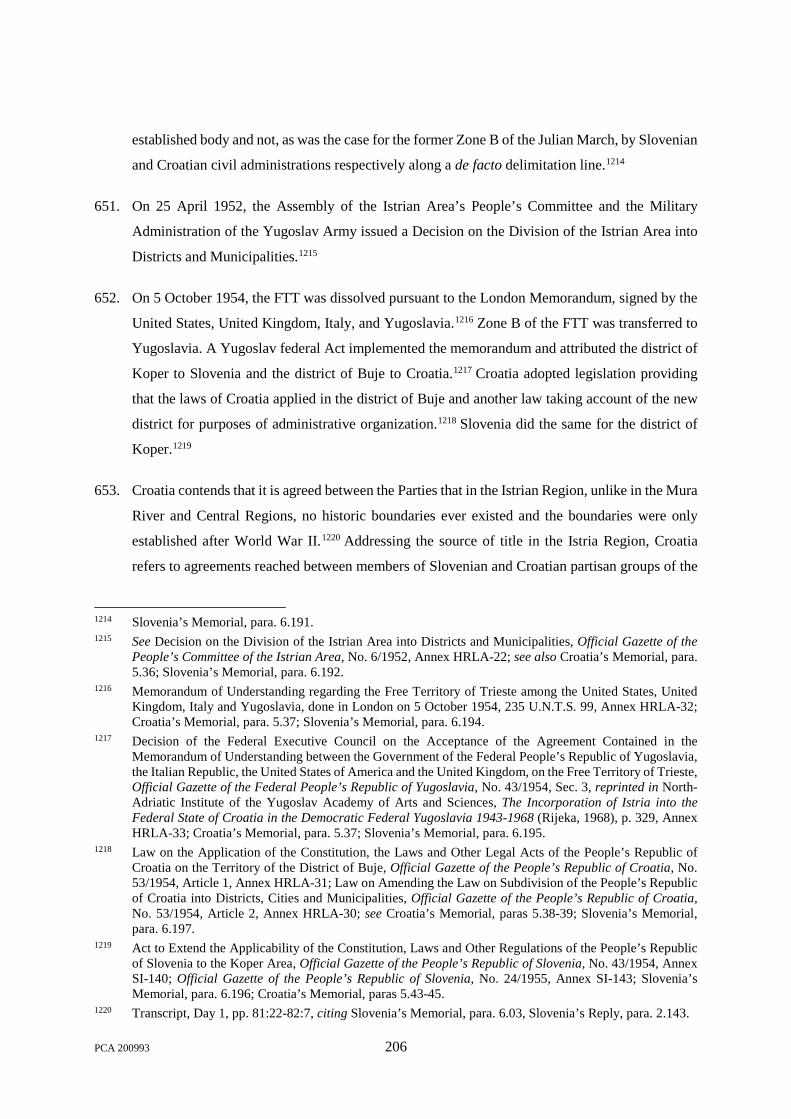
established body and not, as was the case for the former Zone B of the Julian March, by Slovenian
and Croatian civil administrations respectively along a de facto delimitation line.1214
651. On 25 April 1952, the Assembly of the Istrian Area’s People’s Committee and the Military
Administration of the Yugoslav Army issued a Decision on the Division of the Istrian Area into
Districts and Municipalities.1215
652. On 5 October 1954, the FTT was dissolved pursuant to the London Memorandum, signed by the
United States, United Kingdom, Italy, and Yugoslavia.1216 Zone B of the FTT was transferred to
Yugoslavia. A Yugoslav federal Act implemented the memorandum and attributed the district of
Koper to Slovenia and the district of Buje to Croatia.1217 Croatia adopted legislation providing
that the laws of Croatia applied in the district of Buje and another law taking account of the new
district for purposes of administrative organization.1218 Slovenia did the same for the district of
Koper.1219
653. Croatia contends that it is agreed between the Parties that in the Istrian Region, unlike in the Mura
River and Central Regions, no historic boundaries ever existed and the boundaries were only
established after World War II.1220 Addressing the source of title in the Istria Region, Croatia
refers to agreements reached between members of Slovenian and Croatian partisan groups of the
1214 Slovenia’s Memorial, para. 6.191. 1215 See Decision on the Division of the Istrian Area into Districts and Municipalities, Official Gazette of the
People’s Committee of the Istrian Area, No. 6/1952, Annex HRLA-22; see also Croatia’s Memorial, para. 5.36; Slovenia’s Memorial, para. 6.192.
1216 Memorandum of Understanding regarding the Free Territory of Trieste among the United States, United Kingdom, Italy and Yugoslavia, done in London on 5 October 1954, 235 U.N.T.S. 99, Annex HRLA-32; Croatia’s Memorial, para. 5.37; Slovenia’s Memorial, para. 6.194.
1217 Decision of the Federal Executive Council on the Acceptance of the Agreement Contained in the Memorandum of Understanding between the Government of the Federal People’s Republic of Yugoslavia, the Italian Republic, the United States of America and the United Kingdom, on the Free Territory of Trieste, Official Gazette of the Federal People’s Republic of Yugoslavia, No. 43/1954, Sec. 3, reprinted in North-Adriatic Institute of the Yugoslav Academy of Arts and Sciences, The Incorporation of Istria into the Federal State of Croatia in the Democratic Federal Yugoslavia 1943-1968 (Rijeka, 1968), p. 329, Annex HRLA-33; Croatia’s Memorial, para. 5.37; Slovenia’s Memorial, para. 6.195.
1218 Law on the Application of the Constitution, the Laws and Other Legal Acts of the People’s Republic of Croatia on the Territory of the District of Buje, Official Gazette of the People’s Republic of Croatia, No. 53/1954, Article 1, Annex HRLA-31; Law on Amending the Law on Subdivision of the People’s Republic of Croatia into Districts, Cities and Municipalities, Official Gazette of the People’s Republic of Croatia, No. 53/1954, Article 2, Annex HRLA-30; see Croatia’s Memorial, paras 5.38-39; Slovenia’s Memorial, para. 6.197.
1219 Act to Extend the Applicability of the Constitution, Laws and Other Regulations of the People’s Republic of Slovenia to the Koper Area, Official Gazette of the People’s Republic of Slovenia, No. 43/1954, Annex SI-140; Official Gazette of the People’s Republic of Slovenia, No. 24/1955, Annex SI-143; Slovenia’s Memorial, para. 6.196; Croatia’s Memorial, paras 5.43-45.
1220 Transcript, Day 1, pp. 81:22-82:7, citing Slovenia’s Memorial, para. 6.03, Slovenia’s Reply, para. 2.143.
PCA 200993 206

resistance movement in 1944 concerning their respective “jurisdiction(s)”.1221 Croatia contends
that through such agreements, the boundary of Croatia and Slovenia in the Istria Region was
agreed. 1222 In Western Istria specifically, Croatia refers to the establishment of a de facto
boundary along the course of the Dragonja River pursuant to the informal arrangements between
partisan groups in 1944 that remained the de facto situation until 1955, when it was confirmed by
an agreement between the Executive Councils of Croatia and Slovenia.1223 Croatia relies further
on Croatian administration of the area on the southern or left bank of the Dragonja River from
1957 until the critical date.1224
654. Relying on the 1996 Report, Croatia identifies eight disputed areas in the Istria Region.1225 The
largest is disputed area 11.9,1226 which was within a single Austrian, and then Italian municipality,
meaning that there was neither a quasi-international boundary in this area nor a municipal
boundary separating any part of the area claimed by Croatia from any part of the area claimed by
Slovenia.1227
655. Beyond these areas, Croatia faults Slovenia for asserting three “new” claims that it had not raised
at the time of independence.1228 The three new claims encompass approximately 9 ha. Croatia
argues that these new claims are at variance with Slovenia’s own law as well as with Slovenia’s
statement in its Memorial that the boundary in eastern Istria corresponds to cadastral limits.1229
656. Croatia emphasises that the Parties agree on certain points with regard to Istria. According to
Croatia, the Parties agree that there is no historical boundary and the relevant chain of legal
instruments linking the title to the critical date refers back to the Austro-Hungarian boundaries.1230
According to Croatia, the Parties also agree that the western part of Istria was not incorporated
into Croatia or Slovenia until 1954; and that when it was so incorporated, the boundary was
unresolved.1231
1221 Croatia’s Memorial, paras 5.17-24. 1222 Croatia’s Memorial, para. 5.24. 1223 Transcript, Day 2, pp. 33:18-34:8. 1224 Transcript, Day 2, p. 34:4-8. 1225 Croatia’s Counter-Memorial, para. 4.1. 1226 Transcript, Day 2, p. 31:15-17 citing Tab 6.1 for a reference to the disputed area 11.9. 1227 Transcript, Day 2, p. 33:12-17. 1228 Croatia’s Counter-Memorial, para. 4.9; Transcript, Day 2, p. 32:14-19. 1229 Croatia’s Counter-Memorial, paras 4.125-26. 1230 Transcript, Day 5, pp. 166:20-167:5; Transcript, Day 3, pp. 169:7, 129:24-26. 1231 Transcript, Day 5, p. 167:7-9.
PCA 200993 207

657. Slovenia asserts that in the Istria Region, the legal title relevant for the determination of the
boundary and for the application of the uti possidetis was established only after World War II. It
adds that the boundary was nevertheless based on pre-existing cadastral boundaries.1232
658. Slovenia recalls that the eastern part of the former Julian March and Istria were incorporated into
Yugoslavia in accordance with the post-war treaties, specifically, the 1947 Peace Treaty, while
the western part of Istria first became part of the FTT and was included into Slovenia and Croatia
only in 1954.1233
659. Slovenia analyses title in the eastern part of the former Julian March, transferred to Yugoslavia
under the 1947 Peace Treaty with Italy, in the following way:
The legislation concerning the territorial organisation of Slovenia, on the one hand, and Croatia, on the other hand, shows that, upon the transfer of part of Zone B to Yugoslavia, both republics received those municipalities, settlements and districts that had been administrated by the corresponding Slovenian or Croatian civil administration within Zone B. These administrative units were organized for this specific purpose in the eve of the Peace Treaty in 1947. In other words, the transfer was carried out with regard to the established de facto line between districts administrated by the Slovenian authorities and those ruled by Croatian authorities, respectively. After the transfer, this de facto agreed line became the legal boundary between Slovenia and Croatia.1234
660. Slovenia therefore asserts that, in the eastern part of Istria and the former Julian March, “the
cadastre constitutes not only a proof of the boundary line; it is the established legal title for the
delimitation of the boundary.”1235
661. Slovenia adds that the boundary in the eastern part of Istria “has been modified slightly”1236 after
its establishment in 1947. It refers to the transfer of the Gradin area from Croatia to Slovenia,
endorsed by the Federal People’s Assembly of Yugoslavia in 1956.1237
662. Slovenia asserts that the boundary in the western part of Istria, established in 1954, corresponds
to the boundary between the Koper District and the Buje District.1238
1232 Slovenia’s Memorial, para. 6.148; Transcript, Day 3, p. 154:5-9. 1233 Slovenia’s Memorial, para. 6.160; Slovenia’s Counter-Memorial, para. 6.08. 1234 Slovenia’s Memorial, para. 6.170 (footnote omitted); see Slovenia’s Counter-Memorial, para. 6.10. 1235 Slovenia’s Memorial, para. 6.174. 1236 Slovenia’s Memorial, para. 6.175. 1237 Slovenia’s Memorial, paras 6.176-79; Decree Endorsing the Change of Borders between the PR of Croatia
and the People’s Republic of Slovenia, Official Gazette of the Federal People’s Republic of Yugoslavia, No. 15/1956, Article 1, Annex SI-149; see Slovenia’s Counter-Memorial, para. 6.13.
1238 Slovenia’s Memorial, paras 6.195-97; see Slovenia’s Counter-Memorial, para. 6.12.
PCA 200993 208

663. According to Slovenia, the Parties agree that the boundary between them in both parts of the Istria
sector was established de novo, and that the cadastre played a very important role in this de novo
delimitation of the boundary. However, Slovenia says, Croatia fails to indicate on what legal basis
this was done: the cadastre constitutes the legal basis in the Istria sector because the division and
delimitation in this area was done by competent authorities with reference to cadastral limits.1239
664. Concerning what Croatia calls Slovenia’s “three new claims”, Slovenia submits that the Mixed
Expert Group did not find the cadastral boundaries aligned in the area as it did not compare
them.1240 Slovenia emphasises that its own position is supported by cadastral records and official
maps.1241
Leskova Dolina and Snežnik/Prezid
665. There is a discrepancy between the cadastral records of Leskova Dolina and Snežnik (Slovenia)
and Prezid (Croatia),1242 which has given rise to disputed areas 9.3 and 9.4 as identified by the
Expert Group. The boundary claimed by Croatia is marked on the ground by eight concrete stones.
The boundary claimed by Slovenia is marked by 16 concrete columns.1243
666. With 66.55 ha, area 9.3 is the largest. Area 9.4 is composed of six smaller plots. Those seven
forest plots were owned by Mr. Viktor Tomšič from 1943 to 1948/19501244 and are conveniently
called the Tomšič plots.
1239 Transcript, Day 3, p. 156:6-20. 1240 Slovenia’s Reply, para. 2.134. 1241 Slovenia’s Reply, para. 2.135; see Surveying and Mapping Authority of the Socialist Republic of Slovenia: State
Base Map, Socialist Republic of Slovenia, Risnjak-Čabar – 11, 1976, Annex SI-M-71; Surveying and Mapping Authority of the Republic of Slovenia: State Topographic Map, Snežnik 184, 1995, Annex SI-M-75; Cadastral municipality of Sušak (1819), Sheet Nos. I, III, IV, V, Annex SI-828; Cadastral municipality of Sušak (Rectification, 1877), Sheet Nos. III, IV, VSI-839; Surveying and Mapping Authority of the Republic of Slovenia: State Topographic Map, Novokračine 198, 1995, Annex SI-M-76; see also the 1837 rectified copies of the maps of the cadastral municipality Lisac in Slovenia’s Reply, cadastral municipality Lisac (Rectification, 1837), Sheet Nos. III, IV, Annex SI-837; the 1879 rectified copies of the cadastral municipality of Lipa (bordering the cadastral municipalities of Sušak and Lisac), in Slovenia’s Reply, cadastral municipality Lipa (Rectification, 1879), Sheet Nos. I, IV, V, Annex SI-840. Slovenia corrects the depiction of its claim at Slovenia’s Reply, para. 2.136.
1242 Slovenia’s Memorial, para. 6.180. 1243 Minutes from the Field Survey Performed in Collating Unaligned Borders of Cadastral Districts, Border
Sector IX, Case 3 (Prezid/Leskova Dolina), Joint Expert Group, Prezid, 13 June 1996, Annex HR-78; Slovenia’s Counter-Memorial, Figure 6.4.
1244 Extract from the Land Register, cadastral municipality of Snežnik, Folio No. 190, 6 November 1991, Annex SI-241.
PCA 200993 209

667. It is not disputed that the Tomšič plots were part of Croatia before the First World War. It is also
undisputed that they became part of the Italian Julian March under the Treaty of Rapallo of
12 November 1920. They passed under the sovereignty of Yugoslavia under the 1947 Peace
Treaty with Italy.
668. The territory attached to Yugoslavia under the 1947 Peace Treaty with Italy was shared between
Croatia and Slovenia. However no federal legislation fixed the boundary between the two
Republics. Each Republic enacted legislation on the administrative division of its territory.
669. The administrative and territorial division of Croatia was fixed by an Act dated 28 June 1947,1245
amended on 26 May 1948.1246
670. On the Slovenian side, the Supervising Authority of the Regional People’s Liberation Committee
for the Littoral issues enacted, on 8 February 1947, a decree on the organisation of administrative
division of districts and localities.1247 On the basis of that text, a new decree, dated 23 February
1948, fixed the administrative division of the Republic.1248
671. Under that decree, the former Italian district of Monte Nevoso (Mount Snežnik) was shared
between two new districts called Leskova Dolina and Snežnik. Area 9.3 became part of the
municipality of Cerknica within the cadastral district of Leskova Dolina. Area 9.4 became part of
the municipality of Ilirska Bistrica within the cadastral district of Snežnik. It was later decided by
Slovenia to incorporate both areas into the municipality of Čabar within the cadastral district of
Prezid.1249
1245 Law on Administrative and Territorial Subdivision of the People’s Republic of Croatia, Official Gazette of the People’s Republic of Croatia, No. 60/1947, Annex HRLA-16; Act on the Administrative and Territorial Division of the People’s Republic of Croatia, 1947, Official Gazette of the People’s Republic of Croatia, No. 60/1947, Annex SI-106.
1246 Law on Changes and Amendments to the Law on Administrative and Territorial Subdivision of the People’s Republic of Croatia, Official Gazette of the People’s Republic of Croatia, No. 42/1948, Annex HRLA-20; Act Amending the Act on the Administrative and Territorial Division of the People’s Republic of Croatia of 28 June 1947, 1948, Official Gazette of the People’s Republic of Croatia, No. 42/1948, Annex SI-114.
1247 Supervising Authority of the Regional People’s Liberation Committee, Decree on the Organisation of Administrative Division of Districts and Localities, 8 February 1947, Annex SI-100; Supervising Authority of the Regional People’s Liberation Committee, Secretariat, Department for the Establishment of the People’s Authority, Plan for New Administrative Division of the Slovenian Littoral within the Boundaries of the Area to Be Annexed to the Federal People’s Republic of Yugoslavia, 8 February 1947, Annex SI-101.
1248 Act on the Administrative Division of the People’s Republic of Slovenia, 1948, Official Gazette of the People’s Republic of Slovenia, No. 9/1948, Annex SI-113.
1249 Croatia’s Memorial, para. 6.5; Slovenia’s Memorial, para. 6.184-86.
PCA 200993 210

i. The Parties’ Positions
672. Slovenia recalls that pursuant to the Treaty of Rapallo the disputed areas were integrated into the
Kingdom of Italy and a new frontier was demarcated and fixed by border stones on the ground.1250
Disputed areas 9.3 and 9.4 were thus part of the Italian Julian March from 1920 to 1947. Under
the Treaty of Paris of 1947, Slovenia argues, the whole area of Snežnik as it was under Italian
sovereignty became part of Slovenia’s territory, including the disputed areas.1251 Slovenia also
points to its administration of the region since 1947.1252 Thus, according to Slovenia, the current
boundary between the two Parties is the former boundary between Italy and Yugoslavia.
673. For its part, Croatia submits that Slovenia could not avail itself of that boundary, which must be
considered as null and void. In Croatia’s view, the Treaty of Rapallo, which had ceded to Italy
large parts of Croatia’s former territory,1253 was rejected in 1943 by the Slovene and Croat partisan
organisations as well as AVNOJ.1254 Croatia submits that AVNOJ decided that Croatian lands
that had been annexed to Italy would be restored to Croatia, and that annexed Slovenian parts of
the former Austrian Crown Lands would be incorporated into Slovenia.1255 Croatia adds that
“both disputed areas lie on the Croatian side of the historic boundary between the Kingdom of
Croatia and Austria that had been delimited in 1860 and demarcated in the field in 1913.”1256
1250 Slovenia’s Memorial, para. 6.184; Transcript, Day 3, pp. 154:20-155:5. 1251 Slovenia’s Memorial, para. 6.186; Transcript, Day 3, p. 159:14-17. 1252 Slovenia’s Memorial, para. 6.187; see Slovenia’s Counter-Memorial, paras 6.34-35; see also Slovenia’s
Reply, para. 2.127. 1253 Croatia’s Memorial, para. 6.29; Transcript, Day 2, p. 12:19-22. 1254 Croatia’s Reply, para. 4.8; see Croatia’s Memorial, paras 6.16-17; Resolution of the Second Session of the
National Anti-fascist Council of People’s Liberation of Croatia, Plaški, 14 October 1943, Sec. 4, reprinted in North-Adriatic Institute of the Yugoslav Academy of Arts and Sciences, The Incorporation of Istria into the Federal State of Croatia in the Democratic Federal Yugoslavia, 1943-1968 (Rijeka, 1968), p. 197, Annex HRLA-6; Declaration of the Liberation Front of the Slovenian People on the Incorporation of the Slovenian Littoral into Slovenia and Yugoslavia, 16 September 1943, Article 1, reprinted in North-Adriatic Institute of the Yugoslav Academy of Arts and Sciences, The Incorporation of Istria into the Federal State of Croatia in the Democratic Federal Yugoslavia, 1943-1968, Rijeka, 1968, p. 209, Annex HRLA-4; Decision of the Anti-fascist Council of People’s Liberation of Yugoslavia on the Incorporation of Slovenian Littoral, Venetian Slovenia, Istria and Croatian Adriatic Islands to Yugoslavia, Jajce, 30 November 1943, Documents of the General Staff of the People’s Liberation Army of Yugoslavia 1943-1944 in Military History Institute, Almanac of Documents and Records on People’s Liberation War of the Yugoslav Peoples Vol. II, Book 11, p. 446 (1963), Annex HRLA-9; Transcript, Day 2, pp. 13:23-14:3; Transcript, Day 2, p. 14:4-10.
1255 Transcript, Day 6, p. 8:13-19. 1256 Croatia’s Counter-Memorial, para. 5.17.
PCA 200993 211

674. Croatia argues that, on the international plane, the Treaty of Paris returned to Yugoslavia most of
the land that had been lost by the Treaty of Rapallo,1257 restoring the “historic Austro-Hungarian
boundary” in the area.1258
675. As regards Yugoslav domestic law, Croatia invokes federal legislation adopted in 1946 and 1947.
It first mentions the “Law on the Nullity of Laws and Regulations adopted prior to 6 April 1941”
dated 23 October 19461259 and submits that the relevant provisions of that federal Law were
declared applicable to “the territory attached to the Federal People’s Republic of Yugoslavia
pursuant to the Peace Treaty with Italy” through a mandatory interpretation dated 3 November
1947.1260 Croatia also mentions the Federal Order of 15 September 1947, which extended “the
applicability of the constitution, laws and other legal regulations of the Federal People’s Republic
of Yugoslavia” to the same territory.1261 In both Croatia and Slovenia,1262 Orders extending the
law of the two Republics to the attached territory were enacted some days later. These Orders are
drafted in comparable terms.1263
676. Slovenia rejects Croatia’s position that the Treaty of Rapallo was annulled during or after World
War II. It argues that AVNOJ did not challenge pre-war treaties, and did not have the power to
annul them.1264 Moreover, Slovenia points out that the internal legislation upon which Croatia
relies—the Order to Extend the Applicability of the Constitution, Acts and Other Regulations of
the FPRY to the Territory that was Attached to the FPR Yugoslavia under the Peace Treaty with
Italy of September 1947—specifically provides that “[t]he legal regulations of the bodies of the
1257 Transcript, Day 2, p. 14:11-14. 1258 Croatia’s Memorial, para. 6.31; see also Croatia’s Memorial, para. 6.20; Transcript, Day 2, p. 19:7-11. 1259 Law on the Nullity of Laws and Regulations Adopted prior to 6 April 1941, 23 October 1946, Official
Gazette of the Federal People’s Republic of Yugoslavia, No. 86/1946, 25 October 1946, Annex HRLA-80. 1260 Mandatory Interpretation of Provisions of Articles 1, 2, 4, 7, 10, and 11 of the Act on Invalidation of Legal
Regulations Issued prior to 6 April 1941 and During Enemy Occupation (1947), Official Gazette of the Federal People’s Republic of Yugoslavia, No. 96/1947, Annex SI-855.
1261 Order to Extend the Applicability of the Constitution, Laws and Other Legal Regulations of the Federal People’s Republic of Yugoslavia that was attached to the Federal People’s Republic of Yugoslavia under the Peace Treaty with Italy, Official Gazette of the Federal People’s Republic of Yugoslavia, No. 80/1947, Annex SI-108.
1262 In the case of Slovenia, cf. also a preceding decree dated 5 June 1945. 1263 Order to Extend the Applicability of the Constitution, Laws and Other Regulations of the People’s Republic
of Slovenia to the Territory Attached to the Federal People’s Republic of Yugoslavia under the Peace Treaty with Italy to the Extent this Territory Shall Be Incorporated into the People’s Republic of Slovenia (1947), Official Gazette of the People’s Republic of Slovenia, No. 39/1947, Annex SI-109; Order to Extend the Applicability of the Constitution, Laws and Other Regulations of the People’s Republic of Croatia to the Territory of Istria, the Towns of Rijeka and Zadar and to the Island of Lastovo (1947), Official Gazette of the People’s Republic of Croatia, No. 87/1947, Annex SI-110.
1264 Transcript, Day 3, p. 160:12-21.
PCA 200993 212

people’s authority, which were issued in this territory, shall remain valid unless they are contrary
to federal Acts and other legal regulations.”1265
677. Slovenia also objects to Croatia’s claim that the 19th century boundary between Austria and
Hungary could have been re-established in the area.1266 Even if the Treaty of Rapallo had lost its
effect in the manner contended by Croatia, the Tomšič plots became part of Slovenia’s Istria
sector when the boundary was determined anew in 1947.1267 Slovenia contends that it is plain that
the entire district of Ilirska Bistrica, including the disputed area, became part of Slovenia in 1947,
as confirmed by legal acts following the Treaty of Paris, 1268 including the 1948 Act on
Administrative Division of Slovenia. As a result, Slovenia included the Tomšič plots in its
territory as part of the Illirska Bistrica and the cadastral municipality of Snežnik, while Croatia
enacted no legislation to include the plots in its cadastral municipality of Prezid.1269 This confirms
that the plots became part of Slovenia.1270
678. Finally, Croatia adds that effectivités, consisting mainly of forestry management activities,
confirm its sovereignty.1271 A letter from a Slovenian forestry inspector dated 6 February 1989
adduced by Slovenia as Annex SI-954 in connection with disputed area 9.3 concedes, according
to Croatia, that Croatia had administered the disputed area during the four decades preceding the
critical date.1272
679. Slovenia argues that the effectivités, invoked by Croatia, as well as Annex SI-954 confirm
Slovenia’s title to the district.1273
ii. The Tribunal’s Analysis
680. Croatia first submits that the Treaty of Rapallo1274 was null and void. As a consequence, Croatia
argues, “[t]he borders established under the Rapallo Treaty were erased and had no further effect.
They could not be used for any purpose, let alone for Yugoslavia’s territorial organisation.”
1265 Slovenia’s Reply, para. 2.122. 1266 Slovenia’s Counter-Memorial, para. 6.16. 1267 Slovenia’s Counter-Memorial, para. 6.19; Transcript, Day 8, p. 134:1-7. 1268 Slovenia’s Counter-Memorial, paras 6.29-30. 1269 Transcript, Day 8, p. 137:2-6; Transcript, Day 3, p. 164:16-19. 1270 Transcript, Day 3, pp. 164:16-165:1. 1271 Croatia’s Memorial, paras 6.32-33. 1272 Transcript, Day 6, p. 11:5-13 citing the letter dated 6 February 1989 under Tab 6.15 and Annex SI-954. 1273 Transcript, Day 8, p. 137:7-15; Transcript, Day 3, p. 165:2-3. 1274 See note 13, Annex HRLA-3.
PCA 200993 213

[emphasis added]1275 Thus, according to Croatia, Slovenia cannot avail itself of those borders. In
support of this argument, Croatia invokes, among other evidence, declarations made by Yugoslav
partisan organisations in 1943,1276 but does not advance any legal argument to establish the nullity
of the Treaty of Rapallo under international law. Therefore, that submission must be dismissed.
681. Regarding the Federal legislation, the 1946 Law does provide in its Article 2 that “[t]he laws and
regulations . . . that were in force as of 6 April 1941 have lost their legal force.” However, Article 4
provides:
The legal rules contained in the laws and other regulations mentioned in Article 2 of this Law . . . may under this Law be applied to matters not regulated by existing regulations, but only if they are not in contravention of the Constitution of the FPRY, the constitutions of the people’s republics, the laws and other existing regulations enacted by the competent authorities of the new State, and of the principles of the constitutional order of the Federal People’s Republic of Yugoslavia and its republics.1277
682. Similarly, the 1947 Federal Order, which seems to have at least partially abrogated the 1946 Law,
stipulates in Article 2:
The legal regulations of the Federal People’s Republic of Yugoslavia shall come into force in the territory attached on the day of its attachment to the Federal People's Republic of Yugoslavia.
The legal regulations of the bodies of the people’s authority, which were issued in this territory, shall remain valid unless they are contrary to federal laws and other legal regulations.
As from the day of the attachment, all regulations issued by the Italian state authorities and the Allied occupation authorities shall cease to be valid in the attached territory.1278
1275 Transcript, Day 2, p. 18:1-4. 1276 Declaration of the Liberation Front of the Slovenian People on the Incorporation of the Slovenian Littoral
into Slovenia and Yugoslavia, 16 September 1943, Article 1, reprinted in North-Adriatic Institute of the Yugoslav Academy of Arts and Sciences, The Incorporation of Istria into the Federal State of Croatia in the Democratic Federal Yugoslavia, 1943-1968, Rijeka, 1968, p. 209, Annex HRLA-4; Resolution of the Second Session of the National Anti-fascist Council of People’s Liberation of Croatia, Plaški, 14 October 1943, sec. 4, reprinted in North-Adriatic Institute of the Yugoslav Academy of Arts and Sciences The Incorporation of Istria into the Federal State of Croatia in the Democratic Federal Yugoslavia, 1943-1968, Rijeka, 1968, p. 197, Annex HRLA-6; Decision of the Anti-fascist Council of People’s Liberation of Yugoslavia on the Incorporation of Slovenian Littoral, Venetian Slovenia, Istria and Croatian Adriatic Islands to Yugoslavia, Jajce, 30 November 1943, Documents of the General Staff of the People’s Liberation Army of Yugoslavia 1943-1944 in Military History Institute, Almanac of Documents and Records on People’s Liberation War of the Yugoslav Peoples Vol. II, book 11, p. 446 (1963), Annex HRLA-9.
1277 Law on the Nullity of Laws and Regulations Adopted prior to 6 April 1941, 23 October 1946, Official Gazette of the Federal People’s Republic of Yugoslavia, No. 86/1946, 25 October 1946, Annex HRLA-80.
1278 Order to Extend the Applicability of the Constitution, Laws and Other Legal Regulations of the Federal People’s Republic of Yugoslavia that was attached to the Federal People’s Republic of Yugoslavia under the Peace Treaty with Italy, Official Gazette of the Federal People’s Republic of Yugoslavia, No. 80/1947, Annex SI-108.
PCA 200993 214
683. The corresponding Croatian and Slovenian Acts contain the same provision.
684. The Tribunal will not enter into an in-depth analysis of all the legal consequences of those pieces
of legislation. It will be enough for it to observe that those domestic laws could not have nullified
the international boundary established by the Treaty of Rapallo, which was the boundary between
Italy and Yugoslavia under international law from 1920 to 1947. The Tribunal will add that the
purpose of those pieces of legislation was not to nullify the Treaty of Rapallo. Rather, they were
only enacted to determine the law applicable in the territory attached to Yugoslavia under the
Treaty of Paris.
685. The Tribunal thus arrives at the conclusion that the argument of Croatia cannot be upheld. The
eastern limit of the Monte Nevoso district of the Italian Julian March became, in 1947, the eastern
limit of the Slovenian districts of Snežnik and Leskova Dolina. That limit corresponds to the
former boundary between Italy and Yugoslavia which became the border between the two
Republics and is now the boundary between the Parties.
686. The other elements pleaded by the Parties do not allow the Tribunal to arrive at a different
conclusion. In support of its effectivités, Croatia avails itself of a field survey performed by
members of the Expert Group in 1996 stating that “[u]ninterruptedly since the defeat of Fascist
Italy and through present day,” area 9.3 “has been in possession of the forest office Prezid.”1279
Slovenia does not contest this, but it recalls that it protested against the exploitation of the
forest.1280 However, Slovenia only cites one protest made in 1958, and it therefore appears that
from that date to at least 1988, the forest was exploited without further protest by the Snežnik
forest office.1281 In any event, that exploitation cannot be regarded as an act done by Croatia à
titre de souverain (see paragraph 575).
1279 Minutes from the Field Survey Performed in Collating Unaligned Borders of Cadastral Districts, Border Sector IX, Case 3 (Prezid / Leskova Dolina), Joint Expert Group, Prezid, 13 June 1996, Annex HR-78.
1280 Letter from Ljubljana District People’s Committee, Forestry Authority to Prezid Forest Management, 20 June 1958, Annex SI-499; Letter from Ljubljana District People’s Committee, Forestry Authority to Prezid Forest Management, 14 October 1958, Annex SI-500.
1281 Basics of Management (1955-1970), Economic Unit “Milanov vrh - Crni laz”, Forestry Office Prezid – Tršće, Annex HR-12; Basics of Management (1970-1979), Economic Unit “Milanov vrh”, Forestry Office Prezid, Annex HR-29; Minutes from the Field Survey Performed in Collating Unaligned Borders of Cadastral Districts, Border Sector IX, Case 3 (Prezid/Leskova Dolina), Joint Expert Group, Prezid, 13 June 1996, Annex HR-78; Cerknica Local Court: Historical Extract No. 77/97 from Land Register for cadastral municipality Babno polje, Land Register Entry No. 317, 20 May 1997, Annex SI-980; Letter No. 321-34/98-13-IV/Ho from Republic Committee for Agriculture, Forestry and Food of Socialist Republic of Slovenia to Inter-municipal Inspectorate of the Cerknica, Ilirska Bistrica and Postojna Municipalities, 18 October 1988, Annex SI-953; Letter No. 321/A-19/88-6 from Inter-Municipal Inspectorate of the Cerknica, Ilirska Bistrica and Postojna Municipalities to the Assembly of Cerknica Municipality, 6 February 1989, Annex SI-954.
PCA 200993 215

687. For its part, Slovenia recalls that the Tomšič’s plots were expropriated in 1948/1950 by the
Slovenian authorities1282 and that his former properties were then registered in 1951 as “general
people’s property” on the land register of Snežnik. 1283 Slovenia stresses that area 9.3 was
“registered as general people’s property managed by the people’s committee of Čabar”1284 in
Croatia only in 1970. Moreover, when Mr. Tomšič tried in the 1990s to recover his property under
the Denationalisation Act then adopted, he presented his request to the Slovenian authorities and
tribunals.1285 The Tribunal considers that those elements further support the Tribunal’s conclusion
set out in paragraph 685.
688. The Tribunal determines that the boundary between Croatia and Slovenia in areas 9.3 and 9.4
follows the course of the former boundary between Italy and Yugoslavia as it stood from 1920 to
1947.
Gomance
689. Slovenia has also presented a claim for a small area, with an approximate surface of 2.0 ha,
immediately to the south of the settlement of Gomance.
690. Croatia asserts that the cadastral limits in the region are generally aligned, but it does not adduce
any specific evidence in respect of Gomance.
691. Slovenia observes that Croatia “does not provide any evidence for this assertion” that the
cadastres are aligned. It also contends that the Expert Group did not compare the cadastral lines
in this area.1286
692. More specifically, Slovenia maintains that its own claim in the area follows cadastral limits—for
the present area, the southern limit of Slovenia’s cadastral municipality of Snežnik. 1287 As
evidence, Slovenia adduces two official topographic maps, produced by the Surveying and
1282 District Commission for Agrarian Reform in Ilirska Bistrica, Additional Decision concerning Expropriation of Viktor Tomšič, 22 May 1950, Annex SI-475.
1283 Extract from the Land Register, Cadastral Municipality of Snežnik, Folio No. 190, 6 November 1991, Annex SI-241.
1284 Minutes from the Field Survey Performed in Collating Unaligned Borders of Cadastral Districts, Border Sector IX, Case 3 (Prezid/Leskova Dolina), Joint Expert Group, Prezid, 13 June 1996, Annex HR-78.
1285 Decision of Ilirska Bistrica Municipality regarding the Claim of Vitorio Tomsic and others for the Return in Ownership and Possession of the Immovable Property, 5 September 1994, Annex SI-749.
1286 Slovenia’s Reply, para. 2.134. 1287 Slovenia’s Reply, para. 2.135.
PCA 200993 216

Mapping Authority of the Socialist Republic of Slovenia in 19761288 and by the Surveying and
Mapping Authority of the Republic of Slovenia in 1995.1289 Both maps are included below.
However, Slovenia has not provided its cadastral records for the relevant district.
(Surveying and Mapping Authority of the Socialist Republic of Slovenia: State Base Map, Socialist
Republic of Slovenia, Risnjak-Čabar – 11, (1976), Annex SI-M-71 (extract))1290
1288 Surveying and Mapping Authority of the Socialist Republic of Slovenia: State Base Map, Socialist Republic of Slovenia, Risnjak-Čabar – 11 (1976), Annex SI-M-71.
1289 Surveying and Mapping Authority of the Republic of Slovenia: State Topographic Map, Snežnik 184 (1995), Annex SI-M-75.
1290 Surveying and Mapping Authority of the Socialist Republic of Slovenia: State Base Map, Socialist Republic of Slovenia, Risnjak-Čabar – 11 (1976), Annex SI-M-71 (extract).
PCA 200993 217
(Surveying and Mapping Authority of the Republic of Slovenia: State Topographic Map, Snežnik 184
(1995), Annex SI-M-75 (extract))1291
693. At the outset, the Tribunal notes Croatia’s contention that the cadastral limits, as they presently
stand, are aligned and correspond to Croatia’s claim. Croatia has not provided any evidence,
beyond that assertion.
694. Slovenia has presented two official topographic maps, each prepared by Slovenia’s Surveying
and Mapping Authority. The maps are of high quality and large scale. They place the area in
dispute—a small plot of land apparently located opposite the main courtyard of a farm consisting
of five buildings—on Slovenia’s territory. The two maps, published almost two decades from
each other, suggest that a consistent view on the boundary in the area was taken by the Slovenian
geodetic authorities. The Tribunal also notes, however, that Slovenia chose not to submit any
cadastral records in respect of the Snežnik district, even though it did so in a comparable situation
further to the west, in Sušak.1292
695. Having considered the evidence on the record, the Tribunal finds that, overall, the evidence
presented by Slovenia is convincing. Faced in this arbitration with Slovenian official maps of the
sort reproduced above, Croatia could be expected to adduce pertinent rebuttal evidence, had such
evidence been in its possession. As matters stand, the Tribunal must give more weight to
1291 Surveying and Mapping Authority of the Republic of Slovenia: State Topographic Map, Snežnik 184 (1995), Annex SI-M-75 (extract).
1292 Cadastral Municipality of Sušak (1819), Sheet Nos. I, III, IV, V, Annex SI-828; Cadastral Municipality of Sušak (Rectification, 1877), Sheet Nos. III, IV, V, Annex SI-839.
PCA 200993 218

Slovenia’s clear and specific evidence of title than to Croatia’s unsubstantiated assertion of
cadastral alignment.
696. Accordingly, the Tribunal determines that the area with an approximate surface of 2.0 ha
immediately to the south of the settlement of Gomance forms part of Slovenia’s territory.
Klana/Lisac and Zabiče/Sušak as well as Lisac/Sušak
697. The Expert Group identified two disputed areas, areas 10.1 and 10.2, in the east of the part of
Istria that were the subject of the Parties discussions at Malija in 1944.1293 In addition, the Tribunal
observes that there is a further area of triangular shape to the south-west of these disputed areas
in which the Parties’ claims in the present proceedings diverge.
698. Both Croatia and Slovenia base their claims in areas 10.1 and 10.2 on the historic boundaries of
the Austrian cadastral districts that were integrated into Slovenia and Croatia respectively,1294
although they disagree as to where these boundaries are located. Slovenia points out that the post-
World War II delimitation in area 10 was conducted with reference to cadastral limits. 1295
Slovenia finds these limits in cadastral maps created by the surveys carried out in 1819/1820.
Croatia submits that areas 10.1 and 10.2 were incorporated into Croatia in 1948 as part of the
District of Rijeka,1296 and uses its cadastral district boundaries as marked on the ground and
depicted on cadastral maps dating back to 1878 as the basis for its claimed boundary.1297
699. Area 10.1 is considered by Croatia to be part of its Klana/Lisac cadastral districts, while Slovenia
considers area 10.1 to be part of its Zabiče/Sušak cadastral districts. Area 10.1 encompasses
2.9 ha; the boundary in that area is approximately 1.6 km long.1298
700. Area 10.2 is located in the Croatian cadastral district of Lisac and the Slovenian cadastral district
of Sušak. Area 10.2 runs for 0.3 km and encompasses 0.5 ha.1299
1293 Croatia’s Counter-Memorial, paras 4.8, 4.120, 4.122, 4.128. 1294 Slovenia’s Memorial, para. 6.10. 1295 Transcript, Day 3, p. 156:14-17, see also Slovenia’s Memorial, paras 6.173-74; Slovenia’s Reply, paras
2.128-31. 1296 Croatia’s Counter-Memorial, para. 4.120 n.220, para. 4.122 n.222. 1297 Croatia’s Counter-Memorial, paras 4.120-24. 1298 Croatia’s Counter-Memorial, paras 4.8, 4.122. 1299 Croatia’s Counter-Memorial, para. 4.120.
PCA 200993 219

i. The Parties’ Positions
701. Croatia submits that its claim in this area “accurately reflects” the boundary between Croatia and
Slovenia as its claim is “faithful to the boundary as demarcated on the Ground.”1300 Croatia states
that the Joint Expert Group observed in 1997 that the boundary stones dating from 1874 match
the boundary of Croatia’s cadastral districts in the area. It notes that the Joint Expert Group’s
minutes record that the “discrepancy is caused by an erroneous depiction of the border of
[Slovenia’s] c.d. Sušak and c.d. Zabiče (border stones No. 47, 46, 45) on detailed sheets of
cadastral plans of those cadastral districts.”1301
702. Croatia acknowledges that these minutes were not signed by the Joint Expert Group’s Slovenian
participants. However, Croatia suggests that this was due to Slovenia suspending its work within
the Joint Expert Group1302 and does not affect the correctness of the minutes’ conclusions.
703. Croatia further submits a cadastral map of Lisac dating from 1878, as well as photographic
illustrations of boundary stones, to demonstrate that “boundary stone numbers 46 and 47 are found
in the locations depicted on the 1878 cadastral map and correspond precisely to Croatia’s
boundary claim.”1303 Croatia concedes that a further boundary stone, bearing the number 48, has
been moved from its original location.1304
704. Slovenia refers to and attaches the maps produced by surveys undertaken in 1819 and 1820 for
the cadastral municipalities of Klana, 1305 Lisac, 1306 Zabiče, 1307 and Sušak, 1308 and notes that
according to these records, Slovenia’s claim corresponds to the cadastral evidence.1309
1300 Croatia’s Counter-Memorial, paras 4.8, 4.122-24. 1301 Croatia’s Counter-Memorial, para. 4.123, citing Minutes on Field Works in the Area of Unaligned Borders
of Croatian c.d. Lisac and c.d. Klana and the Slovenian c.d. Sušak and c.d. Zabiče Performed from 14 to 16 October 1997, Joint Expert Group, Annex HR-307.
1302 Croatia’s Counter-Memorial, para. 4.124, citing Report of the Croatian Members of the Joint Expert Group, 12 October 1998, Annex HR-308, which stated that “the Slovenian side has until further notice aborted all activities related to the work within the Joint expert Group.”
1303 Croatia’s Counter-Memorial, para. 4.124, Figure CM 4.12. 1304 Croatia’s Counter-Memorial, para. 4.124 n.226. 1305 Sheet Nos. I and XV of the Cadastral Municipality of Klana (1819), Annex SI-826. 1306 Sheet No. II of the Cadastral Municipality of Lisac (1819), Annex SI-827. 1307 Sheet Nos. III, XII of the Cadastral Municipality of Zabiče (1820), Annex SI-829. 1308 Sheet Nos. I, III, IV and V of the Cadastral Municipality of Sušak (1819), Annex SI-828. 1309 Slovenia’s Reply, para. 2.131.
PCA 200993 220

705. Slovenia also provides a map depicting the cadastral limits between these municipalities in
1819/1820. 1310 Slovenia points out that “Croatia never submitted the original surveys of its
cadastral municipalities to the scrutiny of the Mixed Expert Group”1311 and has not responded to
Slovenia’s submission of its cadastral evidence in the present proceedings.1312
706. Moreover, Slovenia dismisses Croatia’s reliance on the 1874 border stones, stating that “only one
of the stones, stone nNo. 47, seems to be located on the boundary claimed by Croatia,”1313 while
other stones (up to stone No. 47), represent the boundary between Lisac and the Croatian
municipality of Klana, (rather than the boundary with the Slovenian municipality of Sušak).1314
Slovenia further states that the cadastral maps of Sušak as rectified in 1877 “bear no indication at
all of any of these stones.”1315
707. Slovenia notes that both the unsigned minutes of the Expert Group referred to by Croatia and the
draft minutes prepared by the Slovenian Mixed Expert Group members reflect the fact that no
further stones were found west of stone No. 47.1316 In fact, there is no explanation as to why stone
No. 48 is not indicated by its number and position on Croatia’s submitted cadastral map, or why
the stone was moved.1317
708. The second of the disputed areas is area 10.2, which is considered by Croatia to be part of its
cadastral district of Lisac, while Slovenia considers it to be part of its cadastral district of Sušak.
The area encompasses 0.5 ha; the boundary in this area is approximately 0.3 km long.1318
709. Croatia submits that its claim in this area matches the cadastral district boundary shown on the
above-mentioned cadastral map prepared in 1878, while “Slovenia’s cadastral district limits are
based on an earlier survey, prepared in 1820.” 1319 Croatia further submits that “[t]his was
1310 Slovenia’s Reply, para. 2.131, citing Figure 2.26. 1311 Slovenia’s Reply, para. 2.131. 1312 Transcript, Day 3, p. 165:13-17. 1313 Slovenia’s Reply, para. 2.130. 1314 Slovenia’s Reply, para. 2.130, referring to Croatia’s Counter-Memorials, Figure CM 4.12. 1315 Slovenia’s Reply, para. 2.130, citing Sheet Nos. III and V of the Cadastral Municipality of Sušak (1877),
Annex SI-839. 1316 Slovenia’s Reply, para. 2.130, citing Mixed Slovenian-Croatian Expert Group for the Comparison of the
Cadastral Boundaries Displaying Discrepancies: Minutes on Field Works in the Area of Unaligned Borders of Croatian c. d. Lisac and c. d. Klana and the Slovenian c.d. Sušak and c.d. Zabiče Performed from 14 to 16 October 1997, Annex SI-982.
1317 Slovenia’s Reply, para. 2.130. 1318 Croatia’s Counter-Memorial, paras 4.8, 4.120. 1319 Croatia’s Counter-Memorial, para. 4.121.
PCA 200993 221
recognized by the geodetic authorities of Slovenia in a letter to their Croatia counterparts dated
22 June 1971,” and quotes the following part of the letter:
The discrepancy between c.d. Sušak (SR Slovenia) and c.d. Lisac (SR Croatia, Municipality of Rijeka) arose upon the cadastral survey around 1820, so that one and the same plot was measured twice and registered in both cadastral districts mentioned. Comparing the situation in c.d. Sušak and c.d Lisac, we have come to the conclusion that the status shown in cadastral plans for c.d. Lisac is correct. We base this conclusion on the comparison of the ownership of the mentioned plot (plot no. 1261 c.d Sušak: plot no. 1798 c.d Lisac). It is correct that the names of the owners are different, but their residence is identical, i.e. Lisac.1320[emphasis added by Croatia]
710. Slovenia argues that in the original survey carried out in 1819 the limits of both cadastral
municipalities coincided.1321 Slovenia acknowledges the 1878 cadastral map for Lisac produced
by Croatia but states that Croatia has not explained the circumstances of the alleged modification
of the cadastre of Lisac.1322 Slovenia provides an extract from the Land Register of Sušak, in
which the disputed plot forming area 10.2 (plot 1261) is recorded and observes that Croatia “has
. . . failed to produce any of the relevant cadastral records concerning the disputed plots.”1323
Slovenia finally dismisses Croatia’s reliance on the letter from the geodetic administration of
Slovenia, describing it as emanating from a “local cadastral official”, who seemed unaware of the
fact that in 1820 the cadastral boundaries matched.1324
ii. The Tribunal’s Analysis
711. The Tribunal observes that it is not disputed that the boundaries between the cadastral
municipalities of Klana, Lisac, Zabiče, and Sušak were surveyed in 1819/1820.1325 Slovenia bases
its claim on these surveys. Croatia, however, claims that the boundary lies in a different position,
as depicted on an 1878 cadastral map of Lisac. As evidence of the legal authority of this 1878
map, Croatia points to three boundary markers allegedly placed on the ground in 1874, which it
1320 Croatia’s Counter-Memorial, paras 4.8, 4.121, citing Letter from the Head of the Cadastral Office of Ilirska Bistrica to the Geodetic Administration of the Socialist Republic of Slovenia, 22 June 1971, Annex HR-206.
1321 Slovenia’s Reply, para. 2.132, citing Sheet Nos. I, III, IV and V of the Cadastral Municipality of Sušak (1819), Annex SI-828; Sheet No. II of the Cadastral Municipality of Lisac, 1819, Annex SI-827; Sheet Nos. III and V of the Cadastral Municipality of Sušak (1877), Annex SI-839.
1322 Slovenia’s Reply, para. 2.132. 1323 Slovenia’s Reply, para. 2.132, citing Historical Extract from Land Register for Cadastral Municipality of
Sušak, plot No. 1261, 12 March 2014, Annex SI-999. 1324 Slovenia’s Reply, para. 2.133. 1325 Sheet Nos. I and XV of the Cadastral Municipality of Klana (1819), Annex SI-826; Sheet No. II of the
Cadastral Municipality of Lisac (1819), Annex SI-827; Sheet Nos. I, III, IV and V of the Cadastral Municipality of Sušak (1819), Annex SI-828; Sheet Nos. III, XII of the Cadastral Municipality of Zabiče (1820), Annex SI-829.
PCA 200993 222

says demarcate area 10.1. 1326 Croatia further points to a letter from the Slovenian geodetic
authorities, which it claims demonstrates Slovenia’s acknowledgement of the correctness of the
boundary now claimed by Croatia in area 10.2.1327
712. On the basis of the relevant cadastral maps from 1819/1820 submitted by Slovenia, it appears to
the Tribunal that, at the time of the 1820 survey, the cadastral limits, in area 10, were aligned, as
the Sušak cadastral maps include the relevant areas, while the Lisac cadastral maps do not.1328 By
contrast, the later maps of the area differ: the 1878 Lisac cadastral maps submitted by Croatia
include areas 10.1 and 10.2 within Lisac,1329 while the 1877 Sušak cadastral maps submitted by
Slovenia include these areas within Sušak.1330
713. A later source of title may take precedence over an earlier source, provided that it is equally valid
and authoritative. Since the later maps from the 1870s contradict each other, it falls to the Tribunal
to determine whether or not the limits of the municipalities of Lisac and Sušak were varied in the
period between 1819/1820 and the 1870s. Not having been provided with any explanation or
context regarding the alleged boundary change, the Tribunal must determine this question upon
the evidence placed before it by the Parties.
714. In this regard, the Tribunal finds that the observations contained in the 1997 minutes of the Expert
Group do support Croatia’s claim in area 10.1 (specifically the conclusion that “[t]he border of
[Croatia’s] c.d. Lisac should be accepted as an aligned border of cadastral districts, as it is
maintained in the cadastral operate of that district, since its depiction on the cadastral plan matches
the situation on the ground.”)1331 However, since the minutes were not signed by the Expert
Group’s Slovenian participants, the Tribunal concludes that the minutes themselves have limited
evidentiary value.
1326 Croatia’s Counter-Memorial, Figure CM 4.12. 1327 Croatia’s Counter-Memorial, paras 4.8, 4.121, citing Letter from the Head of the Cadastral Office of Ilirska
Bistrica to the Geodetic Administration of the Socialist Republic of Slovenia, 22 June 1971, Annex HR-206.
1328 Sheet No. V of the Cadastral Municipality of Sušak, 1819, Annex SI-828; Sheet No. II of the Cadastral Municipality of Lisac (1819), Annex SI-827.
1329 Croatia’s Counter-Memorial, Figure CM 4.11; Figure CM 4.12. 1330 Sheet Nos. III and V of the Cadastral Municipality of Sušak (1877), Annex SI-839. 1331 Croatia’s Counter-Memorial, para. 4.123, citing Minutes on Field Works in the Area of Unaligned Borders
of Croatian c.d. Lisac and c.d. Klana and the Slovenian c.d. Sušak and c.d. Zabiče Performed from 14 to 16 October 1997, Joint Expert Group, Annex HR-307.
PCA 200993 223

715. In respect of the 1971 letter cited by Croatia, authored by the Slovenian Head of the Cadastral
Office of Ilirska Bistrica, 1332 the Tribunal acknowledges that it indeed contains language
supporting Croatia’s claim in area 10.2 (specifically the conclusion that “the status shown in
cadastral plans for c.d. Lisac is correct”).1333 However, that assessment was premised on the
assumption that “[t]he discrepancy between c.d. Sušak (SR Slovenia) and c.d. Lisac (SR Croatia,
Municipality of Rijeka) [i.e., area 10.2] arose upon the cadastral survey around 1820.”1334 Since
no such discrepancy appears to have existed in 1820 in respect of area 10.2, the letter has limited
probative value.1335
716. Turning then to the remaining evidence that has been placed before it, the Tribunal notes that two
of the three boundary stones identified by Croatia in support of its claim have contested
evidentiary value. Croatia has conceded that stone No. 48 has been moved from its original
location, and as such it may not be relied upon as evidencing the location of the relevant municipal
border between Lisac and Sušak. In addition, Slovenia alleges that stone No. 46 is located on the
boundary between the two Croatian municipalities of Lisac and Klana (rather than the boundary
with the Slovenian municipality of Sušak)—an allegation to which Croatia has not responded.
717. The evidentiary value of stone No. 47 is uncontested. Its location on the ground corresponds to
the location marked on the 1878 cadastral map of Lisac. Slovenia does not claim that it was
moved, or that any other irregularity occurred in respect of this stone. Nor does Slovenia allege,
as it does in respect of stone No. 46, that it was intended to demarcate anything other than the
municipalities of Lisac and Sušak. As such, the location of stone No. 47 is fully consistent with
Croatia’s argument that a change of border occurred in the area in question.
718. In contrast, the cadastral limits put forward by Slovenia cannot be reconciled with the existence
and location of the stone. Slovenia has not provided the Tribunal with an alternative explanation
for what the stone’s significance could be—indeed in the absence of any evidence to the contrary,
it appears to the Tribunal that for over 140 years the stone’s location has not been questioned by
Slovenia.
1332 Letter from the Head of the Cadastral Office of Ilirska Bistrica to the Geodetic Administration of the Socialist Republic of Slovenia, 22 June 1971, Annex HR-206.
1333 Ibid. 1334 Ibid. 1335 Sheet No. V of the Cadastral Municipality of Sušak, Annex SI-828; Sheet No. II of the Cadastral
Municipality of Lisac, 1819, Annex SI-827.
PCA 200993 224

719. Uncontested border stones typically represent evidence of high probative value in international
boundary disputes. In respect of area 10, stone No. 47 confirms the authority of the 1878 map of
Lisac, while casting doubt on the 1877 map of Sušak. On balance, the Tribunal is persuaded that
the boundary was adjusted after 1820, as documented in the 1878 map of Lisac submitted by
Croatia. The Tribunal accordingly determines that the boundary between Croatia and Slovenia in
this area follows the boundary between Lisac and Sušak as far as it is depicted on that map.
720. This conclusion also holds true for the additional area of triangular shape to the south-west of
disputed areas 10.1 and 10.2 in which the Parties’ claims in the present proceedings diverge, as
this area is also depicted on the same 1878 map as belonging to the cadastral district of Lisac.1336
Kućibreg/Topolovec
721. Area 11.4 is considered by Croatia to be part of Kućibreg in the Buje District,1337 and by Slovenia
to be part of Topolovec in the Koper District. The Parties differ with respect to the limits of those
districts. Area 11.4 is located in the vicinity of Hrvoji and covers approximately 7.0 ha. The
disputed border measures approximately 3.7 km.
722. As a result of the historical events previously described, this area had undergone a series of
administrative reorganisations in 1947 and 1956. The Parties agree that, in 1956, eight settlements
within the cadastral municipality of Gradin were transferred to Slovenia pursuant to a
recommendation by the 1955 Border Commission. The dispute concerns the territorial limits of
the land transferred to Slovenia, which determines the boundary.1338
723. The transfer was initiated by the adoption by the Croatian Sabor of the 1955 “Decision on the
Change of the Border between the People’s Republic of Croatia and the People’s Republic of
Slovenia.”1339
724. In 1956, the People’s Assembly of Slovenia enacted a parallel “Decision Assenting to the
Declaration of the Sabor of the People’s Republic of Croatia on the Change of the Border between
1336 Croatia’s Reply, Vol. III/6, Maps 95-1, 95-2; 95-3 of the Cadastral Municipality of Lisac. 1337 Transcript, Day 2, p. 32:14-21. 1338 Slovenia’s Memorial, para. 6.205; Slovenia’s Reply, para. 2.139; Croatia’s Counter-Memorial, para. 4.104. 1339 Decision of the Parliament of the People’s Republic of Croatia on the Change of the Border between the
People’s Republic of Croatia and the People’s Republic of Slovenia, Official Gazette of the People’s Republic of Croatia, No. 1/1956, Annex HRLA-37.
PCA 200993 225

the People’s Republic of Croatia and the People’s Republic of Slovenia.”1340 As constitutionally
required, the Federal People’s Assembly of Yugoslavia gave its formal assent in a “Decree
Endorsing the Change of Borders between the People’s Republic of Croatia and the People’s
Republic of Slovenia.”1341 The eight settlements were formally incorporated into the territory of
Slovenia by enactment of the Act Amending the Act on the Geographical Scope of Districts and
Municipalities in the People’s Republic of Slovenia.1342
i. The Parties’ Positions
725. Croatia submits that “the territorial limits of the land Croatia transferred to Slovenia” are “defined
by cadastral district boundaries that had been set in conformity with the 1947 border delimiting
the FTT from Croatia.”1343
726. The establishment of the FTT necessitated a formal division of the cadastral district of Topolovec
(since 1993, Kućibreg) to identify the part that was incorporated into Croatia, for which a separate
designation—along with corresponding cadastral records and maps—was created. 1344 The
cadastral boundaries as identified by those 1947 maps and records remained “fully operational in
1956” when the eight settlements were transferred to Slovenia.1345
727. Croatia asserts that it was clear “throughout the discussions leading to the transfer” that the
territory conveyed was limited to the eight settlements.1346 Croatia argues that they were conveyed
“with their pre-existing limits as defined by Croatian law.”1347
728. While the transfer of the settlements in 1956 is not disputed, Slovenia argues that the border in
this area runs along the pre-existing cadastral boundaries prior to the 1947 division1348 and that
“[n]othing in the cadastral records suggests that Croatia had taken account of this . . . for its
1340 Decision Assenting to the Decision of the Sabor of the People’s Republic of Croatia on the Change of the Border between the People’s Republic of Croatia and the People’s Republic of Slovenia, Official Gazette of the People’s Republic of Slovenia, No. 7/1956, Annex SI-148.
1341 Decree Endorsing the Change of Borders between the People’s Republic of Croatia and the People’s Republic of Slovenia, Official Gazette of the Federal People’s Republic of Yugoslavia, No. 15/1956, Annex SI-149.
1342 Act Amending the Act on the Geographical Scope of Districts and Municipalities in the People’s Republic of Slovenia, Official Gazette of the People’s Republic of Slovenia, No. 13/1956, Annex SI-150.
1343 Croatia’s Counter-Memorial, para. 4.115. 1344 Ibid. 1345 Ibid. 1346 Croatia’s Counter-Memorial, paras 4.106-12. 1347 Croatia’s Counter-Memorial, para. 4.112. 1348 Memorial of Slovenia, para. 6.205; Slovenia’s Counter-Memorial, para. 6.05.
PCA 200993 226
administrative division or implemented any changes to the territorial extent of the
settlements.”1349
729. Slovenia points out that the Croatian and Slovenian acts, as well as the federal decree endorsing
the transfer, refer to “settlements”. 1350 Slovenia takes “settlements” to mean the “economic
territorial units” predating the 1947 division.1351 Slovenia also argues that at the time the transfer
took place, the FTT delimitation line “had no legal existence or relevance anymore.”1352
730. In response to Croatia’s argument that a new cadastral district was created to give effect to the
1947 division, Slovenia points out that any adjustment of the cadastral boundary could not be
effected by Croatia alone.1353 Slovenia faults Croatia for relying on a 1971 letter by Slovenia’s
Geodetic Administration, as the author’s observation that the republican boundary runs along
straight lines and cuts through numerous parcels does not prove that this boundary follows the
former FTT/Yugoslavia boundary and that this was confirmed by Slovenia as Croatia alleges, and
in any event the matter fell outside the author’s competence.1354
ii. The Tribunal’s Analysis
731. The Tribunal acknowledges that historic events have added complexity to the task of ascertaining
the limits of the territory transferred from Croatia to Slovenia in 1956. The Tribunal will focus on
those events bearing upon the delimitation of territory and/or the division of administration
pertaining to this area.
732. The Parties appear to accept that the creation of the FTT in 1947 led to the establishment of a new
delimitation line dividing the cadastral municipality of Topolovec, which served as the boundary
between the FTT and the FPRY.1355 They also agree that the part of Topolovec located on FTT
1349 Memorial of Slovenia, paras 6.206-07. 1350 Slovenia’s Memorial, para. 6.206; Decision on the Change of the Border between the People’s Republic of
Croatia and the People’s Republic of Slovenia, Official Gazette of the People’s Republic of Croatia, No. 1/1956, Annex SI-147; Decision Assenting to the Decision of the Sabor of the People’s Republic of Croatia on the Change of the Border between the People’s Republic of Croatia and the People’s Republic of Slovenia, Official Gazette of the People’s Republic of Slovenia, No. 7/1956, Annex SI-148; Decree Endorsing the Change of Borders between the People’s Republic of Croatia and the People’s Republic of Slovenia, Official Gazette of the Federal People’s Republic of Yugoslavia, No. 15/1956, Annex SI-149.
1351 Slovenia’s Memorial, para. 6.206. 1352 Slovenia’s Memorial, para. 6.207. 1353 Slovenia’s Reply, para. 2.140. 1354 Slovenia’s Reply, para. 2.141. 1355 Slovenia’s Memorial, para. 6.201; Croatia’s Counter-Memorial, para. 4.113.
PCA 200993 227

territory was initially included in the new Istrian County,1356 while the division between the Koper
and Buje Districts was maintained.1357 It is also undisputed that, in 1952, the Istrian County was
abolished and its powers were transferred to the Districts of Koper and Buje.1358
733. There is no question that the 1947 delimitation line assumed the status of an international border
from 1947 until the de facto dissolution of the FTT in 1954. The more difficult question is the
effect of the 1947 delimitation line in the Topolovec cadastral district after this area had been
incorporated into the territory of Yugoslavia in 1954.
734. A State is free to organise the administration and territorial extent of its constituent republics in
any manner, without regard to any former international borders within its territory. In Istria,
Yugoslavia was not required to give any weight to the boundaries of the FTT after its de facto
dissolution in 1954. It was entitled to freely redraw the administrative borders in this area.
However, the evidence before the Tribunal demonstrates that, in fact, the Yugoslav authorities
opted to maintain this geographic and administrative division. Federal legislation provided that
“the rights and duties of the republic authorities [over the districts of Koper and Buje] shall be
exercised by the authorities of the People’s Republic of Slovenia . . . [and the People’s Republic
of Croatia, respectively].”1359
735. The recommendation of the 1955 Border Commission that Croatia transfer the eight settlements
in question to Slovenia does not, in the Tribunal’s view, evidence an effort to undo the 1947
delimitation line and to re-establish the cadastral boundaries that pre-dated 1947. The impetus for
the recommendation arose out of requests of the local population from the municipality of Gradin
in view of the latter’s geographic and economic connection to the District of Koper.1360 It was
1356 Ordinance on the Establishment of the Istrian County, Official Gazette of the Istrian County People’s Committee, No. 1/1947, 20 February 1947, Annex SI-107.
1357 Ordinance concerning the Division of the Istrian County into Districts and Municipalities, Official Gazette of the Istrian County People’s Committee, No. 6/1952, Annex SI-122.
1358 Order Transferring the Powers of the Istrian County People’s Committee to Koper and Buje District People’s Committees and Buje District People’s Committees, Official Gazette of the Military Administration of the Yugoslav Army of the Yugoslav Zone of the Free City of Trieste, No. 3/1952, Annex SI-123.
1359 Yugoslav Federal Act on the Applicability of the Constitution, Laws and other Federal Legal Regulations on the Territory, Article 2, Annex SI-138.
1360 Letter from the Executive Council of the People’s Republic of Slovenia to the Executive Council of the People’s Republic of Croatia, 17 June 1955, Annex HR-158; Minutes of the meeting of the Commission of the Executive Council of the People’s Republic of Croatia and the Executive Council of the People’s Republic of Slovenia held on 14 July 1955 at the Buje District People’s Committee, 14 July 1955, Annex SI-145.
PCA 200993 228

ostensibly based on considerations of practicality and does not evince any State intent to question
the legal effects of the 1947 delimitation line.
736. It is significant that Slovenia accepts that “the entire territories concerned, on both sides of the
former delimitation line between the FTT and Yugoslavia, had become part of Croatia.” The
Tribunal considers that this also amounts to an implicit acceptance of Croatia’s authority to
determine the limits of the settlements to be transferred, subject to any overriding authority of the
Federation. The Tribunal notes that the various decisions giving effect to the transfer of the
settlements do not describe the territorial limits of the transferred territory, and the absence of any
determination by the Yugoslav Federal Assembly. The Tribunal ought therefore to follow the
position taken by Croatia at the time of the transfer. Hence, the Tribunal finds that the 1956
transfer was effected on the basis of Croatia’s cadastral records and maps. They indicate that the
outer limits of the transferred settlements correspond to the new cadastral district giving effect to
the 1947 delimitation line.1361
737. Accordingly, the Tribunal determines that the boundary between Croatia and Slovenia in the area
follows the outer limits of the settlements transferred in 1956 as reflected in the cadastral records
and maps provided at the time of the transfer by Croatia.
Merišće and Krkavče as well as Lower Dragonja Region
738. Area 11.7 extends for 3.9 km and encompasses 11.8 ha. Area 11.7 is considered by Croatia to be
part of Merišće, and by Slovenia to be part of Krkavče.
739. Area 11.9 relates to the hamlets of Škrile, Veli Mlin, Bužin and Škudelin situated in the lower
Dragonja region, which are considered by Croatia to be part of Buje and by Slovenia to be part of
Koper. This area encompasses 111 ha and extends for approximately 6.2 km. Croatia claims that
the boundary is determined by the course of the Dragonja; Slovenia considers that it follows the
southern limit of the Sečovlje cadastral municipality, to the south of the Dragonja.
740. In essence, the question of the boundary’s location is common to the two disputed areas.
Accordingly, the Tribunal will consider the Parties’ respective arguments and reach a decision
that applies both to areas 11.7 and 11.9.
1361 Croatia’s Counter-Memorial, para. 4.119, citing Letter from the Geodetic Administration of the Coastal Council of Koper to the Geodetic Administration of the Socialist Republic of Slovenia, Koper, 20 April 1971, Annex HR-203.
PCA 200993 229

i. The Parties’ Positions
741. Croatia argues that it has title over both disputed areas pursuant to the “agreement to establish the
Dragonja River as the border from the sea to the village of Topolovec”1362 of 1944, which divided
the administration of the territories of western Istria.1363 The agreement “was confirmed the
following month, in March 1944, at a high-level meeting of the Croatian and Slovenian
leaderships.” 1364 Subsequent actions by the authorities were consistent with that agreement,
including the internal legislation enacted on the dissolution of the FTT in 1954—the “Law on
Amending the Law on Subdivision of the People’s Republic of Croatia into Districts, Cities and
Municipalities.” 1365 In contrast, Slovenia’s internal legislation did not name the settlements
covered.
742. According to Croatia, the 1944 “partisan agreement” was confirmed in 1955, upon the
recommendation of the 1955 Border Commission, by the highest authorities of both Republics.
The Executive Council of the People’s Republic of Slovenia accepted the recommendation “to
confirm the border on the river Dragonja according to the current situation.”1366 The Executive
Council of Croatia confirmed that “the border between ‘District of Buje and Kopar is the River
Dragonja.’”1367 Croatia suggests that the 1955 accord between the Executive Councils is the
“dispositive source of legal title to Disputed Area 11.9.”1368
743. Croatia submits that the agreement remained in force and that both Parties acknowledged and
respected the Dragonja River as a boundary between them up until the critical date. It refers to
1362 Croatia’s Memorial, para. 5.23. 1363 Report from the District Committee of the Liberation Front of the Slovenian People for Slovenian Istria to
the Regional Committee of the Liberation Front of the Slovenian People for the Slovenian Littoral, Report No. 47-634/III, 10 February 1944, Annex HR-3.
1364 Croatia’s Memorial, para. 5.23. 1365 Ordinance on the Establishment of the Istrian County, Official Gazette of the Istrian County People’s
Committee, No. 1/1947, Annex SI-107; Decision on Amending the Decision on People’s Courts for the Istrian Area, Official Gazette of the Military Administration of the Yugoslav Army for the Yugoslav Zone of the FTT and the People’s Committee of the Istrian Area, No. 1/1948, Annex HRLA-19; Order of the Commander of the Units of the Yugoslav Army on the Free Territory of Trieste, Official Gazette of the Military Administration of the Yugoslav Army for the Yugoslav Zone of the FTT and the People’s Committee for the Istrian Area, No. 1/1948, Annex HR-9; Administrative-Territorial Division of the District of Buje with an Indication of Cadastral Districts, 4 June 1948, Annex HR-10; Decision on the Division of the Istrian Area into Districts and Municipalities, Official Gazette of the People’s Committee of the Istrian Area, No. 6/1952, Annex HRLA-22.
1366 Letter from the Executive Council of the People’s Republic of Slovenia to the Executive Council of the People’s Republic of Croatia, 25 July 1955, Annex HR-161.
1367 Minutes of the Sessions of the Executive Council of the People’s Republic of Croatia, 3 August 1955, Annex HR-163.
1368 Transcript, Day 2, p. 57:9-16.
PCA 200993 230

consistent conduct by officials of Slovenia1369 and Slovenian publications1370 acknowledging that
the boundary followed the middle of the Dragonja subsequent to the Parties’ confirmation of the
border in 1955, and to the absence of Slovenian protest against municipal ordinances enacted by
Croatia.1371
744. Croatia further observes that, in 1963, upon request by the cadastral office in Buje, the Slovenian
authorities transmitted to that office the cadastral maps and records covering the settlements on
the south bank, which had been maintained in Piran, Koper or Sečovlje since Austrian times.1372
Croatia relies further on the 1963 Treaty of Udine, which established a border traffic regime
covering an area of up to 10 km on each side of the border between Italy and Yugoslavia, which
in an annex lists Škudelin, Bužin and Škrile as part of the Croatian municipality of Buje, and
pursuant to which Croatia issued the border-crossing permits that were requested by inhabitants
of those settlements.1373
745. Croatia acknowledges that “from time to time between 1947 and 1955,” local Slovene authorities
protested the agreed boundary.1374 Croatia however criticizes Slovenia’s reliance on a note by the
Koper authorities dated 7 January 1947, underlining that the note was “completely ignored” by
the People’s Committee of the Istrian Area as well as the Commander of the Yugoslav Army in
1369 See e.g., Letter from the Secretariat for Legislation and Organization of the People’s Republic of Croatia to the Secretariat for Legislation and Organization of the People’s Republic of Slovenia, 12 July 1956, Annex HR-168; Letter from the Secretariat of the Interior of the Socialist Republic of Slovenia to the Directorate for Border Issues, Aliens and Travel Documents of the Federal Secretary for the Interior, 4, No. 21/3-2/2-1-42201-17/166, Ljubljana, 4 September 1985, Annex HR-51; Letter from the Local Committee of Sečovlje to the Municipal People’s Committee of Buje on the Introduction of Electricity to Škrile, Sečovlje, 16 December 1958, Annex HR-175; Copy of Death Certificate for Mr. Stjepan Banić, issued by the Municipality of Izola, Slovenia, 15 March 1995, Annex HR-296; Certificate on Taxes Paid by Stjepan Banić for Registration of A Motor Vehicle, Municipal Administration for Income of the Municipality of Buje, Buje, 8 October 1971, Annex HR-208.
1370 Roman Savnik, Western Part of Slovenia in Lexicon of the Slovenian area, Book I (1968), Annex HR-27. 1371 Law on Amending the Law on Subdivision of the People’s Republic of Croatia into Districts, Cities and
Municipalities, Official Gazette of the People’s Republic of Croatia, No. 53/1954, Annex HRLA-30; Statute of the Municipality of Buje, 29 September 1956, Annex HRLA-38; Law on Areas of Municipalities and Districts, Official Gazette of the People’s Republic of Croatia, No. 39/1962, Annex HRLA-39; Statute of the Municipality of Buje, 24 December 1963, Annex HRLA-41; Statute of the Municipality of Buje, 28 April 1976, Annex HRLA-51.
1372 Transcript, Day 2, pp. 60:1-61:17, citing Letter from the Office for Cadastre Buje to the Office for Cadastre Koper, No. 168-1/59, Buje, 18 February 1959, Annex HR-20; Croatia’s Memorial, Figures 5.9B to 5.9H.
1373 Transcript, Day 2, pp. 61:18-62:10, citing Agreement between the Government of the Socialist Federative Republic of Yugoslavia and the Government of the Italian Republic Regulating the Movement of Persons and Land and Sea Transport and Traffic Between Border Areas, done in Udine on 31 October 1962, Official Gazette of the Socialist Federal Republic of Yugoslavia, No. 3/1964,Annex HRLA-91; Permits Issued Pursuant to the Treaty of Udine (1985-1988), Annex HR-230.
1374 Croatia’s Counter-Memorial, para. 4.58. Transcript, Day 2, pp. 39:14-40:16.
PCA 200993 231

Istria.1375 Croatia also objects to Slovenia’s reliance on the June 1948 and July 1949 petitions
from inhabitants of Veli Mlin and Bužin. 1376 Croatia argues that these petitions undercut
Slovenia’s argument: if Veli Mlin and Bužin, on the south bank of the Dragonja, were already
part of Koper, they would not need to petition to be incorporated into it.1377 In any event, Croatia
points out that the Istrian Area’s People’s Committee continued to recognize that the hamlets
belonged to the Buje district.1378 Croatia acknowledges that in 1948, the People’s Committee for
the Istrian Area approved the request of the residents of Mlini to be detached from Buje and
attached to Koper.1379
746. Croatia claims that unilateral statements by the Slovenian Local People’s Committee of Sečovlje
mentioning Mlini and Bužin as being affiliated with it are irrelevant.1380 According to Croatia,
when Sečovlje attempted to appropriate the hamlets, local Croatian officials in Buje claimed that
the hamlets were under the jurisdiction of the Croatian Local People’s Committee of Kaštel. They
complained to the Istrian People’s District Committee, which invited the Local People’s
Committees of Kaštel and Sečovlje to settle the issue directly.1381 Croatia asserts that the matter
was resolved when Sečovlje returned to Kaštel the relevant documentation for the residents of
Mlini.1382
747. Croatia argues that the 1952 Decision on the Division of the Istrian Area into Districts and
Municipalities by the Istrian Area’s People’s Committee and the Yugoslav Military
Administration confirmed the Dragonja River as the boundary by listing the hamlets of Bužin and
Škudelin as being in the Buje District.1383 Croatia seeks to rebut Slovenia’s assertion that the 1952
1375 Croatia’s Counter-Memorial, paras 4.58-59. 1376 Croatia’s Counter-Memorial, para. 4.60. 1377 Ibid. 1378 Ibid.; Transcript, Day 2, pp. 40:8-16. 1379 Transcript, Day 2, pp. 39:22-40:3, citing Istrian County People’s Committee, Minutes of the 5th regular
session, Piran, 29 June 1948, Official Gazette of the Military Administration of the Yugoslav Army of the Yugoslav zone in the Free Territory of Trieste and the Istrian County People’s Committee, No. 6/1948, Annex SI-115.
1380 Croatia’s Reply, para. 3.14; see Sečovlje Local People’s Committee, List of House Numbers, 1949, Annex SI-473; Population supply register in the Istrian County on 15 December 1948, Final Results, 1951, Annex SI-477. Croatia calls Slovenia’s statement that Mlini refers to the hamlet on the left bank of the Dragonja rather than the location of the same name in undisputed Slovenian territory north of the river “unfounded.” Croatia’s Reply, para. 3.14 n.106.
1381 Croatia’s Reply, para. 3.14; Letter from People’s District Committee of Istria to Local People’s Committee of Kaštel and the Local People’s Committee of Sečovlje, Koper, 19 February 1948, Annex HR-328.
1382 Croatia’s Reply, para. 3.14; Letter from the Local People’s Committee of Sečovlje to the Presidency of the District of Koper, Sečovlje, 27 February 1948, Annex HR-329.
1383 Croatia’s Reply, para. 3.15; Decision on the Division of the Istrian Area into Districts and Municipalities, Official Gazette of the People’s Committee of the Istrian Area, No. 6/1952, Annex HRLA-22 (produced by Slovenia as Annex SI-122). Croatia explains that the reference to Mlini as being in the Koper District in
PCA 200993 232

Decision’s listing of the disputed hamlets as being in the Buje District was a “typographical
error”.1384 Croatia emphasises that the 1952 Decision was never amended to correct this alleged
typographical error.1385
748. Croatia argues that a letter dated 9 May 1952 from the Municipal People’s Committee of Sečovlje
to the Istrian County People’s Committee, asking it to allow Škudelin to join Sečovlje, proves the
opposite of what Slovenia hopes to achieve. According to Croatia, the letter shows that both the
municipal authorities in Sečovlje as well as the inhabitants of Škudelin understood the hamlet to
be part of the Buje District.1386
749. Croatia also disputes Slovenia’s argument that a survey conducted in 1953-1954 by the “Koper
Survey and Mapping Authority” could unilaterally transform the boundary.1387 The Koper Survey
and Mapping Authority did not have the authority to change the border. According to Croatia, it
is precisely for that reason that the 1955 Border Commission was formed.1388
750. As regards the legal effect of the recommendation of the 1955 Border Commission, Croatia rejects
Slovenia’s argument that it needed to meet the constitutional requirements for a change in the
republican boundary. According to Croatia, this was due to it not being a change but merely a
the 1952 Decision concerns a location of that name lying on the north bank of the Dragonja River, not the hamlet in disputed area 11.9. See Croatia’s Reply, para. 3.15 n.117; Transcript, Day 2, pp. 40:17-41:10.
1384 Croatia’s Reply, para. 3.16; Transcript, Day 2, pp. 41:20-44:2. 1385 Croatia’s Reply, para. 3.17. 1386 Croatia’s Reply, para. 3.19; Letter of the Municipal People’s Committee Sečovlje to the Istrian County
People’s Committee Commission on the Territorial Division in Municipal People’s Committees, No.: 348-1/52-A, 9 May 1952, Annex SI-481.
1387 Croatia’s Counter-Memorial, para. 4.62; Transcript, Day 2, pp. 44:16-45:4. 1388 Croatia’s Reply, para. 3.20; Transcript, Day 2, pp. 46:1-47:13.
PCA 200993 233

confirmation of the “actual” or “current” boundary.1389 Croatia notes, that local authorities in
Koper “on occasion” continued to manifest their opposition to the actual boundary.1390
751. In respect of the mouth of the Dragonja, finally, Croatia had initially reserved the right to claim
that the rest of the boundary—namely the final 3.5 km stretch of the river before it reaches the
sea—is set in the middle of the natural course of the Dragonja River, so that the lands south of
the river and north of the St Odoric Canal are Croatian territory. 1391 In the second round of oral
argument, Croatia however confirmed that its position is that the Dragonja River “as it flows
through the St Odoric Canal” is the land boundary as of 25 June 1991.1392
752. Slovenia broadly accepts the historical events relied upon by Croatia, but disputes Croatia’s
characterisation of those events. The 1944 “partisan agreement”, rather than implying any
delimitation of territory, was merely a description of “respective zones of influence” which
referred to the river for convenience.1393 Slovenia also points out that there is no “direct record”
of the partisan arrangement, which “seems to have been made orally.”1394 Slovenia underlines
that the arrangement was concluded “for recruitment purposes,” that “low-rank, regional
representatives of a military administration” did not have the competence to establish the
boundary, and that they did not even claim to do so.1395
1389 Transcript, Day 2, pp. 58:16-59:12; Transcript, Day 5, pp. 169:2-176:11, citing Constitutional Law on the Basis of Social and Political Organization of the Federal People’s Republic of Yugoslavia and Federal Authorities (1953), Official Gazette of the Federal People’s Republic of Yugoslavia, No. 3/1953, Article 15, Annex HRLA-25; Constitutional Act on the Foundations of the Social and Political System and on the Authorities of the People’s Republic of Slovenia (1953), Official Gazette of the People’s Republic of Slovenia, No. 3/1953, Article 21, Annex SI-129; Constitutional Act of the People’s Republic of Croatia on the Foundations of the Social and Political System and on the Republic Authorities (1953), Official Gazette of the People’s Republic of Croatia, Article 21, Annex SI-130; Letter to the Executive Council of the Assembly of the People’s Republic of Croatia and to the Executive Council of the People’s Assembly of the People’s Republic of Slovenia from the Commander of the Military Administration of the Yugoslav People’s Army for the Yugoslav Zone of the Free Territory of Trieste, 25 June 1953, Annex SI-132; Letter from the Executive Council of the People’s Republic of Slovenia to the Executive Council of the People’s Republic of Croatia, 17 June 1955, Annex HR-158; Croatia’s Translation of the Minutes of the Meeting of the Commission of the Executive Council of Croatia and the Executive Council of the People’s Republic of Slovenia, Buje, 14 July 1955, Annex HR-160; Letter from the Executive Council of the People’s Republic of Slovenia to the Executive Council of the People’s Republic of Croatia, 25 July 1955, Annex HR-161; Minutes of the Sessions of the Executive Council of the People’s Republic of Croatia, 3 August 1955, Annex HR-163.
1390 Croatia’s Counter-Memorial, para. 4.71. 1391 Croatia’s Memorial, paras 5.6, 5.56. 1392 Transcript, Day 5, p. 180:8-9. 1393 Slovenia’s Memorial, para. 6.217. 1394 Slovenia’s Counter-Memorial, para. 6.42. 1395 Slovenia’s Counter-Memorial, para. 6.45.
PCA 200993 234

753. For Slovenia, the administrative division of Koper and Buje districts south of the Dragonja was
first discussed in 1947 and given effect by the 1947 Ordinance on the Establishment of the Istrian
County.1396 Slovenia submits that the border between the two districts can be inferred from an
explanatory note pre-dating the Ordinance.1397
754. Slovenia emphasises the refusal by the inhabitants of Mlini and Bužini to be administratively
attached to Buje. This led to the subsequent decisions of the Istrian County People’s Committee
to grant their requests to be administratively attached instead to the Local People’s Committee of
Sečovlje.1398 Slovenia argues that the 1952 Ordinance concerning the Division of the Istrian
County into Districts and Municipalities “surprised the local authorities”1399 because it “listed
Bužini and Škudelin under the heading ‘District of Buje’, and placed only the Mlini hamlet under
the heading ‘District of Koper’.”1400 Slovenia argues that a “typographical error” was at the origin
of the 1952 Ordinance.1401 Slovenia argues that Buje perpetuated the 1952 error after 1954 and
notes that the error cannot be given legal effect. 1402 Slovenia relies on various Slovenian
documents to bolster its claim.1403
755. Slovenia further regards as authoritative the survey conducted by the Koper Surveying and
Mapping Authority of the Piran cadastral municipality in 1953, which established the boundary
1396 Ordinance on the Establishment of the Istrian County, Official Gazetten of the Istrian County People’s Committee, No. 1/1947, Annex SI-107.
1397 Transcript, Day 3, pp. 176:1-177:9, referring to Supervising Authority of the Regional People’s Liberation Committee, No. 1647/46, Koper District, 7 January 1947, Annex SI-97; and Slovenia’s Memorial, para. 6.159.
1398 Slovenia’s Memorial, paras 6.224-27; Istrian County People’s Committee, Minutes of the 5th regular session, Piran, 29 June 1948, Official Gazette of the Military Administration of the Yugoslav Army of the Yugoslav zone in the Free Territory of Trieste and the Istrian County People’s Committee, No. 6/1948, Annex SI-115; Istrian County People’s Committee, Minutes of the 8th regular session, 25 January 1950, Official Gazette of the Military Administration of the Yugoslav Army of the Yugoslav zone in the Free Territory of Trieste and the Istrian County People’s Committee, No. 1/1950, Annex SI-118; Slovenia’s Counter-Memorial, para. 6.77; Transcript, Day 3, pp. 177:16-180:9, citing further Report by the Department for Agidation and Propaganda of the Communist Party, 1947, Annex SI-467; Letter of the Municipal People’s Committee Sečovlje to the Istrian County People’s Committee Commission on the Territorial Division in Municipal People’s Committees, No.: 348-1/52-A, 9 May 1952, Annex SI-481.
1399 Slovenia’s Memorial, para. 6.228; see Slovenia’s Counter-Memorial, para. 6.78 and n.139. 1400 Slovenia’s Memorial, para. 6.228. 1401 Slovenia’s Counter-Memorial, paras 6.79-82. 1402 Slovenia’s Counter-Memorial, paras 6.88-90; see Frontier Dispute (Burkina Faso/Niger), Judgment, I.C.J.
Reports 2013, p. 44 at p. 79, para. 78. 1403 Slovenia’s Counter-Memorial, paras 6.91-93. Transcript, Day 3, pp. 181:10-183:1, citing Decision on the
Division of the Istrian Area into Districts and Municipalities, Official Gazette of the People’s Committee of the Istrian Area, No. 6/1952, Annex SI-122/HRLA-22; Letter of the Municipal People’s Committee Sečovlje to the Istrian County People’s Committee Commission on the Territorial Division in Municipal People’s Committees, No.: 348-1/52-A, 9 May 1952, Annex SI-481; Note from the Municipal People’s Committee Sečovlje, to Local People’s Committee Kaštel, No.: 440/1-52/13, 4 June 1952, Annex SI-483.
PCA 200993 235

of the cadastral municipality of Sečovlje, including three villages on the left bank of the
Dragonja. 1404 This situation remained unchanged, as reflected in the 1964 Act defining the
Territories of Districts and Municipalities in the Socialist Republic of Slovenia,1405 and was
repeatedly affirmed by internal authorities and legislation thereafter.1406 The accurate boundary
in this region is represented by the cadastral records of Sečovlje.1407
756. According to Slovenia, the “central question”, therefore, is the determination of the boundary
between the two districts in 1954—the year of the dissolution of the FTT.1408 Slovenia notes that,
in Istria in general, and in the Lower Dragonja region in particular, the cadastre predated the
establishment of administrative limits, and therefore “in this region the cadastre acquires even
greater weight than elsewhere.”1409 Slovenia submits that “[f]rom evidence of title it turns into
title properly speaking.”1410
757. Slovenia asserts that a comparison of the Austrian cadastral maps on the one hand, and the maps
produced following the 1953 survey undertaken by the authorities of the district of Koper on the
other, entirely confirm Slovenia’s claim.1411
758. Turning to the recommendations of the 1955 Border Commission, Slovenia notes that the Border
Commission presented two sets of recommendations—one relating to eight settlements within the
cadastral municipality of Gradin (see paragraph 722) and another one relating to the hamlets of
Mlini, Škrile, and Bužin, which Slovenia considers to be part of Sečovlje. In the latter regard, the
Commission took the view that the boundary runs along the Dragonja, such that the settlements
of Mlini, Škrile, and Bužin on the left bank of the Dragonja River would be in Croatia. Slovenia
1404 Transcript, Day 3, pp. 184:10-185:4. 1405 Act defining the Territories of Districts and Municipalities in the Socialist Republic of Slovenia, Official
Gazette of the Socialist Republic of Slovenia, No. 35/1964, Annex SI-165. 1406 See e.g., Letter to the Surveying and Mapping Authority of the Socialist Republic of Slovenia from the
Socialist Republic of Croatia, Republic Secretariat for Finance, 27 February 1967, Annex SI-173; Letter to the Secretariat for Justice and General Administration of the Socialist Republic of Slovenia from Surveying and Mapping Authority of the Socialist Republic of Slovenia, 8 March 1967, Annex SI-175; Letter to Republic Secretariat for Justice, Organisation of Administration and the Budget from Public Attorney’s Office of the Socialist Republic of Slovenia, 24 March 1978, Annex SI-196; Letter to the Executive Councils of Assemblies of the Bordering Municipalities from Republic Secretariat for Justice, Organisation of the Administration and the Budget of the Socialist Republic of Slovenia, 18 July 1978, Annex SI-198; Act on the Procedure for Establishing, Merging or Shifting Municipal Boundaries and Municipal Boundaries, Official Gazette of the Socialist Republic of Slovenia, No. 28/1980, Annex SI-203.
1407 Surveying and Mapping Authority Koper: Cadastral maps from the 1953 survey for cadastral municipality Sečovlje, Annex SI-M-69.
1408 Slovenia’s Counter-Memorial, para. 6.68. Transcript, Day 3, pp. 174:21-175:20. 1409 Slovenia’s Memorial, para. 6.211. 1410 Ibid.; see Slovenia’s Reply, para. 2.143. 1411 Slovenia’s Reply, paras 2.144-47; see Slovenia’s Reply, Annexes SI-M-68 and SI-M-69.
PCA 200993 236

characterizes the 1955 Border Commission’s recommendations in respect of Sečovlje as “aborted
proposals” which were “not endorsed by the competent Slovenian authorities.”1412 According to
Slovenia, the applicable constitutional framework at the time required the assent of the People’s
Assemblies and the Federal Assembly, and only the first set of recommendations of the 1955
Border Commission—in respect of Gradin—received the required assent. 1413 Slovenia cites
official Slovenian and Croatian documents from 1955, 1966, 1971, 1978, and 1986 to show that
there was no agreement between the Parties in 1955, and that the dispute continued up to and after
the critical date.1414 In particular, Slovenia notes that the Croatian Prime Minister recognized as
late as 1994 that the area was disputed.1415
759. Finally, Slovenia emphasises that, in the “delta-like landscape” formed by the outflow of the
Dragonja River through a series of channels into the south and southeast of the Bay, salt-pans
have developed since the 18th century.1416 According to Slovenia, the salt-pans are capable of
“division . . . into cadastral plots” of which cadastral maps can be prepared and are “necessary for
the purpose of levy taxes.”1417 Indeed, Slovenia notes that the salt-pans have been included in the
cadastre ever since the Habsburg period1418 and, until the 1953 cadastre, were marked by plot
numbers on the cadastral maps for regulatory purposes.1419 Slovenia claims that, at all relevant
times, the plots of the salt-pans were part of the Piran cadastral municipality. On that basis,
Slovenia contends that the boundary between the Republics, which was to follow the boundaries
between the cadastral municipalities of Sečovlje (former Piran) and Kaštel, results in the salt-pan
area as being “undoubtedly part of Slovenia.”1420 Slovenia argues that the entire Dragonja Valley,
1412 Memorial of Slovenia, paras 6.243-46; Transcript, Day 3, pp. 186:10-188:15. 1413 Slovenia’s Reply, para. 2.156. 1414 Slovenia’s Reply, paras 2.157-64; Letter from the Surveying and Mapping Authority of Slovenia to the
Executive Council of the People’s Republic of Slovenia, 26 August 1955, Annex SI-868; Letter from the Piran Municipal Court to the Buje Cadastral Office, 6 December 1966, Annex SI-877; Letter from Independent Adviser of the Secretariat for Justice and General Administration of the Socialist Republic of Slovenia to Piran Municipal Court, 15 December 1966, Annex SI-878; Letter from the Piran Municipal Court to the Piran Municipal Assembly, 19 January 1967, Annex SI-879; Letter from the Surveying And Mapping Authority of Koper Coastal Council to the Surveying and Mapping Authority of the Socialist Republic of Slovenia, 31 August 1971, Annex SI-891; Letter of the Republic Committee for Environmental Protection and Spatial Planning of the Socialist Republic of Slovenia regarding Regulation of the Dragonja River and land reclamation in the Dragonja valley, 22 January 1986, Annex SI-924; Transcript, Day 3, pp. 189:13-191:2.
1415 Slovenia’s Reply, para. 2.165; Letter of Prime Minister of the Republic of Croatia addressed to the Prime Minister of the Republic of Slovenia, 18 May 1994, Annex SI-968.
1416 Slovenia’s Memorial, paras 7.01, 7.03. 1417 Slovenia’s Memorial, para. 7.96. 1418 Slovenia’s Memorial, para. 7.98. 1419 Slovenia’s Memorial, paras 7.98-99. 1420 Slovenia’s Memorial, para. 7.99.
PCA 200993 237
including the mouth of the river, the salt-pans and the Bay, “forms a single ecosystem that must
be dealt with comprehensively.”1421
ii. The Tribunal’s Analysis
760. The Tribunal accepts that no administrative boundaries were in place at the time of the Austro-
Hungarian Empire and that the earliest administrative division in this region occurred later.
761. Representatives of the Slovenian and Croatian partisan movements met in 1944 in Malija and
agreed on a division of their action along the Dragonja river. The agreed text superseded any prior
arrangement. It reads as follows:
At the invitation of representatives of the Croatian organization, two meetings were held to establish the organizational boundaries between the two organisations of the Liberation Front. This boundary runs as follows: From the sea below the Piran salt pans, where the Dragonja River flows, to the southern end of the village of Topolovec, then turning southeastwards to the southern end of the village of Pregarje, from there eastwards to the northern end of Štrpet,which lies north of Buzet, and then in the direction of Vodice. The population of the settlements situated north of this line and between the Dragonja is only of Slovenian ethnic origin; in the majority of outermost villages, it is impossible to clearly determine the boundary.1422
762. The Tribunal has already recounted some of the intervening historical events, including the
establishment of the FTT in 1947 and its subsequent abolition in 1954. There is nothing on the
record concerning this period that the Tribunal regards as changing the situation existing in 1944.
To the contrary, the record demonstrates that the Dragonja River served as a dividing line between
the Koper and Buje Districts during the time of the FTT1423 and even after the relevant areas were
1421 Slovenia’s Counter-Memorial, para. 7.74. 1422 County Committee of the Slovenian People’s Liberation Front for Slovenian Istria, Monthly report to the
Regional Committee of the Slovenian People’s Liberation Front for the Littoral Slovenia, 10 February 1944, Annex SI-76.
1423 Decision on the Division of the Istrian Area into Districts and Municipalities, Official Gazette of the People’s Committee of the Istrian Area, No. 6/1952, Annex HRLA-22; Decision on the Organization of People’s Courts of the Istrian Area, Official Gazette of the People’s Committee for the Istrian Area, No. 1/1947, Annex HRLA-15; Treaty of Peace with Italy (with Annex I (Maps) and Annexes IV-VIII), done in Paris on 10 February 1947, 49 U.N.T.S. 3, 50 U.N.T.S. 1, Annex HRLA-18.
PCA 200993 238

incorporated into Yugoslavia. 1424 The 1947 Ordinance on the Establishment of the Istrian
County1425 formalised the administrative division between the Koper and Buje districts.
763. Slovenia offers evidence contradicting Croatia’s claim that the Dragonja River served as the
boundary. This includes a note prepared by the Secretariat of the Regional People’s Liberation
Committee for the Slovenian Littoral (“PPNO”) in January 1947 showing that the Slovenian
authorities understood the boundary referred in the 1947 Ordinance as following the southern
boundary of the Piran cadastral municipality.1426 It also referred to a series of petitions by the
local population, requesting to be placed under Slovenian administration.1427 In the Tribunal’s
view, while the former may suggest some doubt regarding the 1944 agreement, there is no
evidence that this note originating from Slovenian authorities was presented to Croatian
counterparts. The latter petitions evidence, in the Tribunal’s view, a desire by inhabitants of
certain settlements in the Buje district to be administered by Sečovlje in the Koper district. These
petitions were sympathetically considered by the Istrian County’s People’s Committee and the
Sečovlje Municipal People’s Committee. However, there is no conclusive evidence that any
territorial change occurred in response to these petitions. In the Tribunal’s view, the petitions’
existence confirms Croatia’s proposition that, at the time of their writing, the settlements in
question fell under the Buje district, as there otherwise would be no reason to seek a change in
their status.
1424 Law on the Validity of the Constitution, Laws and Other Federal Legal Acts on the Territory to which the Civil Administration of the Federal People’s Republic of Yugoslavia Has Been Extended on the Basis of the International Agreement, Official Gazette of the Federal People’s Republic of Yugoslavia, No. 45/1954, Annex HRLA-28; Law on the Application of the Constitution, the Laws and Other Legal Acts of the People’s Republic of Croatia on the Territory of the District of Buje, Official Gazette of the People’s Republic of Croatia, No. 53/1954, Annex HRLA-31; Decision of the Parliament of the People’s Republic of Croatia on the Change of the Border between the People’s Republic of Croatia and the People’s Republic of Slovenia, Official Gazette of the People’s Republic of Croatia, No. 1/1956, Annex HRLA-37.
1425 Ordinance on the Establishment of the Istrian County, Official Gazette of the Istrian County People’s Committee, No. 1/1947, Annex SI-107.
1426 Supervising Authority of the Regional People’s Liberation Committee, No. 1647/46, Koper District, 7 January 1947, Annex SI-97.
1427 Istrian County People’s Committee, Minutes of the 5th Regular Session of the Istrian County People’s Committee, held in Piran, 29 June 1948, Official Gazette of the Military Administration of the Yugoslav Army of the Yugoslav zone in the Free Territory of Trieste and the Istrian County People’s Committee, No. 6/1948, Annex SI-115; Istrian County People’s Committee, Minutes of the 8th Regular Session of the Istrian County People’s Committee, held in the Ristori Theatre in Koper, 17 and 18 July 1949, Official Gazette of the Military Administration of the Yugoslav Army of the Yugoslav zone in the Free Territory of Trieste and the Istrian County People’s Committee, No. 1/1950, Annex SI-118; Letter of the Municipal People’s Committee Sečovlje to the Istrian County People’s Committee Commission on the Territorial Division in Municipal People’s Committees, No.: 348-1/52-A, 9 May 1952, Annex SI-481; Report by the Department for Agitation and Propaganda of the Communist Party, 1947, Annex SI-467.
PCA 200993 239

764. The dispute between the Parties regarding the location of the boundary in this area arose with the
enactment of the 1952 Ordinance on Administrative Division of the Istrian County into Districts
and Municipalities.1428 Slovenia protested against the “typographical error” attributing Bužin and
Škudelin to Croatia, which prompted the Koper authorities to seek explanation from the Istrian
County’s People’s Committee. However, this process came to an end with the abolition of the
Istrian County on 15 May 1952.
765. Accordingly, the dispute remained unresolved, and this led to the formation of the Border
Commission in 1955.1429 This is specifically confirmed by a letter dated 17 June 1955, in which
the Executive Council of Slovenia had requested the formation of a special commission “[t]o
settle the issue of the delimitation between the districts in question.”1430
766. The Tribunal regards this letter as significant. First, it contains a clear statement by the highest
Slovenian authorities that “[t]he actual border between the District of Koper and the District of
Buje does not run in accordance with the above-mentioned decision, but rather along the river
Dragonja.” This statement was communicated to the Executive Council of Croatia. Whatever the
internal position of Slovenia regarding the importance of the cadastral municipality of Sečovlje,
the Executive Council of Croatia was entitled to regard this letter as an authoritative statement of
Slovenia’s position as at the date of this letter. Second, notwithstanding the dispute, the letter
evinces Slovenia’s intention to submit to the jurisdiction of the “special commission” and its
future determination.
767. The Border Commission “unanimously concluded to propose to the Executive Council of
Slovenia that the boundary be determined on the Dragonja River, that is according to the actual
situation.”1431 The Tribunal notes that there is some controversy between the Parties concerning
the correct translation of the proposal that was presented to the Executive Council of the People’s
Republic of Slovenia. Slovenia argues that the correct translation of the proposal was that the
boundary be “established” or “determined” along the Dragonja, “not ‘confirmed’, as Croatia now
implies.”1432 The Tribunal does not consider this semantic nuance to be conclusive. The proposal,
as translated by Slovenia, is that “the boundary be established so that it runs along the Dragonja
1428 Ordinance Concerning the Division of the Istrian County into Districts and Municipalities, Official Gazette of the Istrian County People’s Committee, No. 6/1952, Annex SI-122.
1429 Letter from the Executive Council of the People’s Republic of Slovenia to the Executive Council of the People’s Republic of Croatia, 17 June 1955, Annex HR-158.
1430 Ibid. 1431 Croatia’s Translation of the Minutes of the Meeting of the Commission of the Executive Council of Croatia
and the Executive Council of the People’s Republic of Slovenia, Buje, 14 July 1955, Annex HR-160. 1432 Transcript, Day 3, p. 187:9-12.
PCA 200993 240

or according to the actual situation, i.e. from the outfall of the Dragonja to the sea to the bridge
over the Dragonja near the village of Kaštel and upstream towards the present situation.” From
the use of the words “according to the actual situation,” synonymously translated by Croatia as
“according to the current situation,” it is clear that the intended effect of the proposal was to align
the boundary “according to” the actual situation, and thus to confirm it.
768. The Tribunal also has difficulty accepting Slovenia’s argument that the Border Commission’s
proposal was “aborted” as it was not legally endorsed through the established procedure. In this
regard, the Tribunal notes that the Executive Council of the People’s Republic of Slovenia debated
the proposals on 21 July 1955 and resolved to accept them. This was then communicated to the
Executive Council of the People’s Republic of Croatia in a letter dated 25 July 1955.1433 The
Tribunal notes that it has been presented with a sequence of events instigated by Slovenia, in
which Slovenia unequivocally evinced an intention to be bound by the Border Commission’s
recommendation and the subsequent contemporaneous record shows acceptance of the
recommendation by Slovenia. This agreement by the two Republics, which directly concerned
Croatia and Slovenia, who are now Parties to the present proceedings, strikes the Tribunal as
significant in and of itself. In addition, the Tribunal is persuaded by the argument that approval
by the Federal Assembly was not required in the present case, as the Executive Councils, rather
than proposing any alteration in the status quo ante, merely confirmed in law a boundary existing
in fact.
769. Croatia also accepted the Border Commission’s decision on 3 August 1955.1434 Accordingly, the
Tribunal determines that there was an agreement between the Parties that the boundary between
the Districts of Koper and Buje follows the Dragonja River. Consequently, the Tribunal
determines that the boundary between the Parties today also follows that river; it ends at a point
in the middle of the channel of the St Odoric Canal; that point has the coordinates 45°28′42.3ʺN,
13°35′08.2ʺE.1435
770. The Tribunal recognizes that the boundary thus fixed may present some practical inconvenience
to inhabitants of a small number of settlements which, while on the Croatian side of the border at
least since 1947, are economically tied to the Slovenian town of Sečovlje. The Tribunal appeals
1433 Letter from the Executive Council of the People’s Republic of Slovenia to the Executive Council of the People’s Republic of Croatia, 25 July 1955, Annex HR-161.
1434 Minutes of the Sessions of the Executive Council of the People’s Republic of Croatia, 3 August 1955, Annex HR-163.
1435 See note 615.
PCA 200993 241
to the Parties to cooperate in order to ensure that inhabitants in the hamlets on the Croatian side
of the border have adequate facilities and access rights to Slovenia.
PCA 200993 242

V. DETERMINATIONS IN RESPECT OF THE BAY
771. The Tribunal next turns to the boundary in the area of the “Bay of Savudrija/Piran” (Croatia) or
“Bay of Piran” (Slovenia). It is noted that Slovenia objects to the use of the term “Bay of
Savudrija” because such a term had not historically been used1436 while the name “Piran” had
been associated with the Bay “for centuries”.1437 While the Tribunal will briefly come back to
this question later, the Tribunal generally uses the term “Bay” to denote the body of water that is
alternately referred to by the Parties as the “Bay of Savudrija/Piran” (by Croatia) and the “Bay of
Piran” (by Slovenia).
772. The Parties are in general agreement over most geographical characteristics of the Bay. The Bay
covers approximately 19 square km1438 and its entrance is approximately 5 km wide.1439 The
entrance to the Bay is depicted in Croatia’s maps and figures as lying between Cape Savudrija on
the Croatian coast and Cape Madona on the Slovenian coast,1440 which Slovenia recognizes as
the locations of “the natural entrance points of the Bay.” 1441 As a result of the Parties’
disagreement over the location of the land boundary terminus, the coastal measurements are
disputed between the Parties.1442
A. THE PARTIES’ POSITIONS
773. In their pleadings, the Parties successively consider the status of the Bay prior to the dissolution
of the SFRY, the effect of that dissolution, the applicable law with respect to the delimitation of
the Bay, and the effectivités in the Bay.
1. Status of the Bay Prior to the Dissolution of the SFRY
774. Slovenia raises a preliminary argument to the effect that the Bay constitutes Slovenia’s “internal
waters”, either on the basis of it being a juridical bay or an historic bay, thereby seeking to invoke
the principle of uti possidetis. It emphasises that “the question is not whether, as of today, the Bay
could become a juridical bay, but whether it was so just before the independence. It could be, and
1436 Transcript, Day 3, p. 197:8-11. 1437 Slovenia’s Counter-Memorial, para. 7.11. 1438 Transcript, Day 2, p. 74:9-10. 1439 Croatia’s Memorial, para. 9.12; Slovenia’s Counter-Memorial, para. 7.02 (correcting “slightly erroneous”
figures contained in Slovenia’s Memorial, para. 7.01); Transcript, Day 2, p. 74:8-9; Day 3, p. 197:2-4. 1440 Croatia’s Memorial, para. 9.12, referring to Figure 9.2. 1441 Slovenia’s Memorial, para. 7.01; Transcript, Day 3, pp. 196:23-197:2. 1442 Transcript, Day 2, pp. 74:13-75:1.
PCA 200993 243

it was; and it still is, by way of state succession.”1443 Croatia categorically denies this claim by
Slovenia on both bases and, as a result, disagrees with Slovenia’s characterization of the
determination to be made by the Tribunal in respect of the Bay. Croatia maintains that the Bay is
sea and not land.1444 Accordingly, the determination of the boundary in the Bay is, on Croatia’s
submission, “a matter of maritime, not land, delimitation.”1445
775. According to Slovenia, prior to the dissolution of the former Yugoslavia, the Bay enjoyed the
status of a juridical bay consisting of internal waters1446 pursuant to the criteria set out in Article
7 of the 1958 Geneva Convention on the Territorial Sea and the Contiguous Zone (“1958 Geneva
Convention”), as well as internal Yugoslav legislation.1447 Slovenia also notes that as a result,
Yugoslavia “did not have to rely upon an historic title in order to declare the Bay to be internal
waters because more precise, conventional provisions allowed it to do so.”1448
776. Slovenia notes that Article 7 of the 1958 Geneva Convention became UNCLOS Article 10,
subject to minor changes.1449 Article 7 of the 1958 Geneva Convention provides for a definition
of the juridical bay based upon two main criteria: a geographical criterion and a mathematical
criterion.1450
777. Slovenia submits that the applicability of UNCLOS Article 10 is determined by two clauses: a
positive specification in paragraph 1 that Article 10 relates only to bays the coasts of which belong
to a single State; and a negative specification in paragraph 6 excluding “historic” bays or
situations where the system of straight baselines provided for in UNCLOS Article 7 is applied.1451
778. Slovenia contends that, until 1991, the Bay was “a bay the coasts of which belonged to a single
State, and the waters of which were under the sovereignty of the SFRY.”1452 For these reasons,
Slovenia argues that it was “indisputable” that Article 7 of the 1958 Geneva Convention and
UNCLOS Article 10 applied at the time Yugoslavia confirmed its straight baselines in the
1443 Transcript, Day 4, p. 22:9-13. 1444 Transcript, Day 2, p. 72:11-12. 1445 Croatia’s Counter-Memorial, para. 7.6. 1446 Transcript, Day 4, p. 5:17-18. 1447 Slovenia’s Memorial, para. 7.19; Slovenia’s Counter-Memorial, para. 7.28; Transcript, Day 4, pp. 6:3-7:20. 1448 Slovenia’s Counter-Memorial, para. 7.27. 1449 Slovenia’s Memorial, para. 7.20. 1450 Slovenia’s Memorial, para. 7.21. 1451 Ibid. 1452 Slovenia’s Memorial, para. 7.22.
PCA 200993 244

Adriatic, as a consequence of either Yugoslavia’s signature and ratification of the 1958 Geneva
Convention, or of the customary nature of these rules.1453
779. Slovenia notes the fact that the Bay meets the geographic and mathematical criteria provided in
Article 7 of the 1958 Geneva Convention1454 gave rise to the entitlement for the SFRY to draw a
closing line between the two natural entrance points of the Bay and to consider the enclosed
waters as internal waters.1455
780. Slovenia also refers to the customary practice of Yugoslavia in systematically declaring bays
qualifying as juridical bays to be internal waters,1456 exemplified by Yugoslav legislation in terms
consistent with the 1958 Geneva Convention and UNCLOS.1457 Accordingly, Slovenia contends
that the determination of the status of internal waters for the Bay was “consonant” with the 1958
Geneva Convention and UNCLOS and “thus fully valid under international law.”1458
781. Slovenia does not accept that it is “a condition for the existence of a juridical bay” that a closing
line be drawn on official maps because “there is no such requirement in UNCLOS.”1459 Slovenia
observes that “Croatia itself seems not to have this practice [of marking juridical bays on its
charts].”1460 In any event, Slovenia contends that this closing line formed the baseline from which
the territorial sea of the SFRY was established.1461
782. Slovenia claims that Croatia “makes a rather big deal of the fact that in some police documents,
the Bay of Piran is defined as being ‘territorial sea’,” but notes that there are “other administrative
documents where the bays (including Piran) are defined as internal waters.”1462 In addition, Italy
has acknowledged the status of the Bay as a juridical bay since at least 10 November 1975 (when
1453 Ibid. 1454 Slovenia’s Memorial, para. 7.23. 1455 Slovenia’s Memorial, para. 7.24. 1456 Slovenia’s Memorial, para. 7.25. 1457 Slovenia’s Memorial, paras 7.26-28, Slovenia’s Counter-Memorial, para. 7.28. 1458 Slovenia’s Memorial, para. 7.29. 1459 Transcript, Day 4, p. 8:2-7. 1460 Transcript, Day 4, p. 8:8-12. 1461 Slovenia’s Memorial, para. 7.30, citing Art 16 of the Act concerning the Coastal Sea and the Continental
Shelf of 23 July 1987. 1462 Transcript, Day 4, pp. 9:21-10:6, citing: Republican Secretariat for Economic Affairs of the Socialist
Republic of Croatia (“Naftaplin”), Approval for Oil and Gas Exploration to INA, 3 May 1967, HR-195.
PCA 200993 245
the Treaty of Osimo was signed);1463 and even in the negotiations, the charts used consistently
showed a closing line across the mouth of the Bay.1464
783. Finally, Slovenia relies on examples of international texts and studies to conclude that “before 25
June 1991, the Bay of Piran had the status of internal waters under international law based on its
status as a juridical bay”—a fact that it contends was “not internationally challenged.”1465
784. According to Croatia, the “starting premise” of Slovenia’s argument that “Yugoslavia claimed
the [Bay] as a juridical bay,” has not been established by Slovenia as the status “does not arise
by automatic operation of law.”1466 Croatia refers to Slovenia’s failure to identify “a single
official chart in existence before the critical date that establishes that Yugoslavia had drawn a
closing line across the mouth of the Bay.”1467
785. Croatia does not object to the suggestion that “Yugoslavia could have drawn a closing line, if it
had wished to and the requirements of international law were met” pursuant to what it interprets
as an “enabling provision” of the SFRY domestic legislation of 1965.1468 However, regardless of
any entitlement of Yugoslavia to enclose the Bay, Croatia contends that Slovenia has offered no
evidence to show that Yugoslavia ever drew a closing line between the low-water marks of the
natural entrance points of the Bay, in accordance with the requirements of Article 7(4) of the
1958 Geneva Convention,1469 nor to show that Yugoslavia published the exact coordinates of
those selected natural entrance points.1470
786. Rather, Slovenia “proceeds on the basis of an aspiration and an assumption”1471 and in any event,
Slovenia’s own official document dated 4 September 1985 “plainly shows . . . that Slovenia
considered [the Bay] to be territorial sea, not internal waters.” 1472 Croatia offers its own
1463 Slovenia’s Memorial, para. 7.31. 1464 Slovenia’s Memorial, para. 7.32; Transcript, Day 4, p. 9:4-10, referring to Minutes of the talks for the
delimitation between Yugoslavia and Italy, Rome, 19 March - 17 April 1964, Annex SI-164. 1465 Slovenia’s Memorial, para. 7.35; Slovenia’s Counter-Memorial, para. 7.28. 1466 Croatia’s Counter-Memorial, para. 8.17; Transcript, Day 2, p. 114:9-12. 1467 Croatia’s Counter-Memorial, para. 8.17; Transcript, Day 2, p. 114:12-16. 1468 Transcript, Day 2, pp. 127:4-128:8, referring to Article 3 of the Act concerning the Coastal Sea, Contiguous
Zone of 12 May 1965, Official Gazette of the Socialist Federal Republic of Yugoslavia No. 22/65, Annex SI-168.
1469 Transcript, Day 2, p. 115:8-14. 1470 Croatia’s Counter-Memorial, para. 8.20; Transcript, Day 2, p. 115:7-14. 1471 Croatia’s Counter-Memorial, para. 8.21; Transcript, Day 2, pp. 115:15-116:8. 1472 Transcript, Day 2, pp. 117:20-118:1; Croatia’s Counter-Memorial, paras 8.21-25, referring to Letter from
the Secretariat of the Interior of the Socialist Republic of Slovenia to the Directorate for Border Issues,
PCA 200993 246

contemporaneous documents in support of the Bay’s characterization as territorial sea.1473 Given
this consistency between the Parties, Croatia argues that this is “completely dispositive of the
situation as at 25th June 1991.”1474
787. Accordingly, Croatia argues that “Slovenia has manifestly failed to prove” that the waters of the
Bay constituted the internal waters of the SRFY.1475
2. Effect of the Dissolution of the SFRY
788. The Parties agree that, as a result of the dissolution of the SFRY, the Bay had two coastal States.
However, they differ on the effect of that dissolution on the status of the Bay.
789. Slovenia argues that there was no change in the Bay’s status as internal waters, relying principally
on the fact that the Bay continued to meet the requirements of a juridical bay.1476 Alternatively,
the Bay’s status as a juridical bay “survive[d] the dissolution” and continued by operation of the
law of succession.1477 Slovenia also argues in a further alternative that the Bay is an “historic
bay”.1478
790. Croatia’s principal contention is that it does not accept that the Bay was ever a juridical bay. Even
assuming that it was, quod non, Croatia contends that the effect of the dissolution caused the Bay
to be re-characterized as territorial waters.1479 As to Slovenia’s alternative argument, even if a
closing line was drawn across the mouth of the Bay (which is denied), Croatia does not agree that
this is capable of passing to a successor State by virtue of the law of succession.1480 Moreover,
Croatia rejects Slovenia’s further alternative argument that the Bay is a “historic bay”. In any
event, Croatia highlights the logical inconsistency in Slovenia’s argument on succession of
Aliens and Travel Documents of the Federal Secretary for the Interior, 4, No. 21/3-2/2-1-42201-17/166, Ljubljana, 4 September 1985, Annex HR-51.
1473 Transcript, Day 2, pp. 118:2-119:10; Croatia’s Counter-Memorial, paras 8.26-27, referring to Decision on Determining Territorial Sectors for the Police Station in Umag, Pula Police Directorate, Pula, 8 February 1990, Annex HR-271; Decision on Determining Territorial Sectors, Street and Patrol Areas, Municipal Secretariat for Internal Affairs, Umag, 20 June 1984, Annex HR-227; and Decision on Determining Territorial Sectors, Street and Patrol Areas, Municipal Police Directorate, Umag, 7 March 1989, Annex HR-259.
1474 Transcript, Day 2, p. 119:11-18. 1475 Croatia’s Counter-Memorial, para. 8.28. 1476 Slovenia’s Memorial, para. 7.36. 1477 Ibid. 1478 Slovenia’s Memorial, paras 7.77-82. 1479 Croatia’s Counter-Memorial, paras 8.28-78. 1480 Croatia’s Counter-Memorial, para. 8.100.
PCA 200993 247

historic title, contending that if it did apply to the Bay (which is denied), then both Croatia and
Slovenia are successor States.1481
The Concept of “Juridical Bays” by Reference to Article 7 of the 1958 Geneva Convention and UNCLOS Article 10
791. The Parties agree that the Third United Nations Conference on the Law of the Sea did not address
the issue of plurinational bays and that UNCLOS Article 10 is “a word-by-word restatement of
Article 7 of the 1958 Geneva Convention” and that the travaux préparatoires of Article 7 are
therefore relevant for Article 10.1482
792. Slovenia relies on a restrictive reading of the exclusion clause of Article 7 of the 1958 Geneva
Convention and UNCLOS Article 10 such that it is a “permissive rule”1483 so as “not to deny
internal waters status to multi-State bays which otherwise meet the geographical and
mathematical criteria set out in those provisions”.1484
793. Slovenia acknowledges that UNCLOS Article 10 (and the identical formulation of Article 7(1)
of the 1958 Geneva Convention) potentially gives rise to the question of whether that provision
precludes bays the coasts of which belong to more than one State from enjoying the status of
internal waters. 1485 Slovenia formulates the question in the following manner: “does th[e]
exclusion clause entail the existence of a negative customary rule providing that the bays the
coasts of which belong to more than one State cannot be internal waters”?1486 Slovenia argues in
the negative, relying on the travaux préparatoires of the two provisions, State practice and the
scholarly writings in support.1487
794. Referring to the actual text of these provisions, Slovenia notes that they “merely [state] that the
article applies only to bays that are bordered by no more than one State,” and leaves open the
question of whether “multistate bays cannot be considered to be internal waters if all the
1481 Croatia’s Counter-Memorial, para. 8.107. 1482 Slovenia’s Memorial, para. 7.49; Croatia’s Counter-Memorial, para. 8.35. 1483 Slovenia’s Counter-Memorial, para. 7.19. 1484 Slovenia’s Memorial, para. 7.37. 1485 Slovenia’s Memorial, para. 7.38. 1486 Ibid. 1487 Ibid.
PCA 200993 248

geographic and mathematic criteria set out in the provisions are met.”1488 However, according to
Slovenia, these provisions clearly do not apply to “historic bays.”1489
795. Slovenia analyses the travaux préparatoires of the provisions1490 and argues that the drafting was
“motivated by uncertainty as to the existence of a customary rule . . . and not by the belief that
the substantive rules were not appropriate for bays the coasts of which belong to more than one
State.”1491 By way of illustration, Slovenia notes that the International Law Commission (“ILC”)
Special Rapporteur in his 1954 and 1955 reports “no longer restricted the possibility of
considering the waters of a bay as internal waters for single-State bays, but opened it to bays the
coasts of which belong to more than one State, on condition that they met certain geographic
characteristics.”1492
796. However, Slovenia acknowledges that the 1956 draft articles re-introduced the express condition
of a single riparian State for a bay to be considered as internal waters.1493 It is Slovenia’s position
that notwithstanding the absence of a provision applicable to plurinational bays, the drafting
history of Article 7 of the 1958 Geneva Convention demonstrates that “international law does not
preclude th[is] position” and the absence “cannot . . . be interpreted a contrario as excluding
those bays from the status of internal waters.”1494
797. Croatia rejects what it regards as Slovenia’s “highly distorted account” of the travaux
préparatoires of Article 7 of the 1958 Geneva Convention, which “ignores the critical meeting”
of the First Committee on 15 April 1958, at which Article 7(1) was introduced.1495 Croatia refers
to the record of the meeting and the explanation given therein that:
according to international law, a closing line could only be drawn across a bay in cases where the whole coastline belonged to a single State . . . the concept of internal waters had never been regarded as applicable to a bay belonging to more than one State.1496
1488 Slovenia’s Counter-Memorial, para. 7.19. 1489 Ibid. 1490 Slovenia’s Memorial, paras 7.39-50. 1491 Slovenia’s Memorial, para. 7.39; Transcript, Day 4, p. 21:9-14. 1492 Slovenia’s Memorial, para. 7.45. 1493 Slovenia’s Memorial, para. 7.48. 1494 Slovenia’s Memorial, para. 7.50. 1495 Croatia’s Counter-Memorial, paras 8.31-32; Transcript, Day 2, p. 125:12-22. 1496 Croatia’s Counter-Memorial, para. 8.32; Transcript, Day 2, pp. 125:25-126:2, referring to United Nations
Conference on the Law of the Sea, Official Records, Volume III: First Committee (Territorial Sea and Contiguous Zone), UN Doc. A/CONF.13/39 (1958), p. 144, Annex HRLA-89.
PCA 200993 249

798. Accordingly, Croatia submits that the travaux préparatoires “leave no doubt” that Article 7(1) of
the 1958 Geneva Convention reflects a rule of international law that “a closing line can only be
drawn across a bay, the coast of which belongs to a single State.”1497
799. Croatia further analyses the travaux préparatoires for Article 7 of the 1958 Geneva Convention
and asserts that at the start of the ILC’s codification efforts on the law of the sea in 1930, “it was
clearly envisaged that the right to draw a closing line across a bay could only be accorded to a
State if the coast of the entire bay belonged exclusively to it.”1498 According to Croatia, this
position was maintained by the Special Rapporteur in his report to the Fifth Session of the
Commission in 1953.1499 Notwithstanding an unexplained amendment to draft Article 6 omitting
the limitation,1500 the limitation was later revived at the Sixth Session in 1954.1501
800. In response to Slovenia’s submission, relying on the fact that the ILC carved out plurinational
bays from the scope of Article 7,1502 Croatia contends that the ILC’s reservations concerned
historic bays, not juridical bays.1503 It submits that the ILC “expressed no doubts at all in respect
of juridical bays” concerning the limitation that only a bay the coast of which belongs to a single
State can be internal waters.1504
Relevance of Article 11 of the Vienna Convention on Succession of States in respect of Treaties
801. Concerning the Vienna Convention on Succession of States in respect of Treaties,1505 Slovenia
contends that some of the rules contained therein codify customary principles of a more general
character, which apply more generally to “objective situations created before succession.”1506
Relevantly, Slovenia argues that the principle of continuity of objective territorial situations “can
1497 Croatia’s Counter-Memorial, para. 8.34; Transcript, Day 2, p. 125:4-11. 1498 Croatia’s Counter-Memorial, paras 8.36-40; Transcript, Day 2, p. 126:12-18. 1499 Croatia’s Counter-Memorial, para. 8.41. 1500 Croatia’s Counter-Memorial, para. 8.42. 1501 Croatia’s Counter-Memorial, para. 8.44. 1502 Croatia’s Counter-Memorial, para. 8.47. 1503 Croatia’s Counter-Memorial, paras 8.48-49; Transcript, Day 2, pp. 128:9-129:8. 1504 Croatia’s Counter-Memorial, para. 8.50. 1505 Vienna Convention on succession of States in respect of treaties, done in Vienna on 23 August 1978,
1946 U.N.T.S. 3. Croatia acceded to the Convention on 22 October 1992, Slovenia acceded to the Convention on 6 July 1992.
1506 Slovenia’s Memorial, para. 7.59.
PCA 200993 250

be applied by analogy to the juridical status of the Bay following the dissolution of the former
Yugoslavia”1507 such that its status of internal waters is “not affected.”1508
802. Article 11 of the Vienna Convention on Succession of States in respect of Treaties, dealing with
Boundary Regimes, provides:
A succession of States does not as such affect:
(a) a boundary established by a treaty; or
(b) obligations and rights established by a treaty and relating to the regime of a boundary.
803. According to Slovenia, Article 11 establishes the principle of continuity of boundary lines and of
boundary regimes in case of succession, which is also known as the “rule of continuity ipso jure
of boundary and territorial treaties.”1509 Slovenia argues that this rule applies to the closing lines
of bays because they are “comparable to a boundary or to a boundary regime”1510 and avers that
the dissolution of a State should not result in the loss of territory but rather, “internal waters
should continue to form part of the territory over which a State enjoys full sovereignty.”1511 Thus,
in the present case, the closing line of the Bay “represents the limit of Yugoslavia’s full
sovereignty” which, on Slovenia’s submission, “must be assimilated to a boundary or boundary
regime.”1512
804. Slovenia also refers to the fact that the validity of the closing line was undisputed at the time of
its declaration, and to its role in the delimitation of the maritime boundary between Yugoslavia
and Italy pursuant to the Treaty of Osimo.1513 With respect to the latter, Slovenia argues that the
closing line of the Bay is “inseparable” from the objective regime arising under the Treaty of
Osimo, which the States succeeding to Yugoslavia have inherited.1514
805. According to Slovenia, the States of Slovenia and Croatia inherited the territorial regime
associated with boundaries arising out of “not only the Osimo Treaty that was in force” but also
out of Yugoslavia’s Coastal Sea and Continental Shelf Act of 1987 and “the territorial regime
established by these acts fully recognized.”1515 Express declarations by Slovenia and Croatia to
1507 Ibid. 1508 Slovenia’s Counter-Memorial, para. 7.26. 1509 Slovenia’s Memorial, para. 7.61. 1510 Slovenia’s Memorial, para. 7.62; Transcript, Day 4, p. 11:1-4. 1511 Slovenia’s Memorial, para. 7.62. 1512 Slovenia’s Memorial, para. 7.63; Slovenia’s Counter-Memorial, para. 7.30. 1513 Slovenia’s Memorial, paras 7.64-65. 1514 Slovenia’s Memorial, para. 7.65-66. 1515 Slovenia’s Memorial, para. 7.70.
PCA 200993 251

continue to apply Yugoslavia’s baselines systems and subsequent enactment of implementing
legislation by Croatia effectively resulted in “both Slovenia and Croatia expressly maintain[ing]
the Yugoslav system of closing lines and straight lines, without any exception whatsoever.”1516
806. In support of its argument that it is “unexceptional” for successor States to claim the continuation
of the same status pertaining to bodies of water after the breakup of a State, Slovenia relies on
examples such as the Gulf of Fonseca and the Sea of Azov.1517
807. In respect of Slovenia’s assertion that the closing line of a juridical bay can be equated to a
territorial boundary to which the law of succession must apply, Croatia again notes that Slovenia
has offered no evidence that a closing line was ever drawn1518 and has not otherwise cited any
supporting authority.1519
808. Croatia submits that in any event the unilateral act of “drawing a baseline” does not create title
to those internal waters as it is “not a recognized mode of acquisition of territorial sovereignty in
international law.”1520 According to Croatia, it is in the nature of maritime boundaries to “affect
the rights of third States.” Hence, any delimitation of internal waters “must be claimed by the
coastal State in accordance with international law” 1521 and “may be subject to change over
time.”1522 Croatia submits that the dissolution of a coastal State is one such factor that will affect
the delimitation of internal waters, as the right to draw a closing line across the entrance to a bay
is one conferred by international law upon a single State.1523 Croatia therefore contends, by
reference to academic opinion, that there is “no doubt that the dissolution of a coastal State may
result in a change in the determination of the baselines.”1524
809. Although Slovenia seeks to rely on the Vienna Convention on Succession of States in respect of
Treaties, Croatia notes that it does not identify or cite any authority for asserting that this rule
applies to the closing lines of bays.1525 Moreover, Croatia points out that the ILC Commentary to
1516 Ibid. 1517 Slovenia’s Memorial, para. 7.74-77; Slovenia’s Counter-Memorial, para. 7.31. 1518 Croatia’s Counter-Memorial, para. 8.83. 1519 Croatia’s Counter-Memorial, para. 8.84. 1520 Croatia’s Counter-Memorial, para. 8.85; Transcript, Day 2, p. 120:8-12. 1521 Croatia’s Counter-Memorial, para. 8.87; Transcript, Day 2, p. 121:16-19. 1522 Croatia’s Counter-Memorial, para. 8.87. 1523 Croatia’s Counter-Memorial, para. 8.88; Transcript, Day 2, p. 122:13-22. 1524 Croatia’s Counter-Memorial, paras 8.89-90; Transcript, Day 2, p. 122:6-10. 1525 Croatia’s Counter-Memorial, paras 8.92-93; Transcript, Day 2, p. 124:6-11.
PCA 200993 252

Article 11 of the Vienna Convention on Succession of States in respect of Treaties “makes no
reference to baselines or to maritime delimitation more generally.”1526
810. On the other hand, Croatia argues that the ILC Commentary “makes it abundantly clear” that
Article 11 was intended simply to incorporate the principle of continuity for international
boundaries into the law of State succession1527 and not to “import an elastic and wide-ranging
concept of ‘objective regimes’” as Slovenia contends. 1528 Croatia explains the necessity for
including Article 11 by reference to Article 62(2)(a) of the Vienna Convention on the Law of
Treaties.1529 Furthermore, Croatia recalls the ILC’s express rejection of the notion of “objective
regimes” in its work on the law of treaties.1530
811. Accordingly, Croatia contends that neither Article 11 of the Vienna Convention on Succession
of States in respect of Treaties nor Article 62(2)(a) of the Vienna Convention on the Law of
Treaties was intended to convert a closing line drawn by a coastal State across a bay into an
“objective regime” that could survive dissolution of the coastal State.1531
812. Croatia contests the proposition that the territorial sea boundary established by the Treaty of
Osimo exists independently of the question of whether a closing line was drawn across the Bay,
and argues that Slovenia cannot rely on it as the basis of an “objective regime.”1532 Contrary to
Slovenia’s claim, the Treaty did not ratify or endorse the extent of the territory upon which
Yugoslavia had unqualified territorial sovereignty.1533
813. Croatia points out that the domestic maritime legislation of Croatia and Slovenia since
independence does not advance Slovenia’s case as enacting general legislation contemplating the
drawing of closing lines across bays cannot be taken as endorsement of Yugoslavia’s previous
closing line across the Bay.1534
1526 Croatia’s Counter-Memorial, para. 8.94 referring to Draft Articles on Succession of States in respect of Treaties with Commentaries” in Yearbook of the International Law Commission, Vol II, p. 199, para. 10. (1974).
1527 Croatia’s Counter-Memorial, para. 8.94; Transcript, Day 2, p. 124:12-14. 1528 Croatia’s Counter-Memorial, para. 8.95. 1529 Ibid.; Transcript, Day 2, p. 124:15-17. 1530 Croatia’s Counter-Memorial, para. 8.95. 1531 Ibid. 1532 Croatia’s Counter-Memorial, paras 8.96-97. 1533 Croatia’s Counter-Memorial, para. 8.97, citing Slovenia’s Memorial, para. 7.65. 1534 Croatia’s Counter-Memorial, paras 8.98-99.
PCA 200993 253

814. Essentially, Croatia contends that Slovenia’s claim to the Bay as a juridical bay of a successor
State to Yugoslavia fails for several reasons: Slovenia has not established that Yugoslavia drew
a closing line between the low-water marks of the natural entrance points of the Bay; at the critical
date, the Bay was a maritime area the coasts of which belonged to two States and in respect of
which Slovenia is precluded from claiming as a juridical bay by reason of Article 7 of the 1958
Geneva Convention and UNCLOS Article 10; the existence of a treaty to designate the waters
abutting their coasts as internal waters is irrelevant to Slovenia’s unilateral claim; and a closing
line drawn across the mouth of a bay is not an “objective regime” that is capable of passing to a
successor State by virtue of the rule of continuity in the law of State succession.1535
The Concept of “Historic Bays”
815. Slovenia also discusses the concept of historic title and the recognition of rights of successor
States to maintain the status of internal waters in ICJ jurisprudence, in particular with respect to
the Gulf of Fonseca.1536 However, Slovenia emphasises that the “essential” difference of the
present situation is that “no condominium has ever been established in the Bay of Piran” (a fact
on which the Parties agree and had made abundantly clear1537). According to Slovenia, the notion
of a condominium “would be fundamentally incompatible with Slovenia’s exercising full control
over the Bay.”1538
816. Slovenia reiterates that its primary contention is that the Bay derives legal status as internal waters
under the rules, conventional and customary, embodied in Article 7 of the 1958 Geneva
Convention and UNCLOS Article 10, rather than deriving an historical status by long and
unimpaired possession.1539 The historic bay argument is presented in the alternative, but Slovenia
notes “[i]n any event, the result (and the very purpose) of both notions is the same: the waters
encompassed in the indentations are internal waters.”1540 Slovenia takes issue with Croatia’s
contention that a bay cannot be both a juridical and historic bay. Rather, what is significant is that:
1535 Croatia’s Counter-Memorial, para. 8.100. 1536 Slovenia’s Memorial, paras 7.72-77, referring to the Land, Island and Maritime Frontier Dispute (El
Salvador/Honduras: Nicaragua intervening), Judgment, I.C.J. Reports 1992, p. 351 at p. 589, para. 385 and Fisheries Case (United Kingdom v. Norway), Judgment of 18 December 1951: I.C.J. Reports 1951, p. 116 at p. 130.
1537 Transcript, Day 3, p. 196:1-7, citing Slovenia’s Counter-Memorial, para. 7.04. See also Slovenia’s Memorial, para. 7.77; Croatia’s Memorial, para. 9.53.
1538 Slovenia’s Memorial, para. 7.77. 1539 Slovenia’s Memorial, para. 7.78. 1540 Transcript, Day 4, p. 12:12-15.
PCA 200993 254
The fundamental idea behind this regime is to preserve established situations -- quieta non movere. The Piran Bay presents all these characteristics, with the added factor that it also corresponds to the definition of a juridical bay. The fact that a bay is or can be juridical masks it being an historic bay. It can be both; but the second or alternative qualification is superfluous.1541
817. Moreover, Slovenia challenges Croatia’s argument that “as a matter of principle . . . no historic
bay can exist in the case of bays bordered by more than one State.” 1542 This would be an
“erroneous interpretation of [UNCLOS,] Article 10.”1543
818. In respect of Croatia’s reliance on a 1962 study of historic bays by the UN Secretariat,1544
Slovenia notes that Croatia “misrepresents the conclusions . . . and ignores the caveats
formulated,” which assert the preliminary nature of the remarks and leave open the question of
bays bordered by two or more States.1545
819. Slovenia does not accept Croatia’s argument, which is based on “a subsidiary argument in the
reasoning” of an 1854 arbitral award in the case of the Washington, seized in the Bay of Fundy.1546
In any event, Slovenia contends that the Bay of Fundy, by reference to its sheer size, is “scarcely
comparable” to the Bay.1547
820. Furthermore, Slovenia refers to Croatia’s “harsh critique” of the Court’s findings in the Gulf of
Fonseca case and dismisses Croatia’s doubt over the Court’s approach, which was described as
a “‘sui generis’ status.” As a matter of principle and of the general nature of all historic bays,
Slovenia responds that the category of historic bays was “deliberately not subjected to strict
criteria.”1548 Slovenia asserts that the Gulf of Fonseca case stands for the principle that the Court
accepted that “an historic title could result from pre-independence practice,” which is the same
as the Bay.1549
1541 Transcript, Day 4, p. 13:8-15. 1542 Slovenia’s Counter-Memorial, para. 7.32. 1543 Ibid 1544 Slovenia’s Counter-Memorial, para. 7.34, referring to Croatia’s Memorial, paras 9.49-50, citing UN
Secretariat, Juridical Regime of Historical Waters, Including Historic Bays, U.N. Dec. A/CN.4.143, 9 March 1962 in Yearbook of the International Law Commission, Vol. II, pp. 1-26 (1962).
1545 Slovenia’s Counter-Memorial, para. 7.35. 1546 Slovenia’s Counter-Memorial, para. 7.36. 1547 Slovenia’s Counter-Memorial, para. 7.37. 1548 Slovenia’s Counter-Memorial, para. 7.38. 1549 Ibid.
PCA 200993 255

821. Slovenia highlights that Croatia’s argument that Slovenia is required to prove its historical rights
over the Bay exclusively on the basis of post-independence sovereign activities is logically
inconsistent with Article 5 of the Arbitration Agreement.1550
822. Moreover, Slovenia observes that some eminent authors advocated that “juridical bays having
undergone a process of State dissolution can constitute a special type of ‘historic bays’.”1551
According to Slovenia, the continuing status of the Bay does not require its “historicity” to have
been immemorial for this status to be recognized. Instead, the presence of the following
conditions warrants its continued status: acquisition of status in conformity with international
rules; uninterrupted status since its institution; lack of opposition from third States; and
acquiescence of particularly interested States.1552 In light of the Bay’s fulfilment of all these
conditions, Slovenia submits that “under general international law, the Bay has always enjoyed
the status of internal waters and has retained that status up to the present.”1553 Slovenia also raises
the fact that the Bay is essential to the development of the town of Piran, in contrast to the lack
of permanent settlement on the Croatian coast, as a circumstance in support of the qualification
of the Bay as a particular case of an historic bay.1554
823. Croatia notes that it was first made aware of Slovenia’s assertions of historic title over the Bay
through Slovenia’s 1993 Memorandum on the Bay of Piran, which referred to the Bay as “an
example sui generis demanding an exclusive respect for the historic considerations” of Slovenia’s
exercise of jurisdiction over the Bay as a republic of the SFRY.1555 According to Croatia, whereas
UNCLOS Article 15 “refers to the possibility of adjustments to the equidistance line to take into
account a historic title in the delimitation of the territorial sea,” Slovenia is instead attempting to
use a historic title argument to remove the entirety of the Bay from the purview of UNCLOS.1556
824. Croatia rejects Slovenia’s interpretation of “historic waters” in this context, noting that Slovenia
has not cited “a single document evidencing Yugoslavia’s assertion of a historic title to the
Bay.”1557 In this regard, Croatia recalls that “the burden of proof on a coastal state to establish an
1550 Slovenia’s Counter-Memorial, para. 7.39. 1551 Slovenia’s Memorial, para. 7.79; Slovenia’s Counter-Memorial, para. 7.42. 1552 Slovenia’s Memorial, para. 7.80. 1553 Slovenia’s Memorial, paras 7.81 and 7.83; Slovenia’s Counter-Memorial, para. 7.43, referring to Fisheries
Case (United Kingdom v. Norway), Judgment of 18 December 1951: I.C.J. Reports 1951, p. 116 at p. 130. 1554 Slovenia’s Counter-Memorial, paras 7.45-46, referring to North Atlantic Coast Fisheries (Great Britain v.
United States of America), Award of 7 September 1910, R.I.A.A., Vol. XI, p. 167 at p. 199. 1555 Croatia’s Memorial, para. 9.42. 1556 Croatia’s Memorial, para. 9.43. 1557 Croatia’s Counter-Memorial, para. 8.110; Transcript, Day 2, p. 133:22-23.
PCA 200993 256

historic title to waters is a very high one” and no “exceptional circumstances” exist in relation to
the Bay.1558 In any event, Croatia cites the ICJ in defining such waters as those “treated as internal
waters but which would not have that character were it not for the existence of historic title.”1559
Croatia thus argues that the Bay is within the delimitation area of two States with adjacent and
opposite coasts, and as such, “properly characterized as territorial sea of both the riparian
States.”1560
825. In this regard, Croatia disputes Slovenia’s reliance upon the judgment of a Chamber of the ICJ in
the Gulf of Fonseca case.1561 Croatia cites studies by the Codification Division of the Office of
Legal Affairs of the Secretariat of the UN for the proposition that the concept of “historic waters”
or “historic bays” have been “almost exclusively deployed in circumstances where there was a
single riparian State bordering the area of water in question.”1562 According to Croatia, the Gulf
of Fonseca—the bay at issue in Gulf of Fonseca case—was identified by the Codification
Division as an exception to this general rule; however, it is “readily distinguishable” from the
present dispute.1563 Moreover, Croatia asserts that there is no international practice supporting a
claim to place a plurinational bay under the internal sovereignty of a single riparian State through
the application of historic title.1564
826. With respect to practices concerning the Bay prior to the Parties’ independence, Croatia argues
that Slovenia cannot argue for historic title to the Bay based on events prior to its gaining
Statehood,1565 because the necessary “historical links [for a claim of historic waters] cannot be
established by an entity without standing in international law.”1566
827. Moreover, Croatia recalls that, under the SFRY, the relevant authorities of both Croatia and
Slovenia exercised jurisdiction over their respective parts of the Bay, which were attributed on
the basis of an informal equidistant line of delimitation in the Bay.1567 Croatia highlights aspects
of what it considers “a consistent practice that the southern part of the Bay was under the
1558 Transcript, Day 2, pp. 133:16-134:1. 1559 Croatia’s Memorial, para. 9.44, citing Fisheries Case (United Kingdom v. Norway), Judgment of
18 December 1951: I.C.J. Reports 1951, p. 116 at pp. 125, 130; Croatia’s Counter-Memorial, para. 8.110. 1560 Croatia’s Memorial, para. 9.45; Croatia’s Counter-Memorial, para. 8.110. 1561 Croatia’s Memorial, para. 9.43. 1562 Croatia’s Memorial, para. 9.46. 1563 Croatia’s Memorial, paras 9.46-48, and 9.52-53. 1564 Croatia’s Memorial, para. 9.56. 1565 Transcript, Day 2, p. 133:1-4. 1566 Croatia’s Memorial, para. 9.60. 1567 Croatia’s Memorial, para. 9.58; Croatia’s Counter-Memorial, para. 8.108.
PCA 200993 257

administrative jurisdiction and control of Croatia . . . . ”1568 In support of this, Croatia cites the
role of its authorities in enforcing maritime safety and security regulations. In particular, Croatia
points to a 1973 incident involving the Italian tanker Nonno Ugo’s grounding in the shallows of
the bay, and a 1988 incident in which Slovenian police handed over to Croatian authorities an
Italian fishing vessel captured south of the Bay’s median line on the basis that “she was in
Croatian territorial waters.”1569 Croatia also cites the role of its authorities in the regulation of
fish farming facilities and commercial fishing in the Bay’s southern portion.1570 According to
Croatia, if Slovenia’s position were to be accepted, this would lead to a “rupture of a longstanding
status quo.”1571
828. Croatia also argues that Slovenia has “conflated the concepts of juridical bay and the historic
bay.”1572 Importantly, Croatia contends that each concept “has its own legal regime” and a bay
cannot simultaneously be a juridical bay and a historic bay. 1573 Croatia acknowledges that
Article 7 of the 1958 Geneva Convention and UNCLOS Article 10 carve out an exception for
“historic” bays, to which distinct rules in customary international law apply.1574 In this context,
Croatia considers whether Slovenia can assert a claim to the Bay as a “historic bay”.
829. Croatia reiterates the “obvious difficulty” confronted by Slovenia that it was not in a position to
exercise authority over the Bay as a subject of international law until it attained independence in
1991.1575 Croatia does not accept Slovenia’s attempt to circumvent this obstacle by asserting that
Yugoslavia’s exercise of authority constituted historic title,1576 which survived dissolution and
was inherited by Slovenia and Croatia upon independence, or Slovenia’s “circular argument” by
which it claims that “it (and not Yugoslavia) had exercised the continued authority necessary to
attain historic title to the Bay before its independence.”1577
830. Croatia also underlines the “legal contradiction” upon which Slovenia’s argument rests. 1578
Assuming that both States have “inherited” the historic title of the former Yugoslavia, Croatia
1568 Croatia’s Memorial, para. 9.58. 1569 Croatia’s Memorial, paras 9.62-63; Croatia’s Reply, paras 6.4-9, 6.12-13. 1570 Croatia’s Memorial, para. 9.64. 1571 Croatia’s Counter-Memorial, para. 8.108. 1572 Croatia’s Counter-Memorial, para. 8.101. 1573 Ibid. 1574 Croatia’s Counter-Memorial, para. 8.102. 1575 Croatia’s Counter-Memorial, para. 8.103. 1576 Transcript, Day 2, p. 133:10-16. 1577 Croatia’s Counter-Memorial, para. 8.104. 1578 Croatia’s Counter-Memorial, para. 8.105.
PCA 200993 258

questions Slovenia’s ability to “now claim sovereignty over the entire Bay based upon its
effectivités”1579 and displace Croatia’s right as the “joint-sovereign” of the Bay.”1580 Moreover,
Croatia refers to further “internal contradiction[s] and circularity” of Slovenia’s argument
concerning Yugoslavia’s acquisition of its historic title to the Bay, noting that the sovereign acts
of Yugoslavia to establish historic title are the same effectivités that Slovenia now asserts.1581
831. In any event, Croatia notes that Slovenia cites only the Gulf of Fonseca case to argue that
Yugoslavia’s historic title to the Bay was “transmitted” to the Parties by succession.1582 Croatia
disputes its precedential value based on the “widespread criticism among leading publicists.”1583
Furthermore, Croatia contends that Slovenia has “misread” the case to argue that it has exclusive
sovereignty over the Bay when the “inevitable conclusion would be that the two states have joint
sovereignty over the bay.”1584
832. Croatia asserts that Slovenia also ignores another facet of the Gulf of Fonseca case, namely the
fact that the waters of the Gulf were not conferred with the status of “internal waters”, but instead
recognized as being subject to the right of innocent passage of third States.1585 Accordingly,
Croatia contends that the view of writers describing the waters as “having the characteristics of
the territorial sea” should be accepted.1586
3. Applicable Law with respect to the Delimitation of the Bay
833. According to Slovenia, the fact that the Bay qualifies as internal waters “entails the non-
applicability of the [UNCLOS] provisions on delimitation” and requires the application of “the
rules applicable to the delimitation of the land boundary . . . in particular … the principle uti
1579 Ibid. 1580 Croatia’s Counter-Memorial, paras 8.105-06, referring to Frontier Dispute (Burkina Faso v. Mali),
Judgment, I.C.J. Reports 1986, pp. 554 at pp. 586-87; Transcript, Day 2, pp. 135:18-136:4; 138:9-12. 1581 Croatia’s Counter-Memorial, para. 8.107; Transcript, Day 2, p. 139:5-13. 1582 Croatia’s Counter-Memorial, para. 8.115. 1583 Croatia’s Counter-Memorial, para. 8.116. 1584 Croatia’s Counter-Memorial, paras 8.117-19; Transcript, Day 2, pp. 135:17-136:4. 1585 Croatia’s Counter-Memorial, para. 8.120; Transcript, Day 2, p. 136:5-15. 1586 Croatia’s Counter-Memorial, paras 8.120-23.
PCA 200993 259

possidetis juris.”1587 Slovenia contends that the reading of several provisions of UNCLOS in their
context,1588 the ICJ jurisprudence1589 and State practice1590 support this proposition.
834. To further bolster its argument that land boundary principles apply, Slovenia notes “that the area
of the salt-pans has always been part of the cadastral records.”1591
835. Slovenia observes that, in the area in which the outflow of the Dragonja River has created a delta-
like landscape, “salt-pans have been in existence since the 14th century.”1592 These salt-pans are
a matter of “critical economical and ecological importance” for Slovenia.1593 On the other hand,
Slovenia contends that Croatia “completely ignores the salt-pans.”1594
836. Slovenia submits that even if the Tribunal accepts Croatia’s argument that UNCLOS Article 15
applies to the delimitation within the Bay, this would not support Croatia’s proposed delimitation
boundary.1595 In this regard, Slovenia notes the express reference in Article 15 to “historic title”
and “other special circumstances”, and cites case law for the premise that such factors are not
“corrective”, but rather create “an exception to the drawing of a median line.”1596
837. According to Croatia, Slovenia’s argument fails for two reasons: first, the rules for the
delimitation of land boundaries cannot abrogate Croatia’s interest in the “joint historic title to the
Bay”;1597 and second, Slovenia has offered no authority for its proposition that “the rules for the
delimitation of land boundaries should apply to the waters of a bay.”1598
838. In any event, Croatia’s view is that the principle of uti possidetis does not appear to assist
Slovenia’s case as there is no relevant administrative boundary to transform into an international
frontier.1599 According to Croatia, there is no evidence that Yugoslavia asserted a historic title to
1587 Slovenia’s Memorial, para. 7.85. 1588 Slovenia’s Memorial, para. 7.86, referring to UNCLOS, Articles 2(1), 7(3), 8(1). 1589 Slovenia’s Memorial, paras 7.90-91. 1590 Slovenia’s Memorial, para. 7.92. 1591 Slovenia’s Reply, para. 3.27. 1592 Slovenia’s Memorial, paras 7.01, 7.03; Transcript, Day 3, p. 197:11-14. 1593 Slovenia’s Counter-Memorial, para. 7.02; see also Slovenia’s Memorial, Chapter 7.I.B. 1594 Slovenia’s Counter-Memorial, para. 7.02. 1595 Transcript, Day 7, p. 18:14-20, p. 56:1-8. 1596 Transcript, Day 7, p. 57:4-13. 1597 Croatia’s Counter-Memorial, paras 8.124-26. 1598 Croatia’s Counter-Memorial, paras 8.127-28; Transcript, Day 2, p. 137:1-12. 1599 Croatia’s Counter-Memorial, paras 8.129-30.
PCA 200993 260

the Bay,1600 or evidence supporting any basis for the application of land boundary delimitation
principles to the Bay.1601 Croatia also asserts that if the Bay were internal waters at the time of
the Parties’ independence, both States would have inherited title irrespective of Slovenia’s
effectivités because such conduct “is only relevant to the acquisition of territory if it does not co-
exist with any legal title.”1602
839. Croatia also argues that the “special study” of the Sečovlje salt-pans by Slovenia1603 amounts to
“no more than [to] offer oblique references to the salt pans as being ‘more related to the Bay than
to the land proper,’ and being intimately connected to the Bay.”1604 Furthermore, in Croatia’s
view, Slovenia offers no explanation as to why the salt-pans are “remotely relevant to maritime
delimitation.”1605
840. If the Tribunal rejects Slovenia’s claim to the entire Bay as internal waters, Croatia submits that
“the Tribunal must proceed to delimit the bay as territorial waters on the basis of the equidistance
principle” under UNCLOS Article 15.1606
4. Effectivités in the Bay
841. In the event that it becomes necessary to consider a determination and delimitation with respect
to the Bay on the basis of its status of internal waters to which the principle of uti possidetis
applies, this section considers the Parties’ respective arguments concerning effectivités in the Bay.
842. Beyond the salt-pans, Slovenia relies on “ample evidence” of its effectivités to demonstrate its
exercise of jurisdiction over the whole of the Bay, notably in the form of police patrols, regulation
of fisheries and ecological protection activities.1607
843. In respect of police patrols, Slovenia recalls its exercise of police jurisdiction over the whole Bay
“as a single unit” during Yugoslav times.1608 Although the primary authority competent for
controlling the coastal sea of the former Yugoslavia was the Yugoslav army, the “remoteness of
1600 Transcript, Day 2, p. 133:9-15. 1601 Transcript, Day 2, pp. 136:16-137:7. 1602 Transcript, Day 2, pp. 137:8-138:1. 1603 Croatia’s Counter-Memorial, para. 8.134, referring to Slovenia’s Memorial, pp. 406-18. 1604 Croatia’s Counter-Memorial, para. 8.134. 1605 Croatia’s Counter-Memorial, para. 8.135. 1606 Transcript, Day 5, p. 50:22-26. 1607 Slovenia’s Memorial, paras 7.108-40, Slovenia’s Counter-Memorial, paras 7.55, and 7.63-75; Slovenia’s
Reply, paras 3.13-3.17, 3.19, and 3.22-23; Transcript, Day 3, p. 200:5-11. 1608 Slovenia’s Memorial, para. 7.108; Slovenia’s Counter-Memorial, para. 7.64; Transcript, Day 4, p. 3:6-8.
PCA 200993 261
the Slovenian section of the maritime border” meant that “in reality” this area was under the
surveillance of the Koper Border Police Station1609 and the Yugoslav navy would only venture to
this area “upon request from the Slovenian authorities.”1610 According to Slovenia, the Koper
Border Police Station controlled an area which “included the entire Bay of Piran,”1611 over which
it was “charged with a broad range of responsibilities corresponding to typical police control
competences.”1612 Slovenia notes that its “authorities would only refer the matter to the Croatian
police when the incidents occurred to the south of the Savudrija promontory.”1613
844. Slovenia submits that the fact that the entire Bay was, before independence, under the control of
the Koper Border Police Station was well-known 1614 and to be contrasted with the lack of
intervention by Croatian authorities in the Bay. 1615 Slovenia characterizes this presence as
“limited to a very narrow strip of maritime area allowing for survey of the shore”1616 and “entirely
and exclusively land-oriented” and says that it could not in any way be described as evidencing
distinct zones of control that “were divided by an informal equidistance line.”1617 In particular,
Slovenia highlights its maintenance of a Koper Border Police radio station on the Savudrija
Promontory between 1970 and 1991.1618
845. Slovenia submits that the situation changed on the eve of independence, whereby the Koper and
the Umag police administrations agreed that the Slovenian police “would temporarily extend its
control area somewhat to the south of the Savudrija promontory.”1619 Slovenia contends that
Croatia agreed to and was “fully aware of this provisional division of areas of control.”1620
Pursuant to the agreement reached in Pula in 1991, Slovenia was to retain control and surveillance
over the entire Bay after independence.1621
1609 Slovenia’s Memorial, paras 7.109-10; Transcript, Day 4, p. 3:11-12. 1610 Transcript, Day 4, p. 3:8-11. 1611 Slovenia’s Memorial, para. 7.111. 1612 Slovenia’s Memorial, para. 7.112. 1613 Slovenia’s Reply, para. 3.17 (emphasis in original). 1614 Slovenia’s Memorial, para. 7.114. 1615 Slovenia’s Memorial, para. 7.115; Slovenia’s Counter-Memorial, para. 7.66. 1616 Transcript, Day 4, p. 3:13-17, referring to Slovenia’s Counter-Memorial, para. 7.65; Slovenia’s Memorial,
paras 7.109-16. 1617 Transcript, Day 4, pp. 3:17-4:6. 1618 Slovenia’s Reply, paras 3.20-21. 1619 Slovenia’s Memorial, para. 7.117; Transcript, Day 4, p. 5:2-8. 1620 Slovenia’s Memorial, paras 7.117-18. 1621 Slovenia’s Memorial, paras 7.119 and 7.123.
PCA 200993 262

846. Slovenia contends that “ever since the 1954 London Memorandum . . . regulation of fishing in
the Bay has fallen within the competence of the Republic of Slovenia.” 1622 Slovenia has
established two fishing reserves in the Bay: one in the Bay of Strunjan and the other in the Bay
of Portorož.1623 Slovenia details the introduction and operation of its legislation concerning the
fisheries reserves, which “remained unchanged” since independence.1624 Moreover, Slovenia
refers to a number of other activities, such as shellfish farming, by which it “exploited the
resources of the Bay” to demonstrate the Bay’s underlying importance.1625
847. According to Slovenia, its authorities have “intensely engaged in marine research and monitoring
the quality of the waters of the Bay.” 1626 Slovenia refers to the studies of the Institute for
Exploration of the Sea of the Socialist Republic of Slovenia and of the Marine Biology Station,
demonstrating the breadth of ecological research activities that were conducted in the whole of
the Bay since 1965 and 1976, respectively, and the lack of references in scientific papers to
Croatia engaging in research in the same area.1627
848. Slovenia contends that the situation before independence was that Croatian authorities
acknowledged Slovenia’s competence with respect to the environmental issues in the Bay and on
its surrounding coast to the extent that they considered “the entire coast surrounding [the Bay] as
being a ‘Slovenian coastal area’ for the purposes of environmental protection.”1628 By reference
to the salt-pans and the Bay, Slovenia asserts that the “entire Dragonja Valley” forms a “single
ecosystem” requiring comprehensive management, which was executed by Slovenia when the
area was declared to be a natural park.1629
849. In respect of Croatia’s claim that it exercised jurisdiction over the southern half of the Bay, and
the evidence raised in support,1630 Slovenia argues that Croatia’s examples of this exercise are
“neither numerous nor do they support Croatia’s allegation.”1631 One such example is the incident
1622 Slovenia’s Memorial, para. 7.124. 1623 Slovenia’s Memorial, paras 7.124-25. 1624 Slovenia’s Memorial, paras 7.126-33; Transcript, Day 3, p. 202:2-5. 1625 Slovenia’s Counter-Memorial, paras 7.68-7.69; Slovenia’s Reply, para. 3.25. 1626 Slovenia’s Memorial, para. 7.134; Transcript, Day 3, p. 203:2-5. 1627 Slovenia’s Memorial, paras 7.135-39; Slovenia’s Counter-Memorial, para. 7.72; Slovenia’s Reply, para.
3.23; Transcript, Day 3, p. 203:5-7. 1628 Slovenia’s Memorial, para. 7.140. 1629 Slovenia’s Memorial, paras 7.101-06; Slovenia’s Counter-Memorial, para. 7.74; Slovenia’s Reply, paras
3.24, and 3.26. 1630 Slovenia’s Counter-Memorial, para. 7.56. 1631 Ibid.
PCA 200993 263

of the grounding of the Italian tanker, the Nonno Ugo, on which Croatia relies to illustrate and
confirm shared jurisdiction over the Bay. Slovenia submits that this incident was “completely on
the Croatian coast” and that Slovenian local and central authorities organised the rescue
operations.1632 Slovenia asserts that, at best, Croatia’s evidentiary submissions demonstrate that
its presence in the Bay “was both occasional, scarce and limited in its geographical scope” to an
area very close to the shore.1633
850. Slovenia criticizes other examples relied upon by Croatia as “inaccurate,” 1634 bearing “no
relevance for the delimitation of the Bay,”1635 and “unreliable for creating a stable pattern of
conduct since they lack the geographical precision needed for that purpose,”1636 and notes that
they stand in “stark contrast with [Slovenia’s position].”1637 Moreover, Slovenia contends that
they “highlight Croatia’s difficulty in finding evidence to support its claim,”1638 and serve to
confirm Slovenia’s case.1639
851. Croatia contends that it has exercised jurisdiction over the southern half of the Bay in respect of
police authority, authorization of fishing and mariculture.1640 In its view, Slovenia’s assertions of
effectivités relies on two broad claims: first, that “the Bay continued to be de facto under exclusive
Slovenian jurisdiction” prior to independence; and second, that Croatia showed “little interest, if
any, in the administration of the Bay.”1641
852. Turning to the assertion of Slovenia that it had “de jure and de facto” jurisdiction over the whole
Bay, Croatia does not accept that the evidence provided by Slovenia establishes its “exclusive”
jurisdiction over the Bay. 1642 There is “no evidence on the record . . . that any exclusive
jurisdiction had been conferred by the federal authorities of the former Yugoslavia to the
constituent [R]epublic of Slovenia over the bay” to establish de jure jurisdiction.1643 In fact, there
1632 Transcript, Day 4, pp. 4:7-5:1, referring to Slovenia’s Counter-Memorial, para. 7.57. 1633 Slovenia’s Reply, paras 3.02, 3.04-11; Transcript, Day 4, pp. 3:14-4:6. 1634 Slovenia’s Counter-Memorial, para. 7.57. 1635 Slovenia’s Counter-Memorial, para. 7.58. 1636 Slovenia’s Reply, para. 3.11. 1637 Slovenia’s Counter-Memorial, paras 7.60-62. 1638 Slovenia’s Counter-Memorial, para. 7.59. 1639 Ibid. 1640 Croatia’s Memorial, paras 9.61-65. 1641 Croatia’s Counter-Memorial, para. 8.133. 1642 Croatia’s Counter-Memorial, para. 8.136 (emphasis in original). 1643 Transcript, Day 2, pp. 77:20-78:4.
PCA 200993 264

was no formal division of jurisdiction over the Bay as between the constituent republics,1644
however, Croatia contends that Slovenia’s evidence is consistent with a division of jurisdiction
over the northern and southern parts of the Bay, as argued by Croatia, 1645 and contrary to
Slovenia’s claim of de facto exclusive control.1646
853. Moreover, Croatia relies upon “incontrovertible evidence” which confirms that both Parties
exercised administrative jurisdiction and control over distinct areas of the Bay as constituent
republics of Yugoslavia1647 and establishes Croatia’s effectivités in the Bay.1648
854. Concerning Slovenia’s assertion of “exclusive” control over the Bay demonstrated by its police
patrolling, Croatia argues that documents are “take[n] out of context, or overstate[d] in
significance or ignores [inconsistent] parts of the documents”1649 and attacks each document
relied upon by Slovenia.1650 Croatia also refers to, and relies upon, federal documents of the
SFRY evidencing recognition of the delimitation of jurisdiction between the Republics of Croatia
and Slovenia.1651
855. Contrary to Slovenia’s claims that it exercised exclusive jurisdiction over the Bay in the former
SFRY, Croatia refers to “clear evidence”1652 that a division of jurisdiction existed in respect of
police jurisdiction, 1653 and fishing activities, search and rescue operations and safety of
navigation in the Bay.1654
856. Regarding Slovenia’s objection to evidence concerning incidents occurring close to the Croatian
shore,1655 Croatia does not accept this as a credible basis for asserting that Croatia did not exercise
jurisdiction over the southern half of the Bay given the fact that “most illegal fishing incidents
occur close to the shore.” 1656 Moreover, Croatia cautions against “delimitation based on
1644 Transcript, Day 2, p. 76:21-23. 1645 Croatia’s Counter-Memorial, para. 8.136. 1646 Transcript, Day 2, p. 78:5-12. 1647 Croatia’s Counter-Memorial, para. 8.137; Transcript, Day 2, p. 78:13-15. 1648 Croatia’s Counter-Memorial, para. 8.137. 1649 Croatia’s Counter-Memorial, para. 8.138. 1650 Croatia’s Counter-Memorial, paras 8.138-60; Croatia’s Reply, paras 6.25-30. 1651 Croatia’s Counter-Memorial, paras 8.161-62. 1652 Croatia’s Counter-Memorial, para. 8.163. 1653 Croatia’s Counter-Memorial, paras 8.164-71. 1654 Croatia’s Counter-Memorial, paras 8.171-84. 1655 Transcript, Day 5, pp. 36:22-37:9. 1656 Transcript, Day 2, p. 78:18-23.
PCA 200993 265

haphazard incidents of maritime interventions [which] has no future in international adjudication;
it certainly does not have a past.”1657
857. Croatia also rejects Slovenia’s contention that the regulation of fishing in the Bay “fell under
[Slovenia’s] exclusive competence.” 1658 Croatia reiterates information on the regulation and
authorization of fishing and aquaculture activities in the Bay, which contradicts Slovenian claims
of exclusive competence.1659 Croatia cites a 1978 exchange of letters between authorities in the
Municipalities of Buje and Piran to assert that these authorities “were tasked with reaching
agreement on the boundaries of the fishing reserves in their respective parts of the Bay.”1660
858. In respect of ecological protection activities, Croatia argues that Slovenia “conveniently forgets
to mention” marine research conducted by the Croatian Centre for Marine Research in Rovinj1661
and dismisses Slovenia’s evidence as “superficial and unpersuasive.”1662 Croatia notes that “the
fact that Slovenian institutions may have monitored the parameters of the waters of the Bay does
not establish that Slovenia had the exclusive right to do so before the critical date.”1663
859. Croatia also dismisses other particulars of “Slovenian Activities in Maritime Areas under SFRY”
as “wholly irrelevant”;1664 without explanation of its “significance (if any)”;1665 and unsupported
by “any documentary evidence.”1666
860. In Croatia’s view, what is “abundantly clear” from the “totality of the historical evidence relating
to police patrolling, fisheries regulation and ecological protection activities within the Bay is that
“coordination and cooperation in respect of each constituent republic’s maritime zone was the
order of the day.”1667
1657 Transcript, Day 5, p. 37:10-24. 1658 Croatia’s Counter-Memorial, para. 8.185, referring to Slovenia’s Memorial, paras 7.124-25. 1659 Croatia’s Counter-Memorial, paras 8.187-91; Croatia’s Reply, paras 6.31-32. 1660 Croatia’s Reply, paras 6.14-16, 6.19; Transcript, Day 2, pp. 82:12-83:12, referring to Letter from the
Assembly of the Municipality of Piran to the Municipality of Buje Asking for Consent to the Draft Decision on Sea Fisheries, Piran, 18 April 1978, Annex HR-353.
1661 Croatia’s Counter-Memorial, para. 8.193. 1662 Croatia’s Counter-Memorial, para. 8.194. 1663 Croatia’s Reply, para. 6.34. 1664 Croatia’s Counter-Memorial, paras 8.196-97. 1665 Croatia’s Counter-Memorial, para. 8.198. 1666 Croatia’s Counter-Memorial, paras 8.199-204. 1667 Transcript, Day 2, pp. 82:22-88:6.
PCA 200993 266

5. Regime for the Use of the Bay
861. Slovenia noted at the hearing, “for the sake of completeness,” that the Bay is one area where a
special “regime” could be appropriate in the event that the Tribunal is willing to consider the
entirety of the Bay to have the status of Slovenian internal waters.1668 In such case, Slovenia would
be willing to accept the following:
Croatian police operations may take place within the Bay of Piran, on the understanding that they would be limited to a narrow strip of water along the coast of Croatia, and are conducted for the sole purpose of the security and safety of the Croatian coast bordering the bay.1669
B. THE TRIBUNAL’S ANALYSIS
862. The Bay is a well-marked indentation of the Gulf of Trieste located within the south-east part of
that Gulf. The Parties share the coasts of the Bay, with the Slovenian coast bordering the
north-east and south-east of the Bay and the Croatian coast bordering the south-west of the Bay.
863. Slovenia submits that the Bay had the status of internal waters as a juridical bay (or alternatively,
as an historic bay) prior to the dissolution of Yugoslavia. It kept that status as a consequence of
the principle of automatic succession to boundaries and boundary regimes and to historic titles.
UNCLOS does not exclude the possibility of a juridical bay bordered by several States. It remains
only to fix the States’ limits within the Bay. Slovenia also says that those limits must respect the
principle of uti possidetis, which it says is in favour of Slovenia for the whole Bay.
864. Croatia contests all the points thus made by Slovenia. It submits that the Bay has never been, is
not, and cannot be internal waters. It was territorial waters of Yugoslavia and remained so. It must
be delimited in conformity with UNCLOS Article 15. In the absence of any special circumstances,
this delimitation must be made along the equidistance line.
865. The Tribunal will examine the status of the Bay before deciding on the delimitation.
1. Status of the Bay
866. The Tribunal will first consider whether the Bay consisted of internal waters prior to the
dissolution of Yugoslavia. If so, the Tribunal will then have to decide whether the Bay kept that
status after the independence of Croatia and Slovenia.
1668 Transcript, Day 8, p. 50:12-14. 1669 Transcript, Day 8, p. 50:15-21.
PCA 200993 267

Status of the Bay Prior to the Dissolution of the SFRY
867. According to customary international law, internal waters must be closely linked with land, and
are subject to the sovereignty of the coastal State.1670 The existence of the category of internal
waters has been confirmed by Article 1 of the 1958 Geneva Convention and UNCLOS Article 2.
Both Articles state that: “[t]he sovereignty of a coastal State extends, beyond its land territory and
internal waters . . . to an adjacent belt of sea, described as the territorial sea.”
868. Yugoslavia signed and ratified the 1958 Geneva Convention on 29 April 1958 and 28 January
1966, respectively. That Convention entered into force for Yugoslavia on 1 March 1966. Then
Yugoslavia signed UNCLOS on 10 December 1982 and ratified it on 5 May 1986. UNCLOS
entered into force on 16 November 1994. Croatia and Slovenia became Parties to UNCLOS by
succession.1671
869. Both Conventions describe the way in which the outer and inner limits of the territorial sea must
be fixed. In this respect, the situation of bays is dealt with in Article 7 of the 1958 Geneva
Convention, and UNCLOS Article 10, which reproduces Article 7 with purely formal changes.
870. Article 7 of the 1958 Geneva Convention provides that:
1. This article relates only to bays the coasts of which belong to a single State.
2. For the purposes of these articles, a bay is a well-marked indentation whose penetration is in such proportion to the width of its mouth as to contain land-locked waters and constitute more than a mere curvature of the coast. An indentation shall not, however, be regarded as a bay unless its area is as large as, or larger than, that of the semicircle whose diameter is a line drawn across the mouth of that indentation.
3. For the purpose of measurement, the area of an indentation is that lying between the low-water mark around the shore of the indentation and a line joining the low-water marks of its natural entrance points. Where, because of the presence of islands, an indentation has more than one mouth, the semicircle shall be drawn on a line as long as the sum total of the lengths of the lines across the different mouths. Islands within an indentation shall be included as if they were part of the water areas of the indentation.
4. If the distance between the low-water marks of the natural entrance points of a bay does not exceed twenty-four miles, a closing line may be drawn between these two
1670 Military and Paramilitary Activities in and against Nicaragua (Nicaragua v. United States of America), Judgment, I.C.J. Reports 1986, p. 14 at p. 111, para. 213 (stating that “internal waters . . . are subject to the sovereignty of the coastal State”; Fisheries Case (United Kingdom v. Norway), Judgment, I.C.J. Reports 1951, p. 116 at p. 133.
1671 Croatia became a Party on 5 April 1995 and Slovenia on 16 June 1995. See Status of the United Nations Convention on the Law of the Sea, of the Agreement relating to the implementation of Part XI of the Convention and of the Agreement for the implementation of the provisions of the Convention relating to the conservation and management of straddling fish stocks and highly migratory fish stocks, United Nations Division for Ocean Affairs and the Law of the Sea, available at <www.un.org/Depts/los/reference_ files/status2010.pdf>.
PCA 200993 268

low-water marks, and the waters enclosed thereby shall be considered as internal waters.
5. Where the distance between the low-water marks of the natural entrance points of a bay exceed twenty-four miles, a straight baseline of twenty-four miles shall be drawn within the bay in such a manner as to enclose the maximum area of water that is possible with a line of that length.
6. The foregoing provisions shall not apply to so-called “historic” bays, or in any case where the straight baseline system provided for in article 4 is applied.
871. UNCLOS Article 10 provides that:
1. This article relates only to bays the coasts of which belong to a single State.
2. For the purposes of this Convention, a bay is a well-marked indentation whose penetration is in such proportion to the width of its mouth as to contain land-locked waters and constitute more than a mere curvature of the coast. An indentation shall not, however, be regarded as a bay unless its area is as large as, or larger than, that of the semi-circle whose diameter is a line drawn across the mouth of that indentation.
3. For the purpose of measurement, the area of an indentation is that lying between the low-water mark around the shore of the indentation and a line joining the low-water mark of its natural entrance points. Where, because of the presence of islands, an indentation has more than one mouth, the semi-circle shall be drawn on a line as long as the sum total of the lengths of the lines across the different mouths. Islands within an indentation shall be included as if they were part of the water area of the indentation.
4. If the distance between the low-water marks of the natural entrance points of a bay does not exceed 24 nautical miles, a closing line may be drawn between these two low-water marks, and the waters enclosed thereby shall be considered as internal waters.
5. Where the distance between the low-water marks of the natural entrance points of a bay exceeds 24 nautical miles, a straight baseline of 24 nautical miles shall be drawn within the bay in such a manner as to enclose the maximum area of water that is possible with a line of that length.
6. The foregoing provisions do not apply to so-called "historic" bays, or in any case where the system of straight baselines provided for in article 7 is applied.
872. It is not disputed that, at the time of the SFRY, the coasts of the Bay belonged to a single State
and that the status of the Bay was to be determined according to the provisions of the Articles just
quoted.1672 Nor is it contested that the Bay fulfilled the conditions fixed by the Conventions to be
proclaimed internal waters by Yugoslavia as a juridical bay. Its area (approximatively 18.2 square
km) is larger than that of a semi-circle whose diameter is a line drawn across the mouth of the
Bay (approximatively 9.5 square km). The distance between the low-water marks of the two
natural entrance points of the Bay, Cape Madona in the north and Cape Savudrija in the south, is
1672 Those provisions, according to the ICJ, “might be found to express general customary international law.” Land, Island and Maritime Frontier Dispute (El Salvador/Honduras: Nicaragua intervening), Judgment, I.C.J. Reports 1992, p. 351 at p. 588, para. 383.
PCA 200993 269

2.7 NM, far less than the 24 NM mentioned in the Conventions.1673 As a consequence, Yugoslavia
was entitled under international law to declare the Bay to be internal waters.
873. Several Acts were enacted before 1991 by the SFRY concerning its internal waters:
(a) Under the 1948 Coastal Sea Act, the internal waters of the Federal Republic included bays and river mouths, the breadth of which did not exceed 12 nautical miles.
(b) This Act was replaced in 1965 by a new Coastal Sea Act. Article 3 (1) item 1 of that Act provided that “the internal waters shall comprise . . . (1) the ports and bays on the coast of the mainland and of islands”. It then gave a definition of the bays covered by that provision.
874. That Act was in turn replaced in 1987 by a third Act,1674 which was still applicable in 1991.
Article 3 of that Act reproduced Article 3(1) item 1 of the 1965 Act. It also gave a definition of
bays comparable to that contained in the 1965 Act. That definition reads as follows:
The term “bay” in paragraph 1, item 1 of this article, shall be deemed to include a well-marked indentation in the coast which has a surface area as large as, or larger than, that of a semi-circle whose diameter is a line drawn across the mouth of that indentation.
The area of an indentation is that lying between the low-water mark around the shore of the indentation and a line joining the low-water mark of its natural entrance points.
Article 16 of the Act added that: “The territorial sea of the SFRY is a sea belt whose breadth is
12 NM measured from the baseline towards the high seas.” That Article further specified that
“The baseline is formed by,” inter alia “[t]he straight lines closing the mouths of bays.”
875. It is not contested that the Bay enters within the purview of the definition given by the 1987 Act.
However Croatia recalls that Article 7 of the 1958 Geneva Convention (as well as UNCLOS
Article 10) provides that, when the conditions for the establishment of a juridical bay are fulfilled,
“a closing line may be drawn between [the] two low-water marks” of the natural entrance points
of the bay, “and the water enclosed thereby shall be considered as internal waters.” Croatia
stresses that Yugoslavia never drew the closing line of the Bay and never published any
corresponding official chart at an appropriate scale. As a consequence, the Bay never became
internal waters.
876. The Tribunal recalls that the 1987 Act (as well as the 1965 Act) explicitly provided that bays shall
be part of the internal waters of the SFRY (using in Croatian and Slovenian the present indicative
tense). It then gave a definition of bays which covers the Bay. Under the Act, the outer limit of a
1673 In the present Award, the Tribunal has used the Système International NM of 1,852 metres. 1674 Act concerning the Coastal Sea and the Continental Shelf dated 23 July 1987, published in Official Journal
of the Socialist Federal Republic of Yugoslavia, 25 July 2009, p. 1211 and in the United Nations Law of the Sea Bulletin No. 18/1991.
PCA 200993 270

bay is the “line joining the low water-line of its natural entrance points.” That line closes a bay
and constitutes the baseline for the measurement of the territorial sea. Thus under the 1987 Act,
the closing line of the Bay was the line joining Cape Madona and Cape Savudrija. South-east of
that line, the Bay was part of Yugoslavia’s internal waters. North-west, the Yugoslav territorial
sea started, whose breadth was to be measured from that baseline.
877. The Tribunal further notes that, contrary to Croatian allegations, there is no obligation under the
1958 Convention to publish charts indicating closing lines of juridical bays. Article 4(6) of that
Convention creates such an obligation only for straight baselines. Later, UNCLOS Article 16
established new obligations of publicity for all baselines, including those drawn at the mouth of
juridical bays. However the Tribunal will not have to consider whether, as alleged by Croatia, in
doing so, UNCLOS subordinates the existence or legality of juridical bays to such publicity. In
any event the Bay had become part of Yugoslavia internal waters under the 1958 Geneva
Convention, before the entry into force of UNCLOS in 1994. Thus the existence and legality of
its status cannot be challenged for non-compliance by Croatia and Slovenia with the procedural
requirements of Article 16. Moreover the two countries had diverging views on that status and it
would have been difficult, if not impossible, in the circumstances for them to agree on charts or
coordinates describing a line closing the Bay. In fact, in concluding the arbitration agreement,
they gave to the Tribunal authority to take a decision in this respect.
878. The Tribunal considers that the fact that the closing line of the Bay was not reproduced on maps
does not allow it to arrive at a different conclusion. The applicable Conventions do not
subordinate the existence or the legality of juridical bays to such reproduction and it is not rare
for States to incorporate bays or estuaries within their internal waters without publishing official
maps with closing lines.
879. Moreover, the Tribunal notes that in the present case there can be no significant doubt on the
course of that line. It further observes that, during the discussions between Italy and Yugoslavia
for the delimitation of their boundaries, a sketch map of the relevant maritime areas was produced
in 1964 by Italy in which the closing line of the Bay was clearly indicated.1675 This map seems to
have been the point of departure of the negotiation which was completed some years later by the
signature of the Osimo Treaty.
1675 Minutes of the talks for the delimitation between Yugoslavia and Italy, held in Rome from 19 March to 17 April 1964, 24 May 1964, Annex SI-164.
PCA 200993 271

880. The Tribunal thus concludes that on 25 June 1991, the date of independence of Croatia and
Slovenia, the Bay was Yugoslav internal waters. Its closing line was a line joining the low-water
marks of Cape Madona and Cape Savudrija. The Tribunal determines the precise coordinates of
these points to be 45°31′49.3ʺN , 13°33′46.0ʺE and 45°30′19.2ʺN, 13°30′39.0ʺE , respectively.1676
Effect of the Dissolution of the SFRY
881. The Tribunal recalls that the Bay was established as a juridical bay, with the character of internal
waters, at a time when its coasts belonged only to one State. The status of the Bay was then
determined in conformity with international law. The question to be addressed is whether the
dissolution of the SFRY has altered this status.
882. A comparable question was addressed in 1992 by the ICJ in relation to the Gulf of Fonseca. In
that case the Court noted that the Gulf had been under Spanish sovereignty until 1821. Later it
was bordered by three States, El Salvador, Honduras and Nicaragua. The Court decided that the
rights of those States in the Gulf “were acquired like their land territory by succession from
Spain.” 1677 The Gulf, having been internal waters before 1821, kept that status after
decolonisation.
883. Similarly, in the present case, the Bay was internal waters before the dissolution of the SFRY in
1991, and it remained so after that date. The dissolution, and the ensuing legal transfer of the
rights of Yugoslavia to Croatia and Slovenia as successor States, did not have the effect of altering
the acquired status.
884. The Tribunal further notes that Article 7(1) of the 1958 Geneva Convention and UNCLOS Article
10(1) relate “only to bays the coasts of which belong to a single state.” As a consequence of the
dissolution of the SFRY, the Bay no longer falls under these provisions. The limitation of the
scope of application of these provisions does not, however, imply that they exclude the existence
of bays with the character of internal waters, the coasts of which belong to more than one State.
885. In any case, the effect of the dissolution of the SFRY is a question of State succession. The
Tribunal thus determines that the Bay remains internal waters within the pre-existing limits.1678
1676 See note 615. 1677 Land, Island and Maritime Frontier Dispute (El Salvador/Honduras: Nicaragua intervening), Judgment,
I.C.J. Reports 1992, p. 351 at pp. 589, 599-600; paras 385, 401. 1678 See supra, para. 880.
PCA 200993 272

2. Delimitation within the Bay
886. In the absence of any provision on the delimitation of internal waters in the Conventions
concerning the law of the sea, such delimitations are to be made on the basis of the same principles
as are applicable to the delimitation of land territories. In the present case, that delimitation must
thus be made on the basis of uti possidetis.1679
887. In this regard, the respective role of titles and effectivités in the application of uti possidetis must
be recalled. As stated by the ICJ in a judgment often referred to:
a distinction must be drawn among several eventualities. Where the act corresponds exactly to law . . . the only role of effectivité is to confirm the exercise of the right derived from a legal title. When the fact does not correspond to the law . . . preference should be given to the holder of the title. In the event that the effectivité does not correspond to any legal title, it must invariably be taken into consideration. Finally there are cases in which the legal title is not capable of showing exactly the territorial expanse to which it relates. The effectivités can then play an essential role in showing how the title is interpreted in practice.1680
888. In the present case, the Parties agree that there had been no formal division of the Bay between
the two Republics prior to the dissolution of Yugoslavia and that they inherited no legal title from
that time. They also agree that no condominium had ever been established in the Bay. Delimitation
must thus be made on the basis of the effectivités at the date of independence. Both Parties invoke
various effectivités, mainly relating to regulation of fisheries and police patrol. On those bases,
Slovenia submits that it exercised exclusive jurisdiction over the whole of the Bay which must be
considered as Slovenian territory. In contrast, Croatia contends that it exercised jurisdiction over
the south-west half of the Bay and that Slovenia exercised jurisdiction over the other half. The
Bay must thus be shared along the median line.
889. Before entering into the arguments advanced by the Parties, the Tribunal will recall that, as stated
by the Permanent Court of International Justice:
a claim to sovereignty based not upon some particular act or title . . . but merely upon display of authority involves two elements . . . the intention and will to act as sovereign and some actual exercise or display of such authority.1681
1679 See supra, paras 334-336. 1680 Frontier Dispute (Burkina Faso/Mali), Judgment, I.C.J. Reports 1986, p. 554 at p. 586, para. 63. See also
Sovereignty over Pulau Ligitan and Pulau Sipadan (Indonesia/Malaysia), Judgment, I.C.J. Reports 2002, p. 625 at p. 678, para. 125.
1681 Legal Status of Eastern Greenland (Denmark v. Norway), Judgment, 1933 P.C.I.J. Series A/B, No. 53, pp. 45-46) quoted in the judgment of the ICJ in Sovereignty over Pulau Litigan and Pulau Sipadan (Indonesia/ Malaysia), Judgment, I.C.J. Reports 2002, p. 625 at p. 682, para. 134.
PCA 200993 273

However as observed by the Permanent Court of International Justice and recalled more recently
by the ICJ,1682 in many cases, tribunals have been satisfied with very little in the way of the actual
exercise of sovereignty, for instance in the case of very small islands which were uninhabited or
not permanently inhabited. The situation is comparable in respect of the internal waters of the
Bay, over which the Parties had exercised limited activity before their independence.
890. The Tribunal will first observe that for a significant period of time the Bay has been under the
sovereignty of a single State and that, until recently, it was generally known as the Bay of Piran.
The Slovenian coast is relatively densely populated,1683 having for instance in 2002 a permanent
population of some 12,000 people. The economic life of that population was traditionally based
on fishing, marine transport and the exploitation of salt-pans. Tourism has developed in recent
decades. By contrast, the Croatian coast of the Bay was deserted for centuries. That coast has no
permanent settlements, with the exception of two tourist facilities which were recently opened,
but are not permanently occupied. That situation is reflected in the activities of the Parties in the
Bay.
891. Both Parties first submit that they issued regulations relating to fishing in the Bay and avail
themselves of those regulations as evidence of effectivités.
892. In this respect the Tribunal first notes the existence in the Bay of a fishing reserve east of a line
starting at the salt storage of Monfort in Portorož on the Slovenian side and extending towards
the quarry of Slovenija Ceste at Kanegra on the Croatian side. That reserve had been established
in 1962 by decree of the Secretariat of the Executive Council of Agriculture of Slovenia,1684
confirmed by the Slovenian Marine Fisheries Act of 1967.1685
893. The 1967 Act was modified in 1976. The new Slovenian Marine Fisheries Act1686 then adopted
recalled the existence of the Bay’s fishing reserve, as well as of other fishing reserves, but left to
the municipal assemblies the determination of the limits of those reserves and of the methods of
fishing in the reserves. On that basis, the Assembly of the Piran municipality adopted in 1978 a
1682 Ibid. 1683 Aerial-photographs of the coasts surrounding the Bay of Piran, 1954, Annex SI-M-30; Aerial-photographs
contrasting the two coasts (Slovenia’s Hearing Folder, First Round, Session 2, Projections 2E). 1684 Decree Restricting the Fishing in the Bay of Portoroz, Official Gazette of the People’s Republic of Slovenia,
No. 2/1962, Annex SI-159. 1685 Marine Fisheries Act, Official Gazette of the People’s Republic of Slovenia, No. 34/1967, Annex SI-177. 1686 Marine Fisheries Act, Official Gazette of the Socialist Republic of Slovenia, No. 25/1976, Annex SI-193.
PCA 200993 274

decree 1687 which fixed the limits of the Bay’s fishing reserve without changing them. An
ordinance of 1987 emanating from the Assembly of the Koper Community of coastal
municipalities1688 extended the fisheries reserve to the mouth of the Dragonja River.
894. As to the Croatian side, the Tribunal is not informed of any decision taken in this respect before
1976. In that year, the Municipality of Buje adopted a decision on sea fisheries in general,1689
which included a provision creating a fishing reserve in the Bay and fixing its limits along the
line previously fixed in the Slovenian decisions.
895. It must be added that, as a follow up of a meeting of representatives of the Municipalities of Buje
and Piran in 19751690 concerning the cooperation between those Municipalities, the Municipality
of Buje asked for the consent of the Municipality of Piran before fixing the limits of the reserve
in 1976,1691 and that the Municipality of Piran did the same with the Municipality of Buje in
1978.1692
896. The Tribunal notes that the fishing reserve thus established covers the entire Bay, coast to coast,
east of the closing line mentioned in paragraph 880 above. However, one finds in the texts no
indication whatsoever of any sharing of areas or responsibilities between the Parties in the
management of the reserve. Neither do these texts contemplate cooperation between the Parties.
897. The fact that the local authorities in Buje and Piran each requested the agreement of the other
before fixing the limits of the fishing reserve in 1976 and 1978 implied that they did not have
exclusive jurisdiction to establish such a reserve, but it gave no indication of the territorial extent
of the rights recognized as belonging to each of them.
1687 Sea Fisheries Decree (28 July 1978), Official Announcements by the Municipality of Piran, No. 19/1978, Annex SI-199.
1688 Ordinance on Sea Fisheries, Official Gazette of Municipalities of Ilirska Bistrica, Izola, Koper, Piran, Postojna and Sežana, No. 42/1987, Annex SI-217.
1689 Decision on Sea Fisheries, Official Gazette of the municipality of Buje, No. 8/1976, Annex HR-351, confirmed by Decision on Sea Fisheries, Assembly of the Municipality of [Buje], Buje, 3 June 1982, HR-43.
1690 Minutes of the Meeting of Representatives of the Assembly of the Municipality of Buje and the Assembly of the Municipality of Piran on the Occasion of Determining the Border of the Fishing Reserve at the Confluence of the River Dragonja in the Bay of Portorož, Buje, 10 December 1975, Annex HR-350).
1691 See Decision on Sea Fisheries, Official Gazette of the municipality of Buje, No. 8/1976, Annex HR-351, confirmed by Decision on Sea Fisheries, Assembly of the Municipality of [Buje], Buje, 3 June 1982, HR-43.
1692 See The Sea Fisheries Decree of 28 July 1978, Article 16, Annex SI-199; Letter from the Assembly of the Municipality of Piran to the Municipality of Buje Asking for Consent to the Draft Decision on Sea Fisheries, Piran, 18 April 1978, Annex HR-353; Letter from the Assembly of the Municipality of Buje to the Municipality of Piran Providing Consent to the Draft Decision on Sea Fisheries, Buje, 8 June 1978, Annex HR-354.
PCA 200993 275
898. The Tribunal however is bound to observe that the limits of the reserve were fixed by Slovenia as
early as 1962 and that those limits were endorsed by Croatia in 1976 without any discussion.
899. It further notes that the Slovenian authorities organised the management of the reserve in detail
during the whole period from 1962 to 1991. As early as 1969, the Municipality of Piran entrusted
that management to an association, the Agricultural Association Lucija, under a ten-year contract
for farming and protecting fish.1693 Then the 1978 decree subordinated fishing in the reserve to
authorization (except for mullet)1694 and in 1981 a shellfish farming area was created within the
reserve.1695 A new contract relating to the management of the reserve was signed in 1982 with an
entity called “Riba Izola”.1696 This contract was annulled in 1990 when the Municipality of Piran
decided to organise public tenders limited to mullet fishing.1697
900. By contrast, there is no evidence that any specific regulation of that type was enacted by Croatia
during the whole period from 1962 to 1991, in particular under the 1980 Law on Sea Fishing.1698
901. One inevitably draws from that situation the conclusion that the fishing reserve was of limited
interest for Croatia, which only established such a reserve fourteen years after Slovenia. Croatia
did not adopt any regulation concerning the reserve and did not organise its management.
902. The Parties further discuss their respective roles regarding police patrols in the Bay. Croatia
submits that it exercised such control south-west of the median line. Slovenia contends that it did
so over the whole bay, with the exception of a narrow strip of water along the Croatian coast.
903. The Tribunal notes that the coastal sea of Yugoslavia was under the jurisdiction of the Federation
and that the part of the coast under consideration in this Award was controlled by the Yugoslav
Navy stationed in Pula. An observatory of the federal armed forces, equipped with radar, was
installed for that purpose on the Savudrija promontory. However, police authorities of the
Republics also exercised some control in the sector in order, in particular, to enforce safety
1693 Department for Economic Affairs of the Assembly of the Piran Municipality, Contract on the management of the fisheries reserve, 6 June 1969, Annex SI-532.
1694 The Sea Fisheries Decree of 28 July 1978, Article 16, Annex SI-199. 1695 Decision of the Assembly of the Piran Municipality on the Location of the Shellfish Farms in the Fisheries
Reserve, No. 323-28/80-81, 29 June 1981, Annex SI-590. 1696 Committee for Social Planning and Socio-Economic Development of the Piran Municipality, Contract on
the Management of the Fisheries Reserve, No. 323-4/69-82, 3 January 1982, Annex SI-597. 1697 Executive Council of the Assembly of the Municipality of Piran, Decision to Conclude the Contract on the
Award of the Fishing Rights in Portorož Fisheries Reserve, No. 325-63/90, 30 October 1990, Annex SI-688. 1698 Law on Sea Fishing, Official Gazette of the Socialist Republic of Croatia, No. 44, 4 November 1980,
Article 51(2), Annex HRLA-94, confining fishing reserves to an area of “up to one mile of the coast.”
PCA 200993 276

regulations and to fight against smuggling and illegal fishing. The Koper police station in Slovenia
and the Umag police station in Croatia were in charge of those controls along the coasts of the
respective Republics.
904. In the opinion of the Tribunal, it is established that the Bay was patrolled by the Koper police
station with two vessels.1699 To that effect a permanent radio link was established between the
Savudrija Army observatory and the Slovenian authorities.1700 Moreover, on two occasions at
least, the Slovenian authorities drew the attention of the Croatian authorities to the risks of illegal
immigration or smuggling originating from their coast and requested action in this respect.1701
905. It remains for the Tribunal to determine the nature and extent of the activities of the Umag police
station in the Bay. In support of its allegations on that point, Croatia first mentions an incident
which happened on 8 March 1973 to the Italian tanker, Nonno Ugo, which grounded on the
Croatian coast of the Bay near the Savudrija lighthouse. Croatia recalls that the vessel was
immediately inspected by a Croatian safety of navigation inspector, that the order to the ship
owner to commence rescue operations within 48 hours in order to avoid pollution was given by
Croatian Authorities and that they then approved on 16 March a proposal made for the removal
of oil from the ship.
906. There is no doubt that the accident happened in a part of the Bay over which Croatia claims
jurisdiction and that the Croatian authorities took the decisions thus mentioned. However, the
Tribunal notes that the accident was first detected by the Slovenian authorities and that a patrol
boat of the Koper station arrived on the spot in the middle of the night, one hour and ten minutes
after the accident. For nearly three weeks nothing was done to eliminate the danger of pollution
and it was on the initiative of Slovenia that a meeting was held on 29 March 1973 in Koper with
representatives of all the interested parties (including Croatia) to consider the measures to be
1699 See e.g., Koper Border Police Station: Report regarding Operation Avala 82, 25 August 1982, Annex SI-916, and Koper Border Police Station: Report for Operation Sečuan, 19 May 1983, Annex SI-919.
1700 Cf. Documents on the Observatory of the Yugoslav Navy at the Savudrija Peninsula, 1989, Annex SI-222; Act on Settlements, Official Gazette of the Socialist Republic of Croatia, No. 54/ 1988, Annex SI-665; Fixed Assets Register of Koper Public Safety Administration, 1969, Annex SI-885; and Koper Public Safety Administration: Report on the protection measures regarding Operation Borovik, 29 August 1979, Annex SI-910.
1701 Cf. Koper Border Police Station, Situation Report, 1989, Annex SI-221; Letter from Mirko Slukan, Commander of the Border Police Station Koper to the Police Station in Umag regarding the surveillance of State Border at sea and of the coast – notification, 8 April 1991, Annex SI-231.
PCA 200993 277

taken. Immediately after that meeting, the oil and sediments were removed from the tanker by
one of the Koper police station vessels.1702
907. The Tribunal observes that the accident thus described happened in the immediate vicinity of the
Croatian coast and that the necessary measures were taken by agreement of both Parties. No
conclusion can thus be drawn from those events with respect to Slovenian effectivités in the
immediate vicinity of the Croatian coast or to Croatian effectivités in the rest of the Bay. It shows,
however, that at the time the Slovenian police were more active in the Bay than the Croatian
police and that Slovenia was more immediately involved than Croatia in addressing the risk of
pollution.
908. Croatia further submits that in a number of cases it exercised jurisdiction in the Bay south-west
of the median line in respect of fishing activities, search and rescue operations and safety of
navigation. However, a careful examination of the relevant cases shows that, in most of them,
police activities occurred less than 100 m from the shore. In two cases, controls were exercised at
200 m and 500 m from the shore. 1703 These cases concern activities in the Bay before
independence. The Tribunal does not consider as relevant the instances of police activity that
occurred in the territorial sea, outside the Bay, or after independence.
909. Slovenia contends that Croatia recognized that its own control over the Bay was limited to a very
narrow strip of waters along the coast. In this respect Slovenia refers to an agreement achieved
between the police authorities of both countries at meetings held in Pula on 29 January and
26 February 1991 on the eve of independence.1704 Croatia denies that any such agreement was
concluded.1705 There are no agreed records of the Pula meetings, and the Tribunal is unable in
these circumstances to draw any conclusion from those meetings.
1702 Slovenian reports relating to the case of Nonno Ugo, April-June 1973, Annex SI-545. 1703 Cf. Croatia’s Counter-Memorial, p. 329 and Slovenia’s Reply, p. 136. 1704 Cf. Official Note from Mirko Slukan, Commander of the Border Police Station Koper regarding the
surveillance area of the Koper Border Police Station, 20 October 1992, Annex SI-263. See also Letter from Mirko Slukan, Commander of the Border Police Station Koper to the Police Station in Umag regarding the surveillance of State Border at sea and of the coast – notification, 8 April 1991, Annex SI-231; Official Note from Mirko Slukan, Commander of the Border Police Station Koper regarding the surveillance area of the Koper Border Police Station, 20 October 1992, Annex SI-263; Letter of the Ministry of the Interior of the Republic of Slovenia: The Issues of Conducting Surveillance in the Bay of Piran and Border Incidents at Sea Provoked by the Croatian Security and Defence Authorities, 17 January 1992, Annex SI-252.
1705 Cf. Note No. 521-0502/93-140-1 from the Ministry of Foreign Affairs of the Republic of Croatia Embassy to the Embassy of the Republic of Slovenia, Zagreb, 25 January 1993, Annex HR-288.
PCA 200993 278

910. One may conclude from the preceding analysis that at the time of the SFRY, the Slovenian Koper
police station exercised effective police control in most of the Bay. However, Croatia also
exercised some control in the south-west part of the Bay, generally close to the coast.
911. Slovenia finally submits that the Marine Biology Station of Piran was engaged in marine research
and monitoring the quality of waters of the Bay. This is undisputed, and Croatia has not
established that the Croatian research centres engaged in comparable activities in the Bay at the
time. However one must observe that such activities do not necessarily imply a claim by one State
to the possession of rights to the exclusion of all other States and that, in most cases, the Slovenian
research activities cannot be considered as having been pursued à titre de souverain.
912. In conclusion, the Tribunal notes that, on the occasion of the creation of a fishing reserve by
Croatia, Slovenia recognized that it had no exclusive jurisdiction over the whole Bay. The
Tribunal is also convinced that Croatia did not exercise jurisdiction over the whole area south of
the median line. Taking into account the various effectivités previously analysed, the Tribunal is
of the opinion that the delimitation is to follow a line situated between the lines advanced by the
Parties. It notes that in the agreement contemplated by them in 2001, that line was drawn to join
the end of the land boundary in the mouth of the Dragonja River to a point on the closing line of
the Bay, which is at a distance from Cape Madona that is three times the distance from that same
point to Cape Savudrija.1706 The Tribunal considers that that line corresponds to the effectivités it
has been able to determine and will adopt it.
913. The boundary between Croatia and Slovenia in the Bay shall thus be a straight line joining a point
in the middle of the channel of the St Odoric Canal with the coordinates 45°28′42.3ʺN,
13°35′08.2ʺE, to point A with the coordinates 45°30′41.7ʺN, 13°31′25.7ʺE. It is illustrated on the
following map:
[Intentionally left blank]
1706 Treaty between the Republic of Slovenia and the Republic of Croatia on Common State Border, signed on 20 July 2001, Annex SI-316.
PCA 200993 279

Dragonja
AdriaticSea
Gulf of Trieste
Bay
St. OdoricCanal
River
SLOVENIA
CROATIA
CapeSavudrija
45° 28’ 42.3”N,13° 35’ 08.2”E
45° 30’ 41.7”N,13° 31’ 25.7”E
A
CapeMadona
Projection / Datum:Mercator / ETRS89Map II
Base map: © OpenStreetMap contributors.This map is for illustrative purposes only.
M O U T H O F T H E D R A G O N J AA N D T H E B A Y
Nominal Scale at Latitude 45°30’N - 1:85,000
Nautical Miles
101 2 3Kilometers
1 201 3
13°36’E 13°38’E13°30’E 13°32’E 13°34’E
45°3
0’N
45°3
2’N
45°2
6’N
45°2
8’N
45°30’N45°28’N
45°32’N45°26’N
13°30’E 13°38’E13°36’E13°34’E13°32’E
LegendClosing line of BayTribunal's decision in BaySalt pans
N
S
EW

3. Regime for the Use of the Bay
914. As a result of the Tribunal’s decisions set out above, the Tribunal considers that there is no need
for it to define any particular usage regime in the Bay, different from what applies under
international law.
PCA 200993 281

VI. DETERMINATIONS IN RESPECT OF OTHER MARITIME AREAS
915. Having delimited the border between Croatia and Slovenia on the land as well as within the Bay,
the Tribunal now turns to the remaining maritime aspects of its task. It bears recalling that
Articles 3(1) and 4 of the Arbitration Agreement provide:
Article 3: Task of the Arbitral Tribunal
(1) The Arbitral Tribunal shall determine
(a) the course of the maritime and land boundary between the Republic of Slovenia and the Republic of Croatia;
(b) Slovenia’s junction to the High Sea;
(c) the regime for the use of the relevant maritime areas.
Article 4: Applicable Law
The Arbitral Tribunal shall apply
(a) the rules and principles of international law for the determinations referred to in Article 3 (1)(a);
(b) international law, equity and the principle of good neighbourly relations in order to achieve a fair and just result by taking into account all relevant circumstances for the determinations referred to in Article 3 (1)(b) and (c).
A. TASK OF THE TRIBUNAL AND APPLICABLE LAW
916. The Parties differ in their interpretations of Articles 3 and 4 of the Arbitration Agreement
concerning the Tribunal’s task and the applicable law.
1. The Parties’ Positions
917. The Parties disagree on the relationship between Articles 3(1) and 4, the relevance of the concept
of “vital interests”, and the applicable law.
Relationship between Article 3(1) and Article 4
918. With reference to the different subparagraphs of Article 3(1) of the Arbitration Agreement,
Croatia asserts that Article 4 establishes distinct and different subsets of applicable law. 1707
Article 4 thus “distinguishes expressly between issue (a) on the one hand and issues (b) and (c)
on the other.”1708 As such, the determination of the course of the maritime boundary under Article
1707 Transcript, Day 1, p. 26:15-17. 1708 Ibid.
PCA 200993 283

3(1)(a) must be undertaken separately and independently from the determinations of the “junction
to the High Sea” and the usage regime under Articles 3(1)(b) and (c).1709 This is because Article
4(a) requires that the Tribunal determine the course of the maritime boundary solely on the basis
of the narrower set of “rules and principles of international law,” 1710 whereas the mandate
contained in Article 4(b) requires that the Tribunal determine the other maritime aspects on the
basis of a broader set of rules 1711 —“international law, equity and the principle of good
neighbourly relation”—and in a manner that achieves the objective of a fair and just result.1712
919. Croatia argues that, consequently, the Tribunal must first definitively determine the course of the
maritime boundary under Article 3(1)(a) before turning to the other maritime aspects of its task
under Article 3(1)(b) and (c).1713 In Croatia’s view, the issues of a high seas junction and usage
regime are “supplemental to and consequential upon” the determination of the maritime
boundary.1714 Croatia argues that the Tribunal must therefore not only determine the maritime
boundary first, but must also refrain from later revising this boundary in order to effect a high
seas junction or usage regime.1715
920. Croatia takes issue with Slovenia’s presentation of the Tribunal’s maritime tasks as “maritime
issues”1716 that “compris[e] indiscriminately ‘the course of the maritime boundary between the
Parties, Slovenia’s junction to the High Sea and the regime for the use of the relevant maritime
areas’.”1717 Moreover, Croatia observes that Slovenia “chooses to lump together” the applicable
law provisions of Article 4(a) and (b), 1718 thus engaging in a “complete rewriting of the
Arbitration Agreement.”1719 In doing so, Croatia contends, Slovenia fails to acknowledge “the
most obvious and important aspect of the care that obviously went into the drafting,” namely, the
distinction as to the applicable law in respect of Article 3(1)(a) on the one hand, and
Article 3(1)(b) and (c) on the other.1720 According to Croatia, Slovenia’s “obvious aim of seeking
1709 Croatia’s Memorial, para. 8.6; Transcript, Day 1, pp. 26:15-25, 47:8-10. 1710 Transcript, Day 1, p. 27:4-6. 1711 Transcript, Day 1, p. 27:13-18. 1712 Croatia’s Memorial, para. 8.4; Transcript, Day 1, p. 27:1-2. 1713 Croatia’s Memorial, para. 8.7; Transcript, Day 1, p. 27:9-12. 1714 Croatia’s Memorial, para. 8.7; Transcript, Day 1, p. 48:4-11. 1715 Croatia’s Memorial, para. 8.7; Croatia’s Counter-Memorial, para. 9.2; Transcript, Day 1, p. 46:7-12, and
46:21-25. 1716 Croatia’s Counter-Memorial, paras 7.4, 7.7, 7.9, referring to Slovenia’s Memorial, para. 1.31. 1717 Croatia’s Counter-Memorial, paras 7.4, 7.9. 1718 Croatia’s Counter-Memorial, para. 7.9. 1719 Transcript, Day 1, p. 36:8-10. 1720 Croatia’s Counter-Memorial, para. 7.13.
PCA 200993 284

an acceptable result” has caused it to advance an interpretation that “inverts” Articles 3 and 4 of
the Arbitration Agreement 1721 and “cuts up the Arbitration Agreement and completely
restructures it.”1722
921. Croatia alleges that Slovenia’s approach seeks to incorporate the “junction” in the maritime
delimitation and is motivated by Slovenia’s wish to have a “junction to the high seas understood
as a territorial (direct geographical) contact of its territorial sea with the high seas.”1723 However,
Croatia emphasises that “a claim to territorial contact is a territorial issue by definition” to be
decided by the Tribunal “exclusively” in accordance with Article 3(1)(a) and Article 4(a),1724
which do not contemplate “Slovenia’s junction to the High Sea.”1725 The determination of the
course of the maritime boundary is accordingly not “subordinate—and even adjusted or ‘tailored’
to—the determination of Slovenia’s ‘junction to’ the high seas.” 1726 Croatia argues that the
negotiating history of the Arbitration Agreement “confirms beyond doubt that the interpretation
advanced by Slovenia”—“territorial contact with the High Seas”—“was decisively rejected.”1727
Furthermore, Croatia submits that “Slovenia knew exactly what it was agreeing to in the final
text,”1728 and “is attempting . . . to resurrect a proposal made and resoundingly rejected during the
negotiations.”1729
922. Croatia rejects Slovenia’s argument that the Arbitration Agreement gives discretion to the
Tribunal to make determinations under Article 3(1) “separately or together”.1730 It argues that
there is “no open clause in the Arbitration Agreement that would allow the tasks under
Article 3(1) to be decided all together”—an exercise that would “invariably meld and mix up
distinct applicable laws, that the drafters took care to keep apart.”1731 Instead, Croatia argues that
“[t]he Agreement is clear as to what task the Tribunal is to decide upon ‘separately,’ and what
tasks it can decide ‘together’.”1732 In this regard, Croatia notes that the matters to be determined
1721 Croatia’s Counter-Memorial, paras 7.11, 7.14-16. 1722 Transcript, Day 1, pp. 28:20-29:4. 1723 Croatia’s Counter-Memorial, para. 7.14. 1724 Transcript, Day 1, p. 37:1-4. 1725 Croatia’s Counter-Memorial, para. 7.14. 1726 Croatia’s Counter-Memorial, para. 7.16. 1727 Transcript, Day 1, pp. 30:21-34:7. 1728 Transcript, Day 1, pp. 34:7-35: 21. 1729 Transcript, Day 1, p. 36:12-14. 1730 Croatia’s Counter-Memorial, para. 7.19. 1731 Croatia’s Counter-Memorial, para. 7.20. 1732 Croatia’s Counter-Memorial, para. 7.19.
PCA 200993 285
under Article 3(1)(b) and (c) are “clearly joined” by virtue of their being subject to the same
applicable law.1733
923. Slovenia argues that the Arbitration Agreement confers discretion upon the Tribunal to decide the
three issues under Article 3(1) “separately or together.”1734 Accordingly, Slovenia contends that
the Tribunal must initially determine the course of the maritime boundary under Article 3(1)(a)
of the Agreement in tandem with its determination of Slovenia’s junction to the High Sea under
Article 3(1)(b), to achieve a coherent and workable result.1735 Only thereafter should the Tribunal
address the remaining issue under Article 3(1)(c).1736 In Slovenia’s view, the Tribunal’s mandate
to reach a “fair and just result” in its determination of the junction to the High Sea requires that it
address this issue in the manner Slovenia proposes,1737 as the maritime boundary “cannot be
divorced from” the question of the junction,1738 as the two are “inextricably linked.”1739
924. Slovenia characterizes Croatia’s proposed successive approach as an unsupported “attempt to
impose a two-step process,” which “distorts” the text of the Arbitration Agreement and does not
accord with the overall aim of the Agreement to lead to a comprehensive resolution.1740 Slovenia
notes that the reference to “task” in the title of Article 3 is in the singular, implying that the
Tribunal has one task that consists of three interrelated and interdependent elements.1741 Slovenia
further notes that “[n]o order is imposed on the Tribunal as to how it should make these
determinations” under Article 3(1).1742 However, Slovenia accepts that “as far as the territorial sea is concerned at least, we proceed—and suggest that the Tribunal should proceed—in the order
advocated by Croatia.”1743
925. As to the relationship between Article 3(1) and Article 4, Slovenia asserts that the fact that there
are different applicable law provisions in Article 4 has no impact on the task to be performed
under Article 3(1) or the sequence in which the Tribunal must decide.1744 Slovenia argues that the
1733 Croatia’s Counter-Memorial, para. 7.20; Transcript, Day 1, p. 27:13-18. 1734 Slovenia’s Memorial, para. 4.17; Transcript, Day 4, p. 50:2-21. 1735 Slovenia’s Memorial, para. 8.15. 1736 Ibid. 1737 Slovenia’s Memorial, para. 10.04. 1738 Slovenia’s Memorial, para. 8.06. 1739 Slovenia’s Memorial, para. 8.15. 1740 Slovenia’s Counter-Memorial, paras 8.04-05. 1741 Slovenia’s Counter-Memorial, para. 8.05; Transcript, Day 4, p. 49:15-17. 1742 Slovenia’s Counter-Memorial, para. 8.06. 1743 Transcript, Day 4, pp. 50:23-51:1. 1744 Slovenia’s Counter-Memorial, para. 8.07.
PCA 200993 286

Arbitration Agreement was “a package deal”, or “a series of quid pro quos”1745 which “applies
particularly to the task of the Tribunal and the applicable law” and calls for these provisions to be
“read together as a whole.”1746
926. Slovenia also criticizes Croatia’s treatment of subparagraphs (b) and (c) of Article 3(1) as
“essentially one and the same” and as “consequential and supplemental upon” Article 3(1)(a).
Such treatment is “inconsistent with the text of Article 3, at odds with the negotiating history of
the Arbitration Agreement”,1747 and cannot be reconciled with the object and purpose of the
Arbitration Agreement.1748 According to Slovenia, Croatia’s argument is also contrary to the
principle of effet utile as it fails to give Article 3(1)(b) any independent meaning from
Article 3(1)(c).1749
927. Slovenia asserts that Article 3(1) is cast in mandatory terms such that the Tribunal has an
“obligation” to make findings in respect of each and every enumerated element.1750 Slovenia
recalls that it had rejected Croatia’s prior attempt to subsume the “junction” into a component of
the “regime” during the negotiating process.1751 In any event, Croatia’s treatment is inconsistent
with the use of the plural form (“determinations”) in Article 4(b).1752
928. Countering Croatia’s assertion that the Tribunal is not “required” or “authorized” to “revisit” the
maritime boundary determined under Article 3(1)(a), Slovenia asserts that the argument “raises a
false problem.”1753 According to Slovenia, there is no need for the Tribunal to “revisit” any of the
issues provided that they are considered and dealt with as part of an overall resolution of the
maritime dispute.1754 There are no practical reasons why the Tribunal must delimit the maritime
boundary before it turns to the determination of the junction and the question of the regime.1755
929. Slovenia also contests Croatia’s argument that the maritime boundary “once determined in
accordance with international law under Article 3(1)(a) is final and binding on the Parties,” noting
1745 Transcript, Day 4, p. 41:20-23. 1746 Slovenia’s Counter-Memorial, para. 8.07. 1747 Slovenia’s Counter-Memorial, para. 8.08; Transcript, Day 4, p. 60:4-12. 1748 Transcript, Day 3, p. 54:8-17. 1749 Slovenia’s Counter-Memorial, para. 8.12. 1750 Slovenia’s Counter-Memorial, para. 8.09, 8.96, 10.03. 1751 Slovenia’s Counter-Memorial, para. 8.10. 1752 Slovenia’s Counter-Memorial, para. 8.09. 1753 Slovenia’s Counter-Memorial, para. 8.16. 1754 Slovenia’s Counter-Memorial, para. 8.16. 1755 Slovenia’s Counter-Memorial, para. 8.17.
PCA 200993 287

that it is the Award of the Tribunal “in its totality” that will become final and binding on the
Parties pursuant to Article 7(2) of the Arbitration Agreement.1756
Relevance of the Concept of “Vital Interests”
930. Croatia asserts that the concept of “vital interests” is irrelevant for considering the task of the
Tribunal. According to Croatia, the reference to “vital interests” in the Preamble to the Arbitration
Agreement, when read together with the phrase “the spirit of good neighbourly relations,” clearly
expresses “the overall commitment of the Parties to the peaceful settlement of disputes.”1757
However, there is no ground for attributing a “different, substantive and far-reaching meaning of
the general reference to ‘vital interests’ in the Preamble.”1758
931. In Croatia’s view, Slovenia’s claim that the Arbitration Agreement “reflects the vital interests of
both parties, which in Slovenia’s case is its junction to the High Sea,” rests on two erroneous
steps: first, seeking to relate the general reference to ‘vital interests’ in the Preamble specifically
to Article 4(b); and second, taking that reference further to relate specifically to Article 3(1)(b).1759
Croatia distinguishes between the reference to the “spirit” of good neighbourly relations in the
Preamble and the reference to the “principle” of good neighbourly relations in Article 4(b).1760
932. Croatia argues that Slovenia had proposed during the negotiation of the Arbitration Agreement to
include a reference to “vital interests” in Article 4(b), which Croatia “repeatedly declined.”1761
933. Moreover, Croatia criticizes Slovenia’s attempts to determine what are Croatia’s “vital interests”
in circumstances where it is for Croatia to articulate its own “vital interests”.1762 Croatia asserts
that its vital interest was not limited to obtaining EU membership but included “preserv[ing] its
territorial integrity” as “delimited in accordance with international law.”1763
934. Slovenia attaches significance to the concept of “vital interests”, arguing that “the Arbitration
Agreement was the result of a negotiation process based on a series of quid pro quos that took
1756 Slovenia’s Counter-Memorial, para. 8.18. 1757 Croatia’s Counter-Memorial, para. 7.26. 1758 Croatia’s Counter-Memorial, para. 7.27; Transcript, Day 2, pp. 168:21-169:17. 1759 Croatia’s Counter-Memorial, para. 7.27. 1760 Croatia’s Counter-Memorial, para. 7.29; Transcript, Day 2, p. 169:2-17. 1761 Croatia’s Counter-Memorial, paras 7.33-39; Transcript, Day 2, p. 171:1-10. 1762 Croatia’s Counter-Memorial, para. 7.47. 1763 Ibid.; Transcript, Day 2, p. 171:20-23.
PCA 200993 288

each party’s vital interests into account.”1764 For Slovenia, the junction represents a quid pro quo
for Slovenia’s removal of obstacles to Croatia’s EU accession,1765 and thus a “sine qua non
condition for any settlement of the maritime boundary dispute” and Slovenia’s acceptance of the
Arbitration Agreement.1766
935. Slovenia says that the fact that the notion of “vital interest” was ultimately included in the
Preamble does not, contrary to Croatia’s account, “negate the idea that . . . Slovenia has any vital
interests, particularly in having a junction to the high sea.”1767 Rather, Slovenia argues that it was
“content to have the reference to ‘vital interests’ placed in the preamble because it informs the
overall object and purpose of the agreement.”1768
936. What is clear, according to Slovenia, is that “the terms of the Arbitration Agreement that follow
[the Preamble] had been carefully tailored to take into account both parties’ interests” 1769
including, as Croatia now says, “having its land and maritime boundary with Slovenia delimited
in accordance with international law.”1770 Thus, “the Arbitration Agreement fully takes into
account Croatia’s vital interests” 1771 and in Slovenia’s view, it “cannot be right” to respect
Croatia’s vital interests whilst ignoring Slovenia’s corresponding interests.1772
Applicable Law
937. There is no disagreement between the Parties that Article 4(b) of the Arbitration Agreement
prescribes the applicable law in respect of determinations under Article (3)(1)(b) and (c).
However, the Parties interpret the phrase “international law, equity and the principle of good
neighbourly relations” in Article 4(b) differently.1773
1764 Transcript, Day 3, p. 41:20-23. 1765 Arbitration Agreement, Preamble ( “Affirming their commitment to a peaceful settlement of disputes, in
the spirit of good neighbourly relations, reflecting their vital interests . . . Have agreed as follows . . .”). 1766 Slovenia’s Memorial, paras 1.13, 10.61, 10.64; Slovenia’s Counter-Memorial, para. 80.10. 1767 Transcript, Day 3, p. 45:15-20. 1768 Transcript, Day 3, p. 48:6-8. See also Slovenia’s Counter-Memorial, para. 8.95. 1769 Transcript, Day 3, p. 46:4-6. 1770 Transcript, Day 3, p. 46:11-13, referring to Croatia’s Memorial, para. 2.78 and Croatia’s
Counter-Memorial, para. 7.47. 1771 Transcript, Day 3, p. 46:20-22, and p. 48:9-10. 1772 Transcript, Day 3, p. 48:14-17. 1773 Croatia’s Memorial, para. 10.6; Slovenia’s Memorial, para. 8.46.
PCA 200993 289

938. Croatia notes that the factors of “equity” and “good neighbourly relations” do not appear “in
isolation” in Article 4 but follow a reference to “international law.”1774 Accordingly, Croatia
contends that Tribunal’s determinations cannot be “contrary to international law.”1775 In respect
of equity, Croatia argues that equity “is to be applied infra legem”1776 and cannot “chang[e]
geography” or otherwise “[adjust] the consequences under international law in order to expand
territorial sovereignty.”1777 Finally, Croatia contends that the “principle of good neighbourly
relations” is one that “obligates states to try to reconcile their interests with the interests of
neighbouring states.”1778 Croatia submits that the principle, when used in Article 4(b), is “closely
associated with territorial stability and mutual respect”1779 but cannot extend to “depriving one
State party of its sovereignty over its land or maritime territory for the benefit of another.”1780
939. Croatia considers that “the appropriate way” to perform the tasks in Article 3(1)(b) and (c) is “to
ask what result the application of international law would produce,” and then “to ask whether
equity and/or the principle of good neighbourly relations support some variation, modification or
reinforcement of that result.”1781
940. Slovenia highlights that Article 4(b) contains “an express and separate mention of ‘equity’ and
‘the principle of good neighbourly relations’ alongside ‘international law’.”1782 Accordingly, the
Tribunal is “required” to apply1783 these concepts as a lex specialis1784 “in addition to international
law.”1785 Otherwise, their inclusion in the Arbitration Agreement would be superfluous.1786
941. Slovenia contests the view that the notion of “equity” is “constrained by principles of either
customary or conventional law.” 1787 In Slovenia’s view, the reference to equity and good
1774 Croatia’s Counter-Memorial, para. 9.13. 1775 Croatia’s Memorial, para. 10.60; Transcript, Day 2, p. 165:4-6. 1776 Croatia’s Counter-Memorial, para. 9.13. 1777 Croatia’s Memorial, para. 10.62. 1778 Transcript, Day 2, p. 167:8-10, referring to Note, “New perspectives on international environmental law”
Yale Law Journal, Vol. 82, No. 8, p. 165 (1973) at n.22. 1779 Croatia’s Counter-Memorial, para. 9.17. 1780 Croatia’s Memorial, para. 10.65; Croatia’s Counter-Memorial, para. 9.17. 1781 Croatia’s Counter-Memorial, para. 9.13; Transcript, Day 2, p. 165:100-16. 1782 Slovenia’s Memorial, para. 8.47. 1783 Slovenia’s Counter-Memorial, para. 10.09. 1784 Slovenia’s Counter-Memorial, para. 10.10. 1785 Slovenia’s Memorial, para. 8.47. 1786 Ibid.; Slovenia’s Counter-Memorial, para. 10.12; Transcript, Day 3, p. 56:5-9. 1787 Slovenia’s Memorial, para. 8.52; Slovenia’s Counter-Memorial, para. 10.12, referring to Croatia’s
Memorial, para. 10.62.
PCA 200993 290

neighbourly relations emphasises that “the Tribunal can and must move beyond the strict
application of law”1788 and “supplement the application of the strict legal rules,”1789 which at the
very least means “equity praeter legem.”1790
942. Equity, according to Slovenia, comprises “notions of fairness” and “recourse to principles of
justice.”1791 Slovenia asks that the Tribunal “apply equity insofar as it does not contradict the law;
with a view to obtaining not only an equitable solution, but ‘a fair and just result’,”1792 “by taking
into account all relevant circumstances.”1793 According to Slovenia, “the ICJ has noted the clear
distinction between applying equitable principles infra legem as opposed to applying equity per
se.”1794
943. The meaning of the principle of good neighbourly relations, in Slovenia’s view, depends on the
context.1795 It is of particular importance when States share “legitimate interests in common
resources” and “where they have previously enjoyed maritime rights in the area of concern on a
basis of equality.”1796 Slovenia asserts that the principle of good neighbourly relations “requires
that, whenever possible, a solution to a dispute should be found that upholds the legitimate
interests of the parties to the dispute.”1797
2. The Tribunal’s Analysis
944. As noted above, Article 3(1) of the Arbitration Agreement stipulates:
The Arbitral Tribunal shall determine
(a) the course of the maritime and land boundary between the Republic of Slovenia and the Republic of Croatia;
(b) Slovenia’s junction to the High Sea;
(c) the regime for the use of the relevant maritime areas.
1788 Slovenia’s Counter-Memorial, para. 10.13. 1789 Slovenia’s Counter-Memorial, para. 10.14. 1790 Slovenia’s Counter-Memorial, para. 10.15 1791 Slovenia’s Memorial, para. 8.52. 1792 Slovenia’s Memorial, paras 8.48, 8.56. 1793 Slovenia’s Counter-Memorial, para. 8.75. 1794 Slovenia’s Counter-Memorial, para. 8.81, citing North Sea Continental Shelf, Judgment, I.C.J. Reports
1969, p. 3 at pp. 46-47, para. 85; Continental Shelf (Tunisia/Libyan Arab Jamahiriya), Judgment, I.C.J. Reports 1982, p. 18 at p. 60, para. 71.
1795 See Slovenia’s Memorial, para. 8.58. 1796 Slovenia’s Memorial, para. 8.62. 1797 Slovenia’s Memorial, para. 8.64.
PCA 200993 291

945. Under Article 3(4) of the Arbitration Agreement, “[t]he Arbitral Tribunal has the power to
interpret the present Agreement.”
946. Article 4 of the Arbitration Agreement stipulates:
The Arbitral Tribunal shall apply
(a) the rules and principles of international law for the determinations referred to in Article 3(1)(a);
(b) international law, equity and the principle of good neighbourly relations in order to achieve a fair and just result by taking into account all relevant circumstances for the determinations referred to in Articles 3(1)(b) and (c).
947. The Tribunal considers that the Arbitration Agreement requires it to conduct a sequential analysis
of the tasks set out in Article 3(1) of the Arbitration Agreement. Such an approach follows from
the structure of Article 3, which describes each task in a separate subparagraph, thus implying
distinct steps of analysis. The immediate context of Article 3—the “applicable law” clause of
Article 4—confirms this interpretation. It would be difficult to implement the deliberate
distinction between determinations to be made in accordance with international law, on the one
hand, and those to be made in accordance with international law, equity, and the principle of good
neighbourly relations, on the other hand, if all tasks were to be performed in a combined fashion.
In the Tribunal’s view, a sequential analysis does not preclude the achievement of a “coherent
and workable result,”1798 which Slovenia rightly demands.
948. Accordingly, the Tribunal will address, in turn, the delimitation of the territorial sea between
Croatia and Slovenia, the determination of “Slovenia’s junction to the High Sea,” Slovenia’s
continental shelf claim, and the regime for the use of the relevant maritime areas.
B. DELIMITATION OF THE TERRITORIAL SEA
949. In a first step, the Tribunal is instructed to determine “the maritime . . . boundary” between
Croatia and Slovenia in applying “the rules and principles of international law”. The Tribunal
accordingly turns to the delimitation of the territorial sea.
1798 See e.g., Slovenia’s Memorial, para. 8.15.
PCA 200993 292

1. The Parties’ Positions
Applicable Law with respect to the Delimitation of the Territorial Sea
950. The Parties recognize that the delimitation of the territorial sea must be made in accordance with
the 1958 Geneva Convention on the Territorial Sea and the Contiguous Zone, and the 1982
UNCLOS1799. The 1958 Geneva Convention was ratified by the SFRY on 28 January 1966, and
Croatia and Slovenia deposited instruments of succession to the 1958 Geneva Convention on
3 August 1992 and 6 July 1992, respectively. The SFRY signed UNCLOS on 10 December 1982
and ratified it on 5 May 1986. UNCLOS entered into force on 16 November 1994. Croatia and
Slovenia filed declarations of succession to UNCLOS, respectively on 5 April 1995 and 16 June
1995 .1800 The territorial sea delimitation rules in the 1958 Geneva Convention and in UNCLOS
are found in Article 12 and Article 15, respectively.1801 As the ICJ has acknowledged, UNCLOS
Article 15 is virtually identical to Article 12(1), of the 1958 Geneva Convention, and is to be
regarded as having the character of customary international law.1802
951. UNCLOS Article 15 provides:
Where the coasts of two States are opposite or adjacent to each other, neither of the two States is entitled, failing agreement between them to the contrary, to extend its territorial sea beyond the median line every point of which is equidistant from the nearest points on the baselines from which the breadth of the territorial seas of each of the two States is measured. The above provision does not apply, however, where it is necessary by reason of historic title or other special circumstances to delimit the territorial seas of the two States in a way which is at variance therewith.1803
952. Croatia submits that the basic principle underlying Article 15 is the “primacy of the median line
as the delimitation line between the territorial seas of opposite or adjacent States.”1804 Croatia asserts that none of the exceptions contemplated by Article 15—agreement by the Parties to a
1799 See e.g., Croatia’s Memorial, para. 9.4; Slovenia’s Memorial, para. 8.25. 1800 See United Nations Treaty Collection, Status of the United Nations Convention on the Law of the Sea,
Volume XXI-6, available at <https://treaties.un.org/doc/Publication/MTDSG/Volume%20II/Chapter% 20XXI/XXI-6.en.pdf>.
1801 Transcript, Day 2, p. 99:14-21. 1802 Maritime Delimitation and Territorial Questions between Qatar and Bahrain, Judgment, I.C.J. Reports
2001, p. 40 at p. 94, para. 176. 1803 UNCLOS, Article 15. 1804 Croatia’s Memorial, para. 9.7; Transcript, Day 2, pp. 99:22-100:2, citing Delimitation of Maritime
Boundary between Guyana and Suriname, P.C.A. Case No. 2004-04, Award of 17 September 2007, para. 296.
PCA 200993 293

different means of delimitation, historic title, or the presence of “special circumstances”1805—is
applicable in the present dispute.
953. In response to Croatia’s argument that “[f]rom the earliest days of Slovenia’s emergence as an
independent State there was an understanding that the maritime boundary with Croatia would be
delimited in accordance with the equidistance principle,”1806 Slovenia asserts that the Parties
“have never reached an agreement or ‘understanding’ that their maritime boundary would be
delimited based on equidistance.”1807 Rather, according to Slovenia, they have been unable to
reach any agreement as to how their maritime boundary should be delimited.1808
954. Furthermore, Slovenia contends that “while equidistance is considered to be the general rule, or
starting point, for the delimitation of the territorial seas of adjacent States . . . it is not an absolute
principle.”1809 According to Slovenia, the second sentence of Article 15 makes clear that Article
15 creates no general presumption in favour of equidistance delimitation,1810 nor does it articulate
a per se rule of delimitation.1811 Slovenia argues that the Tribunal should first have regard to
historic title and “special circumstances”.1812 According to Slovenia, “the first sentence of Article
15, referring to the median line, does not apply where under the second sentence it is necessary
by reason of historic title or other special circumstances to delimit the territorial sea in a manner
which is at variance therewith.”1813 In Slovenia’s view, “taken both individually and collectively,
these factors justify delimiting the territorial sea boundary using a method tailored to the particular
circumstances of the maritime areas lying off the Parties’ coasts.”1814
1805 Croatia’s Memorial, paras 9.8, 9.22; Slovenia’s Memorial para. 8.28; Transcript, Day 2, p. 101:16-20. 1806 Croatia’s Memorial, para. 9.14; Transcript, Day 2, pp. 90:3-91:1, 102:26-103:8. 1807 Slovenia’s Counter-Memorial, para. 9.49. See generally Slovenia’s Counter-Memorial, paras 9.48-78;
Slovenia’s Reply, paras 4.03-05. 1808 Slovenia’s Counter-Memorial, para. 9.49. 1809 Slovenia’s Memorial, para. 10.08. 1810 Slovenia’s Memorial, para. 8.27; Slovenia’s Counter-Memorial, para. 8.30; Transcript, Day 4, p. 35:16-23. 1811 Slovenia’s Memorial, paras 8.27-28. 1812 Slovenia’s Memorial, para. 10.10; Slovenia’s Counter-Memorial, paras 8.25-28, 8.30. In support of this
approach, Slovenia cites Dispute Concerning Delimitation of the Maritime Boundary between Bangladesh and Myanmar in the Bay of Bengal, ITLOS Case No. 16, Judgment of 14 March 2012, para. 129; Territorial and Maritime Dispute between Nicaragua and Honduras in the Caribbean Sea (Nicaragua v. Honduras), Judgment, I.C.J. Reports 2007, p. 659 at p. 743, para. 280.
1813 Slovenia’s Counter-Memorial, para. 8.25. 1814 Slovenia’s Memorial, para. 10.10.
PCA 200993 294

Existence of Historic Title
955. Slovenia notes that UNCLOS Article 15 refers to “historic title” as “a factor that justifies
delimiting the territorial sea in a manner at variance with equidistance.”1815 It claims that, as part
of the SFRY, Slovenia and Slovenian entities were entitled to exercise the same territorial sea and
other maritime rights that the SFRY possessed.1816 According to Slovenia, this exercise was long-
standing and well known to the other republics of the SFRY,1817 and the SFRY did not impose
any territorial sea boundary between the republics.1818
956. While Slovenia recognizes that the territorial sea rights it exercised were not exclusive, it asserts
that UNCLOS Article 15 does not require a “historic title” to be exclusive in order for it to be
relevant. 1819 Slovenia argues that the ICJ’s continental shelf delimitation in Tunisia/Libya is
relevant to the present territorial sea dispute insofar as the ICJ affirmed the principle that
“[h]istoric titles must enjoy respect and be preserved as they have always been by long usage.”1820
Slovenia further argues that “[i]nternational courts and tribunals have frequently found that the
traditional rights enjoyed by non-State entities over a prolonged period of time are not
extinguished by the creation or delimitation of new international boundaries.” 1821 Slovenia
submits that the principle should apply in the present dispute, as “the historic entitlements that
Slovenia exercised as part of the SFRY before independence extended throughout the SFRY’s
territorial sea, including in the northern Adriatic.” 1822 Slovenia further submits that “[t]he
existence and the effect of ‘historic waters’ must be determined in concreto on the basis of the
1815 Slovenia’s Memorial, para. 10.42. 1816 Ibid. 1817 Ibid. 1818 Slovenia’s Reply, paras 4.46-51. 1819 Slovenia’s Memorial, para. 10.43. 1820 Slovenia’s Memorial, paras 10.44-46, citing Continental Shelf (Tunisia/Libyan Arab Jamahiriya),
Judgment, I.C.J. Reports 1982, p. 18 at p. 73, para. 100. 1821 Slovenia’s Counter-Memorial, para. 8.38, citing Abyei Arbitration (Government of Sudan v. Sudan People’s
Liberation Movement/Army), Final Award, 22 July 2009, p. 260; Western Sahara, Advisory Opinion, I.C.J. Reports 1975, p. 12 at pp. 64-5, para. 152; Eritrea/Yemen, Award of the Arbitral Tribunal in the First Stage – Territorial Sovereignty and Scope of the Dispute, 9 October 1998, p. 146, para. 526; The Grisbådarna Case (Norway v. Sweden), Award, 23 October 1909, R.I.A.A., Vol. XI, p. 155 at p. 161; Land, Island and Maritime Frontier Dispute (El Salvador/Honduras: Nicaragua intervening), Judgment, I.C.J. Reports 1992, p. 351 at p. 598, para. 400.
1822 Slovenia’s Memorial, paras 10.45-46, citing Continental Shelf (Tunisia/Libyan Arab Jamahiriya), Judgment, I.C.J. Reports 1982, p. 18 at pp. 76-7, para. 105. See also Slovenia’s Counter-Memorial, para. 8.49.
PCA 200993 295

particular combination of rights and interests which form the ‘historical links’ between a State
and a particular maritime area.”1823
957. Slovenia submits that it was “largely because of Slovenia’s long-standing rights in the territorial
sea of the former Yugoslavia, that access to fishing within the territorial sea lying well south of
Croatia’s equidistance line was critical to it.”1824 According to Slovenia, this premise was the
basis for the Parties’ conclusion of various fisheries agreements following their independence.1825
By way of example, Slovenia submits the SOPS/LBTA, which it asserts to have granted Slovenia
“rights in an undelimited territorial sea down to the 45°10′N parallel of latitude.”1826 Croatia’s
proposed maritime boundary in the present dispute would leave “only about 12 per cent of the
SOPS area falling within Slovenia’s territorial sea.” 1827 Other fisheries agreements which
Slovenia sees as codifying its “traditional fishing rights” include the 1994 and 1995 Fisheries
Agreements,1828 the area of application of which exceeded the geographic boundaries of the
SOPS/LBTA.1829
958. Slovenia highlights its fishing activities far south of the equidistance line,1830 as reflected in the
1983 Fisheries Agreement between the SFRY and Italy.1831 In particular, Slovenia notes the
Croatian authorities’ issuance of certificates permitting Slovenian vessels to fish on behalf of
Slovenian entities in waters now claimed by Croatia. 1832 According to Slovenia, “Croatian
authorities continued to tolerate Slovenian fishing activities in the waters of the coast of Croatia”
after the Parties gained independence.1833
1823 Slovenia’s Counter-Memorial, para. 8.44, citing Continental Shelf (Tunisia/Libyan Arab Jamahiriya), Judgment, I.C.J. Reports 1982, p. 18 at p. 74, para. 100.
1824 Slovenia’s Counter-Memorial, para. 9.16. 1825 Ibid. 1826 Ibid.; Transcript, Day 4, p. 33:9-15. 1827 Slovenia’s Counter-Memorial, para. 9.17. 1828 Treaty between the Government of the Republic of Slovenia and the Government of the Republic of Croatia
on Marine Fisheries, 7 February 1994; Treaty on Marine Fisheries between the Government of the Republic of Slovenia and the Government of the Republic of Croatia, 5 June 1995.
1829 Slovenia’s Counter-Memorial, para. 9.27. 1830 Agreement between the Socialist Federative Republic of Yugoslavia and the Italian Republic on the fishing
activities in the Gulf of Trieste within the Scope of Border Economic Cooperation and Trade with Italy, done in Rome on 18 February 1983.
1831 Slovenia’s Reply, paras 4.52-56. 1832 Slovenia’s Counter-Memorial, para. 9.29. 1833 Slovenia’s Counter-Memorial, para. 9.30.
PCA 200993 296

959. Slovenia also asserts its historic exercise of police jurisdiction over maritime areas lying south of
Croatia’s proposed boundary.1834 According to Slovenia, “for a significant period of time prior to
independence, Slovenian authorities exercised jurisdiction off the west-facing coast of the Istrian
Peninsula,” covering a “significant part of the area within which Slovenia’s traditional fishing
rights were focused.”1835 In this regard, Slovenia cites examples of its maritime police activities
“[f]ollowing the Second World War . . . as far south as Novigrad.”1836 In Slovenia’s view, it is
significant that their the jurisdiction of Slovenian police and judicial authorities “over this area
was acknowledged by federal Yugoslav authorities responsible for maritime security in
general.”1837 Furthermore, Slovenia argues that “Slovenian police continued to control a maritime
area extending well south and west of Croatia’s equidistance line following independence.”1838
960. In respect of Slovenia’s claim to historic fishing rights in the SOPS/LBTA, Croatia argues that
the Parties’ relevant fishing rights derive only from the Croatian Accession Treaty amending the
EU Fisheries Regulation for the Mediterranean.1839 Croatia also asserts that the 1994 and 1995
Fisheries Agreements do not evidence historic fishing rights, as they were commercial agreements
that were, in each case, concluded for one year only.1840
961. Croatia also disputes the suggestion that Slovenia could have legally established an historic title
before gaining independence as a subject of international law.1841 Even if this were possible in
principle, Croatia asserts the impossibility of reconciling Slovenia’s claim with “Croatia’s historic
title over the same maritime area.”1842 On both points, Croatia argues that Slovenia has failed to
produce substantial evidence of its alleged historic title.1843
1834 Slovenia’s Counter-Memorial, para. 9.33. 1835 Slovenia’s Counter-Memorial, para. 9.34. 1836 Slovenia’s Counter-Memorial, paras 9.36-41. 1837 Slovenia’s Counter-Memorial, para. 9.44. 1838 Slovenian Reply, paras 4.33, 4.35-36, citing Note of the Ministry of Foreign Affairs of the Republic of
Slovenia No. 111-93/SD-481 with the Pro Memoria, Record of Border Preservation on Sea with enclosed Map sent to Embassy of the Republic of Croatia in Ljubljana, 14 January 1993, SR, Annex SI-962; Ministry of Internal Affairs of the Republic of Slovenia: Report regarding Violation of the Territorial Sea and the Air Space of the Republic of Slovenia, 9 February 1993, SR, Annex SI-963.
1839 Croatia’s Reply, para. 6.35; Transcript, Day 2, p. 145:13-17. 1840 Croatia’s Reply, para. 6.36. 1841 Croatia’s Counter-Memorial, para. 8.229. 1842 Ibid, citing Slovenia’s Memorial, para. 10.43. 1843 Croatia’s Counter-Memorial, para. 8.229.
PCA 200993 297

Existence of Special Circumstances
962. Croatia frames the concept of “special circumstances” narrowly and cautions against transposing
case law and State practice concerning “special” or “relevant” circumstances in the delimitation
of the exclusive economic zone (“EEZ”) or the continental shelf to the different context of the
delimitation of the territorial sea. 1844 Hence, it is “only in the most exceptional cases that
equidistance will not form the basis of the boundary between overlapping claims to territorial
sea.”1845
963. Slovenia on the other hand notes that there are “a number of geographic factors as well as the
economic and security interests of Slovenia” that should be taken into account as “special
circumstances.”1846 Moreover, Slovenia contends that “taken both individually and collectively,
these factors [including also historic title] justify delimiting the territorial sea boundary using a
method tailored to the particular circumstances.”1847
964. The Parties disagree as to whether certain geographic factors qualify as “special circumstances”
under UNCLOS Article 15. Slovenia asserts that its coast is “squeezed between those of its
neighbours”;1848 that its coast includes two distinct concave areas, in the proximity of Piran and
in the proximity of Koper, and that it is situated along a part of the Adriatic coastline which is
itself concave;1849 and that the use of an equidistance line to delimit the Parties’ territorial seas
“would produce a major cut-off effect on Slovenia’s maritime entitlement, and would not achieve
an equitable result.”1850 In addition, Slovenia argues that its security interests constitute a separate
“special circumstance” within the meaning of UNCLOS Article 15.
i. The “Squeezing Effect”
965. In addressing the overall geographic context of the Tribunal’s delimitation,1851 Slovenia argues
that the Adriatic Sea constitutes an “enclosed or semi-enclosed sea” within the meaning of
1844 Croatia’s Memorial, para. 9.66; Transcript, Day 2, p. 140:4-10, citing Dispute Concerning Delimitation of the Maritime Boundary between Bangladesh and Myanmar in the Bay of Bengal, ITLOS Case No. 16, Judgment of 14 March 2012, para. 150.
1845 Croatia’s Memorial, para. 9.66; Transcript, Day 2, p. 140:10-13. 1846 Slovenia’s Memorial, para. 10.10; Transcript, Day 4, p. 40:7-11. 1847 Slovenia’s Memorial, para. 10.10. 1848 Slovenia’s Memorial, para. 10.13. 1849 Slovenia’s Memorial, para. 10.13; Slovenia’s Counter-Memorial, para. 9.10; Transcript, Day 4, p. 32:5-11. 1850 Slovenia’s Memorial, para. 10.13; Transcript, Day 4, p. 39:12-15. 1851 Slovenia’s Memorial, para. 10.14; Transcript, Day 4, p. 29:17-20.
PCA 200993 298

UNCLOS Article 122.1852 Slovenia points to the judgment of the ICJ in Libya/Malta, in which
the Court stated that “[i]n a semi-enclosed sea like the Mediterranean, that reference to
neighbouring States is particularly apposite, for, as will be shown below, it is the coastal
relationships in the whole geographical context that are to be taken account of and respected.”1853
The ICJ went on to note that it “has also to look beyond the area concerned in the case, and
consider the general geographical context in which the delimitation will have to be effected.”1854
966. Slovenia asserts that it possesses “a very limited coastal front . . . circumscribed by an extremely
concave coastline comprising the coasts of Croatia and Italy lying on either side of Slovenia’s
coast as well as by Italy’s coast lying opposite.”1855 In particular, Slovenia cites the length of its
neighbours’ Adriatic coastal fronts (approximately 1,700 km and 1,200 km, for Croatia and Italy
respectively), the widening of the Adriatic to the south of Slovenia (enlarging the distance
between the coasts of Croatia and Italy to up to 55 NM), and the presence of many Croatian
islands capable of generating additional maritime entitlements.1856 As such, Slovenia claims that
“unlike Slovenia, Croatia enjoys substantial maritime areas over which it can exercise sovereignty
and sovereign rights south of the area to be delimited with Slovenia.”1857
967. Slovenia notes that, conversely, it has “no opportunity to enjoy the full maritime entitlements
generated by its coast” due to the presence of Italy’s maritime entitlements, as delimited in the
1975 Treaty of Osimo.1858 Italy’s coast lying opposite to that of Slovenia is only about 11 NM
away, and the part of the Treaty of Osimo boundary line that lies between those coasts is for the
most part less than five miles from Slovenia’s coast.1859 By contrast, Croatia—also a successor to
the Treaty of Osimo—suffers no such “squeezing effect”, as the west coast of Istria lies on average
more than 50 NM from the opposite Italian coast.1860 These overall geographic factors, Slovenia
1852 Slovenia’s Memorial, para. 10.14, citing UNCLOS Article 122. 1853 Slovenia’s Memorial, para. 10.15; Transcript, Day 4, pp. 29:21-30-1, citing Continental Shelf (Libyan Arab
Jamahiriya/Malta), Judgment, I.C.J. Reports 1985, p.13 at p. 40, para. 47. 1854 Slovenia’s Memorial, para. 10.15, citing Continental Shelf (Libyan Arab Jamahiriya/Malta), Judgment,
I.C.J. Reports 1985, p. 13 at p. 50, para. 69. 1855 Slovenia’s Memorial, para. 10.16. 1856 Slovenia’s Memorial, para. 10.17. 1857 Ibid.; Transcript, Day 4, p. 31:10-13. 1858 Slovenia’s Memorial, para. 10.20. 1859 Ibid. 1860 Slovenia’s Memorial, para. 10.21.
PCA 200993 299
urges, must be borne in mind by the Tribunal in determining a “maritime boundary between the
Parties that produces an equitable result.”1861
968. Croatia rejects the notion that geographic factors “squeezing” Slovenia’s maritime space between
those of Croatia and Italy justify a departure from equidistance delimitation under UNCLOS
Article 15.1862 Croatia regards as fundamentally flawed and “of no legal significance” Slovenia’s
assertion that its maritime boundary with Italy under the Treaty of Osimo deprives it of “the full
maritime entitlements generated by its coast” to the north and west.1863 Rather, Croatia argues that
“[a] State’s entitlement to a territorial sea is not absolute; it is conditioned by the entitlement of
another State with an opposite or adjacent coastline.”1864 Croatia therefore rejects the principle of
“full maritime entitlements” as articulated by Slovenia.1865
969. Croatia moreover criticizes what it perceives to be Slovenia’s inequitable application of this
principle1866 in such a way as “to respect Italy’s maritime entitlements but deprive Croatia’s [sic]
of its entitlements in the southern sector.”1867 Croatia characterizes Slovenia’s position as an
attempt to compensate a State’s respect for one neighbour’s maritime entitlement by reducing
another neighbour’s maritime entitlement, and argues that such an approach has no legal basis
within UNCLOS Article 15.1868
ii. Coastal Concavity
970. Slovenia argues that the “concave nature of the coast at the northern end of the Adriatic along
which Slovenia’s coast is situated” constitutes a special circumstance within the meaning of
UNCLOS Article 15.1869 Slovenia relies on the case law of the ICJ for the premise that “special
circumstances are those circumstances which might modify the result produced by the unqualified
1861 Slovenia’s Memorial, para. 10.22. 1862 Croatia’s Counter-Memorial, para. 8.215, citing Slovenia’s Memorial, paras 10.20, 10.21. 1863 Croatia’s Counter-Memorial, para. 8.216; Transcript, Day 2, p. 141:5-7. 1864 Croatia’s Counter-Memorial, para. 8.216; Transcript, Day 2, p. 141:1-4. 1865 Croatia’s Counter-Memorial, para. 8.216, citing Slovenia’s Memorial, para. 10.20; Transcript, Day 2,
pp. 140:19-141:1. 1866 Croatia’s Counter-Memorial, para. 8.216. 1867 Croatia’s Counter-Memorial, para. 8.216; Transcript, Day 2, p. 141:11-16. 1868 Croatia’s Counter-Memorial, para. 8.216; Transcript, Day 2, p. 141:16-18. Cf. Croatia’s Counter-Memorial,
para. 8.217, referring to Slovenia’s Memorial para. 8.15. 1869 Slovenia’s Memorial, paras 10.23-24.
PCA 200993 300

application of the equidistance principle,”1870 as well as for the particular need to account for
concave coasts in order to avoid unreasonable results.1871
971. Slovenia additionally relies upon the arbitral decision in the Guinea/Guinea-Bissau Maritime
Delimitation Case for the premise that a concave coastline shared by three adjacent States renders
the middle country “enclaved” by its neighbours when the equidistance method is applied,
resulting in the middle country being “prevented from extending its maritime territory as far
seaward as international law permits.” 1872 By way of illustration, Slovenia also provides a
comparison of Slovenia’s geographical position with other instances of delimitation where the
existence of concave coasts has been considered a relevant circumstance.1873
972. Slovenia asserts that while Croatia’s written submissions acknowledge the concavity of the
Slovenian coast, Croatia’s maps proposing delimitation by application of the equidistance line
“carefully truncate the maritime area” depicted,1874 eliminating from view the extent to which
equidistance delimitation would leave Slovenia “enclaved”. 1875 Slovenia rejects Croatia’s
description of the coastline within the Bay as “unexceptional”1876 and asserts that “Croatia’s
equidistance claim line . . . takes no account of the geographical setting in the relevant area, which
lies outside [the Bay].”1877
973. Slovenia therefore argues that this Tribunal should arrive at an equitable solution in the present
case either by rejecting the application of the equidistance method altogether 1878 or by
significantly adjusting an equidistance line to abate the effect of concave coasts. 1879 While
1870 Slovenia’s Memorial, para. 10.23, citing Maritime Delimitation in the Area between Greenland and Jan Mayen (Denmark v. Norway), Judgment, I.C.J. Reports 1993, p. 38 at p. 62, para. 55.
1871 Slovenia’s Memorial, para. 10.24, citing North Sea Continental Shelf (Federal Republic of Germany/Denmark), Judgment, I.C.J. Reports 1969, p. 3 at p. 49, para. 89(a) (noting that the Court in this case observed that “it has been seen in the case of concave or convex coastlines that if the equidistance method is employed, then the greater the irregularity and the further from the coastline the area to be delimited, the more unreasonable are the results produced.”).
1872 Slovenia’s Memorial, paras 10.25-26, citing Guinea/Guinea-Bissau Maritime Delimitation Case, International Law Reports, Vol. 77, p. 682, para. 104.
1873 Transcript, Day 4, pp. 37:25-38:7. 1874 Slovenia’s Counter-Memorial, paras 9.06-07. 1875 Slovenia’s Counter-Memorial, para. 9.07; Slovenia’s Memorial, para. 10.25. 1876 Slovenia’s Counter-Memorial, para. 9.08; Transcript, Day 4, p. 37:3-9. 1877 Slovenia’s Counter-Memorial, para. 9.08. 1878 Slovenia’s Memorial, para. 10.27, citing North Sea Continental Shelf (Federal Republic of
Germany/Denmark), Judgment, I.C.J. Reports 1969, p. 3 at p. 53, para. 101(A). See also Slovenia’s Counter-Memorial, para. 8.34.
1879 Slovenia’s Memorial, para. 10.27, citing Dispute Concerning Delimitation of the Maritime Boundary between Bangladesh and Myanmar in the Bay of Bengal, ITLOS Case No. 16, Judgment of 14 March 2012, paras 297 and 325.
PCA 200993 301

Slovenia recognizes that the case law concerning the “squeezing effect” of equidistance
delimitation lines emanating from concave coastlines has thus far involved the delimitation of
areas beyond the territorial sea, it argues that “the reasons for taking this circumstance into
account are even more compelling in the present case given that what is at stake for Slovenia is
its entitlement to a territorial sea area over which it has sovereignty, not simply sovereign
rights.”1880
974. Croatia refers to the case law of the International Tribunal for the Law of the Sea (“ITLOS”) to
support its argument that concavity is “only a relevant circumstance in relation to the delimitation
of the exclusive economic zone and the continental shelf,”1881 given the “juridical character of the
delimitation exercise.”1882 By contrast, Croatia asserts that concavity has no legal significance in
the delimitation of territorial seas under UNCLOS Article 15, which reflects the “primacy of the
median line as the delimitation line between the territorial seas of opposite or adjacent States.”1883
Croatia also cites scholarly commentary to the effect that the “presumption of equidistance [is]
justified by the comparatively small distances involved” in territorial sea delimitation.1884 For
these reasons, Croatia concludes that “[t]he threshold—and the criteria—for departure from the
equidistance line in delimiting the territorial sea by reference to a ‘special circumstance’ in Article
15 of [UNCLOS] is clearly much higher” than for departure from equidistance in other maritime
zones.1885
975. Croatia emphasises that any such concavity is legally irrelevant to the Tribunal’s task in
delimiting the territorial sea.1886 Moreover, Croatia notes that, under the case law of the ICJ, any
alleged concavity must be “within the area to be delimited” in order to bear on the delimitation.1887
1880 Slovenia’s Memorial, para. 10.28; Transcript, Day 4, p. 39:2-15. 1881 Transcript, Day 2, p. 142:11-14. 1882 Croatia’s Counter-Memorial, para. 8.219, citing Dispute Concerning Delimitation of the Maritime
Boundary between Bangladesh and Myanmar in the Bay of Bengal, ITLOS Case No. 16, Judgment of 14 March 2013.
1883 Croatia’s Counter-Memorial, para. 8.220, citing Delimitation of Maritime Boundary between Guyana and Suriname, P.C.A. Case No. 2004-04, Award of 17 September 2007, para. 296.
1884 Croatia’s Counter-Memorial, para. 8.220; Transcript, Day 2, pp. 142:18-143:2, citing James Crawford, Brownlie’s Principles of Public International Law, p. 283 (2012).
1885 Croatia’s Counter-Memorial, para. 8.220. 1886 Croatia’s Counter-Memorial, para. 8.222. 1887 Croatia’s Counter-Memorial, para. 8.223, citing Land and Maritime Boundary (Cameroon v. Nigeria:
Equatorial Guinea intervening), Judgment, I.C.J. Reports 2002, p. 303 at pp. 445-46, para. 297.
PCA 200993 302
On this basis, Croatia asks the Tribunal to disregard Slovenia’s discussion of geographic factors
such as concavity, which exist outside of the area to be delimited.1888
iii. The “Cut-Off Effect”
976. Slovenia asserts that variance from the equidistance method is essential to avoid a “cut-off effect”
on Slovenia’s maritime entitlements.1889 Slovenia argues that “when an equidistance line drawn
between two States produces a cut-off effect . . . as a result of the concavity of the coast, then an
adjustment of that line may be necessary in order to reach an equitable result.”1890
977. However, Slovenia distinguishes the cut-off effect in the present case from the general
circumstance of concave coasts.1891 Slovenia argues that an instance such as the present may
require a “significant adjustment or shifting of the provisional equidistance line in order to
produce an equitable result.”1892
978. In the present case, Slovenia notes that an equidistance line drawn seaward of the Bay, controlled
by basepoints situated at Cape Savudrija on the Croatian side of the Bay, would produce a
“manifestly inequitable” result.1893 According to Slovenia, Croatia’s proposal to place basepoints
at “the tip of Cape Savudrija where the Istrian peninsula extends furthest into the sea” creates a
“severe cut-off effect” and fails to take account of the differences between the Parties’ respective
coastlines.1894
979. Slovenia submits that the concave nature of the coasts and the presence of the Savudrija
promontory, when coupled with an equidistance delimitation, would leave Slovenia “no more
than a minuscule area of territorial sea,” which would at no point extend to 12 NM.1895 Slovenia
asserts that the potential cut-off effect on its territorial sea—in contrast with the resulting Croatian
territorial sea of 12 NM from its west-facing Istrian coast—is considerably more severe than the
1888 Croatia’s Counter-Memorial, para. 8.224; Transcript, Day 2, p. 143:3-9. 1889 Slovenia’s Memorial, para. 10.29. 1890 Slovenia’s Memorial, para. 10.30, citing Dispute Concerning Delimitation of the Maritime Boundary
between Bangladesh and Myanmar in the Bay of Bengal, ITLOS Case No. 16, Judgment of 14 March 2012, paras 297 and 325.
1891 Slovenia’s Memorial, para. 10.31. 1892 Slovenia’s Memorial, para. 10.31, citing Maritime Delimitation in the Black Sea (Romania v. Ukraine),
Judgment, I.C.J. Reports 2009, p, 61 at p. 127, para. 201 (observing that “the line of delimitation should allow the coasts of the Parties to produce their effects in terms of maritime entitlements in a reasonable and mutually balanced way”).
1893 Slovenia’s Memorial, paras 10.32-33. 1894 Slovenia’s Counter-Memorial, para. 9.10. 1895 Slovenia’s Memorial, para. 10.33.
PCA 200993 303

situation in the North Sea cases, in which the ICJ rejected the application of equidistance
methodology as a mandatory principle of delimitation.1896
980. Slovenia also directs the Tribunal’s attention to State practice in the delimitation of the maritime
boundary between Malaysia and Brunei.1897 Slovenia likens the Croatian promontory of Cape
Savudrija to the Malaysian promontory of Tanjong Baram, and characterizes the abandonment of
equidistance in the agreement between Malaysia and Brunei as a measure to remedy the cut-off
effect of an equidistance boundary. 1898 Slovenia thus asks this Tribunal to prevent what it
characterizes as “an acute amputation of Slovenia’s territorial sea” through equidistance
methodology.1899
981. Finally, Slovenia rejects Croatia’s contention that “concave coasts and the cut-off effect produced
by coastal anomalies have no role to play as special circumstances in territorial sea delimitation”
as inconsistent with the dominant role that geography plays in delimitation jurisprudence.1900
982. In addressing the question of whether coastal geography disproportionately affects any
equidistance boundary between the Parties’ territorial seas, Croatia rejects as irrelevant Slovenia’s
reliance upon case law concerning continental shelf and EEZ delimitation.1901 Croatia also states
that Slovenia’s submissions inequitably give effect to Slovenia’s sovereignty over Cape Madona
without granting similar effect to Croatia’s sovereignty over Cape Savudrija.1902
983. As regards the alleged “cut-off effect” of equidistance delimitation, Croatia echoes arguments it
has raised elsewhere, notably that Slovenia’s reference to “the concave nature of the overall
coastline in the region” is irrelevant to the delimitation of territorial seas,1903 and that Slovenia
fundamentally misinterprets UNCLOS Article 3 as guaranteeing States a “‘right’ to a territorial
sea extending to 12 nautical miles.”1904 According to Croatia, Slovenia’s latter argument—if
taken to its logical conclusion—would lead to the application of the “cut-off” principle “every
1896 Slovenia’s Memorial, paras 10.33-34, citing North Sea Continental Shelf , Judgment, I.C.J. Reports 1969, p. 3.
1897 Slovenia’s Counter-Memorial, para. 9.11. 1898 Slovenia’s Counter-Memorial, para. 9.12. 1899 Slovenia’s Memorial, para. 10.35. 1900 Transcript, Day 7, p. 69:5-14. 1901 Croatia’s Counter-Memorial, para. 8.225; Transcript, Day 7, p. 143:16-20. 1902 Croatia’s Counter-Memorial, para. 8.227; Transcript, Day 2, p. 144:11-14; Day 7, p. 143:20-24. 1903 Croatia’s Counter-Memorial, para. 8.227; Transcript, Day 2, p. 144:7-11. 1904 Croatia’s Counter-Memorial, para. 8.227; Transcript, Day 2, p. 144:16-20; Day 7, pp. 143:44-144:4. See
also Croatia’s Counter-Memorial, paras 8.212-13, 8.233.
PCA 200993 304

time there was an overlap in the 12-nautical mile territorial sea projections from the coasts of
States with opposite coasts,” rendering UNCLOS Article 15 “meaningless”.1905
iv. Security and Navigational Interests
984. In addition to the geographic circumstances outlined above, the Parties disagree as to whether
security interests may constitute a separate “special circumstance” within the meaning of
UNCLOS Article 15.
985. Slovenia refers to UNCLOS Articles 19 and 25(2) in asserting that territorial sea sovereignty is
closely linked with coastal State security interests, “particularly when the delimitation is effected
near to the coast.”1906 Slovenia also argues that the judgments of the ICJ in Libya/Malta and
Greenland-Jan Mayen1907 recognized security interests as a potentially relevant circumstance for
delimitation. Such interests did not influence the ultimate course of the delimitation line in those
cases “because the area being delimited was situated beyond the territorial sea at a considerable
distance from the parties’ coasts.”1908 Slovenia cites the judgment in Nicaragua v. Colombia, in
which the ICJ stated that “legitimate security concerns might be a relevant consideration if a
maritime delimitation was effected particularly near to the coast of a State.”1909 Slovenia also cites
arbitral awards for the premise that “factors such as convenience and the ability for each Party so
far as possible to navigate in its own water are to be taken into account” as additional
circumstances justifying the extension of territorial seas to 12 NM.1910
986. Slovenia asserts that it has “an overriding interest in ensuring its security given its geographic
situation” in light of “the restrictive nature of Croatia’s territorial sea legislation.”1911 Slovenia
also emphasises “its economic dependency on the sea” and “the importance of its commercial
1905 Croatia’s Counter-Memorial, para. 8.227. 1906 Slovenia’s Memorial, para. 10.36-37, referencing UNCLOS Articles 19 and 25(2) and citing
Guinea/Guinea-Bissau Maritime Delimitation Case, International Law Reports, Vol. 77, p. 689, para. 124, in which the tribunal noted that “[i]ts prime objective has been to avoid that either Party, for one reason or another, should see rights exercised opposite its coasts . . . which could prevent the exercise of its own right to development or compromise its security”; Transcript, Day 7, p. 68:8-15.
1907 Transcript, Day 4, p. 40:15-17. 1908 Slovenia’s Memorial, paras 10.38-39; Transcript, Day 4, p. 17-20, citing Continental Shelf (Libyan Arab
Jamahiriya/Malta), Judgment, I.C.J. Reports 1985, p. 13 at p. 42, para. 51; Maritime Delimitation in the Area between Greenland and Jan Mayen, Judgment, I.C.J. Reports 1993, p. 38 at p. 75, para. 81.
1909 Slovenia’s Memorial, para. 10.40; Transcript, Day 4, p. 41:2-8, citing Territorial and Maritime Dispute (Nicaragua v. Colombia), Judgment of 19 November 2012, para. 222.
1910 Slovenia’s Counter-Memorial, para. 9.14, citing Delimitation of Maritime Boundary between Guyana and Suriname, P.C.A. Case No. 2004-04, Award of 17 September 2007, para. 305; Beagle Channel, ILM, Vol. 17, p. 673, para. 110 (1978).
1911 Slovenia’s Memorial, para. 10.41.
PCA 200993 305

activities associated with the port of Koper.”1912 On this basis, Slovenia argues that it “has a
heightened interest in the security of maritime traffic proceeding to and from Koper and the safety
of its coast.”1913 Slovenia thus asks this Tribunal to find that its “very serious security concerns
off its coast” serve as an additional circumstance justifying its entitlement to a 12 NM reach of
territorial sea.1914
987. In response to Slovenia’s reliance on security considerations, Croatia disputes Slovenia’s
assertion of its “overriding interest in ensuring its security given its geographic situation,” as
unsupported by the facts.1915
988. Croatia also reiterates that Slovenia’s reliance on case law concerning other maritime zones “to
assert that ‘security interests’ are capable of being a ‘special circumstance’ under Article 15” is
irrelevant to the Tribunal’s delimitation of the Parties’ territorial seas.1916
Course of the Maritime Boundary
989. Croatia asserts that the area of delimitation includes the sea and submarine area inside the Bay,
extending from its mouth to the boundary with Italy.1917 According to Croatia, the delimitation of
this area is straightforward “by virtue of the unexceptional geographical features of the adjacent
and opposite coasts within the Bay, which become adjacent outside the Bay.”1918 In particular,
there are no islands, coastline indentions, elevations or established sea lanes in the area.1919 As
such, Croatia requests an equidistance line drawn from the land boundary terminus as identified
by Croatia and illustrated in its Memorial in Figure 9.5.1920 According to Croatia, “international
jurisprudence confirms that four steps are to be followed” when delimitating the territorial sea:
(i) “the relevant coasts of the parties are determined”; (ii) “the location of the baselines is
1912 Slovenia’s Memorial, para. 8.29; Slovenia’s Counter-Memorial, para. 9.13. See also Slovenia’s Memorial, para. 9.22.
1913 Slovenia’s Counter-Memorial, para. 9.13. 1914 Slovenia’s Memorial, para. 10.41; Slovenia’s Counter-Memorial, para. 9.13; Transcript, Day 4, p. 41:10-
16. 1915 Croatia’s Counter-Memorial, para. 8.228, citing Slovenia’s Memorial, para. 10.41; Transcript, Day 2,
p. 144:5-18. 1916 Croatia’s Counter-Memorial, para. 8.228; Transcript, Day 2, p. 144:21-24. 1917 Croatia’s Memorial, para. 9.12. 1918 Croatia’s Memorial, para. 9.13; Transcript, Day 2, pp. 75:17-76:2. 1919 Croatia’s Memorial, para. 9.13. 1920 Croatia’s Memorial, para. 9.15.
PCA 200993 306

established”; (iii) “basepoints are identified to enable an equidistance line to be plotted”; and (iv)
“an equidistance line is then plotted, on a provisional basis.”1921
990. In Croatia’s view, “Slovenia’s submissions [on the delimitation of the territorial sea beyond the
Bay] are premised upon an extraordinary and novel claim to the entire waters of the Bay of
Savudrija/Piran.”1922 Since Croatia does not consider the Bay to constitute internal waters but
territorial sea, Croatia marks the baseline of its territorial sea delimitation at the mouth of the Bay
from the point at which the land boundary touches the sea (45°28′42.3ʺN - 13°35′08.5ʺE).1923
According to Croatia, there are no straight baselines within the Bay which should be taken into
account for the construction of an equidistance line.1924 Plotting an equidistance line based on the
most seaward points on the respective coasts of the Parties, Croatia proposes an equidistance line
stretching from the mouth of the St Odoric Canal over the course of 27 turning points—based on
15 Croatian coastal basepoints, and 13 Slovenian basepoints—until reaching the Treaty of Osimo
delimitation line established between Italy and the SFRY, as indicated in Figure 9.6A of Croatia’s
Memorial.1925
991. Croatia alternatively proposes a simplification of this line, in light of the Bay’s various uses and
the practical enforcement of such a precise delimitation.1926 Under this simplification, as depicted
in Figure 9.7 of Croatia’s Memorial (reproduced below), Slovenia gains maritime territory within
the Bay, which is offset by a corresponding gain of territory for Croatia beyond the Bay.1927 The
result is an equidistance line with only one turning point.1928
1921 Croatia’s Memorial, para. 9.10. 1922 Croatia’s Counter-Memorial, para. 8.206. 1923 Croatia’s Memorial, para. 9.18. 1924 Croatia’s Memorial, para. 9.18; Transcript, Day 2, p. 110:13-16. 1925 Croatia’s Memorial, paras 9.19-20; Transcript, Day 2, pp. 110:23-111:6. 1926 Croatia’s Memorial, para. 9.21; Transcript, Day 2, p. 112:6-11. 1927 Croatia’s Memorial, para. 9.21; Transcript, Day 2, p. 112:13-16. 1928 Croatia’s Memorial, para. 9.21; Transcript, Day 2, p. 112:16-19.
PCA 200993 307
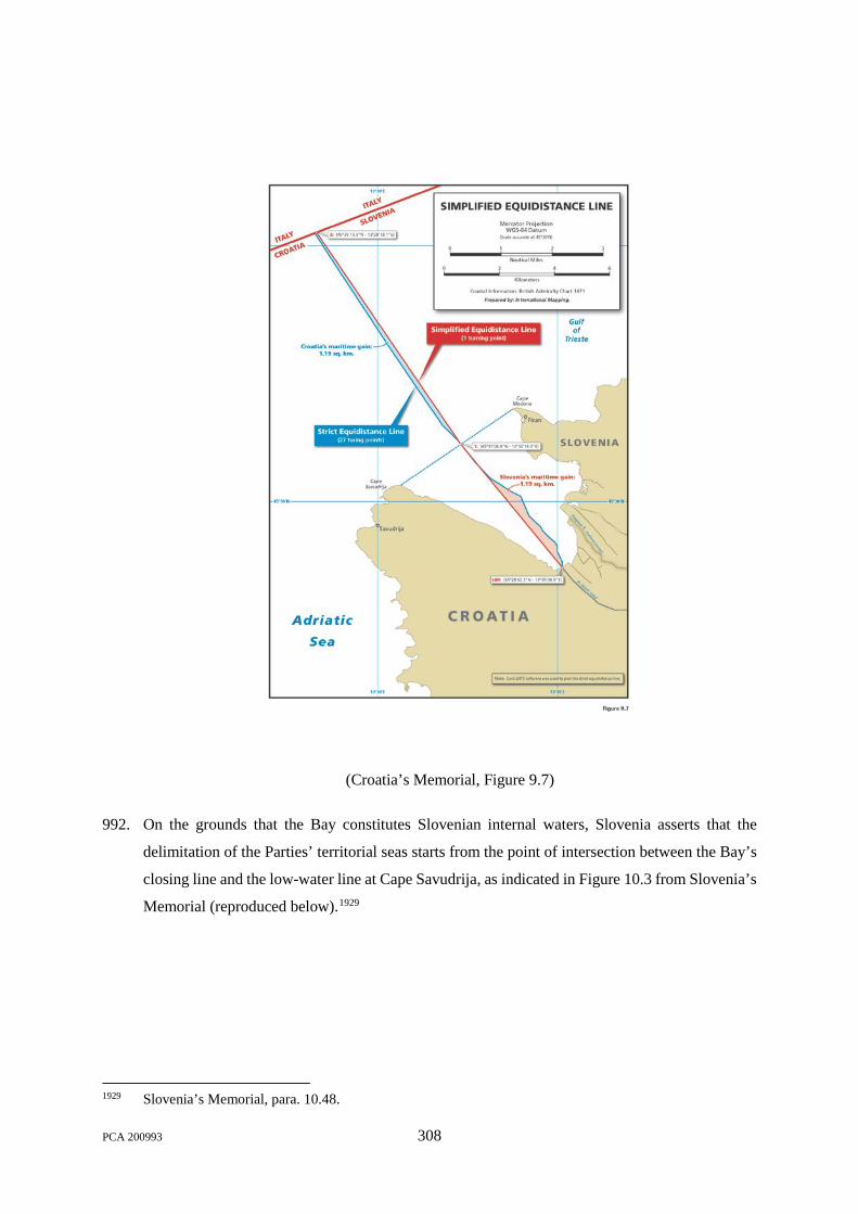
(Croatia’s Memorial, Figure 9.7)
992. On the grounds that the Bay constitutes Slovenian internal waters, Slovenia asserts that the
delimitation of the Parties’ territorial seas starts from the point of intersection between the Bay’s
closing line and the low-water line at Cape Savudrija, as indicated in Figure 10.3 from Slovenia’s
Memorial (reproduced below).1929
1929 Slovenia’s Memorial, para. 10.48.
PCA 200993 308
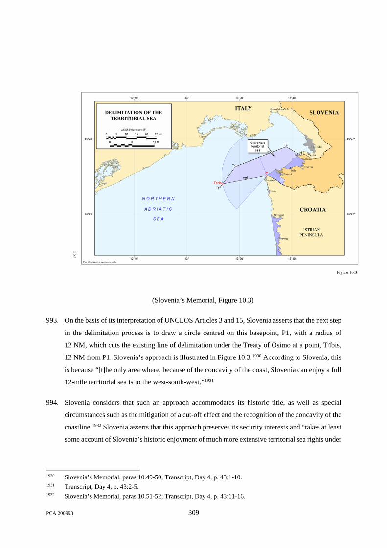
(Slovenia’s Memorial, Figure 10.3)
993. On the basis of its interpretation of UNCLOS Articles 3 and 15, Slovenia asserts that the next step
in the delimitation process is to draw a circle centred on this basepoint, P1, with a radius of
12 NM, which cuts the existing line of delimitation under the Treaty of Osimo at a point, T4bis,
12 NM from P1. Slovenia’s approach is illustrated in Figure 10.3.1930 According to Slovenia, this
is because “[t]he only area where, because of the concavity of the coast, Slovenia can enjoy a full
12-mile territorial sea is to the west-south-west.”1931
994. Slovenia considers that such an approach accommodates its historic title, as well as special
circumstances such as the mitigation of a cut-off effect and the recognition of the concavity of the
coastline.1932 Slovenia asserts that this approach preserves its security interests and “takes at least
some account of Slovenia’s historic enjoyment of much more extensive territorial sea rights under
1930 Slovenia’s Memorial, paras 10.49-50; Transcript, Day 4, p. 43:1-10. 1931 Transcript, Day 4, p. 43:2-5. 1932 Slovenia’s Memorial, paras 10.51-52; Transcript, Day 4, p. 43:11-16.
PCA 200993 309

the former Yugoslavia.”1933 Moreover, it “allocates to each Party territorial sea areas that lie off
their coasts in a reasonable and mutually balanced manner.”1934 Slovenia also submits that this
territorial sea boundary is “consistent with the conduct of the parties before the 1991 critical date,”
such as Slovenia’s assertion of jurisdiction over a joint fishing zone pursuant to an agreement
which entered into force in 1987 and Slovenia’s exercise of police jurisdiction “well south of the
equidistance line.”1935
995. Slovenia notes that its proposed solution, which permits each Party a territorial sea reaching
12 NM, finds precedent in State practice such as the delimitation agreement between France and
Monaco.1936 Slovenia notes that the application of equidistance methodology would have cut off
Monaco’s territorial sea well before reaching the 12 NM limit.1937 To avoid this result, Monaco
and France negotiated a corridor of territorial sea corresponding to the width of Monaco’s coastal
front, providing “ships navigating to and from Monaco with direct access to the high seas without
passing through the territorial sea of other States.”1938
996. Slovenia thus submits that its proposed territorial sea delimitation—in conjunction with its
proposed corridor to the high seas—produces an equitable result in keeping with UNCLOS
Article 15, which reflects State practice concerning special circumstances. 1939 Slovenia
emphasises the equitable nature of its proposed boundary on grounds that it: (i) “accords to each
Party a territorial sea that extends out to the 12-nautical mile limit provided under international
law”;1940 (ii) “abates the effect of the concave nature of the coast, which squeezes Slovenia”;1941
(iii) “allows [Slovenia] to retain sovereignty over the maritime area that is situated off its coast to
the west”;1942 (iv) “reflects the long-standing territorial sea rights that it enjoyed under the former
Yugoslavia in a reasonable and balanced way”;1943 (v) “fully satisfies the ‘disproportionality’ test
based on the length of each Party’s relevant coastal front”;1944 and (vi) “provides a solid and
1933 Transcript, Day 4, p. 43:17-23. 1934 Slovenia’s Memorial, para. 10.53. 1935 Transcript, Day 4, pp. 43:24-46:5. 1936 Slovenia’s Memorial, para. 10.55. 1937 Slovenia’s Memorial, paras 10.56-57. 1938 Slovenia’s Memorial, para. 10.57. 1939 Slovenia’s Memorial, paras 10.131-33. 1940 Slovenia’s Counter-Memorial, para. 9.80. 1941 Slovenia’s Counter-Memorial, para. 9.81. 1942 Slovenia’s Counter-Memorial, para. 9.82. 1943 Slovenia’s Counter-Memorial, para. 9.83. 1944 Slovenia’s Counter-Memorial, para. 9.84.
PCA 200993 310

principled foundation for determining Slovenia’s junction to the High Sea,”1945 which it argues is
“inextricably connected” to the territorial sea boundary.1946
2. The Tribunal’s Analysis
997. The rule applicable to the delimitation of the territorial sea between Croatia and Slovenia, which
reflects well-established international law,1947 is set out in UNCLOS Article 15. It states that:
Where the coasts of two States are opposite or adjacent to each other, neither of the two States is entitled, failing agreement between them to the contrary, to extend its territorial sea beyond the median line every point of which is equidistant from the nearest points on the baselines from which the breadth of the territorial seas of each of the two States is measured. The above provision does not apply, however, where it is necessary by reason of historic title or other special circumstances to delimit the territorial seas of the two States in a way which is at variance therewith.
998. The rule applicable under UNCLOS to delimitation of maritime zones beyond the territorial sea
is set out in Articles 74(1) and 83(1), which are materially identical to one another and provide
that:
1. The delimitation of the [exclusive economic zone / continental shelf] between States with opposite or adjacent coasts shall be effected by agreement on the basis of international law, as referred to in Article 38 of the Statute of the International Court of Justice, in order to achieve an equitable solution.
999. The ICJ has developed a settled jurisprudence relating to the interpretation of those provisions. In
a recent decision it said:
The methodology which the Court usually employs in seeking an equitable solution involves three stages. In the first, it constructs a provisional equidistance line unless there are compelling reasons preventing that. At the second stage, it considers whether there are relevant circumstances which may call for an adjustment of that line to achieve an equitable result. At the third stage, the Court conducts a disproportionality test in which it assesses whether the effect of the line, as adjusted, is such that the Parties’ respective shares of the relevant area are markedly disproportionate to the lengths of their relevant coasts.1948
1000. In relation to the delimitation both of the territorial sea and of the maritime zones beyond the
territorial sea, international law thus calls for the application of an equidistance line, unless
1945 Slovenia’s Counter-Memorial, para. 9.85. 1946 Slovenia’s Counter-Memorial, para. 9.87. 1947 See e.g., the Commentary to Article 15 in S.N. Nandan and S. Rosenne (eds), United Nations Convention
on the Law of the Sea 1982. A Commentary, Vol. II, pp. 132–43 (1993); D.P. O’Connell, The International Law of the Sea, Vol. II, (I.A. Shearer, ed., 1984), ch. 17.
1948 Maritime Dispute (Peru v. Chile), Judgment, I.C.J. Reports 2014, p. 3 at p. 66, para. 180, citing Maritime Delimitation in the Black Sea (Romania v. Ukraine), Judgment, I.C.J. Reports 2009, p. 61 at pp. 101-03, paras 115-22; Territorial and Maritime Dispute (Nicaragua v. Colombia), Judgment, I.C.J. Reports 2012, p. 624 at pp. 695-96, paras 190-93.
PCA 200993 311
another line is required by special circumstances. That is reflected in the practice of the ICJ, which
has applied the ‘equidistance / special circumstances’ approach in the drawing of single maritime
boundaries without distinguishing between its application to the territorial sea and its application
beyond the territorial sea.1949 Similarly, scholars have observed in relation to the territorial sea,
the exclusive economic zone, and the continental shelf that “they all seem to be delimited by
common principles regardless of their differing legal nature and legal regime.”1950 This convergence
of the principles applicable to the territorial sea and to other maritime zones is further evidenced by
the fact that a maritime boundary may separate adjacent maritime zones of different juridical
character, such as the territorial sea of State A and the exclusive economic zone of State B.1951
1001. The “equidistance line” is the line every point of which is equidistant from the nearest point on
the baselines of the States between which the boundary is to be drawn in accordance with
international law. UNCLOS Article 18 obliges States Parties to publicise charts depicting the
baseline or lists specifying the geographical coordinates of basepoints used in the construction of
straight baselines.
1002. Consistently with the practice of the ICJ, the Tribunal will accordingly begin the task of maritime
delimitation by considering the equidistance line between Croatia and Slovenia. In this regard,
the Tribunal recalls that it has determined that the Bay consists of internal waters, and that there
is a closing line across the mouth of the Bay, drawn in accordance with what was formerly the
law of the SFRY. That closing line is the seaward limit of the boundary between Croatia and
Slovenia within the Bay. The boundary intersects the closing line at Point A, whose coordinates
are 45°30′41.7ʺN, 13°31′25.7ʺE. Because Point A marks the boundary between the Parties on the
closing line in the Bay, Point A is also the starting point of the maritime boundary between them.
1003. Both Croatia and Slovenia submitted charts of a scale adequate for ascertaining the position of
the baselines, and the Tribunal has referred to these charts in determining the position of the
maritime boundary. Map III depicts the equidistance line drawn using all available basepoints on
the coasts of Croatia and Slovenia, extending from Point A out to the intersection of that
1949 See e.g., Maritime Dispute (Peru v. Chile), Judgment, I.C.J. Reports 2014, p. 3 at pp. 65-67, paras 178-83; Land and Maritime Boundary (Cameroon v Nigeria), Judgment, I.C.J. Reports 2002, p. 303 at p. 441, para. 288.
1950 C. Yacouba & D. McRae, “The Legal Regime of Maritime Boundary Agreements,” in International Maritime Boundaries, Vol. V, p. 3281 at p. 3920 (D.A. Colson & R.W. Smith eds., 2005).
1951 See Maritime Delimitation in the Black Sea (Romania v. Ukraine), Judgment, I.C.J. Reports 2009, p. 61 at p. 73, para. 26. Cf., D. Colson, “The Legal Regime of Maritime Boundary Agreements”, in International Maritime Boundaries, Vol. I, p. 41 at pp. 43-44 (J.I. Charney and L.M. Alexander eds., 1993).
PCA 200993 312

equidistance line with the maritime boundary between Italy and Yugoslavia established by the
Treaty of Osimo, 1975, at Point O.1952
[Intentionally left blank]
1952 In the Treaty of Osimo, there are two sets of coordinates for the Osimo boundary line, each based upon different geodetic datums. They yield two different sets of coordinates even after being transformed into European Terrestrial Reference System 1989 (ETRS89). For its purposes only, the Tribunal has used the transformed Yugoslav coordinate system for its computations. In that coordinate system, the coordinates of Point O are: 45°35′05.5ʺN, 13°27′16.8ʺE.
PCA 200993 313

Adriatic Sea
Gulf of Trieste
St. OdoricCanal
Dragonja River
ITALY
ITALY
SLOVENIA
CROATIA
CapeSavudrija
CapeMadona
T3
O
A
T5
T4
T2
T1
Projection / Datum:Mercator / ETRS89Map III
Base map: © OpenStreetMap contributors.This map is for illustrative purposes only.
E Q U I D I S T A N C E L I N E
Nominal Scale at Latitude 45°30’N - 1:400,000
Nautical Miles
505 10Kilometers
505 10
13°20’E13°10’E 13°40’E 13°50’E13°30’E
13°20’E13°10’E
45°3
0’N
45°4
0’N
45°5
0’N
45°2
0’N
45°30’N45°20’N
45°40’N45°50’N
13°30’E 13°40’E 13°50’E
LegendOsimo Treaty lineItaly-Croatia continental shelf delimitationOuter limit of Croatia’s 12 NM territorial seaClosing line of BayTribunal's decision in BayTribunal’s equidistance line
N
S
EW

1004. The question is whether this equidistance line should be adopted as the definitive maritime
boundary, or whether, in the words of UNCLOS Article 15, “it is necessary by reason of historic
title or other special circumstances to delimit the territorial seas of the two States in a way which
is at variance therewith” and to adjust the equidistance line accordingly.1953
1005. The Tribunal therefore continues its analysis by considering whether any special circumstance
renders the equidistance line inapposite for the definitive maritime boundary. Slovenia considers
that its position at the head of the Adriatic Sea and on the concave coast of the Gulf of Trieste,
and the confinement of its territorial sea by the territorial seas of its neighbours, among other
factors,1954 constitute special circumstances such as to justify a departure from the equidistance
principle. Slovenia also referred to the difference between the respective coastal lengths of
Slovenia and Croatia.1955
1006. Slovenia argues that “[i]t is only towards the south and southwest that Slovenia has the possibility
of enjoying any semblance of the traditional maritime entitlements it possessed as part of the
SFRY.”1956 The Tribunal does not agree with that analysis. The “entitlements” towards the south
and southwest to which Slovenia refers are entitlements that it had as a matter of the SFRY law
to share and participate in the uses of the maritime zones of the SFRY: 1957 they were not
entitlements of Slovenia in its own right to its own maritime zones, under international law. As a
sovereign coastal State, Slovenia’s entitlement is to the maritime zones generated by its own
coastline alone, limited as that might be. It is very well established that international law cannot
refashion nature by allocating to a State a maritime entitlement other than that generated by its
own coastline.1958
1007. The proposals of the Parties concerning maritime boundaries are far apart. Croatia proposes the
adoption of a strict equidistance line, drawn from the mouth of the Dragonja River, through the
Bay, and out into the Gulf of Trieste.1959 Slovenia proposes a line drawn from what it says is the
furthest point of its territory, just off Cape Savudrija, to the point, west of the Cape, where a
1953 See Maritime Delimitation and Territorial Questions Between Qatar and Bahrain, Merits, Judgment, I.C.J. Reports 2001, p. 40 at p. 104, para. 217; Dispute Concerning Delimitation of the Maritime Boundary between Bangladesh and Myanmar in the Bay of Bengal, ITLOS Case No. 16, Judgment of 14 March 2012, para. 129.
1954 Slovenia’s Memorial, para. 8.29 and Chapter 10. 1955 Slovenia’s Memorial, para. 10.19. 1956 Slovenia’s Memorial, para. 10.21. 1957 As Slovenia recognizes: Slovenia’s Memorial, para. 10.43. 1958 North Sea Continental Shelf, Judgment, I.C.J. Reports 1969, p. 3 at p. 49, para. 91. 1959 Croatia’s Memorial, para. 2.25.
PCA 200993 315
12 NM arc would intersect the Treaty of Osimo line. Such a line would accord to Slovenia a full
12 NM territorial sea in that direction (but only in that direction). These lines are depicted on
Map IV.
[Intentionally left blank]
PCA 200993 316

Adriatic Sea
Gulf of Trieste
St. OdoricCanal
Dragonja River
ITALY
ITALY
SLOVENIA
CROATIA
CapeSavudrija
CapeMadona
T3
O
A
T5
T4
T2
T1
Projection / Datum:Mercator / ETRS89Map IV
Base map: © OpenStreetMap contributors.This map is for illustrative purposes only.
C L A I M S O F T H E P A R T I E S
Nominal Scale at Latitude 45°30’N - 1:400,000
Nautical Miles
505 10Kilometers
505 10
13°20’E13°10’E 13°40’E 13°50’E13°30’E
13°20’E13°10’E
45°3
0’N
45°4
0’N
45°5
0’N
45°2
0’N
45°30’N45°20’N
45°40’N45°50’N
13°30’E 13°40’E 13°50’E
LegendOsimo Treaty lineItaly-Croatia continental shelf delimitationOuter limit of Croatia’s 12 NM territorial seaClosing line of BayTribunal's decision in BayTribunal’s equidistance lineClaim of CroatiaClaim of Slovenia
N
S
EW

1008. In a delimitation of the territorial sea, it is necessary to accommodate two fundamental principles.
The first is the principle of natural prolongation. As the ICJ said in the North Sea Continental
Shelf cases, delimitations are to be effected “in such a way as to leave as much as possible to each
Party all those parts of the continental shelf that constitute a natural prolongation of its land
territory into and under the sea, without encroachment on the natural prolongation of the land
territory of the other [Party].”1960 Though the Court spoke there in relation to the continental shelf,
the principle is equally applicable to the territorial sea.1961 Indeed, given that the outer edge of the
territorial sea is, as a matter of law, the inner edge of the continental shelf, the principle of natural
prolongation could not be secured in respect of the continental shelf unless it is also applied to
the territorial sea.
1009. The second principle is, again in the words of the ICJ, that “the effects of an incidental special
feature from which an unjustifiable difference of treatment could result”1962 should be abated
when effecting a maritime delimitation. The essential notion is that, in circumstances where
particular local geographic features or configurations have a greatly exaggerated or magnified
effect upon a delimitation, the delimitation should seek to mitigate that effect,1963 though without
violating the natural prolongation principle. A small or isolated feature should not have a greatly
disproportionate adverse effect by swinging the delimitation line to the very substantial
disadvantage of one State and advantage of the other State.
1010. These two principles are commonly reconciled without great difficulty. There is generally a
margin of discretion within which a boundary line may be drawn without violating either
principle. A boundary that follows a course that diverges slightly to one side or the other of an
equidistance line, for example, is unlikely to violate the natural prolongation principle but may
significantly mitigate adverse effects arising from strict adherence to the equidistance line.
1011. The Tribunal does not consider that the great difference between the lengths of the coastal fronts
of Croatia and Slovenia is a special circumstance that calls for a departure from the equidistance
line. Nor does it consider that the existence of historic titles that would warrant a departure from
the equidistance line has been established. The Tribunal does, however, consider that certain
features of the coastal configuration in the present case produce an exaggeratedly adverse effect
1960 North Sea Continental Shelf, Judgment, I.C.J. Reports 1969, p. 3 at p. 53, para. 101; cf. pp. 47-48, para. 85. 1961 The Court itself made clear that the principle applied to the maritime zones, such as the contiguous zone:
North Sea Continental Shelf, Judgment, I.C.J. Reports 1969, p. 3 at p. 51, para. 96. 1962 North Sea Continental Shelf, Judgment, I.C.J. Reports 1969, p. 3 at p. 49, para. 91; cf. pp. 48-50,
paras 88-89. 1963 North Sea Continental Shelf, Judgment, I.C.J. Reports 1969, p. 3 at p. 49, para. 89.
PCA 200993 318
if the strict equidistance line is used, and do constitute a special circumstance. That special
circumstance is the fact that very close to Point A the coastline of Croatia turns sharply
southwards around Cape Savudrija, so that the Croatian basepoints that control the equidistance
line are located on a very small stretch of coast whose general (north-facing) direction is markedly
different from the general (southwest-facing) direction of much the greater part of the Croatian
coastline (as illustrated on the following map), and deflect the equidistance line very significantly
towards the north, greatly exaggerating the “boxed-in” nature of Slovenia’s maritime zone.
[Intentionally left blank]
PCA 200993 319

AdriaticSea
ITALY
SLOVENIA
CROATIA
CapeMadona
Projection / Datum:Mercator / ETRS89Map V
Base map: © OpenStreetMap contributors.This map is for illustrative purposes only.
G E N E R A L C O A S T A L P R O J E C T I O N S
Nominal Scale at Latitude 45°00’N - 1:1,025,000
Nautical Miles
10010 20Kilometers
10010 20
14°00’E 14°30’E13°30’E 15°00’E
14°00’E13°30’E
45°0
0’N
44°3
0’N
46°0
0’N
45°3
0’N
45°00’N44°30’N
46°00’N45°30’N
15°00’E14°30’E
N
S
EW

1012. While the Tribunal is not empowered to ‘refashion nature’, it considers that this factor does
constitute a special circumstance that makes it necessary, within the framework of the provisions
of UNCLOS regarding maritime delimitation, to have a maritime boundary that departs from the
strict equidistance line. More specifically, the Tribunal considers that in circumstances such as
these international law calls for the attenuation of the exaggerated ‘boxing-in’ or ‘cut-off’ effect
that the strict application of the equidistance principle would produce in relation to Slovenia’s
waters. This approach is supported by the practice of international tribunals.1964
1013. The Tribunal does not consider the lines proposed by either of the Parties to be wholly consistent
with the applicable rules and principles of international law. Croatia’s proposed line does not take
account of the special circumstances arising from the closed-in geographical configuration of the
area. Slovenia’s proposed line projects the Slovenian territorial sea at such an angle that it cannot
properly be regarded as a part of the territorial sea generated by the Slovenian coast, rather than
by the Croatian coastline in front of which it runs.
1014. The Tribunal has therefore decided that the equidistance line must be modified in order to
attenuate the “boxing in” effect that results from the geographic configuration. There is no
question of “compensating” Slovenia for that “boxed-in” condition: the Tribunal seeks only to
ensure that in the drawing of the maritime boundary the particular configuration of Cape Savudrija
in relation to the Slovenian coast does not disproportionately exacerbate Slovenia’s boxed-in
condition. The Tribunal has accordingly decided that the maritime boundary shall proceed
northwest from Point A in a direction approximately parallel to the Treaty of Osimo line T2-
T3,1965 so as not to increase the “boxing-in” of Slovenia’s maritime zone by narrowing Slovenia’s
territorial sea as it projects out into the Gulf of Trieste. Specifically, the maritime boundary is a
geodetic line from Point A on the closing line across the mouth of the Bay, located at
45°30′41.7ʺN, 13°31′25.7ʺE, with an initial geodetic azimuth of 299°04′45.2ʺ, to Point B on the
1964 See, e.g., North Sea Continental Shelf cases, I.C.J. Reports 1969, p. 3 at p. 51, paras 89-90; Delimitation of the Maritime Boundary between Guinea and Guinea Bissau, Decision of 14 February 1985, R.I.A.A. Vol. XIX pp. 149-96, p. 187 at paras 103-04; Dispute Concerning Delimitation of the Maritime Boundary between Bangladesh and Myanmar in the Bay of Bengal, (2012) ITLOS Case No. 16, Judgment of 14 March 2012, paras 292-97.
1965 For its own purposes only, the Tribunal considers the coordinates of T2 and T3 to be 45°35′56.01″N, 13°42′43.42″E and 45°37′53.58″N, 13°37′43.46″E, respectively, in the Yugoslav coordinate system. The azimuth from T2 to T3 is 299°12′49.1″ and the convergence of meridians between the longitudes of T2 and Point A is 0°08′03.9″ resulting in an azimuth of the parallel line at Point A of 299°04′45.2″. Azimuths in the present Award are clockwise from North.
PCA 200993 321

line between T3 and T4 established by the Treaty of Osimo, located at 45°33′57.4ʺN,
13°23′04.0ʺE.1966 The line is illustrated on Map VI.
[Intentionally left blank]
1966 Similarly to the coordinates of T2 and T3, set out in note 1965, the coordinates of Point B, located on the Treaty of Osimo line, are calculated for the Tribunal’s own purposes only in accordance with the Yugoslav coordinate system.
PCA 200993 322
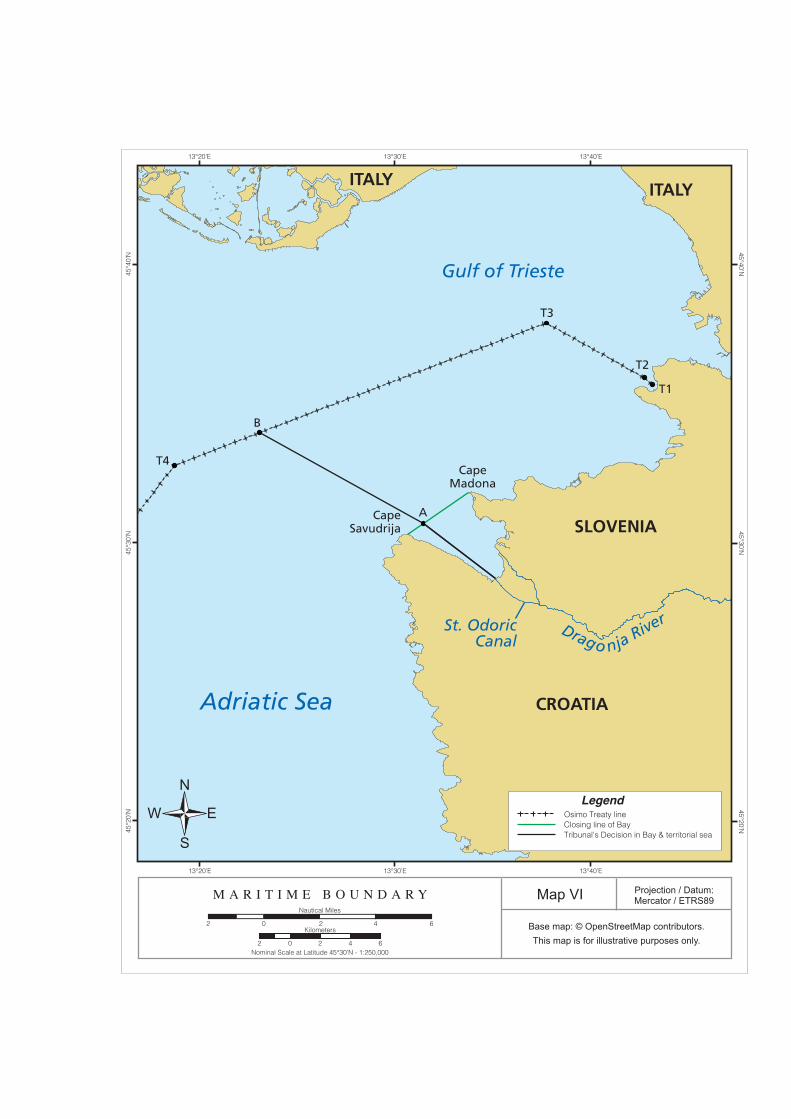
Adriatic Sea
Gulf of Trieste
St. OdoricCanal
Drago nja River
ITALYITALY
SLOVENIA
CROATIA
CapeSavudrija
CapeMadona
T3
B
A
T4
T2
T1
Projection / Datum:Mercator / ETRS89Map VI
Base map: © OpenStreetMap contributors.This map is for illustrative purposes only.
M A R I T I M E B O U N D A R Y
Nominal Scale at Latitude 45°30’N - 1:250,000
Nautical Miles
202 4 6Kilometers
2 402 6
13°20’E 13°40’E13°30’E
13°20’E
45°3
0’N
45°4
0’N
45°2
0’N
45°30’N45°20’N
45°40’N
13°30’E 13°40’E
LegendOsimo Treaty lineClosing line of BayTribunal's Decision in Bay & territorial sea
N
S
EW

C. DETERMINATION OF “SLOVENIA’S JUNCTION TO THE HIGH SEA”
1015. Turning to the Tribunal’s task under Article 3(1)(b), the determination of Slovenia’s junction to
the high seas, the Tribunal notes at the outset that both Croatia and Slovenia agree that for the
purposes of these proceedings there are no proclaimed exclusive economic zones in the Adriatic
Sea. The Parties therefore have in effect invited the Tribunal to treat sea areas lying beyond
territorial seas as high seas for the purposes of this case.1967 The Tribunal observes that in other
respects, however, the Parties’ views as to the Tribunal’s task differ significantly.
1. The Parties’ Positions
Meaning of “Junction to the High Sea”
1016. The Tribunal observes that the Parties are deeply divided as to the meaning of the phrase “junction
to the High Sea.” While there is agreement that the meaning of “junction” is to be interpreted in
accordance with the Vienna Convention on the Law of Treaties, they emphasise different aspects
of the “ordinary meaning” and of the travaux préparatoires of the Arbitration Agreement.
i. Croatia’s Position
1017. Croatia approaches the meaning of “junction” by placing it in the context of two other terms
within Article 3(1)(b): namely, “High Sea” and “Slovenia”.1968 In Croatia’s view, “‘Slovenia's
junction to the High Sea’ cannot be determined until . . . know[ing] where both ‘Slovenia’ and
the ‘High Sea’ are located.”1969
1018. As to the term “High Sea”, Croatia argues that it is “clearly a reference to the High Seas.”1970 It
is Croatia’s position that “[w]hat the High Seas are and where the High Seas are located is
determined exclusively on the basis of international law” and not on the basis of equity or in
accordance with the principle of good neighbourly relations.1971
1019. Croatia refers to the 1958 Geneva Convention, pursuant to which the “high seas” are “all parts of
the sea that are not included in the territorial sea or in the internal waters of a State”; and to
UNCLOS, which states that the UNCLOS provisions regarding “High Seas” apply to “all parts
1967 Slovenia’s Memorial, para. 8.19; Croatia’s Memorial, paras 8.18-19. 1968 Transcript, Day 2, pp. 153:23-154:2. 1969 Transcript, Day 2, p. 153:23-25. 1970 Croatia’s Memorial, para. 10.15; Transcript, Day 2, p. 154:17-20. 1971 Croatia’s Memorial, paras 10.15-16; Transcript, Day 2, p. 154:21-23.
PCA 200993 324

of the sea that are not included in the exclusive economic zone, in the territorial sea or in the
internal waters of a State.”1972 Noting the irrelevance of unilateral conduct after 25 June 1991, in
accordance with Article 5 of the Arbitration Agreement, Croatia further contends that for the
purposes of these proceedings the Tribunal should proceed on the basis that no coastal State in
the Adriatic Sea has proclaimed an exclusive economic zone or similar zone of extended
jurisdiction beyond the outer limit of the territorial sea.1973 As such, Croatia submits that, on 25
June 1991, “the northernmost point of the High Seas in the Adriatic Sea, and thus the one nearest
to Slovenia,” was situated at Point [T]5 under the 1975 Treaty of Osimo,1974 which corresponds
to Point 1 of the 1968 Treaty. 1975 Figure 10.1 of Croatia’s Memorial, depicting Croatia’s
submission in relation to agreed maritime boundaries as at 25 June 1991 is reproduced below.
1972 Croatia’s Memorial, para. 10.17, citing the 1958 Convention, Article 1; UNCLOS Article 87. 1973 Croatia’s Memorial, paras 9.9, 10.18; Transcript, Day 2, p. 155:1-3. 1974 Croatia’s Memorial, paras 10.19, 10.21; Transcript, Day 2, p. 155:8-11. 1975 Croatia’s Memorial, paras 10.19-20, referring to Figure 10.1 following page 210 of its Memorial.
PCA 200993 325

(Croatia’s Memorial, Figure 10.1)
1020. As to the term “Slovenia”, Croatia argues that this term is “determined as a consequence of
determination by the Tribunal of ‘the course of the maritime boundary’,” in accordance with rules
and principles of international law.1976 Croatia submits that “[u]nder no circumstances can the
breadth of the territorial sea of a coastal State exceed 12 [NM], measured from baselines
determined in accordance with the 1982 Law of the Sea Convention.”1977
1021. Moreover, Croatia argues that even without the determination of the maritime boundary, it is
possible to determine “where Slovenia is not.”1978 Specifically Croatia states that regardless of
1976 Croatia’s Memorial, para. 10.22. 1977 Ibid. 1978 Croatia’s Memorial, para. 10.23.
PCA 200993 326
how the Tribunal determines the land and maritime boundary in the Bay, “the resulting Slovenian
baselines will remain more than 12 [NM] away from the nearest High Seas” located at Point
[T]5.1979 This is because, according to Croatia, the closest point on the coast located at a distance
of 12 NM from Point [T]5 (Cape Savudrija) lies “well beyond the relevant area of the delimitation
dispute.”1980 Consequently, Croatia argues that the only effect the Tribunal’s determination of the
land and maritime boundary will have, is to decide by “how much” the distance between
Slovenia’s baselines and the high seas will exceed 12 NM.1981
1022. Turning to the meaning of “junction”, Croatia notes that the term is not defined in international
treaties or in customary international law;1982 that the Parties have not agreed on any particular
meaning;1983 and that legal dictionaries provide no definitions.1984 However, Croatia submits that
it publicly stated its view as to what “is not the meaning of any term in the Arbitration Agreement”
on 9 November 2009, when it declared that “[n]othing in the Arbitration Agreement . . . shall be
understood as Croatia’s consent to Slovenia’s claim of its territorial contact with the High
Seas.”1985 According to Croatia, its submission of this Interpretative Declaration, shortly after the
conclusion of the Agreement, was agreed upon by the Parties, and the declaration is representative
of Croatia’s “longstanding and consistent position throughout the negotiation of the Arbitration
Agreement.”
1023. Croatia also argues that the preposition “to” in English is usually “used to indicate destination (in
the direction of), thus that something is ‘in a direction towards’ (e.g., the road to London).”1986
The combination of the noun “junction” with the preposition “to” in Article 3(1)(b), Croatia
submits, “suggests destination: junction towards the High Seas.”1987 Croatia submits that the use
of the phrase “junction with” might have suggested a rather different meaning than “junction
to.”1988
1979 Croatia’s Memorial, paras 10.24-26, referring to Figure 10.3 following page 212 of its Memorial; Transcript, Day 2, p. 156:5-9.
1980 Croatia’s Memorial, para. 10.26; Transcript, Day 2, 157:3-7. 1981 Croatia’s Memorial, para. 10.26. 1982 Croatia’s Memorial, para. 10.31, citing G.K. Walker, Definitions for the Law of the Sea: Terms Not Defined
by the 1982 Convention (2012). 1983 Croatia’s Memorial, para. 10.32. 1984 Croatia’s Memorial, para. 10.33, citing Parry & Grant Encyclopaedic Dictionary of International Law (J.P.
Grant & J. Craig Parker eds., 2009); B.A. Boczek, International Law: A Dictionary (2005). 1985 Croatia’s Memorial, para. 10.32, referring to Croatia’s Declaration. 1986 Croatia’s Memorial, para. 10.35. 1987 Croatia’s Memorial, para. 10.36; Transcript, Day 2, p. 163:19-24. 1988 Croatia’s Memorial, paras 10.34-35.
PCA 200993 327

1024. Croatia concedes that it is for the Tribunal to determine whether the phrase “junction to” is a
concept of law (a right, an entitlement, or a claim) or a physical concept (the distance to, direction
to, or access to the high seas).1989 However, Croatia emphasises that under Article 4(b), the
determination “cannot be made contrary to, or in violation of, international law – although it can
be based on, in addition to international law, equity and the principle of good neighbourly
relations.”1990
1025. Croatia does not accept that the ordinary meaning of the term “junction” implies a line at which
Slovenia’s territorial waters meet the high seas. It says that “the high seas and Slovenia are in any
event separated from each other by a certain maritime area lying in-between and belonging to
one or other of two third States.”1991 According to Croatia, a “junction” of the kind sought by
Slovenia would be incompatible with the applicable law, as it could be achieved in one of only
two ways: either the territorial sea of Slovenia would extend beyond 12 NM from its nearest
basepoint (in contravention of UNCLOS Article 3); or Croatia’s territorial sea would be
withdrawn to a distance less than 12 NM from its coastline (contrary to Croatia’s entitlement
under UNCLOS).1992 As regards the latter method, Croatia argues that “there is nothing in the
Arbitration Agreement or in international law that justifies or authorizes [the Tribunal] to deprive
Croatia of a portion of its sovereign territory.”1993
1026. Croatia also refers to the travaux préparatoires of the Arbitration Agreement, asserting that “[i]f
the parties had intended something more than a right of usage, in the context of the use of an
indeterminate phrase such as ‘junction’, they would have used the words ‘territorial contact’,
which Slovenia had proposed; and they did not.”1994
1027. Croatia concludes that the “term ‘junction’ and the emphasis on the high seas can only mean that the purpose is to give secure maritime access—not suspendable by any other State—between the
High Seas and Slovenian waters.” 1995 Croatia adds that “[i]f – quod non – there were a continuous
band of Slovenian territorial sea between its coast and the high seas . . . [t]here would already be
1989 Croatia’s Memorial, para. 10.37. 1990 Ibid. 1991 Croatia’s Memorial, para. 10.38. 1992 Croatia’s Counter-Memorial, para. 9.3; Transcript, Day 2, pp. 157:8-158:11. 1993 Transcript, Day 2, p. 159:3-5. 1994 Croatia’s Counter-Memorial, para. 9.5; Transcript, Day 2, pp. 161:16-162-18; Day 5, p. 115:12-24. 1995 Croatia’s Memorial, para. 10.46.
PCA 200993 328

a junction and there would already be a regime [for use],”1996 in which case “there would be
nothing to determine under article 3(1).”1997
ii. Slovenia’s Position
1028. Invoking the rules of interpretation reflected in the Vienna Convention on the Law of Treaties,1998
Slovenia submits that the ordinary meaning of the word “junction” “necessarily and always
implies a link, a connection, between two (or more) different things; in our case, between two
maritime areas.”1999 Slovenia submits that “[t]here is no disagreement between the parties as to
the definition of ‘Slovenia’. . . includ[ing] Slovenia’s territorial sea.”2000 Accordingly, junction of
“Slovenia . . . to the High Sea” means “a direct junction without having to pass through the
territorial sea of another State.”2001 For Slovenia, the concept of junction denotes a “straight line
between . . . Slovenia’s territorial sea and the high seas.”2002 Slovenia notes, moreover, that there
“has to be a corridor – of high seas” leading to “a junction of Slovenia’s territorial sea to the high
seas.”2003
1029. According to Slovenia, the determination of a junction “cannot be confused with, or assimilated
to, ‘the regime for the use of the relevant areas’.”2004 In this regard, Slovenia asserts that a mere
right of innocent passage through the territorial sea of Croatia “has never been acceptable to
Slovenia”2005 as, under such a regime, Croatia could “temporarily suspend” innocent passage and
“obstruct maritime traffic proceeding . . . on the grounds of verifying compliance with Croatian
laws and for inspection purposes.”2006
1030. According to Slovenia, Croatia advocates a right of Slovenian “access” to the high seas which is
insufficiently specific and not necessarily unimpeded.2007 For example, Slovenia notes that it
1996 Croatia’s Memorial, para. 10.46. 1997 Croatia’s Counter-Memorial, para. 9.6; Transcript, Day 2, p. 162:17-25. 1998 Slovenia’s Counter-Memorial, para. 10.22. 1999 Slovenia’s Counter-Memorial, para. 10.23; Transcript, Day 4, p.52:11-13. 2000 Transcript, Day 4, p.53:5-10, referring to Croatia’s Memorial, paras 10.22-30 and Croatia’s Counter-
Memorial, paras 9.13-14. 2001 Slovenia’s Memorial, para. 10.70. 2002 Transcript, Day 8, p. 37:5-19. 2003 Transcript, Day 8, p. 34:15-24. 2004 Transcript, Day 4, pp. 56:23-57:19; Day 8, p. 19:13-22. 2005 Slovenia’s Memorial, para. 10.66. 2006 Slovenia’s Memorial, para. 10.67, citing Article 16(3) of the Geneva Convention, UNCLOS Article 25(3),
Article 30 of Croatia’s Maritime Code, Annex SI-351. 2007 Transcript, Day 4, p. 88:9-21.
PCA 200993 329

would have limited rights in Croatia’s territorial sea in respect of overflight, laying of submarine
pipelines or cables, hot pursuit, and the passage of warships.2008 Slovenia concludes that a “direct
junction” is necessary for its “economic, security and safety interests” so that it can ensure that
maritime traffic using its Port of Koper is subject to no restrictions, impediments or delays.”2009
1031. Slovenia relies on several documents in the negotiating history to support its interpretation of the
term “junction”.2010 In particular, Slovenia refers to the unratified Drnovšek-Račan Agreement as
a “source of inspiration and an indication of the way the Parties themselves had interpreted the
notion of junction even before the Arbitration Agreement was signed,” as well as Slovenia’s
rejection of the Rehn Draft I “because it reunited ‘contact’ and ‘regime’.”2011 Slovenia also
contests Croatia’s claim that the term “‘junction’ came out of the blue.”2012 Moreover, Slovenia
notes that the 2002 Protocol between Croatia and Serbia-Montenegro in relation to the Prevlaka
peninsula uses the word “junction” five times and that its meaning in that context is that of “direct
geographical contact.”2013
1032. Slovenia characterizes Croatia’s interpretative Declaration (see paragraph 1022) as “an attempt
to reduce to nothing the provision of Article 3(1)(b) of the Arbitration Agreement.” Moreover,
Slovenia emphasises that it has never accepted or consented to Croatia’s Interpretative
Declaration, citing a note it sent on 19 November 2009,2014 and submits that the Tribunal must
disregard the Declaration pursuant to Article 5 of the Agreement as a “document or action
undertaken unilaterally by either side after 25 June 1991” and that the Declaration “cannot and
does not modify the Arbitration Agreement” and “has no bearing on [its] interpretation.”2015 In
any case, Slovenia contends that Croatia’s Declaration of 2009 lends additional support to
Slovenia’s argument because in “denying the clear meaning of the work as envisaged during
negotiations . . . in a context where no declaration of Slovene authorities called for such a
statement,” it is “in fact a contrario indicative of the understanding of the concept of ‘junction’
2008 Slovenia’s Memorial, para. 10.68, citing UNCLOS Article 111. 2009 Slovenia’s Memorial, para. 10.69. 2010 Slovenia’s Memorial, para. 10.71. 2011 Slovenia’s Memorial, para. 10.78; Transcript, Day 8, pp. 22:19-23:8. 2012 Slovenia’s Counter-Memorial, para. 10.50. 2013 Transcript, Day 4, p. 60:8-12, 2014 See Slovenia’s Memorial, para. 4.45; Slovenia’s Counter-Memorial, para. 8.20. See also Slovenia’s Reply,
paras 1.17-21. 2015 Slovenia’s Counter-Memorial, para. 8.21.
PCA 200993 330

the Parties had during negotiations” and “can only strengthen the understanding of ‘junction’ as
concerning ‘Slovenia’s . . . territorial contact with the high seas’.”2016
1033. Finally, Slovenia argues that such a meaning is necessary in order to respect the effet utile
principle of treaty interpretation,2017 as the determination of the junction is to be distinguished
from the determination of the maritime boundary and the regime for the use of the relevant
maritime areas.2018 Slovenia criticizes Croatia’s attempts to “deprive sub-paragraph (b) of Article
3(1) of any effet utile,”2019 by suggesting that: (i) the high seas, having already been determined
on the basis of international law, “cannot be modulated in order to establish the junction”;2020 and
(ii) the junction “only covers a regime of innocent passage through [Croatia’s] territorial sea,
which Slovenia already enjoys.”2021
Circumstances to Be Taken into Account under Article 4(b) of the Arbitration Agreement
1034. The Parties acknowledge that the Tribunal, in establishing Slovenia’s “junction to the High Sea,”
must be guided by the objective of “achieving a fair and just result.”2022 However, the Parties
commend different circumstances to the Tribunal’s attention.
i. Croatia’s Position
1035. Croatia notes that a number of circumstances are pertinent to the Tribunal’s determination under
Article 3(1)(b),2023 particularly the “key ‘relevant circumstance’” of “the existing IMO traffic
regulation and established navigation practice in the area”2024 and a series of legal regimes,
2016 Slovenia’s Memorial, para. 10.72; Slovenia’s Counter-Memorial, para. 10.49. 2017 Slovenia’s Memorial, para. 10.74, citing Territorial Dispute (Libyan Arab Jamahiriya/Chad, Judgment,
I.C.J. Reports 1994, p. 6 at p. 25, para. 51; Lighthouses Case between France and Greece, Judgment, P.C.I.J., Series A/B/ No. 62, p. 4 at p. 27; Legal Consequences for States of the Continued Presence of South Africa in Namibia (South West Africa) notwithstanding Security Council Resolution 276 (1970), Advisory Opinion, I.C.J. Reports 1971, p. 16 at p. 35, para. 66; Aegean Sea Continental Shelf (Greece/Turkey), Judgment, I.C.J. Reports 1978, p. 3 at p. 22, para. 52; Corfu Channel (United Kingdom v. Albania), Judgment of 9 April 1949: I.C.J. Reports 1949, p. 4 at p. 24; Carlos Calvo, Dictionnaire manuel de diplomatie et de droit international public et privé, p. 223 (1885, republished 2009); Acquisition of Polish Nationality, Advisory Opinion, P.C.I.J., Series B, No. 7, p. 7 at p. 20.
2018 Slovenia’s Memorial, para. 10.75; Transcript, Day 3, p. 60/3-11. 2019 Slovenia’s Counter-Memorial, para. 10.29. 2020 Slovenia’s Counter-Memorial, para. 10.31, referring to Croatia’s Memorial, paras 10.28, 10.15-16. 2021 Slovenia’s Counter-Memorial, para. 10.36, referring to Croatia’s Memorial, paras 10.69-79 and 10.81. 2022 Croatia’s Memorial, para. 10.68, Slovenia’s Memorial, paras 8.56 and 10.03. 2023 Croatia’s Memorial, para. 10.68. 2024 Croatia’s Memorial, para. 10.79.
PCA 200993 331

including the EU regime, the International Maritime Organization (“IMO”) regime and the
UNCLOS regime, which, taken together “fully protect Slovenia’s right of access.”2025
1036. First, Croatia submits that Slovenia has always enjoyed uninterrupted access to the high seas,2026
meaning that Slovenia’s right of innocent passage through Croatian waters has never been
suspended even in the context of the 1991-1995 war.2027 Croatia argues that the facts and figures
do not support Slovenia’s assertions that it requires a “territorial exit to the high seas” in order to
exercise its “right of communication” or ensure its economic development.2028
1037. Moreover, Croatia notes that Slovenia’s Memorial presents “a litany of complaints as to the
disadvantages of its geographical location and of the need to . . . transit Croatia’s territorial
sea.”2029 However, Croatia asserts that “none of these calamities has actually occurred, or even
been threatened.”2030 In Croatia’s view, “[t]here is simply no evidence that the status quo presents
any problem or impediment to regular passage by sea or air.”2031
1038. In contrast, according to Croatia, the “actual situation” reflects the EU’s regime of the four
freedoms 2032 and the availability of jurisdiction of the “Court of Justice of the European
Communities” to uphold these freedoms;2033 the EU’s legally enforceable “open skies” policy;2034
the well-functioning IMO traffic separation scheme;2035 the pledge to cooperate as North Atlantic
2025 Transcript, Day 2, p. 181:13-16. 2026 Transcript, Day 2, p. 175:23-24. 2027 Croatia’s Memorial, paras 10.69-70. 2028 Ibid. 2029 Croatia’s Counter-Memorial, para. 9.8, referring to Slovenia’s Memorial 10.67-69; Transcript, Day 2, pp.
175:24-176:5. 2030 Croatia’s Counter-Memorial, para. 9.9. 2031 Ibid. 2032 Free Movement of Goods, Articles 28-37 of the Treaty for the Functoning of Europe, done in Lisbon on
the 13 December 2007 (TFEU), Freedom of Establishment and to Provide Services, Articles 49-56 TFEU, Free Movement of Persons and Workers, 21, 45-48 TFEU, Free Movement of Capital, Articles 63-66 TFEU.
2033 Croatia’s Counter-Memorial, para. 9.10; Transcript, Day 2, p. 176:14-18. 2034 Croatia’s Counter-Memorial, para. 9.10; Transcript, Day 2, p. 177:1. 2035 Croatia’s Memorial, paras 10.73-76, citing the Memorandum of Understanding Between the Government
of the Republic of Croatia, the Government of the Italian Republic and the Government of the Republic of Slovenia on the Establishment of a Common Routing System and Traffic Separation Scheme in North Part of the North Adriatic, done in Ancona, Italy on 19 May 2000, Annex HRLA-66; Routeing of Ships, Ship Reporting and Related Matters, Establishment of new recommended Traffic Separation Schemes and other new Routeing Measures in the Adriatic Sea Submitted by Albania, Croatia, Italy, Slovenia and Serbia and Montenegro, IMO Doc. NAV 49/3/7 (23 March 2003), Annex HR-89; Report of the Maritime Safety Committee on its Seventy-Eighth Session, IMO Doc. MSC 78/26 (28 May 2004), p. 86 and Annex 21; New and Amended Traffic Separation Schemes, IMO Doc. COLREG.2/Circ. 54 (28 May 2004), Annex HRLA-70; New and Amended Traffic Separation Schemes, IMO Doc. COLREG.2/Circ. 54 (28 May 2004), Annex 3 and pp. 2-3, Annex HRLA-70. The reference chart referred to in that IMO document is No. 435 of the
PCA 200993 332

Treaty Organization (“NATO”) Members;2036 and the overall increase in annual throughput of the
Port of Koper.2037 In light of these, Croatia does not accept Slovenia’s suggestion that Croatia can
“directly affect Slovenia’s economic, security and safety interests.”2038
1039. According to Croatia, “safety of navigation . . . constitutes the crucial ‘relevant circumstance’,”
as the “relevant maritime areas” in this case—being “those located in the maritime space between
the high seas, point 5 and areas to the south-west, and the outer limit of Slovenia’s territorial
sea”2039—“are among the maritime areas with the highest density of Adriatic Sea commercial
traffic.”2040 Croatia notes that Slovenia also has access through Italian waters and airspace,2041
and “air, road, river and rail access to Italy and its other neighbours,” 2042 and it would be
inaccurate to suggest that Slovenia “is or could be . . . completely enclaved.”2043 In Croatia’s view,
any residual issues “can best be resolved by building on the existing regulations of navigation and
their implementation.”2044 One such scheme, the IMO traffic separation scheme, is of “particular
pertinence” as it recalls the collaboration between Croatia, Slovenia and Italy in “lay[ing] the
foundation for the scheme in a memorandum of understanding signed in 2000, and a routing
system jointly proposed in 2003, based on long-standing navigation practice in this area.”2045
1040. Moreover, Croatia notes that Slovenia’s requested “direct territorial exit” would be contradictory
to the 2004 IMO Traffic Separation Scheme2046 that was proposed and agreed upon by Slovenia,
as the same area along the Croatia coast of Istria is the “entrance” (the direct entry for incoming
Italian Hydrographical Institute, Edition 1993, Datum ED-50 and No. 101 of the Hydrographical Institute of the Republic of Croatia, Edition 1998, Datum Hermanskögel, Bessel Elipsoid.
2036 Croatia’s Counter-Memorial, para. 9.10; Transcript, Day 2, p. 177:1-5. 2037 Croatia’s Memorial, para. 10.70, citing statistics on the website of the Port of Koper, available at
<www.luka-kp.si/slo/terminali-in-tovor> (last visited 4 February 2013). 2038 Croatia’s Counter-Memorial, para. 9.10. 2039 Transcript, Day 2, p. 164:9-11. 2040 Croatia’s Memorial, para. 10.72, referring to the fact that “[o]ver 40 million tons of oil are transported on
tankers every year in this small area, as well as various other forms of hazardous cargo.” 2041 Croatia’s Counter-Memorial, para. 9.10; Transcript, Day 2, p. 177:6-10. 2042 Croatia’s Counter-Memorial, para. 9.11. 2043 Ibid. 2044 Croatia’s Memorial, para. 10.71. 2045 Transcript, Day 2, pp. 177:18-178:4. 2046 IMO, Maritime Safety Committee, 28 May 2004, 78th session (12-21 May 2004), COLREG.2/Circ.54,
Annex 3, Annex SI-343.
PCA 200993 333

traffic) under the IMO regulation and common navigational practice.2047 Croatia exhibits Figure
10.4 (reproduced below) that depicts the 2004 IMO Traffic Separation Scheme.
(Croatia’s Memorial, Figure 10.4)
1041. According to Croatia, the IMO scheme is “bolstered by the range of general maritime transit rights
recognised” in UNCLOS and, in particular, the right of innocent passage. 2048 As regards
UNCLOS Article 25(3), under which a coastal State may “suspend temporarily . . . the innocent
passage of foreign ships,” Croatia argues that this is a “limited qualification”.2049 Croatia further
2047 Croatia’s Memorial, para. 10.78, Transcript, Day 2, pp. 178:4-179:10, citing Figure 10.4 following page 228 of Croatia’s Memorial.
2048 Transcript, Day 2, p. 179:20-23. See also Croatia’s Memorial, para. 10.89(1). 2049 Transcript, Day 2, p. 180:1-5.
PCA 200993 334

argues that such an exception would have no relevance in its relationship with Slovenia as
“Slovenia cannot point to a single instance in which Croatia has suspended innocent passage to
its detriment.”2050
1042. Croatia therefore reaches the following “simple conclusion”:
Slovenia’s concerns about access and communications are already met, both as a matter of law and of firmly established practice. That is what the right of innocent passage under UNCLOS and the IMO scheme are designed to do, and in fact do. But even if there were some residual problems, they could be met by a junction defined as safe and uninterrupted access from Slovenia to the high seas.2051
ii. Slovenia’s Position
1043. According to Slovenia, “three traits are of exceptional importance when discussing the maritime
elements of the present dispute,” namely, (i) “the contrast between the respective maritime
façades of Croatia and Slovenia”; (ii) “Slovenia’s vital interest in maintaining its access to the
high seas, given the importance and growth of its maritime commerce”; and (iii) “Slovenia’s
traditional presence in the whole of the disputed area when it was part of Yugoslavia.”2052
1044. In response to Croatia’s “simple conclusion” ostensibly dispelling Slovenia’s need for any
junction to the high seas, Slovenia gives “two different kinds of answer[s]: a legal and a factual
one.”2053 Legally, Slovenia reiterates that Croatia’s proposal “ignores . . . subparagraph (1)(b) [of
Article 3 of the Arbitration Agreement] concerning the junction which must be determined by the
Tribunal separately from the regime for the use of the relevant maritime areas.”2054 Slovenia
warns that “not to determine Slovenia’s junction to the High Sea would amount to a decision infra
petita whereby the Tribunal would not have fully exercised its jurisdiction.”2055 Slovenia says that
Croatia’s interpretation ignores the reality of relations between the parties and “does not give
Slovenia the res judicata guarantee of access to the high sea which is required from this
Tribunal.”2056 Slovenia cautions that the “status quo is not immune to threats from the future.”2057
2050 Transcript, Day 2, p. 180:8-10. 2051 Transcript, Day 2, p. 184:1-8. 2052 Slovenia’s Memorial, para. 10.02. 2053 Transcript, Day 4, p. 65:8-19. 2054 Transcript, Day 4, pp. 65:20-66:2. 2055 Slovenia’s Memorial, para. 8.08. 2056 Transcript, Day 4, p. 66:3-14. 2057 Transcript, Day 4, p. 67:20-22.
PCA 200993 335

1045. Moreover, Slovenia contends that Croatia’s emphasis on the IMO Traffic Separation Schemes in
the Adriatic “cannot change the picture”2058 as they have “no bearing upon the status of the
maritime areas concerned,”2059 as confirmed by the resolution adopted by the IMO Assembly on
20 November 1985.2060 Furthermore, Slovenia argues that “the traffic separation schemes are
subject to periodic changes.”2061 Slovenia also rejects the EU’s “open skies” policy as unsuitable
for Slovenia’s aerial access needs, as this policy concerns only commercial traffic and related
landing rights.2062
1046. Finally, Slovenia contends, by reference to a number of other cases in arbitral practice and State
practice, that the “establishment of an area of High Sea in order to avoid . . . being cut off from
the high seas is not exceptional.”2063
Determination of “Slovenia’s Junction to the High Sea”
i. Croatia’s Position
1047. On the basis of the arguments set out above, Croatia submits “that ‘Slovenia’s junction to the
High Sea’, if understood as a claim to a territorial contact with the High Seas, must be denied.”2064
1048. Croatia argues that Slovenia cannot have a “territorial contact” with the high seas, since under
international law “such a contact is enabled exclusively by the territorial sea, the breadth of which
cannot exceed 12 [NM] as measured from the baselines.”2065 In view of what it regards as the
successive nature of the Tribunal’s tasks, Croatia submits that the maritime boundary between the
Parties will already have been delimited by the Tribunal in accordance with international law,2066
and under that determination Slovenia’s territorial sea “does not, and cannot stretch as far as to
reach the High Seas.” 2067
2058 Slovenia’s Counter-Memorial, para. 10.52. 2059 Ibid. 2060 Ibid. 2061 Slovenia’s Counter-Memorial, para. 10.55. 2062 Slovenia’s Reply, para. 5.09, referring to Croatia’s Counter-Memorial, para. 9.10. 2063 Slovenia’s Counter-Memorial, para. 10.56. 2064 Croatia’s Memorial, paras 10.81, 10.92. 2065 Croatia’s Memorial, para. 10.30. 2066 Croatia’s Memorial, para. 10.80(1). 2067 Croatia’s Memorial, para. 10.30.
PCA 200993 336
1049. Croatia further argues that Slovenia made a new unilateral claim in 1993 to a territorial (direct
geographical) contact of its territorial sea with the high seas.2068 According to Croatia, this claim
is “inconsistent with the legal and factual situation as it was on 25 June 1991” 2069 and,
furthermore, “[t]here is no basis in the Arbitration Agreement for interpreting ‘Slovenia’s junction
to the High Sea’ as corresponding to Slovenia’s unilateral claim of a ‘territorial (direct
geographical) contact of Slovenia’s territorial sea with the high seas’.”2070
1050. Croatia notes that UNCLOS “does not grant a coastal State a ‘direct’ or ‘territorial’ access to and
from the sea.”2071 Rather, Croatia argues that any “‘[t]erritorial connection’ with the High Seas
depends on the extent of the territorial sea, which in turn depends on the placement and
geographical configuration of the relevant coast.”2072
1051. Croatia submits further that Slovenia has recognized that it cannot claim an EEZ of its own. 2073
1052. As such, Croatia submits that “irrespective of where exactly that boundary will be located, it will
not change the main situation de lege lata: the territorial seas of both Italy and Croatia have
enclosed the territorial sea of Slovenia since the moment of its emergence as an independent
state.”2074
1053. Croatia therefore argues that “Slovenia’s junction to the High Sea,” understood as “safe and
uninterrupted access to the High Seas,” should be secured by the Tribunal by endorsing a suitable
navigational regime.2075
ii. Slovenia’s Position
1054. Slovenia submits that its “junction to the High Sea” should be delimited in accordance with Figure
10.9 on page 585 of its Memorial, reproduced below.
2068 Croatia’s Counter-Memorial, para. 7.49. 2069 Croatia’s Counter-Memorial, para. 7.65. 2070 Croatia’s Counter-Memorial, para. 7.67. 2071 Croatia’s Memorial, para. 10.52. 2072 Ibid. 2073 Croatia’s Memorial, para. 10.30, citing the Memorandum on the Bay of Piran. 2074 Croatia’s Memorial, para. 10.80(2). 2075 Croatia’s Memorial, paras 10.25-30, 10.80(3)-81.
PCA 200993 337

(Slovenia’s Memorial, Figure 10.9)
1055. Slovenia notes that according to UNCLOS Article 86, the high seas include “all parts of the sea
that are not included in the exclusive economic zone, in the territorial sea or in the internal waters
of a State.”2076 Slovenia submits that under the Arbitration Agreement Croatia’s actions relating
to EEZ rights cannot be accorded legal significance as they occurred after 25 June 1991.2077
1056. As such, Slovenia concludes, “the Tribunal is left with the territorial sea” from which to make its
determination of Slovenia’s “junction to the High Sea.”2078 In this regard, Slovenia notes that
coastal States are entitled to a territorial sea up to a maximum breadth of 12 NM from its coast or
2076 Slovenia’s Memorial, para. 10.79. 2077 Slovenia’s Memorial, para. 10.80, citing Ecological Protection Zone and Continental Shelf of the Republic
of Slovenia Act, 22 October 2005, Law of the Sea Bulletin, No. 60/2006, p. 56, Annex SI-357; Article 1042 of the Croatian Maritime Code 1994, Annex SI-281; Decision on the Extension of the Jurisdiction of the Republic of Croatia in the Adriatic Sea (2003), Official Gazette of the Republic of Croatia, No. 157/2003, Annex SI-333 (claiming an Ecological and Fisheries Protection Zone).
2078 Slovenia’s Memorial, para. 10.82.
PCA 200993 338

baselines, but “cannot claim the maximum entitlement if special circumstances exist.” 2079
Slovenia asserts that in this case “special circumstances do exist – this is the very raison d’être of
both the reference to the junction in Article 3(1)(b) of the Arbitration Agreement, and the
inclusion of equity and the principle of good neighbourly relations, in addition to international
law, to deal with the junction in Article 4.”2080
1057. Slovenia contends that it is feasible for the Tribunal to determine Slovenia’s junction to the High
Sea “without infringing the rights of any third State” by establishing a high seas corridor along
the Croatian territorial sea, modelled on what the Parties had negotiated in the 2001 Drnovšek-
Račan Agreement.2081 Noting that the territorial sea which results from Slovenia’s proposed
territorial sea delimitation is narrow, and much smaller than the area that was under the control
of the Republic of Slovenia within the former Yugoslavia,2082 Slovenia argues that “there is no
legal obstacle to partly limiting the extent of Croatia’s territorial sea in order to take the very
special circumstances of the case into consideration.”2083
1058. That the 12 NM limit is “a maximum, not an imperative, nor even a default line” was an
underlying principle accepted by Parties in the initialled Drnovšek-Račan Agreement, Slovenia
submits.2084 Moreover, Slovenia argues, limiting a State’s territorial sea below the maximum
breadth does not jeopardize the rights of third States as “they have more rights in the high seas
than in the territorial sea of other States.”2085 According to Slovenia, “State practice contains
examples of the limitation of territorial sea claims of a State in order to meet the vital interest of
a neighbouring State and to ensure access to remote or otherwise isolated ports,” including the
example of France/Monaco, the example of Japan in limiting its territorial sea claim in five straits,
and the example of Finland in the Gulf of Finland.2086
1059. Slovenia submits that:
equity and the principle of good neighbourly relations, as confirmed with common sense, imply that the limitation of Croatia’s entitlement to a 12-nautical mile territorial sea should be limited but should remain compatible with the circumstances of the case; and the width of the high sea corridor should be sufficient to accommodate military, economic and touristic
2079 Ibid. 2080 Slovenia’s Memorial, para. 10.82. 2081 Slovenia’s Memorial, para. 10.83; Transcript, Day 4, p. 69:8-13. 2082 Slovenia’s Memorial, para. 10.85. 2083 Slovenia’s Memorial, paras 10.85-86. 2084 Slovenia’s Memorial, para. 10.86. 2085 Ibid. 2086 Slovenia’s Memorial, paras 10.87-88, citing the delimitation agreement between France and Monaco and
Japan’s delimitation in the Ōsumi Kaiyō strait and four other straits.
PCA 200993 339

needs, taking into consideration the continuing development of the Port of Koper in the future.2087
1060. A 3 NM wide corridor would meet the aforementioned requirements.2088 Although it does not
exclude a narrower corridor, such as the 2.3 NM wide corridor set up by the Drnovšek-Račan
Agreement, Slovenia notes that the placement of that 2.3 NM corridor was a result of negotiation
and argues that it “complicates things more than it facilitates maritime traffic, without clear
justification.”2089
1061. As such, Slovenia argues for a more conveniently placed corridor of high seas “at the western
extremity of the line from P1 to T4 bis.”2090 The specific junction line Slovenia requests is
represented by the segment of line between P2 and T4 bis.2091 The 3 NM corridor requested by
Slovenia would “come down until it meets the point, P3,” at which point Croatia’s sea extends
12 NM.2092 Beyond this point, Slovenia notes, the corridor reaches an area which, absent any
territorial sea or EEZ, constitutes high seas.2093 These points are depicted on Figure 10.9 from
Slovenia’s Memorial, reproduced after paragraph 1054 above. Slovenia states that it is not
necessary for the Tribunal to extend the corridor any further, reserving, however, its position that
any proclamation of sovereign rights over part of this area by Croatia should not be detrimental
to Slovenia’s “junction to the High Sea.”2094
2. The Tribunal’s Analysis
1062. Having determined the course of the maritime boundary between Croatia and Slovenia, the
Tribunal turns to the question of what the Arbitration Agreement calls “Slovenia’s junction to the
High Sea.”
“High Sea”
1063. The term “High Sea” is not defined in the Arbitration Agreement. The Tribunal notes that the
term was used by both Parties throughout the proceedings as a synonym for “high seas”. There is
no area in the Mediterranean Sea that lies more than 200 NM from the coasts of one or more of
2087 Slovenia’s Memorial, para. 10.89. 2088 Slovenia’s Memorial, para. 10.90; Transcript, Day 4, p. 69:20-22. 2089 Slovenia’s Memorial, para. 10.91. 2090 Ibid. 2091 Ibid.; Transcript, Day 4, p. 69:23-24. 2092 Slovenia’s Memorial, para. 10.92. 2093 Slovenia’s Memorial, para. 10.93. 2094 Slovenia’s Memorial, para. 10.93.
PCA 200993 340

the littoral States; and under UNCLOS every coastal State may establish a 200 NM exclusive
economic zone. UNCLOS Part VII (“High Seas”) sets out the legal framework governing the high
seas, and according to Article 86 it applies to “all parts of the sea that are not included in the
exclusive economic zone, in the territorial sea or in the internal waters of a State.” There is,
accordingly, no area anywhere in the Mediterranean Sea (let alone in the Adriatic Sea) to which
the UNCLOS high seas regime stricto sensu would be applicable if every Mediterranean State
claimed the EEZ to which it is entitled under UNCLOS.2095
1064. That point does not deprive the notion of “junction to the High Sea” of meaning, for two reasons.
1065. First, Croatia has not yet established an EEZ. There is currently lying beyond and adjacent to
Croatia’s territorial sea an area which has the status of high seas.
1066. Second, as has been noted,2096 the Parties have in effect invited the Tribunal to treat all sea areas
lying beyond territorial seas as high seas for the purposes of this case. It was made very clear in
the written and the oral submissions of both Parties that the main concern in this context is with
rights of access from the high seas to Slovenia, and from Slovenia to the high seas, for ships and
aircraft.
1067. The characteristic of the high seas on which the Parties focused is the freedom of the high seas,
and in particular the freedoms of navigation and overflight. UNCLOS Article 87 sets out these
freedoms.
1068. The high seas freedoms of navigation and overflight extend under UNCLOS not only to the high
seas proper (i.e. the waters beyond the exclusive economic zone, the territorial sea or the internal
waters of any State), but also to the EEZs of coastal States. Thus, UNCLOS Article 58(1)
provides:
In the exclusive economic zone, all States, whether coastal or land-locked, enjoy, subject to the relevant provisions of this Convention, the freedoms referred to in article 87 of navigation and overflight and of the laying of submarine cables and pipelines, and other internationally lawful uses of the sea related to these freedoms, such as those associated with the operation of ships, aircraft and submarine cables and pipelines, and compatible with the other provisions of this Convention.
1069. The effect of Article 58(1) is to assimilate the EEZ and the high seas in so far as concerns “the
freedoms referred to in article 87 of navigation and overflight and of the laying of submarine
cables and pipelines, and other internationally lawful uses of the sea related to these freedoms.”
2095 UNCLOS, Article 86. 2096 See supra, para. 1015.
PCA 200993 341

Those high seas freedoms established in the EEZ by Article 58 are particularly relevant in this
case.
1070. The phrase “High Sea” can accordingly be understood to mean that area in which those freedoms
are established by law—that is, the area lying beyond the territorial sea. That remains the case
whether or not an EEZ in accordance with UNCLOS is established in respect of those waters.
“Junction”
1071. The Parties are deeply divided over the question of whether the reference to a “junction” in the
Arbitration Agreement signifies that Slovenia’s maritime zones must abut and have a boundary
with an area of high seas (as Slovenia maintains) or whether a “junction” requires, not physical
contiguity, but only that there should be secure and uninterrupted access between the high seas
and Slovenia’s maritime zones (as Croatia maintains).
1072. The Tribunal recalls that Article 3 of the Arbitration Agreement stipulates that “[t]he Arbitral
Tribunal shall determine . . . (b) Slovenia’s junction to the High Sea; (c) the regime for the use of
the relevant maritime areas.” It is thus for the Tribunal to determine both (i) what is Slovenia’s
“junction” to the high seas, and (ii) what is the regime for the use of the maritime area relevant to
that junction.
1073. The Arbitration Agreement was made in the English language, and in the absence of any
indication that the Parties intended that the term “junction” should have some special meaning, it
is the ordinary meaning of the term in English that is material. After lengthy and detailed
consideration of the matter, the Tribunal considers that the term “junction” has an essentially
spatial meaning and connotation. In the standard dictionaries of the English language,2097 the core
meaning of “junction” is a place where two or more things come together or join. Railway
junctions, road junctions, and river or canal junctions are common instances.2098 Perhaps more
2097 The Tribunal has consulted, inter alia, the Oxford English Dictionary, Webster’s Dictionary, Collins English Dictionary, Cambridge Dictionaries Online, and Chamber’s 21st Century Dictionary.
2098 The Tribunal notes that the term “junction” has been used in this sense in legal instruments. See e.g., the Convention between the Government of Egypt and the Suez Canal Company for the Construction of a Fresh Water Canal between Cairo and Ouady of 18 March 1863, where notably Article 2 refers to the establishment of “la jonction au Nil du Canal d’eau douce”, in the French authentic language, as well as the related Convention of 22 February 1866 (Article 5). Both Conventions are referred to in Article II of the Constantinople Convention of 29 October 1888 Respecting the Free Navigation of the Suez Maritime Canal. These instruments are reprinted in British and Foreign State Papers, Vol. 55, p. 999 (1864-1865) and Vol. 56, pp. 274, 277 (1865-1866). Similarly, a Report on the Suez Canal by Captain Richards, Hydrographer to the Admiralty, and Lieut. Colonel Clarke, Director of Engineering and Architectural Works of the Admiralty, reprinted from the official report in Proceedings of the Royal Geographic Society of London, Vol. 14, No. 3 (1869-1870), speaks of “a short junction to the north end of Lake Timsah.”
PCA 200993 342

importantly, dictionaries offer no substantial support to the contention that there is an agreed
ordinary meaning of the term “junction” that signifies a destination or direction (as is suggested
by Croatia), rather than the location of a physical connection.2099 The use in the Agreement of the
term “junction to” rather than “junction with” the high seas does not alter that conclusion.2100 The
preposition “to” is commonly used to indicate physical adjacency, as in a phrase such as “fixed
to”.
1074. The Tribunal reaches that conclusion on the basis of the ordinary meaning of the term, in
accordance with the general rule of treaty interpretation set out in Article 31 of the Vienna
Convention on the Law of Treaties. It has, however, also fully considered the submissions of the
Parties relating to the travaux préparatoires of the Arbitration Agreement, attending in particular
to the changes in the wording of successive drafts of the Arbitration Agreement.2101 If it had been
necessary to have recourse to those supplementary means of interpretation in accordance with
Article 32 of the Vienna Convention, the Tribunal would have come to the same conclusion.
1075. The Tribunal is aware that each Party had insisted on language in the Agreement that did not in
its view overtly contradict the position that it took. Moreover, there is no evidence that either
Party gave the other cause to believe that it had abandoned its position, even when the word
“contact” was omitted from the drafts and the word “junction” was included. The Tribunal also
notes the exchange between the Parties concerning Croatia’s interpretative declaration made after
the conclusion of the Agreement (see paragraph 1022), which sets out Croatia’s position regarding
the interpretation of the Agreement, and to which Slovenia objected (see paragraph 1032). Yet,
while each Party may consider that it would not have concluded the Agreement if the text had not
carried the meaning on which that Party insisted, it cannot be the case that both Parties are correct
in their interpretation of the text. The Tribunal must interpret the Arbitration Agreement in
accordance with the rules of international law on treaty interpretation, and it must arrive at a single
interpretation of the Agreement; and that it has done.
2099 The loosest meaning appears to be the technical usage of the term in electronics, where the Oxford English Dictionary states that “junction” can mean “a transition zone in a semiconductor between two regions of different conductivity type (usually n-type and p-type).”
2100 An example is contained in the official Admiralty “Report on the Suez Canal”, making reference to a “short junction to” the north end of Lake Timsah, see Report on the Suez Canal by Captain Richards, Hydrographer to the Admiralty, and Lieut. Colonel Clarke, Director of Engineering and Architectural Works of the Admiralty, reprinted from the official report in Proceedings of the Royal Geographic Society of London, Vol. 14, No. 3 (1869-1870).
2101 The subject was given very detailed treatment both by Croatia in its oral submissions (see e.g., Transcript, Day 1, pp. 24-45; Day 2, pp. 160-164, 182-183, 189; Day 5, pp. 22-29, 96-134 passim), and similarly by Slovenia (see e.g., Transcript, Day 3, pp. 3-12, 25-31, 36-38, 44-47, 51-64; Day 4, pp. 47-69, 87-93; Day 7, pp. 6-9; Day 8, pp. 6-12, 19-23, 32-35, 37-38).
PCA 200993 343

1076. In conclusion, the Tribunal determines that the term “junction” signifies the physical location of
a connection between two or more areas. In the present case, the Tribunal defines the term
“junction” as the connection between the territorial sea of Slovenia and an area beyond the
territorial seas of Croatia and Italy.
1077. The Tribunal adds that the term “junction” may be understood literally to mean either a
geographical point or line, without spatial extension, or an area. The junction between the Atlantic
Ocean and the Mediterranean Sea, for example, occurs at the Straits of Gibraltar; but one might
think either of a precise line across those straits, or a certain area of coastline and sea in the strait
as “the junction”.
The Location of “Slovenia’s Junction to the High Sea”
1078. The next question is, what is the geographical location of that connection between Slovenia (i.e.
Slovenia’s territorial sea) and the “High Sea”? No part of the boundary of Slovenia’s territorial
sea, as determined by the Tribunal,2102 directly abuts upon an area of high seas or of exclusive
economic zone. The whole of Slovenia’s territorial sea boundary is adjacent to the territorial sea
of either Italy or Croatia. There is thus no place where at present Slovenia’s territorial sea is
immediately adjacent to an area in which the applicable legal regime preserves the freedoms
referred to in UNCLOS Article 87 of navigation and overflight and of the laying of submarine
cables and pipelines, and other internationally lawful uses of the sea related to these freedoms.
1079. The Tribunal recalls once more the provision of the Arbitration Agreement that it must apply to
this question. Under Article 4 of the Agreement, the Tribunal has the duty to determine both
“Slovenia’s junction to the High Sea” and “the regime for the use of the relevant maritime
areas,” 2103 and must do so applying “international law, equity and the principle of good
neighbourly relations in order to achieve a fair and just result by taking into account all relevant
circumstances.”2104 The power and duty of the Tribunal to determine the “regime for the use of
the relevant maritime areas” implies that the Tribunal is not to regard itself as confined to an
indication that the “regime” in any particular location is whatever it would be if each Party were
to assert to the fullest extent its rights under UNCLOS at the relevant distance from the coast. The
duty to “achieve a fair and just result by taking into account all relevant circumstances,” which
includes consideration of the vital interests of the Parties, requires the Tribunal to consider what
2102 See supra, para. 1014. 2103 Arbitration Agreement, Article 3. 2104 Arbitration Agreement, Article 4.
PCA 200993 344

modifications might be necessary in order to achieve that fair and just result. This is underlined
by the very broad terms in which the principles that the Tribunal is directed to apply are framed.
1080. The Tribunal has taken into account all the “relevant circumstances” submitted by the Parties, and
has noted in particular the importance attached by both Parties to the question of rights of access
to and from Slovenia by sea and by air, and of the exercise of jurisdiction over ships and aircraft
exercising that right, viewed in the context of the geography of the northern Adriatic Sea.
1081. The Tribunal determines that the junction between the Slovenian territorial sea and the “High
Sea” is an area in which ships and aircraft enjoy essentially the same rights of access to and from
Slovenia as they enjoy on the high seas. That area connects the Slovenian territorial sea with the
area that is beyond the 12 NM territorial sea limits of Croatia and Italy. Such a connection results
from the identification of an area of Croatia’s territorial sea adjacent to the boundary with Italy
established by the Treaty of Osimo within which a special legal regime applies, as is set out below.
The Tribunal will refer to this area as the “Junction Area.”
1082. The Tribunal has already determined that the boundary between the waters of Croatia and
Slovenia is a geodetic line from Point A on the closing line across the mouth of the Bay with an
initial geodetic azimuth of 299°04′45.2ʺ to Point B on the line between T3 and T4 established by
the Treaty of Osimo, proceeding northwest from Point A on the Bay closing line and parallel to
the Treaty of Osimo line T2-T3.2105
1083. The Junction Area shall be approximately 2.5 NM wide, and be immediately adjacent to the
boundary laid down by the Treaty of Osimo in Croatia’s territorial sea. The limits of the Junction
Area consist of the five geodetic lines joining the following six points in the order given:
Point T5, being a point on the boundary established by the Treaty of Osimo;2106
Point T4, being a point on the boundary established by the Treaty of Osimo;2107
Point B, being the tripoint on the boundary between the maritime zones of Croatia and
Slovenia, and the boundary established by the Treaty of Osimo, at 45°33ʹ57.4ʺN,
13°23ʹ04.0ʺE ;
2105 See supra, para. 1014. 2106 For its own purposes only, the Tribunal considers the coordinates of T5 to be 45°27′11.02″N, 13°12′
37.68″E in the Yugoslav coordinate system. 2107 For its own purposes only, the Tribunal considers the coordinates of T4 to be 45°32′46.99″N, 13°18′
43.62″E in the Yugoslav coordinate system.
PCA 200993 345

Point C, being a point on the boundary between the maritime zones of Croatia and
Slovenia, at 45°32ʹ22.5ʺN, 13°27ʹ07.7ʺE;
Point D, being a point landward of the turning point T4 on the Treaty of Osimo
boundary, at 45°30ʹ42.2ʺN, 13°20ʹ56.3ʺE;
Point E, being a point on the outer limit of Croatia’s territorial sea, lying 12 NM from
the coast of Croatia, at 45°23ʹ56.6ʺN, 13°13ʹ34.6ʺE;
and the line from Point E along the outer limit of Croatia’s territorial sea to Point T5. The Junction
Area is illustrated on Map VII.
[Intentionally left blank]
PCA 200993 346
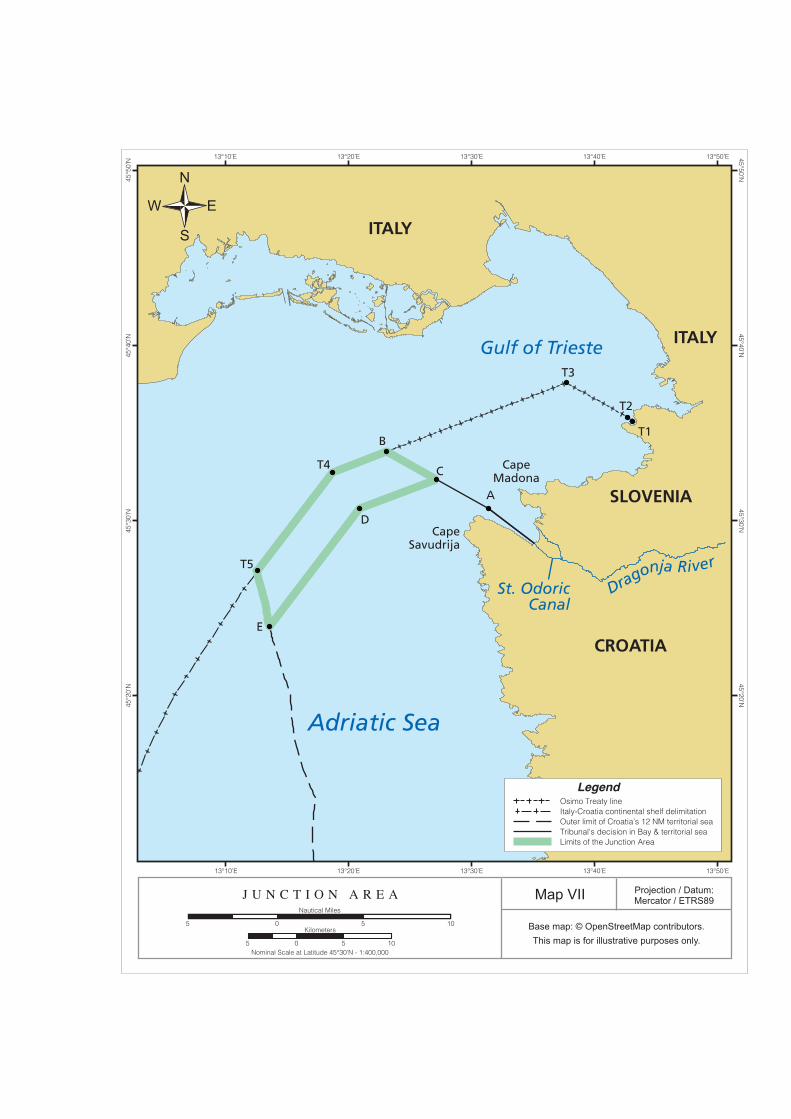
Adriatic Sea
Gulf of Trieste
St. OdoricCanal
Dragonja River
ITALY
ITALY
SLOVENIA
CROATIA
CapeSavudrija
CapeMadona
T3
B
C
D
A
T5
E
T4
T2
T1
Projection / Datum:Mercator / ETRS89Map VII
Base map: © OpenStreetMap contributors.This map is for illustrative purposes only.
J U N C T I O N A R E A
Nominal Scale at Latitude 45°30’N - 1:400,000
Nautical Miles
505 10Kilometers
505 10
13°20’E13°10’E 13°40’E 13°50’E13°30’E
13°20’E13°10’E
45°3
0’N
45°4
0’N
45°5
0’N
45°2
0’N
45°30’N45°20’N
45°40’N45°50’N
13°30’E 13°40’E 13°50’E
LegendOsimo Treaty lineItaly-Croatia continental shelf delimitationOuter limit of Croatia’s 12 NM territorial seaTribunal's decision in Bay & territorial seaLimits of the Junction Area
N
S
EW

D. DELIMITATION OF THE CONTINENTAL SHELF
1084. Slovenia makes a claim to a continental shelf in the area of the “corridor of high seas”2108 in which
Slovenia invites the Tribunal to restrict Croatia’s right to establish a territorial sea. However, the
Parties differ as to whether the question of continental shelf delimitation in fact arises.
1. The Parties’ Positions
Entitlement to a Continental Shelf
i. Slovenia’s Position
1085. On the basis of its junction claim,2109 Slovenia identifies “a corridor of high seas three miles in
width”2110 situated more than 12 NM from its territorial sea, which it argues “constitutes an area
over which Slovenia possesses continental shelf rights”2111 by virtue of UNCLOS Article 76(1)
as well as customary international law.2112
1086. UNCLOS Article 76(1) provides:
The continental shelf of a coastal State comprises the seabed and subsoil of the submarine areas that extend beyond its territorial sea throughout the natural prolongation of its land territory to the outer edge of the continental margin, or to a distance of 200 nautical miles from the baselines from which the breadth of the territorial sea is measured where the outer edge of the continental margin does not extend up to that distance.
1087. According to Slovenia, its “sovereign rights over the continental shelf exist ipso facto and ab
initio, and do not depend on any occupation . . . or on any express proclamation, or actual exercise
of the right.” 2113 Slovenia acknowledges that the Parties have overlapping continental shelf
entitlements beyond this 3 NM corridor, in the high seas areas beyond point T5 under the 1975
Treaty of Osimo, arising out of their “ipso facto rights” under UNCLOS and customary
international law.2114 In this regard, and noting that “neither Party has proclaimed an exclusive
economic zone,”2115 Slovenia contends that the fact that Croatia also has a continental shelf
2108 Slovenia’s Memorial, para. 10.96. 2109 Slovenia’s Memorial, para. 8.20. 2110 Slovenia’s Memorial, para. 10.96. 2111 Ibid. 2112 Slovenia’s Memorial, paras 8.20, 10.94, referring to North Sea Continental Shelf, I.C.J. Reports 1969, p. 3. 2113 Slovenia’s Counter-Memorial, para. 8.53. 2114 Slovenia’s Memorial, para. 8.20; Transcript, Day 4, p. 74:12-15; p. 75:8-18. 2115 Slovenia’s Memorial, para. 10.97.
PCA 200993 348
entitlement “does not make Slovenia’s entitlement evaporate,”2116 rather the Parties’ overlapping
entitlements “fall to be delimited in accordance with principles and rules of international law as
part of determining the course of the maritime boundary between the Parties.”2117 In Slovenia’s
view, “the fact that the Arbitral Tribunal is charged with determining Slovenia’s junction to the
High Sea presupposes that ‘maritime spaces’ beyond the territorial sea are also at issue.”2118 It
also notes that the reference to “the relevant maritime areas” is in the plural in Article 3(1)(c) of
the Arbitration Agreement.2119
1088. Slovenia submits that its entitlement to a continental shelf should not be blocked by the Cape
Savudrija promontory2120 and that Cape Savudrija is an example of “precisely the kind of relevant
circumstances that should be abated in order for the coasts of the parties to produce their effects
in terms of maritime entitlements,” such as the continental shelf.2121
ii. Croatia’s Position
1089. Croatia rejects outright Slovenia’s claim to a continental shelf as “entirely spurious”2122 and
criticizes Slovenia’s “resource grab under the guise of a maritime access corridor,”2123 which
“infringes the most elementary rules of maritime delimitation and all known principles of
international law.”2124
1090. While Croatia does not address in detail Slovenia’s alleged entitlement to a continental shelf, it
characterizes the Treaty of Osimo as an “untouchable” agreement that established a regime under
which Slovenia has no right to a continental shelf. 2125 Croatia also points out that the draft
2116 Transcript, Day 4, p. 75:19-21. 2117 Slovenia’s Memorial, paras 8.20, 10.98; Transcript, Day 4, p. 75:21-23. 2118 Slovenia’s Counter-Memorial, para. 8.55. 2119 Slovenia’s Counter-Memorial, para. 8.56. 2120 Transcript, Day 4, pp. 78:22-79:2, referring to Delimitation of the Continental Shelf between the United
Kingdom of Great Britain and Northern Ireland, and the French Republic (United Kingdom/France), Decision of 30 June 1977 and 14 March 1978, R.I.A.A. Vol. XVIII, pp. 3-413 and Dispute Concerning Delimitation of the Maritime Boundary between Bangladesh and Myanmar in the Bay of Bengal, ITLOS Case No. 16, Judgment of 14 March 2012. See also Slovenia’s Counter-Memorial, paras 11.02-05.
2121 Transcript, Day 8, pp. 4:8-5:3. 2122 Croatia’s Counter-Memorial, para. 9.14; Transcript, Day 2, p. 174:7-9. 2123 Croatia’s Counter-Memorial, para. 9.14; Transcript, Day 2, p. 174:17-18. 2124 Croatia’s Counter-Memorial, para. 9.14. 2125 Transcript, Day 5, pp. 94:19-95:12.
PCA 200993 349

agreement that Slovenia proposed on 29 October 1991 did not present any “claim to an extended
boundary off to the south, still less to a continental shelf.”2126
1091. In any event, Croatia notes that the Government of Slovenia, in its Proposal of the Maritime Code
of the Republic of Slovenia (adopted 23 March 2001), with Explanations of 25 May 2000, stated
that Slovenia “has the characteristics of a so-called ‘geographically disadvantaged State’, thus a
State without the continental shelf of its own or sovereign rights in this maritime area, and that,
given its geographical location, Slovenia does not have the possibility to proclaim other maritime
zones beyond the area under its sovereignty and in the direction towards the high seas (contiguous
zone, Exclusive Economic Zone).”[emphasis added] 2127
1092. As a consequence of its position that Slovenia is not entitled to a continental shelf, Croatia does
not present any detailed argument regarding the applicable law with respect to the delimitation of
the continental shelf or the delimitation of Slovenia’s continental shelf.
Applicable Law with respect to the Delimitation of the Continental Shelf
1093. Slovenia refers to UNCLOS Article 83(1) which governs the delimitation of the continental shelf
between States with adjacent coasts,2128 and provides as follows:
The delimitation of the continental shelf between States with opposite or adjacent coasts shall be effected by agreement on the basis of international law, as referred to in article 38 of the Statue of the International Court of Justice, in order to achieve an equitable solution.2129
1094. Slovenia stresses that UNCLOS Article 83(1) does not prioritize a particular method of
delimitation, but refers instead to “international law, as referred to in Article 38 of the Statute of
the International Court of Justice.” 2130 Slovenia argues that Article 83(1) imposes as the
“overriding objective” the achievement of “an equitable solution.”2131 Slovenia highlights the fact
that the construction of Article 83(1) is “markedly different” from Article 6 of the 1958
Convention on the Continental Shelf, which did in fact ascribe a prima facie role to the
equidistance method.2132
2126 Transcript, Day 1, pp. 51:17-52:2. 2127 Croatia’s Memorial, para. 10.59, citing Memorandum on the Piran Bay (Ljubljana, 7 April 1993), Annex
HR-69. 2128 Slovenia’s Memorial, para. 8.17. 2129 Slovenia’s Memorial, paras 8.30-31, citing UNCLOS, Article 83(1). 2130 Slovenia’s Memorial, paras 8.32, 10.104; Slovenia’s Counter-Memorial, para. 8.58. 2131 Slovenia’s Memorial, paras 8.32 and 10.99-102. 2132 Slovenia’s Memorial, paras 8.32 and 10.99.
PCA 200993 350

1095. That the equidistance method is not a mandatory rule of international law and does not have a
priori status over other methods, Slovenia submits, has been recognized by the ICJ in the North
Sea cases and the Tunisia/Libya case.2133 According to Slovenia, these precedents founded what
came to be known as the “equitable principles/relevant circumstances” rule, whereby continental
shelf delimitation is done by agreement in accordance with equitable principles and taking all
relevant circumstances into account.2134
1096. According to Slovenia, more recent ICJ and arbitral decisions have indicated that the application
of the “equitable principles/relevant circumstances” rule involves a three-step process: first,
plotting a provisional equidistance line; second, assessing the relevant circumstances in order to
determine whether they justify an adjustment being made to the provisional line in order to
achieve an equitable result; and third, testing the result obtained by the first two steps to verify
that it does not lead to a markedly disproportionate result.2135
1097. However, Slovenia contends that this three-step process is not mandatory and does not apply in
all cases. 2136 Notably, Slovenia argues that it is not appropriate to apply the equidistance
methodology in the present case.2137 First, it does not adhere to the “need for the Tribunal to
determine Slovenia’s junction with the High Sea and to tailor the course of the maritime boundary
to take into account that determination”2138 and in any event, it is at variance with the territorial
2133 Slovenia’s Memorial, paras 8.33-35, 10.99; Slovenia’s Counter-Memorial, para. 8.60; Transcript, Day 4, p. 79:3-18, citing North Sea Continental Shelf, Judgment, I.C.J. Reports 1969, p. 3 at pp. 46-47, paras 83, 85; p. 53, paras 101(B), 101(C)(1); Continental Shelf (Tunisia/Libyan Arab Jamahiriya), Judgment, I.C.J. Reports 1982, p. 18 at p. 59, para. 70; p. 79, para. 110; Continental Shelf (Libyan Arab Jamahiriya/Malta), Judgment, I.C.J. Reports 1985, p. 13 at p. 47, para. 63.
2134 Slovenia’s Memorial, paras 8.33-35, 10.101, citing North Sea Continental Shelf, Judgment, I.C.J. Reports 1969, p. 3 at p. 46, para. 83; p. 53, paras 101(B), 101(C)(1), Continental Shelf (Tunisia/Libyan Arab Jamahiriya), Judgment, I.C.J. Reports 1982, p. 18 at pp. 59-60, para. 70; p. 79, para. 110; and Continental Shelf (Libyan Arab Jamahiriya/Malta), Judgment, I.C.J. Reports 1985, p. 13 at pp. 38-39, para. 45; p. 47, para. 63.
2135 Slovenia’s Memorial, paras 8.36, 10.103, citing Territorial and Maritime Dispute (Nicaragua v. Columbia), Judgment, I.C.J. Reports 2012, p. 624 at pp. 695-98, paras 190-99; Continental Shelf (Libyan Arab Jamahiriya/Malta), Judgment, I.C.J. Reports 1985, p.3 at p. 86, para. 60; Maritime Delimitation in the Black Sea (Romania v. Ukraine), Judgment, I.C.J. Reports 2009, p. 61 at p. 101, paras 115-16. See also Slovenia’s Counter-Memorial, para. 8.61.
2136 Slovenia’s Memorial, paras 8.36, 10.104; Slovenia’s Counter-Memorial, paras 8.62, 11.06-08, citing Territorial and Maritime Dispute (Nicaragua v. Colombia), Judgment, I.C.J. Reports 2012, p. 624 at p. 696, para. 194; Territorial and Maritime Dispute (Nicaragua v. Colombia), Separate Opinion of Judge Abraham, I.C.J. Reports 2012, p. 730 at p. 735-36, paras 21, 23; Delimitation of Maritime Boundary between Guyana and Suriname, P.C.A. Case No. 2004-04, Award of 17 September 2007, para. 342, Territorial and Maritime Dispute between Nicaragua and Honduras in the Caribbean Sea (Nicaragua v. Honduras), Judgment, I.C.J. Reports 2007, p. 659 at p. 745, para. 283.
2137 Slovenia’s Memorial, paras 8.40 and 10.106; Slovenia’s Counter-Memorial, para. 8.62; Transcript, Day 4, pp. 79:19-80:1.
2138 Slovenia’s Memorial, para. 8.40.
PCA 200993 351

sea delimitation due to Slovenia’s historic rights and other special circumstances.2139 Second, this
would entail a “radical result” with Slovenia having no continental shelf at all, cutting Slovenia
off from areas of continental shelf to which it historically had access,2140 which “cannot possibly
be viewed as achieving an equitable solution.”2141 Third, a maritime delimitation that does not use
the equidistance methodology would not produce a disproportionate result for Croatia.2142
1098. For all these reasons, Slovenia argues that the appropriate method of delimiting the Parties’
respective continental shelves is one that takes into account the relevant geographic, historic and
economic circumstances.2143
Proposed Limits of the Continental Shelf
1099. On the basis of the foregoing, Slovenia contends that an equitable delimitation of its continental
shelf entitlement would be to extend a 3 NM wide corridor from Slovenia’s junction to the High
Sea towards the south-southwest until it intersects the 45°10′N parallel of latitude, as shown on
Figure 10.11 from Slovenia’s Memorial, reproduced below.2144
[Intentionally left blank]
2139 Slovenia’s Memorial, paras 8.40, 10.109-14. 2140 Slovenia’s Memorial, paras 8.41, 10.106; Slovenia’s Counter-Memorial, para. 8.62; Transcript, Day 4,
p. 80:1-7. 2141 Slovenia’s Memorial, paras 8.40, 10.106-07, citing North Sea Continental Shelf, Judgment, I.C.J. Reports
1969, p. 3 at p. 50, para. 91. See also Slovenia’s Counter-Memorial, para. 8.62; 2142 Slovenia’s Memorial, paras 8.42, 10.120, 10.137-46; Figures 10.1210.13, 10.14, 10.15. 2143 Slovenia’s Memorial, para. 10.114. 2144 Slovenia’s Memorial, para. 10.114; Slovenia’s Counter-Memorial, para. 11.10; Transcript, Day 4, p. 80:11-
25.
PCA 200993 352

(Slovenia’s Memorial, Figure 10.11)
1100. Slovenia contends that the proposed southern limit for Slovenia’s continental shelf delimitation
is appropriate for three reasons.2145 First, it corresponds to the provisional limit of Slovenia’s
ecological protection zone.2146 Second, it corresponds to the fishing limit area under the 1997
SOPS Agreement, which in turn reflects the historical rights and interests of both Parties.2147
Third, the fact that Slovenia once shared continental shelf rights with Croatia under the SFRY
“justifies the recognition of Slovenia’s sovereign rights over a reasonable area of continental shelf
lying seaward of the area covered by the SOPS Agreement.”2148
1101. Finally, Slovenia asserts that its proposed delimitation “produces a result that leaves each Party
with maritime areas that are not disproportionate when compared with the lengths of their relevant
coasts.”2149 Slovenia submits that under its proposed delimitation, the ratio of Slovenia’s maritime
space (approximately 555 square km) to Croatia’s maritime space (approximately 1040 square
km) is 1 to 1.9 in favour of Croatia (the figures quoted by Slovenia here include internal
2145 Slovenia’s Memorial, para. 10.117. 2146 Slovenia’s Memorial, para. 10.117, citing the discussion contained in its Memorial, paras 9.75-77. 2147 Slovenia’s Memorial, para. 10.117, citing the discussion contained in its Memorial, para. 9.137. 2148 Slovenia’s Memorial, para. 10.117. 2149 Slovenia’s Memorial, para. 10.120.
PCA 200993 353

waters).2150 This ratio, Slovenia avers, is not disproportionate as the ratio of the lengths of the
Parties’ relevant coastal fronts is 1:2.2151
1102. Slovenia also states that its continental shelf claim is not disproportionate when viewed in the
context of the Adriatic Sea as a whole, where, regardless of whether one includes or excludes
internal waters, the ratio of the area of Croatia’s maritime entitlement to its coastal front length is
far larger than that of Slovenia.2152
2. The Tribunal’s Analysis
1103. The consequence of the Tribunal’s determinations above, in respect of the maritime boundary
between Slovenia and Croatia and Slovenia’s Junction to the high seas, is that the maritime
boundary between Slovenia and Croatia extending from Point A at the mouth of the Bay to Point
B on the Treaty of Osimo line is the boundary for all purposes, and that Slovenia has no maritime
zone extending west beyond that maritime boundary. Slovenia’s claim to continental shelf rights
is therefore incompatible with the Tribunal’s determination of the entitlements of the two States
in this area, and no question of continental shelf delimitation arises.
E. DETERMINATION OF THE REGIME FOR THE USE OF THE RELEVANT MARITIME AREAS
1104. Finally Article 3(1)(c) of the Arbitration Agreement calls upon the Tribunal to determine the
regime for the use of the relevant maritime areas. The Parties have presented submissions on the
usage regime for the relevant maritime areas. At the hearing, Slovenia also made a proposal for a
special usage regime within the Bay on the assumption that the Bay in its entirety constituted
Slovenian internal waters.
2150 Slovenia’s Memorial, paras 10.143-44. 2151 Ibid.; Transcript, Day 4, p. 81:5-7. 2152 Slovenia’s Memorial, paras 10.145-46, citing Figure 10.14, Figure 10.15.
PCA 200993 354

1. The Parties’ Positions
Regime for the Use of the Territorial Sea
i. Slovenia’s Position
1105. Slovenia agrees that no special adjustment of the usual legal regime applicable to the territorial
sea—as described in UNCLOS Articles 2 and 17 to 32—is needed.2153 As such, Slovenia affirms
that ships of all States have a right of innocent passage and that the special rules applicable to
merchant ships and commercial ships operated for commercial purposes, and warships or other
government ships operated for non-commercial purposes, should operate in the usual way.2154
Slovenia also notes that because the Adriatic Sea is semi-enclosed, the provisions of UNCLOS
Article 123 on cooperation are “undoubtedly part of the legal background to the maritime aspects
of the present case.”2155
1106. Slovenia notes that fishing rights2156 and maritime traffic routing are already regulated in the
Parties’ territorial seas, 2157 under the SOPS/LBTA and the Memorandum of Understanding
between Italy, Slovenia and Croatia of 19 May 2000, which later became the 2004 IMO Traffic
Separation Scheme. 2158 However, Slovenia contends that “a confirmation of existing special
regimes is needed in order to protect Slovenia’s historic fishing rights.” 2159 In this regard,
Slovenia requests the Tribunal to “adjudge and declare” its fishing rights under the SOPS/LBTA
and the 2012 Croatian EU Accession Treaty to “constitute the regime of historic fishing rights of
Slovenia in the territorial sea of Croatia.”2160 This is necessary in Slovenia’s view due to the
implementation difficulties and uncertainties in connection with these treaty-based regimes
entered into with Croatia.2161 According to Slovenia, “[t]he current legal framework, no doubt
2153 Slovenia’s Memorial, para. 10.123. 2154 Ibid. 2155 Transcript, Day 8, p. 46:14-18. 2156 Transcript, Day 8, p. 51:11-12. 2157 Transcript, Day 8, p. 51:7-20. 2158 Slovenia’s Memorial, paras 10.124-25, citing Agreement between the Republic of Slovenia and the
Republic of Croatia on Border Traffic and Cooperation, 28 April 1997, Annex SI-295; Memorandum of Understanding between the Government of the Republic of Slovenia, the Government of the Republic of Croatia and the Government of the Italian Republic on the Establishment of a Common Routing System and Traffic Separation Scheme in North Part of the North Adriatic, 19 May 2000, Annex SI-310.
2159 Slovenia’s Counter-Memorial, para. 12.30. 2160 Slovenia’s Counter-Memorial, para. 12.33; Transcript, Day 8, pp. 51:13-52:11. 2161 Slovenia’s Counter-Memorial, paras 12.30-32; Transcript, Day 8, p. 52:11-14.
PCA 200993 355

modified from time to time, will remain in place, and [one] can see no reason why it should be
affected by the award.”2162
1107. Slovenia submits that the Tribunal’s Award may establish regimes that “modify or suspend the
operation of provisions of UNCLOS as between Slovenia and Croatia, provided they do not relate
to a provision derogation from which is incompatible with the effective execution of the object
and purpose of UNCLOS, and provided that such arrangements do not affect the application of
the basic principles embodied in UNCLOS.”2163
1108. In response to Croatia’s arguments, Slovenia contends that Croatia “conflates ‘Slovenia’s junction
to the High Sea’ and ‘the regime for the use of the maritime areas’.”2164 It also argues that Croatia
refers to a “regime of innocent passage”2165 while failing to acknowledge that the right of innocent
passage is significantly restricted by “the existing IMO traffic separation scheme as may be
modified from time to time”. 2166
1109. Slovenia also objects to the uncertainty arising out of Croatia’s statement that “[the regime for
use] needs to enable access to the High Sea that is as unimpeded as possible, in conformity with
international law” [insertion by Slovenia].2167 In particular, Slovenia argues that the term “access”
is uncertain and “heavily qualified” by the phrase “as unimpeded as possible”, and Croatia does
not indicate which rules of international law it refers to.2168 Moreover, Slovenia notes the lack of
reference to outbound ships, 2169 aircraft, 2170 or other important elements of the right of
communication2171 in Croatia’s proposals.
1110. Slovenia argues that Croatia’s arrangements are inadequate in “meeting Slovenia’s vital interest
in a territorial access to the high seas.”2172 In respect of UNCLOS Article 45, Slovenia contends
that the right of innocent passage “is far removed from unimpeded communication,”2173 and
2162 Transcript, Day 8, p. 47:3-9. 2163 Transcript, Day 8, p. 45:5-14. 2164 Transcript, Day 4, pp. 84:20-24, 87:19-20. 2165 Transcript, Day 4, p. 87:20-21. 2166 Slovenia’s Counter-Memorial, para. 12.11; Transcript, Day 4, p. 88:4-10. 2167 Slovenia’s Counter-Memorial, para. 12.13; Transcript, Day 4, p. 88:12-15. 2168 Slovenia’s Counter-Memorial, para. 12.13; Transcript, Day 4, p. 88:15-23. 2169 Slovenia’s Counter-Memorial, para. 12.18; Transcript, Day 4, p. 87:17-24. 2170 Slovenia’s Counter-Memorial, para. 12.19. 2171 Slovenia’s Counter-Memorial, para. 12.25. 2172 Slovenia’s Counter-Memorial, para. 12.20. 2173 Slovenia’s Counter-Memorial, para. 12.22.
PCA 200993 356

neither the right of transit passage nor the right of archipelagic sea lanes passage provides a right
of unimpeded passage.2174
ii. Croatia’s Position
1111. It is Croatia’s position that the purpose of Article 3(1)(c) of the Arbitration Agreement is to secure
maritime access in Croatia’s territorial seas, not to determine sovereignty or rights to
resources.2175 Croatia notes that while the Arbitration Agreement applies only to Croatia and
Slovenia, a full solution for the “regime for the use” cannot be found on one side of the Treaty of
Osimo delimitation line only. 2176 However, Croatia argues that while the Tribunal cannot impose
any obligations on Italy, it can take note of the obligations Italy already has under the existing
regulations and which it has consistently implemented.2177
1112. Croatia submits that there is a range of maritime transit rights presently recognized in the law of
the sea, namely innocent passage through the territorial sea; transit passage through international
straits; passage through the EEZ; and archipelagic sea lanes passage.2178 Croatia acknowledges
that vessels flying the Slovenian flag, and foreign vessels bound for Slovenian ports, should be
entitled to secure and uninterrupted passage through Croatian waters.2179 According to Croatia, it
has acted consistently with this regime with Slovenia enjoying uninterrupted access to the high
seas.2180
1113. Considering the applicable rules under the law of the sea as well as the IMO traffic separation
scheme, which Croatia submits has operated virtually without incident since its inception in 2004,
Croatia argues that there is “little or no practical need for any further guarantees.” 2181 Croatia
submits that “the junction and the regime should be, mutatis mutandis, the usual regime of
innocent passage through international straits under UNCLOS, subject to the existing IMO
scheme.”2182
2174 Slovenia’s Counter-Memorial, para. 12.23. 2175 Croatia’s Memorial, para. 10.47. 2176 Croatia’s Memorial, para. 10.84. 2177 Ibid. 2178 Croatia’s Memorial, para. 10.89, citing James Crawford, Brownlie’s Principles of Public International Law
(2012), pp. 316-20; Transcript, Day 2, pp. 183:19-24; 184:11-185:1. 2179 Croatia’s Memorial, paras 10.69, 10.90. 2180 Ibid. 2181 Croatia’s Memorial, para. 10.91. 2182 Transcript, Day 2, 185:2-7.
PCA 200993 357

1114. Croatia asserts that Slovenia’s claim of geographic disadvantage is “irrelevant to Slovenia’s rights
of transit or access through Croatian territorial waters,” stating that “only landlocked states have
special transit rights” under UNCLOS.2183 While Croatia agrees that the Adriatic Sea qualifies as
a semi-enclosed sea for the purposes of the general applicability of UNCLOS Article 123, Croatia
submits that this is of limited guidance to the Tribunal because “[u]nlike the Arbitration
Agreement, Article 123 proceeds on the basis that maritime territory and sovereign rights are
pertinent to territory, are to be delimited in accordance with international law, and not in
accordance with general equity.”2184
1115. Croatia notes as well that “there is no reason to anticipate that the minimum legal framework” of
EU law, treaties and regulations currently governing the Parties’ conduct in the territorial sea
“would be subject to adverse change” that would justify a heightened regime.2185 However, should
any heightened regime for the use of the relevant maritime areas be considered necessary by the
Tribunal, Croatia submits that it “should not exceed the application of the 1982 Law of the Sea
Convention provisions for innocent passage through international straits, by analogy, in the area
consisting of the north-bound navigational way of the IMO traffic separation scheme insofar as
it, or its extension from Point 5, falls within Croatian territorial sea.”2186
Regime for the Use of the Continental Shelf
1116. Slovenia submits that the legal regime of the continental shelf is provided for in UNCLOS Articles
77 to 82 and 852187 and that there is no need to adjust it either for Slovenia’s or Croatia’s
continental shelf.2188 As such, Slovenia claims sovereign rights and jurisdiction on the part of the
continental shelf allocated to it in accordance with its explanations given above.2189
1117. Slovenia notes that apart from obligations which might arise from future EU rules, there do not
seem to be special obligations in this area.2190
2183 Transcript, Day 5, p. 102:10-14. 2184 Transcript, Day 5, p. 138:8-12. 2185 Transcript, Day 5, p. 135:8-21; pp. 138:22-139:3. 2186 Croatia’s Memorial, para. 10.91. 2187 Slovenia’s Memorial, para. 10.126; Transcript, Day 8, p. 55:2-3. 2188 Transcript, Day 8, p. 55:2-5. 2189 Slovenia’s Memorial, para. 10.127, Slovenia’s Counter-Memorial, para. 12.35. 2190 Slovenia’s Memorial, para. 10.128 n.112.
PCA 200993 358

1118. Croatia asserts that “Slovenia has no continental shelf.” 2191 In particular, Croatia notes that
Slovenia, “being hemmed in due to its geographical situation by the territorial seas . . . of Italy
and Croatia, can have no claim to an EEZ or continental shelf.”2192
Regime for the Use of the High Seas
1119. Slovenia contends that the legal regime of the high seas is provided for in UNCLOS Articles 86
to 115,2193 and argues that this regime must be “fully applied within the [high seas] corridor.”2194
As such, Slovenia submits that, in the corridor, all States, including Croatia and Slovenia, benefit
from the freedom of the high seas, including the freedom of navigation and overflight.2195
1120. Furthermore, Slovenia argues that the legal regime of the high seas in UNCLOS should apply “in
the area beyond point P3 [shown on Figure 10.9, reproduced after paragraph 1054, above] which
marks the outer limit of the corridor of high seas, until it reaches the area on which third States
may have overlapping claims, over which this Tribunal has no jurisdiction.”2196 Slovenia notes
that the Tribunal is not called to fix the southernmost limit of the area where the high seas regime
applies since it does not have jurisdiction in areas in which third States may have overlapping
claims.2197 Nevertheless, Slovenia submits that the Tribunal should specify that if Croatia were to
claim sovereign rights over part of this area, such claim could not jeopardize Slovenia’s junction
with the High Sea.2198 In particular, Slovenia argues that “[t]he Tribunal’s award determining an
area of high seas south of the line of the junction . . . will mean that neither party will be entitled
to declare an exclusive economic zone in that area, [which] is essential in order for the award to
meet Slovenia’s vital interest in a direct contact with the high seas.”2199
1121. Croatia submits that “the regime of access from Slovenia’s territorial sea to the high seas, the
direct link between the two, could only be achieved through the regime of innocent passage under
existing international law.” 2200 According to Croatia, no special regime is warranted under
2191 Transcript, Day 5, p. 96:3. 2192 Transcript, Day 5, p. 102:15-21. 2193 Slovenia’s Counter-Memorial, para. 12.37; Transcript, Day 8, p. 55:12-13. 2194 Slovenia’s Memorial, para. 10.129. 2195 Ibid. 2196 Slovenia’s Memorial, para. 10.130. 2197 Ibid. 2198 Slovenia’s Memorial, para. 10.130, Slovenia’s Counter-Memorial, para. 12.39; Transcript, Day 4, p. 91:6-16. 2199 Transcript, Day 8, p. 55:16-21. 2200 Transcript, Day 5, p. 102:22-25.
PCA 200993 359

UNCLOS because “[t]here is no strait in this area, as a matter of existing international law and
the existing definition of ‘straits’.”2201
2. The Tribunal’s Analysis
Regime of the Junction Area
1122. The Tribunal now turns to the regime that shall apply to the Junction Area.2202 The Tribunal
recalls again that it is directed by the Parties, by Article 4 of the Arbitration Agreement, to
determine the regime for the use of the relevant maritime areas applying “international law, equity
and the principle of good neighbourly relations in order to achieve a fair and just result by taking
into account all relevant circumstances.” It has given that instruction the most careful
consideration; and in the light of the submissions of the Parties, the framework established by
UNCLOS, and the geography of the northern Adriatic Sea, it has determined a regime that fulfils
that instruction.
i. The Content and Scope of the Freedoms of Communication
1123. The regime that has been determined by the Tribunal is intended to guarantee both the integrity
of Croatia’s territorial sea and Slovenia’s freedoms of communication between its territory and
the high seas. To that end, the Tribunal considers it essential that, in the Junction Area,2203 there
is freedom of communication for the purposes of uninterrupted and uninterruptible access to and
from Slovenia, including its territorial sea and its airspace. That freedom consists in the freedoms
of navigation and overflight and of the laying of submarine cables and pipelines, and other
internationally lawful uses of the sea related to these freedoms, such as those associated with the
operation of ships, aircraft and submarine cables and pipelines.
1124. These freedoms apply to all ships and aircraft, civil and military, of all flags or States of
registration, equally and without discrimination on grounds of nationality. The extension of these
rights to ships and aircraft of all States, and not just to Slovenian ships and aircraft, is necessary
for the practical realization of rights of access to and from Slovenia’s ports and waters, which is
a matter that relates not only to Slovenian vessels and aircraft but also to vessels sailing and
aircraft flying under the flags of all countries other than Slovenia.
2201 Transcript, Day 5, pp. 102:25-103:2. 2202 As defined in paragraph 1083 above. 2203 No other areas of Croatia’s territorial sea are affected by this special regime for the Junction Area.
PCA 200993 360

1125. Ships and aircraft are entitled to the freedoms of communication in the Junction Area described
above when travelling to or from Slovenia, including its territorial sea and its airspace.
1126. The freedoms of communication in the Junction Area do not include the freedom to explore,
exploit, conserve or manage the natural resources, whether living or non-living, of the waters or
the seabed or the subsoil in the Junction Area. Nor do they include the right to establish and use
artificial islands, installations or structures, or the right to engage in marine scientific research, or
the right to take measures for the protection or preservation of the marine environment.
1127. Unlike innocent passage, the freedoms of communication in the Junction Area are not conditioned
upon any criterion of innocence and are not suspendable under any circumstances. The freedoms
of communication in the Junction Area are not subject to any duty of submarine vessels to
navigate on the surface, nor to any coastal State controls or requirements other than those
permitted under the legal regime of the EEZ established by UNCLOS.
1128. Unlike transit passage, the freedoms of communication in the Junction Area are exercisable as if
they were high seas freedoms exercisable in an exclusive economic zone. They are not subject to
any additional restrictions and conditions except as provided in this Award. They include the
freedoms of navigation and overflight and of the laying of submarine cables and pipelines, and
other internationally lawful uses of the sea related to these freedoms. The laying of submarine
cables and pipelines is subject to the conditions set out in UNCLOS Article 79, including the right
of Croatia under Article 79(4) to establish conditions for such cables and pipelines entering other
parts of Croatia’s territorial sea.
ii. Guarantees of, and Limitations to, the Freedoms of Communication
1129. The Tribunal considers that, in order to guarantee the freedoms of communication as defined
above, it is necessary that ships and aircraft of all flags and of all kinds, civil and military,
exercising the freedom of communication are not subject to boarding, arrest, detention, diversion
or any other form of interference by Croatia while in the Junction Area.2204
2204 The Tribunal notes that specific regimes have been established in legal instruments ensuring unhindered access rights in the territorial waters of certain straits, which go clearly beyond those of transit passage in accordance with UNCLOS Article 35(c). See e.g., Article 1 of the Treaty on the Redemption of the Sound Dues between Denmark and Sweden, done in Copenhagen on 14 March 1857, C. Parry, Consolidated Treaty Series, Vol. 116, No. 357 (1969). It is also noted that the Danish Straits are an example of a maritime area of vital interest to Denmark and other Baltic States, see Kaare Bangert, “Belts and Sund” in Max Planck Encyclopedia of Public International Law, paras 1-3 (R. Wolfrum ed., 2013); Erik Brüel, “La topographie, la fonction géographique et l'histoire politique des détroits”, Recueil des Cours, Vol. 55, p. 604 (1936).
PCA 200993 361

1130. A distinction must be drawn between, on the one hand, Croatia’s right to prescribe laws and
regulations for ships and aircraft within the Junction Area and, on the other hand, Croatia’s right
to take action to enforce its laws and regulations in that area. The Tribunal considers it fair, just,
and practical for Croatia to remain entitled to adopt laws and regulations applicable to non-
Croatian ships 2205 and aircraft in the Junction Area, giving effect to the generally accepted
international standards in accordance with UNCLOS Article 39(2) and (3). Ships and aircraft
exercising any aspect of the freedom of communication would be under an obligation to comply
with such Croatian laws and regulations.
1131. In this regard, the Tribunal observes that the Junction Area is small, and Croatia retains its rights
to enforce its laws and regulations in all other areas of its territorial sea and other maritime zones
in accordance with UNCLOS. Notably, the present Award does not affect the right of Croatia to
take enforcement action outside the Junction Area in accordance with international law. Those
rights include the right to take enforcement action in respect of violations of Croatian law that
had been committed in the Junction Area.
1132. The Tribunal considers that, in order to ensure a fair, just, and practical result, it is necessary that
in the Junction Area Croatia should retain the right to respond to a request made by the master of
a ship or by a diplomatic agent or consular officer of the flag State for the assistance of the
Croatian authorities and also, exceptionally, that Croatia should retain the right to exercise in the
Junction Area powers under UNCLOS Article 221 in respect of maritime casualties.
1133. The Tribunal emphasises that, in order to achieve a fair and just result, all rights and obligations
established by this Award must be exercised and fulfilled in good faith and in a reasonable
manner, and in accordance with other applicable rules of international law.
iii. Duty of Cooperation and Other Agreements between the Parties
1134. In every case the rights and obligations of the Parties under the regime of the Junction Area must
be exercised in good faith and with due regard for the rights and obligations of other States. The
Tribunal observes that, given the small size of the Junction Area and its proximity to adjacent
States, this obligation is a particularly important element of the legal regime of the Junction Area.
The Tribunal recalls, in addition, the express obligations under UNCLOS Articles 123
2205 The right to adopt laws and regulations in respect of Croatian ships remains unaffected by the Tribunal’s decision.
PCA 200993 362

(“Cooperation of States bordering enclosed or semi-enclosed seas”), 300 (“Good faith and abuse
of rights”), and 301 (“Peaceful uses of the seas”) on all States.
1135. Moreover, there are many international treaties and other arrangements under which States
cooperate in order to ensure that limitations upon their right to exercise jurisdiction do not enable
wrongdoers to escape legal controls.2206 The Tribunal notes the importance of such agreements
and of similar practical arrangements, and encourages the Parties to cooperate fully with each
other, and with other States, in the exercise of their rights and the performance of their obligations
in the northern Adriatic. It emphasises that the Parties are obliged by the special regime for the
Junction Area to cooperate with one another to the extent necessary to ensure that the Junction
Area does not unreasonably impede law enforcement activities consistent with this Award.
1136. This Award is without prejudice to any existing or future agreements between the Parties. Nor
does anything in this Award affect the IMO Traffic Separation Scheme in the northern Adriatic
Sea, or international rules applicable to air navigation.
1137. Similarly, nothing in this Award purports to address any rights or obligations of the Parties arising
under EU law.
1138. The rights and obligations of Croatia and Slovenia, in accordance with UNCLOS, in all areas of
their respective territorial seas and other maritime zones apart from the Junction Area are
unaffected, except to the extent necessary to ensure the application of the regime established by
this Award.
1139. The boundary between the territorial seas of Croatia and Slovenia, the special regime for the
Junction Area, and the rights and obligations of Croatia and Slovenia established by this Award
shall subsist unless and until they are modified by agreement between those two States.
1140. The Tribunal notes that UNCLOS States Parties must not conclude agreements that affect the
application of the basic principles embodied in UNCLOS.2207 The Tribunal is satisfied that the
special regime for the Junction Area described above is consistent with those basic principles.
2206 See e.g., United Nations Convention against Illicit Traffic in Narcotic Drugs and Psychotropic Substances, done in Vienna on 20 December 1988, 1582 U.N.T.S. 95. Another example are Shiprider Agreements between States that grant law enforcement officers of one State the right to board ships in the territory waters of the other State and exercise certain sovereign powers in respect of these ships. Similarly, Croatia and Slovenia have commited themselves, in the Paris Memorandum of Understanding on Port State Control (39th Amendment, adopted on 27 May 2016), to a system of effective port State control, inspections and information exchange in accordance with that Memorandum.
2207 UNCLOS Article 311(3).
PCA 200993 363

Regime for the Use of the Continental Shelf
1141. As a result of the Tribunal’s decision with respect to the maritime boundary, there is no need to
establish any particular usage regime, different from what already applies under international law,
applicable to the continental shelf.
Regime for the Use of the High Seas
1142. As regards the ‘high seas’—that is, the area lying beyond the 12 NM limit of the territorial sea
prescribed by UNCLOS Article 3—the Tribunal again finds it unnecessary to define any
particular usage regime. As has been explained, if coastal States exercise their rights under
UNCLOS to establish exclusive economic zones, every part of the ‘high seas’ in the Adriatic Sea
and Mediterranean Sea could be converted into exclusive economic zones. International law does
not require the creation of a special regime for parts of the exclusive economic zone in the
northern Adriatic Sea, and neither do equity or the principle of good neighbourly relations. The
Tribunal is satisfied that its determinations concerning “Slovenia’s junction to the high sea” and
the regime for use of the territorial sea achieve a fair and just result.
PCA 200993 364

VII. COSTS OF THE ARBITRATION
1143. The Tribunal takes note of Article 6(7) of the Arbitration Agreement, which provides that “[t]he
costs of the Arbitral Tribunal shall be borne in equal terms by the two Parties.” The Tribunal
further notes that neither side has requested the Tribunal to make any other determination on costs
or presented any submission on costs to the Tribunal.
1144. In these circumstances, the Tribunal decides that the costs of the Tribunal and the Registry shall
be borne by the Parties in equal shares.
PCA 200993 365


VIII. DISPOSITIF
For the foregoing reasons, the Arbitral Tribunal unanimously,
I. In relation to the land boundary between Croatia and Slovenia,
A. Determines that the boundary in the Mura River Region runs as follows:
1. In the area of Brezovec-del/Murišće, as set out in paragraph 413, the boundary follows a
line along the southern wayside of a path to the south of that settlement, as illustrated on
Award Map I;
2. In the areas of Podturen/Pince and Novakovec/Pince, as set out in paragraph 440, the
boundary follows the cadastral limits as modified in 1956 and 1957;
3. In the area of Ferketinec/Pince, as set out in paragraph 440, the boundary follows the aligned
limits of the cadastres of Croatia and Slovenia as they stood before 1956;
4. In the area of Mursko Središće/Peklenica, as set out in paragraph 446, the boundary is as
recorded in the 1956 Minutes on the Determination of the Borders of the Cadastral District
of Peklenica;
5. In all other areas, to the extent that the boundary is disputed, the boundary follows the
aligned limits of the cadastres of Croatia and Slovenia;
B. Determines that the boundary in the Central Region runs as follows:
1. In the Slovenske gorice,
a. In the area of Razkrižje, as set out in paragraph 473, the boundary follows the
aligned limits of the cadastres of Croatia and Slovenia;
b. In the area of Robadje/Globoka, as set out in paragraph 478, the boundary follows
the limits recorded in the cadastre of Slovenia;
c. In certain areas in the vicinity of the Santavec River, as set out in paragraph 482,
the boundary follows the aligned limits of the cadastres of Croatia and Slovenia;
PCA 200993 367

d. In the vicinity of the Zelena River, as set out in paragraph 485, the boundary follows
the aligned cadastral limits of Croatia and Slovenia.
2. In the area of the Drava River, as set out in paragraph 495, the boundary follows the aligned
limits of the cadastres of Croatia and Slovenia;
3. In the area of Haloze-Macelj, as set out in paragraph 505, the boundary follows the
boundaries as depicted on maps dated 1914, corresponding to the limits of the cadastre of
Slovenia;
4. Within the Sotla River area,
a. In area 5.1, as set out in paragraph 521, the boundary follows the limits of the
cadastre of Croatia;
b. In area 5.2, as set out in paragraph 522, the boundary follows the limits recorded in
the cadastre of Croatia;
5. Within the areas of the Sava and Bregana Rivers,
a. In area 6.1, as set out in paragraph 531, the boundary follows the middle of the Sava
River;
b. In the area of the junction of the Sava and Bregana Rivers, as set out in paragraph
540, the boundary follows the aligned limits of the cadastres of Croatia and
Slovenia;
6. Within the area of Gorjanci/Žumberak,
a. In area 7.1, as set out in paragraph 564, the boundary follows the limits of the
cadastre of Slovenia;
b. In area 6.3, as set out in paragraph 578, the boundary follows the eastern limit of
the Sekulići/Sekuliči Slovenian cadastral district;
PCA 200993 368

c. In the area of Trdinov Vrh/Sveta Gera, as set out in paragraph 586, the boundary
follows the aligned limits of the cadastres of Croatia and Slovenia;
7. Within the areas of the Kamenica, Kupa/Kolpa and Čabranka Rivers,
a. In the Kamenica River area, as set out in paragraph 608, the boundary is as shown
on Map 23 of Volume III of Croatia’s Counter-Memorial and on Map 59 of
Volume III of Croatia’s Reply;
b. In the Kupa/Kolpa River area, as set out in paragraph 614, the boundary is as
concurrently depicted on the Parties’ claim maps in the present proceedings;
c. In the Čabranka River area, as set out in paragraph 624, the boundary follows the
aligned limits of the cadastres of Croatia and Slovenia;
8. In the area to the east of the settlement of Črneča Vas, as set out in paragraph 630, the
boundary follows the aligned cadastral limits of Croatia and Slovenia.
9. Within the area of Novi Kot/Prezid, Draga/Prezid, Babno Polje/Prezid,
a. In the areas of Novi Kot/Prezid and Draga/Prezid, as set out in paragraph 636, the
boundary follows the aligned limits of the cadastres of Croatia and Slovenia;
b. In the area of Babno Polje/Prezid, as set out in paragraph 642, the boundary is as
indicated on an Imperial-Royal field sketch of June 1918 of the provincial boundary
between Carniola and Croatia;
C. Determines that the boundary in the Istria Region runs as follows:
1. In areas 9.3 and 9.4, as set out in paragraph 688, the boundary follows the course of the
former boundary between Italy and Yugoslavia as it stood from 1920 to 1947;
2. The area of 2 ha immediately south of Gomance, as set out in paragraph 696, forms part of
the territory of Slovenia;
PCA 200993 369

3. In the areas of Klana/Lisac and Zabiče/Sušak as well as Lisac/Sušak, as set out in paragraphs
719 and 720, the boundary follows the boundary between Lisac and Sušak as depicted on a
1878 map of Lisac;
4. In the area of Kućibreg/Topolovec, as set out in paragraph 737, the boundary follows the
outer limits of the settlements transferred from Croatia to Slovenia in 1956, as reflected in
cadastral records and maps maintaining the 1947 delimitation line as the new cadastral
limits;
5. In the area of Merišće/Krkavče and in the Lower Dragonja region, as set out in paragraph
769, the boundary follows the Dragonja River up to a point in the middle of the channel of
the St Odoric Canal with the coordinates 45°28′42.3ʺN, 13°35′08.2ʺE;2208
D. Determines that, in all areas not specifically mentioned above, the boundary is as agreed by
the Parties in the course of the present proceedings; in the absence of such agreement, the
boundary follows the aligned limits of the cadastres of Croatia and Slovenia;
E. Decides further that:
1. The Tribunal has no jurisdiction to address Croatia’s request that the Tribunal adjudge and
declare that “no Slovenian personnel, whether military, civilian, police or security, shall be
entitled to remain at the facility located at Sveta Gera in the Croatian Municipality of Ozalj”;
2. Croatia’s request that the Tribunal adjudge and declare that “Slovenia shall not hinder
communication between the Croatian municipality of Sveti Martin na Muri, including the
area of Murišće” is moot, and no decision by the Tribunal is accordingly called for;
II. In relation to the Bay,
A. Finds that the Bay had the status of internal waters prior to the dissolution of the SFRY and
determines that it retained that status after the independence of Croatia and Slovenia;
2208 The geographical coordinates used in this Award are referenced to the ETRS89, unless otherwise indicated. See note 615.
PCA 200993 370

B. Determines that the closing line of the Bay (dividing internal waters from territorial sea) runs
from Cape Madona, Slovenia (45°31ʹ49.3ʺN, 13°33ʹ46.0ʺE) to Cape Savudrija, Croatia
(45°30ʹ19.2ʺN, 13°30ʹ39.0ʺE);
C. Determines that the boundary between Croatia and Slovenia in the Bay shall be a straight line
joining a point in the middle of the channel of the St Odoric Canal with the coordinates
45°28′42.3ʺN, 13°35′08.2ʺE, to point A with the coordinates 45°30′41.7ʺN, 13°31′25.7ʺE;
III. In relation to the maritime boundary between Croatia and Slovenia,
Determines that the maritime boundary between the territorial seas of Croatia and Slovenia is a
geodetic line joining Point A with the coordinates 45°30′41.7ʺN, 13°31′25.7ʺE, with an initial
geodetic azimuth of 299°04′45.2ʺ, to Point B on the line established by the Treaty of Osimo;
IV. In relation to the Junction Area,
A. Establishes a Junction Area whose limits consist of the five geodetic lines joining the following
six points in the order given:
Point T5, being a point on the boundary established by the Treaty of Osimo;
Point T4, being a point on the boundary established by the Treaty of Osimo;
Point B, being the tripoint on the boundary between the maritime zones of Croatia and
Slovenia, and the boundary established by the Treaty of Osimo, at 45°33ʹ57.4ʺN, 13°
23ʹ04.0ʺE;
Point C, being a point on the boundary between the maritime zones of Croatia and
Slovenia, at 45°32ʹ22.5ʺN, 13°27ʹ07.7ʺE;
Point D, being a point landward of the turning point T4 on the Treaty of Osimo
boundary, at 45°30ʹ42.2ʺN, 13°20ʹ56.3ʺE;
Point E, being a point on the outer limit of Croatia’s territorial sea, lying 12 NM from
the coast of Croatia, at 45°23ʹ56.6ʺN, 13°13ʹ34.6ʺE;
and the line from Point E along the outer limit of Croatia’s territorial sea to Point T5.
B. Determines that, in the Junction Area, the following usage regime shall apply:
PCA 200993 371

a. Freedom of communication shall apply to all ships and aircraft, civil and military, of all
flags or States of registration, equally and without discrimination on grounds of
nationality, for the purposes of access to and from Slovenia, including its territorial sea
and its airspace;
b. The freedom of communication shall consist in the freedoms of navigation and
overflight and of the laying of submarine cables and pipelines, and other internationally
lawful uses of the sea related to these freedoms, such as those associated with the
operation of ships, aircraft and submarine cables and pipelines;
c. The freedom of communication shall not be conditioned upon any criterion of
innocence, shall not be suspendable under any circumstances, and shall not be subject
to any duty of submarine vessels to navigate on the surface or to any coastal State
controls or requirements other than those permitted under the legal regime of the EEZ
established by UNCLOS;
d. The laying of submarine cables and pipelines shall be subject to the conditions set out
in UNCLOS Article 79, including the right of Croatia under Article 79(4) to establish
conditions for such cables and pipelines entering other parts of Croatia’s territorial sea;
e. The freedom of communication shall not include the freedom to explore, exploit,
conserve or manage the natural resources, whether living or non-living, of the waters
or the seabed or the subsoil in the Junction Area, nor shall it include the right to establish
and use artificial islands, installations or structures, or the right to engage in marine
scientific research, or the right to take measures for the protection or preservation of the
marine environment;
f. Ships and aircraft exercising the freedom of communication shall not be subject to
boarding, arrest, detention, diversion or any other form of interference by Croatia while
in the Junction Area, but Croatia shall remain entitled to adopt laws and regulations
applicable to non-Croatian ships and aircraft in the Junction Area, giving effect to the
generally accepted international standards in accordance with UNCLOS Article 39(2)
and (3);
g. Croatia shall retain the right in the Junction Area to respond to a request made by the
master of a ship or by a diplomatic agent or consular officer of the flag State for the
PCA 200993 372

assistance of the Croatian authorities and also the exceptional right to exercise in the
Junction Area powers under UNCLOS Article 221 in respect of maritime casualties;
h. The rights and obligations of the Parties referred to in sub-paragraphs (a) to (g) shall be
exercised in good faith and with due regard for the rights and obligations of other States;
C. Notes that this regime is without prejudice to any existing or future agreements regarding the
usage of relevant maritime areas between the Parties, and that nothing in this Award affects the
IMO Traffic Separation Scheme in the northern Adriatic Sea, or international rules applicable
to air navigation, or any rights or obligations of the Parties arising under EU law;
D. Affirms that the rights and obligations of Croatia and Slovenia, in accordance with UNCLOS,
in all areas of their respective territorial seas and other maritime zones apart from the Junction
Area are unaffected, except to the extent necessary to ensure the application of the regime
established by this Award;
E. Decides that, in view of the decisions set out above, no further determinations in respect of
maritime matters are necessary or appropriate;
V. In relation to the permanence of the rights and obligations of the Parties under the
Award,
Notes that the land boundary as well as the boundary between the territorial seas of Croatia and
Slovenia, the special regime for the Junction Area, and the rights and obligations of Croatia and
Slovenia established by this Award shall subsist unless and until they are modified by agreement
between those two States;
VI. In relation to the costs of the arbitration,
Decides that the costs of the Tribunal and the Registry shall be borne by the Parties in equal
shares.
PCA 200993 373


PCA CASE NO. 2012-04
IN THE MATTER OF AN ARBITRATION UNDER THE ARBITRATION AGREEMENT BETWEEN THE GOVERNMENT OF THE REPUBLIC OF CROATIA AND THE
GOVERNMENT OF THE REPUBLIC OF SLOVENIA, SIGNED ON 4 NOVEMBER 2009
- between -
THE REPUBLIC OF CROATIA
- and -
THE REPUBLIC OF SLOVENIA
(together, the “Parties”)
________________________________________________________
ANNEX TO THE FINAL AWARD
29 June 2017 ________________________________________________________
ARBITRAL TRIBUNAL: Judge Gilbert Guillaume (President)
Ambassador Rolf Einar Fife Professor Vaughan Lowe Professor Nicolas Michel
Judge Bruno Simma
REGISTRAR: Dr. Dirk Pulkowski
The Permanent Court of Arbitration

Annex HRLA-75
ARBITRATION AGREEMENT between the Government of the Republic of Croatia
and the Government of the Republic of Slovenia
The Governments of the Republic of Croatia and the Republic of Slovenia (hereinafter referted to ai; "the Pnrtics"),
Whereas through numetous attempts the Parties have not rcsolvc<l tbeir territorial and maritime border dispute in the course of the past years,
Recalling the peaceful means for the settlement of disputes enumerated in Article 33 of the UN-Charter,
Affirming their commitment ta a peaceful settlement of disputes, m the spitit of good neighbourly .tclations, reflecting their vital interests,
Welcoming the facilitation offe.i:ed by the European Commission,
Have agreed as follows:
Article 1; Establishment of the Arbitral Tribunal
The Patties hereby set up an Athitral Tribunal.
Article 2: Composition of the ArbjtcaJ Tribi.ma.1
(1) Both Parties shall appoint by c<>mtnon 11gteemcnt the Pi-esident of the Arbittri.1 Tribunal and two members recognized for their competence in international law within fifteen days drawn ftom a list of candidates established ~y the President of the European Commission and the Member tesponsible for the enlatgement of the European Commission. In case that they cannot agree within this delay, the President and the two membcn of the Arbitt11.l Tribunal shall be appnimcd by the Pte$idcnt of the Intcm1ttio11al Court of Justice fto1n the list.
(2) Each Party shall appoint a further member of the Arbitral Tribunal within fifteen d:iys after the appointments rcfcned to ill pamgcaph 1 have been finalised. In cnse that no appointment has been made ... vithin this delay, the respective member shall be appointed by the President of the Arbitral Tribunal.
(3) If, whether before or after tht proceedings have begun, a vacancy should occur on account of the death, incapacity or resignation of a member, it shall be filleJ in accordance with the procedure prescribed for the: original appoirtt1ne11t. .

Annex HRLA-75
2
/u:tide 3; Task of the Arbitral Tcibuna]
(1) The Arbittal Tribunal shall dcteiminc
(a) the course of the mai:icirnc and land boundary between the Rep~1bhc of Croatia and the Republic of Slovenia;
(b) Slovenia's junction to the High Sea;
(c) the regime for the use of the relevant maritime areas.
~he P1uties shall specify the details of the subject-matter of the dispute within one month. 'ftb"'t:hey fail to do so, the Arbittlll Tribunal shill use the submissions of the Parties for the determination of the exact scope of the maritime and territorial disputes and claims between the Parties.
{3) The Arbitml Tribunal shall render an award on the dispute.
(4) lbe Atbitral Tribunal has the powet to interpret the present Agreement.
Attide 4; Applicable I..aw
The Arbitral Tribunal shall apply
(a) the rules and principles of international law for the determinations referred to in Atdcle 3 (1) (a);
(b) intemational law, equity and the principle of goc><l neighbourly relations in otder to achieve a £ait and just result by taking into account all relevant cixcumstances for the determinations cefetred to in Article 3 (1) (b) and (c).
Article S: Critical date
No document or action undettaken unilaterally by eithet side after 25 June t 991 shall be accorded legaJ significance for the tasks of the Arbitral Tribunal or commit eithet side of the dispute and cannot, in any way, ptejudge the 1wud.
A.ttidc 6: Procedure
(1) Each Party shall submit a memorial to the Atbitral Tribunal within twelve months. Each Party has the right to comment on the memorial of the other Party within a deadline fixed by the Atbirral Tribunal.
(2) Unless envisaged otherwise, the Arbitral Tribunal shall conduct the proceedings according to the Permanent Court of Arbittation Optional Rules for Arbittnting Disputes between Two S~k~ .

Annex HRLA-75
3
(3) The Arbitral Tribunal may seek expert advice and organize oral hearings.
(4) .The Atbittal Tribunal shall, after consultation of the Patties, decide expeditiously on all ptocedural matters by majority of its members.
(5) The proceedings arc confidential and shall be conducted in English.
(6) The Parties shall appoint teprcscrttatives to act u intermediary between them and the Arbitr:al Tribunal. 1hcy may retain counsels to suppou thei.t tepresentative.
(7) The Arbittal Tribunal shall be supported by a Secretariat. The costs of the Arbttral Tribunal shall be botnc in equal terms by the two Parties. The Parties invite the European Commission to provide seCJ:etarial support to the Arbitral Tribunal. The pb.cc of arbittacion shall be Brussels, Bclgiutn.
(8) The Arbitration Tribunal may at any stage of the procedure with the consent of both Parties assist them in reaching a friendly settlement.
Article 7: The award of the .Arbitcal Tribunal
(1) The Ai:bitral Tribunal 11hall issue its award expeditiously after due conside[ation of all relevant facts pertinent to the caae. The Arbitnl Ttibunal adopts the aw11rd by majority of its membeIS. The award shall state the reasons on which it ~ based. No individual or dissenting opinions shall be attached to the awai:d.
(2) The award of the Arbitml Ttibu11al shall be binding on the Parties and shall constitute a definitive settlement of the di~putc.
(3) The Parties shall take all necessary steps to implement the awud, including by xcvislng national legislation, as necessary, within six months after the adoption of the award .
.Article 8; EU accession ncgp6atio11 d0g1mcnts
(1) No docu1nent p.tesented in the EU accession negotiations unilaterally shall prejudice the Arbittal Tribunal when perfoi:ming its tasks or commit either side on the dispute.
(2) The above applies to all documents and positions either written or submitted orally, including, itiltr alia, maps, negotiating positions, legal acts and othet documents in whatever form, ptoduced, presented ot reft:~re<l to unilaterally in the framework of the EU accession oegptiation.s. It a.Isa applies to all EU documents and positions which refer to or summ:uize the above-mentioned docu1nents and positions.

Annex HRLA-75
Article 9; The continuation of the EU accession nr.gotiatioru according to the ncg.otiatigg fmmcwotk
(1) The Republic of Slovenia shall lift its resctVations as regards opening and dosing of negotiation chapters where the obstacle is tefated to the di5putc.
(2) Both Parties shall refrain from any action or statement which might negatively affect the accession negotiations. ·
Article 10: Stand-still
(1) Both Patties .cefrrun from any action or statement which might intensify the dispute or jeopardize the work of the Arbittal Tribunal.
(2) The Arbittal Tribunal has the power to order, if it considers that citcumstances so requite, any provisional measures it deems necessary to preserve the stand-1Still.
Article 11
(1) The Agreement shall be ratified expeditiously by both sides m accordance with their respective constitutional requirements.
(2) The Agreement shall enccr into force on the fu:st day of the week following the cxchaugc of diplomatic nott:s with which the Patties cxpre511 their consenc robe bound.
(3) All prcx;cdutal titnclines expressed in this Agreetnc:nt shall start to apply from the: date of the signatutc of Croatia's EU Accession Treaty.
(4) The: Agreement shall be registered with the Seactuiat of the United Nations m accordance with Article 102 of the Chatter of the United Nations.
Done at ~c...~~otvvv in English language.
For the Government of the Republic of Croatia.
on S N<t\lt.IM~ "009 in three originals
~e4\ for the Government of the Republic of Slovenin
For the Presidency of the Co nci.I of the Europt:an Union

ARBITRATION AGREEMENT between the Government of the Republic of Slovenia
and the Government of the Republic of Croatia
51-395
The Governments of the Republic of Slovenia and the Republic of Croatia ~1ereinafter referred to as "the Parties"),
Whereas through numerous attempts the Parties have not resolved their territorial and mat-icime border dispute in the course of the past years,
Recalling the peaceful means for me settlement of disputes enumerared in Article 33 of the UN-Charter,
Affirming their commitment co a peaceful sertlemenr of disputes, m the spll.-it of good neighbourly relatio ns, refrecting their vital interests,
Welcoming the facilitation o ffered by the European Commission,
Have agreed as follows:
Article I : Establishment of the Arbitral Tribunal
The Parties hereby set up an Arbitral Tribunal.
Article ? : Comp osition of the Arbitral Tribw1al
(1) Both Parties shall app oint by common agreement the President o f the Atbitral T ribunal and rwo members recognized for th eir competence in international law \vithin fifteen days drawn from a list of candidates established by the President of the European Commission and the Member responsible for the enlargement of the European Commission. In case that they cannot agree within this delay, the President and the two members of the Arbitral Tribunal shall be appointed by the President of the Internacional Court of Justice from the list.
(2) Each Parry shall appoint a further member of the Arbitral Tribunal within fifteen days after the appointments referred to in paragraph 1 have been finalised. In case that no appointment has been made within this delay, the respective member shalJ be appointed by the President of the Arbitral Tribunal.
(3) If, whether before or after the proceedings hav-e begun, a vacancy should occur on account of the death, incapacity or resignarion of a member, it shall be filled in accordance with the procedme presct-ibed for the original appointment.

Article 3: Task of the Arbitral Tribunal
(1) The .Arbiual Tribunal shall determine
(a) the course of the maritime and land boundary between the Republic of SlO\•enia and the Republic of Croatia;
(b) Slovenia's junction to the High Sea;
(c) the regime for the use of the relevant maritime areas.
(2) The Parties shall speci~r the details of the subject-matter of the dispute within one month. If they fail to do so, the Arbitral Tribunal shall use d1e submissions of the Parties for the determination of the exact scope of the maritime and territorial disputes and claims between the Parties.
(3) The .r\rbiuaJ Tribunal shall render an award on the dispute.
(4) The Arbitral Tribunal has the power to interpret the present Agreement.
Article 4: Applicable Law
The r\rbitral Tribunal shall apply
(a) the rules and principles of international law for the determinations referred to in Article 3 (1) (a) ;
(b) international law, equity and the principle of good neighbourly relations in order to
achieve a fair and just resul t by taking into account all relevant circumstances for the determinations referred to in Article 3 (1) (b) and (c).
Article 5: Critical date
No document or action undertaken unilaterally by either side after 25 June 1991 shall be accorded legal significance for the tasks of the .Arbitral Tribunal or commit either side of the dispute and cannot, in any way, prejudge the award.
Article 6: Procedure
(1) Each Party shall submit a memorial to the Arbitral Tribunal within t\velve months. Each Party has the right to comment on the memorial of the other Party within a deadline fixed by the Arbitra1 Tribunal.
(2) U nless envisaged otherwise, the Arbitral T ribunal shall conduct the proceedings according to the Permanent Court of Arbitration Optional Rules for Arbitrating Disputes between Two States.

(3) The .Arbitral Tribunal may seek expert adY:ice and orgaruze oral hearings. Sl-395
(4) The Arbittal Tribunal shall, after consultation of the Parties, decide expeditiously on all procedural matters by majority of its members.
(5) The proceedings are confidential and shall be conducted in E nglish.
(6) The Parties shall appoint representatives ro act as intermediary between them and the Arbitral Tribunal. They may retain counsels to support their representative.
(7) T he Arbitral Tribunal shall be supported by a Secretariat. The costs of rhe ArbitraJ Tribunal shall be borne in equal terms by the two Parties. The Parties invite the E uropean Commission to provide secretarial support to the r\rbitral Tribunal The place of arbitration shall be Brussels, Belgium.
(8) T he .i\.rbitration Tribunal may at any stage of the procedure with the consent of both Parties assist them in reaching a friendly settlement.
Article 7: The award of the Arbitral Tribunal
(1) The Arbitral Tribunal shall issue its awa.rd expeditiously after due considc.ration of all relevant facts pertinent to the case. The Arbitral Tribunal adoprs the award by majority of its members. The award shall state the reasons 0 11 which it is based. No individual or dissenting opinions shall be attached co the award.
(2) The award of the Arbitral Tribunal shall be binding 0 11 the Parties and shall constitute a definitive settlement of the dispute.
(3) The Parties shall rake all necessary steps to implement the award, including by revising national legislation, as necessary, within six months after the adoption of the award .
.Article 8: EU accession negotiation documents
(1) No document presented in the EU accession negotiations unilaterally shall prejudice the Arbitral Tribw1al when performing its tasks or commit either side on the dispute.
(2) The above applies to all documents and positions either written or submitted orally, including, inter alia, maps, negotiating positions, legal acts and other documents in whateYer form, produced, presented or referred to unilaterally in the framework of the EU accession negotiations. It also applies to all EU documents and positions wh_ich refer to or summarize the above-mentioned documents and positions.

_Article 9: The continuation of the EU accession negotiations according to the oegociating framework
(1) T11e Republic of Slovenia shall lift its reservations as regards opening and closing of negotiation chapters where the obstacle is related to the dispute.
(2) Both Parties shall refrain from any action or statement which might negatively affect the accession negotiations.
Article 10: Stand-still
(1) Both Parties refrain from any action or statement which might intensify the dispute or jeopardize the work of the Arbitral Tribunal.
(2) The J\rbitraJ Tribunal has the power to order, if it considers that circumstances so require, any provisional measures it deems necessaq to prese1-ve the stand-still.
Article 11
(1) The Agreement shall be ratified expeditiously by both sides in accordance with their respective constitutional requirements.
(2) The Agreement shall enter into force on the first day of the week following the exchange of diplomatic nores with which the Parties express their consent to be bound.
(3) AU procedural timelines expressed in this Agreement shall start to apply from the date of the signature of Croatia's EU Accession Treaty.
(4) The Agreement shall be registered with the Secretariat of the United Nations 10
accordance with Article 102 of the Charter of the United Nations.
Done at ~ Oc.~(/)p{an, in English language.
Signed by
~ for the Government of the Republic of Slovenia
Witnessed bv
~
, on 1 N®Uf'<\tw ~ D09 in three originals
For the Government of the Republic of Croatia
For the Presidency of the Council of the European Union