Coarse In-building Localization with Smartphones
12
Coarse In-building Localization with Smartphones ? Avinash Parnandi § , Ken Le † , Pradeep Vaghela † , Aalaya Kolli § , Karthik Dantu † , Sameera Poduri † , Gaurav S. Sukhatme †§ † Computer Science Department, § Ming Hsieh Department of Electrical Engineering University of Southern California, Los Angeles, CA 90089, USA {parnandi,hienle,pvaghela,kolli,dantu,sameera,gaurav}@usc.edu Abstract. Geographic location of a person is important contextual information that can be used in a variety of scenarios like disaster relief, directional assistance, context-based advertisements, etc. GPS provides accurate localization outdoors but is not useful inside buildings. We propose an coarse indoor localization ap- proach that exploits the ubiquity of smart phones with embedded sensors. GPS is used to find the building in which the user is present. The Accelerometers are used to recognize the user’s dynamic activities (going up or down stairs or an elevator) to determine his/her location within the building. We demonstrate the ability to estimate the floor-level of a user. We compare two techniques for activ- ity classification, one is naive Bayes classifier and the other is based on dynamic time warping. The design and implementation of a localization application on the HTC G1 platform running Google Android is also presented. 1 Introduction Indoor localization is a challenging problem facing the ubiquitous computing research community. Accurate location information is easily obtained outdoors using GPS. How- ever, when we enter a building the reception of GPS signals become weak or is lost causing the inability to determine additional location information within the building. Existing solutions for indoor localization include techniques that use WiFi [4], RFID, Bluetooth [2], ultrasound [16], infrared [19] and GSM [17] [13] etc. Many of these solu- tions rely on external infrastructure or a network of nodes to perform localization. Note that improving the localization accuracy or increasing the availability of the services provided by these systems require the scaling of infrastructure which can be costly and a challenge on its own. Our goal is to develop a localization system that is independent of external infras- tructure. To this end, we built an indoor localization application that relies primarily on the sensors embedded in a smartphone to coarsely locate a person within a building. Our approach is based on user activity modeling. We use the GPS receiver to deter- mine which building the user entered, and we use the accelerometer to determine what activities the user is performing within the building. We localize the user by coupling ? This work was supported in part by NSF grant CCR-0120778 (CENS: Center for Embedded Networked Sensing), and by a gift from the Okawa Foundation. It was initiated as a project for the graduate course CS 546: Intelligent Embedded Systems taught at USC in Spring 2009.
-
Upload
independent -
Category
Documents
-
view
1 -
download
0
Transcript of Coarse In-building Localization with Smartphones
Coarse In-building Localization with Smartphones ?
Avinash Parnandi§, Ken Le†, Pradeep Vaghela†, Aalaya Kolli§, Karthik Dantu†,Sameera Poduri†, Gaurav S. Sukhatme†§
†Computer Science Department, §Ming Hsieh Department of Electrical EngineeringUniversity of Southern California, Los Angeles, CA 90089, USA
{parnandi,hienle,pvaghela,kolli,dantu,sameera,gaurav}@usc.edu
Abstract. Geographic location of a person is important contextual informationthat can be used in a variety of scenarios like disaster relief, directional assistance,context-based advertisements, etc. GPS provides accurate localization outdoorsbut is not useful inside buildings. We propose an coarse indoor localization ap-proach that exploits the ubiquity of smart phones with embedded sensors. GPSis used to find the building in which the user is present. The Accelerometers areused to recognize the user’s dynamic activities (going up or down stairs or anelevator) to determine his/her location within the building. We demonstrate theability to estimate the floor-level of a user. We compare two techniques for activ-ity classification, one is naive Bayes classifier and the other is based on dynamictime warping. The design and implementation of a localization application on theHTC G1 platform running Google Android is also presented.
1 Introduction
Indoor localization is a challenging problem facing the ubiquitous computing researchcommunity. Accurate location information is easily obtained outdoors using GPS. How-ever, when we enter a building the reception of GPS signals become weak or is lostcausing the inability to determine additional location information within the building.Existing solutions for indoor localization include techniques that use WiFi [4], RFID,Bluetooth [2], ultrasound [16], infrared [19] and GSM [17] [13] etc. Many of these solu-tions rely on external infrastructure or a network of nodes to perform localization. Notethat improving the localization accuracy or increasing the availability of the servicesprovided by these systems require the scaling of infrastructure which can be costly anda challenge on its own.
Our goal is to develop a localization system that is independent of external infras-tructure. To this end, we built an indoor localization application that relies primarily onthe sensors embedded in a smartphone to coarsely locate a person within a building.Our approach is based on user activity modeling. We use the GPS receiver to deter-mine which building the user entered, and we use the accelerometer to determine whatactivities the user is performing within the building. We localize the user by coupling
? This work was supported in part by NSF grant CCR-0120778 (CENS: Center for EmbeddedNetworked Sensing), and by a gift from the Okawa Foundation. It was initiated as a projectfor the graduate course CS 546: Intelligent Embedded Systems taught at USC in Spring 2009.

2 A. Parnandi, K. Le, P. Vaghela, A. Kolli, K. Dantu, S. Poduri, G. S. Sukhatme
successive activities like climbing the stairs with some background knowledge. For ex-ample, using timestamps we can determine how long the user traversed the stairs orthe elevator allowing us to infer which floor he/she is on. The accuracy and capabilitiesof our localization thus depends on how well we can identify and describe the user’scontexts and the knowledge we have about the building.
The rest of the paper is as follows. Section 2 discusses the related work. Section 3describes the implementation and data collection. Section 4 describes our feature setand classification algorithm, Dynamic Time Warping (DTW) – an alternate techniquewe explore for better classification at a greater computational cost, and our methodologyto detect elevator usage. Section 5 discusses our experimental results in detail. Section 6lists our conclusions and some directions to extend our work.
2 Related Work
As mentioned in Sec. 1, indoor localization has been the subject of much research. Wesample some representative pieces of work from this literature.
Pedestrian indoor localization system developed in [20], does localization usingparticle filter estimation based on inertial measurement units‘ data. This work, thoughrequires a detailed map of the building, is close to ours because both use on-board in-ertial sensors while most other systems depend heavily on external infrastructure. Anactive badge location system was developed in [18]. In this system, the badges emit aunique id via infrared sensors and the building is instrumented with infrared receivers.All these received ids are relayed to a central server that then tracks every active badge.The RADAR system [4] was a building wide tracking system using wireless LAN. Thework in [13] relies on the GSM cell towers id and signal strength for indoor local-ization. The E911 emergency tracking system locates people who call 911 by doingsophisticated radio signaling and computing the time of arrival,and time difference ofarrival from cellphone to perform accurate triangulation. The major difference betweenall these system and ours, is the fact that all of these require extensive external in-frastructure and information, like cell tower id, signal strength measurement capability,access point locations which are not readily available to be used on a mobile phone.Our work does not depend on external infrastructure and uses embedded sensors tosolve the localization problem. While in [20] they use the IMU data and estimate thecurrent location using a particle filter on an offline system, we use an accelerometer foractivity recognition with time stamps and utilize this information to do online indoorlocalization. Another important contribution of our work is the elevator ride detection,which to the best of our knowledge has not been greatly explored before.
Activity recognition using inertial sensors has been a topic of great interest to theresearch community for the last two decades [7]. It promises to have great impact on avariety of domains like elder care [6], fitness monitoring [9, 14], and intelligent context-aware applications [5]. Recently several researchers have used the accelerometers em-bedded in smartphones to detect activities such as walking, standing, running and sittingwith the goal of developing context-aware applications [10, 8]. Our goal in doing activ-ity detection is localization. We focus on activities that may cause a person’s location(floor) to change within a building.

Coarse In-building Localization with Smartphones 3
3 Implementation
3.1 Hardware
The sensing device we use is the HTC G1 smartphone equipped with GPS receiverand tri-axial accelerometer. The software was implemented on the Android platform,Google’s operating system for mobile devices which includes an extensive API for ap-plication development. Notably, the API includes ways for accessing and using thephone’s sensors [1].
3.2 SoftwareIn this section we’ll describe the localization application that was implemented in thesmartphone. The application is made up of multiple services that run ubiquitously inthe background. Each service provides a specific functionality and each turns on oroff automatically depending on which state the application is in. The Main service
Fig. 1: State diagram of context sensing application
provides the state machine functionality of the application, this is displayed in Figure 1.Its primary responsibility is to turn on and off other services based on the current stateof the application and the actions that occur. Lets briefly walk through each of the states.
When the user is outdoors, the application is in the OUTDOOR state. In this statethe Indoor/Outdoor Transition Detection service, abbreviated as InOut in Figure 1,is on to determine when an outdoor to indoor activity occurs using the phone’s GPSreceiver. When the user enters a building the Indoor/Outdoor Detection service logs the

4 A. Parnandi, K. Le, P. Vaghela, A. Kolli, K. Dantu, S. Poduri, G. S. Sukhatme
location (latitude and longitude) of where the outdoor to indoor activity occurred andtransmits a signal to the Main service.
When an outdoor to indoor signal is detected the application goes into the LOGstate. The Unlabeled Activity Logger service (ALogger) turns on and begins logging“Unlabeled” accelerometer data into a file.
Fig. 2: Outdoor to indoor activity indicating which entrance of the building was used
When the application is in the LOG state and the user becomes still for a specificduration, the application transitions into the CLASSIFY state. Stillness is detected bythe Simple Activity Detection Service, which is a lightweight module that determineswhether the user is performing an activity or not. This service remains on throughoutthe life of the application for the purpose of triggering various state transitions.
In the CLASSIFY state the Classification+Filter service (Classifier) is turned on.This service retrieves the log file created by the Unlabeled Activity Logger, analyzesthe data sequence, and classifies/labels each instance in the sequence with the mostprobable activity ( e.g. stairs up, walk). Occasionally, the classification will be wrong.For this reason, we implement an in-line filtration algorithm that removes misclassi-fied activities. The result is a sequence of identified activities tagged with timestampsindicating when the activities occurred as shown in Figure 2.
Once classification is done, the application transitions to the SLEEP state whereeverything is turned off except for the Simple Activity Detection service. This is themost efficient state, and occurs when the user is staying still.
When the Simple Activity Detection service detects an activity again, the applicationtransitions back to the LOG state where the processes described above repeat.
3.3 Data Collection and AnalysisTable 1 shows the list of activities that we focus on perceiving for our initial implemen-tation.
We are interested in these activities since they all cause location change within abuilding except for the still activity. We began by collecting raw accelerometer data

Coarse In-building Localization with Smartphones 5
Activity Label DescriptionStill The user is stillWalk The user is walking
Stairs up The user is going up a staircaseStairs down The user is going down a staircaseElevator up The user is going up in an elevator
Elevator down The user is going down in an elevator
Table 1: List of activities used to estimate floor-level
using a simple logging application. To keep the data collection trials consistent westrapped the phone to the user’s ankle as shown in Figure 3; this kept the y-axis of thephone aligned to the lower leg at all times. Figure 4 shows acceleration data in the
x
y
Fig. 3: Position of the phone for data collection with the axis
y-axis while performing various activities. As you can see from the activity labels, wefound that there were distinguishable characteristics in the accelerometer data betweenthe different activities. Note that the still activity is represented by the flat sections inthe graph. Our next task was to find a way to quantize the data into various features that
Fig. 4: Acceleration data along the Y axis
would allow us to distinguish the different activities in numerical terms.The section on Classification will go into further detail on the other features that
were explored.

6 A. Parnandi, K. Le, P. Vaghela, A. Kolli, K. Dantu, S. Poduri, G. S. Sukhatme
3.4 Feature Extraction and Classification
Features are extracted from the accelerometer data every X amount of samples, X waschosen to be 50 within our implementation. There were four sampling rates providedby the Android API.
We chose to operate at the fastest rate which from our observations sampled atapproximately 75 samples/sec max and 40 samples/sec on average.
We used the Weka machine learning library in Java for activity classification on thephone. The classifier is used within the Classification+Filter service to classify/label theunlabeled log file, which is stored in Attribute Relation File Format. This file is createdduring feature extraction in the Unlabeled Activity Logger service.
4 Classification
In this section we describe the classification algorithms used to differentiate betweenthe activities listed in Table 1. Two different approaches are presented and compared.The first approach, using a naive Bayes classifier, computes the posterior class probabil-ities based on a set of carefully chosen features. While this method gives good resultsfor detecting stairs up, stairs down, and walking activities (average accuracy of 97%for a user specific trained classifier and 84% for a generally trained classifier), it doesnot perform well for elevator activity detection. The second approach, Dynamic TimeWarping (DTW), classifies activities based on matching raw data with a reference tem-plate for each activity. This approach gives competitive results but is computationallyexpensive and not suited for implementation on a phone. We designed a light-weightDTW inspired approach that uses templates and a convolution operation to detect ele-vator up and elevator down activities.
4.1 Naive Bayes ClassificationNaive Bayes classification [11] is a simple and well-known method for classification.Given a feature vector f , the class variable C is given by the maximum aposteriori(MAP) decision rule as
C(f) = argmaxC
{p(C)
k∏i=1
p(fi|C)}
(1)
The accuracy of the classifier depends on the choice of features. After testing a widerange of features [3] [15], we selected the following four features based on classificationaccuracy and computational cost. Details are shown in the table in Figure 5 . The rawacceleration data is divided into windows of fixed size samples. Each window getsfeature extracted and classified independently. As expected, the acceleration data alongthe y-axis (vertical direction) contained most information about the activity.
We use the following four features for the classification:
1. mean (along y).2. variance (along y).3. skewness (along x) which is the degree of asymmetry in the distribution of the
acceleration data.
Coarse In-building Localization with Smartphones 7
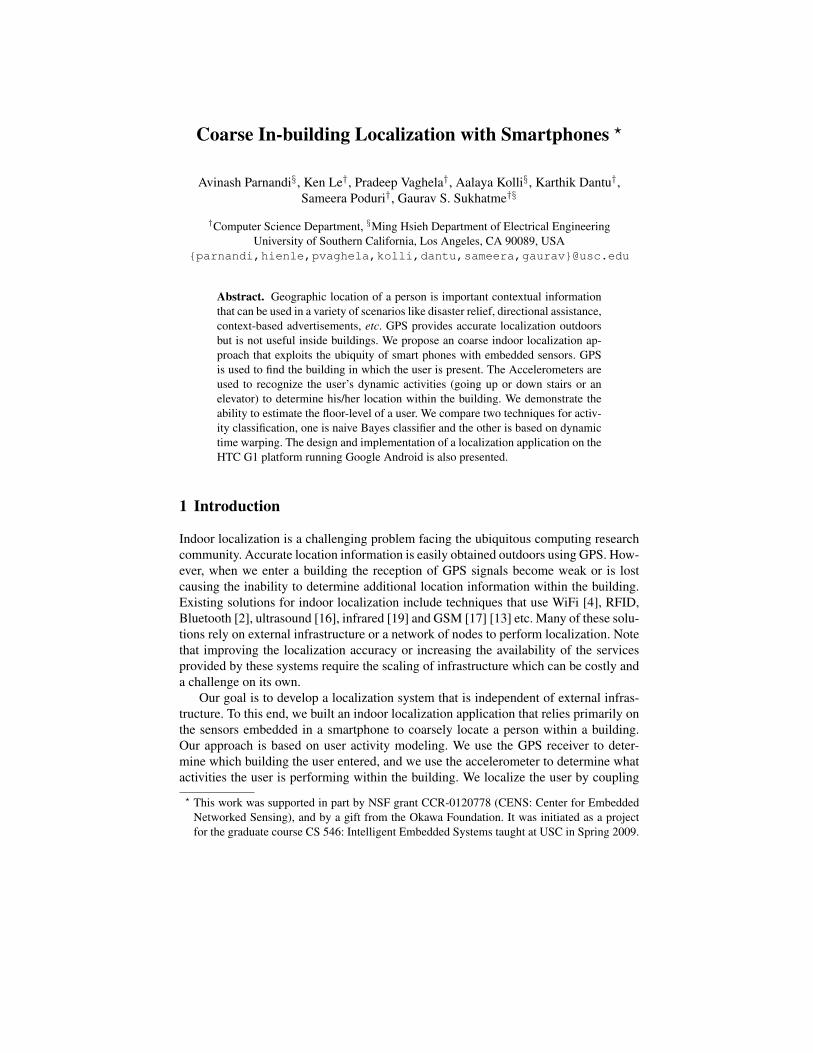
Fig. 5: Cluster plot and Misclassification rate of features
4. kurtosis (along y) is a measure of how much a distribution is peaked at the centerof the distribution.Figure 5 shows a cluster plot of a set of training data along a pair of selected features
(average y and kurtosis y). It can be seen that the feature pair confidently separates thethree activities. We estimate the likelihood distributions to be used in equation 1 asGaussian distributions that minimize the least squares error of the training data.
4.2 Dynamic Time WarpingDynamic time warping (DTW) is an algorithm for measuring similarity between twosignals which may vary in time or speed [12]. It has been used successfully to classifyactivities that have a cyclic pattern. A reference signal called a template, which is onecycle of the activity, is generated for each activity based on training data and new datais compared with the templates to find the best match on the basis of their Euclideandistance.
We extracted templates manually from the training data. Figure 6 shows an exampleof the stairs up template. Classification of data is performed by using a sliding windowof y acceleration data and finding its (Euclidean) distance to each of the activity tem-plates. The window is labeled with the activity that gives the least distance. The DTWbased approach had an average accuracy of 87.5% .
4.3 Elevator Activity DetectionAs mentioned earlier, when using naive Bayes classifier, it was difficult to find featuresthat allow classification of elevator up and elevator down activities. Preferring to usenaive Bayes over DTW for efficiency, we needed to develop an auxiliary method fordetecting elevator rides. The method we developed specifically for elevator detectionperforms template matching using a convolution operator. The first step in this methodis to filter out all data that has a standard deviation above a certain threshold. Observing

8 A. Parnandi, K. Le, P. Vaghela, A. Kolli, K. Dantu, S. Poduri, G. S. Sukhatme
Fig. 6: stairs up activity template
Figure 4, we note that elevator activity has significantly less variance than other activ-ities. With a correctly chosen threshold, the filtered data leaves us only with elevatorpeaks as shown in Figure 7.
Fig. 7: Acceleration data post filtering
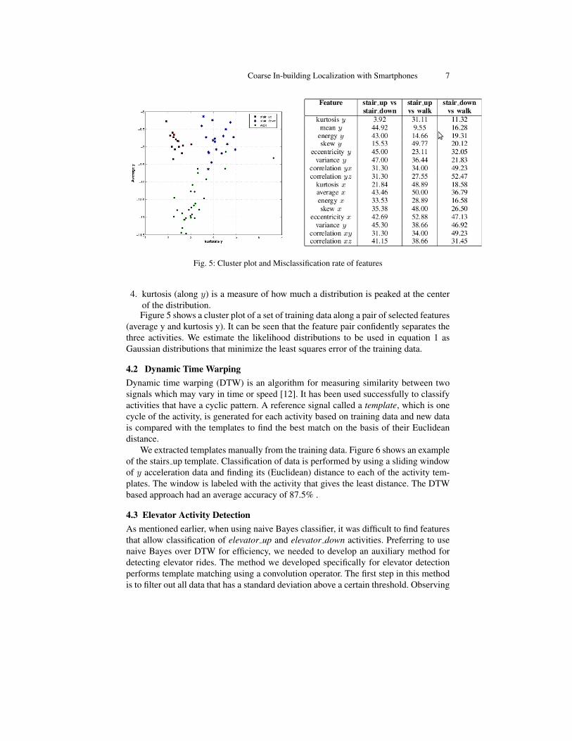
The filtered data is then convolved with the elevator activity template. A typicaloutput of the convolution step is shown in Fig. 8. When the incoming elevator datais convolved with the standard elevator template, the points in the output curve corre-sponding to the elevator minima get amplified and are shown as the maxima in Fig. 8(the minima gets amplified because our template has downward facing tip) while theelevator maxima gets registered as a minima in the convolution output.
Coarse In-building Localization with Smartphones 9
Fig. 8: Convolutional elevator detector: the minima and maxima with respect to the threshold
5 Experiments and Results
This section goes over the various experiments we carried out and their results.
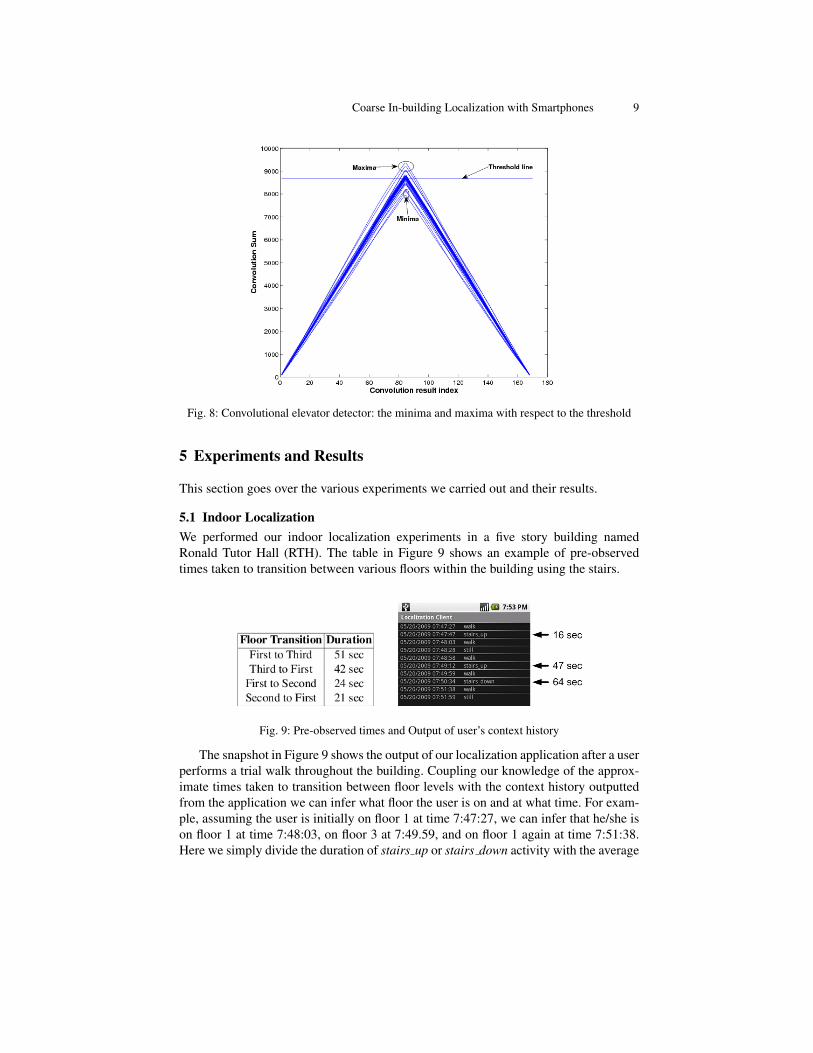
5.1 Indoor LocalizationWe performed our indoor localization experiments in a five story building namedRonald Tutor Hall (RTH). The table in Figure 9 shows an example of pre-observedtimes taken to transition between various floors within the building using the stairs.
Fig. 9: Pre-observed times and Output of user’s context history
The snapshot in Figure 9 shows the output of our localization application after a userperforms a trial walk throughout the building. Coupling our knowledge of the approx-imate times taken to transition between floor levels with the context history outputtedfrom the application we can infer what floor the user is on and at what time. For exam-ple, assuming the user is initially on floor 1 at time 7:47:27, we can infer that he/she ison floor 1 at time 7:48:03, on floor 3 at 7:49.59, and on floor 1 again at time 7:51:38.Here we simply divide the duration of stairs up or stairs down activity with the average
10 A. Parnandi, K. Le, P. Vaghela, A. Kolli, K. Dantu, S. Poduri, G. S. Sukhatme
time to transition up or down one floor level to determine the number of floor transi-tions. The inferences made match with the actual floors the user was on during the trialrun. The results here show the potential possibilities of performing localization usinginference with dynamically retrieved contextual knowledge about the user and staticbackground knowledge about the building.
5.2 Activity ClassificationTo test activity classification we asked 10 users with different physique and walkingstyles to perform composite activities. We tested two cases. The first case, User Spe-cific, is where the classifier is trained and tested uniquely for each user. In this case,the trial begins by placing the application in training mode and asking the user to per-form each activity several times. After training the classifier specifically for the user,the application is switched to operational mode and the user performs the same set ofactivities to see how well they can be classified. In the second case, General, the classi-fier is generically trained with a couple people and tested on all. In this case, we beginby selecting only a couple of users to train the phone. We then switch to operationalmode, and ask every user to exercise the set of activities to see how well the genericallytrained classifier performs.
Results from our tests show that the User Specific case classified with 97% accuracyand the General case classified with 84% accuracy. In either case, after running theclassified activities through the filter in the Classifier+Filter service all misclassifiedactivities were removed.
5.3 ElevatorUsing the elevator detection method we developed, we were able to detect elevatorrides pretty well. The key part about an elevator ride (whether going up or down) is thatconvolution maxima and minima always occur in pair, at the start and end point. This isevident from Figure 7. By keeping track of these max-min pairs and their correspondingtimestamps we can find out how much time the user spent in the elevator. To test elevatordetection we began by extracting an elevator ride template from a trial ride of one user.We then convolved this template with the filtered acceleration data of test runs by 10other users. Our algorithm detected the elevator rides in each of these runs with noerrors.
5.4 AnalysisIn Figure 10 we compare the performance of the generally trained classifier, user spe-cific trained classifier, and DTW for each of the 10 users. For the classifiers we use thefour features mentioned earlier. Naive Bayes classifier and DTW results are comparedwith ground truth. The number of false positives divided by total number gives the er-ror percentage. Note that convolution based elevator detection is used in the classifiercases. DTW with generic templates performed better than the generally trained classi-fier for most users. The user specific trained classifier performed the best on all users.Computationally, DTW is much more expensive and time consuming than the naiveBayes classifier. Since a mobile device must use its resources efficiently and since therewas not a clear advantage for using DTW, naive Bayes classification is our method ofchoice.

Coarse In-building Localization with Smartphones 11
Fig. 10: Percentage of misclassification between Classifier and DTW
6 Conclusion and Future Work
This paper presents an indoor localization system that demonstrates the ability to per-form floor level detection using mobile phones. Specifically, we use the accelerome-ters of the phone to detect activities like stair up, stair down, elevator up and eleva-tor down and further investigate these activities to detect movement between floors.We propose two algorithms (DTW and naive Bayes classifier) to perform this activitydetection. These algorithms offer a trade off between detection accuracy and computa-tional requirement (energy efficiency).
Our initial results for floor-level detection are encouraging. We have manually com-puted the average times needed to traverse up/down a floor for one building but thismay vary significantly across different users and different buildings. Our next step is toimplement a learning algorithm to adapt this (with user feedback) for the buildings thatthe particular user visits. We would also like to implement a coordinate frame transfor-mation on the phone so that the application becomes independent of where the phoneis on the body.
References
1. Google Android. http://www.android.com/.2. L. Aalto, N. Gothlin, J. Korhonen, and T. Ojala. Bluetooth and wap push based location-
aware mobile advertising system. In MobiSys ’04: Proceedings of the 2nd international con-ference on Mobile systems, applications, and services, pages 49–58, New York, NY, USA,2004. ACM.
3. J. Baek, G. Lee, W. Park, and B.-J. Yun. Accelerometer signal processing for user activitydetection. volume Vol.3, pages 610 – 17, Berlin, Germany, 2004.

12 A. Parnandi, K. Le, P. Vaghela, A. Kolli, K. Dantu, S. Poduri, G. S. Sukhatme
4. P. Bahl and V. N. Padmanabhan. RADAR: An in-building RF-based user location and track-ing system. In International Conference on Computer Communications (INFOCOM), pages775–784, 2000.
5. T. Choudhury, G. Borriello, S. Consolvo, D. Haehnel, B. Harrison, B. Hemingway, J. High-tower, P. . Klasnja, K. Koscher, A. Lamarca, J. A. Landay, L. Legrand, J. Lester, A. Rahimi,A. Rea, and D. Wyatt. The mobile sensing platform: An embedded activity recognitionsystem. IEEE Pervasive Computing, 7(2):32–41, 2008.
6. A. Jeon, J. Kim, I. Kim, J. Jung, S. Ye, J. Ro, S. Yoon, J. Son, B. Kim, B. Shin, and G. Jeon.Implementation of the personal emergency response system using a 3-axial accelerometer.In Information Technology Applications in Biomedicine, 2007. ITAB 2007. 6th InternationalSpecial Topic Conference onX, pages 223–226, Nov. 2007.
7. A. Jeon, J. Kim, I. Kim, J. Jung, S. Ye, J. Ro, S. Yoon, J. Son, B. Kim, B. Shin, and G. Jeon.Implementation of the personal emergency response system using a 3-axial accelerometer.pages 223 – 226, Tokyo, Japan, 2008.
8. A. Krause, M. Ihmig, E. Rankin, D. Leong, S. Gupta, D. Siewiorek, A. Smailagic,M. Deisher, and U. Sengupta. Trading off prediction accuracy and power consumption forcontext-aware wearable computing. In ISWC ’05: Proceedings of the Ninth IEEE Inter-national Symposium on Wearable Computers, pages 20–26, Washington, DC, USA, 2005.IEEE Computer Society.
9. M. Mathie, A. Coster, N. Lovell, and B. Celler. Accelerometry: providing an integrated,practical method for long-term, ambulatory monitoring of human movement. PhysiologicalMeasurement, 25(2):1 – 20, 2004/04/.
10. E. Miluzzo, N. D. Lane, K. Fodor, R. Peterson, H. Lu, M. Musolesi, S. B. Eisenman,X. Zheng, and A. T. Campbell. Sensing meets mobile social networks: the design, im-plementation and evaluation of the cenceme application. In SenSys ’08: Proceedings of the6th ACM conference on Embedded network sensor systems, pages 337–350, New York, NY,USA, 2008. ACM.
11. T. M. Mitchell. Machine Learning. McGraw-Hill, New York, 1997.12. R. Muscillo, S. Conforto, M. Schmid, P. Caselli, and T. D’Alessio. Classification of motor
activities through derivative dynamic time warping applied on accelerometer data. pages4930–4933, Aug. 2007.
13. V. Otsason, A. Varshavsky, A. LaMarca, and E. de Lara. Accurate gsm indoor localization.pages 141 – 58, Berlin, Germany, 2005//.
14. S. Preece, J. Goulermas, L. Kenney, D. Howard, K. Meijer, and R. Crompton. Activity iden-tification using body-mounted sensors-a review of classification techniques. PhysiologicalMeasurement, 30(4):R1–R33 –, 2009/04/.
15. N. Ravi, N. Dandekar, P. Mysore, and M. L. Littman. Activity recognition from accelerom-eter data. volume 3, pages 1541 – 1546, Pittsburgh, PA, United states, 2005.
16. A. Savvides, C.-C. Han, and M. B. Srivastava. Dynamic fine-grained localization in ad-hocnetworks of sensors. In International Conference on Mobile Computing and Networking(MOBICOM), pages 166–179, 2001.
17. A. Varshavsky, E. de Lara, J. Hightower, A. LaMarca, and V. Otsason. GSM indoor local-ization. Pervasive and Mobile Computing, 3(6):698–720, 2007.
18. R. Want, A. Hopper, V. Falcao, and J. Gibbons. The active badge location system. ACMTransactions on Information Systems, 10(1):91–102, Jan. 1992.
19. A. Ward, A. Jones, and A. Hopper. A new location technique for the active office. PersonalCommunications, IEEE, 4(5):42–47, Oct 1997.
20. O. Woodman and R. Harle. Pedestrian localisation for indoor environments. In UbiComp’08: Proceedings of the 10th international conference on Ubiquitous computing, pages 114–123, New York, NY, USA, 2008. ACM.