Breaking down the tropospheric circulation response by forcing
Upload
independentCategory
view
2download
0
930
ABSTRACT
New apatite fi ssion-track data, paleoele-vation estimates from paleobotany, and recently acquired geological data from the Eastern Cordillera of Colombia document the onset of increased exhumation rates in the northeastern Andes at ca. 3 Ma. The Eastern Cordillera forms an effi cient oro-graphic barrier that intercepts moisture-laden winds sourced in the Amazon low-lands, leading to high rainfall and erosion gradients across the eastern fl ank of the range. In contrast, the drier leeward west-ern fl ank is characterized by lower rates of deformation and exhumation. In light of the geological evolution of the Eastern Cordil-lera, the combination of these data sets sug-gests that the orographic barrier reached a critical elevation between ca. 6 and ca. 3 Ma, which ultimately led to protracted, yet more focused erosion along the eastern fl ank. Sequentially restored structural cross sec-tions across the eastern fl ank of the Eastern Cordillera indicate that shortening rates also have increased during the past 3 Ma. From fi ssion-track and structural cross-section balancing, we infer that accelerated exhumation led to increasing tectonic rates on the eastern fl ank, creating a pronounced topographic and structural asymmetry in the Eastern Cordillera. The tectonic and climatic evolution of this orogen thus makes
it a prime example of the importance of cli-matic forcing on tectonic processes.
Keywords: Apatite fi ssion tracks, deformation, balanced cross sections, erosion, orographic barriers, paleoelevation, paleoclimate.
INTRODUCTION
Important advances have been made in the understanding of climatic forcing of orogenic evolution over the past several decades (Koons, 1989; Molnar and England, 1990; Beaumont et al., 1992; Masek et al., 1994; Willett, 1999; Montgomery et al., 2001; Molnar, 2004; Strecker et al., 2007). Probably one of the most important conclusions has been that active shortening and tectonic uplift may be localized in areas where protracted erosion impacts tectonically active landscapes. Here, focused high precipitation and exhumation result from orographic barriers that intercept moisture and generate powerful erosional regimes on the windward fl anks of an orogen (Horton, 1999; Montgomery et al., 2001; Reiners et al., 2003; Thiede et al., 2005; Barnes and Pelletier, 2006). Beaumont et al. (1992) and Willett (1999) argued that the degree of asym-metry of an orogen may be highly dependent on climatic (e.g., precipitation) gradients. Their conclusions rely on numerical modeling of an idealized orogen with long-term precipitation focused on one side and can also be reproduced in numerical and sandbox models. These models show that long-term erosion and sedimentation patterns are fundamental in determining struc-
tural styles and evolution (Dahlen and Suppe, 1988; Mugnier et al., 1997; Koyi et al., 2000; Whipple and Meade, 2004; Hoth et al., 2006). If such conditions are associated with wedge-shaped thrust belts, focused precipitation and erosional removal of rock may ultimately lead to out-of-sequence thrusting (Mugnier et al., 1997; Koyi et al., 2000; Hilley and Strecker, 2004). In contrast, more arid, interior sectors of an orogen may experience less tectonic activity due to the increase of lithostatic stresses resulting from fail-ure to evacuate erosional materials (e.g., Sobel and Strecker, 2003; Hilley and Strecker, 2005).
The Himalayas, the southern and central Andes, and the New Zealand Alps are premier examples of orogens where interactions between tectonics and climate have been documented and where the interplay between them may have fundamentally infl uenced the evolution of indi-vidual mountain ranges and intraorogenic pla-teaus (Montgomery et al., 2001; Koons et al., 2002; Sobel et al., 2003; Sobel and Strecker, 2003; Thiede et al., 2005; Strecker et al., 2007). In the northern Andes, where strong precipita-tion gradients also exist, such relations have not been explored. The NNE-oriented northern Andes have created important precipitation gra-dients across the Western and Eastern cordille-ras (Fig. 1). In fact, with ~7 m of annual precipi-tation (Fig. 1), the humid fl anks of these ranges receive one of the highest amounts of precipi-tation on Earth. This sector of the Andes thus lends itself to a study of the interplay between tectonic activity, the spatiotemporal evolution of climatic gradients, and exhumation patterns.
For permission to copy, contact [email protected]© 2008 Geological Society of America
GSA Bulletin; July/August 2008; v. 120; no. 7/8; p. 930–949; doi: 10.1130/B26186.1; 13 fi gures; 3 tables.
Climatic forcing of asymmetric orogenic evolution in the Eastern Cordillera of Colombia
Andrés Mora†
Mauricio ParraManfred R. StreckerEdward R. SobelInstitut für Geowissenschaften, Universität Potsdam, Karl Liebnecht-Str 24, D14476 Potsdam-Golm, Germany
Henry HooghiemstraVladimir TorresInstitute for Biodiversity and Ecosystem Dynamics (IBED), Paleoecology and Landscape Ecology, Faculty of Science, University of Amsterdam, Kruislaan 318, 1098 SN Amsterdam, Netherlands
Jaime Vallejo JaramilloPetrobras-Colombia, Carrera 7, No 71-21, Torre B. Edifi cio Bancafé, Bogotá, Colombia
†E-mail: [email protected]

Climatic forcing of orogenic evolution
Geological Society of America Bulletin, July/August 2008 931
The eastern boundary faults of the Eastern Cordillera, here referred to as the Guaicaramo fault system (Fig. 1), constitutes a major plate boundary separating the structural domain of the Northern Andes microplate from the South American plate (Aggarwal, 1983). Between 4° and 5° N, the eastern fl ank of the Eastern Cordillera has accommodated signifi cantly more shortening, and basement rocks crop out at elevations ~2 km higher compared to the western fl ank (Toro et al., 2004; Mora et al., 2006; Fig. 2). In addition to the structural asymmetry, the distribution of rainfall is also asymmetric, and the more humid eastern fl ank strongly contrasts with the drier western parts (Fig. 1). Nevertheless, interactions between climate and tectonics remain poorly known. If signifi cant feedback between tectonics and cli-mate indeed existed in the Eastern Cordillera, it would likely be detectable through an erosional gradient. Therefore, we evaluated the role of erosional denudation in the context of the styles
and timing of the structures that constitute the mountain range. We collected fi eld structural data and constructed geologic cross sections to assess the degree of overall shortening and removal of cover units. We then carried out apa-tite fi ssion-track thermochronology to quantify the long-term role and timing of erosional denu-dation. In a third step, we examined published data on the paleofl oristic evolution of the area, the late Cenozoic sedimentary record, and ther-mochronology data to reconstruct range-wide late Cenozoic surface uplift, denudation, and tectonism. In our attempt to unravel tectonics and climate interactions we compare different domains in the Eastern Cordillera with remark-ably different Plio-Pleistocene denudation and uplift histories and explain their patterns in light of interactions between tectonically and climatically controlled migration of deforma-tion. Our investigation reveals that the uplift of the Eastern Cordillera generated an effec-tive orographic barrier for easterly moisture-
bearing winds, resulting in strong precipitation gradients across the range. Focused precipita-tion and removal of rocks conspire in sustaining high exhumation rates on the windward fl anks, whereas the drier leeward side is characterized by low rates, emphasizing the pivotal role of climate in the evolution of mountain ranges.
REGIONAL GEOLOGY
The Eastern Cordillera is the easternmost range in the northern Andes (Fig. 1). It is an inversion orogen that coincides with a Lower Cretaceous rift (Colleta et al., 1990; Sarmiento-Rojas, 2001; Mora et al., 2006). Structurally, the Eastern Cordillera can be divided into three major areas perpendicular to strike, including the western and eastern marginal thrust belts with associated basement uplifts, and the Bogotá Basin (Fig. 1). Situated between two mountain ranges, the Bogotá Basin forms a central, low-relief highland with outcrops of Cretaceous and
B
0 80 KmN
Precipitation (mm)
5700
650
6°
5°
4°
-72°-73°-74°
PKPK
A
B
B'
A'
PK
SbBA
B
B'B'
A'A'
PKPK
SbBSbBA
B
B'
A'
125
4
40
159
89 52129
441
1548
PK
PK
SbB
5000 m
0 m
0 80 KmN
6°
5°
4°
-72°-73°
Swath profilein Fig 3A Fig 2A
PLATE
PLATEECNAZCA SOUTH
AMERICANPLATE
CARIBBEAN
-74° 0°
6°
-73°
Fig 2B
Yopa
l Thr
ust
Yopa
l Thr
ust
Gua
icar
amo
Thrus
t
Gua
icar
amo
Thrus
t
Leng
upa T
hust
Leng
upa T
hust
La S
alin
a Th
rust
Ho n
da T
hrus
t
Ho n
da T
hrus
tB
ituim
a T
hust
Bitu
ima
Thu
st
Cam
bao
Cam
bao
Mag
dalena T
hrus
t
Mag
dalena T
hrus
t
Servi
tá Fault
Servi
tá Fault
RNRNRN
RBRBRB
RSRSRS
RURURU
RGtRGtRGt
RGyRGyRGy
RHRHRH
RMRMRMLa
Sal
ina
Thru
st
A
Figure 1. (A) General features of the Colombian Eastern Cordillera. Regional structure with the main thrusts bounding the major topo-graphic breaks in the Eastern Cordillera. River discharges (values in red in m3/sec) of the main rivers in the eastern and western fl anks clearly showing higher values in the eastern side rivers fl owing toward the Orinoco (e.g., Guayuriba—RGy; Guatiquía—RGt; Humea—RH; Upía—RU. Western rivers fl owing toward the Magdalena—RM (e.g., Negro—RN, Bogotá—RB, and Sumapaz—RS rivers) do not manage to cut across the structures. SbB—Sabana de Bogotá basin. The box in the smaller map shows the location of the bigger area. EC—Eastern Cordillera. (B) Precipitation map compiled from data of 424 meteorological stations for the past 20 yr from Instituto de Hidrología, Meteorología y Estudios Ambientales de Colombia (IDEAM). The eastern slopes of the Eastern Cordillera clearly constitute a present-day orographic barrier for winds, therefore concentrating precipitations to the E.

Mora et al.
932 Geological Society of America Bulletin, July/August 2008
Guyana Shield Basement
Paleogene
Neogene
LKUK
LKLK
T
3.51(7)3.51(7)
4.05(8)4.05(8)
0.49(5)0.49(5)
0.77(2)0.77(2)
0.27(1)0.27(1) 1.38(3)1.38(3)4.45(4)4.45(4)
3.51(7)
4.05(8)
0.49(5)
74°W
4°N
4°30'N0.77(2)
0.27(1) 1.38(3)4.45(4) FAFAFASJ
FSJ
FSJ
F
STFSTFSTFM
SCM
SCM
SC
GTGTGT
LKUK
PK
LK
NFNFNF
LK
PK
T
D
C
E
E'
D'
C'
GuatiquiaGuatiquiaGuatiquiaGuatiquia
HumeaHumeaHumeaHumea
GuayuribaGuayuribaGuayuribaGuayuriba
Anaconda WellAnaconda WellAnaconda Well
101010
99
8877
6655 44
33
2211
17171711-1411-1411-14 15-1615-1615-16
10 kmFig. 5
0
N
30
km
Upper Cretaceous
Lower Cretacous
Gomez (2001) AFT Profiles
AFT sample location (this study)
5°
2.6 ± 0.3 Ma2.7 ± 0.3 Ma
3.0 ± 0.4 Ma2.9 ± 2.1 Ma
2.3 ± 0.6 Ma2.6 ± 0.6 Ma2.6 ± 1.1 Ma
2.8 ± 0.4 Ma
2.6 ± 0.7 Ma2.4 ± 0.7 Ma
2.8 ± 0.4 Ma2.3 ± 0.4 Ma
3.8 ± 0.7 Ma0.9 ± 0.2 Ma
1.2 ± 0.4 Ma0.8 ± 0.3 Ma
1.6 ± 0.4 Ma
30 km
Triassic-Jurassic
Paleozoic-Carboniferous
Eastern flank
Western flank
SbBSbBSbB
GS VA
B
Paleozoic-Devonian
Andean Basement
SbB
A
Figure 2. (A) Digital elevation model of the Eastern Cordillera including the deeply dissected Eastern fl ank, the central fl at-lying Sabana de Bogotá basin and the topographically lower western fl ank. GS—Guaduas syncline; VA—Villleta anticlinorium. (B) Topographic and gen-eralized geologic map of the area studied in detail (see location in Fig. 1). Apatite fi ssion-track (AFT) sample locations are shown in red, and vitrinite refl ectance values are shown in black. Abbreviations: FA—Farallones anticline; GT—Guaicaramo thrust; LK—Lower Cretaceous units; MSC—Mirador short-cut fault; NF—Naranjal fault; PK—Pre-Cretaceous units; SbB—Sabana de Bogotá; SJF—San Juanito fault; STF—Servita fault; T—Tertiary units.
Climatic forcing of orogenic evolution
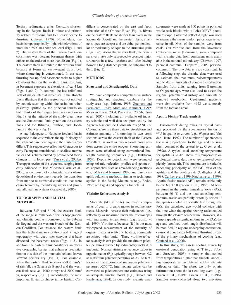
Geological Society of America Bulletin, July/August 2008 933
Tertiary sedimentary units. Cenozoic shorten-ing in the Bogotá Basin is minor and primar-ily related to folding and to a lesser degree to thrusting (Julivert, 1970). Nonetheless, the basin is topographically high, with elevations of more than 2500 m above sea level (Figs. 1 and 2). The western fl ank of the Eastern Cordillera constitutes west-vergent basement thrusts with offsets on the order of more than 20 km (Fig. 1). The eastern fl ank is similar to the western fl ank because it forms an east-vergent thrust belt where shortening is concentrated. In the east, thrusting has uplifted basement rocks to higher elevations than on the western fl ank, resulting in basement exposure at elevations of ca. 4 km (Figs. 1 and 2). In contrast, the low relief and lack of major internal structures in the Bogotá Basin illustrate that this region was not uplifted by tectonic stacking within the basin, but rather passively uplifted by the principal thrusts on both fl anks of the ranges (see cross section in Fig. 1). At the latitude of the study area, these are the Guaicaramo fault system on the eastern fl ank and the Bituima, Cambao, and Honda faults in the west (Fig. 1).
A late Paleogene to Neogene foreland basin sequence to the east refl ects the uplift history of the adjacent basement highs in the Eastern Cor-dillera. This sequence overlies late Cretaceous to early Paleogene transitional, to shallow marine facies and is characterized by pronounced facies changes in its lower part (Parra et al., 2005a). The upper section of the sequence, ranging from early Miocene to late Miocene (Parra et al., 2006), is composed of continental strata whose depositional environment records the transition from marine to terrestrial conditions that were characterized by meandering rivers and proxi-mal alluvial fan systems (Parra et al., 2006).
TOPOGRAPHY AND FLUVIAL NETWORK
Between 3.5° and 6° N, the eastern fl ank of the range is remarkable for its topographic and climatic contrasts compared to the Sabana de Bogotá and the western branch of the East-ern Cordillera. For instance, the eastern fl ank has the highest mean elevations and a jagged topography with deep river canyons that have dissected the basement rocks (Figs. 1–3). In addition, the eastern fl ank constitutes an effec-tive orographic barrier that enhances precipita-tion on this side of the mountain belt and leaves leeward sectors dry (Fig. 1). For example, while the eastern fl ank receives ~5000 mm/yr of rainfall, the Sabana de Bogotá and the west-ern fl ank receive ~1000 mm/yr and 2000 mm/yr, respectively (Fig. 1). Accordingly, the most important fl uvial discharge in the Eastern Cor-
dillera is concentrated on the east and feeds tributaries of the Orinoco River (Fig. 1). Rivers on the eastern fl ank are shorter than rivers in the Sabana de Bogotá and the western fl ank, chan-nel slopes are steeper and are either perpendicu-lar or moderately oblique to the structural grain (Figs. 1–3). Along the western fl ank, the princi-pal rivers have only succeeded to crosscut major structures in a few locations and after having fl owed a long distance parallel to subparallel to them (Fig. 1).
METHODS
Structural and Stratigraphic Data
We have compiled a comprehensive surface stratigraphic and structural database for the study area (e.g., Julivert, 1963; Guerrero and Sarmiento, 1996; Mora and Kammer, 1999; Mora and Parra, 2004; Parra et al., 2005b; Parra et al., 2006), including all available oil indus-try seismic and well-data sets provided by the Agencia Nacional de Hidrocarburos (ANH) of Colombia. We use these data to retrodeform and estimate amounts of shortening in two cross sections across the eastern fl ank of the Eastern Cordillera, as well as two regional cross sec-tions across the entire orogen. Shortening esti-mates were obtained using conventional line-length balancing techniques (e.g., Dahlstrom, 1969). Depths to detachment were estimated using seismic refl ection profi les and geometri-cal approaches, such as area-balancing methods (e.g., Mitra and Namson, 1989) and basement-uplift balancing methods, similar to techniques applied in the Rocky Mountains (e.g., Erslev, 1986; see Fig. 4 and Appendix for details).
Vitrinite Refl ectance Analysis
Macerals (like vitrinite) are major compo-nents of coal or organic matter in sedimentary rocks. Macerals increase their refl ectance (i.e., refl ectivity as measured under the microscope) with increasing temperatures (e.g., Bustin et al., 1990). Vitrinite refl ectance (R
o) is the most
widespread measurement of the maturity of organic matter as related to heating, commonly associated with burial. Thus, vitrinite-refl ec-tance analysis can provide the maximum paleo-temperatures reached by sedimentary rocks dur-ing burial. Normal vitrinite refl ectance values in organic matter (R
o) typically range between 0.2
at maximum paleotemperatures of <30 to 6 °C for rocks that experienced maximum paleotem-peratures >250 °C. Intermediate values can be converted to paleotemperature estimates using an adequate kinetic model (e.g., Barker and Pawlewicz, 1994). In our study, vitrinite mea-
surements were made at 100 points in polished whole-rock blocks with a Leica MPV3 photo-microscope. Polarized refl ected light was used to measure the mean random percentage refl ec-tance in oil. Most of the samples were from coals. Our vitrinite data from the lowermost Cretaceous rocks (Berriasian) were compared with vitrinite data from equivalent units avail-able in the national oil industry (Chevron, 1997, personal commun.; Ecopetrol, 2005, personal commun.). The two data sets are consistent. In a following step, the vitrinite data were used to estimate the maximum paleotemperatures and to derive amounts of removed overburden. Samples from units, ranging from Barremian to Oligocene age, were also used to assess the regional paleothermal history and amounts of removed overburden. Geothermal gradients were also available from ~678 wells, mostly from the foreland areas.
Apatite Fission-Track Analysis
Fission-track dating relies on crystal dam-age produced by the spontaneous fi ssion of 238U in apatite or zircon (e.g., Wagner and Van den Haute, 1992). The number of spontaneous tracks is proportional to the age and the ura-nium content of the crystal (e.g., Green et al., 1989a). A typical total annealing temperature for apatite is ~120°; above this temperature on geological timescales, tracks are removed com-pletely (annealed). This temperature is variable, depending principally on the F/Cl ratio of the apatites and the cooling rate (Gallagher et al., 1998; Carlson et al., 1999; Ketcham et al., 1999). Apatite fi ssion tracks (AFT) remain stable only below 60 °C (Gleadow et al., 1986). At tem-peratures in the partial annealing zone (PAZ), between 60 °C and the total annealing tem-perature, tracks are partially or totally erased. If the apatites cooled suffi ciently fast through the PAZ, the calculated age would coincide with the time when the apatite-bearing rocks cooled through the closure temperature. However, if a sample spends a signifi cant time in the PAZ, the age and confi ned track-length distribution will be modifi ed. In regions undergoing contraction, erosional denudation following thrusting is one of the primary mechanisms of cooling (e.g., Coutand et al., 2006).
In this study, we assess cooling driven by erosional denudation using AFT (e.g., Sobel and Strecker, 2003) in samples that cooled from temperatures higher than the total anneal-ing temperatures, as determined by vitrinite refl ectance data. Therefore, we only obtain information about the last cooling event (e.g., Green et al., 1989a; Green et al., 1989b). Samples were collected along two elevation
Mora et al.
934 Geological Society of America Bulletin, July/August 2008
Distance (km) Distance (km)300 0 0 300
Elevation (m)
W E
Guayuriba
Guatiquía
HumeaNegro
Sumapaz
Bogotá
B
W E
Minimum
Mean
MaximumSabana de Bogotá
Eastern FlankWestern Flank
40 80 120 160
Distance (km)
0
0
2000
4000
Ele
vatio
n (m
)
A
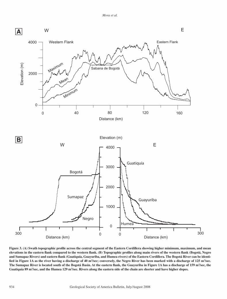
Figure 3. (A) Swath topographic profi le across the central segment of the Eastern Cordillera showing higher minimum, maximum, and mean elevations in the eastern fl ank compared to the western fl ank. (B) Topographic profi les along main rivers of the western fl ank (Bogotá, Negro and Sumapaz Rivers) and eastern fl ank (Guatiquía, Guayuriba, and Humea rivers) of the Eastern Cordillera. The Bogotá River can be identi-fi ed in Figure 1A as the river having a discharge of 40 m3/sec; conversely, the Negro River has been marked with a discharge of 125 m3/sec. The Sumapaz River is located south of the Bogotá Basin. At the eastern fl ank, the Guayuriba in Figure 1A has a discharge of 159 m3/sec, the Guatiquía 89 m3/sec, and the Humea 129 m3/sec. Rivers along the eastern side of the chain are shorter and have higher slopes.

Climatic forcing of orogenic evolution
Geological Society of America Bulletin, July/August 2008 935
profi les to decipher age and elevation trends and derive apparent exhumation rates (e.g., Sobel and Strecker, 2003). Thermochrono-logic data alone do not provide rock uplift or paleoelevation. We therefore compare surface uplift history deduced from published paleofl o-ristic data with the denudation history obtained from apatite fi ssion-track analysis.
In the following sections we present 17 new AFT ages from the eastern fl ank of the East-ern Cordillera and compare them to published AFT data from the western fl ank to examine the Late Cenozoic exhumation histories of the two regions. Data and methodological details are presented in Tables 1 and 2.
STRUCTURAL STYLES AND TOTAL SHORTENING ESTIMATES FROM THE EASTERN CORDILLERA
A correct assessment of the structural styles of the Eastern Cordillera is required to support shortening estimates. In our cross sections we assume that the principal marginal thrusts in the Eastern Cordillera fl atten at depth (Fig. 4) to transfer deformation throughout the middle crust from the west (e.g., the Central Cordil-lera), as has been observed in other inverted intra-plate basins (e.g., Chapman, 1989; Rob-erts, 1989; Deeks and Thomas, 1995; Sinclair, 1995) and other inversion orogens (Beauchamp
et al., 1996). Based on this consideration, we deduced the depth to a mid-crustal detachment using a similar method as the applied by Col-leta et al. (1990) and Cortés et al. (2006) (see Appendix and Fig. 4). In our cross sections, we modeled the Eastern Cordillera as a biver-gent orogen with two main detachments. The assumption that the eastern detachment is the principal structure and the western, east-dip-ping detachment is a backthrust (Figs. 1 and 4) is supported by a major change in the character of the basement in the eastern Llanos foreland. The eastern Guaicaramo fault system (Fig. 1) separates a phyllitic basement domain reported ubiquitously in the Eastern Cordillera from the
0
12
24
36 km
0
12
24
36
12
24
36 km
0
12
24
36 km
0
12
24
36
0
12
24
36
Retrodeformed state
Deformed state
Exess area: 1340 km
Total shortening = 58 km
0
Cam
bao
Th
rust
Bit
uim
a Th
rust
Len
gu
pá
Fau
lt
Gu
aica
ram
o T
hru
st
A
B
Figure 4. (A) Cross section A–A′ (location in Fig. 1) and digital elevation model of the Eastern Cordillera at the latitude of the Bogotá Basin (Sabana de Bogotá). The inferred subsurface geometry implies that the Bogotá basin is a piggy-back basin uplifted on top of the western marginal thrust faults like the Cambao and Bituima faults. (B) Retrodeformation of cross section in Figure 4A, and deformed state cross section. The comparison of both allows calculation of a total shortening of 58 km in the Eastern Cordillera. The area marked on the deformed state cross section is the excess area used (location in Fig. 1) to estimate depths to detachment (see Appendix for details).

Mora et al.
936 Geological Society of America Bulletin, July/August 2008
migmatite and igneous basement rocks of the Guyana shield.
In a subsequent step, additional geometric considerations allow us to model the Sabana de Bogotá as an area passively transported on top of the gently dipping back limb of the basement thrusts of the western marginal thrust belt (Fig. 4). Accordingly, we modeled the boundary of the westward-dipping panel east of the Sabana de Bogotá as an active hinge that coincides at depth with a bend in the main west-dipping detachment (Fig. 4). Therefore, in our cross section A–A′, surface uplift in the Sabana de Bogotá is not necessarily depen-dent on movement along the eastern Guaicar-amo fault system (see Appendix and Fig. 4). The validity of this assumption is underscored by observations from the Magdalena thrust system. Here, where the western marginal thrust system (detaching at ca. 20 km depth) is superseded by the Magdalena thrust system with a fl at detachment at <10 km toward the south (compare cross sections in Figs. 2B and 4), the Eastern Cordillera becomes an asym-metric block, tilted to the west by the eastern marginal thrusts and still detaching at more than 20 km.
Inversion tectonics plays a fundamental role in the present-day structure of the eastern fl ank of the Eastern Cordillera (Mora et al., 2006). We summarize the structural style of this area from west to east. East of the Sabana de Bogotá, several basement highs are bounded by Lower Cretaceous normal faults, such as the San Juanito and Naranjal faults (Figs. 5–7). To the east, the Lower Cretaceous Servitá normal fault was reactivated during the Andean orogeny as a major basement thrust, in contrast to the San
Juanito and Naranjal faults, which have under-gone only minor contractional reactivation. Therefore, the latter two faults are passively uplifted by the Servitá fault. The Farallones anticline (Fig. 7) is a typical inversion structure (Mora et al., 2006) in the hanging wall of the Servitá fault and east of the San Juanito fault. East of the Servitá fault lies the Guaicaramo thrust (Figs. 1 and 2), inferred to have formed in response to the Servitá fault hanging-wall block pushing from behind (Mora et al., 2006). The Guaicaramo and Servitá faults are an integral part of the Guaicaramo fault system, which converges into the basal west-dipping main detachment (Fig. 4).
The Anaconda exploratory well and seismic lines in its vicinity provide good evidence that the main basement thrusts on the eastern fl ank (e.g., Mirador shortcut) dip between 20° and 30° (e.g., Narr and Perez, 1993; Mora et al., 2006; and Fig. 5). Using these fault geometries, we obtained consistent shortening estimates of ~30 km in three cross sections along the east-ern fl ank of the Eastern Cordillera (Figs. 4, 6B, and 7; see Appendix for details). Similar low-angle geometries are supported by seismic lines over the frontal faults along the western marginal thrust belt (e.g., Cambao and Honda thrusts). Relatively gently dipping fault angles demonstrate that vertical uplift estimates can only represent a minor component of much larger amounts of slip along the fault planes. These, and all other previously mentioned considerations, allow us to calculate a total of ~8 km shortening for the northern cross section (A–A′) along the Eastern Cordillera (Fig. 4; see Appendix for details). Overall, ~30 km of shortening along the eastern fl ank and ~23 km
along the western fl ank contrast with ~5 km of shortening in the Bogotá basin (Fig. 4).
NEW APATITE FISSION-TRACK DATA FROM THE EASTERN FLANK OF THE EASTERN CORDILLERA
The Guayuriba and Guatiquía river profi les (Figs. 2, 6, and 7) were collected in deeply incised valleys where the shallowly dipping lower Cre-taceous sedimentary sequence unconformably overlies the basement near the drainage divide. Therefore, samples from lower elevations in the river valleys should correspond to deeper crustal levels. Samples were collected in lower Creta-ceous units. Additional material was collected from basement rocks below the basal Cretaceous unconformity and at lower elevations. The set of samples analyzed represents the youngest ages reported to date in the Eastern Cordillera.
TABLE 1. APATITE FISSION-TRACK DATA Rho-S Rho-I P(x²) Rho-D Sample Latitude
(°N) Longitude
(°W) Lithology Elevation
(m) XI
(104 tracks/cm2)
NS (106
tracks/cm2)
NI
(%) ( 105 tracks/cm2)
ND Age (Ma)
U (ppm)
1 4.1614 73.6702 Meta-tuff 846 30 4.303 118 3.403 9334 76.1 1.202 4926 2.7 ± 0.3 35.4 2 4.1624 73.6690 Meta-tuff 831 40 3.378 75 2.806 6228 15.7 1.198 4926 2.6 ± 0.3 29.3 3 4.1986 73.6447 Conglomerate 567 30 2.716 56 2.277 4695 41.2 1.380 5748 3.0 ± 0.4 20.6 4 4.1962 73.7124 Sandstone 921 10 1.628 2 1.205 148 86.8 1.195 4850 2.9 ± 2.1 12.6 5 4.2029 73.7951 Meta-tuff 1200 30 3.342 13 4.530 1762 97.8 1.193 4926 1.6 ± 0.4 47.5 6 4.2674 73.8003 Meta-tuff 2215 30 3.120 16 3.598 1845 57.9 1.460 5089 2.3 ± 0.6 30.8 7 4.2933 73.7828 Meta-tuff 2963 30 4.158 24 3.640 2101 76.6 1.239 5089 2.6 ± 0.5 36.7 8 4.2925 73.7834 Meta-tuff 2954 20 3.047 6 2.605 513 86.0 1.214 5089 2.6 ± 1.1 26.8 9 4.2245 73.8941 Meta-tuff 1556 40 4.518 54 3.603 4307 74.2 1.217 4926 2.8 ± 0.4 37.0 10 4.3705 73.9008 Sandstone 1458 29 4.953 31 2.850 1784 49.7 1.213 4926 3.8 ± 0.7 29.4 11 4.4885 73.7312 Meta-tuff 3662 20 4.215 12 3.534 1006 6.2 1.193 4850 2.7 ± 0.7 37.0 12 4.4599 73.7083 Meta-tuff 3041 30 4.918 14 4.593 1307 79.0 1.263 5089 2.4 ± 0.7 45.7 13 4.4938 73.6809 Meta-tuff 2699 21 4.743 48 4.417 4470 35.6 1.432 5748 2.8 ± 0.4 38.6 14 4.4716 73.6931 Meta-tuff 2137 20 2.164 15 2.917 2022 0.0 1.388 5748 2.3 ± 0.8 26.3 15 4.4304 73.6802 Sandstone 1644 27 1.704 10 3.564 2092 54.5 1.419 5748 1.2 ± 0.4 31.4 16 4.4949 73.6570 Sandstone 2018 30 9.478 9 3.154 2995 97.7 1.406 5748 0.8 ± 0.3 28.0 17 4.4813 73.5575 Granite 2078 30 9.681 22 2.509 5701 86.6 1.347 5557 0.9 ± 0.2 23.3 Note: Apatites used for apatite fission-track (AFT) analysis were separated from whole rocks following conventional heavy liquid and magnetic methods. The separates were mounted in thin sections and polished to expose the internal surfaces of the grains and then etched for 20 s in 5.5 N nitric acid at 21 °C, to reveal fossil tracks. Samples were irradiated at Oregon State University TRIGA (Training, Research, Isotopes, General Atomics) reactor, and neutron fluxes were monitored withthe CN5 standard glass. Induced tracks in muscovite external detectors were revealed by etching at 21 °C in 40% HF acid. Fission tracks were counted with a Leica DMRM microscope with drawing tube located above a digitizing tablet and a Kinetec computer-controlled stage driven by the FTstage program (Dumitru, 1993). Fission- track ages were determined by measuring the mean track density and U concentration of the sample using the external detector method (Gleadow, 1981). Ages were calculated using the zeta calibration method (Hurford and Green, 1983). Samples were counted by Andrés Mora using a zeta value of 362 ± 7. Xl—number of crystalls counted; NS—spontaneous tracks; NI—induced tracks; ND—total number of tracks counted for determining track density.
TABLE 2. DPAR DATA Sample Sample
(field code)Dpar n Standard
deviationCorrected
Dpar 1 BV-277 3.222 82 0.244 2.861 2 BV-279 2.789 36 0.222 2.477 3 BV-427 2.940 35 0.402 2.610 5 BV-423 2.371 7 0.201 2.105 6 BV-192 2.459 9 0.322 2.184 7 BV-195 2.300 14 0.303 2.042 8 BV-196 2.129 5 0.168 1.890 9 BV-90 2.933 55 0.259 2.604 10 BV-151 2.567 12 0.213 2.279 11 FT-1 2.621 6 0.369 2.327 12 FT-6 2.269 9 0.293 2.015 13 SJ-1 2.621 31 0.133 2.327 14 SJ-5 2.769 7 0.120 2.459 15 SJ-2a 2.691 5 0.193 2.389 16 SJ-3 2.710 2 0.279 2.406 17 HUMEA 2.388 19 0.164 2.120 Note: Dpar values were corrected according to RayDonelick values (Sobel and Seaward, 2006).

Climatic forcing of orogenic evolution
Geological Society of America Bulletin, July/August 2008 937
Along the Guatiquía River profi le (Figs. 6 and 7 and Table 1), we analyzed six samples collected at elevations ranging from 1900 to 3600 m. The samples have no clear age and elevation trend. However, ages are younger in the hanging-wall block of the San Juanito fault compared to the footwall. East of this structure, all ages are younger than 1.6 Ma (maximum 1.2 ± 0.4 and minimum of 0.8 ± 0.2 Ma) and in the footwall to the west, all of them are older than 1.5 Ma (maximum age 2.8 ± 0.4 and minimum of 2.3 ± 0.8 Ma). Dpar has been defi ned by Donelick et al. (2005) as the arithmetic mean, fi ssion-track etch fi gure diameter parallel to the crystallographic c-axis, and is positively corre-
lated with chlorine content in apatites. Our Dpar measurements show similar kinetic character-istics for all of the samples along this profi le; these samples are close to the Fish Canyon apa-tite composition (Ketcham et al., 1999). There-fore, we assume that age differences are not due to compositional differences (Table 2).
In the Guayuriba River profi le (Fig. 6), located south of the Guatiquía River profi le and along strike, four basement samples were collected between 1200 and 2963 m (sam-ples 5–8, Figs. 2 and 6). Ages increase with elevation from 1.6 ± 0.4 Ma at 1200 m to 2.6 ± 0.5 Ma at 2954 m (Fig. 6). The age and eleva-tion plot yields an apparent denudation rate of
1.7 ± 1 mm/year (Fig. 6). In addition to these samples, we collected material from the low-ermost Cretaceous units (samples 3 and 10) or basement units located very close to the basal Cretaceous unconformity in different structural positions (samples 1, 2, 4, and 9). The ages from those samples have similar values between 2.6 ± 0.5 and 3.0 ± 0.4 Ma. These cooling ages are independent of the tectonic block sampled. Fur-thermore, ages from samples of nearly the same stratigraphic horizon are very similar in the dif-ferent blocks of the major structures. Basement samples from lower elevations in the Guayuriba River valley (e.g., samples 5 and 6, Figs. 2 and 6) have younger cooling ages than samples
0
1
2
3
Two
-way
Tra
velt
ime
(s)
0
1
2
3
0
1
2
3
0
1
2
3
Two
-way
Tra
velt
ime
(s)
4 km
Top Cretaceous
Paleozoic Basement
Servitá
Fault
Top Basement
Mirador Thrust
Top Basament
Tertiary
Anaconda-1 well
Anaconda-1 well
Figure 5. Interpreted migrated seismic line near the Ana-conda-1 well. It shows clearly the low-angle basement sheet of the frontal Mirador thrust. See location in Figure 2.

Mora et al.
938 Geological Society of America Bulletin, July/August 2008
10
9123
48
765
11
1615141312
Mir
ado
rth
rust
S an
Juan
ito
Fau
lt
Guayuriba River Profile
Guatiquíia River ProfileA
Lower Cretaceous units
Upper Paleozoic units
Andean metamorphic basement
Neogene molasse deposits
Tertiary (Paleogene-non-molassic Neogene) units
Upper Cretaceous units
2. 2.7 ± 0.3 Ma
3. 3.0 ± 0.4 Ma4. 2.9 ± 2.1 Ma
8. 2.6 ± 1.1 Ma
7. 2.6 ± 0.6 Ma
6. 2.3 ± 0.6 Ma
5. 1.6 ± 0.4 Ma
9. 2.8 ± 0.4 Ma
10. 3.8 ± 0.7 Ma
11. 2.6 ± 0.7 Ma15. 1.2 ± 0.4 Ma
14. 2.3 ± 0.8 Ma
13. 2.8 ± 0.4 Ma
12. 2.4 ± 0.7 Ma16. 0.8 ± 0.3 Ma
D D´W E
C C´W E
2
0
4 km
2
0
4 km
0
2
-6 km
-4
-2
4
0
2
-6 km
-4
-2
4
1. 2.6 ± 0.3 Ma
1. 2.6 ± 0.3 Ma Apatite fission-track sample and age1 AFT sample location (projected)
Serv
ita
fau
lt
Nar
anja
lfa
ult
B
ER = 1.74 ± 1.0 mm/yrr2 = 0.94
Figure 6. (A) Cross section D–D′ showing the projected location of apatite fi ssion-track (AFT) samples along the Guatiquía River profi le. (B) Cross section C–C′ along the Guayuriba River profi le showing the projected samples and an age elevation plot. Samples 5–8 constitute the vertical profi le sampled whose ages were used in the age elevation plot above. Calculated exhumation rates in this profi le are 1.7 ± 1.0 mm/yr, based on error weighted linear regression using Isoplot (Ludwig, 2003) as described by Blythe et al. (2007).

Climatic forcing of orogenic evolution
Geological Society of America Bulletin, July/August 2008 939
collected in Cretaceous or basement rocks at higher elevations in this transect. The youngest sample stratigraphically comes from a horizon ~1 km above the base of the Cretaceous strata and has the oldest cooling age (3.8 ± 0.7 Ma). It appears that cooling-age trends are conditioned by elevation and stratigraphic position, sug-gesting that younger rock units were exhumed prior to older units, as expected in the simplest structural setting. Nonetheless, structures do not appear to have conditioned cooling-age patterns in this profi le. However, Dpar data from sam-ples east of the Servitá fault have larger values, closer to the Fish Canyon apatite composition, whereas Dpar values to the west are closer to the Durango composition (Table 2). Therefore, the eastern samples likely have a closure tempera-ture ~20 °C higher than the western samples (Ketcham et al., 1999).
INTERPRETATION OF THE NEW AFT DATA
To constrain the amount of overburden removed during cooling, estimates of apatite-closure temperature and past geothermal gradi-ents are critical variables. Ketcham et al. (1999)
estimated closure temperatures for Durango and Fish Canyon apatites. Our samples in the Guayuriba River profi le west of the Servitá fault (Figs. 2 and 6B) have Dpar values close to that for Durango apatite (Table 2); therefore, we assume closure temperatures between 107 and 126 °C for cooling rates between 10 and 100 °C/Ma, respectively. In contrast, Dpar values close to those of Fish Canyon apatite in the Guatiquía River transect and in the Guayuriba River pro-fi le east of the Servitá Fault suggest closure tem-peratures between 128 and 148 °C for cooling rates between 10 and 100 °C/Ma.
Based on maximum paleotemperatures esti-mated from vitrinite refl ectance data, compared with the thickness of the sedimentary units (Figs. 8 and 9; Table 3), we calculate a Cam-panian to Oligocene geothermal gradient of ~20 °C/km. This value is similar to the pres-ent average geothermal gradient obtained from wells in the eastern foreland regions (Bachu et al., 1995). However, Mancktelow and Grase-mann (1997) demonstrated that in an active tec-tonic regime with high exhumation rates, normal geothermal gradients may increase by 60% due to advection. Therefore, we use an approximate value of 30 ± 2 °C/km for the geothermal gradi-
ent of areas undergoing denudation at high rates along the eastern fl ank of the orogen.
A compilation of unpublished data from Eco-petrol and new vitrinite refl ectance data shows R
o (vitrinite refl ectance; see our new data in
Table 3) values greater than 4% for the Lower Cretaceous rocks that hosted our AFT samples, implying maximum paleotemperatures above 250 °C (Barker and Pawlewicz, 1994; Table 3 and Figs. 2, 6, and 7). Clearly, AFT data from the same units represent cooling of completely reset samples, and therefore only the record of the last episode of the cooling event.
Given the assumptions concerning closure temperatures and geothermal gradient, our data suggest ~3–5 km of overburden exhumation during the past 3 Ma (Figs. 10 and 11), imply-ing cooling rates of 1.0–1.6 mm/yr. These rates are toward the lower range of that obtained from the elevation profi le (1.7 ± 1.0 mm/yr; Fig. 6). Mancktelow and Grasemann (1997) argue that apparent cooling rates on the order of 2 ± 1 mm/yr derived from elevation profi les can be overestimated and even doubled in set-tings with high relief expressed over 10–20 km wavelengths due to the infl uence of nonplanar isotherms. Therefore, we rely more on the rates
15. 1.2 ± 0.4 Ma
16. 0.8 ± 0.3 Ma
17. 0.9 ± 0.2 Ma
San
Juan
ito
Fau
lt
Serv
itá
Fau
lt
Farallones Anticline
Gu
aica
ram
oTh
rust
Mir
ado
rTh
rust
E E´NW SE
0.27% 0.60% 0.77% 1.38%4.45%
0
-8 km
-4
44.16%15 16 17
Tertiary (Paleogene-non-molassic Neogene) units
1. 2.6 ± 0.3 Ma Apatite fission track sample and age1 AFT sample location (projected)
0.60% Vitrinite relflectance value
Lower Cretaceous units
Upper Paleozoic units
Andean metamorphic basement
Neogene molasse deposits
Upper Cretaceous units
Figure 7. (A) Regional cross section E–E′ across the eastern fl ank of the Eastern Cordillera with projected average values of vitrinite refl ectance measurements and projected additional apatite fi ssion-track (AFT) ages along the Guatiquía River profi le. See Figure 2B for cross-section location.

Mora et al.
940 Geological Society of America Bulletin, July/August 2008
Figure 8. Measured strati-graphic thicknesses in two different structural domains across the study area. To the left, the sequence west of the Servitá fault and in the Bogotá basin shows that the youngest widespread (pre-deformation) formation is of late Eocene age, whereas Oligocene and Mio-cene rocks are absent or have a reduced thickness. To the right, the sequence east of the Servitá fault with a condensed Paleo-gene thickness but an increased Neogene thickness.
kms
11USME Late Maastrichtian
to Eocene thickness(after Julivert, 1963;Mora and Kammer, 1999)
Late Eocene toMiocene thickness(Mora and Parra, 2004;Parra and Mora, 2005)
Cretaceous EarlyEocene thickness(Mora et. al, 2006)
Late Cretaceous(Mora and Kammer, 1999)
Lower Cretaceousthickness(Mora and Kammer, 1999;Mora et. al, 2006)
REGADERA
GUAYABO
LEON
CARBONERA
GUADALUPE
MACANAL
BUENAVISTA
CHIPAQUE
UNE
CUERVOSMIRADOR
BOGOTA
GUADUAS
GUADALUPE
CHIPAQUE
UNE
FÓMEQUE
LAS JUNTAS
MA
CA
NA
L-B
UE
NA
VIS
TA
CACHO
10
9
8
7
6
5
4
3
2
1
0
BOGOTA BASIN MIRADORSHORTCUTHANGING WALL
SERVITA FAULTHANGING WALL
0
50
100
150
200
250
300
0.0 2.0 4.0 6.0 8.0 10.0
Amount of overburden (km)
Max
imu
m P
aleo
tem
per
atu
re (°
C)
Campanian-Oligocene (18.3 °C/km)Berri
asian-C
ampanian (44.0 °C
/km)
1
2
3
4
5
6
Figure 9. Inferred maximum paleotemperatures from vitrinite samples in Table 3 (using Barker and Pawlewicz [1994] kinetic model) versus theoretical amounts of overburden on top of them, assuming that all the measured amounts of burial cov-ering the different units (Fig. 8 and Table 3) in areas where those rocks are preserved equals the eroded thickness in areas where they have been eroded and where we performed vitrinite analysis. The thick lines in the plot show inferred Campanian to Oligocene geothermal gradients (using samples from units of those ages). The same procedure was followed to calculate Ber-riasian to Campanian geothermal gradients. The two differ-ent trends roughly coincide fi rst with the Berriasian to Aptian synrift phase, thus with high geothermal gradients (Sarmiento-Rojas, 2001) and second with the post-Albian post-rift phase (Sarmiento-Rojas, 2001).

Climatic forcing of orogenic evolution
Geological Society of America Bulletin, July/August 2008 941
of 1.0–1.6 mm/yr derived from estimates of overburden removal.
The total thickness of the Meso-Cenozoic sedimentary sequence in areas adjacent to our sampling locations is between 7.5 and 10 km (Julivert, 1963; Mora and Kammer, 1999; Mora et al., 2006; Fig. 8). Our vitrinite-refl ectance data suggest that a comparable thickness of overburden once covered the lower Cretaceous units in the AFT sample locations prior to the onset of denudation (Table 3 and Figs. 8 and 9). Sedimentological and basin analysis show that denudation of these ranges has been active since
middle Oligocene time (Parra et al., 2005a; Parra et al., 2007). In addition, Parra et al. (2007) cal-culated a total of 3 km of unroofi ng between that time and the late Miocene. Our thermochrono-logical data documents that 3–5 km of rock were exhumed from the studied section over the past 3 Ma. Comparing these two data sets reveals that exhumation rates must have accelerated at some point during the Pliocene (Fig. 10).
The exhumation history documented in our study involves rocks eroded from above the Servitá fault and the frontal Mirador shortcut (Figs. 5, 6, 7, and 11). The 4–5 km of eroded
material on top of the Mirador shortcut during the past 3 Ma roughly equal its total vertical throw, calculated by comparing the position of the Lower Cretaceous hanging-wall and foot-wall cutoffs (Figs. 5, 6, and 11). Assuming that the Pleistocene surface elevation at the posi-tion of the most distal thrust sheets, such as the Mirador shortcut, was roughly the same as the present-day elevation of ~1000 m, the Mira-dor shortcut was probably initiated during the past 4 Ma (Figs. 6 and 11). Data from seismic refl ection profi les and the Anaconda-1 explor-atory well reveal that the Mirador shortcut dips ~20–30° W (Fig. 5). Using this information, we estimate that ~13–15 km of shortening has occurred during the past 3 Ma. This is ~50% of the total shortening across the eastern foothills. These values are based in incrementally bal-anced retrodeformations of the cross sections in Figures 6 and 7 (see incremental restorations in Fig. 11). Compared with total shortening estimates in the Eastern Cordillera (Fig. 4), the calculated Plio-Pleistocene shortening along the eastern fl ank represents ~25% of the total accumulated Cenozoic shortening of the entire orogen. The similar AFT ages from the hanging wall of the Mirador shortcut and the hanging-wall block of the Servitá fault demonstrate that both structures formed in a forward-breaking or synchronous sequence of thrusts, with the Ser-vitá hanging-wall block pushing from behind (e.g., Mora et al., 2006). The ongoing tectonic activity of these structures is underscored by numerous fault scarps and tilted river terraces (Robertson, 1989).
In contrast, in the Guatiquía River vertical profi le, the only marked jump in AFT ages coin-cides with a fault (see Figs. 6 and 7, samples 11–16). Our Dpar data show that apatite com-position is very similar on both sides of the structure. Therefore, either the western foot-wall block of the San Juanito fault apparently commenced exhumation ca. 1 Ma prior to the hanging wall or the amount of overburden was greater to the east, so that the ages now found at the surface are younger. The latter case could be expected, given the character of the San Juanito fault as an inherited extensional structure.
Interestingly, east of the San Juanito fault the Lower Cretaceous unconformity in the hinge zone of the Farallones anticline lies at the same elevation as west of the San Juanito fault (Figs. 2 and 7). Younger ages east of this fault may indi-cate that the Lower Cretaceous unconformity in the Farallones anticline may have reached similar elevations later compared to the equiva-lent horizon in the footwall of the San Juanito fault. Thus, at least part of the fold amplifi ca-tion process in the Farallones anticline may be subsequent to movement along the San Juanito
1
2
3
4
5
6
7
8
51015202530
Oligocene MioceneEarly Late Early Middle Late
0.1 mm/yr
0.2 mm
/yr
0.5
mm
/yr
1mm
/yr
Calculated amount of removed materialin the Miocene (Parra et al. 2006)
Calculated amount of removedmaterial in the past 3 Ma (this work)
Timing of removal from source areas (m.y.)
Tota
l am
ou
nt
of o
verb
urd
en (k
m)
TABLE 3. VITRINITE REFLECTANCE DATA Sample Age Overburden
(m) Ro mean
(%) n Maximum
paleotemperature (°C)
Ro range (%)
1 Late Eocene ~300 0.27 100 30 ± 15 0.18–0.37 2 Turonian-Santonian 4000 0.77 100 115 ± 17 0.62–0.94 3 Cenomanian 4800 1.38 100 162 ± 25 0.95–1.69 4 Berriasian 7500–10,000 4.45 69 256 ± 25 3.20–5.68 5 Turonian-Santonian 3500 0.49 63 78 ± 9 0.43–0.54 6 Barremian? 7000 3.51 100 237 ± 20 3.00–4.43 7 Barremian? 7000 2.46 100 208 ± 20 2.00–3.23 8 Berriasian ~8500 4.05 83 249 ± 8 3.7–4.5
Figure 10. Compilation of inferred amount of eroded material versus time in the study area as deduced from our data and data from Parra et al. (2007).

Mora et al.
942 Geological Society of America Bulletin, July/August 2008
0
-8
-16
-24
-32
- 8
-16
-24
-32
Shortening: 2.3 km
Middle Miocene
1000 m
0
-8
-16
-24
-32
0 km
0 km
- 8
-16
-24
-32
A
Maastrichtian-Paleocene retrodeformed state
0 km
-8
-16
-24
0
-8
-16
-24
Total Shortening: 30.0 km
Present
0
-8
-16
-24
-8
-16
-24
Shortening: 14.1 km
ca. 3 Ma
4000 m
0 km
10 km H=V
GTSJF STF
MSCFA
E E
Figure 11. (A) Incremental retrodeformation of cross section E–E′ (location in Fig. 2) using the constraints from paleoaltimetry (from palynofl ora), exhumation (apatite fi ssion-track [AFT]) and total burial from Ro data. On the other hand, many published data (Julivert, 1963; Helmens, 1990; Kammer, 2003; Gómez et al., 2005) constitute pieces of evidence showing that most of the folding in the western part of the section (Bogotá area) is older than Pliocene at least. Shortening at each stage is calculated with line-length balancing. The methods to deduce fault geometry at depth where there is no seismic control are explained in the Appendix. (B) Incremental retrodeformation of cross section C–C′ (location in Fig. 2), using similar constraints as in the previous one. The frontal shortcut geometry is defi ned with seismic profi les and the Anaconda-1 well. Abbreviations as in Figure 2B. (Continued on following page.)

Climatic forcing of orogenic evolution
Geological Society of America Bulletin, July/August 2008 943
fault. Drainage patterns in this area may sup-port this assessment. For example, the Gua-tiquía River fl ows east from the footwall block of the east-dipping San Juanito normal fault, cutting through basement lithologies (Fig. 2). Farther east, the river reaches the hanging-wall block and is defl ected almost 90° to the south near the trace of the San Juanito fault, cutting weak black shales. If an imaginary straight line parallel to the trace of the Guatiquía River in the footwall block of the San Juanito fault were extended ESE, the headwaters of the Humea River would be reached farther east (Fig. 2). We hypothesize that the Guatiquía River was formerly linked to the Humea fl owing directly to the east. In such a scenario incision through basement lithologies during growth of the Far-allones anticline may have caused the Humea to be beheaded and the Guatiquia River to be
defl ected or even captured by the present-day lower Guatiquía River (Fig. 2). After such a capture, the defl ected Guatiquía River may have begun to erode the less resistant litholo-gies of the synrift shales adjacent to the San Juanito fault in the downdip sectors of the tilted hanging wall. This hypothetical geomorphic scenario requires earlier exhumation of the San Juanito footwall block and later folding of the Farallones Anticline, an assessment which is supported by our AFT data.
A remarkable feature of the AFT data is the similarity of young ages of two samples east of the San Juanito fault. The fi rst sample is from a Lower Cretaceous sandstone with an AFT age of 0.8 ± 0.2 (sample 16). The second is from a pre-Silurian granite located to the east (Fig. 7), with an AFT age of 0.9 ± 0.2 Ma (sample 17). The granite underlies the Paleozoic sequence
(Segovia, 1965). Our cross sections show that today the granite sample lies stratigraphically 3 km below the Lower Cretaceous sample (Figs. 7 and 11). Similar ages in these samples that underwent very different amounts of exhu-mation can be explained, if the frontal Servita fault is interpreted as a listric fault that fi rst uplifted and exhumed the frontal, easternmost parts of the hanging-wall block rather than the back limb (Figs. 7 and 11A). In addition, the reconstructed amount of exhumed material in the cross sections (Fig. 11A), calculated from vitrinite-refl ectance data and measured thick-nesses, depicts progressively increasing amounts of total exhumation from the back limb to the frontal areas of the eastern fl ank. In support of our interpretation, structural models show that pronounced and progressively increasing differ-ential exhumation between the back limb of a structure and the deformation front (Fig. 11A) is expected and can be considered to be typical of reactivated listric faults (e.g., Mitra, 1993; McClay, 1995). A listric geometry for the east-ern fl ank frontal thrusts has been previously proposed based on cross-section balancing (Restrepo-Pace et al., 2004; Cortés et al., 2005; Cortés et al., 2006; Mora et al., 2006).
Samples with ages younger than 1 Ma imply removal of 3–4 km of rock in ~1 m.y. One possibility explaining this phenomenon is that such an increase in denudation may have been caused by accelerated incision. However, some additional effect due to isotherm advec-tion cannot be discarded (e.g., Mancktelow and Grasemann, 1997).
APATITE FISSION-TRACK DATA FROM THE WESTERN FLANK
Gómez (2001) and Gómez et al. (2003) ana-lyzed 15 apatite samples from different Meso-Cenozoic stratigraphic units from the Guaduas syncline and the Villeta anticlinorium at 4.5° N (Fig. 2A) to unravel the timing of shortening, exhumation, and related synorogenic sedimen-tation on the western fl ank of the Eastern Cor-dillera. These authors used apatite fi ssion-track dating, track-length distributions, and vitrinite-refl ectance analysis to assess the thermal events associated with tectonism. Their conclusions are mostly based on modeling rather than individual ages. The fi rst event they identify is cooling from maximum temperatures of around 130–100 °C between 65 and 30 Ma, associated with erosion of more than 3–4 km of sedimentary cover. A second event, bracketed between 15 and 5 Ma, indicates cooling from temperatures of ~110 °C and erosion of ~3 km of rock in the hanging wall of the main thrusts of the western fl ank. Only four of the samples (Gómez, 2001) have totally
0 km
-24
-16
-8
-16
-8
0 km
-24
-16
-8
0 km
-16
-8
0
-24
-16
-8
0 km
-16
-8
10 km H=V
Maastrichtian-Paleocene retrodeformed state
ca. 3 Ma
Present
0
-24
B
Shortening: 12.7 km
Total Shortening: 28.1 km
C C
STFMSC
NF FA
Figure 11 (continued). (B) Incremental retrodeformation of cross section C–C′ (location in Fig. 2), using similar constraints as in the previous one. The frontal shortcut geometry is defi ned with seismic profi les and the Anaconda-1 well. Abbreviations as in Figure 2B.

Mora et al.
944 Geological Society of America Bulletin, July/August 2008
reset ages. None of them provided ages younger than 5 Ma.
It is worth emphasizing again that our sam-ples from the eastern fl ank have younger cooling ages and refl ect a larger magnitude of late Ceno-zoic exhumation than samples from the western fl ank. Most of our samples are from structurally deeper levels and were obtained either from basal Cretaceous units or from basement rocks. The only comparable samples from the western fl ank are the two Lower Cretaceous samples of Gómez (2001). In these samples, apatites were totally reset, but the ages are substantially older than the average age of our samples. Combining both data sets reveals a pronounced asymmetry in the degree of exhumation, indicating a signifi -cantly younger onset and higher rate of exhuma-tion along the eastern, compared to the western fl ank of the orogen (Figs. 1 and 2, Table 1).
Gómez et al. (2003) also present data for a shortening event along the western fl ank that occurred between late Miocene and prior to 5 Ma. They argue that this was associated with exhumation documented in the AFT data. Gómez et al. (2003) date the deposition of the Honda Group, in the hanging wall of the more frontal Honda thrust (Fig. 1), between 12.7 and 6 Ma. This unit is tilted ~30° to the west. Over-lying undeformed volcanic-ash–bearing terraces of late Pliocene age provide a minimum age for motion along this fault (Gómez et al., 2003). Furthermore, based on detailed mapping and detailed stratigraphic work in a region 200 km along strike from Gomez study area, Restrepo-Pace et al. (2004) suggest that ~75% of the total shortening along the western fl ank of the East-ern Cordillera must have occurred before the late Miocene. Although this proportion may change southward, important pre-late Miocene shorten-ing has been documented along the entire west-ern fl ank (e.g., Cortés et al., 2005)
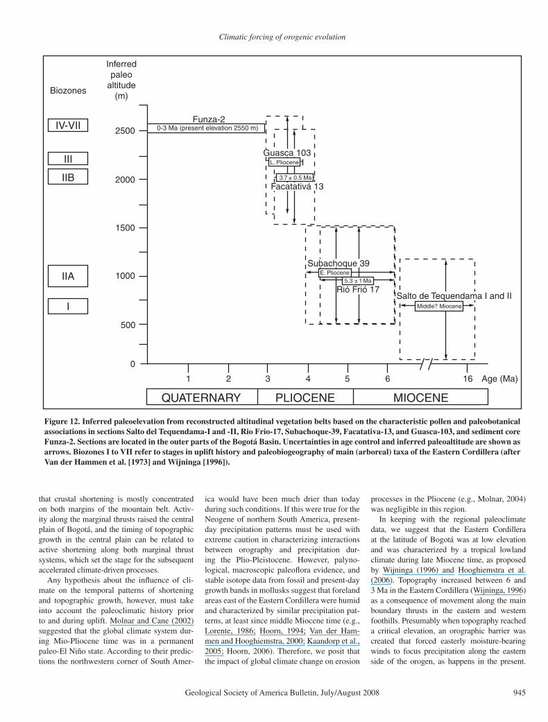
PALEOALTIMETRY AND PALEOFLORA
Paleoaltimetry data in the Andes are sparse and often subject to signifi cant errors and uncer-tainties (e.g., Gregory-Wodzicki, 2000; Blisniuk and Stern, 2005; Garzione et al., 2006). Paleo-fl ora data have been used in the assessment of paleotopography in Bolivia (e.g., Graham et al., 2001) and Colombia. In the northern Andes, Van der Hammen et al. (1973), Wijninga (1996), and Hooghiemstra et al. (2006) analyzed the fossil fl oras of the late Miocene to late Pliocene fl u-viatile Tilatá Formation in outcrops exposed in the Bogotá Basin above 2400 m. Using the near-est living relatives method, they correlated fossil pollen spectra from a 6–3 m.y. sedimentary sec-tion (Andriessen et al., 1993) with similar pollen spectra from modern vegetation and found a clear
trend of environmental evolution (Fig. 12). The oldest pollen assemblages (late Miocene, Salto de Tequendama sections) including Alchornea, Bombacaceae, Humiriaceae, Ilex Iriartea, Mau-ritia Malpighiaceae, Melastomataceae, and Pro-tium, indicate a tropical lowland environment. In contrast, the youngest pollen assemblages from the ca. 3 Ma Guasca section mainly com-prise taxa such as Eugenia, Hedyosmum, Myrica Weinmannia Oreopanax, characteristic of high-elevation (>2000 m) Andean forest.
Wijninga (1996) argued that the present topography of the Eastern Cordillera does not prevent pollen from the tropical lowland for-est in the Magdalena Valley from reaching the high plain of the Sabana de Bogotá. Probably a similar situation has prevailed since at least late Miocene time because pollen of all adjacent vegetation zones is represented in younger sedi-ments of the Bogotá Basin (Wijninga, 1996). However, the proportion of Andean pollen in the Pliocene record of the Bogotá Basin steadily increases in the younger sections, until reaching amounts similar to those in the present-day high elevation Andean forests. Van der Hammen et al. (1973), Wijninga (1996), and Hooghiemstra et al. (2006) proposed that the observed change in pollen spectra implies that a major temperature change must have affected the Bogotá Basin. In their interpretation, this change cannot be solely explained by the effects of late Cenozoic global cooling (Hooghiemstra et al., 2006). Rather, the pollen data are interpreted to refl ect a major change in paleoelevation between 6 and 3 Ma, from less than 1000 m to the present-day eleva-tion of ~2600 m (Fig. 12; Wijninga, 1996).
After the main phase of topographic growth, simultaneous with folding in the Bogotá Basin, the deposition of ~600 m of undeformed fl uvio-lacustrine sediments (Helmens and Van der Hammen, 1994; Hooghiemstra and Cleef, 1995; Hooghiemstra et al., 2006) from ca. 3.2 Ma illustrates that the Bogotá Basin evolved into a subsiding, isolated intermontane basin. The most recent study of the sedimentary and palynological record of these sediments was published by Torres et al. (2005) based on the Funza-2 borehole, located in the depocenter of the Bogotá Basin. The chronology was initially established through tephrochronology (Andries-sen et al., 1993), but more recently astronomical tuning to the pollen record was applied (Torres, 2006). The Funza-2 site provides one of the best terrestrial records of environmental change for the past 3.2 Ma. This data set documents climate change during the past 3 Ma, but no further sur-face uplift in the Bogotá Basin or adjacent areas can be deduced (Hooghiemstra, 1984; Hooghi-emstra and Cleef, 1995; Van’t Veer and Hooghi-emstra, 2000; Hooghiemstra et al., 2006; Tor-
res, 2006). We therefore conclude that the main phase of topographic growth in the Eastern Cor-dillera must have occurred between 6 and 3 Ma. This means that even the eastern third of the Eastern Cordillera probably remained at similar elevations as today, because there are no indica-tors in the pollen data of further surface uplift in areas adjacent to the Bogotá basin during the past 3 Ma (Torres, 2006).
DISCUSSION
Our new thermochronological data reveal a complex interaction between tectonics, cli-mate, and exhumation in the Eastern Cordillera of Colombia. We document an acceleration of exhumation rates on the eastern fl anks of this range by ca. 3 Ma, compared to the previous 30 Ma. However, compared with similar data sets from the western fl ank of the orogen, it appears that focused and accelerated denuda-tion solely characterizes the eastern deforma-tion front. The spatial pattern of exhumation has thus been asymmetric in the Eastern Cordillera from late Pliocene to present. Asymmetry is also visible at different levels in the geological evo-lution of both areas. We document that greater total amounts of shortening have occurred on the eastern versus the western fl ank. In addition, basement exposures occur in the east but are absent in the west (Fig. 1). Accelerated shorten-ing rates of ~5mm/yr (see Appendix and Figs. 4 and 11 for shortening calculations) are restricted to the east during the Pliocene. Finally, topogra-phy, precipitation patterns, and the characteris-tics of the fl uvial network follow this disparate spatiotemporal evolution. An important ques-tion, however, is whether climate and exhuma-tion have been active or passive with respect to the spatial and temporal trends in tectonic evo-lution. In the following discussion we propose a scenario involving the interaction between climate and structures to explain the geological evolution observed in this part of the Andes.
Areas with high mean elevation typically coincide with thickened crust; therefore the tim-ing of crustal thickening presumably coincides with the timing of growth of topography and the establishment of high-relief conditions (e.g., Isacks, 1988). As in many other areas of the Andes (e.g., Allmendinger et al., 1997), crustal thickening in the Eastern Cordillera was mainly accomplished through shortening, because the contribution of magmatic addition can be con-sidered to be minor and uplift related to litho-spheric delamination appears unlikely based on the overall tectono-magmatic evolution of this part of the Andean orogen (e.g., Sarmiento-Rojas, 2001). The specifi c structural style of the Eastern Cordillera (Figs. 1, 2, and 4) shows
Climatic forcing of orogenic evolution
Geological Society of America Bulletin, July/August 2008 945
that crustal shortening is mostly concentrated on both margins of the mountain belt. Activ-ity along the marginal thrusts raised the central plain of Bogotá, and the timing of topographic growth in the central plain can be related to active shortening along both marginal thrust systems, which set the stage for the subsequent accelerated climate-driven processes.
Any hypothesis about the infl uence of cli-mate on the temporal patterns of shortening and topographic growth, however, must take into account the paleoclimatic history prior to and during uplift. Molnar and Cane (2002) suggested that the global climate system dur-ing Mio-Pliocene time was in a permanent paleo-El Niño state. According to their predic-tions the northwestern corner of South Amer-
ica would have been much drier than today during such conditions. If this were true for the Neogene of northern South America, present-day precipitation patterns must be used with extreme caution in characterizing interactions between orography and precipitation dur-ing the Plio-Pleistocene. However, palyno-logical, macroscopic paleofl ora evidence, and stable isotope data from fossil and present-day growth bands in mollusks suggest that foreland areas east of the Eastern Cordillera were humid and characterized by similar precipitation pat-terns, at least since middle Miocene time (e.g., Lorente, 1986; Hoorn, 1994; Van der Ham-men and Hooghiemstra, 2000; Kaandorp et al., 2005; Hoorn, 2006). Therefore, we posit that the impact of global climate change on erosion
processes in the Pliocene (e.g., Molnar, 2004) was negligible in this region.
In keeping with the regional paleoclimate data, we suggest that the Eastern Cordillera at the latitude of Bogotá was at low elevation and was characterized by a tropical lowland climate during late Miocene time, as proposed by Wijninga (1996) and Hooghiemstra et al. (2006). Topography increased between 6 and 3 Ma in the Eastern Cordillera (Wijninga, 1996) as a consequence of movement along the main boundary thrusts in the eastern and western foothills. Presumably when topography reached a critical elevation, an orographic barrier was created that forced easterly moisture-bearing winds to focus precipitation along the eastern side of the orogen, as happens in the present.
Inferredpaleo
altitude(m)
2500
2000
1500
1000
500
0
1 2 3 4 5 6 16 Age (Ma)
L. Pliocene
E. Pliocene
Middle? Miocene
3.7 ± 0.5 Ma
5.3 ± 1 Ma
Funza-2
Guasca 103
Subachoque 39
Salto de Tequendama I and IIRió Frió 17
Facatativá 13
0-3 Ma (present elevation 2550 m)
Biozones
IV-VII
III
IIB
IIA
I
QUATERNARY PLIOCENE MIOCENE
Figure 12. Inferred paleoelevation from reconstructed altitudinal vegetation belts based on the characteristic pollen and paleobotanical associations in sections Salto del Tequendama-I and -II, Rio Frio-17, Subachoque-39, Facatativa-13, and Guasca-103, and sediment core Funza-2. Sections are located in the outer parts of the Bogotá Basin. Uncertainties in age control and inferred paleoaltitude are shown as arrows. Biozones I to VII refer to stages in uplift history and paleobiogeography of main (arboreal) taxa of the Eastern Cordillera (after Van der Hammen et al. [1973] and Wijninga [1996]).

Mora et al.
946 Geological Society of America Bulletin, July/August 2008
The regional precipitation map (Fig. 1) shows that fault-bounded ranges 0.7–1 km higher than the adjacent undeformed foreland, such as the Serranía de las Palomas, apparently have no pronounced effect on amount and distribution of rainfall in this environment. In other tectonically active regions, such as the Sierras Pampeanas or the Patagonian Andes (Sobel and Strecker, 2003; Blisniuk et al., 2005), and the Eastern Cordillera of Bolivia (Masek et al., 1994), higher threshold elevations between 2000 and 2500 m are needed to generate pronounced precipitation gradients. We thus infer that such conditions were proba-bly attained toward the end of the phase of relief growth between 6 and 3 Ma.
If true, focused precipitation on the eastern fl ank would have generated an effective, east-ward fl owing fl uvial system with higher dis-charge that cut deeper canyons compared to the modern rivers of the western fl ank. Accord-ingly, we suggest that some of the differences in AFT ages associated with the different fault blocks can also be linked to differential river incision, such as in the Guatiquía River pro-fi le. Thus, some of the documented cooling occurred through river incision. If such relation-ships indeed had been in place during the past 3 Ma, then climate-driven focused denudation and accelerated rates would be the expected result. Accelerated denudation rates during the past 3 Ma along the eastern side of the East-ern Cordillera would have caused unloading of the fault-bounded ranges, prompting faster movement along the main thrusts, as proposed by Hilley et al. (2005) for orogens strongly conditioned by inherited structures like the Eastern Cordillera. Support for the viability of this model comes from the comparison of tim-ing and amount of shortening along the west-ern (Gómez et al., 2003; Restrepo-Pace et al., 2004; Cortés et al., 2005; Montes et al., 2005) and eastern fl anks (Fig. 11). Crustal shortening has been concentrated on the eastern fl ank dur-ing the past 10 million years, with peak values of ~5 mm/yr during the past 3 Ma (Figs. 1, 2, 4, and 11). Therefore, peak shortening rates would have occurred subsequent to uplift of the Bogotá Basin, as supported by the pollen data (Wijninga, 1996). Thus, enhanced mass removal may have favored, and probably accel-erated motion along the shortcut faults on the eastern fl ank since mid-Pliocene time.
Such accelerated shortening, involving ~25% of a total 60 km orogenic shortening and 50% of the total shortening along the eastern fl ank, is expected to generate a signifi cant amount of lithospheric fl exure in adjacent areas that are not being uplifted. The exact thickness of cor-responding units in the adjacent Llanos foreland basin to the east has never been established, due
to poor chronological constraints. However, the Funza-2 drill hole from the Bogotá Basin records ~0.6 km of lacustrine sediments depos-ited in an area undergoing no deformation dur-ing that time (Helmens and Van der Hammen, 1994; Torres, 2006). We speculate that the onset of continuous deposition and subsidence in the Bogotá Basin at 3.2 Ma (Helmens and Van der Hammen, 1994; Torres, 2006) refl ects enhanced tectonic thickening in adjacent, actively deform-ing areas, such as the eastern foothills. The lacus-trine conditions in the Bogotá Basin prevailed until ~17,000 yr B.P. (Hooghiemstra, 1984). We infer that this was the result of internal drainage, aided by the drier conditions in the highlands, which prevented fl uvial systems from effi cient downcutting and sediment evacuation. We sug-gest that reduced rainfall caused ineffi cient drainages in the leeward highlands to the west, while active tectonism associated with high rain-fall along the eastern fl ank caused deep incision of high-gradient rivers. Probably because of the ongoing tectonic activity along the east, these rivers have not yet been able to reach the Bogotá Basin by headward erosion. Intense, localized precipitation may thus have resulted in higher rock uplift rates and a profound infl uence on the drainage system compared to areas to the west.
CONCLUSION
New structural and thermochronologic data combined with published paleofl ora and ther-mochronologic information allow the contrast-ing deformation, exhumation, and surface-uplift histories in different areas of the Eastern Cordil-lera of Colombia to be evaluated from the late Pliocene to the present. The fundamental trigger causing asymmetry in the orogenic processes is the initial topographic growth between 6 and 3 Ma that built an orographic barrier that sub-sequently intercepted easterly moisture-bearing winds leading to focused erosion. Our data sug-gest that this focused erosion increased mass removal along the eastern fl ank of the orogen to values comparable to tectonically controlled advection of material, therefore enhancing tec-tonic mass fl ux. In contrast, due to the eastern orographic barrier, precipitation was reduced in the western sectors of the orogen during the same period, and the basin became internally drained. Consequently, mass removal and tec-tonic fl ux were reduced. We propose that such disparate behavior ultimately enhanced or even-tually produced the regional tectonic asymme-try. Focused, climate-driven denudation in the Eastern Cordillera is therefore a fundamental process that has profoundly modifi ed the rates and the location of tectonic deformation in this part of the Andean orogen.
APPENDIX
Fault Geometries and Depth to Detachment Calculations:
A correct calculation of shortening depends on a well-constrained fault geometry. Our interpretation of a listric fault shape is favored with the exhuma-tion pattern documented in this work (Fig. 8), remi-niscent of that simulated in inverted listric normal faults (Mitra, 1993; McClay, 1995). Otherwise the forward-breaking sequence of deformation from W to E along the eastern deformation front, documented with apatite fi ssion-track (AFT) analysis in the Guay-uriba profi le, does not favor the geometrical assump-tion of steeply dipping fault planes at depth for the basement faults while the frontal thrusts are low angle. Second it has been observed by means of deep seismic refl exion profi les, reaching more than 7 sec two-way traveltime (TWT) (e.g., Deeks and Thomas, 1995; Sinclair, 1995), that many inverted master faults in intra-plate inverted grabens have a listric shape. We further assume inversion reactivating mostly the same extensional fault planes, following observations by Mora et al. (2006).
With these assumptions an approximate depth to detachment can be found based on the fact that, assuming plain strain deformation, the area of cross-sectional structural relief equals total shortening mul-tiplied by depth to detachment (e.g., Hossack, 1979; Mitra and Namson, 1989; Fig. 4). This relationship has been used already in the Eastern Cordillera by Colleta et al. (1990) and Cortés et al. (2006). With a total shortening of 58 km calculated from line-length balancing in our cross section (Fig. 4) and an excess area of 1340 km2, a depth to detachment of about 23 km in the undeformed state was obtained assuming the west-dipping fault as a main detachment.
Through an iterative process using 2D Move©, we tried to extrapolate the dip data from the area adjacent to the Anaconda well to the west and at depths bigger than 5 km. We searched for a fault plane that cutting-sequence-up fi ts better to the observed spatial and tem-poral evolution of rock uplift, exhumation, and surface uplift during the late Cenozoic and the predicted depth to detachment as well. We tried different fault-related deformation mechanisms but found that a rigid block rotation along a circular fault, such as proposed by Erslev (1986) in the Rocky Mountains, reproduced better the observations at different moments in time (Fig. 4). This geometry was used also by Jordan and Allmendinger (1986) in the Sierras Pampeanas and Kley and Monaldi (2002) in the Santa Barbara Sys-tem. As proposed by Erslev (1986), the back-limb dip angle of a given basement uplift (Δ tilt) can be related to fault curvature (1/R, where R is the radius of curva-ture) and slip along the circular fault segment by the following relationship (Fig. 13):
Δ tilt = 180 SRA
/πR.
Using as an example cross section E–E′ (Fig. 7), we only know the back-limb dip angle (7°) from draw-ing a tangent line to the base of the best constrained horizon, that is the base of the Aptian Une Forma-tion in section E (Figs. 7 and 13). Then we assumed a radius of curvature of a circle that fi ts approximately the surface trace of the fault and the depth to detach-ment, where the rotation axis is located above the place where the back limb is horizontal, in our case the axis of the Bogotá Basin (Figs. 4, 7, 11, and 13). Given the uncertainties, we obtained a range of val-ues, but we fi nally chose those variables that had the

Climatic forcing of orogenic evolution
Geological Society of America Bulletin, July/August 2008 947
best fi t with depth to detachment and rock uplift, sur-face uplift, and exhumation through time. With such radius of curvature, we calculated the slip along the main listric inverted fault assuming an additional constraint—a retrodeformed state where lowermost Cretaceous hanging-wall and footwall cutoffs fi t to each other (which equals back rotating 7° the back limb to zero dip) plus some differential subsidence in the downthrown block of the Servitá fault during the Lower Cretaceous, assuming the Farallones Anti-cline as an amplifi ed rollover of the listric detachment as interpreted by Mora et al. (2006). This means an additional 1° rotation along the fault (Figs. 11 and 13). Finally we found the best fi t with a total rotation of 8°, ~21 km of slip along the main fault and a radius of curvature of about 158.5 km (Figs. 11 and 13). We used those geometries to calculate the shortening val-ues obtained in our cross sections.
Another subsequent step was to incrementally ret-rodeform the deformed state cross sections (Fig. 11). In this step we used the mentioned considerations plus the data of total amount of overburden from vitrinite refl ectance and removed overburden at each stage cal-culated from our thermochronological data.
ACKNOWLEDGMENTS
The authors are indebted to Peter Molnar, Richard W. Allmendinger, John Suppe, Jose María Jaramillo, Thomas van der Hammen, and Brian Horton for fruit-ful suggestions, and Birgit Fabian for graphic work. Gerold Zeilinger helped generate the digital elevation model (DEM) and the swath profi les. Careful reviews by Douglas Burbank, David Montgomery, and Associ-ate Editor Brendan Murphy greatly helped our inter-pretation. Seismic and well data were kindly provided
by Javier Cardona and Mauricio Blanco (Agencia Nacional de Hidrocarburos) and German Rodriguez (Sipetrol). Sandra Passos (Ecopetrol) allowed us to use vitrinite refl ectance data from Ecopetrol. Carlos Costa Posada from IDEAM Colombia provided data of precipitation and river discharge for the past 20 years from the Eastern Cordillera. Vitrinite refl ectance analy-sis was carried out at the Departamento de Geocien-cias (Universidad Nacional) and Ingeominas, with the cooperation of Gladys Valderrama, Luis Jorge Mejía, Andreas Kammer, and Luis Ignacio Quiroz. Oscar Fernandez, from Midland Valley, provided a 2D Move license. Elias Gomez kindly provided some of his orig-inal data from the western fl ank. Financial support for fi eld work and analysis came from Petrobras Colombia and the German Science Foundation to M. Strecker (Str 373/19-1). A. Mora and M. Parra thank the German Academic Exchange Service (Der Deutsche Akademis-che Austauschdienst [DAAD]) and the Leibniz Center for Earth Surface and Climate Studies at Potsdam Uni-versity for funding their studies at Potsdam University. M.R. Strecker also thanks the A. Cox fund of Stanford University for additional support.
REFERENCES CITED
Aggarwal, Y., 1983, Seismic slip rates and earthquake rup-ture zones in the southern Caribbean: Implications for plate motions and earthquake hazard in this region: Cartagena, Colombia, Abstracts, Tenth Caribbean Geo-logical Conference, p. 16.
Allmendinger, R.W., Jordan, T.E., Kay, S.M., and Isacks, B.L., 1997, The evolution of the Altiplano-Puna Pla-teau of the Central Andes: Annual Review of Earth and Planetary Sciences, v. 25, p. 139–174, doi: 10.1146/annurev.earth.25.1.139.
Andriessen, P.A.M., Helmens, K.F., Hooghiemstra, H., Riezebos, P.A., and Van der Hammen, T., 1993, Pliocene-Pleistocene chronology of the sediments of the basin of Bogotá, Eastern Cordillera: Quaternary Science Reviews, v. 12, p. 483–501, doi: 10.1016/0277-3791(93)90066-U.
Bachu, S., Ramon, J.C., Villegas, M.E., and Underschultz, J.R., 1995, Geothermal regime and thermal history of the Llanos Basin, Colombia: American Association of Petroleum Geologists Bulletin, v. 79, no. 1, p. 116–129.
Barker, C.E., and Pawlewicz, M.J., 1994, Calculation of vitrinite refl ectance from thermal histories and peak temperatures: A comparison of methods, in Mukho-padhyay, P.K., and Dow, W.G., eds., Vitrinite refl ec-tance as a maturity parameter: Applications and limita-tions: American Chemical Society Symposium Series, v. 570, p. 216–219.
Barnes, J.B., and Pelletier, J.D., 2006, Latitudinal variation of denudation in the evolution of the Bolivian Andes: American Journal of Science, v. 306, p. 1–31, doi: 10.2475/ajs.306.1.1.
Beauchamp, W., Barazangi, M., Demnati, A., and El Alji, M., 1996, Intracontinental rifting and inversion: Mis-sour Basin and Atlas Mountains, Morocco: American Association of Petroleum Geologists Bulletin, v. 80, no. 9, p. 1459–1482.
Beaumont, C., Fullsack, P., and Hamilton, J., 1992, Ero-sional control of active compressional orogens, in McClay, K.R., ed., Thrust tectonics: Chapman and Hall, p. 1–18.
Blisniuk, P.M., and Stern, L.A., 2005, Stable isotope paleoal-timetry—A critical review: American Journal of Science, v. 305, p. 1033–1074, doi: 10.2475/ajs.305.10.1033.
Blisniuk, P.M., Stern, L.A., Chamberlain, C.P., Idleman, B., and Zeitler, P.K., 2005, Climatic and ecologic changes during Miocene surface uplift in the southern Patago-nian Andes: Earth and Planetary Science Letters, v. 230, p. 125–142, doi: 10.1016/j.epsl.2004.11.015.
Blythe, A.E., Burbank, D.W., Carter, A., Schmidt, K., and Putkonen, J., 2007, Plio-Quaternary exhumation history of the central Nepalese Himalaya: 1. Apatite and zircon fi ssion track and apatite [U-Th]/He analyses: Tectonics, v. 26, no. 3, p. TC3002, doi: 10.1029/2006TC001990.
0
-12 km
-8
-4
0
-12 km
-8
-4
Dip = 7°
8°
Slip = 21.5 km
Figure 13. Back-limb dip (7°), rotation angle (8°), and total slip along the Servitá fault, taken to constrain fault geometry in section E–E′.

Mora et al.
948 Geological Society of America Bulletin, July/August 2008
Bustin, R.M., Barnes, M.A., and Barnes, W.C., 1990, Deter-mining levels of organic diagenesis in sediments and fossil fuels, in McIlereath, I.A., and Morrow, D.W., eds., Diagenesis: Geosciences Canada Reprint, Fourth series, Geological Association of Canada, p. 205–226.
Carlson, W.D., Donelick, R.A., and Ketcham, R., 1999, Variability of apatite fi ssion-track annealing kinetics: I. Experimental results: American Mineralogist, v. 84, p. 1213–1223.
Chapman, T.J., 1989, The Permian to Cretaceous structural evolution of the Western Approaches Basin (Melville sub-basin), UK, in Cooper, M.A., and Williams, D.G., eds., Inversion tectonics: The Geological Society of London, Special Publication, v. 44, p. 177–200.
Colleta, B., Hebrard, F., Letouzey, J., Werner, P., and Rudki-weicz, J.L., 1990, Tectonic style and crustal structure of the Eastern Cordillera, Colombia from a balanced cross section, in Letouzey, J., ed., Petroleum and tectonics in mobile belts: Paris, Editions Technip, p. 81–100.
Cortés, M., Angelier, J., and Colleta, B., 2005, Paleostress evolution of the northern Andes (Eastern Cordillera of Colombia): Implications on plate kinematics of the South Caribbean region: Tectonics, v. 24, p. TC1008, doi: 10.1029/2003TC001551.
Cortés, M., Bayona, G., Aristizabal, J., Ojeda, G., Reyes-Harker, A., and Gamba, N., 2006, Structure and kine-matics of the Eastern Foothills of the Eastern Cordil-lera of Colombia from balanced cross-sections and forward modeling: Extended Abstracts, IX Simposio Bolivariano de Exploración Petrolera en las Cuencas Subandinas, Cartagena de Indias, Colombia.
Coutand, I., Carrapa, B., Deeken, A., Schmitt, A.K., Sobel, E.R., and Strecker, M.R., 2006, Propagation of oro-graphic barriers along an active range front: Insights from sandstone petrography and detrital apatite fi ssion-track thermochronology in the intramontane Angastaco basin, NW Argentina: Basin Research, v. 18, no. 1, p. 1–26, doi: 10.1111/j.1365-2117.2006.00283.x.
Dahlen, F.A., and Suppe, J., 1988, Mechanics growth and ero-sion of mountain belts, in Clark, S.P.J., ed., Processes in continental lithospheric deformation: Geological Soci-ety of America Special Paper, v. 218, p. 161–178.
Dahlstrom, C.D.A., 1969, Balanced cross sections: Cana-dian Journal of Earth Sciences, v. 6, p. 743–757.
Deeks, N.R., and Thomas, S.A., 1995, Basin inversion in a strike-slip regime: The Tornquist Zone, southern Bal-tic Sea, in Buchanan, J.G., and Buchanan, P.G., eds., Basin inversion: The Geological Society of London, Special Publication, v. 88, p. 319–338.
Donelick, R.A., O’Sullivan, P.B., and Ketcham, R.A., 2005, Apatite fi ssion-track analysis: Reviews in Mineral-ogy and Geochemistry, v. 58, p. 49–94, doi: 10.2138/rmg.2005.58.3.
Dumitru, T.A., 1993, New computer-automated microscope stage system for fi ssion-track analysis: Nuclear Tracks and Radiation Measurements, v. 21, no. 4, p. 575–580, doi: 10.1016/1359-0189(93)90198-I.
Erslev, E.A., 1986, Basement balancing of Rocky Moun-tain foreland uplifts (USA): Geology, v. 14, no. 3, p. 259–262, doi: 10.1130/0091-7613(1986)14<259:BBORMF>2.0.CO;2.
Gallagher, K., Brown, R., and Johnson, C., 1998, Fis-sion track analysis and its applications to geologi-cal problems: Annual Review of Earth and Planetary Sciences, v. 26, p. 519–572, doi: 10.1146/annurev.earth.26.1.519.
Garzione, C.N., Molnar, P., Libarkin, J.C., and MacFadden, B.J., 2006, Rapid late Miocene rise of the Bolivian Altiplano: Evidence for removal of mantle lithosphere: Earth and Planetary Science Letters, v. 241, no. 3–4, p. 543–556, doi: 10.1016/j.epsl.2005.11.026.
Gleadow, A.J.W., 1981, Fission-track dating methods: What are the real alternatives?: Nuclear Tracks, v. 5, no. 1–2, p. 3–14, doi: 10.1016/0191-278X(81)90021-4.
Gleadow, A.J.W., Duddy, I.R., Green, P.F., and Lovering, J.F., 1986, Confi ned fi ssion track lengths in apatite: A diagnostic tool for thermal history analysis: Con-tributions to Mineralogy and Petrology, v. 94, no. 4, p. 405–415, doi: 10.1007/BF00376334.
Gómez, E., 2001, Tectonic controls on the Late Cretaceous to Cenozoic sedimentary fi ll of the Middle Magdalena Valley Basin, Eastern Cordillera and Llanos Basin, Colombia [Ph. D. thesis]: Cornell University.
Gómez, E., Jordan, T.E., Allmendiger, R.W., Hegarty, K., Kelley, S., and Heizler, M., 2003, Controls on archi-tecture of the Late Cretaceous to Cenozoic southern Middle Magdalena Valley Basin, Colombia: Geologi-cal Society of America Bulletin, v. 115, p. 131–147.
Gómez, E., Jordan, T.E., Allmendinger, R.W., and Cardozo, N., 2005, Development of the Colombian foreland-basin system as a consequence of the diachronous exhumation of the northern Andes: Geological Society of America Bulletin, v. 117, no. 9–10, p. 1272–1292, doi: 10.1130/B25456.1.
Graham, A., Gregory-Wodzicki, K.M., and Wright, K.L., 2001, Studies in neotropical paleobotany. XV. A Mio-Pliocene palynofl ora from the Eastern Cordillera, Bolivia: Implications for the uplift history of the Cen-tral Andes: American Journal of Botany, v. 88, no. 9, p. 1545–1557, doi: 10.2307/3558398.
Green, P.F., Duddy, I.R., Gleadow, A.J.W., and Lovering, J.F., 1989a, Apatite fi ssion track analysis as a pale-otemperature indicator for hydrocarbon exploration, in Naesser, N.D., and McCulloh, T., eds., Thermal history of sedimentary basins—Methods and case histories: New York, Springer Verlag, p. 181–195.
Green, P.F., Duddy, I.R., Laslett, G.M., Hegarty, K.A., Gleadow, A.J.W., and Lovering, J.F., 1989b, Thermal annealing of fi ssion tracks in apatite: 4. Quantitative modelling techniques and extension to geological tim-escales: Chemical Geology, v. 79, no. 2, p. 155–182.
Gregory-Wodzicki, K.M., 2000, Uplift history of the Central and Northern Andes: A review: Geological Society of America Bulletin, v. 112, no. 7, p. 1091–1105, doi: 10.1130/0016-7606(2000)112<1091:UHOTCA>2.3.CO;2.
Guerrero, J., and Sarmiento, G., 1996, Estratigrafía física, palinológica, sedimentológica y secuencial del Cre-tácico Superior y Paleoceno del Piedemonte Llanero. Implicaciones en exploración petrolera: Geología Colombiana, no. 20, p. 3–66.
Helmens, K.F., 1990, Neogene-Quaternary geology of the High Plain of Bogotá, Eastern Cordillera, Colombia (stratigraphy, paleoenvironments and landscape evolu-tion) [Ph.D. thesis]: University of Amsterdam, 202 p.
Helmens, K.F., and Van der Hammen, T., 1994, The Plio-cene-Quaternary of the high plain of Bogotá: A his-tory of tectonic uplift, basin development and climatic change: Quaternary International, v. 21, p. 41–61, doi: 10.1016/1040-6182(94)90020-5.
Hilley, G. E., and Strecker, M. R., 2004, Steady state erosion of critical Coulomb wedges with applica-tions to Taiwan and the Himalaya: Journal of Geo-physical Research: Solid Earth, v. 109, B01411, doi 10.1029/2002JB002284.
Hilley, G.E., and Strecker, M.R., 2005, Processes of oscil-latory basin infi lling and excavation in a tectonically active orogen: Quebrada del Toro Basin, NW Argen-tina: Geological Society of America Bulletin, v. 117, no. 7–8, p. 887–901, doi: 10.1130/B25602.1.
Hilley, G.E., Blisniuk, P.M., and Strecker, M.R., 2005, Mechanics and erosion of basement cored uplift prov-inces: Journal of Geophysical Research, Solid Earth, v. 110, B12409, doi: 10.1029/2005JB003704.
Hooghiemstra, H., 1984, Vegetational and climatic history of the high plain of Bogotá, Colombia: A continuous record of the past 3.5 million years: Dissertationes Botanicae, v. 79, 368 p.
Hooghiemstra, H., and Cleef, A.M., 1995, Pleistocene cli-matic change and environmental and generic dynam-ics in the north Andean montane forest and paramo, in Churchill, S.P., Balslev, H., and Luteyn, J.L., eds., Biodiversity and conservation of neotropical montane forests: Memoirs of the New York Botanical Garden, 78, p. 35–49.
Hooghiemstra, H., Wijninga, V.M., and Cleef, A.M., 2006, The paleobotanical record of Colombia: Implications for biogeography and biodiversity: Annals of the Mis-souri Botanical Garden, v. 93, p. 297–325, doi: 10.3417/0026-6493(2006)93[297:TPROCI]2.0.CO;2.
Hoorn, C., 1994, An environmental reconstruction of the paleo-Amazon River system (Middle to Late Mio-cene, NW Amazonia): Paleogeography, Paleocli-matology, Paleoecology, v. 112, p. 187–238, doi: 10.1016/0031-0182(94)90074-4.
Hoorn, C., 2006, The birth of the mighty Amazon: Scientifi c American, v. 294, no. 5, p. 52–59.
Horton, B.K., 1999, Erosional control on the geometry and kinematics of thrust belt development in the central Andes: Tectonics, v. 18, no. 6, p. 1292–1304, doi: 10.1029/1999TC900051.
Hossack, J.R., 1979, The use of balanced cross-sections in the calculation of orogenic contraction: A review: Jour-nal of the Geological Society, v. 136, no. 6, p. 705–711, doi: 10.1144/gsjgs.136.6.0705.
Hoth, S., Adam, J., Kukowski, N., and Onken, O., 2006, Infl uence of erosion on the kinematics of bivergent orogens: Results from scaled sandbox simulations, in Willet, S.D., Hovius, N., Brandon, M.T., and Fisher, D., eds., Tectonics, climate, and landscape evolution: Penrose Conference Series, Geological Society of America, Special Paper 398, p. 201–225.
Hurford, A.J., and Green, P.F., 1983, The zeta age calibration of fi ssion-track dating: Isotope Geoscience, v. 1, no. 4, p. 285–317.
Isacks, B.L., 1988, Uplift of the central Andean Plateau and bending of the Bolivian Orocline: Journal of Geophysical Research: Solid Earth, v. 93, no. B4, p. 3211–3231.
Jordan, T.E., and Allmendinger, R.W., 1986, The Sierras Pampeanas of Argentina: A modern analogue of Rocky Mountain foreland deformation: American Journal of Science, v. 286, no. 10, p. 737–764.
Julivert, M., 1963, Los rasgos tectónicos de la región de la Sabana de Bogotá y los mecanismos de la formación de las estructuras: Boletín de Geología, Universidad Industrial de Santander, v. 13–14, p. 5–102.
Julivert, M., 1970, Cover and basement tectonics in the Cordillera Oriental of Colombia, South America, and a comparison with some other folded chains: Geologi-cal Society of America Bulletin, v. 81, p. 3623–3646, doi: 10.1130/0016-7606(1970)81[3623:CABTIT]2.0.CO;2.
Kaandorp, R.J.G., Vonhof, H.B., Wesselingh, F.P., Pittman, L.R., Kroon, D., and Van Hinte, J.E., 2005, Seasonal Amazonian rainfall variation in the Miocene climate optimum: Palaeogeography, Palaeoclimatology, Palaeoecology, v. 221, no. 1–2, p. 1–6, doi: 10.1016/j.palaeo.2004.12.024.
Kammer, A., 2003, La Formación Tilatá en los alrededores de Chocontá: Marco tectónico y ambientes deposicio-nales: Análisis Geográfi cos, v. 26, p. 69–100.
Ketcham, R., Donelick, R.A., and Carlson, W.D., 1999, Variability of apatite fi ssion-track annealing kinetics: III. Extrapolation to geological time scales: American Mineralogist, v. 84, p. 1235–1255.
Kley, J., and Monaldi, C.R., 2002, Tectonic inversion in the Santa Barbara System of the central Andean foreland thrust belt, northwestern Argentina: Tectonics, v. 21, no. 6, 1016, doi: 10.1029/2002TC902003.
Koons, P.O., 1989, The topographic evolution of collisional mountain belts: A numerical look at the Southern Alps, New Zealand: American Journal of Science, v. 289, no. 9, p. 1041–1069.
Koons, P.O., Zeitler, P.K., Chamberlain, C.P., Craw, D., and Meltzer, A.S., 2002, Mechanical links between ero-sion and metamorphism in Nanga Parbat, Pakistan Himalaya: American Journal of Science, v. 302, no. 9, p. 749–773, doi: 10.2475/ajs.302.9.749.
Koyi, H.A., Hessami, K., and Teixell, A., 2000, Epicenter distribution and magnitude of earthquakes in fold-thrust belts: Insights from sandbox models: Geophysi-cal Research Letters, v. 27, no. 2, p. 273–276, doi: 10.1029/1999GL010833.
Lorente, M.A., 1986, Palynology and Palynofacies of the Upper Tertiary in Venezuela [Ph.D. thesis]: University of Amsterdam, 222 p.
Ludwig, K.R., 2003, User’s manual for Isoplot 3.00: A geochronological toolkit for Microsoft Excel: Berke-ley Geochronology Center Special Publication No. 4, p. 1–71.
Mancktelow, N.S., and Grasemann, B., 1997, Time-dependent effects of heat advection and topography on cooling histories during erosion: Tectonophysics, v. 270, no. 3–4, p. 167–195, doi: 10.1016/S0040-1951(96)00279-X.
Masek, J. G., Isacks, B. L., Gubbels, T. L., and Fielding, E. J., 1994, Erosion and tectonics at the margins of continental plateaus: Journal of Geophysical Research, v. 99 (B7), p. 13,941–13,956.

Climatic forcing of orogenic evolution
Geological Society of America Bulletin, July/August 2008 949
McClay, K.R., 1995, The geometries and kinematics of inverted fault systems: A review of analogue model studies, in Buchanan, J.G., and Buchanan, P.G., eds., Basin inversion: The Geological Society of London, Special Publication, v. 88, p. 97–118.
Mitra, S., 1993, Geometry and kinematic evolution of inver-sion structures: American Association of Petroleum Geologists Bulletin, v. 77, no. 7, p. 1159–1191.
Mitra, S., and Namson, J.S., 1989, Equal area balancing: American Journal of Science, v. 289, p. 563–599.
Molnar, P., 2004, Late Cenozoic increase in accumula-tion rates of terrestrial sediment: How might climate change have affected erosion rates?: Annual Review of Earth and Planetary Sciences, v. 32, p. 67–89, doi: 10.1146/annurev.earth.32.091003.143456.
Molnar, P., and Cane, N. A., 2002, El Niño’s tropical cli-mate and teleconnections as a blueprint for pre-Ice Age climates: Paleoceanography, v. 17, no. 2, doi: 10.1029/2001PA000663.
Molnar, P., and England, P., 1990, Late Cenozoic uplift of mountain ranges and global climatic change: chicken or egg?: Nature, v. 346, no. 6279, p. 29–34, doi: 10.1038/346029a0.
Montes, C., Hatcher, R.D., Jr., and Restrepo-Pace, P.A., 2005, Tectonic reconstruction of the northern Andean blocks: Oblique convergence and rotations derived from the kinematics of the Piedras-Girardot area, Colombia: Tectonophysics, v. 399, no. 1–4, p. 221–250, doi: 10.1016/j.tecto.2004.12.024.
Montgomery, D.R., Balco, G., and Willett, S.D., 2001, Cli-mate, tectonics, and the morphology of the Andes: Geology, v. 29, no. 7, p. 579–582, doi: 10.1130/0091-7613(2001)029<0579:CTATMO>2.0.CO;2.
Mora, A., and Kammer, A., 1999, Comparación de los esti-los estructurales en la sección entre Bogotá y los Far-allones de Medina, Cordillera Oriental de Colombia: Geología Colombiana, v. 24, p. 55–82.
Mora, A., and Parra, M., 2004, Medición, levantamiento y muestreo de secciones estratigráfi cas del Grupo Gua-dalupe y las Formaciones Barco y Carbonera (C5 a C8), en el área de Sabanalarga, San Luis de Gaceno y Guaicaramo: Internal Report, Instituto Colombiano del Petroleo.
Mora, A., Parra, M., Strecker, M.R., Kammer, A., Dimaté, C., and Rodriguez, F., 2006, Cenozoic contractional reactivation of Mesozoic extensional structures in the Eastern Cordillera of Colombia: Tectonics, v. 25, p. TC2010, doi: 10.1029/2005TC001854
Mugnier, J.L., Baby, P., Colleta, B., Vinour, P., Bale, P., and Leturmy, P., 1997, Thrust geometry controlled by ero-sion and sedimentation: A view from analogue models: Geology, v. 25, p. 427–430, doi: 10.1130/0091-7613(1997)025<0427:TGCBEA>2.3.CO;2.
Narr, J., and Perez, 1993, Geology of the Río Blanco Block, Colombia: Internal Report, Chevron Petroleum Com-pany.
Parra, M., Mora, A., Jaramillo, C., Strecker, M.R., and Veloza, G., 2005a, New stratigraphic data on the ini-tiation of mountain building at the eastern front of the Colombian Eastern Cordillera: Barcelona, Extended abstracts, Sixth International Symposium on Andean Geodynamics, p. 567–571.
Parra, M., Mora, A., Quiroz, L.A., and Romero, O., 2005b, Secciones estratigráfi cas detalladas de las Formaciones Carbonera (C5–C1) y León en el Sinclinal de Medina,
Cordillera Oriental Colombiana: Internal Report, Smithsonian Tropical Research Institute.
Parra, M., Mora, A., Romero, O., and Moron, S., 2006, Sec-ciones estratigráfi cas detalladas de las Formaciones Carbonera (C1), León y el Grupo Guayabo en los Sinclinales de Nazareth y Medina, Piedemonte Llan-ero, Cordillera Oriental de Colombia: Internal Report, Smithsonian Tropical Research Institute.
Parra, M., Mora, A., Jaramillo, C., Strecker, M.R., and Sobel, E.R., 2007, Cenozoic exhumation history in the northeastern Andes: Evidence from low-T thermo-chronology and basin analysis in the Eastern Cordillera of Colombia: Vienna, Austria, XVI European Geosci-ences Union General Assembly.
Reiners, P.W., Ehlers, T.A., Mitchell, S.G., and Montgom-ery, D.R., 2003, Coupled spatial variations in precipita-tion and long-term erosion rates across the Washington Cascades: Nature, v. 426, no. 6967, p. 645–647, doi: 10.1038/nature02111.
Restrepo-Pace, P.A., Colmenares, F., Higuera, C., and Mayorga, M., 2004, A fold-and-thrust belt along the western fl ank of the Eastern Cordillera of Colombia: Style, kinematics, and timing constraints derived from seismic data and detailed surface mapping, in McClay, K.R., ed., Thrust tectonics and hydrocarbon systems: Tulsa, American Association of Petroleum Geologists Memoir, v. 82, p. 598–613.
Roberts, D.G., 1989, Basin inversion in and around the Brit-ish Isles, in Cooper, M.A., and Williams, D.G., eds., Inversion tectonics: Geological Society, London, Spe-cial Publication, v. 44, p. 131–150.
Robertson, K., 1989, Actividad neotectónica del Piedemonte Llanero, sector Villavicencio-Tauramena, Colom-bia: Bogotá, Memorias V. Congreso Colombiano de Geología, p. 170–192.
Sarmiento-Rojas, L.F., 2001, Mesozoic rifting and Cenozoic Basin inversion history of the Eastern Cordillera, Colom-bian Andes [Ph.D. thesis]: Vrije University, 295 p.
Segovia, A., 1965, Mapa geológico de la plancha L-12 (Medina) de la República de Colombia: Servicio Geológico Nacional.
Sinclair, I.K., 1995, Transpressional inversion due to epi-sodic rotation of extensional stresses in the Jeanne d’Arc Basin, offshore Newfoundland, in Buchanan, J.G., and Buchanan, P.G., eds., Basin inversion: The Geological Society of London, Special Publication, v. 88, p. 249–271.
Sobel, E.R., and Seaward, D., 2006, Infl uence of etching conditions on apatite fi ssion track etch pit diameter: Bremen, European Conference on Thermochronology, p. 128–130.
Sobel, E.R., and Strecker, M.R., 2003, Uplift, exhumation and precipitation: Tectonic and climatic control of Late Cenozoic landscape evolution in the northern Sierras Pampeanas, Argentina: Basin Research, v. 15, no. 4, p. 431–451, doi: 10.1046/j.1365-2117.2003.00214.x.
Sobel, E.R., Hilley, G.E., and Strecker, M.R., 2003, For-mation of internally drained contractional basins by aridity-limited bedrock incision: Journal of Geophysi-cal Research, Solid Earth, v. 108, no. 7, p. 2344, doi: 10.1029/2002JB001883.
Strecker, M.R., Alonso, R.N., Bookhagen, B., Carrapa, B., Hilley, G.E., Sobel, E.R., and Trauth, M.H., 2007, Tectonics and climate of the southern Cen-tral Andes: Annual Review of Earth and Planetary
Sciences, v. 35, p. 747–787, doi: 10.1146/annurev.earth.35.031306.140158.
Thiede, R., Bookhagen, B., Arrowsmith, R., Sobel, E., and Strecker, M., 2005, Climatic control on areas of rapid exhumation along the Southern Himalayan Front: Earth and Planetary Science Letters, v. 222, no. 3–4, p. 791–806, doi: 10.1016/j.epsl.2004.03.015.
Toro, J., Roure, F., Bordas-Le Floch, N., Le Cornec-Lance, S., and Sassi, W., 2004, Thermal and kinematic evo-lution of the Eastern Cordillera fold-and-thrust-belt, Colombia, in Swennen, R., Roure, F., and Granath, J.W., eds., Deformation, fl uid fl ow, and reservoir appraisal in foreland fold and thrust belts: Ameri-can Association of Petroleum Geologists, Hedberg Series, 1, p. 79–115.
Torres, V., 2006, Pliocene-Pleistocene evolution of fl ora, vegetation and climate: A palynological and sedimen-tological study of a 586-m core from the Bogotá Basin, Colombia [Ph.D. thesis]: University of Amsterdam, 181 p.
Torres, V., Vandenberghe, J., and Hooghiemstra, H., 2005, An environmental reconstruction of the sediment infi ll of the Bogotá basin (Colombia) during the last 3 million years from abiotic and biotic proxies: Palaeogeography, Palaeoclimatology, Palaeoecology, v. 226, no. 1–2, p. 127–148, doi: 10.1016/j.palaeo.2005.05.005.
Van der Hammen, T., and Hooghiemstra, H., 2000, Neo-gene and Quaternary history of vegetation, climate and plant diversity in Amazonia: Quaternary Sci-ence Reviews, v. 19, p. 725–742, doi: 10.1016/S0277-3791(99)00024-4.
Van der Hammen, T., Werner, J. H., and van Dommelen, H., 1973, Palynological record of the upheaval of the northern Andes: A study of the Pliocene and Lower Quaternary of the Colombian Eastern Cordillera and the early evolution of its High-Andean biota: Review of Palaeobotany and Palynology, v. 16, p. 1–42, doi: 10.1016/0034-6667(73)90031-6.
Van’t Veer, R., and Hooghiemstra, H., 2000, Montane forest evolution during the last 650,000 yr in Colombia: A multivariate approach based on pollen record Funza-1: Journal of Quaternary Science, v. 15, no. 4, p. 329–346, doi: 10.1002/1099-1417(200005)15:4<329::AID-JQS538>3.0.CO;2-3.
Wagner, G.A., and Van den Haute, P., 1992, Fission track dat-ing: Dordrecht, Kulwer Academic Publishers, 285 p.
Whipple, K. X., and Meade, B. J., 2004, Controls on the strength of coupling among climate, erosion, and deformation in two-sided frictional orogenic wedges at steady state: Journal of Geophysical Research, v. 109, doi: 10.1029/2003JF000019.
Wijninga, V.M., 1996, Palynology and paleobotany of Neo-gene sediments from the high plain of Bogotá (Colom-bia): Evolution of the Andean fl ora from an ecological perspective [Ph.D. thesis]: University of Amsterdam, 370 p.
Willett, S.D., 1999, Orogeny and orography: The effects of erosion on the structure of mountain belts: Journal of Geophysical Research, v. 104, p. 28,957–28,982, doi: 10.1029/1999JB900248.
MANUSCRIPT RECEIVED 26 JANUARY 2007REVISED MANUSCRIPT RECEIVED 13 NOVEMBER 2007MANUSCRIPT ACCEPTED 14 NOVEMBER 2007
Printed in the USA
Copyright © 2022 FDOKUMEN