CLIMATE OF INDIA - Target UPSC
17
CLIMATE OF INDIA RAIN-BEARING SYSTEMS AND RAINFALL DISTRIBUTION There seem to be two rain-bearing systems in India. o First, originating in the Bay of Bengal causing rainfall over the plains of north India. o Second is the Arabian Sea current of the south- west monsoon which brings rain to the west coast of India. Much of the rainfall along the Western Ghats is orographic as the moist air is obstructed and forced to rise along the Ghats. The intensity of rainfall over the west coast of India is, however, related to two factors: o The offshore meteorological conditions. o The position of the equatorial jet stream along the eastern coast of Africa. EI-NINO AND THE INDIAN MONSOON EI-Nino is a complex weather system that appears once every three to seven years, bringing drought, floods and other weather extremes to different parts of the world. The system involves oceanic and atmospheric phenomena with the appearance of warm currents off the coast of Peru in the Eastern Pacific and affects weather in many places including India. EI-Nino is merely an extension of the warm equatorial current which gets replaced temporarily by cold Peruvian current or Humbolt current (locate these currents in your atlas). This current increases the temperature of water on the Peruvian coast by 10°C which results in: o the distortion of equatorial atmospheric circulation; o irregularities in the evaporation of sea water; o reduction in the amount of planktons which further reduces the number of fish in the sea. The word EI-Nino means ‘Child Christ’ because this current appears around Christmas in December. December is a summer month in Peru (Southern Hemisphere). EI-Nino is used in India for forecasting long range monsoon rainfall. In 1990-91, there was a wild EI-Nino event and the onset of southwest monsoon was delayed over most parts of the country ranging from five to twelve days.
-
Upload
khangminh22 -
Category
Documents
-
view
1 -
download
0
Transcript of CLIMATE OF INDIA - Target UPSC

CLIMATE OF INDIA
RAIN-BEARING SYSTEMS AND RAINFALL DISTRIBUTION
There seem to be two rain-bearing systems in India.
o First, originating in the Bay of Bengal causing rainfall over the plains of north
India.
o Second is the Arabian Sea current of the south- west monsoon which brings
rain to the west coast of India.
Much of the rainfall along the Western Ghats is orographic as the moist air is
obstructed and forced to rise along the Ghats.
The intensity of rainfall over the west coast of India is, however, related to two
factors:
o The offshore meteorological conditions.
o The position of the equatorial jet stream along the eastern coast of Africa.
EI-NINO AND THE INDIAN MONSOON
EI-Nino is a complex weather system that appears once every three to seven years,
bringing drought, floods and other weather extremes to different parts of the world.
The system involves oceanic and atmospheric phenomena with the appearance of
warm currents off the coast of Peru in the Eastern Pacific and affects weather in
many places including India.
EI-Nino is merely an extension of the warm equatorial current which gets replaced
temporarily by cold Peruvian current or Humbolt current (locate these currents in
your atlas).
This current increases the temperature of water on the Peruvian coast by 10°C which
results in:
o the distortion of equatorial atmospheric circulation;
o irregularities in the evaporation of sea water;
o reduction in the amount of planktons which further reduces the number of
fish in the sea.
The word EI-Nino means ‘Child Christ’ because this current appears around
Christmas in December. December is a summer month in Peru (Southern
Hemisphere).
EI-Nino is used in India for forecasting long range monsoon rainfall.
In 1990-91, there was a wild EI-Nino event and the onset of southwest monsoon was
delayed over most parts of the country ranging from five to twelve days.

BREAK IN THE MONSOON
During the south-west monsoon period after having rains for a few days, if rain fails
to occur for one or more weeks, it is known as break in the monsoon.
These dry spells are quite common during the rainy season.
These breaks in the different regions are due to different reasons:
o In northern India rains are likely to fail if the rain-bearing storms are not very
frequent along the monsoon trough or the ITCZ over this region.
o Over the west coast the dry spells are associated with days when winds blow
parallel to the coast.
THE RHYTHM OF SEASONS
The climatic conditions of India can best be described in terms of an annual cycle of seasons.
The four seasons which are recognized are:
the cold weather season
the hot weather season
the southwest monsoon season
the retreating monsoon season
THE COLD WEATHER SEASON
Temperature
Usually, the cold weather season sets in by mid-November in northern India.
December and January are the coldest months in the northern plain.
There are three main reasons for the excessive cold in north India during this season:
o States like Punjab, Haryana and Rajasthan being far away from the
moderating influence of sea experience continental climate.
o The snowfall in the nearby Himalayan ranges creates cold wave situation.
o Around February, the cold winds coming from the Caspian Sea and
Turkmenistan bring cold wave along with frost and fog over the north-
western parts of India
The Peninsular region of India, however, does not have any well-defined cold
weather season.
There is hardly any seasonal change in the distribution pattern of the temperature in
coastal areas because of moderating influence of the sea and the proximity to
equator.

Pressure and Winds
By the end of December (22nd December), the sun shines vertically over the Tropic
of Capricorn in the southern hemisphere.
The weather in this season is characterised by feeble high-pressure conditions over
the northern plain.
In south India, the air pressure is slightly lower.
The isobars of 1019 mb and 1013 mb pass through northwest India and far south.

As a result, winds start blowing from north-western high-pressure zone to the low air
pressure zone over the Indian Ocean in the south.
Due to low pressure gradient, the light winds with a low velocity of about 3-5 km per
hour begin to blow outwards.
They are westerly or north westerly down the Ganga Valley. They become northerly
in the Ganga-Brahmaputra delta and north easterly over the Bay of Bengal.

Rainfall
Winter monsoons do not cause rainfall as they move from land to the sea.
It is because they have little humidity and due to anti cyclonic circulation on land,
the possibility of rainfall from them reduces. So, most parts of India do not have
rainfall in the winter season.
However, there are some exceptions to it:
o In north western India, some weak temperate cyclones from the
Mediterranean Sea cause rainfall in Punjab, Haryana, Delhi and western Uttar
Pradesh. Although the amount is meagre, it is highly beneficial for rabi crops.
The precipitation is in the form of snowfall in the lower Himalayas. It is this
snow that sustains the flow of water in the Himalayan rivers during the
summer months.
o Central parts of India and northern parts of southern Peninsula also get
winter rainfall occasionally.
o Arunachal Pradesh and Assam in the north eastern parts of India also have
rains between 25 mm and 50 mm during these winter months.
o During October and November, northeast monsoon while crossing over the
Bay of Bengal, picks up moisture and causes torrential rainfall over the Tamil
Nadu coast, southern Andhra Pradesh, southeast Karnataka and southeast
Kerala.
THE HOT WEATHER SEASON
Temperature
With the apparent northward movement of the sun towards the Tropic of Cancer in
March, temperatures start rising in north India.
April, May and June are the months of summer in north India.
The Peninsular situation of south India with moderating effect of the oceans keeps
the temperatures lower than that prevailing in north India.
Due to altitude, the temperatures in the hills of Western Ghats remain below 25°C.
In the coastal regions, the north-south extent of isotherms parallel to the coast
confirms that temperature does not decrease from north to south rather it increases
from the coast to the interior.

Pressure and Winds
The summer months are a period of excessive heat and falling air pressure in the
northern half of the country.
Because of the heating of the subcontinent, the ITCZ moves northwards occupying a
position centred at 25°N in July.
This elongated low-pressure monsoon trough extends over the Thar desert in the
north-west to Patna and Chotanagpur plateau in the east-southeast.

The location of the ITCZ attracts a surface circulation of the winds which are south-
westerly on the west coast as well as along the coast of West Bengal and
Bangladesh.
These currents of south-westerly monsoon are in reality ‘displaced’ equatorial
westerlies.
In the heart of the ITCZ in the northwest, the dry and hot winds known as ‘Loo’, blow
in the afternoon.
Some Famous Local Storms of Hot Weather Season
Mango Shower: Towards the end of summer, there are pre-monsoon showers which are
a common phenomenon in Kerala and coastal areas of Karnataka. Locally, they are
known as mango showers since they help in the early ripening of mangoes.
Blossom Shower: With this shower, coffee flowers blossom in Kerala and nearby areas.
Nor Westers: These are dreaded evening thunderstorms in Bengal and Assam. Their
notorious nature can be understood from the local nomenclature of ‘Kalbaisakhi’, a
calamity of the month of Baisakh. These showers are useful for tea, jute and rice
cultivation. In Assam, these storms are known as “Bardoli Chheerha”.
Loo: Hot, dry and oppressing winds blowing in the Northern plains from Punjab to Bihar
with higher intensity between Delhi and Patna.

THE SOUTHWEST MONSOON SEASON
As a result of rapid increase of temperature in May over the north-western plains,
the low-pressure conditions over there get further intensified.
By early June, they are powerful enough to attract the trade winds of Southern
Hemisphere coming from the Indian Ocean.
These southeast trade winds cross the equator and enter the Bay of Bengal and the
Arabian Sea.
Passing over the equatorial warm currents, they bring with them moisture in
abundance.
After crossing the equator, they follow a south-westerly direction. That is why they
are known as southwest monsoons.
The rain in the southwest monsoon season begins rather abruptly. One result of the
first rain is that it brings down the temperature substantially.
This sudden onset of the moisture-laden winds associated with violent thunder and
lightning, is often termed as the ‘break’ or ‘burst’ of the monsoons.
As these winds approach the land, their south-westerly direction is modified by the
relief and thermal low pressure over the northwest India.
The monsoon approaches the landmass in two branches:
o The Arabian Sea branch.
o The Bay of Bengal branch.
Monsoon Winds of the Arabian Sea
The monsoon winds originating over the Arabian Sea further split into three branches:
Its one branch is obstructed by the Western Ghats.
o These winds climb the slopes of the Western Ghats from 900-1200 m.
o Soon, they become cool, and as a result, the windward side of the Sahyadris
and Western Coastal Plain receive very heavy rainfall ranging between 250
cm and 400 cm.
o After crossing the Western Ghats, these winds descend and get heated up.
This reduces humidity in the winds.
o As a result, these winds cause little rainfall east of the Western Ghats.
o This region of low rainfall is known as the rain-shadow area.
Another branch of the Arabian sea monsoon strikes the coast north of Mumbai.
o Moving along the Narmada and Tapi river valleys, these winds cause rainfall
in extensive areas of central India.
o The Chotanagpur plateau gets 15 cm rainfall from this part of the branch.
o Thereafter, they enter the Ganga plains and mingle with the Bay of Bengal
branch.
A third branch of this monsoon wind strikes the Saurashtra Peninsula and the
Kachchh.

o It then passes over west Rajasthan and along the Aravalis, causing only a
scanty rainfall.
o In Punjab and Haryana, it too joins the Bay of Bengal branch.
o These two branches, reinforced by each other, cause rains in the western
Himalayas,
Monsoon Winds of the Bay of Bengal
The Bay of Bengal branch strikes the coast of Myanmar and part of southeast
Bangladesh.
But the Arakan Hills along the coast of Myanmar deflect a big portion of this branch
towards the Indian subcontinent.
The monsoon, therefore, enters West Bengal and Bangladesh from south and
southeast instead of from the south-westerly direction.
From here, this branch splits into two under the influence of the Himalayas and the
thermal low is northwest India.
Its one branch moves westward along the Ganga plains reaching as far as the Punjab
plains.
The other branch moves up the Brahmaputra valley in the north and the northeast,
causing widespread rains.
Its sub-branch strikes the Garo and Khasi hills of Meghalaya.
Mawsynram, located on the crest of Khasi hills, receives the highest average annual
rainfall in the world.
During this season, the Tamil Nadu coast remains dry. There are two factors
responsible for it:
o The Tamil Nadu coast is situated parallel to the Bay of Bengal branch of
southwest monsoon.
o It lies in the rain shadow area of the Arabian Sea branch of the south-west
monsoon.
CHARACTERISTICS OF MONSOONAL RAINFALL
Rainfall received from the southwest monsoons is seasonal in character, which
occurs between June and September.
Monsoonal rainfall is largely governed by relief or topography. For instance, the
windward side of the Western Ghats register a rainfall of over 250 cm.
The monsoon rainfall has a declining trend with increasing distance from the sea.
The monsoon rains occur in wet spells of few days duration at a time. The wet spells
are interspersed with rainless interval known as breaks.
The summer rainfall comes in a heavy downpour leading to considerable run off and
soil erosion.

Monsoons play a pivotal role in the agrarian economy of India because over three-
fourths of the total rain in the country is received during the south-west monsoon
season.
Its spatial distribution is also uneven which ranges from 12 cm to more than 250 cm.
The beginning of the rains sometimes is considerably delayed over the whole or a
part of the country.
The rains sometimes end considerably earlier than usual, causing great damage to
standing crops and making the sowing of winter crops difficult.
SEASON OF RETREATING MONSOON
The months of October and November are known for retreating monsoons.
By the end of September, the southwest monsoon becomes weak as the low-
pressure trough of the Ganga plain starts moving southward in response to the
southward march of the sun.
The monsoon retreats from the western Rajasthan by the first week of September. It
withdraws from Rajasthan, Gujarat, Western Ganga plain and the Central Highlands
by the end of the month.
By the beginning of October, the low pressure covers northern parts of the Bay of
Bengal and by early November, it moves over Karnataka and Tamil Nadu.
By the middle of December, the centre of low pressure is completely removed from
the Peninsula.
The retreating southwest monsoon season is marked by clear skies and rise in
temperature. The land is still moist.
Owing to the conditions of high temperature and humidity, the weather becomes
rather oppressive. This is commonly known as the ‘October heat’.
The weather in the retreating monsoon is dry in north India but it is associated with
rain in the eastern part of the Peninsula. Here, October and November are the
rainiest months of the year.
The widespread rain in this season is associated with the passage of cyclonic
depressions which originate over the Andaman Sea and manage to cross the eastern
coast of the southern Peninsula.
These tropical cyclones are very destructive. The thickly populated deltas of the
Godavari, Krishna and Kaveri are their preferred targets. Every year cyclones bring
disaster here.
A few cyclonic storms also strike the coast of West Bengal, Bangladesh and
Myanmar.
A bulk of the rainfall of the Coromondal coast is derived from these depressions and
cyclones. Such cyclonic storms are less frequent in the Arabian Sea.
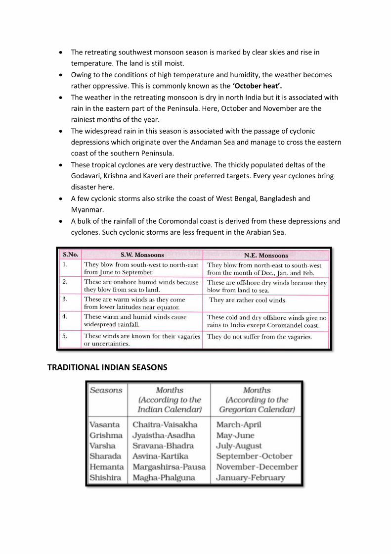
TRADITIONAL INDIAN SEASONS

DISTRIBUTION OF RAINFALL
The average annual rainfall in India is about 125 cm, but it has great spatial variations.
Areas of High Rainfall
The highest rainfall occurs along the west coast, on the Western Ghats, as well as in
the sub-Himalayan areas is the northeast and the hills of Meghalaya. Here the
rainfall exceeds 200 cm.
In some parts of Khasi and Jaintia hills, the rainfall exceeds 1,000 cm.
In the Brahmaputra valley and the adjoining hills, the rainfall is less than 200 cm.
Areas of Medium Rainfall
Rainfall between 100-200 cm is received in the southern parts of Gujarat, east Tamil
Nadu, north-eastern Peninsula covering Odisha, Jharkhand, Bihar, eastern Madhya
Pradesh, northern Ganga plain along the sub-Himalayas and the Cachar Valley and
Manipur.
Areas of Low Rainfall
Western Uttar Pradesh, Delhi, Haryana, Punjab, Jammu and Kashmir, eastern
Rajasthan, Gujarat and Deccan Plateau receive rainfall between 50-100 cm.
Areas of Inadequate Rainfall
Parts of the Peninsula, especially in Andhra Pradesh, Karnataka and Maharashtra,
Ladakh and most of western Rajasthan receive rainfall below 50 cm.
Snowfall is restricted to the Himalayan region.

Variability of Rainfall
A characteristic feature of rainfall in India is its variability.
The variability of rainfall is computed with the help of the following formula:
𝐶. 𝑉. =𝑆𝑡𝑎𝑛𝑑𝑎𝑟𝑑 𝐷𝑒𝑣𝑖𝑎𝑡𝑖𝑜𝑛
𝑀𝑒𝑎𝑛 𝑋 100
where C.V. is the coefficient of variation.

The values of coefficient of variation show variability of rainfall in India.
A variability of less than 25 per cent exists on the western coasts, Western Ghats,
north-eastern Peninsula, eastern plains of the Ganga, north-eastern India,
Uttarakhand and Himachal Pradesh and south-western part of Jammu and Kashmir.
These areas have an annual rainfall of over 100 cm.
A variability of over 50 per cent exists in the western part of Rajasthan, northern
part of Jammu and Kashmir and interior parts of the Deccan plateau. These areas
have an annual rainfall of less than 50 cm.
Rest of India have a variability of 25-50 per cent and these areas receive an annual
rainfall between 50 -100 cm.

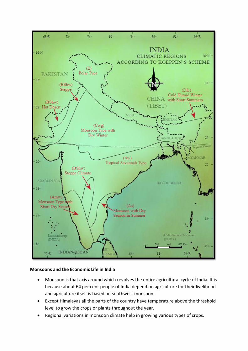
CLIMATIC REGIONS OF INDIA
The whole of India has a monsoon type of climate.
Temperature and rainfall are two important elements which are considered to be
decisive in all the schemes of climatic.
Major climatic types of India are based on Koeppen‘s scheme.
Koeppen based his scheme of Climatic classification on monthly values of
temperature and precipitation.
He identified five major climatic types, namely:
o Tropical climates, where mean monthly temperature throughout the year is
over 18°C.
o Dry climates, where precipitation is very low in comparison to temperature,
and hence, dry. If dryness is less, it is semi-arid (S); if it is more, the climate is
arid(W).
o Warm temperate climates, where mean temperature of the coldest month is
between 18°C and minus 3°C.
o Cool temperate climates, where mean temperature of the warmest month is
over 10°C, and mean temperature of the coldest month is under minus 3°C.
o Ice climates, where mean temperature of the warmest month is under 10°C.
Koeppen used letter symbols to denote climatic types as given above.
Each type is further sub-divided into sub-types on the basis of seasonal variations in
the distributional pattern of rainfall and temperature.
He used S for semi-arid and W for arid and the following small letters to define sub-
types: f (sufficient precipitation), m (rain forest despite a dry monsoon season), w
(dry season in winter), h (dry and hot), c (less than four months with mean
temperature over 10°C), and g (Gangetic plain).
India can be divided into eight climatic regions:
Monsoons and the Economic Life in India
Monsoon is that axis around which revolves the entire agricultural cycle of India. It is
because about 64 per cent people of India depend on agriculture for their livelihood
and agriculture itself is based on southwest monsoon.
Except Himalayas all the parts of the country have temperature above the threshold
level to grow the crops or plants throughout the year.
Regional variations in monsoon climate help in growing various types of crops.

Variability of rainfall brings droughts or floods every year in some parts of the
country.
Agricultural prosperity of India depends very much on timely and adequately
distributed rainfall.
Sudden monsoon burst creates problem of soil erosion over large areas in India.
Winter rainfall by temperate cyclones in north India is highly beneficial for rabi crops.
Regional climatic variation in India is reflected in the vast variety of food, clothes and
house types.
GLOBAL WARMING
Climate has also witnessed change in the past at the global as well as at local levels.
Besides the natural causes, human activities such as large-scale industrialisation and
presence of polluting gas in the atmosphere are also important factors responsible
for global warming.
Carbon dioxide produced by human activities is a major source of concern.
Other gases like methane, chlorofluorocarbons, and nitrous oxide which are present
in much smaller concentrations in the atmosphere, together with carbon dioxide are
known as green house gases.
These gases have been contributing to global warming.
It is said that due to global warming the polar ice caps and mountain glaciers would
melt and the amount of water in the oceans would increase.