Epigenetics of Host–Pathogen Interactions: The Road Ahead and the Road Behind
Upload
khangminh22Category
view
2download
0
CLALLAM COUNTY ROAD DEPARTMENT
Integrated Weed Management Plan
2021 Annual Report
BIO
LO
GIC
AL
P
HY
SIC
AL
C
HE
MIC
AL
C
UL
TU
RA
L
PR
EV
EN
TIT
IVE
P
OL
LIN
AT
OR
FR
IEN
DL
Y

Prepared by Clallam County Noxious Weed Control Board
Available online: http://www.clallam.net/Weed/RD_IWMP.html
Joe Reynolds, Control Specialist
Todd Coward, Lead Inspector
Cathy Lucero, Coordinator
3
Clallam County Road Department Integrated Weed Management Plan – 2021 Report
EXECUTIVE SUMMARY ................................................................................................................................................................ 4
PROJECT SUMMARY ................................................................................................................................................................... 6
MAPS: PROJECT AREAS AND TARGET ROADS .................................................................................................................... 8
MAP 1. CLALLAM COUNTY ROADSIDE TREATMENT OVERVIEW 2021 ................................................................................................. 9
MAP 2. BLYN – MILLER PENINSULA TREATMENT AREA ..................................................................................................................... 10
MAP 3. SEQUIM-DUNGENESS VALLEY TREATMENT AREA ................................................................................................................. 11
MAP 4. SOUTH SEQUIM TREATMENT AREA ........................................................................................................................................ 12
MAP 5. PORT ANGELES TREATMENT AREA ........................................................................................................................................ 13
MAP 6. JOYCE TREATMENT AREA ...................................................................................................................................................... 14
MAP 7. CLALLAM BAY TREATMENT AREA ........................................................................................................................................... 15
MAP 8. FORKS TREATMENT AREA ...................................................................................................................................................... 16
POST SEASON OBSERVATIONS: ............................................................................................................................................ 17
RECOMMENDATIONS: ............................................................................................................................................................... 21
APPENDIX A: 2021 IWM TASK TABLE .................................................................................................................................... 23
APPENDIX B: WEED SPECIES TREATED ON COUNTY ROADSIDES AND ROCK SOURCES 2021 ............................. 27
APPENDIX C: 2021 ROADSIDE TREATMENT ACTIVITIES: ................................................................................................. 30
APPENDIX D: COUNTY ROCK SOURCES/SOIL DISPOSAL SITE TREATMENT ACTIVITIES ........................................ 42
APPENDIX E: HERBICIDE VOLUMES BY COUNTY ROADS AND ROCK SOURCES ....................................................... 48
APPENDIX F: PILOT POLLINATOR PLANTINGS ................................................................................................................... 61
APPENDIX G: PROTOCOLS ...................................................................................................................................................... 63
APPENDIX H: WSU EXTENSION MASTER GARDENER ROADSIDE WEED MANAGEMENT MONITORING REPORT .................. 66
APPENDIX I: PENINSULA DAILY NEWS LEGAL NOTICE OF HERBICIDE USE 2021 ...................................................... 90
APPENDIX J: SAMPLE HERBICIDE NOTICE .......................................................................................................................... 91
APPENDIX K: SAMPLE HERBICIDE/MANUAL TREATMENT DATA FORM (SIDE 1)........................................................ 92
APPENDIX K: SAMPLE HERBICIDE/MANUAL TREATMENT DATA FORM (SIDE 2)........................................................ 93
APPENDIX L: SAMPLE OWNER WILL CONTROL ................................................................................................................. 94
APPENDIX M: SAMPLE ADOPT-A-PATCH PERMIT .............................................................................................................. 95
APPENDIX N: SAMPLE ADOPT-A-PATCH ACTIVITY REPORT ........................................................................................... 96
APPENDIX O: SAMPLE ADOPT-A-PATCH WAIVER .............................................................................................................. 97

4
Clallam County Road Department Integrated Weed Management Plan – 2021 Report
Executive summary Program Goal:
This program ensures Clallam County complies with noxious weed laws of Washington State. The goal of this project is to
shift roadside vegetation to natural, site appropriate plant communities. The goal is implemented by reducing existing
weed populations and preventing the establishment of new ones across the county.
Program Overview:
The Clallam County Integrated Weed Management Plan (IWM) was created to help the County efficiently comply with its
noxious weed control obligations. Integrated Weed Management is a coordinated decision making process that uses the
most appropriate weed management methods and strategies, along with a monitoring and evaluation system, to achieve
roadside maintenance goals and objectives in an environmentally and economically sound manner. The project identifies
high priority targets to contain the worst infestations and prevent the spread of noxious weeds.
2021 Project Overview:
This year we further integrated weed management into Road Department activities. We began treatments earlier and
expanded our control of weeds in pits. We combined weed surveys with manual control wherever possible. Our roadside
treatments were observed to be effective and well received by the public. Where treatments have occurred, overall weed
densities are declining. We monitored, maintained, and augmented pollinator-friendly native planting begun four years
ago; we applied lessons learned, and expanded our plantings at some 2019 and 2020 sites.
2021 Project Accomplishments:
Program Development
Progressed with all program development and implementation tasks outlined in IWM Plan.
Facilitated communication to further synch the IWM Plan with Road Department activities.
Implemented Pit Plans and treated each pit multiple times throughout the growing season.
Expanded Pollinator Planting Program; 2 new plantings, monitored, maintained and augmented 2018 -2020
projects. This has created great volunteer opportunities for the public.
Roadsides:
Controlled weeds on a total of 188 county roads and 72 retreatment/spot treatments; 27 roads manual only, 39 roads manual/herbicide, and 122 roads herbicide only.
Controlled 173 miles and examined 439 acres (including retreatments), treating 321.5 acres.
Herbicide was applied on 95 individual roads with a total of 17.1 gallons applied over 165 miles
Controlled 37 species.
More than 94 individuals interacted with staff during treatments.
County Rock Sources/Spoil Disposal Sites (Pits):
Treated 25 County Pits.
Controlled a total of 31 species over a total of 196.0 acres.
Controlled an estimated 18.2 solid acres chemically.
Herbicide was applied within 25 County Pits with a total of 14.7 gallons applied over 182 acres.
Strategic Pollinator Plantings:
Monitored, maintained, and/or augmented three projects (Black Diamond, Old Olympic Hwy/ODT and Deer Park Overpass).
Expanded the Deer Park planting site to the North of the overpass and augmented the slopes. Expanded the Old Olympic Highway/ ODT planting site adding mainly shrubs.
Coordinated with Clallam Conservation District, Broom Busters, and Peninsula Trails Coalition to recruit volunteers.
Incorporated 45 native shrub and forb species with sequential bloom periods.
A combined total of 8922 plants over approximately two acres were planted between the two sites.
Program Monitoring, Evaluation and Reporting
The Roadside Weed Monitoring Team (RWMT) assessed 49% of roadside treatments and reported 83% average
efficacy. RWMT assessed 49% of treated roads and reported 83% average efficacy. The team spent 400 hours
monitoring treatments and writing their annual report (See Master Gardener
Herbicide treatments were determined to be “Good”.
RWMT concluded their observations on the effect of native shrub cover on tree seedling recruitment in the right-of
way.

5
Clallam County Road Department Integrated Weed Management Plan – 2021 Report
Observations and Recommendations:
Italian thistle is an aggressive Class A noxious weed whose range and seedbank has been dramatically reduced
from a combination of frequent monitoring and treatments. There was a 90% reduction in hand pulling this year
compared to last year. We continue to experiment with ways to improve control techniques. Early treatments of widespread weeds such
as Scotch broom and uncut Himalayan blackberry were very successful. Conversely, early treatments of
Canada thistle and mowed Himalayan blackberry were not.
Progress in reducing regulated noxious weeds infestations along county roads will move many “priority 1 roads”
to a lower priority category. (See Integrated Weed Management Plan 2020 pp. 51-58 for more details).
Retreatments on county roads are a great tool for monitoring success. Retreatments also provide opportunity for
selective treatments that target specific weeds at different times of year.
The number of individual regulated weeds on roadsides has been greatly reduced. For this reason, we have
begun to tally the number of each species controlled during each treatment. Going forward, we will be able to
better compare weed density change year to year.
Ensuring clean materials for county projects reduces the potential for spreading noxious weeds and is our most
important and effective prevention tool. Whole rock source treatments continue to reduce the weed seedbank in
these areas. Because of progress in reducing the overall weed burden in our pits, treating entire pits for all
noxious weeds is becoming possible.
Poison hemlock and common teasel are concentrated in the eastern portion of the county. This year, new
infestations of poison hemlock and common teasel have been found farther west than ever before. Preventing
further spread, as well as detecting and eradicating new populations will be a high priority in 2022.
Treatments at “Special Sites” such as county revegetation sites and pollinator habitat enhancement corridors will
be a higher priority for next year. The steady reduction of regulated weeds along many of our county roads
creates more opportunity to focus on the long term maintenance and health of these additional county lands.
Volunteers at the Deer Park Overpass pollinator planting site greatly helped with maintenance obligations.
Setting up additional watering stations and seeking long term volunteer assistance at these sites until they are
well established is imperative to the future success of these projects.
Volunteer opportunities to participate in pollinator habitat enhancement at the Deer Park Overpass and the ODT
Berm are a great way to increase awareness of our pollinator program and to expedite plant installation.
Scotch broom pulling events were a popular way of engaging volunteers in a meaningful activity that improved
the quality and enjoyment of public lands.
The program tackled more widespread weeds such as Scotch broom and Himalayan blackberry. Further
research on additional Himalayan blackberry treatments options will be helpful.
Mowing to reduce tree growth on roadsides is a major consideration and one of the driving factors for roadside
mowing practices and frequency cycles. The “light mow” pilot projects on Diamond Point and Place Rd [study
conducted by the Roadside Weed Management Team (RWMT)] indicate that there is less tree seedling
recruitment when there is more competition from low growing plant communities. Potential expansion of this low
mow project to reduce effort needed to preserve safety and maintenance standards is an interesting prospect.
6
Clallam County Road Department Integrated Weed Management Plan – 2021 Report
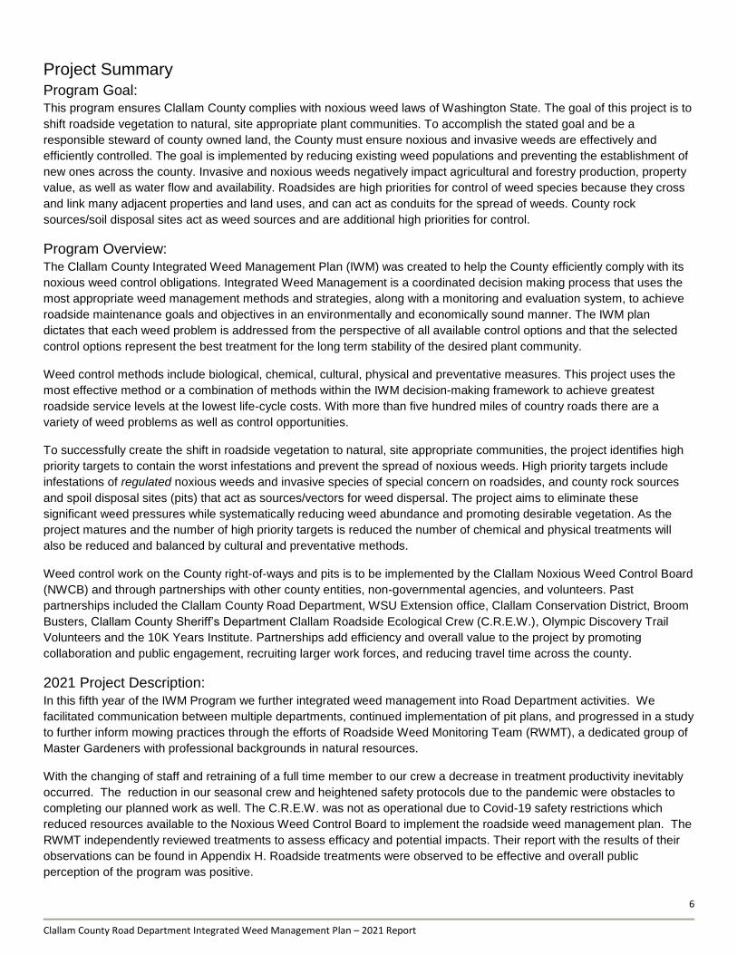
Project Summary
Program Goal: This program ensures Clallam County complies with noxious weed laws of Washington State. The goal of this project is to
shift roadside vegetation to natural, site appropriate plant communities. To accomplish the stated goal and be a
responsible steward of county owned land, the County must ensure noxious and invasive weeds are effectively and
efficiently controlled. The goal is implemented by reducing existing weed populations and preventing the establishment of
new ones across the county. Invasive and noxious weeds negatively impact agricultural and forestry production, property
value, as well as water flow and availability. Roadsides are high priorities for control of weed species because they cross
and link many adjacent properties and land uses, and can act as conduits for the spread of weeds. County rock
sources/soil disposal sites act as weed sources and are additional high priorities for control.
Program Overview:
The Clallam County Integrated Weed Management Plan (IWM) was created to help the County efficiently comply with its
noxious weed control obligations. Integrated Weed Management is a coordinated decision making process that uses the
most appropriate weed management methods and strategies, along with a monitoring and evaluation system, to achieve
roadside maintenance goals and objectives in an environmentally and economically sound manner. The IWM plan
dictates that each weed problem is addressed from the perspective of all available control options and that the selected
control options represent the best treatment for the long term stability of the desired plant community.
Weed control methods include biological, chemical, cultural, physical and preventative measures. This project uses the
most effective method or a combination of methods within the IWM decision-making framework to achieve greatest
roadside service levels at the lowest life-cycle costs. With more than five hundred miles of country roads there are a
variety of weed problems as well as control opportunities.
To successfully create the shift in roadside vegetation to natural, site appropriate communities, the project identifies high
priority targets to contain the worst infestations and prevent the spread of noxious weeds. High priority targets include
infestations of regulated noxious weeds and invasive species of special concern on roadsides, and county rock sources
and spoil disposal sites (pits) that act as sources/vectors for weed dispersal. The project aims to eliminate these
significant weed pressures while systematically reducing weed abundance and promoting desirable vegetation. As the
project matures and the number of high priority targets is reduced the number of chemical and physical treatments will
also be reduced and balanced by cultural and preventative methods.
Weed control work on the County right-of-ways and pits is to be implemented by the Clallam Noxious Weed Control Board
(NWCB) and through partnerships with other county entities, non-governmental agencies, and volunteers. Past
partnerships included the Clallam County Road Department, WSU Extension office, Clallam Conservation District, Broom
Busters, Clallam County Sheriff’s Department Clallam Roadside Ecological Crew (C.R.E.W.), Olympic Discovery Trail
Volunteers and the 10K Years Institute. Partnerships add efficiency and overall value to the project by promoting
collaboration and public engagement, recruiting larger work forces, and reducing travel time across the county.
2021 Project Description:
In this fifth year of the IWM Program we further integrated weed management into Road Department activities. We
facilitated communication between multiple departments, continued implementation of pit plans, and progressed in a study
to further inform mowing practices through the efforts of Roadside Weed Monitoring Team (RWMT), a dedicated group of
Master Gardeners with professional backgrounds in natural resources.
With the changing of staff and retraining of a full time member to our crew a decrease in treatment productivity inevitably
occurred. The reduction in our seasonal crew and heightened safety protocols due to the pandemic were obstacles to
completing our planned work as well. The C.R.E.W. was not as operational due to Covid-19 safety restrictions which
reduced resources available to the Noxious Weed Control Board to implement the roadside weed management plan. The
RWMT independently reviewed treatments to assess efficacy and potential impacts. Their report with the results of their
observations can be found in Appendix H. Roadside treatments were observed to be effective and overall public
perception of the program was positive.
7
Clallam County Road Department Integrated Weed Management Plan – 2021 Report
The Roadside Weed Management Team (RWMT) continues to develop the Strategic Pollinator Assessment map which
identifies pollinator corridor potential on County roadsides or managed lands. NWCB staff and volunteers expanded two
pollinator friendly plantings with locally sourced native plants.
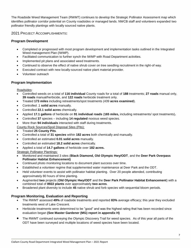
2021 PROJECT ACCOMPLISHMENTS:
Program Development
Completed or progressed with most program development and implementation tasks outlined in the Integrated Weed management Plan (IWMP).
Facilitated communication to further synch the IWMP with Road Department activities.
Implemented pit plans and associated weed treatments.
Continued to observe the effect of native shrub cover on tree seedling recruitment in the right-of way.
Executed contract with new locally-sourced native plant material provider.
Volunteer outreach
Program Implementation Roadsides:
Controlled weeds on a total of 116 individual County roads for a total of 188 treatments; 27 roads manual only, 39 roads manual/herbicide, and 122 roads herbicide treatment only.
Treated 173 miles including retreatments/spot treatments (439 acres examined).
Controlled .1 solid acres manually.
Controlled 22.1 solid acres chemically.
Applied 17.1 gallons of herbicide on 91 individual roads (165 miles, including retreatments/ spot treatments).
Controlled 37 species – including 14 regulated noxious weed species.
More than 94 individuals interacted with staff during treatments.
County Rock Sources/Spoil Disposal Sites (Pits):
Treated 25 County Pits.
Controlled a total of 31 species within 182 acres both chemically and manually.
Controlled an estimated 0.01 solid acres manually.
Controlled an estimated 18.2 solid acres chemically.
Applied a total of 14.7 gallons of herbicide over 182 acres.
Strategic Pollinator Plantings:
Monitored and maintained 3 sites (Black Diamond, Old Olympic Hwy/ODT, and the Deer Park Overpass Pollinator Habitat Enhancement)
Continued photo monitoring locations to document plant success over time.
Established a volunteer regime that supplemented water maintenance at Deer Park and the ODT.
Held volunteer events to assist with pollinator habitat planting. Over 20 people attended, contributing
approximately 80 hours of time planting.
Augmented two projects (Old Olympic Hwy/ODT and the Deer Park Pollinator Habitat Enhancement) with a combined total of 8922 plants over approximately two acres.
Broadened plant diversity to include 45 native shrub and forb species with sequential bloom periods.
Program Monitoring, Evaluation and Reporting
The RWMT assessed 49% of roadside treatments and reported 83% average efficacy; this year they excluded
treatments west of Lake Crescent.
Herbicide treatments were determined to be ”good” and was the highest rating that has been recorded since
evaluation began (See Master Gardener (MG) report in appendix H)
The RWMT continued surveying the Olympic Discovery Trail for weed species. As of this year all parts of the
ODT have been surveyed and multiple locations of weed species have been located.
8
Clallam County Road Department Integrated Weed Management Plan – 2021 Report
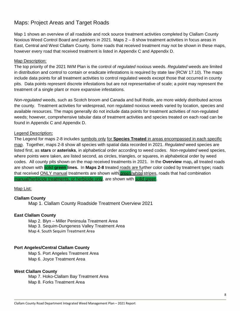
Maps: Project Areas and Target Roads
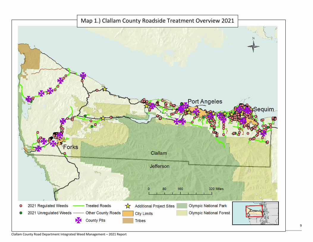
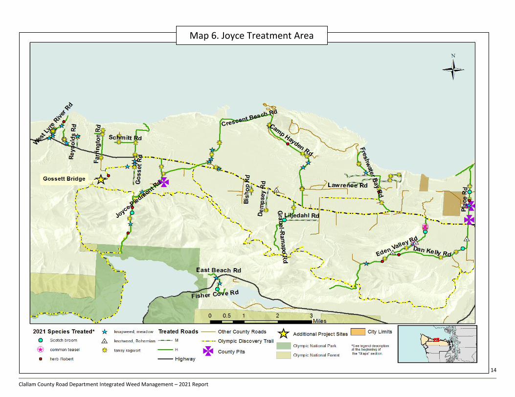
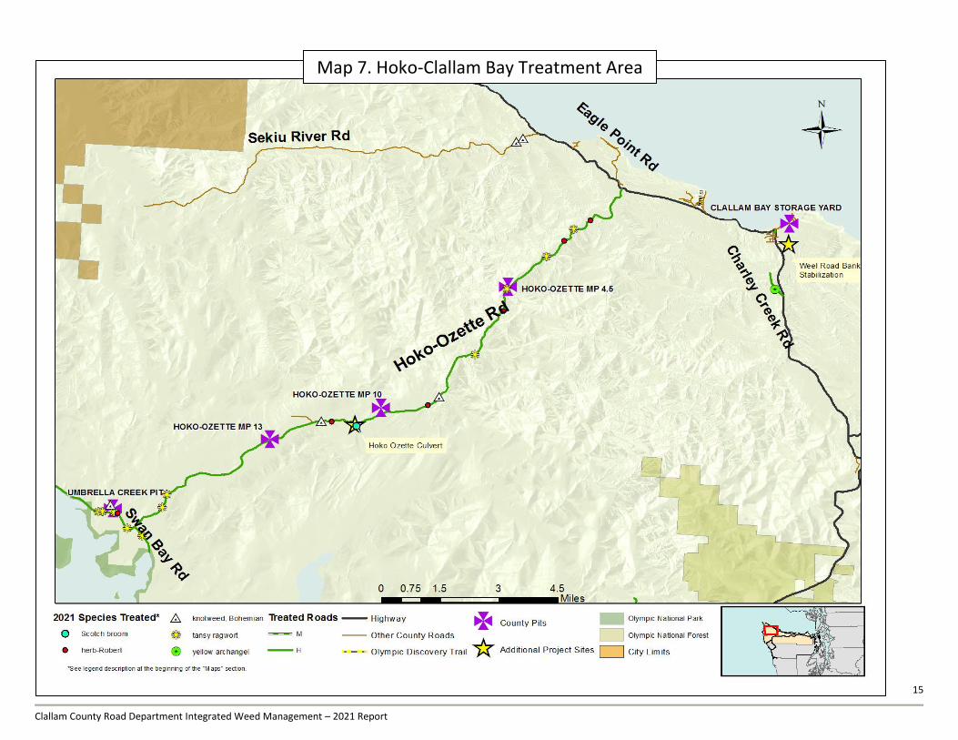
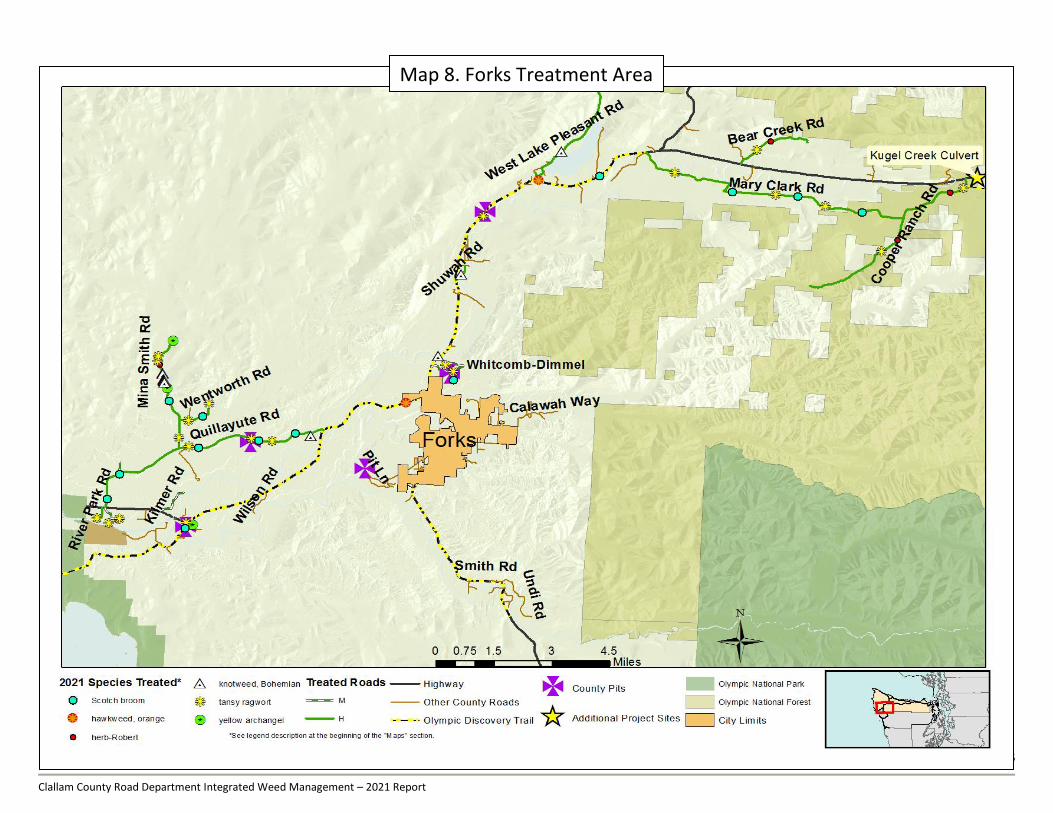
Map 1 shows an overview of all roadside and rock source treatment activities completed by Clallam County
Noxious Weed Control Board and partners in 2021. Maps 2 – 8 show treatment activities in focus areas in
East, Central and West Clallam County. Some roads that received treatment may not be shown in these maps,
however every road that received treatment is listed in Appendix C and Appendix D.
Map Description:
The top priority of the 2021 IWM Plan is the control of regulated noxious weeds. Regulated weeds are limited
in distribution and control to contain or eradicate infestations is required by state law (RCW 17.10). The maps
include data points for all treatment activities to control regulated weeds except those that occurred in county
pits. Data points represent discrete infestations but are not representative of scale; a point may represent the
treatment of a single plant or more expansive infestations.
Non-regulated weeds, such as Scotch broom and Canada and bull thistle, are more widely distributed across
the county. Treatment activities for widespread, non regulated noxious weeds varied by location, species and
available resources. The maps generally do not include data points for treatment activities of non-regulated
weeds; however, comprehensive tabular data of treatment activities and species treated on each road can be
found in Appendix C and Appendix D.
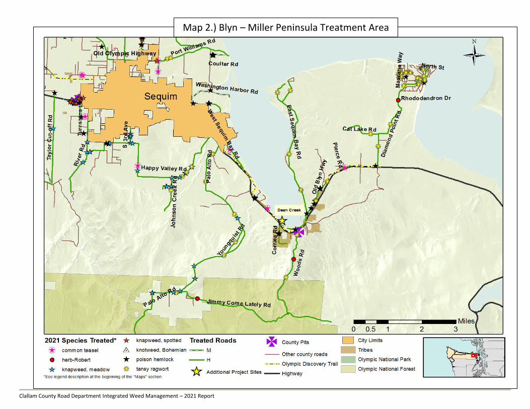
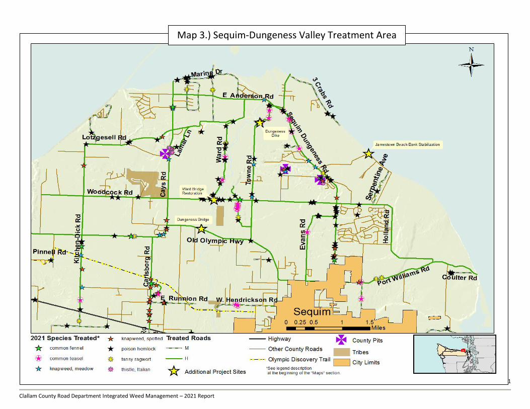
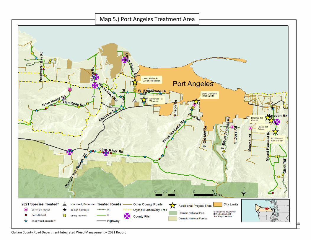
Legend Description:
The Legend for maps 2-8 includes symbols only for Species Treated in areas encompassed in each specific
map. Together, maps 2-8 show all species with spatial data recorded in 2021. Regulated weed species are
listed first, as stars or asterisks, in alphabetical order according to weed codes. Non-regulated weed species,
where points were taken, are listed second, as circles, triangles, or squares, in alphabetical order by weed
codes. All county pits shown on the map received treatments in 2021. In the Overview map, all treated roads
are shown with solid green lines. In Maps 2-8 treated roads are further color coded by treatment type; roads
that received ONLY manual treatments are shown with green/white stripes, roads that had combination
manual/herbicide treatments, or herbicide only, are shown with solid green.
Map List:
Clallam County
Map 1. Clallam County Roadside Treatment Overview 2021
East Clallam County
Map 2. Blyn – Miller Peninsula Treatment Area Map 3. Sequim-Dungeness Valley Treatment Area
Map 4. South Sequim Treatment Area
Port Angeles/Central Clallam County
Map 5. Port Angeles Treatment Area
Map 6. Joyce Treatment Area
West Clallam County Map 7. Hoko-Clallam Bay Treatment Area
Map 8. Forks Treatment Area
Map
2. B
lyn
– M
iller P
en
ins
ula
9
Clallam County Road Department Integrated Weed Management – 2021 Report
Map 1.) Clallam County Roadside Treatment Overview 2021
10
Clallam County Road Department Integrated Weed Management – 2021 Report
Map 1. Clallam County Roadside Treatment Overview 2017
Map 1. Clallam County Roadside Treatment Overview 2017
Map 2.) Blyn – Miller Peninsula Treatment Area
11
Clallam County Road Department Integrated Weed Management – 2021 Report
Map 3.) Sequim-Dungeness Valley Treatment Area

12
Clallam County Road Department Integrated Weed Management – 2021 Report
Map 4.) South Sequim Treatment Area
13
Clallam County Road Department Integrated Weed Management – 2021 Report
Map 5.) Port Angeles Treatment Area
14
Clallam County Road Department Integrated Weed Management – 2021 Report
Map 6. Joyce Treatment Area
15
Clallam County Road Department Integrated Weed Management – 2021 Report
Map 7. Hoko-Clallam Bay Treatment Area
16
Clallam County Road Department Integrated Weed Management – 2021 Report
Map 8. Forks Treatment Area

17
Clallam County Road Department Integrated Weed Management – 2021 Report
POST SEASON OBSERVATIONS:
2021:
Roadside weed management is an evolving process and the IWM Plan is intended to be evaluated and adapted over time based
on our observations, technical updates and input from partners and the public. The 2021 Plan was designed to complement our
previous work, adapt to the observed conditions, and further specific weed management goals. The successful execution of the
IWM plan is dependent on the effective coordination of its components. We reviewed the existing program, forms and protocols
developed previously and revised where needed for 2021. We invested substantial time and effort to improve coordination
between IWM and maintenance activities. The IWM Plan is a unique element within the Road department’s maintenance
program, but to be successful, weed control activities must be seamlessly incorporated into the general maintenance activities.
Weed control strategies must also be shaped to fit road maintenance criteria.
In the spring we solicited feedback from each shop superintendent, the environmental coordinator, and head of engineering
regarding planned weed control activities in the upcoming treatment season. We discussed specific weed control needs for pits
within each road district and how to synchronize road mowing schedules to better fit high priority weed life cycles and our
treatments. We noted individual communication preferences and exchanged or updated contact information. We brainstormed
solutions for mechanized removal of a Scotch broom infestation on the Lower Elwha Rd Right of Way (ROW). The District 2
superintendent committed crew and equipment to remove, haul and dispose of the Scotch broom. Another Scotch broom site
was located on county land adjacent to the District 3 shop and was undertaken at the specific request of the District 3
superintendent. Mowers efficiently reduced the biomass of approximately 6.5 acres of Scotch broom and allowed the Noxious
Weed Department to effectively treat this area.
Under staffing and turnover combined with increased maintenance obligations at pollinator enhancement sites resulted in less
time spent on roadside and pit treatments compared to 2020. We experienced the loss of one full time staff, a vacancy that was
prolonged until mid-April, thus reducing personnel usually available for some of our early season treatments. We had fewer
seasonals, who worked a shorter period, compared to last year. Watering upkeep on the pollinator enhancement sites also
weighed on resources available for treatment activities.
Pandemic safety protocols required adaptations to program strategies and operating procedures. The Sheriff’s C.R.E.W. was
reduced during the pandemic which limited resources at our disposal. Volunteer events and coordination with other
organizations did occur but Covid-19 precautions likely suppressed participation. Even with these obstacles, we were able to
meet many of our goals for this season. Not only were we were able to treat most of our priority 1 roads, we were also able to
conduct more in-season follow-up spot treatments of small, high priority weeds infestations. All but one county pit in the plan
were treated, often multiple times. Progress made controlling regulated weed species over the past several years has allowed us
to control of more widespread species such as Himalayan blackberries and Scotch broom.
The program also continues to supplement its pollinator habitat enhancement areas. This is now our fifth year of planting native
vegetation for pollinator habitat. It serves not only as native pollinator forage and habitat but a way of increasing the resilience of
public areas against noxious weed encroachment. An interpretive sign was constructed on the Olympic Discovery Trail,
spearheaded by the RWMT. These pollinator projects are a great way to educate the public on the many environmental
services that our program provides. Watering and maintenance though have begun to limit some of our ability to perform other
tasks. By summer, watering demanded around 25% of the total maintenance hours to keep the plantings survival rate at
standards we found acceptable. We were able to recruit two volunteer once a week to assist with our watering regime, but more
help will be needed next year to reduce these maintenance obligations.
Specific observations:
Program Development
“Adopt-a-patch” and “Owner Will Control” options were published online; received and accepted one “Owner Will
Control” agreement.
9 out of 10 “Public Requests” were accomplished.
We added “Priority 4” category (IWMP Report 2021 pages 51-58) for county roads where no noxious weeds were found.
Roads placed in this priority require less active annual monitoring. It is a goal to get all county roads sufficiently noxious
weed free to be placed into this category on a four year monitor/treatment cycle.
18
Clallam County Road Department Integrated Weed Management – 2021 Report
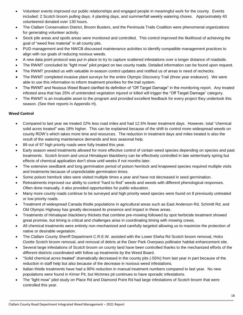
Volunteer events improved our public relationships and engaged people in meaningful work for the county. Events
included: 2 Scotch broom pulling days, 4 planting days, and summer/fall weekly watering chores. Approximately 40
volunteered donated over 130 hours.
The Clallam Conservation District, Broom Busters, and the Peninsula Trails Coalition were phenomenal organizations
for generating volunteer activity.
Stock pile areas and spoils areas were monitored and controlled. This control improved the likelihood of achieving the
goal of “weed free material” in all county pits.
PUD management and the NWCB discussed maintenance activities to identify compatible management practices to
align with our goals of reducing noxious weeds.
A new data point protocol was put in place to try to capture scattered infestations over a longer distance of roadside.
The RWMT concluded its “light mow” pilot project on two county roads. Detailed information can be found upon request.
The RWMT provided us with valuable in-season control updates and notified us of areas in need of rechecks.
The RWMT completed invasive plant surveys for the entire Olympic Discovery Trail (three year endeavor). We were
able to use this information to inform treatment priorities for the trail system. The RWMT and Noxious Weed Board clarified its definition of “Off Target Damage” in the monitoring report. Any treated
infested area that has 25% of unintended vegetation injured or killed will trigger the “Off Target Damage” category.
The RWMT is an invaluable asset to the program and provided excellent feedback for every project they undertook this
season. (See their reports in Appendix H).
Weed Control
Compared to last year we treated 22% less road miles and had 12.5% fewer treatment days. However, total “chemical
solid acres treated” was 18% higher. This can be explained because of the shift to control more widespread weeds on
county ROW’s which takes more time and resources. The reduction in treatment days and miles treated is also the
result of the watering maintenance demands and less seasonal help.
89 out of 97 high priority roads were fully treated this year.
Early season weed treatments allowed for more effective control of certain weed species depending on species and past
treatments. Scotch broom and uncut Himalayan blackberry can be effectively controlled in late winter/early spring but
effects of chemical application don’t show until weeks if not months later.
The extensive seedbank and long germination period of poison hemlock and knapweed species required multiple visits
and treatments because of unpredictable germination times.
Some poison hemlock sites were visited multiple times a year and have not decreased in seed germination.
Retreatments improved our ability to control “hard to find” weeds and weeds with different phenological responses.
Often done manually, it also provided opportunities for public education.
Many more county roads continue to be surveyed and high priority weed species were found on 8 previously untreated
or low priority roads.
Treatment of widespread Canada thistle populations in agricultural areas such as East Anderson Rd, Schmitt Rd, and
Old Olympic Highway has greatly decreased its presence and impact in these areas.
Treatments of Himalayan blackberry thickets that combine pre-mowing followed by spot herbicide treatment showed
great promise, but timing is critical and challenges arise in coordinating timing with mowing crews.
All chemical treatments were entirely non-mechanized and carefully targeted allowing us to maximize the protection of
native or desirable vegetation.
The Clallam County Sheriff Department C.R.E.W. assisted with the Lower Elwha Rd Scotch broom removal, Hoko
Ozette Scotch broom removal, and removal of debris at the Deer Park Overpass pollinator habitat enhancement site.
Several large infestations of Scotch broom on county land have been controlled thanks to the mechanized efforts of the
different districts coordinated with follow up treatments by the Weed Board.
“Solid chemical acres treated” dramatically decreased in the county pits (-55%) from last year in part because of the
reduction in staff help but also because of the decrease in noxious weed infestations.
Italian thistle treatments have had a 90% reduction in manual treatment numbers compared to last year. No new
populations were found in Kirner Pit, but McInnes pit continues to have sporadic infestations.
The “light mow” pilot study on Place Rd and Diamond Point Rd had large infestations of Scotch broom that were
controlled this year.
19
Clallam County Road Department Integrated Weed Management – 2021 Report
We invested substantial time and effort to communicate with individuals and businesses with specific concerns
regarding herbicide treatments.
The RWMT surveyed the ODT and we have responded with controlling the high priority weeds and are accounting for
areas where weedy wide spread species may be effectively treated and replaced with native vegetation.
The program assisted with the inventory and control of noxious weeds at the Department of Community Development
Towne Dike Project. This involved multiple days of mapping and treatment of existing weed species.
Plantings
The RWMT monitored 2018, 2019, and 2020 pollinator habitat enhancement projects on Black Diamond Rd, Old
Olympic Hwy/ODT, and Deer Park Enhancement Site. The purpose of the monitoring was to assess plant survivorship
and to assess the quality of pollinator habitat using the Xerces Society habitat assessment protocol. Planting areas were
treated for noxious weeds and augmented with additional native plants as dictated by space and need.
The partnership between Clallam County and a nursery that provided locally sourced native plants was crucial to our
planting successes this year. They were a flexible, knowledgeable local resource that provided us with healthy plants
and technical advice.
Native plant material was shared between road department projects as needed.
Our program assisted the Environmental coordinator in the fall for their planting revegetation sites. These sites included
augmenting Hoko-Ozette Rd, Ward Bridge, McDonald Bridge, Gossett Bridge, and a new site Dawley culvert. Dean
Creek was skipped due to the encroachment of Himalayan blackberry at the site.
The Deer Park Overpass site is very large and is comprised of many microenvironments. It is notably steep and
inhospitable. This year’s plantings are the 3rd
phase of a multi-year project.
The watering regime needed to support the 2019 and 2020 plantings was time intensive and required considerable
resources during our treatment season.
We have located two different locations to fill up water near our planting sites. This should help out with our watering
logistics.
New plantings began after weather had cooled and rainfall was likely to supply consistent moisture. Plantings at Deer
Park and the ODT trail were undertaken after all other road department sites were completed, but timing with the wetter
weather made it so that we rarely had to water any plants.
Two “super” volunteers helped with watering our pollinator enhancement areas. Weekly watering happened throughout
the dry periods of summer and into fall. This helped eliminate some of the program’s watering obligations.
We incorporated water polymers again when planting all our trees and shrubs at the Deer Park/ ODT Old Olympic berm
this year. This additive will hopefully retain water and cut down on resources needed for hand watering going forward.
Crew and Equipment
The published 2021 IWM was a valuable guide for crew and a helpful reference for the public.
The roadside crew included up to 3 full-time staff and 2 seasonal employees but crew composition on any given day
varied depending on the need.
Only two seasonal employees applied for positions this year. One worker returned to school by mid-August, the other at
the end of September. Even with our smaller staff we were able to accomplish most of our goals for this year.
One of the two seasonal workers acquired their Washington State Pesticide License. Seasonal crew received on-going
training; crew efficiency improved over the season.
No safety infractions or private property off target damage occurred during treatments.
Adding safety cones to our daily operations helped with professionalism and safety.
6 new backpacks were ordered early this year due to constant maintenance needs from older, worn backpacks. These
equipment updates immediately increased treatment efficiency and quality of work.
Our blue indicator dye continues to be a source of general maintenance and clean up in the bed of the truck and
equipment.
WSDA Smartphone and ArcCollector provided the crew access to spatial databases in the field and increased crew
ability to identify adjacent ownership and boundary lines and to coordinate treatments with wider landscape goals.

20
Clallam County Road Department Integrated Weed Management – 2021 Report
Crew uses a combination of control methods and strategies to treat infestations of noxious weeds Clockwise (beginning
from top left): manual control of large teasel patch; mechanized removal of Scotch broom on Lower Elwha Rd; volunteer
event on Old Blyn Highway; chemical control of golden bamboo spp.)
21
Clallam County Road Department Integrated Weed Management – 2021 Report
RECOMMENDATIONS:
The Clallam County Integrated Weed Management Plan is intended to be annually evaluated and adapted over time in response
to changing conditions and needs. Input and technical updates from federal and state agencies, tribes, universities and local
partners and stakeholders are essential. For that reason the results of control activities are monitored, evaluated and the
program activities adjusted as necessary.
Specific recommendations for the 2022 IWM Program:
Program Development
Identify most or all county lands. This will help the program’s ability to monitor and respond to noxious weed problems
more quickly and effectively.
Planting species that have known success on the Deer Park Overpass pollinator enhancement project will help mortality
rates. Planting lower on the slopes and closer together will help minimize our watering needs.
Utilization of volunteer help on Deer Park and the Old Olympic Highway ODT planting sites will greatly help survivorship
of plants and minimize maintenance for program staff.
Develop and expand pollinator forage and habitat enhancement projects and coordinate with Road Department, WSU
Extension and other partners.
Publicizing program efforts on our pollinator enhancement sites, Scotch broom pulling events, and RWMT activity can
create more public engagement and highlight road department efforts at environmental stewardship. Examples include
linking in with the mailing list of active organizations such as the Clallam Conservation District, Broom Busters,
Peninsula Trails Coalition and the social media arm of the WSU Master Gardeners.
FAQ page on website should be created to answer more of our common email questions. Some of those questions are:
“How should we dispose of Scotch broom?” “What roads do you plan to treat and when?” “Is ---- a regulated weed?”
“Owner Will Control Agreements” (Appendix F IN IWMP 2020) have only been submitted by one property owner through
the entire programs history, and “Adopt a Patch” (Appendix G IWMP 2020) have never been used. “Owner Will Control”
agreements may need to be highlighted on our website more and in a brochure for the courthouse. “Adopt a Patch”
agreements should potentially be replaced in favor or volunteer events with specific dates and locations.
Continue to support coordination and communication between the Noxious Weed Control Board, Road Department,
Sheriff’s Department, Clallam Conservation District, WSU Extension, and other partners.
Collaborate with Road Department maintenance staff and Clallam PUD to identify landscape goals and harmonize
maintenance techniques wherever possible.
Prior years had protocols that public requests needed to be asked for before March 1st, something we may consider
changing to later in year if flexibility in schedule continues.
Foster and maintain an atmosphere of cooperation and open communication between mowing staff and noxious weed
department.
Continue to support and develop native plant material availability. Coordinate and plan better for the private property
“native plant enhancement” option with our “owner will control” contracts.
Evaluate and revise pit plans as necessary with input from ER&R Manager, shop supervisors and engineers.
Identify more county roads where we can implement the “light touch” mowing program.
Crew, Equipment, and Data
Finding better containers for the blue indicator dye would help with clean up and professionalism.
Create weed point/layers of our data for the Avensa App. This will make it easier for the RWMT and Noxious Weed
Board to navigate to past sites that are outside of reception area and utilization of more electronic devices.
Coordinate with Road Department for gear rack and accessories as necessary for work vehicle.
Get water capacity of around 400 gallons between the two sites (Olympic Hwy/ODT and Deer Park). This will make
volunteer assistance easier for the late spring and summer watering needs.

22
Clallam County Road Department Integrated Weed Management – 2021 Report
The RWMT found the new point methodology a hindrance to monitoring efficacy. We will move back to our previous
data collecting protocols next year.
Standardize protocol for point taking to help the program’s ability to record and track infestations and assist the RWMT’s
efforts. Striking a balance between too many points and overgeneralization needs to be clarified.
Develop a table for annual report that captures multiple years of treatments and data trends on county roads.
Recruit and train seasonal crew earlier in 2022.
Coordinate with Clallam County GIS department to support and utilize all technical upgrades for data collection.
Weed Control
“Special Sites” will be a higher priority for next year. Revegetation projects for road sites have become a larger part of
our obligations in the fall, and follow up maintenance is an essential aspect of success of these projects.
Continue inventorying Scotch broom patches for future potential volunteer events. Projects must be in low traffic areas,
optimally on Olympic Discovery Trail or other county lands, where work parties can safely operate.
Himalayan blackberry is now the species that requires more effort and collaboration. This is a daunting prospect without
clear answers, further confounded by the long bloom time of the species and the occasional public harvesting of berries.
Treatments with the active ingredient clopyralid show great promise on many different weed species. Its limitations are
also its greatest qualities; it’s highly selective on what it will control. With added flexibility and retreatments we may be
able to do more selective treatments at different times to best optimize our management practices.
Reducing the number of priority 1 roads will free up our ability to focus on spot treatments of known regulated weed
infestations.
With the reduction of C.R.E.W. personnel, the need for weed control around guard rails and line of sight treatments is
greater and will have to be prioritized in our plan of work.
Provide for time and resources to walk treatment areas of roads with known infestations of priority weeds.
Develop strategies to determine treatments of non-priority category 2 species.
Continue to diligently map and record all new infestations of high priority, category 1 species.
Begin to lower priorities on roads that have been treated for multiple years that have smaller, sporadic infestations.
Increase communication with Olympic Discovery Trail Volunteers and Coordinator to find and transition areas from weed
landscapes to more native vegetation corridors.
Monitor and support the pilot Pollinator Habitat Enhancement Areas with follow-up weed control.
Evaluate roads not treated in prior seasons.
General 2022 Treatment Recommendations:
1. Treat category 1, priority weeds on roadsides. a. Repeat treatment of roads in 2021 IWM Plan as necessary; identify roads to begin a 4 year maintenance cycle.
b. Survey known or suspected infestation areas on foot as time and resources allow.
c. Control noxious weeds on intersecting or adjacent roads to 2021 treatments as necessary.
2. Treat category 1 and category 2 weeds in County pits as determined by pit plans.
3. Treat species and locations with most impact local agriculture.
a. Continue outreach with local farmers to identify priorities and potential concerns.
4. Treat species and locations with most impact to local forestry
a. Continue outreach to identify priorities and potential concerns.
5. Treat non-native weeds at Road Department identified special sites.
a. Consult with environmental coordinator, shop supervisors, and engineers to identify priorities.
6. Coordinate roadside treatments to support weed management goals adjacent to County land.

23
Clallam County Road Department Integrated Weed Management – 2021 Report
Appendix A: 2021 IWM Task Table The table below lists the tasks included in the IWM Work Plan and highlights the balanced approach to weed management. The
specific tasks represent the best mix of control options chosen to address specific weed problems. The tasks are categorized by
the weed management strategies: Biological, Physical, Cultural, Preventative, and Chemical. We completed or made
substantial progress on all tasks listed below. The integral precept of the IWM Work Plan is that all treatment methods are
potentially applicable to the County’s management of noxious weeds. The table lists the task in bold, description of 2021
activities; blue check marks indicate completed tasks, orange check marks indicate partially completed tasks.
Task Status1 Biological
Identify release appropriate sites adjacent to County right-of-way: Identified project sites, no new developments in 2020
Coordinate with WSU Extension and Noxious Weed Control Board for Releases as they become available: Nothing new in 2020, site appropriate biocontrol agents currently available. Suitable sites TBD.
Assist with research projects where possible: Master Gardeners finished a 3 yearlong study showing that native shrub communities do suppress tree and noxious weed encroachment. Identifying other areas for light mow expansion is now possible.
Physical
Update contact list to be shared between departments: Shared contact between Road Department Superintendents, Environmental Coordinator, and ODT Volunteer Coordinator.
Coordinate mowing schedule with weed treatments to avoid incompatible treatments: NWCB staff regularly updated shop supervisors when working in their regions. Treatments were able to be effectively applied to all sites without interference of mowers or NWCB staff interfering with mowing schedule.
Provide mowers with map of planned weed treatment areas: Found to be unnecessary. Verbal communication and regular check ins on district mow maps in each shop is a better strategy for coordination.
Clearly mark treatment areas, communicate location to field crews: All treatment sections were posted with Herbicide Notice during and after treatments for at least 24 hours. Unnecessary to communicate location to field crews.
Schedule and oversee six weeks of Chain Gang for large pulling projects: 2021 had a major reduction in the Chain Gang members and played catch up through a large part of the year. Even so they helped with Scotch broom removal on Lower Elwha Rd and Hoko Ozette culvert, as well as disposing of biomass at Deer Park Loop.
Provide training and focus area maps for Chain Gang projects: Reduction of Chain Gang or absence of members led to no training or focus area maps.
Support volunteer opportunities for weed pulling projects as appropriate: Volunteer events were a major part of 2021. The program had over 40 people and 130 hours of volunteer cooperation.
Identify "Adopt-a-Patch" locations appropriate for manual control that can be adopted by members of the public; post online before treatment season begins: Prior roads had been identified but no applications were submitted.
Review public involvement opportunities to ensure the available material meets program goals and is readily accessible online: Coordinating with the Clallam Conservation District, Broom Busters, and Peninsula Trails Coalition and WSU Extension mailing lists helped our online presence and led to tremendous volunteer support.
Discourage mowing of desirable native vegetation wherever possible: Discussed with district mow staff about progressive mow BMPs. Focused on a “light touch” techniques to maintain desirable vegetation.

24
Clallam County Road Department Integrated Weed Management – 2021 Report
Collaborate with mowing personnel to update mowing practices: Pre- season meeting with shop supervisors. Research on current mowing equipment and potential upgraded implements required.
Consult on road standards that maximize mowing effectiveness in regard to weed control: Developed “light touch” BMPs with Roads management and maintenance staff. Began implementing progressive approach where appropriate.
Cultural
Identify opportunities to use native plantings in the early stages of projects in the county's transport plan: Provided assistance in augmenting revegetation sites for county lands.
Further develop Strategic Pollinator friendly plantings and coordinate with Road Department, WSU Extension to incorporate existing volunteer programs: Another successful year of augmenting and expanding our Pollinator plantings at Deer Park and the ODT Old Olympic sites. Over 100 volunteer hours were put into planting and interpretive sign development.
Compile list of plant material sources and needs from other government entities: Continued collaboration with local agencies including: USFS, Olympic National Park, WSDOT, and DNR to address plant material needs and potential sources.
Seek grant opportunities to implement pilot projects: Monitored and maintained Pollinator Enhancement projects, completed light mow pilot projects, and WSU extension achieved a $500 grant for an interpretive sign at our ODT Old Olympic Highway site.
Foster partnership with locally sourced nursery and updated native plant material list and program as necessary: Renewed contract.
Partner with experts from local, state and federal agencies and entities including but not limited to: Clallam County Parks, Washington State University Extension, WSU Master Gardeners, local chapter of bee keepers, the native plant and Audubon societies, the Nature Conservancy, conservation districts, Olympic National Park, Olympic National Forest, USFW Marine Refuge System, Makah, Quileute, Lower Elwha Klallam, and Jamestown S'Klallam tribes, and others who have an interest in developing local native seed and plant resources for use in government projects:. Our partnership with WSU extension and the WSU Master Gardeners is ongoing, and continues to be a linchpin in our public operations. Collaboration with 10KYI and fulfilling a “Partnership Packet” helps coordinate each other’s objectives.
Encourage landowners with "Owner Will Control" agreements to undertake adjacent roadside enhancement consistent with developing a low maintenance, self-sustaining plant community to prevent weed invasion: Dispersed material to public on “Owner Will Control” agreements whenever interest arose or conflict about weed management on ROW occurred. Program was willing to waive the March 1
st deadline to anyone with conflicting
management goals; at least 10 agreements were given out, none were returned. Only one contract was agreed upon and was the same property owner as last year.
Develop native seed mix for Road Department projects where bare ground is necessary: This project is underway for locally sourced seed mix
Preventative
Update rock and gravel source weed management protocols: Protocols remained the same throughout the year.
Inventory, develop and implement weed management plans for all county quarries, storage areas, and spoil disposal sites (pits); update as needed as County use requirements change: Completed inventories of most County pits (25). Meeting with ER&R manager to discuss any future changes.
Create county pit reference maps to include in management plans: Aerial maps were created last year but not necessary for any practical use in pits. Having locations in ArcMap has been adequate reference.
25
Clallam County Road Department Integrated Weed Management – 2021 Report
Adopt weed free material requirements for all county projects: A rewriting of the “Weed Free Material” clause is underway in the county contracts.
Provide inspection services for all privately sourced material for county projects that may be weed-contaminated: Completed 9 private pit inspections.
Compile list of sources that meet weed-free standards: Updated private pit list in K:\Interdepartmental\A-Share\Roads\NoxiousWeeds_PitCertifications\Pit Inspections\ClallamPits_NoxiousWeedCertifications.xlsx
Facilitate annual department weed and native plant identification training in cooperation with weed board staff. Supply field crew with identification booklets. Provide plant identification services for field crew in cooperation with weed board staff: No annual department weed and native plant identification training was conducted and none was deemed necessary. The mowing crews have all been educated on not mowing knotweed and to communicate with program staff if patches are found on county land. All other weed strategies are either adapted to the mowing schedule or coordinated with the program and the superintendents of each district.
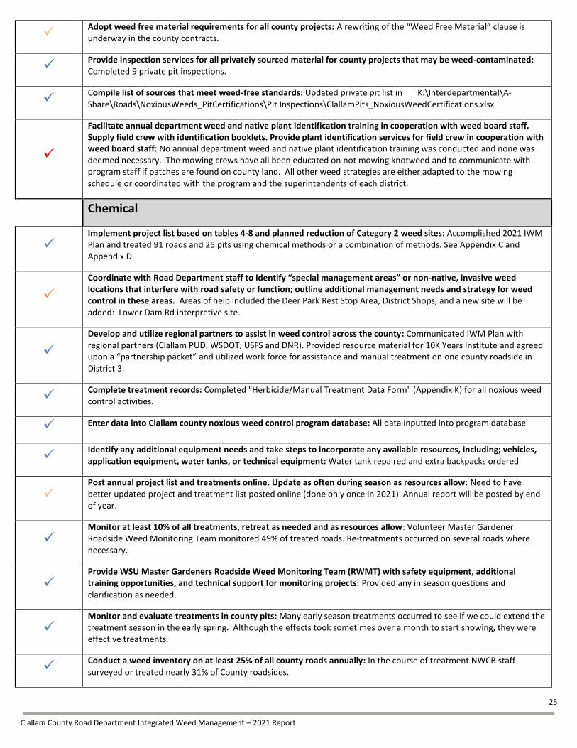
Chemical
Implement project list based on tables 4-8 and planned reduction of Category 2 weed sites: Accomplished 2021 IWM Plan and treated 91 roads and 25 pits using chemical methods or a combination of methods. See Appendix C and Appendix D.
Coordinate with Road Department staff to identify “special management areas” or non-native, invasive weed locations that interfere with road safety or function; outline additional management needs and strategy for weed control in these areas. Areas of help included the Deer Park Rest Stop Area, District Shops, and a new site will be added: Lower Dam Rd interpretive site.
Develop and utilize regional partners to assist in weed control across the county: Communicated IWM Plan with regional partners (Clallam PUD, WSDOT, USFS and DNR). Provided resource material for 10K Years Institute and agreed upon a “partnership packet” and utilized work force for assistance and manual treatment on one county roadside in District 3.
Complete treatment records: Completed "Herbicide/Manual Treatment Data Form" (Appendix K) for all noxious weed control activities.
Enter data into Clallam county noxious weed control program database: All data inputted into program database
Identify any additional equipment needs and take steps to incorporate any available resources, including; vehicles, application equipment, water tanks, or technical equipment: Water tank repaired and extra backpacks ordered
Post annual project list and treatments online. Update as often during season as resources allow: Need to have better updated project and treatment list posted online (done only once in 2021) Annual report will be posted by end of year.
Monitor at least 10% of all treatments, retreat as needed and as resources allow: Volunteer Master Gardener Roadside Weed Monitoring Team monitored 49% of treated roads. Re-treatments occurred on several roads where necessary.
Provide WSU Master Gardeners Roadside Weed Monitoring Team (RWMT) with safety equipment, additional training opportunities, and technical support for monitoring projects: Provided any in season questions and clarification as needed.
Monitor and evaluate treatments in county pits: Many early season treatments occurred to see if we could extend the treatment season in the early spring. Although the effects took sometimes over a month to start showing, they were effective treatments.
Conduct a weed inventory on at least 25% of all county roads annually: In the course of treatment NWCB staff surveyed or treated nearly 31% of County roadsides.

26
Clallam County Road Department Integrated Weed Management – 2021 Report
Identify, document and map additional species, location, size and density: Mapped and recorded information on all regulated weed species encountered on county roadsides and rock sources during 2021 activities.
Update survey data of county roadsides and catalog infestations over time: All survey and treatment data has been compiled for this report. Infestations and survey results will be recorded in NWCB database this winter.
Identify and compile a list of high priority infestations for following year. Create map: In process.
Identify and compile a list of sites for revegetation appropriate opportunities: List of possible pollinator identified and in process with Road department to determine long-term feasibility.
Support four, volunteer-based projects either on or adjoining county property that protects county property from weed infestations. This may include monitoring, road-typing for re-vegetation, and re-vegetation projects: Completed 4 planting events to implement pilot-pollinator projects and 3 Scotch broom events. Events totaled over 130 volunteer hours and 40 different people. Volunteer Master Gardener RWMT recorded over 400 volunteer hours dedicated to the 2021 IWM Plan.
Compile locations and instructions for special management areas. Include and update field maps as frequently as needed:. Lower Dam Interpretive center and Dawley Washout will be added to “special sites.” Last year Dean Creek, Gosset Bridge, and Dungeness Bridge were added.
Promptly respond to all public inquiries. Address any public concerns regarding applications: Provided project information and specific activity information to over 94 individuals in the field. Answered and responded to inquiries directed to the phone number listed on “Herbicide Notice” (Appendix J). Contacted all registered sensitive persons relevant to control activities (2); in addition to RCW requirements we provided periodic updates, alternate route information and additional accommodations.
Manage "Owner Will Control" agreements: Complete. 1 accepted agreements.
Review “Owner Will Control” application process and forms to ensure all public involvement opportunities are readily accessible online: Complete.
Maintain current list and map of "Owner Will Control" locations for both office and field use: Complete.
Review and update on-line weed control request application process and forms as necessary: Contact form available online at: http://www.clallam.net/features/emailClallam.asp?em=weed
Review process and forms for interdepartmental communication: Inquired about up to date mowing layer and more electronic point communication between road and noxious weed department. Development of interdepartmental communication still years away. Continued interdepartmental spreadsheet showing certified private pit inspections.
Compile annual report summarizing accomplishments, effectiveness, and recommendations for subsequent year. Brief the Road Department and County Commissioners by December 31st: In process, will be completed by December 31st
Draft IWM plan and submit to the Clallam County Noxious Weed Control Board and Road Department Supervisor for approval prior to the Weed Board's first meeting of the year. Submission of the IWM plan should occur 20 days before the meeting, and should be posted online. Provide public notice that plan will be discussed, with weed board meeting announcements. The finalized plan and a map of proposed treatment locations should be posted online and made available upon public request: In process.
1Blue check marks indicate task completed in 2021; Orange check marks indicate partial completion, Red check marks indicate not completed.
27
Clallam County Road Department Integrated Weed Management– 2021 Report
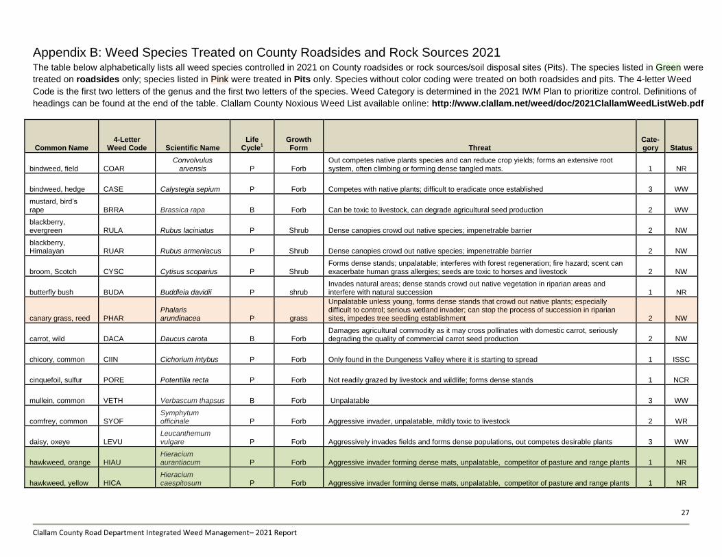
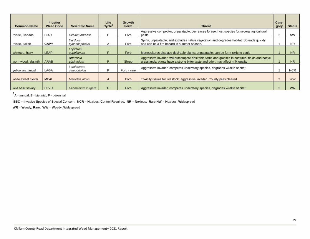
Appendix B: Weed Species Treated on County Roadsides and Rock Sources 2021 The table below alphabetically lists all weed species controlled in 2021 on County roadsides or rock sources/soil disposal sites (Pits). The species listed in Green were
treated on roadsides only; species listed in Pink were treated in Pits only. Species without color coding were treated on both roadsides and pits. The 4-letter Weed
Code is the first two letters of the genus and the first two letters of the species. Weed Category is determined in the 2021 IWM Plan to prioritize control. Definitions of
headings can be found at the end of the table. Clallam County Noxious Weed List available online: http://www.clallam.net/weed/doc/2021ClallamWeedListWeb.pdf
Common Name 4-Letter
Weed Code Scientific Name Life
Cycle1
Growth Form Threat
Cate-gory Status
bindweed, field COAR Convolvulus
arvensis P Forb Out competes native plants species and can reduce crop yields; forms an extensive root system, often climbing or forming dense tangled mats. 1 NR
bindweed, hedge CASE Calystegia sepium P Forb Competes with native plants; difficult to eradicate once established 3 WW
mustard, bird’s rape BRRA Brassica rapa B Forb Can be toxic to livestock, can degrade agricultural seed production 2 WW
blackberry, evergreen RULA Rubus laciniatus P Shrub Dense canopies crowd out native species; impenetrable barrier 2 NW
blackberry, Himalayan RUAR Rubus armeniacus P Shrub Dense canopies crowd out native species; impenetrable barrier 2 NW
broom, Scotch CYSC Cytisus scoparius P Shrub Forms dense stands; unpalatable; interferes with forest regeneration; fire hazard; scent can exacerbate human grass allergies; seeds are toxic to horses and livestock 2 NW
butterfly bush BUDA Buddleia davidii P shrub Invades natural areas; dense stands crowd out native vegetation in riparian areas and interfere with natural succession 1 NR
canary grass, reed PHAR Phalaris arundinacea P grass
Unpalatable unless young, forms dense stands that crowd out native plants; especially difficult to control; serious wetland invader; can stop the process of succession in riparian sites, impedes tree seedling establishment 2 NW
carrot, wild DACA Daucus carota B Forb Damages agricultural commodity as it may cross pollinates with domestic carrot, seriously degrading the quality of commercial carrot seed production 2 NW
chicory, common CIIN Cichorium intybus P Forb Only found in the Dungeness Valley where it is starting to spread 1 ISSC
cinquefoil, sulfur PORE Potentilla recta P Forb Not readily grazed by livestock and wildlife; forms dense stands 1 NCR
mullein, common VETH Verbascum thapsus B Forb Unpalatable 3 WW
comfrey, common SYOF Symphytum officinale P Forb Aggressive invader, unpalatable, mildly toxic to livestock 2 WR
daisy, oxeye LEVU Leucanthemum vulgare P Forb Aggressively invades fields and forms dense populations, out competes desirable plants 3 WW
hawkweed, orange HIAU Hieracium aurantiacum P Forb Aggressive invader forming dense mats, unpalatable, competitor of pasture and range plants 1 NR
hawkweed, yellow HICA Hieracium caespitosum P Forb Aggressive invader forming dense mats, unpalatable, competitor of pasture and range plants 1 NR

28
Clallam County Road Department Integrated Weed Management– 2021 Report
Common Name 4-Letter
Weed Code Scientific Name Life
Cycle1
Growth Form Threat
Cate-gory Status
hawthorne, English CRMO Crataegus monogyna O Tree Dense thickets can dominate shrub layer and suppress desirable vegetation 2 NR
hoary alyssum BEIN Berteroa incana A, B Forb Can be toxic to horses; spreads aggressively in disturbed areas 1 NR
holly, English ILAQ Ilex aquifolium P Shrub Dense thickets can dominate shrub layer and suppress desirable vegetation 3 WW
fennel, common* FOVU Foeniculum vulgare P Forb Dense stands exclude native vegetation 1 NCR
fox glove DIPU Digitalis purpurea B Forb Can be toxic to livestock; spreads aggressively in disturbed areas 3 WW
nightshade, hairy SOPH Solanum physalifolium P Forb Can be toxic to humans and livestock; limited distribution 1 WR
herb Robert GERO Geranium robertianum A, B Forb
Rapid spreading; displaces native herbaceous plants; allelopathic, inhibits the germination of small seeded forbs in forest understory 1 NW
Ivy, English HEHE Hedera helix P Shrub - vine Aggressive invader, competes understory species, degrades wildlife habitat, can cause tree collapse due to added canopy weight and surface area. 2 NW
knapweed, meadow CEMO
Centaurea x moncktonii P Forb Outcompetes pasture species; degrades wildlife habitat; interferes with agriculture 1 NCR
knapweed, spotted CEST Centaurea stoebe B Forb Allelopathic plant that can inhibit the germination of grasses; forms dense stands that exclude desired plants and wildlife 1 NCR
knotweed, Bohemian POBO
Polygonum x bohemicum P Shrub
Easily spreads by disturbance; dense colonies eliminate other plant species and can degrade fish habitat; causes structural damage to human structures 1 NCR
laurel, spurge DALA Daphne laureola P Shrub Toxic to humans and animals; contact with plants can cause dermatitis 1 NR
lupine, tree LUAR Lupinus arboreus P Shrub Aggressive invader forming dense monocultures, potentially toxic to livestock 2 WR
peavine, everlasting LALA Lathyrus latifolius, P Forb - vine
Forms dense thickets; seeds can be toxic to livestock; seriously interferes with forest regeneration where it invades from edges of timber units 2 ISSC
periwinkle, greater VIMA Vinca major P Shrub - vine Rapidly spreading, invades and displaces native or desirable vegetation 2 WR
poison hemlock COMA Conium maculatum B Forb Highly toxic to humans and animals; all parts of the plant are toxic; severe birth defects 1 NCR
St Johnswort, common HYPE
Hypericum perforatum P Forb Causes photo-sensitization when grazed; toxic at all stages of growth 3 NW
tansy ragwort SEJA Senecio jacobaea B Forb Poisonous to horses, cattle, and pigs; animals grazing tansy can produce tainted milk, may result in potentially toxic residue in honey 1 NCR
tansy, common TAVU Tanacetum vulgare P Forb Dense stands degrade forage value; toxicity issues for humans and livestock 1 NR
teasel, common DIFU Dipsacus fullonum B Forb Forms dense stands of prickly, unpalatable plants; degrades habitat and reduces accessibility 1 NR
thistle, bull CIVU Cirsium vulgare B Forb Aggressive competitor, unpalatable for cattle 2 NW
29
Clallam County Road Department Integrated Weed Management– 2021 Report
Common Name 4-Letter
Weed Code Scientific Name Life
Cycle1
Growth Form Threat
Cate-gory Status
thistle, Canada CIAR Cirsium arvense P Forb Aggressive competitor, unpalatable; decreases forage; host species for several agricultural pests 2 NW
thistle, Italian CAPY Carduus pycnocephalus A Forb
Spiny, unpalatable, and excludes native vegetation and degrades habitat. Spreads quickly and can be a fire hazard in summer season. 1 NR
whitetop, hairy LEAP Lepidium appelianum P Forb Monocultures displace desirable plants; unpalatable; can be form toxic to cattle 1 NR
wormwood, absinth ARAB Artemisia absinthium P Shrub
Aggressive invader, will outcompete desirable forbs and grasses in pastures, fields and native grasslands; plants have a strong bitter taste and odor, may affect milk quality 1 NR
yellow archangel LAGA Lamiastrum galeobdolon P Forb - vine
Aggressive invader, competes understory species, degrades wildlife habitat 1 NCR
white sweet clover MEAL Melilotus albus A Forb Toxicity issues for livestock; aggressive invader. County piles cleared 3 WW
wild basil savory CLVU Clinopidium vulgare P Forb Aggressive invader, competes understory species, degrades wildlife habitat 2 WR
1A - annual; B - biennial; P - perennial
ISSC = Invasive Species of Special Concern, NCR = Noxious, Control Required, NR = Noxious, Rare NW = Noxious, Widespread
WR = Weedy, Rare, WW = Weedy, Widespread
30
Clallam County Road Department Integrated Weed Management– 2021 Report
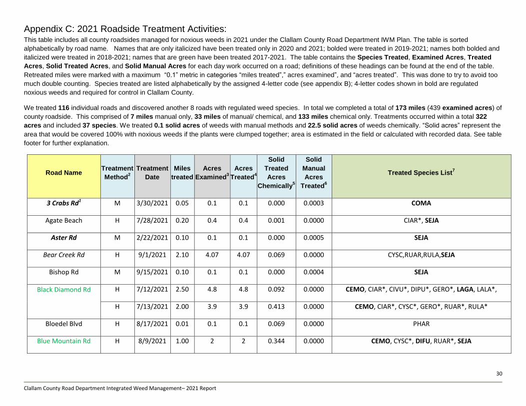
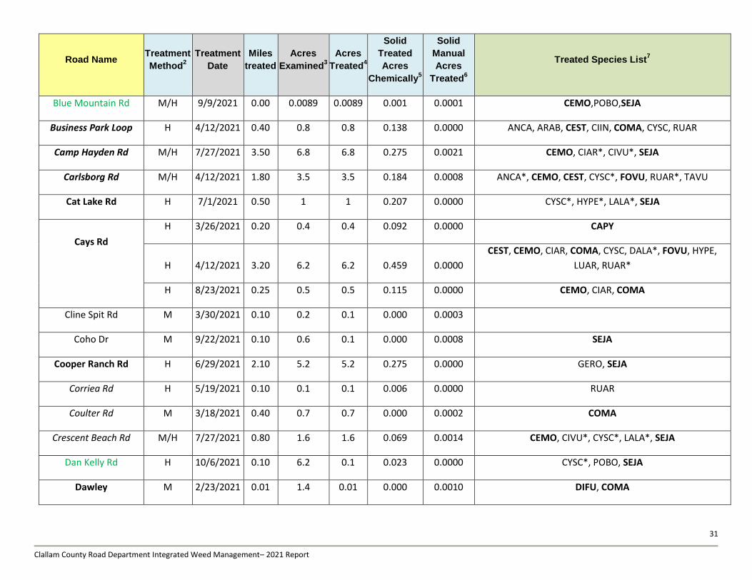
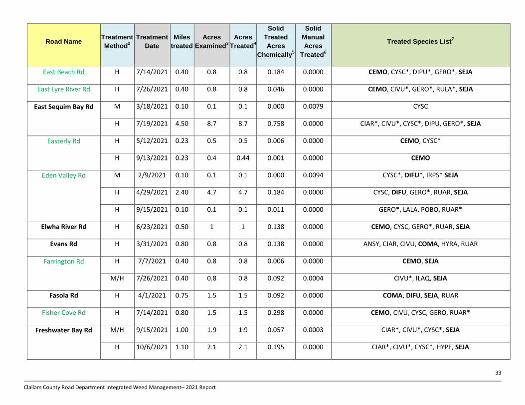
Appendix C: 2021 Roadside Treatment Activities: This table includes all county roadsides managed for noxious weeds in 2021 under the Clallam County Road Department IWM Plan. The table is sorted
alphabetically by road name. Names that are only italicized have been treated only in 2020 and 2021; bolded were treated in 2019-2021; names both bolded and
italicized were treated in 2018-2021; names that are green have been treated 2017-2021. The table contains the Species Treated, Examined Acres, Treated
Acres, Solid Treated Acres, and Solid Manual Acres for each day work occurred on a road; definitions of these headings can be found at the end of the table.
Retreated miles were marked with a maximum “0.1” metric in categories “miles treated”,” acres examined”, and “acres treated”. This was done to try to avoid too
much double counting. Species treated are listed alphabetically by the assigned 4-letter code (see appendix B); 4-letter codes shown in bold are regulated
noxious weeds and required for control in Clallam County.
We treated 116 individual roads and discovered another 8 roads with regulated weed species. In total we completed a total of 173 miles (439 examined acres) of
county roadside. This comprised of 7 miles manual only, 33 miles of manual/ chemical, and 133 miles chemical only. Treatments occurred within a total 322
acres and included 37 species. We treated 0.1 solid acres of weeds with manual methods and 22.5 solid acres of weeds chemically. “Solid acres” represent the
area that would be covered 100% with noxious weeds if the plants were clumped together; area is estimated in the field or calculated with recorded data. See table
footer for further explanation.
Road Name Treatment
Method2
Treatment
Date
Miles
treated
Acres
Examined3
Acres
Treated4
Solid
Treated
Acres
Chemically5
Solid
Manual
Acres
Treated6
Treated Species List7
3 Crabs Rd1 M 3/30/2021 0.05 0.1 0.1 0.000 0.0003 COMA
Agate Beach H 7/28/2021 0.20 0.4 0.4 0.001 0.0000 CIAR*, SEJA
Aster Rd M 2/22/2021 0.10 0.1 0.1 0.000 0.0005 SEJA
Bear Creek Rd H 9/1/2021 2.10 4.07 4.07 0.069 0.0000 CYSC,RUAR,RULA,SEJA
Bishop Rd M 9/15/2021 0.10 0.1 0.1 0.000 0.0004 SEJA
Black Diamond Rd
H 7/12/2021 2.50 4.8 4.8 0.092 0.0000 CEMO, CIAR*, CIVU*, DIPU*, GERO*, LAGA, LALA*,
H 7/13/2021 2.00 3.9 3.9 0.413 0.0000 CEMO, CIAR*, CYSC*, GERO*, RUAR*, RULA*
Bloedel Blvd H 8/17/2021 0.01 0.1 0.1 0.069 0.0000 PHAR
Blue Mountain Rd H 8/9/2021 1.00 2 2 0.344 0.0000 CEMO, CYSC*, DIFU, RUAR*, SEJA
31
Clallam County Road Department Integrated Weed Management– 2021 Report
Road Name Treatment
Method2
Treatment
Date
Miles
treated
Acres
Examined3
Acres
Treated4
Solid
Treated
Acres
Chemically5
Solid
Manual
Acres
Treated6
Treated Species List7
Blue Mountain Rd M/H 9/9/2021 0.00 0.0089 0.0089 0.001 0.0001 CEMO,POBO,SEJA
Business Park Loop H 4/12/2021 0.40 0.8 0.8 0.138 0.0000 ANCA, ARAB, CEST, CIIN, COMA, CYSC, RUAR
Camp Hayden Rd M/H 7/27/2021 3.50 6.8 6.8 0.275 0.0021 CEMO, CIAR*, CIVU*, SEJA
Carlsborg Rd M/H 4/12/2021 1.80 3.5 3.5 0.184 0.0008 ANCA*, CEMO, CEST, CYSC*, FOVU, RUAR*, TAVU
Cat Lake Rd H 7/1/2021 0.50 1 1 0.207 0.0000 CYSC*, HYPE*, LALA*, SEJA
Cays Rd
H 3/26/2021 0.20 0.4 0.4 0.092 0.0000 CAPY
H 4/12/2021 3.20 6.2 6.2 0.459 0.0000
CEST, CEMO, CIAR, COMA, CYSC, DALA*, FOVU, HYPE,
LUAR, RUAR*
H 8/23/2021 0.25 0.5 0.5 0.115 0.0000 CEMO, CIAR, COMA
Cline Spit Rd M 3/30/2021 0.10 0.2 0.1 0.000 0.0003
Coho Dr M 9/22/2021 0.10 0.6 0.1 0.000 0.0008 SEJA
Cooper Ranch Rd H 6/29/2021 2.10 5.2 5.2 0.275 0.0000 GERO, SEJA
Corriea Rd H 5/19/2021 0.10 0.1 0.1 0.006 0.0000 RUAR
Coulter Rd M 3/18/2021 0.40 0.7 0.7 0.000 0.0002 COMA
Crescent Beach Rd M/H 7/27/2021 0.80 1.6 1.6 0.069 0.0014 CEMO, CIVU*, CYSC*, LALA*, SEJA
Dan Kelly Rd H 10/6/2021 0.10 6.2 0.1 0.023 0.0000 CYSC*, POBO, SEJA
Dawley M 2/23/2021 0.01 1.4 0.01 0.000 0.0010 DIFU, COMA

32
Clallam County Road Department Integrated Weed Management– 2021 Report
Road Name Treatment
Method2
Treatment
Date
Miles
treated
Acres
Examined3
Acres
Treated4
Solid
Treated
Acres
Chemically5
Solid
Manual
Acres
Treated6
Treated Species List7
Dawley
M/H 7/28/2021 0.60 1.1 1.1 0.092 0.0004 CEMO, CIAR*, GERO*, LALA*, RUAR*, SEJA
M 9/21/2021 0.10 0.1 0.1 0.000 0.0005 CEMO, SEJA
Deer Park Rd
H 4/22/2021 0.80 1.5 1.5 0.138 0.0000 HICA
H 6/2/2021 4.00 7.75 7.75 0.712 0.0000
CEST, CIAR, CYSC*, HICA, GERO*, HYPE*, LALA*, RUAR*,
SEJA
H 6/9/2021 3.00 5.8 5.8 0.000 0.0000 CEMO, CIAR*, CIVU*, CYSC*, FOVU, HICA, RUAR*, SEJA
H 6/24/2021 0.50 1.0 1 0.184 0.0000 CIAR*, COMA, CYSC*, RUAR*, SEJA
M/H 8/9/2021 0.10 15.5 0.1 0.001 0.0011 SEJA*
Deitz Rd M 8/11/2021 0.01 1.0 0.01 0.000 0.0003 SEJA
Dempsey Rd M 9/15/2021 0.10 0.1 0.1 0.000 0.0000 SEJA
Diamond Point Rd M 2/22/2021 0.10 0.1 0.1 0.000 0.0030 CYSC*, SEJA
H 4/14/2021 1.30 2.6 2.6 0.092 0.0022 CIAR, CIVU, CYSC, RUAR
M/H 4/15/2021 2.20 4.2 4.2 0.149 0.0030 CIAR, CIVU, CYSC, GERO*, RUAR*, SEJA
M/H 5/18/2021 0.08 0.08 0.08 0.000 0.0050 CYSC*
H 7/1/2021 0.30 0.6 0.6 0.253 0.0000 CYSC, SEJA
Dry Creek Rd H 9/8/2021 0.70 1.3 1.3 0.052 0.0000 CEMO,CIVU,CYSC,POBO,RUAR
E Michigan School Rd H 7/1/2021 0.10 0.1 0.1 0.002 0.0000 CYSC, DIFU
33
Clallam County Road Department Integrated Weed Management– 2021 Report
Road Name Treatment
Method2
Treatment
Date
Miles
treated
Acres
Examined3
Acres
Treated4
Solid
Treated
Acres
Chemically5
Solid
Manual
Acres
Treated6
Treated Species List7
East Beach Rd H 7/14/2021 0.40 0.8 0.8 0.184 0.0000 CEMO, CYSC*, DIPU*, GERO*, SEJA
East Lyre River Rd H 7/26/2021 0.40 0.8 0.8 0.046 0.0000 CEMO, CIVU*, GERO*, RULA*, SEJA
East Sequim Bay Rd
M 3/18/2021 0.10 0.1 0.1 0.000 0.0079 CYSC
H 7/19/2021 4.50 8.7 8.7 0.758 0.0000 CIAR*, CIVU*, CYSC*, DIPU, GERO*, SEJA
Easterly Rd
H 5/12/2021 0.23 0.5 0.5 0.006 0.0000 CEMO, CYSC*
H 9/13/2021 0.23 0.4 0.44 0.001 0.0000 CEMO
Eden Valley Rd
M 2/9/2021 0.10 0.1 0.1 0.000 0.0094 CYSC*, DIFU*, IRPS* SEJA
H 4/29/2021 2.40 4.7 4.7 0.184 0.0000 CYSC, DIFU, GERO*, RUAR, SEJA
H 9/15/2021 0.10 0.1 0.1 0.011 0.0000 GERO*, LALA, POBO, RUAR*
Elwha River Rd H 6/23/2021 0.50 1 1 0.138 0.0000 CEMO, CYSC, GERO*, RUAR, SEJA
Evans Rd H 3/31/2021 0.80 0.8 0.8 0.138 0.0000 ANSY, CIAR, CIVU, COMA, HYRA, RUAR
Farrington Rd
H 7/7/2021 0.40 0.8 0.8 0.006 0.0000 CEMO, SEJA
M/H 7/26/2021 0.40 0.8 0.8 0.092 0.0004 CIVU*, ILAQ, SEJA
Fasola Rd H 4/1/2021 0.75 1.5 1.5 0.092 0.0000 COMA, DIFU, SEJA, RUAR
Fisher Cove Rd H 7/14/2021 0.80 1.5 1.5 0.298 0.0000 CEMO, CIVU, CYSC, GERO, RUAR*
Freshwater Bay Rd
M/H 9/15/2021 1.00 1.9 1.9 0.057 0.0003 CIAR*, CIVU*, CYSC*, SEJA
H 10/6/2021 1.10 2.1 2.1 0.195 0.0000 CIAR*, CIVU*, CYSC*, HYPE, SEJA
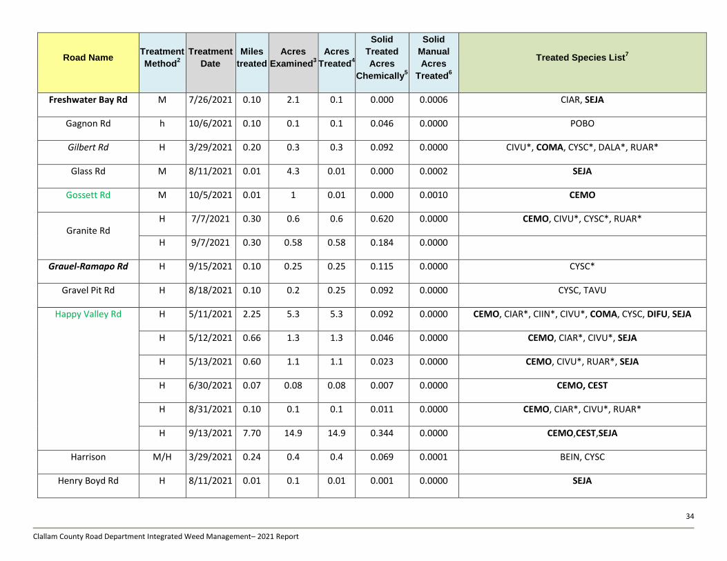
34
Clallam County Road Department Integrated Weed Management– 2021 Report
Road Name Treatment
Method2
Treatment
Date
Miles
treated
Acres
Examined3
Acres
Treated4
Solid
Treated
Acres
Chemically5
Solid
Manual
Acres
Treated6
Treated Species List7
Freshwater Bay Rd M 7/26/2021 0.10 2.1 0.1 0.000 0.0006 CIAR, SEJA
Gagnon Rd h 10/6/2021 0.10 0.1 0.1 0.046 0.0000 POBO
Gilbert Rd H 3/29/2021 0.20 0.3 0.3 0.092 0.0000 CIVU*, COMA, CYSC*, DALA*, RUAR*
Glass Rd M 8/11/2021 0.01 4.3 0.01 0.000 0.0002 SEJA
Gossett Rd M 10/5/2021 0.01 1 0.01 0.000 0.0010 CEMO
Granite Rd H 7/7/2021 0.30 0.6 0.6 0.620 0.0000 CEMO, CIVU*, CYSC*, RUAR*
H 9/7/2021 0.30 0.58 0.58 0.184 0.0000
Grauel-Ramapo Rd H 9/15/2021 0.10 0.25 0.25 0.115 0.0000 CYSC*
Gravel Pit Rd H 8/18/2021 0.10 0.2 0.25 0.092 0.0000 CYSC, TAVU
Happy Valley Rd H 5/11/2021 2.25 5.3 5.3 0.092 0.0000 CEMO, CIAR*, CIIN*, CIVU*, COMA, CYSC, DIFU, SEJA
H 5/12/2021 0.66 1.3 1.3 0.046 0.0000 CEMO, CIAR*, CIVU*, SEJA
H 5/13/2021 0.60 1.1 1.1 0.023 0.0000 CEMO, CIVU*, RUAR*, SEJA
H 6/30/2021 0.07 0.08 0.08 0.007 0.0000 CEMO, CEST
H 8/31/2021 0.10 0.1 0.1 0.011 0.0000 CEMO, CIAR*, CIVU*, RUAR*
H 9/13/2021 7.70 14.9 14.9 0.344 0.0000 CEMO,CEST,SEJA
Harrison M/H 3/29/2021 0.24 0.4 0.4 0.069 0.0001 BEIN, CYSC
Henry Boyd Rd H 8/11/2021 0.01 0.1 0.01 0.001 0.0000 SEJA
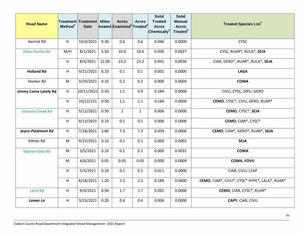
35
Clallam County Road Department Integrated Weed Management– 2021 Report
Road Name Treatment
Method2
Treatment
Date
Miles
treated
Acres
Examined3
Acres
Treated4
Solid
Treated
Acres
Chemically5
Solid
Manual
Acres
Treated6
Treated Species List7
Herrick Rd H 10/4/2021 0.30 0.6 0.6 0.046 0.0000 CYSC
Hoko-Ozette Rd M/H 8/1/2021 5.50 10.6 10.6 0.000 0.0027 CYSC, RUAR*, RULA*, SEJA
H 8/4/2021 12.00 23.2 23.2 0.941 0.0030 CIAR, GERO*, RUAR*, RULA*, SEJA
Holland Rd H 9/21/2021 0.10 0.1 0.1 0.001 0.0000 LAGA
Hooker Rd M 3/29/2021 0.10 0.2 0.2 0.000 0.0004 COMA
Jimmy Come Lately Rd
H 10/11/2021 0.50 1.1 0.9 0.184 0.0000 CIVU, CYSC, DIPU, GERO
H 10/12/221 0.50 1.1 1.1 0.184 0.0000 CEMO, CYSC*, CIVU, GERO, RUAR*
Johnson Creek Rd
H 5/12/2021 0.50 1 1 0.006 0.0000 CEMO, CYSC*, SEJA
H 9/13/2021 0.10 0.1 0.1 0.006 0.0000 CEMO, CIAR*, CYSC*
Joyce-Piedmont Rd H 7/28/2021 3.80 7.3 7.3 0.459 0.0000 CEMO, CIAR*, GERO*, RUAR*, SEJA
Kilmer Rd M 9/22/2021 0.10 0.1 0.1 0.000 0.0001 SEJA
Kitchen-Dick Rd
M 3/5/2021 0.10 0.1 0.1 0.000 0.0031 COMA
M 4/6/2021 0.05 0.05 0.05 0.000 0.0009 COMA, FOVU
H 5/5/2021 0.10 0.1 0.1 0.011 0.0000 CIAR, CIVU, LEAP
H 8/18/2021 1.20 2.3 2.3 0.189 0.0000 CEMO, CIAR*, CIVU*, CYSC* HYPE*, LALA*, RUAR*
Laird Rd H 9/4/2021 0.90 1.7 1.7 0.092 0.0000 CEMO, CIAR, CYSC*, RUAR*
Lamar Ln H 3/23/2021 0.20 0.4 0.4 0.006 0.0000 CAPY, CIAR, CIVU
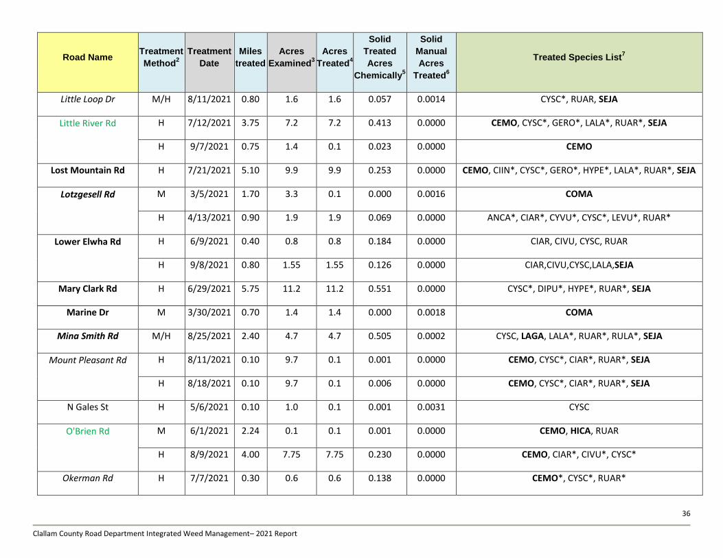
36
Clallam County Road Department Integrated Weed Management– 2021 Report
Road Name Treatment
Method2
Treatment
Date
Miles
treated
Acres
Examined3
Acres
Treated4
Solid
Treated
Acres
Chemically5
Solid
Manual
Acres
Treated6
Treated Species List7
Little Loop Dr M/H 8/11/2021 0.80 1.6 1.6 0.057 0.0014 CYSC*, RUAR, SEJA
Little River Rd
H 7/12/2021 3.75 7.2 7.2 0.413 0.0000 CEMO, CYSC*, GERO*, LALA*, RUAR*, SEJA
H 9/7/2021 0.75 1.4 0.1 0.023 0.0000 CEMO
Lost Mountain Rd H 7/21/2021 5.10 9.9 9.9 0.253 0.0000 CEMO, CIIN*, CYSC*, GERO*, HYPE*, LALA*, RUAR*, SEJA
Lotzgesell Rd
M 3/5/2021 1.70 3.3 0.1 0.000 0.0016 COMA
H 4/13/2021 0.90 1.9 1.9 0.069 0.0000 ANCA*, CIAR*, CYVU*, CYSC*, LEVU*, RUAR*
Lower Elwha Rd
H 6/9/2021 0.40 0.8 0.8 0.184 0.0000 CIAR, CIVU, CYSC, RUAR
H 9/8/2021 0.80 1.55 1.55 0.126 0.0000 CIAR,CIVU,CYSC,LALA,SEJA
Mary Clark Rd H 6/29/2021 5.75 11.2 11.2 0.551 0.0000 CYSC*, DIPU*, HYPE*, RUAR*, SEJA
Marine Dr M 3/30/2021 0.70 1.4 1.4 0.000 0.0018 COMA
Mina Smith Rd M/H 8/25/2021 2.40 4.7 4.7 0.505 0.0002 CYSC, LAGA, LALA*, RUAR*, RULA*, SEJA
Mount Pleasant Rd
H 8/11/2021 0.10 9.7 0.1 0.001 0.0000 CEMO, CYSC*, CIAR*, RUAR*, SEJA
H 8/18/2021 0.10 9.7 0.1 0.006 0.0000 CEMO, CYSC*, CIAR*, RUAR*, SEJA
N Gales St H 5/6/2021 0.10 1.0 0.1 0.001 0.0031 CYSC
O'Brien Rd
M 6/1/2021 2.24 0.1 0.1 0.001 0.0000 CEMO, HICA, RUAR
H 8/9/2021 4.00 7.75 7.75 0.230 0.0000 CEMO, CIAR*, CIVU*, CYSC*
Okerman Rd H 7/7/2021 0.30 0.6 0.6 0.138 0.0000 CEMO*, CYSC*, RUAR*
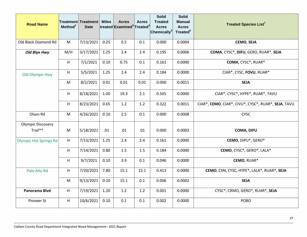
37
Clallam County Road Department Integrated Weed Management– 2021 Report
Road Name Treatment
Method2
Treatment
Date
Miles
treated
Acres
Examined3
Acres
Treated4
Solid
Treated
Acres
Chemically5
Solid
Manual
Acres
Treated6
Treated Species List7
Old Black Diamond Rd M 7/13/2021 0.25 0.5 0.1 0.000 0.0004 CEMO, SEJA
Old Blyn Hwy
M/H 3/17/2021 1.25 2.4 2.4 0.195 0.0006 COMA, CYSC*, DIFU, GERO, RUAR*, SEJA
H 7/1/2021 0.10 0.75 0.1 0.161 0.0000 COMA, CYSC*, RUAR*
Old Olympic Hwy
H 5/5/2021 1.25 2.4 2.4 0.184 0.0000 CIAR*, CYSC, FOVU, RUAR*
M 8/2/2021 0.01 0.01 0.01 0.000 0.0011 SEJA
H 8/18/2021 1.00 19.3 2.1 0.505 0.0000 CIAR*, CYSC*, HYPE*, RUAR*, TAVU
H 8/23/2021 0.65 1.2 1.2 0.322 0.0011 CIAR*, CEMO, CIAR*, CIVU*, CYSC*, RUAR*, SEJA, TAVU
Olson Rd M 4/26/2021 0.10 2.5 0.1 0.000 0.0008 CYSC
Olympic Discovery
Trail** M 5/18/2021 .01 .01 .01 0.000 0.0003 COMA, DIFU
Olympic Hot Springs Rd
H 7/13/2021 1.25 2.4 2.4 0.161 0.0000 CEMO, DIPU*, GERO*
H 7/14/2021 0.80 1.5 1.5 0.184 0.0000 CEMO, CYSC*, GERO*, LALA*
H 9/7/2021 0.10 3.9 0.1 0.046 0.0000 CEMO, RUAR*
Palo Alto Rd
H 7/20/2021 7.80 15.1 15.1 0.413 0.0000 CEMO, CIIN, CYSC, HYPE*, LALA*, RUAR*, SEJA
M 9/13/2021 0.10 15.1 0.1 0.006 0.0002 SEJA
Panorama Blvd H 7/19/2021 1.20 1.2 1.2 0.001 0.0000 CYSC*, CRMO, GERO*, RUAR*, SEJA
Pioneer St H 10/6/2021 0.10 0.1 0.1 0.002 0.0000 POBO
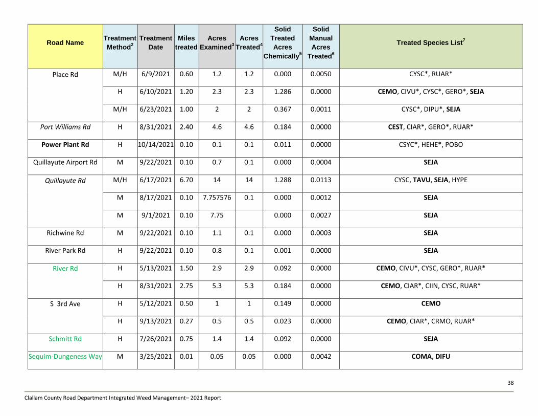
38
Clallam County Road Department Integrated Weed Management– 2021 Report
Road Name Treatment
Method2
Treatment
Date
Miles
treated
Acres
Examined3
Acres
Treated4
Solid
Treated
Acres
Chemically5
Solid
Manual
Acres
Treated6
Treated Species List7
Place Rd
M/H 6/9/2021 0.60 1.2 1.2 0.000 0.0050 CYSC*, RUAR*
H 6/10/2021 1.20 2.3 2.3 1.286 0.0000 CEMO, CIVU*, CYSC*, GERO*, SEJA
M/H 6/23/2021 1.00 2 2 0.367 0.0011 CYSC*, DIPU*, SEJA
Port Williams Rd H 8/31/2021 2.40 4.6 4.6 0.184 0.0000 CEST, CIAR*, GERO*, RUAR*
Power Plant Rd H 10/14/2021 0.10 0.1 0.1 0.011 0.0000 CSYC*, HEHE*, POBO
Quillayute Airport Rd M 9/22/2021 0.10 0.7 0.1 0.000 0.0004 SEJA
Quillayute Rd
M/H 6/17/2021 6.70 14 14 1.288 0.0113 CYSC, TAVU, SEJA, HYPE
M 8/17/2021 0.10 7.757576 0.1 0.000 0.0012 SEJA
M 9/1/2021 0.10 7.75
0.000 0.0027 SEJA
Richwine Rd M 9/22/2021 0.10 1.1 0.1 0.000 0.0003 SEJA
River Park Rd H 9/22/2021 0.10 0.8 0.1 0.001 0.0000 SEJA
River Rd
H 5/13/2021 1.50 2.9 2.9 0.092 0.0000 CEMO, CIVU*, CYSC, GERO*, RUAR*
H 8/31/2021 2.75 5.3 5.3 0.184 0.0000 CEMO, CIAR*, CIIN, CYSC, RUAR*
S 3rd Ave
H 5/12/2021 0.50 1 1 0.149 0.0000 CEMO
H 9/13/2021 0.27 0.5 0.5 0.023 0.0000 CEMO, CIAR*, CRMO, RUAR*
Schmitt Rd H 7/26/2021 0.75 1.4 1.4 0.092 0.0000 SEJA
Sequim-Dungeness Way M 3/25/2021 0.01 0.05 0.05 0.000 0.0042 COMA, DIFU
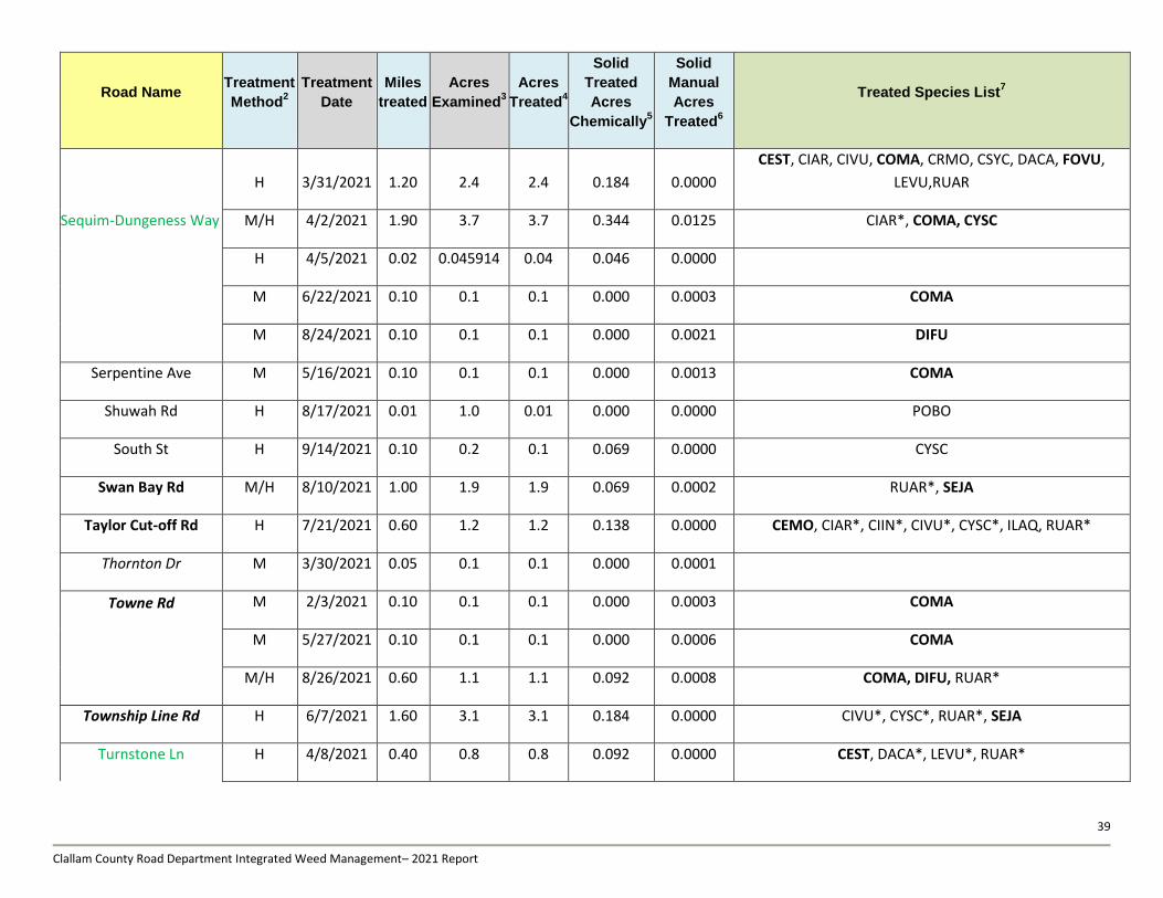
39
Clallam County Road Department Integrated Weed Management– 2021 Report
Road Name Treatment
Method2
Treatment
Date
Miles
treated
Acres
Examined3
Acres
Treated4
Solid
Treated
Acres
Chemically5
Solid
Manual
Acres
Treated6
Treated Species List7
H 3/31/2021 1.20 2.4 2.4 0.184 0.0000
CEST, CIAR, CIVU, COMA, CRMO, CSYC, DACA, FOVU,
LEVU,RUAR
Sequim-Dungeness Way M/H 4/2/2021 1.90 3.7 3.7 0.344 0.0125 CIAR*, COMA, CYSC
H 4/5/2021 0.02 0.045914 0.04 0.046 0.0000
M 6/22/2021 0.10 0.1 0.1 0.000 0.0003 COMA
M 8/24/2021 0.10 0.1 0.1 0.000 0.0021 DIFU
Serpentine Ave M 5/16/2021 0.10 0.1 0.1 0.000 0.0013 COMA
Shuwah Rd H 8/17/2021 0.01 1.0 0.01 0.000 0.0000 POBO
South St H 9/14/2021 0.10 0.2 0.1 0.069 0.0000 CYSC
Swan Bay Rd M/H 8/10/2021 1.00 1.9 1.9 0.069 0.0002 RUAR*, SEJA
Taylor Cut-off Rd H 7/21/2021 0.60 1.2 1.2 0.138 0.0000 CEMO, CIAR*, CIIN*, CIVU*, CYSC*, ILAQ, RUAR*
Thornton Dr M 3/30/2021 0.05 0.1 0.1 0.000 0.0001
Towne Rd
M 2/3/2021 0.10 0.1 0.1 0.000 0.0003 COMA
M 5/27/2021 0.10 0.1 0.1 0.000 0.0006 COMA
M/H 8/26/2021 0.60 1.1 1.1 0.092 0.0008 COMA, DIFU, RUAR*
Township Line Rd H 6/7/2021 1.60 3.1 3.1 0.184 0.0000 CIVU*, CYSC*, RUAR*, SEJA
Turnstone Ln H 4/8/2021 0.40 0.8 0.8 0.092 0.0000 CEST, DACA*, LEVU*, RUAR*
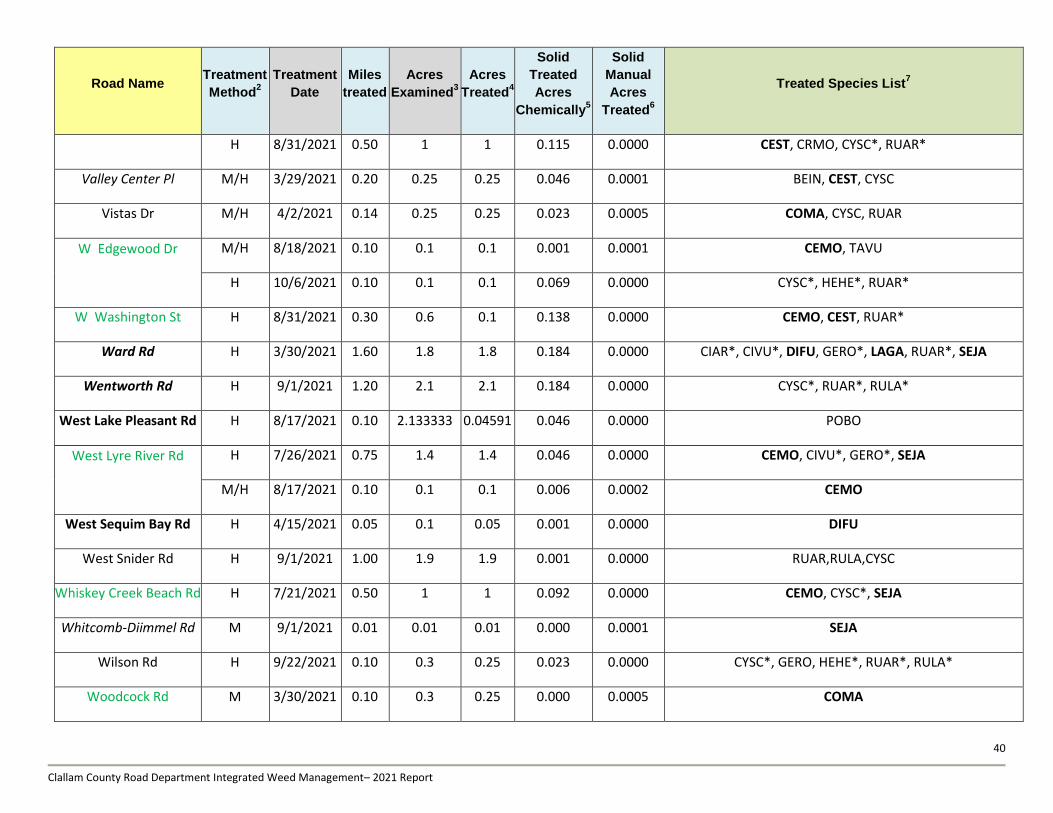
40
Clallam County Road Department Integrated Weed Management– 2021 Report
Road Name Treatment
Method2
Treatment
Date
Miles
treated
Acres
Examined3
Acres
Treated4
Solid
Treated
Acres
Chemically5
Solid
Manual
Acres
Treated6
Treated Species List7
H 8/31/2021 0.50 1 1 0.115 0.0000 CEST, CRMO, CYSC*, RUAR*
Valley Center Pl M/H 3/29/2021 0.20 0.25 0.25 0.046 0.0001 BEIN, CEST, CYSC
Vistas Dr M/H 4/2/2021 0.14 0.25 0.25 0.023 0.0005 COMA, CYSC, RUAR
W Edgewood Dr
M/H 8/18/2021 0.10 0.1 0.1 0.001 0.0001 CEMO, TAVU
H 10/6/2021 0.10 0.1 0.1 0.069 0.0000 CYSC*, HEHE*, RUAR*
W Washington St H 8/31/2021 0.30 0.6 0.1 0.138 0.0000 CEMO, CEST, RUAR*
Ward Rd H 3/30/2021 1.60 1.8 1.8 0.184 0.0000 CIAR*, CIVU*, DIFU, GERO*, LAGA, RUAR*, SEJA
Wentworth Rd H 9/1/2021 1.20 2.1 2.1 0.184 0.0000 CYSC*, RUAR*, RULA*
West Lake Pleasant Rd H 8/17/2021 0.10 2.133333 0.04591 0.046 0.0000 POBO
West Lyre River Rd
H 7/26/2021 0.75 1.4 1.4 0.046 0.0000 CEMO, CIVU*, GERO*, SEJA
M/H 8/17/2021 0.10 0.1 0.1 0.006 0.0002 CEMO
West Sequim Bay Rd H 4/15/2021 0.05 0.1 0.05 0.001 0.0000 DIFU
West Snider Rd H 9/1/2021 1.00 1.9 1.9 0.001 0.0000 RUAR,RULA,CYSC
Whiskey Creek Beach Rd H 7/21/2021 0.50 1 1 0.092 0.0000 CEMO, CYSC*, SEJA
Whitcomb-Diimmel Rd M 9/1/2021 0.01 0.01 0.01 0.000 0.0001 SEJA
Wilson Rd H 9/22/2021 0.10 0.3 0.25 0.023 0.0000 CYSC*, GERO, HEHE*, RUAR*, RULA*
Woodcock Rd M 3/30/2021 0.10 0.3 0.25 0.000 0.0005 COMA
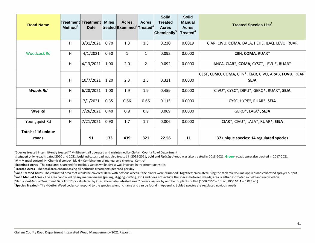
41
Clallam County Road Department Integrated Weed Management– 2021 Report
Road Name Treatment
Method2
Treatment
Date
Miles
treated
Acres
Examined3
Acres
Treated4
Solid
Treated
Acres
Chemically5
Solid
Manual
Acres
Treated6
Treated Species List7
H 3/31/2021 0.70 1.3 1.3 0.230 0.0019 CIAR, CIVU, COMA, DALA, HEHE, ILAQ, LEVU, RUAR
Woodcock Rd H 4/1/2021 0.50 1 1 0.092 0.0000 CIIN, COMA, RUAR*
H 4/13/2021 1.00 2.0 2 0.092 0.0000 ANCA, CIAR*, COMA, CYSC*, LEVU*, RUAR*
H 10/7/2021 1.20 2.3 2.3 0.321 0.0000
CEST, CEMO, COMA, CIIN*, CIAR, CIVU, ARAB, FOVU, RUAR,
SEJA
Woods Rd H 6/28/2021 1.00 1.9 1.9 0.459 0.0000 CIVU*, CYSC*, DIPU*, GERO*, RUAR*, SEJA
H 7/1/2021 0.35 0.66 0.66 0.115 0.0000 CYSC, HYPE*, RUAR*, SEJA
Wye Rd H 7/26/2021 0.40 0.8 0.8 0.069 0.0000 GERO*, LALA*, SEJA
Youngquist Rd H 7/21/2021 0.90 1.7 1.7 0.006 0.0000 CIAR*, CIVU*, LALA*, RUAR*, SEJA
Totals: 116 unique
roads 91 173 439 321 22.56 .11 37 unique species: 14 regulated species
*Species treated intermittently treated**Multi-use trail operated and maintained by Clallam County Road Department. 1Italicized only =road treated 2020 and 2021, bold indicates road was also treated in 2019-2021, bold and Italicized=road was also treated in 2018-2021, Green= roads were also treated in 2017-2021 2M – Manual control; H- Chemical control; M, H – Combination of manual and chemical Control 3Examined Acres - The total area searched for noxious weeds while c0rew was involved in treatment activities 4Treated Acres - The total area encompassing all herbicide treatments per road per day 5Solid Treated Acres- The estimated area that would be covered 100% with noxious weeds if the plants were “clumped” together; calculated using the tank mix volume applied and calibrated sprayer output 6Solid Manual Acres - The area controlled by any manual means (pulling, digging, cutting, etc.) and does not include the spaces between weeds; area is either estimated in field and recorded on “Herbicide/Manual Treatment Data Form” or calculated by infestation data (infested area * cover class) or by number of plants pulled (1000 CYSC = 0.1 ac, 1000 SEJA = 0.025 ac.) 7Species Treated - The 4-Letter Weed codes correspond to the species scientific name and can be found in Appendix. Bolded species are regulated noxious weeds
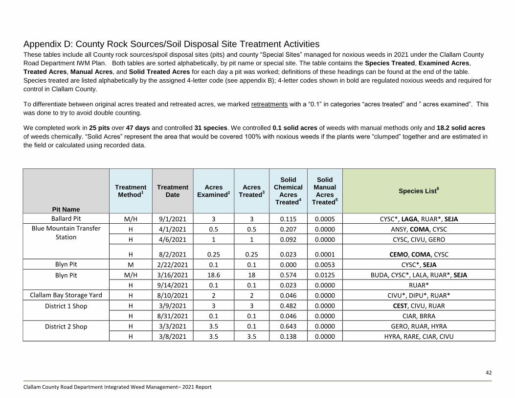
42
Clallam County Road Department Integrated Weed Management– 2021 Report
Appendix D: County Rock Sources/Soil Disposal Site Treatment Activities These tables include all County rock sources/spoil disposal sites (pits) and county “Special Sites” managed for noxious weeds in 2021 under the Clallam County
Road Department IWM Plan. Both tables are sorted alphabetically, by pit name or special site. The table contains the Species Treated, Examined Acres,
Treated Acres, Manual Acres, and Solid Treated Acres for each day a pit was worked; definitions of these headings can be found at the end of the table.
Species treated are listed alphabetically by the assigned 4-letter code (see appendix B); 4-letter codes shown in bold are regulated noxious weeds and required for
control in Clallam County.
To differentiate between original acres treated and retreated acres, we marked retreatments with a “0.1” in categories “acres treated” and ” acres examined”. This
was done to try to avoid double counting.
We completed work in 25 pits over 47 days and controlled 31 species. We controlled 0.1 solid acres of weeds with manual methods only and 18.2 solid acres
of weeds chemically. “Solid Acres” represent the area that would be covered 100% with noxious weeds if the plants were “clumped” together and are estimated in
the field or calculated using recorded data.
Pit Name
Treatment Method
1 Treatment
Date Acres
Examined2 Acres
Treated3
Solid Chemical
Acres Treated
4
Solid Manual Acres
Treated5
Species List6
Ballard Pit M/H 9/1/2021 3 3 0.115 0.0005 CYSC*, LAGA, RUAR*, SEJA
Blue Mountain Transfer Station
H 4/1/2021 0.5 0.5 0.207 0.0000 ANSY, COMA, CYSC
H 4/6/2021 1 1 0.092 0.0000 CYSC, CIVU, GERO
H 8/2/2021 0.25 0.25 0.023 0.0001 CEMO, COMA, CYSC
Blyn Pit M 2/22/2021 0.1 0.1 0.000 0.0053 CYSC*, SEJA
Blyn Pit
M/H 3/16/2021 18.6 18 0.574 0.0125 BUDA, CYSC*, LALA, RUAR*, SEJA
H 9/14/2021 0.1 0.1 0.023 0.0000 RUAR*
Clallam Bay Storage Yard H 8/10/2021 2 2 0.046 0.0000 CIVU*, DIPU*, RUAR*
District 1 Shop
H 3/9/2021 3 3 0.482 0.0000 CEST, CIVU, RUAR
H 8/31/2021 0.1 0.1 0.046 0.0000 CIAR, BRRA
District 2 Shop
H 3/3/2021 3.5 0.1 0.643 0.0000 GERO, RUAR, HYRA
H 3/8/2021 3.5 3.5 0.138 0.0000 HYRA, RARE, CIAR, CIVU
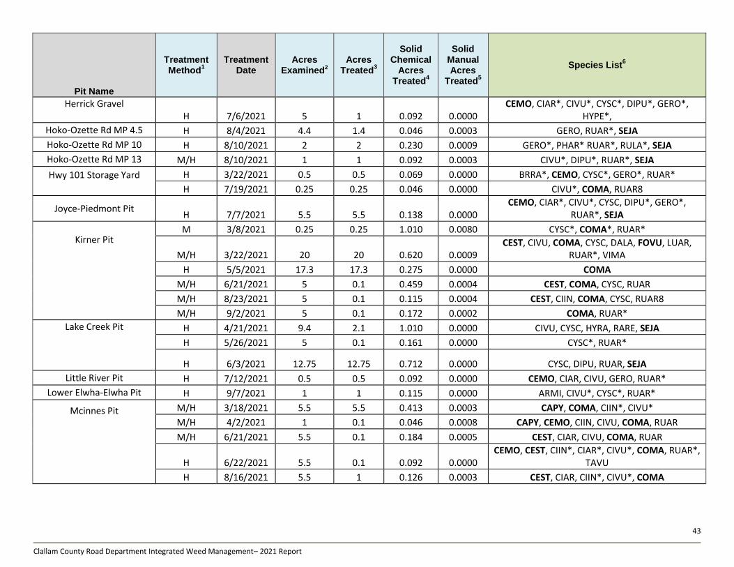
43
Clallam County Road Department Integrated Weed Management– 2021 Report
Pit Name
Treatment Method
1 Treatment
Date Acres
Examined2 Acres
Treated3
Solid Chemical
Acres Treated
4
Solid Manual Acres
Treated5
Species List6
Herrick Gravel H 7/6/2021 5 1 0.092 0.0000
CEMO, CIAR*, CIVU*, CYSC*, DIPU*, GERO*, HYPE*,
Hoko-Ozette Rd MP 4.5 H 8/4/2021 4.4 1.4 0.046 0.0003 GERO, RUAR*, SEJA
Hoko-Ozette Rd MP 10 H 8/10/2021 2 2 0.230 0.0009 GERO*, PHAR* RUAR*, RULA*, SEJA
Hoko-Ozette Rd MP 13 M/H 8/10/2021 1 1 0.092 0.0003 CIVU*, DIPU*, RUAR*, SEJA
Hwy 101 Storage Yard
H 3/22/2021 0.5 0.5 0.069 0.0000 BRRA*, CEMO, CYSC*, GERO*, RUAR*
H 7/19/2021 0.25 0.25 0.046 0.0000 CIVU*, COMA, RUAR8
Joyce-Piedmont Pit H 7/7/2021 5.5 5.5 0.138 0.0000
CEMO, CIAR*, CIVU*, CYSC, DIPU*, GERO*, RUAR*, SEJA
Kirner Pit
M 3/8/2021 0.25 0.25 1.010 0.0080 CYSC*, COMA*, RUAR*
M/H 3/22/2021 20 20 0.620 0.0009 CEST, CIVU, COMA, CYSC, DALA, FOVU, LUAR,
RUAR*, VIMA
H 5/5/2021 17.3 17.3 0.275 0.0000 COMA
M/H 6/21/2021 5 0.1 0.459 0.0004 CEST, COMA, CYSC, RUAR
M/H 8/23/2021 5 0.1 0.115 0.0004 CEST, CIIN, COMA, CYSC, RUAR8
M/H 9/2/2021 5 0.1 0.172 0.0002 COMA, RUAR*
Lake Creek Pit
H 4/21/2021 9.4 2.1 1.010 0.0000 CIVU, CYSC, HYRA, RARE, SEJA
H 5/26/2021 5 0.1 0.161 0.0000 CYSC*, RUAR*
H 6/3/2021 12.75 12.75 0.712 0.0000 CYSC, DIPU, RUAR, SEJA
Little River Pit H 7/12/2021 0.5 0.5 0.092 0.0000 CEMO, CIAR, CIVU, GERO, RUAR*
Lower Elwha-Elwha Pit H 9/7/2021 1 1 0.115 0.0000 ARMI, CIVU*, CYSC*, RUAR*
Mcinnes Pit
M/H 3/18/2021 5.5 5.5 0.413 0.0003 CAPY, COMA, CIIN*, CIVU*
M/H 4/2/2021 1 0.1 0.046 0.0008 CAPY, CEMO, CIIN, CIVU, COMA, RUAR
M/H 6/21/2021 5.5 0.1 0.184 0.0005 CEST, CIAR, CIVU, COMA, RUAR
H 6/22/2021 5.5 0.1 0.092 0.0000 CEMO, CEST, CIIN*, CIAR*, CIVU*, COMA, RUAR*,
TAVU
H 8/16/2021 5.5 1 0.126 0.0003 CEST, CIAR, CIIN*, CIVU*, COMA
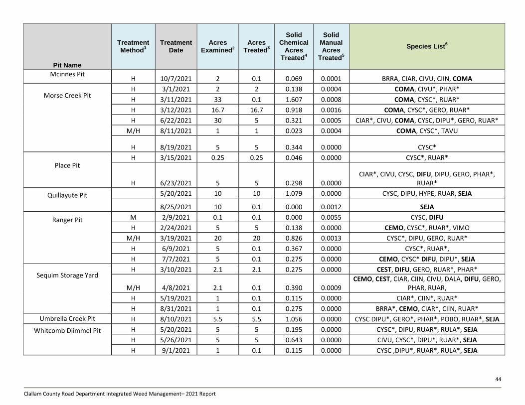
44
Clallam County Road Department Integrated Weed Management– 2021 Report
Pit Name
Treatment Method
1 Treatment
Date Acres
Examined2 Acres
Treated3
Solid Chemical
Acres Treated
4
Solid Manual Acres
Treated5
Species List6
Mcinnes Pit H 10/7/2021 2 0.1 0.069 0.0001 BRRA, CIAR, CIVU, CIIN, COMA
Morse Creek Pit
H 3/1/2021 2 2 0.138 0.0004 COMA, CIVU*, PHAR*
H 3/11/2021 33 0.1 1.607 0.0008 COMA, CYSC*, RUAR*
H 3/12/2021 16.7 16.7 0.918 0.0016 COMA, CYSC*, GERO, RUAR*
H 6/22/2021 30 5 0.321 0.0005 CIAR*, CIVU, COMA, CYSC, DIPU*, GERO, RUAR*
M/H 8/11/2021 1 1 0.023 0.0004 COMA, CYSC*, TAVU
H 8/19/2021 5 5 0.344 0.0000 CYSC*
Place Pit
H 3/15/2021 0.25 0.25 0.046 0.0000 CYSC*, RUAR*
H 6/23/2021 5 5 0.298 0.0000 CIAR*, CIVU, CYSC, DIFU, DIPU, GERO, PHAR*,
RUAR*
Quillayute Pit
5/20/2021 10 10 1.079 0.0000 CYSC, DIPU, HYPE, RUAR, SEJA
8/25/2021 10 0.1 0.000 0.0012 SEJA
Ranger Pit
M 2/9/2021 0.1 0.1 0.000 0.0055 CYSC, DIFU
H 2/24/2021 5 5 0.138 0.0000 CEMO, CYSC*, RUAR*, VIMO
M/H 3/19/2021 20 20 0.826 0.0013 CYSC*, DIPU, GERO, RUAR*
H 6/9/2021 5 0.1 0.367 0.0000 CYSC*, RUAR*,
H 7/7/2021 5 0.1 0.275 0.0000 CEMO, CYSC* DIFU, DIPU*, SEJA
Sequim Storage Yard
H 3/10/2021 2.1 2.1 0.275 0.0000 CEST, DIFU, GERO, RUAR*, PHAR*
M/H 4/8/2021 2.1 0.1 0.390 0.0009 CEMO, CEST, CIAR, CIIN, CIVU, DALA, DIFU, GERO,
PHAR, RUAR,
H 5/19/2021 1 0.1 0.115 0.0000 CIAR*, CIIN*, RUAR*
H 8/31/2021 1 0.1 0.275 0.0000 BRRA*, CEMO, CIAR*, CIIN, RUAR*
Umbrella Creek Pit H 8/10/2021 5.5 5.5 1.056 0.0000 CYSC DIPU*, GERO*, PHAR*, POBO, RUAR*, SEJA
Whitcomb Diimmel Pit
H 5/20/2021 5 5 0.195 0.0000 CYSC*, DIPU, RUAR*, RULA*, SEJA
H 5/26/2021 5 5 0.643 0.0000 CIVU, CYSC*, DIPU*, RUAR*, SEJA
H 9/1/2021 1 0.1 0.115 0.0000 CYSC ,DIPU*, RUAR*, RULA*, SEJA
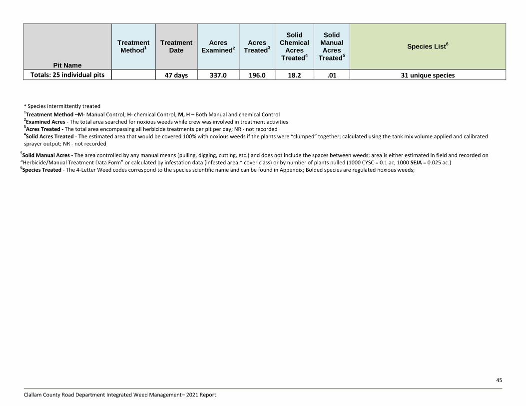
45
Clallam County Road Department Integrated Weed Management– 2021 Report
Pit Name
Treatment Method
1 Treatment
Date Acres
Examined2 Acres
Treated3
Solid Chemical
Acres Treated
4
Solid Manual Acres
Treated5
Species List6
Totals: 25 individual pits 47 days 337.0 196.0 18.2 .01 31 unique species
* Species intermittently treated 1Treatment Method –M- Manual Control; H- chemical Control; M, H – Both Manual and chemical Control
2Examined Acres - The total area searched for noxious weeds while crew was involved in treatment activities
3Acres Treated - The total area encompassing all herbicide treatments per pit per day; NR - not recorded
4Solid Acres Treated - The estimated area that would be covered 100% with noxious weeds if the plants were “clumped” together; calculated using the tank mix volume applied and calibrated
sprayer output; NR - not recorded
5Solid Manual Acres - The area controlled by any manual means (pulling, digging, cutting, etc.) and does not include the spaces between weeds; area is either estimated in field and recorded on
“Herbicide/Manual Treatment Data Form” or calculated by infestation data (infested area * cover class) or by number of plants pulled (1000 CYSC = 0.1 ac, 1000 SEJA = 0.025 ac.) 6Species Treated - The 4-Letter Weed codes correspond to the species scientific name and can be found in Appendix; Bolded species are regulated noxious weeds;
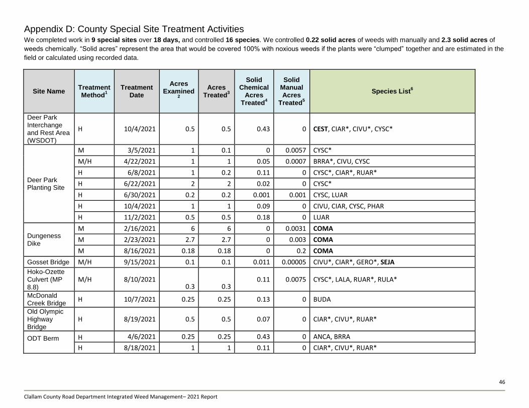
46
Clallam County Road Department Integrated Weed Management– 2021 Report
Appendix D: County Special Site Treatment Activities We completed work in 9 special sites over 18 days, and controlled 16 species. We controlled 0.22 solid acres of weeds with manually and 2.3 solid acres of
weeds chemically. “Solid acres” represent the area that would be covered 100% with noxious weeds if the plants were “clumped” together and are estimated in the
field or calculated using recorded data.
Site Name Treatment Method
1 Treatment
Date
Acres Examined
2
Acres Treated
3
Solid Chemical
Acres Treated
4
Solid Manual Acres
Treated5
Species List6
Deer Park Interchange and Rest Area (WSDOT)
H 10/4/2021 0.5 0.5 0.43 0 CEST, CIAR*, CIVU*, CYSC*
Deer Park Planting Site
M 3/5/2021 1 0.1 0 0.0057 CYSC*
M/H 4/22/2021 1 1 0.05 0.0007 BRRA*, CIVU, CYSC
H 6/8/2021 1 0.2 0.11 0 CYSC*, CIAR*, RUAR*
H 6/22/2021 2 2 0.02 0 CYSC*
H 6/30/2021 0.2 0.2 0.001 0.001 CYSC, LUAR
H 10/4/2021 1 1 0.09 0 CIVU, CIAR, CYSC, PHAR
H 11/2/2021 0.5 0.5 0.18 0 LUAR
Dungeness Dike
M 2/16/2021 6 6 0 0.0031 COMA
M 2/23/2021 2.7 2.7 0 0.003 COMA
M 8/16/2021 0.18 0.18 0 0.2 COMA
Gosset Bridge M/H 9/15/2021 0.1 0.1 0.011 0.00005 CIVU*, CIAR*, GERO*, SEJA
Hoko-Ozette Culvert (MP 8.8)
M/H 8/10/2021 0.3 0.3
0.11 0.0075 CYSC*, LALA, RUAR*, RULA*
McDonald Creek Bridge
H 10/7/2021 0.25 0.25 0.13 0 BUDA
Old Olympic Highway Bridge
H 8/19/2021 0.5 0.5 0.07 0 CIAR*, CIVU*, RUAR*
ODT Berm
H 4/6/2021 0.25 0.25 0.43 0 ANCA, BRRA
H 8/18/2021 1 1 0.11 0 CIAR*, CIVU*, RUAR*

47
Clallam County Road Department Integrated Weed Management– 2021 Report
Site Name Treatment Method
1 Treatment
Date
Acres Examined
2
Acres Treated
3
Solid Chemical
Acres Treated
4
Solid Manual Acres
Treated5
Species List6
ODT Berm H 10/14/2021 1 1 0.36 0 CIAR*, CIVU*, PHAR*, MESA*, RUAR*
Ward Bridge Restoration
H 3/31/2021 0.25 0.25 0.01 0 COMA, GERO, RUAR*
H 10/7/2021 0.25 0.25 0.13 0 COMA, GERO, RUAR*
Totals 18 days 19.68 17.98 2.30 0.22 16 Species * Species intermittently treated 1Treatment Method –M- Manual Control; H- chemical Control; M, H – Both Manual and chemical Control
2Examined Acres - The total area searched for noxious weeds while crew was involved in treatment activities
3Treated Acres - The total area encompassing all herbicide treatments per road per day; NR - not recorded
4Solid Acres Treated - The estimated area that would be covered 100% with noxious weeds if the plants were “clumped” together; calculated using the tank mix volume applied and calibrated
sprayer output; NR - not recorded 5Solid Manual Acres - The area controlled by any manual means (pulling, digging, cutting, etc.) and does not include the spaces between weeds; area is either estimated in field and recorded on
“Herbicide/Manual Treatment Data Form” or calculated by infestation data (infested area * cover class) or by number of plants pulled (1000 CYSC = 0.1 ac, 1000 SEJA = 0.025 ac.) 6Species Treated - The 4-Letter Weed codes correspond to the species scientific name and can be found in Appendix; Bolded species are regulated noxious weeds;

48
Clallam County Road Department Integrated Weed Management– 2021 Report
Appendix E: Herbicide Volumes by County Roads and Rock Sources and Special Sites
The table alphabetically lists the county roads, rock sources, and other county property called “Special Sites” that received chemical treatment in 2021.
The table includes the trade name of herbicides used and amounts applied in ounces per treated road section (Note: 1 oz. equals 2 tablespoons). The Treated
Road Section lists the portions for each road where herbicide application may have occurred. Herbicide applications within the listed boundaries were only made to
noxious weeds and exact treatment locations varied with individual plant locations.
Names shown in italics are roads that were treated in 2020 and 2021; names bolded are roads that were treated 2019-2021; names both bolded and italicized
were treated in 2018-2021; 2020; roads that are green have been treated 2017-2021.
In 2021 we applied a total of 17.12 gallons of herbicide on County roadside and 15.7 gallons in County pits. An additional 1.6 gallons of herbicide was applied
on “Special Sites”. A combination of Milestone® and Vastlan® or Element 3A® was used on most roads included in chemical treatment; a mix that was chosen for
its efficacy on expected weed species. Polaris® was almost used exclusively for knotweed species and AquaNeat® was mainly used for cut stumping Scotch
broom and to assist with site preparation to clear noxious weeds in advance of pollinator-friendly native plantings. All treatment locations were posted and signs
left in place for 24 hours. An online table of treated roads and treatment dates was updated once last season.
Road Name Treatment
Date Treatment Location
Miles Treated
milesto
ne
1®
(o
z)
vastl
an
2®
(o
z)
po
lari
s3®
(o
z)
ele
men
t 3
A4®
(o
z)
aq
uan
eat5
® (
oz)
garl
on
46®
(o
z)
tran
slin
e7®
(o
z)
Agate Beach 7/28/2021 Behind Joyce General 0.20 0.005 0.06
Bear Creek Rd 9/1/2024 2.1 Miles 2.10 0.5 6
Black Diamond Rd
7/12/2021 Little River Rd to the Grange 2.50 0.64 1.9
7/13/2021 Grange to North End 2.00 2.9 34.6
Bloedel Blvd 8/17/2021
0.01 1.3 5.1
Blue Mountain Rd
8/9/2021 (Guard rail North of transfer station to Highway 101) 1.00 2.4 28.8
9/9/2021 Entire Rd 0.00 0.08
Business Park Loop 4/12/2021 Entire Rd 0.40 1 15
Camp Hayden Rd 7/27/2021 Entire Rd 3.50 2 23
Carlsborg Rd 4/12/2021 Entire Rd 1.80 1.3 20
Cat Lake Rd 7/1/2021 Entire Rd 0.50 1.4 17.3

49
Clallam County Road Department Integrated Weed Management– 2021 Report
Road Name Treatment
Date Treatment Location
Miles Treated
milesto
ne
1®
(o
z)
vastl
an
2®
(o
z)
po
lari
s3®
(o
z)
ele
men
t 3
A4®
(o
z)
aq
uan
eat5
® (
oz)
garl
on
46®
(o
z)
tran
slin
e7®
(o
z)
Cays Rd
4/12/2021 Entire Rd 3.20 3.3 50
3/26/2021 Cays Rd to western guard rail 0.20 2.5
8/23/2021 (Carlsborg to Old Olympic Highway) 0.25 0.8 9.6
Cooper Ranch Rd 6/29/2021 REF Forest Service record #169 2.10 1.9 7.7 23
Corriea Rd 5/19/2021 South of last parking lot on west side of road 0.10 0.04 0.6
Crescent Beach Rd
7/27/2021 Wooden entrance way to .8 miles south 0.80 0.5 5.75
7/28/2021 (751 Crescent to Agate Beach Rd) 0.60 0.64 7.7
Dan Kelly Rd 10/6/2021 .5 miles south of Hwy 112 0.10 0.2 1.9 0.04
Deer Park Rd
6/2/2021 Township Lane to Park Entrance 4.00 5 79.3
6/9/2021 Pelican Rd to powerlines 3.00 0.7 11.5
6/24/2021 View Ridge Drive to Deer park Loop 0.50 1.3 15.3
4/22/2021 Township Line to .8 South 0.80 0.1 15.3
8/9/2021 Entire Rd 0.10 0.005 0.06
Diamond Point Rd
4/14/2021 Highway 101 to Sunshine Dr 1.30 0.25 3.8 20
4/15/2021 Sunshine Dr to North Rhodendron Dr 2.20 1 16.7
7/1/2021 Cat Lake to Sunshine Dr 0.30 1.8 21.1
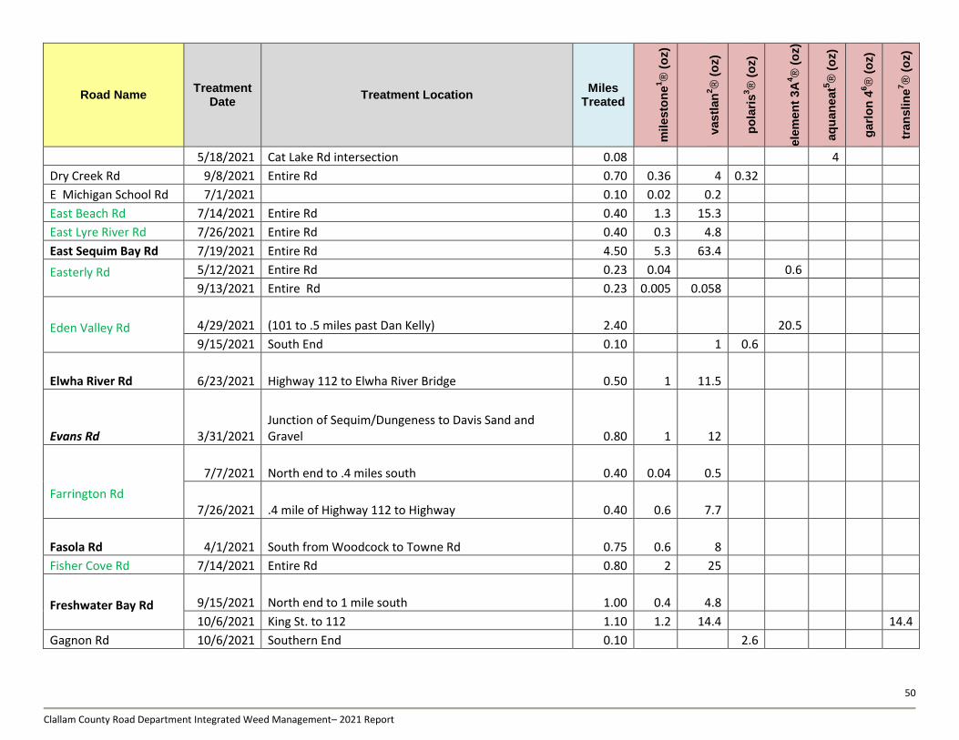
50
Clallam County Road Department Integrated Weed Management– 2021 Report
Road Name Treatment
Date Treatment Location
Miles Treated
milesto
ne
1®
(o
z)
vastl
an
2®
(o
z)
po
lari
s3®
(o
z)
ele
men
t 3
A4®
(o
z)
aq
uan
eat5
® (
oz)
garl
on
46®
(o
z)
tran
slin
e7®
(o
z)
5/18/2021 Cat Lake Rd intersection 0.08 4
Dry Creek Rd 9/8/2021 Entire Rd 0.70 0.36 4 0.32
E Michigan School Rd 7/1/2021 0.10 0.02 0.2
East Beach Rd 7/14/2021 Entire Rd 0.40 1.3 15.3
East Lyre River Rd 7/26/2021 Entire Rd 0.40 0.3 4.8
East Sequim Bay Rd 7/19/2021 Entire Rd 4.50 5.3 63.4
Easterly Rd
5/12/2021 Entire Rd 0.23 0.04 0.6
9/13/2021 Entire Rd 0.23 0.005 0.058
Eden Valley Rd
4/29/2021 (101 to .5 miles past Dan Kelly) 2.40 20.5
9/15/2021 South End 0.10 1 0.6
Elwha River Rd 6/23/2021 Highway 112 to Elwha River Bridge 0.50 1 11.5
Evans Rd 3/31/2021 Junction of Sequim/Dungeness to Davis Sand and Gravel 0.80 1 12
Farrington Rd
7/7/2021 North end to .4 miles south 0.40 0.04 0.5
7/26/2021 .4 mile of Highway 112 to Highway 0.40 0.6 7.7
Fasola Rd 4/1/2021 South from Woodcock to Towne Rd 0.75 0.6 8
Fisher Cove Rd 7/14/2021 Entire Rd 0.80 2 25
Freshwater Bay Rd
9/15/2021 North end to 1 mile south 1.00 0.4 4.8
10/6/2021 King St. to 112 1.10 1.2 14.4 14.4
Gagnon Rd 10/6/2021 Southern End 0.10 2.6

51
Clallam County Road Department Integrated Weed Management– 2021 Report
Road Name Treatment
Date Treatment Location
Miles Treated
milesto
ne
1®
(o
z)
vastl
an
2®
(o
z)
po
lari
s3®
(o
z)
ele
men
t 3
A4®
(o
z)
aq
uan
eat5
® (
oz)
garl
on
46®
(o
z)
tran
slin
e7®
(o
z)
Gilbert Rd 3/29/2021 Entire Rd 0.20 0.6 8
Granite Rd
7/7/2021 Entire Rd 0.30 4.3 51.9
9/7/2021 Entire Rd 0.30
Grauel-Ramapo Rd 9/15/2021 0.10 9.6
Gravel Pit Rd 8/18/2021 West end to guard rail 0.10 9.6
Happy Valley Rd
5/11/2021 River Rd to Haven Heights 2.25 0.6 10.2
5/12/2021 .5 W of Johnson Creek to Haven Heights 0.66 0.3 5.1
5/13/2021 Elk Height to Huffman Heights Rd 0.60 0.2 2.5
6/30/2021 McFarland Intersection 0.01 0.02 0.2
6/30/2021 Trail Head near River Rd 0.05 0.01 0.1
6/30/2021 Happy Valley and 3rd Ave 0.01 0.02 0.24
8/31/2021 Trail head near River Rd 0.10 1
9/13/2021 Entire Rd 7.70 2.4 28.8
Harrison 3/29/2021 Entire Rd 0.24 0.5 6
Henry Boyd Rd 8/11/2021 0.01 0.005 0.06
Herrick Rd 10/4/2021 Highway 101 to .1 mile south of pit 0.30 0.3 3.8
Hoko-Ozette Rd
8/1/2021 M.P. 7.5 to M.P. 13 5.50 19.2
8/4/2021 Int. with 112 to MP 7.5 7.50 1.1 13.4
8/4/2021 MP 18.5 to MP 14 4.50 1.4 16.7
Holland Rd 9/21/2021 0.10 0.05
Jimmy Come Lately Rd 10/11/2021 0.5 miles east of Schmitt Rd) 0.5 1.3 20.5
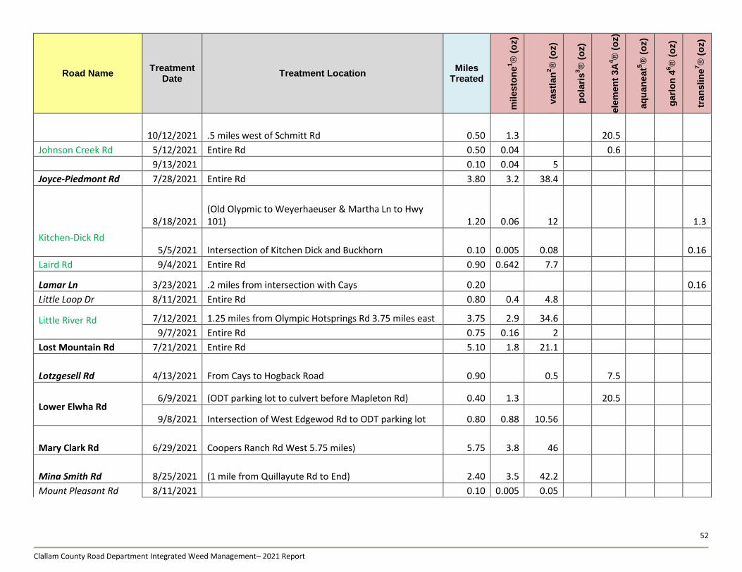
52
Clallam County Road Department Integrated Weed Management– 2021 Report
Road Name Treatment
Date Treatment Location
Miles Treated
milesto
ne
1®
(o
z)
vastl
an
2®
(o
z)
po
lari
s3®
(o
z)
ele
men
t 3
A4®
(o
z)
aq
uan
eat5
® (
oz)
garl
on
46®
(o
z)
tran
slin
e7®
(o
z)
10/12/2021 .5 miles west of Schmitt Rd 0.50 1.3 20.5
Johnson Creek Rd 5/12/2021 Entire Rd 0.50 0.04 0.6
9/13/2021 0.10 0.04 5
Joyce-Piedmont Rd 7/28/2021 Entire Rd 3.80 3.2 38.4
Kitchen-Dick Rd
8/18/2021 (Old Olypmic to Weyerhaeuser & Martha Ln to Hwy 101) 1.20 0.06 12 1.3
5/5/2021 Intersection of Kitchen Dick and Buckhorn 0.10 0.005 0.08 0.16
Laird Rd 9/4/2021 Entire Rd 0.90 0.642 7.7
Lamar Ln 3/23/2021 .2 miles from intersection with Cays 0.20 0.16
Little Loop Dr 8/11/2021 Entire Rd 0.80 0.4 4.8
Little River Rd
7/12/2021 1.25 miles from Olympic Hotsprings Rd 3.75 miles east 3.75 2.9 34.6
9/7/2021 Entire Rd 0.75 0.16 2
Lost Mountain Rd 7/21/2021 Entire Rd 5.10 1.8 21.1
Lotzgesell Rd 4/13/2021 From Cays to Hogback Road 0.90 0.5 7.5
Lower Elwha Rd
6/9/2021 (ODT parking lot to culvert before Mapleton Rd) 0.40 1.3 20.5
9/8/2021 Intersection of West Edgewod Rd to ODT parking lot 0.80 0.88 10.56
Mary Clark Rd 6/29/2021 Coopers Ranch Rd West 5.75 miles) 5.75 3.8 46
Mina Smith Rd 8/25/2021 (1 mile from Quillayute Rd to End) 2.40 3.5 42.2
Mount Pleasant Rd 8/11/2021 0.10 0.005 0.05

53
Clallam County Road Department Integrated Weed Management– 2021 Report
Road Name Treatment
Date Treatment Location
Miles Treated
milesto
ne
1®
(o
z)
vastl
an
2®
(o
z)
po
lari
s3®
(o
z)
ele
men
t 3
A4®
(o
z)
aq
uan
eat5
® (
oz)
garl
on
46®
(o
z)
tran
slin
e7®
(o
z)
8/18/2021 0.10 0.04 0.5
N Gales St 5/6/2021 North end of Gales St 0.10 4
O'Brien Rd 8/9/2021 Entire Rd 4.00 1.6 19.2
Okerman Rd 7/7/2021 Entire Rd 0.30 1 11.5
Old Blyn Hwy
3/17/2021 Entire Rd 1.25 1.25 3.75 11.5 1.25
7/1/2021 (Thompson Rd west .4 miles) 0.10 1.1 13
Old Olympic Hwy
5/5/2021 Carlsborg Int to Kitchen Dick 1.25 1.3 20.5
8/18/2021 Western end 10 miles east 1.00 3.52 44 14
8/23/2021 (.1 mile west of Dungeness River crossing) 0.10 0.3 3.8 0.64
8/23/2021 (PUD Old Oly. Well site to ODT bridge) 0.25 0.5 5.8
8/23/2021 .2 miles west of Kitchen Dick 0.20 0.3 3.8 1.3
8/23/2021 (.1 MILES WEST OF Towne Intersection) 0.10 0.5 5.8 0.64
Olympic Hot Springs Rd
7/13/2021 1.25 1.1 13.4
7/14/2021 0.80 1.3 15.3
9/7/2021 South End to .1 mile south of Little River Rd 0.10 0.3 3.8
Palo Alto Rd 7/20/2021 Entire Rd 7.80 2.9 34
Panorama Blvd 7/19/2021 Entire Rd 1.20 0.01 0.12
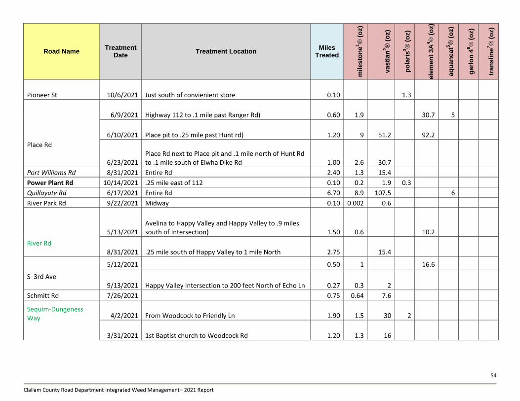
54
Clallam County Road Department Integrated Weed Management– 2021 Report
Road Name Treatment
Date Treatment Location
Miles Treated
milesto
ne
1®
(o
z)
vastl
an
2®
(o
z)
po
lari
s3®
(o
z)
ele
men
t 3
A4®
(o
z)
aq
uan
eat5
® (
oz)
garl
on
46®
(o
z)
tran
slin
e7®
(o
z)
Pioneer St 10/6/2021 Just south of convienient store 0.10 1.3
Place Rd
6/9/2021 Highway 112 to .1 mile past Ranger Rd) 0.60 1.9 30.7 5
6/10/2021 Place pit to .25 mile past Hunt rd) 1.20 9 51.2 92.2
6/23/2021 Place Rd next to Place pit and .1 mile north of Hunt Rd to .1 mile south of Elwha Dike Rd 1.00 2.6 30.7
Port Williams Rd 8/31/2021 Entire Rd 2.40 1.3 15.4
Power Plant Rd 10/14/2021 .25 mile east of 112 0.10 0.2 1.9 0.3
Quillayute Rd 6/17/2021 Entire Rd 6.70 8.9 107.5 6
River Park Rd 9/22/2021 Midway 0.10 0.002 0.6
River Rd
5/13/2021 Avelina to Happy Valley and Happy Valley to .9 miles south of Intersection) 1.50 0.6 10.2
8/31/2021 .25 mile south of Happy Valley to 1 mile North 2.75 15.4
S 3rd Ave
5/12/2021 0.50 1 16.6
9/13/2021 Happy Valley Intersection to 200 feet North of Echo Ln 0.27 0.3 2
Schmitt Rd 7/26/2021 0.75 0.64 7.6
Sequim-Dungeness Way
4/2/2021 From Woodcock to Friendly Ln 1.90 1.5 30 2
3/31/2021 1st Baptist church to Woodcock Rd 1.20 1.3 16
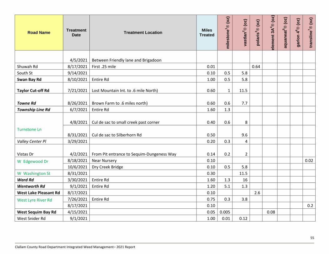
55
Clallam County Road Department Integrated Weed Management– 2021 Report
Road Name Treatment
Date Treatment Location
Miles Treated
milesto
ne
1®
(o
z)
vastl
an
2®
(o
z)
po
lari
s3®
(o
z)
ele
men
t 3
A4®
(o
z)
aq
uan
eat5
® (
oz)
garl
on
46®
(o
z)
tran
slin
e7®
(o
z)
4/5/2021 Between Friendly lane and Brigadoon
Shuwah Rd 8/17/2021 First .25 mile 0.01 0.64
South St 9/14/2021 0.10 0.5 5.8
Swan Bay Rd 8/10/2021 Entire Rd 1.00 0.5 5.8
Taylor Cut-off Rd 7/21/2021 Lost Mountain Int. to .6 mile North) 0.60 1 11.5
Towne Rd 8/26/2021 Brown Farm to .6 miles north) 0.60 0.6 7.7
Township Line Rd 6/7/2021 Entire Rd 1.60 1.3
Turnstone Ln
4/8/2021 Cul de sac to small creek past corner 0.40 0.6 8
8/31/2021 Cul de sac to Silberhorn Rd 0.50 9.6
Valley Center Pl 3/29/2021 0.20 0.3 4
Vistas Dr 4/2/2021 From Pit entrance to Sequim-Dungeness Way 0.14 0.2 2
W Edgewood Dr
8/18/2021 Near Nursery 0.10 0.02
10/6/2021 Dry Creek Bridge 0.10 0.5 5.8
W Washington St 8/31/2021 0.30 11.5
Ward Rd 3/30/2021 Entire Rd 1.60 1.3 16
Wentworth Rd 9/1/2021 Entire Rd 1.20 5.1 1.3
West Lake Pleasant Rd 8/17/2021 0.10 2.6
West Lyre River Rd
7/26/2021 Entire Rd 0.75 0.3 3.8
8/17/2021 0.10 0.2
West Sequim Bay Rd 4/15/2021 0.05 0.005 0.08
West Snider Rd 9/1/2021 1.00 0.01 0.12

56
Clallam County Road Department Integrated Weed Management– 2021 Report
Road Name Treatment
Date Treatment Location
Miles Treated
milesto
ne
1®
(o
z)
vastl
an
2®
(o
z)
po
lari
s3®
(o
z)
ele
men
t 3
A4®
(o
z)
aq
uan
eat5
® (
oz)
garl
on
46®
(o
z)
tran
slin
e7®
(o
z)
Whiskey Creek Beach Rd 7/21/2021 Entire Rd 0.50 0.64 7.6
Wilson Rd 9/22/2021 0.10 1.9
Woodcock Rd
3/31/2021 Towne Rd to Sequim Dungeness 0.60 1.7 20
4/1/2021 Fasola intersection to Ward Bridge 0.50 0.6 8
4/13/2021 From intersection of Cays- West 1 mile 1.00 0.66 10
10/7/2021 Stills farm to Ward Rd 1.20 2.2 26.9
Woods Rd
6/28/2021 Forest Service Entrance to .1 mile south of Blyn Pit 1.00 3.2 23 2 15.3
7/1/2021 Highway 101 Intersection to .35 miles South 0.35 0.8 9.6
Wye Rd 7/26/2021 Entire Rd 0.40 0.5 5.8
Youngquist Rd 7/21/2021 Entire Rd 0.90 0.04 0.5
Totals: 95 roads 72
treatment days
Totals: 165.6 miles
164.9 oz
1386.1 oz
13.8 oz
533.3 oz
44.1 oz
11.5 oz
36.6 oz
=1.29 gal
=10.83 gal
=.11 gal
=4.17 gal
=.34 gal
=.09 gal
=.29 gal
1Milestone® - Active ingredient: aminopyralid; in 0.125% solution.
2Vastlan® - Active ingredient: triclopyr; in 1.5-2% solution, 25-50% solution for cut-stump application only.
3Element 3A® - Active ingredient: triclopyr; in 2-2.5% solution on roadsides, 25-50% solution for cut stump only.
4Polaris® - Active ingredient: imazapyr in 1% solution, 10% for cut stump only
5AquaNeat® - Active ingredient: glyphosate in 0.5-2% solution, 50%-100% solution for cut stump only
6Garlon 4 ®- Active ingredient: triclopyr in 1.5-2% solution
7Transline ® Active ingredient: clopyralid in .5% solution
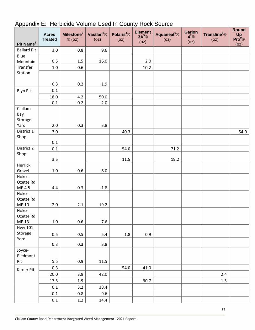
57
Clallam County Road Department Integrated Weed Management– 2021 Report
Appendix E: Herbicide Volume Used In County Rock Source
Pit Name1
Acres Treated
Milestone2
® (oz) Vastlan
3®
(oz) Polaris
4®
(oz)
Element 3A
5®
(oz)
Aquaneat6®
(oz)
Garlon 4
7®
(oz)
Transline8®
(oz)
Round Up
Pro9®
(oz)
Ballard Pit 3.0 0.8 9.6
Blue Mountain Transfer Station
0.5 1.5 16.0 2.0
1.0 0.6 10.2
0.3 0.2 1.9
Blyn Pit
0.1
18.0 4.2 50.0
0.1 0.2 2.0
Clallam Bay Storage Yard 2.0 0.3 3.8
District 1 Shop
3.0 40.3 54.0
0.1
District 2 Shop
0.1 54.0 71.2
3.5 11.5 19.2
Herrick Gravel 1.0 0.6 8.0
Hoko-Ozette Rd MP 4.5 4.4 0.3 1.8
Hoko-Ozette Rd MP 10 2.0 2.1 19.2
Hoko-Ozette Rd MP 13 1.0 0.6 7.6
Hwy 101 Storage Yard
0.5 0.5 5.4 1.8 0.9
0.3 0.3 3.8
Joyce-Piedmont Pit 5.5 0.9 11.5
Kirner Pit
0.3 54.0 41.0
20.0 3.8 42.0 2.4
17.3 1.9 30.7 1.3
0.1 3.2 38.4
0.1 0.8 9.6
0.1 1.2 14.4
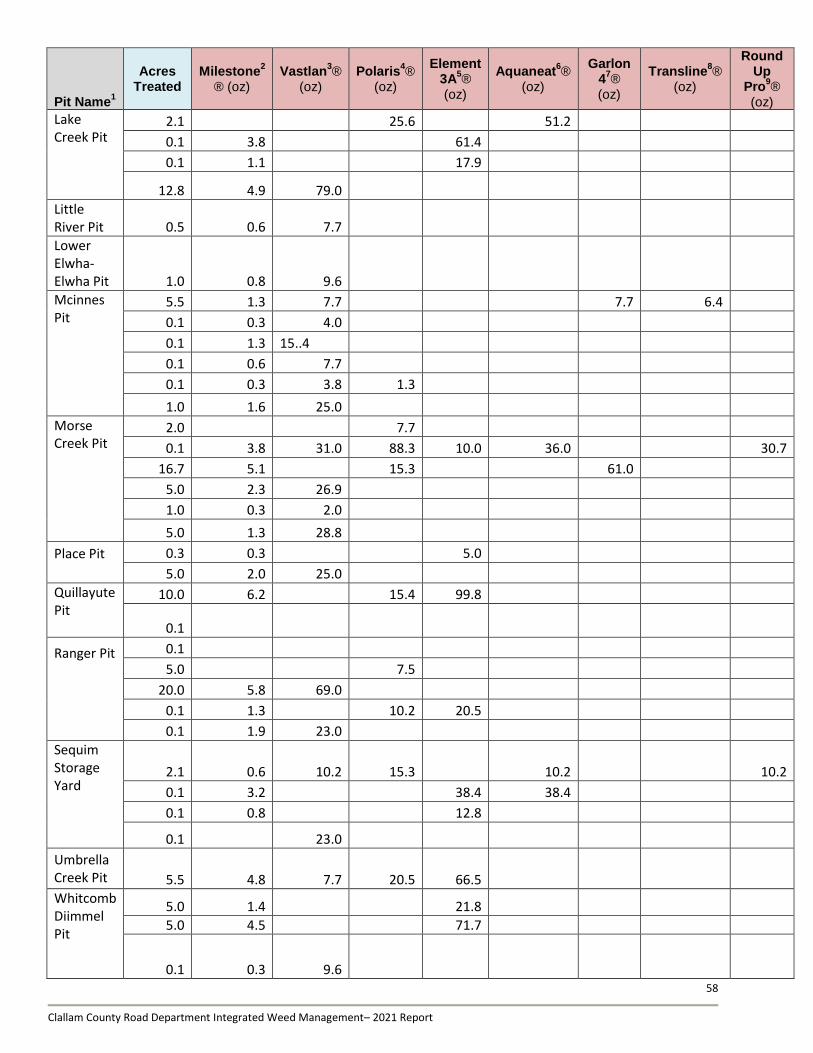
58
Clallam County Road Department Integrated Weed Management– 2021 Report
Pit Name1
Acres Treated
Milestone2
® (oz) Vastlan
3®
(oz) Polaris
4®
(oz)
Element 3A
5®
(oz)
Aquaneat6®
(oz)
Garlon 4
7®
(oz)
Transline8®
(oz)
Round Up
Pro9®
(oz)
Lake Creek Pit
2.1 25.6 51.2
0.1 3.8 61.4
0.1 1.1 17.9
12.8 4.9 79.0
Little River Pit 0.5 0.6 7.7
Lower Elwha-Elwha Pit 1.0 0.8 9.6
Mcinnes Pit
5.5 1.3 7.7 7.7 6.4
0.1 0.3 4.0
0.1 1.3 15..4
0.1 0.6 7.7
0.1 0.3 3.8 1.3
1.0 1.6 25.0
Morse Creek Pit
2.0 7.7
0.1 3.8 31.0 88.3 10.0 36.0 30.7
16.7 5.1 15.3 61.0
5.0 2.3 26.9
1.0 0.3 2.0
5.0 1.3 28.8
Place Pit
0.3 0.3 5.0
5.0 2.0 25.0
Quillayute Pit
10.0 6.2 15.4 99.8
0.1
Ranger Pit
0.1
5.0 7.5
20.0 5.8 69.0
0.1 1.3 10.2 20.5
0.1 1.9 23.0
Sequim Storage Yard
2.1 0.6 10.2 15.3 10.2 10.2
0.1 3.2 38.4 38.4
0.1 0.8 12.8
0.1 23.0
Umbrella Creek Pit 5.5 4.8 7.7 20.5 66.5
Whitcomb Diimmel Pit
5.0 1.4 21.8
5.0 4.5 71.7
0.1 0.3 9.6
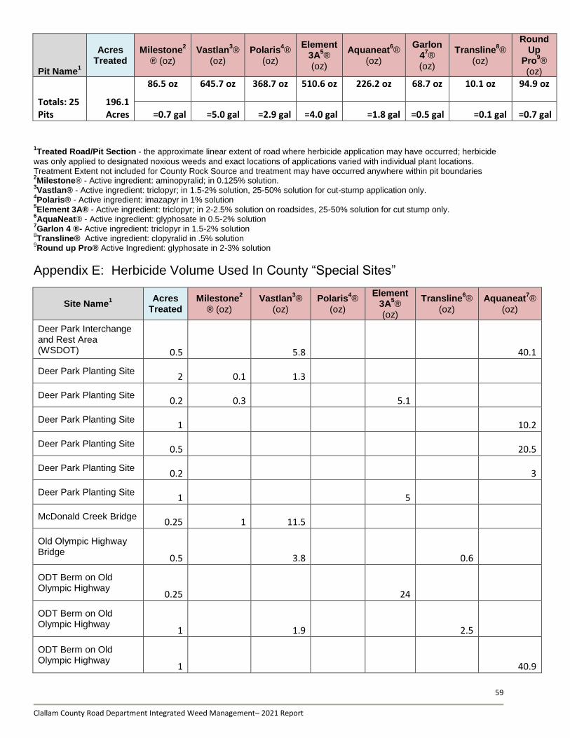
59
Clallam County Road Department Integrated Weed Management– 2021 Report
Pit Name1
Acres Treated
Milestone2
® (oz) Vastlan
3®
(oz) Polaris
4®
(oz)
Element 3A
5®
(oz)
Aquaneat6®
(oz)
Garlon 4
7®
(oz)
Transline8®
(oz)
Round Up
Pro9®
(oz)
Totals: 25 Pits
196.1 Acres
86.5 oz 645.7 oz 368.7 oz 510.6 oz 226.2 oz 68.7 oz 10.1 oz 94.9 oz
=0.7 gal =5.0 gal =2.9 gal =4.0 gal =1.8 gal =0.5 gal =0.1 gal =0.7 gal
1Treated Road/Pit Section - the approximate linear extent of road where herbicide application may have occurred; herbicide
was only applied to designated noxious weeds and exact locations of applications varied with individual plant locations. Treatment Extent not included for County Rock Source and treatment may have occurred anywhere within pit boundaries 2Milestone® - Active ingredient: aminopyralid; in 0.125% solution.
3Vastlan® - Active ingredient: triclopyr; in 1.5-2% solution, 25-50% solution for cut-stump application only.
4Polaris® - Active ingredient: imazapyr in 1% solution
5Element 3A® - Active ingredient: triclopyr; in 2-2.5% solution on roadsides, 25-50% solution for cut stump only.
6AquaNeat® - Active ingredient: glyphosate in 0.5-2% solution
7Garlon 4 ®- Active ingredient: triclopyr in 1.5-2% solution
8Transline® Active ingredient: clopyralid in .5% solution
9Round up Pro® Active Ingredient: glyphosate in 2-3% solution
Appendix E: Herbicide Volume Used In County “Special Sites”
Site Name1 Acres
Treated Milestone
2
® (oz) Vastlan
3®
(oz) Polaris
4®
(oz)
Element 3A
5®
(oz)
Transline6®
(oz) Aquaneat
7®
(oz)
Deer Park Interchange and Rest Area (WSDOT) 0.5 5.8 40.1
Deer Park Planting Site 2 0.1 1.3
Deer Park Planting Site 0.2 0.3 5.1
Deer Park Planting Site 1 10.2
Deer Park Planting Site 0.5 20.5
Deer Park Planting Site 0.2 3
Deer Park Planting Site 1 5
McDonald Creek Bridge 0.25 1 11.5
Old Olympic Highway Bridge
0.5 3.8 0.6
ODT Berm on Old Olympic Highway
0.25 24
ODT Berm on Old Olympic Highway
1 1.9 2.5
ODT Berm on Old Olympic Highway
1 40.9
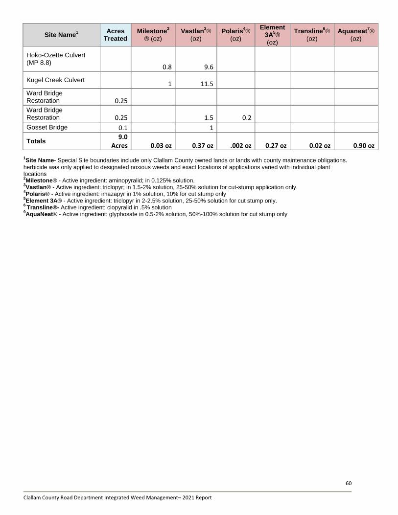
60
Clallam County Road Department Integrated Weed Management– 2021 Report
Site Name1 Acres
Treated Milestone
2
® (oz) Vastlan
3®
(oz) Polaris
4®
(oz)
Element 3A
5®
(oz)
Transline6®
(oz) Aquaneat
7®
(oz)
Hoko-Ozette Culvert (MP 8.8)
0.8 9.6
Kugel Creek Culvert 1 11.5
Ward Bridge Restoration 0.25
Ward Bridge Restoration 0.25 1.5 0.2
Gosset Bridge 0.1 1
Totals 9.0
Acres 0.03 oz 0.37 oz .002 oz 0.27 oz 0.02 oz 0.90 oz
1Site Name- Special Site boundaries include only Clallam County owned lands or lands with county maintenance obligations.
herbicide was only applied to designated noxious weeds and exact locations of applications varied with individual plant locations 2Milestone® - Active ingredient: aminopyralid; in 0.125% solution.
3Vastlan® - Active ingredient: triclopyr; in 1.5-2% solution, 25-50% solution for cut-stump application only.
4Polaris® - Active ingredient: imazapyr in 1% solution, 10% for cut stump only
5Element 3A® - Active ingredient: triclopyr in 2-2.5% solution, 25-50% solution for cut stump only.
6 Transline®- Active ingredient: clopyralid in .5% solution
9AquaNeat® - Active ingredient: glyphosate in 0.5-2% solution, 50%-100% solution for cut stump only
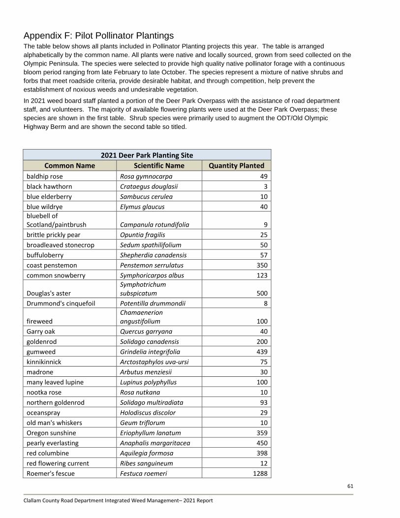
61
Clallam County Road Department Integrated Weed Management– 2021 Report
Appendix F: Pilot Pollinator Plantings The table below shows all plants included in Pollinator Planting projects this year. The table is arranged
alphabetically by the common name. All plants were native and locally sourced, grown from seed collected on the
Olympic Peninsula. The species were selected to provide high quality native pollinator forage with a continuous
bloom period ranging from late February to late October. The species represent a mixture of native shrubs and
forbs that meet roadside criteria, provide desirable habitat, and through competition, help prevent the
establishment of noxious weeds and undesirable vegetation.
In 2021 weed board staff planted a portion of the Deer Park Overpass with the assistance of road department
staff, and volunteers. The majority of available flowering plants were used at the Deer Park Overpass; these
species are shown in the first table. Shrub species were primarily used to augment the ODT/Old Olympic
Highway Berm and are shown the second table so titled.
2021 Deer Park Planting Site
Common Name Scientific Name Quantity Planted
baldhip rose Rosa gymnocarpa 49
black hawthorn Crataegus douglasii 3
blue elderberry Sambucus cerulea 10
blue wildrye Elymus glaucus 40
bluebell of Scotland/paintbrush Campanula rotundifolia 9
brittle prickly pear Opuntia fragilis 25
broadleaved stonecrop Sedum spathilifolium 50
buffuloberry Shepherdia canadensis 57
coast penstemon Penstemon serrulatus 350
common snowberry Symphoricarpos albus 123
Douglas's aster Symphotrichum subspicatum 500
Drummond's cinquefoil Potentilla drummondii 8
fireweed Chamaenerion angustifolium 100
Garry oak Quercus garryana 40
goldenrod Solidago canadensis 200
gumweed Grindelia integrifolia 439
kinnikinnick Arctostaphylos uva-ursi 75
madrone Arbutus menziesii 30
many leaved lupine Lupinus polyphyllus 100
nootka rose Rosa nutkana 10
northern goldenrod Solidago multiradiata 93
oceanspray Holodiscus discolor 29
old man's whiskers Geum triflorum 10
Oregon sunshine Eriophyllum lanatum 359
pearly everlasting Anaphalis margaritacea 450
red columbine Aquilegia formosa 398
red flowering current Ribes sanguineum 12
Roemer's fescue Festuca roemeri 1288
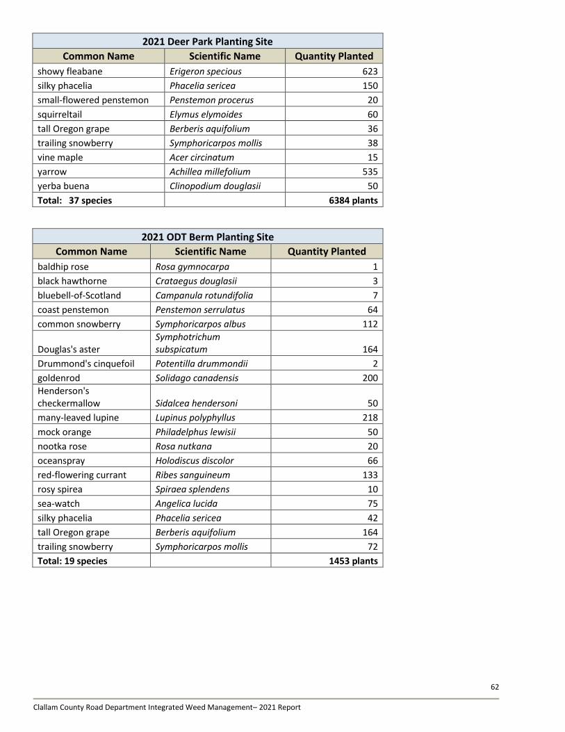
62
Clallam County Road Department Integrated Weed Management– 2021 Report
2021 Deer Park Planting Site
Common Name Scientific Name Quantity Planted
showy fleabane Erigeron specious 623
silky phacelia Phacelia sericea 150
small-flowered penstemon Penstemon procerus 20
squirreltail Elymus elymoides 60
tall Oregon grape Berberis aquifolium 36
trailing snowberry Symphoricarpos mollis 38
vine maple Acer circinatum 15
yarrow Achillea millefolium 535
yerba buena Clinopodium douglasii 50
Total: 37 species 6384 plants
2021 ODT Berm Planting Site
Common Name Scientific Name Quantity Planted
baldhip rose Rosa gymnocarpa 1
black hawthorne Crataegus douglasii 3
bluebell-of-Scotland Campanula rotundifolia 7
coast penstemon Penstemon serrulatus 64
common snowberry Symphoricarpos albus 112
Douglas's aster Symphotrichum subspicatum 164
Drummond's cinquefoil Potentilla drummondii 2
goldenrod Solidago canadensis 200
Henderson's checkermallow Sidalcea hendersoni 50
many-leaved lupine Lupinus polyphyllus 218
mock orange Philadelphus lewisii 50
nootka rose Rosa nutkana 20
oceanspray Holodiscus discolor 66
red-flowering currant Ribes sanguineum 133
rosy spirea Spiraea splendens 10
sea-watch Angelica lucida 75
silky phacelia Phacelia sericea 42
tall Oregon grape Berberis aquifolium 164
trailing snowberry Symphoricarpos mollis 72
Total: 19 species 1453 plants
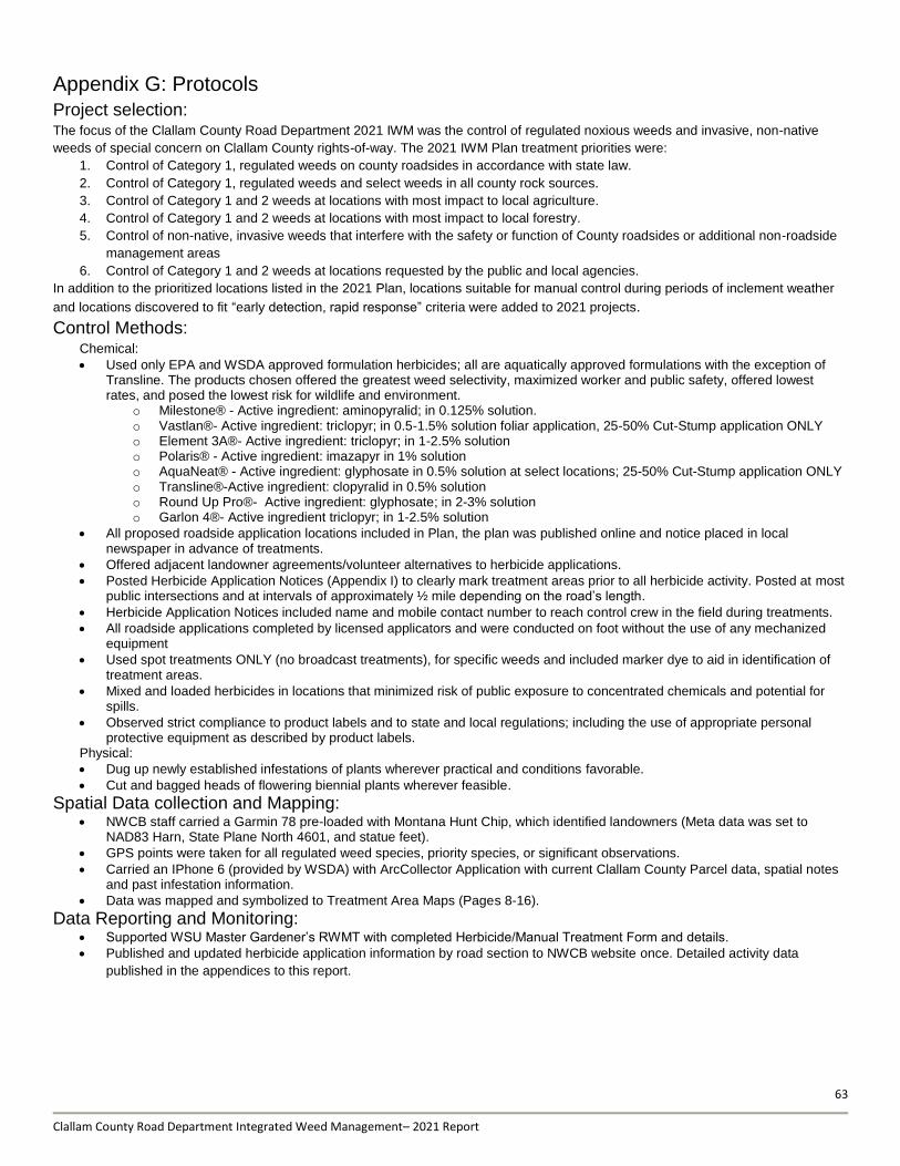
63
Clallam County Road Department Integrated Weed Management– 2021 Report
Appendix G: Protocols
Project selection: The focus of the Clallam County Road Department 2021 IWM was the control of regulated noxious weeds and invasive, non-native
weeds of special concern on Clallam County rights-of-way. The 2021 IWM Plan treatment priorities were:
1. Control of Category 1, regulated weeds on county roadsides in accordance with state law.
2. Control of Category 1, regulated weeds and select weeds in all county rock sources.
3. Control of Category 1 and 2 weeds at locations with most impact to local agriculture.
4. Control of Category 1 and 2 weeds at locations with most impact to local forestry.
5. Control of non-native, invasive weeds that interfere with the safety or function of County roadsides or additional non-roadside
management areas
6. Control of Category 1 and 2 weeds at locations requested by the public and local agencies.
In addition to the prioritized locations listed in the 2021 Plan, locations suitable for manual control during periods of inclement weather
and locations discovered to fit “early detection, rapid response” criteria were added to 2021 projects.
Control Methods: Chemical:
Used only EPA and WSDA approved formulation herbicides; all are aquatically approved formulations with the exception of Transline. The products chosen offered the greatest weed selectivity, maximized worker and public safety, offered lowest rates, and posed the lowest risk for wildlife and environment.
o Milestone® - Active ingredient: aminopyralid; in 0.125% solution. o Vastlan®- Active ingredient: triclopyr; in 0.5-1.5% solution foliar application, 25-50% Cut-Stump application ONLY o Element 3A®- Active ingredient: triclopyr; in 1-2.5% solution o Polaris® - Active ingredient: imazapyr in 1% solution o AquaNeat® - Active ingredient: glyphosate in 0.5% solution at select locations; 25-50% Cut-Stump application ONLY o Transline®-Active ingredient: clopyralid in 0.5% solution o Round Up Pro®- Active ingredient: glyphosate; in 2-3% solution o Garlon 4®- Active ingredient triclopyr; in 1-2.5% solution
All proposed roadside application locations included in Plan, the plan was published online and notice placed in local newspaper in advance of treatments.
Offered adjacent landowner agreements/volunteer alternatives to herbicide applications.
Posted Herbicide Application Notices (Appendix I) to clearly mark treatment areas prior to all herbicide activity. Posted at most public intersections and at intervals of approximately ½ mile depending on the road’s length.
Herbicide Application Notices included name and mobile contact number to reach control crew in the field during treatments.
All roadside applications completed by licensed applicators and were conducted on foot without the use of any mechanized equipment
Used spot treatments ONLY (no broadcast treatments), for specific weeds and included marker dye to aid in identification of treatment areas.
Mixed and loaded herbicides in locations that minimized risk of public exposure to concentrated chemicals and potential for spills.
Observed strict compliance to product labels and to state and local regulations; including the use of appropriate personal protective equipment as described by product labels.
Physical:
Dug up newly established infestations of plants wherever practical and conditions favorable.
Cut and bagged heads of flowering biennial plants wherever feasible.
Spatial Data collection and Mapping: NWCB staff carried a Garmin 78 pre-loaded with Montana Hunt Chip, which identified landowners (Meta data was set to
NAD83 Harn, State Plane North 4601, and statue feet).
GPS points were taken for all regulated weed species, priority species, or significant observations.
Carried an IPhone 6 (provided by WSDA) with ArcCollector Application with current Clallam County Parcel data, spatial notes and past infestation information.
Data was mapped and symbolized to Treatment Area Maps (Pages 8-16).
Data Reporting and Monitoring: Supported WSU Master Gardener’s RWMT with completed Herbicide/Manual Treatment Form and details.
Published and updated herbicide application information by road section to NWCB website once. Detailed activity data
published in the appendices to this report.
Clallam County Road Department Integrated Weed Management– 2021 Report
66
Appendix H: WSU Extension Master Gardener Roadside Weed Management
Monitoring Report
The following report document is a scanned copy of the report created by WSU Extension program’s Master Gardeners Roadside Weed Monitoring Team (RWMT). The WSU Master Gardener program was established in 1971 to assist Extension professionals in the delivery of research-based horticultural information to communities. Today, Master Gardeners undergo 100 hours of training in topics such plant biology and species identification training to become certified Master Gardeners and provide for a variety of community services including educational programs, diagnostic services and answers to home gardening questions. The RWMT are Master Gardeners engaged as citizen scientists to collect data and provide an independent assessment of the IWM Program and its treatment activities. Master Gardener’s unique qualities as an educated, highly-trained volunteer group make the RWMT an extremely valuable asset to the IWM Program. The 2019 RWMT consisted of seven certified Master Gardeners with a particular interest in environmental stewardship and research. Individually, the team members come from a variety of professional and academic backgrounds, including, resource management, applied sciences and natural science. The team logged over 400 volunteer hours during which they assessed 45% of the treated roads as well as assisted in the development and implementation of a variety of research projects, each of which is described in the following report.
Appendix H Page 1 of 25
Clallam County Master Gardener
Roadside Weed Monitoring Report – 2021
EXECUTIVE SUMMARY:
The Washington State University Clallam County Extension Master Gardener’s Roadside Weed Monitoring Team
(RWMT) continued its Clallam County roadside monitoring activity in 2021, surveying fifty-nine (59) roadsides in the East
and Central Clallam Road Commission Districts. Eighty-nine (89) Herbicide/Manual treatment forms were analyzed.
Overall, 2021 weed control efficacy was 83% (Good); the highest rating of this five-year project. Twenty-eight (28) weed
species were evaluated for efficiency and an additional eleven (11) weed species were observed or noted but not rated
since only partial treatments were done.
Three (3) additional projects initiated in 2019 by RWMT were continued this year. Reports have been delivered
to the Noxious Weed Office and are available upon request.
1. The No-Mow Pilot Area Project involving Place and Diamond Point roadsides continues and is
demonstrating some modest tree suppression.
2. The Olympic Discovery Trail weed species evaluation continues with a survey of the noxious weed
locations.
3. Pollinator plantings continue this year at the Deer Park interchange and Olympic Discovery Trail west of
Agnew.
The RWMT volunteered over 400 hours this year to support these efforts. We are enjoying the projects,
expanding our knowledge base, and look forward to further research opportunities. With five (5) years of monitoring,
some distribution and eradication trends are noticeable. Treated weed species appear and disappear from the
landscape.

Appendix H Page 2 of 25
MONITORING PROJECT OVERVIEW:
Entering the fifth year of the Clallam County Integrated Weed Management Plan, Master Gardeners continued
our role as an impartial monitor of the weed control efficacy along Clallam County roadsides. Master Gardeners have
been monitoring Clallam County roadsides since 2012, noting specific noxious weeds. In 2017, the objective changed to
monitoring undesirable weeds treated (herbicide and/or manual) by the noxious weed staff. The primary purpose of the
monitoring was and is to evaluate the efficacy of treatment. This emphasis continues. In this report, there will be some
numerical analysis. While it may be generally useful, we acknowledge that the collected data are not designed for
statistical treatment as they are subjective and not normally distributed.
METHODOLOGY for 2021:
The year 2021 continued two significant changes in our operational procedures.
1. The pandemic 2. The use of a data collection device (DCD)
Because of the possible transmission of SARS CoV-2, we continued to follow the State and County guidelines.
If we were to be effective in our evaluation, an additional means of data viewing was needed besides a single
DCD. It was found that we could use the ArcGIS Collector app on our cell phones. However, availability and
usefulness of previously enter data was limited. Thus, we mainly relied on our standard manual method of
roadside surveillance to determine efficacy. If we found sites with poor efficacy ratings or other pertinent
information, it was punctually relayed to the Noxious Weed Office.
Appendix H Page 3 of 25
MONITORING:
Commencing early in May, nine Master Gardeners launched the 2021 treatment site monitoring. During the
season, the team was given one hundred six (106) completed in season Herbicide/Manual Treatment Data Forms (TDF;
Table 1).
Table 1: Treatment Forms
Treatment forms received: ------------------------------------------- 106
Herbicide treatment: ---------------------------------- 77
Manual treatment: ------------------------------------- 12
Treatment forms monitored: ---------------------------------------- 89 (84%)
Fifty-nine (59) roadsides were monitored during the 2021 season (Appendix A) with 40 in the East Clallam Road
Department District and 19 in the Central District. Thirteen (13) previously un-monitored roadsides were evaluated, and
9 roadsides were monitored for the fifth consecutive year.
Twenty-eight (28) Clallam County noxious weed species were monitored and received efficacy ratings (Appendix
B). Category 1 weeds remained the highest priority for control in 2021. Most of the commonly monitored weeds of 2017
were still being monitored in 2021 (Table 2). The knapweeds (meadow, spotted, and diffuse) were a high priority in 2017
and remained such for 2021. Meadow knapweed, the most commonly monitored in 2019, was noted on 31 of the TDFs
in 2021. It is still more prevalent in the Central District than the East.
This year there are only four (4) ranked commonly monitored weeds since there was a significant gap between
position 4 and 5. Meadow knapweed and tansy ragwort topped this year’s list. Poison hemlock and Scotch Broom were
both at 23 efficacy ratings, trailing meadow knapweed and tansy ragwort by approximately 8 efficacy ratings. This year’s
top four can be found in previous year’s top five list. Two-thirds of the 28 monitored weed species had four or fewer
locations to be monitored, and the area coverage of these was minimal. Without the updated DCD data or when out of
cell range, it is still difficult to locate small infestations with low densities.

Appendix H Page 4 of 25
Table 2: Most Commonly Monitored Weeds
2021 1 Tansy Ragwort 2 Meadow Knapweed 3 Poison Hemlock 4 Scotch Broom
Rank 2017 Rank 2018
1 Tansy Ragwort 1 Canada thistle
2 Canada Thistle 2 Bull Thistle
3 Meadow Knapweed 3 Scotch Broom
4 Scotch Broom 4 Meadow Knapweed
5 Diffuse Knapweed 5 Tansy Ragwort
Rank 2019 Rank 2020
1 Meadow Knapweed 1 Scotch Broom
2 Canada Thistle 2 Poison Hemlock
3 Bull Thistle 3 Meadow Knapweed
4 Poison Hemlock 4 Himalayan Blackberry
4T Tansy Ragwort 5 Tansy Ragwort
Partial treatments were common with 150 applications. Observed but not rated, partial treatments are typically
dealt with in the comment section on the monitoring sheets. Scotch Broom appears in a predominant position on both
the monitored and partial treatment lists; in total, it is the most observed weed. Also, commonly treated partial sites
included Himalayan blackberry, Herb Robert, Canada thistle, bull thistle, and everlasting pea vine. Bull thistle is a prized
pull by any RVMT member. Everlasting peavine was partially treated 9 times this year, but lacked a complete treatment.
Considering that two-thirds of the monitored roads were in the East District, there is a preponderance of partially
treated sites in the Central District. Himalayan blackberry is treated predominately in the Eastern District (80%). The
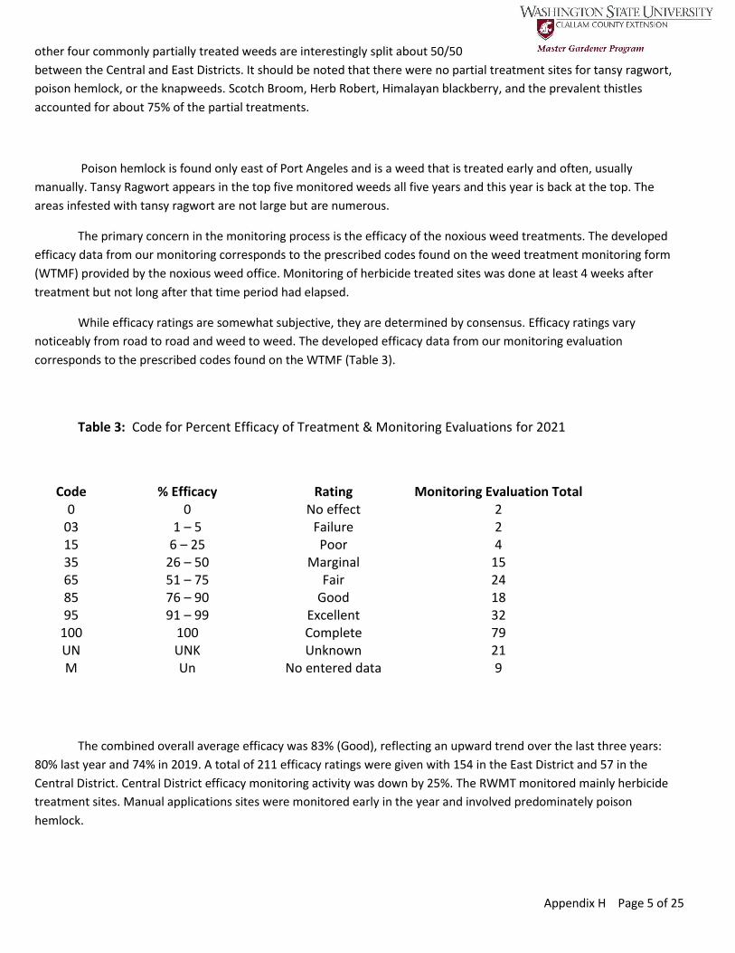
Appendix H Page 5 of 25
other four commonly partially treated weeds are interestingly split about 50/50
between the Central and East Districts. It should be noted that there were no partial treatment sites for tansy ragwort,
poison hemlock, or the knapweeds. Scotch Broom, Herb Robert, Himalayan blackberry, and the prevalent thistles
accounted for about 75% of the partial treatments.
Poison hemlock is found only east of Port Angeles and is a weed that is treated early and often, usually
manually. Tansy Ragwort appears in the top five monitored weeds all five years and this year is back at the top. The
areas infested with tansy ragwort are not large but are numerous.
The primary concern in the monitoring process is the efficacy of the noxious weed treatments. The developed
efficacy data from our monitoring corresponds to the prescribed codes found on the weed treatment monitoring form
(WTMF) provided by the noxious weed office. Monitoring of herbicide treated sites was done at least 4 weeks after
treatment but not long after that time period had elapsed.
While efficacy ratings are somewhat subjective, they are determined by consensus. Efficacy ratings vary
noticeably from road to road and weed to weed. The developed efficacy data from our monitoring evaluation
corresponds to the prescribed codes found on the WTMF (Table 3).
Table 3: Code for Percent Efficacy of Treatment & Monitoring Evaluations for 2021
Code % Efficacy Rating Monitoring Evaluation Total 0 0 No effect 2
03 1 – 5 Failure 2 15 6 – 25 Poor 4 35 26 – 50 Marginal 15 65 51 – 75 Fair 24 85 76 – 90 Good 18 95 91 – 99 Excellent 32
100 100 Complete 79 UN UNK Unknown 21 M Un No entered data 9
The combined overall average efficacy was 83% (Good), reflecting an upward trend over the last three years:
80% last year and 74% in 2019. A total of 211 efficacy ratings were given with 154 in the East District and 57 in the
Central District. Central District efficacy monitoring activity was down by 25%. The RWMT monitored mainly herbicide
treatment sites. Manual applications sites were monitored early in the year and involved predominately poison
hemlock.

Appendix H Page 6 of 25
There were 151 partial treatments listed on the TDFs. Unknowns and partial treatment applications are not
reflected in the overall efficacy ratings. Unknowns were up significantly this year. Two factors contributed: first, trying
to monitor on high traffic roads and second, lack of site information on small patches. Missing data were predominately
the result of communication difficulties and missing DCD data.
Stellar efficacy ratings were earned on several common weed species (Table 4). Tansy ragwort treatment sites
increased significantly, and the efficacy rating increased to 92 and typically received a complete rating . Meadow
knapweed also showed a significant rise in efficacy rating and again, most typically was given a complete rating. Poison
hemlock application ratings showed a slight drop this year, with a mean efficacy rating of 86. Scotch Broom lowered the
overall efficacy. Some of the less monitored common weeds, such as Canada thistle and bull thistle, also tended to lower
the efficacy rating. Canada thistle’s efficacy rating was 60 while bull thistle came in at 74. Overall, efficacy ratings
showed a wide range for individual species (Appendix C).
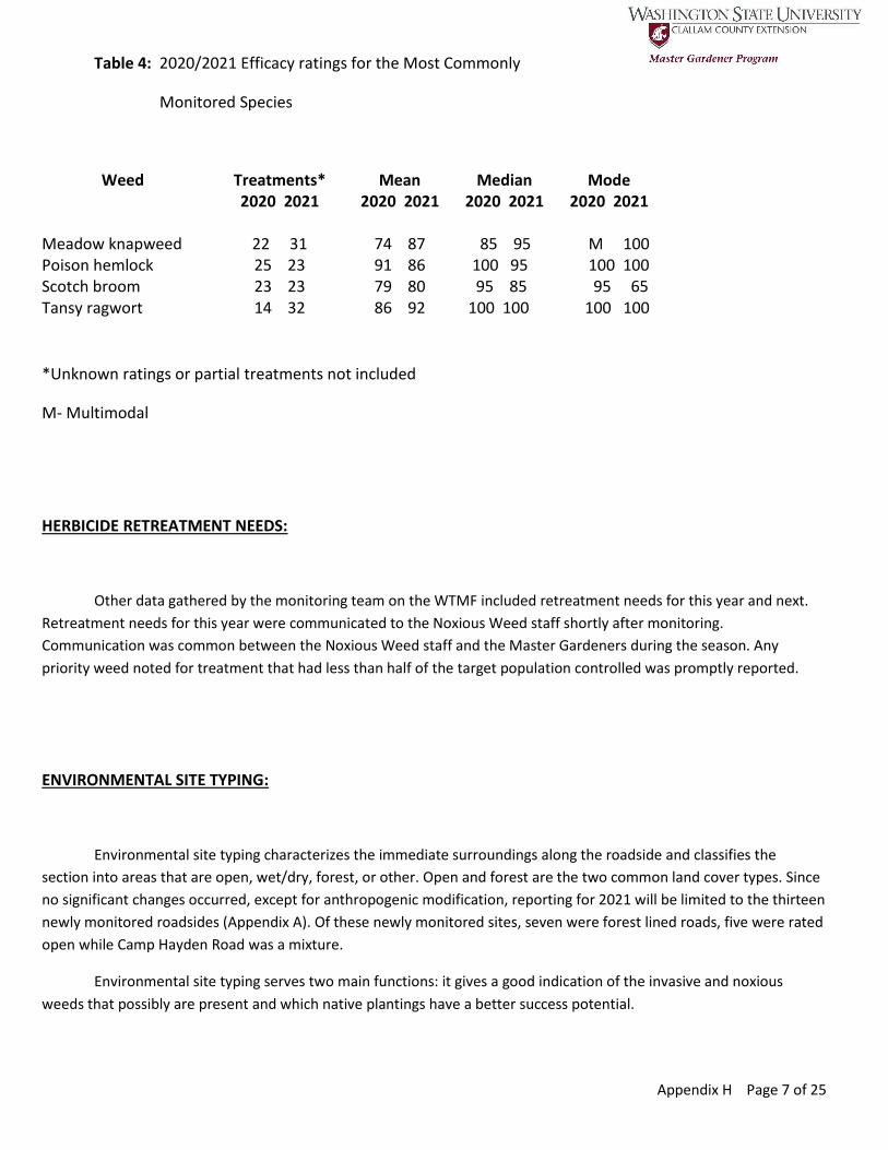
Appendix H Page 7 of 25
Table 4: 2020/2021 Efficacy ratings for the Most Commonly
Monitored Species
Weed Treatments* Mean Median Mode 2020 2021 2020 2021 2020 2021 2020 2021 Meadow knapweed 22 31 74 87 85 95 M 100 Poison hemlock 25 23 91 86 100 95 100 100 Scotch broom 23 23 79 80 95 85 95 65 Tansy ragwort 14 32 86 92 100 100 100 100
*Unknown ratings or partial treatments not included
M- Multimodal
HERBICIDE RETREATMENT NEEDS:
Other data gathered by the monitoring team on the WTMF included retreatment needs for this year and next.
Retreatment needs for this year were communicated to the Noxious Weed staff shortly after monitoring.
Communication was common between the Noxious Weed staff and the Master Gardeners during the season. Any
priority weed noted for treatment that had less than half of the target population controlled was promptly reported.
ENVIRONMENTAL SITE TYPING:
Environmental site typing characterizes the immediate surroundings along the roadside and classifies the
section into areas that are open, wet/dry, forest, or other. Open and forest are the two common land cover types. Since
no significant changes occurred, except for anthropogenic modification, reporting for 2021 will be limited to the thirteen
newly monitored roadsides (Appendix A). Of these newly monitored sites, seven were forest lined roads, five were rated
open while Camp Hayden Road was a mixture.
Environmental site typing serves two main functions: it gives a good indication of the invasive and noxious
weeds that possibly are present and which native plantings have a better success potential.
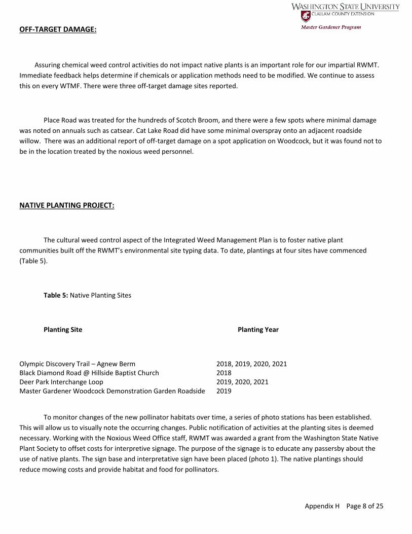
Appendix H Page 8 of 25
OFF-TARGET DAMAGE:
Assuring chemical weed control activities do not impact native plants is an important role for our impartial RWMT.
Immediate feedback helps determine if chemicals or application methods need to be modified. We continue to assess
this on every WTMF. There were three off-target damage sites reported.
Place Road was treated for the hundreds of Scotch Broom, and there were a few spots where minimal damage
was noted on annuals such as catsear. Cat Lake Road did have some minimal overspray onto an adjacent roadside
willow. There was an additional report of off-target damage on a spot application on Woodcock, but it was found not to
be in the location treated by the noxious weed personnel.
NATIVE PLANTING PROJECT:
The cultural weed control aspect of the Integrated Weed Management Plan is to foster native plant
communities built off the RWMT’s environmental site typing data. To date, plantings at four sites have commenced
(Table 5).
Table 5: Native Planting Sites
Planting Site Planting Year
Olympic Discovery Trail – Agnew Berm 2018, 2019, 2020, 2021 Black Diamond Road @ Hillside Baptist Church 2018 Deer Park Interchange Loop 2019, 2020, 2021 Master Gardener Woodcock Demonstration Garden Roadside 2019
To monitor changes of the new pollinator habitats over time, a series of photo stations has been established.
This will allow us to visually note the occurring changes. Public notification of activities at the planting sites is deemed
necessary. Working with the Noxious Weed Office staff, RWMT was awarded a grant from the Washington State Native
Plant Society to offset costs for interpretive signage. The purpose of the signage is to educate any passersby about the
use of native plants. The sign base and interpretative sign have been placed (photo 1). The native plantings should
reduce mowing costs and provide habitat and food for pollinators.

Appendix H Page 9 of 25
I
OLYMPIC DISCOVERY TRAILSURVEY PROJECT:
Weed species, Global Positioning System (GPS) coordinates, and other weed location data along the Olympic
Discovery Trail from the Elwha River to the East Clallam County line were provided in a 2019 report to the Noxious Weed
Office. Additional areas of the trail were surveyed this year, as well as spot resurveys. Potential areas of future native
plantings are also included.
NO-MOW PILOT:
Data gathering to determine if some low growing native shrubs can help suppress roadside tree growth, which
could reduce the County roadside mowing burden while enhancing pollinator habitat. Preliminary results are that
modest tree suppression is happening, and the vast majority of tree seedlings were proximate to the ditch, which will
continue to be mowed.
Photo 1: Interpretive sign adjacent to the
Olympic Discovery Trail west of the Agnew
Berm.
Photo credit: Lisa Bridge
Appendix H Page 10 of 25
MONITORING OBSERVATIONS AND CONCLUSIONS:
With the completion of the 2021 fieldwork, we now have five years of data along nine roadsides. Thirteen (13)
roadsides are new this year with the remaining 37 having been monitored multiple times. Most of the following text will
refer to the four mostly commonly rated weed species of 2021 (Table 2).
The knapweed species have remained a high priority weed. Meadow knapweed appears to be the prevalent
knapweed species currently monitored. It is cosmopolitan in its distribution in the East and Central districts, but there
are several troublesome locations that need to be highlighted. Happy Valley is one of the prime locations, mainly west of
Johnson Creek Road. There have been a number of repeat applications in this area. Another location that has an
abundance is the area just east of the Elwha River including Olympic Hot Springs Road and River Road. In the same area,
the roads around Lairds Corner, meadow knapweed plants are found in abundance. Efficacy ratings improved notably
this year, but these trouble spots are persistent and need continued intense care.
Tansy ragwort treatments increased noticeably, returning back to the levels of 2018. Efficacy ratings are general
high, and several spots have shown improvement, such as Happy Valley. Nearby, Palo Alto continues to receive only fair
or marginal efficacy ratings. West of Joyce, Schmitt Road is a hot spot for tansy ragwort. One of the residents had a
warm positive reaction to the attempt to control it at that location. Nearby Whiskey Creek Beach Road had a fair rating
as well this year. Several roadsides that were treated in early years and received low ratings, such as Fors, have not
been monitored recently.
Poison hemlock has become a point of attention in the monitoring process, first monitored in 2018. It currently
seems to be confined to the East District but is persistent. Most of the sites are manually treated early in the growing
season. Efficacy ratings are generally excellent or complete but there is one locale that seems to pose a problem –
Woodcock near the Dungeness River and the crossing road Fasola. Nearby, Ward has improved, and this year had
complete ratings. The Voice of America site, which has had an abundance of the plant the previous three years, did not
have any plants when checked. Even with so many complete removals each year, the seed bank does replenish the plant
in many locations.
Scotch Broom treatment efficacies have improved from marginal to fair to good since 2017, with a decrease in
area and a pleasing increase in efficacy. Yet, it remains a problem on adjacent private property. The notable change this
year was the significant increase in partial treatments. In 2017, there were few treatments and no partial treatments.
Partial treatments in 2020 were about 20% with an increase in treatments, but this year, partial treatments were slightly
over 50% of all the Scotch Broom treatments, and the number of treatments sites (both partial and complete) continue
to climb. Additionally, mature plants are prolific seed producers, and many small plants are found sprouting later in the
same or next year. If some have been removed, it seems that another can be found. This is the weed species that seems
to garner the most conversation in our interactions with the public.

Appendix H Page 11 of 25
Noting a few of the other weeds, Italian thistle was monitored intensely. The first pass was with eight Master
Gardener volunteers walking the area of infestation. It was followed up later in the growing season with another
viewing. Ber chervil, noted only in the East District north and west of Sequim, was monitored for the first time, and with
its abundance will probably be seen next year. Efficacy ratings were low. Another new weed this year was purple
foxglove, found mainly in the Central District. Spotted knapweed, monitored seven times with high efficacy ratings, was
again clustered around Sequim. The one exception was Deer Park, with an efficacy rating of poor. Common teasel has
been persistently appearing around and east of Sequim. Efficacy ratings are generally complete, but several locations
had poor ratings (Appendix C). Closer attention needs to be paid to this species. Yellow Hawkweed persists along Deer
Park and O’Brien, but efficacy ratings are improving. St. Johnswort seems to be rearing its yellow head more frequently
and in places not seen before. Density and area comparisons through the study timespan was not possible this year due
to incomplete received data.
Since the Integrated Weed Management Plan has only been in effect since 2017 and noxious weed seeds can
survive years, even decades, it is important to continue to appropriately resource the County’s efforts in order to comply
with Washington State weed laws. Supported activity by the Clallam County Road Commission and the Clallam County
Commissioners illustrates an awareness of the “big picture” and a view to a sustainable future.
Appendix H Page 12 of 25
RWMT:
In 2021, six Master Gardeners continued in the activities associated with the Noxious Weed Office. They were:
Brick Ayola, Peggy Goette, Bev Hetrick, Brenda Lasorsa, John Viada, and Bruce Pape. They were joined by three interns
from the Master Gardener class of 2021: Lorraine Eckard, Nancy Kohn, and Harmony Rutter.
Monitoring was mainly accomplished from a slow-moving vehicle, but when necessary, sites were examined on
foot. Safety was always a priority. Activities were limited to the East and Central Clallam Road District areas. During the
monitoring, the teams documented post-treatment live noxious weeds and provided point notations for the Noxious
Weed Office staff.
Much was learned from our Spring tune-up tour with the Head of the Noxious Weed Office. Being out and
about, we occasionally had people inquire about our purpose. Contacts, again, were all positive. Monitoring commenced
early in May and ended in mid- September. Field work for the No-Mow project was done in mid-spring and late
September. Total volunteer hours compiled were over 400.
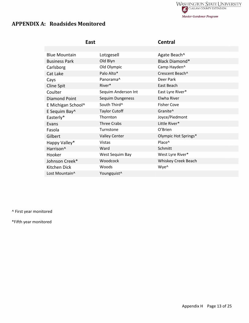
Appendix H Page 13 of 25
APPENDIX A: Roadsides Monitored
East Central
Blue Mountain Lotzgesell Agate Beach^
Business Park Old Blyn Black Diamond*
Carlsborg Old Olympic Camp Hayden^
Cat Lake Palo Alto* Crescent Beach^
Cays Panorama^ Deer Park
Cline Spit River* East Beach
Coulter Sequim Anderson Int East Lyre River*
Diamond Point Sequim Dungeness Elwha River
E Michigan School^ South Third^ Fisher Cove
E Sequim Bay^ Taylor Cutoff Granite^
Easterly* Thornton Joyce/Piedmont
Evans Three Crabs Little River*
Fasola Turnstone O’Brien
Gilbert Valley Center Olympic Hot Springs*
Happy Valley* Vistas Place^
Harrison^ Ward Schmitt
Hooker West Sequim Bay West Lyre River*
Johnson Creek* Woodcock Whiskey Creek Beach
Kitchen Dick Woods Wye^
Lost Mountain^ Youngquist^
^ First year monitored
*Fifth year monitored
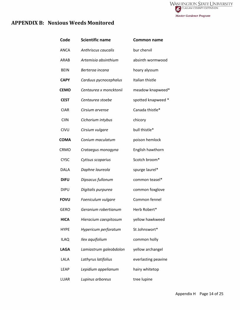
Appendix H Page 14 of 25
APPENDIX B: Noxious Weeds Monitored
Code Scientific name Common name
ANCA Anthriscus caucalis bur chervil
ARAB Artemisia absinthium absinth wormwood
BEIN Berteroa incana hoary alyssum
CAPY Carduus pycnocephalus Italian thistle
CEMO Centaurea x moncktonii meadow knapweed*
CEST Centaurea stoebe spotted knapweed *
CIAR Cirsium arvense Canada thistle*
CIIN Cichorium intybus chicory
CIVU Cirsium vulgare bull thistle*
COMA Conium maculatum poison hemlock
CRMO Crataegus monogyna English hawthorn
CYSC Cytisus scoparius Scotch broom*
DALA Daphne laureola spurge laurel*
DIFU Dipsacus fullonum common teasel*
DIPU Digitalis purpurea common foxglove
FOVU Foeniculum vulgare Common fennel
GERO Geranium robertianum Herb Robert*
HICA Hieracium caespitosum yellow hawkweed
HYPE Hypericum perforatum St Johnswort*
ILAQ Ilex aquifolium common holly
LAGA Lamiastrum galeobdolon yellow archangel
LALA Lathyrus latifolius everlasting peavine
LEAP Lepidium appelianum hairy whitetop
LUAR Lupinus arboreus tree lupine
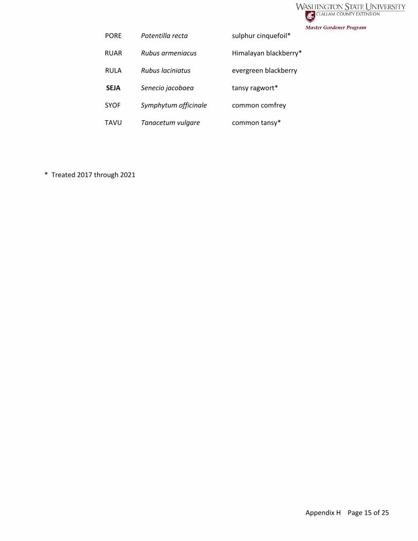
Appendix H Page 15 of 25
PORE Potentilla recta sulphur cinquefoil*
RUAR Rubus armeniacus Himalayan blackberry*
RULA Rubus laciniatus evergreen blackberry
SEJA Senecio jacobaea tansy ragwort*
SYOF Symphytum officinale common comfrey
TAVU Tanacetum vulgare common tansy*
* Treated 2017 through 2021
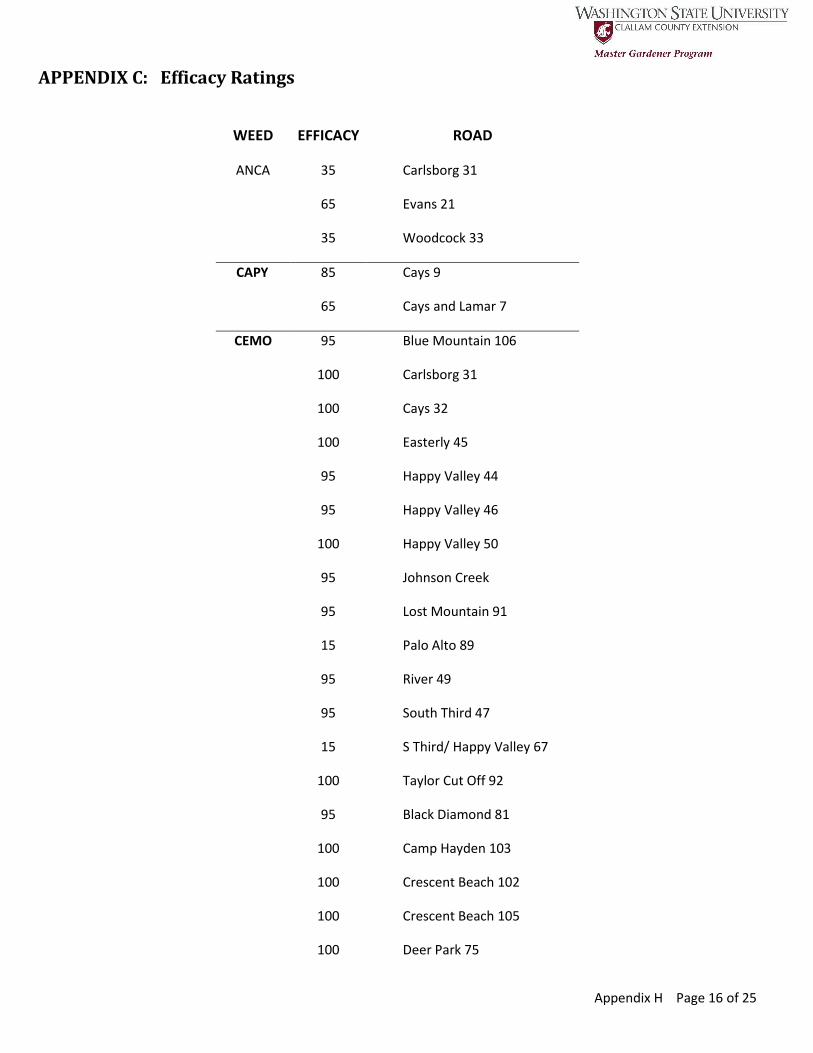
Appendix H Page 16 of 25
APPENDIX C: Efficacy Ratings
WEED EFFICACY ROAD
ANCA 35 Carlsborg 31
65 Evans 21
35 Woodcock 33
CAPY 85 Cays 9
65 Cays and Lamar 7
CEMO 95 Blue Mountain 106
100 Carlsborg 31
100 Cays 32
100 Easterly 45
95 Happy Valley 44
95 Happy Valley 46
100 Happy Valley 50
95 Johnson Creek
95 Lost Mountain 91
15 Palo Alto 89
95 River 49
95 South Third 47
15 S Third/ Happy Valley 67
100 Taylor Cut Off 92
95 Black Diamond 81
100 Camp Hayden 103
100 Crescent Beach 102
100 Crescent Beach 105
100 Deer Park 75
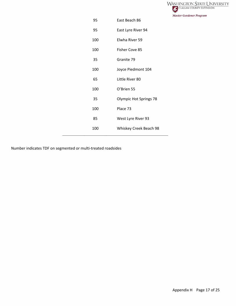
Appendix H Page 17 of 25
95 East Beach 86
95 East Lyre River 94
100 Elwha River 59
100 Fisher Cove 85
35 Granite 79
100 Joyce Piedmont 104
65 Little River 80
100 O’Brien 55
35 Olympic Hot Springs 78
100 Place 73
85 West Lyre River 93
100 Whiskey Creek Beach 98
Number indicates TDF on segmented or multi-treated roadsides
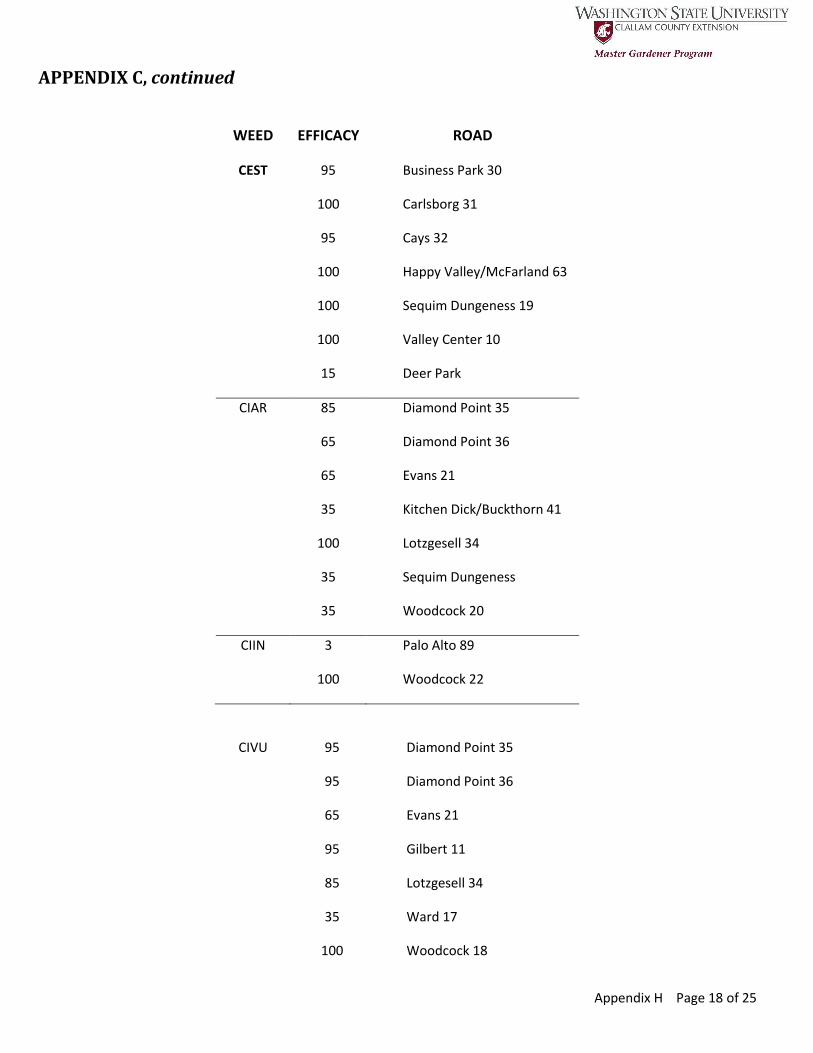
Appendix H Page 18 of 25
APPENDIX C, continued
WEED EFFICACY ROAD
CEST 95 Business Park 30
100 Carlsborg 31
95 Cays 32
100 Happy Valley/McFarland 63
100 Sequim Dungeness 19
100 Valley Center 10
15 Deer Park
CIAR 85 Diamond Point 35
65 Diamond Point 36
65 Evans 21
35 Kitchen Dick/Buckthorn 41
100 Lotzgesell 34
35 Sequim Dungeness
35 Woodcock 20
CIIN 3 Palo Alto 89
100 Woodcock 22
CIVU 95 Diamond Point 35
95 Diamond Point 36
65 Evans 21
95 Gilbert 11
85 Lotzgesell 34
35 Ward 17
100 Woodcock 18

Appendix H Page 19 of 25
35 Woodcock 20
35 Deer Park Interchange 40
100 Fisher Cove 85
Number indicates TDF on segmented or multi-treated roadsides

Appendix H Page 20 of 25
APPENDIX C, continued
WEED EFFICACY ROAD
COMA 95 Business Park 30
100 Cline Spit 13A
95 Coulter 4
95 Evans 21
0 Fasola 23
100 Gilbert 11
100 Hooker 13B
95 Kitchen Dick 1
85 Kitchen Dick 27
100 Lotzgesell 2
100 Old Blyn 6
100 Old Blyn 72
100 Sequim Anderson Inter 8
100 Sequim Dungeness 19
100 Three Crabs 15
100 Vistas 24
85 Sequim Dungeness 19
100 Ward 17
100 West Sequim Bay 39
65 Woodcock 16
100 Woodcock 18
35 Woodcock 20
35 Woodcock 22
100 Woodcock 18

Appendix H Page 21 of 25
100 Deer Park 60
CRMO 0 Sequim Dungeness 19
Number indicates TDF on segmented or multi-treated roadsides

Appendix H Page 22 of 25
APPENDIX C, continued
WEED EFFICACY ROAD
CYSC 100 Business Park 30
85 Diamond Point 35
65 Diamond Point 36
95 Diamond Point 68
95 East Michigan School 71
65 Easterly 45
65 Gilbert 11
65 Harrison 12
85 Lost Mountain 91
95 Lotzgesell 34
100 Old Olympic 42
65 Palo Alto 89
65 River 49
85 River/Happy Valley 64A
100 Sequim Dungeness 19
65 Valley Center 10
65 Vistas 24
85 Woodcock 33
100 Woods 70
35 Deer Park Interchange 40
100 Deer Park Rest Area 65
95 Elwha River 59
65 Fisher Cove 85
85 Place 74
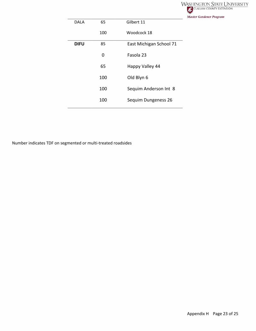
Appendix H Page 23 of 25
DALA 65 Gilbert 11
100 Woodcock 18
DIFU 85 East Michigan School 71
0 Fasola 23
65 Happy Valley 44
100 Old Blyn 6
100 Sequim Anderson Int 8
100 Sequim Dungeness 26
Number indicates TDF on segmented or multi-treated roadsides
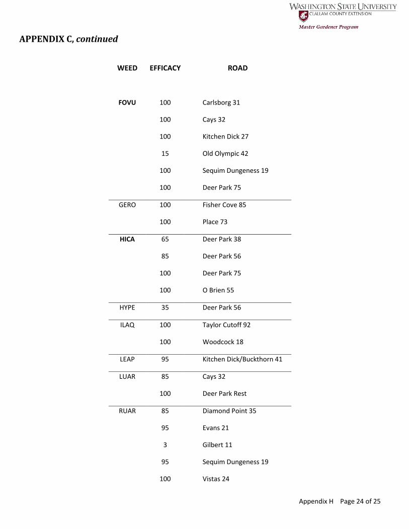
Appendix H Page 24 of 25
APPENDIX C, continued
WEED EFFICACY ROAD
FOVU 100 Carlsborg 31
100 Cays 32
100 Kitchen Dick 27
15 Old Olympic 42
100 Sequim Dungeness 19
100 Deer Park 75
GERO 100 Fisher Cove 85
100 Place 73
HICA 65 Deer Park 38
85 Deer Park 56
100 Deer Park 75
100 O Brien 55
HYPE 35 Deer Park 56
ILAQ 100 Taylor Cutoff 92
100 Woodcock 18
LEAP 95 Kitchen Dick/Buckthorn 41
LUAR 85 Cays 32
100 Deer Park Rest
RUAR 85 Diamond Point 35
95 Evans 21
3 Gilbert 11
95 Sequim Dungeness 19
100 Vistas 24

Appendix H Page 25 of 25
35 Woodcock 20
65 Crescent Beach 105
85 Deer Park 56
95 Elwha River 59
100 O Brien 55
Number indicates TDF on segmented or multi-treated roadsides
APPENDIX C, continued
WEED EFFICACY ROAD
SEJA 95 Blue Mountain 106
95 Cat Lake 69
85 Diamond Point 36
100 Diamond Point 68
100 East Sequim Bay 87
100 Fasola 23
100 Happy Valley 46
100 Happy Valley 50
95 Johnson Creek 48
95 Lost Mountain 91
100 Old Blyn 6
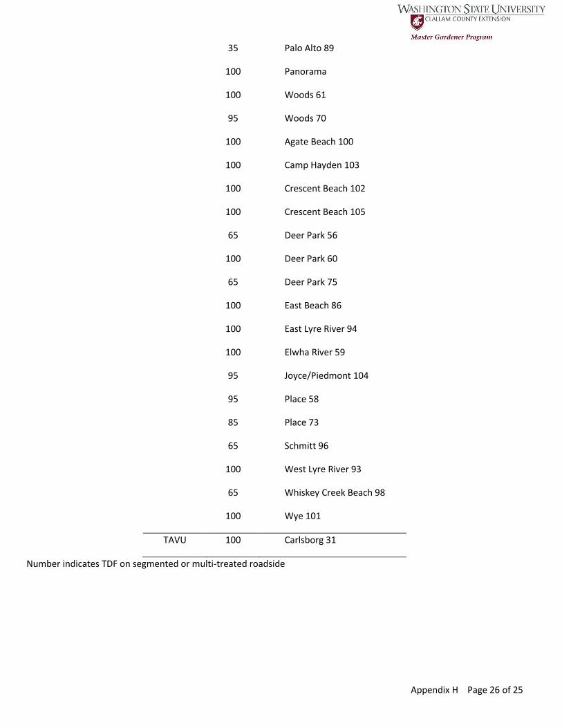
Appendix H Page 26 of 25
35 Palo Alto 89
100 Panorama
100 Woods 61
95 Woods 70
100 Agate Beach 100
100 Camp Hayden 103
100 Crescent Beach 102
100 Crescent Beach 105
65 Deer Park 56
100 Deer Park 60
65 Deer Park 75
100 East Beach 86
100 East Lyre River 94
100 Elwha River 59
95 Joyce/Piedmont 104
95 Place 58
85 Place 73
65 Schmitt 96
100 West Lyre River 93
65 Whiskey Creek Beach 98
100 Wye 101
TAVU 100 Carlsborg 31
Number indicates TDF on segmented or multi-treated roadside
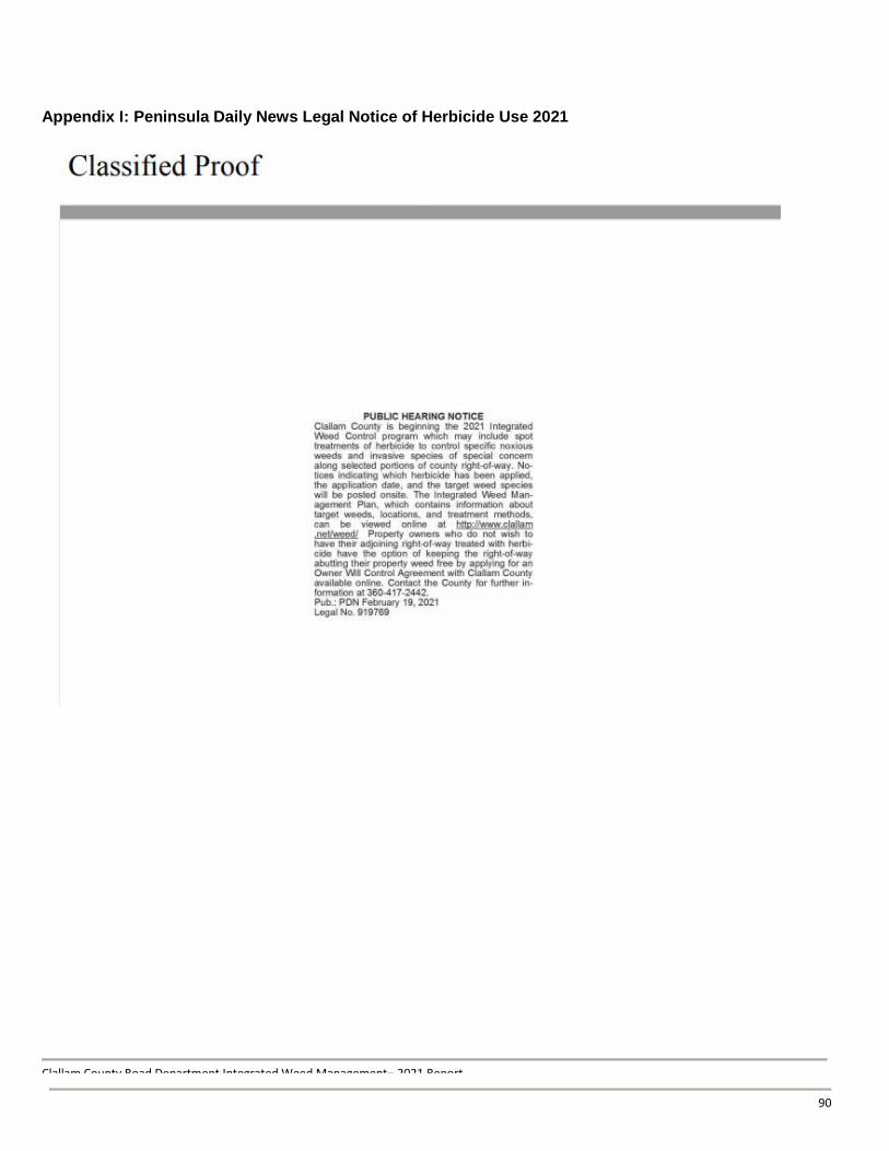
Clallam County Road Department Integrated Weed Management– 2021 Report
66
Appendix I: Peninsula Daily News Legal Notice of Herbicide Use 2021
90
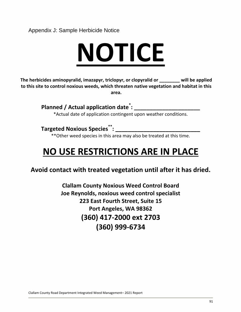
Clallam County Road Department Integrated Weed Management– 2021 Report
91
Appendix J: Sample Herbicide Notice
NOTICE
The herbicides aminopyralid, imazapyr, triclopyr, or clopyralid or ________ will be applied to this site to control noxious weeds, which threaten native vegetation and habitat in this
area.
Planned / Actual application date*: _____________________
*Actual date of application contingent upon weather conditions.
Targeted Noxious Species**: ___________________________
**Other weed species in this area may also be treated at this time.
NO USE RESTRICTIONS ARE IN PLACE
Avoid contact with treated vegetation until after it has dried.
Clallam County Noxious Weed Control Board Joe Reynolds, noxious weed control specialist
223 East Fourth Street, Suite 15 Port Angeles, WA 98362
(360) 417-2000 ext 2703 (360) 999-6734

Clallam County Road Department Integrated Weed Management- 2021 Report
Appendix K: Sample Herbicide/Manual Treatment Data Form (Side 1)
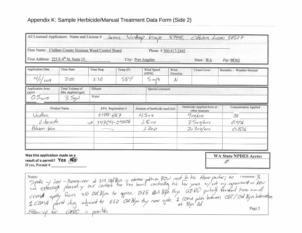
Clallam County Road Department Integrated Weed Management- 2021 Report
Appendix K: Sample Herbicide/Manual Treatment Data Form (Side 2)

94
Clallam County Road Department Integrated Weed Management-2021 Report
Appendix L: Sample Owner Will Control Program details and forms available online at: http://www.clallam.net/weed/RD_IWMP.html

95
Clallam County Road Department Integrated Weed Management-2021 Report
Appendix M: Sample Adopt-a-Patch Permit Program details and forms available online at: http://www.clallam.net/weed/RD_IWMP.html
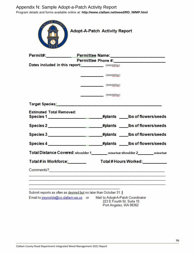
96
Clallam County Road Department Integrated Weed Management-2021 Report
Appendix N: Sample Adopt-a-Patch Activity Report Program details and forms available online at: http://www.clallam.net/weed/RD_IWMP.html
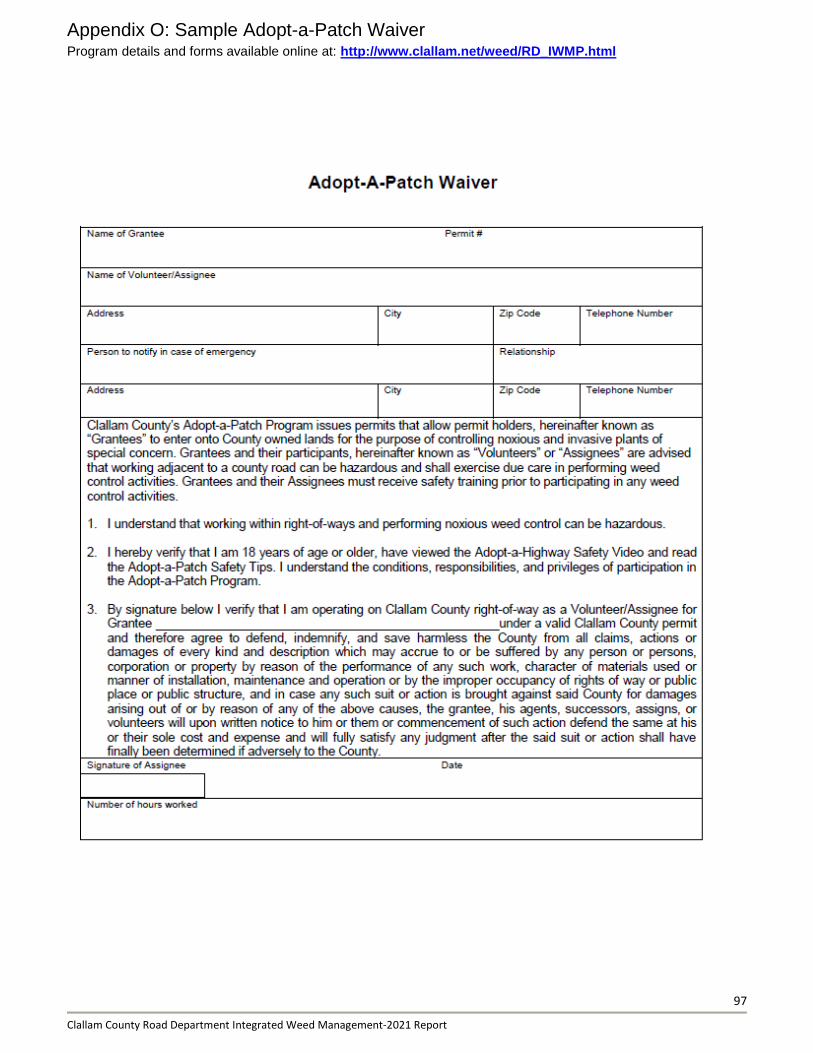
97
Clallam County Road Department Integrated Weed Management-2021 Report
Appendix O: Sample Adopt-a-Patch Waiver Program details and forms available online at: http://www.clallam.net/weed/RD_IWMP.html
Copyright © 2022 FDOKUMEN