Chyulu Hills - Revised - Kenya Water Towers Agency
102
Chyulu Hills - Revised Coordinated Water Towers Conservation A Call To Action 2020
-
Upload
khangminh22 -
Category
Documents
-
view
1 -
download
0
Transcript of Chyulu Hills - Revised - Kenya Water Towers Agency

Chyulu Hills - Revised
Coordinated Water Towers ConservationA Call To Action 2020


Kenya Water Towers Revised Status Report
Coordinated Water Towers ConservationA Call To Action 2020
for Chyulu Hills - Revised

Chyulu Hills Water Tower Revised Status Report4
ISBN 978-9966- 120-10-6
Copyright © Kenya Water Towers Agency, 2020
Kenya Water Towers Agency
Ragati Road, NHIF Building, 15th Floor
P.O. Box 42903-00100
Tel: 020 271 1437
Email:[email protected]
www.watertowers.go.ke
© 2020 All rights reserved: Reproduction of this publication for resale or other commercial purposes is prohibited without prior written permission of the copyright holder

iCoordinated Environmental Protection
The right to clean and safe water in adequate quantities is underscored in Article 43(1) (d) of the Constitution of Kenya. This is achieved through conservation and management of the environment and natural resources for sustainable development. Protection of our Water Towers is crucial to the sustenance of our Country’s socio-economic status. They play key role in economic sectors such as agriculture, industry, energy and tourism, at national, regional and global scale. However, unplanned development, climate change and other significant social pressures have had a negative impact on their resilience and health. This calls for urgent action to salvage water towers for the current and future generation.
My Ministry is committed to addressing threats facing the Water Towers. We are targeting to plant 1.8 Billion trees by 2022. I also encourage Kenyans not only to plant trees but grow them as a way of cultivating a conservation culture. In addition, every institution needs to comply with the Presidential directive that requires them to set aside at least 10% of their land and put it under trees. Chiefs are also required to mobilize citizenry to plant 100,000 seedlings each planting season as well as establish Chief’s tree nurseries.
I therefore encourage stakeholders to collaborate and form strategic partnerships and linkages towards implementation of viable solutions to the challenges facing the Water Towers. Creative and innovative solutions, particularly initiatives that enhance the conservation capacity of rural communities in a coordinated manner are encouraged.
2/21/2018 Director of Public Prosecutions – Office of the Director of Public Prosecution
http://www.odpp.go.ke/director-of-public-prosecutions/ 1/3
Director of Public Prosecutions
Mr. Keriako Tobiko is the current
holder of this o�ce and the �rst
under the new Constitution of
Kenya having being �rst appointed
in 2005. He was re-designated as
the Chief Public Prosecutor in
August 2010 and appointed to
head the independent
constitutional o�ce in June 2011.
He is an advocate of the High Court of Kenya and formerly a lecturer
at the University of Nairobi.
Mr. Tobiko is an alumni of the University of Nairobi and Cambridge.
Mr. Tobiko is a winner of GadhiSmarak Award for Best “A” Level
student 1984 (Kenya), Barclays Cambridge Commonwealth
Scholarship, 1990 for Kenya and Pegasus Cambridge Scholarship,
1990 as well as Fellow of Cambridge Commonwealth Society
(FCCS). He has served in other national institutions namely:
The Commission of Inquiry into the Land Law Systems in Kenya (The
Njonjo Land Commission, between 1999 – 2002) where he was a
Commissioner;
The Constitution of Kenya Review Commission (CKRC, between
2000-2005) where he was a commissioner;
Tel: +254 2732090/2732240 | Email: [email protected]
Home About Our Services Resources Tenders
Complaints Section Contact Us
Translate »Translate »
Statement by the Cabinet Secretary

Chyulu Hills Water Tower Revised Status Reportii
Mr. Keriako Tobiko, CBS, SC Cabinet Secretary MINISTRY OF ENVIRONMENT AND FORESTRY

iiiCoordinated Environmental Protection
Water Towers are the sources of water in Kenya. They play a critical role in maintaining the hydrological cycle, recharge of aquifers and creation of opportunities for investments in natural resources such as generation of hydroelectricity, agriculture and tourism. They are also important resources to the immediate communities and regions where they occur primarily because they provide wide range of ecosystem services.
However, the Water Towers face myriad of challenges which include encroachment into the protected forest and riparian areas, illegal logging, illegal water abstraction, forest fires and unsustainable land
management practice. The result has been severe deforestation, whose impact has been drying up of rivers, dams and springs, loss of species, reduction in agricultural production and increased community conflicts due to competition for scarce resources,
In addressing these challenges, the Ministry of Environment and Forestry is committed to ensuring all the Water Towers in the country are sustainably conserved and managed. As a Ministry, we are championing for nature-based solution to the threats facing water towers such as conservation agriculture and adoption of landscape approach in rehabilitating the water towers ecosystem. Lastly, I call upon all the stakeholders and the community to support implementation of the recommendation made in this report.
Dr. Chris Kiptoo, CBS Principal Secretary MINISTRY OF ENVIRONMENT AND FORESTRY
Remarks by the Principal Secretary

Chyulu Hills Water Tower Revised Status Reportiv

vCoordinated Environmental Protection
Kenya Water Towers Agency (KWTA) is committed in coordinating conservation and the sustainable management of Water Towers. They support rich biological heritage and long-term national development agenda. The link between people and the environment is best manifested in the health of these ecosystems they live in. Population pressures, lack of proper planning and the commensurate increase in the demand for resources have placed undue pressure on our Water Towers ecosystems.
Water Tower Status reports present an in-depth analysis of current condition of various Water Towers in the country. They focus on the land cover trends, the state of rivers and their tributaries, biodiversity status,
stakeholder profile, economic value of the water tower and threats as well as proposed intervention measures. The ultimate goal of this report is to establish a viable sustainable solution that ensures the water towers are well protected and conserved in order to support community livelihoods and biodiversity. As an Agency, we have established a hay production project in Mbirikani area to support pastoral communities in the area who graze their livestock in the Water Tower during the dry season. We have also supported a bee keeping project by providing for Nzeveni bee keepers with modern hives and honey processing equipment.
We are therefore committed to the sustenance of water towers through partnerships and linkages that will tap the knowledge and expertise to mitigate the negative impacts of the threats exacerbated by negative impacts of climate change.
Dr. Julius Malombe, PHD Chairman, Board of Directors KENYA WATER TOWERS AGENCY
Foreword

Chyulu Hills Water Tower Revised Status Reportvi

viiCoordinated Environmental Protection
Kenya Water Towers Agency Board Members
Ms. Hibo BisharMember
Mr. Timothy Ole NaekuMember
Mr. Robert Mutuma (HSC)Member
Mr. Peter Leitoro, OGWMember
Ms. Esther WangombeMember
Ms. Wandia MainaMember
Ms. Wambui MuriithiMember
Mr. Bernard MulwaMember
Prof. Julius Gordon Tanui PhDAg DG, Secretary to the Board
Ms. Edna AtisaMember
Dr. Julius Malombe, Chairman, Board of Directors

Chyulu Hills Water Tower Revised Status Reportviii

ixCoordinated Environmental Protection
On behalf of the team that coordinated this assessment, I wish to acknowledge the contribution by various key stakeholders towards completion of this report. First and foremost, I wish to thank KWTA Board of Management under the leadership of Dr.Julius Malombe, for approving, endorsing and supporting the development of this report.
Further appreciation is extended to fellow KWTA Directors, Senior Management and the entire KWTA staff for their contribution in the development of the report. I would like to
appreciate the Directorate of Ecosystem Assessment Planning and Audit under the leadership of Dr. Winfred Musila for coordinating various activities that have culminated into production of this report. I also appreciate the support from Department of Remote Sensing and Resource Surveys (DRSRS) who provided data on land cover and land use changes in the Water Towers and staff who participated in the field activities.
The invaluable input from Dr. Jones Agwata, Mr. Stanilaus Gachara and Ms. Faith Muturi who peer reviewed the report with KWTA senior management and technical staff is also highly appreciated. I wish to equally acknowledge the support from the KFS through the ecosystem conservators, KWS through the senior wardens, the Government officials at the counties and the community members who participated in the exercise.
Acknowledgement

Chyulu Hills Water Tower Revised Status Reportx
I wish to acknowledge Dr. Samuel Guto and Josephine Mogere who carried out the final editing and proof reading of the report. I also note the design team led by Barnabas Kimani and supported by Jane Njeru who handled the layout, design and printing of the final report. Finally, I thank all those I have not mentioned but who provided support in one way or the other towards the finalization of this report.
Prof. Julius Gordon Tanui PhD, MBSAg. Director General KENYA WATER TOWERS AGENCY
xiCoordinated Environmental Protection
Executive SummaryThis Water Towers Report is a detailed assessment of the status of Chyulu Hills Water Tower. It provides an overview of the changes that have taken place in the Water Tower for the period between 1990 and 2016 (26 years) for the purposes of establishing trends and determining when the Water Tower began to deteriorate, what could have been done and what should be done to avert and reverse the situation.
The main areas of focus are the changes that have occurred in land cover as a result of human activity and to determine the effects of this change to the ecosystem. The second aspect was the change in water flows from the rivers, springs, wetlands and even dams as a result of the changes in land cover. The third was to investigate the biodiversity dimension as to whether species are becoming endangered and what should be done to preserve them. Lastly and most importantly was to assess the human activities around the water towers. In this respect the study sought to determine the effect of the ever-increasing population densities around the Water Tower; the main sources of livelihoods in the face of climate change and dwindling agricultural productivity; how the communities interact and benefit from the ecosystem and what conservation measures are being undertaken to preserve the environment.
Chyulu Hills Water Tower encompasses the Chyulu National Park, Tsavo West National Park, Kibwezi Forest Reserve and Mbirikani and Kuku Group Ranches. It, traverses Makueni, Taita Taveta and Kajiado Counties. The Water Tower lies in the precarious and fragile arid to semi - arid region which accentuates the need for its preservation. It covers 110,945 ha, of which the protected of approximately 7,895 ha and the buffer zone 103,050 ha. The gazetted Kibwezi forest and Chyulu National park has remained largely undisturbed due to the conservation efforts at the National Game Reserves that are major tourist attractions for the country.

Chyulu Hills Water Tower Revised Status Reportxii
A wide range of plant and animal species are found here although some are now becoming endangered. The Hills were once home to the African Elephants and Black Rhinos but their numbers drastically reduced pushing them to be classified by IUCN as Endangered and Critically Endangered respectively. The Water Tower is a major source of water for various rivers and springs. Mzima springs is one of the key water sources that supplies 15% of the water requirements for the City of Mombasa.
Despite the seemingly undisturbed nature of the ecosystem, communities around the Water Tower rely on it for support of their livelihoods. Population increase is now a major threat to the Water Tower due to increased demand for resources especially water, grazing ground and timber for firewood, charcoal and building, most of which are acquired illegally. The Water Tower is also facing serious threats from frequent forest fires deliberately started by herders and honey gatherers. and illegal water abstraction. The impact has been water scarcity, community resource conflicts, human wildlife conflicts and decline in biodiversity.
However, there is hope as there are over 30 stakeholders engaged in conservation and preservation activities both in the game reserves and among the communities. Construction of an electric fence around the game reserves is underway to reduce the human wildlife conflicts and this will inevitably have a positive impact on the Water Tower. Other measure aimed at reversing the degradation trends in this Water Tower has been outlined in this reports’ implementation plan with an indicative budget of KES 840 Million.
1. Community sensitization and awareness on importance of conservation of the Water Tower and create ownership
2. Establish and maintain fire breaks inside the forest as well as development of fire management plan
3. Boundary realignment and demarcation to curb encroachment into the water tower
4. Reclamation of encroached areas and rehabilitation of degraded areas
5. Promote alternative community livelihood options such as hay production, bee keeping and growing of fruit trees so as to reduce over reliance on water towers resources

xiiiCoordinated Environmental Protection
6. Increased operational infrastructure and personnel such as patrol vehicles and personnel for regular monitoring and surveillance of the water tower
7. Facilitate access to affordable and clean energy as well as alternative sources of energy such as briquettes and energy saving jikos
8. Enforcement of existing charcoal rules and regulations
9. Establish an early warning system to report on wildlife conflicts incidences as well as fire alert system
10. Establishment of conflict management committees to address resource conflict issue between the community members residing in the area
11. Protection and rehabilitation of riparian land through tree planting using indigenous species and bamboo
12. Promotion of agroforestry within private farms
13. Strict enforcement and institutional strengthening which are key in sustainable management and protection of the Water Tower
14. Creation of inter-county conservation committee to address differing inter-county priorities

Chyulu Hills Water Tower Revised Status Reportxiv
The Big Four
Food and
NutritionalSecurity
Universal Health
Coverage
Affordable Housing
Enhancing Manufacturing
During the next 5 years, I will dedicate the energy, time and resources of my adminstration to the Big Four.
The Big Four will create jobs, which will enable our people to meet their basic needs. Jobs will transform the lives of our people from that of hardship and want, to new lives of
greater comfort and wellbeing. And that is the future I have seen.Uhuru Kenyatta
PRESIDENT OF THE REPUBLIC OF KENYA
Ecosystem goods and services are the foundation for the success of all the sectors in Kenya and thus the big four agenda will not be achieved without conserving the environment, especially the water towers. The water Towers have direct and indirect linkages with Health, Food and Nutrition, Housing, Industrial and Manufacturing sectors due to their heavy reliance on natural resources such as water and wood. Therefore, the protection and sustainable management of Water Towers must be given high priority in order to provide an enabling environment towards achievement of the Big Four.

xvCoordinated Environmental Protection
The Big Four
Food and
NutritionalSecurity
Universal Health
Coverage
Affordable Housing
Enhancing Manufacturing
During the next 5 years, I will dedicate the energy, time and resources of my adminstration to the Big Four.
The Big Four will create jobs, which will enable our people to meet their basic needs. Jobs will transform the lives of our people from that of hardship and want, to new lives of
greater comfort and wellbeing. And that is the future I have seen.Uhuru Kenyatta
PRESIDENT OF THE REPUBLIC OF KENYA
Ecosystem goods and services are the foundation for the success of all the sectors in Kenya and thus the big four agenda will not be achieved without conserving the environment, especially the water towers. The water Towers have direct and indirect linkages with Health, Food and Nutrition, Housing, Industrial and Manufacturing sectors due to their heavy reliance on natural resources such as water and wood. Therefore, the protection and sustainable management of Water Towers must be given high priority in order to provide an enabling environment towards achievement of the Big Four.
Table of ContentsStatement by the Cabinet Secretary ................................................................................ i
Remarks by the Principal Secretary ................................................................................. iii
Foreword ............................................................................................................................... v
Kenya Water Towers Agency Board Members ................................................................ viii
Acknowledgement .............................................................................................................. ix
Executive Summary ............................................................................................................ xi
Abbreviations and Acronyms ........................................................................................... xx
Definition of Terms .............................................................................................................. xxii
1.0 Introduction .................................................................................................................. 1
1.1 Overview of Water Towers .......................................................................................... 2
1.1.1 Threats to Water Towers .......................................................................................... 5
1.2 Quarterly Water Tower Status Reports ...................................................................... 9
Chyulu Hills Water Tower .................................................................................................... 13
2.0 Geographical Location ................................................................................................. 14
2.1 Hydrology .................................................................................................................... 15
2.1.1 Water flow changes .......................................................................................... 18
2.1.2 Critical water catchment areas ......................................................................... 19
2.1.3 Water Resource Users Associations (WRUAs) .................................................. 22
2.2 Biodiversity ................................................................................................................ 23
2.2.1 Rich biodiversity ....................................................................................................... 23

Chyulu Hills Water Tower Revised Status Reportxvi
2.2.2 Biodiversity hot spots ............................................................................................... 25
2.3 Land Use and Land Cover (LULC) ............................................................................... 29
2.4 Socio Economics and Livelihoods of Adjacent Communities .................................... 33
2.5 Community Interaction ............................................................................................... 35
2.6 Total Economic Valuation ........................................................................................... 36
2.7 Threats ....................................................................................................................... 39
2.8 Priority Areas for Intervention ..................................................................................... 43
2.9 Proposed interventions .............................................................................................. 48
2.10 Interventions and achievements .............................................................................. 50
2.11 Potential community projects ................................................................................... 50
2.12 Stakeholder analysis .................................................................................................. 51
3.0 Implementation Matrix ............................................................................................... 54
4.0 Conclusion and Recommendations ........................................................................... 59
Annexes ................................................................................................................................. 65
Annex I: Preferred species for rehabilitation and their uses in Chyulu Hills water tower ......... 65
Annex II: Conservation Priority Issues and Proposed interventions for Priority 2 Areas .........67
Annex III: Conservation Priority Issues and Proposed interventions for Priority 3 Areas ......... 68
References ............................................................................................................................ 70
Table of Contents

xviiCoordinated Environmental Protection
List of TablesTable 1.1: Gazetted Water Towers and their Location/County ....................................................... 3
Table 1.2: Non-Gazetted Water Towers and their Location/County ............................................... 4
Table 1.3: Key Threats to Gazetted Water Towers ........................................................................... 7
Table 2.1: Establishment of WRUAs and SCMPs at Chyulu Sub Catchments ................................... 22
Table 2.2: Summary of Biodiversity Richness and Hotspots in Chyulu .......................................... 26
Table 2.3: IUCN Red-Listed Animal Species of Chyulu ..................................................................... 27
Table 2.4: CITES Listed Animal Species found in Chyulu ................................................................. 27
Table 2.5: Medicinal Plants of Chyulu Hills ...................................................................................... 28
Table 2.6: Conservation Priority Issues and Proposed Interventions ............................................. 45
Table 2.7: Community Projects Identified and Prioritized .............................................................. 50
Table 2.8: Diversity of Stakeholders in Chyulu and their Roles ........................................................ 51

Chyulu Hills Water Tower Revised Status Reportxviii
List of FiguresFigure 1.1: Gazetted Water Towers in Kenya ...................................................................................2
Figure 2.1: Location of Chyulu Water Tower ..................................................................................14
Figure 2.3: Spatial Rainfall Distribution in Chyulu ..........................................................................15
Figure 2.2: Mean Rainfall Distribution in Chyulu ...........................................................................15
Figure 2.4: Water Catchments of Chyulu .......................................................................................16
Figure 2.5: Watershed Area for Chyulu ..........................................................................................17
Figure 2.6: Minimum Flow for Kibwezi River ..................................................................................18
Figure 2.7: Spring Discharge and Corresponding River Flow .........................................................19
Figure 2.8: Critical Watershed Hotspots in Chyulu Hills .................................................................21
Figure 2.9: Biodiversity Hotspots in Chyulu ...................................................................................26
Figure 2.10: Land Use and Land Cover Changes ...........................................................................29
Figure 2.11: Land Use and Land Cover Changes in Buffer Zone ...................................................30
Figure 2.12: Thematic Land Use and Land Cover Conversions in the Forested (1990 - 2016) ....31
Figure 2.13: Thematic Land Use and Land Cover Conversions in the Buffer Zone (1990 - 2016)..31
Figure 2.14: Spatial Land Cover Maps for Chyulu Water Tower......................................................32
Figure 2.15: Population Density (persons per km squared) in Chyulu (2009 census) ....................33
Figure 2.16: Maasai and Kamba Activities .......................................................................................36
Figure 2.17: Total Economic Valuation for the Chyulu Water Tower .............................................37
Figure 2.18: Priority Areas of Intervention .....................................................................................44

xixCoordinated Environmental Protection
Figure 2.1: Location of Chyulu .......................................................................................................14
Figure 2.2: Mean Rainfall Distribution in Chyulu ...........................................................................15
Figure 2.3: Spatial Rainfall Distribution in Chyulu .........................................................................15
Figure 2.4: Water Catchments of Chyulu .......................................................................................16
Figure 2.5: Watershed Area for Chyulu .........................................................................................17
Figure 2.6: Minimum flow for Kibwezi River ..................................................................................18
Figure 2.7: Spring Discharge and its Corresponding River Flow ....................................................19
Figure 2.8: Critical watershed hotspots in Chyulu Hills ..................................................................21
Figure 2.9: Biodiversity Hotspots in Chyulu ....................................................................................26
Figure 2.10: Land Use and Land Cover Changes ...........................................................................29
Figure 2.11: Land Use and Land Cover Changes in Buffer Zone ....................................................30
Figure 2.12: Thematic Land Use and Land Cover Conversions in the Forested Area ...................31
Figure 2.13: Thematic Land Use and Land Cover Conversions in the Buffer Zone .......................31
Figure 2.14: Spatial Land Cover Maps for Chyulu Water Tower .....................................................32
Figure 2.15: Population density in Chyulu .....................................................................................33
Figure 2.16: Maasai and Kamba Activities ......................................................................................36
Figure 2.17: Total Economic Valuation for Chyulu Water Tower ....................................................37
Figure 2.18: Priority Areas for Intervention ....................................................................................44
The ecosystem services and goods provided by the water towers include micro-climate regulation, water storage and purification, waste treatment and carbon sinks. The communities living adjacent to water towers benefit directly through provision of goods such as firewood, pasture and honey. The contribution of water towers and natural resources in general to the national economy has been grossly undervalued, leading to inadequate resource allocation for their conservation and preservation.
For example, in the current financial year (2017/18), the water and natural resource management has been allocated 78 billion, representing a mere 4% of the total national budget as can be seen in the Figure below. There is need for awareness creation and promoting appreciation of the importance of conservation and protection of the natural resources and the associated need for adequate budgetary allocation.
Budgetary Allocation to Sustainable Natural Resource Management

Chyulu Hills Water Tower Revised Status Reportxx
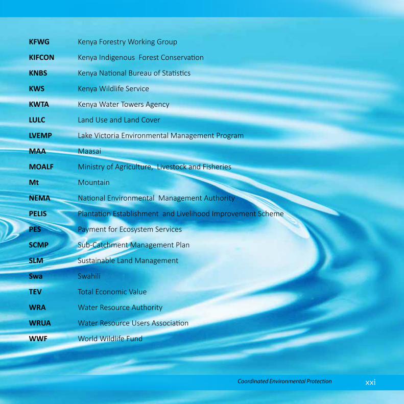
Abbreviations and Acronyms ALs Alternative Livelihoods
App Appendix
AWF Africa Wildlife Foundation
CBFFM Community Based Forest Fire Management
CFA Community Forestry Associations
CITES Convention on International Trade in Endangered Species
GBM Green Belt Movement
GIS Geographical Information System
GoK Government of Kenya
GPS Global Positioning System
ha hectares
IUCN International Union for the Conservation of Nature
JEU Joint Enforcement Unit
KAM Kamba
KCB Kenya Commercial Bank
KEFRI Kenya Forestry Research Institute
KENGEN Kenya Electricity Generating Company Limited
KES Kenya Shillings
KFN Kenya Forestry Network
KFS Kenya Forestry Service
xxiCoordinated Environmental Protection
KFWG Kenya Forestry Working Group
KIFCON Kenya Indigenous Forest Conservation
KNBS Kenya National Bureau of Statistics
KWS Kenya Wildlife Service
KWTA Kenya Water Towers Agency
LULC Land Use and Land Cover
LVEMP Lake Victoria Environmental Management Program
MAA Maasai
MOALF Ministry of Agriculture, Livestock and Fisheries
Mt Mountain
NEMA National Environmental Management Authority
PELIS Plantation Establishment and Livelihood Improvement Scheme
PES Payment for Ecosystem Services
SCMP Sub-Catchment Management Plan
SLM Sustainable Land Management
Swa Swahili
TEV Total Economic Value
WRA Water Resource Authority
WRUA Water Resource Users Association
WWF World Wildlife Fund

Chyulu Hills Water Tower Revised Status Reportxxii
Definition of TermsWater TowerWater Towers are elevated geographical areas comprising mountains, hills, and plateaus where the topography, geology, soils and vegetation support reception, retention, infiltration, and percolation of precipitation and storage as ground water, that is eventually released through springs, streams, rivers, swamps, lakes, and oceans to sustain connected biodiverse ecosystems and is harnessed for use.
WatershedAn area or ridge of land that separates waters flowing to different rivers, basins or seas
Drainage BasinIt is an area of land where all water that falls on that land flows into one river
Drainage systemThe pattern formed by streams, rivers, and lakes in a particular drainage basin
LandcoverIs the physical material on the surface of the earth
Land useRefers to human activities/foot prints on the surface of the earth
Land Use and Land Cover ChangesChanges that occur in land use and land cover over time based on satellite imagery analysis
Land Use and Land Cover Trends Transitional changes in land use and land cover over a period of time BufferAn area of specified distance around a forest (in this case 5 km from the edge of the forest) Geographical Information Systems (GIS)Is a system designed to capture, store, manipulate, analyze, manage, and present geographical data

xxiiiCoordinated Environmental Protection
Remote SensingProcess of obtaining data without being in physical contact with the object, as applied mainly by space satellite in acquiring satellite imagery of the earth from space
Global Positioning System (GPS)Is a network of orbiting satellites that send precise details of their position in space back to earth and are used to provide position on the earth surface
Ecosystem servicesAre the many and varied benefits that humans freely gain from the natural environment and from properly-functioning ecosystems
Ecosystem valuesMeasures the importance of ecosystem services to people
Total Economic Valuation It is a tool for determining the benefits of an environmental system to people by assigning monetary value to all ecosystem goods and services
Plantation Establishment Livelihood Improvement System (PELIS)Scheme ran by Kenya Forest Service (KFS) to help increase forest cover and restore degraded forests in the country whereby Forest Adjacent Communities (FAC) are allocated plots to inter plant tree seedlings and crops and care for seedlings until they form a canopy
River flowVolume of water flowing on a stream at a given time
Biodiversity The variety of plant and animal life in the world or in a particular habitat, which is usually considered to be important and desirable
Biodiversity hotspotAn area with a high concentration of species potentially threatened by destruction or extinction.

Chyulu Hills Water Tower Revised Status Reportxxiv
1Coordinated Environmental Protection
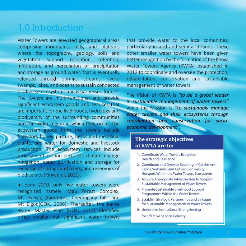
1.0 Introduction Water Towers are elevated geographical areas comprising mountains, hills, and plateaus where the topography, geology, soils and vegetation support reception, retention, infiltration, and percolation of precipitation and storage as ground water, that is eventually released through springs, streams, rivers, swamps, lakes, and oceans to sustain connected biodiverse ecosystems and is harnessed for use. The towers are multi-functional and provide significant ecosystem goods and services that are important for the livelihoods, hydrology and biodiversity of the surrounding communities and the wider region in which they occur. The ecosystem goods from the towers include firewood, honey, pasture, herbs and medicinal plants, and water for domestic and livestock production. The ecosystem services include provision of carbon sinks for climate change mitigation, water purification and storage for recharge of springs and rivers, and reservoirs of biodiversity (Kinyanjui, 2011).
In early 2000, only five water towers were recognized namely; Mau Forest Complex, Mt. Kenya, Aberdares, Cherangany hills and Mt Elgon(GOK, 2006). Thereafter, the Kenya Water Master Plan (GOK, 2012) identified other smaller but significant water towers
that provide water to the local comunities, particularly in arid and semi-arid lands. These other smaller water towers have been given better recognition by the formation of the Kenya Water Towers Agency (KWTA) established in 2012 to coordinate and oversee the protection, rehabilitation, conservation and sustainable management of water towers.
The Vision of KWTA is “to be a global leader in sustainable management of water towers” while the Mission is “to sustainably manage water towers and their ecosystems through coordination and conservation for socio-economic development”.
1. Coordinate Water Towers Ecosystem Health and Resilience
2. Coordinate and Oversee Securing of Catchment Lands, Wetlands, and Critical Biodiversity Hotspots Within the Water Towers Ecosystems
3. Acquire Appropriate Infrastructure to Support Sustainable Management of Water Towers
4. Promote Sustainable Livelihood Support Programmes Within the Water Towers
5. Establish Strategic Partnerships and Linkages for Sustainable Management of Water Towers
6. Undertake Institutional Strengthening
for Effective Service Delivery
The strategic objectives of KWTA are to:

Chyulu Hills Water Tower Revised Status Report2
Water towers vary in size, shape, drainage patterns and features. There are five water towers legally recognized in Kenya namely; the Mau Forest complex, Mt. Kenya, the Aberdares, the Cherangany hills and Mt Elgon. In addition, 13 more water towers have been gazetted since 2012 (Fig. 1.1) and 70 more proposed by various stakeholders across the country (Table 1.1).
Water towers vary in size, shape, drainage patterns and features. There are five water towers legally recognized in Kenya namely; the Mau Forest complex, Mt. Kenya, the Aberdares, the Cherangany hills and Mt Elgon. In addition, 13 more water towers have been gazetted since 2012 (Fig. 1.1) and 70 more proposed by various stakeholders across the country (Table 1.1).
Figure 1.1: Gazetted Water Towers in Kenya

3Coordinated Environmental Protection
Water Tower Immediate /Bordering Counties
1. Aberdare Range Nyeri and Muranga to the east, Kiambu to the south,Nyandarua to the west and Laikipia to the north
2. Cherangani Hills Most of Elgeyo Marakwet, West Pokot to the North,Trans Nzoia to the North-west and Uasin Gishu to the South-west.
3. Chyulu Hills Makueni, TaitaTaveta and Kajiado
4. Huri Hills Marsabit
5. Kirisia Hills Samburu
6. Loita Hills Narok
7. Marmanet Forest Laikipia, Nakuru, Baringo and Nyandarua
8. Matthews Range Samburu
9. Mau Forest Complex Nakuru, Baringo, Kericho, Narok, Bomet, Nandi andUasin Gishu
10. Mt. Elgon Bungoma and Trans Nzoia
11. Mt. Kenya Embu and Tharaka Nithi to the eastern side, Meru to the northern and eastern side, Laikipia to the west, Nyeri to the south west and Kirinyaga to the south
12. Mt. Kipipiri Nyandarua
13. Mt. Kulal Marsabit
14. Mt. Marsabit Marsabit
15. Mt. Nyiru Samburu
16. Ndotos Ranges Samburu
17. Nyambene Hills Meru
18. Shimba Hills Kwale
Table 1.1: Gazetted Water Towers and their Location/County

Chyulu Hills Water Tower Revised Status Report4
Table 1.2: Proposed Water Towers by the various stakeholders
Kajiado County Ngong hills Namanga hill
Emali hills
Maparasha hills
Nyamira County Manga hills Sironga wetland
Machakos County
Machakos hills
Kibauni hills
Kanzalu hills
Matetani hills
Iveti hills
Oldonyo Sabuk
Meru
Imenti hills
Ngaya hills
Embu
Kirimiri hills
Kiang’ombe hills
Homa Bay
Gwassi hills
Nyeri County
Karima hills
Tumutumu hills
Kiamacheru hills
Nyara hills
Nyeri hills
Kilifi County Mwangea hills
Baringo County
Tugen hills
Kisii
Nyangweta hills
Sameta hills
Taracha hills
Nyacheki hills
Elgeyo Marakwet
Elgeyo hills
Makueni County
Makuli hills
Mbooni hills
Nthangu hills
Nzaui hills
Makongo hills
Kilungu hills
Mbui Nzau hills
Yekanga hills
Nakuru County Subukia escarpment
Nandi County
Kibirong swamp
Kingwal swamp
Turkana
Loima hills
Taita-Taveta
Taita hills
Kasigau hills
Narok
Mt. Suswa
Lamu County
Lake Kenyatta

5Coordinated Environmental Protection
Migori
Maeta hills
Magaimuya hills
Taragwiti hills
Nyandarua County
Maungu hills
Kitui County Mutito hillsEndau hillsKavonge/Museve hillsMutuluni hillsMumoni/Ngaikuyu hillsKyawea hillsMutha hillsNuu hills
Kiambu
Kikuyu escarpment
Laikipia
Mukogodo hill
Kajiado County
Nguruman
Escarpment
Uasin Gishu
Leseru Swamp
West Pokot. Chebuko/kamalegon
Karasuk hills

Chyulu Hills Water Tower Revised Status Report6

7Coordinated Environmental Protection
1.1 Overview of Water TowersThe initial mandate of the Agency was to coordinate and oversee sustainable management of 18 gazetted water towers but later included 70 other non-gazzeted towers distributed across the country as shown in Figure 1.1. The Water Tower are located and spread in over 40 counties across the country (Table 1.1 and Table 1.2).
1.1.1 Threats to Water TowersWater towers are sensitive and fragile ecosystems susceptible to various threats, which compromise their ability to provide ecosystem goods and services. The key threats facing the water towers are highlighted in Table 1.3. The major threats to the water towers are:
1. Population pressure: The rapid growth in human population has led to shortage of land for agriculture and settlement resulting in encroachment into the water towers. In addition, there is increased demand for ecosystem goods leading to intesification of poaching, illegal logging and grazing in the water towers which hinders their conservation and protection.
2. Deforestation: Conversion of forestland in the water towers to croplands by adjacent communities degrades land through loss of vegetation cover causing soil erosion and landslides. In addition, illegal logging, forest fires and overgrazing rampant in most water towers further speeds up deforestation thereby accelerating soil erosion.
3. Poor infrastructure: There are limited investments in the water towers due to the “tragedy of commons” whereby adjacent communities are keen to derive maximum
Chyulu Hills Water Tower Revised Status Report8
benefits while incurring minimum cost. Further, negative local factors such as steep slopes and their location in remote areas limits interest of potential investors. There is also minimal infrastructural development investments in water towers by the Central Government and County Government, compromising conservation efforts. This limits the ability of Water towers to optimally perform their socio-economic and ecological roles to benefit the communities.
4. Invasive species: Some water towers are threatened with rapid spread of invasive species such as Prosopis juliflora, Dodonea viscosa and Lantana camara. These species threaten the survival of indigenous and endemic species hence compromising biodiversity concentration and diversity.
5. Resource use conflicts: There is escalation of resource use conflicts amongst communities surrounding the water towers due to competition over scarce natural resources occasioned by negative impacts of climate change, population growth and degradation.
6. Enforcement of laws and regulations: There is weak institutional framework that compromises the enforcement of existing laws and regulations e.g. the Forest Act of 2016 (which prohibit people to live inside the forest) and Charcoal Rules of 2009 (for sustainable charcoal production) hampering conservation and protection of the water towers. Gaps in legal and institutional framework has led to poor coordination in lead agencies, thereby contributing to conflicting roles.
7. Lack of sustainability and ownership: There is limited community ownership of conservation and protection programs initiated by state and non-state actors in the water towers making them unsustainable in the long term. Additionally, weak or lack of mechanisms for strengthening community ownership of projects contribute to unsustainable projects.
8. Partnerships and linkages: Weak partnerships and linkages exist between stakeholders initiating and implementing programs in the water towers leading to unnecessary duplication and overlapping of conservation initiatives.

9Coordinated Environmental Protection
Water Tower Threats
Bush
/For
est F
ires
Illeg
al l
oggi
ng Li
vest
ock
graz
ing
Culti
vatio
n
Char
coal
bur
ning
Bush
mea
t poa
chin
g
Illeg
al h
oney
har
vesti
ng
Illeg
al g
rass
har
vesti
ng Er
osio
n
Deba
rkin
g
Sand
Har
vesti
ng Se
ttle
men
t
1. Aberdare Range
2. Cherangani Hills
3. Chyulu Hills
4. Huri Hills
5. Kirisia Hills
6. Loita Hills
7. Marmanet Forest
8. Matthews Range
9. Mau Forest Complex
10. Mount Elgon
11. Mount Kenya
12. Mount Kulal
13. Mount Marsabit
14. Ndotos
15. Nyambene hills
16. Shimba hills
Key Yes No
Table 1.3: Key Threats to Gazetted Water Towers

Chyulu Hills Water Tower Revised Status Report10
Reduction in forestland cover
Limited availability of timber and firewood
Increased soil and wind erosion
Destruction of water catchment areas
Increased siltation and clogging of water ways, dams and wetlands
Loss of ecosystem services e.g. water storage and purification
Declining water quality
Increased costs of water purification
Declining fisheries production
Reduced power generation from hydro-electric plants
Reduced mitigation to causes of climate change
Vulnerability to negative impacts of climate change e.g. acid rain
Increased incidence of flood damage
Desertification
Loss of biodiversity
Extinction of medicinal herbs and trees
Impacts of Threats to the Water Towers

11Coordinated Environmental Protection
Weak partnerships also contribute to poor coordination and ties among stakeholders and partners, weak monitoring and evaluation mechanisms and poor funding.
9. Monitoring and evaluation: There is inadequate information about key drivers and actual status of degradation in the water towers and the conservation measures undertaken by various stakeholders due to a weak monitoring and evaluation system.
1.2 Quarterly Water Tower Status ReportsTo address the first strategic objective of KWTA on “coordination of water tower ecosystem health and resilience”, current information on the status of water towers is required. The information should indicate temporal and
spatial changes in their health and resilience by establishing the present level of degradation and the corresponding causes coupled with the conservation efforts. The information assists government and non-government actors to identify and prioritize measures for safeguarding the water tower resilience and health. Additionally, the status information is crucial in formulation of water tower management plans and for identification of rehabilitation and conservation strategies.
Consequently, KWTA is expected to undertake regular water tower assessments and publish the findings in quarterly reports to be disseminated to Cabinet, Parliament, County Governments and other key stakeholders. In this regard KWTA has prepared this status report for Chyulu Hills Water Tower following an assessment carried out between October and December 2017.
Reduction in forestland cover
Limited availability of timber and firewood
Increased soil and wind erosion
Destruction of water catchment areas
Increased siltation and clogging of water ways, dams and wetlands
Loss of ecosystem services e.g. water storage and purification
Declining water quality
Increased costs of water purification
Declining fisheries production
Reduced power generation from hydro-electric plants
Reduced mitigation to causes of climate change
Vulnerability to negative impacts of climate change e.g. acid rain
Increased incidence of flood damage
Desertification
Loss of biodiversity
Extinction of medicinal herbs and trees
Impacts of Threats to the Water Towers

Chyulu Hills Water Tower Revised Status Report12
The overall objective of the report is to provide key information on the status of the target water towers for informed decision making and sustainable management by government and other stakeholders.
The specific objectives are to:1. Establish the location, size and bio-
physical attibutes of the water towers;2. Analyze land cover land use changes
between 1990 and 2016;3. Carry out hydrological analysis and
analyze the relationship with land use land cover changes
4. Establish socio-economic status of the communities bordering the water towers
5. Identify critical catchment and biodiversity roles in the water towers and map related hotspots for conservation
6. Identify the threats and challenges facing the waters towers
7. Identify stakeholders and their functions in the protection and conservation of the water towers
8. Establish actions undertaken to protect and rehabilitate the water towers by KWTA and other stakeholders
9. Recommend appropriate measures to be undertaken for the conservation and
rehabilitation of the water towers
1.3 MethodologyThe study employed various methods to assess the current status of water towers. As a first step, existing secondary information was gathered by desktop literature review from existing sources and any related past surveys on the two water towers. This was followed by land use and land cover assessment for the Water Tower and their respective 5km buffer zones through Geographic Information System (GIS) and Remote Sensing (RS). Additional GIS analysis yielded hotspot information for the Water Tower based on slope angle, elevations and deforestation. All the biodiversity and catchment hotspots were further combined in a GIS environment and the potential areas for conservation prioritized along a three tier ascending scale of low, moderate and high.
Household interviews were carried out to assess socio-economic impact of human activities on land use and land cover in the water towers and its environs. Physical observations and photographs taken by field officers traversing the adjacent villages were used to ground truth the general land use and land cover status in the area studied.

13Coordinated Environmental Protection
River flow analysis was carried out using data on daily river discharge acquired from Water Resources Authority (WRA), which was measured in cubic meters per second. The criteria for selecting the data was availability of time series data covering the period under study (1990-2017) with limited gaps. Only river flow data within 5 km buffer of the water towers was used for the study.
When the well’s dry, we know the worth of water Benjamin Franklin, (1706-1790), Founding Father, USA

Chyulu Hills Water Tower Revised Status Report14

15Coordinated Environmental Protection
Geo-referenced sub-location level population statistics of 2009 was acquired from KNBS for analyzing human population density within the 5 km buffer zone of the water towers. The population density was computed in ArcGIS where the number of people per square kilometer was computed at sub-location level and chloropleth maps used to generate the status in the 5 km buffer zone of the Water Tower.
Chyulu Hills Water Tower
Proposed Interventions • Proposed Interventions
• The rehabilitation of the critically degraded water catchments
• Establish and maintain fire breaks inside the forest
• Reclamation and restoration of encroached areas
• Adoption of alternative building materials like bamboo
• Facilitate access to affordable and clean energy
• Enforcement of existing charcoal rules and regulations
• Establishment of conflict management committees among the affected communities
• Creation of inter-county conservation committee
Key Attributes• The Water Tower lies in a fragile arid to
semi-arid region• Chyulu Hills Water Tower encompasses
the Chyulu National Park, Tsavo West National Park, Kibwezi Forest Reserve and Mbirikani and Kuku Group Ranches
• It traverses Makueni, Taita Taveta and Kajiado Counties
• It covers 110,945 ha, of which the protected of approximately 7,895 ha and the buffer zone 103,050 ha.
• The Hills were home to the African Elephants and Black Rhinos but their numbers drastically reduced
• Conservation efforts in the Water Tower as evidenced by the overall increase in forest cover from the initial 2,805 ha (35%) in 1990 to 3,757 ha (47%) in 2016
• Over 34 stakeholder organizations are involved in conservation and protection of the water tower
• Mzima springs is one of the key water sources that supplies 15% of the water requirements for the City of Mombasa.
• It is a key tourist attraction and host unique landforms such as Shetani Lava flow
• Total Economic Value of the Water Tower is KES. 41 Billion
Threats and Challenges• Population increase is now a major
threat to the Water Tower due to increased demand for resources especially water, grazing ground and timber for firewood, charcoal and building, most of which are acquired illegally.
• The Water Tower is also facing serious threats from frequent forest fires deliberately started by herders and honey gatherers.
• Illegal water abstraction.
• The impact has been water scarcity, community resource conflicts, human wildlife conflicts and decline in biodiversity.

Chyulu Hills Water Tower Revised Status Report16
Chyulu hills Water Tower is situated 211 km South-East of Nairobi and 20 km South-West of Kibwezi town. It traverses Makueni, Taita Taveta and Kajiado Counties.
The Water Tower comprises of Chyulu National Park, Tsavo West National Park, Mbirikani Game Reserve, Kuku Game Reserve and Kibwezi Forest (Figure 2.1). The National parks were gazetted in 1983 and the local communities resettled between 1988 and 1991. Socio-economic activities within the Parks became illegal after the gazettement.
The total area of Chyulu hills Water Tower is 110,945 hectares, of which the gazetted forest is approximately 7,895 ha. The hills are made up of a series of hills of varying altitude that rise from 600 m to over 2,188 m above sea level that cover about 100 km between Emali and Mtito Andei townships in Makueni County. They are volcanic in nature with the ability to retain underground water and are among the key water catchment areas found in the coastal region.
2.0 Geographical Location
Figure 2.1: Location of Chyulu Water Tower

17Coordinated Environmental Protection
Figure 2.3: Spatial Rainfall Distribution in Chyulu
2.1 HydrologyChyulu Hills Water Tower is characterized by an arid to semi-arid environment. The annual rainfall ranges between 800 to 1,200 mm and falls during the long rain season from March to April and the short rain season between October and December (Fig 2.2 and 2.3). Temperatures range between 17- 300C.
Figure 2.2: Mean Rainfall Distribution in Chyulu

Chyulu Hills Water Tower Revised Status Report18
Chyulu hills water tower is part of the 15,000 km2 Kilimajaro aquifer that holds ground water originating from Mt. Kilimanjaro and Mt. Meru in Tanzania. The aquifer has three main river basins; Athi Galana in Kenya and Umba and Pangani river basins in Tanzania. The hills do not hold permanent surface water but rainfall percolating through the porous volcanic rocks feed many permanent fresh water sources in the form of rivers and springs in the surrounding plains and the Coastal region.
Most of the underground water drains to the Eastern side of the Water Tower. The hills are the source of water for a number of springs and rivers that include Mzima, Umani, Kiboko,
KwaKyai, Masimba Mang’ellete, Kibwezi and Makindu springs and Tsavo, Galana, Kibwezi Kiboko, Makindu, Thange, Ngai Ndeithia, Mtito Andei and Kambu rivers all situated east of the water tower mostly clustered to the northern and southern parts.
The Western side of the Water Tower, neighbors Loolturesh swamp which is recharged by Motiknaju, Kuku, Loolturesh and Kiramankol streams. No river drains into the swamp as there is a physical divide that separates the Water Tower and the swamp. Figures 2.4 and 2.5 presents the water catchment and watershed areas for Chyulu hills.
Figure 2.4: Water Catchments of Chyulu

19Coordinated Environmental Protection
Figure 2.5: Watershed Area for Chyulu
Chyulu Hills Water Tower Revised Status Report20
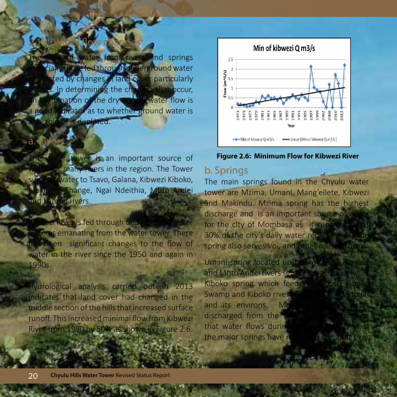
2.1.1 Water flow changesThe flow of water from rivers and springs especially those fed through underground water is affected by changes in land cover particularly forests. In determining the changes that occur, an examination of the dry season water flow is a good indicator as to whether ground water is available or is depleted.
a. Rivers
The water tower is an important source of water for many rivers in the region. The Tower supplies water to Tsavo, Galana, Kibwezi Kiboko, Makindu, Thange, Ngai Ndeithia, Mtito Andei and Kambu rivers.
Kibwezi River is fed through underground water systems emanating from the water tower. There has been significant changes to the flow of water in the river since the 1950 and again in 1990s.
Hydrological analysis carried out in 2013 indicates that land cover had changed in the middle section of the hills that increased surface runoff. This increased minimal flow from Kibwezi River from 1990 by 50% as shown in Figure 2.6.
b. SpringsThe main springs found in the Chyulu water tower are Mzima, Umani, Mang’ellete, Kibwezi and Makindu. Mzima spring has the highest discharge and is an important source of water for the city of Mombasa as it supplies about 30% of the city’s daily water requirement. The spring also serves Voi, and other coastal towns.
Umani spring located upstream of the Kibwezi and Mtito Andei rivers serve Kibwezi town while Kiboko spring which feeds into both Kiboko Swamp and Kiboko river serves Makindu town and its environs. Measurements of water discharged from the various springs indicate that water flows during the dry season from the major springs have remained constant over
Figure 2.6: Minimum Flow for Kibwezi River

21Coordinated Environmental Protection
time. This is an indication that overall ground water storage is still abundant. Observations have shown that the smaller springs dry up
during the dry season. Figure 2.7 shows the discharge rates from various springs.
Figure 2.7: Spring Discharge and Corresponding River Flow
2.1.2 Critical water catchment areas
Chyulu Hills Water Tower has a network of water sources, comprising of rivers, streams, swamps, springs and underground water. Although the Water Tower is reasonably well conserved, there exist critical hot spots where forest cover has been reduced to the bare minimum. Loss of
forest cover reduces the rate at which rainwater percolates to the ground and increaseas surface runoff. This affects the overall level of undergroundwater water which leads to reduced water discharge at various outlets. Figure 2.8 shows the critical hotspots that require urgent conservation and protection.

Chyulu Hills Water Tower Revised Status Report22
Mzima Springs - Tsavo National Park
Kwa Kyai spring - Kibwezi

23Coordinated Environmental Protection
Figure 2.8: Critical Watershed Hotspots in Chyulu Hills

Chyulu Hills Water Tower Revised Status Report24
Table 2.1: Establishment of WRUAs and SCMPs at Chyulu Sub Catchments
Sub Catchment Water Resource User Association
Sub Catchment Management Plan
Mtito Andei Yes Draft SCMP
Upper Kambu Yes None
Thange Yes None
Shilishili No None
Esoitpus No None
Kibwezi Yes None
Wetland near Umani spring has dried due to over abstraction of water upstream
2.1.3 Water Resource Users Associations (WRUAs)
Chyulu Hills Water Tower has 6 sub catchments out of which 4 WRUAs have been established and one had developed a draft Sub catchment Management Plan (SCMP) (Table 2.1).

25Coordinated Environmental Protection
2.2 Biodiversity Chyulu Hills Water Tower is an important biodiversity region due to presence of a wide variety of plant and animal species (biodiversity) with diverse habitats. Over the last fifty (50) years, the Water Tower and the surrounding areas have undergone environmental degradation that not only threatens its biodiversity status and water catchment role, but also its importance as a major economic hub in the country. Poor agricultural practices, encroachment into the forest zone, forest fires, settlements, over-grazing and extractive practices such as charcoal burning, wood for carving and large scale abstraction of water
are some of the pressures experienced that degrade the natural environment which in turn threatens the natural habitat unique for plant and animal species.
2.2.1 Rich biodiversity
Chyulu Hills Water Tower has a rich diversity of plants and animals including threatened species (IUCN Red-Listed, CITEs Listed), endemic, invasive and also a variety of medicinal plants (Musila et al, 2011). The ecology of Chyulu is rich and diverse; composed of aquatic vegetation, dry forest, forest glades and grasslands. The ecosystem is rich in animal fauna including mammals, birds, reptiles, amphibians and invertebrates.
Hilltop Forests Grasslands
Chyulu Hills Water Tower Revised Status Report26
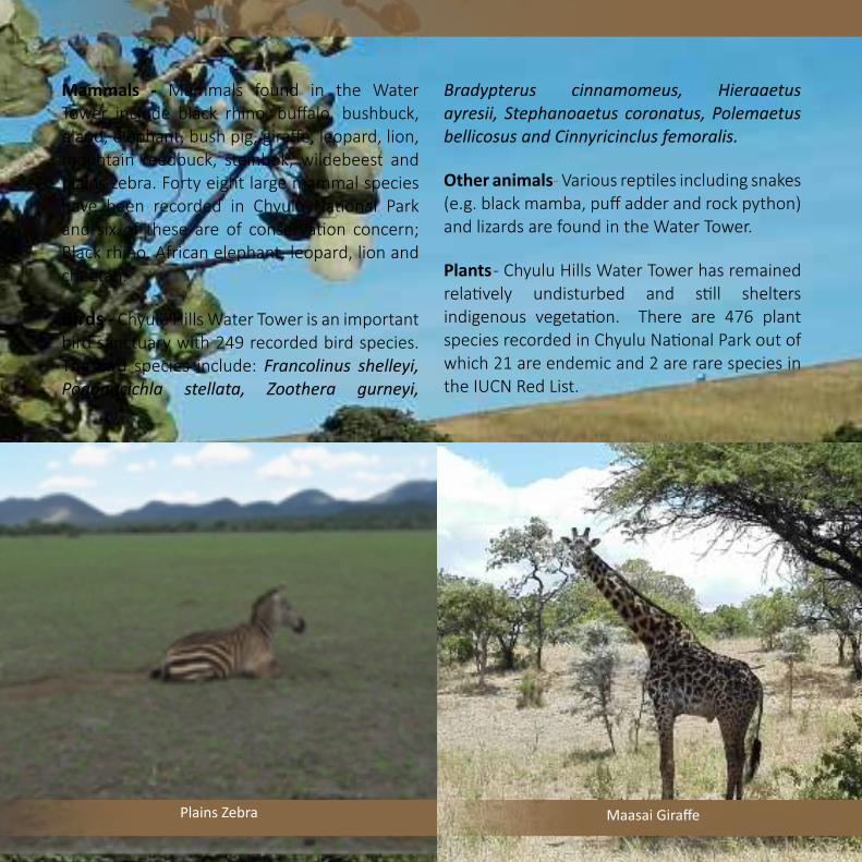
Mammals - Mammals found in the Water Tower include black rhino, buffalo, bushbuck, eland, elephant, bush pig, giraffe, leopard, lion, mountain reedbuck, steinbok, wildebeest and plains zebra. Forty eight large mammal species have been recorded in Chyulu National Park and six of these are of conservation concern; Black rhino, African elephant, leopard, lion and cheetah.
Birds - Chyulu Hills Water Tower is an important bird sanctuary with 249 recorded bird species. The bird species include: Francolinus shelleyi, Pogonocichla stellata, Zoothera gurneyi,
Bradypterus cinnamomeus, Hieraaetus ayresii, Stephanoaetus coronatus, Polemaetus bellicosus and Cinnyricinclus femoralis.
Other animals - Various reptiles including snakes (e.g. black mamba, puff adder and rock python) and lizards are found in the Water Tower.
Plants - Chyulu Hills Water Tower has remained relatively undisturbed and still shelters indigenous vegetation. There are 476 plant species recorded in Chyulu National Park out of which 21 are endemic and 2 are rare species in the IUCN Red List.
Plains Zebra Maasai Giraffe
27Coordinated Environmental Protection
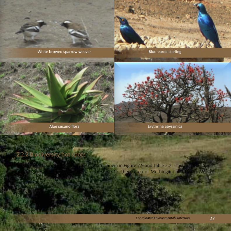
2.2.2 Biodiversity hot spots
The biodiversity hotspots in Chyulu hills are shown in Figure 2.9 and Table 2.2. They include: South of Mang’elete, South of Chyulu Game reserve Northern area of Muthingiini and North West of Olorika.
Aloe secundiflora
White browed sparrow weaver Blue-eared starling
Erythrina abyssinica

Chyulu Hills Water Tower Revised Status Report28
Figure 2.9: Biodiversity Hotspots in Chyulu
Table 2.2: Summary of Biodiversity Richness and Hotspots in Chyulu
Indicator class No. of species
High Medium Low
1. Reptiles + Amphibians
30 None Central part of Chyulu Game Reserve
Central part of Chyulu Game Reserve; NE of Olorika; SW of Muthingiini
2. Invertebrates 200 Iltilal including Northern part; North of Olorika
Iltilal including northern part; North of Olorika; Eastern Oltiasika
Western part of Chyulu; SW Mangelete
3. Mammals 40 Central part of Forest Reserve
Central part of Forest Reserve; SW Muthingiini
SW Muthingiini, SW Mangelete, Western Oltiasika
4. Plants 670 Central part of Forest Reserve
Central part of Forest Reserve; SW Muthingiini
SW Muthingiini; SW Mangelete; SW Muthingiini; SW Utithi; NE Olorika; Eastern Oltiasika
5. Birds 300 Central part of Forest Reserve
Central part of Forest Reserve; NE Iltilal; NE Olorika; SW Muthingiini
SE Mangelete; SW Muthingiini; SW Utithi; West Oltiasika

29Coordinated Environmental Protection
Table 2.3: IUCN Red-Listed Animal Species of Chyulu
Key: Swa - Swahili
Class Common Name Other Names IUCN Red List Status
Bird Abbott’s Starling Vulnerable
Mammal Leopard Chui (Swa.) Near Threatened
Mammal Lion Simba (Swa.) Near Threatened
Mammal Black Rhinoceros Kifaru (Swa.) Critically Endangered
Mammal Cheetah Duma (Swa.) Vulnerable
Threatened Species - Many plant and animal species in Chyulu are of conservation importance as listed in the IUCN red list and CITES (Table 2.3 and 2.4). The black rhino is critically endangered, the lion and leopard are near threatened while the cheetah and Abbort sterling are vulnerable. CITES has listed African elephant, Nile crocodile, Southern rock python
and flap necked chameleon as endangered.
For plants, the hills host 8 species that appear in the IUCN red list, whereby 3 species are near threatened and 3 vulnerable. The hills also have about 20 plant species endemic to the area and 6 that are invasive and medicinal with great value to the surrounding communities (Table 2.5).
Table 2.4: CITES Listed Animal Species found in Chyulu
Class Common Name Other Names CITES Appendix
Mammal African Elephant Ndovu (Swa.) App. I
Reptile Nile Crocodile Mamba (Swa.) App. II
Reptile Southern Rock Python Chatu (Swa.) App. II
Reptile Nile Monitor Lizard Mburukenge (Swa.) App. II
Reptile Flap-necked Chameleon Kinyonga (Swa.) App. II
Key: Appendix 1 – Endangered Appendix 11 – Likely to be endangered unless protected

Chyulu Hills Water Tower Revised Status Report30
Table 2.5: Medicinal Plants of Chyulu Hills
Species Local Name Other Uses
Erythrina abyssinaca
(Standard name: Red hot poker tree)
Mvuti (KAM), Ol-Opongi (MAA)
The wood is used for making doors, stools and beehives; Maasai brew a tonic tea from the roots.
Carissa edulis Mukawa (KAM), Olamuriaki (MAA)
The fruits are edible, tasty, bitter and are sometimes used as a treatement for dysentery, a decoction (boiled mixture) of the roots is used as pain killer
Kigelia africana
(Standard name: Sausage tree)
Muatine, Kiatine (KAM) Ol-Sunguroi, Ol-Darpoi (MAA)
Baked slices of the dried fruit are used to ferment beer
Bridelia micrantha Oleragia (MAA) The wood is used for building poles and it is termite resistant. The bark decoction is used by the Maasai against dysentry in children
The root is given to women after child birth and as a stimulant
Toddalia asiatica Maluia (KAM), Ole-Purmunya (MAA)
The fruit is chewed as a cough remedy; the root decoction is used to induce vomiting and cleanse digestive system by the Maasai
Key: KAM = Kamba, MAA = Maasai, SWA = Swahili)

31Coordinated Environmental Protection
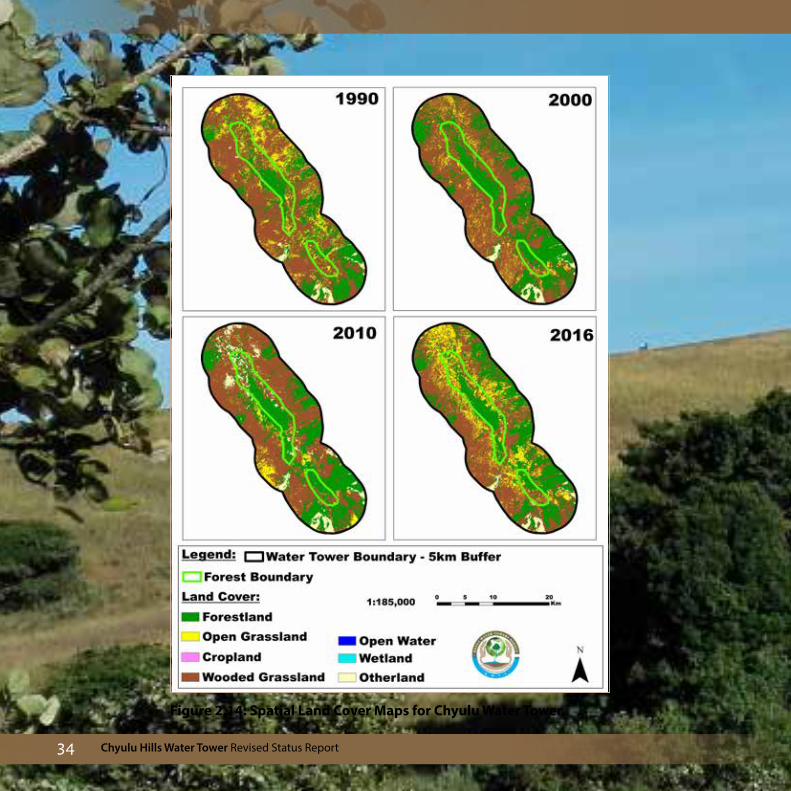
2.3 Land Use and Land Cover (LULC) Chyulu hills lie in an arid to semi arid area with relatively low rainfall and maintaining its ground cover is vital for the region. The predominant ground cover for the Water Tower is open savannah grasslands with scattered perenial bushes. This gives way to wooded grasslands and dense forests towards the hilltops.
Protected zoneThe protected zone is composed of 3, 757 ha (47%) dense forest, 2,501 ha (31.2%) wooded
grassland, 1,735 ha (21.6%) open grassland and 7.5 ha (0.09%) other land. There has been conservation efforts in the Water Tower as evidenced by the overall increase in forest cover from the initial 2,805 ha (35%) in 1990 to 3,757 ha (47%) in 2016 (Figure 2.10). Wooded grassland decreased significantly over the period while open grassland decreased until 2010 then later increased from the same year to 2016. This trend indicates a general reforestation of the Water Tower. It is important to note that cultivation of crops has degraded the Water Tower, and it is recommended that mechanisms should be put in place to stop this trend.
0
1000
2000
3000
4000
5000
1990 1995 2000 2005 2010 2015
Land
Use
and
Lan
d C
over
(ha)
Forest land Wooded grassland Open grassland Other land Cropland
Figure 2.10: Land Use and Land Cover Changes

Chyulu Hills Water Tower Revised Status Report32
Buffer zoneEvery Water Tower has a 5km buffer zone that acts as a barrier towards its protection. The Chyulu Hills Water Tower is about 44,200 ha. Activities in this zone are a measure of the potential stability of the Water Tower as
increased human activities in this region have encroached to the protected zone. Trends show that forest land in this zone increased over time while wooded grasslands and open grasslands decreased indicating a general trend towards conservation efforts (Figure 2.11).
0
5000
10000
15000
20000
25000
30000
1990 1995 2000 2005 2010 2015
Land
Use
and
Lan
d C
over
(ha)
Forest land Wooded grassland Open grassland Other land Cropland
Figure 2.11: Land Use and Land Cover Changes in Buffer Zone
“We do not inherit the earth from our ancestors, we borrow it from our children.” » Native American Proverb

33Coordinated Environmental Protection
Figure 2.12: Thematic Land Use and Land Cover Conversions in the Forested (1990 - 2016)
Figure 2.12, 2.13 and 2.14 show thematic land conversions for the protected and the buffer zone whereby conversion to forest was the predominant activity.
Figure 2.13: Thematic Land Use and Land Cover Conversions in the Buffer Zone (1990 - 2016)
Chyulu Hills Water Tower Revised Status Report34
Figure 2.14: Spatial Land Cover Maps for Chyulu Water Tower

35Coordinated Environmental Protection
2.4 Socio Economics and Livelihoods of Adjacent Communities Communities around Chyulu Hills Water Tower depend on its resources for their livelihoods in the form of water, grazing ground, firewood and medicinal plants among other resources. Population pressure is however threatening the fragile ecosystem due to over extraction of these resources.
Population
Chyulu Hills is inhabited mainly by the Maasai and the Kamba communities. The population distribution based on the 2009 census shows that the areas East of the Water Tower and adjacent to the Tsavo National Park were more densely populated.
About 65,000 people, live in Kibwezi sub-county. The Western side of the Water Tower has fewer people, mainly the Maasai whose population is estimated at 6,000 - 6,500 people residing in Loitoktok Sub County in Kajiado County.
Various towns are located along the Nairobi - Mombasa road and railway line namely Mtito Andei, Kathekani, Darajani, Kambi, Ngwata, Masongaleni, Kikumbulya, Kibwezi, Kaluliu, Makindu, Ikoye, Kiboko and Mwaito have relatively high population densities (Figure 2.15).
Figure 2.15: Population Density (persons per km squared) in Chyulu (2009 census)

Chyulu Hills Water Tower Revised Status Report36
Livelihoods
The main occupation of the communities living adjacent to the Water Tower is crop and livestock production. The Kamba people on the Eastern side grow crops such as beans, maize, green grams, millet, sweet potatoes, and horticultural crops. Other important crops include cotton and mangoes which are of significant economic value. Pastoralism is practiced in the Western side by the Maasai community who own group ranches. Livestock such as cattle, goats, sheep,
donkeys and poultry are kept. The average household size for these communities ranges between 4 and 9 persons. The average land size is 2 - 10 acres under communal land tenure.
Other socio - economic activities in the water tower include:Game Ranching - To enhance wildlife conservation, various community conservancies have been established in the Western side of the hills namely Kuku A, Kuku B and Mbirikani.
Kitui Governor calls for a crackdown on anybody found burning or ferrying charcoal from Kitui to other counties saying that charcoal burning was killing the economy and destroying the environment. This is in the context of illegal logging and charcoal burning that has depleted forest cover in Ukambani

37Coordinated Environmental Protection
Mining - Sand and ballast/stone harvesting is a major economic activity in the Eastern side of the Water Tower.
Wood carving - Small traders make various artefacts and souvenirs mostly in the form of wood carvings. These are then sold locally to tourists.
Honey harvesting - Honey harvesting using traditional bee hives is still widely practiced by the Kamba community. Majority of the hives are placed in the forest.
Charcoal production - This is a lucrative business around Chyulu Hills. Stacks of charcoal bags by the road side indicate booming business.
2.5 Community InteractionMost people residing close to the Water Tower depend on its natural vegetation for both wood and non-wood products for their needs. Many do not have trees on their farms as established through the satellite images. They derive direct benefits from the Water Tower in terms of grazing land, honey and as a source of herbal medicine, wood for carving, water, firewood and building materials.
The Water Tower is an important habitat for wild animals such as buffaloes, cheetahs, elephants, snakes, hyenas, monkeys, antelopes,
dikdiks, leopards, zebras and baboons among others. The communities benefit from the wild animals through provision of employment to people who work in the ranches and earnings from tourism related activities. Despite these benefits from the wild animals, instances of human wildlife conflict in the area is high for about 90% of the households. The conflict is in the form of crop and property destruction, and attacks on human and livestock.

Chyulu Hills Water Tower Revised Status Report38
Some activities carried out by the adjacent communities have had a negative effect on the Water Tower. These include overgrazing, charcoal burning, frequent forest fires created to hasten regeneration of new grass for livestock, overharvesting of wood products and in recent years cultivation in the Water Tower (Figure 2.16).
The impact of the activities on the Water Tower is reflected in a reduction in the amount and quality of water from water points, frequent and prolonged droughts, loss of livestock due to drought and degraded pasture land and increased cases of human wildlife conflicts. These negative impacts have been compounded by effects of climate change.
In order to cope with these impacts, the local communities sink boreholes to extract water while others take their livestock deeper into the Water Tower during prolonged droughts for grazing. Chyulu hills ecosystem supports the livelihoods of an ever increasing human population through provision of water, wood fuel, timber, grazing land, hunting and wood carving. It also serves a large part of the coastal region with water.
2.6 Total Economic Valuation The Total Economic Valuation (TEV) of Chyulu Water Tower was carried out by KWTA in 2015 to determine its worth in monetary terms as an indicator of what the country would lose through its degradation.
Three key ecosystem services and goods were valued as shown in Figure 2.17.
Figure 2.16: Maasai and Kamba Activities

39Coordinated Environmental Protection
The estimated total economic value of the Water Tower was about Ksh 40.92 billion (USD 409 Million). Of this value, Chyulu and Mzima tourism accounted for about 52%; water (domestic, irrigation and livestock) accounted for 8%; issues related to Chyulu hills (carbon
sequestration, land/biodiversity, aquifers) accounted for 27% and the rest 15%.
These results show importance of the Water Tower to the environs and to the country in the broader context.
Figure 2.17: Total Economic Valuation for the Chyulu Water Tower

Chyulu Hills Water Tower Revised Status Report40
Total Economic Valuation
Kenya Water Towers Agency | Saving our Future & Heritage: A Call To Action 3
domestic water supply
KES 2.035B(USD 22,286,276)
irrigation (central province)
KES 6.3B(USD 68,994,368)
irrigation (lake naivasha)
KES 931M(USD 10,195,834)
traditional farming
KES 21.9B(USD 239,837,552)
carbon fixing and soil erosion control
KES 1.385B(USD 15,167,809)
benefits to forest adjacent communities
KES 712M(USD 7,797,459)
biodiversity
KES 20B(USD 219,029,744)
energy
KES 3.03B(USD 33,183,008)
tourism sector and nyayo tea
KES 227M(USD 2,485,987)
Exchange rate
USD1 = KES 91.3
ABERDARE
56.520B
cultural values
KES 64M(USD 700,895) recreation
KES 3.584B(USD 39,250,128)
livestock
KES 8.552B(USD 93,657,120)
climate regulation & carbon storage
KES 7.12B(USD 77,974,592)
other ecosystems services
KES 44.304B(USD 485,194,688)
genetic resources
KES 1.312B(USD 14,368,351)
tourism
KES 5.264B(USD 57,648,628)
soil erosion control
KES 7.84B(USD 85,859,656)
energy
KES 10.528B(USD 115,297,256)
fish production
KES 1.688B(USD 18,486,110)
subsistence agriculture
KES 7.22B(USD 79,069,736)
tea production
KES 13.056B(USD 142,982,608)
Exchange rate
USD1 = KES 91.3
MAU
110.512B
Aberdares and Mau Water Towers Economic Valuation
Kenya Forestry Research Institute (KEFRI) 2009

41Coordinated Environmental Protection
2.7 Threats and Challenges i. Encroachment into the water tower The population of Chyulu hills has increased significantly over the years. The 2009 population census shows that the Eastern part of the Water Tower had 65,000 people while the Western side had about 6,500 people. Many town centers have expanded and new ones sprung up along the major highways that include Makindu, Ikoye, Kiboko, Mwaito Masongaleni, Kikumbulya, Kibwezi, Mtito Andei, Kathekani, Darajani, Kambi, Ngwata, and Kaluliu. These centres have high population densities which inevitably lead to high demand for products and services from the Water Tower.
Extraction of various products from the Water Tower as well as access to water points inside the water tower for both domestic and animal use is on the increase. The major challenge is extraction of water directly from the spring which leads to drying of rivers and wetlands.
ii. Illegal loggingIllegal logging especially of the endangered and indigenous tree species and charcoal burning are on the increase. This is due to the fact that some sections of the Water Tower are not fenced, mainly those in Kajiado and Taita Taveta counties.
iii. Frequent forest firesForest fires are frequent in the Water Tower and are mainly caused by pastoralists who burn vegetation to allow for re-growth. Poachers also burn vegetation to attract wildlife after grass re-grows. Controlling the fires is a challenge as there is lack of proper firefighting equipment, inadequate staff and limited /lack of community involvement.
iv. Human wildlife conflictsThe human / wildlife conflicts involve wildlife destroying crops or killing people and attacks on domestic animals. Human beings respond by killing the wildlife. Delayed compensation is an issue that needs to be addressed through the relevant authority.
v. Declining forest cover and biodiversityThere is evidence that conservation efforts increased between 1990 and 2010. The trend however reversed between 2010 and 2016 as the area under forest cover decreased mainly through human activities.
vi.Reduced water flows from springs and riversThe average flows from Mtito Andei and Kibwezi rivers had decreased significantly overtime due to reduced rate of infiltration. This trend will in the long run affect the many springs that are a source of water in the area as they are fed through ground water.

Chyulu Hills Water Tower Revised Status Report42
vii. Reduced economic value
The economic value of the Chyulu ecosystem is estimated at Ksh. 40 billion as at 2015 mainly from tourism and water provision. The potential however is much higher. Conversion of land to inappropriate uses along with other human interferences will reduce biodiversity which will reduce the number of tourists to the region hence depressing the economic value.
viii. Water shortageIncreased water abstraction upstream has led to the drying of rivers downstream. This has been caused by increased human population and farming activities. Reduced water levels affect both humans and animals and is a major threat to the ecosystem.
ix. Inter-community tensionsIncreased population pressure on the limited resources leads to poor relationships between the communities especially during drought season when there is scarcity of pasture and water. These quickly culminates into inter clan conflicts.
x. Differing Inter county prioritiesThe three Counties, Kajiado, Taita Taveta and Makueni have different priorities in terms
of implementing activities geared towards safeguarding the Water Tower. The three counties also tend to compete for the Water Tower resources (water and pasture). In the case of Mzima spring, Mombasa County has a high stake as the county receives about 30% of its water supply from the springs.
This has led to vandalism of water installations by the local communities who are not direct beneficiaries.
xi. Weak enforcement of laws and regulationsPoor enforcement of existing laws and regulations is the greatest threat to the Water Tower as this allows people to act with impunity to the detriment of the ecosystem.
Further, relevant strategic planning documents specifically focusing on the management of the Water Tower i.e. Environmental Management Plan (EMP) and Participatory Forest Management Plan (PFMP) have not been developed making conservation efforts difficult.
xii. Other issues • Poor road infrastructure: few guards and
warden stations located far apart makes it difficult to coordinate emergencies and to provide adequate security for the Water Tower

43Coordinated Environmental Protection
There is over-reliance on charcoal since about 90% of the households in Kenya use it as fuel (Githomi et al., 2002) with the highest levels of production in the ecologically fragile Arid and semi-arid lands. The major charcoal producing counties are Kajiado, Makueni, Kitui, Kwale, Baringo, Elgeyo Marakwet and Tana River where some of the water towers are located. There are about 700,000 charcoal producers whose average monthly production is about 30 bags. Most trees used for charcoal production as can be seen in the Figure below are sourced from producers’ own farms (76%) followed by community and private lands (18%) and then public forest (6%).
There has been a decline in type and number of high quality tree species on farms and in community/private forests due to continued exploitation without replanting making the producers to invade protected forests in the water towers for feedstock.
Key Challenges to Sustainable Charcoal Production
1. Unregulated/illegal charcoal trade: Wood harvesting, charcoal burning, transport and trade are still unregulated in spite of the enactment of the charcoal rules (2009).
2. Decline in type and number of high quality tree species: Most of the preferred tree species for feedstock for charcoal production are becoming rare due to continued exploitation without replacement.
3. Unsustainable wood resource exploitation: No strategies exist for sustainable fuelwood
exploitation within the charcoal hotspots and where they do, the implementation is poor. Adoption of energy conservation mechanisms such as improved charcoal stoves and alternative sources of cleaner energy is low.
Recommendations1. Full roll-out and implementation of the Charcoal
Rules (2009) in the counties including the provisions that require tree planting to replace those harvested for charcoal production. The Counties should customize and enforce the rules as per the Fourth Schedule of the Constitution.
2. Harmonization of Energy and Forest Acts in relation to licensing of charcoal value chain players.
3. Facilitate access to affordable and clean energy alternatives e.g. LPG gas
Charcoal Production

Chyulu Hills Water Tower Revised Status Report44
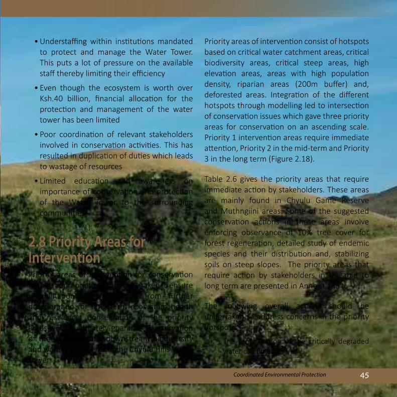
45Coordinated Environmental Protection
• Understaffing within institutions mandated to protect and manage the Water Tower. This puts a lot of pressure on the available staff thereby limiting their efficiency
• Even though the ecosystem is worth over Ksh.40 billion, financial allocation for the protection and management of the water tower has been limited
• Poor coordination of relevant stakeholders involved in conservation activities. This has resulted in duplication of duties which leads to wastage of resources
• Limited education and awareness on importance of conservation and protection of the Water Tower to the surrounding communities
2.8 Priority Areas for InterventionPriority areas of intervention for conservation require appropriate actions to be taken to ensure rehabilitation and protection from further deterioration for long term ecosystem health and resilience. Conservation of the priority areas would ultimately guarantee preservation of the upstream and downstream biodiversity and water catchments in the Chyulu Hills Water Tower.
Priority areas of intervention consist of hotspots based on critical water catchment areas, critical biodiversity areas, critical steep areas, high elevation areas, areas with high population density, riparian areas (200m buffer) and, deforested areas. Integration of the different hotspots through modelling led to intersection of conservation issues which gave three priority areas for conservation on an ascending scale. Priority 1 intervention areas require immediate attention, Priority 2 in the mid-term and Priority 3 in the long term (Figure 2.18).
Table 2.6 gives the priority areas that require immediate action by stakeholders. These areas are mainly found in Chyulu Game Reserve and Muthngiini areas. Some of the suggested conservation actions in these areas involve enforcing observance of 10% tree cover for forest regeneration, detailed study of endemic species and their distribution and, stabilizing soils on steep slopes. The priority areas that require action by stakeholders in the mid to long term are presented in Annex I and II.
The following overall actions should be undertaken to address concerns in the priority hotspots:
i. The rehabilitation of the critically degraded water catchments

Chyulu Hills Water Tower Revised Status Report46
Figure 2.18: Priority Areas of Intervention

47Coordinated Environmental Protection
ii. Rehabilitation of degraded forest habitats with important ecological function such as biodiversity hotspots
iii. Alternative community livelihood options should be designed and implemented to alleviate pressure on the forest resources such as agro-forestry practices that can meet charcoal and fuelwood demands; enforcement of 10% on farm tree cover
iv. Protection of ecologically sensitive areas such as those in high altitude and steep slopes
where soil and water conservation measures should be implemented
v. Replanting and buffering to allow forest regeneration in areas of extensive forest loss in the Kibwezi and upper Kambu sub catchment areas
vi. Habitat improvement in biodiversity hotspots and adoption of participatory approach in conservation of species of conservation importance, encouraging natural adoption of endemic plant species on farms by local residents
Table 2.6: Conservation Priority Issues and Proposed Interventions
Intersecting conservation matrix (priority issues)
Suggested interventions Sublocations
Critical Water Catchment Areas
Biodiversity Hotspot [Species richness,Species of conservation importance, and Conservation threats (observations)]
- Conservation of areas of significant plants and animal occupancy.
- Participatory conservation of species of conservation importance on areas of occupancies
- Improving habitat conditions (e.g. cover) for the animals
- Initiate promulgation of 10% on-farm tree covers
Chyulu Game ReserveMuthingiini
Endemic Species - Detailed study on endemic species and their specific distribution
- Specific species-conservation effort directed on species in areas of concern
- Encouraging natural adoption of endemic species on farms by local residents

Chyulu Hills Water Tower Revised Status Report48
Intersecting conservation matrix (priority issues)
Suggested interventions Sublocations
Critical Water Catchment Areas
Forest Loss - Replanting, buffering to allow for forest regeneration, enforce the 10% on-farm tree cover
Chyulu Game ReserveMuthingiini
Biodiversity Hotspot [Species richness,Species of conservation importance, and Conservation threats (observations)]
- Conservation of areas of significant plants and animal occupancy.
- Participatory conservation of species of conservation importance on areas of occupancies
- Improving habitat conditions (e.g. cover) for the animals
- Initiate promulgation of 10% on-farm tree covers
Endemic Species - Detailed study on endemic species and their specific distribution
- Specific species-conservation effort directed on species in areas of concern
- Encouraging natural adoption of endemic on farms by local residents

49Coordinated Environmental Protection
Intersecting conservation matrix (priority issues)
Suggested interventions Sublocations
Critical Water Catchment Areas
High Population Density - Creating buffers to prevent destructions by trampling on areas with water resources such as springs, swamps
- Planting indigenous trees species (or bamboo) within the buffers
Chyulu Game ReserveMuthingiini
Slope - Stabilization of soils on the slopesPlanting indigenous trees (bamboo) on the slopes
⁻ Avoid cultivation on steep slopes in critical water areas.
Wetlands ⁻ Replanting, buffering to allow for vegetation regeneration
⁻ mapping/surveying and gazettement,
Riparian degradation - Reservation of riverines up to 30m - Establishing sustainable activities on the areas
e.g. proper cultivation strategies within the 30-100m buffer
Springs ⁻ Replanting, buffering to allow for vegetation regeneration
⁻ mapping/surveying and gazettement
Elevation ⁻ Restoration of deforested areas⁻ Restriction of settlements in those areas⁻ Prevention of cultivation⁻ Encouraging zero-grazing only

Chyulu Hills Water Tower Revised Status Report50
2.9 Proposed interventionsPolicy measures
i. Survey and demarcation of the Water Tower in order to establish the boundaries. This is to be accompanied by electric fencing, demarcation of the buffer zones and enforcement of the existing laws. This will pave way for controlled access and utilization of resources within the water towers
ii. Consultative preparation of relevant documents i.e. Environmental Management Plan and Participatory Forest Management Plan for the Water Tower and the entire ecosystem
iii. Development of joint inter-county management plans for the protection and management of the Water Tower. This includes the need to have the plans anchored in the CIDPs
iv. Increase water monitoring stations and automate existing ones to ensure acquisition of timely, reliable and quality data on water flows
v. Strengthen legal and institutional frameworks for respective lead agencies to fill in the gaps and to avoid conflicting roles.
Stakeholder activitiesi. Introduction of Participatory Forest
Management schemes through the formation of Community Forest Association and strengthening existing ones.
ii. Formation of relevant stakeholder committees at various levels i.e. county, sub-county, ward etc. to oversee improved protection and management of the water towers.
iii. Empowerment of actors involved in management, conservation and protection of the Water Tower through allocation of more financial resources and technical staff to enhance their activities on the ground
Actions for the Community i. Promotion of alternative livelihoods (ALs)
through income generating activities such as apiculture, agro-forestry, tree nursery establishment and on-farm tree planting
ii. Implementation of conservation activities such as spring protection, tree planting/agro forestry, soil water conservation, protection of wetlands and riverbank protection

51Coordinated Environmental Protection
iii. Provision of alternative access to water by creating water intakes that are some distance from the springs, developing water harvesting structures and creating strategic watering points outside the water tower
iv. Establishment of additional fire breaks and rehabilitation of the existing ones
v. Establishment of breeding centers for animals in order to improve the quality of existing ones and sensitization of the
community on the need to keep few but quality animals
vi. Awareness creation/ training on the need to conserve the water
vii. Capacity building and empowerment of the community with relevant clean and energy efficient technologies technologies such as making of improved jikos and training on the latest climate-smart technologies. This also includes provision of extension services in areas such as agroforestry.

Chyulu Hills Water Tower Revised Status Report52
2.10 Interventions and achievements
1. KFS has been engaged with other partners notably David Sheldrick/ GAA Biglife foundation to fence the Water Tower
2. The WRUAs have collaborated with the County Government to support their activities aimed at protecting the sources of water
3. There is collaboration between KFS and KWS in ensuring the forest and the park are well protected
4. A community development action plan and an ecosystem management plan have been formulated
2.11 Potential community projectsIn pursuit of alternative livelihoods, the communities identified and prioritized their preferred projects for implementation as shown in Table 2.7.
Table 2.7: Community Projects Identified and Prioritized
Name of Project 1 Agroforestry projects 2 Tree nurseries establishment3 Water harvesting and community boreholes4 Bee keeping for individuals and groups5 Earth dams and sand dams, Water pans for
ranches, dams at the bottom of hills6 Bamboo projects for individuals and groups7 Poultry keeping and rabbit keeping8 Protection of water catchments especially springs and
wetlands, forest and parks by fencing i.e Kilui wetlands9 Fencing of the Makueni County side
of the Chyulu Hills and Forest10 Horticultural projects: Vegetables,
melon, pumpkin, green gram11 Dairy goat farming as an alternative to extensive agric.
12 Ecotourism projects: tented camps and lodges
13 Greenhouses for higher value crop production
14 Fruit farming - passion, oranges, watermelons.
15 Livestock breed multiplication centre
16 Zero grazing
17 Pasture enhancement project in the shambas.
18 Fish farming
19 Conservation of community/private land
20 Brick making
21 Hay projects/Grass bank for pasture during low supply
22 Cultural festival centres
23 Marketing of handcrafts
24 Geographical viewpoints - Hot springs, caves, birds and nature walks

53Coordinated Environmental Protection
Table 2.8: Diversity of Stakeholders in Chyulu and their Roles
Stakeholders Role Area of Operation
NGOs
David Sheldrick wildlife trust Conservation and livelihood Kibwezi FR
Maasai Wilderness Conservation Trust Conservation and livelihood
Maasai land preservation trust Conservation and livelihood Mbirikani group ranch
Big life Foundation Conservation and enterprise Mbirikani group ranch
AWF nature conservation Selected landscapes
Kenya Forests Working Group Advocacy and lobbying Country wide
2.12 Stakeholder analysisStakeholders are important actors in water towers and include organizations or individuals who interact with the Water Tower in a number of ways. Several stakeholders are actively involved in diverse activities within the Chyulu Water Tower. They range from Government Ministries
and institutions to civil society organizations. While some operate in specific land units like Kenya Wildlife Service in the Chyulu and Tsavo West national park, others operate within the expansive ecosystems, particularly state actors such as WRA. Table 2.8 is a list of stakeholders active in the Chyulu water tower.

Chyulu Hills Water Tower Revised Status Report54
Stakeholders Role Area of Operation
Community groups
Friends of the Chyulu Umbrella CBOs, most active in the Chyulu conservation
Kibwezi and Makindu districts
Kibwezi forest CFA Participatory management of Kibwezi FR - Forest conservation and livelihood
Around Kibwezi FR
Kiboko, Makindu and Kibwezi WRUAS Water resources management and conservation
3 river sub-catchments
At least 8 other CBOS Conservation, afforestation Eastern side of the Chyulu
Imbirikani Group ranch Conservation and enterprise Imbirikani ranch
Kuku A and Kuku B group ranch Conservation and enterprise Kuku A and B ranch
Expert institutions and other stakeholders
KWS Biodiversity and ecosystem management
Chyulu hills NP
Tsavo west NP
KFS Forest ecosystem management Kibwezi FR
Water Resources Authority (WRA) Water resources management sub-catchments
Water service boards like KIMAWASCO Water supply within the ecosystem and outside
TanaAthi region
Kenya Agricultural and Livestock Research Organisation
Research in agricultural sector Kiboko research centre
National Museums of Kenya conservation through research and dissemination of information
Country wide

55Coordinated Environmental Protection
Umani twin pools before 1998
Umani twin pools irreversibly damaged

Chyulu Hills Water Tower Revised Status Report56
3.0 Implementation MatrixBased on threats and challenges, the recommended intervention measures and profile of key stakeholder in Chyulu Hills Water Tower, a proposed implementation plan has been developed. The Plan estimates a budget of KES 480 Million that will be required for restoration and conservation of this Water Tower.
No Threats Intervention(s) Period Budget (Kshs. M)
Responsibility Expected Outcome
1. Low level of awareness in conservation
Creation of awareness
Continuous 20 County Government (Makueni, Taita Taveta and Kajiado), KWTA, KFS, KWS, NEMA, WRA CFA, Mbirikani and KUKU group Ranches
• Increased awareness on conservation of the water tower
Capacity building Continuous 20
2. Forest fires Establish and maintain fire breaks inside the forest
Continuous 20 KFS • Increased forest cover
• Increasing biodiversity
• Number of forest fire cases reduced
• Timely response on fire incidence
Develop and implement fire management plan
Continuous 30 KWTA, KFS, KWS,
County Government(Makueni, Taita Taveta and Kajiado)
3. Encroachment Boundary realignment and demarcation
2 20 County Government, NLC and KWS
• Increased forest cover
• Encroached areas reclaimed
• Improved monitoring of water tower
Reclamation of encroached areas
3 25 Interior and Coordination, KWS
Periodic aerial surveillance
Quarterly 50 KWS, KWTA,KFS

57Coordinated Environmental Protection
No Threats Intervention(s) Period Budget (Kshs. M)
Responsibility Expected Outcome
4. Illegal logging for timber
Adoption of alternative building materials like bamboo
5 30 County government, KWTA, KWS, CFA, WRUA
• Increased forest cover
• Increasing biodiversity
Promote agroforestry
3 30 County government- Agriculture, KWS, KFS, CFA
Increased operational infrastructure and personnel such as patrol vehicles and personnel
Continuous 40 KFS,CFA,KWTA,KWS
Promote agroforestry
3 30 County government- Agriculture, KWS, KFS, CFA
5. Charcoal production
Facilitate access to affordable and clean energy
Alternatives such as briquettes and energy saving jikos
4 50 County Government (Makueni, Taita Taveta and Kajiado), KWTA, Mbirikani and KUKU group Ranches, Ministry of energy
• Improved forest cover
• Improved livelihoods
• Increased biodiversity
Enforcement of existing charcoal rules and regulations
Continuous 15 KFS, County Government (Makueni, Taita Taveta and Kajiado)

Chyulu Hills Water Tower Revised Status Report58
No Threats Intervention(s) Period Budget (Kshs. M)
Responsibility Expected Outcome
6. Human wildlife conflict
Increase wildlife patrols
Continuous 25 KWS, Mbirikani and KUKU group Ranches
• Improved human wildlife coexistence
• Increased income from tourism
Timely response on human wildlife conflict cases
Continuous 40 KWS, Mbirikani and KUKU group Ranches, Community
Electric fencing of conflict hotspot areas
5 50 KWS
7. Intercommunity conflicts over land and grazing areas
Establishment of conflict management committees among the affected communities
1 10 Interior and coordination, County Government (Makueni, Taita Taveta and Kajiado)
• Enhanced peaceful coexistence among the communities
Develop and implementation of conflict, management and resolution plan
5 50 Interior and coordination, County Government (Makueni, Taita Taveta and Kajiado)

59Coordinated Environmental Protection
No Threats Intervention(s) Period Budget (Kshs. M)
Responsibility Expected Outcome
8. Growing of bhang
Strong law enforcement and apprehend criminals
Continuous 30 Interior and coordination, County Government (Makueni, Taita Taveta and Kajiado), KFS,KWS
• Bhang eliminated
Mapping areas with bang
1 5 KWTA
Conduct regular patrols (ground and aerial)
Continuous 30 KFS,KWS, KWTA
9. Reducing water levels in rivers and springs
Protection and rehabilitation of riparian land through tree planting using indigenous species and bamboo
3 30 County Government (Makueni, Taita Taveta and Kajiado), WRUAs, WRA, KWTA
• Increased water volume and level in rivers and springs
• Increased water flow down stream
• Increased water flow period in rivers and streams
Enforcement and monitoring of water abstraction upstream
Continuous 20 WRA
10. Differing inter-county priorities
Creation of inter-county conservation committee
1 year 40 County Government (Makueni, Taita Taveta and Kajiado), KWTA
•Coordinated conservation activities
11. Over reliance of forest resources to support livelihoods
Promote alternative community livelihood
3 40 Ministry of Agriculture, KWTA
• Improved livelihoods

Chyulu Hills Water Tower Revised Status Report60
No Threats Intervention(s) Period Budget (Kshs. M)
Responsibility Expected Outcome
12. Weak enforcement of laws and regulations and institutional capacity
Increased operational infrastructure and personnel such as patrol vehicles and personnel
Continuous 40 Interior and Coordination, KFS and KWS
• Increased surveillance
GRANT TOTAL 840

61Coordinated Environmental Protection
4.0 Conclusion and RecommendationsChyulu Hills Water Tower is important to the national and regional economies due to the provision of multiple ecological, economic, social and cultural goods and services; directly to adjacent communities in the form of water for domestic use and livestock production, pasture, firewood and timber. To the wider regions in which it occurs, it provides indirect goods and services such as modification of macro-climate; water storage, purification and supply; and sequestration of greenhouse gases that cause climate change.
The estimated Total Economic Value of the goods and services from the tower is about Kshs. 41 billion and can potentially increase if it is better conserved and protected against various threats that affect their sensitive and fragile ecosystems. The threats are mainly caused by rapid population growth which intensifies the pressure on the limited water tower natural resources thereby accelerating their eventual degradation. In addition, there is change in land use and land cover due to cutting of trees for firewood, charcoal, opening land for cultivation, occurrence of forest and bush fires and excision of gazetted forest to create human settlement. Reduction in forest cover degrades critical water catchments leading to decline in water flows from springs and rivers, especially during the dry season and flooding in rainy conditions. Further, encroachment into areas that are rich in diverse flora and fauna compromises their biodiversity status and some of the species which are already either threatened or endangered according to CITES and IUCN.

Chyulu Hills Water Tower Revised Status Report62

63Coordinated Environmental Protection
Annex I: Preferred species for rehabilitation and their uses in Chyulu Hills water tower Purpose Common name Scientific name Local name
White thorn tree Acacia polyacantha Kiselele
Bushman’s poison Acokanthera oppositifolia Kikweu
Velvet bushwillow Combretum molle Kiama
Croton Croton megalocarpus Kithulu
Red pod terminalia Terminalia brownii Kiuuku
Blue gum Eucalyptus camaldulensis Musanduku
Mango tree Mangifera indica Kiembe
Oil cake tree Albizia amara Kiundwa
Firewood Guava Psidium guajava Kivela
Grevillia Grevillea robusta Mukima
Cypress Cupressus lusitanicaBlue gum Eucalyptus camaldulensis Musanduku
Bi-coloured bushwillow Combretum collinum Kitithi
Building and construction
Grevillea Grevillea robusta Mukima
Velvet bushwillow Combretum molle Kiama
Cypress Cupressus lusitanicaBlue gum Eucalyptus camaldulensis Musanduku
White thorn tree Acacia polyacantha Kiselele
Bushman’s poison Acokanthera oppositifolia Kikweu
Melia Melia volkensii Mukau
Annexes

Chyulu Hills Water Tower Revised Status Report64
Purpose Common name Scientific name Local name
Timber Grevillea Grevillea robusta Mukima
Broad-leaved croton Croton macrostachyus Kitundu
Golden wattle Acacia pycnantha Kiseele
Cypress Cupressus lusitanica
Blue gum Eucalyptus camaldulensis Musanduku
Mango tree Mangifera indica Muembe
Long-tail cassia Cassia abbreviata Kyathandathe
Ficus Ficus thonningii Kiumo
Herbal medicine
Blue gum Eucalyptus camaldulensis Musanduku
Red pod terminalia Terminalia brownii Kiuuku
Bush plum Carissa spinarum Kikawa
Guava Psidium guajava Kivela
Acacia Acacia pycnantha Kiseele
Croton Croton macrostachyus Kitundu
Aloe Aloe vera Kiluma
Mexican marigold Tagetes minuta Muvangi
Others e.g. carvings
Ficus Ficus thonningii Kiumo
Spiny terminalia Terminalia spinosa Kitula
African blackwood Dalbergia melanoxylon Muvingo
Red pod terminalia Terminalia brownii Kiuuku

65Coordinated Environmental Protection
Annex II: Conservation Priority Issues and Proposed interventions for Priority 2 Areas
Intersecting conservation matrix (priority issues)
Suggested interventions Sub-locations
Biodiversity Hotspot
[Species richness,
Species of conservation importance, and Conservation threats (observations)
Endemic Species
- Detailed study on endemic species and their specific distribution
- Specific species-conservation effort directed on species in areas of concern
- Encouraging natural adoption of endemic on farms by local residents
Mang’elete and Eastern Olorika
Pop Density ⁻ Restriction of settlements in the high elevation areas
Slope - Stabilization of soils on the slopes
Planting indigenous trees (bamboo) on the slopes
- Avoid cultivation on steep slopes in critical water areasForest Loss - Replanting, buffering to allow for forest regeneration
- Enforce the 10% on-farm tree cover

Chyulu Hills Water Tower Revised Status Report66
Annex III: Conservation Priority Issues and Proposed interventions for Priority 3 Areas
Intersecting conservation matrix (priority issues)
Suggested interventions Sub-locations
Elevation Endemic Species
- Detailed study on endemic species and their specific distribution
- Specific species-conservation effort directed on species in areas of concern
- Encouraging natural adoption of endemic on farms by local residents
Olorika
Oltiasika
Tsavo West Game Reserve
Pop Density
⁻ Restriction of settlements in the high elevation areas
Slope - Stabilization of soils on the slopes
Planting indigenous trees (bamboo) on the slopes
- Avoid cultivation on steep slopes in critical water areasForest Loss - Replanting, buffering to allow for forest regeneration
- Enforce the 10% on-farm tree cover
Slope Forest Loss - Replanting, buffering to allow for forest regeneration
- Enforce the 10% on-farm tree cover Endemic Species
- Detailed study on endemic species and their specific distribution
- Specific species-conservation effort directed on species in areas of concern
- Encouraging natural adoption of endemic on farms by local residents

67Coordinated Environmental Protection
Intersecting conservation matrix (priority issues)
Suggested interventions Sub-locations
Pop Density
- Creating buffers to prevent destructions by trampling on areas with water resources such as springs, swamps
- Planting indigenous trees species (or bamboo) within the buffers Population Density
Endemic Species
- Detailed study on endemic species and their specific distribution
- Specific species-conservation effort directed on species in areas of concern
- Encouraging natural adoption of endemic on farms by local residents
- Create conservation awareness on the endemic plant speciesForest Loss - Planting indigenous trees species (or bamboo) within the buffers
- Encourage conservation of forest/bamboo isolation in cropland areas
Endemic Species
Forest Loss - Planting indigenous trees species (or bamboo) within the buffers
- Encourage conservation of forest/bamboo isolation in cropland areas

Chyulu Hills Water Tower Revised Status Report68
References Beentje, H.J. (1994). Kenya Trees, Shrubs and Lianas. National Museums of Kenya, Nairobi.
Breiman, L. (2000). Some infinity theory for predictor ensembles. Technical Report 579, Statistics Dept. UCB.
Center for International Forestry Research (CIFOR 2015): Adaptation of People to Climate
Change in Eastern Africa; Forest and Tree based Ecosystem Services, risk Reduction and Human Well-being.
E.J. Van Waveren, (1995). A Comparison of Soil Inventories of Kenya at Scales 1:5M (FAO Soil Map of the World) and 1 :1M (KENSOTER); Land Suitability for Gravity Irrigation of Paddy Rice and Upland Crops; Soil Map of Kenya at a Scale of 1:5M. Land and Water Development Division. Food and Agriculture Organization of the United Nations.
Eriksen, S. and Lind, J., (2009). Adaptation as a political process: adjusting to drought and conflict in Kenya’s drylands. Environmental Management, 43(5).817– 835.
Gachathi F. N (2012). The other Water Towers; Not Much is Known of Dryland hills and Low mountains that offer a lifeline to People in ASAL. KEFRI, Nairobi, Kenya.
Gachathi, F.N. and Amwatta M. (2005). A Vital Habitat and Drought Coping Strategies in Drylands: The Case of Endau Hilltop Forest, Kitui District, Kenya. International Human Dimensions Programme on Global Environmental Change (IHDP), Bonn, Germany.
GoK (2015). Cherangani Hills Forest Strategic Ecosystem Management Plan 2015 - 2040. Kenya Forest Service, Nairobi, Kenya.
Government of Kenya (GoK), (2002). Ministry of Finance and Planning, Kitui District Development Plan 2002-2008. Government Printer, Nairobi, Kenya.

69Coordinated Environmental Protection
Grossman, M. (2008). The Kilimanjaro aquifer: a case study for the research project Transboundary groundwater management in Africa. In Conceptualizing Cooperation on Africa’s Transboundary Groundwater Resources. German Development Institute (DIE), Bonn, Germany.
Hitimana, J., Kiyiapi, J. L., Wambui, P., Kibugi, P., Kisio, H., Mayienda, R., Warinwa, R., Lenaiyasa, P., & Sumba, D. (2011). Challenges of linking socio-economic significance and conservation value of forests in dry-lands of Kenya: case study of Kirisia Forest-Samburu pastoralists coexistence, biological diversity and sustainable resources use. http://www.amnh.org/our-research/center-for-biodiversity-conservation/biodiversity-informatics.
IPCC (2003). Good Practice Guidance for Estimating Emissions from Land Use Land Cover Change and Forestry. The National Greenhouse Gas Inventory Programme.
IPCC (2003). Good Practice Guidance for Estimating Emissions from Land Use Land Cover
ISRIC/FAO-UN. (1995). Procedures for Soil Analysis. Technical Paper 9. (5th edition).
Jaetzold and Schmidt, H., (1983): Agro-ecological zones:Farm Mgt. Handbook of Kenya-Survey and Kenya Agricultural Research Institute (KARI) Volumes 1-3.
Jaetzold R, Schmidt H (1983). Farm management handbook of Kenya: Natural conditions and farm management, Central Kenya. Ministry of Agriculture, Nairobi. pp. 113-127.
Jaetzold, R., & Schmidt, H. (1983). Farm Management Handbook of Kenya. Vol. II. East Kenya (pp. 245-285). Kenya: Ministry of Agriculture.
Kamau, P. N. (2013). Anthropogenic fires, forest resources, and local livelihoods at Chyulu Hills, Kenya. MA thesis, Miami University.
KIFCON (1994). The Forest boundaries of Kenya. Kenya Indigenous Forest Conservation Programme. KIFCON report: Nairobi.
KIFCON (1994): The Forest boundaries of Kenya. Kenya Indigenous Forest Conservation Programme. KIFCON report: Nairobi.
KIFCON, “Kakamega Forest Conservation Project Proposal”. Vol. 1. Preparation Report. March 1992. Nairobi, Kenya.

Chyulu Hills Water Tower Revised Status Report70
Kiringe J. W, Mwaura F and Wrinwa F, (2016). Characterization of Chyulu Hills Watershed Ecosystem Services in South-Eastern Kenya. Canadian Center of Science and Education.
Kiringe, J. W., Mwaura, F., Wandera, P., Kimeu, M., & Gachuga, F. (2015). Water management tools in the Chyulu Hills Watershed. Report prepared for the African Wildlife Foundation (AWF) by Habitat Planners, Nairobi, Kenya.
Kundu, P. M. (2007). Application of remote sensing and GIS techniques to evaluate the impact of land use and land cover change on stream flows: The case for River Njoro catchment in eastern Mau-Kenya. PhD Thesis. Egerton University, Kenya.
Laman M, Khamati B and Milimo P. (2001). Mount Elgon Integrated Conservation and Development Project. External Evaluation Report. Nairobi, Kenya.
Lind, E.W. & Morrison, M.E.S, (1974). East African Vegetation. Longman, London.
Malonza P. K, Muasya A. M, Lange C, Webala P, Mulwa R. K, Wasonga D.V, Mwachala G, Malombe I, Muasya J.P, Mulwa R and Malaki P, (2006). Biodiversity Assessment in Dryland Hilltops of Kitui and Mwingi districts; Research Programme on Sustainable Dryland Biodiversity. National Museums of Kenya, Nairobi, Kenya.
MEMR (2012). Master plan for the Conservation and Sustainable Management of Water Catchment areas in Kenya. Government Printer, Nairobi, Kenya.
Musila, W., Kivai S., Moinde N., Hussein A., Githiru M., Kimeu J., Kioko A. & Mati E., (2011), Chyulu Hills Biodiversity Assessment Technical Report. NMK/NCST Publication, Nairobi
Owuor B, Mauta W & Eriksen S, (2011). Sustainable Adaptation and Human Security: Interactions between Pastoral and Agropastoral groups in dryland Kenya, Climate and Development, 3:1, 42-58.
Pringle, C., & Quayle, L. (2014). The role of the Chyulu Hills in the delivery of ecosystem services in south-eastern Kenya. INR Report No 495/14. Report Prepared for the African Wildlife Foundation: Nairobi, Kenya.
Republic of Uganda (RoU 2013). Ecosystem Based Adaptation in Mountain Elgon Ecosystem. Vulnerability Impact Assessment for Mt. Elgon Ecosystem Report. UNDP, Kampala, Uganda.

71Coordinated Environmental Protection
Soini E. (2007). Land Tenure and Land Management in the districts around Mt. Elgon; an assessment Presented to Mt. Elgon regional Ecosystem Conservation Programme (MERECP). ICRAF Working Paper No. 49. Nairobi, Kenya: World Agroforestry Center.
UNEP (2009). Kenya: Atlas of Our Changing Environment. Division of Early Warning and Assessment (DEWA) United Nations Environment Programme (UNEP).
Vedeld et al 2005 in Kinyanjui et al 2013. Rapid Assesment of Mt Elgon Water Tower; A report of the Kenya Water Towers Agency detailing the status of land use and the land use changes affecting forestland in the period 1990 – 2010.
Wildlife Works, (2014). Chyulu Hills REDD+ Project. Unpublished report: Project description, VCS Version 3, CCB Standards Second Edition. Wildlife Works, Kenya.
Wright, E. P. (1982). Ground water resources of the Chyulu Hills. Progress report, September 1982. Institute of the Geological Sciences for the Study. Wallingford.
Muriuki, G., Leonie, S., Clive, M., Chris, J., Bronwyn, P., & Greg B, (2011). Land-cover change under unplanned human settlements: A study of the Chyulu Hills squatters, Kenya. Landscape and Urban Planning.