Chlorophyll retrieval with MERIS Case-2-Regional in perialpine lakes
11
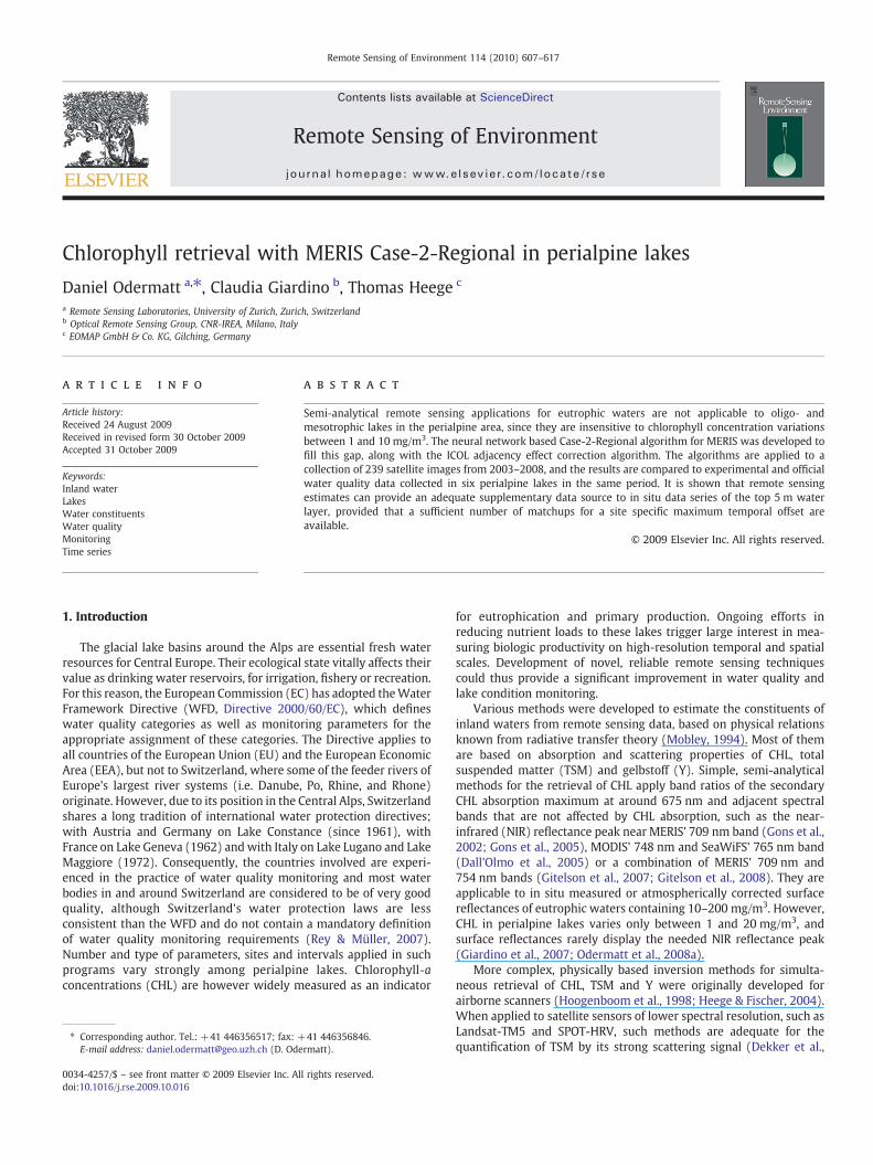
Chlorophyll retrieval with MERIS Case-2-Regional in perialpine lakes Daniel Odermatt a, ⁎, Claudia Giardino b , Thomas Heege c a Remote Sensing Laboratories, University of Zurich, Zurich, Switzerland b Optical Remote Sensing Group, CNR-IREA, Milano, Italy c EOMAP GmbH & Co. KG, Gilching, Germany abstract article info Article history: Received 24 August 2009 Received in revised form 30 October 2009 Accepted 31 October 2009 Keywords: Inland water Lakes Water constituents Water quality Monitoring Time series Semi-analytical remote sensing applications for eutrophic waters are not applicable to oligo- and mesotrophic lakes in the perialpine area, since they are insensitive to chlorophyll concentration variations between 1 and 10 mg/m 3 . The neural network based Case-2-Regional algorithm for MERIS was developed to fill this gap, along with the ICOL adjacency effect correction algorithm. The algorithms are applied to a collection of 239 satellite images from 2003–2008, and the results are compared to experimental and official water quality data collected in six perialpine lakes in the same period. It is shown that remote sensing estimates can provide an adequate supplementary data source to in situ data series of the top 5 m water layer, provided that a sufficient number of matchups for a site specific maximum temporal offset are available. © 2009 Elsevier Inc. All rights reserved. 1. Introduction The glacial lake basins around the Alps are essential fresh water resources for Central Europe. Their ecological state vitally affects their value as drinking water reservoirs, for irrigation, fishery or recreation. For this reason, the European Commission (EC) has adopted the Water Framework Directive (WFD, Directive 2000/60/EC), which defines water quality categories as well as monitoring parameters for the appropriate assignment of these categories. The Directive applies to all countries of the European Union (EU) and the European Economic Area (EEA), but not to Switzerland, where some of the feeder rivers of Europe's largest river systems (i.e. Danube, Po, Rhine, and Rhone) originate. However, due to its position in the Central Alps, Switzerland shares a long tradition of international water protection directives; with Austria and Germany on Lake Constance (since 1961), with France on Lake Geneva (1962) and with Italy on Lake Lugano and Lake Maggiore (1972). Consequently, the countries involved are experi- enced in the practice of water quality monitoring and most water bodies in and around Switzerland are considered to be of very good quality, although Switzerland's water protection laws are less consistent than the WFD and do not contain a mandatory definition of water quality monitoring requirements (Rey & Müller, 2007). Number and type of parameters, sites and intervals applied in such programs vary strongly among perialpine lakes. Chlorophyll -a concentrations (CHL) are however widely measured as an indicator for eutrophication and primary production. Ongoing efforts in reducing nutrient loads to these lakes trigger large interest in mea- suring biologic productivity on high-resolution temporal and spatial scales. Development of novel, reliable remote sensing techniques could thus provide a significant improvement in water quality and lake condition monitoring. Various methods were developed to estimate the constituents of inland waters from remote sensing data, based on physical relations known from radiative transfer theory (Mobley, 1994). Most of them are based on absorption and scattering properties of CHL, total suspended matter (TSM) and gelbstoff (Y). Simple, semi-analytical methods for the retrieval of CHL apply band ratios of the secondary CHL absorption maximum at around 675 nm and adjacent spectral bands that are not affected by CHL absorption, such as the near- infrared (NIR) reflectance peak near MERIS' 709 nm band (Gons et al., 2002; Gons et al., 2005), MODIS' 748 nm and SeaWiFS' 765 nm band (Dall'Olmo et al., 2005) or a combination of MERIS' 709 nm and 754 nm bands (Gitelson et al., 2007; Gitelson et al., 2008). They are applicable to in situ measured or atmospherically corrected surface reflectances of eutrophic waters containing 10–200 mg/m 3 . However, CHL in perialpine lakes varies only between 1 and 20 mg/m 3 , and surface reflectances rarely display the needed NIR reflectance peak (Giardino et al., 2007; Odermatt et al., 2008a). More complex, physically based inversion methods for simulta- neous retrieval of CHL, TSM and Y were originally developed for airborne scanners (Hoogenboom et al., 1998; Heege & Fischer, 2004). When applied to satellite sensors of lower spectral resolution, such as Landsat-TM5 and SPOT-HRV, such methods are adequate for the quantification of TSM by its strong scattering signal (Dekker et al., Remote Sensing of Environment 114 (2010) 607–617 ⁎ Corresponding author. Tel.: + 41 446356517; fax: + 41 446356846. E-mail address: [email protected] (D. Odermatt). 0034-4257/$ – see front matter © 2009 Elsevier Inc. All rights reserved. doi:10.1016/j.rse.2009.10.016 Contents lists available at ScienceDirect Remote Sensing of Environment journal homepage: www.elsevier.com/locate/rse
-
Upload
independent -
Category
Documents
-
view
5 -
download
0
Transcript of Chlorophyll retrieval with MERIS Case-2-Regional in perialpine lakes
Remote Sensing of Environment 114 (2010) 607–617
Contents lists available at ScienceDirect
Remote Sensing of Environment
j ourna l homepage: www.e lsev ie r.com/ locate / rse
Chlorophyll retrieval with MERIS Case-2-Regional in perialpine lakes
Daniel Odermatt a,⁎, Claudia Giardino b, Thomas Heege c
a Remote Sensing Laboratories, University of Zurich, Zurich, Switzerlandb Optical Remote Sensing Group, CNR-IREA, Milano, Italyc EOMAP GmbH & Co. KG, Gilching, Germany
⁎ Corresponding author. Tel.: +41 446356517; fax: +E-mail address: [email protected] (D. Ode
0034-4257/$ – see front matter © 2009 Elsevier Inc. Aldoi:10.1016/j.rse.2009.10.016
a b s t r a c t
a r t i c l e i n f oArticle history:Received 24 August 2009Received in revised form 30 October 2009Accepted 31 October 2009
Keywords:Inland waterLakesWater constituentsWater qualityMonitoringTime series
Semi-analytical remote sensing applications for eutrophic waters are not applicable to oligo- andmesotrophic lakes in the perialpine area, since they are insensitive to chlorophyll concentration variationsbetween 1 and 10 mg/m3. The neural network based Case-2-Regional algorithm for MERIS was developed tofill this gap, along with the ICOL adjacency effect correction algorithm. The algorithms are applied to acollection of 239 satellite images from 2003–2008, and the results are compared to experimental and officialwater quality data collected in six perialpine lakes in the same period. It is shown that remote sensingestimates can provide an adequate supplementary data source to in situ data series of the top 5 m waterlayer, provided that a sufficient number of matchups for a site specific maximum temporal offset areavailable.
41 446356846.rmatt).
l rights reserved.
© 2009 Elsevier Inc. All rights reserved.
1. Introduction
The glacial lake basins around the Alps are essential fresh waterresources for Central Europe. Their ecological state vitally affects theirvalue as drinking water reservoirs, for irrigation, fishery or recreation.For this reason, the European Commission (EC) has adopted theWaterFramework Directive (WFD, Directive 2000/60/EC), which defineswater quality categories as well as monitoring parameters for theappropriate assignment of these categories. The Directive applies toall countries of the European Union (EU) and the European EconomicArea (EEA), but not to Switzerland, where some of the feeder rivers ofEurope's largest river systems (i.e. Danube, Po, Rhine, and Rhone)originate. However, due to its position in the Central Alps, Switzerlandshares a long tradition of international water protection directives;with Austria and Germany on Lake Constance (since 1961), withFrance on Lake Geneva (1962) andwith Italy on Lake Lugano and LakeMaggiore (1972). Consequently, the countries involved are experi-enced in the practice of water quality monitoring and most waterbodies in and around Switzerland are considered to be of very goodquality, although Switzerland's water protection laws are lessconsistent than the WFD and do not contain a mandatory definitionof water quality monitoring requirements (Rey & Müller, 2007).Number and type of parameters, sites and intervals applied in suchprograms vary strongly among perialpine lakes. Chlorophyll-aconcentrations (CHL) are however widely measured as an indicator
for eutrophication and primary production. Ongoing efforts inreducing nutrient loads to these lakes trigger large interest in mea-suring biologic productivity on high-resolution temporal and spatialscales. Development of novel, reliable remote sensing techniquescould thus provide a significant improvement in water quality andlake condition monitoring.
Various methods were developed to estimate the constituents ofinland waters from remote sensing data, based on physical relationsknown from radiative transfer theory (Mobley, 1994). Most of themare based on absorption and scattering properties of CHL, totalsuspended matter (TSM) and gelbstoff (Y). Simple, semi-analyticalmethods for the retrieval of CHL apply band ratios of the secondaryCHL absorption maximum at around 675 nm and adjacent spectralbands that are not affected by CHL absorption, such as the near-infrared (NIR) reflectance peak near MERIS' 709 nm band (Gons et al.,2002; Gons et al., 2005), MODIS' 748 nm and SeaWiFS' 765 nm band(Dall'Olmo et al., 2005) or a combination of MERIS' 709 nm and754 nm bands (Gitelson et al., 2007; Gitelson et al., 2008). They areapplicable to in situ measured or atmospherically corrected surfacereflectances of eutrophic waters containing 10–200 mg/m3. However,CHL in perialpine lakes varies only between 1 and 20 mg/m3, andsurface reflectances rarely display the needed NIR reflectance peak(Giardino et al., 2007; Odermatt et al., 2008a).
More complex, physically based inversion methods for simulta-neous retrieval of CHL, TSM and Y were originally developed forairborne scanners (Hoogenboom et al., 1998; Heege & Fischer, 2004).When applied to satellite sensors of lower spectral resolution, such asLandsat-TM5 and SPOT-HRV, such methods are adequate for thequantification of TSM by its strong scattering signal (Dekker et al.,

608 D. Odermatt et al. / Remote Sensing of Environment 114 (2010) 607–617
2001). However, only more recent sensors were found to providesufficient spectroradiometric properties for the estimation of low CHLconcentrations in inlandwaters, for exampleHyperion (Giardino et al.,2007) orMERIS (Odermatt et al., 2008a) in Lakes Garda and Constance,respectively. However, constant gelbstoff (Y) absorption had to beassumed in both studies, as its variation was not distinguishable fromoligotrophic lakes' CHL patterns with those instruments.
An inversion technique based on neural networks (NN) is used inthe MERIS ground segment to simultaneously retrieve case II waterconstituents. Current MERIS level 2 standard products (algal_2,yellow_subs, total_susp) are processed with such a sensor-specificNN algorithm (Doerffer & Schiller, 2007). Between January 2007 andJune 2008, the European Space Agency (ESA) funded the “Develop-ment of MERIS Lake Water Algorithms” (MERIS Lakes) project on theelaboration and validation of an inland water NN for BEAM (Fomferra& Brockmann, 2006). The project led to three plug-in algorithms basedon theMERIS Case-2 CoreModule: Case-2 Regional (C2R), Boreal Lakesand Eutrophic Lakes (Doerffer & Schiller, 2008a) and a dedicatedatmospheric correction (Doerffer & Schiller, 2008b). At about the sametime the Improved Contrast betweenOcean and Land (ICOL) processorbecame available, which accounts for the correction of adjacencyeffects (Santer & Zagolski, 2009; Odermatt et al., 2008b). Thecorresponding validation campaign concludes that 1) atmosphericallycorrected and in situmeasured reflectances agreewell in the green andred spectral region, but worse in the blue region, 2) ICOL has a positiveor neutral effect, and 3) the accuracy is sufficient for TSM and CHL, butstill not for Y (Koponen et al., 2008; Ruiz-Verdu et al., 2008).
Against the background of this recent progress, the applicability ofthe current C2R CHL product for the support of water qualitymonitoring in perialpine lakes is tested in this study. In Section 2, acollection of MERIS images of the alpine region in the years 2003–2008 is described, along with several field campaigns including in situreflectance measurements coinciding MERIS overpasses and waterquality monitoring datasets acquired by local authorities. Section 3
Fig. 1. ExampleMERIS L1B full scene of the almost cloud free Alpine area, showing the distributi
contains an overview of the automatic processing environmentapplied to the satellite imagery (Odermatt et al., 2008a), which wasadapted for the use with BEAM's command line routines. The sameprocessing environment accounts for the comparison with reflec-tances and concentrations measured in field campaigns and for waterquality monitoring concentrations. Results of all three types ofmatchups are discussed in Section 4. Conclusions are given inSection 5.
We specifically address the following questions: 1) Are theC2R and ICOL appropriate for the routine processing of CHL products?2) What is the spatio-temporal validity of the findings? 3) How doesICOL affect the outcome of the C2R processing for perialpine lakes?
2. Data
2.1. MERIS images
Two hundred and thirty-nine MERIS full resolution (FR) level 1Bquarter and full scenes were used in this investigation. The data wereoriginally collected for other experiments on Lake Constance (2003–2007), Garda, and Maggiore (2003–2008), which are covered by 121,150 and 185 images, respectively. The study includes 7 lakes, whichwere chosen for their regional relevance and are therefore regularlymonitored. This ensures the availability of CHL monitoring referencedata along with experimental spectroradiometric reference data. Thelakes have a size adequate for the 300 m spatial resolution ofMERIS FR(Fig. 1). Partial coverage, inappropriate atmospheric conditions or sunglint affected geometries may occur especially over lakes that the datawas not originally chosen for, leading to the lowest temporal coveragefor Lake Geneva (86). The temporal coverage in winter is lower thanin summer (Fig. 2), since the images were chosen mainly to observephytoplankton growth, and clouds and fog reduce the availability ofdata in the winter half year.
on of investigated lakes around the Alps, with the snow line at about 1000m asl in average.

Fig. 2. Temporal distribution of the 239 images used in this study.
609D. Odermatt et al. / Remote Sensing of Environment 114 (2010) 607–617
2.2. Field campaign data
35 spectroradiometric measurements with coincidingMERIS imageswere used in this study. They were converted to remote sensingreflectance Rrs (i.e. the ratio between thewater leaving radiance and theincoming irradiance flux) for comparison with the C2R calculatedreflectance. Thefield campaigndata represent5 lakes andwere gatheredon 8 field campaigns in the years 2005–2008. No spectroradiometricmeasurements are available for Lake Biel and Lake Zug.
In the northern perialpine region, MERIS coinciding spectroradio-metric measurements were taken during 4 campaigns in 2007; in LakeConstance (14 and 20 April, henceforth addressed as con070414 andcon070420), Lake Geneva (gen070910) and Lake Zurich (zur070815).Lake Geneva and Lake Constance are the two largest freshwaterreservoirs in Western Europe, while Lake Zurich is the most importantdrinking water storage for the city of Zurich. Lake Constance is con-sidered oligotrophic, Lake Geneva and Lake Zurich are mesotrophic. Insitu CHL concentrationswere onlymeasured on the Lake Constancefieldcampaign. All field campaigns took placewithin 3 hours of MERIS imageacquisition. RAMSES ARC and ACC instruments were used to measuredownwelling irradiance as well as upwelling radiance and irradiancebelow the water surface (Koponen et al., 2008).
Field campaigns in the southern perialpine region were carried outon Lake Garda and Lake Maggiore. The two lakes are the largest of Italy,situated in the northern part of the country, which accounts for 80% ofItaly's total freshwater storage. Both are in an oligotrophic state,although Lake Garda tends to mesotrophic conditions (Premazzi et al.,2003). Lake Garda was visited on two field campaigns (gar050726,gar080506),making available three in situ spectroradiometricmeasure-ments. LakeMaggiorefield campaigns cover the northern half of the lakewith 6 Rrs measurements (mag060710), and its southern half withanother 12 measurements (mag080803). Half of the measurements inLake Maggiore were taken in littoral sites, at only a few hundredmetersfrom the shore and thus at a critical distance for MERIS' spatial reso-lution. The measurements were done within 5 h of the acquisition of aMERIS image. Underwater downwelling irradiance and upwellingradiance were measured with an ASD-FR.
Both RAMSES and ASD-FR underwater measurements werecorrected for the emersion factor to derive reflectance values thatare comparable to C2R results. Self-shading was not accounted for, asthey are minimal in clear waters (Leathers et al., 2004).
Table 1List of the lakes investigated, with corresponding water directives, the institutions in chargetimeframe investigated.
Lake Directive Executinginstitution
Biel Cantonal Bernese Cant. Water Protection and Waste ManagemeConstance IGKB1 Institute for Lake Research, Langenargen (Germany)Garda WFD APPA Trento (Italy)Geneva CIPEL INRA, Thonon-Les-Bains (France)Zug Cantonal Zug Cant. Environmental Protection OfficeZurich Cantonal Zurich Municipal Water Utility
1 International Commission for the Protection of Lake Constance.
2.3. CHL monitoring data
A heterogeneous collection of water quality monitoring data wasused for the long time validation of the C2R CHL product with mean-ingful, official water quality monitoring estimates. However, French,German, Italian and Swiss agencies and commissions responsible fortheir acquisition are manifold, and the different measurementmethods and standards may lead to variations in the comparabilitywith remote sensing estimates (Table 1).
The HPLC method applied to vertical composite water samples asin the monitoring program of Lake Biel, Lake Constance and LakeZurich gives a precise laboratory measurement of constituent con-centrations in a sample. In Lake Zurich, such samples are taken at 0, 1,2.5 and 5 m depth and thus represent vertical variations in the topwater layer; in case of Lake Biel and Lake Constance thewater samplesare taken as a vertical mixture of the topmost water layer, i.e. 20 mand 15 m, respectively. In Lake Garda, CHL is derived from spectro-photometer measurements of water samples of the top 1 m waterlayer (ISO 10260-E, 1992). Finally, submersible fluorescence probessuch as the SCUFA used in Lake Zug and the CTD90 used in LakeGeneva allow the depth profiling of CHL and other limnic parametersin the field.
3. Processing chain
Four BEAM routines are used in a processing chain for the auto-matic calculation of the C2R water constituent products. The BEAMtools are controlled by IDL routines, which account for the definitionof parameters in the BEAM processor xml files, but also for the postprocessing of geometrically corrected L2 subsets (Fig. 3).
3.1. Preprocessing
In a first step, BEAM's smile correction meris-smile.bat (version1.1.101) is applied to the original L1B data. This command line algorithmis identical to the MERIS smile correction used in L2 products. It appliesan irradiance correction to all bands, which accounts for the differencebetween actual and nominal wavelengths of the solar irradiance in eachchannel. A reflectance correction is also applied, based on spectralinterpolation of reflectances in two adjacent bands. Thedefault forwatertargets is to apply the reflectance correction to all bands apart from8, 11,14 and 15 (Fomferra & Brockmann, 2006).
The smile corrected L1B data are processed with ICOL (version1.0.4) as implemented in BEAM's gpt.bat command line routine. ICOLcalculates top of atmosphere (TOA) reflectance and applies a regularRayleigh correction as done in the MERIS atmospheric correction overland of the MERIS ground segment (Santer et al., 1999). This is donefor the entire image, while the rest of the procedure is only applied towater pixels within 30 km of land surface areas. Rayleigh and aerosoladjacency effects are corrected by means of a look-up-table simulatedwith a primary scattering model (Santer & Schmechtig, 2000). MERISbands 12 and 13 are thereby used for the estimation of aerosol typeand optical thickness (AOT). The reduction of the surface reflectance
and the methods and intervals applied for the monitoring of CHL concentrations for the
Method Interval Timeframe
nt Office HPLC (15 m) 30 days 2003–2008HPLC (20 m) 14–30 days 2003–2007Spectrophotometer (0–1 m) 30 days 2003–2008Fluorescence probe (1–5 m) 14–30 days 2003–2007Fluorescence probe (1–5 m) 30 days 2005–2007HPLC profile (0–5 m) 30 days 2006–2008

Fig. 3. Flow chart of the processing scheme applied to the MERIS data.
610 D. Odermatt et al. / Remote Sensing of Environment 114 (2010) 607–617
caused Rayleigh and aerosol scattering over adjacent land is alsoaccounted for. Finally, the adjacency effect corrected TOA reflectanceis converted back into at-sensor radiances for all 15 bands, creating anL1C product according to ESA definitions (Santer & Zagolski, 2009).
3.2. Atmospheric correction and water constituent retrieval
The smile corrected L1B and L1C data are processed with C2R(version 1.3.2, Case 2 coremodule version 1.0), resulting in two sets ofwater constituent products, onewith and onewithout ICOL correction(Fig. 3). A C2R batch processing routine was therefore customized asdescribed in the BEAM Lakes Wiki (Peters, 2008). It makes use of anadapted parameter file that switches C2R's internal smile correctionoff. C2R applies a dedicated NN based atmospheric correction built onmore than 200,000 simulations for 15 input neurons, includingradiance reflectance at top of a 50 layer standard atmosphere afterOzone and Rayleigh correction in 12 visible and NIR bands. Only bands11, 14 and 15 are excluded. This helps to avoid the over-correction ofvisible bands occurring in earlier versions, which were based on theextrapolation of NIR retrieved atmospheric parameters to shorterwavelengths. 43 neurons are defined as output, consisting of waterleaving radiance and downwelling irradiance (i.e., the terms to deriveRrs) as well as path scattered radiance for the 12 input bands, AOT in 4bands (given at 550 nm hereafter), and a sun glint parameter. Thescattering by ice crystals in cirrus clouds is also accounted for.Performance tests across the entire range of values of atmosphericparameters included in the NN show that largest inaccuracies occurfor low water leaving reflectances, i.e. at short wavelengths, underhazy conditions and over absorption dominated, low scatteringwaters. Therefore, the atmospheric correction was found to beapplicable for atmospheric conditions up to AOT=0.5 under normalcircumstances, but might fail even at AOT=0.2 over very dark water,such as in Finnish lakes (Doerffer & Schiller, 2008b).
C2R's water constituent retrieval NN uses the Rrs in MERIS bands1–8 after atmospheric correction. It was trained with a LUT consisting
of more than 80,000 Hydrolight simulations (Mobley, 1994). Naturalvariations in IOP and unavoidable errors in input Rrs are accounted for,but fluorescence effects are neglected. A so-called invNN is applied toinvert given directional Rrs into concentrations, and a forwNN modelsRrs for given concentrations and geometries. The invNN provides afirst guess of instant concentrations. They fed in the forwNN togetherwith the acquisition geometry, producing an Rrs spectrum to verifythe inversion procedure. The difference in these Rrs is minimized bymeans of a Levenberg–Marquardt algorithm until an accuracythreshold is met, or up to a maximum of 10 iterations. The L2 pro-ducts calculated in this way include CHL, TSM and Y, but also theminimum irradiance attenuation coefficient and the signal depth z90.Furthermore, retrieval quality flags are set according to failures inmeeting quality check thresholds for both atmospheric correction andwater constituent retrieval (Doerffer & Schiller, 2008a).
3.3. Post processing
The optical closure of in situ Rrs measurements and correspondingC2R Rrs pixel spectra is quantified by means of the absolute and relativespectral Root Mean Square Error (RMSE) of MERIS channels 1–9:
RMSE =
ffiffiffiffiffiffiffiffiffiffiffiffiffiffiffiffiffiffiffiffiffiffiffiffiffiffiffiffiffi∑N
i=1ð―Xi−X̂Þ2
N−1
vuuutð1Þ
Rel: RMSE =
ffiffiffiffiffiffiffiffiffiffiffiffiffiffiffiffiffiffiffiffiffiRMSE
1N ∑
N
i=1
―Xi
⋅vuuut 100 ð2Þ
where N is the number of bands (i.e. 9) and―Xi and X̂i are the remote
sensing reflectancesmeasured in situ and retrieved by C2R, respectively.Once the water constituent concentrations are calculated, the
subsequent post processing steps make use of two tables for the
611D. Odermatt et al. / Remote Sensing of Environment 114 (2010) 607–617
creation of map products and point wise comparison with in situ data.The lake parameter table contains geographic information for eachlake to be extracted from the MERIS L2 images, i.e. name, altitude,pixel size, geographical coordinate subset boundaries in each di-rection and UTM zone. This information is used for geometriccorrection and image clipping by means of the BEAM tool mapproj.bat. The DIMAP format lake clippings are then illustrated with legendand color table templates according to the variation of concentrationsexpected in each lake and saved as JPEG.
The second table with site parameters contains local CHLmonitoringtime series along with site name, acquisition method and latitude andlongitude coordinates. It enables the extraction of spatio-temporalmatchups between in situ CHLmeasurements and correspondingMERISpixels. Where cloud free matchup pixels are found, the values ofacquisition date, L1B flags, C2R flags, viewing zenith angle, C2R's chisquare, AOT, CHL, TSM, Y and z90 are extracted and simple statistics suchas R2 and RMSEs are calculated. Corresponding values extracted from a3×3 neighborhood instead of a single pixel do not consistently lead toimproved results. Channel 13 quick looks of each MERIS image areautomatically generated and manually searched for cirrus and contrailcontaminations that were not identified by the MERIS flags. About 10images per reference sitewere blacklisted andexcluded fromprocessingin this way. Additional criteria for data exclusion in the automaticprocesswere sun glint suspect geometries (i.e. above 10° east in summeror 20° East in winter), C2R's error indicating retrieval flags (i.e. ATC_OORand RAD_ERR) and unrealistic CHL levels (i.e. below 0.1 mg/m3). Thelatter two may differ between ICOL corrected and uncorrected data,causing differences in the number of matchups available.
4. Results
4.1. Field campaign Rrs matchups
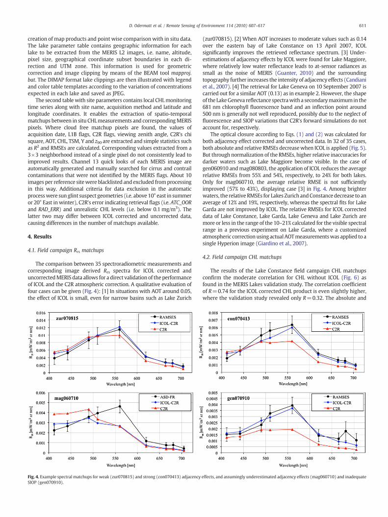
The comparison between 35 spectroradiometric measurements andcorresponding image derived Rrs spectra for ICOL corrected anduncorrectedMERIS data allows for a direct validation of theperformanceof ICOL and the C2R atmospheric correction. A qualitative evaluation offour cases can be given (Fig. 4): [1] In situations with AOT around 0.05,the effect of ICOL is small, even for narrow basins such as Lake Zurich
Fig. 4. Example spectral matchups for weak (zur070815) and strong (con070413) adjacencySIOP (gen070910).
(zur070815). [2] When AOT increases to moderate values such as 0.14over the eastern bay of Lake Constance on 13 April 2007, ICOLsignificantly improves the retrieved reflectance spectrum. [3] Under-estimations of adjacency effects by ICOL were found for Lake Maggiore,where relatively low water reflectance leads to at-sensor radiances assmall as the noise of MERIS (Guanter, 2010) and the surroundingtopography further increases the intensity of adjacency effects (Candianiet al., 2007). [4] The retrieval for Lake Geneva on 10 September 2007 iscarried out for a similar AOT (0.13) as in example 2. However, the shapeof the LakeGeneva reflectance spectrawith a secondarymaximumin the681 nm chlorophyll fluorescence band and an inflection point around500 nm is generally not well reproduced, possibly due to the neglect offluorescence and SIOP variations that C2R's forward simulations do notaccount for, respectively.
The optical closure according to Eqs. (1) and (2) was calculated forboth adjacency effect corrected and uncorrected data. In 32 of 35 cases,both absolute and relative RMSEs decreasewhen ICOL is applied (Fig. 5).But through normalization of the RMSEs, higher relative inaccuracies fordarker waters such as Lake Maggiore become visible. In the case ofgen060910 andmag080803, the application of ICOL reduces the averagerelative RMSEs from 55% and 54%, respectively, to 24% for both lakes.Only for mag060710, the average relative RMSE is not sufficientlyimproved (57% to 43%), displaying case [3] in Fig. 4. Among brighterwaters, the relative RMSEs for Lakes Zurich andConstance decrease to anaverage of 12% and 19%, respectively, whereas the spectral fits for LakeGarda are not improved by ICOL. The relative RMSEs for ICOL correcteddata of Lake Constance, Lake Garda, Lake Geneva and Lake Zurich aremore or less in the range of the 10–21% calculated for the visible spectralrange in a previous experiment on Lake Garda, where a customizedatmospheric correctionusingactualAOTmeasurementswas applied to asingle Hyperion image (Giardino et al., 2007).
4.2. Field campaign CHL matchups
The results of the Lake Constance field campaign CHL matchupsconfirm the moderate correlation for CHL without ICOL (Fig. 6) asfound in the MERIS Lakes validation study. The correlation coefficientof R=0.74 for the ICOL corrected CHL product is even slightly higher,where the validation study revealed only R=0.32. The absolute and
effects, and assumingly underestimated adjacency effects (mag060710) and inadequate

Fig. 5. Spectral RMSEs and relative spectral RMSEs for 35 in situ spectral measurementsand the corresponding Rrs spectra calculated by C2R for ICOL corrected and uncorrectedinput data.
612 D. Odermatt et al. / Remote Sensing of Environment 114 (2010) 607–617
relative RMSEs of ICOL corrected CHL are more than twice that of theuncorrected estimate, since the ICOL correction generally increasesthe water constituent concentration estimate (Koponen et al., 2008).But when the individual bias in the linear relationship between in situdata and the two C2R estimates is taken into account, the ICOLcorrected estimate is again insignificantly better with an RMSE of 0.78against 0.81 mg/m3. In general, the results confirm the contradictoryfinding that ICOL significantly improves the retrieval of Rrs (Fig. 5) butnot the determination of water constituents (Koponen et al., 2008).
4.3. CHL monitoring matchups
The general comparability of C2R results with 0–5 m depthresolved reference data from official water quality monitoring isdemonstrated using the example of Lake Zurich (HPLC reference,
Fig. 7). Correlation coefficients and absolute RMSEs are higher and therelative RMSEs lower than those found in the field campaign matchupsfor Lake Constance, which can be explained with the higher range ofconcentrations occurring in Lake Zurich. Themain difference due to ICOLcan be expressed by a difference in linear regression similar to the LakeConstance field campaign (Fig. 6), only that this time ICOL is closer to the1:1 line. Some outliers among the 3–5 days offset matchups can beidentified for the occurrence of spatio-temporal variations in the CHLpatterns observed by MERIS, but are not discussed individually.
The matchups for Lake Zug in Fig. 8 represent an aggregation oflow concentration cases and only a few algae bloom events, makingthe correlation less reliable than for Lake Zurich. Nevertheless, thecorrelations similar and the linear regression is again considerablysteeper for ICOL corrected than for uncorrected data, whereas both areoff the 1:1 line in this example. The main differences are due to thestrong overestimation of concentrations by C2R for ICOL correcteddata, leading to high RMSEs. However, the two maximum values byC2R with ICOL correspond to spring bloom events in April 2005 and2007, where increased (6–8 mg/m3) CHL concentrations are found at7–12 m depth, but not in the top 5 m layer averaged for the referencedataset. When comparing to the average of the top 20 m probe profiledata, ICOL corrected estimates improve to R=0.84, while it decreasesto 0.74 without ICOL.
For Lake Geneva, 98 in situ measurements in 2003–2007 areavailable for a sampling station in the center of the lake, allowing forthe reduction of maximum temporal offset for data matchups to2 days. However, the entire investigation period reveals correlationsof only R=0.33 without and 0.26 with ICOL. But when only the first 3of 5 years are analyzed, the correlation without ICOL improves, andthe ICOL corrected R=0.89 becomes the highest of all lakes (Fig. 9). Itis assumed that the SIOPs of Lake Geneva have significantly shifted in2006–2007. Several indications support this hypothesis, such as theobvious change in phytoplankton variability visible in the CHLreference data (Fig. 13), the inability to differentiate AOT, CHL, TSMand Y patterns in some images, the difference between the spectralshape of gen070910 compared to the other reference spectra and thepoor retrieval of that spectrum by C2R (Fig. 4, type [4]), and finally theobservation of exceptional blooms of filamentous Mougeotia algae in2007 by local limnologists (Rimet et al., 2008; Tadonleke, R., pers.comm.).
In Lake Garda, the sampling station is very close to the inflow ofRiver Sarca in the narrow northern part of the lake. Zero–1 days offsetwould have to be allowed in order to get enough matchups, butcannot account for the temporal variability in this estuary region(R=0.50, n=11). A local comparison with remote sensing estimatesis thus impossible unless the temporal agreement of image and in situsample acquisition can be improved.
In Lake Biel and Lake Constance, water quality monitoring data ismeasured as HPLC analysis of 20 m composite profiles. A reducedcomparability with remote sensing estimates is indicated by match-ups for 4 different sites in Lake Constance (Fig. 10), where thecorrelation is only about half of that found for the 0–5 m profilematchups. The largest RMSEs are found for the 4 ICOL correctedmatchups of the site BR in the eastern bay of the lake, close to theRiver Rhine estuary. If removed, the other 3 sites achieve R=0.67with ICOL. The small number of Lake Biel reference measurementsrequires a 2-day offset threshold to analyze 12 matchups, whichcorrelate even less (Rb0.26).
4.4. Fusion of CHL time series
The correlation found for 0–5 m monitoring data and C2R CHLestimates are additionally examined by means of their seasonal andinterannual variation. The linear gain factors found for the CHLmonitoring matchups in Figs. 7–9 are applied to the C2R estimates,and the standard deviations of the averaged profile data are displayed

Fig. 6. Lake Constance plots of laboratory CHL with uncorrected (left) and ICOL corrected (right) MERIS C2R estimates. When the linear regressions are applied to the MERISestimates, absolute RMSEs are 0.81 and 0.78 mg/m3 and relative RMSEs are 37% and 36% for data without and with ICOL, respectively.
613D. Odermatt et al. / Remote Sensing of Environment 114 (2010) 607–617
as error bars of in situ CHL. In Lake Zurich, most images are availablefor the second half of 2006, where the in situ concentrations show asteady increase (Fig. 11). Another cluster is related to the minimumconcentrations in summer 2007 and the relative maxima before andafter. Both situations are well reproduced by the C2R estimates,without a significant difference for ICOL corrected (n=39) anduncorrected (n=33) data. A difference in the number of observationsoccurs because C2R L2 flags ATC_OOR and RAD_ERR are less frequentin the corrected (11) than in the uncorrected (17) data, whereasabout half of the flagged non-ICOL CHL concentrations would be in areasonable range, while the other half is mostly above 20 or below1 mg/m3. Furthermore, the C2R estimates seem to underestimate lowconcentrations, while they overestimate higher concentrations. Again,this applies to both types of satellite estimates.
The Lake Zug time series of in situ CHL data consists of relativelyconstant 2–4 mg/m3 concentrations with annual short periods ofincreased concentrations in spring and autumn. For the years 2005and 2007, these events are well reproduced by the C2R estimates, withoccasional overestimations by both non-ICOL and ICOL processed CHL.The spring maximum in 2006 measured on 24 April in situ is not
Fig. 7. Lake Zurich plots of official water quality CHL with uncorrected (left) and ICOL correcestimates, absolute RMSEs are 1.85 and 1.87 mg/m3 and relative RMSEs are 38% and 37% w
confirmed by any valid MERIS observation. A MERIS image acquired on21 April indicates above average CHL concentrations of 4.3 (non-ICOL)and 4.7 mg/m3, but is not displayed in Fig. 12 due to sun glint suspectgeometry. The autumnmaximum in2007 is not visible in the in situdata,since no fluorescence probe measurements were taken between 18 Julyand 29 October. MERIS estimates indicate that this algae growth eventhas taken place to a similar extent as in the year before.
For the Lake Geneva time series, ICOL results (n=50) are moreaccurate than non-ICOL (n=49) results, as already found for thecorrelation of matchups. In the years 2003–2005, only two events ofconcentrations above 4 mg/m3 are documented by in situ data, whilethe variations at low concentrations are very volatile (Fig. 13).Nevertheless, a good agreement is visible especially in 2004, where allbut the first C2R estimates are in the range between the previous andthe subsequent in situ measurement. The years 2006 and 2007introduce increased average and maximum CHL reference concentra-tions and an increased seasonal variability. C2R retrieved CHLconcentrations cannot account for these changes, although theMERIS images still depict many spatial features as relative concen-tration differences.
ted (right) MERIS C2R estimates. When the linear regressions are applied to the MERISithout and with ICOL, respectively.

Fig. 8. Lake Zug plots of official water quality CHL with uncorrected (left) and ICOL corrected (right) MERIS C2R estimates. When the linear regressions are applied to the MERISestimates, absolute RMSEs are 0.71 and 1.32 mg/m3 and relative RMSEs are 35% and 69% without and with ICOL, respectively.
614 D. Odermatt et al. / Remote Sensing of Environment 114 (2010) 607–617
5. Conclusions and discussion
It was shown that both C2R and ICOL are well automatablealgorithms, allowing for the supply of relatively accurate CHLproducts for most of the larger perialpine lakes. The potential fortheir use for in situ water quality monitoring is considerable, alsotaking into account the near real-time availability from ESA's rollingarchives. The application of simplified automatic quality checksregarding sun glint suspect and flagged pixels has strongly reducedthe number of outliers in theMERIS data, although it lead to the loss ofsome significant datasets, which could be avoided by means ofmanual data quality control or an improved C2R flagging system, e.g.for sun glint affected pixels. Extraordinarily complex cases like thestrong adjacency effects over LakeMaggiore (Guanter, 2010; Candianiet al., 2007) or the change in SIOP in Lake Geneva in the years 2006and 2007 require further investigation. Especially the changing
Fig. 9. Lake Geneva plots of official water quality CHL with uncorrected (left) and ICOL corrapplied to the MERIS estimates, absolute RMSEs are 1.04 and 0.44 mg/m3 and relative RMS
environmental conditions in Lake Geneva demonstrate that remotesensing means for water constituent estimation will hardly replace insitu measurements in the near future. At the same time, it couldstrongly improve the current monitoring if in situ observations wouldinclude the estimation of the water's optical properties.
In terms of purposeful water quality monitoring, reliability andsignificance of remote sensing estimates cannot substitute in situestimates, as they are strongly depending on atmospheric conditionsand do not represent identical quantities, regarding area representa-tion and penetration depth. Nevertheless, this study showed that thecombination of in situ and spaceborne inland water CHL monitoringcan improve our knowledge of the current state of our freshwaterreservoirs with both temporally and spatially improved resolution.Depth resolved data are thereby clearly more suitable for comparison(R=0.71 to 0.89 and rel. RMSEs between 30% and 69% with ICOL)with remote sensing estimates than 15 or 20 m composite samples
ected (right) MERIS C2R estimates (only 2003–2005). When the linear regressions areEs are 68% and 30% without and with ICOL, respectively.

Fig. 10. Lake Constance plots of 20 m HPLC water quality data, measured in 4 different sites, with uncorrected (left) and ICOL corrected (right) MERIS C2R estimates of images takenon the same day. When the linear regressions are applied to the MERIS estimates, absolute RMSEs are 1.94 and 1.48 mg/m3 and relative RMSEs are 56% and 41% for data without andwith ICOL, respectively.
615D. Odermatt et al. / Remote Sensing of Environment 114 (2010) 607–617
(ICOL Rb0.58). The signal depth z90 calculated by the C2R algorithmin the present study (not shown) was between 5 to 12 m for all lakes.Vertically resolved in situ measurements of the topmost 5–12 m areaccordingly the most suitable reference datasets when it comes tocombining in situ and remotely sensed water quality estimates(Lindell et al., 1999). Temporal offsets up to 5 days turned out to beadequate for the majority of matchups in Lake Zug and Lake Zurich,whereas a very high temporal agreement is required in estuary sitessuch as BR in Lake Constance or the Lake Garda site. Regarding otherwater constituents, it is known from the outcome of the MERIS Lakesvalidation campaign and was confirmed by our estimates, that theTSM estimates by C2R are even more accurate than CHL, while the Yproduct is faulty, probably due to atmospheric correction issues atshort wavelengths (Koponen et al., 2008).
The role of the ICOL adjacency effect correction in the processing ofMERIS data is consistently positive as far as the retrieval of accurate Rrs byC2R is concerned. It also increases the correlation coefficient for CHL
Fig. 11. Lake Zurich time series of 0–5 m averaged HPLC samples and C2
comparisons in 5 out of 6 examples, but not to a comparable extent. Thisfinding confirms the conclusions of the MERIS Lakes validation study(Koponen et al., 2008), but lacks a simple explanation since the inversioncriteria of the NN are relatively intransparent. However, C2R was ori-ginally developed for use without ICOL, and adjacency effects remainedunconsidered in the forward NN, among other parameters. The reflec-tance inversion is therefore an approximation, in which neglected opticaleffects may be erroneously compensated by other parameters. In thepresent study, the correlation between adjacency effect corrected anduncorrected Y estimates (e.g. R=0.38 for Lake Zurich matchups) isconsiderably lower than in the case of CHL and TSM (R=0.70 and 0.67,respectively). C2R's Y was also found to be the most inaccuratelyretrieved constituent in the MERIS Lakes validation study (Koponenet al., 2008). Average values without adjacency effect correction aretwice to three times lower than found in previous studies (Odermattet al., 2008a,b;Heege&Fischer, 2004) orwhen ICOL is applied. Therefore,we assume that Y buffers a large portion of the inaccuracy of Rrs derived
R estimate after application of the linear regression found in Fig. 7.

Fig. 12. Lake Zug time series of 0–5 m fluorescence in situ measurements and C2R estimate after application of the linear regression found in Fig. 8.
Fig. 13. Lake Geneva time series of 0–5 m fluorescence in situ measurements and C2R estimate after application of the linear regression found in Fig. 9.
616 D. Odermatt et al. / Remote Sensing of Environment 114 (2010) 607–617
without ICOL, while the CHL retrieval suffers only minor damages inrelation to other error sources and the limited comparability of in situand remote sensing measurements.
Acknowledgements
We are very grateful to all those who provided us with their mea-surements or helped in corresponding field campaigns and dataanalyses, namely Brigitte Engesser, Kirstin König and Andreas Schiessel(LuBW), Anke Bogner and Jörg Heblinski (EOMAP), Hanna Huhn, EsraMandici, Thomas Agyemang and Klaus Schmieder (Univ. of Hohen-heim), Peter Gege, Juliane Huth and Thomas Krauss (DLR), Silvia Ballert(Univ. Konstanz); Luca Fila (CRA Sirmione), Alessandro Oggioni andcolleagues from CNR-ISE; Mariano Bresciani and Mauro Musanti (CNR-IREA).For the in situ CHLmonitoring data we thankMarkus Zeh and thewater and soil protection laboratory of the Canton of Berne (GBL); HansGüde, the Regional Office for Environment, Measurements and NatureConservancy of Baden-Württemberg (LuBW) and the InternationalWater Protection Commission for Lake Constance (IGKB); GhislaineMonet, RemyTadonleke, theLacustrianHydrobiologyStation inThonon-les-Bains (INRA UMR CARRTEL) and the International Commission forthe Protection of Lake Geneva (CIPEL); Chiara Defrancesco, theEnvironmental Protection Agency of Trento (APPA) and the Interna-
tional Commission for the Protection of Italo-Swiss Waters (CIPAIS),Peter Keller and the Office of Environmental Protection of the Canton ofZug (AfU); and Richard Forster and the Zurich Water Supply Authority(WVZ).This workwas funded by the Swiss National Science Foundation,contract no. [200020-112626/1]. MERIS data were made availablethrough the ESA projects AO-553 and AO-1107.
References
Candiani, G., Giardino, C., & Brando, V. E. (2007). Adjacency effects and bio-optical modelregionalization: MERIS data to assess lake water quality in the subalpine ecoregion.ENVISAT Symposium, Montreux, Switzerland, 23 April 2007 – 27 April 2007.
Dall'Olmo, G., Gitelson, A. A., Rundquist, D. C., Leavitt, B., Barrow, T., & Holz, J. C. (2005).Assessing the potential of SeaWiFS and MODIS for estimating chlorophyllconcentration in turbid productive waters using red and near-infrared bands. Re-mote Sensing of Environment, 96, 176−187.
Dekker, A. G., Vos, R. J., & Peters, S. W. M. (2001). Comparison of remote sensing data,model results and in situ data for total suspended matter (TSM) in the southernFrisian lakes. The Science of the Total Environment, 268, 197−214.
Directive 2000/60/EC. (2000, December 22). Water Framework Directive of the EuropeanParliament and of the Council of 23 October 2000 establishing a framework forcommunity action in the field of water policy. Official Journal L 327 pp.
Doerffer, R., & Schiller, H. (2007). The MERIS case 2 water algorithm. InternationalJournal of Remote Sensing, 28(3), 517−535.
Doerffer, R. & Schiller, H. (2008a). MERIS lake water algorithm for BEAM ATBD, GKSSResearch Center, Geesthacht, Germany. Version 1.0, 10 June 2008.

617D. Odermatt et al. / Remote Sensing of Environment 114 (2010) 607–617
Doerffer, R. & Schiller, H. (2008b). MERIS regional, coastal and lake case 2 water project —Atmospheric Correction ATBD. GKSS Research Center, Geesthacht, Germany. Version 1.0,18 May 2008.
Fomferra, N. & Brockmann, C. (2006). The BEAM project web page [Internet]. CarstenBrockmann Consult, Hamburg, Germany. Cited 23 April 2009. Available from:http://www.brockmann-consult.de/beam/
Giardino, C., Brando, V., Dekker, A. G., Strömbeck, N., & Candiani, G. (2007). Assessment ofwater quality in LakeGarda (Italy) usingHyperion.Remote Sensing of Environment,109,183−195.
Gitelson, A. A., Schalles, J. F., & Hladik, C. M. (2007). Remote chlorophyll-a retrieval inturbid, productive estuaries: Chesapeake Bay case study. Remote Sensing ofEnvironment, 109, 464−472.
Gitelson, A.A., Dall'Olmo,G.,Moses,W., Rundquist, D. C., Barrow, T., Fisher, T. R.,Gurlin, D., &Holz, J. (2008). A simple semi-analytical model for remote estimation of chlorophyll-ain turbid waters: Validation. Remote Sensing of the Environment, 112, 3582−3593.
Gons, H. J., Rijkeboer, M., & Ruddick, K. G. (2002). A chlorophyll-retrieval algorithm forsatellite imagery (Medium Resolution Imaging Spectrometer) of inland and coastalwaters. Journal of Plankton Research, 24, 947−951.
Gons, H. J., Rijkeboer, M., & Ruddick, K. G. (2005). Effect of a waveband shift on chlorophyllretrieval fromMERIS imageryof inlandandcoastalwaters. Journal of PlanktonResearch,27, 125−127.
Guanter, L., Ruiz-Verdù, A., Odermatt, D., Giardino, C., Simis, S., Estellés, M., Heege, T.,Domínguez-Gòmez, J. A., & Moreno, J. (2010). Atmospheric correction of ENVISAT/MERIS data over inland waters. Validation at European lakes. Remote Sensing of theEnvironment, 114, 467−480.
Heege, T., & Fischer, J. (2004). Mapping of water constituents in Lake Constance usingmultispectral airborne scanner data and a physically based processing scheme.Canadian Journal of Remote Sensing, 30(1), 77−86.
Hoogenboom, H. J., Dekker, A. G., & De Haan, J. F. (1998). Retrieval of chlorophyll andsuspended matter in inland waters from CASI data by matrix inversion. CanadianJournal of Remote Sensing, 24, 144−152.
ISO 10260-E. (1992). Water quality measurement of biochemical parameters —
Spectrophotometric determination of Chlorophyll-a concentration Geneva, Swit-zerland: ISO.
Koponen, S., Ruiz-Verdu, A., Heege, T., Heblinski, J., Sorensen, K., Kallio, K., Pyhälahti, T.,Doerffer, R., Brockmann, C., & Peters, M. (2008). Development of MERIS lake water
algorithms — Validation report. Helsinki, Finland: Helsinki University of Technol-ogy Version 1.01, 26 June 2008.
Leathers, R. A., Downes, T. V., & Mobley, C. D. (2004). Self-shading correction foroceanographic upwelling radiometers. Optics Express, 12(20), 4709−4718.
Mobley, C. D. (1994). Light and water — Radiative transfer in natural waters. San Diego:Academic Press.
Odermatt, D., Heege, T., Nieke, J., Kneubühler, M., & Itten, K. (2008). Water qualitymonitoring for Lake Constance with a physically based algorithm for MERIS data.Sensors, 8(10), 4582−4599.
Odermatt, D., Kiselev, V., Heege, T., Kneubühler, M., & Itten, K. I. (2008). Adjacency effectconsiderations and air/water constituent retrieval for Lake Constance. 2nd MERIS/AATSR workshop, Frascati, Italy, 22 September 2008 – 26 September 2008.
Peters, M. (2008). Technical note — run processor in batch mode. Brockmann Consult,updated 4. Nov 2008, cited 19 Feb 2009; available from: http://www.brockmann-consult.de/beam-wiki/display/LAKES/Home.
Premazzi, G., Dal Miglio, A., Cardoso, A. C., & Chiaudani, G. (2003). Lake management inItaly: The implications of the Water Framework Directive. Lakes & Reservoirs:Research and Management, 8, 41−59.
Rey, P., & Müller, E. (2007). EU-Wasserrahmenrichtlinie und Schweizer Wasser- undGewässerschutzgesetzgebung. Federal Office for the Environment 95 p. (in German.
Rimet, F., Druart, J. C., & Moreau, L. (2008). Rapport Commission International pour laProtection des eaux du Léman contre la pollution.Campagne, 2007, 85−95 (in French).
Ruiz-Verdu, R., Koponen, S., Heege, T., Doerffer, R., Brockmann, C., Kallio, K., Pyhälahti, T.,Pena, R., Polvorionos, A., Heblinski, J., Ylöstalo, P., Conde, L., Odermatt, D., Estelles, V., &Pulliainen, J. (2008). Development of MERIS lake water algorithms: validation resultsfrom Europe. 2nd MERIS/AATSR workshop, Frascati, Italy, 22 September 2008 – 26September 2008.
Santer, R., & Schmechtig, C. (2000). Adjacency effects onwater surfaces: primary scatteringapproximation and sensitivity study. Applied Optics, 39(3), 361−375.
Santer, R., & Zagolski, F. (2009). ICOL — Improve contrast between ocean & land ATBD,Université du Littoral, Wimereux, France. Version 1.1, 6 January 2009.
Santer, R., Carrère, V., Bubuisson, P., & Roger, J. C. (1999). Atmospheric correction overland for MERIS. International Journal of Remote Sensing, 20(9), 1819−1840.