Characterization and genesis of waterfalls of the Presidente Figueiredo region, Northeast State of...
15
Characterization and genesis of waterfalls of the Presidente Figueiredo region, northeast State of Amazonas, Brazil AFONSO C. R. NOGUEIRA 1,2 and ROSEANE R. SARGES 1∗ 1 Departamento de Geociências, Universidade do Amazonas, Campus Universitário 69077-000 Manaus, AM, Brasil 2 Programa de Pós-graduação em Geologia Sedimentar Igc-USP Departamento de Geologia Sedimentar e Ambiental-Igc/USP Rua do Lago, 562 – 05508-000 São Paulo, SP, Brasil Manuscript received on August 30, 2000; accepted for publication on February 12, 2001; presented by K. Suguio ABSTRACT The waterfalls of the Presidente Figueiredo municipality represent a fascinating natural scenery of northeast state of Amazonas, northern Brazil. The falls, generally less than 10m high, are developed on siliciclastic rocks of the Nhamundá (Lower Silurian), and Manacapuru (Upper Silurian – Lower Devonian) formations. Morphological and structural analyses of these features indicate that most of them originated through Qua- ternary neotectonics and are installed in NE-trending normal fault escarpments. Waterfalls also developed within pseudokarstic features, but are less frequent. The origin of the Presidente Figueiredo waterfalls probably goes back to the Neogene, when the region was submitted to laterization processes associated with a humid climate and a dense rainforest. These conditions favored the development of caves in quartzarenites of the Nhamundá Formation. During the Quaternary, the region was subjected to NE-trending normal faulting which displaced laterite layers, rivers and streams giving rise to waterfalls. These climatic and tectonic phenomena promoted intense relief dissection, as indicated by fault escarpment retreat and cave dismantlement, responsible for the present-day morphologic configuration. Key words: waterfalls, Western Amazon, Quaternary tectonics, pseudokarst. INTRODUCTION The Presidente Figueiredo municipality, located about 100 km to the north of Manaus and easily accessible by the BR-174 and AM-240 highways, represents one of the major tourist attractions of the northeast state of Amazonas (Fig. 1). It is mainly due to their natural beauties represented by exuberant fauna and flora, caves, rapids and water- falls. Founded in 1981, this municipality has an area Correspondence to: Afonso C.R. Nogueira E-mail: [email protected] ∗ CNPq undergraduate fellowship of 24.781 km 2 , where the Urubu and Caverna do Maroaga Environmental Protection Areas, Waimiri- Atroari Indigenous Reserve and most of the Uatumã Biological Reservation are located. Presidente Figueiredo region is known as “Wa- terfallsland”, however its geological and geomor- phological settings are still little known, mainly con- cerning to the origin of their nowadays known 57 waterfalls. The morphological and structural analy- ses were conducted on 16 waterfalls, using satel- lite images TM/LANDSAT-5, band 4, WRS 230/61 An. Acad. Bras. Cienc., (2001) 73 (2)
Transcript of Characterization and genesis of waterfalls of the Presidente Figueiredo region, Northeast State of...

Characterization and genesis of waterfalls of thePresidente Figueiredo region, northeast State of Amazonas, Brazil
AFONSO C. R. NOGUEIRA1,2 and ROSEANE R. SARGES1∗
1Departamento de Geociências, Universidade do Amazonas, Campus Universitário69077-000 Manaus, AM, Brasil
2Programa de Pós-graduação em Geologia Sedimentar Igc-USPDepartamento de Geologia Sedimentar e Ambiental-Igc/USP
Rua do Lago, 562 – 05508-000 São Paulo, SP, Brasil
Manuscript received on August 30, 2000; accepted for publication on February 12, 2001;
presented by K. Suguio
ABSTRACT
The waterfalls of the Presidente Figueiredo municipality represent a fascinating natural scenery of northeast
state of Amazonas, northern Brazil. The falls, generally less than 10m high, are developed on siliciclastic
rocks of the Nhamundá (Lower Silurian), and Manacapuru (Upper Silurian – Lower Devonian) formations.
Morphological and structural analyses of these features indicate that most of them originated through Qua-
ternary neotectonics and are installed in NE-trending normal fault escarpments. Waterfalls also developed
within pseudokarstic features, but are less frequent.
The origin of the Presidente Figueiredo waterfalls probably goes back to the Neogene, when the region was
submitted to laterization processes associated with a humid climate and a dense rainforest. These conditions
favored the development of caves in quartzarenites of the Nhamundá Formation. During the Quaternary, the
region was subjected to NE-trending normal faulting which displaced laterite layers, rivers and streams giving
rise to waterfalls. These climatic and tectonic phenomena promoted intense relief dissection, as indicated by
fault escarpment retreat and cave dismantlement, responsible for the present-day morphologic configuration.
Key words: waterfalls, Western Amazon, Quaternary tectonics, pseudokarst.
INTRODUCTION
The Presidente Figueiredo municipality, located
about 100 km to the north of Manaus and easily
accessible by the BR-174 and AM-240 highways,
represents one of the major tourist attractions of
the northeast state of Amazonas (Fig. 1). It is
mainly due to their natural beauties represented by
exuberant fauna and flora, caves, rapids and water-
falls. Founded in 1981, this municipality has an area
Correspondence to: Afonso C.R. NogueiraE-mail: [email protected]∗CNPq undergraduate fellowship
of 24.781 km2, where the Urubu and Caverna do
Maroaga Environmental Protection Areas, Waimiri-
Atroari Indigenous Reserve and most of the Uatumã
Biological Reservation are located.
Presidente Figueiredo region is known as “Wa-
terfallsland”, however its geological and geomor-
phological settings are still little known, mainly con-
cerning to the origin of their nowadays known 57
waterfalls.
The morphological and structural analy-
ses were conducted on 16 waterfalls, using satel-
lite images TM/LANDSAT-5, band 4, WRS 230/61
AABC 73 2 t4
An. Acad. Bras. Cienc., (2001)73 (2)

288 AFONSO C.R. NOGUEIRA, and ROSEANE R. SARGES
and 231/61 (scale 1:100,000), planialtimetric charts
(scale 1:100,000), radar images (scale 1:250,000)
and aerial photographs numbers 20659 to 20669 of
DNPM/CPRM (scale 1:100,000). This study al-
lowed to conclude that the waterfalls, developed in
quartzarenites and shales of the Nhamundá (Lower
Silurian) and Manacapuru (Upper Silurian-Lower
Devonian) formations, are associated to fault scarps
and secondarily to pseudokarstic features.
THE PRESIDENTE FIGUEIREDO REGION
Morphologic and Litostratigraphic Setting
The Presidente Figueiredo region, located along
northern border of the Amazon Basin, is included
within the Amazon Sedimentary Basin Plateau
(ASBP) and Rio Trombetas-Rio Negro Dissected
Plateau (TNDP) (Nascimento et al. 1976, Costa et
al. 1978). The ASBP, the most expressive physio-
graphic feature at the north of the study area, is de-
veloped on older rocks and consists of 100 to 250m
high flat-topped hills (tablelands), gently-sloping
valleys and low to medium drainage density. The
TNDP domain constitutes a large southward gen-
tly dipping planation surface, partially formed by
150-250m high ferrobauxite-capped round-topped
hills. This relief is recognized by interfluvial table-
lands and narrow steeply-sided valleys, forming an
intensely dissected surface with medium to high
drainage density.
The older lithostratigraphic units of the area
are Precambrian in age (Fig. 1). The Uatumã Su-
pergroup is composed by acid volcanic rocks, gran-
ites and basic to intermediary dikes (Santos 1984)
which, together with Prosperança Formation silici-
clastic rocks, constitutes the Proterozoic basement
of the northern margin of the Amazon Basin (Cunha
et al. 1994, Nogueira and Soares 1996).
Three lithostratigraphic units of Trombe-
tas Group have been recognized in the Presidente
Figueiredo region: 1) Nhamundá Formation (Lower
Silurian; Grahn 1991, 1992), that consists of fine
to coarse-grained quartzarenites with cross and pla-
nar beddings, and subordinated shales (Cunha et al.
1994, Nogueira et al. 1997, Soares et al. 1998); 2)
Pitinga Formation (Lower to Middle Silurian; Grahn
1991, 1992), represented by shales and fine-grained
sandstones with wavy bedding (Cunha et al. 1994,
Nogueira et al. 1997); and 3) shales and subordi-
nated sandstones of the Manacapuru Formation (Up-
per Silurian to Lower Devonian; Grahn 1991, 1992,
Coelho 1994), that are exposed at east-western belt
outlining approximately the Urubu River valley.
The Alter do Chão Formation (Upper Creta-
ceous; Dino et al. 1999), confined ingrabens
(Nogueira et al. 1997) or as continuous outcrops
to the south of the studied area, is composed of
feldspathic - kaolinitic sandstones, conglomerates
and subordinated mudstones (Cunha et al. 1994,
Nogueira et al. 1997).
At the top of Precambrian residual massifs and
older sedimentary units occurs Tertiary-Quaternary
Cover. This unit consists of Late Tertiary to Pleis-
tocene mature and immature lateritic profiles and
yellow latosols (Costa 1991, Horbe et al. 1997,
2000) and Quaternary colluvial and alluvial de-
posits.
Hydrographical and Structural Setting
The Urubu and Uatumã rivers represent the main
streams of hydrographic basin of the Presidente
Figueiredo region flowing preferentially to the SE
(Figs. 1 and 2). The rivers exhibit dendritic to sub-
dentritic patterns with a parallel arrangement
of streams, mainly within major lineaments concen-
tration area, with some segments entrenched within
faults and locally developing elbow-like anomalies
(Fig. 2). The waterfalls are more frequent at the
upstream reaches and the most famous are related
to the Urubuí, Mutum, dos Veados and Lajes rivers
(Fig. 2). However, the falls are not always asso-
ciated to larger streams, sometimes being found in
first to second order tributaries (Fig. 2). The rivers
discharge variations modify the waterfall profile
twice a year. From December to May, the discharge
is maximum due to high precipitation, while from
June to November the rivers present a minimum
water volume.
An. Acad. Bras. Cienc., (2001)73 (2)
AABC 73 2 t4

CHARACTERIZATION AND GENESIS OF WATERFALLS OF PRESIDENTE FIGUEIREDO 289
LITHOSTRATIGRAPHY
Tertiary-Quaternary Cover
Alter do Chão Formation (Cretaceous)
Manacapuru Formation (Silurian - Devonian)
Pitinga Formation (Silurian)
Nhamundá Formation (Silurian)
Prosperança Formation (Neoproterozoic)
Uatumã Supergroup (Mesoproterozoic)
LEGEND
City
Secondary road
Highway
Bedding
Drainage
Lineament
10o
State of Amazonas
1000 km
BRAZIL
Ri v
er
Ne
gr o
Ur u
bu
Ri v
er
Ua
t
BR
-174
AM - 240PresidenteFigueiredo
Balbina
MANAUS
2 00’0
3 00’0
61 00’0
60 00’0 59 00’
0
0 50 km
u mãR
i ve
r
59 55’0
2 00’0
2 08’0
60 04’0
PRESIDENTEFIGUEIREDO
Mu
tum
BR
-174
AM - 240
2 km10
o
8o
8o
10o
80o
14o
Uru
buíR
iver
Urubu River
Riv
er
Fig. 1 – Location and geologic map of the Presidente Figueiredo municipality and the study area. (After
Schobbenhaus and Campos 1984 and Nogueira et al. 1997 modified).
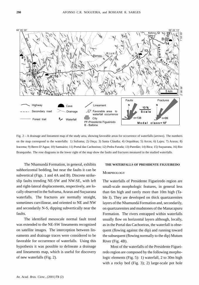
The major identified-lineaments are trending
preferentially to NE-SW and NW-SE, concentrated
between 0◦- 40◦NE and 10◦- 50◦NW. E-W and N-
S orientated lineaments are subordinated. Locally,
the lineaments show romboedral-shaped patterns,
formed by NE-SW and NW-SE conjugated sets,
sometimes associated with right-lateral and left-
lateral brittle strike-slip faults (Fig. 2).
The field surveys consisted mainly in the recog-
nition of planar and linear rock structures, seeking
to understand their geometry and age relationships.
The commonly observed features in the waterfalls
are faults and fractures plans with the same direc-
tion of the falls. The fault scarps have a NE-SW
direction, dipping steeply to NW or SE, and show
straight and subordinated slightly curved geometry
(Fig. 3). As isolated faults, with up to 30m of normal
displacements, there is the Paredão Waterfall, or as
composite stepped fault scarps like in Santa Cláu-
dia, Onça, Iracema,Araras and Suçuarana waterfalls
(Fig. 3). The normal component of these discontinu-
ities have been inferred by bed displacements, and
by scarce and little preserved steeply dipping stria-
tions.
AABC 73 2 t4
An. Acad. Bras. Cienc., (2001)73 (2)
290 AFONSO C.R. NOGUEIRA, and ROSEANE R. SARGES
1
34
5
6
78
9
16
10
11
12
13
14
15
Ri v
er
Ua
tu
mã
R i v e rBarreto
OnçaM
utu
mR
iver
Riv
er R
iver
Veado
s
Uru
buíR
iver
R i v e r
U r u b u
BR
-174
B
AM- 240
59 22’ 13“0
20
8’5
8“
0
60 05’ 00“0
15
3’0
5“
0
2
Secondary road
Highway
Favorable area towaterfall occurrence
Lineament
Drainage
CityForest trail Waterfall8
Cave
Balbinalake
N N
n=138 n=99
M o d a l c l a s s = 10o
M o d a l c l a s s = 10o
S c a l eS c a l e
10 %10 %
Faults Fractures
PF
PF-Presidente FigueiredoB - Balbina
5 km
Fig. 2 – A drainage and lineament map of the study area, showing favorable areas for occurrence of waterfalls (arrows). The numbers
on the map correspond to the waterfalls: 1) Suframa; 2) Onça; 3) Santa Cláudia; 4) Orquídeas; 5) Arcos; 6) Lajes; 7) Araras; 8)
Iracema; 9) Berro D’Agua; 10) Santuário; 11) Portal das Cachoeiras; 12) Pedra Furada; 13) Paredão; 14) Bica; 15) Suçuarana, 16) Rio
Branquinho. The rose diagrams in the lower right of the map show the faults and fractures measured in the studied waterfalls.
The Nhamundá Formation, in general, exhibits
subhorizontal bedding, but near the faults it can be
subvertical (Figs. 1 and 4A and B). Discrete strike-
slip faults trending NE-SW and NW-SE, with left
and right-lateral displacements, respectively, are lo-
cally observed in the Suframa,Araras and Suçuarana
waterfalls. The fractures are normally straight,
sometimes curvilinear, and oriented to NE and NW
and secondarily N-S, dipping subvertically near the
faults.
The identified mesoscale normal fault trend
was extended to the NE-SW lineaments recognized
on satellite images. The interception between lin-
eaments and drainage traces were considered to be
favorable for occurrence of waterfalls. Using this
hypothesis it was possible to delineate a drainage
and lineaments map, which is useful for discovery
of new waterfalls (Fig. 2).
THE WATERFALLS OF PRESIDENTE FIGUEIREDO
Morphology
The waterfalls of Presidente Figueiredo region are
small-scale morphologic features, in general less
than 6m high and rarely more than 10m high (Ta-
ble I). They are developed on thick quartzarenites
layers of the Nhamundá Formation and, secondarily,
on quartzarenites and mudstones of the Manacapuru
Formation. The rivers entrapped within waterfalls
usually flow on horizontal layers although, locally,
as in the Portal das Cachoeiras, the waterfall is obse-
quent (flowing against the dip) and running toward
the subsequent (flowing normally to the dip) Mutum
River (Fig. 4B).
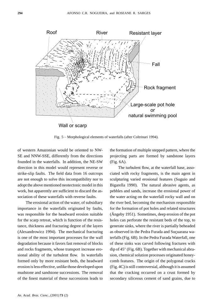
Most of the waterfalls of the Presidente Figuei-
redo region are composed by the following morpho-
logic elements (Fig. 5): 1) waterfall, 2 to 30m high
with a rocky bed (Fig. 3); 2) large-scale pot hole
An. Acad. Bras. Cienc., (2001)73 (2)
AABC 73 2 t4

CHARACTERIZATION AND GENESIS OF WATERFALLS OF PRESIDENTE FIGUEIREDO 291
Fig. 3 – General aspects of fault scarps. A) Paredão Waterfall. B) Onça Waterfall, showing a rock slice detached from the fault plain
(arrow). C) Fall preceeding the Iracema Waterfall. Scale bar is 3m.
TABLE I
Main characteristics of the studied waterfalls.
W a t e r f a l l / L i t h o l o g y S t r u c t u r e / M o r p h o l o g y F e a t u r eH e i g h t ( m ) Sandstone Mudstone Stratification Trace Scarp Honey- Pot Sink Cave Cracks
fossil comb hole hole
Araras / 8 * * *Arcos / 1,5 * * *Berro D’Água / 2,5 *Bica / 4 * *Iracema / 10 * * * * * * *Lajes / 1,7 * * * * * *Onça / 5 * * *Orquídeas / 6 * * *Paredão / 30 * * *Pedra Furada / 6 * * * * * *Portal dasCachoeiras / 3 * * * * *Santa Cláudia / 4 * * * * * *Santuário / 15 * * *Suçuarana / 12 * * * *Suframa / 6 * * * *Rio Branquinho * *
AABC 73 2 t4
An. Acad. Bras. Cienc., (2001)73 (2)

292 AFONSO C.R. NOGUEIRA, and ROSEANE R. SARGES
Fig. 4 – Morphologic aspects of the Portal das Cachoeiras Waterfall. A) The subsequent
behavior of the Mutum River flowing on rotate beds of the Nhamundá sandstones. The
letters "a", "b" and "c" refer, respectively, the pot hole feature,Skolithos-like traces detached
by erosive water action, and honeycomb structure. B) Obsequent main fall (flow contrary to
the dipping). Scale bar is 3m. C) Polygonal cracks.
An. Acad. Bras. Cienc., (2001)73 (2)
AABC 73 2 t4

CHARACTERIZATION AND GENESIS OF WATERFALLS OF PRESIDENTE FIGUEIREDO 293
(or natural swimming pool), scoured at the base of
the waterfall by impact of water, enlarged by rocky
fragments transported by the river (Fig. 4B); 3) roof,
restricted to waterfalls with layers more resistant to
erosion, which is situated at the top of waterfall; 4)
and scarp (or wall), representing the fault plane more
or less retreated by water erosion (Fig. 3). The main
characteristics of the studied waterfalls are summa-
rized in Table I.
At the bottom and margin of rivers with water-
falls there are smaller pot holes (Fig. 4Aa). Some-
times, they have been developed followingSko-
lithos-like traces and fractures, as in the Urubuí
River rapid in Presidente Figueiredo town or in the
Lajes, Iracema and Portal das Cachoeiras waterfalls
(Fig. 4Ab). There are also sandstones with honey-
comb solution features, which sometimes confused
with pot holes, besides tortoise shell-like polygonal
cracks are found in Iracema, Portal das Cachoeiras
and Lajes waterfalls (Figs. 4Ac and 4C). Sink hole
morphology was found mainly on waterfall roof
resistant layers. Its cylindrical shape, where the
stream is beheaded, sometimes is tilted up to 45◦
in relation to the subhorizontal roof (Fig. 6). In
Suframa and Pedra Furada waterfalls, centimetric
layers of silicified-sandstone, form a positive relief
on the wall of finer material with a stepped pattern
(Fig. 6A).
The standard morphology of the waterfalls
(Fig. 5) is suitable to the waterfalls formed in fault
scarps; however, it could not be applied to the water-
falls controlled by pseudokarstic relief features. The
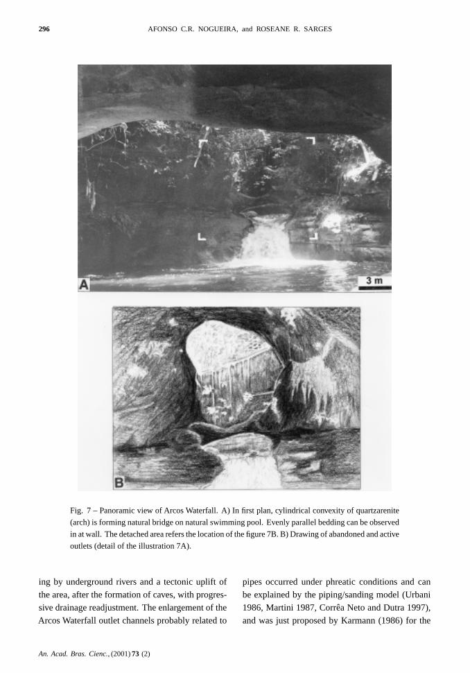
morphology of the Arcos Waterfall area is charac-
terized by three quartzarenite biconvex projections,
whose convexities (arches) are cylindrical with a di-
ameter of 3m and length of 14m, distant themselves
by 12m (Fig. 7). The central part of these biconvexi-
ties forms an elliptical outlet channel with a diameter
of 1 to 6m, that can be active or abandoned. The ac-
tive outlet is draining the stream to form the main
fall of the Arcos Waterfall. In contrast, the aban-
doned outlet rises about 2,5m above the water level
and, sometimes, form natural bridges on the river
(Fig. 7).
Origin
The geological control of waterfalls is well known,
and usually they represent a significant evidence for
faulting or fracturing (Schwarzbach 1967, Philbrick
1970, Barcha and Arid 1975, Young 1985,
Deffontaines and Chorowicz 1991, Alexandrowicz
1994). On the other hand, erosional action of wa-
ters upon beds of different resistance degrees and the
underground rivers surging can also generate water-
falls (Holmes 1966, Schwarzbach 1967, Christofo-
letti 1974, 1981, Coltrinari 1994). The occurrence
of normal faults and fractures, usually with the same
direction of the wall of the falls, the presence of
stratigraphic displacements and of the tilted beds
(Figs. 3 and 4) suggest that the Presidente Figueiredo
waterfalls were mainly controlled by tectonics. The
juvenile nature of the rivers truncated by the NE-
SW fault and/or lineaments, incised within rocks of
the Nhamundá and Manacapuru formations, without
floodplains, as well as displacements of Tertiary-
Quaternary lateritic levels developed on Late Creta-
ceous rocks (Fig. 1), suggest that Quaternary tecton-
ics generated these features. The importance of NE-
SW and NW-SE trending lineaments in the Amazo-
nian region, as identified in this work (Fig. 1), was
firstly recognized by Sternberg (1950) and corrobo-
rated by several authors (Franzinelli and Igreja 1990,
Costa et al. 1993, Costa et al. 1996). Particularly in
the studied area, Nogueira et al. (1997) recognized
these trend controllinggraben structures that con-
fine the Cretaceous sediments of the Alter do Chão
Formation, and promote vertical displacements of
Upper Tertiary-Quaternary lateritic profiles. The
neotectonic studies carried out in the Amazonian
region have been developed in order to character-
ize these tectonic movements (Costa et al. 1988,
Franzinelli and Piuci 1988, Franzinelli and Igreja
1990, Silva et al. 1994, Costa et al. 1996, Fer-
nandes Filho et al. 1997). This event has been at-
tributed to the displacement of the South American
Plate to west since the Miocene (Costa et al. 1996).
In this model, that suggest the action of an intraplate
right-lateral binary, the normal neotectonic faults
AABC 73 2 t4
An. Acad. Bras. Cienc., (2001)73 (2)
294 AFONSO C.R. NOGUEIRA, and ROSEANE R. SARGES
Roof River Resistant layer
Fall
Rock fragment
Large-scale pot holeor
natural swimming pool
Wall or scarp
Fig. 5 – Morphological elements of waterfalls (after Coltrinari 1994).
of western Amazonian would be oriented to NW-
SE and NNW-SSE, differently from the directions
founded in the waterfalls. In addition, the NE-SW
direction in this model would represent reverse or
strike-slip faults. The field data from 16 outcrops
are not enough to solve this incompatibility nor to
adopt the above mentioned neotectonic model in this
work, but apparently are sufficient to discard the as-
sociation of these waterfalls with reverse faults.
The erosional action of the water, of subsidiary
importance in the waterfalls originated by faults,
was responsible for the headward erosion suitable
for the scarp retreat, which is function of the resis-
tance, thickness and fracturing degree of the layers
(Alexandrowicz 1994). The mechanical fracturing
is one of the most important processes for the wall
degradation because it favors fast removal of blocks
and rocks fragments, whose transport increase ero-
sional ability of the turbulent flow. In waterfalls
formed only by more resistant beds, the headward
erosion is less effective, unlike those developed upon
mudstone and sandstone successions. The removal
of the finest material of these successions leads to
the formation of multiple stepped pattern, where the
projecting parts are formed by sandstone layers
(Fig. 6A).
The turbulent flow, at the waterfall base, asso-
ciated with rocky fragments, is the main agent in
sculpturing varied erosional features (Suguio and
Bigarella 1990). The natural abrasive agents, as
pebbles and sands, increase the erosional power of
the water acting on the waterfall rocky wall and on
the river bed, becoming the mechanism responsible
for the formation of pot holes and related structures
(Ängeby 1951). Sometimes, deep erosion of the pot
holes can perforate the resistant beds of the top, to
generate sinks, where the river is partially beheaded
as observed in the Pedra Furada and Suçuarana wa-
terfalls (Fig. 6B). In the Pedra Furada Waterfall, one
of these sinks was carved following fractures with
dip of 45◦ (Fig. 6B). Together with mechanical abra-
sion, chemical solution processes originated honey-
comb features. The origin of the polygonal cracks
(Fig. 4C) is still controversial, although it is assumed
that the cracking occurred on a crust formed by
secondary siliceous cement of sand grains, due to
An. Acad. Bras. Cienc., (2001)73 (2)
AABC 73 2 t4

CHARACTERIZATION AND GENESIS OF WATERFALLS OF PRESIDENTE FIGUEIREDO 295
Fig. 6 – Pedra Furada Waterfall. A) The general aspects and rock of the wall repre-
sented by interbedded shales and basal stratified sandstones and massive sandstone
in the top perforated by two sinks (dry period). Scale bar is 3m. B) Detail of the
sinks (in plant) in flood period. Scale bar is 0,5m.
changes in the temperature and moisture (Robinson
and William 1989).
The tectonic processes recognized in almost
all of the studied waterfalls, cannot be applied to
the origin of Arcos, Pedra Furada and Bica water-
falls. The features in arches, sheltered caves and
outlet channels (Fig. 7) resemble to morphologic el-
ements of pseudokarstic relief, common in the stud-
ied area (Fig. 2), being originated in part by dis-
solution and mainly by hydrodynamic removal of
grains during the formation of these waterfalls. The
higher position and the larger diameter of the aban-
doned in relation to the actives outlets of the Arcos
Waterfall (Fig. 7B) indicate an intense rock rework-
AABC 73 2 t4
An. Acad. Bras. Cienc., (2001)73 (2)
296 AFONSO C.R. NOGUEIRA, and ROSEANE R. SARGES
Fig. 7 – Panoramic view of Arcos Waterfall. A) In first plan, cylindrical convexity of quartzarenite
(arch) is forming natural bridge on natural swimming pool. Evenly parallel bedding can be observed
in at wall. The detached area refers the location of the figure 7B. B) Drawing of abandoned and active
outlets (detail of the illustration 7A).
ing by underground rivers and a tectonic uplift of
the area, after the formation of caves, with progres-
sive drainage readjustment. The enlargement of the
Arcos Waterfall outlet channels probably related to
pipes occurred under phreatic conditions and can
be explained by the piping/sanding model (Urbani
1986, Martini 1987, Corrêa Neto and Dutra 1997),
and was just proposed by Karmann (1986) for the
An. Acad. Bras. Cienc., (2001)73 (2)
AABC 73 2 t4

CHARACTERIZATION AND GENESIS OF WATERFALLS OF PRESIDENTE FIGUEIREDO 297
genesis of the Refúgio do Maroaga Cave.
The piping/sanding model assumes a base level
stability and low gradient of the phreatic zone, as-
sociated to slow groundwater flow that favored par-
tial dissolution of silica (White et al. 1966). As
mentioned by Corrêa Neto and Dutra (1997), this
dissolution could be most active through rock dis-
continuities giving rise to higher porosity and per-
meability zones where the rock would be mechan-
ically weakened concentrating the water flow. The
uplift of the area would increase the slope and the
underground water flow speed, which increases me-
chanically the removal of the quartz grains and forms
cylindrical pipes which would enlarge to form gal-
leries and chambers. Most of the studies concerning
to formation of caves in sandstone assumes an ini-
tial period of water table stability and subsequent
uplift (Young 1986, Urbani 1986, Martini 1987). In
the studied area, the relief dissection processes pro-
moted collapse of the cave roofs resulting locally in
a residual relief with inselbergs, as exemplified by
the current morphologic configuration of the Arcos
Waterfall area (Fig. 7).
Evolution
At the end of Neogene, the quartzarenites of Nha-
mundá Formation, in Presidente Figueiredo region,
suffered chemical solution due to the phreatic zone
stability, intensified by the action of humic acids
supplied by rainforest vegetable remains (Fig. 8B1).
The groundwater flow promoted the mechanical re-
moval of the friable portions of sandstones, and led
to the development of cave morphologic elements
such as galleries, columns and sinks mainly con-
trolled by older structural features (Fig. 8B2).
During the Quaternary, the Presidente Figuei-
redo region was affected by a brittle tectonic event
that caused a drainage readjustment. NE-SW trend-
ing normal faults, generated during this event, sec-
tioned the rivers fit in NW-SE trending lineaments,
originating decametric to metric displacements and,
eventually, bedding tilting in the Nhamundá Forma-
tion generating the waterfalls (Figs. 8A1 and 8A2).
The uplifted blocks (horsts) imposed the va-
dose zone to develop caves, causing subterranean
rivers readjustments (Fig. 8B2). Local hollowing
out and subsequent collapse of less resistant rocks
along fault plans promoted scarps retreating
(Fig. 8A3).
The intense morphologic dissection imposed
by the climatic and tectonic phenomena contributed
for the cave dismantlement. The continuity of the
denudation processes led to the current configura-
tion of the region, with areas locally exhibiting a
residual relief where waterfalls was installed
(Fig. 8B3).
CONCLUSIONS
The waterfalls of Presidente Figueiredo were
formed, in general, by sectioning of rivers by NE-
SW trending normal faults with metric displace-
ment , supposedly of Quaternary age . However ,
some Quaternary waterfalls are controlled by
a pseudokarstic relief, probably formed during the
Late Tertiary-Early Quaternary, as well exemplified
by the Arcos Waterfall.
The morphologic, geological and genetic dif-
ferences observed in the studied waterfalls allowed
the identification of two categories of waterfalls: de-
veloped from normal faults, exemplified by Sufra-
ma, Onça, Santa Cláudia, Lajes, Iracema, Araras,
Orquídeas, Berro D’Água, Santuário, Portal das Ca-
choeiras, Paredão, Suçuarana and Rio Branquinho
waterfalls, and those controlled by pseudokarstic
features, as exemplified by Arcos, Pedra Furada and
Bica waterfalls.
The siliciclastic rocks of the waterfalls beds
belong to the Nhamundá and Manacapuru forma-
tions of the Trombetas Group, whose ages have been
attributed, respectively, to Upper Ordovician-
Wenlockian(±410Ma) and Pridolian-Lochkovian
(±400Ma). However, it is known, in adjacent areas,
occurrence of waterfalls developed in rivers flowing
on Proterozoic igneous rocks of the Uatumã Super-
group.
The identification of lineaments and drainage
interceptions, considered in this work as favorable
AABC 73 2 t4
An. Acad. Bras. Cienc., (2001)73 (2)

298 AFONSO C.R. NOGUEIRA, and ROSEANE R. SARGES
Abandoned outlet
Uplift
Fractures
Rainforest
Cave system
Flow
Resistantlayer
Bedding
Retreated scarp
A B
1)
2)
3)
1)
2)
3)
Fault
Fig. 8 – Block diagrams summarizing the evolution of the Presidente Figueiredo waterfalls. A) Waterfalls developed from normal
faults: 1) Area before tectonism; 2) intersecting of rivers for normal faults, originating waterfalls; and 3) hollowing out and consequent
collapse of the wall composed of weakened rocks, promoting escarpment retreat. B) Waterfalls controlled by pseudokarstic relief,
exemplified by Arcos Waterfall: 1) Caves and pipes formed by dissolution and hydrodynamic removal in the phreatic zone; 2) uplift of
the area and intensification of processes of cave formation and beginning of relief dissection 3) present configuration of the waterfall
area, with ruiniform relief sculptured upon ancient pseudokarstic features.
areas to the waterfalls occurrence, can help in the
discovery of new sites with this morphology, allow-
ing an accurate evaluation of the touristic potential
of the Presidente Figueiredo municipality.
ACKNOWLEDGEMENTS
The authors are grateful to Universidade do Ama-
zonas, for the logistic and financial support and to
CNPq by an undergraduate fellowship to the second
author inserted in the “O Neocenozóico da Amazô-
nia Ocidental” CNPq project (Grant no. 520243/98-
6). Critical reviews by Kenitiro Suguio, Werner
Truckenbrodt, Clauzionor Silva, Claudio Riccomi-
ni, Alexei Kerkis and two anonymous referees are
highly appreciated in the final text. Special thanks
to Emílio Soares and Valmir Souza for discussions
and field assistance.
RESUMO
As cachoeiras da região de Presidente Figueiredo cons-
tituem um dos mais fascinantes cenários naturais do nor-
deste do Estado doAmazonas, norte do Brasil. As quedas,
geralmente com menos de 10m de altura, são desenvolvi-
das em rochas siliciclásticas das formações Nhamundá
An. Acad. Bras. Cienc., (2001)73 (2)
AABC 73 2 t4

CHARACTERIZATION AND GENESIS OF WATERFALLS OF PRESIDENTE FIGUEIREDO 299
(Siluriano inferior) e Manacapuru (Siluriano superior-
Devoniano inferior). Os estudos morfológico e estrutu-
ral dessas feições indicam que a maioria dessas quedas
de água originaram-se por neotectônica quaternária e en-
contram-se instaladas em escarpas de falhas normais NE-
SW. Ocorrem, ainda, com menor freqüência, cachoeiras
evoluídas a partir de feições pseudocársticas.
A origem das cachoeiras de Presidente Figueiredo prova-
velmente remonta ao Neógeno, quando a região estava su-
jeita aos processos de lateritização associados a um clima
úmido em densa cobertura vegetal. Tais condições fa-
voreceram o desenvolvimento de cavernas nos quartzo-
arenitos da Formação Nhamundá. Posteriormente, du-
rante o Quaternário, a região foi afetada por falhas normais
NE-SW que deslocaram perfis lateríticos, rios e igarapés,
originando as cachoeiras. Esses fenômenos climáticos
e tectônicos proporcionaram uma intensa dissecação do
relevo da região, indicado pelo recuo das escarpas de
falha e pelo desmantelamento de cavernas, responsável
pela configuração morfológica atual da região.
Palavras-chave: cachoeiras, Amazônia ocidental, Tec-
tônica quaternária, pseudocarste.
REFERENCES
Alexandrowicz Z. 1994. Geologically controlled wa-
terfall types in the Outer Carpathians. Geomorphol-
ogy 9: 155-165.
Ängeby O. 1951. Pothole erosion in recent water falls.
Lund Stud Geogr A 2: 1-34.
Barcha SF and Arid FM. 1975. Origem das cachoeiras
da Bacia do Alto Paraná. Rev Bras Geoc 5: 120-135.
Christofoletti A. 1974. Geomorfologia. 4.ed. São
Paulo: Edgard Blücher, p. 46.
Christofoletti A. 1981. Geomorfologia fluvial: o
canal fluvial. 1.ed. São Paulo: Edgard Blücher, p.
1-243.
Coelho GL. 1994. Relatório final de estágio na área
de palinologia. Rio de Janeiro, PETROBRÁS -
CENPES/DIVEX/SEBIPE, 22p. (Relatório interno).
Coltrinari L. 1994. A Terra. São Paulo: Ática, p. 36.
Corrêa Neto AV and Dutra G. 1997. A Província
Espeleológica Quartzítica de Andrelândia, sudeste
de Minas Gerais. In: Congresso Brasileiro de Es-
peleologia, 24., Ouro Preto. Anais..., Ouro Preto,
SEE/SBE, 1964. p. 57-64.
Costa JBS, Hasui Y, Bemerguy RL, Borges MS,
Costa AR, Travassos W, Mioto JA and Igreja
HLS. 1993. Aspectos fundamentais de Neotec-
tônica daAmazônia brasileira. In: Simpósio Interna-
cional do Quaternário da Amazônia, 1., Manaus. Re-
sumos..., Manaus, FUA/INPA/UNESCO, 1993. p.
103-105.
Costa JBS, Bemerguy RL, Hasui Y, Borges MS,
Ferreira Júnior CRP, Bezerra PEL, Costa
ML and Fernandes JMG. 1996. Neotectônica
da região Amazônica: aspectos tectônicos, geomor-
fológicos e deposicionais. Geonomos 4: 23-24.
Costa ML. 1991. Aspectos geológicos dos lateritos da
Amazônia. Rev Bras Geoc 21: 146-160.
Costa ML, Horbe AMC, Horbe MA, Teixeira JT
and Costa WAMC. 1988. A Região bauxítica do
Pitinga (AM). In: Congresso Brasileiro de Geologia,
35., Belém. Anais..., Belém, SBG, 1998. 1: 256-
269.
Costa RCR, Filho NT and Oliveira AAB. 1978.
Geomorfologia. In: Brasil. Projeto RADAM-
BRASIL. Folha SA.20 Manaus. Rio de Janeiro:
CPRM/DNPM, 18: 167-244. (Levantamento de
Recursos Naturais).
Cunha PRC, Gonzaga FG, Coutinho LFC and
Feijó FJ. 1994. Bacia do Amazonas. Bol Geoc
Petrobrás 8: 47-55.
Deffontaines B and Chorowicz J. 1991. Principles
of drainage basin analysis from multisource data: ap-
plication to the structural analysis of the Zaire Basin.
Tectonophysics 194: 237-263.
Dino R, Silva OB and Abrahão D. 1999. Pa-
lynological and stratigraphic characterization of the
Cretaceous strata from the Alter do Chão Formation,
Amazonas Basin. In: Simpósio sobre o Cretáceo do
Brasil and Simpósio sobre el Cretácico de América
del Sur 5., Serra Negra. Boletim..., Serra Negra,
1999. p. 557-565.
Fernandes Filho LA, Costa ML and Costa JBS.
AABC 73 2 t4
An. Acad. Bras. Cienc., (2001)73 (2)

300 AFONSO C.R. NOGUEIRA, and ROSEANE R. SARGES
1997. Registros neotectônicos nos lateritos de Ma-
naus – Amazonas. Geociências 16: 9-33.
Franzinelli E and Igreja HLS. 1990. Utiliza-
ção do sensoriamento remoto na investigação da
área do baixo Rio Negro e Grande Manaus. In:
Simpósio Brasileiro de Sensoriamento Remoto,
6., Rio de Janeiro. Anais..., Rio de Janeiro,
INPE/SELPER/ISPRS/SBC, 1990. 3: 641-648.
Franzinelli EandPiuci J.1988. Evidências de neotec-
tonismo na BaciaAmazônica. In: Congresso Latino-
Americano de Geologia, 7., Belém. Anais..., Belém,
SBG, 1988. p. 80-90.
Grahn Y. 1991. Ordovician chitinozoa and biostratigra-
phy of Brazil. Geobios 25: 703-723.
GrahnY. 1992. Revision of Silurian and Devonian strata
of Brazil. Palinology 16: 35-61.
Holmes A. 1966. Geología física. 5.ed. Barcelona:
Omega SA, p. 90-113.
Horbe AMC, Costa ML, Fernandes Filho LA and
Oliveira ZC. 1997. Caracterização de latossolos
desenvolvidos sobre crostas alumino-ferruginosas
lateríticas com base na mineralogia e elementos-
traço. In: Congresso Brasileiro de Geoquímica, 6.,
Salvador. Anais..., Salvador, SBGq, 1997. 2: 547-
549.
Horbe AMC, Nogueira ACR, Horbe MA, Costa ML
and Suguio K. 2000. A lateritização na gênese das
superfícies de aplanamento da região de Presidente
Figueiredo-Vila de Balbina, nordeste do Amazonas
In: Contribuições à Geologia da Amazônia. Belém:
FINEP/SBG-Núcleo Norte. (in press).
Karmann I. 1986. Caracterização geral e aspectos
genéticos da gruta arenítica Refúgio do Maroaga,
AM-02. Espeleo-Tema 15: 9-18.
Martini J. 1987. Karst features in quartzite of South
Africa. Karstologia 9: 45-52.
Nascimento DA, Mauro CA and Garcia MGL.
1976. Geomorfologia. In: Brasil. Projeto RADAM-
BRASIL. Folha SA.21 Santarém. Rio de Janeiro:
CPRM/DNPM, 10: 131-181. (Levantamentos de
Recursos Naturais).
Nogueira ACR and Soares EAA. 1996. Fácies se-
dimentares da Formação Prosperança, Proterozóico
Superior da Bacia do Amazonas, ao norte da cidade
de Manaus. In: Simpósio de Geologia da Amazônia,
5., Belém. Resumos..., Belém, SBG, 1996. p. 214-
216.
Nogueira ACR, Souza V and Soares EAA. 1997.
Contribuição à tectônica cenozóica da região de Pre-
sidente Figueiredo, norte de Manaus-AM. In: Simpó-
sio Nacional de Estudos Tectônicos, 6., Pirinópolis.
Resumos..., Pirinópolis, SBG, 1997. p. 123-125.
Philbrick SS. 1970. Horizontal configuration and the
rate of erosion of Niagara Falls. Geol Soc Am Bull
81(12): 3723-3731.
Robinson DA and William RBG. 1989. Polygonal
cracking of sandstone at Fontainebleau, France. Z
Geomorphol NF 33(1): 59-72.
Santos JOS. 1984. A Parte setentrional do cráton Ama-
zônico (Escudo das Guianas) e a Bacia Amazônica.
In: Schobbenhaus C et al. (Coord.). Geologia do
Brasil. Brasília: DNPM, p. 57-88.
Schobbenhaus C and Campos DA. 1984. A Evolução
da plataforma sul-americana no Brasil e suas prin-
cipais concentrações minerais. In:Schobbenhaus
C et al. (Coord.). Geologia do Brasil. Brasília:
DNPM, p. 9-49.
Schwarzbach KVM. 1967. Islandische Wasserfälle
und eine genetische systematik der wasserfälle über-
haupt. Z Geomorphol NF 11(4): 377-417.
Silva CL, Costa SS and Carvalho JS. 1994. Um
estudo preliminar neotectônico na cidade da Manaus-
AM. In: Simpósio Nacional de Estudos Tectônicos,
5., Rio Claro. Resumos..., SBG, 1994. p. 438-439.
Soares EAA, Truckenbrodt W and Nogueira ACR.
1998. Depósitos glácio-costeiros da Formação Nha-
mundá, Siluriano inferior da Bacia dos Amazonas,
Região de Presidente Figueiredo-AM. In: Congresso
Brasileiro de Geologia, 40., Belo Horizonte. Bol Re-
sumos..., Belo Horizonte, SBG, 1998. p. 99.
Sternberg HO. 1950. Vales tectônicos na planície ama-
zônica? Rev Bras Geogr 12(4): 3-26.
Suguio K and Bigarella JJ. 1990. Ambientes fluviais.
2.ed. Florianópolis: Ed UFSC/UFPr, p. 1-83.
An. Acad. Bras. Cienc., (2001)73 (2)
AABC 73 2 t4

CHARACTERIZATION AND GENESIS OF WATERFALLS OF PRESIDENTE FIGUEIREDO 301
Urbani F. 1986. Notes on the origin of caves in pre-
cambrian quartzites of Roraima Group, Venezuela.
Interciência 11: 298-300.
White WB, Jefferson GL and Haman JF. 1966.
Quartzite karst in southeastern Venezuela. Interna-
tional Journal of Speleology 2: 309-314.
Young RW. 1985. Waterfalls: form and processes. Z
Geomorphol NF suppl 55: 81-95.
Young RW. 1986. Tower karst in sandstone: Bungle
Bungle massif, Northeastern Australia. Z Geomorph
N F 30: 189-202.
AABC 73 2 t4
An. Acad. Bras. Cienc., (2001)73 (2)