Budget Report Analysis and Budget Realization Refocusing ...
Jose A. Marengo
Characteristics and spatio-temporal variability of the AmazonRiver Basin Water Budget
Received: 5 November 2003 / Accepted: 11 May 2004 / Published online: 11 December 2004� Springer-Verlag 2004
Abstract The spatio-temporal variations of the waterbudget components in the Amazon region are investi-gated by using a combination of hydrometeorologicalobservations and moisture fluxes derived from theNCEP/NCAR reanalyses, for the period 1970–1999. Thekey new finding of this study identifies the major dif-ferences in the water balance characteristics and vari-ability between the northern and southern parts of thebasin. Our results show that there is a seasonality andinterannual variability of the water balance that variesacross the basin. At interannual time scales, anomaliesin the water balance components in the northern Ama-zon region show relatively stronger links with tropicalPacific interannual variability. Over the entire region,precipitation exceeds evaporation and the basin acts as asink of moisture (P>E). However, on some occasionsthe basin can act as a source for moisture (P<E) underextreme conditions, such as those related to deficientrainfall in northern Amazonia during the strong El Ninoof 1983. Our estimates of the Amazon region’s waterbalance do not show a closure of the budget, with anaverage imbalance of almost 50%, suggesting that someof the moisture that converges in the Amazon region isnot accounted for. The imbalance is larger over thesouthern Amazon region than over the northern region,and it also exhibits interannual variability. Largeuncertainties are detected in the evaporation and mois-ture-convergence fields derived from the reanalyses, andin the case of evaporation it can be as large as 10–20%when compared with the few field observations acrossthe basin. Observed precipitation fields derived fromstation data and from grid-box products also show somediscrepancies due to sampling problems and interpola-tion techniques. The streamflow observed at the mouth
of the river is obtained after corrections on the seriesobserved taken at a gauging site almost 200 km inland.However, variability in the evaporation, moisture con-vergence, and observed rainfall and runoff matches quitewell.
Keywords Amazon region Æ Water balance Æ Moisturetransport Æ Precipitation
1 Introduction
In discussing the hydrology of the Amazon region, theemphasis of previous studies has been on the movementof water in the terrestrial system, considering precipita-tion and potential evapotranspiration as the forcing andstreamflow and storage as the response. In this context,water that evaporates from the land surface is lost to thesystem if advected out of the prescribed region byatmospheric motion, but recycled in the system if it fallsagain as precipitation. On the other hand, the atmo-spheric approach that focuses on the water balance dealswith the dynamics and thermodynamics of the atmo-sphere at larger scales. The moisture evaporates fromland surfaces, thus acting not only as a source of waterfor later precipitation, but also changing the thermo-dynamic structure of the atmosphere through the alter-ation of the circulation and rainfall.
The hydrological cycle of the Amazon region is ofgreat importance as the region plays an important rolein the functioning of regional and global climate. Vari-ations in its regional water and energy balances at year-to-year and longer time scales are of special interest,because alterations in circulation and precipitation cantranslate ultimately to changes in the streamflow of theAmazon River. In addition, these changes can also affectthe atmospheric moisture transport from the Amazonregion to adjacent regions. Since the late 1970s, largescale water-budget studies have been conducted for this
J. A. MarengoCPTEC/INPE, Rodovia Dutra km. 40, 12630-000 CachoeiraPaulista, Sao Paulo, BrazilE-mail: [email protected].: +55-12-31868464Fax: +55-12-31012835
Climate Dynamics (2005) 24: 11–22DOI 10.1007/s00382-004-0461-6
region using a variety of observational data sets varyingfrom radiosondes to global reanalyses (Salati 1987;Matsuyama 1992; Eltahir and Bras 1994; Vorosmartyet al. 1996; Rao et al. 1996; Costa and Foley 1999; Curtisand Hastenrath 1999; Zeng 1999; Labraga et al. 2000;Roads et al. 2002; and references quoted therein), andmost of them discuss the impacts of remote forcing inthe variability of the components of the water balance,as well as the role of evapotranspiration in the waterbalance.
The surface and upper-air observational network inthe Amazon region is scarce, and by itself cannot pro-vide the comprehensive and complete informationneeded to initialize numerical models to develop ade-quate energy and water-balance estimates. In most ofthe cases, we have to rely on imperfect models orproducts from data assimilation or gridded reanalysesand rainfall data sets to augment the scarce observa-tions. Major numerical simulation centers, including theNational Centers for Environmental Prediction(NCEP), European Centre for Medium Range WeatherForecasts (ECMWF), and National Aeronautics andSpace Administration/Data Assimilation Office (NASA/DAO), have carried out retrospective analysis (reanaly-ses) projects over the last decade, each using a singlemodel and data assimilation to represent climate evo-lution since as early as World War II. These reanalysescan highlight characteristic features of the circulationand water balance. However, while data assimilationshould in principle provide a description of the waterflux field, there are no guarantees that this descriptionwill be superior to that obtained from objective analysisand radiosonde observations alone, especially overcontinental regions, and there is a need for the level ofuncertainty to be identified in the measurement or esti-mation of the components of the water budget (Seereviews in Kalnay et al. 1996; Roads et al. 2002).
The availability of these global reanalyses, togetherwith the currently available gridded climatology pre-cipitation data sets: Climate Prediction Center MergedAnalysis Precipitation (CMAP), Global PrecipitationClimatology Project (GPCP), Climate Research Unit(CRU), Global Historical Climatology Network(GHCN), and the rainfall field from the NCEP reanal-yses, offer the prospect of comprehensive near-globalclimatology needed to estimate the components of thewater balance, with horizontal resolutions varying from0.50� by 0.50� to 2.50� by 2.50� latitude–longitude.However, these data sets cover only the recent decades,and, for most of their coverage periods, they rely oninterpolation techniques or satellite-based estimates inregions with poor data coverage, as in central andnorthwestern Amazonia. By using observations, rea-nalyses, or a combination of both, the atmospheric andsurface hydrologic budgets are difficult to balance, sincesometimes errors in measurements of precipitation andrunoff may be of the same order of magnitude as thedifference of precipitation minus runoff. Although it is adifficult standard to establish, river runoff appears to be
a valuable independent variable for testing closure(Marengo et al. 1994).
The closure of the water budget is one of the mainobjectives of Global Energy Water Cycle Experiment(GEWEX), and the Large Scale Biosphere Atmosphere(LBA) Experiment in the Amazon Basin (a component ofGEWEX). Together with similar regional experimentsbeing conducted globally (Roads et al. 2002), the majorfocus has been in developing data sets and models todescribe regional water and energy budgets, as a preludeto analyzing the closure of these budgets, and developingmethods to simulate and predict changes on those bud-gets at interannual and climate-change time scales.
For the present study, we use precipitation fromdifferent data sources (observed and grid-point data),streamflow of the Amazon River, and estimates of inte-grated moisture convergence and evaporation derivedfrom the NCEP reanalyses during 1970–1999, in order toinvestigate the geographical variations in the seasonaland annual means of the water cycle components. Thefocus is on extremes of the interannual variability, spe-cifically in relation to extreme El Nino and La Ninaevents, during the last 30 years for the Amazon regionand its southern and northern divisions. We also exploreuncertainties in atmospheric water-balance estimates, theclosure of the water balance in the region, investigatepossible reasons for these imbalances, and test thedependence of this closure on different rainfall data setsavailable for the basin.
2 Data and methodology
2.1 Data
The components of the atmospheric water balance in theAmazon River Basin are studied using a combination ofobservations (station and gridded data) and the globalreanalyses. Rainfall that was observed was averagedfrom station data across the entire region, as well as overthe northern and southern sections of the basin. Mar-engo (2004) analyzed these stations and his Fig. 1 dis-plays the domain of the two sub-basins, which can thenbe combined to produce an index for the entire Amazon.Rainfall was seasonalized using the hydrological year(September–August), with rainfall peaking in Decem-ber–January in the southern Amazon region, andMarch–April in the northern Amazon region. Therainfall averages were constructed using monthly datafrom all stations and from all grid boxes fitting withinthe entire basin as within its northern and southernsections. Main basin rainfall is calculated for the entirebasin and sub-basins with a weighted average applied tothe gauged data, and the same procedure was applied tothe gridded data.
Precipitation (P) is computed from rainfall observa-tions in the Amazon region and is derived for the entirebasin, as well as for the northern and southern sectionsof the basin, using the records of 164 stations across the
12 Marengo: Characteristics and spatio-temporal variability of the Amazon River Basin Water Budget

basin derived from Marengo (2004). For comparisonpurposes, we also used gridded rainfall data sets: CMAP(Xie and Arkin 1997), CRU (New et al. 2000), GPCP(Huffman et al. 1997), GHCN (Chen et al. 2001), andthe NCEP reanalyses (Kalnay et al. 1996). Some of thegridded products (CMAP, CRU) used interpolationtechniques to fill gaps in the gauge coverage. Forinstance, in the CRU data set, the rainfall station datawere interpolated as a function of latitude, longitude,and elevation using thin-plate splines. The accuracy ofthe interpolation has been assessed (New et al. 2000)using cross-validation and by comparisons with otherclimatologies.
Streamflow of the Amazon River is measured at thegauging site of Obidos, peaking in May–July. The dis-charge measured at Obidos does not represent the realconditions of water that reaches the mouth of theAmazon, since it does not include the waters of theXingu and Tocantins Rivers (Marengo et al. 1994).Therefore, these values were corrected by the BrazilianNational Water Authority ANA, (de Oliveira E, per-sonal communication) and Zeng (1999) in order toconsider these two rivers and their sub-basin areas. Themean discharge at the Obidos gauging station (01�55¢S,55�28¢W) is 175,000 m3/s (or 2.5 mm/day), while the
corrected values at the mouth of the Amazon reach210,000 m3/s (or 2.9 mm/day). Zeng (1999) and Roadset al. (2002) have used 2.9 and 3.1 mm/day, respectively,for R for the Amazon Basin, which are closer to thecorrected value of 2.9 mm/day.
The NCEP/NCAR reanalyses (Kalnay et al. 1996)are used to estimate precipitable water (W), verticallyintegrated moisture convergence (C), and evaporation(E). The period used in this study for the water-budgetassessment is 1970–1999, mostly because the AmazonRiver streamflow data is available since the 1970s.
2.2 Methodology
For the terrestrial branch of the climate system, thewater-balance equation can be written as:
dsdt¼ P � E � R ð1Þ
where S is the soil water storage, R is the observedrunoff, P is precipitation, and E is evaporation. Mea-surements of R and P are made routinely in the Ama-zon, whereas estimation of S and E has a much weakerobservational basis.
Fig. 1 Mean seasonal rainfall for tropical South America duringDecember–February and March–May based on different griddeddata sources: a DJF-CMAP 1979–1999, b DJF-CRU 1970–1999,
c DJF-NCEP reanalyses 1970–1999, d MAM-CMAP 1979–1999,e MAM-CRU 1970–1999, and f MAM-NCEP reanalyses 1970–1999. Units are mm/day
Marengo: Characteristics and spatio-temporal variability of the Amazon River Basin Water Budget 13

The atmospheric branch of the water balance can beexpressed in the form of a simple equation of verticallyintegrated terms:
dWdt¼ �P þ E þ C ð2Þ
where C is the vertically integrated moisture conver-gence, which can be expressed as
C ¼ �r� Q ð3Þ
where Q is the water-vapor flux estimated followingZeng (1999).
dW/dt in Eq. 2 represents the storage change termand is generally negligible for averages over a month ormore (Roads et al. 1994; Eltahir and Bras 1994; Curtisand Hastenrath 1999; Costa and Foley 1999; Zeng1999). dW/dt can be neglected because changes inatmospheric precipitable water are quite small in sea-sonal time scales (Zeng 1999). Assuming that the storagerate (dS/dt) is small over long time-periods (e.g. 1 year)and then combining Eq. 1 and 2, we obtain Eq. 4:
C ¼ R ð4Þ
The expression 4 indicates that for monthly or longertime scales the vertically integrated moisture conver-gence should be comparable with surface runoff if thewater budget is closed. In a steady state, P�E=R(Baumgartner and Reichel 1975). Short term P–E may,however, differ from R because of changes in storage.Furthermore, P–E different from R may also occur dueto uncertainties in the atmospheric data assimilationsystems for the reanalyses, observational errors in P andR, possible ground water loss, and basin memory effects(Zeng 1999), or poorly represented rainfall for largeparts of Amazonia as they may not be well covered bythe rainfall network.
Thus, an expression of the imbalance of the hydro-logical cycle is shown in Eq. 5:
Imbalance ¼ CR� 1 ð5Þ
P, E, R, E—P, and C are used to investigate seasonaland interannual variability of the water budget in theregion, and are calculated for the northern and southernsections of the basin, and for the entire basin.
3 Results
3.1 Mean distribution of precipitation and evaporationin the basin
Figure 1a–f displays the DJF and MAM seasonal rain-fall derived from the CMAP, CRU, and the NCEPreanalyses. These two seasons represent the peak of therainy season in southern and northern Amazonia,respectively, and compare favorably with seasonal mapsbased on observations (Figueroa and Nobre 1990;
Labraga et al. 2000; Liebmann and Marengo 2001). TheCMAP and CRU data sets show the rainfall featuresthat were observed in the southern Amazon region, suchas the center of 8–10 mm/day during DJF, as well as theabundant rainfall in the region extended between thecentral Amazon and the mouth of the Amazon River.Figure 1a, b, d, and e resembles previous maps based onraingauge data sets (Legates-Willmott, Leemans-Cramer, EOS and GPCP) introduced by Costa andFoley (1998), while rainfall from reanalyses: NCEP(Fig. 1c, f), NASA/DAO, and ECMWF (Rocha 2001)appear to have significant spatial biases resulting fromthe influence of spectral representation of topography.There is particularly large amounts of rainfall in thewestern Amazon region elongated parallel to the Andes,which is likely due to the model orography.
Furthermore, a region with relatively lower rain-fall amounts or a ‘‘dry corridor’’ detected in centralAmazonia is an unrealistic feature generated by theNCEP reanalyses. This underestimation has also beendetected in the NASA/DAO reanalyses (Zeng 1999), andin simulations of rainfall from various climate models:CPTEC/COLA AGCM (Rocha 2001; Cavalcanti et al2002; Marengo et al. 2003), NASA–Goddard Institutefor Space Studies (GISS) (Marengo and Druyan 1994;Marengo et al. 1994), Geophysics Fluid Dynamic Lab-oratory (GFDL) (Stern and Miyakoda 1995), EuropeanCentre for Medium Range Weather Forecasts (EC-MWF) (Brankovic and Molteni 1997), National Centerfor Atmospheric Research (NCAR) CCM3 (Hurrel et al.1998), and the Hadley Centre HadCM3 (Peter Cox,personal communication). These deficiencies are thoughtto be linked to the convection and planetary boundarylayer schemes in various models and possibly to thephysical schemes in the model used to generate theNCEP reanalyses.
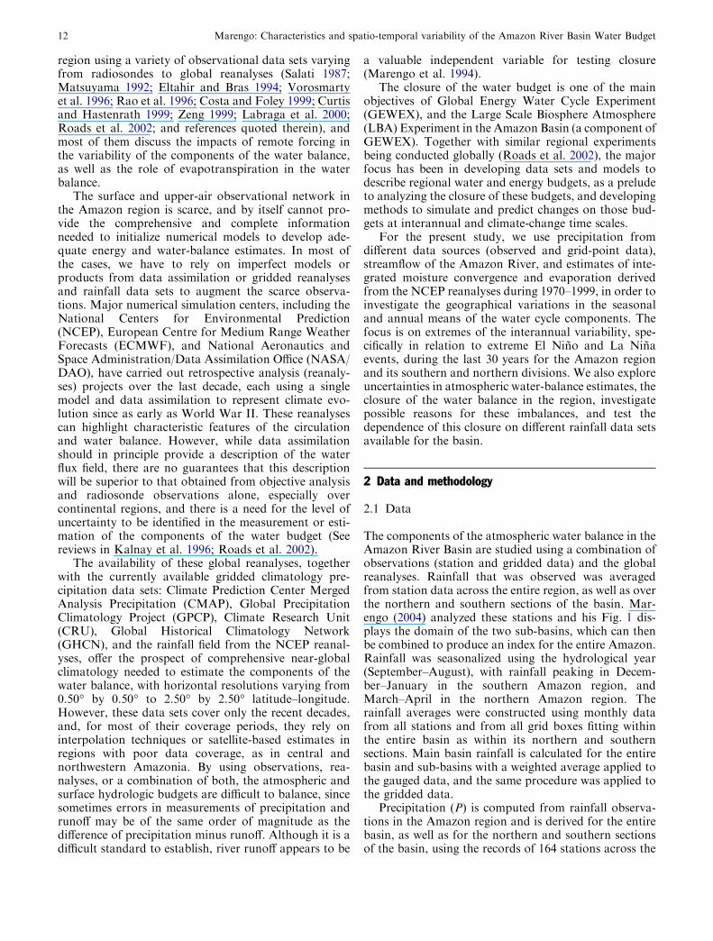
Figure 2a–d shows the E evaporation maps derivedfrom the NCEP reanalyses latent heat. E estimatesreach an annual mean of 4.3 mm/day, which is closeto the 4.6 mm/day obtained by Zeng (1999) from theNASA/DAO reanalyses. Estimates based on theECMWF reanalyses (Fu, personal communication) of Eare�3.7 mm/day, whereasE is 4.0 mm/day (Rocha 2001)if a different period of the ECMWF is used. These esti-mates are larger than some estimates reported in the lit-erature: 3.1 mm/day derived using the climatonomicmethod byMolion (1975), 3.2 mm/day using the Penmanmethod (Villa Nova et al. 1976), 3.5 mm/day usingatmospheric water balance (Marques et al. 1980),3.1 mm/day using the ECMWF data (Matsuyama 1992;Eltahir and Bras 1994), 3.3 mm/day using theThronthwaithemethod (Willmott et al. 1985; Vorosmartyet al. 1996), and 3.8 mm/day using the NCEP/NCARreanalysis after correction by Costa and Foley (1999).
Direct measurements of E are not made continuouslyall around the basin, and the estimation of this quantityrequires high-frequency surface observations. Values ofE derived from the reanalysis are products of theassimilation model, and they are highly sensitive to the
14 Marengo: Characteristics and spatio-temporal variability of the Amazon River Basin Water Budget
model assumptions. Few E measurements derived fromlatent heat observations during the Anglo BrazilianClimate Observational Study (ABRACOS) field experi-ment during the 1990’s (Rocha et al. 1996) yield 3.9 mm/day in the eastern Amazon region and 3.7 mm/day atsites in central and southern regions, and few observa-tions available at Manaus in the central Amazon section(Shuttleworth 1988) exhibit values of 3.6 mm/day. Themean of these observations (�3.8 mm/day) is approxi-mately 10% lower than E derived from the NCEP/NCAR reanalysis.
3.2 Mean distribution of vertically integrated atmo-spheric moisture convergence in Amazonia
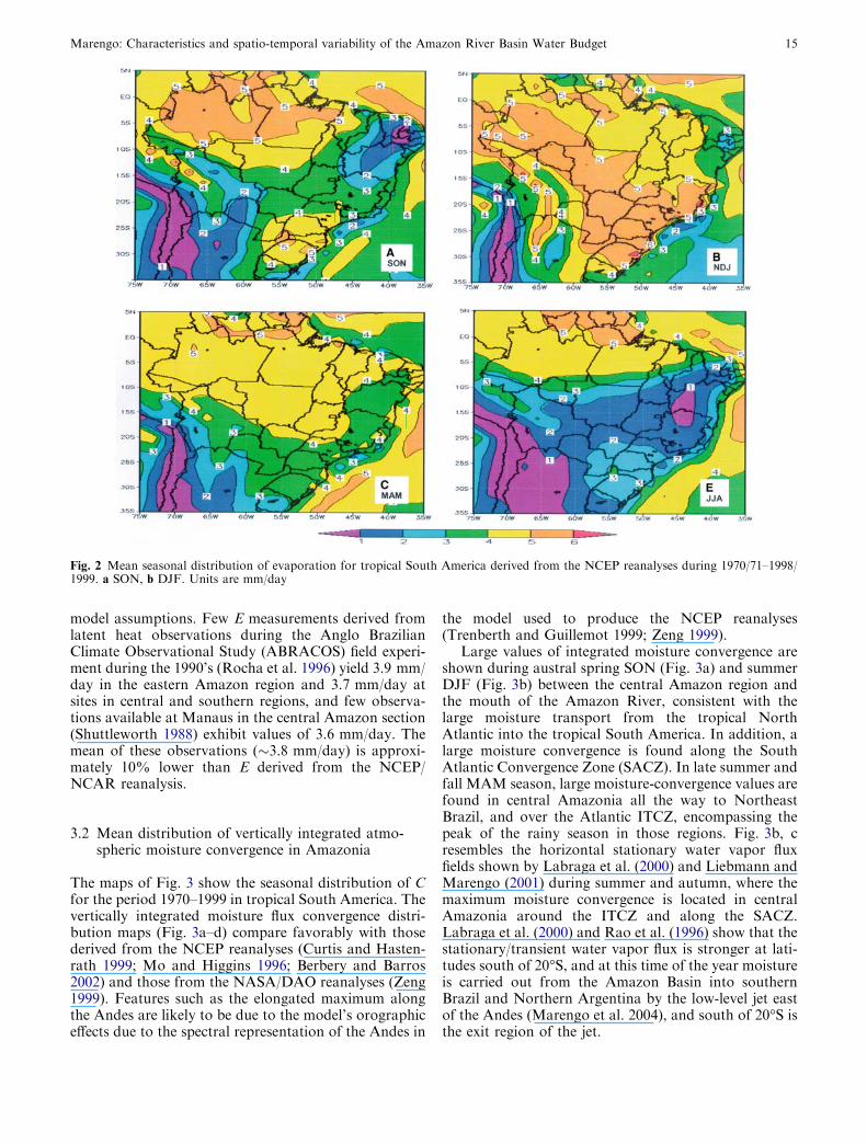
The maps of Fig. 3 show the seasonal distribution of Cfor the period 1970–1999 in tropical South America. Thevertically integrated moisture flux convergence distri-bution maps (Fig. 3a–d) compare favorably with thosederived from the NCEP reanalyses (Curtis and Hasten-rath 1999; Mo and Higgins 1996; Berbery and Barros2002) and those from the NASA/DAO reanalyses (Zeng1999). Features such as the elongated maximum alongthe Andes are likely to be due to the model’s orographiceffects due to the spectral representation of the Andes in
the model used to produce the NCEP reanalyses(Trenberth and Guillemot 1999; Zeng 1999).
Large values of integrated moisture convergence areshown during austral spring SON (Fig. 3a) and summerDJF (Fig. 3b) between the central Amazon region andthe mouth of the Amazon River, consistent with thelarge moisture transport from the tropical NorthAtlantic into the tropical South America. In addition, alarge moisture convergence is found along the SouthAtlantic Convergence Zone (SACZ). In late summer andfall MAM season, large moisture-convergence values arefound in central Amazonia all the way to NortheastBrazil, and over the Atlantic ITCZ, encompassing thepeak of the rainy season in those regions. Fig. 3b, cresembles the horizontal stationary water vapor fluxfields shown by Labraga et al. (2000) and Liebmann andMarengo (2001) during summer and autumn, where themaximum moisture convergence is located in centralAmazonia around the ITCZ and along the SACZ.Labraga et al. (2000) and Rao et al. (1996) show that thestationary/transient water vapor flux is stronger at lati-tudes south of 20�S, and at this time of the year moistureis carried out from the Amazon Basin into southernBrazil and Northern Argentina by the low-level jet eastof the Andes (Marengo et al. 2004), and south of 20�S isthe exit region of the jet.
Fig. 2 Mean seasonal distribution of evaporation for tropical South America derived from the NCEP reanalyses during 1970/71–1998/1999. a SON, b DJF. Units are mm/day
Marengo: Characteristics and spatio-temporal variability of the Amazon River Basin Water Budget 15
In contrast, there is a region with maximum conver-gence in eastern Amazonia around 45�W, persisting allyear long, which seems inconsistent with rainfall distri-bution over the area shown in previous observationalstudies (Liebmann and Marengo 2001). Oki et al. (1995)reported a similar feature while estimating moistureconvergence from the ECMWF reanalysis. In JJA(Fig. 3d), stronger convergence in the northern hemi-sphere indicates the rainy season north of the equator,and convergence over the southern section of theAmazon region starts to increase during spring SON(Fig. 3a), at the height of the onset of the rainy season inthis region. Integrated moisture convergence from theNCEP/NCAR reanalyses averaged for the AmazonBasin shown in Fig. 3 is comparable with the GRDCrunoff estimated by Fekete et al. (1999).
3.3 Climatological water balance in Amazonia
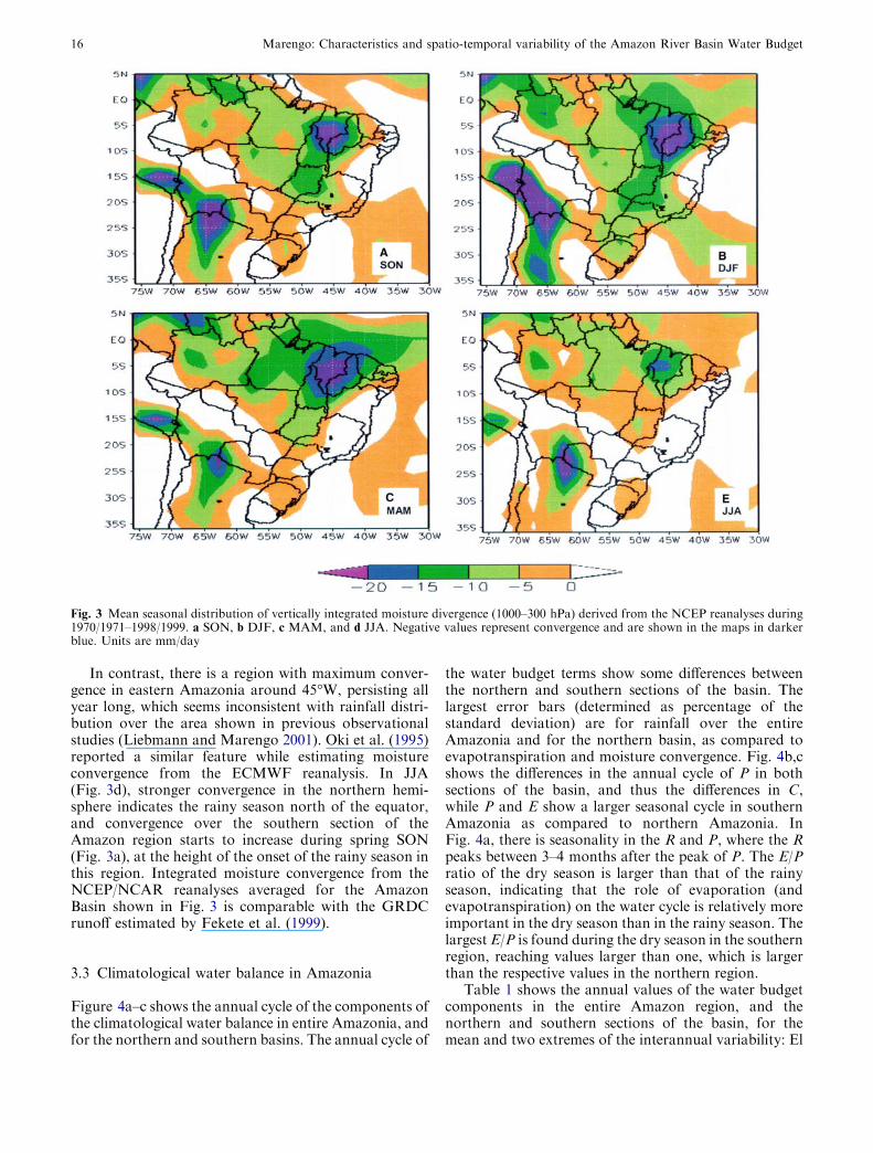
Figure 4a–c shows the annual cycle of the components ofthe climatological water balance in entire Amazonia, andfor the northern and southern basins. The annual cycle of
the water budget terms show some differences betweenthe northern and southern sections of the basin. Thelargest error bars (determined as percentage of thestandard deviation) are for rainfall over the entireAmazonia and for the northern basin, as compared toevapotranspiration and moisture convergence. Fig. 4b,cshows the differences in the annual cycle of P in bothsections of the basin, and thus the differences in C,while P and E show a larger seasonal cycle in southernAmazonia as compared to northern Amazonia. InFig. 4a, there is seasonality in the R and P, where the Rpeaks between 3–4 months after the peak of P. The E/Pratio of the dry season is larger than that of the rainyseason, indicating that the role of evaporation (andevapotranspiration) on the water cycle is relatively moreimportant in the dry season than in the rainy season. Thelargest E/P is found during the dry season in the southernregion, reaching values larger than one, which is largerthan the respective values in the northern region.
Table 1 shows the annual values of the water budgetcomponents in the entire Amazon region, and thenorthern and southern sections of the basin, for themean and two extremes of the interannual variability: El
Fig. 3 Mean seasonal distribution of vertically integrated moisture divergence (1000–300 hPa) derived from the NCEP reanalyses during1970/1971–1998/1999. a SON, b DJF, c MAM, and d JJA. Negative values represent convergence and are shown in the maps in darkerblue. Units are mm/day
16 Marengo: Characteristics and spatio-temporal variability of the Amazon River Basin Water Budget
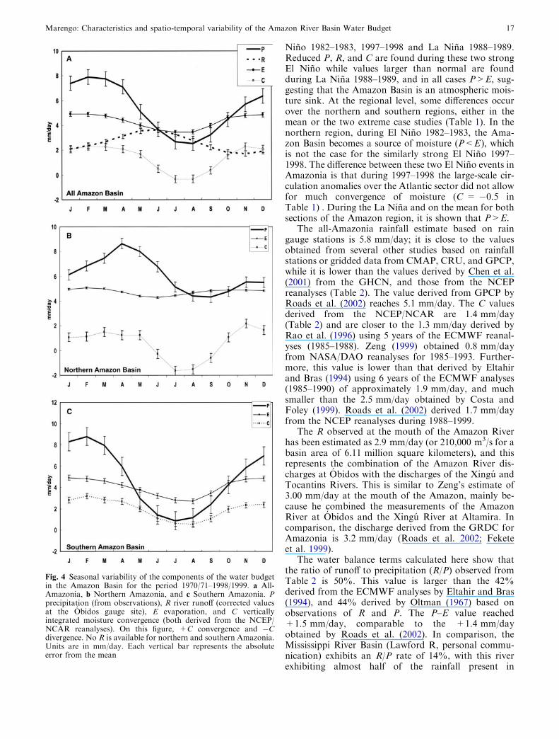
Nino 1982–1983, 1997–1998 and La Nina 1988–1989.Reduced P, R, and C are found during these two strongEl Nino while values larger than normal are foundduring La Nina 1988–1989, and in all cases P>E, sug-gesting that the Amazon Basin is an atmospheric mois-ture sink. At the regional level, some differences occurover the northern and southern regions, either in themean or the two extreme case studies (Table 1). In thenorthern region, during El Nino 1982–1983, the Ama-zon Basin becomes a source of moisture (P<E), whichis not the case for the similarly strong El Nino 1997–1998. The difference between these two El Nino events inAmazonia is that during 1997–1998 the large-scale cir-culation anomalies over the Atlantic sector did not allowfor much convergence of moisture (C = �0.5 inTable 1) . During the La Nina and on the mean for bothsections of the Amazon region, it is shown that P>E.
The all-Amazonia rainfall estimate based on raingauge stations is 5.8 mm/day; it is close to the valuesobtained from several other studies based on rainfallstations or gridded data from CMAP, CRU, and GPCP,while it is lower than the values derived by Chen et al.(2001) from the GHCN, and those from the NCEPreanalyses (Table 2). The value derived from GPCP byRoads et al. (2002) reaches 5.1 mm/day. The C valuesderived from the NCEP/NCAR are 1.4 mm/day(Table 2) and are closer to the 1.3 mm/day derived byRao et al. (1996) using 5 years of the ECMWF reanal-yses (1985–1988). Zeng (1999) obtained 0.8 mm/dayfrom NASA/DAO reanalyses for 1985–1993. Further-more, this value is lower than that derived by Eltahirand Bras (1994) using 6 years of the ECMWF analyses(1985–1990) of approximately 1.9 mm/day, and muchsmaller than the 2.5 mm/day obtained by Costa andFoley (1999). Roads et al. (2002) derived 1.7 mm/dayfrom the NCEP reanalyses during 1988–1999.
The R observed at the mouth of the Amazon Riverhas been estimated as 2.9 mm/day (or 210,000 m3/s for abasin area of 6.11 million square kilometers), and thisrepresents the combination of the Amazon River dis-charges at Obidos with the discharges of the Xingu andTocantins Rivers. This is similar to Zeng’s estimate of3.00 mm/day at the mouth of the Amazon, mainly be-cause he combined the measurements of the AmazonRiver at Obidos and the Xingu River at Altamira. Incomparison, the discharge derived from the GRDC forAmazonia is 3.2 mm/day (Roads et al. 2002; Feketeet al. 1999).
The water balance terms calculated here show thatthe ratio of runoff to precipitation (R/P) observed fromTable 2 is 50%. This value is larger than the 42%derived from the ECMWF analyses by Eltahir and Bras(1994), and 44% derived by Oltman (1967) based onobservations of R and P. The P–E value reached+1.5 mm/day, comparable to the +1.4 mm/dayobtained by Roads et al. (2002). In comparison, theMississippi River Basin (Lawford R, personal commu-nication) exhibits an R/P rate of 14%, with this riverexhibiting almost half of the rainfall present in
Fig. 4 Seasonal variability of the components of the water budgetin the Amazon Basin for the period 1970/71–1998/1999. a All-Amazonia, b Northern Amazonia, and c Southern Amazonia. Pprecipitation (from observations), R river runoff (corrected valuesat the Obidos gauge site), E evaporation, and C verticallyintegrated moisture convergence (both derived from the NCEP/NCAR reanalyses). On this figure, +C convergence and �Cdivergence. No R is available for northern and southern Amazonia.Units are in mm/day. Each vertical bar represents the absoluteerror from the mean
Marengo: Characteristics and spatio-temporal variability of the Amazon River Basin Water Budget 17
Amazonia, and the observed runoff of 0.3 mm/day,which is 2.2 mm/day smaller than in Amazonia. Theevaporation that was observed in the Mississippi is1.9 mm/day, which is 0.4 mm/day smaller than thatestimated from the NCEP/NCAR reanalyses at the samebasin.
Comparing the combined atmospheric–hydrologicbalance, the long-term average convergence C=1.4 mm/day is not matched by R=2.9 mm/day, and there is adifference of 1.5 mm/day (548 mm/year) that is notaccounted for. Table 2 shows that depending on therainfall observational data set; the P–E difference canreach as high as 4.3 mm/day (GHCN) and as low as0.9 mm/day (GPCP). This imbalance suggests a non-closure of the atmospheric–hydrological water cycle inthe Amazon Basin, and this may be linked to severalfactors, including uncertainties in the measurement ofrainfall or river observations, or due to the fact that thereanalyses may not realistically represent those fields inthe Amazon region. Since few upper-air observations inthe Amazon operate on routine basis, little observa-tional data is available for assimilation into the NCEPreanalyses. This may affect the estimation of integrated
moisture convergence or evaporation, and the later isaround 10% higher than observations.
The expression P–E–C is known as ‘‘analysis incre-ment’’ (Zeng 1999), and represents a measure of thisimbalance. It should be equal to zero if the AmazonBasin water budget exhibits closure. Costa and Foley(1999) found this value as 33 mm/year, which is lowerthan our estimates of 36.5 mm/year (Table 2).
3.4 Interannual variability of the water balance terms inAmazonia
Table 1 shows that the P–E values are almost 50% lowerthan the observed R, suggesting that P–E cannot be usedas a proxy for runoff in the Amazon region. Further-more, Dai and Trenberth (2002) found that globally, theP–E derived from the NCEP/NCAR reanalyses under-estimates continental discharge at many latitudes, whilethe P–E from the ECMWF reanalyses agrees reasonablywell with the river-based estimates.
Values of P were derived from observations whileE was derived from the NCEP reanalyses. However,
Table 1 Components of aclimatological water budget for1970–1999 for All-Amazonbasin, Northern, and SouthernAmazonia
Comparisons are made for the1982/1983 El Nino and the1988/1989 La Nina. P is derivedfrom observations (Marengo2004), E and C are derived fromthe NCEP/NCAR reanalyses,and R is runoff from historicaldischarge records of theAmazon River at Obidos. No Ris available for Northern andSouthern Amazonia. Units arein mm/day+C convergence
Component Mean El Nino1982/1983
El Nino1997/1998
La Nina1988/1989
All AmazoniaP 5.8 4.9 5.2 6.7E 4.3 4.5 4.1 4.4R 2.9 2.1 2.5 2.9C 1.4 1.3 1.2 3.1P–E +1.5 +0.4 +0.9 +2.3P–E–C +0.1 �0.9 �0.1 �0.8Imbalance = [((C/R)�1)] (%) 51 38 52 6Northern AmazoniaP 6.1 5.0 6.0 7.4E 4.8 5.1 4.9 4.9C 0.4 0.1 �0.5 2.3P–E +1.3 �0.1 +1.1 +2.5P–E–C +1.0 �0.2 +1.6 +0.2Southern AmazoniaP 4.7 4.8 4.6 6.0E 4.0 4.3 3.9 4.2C 2.0 2.2 2.2 3.1P–E +0.7 +0.5 +0.7 +1.8P–E–C �1.3 �1.7 �1.5 �1.3
Table 2 Components of a water budget climatology for 1970–1999 for the entire Amazon Basin
Component GHCN CMAP GPCP NCEP LW CRU This work
P 8.6 5.6 5.2 6.4 5.9 6.0 5.8E 4.3 4.3 4.3 4.3 4.3 4.3 4.3R 2.9 2.9 2.9 2.9 2.9 2.9 2.9C 1.4 1.4 1.4 1.4 1.4 1.4 1.4P–E 4.3 1.3 0.9 2.1 1.6 1.6 1.5P–E–C +2.9 �0.1 �0.5 +0.7 +0.2 +0.3 +0.1
P is derived from several data sources: GHCN Global HistoricalClimatology Network, CMAP Xie and Arkin, NCEP, LW Legates-Wilmott, CRU Climate Research Unit, and from observationsderived by Marengo (2004). E and C are derived from the NCEP/
NCAR reanalyses, and R is the corrected runoff from historicaldischarge records of the Amazon River at Obidos Units are in mm/day+C convergence
18 Marengo: Characteristics and spatio-temporal variability of the Amazon River Basin Water Budget
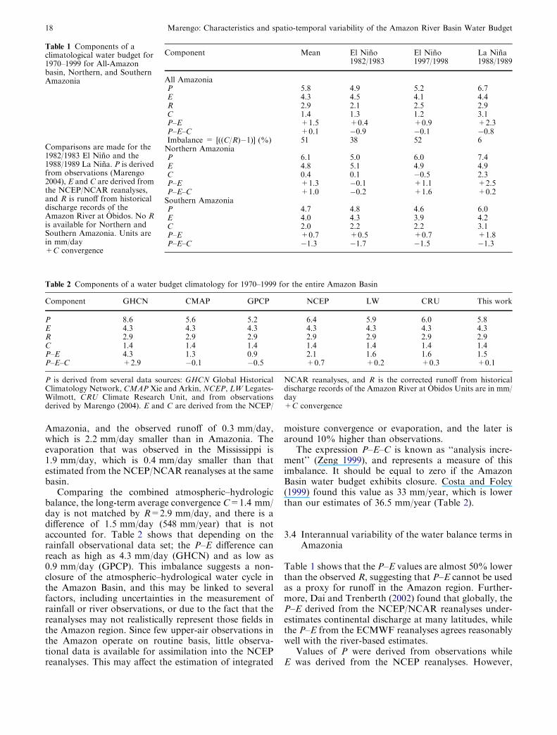
despite this systematic underestimation, P–E can be usedto study interannual to decadal variations of AmazonRiver freshwater discharge. Figure 5 shows reductionsin rainfall during the El Nino events of 1982–1983,1986–1987, and 1997–1998, while relatively large rainfallamounts were observed during the La Nina 1988–1989.Variations in P are accompanied by similar variability ofR, C, and P–E. Figure 6a, b shows the interannualvariability of P, E, C, P–E, and P–E–C for northern andsouthern Amazon region, respectively. No R is availablefor northern or southern Amazonia, but we can useP�R as an indicator of the interannual variability of Rin both sections of the basin. The same Fig. 5 shows thatE displays a sudden increase during the early 1980s andthen decreases again during the early 1990s. This couldbe related the introduction of satellite data and probablymore surface observations could be a likely explanationof this phenomenon. The largest E values between 1980and 1990 were anomalously large, and perhaps closer topotential evaporation (Rocha H, personal communica-tion).
Figure 6a, b shows slightly negative/positive rainfalltrends in northern/southern regions, which are not sta-tistically significant. This variability is part of an inter-decadal pattern in the Amazon Region, in which rainfallafter 1975 tends to be reduced/enhanced in northern/southern Amazon section (Marengo 2004). In the entireregion, the fact that P>E suggests that the regionbehaves as a sink of moisture. The northern andsouthern sections also behave as sinks of moisture in themean state, while during the extreme El Nino 1982–83 year P< E and P–E tends to be larger than or equalto C in the northern region. This is an indication that onthat particular extreme of the interannual variability
associated with an extreme dry year in the region, thenorthern Amazon region behaves as a source of mois-ture rather than a sink.
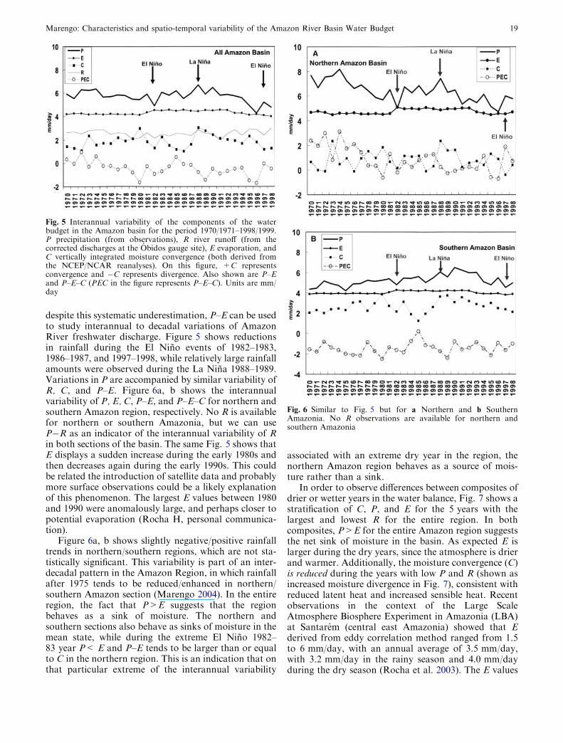
In order to observe differences between composites ofdrier or wetter years in the water balance, Fig. 7 shows astratification of C, P, and E for the 5 years with thelargest and lowest R for the entire region. In bothcomposites, P>E for the entire Amazon region suggeststhe net sink of moisture in the basin. As expected E islarger during the dry years, since the atmosphere is drierand warmer. Additionally, the moisture convergence (C)is reduced during the years with low P and R (shown asincreased moisture divergence in Fig. 7), consistent withreduced latent heat and increased sensible heat. Recentobservations in the context of the Large ScaleAtmosphere Biosphere Experiment in Amazonia (LBA)at Santarem (central east Amazonia) showed that Ederived from eddy correlation method ranged from 1.5to 6 mm/day, with an annual average of 3.5 mm/day,with 3.2 mm/day in the rainy season and 4.0 mm/dayduring the dry season (Rocha et al. 2003). The E values
Fig. 5 Interannual variability of the components of the waterbudget in the Amazon basin for the period 1970/1971–1998/1999.P precipitation (from observations), R river runoff (from thecorrected discharges at the Obidos gauge site), E evaporation, andC vertically integrated moisture convergence (both derived fromthe NCEP/NCAR reanalyses). On this figure, +C representsconvergence and �C represents divergence. Also shown are P–Eand P–E–C (PEC in the figure represents P–E–C). Units are mm/day
Fig. 6 Similar to Fig. 5 but for a Northern and b SouthernAmazonia. No R observations are available for northern andsouthern Amazonia
Marengo: Characteristics and spatio-temporal variability of the Amazon River Basin Water Budget 19
derived by Rocha et al. (2004) in Santarem during thewet season are 12% lower than the NCEP derived Eshown in Fig. 7 for the composites of high and low Rvalues are between 4 and 5 mm/day. The imbalance term(P–E–C) is larger in the low R composite as compared tothe large R composite.
3.5 On the closure of the water balance
Table 2 shows that based on C (estimated from theNCEP reanalyses), and R (observed at the mouth of theAmazon River), the imbalance in the water budget inthe region reaches an average of 51%. In comparison,the imbalance derived by Zeng (1999) is 73% and theimbalance derived by Roads et al (2002) is 46%. Thesestudies used different data sets to estimate C (NCEP orNASA/DAO reanalyses) and R (streamflow observed atObidos or corrected at the mouth of the AmazonRiver). These calculations suggest that the closure orbalance of the water budget in the Amazon Basin issensitive to both the type of reanalyses used to estimateC and to the runoff R value used (in situ ‘‘non-cor-rected’’ or corrected data). While the differences in Camong various reanalyses can be of the order of 50%,the streamflow from several sources varies in theneighborhood of 10%.
On a balanced system, P–E–C should be near zerosince the three terms should be balanced by the dW/dt(change in the atmospheric precipitable water) term inEq. 2, and this term is nearly zero. However, sincethe intrinsic and systematic errors generated during thecollection of each individual data set add up in the
balance calculations, and the possible errors in interpo-lation or corrections in the observed data, the resultinguncertainty may prevent the achievement of closure.Models close the water budget automatically since theyare based upon fundamental laws, such as the conser-vation of mass, but each of the model processes is likelyto have some errors, especially if modeled climate isdrastically different from observations.
The constraint P>E is satisfied in the Amazon Basinand over the long term this region shows convergenceprevailing and is considered a moisture sink. This ismore obvious during the rainy season with a high con-centration of water vapor in the atmosphere. TheAmazon Basin also becomes an open system, trans-porting moisture outside the basin via a moisture cor-ridor located at the lower levels of the atmosphere eastof the Andes. This low-level jet (LLJ) east of the Andesis especially intense during the summertime rainy seasonand represents a mechanism for transporting moisturefrom the Amazon region into central and southeasternSouth America (Seluchi and Marengo 2000; Saulo et al.2000; Marengo et al. 2002). The importance of the LLJcirculation was also noted in the assessment of theatmospheric and surface water balance in Amazoniaapplying reanalyses and output from various GCMs forpresent climates (Marengo et al. 2003; Trenberth andGuillemot 1995; Mo and Higgins 1996; Trenberth andGuillemot 1998) and future climate change scenarios(Cox et al. 2000). In fact, Cox and collaborators used theHadley Centre GCM for simulating future climates, andthey found that due to the increase in the concentrationof greenhouse gases, the Amazon forest would cease toexist and moisture from the tropical North Atlantic willbe transported to southeastern South America, possiblydue to intense and more frequent LLJ, and thus theAmazon Basin would become a source of moisture.
4 Summary and conclusions
This study focuses on the spatial and temporal vari-ability of the water balance of the Amazon Basin, and itsclosure. The components of the water balance wereestimated by using a combination of river and rainfallobservations in the region, as well as reanalyzed mois-ture fluxes and evaporation, for both the entire basinand its northern and southern sections. The scarceupper-air network in the basin and an incomplete net-work for evaporation observations motivated the use ofthe NCEP reanalyses to estimate C and E, which gen-erates some uncertainty in those components of thewater budget. Overall, the Amazon Basin exhibits ob-served P reaching 5.8 mm/day and R of approximately2.9 mm/day, while mean E and C are 4.3 and 1.4 mm/day, respectively. Some differences among rainfall datasets can reach up to 50% in rainfall and 10% in runoff.Uncertainties of P in Amazonia, especially in thesouthern section, can reach up to ±1.0 mm/day andmay be related to the different interpolation techniques
Fig. 7 Stratification of the water balance in the entire AmazonBasin, for the 5 years with largest R and the 5 years with lowest Rover the period 1970–1999. On this figure, +C representsconvergence and �C represents divergence. Units are mm/day
20 Marengo: Characteristics and spatio-temporal variability of the Amazon River Basin Water Budget

used in producing gridded data sets. Our estimates showa basin-wide imbalance of 51%, based on NCEP rea-nalyses derived C and corrected R, and exhibit an in-terannual variability consistent with rainfall variability.This imbalance is also sensitive to the choice of rainfalldata sets, and to the use of corrected or uncorrecteddischarge, also adding some uncertainty in the closure ofthe water budget. It can also be stated that the estima-tion of water vapor fluxes, moisture convergence, andevaporation in the Amazon Basin is another source ofuncertainty due to lack of continuous upper air andevaporation observations across the entire basin.
Perhaps a key contribution of this work has been theillustration of major differences in the behavior of thewater balance between the northern and southern partsof the basin. The components of the water budgetexhibit seasonal to interannual variability that is differ-ent over the northern and southern sections of the basin.El Nino-related circulation and rainfall anomaliesinfluence variability in the hydrometeorology of thenorthern Amazon region, while the southern regionseems to be less affected by the remote tropical PacificSST forcing. In addition, in present climates the entirebasin behaves as a sink of moisture, while apparently thenorthern region can act as a net source for moistureunder extreme dry conditions (e.g. the strong 1983 ElNino event). At interannual time scales, rainfall in thenorthern section of the Amazon Basin modulates thewater budget in the whole basin, since the northernsection is wetter than the southern part. This variabilityis also observed in the moisture convergence and on theriver discharge at Obidos.
Obtaining a better quantitative measure of E and C iscritical to eventually ‘‘closing’’ the water budget. Thereare still large unresolved differences between C and cli-matological R, particularly, C is derived from reanalysesand R is measured. The model used to generate thereanalyses does not account for changes in land-usepatterns or greenhouse gases concentration, so it is notclear what impacts those changes would have on thelong-term temporal variability of the water budgetcomponents.
Studies underway are examining the regional char-acteristics of the water balance as well as long-termvariations and trends in detail. Additional model andobservational studies are required to fully understandthe regional water balances and interactions, as well asits variations on seasonal, interannual, and long-termvariability. Model efforts have been developed in orderto investigate how the water balance in the Amazonbasin may change under remote (SST forcing) and local(land use changes) influences on longer time scales.Additionally, studies using other reanalyses and regionalmodels with energy and water fluxes data observed fromfield experiments (LBA, SALLJEX) assimilated by themodels are being performed to reduce the uncertaintiesin the estimates of the water budget in Amazonia, andalso to reach near-closure of the budget.
Acknowledgements J.A. Marengo was partially supported by theBrazilian Conselho Nacional de Desenvolvimiento Cientifico eTecnologico (CNPq). We thank NCAR for providing access to theNCEP/NCAR reanalyses, to Ping Ping Xie from NOAA andDavid Viner from IPCC-DDC for providing the CMAP and CRUrainfall data sets, respectively, and to ANEEL for providing thestreamflow data from the Amazon River at Obidos and the rainfalldata in Amazonia. Special thanks are due to U. Bhatt, R. Stewart,J. Roads and H. da Rocha for their comments and suggestions onearlier versions of the manuscript.
References
Baumgartner A, Riechel R (1975) The world water balance. Else-vier, New York, p 464
Berbery EH, Barros V (2002) The hydrological cycle of the LaPlata Basin in South America. J Hydromet 3:630–645
Brankovic C, Molteni F (1997) Sensitivity of the ECMWF modelnorthern winter climate to model formulation. Clim Dyn 13:75–101
Cavalcanti IFA, Marengo JA, Satyamurty P, Trosnikov I, BonattiJP, Nobre CA, D’Almeida C, Sampaio G, Cunningham CAC,Camargo H, Sanches MB (2002) Global climatological featuresin a simulation using CPTEC/COLA AGCM. J Clim 15:2965–2988
Chen TC, Yoon JH, St. Croix K, Takle E (2001) Suppressing im-pacts of the Amazonia deforestation by the global circulationchange. Bull Am Meteorol Soc 82:2210–2216
Costa M, Foley J (1998) A comparison of precipitation datasets forthe Amazon basin. Geophys Res Lett 25:155–158
Costa M, Foley J (1999) Trends in the hydrologic cycle of theAmazon basin. J Geophys Res 104:14189–14198
Cox PM, Betts RA, Jones CD, Spall SA, Totterdell IJ, (2000)Acceleration of global warming due to carbon-cycle feedbacksin a coupled climate model. Nature 408:184–187
Curtis S, Hastenrath S (1999) Trends of upper-air circulation andwater vapor over equatorial South America and adjacentoceans. Int J Climatol 19:863–876
Dai A, Trenberth K (2002) Estimates of freshwater discharge fromcontinents: latitudinal and seasonal variations. J Hydromet3:660–687
Eltahir E, Bras R (1994) Precipitation recycling in the Amazonbasin. Q J R Meteorol Soc 120:861–880
Fekete B, Vorosmarty C, Grabs W (1999) Global composite runofffields on observed river discharge and simulated water balances.Tech Rep. 22, Global Runoff Data Centre, Koblenz, p 97
Figueroa N, Nobre C (1990) Precipitation distribution over centraland western tropical South America. Climanalise 5:36–40
Huffman G, Adler R, Arkin PA, Chang A, Ferraro, Gruber A,Janowiak J, Joyce RJ, McNab A, Rudolf B, Schneider U, Xie P(1997) The Global Precipitation Climatology Project (GPCP)combined precipitation data set. Bull Am Meteor Soc 78:5–20
Hurrell JW, Hack JJ, Boville BA, Willianson DL, Kiehl JT (1998)The dynamical simulation of the NCAR Community ClimateModel version 3 (CCM3). J Clim 11:1207–1236
Kalnay E, Kanamitsu M, Kistler R, Collins W, Deaven D, GandinL, Iredell M, Saha S, White G, Woollen J, Zhu J, Chelliah M,Ebisuzaki W, Higgins W, Janowiak J, Mo K, Ropelewski C,Wang J, Leetmaa A, Reynolds R, Jenne R, Joseph D (1996)The NCEP/NCAR 40-year reanalysis project. Bull Am Mete-orol Soc 77:437–471
Labraga JC, Frumento O, Lopez M (2000) The atmospheric watervapor in South America and the tropospheric circulation.J Clim 13:1899–1915
Liebmann B, Marengo JA (2001) Interannual variability of therainy season and rainfall in the Brazilian Amazonia. J Clim14:4308–4318
Marengo JA (2004) Interdecadal variability and trends of rainfallacross the Amazon basin. Theor Appl Climatol 78:79–96
Marengo: Characteristics and spatio-temporal variability of the Amazon River Basin Water Budget 21
Marengo JA, Druyan L (1994) Validation of model improvementsfor the GISS GCM. Clim Dyn 10:163–179
Marengo JA, Miller JA, Russell G, Rosenzweig C, AbramopoulosF (1994) Calculations of river-runoff in the GISS GCM: impactof a new land surface parameterization and runoff routing onthe hydrology of the Amazon River. Clim Dyn 10:349–361
Marengo JA, Douglas M, Silva Dias PL (2002) The South Amer-ican low-level jet east of the Andes during the LBA-TRMM andWET AMC campaign of January–April 1999. J Geophys Res107(47):1–12
Marengo JA, Cavalcanti IFA, Satyamurty P,Nobre CA, Bonatti JP,Manzi A, Trosnikov I, Sampaio G, Camargo H., Sanches MB,Cunningham CAC, D’Almeida C, Pezzi LPm (2003) Ensemblesimulation of regional rainfall features in the CPTEC/COLAatmospheric GCM. Skill and predictability assessment andapplications to climate predictions. Clim Dyn 21:459–475
Marques J, Salati E, Santos J (1980) Calculo da evapotranspiracaoreal na bacia Amazonica atraves do metodo aerologico. ActaAmazonica 10:357–361
Matsuyama H (1992) The water budget in the Amazon river basinduring the FGGE period. J Meteorol Soc Jap 70:1071–1083
Mo K, Higgins W (1996) Large-scale atmospheric moisture trans-port as evaluated in the NCEP/NCAR and the NASA/DAOreanalyses. J Clim 9:1531–1545
Molion LCB (1975) A climatonomic study of the energy andmoisture fluxes of the Amazon basin with considerations ofdeforestation effects. PhD thesis, University of Wisconsin
New M, Hulme M, Jones P (2000) Representing twentieth-centuryspace–time climate variability. Part II: development of 1901–96monthly grids of terrestrial surface climate. J Clim 13:2217–2238
Oki T, Musiake M, Matsuyama H, Masuda K (1995) Globalatmospheric water balance and runoff from large river basins.Hydrol Process 9:655–678
Oltman R (1967) Reconnaissance investigations of the dischargeand water quality of the Amazon, in Atas do Simp. sobre BiotaAmazonica, Rio de Janeiro, CNPq, vol. 3, pp 163–185
Rao VB, Cavalcanti IFA, Hada K (1996) Annual variation ofrainfall over Brazil and water vapor characteristics over SouthAmerica. J Geophys Res 101:16539–16551
Roads J, Chen S, Guetter A, Georgakakos K (1994) Large-scaleaspects of the United States Hydrologic Cycle. Bull AmMeteorol Soc 75:1589–1610
Roads J, Kanamitsu M, Stewart R (2002) CSE water and energybudgets in the NCEP-DOE reanalyses. J Hydromet 3:227–248
Rocha EP (2001) Balanco de umidade e a influencia das condicoessuperficiais na precipitacao da Amazonia (In Portuguese). PhDThesis, Instituto Nacional de Pesquisas Espaciais, p 210
Rocha HR, Sellers P, Collatz G, Wright I, Grace J (1996) Cali-bration and use of the Sib2 model to estimate water vapour andcarbon exchange at the ABRACOS forest sites. In: Gash JHC,Nobre CA, Roberts JM, Victoria RL (eds) Amazonian defor-estation climate. Wiley, Chichester, New York, Brisbane, Tor-onto, Singapore, pp 459–472
Rocha HR, Goulden M, Miller, Menton M, Pinto L, Freitas H,Figueroa A (2004) Seasonality of water and heat fluxes overtropical forests in eastern Amazonia. J Ecol Appl (in press)
Salati E (1987) The forest and the hydrological cycle. In: DickinsonRE (ed) The geophysiology of Amazonia: vegetation and cli-mate interactions. Wiley, New York, pp 273–296
Saulo C, Nicolini M, Chou SC (2000) Model characterization ofthe South American low-level flow during the 1997–98 spring-summer season. Clim Dyn 16:867–881
Seluchi M, Marengo J (2000) Tropical-mid latitude exchange of airmasses during summer and winter in South America: climaticaspects and extreme events. Int J Climatol 20:1167–119
Shuttleworth J (1988) Evaporation from Amazonian rain forests.Proc R Soc London Ser B 233:321–346
Stern W, Miyakoda K (1995) Feasibility of seasonal forecasts in-ferred from multiple GCM simulations. J Clim 8:1071–1085
Trenberth K, Guillemot C (1995) Evaluation of the global atmo-spheric moisture budget as seen from analyses. J Clim 8:2255–2272
Trenberth K, Guillemot C (1998) Evaluation of the atmosphericmoisture and hydrological cycle in the NCEP/NCAR reanaly-ses. Clim Dyn 14:213–231
Villa Nova N, Salati E, Matsui E (1976) Estimativa da evapo-transpiracao na bacia Amazonica. Acta Amazonica 6:215–228
Vorosmarty C, Willmott C, Choudhury B, Schloss A, Stearns T,Robertson S, Dorman T (1996) Analysing the discharge regimeof a large tropical river trough remote sensing, ground climaticdata, and modeling. Water Resour Res 32:3137–3150
Willmott C, Rowe J, Mintz Y (1985) Climatology of terrestrialseasonal cycle. J Climatol 5:589–606
Xie P, Arkin P (1997) Global precipitation: a 17-yr monthlyanalysis based on gauged observations, satellite estimates andnumerical model outputs. Bull Am Meteorol Soc 78:2539–2558
Zeng N (1999) Seasonal cycle and interannual variability in theAmazon hydrologic cycle. J Geophys Res 104:9097–9106
22 Marengo: Characteristics and spatio-temporal variability of the Amazon River Basin Water Budget
Copyright © 2022 FDOKUMEN