Chapter 21. Safety Element - Humboldt County
33
Humboldt County General Plan Preliminary Hearing Draft April 19 th , 2007 Workshop Safety Element Part 3, Chapter 21 Page 21- 1 J:\PLANNING\ADVANCE\GPU\PLANTEXT\SafetyElement\SafetyElement3-21-07posted.doc Chapter 21. Safety Element 21.1 Introduction The purpose of the Safety Element is to reduce the risk of death, injuries, property damage, and economic and social dislocation resulting from earthquake, fire, flood, and other hazards. The components of this Element include: o Geologic/Seismic Hazards o Flooding and Drainage o Fire Hazards o Airport Safety o Industrial Hazards o Emergency Management This Element identifies hazards and hazard abatement provisions to guide local decisions related to zoning, subdivisions, and entitlement permits. Hazard and risk reduction policies supporting hazard implementation measures are contained in this Element. 21.2 Background Hazard Policy & Concepts Land development is subject to a number of hazards to life and property, including seismic and non-seismic conditions of land instability, flooding from several causes, fire, and dangers from airport operations. The degree of risk associated with these hazards can only be measured in relative terms. What constitutes "acceptable risk" varies with the type of development involved. For instance, a hospital should meet very strict earthquake standards in order to ensure that it is able to function in the event of a serious earthquake. A warehouse, on the other hand, would not need to be designed to the same rigorous standards because its functions during an earthquake would not be critical to the community's response to the emergency, nor would it pose serious risk to large numbers of people should it fail. The approach taken in this General Plan involves: 1) consideration of appropriate land use designations in order to limit the populace exposed to hazardous areas; 2) assessment and conditioning of development applications according to the hazards on a site; 3) policies tailored to specific hazardous conditions; and, 4) an action program to improve overall safety conditions within the County.
-
Upload
khangminh22 -
Category
Documents
-
view
4 -
download
0
Transcript of Chapter 21. Safety Element - Humboldt County
Humboldt County General Plan Preliminary Hearing Draft April 19th, 2007 Workshop Safety Element
Part 3, Chapter 21 Page 21- 1 J:\PLANNING\ADVANCE\GPU\PLANTEXT\SafetyElement\SafetyElement3-21-07posted.doc
Chapter 21. Safety Element
21.1 Introduction The purpose of the Safety Element is to reduce the risk of death, injuries, property damage, and economic and social dislocation resulting from earthquake, fire, flood, and other hazards. The components of this Element include:
o Geologic/Seismic Hazards o Flooding and Drainage o Fire Hazards o Airport Safety o Industrial Hazards o Emergency Management
This Element identifies hazards and hazard abatement provisions to guide local decisions related to zoning, subdivisions, and entitlement permits. Hazard and risk reduction policies supporting hazard implementation measures are contained in this Element.
21.2 Background Hazard Policy & Concepts Land development is subject to a number of hazards to life and property, including seismic and non-seismic conditions of land instability, flooding from several causes, fire, and dangers from airport operations. The degree of risk associated with these hazards can only be measured in relative terms. What constitutes "acceptable risk" varies with the type of development involved. For instance, a hospital should meet very strict earthquake standards in order to ensure that it is able to function in the event of a serious earthquake. A warehouse, on the other hand, would not need to be designed to the same rigorous standards because its functions during an earthquake would not be critical to the community's response to the emergency, nor would it pose serious risk to large numbers of people should it fail. The approach taken in this General Plan involves: 1) consideration of appropriate land use designations in order to limit the populace exposed to hazardous areas; 2) assessment and conditioning of development applications according to the hazards on a site; 3) policies tailored to specific hazardous conditions; and, 4) an action program to improve overall safety conditions within the County.
Humboldt County General Plan Preliminary Hearing Draft April 19th, 2007 Workshop Safety Element
Part 3, Chapter 21 Page 21- 2 J:\PLANNING\ADVANCE\GPU\PLANTEXT\SafetyElement\SafetyElement3-21-07posted.doc
Geologic/Seismic Hazards Humboldt County is a relatively hazardous area in terms of ground shaking and fault rupture, landsliding, and soil erosion. The following sections briefly describe the seismic setting, bedrock geology, and soils of the County. Seismicity The County is located within the two highest of five seismic risk zones specified by the Uniform Building Code, and offshore Cape Mendocino has the highest concentration of earthquake events anywhere in the continental United States. The area near Cape Mendocino is a complex, seismically active region, where three crustal plates, the Pacific Plate, the Gorda Plate, and North American Plate intersect to form the Mendocino Triple Junction. The subducting Gorda Plate, together with the Juan de Fuca Plate, form the "Cascadia Subduction Zone", which runs north offshore of Humboldt, Del Norte, Oregon, and Washington. Recent investigations have shown that this system has moved in unison in a series of great earthquakes (magnitude 8 to 9) over the last 20,000 years, most recently about 300 years ago, with events occurring at 300 – 500 year intervals. The above described seismic setting has the potential to cause significant ground shaking, leading to: (1) a serious liquefaction and subsidence hazard, particularly around the muds and sands of Humboldt Bay; (2) a nearshore tsunami striking the coast within 15 minutes of ground-shaking; (3) a significant landslide hazard countywide; and, (4) surface fault rupture along the San Andreas, and possibly along the Little Salmon and Mad River fault zones, and other active or potentially active faults in the County. Surface Fault Rupture Surface fault rupture is a particular type of seismic hazard that is specifically addressed by state legislation, the Alquist-Priolo Earthquake Fault Zoning Act. This act generally requires disclosure and avoidance. Humboldt County has a number of fault zones mapped under this law. The County utilizes a combining zone designation (“G”) to flag these areas where special geologic study is required to identify the precise location of active fault traces to ensure structures for human occupancy are not placed astride them. Liquefaction The two primary natural hazards associated with earthquakes are groundshaking and surface rupture. Groundshaking gives rise to two secondary natural hazards, liquefaction and landsliding. Liquefaction involves a sudden loss in strength of a water-saturated soil, and results in temporary transformation of the soil into a fluid mass. Recent alluvial flood plain soils exhibit the highest liquefaction hazard. To mitigate this hazard, soils engineering investigations can be required to determine appropriate foundation and building design.
Humboldt County General Plan Preliminary Hearing Draft April 19th, 2007 Workshop Safety Element
Part 3, Chapter 21 Page 21- 3 J:\PLANNING\ADVANCE\GPU\PLANTEXT\SafetyElement\SafetyElement3-21-07posted.doc
Active Fault Near-Source Zones Since 1997, the UBC (Uniform Building Code) requires that in Seismic Zone 4 (most of Humboldt is in this zone), each listed ground motion fault shall be assigned a near-source seismic factor, to be used in building design. Applying these factors to building construction substantially increases building strength, and for large multi-story buildings, cost. In Humboldt County, there are “A” and “B” designated fault zone areas, with “A” zones having more stringent design requirements. Bedrock Geology The bedrock geology of the County is divided generally into two provinces: the Klamath Mountains province in the northeast, and the Coast ranges province in the central and southwest portion of the County. The dividing line between the two provinces is the South Fork Mountain Ridge, which separates the Trinity River basin from the Mad River and Redwood Creek drainages. The Klamath Mountains province is an area of high alpine peaks, some attaining elevations of 8,000 feet and more, east of the Humboldt County line. The province is drained by the Klamath and Trinity Rivers, and farther north, by the Smith River. Rocks in the Klamath Mountains province are generally older than those in the Coast Ranges. Rocks of sedimentary origin such as sandstone, chert, slate and schist occur abundantly, with occasional granite intrusions. The Coast Ranges province is the dominant geologic province in the County, trending northwest and drained by the Mad, Eel, and Mattole River drainages. The Franciscan and Yager complexes dominate inland, with sand and other alluvial deposits dominating in the lower reaches of the river basins and the area surrounding Humboldt Bay. The Franciscan complex can be divided into two distinct units. Franciscan sandstone consists mainly of sandstone and siltstone. Although this sandstone unit is frequently sheared, there is little evidence of massive rock deformation. Slopes are fairly stable, but subject to debris sliding along steep river banks and in steep headwater drainages. Franciscan melange consists of a rubble of sheared sandstone and siltstone in which occur more competent blocks of volcanic rock, chert, and schist. Melange terrain is generally unstable and characterized by rolling hummocky slopes which are highly susceptible to mass movement. The Yager formation is predominantly shale and sandstone. Local shearing occurs, but in general the formation is much less deformed and more stable than the Franciscan. However, it is subject to debris slides on steep slopes and river banks. In the lower reaches of the river basins and in the area surrounding Humboldt Bay, alluvial sediments dominate. These unconsolidated to partially consolidated sediments have been mildly folded and faulted, but when forested or gently sloped, are generally stable. The bedrock geology is still poorly mapped in much of the County, particularly the inland areas, but recent advances have been made. Lack of detailed mapping in most cases precludes determining specific site stability without a site investigation. However, it may
Humboldt County General Plan Preliminary Hearing Draft April 19th, 2007 Workshop Safety Element
Part 3, Chapter 21 Page 21- 4 J:\PLANNING\ADVANCE\GPU\PLANTEXT\SafetyElement\SafetyElement3-21-07posted.doc
be valid to conclude varying degrees of relative risk based on general mapping of rock units when averaged over time. Soils There are many varied soils in Humboldt County. Some of the more abundant agricultural and lowland soils found in the County are the Ferndale series, a deep, well drained soil formed on recent flood plains; the Bayside and the Loleta series, both deep, poorly drained soils found in depressed areas or on nearly level alluvial fans; and the Rohnerville, Carlotta and Hookton soils series, all moderately well-drained soils. Rohnerville soils are found on relatively flat, high marine terraces. The Hookton soils are on sloping, dissected marine terraces and the Carlotta soils are found on flat, low-lying terraces. Most of these agricultural soils are rated 80-100 in the Storie Index of agricultural productivity (good to excellent productivity), except the Bayside soils where drainage problems may reduce agricultural potential. Forest Soils The forest soils of the County are, in general, medium textured, acid in reaction, and generally increasing in acidity with depth. They are permeable and well drained. In the lowlands they are formed on alluvial flood plains or low-lying terraces. Here they are either unclassified or of the Carlotta and Ferndale groups. The most superlative old growth redwood groves are found on these soils. Grassland Soils The general characteristics of grassland soils vary widely. They range from shallow loamy soils to deep clay soils. Their permeability ranges from moderate to slow. The general nutrient level of these grassland soils is higher than that of the adjacent forest soils. The major portion of these soils is intermingled with other soils in the Douglas fir zone beyond the fog belt. Some of these soils are formed on Franciscan parent material. Many of these are found in the shear zone or fault gouge material or on the melange material of the Franciscan. This parent material weathers rapidly, forming a grey-blue clay subsoil (commonly called "blue goo") that tends to slip when wet. Thus, because of the parent material, these soils are found in landslide topography. Woodland Soils Most of the woodland soils are inland beyond the cool, foggy belt. They are intermingled with the conifer forest soils of the Douglas fir belt and the adjacent grassland soils. These are shallow soils, usually well drained, but permeability may be slow in some locations. The natural nutrient level of these soils tends to be somewhat higher than for the neighboring forest soils. Because the parent material is predominantly Franciscan melange, one should expect these soils to be relatively unstable. In contrast to the information on the County's bedrock geology, the available soils information is quite detailed. Soil-Vegetation maps prepared by the California State Cooperative Soil-Vegetation Survey are available for the County at the 7-1/2 minute scale. These maps describe vegetation and soils, including information of parent rock materials, soil depth, erosion, and slope.

Humboldt County General Plan Preliminary Hearing Draft April 19th, 2007 Workshop Safety Element
Part 3, Chapter 21 Page 21- 5 J:\PLANNING\ADVANCE\GPU\PLANTEXT\SafetyElement\SafetyElement3-21-07posted.doc
Slope Stability Slope stability refers to the landslide susceptibility of slopes composed of natural rock, soils, artificial fill, or combinations thereof. Landslides move along surfaces of separation by falling, sliding, and flowing, giving rise to many characteristic features. The features range in appearance from being clearly discernible, largely unweathered and uneroded, to highly weathered and eroded, recognized only by topographic configurations. Landslides are characteristically abundant in areas of high seismicity, steep slope, and high rainfall, but may be triggered by any or a mixture of the following: (1) type and structure of earth materials, (2) steepness of slope, (3) water, (4) vegetation, (5) erosion, and (6) earthquake-generated groundshaking. The factors listed above comprise some of the many complex variables contributing to the formation of landslides. The prediction of slope failure at a specific site, therefore, requires an analysis of all possible factors. As part of the County General Plan, relative slope stability maps have been prepared to provide general delineation of areas susceptible to sliding. Still, these maps must be used with caution, since it is possible that areas designated as stable may in fact be unstable. The inverse may also be true. Flooding & Drainage Management This section examines four aspects of flood-related hazards: river flooding, dam failure, coastal high water, and drainage management. River Flooding The 1955 and 1964 floods caused extensive damage along the Eel, Mad, and Trinity Rivers. Damages in the County from the 1964 flood alone totaled $100 million. Flood prone areas have been mapped by the Federal Emergency Management Agency (FEMA). The maps provide the basis for regulating flood plains in conformance with the National Flood Insurance Program. The County has adopted flood plain regulations in order to continue participation in the federal flood insurance program. Dam Failure While providing some degree of flood control, dams also present a possible hazard in the event of failure. Trinity Dam and Ruth Dam pose the most substantial risk, with their large volumes and, in the event of a failure, short downstream warning times. Hazards from dam failure are those associated with the downstream inundation that would occur given a major structural failure of a nearby impoundment. Such failures would most likely be caused by geologic phenomena including seismic events and slope stability problems. Five dams are located in adjacent counties on rivers that drain into Humboldt County, and the failure of any one of these structures could significantly impact this County.
Humboldt County General Plan Preliminary Hearing Draft April 19th, 2007 Workshop Safety Element
Part 3, Chapter 21 Page 21- 6 J:\PLANNING\ADVANCE\GPU\PLANTEXT\SafetyElement\SafetyElement3-21-07posted.doc
The County maintains emergency response plans for the Trinity, Ruth (Matthews), Scott, Copco and Iron Gate dams. Coastal High Water Hazards Tsunamis and storm surges are coastal flooding concerns. Damaging tsunamis are rare but potentially catastrophic events. Over the past 150 years California has had 12 tsunamis which have caused damage, the worst occurring in 1964 when 12 people died from a tsunami generated by an Alaskan earthquake. Local earthquakes can produce damaging tsunamis that will provide very little warning time. The geologic record indicates that the Cascadia Subduction Zone has been a near-shore source for a number of significant tsunami events affecting Humboldt County, the most recent occurring about 300 years before present. Storm surges occur when coastal storms produce large ocean waves that sweep across coastlines, inundating low lying areas and causing flooding. If a storm surge occurs at the same time as high tide, flooding is more extensive. Drainage Management Drainage management becomes increasingly important as new development converts additional areas in a watershed to hard surfaces. These impervious surfaces reduce infiltration and convey storm water faster, increasing peak flows. The traditional approach to handling increased peak flows has been to convert natural drainage ways into higher capacity concrete-lined conveyances which can more rapidly transport storm water. This approach has led to the loss of natural stream and riparian systems in urban areas, and has increased water quality problems for downstream receiving waters by collecting and concentrating non-point runoff which may contain pollutants such as sediment, topsoil, oil and greases, pesticides, fertilizers, metals, and bacterial and viral contaminants. This approach is also problematic for Humboldt’s flood basins which are near sea-level, and drain only with low tides. Moving water faster to these areas only prolongs flooding of the low-lying areas. Drainage problems and associated flooding may be reduced by use of various measures to decrease runoff. These measures include retention and detention basins upstream, improved watershed management and stream protection, reduction of impervious surfaces, proper siting of development projects, and other similar measures. These measures can reduce the need for costly construction projects and disaster relief, while enhancing natural qualities. Fire Hazard Fire hazards fall into two general categories: wildland fires, which emanate from open chaparral, grassland or forest areas, and can threaten adjacent communities; and structural fires, which damage homes and workplaces and may spread to other areas. In general, structural fire protection is the responsibility of local agencies, such as fire protection districts and volunteer fire companies, and wildland fire protection is the responsibility of federal and State agencies. However, there are many areas, particularly around the greater Humboldt Bay where local agencies are responsible for vegetation
Humboldt County General Plan Preliminary Hearing Draft April 19th, 2007 Workshop Safety Element
Part 3, Chapter 21 Page 21- 7 J:\PLANNING\ADVANCE\GPU\PLANTEXT\SafetyElement\SafetyElement3-21-07posted.doc
fires. The U.S. Forest Service is primarily concerned with wildfires in the National Forest and those private lands where they have entered into agreement with the California Department of Forestry (CALFIRE) to provided vegetation fire protection. The Forest Service can respond to structural fires, and can participate in mutual aid agreements with other fire agencies, when crews and equipment are available.
CALFIRE has responsibility for vegetation fires on State Responsibility Areas (SRA)in most of the rural privately owned lands within the County. Through cooperative agreements with the Federal agencies, CALFIRE has agreed to accept responsibility for vegetation fires on specified federal lands, such as the Kings Range. CALFIRE, like the Forest Service, is fully staffed only during summer months. Consequently, it is least able to respond during winter, when the likelihood of structural fires is greater due to increased use of indoor heating.
In Humboldt County, structural fire protection is provided by sixteen fire districts, two cities, eight other special districts. Additionally, CALFIRE provides structural fire protection through an annually renewable contract with the County for County Service Area No. 4 (CSA No. 4). CSA No. 4 covers an area along Highway 101 from the Southern boundary of the Orick CSD to the northern boundary of the Arcata Fire Protection District. Through the District Attorney’s office, the Humboldt County Fire Investigation Unit is available to assist agencies with fire investigations. This organization is a collaborative effort between the fire agencies, the Sheriff’s Department and the District Attorney. In certain areas where no local, state, or federal agency provides year-round fire services, volunteer fire companies have assumed responsibility for protecting their specific communities. However, not all communities have fire protection other than the vegetation fire protection provided by either CALFIRE or the Forest Service. Alderpoint, Bridgeville and other areas currently have no fire protection other than for vegetation fire during the fire seasons. In addition, there are many areas throughout the county, where homeowners live outside of the boundaries of established local fire protection agencies. These agencies often respond to fires outside of their boundaries even though they are under no obligation to provide service. Fire Hazard Severity Mapping Humboldt County exhibits extreme diversity in its potential for destructive fire, from nil to very high in severity classification. The wildfire hazard in the County has been analyzed using the methodology of the CALFIRE’s Fire and Resource Assessment Program (FRAP) (2007). This method takes into account fuels, terrain, weather, and other relevant factors. CALFIRE’s fire hazard methodology as applied to Humboldt County and the distribution of zones is shown on the Fire Hazard Severity Zone Map. This distribution generally reflects a moderate to high rating on the western portions of the County where the fuel potential is high but the climate is damp. The very high ratings are generally in the drier eastern portions of the County or in very steep terrain. Policy application of the fire rating zones is by referring to the map of Fire Hazard Severity Zone Map. These zones define the application of various mitigation strategies to reduce risk associated with wildland fires. This method reduces the risk to structures and their occupants, as well as the threat to surrounding wildland vegetation.
Humboldt County General Plan Preliminary Hearing Draft April 19th, 2007 Workshop Safety Element
Part 3, Chapter 21 Page 21- 8 J:\PLANNING\ADVANCE\GPU\PLANTEXT\SafetyElement\SafetyElement3-21-07posted.doc
The standards that are applied to development to reduce the hazard of fire in SRA are a locally adopted version of the State’s SRA Fire Safe Regulations (HCC Div 11 of Title III). These regulation constitute local alternative standards as authorized by PRC § 4290, and have been approved by CALFIRE as meeting or exceeding the State regulations. Master Fire Protection Plan In 2007 the Humboldt County Board of Supervisors approved the Master Fire Protection Plan (MFPP) as a resource to assist in the development of appropriate policies in this General Plan. The MFPP was developed to be used as a framework for fire coordination, prevention, and protection throughout the county. The MFPP also makes significant findings and recommendations relating to fire protection capability, fire safe education, fire risk and hazard assessment, fire risk reduction and management, community preparedness and response, and fiscal issues relating to fire protection. Some of the key findings of the MFPP are that:
Volunteers for both non-district fire companies and Fire Protection Districts with varying degrees of experience are primarily responsible for delivering emergency response services in some areas of the county;
Many developed areas of the county are located outside jurisdictions responsible for year-round structural fire protection and receive services on a “good will” basis;
Most local fire organizations report having insufficient funding to adequately respond to the demands placed on their service; and,
Hazardous wildland fuel loading is increasing within and adjacent to local communities at a faster rate than it can be eliminated.
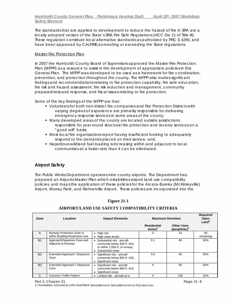
Airport Safety The Public Works Department operates nine county airports. The Department has prepared an Airports Master Plan which establishes airport land use compatibility policies, and maps the application of these policies for the Arcata-Eureka (McKinleyville) Airport, Murray Field, and Rohnerville Airport. These policies are incorporated into the
Figure 21-1
AIRPORT/LAND USE SAFETY COMPATIBILITY CRITERIA
Zone
Location
Impact Elements
Maximum Densities
Required Open Land3
Residential du/ac)1
Other Uses (people/ac)2
A Runway Protection Zone or within Building Restriction Line
• High risk • High noise levels
0 10 All remaining
B1 Approach/Departure Zone and Adjacent to Runway
• Substantial risk - aircraft commonly below 400 ft. AGL or within 1,000 ft. of runway
• Substantial noise
0.1 60 30%
B2 Extended Approach / Departure Zone
• Significant risk - aircraft commonly below 800 ft. AGL
• Significant noise
0.5 60 30%
B3 Extended Approach / Departure Zone
• Significant risk - aircraft commonly below 800 ft. AGL
• Significant noise
4 60 30%
C Common Traffic Pattern • Limited risk - aircraft at or 4 150 15%
Humboldt County General Plan Preliminary Hearing Draft April 19th, 2007 Workshop Safety Element
Part 3, Chapter 21 Page 21- 9 J:\PLANNING\ADVANCE\GPU\PLANTEXT\SafetyElement\SafetyElement3-21-07posted.doc
below 1,000 ft. AGL • Frequent noise intrusion
C* Common Traffic Pattern • Limited risk - aircraft at or below 1,000 ft. AGL
• Frequent noise intrusion
8 150 15%
C1 Common Traffic Pattern • Limited risk - aircraft at or below 1,000 ft. AGL
• Frequent noise intrusion
2 150 15%
C1* Common Traffic Pattern • Limited risk - aircraft at or below 1,000 ft. AGL
• Frequent noise intrusion
2.4 150 15%
D Other Airport Environs • Negligible risk • Potential for annoyance from
overflights
No limit
No limit
No requirements
Additional Criteria Examples
Zone Prohibited Uses Other Development Conditions
Normally Acceptable Uses4
Uses Not Normally Acceptable5
A • All structures except ones with location set by aeronautical function
• Assemblages of people • Objects exceeding FAR
Part 77 height limits • Hazards to flight6
• Dedication of avigation easement
• Aircraft tiedown apron • Pastures, field crops,
vineyards • Automobile parking
• Heavy poles, signs, large trees, etc.
B1 B2 and B3
• Schools, day care centers, libraries
• Hospitals, nursing homes • Highly noise-sensitive
uses • Storage of highly
flammable materials • Hazards to flight6
• Locate structures maximum distance from extended runway center-line
• Minimum NLR7 of 25 dBA in residential and office buildings
• Dedication of avigation easement
• Uses in Zone A • Any agricultural use
except ones attracting bird flocks
• Warehousing, truck terminals
• Single-story offices
• Residential subdivisions • Intensive retail uses • Intensive manufacturing
or food processing uses • Multiple story offices • Hotels and motels
C C* C1 and C1*
• Schools • Hospitals, nursing homes • Hazards to flight6
• Dedication of overflight easement for residential uses
• Uses in Zone B • Parks, playgrounds • Low-intensity retail
offices, etc. • Low-intensity
manufacturing, food processing
• Two-story motels
• Large shopping malls • Theaters, auditoriums • Large sports stadiums • Hi-rise office buildings
D • Hazards to flight6 • Deed notice required for residential development
• All except ones hazardous to flight
Source: Airport Land Use Compatibility Plan - Humboldt County Airports (Hodges & Shutt, 1993, amended 1/27/98) General Plan. The General Plan applies these compatibility policies to the County's six other airports. The Airport Land Use Commission (presently embodied as the Board of Supervisors) coordinates with applicable agencies in ensuring compatible land uses for areas surrounding county airports. The principal airport/land use compatibility issues at most airports are:
Noise: Often the most significant of the adverse impacts of airport activities. Airspace: The height of structures, trees, and other objects in the vicinity of an airport greatly affects the use of that airport.
Humboldt County General Plan Preliminary Hearing Draft April 19th, 2007 Workshop Safety Element
Part 3, Chapter 21 Page 21- 10 J:\PLANNING\ADVANCE\GPU\PLANTEXT\SafetyElement\SafetyElement3-21-07posted.doc
Safety: Controls on land uses near airports can reduce potential risks both to people on the ground and to the occupants of aircraft.
The key policy guidance is given by an Airport Land Use Compatibility Matrix (included here as Figure 21-1). The reader is referred to the Airport Master Plans (www.co.humboldt.ca.us/aviation/), for a more detailed discussion of airport land use issues and policies. Close coordination is needed between the Planning and Public Works Departments of the County in making land use and zoning decisions around the airports. Specific attention to this issue is given in the Community Plans, most importantly the McKinleyville Community Plan. Industrial Hazards Several specific industrial activities have been identified as having the potential to cause significant damage to the surrounding area in the event of an accident. These activities include the use of chlorine at the regional sewage treatment plants, shipping and receiving of hazardous materials other than chlorine, and the nuclear materials at the P.G. & E. Humboldt Bay Power Plant. Each of these activities/facilities has a contingency plan which directs the appropriate disaster responses. In addition, policy is provided here to address the siting of new hazardous industrial facilities. Emergency Management Humboldt County Ordinance 2203 established the Humboldt Operational Area (OA) and identified the Sheriff as Director of Emergency Services for the County. The Humboldt OA is composed of the County of Humboldt, serving as the lead agency, and all political subdivisions (Cities and Special Districts). The Office of Emergency Services (OES) assists the Sheriff in controlling and directing the effort of the emergency organization of the County and is part of the Special Operations Division within the Sheriff's Department. The OES is responsible for maintaining the Humboldt County Emergency Operations Plan which serves to address the planned response to extraordinary emergency situations associated with natural disasters, technological incidents, and national security emergencies in or affecting Humboldt County. OES also maintains specific hazard response plans for earthquake, flooding, tsunamis, coastal storms, and other events.

Humboldt County General Plan Preliminary Hearing Draft April 19th, 2007 Workshop Safety Element
Part 3, Chapter 21 Page 21- 11 J:\PLANNING\ADVANCE\GPU\PLANTEXT\SafetyElement\SafetyElement3-21-07posted.doc
21.3 Goals and Policies General Goal S-G1 Minimize loss. Minimize the potential for loss of life and property resulting from natural and manmade hazards. Policies S-P1 Reduce the potential for loss. Plan land uses and regulate new development to reduce the potential for loss of life, injury, property damage, and economic and social dislocations resulting from natural and manmade hazards, including but are not limited to, steep slopes, unstable soils areas, active earthquake faults, high wildland fire risk areas, airport influence areas, flood plains and tsunami runup areas. S-P2 Coastal Zone. Development within the coastal zone shall minimize risks to life and property in areas of high geologic, flood and fire hazard, assure stability and structural integrity and neither create nor contribute significantly to erosion, geologic instability or destruction of the site or surrounding areas or in any way require the construction of protective devices that would substantially alter natural landforms along bluffs and cliffs.* S-P3 Hazard Education. Encourage the education of the community regarding the nature and extent of hazards.* S-P4 Disaster Response Plans. Continue to provide for the maintenance and upgrading of disaster response plans.* S-P5 Local Hazard Mitigation Plan. Participate in FEMA’s pre-disaster mitigation program by developing, maintaining, and implementing a local hazard mitigation plan.
Geologic/Seismic S-P6 Structural Hazards. Provide for the identification and evaluation of existing structural hazards.* S-P7 Detailed Analysis. Encourage more detailed scientific analysis of natural hazards in the County.*
Flooding & Drainage Goals
Humboldt County General Plan Preliminary Hearing Draft April 19th, 2007 Workshop Safety Element
Part 3, Chapter 21 Page 21- 12 J:\PLANNING\ADVANCE\GPU\PLANTEXT\SafetyElement\SafetyElement3-21-07posted.doc
S-G2 Prevent Unnecessary Exposure. To prevent unnecessary exposure of people and property to risks of damage or injury from flooding.
S-G3 Natural Drainage and Watershed Protection. To protect the community’s natural drainage channels and watersheds by minimizing erosion, runoff and interference with surface and ground water flows. Policies S-P8 Federal Flood Insurance Program. The County shall participate in the Federal Flood Insurance Program to regulate land uses in flood hazard areas in order to minimize loss of life and property, and in order to minimize public flood-related expense.* S-P9 Flood Plains. Agricultural lands which are in flood plain areas shall be retained for use in agriculture.* S-P10 Natural Drainage Courses. Natural drainage courses, including ephemeral streams, shall be retained and protected from development which would impede the natural drainage pattern, increase erosion or sedimentation, or have a significant adverse effect on water quality or wildlife habitat. S-P11 Storm water discharges. Storm water discharges from outfalls, culverts, gutters and other drainage control facilities which discharge into natural drainage courses shall be dissipated so that they make no contribution to additional erosion, and where feasible are filtered and cleaned of pollutants. S-P12 Natural vegetation. Natural vegetation within and immediately adjacent to the bankfull stream channel shall be maintained except for flood control and public safety purposes. S-P13 Downstream Peak Flows. Development shall only be allowed in such a manner that downstream peak flows will not be increased. S-P14 Additional Drainage Facilities. Where it is necessary to develop additional drainage facilities, they shall be designed to be as natural in appearance and function as is feasible. All drainage facilities shall be designed to maintain maximum natural habitat of streams and their streamside management areas and buffers. Detention/retention facilities shall be managed in such a manner as to avoid reducing streamflows during critical low flow periods. S-P15 Restoration Projects. The County shall encourage restoration projects aimed at reducing erosion and improving existing habitat values in Streamside Management Areas. These projects may be pursued utilizing community volunteer programs and urban stream renewal grants. S-P16 Commercial and Industrial Activities. Commercial and industrial activities shall minimize, and eliminate to the extent possible, facility related discharges to the storm water system. As required by state codes and local ordinances, commercial and industrial storm water discharge must be routed to a
Humboldt County General Plan Preliminary Hearing Draft April 19th, 2007 Workshop Safety Element
Part 3, Chapter 21 Page 21- 13 J:\PLANNING\ADVANCE\GPU\PLANTEXT\SafetyElement\SafetyElement3-21-07posted.doc
wastewater collection system. For example, minimization of runoff from vehicle maintenance yards, car washes, restaurants cleaning grease, contaminated mats/carts into storm drains, other wash practices which results in materials other than plain water entering the storm drain system. S-P17 Erosion and Sediment Control Measures. The following erosion and sediment control measures shall be incorporated into development design and improvements: A. Minimize soil exposure during the rainy season by proper timing of grading and construction; B. Retain natural vegetation where feasible; C. Vegetate and mulch denuded areas to protect them from winter rains; D. Divert runoff from steep denuded slopes and critical areas with barriers or ditches; E. Minimize length and steepness of slopes by benching, terracing or constructing diversion structures; F. Trap sediment-ladened runoff in basins to allow soil particles to settle out before flows are released to receiving waters; G. Inspect sites frequently to ensure control measures are working properly and correct problems as needed; H. Allowance for the construction of public roads, trails, and utilities, when properly mitigated.
Fire Hazards Goals S-G4 Adequate Fire Protection. Assure adequate fire protection for new development. S-G5 Reduce Risk. Reduce the risk of destructive fire to Humboldt County communities. Policies S-P18 Master Fire Protection Plan. Utilize the Master Fire Protection Plan for overall fire protection policy. S-P19 Implementation Recommendations. Actively support and pursue the implementation recommendations in the Master Fire Protection Plan. S-P20 Adequate Fire Protection. The County will encourage new development to be located in areas with adequate fire protection.
S-P21 Clustered Development. Encourage clustered development to provide for more localized and effective fire protection measures. *
S-P22 Adequate Water Supplies. Proposed development shall be adequately serviced by water supplies for fire protection or shall have a letter from an

Humboldt County General Plan Preliminary Hearing Draft April 19th, 2007 Workshop Safety Element
Part 3, Chapter 21 Page 21- 14 J:\PLANNING\ADVANCE\GPU\PLANTEXT\SafetyElement\SafetyElement3-21-07posted.doc
appropriate fire protection agency indicating that adequate fire protection can be provided. *
S-P23 Adequate Fire Protection Services. Where no Fire District exists, project applicants shall provide verification, from the most appropriate local fire authority, that adequate fire protection services exist. Where an adequate level of service can not be verified, project approvals shall require a condition for and deed restriction notifying the property owner of the level of service available and acceptance of associated risks to life and property. S-P24 SRA Fire Safe Regulations. The County shall require compliance with Humboldt County SRA Fire Safe Regulations. S-P25 Descriptive Maps. The County shall make available descriptive maps to county residents which make them aware of what areas and assets are currently located within a fire protection district and which ones are not. S-P26 Level-of-Service Standards. The County shall encourage collaboration on the development of level-of-service standards for the provision of all fire protection services (fire, EMS, HazMat, rescue) in the County, and make such standards public so that landowners and residents understand what is and is not available to them. S-P27 Expanded Fire Protection Services. The County shall encourage the development of and/or expansion of additional fire protection services for unprotected and under-protected areas of Humboldt County. S-P28 Internet Access. The County shall make Internet accessible the countywide fire planning maps illustrating data such as fire district boundaries, SRA, and hazard areas. Provide Internet access to other specific fire-hazard related information and to the County Fire Plan. S-P29 Title III Allocation. When available, a portion of the Secure Rural Schools and Community Self-Determination Act, Title III funds will be allocated to local Fire Safe Councils and local fire prevention and protection agencies for coordination and planning. S-P30 Update Risk Assessment. The County shall update the Risk Assessment portion of the Master Fire Protection Plan every five years. S-P31 Prescribed Burning. Humboldt County should encourage the use of prescribed burning as a management tool for hazardous fuels reduction, timber management purposes, livestock production, and enhancement of wildlife habitat. S-P32 Hazardous Fuel Modification Projects. The County shall support an increase in countywide coordination of hazardous fuel modification projects by all involved agencies and organizations. Airport Safety

Humboldt County General Plan Preliminary Hearing Draft April 19th, 2007 Workshop Safety Element
Part 3, Chapter 21 Page 21- 15 J:\PLANNING\ADVANCE\GPU\PLANTEXT\SafetyElement\SafetyElement3-21-07posted.doc
S-P33 Development Compatibility. Ensure that future development within the community is compatible with the airport and its associated noise and hazards.* S-P34 Airport Land Use Compatibility Criteria. Regulate and plan land use around airports according to the Airport Land Use Compatibility Criteria matrix.* S-P35 Obstruction-free Approach Surfaces. The County should maintain obstruction- free approach surfaces at all airports as a high-priority project, annually monitoring the status of potential obstructions identified on the Approach and Clear Zone Plans.* S-P36 Airport Safety Combining Zone. Utilize an airport safety combining zone within airport influence areas to ensure consistent application of the Airport Land Use Compatibility Criteria matrix. Industrial Hazards S-P37 Hazardous Industrial Development. Hazardous industrial development may be permitted when either: 1) It includes mitigation measures sufficient to offset increased risks to adjacent human populations; or, 2) Increased risks to adjacent human populations have been adequately mitigated by approved disaster response plans. (See definition of "hazardous industrial development" in Standards section.) S-P38 Hazardous Waste. Require new development which may generate significant quantities of hazardous wastes to provide a plan for disposal which emphasizes on-site treatment, neutralization, and recycling. Emergency Management Goal S-G6 Response Preparedness. Ensure that the County is prepared to anticipate, respond to and recover from emergencies Policies S-P39 The Emergency Operations Plan. The Humboldt County Operational Area Emergency Operations Plan shall include general procedures to implement the nationwide National Incident Management System (NIMS), statewide Standardized Emergency Management System (SEMS), activate the Operational Area Emergency Operations Center (EOC), coordinate responders, and implement other tactical response measures.
Humboldt County General Plan Preliminary Hearing Draft April 19th, 2007 Workshop Safety Element
Part 3, Chapter 21 Page 21- 16 J:\PLANNING\ADVANCE\GPU\PLANTEXT\SafetyElement\SafetyElement3-21-07posted.doc
S-P40 Tsunami Ready Program. The County should become a Tsunami Ready community.
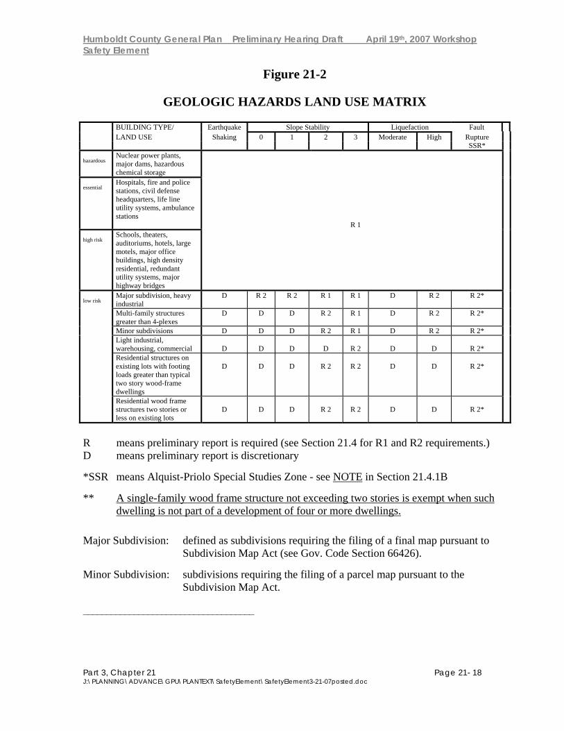
21.4 Standards Geologic S-S1 Geologic Report Requirements. Require geologic reports according to the Geologic Hazards Land Use Matrix (Figure 21-2) as follows: A. R1 Report Requirements:
1. A preliminary engineering geologic report and a preliminary soils engineering report shall be prepared for the classes of development and hazard areas indicated by "R1" in the Geologic Hazards Land Use Matrix.
2. The preliminary engineering geologic report shall be prepared by a
certified engineering geologist and shall provide a geological reconnaissance and evaluation of the project site and surrounding terrain. The preliminary report shall identify areas or issues which either do or do not require further engineering geologic and/or soils engineering evaluation.
3. The preliminary soil engineering report shall describe the nature of the
subsurface soils and any soil conditions which would affect the design and/or layout of the proposed development. The report shall include the locations and logs of any test borings and percolation test results if on-site sewage disposal is proposed. The report shall recommend areas or issues of concern which require additional engineering or geologic evaluation.
4. The additional information that is recommended by the preliminary reports shall
be provided or the proposed development shall be modified to avoid the identified areas of potential instability. The proposed development shall be sited and designed in accordance with the recommendations of the reports in order to minimize risk to life and property on the project site and for any other affected properties.
B. R2 Report Requirements NOTE: A report prepared by a registered geologist is required in the fault rupture Special Studies Zone unless waived pursuant to the Alquist-Priolo Act.
1. A preliminary engineering geologic report and a preliminary soils engineering report shall be prepared for the classes of development and hazard areas indicated by "R2" in the Geologic Hazards Land Use Matrix. These reports shall be prepared by either a registered geologist or a registered civil engineer experienced and knowledgeable in the practice of soil engineering. These reports shall provide a geologic reconnaissance and evaluation of the project site and surrounding terrain.
Humboldt County General Plan Preliminary Hearing Draft April 19th, 2007 Workshop Safety Element
Part 3, Chapter 21 Page 21- 17 J:\PLANNING\ADVANCE\GPU\PLANTEXT\SafetyElement\SafetyElement3-21-07posted.doc
2. A soils engineering analysis may meet the preliminary geologic report requirement for developments where the primary concerns are soils mechanics and appropriate structural design. In such cases it is incumbent upon the engineer to consult a registered geologist should it become apparent that an adequate structural solution requires additional geologic input. If, after preliminary investigation of the project site and the surrounding terrain, no geological consultation is felt by the engineer to be required, the engineer shall certify that such an evaluation is not required. It is incumbent upon the geologist to recommend that a soils engineer be consulted when it becomes apparent that soils mechanics analyses are needed.
3. The applicant shall either provide additional information as recommended by
the preliminary geologic or soils report or modify the application to avoid identified areas of potential instability. The proposed development shall be sited and designed in accordance with the recommendations of the report(s) in order to minimize risk to life and property on the project site and for any other affected properties.
C. The above required geologic reports, "R1" and "R2", shall be prepared in
accordance with the California Division of Mines and Geology (CDMG) Note #44, "Recommended Guidelines for Preparing Engineering Geologic Reports", or the current equivalent standard. CDMG Notes #37, 43, and 49 (or the current equivalent standard) shall be utilized as applicable when seismic or fault rupture hazards are identified as concerns. Within the coastal zone, the report shall follow the geologic report guidelines of the California Coastal Commission.
D. At the discretion of the County, the report requirement may be waived when
an adequate geologic assessment at a suitable scale already exists for the site proposed for development.
E. The criteria for determining whether or not a report is required when it is
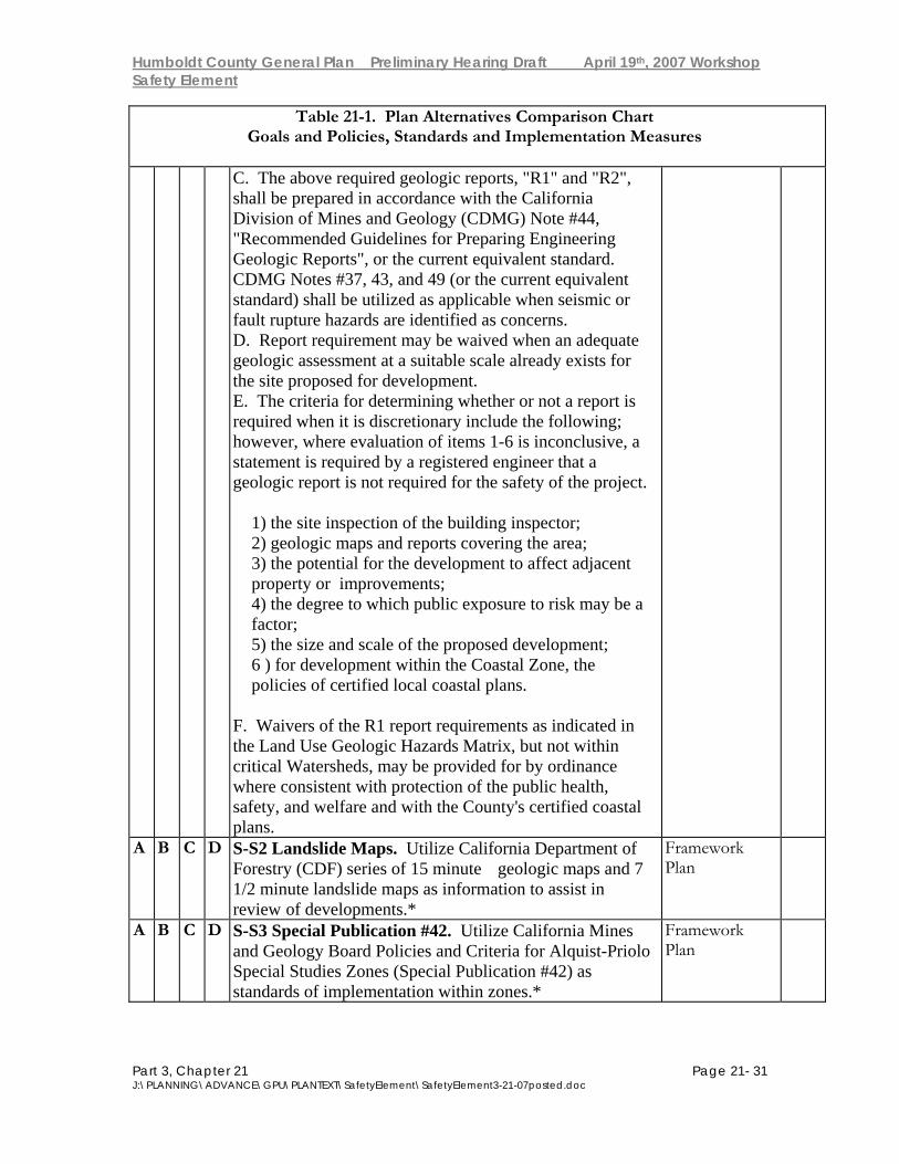
discretionary include the following; however, where evaluation of items 1-6 is inconclusive, a statement is required by a registered engineer that a geologic report is not required for the safety of the project.
1) the site inspection of the building inspector; 2) geologic maps and reports covering the area; 3) the potential for the development to affect adjacent property or
improvements; 4) the degree to which public exposure to risk may be a factor; 5) the size and scale of the proposed development; 6 ) for development within the Coastal Zone, the policies of certified local
coastal plans. F. Waivers of the R1 report requirements as indicated in the Land Use Geologic
Hazards Matrix, but not within critical Watersheds, may be provided for by ordinance where consistent with protection of the public health, safety, and welfare and with the County's certified coastal plans.
Humboldt County General Plan Preliminary Hearing Draft April 19th, 2007 Workshop Safety Element
Part 3, Chapter 21 Page 21- 18 J:\PLANNING\ADVANCE\GPU\PLANTEXT\SafetyElement\SafetyElement3-21-07posted.doc
Figure 21-2
GEOLOGIC HAZARDS LAND USE MATRIX BUILDING TYPE/ Earthquake Slope Stability Liquefaction Fault LAND USE Shaking 0 1 2 3 Moderate High Rupture SSR* hazardous
Nuclear power plants, major dams, hazardous chemical storage
essential
Hospitals, fire and police stations, civil defense headquarters, life line utility systems, ambulance stations
R 1
high risk
Schools, theaters, auditoriums, hotels, large motels, major office buildings, high density residential, redundant utility systems, major highway bridges
low risk
Major subdivision, heavy industrial
D R 2 R 2 R 1 R 1 D R 2 R 2*
Multi-family structures greater than 4-plexes
D D D R 2 R 1 D R 2 R 2*
Minor subdivisions D D D R 2 R 1 D R 2 R 2* Light industrial,
warehousing, commercial
D
D
D
D
R 2
D
D
R 2* Residential structures on
existing lots with footing loads greater than typical two story wood-frame dwellings
D
D
D
R 2
R 2
D
D
R 2*
Residential wood frame structures two stories or less on existing lots
D
D
D
R 2
R 2
D
D
R 2*
R means preliminary report is required (see Section 21.4 for R1 and R2 requirements.) D means preliminary report is discretionary *SSR means Alquist-Priolo Special Studies Zone - see NOTE in Section 21.4.1B ** A single-family wood frame structure not exceeding two stories is exempt when such
dwelling is not part of a development of four or more dwellings. Major Subdivision: defined as subdivisions requiring the filing of a final map pursuant to
Subdivision Map Act (see Gov. Code Section 66426). Minor Subdivision: subdivisions requiring the filing of a parcel map pursuant to the
Subdivision Map Act. _____________________________________
Humboldt County General Plan Preliminary Hearing Draft April 19th, 2007 Workshop Safety Element
Part 3, Chapter 21 Page 21- 19 J:\PLANNING\ADVANCE\GPU\PLANTEXT\SafetyElement\SafetyElement3-21-07posted.doc
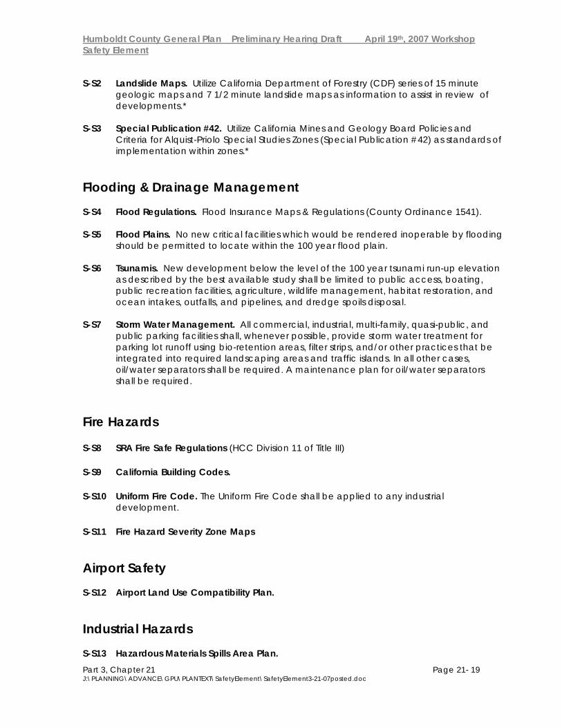
S-S2 Landslide Maps. Utilize California Department of Forestry (CDF) series of 15 minute geologic maps and 7 1/2 minute landslide maps as information to assist in review of developments.* S-S3 Special Publication #42. Utilize California Mines and Geology Board Policies and Criteria for Alquist-Priolo Special Studies Zones (Special Publication #42) as standards of implementation within zones.* Flooding & Drainage Management
S-S4 Flood Regulations. Flood Insurance Maps & Regulations (County Ordinance 1541). S-S5 Flood Plains. No new critical facilities which would be rendered inoperable by flooding should be permitted to locate within the 100 year flood plain. S-S6 Tsunamis. New development below the level of the 100 year tsunami run-up elevation as described by the best available study shall be limited to public access, boating, public recreation facilities, agriculture, wildlife management, habitat restoration, and ocean intakes, outfalls, and pipelines, and dredge spoils disposal. S-S7 Storm Water Management. All commercial, industrial, multi-family, quasi-public, and public parking facilities shall, whenever possible, provide storm water treatment for parking lot runoff using bio-retention areas, filter strips, and/or other practices that be integrated into required landscaping areas and traffic islands. In all other cases, oil/water separators shall be required. A maintenance plan for oil/water separators shall be required. Fire Hazards
S-S8 SRA Fire Safe Regulations (HCC Division 11 of Title III)
S-S9 California Building Codes.
S-S10 Uniform Fire Code. The Uniform Fire Code shall be applied to any industrial development.
S-S11 Fire Hazard Severity Zone Maps
Airport Safety S-S12 Airport Land Use Compatibility Plan. Industrial Hazards S-S13 Hazardous Materials Spills Area Plan.

Humboldt County General Plan Preliminary Hearing Draft April 19th, 2007 Workshop Safety Element
Part 3, Chapter 21 Page 21- 20 J:\PLANNING\ADVANCE\GPU\PLANTEXT\SafetyElement\SafetyElement3-21-07posted.doc
S-S14 Chlorine Accident Response Plans.* S-S15 Oil Spill Response Plan. S-S16 Tsunami Emergency Response Plan (in revision). S-S17 Prohibition on Transport of Nuclear Materials (Ordinance #1403; Humboldt County Code, Title III, Division 8, Chapter 3).* S-S18 Hazardous Industrial Development. Define "hazardous industrial development" as any development that handles toxic, flammable, or explosive materials in such quantities that would, if released or ignited, constitute a significant risk to adjacent human populations or development.* Emergency Management S-S19 Humboldt County Operational Area (OES): Humboldt County Ordinance 2203 S-S20 The California Emergency Services Act (Gov Code 8550 et seq.)
21.5 Implementation Drainage S-I1 Drainage Ordinance. The County shall develop an ordinance to implement the Drainage policies and standards. Fire S-I2 Level of Density. Determine a level of density at which structural fire protection services should be required. S-I3 Update County SRA Fire Safe Regulations. Humboldt County SRA Fire Safe Regulations should be updated to identify specific hazard zones where necessary, to ensure that fire risk is reduced to an acceptable level. These zones may specify special measures for implementation including: irrigated green belts, perimeter roads, roadway layout and design, slope development constraints, fuel modification zones, vegetation setbacks, and enforcement. S-I4 Fire Protection Implementation. Implementation of fire protection and prevention planning efforts is provided through the Humboldt County Master Fire Protection Plan. S-I5 Code Review. Review and amend as needed the code and subdivision regulations for consistency with fire protection policies of the General Plan.*

Humboldt County General Plan Preliminary Hearing Draft April 19th, 2007 Workshop Safety Element
Part 3, Chapter 21 Page 21- 21 J:\PLANNING\ADVANCE\GPU\PLANTEXT\SafetyElement\SafetyElement3-21-07posted.doc
______________________________________________________________________ NOTE: The section below will fall out of the ‘final’ version of the General Plan when it is adopted. It is provided here to assist the review process.
3.4 Staff Analysis and Alternatives State Requirements California Gov. Code § 65302(g) requires that the general plan include a safety element for the protection of the community from any unreasonable risks associated with the effects of seismically induced fault rupture, ground shaking, ground failure, tsunami, seiche, and dam failure; slope instability leading to mudslides and landslides; subsidence, liquefaction, and other known geologic hazards; flooding; and wildland and urban fires. Consideration of these issues also crosses over to topics specified in the conservation, open space, and land use elements. Chapter 21 Safety Element also includes the topic of Airport Safety, previously planned as a separate chapter, and industrial hazards, to provide a consolidated and comprehensive treatment of safety issues. Staff Recommendations The policies of this chapter are largely based on the 1984 Framework Plan. Some updates to the text and standards have been made, as well as incorporation of coastal policies to be applied within the coastal zone. The drainage policies are from the recently adopted McKinleyville Community Plan. The Fire section of the chapter represents the work done as part of the Master Fire Protection Plan, recently approved by the Board of Supervisors. Alternatives The body text of the chapter represents Alternative B, the proposed project. Alternative A includes the following additional policies: S-P5.1 GIS Hazards Database. A Geologic Constraints and Hazards Database shall be developed and maintained in the County Geographic Information System (GIS). The GIS shall be used to identify areas containing hazards and constraints that could potentially impact the type or level of development allowed in these areas. Maps maintained as part of the GIS include: a. Active Regional Faults b. Relative Seismic Shaking Hazards c. Relative Landslide Susceptibility d. Relative Earthquake Induced Liquefaction Susceptibility

Humboldt County General Plan Preliminary Hearing Draft April 19th, 2007 Workshop Safety Element
Part 3, Chapter 21 Page 21- 22 J:\PLANNING\ADVANCE\GPU\PLANTEXT\SafetyElement\SafetyElement3-21-07posted.doc
e. Steep Slope Constraints f. Coastal Erosion g. Moderate and High Erosion Hazards
h. Highly Erodible Soils
Additional policy alternatives will be developed based on public comment and agency input of this preliminary draft. Plan Alternatives Comparison Chart The “Vote” column is provided for the user to indicate a policy preference. Enter a Retain, Delete or Modify.
Table 21-1. Plan Alternatives Comparison Chart Goals and Policies, Standards and Implementation Measures
Plan Alternative Goals & Policies Staff Remarks
Vot
e:
R, D
, M
GOALS A B C S-G1 Minimize loss. Minimize the potential for loss of
life and property resulting from natural and manmade hazards.
A B C S-G2 Prevent Unnecessary Exposure. To prevent unnecessary exposure of people and property to risks of damage or injury from flooding.
A B C S-G3 Natural Drainage and Watershed Protection. To protect the community’s natural drainage channels and watersheds by minimizing erosion, runoff and interference with surface and ground water flows.
A B C S-G4 Adequate Fire Protection. Assure adequate fire protection for new development.
A B C S-G5 Reduce Risk. Reduce the risk of destructive fire to Humboldt County communities.
A B C S-G6 Response Preparedness. Ensure that the County is prepared to anticipate, respond to and recover from emergencies.
POLICIES
Humboldt County General Plan Preliminary Hearing Draft April 19th, 2007 Workshop Safety Element
Part 3, Chapter 21 Page 21- 23 J:\PLANNING\ADVANCE\GPU\PLANTEXT\SafetyElement\SafetyElement3-21-07posted.doc
Table 21-1. Plan Alternatives Comparison Chart Goals and Policies, Standards and Implementation Measures
A B C S-P1 Reduce the potential for loss. Plan land uses and
regulate new development to reduce the potential for loss of life, injury, property damage, and economic and social dislocations resulting from natural and manmade hazards, including but are not limited to, steep slopes, unstable soils areas, active earthquake faults, high wildland fire risk areas, airport influence areas, flood plains and tsunami runup areas.
A B C D S-P2 Coastal Zone. Development within the coastal zone shall minimize risks to life and property in areas of high geologic, flood and fire hazard, assure stability and structural integrity and neither create nor contribute significantly to erosion, geologic instability or destruction of the site or surrounding areas or in any way require the construction of protective devices that would substantially alter natural landforms along bluffs and cliffs.*
From Local Coastal Plans
A B C D S-P3 Hazard Education. Encourage the education of the community regarding the nature and extent of hazards.*
Framework Plan
A B C D S-P4 Disaster Response Plans. Continue to provide for the maintenance and upgrading of disaster response plans.*
Framework Plan
B C S-P5 Local Hazard Mitigation Plan. Participate in FEMA’s pre-disaster mitigation program by developing, maintaining, and implementing a local hazard mitigation plan.
A S-P5.1 GIS Hazards Database. A Geologic Constraints and Hazards Database shall be developed and maintained in the County Geographic Information System (GIS). The GIS shall be used to identify areas containing hazards and constraints that could potentially impact the type or level of development allowed in these areas. Maps maintained as part of the GIS include: a. Active Regional Faults b. Relative Seismic Shaking Hazards c. Relative Landslide Susceptibility d. Relative Earthquake Induced Liquefaction Susceptibility e. Steep Slope Constraints f. Coastal Erosion g. Moderate and High Erosion Hazards h. Highly Erodible Soils
A B C S-P6 Structural Hazards. Provide for the identification and evaluation of existing structural hazards.

Humboldt County General Plan Preliminary Hearing Draft April 19th, 2007 Workshop Safety Element
Part 3, Chapter 21 Page 21- 24 J:\PLANNING\ADVANCE\GPU\PLANTEXT\SafetyElement\SafetyElement3-21-07posted.doc
Table 21-1. Plan Alternatives Comparison Chart Goals and Policies, Standards and Implementation Measures
A B C D S-P7 Detailed Analysis. Encourage more detailed
scientific analysis of natural hazards in the County.* Framework Plan
A B C D S-P8 Federal Flood Insurance Program. The County shall participate in the Federal Flood Insurance Program to regulate land uses in flood hazard areas in order to minimize loss of life and property, and in order to minimize public flood-related expense.*
Framework Plan
A B C D S-P9 Flood Plains. Agricultural lands which are in flood plain areas shall be retained for use in agriculture.*
Framework Plan
S-P10 Natural Drainage Courses. Natural drainage courses, including ephemeral streams, shall be retained and protected from development which would impede the natural drainage pattern, increase erosion or sedimentation, or have a significant adverse effect on water quality or wildlife habitat.
From McKinleyville Area Plan
A B C S-P11 Storm water discharges. Storm water discharges from outfalls, culverts, gutters and other drainage control facilities which discharge into natural drainage courses shall be dissipated so that they make no contribution to additional erosion, and where feasible are filtered and cleaned of pollutants.
From McKinleyville Area Plan
A B C S-P12 Natural vegetation. Natural vegetation within and immediately adjacent to the bankfull stream channel shall be maintained except for flood control and public safety purposes.
From McKinleyville Area Plan
A B C S-P13 Downstream Peak Flows. Development shall only be allowed in such a manner that downstream peak flows will not be increased.
From McKinleyville Area Plan
A B C S-P14 Additional Drainage Facilities. Where it is necessary to develop additional drainage facilities, they shall be designed to be as natural in appearance and function as is feasible. All drainage facilities shall be designed to maintain maximum natural habitat of streams and their streamside management areas and buffers. Detention/retention facilities shall be managed in such a manner as to avoid reducing streamflows during critical low flow periods.
From McKinleyville Area Plan
Humboldt County General Plan Preliminary Hearing Draft April 19th, 2007 Workshop Safety Element
Part 3, Chapter 21 Page 21- 25 J:\PLANNING\ADVANCE\GPU\PLANTEXT\SafetyElement\SafetyElement3-21-07posted.doc
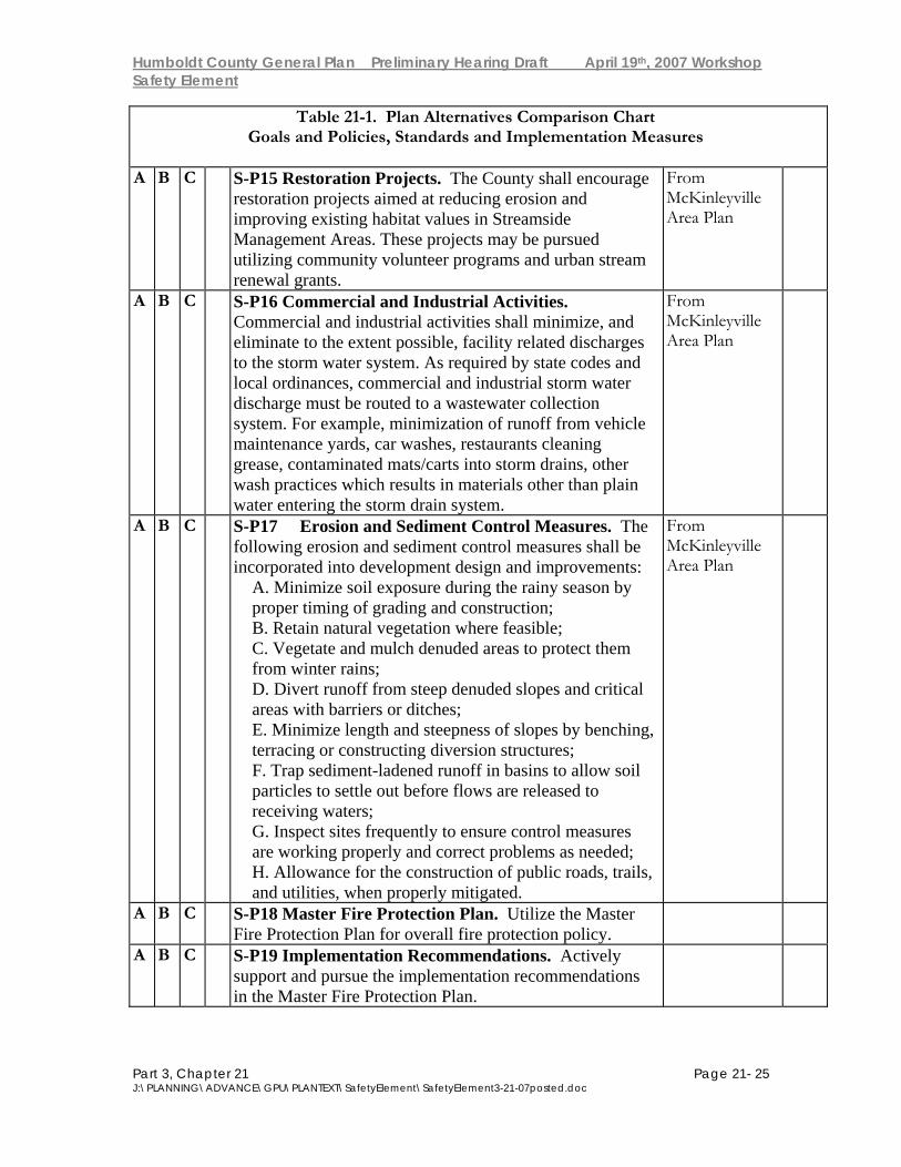
Table 21-1. Plan Alternatives Comparison Chart Goals and Policies, Standards and Implementation Measures
A B C S-P15 Restoration Projects. The County shall encourage
restoration projects aimed at reducing erosion and improving existing habitat values in Streamside Management Areas. These projects may be pursued utilizing community volunteer programs and urban stream renewal grants.
From McKinleyville Area Plan
A B C S-P16 Commercial and Industrial Activities. Commercial and industrial activities shall minimize, and eliminate to the extent possible, facility related discharges to the storm water system. As required by state codes and local ordinances, commercial and industrial storm water discharge must be routed to a wastewater collection system. For example, minimization of runoff from vehicle maintenance yards, car washes, restaurants cleaning grease, contaminated mats/carts into storm drains, other wash practices which results in materials other than plain water entering the storm drain system.
From McKinleyville Area Plan
A B C S-P17 Erosion and Sediment Control Measures. The following erosion and sediment control measures shall be incorporated into development design and improvements:
A. Minimize soil exposure during the rainy season by proper timing of grading and construction; B. Retain natural vegetation where feasible; C. Vegetate and mulch denuded areas to protect them from winter rains; D. Divert runoff from steep denuded slopes and critical areas with barriers or ditches; E. Minimize length and steepness of slopes by benching, terracing or constructing diversion structures; F. Trap sediment-ladened runoff in basins to allow soil particles to settle out before flows are released to receiving waters; G. Inspect sites frequently to ensure control measures are working properly and correct problems as needed; H. Allowance for the construction of public roads, trails, and utilities, when properly mitigated.
From McKinleyville Area Plan
A B C S-P18 Master Fire Protection Plan. Utilize the Master Fire Protection Plan for overall fire protection policy.
A B C S-P19 Implementation Recommendations. Actively support and pursue the implementation recommendations in the Master Fire Protection Plan.
Humboldt County General Plan Preliminary Hearing Draft April 19th, 2007 Workshop Safety Element
Part 3, Chapter 21 Page 21- 26 J:\PLANNING\ADVANCE\GPU\PLANTEXT\SafetyElement\SafetyElement3-21-07posted.doc
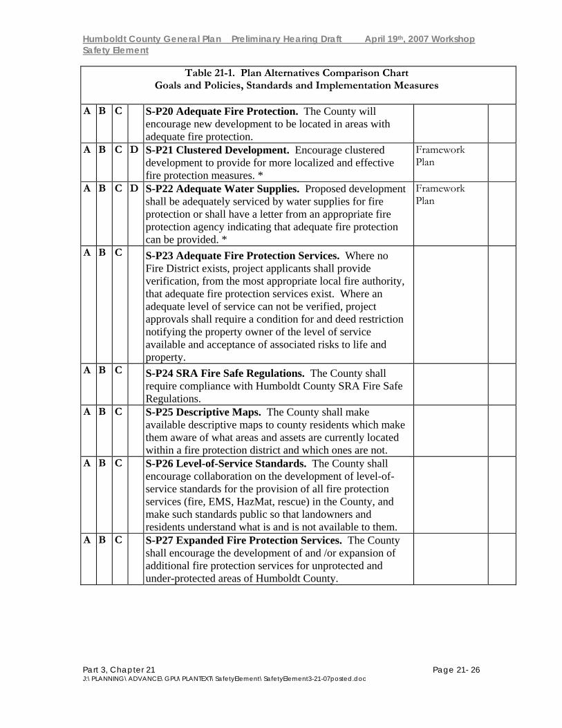
Table 21-1. Plan Alternatives Comparison Chart Goals and Policies, Standards and Implementation Measures
A B C S-P20 Adequate Fire Protection. The County will
encourage new development to be located in areas with adequate fire protection.
A B C D S-P21 Clustered Development. Encourage clustered development to provide for more localized and effective fire protection measures. *
Framework Plan
A B C D S-P22 Adequate Water Supplies. Proposed development shall be adequately serviced by water supplies for fire protection or shall have a letter from an appropriate fire protection agency indicating that adequate fire protection can be provided. *
Framework Plan
A B C S-P23 Adequate Fire Protection Services. Where no Fire District exists, project applicants shall provide verification, from the most appropriate local fire authority, that adequate fire protection services exist. Where an adequate level of service can not be verified, project approvals shall require a condition for and deed restriction notifying the property owner of the level of service available and acceptance of associated risks to life and property.
A B C S-P24 SRA Fire Safe Regulations. The County shall require compliance with Humboldt County SRA Fire Safe Regulations.
A B C S-P25 Descriptive Maps. The County shall make available descriptive maps to county residents which make them aware of what areas and assets are currently located within a fire protection district and which ones are not.
A B C S-P26 Level-of-Service Standards. The County shall encourage collaboration on the development of level-of-service standards for the provision of all fire protection services (fire, EMS, HazMat, rescue) in the County, and make such standards public so that landowners and residents understand what is and is not available to them.
A B C S-P27 Expanded Fire Protection Services. The County shall encourage the development of and /or expansion of additional fire protection services for unprotected and under-protected areas of Humboldt County.

Humboldt County General Plan Preliminary Hearing Draft April 19th, 2007 Workshop Safety Element
Part 3, Chapter 21 Page 21- 27 J:\PLANNING\ADVANCE\GPU\PLANTEXT\SafetyElement\SafetyElement3-21-07posted.doc
Table 21-1. Plan Alternatives Comparison Chart Goals and Policies, Standards and Implementation Measures
A B C S-P28 Internet Access. The County shall make Internet
accessible the countywide fire planning maps illustrating data such as fire district boundaries, SRA, and hazard areas. Provide Internet access to other specific fire-hazard related information and to the County Fire Plan.
A B C S-P29 Title III Allocation. When available, a portion of the Secure Rural Schools and Community Self-Determination Act, Title III funds will be allocated to local Fire Safe Councils and local fire prevention and protection agencies for coordination and planning.
A B C S-P30 Update Risk Assessment. The County shall update the Risk Assessment portion of the Master Fire Protection Plan every five years.
A B C S-P31 Prescribed Burning. Humboldt County should encourage the use of prescribed burning as a management tool for hazardous fuels reduction, timber management purposes, livestock production, and enhancement of wildlife habitat.
A B C S-P32 Hazardous Fuel Modification Projects. The County shall support an increase in countywide coordination of hazardous fuel modification projects by all involved agencies and organizations.
A B C D S-P33 Development Compatibility. Ensure that future development within the community is compatible with the airport and its associated noise and hazards.*
Framework Plan
A B C D S-P34 Airport Land Use Compatibility Criteria. Regulate and plan land use around airports according to the Airport Land Use Compatibility Criteria matrix.*
Framework Plan
A B C D S-P35 Obstruction-free Approach Surfaces. The County should maintain obstruction- free approach surfaces at all airports as a high-priority project, annually monitoring the status of potential obstructions identified on the Approach and Clear Zone Plans.*
Framework Plan
A B C S-P36 Airport Safety Combining Zone. Utilize an airport safety combining zone within airport influence areas to ensure consistent application of the Airport Land Use Compatibility Criteria matrix.

Humboldt County General Plan Preliminary Hearing Draft April 19th, 2007 Workshop Safety Element
Part 3, Chapter 21 Page 21- 28 J:\PLANNING\ADVANCE\GPU\PLANTEXT\SafetyElement\SafetyElement3-21-07posted.doc
Table 21-1. Plan Alternatives Comparison Chart Goals and Policies, Standards and Implementation Measures
A B C S-P37 Hazardous Industrial Development. Hazardous
industrial development may be permitted when either: 1) It includes mitigation measures sufficient to offset increased risks to adjacent human populations; or, 2) Increased risks to adjacent human populations have been adequately mitigated by approved disaster response plans.
A B C S-P38 Hazardous Waste. Require new development which may generate significant quantities of hazardous wastes to provide a plan for disposal which emphasizes on-site treatment, neutralization, and recycling.
A B C S-P39 The Emergency Operations Plan. The Humboldt County Operational Area Emergency Operations Plan shall include general procedures to implement the nationwide National Incident Management System (NIMS), statewide Standardized Emergency Management System (SEMS), activate the Operational Area Emergency Operations Center (EOC), coordinate responders, and implement other tactical response measures.
A B C S-P40 Tsunami Ready Program. The County should become a Tsunami Ready community.
Plan Alternative Standards Staff Remarks
Vot
e:
R, D
, M
Humboldt County General Plan Preliminary Hearing Draft April 19th, 2007 Workshop Safety Element
Part 3, Chapter 21 Page 21- 29 J:\PLANNING\ADVANCE\GPU\PLANTEXT\SafetyElement\SafetyElement3-21-07posted.doc
Table 21-1. Plan Alternatives Comparison Chart Goals and Policies, Standards and Implementation Measures
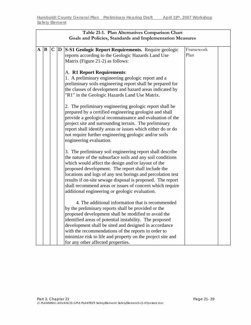
A B C D S-S1 Geologic Report Requirements. Require geologic
reports according to the Geologic Hazards Land Use Matrix (Figure 21-2) as follows: A. R1 Report Requirements: 1. A preliminary engineering geologic report and a preliminary soils engineering report shall be prepared for the classes of development and hazard areas indicated by "R1" in the Geologic Hazards Land Use Matrix.
2. The preliminary engineering geologic report shall be prepared by a certified engineering geologist and shall provide a geological reconnaissance and evaluation of the project site and surrounding terrain. The preliminary report shall identify areas or issues which either do or do not require further engineering geologic and/or soils engineering evaluation.
3. The preliminary soil engineering report shall describe the nature of the subsurface soils and any soil conditions which would affect the design and/or layout of the proposed development. The report shall include the locations and logs of any test borings and percolation test results if on-site sewage disposal is proposed. The report shall recommend areas or issues of concern which require additional engineering or geologic evaluation.
4. The additional information that is recommended by the preliminary reports shall be provided or the proposed development shall be modified to avoid the identified areas of potential instability. The proposed development shall be sited and designed in accordance with the recommendations of the reports in order to minimize risk to life and property on the project site and for any other affected properties.
Framework Plan

Humboldt County General Plan Preliminary Hearing Draft April 19th, 2007 Workshop Safety Element
Part 3, Chapter 21 Page 21- 30 J:\PLANNING\ADVANCE\GPU\PLANTEXT\SafetyElement\SafetyElement3-21-07posted.doc
Table 21-1. Plan Alternatives Comparison Chart Goals and Policies, Standards and Implementation Measures
A B C D B. R2 Report Requirements
NOTE: A report prepared by a registered geologist is required in the fault rupture Special Studies Zone unless waived pursuant to the Alquist-Priolo Act. 1. A preliminary engineering geologic report and a preliminary soils engineering report shall be prepared for the classes of development and hazard areas indicated by "R2" in the Geologic Hazards Land Use Matrix. These reports shall be prepared by either a registered geologist or a registered civil engineer experienced and knowledgeable in the practice of soil engineering. These reports shall provide a geologic reconnaissance and evaluation of the project site and surrounding terrain.
2. A soils engineering analysis may meet the preliminary geologic report requirement for developments where the primary concerns are soils mechanics and appropriate structural design. In such cases it is incumbent upon the engineer to consult a registered geologist should it become apparent that an adequate structural solution requires additional geologic input. If, after preliminary investigation of the project site and the surrounding terrain, no geological consultation is felt by the engineer to be required, the engineer shall certify that such an evaluation is not required. It is incumbent upon the geologist to recommend that a soils engineer be consulted when it becomes apparent that soils mechanics analyses are needed.
3. The applicant shall either provide additional information as recommended by the preliminary geologic or soils report or modify the application to avoid identified areas of potential instability. The proposed development shall be sited and designed in accordance with the recommendations of the report(s) in order to minimize risk to life and property on the project site and for any other affected properties.
Humboldt County General Plan Preliminary Hearing Draft April 19th, 2007 Workshop Safety Element
Part 3, Chapter 21 Page 21- 31 J:\PLANNING\ADVANCE\GPU\PLANTEXT\SafetyElement\SafetyElement3-21-07posted.doc
Table 21-1. Plan Alternatives Comparison Chart Goals and Policies, Standards and Implementation Measures
C. The above required geologic reports, "R1" and "R2",
shall be prepared in accordance with the California Division of Mines and Geology (CDMG) Note #44, "Recommended Guidelines for Preparing Engineering Geologic Reports", or the current equivalent standard. CDMG Notes #37, 43, and 49 (or the current equivalent standard) shall be utilized as applicable when seismic or fault rupture hazards are identified as concerns. D. Report requirement may be waived when an adequate geologic assessment at a suitable scale already exists for the site proposed for development. E. The criteria for determining whether or not a report is required when it is discretionary include the following; however, where evaluation of items 1-6 is inconclusive, a statement is required by a registered engineer that a geologic report is not required for the safety of the project.
1) the site inspection of the building inspector; 2) geologic maps and reports covering the area; 3) the potential for the development to affect adjacent property or improvements; 4) the degree to which public exposure to risk may be a factor; 5) the size and scale of the proposed development; 6 ) for development within the Coastal Zone, the policies of certified local coastal plans.
F. Waivers of the R1 report requirements as indicated in the Land Use Geologic Hazards Matrix, but not within critical Watersheds, may be provided for by ordinance where consistent with protection of the public health, safety, and welfare and with the County's certified coastal plans.
A B C D S-S2 Landslide Maps. Utilize California Department of Forestry (CDF) series of 15 minute geologic maps and 7 1/2 minute landslide maps as information to assist in review of developments.*
Framework Plan
A B C D S-S3 Special Publication #42. Utilize California Mines and Geology Board Policies and Criteria for Alquist-Priolo Special Studies Zones (Special Publication #42) as standards of implementation within zones.*
Framework Plan
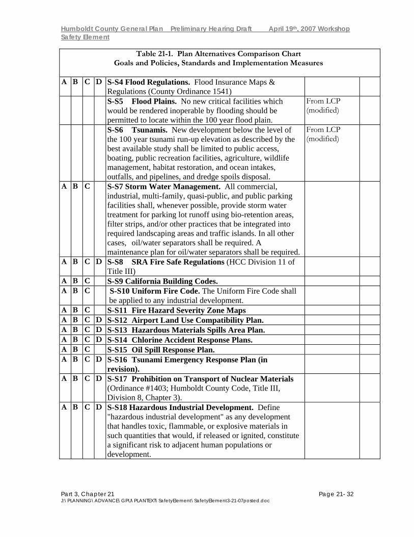
Humboldt County General Plan Preliminary Hearing Draft April 19th, 2007 Workshop Safety Element
Part 3, Chapter 21 Page 21- 32 J:\PLANNING\ADVANCE\GPU\PLANTEXT\SafetyElement\SafetyElement3-21-07posted.doc
Table 21-1. Plan Alternatives Comparison Chart Goals and Policies, Standards and Implementation Measures
A B C D S-S4 Flood Regulations. Flood Insurance Maps &
Regulations (County Ordinance 1541)
S-S5 Flood Plains. No new critical facilities which would be rendered inoperable by flooding should be permitted to locate within the 100 year flood plain.
From LCP (modified)
S-S6 Tsunamis. New development below the level of the 100 year tsunami run-up elevation as described by the best available study shall be limited to public access, boating, public recreation facilities, agriculture, wildlife management, habitat restoration, and ocean intakes, outfalls, and pipelines, and dredge spoils disposal.
From LCP (modified)
A B C S-S7 Storm Water Management. All commercial, industrial, multi-family, quasi-public, and public parking facilities shall, whenever possible, provide storm water treatment for parking lot runoff using bio-retention areas, filter strips, and/or other practices that be integrated into required landscaping areas and traffic islands. In all other cases, oil/water separators shall be required. A maintenance plan for oil/water separators shall be required.
A B C D S-S8 SRA Fire Safe Regulations (HCC Division 11 of Title III)
A B C S-S9 California Building Codes. A B C S-S10 Uniform Fire Code. The Uniform Fire Code shall
be applied to any industrial development.
A B C S-S11 Fire Hazard Severity Zone Maps A B C D S-S12 Airport Land Use Compatibility Plan. A B C D S-S13 Hazardous Materials Spills Area Plan. A B C D S-S14 Chlorine Accident Response Plans. A B C S-S15 Oil Spill Response Plan. A B C D S-S16 Tsunami Emergency Response Plan (in
revision).
A B C D S-S17 Prohibition on Transport of Nuclear Materials (Ordinance #1403; Humboldt County Code, Title III, Division 8, Chapter 3).
A B C D S-S18 Hazardous Industrial Development. Define "hazardous industrial development" as any development that handles toxic, flammable, or explosive materials in such quantities that would, if released or ignited, constitute a significant risk to adjacent human populations or development.
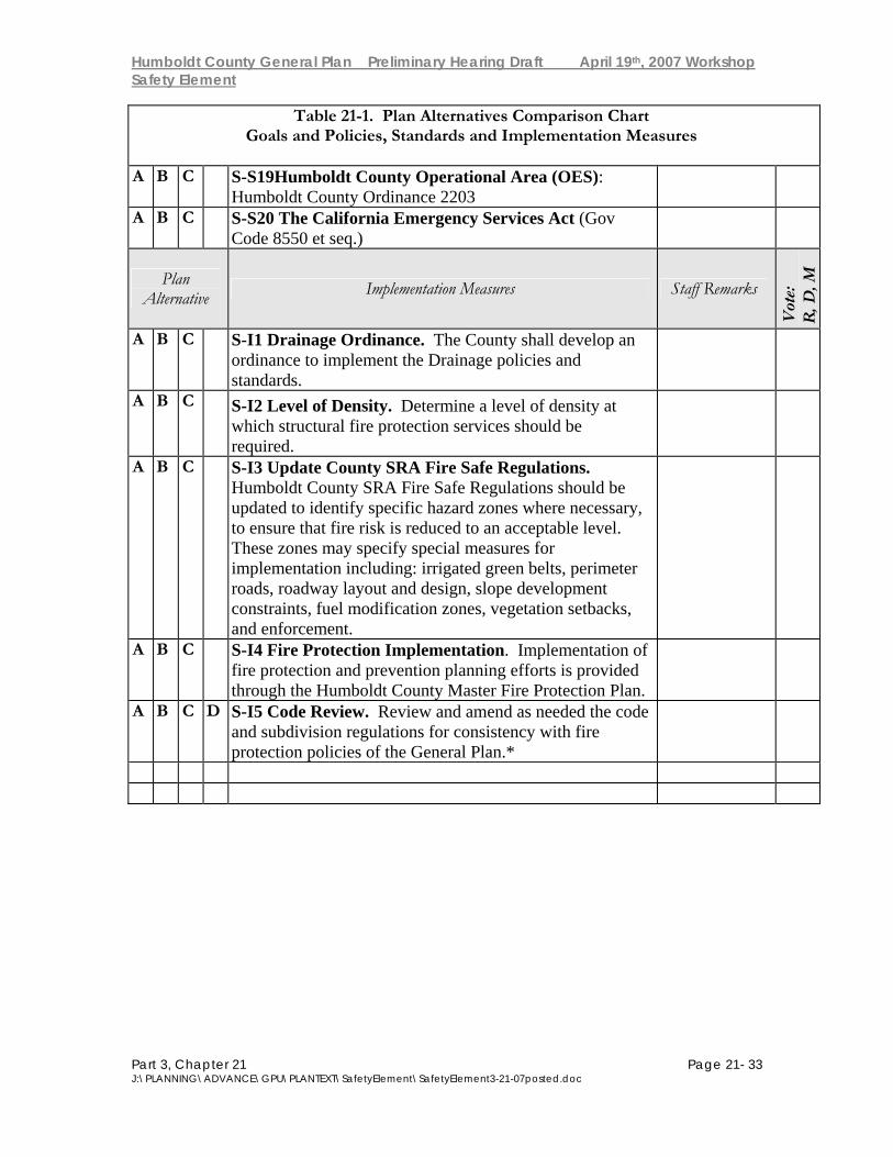
Humboldt County General Plan Preliminary Hearing Draft April 19th, 2007 Workshop Safety Element
Part 3, Chapter 21 Page 21- 33 J:\PLANNING\ADVANCE\GPU\PLANTEXT\SafetyElement\SafetyElement3-21-07posted.doc
Table 21-1. Plan Alternatives Comparison Chart Goals and Policies, Standards and Implementation Measures
A B C S-S19Humboldt County Operational Area (OES):
Humboldt County Ordinance 2203
A B C S-S20 The California Emergency Services Act (Gov Code 8550 et seq.)
Plan Alternative Implementation Measures Staff Remarks
Vot
e:
R, D
, M
A B C S-I1 Drainage Ordinance. The County shall develop an ordinance to implement the Drainage policies and standards.
A B C S-I2 Level of Density. Determine a level of density at which structural fire protection services should be required.
A B C S-I3 Update County SRA Fire Safe Regulations. Humboldt County SRA Fire Safe Regulations should be updated to identify specific hazard zones where necessary, to ensure that fire risk is reduced to an acceptable level. These zones may specify special measures for implementation including: irrigated green belts, perimeter roads, roadway layout and design, slope development constraints, fuel modification zones, vegetation setbacks, and enforcement.
A B C S-I4 Fire Protection Implementation. Implementation of fire protection and prevention planning efforts is provided through the Humboldt County Master Fire Protection Plan.
A B C D S-I5 Code Review. Review and amend as needed the code and subdivision regulations for consistency with fire protection policies of the General Plan.*