Chapter 4. Evaluation of Plan Alternatives - Humboldt County
81
Humboldt County General Plan Revised Draft EIR Chapter 4, Evaluation and Plan Alternatives Page 4-1 Chapter 4. Evaluation of Plan Alternatives 4.1. Introduction 4.1.1. State Requirements The primary intent of the alternatives analysis in an EIR, as stated in §15126.6(a) of the State CEQA Guidelines, is to “describe a range of reasonable alternatives to the project, or to the location of the project, which would feasibly attain most of the basic objectives of the project but would avoid or substantially lessen any of the significant effects of the project, and evaluate the comparative merits of the alternatives.” Further, the State CEQA Guidelines state that “the discussion of alternatives shall focus on alternatives to the project or its location which are capable of avoiding or substantially lessening any significant effects of the project, even if these alternatives would impede to some degree the attainment of the project objectives, or would be more costly” (Guidelines §15126.6(b)). An EIR must describe a range of reasonable alternatives to the proposed project that could feasibly attain most of the basic objectives of the project. The feasibility of an alternative may be determined based on a variety of factors, including but not limited to economic viability, availability of infrastructure, and other plans or regulatory limitations (Guidelines §15126.6(f)(1)). For general plan EIRs, the impacts of buildout under the full entitlement, the “maximum buildout” proposed by the plan, must be analyzed. Therefore, a maximum buildout estimate for each alternative is included. Maximum buildout is explained in more detail in Chapter 5 of this EIR - Other CEQA Considerations. 4.1.2. Project Objectives The basic objectives of the GPU are established by the following "Guiding Principles" in Chapter 1 of the GPU: 1. Ensure that public policy is reflective of the needs of the citizenry of a democratic society as expressed by the citizens themselves. 2. Preserve and enhance the diverse character of Humboldt County and the quality of life it offers. 3. Promote and facilitate the creation of affordable housing opportunities to meet current and future demands for all income levels. 4. Cooperate with services providers and promote efficient use of roads, water, and sewer services by encouraging development that is consistent with Land Use maps contained in the General Plan. Support home construction methods and alternative wastewater systems that are proven to minimize threats to human health and safety with a goal of reducing energy and water usage.
-
Upload
khangminh22 -
Category
Documents
-
view
2 -
download
0
Transcript of Chapter 4. Evaluation of Plan Alternatives - Humboldt County

Humboldt County General Plan Revised Draft EIR
Chapter 4, Evaluation and Plan Alternatives Page 4-1
Chapter 4. Evaluation of Plan Alternatives
4.1. Introduction 4.1.1. State Requirements The primary intent of the alternatives analysis in an EIR, as stated in §15126.6(a) of the State CEQA Guidelines, is to “describe a range of reasonable alternatives to the project, or to the location of the project, which would feasibly attain most of the basic objectives of the project but would avoid or substantially lessen any of the significant effects of the project, and evaluate the comparative merits of the alternatives.” Further, the State CEQA Guidelines state that “the discussion of alternatives shall focus on alternatives to the project or its location which are capable of avoiding or substantially lessening any significant effects of the project, even if these alternatives would impede to some degree the attainment of the project objectives, or would be more costly” (Guidelines §15126.6(b)). An EIR must describe a range of reasonable alternatives to the proposed project that could feasibly attain most of the basic objectives of the project. The feasibility of an alternative may be determined based on a variety of factors, including but not limited to economic viability, availability of infrastructure, and other plans or regulatory limitations (Guidelines §15126.6(f)(1)). For general plan EIRs, the impacts of buildout under the full entitlement, the “maximum buildout” proposed by the plan, must be analyzed. Therefore, a maximum buildout estimate for each alternative is included. Maximum buildout is explained in more detail in Chapter 5 of this EIR - Other CEQA Considerations. 4.1.2. Project Objectives The basic objectives of the GPU are established by the following "Guiding Principles" in Chapter 1 of the GPU:
1. Ensure that public policy is reflective of the needs of the citizenry of a democratic society as expressed by the citizens themselves.
2. Preserve and enhance the diverse character of Humboldt County and the quality of life it offers.
3. Promote and facilitate the creation of affordable housing opportunities to meet current and future demands for all income levels.
4. Cooperate with services providers and promote efficient use of roads, water, and
sewer services by encouraging development that is consistent with Land Use maps contained in the General Plan. Support home construction methods and alternative wastewater systems that are proven to minimize threats to human health and safety with a goal of reducing energy and water usage.

Humboldt County General Plan Revised Draft EIR
Chapter 4, Evaluation and Plan Alternatives Page 4-2
5. Support the County’s economic development strategy and other efforts to retain and create living-wage job opportunities.
6. Encourage, incentivize and support agriculture, timber, ecosystem services and
compatible uses on resource lands.
7. Support individual rights to live in urban, suburban, rural or remote areas of the county while using a balanced approach to protect natural resources, especially open space, water resources, fisheries habitat and water quality in cooperation with state and federal agencies.
8. Adhere to practical strategies that can be implemented utilizing constructive
cooperation and common sense. 9. Provide a clear statement of land use values and policies to provide clarity in the
County’s permit processing system and simplify review of projects. 10. Maximize the opportunities to educate the public about the planning process, in
order to have meaningful participation in the development and maintenance of the Plan.
11. Support a broad public participation program at all levels of the decision making
process; including study, workshops, hearings, a citizens handbook and plan revisions. 4.1.3 Approach to Identifying Alternatives The General Plan Update program began in 1998 by providing the public with choices on the desired range and scope of the General Plan Update effort (the “Critical Choices Phase”). This was followed by the “Sketch Plan Phase” (2002 – 2004), where four (4) generalized alternatives were developed and presented for public review. The public input in this phase resulted in the development of a proposed General Plan Update and three (3) generalized alternatives, which were presented to the Planning Commission in 2007. They were reviewed, discussed and refined in a series of public hearings before the Planning Commission in 2007 and 2008. The revised version of the draft General Plan and the three (3) alternatives were published in 2008 as the Preliminary Planning Commission Draft. Public hearings on this draft and the accompanying alternatives were held by the Planning Commission for three (3) years from 2009 - 2012. The culmination of the Planning Commission’s effort was the Planning Commission Approved Hearing Draft published in March, 2012. The Board of Supervisors held public hearings to refine the Project from June, 2012 through March, 2016. This chapter compares the environmental impacts of implementing the Project against the alternatives considered by the Board of Supervisors that would avoid or substantially lessen any of the significant environmental impacts. One alternative involves maintaining the current Framework Plan into the future, which is the “No Project” alternative required by CEQA to be evaluated in the EIR. 4.1.4. Alternatives that Were Considered But Rejected Consistent with CEQA, primary consideration was given to alternatives that could reduce significant impacts, while still meeting most of the project objectives. During the Sketch Plan phase of the General Plan Update program, two alternatives were developed, but did not

Humboldt County General Plan Revised Draft EIR
Chapter 4, Evaluation and Plan Alternatives Page 4-3
receive significant public support, so they were not carried forward. These original alternatives, known as “Sketch Plan 2” and “Sketch Plan 4” were comprised of maps and generalized goals and policy statements.
Sketch Plan 2: Expanded Growth Patterns Sketch Plan 2 proposed to increase developable parcels and densities compared to the existing Framework Plan. Land use designations were applied to accommodate increased growth. Sketch Plan 2 proposed a higher number of existing parcels that could be developed for homesites. It substantially expanded water service areas beyond present boundaries, thus providing more opportunities for homesites in the outlying parts of communities. Sketch Plan 2 allowed greater flexibility for market forces to determine the form and extent of new development. This would have resulted in a more dispersed development pattern around existing communities, providing extensive opportunities for 1 – 5 acre homesites. A transition between urban and rural areas was provided through Residential Estates lands, including large lot (2 acre or greater) rural residential subdivisions, which could be converted to urban residential densities (greater than 1 dwelling unit/acre) with the extension of sewer and water service. Sketch Plan 2 allowed existing development patterns to continue, including auto-oriented commercial development, but would revise County development standards and subdivision ordinance language to allow developers to respond to market demand for live/work, mixed-use, or neighborhoods designed with traditional town planning principles. Resource protection policies of the existing Framework Plan would be continued under Sketch Plan 2 except that additional resource lands adjacent to urbanized areas were proposed for conversion to residential development. In addition, Sketch Plan 2 included an Urban Fringe Timber land use designation intended to serve as a buffer between residential and resource production uses. Housing affordability was addressed in Sketch Plan 2 by increasing the number of parcels which could be subdivided outside of community plan areas. These parcels were planned for densities appropriate for on-site water and sewer services, that required less up-front investment for public water and sewer infrastructure. Sketch Plan 2 largely relied on market driven forces to address housing supply and demand, and made targeted public financing of infrastructure less of a priority. Performance standards and guidelines were used in Sketch Plan 2 to ensure that design, scale, and buffering of affordable housing projects (especially multi-family and assisted housing) retain the character of surrounding neighborhoods. Density categories were broad enough to allow for diversity of housing types; however, there would be no regulatory requirement to provide specific housing types. Commercial and industrial areas were designated largely based on existing use patterns, with additional areas for expansion. Big box retail was accommodated at selected sites. Community design relied largely on the market and policies contained in existing community plans to determine appropriate design. Overlay zones were proposed in Sketch Plan 2 to ensure protection for specific environmental resources and hazards, including wetlands, steep slopes, floodplains, sensitive habitat, Alquist-Priolo zones, and landslide areas.

Humboldt County General Plan Revised Draft EIR
Chapter 4, Evaluation and Plan Alternatives Page 4-4
Sketch Plan 4: Mixed Growth Patterns Sketch Plan 4 combined the development capacity of Sketch Plan 2 with higher urban density allowances and more resource protection policies than Sketch Plan 2. This resulted in the highest potential number of building sites among the Sketch Plan alternatives while maintaining resource lands protections. The Urban Fringe Timber designation was used in this alternative to serve as a buffer between residential and resource production uses. Sketch Plan 4 assumed housing needs were going to increase by three (3) times the historic rate of increase. These increased housing needs were met through development in currently served areas and urbanization expansion plans.
Housing Element Alternatives In addition to the Sketch Plan alternatives rejected early in the GPU update process, the 2009 Housing Element of the GPU, which was required by state law to move ahead of the other elements of the General Plan, evaluated alternatives that were rejected earlier in the GPU update process. One of those was a proposal to identify adequate sites to accommodate an annual growth rate of 2%, rather than the 0.5% rate projected by the state Department of Finance. This would amount to a household growth rate of close to 2,800 per year for the County, requiring 14,000 additional units by the year 2014. That would be close to 11,500 residential units more than state projections of the actual need. This alternative was rejected from further consideration because it was inconsistent with the state projections of household growth for the County. Another alternative that was considered in the 2009 Housing Element EIR was to limit new residential development to properties in urban areas currently served by public water and sewer, and rural properties with on-site septic systems. The proposal increased the density of residentially zoned properties in the areas with existing public water and sewer to meet the projected housing needs. This proposal would have eliminated approximately 2,100 potential units from the residential land inventory, properties presently planned and zoned for residential use that are presently without public water or sewer even though they are within the boundaries of community service districts that provide public water and sewer services. While other parcels within the service district boundaries could make up some of the lost development potential, the allowed densities would need to be increased by an average of 70% on those parcels. This alternative was rejected because the County is unlikely to achieve the 70% higher densities necessary to retain the development potential in the residential land inventory required by the state. Alternative C - the Expanded Growth Alternative Alternative C - the Expanded Growth Alternative considered by the Board of Supervisors would allow substantially more development than the Project, and eliminates many policies that protect the environment. It is rejected from further consideration in this EIR because it increases environmental impacts compared to the Project, and because CEQA only requires evaluation of alternatives in the EIR that would reduce or eliminate environmental impacts of the Project. The following paragraphs briefly describe the impacts associated with Alternative C - the Expanded Growth Alternative. Alternative C is a high residential capacity plan. The alternative provides for an increase in planned urban residential opportunities and urban-serviceable development compared to the Project. This alternative provides for modest expansion of urban areas, and increases the

Humboldt County General Plan Revised Draft EIR
Chapter 4, Evaluation and Plan Alternatives Page 4-5
amount of suburban land available for residential development. There would be more opportunities for large lot rural residential development with this alternative, recognizing additional rural residential areas established through current use. The policies and land use maps of Alternative C are less prescriptive and restrictive than the Project, taking a more laissez-faire market-based approach, and placing a greater reliance on case-by-case use of CEQA and discretionary decision-making. In many cases this alternative carries forward the policies of the current general plan (Alternative D), and omits more contemporary planning concepts, such as mixed-use designations and clustered development policies.
4.2. Description of Alternatives 4.2.1 Summary of Alternatives The range of alternatives considered by the Board of Supervisors was intended to provide a reasoned choice of options. The alternatives were selected to enhance meaningful public participation and informed decision-making. The General Plan Update process utilized alternatives as a central element in its public participation program. Aside from Alternative C - Expanded Growth Alternative described above, there were four alternatives considered by the Board of Supervisors:
Alternative A - Focused Growth Alternative, Alternative B - 2008 Proposed General Plan Update, Alternative D - No Project (i.e. development under the existing General Plan), and Alternative PC - The Planning Commission Recommended Hearing Draft
The paragraphs below summarize the key features of each of the four alternatives. That summary is followed by a more detailed analysis and comparison of the alternatives. Alternative A - The Focused Growth Alternative Compared to the Project, this alternative provides for a slight increase in planned urban residential densities in existing developed areas, increasing urban-serviceable development, including infill and mixed-use opportunities. It also reduces some planned residential expansion. Alternative A includes resource land protections including limitations on large lot residential development on resource lands. Table 4-1 shows Alternative A has an estimated maximum feasible development potential of 34,720 housing units, 4,250 units less than the Project. The land use maps and policies of Alternative A tend to be more prescriptive and restrictive, and are in general more protective of resources and the environment. It could also be characterized as a more contemporary plan, making increased use of modern planning concepts, such as mixed-use development designations. Alternative A accommodates more units on less land than the Project by slightly increasing densities on urban lands (3-8 units per acre versus 1-7 units in the Project) and slightly lowering the acreage devoted to residential uses. Alternative A classifies a greater number of acres for resource production land uses, and substantially reduces the planned residential capacity on a portion of the resource production lands that are considered of critical importance, specifically the lands designated Industrial Timberland (TI) and Ranchland (AGR). For other agricultural

Humboldt County General Plan Revised Draft EIR
Chapter 4, Evaluation and Plan Alternatives Page 4-6
lands, those designated Agricultural Exclusive (AE) or Agricultural Grazing (AG), the residential capacity of Alternative A is similar to the Project. Based on the analysis of environmental impacts, the EIR concludes that Alternative A would be the “environmentally superior” alternative as defined by CEQA. This chapter of the EIR concludes that Alternative A would overall be more protective of the environment than the Project. However, Alternative A does not achieve all of the project objectives, so it was not selected as the Preferred Alternative. Alternative A included different language for Guiding Principle 6; rather than “encourage, incentivize and support agriculture, timberland, ecosystem services and compatible uses on resource lands”, Alternative A used this language. “Protect agriculture and timberland over the long term, using measures such as increased restrictions on resource lands, subdivisions and patent parcel development.” Alternative A does not include the first part of Guiding Principle 7, “Support individual rights to live in urban, suburban, rural or remote areas of the county while using a balanced approach to protect natural resources…”. It also included former Guiding Principle 8, “Include actionable plans for infrastructure financing and construction”, which is not one of the Guiding Principles in the Project. Alternative B – The 2008 Proposed General Plan Update Alternative B is the 2008 Proposed General Plan Update (“2008 Draft”). Alternative B is designed to balance protection of resource lands with the need for residential development through focused development, appropriate urban expansion, and incentive-based clustering policies to encourage conservation of resource production lands. Table 4-1 shows Alternative B has an estimated maximum feasible development potential of 42,911 housing units, 3,941 units more than the Project. This chapter of the EIR concludes that Alternative B would overall be more protective of the environment than the Project. However, Alternative B does not achieve all of the project objectives, so it was not selected as the Preferred Alternative. As with Alternative A, Alternative B included different language for Guiding Principle 6; rather than “encourage, incentivize and support agriculture, timberland, ecosystem services and compatible uses on resource lands”, Alternative B used this language. “Protect agriculture and timberland over the long term, using measures such as increased restrictions on resource lands, subdivisions and patent parcel development.” Alternative B does not include the first part of Guiding Principle 7, “Support individual rights to live in urban, suburban, rural or remote areas of the county while using a balanced approach to protect natural resources…”. It also included former Guiding Principle 8, “Include actionable plans for infrastructure financing and construction”, which is not one of the Guiding Principles in the Project. Alternative D – The No Project Alternative (i.e. development under the existing General Plan) This alternative considers future development patterns continuing under the existing Framework Plan. It uses policies and land use designations contained in the current 1984 Humboldt County Framework General Plan. This is the “no project” alternative required under CEQA. Alternative D will also serve as a comparison baseline for the Project and the other alternatives. The existing Framework General Plan established community planning area boundaries and called for a program of individual community planning efforts. Within each planning area, urban development and urban expansion areas are defined based on service provider capabilities and logical expansion areas. Resource production lands (agricultural and timber) have been
Humboldt County General Plan Revised Draft EIR
Chapter 4, Evaluation and Plan Alternatives Page 4-7
given protection based largely on their existing zoning, with density ranges of 20 – 160 acres per unit. Similarly, other rural lands have been given density ranges of 20 – 160 acres per unit based on remoteness, natural resources, and natural hazard considerations. Housing availability is addressed by the community planning program and periodic updates of the Housing Element. Together these programs have provided a supply of residentially designated land, particularly multi-family designated land, which is a key component in meeting the required range of affordability. Alternative D does not contain policies that advocate clustering houses which preserve larger contiguous areas of open space. Commercial and industrial areas are designated largely based on existing land use patterns, with logical areas for expansion. Community design has been addressed in individual community plans, applying local design review and landscaping requirements. Alternative D does not include a Mixed Use land use designation, so residential and commercial areas are segregated in the commercial core areas. Acreage comparisons between the existing and proposed general plan are somewhat complicated by the naming convention used in the current plan which refers to many lands as “Agricultural” which are primarily large lot and suburban residential lands. For purposes of comparison with the Project and the other alternatives, the existing Framework General Plan land use designations of Agricultural Lands, Agricultural Rural, and Agricultural Suburban are classified as Rural Residential and Residential Estates in the land use comparison Table 4-1 presented later in this chapter. Table 4-1 shows Alternative D has an estimated maximum feasible development potential of 36,279 housing units, 2,691 units fewer than the Project. This chapter of the EIR concludes that overall, Alternative D would be less protective of the environment than the Project. Alternative PC – The Planning Commission-Recommended GPU This alternative considers future development patterns resulting from the GPU that the Planning Commission recommended to the Board of Supervisors in May, 2012. Many of the goals, policies, standards and implementation measures and land use map designations in the Board’s tentatively approved draft were the same as those selected by the Planning Commission in their recommended draft. However, there are some notable exceptions. In some cases the Planning Commission recommended policies which increase impacts on the environment compared to the Project. For example the Planning Commission recommended using the fish bearing status of a stream for setting minimum setback requirements from streams in Standard BR-S5 Streamside Management Areas Defined. However, not all the fish bearing streams have been mapped, resulting in reduced setbacks for new development from most streams compared to the Project. Other times the Planning Commission selected options that will likely have the opposite effect, reducing the environmental impacts compared to the Project. One example is the Planning Commission’s recommendation to require replanting or reseeding of disturbed areas with riparian vegetation of native species for projects that involve development within the Streamside Management Area in Standard BR-S8 Required Mitigation Measures. This requirement was deleted from BR-S8 in the Project. Table 4-1 shows Alternative PC has an estimated maximum feasible development potential of 38,278 housing units, 692 units fewer than the Project.

Humboldt County General Plan Revised Draft EIR
Chapter 4, Evaluation and Plan Alternatives Page 4-8
This chapter of the EIR concludes that with the exception of Standard BR-S5 discussed above Alternative PC would overall be more protective of the environment than the Project. However, Alternative PC does not achieve all of the project objectives, so it was not selected as the Preferred Alternative. As with Alternatives A and B, Alternative PC included different language for Guiding Principle 6; rather than “encourage, incentivize and support agriculture, timberland, ecosystem services and compatible uses on resource lands”, Alternative PC used this language. “Protect agriculture and timberland over the long term, using measures such as increased restrictions on resource lands, subdivisions and patent parcel development.” Alternative PC does not include the first part of Guiding Principle 7, “Support individual rights to live in urban, suburban, rural or remote areas of the county while using a balanced approach to protect natural resources…”. It also included former Guiding Principle 8, “Include actionable plans for infrastructure financing and construction” which is not one of the Guiding Principles in the Project.
4.3. Comparison of Effects Under Each Alternative The GPU alternatives reviewed by the Board of Supervisors included different sets of policy options and land use maps for each alternative. Generally the policy option sets were developed to reflect a range of approaches for addressing environmental issues. The policy options for each alternative are described in detail in the Alternatives Comparison Charts developed as a companion document to the Planning Commission Recommended GPU. They are available at the following website: (http://www.co.humboldt.ca.us/gpu/documentskeyissuesplanalt.aspx), and at the Planning Division office at 3015 H Street, Eureka California 95501, and are incorporated into this EIR by reference as if set forth fully herein. Appendix V of this EIR compares the policy options that have potential impacts to the environment. The below paragraphs describe the key differences between the Project and each of the alternatives by the environmental impact categories in Chapter 3 of this EIR. 4.3.1 Land Use, Population, and Housing The Land Use Element provides for the distribution, location and extent of uses of land for housing, business, industry, natural resources, open space, recreation, and other uses. The Element guides patterns of development for the County, providing a long-range context for decisions made regarding zoning, subdivision, and public works. These land use policies guide growth and the development and use of land through 2040. The chapter covers population growth and land supply, urban and rural boundaries, development timing policies, and urban and rural development policies. Because of the importance of lands devoted to forest and agricultural uses, these topics are given extended policy treatment in the chapter, and are given separate treatment in this EIR (see Resource Lands discussion below). The chapter describes the kinds, intensity, and location of planned uses, primarily through the General Plan Land Use Designation Map and the supporting descriptions of the land use classifications found in Section 4.8. Land Use Maps The Land Use Maps for the Project are included in Appendix F of the General Plan Update. The Land Use Maps for the Plan Alternatives are at the following website

Humboldt County General Plan Revised Draft EIR
Chapter 4, Evaluation and Plan Alternatives Page 4-9
http://www.co.humboldt.ca.us/gpu/documentsMaps.aspx; both sets of maps are available at the Planning Division office (3015 H Street, Eureka, California, 95501). The land use maps in Appendix A and Appendix V of this EIR show Alternative A and Alternative B encourage proportionately more development in urban areas within the boundaries of community service districts providing public sewer and/or water, with some provisions for logical extensions of those boundaries. As shown on the land use maps, more of the new development will occur in those areas compared to Alternative D, Alternative PC, and the Project. The maximum feasible development potential estimates for housing units and commercial and industrial acreages are presented below in Table 4-1. The maximum buildout figures are presented for each alternative and represent what would happen if all the available land was developed during Plan’s timeframe (to the year 2040) to the maximum extent feasible given site constraints such as steep slopes, flood hazards, availability of public services, etc. Maximum feasible development potential estimates the highest theoretical amount of development that would be possible under each alternative. While that level of development is not expected to occur, it is a useful quantitative tool to compare the alternatives in a meaningful way.

Humboldt County General Plan Revised Draft EIR
Chapter 4, Evaluation and Plan Alternatives Page 4-10
Table 4-1. Acres and Estimated Maximum Feasible Development Potential Estimates for Land Use Designations By Alternative.
Land Use Designation
Alternative A Alternative B Alternative D
(Framework Plan) Planning
Commission GPU Board of Supervisors
GPU
Acres
Max Number of Units Acres
Max Number of Units Acres
Max Number of Units Acres
Max Number of Units Acres
Max Number of Units
Residential RM 617 5,598 679 5,964 713 891 654 4,888 698 5,158 RL 9,505 15,922 9,692 17,428 10,084 8,665 9,878 12,009 11,284 12,004 RE 10,281 1,085 12,342 1,244 17,513 2,485 12,207 1,148 14,155 1,165 RA (Formerly RR) 153,474 1,995 154,984 2,162 156,289 4,858 153,845 2,101 156,047 2,092 Commercial CG 363 259 369 238 600 199 360 176 446 176 CS 366 435 462 368 547 170 516 284 602 239 CR 1,437 691 1,521 836 2,965 188 1,598 813 1,789 806 Mixed Use MU 405 1,011 323 1,027 0 184 263 932 279 925 VC 311 97 313 97 235 182 367 78 119 78 RCC 1,516 1,168 1,585 1,096 1,396 145 1,788 920 1,540 920 Industrial IG or MG 1,686 0 1,768 0 2,096 0 1,773 0 1,998 0 IR 154 0 186 0 240 0 199 0 382 0 MC 553 0 934 0 977 0 934 0 971 0 MB 41 0 41 0 29 0 41 0 46 0 Resource Production T, TI or TC 888,277 3,125 883,234 7,963 899,717 8,312 886,057 7,810 893,571 7.814 AE 64,013 479 60,905 436 59,465 1,767 68,752 419 75,487 419 AG or AGR 402,475 2,684 406,707 3,363 409,722 4,345 399,328 6,698 381,875 6,713 Open Space CF 2,955 0 2,888 0 1,411 127 3,462 0 4,904 0 CFR 588 0 588 0 428 0 0 0 0 0 NR or MR 9,195 24 9,157 24 9,801 588 9,214 0 10,693 0 OS 585 5 660 0 52 20 646 0 342 0 PF 2,870 108 2,870 217 2,594 183 2,878 0 7,418 0 P 567,481 22 566,858 443 544,572 1,412 566,986 0 673,673 0 PR 11,133 0 10,794 0 8,871 107 10,785 0 12,556 0 TL or TTL 127,543 12 127,965 5 127,507 1,410 128,025 1 129,040 461
Total 2,257,824 34,720 2,257,825 42,911 2,257,824 36,279 2,260,556 38,278 2,379,918 38,970Source: Humboldt County Planning and Building Department, 2017

Humboldt County General Plan Revised Draft EIR
Chapter 4, Evaluation and Plan Alternatives Page 4-11
Growth Planning and Urban Land Use The complete set of Growth Planning and Urban Land Use policy differences between the plan alternatives are presented in the Plan Alternative Comparison Chart for Urban Land Uses; the subset of policies that have environmental impacts are presented in Appendix A and Appendix V of this EIR. Alternative A In summary, Alternative A has policy language that imposes more restrictions on new development, which will likely reduce environmental impacts in comparison to the Project and other alternatives. For example, Alternative A would not allow new development served by individual sewage disposal systems within areas served by public sewer:
GP-P6. (Alternative A) Use of On-Site Sewage Systems for new development within Urban Development Areas. The utilization of on-site sewage disposal systems for new development within the Urban Development Area shall not be acceptable.
Alternative B The policy language for Alternative A is more restrictive than the Alternative B policy language, which is as follows:
GP-P6. (Alternative B) Use of On-Site Sewage Systems for Subdivisions within Urban Development Areas. The utilization of on-site sewage disposal systems shall not be acceptable for new subdivisions in the Urban Development Area, unless public sewer services are not available to serve the proposed subdivision and the local sewer service provider provides a written statement that the area is not planned for service in the service provider’s Municipal Service Review and other written long-term plans.
In this instance, the Alternative A policy language would be expected to reduce water quality impacts from new development in urban areas by not allowing on-site individual sewage disposal systems because effluent contaminated with coliform bacteria is more likely to be carried into nearby creeks and rivers from on-site individual sewage disposal systems than from public sewer systems. Alternative D The policy for Alternative D is the least protective of water quality:
GP-P6. (Alternative C and D version - 2633.4). Utilization of public water services should be encouraged in the urban development area.
Alternative PC The policy language for Alternative PC falls in between the two alternatives described above, and is expected to have fewer water quality impacts from individual on-site sewage disposal systems than Alternative B, but more impacts than Alternative A:
GP-P6. (Alternative PC) Use of On-Site Sewage Systems within Urban Development Areas. The utilization of on-site sewage disposal systems shall not be acceptable for new development including subdivisions in the Urban Development Area, unless the Planning Commission makes specific factual findings that: 1) the extension of services are physically infeasible; or 2) the area is not planned for

Humboldt County General Plan Revised Draft EIR
Chapter 4, Evaluation and Plan Alternatives Page 4-12
service in the service provider’s Municipal Service Review and other written long-term plans; or 3) the services are not reasonably available in a timely manner.
Project The policy language for the Project is very similar to Alternative B, and is expected to have more water quality impacts from individual on-site sewage disposal systems than Alternative A. The strikeout text is what was deleted from Alternative PC:
GP-P6. (the Project) Use of On-Site Sewage Systems within Urban Development Areas. The utilization of on-site sewage disposal systems shall not be acceptable for new development, including subdivisions in the Urban Development Area, unless the Planning Commission makes specific factual findings that: 1) the extension of services are physically infeasible; or, 2) the area is not planned for service in the service provider’s Municipal Service Review and other written long-term plans; or, 3) the services are not reasonably available in a timely manner.
Alternative A also contains policies better protecting historic structures (Policy UL-P9 Historic Structures), and better ensuring compatibility of new development with existing neighborhoods (UL-P12 Design Review and UL-P20 Landscaping) than the other alternatives and the Project. Further analysis comparing the impacts of the alternatives and the Project on water quality, historic resources, and neighborhood capacity is provided later in this chapter.
In terms of the land use maps, Alternative A has about 25% less commercial land than the Project, Alternative B and PC also have less commercial land. Alternative A has about half the amount of commercial land as Alternative D, which has the most commercial acreage of any alternative, and 45% more commercial acreage than the Project. Alternative A, B and PC all have less industrial lands than the Project. Alternative D has about the same amount of industrial land as the Project. The following charts help explain some of the other Growth Planning and Urban Land Use differences between the Plan Alternatives.

Humboldt County General Plan Revised Draft EIR
Chapter 4, Evaluation and Plan Alternatives Page 4-13
Growth Planning Key Topics and Issues Alternative A Existing Framework Plan
(Alternative D) Alternative B Alternative PC/Project
Land Supply, Public Services and Infrastructure and Development Timing The Plan must provide for a sufficient supply of developable land with adequate services to accommodate expected growth. Should growth be focused in and around existing infrastructure and services or should growth be more widely distributed without regard to the current location of services and infrastructure? How should increases in the supply of land to accommodate growth be timed with the expansion of public services and infrastructure?
Requires urban development to occur within Urban Development Areas (GP-P3). Relies on increasing urban densities and increasing land supply through expansion of Urban Development Areas as land within development areas is consumed (GP-9). Requires sewer and water service to all new development and subdivisions within Urban Development Areas (GP-6).
Goals, policies and standards are roughly equivalent to B. Planning areas, such as Urban Development Area and Urban Expansion Area, originate in the Framework Plan, however, they have not been well defined in all communities. Utilization of public sewer and water is encouraged but not required in Urban Development Areas (GP-P6, GP-P7). Does not include implementation measures.
Urban Development Boundaries, Urban Expansion Boundaries and Community Plans Areas are used to provide an adequate supply of land in proximity to services and infrastructure. Expansion of development areas is approved by the Planning Commission and Board of Supervisors as land within development areas is consumed. (GP-P1 through GP-P9, GP-S4, GP-S8, and GP-IM1). Polices require use of public sewer and water (for new development) inside Urban Development Areas and prohibit sewer connections outside (GP-P2, P5, P8, P9). New subdivisions can be served with on-site septic if there are no plans to extend sewer service (GP-P6)
Alternative PC Similar to Alternative B – changes include: P6 – requires new development to hook up to sewer within district boundaries unless PC makes specific findings. P10 – modified Alt A. – conversion of resource lands – findings necessary for inclusion in UEA’s. S8 – deleted. Project The policy language for the Project is very similar to Alternative B, and is expected to have more water quality impacts from individual on-site sewage disposal systems than Alternative A.
Community Planning Community Plans allow more direct citizen involvement and focused consideration of local land
Equivalent to B. Roughly equivalent to B. Proposed community planning areas are almost identical to those in existing Framework
Maintains community planning areas as a means of precise land planning, mapping and setting of growth
Alternative PC Same as Alternative B except P6 (see discussion above).

Humboldt County General Plan Revised Draft EIR
Chapter 4, Evaluation and Plan Alternatives Page 4-14
Growth Planning Key Topics and Issues Alternative A Existing Framework Plan
(Alternative D) Alternative B Alternative PC/Project
use issues. Should the Plan continue to support and facilitate the preparation and amendment of individual Community Plans?
Plan. In practice, individual community plans have become more comprehensive, time consuming and costly. This has been due, in part, to the lack of frequent updates of the Framework Plan,
boundaries and timing mechanisms (GP-P1--P7, GP-S1-S2, and GP-IM1). Changes in the proposed plan have been designed to allow increased focus and brevity in community planning processes. Community Plan-specific policies are included as Appendix C.
The Project Limits GP-P6 to new subdivisions.
Urban Lands Key Topics and Issues Alternative A Alternative B Existing Framework Plan
(Alternative D) Alternative PC/Project
Revitalization of Communities Based on community input, the revitalization of developed communities for business expansion, residential growth, and renewed public investment in infrastructure and services should be one of the highest priorities of the Plan. Which incentives and regulations would encourage investment in developed communities?
Alternative A provides less incentives for streamlined regulatory approvals in Urban Development Areas to allow more comprehensive project by project review. Includes policy requiring a mix of uses in Mixed-Use zones for a better balance between jobs and housing.
Urban Development Area designations are used to identify preferred areas for business expansion, housing opportunities and investments in infrastructure (UL-P1). Includes streamlined approvals in core residential (UL-P2) and business areas (UL-P3), mixed-use zoning (UL-P6), and other policies to enhance core areas (UL-P4, -P7).
Development policies in the Framework Plan use plan and zone designations on individual properties and Community Plan Area designations to guide development. Framework policies do not directly address incentives and regulatory reform to promote the revitalization of communities.
Alternative PC Same as Alternative B except P3 - removed cottage industries as principal use in neighborhood centers, town centers and business zones. – revise zoning standards first. Project Similar to Alternative PC.

Humboldt County General Plan Revised Draft EIR
Chapter 4, Evaluation and Plan Alternatives Page 4-15
Urban Lands Key Topics and Issues Alternative A Alternative B Existing Framework Plan
(Alternative D) Alternative PC/Project
Community Identity Residents want new development to compliment the character of their communities. What is the appropriate mix of policies to maintain and enhance community character? Should the Plan provide for and/or encourage the use of mixed use areas? Should the Plan increase the level of design review for development, for example, streetscape appearance in business districts?
The nature of community identity policies in Alternative A are similar to the Alternative B, although it is more aggressive in requiring retention of historic structures. Applies the Mixed Use designation (through land use maps) more extensively than Alt B. Included an implementation measure to develop a form-based development code Would extend design review to more commercial areas through overlay zones. Applies design review to Town Centers and major subdivisions within Urban Development Areas.
Promotes aesthetically appealing UDA’s that preserve and enhance existing community character and provides for town centers to serve as community focal points (UL-G2, -G3, -G4; UL-P5, -P7, -P8, -P9, -P11, -P12). Includes provisions for mixed-use (MU) designation (UL-P6, -P7). Promotes preferred design concepts and design review through UL-P7, P10 -12, P15 -16, P20, UL-S6 and UL-IM8-9.
The Framework Plan does not address preserving existing community identity. Does not include a Mixed Use planned land use designation. Some treatment in Community Plans and design review areas.
Alternative PC Same as Alternative B. Project Similar to Alternative PC. Eliminated Policy UL-P15 “Pedestrian Friendly Streetscapes” so it does less to encourage mixed uses in commercial areas. Alternative PC Merged UL-P10, UL-P15 and UL-P16 into one policy. Otherwise equivalent to B. Project Same as Alternative B.
Humboldt County General Plan Revised Draft EIR
Chapter 4, Evaluation and Plan Alternatives Page 4-16
Urban Lands Key Topics and Issues Alternative A Alternative B Existing Framework Plan
(Alternative D) Alternative PC/Project
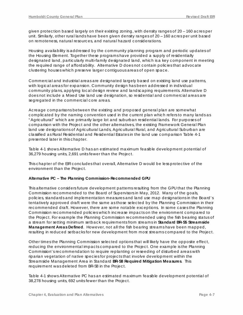
The Board requested that the Plan address big box development and adult entertainment. What are the appropriate policies for these uses? How should the Plan address marijuana cultivation?
Same as Alt. B (differences would be within ordinance.) Not specifically addressed.
Includes policies, standards, and recommended implementation for big box and adult entertainment uses (UL-P13, -P14, -S4, -S5, -IM13, -IM14). Not specifically addressed.
Not specifically addressed. Not specifically addressed.
Alternative PC Similar to Alt. B, except specific design guidance for breaking up monolithic appearance of big box stores was deleted. Also, the requirement for discretionary review of big box projects was deleted (ED-P6). Project Same as Alt. D. Alternative PC Includes a policy and implementation measure to regulate marijuana cultivation by ordinance (UL-P21, UL-IM15). Project Same as Alt. PC
A complete listing of the policy differences between the Plan Alternatives and the Project is contained in Appendix A and Appendix V of this EIR.

Humboldt County General Plan Revised Draft EIR
Chapter 4, Evaluation and Plan Alternatives Page 4-17
Rural Land Use All the policy differences between the plan alternatives are presented in the Plan Alternative Comparison Chart for Rural Land Uses; the subset of policies that have environmental impacts are presented in Appendix A and Appendix V of this EIR. Alternative A In general, Alternative A, in comparison to the Project, has more restrictive policy language for policies RL-P2 - Water Withdrawal and RL-S4 Subdivision Standards, and includes the implementation measure RL-IMx - Decrease Inventory of Rural Residential Lands. Because of this policy language, Alternative A would have fewer impacts on water quality than the other alternatives by ensuring new discretionary development does not impact streams through water withdrawl and subdivisions, and by reducing the number of new residential units dependent on in-stream water sources for domestic water supply. Alternative B Alternative B establishes an implementation program to review the inventory of rural residential lots during the Housing Element update (every five years) to make sure the inventory is adequate for future growth (RL-IM1). Alternative B would inventory and map substandard rural roads to determine areas where development is constrained by substandard roads. Would establish overlay zones to reflect identified constraints (RL-IM2). It does not include as many restrictions on rural development as Alternative A, and would result in more impacts in rural areas than Alternative A. Alternative D Alternative D would continue the existing Framework Plan policies on rural lands which do not address some key rural land use issues identified for the General Plan Update, such as water withdrawal, subdivision standards, clustering rural residential development and road constraints in rural areas. Alternative PC and the Project There is no policy difference between Alternative PC and the Project in the Rural Lands section of the GPU. Alternative A has the least amount of rural residential land of all alternatives, and the maximum buildout of homes on these lands is only two-thirds of that for the Project. Alternative D has the highest rural residential development potential of all the alternatives with a maximum buildout of 11,304 homes on parcels designated Rural Residential Agriculture and Residential Estates. The following chart helps explain the Rural Land policy differences between the Plan Alternatives.

Humboldt County General Plan Revised Draft EIR
Chapter 4, Evaluation and Plan Alternatives Page 4-18
Rural LandsKey Topics and Issues Alternative A Alternative B Existing Framework
Plan (Alternative D) Alternative PC/Project
Adequate supply of lands planned Rural Residential An adequate supply of land for rural living is critical to support rural lifestyles and culture, provide opportunities for growth for successive generations and people moving into the County, and to support the County’s economy and rural town centers. Is the current inventory of vacant rural residential lands adequate for future rural development? Should the County re-zone lower quality agricultural and timber production lands to increase the inventory of lands planned for rural residential uses?
Inventory and road mapping policies equivalent to Alt. B. A plan and zoning program would decrease the availability of rural residential lands for homestead development (RL-IMx).
Establishes an implementation program to review the inventory of rural residential lots during the Housing Element update (every five years) to make sure the inventory is adequate for future growth (RL-IM1). Would inventory and map substandard rural roads to determine areas where development is constrained by substandard roads. Would establish overlay zones to reflect identified constraints (RL-IM2).
The Framework Plan does not contain a requirement for review of rural residential lots as a part of the Housing Element update. Standards for subdivision of rural lands are similar to those found in Alt. B (2554.9).
Alternative PC Same as Alternative B for IM1, minor language changes for IM2. The Project There is no policy difference between Alternative PC and the Project in the Rural Lands section of the GPU

Humboldt County General Plan Revised Draft EIR
Chapter 4, Evaluation and Plan Alternatives Page 4-19
Rural LandsKey Topics and Issues Alternative A Alternative B Existing Framework
Plan (Alternative D) Alternative PC/Project
Compatibility of rural residential uses and commercial resource production. Conflicts can occur between lands planned for commercial resource extractive uses and rural residential uses that can impact the profitability and viability of agriculture and timber production. Which policies are effective in maintaining profitable agricultural and timber production adjacent to lands planned primarily for rural homesteads?
The same policies as Alt. B.
Development on rural residential lands must be planned to be compatible with agriculture and timber production (RL-S1). Clustered development would be promoted to protect resource lands (RL-P7) and all rural subdivisions would need to be evaluated for compatibility with continued resource productivity (RL-S1), requiring a Right to Harvest or Farm agreement. Requires commercial development to be located in developed areas such as rural community centers unless the development is rural in nature, e.g., retreat or camp, or meets rural cottage industry standards (RL-P3).
The Framework Plan does not contain policies that advocate clustering houses. Encourages commercial development to be located in developed areas (RL-P3 -2554.6)
Alternative PC Minor revisions to Alternative B language. P2 adds review of cumulative impacts of onsite septic in critical watersheds; S3 adds additional standards to cottage industry in critical watershed areas. The Project There is no policy difference between Alternative PC and the Project in the Rural Lands section of the GPU

Humboldt County General Plan Revised Draft EIR
Chapter 4, Evaluation and Plan Alternatives Page 4-20
Rural LandsKey Topics and Issues Alternative A Alternative B Existing Framework
Plan (Alternative D) Alternative PC/Project
Carrying capacity of rural lands, wild land fire risks and public service costs. Water withdrawal, habitat fragmentation, sediment discharge to waterways, introduction of ignition sources and deficiencies in road maintenance can accompany rural residential development. Traditional regulatory approaches to protect public health and safety and minimize environmental impacts are often viewed as inappropriate infringement on rural property owner’s rights and property values. Is there a need for local land use regulation and permitting systems in rural residential areas? What practices or programs would increase the sustainability of rural development given anticipated increased in rural populations?
Cumulative impacts of water withdrawals and on-site septic systems evaluated for subdivisions, zone changes and discretionary development (RL-P2). Same as Alt. B for road improvements.
Policies and standards guide the division of rural residential lands so that future development will not be subject to adverse impacts from geologic instability, flooding or fire and would require adequate access, water, and sewage disposal for future development (RL-P4, RL-P5 and RL-S4). Alternative B would allow for clustered rural development that provides a density bonus when significant permanent land dedications are secured (RL-P7). Future subdivisions and zone changes in rural residential areas must evaluate the cumulative impacts of water withdrawals and on-site septic systems (RL-P2). Changes in zoning density and subdivision approvals require road improvements to minimum County standards at time of subdivision or incrementally as future development occurs. (RL-P5).
Cumulative impacts of water withdrawals and sewage disposal evaluated for zone changes only. (RL-P2 – 2553.7) Changes in zoning should reflect road constraints (RL-P5 – 2554.8). Requirements for subdivisions to meet minimum county road standards contained in FRMK 2554.9 and the subdivision ordinance.
Alternative PC RL-P2 is more restrictive than in Alt. B with an assessment of the cumulative impacts from on-site sewage disposal systems as well as water withdrawal. The Project There is no policy difference between Alternative PC and the Project in the Rural Lands section of the GPU
A complete listing of the policy differences between the Plan Alternatives and the Project is contained in Appendix A and Appendix V of this EIR.

Humboldt County General Plan Revised Draft EIR
Chapter 4, Evaluation and Plan Alternatives Page 4-21
4.3.2 Agricultural and Timberland Resources All the alternatives have a similar amount of land designated T - Timberland. Alternative A reduces the maximum buildout of homes on these timberlands to just 33% of the Project and the other alternatives. Aside from Alternative A, Alternative B has least amount of development potential on resource lands, with a maximum buildout of 72% of that of the Project. Alternative D designates more land for agricultural and timberland use than the Project and the other alternatives, but this is primarily due to transfers of timberlands to public open space uses, which are not accounted for in Alternative D. These transfers have already occurred, so there are no practical benefits to the conservation of agriculture and timberland on the land use maps for Alternative D compared to the other alternatives. With new development in the future, Alternative D allows more housing to be built on such lands than the Project and other alternatives, and therefore is the least protective of resource production land use. Based on the land use map designations, Alternative A is more protective of resource productions land use than the Project and other alternatives, and would result in less irreversible conversion of such lands to other uses.
Alternative A Alternative A has stronger policies for preservation of agricultural and timber lands than the other alternatives, including the Project. For example, Agricultural Standard S1 contains the following language preventing subdivision of agricultural lands:
AG-S1. (Alternative A) Subdivision of Ranchlands (AGR) and Agricultural Exclusive (AE) Lands. No further subdivision of lands planned AGR and AE unless the subdivision is necessary for the protection of cultural resources or to mitigate impacts of public acquisition.
This policy is more protective than the other alternatives and the Project:
AG-S1. (Project and Alternative PC) Subdivision of Planned Agricultural Exclusive (AE) Lands. Within areas designated AE, no agricultural land division will be approved whereby any parcel thusly created will be less than 60 acres.
AG-S1. (Alternative B) Subdivision of Planned Agricultural Exclusive (AE) Lands. Within areas designated AE, no agricultural land division will be approved whereby any parcel thusly created will be less than 60 acres. However, divisions of these agricultural lands to a minimum size of 20 acres may be approved if the Planning Commission finds that the division is necessary for a specific agricultural purpose (e.g., to provide for a separate starter farm for a family member), and the division will not adversely affect the area’s agricultural economy or environmental resources. The rezoning and parcel map may be approved only upon satisfaction of all of the following conditions: A. Conveyance of a permanent agricultural easement to the County of Humboldt or other
public entity or private non- profit corporation, having as its chief goal the preservation of agricultural or open space lands.
B. Conveyance of development rights beyond those necessary for agricultural purposes. C. Recorded acknowledgment that, although the new parcel is of a size below that
considered a viable economic agricultural unit, its creation was approved for a specific agricultural purpose, and no further division or other conversion from agricultural use, except to other open space or habitat restoration use, will be allowed in the future even if agricultural use of such separate parcel does not provide adequate economic return.
AG-S1. (Alternative D) 2722.3 Minimum Parcel Size: Sixty (60) acres minimum parcel size, except
that divisions to 20 acres may be permitted where the parcel is subject to an agricultural preserve contract or agreement. The total number of building sites shall not exceed a density

Humboldt County General Plan Revised Draft EIR
Chapter 4, Evaluation and Plan Alternatives Page 4-22
of one dwelling unit per 20 acres. A use permit or special permit shall be required where a density of more than one dwelling unit per parcel is sought, except that 40 acres or larger agriculture parcels zoned Agriculture Exclusive (AE) will be allowed two single family farm dwellings as a principal use. Total homesite coverage shall not exceed two acres for both dwellings and accessory structures. (Res. 89-106, 6- 27-89).
By limiting the subdivision of agricultural lands, Alternative A keeps agricultural lands in larger parcel sizes, which facilitates their use for agricultural purposes. Alternative A also includes a Ranchland designation (AGR), which has a density range of one (1) unit per 160 – 600 acres, which would also tend to keep agricultural areas mapped with this designation intact with larger parcel sizes than the other alternatives. Alternative A includes additional policies for preventing agricultural land conversion, loss of agricultural productivity and conflicts from un-permitted development (AG-P15. Compliance with Regulations), protection of agricultural soils (AG-P16. Protect Productive Agricultural Soils), and recognition of substandard parcels (AG-P17. Substandard Legal Parcels). Alternative PC and the Project both incorporated AG-P16 and AG-P17, but not AG-P17. Alternative D Alternative D, the existing 1984 Framework Plan, has policies that are less protective of resource lands than the other alternatives and the Project because of their flexible nature. For example, Policy 2523.7 of Alternative D states, “Areas with General Plan designations of Agriculture Exclusive should not be annexed to cities or service districts providing sewer service unless it is in the public interest.” This compares to the stronger language of AG-P6 Agricultural Land Conversion - No Net Loss in Alternative PC, “Lands planned for agriculture (AE, AG) shall not be converted to non-agricultural uses unless the Planning Commission makes the following findings: 1. There are no feasible alternatives that would prevent or minimize conversion…”
Alternative PC Alternative PC has mixed impacts on the protection of agricultural and timberlands compared to Alternative B. While Alternative PC contains some stronger protections in its policies and standards than Alternative B, including Standard AG-S1 shown above, it deletes the Ranchland designation from the land use maps, increasing the likelihood these properties will be converted to other uses, so it is less protective of agricultural resources than Alternative B in that way.
The Project The Project is somewhat less protective of Timberlands than Alternative PC by providing for increased housing in Timberlands through second residences and by reducing the standards ensuring compatibility with timber production. And Policy FR-P8 was modified in the Project to be less protective than Alternative PC as shown below in strikeout and underline. The strikeout text is Alternative PC language, and the underline text is the Project language:
“FR-P8. Protection of High Quality Timberlands. Parcels of Timber Site Quality III or higher outside Community Planning Areas shall be conserved to maintain timber production as a primary use. Timberlands planned and zoned for timber production should be retained for timber production, harvesting and compatible uses, and reclassification of the Timberland Production Zones (TPZ) shall be done in accordance with the statutory requirements
The Project also reclassifies single family homes in Table 4-G Resource Production Land Use Classifications from “Residence incidental to Principal Use” to “Single Family Residence”, allowing homes to be permitted without regard to the property’s resource use. Second Residential Units were also added as a permitted use without regard to the property’s resource use. The differences between the alternatives are further explained in the following chart.

Humboldt County General Plan Revised Draft EIR
Chapter 4, Evaluation and Plan Alternatives Page 4-23
Agricultural Resources Key Topics and Issues Alternative A Alternative B Existing Framework Plan
(Alternative D)Alternative PC/Project
Stable Land Base The long-term sustainability of Humboldt’s agricultural economy hinges on the continued profitability of agricultural operations and the availability of farm land. Conversion of agriculture lands to other uses, such as rural residential and natural resources preservation, can negatively impact the agricultural industry as a whole. What blend of policies will provide the most protection for agricultural lands with the least impact on property values.
Similar to Alternative B, it contains development timing polices to control conversion of agricultural land for urban expansion and prohibits conversion for other purposes (AG-P5). Includes explicit permitting compliance program (AG-Px). Explicit protection of prime soils (AG-Pxx). Generally, no further subdivisions on lands planned AE and AGR would be allowed (AG-P5, AG-S1).
Includes a planned rural development program (AG-P1). Subdivision of agricultural land requires specific findings and residential subdivision of Agricultural Exclusive (AE) lands would not be allowed (AG-P5). Conversion of prime agricultural lands must include offsetting protections so there is no net loss (AG-P6). The Right-to-Farm Notice would continue to be used to protect producers from nuisance complaints from neighbors (AG-P8).
Does not contain policies that allow clustering of houses. Protects resource lands by advocating infill and establishing logical boundaries between urban and resource production areas using plan and zone designations. Includes an annual reporting requirement for the conversion of agricultural lands to other uses (2523.2 and 5-2520.1).
Alternative PC Similar to Alternative A – AG-P5, S1 and S6 use Plan A language, AG-P6 (no net loss) has been modified to prevent conversion of any ag land unless specific findings are made by the PC, and P8 includes the right to harvest timber in the policy language. Two Plan A policies have been included – Px and Pxx with IMx. Project The Project is Similar to Alternative PC
Economic Viability of Ag Lands and Land Use Programs While agriculture is one of the most enduring industries in Humboldt county, operators are facing increasing challenges to maintain
Similar to B. Explicitly adds research of a Transfer of Development Rights program and a carbon sequestration program into the County agricultural land conservation program (AG-IM2).
Includes a planned rural development program that provides a density bonus when residential development is clustered and located on the least productive areas in exchange for permanent protection
Supports the Williamson Act Program (AG-P3 - 5-2520.3). Supports Predator Control program (AG-P9 - 2523.5) and vegetation management (AG-P11 -2523.6) Promotes economic parcel sizes
Alternative PC Same as Alternative B with minor modifications to P7 and P12. AG-IM6 includes language from Alternative A regarding a compliance program

Humboldt County General Plan Revised Draft EIR
Chapter 4, Evaluation and Plan Alternatives Page 4-24
Agricultural Resources Key Topics and Issues Alternative A Alternative B Existing Framework Plan
(Alternative D)Alternative PC/Project
economically viable operations. The long-term sustainability of the agricultural land base and industry depends on continued commercial profitability. What measures can the County take to increase the long-term profitability of agricultural land management and production?
on the remainder. Can allow fractional sale of ranchland while maintaining overall productivity (AG-P1). Supports voluntary sale of residential development rights (AG-P2). Continues support for Williamson Act program (AG-P3). Supports supplemental farm income from activities compatible with agriculture (AG-P4). Supports continued agricultural production of lands under easement or purchased by a public agency (AG-P7). Includes a policy to seek advice from the farm community on planning projects near agricultural lands (Ag-P12). Includes program to brand and market local agricultural products (AG-IM7).
(AG-P13 - 2523.4 and 2523.9). Supported adoption of the “Right to Farm” ordinance. Supports public services for the agricultural industry (2523.11).
for Williamson Act contracts. Project The Project is Similar to Alternative PC

Humboldt County General Plan Revised Draft EIR
Chapter 4, Evaluation and Plan Alternatives Page 4-25
Forest Resources Key Topics and Issues Alternative A Alternative B Existing Framework
Plan (Alternative D) Alternative PC/Project
State and Federal Regulatory Issues High regulatory costs for timber harvesting can have the unintended consequence of promoting the conversion of Timberlands to potentially more environmentally harmful residential uses. Increased regulatory efficiency for timber harvesting may yield lower process and compliance costs with little or no loss in environmental performance. Should the County advocate for improved state and federal regulatory efficiency as a means to support continued timber harvesting as the primary land use in Timberlands (T)?
Same as Alternative B. Defers timber harvest reviews to CAL FIRE unless significant land use conflicts require input from the County (FR-P2). Provides policy guidance to the Board of Supervisors for state and federal regulatory issues to support fewer more effective and lower-cost timber regulation to maintain forestlands in timber production (FR-P3). Provides specific support for broader use of NTMP’s for multiple land owners to help reduce permit-ting costs (FR-P4). Requires periodic review of County policy and the Forest Practices Act to promote compatibility (FR-IM8 and IM9). Supports CAL FIRE’s plans to increase regulatory efficiency and productivity of timberlands (FR-P1).
Provides policy guidance to “encourage the long-term management of timberlands” (2514.1). Supports the use of forest improvement programs (2514.4) and more local control for rezoning of lands in TPZ (5-2510.5).
Alternative PC Alternative PC had a split vote on FR-P2 and FR-P3, with half supporting Alternative B language, and half supporting Alternative A language. Project The Project is somewhat less protective of Timberlands than Alternative PC by providing for increased housing in Timberlands through second residences and by reducing the standards ensuring compatibility with timber production
Stable Land Base Lands planned with a Timberland (T) designation are arguably the County’s greatest long-term economic asset for creation of employment and wealth. Acquisition of Timberlands
Establishes an Industrial Timber (IT) designation for large contiguous timberland holdings and increases restrictions on residential development and subdivisions (FR-P8, FR-P9, FR-S4).
Establishes timber production as the primary use of Timberlands (T) and regulates the impacts of residential use (FR-P8, FR-P9). Supports removal of lands from TPZ designation on substandard lots when
Regulates residential use through rural development standards (Section 2550) and does not contain a policy for sub-standard TPZ parcels. Does not
Alternative PC Similar to B. FR-P8 changed from timber as the primary use to a primary use. Alternative PC had a split vote on FR-

Humboldt County General Plan Revised Draft EIR
Chapter 4, Evaluation and Plan Alternatives Page 4-26
Forest Resources Key Topics and Issues Alternative A Alternative B Existing Framework
Plan (Alternative D) Alternative PC/Project
by public agencies has had the largest impact to this land base; increasing conservation values but decreasing timber production. Looking forward, continued declines in timber profitably and demand for rural homesteads has the potential to further decrease economic productivity. What can the County do to maintain the commercial viability of Timberlands so they continue to attract the investment necessary for logging and sustained timber production? Should the County be involved in managing the impacts of residential use of Timberland?
No residential subdivisions would be allowed for lands planned IT (FR-S6). Supports voluntary conservation easement programs and possible acquisition and management of community forests by the County (FR-P15, IM-3). Does not repeal Merger Ordinance (FR-IM4). Alternative A would extend support to homesteads in Timberlands (T) only when they are managed under a Non-Industrial Timber Management Plan (FR-P5). Provides an Implementation measure to remove substandard parcels from TPZ (FR-IMxx)
residential use is the primary use and timber production is secondary (FR-P10). Includes a Planned Rural Development program that provides a density bonus when residential development is clustered and located on the least productive areas in exchange for permanent protection on the remainder (FR-P13). Supports tax incentive programs, such as TPZ and voluntary purchase of Conservation Easements (FR-P6 and P15). Supports funding for Forest Improvement Programs (FR-P5) and development of programs to promote the use of bio-mass for energy or carbon storage (FR-P7, FR-IM2). Allows subdivisions to minimum parcel size to improve site productivity (FR-S4). Repeals existing Merger Ordinance (FR-IM4). Does not provide for second units as an allowable use.
include a Planned Rural Development program or policies that advocate clustering houses. Advocates for the protection of forestlands by utilizing TPZ zoning according to statutory requirements (2514.1) and utilizing forest improvement programs as a mechanism to protect forestlands (2514.4). Allows second units for caretakers (2721.6). Allows subdivisions to minimum parcel size to improve site productivity with an approved Joint Timber Management Plan (Sec 5-2510.4)
P9, with half supporting Alternative B language, and half supporting Alternative A language. Deletes the PRD clustering program (P13 and S1). Revises Merger Ordinance to remove merging substandard TPZ lands. Split vote on second units. Alternative A IMxx regarding the rezoning of substandard lots was included. Project The Project is somewhat less protective of Timberlands than Alternative PC by providing for increased housing in Timberlands through second

Humboldt County General Plan Revised Draft EIR
Chapter 4, Evaluation and Plan Alternatives Page 4-27
Forest Resources Key Topics and Issues Alternative A Alternative B Existing Framework
Plan (Alternative D) Alternative PC/Project residences and by reducing the standards ensuring compatibility with timber production. It includes FR-P13 and FR-PX3, which could allow planned developments in timberlands, resulting in more conservation of timberlands while accommodating residential growth.
Conflicts of Land Use in the Forest-Residential Interface Areas (“FRI zone”) The area where houses and undeveloped forestlands meet can be a focal point for conflict between residential and resource land uses. Should the County implement development standards to address potential use conflicts?
Also recommends the establishment of a Forestland- Residential Interface (FRI) overlay zone to help resolve use conflicts between residential uses and timber production (FR-P17). The FRI zone would be mapped around all residentially zoned areas next to resource lands (FR-IM7).
Recommends the establishment of a Forestland- Residential Interface (FRI) overlay zone to help resolve use conflicts between residential uses and timber production (FR-P17). The FRI zone would be mapped around Rural Community Centers and Community Planning Areas (FR-IM7).
Does not include land use policies to resolve conflicts between residential and timber production uses.
Alternative PC Similar to Alt. B Project Similar to Alt. D

Humboldt County General Plan Revised Draft EIR
Chapter 4, Evaluation and Plan Alternatives Page 4-28
Forest Resources Key Topics and Issues Alternative A Alternative B Existing Framework
Plan (Alternative D) Alternative PC/Project
Infrastructure and Public Services Continued timber production requires reliable road access and wild land fire suppression. Residential uses additionally require police, structural fire and emergency medical services. What level of road maintenance and public services should the County provide to support continued timber production and residential uses of Timberlands?
Similar to Alternative B. Advocates for a public road system to support the transportation of logs and forest products in the rural areas (FR-P19, FR-IM11). Also provides a policy to avoid locating public improvements and utilities on lands zoned TPZ where the project will adversely affect timber production (FR-P14).
Generally the same as Alternative B (2514.5 and 2514.2).
Alternative PC Similar to Alternative B. Project Similar to Alt. D
A complete listing of the policy differences between the Plan Alternatives and the Project is contained in Appendix A and Appendix V of this EIR.

Humboldt County General Plan Revised Draft EIR
Chapter 4, Evaluation and Plan Alternatives Page 4-29
4.3.3 Utilities and Services, and 4.3.4 Public Services Alternative A
Alternative A include alternative wording for several polices. standards and implementation measures which provide a stronger linkage for assessing and addressing public service needs for new development.
IS-P4. Requirements for Discretionary Development. The adequacy of public infrastructure and services for discretionary development shall be assessed relative to service standards adopted by the Board of Supervisors, local service providers, and state and federal agencies. Discretionary development may be approved if it can be found that:
A. Existing services are adequate; or B. Adequacy will be attained concurrent with project implementation through
project conditions. IS-P18. Expanded Fire Protection Services. Require the expansion of existing special district boundaries, or the formation of a County Service Area with agreements to fund contract fire services, to ensure the provision of fire protection services to existing and proposed development outside of fire district boundaries. IS-S1. Adequate Public Infrastructure and Services Ordinance. Adequate public infrastructure and services standards shall be used to determine the level of infrastructure and services necessary for new development. Standards shall be specified by ordinance for County provided services, including roads, bicycle and pedestrian facilities, drainage, law enforcement, on-site wastewater disposal and recreation. Standards for non-County services, including public transportation, water, public wastewater, emergency services and fire, shall be referenced and based on applicable service provider criteria. County standards shall be consistent with Plan policies and, to the extent practical, generally accepted levels of service. Standards for non-County services should be consistent with levels of service adopted by local service providers and, to the extent practical, generally accepted levels of service.
IS-S4. Subdivisions Outside of Fire District Boundaries. Subdivisions outside of fire district boundaries shall be conditioned to annex to or form a fire-related district or county service area and provide funding to ensure that the district has adequate capacity to provide services.
Alternative B
Alternative B contains slightly less effective measures for reducing impacts to utilities and services than Alternative A. For example, in policy IS-P4 Requirements for Discretionary Development above, the Alternative B version would add exceptions that:
C. Adequacy will be obtained over a finite time period through the implementation of a defined capital improvement or service development plan; or D. Evidence in the record supports a finding that the discretionary development cannot be feasibly provided with adequate infrastructure and services and project approval will not adversely impact health, welfare, and safety or plans to provide infrastructure or services to the community.
By adding this wording, projects could be developed without the infrastructure needed to support that development. And in Standard IS-P18 Expanded Fire Protection Services,

Humboldt County General Plan Revised Draft EIR
Chapter 4, Evaluation and Plan Alternatives Page 4-30
Alternative B would “encourage” the expansion of existing special district boundaries, or the formation of a County Service Area to provide fire protection services to areas outside of fire district boundaries, whereas Alternative A would require the expansion of existing special district boundaries. The Project most closely resembles Alternative B.
Alternative D
Alternative D omits the following measures for addressing public service needs for new development: IS-P3. Public infrastructure and Services Standards. IS-P5. Fiscal Impact Assessment. IS-P11. Consolidation and Cost Sharing. IS-P12. State and Federal Advocacy. IS-P13. District Boundaries. IS-P16. Drainage and Flood Control. IS-P20. On-Site Sewage Disposal Requirements. IS-P21. Parks and Recreation Service in Urban Development Areas. IS-P22. Park Dedications Held in Perpetuity. IS-P25. Street Lighting. IS-S1. Adequate Public Infrastructure and Services Ordinance. IS-S4. Subdivisions Outside of Fire District Boundaries. IS-IM13. Drainage and Flood Control Plan. IS-IM14. Storm Drainage Impact Fees. IS-IM16. Sheriff’s Office Funding Sources. IS-IM17. Fire Protection Special Assessments. IS-IM18. Fire Impact Fees. IS-IM20. Fire Protection Levels of Service. IS-IM21. Standards of Fire Protection Response. IS-IM22. County Service Area-Fire Protection. IS-IM23. Fire Protection Municipal Service Review. IS-IM25. Organization of Water and Wastewater Providers. IS-IM26. Sizing of Water and Wastewater Systems. IS-IM29. Parks and Recreation. IS-IM31. Expand Lighting Services. Without these policies, standards and measures, approved development under Alternative D may not keep pace with the need for public services and facilities in all areas and for all types of services that would result from new development under Alternative D. Accordingly, this alternative would be the least effective of any of the other alternatives in reducing impacts on utilities and services. Alternative PC
Alternative PC closely resembles Alternative B. It makes minor edits to IS-P4 Requirements for Discretionary Development and IS-P7 Mitigation of Cross-jurisdictional Impacts. It adds IS-PX Out of Area Service to Address Threats to Public Health, which encourages LAFCo to support out of area services to address threats to public health (in particular water and sewer services) without requiring annexation. It also adds the following two new policies to reduce impacts to fire protection providers:
Humboldt County General Plan Revised Draft EIR
Chapter 4, Evaluation and Plan Alternatives Page 4-31
IS-PX. Building Permit Referrals. Provide building permit referrals to the appropriate local fire chief for new buildings within the fire related district boundary and/or the identified response area. IS-PX1. Fire Service Impacts from New Development. During review of discretionary permits within fire related district boundaries or identified response areas, utilize recommendations from the appropriate local fire chief as feasible mitigation measures to reduce impacts to emergency response and fire suppression services from new development.
The Project The Project is more effective at reducing impacts to utility and service providers than Alternative D, but less effective than the other alternatives. The Project omits IS-P2 Prioritization which would guide prioritization of infrastructure projects. It does not establish minimum levels of service benchmarks, specify infrastructure and service needs for new development, nor set goals for levels of service for funding purposes in IS-P3 Public infrastructure and Services Standards. It exempts single family residences and second units from the requirements of IS-P4 Requirements for Discretionary Development. It limits fiscal impact assessments in IS-P5 Fiscal Impact Assessment to projects that require preparation of an EIR. And the Project omits all the following infrastructure protection measures:
IS-P6 Fair Share Cost Allocation, IS-P10 Infrastructure and Service Inadequacies, IS-P11 Consolidation and Cost Sharing, IS-IM27. Coordination with Water and Wastewater Service Providers
It also consolidates the following implementation measures: IS-IM4 Impact Fees for New Development, IS-IM6 Mello Roos Community Facilities Districts/Special Assessment District Formation Procedures, IS-IM7 Community Facilities Districts/Assessment Districts, IS-IM8 Infrastructure and Services Funding Sources, IS-IM12 Other Roadway Funding Mechanisms, IS-IM14 Storm Drainage Impact Fees, IS-IM15 Other Storm Drainage Funding Mechanisms, IS-IM16. Sheriff’s Office Funding Sources, IS-IM18. Fire Impact Fees, and IS-IM19. Pooled Costs/Shared Resources for Fire Districts
The new consolidated measures are:
IS-IMX1. Public Facilities and Services Funding Sources. Investigate and implement funding sources for public facilities and services, such as, state or federal appropriations, grant and loan programs, special taxes, special assessments, tax increment financing, and fees, as directed by the Board of Supervisors. IS-IMX2. Fire Protection Services Funding Sources. Support the development of funding sources, such as, state or federal appropriations, grant and loan programs, special taxes, special assessments, and fees to support fire protection services, as directed by the Board of Supervisors.
The following chart provides more detail on how each of the alternatives reduce impacts to utilities and services.

Humboldt County General Plan Revised Draft EIR
Chapter 4, Evaluation and Plan Alternatives Page 4-32
Utilities and Services Key Topics, Issues and Policies
Alternative A Alternative B Existing Framework Plan (Alternative D)
Alternative PC/Project
Adequate Infrastructure and Services. Adequate public infrastructure and services throughout the County provide a foundation for growth and are essential for community health, safety, and quality of life. Should the County base land use planning decisions on minimum levels of service for infrastructure and services and condition project approval according to such requirements? Key Policies: P4, P6, P18 and P22 with S1, S4 and S5 (IM2-IM8)
Requires projects to be served with adequate levels of service concurrently with project implementation (IS-P4 and Standard IS-S1).
Requires that adequate service levels be available for the type of development proposed (IS-P4). This is accomplished through the establishment of level of service standards (IS-S1); and programs that involve exactions and ongoing service funding (IS-P5, P6, and IS-IM3 through IM8); development impact fees (IS-IM4); and coordinated infrastructure and service capacity and capital improvement planning (IS-P1, P7, P10, IS-S1-S2, IS-IM1, IM20-IM27).
Does not contain clear policies requiring infrastructure and services or establish comprehensive minimum service standards.
Alternative PC Same as Alternative B with minor edits to P4 and P7. Addition of IS-PX, which encourages LAFCo to support out of area services to address threats to public health (in particular water and sewer services) without requiring annexation. Project Restricts the application of IS-P4 to new subdivisions and multifamily development,
Funding for Services and Construction and Maintenance of Infrastructure. Funding for existing services and infrastructure is inadequate and new programs may be required to bring existing services up to standard, or maintain them at current levels as
Requires that new development be subject to funding mitigations when significant fiscal impacts are identified (IS-P5).
Following the completion of appropriate studies, the proposed Plan establishes development impact fees for facilities such as roads and drainage systems and the framework for the formation of special tax and assessment districts to fund new infrastructure and its ongoing maintenance (IS-P5,
Does not identify the need for infrastructure and service funding or contain policies to ensure such funding is put in place as development occurs.
Alternative PC Same as Alternative B. Minor revision to IM17. Project Restricts the application of IS-P5 to projects that involve an EIR,

Humboldt County General Plan Revised Draft EIR
Chapter 4, Evaluation and Plan Alternatives Page 4-33
Utilities and Services Key Topics, Issues and Policies
Alternative A Alternative B Existing Framework Plan (Alternative D)
Alternative PC/Project
well as to support new development. Should the County establish development impact fees to fund new infrastructure demanded by development and establish tax or assessment funding programs to support service levels? Key Policies: P5 (IM-3)
IS-IM3 through IM18).

Humboldt County General Plan Revised Draft EIR
Chapter 4, Evaluation and Plan Alternatives Page 4-34
Utilities and Services Key Topics, Issues and Policies
Alternative A Alternative B Existing Framework Plan (Alternative D)
Alternative PC/Project
Coordination with Service Providers. Effective land use planning requires close coordination with municipal service providers. What are the County’s coordination obligations for delivery and funding of services that the County does not directly provide?
Contains the same Intergovernmental coordination policies as the proposed Plan
Coordination with other service providers is among the highest priorities of this element (IS-G3 and IS-P1). This element supports and encourages the preparation of capital improvement programs (IS-P19), provides for regular consultation with service providers (IS-P8, IS-IM24 and IS-IM27) and requires the restriction of new development based on capacity limitations that are identified by service providers (IS-S2).
There are few policies regarding Intergovernmental coordination, which are found within specific sections of the Framework Plan, such as trail system coordination with Caltrans, coordination with economic development organizations, and coordination with state and federal agencies regarding solid waste
Alternative PC Similar to Alternative B. Addition of two new policies to address service capabilities of fire districts. IS-Px1 requires that the County provide the local fire chiefs with building permit referrals. IS-Px2 requires the county to utilize the recommendations of the fire chiefs for discretionary permits to reduce impacts of new development on services. Changes to IS-S4, S5 include recording a notice for new development if adequate emergency response is not available. Project omits several infrastructure protection measures from Alt. PC.
A complete listing of the policy differences between the Plan Alternatives and the Project is contained in Appendix A and Appendix

Humboldt County General Plan Revised Draft EIR
Chapter 4, Evaluation and Plan Alternatives Page 4-35
4.3.5 Transportation Alternative A The compact form of development encouraged by land use maps under Alternative A would likely result in fewer vehicle trips and shorter trips than the Project and all the other Plan Alternatives. This will reduce transportation impacts compared to the other alternatives. Plan Alternative A also includes policies, standards and implementation measures that encourage multimodal forms of transportation, which is also expected to result in fewer vehicle trips and shorter trips than the Project and all the other Alternatives. The policies, standards and implementation measures are generally made mandatory in Alternative A which will make them more effective than the other alternatives. This is different than the other alternatives, which have more suggestive policies, standards and implementation measures. Following are several examples of policies in Alternative A:
C-P3. Consideration of Transportation Impacts in Land Use Decision Making. Decisions to change or expand the land use of a particular area shall include an analysis of the impacts to existing and proposed transportation facilities and services so as to minimize or avoid significant operational or economic consequences and promote healthful transportation alternatives.
C-P4. Mitigation Measures. New development shall be conditioned to proportionally mitigate significant transportation-related impacts through construction of on- and off-site multi-modal improvements, dedication of rights-of-way, and/or reduction of vehicular transportation demand through mixed-use development and other transportation demand management strategies. or bicycle, pedestrian and public transit improvements.
C-Px. Circulation Planning for Bicycles, Pedestrians and Transit. Circulation planning and discretionary project review shall include an assessment of quality of service for bicycle, pedestrian and public transit access.
C-P27 Right-of-Way Design Standards. Right-of-way design standards shall incorporate specifications for bicycles, pedestrians, public transit facilities, and buffers.
Alternative B The development pattern shown on the land use maps for Alternative B is more dispersed than Alternative A, so Alternative B is expected to increase both the number and length of motor vehicle trips compared to Alternative A. The resulting increase in the use of the transportation system will have more transportation impacts than Alternative A. The policies, standards and implementation measures for Alternative B are somewhat less protective of the transportation system than those for Alternative A, and would result in more transportation impacts. For example in Policy C-P3 Consideration of Transportation Impacts in Land Use Decision Making and C-P27 Right-of-Way Design Standards, Alternative B substitutes “should” for “shall” in the first sentence, making the policies less effective at reducing transportation impacts. Also Alternative B omits Policy C-Px Circulation Planning for Bicycles, Pedestrians and Transit, which could result in more impacts to bicycle, pedestrian and public transit users.

Humboldt County General Plan Revised Draft EIR
Chapter 4, Evaluation and Plan Alternatives Page 4-36
Alternative D The land use maps for Alternative D, the existing 1984 Framework Plan, show a more dispersed development pattern than under Alternative A, and B, so it would have comparatively greater impacts on the transportation system from both the higher number and length of motor vehicle trips. Alternative D policies and standards do not have the strength of the policies and standards in Alternative A , so there would be greater impacts on the transportation system resulting from the policies in Alternative D. For example, Alternative D Policy 4237.10 states, “Access to public transit, bicycle parking and carpool parking should all be considered in circulation planning.” Compare that language to the Alternative A version in Policy C-Px quoted above which require an assessment of the quality of service impacts for bicycle, pedestrian and public access for all discretionary review and circulation planning efforts. Alternative PC The land use maps for Alternative PC have a more dispersed development pattern than Alternative A and Alternative B, so it will have comparatively greater impacts on the transportation system from both the higher number and length of motor vehicle trips than Alternative A and Alternative B. Alternative PC policies can be characterized as a cross between Alternative A and Alternative B. For instance, Alternative PC uses the same language as Alternative B in Policy C-P4 Mitigation Measures to require new development mitigate traffic impacts through construction of on- and off-site improvements and dedication of rights-of-way. At the same time, Alternative PC includes Alternative A Policy C-Px. Circulation Planning for Bicycles, Pedestrians and Transit, which is not a part of Alternative B. In the aggregate, Alternative PC policies will have greater impacts on the transportation system than Alternative A, and fewer impacts than Alternative B. Alternative PC includes both Alternative A and Alternative B versions of Policy C-P3 Consideration of Transportation Impacts in Land Use Decision Making. The Project In comparison to Alternative PC, the land use maps for the Project look very similar to the land use maps for Alternative PC. There are some notable site-specific changes, but these are unlikely to result in transportation impacts that are noticeably different than Alternative PC. At the policy level, the Project blends together policies from Alternative PC and the other alternatives, often changing the wording in important ways. For example with Policy C-P4 Mitigation Measures, the Project makes changes to the Alternative PC/Alternative B version to allow payment of impact fees in-lieu of construction of improvements as shown below (changes are in underline and strikeout):
“C-P4. Mitigation Measures. New Ddevelopment with potentially significant circulation impacts as determined by CEQA review shall be conditioned to proportionally mitigate significant traffic impacts such impacts through payment of impact fees, construction of on- and off-site improvements and dedication of rights-of-way or a combination of impact fees, improvements and dedications.”
The revised policy’s impacts on the transportation system are expected to be about the same as the Alternative PC/Alternative B version, since impact fees are intended mitigate impacts in an equivalent manner as project-level improvements.

Humboldt County General Plan Revised Draft EIR
Chapter 4, Evaluation and Plan Alternatives Page 4-37
The same cannot be said about all the other changes made to the Project. For instance, Policy C-P5 Level of Service Criteria was revised in the Project to make it less effective than the Alternative PC version as shown below in underline and strikeout:
“C-P5. Level of Service Criteria. The County shall strive to maintain Level of Service C operation on all roadway segments and intersections, except for of U.S. 101, where Level of Service D shall be acceptable. Cumulative impacts to target levels of service shall also be considered in project review and addressed through the use of development impact fees. Level of Service improvements for automobiles shallshould not adversely affect Level of Service and/or Quality of Service for other modes of transportation, if possible.”
The Project often takes a different approach than the other alternatives by referencing a “Countywide Transportation Plan” (CWTP) for multimodal transportation infrastructure that will be developed in the future as an implementation measure. Policies C-P24 Investment in Improvements, C-P27 Right-of-Way Design Standards, C-P28 Landscape Buffer Strips, C-P29 Removal of Obstacles in Pathways, C-P30 On-Street Parking, C-P47 Frontage Improvements and others were all revised in that way, so their immediate effectiveness is diminished until that plan is adopted. The following chart helps explain the key differences between the alternatives in their approach toward reducing transportation impacts.

Humboldt County General Plan Revised Draft EIR
Chapter 4, Evaluation and Plan Alternatives Page 4-38
Transportation Key Topics, Issues and Policies
Alternative A Alternative B Existing Framework Plan (Alternative D)
Alternative PC/Project
Transportation System-Condition, Capacity, Safety Safe and adequate roads, bicycle, and pedestrian routes are essential to accommodate growth. Land use planning must also complement transportation planning by locating uses in areas that can be efficiently served and by conditioning projects to mitigate impacts. How should the Plan ensure that appropriate transportation system improvements are in place to serve new development and that existing facilities are upgraded?
Alternative A expands programs in Alternative B relating to multi-modal uses to address overall transportation system condition, capacity, and safety
Alternative B provides for transportation system-condition, capacity, and safety through the consideration of transportation matters in land use planning and vice versa (C-P1-P3), requires that new development provide its fair share of on- and off-site transportation improvements (C-P4), and establishes multi-modal right of way (C-P11 and C-P25) and level of service standards for proposed developments in order to maintain adequate capacity (C-P12, C-P25).
The Framework Plan considers access to public transit, bicycle parking and carpool parking in circulation planning, but does not contain specific requirements for new development.
Alternative PC Major updating of policies and standards as a result of the review of the Complete Streets Working Group. The policy direction is similar to Alternative A. Split Vote on C-P3 regarding the use of the word “shall” when making land use decisions based upon transportation issues. Changes reflect incorporating multi modal systems of circulation and infrastructure improvements (C-P1) and a movement towards “active” transportation. Project Omits C-P3. Limits C-P4 to projects with potentially significant impacts.

Humboldt County General Plan Revised Draft EIR
Chapter 4, Evaluation and Plan Alternatives Page 4-39
Transportation Key Topics, Issues and Policies
Alternative A Alternative B Existing Framework Plan (Alternative D)
Alternative PC/Project
Balanced Transportation Opportunities Emphasis should be placed on improvements for public transit, pedestrians, bicycles, equestrian What policies and programs are required to balance the needs of all types of transportation? Key Policies: P17 with IM10, P24 with S-3, P25, P27, P31, P34
Alternative A would build on Alternative B and specify additional criteria in multi-modal circulation planning, such as reducing drive–alone automobile use, developing a long term transit plan, and establishing additional standards to prioritize roadway capital expenditures
Alternative B requires that multi-modal uses be increased prior to widening or constructing new roads (C-P14) and supports non-motorized planning as part of the U.S. 101 Safety Corridor improvements (C-P17). In addition, Alternative B requires that bicycle and pedestrian facilities be included in the County’s capital improvement program (C-P24) and includes multi-modal improvement standards in project review (C-P25-32).
The Framework General Plan does not include multi-modal planning considerations
Alternative PC Modified Alternative A policy direction for P17 and IM10 regarding safety corridor improvements and the inclusion of a Class 1 Facility for non motorized use parallel to Hwy 101. Project Allows payment of impact fees in-lieu of construction of improvements. Reduces Level of Service Criteria for traffic impacts. Includes a “Countywide Transportation Plan” (CWTP) for multimodal transportation infrastructure that will be developed in the future as an implementation measure.

Humboldt County General Plan Revised Draft EIR
Chapter 4, Evaluation and Plan Alternatives Page 4-40
Transportation Key Topics, Issues and Policies
Alternative A Alternative B Existing Framework Plan (Alternative D)
Alternative PC/Project
Interagency Cooperation Many agencies plan and operate local transportation system. What policies and programs should be added to provide for comprehensive coordination between transportation agencies and how should projects be prioritized? Key Policies: P35 (with IM12), P42, IM6
Alternative A contains the same interagency coordin-ation policies as Alternative B, but adds coordination with transit providers in the development of a long range transit plan.
Alternative B encourages interagency coordination in many Elements and especially in regards to transportation planning and funding through the regional transportation planning process (C-P6, C-P-22, C-P35), the joint preparation of a travel demand model (C-P7), as well as planning with school districts (C-P18), inter-departmental transportation planning (C-P8), and regarding roadway funding through the Community Infrastructure and Services Element.
The Framework Plan contains policies that support the work of other agencies regarding transportation planning but does not provide for comprehensive coordination between transportation agencies.
Alternative PC Same as Alternative B with the addition of Alternative A policies (Pxx, Pxxx and Pxxxx) on long term transit plans and use of highway funds for improvements on active transportations facilities Project Includes a “Countywide Transportation Plan” (CWTP) for multimodal transportation infrastructure that will be developed in the future as an implementation measure.
A complete listing of the policy differences between the Plan Alternatives and the Project is contained in Appendix A and Appendix V of this EIR.

Humboldt County General Plan Revised Draft EIR
Chapter 4, Evaluation and Plan Alternatives Page 4-41
4.3.6 Noise Alternative A
Alternative A contains the maximum level of protection from noise impacts of all the alternatives and the Project. Below are several examples of how Alternative A seeks to reduce noise impacts.
Industrial Performance Standards
The County Coastal Zoning Code includes Industrial Performance Standards that limit noise as well as lights, dust, vibrations and traffic. These standards could be added to the Inland Zoning Code as well. Performance standards for cottage industry and home occupation use already exist in both the inland and coastal zoning code.
N-IM5 Adoption of Performance Standards. Adopt Industrial Performance Standards Countywide.
Noise Ordinance
While Humboldt is a largely rural county, a Noise Ordinance allowing for the establishment of noise standards based on local standards that are tied to land use designations and zoning districts can protect public health and welfare in more heavily-populated unincorporated areas. Sample noise ordinance language is attached.
Such a Noise Ordinance would codify noise limits for residential, commercial, office, and industrial zones, similar to what is found in Figure 20-2. The main difference would be that it would be applied at the building permit level, ensuring all (new) uses would comply with the standards, not just discretionary uses where environmental review is required, or where mapped noise contours triggered the application of the Noise Impact combining zone.
Considerable concern was expressed early in the General Plan Update process and during the development of the McKinleyville Community Plan regarding nuisance type noises such as gunfire, loud music, cars and power equipment. The sample noise ordinance discussed above includes provisions to address these issues.
N-IM6 Noise Ordinance. Adopt a noise ordinance based on current zoning districts, tailored to community noise standards that address construction noise and other non- transportation noise sources.
Exterior Noise Reduction Standards
The existing general plan identifies acceptable noise levels, but it does not specify how to achieve acceptable noise levels in exterior areas. Adopting the following implementation measure would clarify which portions of a lot are most important for acceptable noise levels, provide design standards for sound walls, and set standards for noise reduction techniques using landscaping:
N-IM7 Exterior Noise Reduction Standards. Adopt standards specifying appropriate measures to reduce exterior noise levels in noise impact areas. Standards shall consider the portion of a lot where noise level reduction measures would apply, acceptable sound wall designs, and standards for achieving noise level reductions through effective site planning techniques.
Alternative A would provide for population growth that could increase noise levels. The increase in most areas is not expected to significantly affect acceptable noise levels. Localized noise impacts which might be significant are mitigated by the recommended policies, standards, and implementation measures.

Humboldt County General Plan Revised Draft EIR
Chapter 4, Evaluation and Plan Alternatives Page 4-42
Alternative B Plan Alternative B differs slightly from Alternative A because it has a higher threshold for determining excessive noise levels (five (5) decibels higher) in Standard N-S8 Short-term Noise Performance Standards (Lmax). It also does not include noise level limits on quarries and other industrial uses which are a part of Alternative A in N-S11 Industrial Performance Standards. Accordingly, Alternative B is expected to have slightly higher noise impacts than Alternative A. Alternative D This is the “no project” alternative and would result in continuation of the policies, standards, and implementation measures of the current Framework Plan. Development would proceed at historic and projected rates and impacts would be similar to that seen under the existing plan, with potential significant impacts addressed through the CEQA process. The Land Use/Noise Compatibility Matrix is less effective at mitigating noise impacts than the policies in Alternatives A, and B. Alternative PC Alternative PC incorporates nearly all the Alternative A policies for noise protection, so it is going to offer about the same level of protection from noise impacts. It omits Standard N-S12 Helicopter Logging, from the Alternative A suite of noise protection measures, which would request CalFire not approve Timber Harvest Plans that involved helicopter logging outside of normal business hours. The Project The Project includes somewhat weaker noise protection standards than Alternative PC. It replaces the word “Shall” with “should” in Standard N-S7 Noise Reduction Requirements for Exterior Areas in Residential Zones, which reduces its effectiveness. It adds exceptions to the Standard N-S8 Short-term Noise Performance Standards (Lmax), and it deletes Standard N-S11 Industrial Performance Standards.
The following chart provides more detail on how each of the alternatives treat noise impacts. A complete listing of the policy differences between the Plan Alternatives and the Project is contained in Appendix A and Appendix V of this EIR.

Humboldt County General Plan Revised Draft EIR
Chapter 4, Evaluation and Plan Alternatives Page 4-43
Noise Key Topics and Issues Alternative A Alternative B Existing Framework
Plan (Alternative D) Alternative PC/Project
Inventory of Noise Sources and Constructive Notice. General Plan guidelines require an inventory so noise sources can be considered during planning processes. Should significant noise sources and surrounding properties also be identified by zoning overlay?
Adds the noise limits in the Industrial Performance Standards of the Coastal Zoning Ordinance to the Inland Zoning Ordinance.
Noise characteristics and sources are generally described. The most significant sources are specifically listed in tables within the Element. The Element includes the use of noise impact combining zones to identify areas where noise mitigation and recorded notice and acknowledgement is required (N-S2, N-IM1).
Includes an inventory of sources but does not include the use of noise impact combining zones.
Alternative PC Same as Alternative B. Project Same as Alternative B.
Noise Compatibility. This is an issue for general plan and zone mapping and project application review to avoid noise conflicts. Are the maximum noise levels appropriate? Should the County regulate short-term noise levels?
Has lower maximum sound level limits.
Acceptable short-term noise levels are defined by zone for day and night time (N-S9). Acceptable exterior and interior average noise levels for residential areas are specified (N-S6,7,8). The Element includes approaches to avoid conflicts through zoning overlays, project review and compliance measures(N-P1,2 and N-S2, 3,4,5)
Noise limits were not described by zone type and did not include limits on short-term noise. Less attention given to steps that should be taken to avoid conflicts.
Alternative PC Minor edits to Alternative B. Recommends Alternative A noise standards (S8), N-S9, 10 were deleted. Project Similar to Alt PC. N-S7 is no longer mandatory. Includes exceptions in N-S8.
Nuisance Abatement. Abatement issues include resolving noise complaints and reducing noise along Highway 101 and 299. Should nuisance be judged
Judges nuisance on sound levels alone with no allowance for mitigating circumstances.
The Element approaches noise complaints with precise allowable noise levels and a compliance program (N-IM3). Highway noise reduction is included as an implementation measure
A general reference is made on the need for code enforcement and interagency attention to noise reduction.
Alternative PC/Project Addition of N-P4 and IM7x which protect persons from existing or future excessive noise

Humboldt County General Plan Revised Draft EIR
Chapter 4, Evaluation and Plan Alternatives Page 4-44
Noise Key Topics and Issues Alternative A Alternative B Existing Framework
Plan (Alternative D) Alternative PC/Project
on sound levels alone or should allowances be made for mitigating factors?
(NM-IM4). levels which interfere with sleep and other permitted uses. Also includes IMx and IMx1 as implementation measures.

Humboldt County General Plan Revised Draft EIR
Chapter 4, Evaluation and Plan Alternatives Page 4-45
4.3.7 Hazards and Hazardous Materials To review the topics covered under this section, the significance criteria for hazards and hazardous materials include the following:
a) Hazard to the public or the environment caused by the routine transport, use, or disposal of hazardous materials. b) Hazard to the public or the environment caused by reasonably foreseeable upset and accident conditions involving the release of hazardous materials into the environment. c) Hazardous emissions or handle hazardous or acutely hazardous materials, substances, or waste within one-quarter mile of an existing or proposed school. d) Located on a site which is included on a list of hazardous materials sites compiled pursuant to Government Code Section 65962.5 and, as a result, would it create a significant hazard to the public or the environment. e) Result in a safety hazard for people residing or working within an airport land use plan or, where such a plan has not been adopted, within two miles of a public airport or public use airport. . f) Result in a safety hazard for people residing or working within the vicinity of a private airstrip. g) Impair implementation of or physically interfere with an adopted emergency response plan or emergency evacuation plan. h) Expose people or structures to a significant risk of loss, injury or death involving wildland fires, including where wildlands are adjacent to urbanized areas or where residences are intermixed with wildlands.
Alternative A For items “a” through “d”, Alternative A is the most aggressive in preventing exposure to hazardous materials. It includes Policy S-P26. Hazardous Waste, which calls for eliminating the use of toxic materials within Humboldt County where possible, and requires the reduction, recycling, and reuse of such materials, to the greatest extent possible, where complete elimination of their use is not feasible. It also requires new development which may generate significant quantities of hazardous wastes to provide a plan for disposal which emphasizes on-site treatment, neutralization, and recycling. Alternative A also includes Policy S-P25. Hazardous Industrial Development which requires mitigation for new industrial development that involves the use of hazardous materials. In terms of Airport Safety in items “e” and “f”, Alternative A includes Policy S-P21 Development Compatibility, S-P22 Airport Land Use Compatibility Criteria and S-P24 Airport Safety Combining Zone which use Airport Land Use Compatibility Plans and Criteria to guide developments near airports to avoid conflicts with airport uses. For item “g”, Alternative A includes S-P27 Pre-disaster Planning and Mitigation, S-P28 Hazard Mitigation Plan, S-P29 Emergency Operations Capability and S-P30 Tsunami Ready Program to develop emergency response plans. New development will be evaluated for consistency with those plans during project review and approval. To minimize wildland fire risk (item “h”), Alternative A requires collaborative planning with fire agencies in S-P12 Joint Planning and Implementation and new development conformance with fire protection standards in Policy S-P13 Subdivision Design in State Responsibility Areas

Humboldt County General Plan Revised Draft EIR
Chapter 4, Evaluation and Plan Alternatives Page 4-46
(SRA), S-P15 Conformance with State Responsibility Areas (SRA) Fire Safe Regulations, and S-P16 Level-of-Service Standards. Alternative B For items “a” through “d”, Alternative B is the same as Alternative A except on Policy S-P26 Hazardous Waste. The Alternative B language is less effective at preventing exposure to hazards in this policy because it uses the term “encourage” instead of requiring new development to provide a plan for disposal that emphasizes on-site treatment, neutralization, and recycling as the Alternative A version does. Alternative B is the same as Alternative A in addressing airport safety impacts, emergency response plan impacts, and wildland fire hazards (items “e” though “h”). Alternative D For items “a” through “f”, Alternative D is the essentially the same as Alternative A, so it would involve similar impacts regarding hazardous materials and airport safety. Alternative D would arguably be the same as Alternative A in preventing interference with emergency response plans (item “g”) because it does not include policies to develop any emergency response plans. Alternative D does not include the wildland fire hazard prevention policies in Alternative A, so it would be less effective in preventing exposure to wildland fires than Alternative A (item “h”). Alternative PC For items “a” through “g”, Alternative PC is the essentially the same as Alternative A, so it would involve similar impacts regarding hazardous materials, airport safety and emergency response plan impacts. To minimize wildland fire risk (item “h”), Alternative PC Adds more detail to S-P13 Subdivision Design in State Responsibility Areas (SRA), and modified it to apply to high and very high fire severity zones. It eliminated ), S-P14 Adequate Water Supplies in State Responsibility Areas (SRA) because no state or local standards currently exist for high and very high severity zones. Accordingly, Alternative PC is somewhat less effective at preventing loss due to wildland fires than Alternative A or B. Otherwise Alternative PC is the same as Alternative A and B, and would have the same impacts. The Project Compared to Alternative PC, the Project has the same impacts with all the items “a” through “h”. Policy S-P21 Development Compatibility was modified to “Encourage the Airport land Use Commission to review the Airport Land Use Compatibility Plan” rather than developing one as Alternative PC required. A complete listing of the policy differences between the Plan Alternatives is contained in Appendix A and Appendix V of this EIR.

Humboldt County General Plan Revised Draft EIR
Chapter 4, Evaluation and Plan Alternatives Page 4-47
4.3.8 Geology and Soils The GPU addresses the items related to Geology and Soils in terms of 1) Exposure to Seismic-Related Hazards, 2) Soil Erosion or the Loss of Topsoil, 3) Soil Stability, and 4) Septic Suitability. Alternative A Alternative A 1) Exposure to Seismic-Related Hazards and 3) Soil Stability Alternative A includes numerous seismic hazard prevention policies, standards and implementation measures including the following policy:
“S-PX1. Site Suitability. New development may be approved only if it can be demonstrated that the proposed development will neither create nor significantly contribute to geologic instability or geologic hazards.”
The Project contains all the same Geology and Soils Hazards policies and standards, so it would have the same impacts as Alternative A. 2) Soil Erosion or the Loss of Topsoil Alternative A includes C-IM9 Adoption of Water Quality and Stream Habitat Protection Measures, which will implement soil erosion prevention measures on County Roads. It also includes BR-P5 Streamside Management Areas, BR-P6 Development within Streamside Management Areas, BR-S6. Development within Stream Channels, BR-S8 Required Mitigation Measures, BR-S9 Erosion Control, WR-P8 Erosion and Sediment Discharge, and twelve other items in the Water Resources Element, Energy Element, and Safety Element that prevent soil erosion and the loss of topsoil. The Project contains many of the same soil erosion prevention policies and standards, so it would have similar impacts as Alternative A. One notable exception is Alternative A requires replanting or reseeding of disturbed areas with riparian vegetation of native species for projects that involve development within the Streamside Management Area in Standard BR-S8 Required Mitigation Measures. This requirement was deleted from BR-S8 in the Project. 4) Septic Suitability Alternative A includes Policy WR-P14, which addresses septic system suitability in the following manner:
“WR-P14. Pathogen and Nutrient Discharge from Septic Systems. Support programs including the experimental sewage disposal program, and practices such as on-site graywater re-use that reduce coliform bacteria and nitrate discharges from septic systems that do not meet operational standards established the North Coast Regional Water Quality Control Board. Work cooperatively with Environment Health to assess the need for land use controls in areas where septic discharge threatens public health or beneficial uses.”
The Project modified this standard which will be somewhat less effective in reducing hazards from septic systems:
“WR-P14. Pathogen and Nutrient Discharge from Septic Systems. Support programs that reduce coliform bacteria and nitrate discharges from septic systems.”

Humboldt County General Plan Revised Draft EIR
Chapter 4, Evaluation and Plan Alternatives Page 4-48
Alternative B 1) Exposure to Seismic-Related Hazards and 3) Soil Stability Policy S-PX1 Site Suitability is omitted from Alternative B, so the impacts of Alternative B would be significantly more than the impacts of Alternative A with respect to Geology and Soils Hazards. Aside from that one policy, Alternative B contains all the same Seismic-Related Hazards and Soil Stability items as Alternative A including WR-P14. Pathogen and Nutrient Discharge from Septic Systems discussed above.
2) Soil Erosion or the Loss of Topsoil The Alternative B land use maps would allow more homes in rural areas than Alternative A, which would lead to more homes in areas served by longer unpaved driveways which would likely lead to higher soil erosion rates compared to Alternative A. On the other hand like Alternative A, Alternative B includes C-IM9 Adoption of Water Quality and Stream Habitat Protection Measures, which will implement soil erosion prevention measures on County Roads. Alternative B is very similar to Alternative A on the other soil erosion prevention measures as well, so it will likely have a similar impact as Alternative A from a policy perspective. 4) Septic Suitability Alternative B contains WR-P14. Pathogen and Nutrient Discharge from Septic Systems, so it will have the same impacts as Alternative A on hazards from septic systems.
Alternative D 1) Exposure to Seismic-Related Hazards and 3) Soil Stability Alternative D policies involving Geology and Soils Hazards are somewhat vague and ineffective. For example, Policy 3291.1 General states the County should “Regulate land use to ensure that development in potentially hazardous areas will not preclude preserving and promoting public safety. Potentially hazardous areas include, but are not limited to, steep slopes, unstable soils areas, on active earthquake fault lines, in wildland fire hazard areas, in airport flight path zones, and in flood plains and tsunami runup areas.” The proposed policy language for the other Plan Alternatives is more precise and effective, so Alternative D is expected to have greater impacts from geologic and soils hazards than each of the alternatives. 2) Soil Erosion or the Loss of Topsoil Alternative D contains soil erosion protection measures BR-S6 Development within Stream Channels, BR-S8 Required Mitigation Measures, and BR-S9 Erosion Control. It does not contain any of the other measures included in the other alternatives, so it would involve more impacts to soil erosion than the others. 4) Septic Suitability Alternative D does not contain WR-P14. Pathogen and Nutrient Discharge from Septic Systems, so it will have more impacts than the other alternatives on hazards from septic systems. Alternative PC 1) Exposure to Seismic-Related Hazards and 3) Soil Stability Alternative PC contains all the same Geology and Soils Hazards policies and standards as Alternative A, so it would have the same impacts as Alternative A.

Humboldt County General Plan Revised Draft EIR
Chapter 4, Evaluation and Plan Alternatives Page 4-49
2) Soil Erosion or the Loss of Topsoil Alternative PC contains nearly all the same Geology and Soils Hazards policies and standards as Alternative A, so it would have similar impacts as Alternative A. 4) Septic Suitability Alternative PC modified Policy WR-P14 as shown below, which will be somewhat less effective in reducing hazards from septic systems than Alternative A:
“WR-P14. Pathogen and Nutrient Discharge from Septic Systems. Support programs that reduce coliform bacteria and nitrate discharges from septic systems.”
The Project The Project contains nearly all the same Geology and Soils Hazards policies and standards as Alternative PC, so it would have similar impacts on these areas as Alternative PC. A complete listing of the policy differences between the Plan Alternatives and the Project is contained in Appendix A and Appendix V of this EIR.
Humboldt County General Plan Revised Draft EIR
Chapter 4, Evaluation and Plan Alternatives Page 4-50
4.3.9 Mineral Resources Alternative A Because of the strategy of focused development in infill areas and a strategy of planning for only the fair share of about 6,000 additional dwelling units. This alternative would be most conservative of mineral resources. Fewer mineral resources would be required for development of new residential, commercial, and industrial buildings and roads. By prohibiting terrace mining of agricultural lands in MR-P12 Off-Channel Terrace Mining, Alternative A may restrict mining activities more compared to Alternative D. However, other policies protect mining activities, such as Policy MR-P2 Right to Mine, MR-P3 Identify Mineral Deposits, MR-P8 Future Development Planning, and MR-P9 Location of Mineral Haul Routes. Alternative A adds policies addressing sustainable extraction levels (MR-P4 Sand and Gravel Extraction and Mean Annual Recruitment, MR- P5 Over-subscribed River Segments and New Permit Applications), and supports scientifically based extraction through the CHERT program (MR-IM1 Scientific Review of In-stream Mining). Alternative A also adds an implementation measure to establish a mineral resource combining zone (MR-IM4 Combining Zone). Alternative B This alternative would have slightly more impacts on mineral resources than Alternative A because more mineral resources would be required for development of new residential, commercial, and industrial buildings and roads compared to Alternative A. On the other hand, Alternative B does not prohibit terrace mining on agricultural lands, so it would not limit mineral resource production as much. It contains all the other policies in Alternative A supporting mining operations, so it would have similar impacts to mineral resources. Alternative D This alternative would have slightly more impacts on mineral resources than Alternative A because more mineral resources would be required for development of new residential, commercial, and industrial buildings and roads compared to Alternative A. Alternative D contains a policy limiting in-stream extraction to annual bedload levels (2533.9) otherwise it is largely silent on in-stream mining. As it does not contain the mining protection policies in the other alternatives, Alternative D would have more impacts to mineral resources. Alternative PC The Alternative PC land use maps would allow more homes in rural areas than either Alternative A or B, so it would impact mineral resources more than Alternatives A and B. On a policy level, Alternative PC is the same as Alternative B with the addition of MR-PX Scientific Review of In-stream Mining, which requires the County to continue the use of CHERT to review in-stream mining projects. MR-IM1 Scientific Review of In-stream Mining was also modified to notify the public that CHERT is a full cost recovery program. The Project The Project is very similar to Alternative PC in terms of the land use maps and mineral resource protection policies, so it is expected to have largely the same impacts on mineral resources. The following chart helps explain the differences between the alternatives.

Humboldt County General Plan Revised Draft EIR
Chapter 4, Evaluation and Plan Alternatives Page 4-51
Mineral Resources
Key Topics and Issues Alternative A Alternative B Existing Framework Plan (Alternative D)
Alternative PC/Project
In-Stream Gravel Mining. River deposits are the main source of sand and gravel. How should in-stream gravel mining be conducted to avoid impacts; especially to aquatic habitat, endangered species and river bed elevations. Key Policies: MR-P4, MR-P5 (MR- IM1)
Same as Alternative B. Adds a goal addressing in-stream sand and gravel extraction (MR-G2), adds policies addressing sustainable extraction levels (MR-P4, MR- P5) and supports scientifically based extraction through the CHERT program (MR-IM1).
Contains a policy limiting in-stream extraction to annual bedload levels (2533.9) otherwise largely silent on in-stream mining.
Alternative PC Same as Alternative B with the addition of MR-PX, which requires the County to continue the use of CHERT to review in-stream mining projects. IM1 was also modified to notify the public that CHERT is a full cost recovery program. Project Similar to Alt. PC.
Land Use Compatibility. Mineral extraction can conflict with residential use. Given the increased construction of housing near mineral extraction sites, should there be additional measures added to the plan to address land use compatibility? Key Policies: MR-P2
Same as Alternative B. Adds policies addressing right to mine (MR-P2), identification of mineral deposits (MR-P3), future development planning (MR-P8), and location of haul routes (MR-P9). Adds an implementation measure to establish a mineral resource combining zone (MR-IM4).
Contains a general policy to plan future development to avoid interference with mineral deposits (2533.2 now MR-P8).
Alternative PC Same as Alternative B with edits to MR-P2 and S7 to establish a 1000 foot noticing distance for the right to mine, and new SMARA projects, and to MR-IM4, to expand the Mineral Resources Combining Zone from 600 feet to 1000 feet from a permitted

Humboldt County General Plan Revised Draft EIR
Chapter 4, Evaluation and Plan Alternatives Page 4-52
Key Topics and Issues Alternative A Alternative B Existing Framework Plan (Alternative D)
Alternative PC/Project
mining extraction site and along haul routes. Project Similar to Alt. PC.
Terrace Mining for Sand and Gravel Deposits. Off-channel terrace mining of historical gravel deposits can avoid in-stream mining effects but can result in agricultural and other impacts. Should the County establish policies on commercial terrace mining, given increased regulatory pressure on in-stream mining? Key Policies: MR-P12
Prohibits terrace mining on agricultural lands planned AG and AE (MR-P12).
Would require full restoration of agricultural productivity on disturbed agricultural lands (MR-P12).
Silent on terrace mining in particular but would seem to support agricultural land conversion through reclamation for alternative land uses (2533.3).
Alternative PC Same as Alternative A. MR- P6 was modified to oppose any new water diversion projects that reduce replenishment of gravel. Project Similar to Alt. PC.
A complete listing of the policy differences between the Plan Alternatives and the Project is contained in Appendix A and Appendix V of this EIR.

Humboldt County General Plan Revised Draft EIR
Chapter 4, Evaluation and Plan Alternatives Page 4-53
4.3.10 Hydrology and Water Quality The Water Resources Element comprehensively deals with water management and conservation issues, and incorporates various policies and implementation measures that would serve to prevent potential impacts to water resources. Measures to address potential degradation of water quality are covered under the following measures in the General Plan Update: Policies WR-P5, P7, P8, P15, and P24, and WR-P30 through P40. Measures to address potential depletion of groundwater or interference of groundwater recharge are covered under policies, standards and implementation measures WR-P2, WR-P12 through WP-P14, WR-S4, and WR-IM12. However, since the County has not comprehensively studied surface water or groundwater supplies, some development may indirectly impact the amount of surface water and groundwater in areas with limited water supply. Measures to address potential alteration the existing drainage pattern of development sites or areas, including through the alteration of the course of a stream or river, or substantially increase the rate or amount of surface runoff in a manner which would result in flooding on- or off-site are addressed in policies WR-P1 through WR-P20. Additional policies address water exportation concerns (WR-P24 and WR-P27) and conservation and reuse (WP-P23). None of the proposed policies, standards or implementation measures would result in changes in the course or direction of water movement. The Water Resource Element and Safety Element policies (S-S10 through S18) and standards (S-S5 through S-S8) would serve to further flood hazard delineation, thus supporting other plan elements designed to avoid placing housing in the 100-year flood hazard area. The policies, standards and implementation measures would serve to avoid exposing people or structures to a significant risk of loss, injury or death involving flooding, including flooding as a result of the failure of a levee or dam, or from inundation by seiche, tsunami, or mudflow.
Alternative A Alternative A includes additional policies and implementation measures in hydrology and water quality categories that would more comprehensively address water resource issues than any of the other alternatives and the Project, but would add significant financial costs to the County for water resource management programs. Following are some examples of policies included in Alternative A which protect water resources.
WR-Px5. Important Groundwater Recharge Areas. Protect important groundwater recharge areas by limiting the construction of impervious surfaces and requiring that new development maintain pre-development infiltration rates.
WR-S4. Protection of Groundwater Recharge Areas. Ministerial and discretionary
development in Critical Water Supply or Watershed Areas where maintenance of groundwater recharge is determined to be necessary to maintain sustainable groundwater demands or surface water flows shall maintain or increase the site’s pre-development absorption to recharge groundwater or be conditioned to reduce effects to water supplies to below levels of significance.
WR-S8. Erosion and Sediment Discharge. Ministerial and discretionary projects
shall conform to grading ordinance standards for erosion and sediment control.

Humboldt County General Plan Revised Draft EIR
Chapter 4, Evaluation and Plan Alternatives Page 4-54
WR-IMx3. Identification of Critical Groundwater Recharge Areas. Identify and map important groundwater recharge areas.
Alternative A would be the most protective alternative for protecting water quality and avoiding hazards from flood. It includes extensive new measures for addressing water resources.
Alternative B
The Alternative B land use maps would allow more homes in rural areas than Alternative A. This is expected to lead to more homes in areas served by on-site water supplies, and longer unpaved driveways which would likely lead to higher impacts on hydrology and water quality compared to Alternative A. In terms of the policies, Alternative B contains nearly all the same hydrology and water quality protection measures as Alternative A, so it would be expected to have similar impacts. One exception is it deletes WR-IMx3 Identification of Critical Groundwater Recharge Areas, which would have the County map important groundwater recharge areas, and better protect them. By deleting this implementation measure, Alternative B would have somewhat more impacts on water quality and hydrology than Alternative A. Alternative D Alternative D would be expected to have substantially higher impacts than Alternative A and B because it allows more development in the rural parts of the County in the land use maps. This is expected to lead to more homes in areas served by on-site water supplies, and longer unpaved driveways which would likely lead to higher impacts on hydrology and water quality compared to Alternatives A and B. Alternative D for the most part, does not contain measures to protect water quality and hydrology like the other alternatives, so on a policy level it would have more impacts to water quality and hydrology. One exception is Alternative D does contain all the soil erosion prevention policies as the other alternatives as described above in Section 4.3.6 Geology and Soils. Alternative PC The Alternative PC land use maps would allow more homes in rural areas than either Alternative A or B. This is expected to lead to more homes in areas served by on-site water supplies, and longer unpaved driveways which would likely lead to higher impacts on hydrology and water quality compared to Alternative A and B. Alternative PC contains all the same hydrology and water quality protection measures as Alternative B, so it would be expected to have similar impacts on a policy level as Alternative B. The Project The Project eliminates Policy WR-P7 - Cumulative Impacts of Rural Subdivisions, WRPx4 Well Permit Applications, and WR-PX5 Important Groundwater Recharge Areas from Alternative PC, so it would have more impacts on water quality Than Alternative PC. On the other hand, it maintains many of the same requirements as Alternative PC, such as the requirements for water storage in flow impaired watersheds, so it is similar to Alternative PC in other ways. The following chart helps explain the key differences between the alternatives in their approach toward reducing hydrology and water quality impacts.

Humboldt County General Plan Revised Draft EIR
Chapter 4, Evaluation and Plan Alternatives Page 4-55
Hydrology and Water Quality
Key Topics and Issues Alternative A Alternative B Existing Framework Plan (Alternative D)
Alternative PC/Project
Water Resources and Land Use. Planned land uses could trigger new water supply and quality impacts or exacerbate existing problems. How can the General Plan Update be used as an effective tool to ensure that new development occurs without damaging water resources on an individual and cumulative basis? Key Policies: WR-P4 (WR-S1, WR-S2, WR-IM1, WR-IM2), WR-P5 (WR-S1, WR-S3, WR-IM1, WR-IM2), WR-Px2 (WR-IMx2)
Same as Alternative B except that additional protections are provided for groundwater recharge areas and data and new requirements for well permit applications to reduce groundwater contamination.
Includes policies for sustainable management of water resources (WR-P1), protection of existing surface and groundwater uses (WR-P2), identification of critical municipal water supply areas (WR-P3) and critical watershed areas (WR-P4), assessment of impacts of subdivision on water resources (WR-P6 and P7) as well as measures addressing erosion, sediment discharge (WR-P8), pathogens, and nutrient discharge (WR-P14 and WR-P15).
While the existing plan does not have a water resources element, it contains water resources and land use policies calling for land use decisions to be consistent with water resource values, timing development with water supply and capacity, and considering existing uses during project review.
Alternative PC Similar to Alternative A. Minor edits to Alternative A/B policies, WR-P2 was split into two policies with P2x1 specifically stating that illegal development is not a beneficial use (IMx2 to implement), addition of Px1 that requires water storage for new development in flow impaired watersheds, and addition of Px6 and IMx that supports programs that modify permit process for greywater or other alternative waste disposal systems. Project eliminates Policy WR-P7 - Cumulative Impacts of Rural Subdivisions, WRPx4 Well Permit Applications, and WR-PX5 Important Groundwater Recharge Areas from Alternative PC

Humboldt County General Plan Revised Draft EIR
Chapter 4, Evaluation and Plan Alternatives Page 4-56
Hydrology and Water Quality
Key Topics and Issues Alternative A Alternative B Existing Framework Plan (Alternative D)
Alternative PC/Project
Watershed Planning. Watershed planning includes an evaluation of land use activities, water supply and quality, and sources of pollution within a watershed and a plan to reduce pollution and accommodate land uses. What should be the approach in the General Plan Update for controlling sedimentation, preventing further increases in water temperature and preserving flow rates within watersheds in Humboldt County where these water parameters have been identified as watershed management issues? Key Policies: WR-P17 (WR-IM8, WR-IM11)
Same as Alternative B. Proposes using watersheds as the geographic planning framework for water resource planning and coordination with other regional, state, and federal planning, implementation, and funding efforts (WR-P17 through WR-P20).
Contains encouraging continued participation in water resource planning efforts and encouraging water investigation by state and federal agencies,
Alternative PC Minor edits to Alternative B. Project Minor edits to Alternative B.
Public Water Supply. Domestic water is supplied by a variety of public agencies and private utilities. Humboldt County is not a water provider. What should be the County’s role in managing public water supplies for
Same as Alternative B Includes measures for sufficient water supply for public systems, designation and regulation of water resources in Critical Water Supply areas, and a water conservation and re-use strategy (WR-P21 through WR-P23).
Includes policies regarding water conservation and development timing
Alternative PC Minor edits to Alternative B. Project Minor edits to Alternative PC.

Humboldt County General Plan Revised Draft EIR
Chapter 4, Evaluation and Plan Alternatives Page 4-57
Hydrology and Water Quality
Key Topics and Issues Alternative A Alternative B Existing Framework Plan (Alternative D)
Alternative PC/Project
new development? Key Policies: WR-P22 Water Exports. Water is diverted from the Klamath, Trinity, and Eel Rivers. Restoring river flows is important to the County’s environment and economy. How should the County manage water rights with respect to water exports? Key Policies: WR-P27
Alternative A would additionally specify that there be no new exports of water to locations outside Humboldt County unless the County has issued a Conditional Use Permit for such exportations (WR-P29). Also requires a re-balancing of considerations for dam relicensing (WR-P28).
Includes measures addressing restoration of flow rates, compliance with water code export laws, and consideration of county water needs in reviewing future water exports (WR-P24 through WR-P 29).
Alternative B water export policy similar to existing plan.
Alternative PC Similar to Alternative A. Edits to P25 to consider protesting new water applications to the state that may adversely affect water resources in Humboldt County. The Alternative A version of WR-P28 has been included. WR-Px, which requires a CUP for water export facilities, and finds that the export will not be detrimental to beneficial uses. Project Omits WR-Px.
Stormwater. Stormwater management plays an important role in water quality and supply. How should the General Plan Update address stormwater management and plan for drainage facility infrastructure? Key Policies:
Alternative A, besides including all of the measures of Alternative B, also includes a requirement for use of Low-Impact Development standards in watersheds showing impairment from stormwater discharge.
Includes policies and standards addressing drainage facilities, erosion and sediment control measures, storm drainage design, reduction of toxic runoff, and fish passage design (WR-P30 through WR-P40).
Contains polices relating to utilizing natural drainage courses, peak stormwater flows, and providing support for restoration projects
Alternative PC Minor revisions to Alternative B. WR-P31 was revised to require new development peak flow runoff mimic natural flows. Also, the Alternative A version of WR-P38 has been included that requires the use

Humboldt County General Plan Revised Draft EIR
Chapter 4, Evaluation and Plan Alternatives Page 4-58
Hydrology and Water Quality
Key Topics and Issues Alternative A Alternative B Existing Framework Plan (Alternative D)
Alternative PC/Project
WR-P38 (WR-IM26) of Low Impact Development standards in impaired watersheds. Alternative PC also includes Px2 that requires discretionary development to mitigate sediment discharge. Project Limits WR-38 to projects under Regional Water Board’s jurisdiction.
A complete listing of the policy differences between the Plan Alternatives and the Project is contained in Appendix A and Appendix V of this EIR.

Humboldt County General Plan Revised Draft EIR
Chapter 4, Evaluation and Plan Alternatives Page 4-59
4.3.11 Biological Resources Development allowed under all the Plan alternatives is likely to have significant effects on biological resources because of scale and scope, which includes accommodating 20+ years of countywide growth. On a comparative basis, Alternative A is expected to have substantially less impacts to biological resources for a variety of reasons. Alternative A proposes less development, and substantially less development on large areas of the county’s resource production lands. Alternative A retains larger parcel sizes and reduces fragmentation of land holdings, which in turn is expected to reduce habitat fragmentation and modification. Alternative A’s policies are more protective of riparian habitats and wetlands, and implementation of Alternative A is less likely to interfere with wildlife movement or to impede wildlife corridors or to disturb nursery sites. The other alternatives differ from each other in the land use maps and specific policy language that favors protection of biological resources in some ways, and in other ways, the language and maps are less protective. For example, Alternative B has the highest maximum buildout of all the alternatives so it may have more impacts on biological resources than the other alternatives. However, more of the development potential in Alternative B is in developed areas with public services on properties designated RM - Residential Medium Density and RL - Residential Low Density, so the impact on biological resources of Alternative B may be less than or no different than the other alternatives. The following paragraphs go into more detail in comparing the alternatives.
Alternative A Alternative A includes additional prescriptions and restrictions in defined resource areas. The following policies, standards and implementation measures have wording specific for Alternative A which is more protective than each of the other alternatives:
BP-P8. Oak Woodlands. Oak woodlands shall be protected through the review and conditioning of discretionary projects to minimize avoidable impacts to functional capacity and aesthetics. BR-P9. Invasive Plant Species. The County shall recommend measures to minimize the introduction of noxious and exotic invasive plant species in landscaping, grading and major vegetation clearing activities. BR-S1. Development Excluded from Sensitive Habitat Policies. Proposed development occurring within areas containing sensitive habitats shall be subject to the conditions and requirements of this chapter except for these exclusions (which do not preempt other County regulations or those of other agencies):
A. Timber management and harvest activities under a timber harvesting plan or non-industrial timber management plan, or activities exempt from local regulation as per California Public Resources Code 4516.5(f). These standards shall not be used to reduce buffers specified under the State Forest Practice Act.
B. Any area proposed for development, which upon examination of the biological resource maps and field inspection is not actually within or does not contain the indicated habitat.
C. Forest management activities that are needed to improve timber productivity regulated by CAL FIRE, which are otherwise consistent with this chapter.

Humboldt County General Plan Revised Draft EIR
Chapter 4, Evaluation and Plan Alternatives Page 4-60
BR-S5. Streamside Management Areas Defined. Streamside Management Areas (SMA) are identified and modified as follows: A. Areas specifically mapped as SMA and Wetland (WR) Combining Zones, subject to
verification and adjustment pursuant to site-specific biological reporting and review procedures.
B. For areas not specifically mapped as SMA and Wetland (WR) Combining Zones and outside of Urban Development and Expansion Areas, the outer boundaries of the SMA shall be defined as:
1) Consistent with the Forest Practice Rule stream buffer widths.
2) 150 feet, measured as the horizontal distance from the stream transition line on either side of perennial streams.
3) 50 feet, measured as the horizontal distance from the stream transition line on either side of intermittent streams.
C. For areas not specifically mapped as SMA and Wetland (WR) Combining Zones and inside of Urban Development and Expansion Areas, the outer boundaries of the SMA shall be defined as:
1) 75 feet, measured as the horizontal distance from the stream transition line on either side of perennial streams.
2) 25 feet, measured as the horizontal distance from the, stream transition line on either side of intermittent streams.
D. The width of Streamside Management Areas shall be expanded as necessary to include significant areas of riparian vegetation adjacent to the buffer area, slides, and areas with visible evidence of slope instability, not to exceed 200 feet measured as a horizontal distance. Where Forest Practice Rules designate wider stream buffer areas, the width of the SMA shall be expanded to be consistent with those regulations when they are applicable.
E. The Streamside Management Area may be reduced or eliminated where the County determines, based on specific factual findings, that the USGS mapping of the stream as perennial or intermittent is not accurate, and there are no in-channel wetland characteristics or off-channel riparian vegetation.
BR-S7. Development within Streamside Management Areas. Development within Streamside Management Areas may be approved where consistent with Policy BR-P6 - Development within Streamside Management Areas, and shall be limited to the following uses: A. Development permitted within stream channels per BR-S6 Development within Stream
Channels.
B. Timber management and harvest activities under a timber harvesting plan or non-industrial timber management plan, or activities exempt from local regulation as per California Public Resources Code 4516.5(e).
C. Road, bridge, and trail replacement or construction, when it can be demonstrated that it would not degrade fish and wildlife resources or water quality, and that vegetative clearing is kept to a minimum.

Humboldt County General Plan Revised Draft EIR
Chapter 4, Evaluation and Plan Alternatives Page 4-61
D. Removal of vegetation for disease control or public safety purposes.
BR-S12 Discretionary Review within Oak Woodlands. Discretionary projects proposed for oak woodlands (defined as lands on which the majority of the trees are of the genus Quercus) shall be analyzed for ways to reduce ecological and aesthetic impacts. The placement of proposed roads and structures shall avoid oak trees and their drip lines, if feasible and site layout and design shall minimize impacts. BR-IM3. Staff Training and Expertise. Building and Planning Division staff shall receive periodic training related to the field identification of biological resources and mitigation of impacts. The County shall also have on staff or retain a qualified biologist to conduct site visits, work with resource agencies, review applicant prepared biological reports and formulate and monitor project conditions and mitigation measures. BR-IMx. Natural Communities Conservation Plan and Habitat Conservation Plan. For biological conservation and the protection of threatened and endangered species, the County shall work with Department of Fish and Game, NOAA Fisheries and the US Fish and Wildlife Service to develop and adopt a County-wide Natural Communities Conservation Plan and Habitat Conservation Plan(California Fish and Game Code 2800-2835 and section 10(a)(1)(B) of the Endangered Species Act)
BR-IMxx. Humboldt Bay and Eel River Delta Wetlands Bank. The County shall facilitate and assist in the development of a wetlands banking system for the Humboldt Bay and Eel River Delta area. BR-IMxxx. Oak Woodlands Conservation Program. The County shall develop an Oak Woodland Management Plan and attain eligibility for Oak Woodland Preservation Program funding (Fish and Game Code, Section 1360, Division 2, Chapter 4) to conserve and protect high-value oak woodlands.
Alternative B
Alternative B would be expected to have more impacts on biological resources than Alternative A based on the higher amount of development allowed and somewhat weaker resource protection policies. For example the width of protective buffers along year-round streams in Alternative B is fifty feet less than in Alternative A (100 feet versus 150 feet). And with Standard BR-S8. Required Mitigation Measures, Alternative B deletes the mitigation measure for development within Streamside Management Areas - “Maximum feasible retention of overstory canopy in riparian corridors”, which was included in Alternative A and Alternative PC.
As explained earlier, the impacts on biological resources from Alternative B differs from Alternative D and Alternative PC in the land use maps and specific policy language that favors protection of biological resources in some ways, and in other ways, the language and maps are less protective. For example, Alternative B includes BR-P7 Wetland Identification, which describes the process for identifying wetlands during review of projects. This policy is expected to result in better protection of wetlands. Alternative D does not include the same or similar language, so Alternative B will likely involve fewer impacts to wetlands compared to Alternative D. Alternative B is expected to have somewhat greater impacts to Biological Resources compared to Alternative PC in several ways. For example, the language of BR-P8 Oak Woodlands in Alternative B only commits the County to encouraging “voluntary protection of oak woodlands”, which is less protective than the language of Alternative PC and the Project, which commit the

Humboldt County General Plan Revised Draft EIR
Chapter 4, Evaluation and Plan Alternatives Page 4-62
County to conserving oak woodlands “through review and conditioning of discretionary projects”. Another example is Alternative B did not contain a policy encouraging establishment of a wetlands bank, which could lead to better protection of wetlands. Both Alternative PC and the Project contain a wetlands banking policy (BR-Pxxx Wetlands Banking).
Alternative D Alternative D, continuing the current plan, would be expected to have somewhat higher impacts to biological resources than Alternative B, Alternative PC and the Project, and substantially higher impacts than Alternative A based on the relative amount of development allowed and the relative weakness of its biological resource protection policies. For example, Alternative D is somewhat vague and meaningless when is seeks to protect biological resources in Policy 3431.1 Maintain Important Habitats, which strives to, “Maintain values of significantly important habitat areas by assuring compatible adjacent land uses, where feasible.” Compare that language to the more precise and direct wording of Alternative B Policy BR-P1. Compatible Land Uses, which states, “Land containing sensitive and critical habitats shall be planned and zoned for uses compatible with the long-term sustainability of the habitat. Discretionary land uses and building activity in proximity to sensitive and critical habitats shall be conditioned to prevent significant habitat degradation or harm to rare, threatened, or endangered species.” Alternative PC Alternative PC mostly falls between Alternative A and Alternative B in its impacts on biological resources. With the land use maps, Alternative PC has a residential development potential that is more than Alternative A, and less than Alternative B, but more dispersed than both those alternatives. On a policy level, it is mostly aligned with Alternative B, although there are specific instances where it is aligned with Alternative A, such as in its protection of Oak Woodlands in Policy BP-P8 Oak Woodlands, its treatment of invasive plant species in BR-P9 Invasive Plant Species, and in its protection of streams in BR-S1 Development Excluded from Sensitive Habitat Policies. Alternative PC modified the Alternative A version of BR-S5 Streamside Management Areas Defined to distinguish between fish bearing streams and non-fish bearing streams in the size of the protected buffer along streams (Streamside Management Areas or SMA’s). It applied the maximum setback - 150 feet - along steams with fish present, and a lesser setback - 75 feet - on streams without fish. This was a different approach than Alternative A, which set the setbacks based on whether the stream had water running in it year round - 150 feet - or intermittently during the year - 75 feet. Alternative PC modified the Alternative A / Alternative B standards related to wetlands in BR-S10 Development Standards for Wetlands to increase the setback requirement. And it applied a one-parameter wetland characteristic in BR-S11 Wetlands Defined, which will result in more areas classified as wetlands than the three-parameter approach in Alternative D. The Project The impacts of the Project on biological resources is described in Chapter 3 of this EIR. It was modified from Alternative PC in several important ways as shown in Appendix U. With the modifications, it became more protective of streams in BR-S5 Streamside Management Areas Defined as described in the following paragraphs.

Humboldt County General Plan Revised Draft EIR
Chapter 4, Evaluation and Plan Alternatives Page 4-63
Analysis of the fish-bearing stream data maintained by the California Department of Fish and Wildlife (CDFW) revealed some difficulties with using fish bearing versus non-fish bearing criteria for General Plan policy. First, the data reflects only positive sightings of fish, and streams that have not yet been surveyed for fish are shown as if they are known to not have fish. This could lead to potential mischaracterizations of unsurveyed streams as “non-fish bearing” when in fact a survey would reveal the presence of fish. There are approximately 162 square miles of SMA along perennial streams in Humboldt County; most of them (63%) are mapped as non-fish bearing. It is unknown how many of these are unsurveyed and have fish, but it is possibly a large number. For example the figure below shows the surveyed fish bearing streams in blue in northern Humboldt Bay, and the unsurveyed or non-fish bearing streams in yellow. As shown in the aerial photo, there are no obstacles to fish passage between unsurveyed or non-fish bearing streams and Humboldt Bay, which is widely known to have an abundance of fish. Most likely these streams are fish bearing, and just not characterized in that way on the map. Applying setbacks based on mischaracterization of streams could result in inappropriately narrow stream protection setbacks being applied in the review of new development projects near streams, which may lead to significant biological impacts. Figure 4.1. Map of Fish Bearing and Non Fish Bearing or Unsurveyed Streams around Northern Humboldt Bay
Another difficulty using the fish bearing criteria in Alternative PC is that the characteristics of streams can change. Stream restoration projects often remove barriers to fish passage, so there may be portions of streams that could become fish-bearing over time even though the General Plan maps continue to show them as non-fish bearing. The opposite could also occur where for instance a massive landslide prevents fish passage to a stream segment in the future. In both cases, the applied SMA setbacks would be different from what is intended by BR-S5 Streamside Management Areas Defined.
Unsurveyed or non fish bearing streams
Fish bearing streams
Humboldt Bay

Humboldt County General Plan Revised Draft EIR
Chapter 4, Evaluation and Plan Alternatives Page 4-64
To resolve these difficulties, the Board of Supervisors modified the Alternative PC version of the standard to continue the Framework Plan’s use of the United States Geological Survey (USGS) maps showing perennial (year-round) and intermittent streams to determine the appropriate setbacks for new development near streams. And based on comments from CDFW, the Board replaced the “stream transition line” with the “top of bank” as the beginning of the setback. The Board also tentatively approved using one hundred feet or the edge of the “riparian drip line” (whichever is greater) up to a maximum of 200 feet as the outside of the setback. And the GPU now includes an implementation measure to allow reduced setbacks with a ministerial permit upon consultation with CDFW. In these ways the Project is more protective of biological resources than the Alternative PC version. But in other ways, the Project is less protective of biological resources than Alternative PC. For example, the Project exempts principally permitted agricultural practices from biological resource protection measures in BR-S1 Development Excluded from Sensitive Habitat Policies. The Project also deletes a requirement for replanting or reseeding of disturbed areas for projects within the SMA in BR-S8 Required Mitigation Measures. In addition, the Project modified the definition of wetlands in BR-S11 Wetlands Defined to align with the US Army Corps of Engineers definition which includes the presence of three attributes: (1) at least periodically, the land supports hydrophytes, (2) the substrate is predominantly undrained hydric soil, and (3) the substrate is non-soil and is saturated with water or covered by shallow water at some time during the growing season of each year. This is a less protective approach than the Alternative PC version, which defined a wetland by the presence of any one of these three attributes, so more areas would be classified and protected as wetlands. The Project also deleted from BR-IM3 Biological Review and Referral in Alternative PC a requirement that the County have or retain a staff biologist for help reviewing projects. And the Project made invasive species removal in the coastal zone more difficult than the Alternative PC version of BR-S13 Principally Permitted Accessory Use by subjecting invasive species removal in the coastal zone to a conditional use permit requirement. In all these ways the Project has potentially greater impacts on biological resources than Alternative PC. The following chart compares the alternatives and explains the key differences between the alternatives in their approach toward reducing biological resource impacts.

Humboldt County General Plan Revised Draft EIR
Chapter 4, Evaluation and Plan Alternatives Page 4-65
Biological Resources
Key Topics and Issues Alternative A Alternative B Existing Framework Plan (Alternative D)
Alternative PC/Project
Protection of Aquatic Habitat to Recover Salmon and Steelhead. With improvements in forest practices, locally regulated land use activities; such as, road construction, site grading and vegetation clearing, will play a greater role in the recovery of salmon and steelhead species. Protection of riparian corridors is central to the protection of aquatic habitat. Should the County increase the size of buffers around rivers, stream and wetlands? Key Policies: BR-G1, BR-P8, BR-P9, (BR-S1, BR-S5, BR-S7, BR-S8 & BR-S12; BR-IM3)
Expands SMA’s for perennial streams to 150 ft and 75 ft (BR-S5). Disallows fire wood-cutting and clearing for pasturage within SMA’s (BR-S7). Retains fallen snags and overstory canopy in SMA’s (BR-S8). Provides for a staff biologist for review of projects that could impact biological resources (BR-IM3).
This element regulates development within stream channels and Streamside Management Areas (SMA’s) to reduce impacts to aquatic habitat. (BR-P4 and 6, BR-S5-9). Defines applicable drainage courses (BR-P5). Excludes man-made drainage systems (BR-S5 (F)). Note: Additional aquatic habitat protection policies are contained in Chapter 11 Water Resources Element.
Roughly equivalent to B. Does not include specific SMA and Wetland map definitions. Does not include exemption for man-made drainage systems.
Alternative PC Applies a 150 foot SMA along steams with fish present, and a lesser setback - 75 feet - on streams without fish (BR-S5). Includes P8, IMx3 for the conservation of Oak Woodlands. Provides for a staff biologist for review of projects that could impact biological resources. BR-IMx2 directs the County to assist in the development of a Wetlands Banking system. Includes staff biologist (BR-IM3). Project Changes SMA standards to be more protective than Alt. PC. Requires a use permit for removal of invasive plants in the coastal zone. Eliminates replanting requirements in BR-S8.

Humboldt County General Plan Revised Draft EIR
Chapter 4, Evaluation and Plan Alternatives Page 4-66
Biological Resources
Key Topics and Issues Alternative A Alternative B Existing Framework Plan (Alternative D)
Alternative PC/Project
Achieving Consistency and Coordinating with State and Federal Biological Resource Laws and Responsible Agencies. Land use is regulated locally but the majority of biological protections are codified in state and federal laws. Close coordination with state and federal agencies is essential for efficient processes and conservation of biological resources and protection of threatened and endangered species. How should County land use policies and regulations be synchronized with state and federal laws and regulatory oversight? Key Policies: P11 (S2) and IMx, IMx2, IMx3 and IMx4
Eliminates exclusion for agricultural operations from Sensitive Habitat policies (BR-S1). Includes preparation of a County-wide Natural Communities Conservation Plan and Habitat Conservation Plan (BR-G2, BR-IMx). Includes staff biologist (BR-IM3).
Incorporates state and federal goals, definitions and recovery strategies for threatened and endangered species and sensitive, critical and essential habitat (BR-G1-2, BR-P1-3). Requires state and federal agency review for development proposed within Sensitive Habitat areas (BR-P11, BR-S2). Codifies use of Department of Fish and Game wetland definitions (BR-S11).
Roughly equivalent to B. Relies on agency consultation within CEQA and NEPA reviews to consider and mitigate impacts to threatened and endangered species.
Alternative PC Same as Alternative B with minor edits to S2. Eliminates exclusion for agricultural operations from Sensitive Habitat policies (BR-S1). Project Modified BR-S11 to reflect a 3-parameter definition of wetlands. Eliminates the term “Essential Habitat”
A complete listing of the policy differences between the Plan Alternatives and the Project is contained in Appendix A and Appendix V of this EIR.

Humboldt County General Plan Revised Draft EIR
Chapter 4, Evaluation and Plan Alternatives Page 4-67
4.3.12 Air Quality, 4.3.13 Climate Change and Greenhouse Gas Emissions, and 4.3.17 Energy Consumption and Conservation The County is in non-attainment status for only one air pollutant monitored by the State – PM10
which is comprised of fine particulate matter, such as dust and smoke. There are numerous sources of PM10 emissions the most significant ones are related to vehicles; unpaved road dust contributes 47% of the total. Development allowed under all the Plan alternatives is projected to lead to increases in the number of vehicle trips and vehicle miles traveled (VMT) by Humboldt County residents, which in turn will result in increased PM10 emissions, primarily due to the fine dust raised by interaction of tires and the road surface, rather than increased tailpipe emissions. A cleaner vehicle fleet in the future will largely offset increases in tailpipe emissions. With the land use maps, Alternatives A and B are expected to result in somewhat fewer motor vehicle trips and corresponding lower PM10 emissions as a more compact form of development is more easily served by alternative modes of transportation, such as public transit. Alternatives A and B hove 89 - 91% of their development potential in existing developed areas with public water, compared with 81% for Alternative D and 87% for Alternative PC.
Alternative A The more compact form of development encouraged by land use maps under Alternative A would likely result in fewer vehicle trips and shorter trips than the Project and each of the other Plan Alternatives. All of the policies, standards and implementation measures that would be more protective of air quality in Alternative A are included in the Project. The key policies are listed below:
AQ-P1. Reduce Length and Frequency of Vehicle Trips. Reduce the length and frequency of vehicle trips through land use and transportation policies by encouraging mixed-use development, compact development patterns in areas served by public transit, and alternative modes of travel.
AQ-P6. Buffering Land Uses. During environmental review of discretionary
commercial and industrial projects, consider the use of buffers between new sources of emissions and adjacent land uses to minimize exposure to air pollution.
AQ-S1. Construction and Grading Dust Control. Ground disturbing construction and
grading shall employ fugitive dust control strategies to prevent visible emissions from exceeding NCAQMD opacity regulations and prevent public nuisance. Projects requiring discretionary review that result in ground disturbance exceeding one acre at any one time shall prepare a fugitive dust control plan.
AQ-Sx. Evaluate Greenhouse Gas Emission Impacts. During environmental review of
large scale residential, commercial and industrial projects, include an assessment of the project’s GHG emissions, and require feasible mitigation consistent with best practices documented by the California Air Pollution Control Officers Association in their 2008 white paper “CEQA & Climate Change” or successor documents.
Section 10.4 of the Open Space Element (Mineral Resources) of the General Plan Update includes the following new implementation measure, which addresses air quality and other impacts associated with surface mining in areas with naturally occurring asbestos:

Humboldt County General Plan Revised Draft EIR
Chapter 4, Evaluation and Plan Alternatives Page 4-68
MR-IM5. Coordination with the Air Quality Management District. The County shall coordinate
with the North Coast Unified Air Quality Management District during discretionary review of proposed mining operations in ultramafic rock areas with naturally occurring asbestos to develop asbestos control plans for the duration of quarrying activities.
Alternative B The development pattern shown on the land use maps for Alternative B is somewhat more dispersed than Alternative A, so it is expected to increase both the number and length of motor vehicle trips compared to Alternative A. The resulting increase in air emissions from paved and unpaved road dust would likely adversely impact air quality more than Alternative A. The policies, standards and implementation measures for Alternative B are somewhat less protective than those for Alternative A and the Project, and would result in more air quality impacts. For instance with Policy AQ-P3 Fireplace and Woodstove PM10 Emissions, Alternative A language is to “Minimize PM10 emissions”, while Alternative B language is “Support incentives to minimize PM10 emissions”. By limiting the scope of the policy, Alternative B renders it less effective than the Alternative A version. Alternative A also included stronger language than the other alternatives in preventing fugitive dust emissions from construction sites. Alternative D The land use maps for Alternative D, the existing 1984 Framework Plan, show the development pattern under Alternative D is more dispersed than under Alternative A, B, PC and the Project, so it would have comparatively greater impacts on air quality from both the number and length of motor vehicle trips. Alternative D does not contain the policies and implementation measures cited above which are protective of air quality, so there would be greater air quality impacts resulting from the policies in Alternative D as well. Alternative PC The development pattern shown on the land use maps for Alternative PC is somewhat more dispersed than Alternative A, so it is expected to increase both the number and length of motor vehicle trips compared to Alternative A. The resulting increase in air emissions from paved and unpaved road dust would likely adversely impact air quality more than Alternative A. The Project The policies, standards and implementation measures for Alternative PC are very close to those of Alternative B and the Project, and would result in the same or very similar air quality impacts. Notable exceptions are the Alternative PC version and the Project include AQ-Sx Evaluate Greenhouse Gas Emission Impacts, and AQ-IMx Review of Greenhouse Gas Emissions Impacts of New Development, which require assessment and mitigation for Greenhouse Gas Emissions for large scale residential, commercial and industrial projects. Those items were not included in Alternative B. The following chart helps explain the key differences between the alternatives in their approach toward reducing air quality, climate change, greenhouse gas emissions, and energy consumption and conservation and impacts.

Humboldt County General Plan Revised Draft EIR
Chapter 4, Evaluation and Plan Alternatives Page 4-69
Air Quality, Climate Change and Greenhouse Gas Emissions, and Energy Consumption/Conservation Key Topics and Issues Alternative A Alternative B Existing Framework Plan
(Alternative D) Alternative PC/Project
Overall Air Quality The county meets all federal standards for air quality and all state standards except for one pollutant—airborne particles that are 10 microns in diameter and smaller (PM10), which are from a variety of sources. Should the County actively seek to reduce PM10 emissions? What policies, standards and implementation measures are most effective at reducing PM10 emissions? More attention is being paid to air quality impacts from mining rock containing asbestos. Should the County adopt requirements to minimize air quality impacts from mining rock containing asbestos?
Alternative A requires fugitive dust control plans for projects with one (1) acre of disturbance. Alternative A includes an implementation measure to apply a Mineral Resources zone overlay to existing rock quarries mining and transporting rock containing asbestos. The standards will protect residential uses near the mining operations and along the haul routes from air quality impacts. It also includes a Standard and Implementation Measure to evaluate Greenhouse Gas Emissions in large scale projects.
The proposed Plan seeks to reduce PM10 emissions throughout the County by reducing the length and frequency of automobile trips (AQ-P1), coordinating with the North Coast Unified Air Quality Management District (NCUAQMD) in the review of projects that may have significant PM10 emissions impacts (AQ-P4, P5, P-7, S1, S2, IM1, IM2), and supporting incentives to minimize PM10 emissions from woodstoves and fireplaces (AQ-P3), and requiring a fugitive dust control plan for projects that involve grading of two (2) acres or more (AQ-S1).
The Framework General Plan had a policy to evaluate new commercial and industrial sources of emissions using analytical methods and significance criteria approved by the District. There was also reference to a possible future limit on wood burning fireplaces.
Alternative PC Same as Alternative B. Project Same as Alternative PC.

Humboldt County General Plan Revised Draft EIR
Chapter 4, Evaluation and Plan Alternatives Page 4-70
Air Quality, Climate Change and Greenhouse Gas Emissions, and Energy Consumption/Conservation Key Topics and Issues Alternative A Alternative B Existing Framework Plan
(Alternative D) Alternative PC/Project
Climate Change and Greenhouse Gas (GHG) Emission Reductions. The state is requiring reductions in GHG emissions from local government actions. These actions include reducing energy use, waste, water use, transportation emissions, and improving energy efficiency in new development through siting and design considerations. Should the County take a leadership role to develop and implement a multi-jurisdictional Climate Action Plan to achieve reductions in greenhouse gas emissions? What GHG reduction measures should be included in the Climate Action Plan? Should the County implement measures to sequester carbon on forest and agricultural lands?
Alternative A takes the policies, standards and implementation measures of Alternative B a step further in reducing GHG emissions by evaluating the impacts of new large scale residential, commercial and industrial projects, and requiring feasible mitigation. Alternative A would also establish a voluntary Transfer of Development Rights program to reduce GHG emissions from new rural development by relocating it into areas with public water and sewer.
The proposed Plan would put the County in a leadership role in reducing GHG emissions. A centerpiece of the new Element is adoption of a Climate Action Plan (AQ-P9). Policy AQ-P10 proposes the County will reduce its 2020 GHG emissions from governmental operations to less than 2003 levels. Other proposed policies will increase solar-electric capacity of new development (AQ-P12), increase energy efficiency of new buildings (AQ-P13), and better accommodating electric vehicles (AQ-P14). The Element recognizes that increasing carbon storage on timber and agricultural lands may be the County’s most effective means to combat global warming. Policy AQ-P11 would have the County provide incentives for increased carbon sequestration on forest lands and encourage the use of forest biomass for sustainable energy generation.
The existing plan does not contain any policies, standards or programs addressing climate change or GHG emissions. There are policies in the Housing Element encouraging energy efficient siting and construction techniques.
Alternative PC Similar to Alt. B. One exception is this alternative also includes AQ-Sx and AQ-IMx that review of Greenhouse Gas Emissions impacts of large scale residential, commercial and industrial projects. These items were part of Alternative A. Also includes an Alt. A implementation measure that strives to reduce air quality impacts from asbestos and other pollutants from surface mining operations, by referring projects to the Air Quality Management District for review. Project Same as Alt. PC.
.

Humboldt County General Plan Revised Draft EIR
Chapter 4, Evaluation and Plan Alternatives Page 4-71
4.3.14 Cultural Resources Development allowed under all the Plan alternatives may have significant effects on cultural/historical resources because of scale and scope. On a comparative basis, Alternative A is expected to have substantially less impacts to cultural resources for a variety of reasons. Alternative A proposes less development, and substantially less development on large areas of the county’s resource production lands. Alternative A retains larger parcel sizes and reduces fragmentation of land holdings, which in turn is expected to reduce disturbance and modification of surface and subsurface cultural resources and historic structures. Alternative A’s policies are more protective of cultural/historical resources, and implementation of Alternative A is less likely to disturb or modify such resources Alternative D, continuing the current plan, would be expected to have slightly higher impacts than implementing the proposed project, and substantially higher impacts than Alternative A based on the relative amount of development allowed and the relative strength of is cultural resource protection policies. Alternative B would be expected to have slightly higher impacts to cultural and historic resources than implementing the Project, substantially higher impacts than Alternative A based on the relative amount of development allowed and the relative strength of its resource protection policies. The following paragraphs go into more detail comparing the alternatives. Alternative A Alternative A includes policies, standards and implementation to provide the maximum level of protection for cultural and historic resources. The compact development form of Alternative A will also serve to protect cultural and historic resources compared to the other alternatives by minimizing the grading required for new construction and result in a lesser chance archaeological, paleontological or unique geologic resources would be disturbed under Alternative A. The following policies are some examples of how Alternative A approaches protection of cultural and historic resources.
CU-P5. Mitigation. Mitigation measures shall be required where new development would adversely impact cultural resources. CU-S5. Assessment of Impacts. A cultural resources report prepared by a professional who meets the U.S. Secretary of the Interior’s professional qualification guidelines (36 Code of Federal Regulations Part 61 as amended) shall be required during environmental assessment to determine the presence, extent, and condition of cultural resources and the likely impact upon such resources. For structures of historical significance, alternations and/or additions shall follow the Secretary of the Interior's Standards and Guidelines for Archeology and Historic Preservation. CU-Sx. Cultural Resources Report Contents. A Cultural Resources Report should, at the minimum, contain:
(1) Evidence of a full background literature search through the depository at the Humboldt County Historical Society. Whether the resource is on any federal, State or local list of designated historic resources. Whether the resource is identified in any information in the historical archives; (2) A brief description of the project parcel(s) and the expectations of the consultant at the onset of the inventory report;

Humboldt County General Plan Revised Draft EIR
Chapter 4, Evaluation and Plan Alternatives Page 4-72
(3) A clear description of the methods and results of the field inventory including rationale for surface coverage and a brief discussion of any historic resources encountered. This treatment should be patterned after the Secretary of the Interior's Standards and Guidelines for ARCHEOLOGY AND HISTORIC PRESERVATION [As Amended and Annotated] - http://www.cr.nps.gov/local-law/arch_stnds_0.htm; (4) A generally accurate map (7.5' USGS topographic, parcel map or engineers map) in a scale sufficient to show the intensity and coverage of the field inventory as well as the location of any resources encountered; (5) A description and evaluation of any structures and a determination of whether or not they qualify as historical resources. This evaluation should answer the following questions with respect to possible historic significance:
a) Is it associated with events that have made a significant contribution to the broad patterns of local or regional history, or the cultural heritage of California, or the United States; b) Is it associated with the lives of persons important to local, California, or national history; c) Does it embody the distinctive characteristics of a type, period, region, or method of construction, or represent the work of a master or possess high artistic values; d) Has it yielded, or does it have the potential to yield, information important to the prehistory or history of the local area, California, or the nation.
(6) a) Given the answers to 5. a. through d., Does the resource qualify as an historic resource? If the answer to 6a is no, and any of the answers to 5a through 5d is yes, explain why, in your assessment, the resource does not qualify as historic. b) Does the resource have integrity for the period of significance? The period of significance is the date or span of time within which significant events transpired, or significant individuals made their important contributions. Integrity is the authenticity of a historical resource's physical identity as evidenced by the survival of characteristics or historic fabric that existed during the resource's period of significance. c) Identify whether or not the resource retains enough of its historic character of appearance to be recognizable as an historical resource and able to convey the reasons for significance. If it is determined that a resource has lost its historic character or appearance, does it still have the potential to yield significant scientific or historical information or specific data? d) Is the historic resource located within a historic district or a concentration of historic buildings, structures, objects, or sites with precise boundaries that share a common historical, cultural or architectural background? If so, and if it is determined that the resource lacks individual significance as an historic resource, could the resource be considered a contributor to the significance of the historic district or concentration of historic structures?
(7) If the resource is historic, provide recommended means to avoid or lessen development related impacts to any historical resources encountered on the
CU-Sxx. Cultural Resource Commission Recommendations & Mitigation. The conclusions, findings and recommendations of the Cultural Resources Report will be evaluated during the environmental review process, and will be referred to the Cultural Resource Commission. The Cultural Resource Commission will make recommendations on historic resources to the Planning Commission. Applicants should be encouraged to avoid impacts to historical resources where feasible. When this is not feasible, mitigation measures shall be incorporated into the project to lessen the impact of the project on

Humboldt County General Plan Revised Draft EIR
Chapter 4, Evaluation and Plan Alternatives Page 4-73
these resources. Mitigation shall be in accordance with Appendix K of the State CEQA Guidelines. CU-S6. Historic Resource Commission Recommendations & Mitigation. The conclusions, findings and recommendations of the historic assessment study will be evaluated during the environmental review process, and will be referred to the Historic Resource Commission. The Historic Resource Commission will make recommendations on historic resources to the Planning Commission. Applicants should be encouraged to avoid impacts to historical resources where feasible. When this is not feasible, mitigation measures shall be incorporated into the project to lessen the impact of the project on these resources. Mitigation shall be in accordance with Appendix K of the State CEQA Guidelines. CU-IM7 Certified Local Government Program. Pursue County certification under the Certified Local Government Program through the State Office of Historic Preservation (SHPO). Requirements of the program include: -Enforce appropriate legislation for the designation and protection of historic properties. -Establish and maintain a qualified historic preservation commission. -Maintain a system for identifying historic properties. -Provide for public participation and perform other agreed functions delegated
by SHPO.
CU-Sxxx. CEQA Review. Historical resources as provided in Section 15064.5 of the State CEQA Guidelines shall include: 1) a resource listed in, or determined to be eligible for listing in, the California Register of Historical Resources; 2) a resource listed in a local register of historical resources; or 3) any object, building structure, site, area or place which the County Planning Division determines to be historically or culturally significant.
Alternative B Alternative B would be expected to have more impacts on biological resources than Alternative A based on the higher amount of development allowed and somewhat weaker resource protection policies. Alternative B provides protection of cultural and historic resources by referencing existing state and federal laws and guidelines. It also updates references. The cultural and historic resource protections of Alternative B policies are less effective than those of Alternative A. For example in Standard CU-S5 Assessment of Impacts, Alternative B states that a cultural resources report, “may be required” to determine the presence, extent, and condition of cultural resources, which is less protective than the “shall be required” language of the Alternative A version. Alternative B does not include Standard CU-Sx Cultural Resource Report Contents, nor Standard CU-Sxx Cultural Resource Commission Recommendations & Mitigation, so it is less prescriptive and more vague than Alternative A.

Humboldt County General Plan Revised Draft EIR
Chapter 4, Evaluation and Plan Alternatives Page 4-74
Alternative D Alternative D, continuing the current plan, would be expected to have substantially higher impacts than Alternative A based on the higher amount of development allowed and the terse nature of policy guiding protection of cultural resources. For example, Alternative D includes Policy 3531.1 Identification and Protection which states, “Cultural resources (including but not limited to archaeological, paleontological and architectural sites, grave sites and cemeteries) shall be identified where feasible, assessed as to significance, and if found to be significant, protected from loss or destruction.” This language is less prescriptive and more vague than Alternative A and Alternative B, and would allow modifications to a significant cultural resource that didn’t involve its destruction or loss, but which could alter its appearance in a way that significantly diminishes its cultural value. Alternative PC The Alternative PC maps allow a more dispersed development pattern compared to Alternative A and B, so it is expected to involve more ground disturbance, and more impacts to cultural resources than Alternative A and B. Alternative PC incorporates Alternative A and Alternative B policies, so it will be somewhat more protective of cultural and historic resources than Alternative D. An example is the Standard CU-Sxxx CEQA Review, which defines historical resources as, “1) a resource listed in, or determined to be eligible for listing in, the California Register of Historical Resources; 2) a resource listed in a local register of historical resources; or 3) any object, building structure, site, area or place which the County Planning Division determines to be historically or culturally significant.” By defining historic resources broadly, Alternative PC would also offer more protections to those resources than Alternative D. The Project Some important differences between Alternative PC and the Project make the Project’s policies more protective of cultural resources than Alternative PC. For example, Standard CU-S1 Significant Cultural Resources Defined includes Native American Sacred Sites in cultural resource protection measures. It also adds CU-S4x Professional Archaeologist Qualification Standards and Practices, which establishes minimum requirements for archaeologists that submit reports for project evaluation. The following charts compare the alternatives in more detail.

Humboldt County General Plan Revised Draft EIR
Chapter 4, Evaluation and Plan Alternatives Page 4-75
Cultural Resources Key Topics and Issues Alternative A Alternative B Existing Framework Plan
(Alternative D) Alternative PC/Project
Cultural Resource Protection The County’s rich history helps define the unique character and identity of the county. What level of protection should be afforded to the cultural resources within the county? Key Policies: P1 (S1, 4, 5, IM5), P2, P3, P4, P5
Provides additional protection through CEQA review (CU-Sxxx) and cultural resources report (CU-Sx) requirements for projects that might impact historic resources. Also establishes a County Cultural Resource Commission (CU-Sxx). Requires the County to map resource areas (IMx).
Provides protection as outlined in existing state and federal laws and guidelines, and includes updated references. Requires identification of cultural resources and mitigation of impacts (CU-P1, 2, 5 S4,5) Calls for review and updating of existing implementing ordinances and guidelines to ensure appropriate protection (CU-IM1,2).
Provides protection for significant cultural resources; includes dated references to state and federal laws, guidelines and interest groups.
Alternative PC Very similar to Alt. A, but deletes CU-Sxxx). Includes earlier referral to Tribes for both ministerial and discretionary projects, mitigation for any project that would adversely impact significant culture resources, and establishing findings for loss or destructions of cultural resources. Establishes a cultural resources advisory committee (IM1), Project Modified Alt. PC policies to be more protective of cultural resources.

Humboldt County General Plan Revised Draft EIR
Chapter 4, Evaluation and Plan Alternatives Page 4-76
Cultural Resources Key Topics and Issues Alternative A Alternative B Existing Framework Plan
(Alternative D) Alternative PC/Project
Historic Structures Historic buildings are a particularly visible and important component of community character. What level of effort is appropriate to ensure conservation of these resources? Key Policies: P1 (S1, 4, 5, IM5), P2, P3, P4, P5
In addition to policy of Alt B, calls for efforts to develop a Certified Local Government Program through the State Office of Historic Preservation (IMx).
Encourages active support of local, state and federal historical registrations programs (IM3), promotes the use of the State Historic Building Code (IM4), and calls for establishing a system for identifying historic properties(IM5).
Encourages active support of local, state and federal historical registrations programs, promotes the use of the State Historic Building Code.
Alternative PC Very similar to Alt. A, but deletes efforts to develop a Certified Local Government Program through the State Office of Historic Preservation (IMx). Project. Modified CU-IM3 to require owner consent. Otherwise, very similar to Alt. PC.
A complete listing of the policy differences between the Plan Alternatives and the Project is contained in Appendix A and Appendix V of this EIR.

Humboldt County General Plan Revised Draft EIR
Chapter 4, Evaluation and Plan Alternatives Page 4-77
4.3.15 Parks and Recreation Alternative A, Alternative B, and Alternative PC Alternatives A, B, PC and the Project are identical in the measures related to parks and recreation, so the impacts and mitigation of Alternative A would be the same as that of Alternative B, and Alternative PC. All three of these alternatives include policies and implementation measures to reduce impacts of new development on park and recreation facilities. Several of these policies are listed below:
IS-P21. Parks and Recreation Service in Urban Development Areas. Encourage and support special districts to provide neighborhood parks and recreation services within Urban Development Areas. IS-P22. Park Dedications Held in Perpetuity. Parklands shall be dedicated and held in perpetuity and protected against diversion to non-recreational purposes and conflicts with adjacent land uses. IS-P23. Private Recreation Facilities. The development of private sector recreation facilities shall be encouraged but shall not be a substitute for public park requirements. IS-IM28. Use of Parkland and Fees. The County shall develop a schedule for the use of land and fees collected under parkland dedication provisions, including mechanisms for tracking the expenditure of funds for a five-year period in coordination with special districts providing parks and recreation. IS-IM29. Parks and Recreation. Prepare parks and recreation standards for new development that differentiate between urban and rural settings; specify acreage of park land per 1,000 residents; and specify land dedication, in-lieu fee, or other mechanisms to make park and recreation improvements and criteria for establishing Mello Roos Community Facilities Districts or special assessment to ensure adequate funding for operation and maintenance.
Alternative D Alternative D includes only one policy related to recreation:
4820.4. Encourage new school facilities to locate near public parks or recreational facilities.
Since Alternative D does not contain measures protecting recreational facilities from impacts of new development, it is the least effective of any of the alternatives in protecting recreational facilities. The Project The Project is somewhat weaker in its protection of parks and recreation facilities compared to these alternatives. The Project omits IS-P22. Park Dedications Held in Perpetuity, which could reduce the supply of land available for park purposes compared to the other alternatives. The Project modifies IS-P23. Private Recreation Facilities to allow private sector recreation facilities to substitute for public park requirements, which could limit public access to certain recreational opportunities. The Project also omits IS-S8 Parkland Dedication, which would ensure parks and recreation services meet the needs of new development.

Humboldt County General Plan Revised Draft EIR
Chapter 4, Evaluation and Plan Alternatives Page 4-78
4.3.16 Scenic Resources Alternative A Generally, Alternative A includes the most protective measures of any alternative to protect scenic resources, so it would have the least impacts on scenic resources. For example, Policy SR-P2 Heritage Landscapes is worded to protect “heritage landscapes” by requiring review of new development by historic resource specialists:
“Protect the scenic quality of mapped heritage landscape areas with appropriate land use designations and design review standards. Require new development within mapped heritage landscape areas to undergo review by historic resources specialists to ensure that such development preserves or enhances the heritage landscape values of the site.”
And Policy SR-P6 Limit the Term of Off-Premise Billboards and Prohibition limits the term of new and existing billboards to gradually phase them out:
“Limit the term of new and existing off-premise billboards by ordinance to provide for removal. Prohibit the construction of new off-premise billboards along mapped Scenic Roadways and coastal views.”
Standard SR-S6 New Off-Premise Billboards limits the size of new billboards to 300 square feet, and does not allow animation or electronic messaging. Alternative A also includes performance standards for all new outdoor lighting:
“SR-SX. Light and Glare. New outdoor lighting shall be compatible with the existing setting. Exterior lighting fixtures and street standards (both for residential and commercial areas) shall be fully shielded, and designed and installed to minimize off-site lighting and direct light within the property boundaries.”
Alternative A calls for protection of other scenic areas, including scenic highways and roads, which are measures shared by other alternatives. Alternative A also Identifies and maps “community separators”, and limits development and subdivisions in those areas to maintain open space areas between communities to help ensure individual communities retain their individual character. Alternative B Alternative B protects Heritage Landscapes only through design review and low-density land use designations. It does not include review of new development by historic resources specialists like Alternative A, so it is somewhat less protective of scenic resources, and would involve more impacts to scenic resources. Alternative B would not limit the term of existing billboards in SR-P6 Limit the Term of Off-Premise Billboards to gradually remove them, which is also less protective of scenic resources than Alternative A. Instead, Alternative B would only limit the term of new billboards by use agreements, and it would not limit the size of billboards. Alternative B is also less protective of Alternative A because it omits performance standards for all new outdoor lighting in Standard SR-SX Light and Glare. Alternative B calls for protection of other scenic areas, including scenic highways and roads similar to Alternative A. Alternative B is also similar to Alternative A in its protection of scenic resources in community separators.

Humboldt County General Plan Revised Draft EIR
Chapter 4, Evaluation and Plan Alternatives Page 4-79
Alternative D Alternative D includes policies for protection of scenic roads and highways. That is the limit scenic resource protection in Alternative D. I it would have more impacts on scenic resources than Alternative A or B. Alternative PC Alternative PC takes the same approach to protecting heritage landscapes and scenic roads as Alternative B, so it would have similar impacts on those scenic resources. Alternative PC contains the Alternative A language protecting community separators in SP-P5 Development within Community Separators, calling for removal of billboards in scenic areas, and limiting light and glare impacts of new outdoor lighting, so it would be more protective of scenic areas than Alternative B. The Project The Project would have more impacts to scenic resources than Alternative PC because it omits Policy SR-P2 Development in Mapped Heritage Landscapes and SR-P4 Community Separators. The Project also limits protection of scenic roads to just scenic highways in SR-IM1 Mapping of Scenic Areas and Scenic Highways. The Project does includes protections for community separators in CO-S6 Development in Community Separation Areas and CO-S7 Subdivisions in Community Separation Areas similar to Alternative PC, and limits to new billboards in Standard SR-S6 New Off-Premise Billboards similar to Alternative B. The following chart helps explain the key differences between the alternatives in their approach toward reducing impacts to scenic resources.

Humboldt County General Plan Revised Draft EIR
Chapter 4, Evaluation and Plan Alternatives Page 4-80
Scenic Resources Key Topics and Issues Alternative A Alternative B Existing Framework Plan
(Alternative D) Alternative PC/Project
Scenic Resource Protection Humboldt County’s coastal areas, rivers, mountains, hills, forests, and grasslands contribute to the County’s unique sense of place and future prosperity. Should the Plan include policies, standards, and programs to identify and protect scenic resources important to the community?
Contains the same scenic resource protection policies and standards as Alternative B, but would include a requirement for historical resource analysis of development in mapped heritage landscapes (SR-P2).
Identifies heritage landscapes (such as the Arcata and Eel River Bottom lands) and scenic areas and protects them through a public process of selection, mapping and standards development. (SR-P1 and P2, SR-S1, S2, and SR-IM1).
The Framework Plan contains scenic highway policies and standards that would require that new development adjacent to such routes complement, enhance, and retain scenic views.
Alternative PC Similar to Alternative A. Includes both Alternative B and D policies. P1, P2, S1, S2, and IM1 require scenic areas be mapped prior to regulating. S1 and S2 provide standards for development in mapped scenic areas and mapped heritage landscapes. Project Eliminates protections for Heritage Landscapes. Limits application of SR-IM1 to State Scenic Highways.
Community Separators Defining and maintaining separation between communities helps maintain community identity. Should the Plan establish policies and programs to identify and protect community separators?
Similar to Alternative B except annexation to sewer service areas within community separators would be prohibited and the transfer of development rights to urban development areas
Identifies and maps community separators (SR-IM2) and contains policies to protect the scenic quality (SR-P4) and limit development to low density without water and sewer service with incentives for open space preservation (SR-P5). Standards for subdivisions
The Framework Plan Land Use Element contained policies intended to separate urban and rural uses in order to protect natural resource and agricultural production.
Alternative PC Similar to Alternative A. Minor edits to the SR-P5 to establish a “TDR” type program in community separators to protect open space values. Edits to SR-S5 to ensure open space values are

Humboldt County General Plan Revised Draft EIR
Chapter 4, Evaluation and Plan Alternatives Page 4-81
Scenic Resources Key Topics and Issues Alternative A Alternative B Existing Framework Plan
(Alternative D) Alternative PC/Project
would be encouraged (SR-P5).
(SR-P5) and development (SR-P4) would establish design standards within community separators.
maintained. Additional guidelines for development in community separators is also provided as incentives. Project Eliminates SR-P4, SR-P5 and SR-IM2