Changes in Runoff Regime. The Lomnice Catchment Case Study
9
40 Original Paper Soil & Water Res., 10, 2015 (1): 40–48 doi: 10.17221/35/2014-SWR Changes in Runoff Regime. e Lomnice Catchment Case Study Tereza BAŽATOVÁ and Jana ŠIMKOVÁ Department of Land Use and Improvement, Faculty of Environmental Sciences, Czech University of Life Sciences Prague, Prague, Czech Republic Abstract Bažatová T., Šimková J. (2015): Changes in runoff regime. e Lomnice catchment case study. Soil & Water Res., 10: 40–48. Water distribution in landscape is essentially influenced by the nature of the catchment rainfall-runoff process. Firstly, this paper presents an analysis of trends in the rainfall-runoff regime of the Lomnice river basin (South Bohemia, Czech Republic), using a single and double mass curve method. Secondly, the analysis of the rainfall- runoff regime is supplemented by an analysis of the evolution of temperature and snow conditions. Finally, a water balance analysis is performed for three selected years, using the Bilan hydrological model. The aim of the present paper was to find out (1) whether any changes have occurred in the trend of the rainfall-runoff regime of the catchment since 1970, and (2) to what extent these changes may have been caused by anthropogenic activi- ties in the catchment. The results show several changes in the runoff scheme that are not related to the amount of precipitation. This statement follows from the comparison of single mass curves of precipitation and discharges. A comparison of the hydrological balance data for the Lomnice river basin, and the Otava and the Upper Vltava (a higher order stream) river basins led to the following conclusions: (1) There has been a change in the trend of the Lomnice river runoff regime. (2) The runoff regime of the Lomnice river basin differs from the regime of the higher order river basin (the Otava, the Upper Vltava). (3) The changes in the runoff regime in the Lomnice river basin were probably caused mainly by anthropogenic activities, the influence of which disappears within the larger basin (a higher order catchment area). Therefore, when planning sustainable water resources management, it is necessary to consider the impact of human activities not only globally, but also at the local scale. Keywords: Bilan model; hydrological regime; mass curve method; water balance The catchment rainfall-runoff process has funda- mental effects on water distribution in landscape. This complex mechanism is influenced by many factors (climatic, physical, geographical, and an- thropogenic). Studies of the development of rainfall- runoff processes in the catchment play a pivotal role in planning the sustainable use of water resources. Changes in runoff regime due to anthropogenic chang- es have been mentioned by many authors (e.g. Kaňok 1997; Bae 2008; Juckem 2008; Langhammer 2010). This paper builds on the co-author’s study of runoff in the Lomnice river basin (Bažatová 2009), and supplements the findings of scientific studies car- ried out on the Otava river basin (Kliment et al . 2011; Váňová & Langhammer 2011). Most rivers in the Czech Republic have been anthropogenically modified, particularly during the 20 th century. In the Lomnice river basin, the most extensive river train- ing interventions were carried out in the 1980s, and many considerable drawbacks of these treatments manifested themselves in the course of the next few years or decades. The natural hydrological regime in the country was disrupted by river training, as has now become apparent particularly from overbanking during floods. The intensity of anthropogenic activities has grown hand-in-hand with the overall intensification of land use, from the headwaters towards the lowland areas, where there are larger settlements and the land use is predominantly agricultural (Bažatová 2009). The aim of this paper is (1) to estimate the trends in the Lomnice rainfall-runoff processes using single and double mass curves and the Bilan model, (2) to prove whether anthropogenic activities (particularly changes in land use) play a key role in the catchment.
Transcript of Changes in Runoff Regime. The Lomnice Catchment Case Study

40
Original Paper Soil & Water Res., 10, 2015 (1): 40–48
doi: 10.17221/35/2014-SWR
Changes in Runoff Regime. The Lomnice Catchment Case Study
Tereza BAŽATOVÁ and Jana ŠIMKOVÁ
Department of Land Use and Improvement, Faculty of Environmental Sciences, Czech University of Life Sciences Prague, Prague, Czech Republic
Abstract
Bažatová T., Šimková J. (2015): Changes in runoff regime. The Lomnice catchment case study. Soil & Water Res., 10: 40–48.
Water distribution in landscape is essentially influenced by the nature of the catchment rainfall-runoff process. Firstly, this paper presents an analysis of trends in the rainfall-runoff regime of the Lomnice river basin (South Bohemia, Czech Republic), using a single and double mass curve method. Secondly, the analysis of the rainfall-runoff regime is supplemented by an analysis of the evolution of temperature and snow conditions. Finally, a water balance analysis is performed for three selected years, using the Bilan hydrological model. The aim of the present paper was to find out (1) whether any changes have occurred in the trend of the rainfall-runoff regime of the catchment since 1970, and (2) to what extent these changes may have been caused by anthropogenic activi-ties in the catchment. The results show several changes in the runoff scheme that are not related to the amount of precipitation. This statement follows from the comparison of single mass curves of precipitation and discharges. A comparison of the hydrological balance data for the Lomnice river basin, and the Otava and the Upper Vltava (a higher order stream) river basins led to the following conclusions: (1) There has been a change in the trend of the Lomnice river runoff regime. (2) The runoff regime of the Lomnice river basin differs from the regime of the higher order river basin (the Otava, the Upper Vltava). (3) The changes in the runoff regime in the Lomnice river basin were probably caused mainly by anthropogenic activities, the influence of which disappears within the larger basin (a higher order catchment area). Therefore, when planning sustainable water resources management, it is necessary to consider the impact of human activities not only globally, but also at the local scale.
Keywords: Bilan model; hydrological regime; mass curve method; water balance
The catchment rainfall-runoff process has funda-mental effects on water distribution in landscape. This complex mechanism is influenced by many factors (climatic, physical, geographical, and an-thropogenic). Studies of the development of rainfall-runoff processes in the catchment play a pivotal role in planning the sustainable use of water resources.
Changes in runoff regime due to anthropogenic chang-es have been mentioned by many authors (e.g. Kaňok 1997; Bae 2008; Juckem 2008; Langhammer 2010).
This paper builds on the co-author’s study of runoff in the Lomnice river basin (Bažatová 2009), and supplements the findings of scientific studies car-ried out on the Otava river basin (Kliment et al. 2011; Váňová & Langhammer 2011). Most rivers in the Czech Republic have been anthropogenically modified, particularly during the 20th century. In the
Lomnice river basin, the most extensive river train-ing interventions were carried out in the 1980s, and many considerable drawbacks of these treatments manifested themselves in the course of the next few years or decades. The natural hydrological regime in the country was disrupted by river training, as has now become apparent particularly from overbanking during floods. The intensity of anthropogenic activities has grown hand-in-hand with the overall intensification of land use, from the headwaters towards the lowland areas, where there are larger settlements and the land use is predominantly agricultural (Bažatová 2009).
The aim of this paper is (1) to estimate the trends in the Lomnice rainfall-runoff processes using single and double mass curves and the Bilan model, (2) to prove whether anthropogenic activities (particularly changes in land use) play a key role in the catchment.

41
Soil & Water Res., 10, 2015 (1): 40–48 Original Paper
doi: 10.17221/35/2014-SWR
MATERIAL AND METHODS
Study area. The Lomnice river is an important stream, in terms of water management, which diverts a significant amount of water to the Otava river. The Lomnice river basin seems to be very diverse from a geographical point of view, and the nature of the discharge is influenced by many factors.
The Lomnice springs on the slopes of Třemšín hill (the Brdy Hills) 733 m a.s.l., and flows from the left into the Otava, not far from the Zvíkov Castle (346 m a.s.l.) (Zídek 1965).
There have been numerous anthropogenic interven-tions in the history of this river basin. Its character has been transformed by fish farming, agriculture, water management, and the emergence and development of settlements. Historically, floods posed no special threat in the Lomnice river basin. However, there had been no flood records of significant value from a hydrological point of view until the second half of the 19th century,
when regular water level measurements began. The mass curves method. The data series of average
annual discharges and precipitation in the Lomnice catchment were used to create single and double mass curves. The corresponding pairs of successive sums of the data series represent the coordinates of points in a rectangular coordinate system, where a straight line drawn through determines the relationship between the rows. Where there are significant deviations from the linear shape, or where there are breaks, changes of runoff regime can be assumed (Beven 2011).
In addition, an analysis of the runoff trends was carried out for the period covered by water level records – i.e. 1975–2011. We then observed the evolution of the percentage of runoff and rainfall, and also the timing of the average discharge in each month and in each season.
The runoff development in the basin was further supplemented by an analysis of the evolution of the air temperature and snow conditions. Variations in the development of air temperature and snow conditions are natural factors affecting the hydrological balance of the catchment. Nowadays, they are often discussed in the context of global warming (Kliment et al. 2011).
Land use data of the Lomnice river basin from the Charles University in Prague (LUCC 2013), map data of water flow regulation from the Ministry of Agriculture of the Czech Republic (MZE 2012), CORINE 1990 and 2000 (CENIA 2013) were used for an assessment of the management interventions in the Lomnice river basin.
Estimation of the water balance. Computation of the water balance in the catchment provides an essential tool for evaluating the occurrence and distribution of water in the basin. The water from atmospheric pre-cipitation is distributed quantitatively into particular components of the balance (Vaculín & Soukalová 2003). This process is significantly affected by the cli-mate conditions in the basin, and vice versa.
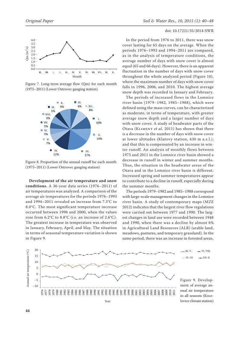
The Bilan hydrological model (Kašpárek & Novický 2004) was used to assess the water balance in the Lom-nice river basin for three selected characteristic years (2002, 2003, and 2004). These years were chosen to describe extreme behaviour of the basin in response to a very wet year (2002, high precipitation), a dry year (2003, low precipitation), and a normal year (2004, average precipitation). The results were compared with the outputs of the hydrological balance of the Czech Republic covering the same years (CHMI 2003, 2004, 2005) and long-term data on average precipitation amounts and discharges. For each year, the previous 25-year time series were used to obtain long-term average values of the data: i.e. for 2002 the data from 1977 to 2001 were averaged, for 2003 the data from 1978 to 2002 were averaged, and for 2004 the data from 1979 to 2003 were averaged. The results were later compared with the long-term discharge at the Lower Ostrovec gauging station (Figure 7) and the percentage proportion for each month in the total annual runoff (Figure 8).
The Bilan model can be classified as a deterministic, conceptual, lumped model. It was developed by the T.G. Masaryk Water Research Institute in Prague (WRI) to simulate components of the water balance of the catchment. It is primarily used for assessing the impacts of climate change on the water regime and on supplies of surface and groundwater (Horáček et al. 2008; Šimková 2012; Vizina et al. 2010). A detailed description of the model is provided by the Bilan model manual, compiled by WRI (WRI 2011).
The model simulates the daily or monthly series components of the hydrological balance. The input variables are the data series for rainfall P (mm), dis-charge measured at the outlet closure station R (mm), air temperature T (°C), and relative air humidity H (%) in daily or monthly steps. To determine the param-eters of the model (for a detailed list, see the manual – Kašpárek & Novický 2004), an optimization al-gorithm is used, which minimizes the value of the selected compliance criterion of the model output and observed data. The average absolute deviation of modelled and observed runoff data is used for

42
Original Paper Soil & Water Res., 10, 2015 (1): 40–48
doi: 10.17221/35/2014-SWR
the optimization criterion (Vaculín & Soukalová 2003). The values of the parameters for the Lom-nice river basin are: soil moisture storage capacity Spa = 147.7 mm; snow melting factor Dgm = 15.2 (–); factor for calculating the quantity of liquid water available on the land surface under winter conditions Dgw = 13.8 (–); parameter for the rainfall-surface runoff equation (direct runoff ) Alf = 0.000779 (–); recharge under summer conditions Soc = 0.699 (–); recharge under conditions of snow melting Mec = 0.799 (–); parameter for recharge under winter condi-tions, controlling the outflow from the groundwater storage (base flow) Wic = 0.342 (–); Grd = 0.499 (–).
The daily flow values, precipitation, snow depth, air temperature, sunshine duration, relative air humidity, and wind speed were used as input data for the analy-ses. The hydrological data for the 1975–2011 period come from the Lower Ostrovec gauging station (on the Lomnice river) and the climatic data (1976–2011) come from the Kocelovice climate station (Figure 1). The data were provided by the České Budějovice branch of the Czech Hydrometeorological Institute.
RESULTS
Analysis of changes in the runoff regime by single and double mass curves. The method of single and double mass curves was used for detect-
ing significant changes in the runoff regime. The curves were created on the basis of the average annual precipitation and discharge values. The cumulative precipitation (Hr) series was created to identify potential climate changes in the basin that could affect runoff conditions.
The progress of the mass curve of discharges (Lower Ostrovec gauging station) is captured in Figure 2. A deflection of the line from linear shape indicates a change in the development of the runoff. Figure 2 shows that in the period 1979–1982 there was an increase in the discharge, and subsequently a decline in 1985. The same pattern characterizes the period from 1985 until 1992, where 1988 is considered a breakthrough year (because of repeated decrease in the discharge that year). The growing and decreasing tendencies of the slopes are comparable.
When comparing the mass curve of discharges and precipitation (Figure 3), it is clear that the observed increase in the flow is not closely related with pre-cipitation, i.e. the period from 1985 until 1992 cannot be considered extremely rich in rainfall. The single mass curve for Hr is almost linear, with hardly any significant deviations.
To clarify the situation and specify the results, a double mass curve of annual discharges and precipi-tation for the Lower Ostrovec station was compiled (Figure 4). The years in which there was a change in runoff (1979, 1982, 1985, 1988, 1992) have been graphically highlighted (with a square).
Seasonal changes in runoff distribution. Changes in the distribution of runoff during the year were assessed on the basis of the percentage of discharge distribution and average flow rates in each month and season. The trend in the Lomnice river basin (Lower Ostrovec station) is characterized by a decreasing discharge in winter and in summer, while increas-ing discharges are typical for spring and autumn (Figure 5). The highest increase in the year-round
Figure 1. Location of the Kocelovice climate station and the Lower Ostrovec gauging station
Figure 2. Single mass curve of the annual discharges Qr (%) (Lower Ostrovec gauging station)
Year
Cum
ulat
ive
Qr (
%)
streamLomnice river basin
km

43
Soil & Water Res., 10, 2015 (1): 40–48 Original Paper
doi: 10.17221/35/2014-SWR
runoff in the Lomnice river basin was recorded in March, and maximum drop was recorded in Decem-ber (Figure 6).
The runoff distribution in the course of each year can also be assessed in terms of the chronology of monthly flows. The average monthly flows (Qm) characterize the runoff distribution in the course of the year (Benson & Matalas 1967). The regularity of this distribution can be expressed in long-term monthly flows. For the Lomnice station, these are calculated from 37 hydrological years. Monthly flows are influenced by climatic characteristics (particu-
larly rainfall and temperature), which have a regular and long-term coverage. The monthly flow is also influenced by gradual accumulation of snow and snowmelt, mostly in spring. Figures 7 and 8 clearly show the highest flow in the Lomnice in spring.
At the same time, the proportion of monthly and seasonal precipitation totals remains at approximately the same level. The average annual precipitation from the Kocelovice station for the period 1976–2011 amounts to 554.9 mm. The wettest year by far was 2002 (905 mm), due to the extreme total precipita-tion in August of that year (209 mm).
Figure 3. Single mass curve of annual precipitation Hr (%) (Kocelovice climate station)
Figure 4. Double mass curve of annual discharges Qr (%) and precipitation Hr (%) (Lomnice river)
Figure 5. Seasonal trend in runoff development (1975–2011) ( Lomnice river, Lower Ostrovec gauging station)
Figure 6. Trends in runoff development in March and December (1975–2011) (Lomice river, Lower Ostrovec gauging station)
Year
Cum
ulat
ive
Hr (
%)
Year
Run-
off (%
)
Year
Run-
off (m
m)
Cum
ulat
ive
Qr (
%)
Cumulative Hr (%)
0
20
40
60
80
100
0 20 40 60 80 100
Cumu
lative
Qr (
%)
Cumulative Hr (%)
year 1982
year 1985
year 1988
year 1992
year 1979
0 20 40 60 80 100
year 1992
100
80
60
40
20
0
year 1988year 1985
year 1982year 1979
44
Original Paper Soil & Water Res., 10, 2015 (1): 40–48
doi: 10.17221/35/2014-SWR
Development of the air temperature and snow conditions. A 36-year data series (1976–2011) of air temperatures was analyzed. A comparison of the average air temperatures for the periods 1976–1993 and 1994–2011 revealed an increase from 7.3°C to 8.0°C. The most significant temperature increase occurred between 1996 and 2000, when the values rose from 6.2°C to 8.8°C (i.e. an increase of 2.6°C). The greatest increase in temperature was observed in January, February, April, and May. The situation in terms of seasonal temperature variation is shown in Figure 9.
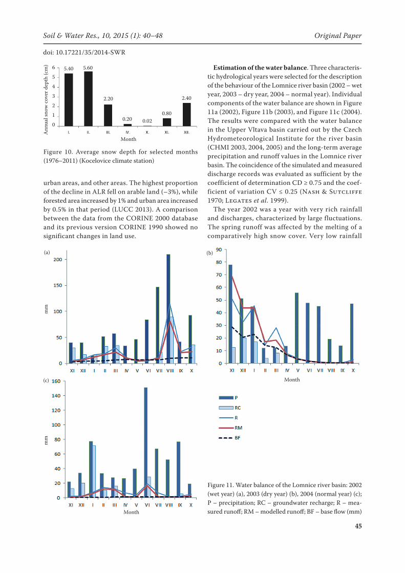
In the period from 1976 to 2011, there was snow cover lasting for 65 days on the average. When the periods 1976–1993 and 1994–2011 are compared, as in the analysis of temperature conditions, the average number of days with snow cover is almost equal (65 and 66 days). However, there is an apparent fluctuation in the number of days with snow cover throughout the whole analyzed period (Figure 10), where the maximum number of days with snow cover falls in 1996, 2006, and 2010. The highest average snow depth was recorded in January and February.
The periods of increased flows in the Lomnice river basin (1979–1982, 1985–1988), which were defined using the mass curves, can be characterized as moderate, in terms of temperature, with greater average snow depth and a larger number of days with snow cover. A study of headwater parts of the Otava (Kliment et al. 2011) has shown that there is a decrease in the number of days with snow cover at lower altitudes (Klatovy station, 430 m a.s.l.), and that this is compensated by an increase in win-ter runoff. An analysis of monthly flows between 1975 and 2011 in the Lomnice river basin showed a decrease in runoff in winter and summer months. Thus, the situation in the headwater areas of the Otava and in the Lomnice river basin is different. Increased spring and summer temperatures appear to contribute to a decline in runoff, especially during the summer months.
The periods 1979–1982 and 1985–1988 correspond with large-scale management changes in the Lomnice river basin. A study of contemporary maps (MZE 2012) indicates that the largest river flow regulations were carried out between 1977 and 1990. The larg-est changes in land use were recorded between 1948 and 1990, when there was a decline by almost 6% in Agricultural Land Resources (ALR) (arable land, meadows, pastures, and temporary grassland). In the same period, there was an increase in forested areas,
Figure 7. Long-term average flow (Qm) for each month (1975–2011) (Lower Ostrovec gauging station)
Figure 8. Proportion of the annual runoff for each month (1975–2011) (Lower Ostrovec gauging station)
Qm
(m3 /s
)
Month
4.03.53.02.52.01.51.00.50.0
Figure 9. Develop-ment of average an-nual air temperature in all seasons (Koce-lovice climate station)Year
Ann
ual a
ir te
mpe
ratu
re (o
C) 20
15
10
5
0
–5
–10-10
-5
0
5
10
15
20
1976
1977
1978
1979
1980
1981
1982
1983
1984
1985
1986
1987
1988
1989
1990
1991
1992
1993
1994
1995
1996
1997
1998
1999
2000
2001
2002
2003
2004
2005
2006
2007
2008
2009
2010
2011
Annu
al air t
empe
rature
(°C)
Year
III.-V. VI.-VIII. IX.-XI. XII.-II.
-10
-5
0
5
10
15
20
1976
1977
1978
1979
1980
1981
1982
1983
1984
1985
1986
1987
1988
1989
1990
1991
1992
1993
1994
1995
1996
1997
1998
1999
2000
2001
2002
2003
2004
2005
2006
2007
2008
2009
2010
2011
Ann
ual a
ir te
mpe
ratu
re (
°C)
Year
III.-V. VI.-VIII. IX.-XI. XII.-II.
-10
-5
0
5
10
15
20
1976
1977
1978
1979
1980
1981
1982
1983
1984
1985
1986
1987
1988
1989
1990
1991
1992
1993
1994
1995
1996
1997
1998
1999
2000
2001
2002
2003
2004
2005
2006
2007
2008
2009
2010
2011
Ann
ual a
ir te
mpe
ratu
re (
°C)
Year
III.-V. VI.-VIII. IX.-XI. XII.-II.
-10
-5
0
5
10
15
20
1976
1977
1978
1979
1980
1981
1982
1983
1984
1985
1986
1987
1988
1989
1990
1991
1992
1993
1994
1995
1996
1997
1998
1999
2000
2001
2002
2003
2004
2005
2006
2007
2008
2009
2010
2011
Ann
ual a
ir te
mpe
ratu
re (
°C)
Year
III.-V. VI.-VIII. IX.-XI. XII.-II.
45
Soil & Water Res., 10, 2015 (1): 40–48 Original Paper
doi: 10.17221/35/2014-SWR
urban areas, and other areas. The highest proportion of the decline in ALR fell on arable land (–3%), while forested area increased by 1% and urban area increased by 0.5% in that period (LUCC 2013). A comparison between the data from the CORINE 2000 database and its previous version CORINE 1990 showed no significant changes in land use.
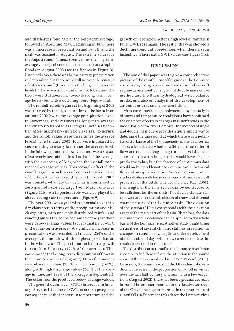
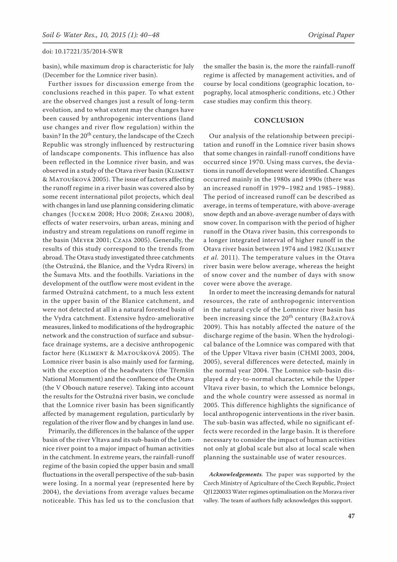
Estimation of the water balance. Three characteris-tic hydrological years were selected for the description of the behaviour of the Lomnice river basin (2002 – wet year, 2003 – dry year, 2004 – normal year). Individual components of the water balance are shown in Figure 11a (2002), Figure 11b (2003), and Figure 11c (2004). The results were compared with the water balance in the Upper Vltava basin carried out by the Czech Hydrometeorological Institute for the river basin (CHMI 2003, 2004, 2005) and the long-term average precipitation and runoff values in the Lomnice river basin. The coincidence of the simulated and measured discharge records was evaluated as sufficient by the coefficient of determination CD ≥ 0.75 and the coef-ficient of variation CV ≤ 0.25 (Nash & Sutcliffe 1970; Legates et al. 1999).
The year 2002 was a year with very rich rainfall and discharges, characterized by large fluctuations. The spring runoff was affected by the melting of a comparatively high snow cover. Very low rainfall
Figure 10. Average snow depth for selected months (1976–2011) (Kocelovice climate station)
Ann
ual s
now
cov
er d
epth
(cm
)
Month
6
5
4
3
2
1
0
5.40 5.60
2.20
0.20 0.020.80
2.40
Figure 11. Water balance of the Lomnice river basin: 2002 (wet year) (a), 2003 (dry year) (b), 2004 (normal year) (c); P – precipitation; RC – groundwater recharge; R – mea-sured runoff; RM – modelled runoff; BF – base flow (mm)
mm
Month
(b)
(c)
Month
mm
(a)
46
Original Paper Soil & Water Res., 10, 2015 (1): 40–48
doi: 10.17221/35/2014-SWR
and discharges (one half of the long-term average) followed in April and May. Beginning in July, there was an increase in precipitation and runoff, and the peak was reached in August. The extreme values for the August runoff (almost twenty times the long-term average values) reflect the occurrence of catastrophic floods in August 2002 (see the figures in Figure 3). Later in the year, there was below-average precipitation in September, but there were still noticeable remains of extreme runoff (three times the long-term average levels). There was rich rainfall in October, and the flows were still abundant (twice the long-term aver-age levels) but with a declining trend (Figure 11a).
The rainfall-runoff regime at the beginning of 2003 was affected by the high saturation of the basin from autumn 2002 (twice the average precipitation levels in November, and six times the long-term average (hereinafter referred to as average) runoff in Decem-ber. After this, the precipitation levels fell to normal and the runoff values were three times the average levels). The January 2003 flows were increased by snow melting to nearly four times the average level. In the following months, however, there was a season of extremely low rainfall (less than half of the average, with the exception of May, when the rainfall totals reached average values). This strongly affected the runoff regime, which was often less than a quarter of the long-term average (Figure 7). Overall, 2003 was considered a very dry year, as is confirmed by zero groundwater recharge from March onwards (Figure 11b). An important role was also played by above-average air temperatures (Figure 9).
The year 2004 was a year with a normal to slightly dry character in terms of the precipitation and dis-charge rates, with unevenly distributed rainfall and runoff (Figure 11c). At the beginning of the year there were below-average values (approximately 55–85% of the long-term average). A significant increase in precipitation was recorded in January (254% of the average), the month with the highest precipitation in the whole year. The precipitation led to a growth in runoff in February (121% of the average). This corresponds to the long-term distribution of flows in the Lomnice river basin (Figure 7). Other fluctuations were observed in June (203%) and September (163%), along with high discharge values (269% of the aver-age in June, and 133% of the average in September). The other months produced below-average values.
The ground water level (GWL) increased in Janu-ary. A typical decline of GWL came in spring as a consequence of the increase in temperature and the
growth of vegetation. After a high level of rainfall in June, GWL rose again. The rest of the year showed a declining trend until September, when there was an insignificant increase in GWL values (see Figure 11c).
DISCUSSION
The aim of this paper was to give a comprehensive picture of the rainfall-runoff regime in the Lomnice river basin, using several methods: rainfall-runoff regime assessment by single and double mass curve method and the Bilan hydrological water balance model, and also an analysis of the development of air temperatures and snow conditions.
Mass curve methods (supplemented by an analysis of snow and temperature conditions) have confirmed the existence of certain changes in runoff trends in the model basin of the river Lomnice. The method of single and double mass curve provides a quite simple way to determine the time point at which there was a poten-tial disturbance of the homogeneity of the data series.
It can be debated whether a 36-year time series of flows and rainfall is long enough to enable valid conclu-sions to be drawn. A longer series would have a higher predictive value, but the absence of continuous data would make it problematic to examine earlier historical flow and precipitation series. According to some other studies dealing with long-term trends of rainfall-runoff processes in the catchment, for instance Bae (2008), this length of the time series can be considered to be sufficient for the analysis. Kocelovice climate sta-tion was used for the calculation of snow and thermal characteristics of the Lomnice basin. The elevation of the station (519 m) corresponds with the elevation range of the main part of the basin. Therefore, the data acquired from Kocelovice can be applied to the whole basin of the Lomnice river. Another study might bring an analysis of several climatic stations in relation to changes in runoff, snow depth, and the development of the number of days with snow cover to validate the results presented in this paper.
The distribution of runoff in the Lomnice river basin is completely different from the situation in the source areas of the Otava analyzed in Kliment et al. (2011). Generally, the source areas of the Otava have shown a distinct increase in the proportion of runoff in winter over the last half-century whereas, with a few excep-tions (August 2002), there has been a gradual decrease in runoff in summer months. In the headwater areas of the Otava, the biggest increase in the proportion of runoff falls in December (March for the Lomnice river
47
Soil & Water Res., 10, 2015 (1): 40–48 Original Paper
doi: 10.17221/35/2014-SWR
basin), while maximum drop is characteristic for July (December for the Lomnice river basin).
Further issues for discussion emerge from the conclusions reached in this paper. To what extent are the observed changes just a result of long-term evolution, and to what extent may the changes have been caused by anthropogenic interventions (land use changes and river flow regulation) within the basin? In the 20th century, the landscape of the Czech Republic was strongly influenced by restructuring of landscape components. This influence has also been reflected in the Lomnice river basin, and was observed in a study of the Otava river basin (Kliment & Matoušková 2005). The issue of factors affecting the runoff regime in a river basin was covered also by some recent international pilot projects, which deal with changes in land use planning considering climatic changes (Juckem 2008; Huo 2008; Zhang 2008), effects of water reservoirs, urban areas, mining and industry and stream regulations on runoff regime in the basin (Meyer 2001; Czaja 2005). Generally, the results of this study correspond to the trends from abroad. The Otava study investigated three catchments (the Ostružná, the Blanice, and the Vydra Rivers) in the Šumava Mts. and the foothills. Variations in the development of the outflow were most evident in the farmed Ostružná catchment, to a much less extent in the upper basin of the Blanice catchment, and were not detected at all in a natural forested basin of the Vydra catchment. Extensive hydro-ameliorative measures, linked to modifications of the hydrographic network and the construction of surface and subsur-face drainage systems, are a decisive anthropogenic factor here (Kliment & Matoušková 2005). The Lomnice river basin is also mainly used for farming, with the exception of the headwaters (the Třemšín National Monument) and the confluence of the Otava (the V Obouch nature reserve). Taking into account the results for the Ostružná river basin, we conclude that the Lomnice river basin has been significantly affected by management regulation, particularly by regulation of the river flow and by changes in land use.
Primarily, the differences in the balance of the upper basin of the river Vltava and its sub-basin of the Lom-nice river point to a major impact of human activities in the catchment. In extreme years, the rainfall-runoff regime of the basin copied the upper basin and small fluctuations in the overall perspective of the sub-basin were losing. In a normal year (represented here by 2004), the deviations from average values became noticeable. This has led us to the conclusion that
the smaller the basin is, the more the rainfall-runoff regime is affected by management activities, and of course by local conditions (geographic location, to-pography, local atmospheric conditions, etc.) Other case studies may confirm this theory.
CONCLUSION
Our analysis of the relationship between precipi-tation and runoff in the Lomnice river basin shows that some changes in rainfall-runoff conditions have occurred since 1970. Using mass curves, the devia-tions in runoff development were identified. Changes occurred mainly in the 1980s and 1990s (there was an increased runoff in 1979–1982 and 1985–1988). The period of increased runoff can be described as average, in terms of temperature, with above-average snow depth and an above-average number of days with snow cover. In comparison with the period of higher runoff in the Otava river basin, this corresponds to a longer integrated interval of higher runoff in the Otava river basin between 1974 and 1982 (Kliment et al. 2011). The temperature values in the Otava river basin were below average, whereas the height of snow cover and the number of days with snow cover were above the average.
In order to meet the increasing demands for natural resources, the rate of anthropogenic intervention in the natural cycle of the Lomnice river basin has been increasing since the 20th century (Bažatová 2009). This has notably affected the nature of the discharge regime of the basin. When the hydrologi-cal balance of the Lomnice was compared with that of the Upper Vltava river basin (CHMI 2003, 2004, 2005), several differences were detected, mainly in the normal year 2004. The Lomnice sub-basin dis-played a dry-to-normal character, while the Upper Vltava river basin, to which the Lomnice belongs, and the whole country were assessed as normal in 2005. This difference highlights the significance of local anthropogenic interventions in the river basin. The sub-basin was affected, while no significant ef-fects were recorded in the large basin. It is therefore necessary to consider the impact of human activities not only at global scale but also at local scale when planning the sustainable use of water resources.
Acknowledgements. The paper was supported by the Czech Ministry of Agriculture of the Czech Republic, Project QJ1220033 Water regimes optimalisation on the Morava river valley. The team of authors fully acknowledges this support.

48
Original Paper Soil & Water Res., 10, 2015 (1): 40–48
doi: 10.17221/35/2014-SWR
R e f e r e n c e s
Bae D. (2008): Long-term trend of precipitation and run-off in Korean river basins. Hydrological Processes, 22: 2644–2656.
Bažatová T. (2009): Changes in rainfall-runoff conditions and anthropogenic modification in the Lomnice river basin. [Diploma Thesis.] Prague, Charles University, Faculty of Science. (in Czech)
Benson M.A., Matalas N.C. (1967): Synthetic hydrology based on regional statistical parameters. Water Resources Research, 3: 931–935.
Beven K.J. (2011): Rainfall-Runoff Modelling: The Primer, 2nd Ed. Chichester, John Wiley & Sons Ltd.
CENIA (2013): Program CORINE Land Cover 1990 and 2000. Czech Environmental Information Agency, Avail-able at http://geoportal.gov.cz (accessed June 2013)
CHMI (2003): Hydrological balance of the Czech Republic. Year 2002. Available at http://voda.chmi.cz/opzv/bilance/zprava_bilance_02.pdf (accessed Mar 2013).
CHMI (2004): Hydrological balance of the Czech Republic. Year 2003. Available at http://voda.chmi.cz/opzv/bilance/zprava_bilance_03.pdf (accessed Mar 2013)
CHMI (2005): Hydrological balance of the Czech Republic. Year 2004. Available at http://voda.chmi.cz/opzv/bilance/zprava_bilance_04.pdf (accessed Mar 2013)
Czaja S. (2005): Changes in river discharge structure and regime in mining-industrial-urban areas. Regional Envi-ronmental Change, 5: 18–26.
Horáček S., Kašpárek L., Novický O. (2008): Estimation of climate change impact on water resources by using Bilan water balance model. IOP Conf. Series: Earth and Environmental Science, 4.
Huo Z. (2008): Effects of climate changes and water related human activities on annual stream flows of the Shiyang river basin in arid north-west China. Hydrological Pro-cesses, 22: 3155–3167.
Juckem P.F. (2008): Effects of climate and land management change on streamflow in the driftless area of Wisconsin. Journal of Hydrology, 355: 123–130.
Kaňok J. (1997): A study of the anthropogenic influence on stream flow magnitude for the river of the Oder basin to the water-gauge at Koźle. Journal of University of Ostrava, 103.
Kašpárek L., Novický O. (2004): User’s Guide Manual. Available at http://www.geo.uio.no/edc/software/BILAN/User_guide_BILAN.pdf (accessed Aug 2014).
Kliment Z., Matoušková M. (2005): Trends of runoff pro-cesses in the Otava River basin. Geografie – Sborník ČGS, 110: 32–45. (in Czech)
Kliment Z., Matoušková M., Ledvinka O., Královec V. (2011): Trend analysis of rainfall-runoff regimes in se-lected headwater areas of the Czech Republic. Journal of Hydrology and Hydromechanics, 59: 36–50.
Langhammer J. (2010): Analysis of the relationship between the stream regulations and the geomorphologic effects of floods. Natural Hazards, 54: 121–139.
Legates D., Gregory J., McCabe Jr. (1999): Evaluating the use of “godness-of-fit” measures in hydrologic and hydroclimatic model validation. Water Resources Research, 35: 233–241.
LUCC (2013): Czechia Database. Database of Long-term Land Use Changes in Czech Republic (1845–2000). Available at http://lucc.ic.cz/lucc_data/okresy. (accessed Jan 2013)
Meyer W.B. (2001): Human Impact on the Earth. Cam-bridge, Cambridge University Press.
MZE (2012): Maps Groundwork, Water Flow Regulation – Lomnice. Prague, Ministry of Agriculture of the Czech Republic.
Nash J.E., Sutcliffe J.V. (1970): River flow forecasting through conceptual models. Part I. A discussion of prin-ciples. Journal of Hydrology, 10: 282–290.
Šimková J. (2012): Study of the water balance in the Medard mining pit, in the Sokolov region. [Diploma Thesis.] Prague, Czech University of Life Sciences Prague, Faculty of Environmental Science. (in Czech)
Vaculín O., Soukalová E. (2003): Regime of groundwater and hydrological water balance model in the infiltration area of the Brno water supply system. In: 5th Scientific Conf., Brno, 2003: 117–122.
Váňová V., Langhammer J. (2011): Modelling the impact of land cover changes on flood mitigation in the upper Lužnice basin. Journal of Hydrology and Hydromechan-ics, 59: 262–274.
Vizina A., Hanel M., Novický O., Treml P. (2010): Experience from Simulation of Climate Impacts on Water Regime in Monthly and Daily Time Step. Prague, T.G. Masaryk Water Research Institute.
WRI (2011): Bilan Water Balance Model – Manual. Prague, T.G. Masaryk Water Research Institute.
Zhang X. (2008): Response of streamflow to changes in climate and land use/cover in the Loess Plateau, China. Water Resources Research, 44.
Zídek H. (1965): Hydrological Conditions ČSSR 1. Prague, Hydrometeorological Institute. (in Czech)
Received for publication February 12, 2014Accepted after corrections September 9, 2014
Corresponding author:
Mgr. Tereza Bažatová, Česká zemědělská univerzita v Praze, Fakulta životního prostředí, katedra biotechnických úprav krajiny, Kamýcká 1176, 165 21 Praha 6, Česká republika; e-mail: [email protected]