A relict bank vole lineage highlights the biogeographic history of the Pyrenean region in Europe
Upload
independentCategory
view
6download
0
ORIGINAL ARTICLE
Changes in Pyrenean woodlands as a result of the intensityof human exploitation: 2,000 years of metallurgy in Vallferrera,northeast Iberian Peninsula
Albert Pelachs Æ Jordi Nadal Æ Joan Manuel Soriano ÆDavid Molina Æ Raquel Cunill
Received: 15 September 2008 / Accepted: 11 May 2009 / Published online: 27 May 2009
� Springer-Verlag 2009
Abstract This research is based on the discovery of a
large number of charcoal kiln sites and abandoned iron
mines in Vallferrera (Axial Pyrenees, northeastern Spain).
The study reveals that this region has been affected by the
metal mining and smelting industry for at least 2,000 years,
with maximum intensity in the eighteenth and nineteenth
centuries, followed by abandonment of the activity.
The region’s woodland dendrochronology and historical
records indicate that exploitation of wood charcoal for
metalworking affected the past vegetation in the area and
impeded the development of mature woodland. Our find-
ings suggest that the greatest changes in vegetation and
landscape history occurred at times of particular special-
ization in socioeconomic activities.
Keywords Late Holocene � Pyrenees � Palaeometallurgy �Charcoal kilns � Dendrochronology � Archival
documentation
Introduction
Recent studies show how anthracological (charcoal identi-
fication) research on the distribution of charcoal kiln sites
provides a good palaeoenvironmental record of the impact
of human activity on woods (Bonhote et al. 2002; Ludemann
2003; Ludemann et al. 2004). The sites are especially useful
for interpreting areas with abandoned metallurgical activity,
because of its high consumption of wood charcoal (Davasse
2000), in the same way that they are a good archaeobotanical
complement to multidisciplinary studies of environmental
history (Davasse and Galop 1990; Davasse et al. 1997;
Galop et al. 2002; Pelachs and Soriano 2003; Monna et al.
2004; Pelachs 2006; Vernet 2006).
One of the primary questions that palaeoecology
attempts to resolve is the extent to which changes in the
landscape are a consequence of human activity or of the
internal dynamics of the natural system (Riera et al. 2004).
This question is less problematic when there is some kind
of evidence that relates human activity with woodland
exploitation. Therefore, the study of the kiln sites con-
tributes to resolving this research question and clearly
shows that an activity such as charcoal production affects
the woodland (Vernet 1997; Davasse 2000). The task, then,
is to determine how far back in history it is possible to use
charcoal studies to explain changes in the natural envi-
ronment. Various multidisciplinary studies in places with a
history of metallurgy show how the consequences of this
activity can be traced back for millennia (Jouffroy et al.
2007; Bal 2006).
This article presents the results of an interdisciplinary
study conducted in an abandoned mining area on the
southern slopes of the Pyrenees at Bosc de Viros,
Vallferrera, with the primary objective of determining: (1)
the moment at which the impact of metallurgy took on
importance in the composition, distribution and structure of
the woods and (2) the origins of the woodland structure.
The study region was selected on the basis of numerous
available sources of information: existing data on the
potential age of the valley’s metallurgical exploitation,
which gives Vallferrera its name from the late Latin, valle
ferraria, meaning a valley where iron is produced (Sancho
Communicated by F. Bittmann.
A. Pelachs (&) � J. Nadal � J. M. Soriano � D. Molina �R. Cunill
GRAMP, Departament de Geografia, Universitat Autonoma de
Barcelona, 08193 Bellaterra, Cerdanyola del Valles, Spain
e-mail: [email protected]
123
Veget Hist Archaeobot (2009) 18:403–416
DOI 10.1007/s00334-009-0218-6
1999); a review of places that dated charcoal intermixed
with iron ore to 1770 ±40 years B.P. [cal A.D. 147–(253,
304, 314)–388] at the oldest dated site (Davasse 2000);
historical data showing continuous metalworking activity
from the eighteenth into the nineteenth century in this
region (Bringue 1995; Esteban et al. 2003; Mas 2000) and
published recommendations that the study of historical
documentation be undertaken at the municipal adminis-
trative level or above to gather useful information about the
region’s natural surroundings (Panareda and Llimargas
1989; Marugan 2001), with special attention to the scale of
analysis (Burt 2003).
Regional characteristics
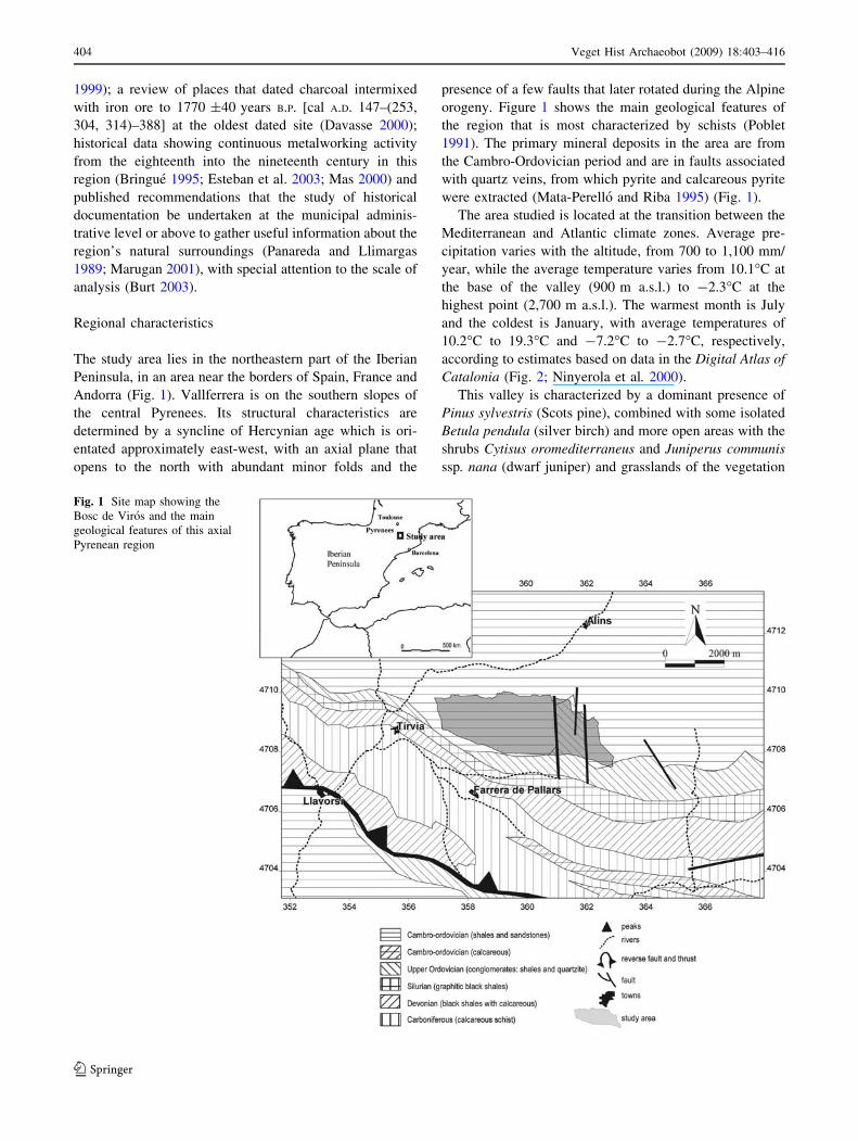
The study area lies in the northeastern part of the Iberian
Peninsula, in an area near the borders of Spain, France and
Andorra (Fig. 1). Vallferrera is on the southern slopes of
the central Pyrenees. Its structural characteristics are
determined by a syncline of Hercynian age which is ori-
entated approximately east-west, with an axial plane that
opens to the north with abundant minor folds and the
presence of a few faults that later rotated during the Alpine
orogeny. Figure 1 shows the main geological features of
the region that is most characterized by schists (Poblet
1991). The primary mineral deposits in the area are from
the Cambro-Ordovician period and are in faults associated
with quartz veins, from which pyrite and calcareous pyrite
were extracted (Mata-Perello and Riba 1995) (Fig. 1).
The area studied is located at the transition between the
Mediterranean and Atlantic climate zones. Average pre-
cipitation varies with the altitude, from 700 to 1,100 mm/
year, while the average temperature varies from 10.1�C at
the base of the valley (900 m a.s.l.) to -2.3�C at the
highest point (2,700 m a.s.l.). The warmest month is July
and the coldest is January, with average temperatures of
10.2�C to 19.3�C and -7.2�C to -2.7�C, respectively,
according to estimates based on data in the Digital Atlas of
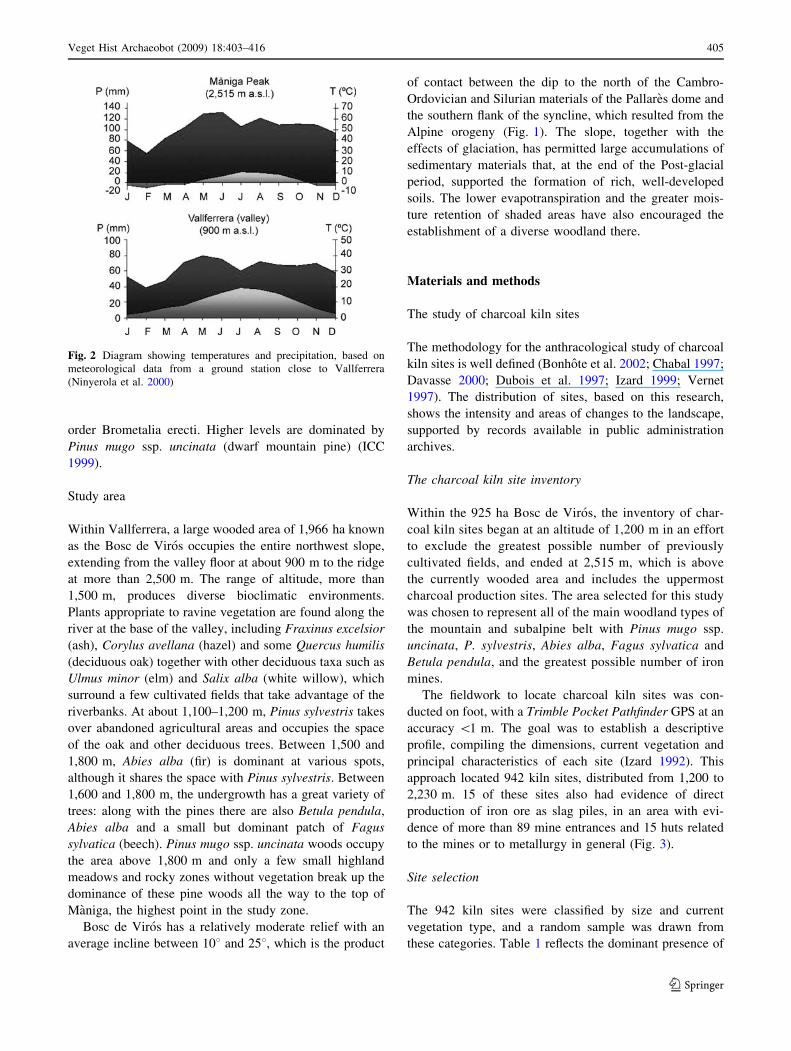
Catalonia (Fig. 2; Ninyerola et al. 2000).
This valley is characterized by a dominant presence of
Pinus sylvestris (Scots pine), combined with some isolated
Betula pendula (silver birch) and more open areas with the
shrubs Cytisus oromediterraneus and Juniperus communis
ssp. nana (dwarf juniper) and grasslands of the vegetation
Fig. 1 Site map showing the
Bosc de Viros and the main
geological features of this axial
Pyrenean region
404 Veget Hist Archaeobot (2009) 18:403–416
123
order Brometalia erecti. Higher levels are dominated by
Pinus mugo ssp. uncinata (dwarf mountain pine) (ICC
1999).
Study area
Within Vallferrera, a large wooded area of 1,966 ha known
as the Bosc de Viros occupies the entire northwest slope,
extending from the valley floor at about 900 m to the ridge
at more than 2,500 m. The range of altitude, more than
1,500 m, produces diverse bioclimatic environments.
Plants appropriate to ravine vegetation are found along the
river at the base of the valley, including Fraxinus excelsior
(ash), Corylus avellana (hazel) and some Quercus humilis
(deciduous oak) together with other deciduous taxa such as
Ulmus minor (elm) and Salix alba (white willow), which
surround a few cultivated fields that take advantage of the
riverbanks. At about 1,100–1,200 m, Pinus sylvestris takes
over abandoned agricultural areas and occupies the space
of the oak and other deciduous trees. Between 1,500 and
1,800 m, Abies alba (fir) is dominant at various spots,
although it shares the space with Pinus sylvestris. Between
1,600 and 1,800 m, the undergrowth has a great variety of
trees: along with the pines there are also Betula pendula,
Abies alba and a small but dominant patch of Fagus
sylvatica (beech). Pinus mugo ssp. uncinata woods occupy
the area above 1,800 m and only a few small highland
meadows and rocky zones without vegetation break up the
dominance of these pine woods all the way to the top of
Maniga, the highest point in the study zone.
Bosc de Viros has a relatively moderate relief with an
average incline between 108 and 258, which is the product
of contact between the dip to the north of the Cambro-
Ordovician and Silurian materials of the Pallares dome and
the southern flank of the syncline, which resulted from the
Alpine orogeny (Fig. 1). The slope, together with the
effects of glaciation, has permitted large accumulations of
sedimentary materials that, at the end of the Post-glacial
period, supported the formation of rich, well-developed
soils. The lower evapotranspiration and the greater mois-
ture retention of shaded areas have also encouraged the
establishment of a diverse woodland there.
Materials and methods
The study of charcoal kiln sites
The methodology for the anthracological study of charcoal
kiln sites is well defined (Bonhote et al. 2002; Chabal 1997;
Davasse 2000; Dubois et al. 1997; Izard 1999; Vernet
1997). The distribution of sites, based on this research,
shows the intensity and areas of changes to the landscape,
supported by records available in public administration
archives.
The charcoal kiln site inventory
Within the 925 ha Bosc de Viros, the inventory of char-
coal kiln sites began at an altitude of 1,200 m in an effort
to exclude the greatest possible number of previously
cultivated fields, and ended at 2,515 m, which is above
the currently wooded area and includes the uppermost
charcoal production sites. The area selected for this study
was chosen to represent all of the main woodland types of
the mountain and subalpine belt with Pinus mugo ssp.
uncinata, P. sylvestris, Abies alba, Fagus sylvatica and
Betula pendula, and the greatest possible number of iron
mines.
The fieldwork to locate charcoal kiln sites was con-
ducted on foot, with a Trimble Pocket Pathfinder GPS at an
accuracy \1 m. The goal was to establish a descriptive
profile, compiling the dimensions, current vegetation and
principal characteristics of each site (Izard 1992). This
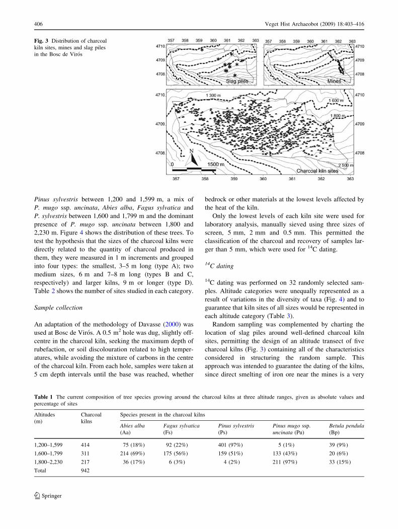
approach located 942 kiln sites, distributed from 1,200 to
2,230 m. 15 of these sites also had evidence of direct
production of iron ore as slag piles, in an area with evi-
dence of more than 89 mine entrances and 15 huts related
to the mines or to metallurgy in general (Fig. 3).
Site selection
The 942 kiln sites were classified by size and current
vegetation type, and a random sample was drawn from
these categories. Table 1 reflects the dominant presence of
Fig. 2 Diagram showing temperatures and precipitation, based on
meteorological data from a ground station close to Vallferrera
(Ninyerola et al. 2000)
Veget Hist Archaeobot (2009) 18:403–416 405
123
Pinus sylvestris between 1,200 and 1,599 m, a mix of
P. mugo ssp. uncinata, Abies alba, Fagus sylvatica and
P. sylvestris between 1,600 and 1,799 m and the dominant
presence of P. mugo ssp. uncinata between 1,800 and
2,230 m. Figure 4 shows the distribution of these trees. To
test the hypothesis that the sizes of the charcoal kilns were
directly related to the quantity of charcoal produced in
them, they were measured in 1 m increments and grouped
into four types: the smallest, 3–5 m long (type A); two
medium sizes, 6 m and 7–8 m long (types B and C,
respectively) and larger kilns, 9 m or longer (type D).
Table 2 shows the number of sites studied in each category.
Sample collection
An adaptation of the methodology of Davasse (2000) was
used at Bosc de Viros. A 0.5 m2 hole was dug, slightly off-
centre in the charcoal kiln, seeking the maximum depth of
rubefaction, or soil discolouration related to high temper-
atures, while avoiding the mixture of carbons in the centre
of the charcoal kiln. From each hole, samples were taken at
5 cm depth intervals until the base was reached, whether
bedrock or other materials at the lowest levels affected by
the heat of the kiln.
Only the lowest levels of each kiln site were used for
laboratory analysis, manually sieved using three sizes of
screen, 5 mm, 2 mm and 0.5 mm. This permitted the
classification of the charcoal and recovery of samples lar-
ger than 5 mm, which were used for 14C dating.
14C dating
14C dating was performed on 32 randomly selected sam-
ples. Altitude categories were unequally represented as a
result of variations in the diversity of taxa (Fig. 4) and to
guarantee that kiln sites of all sizes would be represented in
each altitude category (Table 3).
Random sampling was complemented by charting the
location of slag piles around well-defined charcoal kiln
sites, permitting the design of an altitude transect of five
charcoal kilns (Fig. 3) containing all of the characteristics
considered in structuring the random sample. This
approach was intended to guarantee the dating of the kilns,
since direct smelting of iron ore near the mines is a very
Fig. 3 Distribution of charcoal
kiln sites, mines and slag piles
in the Bosc de Viros
Table 1 The current composition of tree species growing around the charcoal kilns at three altitude ranges, given as absolute values and
percentage of sites
Altitudes
(m)
Charcoal
kilns
Species present in the charcoal kilns
Abies alba(Aa)
Fagus sylvatica(Fs)
Pinus sylvestris(Ps)
Pinus mugo ssp.
uncinata (Pu)
Betula pendula(Bp)
1,200–1,599 414 75 (18%) 92 (22%) 401 (97%) 5 (1%) 39 (9%)
1,600–1,799 311 214 (69%) 175 (56%) 159 (51%) 133 (43%) 20 (6%)
1,800–2,230 217 36 (17%) 6 (3%) 4 (2%) 211 (97%) 33 (15%)
Total 942
406 Veget Hist Archaeobot (2009) 18:403–416
123

old practice (Cantelaube 2002; Dubois 2002), and Davasse
(2000) has shown a relationship between slag and the late
Roman age based on 14C dating of only one site (Fig. 5). A
total of 37 charcoal kilns were dated using the conventional
radiometric technique and 14C accelerator mass spectro-
metry (Table 4 and Fig. 5).
Dendrochronological analysis
The dendrochronological study was conducted throughout
the entire community property of Viros d’Araos, a homo-
geneous entity from a public administration perspective
and therefore subject to the same woodland management
through time. In addition, all four main species were rep-
resented in the woodland around Viros d’Araos: Pinus
mugo ssp. uncinata, P. sylvestris, Abies alba and Fagus
sylvatica, allowing a determination of the ages of various
Fig. 4 The current composition of tree species growing around the
charcoal kiln sites at three altitude ranges, given as percentage of
sites. Aa, Abies alba; Fs, Fagus sylvatica; Ps, Pinus sylvestris; Pu,
Pinus mugo ssp. uncinata; Bp, Betula pendula
Table 2 Sizes of charcoal kilns at three altitude ranges
Altitudes (m) Charcoal kilns Types of the charcoal kilns
A B C D
1,200–1,599 414 41 246 114 13
1,600–1,799 311 20 185 83 23
1,800–2,230 217 14 85 66 52
Total 942 75 516 263 88
A 3–5 m, B 6 m, C 7–8 m, D 9 m or more in length
Table 3 Number of charcoal kiln sites chosen for sampling, by
altitude and size
Altitudes (m) Charcoal kiln sites A B C D Total
1,200–1,599 414 1 5 2 1 9
1,600–1,799 311 1 9 4 1 15
1,800–2,230 217 1 3 2 2 8
Total 942 3 17 8 3 32
Fig. 5 Radiocarbon dating results for Bosc de Viros samples
Veget Hist Archaeobot (2009) 18:403–416 407
123

trees in an area that was also homogeneous from geological
and ecological points of view (ADF 2002a, b).
Woodland plots
Field work conducted in 2002 and photointerpretation of
the 1993 1:5,000 scale orthophoto map using the Miramon
program (Pons 2002) allowed identification of woodland
patches with equal coverage and a variety of areas with
homogeneous vegetation, for a total of 496 homogeneous
patches.
Sampling and sample extraction
Within each patch, one 314 m2 sample plot (20 m in
diameter) was selected to gather an inventory of species by
Table 4 Results of radiocarbon dating of wood charcoal at 37 charcoal kiln sites in Bosc de Viros
Kiln site number Sample code Beta Age (yr BP) Cal age (A.D.)a Intercepted age cal A.D. Media probabilityb
SLAG I 173411 1790 ± 60 90–400 240 234
SLAG II 173447 1780 ± 40 130– 370 240 247
SLAG III 173412 1640 ± 40 340–530 410 414
SLAG IV 173413 1690 ± 40 250–430 380 353
SLAG V 173414 1560 ± 40 410–600 530 492
0 173415 190 ± 70 1520–1950 1670–1780–1800 1771
1 173416 170 ± 40 1650–1950 1680–1770–1800–1940–1950 1778
2 173417 840 ± 40 1060–1270 1210 1200
3 173418 170 ± 40 1650–1950 1680–1770–1800–1940–1950 1778
4 173419 170 ± 40 1650–1950 1680–1770–1800–1940–1950 1778
5 173420 240 ± 40 1530–1950 1660 1666
6 173421 10 ± 60 Modern Modern 1852
7 173422 160 ± 40 1660–1950 1680–1740–1800–1930–1950 1784
8 173446 140 ± 40 1660–1950 1680–1730–1810–1930–1950 1809
9 173423 160 ± 80 1530–1960 1680–1740–1800–1930–1950 1786
10 173424 220 ± 80 1480–1950 1660 1737
11 173425 0 ± 50 Modern Modern 1875
12 173426 500 ± 80 1300–1620 1420 1419
13 173427 390 ± 40 1430–1630 1470 1503
14 173428 150 ± 40 1660–1950 1680-1740–1800–1930–1950 1800
15 173429 140 ± 40 1660–1950 1680–1730–1800–1930–1950 1809
16 173430 230 ± 70 1490–1950 1660 1717
17 173431 60 ± 60 Modern Modern 1838
18 173432 170 ± 40 1650–1950 1680–1770–1800–1940–1950 1778
19 173433 360 ± 50 1440–1650 1500 1544
20 173434 160 ± 40 1660–1950 1680–1740–1800–1930–1950 1784
21 173435 110 ± 60 1660–1960 1700–1720–1820–1840–1880–1920–1950 1823
22 173436 150 ± 60 1650–1950 1680–1740–1810–1930–1950 1800
23 173437 190 ± 60 1530–1950 1670–1780–1800 1773
24 173438 180 ± 40 1650–1950 1670–1770–1800–1940–1950 1775
25 173439 250 ± 60 1490–1950 1650 1654
26 173440 230 ± 40 1530–1950 1660 1740
27 173441 20 ± 50 Modern Modern 1860
28 173442 290 ± 40 1490–1660 1640 1571
29 173443 190 ± 110 1460–1960 1670–1780–1800 1751
30 173444 40 ± 60 Modern Modern 1844
31 173445 80 ± 50 Modern Modern 1838
a Calibration 2 sigma, 95% (Stuiver et al. 1998)b Calib Rev. 5.1 beta (Stuiver and Reimer 1993)
408 Veget Hist Archaeobot (2009) 18:403–416
123
diametric class at 2 cm intervals. Tree size was recorded at
a height of 1.30 m (Burriel et al. 2004). When the inven-
tory was complete, at least two and not more than five trees
were selected for each species and diametric class in the
plot; these were drilled with a 5 mm Pressler auger to
gather evidence of the growth rings. Wherever possible, the
wood sample was collected in a north–south or south–north
direction and in a favourable part of the incline.
The ages of trees
The approximate number of growth rings in each wood
sample was determined (Schweingruber 1988), recognizing
that it takes a few years for the tree to reach the height at
which the sample was extracted and also that when
extracting a sample it is difficult to locate heartwood
(Burriel et al. 2004).
Data from public documents
Municipal documents of the town of Alins, housed in the
historical archives of Sort comarca (AHCSo), were useful
in selecting a variety of information about the exploitation
of natural resources in the smaller communities of Ainet
d’Araos and Ainet de Besan, which own the Viros wood-
lands. During archival research, a variety of interesting
information was found in the following sections: General
Administration, particularly the books containing minutes
of local government meetings; Finance, particularly land
records and annual budgets, which contain various infor-
mation about fires; auctions of wood, timber, and animal;
illegal exploitation of woodland products, etc.; Public
Health, with references to sanitary and veterinary inspec-
tions that reveal the numbers of some types of domestic
animals, such as in the records of home butchering of pigs;
Construction and Public Works, with references to various
infrastructure elements that could be related to woodland
use, since an extensive network of roads was needed to
remove cut trees from the woods; Public Safety, which
contains details about the inhabitants of the area and a
description of their trade or employment, which in turn
gives insight into woodland practices; Military Service,
with its description of the goods subject to military requi-
sition that shows how wood and metal were valued at the
end of the Civil War; and Agropastoral Services, the most
useful section of all, with its broad range of information
related to herding, in particular, but also to agriculture and
woodland management.
The time period covered by these documents begins in
the nineteenth century, although the quantity and quality of
the information increases after the end of the Spanish Civil
War in 1939, probably as a result of the greater discipline
and administrative control that resulted but also because
information was lost and/or destroyed during the war.
Results
The age of the charcoal
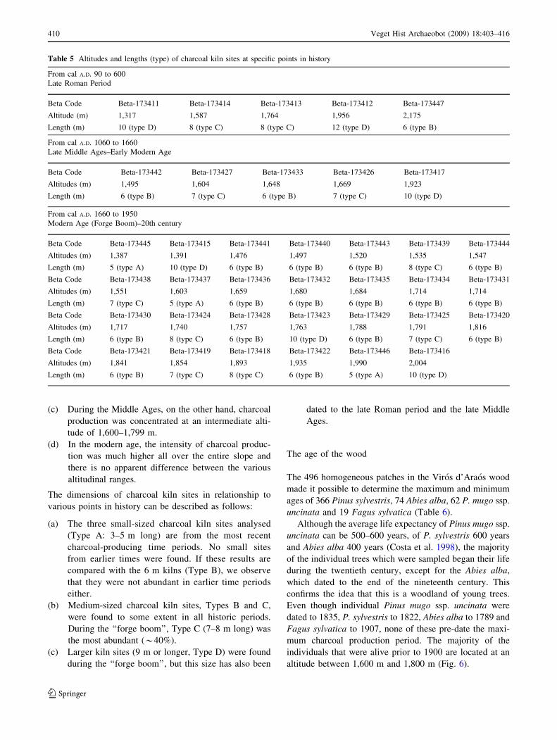
The 37 14C-dated charcoal kilns (Table 4, Fig. 5) allowed
us to establish various periods of human activity and to
relate them to the location and size of each kiln. We
identified three time periods to measure the intensity of
charcoal-producing activity (Table 5):
(a) Cal A.D. 90 to 600: All five of the kiln sites identified
in this group were active between the decline of the
Roman Empire (late Roman Period) and the begin-
ning of the early Middle Ages. The slag piles next to
these charcoal kilns show that there was direct
smelting of iron at the mine in the third and fourth
centuries in the Bosc de Viros, although the activity
was of low intensity.
(b) Cal A.D. 1060 to 1660: All five charcoal kilns from
this period are from the late Middle Ages and the
early modern age. The oldest site is from the
thirteenth century (cal A.D. 1210) and the most recent
from the seventeenth century (cal A.D. 1660). The
intensity of the activity was low to medium.
(c) Cal A.D. 1660 to 1950 (including out of range or
modern): most of these 27 charcoal kilns were active
from cal A.D. 1660 until 1950. Therefore, the period
from the end of the seventeenth and beginning of the
eighteenth century until the twentieth century, with
very highly intense activity, is related to the metal-
lurgy boom and the installation of various ironwork-
ing sites or forges in the valley. Six kilns were dated
to 1950 and are therefore considered twentieth
century sites. Their intensity is low.
In addition, from cal A.D. 530 to 1060, a notable absence of
charcoal samples seems to demonstrate a drastic reduction
in activity during that period.
With respect to altitude, the results demonstrate that the
relationship between the sites and the intensity of charcoal
production has varied a great deal throughout history:
(a) In all three of the periods identified, charcoal
production occurred at all of the altitudinal range
categories for the various tree species.
(b) During the late Roman period, based on the location
of the kiln sites associated with slag piles (Fig. 3) and
the 14C dating, it is possible to conclude that charcoal
production was most intense above 1,800 m, where it
is likely that the iron mines were concentrated.
Veget Hist Archaeobot (2009) 18:403–416 409
123
(c) During the Middle Ages, on the other hand, charcoal
production was concentrated at an intermediate alti-
tude of 1,600–1,799 m.
(d) In the modern age, the intensity of charcoal produc-
tion was much higher all over the entire slope and
there is no apparent difference between the various
altitudinal ranges.
The dimensions of charcoal kiln sites in relationship to
various points in history can be described as follows:
(a) The three small-sized charcoal kiln sites analysed
(Type A: 3–5 m long) are from the most recent
charcoal-producing time periods. No small sites
from earlier times were found. If these results are
compared with the 6 m kilns (Type B), we observe
that they were not abundant in earlier time periods
either.
(b) Medium-sized charcoal kiln sites, Types B and C,
were found to some extent in all historic periods.
During the ‘‘forge boom’’, Type C (7–8 m long) was
the most abundant (*40%).
(c) Larger kiln sites (9 m or longer, Type D) were found
during the ‘‘forge boom’’, but this size has also been
dated to the late Roman period and the late Middle
Ages.
The age of the wood
The 496 homogeneous patches in the Viros d’Araos wood
made it possible to determine the maximum and minimum
ages of 366 Pinus sylvestris, 74 Abies alba, 62 P. mugo ssp.
uncinata and 19 Fagus sylvatica (Table 6).
Although the average life expectancy of Pinus mugo ssp.
uncinata can be 500–600 years, of P. sylvestris 600 years
and Abies alba 400 years (Costa et al. 1998), the majority
of the individual trees which were sampled began their life
during the twentieth century, except for the Abies alba,
which dated to the end of the nineteenth century. This
confirms the idea that this is a woodland of young trees.
Even though individual Pinus mugo ssp. uncinata were
dated to 1835, P. sylvestris to 1822, Abies alba to 1789 and
Fagus sylvatica to 1907, none of these pre-date the maxi-
mum charcoal production period. The majority of the
individuals that were alive prior to 1900 are located at an
altitude between 1,600 m and 1,800 m (Fig. 6).
Table 5 Altitudes and lengths (type) of charcoal kiln sites at specific points in history
From cal A.D. 90 to 600
Late Roman Period
Beta Code Beta-173411 Beta-173414 Beta-173413 Beta-173412 Beta-173447
Altitude (m) 1,317 1,587 1,764 1,956 2,175
Length (m) 10 (type D) 8 (type C) 8 (type C) 12 (type D) 6 (type B)
From cal A.D. 1060 to 1660
Late Middle Ages–Early Modern Age
Beta Code Beta-173442 Beta-173427 Beta-173433 Beta-173426 Beta-173417
Altitudes (m) 1,495 1,604 1,648 1,669 1,923
Length (m) 6 (type B) 7 (type C) 6 (type B) 7 (type C) 10 (type D)
From cal A.D. 1660 to 1950
Modern Age (Forge Boom)–20th century
Beta Code Beta-173445 Beta-173415 Beta-173441 Beta-173440 Beta-173443 Beta-173439 Beta-173444
Altitudes (m) 1,387 1,391 1,476 1,497 1,520 1,535 1,547
Length (m) 5 (type A) 10 (type D) 6 (type B) 6 (type B) 6 (type B) 8 (type C) 6 (type B)
Beta Code Beta-173438 Beta-173437 Beta-173436 Beta-173432 Beta-173435 Beta-173434 Beta-173431
Altitudes (m) 1,551 1,603 1,659 1,680 1,684 1,714 1,714
Length (m) 7 (type C) 5 (type A) 6 (type B) 6 (type B) 6 (type B) 6 (type B) 6 (type B)
Beta Code Beta-173430 Beta-173424 Beta-173428 Beta-173423 Beta-173429 Beta-173425 Beta-173420
Altitudes (m) 1,717 1,740 1,757 1,763 1,788 1,791 1,816
Length (m) 6 (type B) 8 (type C) 6 (type B) 10 (type D) 6 (type B) 7 (type C) 6 (type B)
Beta Code Beta-173421 Beta-173419 Beta-173418 Beta-173422 Beta-173446 Beta-173416
Altitudes (m) 1,841 1,854 1,893 1,935 1,990 2,004
Length (m) 6 (type B) 7 (type C) 8 (type C) 6 (type B) 5 (type A) 10 (type D)
410 Veget Hist Archaeobot (2009) 18:403–416
123

Woodland use
Analysis of documentary data about the Bosc de Viros
confirms the abandonment of metallurgy in the second half
of the nineteenth century. The Disentailment Law (1855)
that left the woods in the hands of Viros communities
explains the state of the woods as described in 1876: ‘‘que
consta de monte bajo, abedul y pino carrascal y otra clase
de pinos; recorrido en todos sus limites, se ha encontrado
en buen estado escepto los tres puntos donde sufrieron un
incendio este verano que es inutil’’ [‘‘…which consists of
scrub with birch and pine and another class of pines;
inspected to all of its boundaries, it was found to be in good
condition except for the three places where it suffered from
a fire this summer and is useless’’], AHCSo: Ainet de
Besan archives, 2g.
Woodland clearance and the immaturity of the woods
are evident in the scrub, with Betula sp., a pioneer that
takes advantage of clearance to recolonize the woodland,
as did Pinus sylvestris in all likelihood, since it had nearly
Table 6 The ages of sampled trees in Viros d’Araos
Species Viros d’Araos
Number of cases Maximum age Minimum age Average Average first year
Pinus sylvestris 366 180 4 72 1930
Abies alba 74 204 21 112 1890
Pinus mugo ssp. uncinata 62 167 22 102 1900
Fagus sylvatica 19 95 46 71 1931
Fig. 6 The main woods
growing before 1900. Black,
growing before 1900; grey,
present distribution
Veget Hist Archaeobot (2009) 18:403–416 411
123
30 years to regenerate itself after the end of the metallurgy
in 1850. It is important to note that beech is not even
mentioned, nor deciduous trees in general, even though the
category ‘‘otra clase de pinos’’ [another class of pines]
probably would have included some remnant firs and in all
probability they would have survived the maximum human
impact.
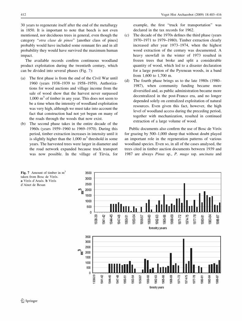
The available records confirm continuous woodland
product exploitation during the twentieth century, which
can be divided into several phases (Fig. 7):
(a) The first phase is from the end of the Civil War until
1960 (years 1938–1939 to 1958–1959). Authoriza-
tions for wood auctions and village income from the
sale of wood show that the harvest never surpassed
1,000 m3 of timber in any year. This does not seem to
be a time when the intensity of woodland exploitation
was very high, although we must take into account the
fact that construction had not yet begun on many of
the roads through the woods that now exist.
(b) The second phase takes in the entire decade of the
1960s (years 1959–1960 to 1969–1970). During this
period, timber extraction increases in intensity until it
is slightly higher than the 1,000 m3 threshold in some
years. The harvested trees were larger in diameter and
the road network expanded because truck transport
was now possible. In the village of Tırvia, for
example, the first ‘‘truck for transportation’’ was
declared in the tax records for 1962.
(c) The decade of the 1970s defines the third phase (years
1970–1971 to 1979–1980). Timber extraction clearly
increased after year 1973–1974, when the highest
wood extraction of the century was documented. A
heavy snowfall in the winter of 1973 resulted in
frozen trees that broke and split a considerable
quantity of wood, which led to a disaster declaration
for a large portion of the Pyrenean woods, in a band
from 1,600 to 1,700 m.
(d) The fourth phase brings us to the late 1980s (1980–
1987), when community funding became more
diversified and, as public administration became more
decentralized in the post-Franco era, and no longer
depended solely on centralized exploitation of natural
resources. Even given this fact, however, the high
level of woodland access during the preceding period,
together with mechanization, resulted in continued
extraction of a large volume of wood.
Public documents also confirm the use of Bosc de Viros
for grazing by 500–1,000 sheep that without doubt played
an important role in the regeneration patterns of various
woodland species. Even so, in all of the cases analysed, the
trees cited in timber auction documents between 1939 and
1987 are always Pinus sp., P. mugo ssp. uncinata and
Fig. 7 Amount of timber in m3
taken from Bosc de Viros.
a Viros d’Araos. b Viros
d’Ainet de Besan
412 Veget Hist Archaeobot (2009) 18:403–416
123
P. sylvestris, reflecting the primary management of these
conifers that was favoured by the woodland industry.
Discussion
Together with dendrochronological dating and a variety of
documentary sources, the pressure exerted by charcoal
production allows identification of the phases of differing
intensity in woodland use (Pelachs 2005):
Cal A.D. 240 to 530
All the charcoal kiln sites from the late Roman period were
found thanks to the presence of slag piles, which show that
iron was smelted there. Their distribution is characterized
by proximity to outcrops of iron ore and, therefore, their
locations are at different altitudes, ranging from 1,317 m to
2,174 m depending on the different mineral veins. If we
accept slag piles as good indicators of smelting, we could
hypothesize that the 15 kiln sites with slag piles in the
study area had extensive impact from the metallurgical
activity at the time, even without slag excavations to
confirm this approach. For this reason, we believe that the
disturbance caused by charcoal production might have
been very localized but very intense at particular points in
time.
Cal A.D. 531 to 1209
For a long time period, from the seventh to the twelfth
centuries, we found no remains of wood charcoal. Even
though we cannot discount the possibility that there might
be some from this period among the total 942 kiln sites that
we located, our current state of knowledge suggests that the
impact on the woods from charcoal production during these
six centuries was low or nonexistent. Historical records
show that feudal activity was largely based on grazing
herds (Esteban et al. 2003) and the feudal lords’ control of
iron smelting (Verna 2001).
Cal A.D. 1210 to 1368
This period is defined by the presence of a charcoal kiln site
dated cal A.D. 1210, more than a century before the installation
in 1368 of the first authorized iron works in the valley (Verna
2001). Although the existence of just one site makes it difficult
to determine the importance of this period, the fact that
charcoal production was found at an altitude of 1,923 m
suggests at least two possible interpretations:
(a) The first is based on location, since we cannot discard
the possibility that this was an attempt to take
advantage of an area that had been used during the
late Roman period in an effort to work iron ore. In any
case, although we found no slag associated with this
kiln, there was a slag pile close by. In this instance,
the smelting method had to be direct production.
(b) Of course, a lone charcoal kiln site is hardly reason to
imagine some metal smelting; it could be that the kiln
was actually for some other charcoal-burning activity.
However, it would be difficult to understand why this
other activity would take place at such an altitude and
not closer to the village, unless the goal was to hide
the activity or to produce a particular type of
charcoal. If the latter, at this altitude the desired
species would have been Pinus mugo ssp. uncinata.
Clearly, however, the intensity of charcoal production
during this time was minimal and very local.
Cal A.D. 1369 to 1499
Beginning with the installation of the first water-powered
forge in the valley in the fourteenth century, the amount of
iron smelting increased rapidly. During the fifteenth and
sixteenth centuries there was a local increase in charcoal
kilns. Charcoal production took place between 1,600 and
1,700 m, and so affected a lower, better-defined part of the
woodland than in preceding time periods. Dependence on
proximity to iron ore was probably not as great at this time
as previously and therefore wood and access to the forges
took on greater value. The pressure of charcoal production
in this period is considered moderate.
Cal A.D. 1500 to 1749
The number of kiln sites identified in this period is the
same as in the preceding one, but there is one detail that
suggests that the intensity of charcoal production was on
the rise: the fact that the kilns are found in a broader
altitude range, from 1,500 to 1,800 m. The pressures of
charcoal production are considered high at this time.
To understand this situation, we must analyse the known
historical data from Vallferrera and its surroundings, since
the Genoese forge was introduced to the neighbouring
valley of Ariege, in France, between 1560 and 1570 (Izard
1999) and a period of severe over-exploitation of the
woodlands in all of the northern valleys lasted until the
seventeenth century. This favoured the development of
technical solutions to address the lack of affordable energy
resources and secure the quantity of charcoal needed to
produce the same quantity of iron (Izard 1999). Therefore,
a first approach was to adopt a new method of injecting air
into the forge, in which bellows forced air through a horn-
shaped nozzle into the smelting hearth. The adoption of
Veget Hist Archaeobot (2009) 18:403–416 413
123

this system, known as the trompa, or hunting horn,
apparently occurred between 1659 and 1670 and is con-
sidered by many researchers to be the fundamental char-
acteristic of the Catalan forge (Solans 1991).
In addition, the political changes in the distribution of
ironworking that resulted from the Treaty of the Pyrenees
(1659) between France and Spain required greater devel-
opment of deposits like those of Vallferrera in the south-
western Pyrenees, away from the sites in the eastern
Pyrenees (now France) that had been used until that time.1
This is confirmed by the development of various sites for
iron-working activities between 1646 and 1665 along with
the increased number of forges, some of which used the
Viros woods (Bringue 1995).
Cal A.D. 1750 to 1850
Despite the calibration difficulties of 14C dating (Table 4),
there is no doubt that the increase in charcoal kilns during
this period is very great. We found 17 kiln sites scattered
across very diverse altitudes. In addition, in this period we
found the greatest variety in site dimensions, since our
research allowed us to date the largest of the kilns to this
time. In the same way, the charcoal production pressure
meant that this was also the point in time when the smallest
of the kilns were developed. This great variety in charcoal
kilns and associated characteristics would have greatly
increased the pressure on the woodland, since the distur-
bance of the various plants would be at a maximum. We
considered the charcoal production pressure to be very high
and related to the boom in metallurgy and forges.
This analysis is compatible with the historical information
that explains the importance of the forges as they increased in
number between 1750 and 1850, when they become con-
centrated, and then disappeared by 1880 (Mas 2000); the
records clearly show that the owners of these businesses and
their neighbours experienced a large number of conflicts
arising from the intensive use of the woods (Bringue 1995).
Cal A.D. 1850 to 1950
After the ‘‘forge boom’’, the pressure on the woods
diminished, even though the number of charcoal kilns
remained high. The pressure from charcoal production
during this period is considered to have been high, proba-
bly explained by a certain cultural inertia in choosing
charcoal production as a vocation: once the metalworking
period ended, charcoal remained an important energy
source well into the twentieth century.
The analysis of woodland use throughout the twentieth
century reveals some particularly intense episodes, partic-
ularly after the 1960s, when technical capacity improved
and the woodland was much more exploited than in the
preceding period. According to records from the time, the
1973 snowstorms were an extraordinary occurrence that
brought down a large quantity of trees, which then had to
be hurriedly removed (Fig. 7).
Of course, it is somewhat difficult to believe that the only
reason for this ecological disaster in a plant type well adapted
to these occurrences should be attributed to an exceptional
winter. Our findings show the impact of woodland man-
agement policies during the 1950s and most of all the ‘60s:
the morphological structure of the woodland became inca-
pable of withstanding winter storms that may not in fact
‘‘exceptional’’ for this region; in fact, a decade earlier in
1962, extremely heavy snowfall did not produce a similar
loss of trees. Be that as it may, it is certain that one of the
largest timber harvests recorded in this study period occurred
just at the moment when the tree population had reached
historic lows and all of the weight of woodland management
fell to a central administration. Even so, this does not remove
all responsibility from the local community that did not
manage to conserve a valuable resource after it had recov-
ered from the disturbance caused by ironworking.
In summary, the study of charcoal kilns and iron mines,
together with historical records, helps to explain the history
of the intensity of human use of woodland vegetation in the
Bosc de Viros, clearly demonstrating the following:
– There is at least a 2,000 year history of metallurgical
activity in the Bosc de Viros.
– The most widespread and intense exploitation of the
Bosc de Viros occurred between cal A.D. 1750 and
1850, as a consequence of a great trend towards
metalworking in Vallferrera. This point in history is the
origin of the current woodland structure of the Bosc de
Viros and had a strong impact on the vegetation and
landscape of the Viros zone.
– Throughout the twentieth century, increasing use of the
woodland assisted by improvements in technology
contributed to keeping the woods young, while wood-
land management based on species selection contrib-
uted to the regeneration of Pinus sylvestris and P. mugo
ssp. uncinata.
Environmental history has contributed to a very precise
interpretation of the current landscape, enabling us to
conclude that the most important disturbances of the past
2,000 years of plant and landscape history were concurrent
with periods of socioeconomic specialization. For this
1 The Treaty of the Pyrenees, a peace accord signed November 7,
1659, by representatives of Philip IV of Castile and Louis XIV of
France, ended the war that had started between the two kingdoms in
1635, giving France control of the ‘‘comtat del Rossello’’, including
Conflent, Capcir and Vallespir, and the eastern half of the Cerdanya
range, important territories with respect to metallurgical activity that
had belonged to Spain up until that point.
414 Veget Hist Archaeobot (2009) 18:403–416
123
reason, the present woods are the result of metallurgical
specialization during the eighteenth and nineteenth centu-
ries and woodland use during the second half of the
twentieth century.
Acknowledgments This article has benefited from funding pro-
vided by the Catalan government (Generalitat de Catalunya) for the
Applied Geography Group (SGR2001-00153) by the Ministry of
Education Science (MEC) for the project entitled ‘‘Soil use, land-
scape, and sustainable development in rural mountain areas. Palaeo-
environmental and prospective reconstruction of the landscape’’
(REN2001-1896/GLO). In addition, Albert Pelachs was supported by
a fellowship from the Generalitat de Catalunya (1999FI 00048 UAB
APMARN). Finally, the authors thank Elaine Lilly, Ph.D., of Writer’s
First Aid for English translation and language revision.
References
ADF (2002a) Projecte d’Ordenacio Forestal de Viros d’Araos. [Forest
organization project for Viros d’Araos]. Unpublished technical
report, Llavorsı
ADF (2002b) Projecte d’Ordenacio Forestal de Viros d’Ainet de
Besan. [Forest organization project for Viros d’Ainet de Besan].
Unpublished technical report, Llavorsı
Bal M-C (2006) Constructions et dynamiques des espaces et des
terrasses agro-pastoraux en zone intermediaire des Pyrenees du
Neolithique a nos jours (Cerdagne, Pays Basque et Pays de Sault).
Approche archeoenvironementale par la pedoanthracologie. Doc-
toral thesis, Universite de Toulouse-le-Mirail, Toulouse
Bonhote J, Davasse B, Dubois C, Izard V, Metailie J-P (2002)
Charcoal kilns and environmental history in the eastern Pyrenees
(France). A methodological approach. In: Thiebault S (eds)
Charcoal analysis. Methodological approaches. Palaeoecological
results and wood uses. Proceedings of the second international
meeting of anthracology, Paris, September 2000 (BAR Interna-
tional Series 1063). Hadrian Books, Oxford, pp 219–228
Bringue JM (1995) Comunitats i bens comunals al Pallars Sobira,
segles XV–XVIII. [Communities and common property in
Pallars Sobira, 15th–18th Century.] Doctoral thesis, Institut
Universitari d’Historia Jaume Vicens Vives, Universitat Pompeu
Fabra, Barcelona
Burriel JA, Gracia C, Ibanez JJ, Mata T, Vayreda J (2004) Inventari
Ecologic i Forestal de Catalunya. Metodes. [Ecology and
forestry inventory of Catalunya. Methods.] CREAF, Bellaterra
(Barcelona)
Burt T (2003) Scale: upscaling and downscaling in physical
geography. In: Holloway SL, Rice SP, Valentine G (eds) Key
concepts in geography. Sage, London, pp 209–227
Cantelaube J (2002) De la forge a bras a la forge a la catalane:
evolution du bas fourneau de reduction directe du minerai de fer
dans les Pyrenees ariegeoises. In: Vila A, Codina O, Bosch, JM
(eds) L’obtencio del ferro pel procediment directe entre els
segles IV i XIX. Actes del 6e curs d’Arqueologia d’Andorra,
2000. [Iron extraction by direct processes from the 4th to 19th
centuries. Proceedings of the 6th Archaeology of Andorra
Course, 2000]. Govern d’Andorra, Ministeri de Cultura, Area de
Recerca Historica, Andorra, pp 9–34
Chabal L (1997) Forets et societes en Languedoc (Neolithique final,
Antiquite tardive). L’anthracologie, methode et paleoecologie.
(Documents d’Archeologie Francaise, 63). Editions de la Maison
des Sciences de l’Homme, Paris
Costa M, Morla C, Sainz H (eds) (1998) Los bosques ibericos. Una
interpretacion geobotanica. Planeta, Barcelona
Davasse B (2000) Forets charbonniers et paysans dans les Pyrenees de
l’est du moyen age a nos jours. Une approche geographique de
l’histoire de l’environnement. GEODE, Toulouse
Davasse B, Galop D (1990) Le paysage forestier du haut Vicdessos
(Ariege). L’evolution d’un milieu anthropise. Revue Geograph-
ique des Pyrenees et du Sudouest 61:433–457
Davasse B, Galop D, Rendu C (1997) Paysages du Neolithique a nos
jours dans les Pyrenees de l’Est d’apres l’ecologie historique et
l’archeologie pastorale. In: Burnouf J, Bravard J-P, Chouquer G
(eds) La dynamique des paysages protohistoriques, antiques,
medievaux et modernes. XVIIe Rencontres Internationales
d’archeologie et d’histoire d’Antibes. Editions APDCA-Sophia
Antipolis, Gap, pp 577–599
Dubois C (2002) Elements sur l’origine de la production du fer en
Ariege: le site de Lercoul. In: Vila A, Codina O, Bosch JM (eds)
L’obtencio del ferro pel procediment directe entre els segles IV i
XIX. Actes del 6e curs d’Arqueologia d’Andorra, 2000. [Iron
extraction by direct processes from the 4th to 19th centuries.
Proceedings of the 6th Archaeology of Andorra Course, 2000.]
Govern d’Andorra, Ministeri de Cultura, Area de Recerca
Historica, Aixovall (Andorra), pp 176–188
Dubois C, Metailie J-P, Izard V (1997) Archeologie de la foret
charbonnee: questions et methodes, illustres par l’exemple du
site de Lercoul (Ariege). In: Burnouf J, Bravard J-PL, Chouquer
G (eds) La dynamique des paysages protohistoriques, antiques,
medievaux et modernes. XVIIe Rencontres Internationales
d’archeologie et d’histoire d’Antibes. Editions APDCA-Sophia
Antipolis, Gap, pp 525–540
Esteban A, Oliver J, Cots P, Pelachs A, Mendizabal E, Soriano JM,
Nasarre E, Matamala N (2003) La humanizacion de las altas
cuencas de la Garona y las Nogueras (4500 aC–1955 dC).
Servicio Nacional de Parques Nacionales, Madrid
Galop D, Monna F, Beyrie A, Carozza L, Mougin V, Marembert F,
Parent G (2002) Metallurgie et histoire de l’environnement au
cours des cinq derniers millenaires en Pays basque nord (Vallee
de Baigorri, Pyrenees-Atlantique, France): resultats prelimi-
naires d’une approche interdisciplinaire. Archeologia Postme-
dievale 6:155–169
ICC (1999) Mapa de vegetacio de Catalunya 1:50.000. [Map of the
vegetation of Catalunya.] Noarre 150 (34–8) Tırvia 182 (34–9).
Institut Cartografic de Catalunya i Direccio General del Medi
Natural, Barcelona
Izard V (1992) La typologie des charbonnieres: methode d’inventaire
pour l’etude diachronique du charbonnage. In: Metailie J-P (ed)
Protoindustries et histoire des forets. Les Cahiers de l’Isard, 3.
GDR ISARD 881-CNRS, Toulouse, pp 223–235
Izard V (1999) Les montagnes du Fer. Eco-histoire de la metallurgie
et des forets dans les Pyrenees mediterraneennes (de l’Antiquite
a nos jours). Pour une histoire de l’environnement. Doctoral
thesis, Departement de Geographie-Amenagement, GEODE,
Toulouse
Jouffroy I, Pulido M, Baron S, Galop D, Monna F, Lavoie M, Ploquin
A, Christophe P, de Beaulieu J-L, Richard H (2007) Environ-
mental impact of early paleometallurgy: pollen and geochemical
analysis. Veget Hist Archaeobot 16:251–258
Ludemann T (2003) Large-scale reconstruction of ancient forest
vegetation by anthracology a contribution from the Black Forest.
Phytocoenologia 33:645–666
Ludemann T, Michiels H-G, Nolken W (2004) Spatial patterns of past
wood exploitation, natural wood supply and growth conditions:
indications of natural tree species distribution by anthracological
studies of charcoal-burning remains. Eur J For Res 123:283–292
Marugan C-M (2001) Les fonts documentals per a l’estudi el medi
natural al Pallars Sobira. V Jornades sobre recerca al Parc
Nacional d’Aiguestortes i Estany de Sant Maurici. [Documen-
tation sources for the study of the natural environment of Pallars
Veget Hist Archaeobot (2009) 18:403–416 415
123
Sobira. 5th Research Conference at Aiguestortes i Estany de Sant
Maurici.] Departament de Medi Ambient, Lleida, pp 421–432
Mas C (2000) Historia de la farga catalana. El cas de la vall Ferrera, al
Pallars Sobira (1750-1850). [History of the Catalan forge. The
case of the Farrera valley, in Pallars Sobira (1750–1850).] Pages,
Lleida
Mata-Perello JM, Riba A (1995) Breus consideracions entorn de la
composicio de les menes de ferro catalanes; passat i present de la
seva mineria. [Brief considerations related to the composition of
various types of Catalan iron; past and present mining.] In:
Tomas E (ed) La farga catalana en el marc de l’arqueologia
siderurgica. [The Catalan forge in the context of siderurgical
archaeology.] Govern d’Andorra, Ministeri d’Afers Socials i
Cultura, Andorra, pp 197–203
Monna F, Galop D, Carozza L, Tual M, Beyrie A, Marembert F,
Chateau C, Dominik J, Grousse FE (2004) Environmental impact
of early Basque mining and smelting recorded in a high ash
minerogenic peat deposit. Sci Total Environ 327:197–214
Ninyerola M, Pons X, Roure JM (2000) A methodological approach
of climatological modelling of air temperature and precipitation
through GIS techniques. Int J Climatol 20:1823–1841
Panareda JM, Llimargas J (1989) Fuentes para una reconstruccion
historica del paisaje. (Siglos XVIII y XIX). Notes de Geografia
Fısica 18:57–62
Pelachs A (2005) Deu mil anys de geohistoria ambiental al Pirineu
Central Catala. Aplicacio de tecniques paleogeografiques per a
l’estudi del territori i el paisatge a la Coma de Burg i a la
Vallferrera. [Ten thousand years of environmental geohistory in
the Central Catalan Pyrenees. Application of palaeogeographical
techniques in the study of land and landscape in Coma de
Burg and Vallferrera.] http://www.tdx.cesca.es/TDX-0119105-
162806/ (19-1-2005), Bellaterra [doctoral thesis]
Pelachs A (2006) Algunes reflexions sobre geografia, paisatge i
geohistoria ambiental. [Reflections on geography, landscape, and
environmental geohistory]. Doc Anal Geogr 48:179–192
Pelachs A, Soriano JM (2003) Las fuentes paleobotanicas y la historia
forestal: el ejemplo de los valles de la Coma de Burg y
Vallferrera (Pallars Sobira-Lleida). Cuadernos de la Sociedad
Espanola de Ciencias Forestales 16:155–160
Poblet J (1991) Estructura herciniana i alpina del vessant sud de la
zona axial del Pirineu central. [Alpine and hercynian structure of
the southern slope of the axial zone of the central Pyrenees.]
Unpublished doctoral thesis, Departament de Geologia Dinami-
ca, Geofısica i Paleontologia, Universitat de Barcelona,
Barcelona
Pons X (2002) MiraMon. Sistema d’Informacio Geografica i software
de Teledeteccio. [Geographic Information Systems and Telede-
tection software.] Centre de Recerca Ecologica i Aplicacions
Forestals (CREAF), Bellaterra
Riera S, Wansard G, Julia R (2004) 2000-Year environmental history
of a karstic lake in the Mediterranean Pre-Pyrenees: the Estany
lakes (Spain). Catena 55:293–324
Sancho M (1999) Homes, fargues, ferro i foc. Arqueologia i
documentacio per a l’estudi de la produccio de ferro en epoca
medieval: les fargues dels segles IX-XIII al sud del Pirineu
catala. [Men, forges, iron and fire. Archaeology and documentation
for the study of Medieval iron production: the forges of the 9th–13th
centuries in the southern Catalan Pyrenees.] Associacio/Col�legi
d’Enginyers Industrials de Catalunya i Boixareu, Barcelona
Schweingruber FH (1988) Tree rings. Basics and applications of
dendrochronology. Reidel, Dordrecht
Solans J (1991) La farga catalana. [The Catalan forge.] In: Llovera, X.
i Bosch, Ma J (eds) La vida Medieval a les dues vessants del
Pirineu. 1r i 2n. Curs d’Arqueologia d’Andorra, 1988 i 1989.
[Medieval life on both slopes of the Pyrenees. 1st & 2nd
Archaeology of Andorra Course, 1977 and 1989.] Govern
d’Andorra, Andorra, pp 121–123
Stuiver M, Reimer PJ (1993) Extended 14C database and revised
CALIB radiocarbon calibration program. Radiocarbon 35:215–
230
Stuiver M, Reimer PJ, Bard E, Beck JW, Burr GS, Hughen KA,
Kromer B, McCormac FG, Van Den Plicht J, Spurk M (1998)
INTCAL98 Radiocarbon age calibration 24,000–0 cal BP.
Radiocarbon 40:1041–1083
Verna C (2001) Les temps des moulines. Fer, technique et societe
dans les Pyrenees centrales (XIIIe-XVIe siecles). Publications de
la Sorbonne, Paris
Vernet J-L (1997) L’homme et la foret mediterraneenne: de la
Prehistoire a nos jours. Edicions Errance, Paris
Vernet J-L (2006) History of the Pinus sylvestris and Pinus nigra ssp.
Salzmanni forest in the Sub-Mediterranean mountains (Grands
Causses, Saint-Guilhem-le-Desert, southern Massif Central,
France) based on charcoal from limestone and dolomitic
deposits. Veget Hist Archaeobot 16:23–42
416 Veget Hist Archaeobot (2009) 18:403–416
123
Copyright © 2022 FDOKUMEN