Changes in ecosystems, climate and societies in the Jura Mountains between 40 and 8 ka cal BP
33
Changes in ecosystems, climate and societies in the Jura Mountains between 40 and 8 ka cal BP Christophe Cupillard a, * , Michel Magny a , Herv e Bocherens b , Anne Bridault c , Carole B egeot a , Vincent Bichet a , Gilles Bossuet a , Doroth ee G. Drucker b, d , Emilie Gauthier a , Gwennol e Jouannic a , Laurent Millet a , Herv e Richard a , Damien Rius a , Pascale Ruffaldi a , Anne-V eronique Walter-Simonnet a a CNRS-UMR6249, Laboratoire Chrono-Environnement, UFR des Sciences et Techniques,16 Route de Gray, 25030 Besançon, France b Fachbereich Geowissenschaften, Forschungsbereich Pal€ aobiologie, Universit€ at Tübingen, H€ olderlinstras., 12, D-72074 Tübingen, Germany c Equipe d'Arch eologies Environnementales, Maison de l'Arch eologie et de l'Ethnologie Ren e Ginouv es, ArScaAn-UMR 7041, case courrier 05, 21 all ee de l'Universit e, F-92023 Nanterre Cedex, France d Fachbereich Geowissenschaften, Forschungsbereich Urgeschichte und Naturwissenschaftliche Arch€ aologie, Universit€ at Tübingen, Rümelinstrs. 23, D-72070 Tübingen, Germany article info Article history: Available online xxx Keywords: Last Glacial Maximum Early Holocene Jura Mountains Palaeoclimates Palaeoenvironment Upper/Late PalaeolithiceMesolithic societies abstract We present radiometric, palaeoclimatological, palaeoenvironmental and archaeological data for the period 40 000e8000 cal BP in the Jura Mountains (eastern France). These mountains culminate at ~1700 m a.s.l. and are today characterised by a semi-continental climate. During the Last Glacial Maximum, the range supported a local ice cap. While recent data suggest a possible early ice-cap development during MIS 4, the chronology of the regional LGM and following deglaciation has still to be refined. The complete disappearance of the local ice cap at ca 17 000e16 600 cal BP marked the beginning of accumulation of sediment archives in the Jurassian lakes and mires, which favoured the reconstruction of past changes in climatic and environmental conditions, in addition to faunal remains found in caves and in archaeological sites. Three main successive stages may be distinguished regarding the history of societies. The first stage at ca 40 000e18 700 cal BP was characterized by very few archaeological sites with only discontinuous intermittent occupations, always located outside the Jura range. The second stage, around 18 700e11 700 cal BP, corresponded to an increase in the population density, as suggested by an increasing number of archaeological sites and a progressive colonisation of elevated areas of the Jura Mountains. The third stage at ca 11 700e8000 cal BP coincided with a rein- forcement of settlement in the lowland areas as well as a development of long-term occupations in elevated areas. The millennial-scale GS-1 cold event had a more long-lasting and stronger impact on societies than did the 200 year-long 8.2 ka cold event. © 2014 Elsevier Ltd and INQUA. All rights reserved. 1. Introduction Following the aims of the INTIMATE Working Group 4, the present paper endeavours to provide a tentative synthesis of palaeoclimatic, palaeoenvironmental and archaeological data for the period 60e8 ka in the Jura Mountains. Along the border between eastern France and western Switzerland, the Jura Moun- tains are a medium-sized range mainly composed of Mesozoic limestone. Their western slope is characterised by a succession of plateaus from around 300 to ~800 m a.s.l. To the east, the ‘Haute Chaîne’ is marked by a folded structure and culminates at ~1700 m a.s.l. with an abrupt transition to the Swiss Plateau located at ~400/ 500 m a.s.l. At present, the climate of the region is semi-continental with strong contrasts between seasonal temperatures. The mean annual temperature is ~9 e10 C in Besançon and Geneva, but only ~3 e4 C at the highest parts of the range. Due to the influence of westerlies and the orographic effect, the annual rainfall ranges from ~1000 mm in Besançon to ~2000 mm in the most elevated areas. Concerning the present-day vegetation, the plateaus are dominated by deciduous forests (Quercus, Fraxinus, Fagus) and the Haute- * Corresponding author. E-mail address: [email protected] (M. Magny). Contents lists available at ScienceDirect Quaternary International journal homepage: www.elsevier.com/locate/quaint http://dx.doi.org/10.1016/j.quaint.2014.05.032 1040-6182/© 2014 Elsevier Ltd and INQUA. All rights reserved. Quaternary International xxx (2014) 1e33 Please cite this article in press as: Cupillard, C., et al., Changes in ecosystems, climate and societies in the Jura Mountains between 40 and 8 ka cal BP, Quaternary International (2014), http://dx.doi.org/10.1016/j.quaint.2014.05.032
Transcript of Changes in ecosystems, climate and societies in the Jura Mountains between 40 and 8 ka cal BP

lable at ScienceDirect
Quaternary International xxx (2014) 1e33
Contents lists avai
Quaternary International
journal homepage: www.elsevier .com/locate/quaint
Changes in ecosystems, climate and societies in the Jura Mountainsbetween 40 and 8 ka cal BP
Christophe Cupillard a, *, Michel Magny a, Herv�e Bocherens b, Anne Bridault c,Carole B�egeot a, Vincent Bichet a, Gilles Bossuet a, Doroth�ee G. Drucker b, d,Emilie Gauthier a, Gwennol�e Jouannic a, Laurent Millet a, Herv�e Richard a, Damien Rius a,Pascale Ruffaldi a, Anne-V�eronique Walter-Simonnet a
a CNRS-UMR6249, Laboratoire Chrono-Environnement, UFR des Sciences et Techniques, 16 Route de Gray, 25030 Besançon, Franceb Fachbereich Geowissenschaften, Forschungsbereich Pal€aobiologie, Universit€at Tübingen, H€olderlinstras., 12, D-72074 Tübingen, Germanyc Equipe d'Arch�eologies Environnementales, Maison de l'Arch�eologie et de l'Ethnologie Ren�e Ginouv�es, ArScaAn-UMR 7041, case courrier 05,21 all�ee de l'Universit�e, F-92023 Nanterre Cedex, Franced Fachbereich Geowissenschaften, Forschungsbereich Urgeschichte und Naturwissenschaftliche Arch€aologie, Universit€at Tübingen, Rümelinstrs. 23, D-72070Tübingen, Germany
a r t i c l e i n f o
Article history:Available online xxx
Keywords:Last Glacial MaximumEarly HoloceneJura MountainsPalaeoclimatesPalaeoenvironmentUpper/Late PalaeolithiceMesolithicsocieties
* Corresponding author.E-mail address: [email protected] (M.
http://dx.doi.org/10.1016/j.quaint.2014.05.0321040-6182/© 2014 Elsevier Ltd and INQUA. All rights
Please cite this article in press as: Cupillard8 ka cal BP, Quaternary International (2014)
a b s t r a c t
We present radiometric, palaeoclimatological, palaeoenvironmental and archaeological data for theperiod 40 000e8000 cal BP in the Jura Mountains (eastern France). These mountains culminate at~1700 m a.s.l. and are today characterised by a semi-continental climate. During the Last GlacialMaximum, the range supported a local ice cap. While recent data suggest a possible early ice-capdevelopment during MIS 4, the chronology of the regional LGM and following deglaciation has still tobe refined. The complete disappearance of the local ice cap at ca 17 000e16 600 cal BP marked thebeginning of accumulation of sediment archives in the Jurassian lakes and mires, which favoured thereconstruction of past changes in climatic and environmental conditions, in addition to faunal remainsfound in caves and in archaeological sites. Three main successive stages may be distinguished regardingthe history of societies. The first stage at ca 40 000e18 700 cal BP was characterized by very fewarchaeological sites with only discontinuous intermittent occupations, always located outside the Jurarange. The second stage, around 18 700e11 700 cal BP, corresponded to an increase in the populationdensity, as suggested by an increasing number of archaeological sites and a progressive colonisation ofelevated areas of the Jura Mountains. The third stage at ca 11 700e8000 cal BP coincided with a rein-forcement of settlement in the lowland areas as well as a development of long-term occupations inelevated areas. The millennial-scale GS-1 cold event had a more long-lasting and stronger impact onsocieties than did the 200 year-long 8.2 ka cold event.
© 2014 Elsevier Ltd and INQUA. All rights reserved.
1. Introduction
Following the aims of the INTIMATE Working Group 4, thepresent paper endeavours to provide a tentative synthesis ofpalaeoclimatic, palaeoenvironmental and archaeological data forthe period 60e8 ka in the Jura Mountains. Along the borderbetween eastern France and western Switzerland, the Jura Moun-tains are a medium-sized range mainly composed of Mesozoic
Magny).
reserved.
, C., et al., Changes in ecosy, http://dx.doi.org/10.1016/j.q
limestone. Their western slope is characterised by a succession ofplateaus from around 300 to ~800 m a.s.l. To the east, the ‘HauteChaîne’ is marked by a folded structure and culminates at ~1700 ma.s.l. with an abrupt transition to the Swiss Plateau located at ~400/500m a.s.l. At present, the climate of the region is semi-continentalwith strong contrasts between seasonal temperatures. The meanannual temperature is ~9�e10 �C in Besançon and Geneva, but only~3�e4 �C at the highest parts of the range. Due to the influence ofwesterlies and the orographic effect, the annual rainfall ranges from~1000 mm in Besançon to ~2000 mm in the most elevated areas.Concerning the present-day vegetation, the plateaus are dominatedby deciduous forests (Quercus, Fraxinus, Fagus) and the Haute-
stems, climate and societies in the Jura Mountains between 40 anduaint.2014.05.032

C. Cupillard et al. / Quaternary International xxx (2014) 1e332
Chaîne by Abies-Picea forests above 800e900 m a.s.l. and (subal-pine) meadows above ~1400e1500 m a.s.l. Over three decades,numerous multidisciplinary papers have been dedicated to thesecond half of the Holocene and the possible interactions in the JuraMountains between climate variations, environmental changes andthe history of the first agricultural societies (e.g. Gauthier, 2004;P�etrequin et al., 2005; Magny et al., 2009). However, relativelyfew studies have focused on the time interval from 40 to 8 ka, andthey often deal with the Jura range only in part, depending on thespace, the time interval, and/or the domains considered (palae-oclimates, palaeoenvironments, archaeology) (e.g. Wohlfarth et al.,1994; Leesch, 2000; Cupillard and Perrenoud-Cupillard, 2003;Leesch et al., 2012; Cupillard et al., 2013). In this general context,the paper attempts (1) to present available palaeoclimatic, palae-oenvironmental and archaeological data to document the 40e8 katime window in the Jura Mountains, and (2) to outline a tentativereconstruction of possible changes in societies in relation tochanges in climatic and environmental conditions. Finally, 1) wepoint out some methodological problems in the development ofthis synthesis, 2) we propose a general model of regional archae-ological evolution, and 3) we develop remarks regarding furtherinvestigations for a better understanding of past interactions be-tween climate, environment and societies.
2. Palaeoenvironmental and palaeoclimatic data
2.1. The Last Glacial extent in the Jura Mountains
In the Jura Mountains, only the last glacial extents arecurrently recorded by glacial deposits (Campy, 1992;Buoncristiani and Campy, 2011). The most extensive glaciationrepresented by lines of strongly eroded end moraines shows awestward extension to the Jura/Bresse limit around 300 m a.s.l.According to palynological studies (Beaulieu de, 1984; Beaulieude and Reille, 1989) and multi-approach dating studies on pro-glacial deposits (Dehnert et al., 2010) in neighboring areas, thismorainic complex, called External Moraine Complex (EMC), isrelated to the classical Riss Glaciation and is correlated to MarineIsotope Stage (MIS) 6. The last main ice extent, the so-called LastGlacial Maximum (LGM), is identified by a large number of ex-posures and the palaeogeography of glacial limits for the Juraand northwest Alps can be drawn with relative confidence. Theproposed limits (Fig. 1) are compiled from Campy and Arn(1991), Campy (1992), Coutterand (2010), and Schlüchter et al.(2010). These authors have synthesized several previousstudies. During the LGM, a discrete icecap covered the JuraMountains. The Internal Moraine Complex (IMC) indicates amore limited westward extension than the EMC. Ice did notextend below 530 m a.s.l. on the western margin where icetongues have impounded some large proglacial lakes. The ice capculminated around 1800 m a.s.l. in the central part of the Juraand only some of the higher summits of the upper rangeemerged from the eastern slope of the glacier (nunataks). On theeastern margin of the Jura, the icecap flowed in contact with theRhone glacier at the mean altitude of 1200 m a.s.l. The petro-graphical nature of deposits of the IMC, exclusively localcalcareous material, demonstrates that during the LGM, theRhone glacier never penetrated the Jura Mountains. Due to thelack of studies and the unclear disposal of moraines, geometryand limits of the northern and the southern ends of the Juraicecap are still unclear. However, north of 47�N, it seems that theicecap was scattered in small units limited to the highest part ofthe relief (Aubert, 1965; Schlüchter et al., 2010). Southwards,Buoncristiani and Campy (2004) propose a maximum extensionof the icecap to the edge of the Rhone Glacier. Coutterand (2010)
Please cite this article in press as: Cupillard, C., et al., Changes in ecosy8 ka cal BP, Quaternary International (2014), http://dx.doi.org/10.1016/j.q
indicates a disconnected limit and a termination of the Juraglacier close to 46�N.
The chronology for the IMC is not clear. Biotic remains havenever been found in the moraines and the calcareous material,subjected to weathering and pedogenetic processes, does notallow for classical luminescence or cosmogenic dating. Based onthe examination of outcrops of the Combe d'Ain proglacial lakefilling (mainly the assemblage of delta sediments and moraines)(Fig. 2), Buoncristiani and Campy (2004) show that IMC wasmarked at its margin by three stages of stabilization during theadvance and five episodes of stabilization in the course of glacialrecession (Fig. 2). Comparison with d18O data from GISP2 (Grooteset al., 1993) allows a possible chronology for the last glacialmaximal advance at 27 500e24 000 cal BP and glacial retreat at24 000e19 000 cal BP. That chronology, indicating a maximalextent during the MIS 2 at 24 000 cal BP, is notably consistentwith the synchronous extent of the Rhine-Linth glacier on thenorthern Swiss Plateau (Preusser et al., 2011) and in phase withthe Rhone glacier variations (Ivy-Ochs et al., 2004; Triganon et al.,2005; Guiter et al., 2005).
Further north from the Combe d'Ain, the recent discovery of asection near Arçon at 850 m a.s.l., located on the limit of the LGMglacier extension, reveals a two-phase glacial extent for the IMC(unpublished data). The sequence consists of two main outwashglaciofluvial gravel deposits situated within a thin lacustrinecomplex (Fig. 2). This intermediate unit is composed of silt tosand layers with, at least, four centimetric peat horizons. Theradiocarbon dates give an infinite chronology for the older peathorizon (>51 000 BP e lab. ref. POZ 42964) and48 600e44 600 cal BP (lab. ref. POZ- 4265) for the uppermostone. This unit indicates a temperate climate and definitely anunglaciated area. Chronology and sediment characteristics lead toa possible correlation with the Gossau-interstadial-Complex inlowland Switzerland (Preusser et al., 2003) at the end of MIS 3.Based on the dating of the lacustrine unit, the basal glaciofluvialunit could correspond to a first early/lower Würmian glacialadvance during MIS 4, according to the data from the SwissPlateau (Preusser and Schlüchter, 2004) and the Evian Plateau(Guiter et al., 2005) (Fig. 2). The top glaciofluvial unit correspondsto an outwash deposit linked with a second and a last extent (orreadvance?) of the glacier. Because of its location on the IMC, thisdeposit must be considered as synchronous of the Combe d'Ainice front. Paleogeography and timing of the glacial retreat in theinner Jura after 19 000 cal BP remain unclear and poorly studied.Moraines and subglacial deposits related to the retreat indicate aprogressive reduction of the ice cap from the external limits tothe upper range (Campy, 1992). However, the discovery of amammoth skeleton at Praz Rodet (Fig. 2) in a proglacial deposit ofthe Vall�ee de Joux (Weidmann, 1969; Aubert, 1971), at 1050 ma.s.l. in one of the upper valleys of the Jura Mountains, highlightsthe terminal stage of the melting. The recent dating of themammoth (Lister, 2009) indicates that the valley, and probablythe almost entirely upper range of the Jura, were ice-free at17 000e16 600 cal BP.
LGM environmental change had a major impact on theterrestrial biota, particularly well documented in the Jura area(Fig. 3). Mammal faunal species responded at a different rateaccording to their individual ecologies and the degree of con-straints they had to cope with. During pre-LGM times, there isevidence of a first wave of extinction concerning the cave bearand probably also the cave hyena. The earliest definite radio-carbon dated cave bear comes from Rochedane, and yielded aradiocarbon date of 23 900 þ 110 -100 BP (28 730e28,500 cal BP,one sigma range) (Bocherens et al., 2013). This date whichcorresponds to the period just before the glacial advance of the
stems, climate and societies in the Jura Mountains between 40 anduaint.2014.05.032

Fig. 1. Maximal extent of the glaciers and ice cap in the Jura Moutains (white line) and the Northern Alps (white dotted line) during the Last Glacial Maximum (LGM). Grey areascorrespond to temporary proglacial lakes. In the inset, numbers refer to the authors for the limits: 1 (black line) ¼ (Campy, 1992) and (Buoncristiani and Campy, 2004); 2 (dottedline) ¼ (Coutterand, 2010); 3 (grey line) ¼ (Schlüchter et al., 2010). Black stars refer to the sites mentioned: CA ¼ Combe d'Ain glacial complex; PR ¼ Praz Rodet mammoth;AR ¼ Arçon site.
C. Cupillard et al. / Quaternary International xxx (2014) 1e33 3
LGM is consistent with the pattern found in Western and CentralEurope (Pacher and Stuart, 2009). This dated cave bear specimenalso documents a longer survival of the specific genetic lineageUrsus spelaeus in the French Jura in contrast to the Swabian Jura(Southwestern Germany) where it was replaced by the Ursusingressus type of cave bear around 31 500 cal BP (Münzel et al.,2013). A late survival of the cave hyena (Crocuta spelaea) to theLate Glacial in the French Jura was previously suggested by thedirect radiocarbon dating of a femur from the Grappin cave(Cupillard and Welt�e, 2006). However, the stable isotope ana-lyses performed since this publication on the same bone haverevealed that it was misidentified and belongs to a herbivore(Drucker, unpublished data). There is thus so far no clear data ofattested hyena during the post-LGM period, and therefore nodata from the French Jura speaks against the general pattern ofextinction of the cave hyena before the LGM (Stuart and Lister,2007).
Please cite this article in press as: Cupillard, C., et al., Changes in ecosy8 ka cal BP, Quaternary International (2014), http://dx.doi.org/10.1016/j.q
2.2. Lateglacial period (ca 17 000e11 700 cal BP)
The local ice cap prevented the accumulation of sediment inthe lake basin of the Jura Moutains during the Last GlacialMaximum. As a consequence, the pollen records documenting thevegetation history in the region begin only with the deglaciation,i.e. after ca 17e16 ka cal BP (Oldest Dryas pollen zone) for thehighest parts of the range (Campy et al., 1985). The Lateglacialvegetation of the Jura Mountains and their western and northernmargins has been revealed by 18 palynological records(Wegmüller, 1966; Richard, 1988, 1996; Ruffaldi, 1993, 2009;Schoellammer, 1998; B�egeot, 2000; B�egeot et al., 2000; B�egeot,2006; Leroux et al., 2008). The cores analysed were collected atdifferent altitudes ranging from 198m to 1370 m (Fig. 4) in variousgeomorphological contexts such as lakes (i.e. Lakes Saint Point,Chalain, Abbaye, Etival, Bellefontaine, and Petit Maclu), mires withresidual lakes (Cerin, Lautrey, Onoz and les Cruilles (CH)), bogs
stems, climate and societies in the Jura Mountains between 40 anduaint.2014.05.032

Fig. 2. Chronology of the Last Glacial Maximum in the Jura Mountains compared to the Alpine glacial system and the Greenland ice sheet climate (NGRIP). The NGRIP oxygenisotopes curve is based on the INTIMATE event stratigraphy (Blockley et al., 2012) for the period 48e0 ka, and the NGRIP Project data (NGRIP Members, 2004) for the period 75e48ka. The GISP2 oxygen isotopes record (Grootes et al., 1993) associated to the Combe d’Ain glacial stages refer to Buoncristiani and Campy (2004). Data for the Alpine glacial systemare from Preusser et al. (2011) for the Rhine-Linth glacier and Triganon et al. (2005) for the Rhone glacier (Evian Plateau).
C. Cupillard et al. / Quaternary International xxx (2014) 1e334
(Creux du Croue (CH) and Arinthod), and marshes (Pr�e Mourey, LeLocle-Col des Roches (CH), le Miroir, Morteau-Montlebon andMont Roux (CH)).
Despite the geographical heterogeneity, the pollen recordsprovide very similar trends of main taxa that characteristically
Please cite this article in press as: Cupillard, C., et al., Changes in ecosy8 ka cal BP, Quaternary International (2014), http://dx.doi.org/10.1016/j.q
dominate the Lateglacial i.e. Juniperus, Betula, Pinus, Artemisia andPoaceae whose percentages are shown in Fig. 1. The regionalbiostratigraphy was inferred by correlation of common pollenevents which were supposed to be synchronous : the start of theBølling pollen zone was indicated by the first consequent increase
stems, climate and societies in the Jura Mountains between 40 anduaint.2014.05.032

Fig. 3. AMS radiocarbon and isotopic records of selected fauna species from the Jura area. The latest date (2 sigmas) is given for the extinct species (Panthera leo, Stuart and Lister,2011; Bocherens et al., 2011; Coleodonta antiquitatis, Cupillard and Welt�e, 2009;Mammuthus primigenius, Bridault and Chaix, 2009). The earliest date is given for Capreolus capreolus,unpubl. For the three other herbivore hunted species, Rangifer tarandus, Equus ferus and Cervus elaphus, the time range is given as well as the number of dates. The bone collagend15N values of reindeer over time reflect the intensity of soil processes which depends mainly on the temperature and permafrost influence (e.g. Drucker et al., 2012). Increasing soilactivity as a result of decreasing permafrost intensity lead to increasing d15N values in soils, plants and animals of the ecosystem. The diamonds in dark grey correspond to reindeerremains found in archaeological sites that were not accessible during the main part of the Last Glacial Maximum. The bone collagen d13C values of red deer are an indicator of thedensity of the forest cover. Under a dense canopy, the depleted d13C values of plants are passed on to the large herbivores feeding regularly on them (e.g. Drucker et al., 2008, 2011a).(For interpretation of the references to colour in this figure legend, the reader is referred to the web version of this article.)
C. Cupillard et al. / Quaternary International xxx (2014) 1e33 5
of the pioneer shrub values (Hippophae, Juniperus and Salix), theOlder Dryas biozone was marked by an increase in Non ArborealPollen (NAP) values, the beginning of the Allerød pollen zone cor-responds to an increase in Pinus values, the transition to the
Please cite this article in press as: Cupillard, C., et al., Changes in ecosy8 ka cal BP, Quaternary International (2014), http://dx.doi.org/10.1016/j.q
Younger Dryas pollen zone was marked by the increase of Artemisiavalues which decrease at the onset of the Preboreal pollen zone. Asmost profiles from pioneer studies have not been radiocarbondated, the chronological context was deduced by comparisons with
stems, climate and societies in the Jura Mountains between 40 anduaint.2014.05.032

C. Cupillard et al. / Quaternary International xxx (2014) 1e336
Please cite this article in press as: Cupillard, C., et al., Changes in ecosystems, climate and societies in the Jura Mountains between 40 and8 ka cal BP, Quaternary International (2014), http://dx.doi.org/10.1016/j.quaint.2014.05.032
C. Cupillard et al. / Quaternary International xxx (2014) 1e33 7
dated sequences, in particular the well radiocarbon-dated andhigh-resolution pollen records from Lake Lautrey which appear toshow strong similarities with the Gerzensee and Greenlandpalaeoclimatic records (Magny et al., 2006).
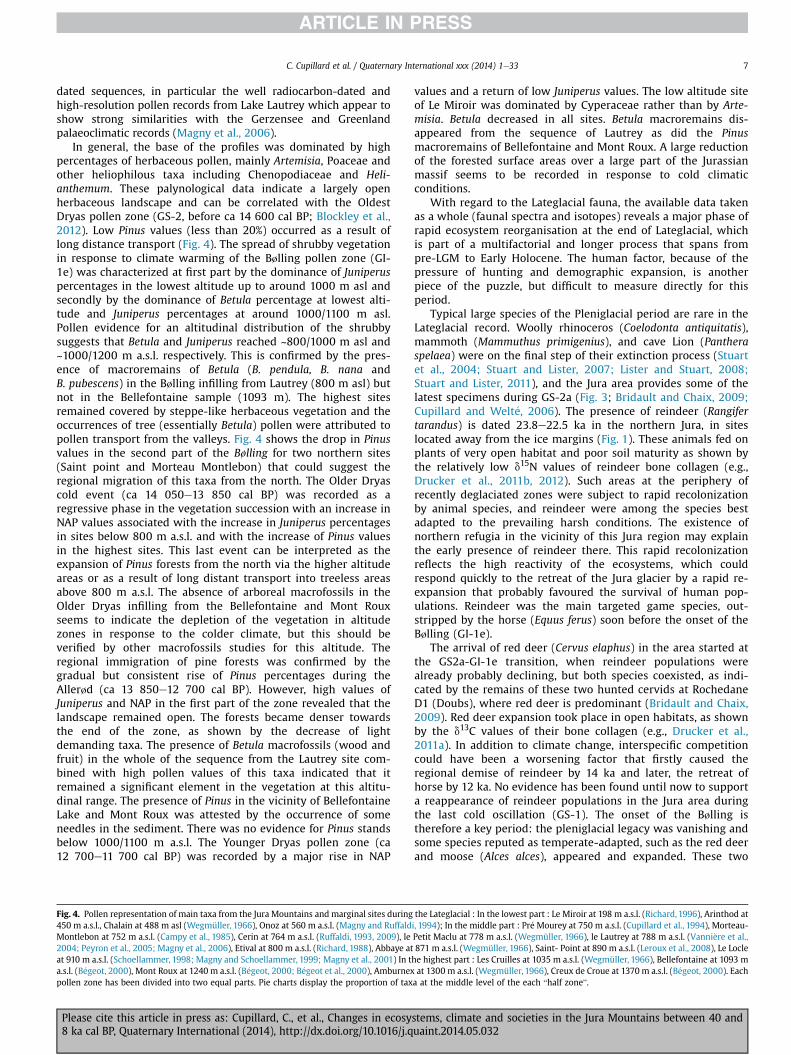
In general, the base of the profiles was dominated by highpercentages of herbaceous pollen, mainly Artemisia, Poaceae andother heliophilous taxa including Chenopodiaceae and Heli-anthemum. These palynological data indicate a largely openherbaceous landscape and can be correlated with the OldestDryas pollen zone (GS-2, before ca 14 600 cal BP; Blockley et al.,2012). Low Pinus values (less than 20%) occurred as a result oflong distance transport (Fig. 4). The spread of shrubby vegetationin response to climate warming of the Bølling pollen zone (GI-1e) was characterized at first part by the dominance of Juniperuspercentages in the lowest altitude up to around 1000 m asl andsecondly by the dominance of Betula percentage at lowest alti-tude and Juniperus percentages at around 1000/1100 m asl.Pollen evidence for an altitudinal distribution of the shrubbysuggests that Betula and Juniperus reached ~800/1000 m asl and~1000/1200 m a.s.l. respectively. This is confirmed by the pres-ence of macroremains of Betula (B. pendula, B. nana andB. pubescens) in the Bølling infilling from Lautrey (800 m asl) butnot in the Bellefontaine sample (1093 m). The highest sitesremained covered by steppe-like herbaceous vegetation and theoccurrences of tree (essentially Betula) pollen were attributed topollen transport from the valleys. Fig. 4 shows the drop in Pinusvalues in the second part of the Bølling for two northern sites(Saint point and Morteau Montlebon) that could suggest theregional migration of this taxa from the north. The Older Dryascold event (ca 14 050e13 850 cal BP) was recorded as aregressive phase in the vegetation succession with an increase inNAP values associated with the increase in Juniperus percentagesin sites below 800 m a.s.l. and with the increase of Pinus valuesin the highest sites. This last event can be interpreted as theexpansion of Pinus forests from the north via the higher altitudeareas or as a result of long distant transport into treeless areasabove 800 m a.s.l. The absence of arboreal macrofossils in theOlder Dryas infilling from the Bellefontaine and Mont Rouxseems to indicate the depletion of the vegetation in altitudezones in response to the colder climate, but this should beverified by other macrofossils studies for this altitude. Theregional immigration of pine forests was confirmed by thegradual but consistent rise of Pinus percentages during theAllerød (ca 13 850e12 700 cal BP). However, high values ofJuniperus and NAP in the first part of the zone revealed that thelandscape remained open. The forests became denser towardsthe end of the zone, as shown by the decrease of lightdemanding taxa. The presence of Betula macrofossils (wood andfruit) in the whole of the sequence from the Lautrey site com-bined with high pollen values of this taxa indicated that itremained a significant element in the vegetation at this altitu-dinal range. The presence of Pinus in the vicinity of BellefontaineLake and Mont Roux was attested by the occurrence of someneedles in the sediment. There was no evidence for Pinus standsbelow 1000/1100 m a.s.l. The Younger Dryas pollen zone (ca12 700e11 700 cal BP) was recorded by a major rise in NAP
Fig. 4. Pollen representation of main taxa from the Jura Mountains and marginal sites during450 m a.s.l., Chalain at 488 m asl (Wegmüller, 1966), Onoz at 560 m a.s.l. (Magny and RuffaldMontlebon at 752 m a.s.l. (Campy et al., 1985), Cerin at 764 m a.s.l. (Ruffaldi, 1993, 2009), le2004; Peyron et al., 2005; Magny et al., 2006), Etival at 800 m a.s.l. (Richard, 1988), Abbaye atat 910 m a.s.l. (Schoellammer, 1998; Magny and Schoellammer, 1999; Magny et al., 2001) In ta.s.l. (B�egeot, 2000), Mont Roux at 1240 m a.s.l. (B�egeot, 2000; B�egeot et al., 2000), Amburnexpollen zone has been divided into two equal parts. Pie charts display the proportion of tax
Please cite this article in press as: Cupillard, C., et al., Changes in ecosy8 ka cal BP, Quaternary International (2014), http://dx.doi.org/10.1016/j.q
values and a return of low Juniperus values. The low altitude siteof Le Miroir was dominated by Cyperaceae rather than by Arte-misia. Betula decreased in all sites. Betula macroremains dis-appeared from the sequence of Lautrey as did the Pinusmacroremains of Bellefontaine and Mont Roux. A large reductionof the forested surface areas over a large part of the Jurassianmassif seems to be recorded in response to cold climaticconditions.
With regard to the Lateglacial fauna, the available data takenas a whole (faunal spectra and isotopes) reveals a major phase ofrapid ecosystem reorganisation at the end of Lateglacial, whichis part of a multifactorial and longer process that spans frompre-LGM to Early Holocene. The human factor, because of thepressure of hunting and demographic expansion, is anotherpiece of the puzzle, but difficult to measure directly for thisperiod.
Typical large species of the Pleniglacial period are rare in theLateglacial record. Woolly rhinoceros (Coelodonta antiquitatis),mammoth (Mammuthus primigenius), and cave Lion (Pantheraspelaea) were on the final step of their extinction process (Stuartet al., 2004; Stuart and Lister, 2007; Lister and Stuart, 2008;Stuart and Lister, 2011), and the Jura area provides some of thelatest specimens during GS-2a (Fig. 3; Bridault and Chaix, 2009;Cupillard and Welt�e, 2006). The presence of reindeer (Rangifertarandus) is dated 23.8e22.5 ka in the northern Jura, in siteslocated away from the ice margins (Fig. 1). These animals fed onplants of very open habitat and poor soil maturity as shown bythe relatively low d15N values of reindeer bone collagen (e.g.,Drucker et al., 2011b, 2012). Such areas at the periphery ofrecently deglaciated zones were subject to rapid recolonizationby animal species, and reindeer were among the species bestadapted to the prevailing harsh conditions. The existence ofnorthern refugia in the vicinity of this Jura region may explainthe early presence of reindeer there. This rapid recolonizationreflects the high reactivity of the ecosystems, which couldrespond quickly to the retreat of the Jura glacier by a rapid re-expansion that probably favoured the survival of human pop-ulations. Reindeer was the main targeted game species, out-stripped by the horse (Equus ferus) soon before the onset of theBølling (GI-1e).
The arrival of red deer (Cervus elaphus) in the area started atthe GS2a-GI-1e transition, when reindeer populations werealready probably declining, but both species coexisted, as indi-cated by the remains of these two hunted cervids at RochedaneD1 (Doubs), where red deer is predominant (Bridault and Chaix,2009). Red deer expansion took place in open habitats, as shownby the d13C values of their bone collagen (e.g., Drucker et al.,2011a). In addition to climate change, interspecific competitioncould have been a worsening factor that firstly caused theregional demise of reindeer by 14 ka and later, the retreat ofhorse by 12 ka. No evidence has been found until now to supporta reappearance of reindeer populations in the Jura area duringthe last cold oscillation (GS-1). The onset of the Bølling istherefore a key period: the pleniglacial legacy was vanishing andsome species reputed as temperate-adapted, such as the red deerand moose (Alces alces), appeared and expanded. These two
the Lateglacial : In the lowest part : Le Miroir at 198 m a.s.l. (Richard, 1996), Arinthod ati, 1994); In the middle part : Pr�e Mourey at 750 m a.s.l. (Cupillard et al., 1994), Morteau-Petit Maclu at 778 m a.s.l. (Wegmüller, 1966), le Lautrey at 788 m a.s.l. (Vanni�ere et al.,871 m a.s.l. (Wegmüller, 1966), Saint- Point at 890 m a.s.l. (Leroux et al., 2008), Le Loclehe highest part : Les Cruilles at 1035 m a.s.l. (Wegmüller, 1966), Bellefontaine at 1093 mat 1300 m a.s.l. (Wegmüller, 1966), Creux de Croue at 1370 m a.s.l. (B�egeot, 2000). Eacha at the middle level of the each “half zone”.
stems, climate and societies in the Jura Mountains between 40 anduaint.2014.05.032

C. Cupillard et al. / Quaternary International xxx (2014) 1e338
cervids probably benefited from the spread of shrubs and smalltrees that provided abundant grazing. A transitional state of theecosystems is reflected in the non-analogous combination of taxathat characterizes the faunal spectra of this short stage. Despitethe spread of woody plant species, the landscape was still veryopen and, thus, the impact of the faunal corpus change on thehunting strategy of the human population was probably moreinfluenced by the differences in their ethology (large herds ofmigrating reindeer were replaced by small groups of territorialred deer and moose) than by the change of species composition(e.g. Bridault and Chaix, 2009). After the first warm oscillation,the fauna reorganisation seems to have accelerated and consol-idated. Red deer become the predominant hunted species duringthe Allerød. Together with wild boar (Sus scrofa) and roe deer(Capreolus capreolus), they are the main prey species throughoutthe early Holocene.
2.3. The early to mid-Holocene (ca 11 700e7000 cal BP)
Pollen records of the Preboreal pollen zone (ca 11700-10 200 calBP) showa very similar picture to those observed during the secondpart of the Allerød. Pinus values were very high above 1000 m a.s.l.and their presence with Betula was attested by the occurrence ofmacrofossils at Bellefontaine and Mont Roux. Below 1000 m a.s.l.,only the presence of Betula stands was confirmed bymacroremainsrecords at Lautrey.
From ca 10 200 to ca 9000 cal BP, during the Boreal pollenzone, Pinus remains dominant above 1100 m a.s.l. and masksCorylus which shows a clear domination everywhere else, whilemesophilous trees expand, with a domination of Ulmus at theend of the pollen zone. The analysis of the peat-bog of Mouthe, inthe high chain at 960 m a.s.l., shows abnormal variations in thehazel ratio at the end of the Boreal (Cupillard et al., 1994). Thesefluctuations could have a natural cause such as, for instance,spontaneous fires followed by regeneration of the vegetation(Richard, 1995), but might also result from human activity(Cupillard, 2010), but this needs to be confirmed by furtherstudies.
Finally, the older Atlantic pollen zone (i.e. ca 9000e7000 calBP) was characterized by an expansion of the Quercetum mixtum.However, the forest composition is closely related to the localclimatic and edaphic conditions. Thus, the expansion of Fraxinusand Tilia depends on the altitude: above 1100 m a.s.l., Tilia showsrelatively low percentage values, whereas it attains a maximumaround 8000 cal BP at 1000 m a.s.l. and as early as 9000 cal BPbelow 800 m a.s.l. (Beaulieu de et al., 1994). The most ancientpollen from cereals found in the region was dated to the latterhalf of the Atlantic about 7700/7800 cal BP, and it is observed ontwo Jura sites (Richard and Ruffaldi, 2004; Gauthier and Richard,2008). This very early evidence must be questioned, even thoughsimilar evidence was observed near the lake of Zurich on theSwiss Plateau (Haas, 1996; Erny-Rodmann et al., 1997) and in theupper Rhone valley (Welten, 1982). Around 7300/7000 cal BP,human impact and pollen from cereals are recognised at the lakeof Chalain on the lower western plateau (Richard, 1997) and ondifferent lacustrine or peat bog sequences of the high range(Cupillard et al., 1994; Buttler et al., 2002; Gauthier, 2004;Richard and Ruffaldi, 2004; Leroux et al., 2008). These varioussites indicate that by that time, neolithisation was accomplishedthroughout the Jura, at least since 7300 cal BP (Gauthier andRichard, 2008).
Regarding the fauna, the depleted d13C values of the red deer inthe early Holocene indicate a high degree of closure of the forestcanopy (Drucker et al., 2011a). In such a landscape, the acquisitionof large game (i.e. the main animal food supply of the mesolithic
Please cite this article in press as: Cupillard, C., et al., Changes in ecosy8 ka cal BP, Quaternary International (2014), http://dx.doi.org/10.1016/j.q
subsistance) probably involved a great change of hunting practicesand settlement-procurement systems.
2.4. Quantitative estimates of climatic variations
Quantitative estimates of climatic variations in the JuraMountains during the period 40e8 ka have been mainly recon-structed using pollen and chironomid data from lake sedimentsequences. However, due to environmental conditions, i.e. theoverall covering of the Jura Mountains by an ice cap above~500 m a.s.l. and the quasi-absence of lake basins in the lowerparts of the Jura, no data is available to establish a regionalpaleoclimate record for the interval 40e17 ka. Fortunately, thetwo sites of La Grande Pile (330 m a.s.l.) and Les Echets (267 ma.s.l.) located close to the northern and the southern extremitiesof the Jura Mountains (Fig. 5) have provided long pollen recordswhich have been used for quantitative reconstructions of palae-oclimates during the whole Last Glacial/Interglacial cycle (Guiotet al., 1989). Both records suggest that the period 40e30 kawas characterised by relatively less cold and less dry conditionsthan the LGM marked by very cold and very dry conditions(Guiot et al., 1989; Guiot, 1990). In addition, using pollen datashowing only organic matter content and beetle data, Guiot et al.(1993) have indicated that the interval 60e15 ka in the palae-oclimatic record of La Grande Pile was punctuated by cold peaksin phase with Heinrich events defined in the North AtlanticOcean.
The general retreat of the ice cap after ca 17e16 ka favouredthe accumulation of sediments in the ice-free Jurassian lake ba-sins and, as a result, the establishment of regional palaeoclimaticand palaeoenvironmental records for the Lateglacial and the earlyHolocene. Based on a multi-proxy reconstruction using pollenand chironomid data, the well-dated high-resolution palae-oclimatic record of Lake Lautrey spans the Late GlacialeearlyHolocene transition in the central Jura range (Heiri and Millet,2005; Peyron et al., 2005; Magny et al., 2006). Major abruptchanges in climatic conditions appear to have been associatedwith the GS-2a/GI-1a, GI-1a/GS-1, and GS-1/Preboreal transitions.The temperature of the warmest month increased by ~5 �C at thestart of GI-1 and by 1.5�e3 �C at the onset of the Holocene, whileit fell by ~3�e4 �C at the beginning of GS-1. In addition, thepollen-based quantitative estimates suggest that the Lateglacialinterstadial was punctuated by three successive minor coolingevents by ~0.7�e2 �C possibly synchronous with the GI-1d, GI-1c2 (Brauer et al., 2000), and GI-1b oscillations. A comparison oftemperature estimates obtained at Lake Lautrey with otherquantitative reconstructions from neighbouring regions in west-central Europe show general agreement in identifying an iden-tical succession of major warming (GI-1a, Preboreal) and cooling(GS-2a, GS-1) phases, but differences in the magnitude of thetemperature changes reconstructed indicate difficulties con-cerning the methods of reconstruction and/or to the sensitivity oraccuracy of the climatic indicators used (Peyron et al., 2005;Magny et al., 2006).
Regarding the annual precipitation (PANN) and its seasonaldistribution throughout the last GlacialeInterglacial transition atLake Lautrey, the onset of GI-1 and Holocene coincided with aclear reactivation of the hydrological cycle with an increase inannual precipitation and available moisture, probably inconnection with the retreat of sea ice and an increasing evapo-ration over the ice-free North Atlantic Ocean due to highertemperature (Renssen and Isarin, 2001). Given (1) that theabrupt warming in ca 14 700 and 11 700 cal BP corresponded toa major lowering of lake levels in the Jura Mountains (Magny,2001; Magny et al., 2006) and (2) that the sediment markers
stems, climate and societies in the Jura Mountains between 40 anduaint.2014.05.032

Fig. 5. Quantitative estimates of climatic parameters for the Lateglacial and early Holocene in the Jura Mountains using pollen, chironomidae, and lake-level data. Lower panel : theLateglacial palaeoclimatic record from Lake Lautrey (from Heiri and Millet, 2005; Peyron et al., 2005; Magny et al., 2006). Upper panel: the early Holocene palaeoclimatic recordfrom Lake Le Locle (from Magny et al., 2001). GDD5: growing degrees above 5 �C � days; PANN : annual rainfall; MTWA: mean temperature of the warmest month; E/PET: realevapotranspiration/potential evapotranspiration.
C. Cupillard et al. / Quaternary International xxx (2014) 1e33 9
used for the reconstruction of past lake levels form during thewarm season, quantitative estimates obtained at Lake Lautreysuggest dry summers and wet winters at the onset of the GI-1and Holocene. GS-2a and GS-1 may have been characterised by
Please cite this article in press as: Cupillard, C., et al., Changes in ecosy8 ka cal BP, Quaternary International (2014), http://dx.doi.org/10.1016/j.q
dry winters and wet summers. Such opposite patterns of sea-sonality may have reflected variations in the extension of the seaice and the position of the storm track in agreement with AGCMexperiments (Renssen and Isarin, 2001).
stems, climate and societies in the Jura Mountains between 40 anduaint.2014.05.032

C. Cupillard et al. / Quaternary International xxx (2014) 1e3310
The early Holocene palaeoclimates in the Jura Mountains havebeen best documented by quantitative estimates obtained at LakeLe Locle, Swiss Jura, using pollen and lake-level data (Magny et al.,2001). Climatic parameters reconstructed here suggest thatregional phases of higher lake-level conditions around11 350e11 100 (Preboreal oscillation), 10 250e9900, 9550e9350(Boreal oscillations), and 8400e8050 cal BP (8200 event) (Magny,2013) coincided with an increase in annual precipitation by~300 mm, a decrease in summer temperature by ~1.5�e2 �C, and ashortening of the growing season. This general pattern could haveresulted from alternate southward-northward displacements of theAtlantic Westerly Jet Stream and its associated cyclonic track inresponse to both deglaciation events and variations in solar activity(Magny and B�egeot, 2004).
Fig. 6. A e Lateglacial and Holocene tephra and cryptotephra layers in Jura Mountains, Nor4, 40. Wegmüller and Welten (1973); 5. Martini (1970), Eicher (1987), van den Bogaard aVanni�ere et al. (2004), Walter-Simonnet et al. (2008); 8. Magny and Ruffaldi (1994), Walunpublished data; 12. Unpublished data; 13. Eicher and Siegenthaler (1976), Eicher (1987)(2010); 16. B�egeot (2000); 17. Fuchs (2008); 18. Moscariello and Costa (1997), Moscariello eEicher and Siegenthaler (1976), Lotter et al. (1992); 22. Wegmüller and Lotter (1990), Lotte(1983), Eicher and Siegenthaler (1983), van den Bogaard and Schminke (1985); 25. Eich(1970), van den Bogaard and Schminke (1985); 32. Lotter et al. (1992), Blockley et al. (et al. (2006); 35. Magny (2001); 36, 37. Hofmann (1963); 38. van den Bogaard and Schmthe French Massif Central and Italy; C e Continental dispersion of La Nug�ere Tephras, Laachalkaline elements diagram for Laacher See Tephra, Vedde Ash, Askja-10ka Tephra and VTephras.
Please cite this article in press as: Cupillard, C., et al., Changes in ecosy8 ka cal BP, Quaternary International (2014), http://dx.doi.org/10.1016/j.q
2.5. Tephrochronological data
In addition to data documenting palaeoenvironmental andpalaeoclimatic changes, the sediment sequences studied in lakesand peat bogs of the Jura Mountains include tephra layers whichoffer key time-marker horizons for inter-regional correlationsaccording to the INTIMATE strategy (Davies et al., 2002; Turneyet al., 2006; Blockley et al., 2012). In this area and the SwissPlateau, at least 40 sites have been studied since the Hofmann(1963) study carried out on Neeracherriet and Feldenmoospeatbogs (Switzerland) (Fig. 6-A). Some of the tephra describedin lakes and peatbogs in French and Swiss Jura mountains arevisible, usually observed as a greyish or dark layer depending onthe host-sediment mineralogy, while the others are invisible to
thern Alps and Western Swiss Plateau. 1. Eicher (1979); 2,3. Martini and Duret (1966);nd Schminke (1985); 6, 9, 27, 28, 29, 30, 31. Martini (1970); 7. Bossuet et al. (1997),ter-Simonnet et al. (2008); 10. Unpublished data; 11. Duret and Martini (1965), and, Lotter et al. (1992), Walter-Simonnet et al. (2008); 14. Creer et al. (1980); 15. Lerouxt al., (1998); 19. Ruffaldi (1993); 20. Brauer and Casanova (2001), Nomade (2005); 21.r et al. (1992); 23. Rolliå et al. (1994), Hadorn (1992, 1994); 24. Amman and Tobolskier (1979, 1987), Welten (1982), van den Bogaard and Schminke (1985); 26. Martini2007), Lane et al., (2011a); 33. Eicher (1987), Lotter et al. (1992); 34. Schnellmanninke (1985); 39. Juvign�e (1980); B e Main tephras from Iceland, the Eifel complex,er See Tephra, Vedde Ash, Askja-10 ka Tephra and Vasset-Killian Tephra; D e Silica vsasset-Killian Tephra; E e Chemical composition of plagioclase from the La Nug�ere
stems, climate and societies in the Jura Mountains between 40 anduaint.2014.05.032

C. Cupillard et al. / Quaternary International xxx (2014) 1e33 11
the naked eye. Therefore, their detection is obtained either usingmagnetic susceptibility measurement with a 5 mm step alongthe cores (Jouannic, in prep.; Walter-Simonnet et al., 2008;Jouannic, in prep.), or by quantification of tephra glass shardconcentration under an optical microscope in continuous(~1 cm3) samples of sediment prepared according to the processpublished by Blockley et al. (2004). Quantification under anoptical microscope of the tephras, especially acidic ones whichcannot be detected by susceptibility measurement, is a long andexacting task. This is the reason why new rapid detectionmethods are currently being tested (Jouannic, in prep.; Caseldineet al., 1999; Kylander et al., 2012; Jouannic, in prep.). Assigning atephra to a known eruption or a volcano can be made either byheavy mineral assemblage, phenocristal chemistry, or chemicalcharacterization of glass shards achieved by the analysis of majorand minor elements using electron microprobe equipment. Thelatter method is now commonly used except when glass shardsare too weathered for chemical analysis.
During the period 40e8 ka cal BP, many different volcaniccomplexes have been active in Europe (e.g. Iceland, the Eifel, theFrench Massif Central, Italy), generating a great number oftephras deposited during the main eruptions (Fig. 6-B). North-west Europe, and especially eastern France and Switzerland, arein the centre of the area circumscribed by these points of erup-tion (Fig. 6-C). Six tephra layers can be identified and character-ized in lakes and peatbogs in the Jura Mountains and SwissPlateau (Fig. 6-A).
The Icelandic volcanic complex is composed of two groups ofvolcanoes. Tholeiitic basalts are related to the Grimsv€otn-Kverfj€oll group situated in the Northern part of Iceland, whenvolcanoes from the southeast part of the island (Hekla and Katla)erupt alkaline basalts, olivine basalts and rhyolite (Jakobsson,1979 in Davies et al., 2002). Some Iceladic tephras have a widedispersion (Davies et al., 2005; Pilcher et al., 2005; Blockley et al.,2007; Lane et al., 2011, 2012). In lakes and peatbogs of the JuraMountains and Swiss Plateau two Icelandic tephras were iden-tified: the Vedde Ash (12 121 ± 114 a) and the Askja-10ka tephra(10 702e10 991 cal BP) (Lane et al., 2011) (Fig. 6-C). The VeddeAsh is characterized by a bimodal basaltic-rhyolitic composition:in this area only the rhyolitic phase can be observed (Fig. 6-D).The Askja-10ka tephra was described in only one site, the Sop-pensee (Lane et al., 2011). Its rhyolitic composition cannot bemistaken for the Vedde Ash's (Fig. 6-D).
The Eifel volcanic complex (near Bonn, Germany) generated twomain tephras (Fig. 6-B), but only the Laacher See Tephra is observedas a visible layer in the region. It was dated to 12 880 ± 40 varveyears (Brauer et al., 1999), 12 900 ± 560 years 40Ar/39Ar (Van denBogaard, 1995), and ca. 13 160 years from tree-ring analysis(Friedrich et al., 2004). This phonolitic tephra (Fig. 6-D) is wide-spread in the North Atlantic region as well as in northern, southern,and continental Central Europe, where three phases with adifferent chemistry and manner of dispersion were identified(van den Bogaard and Schminke, 1985; Harms and Schmincke,2000) (Fig. 6-C).
The volcanoes of the Chaîne des Puys were very active duringthe Lateglacial and the Early Holocene (Fig. 6-B). Chemicalanalysis of tephras and volcanic products from the Chaîne desPuys shows an evolution of basalts and trachy-basalts into tra-chytes (Maury et al., 1980; Boivin et al., 2004). Their dispersion isusually limited to Limagne and Monts du Forez (Etlicher et al.,1987; Juvign�e and Gewelt, 1987; Vernet et al., 1990; Juvign�eet al., 1992; Juvign�e et al., 1996; Boivin et al., 2004), and theirrelative chronology was built by using four methods: pollenanalysis, radiocarbon dating, thermoluminescence dating, andtephric overlap (Vivent and Vernet, 2001; Vernet and Raynal,
Please cite this article in press as: Cupillard, C., et al., Changes in ecosy8 ka cal BP, Quaternary International (2014), http://dx.doi.org/10.1016/j.q
2000; Boivin et al., 2004). In our region, the oldest tephraoccurrence corresponding to the Chaîne des Puys eruption wasidentified in only one site, Pont de la Douceur (Fig. 6-A), byMartini (1970). Martini related this tephra layer to the Chaîne desPuys volcanoes owing to its late pleniglacial age (Blavoux andBrun, 1966) and its heavy mineral assemblage mostly composedof brown hornblende. Two very discrete tephra layers have beendeposited during the Allerød, before the Laacher See Tephra(Walter-Simonnet et al., 2008). The chemical composition anal-ysis of glass shards weathered into zeolites could not be carriedout by using an electron microprobe. However, they havet ages,mineral assemblages, and plagioclase chemical composition closeto those of tephras emitted by the Puy de la Nug�ere (ca 13 300 a)(Fig. 6- E).
The Vasset-Killian Tephra (VKT), a trachytic tephra (Fig. 6-Aand D), was detected in nine sites, but chemically characterizedonly in Soppensee tephrostratigraphy by Lane et al. (2011). In theother sites, this tephra was characterized only by its heavymineral assemblage (Jouannic, in prep.; Martini, 1970; Eicher,1987; Leroux et al., 2008; Jouannic, in prep.) or by correlationwith magnetic susceptibility peaks (Schnellmann et al., 2006).However, the exact source volcano is unknown and the precisedate of the eruption remains uncertain. In Soppensee, a new dateof 9406e9265 cal BP for the VKT was proposed (Lane et al.,2011).
To sum up, with six different occurrences of tephras layersdeposited during the Late Glacial and Early Holocene, the JuraMountains and Swiss Plateau area appear as an importanttephrochronological bridge between northern and centralEurope records and southern and western ones. These dataoutline the potential of tephra layers as isochronous markers fordeveloping more precise chronology and inter-site comparisonson common timescales. They also suggest the probable occur-rence of other Lateglacial and Holocene cryptotephras in easternFrance records.
3. Archaeological data and cultural history
On both the French and Swiss sides of the Jura range during thelast thirty years, the study of prehistoric sites has been greatlyimproved, firstly because of the achievements and the complete orpartial publications of important rescue or programmed excava-tions, and secondly because new scientific research programmeshave been undertaken to define the chronological framework ofUpper Paleolithic, final Palaeolithic and Mesolithic cultures. Thisnew research performed at 48 prehistoric sites (Table 1, Fig. 7) hasyielded a huge set of environmental and archaeological data, and256 new AMS dates which have been calibrated using the calibra-tion software CALPAL (Danzeglocke et al., 2009; www. Cal.pal.-de)(Appendix 1). This data now can be considered (at least as a firstapproximation) as representative of Palaeolithic and Mesolithicdemography (Gamble et al., 2005;; D'Errico et al., 2012) and in-dicates the main stages of human population between 40 000 and8000 cal BP with cultural phases similar to those defined andradiocarbon-dated in neighbouring regions by Jaubert (2011),Leesch et al. (2012), and Gesqui�ere and Marchand (2010). Thesewell-dated sites constitute merely a sample of the recognisedprehistoric sites, the number of which is not accurately known butis around seven hundred. The 256 AMS dates have mostly beenalready published but some of them are presented for the first time(Appendix 1). Half of them have been carried out on samples fromexcavations and the other half on samples from several in-vestigations specifically aimed at chronology (Cupillard, 2008;Pion, 2000a; Pion and M�evel, 2009; Szmidt et al., 2010; Leesch etal., 2012, 2013; Drucker et al., 2011a, 2012; Cupillard et al., 2013).
stems, climate and societies in the Jura Mountains between 40 anduaint.2014.05.032
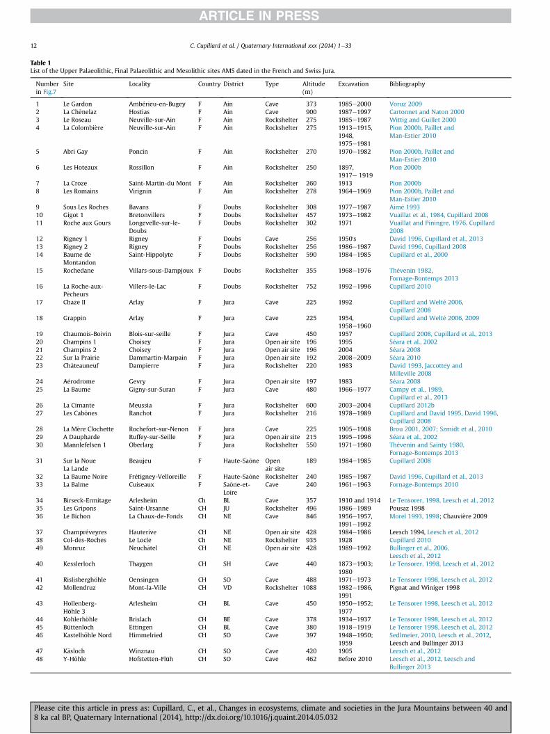
Table 1List of the Upper Palaeolithic, Final Palaeolithic and Mesolithic sites AMS dated in the French and Swiss Jura.
Numberin Fig.7
Site Locality Country District Type Altitude(m)
Excavation Bibliography
1 Le Gardon Amb�erieu-en-Bugey F Ain Cave 373 1985e2000 Voruz 20092 La Chenelaz Hostias F Ain Cave 900 1987e1997 Cartonnet and Naton 20003 Le Roseau Neuville-sur-Ain F Ain Rockshelter 275 1985e1987 Wittig and Guillet 20004 La Colombi�ere Neuville-sur-Ain F Ain Rockshelter 275 1913e1915,
1948,1975e1981
Pion 2000b, Paillet andMan-Estier 2010
5 Abri Gay Poncin F Ain Rockshelter 270 1970e1982 Pion 2000b, Paillet andMan-Estier 2010
6 Les Hoteaux Rossillon F Ain Rockshelter 250 1897,1917e 1919
Pion 2000b
7 La Croze Saint-Martin-du Mont F Ain Rockshelter 260 1913 Pion 2000b8 Les Romains Virignin F Ain Rockshelter 278 1964e1969 Pion 2000b, Paillet and
Man-Estier 20109 Sous Les Roches Bavans F Doubs Rockshelter 308 1977e1987 Aim�e 199310 Gigot 1 Bretonvillers F Doubs Rockshelter 457 1973e1982 Vuaillat et al., 1984, Cupillard 200811 Roche aux Gours Longevelle-sur-le-
DoubsF Doubs Rockshelter 302 1971 Vuaillat and Piningre, 1976, Cupillard
200812 Rigney 1 Rigney F Doubs Cave 256 1950's David 1996, Cupillard et al., 201313 Rigney 2 Rigney F Doubs Rockshelter 256 1986e1987 David 1996, Cupillard 200814 Baume de
MontandonSaint-Hippolyte F Doubs Rockshelter 590 1984e1985 Cupillard et al., 2000
15 Rochedane Villars-sous-Dampjoux F Doubs Rockshelter 355 1968e1976 Th�evenin 1982,Fornage-Bontemps 2013
16 La Roche-aux-Pecheurs
Villers-le-Lac F Doubs Rockshelter 752 1992e1996 Cupillard 2010
17 Chaze II Arlay F Jura Cave 225 1992 Cupillard and Welt�e 2006,Cupillard 2008
18 Grappin Arlay F Jura Cave 225 1954,1958e1960
Cupillard and Welt�e 2006, 2009
19 Chaumois-Boivin Blois-sur-seille F Jura Cave 450 1957 Cupillard 2008, Cupillard et al., 201320 Champins 1 Choisey F Jura Open air site 196 1995 S�eara et al., 200221 Champins 2 Choisey F Jura Open air site 196 2004 S�eara 200822 Sur la Prairie Dammartin-Marpain F Jura Open air site 192 2008e2009 S�eara 201023 Chateauneuf Dampierre F Jura Rockshelter 220 1983 David 1993, Jaccottey and
Milleville 200824 A�erodrome Gevry F Jura Open air site 197 1983 S�eara 200825 La Baume Gigny-sur-Suran F Jura Cave 480 1966e1977 Campy et al., 1989,
Cupillard et al., 201326 La Cimante Meussia F Jura Rockshelter 600 2003e2004 Cupillard 2012b27 Les Cabones Ranchot F Jura Rockshelter 216 1978e1989 Cupillard and David 1995, David 1996,
Cupillard 200828 La M�ere Clochette Rochefort-sur-Nenon F Jura Cave 225 1905e1908 Brou 2001, 2007; Szmidt et al., 201029 A Daupharde Ruffey-sur-Seille F Jura Open air site 215 1995e1996 S�eara et al., 200230 Mannlefelsen 1 Oberlarg F Jura Rockshelter 550 1971e1980 Th�evenin and Sainty 1980,
Fornage-Bontemps 201331 Sur la Noue
La LandeBeaujeu F Haute-Saone Open
air site189 1984e1985 Cupillard 2008
32 La Baume Noire Fr�etigney-Velloreille F Haute-Saone Rockshelter 240 1985e1987 David 1996, Cupillard et al., 201333 La Balme Cuiseaux F Saone-et-
LoireCave 240 1961e1963 Fornage-Bontemps 2010
34 Birseck-Ermitage Arlesheim Ch BL Cave 357 1910 and 1914 Le Tensorer, 1998, Leesch et al., 201235 Les Gripons Saint-Ursanne CH JU Rockshelter 496 1986e1989 Pousaz 199836 Le Bichon La Chaux-de-Fonds CH NE Cave 846 1956e1957,
1991e1992Morel 1993, 1998; Chauvi�ere 2009
37 Champr�eveyres Hauterive CH NE Open air site 428 1984e1986 Leesch 1994, Leesch et al., 201238 Col-des-Roches Le Locle Ch NE Rockshelter 935 1928 Cupillard 201049 Monruz Neuchatel CH NE Open air site 428 1989e1992 Bullinger et al., 2006,
Leesch et al., 201240 Kesslerloch Thaygen CH SH Cave 440 1873e1903;
1980Le Tensorer, 1998, Leesch et al., 2012
41 Rislisbergh€ohle Oensingen CH SO Cave 488 1971e1973 Le Tensorer 1998, Leesch et al., 201242 Mollendruz Mont-la-Ville CH VD Rockshelter 1088 1982e1986,
1991Pignat and Winiger 1998
43 Hollenberg-H€ohle 3
Arlesheim CH BL Cave 450 1950e1952;1977
Le Tensorer 1998, Leesch et al., 2012
44 Kohlerh€ohle Brislach CH BE Cave 378 1934e1937 Le Tensorer 1998, Leesch et al., 201245 Büttenloch Ettingen CH BL Cave 380 1918e1919 Le Tensorer 1998, Leesch et al., 201246 Kastelh€ohle Nord Himmelried CH SO Cave 397 1948e1950;
1959Sedlmeier, 2010, Leesch et al., 2012,Leesch and Bullinger 2013
47 K€asloch Winznau CH SO Cave 420 1905 Leesch et al., 201248 Y-H€ohle Hofstetten-Flüh CH SO Cave 462 Before 2010 Leesch et al., 2012, Leesch and
Bullinger 2013
C. Cupillard et al. / Quaternary International xxx (2014) 1e3312
Please cite this article in press as: Cupillard, C., et al., Changes in ecosystems, climate and societies in the Jura Mountains between 40 and8 ka cal BP, Quaternary International (2014), http://dx.doi.org/10.1016/j.quaint.2014.05.032

Fig. 7. Archaeological maps of AMS dated sites. For the site numbers, refer to Table 1. A e Map of the Aurignacian, Gravettian, Badegoulian AMS dated sites B e Map of the MiddleMagdalenian AMS dated sites C e Map of the Upper Magdalenian AMS dated sites D e Map of the Early and Middle Azilian AMS dated sites E e Map of Late Azilian/EpigravettianAMS dated sites F e Map of the Early Mesolithic AMS dated sites G e Map of theMiddle Mesolithic AMS dated sites H e Map of the Late and Final Mesolithic AMS dated sites.
C. Cupillard et al. / Quaternary International xxx (2014) 1e33 13
3.1. Aurignacian: from 41 000 to 33 000 cal BP (Fig. 7A)
As of 2013, evidence of Aurignacian culture is totally absent fromSwitzerland and from the Jura range (Leesch and Bullinger, 2013)and the only example of its kind is the Cave of La M�ere Clochette atRochefort-sur-Nenon located along the lower Doubs River on thewestern margins of the Jura range (Szmidt et al., 2010). On this site,excavated around 1900, five AMS dates have been made on bone orartefacts and fixed between 41 222e39 540 cal BP (OxA-19622) and33 539e34 154 cal BP (Beta-150312). The results of greatest confi-dence seem to be those given by two samples treated by ultrafil-tration, ie OxA-19622 : 41 222e39 540 cal BP and OxA-19621 :40 464e38 120 cal BP (Szmidt et al., 2010). This occupation
Please cite this article in press as: Cupillard, C., et al., Changes in ecosy8 ka cal BP, Quaternary International (2014), http://dx.doi.org/10.1016/j.q
corresponds to Proto-Aurignacian or Early Aurignacian culture,contemporany with MIS 3 and with a time range extending fromGS-9 to GI-10 (Blockley et al., 2012). Close to this site, the Cave desGorges at Amange (Jura) is a new, interesting stratigraphicalsequence still being investigated, where the lowest layer US 4provides few lithic artefacts and cold tolerantmammal faunawith 2AMS dates of 40 666 to 38 641 cal BP (Bereiziat et al., 2012).
3.2. Middle Gravettian : around 30 000 cal BP (Fig. 7A)
Gravettian peopling is unknown in Switzerland and in the Jurarange (Cupillard et al., 2013; Leesch and Bullinger, 2013). Its seemsto be present in the Prejurassian area, but recent TL dates between
stems, climate and societies in the Jura Mountains between 40 anduaint.2014.05.032

C. Cupillard et al. / Quaternary International xxx (2014) 1e3314
17.6 and 10.1 ka do not fit with the Gravettian lithic industry(Lamotte et al., 2012). Nevertheless, the only one of its kind is theCave of La Balme at Cuiseaux located on the western margins of theCentral Jura range (Fornage-Bontemps, 2010; Cupillard et al., 2013;Leesch et al., 2013). On this site, excavated during the 1960s, faunalremains are very poor, and the lithic industry belongs to theMiddleGravettian, dated between 29 914 and 30 447 cal BP (Ly-3728(GrA))(Fornage-Bontemps, 2010; Cupillard et al., 2013). Therefore,this occupation could be coeval with GS-5 and GI-4 (Lowe et al.,2008). This point shows that human peopling was possible alongthe western fringe of the range, 20 km from the front of the ice cap(Buoncristiani et al., 2002). Moreover, the study of the lithic in-dustry shows that flints come mainly from local upper Cretaceousoutcrops and seem to exclude an allochthonous occupation(Fornage-Bontemps, 2010).
3.3. Badegoulian or possible Early Magdalenian: from 23 300 to19 700 cal BP (Fig. 7A)
Between 27 000 and 23 000 cal BP, the Jura range experi-enced a glacial advance and the climatic conditions must havebeen very harsh at its western margins (Buoncristiani et al.,2002). Solutrean culture, which in France, extends from 26 000to 23 000 cal BP (Jaubert, 2011), is not present beyond theeastern part of the Saone River (Combier and Montet-White,2002; Tiffagom, 2006). The first stage of repopulation is datedbetween 23 300 and 21 400 cal BP at the end of the LGM duringthe glacial decay. Four sites produced 6 AMS dates. The beststudied and documented site is Himmelried (Kastelh€ohle-Nord),whose “middle layer” is attributed to the Badegoulian tech-nocomplex, corresponding to the Type A Magdalenian techno-assemblage defined by Leesch (1993). At this site, 3 AMS datesperformed on modified reindeer bones are placed between23 051e23 775 and 21 788e22 468 cal BP (Sedlmeier, 2010;Leesch et al., 2012). In France, in the rock-shelter of Fr�etigney«La Baume Noire», two new AMS dates performed on reindeerbone of levels M4 et M5 are respectively placed at22 804e23 338 cal BP and 21 454e22 172 cal BP (Drucker et al.,2012). They are contemporany with the Middle Kastelh€ohle layerand Y-H€ohle cave where a cut marked reindeer bone is datedbetween 22 466 and 23 021 cal BP (Leesch et al., 2012). Thesefour sites lie in the time range corresponding to the extension ofGI-2 and GS-2c. The second stage of peopling is dated between21 000 and 19 700 cal BP during the second part of the degla-ciation (GS-2b). Four sites with four reindeer and woolly rhi-noceros skull AMS dates are involved: layer V of La Baume deGigny (Jura) (Drucker et al., 2012), layer D of Rigney 1 (Cupillardand Welt�e, 2006), a part of layer C Grappin Cave in Arlay(Jura)(Drucker et al., 2012) and Kohler cave (Leesch et al., 2012).In these 4 cases, the cultural context is badly documented but wecan suppose that they correspond to Late Badegoulian or EarlyMagdalenian short term occupations. The seven sites of thesetwo stages are located in the Jura margins, at a low altitudebetween 220 and 462 m and between 20 and 50 km from theJurassian or Alpine glacier fronts. They show that prehistoricgroups can be found at the end of LGM, during ice melt. Thewell-identified and well-dated fauna remains show that thevegetation was sufficient to support these large species. On theother hand, lithic raw materials indicate regional origins whichreflect regional sources of flint close to the Magdalenian ones,indicating that these prehistoric groups were not pioneersexploiting a new area, but were exploiting a familiar territory fora long time (Leesch et al., 2012). These new data obtained in thewestern part of Jura confirm as well the early recolonization of
Please cite this article in press as: Cupillard, C., et al., Changes in ecosy8 ka cal BP, Quaternary International (2014), http://dx.doi.org/10.1016/j.q
Central Europe at the end of the LGM, already noted by severalauthors (Terberger and Street, 2002; Blockley et al., 2006).
3.4. Middle Magdalenian: from 18 700/18 000 cal BP to 17 000 calBP (Fig. 7B)
The Middle Magdalenian is traditionally divided into differentgroups or ‘faci�es’ (Leesch, 1993; Le Tensorer, 1998; Cupillard andWelt�e, 2006; Leesch et al., 2012). The first one is the Magdalenian“�a navettes” only known in the French Jura at Arlay ‘Grappin’(Cupillard et al., 2013). The second one is the Middle Magdalenianwith triangles, “baguettes demi-rondes” and double bevelledantler points defining a Type B Magdalenian techno-assemblageon the basis of the lower layer at Birsek-Ermitage cave (Leesch,1993). The third one is the Middle Magdalenian with points ofLussac-Angles and “baguettes demi-rondes �a d�ecor detub�erosit�es” corresponding to the Type C Magdalenian techno-assemblage defined at Kesslerloch (Leesch, 1993. At Arlay, thebeginning of the first faci�es is dated between 18 111e18 727 calBP and 18 084e18 649 cal BP, i.e. the end of GS-2b, and its endmight have occurred around 17 164e17 656 cal BP, i.e. thebeginning of GS-2a. The Magdalenian with triangles is not well-dated at Birsek-Ermitage (Table 1), but in the cave of Chaze 2 inArlay, which provides a triangle and a ‘baguette demi-ronde’, awoolly rhinoceros mandibule is dated between 17 347 and16 929 cal BP (Cupillard and Welt�e, 2006), i.e. the beginning ofGS-2a (Table 1). On the site of Kesslerloch, the oldest new AMSdates could correspond to Middle Magdalenian, and in this case itwould be fixed at least around 17 500 cal BP at the beginning ofGS-2a (Leesch et al., 2012). All Middle Magdalenian sites arelocated on the margins of the Jura range and at low altitude.Although sites are mainly known in caves and rock-shelters,open-air sites of techno-assemblage B have been recognized inSwitzerland and France (David, 1993; Leesch et al., 2012). Thefauna is well-known and characterized with cold tolerant speciesincluding mammoth, woolly rhinoceros, reindeer, and horse. Thisshows that the vegetation could support these large herbivores.Moreover, some of these karst sites are very rich in lithic in-dustries, bone and antler reindeer industries and portable art,such as the rock-shelter of la Colombi�ere (Pion, 2000b; Paillet andMan-Estier, 2011), Grappin Cave (Cupillard and Welt�e, 2006,2009) and Thaygen (Kesslerloch) cave (H€oneisen, 1993; LeTensorer, 1998). In Grappin Cave, the petrographic study offlints shows a large spectrum of flint resources which reflects ahuge site catchment area along the Jura range (Cupillard andWelt�e, 2009).
3.5. Upper Magdalenian: From 17 500 to 14 000 cal BP (Fig. 7C)
Upper Magdalenian is undoubtedly the best known stage of theUpper Paleolithic because of the great number of caves and rock-shelters and because of the presence of two very well-preservedopen-air sites in Neuchatel (Monruz) and Hauterive(Champr�eveyres) where modern excavations have provided avery detailed palaeoenvironmental, chronological and palae-oethnological framework for Upper Magdalenian groups (Leesch,1997; Morel and Müller, 1997; Bullinger et al., 2006). Today, 77AMS dates have been obtained from 22 sites mainly located inlowlands under 600 m altitude, but two belong to the high range:Hostias ‘La Chenelaz’ (900 m) (Cartonnet and Naton, 2000) andMont-la-Ville ‘Mollendruz’ (1088 m) (Pignat and Winiger, 1998). Ifthe typology of Upper Magdalenian is well-established in theSwiss Jura range where Leesch et al. (1993, 2012) identified TypesD and E Magdalenian techno-assemblages (Leesch 1993; Leeschet al., 2012), the chronological framework of these two techno-
stems, climate and societies in the Jura Mountains between 40 anduaint.2014.05.032

C. Cupillard et al. / Quaternary International xxx (2014) 1e33 15
assemblages is quite unequally documented. The Type D, charac-terised by “lithic industries dominated by backed bladelets, but notcontaining enough antler industry to distinguish them fromtechno-assemblage B” (Leesch et al., 2012, p. 7), is very well datedfrom the site of Monruz and Champr�eveyres, with 24 AMS datesfrom between 16 691e15 819 and 15 168e14 454 cal BP (Table 2).However, this chronological window could be reduced in timebetween 15 800 and 14 700 cal BP, a time range corresponding tothe results of AMS dates from horse bone at Monruz and to thewell-dated and very detailed pollen sub-zone CHb-1c in whichMagdalenian levels are present (Leesch et al., 2012). On the otherhand, the Type E Magdalenian assemblage, defined by “lithic in-dustries with angle backed points, shouldered points, curve-backed points and backed bladelets”, known in a few rock-shelters such as Kohlerh€ohle and Kastelh€ohle-Nord and in theopen air site of Winznau-K€opfli, has not been recognised fromopen air lacustrine sites. New AMS dates from these latter 3 sitesdo not permit more precise data on the chronological stage ofthese industries. According to the chronological position of theMiddle Madgalenian and of the Early Azilian occupations ofMonruz and Champr�eveyres, the Upper Magdalenian would betheoretically dated between 17 000 and 14 000 cal BP, but we needto use reindeer AMS dates to check and detail this assertion on thebasis of the best Upper Magdalenian assemblages. After the AMSdating from these sites, the Upper Magdalenian is placed between17419/16 792 cal BP and 14189/13 819 cal BP, a time rangewhich iscoeval with GS-2a and GI-1d. Hence, its onset would overlap theend of the Middle Magdalenian and, on the other hand, its endwould be contemporany with the Early Azilian. Some new AMSdates from Arlay (Grappin, layer C, pro parte), Kesslerloch pro parteand Mont-la-Ville (Mollendruz rockshelter, layer 5), indicate Up-per Magdalenian occupation, but they need to be collaborated byfurther detailed studies. Generally, in the Jurassian area, the UpperMagdalenian is characterised by an increase of sites and by a largehuman dispersal enhanced by the development of large open airsites (Leesch and Bullinger, 2012), as well as the presence of thefirst human grave of Les Hoteaux (Pion, 2000b; Tillet, 2001). Themajority of sites belong to GS-2a. Those of GI-1d are scarce and co-vary with a climatic improvement and the development of sparseforest coeval to the local disappearance of reindeer (Drucker et al.,2012).
3.6. Early Azilian and Middle Azilian : from 14 400 to 13 000 cal BP(Fig. 7D)
The first manifestations of Azilian culture, with its backed-curved points, were easily recognised at the open air sites ofChampr�eveyres and Monruz along the Neuchatel lake where theyare dated between 14 400 and 14 000 cal BP, at the end of theB€olling, GI-1d (Leesch et al., 2004, 2012). Between 14 400 and13 800 cal BP, well-dated occupations are scarce and lithictechno-assemblages are not typical and could be attributed toearly Azilian. The sites in question are Thaygen (Kesslerloch, layerIIc pro parte), Mont-la-Ville (Mollendruz, layer C5 inf. pro parte),Buttenloch layer B, Meussia layer 3, (Cupillard, 2012b) andCuiseaux (La Balme, Layer B). During the Aller€od, from the end ofGI-1c to GI-1a, corresponding to the Middle Azilian, there isapparently a numerical increase of sites characterized by largergeographical dispersal (Cupillard and Bourgeois, 2008). Unfor-tunately, our data are unequally documented, as the well-datedsites are located in the northwestern part of the Jura. Thesesites are located below 550 m a.s.l., except Le Bichon (846 m). The22 available radiocarbon dates from Aller€od belong mainly to thefirst part of this period, the end of GI-1c and GI-1b. Palynologicalstudies show that all these sites were located below the treeline,
Please cite this article in press as: Cupillard, C., et al., Changes in ecosy8 ka cal BP, Quaternary International (2014), http://dx.doi.org/10.1016/j.q
in an open pine-birch forest (B�egeot, 2000). Rochedane‘s layersC’1 and B show intensive occupations which provided a richfauna dominated by red deer (Bridault, 1990), an abundant lithicindustry (Th�evenin, 1982), engraved and painted portable art(D'Errico, 1995) and scattered, well-dated human bones(Cupillard, 2008). In contrast, the other sites including OberlagLayer S (Th�evenin and Sainty, 1980), Rigney 2, and Bretonvillers(Cupillard, 2008) have smaller lithic and bone series and seem tobe short-term occupations. The cave of Bichon is a very specialcase of a bear hunting accident (Morel, 1998; Chauvi�ere, 2008).On the other hand, the study of lithic raw material shows theimportance of regional flints, which indicate that the Jura rangewas no longer a barrier to exchanges (Cupillard and Bourgeois,2008).
3.7. Late Azilian and Late Epigravettian: from 13 000 to 11 700 calBP (Fig. 7E)
For the Younger Dryas, archaeological data are poor (Th�evenin,1982, 2002; Pion, 2004) and our precise knowledge is based onlyon four well-dated sites. These occupations in rockshelters are thelayer R of Oberlag, the layer A4 of Rochedane (Drucker et al., 2011a),the layer D2 of Gigot at Bretonvillers and the layer III of Longevelle(Cupillard, 2008). In addition, a part of layer II of Rislisbergh€ohlecould be included in this small group of sites (Leesch et al., 2012).The lithic techno-assemblages from sites of Oberlag, Rochedanne,Bretonvillers, and Longevelle have been recently revised. Layers A4of Rochedanne and R of Oberlag may be attributed to the LateEpigravettian, while layers D2 of Bretonvillers and III of Longevellemay be considered as belonging to the Late Azilian or to the LateEpigravettian (Fornage-Bontemps, 2013).
At Rochedane and Oberlag, the hunted fauna has been wellstudied : it is temperate and dominated by red deer (Bridault,1990). Stone industries are made from local resources and theabundance of small geometric points at Rochedane (Fornage-Bontemps, 2013) reflects intensive hunting practices (Bridault,1990) with the presence of engraved and painted portable art(D'Errico, 1995), whereas the three other sites are less documented(Fornage-Bontemps, 2013). These very late Final Palaeolithic oc-cupations are all dated from the first part of GS-1 between12 900 cal BP and 12 661 cal BP. The lack of 14C dates between12 600 and 11700 cal BP must be emphasized. Could this situationbe explained by climatic context or by changes in human use oflandscape during the Younger Dryas? The latter hypothesis mustbe carefully examined, because palynological studies show atripartite division of this biozone with a warmer phase betweentwo colder phases (B�egeot, 2000).
3.8. Early Mesolithic: From 11 700 to 9600 cal BP (Fig. 7F)
The Preboreal saw the first appearance and the development ofthe Early Mesolithic, which corresponds to the first part of the FirstMesolithic defined by Gesqui�ere and Marchand (2010). This firstMesolithic settlement is characterised by a general increase of sitesand of radiocarbon dates (Crotti and Cupillard, 2013). This period ismarked as well by the appearance of important open air sites in thewestern lowlands, including Choisey les Champins, Ruffey a Dau-pharde, and Dammartin-Marpain sur la Prairie (Crotti andCupillard, 2013). The rhythm of these occupations is not regularand varies with time. According to the calibrated 14C dates, theoldest Mesolithic phase is isolated and is known only from the layerC2 at the open air site of Choisey les Champins 1 dated between11 270 and 11 190 cal BP. The flint industry of this site showsnorthern influences, similar to Epi-ahrensbourgian traditions(S�eara et al., 2002). Between this first occupation and the following
stems, climate and societies in the Jura Mountains between 40 anduaint.2014.05.032
C. Cupillard et al. / Quaternary International xxx (2014) 1e3316
sites, there is a gap of several centuries. Most of the EarlyMesolithicsites belong to the later part of the Preboreal and the beginning ofthe Boreal. This second phase of the Early Mesolithic is dated be-tween 10 400 and 9600 cal BP in several open air sites includingDammartin-Marpain (S�eara, 2010), Choisey Les Champins 1, andRuffey A Daupharde (S�eara et al., 2002) and in several rocksheltersincluding Oberlag (Mannlefelsen, layer Q), Mollendruz, layer 4e
(Pignat and Winiger, 1998) and Hostias La Chenelaz, layer 2b(Cartonnet and Naton, 2000). As far as the Early Mesolithic isconcerned, two main points must be emphasized. First, there is achronological gap between the beginning of the Holocene and theearliest phase of the Early Mesolithic. Is there a link with thedeterioration, the Remoray Phase, dated around 11 200 cal BP(Magny, 2004) and the Northern Mesolithic because of this climaticcrisis? The second point is the consolidation phase of peopling atthe end of Preboreal and the beginning of Boreal characterised by awide dispersal of Beuronian and Sauveterrian groups, even in theJura Range. This phenomenon is in conformity with the generalclimatic improvement demonstrated by palynology and climaticlimnology (Magny, 2004).
3.9. Middle Mesolithic : from 9600 to 9000 cal BP (Fig. 7G)
The Middle Mesolithic corresponds to the second part of theFirst Mesolithic defined by Gesqui�ere and Marchand (2010). Duringthe main part of the Boreal, there is a wider dispersal of MiddleMesolithic sites. In the western lowlands, important open-air set-tlements of Dammartin-Marpain (S�eara, 2010), Choisey LesChampins 1, and Ruffey A Daupharde (S�eara et al., 2002) have beenexcavated and provide an important set of AMS dates showing acontinuity of settlement during this period, despite “Boreal oscil-lations” dated between 9550 and 9350 cal BP (Magny, 2013). Manyoccupations are recognised as well in rockshelters as, for example,Bavans (Sous la Roche, layers 6 and 7), Ranchot (Les Cabones, layer 3pro parte), and Mollendruz, layer 4d (Pignat and Winiger, 1998).Beuronian and Sauveterian groups exploited intensively all thealtitudinal ecosystems, and base camps are found in the plains butalso in the high ranges (Cupillard and Crotti, 2013). The discovery ofscattered human bones at Ranchot layer 3 (Valentin, 1998) and of avery special grave at Ruffey-sur-Seille level R2 must also beemphasized (Valentin and Le Goff, 1998).
3.10. Late Mesolithic: from 9000 to 7000 cal BP (Fig. 7H)
This phase corresponds to the Second Mesolithic defined byGesqui�ere and Marchand (2010). The first part of the Early Atlanticand the beginning of the Late Mesolithic are characterised by thedevelopment of trapezes (Perrin et al., 2009). Only few sites areconcerned; they are Oberlag «Mannlefelsen I/J, Bretonvillers ‘Gigot,layer C2 pro parte’ (Cupillard, 2008), Ruffey ‘A Daupharde, layer R1pro parte’ (S�eara et al., 2002), Villers-le-Lac ‘Roche aux Pecheurs,layer 50 (Cupillard, 2010) and Mollendruz layer 4b (Pignat andWiniger, 1998). This first phase of the Late Mesolithic beganaround 9000 cal BP. The rareness of this initial stage of SecondMesolithic must be stressed, and the poor preservation of sitescould be explained by destruction provoked by the 8200 cal BPevent (Crotti and Cupillard, 2013).
The latter part of the Early Atlantic, between 8000 and 7000 calBP, is the second stage of the Late Mesolithic. Sites are well-preserved and several of them are well-dated : this is the casewith Villers-le-Lac ‘Roche-aux-Pecheurs, layer C4’ (Cupillard,2010), Bretonvillers ‘Gigot, layer C2 pro parte’ (Cupillard, 2008),Saint-Ursanne ‘Les Gripons, layer 30 (Pousaz, 1991), Saint-Hippolyte‘Montandon, layer 4’ (Cupillard, 2008), Ruffey-sur-Seille ‘A Dau-pharde, level R1’ (S�eara et al., 2002), Neuville ‘Le Roseau, layer 30
Please cite this article in press as: Cupillard, C., et al., Changes in ecosy8 ka cal BP, Quaternary International (2014), http://dx.doi.org/10.1016/j.q
(Perrin, 2001) and Amb�erieu-en-Bugey ‘Gardon cave, layers 57 and54’ (Voruz, 2009).
From 8000 to 7300 cal BP, the economy of Mesolithic groupsseems to have been based only on hunting and gathering. Since7300 cal BP, few Final Mesolithic industries are contemporany withEarly Neolithic industries, as in the Gardon cave where FinalMesolithic levels 54 and 57 are interstratified with Early Neolithiclevels 56 and 58 (Voruz, 2009). This Early Neolithic presence isconfirmed by palynological results which clearly show agriculturalpractices in lacustrine or peat-bog sequences at differing altitudesin the Jura range.
4. Discussion and conclusions
The French and Swiss Jura range, between 40 000 and 8000 calBP, provides an abundance of palaeoclimatic/palae-oenvironmental and archaeological data which have been pro-duced separately for a few decades. In this work, we haveattempted to give a general overview of the all this data with aspecial focus on archaeology. At this point, although it is not yetpossible to present a general integrated synthesis, we can never-theless point out possible correlations between cultural evolutionand palaeoclimatic and palaeoenvironmental changes. However,before attempting to compare palaeoclimatic and palae-oenvironmental records with archaeological data for a regionalsynthesis, it is important to point out some problems in order toreach this integrated view.
The first problem deals with the representativeness of the 48archaeological sites which have been selected for this study and the256 available AMS dates used for the reconstruction of the generalcultural evolution. In the Jura range and its margins, according toour recent and unpublished archaeological inventories, around 700Upper/Final Palaeolithic and Mesolithic sites (caves, rockshelters,open air sites and scatter areas) have been found. They compose130 Upper Paleolithic sites (18%) with 2 Aurignacian sites, 3Gravettian sites and 7 Badegoulian sites; 53 Final Palaeolithic sites(8%), with 38 Early and Middle Azilian sites, and 15 Late Azilian/Epigravettian sites; and 523 Mesolithic sites (74%), with 78 EarlyMesolithic sites, 162 middle Mesolithic sites and 283 Late Meso-lithic sites.
Fig. 8a presents the altitudes of these 700 archaeological sites.It shows (i) that Aurignacian, Gravettian and Badegoulian sitesare scarce and are located below 500 m a.s.l.; (ii) that Magdale-nian sites are relatively abundant and located mainly between190 and 500 m a.s.l., whereas only rare occupations are locatedabove 900 m a.s.l.; (iii) that Azilian and Epigravettian sites areless numerous than the Upper Magdalenian sites, but withelevated occupations between 700 and 1000 m a.s.l. particularlyduring the early and middle Azilian. The late Azilian and the lateEpigravettian are less numerous and located below ca 500 ma.s.l.; and (iv) that Mesolithic sites are very abundant, locatedbetween 190 and 1500 m, but mainly between 190 m and 900 m,with an increasing number of sites from the early to the recentMesolithic.
Among these 700 sites, only 63 (9%) have been radiocarbon-dated and give 397 dates, with 141 conventional results obtainedfrom 41 sites (5% of the total sites and 36% of the dates), and 256AMS results from 48 sites (7% of the total of sites and 64% of thedates), with 29 Upper Palaeolithic sites (22% of the Upper Palae-olithic sites), 15 Late Palaeolithic sites (28% of Final Palaeolithicsites) and 21 Mesolithic sites (4% of the Mesolithic sites). Therefore,the Upper and Final Paleolithic are better radiocarbon-dated thanthe Mesolithic. This situation is illustrated by Fig. 8b which showsthe altitude distribution of the 48 AMS radiocarbon-dated sites.This picture mainly reflects the present state of the research and
stems, climate and societies in the Jura Mountains between 40 anduaint.2014.05.032

Fig. 8. A. Number and elevation (in m a.s.l.) of all the archaeological sites (radiocarbon-dated or not, i.e. 700 sites): Aurignacian (ca 45 000e34 000 cal BP), Gravettian (ca34 500e25 000 cal BP), Badegoulian/early Magdalenian (ca 23 000e18 700 cal BP), middle Magdalenian (ca 18 700e17 000 cal BP), late Magdalenian (ca 17 500e14 000 cal BP),early and middle Azilian (ca 14 500e13 000 cal BP), late Azilian and late Epigravettian (ca 13 000e11 700 cal BP), early Mesolithic (ca 11 700e9600 cal BP), middle Mesolithic (ca9600e9000 cal BP), and late Mesolithic (ca 9000-7000 cal BP). From Cupillard et al. (2013), Leesch et al. (2013), Crotti and Cupillard (2013), Cupillard and Perrenoud-Cupillard(unpublished data). The chronology is in agreement with and refers to cultural phases defined and radiocarbon-dated in neighbouring regions by Jaubert (2011) and Leeschet al. (2012). B. Number and elevation (in m a.s.l.) of the archaeological sites discussed in the paper and dated by the AMS-radiocarbon method (48 sites, 256 AMS dates).
C. Cupillard et al. / Quaternary International xxx (2014) 1e33 17
has still to be improved, particularly for the Mesolithic period, byincreasing the number of AMS dates.
The second difficulty arises from the chronological andspatial heterogeneity of the sequences used for the reconstruc-tion of palaeoclimatic and paleoenvironmental evolution.Because of the LGM, the Jura mountains do not deliver contin-uous natural or archaeological sequences covering the period40 000 to 8000 cal BP. The closest continuous natural ones arelocated beyond the extent of the LGM, with Les Echets and LaGrande Pile, located on the southwestern and northwesternmargins of the range. Moreover, continuous karst sequences areabsent because of erosion or sedimentation gaps observed inseveral infillings (Campy and Chaline, 1993) whereas loessicsequences are incomplete in the northern part of Switzerland.On the other hand, in the extent of LGM, pre-LGM naturalsequences are very scarce and truncated, whereas post-LGMsequences from lakes and mires up to 400 m a.s.l. are abun-dant, and their multi-proxy studies can establish high-resolutionpalaeoenvironmental and palaeoclimatic records. Unfortunately,only a few provide well-preserved archaeological layers, such asthe Magdalenian and Azilian open-air sites of Neuchatel “Mon-ruz” and Hauterive “Champr�eveyres”. Between 17 000 and
Please cite this article in press as: Cupillard, C., et al., Changes in ecosy8 ka cal BP, Quaternary International (2014), http://dx.doi.org/10.1016/j.q
8000 cal BP, the archaeological sites are included mainly in karstsequences and secondarily in Holocene alluvial sequences.Although they are rarely continuous (but there are exceptions),these sequences give large sets of well-preserved organic ma-terials such as bones, nut shells and charcoal, which facilitatearchaeozoological studies, AMS dating and isotope geochemicalanalyses. These types of data are often the only tools availablefor reconstructing the palaeoenvironmental and palaeoclimaticcontext of human settlements. Therefore, defining the palae-oenvironmental and paleoclimatic context of the culturalchanges consists of establishing correlations, on the basis of AMSdates, between (i) the data obtained from archaeological sitesand (ii) the multi-proxy records provided by lake and miresediment sequences.
A third difficulty deals with the taphonomy which appears to beparticularly evident for archaeological sites as shown by the sites ofHauterive-Champr�eveyres and of Neuchatel-Monruz, recentlyinvestigated on the shore of Lake Neuchatel (Leesch et al., 2012). Asnoted by Leesch et al. (2012), Cupillard et al. (2013), and Crotti andCupillard (2013), Palaeolithic and Mesolithic research has longconcentrated on caves and rockshelters since they are easier tolocate than open air sites. The fortuitous discovery of
stems, climate and societies in the Jura Mountains between 40 anduaint.2014.05.032

C. Cupillard et al. / Quaternary International xxx (2014) 1e3318
Champr�eveyres and Monruz or Choisey “Les Champins”, Ruffey “ADaupharde” and Dammartin-Marpain “Sur la Prairie”, hintsstrongly at the possibility of many other well-preserved archaeo-logical sites below the present-day lake water-levels, in alluvialdeposits, or even in peat bogs. In contrast, the above compilation ofregional lake sediment sequences document the period 40e8 ka.The lack of data for the LGM is due to a local ice cap preventingsediment accumulation in lake basins in elevated areas of the JuraMountains up to the deglaciation. This points out the need todevelop systematic investigations in lower areas (even if geomor-phological conditions were not favourable to the formation oflacustrine basins) and/or in more elevated but ice-free areas closeto the regional icecap border. This appears to be a pre-requisite toestablish a continuous palaeoclimatic-palaeoenvironmental recordas well as a solid chronology for the LGM in the Jura range.
A fourth difficulty arises from discrepancies between palae-oclimatic/palaeoenvironmental and archaeological data. Thus, evenif several archaeological sites provided key stratigraphic sequencesgiving evidence of well-dated successive occupations from distinctcultural periods, the available archaeological data most oftenrepresent discontinuous cultural sequences from a chronologicaland spatial point of view. Systematic and extensive investigationsare needed and are at work to establish a solid pattern of theregional history of human settlement in terms of changes in cul-ture, spatial extension of occupation in the region, and demography(Leesch et al., 2012; Cupillard et al., 2013; Crotti and Cupillard,2013). In contrast, strategically selected lake-sediment sequencesmay relatively easily provide continuous records to identify pastchanges in climatic and environmental conditions (Wegmüller,1966; B�egeot, 2006; Magny et al., 2006).
In addition to these first methodological problems dealingwith the representativeness of the palaeoenvironmental recordsand the archaeological data, we have also to consider questionsabout the economic and social structures of the Upper Palae-olithic and Mesolitic groups (and their possible variations). In thisdomain, our knowledge has still to be improved: this appears tobe particularly evident in comparison with the richness of datacollected in the Jurassian range from the Neolithic and Bronze agelake-dwellings sites (P�etrequin et al., 2005). This is a crucial pointin evaluating the possible sensitivity of the last hunter-gatherersocieties to climatic changes. Nevertheless, during the last de-cades many improvements have been made which help to definemore precisely the subsistence strategies and their variationsespecially during the Upper Magdalenian and the Mesolithic(Leesch, 2000; Cupillard, 2010; Leesch et al., 2013; Crotti andCupillard, 2013).
A last difficulty may arise from an estimation of the populationdensity and human dispersal from the number of sites recognisedin the region for prehistoric stages characterised by nomadichunter-gatherer groups (Bocquet-Appel et al., 2005). Studies onlithic raw material and exotic artefacts help to outline exploitedterritories and exchange networks (Affolter, 2002; Leesch et al.,2013; S�eara et al., 2002; Cattin et al., 2009; Cupillard, 2010) andarchaeozoological studies coupled with stable isotope analysesprovide useful data on the palaeoenvironment and the territoriesexploited (Drucker et al., 2011a, 2012). However, even if impor-tant, these palaeoenvironmental data appear still to be limited tobest documented periods, i.e. those after 18 700 cal BP. Similarly,regarding our knowledge about settlements, spatial investigationshave been developed only for sites of the Upper Magdalenian andMesolithic, which give a good data set for a deeper understandingof the organization of hunter-gatherer settlements and help todevelop functional models of societies such as those proposed byLeesch and Bullinger (2012) and S�eara et al. (2002). In contrast,the data about the habitat appear more deficient for the Upper
Please cite this article in press as: Cupillard, C., et al., Changes in ecosy8 ka cal BP, Quaternary International (2014), http://dx.doi.org/10.1016/j.q
Paleolithic before 17 500 cal BP. These types of studies are obvi-ously crucial and need to be developed for a better understandingof the sensitivity of the last hunter-gatherer groups to climaticand environmental changes. As illustrated by Fig. 9, it is clear thatthe available documentation displays a discontinuity of settle-ment which supports previous observations (Campy and Richard,1988). This may reflect a possible impact of the Jurassian LGM icecap and its consequences on the preservation and the possiblediscovery of archaeological sites (Cupillard, 2012a; Leesch et al.,2012; Cupillard et al., 2013). According to the apparent timingof the human settlement shown in Fig. 8, three main stages canbe distinguished:
1) The first stage spans the period 40 000e18 700 cal BP and it isstrongly influenced by the LGM. From an archaeological andpalaeoclimatological point of view, it is poorly documentedbecause the Jurassian lakes were ice-covered during this phaseand because only a few well-dated Aurignacian, Gravettian andBadegoulian occupations have been studied in the westernJurassian lowlands.
Aurignacian and Gravettian settlements, between 40 000 et30 000 cal BP, predate the LGM. They are very few, and locatedoutside the Jura range. They also seem to be intermittent occu-pations. The complete absence of Upper Palaeolithic sites before27 000 cal BP in the Jura mountains as well as on the SwissPlateau may be explained by their possible destruction by theLGM ice cap. Their regional rareness outside the LGM ice-capextent is more problematic in comparison with the neighbour-ing settlement centers recognised in the Swabian Jura (South-western Germany) and in Burgundy in eastern France (Otte, 2010;Floss et al., 2013). This suggests that the western Jura range couldhave been occasionally frequented by Aurignacian and Gravettiangroups. Such a hypothesis has still to be examined on the basis ofsystematic investigations between the valleys of the Saone andDoubs rivers.
Between 27 000 and 18 700 cal BP, the absence of Solutrean sitesand the scarceness of Badegoulian sites in the Jura region may beexplained by the presence of an ice cap and unfavourable envi-ronmental conditions in its surroundings. Markers of a first re-occupation by Palaeolithic groups appear only at the end of theLGM in the northern and northwestern parts of the Jura region.They suggest only short-term occupations in the vicinity of recentlydeglaciated zones, marked by presence of reindeers, probably inrelation to the existence of refuge areas in margin lowlands aroundthe Jura range (Drucker el al. 2012).
2) The second stage from 18 700/18 000 to 11 700 cal BP corre-sponds to the time window between the end of the ice melt inthe Jura Mountains and the end of the Late Glacial. Since ca17 000 cal BP, climate and paleoenvironment are well revealedby Jurassian lake sediment-sequences, while archaeologicalsites are numerous and well investigated. Human dispersalsuggests different successive sub-stages.
The first one, between 18 700 and 17 000 cal BP, corresponds tothe onset of the true Magdalenian settlement (Middle Magdale-nian) which is limited to the periphery of the Jura. The absence ofMagdalenian sites in the highest parts of the Jura Mountainsprobably reflects the presence of a residual ice cap. On the less-elevated plateaus, the absence of Magdalenian sites may beexplained by particular characteristics of territories exploited byMagdalenian hunters with an apparent preference for rawmaterialoriginating from lowland areas as suggested by lithic artefacts fromGrappin cave in Arlay (Cupillard and Welt�e, 2009).
stems, climate and societies in the Jura Mountains between 40 anduaint.2014.05.032
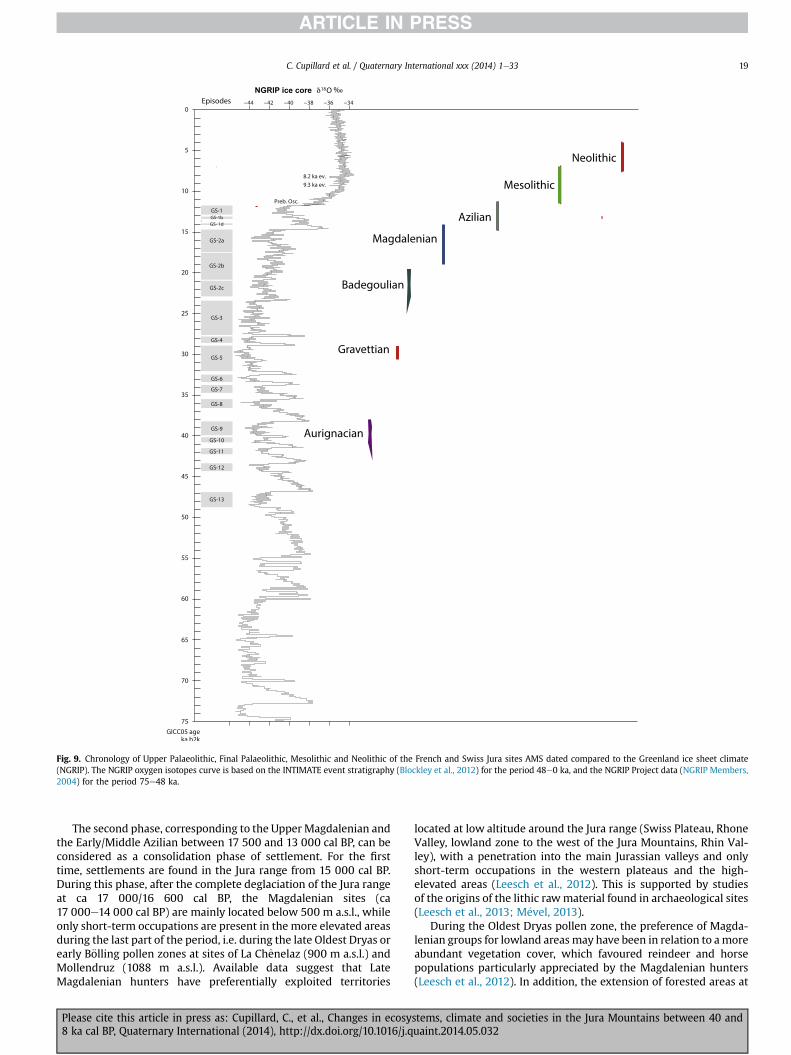
Fig. 9. Chronology of Upper Palaeolithic, Final Palaeolithic, Mesolithic and Neolithic of the French and Swiss Jura sites AMS dated compared to the Greenland ice sheet climate(NGRIP). The NGRIP oxygen isotopes curve is based on the INTIMATE event stratigraphy (Blockley et al., 2012) for the period 48e0 ka, and the NGRIP Project data (NGRIP Members,2004) for the period 75e48 ka.
C. Cupillard et al. / Quaternary International xxx (2014) 1e33 19
The second phase, corresponding to the Upper Magdalenian andthe Early/Middle Azilian between 17 500 and 13 000 cal BP, can beconsidered as a consolidation phase of settlement. For the firsttime, settlements are found in the Jura range from 15 000 cal BP.During this phase, after the complete deglaciation of the Jura rangeat ca 17 000/16 600 cal BP, the Magdalenian sites (ca17 000e14 000 cal BP) are mainly located below 500 m a.s.l., whileonly short-term occupations are present in the more elevated areasduring the last part of the period, i.e. during the late Oldest Dryas orearly B€olling pollen zones at sites of La Chenelaz (900 m a.s.l.) andMollendruz (1088 m a.s.l.). Available data suggest that LateMagdalenian hunters have preferentially exploited territories
Please cite this article in press as: Cupillard, C., et al., Changes in ecosy8 ka cal BP, Quaternary International (2014), http://dx.doi.org/10.1016/j.q
located at low altitude around the Jura range (Swiss Plateau, RhoneValley, lowland zone to the west of the Jura Mountains, Rhin Val-ley), with a penetration into the main Jurassian valleys and onlyshort-term occupations in the western plateaus and the high-elevated areas (Leesch et al., 2012). This is supported by studiesof the origins of the lithic rawmaterial found in archaeological sites(Leesch et al., 2013; M�evel, 2013).
During the Oldest Dryas pollen zone, the preference of Magda-lenian groups for lowland areas may have been in relation to amoreabundant vegetation cover, which favoured reindeer and horsepopulations particularly appreciated by the Magdalenian hunters(Leesch et al., 2012). In addition, the extension of forested areas at
stems, climate and societies in the Jura Mountains between 40 anduaint.2014.05.032

C. Cupillard et al. / Quaternary International xxx (2014) 1e3320
the beginning of the B€olling pollen zone favoured the developmentof new species such as deer and probably provoked changes incynegetic practices. This led to a diversification of hunting terri-tories which may explain the first Magdalenian occupations in thehighest parts of the Jura range, which were followed between14 000 and 13 000 cal BP by a large altitude range of the Aziliansites.
During the third sub-stage, between 13 000 and 11 700 cal BP(i.e. during the Younger Dryas cold event), Late Palaeolithic sites arerare, and only few well-dated sites are located below 500 m a.s.l.This suggests a contraction of the population density probablylinked to cooler climatic conditions during the GS-1 cold eventwhich strongly affected the ecosystems and provoked a decrease inavailable natural resources. This period is coeval with the appari-tion of Late Epigravettian groups. It is important to note the syn-chronicity between changes in climatic/environmental conditionsand cultures (northern extension of Epigravettian culture).
3) The third stage between 11 700 and 7000 cal BP corresponds tothe early Holocene. An important corpus of palae-oenvironmental and archaeological data record this phasecharacterised by warmer climatic conditions, an extension ofthe forest and a recolonisation of the Jura range by Mesolithicgroups. Nevertheless, AMS dating shows that this phenomenonwas not regular and that the rhythm of these occupations un-derwent variations during the period.
The first occurrence of the Mesolithic has been radiocarbondated to ca 11 270e11 190 cal BP. It seems to have beengeographically limited to the western lowlands of the Jura rangeand lithic industries could indicate a northern cultural influenceclose to the Epi-Ahrensbourgian. This delay of the Mesolithic re-colonization, whereas climatic and environmental conditions arequite favourable, could have been explained by a previous strongimpact of the more than 1000 year-long Younger Dryas cold eventon the Late Azilian/Late Epigravettian groups (strong decrease innatural resources associated with hard climatic and environmentalconditions) resulting in a marked decrease in the regional popu-lation density.
The true development of the Mesolithic dispersal of the Jurarange occurred around 10 400 cal BP during the second part of thePreboreal pollen zone, reinforced during the Boreal pollen zone.
Dating from the second part of the Preboreal, after ca 11 200 calBP, large Mesolithic open-air sites have been recognized in low-land areas to the west and east of the Jura range, while moreelevated areas in the Jura Mountains are characterized by the firstEarly Mesolithic occupations in the Upper part of the Jura range.The Boreal pollen zone, between ca 10 200 and 9000 cal BP, cor-responds to a reinforcement of the Mesolithic settlement in low-land as well in more elevated areas with intensification ofoccupations to ~1100 m a.s.l. This time interval is also charac-terised by the possible appearance of a first human impact on thevegetation.
The first part of the Old Atlantic pollen zone before ca 8000 calBP is characterised by the development of the second phase of theMesolithic with regular blade debitage and trapezes (Perrin et al.,2010). In the Jura range, this period is marked by a clear decrease inthe number of Mesolithic sites which suggests a strong decrease inthe population probably affected by unfavourable climatic andenvironmental conditions (with a reduction in natural resources)characteristic for the 8.2 ka event in the Jura region (Magny et al.,2001). However, the rapid re-expansion of the Mesolithic occupa-tions on the whole Jura range after 8000 cal BP indicates that, inaddition to the dynamics of the last Mesolithic societies and thedevelopment of the first Neolithic groups, around 7300 cal BP
Please cite this article in press as: Cupillard, C., et al., Changes in ecosy8 ka cal BP, Quaternary International (2014), http://dx.doi.org/10.1016/j.q
(Gauthier and Richard, 2008), the impact of the ca 200 years-long8.2 ka cold event was less strong on both the ecosystems and so-cieties than that of the millennial-scale Younger Dryas cold event.
In conclusion, study of the Jura range has supplied a large dataset about climate, paleoenvironment and prehistory for the period40e8 ka cal BP. Considered as a whole, the data gathered in thissynthesis invite further investigations for a better understanding ofthe response of environment and societies to climate changes asfollows:
1. There is a need to develop further systematic exploration of theJura range to find archaeological sites and sediment sequencescontaining a record the time window 40 000e17 000 cal BP.
2. Made of calcareous rock, the Jura Mountains have hundreds ofcaves at different altitudes, inside or outside of the maximalextent of the LGM ice cap. These sites can be ideal for the studyof speleothems and fauna (above all bones of bears such as Ursusspelaeus and Ursus arctos) which will provide highly significantdata for the understanding of the regional climatic conditionsduring the period 40e17 ka cal BP not documented by lakesediment sequences.
3. There is a need to establish a solid chronology for the disap-pearance of the Jurassian ice cap during the transition betweenthe late Pleniglacial and the early Lateglacial.
4. Another important requirement is to develop systematicextensive archaeological surveys of all the available UpperPaleolithic, Late Paleolithic and Mesolithic sites in order toestablish improved chronological, typo-technological and pale-oenvironmental records and detailed archaeological maps(Cupillard, 2012a). It is necessary to continue surveys abouthuman impact on environment in pollen profiles (developingstudies of anthropogenic pollen indicators and charcoal, andmore AMS dates) in order to confirm possible Mesolithic landclearance(s) and to refine the chronology, the intensity and therhythm of the earliest stages of agriculture.
Acknowledgements
Financial support for the regional studies synthesized in thispaper was provided by (1) the French CNRS (UMR-6249 Chrono-Environment), (2) the CNRS-programme ECLIPSE “Cervus” (dir A.Bridault), (3) the Collective Research Program (PCR-1997-2003) «The Late Glacial at the North of the Alps and at the South of Jurarange » (dir. G. Pion, 1997e2003), (4) the PCR (2005-2008) « TheLate Glacial and the beginning of Holocene in the Jura range and itsmargins » (dir. Christophe Cupillard, 2005e2008), (5) the Programno 124457 of the Swiss National Science Foundation Fonds: «Dynamics of land use pattern of lateglacial hunter populationsthroughout the seasonal cycle: the mobility of Magdaleniangroups of the Swiss Plateau and Jura mountain » (dir. D. Leeschand W. Muller), (6) a PCR directed by P. Bodu, F. Bon and L. Brou,(2001e2009), (7) the PCR « Raw material's gestion and humanpeopling around the Serre range » (dir. L. Jaccottey et A. Milleville;2007e2009), (8) the PCR « Final Paleolithic and Mesolithic in theParisian Bassin and its margins» (dir. P. Bodu and B. Valentin;2010e2012), and (9) and the programme IFB-INRA « Global change,animal biodiversity and societies since 16000 years ago in northernFrance » (dir. A. Bridault). We would like to thank our colleaguesPierre Bodu, J�erome Bullinger, Luc Jaccottey, Denise Leesch,Annabelle Milleville, Werner Müller, Gilbert Pion, Fr�ed�eric S�eara,Caroline Szmidt and Boris Valentin for fruitful collaborations.Many thanks are due to Beryl Sandoz and Jim H. Dickson for theirreview of the English language. We thank two anonymous re-viewers for their constructive comments, which helped us toimprove the quality of the paper.
stems, climate and societies in the Jura Mountains between 40 anduaint.2014.05.032

Appendix 1
Table 2List of the AMS dates of the Upper Palaeolithic, Final Palaeolithic andMesolithic sites in the French and Swiss Jura. These 256 new AMS dates have been calibrated using the calibrationsoftware CALPAL (Danzeglocke et al., 2009; www. Cal.pal.de)
Number District Site Locality Altitude(m)
Layer orlevel
Sample material Laboratory BP Ecart-type
Cal BP Ecarttype
Mini Maxi Reference Typo-chronologicalattribution
1 1 Le Gardon Amb�erieu-en-Bugey
373 Layer 58 Charcoal Ly-5515 5982 96 6835 118 6717 6953 Voruz 2009 Early Neolithic/FinalMesolithic
2 1 Le Gardon Amb�erieu-en-Bugey
373 Layer 58 Charcoal Ly-5513 6124 42 7044 85 6958 7129 Voruz 2009 Early Neolithic/FinalMesolithic
3 1 La Chenelaz Hostias 900 Layer 2b Bone (indet.) Ly-5498 9528 140 10,860 213 10646 11073 Cartonnet andNaton 2000
Early Mesolithic
4 1 La Chenelaz Hostias 900 Layer 2 Rangifer OxA-8027 (Ly-703)
12460 65 14,737 320 14416 15057 Bridault et al., 2000 Upper Magdalenian
5 1 La Chenelaz Hostias 900 Layer 2c Bone (indet.) Ly-4790 12610 200 14,945 429 14516 15374 Cartonnet andNaton 2000
Upper Magdalenian
6 1 La Chenelaz Hostias 900 Layer 2c Bone (indet.) Ly-743/OxA-8068
12780 75 13,291 278 14962 15519 Cartonnet andNaton 2000
Upper Magdalenian
7 1 Le Roseau Neuville-sur-Ain 275 Layer 3 Bone (indet.) Ly-5923 6140 70 7043 98 6944 7141 Wittig and Guillet2000
Early Neolithic/FinalMesolithic
8 1 Le Roseau Neuville-sur-Ain 275 Layer 3 Bone (indet.) GrA-16351 6720 40 7588 33 7554 7621 Perrin 2001 Late Mesolithic9 1 Le Roseau Neuville-sur-Ain 275 Layer 4 Bone (indet.) GrA-13649 7600 40 8405 20 8385 8425 Perrin 2001 Late Mesolithic10 1 Le Roseau Neuville-sur-Ain 275 Layer 4 Bone (indet.) GrA-13648 8050 40 8916 95 8821 9011 Perrin 2001 Middle Mesolithic11 1 La Colombi�ere Neuville-sur-Ain 275 E7-6/27.7 Rangifer/antler Ly-644/GrA-
971314390 70 17,542 253 17289 17795 Bridault et al., 2000 Middle Magdalenian
12 1 Abri Gay Poncin 270 CF2b M13/909 Rangifer Ly-640 (Gr-9705)
12160 60 14,193 233 13960 14426 Bridault et al., 2000 Upper Magdalenian
13 1 Abri Gay Poncin 270 C? - 430/P13 Alces Ly-1454(OxA) 12505 65 14,821 303 14518 15124 Drucker et al., 2009 Upper Magdalenian14 1 Abri Gay Poncin 270 CF2d G18/123 Rangifer Ly-639 (GrA-
9720)12980 70 15,822 409 15412 16231 Drucker et al., 2009 Upper Magdalenian
15 1 Abri Gay Poncin 270 81-I 15 Gulo Ly-1543 (OxA) 13795 100 16,972 192 16780 17164 Bridault and Chaix2009
Upper Magdalenian
16 1 Les Hoteaux Rossillon 250 Human grave Rangifer/antlerbaton perc�e
OxA-9457(Ly-1132)
12830 75 15,352 269 15082 15621 Oberlin and Pion2009
Upper Magdalenian
17 1 La Croze Saint-Martin-duMont
260 R7 Rangifer GrA-9704(Ly-638)
14260 70 17,463 254 17209 17717 Bridault et al., 2000 Middle Magdalenian
18 1 Les Romains Virignin 278 Layer C II b Rangifer GrA-9710 (Ly-432)
12830 60 15,350 250 15099 15600 Bridault et al., 2000 Upper Magdalenian
19 1 Les Romains Virignin 278 Layer C III Rangifer GrA-9709(Ly-642)
12690 60 15,076 307 14768 15383 Bridault et al., 2000 Upper Magdalenian
20 1 Les Romains Virignin 278 Layer 4 ? Mammuthus Ly-1772 13140 80 16,062 396 15665 16458 Oberlin and Pion2009
Upper Magdalenian
21 25 Sous Les Roches Bavans 308 Layer 5 Cervus GrA-22131 6000 60 6848 75 6772 6923 Drucker et al., 2009 Early Neolithic/FinalMesolithic
22 25 Sous Les Roches Bavans 308 Layer 6 Cervus GrA-23126 8590 60 9582 52 9529 9634 Drucker et al., 2009 Middle Mesolithic23 25 Sous Les Roches Bavans 308 Layer 7 Cervus GrA-23127 6935 40 7769 49 7719 7818 Drucker et al., 2009 Late Mesolithic24 25 Sous Les Roches Bavans 308 Layer 8 Cervus GrA-23129 12170 60 14,204 232 13972 14436 Drucker et al., 2009 Azilian25 25 Gigot 1 Bretonvillers 457 Layer C2 Cervus Ly-6511(OxA) 6130 35 7053 80 6972 7133 This work Late Mesolithic26 25 Gigot 1 Bretonvillers 457 Layer C2 Sus Ly-6512(OxA) 7705 45 8493 47 8445 8540 This work Late Mesolithic27 25 Gigot 1 Bretonvillers 457 Layer C3 Sus Ly-6514(OxA) 8640 45 9608 49 9558 9657 This work Middle Mesolithic28 25 Gigot 1 Bretonvillers 457 Layer C3 Cervus Ly-6513 (OxA) 8735 40 9716 88 9628 9804 This work Middle Mesolithic29 25 Gigot1 Bretonvillers 457 Layer C4 Cervus GrA-43939 8645 40 9607 46 9560 9653 Drucker et al.,
2011aMiddle Mesolithic
30 25 Gigot 1 Bretonvillers 457 Layer D2 zone 2 Cervus Ly-4716 (OxA) 10840 50 12,810 78 12732 12888 Drucker et al., 2009 Late Azilian31 25 Gigot 1 Bretonvillers 457 Layer D8 zone 3 Cervus Ly-4715 (OxA) 11560 55 13,448 113 13334 13561 Drucker et al., 2009 Azilian
(continued on next page)
C.Cupillardet
al./Quaternary
Internationalxxx(2014)
1e33
21
Pleasecite
thisarticle
inpress
as:Cupillard,C.,et
al.,Changesin
ecosystems,clim
ateand
societiesin
theJura
Mountains
between
40and
8ka
calBP,Quaternary
International(2014),http://dx.doi.org/10.1016/j.quaint.2014.05.032

Table 2 (continued )
Number District Site Locality Altitude(m)
Layer orlevel
Sample material Laboratory BP Ecart-type
Cal BP Ecarttype
Mini Maxi Reference Typo-chronologicalattribution
32 25 Roche aux Gours Longevelle-sur-le-Doubs
302 Layer III Bone indet. Ly-4549(GrA) 10720 40 12,703 42 12661 12745 This work Late Azilian
33 25 Rigney 1 Rigney 256 Out ofstratigraphy
Homo sapiens,ochred mandibule
Ly-6515(OxA) 12930 55 15,716 389 15326 16105 This work Upper Magdalenian
34 25 Rigney 1 Rigney 256 Layer D Coelodonta GrA-21036 (Ly-1925)
16880 80 20,111 267 19843 20378 Cupillard andWelt�e 2006
Bagedoulian
35 25 Rigney 2 Rigney 256 Layer 2 Bone (indet.) Ly-4872(GrA) 11805 50 13,713 123 13590 13836 Cupillard et al.,2013
Azilian
36 25 Rigney 2 Rigney 256 Layer 2 Bone (indet.) Ly-4873(GrA) 11775 50 13,669 117 13552 13786 Cupillard et al.,2013
Azilian
37 25 Montandon Saint-Hippolyte 590 Layer IV Cervus Ly-3734(GrA) 6445 40 7371 41 7329 7412 Drucker et al., 2009 Late Mesolithic38 25 Montandon Saint-Hippolyte 590 Layer VI Cervus Ly-3733(GrA) 8680 45 9634 56 9577 9690 This work Middle Mesolithic39 25 Montandon Saint-Hippolyte 590 Layer VI Cervus Ly-3732(GrA) 9255 40 10,422 78 10343 10500 Drucker et al., 2009 Middle Mesolithic40 25 Rochedane Villars-sous-
Dampjoux355 Level A1 Cervus GrA-21522 6230 60 7136 92 7043 7228 Drucker et al., 2009 Early Neolithic/Final
Mesolithic41 25 Rochedane Villars-sous-
Dampjoux355 Level A2 Cervus GrA-21520 6730 60 7592 54 7538 7646 Drucker et al., 2009 Late Mesolithic
42 25 Rochedane Villars-sous-Dampjoux
355 Level A3 Cervus GrA-21519 8640 60 9621 61 9559 9682 Drucker et al., 2009 Middle Mesolithic
43 25 Rochedane Villars-sous-Dampjoux
355 Level A3 Cervus GrA-23150 10880 50 12,842 82 12760 12924 Drucker et al., 2009 Late Azilian
44 25 Rochedane Villars-sous-Dampjoux
355 Level A4 Cervus GrA-23147 10880 50 12,842 82 12760 12924 Drucker et al., 2009 Late Azilian
45 25 Rochedane Villars-sous-Dampjoux
355 Level A4 Cervus GrA-23518 10830 70 12,811 87 12723 12898 Drucker et al., 2009 Late Azilian
46 25 Rochedane Villars-sous-Dampjoux
355 Level A0 Homo sapiens GrA-41739 11120 50 13,017 120 12896 13137 Drucker et al.,2011a
Azilian
47 25 Rochedane Villars-sous-Dampjoux
355 Level B Homo sapiens GrA-41740 11560 50 13,448 111 13336 13559 Drucker et al.,2011a
Azilian
48 25 Rochedane Villars-sous-Dampjoux
355 Level B Cervus GrA-21516 11600 80 13,486 133 13352 13619 Drucker et al., 2009 Azilian
49 25 Rochedane Villars-sous-Dampjoux
355 Level B Homo sapiens GrA-41741 11920 50 13,820 149 13670 13969 Drucker et al.,2011a
Azilian
50 25 Rochedane Villars-sous-Dampjoux
355 Level C'1 Capreolus GrA-45669 11370 50 13,265 123 13142 13388 Drucker et al.,2011a
Azilian
51 25 Rochedane Villars-sous-Dampjoux
355 Level C'1 Cervus GrA-21514 11570 70 13,454 119 13335 13573 Drucker et al., 2009 Azilian
52 25 Rochedane Villars-sous-Dampjoux
355 Level D1 Cervus GrA-45781 12230 50 14,287 245 14041 14532 Drucker et al., 2009 Upper Magdalenian
53 25 Rochedane Villars-sous-Dampjoux
355 Level D1 Cervus GrA-21512 12250 70 14,333 276 14057 14609 Drucker et al., 2009 Upper Magdalenian
54 25 Rochedane Villars-sous-Dampjoux
355 Level D1 Rangifer OxA�8030 (Ly-709)
12420 75 14,653 346 14306 14999 Bridault et al., 2000 Upper Magdalenian
55 25 La Roche-aux-Pecheurs
Villers-le-Lac 752 Layer 4 Sus scrofa ETH-11831 6530 70 7434 71 7363 7505 Cupillard 2010 Late Mesolithic
56 25 La Roche-aux-Pecheurs
Villers-le-Lac 752 Layer 4b Charcoal Ly-606 (Oxa) 6590 70 7500 53 7446 7553 Cupillard 2010 Late Mesolithic
57 25 La Roche-aux-Pecheurs
Villers-le-Lac 752 Layer 4c Charcoal Ly-1926 (GrA-21038)
6680 45 7551 36 7515 7587 Cupillard 2010 Late Mesolithic
58 25 La Roche-aux-Pecheurs
Villers-le-Lac 752 Layer 5 Vulpes Ly-1927(GrA-21039)
7740 45 8517 52 8465 8569 Cupillard 2010 Late Mesolithic
59 39 Chaze II Arlay 225 Out ofstratigraphy
Coelodonta Ly-3291 (Poz) 13890 80 17,138 209 16929 17347 Cupillard et al. inpress
Middle Magdalenian
60 39 Grappin Arlay 225 Layer C Rangifer Ly- 4865 (GrA) 13450 50 16,404 410 15994 16814 Drucker et al., 2012 Upper Magdalenian61 39 Grappin Arlay 225 Layer C Rangifer Ly- 3878 (GrA) 13640 60 16,734 252 16482 16986 Drucker et al., 2012 Upper Magdalenian62 39 Grappin Arlay 225 Layer C Rangifer Ly- 4868 (GrA) 14180 50 17,410 246 17164 17656 Drucker et al., 2012 Middle Magdalenian
C.Cupillardet
al./Quaternary
Internationalxxx
(2014)1e33
22Pleasecite
thisarticle
inpress
as:Cupillard,C.,et
al.,Changesin
ecosystems,clim
ateand
societiesin
theJura
Mountains
between
40and
8ka
calBP,Quaternary
International(2014),http://dx.doi.org/10.1016/j.quaint.2014.05.032

63 39 Grappin Arlay 225 Layer C Equus Ly- 4866 (GrA) 14220 50 17,438 250 17188 17688 Cupillard et al. inpress
Middle Magdalenian
64 39 Grappin Arlay 225 Layer C Rangifer Ly- 4871 (GrA) 14520 50 17,666 234 17431 17900 Drucker et al., 2012 Middle Magdalenian65 39 Grappin Arlay 225 Layer C Rangifer Ly- 4869 (GrA) 14850 50 18,182 258 17924 18440 Drucker et al., 2012 Middle Magdalenian66 39 Grappin Arlay 225 Layer C Rangifer Ly- 4865 (GrA) 14940 60 18,226 240 17985 18466 Drucker et al., 2012 Middle Magdalenian67 39 Grappin Arlay 225 Layer C Rangifer Ly- 4865 (GrA) 15260 70 18,367 282 18084 18649 Drucker et al., 2012 Middle Magdalenian68 39 Grappin Arlay 225 Layer C Equus Ly- 3161 (GrA) 15335 100 18,418 304 18113 18722 Cupillard and
Welt�e 2006Middle Magdalenian
68 39 Grappin Arlay 225 Layer C Rangifer Ly- 3162 (GrA) 15335 115 18,419 308 18111 18727 Cupillard andWelt�e 2006
Middle Magdalenian
70 39 Grappin Arlay 225 Layer C Rangifer Ly- 3160 (GrA) 16840 100 20,062 285 19776 20347 Cupillard andWelt�e 2006
Middle Magdalenian
71 39 Grappin Arlay 225 Layer C Ursus Ly- 4870 (GrA) 23400 90 28,167 162 28004 28329 Cupillard andWelt�e 2009
Animal occupation
72 39 Grappin Arlay 225 Layer C Bos/Bison Ly- 3879 (GrA) 24960 130 29,942 277 29664 30219 Cupillard andWelt�e 2009
Animal occupation
73 39 Grappin Arlay 225 Layer D Crocuta OxA-19633 28570 150 31,045 355 32639 33350 Stuart 2008 Animal occupation74 39 Chaumois-Boivin Blois-sur-seille 450 Upper
paleolithic levelRangifer Ly-3280 (Poz)
renne12530 120 14,844 344 14499 15188 Drucker et al., 2012 Upper Magdalenian
75 39 Les Champins 1 Choisey 196 Level C1 Hazelnut shell Ly-244 (Oxa) 9175 70 10,366 91 10275 10457 S�eara et al., 2002 Early Mesolithic76 39 Les Champins 1 Choisey 196 Level C2 Hazelnut shell Ly-2803 (Poz) 9805 65 11,230 40 11189 11270 S�eara 2008 Early Mesolithic77 39 Les Champins 2 Choisey 196 Unique level Bos, engraved
metacarpialLy-3125 (Poz) 8700 55 9676 85 9590 9761 S�eara 2008 Middle Mesolithic 248 and
24978 39 Sur la Prairie Dammartin-
Marpain192 Locus 1 Hazelnut shell Poz-32793 8130 50 9090 61 9028 9151 S�eara 2010 Middle Mesolithic
79 39 Sur la Prairie Dammartin-Marpain
192 Locus 9 Hazelnut shell Poz-32833 8170 50 9137 85 9052 9222 S�eara 2010 Middle Mesolithic
80 39 Sur la Prairie Dammartin-Marpain
192 Locus 2 Hazelnut shell Poz-32826 8170 50 9137 85 9052 9222 S�eara 2010 Middle Mesolithic
81 39 Sur la Prairie Dammartin-Marpain
192 Locus 3 Hazelnut shell Poz-32828 8180 50 9145 86 9058 9231 S�eara 2010 Middle Mesolithic
82 39 Sur la Prairie Dammartin-Marpain
192 Locus 1 Hazelnut shell Poz-35483 8190 50 9153 87 9066 9240 S�eara 2010 Middle Mesolithic
83 39 Sur la Prairie Dammartin-Marpain
192 Locus 7 Hazelnut shell Poz-35492 8210 50 9174 84 9090 9258 S�eara 2010 Middle Mesolithic
84 39 Sur la Prairie Dammartin-Marpain
192 Locus 5 Hazelnut shell Poz-32830 8230 50 9202 82 9120 9284 S�eara 2010 Middle Mesolithic
85 39 Sur la Prairie Dammartin-Marpain
192 Locus 8 Hazelnut shell Poz-32832 8230 50 9202 82 9120 9284 S�eara 2010 Middle Mesolithic
86 39 Sur la Prairie Dammartin-Marpain
192 Locus 11 Hazelnut shell Poz-32794 8420 50 9446 48 9397 9494 S�eara 2010 Middle Mesolithic
87 39 Sur la Prairie Dammartin-Marpain
192 Locus 7 Hazelnut shell Poz-32791 8500 50 9506 24 9482 9530 S�eara 2010 Middle Mesolithic
88 39 Sur la Prairie Dammartin-Marpain
192 Locus 11 Hazelnut shell Poz-32795 8540 60 9522 27 9494 9549 S�eara 2010 Middle Mesolithic
89 39 Sur la Prairie Dammartin-Marpain
192 Locus 11 Hazelnut shell Poz-32824 8600 50 9583 43 9540 9626 S�eara 2010 Middle Mesolithic
90 39 Sur la Prairie Dammartin-Marpain
192 Locus 7 Hazelnut shell Poz-32797 8830 50 9938 152 9786 10090 S�eara 2010 Middle Mesolithic
91 39 Sur la Prairie Dammartin-Marpain
192 Locus 2 Hazelnut shell Poz-35486 8830 50 9938 152 9786 10090 S�eara 2010 Early Mesolithic
92 39 Sur la Prairie Dammartin-Marpain
192 Locus 2 Hazelnut shell Poz-35485 8850 50 9964 142 9822 10106 S�eara 2010 Early Mesolithic
93 39 Sur la Prairie Dammartin-Marpain
192 Locus 7 Hazelnut shell Poz-35493 8890 50 10,030 104 9926 10134 S�eara 2010 Early Mesolithic
94 39 Sur la Prairie Dammartin-Marpain
192 Locus 14 Hazelnut shell Poz-32825 8890 50 10,030 104 9926 10134 S�eara 2010 Early Mesolithic
95 39 Sur la Prairie Dammartin-Marpain
192 Locus 1 Hazelnut shell Poz-35482 8890 50 10,030 104 9926 10134 S�eara 2010 Early Mesolithic
(continued on next page)
C.Cupillardet
al./Quaternary
Internationalxxx(2014)
1e33
23
Pleasecite
thisarticle
inpress
as:Cupillard,C.,et
al.,Changesin
ecosystems,clim
ateand
societiesin
theJura
Mountains
between
40and
8ka
calBP,Quaternary
International(2014),http://dx.doi.org/10.1016/j.quaint.2014.05.032

Table 2 (continued )
Number District Site Locality Altitude(m)
Layer orlevel
Sample material Laboratory BP Ecart-type
Cal BP Ecarttype
Mini Maxi Reference Typo-chronologicalattribution
96 39 Sur la Prairie Dammartin-Marpain
192 Locus 1 Hazelnut shell Poz-32823 8990 50 10,030 104 9926 10134 S�eara 2010 Early Mesolithic
97 39 Sur la Prairie Dammartin-Marpain
192 Locus 2 Hazelnut shell Poz-35487 9060 50 10,227 23 10203 10250 S�eara 2010 Early Mesolithic
98 39 Sur la Prairie Dammartin-Marpain
192 Locus 6 Hazelnut shell Poz-32831 9110 50 10,296 60 10236 10356 S�eara 2010 Early Mesolithic
99 39 Sur la Prairie Dammartin-Marpain
192 Locus 2 Hazelnut shell Poz-32827 9140 50 10,320 65 10254 10385 S�eara 2010 Early Mesolithic
100 39 Sur la Prairie Dammartin-Marpain
192 Locus 6 Hazelnut shell Poz-35489 9170 50 10,343 69 10273 10412 S�eara 2010 Early Mesolithic
101 39 Sur la Prairie Dammartin-Marpain
192 Locus 6 Hazelnut shell Poz-32796 9180 50 10,351 72 10279 10423 S�eara 2010 Early Mesolithic
102 39 Sur la Prairie Dammartin-Marpain
192 Locus 6 Hazelnut shell Poz-35490 9210 50 10,382 84 10298 10466 S�eara 2010 Early Mesolithic
103 39 Chateauneuf Dampierre 220 Horsstratigraphie
Cervus Ly-4743(OxA) 8100 40 9051 40 9011 9091 S�eara 2010 Middle Mesolithic
104 39 Chateauneuf Dampierre 220 Horsstratigraphie
Hazelnut shell Ly-4743(OxA) 8815 40 9908 136 9772 10044 S�eara 2010 Middle Mesolithic
105 39 Chateauneuf Dampierre 220 Horsstratigraphie
Hazelnut shell Ly-4741(OxA) 9110 45 10,290 52 10237 10342 S�eara 2010 Early Mesolithic
106 39 A�erodrome Gevry 197 Unique Layer Charcoals Ly-412 (Oxa) 8765 75 9810 154 9656 9964 S�eara 2010 Middle Mesolithic107 39 La Baume Gigny-sur-Suran 480 Layer IV Cervus Ly-3289 (Poz) 6280 45 7216 39 7176 7255 Drucker et al., 2009 Early Neolithic/Final
Mesolithic ?108 39 La Baume Gigny-sur-Suran 480 Layer VI Rangifer Ly-3290 (Poz) 17645 110 21047 329 20718 21376 Drucker et al., 2012 Badegoulian ?109 39 La Cimante Meussia 600 Layer 2 Charcoal Ly-2739(OxA) 9590 50 10,946 129 10946 11075 Cupillard 2012b Early Mesolithic110 39 La Cimante Meussia 600 Layer 5 Bone indet. Ly-2738 12240 55 14,305 254 14050 14559 Cupillard 2012b Azilian ?111 39 Les Cabones Ranchot 216 Layer 3 Cervus GrA-23149 Cerf 8380 45 9399 62 9337 9461 Drucker et al., 2008 Middle Mesolithic112 39 Les Cabones Ranchot 216 Layer 3 Cervus GrA-21524 8570 60 9557 45 9511 9602 Drucker et al., 2008 Middle Mesolithic113 39 Les Cabones Ranchot 216 Layer 3 Cervus GrA-21529 8840 60 9945 154 9790 10099 Drucker et al., 2008 Middle Mesolithic114 39 Les Cabones Ranchot 216 Layer 4 Panthera spelea OxA-12021 12565 50 14,911 290 14620 15201 Stuart and Lister,
2011Upper Magdalenian
115 39 Les Cabones Ranchot 216 Layer 4 Rangifer ErL-9392 13965 101 17,219 224 16995 17443 Drucker et al., 2012 Upper Magdalenian116 39 La M�ere
ClochetteRochefort-sur-Nenon
225 Aurignacianlevel
Ochred split-basedpoint
Beta-150312 29490 190 33,847 190 33539 34154 Szmidt et al., 2010 Aurignacian
117 39 La M�ereClochette
Rochefort-sur-Nenon
225 Aurignacianlevel
Ochred awl Beta-150311 29920 220 34,204 203 34000 34407 Szmidt et al., 2010 Aurignacian
118 39 La M�ereClochette
Rochefort-sur-Nenon
225 Aurignacianlevel
Ochred compactbone fragment
Beta-150314 30800 220 34,935 365 34569 35300 Szmidt et al., 2010 Aurignacian
119 39 La M�ereClochette
Rochefort-sur-Nenon
225 Aurignacianlevel
Split -based point(Wing)
OxA-19621 33750 350 39,292 1172 38120 40464 Szmidt et al., 2010 Aurignacian
120 39 La M�ereClochette
Rochefort-sur-Nenon
225 Aurignacianlevel
Split -based point(Wing)
OxA-19622 35460 250 40,381 841 39540 41222 Szmidt et al., 2010 Aurignacian
121 39 A Daupharde Ruffey-sur-Seille 215 Level R1 Bone indet. Ly-380 (Oxa-6777)
6560 75 7476 64 7411 7540 S�eara et al., 2002 Late Mesolithic
122 39 A Daupharde Ruffey-sur-Seille 215 Level R1 Bone indet. Ly-172 (Oxa-5642)
6760 80 7617 60 7556 7677 S�eara et al., 2002 Late Mesolithic
123 39 A Daupharde Ruffey-sur-Seille 215 Level R1 Bone indet. Ly-381 (Oxa-6776)
7650 160 8479 171 8308 8650 S�eara et al., 2002 Late Mesolithic
124 39 A Daupharde Ruffey-sur-Seille 215 Level R2 Charcoal Ly-7352 8230 95 9221 137 9083 9358 S�eara et al., 2002 Middle Mesolithic125 39 A Daupharde Ruffey-sur-Seille 215 Level R2 Hazelnut shell Ly-218 (Oxa) 8515 65 9508 31 9477 9539 S�eara et al., 2002 Middle Mesolithic126 39 A Daupharde Ruffey-sur-Seille 215 Level R2 Hazelnut shell Ly-240 (Oxa) 8690 80 9712 124 9588 9836 S�eara et al., 2002 Middle Mesolithic127 39 A Daupharde Ruffey-sur-Seille 215 Level R2 Hazelnut shell Ly-217 (Oxa) 8655 130 9733 172 9560 9905 S�eara et al., 2002 Middle Mesolithic128 39 A Daupharde Ruffey-sur-Seille 215 Level R2 Hazelnut shell Ly-238 (Oxa) 8735 85 9766 145 9621 9911 S�eara et al., 2002 Middle Mesolithic129 39 A Daupharde Ruffey-sur-Seille 215 Level R2 Hazelnut shell Ly-213 (Oxa) 8765 65 9786 125 9661 9911 S�eara et al., 2002 Middle Mesolithic130 39 A Daupharde Ruffey-sur-Seille 215 Level R2 Hazelnut shell Ly-214 (Oxa) 8795 65 9876 163 9712 10039 S�eara et al., 2002 Middle Mesolithic131 39 A Daupharde Ruffey-sur-Seille 215 Level R3 Hazelnut shell Ly-7353 8710 110 9776 172 9603 9948 S�eara et al., 2002 Early Mesolithic
C.Cupillardet
al./Quaternary
Internationalxxx
(2014)1e33
24Pleasecite
thisarticle
inpress
as:Cupillard,C.,et
al.,Changesin
ecosystems,clim
ateand
societiesin
theJura
Mountains
between
40and
8ka
calBP,Quaternary
International(2014),http://dx.doi.org/10.1016/j.quaint.2014.05.032

132 39 A Daupharde Ruffey-sur-Seille 215 Level R3 Hazelnut shell Ly-410/AA-23362
8855 65 9959 151 9807 10110 S�eara et al., 2002 Early Mesolithic
133 39 A Daupharde Ruffey-sur-Seille 215 Level R3 Hazelnut shell Ly-241 (Oxa) 8980 80 10,083 124 9958 10207 S�eara et al., 2002 Early Mesolithic134 39 A Daupharde Ruffey-sur-Seille 215 Level R3 Hazelnut shell Ly-411/AA-
233639055 65 10,226 44 10181 10270 S�eara et al., 2002 Early Mesolithic
135 39 A Daupharde Ruffey-sur-Seille 215 Level R3 Hazelnut shell Ly-215 (Oxa) 9210 70 10,390 94 10295 10484 S�eara et al., 2002 Early Mesolithic136 39 A Daupharde Ruffey-sur-Seille 215 Level R4 Hazelnut shell Ly-242 (Oxa.) 9005 85 10,100 129 9970 10229 S�eara et al., 2002 Early Mesolithic137 39 A Daupharde Ruffey-sur-Seille 215 Level R4 Hazelnut shell Ly-216 (Oxa.) 9135 75 10,335 85 10249 10420 S�eara et al., 2002 Early Mesolithic138 39 A Daupharde Ruffey-sur-Seille 215 Level R4 Hazelnut shell Ly-239 (Oxa.) 9210 85 10,396 104 10292 10500 S�eara et al., 2002 Early Mesolithic139 68 Mannlefelsen 1 Oberlarg 550 Layer H Cervus GrA-35604 6600 45 7505 45 7460 7550 Drucker et al.,
2011aLate Mesolithic
140 68 Mannlefelsen 1 Oberlarg 550 Layer I Cervus GrA-35603 7215 45 8054 65 7989 8119 Drucker et al.,2011a
Late Mesolithic
141 68 Mannlefelsen 1 Oberlarg 550 Layer L Cervus GrA-35595 8040 45 8907 96 8811 9003 Drucker et al.,2011a
Middle Mesolithic ?
142 68 Mannlefelsen 1 Oberlarg 550 Layer Q Cervus GrA-35594 9365 45 10,596 60 10536 10656 Drucker et al.,2011a
Early Mesolithic
143 68 Mannlefelsen 1 Oberlarg 550 Layer R Cervus GrA-35592 10770 50 12,750 52 12697 12802 Drucker et al.,2011a
Late Azilian
144 68 Mannlefelsen 1 Oberlarg 550 Layer S Cervus GrA-35571 11530 50 13,429 112 13316 13541 Drucker et al.,2011a
Azilian
145 70 Sur la Noue LaLande
Beaujeu 189 Unique Layer Hazelnut shell Ly-3293 (Poz) 8925 55 10,056 106 9950 10162 This work Middle Mesolithic
146 70 La Baume Noire Fr�etigney-Velloreille
240 Level M3 Rangifer tarandus Ly-3292(Poz) 13045 75 15,932 401 15530 16333 Drucker et al., 2012 Upper Magdalenian
147 70 La Baume Noire Fr�etigney-Velloreille
240 Level M4 Rangifer tarandus Ly-5217(GrA) 19310 80 23,071 267 22804 23338 Drucker et al., 2012 Badegoulian ?
148 70 La Baume Noire Fr�etigney-Velloreille
240 Level M5 Rangifer tarandus Ly-5218(GrA) 18070 80 21,813 359 21454 22172 Drucker et al., 2012 Badegoulian ?
149 71 La Balme Cuiseaux 240 Layer B Vulpes/Alopex Ly-3727(GrA) 11990 50 13,963 201 13762 14164 Cupillard et al.,2013
Azilian
150 71 La Balme Cuiseaux 240 Layer C Bos/bison Ly-3728 (GrA) 43120 490 46,759 1588 45170 48347 Cupillard et al.,2013
Animal occupation
151 71 La Balme Cuiseaux 240 Layer D Marmota marmota Ly-3729 (GrA) 24030 110 28,854 380 28473 29234 Cupillard et al.,2013
Animal occupation
152 71 La Balme Cuiseaux 240 Layer F Lepus Ly-3728 (GrA) 25340 120 30,181 266 29914 30447 Cupillard et al.,2013
Gravettian
153 JU Les Gripons Saint-Ursanne 496 Layer 3 Charcoal UZ-2597/ETH-6217
6540 80 7444 79 7365 7523 Pousaz 1991 Late Mesolithic
154 JU Les Gripons Saint-Ursanne 496 Layer 4 Charcoal UZ-2599/ETH-6219
7205 80 8051 82 7968 8133 Pousaz 1991 Middle Mesolithic
155 JU Les Gripons Saint-Ursanne 496 Layer 4 Charcoal UZ-2478/ETH-4713
8405 90 9395 93 9301 9488 Pousaz 1991 Middle Mesolithic
156 JU Les Gripons Saint-Ursanne 496 Layer 4 Charcoal UZ-2477/ETH-4712
8660 100 9709 139 9570 9848 Pousaz 1991 Middle Mesolithic
157 JU Les Gripons Saint-Ursanne 496 Layer 4 Charcoal UZ-2598/ETH-6218
8850 85 9940 169 9770 10109 Pousaz 1991 Middle Mesolithic
158 JU Les Gripons Saint-Ursanne 496 Layer 4 Charcoal UZ-2370/ETH-3694
8960 125 10,025 184 9841 10209 Pousaz 1991 Middle Mesolithic
159 NE Le Bichon La Chaux-de-Fonds
846 Unique layer Charcoal (Salix) ETH-4245 10950 180 12,911 154 12756 13065 Egloff and LeTensorer 1989
Azilian
160 NE Le Bichon La Chaux-de-Fonds
846 Unique layer Charcoal (Pinus) ETH-17831 11200 110 13,092 142 12950 13234 Chauvi�ere 2008 Azilian
161 NE Le Bichon La Chaux-de-Fonds
846 Unique layer Charcoal (Pinus) ETH-17835 11220 100 13,112 134 12977 13246 Chauvi�ere 2008 Azilian
162 NE Le Bichon La Chaux-de-Fonds
846 Unique layer Charcoal (Salix) ETH-17833 11250 100 13,146 134 13011 13280 Chauvi�ere 2008 Azilian
163 NE Le Bichon La Chaux-de-Fonds
846 Unique layer Charcoal (Salix) ETH-17830 11290 110 13,193 137 13056 13330 Chauvi�ere 2008 Azilian
(continued on next page)
C.Cupillardet
al./Quaternary
Internationalxxx(2014)
1e33
25
Pleasecite
thisarticle
inpress
as:Cupillard,C.,et
al.,Changesin
ecosystems,clim
ateand
societiesin
theJura
Mountains
between
40and
8ka
calBP,Quaternary
International(2014),http://dx.doi.org/10.1016/j.quaint.2014.05.032

Table 2 (continued )
Number District Site Locality Altitude(m)
Layer orlevel
Sample material Laboratory BP Ecart-type
Cal BP Ecarttype
Mini Maxi Reference Typo-chronologicalattribution
164 NE Le Bichon La Chaux-de-Fonds
846 Unique layer Charcaol (Pinus) ETH-17834 11380 110 13,287 157 13129 13444 Chauvi�ere 2008 Azilian
165 NE Le Bichon La Chaux-de-Fonds
846 Unique layer Ursus arctos, tibia ETH-8775 11360 120 13,269 161 13108 13430 Morel 1993 Azilian
166 Morel Le Bichon La Chaux-de-Fonds
846 Unique layer Homo sapiens,f�emur
ETH-8774 11610 110 13,504 159 13345 13663 Morel 1993 Azilian
167 NE Le Bichon La Chaux-de-Fonds
846 Unique layer Charcoal (Pinus) ETH-17836 11670 100 13,557 158 13399 13715 Chauvi�ere 2008 Azilian
168 NE Le Bichon La Chaux-de-Fonds
846 Unique layer Ursus arctos,phalanx 1
ETH- 8301 11680 90 13,566 153 13413 13719 Morel 1993 Azilian
169 NE Le Bichon La Chaux-de-Fonds
846 Unique layer Charcoal (Salix) ETH-4246 11680 120 13,566 169 13397 13735 Egloff and LeTensorer 1989
Azilian
170 NE Le Bichon La Chaux-de-Fonds
846 Unique layer Homo sapiens, tibia ETH-8773 11760 110 13,648 169 13479 13817 Morel 1993 Azilian
171 NE Champr�eveyres Hauterive 428 Hearth L23 Charcoal UZ-2284 12120 170 14,190 333 13857 14523 Leesch 1997 Azilian172 NE Champr�eveyres Hauterive 428 Hearth E18 Charcoal UZ-2170 12550 130 14,870 350 14519 15220 Leesch 1997 Azilian173 NE Champr�eveyres Hauterive 428 Hearth K12 Charcoal UZ-2174 12510 130 14,811 357 14454 15168 Leesch 1997 Upper Magdalenian174 NE Champr�eveyres Hauterive 428 Hearth O 39 Charcoal UZ-2287 12500 145 14,778 387 14391 15165 Leesch 1997 Upper Magdalenian175 NE Champr�eveyres Hauterive 428 Hearth A12 Charcoal UZ-2173 12540 140 14,852 362 14489 15214 Leesch 1997 Upper Magdalenian176 NE Champr�eveyres Hauterive 428 Hearth I16 Charcoal UZ-2177 12600 145 14,939 361 14577 15300 Leesch 1997 Upper Magdalenian177 NE Champr�eveyres Hauterive 428 HearthE21 Charcoal UZ-2172 12620 145 14,967 362 14604 15329 Leesch 1997 Upper Magdalenian178 NE Champr�eveyres Hauterive 428 Hearth L13 Charcoal UZ-2175 12630 130 14,983 349 14634 15332 Leesch 1997 Upper Magdalenian179 NE Champr�eveyres Hauterive 428 Hearth M17 Charcoal UZ-2171 12730 135 15,126 361 14765 15487 Leesch 1997 Upper Magdalenian180 NE Champr�eveyres Hauterive 428 Hearth D11 Charcoal UZ-2282 12825 155 15,414 462 14951 15876 Leesch 1997 Upper Magdalenian181 NE Champr�eveyres Hauterive 428 Hearth X10 Charcoal UZ-2286 12870 135 15,559 459 15100 16018 Leesch 1997 Upper Magdalenian182 NE Champr�eveyres Hauterive 428 Hearth A12 Charcoal UZ-2283 12950 155 15,766 490 15276 16256 Leesch 1997 Upper Magdalenian183 NE Champr�eveyres Hauterive 428 Hearth N16 Charcoal UZ-2285 13050 155 15,937 460 15477 16397 Leesch 1997 Upper Magdalenian184 NE Champr�eveyres Hauterive 428 Hearth A12 Charbon UCLA-2760 17690 210 21,121 400 20721 21521 Leesch 1997 Upper Magdalenian185 NE Champr�eveyres Hauterive 428 Sector 1 Equus OxA-20700 12815 65 15,315 257 15058 15572 Bodu et al., 2009 Upper Magdalenian186 NE Champr�eveyres Hauterive 428 Sector 1 Equus OxA-20701 12805 75 15,293 269 15023 15562 Bodu et al., 2009 Upper Magdalenian187 NE Col-des-Roches Le Locle 935 Layer III Bones indet. ETH-11356 6885 65 7734 64 7670 7798 Cupillard 2010 Late Mesolithic188 NE Monruz Neuchatel 428 Level C2 hearth
Y50Charcoal(Juniperus)
ETH-17973 12165 130 14,230 296 13934 14526 Leesch et al., 2004 Azilian
189 NE Monruz Neuchatel 428 Level C2 hearthY50
Charcoal(Juniperus)
ETH-17974 12370 110 14,575 372 14203 14947 Leesch et al., 2004 Azilian
190 NE Monruz Neuchatel 428 Hearth P49 Charcoal (indet.) ETH-20727 12800 85 15,281 282 14998 15563 Bullinger et al.,2006
Upper Magdalenian
191 NE Monruz Neuchatel 428 Hearth V 57 Charcoal (Salix sp.) ETH- 6414 12840 120 15,444 397 15046 15841 Bullinger et al.,2006
Upper Magdalenian
192 NE Monruz Neuchatel 428 Hearth R54 Charcoal (Salix sp.) ETH- 6419 12880 120 15,586 436 15149 16022 Bullinger et al.,2006
Upper Magdalenian
193 NE Monruz Neuchatel 428 Hearth S50 Charcoal (Salix sp.) ETH-6415 12900 120 15,654 452 15201 16106 Bullinger et al.,2006
Upper Magdalenian
194 NE Monruz Neuchatel 428 Hearth V 57 Charcoal(Salix sp.) ETH-6412 12970 110 15,807 440 15367 16247 Bullinger et al.,2006
Upper Magdalenian
195 NE Monruz Neuchatel 428 Hearth S 50 Charcoal ETH-6417 13030 120 15,910 435 15474 16345 H€oneisen, 1993 Upper Magdalenian196 NE Monruz Neuchatel 428 Level C2 Sector 1 Equus OxA-20699 13055 60 15,946 392 15553 16338 Bodu et al., 2009 Upper Magdalenian197 NE Monruz Neuchatel 428 Hearth S50 Charcoal (Salix sp.) ETH-6416 13070 130 15,970 433 15537 16403 Bullinger et al.,
2006Upper Magdalenian
198 NE Monruz Neuchatel 428 Hearth R 57 Charcoal (indet.) ETH-6418 13110 120 16,026 420 15606 16446 Bullinger et al.,2006
Upper Magdalenian
199 NE Monruz Neuchatel 428 Hearth S49 Charcoal (Salix sp.) ETH-6420 13120 120 16,040 419 15620 16459 Bullinger et al.,2006
Upper Magdalenian
200 NE Monruz Neuchatel 428 Hearth C13 Charcoal ETH-6421 13140 120 16,064 419 15645 16483 Housley et al., 1997 Upper Magdalenian201 NE Monruz Neuchatel 428 Hearth V 50 Charcoal
(Salix sp.)ETH-6413 13330 110 16,255 436 15819 16691 Bullinger et al.,
2006Upper Magdalenian
C.Cupillardet
al./Quaternary
Internationalxxx
(2014)1e33
26Pleasecite
thisarticle
inpress
as:Cupillard,C.,et
al.,Changesin
ecosystems,clim
ateand
societiesin
theJura
Mountains
between
40and
8ka
calBP,Quaternary
International(2014),http://dx.doi.org/10.1016/j.quaint.2014.05.032

202 SH Kesslerloch Thaygen 440 ind.layer Equus KIA-11825 12774 54 15,237 262 14974 15499 Napierala, 2008 Upper Magdalenian203 SH Kesslerloch Thaygen 440 ind.layer Equus KIA-11826 12502 52 14,819 295 14524 15114 Napierala, 2008 Upper Magdalenian204 SH Kesslerloch Thaygen 440 Layer In Equus KIA-11827 13052 53 15,941 390 15550 16331 Napierala, 2008 Upper Magdalenian205 SH Kesslerloch Thaygen 430 Layer IIIn Equus KIA-11828 13858 55 17,085 180 16904 17265 Napierala, 2008 Upper Magdalenian206 g Kesslerloch Thaygen 440 Layer II c Equus KIA-11829 12897 53 15,591 329 15262 15920 Napierala, 2008 Upper Magdalenian207 SH Kesslerloch Thaygen 440 Layer II c Canis KIA-33350 12225 45 14,277 239 14037 14516 Napierala, 2008 Azilian ?208 SH Kesslerloch Thaygen 440 Layer II c Cervus KIA-33351 12335 45 14,502 338 14163 14840 Napierala, 2008 Azilian ?209 SH Kesslerloch Thaygen 440 Layer II c Coelodonta OxA-10238 14330 110 17,505 261 17243 17766 Napierala, 2008 Middle Magdalenian210 SH Kesslerloch Thaygen 440 Layer II c Mammuthus OxA-10239 13980 110 17,234 228 17006 17462 Napierala, 2008 Middle Magdalenian211 SH Kesslerloch Thaygen 440 Layer II c Mammuthus OxA-10298 15020 180 18,254 263 17990 18517 Napierala, 2008 Middle Magdalenian212 SH Kesslerloch Thaygen 440 Layer II c Rangifer,
antler pointOxA-5746 13120 90 16,038 401 15636 16439 Housley et al., 1997 Upper Magdalenian
213 SH Kesslerloch Thaygen 440 Layer III Bc Rangifer OxA-5747 13430 100 16,367 427 15939 16794 Housley et al., 1997 Upper Magdalenian214 SH Kesslerloch Thaygen 440 Layer III Bc Bone modif. OxA-5748 12770 90 15,213 302 14911 15515 Housley et al., 1997 Upper Magdalenian215 SH Kesslerloch Thaygen 440 Layer III Ac Rangifer,
antler modif.OxA-5749 14150 100 17,392 254 17138 17646 Housley et al., 1997 Upper Magdalenian
216 SH Kesslerloch Thaygen 440 Layer III Ac Rangifer, antlermodif.
OxA-5750 13670 100 16,745 270 16475 17015 Housley et al., 1997 Upper Magdalenian
217 SH Kesslerloch Thaygen 440 Layer III Ac Rangifer B-3329 12970 180 15,798 512 15285 16310 Albrecht 1982 Upper Magdalenian218 SH Kesslerloch Thaygen 440 Layer III Ac Bone (indet.) Hv-10652 12890 90 15,595 380 15214 15975 Geyh and Schreiner
1984Upper Magdalenian
219 SO Rislisbergh€ohle Oensingen 488 Layer II Equus ETH-39678 10770 45 12,749 50 12699 12799 Leesch and Müller,2012
Late Azilian ?
220 SO Rislisbergh€ohle Oensingen 488 Layer II Cf. Equus ETH-42514 12235 45 14,292 245 14047 14537 Leesch and Muller2012
Upper Magdalenian
221 SO Rislisbergh€ohle Oensingen 488 Layer II Capra ibex ETH-42515 12710 45 15,112 296 14815 15408 Leesch and Muller2012
Upper Magdalenian
222 SO Rislisbergh€ohle Oensingen 488 Layer II Cervus ETH-42516 12680 45 15,064 301 14762 15365 Leesch and Muller2012
Upper Magdalenian
223 SO Rislisbergh€ohle Oensingen 488 Layer II Rangifer ETH-42517 13000 50 15,856 398 15457 16254 Leesch and Muller2012
Upper Magdalenian
224 VD Mollendruz Mont-la-Ville 1088 Layer 4b Charcoals CRG-579 7190 140 8022 141 7880 8163 Pignat and Winiger1998
Late Mesolithic
225 VD Mollendruz Mont-la-Ville 1088 Layer 4b Charcoals ETH-9570 7745 85 8609 173 8436 8782 Pignat and Winiger1998
Middle Mesolithic
226 VD Mollendruz Mont-la-Ville 1088 Layer 4d Charcoals ETH-5597 8175 100 9158 130 9027 9288 Pignat and Winiger1998
Middle Mesolithic
227 VD Mollendruz Mont-la-Ville 1088 Layer 4d Charcoals CRG-431 8207 206 9113 275 8837 9388 Pignat and Winiger1998
Middle Mesolithic
228 VD Mollendruz Mont-la-Ville 1088 Layer 4e Charcoals ETH-5598 9505 105 10,853 192 10661 11045 Pignat and Winiger1998
Early Mesolithic
229 VD Mollendruz Mont-la-Ville 1088 Layer 4e Charcoals ETH-9572 9265 85 10,442 118 10324 10560 Pignat and Winiger1998
Early Mesolithic
230 VD Mollendruz Mont-la-Ville 1088 Layer 5a Charcoals ETH-9571 8920 90 10,009 150 9859 10159 Pignat and Winiger1998
Early Mesolithic
231 VD Mollendruz Mont-la-Ville 1088 Layer 5 inf Bone (indet.) ETH-5600 11760 145 13,662 203 13459 13865 Pignat and Winiger1998
Azilian ?
232 VD Mollendruz Mont-la-Ville 1088 Layer 5 inf Bone (indet.) ETH-5601 12020 120 14,040 268 13771 14308 Pignat and Winiger1998
Azilian ?
233 VD Mollendruz Mont-la-Ville 1088 Layer 5 inf Rangifer OxA-9460 (Ly-1135)
12780 80 15,239 284 14954 15523 Oberlin and Pion2009
Upper Magdalenian
234 BL Hollenberg-H€ohle 3
Arlesheim 450 Layer D Rangifer Erl-13569 12846 63 15,397 263 15134 15660 Müller and Leesch2011
Upper Magdalenian
235 BL Hollenberg-H€ohle 3
Arlesheim 450 Layer D Rangifer Erl-13570 12798 70 15,279 266 15013 15545 Müller and Leesch2011
Upper Magdalenian
236 BL Hollenberg-H€ohle 3
Arlesheim 450 Layer D Rangifer Erl-13571 13114 71 16,028 392 15636 16420 Müller and Leesch2011
Upper Magdalenian
237 BL Hollenberg-H€ohle 3
Arlesheim 450 Layer D Rangifer Erl-13572 13077 71 15,978 394 15584 16372 Müller and Leesch2011
Upper Magdalenian
(continued on next page)
C.Cupillardet
al./Quaternary
Internationalxxx(2014)
1e33
27
Pleasecite
thisarticle
inpress
as:Cupillard,C.,et
al.,Changesin
ecosystems,clim
ateand
societiesin
theJura
Mountains
between
40and
8ka
calBP,Quaternary
International(2014),http://dx.doi.org/10.1016/j.quaint.2014.05.032

Table 2 (continued )
Number District Site Locality Altitude(m)
Layer orlevel
Sample material Laboratory BP Ecart-type
Cal BP Ecarttype
Mini Maxi Reference Typo-chronologicalattribution
238 BE Kohlerh€ohle Brislach 378 Upper layer Equus ETH-39760 11525 60 13,423 117 13306 13540 Leesch and Müller2012
Azilian
239 BE Kohlerh€ohle Brislach 378 Unique layer Equus ETH-39761 12790 45 15,270 248 15021 15518 Leesch and Müller2012
Upper Magdalenian
240 BE Kohlerh€ohle Brislach 378 Unique layer Equus ETH-39762 12465 40 14,761 293 14468 15054 Leesch and Müller2012
Upper Magdalenian
241 BE Kohlerh€ohle Brislach 378 Unique layer Rangifer ETH-43309 12460 45 14,751 297 14454 15048 Leesch and Müller2012
Upper Magdalenian
242 BE Kohlerh€ohle Brislach 378 Unique layer Rangifer ETH-43310 16205 55 19,350 289 19061 19639 Leesch and Müller2012
Badegoulian ?
243 BL Büttenloch Ettingen 380 Layer B upperunit
Lagopus UtC-12576 12170 80 14,208 242 13965 14450 Leesch and Müller2012
Azilian ?
244 BL Büttenloch Ettingen 380 Layer B upperunit
Lagopus UtC-12577 12180 90 14,227 254 13973 14481 Leesch and Müller2012
Azilian
245 BL Büttenloch Ettingen 380 Layer A Lepus UtC-12575 12750 80 15,174 303 14871 15477 Leesch and Müller2012
Upper Magdalenian
246 BL Büttenloch Ettingen 380 Layer A lowerunit
Lepus UtC-12574 12870 80 15,520 344 15175 15864 Leesch and Müller2012
Upper Magdalenian
247 SO Kastelh€ohleNord
Himmelried 397 Upper layer Bos/Bison ETH-45024 13435 50 16,388 410 15977 16798 Leesch and Müller2012
Upper Magdalenian
248 SO Kastelh€ohleNord
Himmelried 397 Upper layer Rangifer ETH-45025 12395 45 14,611 332 14278 14943 Leesch and Müller2012
Upper Magdalenian
249 SO Kastelh€ohleNord
Himmelried 397 Upper layer Rangifer ETH-45026 12215 45 14,261 235 14026 14496 Leesch and Müller2012
Upper Magdalenian
250 SO Kastelh€ohleNord
Himmelried 397 Middle layer Rangifer OxA-9737 18530 150 22,128 340 21788 22468 Bronk Ramseyet al., 2002
Badegoulian
251 SO Kastelh€ohleNord
Himmelried 397 Middle layer Rangifer OxA-9739 19200 150 22,981 301 22680 23282 Bronk Ramseyet al., 2002
Badegoulian
252 SO Kastelh€ohleNord
Himmelried 397 Middle layer Rangifer OxA-9738 19620 140 23,413 362 23051 23775 Bronk Ramseyet al., 2002
Badegoulian
253 SO K€asloch Winznau 420 Unique layer Equus ETH-39769 12505 45 14,825 291 14534 15116 Leesch and Muller2012
Upper Magdalenian
254 SO K€asloch Winznau 420 Unique layer Equus ETH-39770 13760 45 16,931 154 16776 17085 Leesch and Muller2012
Upper Magdalenian
255 SO K€asloch Winznau 420 Unique layer Equus ETH-39771 12450 45 14,719 313 14405 15032 Leesch and Muller2012
Upper Magdalenian
256 SO Y-H€ohle Hofstetten-Flüh 462 ? Out ofstratigraphy
Tarandus, bonewith cut marks
ETH-34750 18875 115 22,744 277 22466 23021 Sedlmeier, 2010 Badegoulian ?
Upper Palaeolithic, Final Palaeolithic, Mesolithic and Early Neolithic AMS dates of French and Swiss Jura Range and its margins.
C.Cupillardet
al./Quaternary
Internationalxxx
(2014)1e33
28Pleasecite
thisarticle
inpress
as:Cupillard,C.,et
al.,Changesin
ecosystems,clim
ateand
societiesin
theJura
Mountains
between
40and
8ka
calBP,Quaternary
International(2014),http://dx.doi.org/10.1016/j.quaint.2014.05.032

C. Cupillard et al. / Quaternary International xxx (2014) 1e33 29
References
Affolter, J., 2002. Provenance des silex pr�ehistoriques du Jura et des r�egions limi-trophes. Arch�eologie Neuchateloise 28, Service et Mus�ee cantonald’arch�eologie, Neuchatel/Hauterive.
Aim�e, G., 1993. Les abris sous roche de Bavans (Doubs). In: M�emoires de la Soci�et�ed’Agriculture, Lettres, Sciences et Art de Haute-Saone, Arch�eologie 3.
Amman, B., Tobolski, K., 1983. Vegetational development during the late-Würm atLobsingensee (Swiss plateau). Studies in the late Quaternary of Lobsingensee 1.Revue de Pal�eobiologie 2 (2), 163e180.
Aubert, D., 1965. Calotte glaciaire et morphologie jurassienne. Eclogae GeologicaeHelvetiae 58, 555e578.
Aubert, D., 1971. Les graviers du mammouth de Praz Rodet (Vall�ee de Joux, Juravaudois). Bulletin de G�eologie de l’Universit�e de Lausanne 186, 1e10.
Beaulieu de, J.L., 1984. A long upper Pleistocene pollen record from Les Echets, nearLyon, France. Boreas 13, 111e132.
Beaulieu de, J.L., Reille, M., 1989. The transition from temperate phases to stadials inthe long upper Pleistocene sequence from Les Echets (France). PalaeogeographyPalaeoclimatology Palaeoecology 72, 147e159.
Beaulieu, de J.-L., Richard, H., Ruffaldi, P., Clerc, J., 1994. History of Vegetation, Climateand Human Action in the French Alps and the Jura over the last 15000 years. In:Lotter, A.-F., Amman, B. (Eds.), Festschrift Gerhardt Lang. Beitrage zur Systematikund Evolution, Floristik und Geobotanik,Vegetationsgeschichte und Pal€aokologie,Berlinand Stuttgart, Gamer, Dissertationes Botanicae, t. 234, pp. 253e275.
B�egeot, C., 2000. Histoire de la v�eg�etation et du climat au cours du Tardiglaciaire etdu d�ebut de l'Holoc�ene sur le massif jurassien central �a partir de l'analyse despollens et des macrorestes v�eg�etaux. PhD Thesis. University of Franche-Comt�e,France.
B�egeot, C., 2006. V�eg�etation et changements climatiques : variations de lav�eg�etation en Franche-Comt�e entre -15000 ete10000 ans. Images de Franche-Comt�e 33, 1e5.
B�egeot, C., Richard, H., Ruffaldi, P., Bossuet, G., 2000. Enregistrement pollinique deschangements climatiques de l'intestade Bølling/Allerød dans l'Est de la France.Bulletin Soci�et�e G�eologique de France 171, 51e58.
Bereiziat, G., Berrouet, F., Cailhol, D., David, S., D’Errico, F., Jaillet, S., Paitier, H.,Petrognani, S., Pigeaud, R., Robert, E., 2012. La grotte des Gorges. Amange (Jura).Rapport de fouille programm�ee 2012. Responsable Serge David. Besançon,unpublished, 197 p.
Blavoux, B., Brun, A., 1966. Nouvelles donn�ees sur les terrains quaternaires de lar�egion l�emanique. Comptes Rendues Academie des Sciences Paris 262,2569e2572.
Blockley, S.P., Blockley, S.M., Donahue, R.E., Lane, C.S., Lowe, J.J., Pollard, A.M., 2006.The chronology of abrupt climate change and Late Upper Palaeolithic humanadaptation in Europe. Journal of Quaternary Science 21 (5), 575e584.
Blockley, S.P., Lane, C.S., Hardiman, M., Rasmussen, S.O., Seierstad, I.K.,Steffensen, J.P., Svensson, A., Lotter, A.F., Turney, C.S., Bronk Ramsey, C., INTI-MATE members, 2012. Synchronisation of palaeoenvironmental records overthe last 60,000 years, and an extended INTIMATE event stratigraphy to 48,000b2k. Quaternary Science Reviews 36, 2e10.
Blockley, S.P.E., Pyne-O'Donnell, S.D.F., Lowe, J.J., Matthews, I.P., Stone, A.,Pollard, A.M., Turney, C.S.M., Molyneux, E.G., 2004. A new and less destructivelaboratory prosedure for the physical separation of distal glass tephra shardsfrom sediments. Quaternary Science Reviews 24, 1952e1960.
Blockley, S.P.E., Lane, C.S., Lotter, A.F., Pollard, A.M., 2007. Evidence for the presenceof the Vedde Ash in Central Europe. Quaternary Science Reviews 26,3030e3036.
Bocherens, H., Drucker, D.G., Bonjean, D., Bridault, A., Conard, N.J., Cupillard, C.,Germonpr�e, M., H€oneisen, M., Münzel, S.C., Napierala, H., Patou-Mathis, M.,Stephan, E., Uerpmann, H.-P., Ziegler, R., 2011. Isotopic evidence for dietaryecology of cave lion (Panthera spelaea) in North-Western Europe: prey choice,competition and implications for extinction. Quaternary International 245,249e261.
Bocherens, H., Bridault, A., Drucker, D.G., Hofreiter, M., Münzel, S.C., Stiller, M., vander Plicht, J., 2013. The last of its kind? Radiocarbon, ancient DNA and stableisotope evidence from a late cave bear (Ursus spelaeus ROSENMÜLLER, 1794)from Rochedane (France). Quaternary International. http://dx.doi.org/10.1016/j.quaint.2013.05.021.
Bocquet-Appel, J.-P., Demars, P.-Y., Noiret, L., Dobrowsky, D., 2005. Estimates ofUpper Palaeolithic m�eta-population in Europe from archaeological data. Journalof Archaeological Science 32, 1656e1668.
Bodu, P., Debout, G., Dumarçay, G., Leesch, D., Valentin, B., 2009. R�evision de la chro-nologie magdal�enienne dans le Bassin parisien et alentours: nouveaux r�esultats.In: Valentin, B. (Ed.), Pal�eolithique final et M�esolithique dans le Bassin parisien etses marges. Habitats, soci�et�es et environnements. Projet collectif de recherche.Programmes P7, P8 et P10. Rapport d’activit�es pour 2009, Paris, pp. 91e99.
Boivin, P., Besson, J.-C., Briot, D., Camus, G., Go€er de Herv�e de, A, Gourgaud, A,Labazuy, P, Larouzi�ere, F.-D. De, Livet, M., Mercoil, J., Miallier, D., Morel, J.-M.,Vernet, G., Vincent, P.M., (avec la participation de S. Jannot et J.P. Raynal), 2004.Volcanologie de la Chaîne des Puys (Massif Central Français), 4�eme �edition.�Editions Parc Naturel R�egional des Volcans d'Auvergne, Chateau de Montlosier,Randanne, 63 970 Aydat.
Bossuet, G., Richard, H., Magny, M., Rossy, M., 1997. Nouvelle occurrence du LaacherSee Tephra dans le Jura central. L'�etang du Lautrey (France). Comptes rendus del'Acad�emie des Sciences 325, 43e48.
Please cite this article in press as: Cupillard, C., et al., Changes in ecosy8 ka cal BP, Quaternary International (2014), http://dx.doi.org/10.1016/j.q
Brauer, A., Casanova, J., 2001. Chronology and depositionnal process of the lami-nated sediment record from Lac d'Annecy, French Alps. Journal of Paleo-limnology 25, 163e177.
Brauer, A., Endres, C., Negendank, J.F.W., 1999. Lateglacial calendar year chronologybased on annually laminated sediments from Lake Meerfelder Maar, Germany.Quaternary International 61, 17e25.
Brauer, A., Günter, C., Johnsen, S.J., Negendank, J.F.W., 2000. Land-ice tele-connections of cold climatic periods during the last Glacial/Interglacial transi-tion. Climate Dynamics 16, 229e239.
Bridault, A., 1990. Epipal�eolithique et M�esolithique de l’Est de la France et du BassinParisien : que dit la faune ? Revue Arch�eologique de l’Est 41, 213e222.
Bridault, A., Chaix, L., 2009. R�eflexions sur la recomposition des spectres fauniquesdans le massif jurassien et les Alpes françaises du nord durant le Tardiglaciaire.M�emoire L de la Soci�et�e pr�ehistorique française, 59e71.
Bridault, A., Chaix, L., Pion, G., Oberlin, C., Thi�ebault, S., Argant, J., 2000. Positionchronologique du renne (Rangifer tarandus L.) �a la fin du Tardiglaciaire dans lesAlpes du Nord françaises et le Jura m�eridional. M�emoire XVIII de la Soci�et�epr�ehistorique française, 47e57.
Bronk Ramsey, C., Higham, T.H.F., Owen, D.C., Pike, A.W.G., Hedges, R.E.M., 2002.Radiocarbon dates from the oxford AMS system : archaeometry Datelist 31.Archaeometry 44 (3s), 1e149.
Brou, L., 2001. R�esultats des datations 14C AMS r�ealis�es sur le mobilier osseuxaurignacien du gisement du « Trou de la M�ere Clochette », commune deRochefort-sur-Nenon (Jura). In: Bodu, P., Bon, F., Brou, L. (Eds.), Le Pal�eolithiquesup�erieur ancien au centre et au sud du Bassin Parisien. Des syst�emes tech-niques aux comportements, Rapport de PCR 2001, Programme 4, R�egion Centre-Nord, Equipe d’Ethnologie pr�ehistorique, UMR 7041 Arscan, Maison Ren�eGinouv�es, Arch�eologie et Ethnologie, Nanterre, pp. 52e57.
Brou, L., 2007. Le Pal�eolithique sup�erieur ancien. In: Jaccottey Milleville, A. (Ed.),Gestion des mati�eres premi�eres et implantation humaine autour du massif de laSerre. PCR 2007-2009, rapport interm�ediaire 2007, Universit�e de Franche-Comt�e, Laboratoire de Chronoenvironnement/UMR 6249 et MSHE Claude Nic-olas Ledoux/UMR 3124, Besançon, pp. 145e162.
Bullinger, J., Leesch, D., Plumettaz, N., 2006. Le site magdal�enien de Monruz, 1.Premiers �el�ements pour l’analyse d’un habitat de plein air. Arch�eologie Neu-chateloise 33, Service et mus�ee cantonal d’arch�eologie, Neuchatel/Hauterive.
Buoncristiani, J.F., Campy, M., 2004. Expansion and retreat of the Jura ice sheet(France) during the last glacial maximum. Sedimentary Geology 165, 253e264.
Buoncristiani, J.F., Campy, M., 2011. Quaternary glaciations in the french alps andjura. In: Ehlers, J., Gibbard, P.L., Hughes, P.D. (Eds.), Developments in QuaternaryScience, vol. 15, pp. 117e126.
Buoncristiani, J.F., Campy, M., Pugin, A., 2002. Modalit�e de la derni�ere extensionglaciaire maximale dans le Jura et proposition de corr�elation avec l’enre-gistrement isotopique du Groenland. In: Equilibres et ruptures dans les�ecosyst�emes depuis 20000 ans en Europe de l'Ouest. Presses universitaires deFranche-Comt�e, Annales Litt�eraires n�730, S�erie environnement, soci�et�es etarch�eologie 3, Besançon, pp. 27e34.
Buttler, A., Mitchell, E.A.D., Frelechoux, F., van der Knap, W.O., van Leeuwen, J.F.N.,Warner, B.G., Gobat, J.-M., Schweingruber, F., Amman, B., 2002. Ruptures mul-tiples dans les tourbi�eres du Jura: changements climatiques et hydrologiques,successions v�eg�etales et impacts humains. In: Equilibres et ruptures dans les�ecosyst�emes depuis 20000 ans en Europe de l'Ouest. Presses universitaires deFranche-Comt�e, Annales Litt�eraires 730, S�erie environnement, soci�et�es etarch�eologie 3, Besançon, pp. 331e344.
Campy, M., 1992. Palaeogeographical relationships between Alpine and Jura glaciersduring the two last Pleistocene glaciations. Palaeogeography PalaeoclimatologyPalaeoecology 93, 1e12.
Campy, M., Arn, R., 1991. A case study of glacial paleogeography at the würmiancircum-alpine zone: the Jura glacier. Boreas 20, 17e27.
Campy, M., Chaline, J., 1993. Missing records and depositional breaks in French LatePleistocene cave sediments. Quaternary Research 40, 318e331.
Campy, M., Richard, H., 1988. Modalit�es et chronologie de la d�eglaciation würmi-enne dans la chaîne jurassienne. Bulletin de l’Association Français pour l’Etudedu Quaternaire 2/3, 81e90.
Campy, M., Heim, J., Richard, H., 1985. Dynamique de comblement et contexte cli-matique du remplissage tardi et post glaciaire du lac de Chaillexon (Doubs,France). Ecologia Mediterranea 11, 135e146.
Campy, M., Chaline, J., Vuillemey, M., 1989. La Baume de Gigny (Jura). 27�eme suppl.Gallia Pr�ehistoire. CNRS, Paris, 261 p.
Cartonnet, M., Naton, H.G., 2000. Le Magdal�enien de la grotte de la Chenelaz �a Hostias(Ain). In: M�emoire XVIII de la Soci�et�e pr�ehistorique française, pp. 235e243.
Caseldine, C., Baker, A., Barnes, W.L., 1999. A rapid, non-destructive scanningmethod for detecting distal tephra layers in peats. The Holocene 9, 635e638.
Cattin, M.-I., Affolter, J., Thew, N., 2009. Provenance de diverses mati�eres premi�eres:un indice pour d�efinir circulations et territoires au Magdal�enien sup�erieur enSuisse. In: Le concept de territoires dans le Pal�eolithique sup�erieur europ�een.Archaeopress, Oxford, pp. 157e165.
Chauvi�ere, F.X., 2008. La grotte du Bichon: un site pr�ehistorique des montagnesneuchateloises. Arch�eologie neuchateloise 42. Office et mus�ee cantonald’arch�eologie, Neuchatel/Hauterive.
Combier, J., Montet-White, A., 2002. Solutr�e 1968e1998. In: M�emoire XXX de laSoci�et�e pr�ehistorique française.
Coutterand, S., 2010. Etude g�eomorphologique des flux glaciaires dans les Alpesnord-occidentales au Pl�eistoc�ene recent. PhD thesis. University of Savoie,France.
stems, climate and societies in the Jura Mountains between 40 anduaint.2014.05.032

C. Cupillard et al. / Quaternary International xxx (2014) 1e3330
Creer, K.M., Hogg, E., Readman, P.W., Reynaud, G., 1980. Palaeomagnetic secularvariation curves extending back to 13 400 yr BP, recorded by sedimentsdeposited in Lac de Joux, Switzerland. Journal of Geophysical Research 48,139e147.
Crotti, P., Cupillard, C., 2013. Le peuplement m�esolithique de l’arc jurassien. In: Lepeuplement de l’Arc jurassien de la Pr�ehistoire au Moyen Age. Presses Uni-versitaires de Franche-Comt�e et Office de la Culture et Soci�et�e jurassienned’�Emulation, Besançon et Porrentruy (Annales litt�eraires de l’Universit�e deFranche-Comt�e, s�erie environnement, soci�et�es et arch�eologie 17 ; Cahierd’arch�eologie jurassienne, 21), pp. 127e142.
Cupillard, C., 2008. Le Tardiglaciaire et le d�ebut de l’Holoc�ene dans le massif du Juraet ses marges. 20000 e 5000 avant J.-C. : des derniers chasseurs de rennes auxpremiers agriculteurs, PCR 2005-2008. Rapport 2008, Service R�egionald'Arch�eologie de Franche-Comt�e et Laboratoire de Chrono-environnement UMR6249, Besançon, 247 p.
Cupillard, C., 2010. Le M�esolithique et le d�ebut du N�eolithique dans la haute Vall�eedu Doubs : contextes, mouvement des recherches et bilan stratigraphique. PhDthesis. University of Franche-Comt�e, France.
Cupillard, C., 2012a. La recherche arch�eologique en Franche-Comt�e : lePal�eolithique et l'Epipal�eolithique-M�esolithique e Bilan 1993e2003 et per-spectives de recherches 2004e2010. In: Piningre, J.F., Richard, A. (Eds.),1995e2005 : dix ans d’arch�eologie en Franche-Comt�e. Bilan Scientifique, Hors-S�erie, Direction R�egionale des Affaires Culturelles de Franche-Comt�e, ServiceR�egional de l'Arch�eologie, Minist�ere de la Culture et de la Communication,Direction G�en�erale des Patrimoines, Sous-Direction de l'Arch�eologie, Paris,pp. 66e87.
Cupillard, C., 2012b. Meussia, abri de la Cimante. In: Richard, A. (Ed.), Bilan scien-tifique 2002e2003e2004. Direction R�egionale des Affaires Culturelles deFranche-Comt�e, Service R�egional de l’Arch�eologie, Minist�ere de la Culture et dela Communication, Direction G�en�erale des Patrimoines, Sous-Direction del'Arch�eologie, Paris, p. 135.
Cupillard, C., Bourgeois, D., 2008. Le peuplement azilien du Jura durant l'interstadeB€olling-Aller€od. In: Chauvi�ere, F.X. (Ed.), La grotte du Bichon : un sitepr�ehistorique des montagnes neuchateloises. Arch�eologie neuchateloise, 42,Office et mus�ee cantonal d’arch�eologie Neuchatel/Hauterive, pp. 103e118.
Cupillard, C., David, S., 1995. La pr�edation au Magdal�enien final et au M�esolithique :les chasseurs-cueilleurs de l'abri des Cabones �a Ranchot (Jura). In: Eclatsd'histoire, 25000 ans d'h�eritages, 10 ans d'arch�eologie en Franche-Comt�e,�editions Cetre, Besançon, pp. 104e109.
Cupillard, C., Perrenoud-Cupillard, N., 2003. The Mesolithic of the Swiss and FrenchJura and its margins, 10150e6000 BP. In: Mesolithic on the Move. Oxbow Books,London, pp. 82e95.
Cupillard, C., Welt�e, A.C., 2006. Le Magdal�enien de la grotte « Grappin » �a Arlay(Jura, France): nouveaux regards. L'Anthropologie 110, 624e683.
Cupillard, C., Welt�e, A.C., 2009. Un gisement jurassien du Magdal�enien moyen, lagrotte Grappin �a Arlay (Jura, France) : chronologie, environnement et espacessymboliques. In: Symbolic Spaces in Prehistoric Art. Territories, travels and sitelocations. BAR International Series 1999. Archaeopress, Oxford, pp. 47e73.
Cupillard, C., Magny, M., Richard, H., Ruffaldi, P., Marguier, S., 1994. M�esolithisationet N�eolithisation d'une zone demoyenne montagne : �Evolution du peuplementet du paysage de la Haute Vall�ee du Doubs. Besançon : CNRS, Laboratoire deChrono-Ecologie, UPR 7557, 120 pp.
Cupillard, C., Chaix, L., Piningre, J.-F., Bourgeois, D., 2000. L'abri de la Baume deMontandon �a Saint-Hippolyte (Doubs, France). In: Epipal�eolithique etM�esolithique : les derniers chasseurs-cueilleurs d'Europe occidentale(13000e5500 av. J.-C.). Presses Universitaires de Franche-Comt�e, CollectionAnnales Litt�eraires de l'Universit�e de Franche-Comt�e, Environnement, soci�et�eset Arch�eologie 1, Besançon, pp. 219e251.
Cupillard, C., Fornage, S., Malgarini, R., 2013. Le Pal�eolithique sup�erieur ancien dansle quart nord-est de la France : l’exemple de la Franche-Comt�e. In: Environ-nement, chronologie et faci�es culturels. M�emoire LVI de la Soci�et�e pr�ehistoriquefrançaise, pp. 351e363.
D'Errico, F., 1995. L'art grav�e azilien : de la technique �a la signification. In: XXXesuppl�ement �a Gallia-Pr�ehistoire, �editions du CNRS, Paris, 329 pp.
D'Errico, F., S�anchez Go~ni, M.F., Banks, W., 2012. L'impact du Dernier Maximumglaciaire sur les populations europ�eennes. In: Des climats et des hommes. Paris,La D�ecouverte, pp. 125e140.
Danzeglocke, U., Joris, O., Weninger, B., 2009. CalPal-2007 online. http://www.calpal-online.de/.
David, S., 1993. Magdal�enien et Azilien en Franche-Comt�e : contribution �a l'�etudedes cultures du Tardiglaciaire dans l'Est de la France. PhD thesis. University ofFranche-Comt�e, France.
David, S., 1996. La fin du Pal�eolithique sup�erieur en Franche-Comt�e : environne-ment, cultures, chronologie. Gallia Pr�ehistoire 38, 111e248.
Davies, S., Branch, N., Lowe, J., Turney, C., 2002. Towards a European teph-rochronological framework for Termination 1 and the Early Holocene. Philo-sophical Transactions of the Royal Society of London Series A, 767e802.
Davies, S.M., Hoek, W.Z., Bohncke, S.J.P., Lowe, J.J., Pyne O'Donnell, S., Turney, C.S.M.,2005. Detection of Lateglacial distal tephra layers in The Netherlands. Boreas 34,123e135.
Dehnert, A., Preusser, F., Kramers, J.D., Akçar, N., Kubik, P.W., Reber, R., Schlüchter, C.,2010. A multi-dating approach applied to proglacial sediments attributed to theMost Extensive Glaciation of the Swiss Alps. Boreas 39, 620e632.
Drucker, D.G., Bridault, A., Hobson, K.A., Szuma, E., Bocherens, H., 2008. Cancollagen carbon-13 abundance of large herbivore reflect the canopy effect in
Please cite this article in press as: Cupillard, C., et al., Changes in ecosy8 ka cal BP, Quaternary International (2014), http://dx.doi.org/10.1016/j.q
temperate and boreal ecosystems? Palaeogeography, Palaeoclimatology,Palaeoecology 266, 69e82.
Drucker, D.G., Bridault, A., Iacumin, P., Bocherens, H., 2009. Bone stable isotopicsignatures (15N, 18O) as tracers of temperature variation during the late-glacialand early Holocene: case study on red deer Cervus elaphus from Rochedane(Jura, France). Geological Journal 44, 593e604.
Drucker, D.G., Bridault, A., Cupillard, C., Hujic, A., Bocherens, H., 2011a. Evolution ofhabitat and environment of red deer (Cervus elaphus) during the Late-glacialand early Holocene in eastern France (French Jura and the western Alps) us-ing multi-isotope analysis (d13C, d15N, d18O, d34S) of archaeological remains.Quaternary International 245, 268e278.
Drucker, D.G., Kind, C.J., Stephan, E., 2011b. Chronological and ecological infor-mation on Late- glacial and early Holocene reindeer from northwest Europeusing radiocarbon (14C) and stable isotope (13C, 15N) analysis of bonecollagen: case study in southwestern Germany. Quaternary International 245,218e224.
Drucker, D.G., Bridault, A., Cupillard, C., 2012. Environmental context of theMagdalenian settlement in the Jura Mountains using stable isotope tracking(13C, 15N, 34S) of bone collagen from reindeer (Rangifer tarandus). QuaternaryInternational 272e273, 322e332.
Duret, J.J., Martini, J., 1965. Un niveau de cendres volcaniques dans la craie lacustredu lac de Chalain (Jura français). Archives des Sciences, Gen�eve 18 (3), 679e686.
Eicher, U., 1979. Pollen- und Sauerstoffisotopenanalysen an sp€atglazialen Profilenvom Gerzensee, Faulenseemoos und vom Regenmoos ob Boltigen. MittelungenNatf. Ges. Bern 37, pp. 65e80.
Eicher, U., 1987. Die sp€atglazialen sowie die frühpostglazialen Klimaverh€altnisse imBereiche der Alpen: Sauerstoffisotopenkurven kalkhaltiger Sedimente. Geo-graphica Helvetica 2, 99e104.
Eicher, U., Siegenthaler, U., 1976. Palynological and isotope investigations on Late-Glacial sediment cores from Swiss lakes. Boreas 5, 109e117.
Eicher, U., Siegenthaler, U., 1983. Stable isotope in lake marl and mollusc shells fromlobsigensee (Swiss plateau). Studies in the Late Quaternary of Lobsingensee 6.Revue de Pal�eobiologie 2 (2), 217e220.
Erny-Rodmann, C., Gross-Klee, E., Haas, J.C., Jacomet, S., Zoller, H., 1997. Früher «human impact » und Ackerbau im übergangsbereich Sp€atmesolithikum-Frü-neolithikum im schweizerischen Mittelland. Annuaire de la Soci�et�e Suisse dePr�ehistoire et d'Arch�eologie 80, 27e56.
Etlicher, B., Janssen, C.R., Juvign�e, E., van Leewen, J.L., 1987. Le Haut Forez (MassifCentral, France) apr�es le Pl�eniglaciaire würmien: environnement et t�ephra duvolcan de la Nug�ere. Bulletin de l’AFEQ 32 (3/4), 229e239.
Floss, H., Dutkiewicz, Frick, J., Hoyer, C., 2013. Le Pal�eolithique ancien en Bourgognedu sud. In: Le Pal�eolithique sup�erieur ancien de l'Europe du Nord-Ouest.R�eflexions et synth�eses �a partir d'un projet collectif de recherche sur lecentre et le sud du Bassin Parisien. M�emoire LVI, Soci�et�e pr�ehistorique fran-çaise, pp. 351e363.
Fornage-Bontemps, S., 2010. La grotte de la Balme (Cuiseaux, Saone-et-Loire,France) : une industrie �a becs du Gravettien moyen. In: �A la recherche desidentit�es gravettiennes : actualit�es, questionnements et perspectives. M�emoireLII de la Soci�et�e pr�ehistorique française, pp. 100e109.
Fornage-Bontemps, S., 2013. Le niveau A4 de Rochedane, l'Est de la France et laquestion des influences �epigravettiennes �a la fin du Tardiglaciaire. PhD. Uni-versity of Franche-Comt�e, France.
Friedrich, M., Remmele, S., Kromer, B., Hofman, J., Spurk, M., Kaiser, K.F., Orcel, C.,Küppers, M., 2004. The 12,460-year Hohenheim Oak and Pine tree-ring chro-nology from Central Europe e a unique annual record for radiocarbon cali-bration and paleoenvironment reconstructions. Radiocarbon 46 (3) v-1334,1111-1122.
Fuchs, M., 2008. Integration of Ground Penetrating Radar, High Resolution Seismicand Stratigraphic Methods in Limnogeology : Holocene examples from west-ernSswiss lakes Deposits. Th�ese de doctorat. Univ. Gen�eve, 2008, n� Sc. 3997.
Gamble, C., Davies, W., Pettitt, P., Hazelwood, L., Richards, M., 2005. The archaeo-logical and genetic foundations of European population during the late Glacial:implications for “agricultural thinking”. Cambridge Archaeological Journal 15,193e223.
Gauthier, E., 2004. Forets et agriculteurs du Jura. Les quatre derniers mill�enaires.Presses Universitaires franc-Comtoises.
Gauthier, E., Richard, H., 2008. L'anthropisation du massif jurassien. Bilan desdonn�ees palynologiques. In: Du climat �a l'homme. Dynamique holoc�ene del'environnement dans le Jura et les Alpes. Cahiers de Pal�eoenvironnement 6,Collection Edytem, Universit�e de Savoie, Chamb�ery, pp. 273e280.
Gesqui�ere, E., Marchand, G., 2010. Le M�esolithique en France. Arch�eologie desdernires chasseurs-cueilleurs. Editions La D�ecouverte, Paris.
Grootes, P.M., Stuiver, M., White, J.W.C., Johnsen, S.J., Jouzel, J., 1993. Comparison ofoxygen isotope records from the GISP2 and GRIP Greenland ice cores. Nature366, 552e554.
Guiot, J., 1990. Methodology of palaeoclimatic reconstruction from pollen in France.Palaeogeography, Palaeoclimatology, Palaeoecology 80, 49e69.
Guiot, J., Beaulieu de, J.L., Pons, A., Reille, M., 1989. A 140,000-year climatic recon-struction from two European pollen records. Nature 338, 309e313.
Guiot, J., Beaulieu de, J.L., Cheddadi, R., David, F., Ponel, P., Reille, M., 1993. Theclimate in western Europe during the last Glacial/Interglacial cycle derived frompollen and insect remains. Palaeogeography Palaeoclimatology Palaeoecology103, 73e93.
Guiter, F., Triganon, A., Andrieu-Ponel, V., Ponel, P., H�ebrard, J.P., Nicoud, G., DeBaulieu, J.L., Brewer, S., Guibal, F., 2005. First evidence of ‘‘in situ’’ Eemian
stems, climate and societies in the Jura Mountains between 40 anduaint.2014.05.032

C. Cupillard et al. / Quaternary International xxx (2014) 1e33 31
sediments on the high plateau of Evian (Northern Alps, France): implicationsfor the chronology of the Last Glaciation. Quaternary Science Reviews 24,35e47.
Haas, J.N., 1996. Pollen and Plant Macrofossil Evidence of Vegetation Change atWallisellen-Langachermoos (Switzerland) During the MesolithiceNeolithicTransition 8500 to 6500 Years Ago. Dissertationes Botanicae 267, Berlin etStuttgart.
Hadorn, P., 1992. Vegetationsgeschichtliche Studie am Nordufer des Lac de Neu-chatel: pollenanalytische Untersuchungen im Loclat, in der Bucht vonHauterive/Saint-Blaise und in den neolithischen Ufersiedlungen von Saint-Blaise/Bain des Dames. Universit€at Bern, 112 p.
Hadorn, P., 1994. Saint-Blaise/Bains des Dames, 1. Palynologie d'un site n�eolithiqueet histoire de la v�eg�etation des derniers 16 000 ans. Arch�eologie neuchateloise18, 172.
Harms, E., Schmincke, H.-U., 2000. Volatile composition of the phonolitic LaacherSee magma (12,900 yr BP): implications for syn-eruptive degassing of S, F, Cland H2O. Contributions to Mineralogy and Petrology 138, 84e98.
Heiri, O., Millet, L., 2005. Reconstruction of Late Glacial summer temperatures fromchironomid assemblages in Lac Lautrey (Jura, France). Journal of QuaternaryScience 20, 1e12.
Hofmann, F., 1963. Sp€atglaziale Bimsstaublagen des Laachersee-Vulkanismus inschweizerischen Mooren. Eclogae geologicae Helveticae 56, 147e164.
H€oneisen, M., 1993. Technologie du bois de cervid�e, de l'os et de l'ivoire. In:H€oneisen, M., Leesch, D., Le Tensorer, J.M. (Eds.), le Pal�eolithique sup�erieurr�ecent. SPM 1, La Suisse du Pal�eolithique �a l'aube du Moyen-Age. I. Pal�eolithiqueet M�esolithique, Verlag Schweizerische Gesellschaft für Ur-und Frühgeschichte,Bale, pp. 173e181.
Housley, R.A., Gamble, C.S., Street, M., Pettitt, P., 1997. Radiocarbon evidence for theLateglacial human recolonisation of northern Europe. Proceedings of thePrehistoric Society 63, 25e54.
Ivy-Ochs, S., Sch€afer, J., Kubik, P.W., Synal, H.A., Schlüchter, C., 2004. Timing ofdeglaciation on the northern Alpine foreland (Switzerland). Eclogae GeologicaeHelvetiae 97, 47e55.
Jaccottey, L., Milleville, A., 2008. Gestion des mati�eres premi�eres et implantationhumaine autour du massif de la Serre, PCR 2007-2009, Rapport interm�ediaire2008. Universit�e de Franche-Comt�e, Laboratoire de Chronoenvironnement UMR6249, MSHE Claude-Nicolas Ledoux UMR 3124, Besançon.
Jaubert, J., 2011. Pr�ehistoires de France. �editions confluences, Bordeaux.Jouannic, G., 2014. Propri�et�es physiques et chimiques fines des cendres volcaniques
: application �a la t�ephrochronologie. Th�ese de Doctorat de l'Universit�e deFranche-Comt�e, France. in prep.
Juvign�e, E., 1980. R�evision de l'age des volcans de l'Eifel occidental. Zeitschrift fürGeomorphologie 24, 345e355.
Juvign�e, E., Gewelt, M., 1987. Narse d'Ampoix comme t�ephrostratotype dans laChaîne des Puys m�eridionale (France). Bulletin de l'Association française pourl'�etude du Quaternaire 1, 37e49.
Juvign�e, E., Kroonenberg, S.B., Welddkamp, A., El Arabi, A., Vernet, G., 1992. Wide-spread Allerød and Boreal trachyandesitic to trachytic tephra layers as strati-graphical markers in the Massif Central, France. Quaternaire 3 (3-4), 137e146.
Juvign�e, E., Bestin, B., Delibrias, G., Evin, J., Gewelt, M., Gilot, E., Streel, M., 1996. Acomprehensive pollen ans tephra-based chronostratigraphic model for the lateglacial and Holocene period in the French Massif-Central. Quaternary Interna-tional 35/36, 113e120.
Kylander, M.E., Lind, M.E., Wastegård, S., L€owemark, L., 2012. Recommendations forusing XRF core scanning as a tool in tephrochronology. The Holocene 22 (3),371e375.
Lamotte, A., Aubry, D., Debenham, N., Magniez, P., Le M�en�e, F., Galtier, F., 2012. Legisement pal�eolithique de Pont-de-Planches (Haute-Saone, France): cadrepal�eoenvironnemental et datations des occupations du Pal�eolithique moyen etPal�eolithique sup�erieur. Quaternaire 23, 291e308.
Lane, C.S., Blockley, S.P.E., Bronk Ramsey, C., Lotter, A.F., 2011. Tephrochronology andabsolute centennial scale synchronisation of European and Greenland recordsfor the last glacial to interglacial transition: a case study of Soppensee andNGRIP. Quaternary International 246, 145e156.
Lane, C.S., Blockley, S.P.E., Lotter, A.F., Finsinger, W., Filippi, M.L., Matthews, L.P., 2012.A regional tephrostratigraphic framework for central and southern Europeanclimate archives during the Last Glacial to Interglacial transition: comparisonsnorth and south of the Alps. Quaternary Science Reviews 36, 50e58.
Le Tensorer, J.-M., 1998. Le Pal�eolithique en Suisse. �ed. J�erome Million, CollectionL'Homme des origines, s�erie « Pr�ehistoire d'Europe », Grenoble.
Leesch, D., 1993. Cadre chronologique et faci�es industriels. In: H€oneisen, M., Leesch, D.,Le Tensorer, J.M. (Eds.), le Pal�eolithique sup�erieur r�ecent. SPM 1, La Suisse duPal�eolithique �a l'aube du Moyen-Age. I. Pal�eolithique et M�esolithique, VerlagSchweizerische Gesellschaft für Ur-und Frühgeschichte, Bale, pp. 153e164.
Leesch, D., 1997. Hauterive-Champr�eveyres, 10. Un campement magdal�enien aubord du lac de Neuchatel. Cadre chronologique et culturel, mobilier et struc-tures, analyse spatiale (secteur 1). Arch�eologie Neuchateloise 19, Mus�eecantonal d’arch�eologie, Neuchatel/Hauterive.
Leesch, D., 2000. Le Tardiglaciaire en Suisse: corr�elation des donn�eespal�eoenvironnementales et arch�eologiques. In: L'Europe centrale et septen-trionale au Tardiglaciaire. Confrontation des mod�eles r�egionaux de peuplement.Association pour la promotion de la recherche arch�eologique en Ile-de-France,Nemours, pp. 217e221.
Leesch, D., Bullinger, J., 2012. Identifying dwellings in Upper Palaeolithic open-airsites. The Magdalenian site at Monruz and its contribution to analysing
Please cite this article in press as: Cupillard, C., et al., Changes in ecosy8 ka cal BP, Quaternary International (2014), http://dx.doi.org/10.1016/j.q
palimpsests. In: A mind set on flint. Studies in honour of Dick Stapert.Gr€oningen Archaeological Studies Volume 16. Gr€oningen Institute of Archae-ology, Gr€oningen, pp. 166e181.
Leesch, D., Bullinger, J., 2013. Le Plateau suisse et le massif du Jura pendant lePal�eolithique sup�erieur ancien: pal�eoenvironnment et indices d'occupationhumaine. In: Le Pal�eolithique sup�erieur ancien de l'Europe du Nord-Ouest.R�eflexions et synth�eses �a partir d'un projet collectif de recherche sur lecentre et le sud du Bassin Parisien. M�emoire LVI Soci�et�e pr�ehistorique française,pp. 385e394.
Leesch, D., Müller, W., 2012. Neue Radiokarbondaten an Knochen, Z€ahnen undGeweih aus einigen Magdal�enien-Fundstellen der Schweiz, und ihre Bedeutungfür die Stellung des Magdal�enien innerhalb des Sp€atglazials. Annuaire d'Arch-�eologie suisse 95, 117e126.
Leesch, D., Cattin, M.I., Müller, W., 2004. Hauterive-Champr�eveyres et Neuchatel-Monruz. T�emoins d’implantations magdal�eniennes et aziliennes sur la rivenord du lac de Neuchatel. Arch�eologie Neuchateloise 31, Service et mus�eecantonal d'arch�eologie de Neuchatel, Hauterive.
Leesch, D., Müller, W., Nielsen, E., Bullinger, J., 2012. The Magdalenian inSwitzerland : re-colonisation of the newly accessible lanscape. Quaternary In-ternational 272e273, 191e205.
Leesch, D., Bullinger, J., Cupillard, C., 2013. Le peuplement de l’arc jurassien auPal�eolithique sup�erieur. In: Le peuplement de l'Arc jurassien de la Pr�ehistoire auMoyen Age. Presses Universitaires de Franche-Comt�e et Office de la Culture etSoci�et�e jurassienne d’�Emulation, Besançon et Porrentruy (Annales litt�eraires del'Universit�e de Franche-Comt�e, s�erie environnement, soci�et�es et arch�eologie 17; Cahier d’arch�eologie jurassienne, 21), pp. 71e84.
Leroux, A., 2010. Caract�erisation et �evolution des flux d�etritiques et authig�enes encontexte lacustre carbonat�e au cours du Tardiglaciaire et de l'Holoc�ene (LacSaint-Point, Haute-Chaîne du Jura) : implications pal�eoclimatiques etpal�eoenvironnementales. PhD. University of Franche-Comt�e, France.
Leroux, A., Bichet, V., Walter-Simonnet, A.V., Magny, M., Adatte, T., Gauthier, E.,Richard, H., Baltzer, A., 2008. Late GlacialeHolocene sequence of Lake Saint-Point (Jura Mountains, France): detrital inputs as records of climate changeand anthropic impact. Comptes Rendus Geosciences 340 (12), 883e892.
Lister, A.M., 2009. Late-glacial mammoth skeletons (Mammuthus primigenius)from Condover (Shropshire, UK): anatomy, pathology, taphonomy and chro-nological significance. Geological Journal 44, 447e479.
Lister, A.M., Stuart, A.J., 2008. The impact of climate change on large mammaldistribution and extinction: evidence from the last glacial/interglacial transi-tion. C. R. Geosci 340, 615e620.
Lotter, A.F., Ammann, B., Sturm, M., 1992. Rates of change and chronologicalproblems during the late-glacial period. Climate Dynamics 6 (3e4),233e239.
Lowe, J.J., Rasmussen, S.O., Bj€orck, S., Hoek,W.Z., Steffensen, J.P.,Walker, M.J.C., Yu, Z.C.,the INTIMATE group, 2008. Synchronisation of palaeoenvironmental �events in theNorth Atlantic r�egion during the Last Termination: a revised protocol recom-mended by the INTMATE group. Quaternary Science Reviews 27, 6e17.
Magny, M., 2001. Palaeohydrological changes as reflected by lake-level fluctuationsin the Swiss Plateau, the Jura mountains and the northern French Pre-Alpsduring the Last GlacialeHolocene transition: a regional synthesis. Global andPlanetary Change 30, 85e101.
Magny, M., 2004. Holocene climate variability as reflected by mid-European lake-level fluctuations and its probable impact on prehistoric human settlements.Quaternary International 61, 181e192.
Magny, M., 2013. Orbital, ice-sheet, and possible solar forcing of Holocene lake-levelfluctuations in west-central Europe. A comment on Blezicher (2013). The Ho-locene. http://dx.doi.org/10.1177/0959683613483627.
Magny, M., B�egeot, C., 2004. Hydrological changes in the European midlatitudesassociated with freshwater outbursts from Lake Agassiz during the YoungerDryas event and the early Holocene. Quaternary Research 61, 181e192.
Magny, M., Ruffaldi, P., 1994. A palaeohydrological record of Younger Dryas fromLake Onoz in Jura, France. Comptes Rendues Academie des Sciences Paris 319(II), 459e466.
Magny, M., Schoellammer, P., 1999. Lake-level fluctuations at the Locle, Swiss Jura,from the younger Dryas to the mid-Holocene: a high resolution record ofclimate oscillation during the final deglaciation. Geographie physique et Qua-ternaire 53 (2), 183e197.
Magny, M., Guiot, J., Schoellammer, P., 2001. Quantitative reconstruction of YoungerDryas to mid-Holocene paleoclimates at Le Locle, Swiss Jura, using pollen andlake-level data. Quaternary Research 56, 170e180.
Magny, M., Aalbersberg, G., B�egeot, C., Benoit-Ruffaldi, P., Bossuet, G., Disnar, J.R.,Heiri, O., Laggoun-Defarge, F., Mazier, F., Millet, F., Peyron, O., Vanni�ere, B.,Walter-Simonnet, A.V., 2006. Environmental and climatic changes in the Juramountains (eastern France) during the Lateglacial-Holocene transition: a multi-proxy record from Lake Lautrey. Quaternary Science Reviews 25, 414e445.
Magny, M., Peyron, O., Gauthier, E., Rou�eche, Yv, Bordon, A., Billaud, Y., Chapron, E.,Marguet, A., P�etrequin, P., Vanni�ere, B., 2009. Quantitative reconstruction ofclimatic variations during the Bronze and early Iron ages based on pollen andlake-level data in the NW Alps, France. Quaternary International 200, 102e110.
Martini, J., 1970. Recherches de retomb�ees volcaniques quaternaires dans le sud-estde la France et la Suisse occidentale. Archives des Sciences, Gen�eve 23 (3),641e674.
Martini, J., Duret, J.J., 1966. Etude du niveau de cendres volcaniques des s�edimentspost-glaciaires r�ecents des environs de Gen�eve. Archives des Sciences, Gen�eve18 (3), 563e575.
stems, climate and societies in the Jura Mountains between 40 anduaint.2014.05.032

C. Cupillard et al. / Quaternary International xxx (2014) 1e3332
Maury, R.C., Brousse, R., Villemant, B., Joron, J.L., Jaffrezic, H., Treuil, M., 1980.Cristallisation fractionn�ee d'un magma basaltique alcalin: la s�erie de la Chaînedes Puys (Massif Central, France). Bulletin de Min�eralogie 103, 250e266.
M�evel, L., 2013. Magdalenian pionners in the northern French Alps, 17000 cal BP.Antiquity 87, 384e404.
Morel, P., 1993. Une chasse �a l'ours li y a 12000 ans: nouvelle d�ecouverte �a la grottedu Bichon (La Chaux-de Fonds. Arch�eologie Suisse 16 (1), 110e117.
Morel, P., 1998. La grotte du Bichon (La Chaux-de-Fonds, canton de Neuchatel,Suisse). Un site arch�eologique singulier, ou l'histoire d'une chasse �a l'ours brun ily a 12000 ans dans le Jura suisse. In: Les derniers chasseurs cueilleurs (13000-5500 av.JC) dans le massif du Jura et ses marges. Centre Jurassien du Patrimoine,Lons-le-Saunier, pp. 88e93.
Morel, P., Müller, W., 1997. Hauterives-champr�eveyres, 11. Un campement mag-dal�enien au bord du lac de Neuchatel : �etude arch�eozoologique (Secteur 1).Arch�eologie Neuchateloise 23. Service et mus�ee cantonal d'Arch�eologie, Neu-chatel/Hauterive.
Moscariello, A., Costa, F., 1997. The upper laacher See tephra in Lake Geneva sedi-ments: paleoenvironmental and paleoclimatological implications. SchweizerMineralogische und Petrographische Mitteilungen 77, 175e177.
Moscariello, A., Pugin, A., Wildi, W., Beck, C., Chapron, E., de Batist, M., Girardclos, S.,Ivy Ochs, S., Rachoud-Schneider, A.M., Signer, C., van Clauwenberghe, T., 1998.D�eglaciation würmienne dans des conditions lacustres �a la terminaison occi-dentale du bassin l�emanique (Suisse occidentale et France). Eclogae geolicaHelvetica 91, 185e201.
Münzel, M.C., Rivals, F., Pacher, M., D€oppes, D., Rabeder, G., Conard, N.J., Bocherens, H.,2013. Behavioural ecology of Late Pleistocene cave bears (Ursus spelaeus, U.ingressus): insights from stable isotopes (C, N, O) and tooth microwear. Quater-nary International. http://dx.doi.org/10.1016/j.quaint.2013.10.020.
Napierala, H., 2008. Die Tierknochen aus dem Kesslerloch. Neubearbeitung derpal€aolithischen Fauna. Beitr€age zur Schaffhauser Arch€aologie, 2. Baudeparte-ment des Kantons Schaffhausen, Schaffhausen.
NGRIP Members, 2004. High resolution climate record of the northern Hemispherereaching into the last glacial interglacial period. Nature 431, 147e151.
Nomade, J., 2005. Chronologie et s�edimentologie du remplissage du lac d’Annecydepuis le Tardiglaciaire: Implications pal�eoclimatologiques etpal�eohydrologiques. Th�ese de l’Universit�e Joseph Fourier, Grenoble.
Oberlin, C., Pion, G., 2009. Le corpus des datations radiocarbone et la disparition duRenne. In: La fin du Pal�eolithique sup�erieur dans les Alpes du nord et le Juram�eridional. Approches culturelles et environnementales. M�emoire n� L de laSoci�et�e Pr�ehistorique Française, pp. 51e57.
Otte, M., 2010. Les Aurignaciens. Editions Errance, Paris.Pacher, M., Stuart, A.J., 2009. Extinction chronology and palaeobiology of the cave
bear (Ursus spelaeus). Boreas 38, 189e206.Paillet, P., Man-Estier, E., 2010. Les œuvres d'art de l'abri magdal�enien de la
Colombi�ere (Neuville-sur-Ain, Ain). Nouvelle �etude d'une collection majeure del'art mobilier pal�eolithique. Pr�ehistoire du Sud-Ouest 18 (1), 35e104.
Perrin, T., 2001. Evolution du silex taill�e dans le N�eolithique haut-rhodanien autourde la stratigraphie du Gardon (Amb�erieu-en-Bugey, Ain). PhD. University ofParis I Panth�eon-Sorbonne.
Perrin, T., Marchand, G., Allard, P., Binder, D., 2009. « Le second M�esolithique »d'Europe occidentale: origines et gradient chronologique. Annales de laFondation Fyssen 24, 160e176.
P�etrequin, P., Magny, M., Bailly, M., 2005. Habitat lacustre, densit�e de population etclimat. L'exemple du Jura français. In: Della Casa, P., Trachsel, M. (Eds.), WES'O4,Wetland Economies and Societies. Proceedings of the International Conferencein Zürich, 10-13 March 2004, Collectio Archaeologica, vol. 3, pp. 140e168.
Peyron, O., B�egeot, C., Brewer, S., Heiri, O., Magny, M., Millet, L., Ruffaldi, P., VanCampo, E., Yu, G., 2005. Late-Glacial climatic changes in eastern France (LakeLautrey) from pollen lake-levels, and chrironomids. Quaternary Research 64,197e211.
Pignat, G., Winiger, A., 1998. Les occupations m�esolithiques de l'abri du Mollendruz.Abri Freymond, commune de Mont-la-Ville (VD, Suisse). Cahiers d'Arch�eologieRomande 72, Lausanne.
Pilcher, J., Bradley, R.S., Francus, P., Anderson, L., 2005. A Holocene tephra recordfrom the Lofoten Islands, Arctic Norway. Boreas 34, 136e156.
Pion, G., 2000a. Le Pal�eolithique Sup�erieur r�ecent : nouvelles donn�ees sur lepeuplement et l'environnement. M�emoire XVIII de la Soci�et�e Pr�ehistoriqueFrançaise.
Pion, G., 2000b. Le Magdal�enien des deux Savoie et du Jura m�eridional : synth�esepr�eliminaire des donn�ees accessibles ; proposition d’une chronologie pour lesprincipaux gisements. In: Le Pal�eolithique Sup�erieur r�ecent : nouvelles donn�eessur le peuplement et l'environnement. M�emoire XVIII de la Soci�et�ePr�ehistorique Française, pp. 147e164.
Pion, G., M�evel, L. (Eds.), 2009. La fin du Pal�eolithique sup�erieur dans les Alpes dunord françaises et le Jura m�eridional. Approches culturelles et environ-nementales. M�emoire L de la Soci�et�e pr�ehistorique française.
Pousaz, N., 1991. L'abri-sous-roche m�esolithique des Gripons �a Saint-Ursanne (JU,Suisse). Cahier d'Arch�eologie Jurassienne 2, Porrentruy.
Preusser, F., Schlüchter, C., 2004. Dates from an important early Late Pleistocene iceadvance in the Aare valley, Switzerland. Eclogae Geologicae Helvetiae 97,245e253.
Preusser, F., Geyh, M.A., Schlüchter, C., 2003. Timing of Late Pleistocene climatechange in lowland Switzerland. Quaternary Science Reviews 22, 1435e1445.
Preusser, F., Graf, H.R., Keller, O., Krayss, E., Schlüchter, C., 2011. Quaternary glaci-ation history of northern Switzerland. Quaternary Science Journal 60, 282e305.
Please cite this article in press as: Cupillard, C., et al., Changes in ecosy8 ka cal BP, Quaternary International (2014), http://dx.doi.org/10.1016/j.q
Renssen, H., Isarin, R., 2001. The two major warming phases of the last deglaciationat 14,7 and 11,5 ka cal BP in Europe: climate reconstructions and GCM exper-iments. Global and Planetary Change 30, 117e153.
Richard, H., 1988. Palynologie et climat. Histoire et Mesure 3, 359e384.Richard, H., 1995. Indices d'anthropisation dans les diagrammes polliniques du
massif jurassien. Palynosciences 3, 37e49.Richard, H., 1996. Nouvelles donn�ees polliniques en Bresse : le marais de La Peu-
pleraie �a Le Miroir (Saone-et-Loire, France). Comptes Rendues Academie desSciences Paris 323, s�erie II1, 531e538.
Richard, H., 1997. Analyse pollinique d'un sondage de 7,50m. In: P�etrequin, P. (Ed.),Les sites littoraux n�eolithiques de Clairvaux-les-Lacs et de Chalain (Jura), III :Chalain, station 3, 3200e2900 av JC, vol. 2. Maison des Sciences de L'Homme,Paris, pp. 102e112.
Richard, H., Ruffaldi, P., 2004. Premi�eres traces polliniques d’influence de l’hommesur le couvert v�eg�etal de l’Est de la France (Franche-Comt�e, Plateau lorrain,Alsace, Bourgogne). In: N�eolithisation pr�ecoce. Premi�eres traces d'anthropisa-tion du couvert v�eg�etal �a partir des donn�ees polliniques. Presses Universitairesde Franche-Comt�e, Annales Litt�eraires de l’Universit�e de Franche-Comt�e 777,S�erie Environnement, soci�et�es et arch�eologie 7, pp. 117e125.
Rolliå, M., Filippi, M.L., Hadorn, P., Moscariello, A., 1994. Variazioni Climatiche Post-Glaciali Nei Sedimenti Lacustri Del Lago Di Loclat (Neuchatel, Svizzera): Evi-denze Sedimentologiche, Palinologiche, Mineralogiche, Geochimiche. In: Iso-topiche. Dati Preliminari. Il Quaternario 7(1), pp. 335e342.
Ruffaldi, P., 1993. Histoire de la v�eg�etation du Jura m�eridional depuis le retrait duglacier würmine �a partir des analyses palynologiques du lac de Cerin (Ain,France). PhD thesis. University of Franche-Comt�e, France.
Ruffaldi, P., 2009. Histoire de l'�evolution du couvert v�eg�etal tardiglaciaire et hol-oc�ene du Jura m�eridional �a partir des analyses palynologiques du lac de Cerin(France). In: Voruz, J.-L. (Ed.), La grotte du Gardon (Ain). Volume I. Le site et las�equence n�eolithique des couches 60 �a 47, Archives d’Ecologie Pr�ehistorique 1,Toulouse, pp. 157e166.
Schlüchter, C., Bini, A., Buoncristiani, J.F., Coutterand, S., Ellwanger, D., Felber, M.,Florineth, D., Graf, H.R., Keller, O., Kelly, M., Schoeneich, P., 2010. Die Schweizw€ahrend des letzteiszeitlichen Maximum (LGM) 1:500 000. Bundesamt fürLandestopografie Swisstopo. Wabern.
Schnellmann, M., Anselmetti, F.S., Giardini, D., McKenzie, J.A., 2006. 15,000 years ofmass-movement history in Lake Lucerne: implications for seismic and tsunamihazard. Eclogae Geologicae Helvetiae 99, 409e428.
Schoellammer, P., 1998. Recherche des signatures pal�eoclimatiques dans lesremplissages lacustres Fini- et Postwürmiens du locle (Neuchatel, Suisse) etd'Ilay (Jura, france) �a partir des analyses palynologiques, min�eralogiques etg�eochimiques. PhD thesis. University of Neuchatel, Switzerland.
S�eara, F., 2008. Campements m�esolithiques de plein air : D�etection, caract�erisation,mod�elisation de Ruffey-sur-Seille et Choisey (Jura), aux occupations des 9e et 8emill�enaires de Pont-sur-Yonne. PhD thesis. University of Burgundy, France.
S�eara, F., 2010. Dammartin-Marpain (Jura), Prairie du Milieu. Nouvelles donn�ees surle peuplement m�esolithique, n�eolithique, protohistorique et antique de la bassevall�ee de l’Ognon. Rapport final d’op�eration, fouille arch�eologique. Inrap GrandEst sud, Dijon.
S�eara, F., Rotillon, S., Cupillard, C., 2002. Campements m�esolithiques en Bressejurassienne : Choisey et Ruffey-sur-Seille. In: Document d'Arch�eologie Française92. Paris.
Sedlmeier, J., 2010. Die jungpal€aolithischen Funde aus der mittleren Fundschichtder Kastelh€ohle Nord im nordwestschweizerischen Kaltbrunnental, Him-melried SO. Ein Nachweis für die Begehung der Schweiz durch Mensch und Tierkurz nach dem K€altemaximum der letzten Eiszeit. Jahrbuch der Arch€aologieSchweiz 93, 7e34.
Stuart, A.J., Kosintsev, P.A., Higham, T.F.G., Lister, A., 2004. Pleistocene and Holoceneextinction dynamics in giant deer and wolly mammoth. Nature 431, 684e689.
Stuart, A.J., Lister, A.M., 2007. Patterns of Late Quaternary megafaunal extinctions inEurope and northern Asia. Courier Forschungsinstitut Senckenberg 259,289e299.
Stuart, A.J., Lister, A.M., 2011. Extinction chronology of the cave lion Panthera spe-laea. Quaternary Science Reviews 30, 2329e2340.
Szmidt, C.C., Brou, L., Jaccottey, L., 2010. Direct radiocarbon (AMS) dating of split-based points from the (Proto)Aurignacian of Trou de la M�ere Clochette,Northeastern France. Implications for the characterization of the Aurignacianand the timing of technical innovations in Europe. Journal of ArchaeologicalScience 37, 3320e3337.
Terberger, T., Street, M., 2002. Hiatus or continuity? New results for the question ofpleniglacial settlement in Central Europe. Antiquity 76, 691e698.
Th�evenin, A., 1982. Rochedane. L'Azilien, l'Epipal�eolithique de l'Est de la France etles civilisations �epipal�eolithiques de l'Europe occidentale. In: M�emoire de laFacult�e des Sciences Sociales. EthnologieUniversit�e des Sciences humaines,Strasbourg.
Th�evenin, A., 2002. Stabilit�e et changement dans les �equipements des dernierschasseurs-cueilleurs : relation avec leur environnement. In: Equilibres et rup-tures dans les �ecosyst�emes durant les 20 derniers mill�enaires en Europe del'Ouest. Presses universitaires de Franche-Comt�e, Annales Litt�eraires n�730,S�erie environnement, soci�et�es et arch�eologie, n� 3, Besançon, pp. 153e164.
Th�evenin, A., Sainty, J., 1980. Un gisement pr�ehistorique exceptionnel du Juraalsacien: l'abri du Mannlefelsen I �a Oberlag (Haut-Rhin). Annuaire de la Soci�et�ed'Histoire Sundgauvienne, 21e39.
Tiffagom, M., 2006. De la pierre �a l’homme. Essai sur une pal�eoanthropologie sol-utr�eenne. ERAUL 113. Li�ege.
stems, climate and societies in the Jura Mountains between 40 anduaint.2014.05.032

C. Cupillard et al. / Quaternary International xxx (2014) 1e33 33
Tillet, T., 2001. Les Alpes et le Jura. Quaternaire et Pr�ehistoire ancienne, coll.G�eosciences, �ed. scientifiques G.B., Paris.
Triganon, A., Nicoud, G., Guiter, F., Blavoux, B., 2005. Controle de la construction del'ensemble d�etritique de la r�egion d'Evian par trois phases glaciaires durant leWürm. Quaternaire 16, 57e63.
Turney, C.S.M., van den Burg, K., Wastergård, S., Davies, S.M., Whitehouse, N.J.,Pilcher, J.R., Callaghan, C., 2006. North European last glacial-interglacial tran-sition (LGIT; 15e9 ka) tephrochronology: extended limits and new events.Journal of Quaternary Science 21 (4), 335e345.
Valentin, F., 1998. Les restes humains de l'abri des Cabones �a Ranchot. In: Les der-niers chasseurs-cueilleurs (13000e5500 av. JC) dans le massif du Jura et sesmarges. Centre Jurassien du Patrimoine, Lons-le-Saunier, pp. 185e186.
Valentin, F., Le Goff, I., 1998. S�epultures et pratiques fun�eraires m�esolithiques. In:Les derniers chasseurs-cueilleurs (13000e5500 av. JC) dans le massif du Jura etses marges. Centre Jurassien du Patrimoine, Lons-le-Saunier, pp. 182e184.
Van den Bogaard, P., 1995. 40Ar/39Ar ages of sanidine phenocrysts from Laacher Seetephra (12,900 yr BP): chronostratigraphic and petrological significance. Earthand Planetary Science Letters 133, 163e174.
Van den Bogaard, P., Schmincke, H., 1985. Laacher See tephra: a widespreadisochronous late Quaternary tephra layer in central and northern Europe.Geological Society of America Bulletin 96, 1554e1571.
Vanni�ere, B., Bossuet, G., Walter-Simonnet, A.-V., Ruffaldi, P., Adatte, T., Rossy, M.,Magny, M., 2004. High resolution record of environnemental changes andtephrochronological markers of the Last Glacial-Holocene Transition at LakeLautrey (Jura, France). Journal of Quaternary Science 18 (8), 797e808.
Vernet, G., Raynal, J.-P., 2000. Un cadre t�ephrostratigraphique r�eactualis�e pour lapr�ehistoire tardiglaciaire et holoc�ene de Limagne (Massif Central, France).Compte-rendu acad�emie des sciences de Paris 330, 399e405.
Vernet, G., Raynal, J.P., Miallier, D., Pilleyre, T., Fain, J., Sanzelle, S., Montret, M., 1990.La retomb�ee de la Moutade, marqueur stratigraphique de l'Allerød en Limagneseptentrionale (Massif central, France). Comptes Rendus de l'Acad�emie desSciences de Paris 310. s�erie II, 1077e1082.
Vivent, D., Vernet, G., 2001. Apport de la palynologie �a l’�etude des retomb�ees vol-caniques tardiglaciaires et holoc�enes de la Chaîne des Puys enregistr�ees enLimagne (France). In: Tephras, chronologie, arch�eologie, sous la direction de E.Juvign�e et J.-P. Raynal, Les Dossiers de l’Arch�eologie n�1, juillet 2001,pp. 255e262.
Please cite this article in press as: Cupillard, C., et al., Changes in ecosy8 ka cal BP, Quaternary International (2014), http://dx.doi.org/10.1016/j.q
Voruz, J.-L. (dir.), 2009. La grotte du Gardon (Ain). vol. I. Le site et la s�equencen�eolithique des couches 60 �a 47. Centre de recherche sur la Pr�ehistoire et laProtohistoire de la M�editerran�ee et Ecole des hautes Etudes en SciencesSociales, Archives d'Ecologie Pr�ehistorique, Toulouse.
Vuaillat, D., Piningre, J.-F., 1976. L'abri �epipal�eolithique, n�eolithique et proto-historique de « La Roche aux Gours », Longevelle (Doubs). Revie Arch�eologiquede l'Est et du Cetre-Est 21 (1), 43e80.
Vuaillat, D., Th�evenin, A., Heim, J., 1984. Un nouveau gisement �epipal�eolithique etm�esolithique en Franche-Comt�e : l'abri de Gigot �a Bretonvillers. (Doubs) : notepr�eliminaire. In: Hommages au professeur J.-P. Millotte. El�ements de Pr�e etProtothistoire Europ�eenne. Paris, Annales Litt�eraires de l’Universit�e de Besan-çon, Les Belles Lettres, pp. 115e124.
Walter-Simonnet, A.V., Bossuet, G., Develle, A.L., B�egeot, C., Benoit-Ruffaldi, P.,Magny, M., Adatte, T., Simonnet, J.P., Rossy, M., Vanni�ere, B., Thivet, M., Millet, L.,R�egent, B., Wackenheim, C., 2008. Chronologie et spatialisation de retomb�eesde cendres volcaniques Tardiglaciaires dans les massifs des Vosges et du Jura, etle plateau suisse. Quaternaire 19 (2), 117e132.
Wegmüller, S., 1966. Uber die Sp€at- und postglaziale Vegetationgeschischte desSüdwestichen Jura. Beitrage zur geobotanischen Landesaufnahme der Schweiz48, 156pp.
Wegmüller, S., Lotter, A.F., 1990. Palynostratigraphische Untersuchungen zur sp€at-und postglazialen Vegetationsgeschichte der nordwestlichen Kalkvoralpen.Botanica Helvetica 100 (1), 37e73.
Wegmüller, S., Welten, M., 1973. Sp€atglaziale Bimstufflagen des Laacher Vulka-nismus im Gebiet der westlichen Schweiz und der Dauphin�e (F). Eclogae geo-logicae Helveticae 66 (3), 533e541.
Weidmann, M., 1969. Le mammouth de Praz Rodet (le Brassus, Vaud). Bulletin de laSoci�et�e Vaudoise des Sciences Naturelles 70, 229e240.
Welten, M., 1982. Pollenanalytische Untersuchungen im Jüngeren Quart€ar desn€ordlichen Alpenvorlandes der Schweiz. Beitr€age zur Geologischen Karte derSchweiz: schweizerische Geologische Kommission.
Wittig, M., Guillet, C., 2000. Le M�esolithique de l’abri du Roseau (Ain, France). In:Crotti, P. (Ed.), Epipal�eolithique et M�esolithique. Cahiers d'Arch�eologieRomande 81, Lausanne, pp. 165e170.
Wohlfarth, B., Gaillard, M.J., Haeberli, W., Kelts, K., 1994. Environment and climate insouthwestern Switzerland during the last Termination, 15e10 ka BP. QuaternaryScioence Reviews 13, 361e394.
stems, climate and societies in the Jura Mountains between 40 anduaint.2014.05.032