CD006-Proposed-Plan-Strategic-Environmental-Assessment ...
852
PLANNING Cairngorms National Park Local Development Plan 2020 Strategic Environmental Assessment Environmental Report January 2019
-
Upload
khangminh22 -
Category
Documents
-
view
1 -
download
0
Transcript of CD006-Proposed-Plan-Strategic-Environmental-Assessment ...

PLANNING
Cairngorms National Park Local Development Plan 2020
Strategic Environmental Assessment Environmental Report January 2019

[LDP SEA ENVIRONMENTAL REPORT] January 2019
Cairngorms National Park Authority | Cover Note i
Cover Note
PART 1 To: [email protected]
or SEA Gateway 2 H (South) Victoria Quay
Edinburgh EH6 6QQ
PART 2
An SEA Environmental Report is attached for the plan, programme or strategy (PPS) entitled:
The Responsible Authority is:
PART 3
Please tick the appropriate box
The PPS falls under the scope of Section 5(3) of the Act and requires an SEA under the Environmental Assessment (Scotland) Act 2005. or
The PPS falls under the scope of Section 5(4) of the Act and
requires an SEA under the Environmental Assessment (Scotland) Act 2005. or
The PPS does not require an SEA under the
Environmental Assessment (Scotland) Act 2005. However, we wish to carry out an SEA on a voluntary basis. We accept that, as this SEA is voluntary, the statutory 5 week timescale for views from the Consultation Authorities cannot be guaranteed.
The Cairngorms National Park Local Development Plan 2020
The Cairngorms National Park Authority

[LDP SEA ENVIRONMENTAL REPORT] January 2019
Cairngorms National Park Authority | Cover Note ii
PART 4 Contact name
Job Title
Contact address
Contact tel no
Contact email
PART 5 Signature (electronic signature is acceptable) Date
Dan Harris
Planning Officer
Cairngorms National Park Authority 14 The Square Grantown-on-Spey
PH26 3HG
01479 870 553
24/01/2019

[LDP SEA ENVIRONMENTAL REPORT] January 2019
Cairngorms National Park Authority | Table of Contents iii
Table of Contents
Cover Note ........................................................................................................ i
Table of Contents ........................................................................................... iii
List of Figures ................................................................................................. viii
List of Tables .................................................................................................. xiv
List of Abbreviations ..................................................................................... xvi
Non-Technical Summary ................................................................................ 1
Introduction ....................................................................................................... 1
Summary of the LDP Process .................................................................... 1
Summary of the SEA Process .................................................................... 1
Summary of SEA Objectives ...................................................................... 2
Summary of the Assessment ...................................................................... 2
Summary of Next Steps .............................................................................. 2
Introduction ....................................................................................................... 4
What is a Strategic Environmental Assessment? ................................... 5
What is an Environmental Report? .......................................................... 9
The Cairngorms National Park .............................................................. 12
Planning in the Cairngorms National Park ........................................... 12
The Local Development Plan .................................................................. 13
Policy Context ............................................................................................... 17
Baseline ............................................................................................................ 18
Summary of the Environmental Baseline and Main Issues ................ 19
Environmental Assessment .......................................................................... 26
SEA Objectives ........................................................................................... 26
Compatibility of SEA Objectives ............................................................ 34
Likely changes to the environment in the absence of a Plan ........... 35
Development of the Cairngorms LDP Proposed Plan ...................... 40
Background and Strategic Context .................................................... 40
Proposed LDP ........................................................................................ 41
Assessing the effects of the Proposed LDP’s Vision, Strategy and Policies.......................................................................................................... 44
Assessment of Sites ................................................................................... 53
Summary of Site Assessments ............................................................ 69
Changes Arising from the Assessment ................................................. 70
Assessing Cumulative Effects .................................................................. 81
Evaluation of Uncertainties and Risks ................................................... 84
Key Messages from Assessment ............................................................. 86
Mitigation ..................................................................................................... 87
1b Increase resilience to the effects of climate change ................. 88
5 Encourage the sustainable use and reuse of material assets. ... 93

[LDP SEA ENVIRONMENTAL REPORT] January 2019
Cairngorms National Park Authority | Table of Contents iv
6b Maintain and improve the sustainable management of woodland for multiple benefits .......................................................... 95
7 Protect and enhance the character, diversity and special qualities of the National Park’s landscape and cultural and historic heritage ..................................................................................... 95
8a Promote opportunities that maximise the health and wellbeing of local people, visitors and communities. ...................................... 99
8b Support vibrant, safe and healthy communities. ..................... 100
Monitoring ..................................................................................................... 101
Consultation / Next Steps ......................................................................... 106
Appendices .................................................................................................... 107
Appendix 1: Plans, Policies and Strategies ......................................... 107
International Directives and Policies .............................................. 107
National Legislation (UK and Scotland) ......................................... 113
National Policy (UK and Scotland) .................................................. 119
Local Plans and Strategies ................................................................. 126
Appendix 2: Environmental Baseline ................................................... 131
Topic 1: Climatic Factors .................................................................. 131
Past Trends ..................................................................................... 131
Climate Projections ....................................................................... 131
Greenhouse Gas Emissions ......................................................... 135
Topic 2: Air .......................................................................................... 141
Topic 3: Water ..................................................................................... 145
Water Quality ................................................................................. 146
Water Quantity .............................................................................. 149
Water Infrastructure ..................................................................... 150
Flooding ............................................................................................ 152
Topic 4: Soil .......................................................................................... 162
Land Capability for Agriculture ................................................... 162
Organic Matter ............................................................................... 165
Contamination ................................................................................ 168
Soil Erosion ...................................................................................... 169
Topic 5: Material Assets ..................................................................... 173
Geoconservation ............................................................................ 173
Energy ............................................................................................... 178
Waste ................................................................................................ 180
Transport Infrastructure............................................................... 181
Internet Infrastructure .................................................................. 190
Topic 6: Biodiversity, Fauna and Flora ............................................ 192
National Designations ............................................................... 192
International Designations ....................................................... 217
Non-Statutory Designations.................................................... 239
Important Species and Habitats .................................................. 240

[LDP SEA ENVIRONMENTAL REPORT] January 2019
Cairngorms National Park Authority | Table of Contents v
Woodlands ................................................................................. 240
Freshwater, Wetlands & Wet Grassland ............................. 251
Uplands ........................................................................................ 257
Lowlands ..................................................................................... 260
Bio-security ..................................................................................... 261
Domestic Pets ................................................................................ 263
Topic 7: Landscape and Cultural Heritage .................................... 267
Landscape ........................................................................................ 267
Landscape Character Areas .................................................... 268
National Scenic Areas .............................................................. 269
Special Qualities ......................................................................... 270
Wildness ...................................................................................... 272
Wild Land .................................................................................... 274
Cultural Heritage ........................................................................... 275
Historic Landscape .................................................................... 275
Scheduled Monuments ............................................................. 278
Designated Landscapes and Gardens .................................... 278
Battlefields ................................................................................... 281
Built Heritage ............................................................................. 282
Towns and Conservation Areas ............................................ 282
Listed Buildings .......................................................................... 284
Buildings at Risk ......................................................................... 286
Linguistic Heritage ..................................................................... 289
Topic 8: Population and Human Health ......................................... 296
Population ........................................................................................ 296
Mid-year Estimates .................................................................... 296
Population Projections.............................................................. 303
Household Estimates ................................................................ 305
Household Projections ............................................................. 307
Sub-council Area Projections .................................................. 308
Housing Deprivation ................................................................. 313
Economic Activity ...................................................................... 324
Wages and Income .................................................................... 328
Commuting ................................................................................. 333
Human Health ................................................................................. 334
Life Expectancy ........................................................................... 334
Health ........................................................................................... 336
Index of Multiple Deprivation ................................................. 337
Outdoor Recreation ................................................................. 340
Visitors ......................................................................................... 341
Appendix 3: Boundaries and statistical areas used in the analysis of the Cairngorms National Park .............................................................. 343

[LDP SEA ENVIRONMENTAL REPORT] January 2019
Cairngorms National Park Authority | Table of Contents vi
Population and Demographics ......................................................... 343
Waterbodies ........................................................................................ 346
Appendix 4: Consultation Responses ................................................. 348
Scoping Report .................................................................................... 348
MIR Environmental Report ............................................................... 370
Appendix 5: SEA Assessment Key ....................................................... 438
Appendix 6: Assessment of Proposed Plan Vision, Strategy and Policies ....................................................................................................... 439
1a Reduce greenhouse gas emissions ............................................. 439
1b Increase resilience to the effects of climate change .............. 452
2 Protect and enhance air quality .................................................... 463
3a Reduce flood risk ........................................................................... 474
3b Maintain and improve the quality of water resources .......... 486
4 Minimise contamination and safeguard and improve soil and peat quality. .......................................................................................... 497
5 Encourage the sustainable use and reuse of material assets. . 510
6a Value, conserve and enhance biodiversity, distinctive wild species and habitats ............................................................................ 520
6b Maintain and improve the sustainable management of woodland for multiple benefits ........................................................ 533
7 Protect and enhance the character, diversity and special qualities of the National Park’s landscape and cultural and historic heritage ................................................................................... 544
8a Promote opportunities that maximise the health and wellbeing of local people, visitors and communities. ..................................... 556
8b Support vibrant, safe and healthy communities. ..................... 567
Appendix 7: Assessment of Sites ......................................................... 579
1a Reduce greenhouse gas emissions ............................................. 579
1b Increase resilience to the effects of climate change ............... 596
2 Protect and enhance air quality .................................................... 625
3a Reduce flood risk ........................................................................... 641
3b Maintain and improve the quality of water resources ........... 670
4 Minimise contamination and safeguard and improve soil and peat quality. ........................................................................................... 683
5 Encourage the sustainable use and reuse of material assets. . 697
6a Value, conserve and enhance biodiversity, distinctive wild species and habitats ............................................................................. 707
6b Maintain and improve the sustainable management of woodland for multiple benefits ......................................................... 731
7 Protect and enhance the character, diversity and special qualities of the National Park’s landscape and cultural and historic heritage ................................................................................... 741

[LDP SEA ENVIRONMENTAL REPORT] January 2019
Cairngorms National Park Authority | Table of Contents vii
8a Promote opportunities that maximise the health and wellbeing of local people, visitors and communities. .................................... 772
8b Support vibrant, safe and healthy communities. ..................... 799
Appendix 8: Glossary ............................................................................. 816
Bibliography .................................................................................................. 825

[LDP SEA ENVIRONMENTAL REPORT] January 2019
Cairngorms National Park Authority | List of Figures viii
List of Figures
Figure 1 Stages of the SEA. ............................................................................. 8
Figure 2 Area covered by the PPS. ............................................................ 16
Figure 3 Compatibility assessment of SEA objectives. .......................... 34
Figure 4 The LDP’s proposed Settlement Strategy ............................... 42
Figure 5 Summary of assessment by SEA Objective. ............................. 81
Figure 6 Summary of assessment by LDP’s Vision, Strategy and Policies ............................................................................................................. 83
Figure 7 Overall summary of the LDP vision, strategy and policies predicted long term effects. ........................................................................ 85
Figure 8 Maximum and minimum annual temperatures at Braemar Weather Station .......................................................................................... 132
Figure 9 Days of frost at Braemar Weather Station ........................... 132
Figure 10 Total Rainfall at Braemar Weather Station ......................... 132
Figure 11 Central estimate for mean change in annual temperature for Grid Box No. 612 (Braemar area). ................................................... 133
Figure 12 Central estimate for mean change in precipitation for Grid Box No. 612 (Braemar area). ................................................................... 133
Figure 13 Mean annual temperature increase 2020s. .......................... 134
Figure 14 Mean annual temperature increase 2040s ........................... 134
Figure 15 Mean annual temperature increase 2080s ........................... 134
Figure 16 Carbon Dioxide (as Carbon) Emissions .............................. 135
Figure 17 Estimated CO2 Emissions by sector. ..................................... 137
Figure 18 Estimated Per Capita CO2 Emissions by Local Authority.137
Figure 19 Estimated levels of methane released from Granish Landfill Site, Aviemore 2002-2016 ......................................................................... 138
Figure 20 Emissions of PM10....................................................................... 142
Figure 21 Emissions of Nitrogen Oxides (NOx) as NO2 .................... 143
Figure 22 River catchment areas .............................................................. 145
Figure 23 Overall status of waterbodies ................................................ 148
Figure 24 Change from previous year in the overall status of waterbodies ................................................................................................... 148
Figure 25 Overall hydrology status of waterbodies w ........................ 148
Figure 26 Change from previous year in the overall hydrology status of waterbodies .............................................................................................. 148
Figure 27 Annual maximum data for the River Spey at Grantown-on Spey (Station 8010). .................................................................................... 149
Figure 28 Annual maximum data for the River Dee at Polhollick, near Ballater (Station 12003) .............................................................................. 149
Figure 29 Indicative river flooding extent............................................... 152
Figure 30 River Spey PVAs ........................................................................ 153
Figure 31 Annual average damages in Carrbridge PVA ....................... 154

[LDP SEA ENVIRONMENTAL REPORT] January 2019
Cairngorms National Park Authority | List of Figures ix
Figure 32 Annual average damages in Aviemore and Boat of Garten PVA. ................................................................................................................ 154
Figure 33 Annual average damages in Kingussie PVA ......................... 154
Figure 34 Annual average damages in Newtonmore PVA ................. 154
Figure 35 Annual average damages in Dalwhinnie PVA ...................... 154
Figure 37 Annual average damages of all National Park PVAs in Spey Catchment area. .......................................................................................... 154
Figure 37 Annual average damages of all PVAs within or overlapping the Cairngorms National Park ................................................................. 155
Figure 38 Annual average damages of all PVAs within or overlapping the Cairngorms National Park by catchment area .............................. 155
Figure 39 River Dee PVAs in the River Dee catchment area within the Cairngorms National Park. ................................................................ 156
Figure 40 Annual average damages in Aboyne PVA. ........................... 157
Figure 41 Annual average damages in Ballater PVA. ............................ 157
Figure 42 Annual average damages of all National Park PVAs in Dee Catchment area. .......................................................................................... 157
Figure 43 Annual average damages in Heugh-head PVA .................... 158
Figure 44 Heugh-Head PVA in the River Don catchment area within the Cairngorms National Park. ................................................................ 158
Figure 45 Annual average damages in Blair Atholl PVA ...................... 159
Figure 46 River Tay PVAs in the River Tay catchment area within the Cairngorms National Park. ........................................................................ 159
Figure 47 Land use classification by area ................................................ 163
Figure 48 Landuse Classifications ............................................................. 163
Figure 49 Agricultural land classification ................................................. 164
Figure 50 Agricultural land classification ................................................. 164
Figure 52 Carbon richness of soil by area . ........................................... 166
Figure 52 Carbon Richness of Soil ........................................................... 166
Figure 53 Depth of peat ............................................................................. 167
Figure 54 Soil erosion risk ......................................................................... 170
Figure 55 Geological Conservation Review Sites within the Cairngorms National Park by GCR Block Description. ...................... 174
Figure 56 Area covered by GCR Site block description ..................... 175
Figure 57 Geomorphological heritage of the Cairngorm Mountains ......................................................................................................................... 176
Figure 58 MW of installed renewable energy generation ................... 178
Figure 59 The Beauly-Denny Line. ........................................................... 179
Figure 60 Estimated household waste ..................................................... 180
Figure 61 Estimated household waste per person. .............................. 180
Figure 62 The A9 in the Cairngorms National Park. ........................... 181
Figure 63 Geographic Access to Services Deprivation ....................... 183
Figure 64 Data zones ranked within the 10% most deprived according to drive times ................................................................................................ 183

[LDP SEA ENVIRONMENTAL REPORT] January 2019
Cairngorms National Park Authority | List of Figures x
Figure 65 Average drive time to a GP surgery ..................................... 184
Figure 66 Average dive time to a Post Office. ...................................... 184
Figure 67 Population distribution by average drive time to a GP surgery. .......................................................................................................... 184
Figure 68 Population distribution by average drive time to a Post Office .............................................................................................................. 184
Figure 69 Average drive time to a petrol station. ................................ 185
Figure 70 Average drive time to a retail centre. .................................. 185
Figure 71 Population distribution by average drive time to a petrol station ........................................................................................................... 185
Figure 72 Population distribution by average drive time to a retail centre ............................................................................................................. 185
Figure 73 Average drive time to primary school. ................................ 186
Figure 74 Average drive time to secondary school. ............................ 186
Figure 75 Population distribution by average drive time to primary school. ............................................................................................................ 186
Figure 76 Population distribution by average drive time to secondary school ............................................................................................................. 186
Figure 77 Proportion of households with access to a car or van .... 187
Figure 78 Household composition by car or van availability ............. 187
Figure 79 Total annual passenger usage ................................................. 188
Figure 80 Timetable for rollout of high-speed fibre broadband ...... 190
Figure 81 National Nature Reserves in the Cairngorms National Park. ......................................................................................................................... 193
Figure 82 Area (km2) covered by the three types of SSSI .................. 215
Figure 83 Summary condition of interests of SSSI. ............................... 215
Figure 84 SSSIs by type. .............................................................................. 215
Figure 85 Category of interests of SSSIs ................................................ 216
Figure 86 Year of latest assessed visit of interests of SSSIs ............... 216
Figure 87 Pressures on interests of SSSIs ............................................... 216
Figure 88 Summary condition of qualifying features of SACs. ........... 230
Figure 89 Special Areas of Conservation ............................................... 230
Figure 90 Category of qualifying features of SACs. .............................. 231
Figure 91 Year of latest assessed visit of qualifying features of SACs ......................................................................................................................... 231
Figure 92 Pressures on qualifying features of SACs. ............................ 231
Figure 94 Summary condition of qualifying features of SPAs ............. 236
Figure 95 Special Protection Areas .......................................................... 236
Figure 95 Qualifying features of SPAs ..................................................... 237
Figure 96 Year of latest assessed visit of qualifying features of SPAs ......................................................................................................................... 237
Figure 97 Pressures on qualifying features of SPAs .............................. 237
Figure 98 Ramsar Sites. ............................................................................... 238

[LDP SEA ENVIRONMENTAL REPORT] January 2019
Cairngorms National Park Authority | List of Figures xi
Figure 99 RSBP and Biogenetic Reserves ............................................... 239
Figure 100 Areas of woodland and woodland expansion .................. 240
Figure 101 Areas of ancient woodland ................................................... 241
Figure 102 Existing woodland and land with potential for woodland ......................................................................................................................... 242
Figure 103 Areas where Capercaillie have been sighted in the Cairngorms National Park since 2007. ................................................... 247
Figure 104 Wildcat Priority Areas ........................................................... 248
Figure 105 Deer density polygons of 1km2............................................ 249
Figure 106 Aspirational Red Deer Densities ....................................... 250
Figure 107 Wetlands ................................................................................... 251
Figure 108 Ecological status of waterbodies ......................................... 252
Figure 109 Change from previous year in the ecological status of waterbodies .................................................................................................. 252
Figure 110 Areas covered by River Catchment Initiatives. .............. 255
Figure 111 Upland land cover types. ....................................................... 257
Figure 112 Lowland land cover types. .................................................... 260
Figure 113 Dog density by 1km2. ............................................................. 264
Figure 114 Cat density by 1km2. .............................................................. 265
Figure 115 Broad categories of Landscape Character Areas ............ 268
Figure 116 National Scenic Areas ............................................................ 269
Figure 117 Relative wildness of Scotland ................................................ 272
Figure 118 Perceived naturalness of land cover ................................... 273
Figure 119 Ruggedness of terrain ............................................................. 273
Figure 120 Remoteness from public roads, ferries or railway stations ......................................................................................................................... 273
Figure 121 Lack of built modern artefacts ............................................. 273
Figure 122 Wild land areas ........................................................................ 274
Figure 123 Distribution of National Monuments Record sites ......... 276
Figure 124 Number of Scheduled Monument types 279
Figure 125 Historic Designations ............................................................ 279
Figure 126 Historic and designed landscapes. ....................................... 280
Figure 127 Conservation Areas ................................................................ 283
Figure 128 Listed Buildings i ...................................................................... 285
Figure 129 Condition of Buildings at Risk . ............................................ 286
Figure 130 Category of risk of Buildings at Risk .................................. 286
Figure 131 Location of Buildings at Risk. ................................................ 288
Figure 132 Gaelic language skills for all people aged 3 and over ...... 290
Figure 133 Age profile of the population who can understand, speak, read or write Gaelic .................................................................................... 290
Figure 134 Scots language skills for all people aged 3 and over ........ 290

[LDP SEA ENVIRONMENTAL REPORT] January 2019
Cairngorms National Park Authority | List of Figures xii
Figure 135 Age profile of the population who can understand, speak, read or write Scots ..................................................................................... 290
Figure 136 Proportionate age profiles of the population who can understand, speak, read or write Gaelic or Scots ............................... 291
Figure 137 Proportion of people aged 3 and over with any combination of Gaelic language Skills ...................................................... 292
Figure 138 Proportion of people aged 3 and over with any combination of Scots language Skills ....................................................... 293
Figure 139 Estimated population profile by age and sex .................... 296
Figure 140 Estimated population profile by age and sex in Scotland ......................................................................................................................... 296
Figure 141 Mid-year estimates of total population ............................. 297
Figure 142 Mid-year estimates of total population .............................. 297
Figure 143 Population change ................................................................... 298
Figure 144 Components of population change 2002-2013 ................ 299
Figure 145 Estimated population profile by age and sex in 2001. .... 302
Figure 146 Estimated population profile by age and sex in 2017. ... 302
Figure 147 Estimated and projected total population of the National Park, 2016-2041. .......................................................................................... 303
Figure 148 Estimated population profile by age and sex in the Cairngorms National Park in 2016 .......................................................... 304
Figure 149 Projected population profile by age and sex in the Cairngorms National Park in 2041 .......................................................... 304
Figure 150 Changes in household occupation 2008-2017. ................. 305
Figure 151 Change in the proportion of households claiming Single Adult Discount 2008-2017. ....................................................................... 306
Figure 152 Overall household projections 2016 to 2041 ................... 308
Figure 153 Projected household size, 2016 to 2041. ........................... 308
Figure 154 Population projections for sub-council areas. .................. 309
Figure 155 Estimated population profile by age and sex in Badenoch and Strathspey in 2012 ............................................................................... 311
Figure 156 Projected population profile by age and sex in Badenoch and Strathspey in 2026 ( ............................................................................. 311
Figure 157 Projected population profile by age and sex in Badenoch and Strathspey in 2037 ............................................................................... 311
Figure 158 Overall household projections for sub-council areas ..... 312
Figure 159 Household projections for Badenoch and Strathspey, by type of household, 2012 to 2037. ............................................................ 313
Figure 160 Housing deprivation by decile according to the SIMD (2016). ............................................................................................................ 314
Figure 161 Proportion of household population without central heating. ........................................................................................................... 315
Figure 162 Proportion of household population living in overcrowded households. .................................................................................................... 315
Figure 163 Number of new dwelling per year ...................................... 317
Figure 164 Number of new dwelling per year in by LA ...................... 317

[LDP SEA ENVIRONMENTAL REPORT] January 2019
Cairngorms National Park Authority | List of Figures xiii
Figure 165 House prices and household incomes 1993-2017 ........... 320
Figure 166 Box plots of Median house prices ....................................... 321
Figure 167 Median House Prices ............................................................. 322
Figure 168 Property types on sale ........................................................... 323
Figure 169 Median asking price by property type ................................ 323
Figure 170 Occupations of the economically active population ...... 324
Figure 171 Occupations of the economically active population ....... 324
Figure 172 Proportion of the population aged 16-75 that are economically active. .................................................................................... 325
Figure 173 Proportion of all people aged 16 to 74 in employment the week before the census by industry ....................................................... 326
Figure 174 Proportion of the population aged 16-75 that are unemployed. ................................................................................................. 327
Figure 175 Job Seekers Allowance claimants ........................................ 328
Figure 176 Estimated median weekly gross household income ........ 330
Figure 177 Box plots of median weekly gross household income. .. 332
Figure 178 Method of travel to work, 2011 .......................................... 333
Figure 179 Distance travelled to work, 2011 ....................................... 333
Figure 180 Life expectancy ........................................................................ 335
Figure 181 Distribution of SIMD 2016 deciles by domain acoording to data zones within the Cainrgorms National Park. ............................... 337
Figure 182 Overall SIMD 2016 deciles according to data zones within the Cainrgorms National Park .................................................................. 338
Figure 183 Boxplots showing the distribution of data zones in the Cairngorms National Park by their overall SIMD rank. ...................... 339
Figure 184 Population distribution by the overall SIMD decile for data zones in the Cairngorms National Park. ................................................. 339
Figure 185 Public footpath network and ‘listed’ mountains of the Cairngorms National Park. ........................................................................ 340
Figure 186 2001 Scottish Data Zones ..................................................... 344
Figure 187 2011 Scottish Data Zones. .................................................... 345

[LDP SEA ENVIRONMENTAL REPORT] January 2019
Cairngorms National Park Authority | List of Tables xiv
List of Tables
Table 1 Summary of SEA’s conclusions. ...................................................... 2
Table 2 Key Facts about the LDP. ............................................................. 14
Table 3 Summary of baseline information and main issues .................. 19
Table 4 Proposed SEA Objectives. ............................................................ 27
Table 5 Likely environmental changes in the absence of a Plan. ......... 36
Table 6 Summary of SEA Assessment of the Proposed LDP’s Vision, Settlement Strategy and Policies. ............................................................... 45
Table 7 Summary of SEA Assessment of Proposed Sites ..................... 54
Table 8 Summary of SEA Assessment of Proposed Sites ..................... 69
Table 9 Changes arising from the assessment. ....................................... 70
Table 10 Summary of SEA’s conclusions on Vision, Strategy and Policies. ............................................................................................................ 86
Table 11 Summary of measures proposed to mitigate any negative effects arising from the implementation of the LDP.. ........................... 87
Table 12 Proposed SEA Monitoring Framework ................................. 102
Table 13 Estimated CO2 Emissions f ....................................................... 136
Table 14 Capacity of water and waste treatment works ................... 150
Table 15 Estimated household waste produced and recycled. ......... 180
Table 16 Approximate road infrastructure ........................................... 182
Table 17 Annual passenger usage at stations within the Cairngorms National Park 1997 – 2016. ...................................................................... 189
Table 18 National Nature Reserves ........................................................ 193
Table 19 Condition of Biological and Mixed SSSIs ............................... 194
Table 20 Special Areas of Conservation ................................................. 218
Table 21 Special Protection Areas ........................................................... 232
Table 22 Ramsar Convention Sites .......................................................... 238
Table 23 Issues affecting woodlands ........................................................ 244
Table 24 Woodland species selected for targeted action in CNAP 245
Table 25 Issues affecting Freshwater, Wetlands and Wet Grassland ......................................................................................................................... 253
Table 26 Freshwater, Wetlands & Wet Grassland species selected for targeted action in CNAP ............................................................................ 254
Table 27 Issues affecting uplands. ............................................................. 258
Table 28 Upland species selected for targeted action in CNAP ....... 259
Table 29 Lowland species selected for targeted action in CNAP .... 261
Table 30 Summary of the special landscape qualities of the Cairngorms National Park. ........................................................................ 271
Table 31 Buildings at risk in the National Park . ................................... 287
Table 32 Components of population change 2002-2013 .................... 300
Table 33 Components of projected population change for the Cairngorms National Park, Principle projection 2016 to 2041 ......... 304

[LDP SEA ENVIRONMENTAL REPORT] January 2019
Cairngorms National Park Authority | List of Tables xv
Table 34 Household projections for the Cairngorms National, by type of household, 2016 to 2041. ..................................................................... 307
Table 35 Projected population change for sub-council areas within and overlapping the National Park .......................................................... 309
Table 36 Projected household change for sub-council areas within and overlapping the National Park .......................................................... 312
Table 37 Number of dwellings by size in the Cairngorms National Park in 2017 .................................................................................................. 316
Table 38 Proportion of dwellings by size in the Cairngorms National Park in 2017. ................................................................................................. 316
Table 39 Median House Prices in the Cairngorms National Park .... 318
Table 40 Median gross weekly earnings by residence, 2018 ............. 329
Table 41 Estimated household income for data zones within the Cairngorms National Park 2008 / 2009 ................................................. 331
Table 42 Life expectancy at birth in Scotland, 2011-2013, by Local Authority and NHS Board area ................................................................ 334
Table 43 Census health indices, 2011. .................................................... 336
Table 44 Waterbodies within or overlapping the Cairngorms National Park. ............................................................................................... 347
Table 45 Responses to consultation on Scoping Report .................. 348
Table 46 Responses to consultation on MIR Environmental Report ......................................................................................................................... 370
Table 47 SEA Assessment Key. ................................................................ 438

[LDP SEA ENVIRONMENTAL REPORT] January 2019
Cairngorms National Park Authority | List of Abbreviations xvi
List of Abbreviations
2000 Act National Parks (Scotland) Act 2000
2005 Act Environmental Assessment (Scotland) Act 2005
ABD Aberdeenshire
AQMA Air Quality Management Area
BARR Buildings at Risk Register
BGS British Geological Society
CA Consultation Authority
CNAP Cairngorms Nature Action Plan
CNP Cairngorms National Park
CNPA Cairngorms National Park Authority
EC European Commission
EEC European Economic Community
EIA Environmental Impact Assessment
EU European Union
FWPM Freshwater Pearl Mussel
GCR Geological Conservation Review
GP General Practitioner
Ha Hectares
HES Historic Environment Scotland
JSA Job Seekers Allowance
LDP Local Development Plan
MW Megawatts
NH3 Ammonia
NMVOC Non-methane volatile organic compound
NNR National Nature Reserve
NO2 Nitrogen dioxide
NOx Nitrogen oxides
NPF National Planning Framework
NPPP National Park Partnership Plan
NRS National Records of Scotland
NSA National Scenic Area
O3 Ground-level ozone
ODPM Office of the Deputy Prime Minister
PKC Perth and Kinross Council
PM2.5 Particulate matter with particles with a diameter of 2.5 micrometres or less
PM10 Particulate matter with particles with a diameter of 10 micrometres or less
PPS Plans, Programmes and Strategies
pSPA Potential Special Protection Area
PVA Potentially Vulnerable Area
RCAHMS Royal Commission on the Ancient and Historical Monuments of Scotland

[LDP SEA ENVIRONMENTAL REPORT] January 2019
Cairngorms National Park Authority | List of Abbreviations xvii
RSPB Royal Society for the Protection of Birds
SAC Special Area of Conservation
SEA Strategic Environmental Assessment
SEPA Scottish Environment Protection Agency
SIMD Scottish Index of Multiple Deprivations
SM Scheduled Monument
SNH Scottish Natural Heritage
SO2 Sulphur dioxide
SPA Special Protection Area
SPP Scottish Planning Policy
SSSI Site of Special Scientific Interest
SW Scottish Water
SWWI Strathspey Wetlands and Waders Initiative
TTWA Travel To Work Area
WFD Water Framework Directive
UK United Kingdom
UKBAP United Kingdom Biodiversity Action Plan
UK GAP United Kingdom Geodiversity Action Plan
UN United Nations
UNESCO United Nations Educational, Scientific and Cultural Education
A glossary of terms may be found in Appendix 8 (p. 348).

[LDP SEA ENVIRONMENTAL REPORT] January 2019
Cairngorms National Park Authority | Non-Technical Summary 1
Non-Technical Summary
Introduction
Strategic Environmental Assessment (SEA) of the Cairngorms National Park Local Development Plan (LDP) is a statutory requirement under the Environmental Assessment (Scotland) Act 2005. SEA is a systematic process developed to ensure that potential environmental impacts of Plans, Programmes and Strategies (PPS) (both positive and negative) are assessed and considered during the course of their preparation.
This section presents a non-technical summary of the SEA Environmental Report of the Propose Plan. The Environmental Report contains the findings of the environmental assessment, which establishes the likely significant (positive and negative) environmental effects of implementing a plan.
Summary of the LDP Process The LDP is the spatial planning document that will set out the National Park’s policies and proposals for the use and development
of land across the Cairngorms National Park over the 5 to 10 years from its adoption. It will mainly be concerned with the use of land and will guide future development to the most appropriate locations.
The LDP will provide clear guidance on what development will or will not be allowed and where, and it will address a wide range of policy issues, including housing, shopping, business, industry, transport, recreation, and built and natural heritage.
Summary of the SEA Process SEA aims to:
integrate environmental factors into LDP preparation and decision making;
improve LDP and enhance environmental protection;
increase public participation in decision making; and
facilitate openness and transparency of decision making.
The SEA process is divided into five main stages which are:
Stage A: Setting the context and objectives, establishing the baseline and deciding on the scope;
Stage B: Developing and refining alternatives and assessing effects;
Stage C: Preparing the Environmental Report.
Stage D: Consulting on the draft LDP and its Environmental Report; and
Stage E: Monitoring implementation of the LDP.
The Environmental Report sets out the findings of Stages C and D. To assist this process of the work has been categorised into 8 topic areas designed to provide a wide and detailed coverage of the environmental issues across National Park. These topics are:
Topic 1: Climatic Factors Topic 2: Air Topic 3: Water Topic 4: Soil Topic 5: Material Asset

[LDP SEA ENVIRONMENTAL REPORT] January 2019
Cairngorms National Park Authority | Introduction 2
Topic 6: Biodiversity, Fauna and Flora
Topic 7: Landscape and Cultural Heritage
Topic 8: Population and Human Health
Summary of SEA Objectives Proposed SEA Objectives have been developed as a result of the review of PPS (Policy Context, p. 17) and baseline information (Baseline, p. 18). Identifying objectives is an important part of the SEA process as these will be used as the primary tool for testing the emerging LDP to ensure it will not result in any significant environmental effects. This process is referred to as the assessment stage (Stage B). At the Scoping Stage of the SEA, it is only necessary to publish ‘proposed’ SEA Objectives to allow the Consultation Authorities to offer feedback during the consultation of the Scoping Report.
The SEA Objectives have been separated into ‘main’ and ‘sub’ objectives. It is important that the assessment process is proportional, practical and manageable.
Consequently, the assessment process will utilise the ‘main’ SEA Objectives, but take account of the SEA Sub-Objectives. This distinction is important to ensure the assessment work is practical and achievable. The proposed SEA Objectives for the SEA of the Cairngorms National Park LDP are shown in Table 4 (p. 27).
Summary of the Assessment Generally, the Policies scored well in the assessment (Table 6 and Table 8). Only one likely significant adverse effects was identified, which was a site based issue and appropriate mitigation identified.
Some minor adverse effects were predicted, these mostly being linked to the settlement strategy and economic growth, and the land-take associated with these. These effects have not resulted in the need to make significant changes to the Plan’s proposals at this stage. Mitigation measures have been identified that address potential negative effects (Table 11).
Table 1 Summary of SEA’s conclusions.
Long Term Significance Count %
++ 51 7.7%
+ 116 17.6%
427 64.8%
? 46 7.0%
- 18 2.7%
-- 1 0.2%
Summary of Next Steps The SEA Environmental Report will be consulted on for a period of 10 weeks between 25th January 2019 and 4th April 2019. The development of the final LDP for examination will take place in summer 2019. Following consultation on the Environmental Report, the CNPA will consider any comments received and will amend the SEA work where appropriate. This will take place in May / June 2019.
Future stages of the SEA process will take place alongside the development of the LDP. Details of the LDP process can be

[LDP SEA ENVIRONMENTAL REPORT] January 2019
Cairngorms National Park Authority | Introduction 3
found in the Cairngorms National Park Local Plan - Development Plan Scheme, which is updated on an annual basis and is available on the CNPA’s website:
www.cairngorms.co.uk
The SEA is an ongoing process and will need to be updated at regular intervals throughout the work. For further information contact:
Cairngorms National Park Authority 14 the Square Grantown-on-Spey PH25 3HG
Email: [email protected]
Tel: 01479 873535
Fax: 01479 873527
www.cairngorms.co.uk

[LDP SEA ENVIRONMENTAL REPORT] January 2019
Cairngorms National Park Authority | Introduction 4
Introduction

[LDP SEA ENVIRONMENTAL REPORT] January 2019
Cairngorms National Park Authority | Introduction 5
What is a Strategic Environmental Assessment?1 As part of the preparation of the Cairngorms Local Development Plan (LDP), the Cairngorms National Park Authority (CNPA) is required under the Environmental Assessment (Scotland) Act 2005 to carry out a Strategic Environmental Assessment (SEA). SEA is a systematic method for considering the likely environmental effects of certain Plans, Programmes or Strategies (PPS). SEA aims to:
integrate environmental factors into PPS preparation and decision making; improve PPS and enhance environmental protection; increase public participation in decision making; and facilitate openness and transparency of decision making.
The SEA process is divided into five main stages which are:
1 A glossary of terms used in this report is provided in Appendix 8.
“The objective of this Directive is to provide for a high level of protection of the environment and to contribute to the integration of environmental considerations into the preparation and adoption of plans and programmes with a view to promoting sustainable development, by ensuring that, in accordance with this Directive, an environmental assessment is carried out of certain plans and programmes which are likely to have significant effects on the environment.”
Directive 2001/42/EC

[LDP SEA ENVIRONMENTAL REPORT] January 2019
Cairngorms National Park Authority | Introduction 6
Stage A: Setting the context and objectives, establishing the baseline and deciding on the scope; Stage B: Developing and refining alternatives and assessing effects; Stage C: Preparing the Environmental Report. Stage D: Consulting on the draft LDP and its Environmental Report; and Stage E: Monitoring implementation of the LDP.
2001
Sco
ttis
h D
ata
Zon
es
Abe
rdee
nshi
re
S01000301 S01000303 S01000312 S01000316 S01000360

[LDP SEA ENVIRONMENTAL REPORT] January 2019
Cairngorms National Park Authority | Introduction 7
Hig
hlan
d
S01003743 S01003747 S01003748 S01003749 S01003750 S01003751 S01003754 S01003755 S01003756 S01003759 S01003760 S01003764 S01003766 S01003767 S01003771 S01003772
Moray S01004233
PKC S01005147 Figure 186 2001 Scottish Data Zones Reproduced by permission of Ordnance Survey on behalf of HMSO. © Crown copyright and database right 2019. All rights reserved. Ordnance Survey Licence number 100040965 Cairngorms National Park Authority. © Scottish Government.
provides details of the actions required during these stages as well as the indicative timetable for their completion alongside the production of the LDP.
It is also necessary for the CNPA to undertake a Habitats Regulation
Assessment (HRA) in accordance with the Conservation (Natural Habitats &c) Regulations 1994 (as amended). The HRA will be reported separately during the LDP process.

[LDP SEA ENVIRONMENTAL REPORT] January 2019
Cairngorms National Park Authority | Introduction 8
Figure 1 Stages of the SEA of the Cairngorms National Park LDP and its indicative timetable; current stage is outlined in bold.
Stage E
Stage A
Compile Baseline Info.
Review of PPS
Identify Environmental Issues
Stage B
Consideration of Alternatives
Assessment of Significant Effects of LDP Options
Propose Mitigation & Enhancement
Prepare and Consult on Environmental Report
Stage C & D
Monitoring of Predicted Effects
June 2015 to June
2017
June 2017 to
November
2017
Nov. ‘17
to Dec. ‘18
After Plan is adopted
in 2020
Definition of SEA Objectives
Consultation with CAs

[LDP SEA ENVIRONMENTAL REPORT] January 2019
Cairngorms National Park Authority | Introduction 9
What is an Environmental Report?
This is the ‘Environmental Report’ for the SEA of the Cairngorms National Park LDP. It represents Stages C and D of the SEA process (see Figure 1
2001
Sco
ttis
h D
ata
Zon
es
Abe
rdee
nshi
re
S01000301 S01000303 S01000312 S01000316 S01000360
“The assessment establishes the likely significant (positive and negative) environmental effects of implementing a plan. The effects of a plan and any potential reasonable alternatives should be considered at this stage, along with viable mitigation measures to avoid, reduce or offset adverse effects.”
SEA Guidance (Scottish Government, 2013)

[LDP SEA ENVIRONMENTAL REPORT] January 2019
Cairngorms National Park Authority | Introduction 10
Hig
hlan
d
S01003743 S01003747 S01003748 S01003749 S01003750 S01003751 S01003754 S01003755 S01003756 S01003759 S01003760 S01003764 S01003766 S01003767 S01003771 S01003772
Moray S01004233
PKC S01005147 Figure 186 2001 Scottish Data Zones Reproduced by permission of Ordnance Survey on behalf of HMSO. © Crown copyright and database right 2019. All rights reserved. Ordnance Survey Licence number 100040965 Cairngorms National Park Authority. © Scottish Government.

[LDP SEA ENVIRONMENTAL REPORT] January 2019
Cairngorms National Park Authority | Introduction 11
). The Environmental Report contains the findings of the environmental assessment, which establishes the likely significant (positive and negative) environmental effects of implementing a plan.

[LDP SEA ENVIRONMENTAL REPORT] January 2019
Cairngorms National Park Authority | Introduction 12
The Cairngorms National Park The Cairngorms National Park was designated in 2003 by the Scottish Parliament because it satisfied the conditions for a National Park as set out in the National Parks (Scotland) Act 2000.
The National Park is the UK’s largest, with a total land area of some 4,528km2. Dominated by mountain plateau, it bastes extensive moorland, forest and straths and is home to around 25% of the UK’s threatened bird, animal and plant species. Approximately 18,000 people live in the National Park and it welcomes around 1.4 million visitors each year.
The general purpose of the National Park Authority (NPA), as set out in the 2000 Act, is to ensure that the National Park aims are collectively achieved in a co-ordinated way. The CNPA is therefore an enabling organisation that must work with and through other bodies to bring added value to the management of the National Park, to achieve the four aims.
If it appears to the authority that there is conflict between the first aim and the others, the first aim must be given greater weight.
Planning in the Cairngorms National Park Planning in the Cairngorms National Park is unique. It involves the CNPA working alongside the five local authorities which operate in the Park – Aberdeenshire, Angus, Highland, Moray and Perth &
Kinross. The LDP together with any Supplementary Guidance sets the detailed policies and proposals for the whole of the National Park. It is the document against which all planning applications will be judged.
Planning applications are submitted to the relevant local authority in the normal manner. The local authority ensures all the necessary information is supplied and registers receipt of the application. The CNPA is informed by the local authority and then decides whether to call-in the application. Only applications which are of general significance to the aims of the Park are called in and determined by the CNPA. The local authority determines those applications not called-in. The Local Development Plan applies to all planning applications, regardless of whether they are called-in or not.
The aims of the National Park are: to conserve and enhance the
natural and cultural heritage of the area;
to promote sustainable use of the natural resources of the area;
to promote understanding and enjoyment (including enjoyment in the form of recreation) of the special qualities of the area by the public;
to promote sustainable economic and social development of the area’s communities.

[LDP SEA ENVIRONMENTAL REPORT] January 2019
Cairngorms National Park Authority | Introduction 13
The Local Development Plan The CNPA is required to prepare an LDP for the Cairngorms National Park under the Planning etc. (Scotland) Act 2006. This is the second LDP for the Cairngorms National Park, the first and current LDP having been adopted on 27th March 2015. The Act requires the LDP to set out where most new development will happen and include policies that will guide decision making on planning applications. It also requires that the LDP be updated every five years, therefore once adopted, this LDP will update and replace the current one.
The LDP falls under the scope of Section 5(3) of the Environmental Assessment (Scotland) Act 2005. It has potential to generate significant environmental effects and so a Strategic Environmental Assessment (SEA) is being undertaken.
The key facts relating to the proposed LDP are set out in Table 2.

[LDP SEA ENVIRONMENTAL REPORT] January 2019
Cairngorms National Park Authority | Introduction 14
Table 2 Key Facts about the LDP.
Responsible Authority
Cairngorms National Park Authority
Title of PPS Local Development Plan
Purpose of PPS The Local Development Plan (LDP) is a land use planning document that will set out the National Park’s policies and proposals for the use and development of land across the Cairngorms National Park over at least the next 10 years. It will mainly be concerned with the use of land and will guide future development to the most appropriate locations.
The LDP will provide clear guidance on what development will or will not be allowed and where, and it will address a wide range of policy issues, including housing, shopping, business, industry, transport, recreation, and built and natural heritage.
What prompted the PPS?
Planning Authorities are required to prepare a LDP under Section 2 of the Planning etc. (Scotland) Act 2006.
Planning Authorities must from time to time review their NPPs and, if thought fit, prepare an amended Plan. The review, which must take place at least every 5 years, should focus on what has to change rather than invite the re-opening of settled issues.
Therefore, a review of the current LDP 2015 must now take place if the reviewed LDP is to be adopted within the set timescale.
Subject (e.g. Planning, transport etc.)
The LDP is concerned with spatial planning and due to its strategic nature will have influence over a wide range of subjects, including:
Housing development; Economic development; Infrastructure development; Natural Heritage; Historic and cultural heritage; Transport; Waste management;

[LDP SEA ENVIRONMENTAL REPORT] January 2019
Cairngorms National Park Authority | Introduction 15
Energy; Resources; Leisure and recreation; Tourism.
Summary of the nature / content of PPS
Taking its strategic direction from the National Park Partnership Plan 2017-2922, the LDP will set out the planning policies for the whole of the Cairngorms national Park.
These policies will guide development by identifying sites for specific uses as well as setting out policies coverings such issues as affordable housing, economic development and nature conservation.
Period Covered by PPS
2020-2029.
Frequency of Updates
Document reviewed every 5 years.
Area covered by PPS
4,528 km2
Map included? A map of the Cairngorms National Park is provided on page 16.
Are there any proposed PPS objectives
Full PPS objectives are not yet fully developed, however Main Issues have been identified and preferred and alternative options have been created.
Copy of attached objectives
None to attach.

[LDP SEA ENVIRONMENTAL REPORT] January 2019
Cairngorms National Park Authority | Introduction 16
Figure 2 Area covered by the PPS. .
Legend
National Park Boundary
Land greater than1,000m
600 to 1,000m
300 to 600m
Land less than 300m
River
Loch
Woodland
Built up area
Main Road
Minor Road
Railway
Railway station
Scale:
1:600,000
North
Reproduced by permission of Ordnance Survey on behalf of HMSO. © Crown copyright and database right 2019. All rights reserved. Ordnance Survey Licence number 100040965 Cairngorms National Park Authority.

[LDP SEA ENVIRONMENTAL REPORT] January 2019
Cairngorms National Park Authority | Policy Context 17
Policy Context
The LDP must have appropriate regard to a wide range of national and international laws, policy and strategy. A review of Plans, Programmes and Strategies (PPS) has therefore been conducted in accordance with the Scottish Government’s SEA Guidance (2013) and the ODPM Guidance on SEA (2005). This is an important part of the SEA process as it ensures the work is consistent with up to date policy, is informed by robust information and also helps in the process of identifying environmental issues, which are discussed
further under the Baseline section of this report (p. 18).
Review Findings
A preliminary review of all the PPSs considered is presented in Appendix 1. The PPSs are categorised according to their international, national and local scales and are accompanied by information on their purpose, relationship with the LDP and the SEA Issue they relate to.
The SEA Environmental Report will need to consider the PPSs that are active at the time of writing and therefore this aspect of the SEA process will be kept under continual review.
“A plan or programme may be influenced in various ways by other plans or programmes, or by external environmental protection objectives such as those laid down in policies or legislation. These relationships enable the Responsible Authority to take advantage of potential synergies and to deal with any inconsistencies and constraints.”
A Practical Guide to the SEA Directive (ODPM, 2005)

[LDP SEA ENVIRONMENTAL REPORT] January 2019
Cairngorms National Park Authority | Baseline 18
Baseline
The Environmental Assessment (Scotland) Act 2005 requires that information should be provided on the “relevant aspects of the current state of the environment and the likely evolution thereof without implementation of the plan or programme” and “the environmental characteristics of areas likely to be significantly affected”. This section aims to describe the environmental context within which the LDP operates and the constraints and targets that this context imposes on the LDP.
Baseline information serves two purposes, it helps to identify the issues on which the SEA should focus, and provides a benchmark against which the performance
of the Plan (and the accuracy of any predictions) can be assessed. As well as showing the current situation the baseline data shows where possible the situation in the past and projections for the future, in order to indicate trends. It is important to recognise that where information on trends is available, the extrapolation of trends into the future can change in response to changes in legislation or other interventions.
An environmental baseline for the Cairngorms National Park is presented in Appendix 2 of this report. The baseline is presented using a topic based approach, which reflects the Issues set out within Schedule 3 of the 2005 Act:
Topic 1: Climatic Factors (p. 131); Topic 2: Air (p. 141); Topic 3: Water (p. 145); Topic 4: Soil (p. 162); Topic 5: Material Assets (p. 173); Topic 6: Biodiversity, Fauna and Flora (p. 192);
Topic 7: Landscape and Cultural Heritage ( p. 267); and
Topic 8: Population and Human Health (p. 296).
While it is recognised that all topics will inter-relate to some degree, it is beyond the scope of this assessment to describe them all in full detail. However, the report does highlight important inter-relationship where they exist and describes their effects under the most relevant topic.
A summary of the baseline may be found in Table 3.
“Baseline information provides the basis for predicting and monitoring environmental effects and helps to identify environmental problems and alternative ways of dealing with them.”
A Practical Guide to the SEA Directive (ODPM, 2005)

[LDP SEA ENVIRONMENTAL REPORT] January 2019
Cairngorms National Park Authority | Baseline 19
Summary of the Environmental Baseline and Main Issues Table 3 Summary of baseline information and main issues; see Appendix 2 for full details.
SEA Topic Summary of environmental baseline
Climatic Factors
Pages 125 - 133
Historic trends show an increase in minimum and maximum temperatures and rainfall and a reduction in the number of days of frost.
Climate change projections offer a central estimate of a: 2.4°C increase in mean annual temperature, 2.7°C increase in mean summer temperature, 2.1°C increase in mean winter temperature, 0.07% increase in mean annual precipitation, but with a 13.5% decrease in mean summer precipitation, and a 2% decrease in mean winter precipitation.
Per capita carbon emissions in the form of CO2 are estimated to have decreased from 10.3 tonnes in 2006 to 7.7 tonnes to 2014.
Air
Pages 134 - 137
Air quality is relatively high within the National Park. No Air Quality Management Areas within National Park. Most air pollution associated with transport, with emissions of PM10 and NO2 highest along the National Park’s main
roads, with the A9 being the greatest contributor.
Water
Pages 138 - 154
Water quality is relatively high within the National Park. In 2017 the overall status of waterbodies within and overlapping the Cairngorms National Park was:
7.8% High, 60.1% Good, 18.3% Moderate, 11.1% Poor, and

[LDP SEA ENVIRONMENTAL REPORT] January 2019
Cairngorms National Park Authority | Baseline 20
SEA Topic Summary of environmental baseline
2.6% Bad. 2014 saw:
4.6% of waterbodies improve in overall status, 92.8% remain the same, and 2.6% degraded in overall status.
Data from the Spey and Dee indicates a general trend for higher annual maximum instantaneous peak flows. There is insufficient capacity in the water and sewage treatment works that serve the National Park to meet the
projected level of housing growth for the Plan period. Flood risk: there are nine Potentially Vulnerable Areas (PVAs) within the National Park. The estimated total average
annual cost of damage in these areas is £1,071,000.
Soil
Pages 155 - 165
The Cairngorms National Park does not contain any mapped areas of Prime Agricultural Land. Around 1,700km2 of peat soils within the National Park. Soil erosion represents a risk to soils with high organic content (such as peat) over large areas of the National Park.
Material Assets
Pages 166 - 184
39 GCR sites within or overlapping the National Park boundary. Combined they cover an area of around 592 km2. CNPA has permitted around 4.2MW of renewable energy since 2010 although data gaps remain in the exact level of
energy generated in the National Park. Household waste produced is reducing, while the recycling rate is increasing. In 2015, the Cairngorms National Park:
Produced 10,080 tonnes of household waste, Recycled 4,608 tonnes of household waste (45.8%).
Transport infrastructure, while good along the National Park’s main corridors, is poor elsewhere in the National Park, resulting in long drive times and high levels of deprivation in SIMD domains relating to access.
Rail use is on the increase, although the reliance on private transport remains high. The National Park’s internet infrastructure is currently being upgraded, although plans are yet to be confirmed for a

[LDP SEA ENVIRONMENTAL REPORT] January 2019
Cairngorms National Park Authority | Baseline 21
SEA Topic Summary of environmental baseline
third of the exchanges servicing the area.
Biodiversity, Fauna and Flora
Pages 185 - 258
Cairngorms National Park is home to 25% of the UK’s rare animal, insect, lichen, fungi and insect species. There are around 1,200 species considered to be important for nature conservation within the National Park. National Park contains 11 National Nature Reserves (NNRs), covering an area of around 513 km2. National Park contains 59 Sites of Special Scientific Interest (SSSIs), covering an area of around 1,128 km2. Of these:
40 are Biological SSSIs, covering around 449 km2. 9 are Geological SSSIs, covering an area of around 9 km2. 10 are Mixed SSSI’s, covering an area of around 671 km2.
Of the 50 SSSIs with biological notifiable interests, 28 have at least one notifiable interest that is in unfavourable
condition. 5 SSSIs, namely Aldclune and Invervack Meadows, Blair Atholl Meadow, Craigendarroch, Creag Dhubh and Garbh
Choire, have no notifiable interests in favourable condition. National Park contains 39 sites within the Natura 2000 Network. Of these:
23 are Special Areas of Conservation (SACs), covering around 1,083 km2. 16 are Special Protection Areas (SPAs), covering an area of around 2,536 km2.
16 SACs have at least one qualifying feature that is in unfavourable condition. 4 SACs, namely Monadhliath, River South Esk, Kinveachy Forest and The Maim, have no qualifying features in
favourable condition. 33 Annex I (Habitats Directive) habitats occur in the National Park. 10 Annex II (Habitats Directive) species are native to, and normally resident in, the National Park. 9 SPAs have at least one qualifying feature that is in unfavourable condition. 3 SPAs, namely Craigmore Wood, Creag Meagaidh and Muir of Dinnet have no qualifying features in favourable
condition. 35 Annex I (Birds Directive) species can be found within the Cairngorms National Park.

[LDP SEA ENVIRONMENTAL REPORT] January 2019
Cairngorms National Park Authority | Baseline 22
SEA Topic Summary of environmental baseline
National Park contains 3 Ramsar Sites, covering an area of around 15 km2. National Park contains one Biogenetic Reserve at Muir of Dinnet. National Park contains 2 Royal Society for the Protection of Birds (RSPB) Reserves at Loch Garten and Insh Marshes. National Park contains the most extensive tracts of Caledonian forest in Britain. Native tree species comprise around 79% of the National Park’s woodlands, representing a quarter of the entire
Scottish native woodland resource. Aspen dominated woodland is unique to the Cairngorms National Park, the stands are small and total less than 350ha
concentrated in Strathspey and Deeside. Around 340 km2 of the National Park’s woodlands are identified as being ancient according to SNH’s Ancient
Woodland Inventory. Around 160 km2 of this has also been identified as being semi-natural. Some of the UK’s best ancient floodplain woodlands are located in the Cairngorms National Park. Caledonian Pinewood is at threat from habitat loss lack of regeneration, limited deadwood and poor structural
diversity. Approximately 1,120ha of new native woodland was created between 2013 and 2017. Conifer plantations make up 50% of the woodland resource and are of limited value for biodiversity. Lack of regeneration, poor structural diversity and grazing pressure has reduced the biodiversity value of upland oak. Capercaillie populations in Scotland have declined significantly from an estimated 20,000 birds in 1970 to around
1,285 at the most recent national winter survey in 2009/10. The National Park holds a significant proportion of the national Capercaillie population – at least 75% of the national
number of lekking males, with the majority in Strathspey. The Strathspey capercaillie population is crucial to the long-term survival of the species in the UK. The National Park is one of the last strongholds for red squirrel and Scottish Wildcat in the UK. The National Park is one of the most important sites for breeding waders due to the combination of wetlands, wet
grassland and low-intensity mixed farming.

[LDP SEA ENVIRONMENTAL REPORT] January 2019
Cairngorms National Park Authority | Baseline 23
SEA Topic Summary of environmental baseline
Wetlands have historically been drained for agriculture, suffered water shortages as a result of over abstraction and impoundment and been subject to pollution pressure from diffuse and point sources. The remaining wetlands are now often small and fragmented.
Wet grasslands are under threat from over-grazing and poaching by livestock, cutting for hay at critical wader breeding times and drainage to create productive agricultural land.
Rivers, lochs and the species they support have been affected by large scale impoundments which have a hydrological impact and also affect sediment dynamics, create barriers to fish passage, diffuse and point source pollution and invasive species
The freshwater pearl mussel is declining dramatically throughout its range. Mussel populations have been affected by multiple issues, including wildlife crime, habitat degradation and declining water quality.
The Cairngorms Mountains support a rich arctic montane flora. Montane and moorland habitat under threat from climate change, trampling, erosion and disturbance. Upland heathland under threat from drainage issues. Blanket bog under threat from erosion, which is likely to be a significant cause of carbon emissions. Montane scrub is under threat from overgrazing and burning. Small fragmented areas of lowland and upland hay meadows, which are locally important for biodiversity and include
many species of orchid and waxcap fungi, still exist in places.
Landscape and Cultural Heritage
Pages 259 - 287
At 4,528 square kilometres, and comprising 6% of Scotland’s land area, the Cairngorms National Park is the UK’s largest protected landscape.
National Park contains 3 National Scenic Areas (NSA), with two, namely the Cairngorm Mountains NSA and Deeside and Lochnagar NSA, located entirely within the National Park’s boundary.
Combined, the two main NSAs cover an area of around 1,072 km2, which equates to just under 25% of the National Park’s land area.
Around 2,100 km2 (46%) of the Cairngorms National Park has been identified as Wild Land Areas.

[LDP SEA ENVIRONMENTAL REPORT] January 2019
Cairngorms National Park Authority | Baseline 24
SEA Topic Summary of environmental baseline
There are 106 Scheduled Monuments recorded within the National Park. ‘The Inventory of Gardens and Designed Landscapes in Scotland’ lists 10 gardens and designed landscapes within the
National Park. There are 2 Inventory Battlefields within the National Park. There are 5 historic planned towns within the National Park. There are 6 Conservation Areas within the National Park. There are around 753 Listed buildings or structures within the National Park, with:
56 in Category A, 341 in Category B, and 356 in Category C.
There are 17 buildings on the Buildings at Risk Register within the National Park. There are around 370 Gaelic and 5,400 Scots speakers living in the National Park.
Population and Human Health
Pages 288 - 333
In 2017, the estimated population of the National Park was 18,605, with 9,214 males and 9,391 females. The National Park has a relatively high proportion of people within the 10 to 29 and 55 to 74 age cohorts compared
to other rural areas. National Park has a working age population of approximately 11,355 people (51.9% of total population), with 5,065
males and 5,155 females. Those of pensionable age numbered 4,119 (23.8% of total population) with 1,378 males and 1796 females. Since 2001, the National Park has experienced a significant net increase in its resident population, rising by
approximately 2,272 persons (a growth of 13.9%). Greatest rate of population growth occurred in Aviemore, which increased by around 1,200 people since 2001. Population projections for the National Park estimate that between 2016 and 2041, the population is projected to
drop from 19,006 to 18,332 (an increase of around 4%). Over the projection period:

[LDP SEA ENVIRONMENTAL REPORT] January 2019
Cairngorms National Park Authority | Baseline 25
SEA Topic Summary of environmental baseline
Number of children aged under 16 are projected to decrease by 20% from 2,933 to 2,362. The working age population is projected to decrease by 8% from 11,612 to 10,710. People of pensionable age are projected to rise by 18% from 4,461 to 5,260. People over the number of people aged 75 are projected to rise by 81% from 1,794 to 3,242.
Household projections suggest that households are set to increase from 8,615 in 2016 to 9,178 in 2041, an increase of 7%.
The average household size is projected to fall from 2.14 people in 2016 to 1.93 people in 2041. Around 76.8% of the 16+ Census population had NVQ1 level and above (Scotland 73.2%), and around 30.8% had
NVQ4 and above (Scotland 26.1%). Around 95% of people classed as being economically active were in employment in 2011, which is slightly higher than
the Scottish level of 91.9%. Of the economically inactive in 2011, who numbered 5,377 (around 33.9% of the 16+ population), 75.1% were
inactive due to retirement. The level of full time (72.8%) and part time (27.2%) employee jobs (excludes self-employed, government, trainees and
HM Forces) is generally consistent with Scotland as a whole. Unemployment levels are low, with only 225 people claiming Job Seekers Allowance in Q 4 of 2012. Gross median wage is relatively low in the National Park, but gross household income is above the Scottish median. Estimated life expectancy of the National Park is 79 for males and 82.3 for females. Low levels of people with long term health problems or disabilities and high levels of people with good health within
the National Park. Low levels of overall deprivation within the National Park, with 3 data zones being in the 20% least deprived in
Scotland. Extensive public footpath network, including 1,073km of Core Path.

[LDP SEA ENVIRONMENTAL REPORT] January 2019
Cairngorms National Park Authority | Environmental Assessment 26
Environmental Assessment
SEA Objectives
This section of the Scoping Report sets out the CNPA’s proposed approach to assessment of the LDP.
Proposed SEA Objectives have been developed as a result of the review of PPS (Policy Context, p. 17) and baseline information (Baseline, p. 18) as well as the responses to the consultation on the Scoping Report (Appendix 4, p.348). Identifying objectives is an important part of the SEA process as these will be used as the primary tool for testing the emerging LDP
to ensure it will not result in any significant environmental effects.
The proposed SEA Objectives are thematically based and are designed to cover the environmental assets that the Plan could potentially affect. It is important to recognise that environmental effects are rarely confined to a single a single issue, therefore it has been highlighted where significant inter-relationships occur. The SEA Objectives proposed here therefore represent the scope of the assessment that will be undertaken to identify potential environmental effects of the Cairngorms National Park LDP.
It is important that the assessment process is proportional, practical and manageable. Consequently, the assessment process will utilise the ‘main’ SEA Objectives, but take account of the SEA Sub-Objectives. This distinction is important to ensure the assessment work is practical and achievable. It should also be noted that not all SEA Sub-
Objectives will not be relevant to every aspect of the Plan. Therefore, in the interest of proportionality, where they are not relevant, they will not be considered as part of the assessment process.
The Objectives and their relationship with the SEA Issues identified for the National Park are outlined in Table 4, along with any associated sub objectives. The main objectives have been tested for their compatibility with one another, the findings of which can be found in the section on the Compatibility of Objectives (p. 34). The framework in which they will be utilised is set out on page 36.
“The review of relevant environmental objectives can be used to construct a framework of objectives against which a plan can be assessed. This can identify whether a plan supports wider environmental objectives or whether there are any environmental gaps.”
SEA Guidance (Scottish Government, 2013)

[LDP SEA ENVIRONMENTAL REPORT] January 2019
Cairngorms National Park Authority | Environmental Assessment 27
Table 4 Proposed SEA Objectives.
SEA Topic No. SEA Objective SEA Sub-Objectives Inter-relationships
Clim
atic
Fac
tors
1a
Reduce greenhouse gas emissions
Reduce the emissions of greenhouse gases with particular focus on emissions from buildings, transport, energy generation and industry (especially CO2).
Encourage energy conservation and higher energy efficiency. Encourage investment in cleaner technologies. Support investment in suitable renewable energy sources. Decouple increase in GDP and greenhouse gas emissions. Encourage the appropriate local sourcing of materials, resources and food
produce.
Air Water Soil Material Assets Population and Human
health
1b
Increase resilience to the effects of climate change
Ensure that new development is appropriately located, having considered the potential effects of future climate conditions.
Ensure infrastructure and buildings are designed to cope with future climate conditions.
Encourage climate change adaptation through green infrastructure. Encourage existing infrastructure and buildings to adapt to cope with
future climate conditions.
Water Soil Landscape and Cultural
Heritage Biodiversity, Fauna and
Flora Population and Human
health

[LDP SEA ENVIRONMENTAL REPORT] January 2019
Cairngorms National Park Authority | Environmental Assessment 28
SEA Topic No. SEA Objective SEA Sub-Objectives Inter-relationships
Air
2
Protect and enhance air quality
Reduce levels of the UK National Air Quality pollutants (e.g. NO2, PM10, SO2).
Reduce levels of ground-level ozone (O3). Reduce the need for travel, through appropriate siting of new
developments and provision of public infrastructure. Reduce negative effects of power generation, industry and transport on
local air quality. Contribute towards reducing levels of stratospheric ozone depletions. Encourage appropriate cleaner technology for power generation, industry
and transport. Reduce levels of acid deposition. Reduce levels of ammonia deposition.
Water Soil Biodiversity, Fauna and
Flora Population and Human
health
Wat
er
3a
Reduce flood risk
Safeguard the functional floodplain. Encourage the restoration of a natural flood regime. Promote land uses and habitat changes that will help to decrease run-off,
stabilise slopes, and attenuate flows. Ensure new development is not located in areas of high or medium flood
risk. Ensure new development does not increase flood risk on site or
elsewhere. Increase the use of sustainable drainage systems (SuDS) in both new and
refurbished developments. Avoid loss of soils to non-permeable surfaces. Reduce reliance on flood mitigation and hard engineered solutions.
Climatic factors Soil Biodiversity, Fauna and
Flora Landscape and Cultural
Heritage Population and Human
health

[LDP SEA ENVIRONMENTAL REPORT] January 2019
Cairngorms National Park Authority | Environmental Assessment 29
SEA Topic No. SEA Objective SEA Sub-Objectives Inter-relationships
Increase provision to manage stormwater.
3b
Maintain and improve the quality of water resources
Ensure the water quality of rivers, lochs and ground-water is maintained or improved.
Maintain and improve the ability of river catchments to store water. Conserve public water supply. Reduce demand for water and minimise unnecessary water use. Reduce diffuse pollution from urban and rural areas. Limit land use related pollution (particularly nitrates) on water resources.
Climatic factors Soil Material Assets Biodiversity, Fauna and
Flora Population and Human
health

[LDP SEA ENVIRONMENTAL REPORT] January 2019
Cairngorms National Park Authority | Environmental Assessment 30
SEA Topic No. SEA Objective SEA Sub-Objectives Inter-relationships
Soil
4
Minimise contamination and safeguard and improve soil and peat quality.
Maintain or improve the productive capacity of soils. Maintain or improve the ability of farmland in the Park to sustainably
produce high quality local and seasonal food. Avoid increased diffuse pollution, particularly SO2 and NO2 emissions and
nitrate pollution from agriculture and other economic activities. Protect and enhance soil quantity (including non-chemical soil functions
and processes such as permeability) and quantity, especially of carbon rich soils.
Maintain, restore or improve the carbon storage capacity of peat and soils.
Minimise carbon emissions from land use (e.g. muirburn). Avoid and reduce contamination of soils. Promote the regeneration and redevelopment of brownfield and
contaminated land. Take account of soil function. Minimise soil erosion. Minimise soil sealing. Minimise soil compaction.
Climatic factors Water Material Assets Biodiversity, Fauna and
Flora Landscape and Cultural
Heritage Population and Human
health

[LDP SEA ENVIRONMENTAL REPORT] January 2019
Cairngorms National Park Authority | Environmental Assessment 31
SEA Topic No. SEA Objective SEA Sub-Objectives Inter-relationships
Mat
eria
l Ass
ets
5
Encourage the sustainable use and reuse of material assets
Promote decoupling of resource use from economic prosperity. Encourage sustainable use of natural resources e.g. water, timber,
aggregates. Minimise the use of finite resources and promote higher resource
efficiency and the use of secondary and recycled materials. Promote the waste hierarchy of reduce, reuse and recycle. Value, conserve and enhance geodiversity.
Climatic factors Air Water Soil Biodiversity, Fauna and
Flora Landscape and Cultural
Heritage Population and Human
Health
Bio
dive
rsit
y, F
auna
and
Flo
ra
6a
Value, conserve and enhance biodiversity, distinctive native species and habitats
Protect the integrity of European sites, proposed European sites and listed Ramsar sites, and to conserve or, where not at a favourable conservation status, enhance their qualifying features.
Avoid damage or fragmentation of designated sites, habitats and protected species and encourage their enhancement and connection.
Conserve and enhance the viability and diversity of distinctive species and habitats and their connectivity.
Avoid the introduction and spread of invasive non-native species and tree diseases.
Conserve, enhance and create appropriate natural habitats and wider biodiversity within and outwith settlements.
Encourage innovative methods of producing biodiversity gain for both new and existing developments.
Reduce the ecological footprint of the Cairngorms National Park.
Climatic factors Air Water Soil Material Assets Landscape and Cultural
Heritage Population and Human
Health

[LDP SEA ENVIRONMENTAL REPORT] January 2019
Cairngorms National Park Authority | Environmental Assessment 32
SEA Topic No. SEA Objective SEA Sub-Objectives Inter-relationships
Enable people to access and appreciate the Cairngorms National Park’s natural heritage more.
6b
Maintain and improve the sustainable management of woodland for multiple benefits
Maintain or improve the capacity of woodland to sequester and store carbon.
Enhance the ecological functioning of woodland at a landscape scale. Avoid the loss of ancient woodland and veteran trees. Protect and enhance the ecosystem services woodland provide (e.g. flood
alleviation and pollution mitigation). Protect and promote the recreational, cultural, landscape and economic
value of woodland.
Climatic factors Air Water Soil Material Assets Landscape and Cultural
Heritage Population and Human
Health
Land
scap
e an
d C
ultu
ral
Her
itag
e
7
Protect and enhance the character, diversity and special qualities of the National Park’s landscape and cultural heritage
Protect and enhance the National Park’s special landscape qualities. Work towards creating landscapes that are ecologically functional. Minimise the loss of wild land. Reduce light pollution. Value, protect and enhance the historic and cultural environment and its
assets. To promote high quality design based on a comprehensive understanding
of landscape character and distinctiveness. Protect and enhance townscape and respect the existing pattern, form
and setting of settlements.
Climatic Factors Material Assets Biodiversity, Fauna and
Flora Population and Human
health

[LDP SEA ENVIRONMENTAL REPORT] January 2019
Cairngorms National Park Authority | Environmental Assessment 33
SEA Topic No. SEA Objective SEA Sub-Objectives Inter-relationships
Pop
ulat
ion
and
Hum
an H
ealt
h
8a
Promote opportunities that maximise the health and wellbeing of local people, visitors and communities.
Maintain the recreational value of the Cairngorms National Park. Promote and maintain opportunities for people to enjoy physical
recreation and lead healthy lifestyles. Encourage walking or cycling as an alternative means of transportation. Empower people to experience, learn about and share the Cairngorms
National Park’s historic, cultural and natural heritage. Promote the improvement and maintenance of social and physical
environments / facilities that provide opportunities to enhance health and wellbeing.
Landscape and Cultural Heritage
Population and Human Health
8b
Support vibrant, safe and healthy communities.
Ensure the population and household growth is accommodated in appropriate locations.
Ensure a suitable affordable housing stock is available to meet needs. Promote the design of settlements that improve social fabric by removing
barriers and creating opportunities for positive interactions. Promote the inclusion of disadvantaged and minority groups. Redress imbalances of inequality, deprivation and exclusion. Provide easy access to high quality facilities and services. Ensure that adequate healthcare premises are provided throughout the
National Park. Reduce burden of ill-health in the population. Reduce the causes of accidents. Ensure the quality of the built environment complements the high quality
natural environment.
Climatic factors Air Water Soil Material Assets Biodiversity, Fauna
and Flora Landscape and
Cultural Heritage Population and
Human Health

[LDP SEA ENVIRONMENTAL REPORT] January 2019
Cairngorms National Park Authority | Environmental Assessment 34
Compatibility of SEA Objectives
The SEA Objectives identified in Table 4 have been tested for compatibility in accordance with the guidance as set out by the ODPM. A matrix approach has been used which is consistent with this guidance. The results of the compatibility assessment are summarised in Figure 3. Only the ‘main’ objectives have been considered as part of the compatibility test, since the sub-objectives effectively feed into these.
Figure 3 Compatibility assessment of SEA objectives (abridged).
1a. Reduce greenhouse gas emissions Objectives are compatible
1b. Increase resilience to climate change ? Uncertainty over compatibility
2. Protect and enhance air quality Objectives are not compatible
3a. Reduce flood risk No relationship between objectives
3b. Maintain and improve the quality of water
4. Safeguard and improve soil and peat quality
5. Sustainable use and reuse of material assets
6a. Value, conserve and enhance biodiversity
6b. Improve the management of woodland
7. Protect the special qualities of the landscape and cultural heritage ?
8a. Maximise health and wellbeing ?
8b. Vibrant, safe and healthy communities.
1a. Reduce greenhouse gas
emissions
1b. Increase resilience to climate
change
2. Protect and enhance air quality
3a. Reduce flood risk
3b. Maintain and im
prove the quality of w
ater
4. Safeguard and improve soil
and peat quality
5. Sustainable use and reuse of m
aterial assets
6a. Value, conserve and enhance
biodiversity
6b. Improve the m
anagement of
woodland
7. Protect the special qualities of the landscape and cultural heritage
8a. Maxim
ise health and w
ellbeing
8b. Vibrant, safe and healthy
comm
unities.
“It may be useful to test the internal compatibility of the SEA objectives... There may be tensions between objectives that cannot be resolved: the compatibility assessment will clarify these so that subsequent decisions are well based, and mitigation or alternatives can be considered.”
A Practical Guide to the SEA Directive (ODPM, 2005)

[LDP SEA ENVIRONMENTAL REPORT] January 2019
Cairngorms National Park Authority | Environmental Assessment 35
As can be seen from Figure 3, a large number of the SEA objectives are either compatible with each other, or there is no relationship between them. Where there is no relationship between objectives this means they can be achieved simultaneously without conflict. However, there is uncertainty between the compatibility of some objectives, for example the objectives 3a and 7. This uncertainty will be considered in greater detail within the assessments.
Likely changes to the environment in the absence of a Plan
In forecasting the ‘business as usual’, or ‘without the plan’ scenario it is first necessary to determine what that means. In the case of the LDP, the absence of a Plan is
taken to mean the continued implementation of the CNPA’s overarching Plans such as the NPPP 2017 and current Local Development Plan (LDP) 2015 as well as the international and national PPS listed in Appendix 1 (p. 107).
The Environmental effects of this interpretation are forecast in the context of the SEA Objectives (Table 4). The SEA Objectives have been chosen as a context for this exercise because:
They provide the context against which the likely effects of the Plan have been assessed; and
They provide the proposed framework for SEA monitoring.
“It is important to be aware that baselines will change over time under ‘no plan or programme’ and ‘business as usual’ alternatives, as well as under new plans or programmes.”
A Practical Guide to the SEA Directive (ODPM, 2005)

[LDP SEA ENVIRONMENTAL REPORT] January 2019
Cairngorms National Park Authority | Environmental Assessment 36
Table 5 Likely environmental changes in the absence of a Plan.
SEA Objective Business as Usual Scenario
1a Reduce greenhouse gas emissions
In the absence of the Plan, statutory plans such as the National Park Plan (NPPP) 2017 will provide strategic context for decisions on development and help direct it to the most appropriate locations and promote sustainable development. The NPPP also provides the policy basis which all daughter PPS should follow, therefore its existence ensures that issues such as climate change are not missed at a lower level. However, the NPPP does not identify specific settlements and therefore the absence of an LDP could lead to an increase in speculative development resulting in greater levels of car use. National guidance such as Scottish Planning Policy (SPP), which as the aim of turning Scotland into “A low carbon place – reducing our carbon emissions and adapting to climate” will also be material. SPPP requires that decision makers support climate change mitigation and adaptation including taking account of flood risk. National Planning Framework (NPF) 3 would also play a role as it aims to facilitate the transition to a low carbon economy, particularly by supporting diversification of the energy sector. However, it is important to note that both SPPP and SPF require LDP’s to deliver their objectives and therefore, in its absence, the ability of the CNPA to reduce climate change emissions is more limited.
1b Increase resilience to the effects of climate change
The NPPP has a number of measures that help mitigate and adapt to the effects of climate change. These include targets to expand woodland and restore peatland. National guidance such as Scottish Planning Policy (SPP), which as the aim of turning Scotland into “A low carbon place – reducing our carbon emissions and adapting to climate” will also be material. SPPP requires that decision makers support climate change mitigation and adaptation including taking account of flood risk. National Planning Framework (NPF) 3 would also play a role as it aims to facilitate the transition to a low carbon economy, particularly by supporting diversification of the energy sector. However, it is important to note that both SPPP and SPF require LDP’s to deliver their objectives and therefore, in its absence, the ability of the CNPA to encourage develop climate change adaptation is more limited.
2a Protect and enhance air quality
With a growing population, increasing visitor numbers and high levels of private motor vehicle use, there is likely to be a minor negative impact on air quality over the Plan period. The NPPP provides strategic direction

[LDP SEA ENVIRONMENTAL REPORT] January 2019
Cairngorms National Park Authority | Environmental Assessment 37
SEA Objective Business as Usual Scenario
for the location of development and also aims is to integrate sustainable patterns of development and travel. However, it requires the LDP to provide the policy basis for decisions on development to be to be made and therefore in its absence it is likely that development would be harder to direct to locations that limit air pollution.
3a Reduce flood risk NPPP may act as a means of coordinating the delivery of natural flood management measures, particularly when they are implemented as part of broader landscape scale habitat management priorities, such woodland expansion or peatland restoration. National policy in the form of SPP and NPF would also play a role, with the NPF in particular supporting a catchment-scale approach to sustainable flood risk management. Furthermore, SPP states that the planning system should prevent development which would have a significant probability of being affected by flooding or would increase the probability of flooding elsewhere. Therefore, while it is likely that flood risk would still be a key consideration in the development process, it would be harder to deliver more strategic benefits, that coordinating actions between different land ownership interests. It is likely therefore, that in the absence of a LDP, that opportunities for reducing flood risk could be missed.
3b Maintain and improve the quality of water resources
According to SPPP, where relevant policies in a development plan are out-of-date then the presumption in favour of development that contributes to sustainable development will be a significant material consideration. However, the LDP plays an important role on minimising the effect on water quality, particularly through the designation of sites that are likely to have the least impact. In its absence of a plan ad-hoc development could lead water resources may be damaged by inappropriate placement. To a certain extent, national policy will be able to limit some of the effects by restricting development on established floodplains
4 Minimise contamination and safeguard and improve soil and peat quality.
According to SPPP, where relevant policies in a development plan are out-of-date then the presumption in favour of development that contributes to sustainable development will be a significant material consideration. However, the absence of a settlement strategy the location of development is harder to manage and therefore greater adverse impact on soil could occur through an increase in development of greenfield sites. This could be particularly significant if large scale development were to be allowed on the best and most versatile

[LDP SEA ENVIRONMENTAL REPORT] January 2019
Cairngorms National Park Authority | Environmental Assessment 38
SEA Objective Business as Usual Scenario
agricultural land.
5 Encourage the sustainable use and reuse of material assets
According to SPPP, where relevant policies in a development plan are out-of-date then the presumption in favour of development that contributes to sustainable development will be a significant material consideration. While decisions can be made it may reduce the ability for the CNPA to deliver desirable outcomes for specific types of applications e.g. mineral operations and hill tracks.
6a Value, conserve and enhance biodiversity, distinctive wild species and habitats
The National Park is protected by many tiers of protected site and even in the absence of the LDP, development and land management practices would still have to meet the requirements of Natura legislation. However, biodiversity is more than just protected sites and the National Park is home to many important yet undesignated habitats, many of which are important to the protected sites themselves. In the absence of an LDP national policy will continue to restrict development in the open countryside, and national and international legislation for conservation sites will continue to protect them from direct development. However, the overall biodiversity value of individual sites, and of the National Park as a whole could be damaged in the absence of policies concerning the selection of development sites and means of mitigating negative effects. Biodiversity is therefore likely to decline more than if and LDP was not in place. This is probable because the landscape and biodiversity policies of the plan provide additional policy guidance, which is amplified through the preparation of supplementary planning guidance. Furthermore, in this scenario it’s likely that the CNPA would have difficulty meeting its aim “to conserve and enhance the natural and cultural heritage of the area”.
6b Maintain and improve the sustainable management of woodland for multiple benefits
The National Park contains the most extensive tract of Caledonian forest in Britain. It has around 340 km2 of ancient woodland, of which around 160 km2 is semi-natural. Woodland is therefore an important habitat and resource of interest to many of the National Park’s partners. In the LDP’s absence, national policy such as SPP would continue to protect Ancient and Semi-natural woodland, however it would become more difficult to protect undesignated, yet still important woodlands, from development.
7 Protect and enhance the character, diversity and special qualities of the National Park’s
The Cairngorms National Park represents the UK’s largest protected landscape and the NPPP offers the CNPA the ability to protect the special qualities of the National Park’s landscape from development or land management practices that take place both within and outwith its boundary. However, the LDP and its

[LDP SEA ENVIRONMENTAL REPORT] January 2019
Cairngorms National Park Authority | Environmental Assessment 39
SEA Objective Business as Usual Scenario
landscape and cultural and historic heritage
Supplementary Guidance provide direction at a site level and help direct and formulate the implementation of landscaping schemes. Should this ability be lost then it may result in a loss of landscape quality at a local level, which in combination with other sites, could have a wider landscape impact.
8a Promote opportunities that maximise the health and wellbeing of local people, visitors and communities
One of the aims of the National Park is “to promote understanding and enjoyment (including enjoyment in the form of recreation) of the special qualities of the area by the public”. The LDP is not the greatest contributor to meeting this objective. For example, it is the NPPP 2017 offers a framework for the coordinated delivery of services and facilities that support healthy living. However, the LDP’s remit over the location of development sites can play a role in creating environments in which opportunities for health and wellbeing can be maximised. In the absence of an LDP to coordinate development, such opportunities could be lost.
8b Support vibrant, safe and healthy communities
One of the aims of the National Park is “to promote sustainable economic and social development of the area’s communities”. Issues include a growing but aging population, relatively high house prices and relatively low median incomes. SPP states that here relevant policies in a development plan are out-of-date, then the presumption in favour of development that contributes to sustainable development will be a significant material consideration. Decisions may therefore be made on a development management basis, however it will reduce the ability to gain housing that meets specific affordable and other special needs, or at least the ability to shape development for specific needs.

[LDP SEA ENVIRONMENTAL REPORT] January 2019
Cairngorms National Park Authority | Environmental Assessment 40
Development of the Cairngorms LDP Proposed Plan
Background and Strategic Context All planning authorities in Scotland are required by law to publish a Local Development Plan (LDP) for their area. The LDP should set out policies and site allocations to guide the development and use of land within the plan area. Current legislation requires the LDP to be kept up-to-date and reviewed at least every five years. The existing LDP for the Cairngorms
National Park was adopted in March 2015 and a new LDP must therefore be adopted in 2020.
The process for producing an LDP is set out in planning legislation and includes a number of key stages:
identifying and consulting on the key issues for the LDP through a Main Issues Report;
producing a Proposed LDP to outline the planning authority’s settled view on policies and proposals for the development and use of land; and
subjecting the Proposed LDP to public scrutiny and then an independent examination by a Reporter appointed by Scottish Ministers.
A Main Issues Report (MIR) was published for consultation from 17 November 2017 to 2 March 2018. The MIR identified 10 key topics that were considered to be the most important issues that the LDP 2020 would need to address. It also identified issues and objectives, as well as potential development
options, for each of the main settlements in the National Park. The MIR sought views on the potential options for tackling the issues identified, including both the CNPA’s preferred options and other reasonable alternatives. The MIR was subject to an environmental assessment which was published in an Environmental Report and consulted on at the same time as the MIR itself:
www.cairngorms.co.uk/authority/publication/435
A total of 329 formal responses were received to the MIR consultation. These came from a broad range of organisations and private individuals. A report summarising the consultation responses and seeking direction on how to take them into account in developing the Proposed LDP was considered by the Planning Committee in June 2018.
The MIR consultation responses included a number of new site proposals that were not included as options in the MIR. The
“[Reasonable alternatives] can be used to achieve environmental benefits and, where well executed, can be an opportunity for the SEA to add value to the planning process by encouraging lateral or creative thinking. Alternatives must be realistic and are likely to emerge from the plan-making process. However, the SEA can encourage further thinking around alternatives, and highlight where environmentally preferable options exist.”
SEA Guidance (Scottish Government, 2013)

[LDP SEA ENVIRONMENTAL REPORT] January 2019
Cairngorms National Park Authority | Environmental Assessment 41
Planning Committee identified a small number of these proposals as being potentially appropriate for inclusion in the Proposed LDP. An additional focused consultation was carried out to seek wider public views on these new site proposals from 13 August to 21 September 2018. These sites were also subject to Environmental Assessment, which was presented as an addendum to the MIR’s Environmental Report:
www.cairngorms.co.uk/consultation/post-mir
A total of 72 responses were received to the new sites consultation. A report summarising the responses and seeking direction on whether or not to include the new sites in the Proposed LDP in light of the consultation comments was considered by the Planning Committee in November 2018.
Proposed LDP The Proposed Plan is the result of this process. Its content takes account of the consultation responses to the MIR and the
new sites consultation, as well as comments from Members during subsequent informal discussion sessions. In addition, it takes account of comments from other key stakeholders, including the Scottish Environment Protection Agency, Scottish Natural Heritage, Scottish Water, Transport Scotland and partner local authorities, who have also been informally consulted on its emerging content.
The Proposed LDP links closely with the National Park Partnership Plan 2017-2022 (NPPP), which provides a strategic context for the LDP. It also takes account of guidance in the National Planning Framework and Scottish Planning Policy.
The Proposed LDP includes 5 sections: Introduction; Vision; Spatial Strategy; Policies; and Community Information. The vision is based on the vision and long-term outcomes in the NPPP. The spatial strategy (the overall development strategy on which the Proposed LDP is based) is largely unaltered from the current LDP. Nevertheless, the Proposed LDP does
introduce a number of changes from the current LDP.
The Proposed LDP identifies eleven overarching policies, most of which also have sub-policies dealing with specific aspects of that policy area:
Policy 1: New Housing Development;
Policy 2: Supporting Economic Growth;
Policy 3: Design and Placemaking; Policy 4: Natural Heritage; Policy 5: Landscape; Policy 6: The Siting and Design of
Digital Communications Equipment; Policy 7: Renewable Energy; Policy 8: Open Space, Sport and
Recreation; Policy 9: Cultural Heritage; Policy 10: Resources; Policy 11: Developer Obligations.
The Plan is based on an overall development strategy (Figure 4) which focuses most development to the main settlements of the National Park – Aviemore, Ballater, Grantown-on Spey, Kingussie and Newtonmore. These

[LDP SEA ENVIRONMENTAL REPORT] January 2019
Cairngorms National Park Authority | Environmental Assessment 42
settlements are referred to as ‘strategic settlements’.
In additional to the strategic settlements, the development strategy also identifies ‘intermediate settlements’ and ‘rural settlements’. Intermediate settlements will accommodate development to meet wider needs, albeit at a more modest scale than within the strategic settlements, whilst development in rural settlements will primarily be aimed at meeting local need.
This Settlement hierarchy is set out as follows:
Strategic Settlements
Aviemore Ballater Grantown-on-Spey Kingussie Newtonmore
Intermediate Settlements
Blair Atholl Boat of Garten Braemar Carr-Bridge
Figure 4 The LDP’s proposed Settlement Strategy
Reproduced by permission of Ordnance Survey on behalf of HMSO. © Crown copyright and database right 2019. All rights reserved. Ordnance Survey Licence number 100040965 Cairngorms National Park Authority.

[LDP SEA ENVIRONMENTAL REPORT] January 2019
Cairngorms National Park Authority | Environmental Assessment 43
Cromdale Dulnain Bridge Kincraig Nethy Bridge Tomintoul
Rural Settlements
Angus Glens Bruar and Pitagowan Calvine Dalwhinnie Dinnet Glenlivet Glenmore Glenshee Insh Inverdruie and Coylumbridge Killiecrankie Laggan Strathdon
The Environmental Assessment (Scotland) 2005 requires that reasonable alternatives to the Plan be considered as part of the SEA. These options were presented and assessed in the Environmental Report of the MIR. The content on this Report therefore only contains assessments of the
policies and sites developed from these options.

[LDP SEA ENVIRONMENTAL REPORT] January 2019
Cairngorms National Park Authority | Environmental Assessment 44
Assessing the effects of the Proposed LDP’s Vision, Strategy and Policies
The vision, settlement strategy and policies of the LDP were assessed for their likely effects in relation to the SEA Objectives. That is to say, are the steps necessary to pursue the LDP likely to have an effect on the aims of the SEA Objective?
This stage of the SEA involves:
Predicting the effects of the plan or programme, including alternatives;
Evaluating the effects of the draft plan or programme, including alternatives;
Considering ways of mitigating adverse effects; and
Proposing measures to monitor the environmental and sustainability
effects of plan or programme implementation.
A summary of the assessment of the Strategy and Policies is shown in Table 6. The full appraisal matrices are included in Appendix 6.
The assessment was carried out using the following criteria:
++ Option would have a major positive effect.
+ Option would have a minor positive effect.
? Effect of Option is uncertain.
Option would have no predicted effects or no site specific effects.
- Option would have a minor adverse effect.
-- The Option would have a major adverse effect.
A full outline of the assessment criteria can be found in Appendix 5.
“Evaluation involves forming a judgement on whether or not a predicted effect will be environmentally significant.”
A Practical Guide to the SEA Directive (ODPM, 2005)

[LDP SEA ENVIRONMENTAL REPORT] January 2019
Cairngorms National Park Authority | Environmental Assessment 45
Table 6 Summary of SEA Assessment of the Proposed LDP’s Vision, Settlement Strategy and Policies.
Plan Element
SEA Objectives
1a R
educ
e gr
eenh
ouse
gas
em
issi
ons
1b. I
ncre
ase
resi
lienc
e to
clim
ate
chan
ge
2. P
rote
ct a
nd
enha
nce
air
qual
ity
3a. R
educ
e flo
od
risk
3b. M
aint
ain
and
impr
ove
the
qual
ity
of w
ater
4.
Saf
egua
rd a
nd
impr
ove
soil
and
peat
qua
lity
5. S
usta
inab
le u
se
and
reus
e of
m
ater
ial a
sset
s 6a
. Val
ue, c
onse
rve
and
enha
nce
biod
iver
sity
6b
. Im
prov
e th
e m
anag
emen
t of
w
oodl
and
7. P
rote
ct t
he
spec
ial q
ualit
ies
of
the
land
scap
e
8a. M
axim
ise
heal
th
and
wel
lbei
ng
8b. V
ibra
nt, s
afe
and
heal
thy
com
mun
ities
.
Vision
Vision + + + ++ + + + ++ ++ ++ ++ ++
Spatial Strategy
Spatial Strategy + + + - - ? + + ++
Policies
Policy 1: New Housing Development
1.1 Housing delivery in settlements - + - - - ? ? + + ++
1.2 Housing development in existing rural groups ? ? ? ? +
1.3 Other housing in the countryside ? ? ? ? +

[LDP SEA ENVIRONMENTAL REPORT] January 2019
Cairngorms National Park Authority | Environmental Assessment 46
Plan Element
SEA Objectives
1a R
educ
e gr
eenh
ouse
gas
em
issi
ons
1b. I
ncre
ase
resi
lienc
e to
clim
ate
chan
ge
2. P
rote
ct a
nd
enha
nce
air
qual
ity
3a. R
educ
e flo
od
risk
3b. M
aint
ain
and
impr
ove
the
qual
ity
of w
ater
4.
Saf
egua
rd a
nd
impr
ove
soil
and
peat
qua
lity
5. S
usta
inab
le u
se
and
reus
e of
m
ater
ial a
sset
s 6a
. Val
ue, c
onse
rve
and
enha
nce
biod
iver
sity
6b
. Im
prov
e th
e m
anag
emen
t of
w
oodl
and
7. P
rote
ct t
he
spec
ial q
ualit
ies
of
the
land
scap
e
8a. M
axim
ise
heal
th
and
wel
lbei
ng
8b. V
ibra
nt, s
afe
and
heal
thy
com
mun
ities
.
1.4 Designing for affordability + + + + + ++ ++
1.5 Affordable housing ++ ++
1.6 Affordable housing exception sites ? ? ? ? ? ? ? + +
1.7 Alterations to existing houses +
1.8 Conversions
1.9 Replacement houses
1.10 Housing for gypsies and travellers +
1.11 Long term designations - - - - - - -- ? - - -

[LDP SEA ENVIRONMENTAL REPORT] January 2019
Cairngorms National Park Authority | Environmental Assessment 47
Plan Element
SEA Objectives
1a R
educ
e gr
eenh
ouse
gas
em
issi
ons
1b. I
ncre
ase
resi
lienc
e to
clim
ate
chan
ge
2. P
rote
ct a
nd
enha
nce
air
qual
ity
3a. R
educ
e flo
od
risk
3b. M
aint
ain
and
impr
ove
the
qual
ity
of w
ater
4.
Saf
egua
rd a
nd
impr
ove
soil
and
peat
qua
lity
5. S
usta
inab
le u
se
and
reus
e of
m
ater
ial a
sset
s 6a
. Val
ue, c
onse
rve
and
enha
nce
biod
iver
sity
6b
. Im
prov
e th
e m
anag
emen
t of
w
oodl
and
7. P
rote
ct t
he
spec
ial q
ualit
ies
of
the
land
scap
e
8a. M
axim
ise
heal
th
and
wel
lbei
ng
8b. V
ibra
nt, s
afe
and
heal
thy
com
mun
ities
.
Policy 2: Supporting Economic Growth
2.1 Retail development and high footfall generating uses + + ? +
2.2 Tourist accommodation ? ? ? ? ? ? +
2.3 Other tourism and leisure developments ? ? ? ? ? ? +
2.4 Other economic development ? ? ? ? ? ? +
2.5 Protecting existing economic activity ? ? +
Policy 3: Design and Placemaking
3.1 Placemaking ++ + + + + + + ++ ++ +
3.2 Major Developments ++ + + + + + + + + + ++ ++

[LDP SEA ENVIRONMENTAL REPORT] January 2019
Cairngorms National Park Authority | Environmental Assessment 48
Plan Element
SEA Objectives
1a R
educ
e gr
eenh
ouse
gas
em
issi
ons
1b. I
ncre
ase
resi
lienc
e to
clim
ate
chan
ge
2. P
rote
ct a
nd
enha
nce
air
qual
ity
3a. R
educ
e flo
od
risk
3b. M
aint
ain
and
impr
ove
the
qual
ity
of w
ater
4.
Saf
egua
rd a
nd
impr
ove
soil
and
peat
qua
lity
5. S
usta
inab
le u
se
and
reus
e of
m
ater
ial a
sset
s 6a
. Val
ue, c
onse
rve
and
enha
nce
biod
iver
sity
6b
. Im
prov
e th
e m
anag
emen
t of
w
oodl
and
7. P
rote
ct t
he
spec
ial q
ualit
ies
of
the
land
scap
e
8a. M
axim
ise
heal
th
and
wel
lbei
ng
8b. V
ibra
nt, s
afe
and
heal
thy
com
mun
ities
.
3.3 Sustainable Design ++ + + + + + + ++ ++ +
3.4 Replacing existing building stock
3.5 Converting existing building stock
3.6 Alterations to existing building stock
Policy 4: Natural Heritage
4.1 International designations ++ +
4.2 National designations ++ +
4.3 Woodlands + + + + + + + ++ ++ + + +

[LDP SEA ENVIRONMENTAL REPORT] January 2019
Cairngorms National Park Authority | Environmental Assessment 49
Plan Element
SEA Objectives
1a R
educ
e gr
eenh
ouse
gas
em
issi
ons
1b. I
ncre
ase
resi
lienc
e to
clim
ate
chan
ge
2. P
rote
ct a
nd
enha
nce
air
qual
ity
3a. R
educ
e flo
od
risk
3b. M
aint
ain
and
impr
ove
the
qual
ity
of w
ater
4.
Saf
egua
rd a
nd
impr
ove
soil
and
peat
qua
lity
5. S
usta
inab
le u
se
and
reus
e of
m
ater
ial a
sset
s 6a
. Val
ue, c
onse
rve
and
enha
nce
biod
iver
sity
6b
. Im
prov
e th
e m
anag
emen
t of
w
oodl
and
7. P
rote
ct t
he
spec
ial q
ualit
ies
of
the
land
scap
e
8a. M
axim
ise
heal
th
and
wel
lbei
ng
8b. V
ibra
nt, s
afe
and
heal
thy
com
mun
ities
.
4.4 Protected species + ++ +
4.5 Other biodiversity + + + + + + ++ + + + +
4.6 All development + + + + + + ++ + + + +
Policy 5: Landscape
5.1 Special Landscape Qualities + + ++ + +
5.2 Private Roads and Ways + + + +
Policy 6: The Siting and Design of Digital Communications Equipment
Policy 6: The Siting and Design of Digital Communications Equipment ? +
Policy 7: Renewable Energy

[LDP SEA ENVIRONMENTAL REPORT] January 2019
Cairngorms National Park Authority | Environmental Assessment 50
Plan Element
SEA Objectives
1a R
educ
e gr
eenh
ouse
gas
em
issi
ons
1b. I
ncre
ase
resi
lienc
e to
clim
ate
chan
ge
2. P
rote
ct a
nd
enha
nce
air
qual
ity
3a. R
educ
e flo
od
risk
3b. M
aint
ain
and
impr
ove
the
qual
ity
of w
ater
4.
Saf
egua
rd a
nd
impr
ove
soil
and
peat
qua
lity
5. S
usta
inab
le u
se
and
reus
e of
m
ater
ial a
sset
s 6a
. Val
ue, c
onse
rve
and
enha
nce
biod
iver
sity
6b
. Im
prov
e th
e m
anag
emen
t of
w
oodl
and
7. P
rote
ct t
he
spec
ial q
ualit
ies
of
the
land
scap
e
8a. M
axim
ise
heal
th
and
wel
lbei
ng
8b. V
ibra
nt, s
afe
and
heal
thy
com
mun
ities
.
7.1 All renewable energy developments ++ + ? + ?
7.2 Hydropower
7.3 Wind energy
7.4 Biomass
7.5 Energy from waste
7.6 Heat networks
Policy 8: Open Space, Sport and Recreation
8.1 New development ++ ++

[LDP SEA ENVIRONMENTAL REPORT] January 2019
Cairngorms National Park Authority | Environmental Assessment 51
Plan Element
SEA Objectives
1a R
educ
e gr
eenh
ouse
gas
em
issi
ons
1b. I
ncre
ase
resi
lienc
e to
clim
ate
chan
ge
2. P
rote
ct a
nd
enha
nce
air
qual
ity
3a. R
educ
e flo
od
risk
3b. M
aint
ain
and
impr
ove
the
qual
ity
of w
ater
4.
Saf
egua
rd a
nd
impr
ove
soil
and
peat
qua
lity
5. S
usta
inab
le u
se
and
reus
e of
m
ater
ial a
sset
s 6a
. Val
ue, c
onse
rve
and
enha
nce
biod
iver
sity
6b
. Im
prov
e th
e m
anag
emen
t of
w
oodl
and
7. P
rote
ct t
he
spec
ial q
ualit
ies
of
the
land
scap
e
8a. M
axim
ise
heal
th
and
wel
lbei
ng
8b. V
ibra
nt, s
afe
and
heal
thy
com
mun
ities
.
8.2 Re-development of outdoor sports facilities ++ ++
8.3 Re-development of other open space ++ ++
Policy 9: Cultural Heritage
9.1 Listed buildings ++ ++
9.2 Cultural and historic designations ++ ++
9.3 Conservation areas ++ ++
9.4 Other cultural heritage ++ ++
Policy 10: Resources
10.1 Water resources + ++ + +
10.2 Flooding + ++ +

[LDP SEA ENVIRONMENTAL REPORT] January 2019
Cairngorms National Park Authority | Environmental Assessment 52
Plan Element
SEA Objectives
1a R
educ
e gr
eenh
ouse
gas
em
issi
ons
1b. I
ncre
ase
resi
lienc
e to
clim
ate
chan
ge
2. P
rote
ct a
nd
enha
nce
air
qual
ity
3a. R
educ
e flo
od
risk
3b. M
aint
ain
and
impr
ove
the
qual
ity
of w
ater
4.
Saf
egua
rd a
nd
impr
ove
soil
and
peat
qua
lity
5. S
usta
inab
le u
se
and
reus
e of
m
ater
ial a
sset
s 6a
. Val
ue, c
onse
rve
and
enha
nce
biod
iver
sity
6b
. Im
prov
e th
e m
anag
emen
t of
w
oodl
and
7. P
rote
ct t
he
spec
ial q
ualit
ies
of
the
land
scap
e
8a. M
axim
ise
heal
th
and
wel
lbei
ng
8b. V
ibra
nt, s
afe
and
heal
thy
com
mun
ities
.
10.3 Connection to sewerage
10.4 Waste management and minimisation ++
10.5 Landfill +
10.6 Minerals - - ? - + ? ? ?
10.7 Carbon sinks and stores + + + ++ + +
10.8 Contaminated land ++
Policy 11: Developer Obligations
Policy 11: Developer Obligations + + + + ++ ++

[LDP SEA ENVIRONMENTAL REPORT] January 2019
Cairngorms National Park Authority | Environmental Assessment 53
Assessment of Sites As part of the Local Development Plan (LDP) preparation CNPA invited developers, landowners, public service providers, health providers and community councils to submit land that they would like to be considered for inclusion in the LDP for development. It should be noted that a request for such consideration did not automatically result in the land being included in the LDP. Whether or not sites get included in the LDP is the subject of a detailed SEA assessment.
The SEA formed part of the process for evaluating these sites and help identify preferred options. The sites were assessed for their likely effects in relation to the SEA Objectives. That is to say, would development of a site be likely to have an effect on the aims of the SEA Objective.
The outcome of this process, including assessments of both preferred and alternative options, was published in the Environmental Report for the MIR and can be viewed here:
www.cairngorms.co.uk/wp-content/uploads/2017/11/171113LDPMIRSiteAssessmentLocked.pdf
The next stage in the process is to assess the proposed allocations that evolved from these options and that assessment is presented in this report. A summary of the assessment of the sites is shown in Table 7. The full appraisal matrices, including details regarding the predicted effects of the sites, are included in Appendix 7.
Generally the effects that are predicted to result from implementation of the proposed allocations are found to be compatible with the SEA Objectives. Some adverse effects have been predicted, these largely being linked to the effects on the environmental SEA Objectives. These also relate to pre-mitigation effects and as a result do not reflect the final outcome that is expected from the Plan. A conclusion of no site specific effects has also been the result of a large number of assessments. This is for a number of main reasons:
The site can have no likely effect on the objective because of its scale, location or nature of the development; or
While development might have an effect on the Objective, the choice of one site over another in any particular settlement, would not. For example developing new houses in a settlement may put pressure on existing infrastructure (e.g. waste water treatment), but the exact location of the houses has no effect on this issue.

[LDP SEA ENVIRONMENTAL REPORT] January 2019
Cairngorms National Park Authority | Environmental Assessment 54
Table 7 Summary of SEA Assessment of Proposed Sites
Site Ref. Site Name
SEA Objectives
1a R
educ
e gr
eenh
ouse
gas
em
issi
ons
1b. I
ncre
ase
resi
lienc
e to
cl
imat
e ch
ange
2. P
rote
ct a
nd e
nhan
ce a
ir
qual
ity
3a. R
educ
e flo
od r
isk
3b. M
aint
ain
and
impr
ove
the
qual
ity o
f wat
er
4. S
afeg
uard
and
impr
ove
soil
and
peat
qua
lity
5. S
usta
inab
le u
se a
nd
reus
e of
mat
eria
l ass
ets
6a. V
alue
, con
serv
e an
d en
hanc
e bi
odiv
ersi
ty
6b. I
mpr
ove
the
man
agem
ent
of w
oodl
and
7. P
rote
ct t
he s
peci
al
qual
ities
of t
he la
ndsc
ape
8a. M
axim
ise
heal
th a
nd
wel
lbei
ng
8b. V
ibra
nt, s
afe
and
heal
thy
com
mun
ities
.
Strategic Centres
Aviemore
H1 Dalfaber 1 - - - - - - - - -
H2 Dalfaber 2 - - - - - - -
M1 Aviemore Highland Resort + - + - - - -- - + + +
M2 Laurel Bank + - + - - + + - + +
C1 Land on Dalfaber Drive + + - - + +

[LDP SEA ENVIRONMENTAL REPORT] January 2019
Cairngorms National Park Authority | Environmental Assessment 55
Site Ref. Site Name
SEA Objectives
1a R
educ
e gr
eenh
ouse
gas
em
issi
ons
1b. I
ncre
ase
resi
lienc
e to
cl
imat
e ch
ange
2. P
rote
ct a
nd e
nhan
ce a
ir
qual
ity
3a. R
educ
e flo
od r
isk
3b. M
aint
ain
and
impr
ove
the
qual
ity o
f wat
er
4. S
afeg
uard
and
impr
ove
soil
and
peat
qua
lity
5. S
usta
inab
le u
se a
nd
reus
e of
mat
eria
l ass
ets
6a. V
alue
, con
serv
e an
d en
hanc
e bi
odiv
ersi
ty
6b. I
mpr
ove
the
man
agem
ent
of w
oodl
and
7. P
rote
ct t
he s
peci
al
qual
ities
of t
he la
ndsc
ape
8a. M
axim
ise
heal
th a
nd
wel
lbei
ng
8b. V
ibra
nt, s
afe
and
heal
thy
com
mun
ities
.
C2 Former School Playing Fields + - + - - + + + +
C3 Land South of Dalfaber Drive + - + - - - - + +
ED1 Dalfaber Industrial Estate + + + + + + +
ED2 Myrtlefield Industrial Estate + + + + + +
ED3 Granish - - - - - + + -- -- - - -
ACM An Camas Mòr ? - ? - - - -- -- -- ? ?

[LDP SEA ENVIRONMENTAL REPORT] January 2019
Cairngorms National Park Authority | Environmental Assessment 56
Site Ref. Site Name
SEA Objectives
1a R
educ
e gr
eenh
ouse
gas
em
issi
ons
1b. I
ncre
ase
resi
lienc
e to
cl
imat
e ch
ange
2. P
rote
ct a
nd e
nhan
ce a
ir
qual
ity
3a. R
educ
e flo
od r
isk
3b. M
aint
ain
and
impr
ove
the
qual
ity o
f wat
er
4. S
afeg
uard
and
impr
ove
soil
and
peat
qua
lity
5. S
usta
inab
le u
se a
nd
reus
e of
mat
eria
l ass
ets
6a. V
alue
, con
serv
e an
d en
hanc
e bi
odiv
ersi
ty
6b. I
mpr
ove
the
man
agem
ent
of w
oodl
and
7. P
rote
ct t
he s
peci
al
qual
ities
of t
he la
ndsc
ape
8a. M
axim
ise
heal
th a
nd
wel
lbei
ng
8b. V
ibra
nt, s
afe
and
heal
thy
com
mun
ities
.
LTH1 North Aviemore 1 - - - - - - - -
LTH2 North Aviemore 2 - - - - - - -- ? - - -
Ballater
H1 Monaltrie Park + - + - - - + -- + +
C1 Former School Site + + + + + + +
ED1 Ballater Business Park + + + + + + + +
T1 Ballater Caravan Park + + + + + +

[LDP SEA ENVIRONMENTAL REPORT] January 2019
Cairngorms National Park Authority | Environmental Assessment 57
Site Ref. Site Name
SEA Objectives
1a R
educ
e gr
eenh
ouse
gas
em
issi
ons
1b. I
ncre
ase
resi
lienc
e to
cl
imat
e ch
ange
2. P
rote
ct a
nd e
nhan
ce a
ir
qual
ity
3a. R
educ
e flo
od r
isk
3b. M
aint
ain
and
impr
ove
the
qual
ity o
f wat
er
4. S
afeg
uard
and
impr
ove
soil
and
peat
qua
lity
5. S
usta
inab
le u
se a
nd
reus
e of
mat
eria
l ass
ets
6a. V
alue
, con
serv
e an
d en
hanc
e bi
odiv
ersi
ty
6b. I
mpr
ove
the
man
agem
ent
of w
oodl
and
7. P
rote
ct t
he s
peci
al
qual
ities
of t
he la
ndsc
ape
8a. M
axim
ise
heal
th a
nd
wel
lbei
ng
8b. V
ibra
nt, s
afe
and
heal
thy
com
mun
ities
.
Grantown-on-Spey
H1 Beachen Court + - - - - - + + - -
H2 Castle Road + - + - - - - - - + +
C1 Mossie Road + + - + + +
C2 Strathspey Railway extension - - - - - + - -
ED1 Woodlands Industrial Estate - - + + + + - -
T1 Grantown Caravan Park - - + + -- -- -- - -

[LDP SEA ENVIRONMENTAL REPORT] January 2019
Cairngorms National Park Authority | Environmental Assessment 58
Site Ref. Site Name
SEA Objectives
1a R
educ
e gr
eenh
ouse
gas
em
issi
ons
1b. I
ncre
ase
resi
lienc
e to
cl
imat
e ch
ange
2. P
rote
ct a
nd e
nhan
ce a
ir
qual
ity
3a. R
educ
e flo
od r
isk
3b. M
aint
ain
and
impr
ove
the
qual
ity o
f wat
er
4. S
afeg
uard
and
impr
ove
soil
and
peat
qua
lity
5. S
usta
inab
le u
se a
nd
reus
e of
mat
eria
l ass
ets
6a. V
alue
, con
serv
e an
d en
hanc
e bi
odiv
ersi
ty
6b. I
mpr
ove
the
man
agem
ent
of w
oodl
and
7. P
rote
ct t
he s
peci
al
qual
ities
of t
he la
ndsc
ape
8a. M
axim
ise
heal
th a
nd
wel
lbei
ng
8b. V
ibra
nt, s
afe
and
heal
thy
com
mun
ities
.
Kingussie
H1 Land between Ardbroilach Road and Crag an Darach - - - + - -
C1 Ardovnie Car Park + + + +
C2 Car Park + + + +
C3 Am Fasgadh + - - - + + + +
C4 Car Park + - + - - + � + +
ED1 Council Depot + - + - + + + + +

[LDP SEA ENVIRONMENTAL REPORT] January 2019
Cairngorms National Park Authority | Environmental Assessment 59
Site Ref. Site Name
SEA Objectives
1a R
educ
e gr
eenh
ouse
gas
em
issi
ons
1b. I
ncre
ase
resi
lienc
e to
cl
imat
e ch
ange
2. P
rote
ct a
nd e
nhan
ce a
ir
qual
ity
3a. R
educ
e flo
od r
isk
3b. M
aint
ain
and
impr
ove
the
qual
ity o
f wat
er
4. S
afeg
uard
and
impr
ove
soil
and
peat
qua
lity
5. S
usta
inab
le u
se a
nd
reus
e of
mat
eria
l ass
ets
6a. V
alue
, con
serv
e an
d en
hanc
e bi
odiv
ersi
ty
6b. I
mpr
ove
the
man
agem
ent
of w
oodl
and
7. P
rote
ct t
he s
peci
al
qual
ities
of t
he la
ndsc
ape
8a. M
axim
ise
heal
th a
nd
wel
lbei
ng
8b. V
ibra
nt, s
afe
and
heal
thy
com
mun
ities
.
ED2 McCormack's Garage + + + + + + +
T1 Kingussie Golf Club - - + + - - - -
Newtonmore
H1 Land between Perth Road and Station Road - - - - - -
ED1 Rear of Café - - + + - -
ED2 Industrial Park - - - - - - + - -
T1 Highland Folk Museum - - - - -

[LDP SEA ENVIRONMENTAL REPORT] January 2019
Cairngorms National Park Authority | Environmental Assessment 60
Site Ref. Site Name
SEA Objectives
1a R
educ
e gr
eenh
ouse
gas
em
issi
ons
1b. I
ncre
ase
resi
lienc
e to
cl
imat
e ch
ange
2. P
rote
ct a
nd e
nhan
ce a
ir
qual
ity
3a. R
educ
e flo
od r
isk
3b. M
aint
ain
and
impr
ove
the
qual
ity o
f wat
er
4. S
afeg
uard
and
impr
ove
soil
and
peat
qua
lity
5. S
usta
inab
le u
se a
nd
reus
e of
mat
eria
l ass
ets
6a. V
alue
, con
serv
e an
d en
hanc
e bi
odiv
ersi
ty
6b. I
mpr
ove
the
man
agem
ent
of w
oodl
and
7. P
rote
ct t
he s
peci
al
qual
ities
of t
he la
ndsc
ape
8a. M
axim
ise
heal
th a
nd
wel
lbei
ng
8b. V
ibra
nt, s
afe
and
heal
thy
com
mun
ities
.
Intermediate Settlements
Blair Atholl
H1 Land between Bridge of Tilt and Old Bridge of Tilt -- -- - - -- --
H2 Land Opposite Tilt Hotel + + - - -- + +
ED1 Blair Atholl Saw Mill Yard + - + - + + + + +
T1 Blair Castle Caravan Park + + - - + +
T2 Blair Atholl Caravan Park + - + - + + -- - + +

[LDP SEA ENVIRONMENTAL REPORT] January 2019
Cairngorms National Park Authority | Environmental Assessment 61
Site Ref. Site Name
SEA Objectives
1a R
educ
e gr
eenh
ouse
gas
em
issi
ons
1b. I
ncre
ase
resi
lienc
e to
cl
imat
e ch
ange
2. P
rote
ct a
nd e
nhan
ce a
ir
qual
ity
3a. R
educ
e flo
od r
isk
3b. M
aint
ain
and
impr
ove
the
qual
ity o
f wat
er
4. S
afeg
uard
and
impr
ove
soil
and
peat
qua
lity
5. S
usta
inab
le u
se a
nd
reus
e of
mat
eria
l ass
ets
6a. V
alue
, con
serv
e an
d en
hanc
e bi
odiv
ersi
ty
6b. I
mpr
ove
the
man
agem
ent
of w
oodl
and
7. P
rote
ct t
he s
peci
al
qual
ities
of t
he la
ndsc
ape
8a. M
axim
ise
heal
th a
nd
wel
lbei
ng
8b. V
ibra
nt, s
afe
and
heal
thy
com
mun
ities
.
T3 Visitor Gateway + - + - + + + +
Boat of Garten
ED1 The Steam Railway Station + + + + + +
T1 Boat of Garten Caravanning and Camping Park
+ + + + + +
Braemar
H1 Chapel Brae 1 + + - - + +
H2 St Andrew's Terrace + + - - + +

[LDP SEA ENVIRONMENTAL REPORT] January 2019
Cairngorms National Park Authority | Environmental Assessment 62
Site Ref. Site Name
SEA Objectives
1a R
educ
e gr
eenh
ouse
gas
em
issi
ons
1b. I
ncre
ase
resi
lienc
e to
cl
imat
e ch
ange
2. P
rote
ct a
nd e
nhan
ce a
ir
qual
ity
3a. R
educ
e flo
od r
isk
3b. M
aint
ain
and
impr
ove
the
qual
ity o
f wat
er
4. S
afeg
uard
and
impr
ove
soil
and
peat
qua
lity
5. S
usta
inab
le u
se a
nd
reus
e of
mat
eria
l ass
ets
6a. V
alue
, con
serv
e an
d en
hanc
e bi
odiv
ersi
ty
6b. I
mpr
ove
the
man
agem
ent
of w
oodl
and
7. P
rote
ct t
he s
peci
al
qual
ities
of t
he la
ndsc
ape
8a. M
axim
ise
heal
th a
nd
wel
lbei
ng
8b. V
ibra
nt, s
afe
and
heal
thy
com
mun
ities
.
H3 Kindrochit Court + + - - - + +
H4 Chapel Brae 2 - - - - - - - -
H5 North Braemar + + - - - + +
ED1 Ambulance Station + + + + + +
ED2 The Mews + + + + + +
T1 Braemar Caravan Park - - - - - - - - -
Carr-Bridge

[LDP SEA ENVIRONMENTAL REPORT] January 2019
Cairngorms National Park Authority | Environmental Assessment 63
Site Ref. Site Name
SEA Objectives
1a R
educ
e gr
eenh
ouse
gas
em
issi
ons
1b. I
ncre
ase
resi
lienc
e to
cl
imat
e ch
ange
2. P
rote
ct a
nd e
nhan
ce a
ir
qual
ity
3a. R
educ
e flo
od r
isk
3b. M
aint
ain
and
impr
ove
the
qual
ity o
f wat
er
4. S
afeg
uard
and
impr
ove
soil
and
peat
qua
lity
5. S
usta
inab
le u
se a
nd
reus
e of
mat
eria
l ass
ets
6a. V
alue
, con
serv
e an
d en
hanc
e bi
odiv
ersi
ty
6b. I
mpr
ove
the
man
agem
ent
of w
oodl
and
7. P
rote
ct t
he s
peci
al
qual
ities
of t
he la
ndsc
ape
8a. M
axim
ise
heal
th a
nd
wel
lbei
ng
8b. V
ibra
nt, s
afe
and
heal
thy
com
mun
ities
.
H1 Carr Road - - - - - - - -
H2 Crannich Park - - - - - - - - - -
ED1 Land at Railway Station - - - - - + + -- -- - - -
ED2 Carr-Bridge Garage + + + + + + +
ED3 Former Saw Mill - - - - - + + ? + - -
T1 Landmark Forest Adventure Park + + - -- -- - + +
Cromdale

[LDP SEA ENVIRONMENTAL REPORT] January 2019
Cairngorms National Park Authority | Environmental Assessment 64
Site Ref. Site Name
SEA Objectives
1a R
educ
e gr
eenh
ouse
gas
em
issi
ons
1b. I
ncre
ase
resi
lienc
e to
cl
imat
e ch
ange
2. P
rote
ct a
nd e
nhan
ce a
ir
qual
ity
3a. R
educ
e flo
od r
isk
3b. M
aint
ain
and
impr
ove
the
qual
ity o
f wat
er
4. S
afeg
uard
and
impr
ove
soil
and
peat
qua
lity
5. S
usta
inab
le u
se a
nd
reus
e of
mat
eria
l ass
ets
6a. V
alue
, con
serv
e an
d en
hanc
e bi
odiv
ersi
ty
6b. I
mpr
ove
the
man
agem
ent
of w
oodl
and
7. P
rote
ct t
he s
peci
al
qual
ities
of t
he la
ndsc
ape
8a. M
axim
ise
heal
th a
nd
wel
lbei
ng
8b. V
ibra
nt, s
afe
and
heal
thy
com
mun
ities
.
H1 Kirk Road + + - + + +
H2 Auchroisk Park + + - + + +
ED1 The Smoke House + + - + + +
Dulnain Bridge
H1 Land west of play area + + - - - + +
H2 Land adjacent to A938 + + - - - + +
ED1 Dulnain Garage + + + + + +

[LDP SEA ENVIRONMENTAL REPORT] January 2019
Cairngorms National Park Authority | Environmental Assessment 65
Site Ref. Site Name
SEA Objectives
1a R
educ
e gr
eenh
ouse
gas
em
issi
ons
1b. I
ncre
ase
resi
lienc
e to
cl
imat
e ch
ange
2. P
rote
ct a
nd e
nhan
ce a
ir
qual
ity
3a. R
educ
e flo
od r
isk
3b. M
aint
ain
and
impr
ove
the
qual
ity o
f wat
er
4. S
afeg
uard
and
impr
ove
soil
and
peat
qua
lity
5. S
usta
inab
le u
se a
nd
reus
e of
mat
eria
l ass
ets
6a. V
alue
, con
serv
e an
d en
hanc
e bi
odiv
ersi
ty
6b. I
mpr
ove
the
man
agem
ent
of w
oodl
and
7. P
rote
ct t
he s
peci
al
qual
ities
of t
he la
ndsc
ape
8a. M
axim
ise
heal
th a
nd
wel
lbei
ng
8b. V
ibra
nt, s
afe
and
heal
thy
com
mun
ities
.
Kincraig
H1 Land Opposite School + - + - - - + +
ED1 Baldow Smiddy + + - + +
ED2 Land north of B9152 + + - - + +
Nethy Bridge
H1 Land at Lynstock Crescent - - - - -- - -
H2 Lettoch Road - - - - - - - - - - -
Tomintoul

[LDP SEA ENVIRONMENTAL REPORT] January 2019
Cairngorms National Park Authority | Environmental Assessment 66
Site Ref. Site Name
SEA Objectives
1a R
educ
e gr
eenh
ouse
gas
em
issi
ons
1b. I
ncre
ase
resi
lienc
e to
cl
imat
e ch
ange
2. P
rote
ct a
nd e
nhan
ce a
ir
qual
ity
3a. R
educ
e flo
od r
isk
3b. M
aint
ain
and
impr
ove
the
qual
ity o
f wat
er
4. S
afeg
uard
and
impr
ove
soil
and
peat
qua
lity
5. S
usta
inab
le u
se a
nd
reus
e of
mat
eria
l ass
ets
6a. V
alue
, con
serv
e an
d en
hanc
e bi
odiv
ersi
ty
6b. I
mpr
ove
the
man
agem
ent
of w
oodl
and
7. P
rote
ct t
he s
peci
al
qual
ities
of t
he la
ndsc
ape
8a. M
axim
ise
heal
th a
nd
wel
lbei
ng
8b. V
ibra
nt, s
afe
and
heal
thy
com
mun
ities
.
H1 Conglass Lane + + - + +
H2 Lecht Drive + + - + +
ED1 Garage North East + + - + + +
ED2 Land by A939 + + - - - + +
T1 Land to the South West + + + +
Rural Settlement
Calvine

[LDP SEA ENVIRONMENTAL REPORT] January 2019
Cairngorms National Park Authority | Environmental Assessment 67
Site Ref. Site Name
SEA Objectives
1a R
educ
e gr
eenh
ouse
gas
em
issi
ons
1b. I
ncre
ase
resi
lienc
e to
cl
imat
e ch
ange
2. P
rote
ct a
nd e
nhan
ce a
ir
qual
ity
3a. R
educ
e flo
od r
isk
3b. M
aint
ain
and
impr
ove
the
qual
ity o
f wat
er
4. S
afeg
uard
and
impr
ove
soil
and
peat
qua
lity
5. S
usta
inab
le u
se a
nd
reus
e of
mat
eria
l ass
ets
6a. V
alue
, con
serv
e an
d en
hanc
e bi
odiv
ersi
ty
6b. I
mpr
ove
the
man
agem
ent
of w
oodl
and
7. P
rote
ct t
he s
peci
al
qual
ities
of t
he la
ndsc
ape
8a. M
axim
ise
heal
th a
nd
wel
lbei
ng
8b. V
ibra
nt, s
afe
and
heal
thy
com
mun
ities
.
C1 Old School + + + + + + +
Dalwhinnie
H1 Land by garage - - - - - -
ED1 Garage Site - - - + + - -
Dinnet
H1 Land to East + - + - - - - - + +
ED1 Former Steading - - - - + + + - -
Glenmore

[LDP SEA ENVIRONMENTAL REPORT] January 2019
Cairngorms National Park Authority | Environmental Assessment 68
Site Ref. Site Name
SEA Objectives
1a R
educ
e gr
eenh
ouse
gas
em
issi
ons
1b. I
ncre
ase
resi
lienc
e to
cl
imat
e ch
ange
2. P
rote
ct a
nd e
nhan
ce a
ir
qual
ity
3a. R
educ
e flo
od r
isk
3b. M
aint
ain
and
impr
ove
the
qual
ity o
f wat
er
4. S
afeg
uard
and
impr
ove
soil
and
peat
qua
lity
5. S
usta
inab
le u
se a
nd
reus
e of
mat
eria
l ass
ets
6a. V
alue
, con
serv
e an
d en
hanc
e bi
odiv
ersi
ty
6b. I
mpr
ove
the
man
agem
ent
of w
oodl
and
7. P
rote
ct t
he s
peci
al
qual
ities
of t
he la
ndsc
ape
8a. M
axim
ise
heal
th a
nd
wel
lbei
ng
8b. V
ibra
nt, s
afe
and
heal
thy
com
mun
ities
.
T1 Glenmore Camp Site -- - -- - - +
T2 Glenmore Lodge -- -- + +
Inverdruie and Coylumbridge
T1 Camping Site - - - - - -- -- -
Laggan
H1 Land adjacent to Achduchil -- - -- - - -- - - -- -- --

[LDP SEA ENVIRONMENTAL REPORT] January 2019
Cairngorms National Park Authority | Environmental Assessment 69
Summary of Site AssessmentsThe following table provides a brief summary of the potential effects identified by the SEA assessment of the proposed allocated sites. The table shows that the majority of assessments were either positive or neutral around (around 66%) in their effects on the SEA Objectives.
Since the strategy and policies of the LDP direct the type of development appropriate for the sites and therefore contribute significantly to the mitigation identified during their assessment, a more comprehensive summary, which also discusses matters of cumulative, in combination and synergistic effects, can be found on the section on Assessing Cumulative Effects (page 81). Full details of suggested mitigation can be found alongside the assessments in Appendix 7.
Table 8 Summary of SEA Assessment of Proposed Allocated Sites
Long Term Significance Count %
++ 0 0.0%
+ 287 29.3%
363 37.0%
? 6 0.6%
- 291 29.7%
-- 34 3.5%

[LDP SEA ENVIRONMENTAL REPORT] January 2019
Cairngorms National Park Authority | Environmental Assessment 70
Changes Arising from the AssessmentDuring the assessment of the options of the LDP a number of opportunities for enhancing its performance were identified.
Table 9 Changes arising from the assessment.
Policy / Site SEA Objective Reasons for Change Recommendation
Policies 10.6 Minerals SEA Objective 5:
Sustainable use and reuse of material assets
While the policy performs positively against the SEA Objective, a possible enhancement has been identified. Though restrictive, as worded the policy only dealt with primary mineral resources, however it should be recognised that secondary aggregates and / or recycled materials can be a more sustainable source of mineral resources and should be encouraged. The result could mean that the need to exploit new mineral resources is lessened, thereby increasing the overall effectiveness of the policy.
Policy could be enhanced by encouraging the processing of secondary aggregate/recycled materials:
"Proposals will be supported that enable a higher proportion of secondary aggregate/recycled materials to substitute for the consumption of primary aggregates; including facilities for storing, processing and recycling construction, demolition and excavation materials on construction sites and within active mineral sites and former quarries."
Sites H1 Aviemore 1b Increase resilience to
the effects of climate change and 3a. Reduce flood risk
Around 10% site is affected by the low probability river extent flood zone.
Include following requirements: “Should the existing permission expire or be varied, a revised Flood Risk Assessment and hydromorphological study will be required to identify the functional floodplain and developable area.”

[LDP SEA ENVIRONMENTAL REPORT] January 2019
Cairngorms National Park Authority | Environmental Assessment 71
Policy / Site SEA Objective Reasons for Change Recommendation “A revised Drainage Impact Assessment may be required.”
M1 Aviemore 1b Increase resilience to the effects of climate change and 3a. Reduce flood risk
The site's north eastern boundary runs along a burn and consequently a small strip along this boundary is affected by the medium probability flood zone. Across the site there are patches of medium and high probability surface water flood risk, though combined this probably equates to less than 15%.
Include following requirements: “A Flood Risk Assessment or other supporting information will be required to identify the developable area.” “A Drainage Impact Assessment is required and should address existing surface water flooding issues.”
M2 1b Increase resilience to the effects of climate change and 3a. Reduce flood risk
Around 10% is affected by the medium probability river extent flood zone.
Include following requirements: “A Flood Risk Assessment or other supporting information will be required to identify the developable area.” “A Drainage Impact Assessment is required and should address existing surface water flooding issues.”
C2 Aviemore 1b Increase resilience to the effects of climate change and 3a. Reduce flood risk
The whole site is affected by the low probability river extent flood zone.
Site specific mitigation Include following requirements: “A Flood Risk Assessment or other supporting information will be required to identify the developable area.” “A Drainage Impact Assessment is required and should address existing surface water flooding issues.”
C3 Aviemore 1b Increase resilience to the effects of climate change and 3a. Reduce
Around 10% is affected by the medium probability surface water flood zone.
See Mitigation for Site Aviemore H1. Site specific mitigation

[LDP SEA ENVIRONMENTAL REPORT] January 2019
Cairngorms National Park Authority | Environmental Assessment 72
Policy / Site SEA Objective Reasons for Change Recommendation flood risk
Include following requirements: “A Drainage Impact Assessment is required and should address existing surface water flooding issues.”
ED1 Aviemore 1b Increase resilience to the effects of climate change and 3a. Reduce flood risk
Parts of the site are affected by the medium probability surface water flood zone. These areas are however already developed.
Include following requirements: “A Drainage Impact Assessment is required and should address existing surface water flooding issues.”
ED3 Aviemore 1b Increase resilience to the effects of climate change and 3a. Reduce flood risk
Patches of the site are affected by the medium probability surface water flood zone. Combined these equate to less than 10%.
Include following requirements: “A Flood Risk Assessment or other supporting information will be required to identify the developable area.” “A Drainage Impact Assessment is required and should address existing surface water flooding issues.”
ACM 1b Increase resilience to the effects of climate change and 3a. Reduce flood risk
Large areas of the site are affected by the medium and low probability river extent and surface water flood zones. These areas fall outside of the site's preferred area. However, a large proportion of the site is wooded, so development would result in a loss of trees, which have benefits in terms of managing the effects of climate change, especially those related to flooding.
Include following requirements: “A Flood Risk Assessment or other supporting information will be required to identify the developable area.”
LTH 1 Aviemore
1b Increase resilience to the effects of climate change and 3a. Reduce
Small areas of the site are affected by the medium probability surface water flood zone. These are however so
Include following requirements: “A Flood Risk Assessment or other supporting information will

[LDP SEA ENVIRONMENTAL REPORT] January 2019
Cairngorms National Park Authority | Environmental Assessment 73
Policy / Site SEA Objective Reasons for Change Recommendation flood risk minor that they are unlikely to have an
effect. be required to identify the developable area.” “A Drainage Impact Assessment is required and should address existing surface water flooding issues.”
LTH2 Aviemore
1b Increase resilience to the effects of climate change and 3a. Reduce flood risk
Patches of the site are affected by the medium probability surface water flood zone. Combined these equate to less than 10%.
Include following requirements: “A Flood Risk Assessment or other supporting information will be required to identify the developable area.” “A Drainage Impact Assessment is required and should address existing surface water flooding issues.”
H1 Ballater 1b Increase resilience to the effects of climate change and 3a. Reduce flood risk
Around 20% of the site is affected by the low probability river flooding zone. Aberdeenshire Council has commissioned a flood study for Ballater, which reviewed the hydrology of the area in light of Storm Frank. The draft Storm Frank extents have been used to inform the site assessment.
Include following requirements: “Aberdeenshire Council has commissioned a flood study for Ballater. Any site layout will need to take account of the functional flood plain, as defined in the Ballater Flood Study, and will require safe access and egress.” “A Drainage Impact Assessment is required and should address existing surface water flooding issues.”
ED1 Ballater 1b Increase resilience to the effects of climate change and 3a. Reduce flood risk
The whole site is affected by the low and medium probability river extent flood zone. The site is however already developed.
Include following requirements: “A Flood Risk Assessment or other supporting information will be required to identify the developable area.”
T1 Ballater 1b Increase resilience to the effects of climate change and 3a. Reduce flood risk
The whole site is affected by the medium probability river extent flood zone. The site is however already developed.
Include following requirements: “A Flood Risk Assessment or other supporting information will be required to identify the developable area.”
H1 Grantown- 1b Increase resilience to Around 10% of the site is affected by Include following requirements:

[LDP SEA ENVIRONMENTAL REPORT] January 2019
Cairngorms National Park Authority | Environmental Assessment 74
Policy / Site SEA Objective Reasons for Change Recommendation on-Spey the effects of climate
change and 3a. Reduce flood risk
the low probability river extend flood zone.
“A revised Flood Risk Assessment will be required.” “A revised Drainage Impact Assessment will be required and any new development must take account of and ensure integration with the existing SuDS scheme.”
H2 Grantown-on-Spey
1b Increase resilience to the effects of climate change and 3a. Reduce flood risk
Patches of the site, which combined equate to around 15% of its area, are affected by the medium probability surface water flood zone. The most significant of these of these are outside of the site's preferred area.
Include following requirements: “A Flood Risk Assessment will be required.” “A Drainage Impact Assessment is required.”
C2 Grantown-on-Spey
1b Increase resilience to the effects of climate change and 3a. Reduce flood risk
Around 10% of the site is affected by the medium probability surface water flooding.
Include following requirements: “A Flood Risk Assessment or other supporting information will be required to identify the developable area.” “A Drainage Impact Assessment is required and should address existing surface water flooding issues
ED1 Grantown-on-Spey
1b Increase resilience to the effects of climate change and 3a. Reduce flood risk
The site is affected by small patches of the medium probability surface water flood zone. Most of the site is however already developed.
Include following requirements: “A Drainage Impact Assessment is required and should address existing surface water flooding issues.”
C3 Kingussie 1b Increase resilience to the effects of climate change and 3a. Reduce flood risk
Around 70% of the site is affected by the medium probability river extent flood zone. Most of the site is however already developed in some form.
Include following requirements: “A Flood Risk Assessment or other supporting information will be required to identify the developable area.” “A Drainage Impact Assessment is required and should address existing surface water flooding issues.”

[LDP SEA ENVIRONMENTAL REPORT] January 2019
Cairngorms National Park Authority | Environmental Assessment 75
Policy / Site SEA Objective Reasons for Change Recommendation
ED1 Kingussie 1b Increase resilience to the effects of climate change and 3a. Reduce flood risk
Around 50% of the site is affected by the low and medium probability river extent flood zones.
Include following requirements: “A Flood Risk Assessment or other supporting information will be required to identify the developable area.” “A Drainage Impact Assessment is required and should address existing surface water flooding issues.”
ED2 Kingussie 1b Increase resilience to the effects of climate change and 3a. Reduce flood risk
No site specific effects, although the medium and high probability flood zone surrounds the site.
Include following requirements: “A Flood Risk Assessment or other supporting information will be required to accompany any further development proposals.”
T1 Kingussie 1b Increase resilience to the effects of climate change and 3a. Reduce flood risk
Around 15% of the site is affected by the medium probability river extent and surface water flood zones. These areas are however already developed or excluded from the developable area.
Include following requirements: “A Flood Risk Assessment or other supporting information will be required to identify the developable area.” “A Drainage Impact Assessment is required and should address existing surface water flooding issues.”
H1 Newtonmore
1b Increase resilience to the effects of climate change and 3a. Reduce flood risk
Around 20% of the site is affected by the medium probability river extend flood zone. This area is however confined to the south and is excluded from the site's developable area.
Include following requirements: “A Flood Risk Assessment or other supporting information will be required to identify the developable area.” “A Drainage Impact Assessment is required and should address existing surface water flooding issues.”
ED1 Newtonmore
1b Increase resilience to the effects of climate change and 3a. Reduce flood risk
No site specific effects, although the site is surrounded by the medium and high probability flood zone.
See Mitigation for Site Aviemore H1. Include following requirements:

[LDP SEA ENVIRONMENTAL REPORT] January 2019
Cairngorms National Park Authority | Environmental Assessment 76
Policy / Site SEA Objective Reasons for Change Recommendation “A Flood Risk Assessment or other supporting information will be required to identify the developable area.” “A Drainage Impact Assessment is required and should address existing surface water flooding issues”
ED2 Newtonmore
1b Increase resilience to the effects of climate change and 3a. Reduce flood risk
Parts of the site are affected by the low medium and low probability river extent flood zone.
See Mitigation for Site Aviemore H1. Site specific mitigation Include following requirements: “A Flood Risk Assessment or other supporting information will be required to identify the developable area.” “A Drainage Impact Assessment is required and should address existing surface water flooding issues”
T1 Newtonmore
1b Increase resilience to the effects of climate change and 3a. Reduce flood risk
A small area along the site's southern boundary is affected by the medium probability river extent flood zone. Owing to the nature of the site's use it is unlikely that this is going to be developed.
See Mitigation for Site Aviemore H1. Site specific mitigation Include following requirements: “A Flood Risk Assessment or other supporting information will be required to identify the developable area.” “A Drainage Impact Assessment is required and should address existing surface water flooding issues”
H2 Blair Atholl
1b Increase resilience to the effects of climate
A small part of the site is affected by the medium probability river flooding
Include following requirements:

[LDP SEA ENVIRONMENTAL REPORT] January 2019
Cairngorms National Park Authority | Environmental Assessment 77
Policy / Site SEA Objective Reasons for Change Recommendation change and 3a. Reduce flood risk
and surface water flood zones. “A Flood Risk Assessment or other supporting information will be required to identify the developable area.” “A Drainage Impact Assessment is required and should address existing surface water flooding issues”
ED1 Blair Atholl
1b Increase resilience to the effects of climate change and 3a. Reduce flood risk
The whole site is affected by the medium probability river extent and surface water flood zones. The site is however already developed.
Include following requirements: “A Flood Risk Assessment or other supporting information will be required to identify the developable area.” “A Drainage Impact Assessment is required and should address existing surface water flooding issues”
T1 Blair Atholl 1b Increase resilience to the effects of climate change and 3a. Reduce flood risk
Small areas of the site are affected by the medium probability surface water flood zone. These are however so minor that they are unlikely to have an effect.
Include following requirements: “A Flood Risk Assessment or other supporting information will be required to identify the developable area.” “A Drainage Impact Assessment is required and should address existing surface water flooding issues”
T2 Blair Atholl 1b Increase resilience to the effects of climate change and 3a. Reduce flood risk
Around 20% of the site is affected by the medium probability river flooding zone. The site is however already developed.
Include following requirements: “A Flood Risk Assessment or other supporting information will be required to identify the developable area.” “A Drainage Impact Assessment is required and should address existing surface water flooding issues”
T3 Blair Atholl 1b Increase resilience to the effects of climate change and 3a. Reduce
Around 50% of the site is affected by the medium probability river extent flood zone. The site is however already
Include following requirements: “A Flood Risk Assessment or other supporting information will

[LDP SEA ENVIRONMENTAL REPORT] January 2019
Cairngorms National Park Authority | Environmental Assessment 78
Policy / Site SEA Objective Reasons for Change Recommendation flood risk developed. be required to identify the developable area.”
“A Drainage Impact Assessment is required and should address existing surface water flooding issues”
T1 Braemar 1b Increase resilience to the effects of climate change and 3a. Reduce flood risk
Around 20% of the site is affected by the low probability river flooding zone. This part is not within the area preferred for the extension of the caravan park.
Include following requirements: “A Flood Risk Assessment or other supporting information will be required to identify the developable area.”
H1 Carr-Bridge
1b Increase resilience to the effects of climate change and 3a. Reduce flood risk
Small areas of the site are affected by the medium probability surface water flood zone. Around half the site is wooded, so development would result in a loss of trees, which have benefits in terms of managing the effects of climate change, especially those related to flooding. This wooded area falls outside of the site's preferred area.
Include following requirements: “A Drainage Impact Assessment is required and should address existing surface water flooding issues”
H2 Carr-Bridge
1b Increase resilience to the effects of climate change and 3a. Reduce flood risk
Around 10% is affected by the medium probability surface water flood zone.
Include following requirements: “A revised Flood Risk Assessment may be required.”
ED1 Carr-Bridge
1b Increase resilience to the effects of climate change and 3a. Reduce flood risk
The site is affected by small patches of the medium probability surface water flood zone. Most of the site is wooded, so development would result in a loss of trees, which have benefits in terms of managing the effects of climate change, especially those related to
Site specific mitigation Include following requirements: “A revised Flood Risk Assessment may be required.”

[LDP SEA ENVIRONMENTAL REPORT] January 2019
Cairngorms National Park Authority | Environmental Assessment 79
Policy / Site SEA Objective Reasons for Change Recommendation flooding.
ED3 Carr-Bridge
1b Increase resilience to the effects of climate change and 3a. Reduce flood risk
Around 50% is affected by the medium probability river extent and surface water flood zone.
Include following requirements: “A Flood Risk Assessment or other supporting information will be required to identify the developable area.”
T1 Carr-Bridge
1b Increase resilience to the effects of climate change and 3a. Reduce flood risk
Small areas of the site are affected by the medium probability surface water flood zone. These are however so minor that they are unlikely to have an effect.
Include following requirements: “A Flood Risk Assessment or other supporting information will be required to identify the developable area.” “A Drainage Impact Assessment is required and should address existing surface water flooding issues”
H1 Kincraig 1b Increase resilience to the effects of climate change and 3a. Reduce flood risk
Around 40% of the site is affected by the medium probability surface water flood zone and a watercourse runs along its western edge.
Include following requirements: “A Flood Risk Assessment or other supporting information will be required to identify the developable area.” “A Drainage Impact Assessment is required and should address existing surface water flooding issues”
H2 Nethy Bridge
1b Increase resilience to the effects of climate change and 3a. Reduce flood risk
Around 40% is affected by the medium probability river extent flood zone. The preferred part of the site is not within this area.
Include following requirements: “A Flood Risk Assessment or other supporting information will be required to identify the developable area.”
ED1 Dinnet 1b Increase resilience to the effects of climate change and 3a. Reduce flood risk
A small area of the site, certainly less than 5%, is affected by the medium probability river extent flood zone.
Include following requirements: “A Flood Risk Assessment or other supporting information will be required to identify the developable area.”
T1 Glenmore 1b Increase resilience to the effects of climate
Around 15% of the site is affected by the medium probability river extend
Include following requirements:

[LDP SEA ENVIRONMENTAL REPORT] January 2019
Cairngorms National Park Authority | Environmental Assessment 80
Policy / Site SEA Objective Reasons for Change Recommendation change and 3a. Reduce flood risk
flood zone, essentially following the path of a water course.
“A Flood Risk Assessment or other supporting information will be required to identify the developable area.”
T1 Inverdruie and Coylumbridge
1b Increase resilience to the effects of climate change and 3a. Reduce flood risk
Around 40% of the site is affected by the medium probability river extend flood zone, essentially following the path of a water course.
Include following requirements: “A Flood Risk Assessment or other supporting information will be required to identify the developable area.”
H1 Laggan 1b Increase resilience to the effects of climate change and 3a. Reduce flood risk
Around 15% is affected by the medium probability river extent flood zone and surface water run-off zone.
Include following requirements: “A Flood Risk Assessment or other supporting information will be required to identify the developable area.”
H1 Laggan 4 Minimise contamination and safeguard and improve soil and peat quality.
There is deep present along the site's north western boundary. While not likely that deep peat covers a significant proportion of the site, in order to ensure negative effects do not arise, it is recommended that a peat survey be one of the site’s requirements.
Add following text to site requirements: “Deep peat in vicinity of site. A Peat survey will be required to ensure that development does not occur where deep peat is present.”

[LDP SEA ENVIRONMENTAL REPORT] January 2019
Cairngorms National Park Authority | Environmental Assessment 81
Assessing Cumulative Effects
It is a requirement of the SEA Directive that the effects of Strategy’s objectives and spatial options are assessed in combination with other Strategy elements (as opposed to in isolation) (Figure 5, Figure 6Error! Reference source not found. and Figure 7). These combined effects are called cumulative effects; effects that arise due to the addition of the effects of a number of elements to produce a greater effect; and synergistic effects; those that arise from an interaction of the effects of objectives, and can be thought of as effects that are greater than the sum of the parts.
It is important to note that in isolation, only one significant adverse effects was identified by the assessment of the Plan’s vision,
Figure 5 Summary of assessment by SEA Objective.
0% 10% 20% 30% 40% 50% 60% 70% 80% 90%100%
1a Reduce greenhouse gas emissions
1b. Increase resilience to climate change
2. Protect and enhance air quality
3a. Reduce flood risk
3b. Maintain and improve the quality of water
4. Safeguard and improve soil and peat quality
5. Sustainable use and reuse of material assets
6a. Value, conserve and enhance biodiversity
6b. Improve the management of woodland
7. Protect the special qualities of the landscape
8a. Maximise health and wellbeing
8b. Vibrant, safe and healthy communities.
++
+
¨
?
-
--
“Many environmental problems result from the accumulation of multiple small and often indirect effects, rather than a few large and obvious ones.”
A Practical Guide to the SEA Directive (ODPM, 2005)

[LDP SEA ENVIRONMENTAL REPORT] January 2019
Cairngorms National Park Authority | Environmental Assessment 82
strategy and policies. However, this effect was identified against Policy 1.11, the purpose of which is to set out the circumstances under which long-term allocated sites may be released during the plan period 2020-2029. The assessment is does not relate to the policy itself but to the sites that fall underneath its requirements, namely LTH 1 and LTH 2.
The assessment therefore reflects a site based issue and one that is limited in scale. The effects of sites LTH1 and LTH 2 are better considered under the section of the Environmental Report that considers the relative merits of sites. It is also important to note that the requirements of Policy 1.11 also mean that the sites are unlikely to be delivered during the Plan period and if they are, it is only because other sites are not, causing the land supply to fall below its 5-year threshold. Cumulative effects are therefore not likely to occur as the shortfall required for this to happen is significant.
Nevertheless, site based and plan base policy based mitigation measures have been identified , which means significant adverse
effects can be avoided. Therefore, the policy is not considered to have any bearing on the overall sustainability or environmental impact of the of the Plan.
Consideration also needs to be given as to whether or not significant in-combination or cumulative effects might arise from the 18 predicted minor adverse effects identified in the assessment.
The adverse effects cluster around certain options and certain SEA Objectives. SEA Objective 1a to Reduce GHG emissions, Objective 2 to protect and enhance air quality, Objective 3b to maintain and improve the quality of water and Objective 4 to Safeguard and improve soil and peat quality returned the greatest number of minor adverse effects, with 2, 2, 3 and 3 respectively. Most of these are associated with housing growth.
In terms of GHG emissions, it is not considered that the cumulative effects are likely to become significant. This largely because the National Park’s population is a small one and is not projected to grow let
alone reach levels whereby considerable harm might be caused. Furthermore, improvements to the insulatory standards and energy efficiency of buildings means that the effects of any new development are likely to be limited.
Where the effects of SEA Objectives 1a and 2 meet is with the emissions caused by private motor vehicles. The SEA predicts that a growing population combined with growing visitor numbers is likely to result in a concurrent rise in the use of private motor vehicles.
These effects also need to be considered in combination with the duelling of the A9, which is set to take place over the Plan period, with work already underway within the National Park.
In terms of GHG emissions, it is not considered that the number of additional journeys created is likely to result in significant harm. Again, this is because the projections over the Plan period and beyond indicate a small reduction in the average household size and existing

[LDP SEA ENVIRONMENTAL REPORT] January 2019
Cairngorms National Park Authority | Environmental Assessment 83
Figure 6 Summary of assessment by LDP’s Vision, Strategy and Policies
0% 10% 20% 30% 40% 50% 60% 70% 80% 90% 100%Vision
Spatial Strategy1.1 Housing delivery in settlements
1.2 Housing development in existing rural groups1.3 Other housing in the countryside
1.4 Designing for affordability1.5 Affordable housing
1.6 Affordable housing exception sites1.7 Alterations to existing houses
1.8 Conversions1.9 Replacement houses
1.10 Housing for gypsies and travellers1.11 Long term designations
2.1 Retail development and high footfall generating uses2.2 Tourist accommodation
2.3 Other tourism and leisure developments2.4 Other economic development
2.5 Protecting existing economic activity3.1 Placemaking
3.2 Major Developments3.3 Sustainable Design
3.4 Replacing existing building stock3.5 Converting existing building stock
3.6 Alterations to existing building stock4.1 International designations
4.2 National designations4.3 Woodlands
4.4 Protected species4.5 Other biodiversity
4.6 All development5.1 Special Landscape Qualities
5.2 Private Roads and WaysPolicy 6: The Siting and Design of Digital Communications Equipment
7.1 All renewable energy developments7.2 Hydropower7.3 Wind energy
7.4 Biomass7.5 Energy from waste
7.6 Heat networks8.1 New development
8.2 Re-development of outdoor sports facilities8.3 Re-development of other open space
9.1 Listed buildings9.2 Cultural and historic designations
9.3 Conservation areas9.4 Other cultural heritage
10.1 Water resources10.2 Flooding
10.3 Connection to sewerage10.4 Waste management and minimisation
10.5 Landfill10.6 Minerals
10.7 Carbon sinks and stores10.8 Contaminated land
Policy 11: Developer Obligations
++
+
¨
?
-
--

[LDP SEA ENVIRONMENTAL REPORT] January 2019
Cairngorms National Park Authority | Environmental Assessment 84
population and therefore the growth in car journeys is unlikely to be high.
In terms of the effect on air quality, the fact that no air quality objectives are currently failing within the National Park and that the duelling of the A9 is likely to result in a reduction in ambient air pollution means that again, the effects are unlikely to become significant.
A number of minor negative effects have also been identified around SEA Objective 3b, which is concerned with water quality and quantity. These largely relate to potential effects from surface-water pollutants, particularly during the construction phase and the pressure developments might place on water and waste treatment infrastructure, which in some areas does not have enough capacity to meet projected growth. Since all of these effects essentially relate to the same cause, namely the development of housing, cumulative effects are not considered likely.
In fact, taken together with the work carried out by River Catchment Initiatives,
the overall effects of the Plan are likely to be positive.
In terms of soil and peat quality, minor effects relate to the fact that most development is likely to occur on greenfield sites. There is little that can be done about this, although particularly valuable and sensitive soils should be avoided. Again, owing to the limited scale at which development is likely to take place over the Plan period, this is not expected to become significant.
Overall, the Strategy’s cumulative effects are likely to be positive in nature, with strong environmental priorities protecting and encouraging the conservation and enhancement of the National Park’s important habitats and species and progressive economic and recreational outcomes generating positive effects on human health and wellbeing.
Evaluation of Uncertainties and Risks Although some policies score negatively against one or more SEA Objective, the
implementation of mitigation measures can help alleviate, if not neutralise some of these effects. It is worth noting that all but one of these potential adverse effects are only minor in nature.
A large number of uncertainties exist around the provision of tourist facilities and accommodation. This is largely because the scale and location of these can vary greatly and it is not possible to accurately predict what might come forward during the plan period. Risks are minimised by the fact the development plan contains policies that can be used to avoid any significant adverse effects.
For the same reason, uncertainties are identified around policies relating to economic development. While sites have been identified to accommodate some growth, businesses in the Cairngorms often fall within the small to medium enterprise category. Thus, need for development is often small in scale and in locations that are difficult to plan for in the long-term. Based on historical rates of development and the

[LDP SEA ENVIRONMENTAL REPORT] January 2019
Cairngorms National Park Authority | Environmental Assessment 85
nature and scale of projects, risks are considered to be low.
Uncertainty also exist around certain housing policies, in particular policies 1.2, 1.3 and 1.6. These essentially deal with windfall development outwith settlements and therefore the location of proposals is unknown. Risks are however low, largely due to the limited scale of the development these policies enable.
It is important to note that as a precautionary measure mitigation measures have not only been identified in relation to predicted adverse effects, but also where uncertainties are recognised. These are described in Table 11.
Figure 7 Overall summary of the LDP vision, strategy and policies predicted long term effects.
0 50 100 150 200 250 300 350 400 450
++
+
¨
?
-
--

[LDP SEA ENVIRONMENTAL REPORT] January 2019
Cairngorms National Park Authority | Environmental Assessment 86
Key Messages from Assessment Generally, the plan elements scored well in the assessment (Figure 5,
Figure 6, Figure 7 and Table 10). No
likely significant adverse effects were identified.
Some minor adverse effects were predicted, these mostly being linked to the settlement strategy and economic growth, and the land-take associated with these. These effects have not resulted in the need to make significant changes to the Plan’s proposals at this stage. Mitigation measures have been identified that address potential negative effects (Table 11).
Table 10 Summary of SEA’s conclusions on Vision, Strategy and Policies.
Long Term Significance Count %
++ 51 7.7%
+ 116 17.6%
427 64.8%
? 46 7.0%
- 18 2.7%
-- 1 0.2%
0%Vision
Spatial Strategy1.1 Housing delivery in settlements
1.2 Housing development in existing rural groups1.3 Other housing in the countryside
1.4 Designing for affordability1.5 Affordable housing
1.6 Affordable housing exception sites1.7 Alterations to existing houses
1.8 Conversions1.9 Replacement houses
1.10 Housing for gypsies and travellers1.11 Long term designations
2.1 Retail development and high footfall generating uses2.2 Tourist accommodation
2.3 Other tourism and leisure developments2.4 Other economic development
2.5 Protecting existing economic activity3.1 Placemaking
3.2 Major Developments3.3 Sustainable Design
3.4 Replacing existing building stock3.5 Converting existing building stock
3.6 Alterations to existing building stock4.1 International designations
4.2 National designations4.3 Woodlands
4.4 Protected species4.5 Other biodiversity
4.6 All development5.1 Special Landscape Qualities
5.2 Private Roads and WaysPolicy 6: The Siting and Design of Digital Communications Equipment
7.1 All renewable energy developments7.2 Hydropower7.3 Wind energy
7.4 Biomass7.5 Energy from waste
7.6 Heat networks8.1 New development
8.2 Re-development of outdoor sports facilities8.3 Re-development of other open space
9.1 Listed buildings9.2 Cultural and historic designations
9.3 Conservation areas9.4 Other cultural heritage
10.1 Water resources10.2 Flooding
10.3 Connection to sewerage10.4 Waste management and minimisation
10.5 Landfill10.6 Minerals
10.7 Carbon sinks and stores10.8 Contaminated land
Policy 11: Developer Obligations

[LDP SEA ENVIRONMENTAL REPORT] January 2019
Cairngorms National Park Authority | Environmental Assessment 87
Mitigation Table 11 Summary of measures proposed to mitigate any negative effects arising from the implementation of the LDP. Site specific mitigation measures can be found in Appendix 7.
SEA Objective Policy Measures Site Measures Lead Authority
Proposed Timescale
1a Reduce greenhouse gas emissions
The Settlement Strategy and Policy1 partially mitigates themselves by supporting the improvement of an integrated and sustainable walking and cycling network with better links to transport. Furthermore, Policies 3, 7 and 11 have a wide range of elements that will help mitigate the negative effects of this policy on the SEA Objective, including encouraging the incorporation of renewable energy technologies into development, requiring a high standard of design and the LPA to ask for developer obligations to deliver improvements to walking and cycling infrastructure and the public transport network. The overall policy approach is supported by the Cairngorms NPPP, particular Policy 3.2.
The effects of climate change have been a key consideration in the formation of the LDP's overall Settlement Strategy, with the focus of Strategic and Intermediate Settlement’s designed to reduce the reliance on private motor vehicles. Policies 1 and 2 have been designed to direct development to these more sustainable locations Policies 3, and 7 also have elements that require the delivery of different types of mitigation that will limit the effects of the site on the climate, including building high quality and energy efficient buildings that incorporate renewable energy technologies. Through these policies, where appropriate development should include provision for improved pedestrian and public transport infrastructure. This may include the provision of pavements, public footpaths, cycle tracks and improved on-site access.
CNPA 2020-2025

[LDP SEA ENVIRONMENTAL REPORT] January 2019
Cairngorms National Park Authority | Environmental Assessment 88
SEA Objective Policy Measures Site Measures Lead Authority
Proposed Timescale
1b Increase resilience to the effects of climate change
Development, whether it be on allocated sites or windfall, will need to meet the requirements of Flood Risk Management (Scotland) Act 2009, National Planning Framework 3 and Scottish Planning Policy. Under the provisions of the 2009 Act, the CNPA has carried out a Strategic Flood Risk Assessment for all sites identified for allocation within the Proposed Plan and recommends methods of managing flood risk on sites that may be subject to some risk. Where necessary, these site specific recommendations have been incorporated into the Settlement Information section of the Proposed Plan and will therefore need to be met in order for planning permission to be gained. Further, more detailed Flood Risk Assessments will be required on sites where they have been deemed necessary. Policies 3 and 10 have a wide range of elements relating to design and SuDS, which are applicable to all developments that will help mitigate the negative effects of this policy on the SEA Objective. Other policies may also have indirect effects in mitigating any negative effects, for example, Policies 4 and 5. It is however important to note that the development of these sites is unlikely within
The Settlement Strategy has been designed to locate development in the most sustainable locations, a key part of which has been the desire to locate development in those areas least susceptible to the effects of climate change. With respect to flood risk, both present and future, development, whether it be on allocated sites or windfall, will need to meet the requirements of Flood Risk Management (Scotland) Act 2009, National Planning Framework 3 and Scottish Planning Policy. Under the provisions of the 2009 Act, the CNPA has carried out a Strategic Flood Risk Assessment for all sites identified for allocation within the Proposed Plan and recommends methods of managing flood risk on sites that may be subject to some risk. Where necessary, these site specific recommendations have been incorporated into the Settlement Information section of the Proposed Plan and will therefore need to be met in order for planning permission to be gained. Further, more detailed Flood Risk Assessments will be required on sites where they have been deemed necessary.

[LDP SEA ENVIRONMENTAL REPORT] January 2019
Cairngorms National Park Authority | Environmental Assessment 89
SEA Objective Policy Measures Site Measures Lead Authority
Proposed Timescale
the Plan period. Policies 3 and 10 have a wide range of elements relating to design and SuDS, which are applicable to all developments that will help mitigate the negative effects of this policy on the SEA Objective. Both policies may also be used to ensure that flood resistant building measures are incorporated into developments. Other policies may also have indirect effects in mitigating any negative effects, for example, Policies 4 and 5.
2 Protect and enhance air quality
The policy partially mitigates itself by supporting the improvement of an integrated and sustainable walking and cycling network with better links to transport. Furthermore, Policies 3, 7 and 11 have a wide range of elements that will help mitigate the negative effects of this policy on the SEA Objective, including encouraging the incorporation of renewable energy technologies into development, requiring a high standard of design and the LPA to ask for developer obligations to deliver improvements to walking and cycling infrastructure and the public transport network. The overall policy approach is supported by the Cairngorms NPPP, particular Policy 3.2.
The Settlement Strategy supports the improvement of an integrated and sustainable walking and cycling network with better links to transport. Policies 1 and 2 have been designed to direct development to more sustainable locations. Furthermore, Policies 3 and 11 have a wide range of elements that will help mitigate the negative effects of this policy on the SEA Objective, including encouraging the incorporation of renewable energy technologies into development, requiring a high standard of design and the LPA to ask for developer obligations to deliver improvements to walking and cycling infrastructure and the public transport network. The overall policy approach is supported by the Cairngorms NPPP,
CNPA 2020-2025

[LDP SEA ENVIRONMENTAL REPORT] January 2019
Cairngorms National Park Authority | Environmental Assessment 90
SEA Objective Policy Measures Site Measures Lead Authority
Proposed Timescale
particular Policy 3.2.
3a Reduce flood risk Development, whether it be on allocated sites or windfall, will need to meet the requirements of Flood Risk Management (Scotland) Act 2009, National Planning Framework 3 and Scottish Planning Policy. Under the provisions of the 2009 Act, the CNPA has carried out a Strategic Flood Risk Assessment for all sites identified for allocation within the Proposed Plan and recommends methods of managing flood risk on sites that may be subject to some risk. These site specific recommendations have been incorporated into the Settlement Information section of the Proposed Plan and will therefore need to be met in order for planning permission to be gained. Further, more detailed Flood Risk Assessments will be required on sites where they have been deemed necessary. Policies 3 and 10 have a wide range of elements relating to design and SuDS, which are applicable to all developments that will help mitigate the negative effects of this policy on the SEA Objective. Other policies may also have indirect effects in mitigating any negative effects, for example, Policies 4 and 5. It is
Development, whether it be on allocated sites or windfall, will need to meet the requirements of Flood Risk Management (Scotland) Act 2009, National Planning Framework 3 and Scottish Planning Policy. Under the provisions of the 2009 Act, the CNPA has carried out a Strategic Flood Risk Assessment for all sites identified for allocation within the Proposed Plan and recommends methods of managing flood risk on sites that may be subject to some risk. These site specific recommendations have been incorporated into the Settlement Information section of the Proposed Plan and will therefore need to be met in order for planning permission to be gained. Further, more detailed Flood Risk Assessments will be required on sites where they have been deemed necessary. Policies 3 and 10 have a wide range of elements relating to design and SuDS, which are applicable to all developments that will help mitigate the negative effects of this policy on the SEA Objective. Other policies may also have indirect effects in mitigating any negative effects, for example, Policies 4 and 5. It is however important to note that the
CNPA 2020-2025

[LDP SEA ENVIRONMENTAL REPORT] January 2019
Cairngorms National Park Authority | Environmental Assessment 91
SEA Objective Policy Measures Site Measures Lead Authority
Proposed Timescale
however important to note that the development of these sites is unlikely within the Plan period.
development of these sites is unlikely within the Plan period.
3b Maintain and improve the quality of water resources
Development, whether it be on allocated sites or windfall, will need to meet the requirements of Flood Risk Management (Scotland) Act 2009, National Planning Framework 3 and Scottish Planning Policy. Under the provisions of the 2009 Act, the CNPA has carried out a Strategic Flood Risk Assessment for all sites identified for allocation within the Proposed Plan and recommends methods of managing flood risk on sites that may be subject to some risk. These site specific recommendations have been incorporated into the Settlement Information section of the Proposed Plan and will therefore need to be met in order for planning permission to be gained. Further, more detailed Flood Risk Assessments will be required on sites where they have been deemed necessary. Policies 3 and 10 have a wide range of elements relating to design and SuDS, which are applicable to all developments that will help mitigate the negative effects of this policy on the SEA Objective. Other policies may also have
Policy 10 requires SUDS to be implemented as part of all developments in order to manage on-site run-off and reduce flood risk in adjacent areas. Management schemes can be put in place to ensure negative effects do not arise during construction.
CNPA 2020-2025

[LDP SEA ENVIRONMENTAL REPORT] January 2019
Cairngorms National Park Authority | Environmental Assessment 92
SEA Objective Policy Measures Site Measures Lead Authority
Proposed Timescale
indirect effects in mitigating any negative effects, for example, Policies 4 and 5.
4 Minimise contamination and safeguard and improve soil and peat quality.
While a minor negative effect has been identified, the strategy aims to minimise the loss of soil by directingdevelopment to the most sustainable locations andencouraging the coalescence of uses. Sites are also scaled so that their use is maximised through the requirement to deliver higher densities than has been the historic norm. Policies 3, 4 and 10 also have elements that will help mitigate the negative effects of this policy on the SEA Objective.
In order to maximise the use of land, thereby reducing the negative effects on soil, sites have been allocated to offer the highest density of development possible, without appearing out of place with their surroundings.
CNPA 2020-2025

[LDP SEA ENVIRONMENTAL REPORT] January 2019
Cairngorms National Park Authority | Environmental Assessment 93
SEA Objective Policy Measures Site Measures Lead Authority
Proposed Timescale
5 Encourage the sustainable use and reuse of material assets.
No mitigation required. No mitigation required. N/A N/A

[LDP SEA ENVIRONMENTAL REPORT] January 2019
Cairngorms National Park Authority | Environmental Assessment 94
SEA Objective Policy Measures Site Measures Lead Authority
Proposed Timescale
6a Value, conserve and enhance biodiversity, distinctive wild species and habitats
Ecological appraisals have been carried out and have been used to inform the choice of allocations and the mitigation that may be applied to limit any negative effects they may have on biodiversity. Where necessary, these have been included within the Settlement Information Section of the Proposed Plan and their requirements will need to be met to gain planning permission. Where necessary, the requirement for further surveys has been identified. Where no site specific requirements have been identified, requirements are set out by Policy 4, which seeks to reduce any negative effects on biodiversity, while Policies 5 and 11 also have some positive synergistic effects on the SEA Objective. With regard to Capercaillie, the CNPA is in the process of developing a Capercaillie Framework, which it is intended the LDP support, which will:
Bring together existing knowledge on the state of Capercaillie across the Cairngorms National Park, the combined knowledge of the pressures they face, particularly with regard to recreation and housing development; and the suite of management measures currently being deployed, using spatial mapped data where possible;
inform future decisions about co-ordinated deployment of management
Ecological appraisals have been carried out and have been used to inform the choice of allocations and the mitigation that may be applied to limit any negative effects they may have on biodiversity. Where necessary, these have been included within the Settlement Information Section of the Proposed Plan and their requirements will need to be met to gain planning permission. Where necessary, the requirement for further surveys has been identified. Where no site specific requirements have been identified, requirements are set out by Policy 4, which applies to all development, and seeks to reduce any negative effects on biodiversity. Mitigation is applied through Policy 4, with:
4.1 dealing with the potential effects on International Designations, such as SACs, SPAs, SSSIs and Ramsar sites;
4.2 dealing with the potential effects on national designations such as SSSIs, NNRs and NSAs;
4.3 dealing with the potential effects on woodland habitats, including areas identified on the AWI;
4.4 dealing with the potential effects on protected species, including European Protected Species, species protected under Schedule 1, 1A, A1 and 5 of the Wildlife and Countryside Act 1981 and badgers and their sets, as required but h the Protection of Badgers Act1992 (as amended)
CNPA 2020-2025

[LDP SEA ENVIRONMENTAL REPORT] January 2019
Cairngorms National Park Authority | Environmental Assessment 95
SEA Objective Policy Measures Site Measures Lead Authority
Proposed Timescale
6b Maintain and improve the sustainable management of woodland for multiple benefits
Ecological appraisals, which included an assessment of the condition of woodlands and trees that may be affected by development, have been carried out and have been used to inform the choice of allocations and the mitigation that may be applied to limit any negative effects they may have on biodiversity. These have been included within the Settlement Information Section of the Proposed Plan and their requirements will need to be met to gain planning permission. Where necessary, the requirement for further surveys has been identified. Policy 4 also seeks to reduce any negative effects on biodiversity, while Policy 5 also has some positive synergistic effects on the SEA Objective.
Ecological appraisals have been carried out and have been used to inform the choice of allocations and the mitigation that may be applied to limit any negative effects they may have on woodlands. Policy 4, which applies to all development seeks to reduce any negative effects on biodiversity as a whole, with Policy 4.4 specifically seeking to avoid the loss of woodland habitats, including areas identified on the AWI.
CNPA 2020-2025
7 Protect and enhance the character, diversity and special qualities of the National Park’s landscape and cultural and historic heritage
Landscape appraisals have been carried out and have been used to inform the choice of allocations and the mitigation that may be applied to limit any negative effects they may have on the special qualities of the National Park. Although the effects of this policy are uncertain, Policies 4 and 5 will help mitigate against any of the possible negative effects facing the National Park's landscape
Landscape appraisals have been carried out and have been used to inform the choice of allocations and the mitigation that may be applied to limit any negative effects they may have on the special qualities of the National Park. As the overarching strategy for policy within the National Park the NPPP offers a means of mitigation that would need to be incorporated within the Proposed LDP. NPPP Policy 1.3 seeks to ensure that the
CNPA 2020-2025

[LDP SEA ENVIRONMENTAL REPORT] January 2019
Cairngorms National Park Authority | Environmental Assessment 96
SEA Objective Policy Measures Site Measures Lead Authority
Proposed Timescale
management of the National Park results in the conservation and enhancement of the National Park’s special qualities. Within the LDP itself, Policy 5 aims to ensure that the impact of development on landscape will be limited and where possible contribute to its enhancement. Additionally Policy 4 and Policy and 8 offer synergistic effects as habitat mitigation and compensation and the protection and creation of open spaces can contribute positively to landscape quality. With respect to the historic environment, Policy 9 provides the primary means of avoiding negative effects, with:
9.1 dealing with the potential effects on listed buildings;
9.2 dealing with the potential effects on cultural and historic designations such as scheduled monuments, inventory battlefield sites and designed gardens and landscapes
9.3 dealing with the potential effects on conservation areas; and
9.4 dealing with the potential effects on all other heritage assets, including

[LDP SEA ENVIRONMENTAL REPORT] January 2019
Cairngorms National Park Authority | Environmental Assessment 97
SEA Objective Policy Measures Site Measures Lead Authority
Proposed Timescale
those identified on the Sites and Monuments and Records.
Policy 3 also plays an important role in not only avoiding negative effects, but also delivering enhancements. Specifically:
3.1 requires all developments to meet the six qualities of successful places;
3.2 requires all major developments to be subject to masterplans or development briefs, meaning that opportunities can be taken at a strategic level to manage the effects of development on landscape quality and heritage assets
3.3 requires development to meet a variety of tests, including that development be sympathetic to the traditional pattern and character of the surrounding area, use materials and landscaping that complement the setting of the development and improve or add to existing public and amenity open space.

[LDP SEA ENVIRONMENTAL REPORT] January 2019
Cairngorms National Park Authority | Environmental Assessment 98
SEA Objective Policy Measures Site Measures Lead Authority
Proposed Timescale
Where necessary, landscaping requirements have been highlighted in the Site information of the LDP.

[LDP SEA ENVIRONMENTAL REPORT] January 2019
Cairngorms National Park Authority | Environmental Assessment 99
SEA Objective Policy Measures Site Measures Lead Authority
Proposed Timescale
8a Promote opportunities that maximise the health and wellbeing of local people, visitors and communities.
Policies 3, 7 and 11 have a wide range of elements that will help mitigate the negative effects of this policy on the SEA Objective, Policy 11 allows the LPA to ask for developer obligations to deliver improvements to walking and cycling infrastructure and the public transport network.
The desire to co-locate housing with other community facilities has been a key consideration in the formation of the LDP's overall Strategy as it promotes walking and cycling and provides easy access to health facilities. Policies 1 and 2 have been designed to locate development in the most sustainable locations, which limit the need to travel by elsewhere to get involved in community interactions. Healthy lifestyles are indirectly prompted through Policy 3, and in particular Policy 3.1, which requires all development to meet the six qualities of successful places, including the need to be safe and pleasant, welcoming and easy to move around and beyond. Policy 8 also promotes healthy lifestyles through encouraging the development and protection of recreational facilities and other open spaces, both formal and informal. Policies 4 and 5 both have elements that offer synergistic effects as good biodiversity mitigation and landscaping schemes can double up as recreational spaces and encourage people to engage in their
CNPA 2020-2025

[LDP SEA ENVIRONMENTAL REPORT] January 2019
Cairngorms National Park Authority | Environmental Assessment 100
SEA Objective Policy Measures Site Measures Lead Authority
Proposed Timescale
surrounding environment. More practically, Policy 11 offers the means of delivering these.
8b Support vibrant, safe and healthy communities.
Policies 3, 7 and 11 have a wide range of elements that will help mitigate the negative effects of this policy on the SEA Objective, Policy 11 allows the LPA to ask for developer obligations to deliver improvements to walking and cycling infrastructure and the public transport network.
The desire to co-locate housing with other community facilities has been a key consideration in the formation of the LDP's overall Strategy. Policies 1 and 2 have been designed to locate development in the most sustainable locations, which limit the need to travel by elsewhere to get involved in community interactions. Policies 3, 4, 5, 9 and 11 all have elements that will help mitigate many of the effects of the site on the SEA Objective. In Particular Policy 3.1 requires all development to meet the six qualities of successful places, which requires development to be safe and pleasant, welcoming and easy to move around and beyond, all of which can contribute positively towards enabling people, to engage with their environment and those they share it with. This is supported by Policy 3.3, which requires development to add to excising public and amenity space and maintain and maximise all opportunities for responsible outdoor access.
CNPA 2020-2025

[LDP SEA ENVIRONMENTAL REPORT] January 2019
Cairngorms National Park Authority | Monitoring 101
Monitoring
It is a requirement of the Environmental Assessment (Scotland) Act 2005 that the significant environmental effects of implementing a plan or program are monitored. This environmental monitoring may in turn form part of the monitoring framework for the LDP itself.
SEA monitoring should be undertaken for the following reasons:
to identify whether the SEA’s predictions of environmental effects were accurate;
to identify unforeseen adverse effects and to enable appropriate remedial action to be taken;
to identify whether the plan is contributing to the achievement of SEA Objectives;
to identify whether mitigation measures are performing as well as expected;
to identify whether any adverse effects are within acceptable limits or whether remedial action is required;
to help compile a baseline for future plans and programmes; and
to provide information for the EIAs of projects.
The 2005 Act does not require bespoke monitoring arrangements or timelines to be set out for SEA. Furthermore SEA monitoring should be based around the significant environmental effects identified
during the assessment. The potential significantly adverse effects has not been identified by the assessment and therefore there is not a duty under the act to establish a monitoring framework.
However, owing to the special nature of the National Park’s environment and the scope of the LDP to affect it, a proposed monitoring framework is being been developed. The framework designed to monitor what are considered to be the key environmental impacts of the LDP (Table 12, p.102). Indicators have not been developed for all SEA objectives as the potential for effects has been determined to be negligible. The indicators will be monitored as part of the LDP implementation and sit alongside the monitoring regimes of other PPS active within the Cairngorms, for example the NPPP (2017) and its successors.
This Environmental Report is not the conclusion of the SEA process and the proposed monitoring framework will be
“…focusing monitoring on the significant environmental effects identified in the assessment is likely to encourage the creation of new monitoring regimes. It is therefore practical to make a clear link between the significant effects predicted within an assessment and the indicators selected to monitor the likely environmental effects.”
SEA Guidance (Scottish Government, 2013)

[LDP SEA ENVIRONMENTAL REPORT] January 2019
Cairngorms National Park Authority | Monitoring 102
refined following its publication. A finalised set of indicators will be set out in the Post-adoption Statement, which will be published following the LDP’s approval by the Scottish Government.
Table 12 Proposed SEA Monitoring Framework.
Indicator Related Objectives Rationale Source Frequency
Estimated per capita CO2 emissions (t) for the National Park
1a Reduce greenhouse gas emissions
Carbon dioxide emissions account for around 82% of greenhouse gas emissions in the UK. As the population of the National Park grows it is important to ensure it does so sustainably and that per capita emissions continue to decline for significant adverse effects to be avoided.
Department of Energy and Climate Change
Annual
1b Increase resilience to the effects of climate change
Area of land permitted on 1:200 floodplain
3a Reduce flood risk The estimated total average annual cost of damage in Potentially Vulnerable Areas (PVAs) within and overlapping the National Park is £1,071,000. To avoid significant adverse effects it is important to ensure that floodplains remain functional and people and infrastructure are not placed at increased risk.
CNPA Annual
Water quality classification of waterbodies within and overlapping the Cairngorms National Park
3b Maintain and improve the quality of water resources
Good water quality is essential for many of the National Park’s important wetland habitats and species as well as for providing clean drinking water.
SEPA Annual

[LDP SEA ENVIRONMENTAL REPORT] January 2019
Cairngorms National Park Authority | Monitoring 103
Indicator Related Objectives Rationale Source Frequency
Area under peatland restoration
4 Minimise contamination and safeguard and improve soil and peat quality.
Peat and carbon rich soils offer a range of important ecosystem services as well as being important ecosystems in their own right.
CNPA Annual
Area of peatland lost due to development
Estimated household waste per person (kg per person) in National Park
5 Encourage the sustainable use and reuse of material assets
Reducing the amount of waste produced and increasing the percentage of this waste that is recycled is essential for the sustainable use and management of our material assets.
Scottish Government Annual
Estimated recycling rate (%) in National Park
Number cappercaillie recorded during the annual lek count
6a Value, conserve and enhance biodiversity, distinctive native species and habitats
The LDP’s spatial strategy focuses growth on the main settlements as identified in the current and future LDP. Many of these settlements are near to important habitats and protected sites, for example Glenmore and the River Spey near Aviemore.
CNPA Annual
Number cappercaillie recorded during the annual brood count
SNH RSPB FCS
Annual
Number of cappercaillie recorded during the National Winter Survey
SNH RSPB
Every 6 years
(Most recent count Winter 15/16)
The Ecological status of waterbodies within and overlapping the National Park
SEPA Annual

[LDP SEA ENVIRONMENTAL REPORT] January 2019
Cairngorms National Park Authority | Monitoring 104
Indicator Related Objectives Rationale Source Frequency
Number of new ponds created, including SuDS ponds.
Wetlands area CNAP priority habitat and development may result in its loss. Development can however be the driving force behind creating new wetlands, in particular through the creation of SuDs schemes.
CNPA Annual
Percentage of designated features in favourable condition
It is important that the application of the LDP avoids having adverse effects on designated sites. The LDP should have a positive effect. The indicator will provide information for a wide range of habitat types.
SNH As and when sites are assessed.
Area of new native woodland created in the National Park
6b Maintain and improve the sustainable management of woodland for multiple benefits
Woodlands offer a range of important ecosystem services as well as being important ecosystems in their own right.
FCS Annual
Change in the wildness of land within the National Park.
7 Protect and enhance the character, diversity and special qualities of the National Park’s landscape and cultural heritage
Changes to land management practices and the development delivered through the LDP could have an effect of the special qualities of the landscape, with relative wildness being an important part.
CNPA SNH
Once at end of Plan period
Percentage of visitors using active travel during their stay
8a Promote opportunities that maximise the health and wellbeing of local people, visitors and
In 2015, 16% of visitors used active travel during their stay in the National Park. An increase in this level would contribute towards the National Park’s
CNPA 2020

[LDP SEA ENVIRONMENTAL REPORT] January 2019
Cairngorms National Park Authority | Monitoring 105
Indicator Related Objectives Rationale Source Frequency
communities. overall sustainability.
Percentage of new dwellings with a selling price below the overall median house price of the National Park
8b Support vibrant, safe and healthy communities.
Access to suitable housing is essential for the health and wellbeing of communities. Houses sold at or above the median price are however out of the range of those with incomes around the median. Delivering ‘affordable housing’ is therefore essential to avoid significant adverse effects.
CNPA Annual
Average distance of households from key community facilities (e.g. post office, petrol station, primary school, secondary school, GP).
Facilities such as post offices and primary schools are essential for the viability of communities while facilities such as GPs are important for supporting healthy lifestyles. The indicator can be compared against 2012 and 2016 baselines.
Scottish Index of Multiple Deprivation
2020

[LDP SEA ENVIRONMENTAL REPORT] January 2019
Cairngorms National Park Authority | Consultation / Next Steps 106
Consultation / Next Steps
The SEA Environmental Report will be submitted to the SEA Gateway and consulted on with the CAs for a period of 10 weeks between 25th January 2019 and 4th April 2019. Following consultation on the Environmental Report, the CNPA will consider any comments received and will amend the SEA work where appropriate. This will take place in spring/summer 2019.
All documents will be available for inspection in the CNPA’s main office in Grantown-on-Spey and in on its website.
Once the LDP has been adopted an Adoption Statement will be published. The Adoption Statement will summarise how the CNPA took the findings of the SEA
process into account and how environmental considerations more generally have been integrated into the LDP. It will also be stated within the Post-adoption Statement if any changes have been made to the LDP as a result of the SEA process and following responses to consultation. If changes have been rejected this will also be explained.
It will also be necessary for the CNPA to monitor significant effects following the adoption of the LDP in accordance with the Scottish Government’s SEA Guidance (2013).
For further information contact:
Cairngorms National Park Authority 14 the Square Grantown-on-Spey PH25 3HG
Email: [email protected]
Tel: 01479 873535
Fax: 01479 873527
www.cairngorms.co.uk “Consultation with the Consultation Authorities at screening and scoping stages has a statutory duration period of 28 days and five weeks respectively.”
SEA of Development Plans (Scottish Government, 2010)

[LDP SEA ENVIRONMENTAL REPORT] January 2019
Cairngorms National Park Authority | Appendices 107
Appendices
Appendix 1: Plans, Policies and Strategies
Relevant PPS Relevant Objectives/Purpose SEA Issue / Topic Relationship between the
PPS and the LDP
International Directives and Policies
The Clean Air Policy Package (EC, 2013)
The package consists of a Clean Air Programme for Europe with air quality objectives for the period up to 2030, a revised National Emission Ceilings Directive (currently under review) with stricter national emission ceilings for the six main pollutants, and a proposal for a new Directive to reduce pollution from medium-sized combustion installations.
Air Water Soil Biodiversity, Fauna
and Flora Population and
Human Health
The Proposals of the Plan should not adversely affect air quality.
Directive 91/676/EEC: Nitrates Directive
Requires member states to reduce water pollution caused or induced by nitrates from agricultural sources and to prevent further such pollution.
Water Biodiversity, Fauna
and Flora
Plan should not increase water pollution caused or induced by nitrates from agricultural sources.
Directive 92/42/EC: The Conservation of Natural Habitats of Wild Fauna and Flora
Requires member states to sustain populations of naturally occurring flora and fauna by sustaining areas of habitats to maintain ecologically and scientifically sound levels.
Water Soil Biodiversity, Fauna
and Fauna Landscape and
Cultural Heritage
Plan must ensure protection and enhancement of Natura Sites and protection of European Protected Species.
Directive 1999/31/EC: Landfill of waste Directive
The objective of the Directive is to prevent or reduce as far as possible negative effects on the environment, in particular on surface water, groundwater, soil, air,
Air Water Soil
Plan should promote the waste hierarchy and work towards

[LDP SEA ENVIRONMENTAL REPORT] January 2019
Cairngorms National Park Authority | Appendices 108
Relevant PPS Relevant Objectives/Purpose SEA Issue / Topic Relationship between the
PPS and the LDP and on human health from the landfilling of waste by introducing stringent technical requirements for waste and landfills.
Material Assets Population and
Human Health
reducing landfill waste.
Directive 2000/60/EC: The Water Framework Directive
Requires member states to achieve good ecological status of inland water bodies, and develop integrated catchment management and river basin management plans.
Water Soil Biodiversity, Fauna
and Flora Landscape and
Cultural Heritage
Plan should support protection and enhancement of the water environment.
Directive 2001/42/EC: Strategic Environmental Assessment Directive
Requires Strategic Environmental Assessments to be undertaken for plans, programmes and strategies with significant environmental effects.
All SEA Issues listed in Schedule 2 of the Environmental Assessment (Scotland) Act 2005
Enables significant environmental effects of the Plan to be identified and addressed.
Directive 2001/81/EC (NECD): National Emissions Ceiling Directive
Sets ceilings for each member state for emissions of ammonia, oxides of nitrogen, sulphur dioxide and volatile organic compounds.
Air Population and
Human health
Plan should reflect the purpose of the Directive and should not adversely affect air quality.
Directive 2002/49/EC: Environmental Noise Directive
Aims to define a common approach intended to avoid, prevent or reduce on a prioritised basis the harmful effects, including annoyance, due to the exposure to environmental noise
Population and Human health
Plan should seek to ensure policies and developments do not result in negative health and wellbeing effects resulting from noise.
Directive 2006/7/EC: Bathing Water Directive
Aims to protect the public and the environment from faecal pollution at waters used for bathing by a large
Water Population and
Plan should consider the contribution that actions could

[LDP SEA ENVIRONMENTAL REPORT] January 2019
Cairngorms National Park Authority | Appendices 109
Relevant PPS Relevant Objectives/Purpose SEA Issue / Topic Relationship between the
PPS and the LDP number of visitors. Human health make towards the attainment of
bathing water quality standards.
Directive 2006/113/EC: The Shellfish Waters Directive
Aims to protect or improve shellfish waters in order to support shellfish life and growth. It is designed to protect the aquatic habitat of bivalve and gastropod molluscs, which include oysters, mussels, cockles, scallops and clams.
Water Biodiversity, Fauna
and Flora
Plan should seek to avoid negative effects on shellfish waters, which in the National Park context include Freshwater Pearl Mussel.
Directive 2006/118/EC: Groundwater Daughter Directive
Made under the Water Framework Directive, the Daughter Directive aims to prevent and limit inputs of pollutants to groundwater.
Water Soil Biodiversity, Fauna
and Flora Population and
Human health
Plan should where possible contribute to the protection of groundwater resources.
Directive 2007/60/EC: Floods Directive
Requires member states to assess if all water courses and coast lines are at risk from flooding, to map the flood extent and assets and humans at risk in these areas and to take adequate and coordinated measures to reduce this flood risk
Climatic Factors Water Population and
Human health
Plan should reduce and manage flood risk encouraging natural flood management approaches.
Directive 2008/50/EC: Ambient Air Quality and Cleaner Air for Europe
Establishes standards for air quality and sets limits for various pollutants.
Air Population and
Human health
Plan should support measures that would improve air quality.
Directive 2008/98/EC: Waste Framework
The revised EU Waste Framework Directive establishes the legislative framework for the handling
Material assets Population and
Human health
Plan should, if needed, provide a strategic context for waste management within the

[LDP SEA ENVIRONMENTAL REPORT] January 2019
Cairngorms National Park Authority | Appendices 110
Relevant PPS Relevant Objectives/Purpose SEA Issue / Topic Relationship between the
PPS and the LDP Directive of waste by member states. National Park.
Directive 2009/28/EC: Promotion of the use of energy from renewable sources
Establishes a common framework for the production of energy from renewable sources and the promotion of its use.
Climatic factors Plan should seek to promote the development and use of appropriate renewable energy sources.
Directive 2009/147/EC on the Conservation of Wild Birds
Requires member states to sustain populations of naturally occurring wild birds by sustaining areas of habitats to maintain ecologically and scientifically sounds levels.
Water Soil Biodiversity, Fauna
and Flora Landscape and
Cultural Heritage
Plan should support protection and enhancement of bird habitat through policies and targets.
European Charter for Regional or Minority Languages (European Council, 1992)
European adopted under the auspices of the Council of Europe to protect and promote historical regional and minority languages in Europe.
The charter identifies Gaelic as being an endangered language.
Landscape and Cultural heritage
Population and Human health
Plan can support the Gaelic language by encouraging good design and placemaking.
European Framework for Sustainable Development (2001)
Promotes quality of life, coherent and cost effective policy making, technological innovation, stronger involvement of civil society and business in policy formulation. Strategies for sustainable economic growth should support social progress and respect the local environment.
All SEA Issues listed in Schedule 2 of the Environmental Assessment (Scotland) Act 2005
The Plan should support social progress and respect the local environment.
European Landscape Promotes the protection, management and planning of Biodiversity, Fauna Plan should be a tool for the

[LDP SEA ENVIRONMENTAL REPORT] January 2019
Cairngorms National Park Authority | Appendices 111
Relevant PPS Relevant Objectives/Purpose SEA Issue / Topic Relationship between the
PPS and the LDP Convention (2000) European landscapes and organises European co-
operation on landscape issues and Flora
Landscape and Cultural heritage
Population and Human health
maintenance and restoration of landscapes and their natural habitats.
European Union Biodiversity Strategy to 2020 (2011)
Strategy aims to halt the loss of biodiversity and ecosystem services in the EU by 2020.
Soil Biodiversity, Fauna
and Flora
Plan should support conservation and enhancement of biodiversity.
European Union Climate Change Agreement 2007
EU member states agreed to cut greenhouse gas emissions by 20 per cent by 2020.
Climatic Factors Plan should seek to promote the development and use of appropriate renewable energy sources and contribute to climate change mitigation.
European Union Common Agricultural Policy
Sets policy for agricultural support with increased emphasis on rural development support.
Landscape and Cultural Heritage
Population and Human Health
Plan should recognise and provide for rural diversification of economic activities.
European Union Policy Framework for Climate and Energy (2020 to 2030)
A framework for EU climate and energy policies in the period from 2020 to 2030. At the heart of the 2030 framework is a 40 % reduction in greenhouse gas emissions by 2030.
Climatic Factors Plan should seek to promote the development and use of appropriate renewable energy sources and contribute to climate change mitigation.
Kyoto Protocol (UNFCCC, 1997)
Protocol to the international Framework Convention on Climate Change Framework with the objective of
Climatic factors Plan should support measures that will reduce greenhouse gas

[LDP SEA ENVIRONMENTAL REPORT] January 2019
Cairngorms National Park Authority | Appendices 112
Relevant PPS Relevant Objectives/Purpose SEA Issue / Topic Relationship between the
PPS and the LDP reducing the Greenhouse gases that cause climate change.
emissions.
The Pan-European Biological and Landscape Diversity Strategy (Council of Europe, 1995)
The Strategy aims to reverse the decline of landscape and biological diversity, by promoting innovation and proactive policy making.
Soil Biodiversity, Fauna
and Flora Landscape and
Cultural Heritage Population and
Human health
Plan should support the Strategy by considering the contribution that actions could make to protecting biodiversity and landscapes.
Ramsar Convention on Wetlands of International Importance 1971
Requires conservation and wise use of wetlands. Water Biodiversity, Fauna
and Flora Landscape and
Cultural Heritage
Plan should ensure the protection and enhancement of wetlands.
Sixth Environmental Action Programme of the European Community 1600/2002/EEC
Promotes Clean Air for Europe (CAFÉ), supports sustainable use of pesticides, conservation of the marine environment, soil protection, waste prevention and recycling as well as the sustainable use of natural resources.
All SEA Issues listed in Schedule 2 of the Environmental Assessment (Scotland) Act 2005
The Plan should promote all forms of sustainable development.
Taking Sustainable Use of Resources Forward: A thematic Strategy on the prevention and recycling of
A sector based strategy produced under the Environmental Action Programme.
Soil Climatic factors Air Material assets
Plan should seek to minimise waste and promote recycling.

[LDP SEA ENVIRONMENTAL REPORT] January 2019
Cairngorms National Park Authority | Appendices 113
Relevant PPS Relevant Objectives/Purpose SEA Issue / Topic Relationship between the
PPS and the LDP waste (EU 2005)
Thematic Strategy for Soil Protection (EU 2006)
The Soil Thematic Strategy is seeking to establish common principles for the protection and sustainable use of soils.
Soil Biodiversity, Fauna
and Flora
Plan should contribute towards the protection and improvement of soil.
UN Convention on Biological Diversity (1992)
Key objective of the Convention is to develop national strategies for the conservation and sustainable use of biological diversity, which should be integrated across other policy sectors.
Biodiversity, Fauna and Flora
Plan should look for opportunities to conserve, and where possible restore, biodiversity.
UN Framework Convention on Climate Change (the Rio Earth Summit) 1992
Treaty aimed at reducing global emissions of greenhouse gases to combat global warming.
Climatic factors Plan should assist in the reduction of greenhouse gas emissions.
National Legislation (UK and Scotland)
Air Quality (Scotland) Regulations 2000 and Amendment 2002
Establishes standards for air quality and sets limits for various pollutants in Scotland.
Air Population and
Human health
Plan should support measures that would improve air quality.
Ancient Monuments and Archaeological Areas Act 1979 (as amended by Historic Environment (Amendment) (Scotland) Act 2011)
Prescribes the approach to be taken to planning for scheduled ancient monuments and archaeological areas.
Landscape and Cultural heritage
Plan should ensure that scheduled ancient monuments and archaeological areas are not adversely affected by new development.

[LDP SEA ENVIRONMENTAL REPORT] January 2019
Cairngorms National Park Authority | Appendices 114
Relevant PPS Relevant Objectives/Purpose SEA Issue / Topic Relationship between the
PPS and the LDP Climate Change Act 2008 The Act sets a statutory target for the UK as a whole
to reduce greenhouse gas emissions by at least 80 per cent by 2050 and provides a framework for shared action. In Scotland, its targets are subsumed by the Climate Change (Scotland) Act 2009
Climatic factors Plan should support and include climate change adaptation and mitigation measures.
Climate Change (Scotland) Act 2009
Outlines emission reduction targets, adaptation measures, and establishes duties on public bodies.
Climatic factors The Plan should support and include climate change adaptation and mitigation measures.
Conservation (Natural Habitats, &c) Regulations 1994 (as amended for Scotland)
These regulations relate to the designation of Natura sites, and provision of protection to various plant and animal species.
Biodiversity, Fauna and
Flora
Plan should ensure that Natura 2000 sites are protected from loss or damage.
Environment Act 1995 The Act sets new standards for environmental management by National Parks and other statutory bodies.
All SEA Issues listed in Schedule 2 of the Environmental Assessment (Scotland) Act 2005
The CNPA must adhere to the standards set out in the Act.
Environmental Assessment (Scotland) Act 2005
Requires Strategic Environmental Assessments to be completed for plans, programmes and strategies likely to have significant environmental effects.
All SEA Issues listed in Schedule 2 of the Environmental Assessment (Scotland) Act 2005
Enables the significant environmental effects of the Plan to be identified and addressed.

[LDP SEA ENVIRONMENTAL REPORT] January 2019
Cairngorms National Park Authority | Appendices 115
Relevant PPS Relevant Objectives/Purpose SEA Issue / Topic Relationship between the
PPS and the LDP Environmental Impact Assessment (Forestry) (Scotland) Regulations 1999
Requires environmental impact assessments for certain forestry projects.
All SEA Issues listed in Schedule 2 of the Environmental Assessment (Scotland) Act 2005
The Plan will be required to be compatible with Environmental Impact Assessments legislation.
Environmental Impact Assessment (Scotland) Regulations 2011
Requires environmental impact assessment of site specific projects and specifically requires consideration of Sensitive Areas including National Parks.
All SEA Issues listed in Schedule 2 of the Environmental Assessment (Scotland) Act 2005
The Plan will be required to be compatible with Environmental Impact Assessments legislation.
Equality Act 2010 The Equality Act 2010 legally protects people from discrimination in the workplace and in wider society.
Population and Human health
The Plan should ensure that it does not result in individuals or groups with protected characteristics being discriminated against.
Flood Risk Management (Scotland) Act 2009
Establishes roles, responsibilities and requirements for sustainable flood management.
Climatic Factors Water Soil Biodiversity, Fauna
and Flora Population and
Human health
Plan should support flood management, particularly natural flood management.
Gaelic Language (Scotland) Act 2005
The Act aims to secure Gaelic as an official language of Scotland, "commanding equal respect" with English
Landscape and Cultural heritage
In its production the Plan should meet the requirements

[LDP SEA ENVIRONMENTAL REPORT] January 2019
Cairngorms National Park Authority | Appendices 116
Relevant PPS Relevant Objectives/Purpose SEA Issue / Topic Relationship between the
PPS and the LDP Population and
Human health of the Act and enable and other partners, including those not covered by the Act, to do the same.
Historic Environment Scotland Act 2014
Has the general function of investigating, caring for and promoting Scotland's historic environment.
Landscape and Cultural heritage
Plan should support the protection and preservation of the historic environment.
Housing (Scotland) Act 2014
Makes provision about housing, including provision about the abolition of the right to buy, social housing, the law affecting private housing, the regulation of letting agents and the licensing of sites for mobile homes.
Population and Human health
Plan should support the provision of housing, particularly affordable housing.
Land Reform (Scotland) Act 2003
Establishes right of responsible access to land and water.
Water Soil Landscape and
Cultural Heritage Biodiversity, Fauna
and Flora Population and
Human health
Plan can provide for and support responsible access.
National Parks (Scotland) Act 2000
Specifies what a Park Authority can do and how it should be run, including a requirement to produce a National Park Plan.
All SEA Issues listed in Schedule 2 of the Environmental Assessment (Scotland)
Establishes the aims of National Parks. Provides direction on the functions and role of the National Park Authority.

[LDP SEA ENVIRONMENTAL REPORT] January 2019
Cairngorms National Park Authority | Appendices 117
Relevant PPS Relevant Objectives/Purpose SEA Issue / Topic Relationship between the
PPS and the LDP Act 2005
Nature Conservation Act (Scotland) 2004
Act places duties on public bodies for conserving biodiversity, increases protection for Sites of Special Scientific Interest (SSSI), amends legislation on Nature Conservation Orders, provides for Land Management Orders for SSSIs and associated land, strengthens wildlife enforcement legislation, and requires the preparation of a Scottish Fossil Code.
Water Soil Biodiversity, Fauna
and Flora Landscape and
Cultural Heritage
Plan should support conservation and enhancement of biodiversity.
Planning (Listed Buildings and Conservation Areas) (Scotland) Act 1997
Prescribes the approach to be taken in planning for listed buildings, conservation areas and designed landscapes and gardens.
Material Assets Landscape and
Cultural heritage
Plan should ensure that listed buildings, conservation areas and designed landscapes and gardens are not adversely affected by new development.
Protection of Badgers Act 1992 (as amended)
Protects badgers Biodiversity, Fauna and Flora
Plan should seek to protect badgers.
Sewage (Scotland) Act 1968 Along with the Water Industry (Scotland) Act 2002 this gives responsibilities to Scottish Water to manage the discharge of surface water that enters its drainage systems (by providing sewers and public Sustainable Urban Drainage Systems (SUDs)) and to maintain water supplies and drainage infrastructure.
Water Population and
Human health
Plan should have regard to Scottish Water’s duties under this Act.
Water Environment and Transposes the Water Framework Directive into Water Plan should encourage

[LDP SEA ENVIRONMENTAL REPORT] January 2019
Cairngorms National Park Authority | Appendices 118
Relevant PPS Relevant Objectives/Purpose SEA Issue / Topic Relationship between the
PPS and the LDP Water Services (Scotland) Act 2003
Scots law. Biodiversity, Fauna and Flora
Landscape and Cultural Heritage
Population and Human health
improvements to the water environment and support measures for more efficient use of water.
Water Industry (Scotland) Act 2002
Along with the Sewage (Scotland) Act 1968 this gives responsibilities to Scottish Water to manage the discharge of surface water that enters its drainage systems (by providing sewers and public Sustainable Urban Drainage Systems (SUDs)) and to maintain water supplies and drainage infrastructure.
Water Population and
Human health
Plan should have regard to Scottish Water’s duties under this Act.
Wildlife and Countryside Act 1981
Requires certain species to be protected. Biodiversity, Fauna and Flora
Plan should support protected species.
Wildlife and Natural Environment (Scotland) Act 2011
Amends Wildlife and Countryside Act 1981, and seeks to modernise game law; abolish the designation ‘areas of special protection’; improve snaring practice; regulate invasive non-native species; change the licensing system for protected species; amend current arrangements for deer management and deer stalking; strengthen protection of badgers; change how muirburn can be practised; and make operational changes to the management of Sites of Scientific Interest; game law, use of shores, and invasive species legislation.
Biodiversity, Fauna and Flora
Plan should support provisions of the Act.

[LDP SEA ENVIRONMENTAL REPORT] January 2019
Cairngorms National Park Authority | Appendices 119
Relevant PPS Relevant Objectives/Purpose SEA Issue / Topic Relationship between the
PPS and the LDP
National Policy (UK and Scotland)
Air Quality Strategy for England, Scotland, Wales and Northern Ireland (2007)
Sets out objectives for eight air pollutants. Air Population and
Human health
Plan should encourage reductions in emissions through a range of measures.
A Policy on Architecture for Scotland (2001 updated in 2006)
Scottish Government Guidance 2001. Landscape and Cultural heritage
Population and Human health
Plan should support good design.
A Policy Statement for Scotland – Designing Places
Provides the policy context for important areas of planning policy and design guidance.
Landscape and Cultural heritage
Population and Human health
Plan should support good design.
Changing Our Ways: Scotland’s Climate Change Programme
Demonstrates how Scotland will deliver carbon savings from devolved policy measures and reduce its vulnerability to the changing climate.
Climatic factors Population and
Human health
Plan should encourage reductions in emissions through a range of measures.
Choosing our future: Scotland’s Sustainable Development Strategy
Outlines a strategic framework for the Scottish Government’s strategies on climate change, transport, renewable energy, energy efficiency, green jobs and biodiversity.
All SEA Issues listed in Schedule 2 of the Environmental Assessment (Scotland) Act 2005
Plan should help deliver sustainable development.
Civil Contingencies Act 2004
Delivers a framework for civil protection in the UK and defines the responsibilities for responders to
Material Assets Population and
Plan should support the requirements of responders to

[LDP SEA ENVIRONMENTAL REPORT] January 2019
Cairngorms National Park Authority | Appendices 120
Relevant PPS Relevant Objectives/Purpose SEA Issue / Topic Relationship between the
PPS and the LDP emergency which include (among others) Human health fulfil their statutory duties.
Cleaner Air for Scotland – The Road to a Healthier Future (2015)
The national cross-government strategy that sets out how the Scottish Government and its partner organisations propose to reduce air pollution further to protect human health and fulfil Scotland’s legal responsibilities as soon as possible.
Air Population and
Human health
Strategy should encourage reductions in emissions through a range of measures.
Climate Change: The UK Programme
Goal to reduce carbon emissions in the UK by 60% by 2050.
Climatic factors Air
Plan should encourage reductions in emissions through a range of measures.
Groundwater Protection Policy for Scotland (SEPA, 2009)
This policy aims to provide a sustainable future for Scotland’s groundwater resources by protecting legitimate uses of groundwater and providing a common SEPA framework.
Water Soil
Plan should aim, where possible, to manage significant flood risk to groundwater from flooding related pollution.
Designations Three Year Plan 2016 - 2019
This document sets out the three year plan for Historic Environment Scotland's work on designations. Find the aims and priorities for the organisation until 2019
Landscape and Cultural heritage
Plan should follow the guidance when considering designated sites and structures.
Historic Environment Circular 1
This circular covers the requirements of the secondary legislation (‘the Regulations’) relating to the Historic Environment Scotland Act 2014 (‘the 2014 Act’).
Landscape and Cultural heritage
Plan should follow the guidance for policy development on the management of the historic environment.
Historic Environment Policy Document to which planning authorities are directed in Landscape and Plan should follow the guidance

[LDP SEA ENVIRONMENTAL REPORT] January 2019
Cairngorms National Park Authority | Appendices 121
Relevant PPS Relevant Objectives/Purpose SEA Issue / Topic Relationship between the
PPS and the LDP Statement (2016) their consideration of applications for conservation area
consent, listed building consent for buildings of all three categories and their consideration of planning applications affecting the historic environment and the setting of individual elements of the historic environment.
Cultural heritage for policy development on the management of the historic environment.
Land Use Strategy for Scotland (2011)
Outlines strategy for achieving sustainable land use across Scotland and getting the best from the land of Scotland.
All SEA Issues listed in Schedule 2 of the Environmental Assessment (Scotland) Act 2005
Plan can provide more specific direction on the National Land Use Strategy and can be implemented at a regional level.
Managing Change in the Historic Environment Guidance Notes
Series of guidance notes which are designed to support the Scottish Historic Environment Policy (SHEP) and Scottish Planning Policy.
Landscape and Cultural heritage
Guidance for policy development on the management of the historic environment.
National Planning Framework 3 (2014)
A long term strategy for Scotland that provides the spatial expression of the Government’s Economic Strategy and plans for the development and investment in infrastructure.
All SEA Issues listed in Schedule 2 of the Environmental Assessment (Scotland) Act 2005
Provides strategic context for future regional change around the Park.
Scotland Policy on Control of Woodland Removal
Sets out Scottish Ministers policy on woodland removal
Climatic Factors Water Soil Biodiversity, Fauna
and Flora
Plan should support the policy

[LDP SEA ENVIRONMENTAL REPORT] January 2019
Cairngorms National Park Authority | Appendices 122
Relevant PPS Relevant Objectives/Purpose SEA Issue / Topic Relationship between the
PPS and the LDP Landscape and
Cultural Heritage
The River Basin Management Plan for the Scotland River Basin District: 2015–2027
Fulfils a requirement under the EU Water Framework Directive.
Water Soil Biodiversity, Fauna
and Flora
Includes management objectives for water bodies in the National Park which the Plan should take account of.
Scotland Rural Development Programme
Sets goals for sustainable rural development and the types of support available.
All SEA Issues listed in Schedule 2 of the Environmental Assessment (Scotland) Act 2005
Plan can provide more specific direction on how rural development and diversification should be supported in the Park.
Scotland’s Climate Change Adaptation Framework (2009)
The framework plays a central role in building Scotland's resilience to the changing climate, by setting the strategic direction for Scottish Government actions and providing specific actions for different sectors
Climatic factors Population and
Human health
Plan should support and include climate change adaptation and mitigation measures.
Scotland’s Economic Strategy
Reaffirms the Scottish Government’s commitment to creating a more successful country, with opportunities for all of Scotland to flourish, through increasing sustainable economic growth.
Material assets Population and
Human Health
Plan should encourage economic development that does not adversely affect the special qualities of the Park.
Scotland’s National Transport Strategy (2006)
Scottish Government’s National Strategy for reducing transport emissions by 80%.
Climatic Factors Air Population and
Plan should support reductions in emissions from transport.

[LDP SEA ENVIRONMENTAL REPORT] January 2019
Cairngorms National Park Authority | Appendices 123
Relevant PPS Relevant Objectives/Purpose SEA Issue / Topic Relationship between the
PPS and the LDP Human health
Scottish Biodiversity Strategy
Comprises of two documents:
Scotland’s Biodiversity – It’s in Your Hands. A strategy for the conservation and enhancement of biodiversity in Scotland (2004)
2020 Challenge for Scotland's Biodiversity - A Strategy for the conservation and enhancement of biodiversity in Scotland (2013)
Identifies Scottish biodiversity priorities and lead partners for taking action.
Water Soil Biodiversity, Fauna
and Flora Landscape and
Cultural Heritage
Plan should reflect the purpose of the Strategy through support for the Cairngorms Nature Action Plan 2013 - 2018.
Scottish Forestry Strategy (2006)
Outlines strategic priorities for forestry including management, planting and environmental stewardship.
Water Soils Biodiversity, Fauna
and Flora Landscape and
Cultural Heritage
Plan should provide a strategic direction for forestry policy within the National Park.
Scottish Geodiversity Charter 2012-2017
Charter sets out why geodiversity is important, and presents a vision that geodiversity is recognised as an integral and vital part of our environment, economy, heritage and future sustainability to be safeguarded for existing and future generations in Scotland.
Material Assets Biodiversity, Fauna
and Flora Landscape and
Cultural Heritage
The CNPA is a signatory to the Charter and therefore the Plan should include actions to help meet its objectives.
Scottish Government’s Infrastructure Investment Plan (2011)
Gives an overview of the Scottish Government's plans for infrastructure investment over the coming decades.
Material Assets Population and
Human health
Plan should take account of potential impacts (both positive and negative) of actions on

[LDP SEA ENVIRONMENTAL REPORT] January 2019
Cairngorms National Park Authority | Appendices 124
Relevant PPS Relevant Objectives/Purpose SEA Issue / Topic Relationship between the
PPS and the LDP existing and planned developments.
Scottish Government’s National Outcomes
The Scottish Government has 15 National Outcomes that the public sector must collectively deliver.
All SEA Issues listed in Schedule 2 of the Environmental Assessment (Scotland) Act 2005
The Plan should identify and contribute to delivery of the outcomes that are most appropriate in the Park.
Scottish Government Purpose
The Scottish Government’s purpose is to secure sustainable economic growth for Scotland. All the public sector should be working to the purpose.
All SEA Issues listed in Schedule 2 of the Environmental Assessment (Scotland) Act 2005
The Plan should support the delivery of sustainable economic growth in the context of the Park and its special qualities and management needs.
Scottish Planning Policy (2014)
National planning policy and guidance covering a range of topics relevant to the Local Development Plan.
All SEA Issues listed in Schedule 2 of the Environmental Assessment (Scotland) Act 2005
In its spatial strategy and policies, the Plan will need to meet the requirements set out within Scottish Planning Policy.
Scottish Soil Framework 2009
Ministers policies and objectives for the conservation and use of soils.
Climatic Factors Water Soil Material Assets Biodiversity, Fauna
and Flora Landscape and
Plan should promote soil conservation.

[LDP SEA ENVIRONMENTAL REPORT] January 2019
Cairngorms National Park Authority | Appendices 125
Relevant PPS Relevant Objectives/Purpose SEA Issue / Topic Relationship between the
PPS and the LDP Cultural Heritage
Population and Human health
Scottish Water Business Plan 2015 - 2021
The business plan sets out how Scottish Water will deliver improvements to drinking water quality, the environment and customer service required by Scottish Ministers.
Water Population and
Human health
Plan should be developed with regard to the objectives and actions proposed in the Business Plan.
Scottish Zero Waste Plan (2010)
Provides context for waste planning in Scotland. Climatic Factors Soil Material assets Population and
Human health
Directs the Plan to secure zero waste in new development through support for waste management and good design.
Tourism Scotland 2020 – A Strategy for Leadership and Growth
The strategy targets those markets that offer Scotland the greatest growth potential, provides collaboration within and across Scotland’s tourism destinations and develops the authentic memorable experiences tourists seek.
Landscape and Cultural Heritage
Population and Human health
Plan should support development of sustainable tourism to contribute to national targets for tourism growth.
UK Geodiversity Action Plan
The Action Plan provides a framework in which actions for geodiversity can be captured in one place, allowing a range of organisations, groups and individuals to demonstrate their achievements in a UK-wide context
Material Assets Biodiversity, Fauna
and Flora Landscape and
Cultural Heritage
The CNPA is a signatory to the Scottish Geodiversity Charter and therefore the Plan should include actions to help promote and protect the National Park’s geodiversity.
UK Post-2010 Biodiversity The Framework sets out the common purpose and Water Plan should reflect the purpose

[LDP SEA ENVIRONMENTAL REPORT] January 2019
Cairngorms National Park Authority | Appendices 126
Relevant PPS Relevant Objectives/Purpose SEA Issue / Topic Relationship between the
PPS and the LDP Framework 2011 – 2020 shared priorities of the UK and Scotland for the
management of the environment as a whole. Soil Biodiversity, Fauna
and Flora Landscape and
Cultural Heritage
of the Framework through support for the Cairngorms Nature Action Plan 2013 - 2018.
Local Plans and Strategies
A9 Duelling Strategy The project involves the upgrade of 80 miles of single carriageway along the A9 between Perth and Inverness by 2025.
All SEA Issues listed in Schedule 2 of the Environmental Assessment (Scotland) Act 2005
The Plan will need to consider the effects of the duelling on the aims of the National Park and how this will influence the spatial priorities of the CNPA.
Cairngorms National Park Capercaillie Framework 2015
Provides a set of working data, analysis and recommendations that will inform implementation across a wide spectrum of work, from habitat and species management, to recreation management and development planning.
Biodiversity, Fauna and Flora
Plan should support the aims of the Framework and ensure that Capercaillie and their habitat are not adversely affected by management and planning decisions.
Cairngorms National Park Core Paths Plan 2015
Identifies a network of core paths throughout the National Park.
Biodiversity, Fauna and Flora
Population and Human health
Plan should support the promotion and development of core paths.
Cairngorms National Park Economic Strategy 2015-
The purpose of the Strategy for the Cairngorms National Park is to identify the priorities that are specifically relevant to the area and to ensure that
Population and Human Health
Plan should support the National Park’s aim to promote sustainable economic and social

[LDP SEA ENVIRONMENTAL REPORT] January 2019
Cairngorms National Park Authority | Appendices 127
Relevant PPS Relevant Objectives/Purpose SEA Issue / Topic Relationship between the
PPS and the LDP 2018 partners are working together to address them. development of the area’s
communities.
Cairngorms National Park Landscape Framework
A framework for managing landscape change in the Cairngorms to maintain and enhance the special landscape qualities and character.
Landscape and Cultural heritage
Plan will use this to guide appropriate development to the right location.
Cairngorms National Park Gaelic Language Plan 2013
A plan that aims to enhance the Gaelic Language and culture within the National Park.
Landscape and Cultural Heritage
Population and Human health
Plan can support the Gaelic language through good design and placemaking.
Cairngorms National Park Local Development Plan 2015
Establishes development and settlement strategy for the Park, allocates specific development sites, and provides policies for managing development in the Park.
All SEA Issues listed in Schedule 2 of the Environmental Assessment (Scotland) Act 2005
This is the current framework for development within the National Park. The Plan will need to take account of its contents.
Cairngorms Nature Action Plan 2013-2018
Priorities and actions for biodiversity in the National Park.
Water Soil Biodiversity, Fauna
and Flora
Plan should support the implementation and review of Cairngorms Action Plan
Active Cairngorms (2015) Provides a framework for managing outdoor access in the Park.
Soil Biodiversity, Fauna
and Flora Landscape and
Cultural Heritage Population and
Plan can support and promote responsible outdoor access.

[LDP SEA ENVIRONMENTAL REPORT] January 2019
Cairngorms National Park Authority | Appendices 128
Relevant PPS Relevant Objectives/Purpose SEA Issue / Topic Relationship between the
PPS and the LDP Human health
Community Plans Plans set out how public services will be planned and delivered, through consultation and co-operation.
All SEA Issues listed in Schedule 2 of the Environmental Assessment (Scotland) Act 2005
Plan can support parts of Community Plans.
Community Visions and Local Community Action or development Plans
Statements from communities in the Park about how they would like to change or develop in future, sometimes with plans on how to get there.
Biodiversity, Fauna and Flora
Landscape and Cultural heritage
Population and Human health
Plan can support communities in developing their own plans and capacity.
Housing Need and Demand Assessments (prepared by local authorities as housing authorities for each council area)
Assess housing need and demand in each local authority area, and identify likely future need and demand to inform housing strategies and development plans.
Population and Human health
HNDAs inform housing requirement for the National Park.
Economic Development Strategies
Priority areas for economic development. Soil Material assets Biodiversity, Fauna
and Flora Landscape and
Cultural heritage Population and
human health
Plan should encourage economic development that does not adversely affect the special qualities of the Park.

[LDP SEA ENVIRONMENTAL REPORT] January 2019
Cairngorms National Park Authority | Appendices 129
Relevant PPS Relevant Objectives/Purpose SEA Issue / Topic Relationship between the
PPS and the LDP
Local Authority Single Outcome Agreements
Strategic documents outlining priorities across communities in the National Park.
All SEA issues listed in Schedule 2 of the Environmental Assessment (Scotland) Act 2005
Plan can help deliver community priorities.
Local Housing Strategies (prepared by local authorities as housing authorities for each council area)
Required by the Housing (Scotland) Act 2001. Sets out how housing authorities will provide for housing needs and demands in their area.
Population and Human health
LHS can be used to provide evidence to support the approach taken to the delivery of housing within the National Park.
Regional and Local Transport Strategies
Set out how to maintain and improve infrastructure. Climatic Factors Air Population and
Human health
Plan should support sustainable transport solutions and encourage lower carbon forms of transport.
River Dee Catchment Management Plan (2007)
Aims to promote sustainable use of natural resources, to improve water quality and biodiversity.
Water Soil Biodiversity, Fauna
and Flora Landscape and
Cultural heritage
Plan should support integrated catchment management as a way of improving water quality and the health of natural systems.
River Spey Catchment Management Plan (2003)
Aims to promote sustainable use of natural resources, to improve water quality and biodiversity.
Water Soil Biodiversity, Fauna
Plan should support integrated catchment management as a way of improving water quality

[LDP SEA ENVIRONMENTAL REPORT] January 2019
Cairngorms National Park Authority | Appendices 130
Relevant PPS Relevant Objectives/Purpose SEA Issue / Topic Relationship between the
PPS and the LDP and Flora
Landscape and Cultural Heritage
and the health of natural systems.
South Esk River Catchment Management Plan (2009)
Aims to promote sustainable use of natural resources, to improve water quality and biodiversity.
Water Soil Biodiversity, Fauna
and Flora Landscape and
Cultural Heritage
Plan should support integrated catchment management as a way of improving water quality and the health of natural systems.
Strategy and Action Plan for Sustainable Tourism in the Cairngorms 2011-2016
Identifies measures to support and develop sustainable management of tourism in the Park in line with the Europarc Federation of Protected Areas Charter.
Air Water Material assets Biodiversity, Fauna
and Flora Landscape and
Cultural Heritage
Plan should support the implementation of the Sustainable Tourism Strategy.

[LDP SEA ENVIRONMENTAL REPORT] January 2019
Cairngorms National Park Authority | Appendices 131
Appendix 2: Environmental Baseline
Topic 1: Climatic Factors
Scotland has a temperate climate with cool summers and mild winters. As a whole it is influenced by predominantly westerly depressions alternating with less frequent settled periods. A range of factors, including topography, latitude and altitude, affect these weather systems at a more local level.
Rainfall is spread throughout the year but there are regional differences. For example, the easterly position of the Cairngorms massif results in a climate that is less oceanic, and therefore drier, than the west of Scotland. The mountains exert a noticeable rain shadow effect that reduced the amount of rainfall on the eastern side of the country.
Scotland is currently experiencing climate change, which owing to the global emission of greenhouse gasses, is likely to continue into the future. The effects of this are likely to include:
hotter, drier summers; milder, wetter autumns and winters. increased frequency and intensity of
extreme rainfall; and reduced snowfall.
Past Trends
The 20th and 21st centuries have already seen a rise in average maximum and minimum temperatures throughout Scotland. This trend is reflected in the Cairngorms National Park, as demonstrated by historical data provided by the Breamar weather station (Figure 8). Records from the weather station also indicate that the National Park is experiencing a decrease in the number of days of air frost and an increase in annual rainfall (Figure 9 and
Figure 10). This is consistent with broader trends across Scotland.
Climate Projections
Climate Change projections are available from The UK Climate Projections (UKCP09) website, which is the leading source of climate information for the UK and its regions. Probabilistic projections are available for high, medium and low emission scenarios at resolutions as fine as 25km2. It is possible therefore to analyse data for the area in which Braemar sits (Grid Box No. 612) (see Figure 11 and Figure 12). It is recognised that this is a blunt proxy for the National Park as a whole, however it is useful in when taken together with the historic climate data taken from the Braemar Weather Station. How this change relates to the UK as a whole is presented in Figure 13, Figure 14 and Figure 15.
“In recent decades, changes in climate have caused impacts on natural and human systems on all continents and across the oceans.”
Intergovernmental Panel on Climate Change (2014).

[LDP SEA ENVIRONMENTAL REPORT] January 2019
Cairngorms National Park Authority | Appendices 132
Figure 8 Maximum and minimum annual temperatures at Braemar Weather Station (Met Office, 2018).
Figure 9 Days of frost at Braemar Weather Station (Met Office, 2018). Figure 10 Total Rainfall at Braemar Weather Station (Met Office, 2018).
-15
-10
-5
0
5
10
15
20
2519
59
1961
1963
1965
1967
1969
1971
1973
1975
1977
1979
1981
1983
1985
1987
1989
1991
1993
1995
1997
1999
2001
2003
2005
2007
2009
2011
2013
2015
2017
Maximum temperature °C Minimum temperature °C
020406080
100120140160
1959
1962
1965
1968
1971
1974
1977
1980
1983
1986
1989
1992
1995
1998
2001
2004
2007
2010
2013
2016
Day
s
Days of air frost Trend
0
200
400
600
800
1000
1200
1400
Total rainfall (mm) Trend

[LDP SEA ENVIRONMENTAL REPORT] January 2019
Cairngorms National Park Authority | Appendices 133
In summary from the benchmark of 2009, by 2050, under the medium emissions scenario, the central estimate (50% probability level) for Braemar is for a:
2.4°C increase in mean annual temperature,
2.7°C increase in mean summer temperature,
2.1°C increase in mean winter temperature,
0.07% increase in mean annual precipitation, but with a
13.5% decrease in mean summer precipitation, and a
2% decrease in mean winter precipitation.
Although precipitation rates only show a relatively small net annual increase, as well as summer and winter decreases by 2050, it should be noted that this is but a snapshot. Annual precipitation between 2030 and 2059 is projected to be higher, at around 0.3% greater than in 2009.
Figure 11 Central estimate for mean change in annual temperature for Grid Box No. 612 (Braemar area).
Figure 12 Central estimate for mean change in precipitation for Grid Box No. 612 (Braemar area).
© Crown Copyright 2009. The UK Climate Projections data have been made available by the Department for Environment, Food and Rural Affairs (Defra) and Department for Energy and Climate Change (DECC) under licence from the Met Office, Newcastle University, University of East Anglia and Proudman Oceanographic Laboratory. These organisations accept no responsibility for any inaccuracies or omissions in the data, nor for any loss or damage directly or indirectly caused to any person or body by reason of, or arising out of, any use of this data.
0
1
2
3
4
2010 - 2038 2020 - 2049 2030 - 2069 2040 -2069 2050 - 2079 2060 - 2089 2070 - 2099
Cha
nge
in M
ean
Tem
pera
ture
(°
C)
Time Period
High Emissions Scenario Medium Emissions Scenario Low Emissions Scenario
00.050.1
0.150.2
0.250.3
2010 - 2038 2020 - 2049 2030 - 2069 2040 -2069 2050 - 2079 2060 - 2089 2070 - 2099
Cha
nge
in P
reci
pita
tion
Rat
e (%
)
Time Period
High Emissions Scenario Medium Emissions Scenario Low Emissions Scenario

[LDP SEA ENVIRONMENTAL REPORT] January 2019
Cairngorms National Park Authority | Appendices 134
Figure 13 Mean annual temperature increase 2020s. Medium emissions scenario, central estimate.
Figure 14 Mean annual temperature increase 2040s. Medium emissions scenario, central estimate.
Figure 15 Mean annual temperature increase 2080s. Medium emissions scenario, central estimate.
© Crown Copyright 2009. The UK Climate Projections data have been made available by the Department for Environment, Food and Rural Affairs (Defra) and Department for Energy and Climate Change (DECC) under licence from the Met Office, Newcastle University, University of East Anglia and Proudman Oceanographic Laboratory. These organisations accept no responsibility for any inaccuracies or omissions in the data, nor for any loss or damage directly or indirectly caused to any person or body by reason of, or arising out of, any use of this data. Reproduced by permission of Ordnance Survey on behalf of HMSO. © Crown copyright and database right 2019. All rights reserved. Ordnance Survey Licence number 100040965 Cairngorms National Park Authority.
Cairngorms National Park
0 to 0.5 °C
0.5 to 1 °C
1 to 1.5 °C
1.5 to 2 °C
2 to 2.5 °C
2.5 to 3 °C
3 to 3.5 °C
3.5 to 4 °C Scale: 1:10,000,000
North

[LDP SEA ENVIRONMENTAL REPORT] January 2019
Cairngorms National Park Authority | Appendices 135
It should also be noted that the use of the medium emissions scenario combined with the central probability projection represents a relatively conservative picture of the area’s possible future climate. Adjusting these variables, particularly the emissions scenario, can lead to more serious projections, which at the time of writing cannot be discounted. Even with the conservative estimates provided in this summary an annual increase in mean temperature of 2.4°C would leave the National Park with some serious challenges to face.
Greenhouse Gas Emissions
The causes of climate change are clearly greater than local in scale and there is a strong global consensus that a reduction in greenhouse gas emissions is needed to avoid some significantly adverse effects. The Climate Change (Scotland) Act 2009 has introduced legislation to reduce Scotland’s greenhouse gas emissions by at least 80% by 2050 against a 1990 baseline. In recent years, increasing emphasis has been placed
Figure 16 Carbon Dioxide (as Carbon) Emissions in tonnes for the Cairngorms National Park in 2015.
Reproduced by permission of Ordnance Survey on behalf of HMSO. © Crown copyright and database right 2019. All rights reserved. Ordnance Survey Licence number 100040965 Cairngorms National Park Authority. © Department of Environment Food and Rural Affairs © National Atmospheric Emissions Inventory.
< 1
1 to 3
3 to 10
10 to 32
32 to 100
100 to 1,995
> 1,995
Scale: 1:700,000
North

[LDP SEA ENVIRONMENTAL REPORT] January 2019
Cairngorms National Park Authority | Appendices 136
on the role of regional bodies and local government in contributing to energy efficiency improvements, and hence reductions in carbon dioxide emissions. It is clear therefore that the NPPP has a role in meeting this target.
Estimates of carbon dioxide emissions for Local Authority (LA) areas for 2005-2014 are available from The Department for Energy and Climate Change (DECC). Carbon dioxide emissions contribute the
greatest proportion of total greenhouse gas emissions in the UK, accounting for around 82% in 2014 (Department of Energy and Climate Change, 2016). Annualised data for the UK’s national parks is not available and therefore to get an approximation of the Cairngorms National Park’s contribution (Figure 16) further assumptions need to be made.
Mid-year population estimates have been used as a proxy for proportionally
attributing the emissions of the LAs that cover the National Park’s area to the National Park itself. It is recognised that this is a blunt means of estimation, particularly in terms of commercial and transport data; indeed estimates based on estimates should always be treated with caution. However, in the absence of a detailed carbon-audit, the figures presented in Table 13, Figure 17 and Figure 18 offers a ‘best-guess’ and a generalised baseline for measurement over the plan period.
Table 13 Estimated CO2 Emissions for the Cairngorms National Park. Based on Department of Energy and Climate Change (2016).
Year Industry and
Commercial (kt CO2)
Domestic (kt CO2)
Road Transport (kt CO2)
Total (kt CO2)2 Population (mid-year estimate)
Per Capita Emissions (t)
2005 68.6 60.9 47.7 177.3 17,264 10.3 2006 69.5 62.9 48.7 181.1 17,590 10.3 2007 68.8 61.4 49.3 179.5 17,835 10.1 2008 67.3 62.0 47.3 176.5 18,024 9.8 2009 59.1 57.2 46.6 162.8 18,061 9.0 2010 66.1 62.0 46.7 174.7 18,366 9.5 2011 60.6 53.3 45.8 159.8 18,461 8.7 2012 59.1 54.8 45.0 158.9 18,583 8.6 2013 59.0 52.0 45.3 156.3 18,420 8.5 2014 52.3 45.2 46.2 143.7 18,594 7.7
2 Figures may not sum due to rounding.

[LDP SEA ENVIRONMENTAL REPORT] January 2019
Cairngorms National Park Authority | Appendices 137
Figure 17 Estimated CO2 Emissions for the Cairngorms National Park by sector. Figure 18 Estimated Per Capita CO2 Emissions for the Cairngorms National Park by Local Authority.
Based on Department of Energy and Climate Change (2016).
0
20
40
60
80
100
120
140
160
180
200
2005 2006 2007 2008 2009 2010 2011 2012 2013 2014
Kt
CO
2
Industry and Commercial Domestic Transport
0
2
4
6
8
10
12
2005 2006 2007 2008 2009 2010 2011 2012 2013 2014
Per
Cap
ita E
mis
sion
s (t
)Aberdeenshire Highland Moray
Perth and Kinross CNP

[LDP SEA ENVIRONMENTAL REPORT] January 2019
Cairngorms National Park Authority | Appendices 138
Emissions from motorways, diesel railways, land use, land use change and forestry and EU ETS industrial installations are absent from the national dataset, while for the purpose of the estimates in this document, emissions for ‘Large Industrial Installations’ have been removed while emissions from gas, a fuel source that is only available via private supply within the National Park, have been subsumed as a generalised source of emissions into the overall ‘Industry and Commercial’ and ‘Domestic’ categories of the table. The energy consumed by the comparatively high number tourists and visitors to the National Park have not been adjusted for. It should also be noted that estimating the population of the National Park is not a simple task either as data-zone3 boundaries do not exactly match the National Park’s boundary. Further information on the methodology used to identify boundaries and statistical areas used in the analysis of the Cairngorms National Park can be found in Appendix 3.
3 The data zone is the key small-area statistical geography in Scotland.
The most recently available data relates to 2014, and estimates that per capita emissions in the National Park are 7.7 tonnes of CO2, which is above the Scottish average of 5.7 tonnes of CO2 per capita. This may be attributed to the deeply rural nature of the National Park and the consequent reliance on private motor vehicles as a mode of transport (see Figure 64 to Figure 78 and Figure 178 and Figure 179). Nevertheless, there is an indication that per capita emissions are on a
downward trend, which is consistent with the national situation.
This is supported by information from the only facility within the National Park that contributes towards the Scottish Pollutant Release Inventory (SPRI) - Granish Landfill site, which is operated by the Highland
Figure 19 Estimated levels of methane released from Granish Landfill Site, Aviemore 2002-2016 (Source: http://apps.sepa.org.uk/SPRIPA/Search/ViewReturn.aspx?returnId=30683).
0
50,000
100,000
150,000
200,000
250,000
300,000
350,000
2002 2003 2004 2005 2006 2007 2008 2009 2010 2011 2012 2013 2014 2015 2016
Met
hane
em
issi
ons
(kg)

[LDP SEA ENVIRONMENTAL REPORT] January 2019
Cairngorms National Park Authority | Appendices 139
Council (
Figure 19). Estimates of the site’s methane emissions are available as far back as 2002, with data suggesting a net decrease of 283,800 kg from that year.
0
50,000
100,000
150,000
200,000
250,000
300,000
350,000
2002 2003 2004 2005 2006 2007 20
Met
hane
em
issi
ons
(kg)

[LDP SEA ENVIRONMENTAL REPORT] January 2019
Cairngorms National Park Authority | Appendices 140
Key Messages
Climate change is set to affect the Cairngorms National Park with the UK’s climate projections offering a central estimate of a 2.4°C increase in mean annual temperature.
The drivers of climate change are greater than the National Park, however it is estimated that the Park is contributing towards a nationwide reduction in GHG emissions with per capita emissions falling to 8.9 tonnes in 2011.
The LDP may have an effect on GHG, particularly through its influence over the scale and location of development. Design policies may also play a role, as the implementation of food design should consider the energy efficiency of buildings as an integral factor.
Inter-relationships with other topics
Topic 2: Air 141
Topic 3: Water 145
Topic 4: Soil 162
Topic 5: Material Assets 173
Topic 6: Biodiversity, Fauna and Flora 192
Topic 7: Landscape and Cultural Heritage 267
Topic 8: Population and Human Health 296

[LDP SEA ENVIRONMENTAL REPORT] January 2019
Cairngorms National Park Authority | Appendices 141
Topic 2: Air
Air pollution results from the introduction of a range of substances into the atmosphere from a wide variety of sources, including industry, transport and power generation. Even domestic activities such as driving, heating and cooking contribute, as do natural sources like sea salt, wildfires, volcanic activity, soil erosion and farming (Scottish Government, 2015).
Poor air quality can have both short term and long term effects on health. In general, healthy people may not suffer from any serious ill effects; however people with pre-existing health conditions (e.g. heart disease, lung conditions and asthma) may be affected by day to day changes in air pollution levels. It is estimated that in 2010,
particulate matter in the air (PM10 and PM2.5) could have caused the deaths of 2,094 people in Scotland.
Air pollution can also damage the wider environment, causing the acidification of soils and water, damaging plant and animal life in forests, lakes and rivers. It can also add nutrients to soil, which can affect biodiversity. Air pollution can also damage the fabric of buildings and historic monuments (Scottish Government, 2014).
The air quality objectives for Scotland are set out in the Air Quality (Scotland) Regulations 2000 and its 2002 Amendment. The main pollutants of concern are:
Nitrogen oxides (NOx); Particulate matter (PM10 and PM2.5); Sulphur dioxide (SO2); Non-methane volatile organic
compounds (NMVOCs); Ground-level ozone (O3) and Ammonia (NH3)
Scotland’s air quality is generally better now than it has been at any time since before
the Industrial Revolution, with increasingly strict controls over industrial emissions, tighter fuel and emission standards for road vehicles and the control of smoke from domestic premises yielding positive results. Between 1990 and 2012 significant reductions were seen in the emissions of particulates (-59%), nitrogen oxides (-65%) and sulphur dioxide (-79%) (Sailsbury et al. 2014).
Human exposure to air pollution is now largely associated with transport emissions. The effects of this pollution are not confined to Scotland’s cities but occur in many of the country’s built areas. Where air quality objectives are not being met, Local Authorities have a duty under section 83(10 of the Environment Act 1995 to designate Air Quality Management Areas (AQMAs), where plans must be implemented to improve air quality. All air quality objectives are currently being met within the Cairngorms National Park and therefore no AQMAs exist within its boundary (the
“In order to protect human health and the environment as a whole, it is particularly important to combat emissions of pollutants at source...”
Ambient air quality and cleaner air for Europe Directive (2008/50/EC).

[LDP SEA ENVIRONMENTAL REPORT] January 2019
Cairngorms National Park Authority | Appendices 142
nearest AQMAs are located in Aberdeen and Inverness). It is therefore unlikely that the LDP will cause air quality objectives to be exceeded.
Nevertheless, the influence spatial planning has over traffic levels means that air quality could be a policy concern. In particular, the potential for increasing pollutants associated with traffic emissions such as PM10 (Figure 20) and Nitrogen dioxide (NO2) (Figure 21) needs to be given consideration. Spatial data on the emission of both is available from the UK National Atmospheric Emissions Inventory for 2012. As might be expected, the highest emissions for both are located along the A9 and within National Park’s main settlements of Aviemore, Grantown-on-Spey and Ballater, where traffic volumes are greatest.
Figure 20 Emissions of PM10 in tonnes in the Cairngorms National Park in 2015.
Reproduced by permission of Ordnance Survey on behalf of HMSO. © Crown copyright and database right 2019. All rights reserved. Ordnance Survey Licence number 100040965 Cairngorms National Park Authority. © Department of Environment Food and Rural Affairs © National Atmospheric Emissions Inventory.
< 0.003
0.003 to 0.03
0.03 to 0.1
0.1 to 0.2
0.2 to 1
1 to 4
> 4
Scale: 1:700,000
North

[LDP SEA ENVIRONMENTAL REPORT] January 2019
Cairngorms National Park Authority | Appendices 143
Scottish Household Survey data for 2012 / 2013 (Scottish Government, 2014) indicates that private motorised vehicle use is the main mode of transport for the LAs that cover the National Park’s area, ranging from around 77% in Aberdeenshire to around 65% in Highland. While specific data for the National Park is unavailable, it is assumed that due to the area’s rurality, a similar level of use exists within its boundary. Indeed, Census information collected on household access to cars or vans supports this assumption (see Topic 5: Material Asset, p. 173) Road traffic is on the increase across Scotland (Transport Scotland, 2014) and owing to population growth and increasing visitor numbers, is also likely to rise within the National Park over the Plan period. It is estimated that the A9 alone will see a growth in traffic in the region of 10 to 15%, even without the effects of the planned duelling (Transport Scotland, 2013).
Figure 21 Emissions of Nitrogen Oxides (NOx) as NO2 in tonnes in the Cairngorms National Park in 2015.
Reproduced by permission of Ordnance Survey on behalf of HMSO. © Crown copyright and database right 2019. All rights reserved. Ordnance Survey Licence number 100040965 Cairngorms National Park Authority. © Department of Environment Food and Rural Affairs © National Atmospheric Emissions Inventory.
< 0.001
0.001 to 0.03
0.03 to 0.1
0.1 to 0.3
0.3 to 1
1 to 25
> 25
Scale: 1:700,000
North

[LDP SEA ENVIRONMENTAL REPORT] January 2019
Cairngorms National Park Authority | Appendices 144
The Plan’s spatial strategy will therefore need to carefully consider its impact on traffic levels and seek to avoid adverse effects on air quality. It will also need to consider its relationship with the A9 Duelling Strategy (Transport Scotland, 2015), which is predicted to result in a reduction in ambient roadside carbon, NOx and particulate levels through resultant improved traffic flows (Transport Scotland, 2013).
Key Messages
Air pollution is relatively low within the Cairngorms National Park, with no AQMAs within its boundary. However, there are localised areas along the main transport corridors where pollutants related to vehicle use are high enough to generate concern should they not be managed appropriately.
The LDP may have an influence over air quality both on its own and in combination with other PPS such as the A9 Dualling Strategy. The Plan’s influence over the level and distribution of development as well as its aim to facilitate a better visitor experience, means that spatial options should be carefully considered.
Inter-relationships with other topics
Topic 3: Water 145
Topic 4: Soil 162
Topic 6: Biodiversity, Fauna and Flora 192
Topic 8: Population and Human Health 296

[LDP SEA ENVIRONMENTAL REPORT] January 2019
Cairngorms National Park Authority | Appendices 145
Topic 3: Water
The Cairngorms National Park encompasses the headwaters of three of Scotland’s major rivers as well as many smaller ones (Figure 22). Many of the rivers and their tributaries as well as lochs and wetlands are designated as Natura sites and Sites of Special Scientific Interest (SSSIs). The rivers in particular provide water for society in the National Park, and for people outside the Park as they flow downstream towards the sea.
Three of the National Park’s rivers are subject to catchment management plans, the Dee, the Esk and the Spey. These plans aim to protect water quality, direct the use of the rivers as resources, protect against flooding, enhance biodiversity, and promote access and economic development.
Figure 22 River catchment areas within the Cairngorms National Park.
Reproduced by permission of Ordnance Survey on behalf of HMSO. © Crown copyright and database right 2019. All rights reserved. Ordnance Survey Licence number 100040965 Cairngorms National Park Authority. Contains SEPA data © Scottish Environment Protection Agency and database right 2016. All rights reserved.
“Water is a heritage which must be protected and defended.”
The European Union Water Framework Directive (2000/60/EC).
Scale: 1:700,000
North
R i v e r T a y
L o c h y
D e v e r o n

[LDP SEA ENVIRONMENTAL REPORT] January 2019
Cairngorms National Park Authority | Appendices 146
Water Quality
Pollution leading to the deterioration of water quality can originate from one of two sources, point and diffuse.
Point source discharge means a release of effluent or other matter to the water environment or land, via a pipe or outlet. For example, this includes sewage and trade effluent; surface water discharges from urban areas; and abandoned mine discharges.
Diffuse pollution is the release of potential pollutants from a range of activities that, individually, may have no effect on the water environment, but, at the scale of a catchment, can have a significant effect. Activities associated with diffuse pollution are varied and include run-off from roads, houses, commercial areas, farmland, forestry activities and community and amenity green spaces; seepage into groundwater from developed landscapes of all kinds; and yard run-off from industrial activities.
Government regulation has been extremely successful in reducing instances of point source pollution and therefore diffuse pollution is now of greatest concern. Diffuse sources of water pollution can have a significant effect of biodiversity and human health. The effects include:
Groundwater and surface water contamination and the subsequent loss, or need for treatment of drinking water resources;
Nutrient enrichment and eutrophication of water bodies;
Oxygen depletion of water bodies; Toxicity to plant and animal life,
including endocrine disruption in fish; and
Smothering of freshwater pearl mussel beds and fish spawning gravels (Dee Catchment Partnership, 2007).
Of particular significance is the effect of water pollution on freshwater pearl mussel populations, as good water quality is essential for the completion of their life cycle (Young, 2005). Freshwater pearl mussel is one of the species on the Nature Action Plan List (Cairngorms National Park
Authority, 2013) and is one of the qualifying features for a number of the National Park’s SACs, including the River Spey and River Dee SACs. Further information may be found under Topic 6: Biodiversity, Fauna and Flora (p. 192).
The European Union Water Framework Directive (2000/60/EC) (WFD), adopted in 2000, is the operational tool that sets out the objectives for water protection in Scotland. The WFD sets out a number of objectives in respect of which the quality of water is protected. The key ones at European level are:
General protection of the aquatic ecology;
Specific protection of unique and valuable habitats;
Protection of drinking water resources; and
Protection of bathing water.
All these objectives must be integrated for each river basin. It is clear that the last three - special habitats, drinking water areas and bathing water - apply only to specific bodies of water (those supporting special

[LDP SEA ENVIRONMENTAL REPORT] January 2019
Cairngorms National Park Authority | Appendices 147
wetlands; those identified for drinking water abstraction; those generally used as bathing areas). In contrast, ecological protection should apply to all waters: the central requirement of the WFD is that the environment be protected to a high level in its entirety (European Commission, 2014).
SEPA are the responsible authority for monitoring water quality in Scotland to the requirements set out by the WFD. The Directive requires all water features in a category (i.e. rivers, lochs, transitional waters, coastal waters and groundwater) above a certain size threshold to be defined as water bodies.
Surface water bodies are classified using a system of five quality classes – high, good, moderate, poor and bad, with groundwater classified as good or poor. In general, the classification of water bodies describes by how much their condition or status differs from near natural conditions. Water bodies in a near natural condition are at high status, while those whose quality has been severely damaged are at bad status
The ultimate overall aim of the WFD is therefore to ensure that these water bodies don’t deteriorate in status and that all water bodies achieve at least ‘good’ status by 2015, unless it is demonstrated that less stringent objectives should apply (Scottish Environment Protection Agency, 2007).
The overall status and hydorology classification of waterbodies within the Cairngorms National Park for years 2007- 2017 is presented in Figure 23, Figure 24, Figure 25 and Figure 264. The main reasons for waterbodies not achieving overall good status is the presence of a large number of barriers to fish and poor morphology (this covers catchment/landuse matters such inputs of fine sediments or impacts to hydrology and direct impacts such as through engineering or condition of riparian corridor).
The status of waterbodies for 2018 was not available at the time of writing. The definition of what constitutes a waterbody
4 Ecological Status is presented in Topic 6: Biodiversity, Fauna and Flora, Freshwater, Wetlands & Wet Grassland (page 244).
in the National Park is set out in Appendix 3.
As can be seen, the current situation is mixed, and only a minority of waterbodies are in bad or poor condition, there has been an increase in the number of waterbodies changing to a worse status or classification.

[LDP SEA ENVIRONMENTAL REPORT] January 2019
Cairngorms National Park Authority | Appendices 148
Figure 23 Overall status of waterbodies within and overlapping the Cairngorms National Park.
Figure 24 Change from previous year in the overall status of waterbodies within or overlapping the Cairngorms National Park
Figure 25 Overall hydrology status of waterbodies within and overlapping the Cairngorms National Park.
Figure 26 Change from previous year in the overall hydrology status of waterbodies within or overlapping the Cairngorms National Park
Source: www.environment.scotland.gov.uk/get-interactive/data/water-body-classification/
0%
10%
20%
30%
40%
50%
60%
70%
80%
90%
100%
2008 2009 2009 2010 2011 2012 2013 2014 2015 2016 2017
Bad
Poor
Moderate
Good
High
0%
10%
20%
30%
40%
50%
60%
70%
80%
90%
100%
2008 2009 2010 2011 2012 2013 2014 2015 2016 2017
Degraded
No change
Improved
0%
10%
20%
30%
40%
50%
60%
70%
80%
90%
100%
2008 2009 2009 2010 2011 2012 2013 2014 2015 2016 2017
Bad
Poor
Moderate
Good
High
0%
10%
20%
30%
40%
50%
60%
70%
80%
90%
100%
2008 2009 2010 2011 2012 2013 2014 2015 2016 2017
Degraded
No change
Improved

[LDP SEA ENVIRONMENTAL REPORT] January 2019
Cairngorms National Park Authority | Appendices 149
Water Quantity
In order to provide information for the management of water resources, SEPA monitor water levels at 20 sites within the Cairngorms National Park, as well as at a number of locations just outside the Park’s boundary. Water levels are converted to flow at most river gauging stations. The information gathered may inform the SEA, since trends may be used as an indicator of climate change or as an identifier of potential risks, such as flooding.
Figure 27 and Figure 28 represent the series of maximum instantaneous peak flows within a given water year (October to September) for monitoring stations on the River Spey and River Dee. The data from both stations shows a general trend for higher annual maximums over the time they were monitored. The causes of this are uncertain; however, it highlights the importance of taking into account the potential for an increase in the number and severity of flood events over the lifetime of the LDP and beyond.
Figure 27 Annual maximum (AMAX) data for the River Spey at Grantown-on Spey (Station 8010). Contains SEPA data © Scottish Environment Protection Agency and database right 2018. All rights reserved.
Figure 28 Annual maximum (AMAX) data for the River Dee at Polhollick, near Ballater (Station 12003). Contains SEPA data © Scottish Environment Protection Agency and database right 2018. All rights reserved.
0
100
200
300
400
500
600
Flow
(m3/
s
Flow (m3/s)
0
100
200
300
400
500
600
Flow
m3/
s
Flow (m3/s)

[LDP SEA ENVIRONMENTAL REPORT] January 2019
Cairngorms National Park Authority | Appendices 150
Water Infrastructure
Whilst Scottish Water (SW) is funded to provide any strategic capacity that may be required for water supply / waste water treatment ('part 4' assets) to facilitate development, it is necessary to consider the timescale to deliver new strategic capacity to ensure that the provision of it is timed to enable development in the right place at the right time. The implications of this on any programme of development must therefore be considered. The current capacity status of the water and waste treatment works that serve the National Park’s settlements is shown in Table 14.
Including all planned and committed development proposals, capacity exists at most of the SW water treatment works serving settlements in the National Park. There are however constraints in certain locations. For example, there is currently not enough capacity to supply the 1,500 units permitted at An Camas Mòr.
Table 14 Capacity of water and waste treatment works serving the Cairngorms National Park, July 2015 (Source: Scottish Water).
Local Authority Settlement
Water Treatment
Works
Capacity (housing
units)
Waste treatment
Works
Capacity (housing
units)
Aberdeen- shire
Ballater Ballater 93 Ballater 93
Braemar Braemar 315 Braemar 63
Dinnet Ballater 93 Dinnet <10
Strathdon Lumsden <10 Private N/A
Angus Angus Glens Private N/A Private N/A
Highland
An Camas Mòr Aviemore 966 Aviemore 60
Aviemore Aviemore 966 Aviemore 60
Boat of Garten Aviemore 966 Boat of Garten 96
Carr Bridge Aviemore 966 Carr Bridge 87
Cromdale & Advie Aviemore 966 Cromdale 105
Dalwhinnie Dalwhinnie 20 Dalwhinnie <10
Dulnain Bridge Aviemore 966 Dulnain Bridge 24
Glenmore Private N/A Glenmore <10
Grantown of Spey Aviemore 966 Grantown 197
Insh Aviemore 966 Insh <10 Inverdruie & Coylum Bridge Aviemore 966 Aviemore 60

[LDP SEA ENVIRONMENTAL REPORT] January 2019
Cairngorms National Park Authority | Appendices 151
More significantly, the current capacity of many waste treatment works serving the National Park is a constraint to development. For example, the Aviemore treatment works, which serves the eponymous town and much of the surrounding area, including An Camas Mòr, only has capacity for a further 60 units.
Therefore, investment in both water and waste treatment works will be necessary for the National Park’s permitted and projected growth to be met sustainably.
Where there is no public water supply network within the vicinity there would be a need either for a private water treatment system or to lay a new water infrastructure to the existing public network, and early discussion with SW would be required. Where there is no public sewer network a private wastewater treatment system may be required. Early engagement with SEPA to discuss the specific requirements and approval of any private systems is essential.
Local Authority Settlement
Water Treatment
Works
Capacity (housing
units)
Waste treatment
Works
Capacity (housing
units)
Highland
Kincraig Aviemore 966 Kincraig 52
Kingussie Aviemore 966 Kingussie 327
Laggan Laggan Bridge <10 Laggan Bridge ST <10
Nethy Bridge Aviemore 966 Nethy Bridge 70
Newtonmore Aviemore 966 Newtonmore 208
Moray Glenlivet Tomnavoulin <10 Private N/A
Tomintoul Blairnamarrow 65 Tomintoul 46
Perth & Kinross
Blair Atholl Killiecrankie 2000+ Blair Atholl 16
Bruar & Pittagowan Killiecrankie 2000+ Private N/A
Calvine Killiecrankie 2000+ Private N/A
Glenshee Private N/A Private N/A
Killiecrankie Killiecrankie 2000+ Killiecrankie <10

[LDP SEA ENVIRONMENTAL REPORT] January 2019
Cairngorms National Park Authority | Appendices 152
Flooding
All of the National Park’s rivers and watercourses have the potential to flood to some degree (Figure 29). Most concern is generated along the National Park’s main straths and glens, as when the rivers and tributaries that flow along these, namely the Spey, Dee and Don, break their banks, they often result in economic, and occasionally human, cost. Small watercourses also represent a risk but are often poorly understood with respect to the severity of the flood hazard that can be generated on a catchment scale. Furthermore, in some areas surface water flooding, which can arise for a number of reasons, is a significant risk.
Figure 29 Indicative river flooding extent (medium probability 1 in 200 years) in Cairngorms National Park.
Reproduced by permission of Ordnance Survey on behalf of HMSO. © Crown copyright and database right 2019. All rights reserved. Ordnance Survey Licence number 100040965 Cairngorms National Park Authority. Contains SEPA data © Scottish Environment Protection Agency and database right 2016. All rights reserved.
Scale: 1:700,000
North

[LDP SEA ENVIRONMENTAL REPORT] January 2019
Cairngorms National Park Authority | Appendices 153
River Spey
The River Spey (Figure 30) rises in the high ground of the Monadhliath and Cairngorm Mountain ranges and flows in a north-easterly direction through narrow straths and scenic river valleys before discharging into the Moray Firth beyond the fertile farmlands of Morayshire. The upper part of the catchment is characterised by its mountainous areas, the highest point being the summit of Ben Macdui at 1,309 metres above sea level.
The River Spey is the seventh largest river in Britain, with a catchment area of over 3,000 km2, and a stream network length of about 36,500 km, of which the main river comprises 157 km (Spey Catchment Steering Group, 2003).
There is a long history of flooding within the Spey catchment area, with a notable event, known as the Great Muckle Spate, destroying several bridges in 1829. The River Spey and its tributaries continue to flood regularly, with heavy rains and melting snows increasing the volumes of water in
Figure 30 River Spey PVAs in the River Spey catchment area within the Cairngorms National Park and indicative river flooding extent (medium probability 1 in 200 years).
Reproduced by permission of Ordnance Survey on behalf of HMSO. © Crown copyright and database right 2019. All rights reserved. Ordnance Survey Licence number 100040965 Cairngorms National Park Authority. Contains SEPA data © Scottish Environment Protection Agency and database right 2016. All rights reserved
North
Scale: 1:600,000
Dalwhinnie PVA
Carrbridge PVA
Kingussie PVA
Newtonmore PVA
Aviemore & Boat of Garten PVA

[LDP SEA ENVIRONMENTAL REPORT] January 2019
Cairngorms National Park Authority | Appendices 154
the catchment. These floods have damaged properties in Newtonmore, Aviemore and Carr-Bridge on a number of occasions. Most recently in 2014, Gynack Burn broke its banks in Kingussie, damaging local buildings and infrastructure (Scottish Environment Protection Agency, 2015).
Flood management practices are being undertaken at a number of locations. The Spey Catchment Initiative has carried out natural flood management / river restoration works on a tributary upstream of the River Dulnain (Spey Catchment Initiative, 2013). There are also agricultural embankments along the River Spey between Aviemore and Boat of Garten and further embankments at Dalwhinnie. The standard of protection (and condition) provided by these embankments is however unknown (Scottish Environment Protection Agency, 2015).
Figure 31 Annual average damages in Carr-Bridge PVA (PVA 05/10).
Figure 32 Annual average damages in Aviemore and Boat of Garten PVA (PVA 05/11).
Figure 33 Annual average damages in Kingussie PVA (PVA 05/12).
Figure 34 Annual average damages in Newtonmore PVA (PVA 05/13).
Figure 35 Annual average damages in Dalwhinnie PVA (PVA 05/14).
Figure 36 Annual average damages of all National Park PVAs in Spey Catchment area.
(Source: Scottish Environment Protection Agency, 2015).
£3,870
£5,130
£66,600
£113,400
£83,720
£8,280
£11,070
£29,930
£170,000
£0
£335,260
£156,740
River flooding Surface water flooding

[LDP SEA ENVIRONMENTAL REPORT] January 2019
Cairngorms National Park Authority | Appendices 155
Due to the potential risk caused by flooding within the catchment area, five Potentially Vulnerable Areas (PVAs) have been identified within the National Park (Figure 30), at:
Carr-Bridge (PVA 05/10); Aviemore and Boat of Garten (PVA
05/11); Kingussie (PVA 05/12); Newtonmore (PVA 05/13); and Dalwhinnie (PVA 05/14).
The estimated total average annual cost of damage in these areas is £492,000 (Figures 31 to 36). Around £335,000 (68%) of this damage is caused by river flooding (Scottish Environment Protection Agency, 2015).
SEPA have identified a number of actions for managing flood risk in these areas, which were consulted on in 2015.
Figure 37 Annual average damages of all PVAs within or overlapping the Cairngorms National Park (Scottish Environment Protection Agency, 2015).
Figure 38 Annual average damages of all PVAs within or overlapping the Cairngorms National Park by catchment area (Scottish Environment Protection Agency, 2015).
£879,560
£191,440
£0
£100,000
£200,000
£300,000
£400,000
£500,000
Spey Dee Don Tay
River Flooding Surface Water
Surface water flooding
River flooding

[LDP SEA ENVIRONMENTAL REPORT] January 2019
Cairngorms National Park Authority | Appendices 156
River Dee
The River Dee (Figure 39) rises in the Cairngorm Mountains east of Braemar on the semi-arctic Braeriach-Cairn Toul plateau. For the majority of its course, the river flows eastwards through a broadening valley, which becomes much gentler in relief as it leaves the National Park. Within the National Park, the river is fed by a number of important tributaries, namely the Lui, Clunie, Gairn, Muick and Tanar, the latter’s confluence located just outwith the National Park Boundary (Dee Catchment Partnership, 2007).
The river is considered to be the best example of a natural highland river in Scotland (Maitland, 1985). The notable characteristics of the river include its great altitudinal range, its unique succession of plant communities, and its seep profile compared to other large British rivers (Dee Catchment Partnership, 2007).
Like the Spey, the Dee suffers from flooding related to heavy rain and melting snows. Major floods have been recorded in 1769,
Figure 39 River Dee PVAs in the River Dee catchment area within the Cairngorms National Park and indicative river flooding extent (medium probability 1 in 200 years).
Reproduced by permission of Ordnance Survey on behalf of HMSO. © Crown copyright and database right 2019. All rights reserved. Ordnance Survey Licence number 100040965 Cairngorms National Park Authority. Contains SEPA data © Scottish Environment Protection Agency and database right 2016. All rights reserved.
North
Scale: 1:400,000
Ballater PVA
Aboyne PVA

[LDP SEA ENVIRONMENTAL REPORT] January 2019
Cairngorms National Park Authority | Appendices 157
1829 (the Great Muckle Spate), 1920 and 1956 (the Cairngorm Flood) (Dee Catchment Partnership, 2007). In 2008 surface run-off entered the Netherly Guesthouse in Ballater and in 2014 the town’s caravan park and a number of roads were closed due to flooding (Scottish Environment Protection Agency, 2015). More recently, in December 2015 / January 2016, the Dee experienced widespread flooding, which caused significant damage to property and transport infrastructure.
The Dee catchment contains two PVAs that fall within or across the National Park boundary Figures 40 to 42), namely:
Aboyne (PVA 06/20); and Ballater (PVA 06/22).
The former is only partly within the boundary, with the majority of the population and the associated risk located outwith. As one of the National Park’s main settlements, the PVA around Ballater therefore offers most concern. The estimated average annual cost of damage here is £230,000, 99% of which is
Figure 40 Annual average damages in Aboyne PVA (PVA 06/20).
Figure 41 Annual average damages in Ballater PVA (PVA 06/22).
Figure 42 Annual average damages of all National Park PVAs in Dee Catchment area.
(Source: Scottish Environment Protection Agency, 2015).
associated with river flooding. The majority of estimated damages are due to flooding to non-residential properties (80%), although more significantly, the fire station is located in an area which has a medium likelihood of flooding (Scottish Environment Protection Agency, 2015).
£220,800
£19,200
£227,700
£2,300
£448,500
£21,500
River flooding Surface water flooding

[LDP SEA ENVIRONMENTAL REPORT] January 2019
Cairngorms National Park Authority | Appendices 158
River Don
Rising in the in the peat flat beneath Druim na Feithe, and in the shadow of Glen Avon, the River Don flows 135km east to the sea in Aberdeen. It’s Scotland’s 6th largest river, draining a catchment of around 1,300km2.
The Don catchment contains one PVA that falls across the National Park boundary, namely Heugh-Head (PVA 06/14) (Figure 44). There was a surface water flood in August 2006 affecting Strathdon, Waterside and Bellabeg when water ponded in low points of the road, with heavy rainfall and steep sloping fields to the south resulting in significant amounts of flood water. Most of the PVA’s estimated annual average damages, which equate to £95,000, are associated with river flooding (92%) (Figure 43). These damages mostly affect residential properties (60%) (Scottish Environment Protection Agency, 2015).
Figure 44 Heugh-Head PVA (PVA 06/14) and indicative river flooding extent (medium probability 1 in 200 years) in the River Don catchment area within the Cairngorms National Park.
Reproduced by permission of Ordnance Survey on behalf of HMSO. © Crown copyright and database right 2019. All rights reserved. Ordnance Survey Licence number 100040965 Cairngorms National Park Authority. Contains SEPA data © Scottish Environment Protection Agency and database right 2016. All rights reserved.
Surface water flooding
River flooding
North
Scale: 1:200,000
£87,400
£7,600
Figure 43 Annual average damages in Heugh-head PVA (PVA 06/14).
Heugh-Head PVA

[LDP SEA ENVIRONMENTAL REPORT] January 2019
Cairngorms National Park Authority | Appendices 159
The River Tay has the largest catchment area and is the longest river in Scotland, with many of its headwaters lying within the Cairngorms National Park (Figure 46). It covers an area of 5,088km2 and is around 190km in length. More water flows through the River Tay than any other river in the United Kingdom. The main tributaries include the River Garry, River Tummel, River Lyon, River Braan, River Isla and River Almond. The largest lochs in the River Tay catchment include Loch Ericht, Loch Rannoch and Loch Tay (Scottish Environmental Protection Agency, 2015).
The Tay catchment contains one PVA that falls across the National Park boundary, namely Blair Atholl (PVA 08/01). A number of river floods have been recorded in this area. These include:
13 June 1931: Evacuation was required as River Garry flooded near Blair Atholl, the railway was also affected.
July 1916: Evacuation was required as River Garry flooded near Blair Atholl, the railway was also flooded.
Figure 46 River Tay PVAs in the River Tay catchment area within the Cairngorms National Park and indicative river flooding extent (medium probability 1 in 200 years).
Reproduced by permission of Ordnance Survey on behalf of HMSO. © Crown copyright and database right 2019. All rights reserved. Ordnance Survey Licence number 100040965 Cairngorms National Park Authority. Contains SEPA data © Scottish Environment Protection Agency and database right 2016. All rights reserved.
North
£8,400
£5,600
Surface water flooding
River flooding
Figure 45 Annual average damages in Blair Atholl PVA (PVA 08/01).
Scale: 1:450,000
Blair Atholl PVA

[LDP SEA ENVIRONMENTAL REPORT] January 2019
Cairngorms National Park Authority | Appendices 160
Blair Atholl continues to be at risk of flooding from the Garry Burn and from surface water. The risk of flooding to people, property, as well as to community facilities, utilities, the transport network, designated sites and agricultural land is presented in Figure 45.
Currently there is relatively low confidence in SEPA’s river flood hazard maps due to limitations arising from the data used and techniques applied in the national modelling. The number of properties at risk of flooding in the Blair Atholl area is likely to be underestimated (Scottish Environmental Protection Agency, 2015).

[LDP SEA ENVIRONMENTAL REPORT] January 2019
Cairngorms National Park Authority | Appendices 161

[LDP SEA ENVIRONMENTAL REPORT] January 2019
Cairngorms National Park Authority | Appendices 162
Topic 4: Soil
Soils cover most of the natural world, forming the foundation of all terrestrial ecosystems and services. They support key processes in biomass production and mass exchange with atmospheric and hydrological systems. Nearly all of the food, fuel and fibres used by humans are produced in soil. Soil is also essential for water and ecosystem health. It is second only to the oceans as a carbon sink, with an important role in the potential slowing of carbon change. Soil functions depend on a multitude of soil organisms, which makes soil an important part of our biodiversity (Joint Research Centre, 2012).
Although soils are a continually evolving, living and dynamic medium responding to external pressures and management, some
activities such as development or pollution can mean their recovery or reformation cannot take place within human timescales. This means soils are a finite and essentially non-renewable resource (Scottish Government, 2009).
Land Capability for Agriculture
Although it is estimated that Agriculture contributed about £688 million to the Scottish economy in 2014 (Scottish Government, 2015), it is difficult to value the direct financial contribution that healthy soils make to our economy. But it is now widely acknowledged that the sustainable management of soils, and the protection of soils' ability to deliver a wide range of environmental and ecological services, is essential to achieving sustainable economic growth.
Land Capability Classification for Agriculture mapping provides detailed information on soil, climate and relief for those involved in the management of land use and resources. The classification ranks
land from 1 to 7 on the basis of its potential productivity and cropping flexibility determined by the extent to which its physical characteristics (soil, climate and relief) impose long term restrictions on its agricultural use. Land classified from 1 to 3.1 is considered to be prime agricultural land, while land classified as 3.2 to 7 is considered to be non-prime (Soil Survey of Scotland Staff, 1981).
There are no areas of prime agricultural land within the Cairngorms National Park, although there are areas of land in Strath Spey and Deeside within the 3.2 classification (around 1.2% of the National Park’s total area), which denotes non-prime land that is limited by moderate climatic factors and may yield a moderate range of crops, with average production, but potentially high yields of barley, oats and grass. Most land within the National Park is classified as 6 or 7 (around 73%), which denote areas of ‘rough grazing only’ and ‘very limited agricultural value’ respectively.
“Soil is a resource of common interest… and failure to protect it will undermine sustainability and long term competitiveness in Europe.”
Commission of the European Communities (2006).

[LDP SEA ENVIRONMENTAL REPORT] January 2019
Cairngorms National Park Authority | Appendices 163
Figure 48 Landuse Classifications in the Cairngorms National Park (Soil Survey of Scotland Staff, 1981).
Reproduced by permission of Ordnance Survey on behalf of HMSO. © Crown copyright and database right 2019. All rights reserved. Ordnance Survey Licence number 100040965 Cairngorms National Park Authority. © James Hutton Institute.
Arable
Recently ploughed
Smooth grassland
Coarse grassland
Improved grassland
Bracken
Heather moor
Blanket bog and peatlands
Montane vegetation
Cliffs
Low scrub
Felled woodland
Ripping
Young plantation
Broadleaved woodland
Coniferous woodland
Mixed woodland
Wetland
Water
Recreational land
Urban
Other (e.g. snow cover)
Scale:
1:600,000
North
29.7 14.0 198.3
80.6216.0
5.0
2,000.7836.3
496.5
16.31.5
11.2 0.541.0
68.5327.0
109.48.7 22.8 3.78.3 32.1
Figure 47 Land use classification by area (km2) in the Cairngorms National Park (Soil Survey
of Scotland Staff, 1981).

[LDP SEA ENVIRONMENTAL REPORT] January 2019
Cairngorms National Park Authority | Appendices 164
Figure 50 Agricultural land classification in the Cairngorms National Park (Soil Survey of Scotland Staff, 1981).
Reproduced by permission of Ordnance Survey on behalf of HMSO. © Crown copyright and database right 2019. All rights reserved. Ordnance Survey Licence number 100040965 Cairngorms National Park Authority. © James Hutton Institute.
54.8 68.5 299.0
42.5
488.7
252.713.4
374.5
1967.6
943.4
22.8
1
2
3.1
3.2
4.1
4.2
5.1
5.2
5.3
6.1
6.2
6.3
7
Built-up area
Inland water
Unencoded island
Figure 49 Agricultural land classification by area (km2) in the Cairngorms National Park (Soil Survey of Scotland Staff, 1981).
Scale:
1:600,000
North

[LDP SEA ENVIRONMENTAL REPORT] January 2019
Cairngorms National Park Authority | Appendices 165
Organic Matter
Soil organic matter is a universal constituent of soils and plays a vital role in contributing to a range of soil functions. Organic carbon is the dominant component of soil organic matter (around 50%), so management of soil has important wider consequences in the context of greenhouse gas emissions and climate change. Soil organic matter also contains a wide range of nutrients (e.g. nitrogen, phosphorus) and trace elements that are essential for plant growth and health. The presence of soil organic matter is a critical indicator of soil quality and is required to deliver many of the vital functions of soil including its ability to provide nutrients, ameliorate the inputs of wastes and pollutants, contribute to the formation of good physical conditions, improve water storage and provide a habitat for microbial populations (Rees et al. 2011).
The soils of the Cairngorms National Park are particularly rich in soil organic matter because the cool, moist climate encourages the retention of decomposed organic
materials, with peatlands containing the largest quantities of soil organic matter (Figure 51, Figure 52 and Figure 53). These soils are important global reserves of soil carbon.
The organic matter content of soils is at risk from a range of pressures, with land use change and climate change being of particular importance. The pressures affect the incorporation, cycling and breakdown of organic matter in the soil through alteration of soil conditions populations (Rees et al. 2011). The major pathway of loss of organic matter from soils is by carbon dioxide (CO2) emission to the atmosphere via soil respiration, but other greenhouse gases can also be emitted as a result of soil organic matter decomposition, for example methane (CH4) and nitrous oxide (N2O) (Scottish Executive, 2007). In addition, carbon compounds can be released from soil into water, for example dissolved organic carbon and particulate organic carbon (Buckingham et al. 2008; Dinsmore et al. 2010). Other processes can also influence the amount of organic matter
loss, such as soil erosion (Bilotta et al. 2007). Although most CO2 is returned to soils as a consequence of the photosynthetic activity of plants, the net exchange (the difference between gains and losses) of carbon from land surfaces may still be large (Rees et al. 2011).
Climate is important in determining the equilibrium soil organic matter content. Temperature and rainfall influence both the input of organic matter via photosynthesis (e.g. litter and root inputs), and its subsequent decomposition through microbial activity, with resultant release of greenhouse gases and dissolved organic carbon, along with nutrients and trace elements. Thus any change in climate, for example increased rainfall and/ or increased temperature, is likely to change the rate at which organic matter is lost or accumulated in Scottish soils (Rees et al. 2011).

[LDP SEA ENVIRONMENTAL REPORT] January 2019
Cairngorms National Park Authority | Appendices 166
Figure 52 Carbon Richness of Soil (Scottish Natural Heritage, 2012).
Reproduced by permission of Ordnance Survey on behalf of HMSO. © Crown copyright and database right 2018. All rights reserved. Ordnance Survey Licence number 100040965 Cairngorms National Park Authority. © James Hutton Institute.
Peat (richest)
Organo-mineral with peat
Organo-mineral with some peat
Organo-mineral no peat
Mineral with some peat
Mineral (poorest)
Scale:
1:600,000
North
Figure 51 Carbon richness of soil by area (km2) in the Cairngorms National Park (Scottish Natural Heritage, 2012).
426.0
1,177.4
314.8
569.7327.5
1,694.0

[LDP SEA ENVIRONMENTAL REPORT] January 2019
Cairngorms National Park Authority | Appendices 167
Figure 53 Depth of peat in the Cairngorms National Park (Soil Survey of Scotland Staff, 1981).
Reproduced by permission of Ordnance Survey on behalf of HMSO. © Crown copyright and database right 2018. All rights reserved. Ordnance Survey Licence number 100040965 Cairngorms National Park Authority. © James Hutton Institute.
Scale:
1:600,000
North
0.0 – 0.5 m
0.5 – 1.0 m
1.0 – 1.5 m
1.5 – 2.0 m
2.0 – 2.5 m
2.5 – 3.0 m
3.0 – 3.5 m
3.5 – 4.0 m
4.0 – 4.5 m

[LDP SEA ENVIRONMENTAL REPORT] January 2019
Cairngorms National Park Authority | Appendices 168
There is a particular concern regarding the sensitivity of soil organic matter to changes in climate. Projected climate change in the Cairngorms National Park, with warmer and drier summers and wetter winters, threatens to increase losses of soil organic matter (see Topic 1: Climatic Factors, p. 131). Another concern is that extreme weather events such as heavy rainfall could contribute to significant losses of organic matter through soil erosion (Rees et al. 2011).
Issues caused by climate change may be compounded by unsustainable land use activities such as those related to agriculture, forestry practices, recreation / game management, peat exploitation and development. Many of the Cairngorms National Park’s most organic rich soils are located on its moorlands, large areas of which are managed for game. Deer can cause compaction and erosion and it is necessary to maintain the deer population at a sustainable level. Grouse shooting requires management of the moorland habitat such that a good balance of young
heather is available for forage. This is normally done by burning (muirburn), typically in patches which are burnt every 10–20 years. Carefully managed heather moorland should aim to retain soil organic matter and the soil carbon balance over time but poorly managed burning can result in losses. There is evidence of soil organic matter loss following burning though the evidence base is scant (Rees et al. 2011).
The consequences of organic soil loss are potentially serious since it provides a number of important ecosystem services, such as:
Providing the basis for food and biomass production
Controlling and regulating environmental interactions
Storing carbon and maintaining the balance of gases in the air
Providing valued habitats and sustaining biodiversity
Preserving cultural and archaeological heritage; and
Providing raw materials.
Contamination
Soil contamination can come in many forms and from many sources. However, not all are of concern within the Cairngorms National Park. While contamination from metals, organic chemicals, radioactive substances and pathogens may exist within National Park boundary, they are not of an order that is likely to cause significant harm to the environment and can therefore be scoped out of the assessment.
Because of its potential effects on habitat and biodiversity, soil acidification is however of significance to the National Park. Typically, this pollution originates from gaseous emissions of sulphur dioxide and oxides of nitrogen, which are dissolved in rainwater to form sulphuric and nitric acids which subsequently are deposited on soil, causing soil acidification. Excess nitrogen deposition can also lead to soil eutrophication.
Acidification and eutrophication impacts are often greatest in upland areas as a result of high rainfall and are exacerbated by

[LDP SEA ENVIRONMENTAL REPORT] January 2019
Cairngorms National Park Authority | Appendices 169
predominantly poorly-buffered and nutrient-poor soils and the greater sensitivity of locally adapted biodiversity to a change in soil conditions. However, lowland soils, especially those associated with ecosystems of high conservation value, may also be affected by acidification and eutrophication. In addition, fertiliser application in excess of crop nutrient requirements can result in acidification and eutrophication of agricultural and forestry soils (Cundill et al. 2011).
Acidification can impact on soil nutrient cycling, causing critical load exceedance and a reduction in the ability of soils to filter contaminants. Further nitrogen additions are also less readily retained in ecosystems where the critical load for nitrogen is exceeded, resulting in ‘nitrogen’ saturation’ (Aber et al. 1989; Agren & Bosatta, 1988).
Contaminates may therefore more readily enter water bodies, the acidification of which has been linked with soil acidification in Scotland (Helliwell et al. 2001). The impacts of soil acidification on both the biological and chemical quality of water has
been observed in the Cairngorms (Soulsby et al. 1997). See Topic 3: Water (p. 145) for further details.
Soil Erosion
Soil erosion by water or wind is a natural process where soil particles become detached and are transported within the landscape. Features of soil erosion may be found throughout the Cairngorms National Park (Figure 54). For example, landslides and debris flows are a relatively common occurrence on many of the National Park’s hill slopes, which have been over-steepened by glaciation (Ballantyne, 1986, 2004). The rate of soil loss via erosion and the incidence of landslides can be increased by removing the vegetation cover that protects the soil (e.g. ploughing to grow crops, deforestation) or by engineering works. Tillage erosion also leads to the redistribution of soil downslope (Lilly et al. 2011).
The erosion of upland organic (peat) soils is also prevalent in some parts of the National Park, and in particular the Monadhliath
Mountains, the southern part of which fall within its boundary. The mechanisms that lead to erosion in these soils are not fully understood although historic overgrazing by sheep and deer may be a contributory factor. There is also evidence that changes in climate over many years may be partly responsible for the development of gully systems in these areas (Lilly et al. 2009).
Landslides (in the form of debris flows) have occurred in clusters over the last 7,000 years which may be related to climatic factors such as the frequency of extreme rainfall events, for example, although deforestation is also likely to be an important factor. Debris flows in the Lairig Ghru appear to occur with a return period of around 20 years, with each episode of debris flow activity thought to be linked to intense rain storms (Baird & Lewis, 1957; Innes, 1982; Luckman, 1992). Landslide and debris flow activity is reported to have increased over the last 200–500 years (Innes, 1985; Ballantyne, 2004) and it is thought that localised extreme rainfall was the major contributing factor to the

[LDP SEA ENVIRONMENTAL REPORT] January 2019
Cairngorms National Park Authority | Appendices 170
Scottish landslides in 2004 (Winter et al. 2005). Triggering of peat slides is also commonly attributed to intense rainfall events (Dykes & Warburton, 2008).
Climate change (see Topic 1: Climatic Factors, p. 131) is therefore likely to lead to an increase in the frequency of landslides and in the intensity of soil erosion (Ballantyne, 2004; Winter et al. 2005).
One of the most important factors in the protection of soils from erosion is vegetation cover, as roots bind soil particles together and plants protect soil from direct raindrop impact, as well as disrupting overland flow. Where vegetation cover is sparse, or soils are bare, the incidence of landslides and soil erosion (by wind and water) is greater.
Figure 54 Soil erosion risk within Cairngorms National Park.
Reproduced by permission of Ordnance Survey on behalf of HMSO. © Crown copyright and database right 2019. All rights reserved. Ordnance Survey Licence number 100040965 Cairngorms National Park Authority. © James Hutton Institute.
Unstable slopes
High Risk
Medium Risk
Low Risk
Rock and Scree
Urban
North
Scale:
1:700,000

[LDP SEA ENVIRONMENTAL REPORT] January 2019
Cairngorms National Park Authority | Appendices 171
In some upland areas of the Cairngorms National Park, heavy grazing by sheep and deer has caused a decline in heather cover which has then been replaced by tussock forming grasses with poorer soil binding abilities. However, one difficulty in establishing links between soil erosion (in particular, the erosion of peat) and grazing is that historic stocking densities, which are generally unknown, may have had more influence on the risk of erosion than current stocking densities. Also, both sheep and deer will preferentially graze specific areas, resulting in localised areas experiencing greater grazing pressures and an increased risk of erosion (Lilly et al. 2011).
In the Cairngorms National Park, estates and upland farms have commonly used burning as a means of controlling vegetation structure and improved heathland productivity. This can cause issues when too much vegetation is removed. Severe burning may even make the surface organic layer of the soil water restent, resulting in greater run-off and greater potential for soil erosion and landslides (Lilly et al. 2011).
With an area around 600 km2 of forest cover, soil erosion originating from forestry activities is also a consideration for the National Park. While in most instances, tree cover has a positive effect on soil erosion, providing vegetation cover and binding soils, certain activities may cause issues. For
example, the bed of new drainage ditches can be scoured and run-off during harvesting can remove the loosened soil (Lilly et al. 2011).
Due to the National Park’s popularity as a visitor and tourist destination, the effects of recreation must also be given consideration. Hill walking and mountain biking on some hill and upland areas can cause erosion and lead to the extension of paths across sensitive environments where natural regeneration of the vegetation is slow. These areas then become vulnerable to continued erosion (Lilly et al. 2011).

[LDP SEA ENVIRONMENTAL REPORT] January 2019
Cairngorms National Park Authority | Appendices 172

[LDP SEA ENVIRONMENTAL REPORT] January 2019
Cairngorms National Park Authority | Appendices 173
Topic 5: Material AssetsIn SEA terms Material Assets may cover a range of apparently disparate environmental concerns, including natural resources, geodiversity, waste, infrastructure and property. Many can be scoped out of the SEA for the National Park, while others may be dealt with under other topics. For example, soil and water are covered by their own topics. The issues covered within this section therefore, are:
Geoconservation; Energy; Waste; Transport infrastructure; and Broadband infrastructure.
Geoconservation
Geoconservation involves recognising, protecting and managing sites and landscapes identified as important for their rocks, fossils, minerals, or other geological or geomorphological features of interest. Some of the concepts of geoconservation are still being developed; however, in some areas a good deal has been achieved, particularly in the creation of the UK Geodiversity Action Plan (UK GAP) and Scotland's Geodiversity Charter.
There are many definitions of 'geodiversity', but the majority are variations on similar wording (see Gray, 2008, 2013; Sharples, 1993). Broadly, it may be defined as:
“The variety of rocks, minerals, fossils, landforms, sediments and soils, together with the natural processes which form and alter them” (Bruneau et al. 2011, p. 3).
As well as being of scientific and cultural importance, geodiversity makes an immense contribution to Scotland’s economy, as a source of energy and materials, and as a visitor attraction through its contribution
to our unique landscape. Crucially, geodiversity underpins biodiversity through providing mosaics of landforms, soils, water, nutrients and natural processes to support our nationally and internationally important habitats, species and ecosystems (Scottish Geodiversity Forum, 2013; Bruneau et al. 2011; Gordon et al. 1998, 2001; Haynes, et al. 1998; Jonasson et al. 2005).
Protecting Geodiversity
There are a range of designations that help to safeguard geodiversity within the Cairngorms National Park, including Sites of Special Scientific Interest (SSSI) and Geological Conservation Review (GCR) Sites. Indeed, geodiversity is part of the special qualities of the National Park.“…geological heritage constitutes a
natural heritage of scientific, cultural, aesthetic, landscape, economic and intrinsic values, which needs to be preserved and handed down to future generations.”
Council of Europe (2004).

[LDP SEA ENVIRONMENTAL REPORT] January 2019
Cairngorms National Park Authority | Appendices 174
The landscapes of the Cairngorms National Park have a remarkable history stretching back to some 700 million years. The processes that have led to these old landscapes can be traced today in the rocks, landforms and soils beneath our feet and in the shapes of the straths and mountains around us (Gordon et al. 2006; Thomas et al. 2004). These landscapes incorporate a wealth of information about past environmental change and in particular, the Cairngorm Mountains are considered to be one of the finest examples in the world of glaciated granite mountains, notable for their distinctive plateau surfaces, tors and glacially sculptured features. These mountains therefore represent a precious scientific, educational, environmental and Earth heritage asset (Kirkbride et al. 2010).
There are 16 Geological and Mixed SSSI within the National Park, covering an area of some 680 km2 (around 15% of the Park’s area) (see Figure 84, p. 215).
Figure 55 Geological Conservation Review Sites within the Cairngorms National Park by GCR Block Description.
Reproduced by permission of Ordnance Survey on behalf of HMSO. © Crown copyright and database right 2019. All rights reserved. Ordnance Survey Licence number 100040965 Cairngorms National Park Authority. © Scottish Natural Heritage.
Caledonian Igneous
Dalradian
Fluvial Geomorphology of Scotland
Mass Movement
Mineralogy of Scotland
Quaternary of Scotland
North
Scale: 1:700,000

[LDP SEA ENVIRONMENTAL REPORT] January 2019
Cairngorms National Park Authority | Appendices 175
Further protection is given to certain areas, which includes areas both within and outwith SSSIs, by the 39 GCR sites within or overlapping the National Park boundary (Figure 55 and Figure 56). Combined they cover an area of around 592 km2, the vast majority of which lies wholly within the National Park itself. In fact, the vast majority of this area (around 526 km2) is attributed to a single GCR site, the Cairngorms Mountains (site 2284), which is listed for its exceptional assemblage of pre-glacial, glacial, glaciofluvial and periglacial features.
Although British Geological Society (BGS) mapping is available for the whole National Park, detailed geomorpholoical information is more limited. However, SNH along with the BGS have compiled a spatial inventory of the geomorphology of the Cairngorm Mountains core area (Kirkbride & Gordon, 2010) (Figure 57).
Figure 56 Area covered by GCR Site block description (legend on p. 167).
The inventory identifies the location and extent of the main landform assemblages: landforms of glacial erosion; landforms of glacial and glaciofluvial deposition; relict periglacial landforms; and postglacial and contemporary landforms and processes. The spatial data is complemented by descriptions of the landforms and additional information on larger landscape features, the survival of relict non-glacial features and details of Lateglacial and Holocene palaeoenvironmental records. Together, they provide a basic source of information
for the development of conservation management and interpretation of the Cairngorm Mountains.
The inventory highlights that understanding the links between geodiversity and biodiversity is particularly crucial for conservation management in dynamic environments such as the Cairngorm Mountains, where natural processes (e.g. floods, sediment transport and flow regimes) maintain habitat diversity and ecological functions. It also highlights that consideration of geomorphological sensitivity is a vital part of working in sympathy with natural processes, in assessing natural hazards and implementing sustainable management of ecosystems, particularly under future climate change scenarios.
The inventory recommends that geomorphology is integrated in current monitoring programmes in the Cairngorm Mountains and that much more could be done to raise wider awareness of geodiversity interests within the overall framework for interpretation within the
0.2% 1.5% 1.6%0.0%
0.4%
96.4%

[LDP SEA ENVIRONMENTAL REPORT] January 2019
Cairngorms National Park Authority | Appendices 176
Figure 57 Geomorphological heritage of the Cairngorm Mountains (legend on p. 170).
Reproduced by permission of Ordnance Survey on behalf of HMSO. © Crown copyright and database right 2019. All rights reserved. Ordnance Survey Licence number 100040965 Cairngorms National Park Authority. © Scottish Natural Heritage.
Scale:
1:180,000
North

[LDP SEA ENVIRONMENTAL REPORT] January 2019
Cairngorms National Park Authority | Appendices 177
Postglacial and contemporary landforms and processes
Active river corridor
Debris cone
Debris slope
Large scale rockfall deposits
Partially vegetated wind stressed surface
Peat
Postglacial active alluvial fan surface
Postglacial relict alluvial fan surface
Postglacial river terraces and alluvium
Semi-permanent snow patch and melt-out deposits
Snow avalanche modified debris slope
Sparse vegetation
Wet flushes and snowmelt drainage
Wetland
Relict periglacial landforms
Blockfield
Boulder lobes
Patterned ground
Rock glacier deposits
Solifluction sheets and lobes
Landforms of glacial erosion
Corrie headwall
Ice-scoured bedrock
Roche moutonnée
Thin regolith covered rock
Landforms of glacial and glaciofluvial deposition
Boulder and drift limit
Delta deposit
Dissected drift
Eskers
Former lake shoreline
Ice-contact slope
Ice-marginal kame
Kames and kettled kame
Kettle hole
Meltwater channel (bedrock)
Meltwater channel (drift)
Moraine
Moraine limit
Undifferentiated drift
Undifferentiated glaciofluvial deposits
Undifferentiated ice-marginal deposits
Other landform types
Rock outcrop
Stable vegetated surface
Tor

[LDP SEA ENVIRONMENTAL REPORT] January 2019
Cairngorms National Park Authority | Appendices 178
Cairngorms National Park. Issues include raising awareness of geodiversity per se, as well as the links between geodiversity and other elements of the landscape and land use (Kirkbride & Gordon, 2010).
Within the context of the National Park, the diversity of Earth heritage interests also offers potential opportunities for local involvement in income-generating tourism.
Energy
Because the CNPA has historically implemented quite restrictive policies on energy, developments of energy generating infrastructure have been relatively minor. Since 2010 there have only been 24 planning applications approved by the CNPA, giving a total installed capacity of around 4.2 Megawatts (MW). Of these, 14 were for hydroelectric schemes, 5 were wind turbines, 3 were biomass boilers and 2 were solar panel arrays (Figure 58).
It should be noted that the CNPA is a ‘call in’ authority and therefore planning applications in the National Park are decided by either the relevant local
authority or by the CNPA. The CNPA only ‘calls in’ and determines the bigger and most sensitive applications, while the rest are determined by the relevant local authority.
Figure 58 MW of installed renewable energy generation permitted by the CNPA since 2010.
Wind turbines, hydro schemes or large solar panel farms are likely to be ‘called in’, however smaller scale developments may not be. Furthermore, installing certain renewable energy technologies, such as
solar panels and biomass boilers is within the permitted development rights of householders and businesses provided certain conditions are met. Therefore, figures quoted within this section do not offer a comprehensive indication of the amount of energy generated within the National Park.
There is therefore currently a gap in the data available for renewable energy generation within the National Park that will need to be addressed for the SEA of the LDP.
Beauley-Denny Line
In 2010 Scottish Ministers granted consents to install a 400kV overhead electricity transmission line to replace an existing 132kV overhead transmission line between Beauly and Denny.
The proposed route for the replacement line will result in a reduction in the length of the transmission line and in the number of towers going through the Cairngorms National Park (Figure 59). The length of
0.15
3.29
0.51
0.22
Biomass Hydroelectric Solar Wind

[LDP SEA ENVIRONMENTAL REPORT] January 2019
Cairngorms National Park Authority | Appendices 179
the replacement line in the National Park will be 28 km, supported by 76 towers. It will replace the existing line, which is 36 km long and supported by 128 towers. The proposed route is on the boundary of the National Park and avoids settlements and popular tourist routes as far as possible.
Although the project is due to be completed in November 2015, a major operation will continue during 2015/16 to decommission and dismantle the original 132kV line and reinstate access tracks and ground disturbed by construction activity. Good progress was made during 2014 with the majority of the original 132kV towers being removed along the A9 between Dalwhinnie and Trinafour. Good progress has also been made to install replacement circuits between Etteridge and Boat of Garten, which will allow the removal of a further 40 km of existing overhead lines supported by steel towers. 53 km of 132kV overhead transmission line between Boat of Garten and Cairnmore has already been removed (Scottish and Southern Energy, 2015).
Figure 59 The Beauly-Denny Line.
Reproduced by permission of Ordnance Survey on behalf of HMSO. © Crown copyright and database right 2019. All rights reserved. Ordnance Survey Licence number 100040965 Cairngorms National Park Authority.
North
Scale: 1:700,000
Beauly-Denny Line

[LDP SEA ENVIRONMENTAL REPORT] January 2019
Cairngorms National Park Authority | Appendices 180
Waste
Estimates of household waste and recycling for Local Authority (LA) areas for 2011-2014 are recorded by SEPA. Specific data for Scotland’s national parks is not available and therefore to get an approximation of the Cairngorms National Park’s contribution further assumptions need to be made.
Mid-year population estimates have been used as a proxy for proportionally attributing the waste produced and recycled for the LAs that cover the National Park’s area to the National Park itself (see Appendix 3 for further details). It is recognised that this is a blunt means of estimation; indeed estimates based on estimates should always be treated with caution. However, in the absence of detailed National Park specific information, the information presented in Figure 60, Figure 61 and Table 15 offer a ‘best-guess’ and a generalised baseline for measurement over the plan period.
Figure 60 Estimated household waste produced in Cairngorms National Park.
Figure 61 Estimated household waste per person in Cairngorms National Park.
(Source: www.environment.scotland.gov.uk/get-interactive/data/household-waste) Table 15 Estimated household waste produced and recycled in the Cairngorms National Park. (Source: www.environment.scotland.gov.uk/get-interactive/data/household-waste)
2011 2012 2013 2014 2015
Household Waste (tonnes) 10,113 9,923 9,779 9,935 10,080
Household Waste (kg per person) 548 538 531 534 542
Household Recycling (tonnes) 4,340 4,335 4,326 4,759 4,608
Recycling Rate 42.9% 43.7% 44.2% 46.6% 45.8%
2015
2014
2013
2012
2011
Tonnes
Household Waste Household Recycling
500
510
520
530
540
550
2011 2012 2013 2014 2015
Household Waste (kg per person)

[LDP SEA ENVIRONMENTAL REPORT] January 2019
Cairngorms National Park Authority | Appendices 181
According to this estimate the household waste per person is higher than the Scottish average, which for 2014 was 460 kg per person. However, it is estimated that the recycling rate is higher than the Scottish average, which in 2014 was 43.6%.
It should be recognised that the Cairngorms National Park is not responsible for waste management in the area, with this function falling to the Local Authorities that cover its area. The NPPP may however play a role in waste reduction, contributing the objectives of the Scottish Zero Waste Plan (Scottish Government, 2010), by promoting the waste hierarchy of reduce, reuse and recycle
Transport Infrastructure
Road
The National Park benefits from relatively good transport infrastructure and services compared to many other rural areas in Scotland (Table 16). Four A Class roads, namely the A9, A93, A95 and A86 connect the area with Inverness, Moray,
Aberdeenshire, Perth and Kinross and the West Coast.
The A9 (Figure 62) is currently the subject of the A9 Duelling Strategy, which aims to link up the road’s existing sections of dual carriageway to create a continuous Category 7 All Purpose Dual Carriageway between Inverness and Perth. It’s one of the biggest infrastructure projects in Scotland’s history and will involve the:
Full grade separation of junctions to remove at-grade junctions;
Grade separated junctions to provide direct links, over and under, the A9 for non-motorised user crossing / access;
No gaps in the central reserve, to prevent right-turns across carriageways;
Hard shoulder strips at least 1m width;
Route, signage and lighting design to minimise overall visual impact (Transport Scotland, 2013, p. 1).
Figure 62 The A9 in the Cairngorms National Park.
Reproduced by permission of Ordnance Survey on behalf of HMSO. © Crown copyright and database right 2019. All rights reserved. Ordnance Survey Licence number 100040965 Cairngorms National Park Authority.
Scale: 1:650,000
North

[LDP SEA ENVIRONMENTAL REPORT] January 2019
Cairngorms National Park Authority | Appendices 182
Once complete, the project is anticipated to provide the following benefits:
Improved road safety and reduction in accident severity;
Improved journey times and reliability;
Safe crossing points to link non-motorised user touts and public transport facilities;
Improved access to tourist and recreation sites;
Improved trunk road transport infrastructure supporting sustainable economic growth, and resilience to climate change (Transport Scotland, 2013, pp. 1-2).
It is therefore anticipated that the programme will have significant implications for the LDP, which may result in cumulative or in-combination effects that demand consideration.
Networks of other A, B, C and unclassified roads provide access to other parts of the National Park. The area’s geography means that links between certain parts of the National Park are relatively poor. A notable example is the route between Badenoch and Strathspey and Deeside, with the principle road, the A939 being susceptible to inclement weather.
The Scottish Index of Multiple Deprivation (SIMD) gives an indication some of the accessibility issues faced by certain parts of the part, with 11 of the 24 data zones used to define the National Park falling within the Index’s most deprived 10% in terms of geographic access to services (see Figure 63 to Figure 76). It should be noted that such a situation is not unexpected for such a rural area, and none of the National Park’s data zones rank highly in terms of overall deprivation.
Table 16 Approximate road infrastructure (in km), and the Authority responsible for its maintenance, in the Cairngorms National Park (source: Local Authorities).
Local Authority A Class (Trunk) A Class B Class C Class Unclassified Total5 Aberdeenshire Angus6 0 0 65.363 49.499 5.979 120.841 Highland7 128 40.7 106.7 69.9 169.9 515.2 Moray 0 18.1 24.4 10.6 24.6 77.7 Perth & Kinross 43.548 16.6 15.16 0.34 23.0 124.3
5 Figures may not sum due to rounding. 6 Angus Council does not keep a record of road length within the National Park. Therefore the figure quoted are for public roads in Angus that cross into the National Park. 7 Figures refer to the Badenoch & Strathspey Area of Highland Council. 8 Trunk A Roads value managed by Perth & Kinross Council includes only one side of the dual carriageway along Glen Garry.

[LDP SEA ENVIRONMENTAL REPORT] January 2019
Cairngorms National Park Authority | Appendices 183
Figure 64 Data zones ranked within the 10% most deprived according to drive times (SIMD 2016).
Reproduced by permission of Ordnance Survey on behalf of HMSO. © Crown copyright and database right 2019. All rights reserved. Ordnance Survey Licence number 100040965 Cairngorms National Park Authority. © Scottish Government.
Scale:
1:600,000
North
Figure 63 Data zone distribution by decile according to Geographic Access to Services Deprivation (SIMD, 2016)
0
2
4
6
8
10
12

[LDP SEA ENVIRONMENTAL REPORT] January 2019
Cairngorms National Park Authority | Appendices 184
Figure 65 Average drive time to a GP surgery (SIMD, 2016).
Figure 66 Average dive time to a Post Office (SIMD, 2016).
All drive time maps are produced at a scale of 1:1,400,000 when printed at A4.
Figure 67 Population distribution by average drive time (minutes) to a GP surgery (SIMD, 2016).
Figure 68 Population distribution by average drive time (minutes) to a Post Office (SIMD, 2016).
To maintain consistency with SIMD data, population data is based on 2016 mid-year estimates. Reproduced by permission of Ordnance Survey on behalf of HMSO. © Crown copyright and database right 2019. All rights reserved. Ordnance Survey Licence number 100040965 Cairngorms National Park Authority. © Scottish Government.
0
2000
4000
6000
8000
10000
12000
14000
16000
Popu
latio
n
0
2000
4000
6000
8000
10000
12000
14000
16000
Popu
latio
n
0 to 5 minutes
5 to 10 minutes
10 to 15 minutes
15 to 20 minutes
20 to 25 minutes
25 to 30 minutes
30 to 35 minutes
35 to 40 minutes
Drive Times N

[LDP SEA ENVIRONMENTAL REPORT] January 2019
Cairngorms National Park Authority | Appendices 185
Figure 69 Average drive time to a petrol station (SIMD, 2016).
Figure 70 Average drive time to a retail centre (SIMD, 2016).
All drive time maps are produced at a scale of 1:1,400,000 when printed at A4.
Figure 71 Population distribution by average drive time (minutes) to a petrol station (SIMD, 2016).
Figure 72 Population distribution by average drive time (minutes) to a retail centre (SIMD, 2016).
To maintain consistency with SIMD data, population data is based on 2016 mid-year estimates. Reproduced by permission of Ordnance Survey on behalf of HMSO. © Crown copyright and database right 2019. All rights reserved. Ordnance Survey Licence number 100040965 Cairngorms National Park Authority. © Scottish Government.
0
2000
4000
6000
8000
10000
12000
14000
16000
Popu
latio
n
0
2000
4000
6000
8000
10000
12000
14000
16000
Popu
latio
n
0 to 5 minutes
5 to 10 minutes
10 to 15 minutes
15 to 20 minutes
20 to 25 minutes
25 to 30 minutes
30 to 35 minutes
35 to 40 minutes
Drive Times N

[LDP SEA ENVIRONMENTAL REPORT] January 2019
Cairngorms National Park Authority | Appendices 186
Figure 73 Average drive time to primary school (SIMD, 2016).
Figure 74 Average drive time to secondary school (SIMD, 2016).
All drive time maps are produced at a scale of 1:1,400,000 when printed at A4.
Figure 75 Population distribution by average drive time (minutes) to primary school (SIMD, 2016).
Figure 76 Population distribution by average drive time (minutes) to secondary school (SIMD, 2016).
To maintain consistency with SIMD data, population data is based on 2016 mid-year estimates. Reproduced by permission of Ordnance Survey on behalf of HMSO. © Crown copyright and database right 2019. All rights reserved. Ordnance Survey Licence number 100040965 Cairngorms National Park Authority. © Scottish Government.
0
2000
4000
6000
8000
10000
12000
14000
16000
Popu
latio
n
0
2000
4000
6000
8000
10000
12000
14000
16000
Popu
latio
n
0 to 5 minutes
5 to 10 minutes
10 to 15 minutes
15 to 20 minutes
20 to 25 minutes
25 to 30 minutes
30 to 35 minutes
35 to 40 minutes
Drive Times N

[LDP SEA ENVIRONMENTAL REPORT] January 2019
Cairngorms National Park Authority | Appendices 187
Drive time data provided in Figure 65 to Figure 76 also demonstrates the nature of the National Park’s road infrastructure, with the population often having to travel for a long time to reach key services. Of particular significance are the times needed to travel from the Braemar area to reach the neatest secondary school or retail centre.
The rurality of the area is also demonstrated through the relatively high instances of car ownership within the National Park (Figure 77 and Figure 78). According to the 2011 Census around 85% of households had access to a car or van, which is higher than the Scottish level of around 70%. As a result, a high proportion of the National Park’s population have a reliance on the area’s road infrastructure.
Figure 77 Proportion of households with access to a car or van (Census table LC1401SC).
Figure 78 Household composition by car or van availability in the Cairngorms National Park (Census table LC1401SC). Crown copyright 2014. For further information on variables, see www.scotlandscensus.gov.uk/variables.
15.1%30.5%
48.6%
42.2%
36.2%27.2%
0%
20%
40%
60%
80%
100%
Cairngorms National Park Scotland
No cars or vans One car or van Two or more cars or vans
32.1%
6.6% 12.4%
60.4%
43.6% 35.0%
7.6%
49.8% 52.6%
0%
20%
40%
60%
80%
100%
One person household One family household Other household types
No cars or vans One car or van Two or more cars or vans

[LDP SEA ENVIRONMENTAL REPORT] January 2019
Cairngorms National Park Authority | Appendices 188
Rail
The Highland Main Railway Line which runs between Inverness and Perth runs through the National Park, with stations at Carr-Bridge, Aviemore, Kingussie, Newtonmore, Dalwhinnie and Blair Atholl. Much of the line is single track, and trains coming in opposite directions are often timed to arrive at stations at the same time, where crossing loops permit them to pass.
If the annual passenger usage at stations, which is based on sales of tickets, is taken as an indicator of the overall use of the line, then there is an indication that its popularity has increased significantly within the National Park over the last 17 years (Figure 79 and Table 17).
The data on fare types also gives an indication of the types of journey being made. For example, while, season ticket use remains extremely low (around 4%) relative to Scotland (around 28%) and the UK as a whole (around 39%), their increase in their use between 1997 and 2016, particularly at Aviemore station, may offer an insight
Figure 79 Total annual passenger usage (the sum of entrances and exits) by fare type at stations within the Cairngorms National Park (Source: www.orr.gov.uk/statistics/published-stats/station-usage-estimates)9. 9 No fare information is available for 2002-03, while no data at all is available for 2003-04.
0
50,000
100,000
150,000
200,000
250,000
Standard Reduced Season

[LDP SEA ENVIRONMENTAL REPORT] January 2019
Cairngorms National Park Authority | Appendices 189
into the impact of the town’s significant population growth over the past 15 years has had (see Topic 8: Population and Human Health (p. 296) for further information).Table 17 Annual passenger usage at stations (the sum of entrances and exits) within the Cairngorms National Park 1997 – 2016 (Source: www.orr.gov.uk/statistics/published-stats/station-usage-estimates).
Station Name 97-98 98-99 99-00 00-01 01-02 02-03 04-05 05-06 06-07 07-08 08-09 09-10 10-11 11-12 12-13 13-14 14-15 15-16
Carr-Bridge 2,365 2,030 2,432 2,441 1,930 1,531 1,910 2,987 3,954 5,508 3,796 4,500 5,118 5,636 4,454 5,540 6,256 6,898
Aviemore 53,872 61,358 61,795 62,338 70,230 70,272 80,977 91,456 101,294 108,353 121,090 124,972 132,336 132,052 136,456 141,311 150,724 152,082
Kingussie 17,565 18,856 21,196 19,207 22,585 23,815 27,725 30,045 32,135 33,416 38,054 35,838 38,544 40,298 40,954 41,400 42,522 42,850
Newtonmore 3,528 3,868 4,013 4,146 4,062 4,184 5,396 6,815 6,585 7,060 7,446 7,972 9,484 9,406 8,958 8,326 8,636 9,432
Dalwhinnie 2,080 1,974 1,937 2,027 2,062 2,066 1,619 2,013 1,774 1,975 2,296 2,208 1,894 1,984 2,172 2,472 2,460 2,392
Blair Atholl 10,710 10,776 10,893 9,341 8,573 8,613 11,708 11,896 10,491 10,443 10,580 11,572 13,948 12,608 14,280 14,084 16,062 16,652
Total 90,120 98,862 102,266 99,500 109,442 110,481 129,335 145,212 156,233 166,755 183,262 187,062 201,324 201,984 207,274 213,133 226,660 230,306

[LDP SEA ENVIRONMENTAL REPORT] January 2019
Cairngorms National Park Authority | Appendices 190
Internet Infrastructure
Good digital connectivity is increasingly seen as a basic service that is required by residents, businesses, students, visitors and the public sector.
There are currently 28 telephone exchanges that cover the Cairngorms National Park, not all of which are located within its boundary. Combined they service around 15,065 telephone connections (not all within the National Park area) of which 13,682 are classed as residential and 1,176 as non-residential. All 28 exchanges are enabled to provide ADSL broadband, with all but two providing connection speeds up to 8 Mb/s. The two that are not equipped for these speeds are the Clova (ESCLO) and Advie (NSADV) Exchanges, which only provide speeds of up to 512 Kb/s (SamKnows, 2015). Average speeds across the National Park are however currently in the 5-6 M/bs range (Broadband Speedchecker, 2015).
A survey of 634 National Park households and businesses conducted in 2011/2012
found that 93.7% had access to broadband, with 1.7% claiming to use dial-up and 4.4% not to have any internet access at all. Speed was however found to be an issue for many, with 43.3% rating their connection as slow or very slow (Cairngorms National Park Authority, 2013).
Following the survey, a Digital Connectivity Audit was carried out by Broadband Strategies Limited (2012). The study concluded that the following targets should be set for all premises within the National Park:
A minimum download speed of 2 Mbit/s and 350 Kbps upload with better than 150 ms latency and a contention ratio of 100:1 or better for residents and 50:1 or better for business by 2014.
An average download speed of 10 Mbit/s down and 4 Mbit/s up, for all residents by 2015.
Access to high speed broadband for all residents and businesses by 2020
Since then, high-speed fibre broadband networks have been programmed for expansion across most of the National
Park’s area by the end of 2016 (Figure 80). Once complete, Tomintoul will become the highest village in Scotland to be connected to high-speed fibre broadband (Digital Scotland, 2015).
Figure 80 Timetable for rollout of high-speed fibre broadband networks for telephone exchanges servicing the Cairngorms National Park (Digital Scotland, 2015).
7%3%
14%
32%
4%4%
36%
Available
Coming January to June 2015
Coming June 2015
Coming July to December 2015
Coming January to June 2016
Coming July to December 2016
Exploring solutions

[LDP SEA ENVIRONMENTAL REPORT] January 2019
Cairngorms National Park Authority | Appendices 191

[LDP SEA ENVIRONMENTAL REPORT] January 2019
Cairngorms National Park Authority | Appendices 192
Topic 6: Biodiversity, Fauna and Flora
The Cairngorms National Park is a haven for nature and wildlife and is of great significance for Scotland and the UK. The National Park covers less than two per cent of the UK landmass but is home to 25% of its rare animal, insect, lichen, fungi and insect species. Habitats are rich and varied and include the montane alpine plants high on the Cairngorms plateaux, the sources of renowned salmon rivers the Spey, Dee, Tay and South Esk and stands of trembling Aspen in Strathspey which support rare insects and fungi.
Protected Areas
Protected areas represent the very best of Scotland's landscapes, plants and animals, rocks, fossils and landforms. Their protection and management will help to ensure that they remain in good health for all to enjoy, both now and for future generations.
The Cairngorms National Park is home to a number of areas designated to meet the needs of international directives and treaties, national legislation and policies as well as more local needs and interests.
National Designations
National designations cover a range of different types of protected area, including Natural Nature Reserves (NNR) and Sites of Special Scientific Interest (SSSI), both of which are located within the Cairngorms National Park. The National Park is also home to a number of non-statutory protected sites, such as the RSPB reserve at Loch Garten.
National Nature Reserves
NNRs are statutory nature reserves designed under Part III of the National Parks and Access to the Countryside Act 1949. Most reserves have habitats and species that are nationally or internationally important so the wildlife is managed very carefully. However, people are also encouraged to enjoy NNRs too and so most have some form of visitor facilities that are designed to ensure recreational activities are not pursued without heed for the wildlife and habitat that exists there.
The Cairngorms National Park is home to 11 NNRs10 (Table 18 and Figure 81), which cover a combined area of around 513 km2.
10 While the Cairngorms NNR, Dinnet Oakwood NNR and Morrone Birkwood NNR are technically declared NNRs (see Table 12), they are under review and not managed or promoted as NNRs.
“Biodiversity – the variety of Life on Earth – makes our planet habitable and beautiful. We depend on it for food, energy, raw materials, air and water that make life possible and drive our economy. We look to the natural environment for equally important things like aesthetic pleasure, artistic inspiration and recreation.”
European Commission Natura 2000.

[LDP SEA ENVIRONMENTAL REPORT] January 2019
Cairngorms National Park Authority | Appendices 193
The NNRs are run by a range of organisations. For example, most of the Abernethy and Inch Marshes NNRs are also managed as part of RSPB reserves.
Table 18 National Nature Reserves in the Cairngorms National Park.
Site Code Name Year
Est. Area (ha)
5013 Cairngorms 1954 25,963.63 5020 Craigellachie 1960 257.46
5023 Dinnet Oakwood 1966 30.8
5032 Glen Tanar 1979 4,186.76
5051 Morrone Birkwood 1972 226.48
5054 Muir of Dinnet 1977 1,166.17
8628 Insh Marshes 2003 695.18 8670 Corrie Fee 2005 165.38
10097 Invereshie and Inshriach 2007 3,730.86
10098 Glenmore 2007 2,119.49 10099 Abernethy 2007 12,753.81
Figure 81 National Nature Reserves in the Cairngorms National Park.
Reproduced by permission of Ordnance Survey on behalf of HMSO. © Crown copyright and database right 2018. All rights reserved. Ordnance Survey Licence number 100040965 Cairngorms National Park Authority. © Scottish Natural Heritage.
Scale: 1:700,000
North

[LDP SEA ENVIRONMENTAL REPORT] January 2019
Cairngorms National Park Authority | Appendices 194
Sites of Special Scientific Interest
Designated under the Nature Conservation (Scotland) Act 2004, SSSIs are those areas of land and water that SNH considers to best represent Scotland’s natural heritage - its diversity of plants, animals and habitats, rocks and landforms, or a combinations of such natural features (see Table 19 Figure 82 and Figure 84).
They are the essential building blocks of Scotland's protected areas for nature conservation and therefore many are also designated as Natura 2000 sites.
SSSIs designated solely for geological or physiographical features are also covered in Topic 4: Soil (p. 162) and Topic 5: Material Assets (p. 173).
A simple colour scheme has been used to highlight the condition of interests, the key to which is provided:
Features in ‘Favourable’ condition.
Features that are in ‘Unfavourable’ condition.
Features that have not been monitored to date.
Table 19 Condition of Biological and Mixed SSSIs located within the Cairngorms National Park.
Site Code Name Type
Total Area (ha)
Are in CNP (ha)
Interest Summary Condition Pressures Visit
Date
9
Abe
rnet
hy F
ores
t
Mixed 5793.46 5793.46
Basin fen Favourable No negative pressures identified 18/10/2014
Beetle assemblage Favourable Over-grazing 17/11/2002
Breeding bird assemblage Favourable No negative pressures identified 23/04/2013
Capercaillie (Tetrao urogallus), breeding Favourable Under-grazing 19/04/2014
Crested tit (Lophophanes cristatus), breeding Favourable No negative pressures identified 03/05/1998
Dragonfly assemblage Favourable Forestry operations, other 01/08/2013
Fluvial Geomorphology of Scotland Favourable Invasive species 06/04/2007
Fungi assemblage Favourable Over-grazing, under-grazing 01/10/2014
Invertebrate assemblage Favourable Trampling 01/08/2013

[LDP SEA ENVIRONMENTAL REPORT] January 2019
Cairngorms National Park Authority | Appendices 195
Site Code Name Type
Total Area (ha)
Are in CNP (ha)
Interest Summary Condition Pressures Visit
Date
Lichen assemblage Favourable No negative pressures identified 25/06/2010
Native pinewood Favourable Game/ fisheries management 30/09/2008
Osprey (Pandion haliaetus), breeding Unfavourable No negative pressures identified 14/06/2013
Quaternary of Scotland Favourable No negative pressures identified 03/05/2007
Raised bog Favourable No negative pressures identified 12/08/2014
Scottish crossbill (Loxia scotica), breeding Favourable No negative pressures identified 28/03/2012
Subalpine dry heath
Unfavourable Recovering
Due to Management
Burning, under-grazing 27/09/2004
Vascular plant assemblage Favourable Maintenance activities 28/03/2007
30
Aldclune and
Invervack Meadows
Biological 16.61 16.61 Lowland calcareous grassland Unfavourable Under-grazing 22/08/2012
44 Allt Mor Geological 40.68 40.68 Fluvial Geomorphology of Scotland Favourable No negative pressures identified 27/04/2007
53 Alvie Biological 339.01 339.01 Goldeneye (Bucephala clangula), breeding Favourable No negative pressures
identified 15/05/2013
Hydromorphological mire range Favourable No negative pressures identified 13/07/2011

[LDP SEA ENVIRONMENTAL REPORT] January 2019
Cairngorms National Park Authority | Appendices 196
Site Code Name Type
Total Area (ha)
Are in CNP (ha)
Interest Summary Condition Pressures Visit
Date
Invertebrate assemblage Favourable Forestry operations, over-grazing 16/07/2013
Upland oak woodland
Unfavourable Recovering
Due to Management
Over-grazing 20/07/2005
161 Beinn a' Ghlo Mixed 8084.76 7763.08
Breeding bird assemblage Favourable Game/ fisheries management 20/06/2013
Bryophyte assemblage Favourable No negative pressures identified 17/08/2013
Caledonian Igneous Favourable No negative pressures identified 24/11/2010
Dalradian Favourable No negative pressures identified 25/04/2002
Upland assemblage Favourable No negative pressures identified 22/07/2010
Upland birch woodland Favourable No negative pressures identified 30/07/2004
Vascular plant assemblage Favourable Agricultural operations 29/08/2002
223 Blair
Atholl Meadow
Biological 0.55 0.55 Lowland calcareous grassland
Unfavourable Recovering
Due to Management
Agricultural operations 17/07/2007
235 Bochel Wood Biological 197.87 197.55 Upland birch woodland Favourable No negative pressures
identified 19/06/2000
282 Ca
en loc
ha n Biological 4974.75 4974.75 Breeding bird assemblage Favourable Over-grazing, recreation / disturbance 01/07/2003

[LDP SEA ENVIRONMENTAL REPORT] January 2019
Cairngorms National Park Authority | Appendices 197
Site Code Name Type
Total Area (ha)
Are in CNP (ha)
Interest Summary Condition Pressures Visit
Date
Bryophyte assemblage Favourable Trampling 31/12/2005 Dystrophic loch Favourable Over-grazing 02/07/2004
Invertebrate assemblage Favourable No negative pressures identified 15/08/2011
Lichen assemblage Favourable No negative pressures identified 03/10/2010
Montane assemblage Unfavourable Over-grazing 16/07/2006
Quaternary of Scotland Favourable No negative pressures identified 26/07/2011
Vascular plant assemblage Unfavourable Over-grazing, to be identified 31/08/2009
288
Cai
rngo
rms
Mixed 29226.7 29226.7
Breeding bird assemblage Favourable Over-grazing, recreation / disturbance 15/07/2006
Bryophyte assemblage Favourable Natural event 18/08/2005
Dotterel (Charadrius morinellus), breeding Favourable Over-grazing, recreation /
disturbance, trampling 01/07/2011
Dystrophic and oligotrophic lochs Not monitored to date
No negative pressures identified N/A
Fluvial Geomorphology of Scotland Favourable Forestry operations 30/04/2003
Fungi assemblage Favourable Over-grazing, recreation / disturbance 20/10/2010
Golden eagle (Aquila chrysaetos), breeding Favourable Recreation/disturbance 21/10/2007
Invertebrate assemblage Favourable Agricultural operations, other 30/08/2013
Lichen assemblage Favourable Over-grazing 19/08/2010

[LDP SEA ENVIRONMENTAL REPORT] January 2019
Cairngorms National Park Authority | Appendices 198
Site Code Name Type
Total Area (ha)
Are in CNP (ha)
Interest Summary Condition Pressures Visit
Date
Mineralogy of Scotland Favourable No negative pressures identified 30/08/2006
Native pinewood
Unfavourable Recovering
Due to Management
Over-grazing, under-grazing 27/01/2009
Ptarmigan (Lagopus muta), breeding Favourable Recreation/disturbance 17/07/2004
Quaternary of Scotland Favourable Climate Change, recreation / disturbance 07/08/2003
Snow bunting (Plectrophenax nivalis), breeding Favourable Recreation /
disturbance, other 24/07/2004
Upland assemblage Not monitored to date
No negative pressures identified N/A
Vascular plant assemblage Favourable Natural event 05/10/2006
291 Cairnwell Biological 22.96 22.96 Alpine calcareous grassland Favourable Over-grazing 20/08/2008 Vascular plant assemblage Favourable Over-grazing 20/07/2011
415 Coyles of Muick Biological 122.52 122.52
Calaminarian grassland and serpentine heath Favourable No negative pressures identified 25/07/2012
Subalpine flushes Favourable No negative pressures identified 08/07/2008
Vascular plant assemblage Favourable No negative pressures identified 25/07/2012

[LDP SEA ENVIRONMENTAL REPORT] January 2019
Cairngorms National Park Authority | Appendices 199
Site Code Name Type
Total Area (ha)
Are in CNP (ha)
Interest Summary Condition Pressures Visit Date
419 Craig Leek Biological 185.13 185.13
Bryophyte assemblage
Unfavourable Recovering
Due to Management
Under-grazing 24/07/2009
Native pinewood Favourable Over-grazing 10/09/2009 Subalpine calcareous grassland Favourable Invasive species 01/08/2006
Upland assemblage Unfavourable Forestry operations, under-grazing 16/07/2012
Upland birch woodland
Unfavourable Recovering
Due to Management
Over-grazing 14/07/2011
Vascular plant assemblage Favourable No negative pressures identified 21/11/2013
428 Craigellachie Biological 379.85 379.85
Moth assemblage Favourable Other 13/08/2014 Upland birch woodland Favourable Burning 23/07/2009
429 Craigendarroch Biological 67.07 67.07 Upland oak woodland Favourable No negative pressures
identified 10/07/2013

[LDP SEA ENVIRONMENTAL REPORT] January 2019
Cairngorms National Park Authority | Appendices 200
Site Code Name Type
Total Area (ha)
Are in CNP (ha)
Interest Summary Condition Pressures Visit Date
452 Crathie Wood Biological 193.34 29.06
Invertebrate assemblage Favourable Agricultural operations, over-grazing 05/08/2013
Juniper scrub Favourable Burning, plant pests and diseases, under-grazing 18/09/2012
Native pinewood Favourable Plant pests and diseases 13/08/2009 Rocky slopes (includes inland cliff, rocky outcrops, chasmophytic vegetation) Favourable No negative pressures
identified 18/09/2012
Upland birch woodland Favourable No negative pressures identified 18/09/2012
1697
Creag Clunie and the Lion's
Face
Biological 251.94 251.94
Bryophyte assemblage Not monitored to date
No negative pressures identified N/A
Capercaillie (Tetrao urogallus), breeding Unfavourable Over-grazing, under-grazing 31/03/2011
Elm Gyalecta lichen (Gyalecta ulmi) Favourable Invasive species 11/02/2003
Lichen assemblage Not monitored to date
No negative pressures identified N/A
Native pinewood
Unfavourable Recovering
Due to Management
Invasive species, over-grazing 08/08/2011
Scottish crossbill (Loxia scotica), breeding Favourable No negative pressures identified 01/03/2015
455 Creag Dhubh Biological 1052.31 1052.31 Upland birch woodland Unfavourable Over-grazing 03/07/2009
457 Creag Meagaidh Biological 7033.13 507.19 Breeding bird assemblage Favourable
Over-grazing, recreation /
disturbance, trampling 26/06/2013

[LDP SEA ENVIRONMENTAL REPORT] January 2019
Cairngorms National Park Authority | Appendices 201
Site Code Name Type
Total Area (ha)
Are in CNP (ha)
Interest Summary Condition Pressures Visit Date
Rocky slopes (includes inland cliff, rocky outcrops, chasmophytic vegetation) Favourable Natural event 30/09/2005
Upland assemblage Favourable Trampling 30/09/2005
Upland birch woodland Favourable No negative pressures identified 10/09/2015
Vascular plant assemblage Favourable Natural event 04/09/2011
460
Cre
ag n
an G
amha
inn
Biological 15.75 6.2
Broad-leaved helleborine (Epipactis helleborine) Favourable Maintenance activities 28/08/2012
Lowland calcareous grassland Favourable Invasive species 28/08/2012
Lowland neutral grassland Favourable No negative pressures identified 14/07/2008
Northern brown argus (Aricia artaxerxes) Favourable Maintenance activities 14/07/2008
Springs (including flushes) Favourable No negative pressures identified 21/07/2011
Upland birch woodland Favourable No negative pressures identified 16/07/2002
490 Dalnabo Quarry Geological 0.28 0.28 Mineralogy of Scotland Favourable Natural event 18/10/2007
514 Dinnet Oakwood Biological 19.73 19.73 Upland oak woodland Favourable
Invasive species, no proactive management,
over-grazing 12/07/2002

[LDP SEA ENVIRONMENTAL REPORT] January 2019
Cairngorms National Park Authority | Appendices 202
Site Code Name Type
Total Area (ha)
Are in CNP (ha)
Interest Summary Condition Pressures Visit Date
541
Dru
moc
hter
Hill
s
Biological 9688.13 7625.11
Breeding bird assemblage Favourable Over-grazing, recreation / disturbance 25/04/2003
Fluvial Geomorphology of Scotland Favourable No negative pressures identified 11/10/2011
Montane assemblage Favourable No negative pressures identified 31/07/2006
Vascular plant assemblage Unfavourable Burning, over-grazing, water management 15/08/2003
593
Eas
tern
Cai
rngo
rms
Mixed 16503.4 16503.4
Arctic charr (Salvelinus alpinus) Favourable No negative pressures identified 18/07/2008
Breeding bird assemblage Favourable Burning, game/ fisheries management 14/06/2013
Bryophyte assemblage Unfavourable Air pollution 31/07/2010
Dystrophic and oligotrophic lochs Favourable Game/ fisheries management 21/06/2010
Fluvial Geomorphology of Scotland Favourable Water management 15/01/2003
Fungi assemblage Not monitored to date
No negative pressures identified N/A
Invertebrate assemblage Favourable Forestry operations 04/07/2013
Lichen assemblage Not monitored to date
No negative pressures identified N/A
Native pinewood
Unfavourable Recovering
Due to Management
Natural event, over-grazing 01/04/2008
Quaternary of Scotland Favourable Recreation/disturbance 07/08/2003

[LDP SEA ENVIRONMENTAL REPORT] January 2019
Cairngorms National Park Authority | Appendices 203
Site Code Name Type
Total Area (ha)
Are in CNP (ha)
Interest Summary Condition Pressures Visit Date
Upland assemblage Not monitored to date
No negative pressures identified N/A
Vascular plant assemblage Favourable Burning, over-grazing, recreation / disturbance 31/08/2010
1696 Fafernie Biological 252.44 252.44 Breeding bird assemblage Favourable Over-grazing,
recreation / disturbance 30/04/2003
Dotterel (Charadrius morinellus), breeding Favourable Burning, recreation / disturbance 31/05/1999
646 Fodderletter Biological 3.08 1.19
Lowland acid grassland Favourable No negative pressures identified 14/07/2008
Springs (including flushes) Favourable No negative pressures identified 25/06/2013
1709 Forest of Clunie Biological 19476.6 233.8
Black grouse (Tetrao tetrix), breeding Favourable Burning, natural event, over-grazing 14/05/2009
Breeding bird assemblage Favourable Water management 29/05/2009
Hen harrier (Circus cyaneus), breeding Unfavourable Burning, natural event, over-grazing 29/05/2009
Osprey (Pandion haliaetus), breeding Favourable No negative pressures identified 01/08/2010
Short-eared owl (Asio flammeus), breeding Unfavourable Burning 29/05/2009
670 Garbh Choire Biological 229.32 229.32
Alpine flush Favourable Over-grazing 22/06/2011
Bryophyte assemblage
Unfavourable Recovering
Due to Management
Over-grazing 27/10/2004
Snowbed Not monitored to date Over-grazing N/A

[LDP SEA ENVIRONMENTAL REPORT] January 2019
Cairngorms National Park Authority | Appendices 204
Site Code Name Type
Total Area (ha)
Are in CNP (ha)
Interest Summary Condition Pressures Visit Date
Spring-head, rill and flush
Unfavourable Recovering
Due to Management
Over-grazing 10/07/2006
Upland assemblage Unfavourable Natural event, Over-grazing, Trampling 03/08/2012
Vascular plant assemblage
Unfavourable Recovering
Due to Management
Over-grazing 16/07/2005
693 Glas
Tulaichean
Biological 456.43 456.43 Vascular plant assemblage Favourable Natural event 13/07/2010
702 Glen Callater Biological 1513.01 1513.01
Alpine blue-sow-thistle (Cicerbita alpina) Not monitored to date
No negative pressures identified N/A
Alpine heath Favourable No negative pressures identified 30/07/2015
Blanket bog Unfavourable Natural event, trampling 30/07/2015
Breeding bird assemblage Favourable Game/ fisheries management 21/06/2013
Bryophyte assemblage Favourable No negative pressures identified 30/10/2010
Mineralogy of Scotland Favourable No negative pressures identified 10/07/2013
Oligotrophic loch Favourable No negative pressures identified 09/07/2009

[LDP SEA ENVIRONMENTAL REPORT] January 2019
Cairngorms National Park Authority | Appendices 205
Site Code Name Type
Total Area (ha)
Are in CNP (ha)
Interest Summary Condition Pressures Visit Date
Spring-head, rill and flush Favourable Over-grazing, trampling 05/09/2001 Tall herb ledge Favourable Under-grazing 30/07/2015
Upland assemblage Not monitored to date
No negative pressures identified N/A
Vascular plant assemblage Unfavourable Natural event, over-grazing 04/08/2006
705 Glen Ey Gorge Mixed 41.24 41.24
Dalradian Favourable No negative pressures identified 31/07/2012
Subalpine dry heath Favourable Over-grazing 24/05/2013
Tall herb ledge Favourable No negative pressures identified 31/07/2012
708 Glen
Fender Meadows
Biological 96.15 96.15
Lowland calcareous grassland Favourable No negative pressures identified 02/08/2002
Lowland dry heath
Unfavourable Recovering
Due to Management
Agricultural operations, over-grazing 02/06/2014
Springs (including flushes)
Unfavourable Recovering
Due to Management
Under-grazing 02/09/2004
Vascular plant assemblage Favourable Over-grazing 09/08/2014
710 Glen Garry Geological 28.59 0 Dalradian Favourable No negative pressures
identified 29/01/2001
724 Glen Tanar Mixed 4180.09 4142.25 Capercaillie (Tetrao urogallus), breeding Unfavourable No negative pressures
identified 30/04/2014

[LDP SEA ENVIRONMENTAL REPORT] January 2019
Cairngorms National Park Authority | Appendices 206
Site Code Name Type
Total Area (ha)
Are in CNP (ha)
Interest Summary Condition Pressures Visit Date
Fungi assemblage Favourable No negative pressures identified 26/10/2009
Invertebrate assemblage Favourable Forestry operations, under-grazing 26/06/2013
Native pinewood Favourable Invasive species 08/04/2010
Scottish crossbill (Loxia scotica), breeding Favourable No negative pressures identified 23/03/2012
Subalpine dry heath Favourable No negative pressures identified 17/11/2009
726 Glen Tilt Woods Biological 15.02 9.4 Upland mixed ash woodland Favourable No negative pressures
identified 15/08/2000
1665
Gle
nmor
e Fo
rest
Biological 1440.38 1440.38
Capercaillie (Tetrao urogallus), breeding Favourable Proactive on-site management 30/04/2009
Narrow-headed ant (Formica exsecta) Favourable
Conservation activities, Inter-specific
competition, No proactive management
30/08/2013
Native pinewood Favourable Game/ fisheries management 16/06/2008
Quaternary of Scotland Not monitored to date
No negative pressures identified N/A
Scottish crossbill (Loxia scotica), breeding Not monitored to date
No negative pressures identified 7/03/2012
Vascular plant assemblage Favourable No negative pressures identified 23/07/2007
742 en
Hill
of
St
rat
h Biological 640.77 640.77 Calaminarian grassland and serpentine heath Favourable Over-grazing 02/08/2002 Moorland juniper Favourable Burning 29/07/2011

[LDP SEA ENVIRONMENTAL REPORT] January 2019
Cairngorms National Park Authority | Appendices 207
Site Code Name Type
Total Area (ha)
Are in CNP (ha)
Interest Summary Condition Pressures Visit Date
Subalpine dry heath Favourable Burning, over-grazing 15/08/2008
Subalpine flushes Favourable No negative pressures identified 29/07/2011
807 Inchrory Mixed 1089.93 1089.93
Mountain whorl snail (Vertigo alpestris) Favourable No negative pressures identified 17/07/2013
Northern brown argus (Aricia artaxerxes) Not monitored to date
No negative pressures identified N/A
Quaternary of Scotland Favourable No negative pressures identified 31/10/1999
Upland assemblage Not monitored to date
Burning, over-grazing, trampling, under-grazing N/A
Vascular plant assemblage Favourable Burning, over-grazing, trampling 09/06/2008
858
Kinlochlaggan
Boulder Beds
Geological 6.13 6.13 Dalradian Favourable No negative pressures identified 08/01/2014
864 Kinveachy Forest Biological 5325.7 3728.87
Breeding bird assemblage Favourable No negative pressures identified 08/06/2007
Native pinewood Favourable No negative pressures identified 24/06/2008
887 Ladder Hills Biological 4357.94 4357.94
Alpine heath Favourable Game/ fisheries management 04/07/2013
Blanket bog Favourable Agricultural operations, burning 03/09/1999
Mineralogy of Scotland Favourable No negative pressures identified 31/03/2006

[LDP SEA ENVIRONMENTAL REPORT] January 2019
Cairngorms National Park Authority | Appendices 208
Site Code Name Type
Total Area (ha)
Are in CNP (ha)
Interest Summary Condition Pressures Visit Date
Subalpine dry heath Unfavourable Burning, over-grazing, recreation / disturbance 09/04/2007
Upland assemblage Unfavourable Agricultural operations, burning 04/07/2013
968 Loch Brandy Biological 98.98 98.98
Bryophyte assemblage Favourable Recreation / disturbance 31/10/2010
Oligotrophic loch Favourable Recreation / disturbance 01/07/2004
981 Loch Etteridge Geological 114.94 114.94 Quaternary of Scotland Favourable
Agricultural operations, extraction, recreation /
disturbance 28/03/2000
1014 Loch Moraig Biological 33.46 33.46
Mesotrophic loch Favourable No negative pressures identified 01/07/2010
Springs (including flushes) Favourable No negative pressures identified 23/07/2008
Vascular plant assemblage Favourable No negative pressures identified 29/07/2010
1065 Loch Vaa Biological 44.6 44.6
Beetles Favourable No negative pressures identified 12/07/2010
Goldeneye (Bucephala clangula), breeding Unfavourable Recreation/disturbance 30/06/2007
Slavonian grebe (Podiceps auritus), breeding Unfavourable
Game/ fisheries management, natural event, recreation /
disturbance
30/06/2007

[LDP SEA ENVIRONMENTAL REPORT] January 2019
Cairngorms National Park Authority | Appendices 209
Site Code Name Type
Total Area (ha)
Are in CNP (ha)
Interest Summary Condition Pressures Visit Date
1108 Lower
Strathabon Woods
Biological 293.47 0
Upland birch woodland Favourable Over-grazing, under-grazing 20/08/2010
Upland oak woodland Favourable Over-grazing 29/08/2002
Wet woodland Favourable No negative pressures identified 29/08/2002
1180
Mon
adhl
iath
Biological 10671.1 7120.93
Black mountain moth (Glacies coracina) Favourable No negative pressures identified 26/06/2014
Blanket bog Unfavourable Trampling 03/11/2004 Breeding bird assemblage Favourable Over-grazing 19/06/2008
Dotterel (Charadrius morinellus), breeding Unfavourable Over-grazing, recreation / disturbance 01/07/2011
Upland assemblage Favourable Over-grazing 03/11/2004 Vascular plant assemblage Favourable Over-grazing 06/08/2015
1190
Mor
rone
Bir
kwoo
d
Biological 328.34 328.34
Alpine heath Favourable Over-grazing 03/06/2014
Basin fen Favourable No negative pressures identified 02/08/2013
Bryophyte assemblage Favourable No negative pressures identified 06/09/2013
Fungi assemblage Favourable No negative pressures identified 18/10/2012
Invertebrate assemblage Favourable Under-grazing 25/06/2013
Juniper scrub
Unfavourable Recovering
Due to Management
Over-grazing 11/10/2009
Quaternary of Scotland Favourable No negative pressures 04/06/2014

[LDP SEA ENVIRONMENTAL REPORT] January 2019
Cairngorms National Park Authority | Appendices 210
Site Code Name Type
Total Area (ha)
Are in CNP (ha)
Interest Summary Condition Pressures Visit Date
identified Rocky slopes (includes inland cliff, rocky outcrops, chasmophytic vegetation)
Not monitored to date
No negative pressures identified N/A
Spring-head, rill and flush Favourable No negative pressures identified 03/06/2014
Subalpine calcareous grassland Favourable No negative pressures identified 03/06/2014
Subalpine flushes Favourable No negative pressures identified 03/06/2014
Upland birch woodland
Unfavourable Recovering
Due to Management
Over-grazing 12/11/2009
Vascular plant assemblage Favourable Over-grazing, recreation / disturbance 03/08/2005
1194
Mor
ven
and
Mul
lach
dubh
Biological 2508.35 2345.72
Alpine heath Favourable No negative pressures identified 16/08/2000
Blanket bog Favourable No negative pressures identified 11/11/2012
Breeding bird assemblage Favourable Burning, game /
fisheries management, wildlife crime
13/07/2013
Moorland juniper Favourable Over-grazing, plant pests and diseases,
under-grazing 04/09/2008
Upland assemblage Not monitored to date
No negative pressures identified N/A

[LDP SEA ENVIRONMENTAL REPORT] January 2019
Cairngorms National Park Authority | Appendices 211
Site Code Name Type
Total Area (ha)
Are in CNP (ha)
Interest Summary Condition Pressures Visit Date
Vascular plant assemblage Favourable No negative pressures identified 04/08/2015
1212 Muir of Dinnet Mixed 2308.59 15.54
Breeding bird assemblage
Unfavourable Recovering
Due to Management
No proactive management 31/08/2004
Dragonfly assemblage Favourable No negative pressures identified 31/10/2012
Greylag goose (Anser anser), non-breeding Unfavourable No negative pressures identified 10/12/2012
Hydromorphological mire range Favourable Invasive species N/A
Invertebrate assemblage Favourable No negative pressures identified 31/10/2012
Lowland dry heath Favourable No proactive management 30/07/2013
Lowland wet heath Unfavourable Over-grazing 24/07/2015
Oligo-mesotrophic loch Favourable Invasive species, water quality 25/06/2004
Quaternary of Scotland Favourable Forestry operations 30/06/2000
1241
Nor
th
Rot
hiem
urch
us
Pin
ewoo
d
Mixed 1509.75 1509.75
Breeding bird assemblage Favourable No negative pressures identified 17/06/2014
Capercaillie (Tetrao urogallus), breeding Favourable Proactive on-site management 30/04/2010
Crested tit (Lophophanes cristatus), breeding Favourable No negative pressures identified 17/03/2005
Fungi assemblage Favourable Forestry operations, over-grazing, recreation 02/10/2014

[LDP SEA ENVIRONMENTAL REPORT] January 2019
Cairngorms National Park Authority | Appendices 212
Site Code Name Type
Total Area (ha)
Are in CNP (ha)
Interest Summary Condition Pressures Visit Date
/ disturbance, under-grazing
Invertebrate assemblage Favourable No negative pressures identified 20/08/2013
Lichen assemblage Favourable Over-grazing 21/08/2010 Native pinewood Favourable Invasive species 22/05/2008
Osprey (Pandion haliaetus), breeding
Unfavourable Recovering
Due to Management
Other 20/06/2010
Quaternary of Scotland Favourable No negative pressures identified 11/06/2003
Scottish crossbill (Loxia scotica), breeding Favourable No negative pressures identified 12/02/2012
Vascular plant assemblage Favourable Under-grazing 23/07/2010
1243
Nor
ther
n C
orri
es,
Cai
rngo
rms
Mixed 1966.37 1966.37
Breeding bird assemblage Favourable Recreation / disturbance, other 11/07/2013
Quaternary of Scotland Favourable No negative pressures identified 26/06/2003
Scrub Favourable No negative pressures identified 28/07/2008
Upland assemblage Favourable No negative pressures identified 03/04/2007
Vascular plant assemblage Favourable No negative pressures identified 05/10/2006
1274 Pass of Killiecrank Biological 62.24 5.55 Fly assemblage Favourable No negative pressures
identified 03/08/2010

[LDP SEA ENVIRONMENTAL REPORT] January 2019
Cairngorms National Park Authority | Appendices 213
Site Code Name Type
Total Area (ha)
Are in CNP (ha)
Interest Summary Condition Pressures Visit Date
ie Upland oak woodland Unfavourable Invasive species 28/09/2006
1335 Red Craig Geological 105.43 105.43 Caledonian Igneous Favourable No negative pressures identified 20/07/2001
1361 River Feshie Geological 598.82 598.82
Fluvial Geomorphology of Scotland Favourable Flood defence works 27/04/2007 Quaternary of Scotland Favourable Flood defence works 28/07/2011
1699 River Spey Mixed 1958.79 346.3
Atlantic salmon (Salmo salar) Favourable Invasive species 20/10/2004
Freshwater pearl mussel (Margaritifera margaritifera) Unfavourable
Invasive species, extraction, invasive
species, water quality, wildlife crime
30/09/2014
Otter (Lutra lutra) Favourable Over-grazing 08/09/2004
Sea lamprey (Petromyzon marinus) Favourable No negative pressures identified 07/11/2011
1364 River Spey
- Insh Marshes
Biological 1158.77 1158.77
Arctic charr (Salvelinus alpinus) Favourable Game/ fisheries management 17/07/2008
Breeding bird assemblage Favourable No negative pressures identified 31/07/2001
Flood-plain fen Favourable Trampling, water management 20/07/2011
Invertebrate assemblage Favourable Over-grazing 20/08/2013
Mesotrophic loch Favourable Invasive species, recreation / disturbance 30/07/2010
Osprey (Pandion haliaetus), breeding Favourable Recreation / disturbance 07/09/2009
Otter (Lutra lutra) Favourable Over-grazing 08/09/2004 Vascular plant assemblage Favourable Invasive species, over- 09/07/2007

[LDP SEA ENVIRONMENTAL REPORT] January 2019
Cairngorms National Park Authority | Appendices 214
Site Code Name Type
Total Area (ha)
Are in CNP (ha)
Interest Summary Condition Pressures Visit Date
grazing Whooper swan (Cygnus cygnus), non-breeding Favourable Recreation /
disturbance 28/03/2010
1504 Struan Wood Biological 82.82 0
Beetles Favourable No negative pressures identified 28/06/2013
Rannoch roller moth (Ancylis tineana) Favourable No negative pressures identified 03/08/2012
Upland birch woodland Unfavourable Over-grazing 20/06/2013

[LDP SEA ENVIRONMENTAL REPORT] January 2019
Cairngorms National Park Authority | Appendices 215
There are 59 SSSIs within or overlapping the National Park. Of these, 50 have biological notifiable features, covering an area of around 1,120 km2 (or 25% of the National Park’s area). Of these, 28 have at least one notifiable interest that is in unfavourable condition. 5 SSSIs, namely Aldclune and Invervack Meadows, Blair Atholl Meadow, Craigendarroch, Creag Dhubh and Garbh Choire, have no interests in favourable condition.
Figure 82 Area (km2) covered by the three types of SSSI within the Cairngorms National Park.
Figure 84 Sites of Special Scientific Interest by type within and overlapping the Cairngorms National Park Authority.
Reproduced by permission of Ordnance Survey on behalf of HMSO. © Crown copyright and database right 2019. All rights reserved. Ordnance Survey Licence number 100040965 Cairngorms National Park Authority. © Scottish Natural Heritage.
448.9
9.3
670.7
Biological Geological Mixed
Scale: 1:700,000
North
77%
7%
10%6%
Figure 83 Summary condition of interests of SSSI.
Unfavourable Recovering Due to Management
Favourable
Unfavourable
Not assessed
Biological SSSI
Geological SSSI
Mixed SSSI

[LDP SEA ENVIRONMENTAL REPORT] January 2019
Cairngorms National Park Authority | Appendices 216
Figure 85 Category of interests of SSSIs within the Cairngorms National Park.
Figure 86 Year of latest assessed visit of interests of SSSIs within the Cairngorms National Park.
Figure 87 Pressures on interests of SSSIs within the Cairngorms National Park.
18%
11%
1%3%
10%
2%1%1%9%
19%
10%
4%
11%Birds
Earth sciences
Fish
Freshwater habitats
Invertebrates
Lowland grassland
Lowland heath
Mammals (except marine)
Non-vascular plants
Upland habitat
Vascular plants
Wetlands
Woodland
05
10152025303540
Num
ber
of fe
atur
es
asse
ssed
0 20 40 60 80 100 120
Agricultural operationsAir pollution
BurningClimate Change
Conservation activitiesExtraction
Flood defenceForestry operations
Game/fisheries managementInter-specific competition
Invasive speciesMaintenance activities
Natural eventNo proactive management
Over-grazingPlant pests and diseases
Proactive on-site managementRecreation/disturbance
TramplingUnder-grazing
Water managementWater qualityWildlife crime
OtherTo be identified
No negative pressures identified
Number of pressures

[LDP SEA ENVIRONMENTAL REPORT] January 2019
Cairngorms National Park Authority | Appendices 217
International Designations
Natura 2000 Network
Nearly half of the Cairngorms National Park is designated within the Natura 2000 network, sites which are considered the best for wildlife in Europe.
There are two types of Natura 2000 site within the National Park, namely Special Areas of Conservation (SAC) and Special Protection Areas (SPA).
SACs are strictly protected sites designated under the EC Habitats Directive. Article 3 of the Directive requires the establishment of a European network of important high-quality conservation sites that will make a significant contribution to conserving the 189 habitat types and 788 species identified in Annexes I and II of the Directive (as amended). The listed habitat types and
species are those considered to be most in need of conservation at a European level (excluding birds). Of the UK’s 78 Annex I habitat types (of which 26 are marine and coastal and therefore not relevant to the National Park), 33 occur in the National Park. Of the UK’s 33 Annex II species (of which 4 are marine and coastal and therefore not relevant to the National Park), 10 are native to, and normally resident in, the National Park.
SPAs are strictly protected sites classified in accordance with Article 4 of the EC Birds Directive. They are classified for rare and vulnerable birds (as listed on Annex I of the Directive), and for regularly occurring migratory species. 35 of these Annex I species can be found within the Cairngorms National Park, with SPAs designated to protect populations of 15 of them.
Table 20 and Table 21 provide information on SACs and SPAs both within and overlapping the Cairngorms National Park. Sites are listed with their qualifying features, the latest assessment of their respective conditions and when the assessments took place aned the key pressures affecting the features.
A simple colour scheme has been used to highlight the condition of qualifying features, the key to which is provided below:
Features in ‘Favourable’ condition.
Features that are in ‘Unfavourable’ condition.
Features that have not been monitored to date.

[LDP SEA ENVIRONMENTAL REPORT] January 2019
Cairngorms National Park Authority | Appendices 218
Table 20 Special Areas of Conservation within the Cairngorms National Park.
Site Code Name Total Area (ha)
Are in CNP (ha)
Qualifying Feature Summary Condition Pressures Visit
Date
UK
0012
957
Bei
nn a
’ Ghl
o SA
C
8084.76 7762.25
Base-rich fens Unfavourable Trampling, over-grazing. 22/07/2010
Dry grasslands and scrublands on chalk or limestone Favourable No negative pressures
identified 22/07/2010
High-altitude plant communities associated with areas of water seepage Favourable No negative pressures
identified 22/07/2010
Species-rich grassland with mat-grass in upland areas Favourable No negative pressures
identified 22/07/2010
Plants in crevices on acid rocks Favourable No negative pressures identified 22/07/2010
Alpine and subalpine heaths Favourable No negative pressures identified 22/07/2010
Blanket bog Favourable Burning 22/07/2010
Montane acid grasslands
Unfavourable Recovering
Due to Management
Over-grazing 19/08/2004
Plants in crevices on base-rich rocks Favourable No negative pressures identified 19/08/2004
Dry heaths
Unfavourable Recovering
Due to Management
Burning, over-grazing. 19/08/2004
Acidic scree Favourable No negative pressures identified 19/08/2004
Hard-water springs depositing lime Unfavourable Burning, over-grazing. 19/08/2004

[LDP SEA ENVIRONMENTAL REPORT] January 2019
Cairngorms National Park Authority | Appendices 219
Site Code Name Total Area (ha)
Are in CNP (ha)
Qualifying Feature Summary Condition Pressures Visit
Date
Geyer's whorl snail (Vertigo geyeri) Favourable No negative pressures identified
22/07/2010
Round-mouthed whorl snail (Vertigo genesii) Favourable No negative pressures
identified 22/07/2010
UK
0030
0278
1
Bal
loch
buie
SA
C
1881.73 1881.73
Bog woodland
Unfavourable Recovering
Due to Management
Over-grazing 02/08/2011
Caledonian forest
Unfavourable Recovering
Due to Management
Over-grazing 08/08/2011
Blanket bog
Unfavourable Recovering
Due to Management
Burning 05/05/2006
Plants in crevices on acid rocks Favourable No negative pressures identified 01/11/2006
Dry heaths
Unfavourable Recovering
Due to Management
Burning 01/11/2006
Wet heathland with cross-leaved heath
Unfavourable Recovering
Due to Management
Burning 01/11/2006
Plants in crevices on base-rich rocks Favourable No negative pressures identified 23/11/2004

[LDP SEA ENVIRONMENTAL REPORT] January 2019
Cairngorms National Park Authority | Appendices 220
Site Code Name Total Area (ha)
Are in CNP (ha)
Qualifying Feature Summary Condition Pressures Visit
Date
Otter (Lutra lutra) Favourable No negative pressures identified
12/11/2011
UK
0012
821
Cae
nloc
han
SAC
5975.28 5975.28
Mountain willow scrub Unfavourable Climate change, over-grazing, plant pests and
diseases 23/08/2012
Acidic scree Unfavourable Over-grazing 30/08/2012
Montane acid grasslands Unfavourable Climate change, over-grazing 18/09/2012
High-altitude plant communities associated with areas of water seepage Favourable No negative pressures
identified 18/09/2012
Tall herb communities Favourable No negative pressures identified 18/09/2012
Plants in crevices on base-rich rocks Favourable No negative pressures identified 18/09/2012
Dry heaths Unfavourable Burning, over-grazing 16/07/2006
Plants in crevices on acid rocks Favourable No negative pressures identified 16/07/2006
Blanket bog Unfavourable Burning, over-grazing 16/07/2006
Alpine and subalpine heaths Unfavourable Climate change, over-grazing 16/07/2006
Base-rich fens Unfavourable No negative pressures identified 16/07/2006
Base-rich scree Favourable No negative pressures identified 16/07/2006
Grasslands on soils rich in heavy metals Favourable No negative pressures identified
16/07/2006
Species-rich grassland with mat-grass in Unfavourable No negative pressures 16/07/2006

[LDP SEA ENVIRONMENTAL REPORT] January 2019
Cairngorms National Park Authority | Appendices 221
Site Code Name Total Area (ha)
Are in CNP (ha)
Qualifying Feature Summary Condition Pressures Visit
Date
upland areas identified
UK
0016
412
Cai
rngr
oms
SAC
50903.74 50903.74
Clear-water lakes or lochs with aquatic vegetation and poor to moderate nutrient levels
Favourable No negative pressures identified 23/06/2010
Acid peat-stained lakes and ponds Favourable No negative pressures identified 24/06/2010
Caledonian forest
Unfavourable Recovering
Due to Management
Invasive species; under-grazing 27/01/2009
Dry grasslands and scrublands on chalk or limestone Unfavourable Over-grazing; under-
grazing; over grazing 03/04/2007
Blanket bog Unfavourable Over-grazing 03/04/2007
Tall herb communities Favourable No negative pressures identified 03/04/2007
Hard-water springs depositing lime Favourable Over-grazing 03/04/2007
Alpine and subalpine heaths Unfavourable Burning; over grazing;
Recreation / disturbance
03/04/2007
Dry heaths Unfavourable Burning 03/04/2007
Plants in crevices on acid rocks Favourable Recreation / disturbance 03/04/2007
Acidic scree Favourable Recreation / disturbance 03/04/2007
Mountain willow scrub Unfavourable Over-grazing 03/04/2007 Wet heathland with cross-leaved heath Unfavourable Over-grazing 03/04/2007 Species-rich grassland with mat-grass in Unfavourable Trampling; under- 03/04/2007

[LDP SEA ENVIRONMENTAL REPORT] January 2019
Cairngorms National Park Authority | Appendices 222
Site Code Name Total Area (ha)
Are in CNP (ha)
Qualifying Feature Summary Condition Pressures Visit
Date
upland areas grazing Plants in crevices on base-rich rocks Unfavourable Invasive species 03/04/2007 Juniper on heaths or calcareous grasslands Favourable No negative pressures
identified 03/04/2007
Very wet mires often identified by an unstable 'quaking' surface Favourable No negative pressures
identified 08/04/2007
Montane acid grasslands Favourable Recreation / disturbance 14/07/2006
High-altitude plant communities associated with areas of water seepage Unfavourable Over-grazing 15/10/2006
Bog woodland Favourable Over-grazing 05/09/2002 Green shield-moss (Buxbaumia viridis) Favourable Forestry operations 02/05/2006
Otter (Lutra lutra) Unfavourable Recreation / disturbance 22/09/2011
UK 0030122
Coyles of Muick SAC 135.16 135.16 Grasslands on soils rich in heavy metals Favourable No negative pressures
identified 03/08/2006
UK
0012
955
Cre
ag M
eaga
idh
SAC
6144.58 507.19
Clear-water lakes or lochs with aquatic vegetation and poor to moderate nutrient levels
Favourable No negative pressures identified 10/06/2010
Plants in crevices on base-rich rocks Favourable No negative pressures identified 15/08/2010
Plants in crevices on acid rocks Favourable No negative pressures identified 08/08/2005
Alpine and subalpine heaths Unfavourable Over-grazing 01/09/2005
Mountain willow scrub Unfavourable Recovering
Due to Over-grazing 01/09/2005

[LDP SEA ENVIRONMENTAL REPORT] January 2019
Cairngorms National Park Authority | Appendices 223
Site Code Name Total Area (ha)
Are in CNP (ha)
Qualifying Feature Summary Condition Pressures Visit
Date
Management Tall herb communities Unfavourable Over-grazing 30/09/2005
Wet heathland with cross-leaved heath Unfavourable Burning, game /
fisheries management, over-grazing
30/09/2005
Montane acid grasslands Unfavourable Over-grazing 30/09/2005 Dry heaths Unfavourable Burning, over-grazing 30/09/2005 Blanket bog Unfavourable Burning, over-grazing 30/09/2005 Acidic scree Unfavourable Over-grazing 30/09/2005
UK0013584 Creag nan Gamhainn
SAC 15.75 15.75 Hard-water springs depositing lime Favourable No negative pressures
identified 21/07/2011
UK0030134 Dinnet
Oakwood SAC
19.73 19.73 Western acidic oak woodland Favourable Invasive species, no
proactive management, over-grazing
12/07/2002
UK0012942 Drumochter Hills SAC 9445.56 7382.22
Alpine and subalpine heaths Unfavourable Over-grazing, trampling 05/07/2006 Montane acid grasslands Unfavourable Over-grazing, trampling 06/07/2006 Plants in crevices on acid rocks Unfavourable Over-grazing 06/07/2006 Dry heaths Unfavourable Burning 06/07/2006 Mountain willow scrub Unfavourable Over-grazing 06/07/2006
Wet heathland with cross-leaved heath Unfavourable Burning, over-grazing, trampling 06/07/2006
Blanket bog Unfavourable Burning, over-grazing, trampling 06/07/2006
Species-rich grassland with mat-grass in upland areas Unfavourable Under-grazing 06/07/2006
Acidic scree Favourable No negative pressures 06/07/2006

[LDP SEA ENVIRONMENTAL REPORT] January 2019
Cairngorms National Park Authority | Appendices 224
Site Code Name Total Area (ha)
Are in CNP (ha)
Qualifying Feature Summary Condition Pressures Visit
Date
identified
Tall herb communities Favourable No negative pressures identified 08/08/2013
UK
0012
756
Gle
n T
anar
SA
C
4180.09 4142.25
Caledonian forest Favourable Invasive species 08/04/2010
Wet heathland with cross-leaved heath Favourable No negative pressures identified 21/11/2009
Dry heaths Favourable Under-grazing 23/10/2003 Blanket bog Favourable Burning 31/10/2003
Otter (Lutra lutra) Favourable No negative pressures identified 23/09/2012
UK
0030
159
Gre
en
Hill
of
Stra
thd
on S
AC
640.77 640.77
Dry heaths Favourable Burning, over-grazing 15/08/2008 Grasslands on soils rich in heavy metals Favourable Burning 15/08/2008 Juniper on heaths or calcareous grasslands Favourable Over-grazing 02/08/2002
UK
0019
812
Insh
Mar
shes
SA
C
1158.78 1158.78
Clear-water lakes or lochs with aquatic vegetation and poor to moderate nutrient levels
Favourable Invasive species,
recreation / disturbance
30/07/2010
Alder woodland on floodplains Favourable
Flood defence works, invasive species, no
proactive management, over-grazing, water
management
19/05/2009
Very wet mires often identified by an unstable 'quaking' surface Favourable No negative pressures
identified 04/10/2002
Otter (Lutra lutra) Favourable Over-grazing, other 08/09/2004

[LDP SEA ENVIRONMENTAL REPORT] January 2019
Cairngorms National Park Authority | Appendices 225
Site Code Name Total Area (ha)
Are in CNP (ha)
Qualifying Feature Summary Condition Pressures Visit
Date U
K00
1981
2
Insh
Mar
shes
SA
C
1158.78 1158.78
Clear-water lakes or lochs with aquatic vegetation and poor to moderate nutrient levels
Favourable Invasive species,
recreation / disturbance
30/07/2010
Alder woodland on floodplains Favourable
Flood defence works, invasive species, no
proactive management, over-grazing, water
management
19/05/2009
Very wet mires often identified by an unstable 'quaking' surface Favourable No negative pressures
identified 04/10/2002
Otter (Lutra lutra) Favourable Over-grazing, other 08/09/2004
UK0012759 Kinveachy Forest SAC 2849.36 2232.59
Bog woodland Favourable No negative pressures identified 24/06/2008
Caledonian forest Favourable No negative pressures identified 24/06/2008
UK
0030
179
Ladd
er H
ills
SAC
4357.94 4357.94
Dry heaths Unfavourable Burning, over-grazing,
recreation / disturbance
09/04/2007
Blanket bog Favourable Agricultural operations, burning 03/09/1999
Alpine and subalpine heaths Favourable No negative pressures identified 03/09/1999
UK0030210 Monadhliath SAC 1061.11 7121.03 Blanket bog Unfavourable Trampling 23/09/2004

[LDP SEA ENVIRONMENTAL REPORT] January 2019
Cairngorms National Park Authority | Appendices 226
Site Code Name Total Area (ha)
Are in CNP (ha)
Qualifying Feature Summary Condition Pressures Visit
Date U
K00
1289
4
Mor
rone
Bir
kwoo
d SA
C
318.4 318.4
Base-rich fens Favourable Trampling 03/06/2014
Hard-water springs depositing lime Favourable Invasive species, over-grazing 03/06/2014
High-altitude plant communities associated with areas of water seepage Favourable Invasive species,
trampling 03/06/2014
Dry grasslands and scrublands on chalk or limestone Favourable No negative pressures
identified 03/06/2014
Juniper on heaths or calcareous grasslands
Unfavourable Recovering
Due to Management
Over-grazing 11/10/2009
Alpine and subalpine heaths Favourable Over-grazing, recreation / disturbance
01/07/2008
Geyer's whorl snail (Vertigo geyeri) Unfavourable No negative pressures identified 30/06/2013
UK0019958 Morven &
Mullachdubh SAC
916.76 916.76 Juniper on heaths or calcareous grasslands Favourable
Burning, no proactive management, over-
grazing, plant pests and diseases
25/01/2005
UK
0019
959
Mui
r of
Din
net
SAC
415.76 415.76
Very wet mires often identified by an unstable 'quaking' surface
Unfavourable Recovering
Due to Management
Invasive species 30/08/2008
Clear-water lakes or lochs with aquatic vegetation and poor to moderate nutrient levels
Favourable Invasive species, water quality 25/06/2004
Dry heaths Unfavourable No proactive 16/02/2001

[LDP SEA ENVIRONMENTAL REPORT] January 2019
Cairngorms National Park Authority | Appendices 227
Site Code Name Total Area (ha)
Are in CNP (ha)
Qualifying Feature Summary Condition Pressures Visit
Date
Recovering Due to
Management
management
Degraded raised bog Favourable Agricultural operations, invasive species 30/06/2000
Otter (Lutra lutra) Favourable Natural event, water quality 04/10/2012
UK
0030
251
Riv
er D
ee S
AC
2446.82 1368.59
Otter (Lutra lutra) Favourable No negative pressures identified 06/10/2012
Atlantic salmon (Salmo salar) Favourable
Agricultural operations, invasive species, water
management, water quality
21/07/2011
Freshwater pearl mussel (Margaritifera margaritifera) Unfavourable
Development, invasive species, water
management. To be identified, other
07/08/2003
UK
0030
262
Riv
er S
outh
Esk
SA
C
478.62 103.48
Atlantic salmon (Salmo salar) Unfavourable
Agricultural operations, climate change, forestry
operations, invasive species, over-grazing, water management,
water quality
29/07/2011
Freshwater pearl mussel (Margaritifera margaritifera) Unfavourable
Invasive species, water management, wildlife
crime 13/09/2009

[LDP SEA ENVIRONMENTAL REPORT] January 2019
Cairngorms National Park Authority | Appendices 228
Site Code Name Total Area (ha)
Are in CNP (ha)
Qualifying Feature Summary Condition Pressures Visit
Date U
K00
1981
1
Riv
er S
pey
SAC
5729.48 4181.76
Sea lamprey (Petromyzon marinus) Favourable No negative pressures identified 07/09/2011
Otter (Lutra lutra) Favourable Over-grazing; other 18/09/2012
Atlantic salmon (Salmo salar) Unfavourable Agricultural operations; invasive species; water
management 04/09/2011
Freshwater pearl mussel (Margaritifera margaritifera) Unfavourable
Extraction; invasive species; water quality;
wildlife crime 30/09/2014
UK
0030
312
Riv
er T
ay S
AC
9497.72 233.94
Clear-water lakes or lochs with aquatic vegetation and poor to moderate nutrient levels
Favourable Water management 12/08/2009
Atlantic salmon (Salmo salar) Favourable
Game/ fisheries management, invasive
species, water management, water
quality
19/09/2011
Sea lamprey (Petromyzon marinus) Favourable Development, water management, water
quality 30/11/2007
River lamprey (Lampetra fluviatilis) Favourable Development, water management, water
quality 30/11/2007
Brook lamprey (Lampetra planeri) Favourable Development, water management, water
quality 30/11/2007
Otter (Lutra lutra) Favourable Agricultural operations, invasive species, 03/04/2004

[LDP SEA ENVIRONMENTAL REPORT] January 2019
Cairngorms National Park Authority | Appendices 229
Site Code Name Total Area (ha)
Are in CNP (ha)
Qualifying Feature Summary Condition Pressures Visit
Date
recreation / disturbance, water
management
UK0030348 The Maim SAC 484.58 484.58 Dry heaths Unfavourable Burning 12/06/2006

[LDP SEA ENVIRONMENTAL REPORT] January 2019
Cairngorms National Park Authority | Appendices 230
There are 23 SACs within or overlapping the National Park (Figure 89), covering an area of around 1,063 km2 (or 24% of the National Park’s area). Of these, 16 have at least one qualifying feature that is in unfavourable condition. 4 SACs, namely Monadhliath, River South Esk, Kinveachy Forest and The Maim, have no qualifying features in favourable condition. It should be noted that the majority of the River South Esk SAC is located outwith the National Park boundary and therefore the CNPA has only limited influence over its status.
Significant pressures on qualifying features are burning and over-grazing (Figure 92).
Around 53% of the land area protected as an SAC falls within the Cairngorms SAC, which is the third largest in Scotland.
Figure 89 Special Areas of Conservation within the Cairngorms National Park.
Reproduced by permission of Ordnance Survey on behalf of HMSO. © Crown copyright and database right 2019. All rights reserved. Ordnance Survey Licence number 100040965 Cairngorms National Park Authority. © Scottish Natural Heritage.
Scale: 1:700,000
North
58%
9%
33%
Figure 88 Summary condition of qualifying features of SACs.
Unfavourable Recovering Due to Management
Favourable
Unfavourable

[LDP SEA ENVIRONMENTAL REPORT] January 2019
Cairngorms National Park Authority | Appendices 231
Figure 90 Category of qualifying features of SACs within the Cairngorms National Park.
Figure 91 Year of latest assessed visit of qualifying features of SACs within the Cairngorms National Park.
Figure 92 Pressures on qualifying features of SACs within the Cairngorms National Park.
70%
7%
1%4%1%
6%
5%6%
Upland habitat
Woodland
Wetlands
Freshwater habitats
Non-vascular plants
Mammals (except marine)
Invertebrates
Fish
0
5
10
15
20
25
30
Num
ber
of fe
atur
es a
sses
sed
0 10 20 30 40 50
Agricultural operations
Burning
Climate Change
Development
Extraction
Flood defence/coastal defence works
Forestry operations
Game/ fisheries management
Invasive species
Natural event
No proactive management
Over-grazing
Plant pests and diseases
Recreation/disturbance
Trampling
Under-grazing
Water management
Water quality
Wildlife crime
Other
To be identified
No negative pressures identified
Number of pressures

[LDP SEA ENVIRONMENTAL REPORT] January 2019
Cairngorms National Park Authority | Appendices 232
Table 21 Special Protection Areas within the Cairngorms National Park.
Site Code Name Total Area (ha)
Are in CNP (ha)
Qualifying Feature Summary Condition Pressures Visit
Date
UK
9002
561
Abe
rnet
hy
Fore
st
SPA
5793.46 5793.46
Capercaillie (Tetrao urogallus), breeding Favourable Under-grazing 28/04/2009
Osprey (Pandion haliaetus), breeding Favourable No negative pressures identified 31/05/2007
Scottish crossbill (Loxia scotica), breeding Favourable No negative pressures identified 28/03/2012
UK9020297 Anagach Woods SPA 392.78 392.78 Capercaillie (Tetrao urogallus), breeding Unfavourable Recreation /
disturbance 29/04/2015
UK9002781 Ballochbuie SPA 1881.73 1881.73
Capercaillie (Tetrao urogallus), breeding Unfavourable Forestry operations, natural event, over-
grazing, under-grazing. 14/04/2014
Scottish crossbill (Loxia scotica), breeding Favourable No negative pressures identified 01/03/2015
UK9004011 Caenlochan SPA 5975.28 5975.28
Dotterel (Charadrius morinellus), breeding Favourable
Over-grazing, recreation / disturbance
01/01/1999
Golden eagle (Aquila chrysaetos), breeding Favourable
Over-grazing, recreation / disturbance
04/12/2009
UK
9002
241
Cai
rngo
rms
SPA
50903.74 50903.74
Capercaillie (Tetrao urogallus), breeding Favourable No negative pressures identified 25/04/2011
Merlin (Falco columbarius), breeding Not
monitored to date
No negative pressures identified N/A
Osprey (Pandion haliaetus), breeding Favourable No negative pressures identified 01/06/2006
Golden eagle (Aquila chrysaetos), Favourable Game / fisheries 31/07/2009

[LDP SEA ENVIRONMENTAL REPORT] January 2019
Cairngorms National Park Authority | Appendices 233
Site Code Name Total Area (ha)
Are in CNP (ha)
Qualifying Feature Summary Condition Pressures Visit
Date
breeding management
Dotterel (Charadrius morinellus), breeding Unfavourable
Recreation / disturbance; over-
grazing 01/07/2011
Scottish crossbill (Loxia scotica), breeding Favourable No negative pressures identified 14/03/2012
Peregrine (Falco peregrinus), breeding Favourable Recreation / disturbance 30/06/2002
UK9020308 Cairngorms Massif SPA 187504.1 173254.6 Golden eagle (Aquila chrysaetos),
breeding Favourable Plant pests & diseases;
proactive onsite management
31/08/2003
UK9001801 Craigmore Wood SPA 654.09 654.09 Capercaillie (Tetrao urogallus), breeding Unfavourable No onsite activities
identified 20/04/2014
UK9002161 Creag
Maegaidh SPA
6144.58 507.19 Dotterel (Charadrius morinellus), breeding Unfavourable No negative pressures
identified 01/07/2011
UK9002301 Drumochter Hills SPA 9445.56 7382.22
Dotterel (Charadrius morinellus), breeding Favourable Other 11/02/2004
Merlin (Falco columbarius), breeding Unfavourable Burning, over-grazing 31/08/2004
UK
9004
381
Fore
st o
f Clu
nie
SPA
19349.38 905.22
Osprey (Pandion haliaetus), breeding Favourable No negative pressures identified 01/08/2010
Merlin (Falco columbarius), breeding Unfavourable Burning, natural event, over-grazing 29/05/2009
Hen harrier (Circus cyaneus), breeding Unfavourable Burning, natural event, over-grazing 29/05/2009
Short-eared owl (Asio flammeus), breeding Unfavourable Burning 29/05/2009

[LDP SEA ENVIRONMENTAL REPORT] January 2019
Cairngorms National Park Authority | Appendices 234
Site Code Name Total Area (ha)
Are in CNP (ha)
Qualifying Feature Summary Condition Pressures Visit
Date U
K90
2771
Gle
n T
anar
SP
A
4180.09 4142.25
Capercaillie (Tetrao urogallus), breeding Unfavourable
Forestry operations, recreation /
disturbance, under-grazing
18/04/2011
Hen harrier (Circus cyaneus), breeding Favourable No negative pressures identified 19/07/2010
Osprey (Pandion haliaetus), breeding Favourable Forestry operations,
recreation / disturbance
13/10/2010
Scottish crossbill (Loxia scotica), breeding Favourable No negative pressures identified 23/03/2012
UK9002581 Kinveachy Forest SPA 2849.36 2232.59
Capercaillie (Tetrao urogallus), breeding Favourable No negative pressures identified 15/05/2008
Scottish crossbill (Loxia scotica), breeding Favourable No negative pressures identified 27/03/2012
UK9002951 Ladder Hills pSPA 4240.4 4240.4 Hen Harrier (Circus cyaneus), breeding
Not monitored to
date
No negative pressures identified N/A
UK9002751 Loch Vaa SPA 44.6 44.6 Slavonian grebe (Podiceps auritus),
breeding Unfavourable Natural event, recreation / disturbance
30/06/2007

[LDP SEA ENVIRONMENTAL REPORT] January 2019
Cairngorms National Park Authority | Appendices 235
Site Code Name Total Area (ha)
Are in CNP (ha)
Qualifying Feature Summary Condition Pressures Visit
Date U
K90
0279
1
Mui
r of
D
inne
t SP
A
157.6 157.6 Waterfowl assemblage, non-breeding Unfavourable No negative pressures
identified 01/12/2012
Greylag goose (Anser anser), non-breeding Unfavourable No negative pressures
identified 05/11/2010
UK
9002
231
Riv
er S
pey
– In
sh M
arsh
es S
PA
1158.87 1158.87
Hen harrier (Circus cyaneus), non-breeding Favourable No negative pressures
identified 22/02/2010
Wigeon (Anas penelope), breeding Unfavourable Natural event, recreation / disturbance
30/05/2009
Osprey (Pandion haliaetus), breeding Favourable Recreation / disturbance 07/09/2009
Whooper swan (Cygnus cygnus), non-breeding Favourable No negative pressures
identified 31/12/2000
Spotted crake (Porzana porzana), breeding Favourable No negative pressures
identified 31/12/2000
Wood sandpiper (Tringa glareola), breeding
Unfavourable Recovering
Due to Management
Forestry operations 31/12/2000

[LDP SEA ENVIRONMENTAL REPORT] January 2019
Cairngorms National Park Authority | Appendices 236
There are 15 SPAs within or overlapping the National Park (Figure 94), covering an area of around 2,013 km2 (or 45% of the National Park’s area). Of these, 9 have at least one qualifying feature that is in unfavourable condition. 3 SPAs, namely Craigmore Wood, Creag Meagaidh and Muir of Dinnet have no qualifying features in favourable condition.
With around 1,733 km2 of its 1,875 km2 within the National Park, The Cairngorms Massif SPA contributes 68% of the land protected as an SPA within the National Park. It is the largest in Scotland. There are currently no public records on the condition of the breeding population of Golden eagle (Aquila chrysaetos) in the SPA, which is its only qualifying feature.
There is also one area currently under consideration for designation as a SPA. If Ladder Hills is designated then it will create an additional 42 km2 of land within the National Park protected under the Birds Directive.
Figure 94 Special Protection Areas within the Cairngorms National Park.
Reproduced by permission of Ordnance Survey on behalf of HMSO. © Crown copyright and database right 2017. All rights reserved. Ordnance Survey Licence number 100040965 Cairngorms National Park Authority. © Scottish Natural Heritage.
North
Scale: 1:700,000
Figure 93 Summary condition of qualifying features of SPAs.
Unfavourable Recovering Due to Management
Favourable
Unfavourable Not assessed
59%
2%
34%
5%

[LDP SEA ENVIRONMENTAL REPORT] January 2019
Cairngorms National Park Authority | Appendices 237
Figure 95 Qualifying features of SPAs within the Cairngorms National Park.
Figure 96 Year of latest assessed visit of qualifying features of SPAs within the Cairngorms National Park.
Figure 97 Pressures on qualifying features of SPAs within the Cairngorms National Park.
Capercaillie18%
Dotterel13%
Golden eagle8%
Greylag goose3%Hen harrier
8%Merlin8%
Osprey13%
Peregrine3%
Scottish crossbill13%
Short‐eared owl3%
Slavonian grebe3%
Spotted crake3%
Whooper swan3%
Wigeon3%
Wood sandpiper3%
Waterfowl assemblage
3%
0
1
2
3
4
5
6
7
8
9
Num
ber
of fe
atur
es a
sses
sed
0 5 10 15 20
Burning
Forestry operations
Game/fisheries management
Natural event
Over-grazing
Plant pests and diseases
Proactive on-site management
Recreation/disturbance
Under-grazing
Other
To be identified
No negative pressures identified
Number of pressurs

[LDP SEA ENVIRONMENTAL REPORT] January 2019
Cairngorms National Park Authority | Appendices 238
Ramsar Convention
The National Park is also home to three wetlands of international importance that have been designated under the Ramsar Convention (Table 22 and Figure 98). All are wholly located within the Cairngorms National Park. The designation recognises the fundamental ecological functions of these areas as well as their economic, cultural, scientific, and recreational value.
Table 22 Ramsar Convention Sites within the Cairngorms National Park.
Site Code Name Area
(ha) UK13002 Cairngorm Lochs 172.99 UK13049 Muir of Dinnet 157.60
UK13053 River Spey - Insh Marshes 1158.77
Figure 98 Ramsar Sites within the Cairngorms National Park.
Reproduced by permission of Ordnance Survey on behalf of HMSO. © Crown copyright and database right 2019. All rights reserved. Ordnance Survey Licence number 100040965 Cairngorms National Park Authority. © Scottish Natural Heritage.
North
Scale: 1:700,000

[LDP SEA ENVIRONMENTAL REPORT] January 2019
Cairngorms National Park Authority | Appendices 239
Non-Statutory Designations
The National Park contains a number of non-statutory designations (Figure 99). The RSPB runs 2 Nature Reserves within the National Park namely, Loch Garten and Insh Marshes. Both encompass areas of statutory designation, with the former covering most of Abernethy NNR and SPA and the latter, Inch Marshes NNR and SPA.
Loch Garten is best known for its osprey, but is also an important site for capercaillie, crested tit, goldeneye and Scottish crossbill. Insh Marshes is home to an important assemblage of wetland birds, including curlew, lapwing, redshank, snipe and whooper swan.
The National Park contains one Biogenetic Reserve at Muir of Dinnet. This is part of a European network of ‘living laboratories’ representative of various types of natural environment found in Europe. The purpose of Biogenetic Reserves has now been overtaken by that of Scotland's national nature reserve network and so the designation is rarely referred to.
Figure 99 RSBP and Biogenetic Reserves in the Cairngorms National Park.
Reproduced by permission of Ordnance Survey on behalf of HMSO. © Crown copyright and database right 2019. All rights reserved. Ordnance Survey Licence number 100040965 Cairngorms National Park Authority. © Scottish Natural Heritage.
Biogenetic Reserves
RSPB Reserves North
Scale: 1:700,000

[LDP SEA ENVIRONMENTAL REPORT] January 2019
Cairngorms National Park Authority | Appendices 240
Important Species and Habitats
There are around 1,200 species considered to be important for nature conservation within the National Park. Of these, 26 have been identified for priority action within the Cairngorms Nature Action Plan (CNAP) 2013-2018.
The CNAP also identifies the National Park’s threatened habitats, which are broader than those afforded special protection as designated sites. For the purpose of discussing them and the priority species that depend on them, they are described here under four headings, namely:
Woodlands (p. 240), Freshwater, Wetlands & Wet
Grassland (p.251), Uplands (p. 257), and Lowlands (p. 260).
Woodlands
The Cairngorms National Park contains the most extensive tracts of Caledonian forest in Britain, comprising pine, juniper and broadleaved species (Figure 100). It also
Figure 100 Areas of woodland and woodland expansion in the Cairngorms National Park.
Reproduced by permission of Ordnance Survey on behalf of HMSO. © Crown copyright and database right 2019. All rights reserved. Ordnance Survey Licence number 100040965 Cairngorms National Park Authority. © Forestry Commission Scotland.
Non-native woodland
Native woodland
Woodland expansion area North
Scale: 1:700,000

[LDP SEA ENVIRONMENTAL REPORT] January 2019
Cairngorms National Park Authority | Appendices 241
contains the best examples in Scotland of bog woodland, montane willow scrub and stands of aspen. Native tree species comprise around 79% of these woodlands, representing a quarter of the entire Scottish native woodland resource.
Strathspey, Strath Avon, Glenlivet, Donside, Deeside and the Angus Glens combined contain an extensive, varied and predominantly native network of forest habitats. This is one of the most valuable ecological networks in Britain and one of the most widely recognised special qualities of the Cairngorms National Park.
Key woodland types found within the National Park are:
Caledonian Pinewoods, Conifer Plantations, Birch & Aspen Woodland, Wet & Riparian woodland, and Upland Oak.
The native pine woodlands of predominantly self-sown Scots pine are the western-most link to the extensive boreal forest which formerly covered a much
Figure 101 Areas of ancient woodland in the Cairngorms National Park.
Reproduced by permission of Ordnance Survey on behalf of HMSO. © Crown copyright and database right 2019. All rights reserved. Ordnance Survey Licence number 100040965 Cairngorms National Park Authority. © Forestry Commission Scotland.
Non-ancient woodland
Ancient Woodland
Semi-Natural Woodland North
Scale: 1:700,000

[LDP SEA ENVIRONMENTAL REPORT] January 2019
Cairngorms National Park Authority | Appendices 242
larger area of northern Europe. Aspen can tolerate a wide range of soil types and climatic conditions and it is likely that its present distribution is due to the effects of deforestation.
Around 340 km2 of the National Park’s woodlands are also identified as being ancient according to SNH’s Ancient Woodland Inventory (Figure 101). Around 160 km2 of this has also been identified as being semi-natural. Ancient woodland is defined as land that is currently wooded and has been continually wooded, at least since 1750. This type of woodland has important biodiversity and cultural values by virtue of its antiquity.
Over the last 25 years there has been an increased awareness of the multiple benefits that native woodland can deliver and an upsurge in action to restore and expand native woods. Between 2013 and 2015 890ha of new native woodland has been created in the National Park, while work is underway to identify areas of with future potential (Figure 100 and Figure 102). Of
Figure 102 Existing woodland and land with potential for woodland and scrub in the Cairngorms National Park.
Reproduced by permission of Ordnance Survey on behalf of HMSO. © Crown copyright and database right 2019. All rights reserved. Ordnance Survey Licence number 100040965 Cairngorms National Park Authority. . © James Hutton Institute.
Scale: 1:700,000
North
Existing woodland
Potential for woodland
Potential for scrub

[LDP SEA ENVIRONMENTAL REPORT] January 2019
Cairngorms National Park Authority | Appendices 243
the newly created woodland, around 704ha is adjacent to the existing resource.
However, Lack of regeneration, poor structural diversity and grazing pressure has resulted in some woodlands suffering from reduced biodiversity value.
Improved connectivity through woodland expansion combined with good management is crucial to enhance habitat that supports species of high conservation value. The CNPA Woodlands Expansion programme (Cairngorms National Park Authority, 2008) actively promotes this and in combination with the Cairngorms Deer Management Framework (Cairngorms National Park Authority, 2011) aims to ensure greater connectivity and management.
Table 23 provides the main issues affecting woodlands within the National Park together with actions required to address them.

[LDP SEA ENVIRONMENTAL REPORT] January 2019
Cairngorms National Park Authority | Appendices 244
Table 23 Issues affecting woodlands in the Cairngorms National Park.
Habitat Issue Action Required Caledonian Pinewood
At threat from habitat loss, lack of regeneration, limited deadwood and poor structural diversity. Past management has reduced species diversity in many of the remaining woods.
Improving the existing resource and encouraging expansion into areas for habitat connectivity and resilience which will mitigate against further loss and also enhance the habitat to halt the decline and encourage growth.
Conifer Plantations
Mixture of Scots Pine, Sitka and Norwegian Spruce, Lodgepole pine and Douglas fir and larch. Many are of single species and single age and are of limited value for biodiversity. Conifer plantations make up 50% of the woodland resource and a third of these are on Ancient Woodland Sites.
Promote the restoration of Plantations on Ancient Woodland Sites.
Encourage and provide advice and guidance on continuous forest cover via workshops, demonstration projects and events.
Promote stand restructuring and thinning to create a mosaic of different densities and structures.
Birch & Aspen Woodland
Aspen dominated woodland is unique to the Cairngorms National Park, the stands are small and total less than 350ha concentrated in Strathspey and Deeside.
Encourage and advise land managers to manage birch woodlands for aspen enhancement.
Review grazing management in high nature value areas to encourage vigorous birch and aspen regeneration and a diverse field layer.
Wet & riparian woodland
Fragments of ancient floodplain woodlands are rare in the UK, the Cairngorms National Park has some of the best, especially in Strathspey and Deeside.
Identify sites for creating and expanding bog and wet woodland.
Block drains, re-wet areas and remove non-native conifers.
Upland oak
Lack of regeneration, poor structural diversity and grazing pressure has reduced their biodiversity value. Most of the oak woodlands are found in Deeside
Encourage better land management and reduce grazing pressures.

[LDP SEA ENVIRONMENTAL REPORT] January 2019
Cairngorms National Park Authority | Appendices 245
Key Woodland Species
The CNAP species which have been selected for targeted action and are dependent on woodland habitat are listed in Table 24.
Working in partnership, the CNPA is involved in projects aimed directly at improving the status of woodland habitats and associated species, some of which were listed in Table 24, within the Cairngorms National Park, these include:
Capercaillie Framework
Capercaillie (Tetrao urogallus) populations in Scotland have declined significantly from an estimated 20,000 birds in 1970 to around 1,285 at the most recent national winter survey in 2009/10 (Ewing et al. 2012).
The Cairngorms National Park holds a significant proportion of the national population – at least 75% of the national number of lekking males, with the majority in Strathspey (Eaton et al. 2007; Poole, 2010) (Figure 103, p. 240).
Table 24 Woodland species selected for targeted action in CNAP (Cairngorms National Park Authority, 2013).
Species Status in the CNP Capercaillie Tetrao urogallus
Capercaillie are found almost exclusively in Caledonian Pine Forest. Including Anagach, Rothiemurchus and Abernethy woods. Capercaillie chicks feed on moth caterpillars feeding on blueberry plants, adults and older chicks feed on leaves and berries, during winter they feed on pine needles.
Scottish Wildcat Felix sylvestris
The Scottish wildcat is a rare, elusive and largely nocturnal species confined to the most thinly populated parts of the UK. main threats to the survival of the species in Scotland were: hybridisation with feral or domestic cats, being inadvertently killed during feral cat control operation and disease
One-flowered Wintergreen Moneses uniflora
This plant used to be called St Olaf’s Candlestick. It has a single nodding white flower at the top of a stem, and a rosette of leaves at the base. Key threats are the loss of the old Caledonian Forest and the harvesting of commercial forests.
Twinflower Linnea borealis
Twinflower is an Artic-alpine flower which is a relic of the ice age it has a stronghold in Strathspey. It is dependent on the open canopy of Caledonian Pinewoods.
Green Shield-moss Buxbaumia viridis
The Green Shield-moss is a rare and endangered species which grows on decaying wood. The loss of woodland cover over the centuries and, more recently, the intense management of woodland areas has led to a significant loss of habitat for this bryophyte species.
Pine hoverfly Blera fallax
The Pine Hoverfly is found in only two locations in the UK in Strathspey. It needs rotten tree stumps that are more than 40 cm in diameter to breed. The lack of these large stumps in pinewoods – especially stumps with the necessary rot conditions – has been the cause of the decline.

[LDP SEA ENVIRONMENTAL REPORT] January 2019
Cairngorms National Park Authority | Appendices 246
Although capercaillie numbers have held up in Strathspey in recent years, the population is now extremely vulnerable elsewhere. Capercaillie persist in other areas (Deeside, Donside, Easter Ross, Moray and Perthshire) but these populations are smaller and more fragmented.
The Strathspey capercaillie population is crucial to the long-term survival of the species in the UK. The Capercaillie Framework (Cairngorms National Park Authority, 2015) aims to improve conservation for Capercaillie by the introduction of landscape scale measures to target the main threats of disturbance, predation, collision with deer fences, unsympathetic woodland management, habitat loss and fragmentation.
Increased disturbance resulting from development and recreation can have a significant effect on Capercaillie usage of habitat for example Capercaillie have been shown to avoid habitat close to tracks,
Species Status in the CNP Pearl-bordered fritillary Boloria euphrosyne
Changes in woodland management over recent years have led to the decline of the species. Woodland practices such as coppicing and thinning are in decline, and many areas have been planted with conifers. Woodland rides and clearings have become increasingly shady and overgrown. Bracken habitats are no longer managed through grazing
Dark bordered beauty Epione vespertaria
A small yellow- orange moth with brown bordered wings. The caterpillar feeds on young suckering aspen, which requires particular levels of grazing. Only found in a handful of locations in the CNP.
Scarlet splash fungus Cytidia salicina
This fungus appears as a bright red splash on the underside of dead willow branches, especially those lying close to the ground. It has only been recorded 14 times in Scotland most of these records are in the CNP,
Kentish Glory Endronis versicolora
Kentish Glory, a large day flying moth is found in open birch woodlands. Both sexes are brown with white markings on the forewings.
Wood Ants There are four species considered for action: Formica aquilonia, F. lugubis, F. exsecta and Formicoxensus nitidulus. They perform a number of important roles in the forest ecosystem, earning them the status of “keystone” species, these are species which play critical roles in the structure of their ecological community. Changes in woodland management, deforestation, inappropriate afforestation, urban expansion, human disturbance and agriculture are all linked to the loss of suitable habitat for woodland ant species.

[LDP SEA ENVIRONMENTAL REPORT] January 2019
Cairngorms National Park Authority | Appendices 247
which may reduce overall carrying capacity in forests with a high density of tracks (Rosner et al. 2013). A study at Abernethy forest estimated that 21-41% of suitable woodland habitat could be lost due to avoidance of tracks (Summers et al. 2007). To ensure these factors are considered the framework integrates habitat management, recreation and development plans as outlined in the Cairngorms Nature Strategy (2012-2018), Active Cairngorms (2015) and the Local Development Plan (2015) and suggests mitigation packages be developed to ensure no impact on Capercaillie.
Red Squirrel of the Highlands
The Cairngorms National Park is one of the last strongholds for Red Squirrel (Sciurus vulgaris) in the UK. Grey Squirrels (Sciurus carolinensis) are larger than the native reds and were introduced to the UK from America and Canada in the early 1900’s. They pose a serious threat to the survival of the red squirrel population through transmission of the deadly squirrel pox
Figure 103 Areas where Capercaillie have been sighted in the Cairngorms National Park since 2007.
Reproduced by permission of Ordnance Survey on behalf of HMSO. © Crown copyright and database right 2019. All rights reserved. Ordnance Survey Licence number 100040965 Cairngorms National Park Authority.
Scale: 1:700,000
North

[LDP SEA ENVIRONMENTAL REPORT] January 2019
Cairngorms National Park Authority | Appendices 248
virus that the grey squirrel carries. Grey squirrels are occasionally seen moving up the River Dee from Aboyne or moving up the River Garry from Pitlochry. The Red Squirrels of the Highlands Project is working to monitor and conserve Red Squirrels in the National Park.
Wildcat - Tiger of the Highlands
The project raised awareness of the wildcat's (Felis silvestris) plight using a campaign branded ‘Highland Tiger’. It worked with a range of partners and interest groups to safeguard surviving Scottish wildcat populations and create favourable conditions for the species to thrive in the future. Part of the project was aimed at assisting gamekeepers to confidently identify wildcats to ensure they are not inadvertently culled through otherwise legal predator control activities. The project also worked with vets and cat welfare charities to encourage responsible cat ownership and the expansion of feral cat trapping and neutering. SNH have produced the Scottish Wildcat Conservation Action Plan 2013-2018, which
Figure 104 Wildcat Priority Areas within the Cairngorms National Park.
Reproduced by permission of Ordnance Survey on behalf of HMSO. © Crown copyright and database right 2019. All rights reserved. Ordnance Survey Licence number 100040965 Cairngorms National Park Authority. © Scottish Natural Heritage.
Scale: 1:700,000
North

[LDP SEA ENVIRONMENTAL REPORT] January 2019
Cairngorms National Park Authority | Appendices 249
details three wildcat conservation areas within the National Park (Figure 104).
Deer
There are four species of deer found within the Cairngorms National Park, all contributing to different extents to the biodiversity and economy of the area. The UK's largest wild land mammal, Red deer are common in most areas of the National Park and have long been central to the cultural and natural heritage of the Highlands. Their economic importance and significant positive and negative impacts on the land means that their careful management is critical, and at times causes controversy.
Roe Deer (Capreolus capreolus) are also numerous in the National Park and are a common sight on lower ground in and around woodlands. Although less high profile, they are popular with wildlife spotters and are valued for venison, but can cause damage to young trees and crops.
Figure 105 Deer density polygons of 1km2 based on results from deer counts, 2000 - 2018.
Reproduced by permission of Ordnance Survey on behalf of HMSO. © Crown copyright and database right 2019. All rights reserved. Ordnance Survey Licence number 100040965 Cairngorms National Park Authority. © Scottish Natural Heritage.
Scale: 1:700,000
North
0 to 33 deer
33 to 96 deer
96 to 210 deer
210 to 435 deer
435 to 1,612 deer

[LDP SEA ENVIRONMENTAL REPORT] January 2019
Cairngorms National Park Authority | Appendices 250
Non-native Sika Deer (Cervus nippon) are present in much smaller numbers and are of concern because of their potential to interbreed with Red Deer.
The unique herd of semi-domestic Reindeer (Rangifer tarandus) in the National Park are important mainly as a tourist attraction.
The Cairngorms Deer Advisory Group is a forum to promote and advise on best practice deer management within the Cairngorms and is formed from local deer group members. In partnership with the CNPA they have produced The Cairngorms Deer Management Framework (Cairngorms National Park Authority, 2011). One of the Framework’s aims is to create patchwork of deer densities allowing different deer management objectives to be achieved in different parts of the Park Figure 106.
Key Woodland Sites in the Cairngorms National Park
Key woodlands within the Cairngorms National Park are Abernethy, Glenmore, Rothiemurchas and Inshriach, all of which are located in Strathspey. Together these
Figure 106 Aspirational Red Deer Densities in the Cairngorms National Park, November 2015.
Reproduced by permission of Ordnance Survey on behalf of HMSO. © Crown copyright and database right 2019. All rights reserved. Ordnance Survey Licence number 100040965 Cairngorms National Park Authority.
Scale: 1:700,000
North
< 5/km2
5 - 10/km2
> 10/km2

[LDP SEA ENVIRONMENTAL REPORT] January 2019
Cairngorms National Park Authority | Appendices 251
reserves form the largest continuous tract of native woodland in the UK. In Deeside the two NNRs Glen Tanar and Dinnet Oakwood are examples of Caledonian woodland and old Sessile Oak (Quercus petraea) woodland, a habitat which is very fragmented in north-east Scotland. They are managed by various organisations, which include the Forestry Commission, SNH, RSPB and the Estates. They are home to Osprey, Capercaillie, Red Squirrel and Crossbill. The forests have a rich understorey and plant species include Twinflower and One flowered wintergreen (Moneses uniflora).
Freshwater, Wetlands & Wet Grassland
A mosaic of wetland habitats with fens, bogs, woods, wet grassland and open water provides a home to a rich array of wildlife (Figure 107). The National Park is one of the most important sites for breeding waders due to the combination of wetlands, wet grassland and low-intensity mixed farming. Even so, birds such as lapwing and redshank have seen dramatic declines in
Figure 107 Wetlands within the Cairngorms National Park (Soil Survey of Scotland Staff, 1981).
Reproduced by permission of Ordnance Survey on behalf of HMSO. © Crown copyright and database right 2019. All rights reserved. Ordnance Survey Licence number 100040965 Cairngorms National Park Authority. . © James Hutton Institute.
Scale: 1:700,000
North
Wetlands
Watercourses

[LDP SEA ENVIRONMENTAL REPORT] January 2019
Cairngorms National Park Authority | Appendices 252
numbers in recent years. Wet grasslands are the products of agricultural management, they are not extensive within the National Park and are often in low-lying areas of fields where crop yield and productivity is low. Wetlands would have once been an extensive habitat within the Cairngorms National Park but have suffered dramatic declines here as in the rest of the UK.
The Cairngorms are the source of the internationally designated rivers Spey, Dee, Tay and South Esk, which support Atlantic Salmon (Salmo salar), Freshwater Pearl Mussel (Margaritifera margaritifera), Otter (Lutra lutra) and Lamprey (Petromyzontiformes). The lochs support fish including Arctic Charr (Salvelinus alpinus).
The WFD Classification places a requirement on SEPA to monitor the ecological status of waterbodies and its ability to continue to function as such. Within the National Park around 65% of waterbodies are classified as being at good or better ecological status (Figure 108), recovering from a low of around 50% in
Figure 108 Ecological status of waterbodies within and overlapping the Cairngorms National Park.
Figure 109 Change from previous year in the ecological status of waterbodies within or overlapping the Cairngorms National Park
Source: http://www.sepa.org.uk/data-visualisation/rbmp-interim-planning-tool/
0%10%20%30%40%50%60%70%80%90%
100%
2008 2009 2009 2010 2011 2012 2013 2014 2015 2016 2017
Bad
Poor
Moderate
Good
High
0%10%20%30%40%50%60%70%80%90%
100%
2008 2009 2010 2011 2012 2013 2014 2015 2016 2017
Degraded
No change
Improved

[LDP SEA ENVIRONMENTAL REPORT] January 2019
Cairngorms National Park Authority | Appendices 253
2013 (Figure 109). See Topic 3: Water (p. 145) for further information on the quality of waterbodies in the National Park. Table 25 provides the main issues affecting wetlands within the National Park together with actions required to address them.
Table 25 Issues affecting Freshwater, Wetlands and Wet Grassland in the Cairngorms National Park.
Habitat Issue Action Required Wet Grassland
Over-grazing and poaching by livestock, cutting for hay at critical wader breeding times and drainage to produce productive agricultural land
Support land managers and farmers to conserve populations of breeding waders. Improve and restore wet grassland.
Wetlands Wetlands have historically been drained for agriculture, suffered water shortages as a result of over abstraction and impoundment and been subject to pollution pressure from diffuse and point sources. The remaining wetlands are now often small and fragmented.
Create new wetland habitats.
Freshwater Rivers and lochs and the species they support have been affected by large scale impoundments which have a hydrological impact but also affect sediment dynamics, barriers to fish passage, diffuse and point source pollution and invasive species such as Ranunculus.
Continue to support river management to improve and maintain good ecological status of waterbodies, create new freshwater targets.

[LDP SEA ENVIRONMENTAL REPORT] January 2019
Cairngorms National Park Authority | Appendices 254
Key species for focused action
The CNAP species which have been selected for targeted action and are dependent on Freshwater, Wetlands & Wet Grassland habitat are listed in Table 26.
Working in partnership, the CNPA is involved in projects aimed directly at improving the status of wetland habitats and their associated species within the Cairngorms National Park, these include:
River Catchment Initiatives
Several of the rivers within the National Park have associated initiatives who co-ordinate partnerships to deliver integrated catchment management they are (Figure 110):
Spey Catchment Initiative, Dee Catchment Partnership, River South Esk Catchment
Partnership, and River Don Catchment Partnership.
The main objectives to meet WFD good status within these catchments are to
Table 26 Freshwater, Wetlands & Wet Grassland species selected for targeted action in CNAP (Cairngorms National Park Authority, 2013).
Species Status in the CNP Lapwing Vanellus vanellus
Breeding lapwings are in decline in Strathspey, the Waders and Wetlands Project aims to research reasons for the decline and work with landowners to encourage sympathetic land management.
Northern damselfly Coenagrion hastulatum
This a very rare and localised species with almost all known lochan locations within the CNP, it is very similar to Common blue damselfly but has a distinctive ‘ace of spades’ marking.
Northern silver-stiletto fly Spiriverpa lunulata
Stiletto larvae are long, thin, white and worm-like. They are ferocious predators with a glossy hard skin that lets them slither through dry sand as they chase their insect prey. Habitat needs – exposed sand and shingle on river banks
Freshwater pearl mussel Margaritifera margaritifera
The freshwater pearl mussel Margaritifera margaritifera grows to 140 mm in length, and burrows into sandy substrates, often between boulders and pebbles, in fast-flowing rivers and streams. It is sensitive to heavy siltation and requires high water quality.
Northern February red stonefly Brachyptera putata
The Northern February red is a freshwater species endemic to Britain, found mainly in Scottish upland streams. Due to its rarity and decline in numbers this insect has been made a Priority Species on the UK Biodiversity Action Plan (BAP).

[LDP SEA ENVIRONMENTAL REPORT] January 2019
Cairngorms National Park Authority | Appendices 255
address barriers to fish, tackle diffuse pollution and improve river morphology.
Strathspey Wetland and Waders Initiative
The Strathspey Wetlands and Waders Initiative (SWWI) was set up to work with farmers and other landowners to safeguard wetland habitats and the future of the nationally important wader population in Badenoch and Strathspey - the largest of its kind in mainland Britain.
Pearls in Peril
‘Pearls in Peril’ (PIP) is a UK wide LIFE funded nature project with 22 partners working together to restore river habitats benefiting freshwater pearl mussel and salmonids. A total of 48 actions will be delivered across 21 rivers designated as SACs for freshwater pearl mussel. The freshwater pearl mussel (Margaritifera margaritifera) is declining dramatically throughout its range. Mussel populations have been affected by multiple issues, including wildlife crime – pearl fishing was
Figure 110 Areas covered by River Catchment Initiatives.
Reproduced by permission of Ordnance Survey on behalf of HMSO. © Crown copyright and database right 2019. All rights reserved. Ordnance Survey Licence number 100040965 Cairngorms National Park Authority. Contains SEPA data © Scottish Environment Protection Agency and database right 2015. All rights reserved.
Scale: 1:700,000
North

[LDP SEA ENVIRONMENTAL REPORT] January 2019
Cairngorms National Park Authority | Appendices 256
legal until 1992, habitat degradation and declining water quality. This project will help to safeguard the future of the most important pearl mussel populations in the UK by tackling these threats and implementing best practice conservation methods.
A recent survey of FWPM sites in the River Spey highlighted a 50% decline in the population (Sime, 2014), meaning the status of FWPM in the River Spey SAC is currently classified as unfavourable and declining. The reasons for this are still under investigation but are attributed to water quality, especially nutrient levels; an increase in the abundance of water crowfoot (Ranunculus spp.) in the middle and lower Spey; low river levels in the middle and lower reaches which have killed established mussel beds; illegal fishing and no recruitment of juveniles in the middle to upper reaches which means the distribution will gradually contract as older mussels die.
Key Wetland Sites
Muir of Dinnet NNR
At the heart of the Reserve are Lochs Davan and Kinord, with their near pure water and associated bogs and fens providing ideal habitat for a wide mix of species; from rare water beetles to mammals like otter, feeding and breeding on the Reserve. During winter, the lochs are an important roost site, attracting migrating geese and other wildfowl. Their international importance is recognised by their designation as a SAC, SPA and Ramsar site.
Muir of Dinnet has two areas of raised bog, one at Parkin’s Moss to the south-west of Loch Kinord and the other at Black Moss to the north-east of the Reserve. Together they cover approximately 32 ha. Sphagnum mosses, the most important plants of a raised bog, are found at both locations, growing in the wet, acid and nutrient poor conditions. Both bogs support other specialist bog plants including bog cotton, cranberry and the carnivorous plants,
butterwort and sundew. The bogs are also home to a wide variety of insects, including at least eight species of dragonfly or damselfly.
Insh Marshes NNR
One of the most designated wetlands sites in Scotland, the Insh Marshes is owned and managed by the RSPB and is renowned for its birdlife throughout the year. The marshes are also home to rare invertebrates such as the newly discovered in Scotland caddisfly (Molanna angustata) and hoverfly (Cheilosia psilophthalma) and a population of Dark Bordered Beauty moth (Epione vespertaria). Mammals include water vole and otter. Wetland vegetation includes String Sedge (Carex chordorrhiza), which is only found at one other location in Scotland. Its international importance is recognised by its designation as a SAC, SPA and Ramsar site.

[LDP SEA ENVIRONMENTAL REPORT] January 2019
Cairngorms National Park Authority | Appendices 257
Uplands
The Cairngorms are considered to be one of the most spectacular mountain areas in Britain and support a rich arctic montane flora (Figure 111). Upland heath is the most extensive habitat due mainly to human activities such as felling, burning and grazing which prevents natural tree regeneration and drainage to allow grouse and red deer hunting. Blanket bog (Figure 52 and Figure 53) is the second most extensive habitat and is mainly Calluna-Eriophorum dominated blanket mire.
Montane scrub is where dwarf trees and shrubs grow above the natural tree line. Dwarf willows, birches and juniper grow in a low twisted, wind-pruned form together with a variety of flowering plants, fungi, lichen and insects. The best example of a continuous treeline in Britain is at Creag Fhialach above Inshriach where a complex of Juniper and birch scrub grows at 550-650m.
Figure 111 Upland land cover types within the Cairngorms National Park (Soil Survey of Scotland Staff, 1981).
Reproduced by permission of Ordnance Survey on behalf of HMSO. © Crown copyright and database right 2019. All rights reserved. Ordnance Survey Licence number 100040965 Cairngorms National Park Authority. © James Hutton Institute.
Scale: 1:700,000
North
Montane vegetation
Heather moor
Blanket bog and peatlands
Cliffs
Other (e.g. snow cover)

[LDP SEA ENVIRONMENTAL REPORT] January 2019
Cairngorms National Park Authority | Appendices 258
Table 27 provides the main issues affecting uplands within the National Park together with actions required to address them.
Table 27 Issues affecting uplands in the Cairngorms National Park.
Habitat Issue Action Required Montane & moorland
Climate change, trampling, erosion and disturbance. Reduced grazing pressure and sympathetic disturbance.
Upland heathland
Drainage. Restoration and blockage of drainage channels.
Blanket bog Erosion, which is likely to be a significant cause of carbon emissions.
Sustainable deer management and following the Muirburn Code.
Montane scrub
Overgrazing and burning. Deer Management to prevent overgrazing.

[LDP SEA ENVIRONMENTAL REPORT] January 2019
Cairngorms National Park Authority | Appendices 259
Key species for focused action
Those Cairngorms Nature Action Plan species dependent upon upland habitat are listed in Table 28.
Working in partnership, the CNPA is involved in projects aimed directly at improving the status of upland habitats and their associated species within the Cairngorms National Park, these include:
Golden Eagle
North East Scotland Raptor Watch began in 2006. It’s a partnership project that aims to address the problem of declining populations of rare or endangered species of birds of prey that breed in the uplands of North East Scotland. The Raptortrack project is into its fifth year of satellite tracking specific raptors in the Cairngorms National Park. Three Golden eagles (Aquila chrysaetos) are presently being followed.
Montane Scrub Expansion
High altitude birches, willows and junipers would have been much more prevalent in
the Cairngorms in the past. Centuries of burning and heavy grazing by livestock and deer have taken their toll on trees and shrubs which grow only slowly amid the poor soils and exposed conditions found high in the Cairngorms. Cairngorms Nature is bringing landowners in the core of the national park together to help identify where all the remnants are and the condition they’re in, and explore ways of enhancing and expanding them (Figure 102).
The Cairngorms SAC/SPA is a key site in the effort to expand mountain scrub. Some of the best cliff and scree flora in the Cairngorms is found high up in the cliff buttresses, ridges and deeply indented gullies of the Northern Corries. A number of rare species grow here including alpine saxifrage (Micranthes nivalis), Highland saxifrage (Saxifraga rivularis), hare’s-foot sedge (Carex lachenalii), curved wood-rush (Luzula arcuata) and green shield-moss (Buxbaumia viridis) above the treeline in
Table 28 Upland species selected for targeted action in CNAP (Cairngorms National Park Authority, 2013).
Species Status in the CNP Golden eagle Aquila chrysaetos
Breeds in high altitude areas of the CNP. At threat from persecution and disturbance.
Alpine blue sow thistle Cicerbita alpina
Alpine blue-sow-thistle is a very rare plant in the UK; it grows on only four rocky ledges sites on the Cairngorm Massif. It was once part of a more widely distributed mountain flora that is today restricted by changing land management practices and increased levels of grazing.
Tufted saxifrage Saxifraga cespitosa
A cushion-forming, perennial herb of well-drained base-rich rocks. It is found on mossy ledges, in crevices and on boulder-scree slopes, it is in decline in the Cairngorms.
Powdered sunshine lichen Vulpicida pinastri
Records exist for the Eastern and Southern Cairngorms.

[LDP SEA ENVIRONMENTAL REPORT] January 2019
Cairngorms National Park Authority | Appendices 260
Creag Fhiaclach is one of the best areas for montane scrub in Britain.
Lowlands
The lowland farmland and grassland within the National Park (Figure 112) has been traditionally managed less intensively than the rest of the UK. There are small fragmented areas of lowland and upland hay meadows which are locally important for biodiversity and include many species of orchid and waxcap fungi.
Those Cairngorms Nature Action Plan species dependent on lowland habitat are listed in Table 29.
Figure 112 Lowland land cover types within the Cairngorms National Park (Soil Survey of Scotland Staff, 1981).
Reproduced by permission of Ordnance Survey on behalf of HMSO. © Crown copyright and database right 2019. All rights reserved. Ordnance Survey Licence number 100040965 Cairngorms National Park Authority. © James Hutton Institute.
Scale: 1:700,000
North
Arable
Recently ploughed
Smooth grassland
Improved grassland
Bracken
Low scrub

[LDP SEA ENVIRONMENTAL REPORT] January 2019
Cairngorms National Park Authority | Appendices 261
Working in partnership, the CNPA is involved in projects aimed directly at improving the status of lowland habitats and their associated species within the Cairngorms National Park, these include:
Farm Advisory
Most of the farms in the National Park are livestock farms. Farmers and crofters keep beef cows, sheep and grow small areas of crops. Most of the crops are for feeding to livestock - grass for hay and silage, turnips for sheep in winter - however some crops such as barley are grown for whisky distilleries. Many of the farmers and crofters in the park are in 'agri-environment' schemes, which means that they take extra care of the environment by careful grazing, growing special crops for birds, and growing wildflower meadows. The CNPA provides advice, support, various projects and special learning events such as the Land Management Training Series which recently included a deer stalking course for women working within the Cairngorms National Park.
Bio-security
Non-native species, pathogens and disease can have an impact on the nature of the Cairngorms and a range of environment-based economic activities including fishing, farming and forestry.
Non-native species can kill, harbour disease, or compete with native species. A number have been recorded in the National Park, including the plants, Japanese knotweed (Fallopia japonica), giant hogweed (Heracleum mantegiazzanum), Himalayan balsam (Impatiens glandulifera), American
Skunk Cabbage (Lysichiton americanus); the mammals American Mink (Mustela vison) and Grey Squirrel (Sciurus carolinensis); and the fish, rudd (Scardinius erythrophthalmus), roach (Rutilus rutilus), tench (Tinca tinca), golden orfe (Leuciscus idus) and bream (Abramis brama).
The CNPA is a partner in the Scottish Mink Initiative which aims to have river catchments within the Cairngorms (and throughout Scotland) free from mink to enhance water vole and ground nesting bird populations. The CNPA also supports the
Table 29 Lowland species selected for targeted action in CNAP (Cairngorms National Park Authority, 2013).
Species Status in the CNP Small dark yellow underwing Anarta cordigera
Depends on bearberry-rich moorland, mainly at altitudes of between 200-650m. Flies rapidly in sunshine, but in dull weather can be found at rest on rocks and posts.
Mining bee Andrena marginata
Requires bare ground for nesting and grassland rich in devils-but scabious as a nectar source. Only a handful of known sites in the National Park.
Violet oil beetle Meloe violaceus
Occurs in woodland, heathland and grassland habitats where solitary bees are abundant which it requires for part of its lifecycle.
Crimson waxcap Hygrobyce punicea
One of the largest of the waxcaps, Hygrocybe punicea is an infrequent find on cropped grassland. It occurs in late summer and autumn and is only found in grassland along Strathspey and Deeside.

[LDP SEA ENVIRONMENTAL REPORT] January 2019
Cairngorms National Park Authority | Appendices 262
Cairngorms non-native fish project to stop the deliberate or accidental release of non-native fish into the Dee or Spey catchments.
Pathogens can cause death or reduce viability of populations which has great implications for habitat connectivity.
Red band needle blight (also known as Dothistroma Needle Blight) is a fungus which causes the premature loss of pine needles. Currently in the National Park planting of Scots Pine next to existing stands is discouraged which could have long term impacts on woodland structure and species composition.
Ash die back or Chalara (Hymenoecyphus fraxineus) is a fungus causing dieback and mortality in Ash trees. In 2015 records show it on the southern edges of the National Park.
Ramorum Phytophthora ramorum is a fungal disease of Larch, the highest incidence is in the south west of Scotland but it was recorded on the southern and eastern fringes of the National Park in 2015.
Phytophthora austrocedraeon is a fungus which causes dieback and mortality in Juniper when it attacks the roots and stems, it has been found within the CNP and is thought to be transmitted to new areas through movement of sheep.

[LDP SEA ENVIRONMENTAL REPORT] January 2019
Cairngorms National Park Authority | Appendices 263
Domestic Pets
The number and distribution of domestic pets can have a variety of impacts on ecosystems, either directly, for example through predation or indirectly, for example as a result of the recreation patterns of their owners. Estimates of dog and cat numbers and their spatial distribution are available from Animal and Plant Health Agency and discussed in (Aegerter, Fourcare, & Smith, 2017).
In the National Park context, dogs are of interest as those recreating with them may have a negative effect on capercaillie though recreational disturbance, while cats may predate on bird life and inter-breed with wildcat populations.
There are approximately 8,400 dogs and 7,700 in the National Park, with Figure 143 Population change within the Cairngorms National Park between 2001 and 2017 (based on mid-year estimates).Figure 113 and Figure 114 showing their distribution. The absence of a data point does not necessarily indicate that
there are no dogs or cats at addresses in these areas, just that the density of the population is below one per km2.
1 to 5 dogs
15 to 10 dogs
10 to 50 dogs
50 to 100 dogs
100 to 500 dogs
500 to 1,000 dogs
> 1,000 dogs
North

[LDP SEA ENVIRONMENTAL REPORT] January 2019
Cairngorms National Park Authority | Appendices 264
Figure 113 Dog density by 1km2.
Reproduced by permission of Ordnance Survey on behalf of HMSO. © Crown copyright and database right 2019. All rights reserved. Ordnance Survey
Licence number 100040965 Cairngorms National Park Authority. © Animal and Plant Health Agency.
Scale: 1:700,000

[LDP SEA ENVIRONMENTAL REPORT] January 2019
Cairngorms National Park Authority | Appendices 265
The predicted density of pets varies substantially, with the lowest densities in the more rural areas, and the highest in the more urban towns. Conversely, the number of pets per household generally shows the opposite relationship.
AB37, which covers the Tomintoul and Glenlivet area had the most dogs per household (1.2), while PH20, which covers Newtonmore, PH22, which covers Aviemore and AB35, which covers Braemar, all have fewer dogs per household than the National Park average of about 0.8 dogs per household.
The difference in the number of cats per household, which is also around 0.8 for the whole National Park, shows less variation between towns and more rural areas, with the highest number 1.1 in AB37 and 0.4 in AB35.
Figure 114 Cat density by 1km2.
Reproduced by permission of Ordnance Survey on behalf of HMSO. © Crown copyright and database right 2019. All rights reserved. Ordnance Survey Licence number 100040965 Cairngorms National Park Authority. © Animal and Plant Health Agency.
Scale: 1:700,000
North
1 to 5 cats
15 to 10 cats
10 to 50 cats
50 to 100 cats
100 to 500 cats
500 to 1,000 cats
> 1,000 cats

[LDP SEA ENVIRONMENTAL REPORT] January 2019
Cairngorms National Park Authority | Appendices 266

[LDP SEA ENVIRONMENTAL REPORT] January 2019
Cairngorms National Park Authority | Appendices 267
Topic 7: Landscape and Cultural HeritageLandscape
Landscape is the physical manifestation of space, the tangible elements that give shape and diversity to our surroundings. It is the product of thousands of years of interaction between man and nature, encompassing the environmental and cultural, physical and symbolic. It is also the environment perceived, predominantly visually but additionally through our senses of smell, touch and hearing. Our appreciation of landscape is also affected, by our cultural backgrounds, and by personal and professional interests.
Landscape is important, not just as scenery but because it links culture with nature, and
the past with the present. Well-looked after and highly valued landscapes are essential to social well-being and an economically healthy society. Landscapes are valued because of their inherent interest, their contribution to both national identity and local distinctiveness. The protection of high quality and highly valued landscapes therefore is important both for its own sake and for the health, social and economic wellbeing of individuals and communities.
At 4,528 square kilometres, and comprising 6% of Scotland’s land area, the Cairngorms National Park is the UK’s largest protected landscape.
The Cairngorms are best known as an upland massif of expansive proportions and a sub-arctic environment. There are no other mountains like them in Britain. Massive granite domes with corries and passes scooped out; broad rolling plateau more like Scandinavia than the UK.
Nowhere else is consistently higher, colder or wilder. The mountains domination the National Park and have an effect on the way people live and the landscapes they live in.
But the landscape of the Cairngorms National Park is far more than that. It encompasses strath and glen, village and farm, woodland, moorland, river and loch. Landscapes that provide a home and a livelihood, engage the imagination, excite the mind, challenge our endurance and strength and give us a sense of the past and memories for the future.
Landscapes change daily, seasonally and year by year as the light changes, as crops are harvested, as trees grow, as houses are built and others fall into ruin and as rocks weather and erode. In the coming years and decades, the landscapes of the National Park will change as we address issues such as climate change, the decline of fossil fuels and changing population dynamics.
“Landscapes [are]… an essential component of people’s surroundings, an expression of the diversity of their shared cultural and natural heritage, and a foundation of their identity.”
European Landscape Convention (2000).

[LDP SEA ENVIRONMENTAL REPORT] January 2019
Cairngorms National Park Authority | Appendices 268
Landscape Character Areas
The whole of the National Park is divided into landscape character areas, which can be categorised as belonging to either its Uplands or Glens and Straths (Figure 115). These areas are all different but within each one there is a consistency of character formed by the topography, land use, history, settlement and development and the way the landscape is experienced. Within the glens and straths there is more diversity of landscapes in a smaller area, whereas in the uplands the landscape tends to be similar over much larger areas (Grant et al. 2009).
The character areas provide a spatial framework for the delivery of the National Park’s responsibilities, duties and policies. A description of their landscape characteristics, experience and sensitivity of each area, along with a succinct summary of what makes the areas distinctive from elsewhere in the national Park, is provided on the CNPA’s website:
www.cairngorms.co.uk/landscape-toolkit
Figure 115 Broad categories of Landscape Character Areas of the Cairngorms National Park.
Reproduced by permission of Ordnance Survey on behalf of HMSO. © Crown copyright and database right 2019. All rights reserved. Ordnance Survey Licence number 100040965 Cairngorms National Park Authority.
Scale: 1:700,000
North
Glens and Straths
Uplands
Settlements

[LDP SEA ENVIRONMENTAL REPORT] January 2019
Cairngorms National Park Authority | Appendices 269
National Scenic Areas
The landscapes of the Cairngorms National Park have long been regarded as worthy of protection, with three National Scenic Areas (NSAs) being designated in 1980/1981 (Scottish Natural Heritage, 2010). Two, namely the Cairngorm Mountains NSA and Deeside and Lochnagar NSA, are located entirely within the National Park boundary and are largely centred on the highest mountain plateau at its core (see Figure 116), but also include lower hills and areas of moorland, woodland and inhabited strath (Scottish Natural Heritage & Cairngorms National Park Authority, 2010). Combined, the two NSAs cover an area of around 1,072 square kilometres, which equates to just under 25% of the National Park’s land area. The third designation is the Loch Tummel NSA which very slightly overlaps the National Park’s boundary at Killiecrankie, near Blair Atholl. The area of this NSA within the National Park is insignificant when considering its full dimensions.
Figure 116 National Scenic Areas of the Cairngorms National Park.
Reproduced by permission of Ordnance Survey on behalf of HMSO. © Crown copyright and database right 2019. All rights reserved. Ordnance Survey Licence number 100040965 Cairngorms National Park Authority. © Scottish Natural Heritage.
Scale: 1:700,000
North
Deeside and
Lochnagar

[LDP SEA ENVIRONMENTAL REPORT] January 2019
Cairngorms National Park Authority | Appendices 270
NSAs are designated under Section 263A of the Town and Country Planning (Scotland) Act 1997, and are defined as “of outstanding scenic value in a national context”. The legislation also states that within an NSA “special attention is to be paid to the desirability of safeguarding or enhancing its character or appearance” (Scottish Natural Heritage, 2010). This is given a policy basis through paragraph 212 of Scottish Planning Policy (SPP) (Scottish Government, 2014, p. 48). Most new developments within NSAs need to be accompanied by a design statement, and there are restrictions on certain permitted development rights.
The original descriptions given in the 1978 report Scotland’s Scenic Heritage (Countryside Commission for Scotland, 1978), which lead to the designation of NSAs, may be found in the appendices of The Special Landscape Qualities of the Cairngorms National Park (Scottish Natural Heritage & Cairngorms National Park Authority, 2010):
www.snh.gov.uk/publications-data-and-research/publications/search-the-catalogue/publication-detail/?id=1520
Special Qualities
In 2010 work was conducted to identify the ‘Special Qualities’ of the Cairngorms National Park’s landscape (Scottish Natural Heritage & Cairngorms National Park Authority, 2010). This work identified the qualities that make the landscape and scenery of the area special and hence underpins the reason for the designation of both the National Park and the National Scenic Areas within it. The work should make it easier to direct future landscape change so that the appeal and value of the National Park can be passed on to future generations. The work also provides a solid basis for any activity designed to promote the area, whether to residents, businesses or visitors.
Table 30 provides a summary of the National Park’s special qualities; full details may be found in The Special Landscape Qualities of the Cairngorms National Park (Scottish Natural Heritage & Cairngorms National Park Authority, 2010):
www.snh.gov.uk/publications-data-and-research/publications/search-the-catalogue/publication-detail/?id=1520

[LDP SEA ENVIRONMENTAL REPORT] January 2019
Cairngorms National Park Authority | Appendices 271
Table 30 Summary of the special landscape qualities of the Cairngorms National Park (Scottish Natural Heritage & Cairngorms National Park Authority, 2010).
General Qualities Magnificent mountains towering over moorland, forest and
strath. Vastness of space, scale and height. Strong juxtaposition of contrasting landscapes. A landscape of layers, from inhabited strath to remote,
uninhabited upland. ‘The harmony of complicated curves’. Landscapes both cultural and natural.
The Mountains and Plateaux The unifying presence of the central mountains. An imposing massif of strong dramatic character. The unique plateaux of vast scale, distinctive landforms and
exposed, boulderstrewn high ground. The surrounding hills. The drama of deep corries. Exceptional glacial landforms. Snowscapes.
Moorlands Extensive moorland, linking the farmland, woodland and the
high tops. A patchwork of muirburn.
Glens and Straths Steep glens and high passes. Broad, farmed straths. Renowned rivers. Beautiful lochs.
Trees, Woods and Forests Dark and venerable pine forest. Light and airy birch woods. Parkland and policy woodlands. Long association with forestry.
Wildlife and Nature Dominance of natural landforms. Extensive tracts of natural vegetation. Association with iconic animals. Wild land. Wildness.
Visual and Sensory Qualities Layers of receding ridge lines. Grand panoramas and framed views. A landscape of many colours. Dark skies. Attractive and contrasting textures. The dominance of natural sounds.
Culture and History Distinctive planned towns. Vernacular stone buildings. Dramatic, historical routes. The wistfulness of abandoned settlements. Focal cultural landmarks of castles, distilleries and bridges. The Royal connection.
Recreation A landscape of opportunities. Spirituality.

[LDP SEA ENVIRONMENTAL REPORT] January 2019
Cairngorms National Park Authority | Appendices 272
Wildness
Wildness is a quality experienced by people when visiting places of a certain character. Measuring wildness is inherently difficult, as people respond differently according to their personal experience and their expectations of a place. However, an exercise carried out by SNH considered wildness through four physical attributes being present, which they measured and mapped. These attributes were:
The perceived naturalness of the land cover (Figure 118);
The ruggedness of the terrain which is therefore challenging to cross (Figure 119);
Remoteness from public roads, ferries or railway stations (Figure 120); and
The visible lack of buildings, roads, pylons and other modern artefacts (Figure 121).
These four attributes were then combined to produce a map of relative wildness of the whole of Scotland (Figure 117).
Figure 117 Relative wildness of Scotland (composite of Figures 110, 111, 112 and 113).
Reproduced by permission of Ordnance Survey on behalf of HMSO. © Crown copyright and database right 2019. All rights reserved. Ordnance Survey Licence number 100040965 Cairngorms National Park Authority. © Scottish Natural Heritage.
North
Scale: 1:700,000
High value
Low value

[LDP SEA ENVIRONMENTAL REPORT] January 2019
Cairngorms National Park Authority | Appendices 273
Figure 118 Perceived naturalness of land cover
Figure 119 Ruggedness of terrain
All maps are at a scale of 1:1,400.000.
Figure 120 Remoteness from public roads, ferries or railway stations
Figure 121 Lack of built modern artefacts
Reproduced by permission of Ordnance Survey on behalf of HMSO. © Crown copyright and database right 2019. All rights reserved. Ordnance Survey Licence number 100040965 Cairngorms National Park Authority. © Scottish Natural Heritage.
High value
Low value
N

[LDP SEA ENVIRONMENTAL REPORT] January 2019
Cairngorms National Park Authority | Appendices 274
Wild Land
Based on the work carried out to measure relative wildness, SNH published a new map of wild land areas, which represent the most extensive areas of high wildness in Scotland.
Around 2,100 km2, or 46%, of the Cairngorms National Park has been identified as ‘wild land’ as defined by its perceived naturalness, rugged or challenging terrain, remoteness from public mechanised access and lack of built modern artefacts (Scottish Natural Heritage, 2014).
Five areas have been identified within the National Park (Figure 122), namely:
14. Rannoch - Nevis - Mamores - Alder; 15. Cairngorms; 16. Lochnagar – Mount Keen; 19. Braeroy - Glenshirra - Creag
Meagaidh; and 20. Monadhliath.
Figure 122 Wild land areas in the Cairngorms National Park.
Reproduced by permission of Ordnance Survey on behalf of HMSO. © Crown copyright and database right 2019. All rights reserved. Ordnance Survey Licence number 100040965 Cairngorms National Park Authority. © Scottish Natural Heritage.
Scale: 1:700,000
North
20
14 14
19
15

[LDP SEA ENVIRONMENTAL REPORT] January 2019
Cairngorms National Park Authority | Appendices 275
Areas 15 and 16 are almost entirely located within the National Park, while the other three only just overlap its boundary.
These wild and remote areas have a distinct and special character, which is increasingly rare to find. A key component of Scotland's identity, they bring significant economic benefits, attracting visitors and tourists. Many people derive psychological and spiritual benefit from their existence, and they provide increasingly important havens for Scotland's wildlife (Scottish Natural Heritage, 2014).
Wild land is described in the National Planning Framework (NPF) (Scottish Government, 2014) as a “…nationally important asset” (p. 42) and according to SPP (Scottish Government, 2014), “plans should identify and safeguard the character of areas of wild land…”. The LDP will therefore need to take account of these areas.
Cultural Heritage
Historic Landscape
The landscape we see today is the endpoint of a long period of evolution, involving a complex interplay of the natural elements of climate, geology, geomorphology, soil development, vegetation succession and herbivore impact – and with a rich overlay of human elements linked to settlement, transport, farming and forestry (see Figure 123). Similarly, it should be expected that the landscape will continue to evolve in future in response to on-going social,
economic and environmental change (Scottish Natural Heritage & Cairngorms National Park Authority, 2010).
Similar to the rest of rural Scotland, the landscape of the National Park was transformed during the late-18th and 19th centuries, and its present character was established at this time. The Improvement, as this period was known, resulted in a revolution in the agricultural practices of the area, with the landscape reorganised as regular fields were laid out, farmsteadings replaced, farms amalgamated into larger units and improved cropping regimes were introduced alongside other measures to improve productivity, such as underground drainage. In the uplands, the reorganisation saw the wholesale depopulation of the large areas to create extensive sheepwalks and shooting estates (Royal Commission on the Ancient and Historical Monuments of Scotland & Historic Scotland, 2001) (Dalglish & Tarlow, 2012).
Prior to this the pattern of settlement was dominated by multiple-tenancy farms, within which houses were usually clustered
“The context or setting in which specific historic features sit and the patterns of past use are part of our historic environment. The historical, artistic, literary, linguistic, and scenic associations of places and landscapes are some of the less tangible elements of the historic environment. These elements make a fundamental contribution to our sense of place and cultural identity.”
Historic Scotland (2011).

[LDP SEA ENVIRONMENTAL REPORT] January 2019
Cairngorms National Park Authority | Appendices 276
together in small townships, with ridged fields, which had grazing grounds beyond. These townships and their field systems are by-far the most extensive archaeological remains in the National Park, and reflect the zenith in the area’s population during the 18th century (Royal Commission on the Ancient and Historical Monuments of Scotland & Historic Scotland, 2001) (Dalglish & Tarlow, 2012).
There is very little remaining evidence across the National Park for settlement pre-dating the 18th or perhaps the 17th century. Indeed beyond the few castles, towers and churches for which medieval dates can be suggested, evidence for medieval settlement is almost non-existent. It is likely that the pattern of medieval settlement largely followed that of the present day and therefore, much is likely to have been lost due to development and intrusive agricultural practices, such as ploughing (Royal Commission on the Ancient and Historical Monuments of Scotland & Historic Scotland, 2001) (Hall & Price, 2012). This does not mean however that
Figure 123 Distribution of National Monuments Record sites in the Cairngorms National Park. See http://canmore.org.uk/ for further information.
Reproduced by permission of Ordnance Survey on behalf of HMSO. © Crown copyright and database right 2019. All rights reserved. Ordnance Survey Licence number 100040965 Cairngorms National Park Authority. © Historic Environment Scotland.
Scale: 1:700,000
North

[LDP SEA ENVIRONMENTAL REPORT] January 2019
Cairngorms National Park Authority | Appendices 277
further evidence does not exist, and appropriate measures should be taken to investigate sites prior to the commencement of future land-use changes.
The distribution of prehistoric monuments largely lies in a zone of survival beyond he fringes of the Improvement and pre-Improvement remains. The episodes of settlement are difficult to differentiate within the National Park, and therefore the term ‘Prehistoric’ is often used to describe a period starting around 9,000 years ago in the Mesolithic to around AD 1000. Overall there was a spread of human activity across the area during this period, though evidence suggests that the focus of settlement was in the main Glens and a cycle of expansion and contraction in the uplands as the prevailing climate fluctuated (Royal Commission on the Ancient and Historical Monuments of Scotland & Historic Scotland, 2001).
Owing to the transitory nature of the Mesolithic populations, evidence of occupation during this period is scarce. It is not until the Neolithic, beginning around 4,000 BC, that people began to build the
structures, such as chambered cairns and stone circles, that we still see today. Bronze Age burial monuments from after 2000 BC can also be found, and evidence of settlement from this period is more common. From around 1000 BC Bronze age patterns of settlement a burial and ritual monument cease and the primary evidence for occupation takes the form of settlement and landuse. Fortified enclosures such as Dun-da-lamh near Laggan, date from this period (Royal Commission on the Ancient and Historical Monuments of Scotland & Historic Scotland, 2001) (Saville & Wickham-Jones, 2012).
Archaeological evidence from around AD 500 to AD 1000 is rare, although some buildings of a subrectangular plan, cemeteries, cropmarks and earthworks thought to date from this period have been identified. Other more visible monuments of this period are the sculptured stones, in particular the cross-slabs, which illustrate the establishment of Christianity in the area (Royal Commission on the Ancient and Historical Monuments of Scotland &
Historic Scotland, 2001) (Sheridan & Brophy, 2012) (Downes, 2012) (Hunter & Carruthers, 2012)
This archaeological evidence is of great cultural significance because it relates to areas or periods for which there are no written records and is therefore of fundamental value in understanding the development of the current landscape. The historic environment makes a special contribution to the landscape of the National Park through the story it tells of past history, through providing a human scale to the dramatic natural environment and through vividly demonstrating the tenacity and strength of the human spirit in the face of difficult circumstances. This evidence of historic land use is consequently an important quality of the landscape of much of the National Park (Scottish Natural Heritage & Cairngorms National Park Authority, 2010).
Information about the National Park’s historic environment is available from the Historic Environment Scotland’s Historic Land Use Map:

[LDP SEA ENVIRONMENTAL REPORT] January 2019
Cairngorms National Park Authority | Appendices 278
www.hla.rcahms.gov.uk
The map uses simple annotations to show how the landscape has changed over time, giving the user a tool to decipher the broad elements of the historic environment.
HES also offer an interactive map of archaeological and architectural sites in Scotland, which acts as a portal to more detailed information held by various partners:
www.pastmap.org.uk
Scheduled Monuments
Scheduled Monuments (SMs) are nationally important sites, buildings and other features of artificial construction given legal protection under the Ancient Monuments and Archaeological Areas Act 1979 (Historic Scotland, 2013). There are 106 SMs recorded within the National Park (Figure 124 and Figure 125), covering 6 of the 8 periods recorded. They include chambered burial cairns and associated stone circles of late Neolithic age; examples of Iron Age defensive remains such as the
aforementioned Dun-da-lamh hill fort; Pictish remains such as the 8th century Loch Kinnord Cross Slab; military structures such as the 18th century Hanoverian fort of Ruthven; and industrial remains such as the 18th / 19th century ironstone mine-crushing mill at the Well of Lecht (Cairngorms National Park Authority, 2006).
Further information on SMs may be found on Historic Environment Scotland (HES) (formerly Historic Scotland and the Royal Commission on the Ancient and Historical Monuments of Scotland) website:
www.historic-scotland.gov.uk/index/heritage/searchmonuments.htm
Designated Landscapes and Gardens
Designed gardens and landscapes form a relatively small part of the National Park’s landscape, with the majority being country house gardens and policies. Components include woodlands, parklands, meadows, water features, glass houses, pinetums, kitchen gardens, formal gardens, avenues, drives and approaches, architectural
features, statuary and vistas (Cairngorms National Park Authority, 2006).
‘The Inventory of Gardens and Designed Landscapes in Scotland’, which is maintained by HES, lists 11 gardens and designed landscapes within the National Park (Figure 125):
Aberdeenshire
Balmoral Castle Candacraig House Glen Tanar Invercauld
Highland
Aultmore Castle Grant Doune of Rothiemurchus Inshriach Nursery Kinara
Perth and Kinross
Blair Castle Falls of Bruar
The effect of proposed development on a garden or designed landscape is a material

[LDP SEA ENVIRONMENTAL REPORT] January 2019
Cairngorms National Park Authority | Appendices 279
Figure 125 Historic Designations in the Cairngorms National Park.
Reproduced by permission of Ordnance Survey on behalf of HMSO. © Crown copyright and database right 2019. All rights reserved. Ordnance Survey Licence number 100040965 Cairngorms National Park Authority. © Historic Environment Scotland.
Scale:
1:600,000
North
Inventory Gardens and Designed
Battlefield Inventory Sites
Scheduled Monuments
Figure 124 Number of SM types in the Cairngorms National Park
0
10
20
30
40
50
60
70
80
90
1. Prehistoric Ritual &
Funerary
2. Prehistoric Dom
estic & D
efensive
3. Rom
an
4. Crosses &
Carvestones
5. Eclesiastical
6. Secular
7. Industiral and Transport
8. 20th Century M
ilitary & R
elated

[LDP SEA ENVIRONMENTAL REPORT] January 2019
Cairngorms National Park Authority | Appendices 280
consideration in the determination of planning applications.
The Inventory is a list of sites that meet the criteria for defining national importance, as published in the Scottish Historic Environment Policy (Historic Scotland, 2011, pp. 81-82). The effect of proposed development on a garden or designed landscape is a material consideration in the determination of planning applications.
With the exception of Inshriach Nursery, which is a specimen nursery, all other Inventory gardens and designed landscapes relate to country houses and estates.
While the Inventory is concerned with historic landscapes of national importance, there are other historic landscapes that are of more local significance. The Cairngorms National Park Historic Designed Landscapes Project (Peter McGowan Associates, 2013) identifies 33 historic and designed landscapes within the National Park and provides information about the history and context of each (Figure 126).
Figure 126 Historic and designed landscapes within the Cairngorms National Park (Peter McGowan Associates, 2013). Reproduced by permission of Ordnance Survey on behalf of HMSO. © Crown copyright and database right 2019. All rights reserved. Ordnance Survey Licence number 100040965 Cairngorms National Park Authority.
North
Scale: 1:700,000

[LDP SEA ENVIRONMENTAL REPORT] January 2019
Cairngorms National Park Authority | Appendices 281
Although not statutory designations and localised in their impact, the designed landscapes in the National Park can be seen to make a significant contribution to landscape character through their buildings, policy woodlands, parkland, surrounding plantations and fields. While some are comparatively isolated, and stand out in the landscape through their contrast with their mountainous setting, others benefit from their proximity to neighbouring landscapes, as Strathdon and around Kingussie, where they can be seen to have a group value. Although the landscapes can be categorised to some extent by their period, style or other characteristics, each one has a different story to tell, depending on the circumstances of its creation (Peter McGowan Associates, 2013).
Detailed information on the landscapes and gardens may be found on HES’ website:
www.historic-scotland.gov.uk/index/heritage/gardens.htm
Battlefields
Historic battlefields make a distinctive contribution to an area’s sense of place and history, both locally and nationally. They are a superb resource for education, helping us understand why significant events in history unfolded as they did and providing a tangible link to some of the key figures of history. The ground on which the battles were fought has enormous potential for attracting tourists, as well as for general recreation, allowing visitors to experience the site of a dramatic historical event for themselves and imagine the past (Historic Scotland, 2011).
‘The Inventory of Historic Battlefields’, which is maintained by HES, lists 2 designated battlefield sites within the National Park (Figure 125):
Battle of Cromdale (1st May 1690) Battle of Killiecrankie (27th July
1689)
The former battlefield is in Highland, while the latter falls within Perth and Kinross. The site of the Battle of Glenlivet (3rd
October 1595) in Moray, falls just outside of the National Park’s boundary. It should be noted that not all battlefields within the National Park are listed in the Inventory, with the sites of the Battle of Invernhavon (1370 or 1386) and Battle of Culblean (30th November 1335) being important examples.
The Inventory is a list of nationally important battlefields in Scotland that meet the criteria published in Scottish Historic Environment Policy (Historic Scotland, 2011, pp. 83-85). It provides information on the sites in it to raise awareness of their significance and assist in their protection and management for the future. It is a major resource for enhancing the understanding, appreciation and enjoyment of battlefields, for promoting education and stimulating further research, and for developing their potential as attractions for visitors. The effect of proposed development on an Inventory Battlefield is a material consideration in the determination of planning applications (Historic Scotland, 2011).

[LDP SEA ENVIRONMENTAL REPORT] January 2019
Cairngorms National Park Authority | Appendices 282
Detailed information on Inventory Battlefields may be found on HES’ website:
www.historic-scotland.gov.uk/index/heritage/battlefields.htm
Built Heritage
Historic structures are a highly visible and accessible element of the Cairngorms National Park’s rich heritage. The National Park is home to a wealth of historic buildings which cover a wide range of functions and periods and together chart the history of the nation. They cross all boundaries of life, from education to recreation, defence, industry, homes and worship. Much of the area’s social and economic past and its present are expressed in these exceptional buildings (Historic Scotland, 2007).
Towns and Conservation Areas
Planned towns are a feature of 18th and 19th century Scotland, and the National Park is home to five of importance, namely Ballater, Blair Atholl, Tomintoul, Grantown-
on-Spey and Kingussie. The latter three were created as market towns for the surplus food that resulted from higher productivity on the increasingly sophisticated farms. Town plans were drawn up and often specified the type of house which the landowner wished to encourage. Commodious permanent houses built of stone with slated roofs, glazed windows and usually comprising a single storey and attic with three or five rooms were often indicated, all placed within a rational and carefully thought out street plan. This is in direct contrast to the ad hoc dark, single-storey, single-room dwellings made from turf or rubble with a thatched roof, which would have been more typical in villages at this time (Historic Scotland, 2007).
Ballater, Grantown-on-Spey and Blair Atholl have been designated as Conservation Areas, which are protected under the Planning (Listed Buildings and Conservation Areas) (Scotland) Act 1997. The National Park also has a further two Conservation Areas within its boundary at Braemar and
Inverey (Figure 127). Of these, only Blair Atholl benefits from a Conservation Area Appraisal (Perth and Kinross Council, 2007), which is available on the Council’s website:
www.pkc.gov.uk/blairathollconservationarea

[LDP SEA ENVIRONMENTAL REPORT] January 2019
Cairngorms National Park Authority | Appendices 283
Figure 127 Conservation Areas in the Cairngorms National Park.
Reproduced by permission of Ordnance Survey on behalf of HMSO. © Crown copyright and database right 2019. All rights reserved. Ordnance Survey Licence number 100040965 Cairngorms National Park Authority. © Highland Council. © Aberdeenshire Council. © Perth & Kinross Council.
1
5
4
3
2
1. Grantown-on-Spey
5. Blair Atholl 4. Inverey 3. Braemar
2. Ballater
All Conservation Area maps are at a scale of 1:15.000
N

[LDP SEA ENVIRONMENTAL REPORT] January 2019
Cairngorms National Park Authority | Appendices 284
Listed Buildings
Listing buildings and structures recognises their historic importance and this in turn helps ensure that their potential is not only for the study of history but for wider issues such as sustainability, community identity, local distinctiveness and social and economic regeneration.
Listed buildings can include structures from great country houses to modest croft houses, tenements to toll houses, and post boxes to primary schools. They can date from the early medieval period up until the 1980s. They need not necessarily be ‘buildings’ but could be bridges, railings, mileposts or statues. Whether urban, rural, industrial, public or residential they all contribute to their particular area and to Scotland as a whole. They are integral to Scottish culture and provide a unique record of our economic and social history (Historic Scotland, 2007).
The National Park contains around 753 buildings or structures of special historic or architectural interest, which are protected
under the Planning (Listed Buildings and Conservation Areas) (Scotland) Act 1997 (Figure 128); 56 of these are within Category A, 341 in Category B and 356 in Category C. The size of the National Park means that it is home to a number of distinctive building traditions, which were frequently determined by local conditions of geology and land-use. While it is beyond the remit of this document to describe every local characteristic throughout the area, some overarching trends are apparent.
A large proportion of structures relate to the agricultural revolution that took place during the Improvement of the 18th and 19th centuries. The period saw the establishment of the aforementioned planned towns, the creation of new more compact farmsteads, the enlargement or replacement of churches and the enlargement or replacement of old tower houses with new mansions. Such was the scale of change, that with the exception of a few of the major houses such as Muckrach, Braemar, Corgaff and Abergeldie Castles, few pre-
Improvement buildings now survive (Cairngorms National Park Authority, 2006) (Historic Scotland, 2007).
Classical country houses on the Anglo-Dutch model of plain pined roofed boxes are rare within the National Park, although some notable examples exist in the 1753 north block at Castle Grant near Grantown-on-Spey and the 1790-96 Balavil House near Kingussie (Cairngorms National Park Authority, 2006).
Until the late 19th century buildings were mostly constructed of locally available materials, such as earth, granite and quartz. Wood was also widely available and many structures, such as Mar Lodge and Ballater Station, were faced in timber. This has however led to issues over their preservation as both have been severely damaged by fires, the former in 1991 and the latter in 2015. Throughout the area, tree-trunks have been used as picturesque supports for porches, overhanging roofs, verandas and balconies. Following the construction of the prefabricated ballroom at Balmoral, corrugated iron also gained in

[LDP SEA ENVIRONMENTAL REPORT] January 2019
Cairngorms National Park Authority | Appendices 285
popularity (Cairngorms National Park Authority, 2006).
The purchase of the Balmoral Estate by Queen Victoria and Prince Albert in 1852, and the subsequent arrival of the railway, had a major impact on the area, particularly in the settlements along the River Dee. Balmoral Castle was rebuilt in the Baronial vernacular in 1856 and its influence spread throughout the area, with neighbouring estates such as Invercauld, where the old house was remodelled, imitating its style. Buildings in Braemar and Ballater also adopted Baronial characteristics, together with hotels, shooting lodges, entrance lodges, banks and police stations.
Detailed information on Listed Buildings in Scotland may be found on HES’ website:
www.historic-scotland.gov.uk/historicandlistedbuildings
Figure 128 Listed Buildings in the Cairngorms National Park.
Reproduced by permission of Ordnance Survey on behalf of HMSO. © Crown copyright and database right 2019. All rights reserved. Ordnance Survey Licence number 100040965 Cairngorms National Park Authority. © Historic Environment Scotland.
Category A
Category B
Category C
North
Scale: 1:700,000

[LDP SEA ENVIRONMENTAL REPORT] January 2019
Cairngorms National Park Authority | Appendices 286
Buildings at Risk
The Buildings at Risk Register (BARR) for Scotland highlights properties of architectural or historic merit throughout the country that are considered to be at risk or under threat.
A Building at Risk is usually a listed building, or an unlisted building within a conservation area, that meets one or several of the following criteria:
Vacant with no identified new use, Suffering from neglect and/or poor
maintenance, Suffering from structural problems, Fire damaged, Unsecured, Open to the elements, and / or Threatened with demolition.
To be at risk, a building does not necessarily need to be in poor condition, it may simply be standing empty with no clear future use. Many buildings at risk are in this latter category.
Figure 129 Condition of Buildings at Risk in the National Park in 2015 (Royal Commission on the Ancient and Historical Monuments of Scotland, 2015).
Figure 130 Category of risk of Buildings at Risk in the National Park in 2015 (Royal Commission on the Ancient and Historical Monuments of Scotland, 2015).
012345678
Good Fair Poor Very Poor Ruinous
Num
ber
of b
uild
ings
0
1
2
3
4
5
6
7
8
Minimal Low Moderate High Critical
Num
ber
of b
uild
ings

[LDP SEA ENVIRONMENTAL REPORT] January 2019
Cairngorms National Park Authority | Appendices 287
Table 31 Buildings at risk in the National Park (Royal Commission on the Ancient and Historical Monuments of Scotland, 2015).
Name Listing Condition Category of Risk
Date of Assessment
Hig
hlan
d
Badden Cottage; Thatched Cottage, Kincraig C Very poor High 13 November 2013
Cottage at Dalnahaitnach, Carr-Bridge Unlisted Poor Moderate 28 June 2013
Cottage at Glenbanchor, Newtonmore Unlisted Very poor Moderate 6 July 2012
Cottage & Kennels, Woods of Glen Tromie, near Kingussie Unlisted Fair Low July 2001
Braeruthven, near Ruthven Barracks, Kingussie Unlisted Very poor Critical 20 July 2009
Croft Cottage, Blaragie, Laggan Unlisted Very poor High 20 July 2013
Upper Tullochgrue Farm, Aviemore Unlisted Very poor High 28 June 2013
Old Cromdale Church of Scotland Manse Steading, Cromdale B Very poor Critical 28 June 2013
17-19, Castle Road, Grantown-on-Spey C Poor Low 28 June 2013
Garva Barracks; King's House, Garva Bridge A Fair Low 20 June 2013
Abe
rdee
nshi
re
55 Golf Road, Ballater Unlisted Fair Low 7 August 2013
The Old School, School Lane, Ballater C Fair Moderate 7 August 2013
Queen Victoria's Picnic Lodge, Mar Lodge Estate, Braemar C Poor High 6 August 2013
Derry Lodge, Mar Lodge Estate, Braemar C Fair Moderate 6 August 2013
Abergeldie Bridge, Crathie B Very poor Critical 7 August 2013
6 Castleton Terrace, Braemar C Poor Moderate 6 August 2013 St Margaret's Episcopal Church (Former), Castleton Terrace, Braemar A Poor Moderate 6 August 2013

[LDP SEA ENVIRONMENTAL REPORT] January 2019
Cairngorms National Park Authority | Appendices 288
The BARR was established in 1990 and is funded and managed by HES.
The BARR lists seventeen Buildings at Risk within the Cairngorms National Park (see Figure 129, Figure 130, Table 31 and Figure 131). Three of these are in Critical condition, which is the most serious category awarded by the BARR which is the most serious category awarded by the BARR. Critical status is awarded to buildings that are either threatened with demolition, and a real or perceived conservation deficit now makes rescue unlikely or are suffering from an acute structural problem that could lead to full or partial collapse. The status is also awarded to A-listed properties in poor or very poor condition or B-listed properties in very poor condition.
The BARR can be consulted on the Buildings at Risk website:
www.buildingsatrisk.org.uk
Figure 131 Location of Buildings at Risk as of 2015 in the Cairngorms National Park.
Reproduced by permission of Ordnance Survey on behalf of HMSO. © Crown copyright and database right 2019. All rights reserved. Ordnance Survey Licence number 100040965 Cairngorms National Park Authority. © Historic Environment Scotland
North
Scale: 1:700,000

[LDP SEA ENVIRONMENTAL REPORT] January 2019
Cairngorms National Park Authority | Appendices 289
Linguistic Heritage
Cultural heritage does not simply manifest itself in the physical remains of past actions or in the evolving morphology of the built form. It also exists as a shared consciousness, which is consumed and reproduced in the mundane interactions of everyday life. Language, be it spoken, or as an elemental feature of the cultural landscape, is a potent vessel in which this heritage is maintained and reproduced. Ultimately, it is a driving force in shaping the way we see the world and the way the world sees us.
Over the past few decades, concern about the global scale and speed of language loss has emerged as a strong theme in the work of a growing number of socio-linguists (Crystal, 2000; Romaine & Nettle, 2000; Skutnubb-Kangas, 2000). UNESCO estimates that there are currently around 3,000 endangered languages in the world (Moseley, 2010). Many of these are undergoing ‘language shift’, as speakers cease using a minority language and choose to use a majority language in its place
(Fishman, 1991). While intergenerational transmission is typically seen as the most significant means of language transmission, there are many other factors that may play a part, including economic benefit, perceived status, educational provision and so on (Clyne, 2004; Grin, 2007). As such, the matter of language change has found its way into the policy streams of many tiers of many governments (Ager, 2001; Wright, 2004). Biological and ecological metaphors abound within the field of socio-linguistics, so to say that the emphasis has moved from the lassaiz-faire stance of ‘survival of the fittest’ to the more interventionist stance position of ‘preservation of the species’ (Edwards & Newcombe, 2005) describes the evolving state of Scottish language policy and legislation well.
Scotland’s linguistic history is complex (MacKinnon, 2000) with the current situation resulting from hundreds of years of population movement and cultural interaction. Located near the centre of the country, and owing to the restrictive nature of its mountainous terrain, the Cairngorms
National Park occupies a position where many of these linguistic and cultural differences intersect.
Within the National Park two minority languages, both of which have undergone significant language shift towards English, are still spoken, namely Scottish Gaelic and Scots (MacKinnon, 1991; Withers, 1984; Smith, 2000). The languages belong to contrasting linguistic families, the former being a member of the Goidelic branch of the Insular Celtic family (Price, 2000), the latter being a part of the same dialect continuum as English (Smith, 2000).
Gaelic, which was bought to Scotland from Ireland in around AD 500, was once spoken throughout the area. Though the language is now spoken by but a minority (around 370 or 2.2%; down from around 3.1% in 200111) (see Figure 132, Figure 133, Figure 136 and Figure 137 for an overview of Gaelic language skills) in the National Park, it is a visible and inseparable part of the area’s
11 The samples that these statistics are drawn from are too small to allow any robust analysis of the Gaelic speaking population.

[LDP SEA ENVIRONMENTAL REPORT] January 2019
Cairngorms National Park Authority | Appendices 290
Figure 132 Gaelic language skills for all people aged 3 and over in the Cairngorms National Park (Census table QS211SC).
Figure 133 Age profile of the Cairngorms National Park population who can understand, speak, read or write Gaelic (Census table LC2120SCdz).
Figure 134 Scots language skills for all people aged 3 and over in the Cairngorms National Park (Census table QS212SC).
Figure 135 Age profile of the Cairngorms National Park population who can understand, speak, read or write Scots (Census table LC2121SC).
Crown copyright 2013. For further information on variables, see www.scotlandscensus.gov.uk/variables.
0
50
100
150
200
250
Understandsbut does notspeak, read
or writeGaelic
Speaks, readsand writes
Gaelic
Speaks butdoes not
read or writeGaelic
Speaks andreads butdoes not
write Gaelic
Reads butdoes notspeak or
write Gaelic
Othercombinationof skills in
Gaelic
Num
ber
of p
eopl
e
020406080
100120140160180
3 to 15 16 to 24 25 to 34 35 to 49 50 to 64 65 and over
Num
ber
of p
eopl
e
Age cohort
0
1,000
2,000
3,000
4,000
5,000
Understandsbut does notspeak, read
or writeScots
Speaks,reads and
writes Scots
Speaks butdoes notread or
write Scots
Speaks andreads butdoes not
write Scots
Reads butdoes notspeak or
write Scots
Othercombinationof skills in
Scots
Num
ber
of p
eopl
e
0
500
1000
1500
2000
2500
3 to 15 16 to 24 25 to 34 35 to 49 50 to 64 65 andover
Num
ber
of p
eopl
e
Age cohort

[LDP SEA ENVIRONMENTAL REPORT] January 2019
Cairngorms National Park Authority | Appendices 291
identity, as it continues to dominate the names of places, both built and natural. Nevertheless, it is classified by UNESCO as being ‘Definitely endangered’12 (Moseley, 2010). Currently, the CNPA seeks to support the Gaelic language through its Gaelic Language Plan (Cairngorms National Park Authority, 2013).
Scots, which takes the form of its Northern / North-eastern dialect, Doric (McColl Millar, 2007), is also spoken throughout the National Park, but is stronger in the east where the influence of the lowlands is 12 UNESCO has established six degrees of endangerment that ‘may be distinguished with regard to intergenerational transmission’, namely, ‘Safe’, ‘Stable yet threatened’, ‘Vulnerable’, ‘Definitely endangered’, ‘Severely endangered’, ‘Critically endangered’ and ‘Extinct’. In the case of Gaelic’s status as a ‘Definitely endangered’ language, this means it is predominantly no longer being learned as a mother tongue by children in the home. The youngest speakers are thus of the parental generation. At this stage, parents may still speak their language to their children, but children do not typically respond to the language. In the case of Scots as a ‘Vulnerable’ language, this means that most, but not all children of families of a particular community speak their parental language as a first language, but this may be restricted to specific social domains (UNESCO, 2003).
Figure 136 Proportionate age profiles of the Cairngorms National Park and Scottish populations who can understand, speak, read or write Gaelic or Scots (Census tables LD2120SCdz and LC2121SC).
Crown copyright 2013. For further information on variables, see www.scotlandscensus.gov.uk/variables
0.00%
5.00%
10.00%
15.00%
20.00%
25.00%
30.00%
35.00%
40.00%
45.00%
50.00%
3 to 15 16 to 24 25 to 34 35 to 49 50 to 64 65 and over
Prop
ortio
n of Pop
ulation
Age cohort
CNP Gaelic CNP Scots Scotland Gaelic Scotland Scots

[LDP SEA ENVIRONMENTAL REPORT] January 2019
Cairngorms National Park Authority | Appendices 292
greatest. The language has also seen a fall in use since its apex in the Medieval period (Smith, 2000), with around 5,400 (29.3%) of the National Park’s population claiming to be able to speak it in 2011 (see Figure 134, Figure 135, Figure 136 and Figure 138 for an overview of Scots language skills). It is classified by UNESCO as being ‘Vulnerable’.
Despite apparently having a greater number of speakers than Gaelic, an analysis of the Scots language skills remains difficult. Firstly, the 2011 Census was the first to collect information on the Scots language and therefore no detailed information on trends is available. Secondly, research carried out prior to the census suggested that people vary considerably in their interpretation of what is meant by “Scots” and that it is therefore likely that the census statistics reflect a very broad definition of the language (National Records Scotland, 2015).
The number and proportion of both Gaelic and Scots speakers is therefore low within the Cairngorms National Park and it should
Figure 137 Proportion of people aged 3 and over with any combination of Gaelic language Skills (the sum of the skills outlined in Figure 132) (Census table QS211SC).
Reproduced by permission of Ordnance Survey on behalf of HMSO. © Crown copyright and database right 2019. All rights reserved. Ordnance Survey Licence number 100040965 Cairngorms National Park Authority. © Scottish Government. Crown copyright 2013. For further information on variables, see www.scotlandscensus.gov.uk/variables
10 - 12%
8 - 10%
6 - 8%
4 - 6%
2 - 4%
0 - 2%
North
Scale: 1:700,000

[LDP SEA ENVIRONMENTAL REPORT] January 2019
Cairngorms National Park Authority | Appendices 293
be recognised that the CNPA is extremely limited in its ability to influence language use and acquisition. However, the LDP may play an indirect role in language maintenance through its ability to shape the National Park’s sense of place.
A sense of place may be defined at its simplest as the human interpretation of space (Tewdwr-Jones, 2002) and therefore the linguistic landscape, be it in the form of visible displays on advertisements or signage, or interpreted through the names written on maps or in literature, may form a strong part of this interpretation (Coupland, 2012). Place-names, for example, can offer a strong insight into the culture, history, environment and wildlife of an area. Public displays of language, which may be framed within the context of bilingualism, and which may form part of the broader cultural landscape, can play an important role in generating cultural norms such as the use of a minority language, effectively creating an environment in which the language is a prominent day to day
Figure 138 Proportion of people aged 3 and over with any combination of Scots language Skills (the sum of the skills outlined in Figure 134) (Census table Q212SC).
Reproduced by permission of Ordnance Survey on behalf of HMSO. © Crown copyright and database right 2019. All rights reserved. Ordnance Survey Licence number 100040965 Cairngorms National Park Authority. © Scottish Government. Crown copyright 2013. For further information on variables, see www.scotlandscensus.gov.uk/variables
60 - 65%
55 - 60%
50 - 55%
45 - 50%
40 - 45%
35 - 40%
30 - 35%
Scale: 1:700,000
North

[LDP SEA ENVIRONMENTAL REPORT] January 2019
Cairngorms National Park Authority | Appendices 294
feature of the environment (Adam, 1998; Urban, 2001; Shein, 1997; Kirshenblatt- Gimblett, 2004; Coupland & Garrett, 2010; Bauman & Briggs, 1990).
In turn, there is a perception that in the case of Gaelic at least, there is an economic benefit in the public use and display of the language. It is estimated that the potential economic value of Gaelic to the Scottish economy is in the region of between £82 million and £149 million (DC Research, 2014).

[LDP SEA ENVIRONMENTAL REPORT] January 2019
Cairngorms National Park Authority | Appendices 295

[LDP SEA ENVIRONMENTAL REPORT] January 2019
Cairngorms National Park Authority | Appendices 296
Topic 8: Population and Human Health Population
Population statistics within the Cairngorms National Park are calculated using an aggregate of data zones that roughly correspond with its boundary. For full details on how these data zones are collected, see Appendix 3 (p. 343).
Mid-year Estimates
In 201713 the estimated population of the National Park was 18,605, with 9,214 males and 9,391 females.
The National Park has a distinctly different population profile to the national (Figure 139 and Figure 140), with a higher proportion of people falling within the 55 to 74 age cohorts. When compared to other rural parts of Scotland, the Cairngorms National Park also has a relatively high proportion of residents
13 2017 Mid-year estimates represent the most recent set of population statistics at a data zone level at time of writing.
Figure 139 Estimated population profile by age and sex in the Cairngorms National Park in 2017.
Figure 140 Estimated population profile by age and sex in Scotland in 2017.
Source: www.sns.gov.uk
5% 0% 5%
0-45-9
10-1415-1920-2425-2930-3435-3940-4445-4950-5455-5960-6465-6970-7475-7980-8485-89
90 And Over
Propoprtion of population
Age
coh
ort
Female Male
5% 0% 5%
0-45-9
10-1415-1920-2425-2930-3435-3940-4445-4950-5455-5960-6465-6970-7475-7980-8485-89
90 And Over
Propoprtion of population
Age
coh
ort
Female Male

[LDP SEA ENVIRONMENTAL REPORT] January 2019
Cairngorms National Park Authority | Appendices 297
within the 10 to 29 age cohorts (see NRS (2018). This is thought to be due to the relatively high number of opportunities for employment in the outdoor and tourism sectors. There is also a spike in the 10 to 15 year cohort, which is replicated across Scotland as a whole.
Although mid-year estimates suggest a slowdown in the rate of growth between 2011 and 2017, during the 21st century14, the National Park has experienced a significant net increase in its resident population, rising by approximately 2,272 persons (a growth of 13.9%) (Figure 141). This growth is well above the overall Scottish rate, which saw a net increase of around 7.1% over the same period.
14 Figures between 2001 and 2009 include people living in the area of Perth and Kinross which did not become part of the National Park until 2010.
Figure 141 Mid-year estimates of total population for the Cairngorms National Park. Source: www.sns.gov.uk
Figure 142 Mid-year estimates of total population for the Cairngorms National Park distributed by Local Authority Area. Source: www.sns.gov.uk
15000
15500
16000
16500
17000
17500
18000
18500
19000
2001 2002 2003 2004 2005 2006 2007 2008 2009 2010 2011 2012 2013 2014 2015 2016 2017
0
5000
10000
15000
20000
2001 2002 2003 2004 2005 2006 2007 2008 2009 2010 2011 2012 2013 2014 2015 2016 2017
Aberdeenshire Highland Moray Perth and Kinross

[LDP SEA ENVIRONMENTAL REPORT] January 2019
Cairngorms National Park Authority | Appendices 298
This growth has not been evenly distributed throughout the National Park (Figure 142 and Figure 143). Indeed, the overall population in data zones within Aberdeenshire and Perth and Kinross has remained relatively stable.
The greatest increase occurred within Aviemore, which is estimated to have grown by around 1,200 people. Proportionally this represents a growth of around 150%. Most of Badenoch and Strathspey also experienced growth, gaining an estimated 967 people. Taken together, this addition of 2,200 persons resulted in the Highland area of the National Park growing by 19%15.
Although net population change within the National Park has been positive, certain areas experienced a reduction in the
15 Estimates of population change between 2001 and 2017 are complicated by the fact that boundary changes have occurred during the transition from 2001 and 2011 data zones, including the splitting of a single data zone in Aviemore to form two data zones. While efforts have been made to match these geographies as much as possible, the degree to which actual population change has occurred is likely to be exaggerated in certain instances.
Figure 143 Population change within the Cairngorms National Park between 2001 and 2017 (based on mid-year estimates). Reproduced by permission of Ordnance Survey on behalf of HMSO. © Crown copyright and database right 2019. All rights reserved. Ordnance Survey Licence number 100040965 Cairngorms National Park Authority. © Scottish Government.
Over 20%
10 to 20%
0 to 10%
0 to -10%
-10 to -20%
Under -20%
Scale: 1:700,000
North

[LDP SEA ENVIRONMENTAL REPORT] January 2019
Cairngorms National Park Authority | Appendices 299
population. For example, the population of the Aberdeenshire area of the National Park lost around 60 persons (around 3%). It is unclear if this represents a genuine trend or is a result of methodical or sampling changes to the mid-year estimate methodology.
The components of this population change can be calculated for the years 2002-201316 (Figure 144 and Table 32). This shows that deaths have exceeded births every year of this period and that the National Parks’ population growth is driven by migration. Over this period, the population grew by around 11.8%, but would have fallen by around 3.4% had no migration taken place. The nature of change has not of course been even throughout the National Park, with areas such as Aviemore seeing births exceeding deaths and a far higher level of migration, while in other areas, such as Aberdeenshire and Perth and Kinross the net change has been insignificant.
16 Data on deaths is not currently available for small area geographies beyond 2013
Figure 144 Components of population change 2002-2013 (Source: www.statistics.gov.scot).
-200
-100
0
100
200
300
400
2002 2003 2004 2005 2006 2007 2008 2009 2010 2011 2012 2013
Pers
ons
Natural Change Net Migration Population Change

[LDP SEA ENVIRONMENTAL REPORT] January 2019
Cairngorms National Park Authority | Appendices 300
Table 32 Components of population change 2002-2013 (Source: www.statistics.gov.scot).
Reference Area 2002 2003 2004 2005 2006 2007 2008 2009 2010 2011 2012 2013 Change
2002-2013
Aberdeenshire
Births 21 26 25 26 25 21 21 30 24 18 24 17 278
Deaths 36 57 56 46 56 42 47 40 41 45 39 49 554
Natural Change -15 -31 -31 -20 -31 -21 -26 -10 -17 -27 -15 -32 -276
Net Migration -2 92 -1 26 137 -26 54 -47 1 0 14 38 303
Population Change -17 61 -32 6 106 -47 28 -57 -16 -27 -1 6 27
Total Population 3113 3174 3142 3148 3254 3207 3235 3178 3162 3135 3134 3140
Highland
Births 89 89 94 112 103 121 142 114 112 120 116 122 1334
Deaths 149 138 139 138 128 129 158 131 132 139 120 145 1646
Natural Change -60 -49 -45 -26 -25 -8 -16 -17 -20 -19 -4 -23 -312
Net Migration 211 232 287 295 220 269 185 74 294 151 19 -13 2073
Population Change 151 183 242 269 195 261 169 57 274 132 15 -36 1761
Total Population 11800 11983 12225 12494 12689 12950 13119 13176 13450 13582 13597 13561
Moray
Births 9 4 7 1 9 3 5 4 2 9 2 5 60
Deaths 5 4 11 2 9 5 7 5 8 5 5 10 76
Natural Change 4 0 -4 -1 0 -2 -2 -1 -6 4 -3 -5 -16
Net Migration 2 -6 43 36 44 38 -8 -7 33 18 -7 -3 177
Population Change 6 -6 39 35 44 36 -10 -8 27 22 -10 -8 161
Total Population 635 629 668 703 747 783 773 765 792 814 804 796
Perth and Births 13 17 16 13 9 12 10 5 16 7 10 7 135

[LDP SEA ENVIRONMENTAL REPORT] January 2019
Cairngorms National Park Authority | Appendices 301
Reference Area 2002 2003 2004 2005 2006 2007 2008 2009 2010 2011 2012 2013 Change
2002-2013
Kinross Deaths 6 4 9 9 10 9 14 6 7 3 8 8 93
Natural Change 7 13 7 4 -1 3 -4 -1 9 4 2 -1 42
Net Migration -9 27 -34 -21 -18 -8 6 46 -11 -14 -6 -2 -42
Population Change -2 40 -27 -17 -19 -5 2 45 -2 -10 -4 -3 0
Total Population 923 963 936 919 900 895 897 942 940 930 926 923
Cairngorms National Park
Births 132 136 142 152 146 157 178 153 154 154 152 151 1807
Deaths 196 203 215 195 203 185 226 182 188 192 172 212 2369
Natural Change -64 -67 -73 -43 -57 -28 -48 -29 -34 -38 -20 -61 -562
Net Migration 202 345 295 336 383 273 237 66 317 155 20 20 2511
Population Change 138 278 222 293 326 245 189 37 283 117 0 -41 1949
Total Population 16471 16749 16971 17264 17590 17835 18024 18061 18344 18461 18461 18420

[LDP SEA ENVIRONMENTAL REPORT] January 2019
Cairngorms National Park Authority | Appendices 302
Despite migration exceeding natural change, which has bought younger people into the National Park, particularly in Aviemore area, the population has aged over the 2011-2017 period (Figure 145 and Figure 146). The number of children within the National Park has fallen by around 4% while the pensionable age population has grown by around 39%.
Figure 145 Estimated population profile by age and sex in the Cairngorms National Park in 2001.
Source: www.statistics.gov.scot
Figure 146 Estimated population profile by age and sex in the Cairngorms National Park in 2017.
1,000 500 0 500 1,000
0-45-9
10-1415-1920-2425-2930-3435-3940-4445-4950-5455-5960-6465-6970-7475-7980-8485-89
90 And Over
Persons
Age
coh
ort
Female Male
1,000 500 0 500 1,000
0-45-9
10-1415-1920-2425-2930-3435-3940-4445-4950-5455-5960-6465-6970-7475-7980-8485-89
90 And Over
Persons
Age
coh
ort
Female Male

[LDP SEA ENVIRONMENTAL REPORT] January 2019
Cairngorms National Park Authority | Appendices 303
Population Projections
Population projections for the National Park are produced by National Records of Scotland (NRS), with the most recent being 2016 based projections, published in March 2018. NRS’s (2018) principal projection is that between 2016 and 2041, the population of Cairngorms National Park will drop from 19,006 to 18,332 (a decrease of around 4%) (Figure 147).
This projection is in contrast to the level of growth experienced previously and indeed NRS’ 2012 based principle projection, which projected a growth in the population of around 1%.
Population projections are calculations showing what happens under certain assumptions about future fertility, mortality and migration. Household projections also incorporate information on trends of household formation.
The assumptions in NRS’ projections continue these past trends in local fertility, mortality, migration and household formation. They do not take account of any
Figure 147 Estimated and projected total population of the National Park, 2016-2041 (NRS, 2018).
17,000
17,500
18,000
18,500
19,000
19,500
2016
2017
2018
2019
2020
2021
2022
2023
2024
2025
2026
2027
2028
2029
2030
2031
2032
2033
2034
2035
2036
2037
2038
2039
2040
2041
Pers
ons
High Migration Principle Low Migration

[LDP SEA ENVIRONMENTAL REPORT] January 2019
Cairngorms National Park Authority | Appendices 304
future changes that may occur as a result of policy initiatives, social or economic change. They will reflect past policy changes and trends in house building, but they do not incorporate information on planned future policy changes or house building. For example, an area may have had a high level of house building over the last few years, which is now coming to an end, but the projections would show a continuation of the past trends. These projections are not, therefore, forecasts of what the government expects to happen.
Table 33 shows the principle projected percentage population change for the National Park and compares the projected rates of natural change and migration across areas between 2016 and 2041.
The population of the National Park is projected to decrease despite positive projected net migration to the area over the projection period. This is because the number of deaths is projected to exceed the number of births. This is largely due to the age structure of the population in these areas.
Table 33 Components of projected population change for the Cairngorms National Park, Principle projection 2016 to 2041 (NRS, 2018).
Natural Change Net migration Population change (percentage)
-1,914 1,505 -3.5
Figure 148 Estimated population profile by age and sex in the Cairngorms National Park in 2016 (NRS, 2018).
Figure 149 Projected population profile by age and sex in the Cairngorms National Park in 2041 (NRS, 2018).
300 100 100 30005
10152025303540455055606570758085
90 & over
Persons
Age
Female Male
300 100 100 30005
10152025303540455055606570758085
90 & over
Persons
Age
Female Male

[LDP SEA ENVIRONMENTAL REPORT] January 2019
Cairngorms National Park Authority | Appendices 305
NRS (2018) also give an indication of how the age structure of the population might change (Figure 148 and Figure 149). According to the principal migration scenario, the number of children aged under 16 is projected to decrease by 20% over the projection period from 2,933 in 2016 to 2,362 in 2041. The number of people of working age is projected to decrease from 11,612 in 2016 to 10,710 in 2041, a decrease of 8%. The population of pensionable age is projected to rise by 18% from 4,461 in 2016 to 5,260 in 2041. However, the number of people aged 75 and over is projected to from 1,794 in 2016 to 3,242 in 2041, an increase of 81%. By 2041 the population is projected to be more heavily distributed at older ages.
Household Estimates
Since 2008, the number of dwellings in the National Park grew from 9,722 to 10,196 (an increase of around 5%), with occupation levels varying from a nadir of 82.95% in 2012 to a maximum of 83.46% in 2008 (Figure 150).
Figure 150 Changes in household occupation in the Cairngorms National Park 2008-2017 (Source: www.statistics.gov.scot).
0
2000
4000
6000
8000
10000
12000
2008 2009 2010 2011 2012 2013 2014 2015 2016 2017
Num
ber
of d
wel
lings
Occupied Second Homes Vacant

[LDP SEA ENVIRONMENTAL REPORT] January 2019
Cairngorms National Park Authority | Appendices 306
Over this period the number of households claiming Single Adult Discount also increased from 2,866 to 2,968 (an increase of around 4%), with levels varying from a nadir of 28.15% in 2015 to a maximum of 29.48 in 2008 (Figure 151). This discount is signifies whether a property is occupied by a single adult household and that household has declared it as such. These levels are significantly lower than the Scottish, which have been around 38% for the same period.
This rate of change has however varied significantly between the different Local Authority areas of the National Park, with the areas that have seen the least growth in households seeing the most significant increases in single occupancy households. For example, over the period of 2008 to 2017 the Perth and Kinross area saw a net increase of 20.6%.
Figure 151 Change in the proportion of households claiming Single Adult Discount in the Cairngorms National Park 2008-2017 (Source: www.statistics.gov.scot).
15.00%
17.00%
19.00%
21.00%
23.00%
25.00%
27.00%
29.00%
31.00%
33.00%
2008 2009 2010 2011 2012 2013 2014 2015 2016 2017
Prop
ortio
n of
Hou
seho
lds
Aberdeenshire Highland Moray Perth & Kinross CNP Total

[LDP SEA ENVIRONMENTAL REPORT] January 2019
Cairngorms National Park Authority | Appendices 307
Household Projections
It’s clear that this projected change in population and demographic character will result in an increase in the number of households within the National Park. NRS’ (National Records Scotland, 2018) principle projection suggests that households are set to increase from 8,615 in 2016 to 9,178 in 2041, an increase of 7% (Table 34 and Figure 152).
Given the limited nature of the projected population growth associated with these, it is clear that it does not entirely explain the projected change in the number of households. Indeed, the difference between the household and population projections is due to the trend in more people living alone or in smaller households. In the Cairngorms National Park, the average household size is projected to drop from 2.14 people in 2016 to 1.93 people in 2041 (Figure 153).
Table 34 Household projections for the Cairngorms National, by type of household, 2016 to 2041 (NRS, 2018).
Household Type 2016 2041 Change 2016-2041 1 adult 2,879 3,393 +514 18%
2 adults 3,189 3,360 +171 5%
1 adult with children 460 593 +133 29%
2+ adults with children 1,521 1,409 -112 -7%
3+ adults 566 423 -143 -25%
All households 8,615 9,178 +563 7%

[LDP SEA ENVIRONMENTAL REPORT] January 2019
Cairngorms National Park Authority | Appendices 308
An important driver of decreasing household size is the ageing population, as children tend to live in larger households and older people in smaller ones. The National Park has a projected increase of 35% in the number of people in older age groups (65+), while children (aged zero to fifteen) and the 16 to 64 population are projected to decrease by 19% and 14%, respectively.
Sub-council Area Projections
In 2016 the National Records of Scotland published the results of a one-off research project to produce population and household projections for sub-council areas (Figure 154).
Additional caution should be taken for sub-council area projections because small areas show more short-term change than larger areas and in the projections, these trends are continued for the length of the projection. As the process of change is cumulative, the reliability of projections decreases over time and for this reason
Figure 152 Overall household projections for the Cairngorms National Parks, 2016 to 2041 (NRS, 2018).
Figure 153 Projected household size for the Cairngorms National Park, 2016 to 2041 (NRS, 2018).
8,000
8,200
8,400
8,600
8,800
9,000
9,200
9,400
9,600
9,800
Hou
seho
lds
High Migration Principle Low Migration
1.80
1.85
1.90
1.95
2.00
2.05
2.10
2.15
2.20
2016
2017
2018
2019
2020
2021
2022
2023
2024
2025
2026
2027
2028
2029
2030
2031
2032
2033
2034
2035
2036
2037
2038
2039
2040
2041
Pers
ons

[LDP SEA ENVIRONMENTAL REPORT] January 2019
Cairngorms National Park Authority | Appendices 309
caution should be used when considering these projections in the longer-term.
Therefore, although projections have been prepared to 2037 (25 years ahead), in line with the sub-national projections at council area and National Park level, the main results are reported to 2026. Projections become more uncertain the further ahead they project, especially for smaller areas, as these populations are affected more by the migration assumptions, therefore the results to 2026 are considered more reliable than the longer-term projections and are presented in this report (Table 35).
The sub-council areas are not consistent in size, varying from base populations of 2,100 to 79,000; with the average area having a population at mid-2012 of 17,700. The larger areas tend to be in urban areas and the smallest in rural areas.
The only sub-council area that is contiguous with the National Park boundary is Badenoch and Strathspey. Due to the very small populations within them, the other
Figure 154 Population projections for sub-council areas within and overlapping the National Park (NRS, 2016).
Table 35 Projected population change for sub-council areas within and overlapping the National Park (NRS, 2016)
Local Authority Sub-council Area 2012 2026 Change
Aberdeenshire Aboyne, Upper Deeside and Donside 11,656 12,134 4.1% Highland Badenoch and Strathspey 13,597 14,158 4.1% Moray Speyside and Glenlivet 9,377 9,657 3.0% PKC North Perthshire 1 10,249 10,831 5.7%
8,000
9,000
10,000
11,000
12,000
13,000
14,000
15,000
Person
sAboyne, Upper Deeside and Donside Badenoch and Strathspey
Speyside and Glenlivet North Perthshire 1

[LDP SEA ENVIRONMENTAL REPORT] January 2019
Cairngorms National Park Authority | Appendices 310
local Authority areas of the National Park form part of larger statistical areas:
The Aberdeenshire part of the National Park forms part of a larger area that includes Aboyne;
The Moray part of the National Park forms part of a larger are that includes most of Speyside, including Aberlour and Dufftown;
The Perth & Kinross are of the National Park forms part of a large rural area that includes towns such as Pitlochry and Aberfeldy;
The Angus part of the National Park forms part of a large rural area that includes Kirriemuir and Dean.
Because the Angus part of the National Park only contains 20 occupied dwellings, the cub-council projections for the area will not be considered within this report.
Figure 154 and Table 35 indicate that the level of population change will differ between the different sub-council areas. Caution should however be exercised when drawing conclusions about the National Park, particularly when the majority of area’s population is located outside the
National Park. For example, according to 2012 mid-year estimates only around 27% of Aboyne, Upper Deeside and Donside’s, 9% of Speyside and Glenlivet’s and 9% of North Perthshire 1’s population live within the National Park. It is likely therefore that the projections for these areas are not representative of the National Park’s population.
The projections for Badenoch and Strathspey are however useful, since according to the Highland Council (2015), only 97.6% of the area’s housing stock is located within the National Park. We may therefore take a closer look at the projections for this area.
NRS (2016) project that between 2012 and 2026 the population of Badenoch will rise from 13,597 to 14,158. The projections also give an indication of how the area’s age structure might change (Figure 155, Figure 156 and Figure 157). The number of children aged under 16 is projected to decrease by 12% over the projection period from 2,270 in 2012 to 2,001 in 2026. The number of people of working age is
projected to decrease from 8,583 in 2012 to 8,538 in 2026, a decrease of 1%.The population of pensionable age is projected to rise by 32% from 2,744 in 2012 to 3,618 in 2026.
Household projections for the sub-council areas are available on the basis of seven household types, based on the number of adults and children living in the household, and sixteen age groups. This is equivalent to the main household projections.
This combination of household types, age groups and areas means that the figures for some individual groups are extremely small. For example, there are very few households in the whole of Scotland which contain one adult aged 75-79 and one child. Therefore, in every sub-council area some combinations of household type and age group have extremely small figures, or zeros.
This information is not considered ‘disclosive’ as the projections do not refer to individual households. However, recognising that projections for small

[LDP SEA ENVIRONMENTAL REPORT] January 2019
Cairngorms National Park Authority | Appendices 311
Figure 155 Estimated population profile by age and sex in Badenoch and Strathspey in 2012 (NRS, 2016).
Figure 156 Projected population profile by age and sex in Badenoch and Strathspey in 2026 (NRS, 2016).
Figure 157 Projected population profile by age and sex in Badenoch and Strathspey in 2037 (NRS, 2016).
600 400 200 0 200 400 600
0-45-9
10-1415-19
20-24 25-29 30-34 35-39 40-44 45-49 50-54 55-59 60-64 65-69 70-74 75-79 80-84 85-89
90 & over
Female Male
600 400 200 0 200 400 600
0-45-9
10-1415-19 20-24 25-29 30-34 35-39 40-44 45-49 50-54 55-59 60-64 65-69 70-74 75-79 80-84 85-89
90 & over
Female Male
600 400 200 0 200 400 600
0-45-9
10-1415-19
20-24 25-29 30-34 35-39 40-44 45-49 50-54 55-59 60-64 65-69 70-74 75-79 80-84 85-89
90 & over
Female Male

[LDP SEA ENVIRONMENTAL REPORT] January 2019
Cairngorms National Park Authority | Appendices 312
groups are likely to be less reliable than those for larger groups, the projections within this report have been grouped into broader household types.
In geographical terms, the same caveats apply to the household projections as the population projections. That is, since most households within the Aberdeenshire, Moray and Perth and Kinross areas are located outwith the National Park, caution should be taken when considering their projections within the National Park context. Therefore, while Figure 158 and Table 36 provide useful information about broader demographic changes, only the Badenoch and Strathspey area deserves greater analysis.
The projections suggest that households in Badenoch and Strathspey are set to increase from 5,-82 in 2012 to 6,688 in 2026, an increase of around 12% (Figure 158). During this period households with 2 adults with children are set to fall from around 1,117 to 1,094, a drop of around 2%. Households with three adults or more are also projected to fall, from 429 to 378,
Figure 158 Overall household projections for sub-council areas within and overlapping the National Park (NRS, 2016).
Table 36 Projected household change for sub-council areas within and overlapping the National Park (NRS, 2016)
Local Authority Sub-council Area 2012 2026 Change
Aberdeenshire Aboyne, Upper Deeside and Donside 5,002 5,413 8.2% Highland Badenoch and Strathspey 5,982 6,688 11.8% Moray Speyside and Glenlivet 4,142 4,550 9.9% PKC North Perthshire 1 4,631 5,030 8.6%
3,000
4,000
5,000
6,000
7,000
8,000
Hou
seho
lds
Aboyne, Upper Deeside and Donside Badenoch and Strathspey
Speyside Glenlivet North Perthshire 1

[LDP SEA ENVIRONMENTAL REPORT] January 2019
Cairngorms National Park Authority | Appendices 313
representing a more significant proportional decrease of 12% (Figure 159). All other household types are projected to grow, with 1 adult households (1,965 to 2,351; 20%) and single parent households (320 to 378; 18%) seeing the greatest proportional increases.
Housing Deprivation
The relationship between the availability of good quality housing and the health and well-being of people is now well recognised (National Housing Federation, 2014; Parliamentary Office of Science and Technology, 2011).
For example, children who are brought up in disadvantaged neighbourhoods, in poor quality housing or insecure accommodation are more likely to be exposed to avoidable health risks such as damp, cold, accidents, community safety concerns, inadequate pre-school and early-years provision, poor schools, and a lack of safe play areas
Figure 159 Household projections for Badenoch and Strathspey, by type of household, 2012 to 2037 (NRS, 2016).
0
1,000
2,000
3,000
4,000
5,000
6,000
7,000
8,000
Hou
seho
lds
1 adult 2 adults 1 adult with children 2+ adults with children 3+ person all adult

[LDP SEA ENVIRONMENTAL REPORT] January 2019
Cairngorms National Park Authority | Appendices 314
(Shelter, 2006). Similarly, growing older in poor quality, unaffordable or inappropriate housing has a negative impact on quality of life the maintenance of independence in retirement (The Housing and Ageing Alliance, 2013). Research carried out in England, showed an average life expectancy gap of seven years between the richest and poorest areas of the country. People living in poorer areas and households with the lowest incomes spend a greater proportion of their lives (an additional 17 years on average) coping with the impact of long-term illness and associated disability (Marmot, 2010).
Fortunately, there is not a high level of housing related deprivation within the National Park, with no data zones falling within the 20% most deprived (see Figure 160). There are however areas of the National Park where certain indicators of housing deprivation exceed the national average.
In particular, many areas of the National Park have relatively high proportions of the
Figure 160 Housing deprivation by decile according to the SIMD (2016).
Reproduced by permission of Ordnance Survey on behalf of HMSO. © Crown copyright and database right 2019. All rights reserved. Ordnance Survey Licence number 100040965 Cairngorms National Park Authority. © Scottish Government.
0 - 10% (most deprived)
11 - 20%
21 - 30%
31 - 40%
41 - 50%
51 - 60%
61 - 70%
71 - 80%
81 - 90%
90 - 100% (least deprived)
Scale: 1:700,000
North

[LDP SEA ENVIRONMENTAL REPORT] January 2019
Cairngorms National Park Authority | Appendices 315
Figure 161 Proportion of household population without central heating (SIMD, 2016).
Figure 162 Proportion of household population living in overcrowded households (SIMD, 2016).
In order to protect against disclosure of personal information, some records have been swapped between different geographic areas. Some cell values will be affected, particularly small values at the most detailed geographies.
Reproduced by permission of Ordnance Survey on behalf of HMSO. © Crown copyright and database right 2019. All rights reserved. Ordnance Survey Licence number 100040965 Cairngorms National Park Authority. © Scottish Government.
Scale: 1:900,000
0 - 2%
2 - 4%
4 - 6%
6 - 8%
0 - 5%
5 - 8%
8 - 11%
11 - 14%
North

[LDP SEA ENVIRONMENTAL REPORT] January 2019
Cairngorms National Park Authority | Appendices 316
household population living in homes with no central heating, equating to around 4.3% across the whole area (Scotland 2.3%) (Figure 161). Levels of household overcrowding are relatively low within the National Park (Figure 162), with the vast
majority of data zones falling below the Scottish average of around 13.9%.
Overcrowding statistics may be skewed by the fact that compared to the Scottish average, there is higher proportion of large dwellings within the National Park and a
lower proportion of small ones (Table 37 and Table 38). This may therefore mask significant instances of overcrowding suffered by those unable to afford larger properties (see pages 321 to 323).
Table 37 Number of dwellings by size in the Cairngorms National Park in 2017 (Source: www.sns.gov.uk/).
Area of National Park
All Dwellings
One Room
Two Rooms
Three Rooms
Four Rooms
Five Rooms
Six Rooms
Seven Rooms
Eight Rooms
Nine Rooms
Ten or more rooms
Unknown
ABD 1,937 40 220 294 438 410 245 128 74 37 51 0 Highland 7,290 27 710 1,711 1,872 1,200 712 426 177 85 140 230 Moray 418 6 38 49 118 97 49 27 15 6 13 0 PKC 541 2 27 92 166 101 50 41 13 15 31 3 CNPA 10,186 75 995 2,146 2,594 1,808 1,056 622 279 143 235 233 Scotland 2,603,174 28,632 304,447 754,626 684,560 425,583 199,666 92,424 41,440 17,417 14,736 39,643
Table 38 Proportion of dwellings by size in the Cairngorms National Park in 2017 (Source: www.sns.gov.uk/).
Area of National Park
All Dwellings
One Room
Two Rooms
Three Rooms
Four Rooms
Five Rooms
Six Rooms
Seven Rooms
Eight Rooms
Nine Rooms
Ten or more rooms
Unknown
ABD 100% 2.1% 11.4% 15.2% 22.6% 21.2% 12.6% 6.6% 3.8% 1.9% 2.6% 0.0% Highland 100% 0.4% 9.7% 23.5% 25.7% 16.5% 9.8% 5.8% 2.4% 1.2% 1.9% 3.2% Moray 100% 1.4% 9.1% 11.7% 28.2% 23.2% 11.7% 6.5% 3.6% 1.4% 3.1% 0.0% PKC 100% 0.4% 5.0% 17.0% 30.7% 18.7% 9.2% 7.6% 2.4% 2.8% 5.7% 0.6% CNPA 100% 0.7% 9.8% 21.1% 25.5% 17.7% 10.4% 6.1% 2.7% 1.4% 2.3% 2.3% Scotland 100% 1.1% 11.7% 29.0% 26.3% 16.3% 7.7% 3.6% 1.6% 0.7% 0.6% 1.5%

[LDP SEA ENVIRONMENTAL REPORT] January 2019
Cairngorms National Park Authority | Appendices 317
A significant barrier in reducing household deprivation is the availability of enough new housing to replace existing poor quality stock while also meeting projected growth in households. The number of new homes completed in the National Park fell following the ‘credit crunch’ in 2008 and has resulted in an average annual completion rate of around 60 new dwellings (Figure 163). The planned ending of the Government’s Help to Buy Scheme (Scotland) in 2016, combined with continued constraints on mortgage availability, may further dampened confidence in the housing market and limit the development of new homes.
Being the area of the National Park in which most development takes place, completions in Badenoch and Strathspey heavily influence this trend with development peaking in 2006, and falling to a nadir in 2013 (Figure 164).
Affordability is a further barrier. Between 1993 and 2015, the median price of a property in the Cairngorms National Park
Figure 163 Number of new dwelling per year in the Cairngorms National Park.
Figure 164 Number of new dwelling per year in by Local Authority
0
50
100
150
200
250
2000 2001 2002 2003 2004 2005 2006 2007 2008 2009 2010 2011 2012 2013 2014 2015 2016 2017
Num
ber
of c
ompl
etio
ns
Year
Completions per year Underlying trend
0
50
100
150
200
250
2000 2001 2002 2003 2004 2005 2006 2007 2008 2009 2010 2011 2012 2013 2014 2015 2016 2017
Num
ber
of c
ompl
etio
ns
Angus Aberdeenshire Highland Moray Perth & Kinross

[LDP SEA ENVIRONMENTAL REPORT] January 2019
Cairngorms National Park Authority | Appendices 318
Table 39 Median House Prices in the Cairngorms National Park (Source: http://www.sns.gov.uk/).
Year Lower
Quartile House Price
Annual Change in
Lower Quartile
House Price
Median Sale Price
Annual Change in
Median House Price
Number of Sales
Annual Change in Number of
Sales
Median Gross
Household Income17
Annual Change in Estimated
Median Gross
Household Income
Estimated Median
House Price / Income
Ratio
1993 £43,750 N/A £56,000 N/A 237 N/A
No data
1994 £44,200 1.0% £58,500 4.5% 222 -6.30%
1995 £52,400 15.6% £60,000 2.6% 234 5.40%
1996 £48,400 -8.3% £59,000 -1.7% 233 -0.40%
1997 £47,900 -1.0% £65,500 11.0% 274 17.60%
1998 £45,300 -5.7% £57,000 -13.0% 276 0.70%
1999 £52,100 13.1% £68,876 20.8% 301 9.10%
2000 £55,600 6.3% £75,000 8.9% 258 -14.30%
2001 £55,700 0.2% £75,000 0.0% 344 33.30%
2002 £61,500 9.4% £87,000 16.0% 338 -1.70% £21,465 N/A 4
2003 £70,000 12.1% £93,250 7.2% 334 -1.20% £22,108 3.0% 4
2004 £88,700 21.1% £125,000 34.0% 306 -8.40% £22,466 1.6% 5
2005 £105,100 15.6% £146,000 16.8% 328 7.20% £23,847 6.1% 6
2006 £128,800 18.4% £175,000 19.9% 392 19.50% £25,058 5.1% 6
17 Based on Scottish Government Experimental Statistics on Local Level Household Income Estimates (Scottish Government, 2017).

[LDP SEA ENVIRONMENTAL REPORT] January 2019
Cairngorms National Park Authority | Appendices 319
Year Lower
Quartile House Price
Annual Change in
Lower Quartile
House Price
Median Sale Price
Annual Change in
Median House Price
Number of Sales
Annual Change in Number of
Sales
Median Gross
Household Income17
Annual Change in Estimated
Median Gross
Household Income
Estimated Median
House Price / Income
Ratio
2007 £131,300 1.9% £180,500 3.1% 414 5.60% £25,598 2.2% 7
2008 £142,200 7.7% £181,000 0.3% 287 -30.70% £27,039 5.6% 7
2009 £127,500 -11.5% £175,000 -3.3% 229 -20.20% £28,711 6.2% 6
2010 £147,400 13.5% £190,000 8.6% 289 26.20% £28,915 0.7% 6
2011 £145,800 -1.1% £191,000 0.5% 251 -13.10% £29,069 0.5% 6
2012 £127,300 -14.5% £176,500 -7.6% 230 -8.40% £29,774 2.4% 6
2013 £121,800 -4.5% £165,000 -6.5% 294 -27.80% £30,206 1.5% 5
2014 £147,100 17.2% £185,000 12.1% 351 19.40% £31,058 2.8% 6
2015 £141,400 -4.0% £197,500 6.8% 341 -2.90% £31,070 0.0% 6
2016 £134,200 -5.4% £181,500 -8.1% 298 -12.60% £32,483 4.5% 5
2017 £150,400 10.8% £197,375 8.8% 319 7% £33,412 2.9% 6

[LDP SEA ENVIRONMENTAL REPORT] January 2019
Cairngorms National Park Authority | Appendices 320
saw a net rise of almost 230%, with a peak in 2015 of £192,500 (Table 39). The ‘credit crunch’ does not appear to have had much of an immediate impact on prices, although it seems to have resulted in a lower level of sales since a peak in 2007. The ‘credit crunch’ does not appear to have had much of an immediate impact on prices, although it seems to have resulted in a lower level of sales between 2007 and 2014. The growth in house prices has also been lower and more variable since 2007 and while 2015 represents an all-time high, it is difficult in the current economic climate to tell whether this marks the beginning of a longer term trend..
Between 2007 and 2015, the median house price to median household income/earnings ratio in the National Park fell from over 8 times income to around 6 (see page 328 for information on income). However, despite this improvement, the lower availability of mortgage finance for first time buyers means that many aspiring households still cannot afford to buy.
Figure 165 House prices and household incomes within the Cairngorms National Park 1993-2017 (Sources: www.statistics.gov.scot; Scottish Government, 2017 & Nomis: Official Labour Market Statistics).
£0
£20,000
£40,000
£60,000
£80,000
£100,000
£120,000
£140,000
£160,000
£180,000
£200,000
1993
1994
1995
1996
1997
1998
1999
2000
2001
2002
2003
2004
2005
2006
2007
2008
2009
2010
2011
2012
2013
2014
2015
2016
2017
Median Sale Price
Median Gross Household Income
Lower Quartile House Price
Theoretical income needed to meet 3.5 of Median Sale price - 10% deposit
Theoretical income needed to meet 3.5 of Lower Quartile Sale price - 10% deposit
Theoretical maximum house price afffordable to housholds on a gross median income

[LDP SEA ENVIRONMENTAL REPORT] January 2019
Cairngorms National Park Authority | Appendices 321
There is also considerable variation in the median house prices across the National Park, ranging from £100,000 in part of Badenoch and Stathspey, to £355,000 in part of Deeside (Figure 166 and Figure 167. However, it should be noted that statistics for these individual data zones can represent only a small number of sales year on year and therefore annual changes in these areas can be significant.
Figure 166 offers an insight into the evolution of median house prices across the National Park. It indicates that not only have median house prices risen dramatically since 1993, but that the difference between the most and least expensive data zones has also grown considerably. Indeed, the distribution of median prices has broadened across all quartiles, further indicating significant variations between localities.
Figure 166 Box plots of Median house prices of data zones within the Cairngorms National Park (Source: http://www.sns.gov.uk/).
£0
£50,000
£100,000
£150,000
£200,000
£250,000
£300,000
£350,000
£400,000
1993
1994
1995
1996
1997
1998
1999
2000
2001
2002
2003
2004
2005
2006
2007
2008
2009
2010
2011
2012
2013
2014
2015
2016
2017

[LDP SEA ENVIRONMENTAL REPORT] January 2019
Cairngorms National Park Authority | Appendices 322
Between the 17th and 18th September 2015 the CNPA undertook a study of the current asking price for property within the National Park based on a search of Estate Agent and property marketing websites. It was found that there were 169 properties for sale within the National Park on these dates, mostly within Badenoch and Strathspey.
According to this sample the median asking price within the National Park was £225,000, which is around 8 times greater than median income/earnings. While this figure is considerably higher than the median sale price achieved in 2013, it is unlikely to equate to the current median sale price, given that negotiation tends to result in a drop in price at the point for sale. It is probable that median prices have risen since 2013, probably sitting somewhere between the median sale and asking prices quoted in this paper. The high median asking price quoted in this study is likely to be in part due to the current dominance of large and / or detached units within the sample (Figure 168 and
Figure 167 Median House Prices of data zones within the Cairngorms National Park in 2015.
Reproduced by permission of Ordnance Survey on behalf of HMSO. © Crown copyright and database right 2019. All rights reserved. Ordnance Survey Licence number 100040965 Cairngorms National Park Authority. © Scottish Government.
North
Scale: 1:700,000
0 – £100,000
£100,000 – £150,000
£150,000 – £200,000
£200,000 - £250,000
£250,000 – £300,000
£300,000 – £350,000
£350,000 – £400,000

[LDP SEA ENVIRONMENTAL REPORT] January 2019
Cairngorms National Park Authority | Appendices 323
Figure 169) as the median asking price for detached properties is around twice that of terraced and semi-detached properties and around three times that of flats.
The relatively low numbers of small units in the sample may be due to a number of reasons. Firstly, it is likely that such units are sold quicker than larger units and therefore the number of properties counted in a sample such as this is always likely to be low. Secondly, based on information derived from Council Tax payments, it is evident that the National Park contains a lower proportion of smaller houses than the Scottish average (see Table 37 and Table 38).
Figure 168 Property types on sale within the Cairngorms National Park, September 2015, December 2016 and October 2018.
Figure 169 Median asking price by property type the Cairngorms National Park, September 2015, December 2016 and October 2018.
020406080
100120140160180
Flat Terraced Semi-detached Detached All House Types
No.
pro
pert
ies
2015 2016 2018
£0.00
£50,000.00
£100,000.00
£150,000.00
£200,000.00
£250,000.00
£300,000.00
£350,000.00
Flat Terraced Semi-detached Detached All House Types
2015 2016 2018

[LDP SEA ENVIRONMENTAL REPORT] January 2019
Cairngorms National Park Authority | Appendices 324
Economic Activity
At the time of writing 2014 estimates of working age population were not available at a data zone level and therefore this report draws upon data from the 2013 mid-year estimates. These indicate that the National Park had a working age population of 10,909 people (51.9% of total population), with 5,666 males and 5,243 females. Those of pensionable age numbered 4,539 (24.6% of total population) with 1,911 males and 2,628 females.
Educational achievement within the National Park is a little higher than the Scottish average. In terms of qualifications, the 2011 Census (Table LC5102SC) suggests that around 76.8% of the 16+ Census population had NVQ1 level and above (Scotland 73.2%), and around 30.8% had NVQ4 and above (Scotland 26.1%).
Figure 170 Occupations of the economically active population (Census table KS601SC).
Figure 171 Occupations of the economically active population (Census table KS601SC). For further information on variables, see www.scotlandscensus.gov.uk/variables In order to protect against disclosure of personal information, some records have been swapped between different geographic areas. Some cell values will be affected, particularly small values at the most detailed geographies.
0%
20%
40%
60%
80%
100%
CNPA Scotland
Employee: Part-time Employee: Full-time Self-employed Unemployed Full-time student
0%
20%
40%
60%
80%
100%
CNPA Scotland
Retired Student Looking after home or family Long-term sick or disabled Other

[LDP SEA ENVIRONMENTAL REPORT] January 2019
Cairngorms National Park Authority | Appendices 325
According to the Census (Table LC6107SC) of the economically active in 2011 (around 10,487 individuals, or 66% of the 16+ population), around 95% were classed as being in employment, which is slightly higher than the Scottish level of 91.9% (Figure 170 and Figure 172). Of the inactive, who numbered 5,377 (around 33.9% of the 16+ population), around 75% were inactive due to retirement. This is much higher than the Scottish retirement level of approximately 60% (Figure 171). There are two reasons for this. Firstly, as shown by Figure 139 the National Park has a higher proportion of those over the age of 55 than the national average, and secondly, owing to the absence of a higher education facility within the National Park, there are relatively few full time students residing within its boundary.
The Census profile of full time (72.8%) and part time (27.2%) employee jobs (excludes self-employed, government, trainees and HM Forces) (Table LC6109SC) is generally consistent with Scotland as a whole.
Figure 172 Proportion of the population aged 16-75 that are economically active. (Census table KS601SC).
Reproduced by permission of Ordnance Survey on behalf of HMSO. © Crown copyright and database right 2019. All rights reserved. Ordnance Survey Licence number 100040965 Cairngorms National Park Authority. © Scottish Government. Crown copyright 2013.
For further information on variables, see www.scotlandscensus.gov.uk/variables
80 - 82%
78 - 80%
76 - 78%
74 - 76%
72 - 74%
70 - 72%
68 - 70%
North
Scale: 1:700,000

[LDP SEA ENVIRONMENTAL REPORT] January 2019
Cairngorms National Park Authority | Appendices 326
The significance of certain employment sectors differs quite significantly however, with the proportion of those employed in agriculture, forestry and fishery, accommodation and food and ‘other’ forms of work far exceeding the Scottish average (Figure 173).
According to SIMD 2012 data, the National Park has relatively low levels of employment related deprivation, which it rates using indicators such as Working Age Unemployment Claimant Count, Working Age Incapacity Benefit recipients and Working Age Severe Disablement Allowance recipients. None of the data zones within the National Park fall into any of the most deprived categories, with 10 out of the 23 falling within the 20% least deprived.
Indeed, unemployment levels within the National Park are relatively low, with the Census suggesting that in March 2011 only around 445 of the population aged 16-74 (3.2% compared to the Scottish 4.8%)
Figure 173 Proportion of all people aged 16 to 74 in employment the week before the census by industry (Census table KS605SC). Crown copyright 2013. For further information on variables, see www.scotlandscensus.gov.uk/variables In order to protect against disclosure of personal information, some records have been swapped between different geographic areas. Some cell values will be affected, particularly small values at the most detailed geographies.
0.0% 2.0% 4.0% 6.0% 8.0% 10.0% 12.0% 14.0% 16.0% 18.0%
Agriculture, forestry and fishing
Mining and quarrying
Manufacturing
Utilities supply
Water and waste management
Construction
Wholesale and retail trade, motor repair
Transport and storage
Accommodation and food service
Information and communication
Financial and insurance activities
Real estate activities
Professional scientific and technical
Administrative and support service
Public administration and defence
Education
Human health and social work
Other
Cairngorms National Park Scotland

[LDP SEA ENVIRONMENTAL REPORT] January 2019
Cairngorms National Park Authority | Appendices 327
were unemployed, of which around 150 were in long term unemployment, while only around 35 had never worked at all (Table KS601SC). There is however some geographical variation across the area, with the Moray part of the National Park experiencing the highest unemployment level, at around 6.2% (Figure 174).
Data on Out of work benefits issued to those of working age in the area supports this , with those claiming Job Seekers Allowance (JSA) in quarter 4 of 2012 standing at 225 (1.7%), below the Scottish figure of 4%. The nature of employment within the National Park is however extremely seasonal, with JSA claimants peaking in the winter months (Figure 175). Unemployment is at its lowest in July, which coincides with Scottish school and public holidays.
In employment terms, claimant data suggests that the recession began in the National Park in March 2008. It continued to get worse at the rate of about two jobs per week until July 2009 when the position
Figure 174 Proportion of the population aged 16-75 that are unemployed. (Census table KS601SC).
Reproduced by permission of Ordnance Survey on behalf of HMSO. © Crown copyright and database right 2019. All rights reserved. Ordnance Survey Licence number 100040965 Cairngorms National Park Authority. © Scottish Government. Crown copyright 2013.
For further information on variables, see www.scotlandscensus.gov.uk/variables
7 - 8%
5 - 6%
4 - 5%
3 - 4%
2 - 3%
1 - 2%
0 - 1%
Scale: 1:700,000
North

[LDP SEA ENVIRONMENTAL REPORT] January 2019
Cairngorms National Park Authority | Appendices 328
Figure 175 Job Seekers Allowance (JSA) claimants within the Cairngorms National Park (Source: http://www.sns.gov.uk/default.aspx).
began to improve, with a stabilisation in the level of those claiming JSA. Most recent data suggests that claimant numbers are beginning to fall, though it is still too soon say whether this represents the beginnings of a durable recovery (CogentSi, 2010; CogentSi, 2013).
Wages and Income
Due to the low level of unemployment within the National Park, levels of income
deprivation are relatively low according to the SIMD 2012. However, this masks the fact that there is strong evidence to suggest that average earnings within the National Park are well below the Scottish and British averages.
There is no official up-to-date data available for earnings specifically in the National Park, however an idea may be gained from the Local Authorities that contribute towards
the National Park’s area. Of these, only Aberdeenshire is above to the Scottish median income (Table 40). However, the shire figures will be heavily influenced by high earners living near and working in or near the city of Aberdeen, which is by far the best-paying Council area in Scotland. Therefore, Aberdeenshire residents who are actually living within the Park are likely to have smaller incomes more in line with
0
50
100
150
200
250
300
350
Pers
ons
Quaterly JSA Claiments Underlying Trend

[LDP SEA ENVIRONMENTAL REPORT] January 2019
Cairngorms National Park Authority | Appendices 329
the figures for other parts of the National Park.
Table 40 Median gross weekly earnings by residence, 2018 (Source: ONS annual survey of hours and earnings - resident analysis; www.nomisweb.co.uk).
Area Median Gross Weekly Earnings
Great Britain £571.1 Scotland £562.7 Aberdeenshire £ 594.5 Angus £498.6 Highland £557.0 Moray £527.2 Perth & Kinross £569.7
The likelihood is that the nature of earnings for National Park residents is closer to the Moray and Angus figures than it is to Highland and Perthshire, because both the industrial and urban structure in the National Park is much closer to the first two Local Authorities. Indeed, there is evidence that it is likely to be below the Moray and Angus figures.
To aid understanding of the incomes of residents within the National Park, CongestSi (2010) calculated earnings by
industry in each of its contributing NUTS318 areas. With the exception of utilities and distilling, the National Park tends to focus on the lower paying industries, notably the hospitality industries and retailing. Using these estimates of employee compensation industry-by-industry, annual earnings levels per head for National Park residents for 2006 were estimated at significantly lower levels than the contributing NUTS3 areas. One factor behind this is the relatively light representation of the public sector in the National Park’s economy. Since they pay according to national scales, public authorities in rural areas tend to be amongst the better payers.
Average annual compensation of (non-agricultural) employees in the National Park in 2006 was estimated at £18,370, which is 74% of the Scottish average of £24,840 (CogentSi, 2010).
Another indicator of the income of National Park’s residents may be found in
18 NUTS is the standard statistical geography of the European Union. The National Park consists of part of four of Scotland’s 23 NUTS3 areas.
research carried out by Herriot-Watt University on developing local and small area estimates of income distribution, poverty and deprivation (Bramley & Watkins, 2013). This study offers a snap shot of household incomes at a data zone level in 2008 / 2009. It should be noted that the figures presented in this study are not directly comparable to those in Table 40, since the Herriot-Watt figures represent household income rather than individual worker pay. The Herriot-Watt figures also include welfare payments (e.g. pensions, tax credits, JSA etc.) within their figures, which are also not present within the Table 40 figures. It is not possible to use the figures to create an aggregate of the National Park either since it is not appropriate to sum the median figures or percentages for individual data zones. Therefore analysis must take place at a data zone by data zone level.
What the data presents in Table 41 and Figure 176 therefore is an idea of the variation in median household incomes

[LDP SEA ENVIRONMENTAL REPORT] January 2019
Cairngorms National Park Authority | Appendices 330
across the National Park. An analysis of these figures (Figure 177) shows that the National Park’s median gross household income (£503) is above that of Scotland (£467) and, with the exception of Aberdeenshire, is comparable with all of its constituent Local Authorities. It also shows that the distribution of incomes is much narrower than these areas, with the maximum income being lower and the minimum income being higher.
The figures also demonstrate a great deal of variation between the proportions of households on low incomes. For example, 20% of households in S01000303 have a gross income of less than £300 per week, while the figure is 38% for households in S01004233. Most are however around the median of 25%, which is below the Scottish 28%.
Figure 176 Estimated median weekly gross household income of data zones within the Cairngorms National Park 2008 /2009 (based on Bramley & Watkins, 2013).
Reproduced by permission of Ordnance Survey on behalf of HMSO. © Crown copyright and database right 2019. All rights reserved. Ordnance Survey Licence number 100040965 Cairngorms National Park Authority. © Scottish Government.
Scale: 1:700,000
North
£600 - £650
£550 - £600
£500 - £550
£450 - £500
£400 - £450

[LDP SEA ENVIRONMENTAL REPORT] January 2019
Cairngorms National Park Authority | Appendices 331
Table 41 Estimated household income for data zones within the Cairngorms National Park 2008 / 2009 (Bramley & Watkins, 2013).
Local Authority
Data Zone (2001)
Median weekly net19 household
income
Median weekly median gross20
household income
Households with a gross income of less than £300 per
week
Households with a gross income of less than £400 per
week
Households with a gross income of less than £500 per
week
Households with a gross income of less than £600 per
week
Households with a gross income of less than £800 per
week
Abe
rdee
n-sh
ire
S01000301 £476 £586 22% 31% 42% 49% 65% S01000303 £510 £625 20% 28% 37% 44% 60% S01000312 £470 £573 23% 33% 45% 49% 64% S01000316 £405 £510 29% 42% 53% 58% 71% S01000360 £459 £560 26% 34% 45% 51% 67%
Hig
hlan
d
S01003743 £451 £495 27% 35% 43% 52% 69% S01003747 £415 £487 24% 37% 49% 57% 76% S01003748 £441 £511 23% 35% 45% 52% 70% S01003749 £428 £517 23% 36% 44% 53% 71% S01003750 £437 £515 26% 36% 45% 53% 70% S01003751 £401 £473 25% 37% 49% 57% 77% S01003754 £338 £430 29% 44% 54% 62% 78% S01003755 £364 £460 26% 40% 49% 58% 74% S01003756 £391 £457 30% 41% 52% 59% 76% S01003759 £414 £484 27% 38% 49% 56% 74% S01003760 £446 £525 22% 33% 42% 51% 70% S01003764 £396 £485 26% 39% 49% 59% 77% S01003766 £341 £432 31% 45% 55% 61% 75% S01003767 £412 £484 25% 37% 49% 56% 73%
19 Net income covers income from all sources (as in Gross Income) but after the deduction of income taxes and national insurance contributions. 20 Gross income is income from all sources (wages, salaries, pensions, benefits, rent, interest, maintenance) before the deduction of tax and national insurance contributions.

[LDP SEA ENVIRONMENTAL REPORT] January 2019
Cairngorms National Park Authority | Appendices 332
Local Authority
Data Zone (2001)
Median weekly net21 household
income
median weekly gross22
household income
Households with a gross income of less than £300 per
week
Households with a gross income of less than £400 per
week
Households with a gross income of less than £500 per
week
Households with a gross income of less than £600 per
week
Households with a gross income of less than £800 per
week
Highland S01003771 £469 £513 24% 32% 39% 49% 66% S01003772 £460 £503 25% 34% 41% 50% 66%
Moray S01004233 £388 £484 38% 46% 58% 61% 78% PKC S01005147 £443 £549 25% 33% 45% 53% 69%
Figure 177 Box plots of median weekly gross household income for data zones in 2008 / 2009 (based on Bramley & Watkins, 2013).
21 Net income covers income from all sources (as in Gross Income) but after the deduction of income taxes and national insurance contributions. 22 Gross income is income from all sources (wages, salaries, pensions, benefits, rent, interest, maintenance) before the deduction of tax and national insurance contributions.
£150
£250
£350
£450
£550
£650
£750
£850
£950
£1,050
CNPA Scotland Aberdeenshire Angus Highland Moray Perth & Kinross
Gro
ss W
eekl
y In
com
e

[LDP SEA ENVIRONMENTAL REPORT] January 2019
Cairngorms National Park Authority | Appendices 333
Commuting
The 2011 Census indicated that of the 9,700 people aged 16 -74 in employment around 4,771 (49.2%) of them commuted to work via car, van or motor cycle (Census table LC7101SC) (Figure 178). This is lower than the Scottish level of 56%, a reflection of the fact that the National Park has a relatively high level of home working (22.9%). The use of public transport is particularly low within the National Park, a reflection of the difficulties of providing good service in such a rural area.
Most commuting occurs within the National Park, since most of its population is too far from major centres of employment for commuting out to be a very large scale phenomenon. In fact, over half of workers travel less than 10km to their place of work (Figure 179). Even with improved connectivity bought about by the A9 Dualling Strategy (see Topic 5: Material Asset, p. 173), there is very little chance of the Cairngorms National Park becoming a
Figure 178 Method of travel to work, 2011 (Census table LC7101SC).
Figure 179 Distance travelled to work, 2011 (Census table LC7102SC)2324. Crown copyright 2014. For further information on variables, see www.scotlandscensus.gov.uk/variables In order to protect against disclosure of personal information, some records have been swapped between different geographic areas. Some cell values will be affected, particularly small values at the most detailed geographies. 23 The distance travelled is a calculation of the straight line between the postcode of place of residence and postcode of workplace. 24 ‘Other’ Includes no fixed place of work, working on an offshore installation and working outside the UK
0%
20%
40%
60%
80%
100%
Cairngorms National Park Scotland
Work mainly at or from home
Train underground metro light railtram bus minibus or coach
Driving a car or van
All other methods of travel towork
0%
20%
40%
60%
80%
100%
Cairngorms National Park Scotland
Work mainly at or from home
Less than 2km
2km to less than 5km
5km to less than 10km
10km to less than 20km
20km to less than 30km
30km and over
Other

[LDP SEA ENVIRONMENTAL REPORT] January 2019
Cairngorms National Park Authority | Appendices 334
dormitory suburb to any significant extent (CogentSi, 2010).
Nevertheless, within the National Park the range of employment opportunities which are not tied to visitors, the land, or local services is only limited, and so people with special skills who want to live in the National Park may need to travel outwith the area to work. According to the 2011 Census, some 287 people were commuting out of the Badenoch and Strathspey Travel to Work Area (TTWA) and into the neighbouring Inverness and Dingwall TTWA for work (Highland Council, 2015). Correspondingly, the National Park does not have so many jobs that it attracts commuters in from long distances, but nevertheless there are small communities and isolated residences around the National Park, but outwith its boundaries; for example the Badenoch and Strathspey TTWA had around 6 workers commuting in from the neighbouring Lochaber TTWA (Highland Council, 2015). For these surrounding residents the National Park
offers the best job prospects available (CogentSi, 2010).
Human Health
Life Expectancy
Human Health covers a wide range of issues, many of which have strong relationships with other topic areas. Life expectancy is a good indicator of the overall health of a population. While there is no official data available for life expectancy specifically within the National Park, quantitative reasoning, based on statistics available for Local Authorities, Health Board Areas, SIMD 2012 deciles and Urban / Rural Categories, may be used to gain a reasonable estimate. This data is based on that presented in NRS (Life Expectancy for Areas within Scotland 2011-2013, 2014), while work is currently underway to provide updated estimates based on SIMD 2016 data (National Records Scotland, 2016).
Taking the Local Authorities and Health Board areas that cover the National Park’s area (Table 42) as a starting point, it can
be seen that all have life expectancies that are above the Scottish average. Estimates range from 77.6 to 79.3 for males and 81.4 to 82.8 for females and it is not unreasonable to assume that the National Park’s overall life expectancy falls somewhere within this range.
Table 42 Life expectancy at birth in Scotland, 2011-2013, by Local Authority and NHS Board area (National Records of Scotland, 2014).
Area Male Female Scotland 76.9 81.0
Local Authority Aberdeenshire 79.2 82.2 Angus 78.5 81.6 Highland 77.7 82.2 Moray 77.9 81.7 Perth & Kinross 79.3 82.8
Health Board Grampian 78.3 81.8 Highland 77.8 82.0 Tayside 77.6 81.4

[LDP SEA ENVIRONMENTAL REPORT] January 2019
Cairngorms National Park Authority | Appendices 335
Estimates may also be derived from the SIMD 2012; according to NRS (2014), male and female life expectancy increases and the gap between male and female life expectancy decreases as the level of deprivation decreases. Consequently, NRS have estimated life expectancy according to SIMD decile. Based on the position of the National Park’s data zones within the SIMD therefore, an estimate of its life expectancy may be derived. Furthermore, because data zones represent discreet geographies, potential variations in life expectancy across the National Park may be mapped (Figure 180).
It should be noted that the SIMD measures deprivation and not affluence, therefore the data displayed by Figure 180 should not be translated as ‘life expectancy of the rich versus that of the poor’. It should also be noted that NRS estimates are generalised and the criteria that result in an overall SIMD rank may vary greatly between data zones. The life expectancies presented therefore should not be viewed as geography specific absolutes, but as rough
Figure 180 Life expectancy within the Cairngorms National Park by SIMD Decile. Based on NRS (2014).
Reproduced by permission of Ordnance Survey on behalf of HMSO. © Crown copyright and database right 2019. All rights reserved. Ordnance Survey Licence number 100040965 Cairngorms National Park Authority. © Scottish Government.
Male 69.9 Female 76.3
Male 73.0 Female 78.2
Male 74.0 Female 79.2
Male 75.7 Female 79.8
Male 76.7 Female 81.1
Male 78.0 Female 81.8
Male 79.2 Female 82.4
Male 79.9 Female 83.1
Male 80.9 Female 83.3
Male 82.4 Female 84.8
Scale: 1:700,000
North

[LDP SEA ENVIRONMENTAL REPORT] January 2019
Cairngorms National Park Authority | Appendices 336
approximations based on national data.
Estimating life expectancy via this means offers a range of 76.7 to 80.9 for males and 81.1 to 83.3 for females living within the National Park. This is a broader range than the estimate based on the Local Authorities and Health Boards, but is close enough to support the theory that the life expectancy falls within this initial estimate.
If the deprivation based estimates are weighted according to the population of the National Park’s data zones, then the estimated life expectancy of the National Park is 79 for males and 82.3 females. This estimate is not unreasonable as it falls within 1% of figures for the Scottish Government’s Urban Rural Classification areas, which estimates life expectancy for males to be 79.2 and females to be 82.6 in remote rural areas25 (National Records of Scotland, 2014), which the whole of the Cairngorms National Park is identified as.
25 Defined as “areas with a population of less than 3,000 people, and with a drive time of over 30 minutes to a settlement of 10,000 or more.”
Irrespective of the exact figures, it is possible to say with some confidence that the residents of the Cairngorms National Park have a greater life expectancy than the Scottish average and live around 6 to 9 years longer than people living in the most deprived parts of Scotland.
Health
Evidence suggests that the population in the National Park is healthier than the Scottish average. According to the 2011 Census, the proportion of people with long term health problems whereby their day-to-day activities are limited a lot was only 6.8% (Scotland 9.6%) while the proportion of people claiming very good to fair health was higher (96.6% compared to Scotland’s 94.4%) and the proportion claiming bad to very bad health lower (3.4% compared to Scotland’s 6.1%) (Table 43). This is supported by evidence from the proportion of Incapacity Benefit and Severe Disability Allowance claimants within the National Park, which in 2012 ranged between 1.1 and 1.8% of the 16+ population, compared to Scotland’s 2.7 to 4.1%.
Table 43 Census health indices, 2011.
Indicator CNP Scot.
Long-term health problem or disability (Table LC3101SC) Day-to-day activities limited a lot 6.8% 9.6%
Day-to-day activities limited a little 10.2% 10.1%
Day-to-day activities not limited 83.0% 80.4%
General health (Table LC3102SC) Very good health 55.6% 52.5% Good health 30.7% 29.7% Fair health 10.3% 12.2% Bad health 2.7% 4.3% Very bad health 0.7% 1.3% Provision of unpaid care (Table LC3301SC) Provides no unpaid care 90.9% 90.6% Provides 1 to 19 hours unpaid care a week 5.7% 5.2%
Provides 20 to 34 hours unpaid care a week 0.8% 0.9%
Provides 35 to 49 hours unpaid care a week 0.6% 0.8%
Provides 50 or more hours unpaid care a week 2.0% 2.5%

[LDP SEA ENVIRONMENTAL REPORT] January 2019
Cairngorms National Park Authority | Appendices 337
The Health Domain of the SIMD also provides an indication of the relative healthiness of the National Park, with 5 of its 23 data zones falling within the 10% least deprived. The SIMD does however demonstrate an element of geographical variation, with 6 data zones, mostly in Badenoch and Strathspey falling within the 41 to 50% most deprived range. This is not
necessarily an indication of poor health within these areas, but rather an indication that health related deprivation is closer to the Scottish median in these locations.
Index of Multiple Deprivation
SIMD domains (see Figure 181 for summary) have been drawn upon throughout this report and since the level
of deprivation experienced by an area can have significant influence on the health and wellbeing of its population, it is also worth considering the SIMD’s overall ranking of data zones within the National Park as well as briefly summarising the factors that have led to this situation.
Figure 181 Distribution of SIMD 2016 deciles by domain acoording to data zones within the Cainrgorms National Park.
0
2
4
6
8
10
12
GeographicAccess toServices
Deprivation
CrimeDeprivation
Education, Skillsand TrainingDeprivation
EmploymentDeprivation
HealthDeprivation
HousingDeprivation
CurrentIncome
Deprivation
Scottish Indexof MultipleDeprivation
No.
dat
a zo
nes
0 - 10% (most deprived
11 - 20%
21 - 30%
31 - 40%
41 - 50%
51 - 60%
61 - 70%
71 - 80%
81 - 90%
91 - 100% (least deprived)

[LDP SEA ENVIRONMENTAL REPORT] January 2019
Cairngorms National Park Authority | Appendices 338
According to the SIMD 2012, overall deprivation levels within the National Park are relatively low (Figure 182). Two data zones (S01006789 and S01006793) fall within the 20% least deprived, while no data zones are ranked within the most deprived 50%.
Most domains possess a low level of deprivation, and it is only the domains relating to drive times, public transport and access to services that show any signs of significant deprivation. This is consistent with the rest of remote rural Scotland, where the sparse nature of settlement makes long distances between services inevitable.
Figure 182 Overall SIMD 2016 deciles according to data zones within the Cainrgorms National Park (SIMD, 2016).
Reproduced by permission of Ordnance Survey on behalf of HMSO. © Crown copyright and database right 2019. All rights reserved. Ordnance Survey Licence number 100040965 Cairngorms National Park Authority. © Scottish Government.
Scale: 1:700,000
91 - 100% (least deprived)
0 - 10% (most deprived)
11 - 20%
21 - 30%
31 - 40%
41 - 50%
51 - 60%
61 - 70%
81- 90%
71 - 80%
North

[LDP SEA ENVIRONMENTAL REPORT] January 2019
Cairngorms National Park Authority | Appendices 339
The 2016 SIMD is the fifth version of the index. However, because SIMD is a relative measure (it ranks Scotland’s data zones relative to each other), it is not straightforward to interpret any change in a data zone’s rank from one version of the index to another. Additionally, analysis of change over time is complicated because there have been changes to the methodology and changes to some of the indicators used. Disclosure control methods can also complicate analysis of change over time for some SIMD indicators because when cell values are suppressed, this may lead to data zones having empty cells for one or more of the versions of the SIMD.
Bearing in mind the cautions expressed above, there are ways of undertaking a limited amount of analysis of change over time. Figure 183 and Figure 184 offer two different means of measuring relative change, the former showing changes in overall rank and distribution of data zones and the latter showing the number of people falling within an overall SIMD decile.
Figure 183 Boxplots showing the distribution of data zones in the Cairngorms National Park by their overall SIMD rank.
Figure 184 Population distribution by the overall SIMD decile for data zones in the Cairngorms National Park.
0
1000
2000
3000
4000
5000
6000
SIMD 2004 SIMD 2006 SIMD 2009 SIMD 2012 SIMD 2016
02000400060008000
100001200014000160001800020000
SIMD 2004 SIMD 2006 SIMD 2009 SIMD 2012 SIMD 2016
90 - 100% (least deprived in CNP)
81 - 90%
71 - 80%
61 - 70%
51 - 60%
41 - 50% (most deprived in CNP)

[LDP SEA ENVIRONMENTAL REPORT] January 2019
Cairngorms National Park Authority | Appendices 340
Outdoor Recreation
Standardised measures of deprivation aside, there are many factors that can have an influence on a population’s health and it is probable that the high quality environment described in this report is a contributory factors. Another factor is likely to be the ability of the population to easily access this environment for leisure and recreational purposes.
Significantly, the Cairngorms National Park is a world renowned area where both residents and visitors can enjoy an unparalleled range of outdoor recreation opportunities. People are able to explore the area on foot, in a wheelchair, on horse-back, on a bicycle or even in a boat or canoe, as long as they do so in a responsible manner, with respect for other people and for the environment, and in accordance with the Scottish Outdoor Access Code.
One important means of access is via the National Park’s public footpath network, of which the Core Paths network plays a
Figure 185 Public footpath network and ‘listed’ mountains of the Cairngorms National Park.
Reproduced by permission of Ordnance Survey on behalf of HMSO. © Crown copyright and database right 2019. All rights reserved. Ordnance Survey Licence number 100040965 Cairngorms National Park Authority.
Core Path
Other public right of way
Munro
Corbett
Scale: 1:700,000
North

[LDP SEA ENVIRONMENTAL REPORT] January 2019
Cairngorms National Park Authority | Appendices 341
significant role (see Figure 185). The CNPA has a duty under the Land Reform (Scotland) Act 2003 to prepare a Core Paths Plan. Section 17 (1) Act states that the core paths network should be: ‘… sufficient for the purpose of giving the public reasonable access throughout the area’.
The CNPA has recently published its Core Paths Plan (2015), which was developed in Partnership with the Local Outdoor Access Forum and Inclusive Cairngorms. The aim of the Plan is to help people enjoy and understand the special qualities of the National Park through the identification of outdoor access opportunities. The path network should satisfy the needs of visitors and local people to get around, and link to the wider path network and beyond.
The network is made up of a mixture of existing and new paths, which together
provide a cohesive system. The National Park now has a network that totals 1,073km of core path, 88km of which is on water (River Spey). Furthermore, over 300km of the network has been signed and promoted with a further 100 or so km to be developed and improved.
Visitors
There has been an overall increase in the number of visitors to the Cairngorms National Park since 2009 with 1.64 million visitors in 2014. Between 2012 and 2014, visitor numbers have increased by 8.6% and visitor days by 9.6% (STEAM, 2015).
Whilst the overall numbers have increased, there is still a strong seasonal trend in tourism, with the highest numbers of visitors in the summer months. A continuing challenge for the National Park is
creating a more year round tourism economy, and the 2014 data shows some slight improvement in that area with a greater increase in visitors at off-peak times.
The Cairngorms Visitor Survey 2014/15 gathered a range of information about how visitors interact with the National Park. The survey has been repeated every five years since 2003/04 using the same methodology of 2,500 face to face interviews over a 12 month period in a range of locations across the National Park.
The survey found that the area’s status as a National Park was of high importance for those deciding to visit the area, particularly for overseas visitors. This also varies considerably between the National Park areas where status is of greater importance to those visiting the Moray area.

[LDP SEA ENVIRONMENTAL REPORT] January 2019
Cairngorms National Park Authority | Appendices 342

[LDP SEA ENVIRONMENTAL REPORT] January 2019
Cairngorms National Park Authority | Appendices 343
Appendix 3: Boundaries and statistical areas used in the analysis of the Cairngorms National Park
Population and Demographics The population and demographic information contained within this publication is mostly based on data zones aggregated to a larger geographical area, which roughly corresponds with the area of the Cairngorms National Park.
Data zones are the standard small area geography used by the Scottish Government (SG). In general they have populations of between 500 and 1,000 residents. Data zone boundaries do not exactly match the National Park boundary and so, for the purpose of statistical analysis, data zones are included or excluded based on the ‘population weighted centroid’. This is a standard procedure for assigning the population of a small geography to a large geography if the former does not wholly fit within the boundaries of the latter or lies across the border of two large geographies. This is the methodology used in National Records of
Scotland’s (NRS) population projections for National Parks and Strategic Development Plan Areas (National Records of Scotland, 2014), and so for the sake of transparency and consistency, the same approach has been applied to all relevant data-sets within this document.
It should be noted that the NRS has not in the past included data zone S01005147 / S01011981 within its projections. It is assumed that this is because the data zone, which is entirely within Perth and Kinross, only became part of the National Park with the boundary change in 2010. The population weighted centroid is however within the National Park and therefore the data zone has been included within the CNPA’s own analyses of the National Park’s demographic and socio-economic character.
The population weighted centroid is essentially the point in the area where population density is the same all around the point, or put more simply, the population ‘centre of gravity’ of the area. A data zone has been allocated to the
National Park area if the population weighted centroid lies within it.
It should be noted that the Scottish Government published revised 2011 Data Zones on 6 November 2014 and that these geographies replace the original 2001 boundaries used in the NRS population projections (National Records of Scotland, 2014). At a National Park level the changes are very minor with the 2011 data zone boundaries corresponding closely with those of the 2001 ones. This however means that within this document both 2001 and 2011 data zones are used, as at the time of writing large amounts of data was not yet available in for the revised data zones. Based on this methodology, the data zones shown in Error! Reference source not found. and Figure 187 have been chosen to represent the National Park.

[LDP SEA ENVIRONMENTAL REPORT] January 2019
Cairngorms National Park Authority | Appendices 344
2001
Sco
ttis
h D
ata
Zon
es
Abe
rdee
nshi
re
S01000301 S01000303 S01000312 S01000316 S01000360
Hig
hlan
d
S01003743 S01003747 S01003748 S01003749 S01003750 S01003751 S01003754 S01003755 S01003756 S01003759 S01003760 S01003764 S01003766 S01003767 S01003771 S01003772
Moray S01004233
PKC S01005147 Figure 186 2001 Scottish Data Zones Reproduced by permission of Ordnance Survey on behalf of HMSO. © Crown copyright and database right 2019. All rights reserved. Ordnance Survey Licence number 100040965 Cairngorms National Park Authority. © Scottish Government.
North
Scale:
1:600,000
S01003755
S01000301
S01000360
S01003750
S01003743
S01004233
S01005147
S01000303
S01000316
S01003756
S01003760
S01003772 S01003771
S01003751
S01003747
S01003754
S01003749
S01003748
S01000312
S01003767 S01003764
S01003759 S01003766

[LDP SEA ENVIRONMENTAL REPORT] January 2019
Cairngorms National Park Authority | Appendices 345
2011
Sco
ttis
h D
ata
Zon
es
Abe
rdee
nshi
re
S01006789 S01006790 S01006791 S01006792 S01006793
Hig
hlan
d
S01010531 S01010532 S01010533 S01010534 S01010535 S01010536 S01010537 S01010538 S01010539 S01010540 S01010541 S01010542 S01010543 S01010544 S01010545 S01010546 S01010547
Moray S01011045
PKC S01011981 Figure 187 2011 Scottish Data Zones. Reproduced by permission of Ordnance Survey on behalf of HMSO. © Crown copyright and database right 2019. All rights reserved. Ordnance Survey Licence number 100040965 Cairngorms National Park Authority. © Scottish Government.
North
Scale:
1:600,000
S01010538
S01006793
S01006791
S01010535
S01010532
S01011045
S01011981
S01006792
S01006790
S01010542
S01010541
S01010543 S01010547
S01010539
S01010531
S01010537
S01010534
S01010533 S01006789
S01010546 S01010544
S01010540 S01010545
S01010536

[LDP SEA ENVIRONMENTAL REPORT] January 2019
Cairngorms National Park Authority | Appendices 346
Though the actual National Park boundary does not precisely match the one derived from the data zones, the difference between the two is very small in terms of population. In 2012, data zone populations were estimated to be just1.89% less than the overall National Park population (National Records of Scotland, 2014).
Notably, the National Park boundary does not coincide with the data zone boundary around Boultenstone and Dinnet to the east, Glen Clova to the south west, Glenlivet to the north east, and the area east of Loch Laggan. Consequently, these areas are omitted with the omission of the area around Glen Clova meaning that no part of the Angus Council area is included in the data zone boundary.
More detailed maps that show the location of population weighted centroids are available within the Scottish Neighbourhood Statistics - Boundary Mapping section of the SG website:
www.gov.scot/Topics/Statistics/sns/BoundMap
A paper describing the methodology for calculating data zone centroids can be found on the Scottish Neighbourhood Statistics - Reference Material page of the SG website:
www.gov.scot/Topics/Statistics/sns/SNSRef
Waterbodies SEPA are the responsible authority for monitoring water quality in Scotland to the requirements set out by the WFD. The Directive requires all water features in a category (i.e. rivers, lochs, transitional waters, coastal waters and groundwater) above a certain size threshold to be defined as waterbodies. For Scotland, this was carried out using a combination of typology data and data on ecosystem health (from both SEPA data and consultation with external stakeholders). Waterbodies are by definition of the same typology and overall quality along their length. (Scottish Environment Protection Agency, 2007).
By their nature, waterbodies do not exactly match the National Park boundary. It is also clear that factors affecting a waterbody in the upper part of a catchment area may
also affect other waterbodies in its lower part. Therefore, a judgment as to the waterbodies to include in the baseline for the National Park must be made. For the purpose of this analysis, all waterbodies located within or overlapping the National Park Boundary have been selected.
Table 44 provides the reference numbers for these waterbodies and it is these that form the basis for the information presented in Figure 23 to Figure 26. Data for the whole of Scotland may be gained from:
www.environment.scotland.gov.uk/get-interactive/data/water-body-classification/

[LDP SEA ENVIRONMENTAL REPORT] January 2019
Cairngorms National Park Authority | Appendices 347
Table 44 Waterbodies within or overlapping the Cairngorms National Park.
River Spey Catchment Area River Dee Catchment Area South Esk Catchment Area Rivers Rivers Rivers
23084 23115 23141 23332 23351 23362 5800 5810 23085 23116 23142 23339 23352 23363 5801 5813 23086 23117 23143 23340 23353 23364 River Tay Catchment Area 23090 23118 23144 23343 23354 23365 Rivers 23091 23119 23145 23344 23355 23366 6523 6598 6608 23092 23121 23146 23345 23356 23367 6524 6599 6609 23093 23122 23148 23346 23357 23368 6536 6600 6610 23094 23123 23149 23347 23358 23372 6540 6601 6836 23095 23124 23150 23348 23359 23577 6541 6602 6911 23096 23125 23151 23349 23360 6544 6603 6912 23097 23126 23152 23350 23361 6545 6605 6914 23100 23127 23638 Lochs 6546 6606 6915 23101 23128 23639 100192 100202 6552 6607 23102 23129 23640 River Don Catchment Area River Lochy Catchment Area 23103 23130 23641 Rivers Rivers 23104 23131 23907 23294 23297 23299 20347 23105 23132 23908 23295 23298 23578 River Deveron Catchment Area 23106 23133 23909 North Esk Catchment Area Rivers 23110 23134 23910 Rivers 23187 23111 23136 23913 5702 5704 5722 23112 23137 23914 5703 5721 5723 23113 23138 Lochs 23114 23140 100209
Lochs 100181 100187 100195 100182 100189 100199 100183 100193

[LDP SEA ENVIRONMENTAL REPORT] January 2019
Cairngorms National Park Authority | Appendix 6: SEA Assessment Key 348
Appendix 4: Consultation Responses
Scoping Report Table 45 Responses to consultation on Scoping Report and the actions taken in response.
Consultation Authority
Section of Scoping Report Comment Response of CNPA Change to SEA
Scoping Report Consultation
Historic Environment Scotland
General We note that the historic environment (under landscape and cultural heritage) has been scoped into the assessment. On the basis of the information provided, we are content with this approach and are satisfied with the scope and level of detail proposed for the assessment, subject to the detailed comments provided in the attached annex.
Comment noted. No change to the SEA.

[LDP SEA ENVIRONMENTAL REPORT] January 2019
Cairngorms National Park Authority | Appendix 6: SEA Assessment Key 349
Consultation Authority
Section of Scoping Report Comment Response of CNPA Change to SEA
General We note that it is proposed that the Main Issues Report and its Environment Report shall be subject to consultation for a period of 6 weeks between February and April 2017. We are content with the length of consultation period proposed. Please note that, for administrative purposes, we consider that the consultation period commences on receipt of the relevant documents by the SEA Gateway.
Comment noted. No change to the SEA although period over which consultation will take place has been changed to November 2017 to March 2018.
Policy Context We welcome the way in which the context of the Plan has been identified and presented in Appendix 1. You may also wish to include the Historic Environment Strategy for Scotland (2014) and the section referring to the Managing Change in the Historic Environment series should be updated to refer to the Historic Environment Scotland Policy Statement 2016.
Comment noted. No change to the SEA.
Baseline We welcome that the environmental baseline includes cultural heritage. We would note that our information currently indicates that there are 106 scheduled monuments within the
The CNPA welcomes the comment.
Suggested change made.

[LDP SEA ENVIRONMENTAL REPORT] January 2019
Cairngorms National Park Authority | Appendix 6: SEA Assessment Key 350
Consultation Authority
Section of Scoping Report Comment Response of CNPA Change to SEA
National Park boundary rather than the 110 indicated in Table 2 and Appendix 2, Topic 7.
Baseline We are content that cultural heritage is scoped into the environmental assessment and that both positive and negative impacts are considered.
Comment noted. No change to the SEA.
Baseline We are content with the SEA objective for Topic 7 which reflects the first aim of the Cairngorms National Park Authority. Regarding the SEA sub-objectives, you may wish to consider adding ‘where appropriate’ to this objective (before the word enhance) for it to read ‘value, protect and, where appropriate, enhance the historic and cultural environment and its assets.’
We welcome the comment, but disagree. The word ‘appropriate’ is notoriously ambiguous within the field of spatial planning and should be avoided. We are content with the scope of the sub-objective.
No change to the SEA.
Baseline We welcome the references to the inter-relationships between the topics, however, you may wish to consider including Landscape and Cultural Heritage as an inter-relationship at topic 1a, as the sub-objective to support investment in suitable renewable energy resources
The CNPA welcomes the comment and proposes a change to address the identified issue.
Include Landscape and Cultural Heritage as an inter-relationship at topic 1a

[LDP SEA ENVIRONMENTAL REPORT] January 2019
Cairngorms National Park Authority | Appendix 6: SEA Assessment Key 351
Consultation Authority
Section of Scoping Report Comment Response of CNPA Change to SEA
could have considerable implications for cultural heritage. We welcome the references to cultural heritage and the built environment in topics 8a and 8b.
Compatibility of SEA objectives
While we welcome the easy to view matrix format of Figure 3 it would be helpful if objective 7 on both axes could refer to landscape and cultural heritage. We would also suggest that there may be the possibility for objective 3 Flood Risk to have a relationship with objective 7 landscape and cultural heritage, as depending on the scale of development to reduce flood risk (flood alleviation schemes etc.) there is the potential for impacts to cultural heritage assets.
The CNPA welcomes the comment and proposes a change to address the identified issue
Landscape and cultural heritage referred to on both axes of Table 3.
While the CNPA agrees that there is a relationship it does not believe that the objectives are necessarily incompatible. The relationship in Table 3 is therefore identified as being uncertain.
Proposed Assessment Framework
We are content with the proposed assessment matrix (Table 5) and welcome that it includes scope for narrative commentary to complement a scoring system and also that mitigation measures will be recorded
CNPA welcome the comment. Table has been split into two.

[LDP SEA ENVIRONMENTAL REPORT] January 2019
Cairngorms National Park Authority | Appendix 6: SEA Assessment Key 352
Consultation Authority
Section of Scoping Report Comment Response of CNPA Change to SEA
within the assessment matrix. We also welcome the proposed approach to proportionate assessment, focusing on significant effects. We would suggest that Table 6 is separated more clearly into two parts to avoid any confusion or assumed relationship between the significance of effect and the scale and permanence of effect.
Predicting the Effects of Implementation
We welcome the early engagement with key stakeholders and interested parties, we would be happy to continue to provide advice and information regarding baseline information, alternatives, mitigation and enhancement throughout the Plan process.
Comment noted. No change to the SEA.
Mitigation & Enhancement and Monitoring
We note that recommendations for mitigation and enhancement will be proposed and that a monitoring framework will be provided. We look forward to further details on these subjects as the assessment progresses.
Comment noted. No change to the SEA.
Appendix 2 The references to Scottish Historic Environment Policy (SHEP) throughout this topic (for example in
Comment noted. References to SHEP replaced with reference to Historic Environment Scotland Policy

[LDP SEA ENVIRONMENTAL REPORT] January 2019
Cairngorms National Park Authority | Appendix 6: SEA Assessment Key 353
Consultation Authority
Section of Scoping Report Comment Response of CNPA Change to SEA
the Gardens and Designed Landscapes and Battlefields sections) should be updated to reflect the replacement of SHEP by the Historic Environment Scotland Policy Statement (2016).
Statement (2016).
Scottish Environment Protection Agency
Relationship with other Plans, Policies and Strategies (PPS)
We consider that the PPS listed in Appendix 1 provides a good start at providing a background framework to the development of the plan
Comment noted. No change to the SEA.
Relationship with other Plans, Policies and Strategies (PPS)
Some of the PPS included have themselves been subject to SEA. Where this is the case you may find it useful to prepare a summary of the key SEA findings that may be relevant to The Cairngorms National Park Local Development Plan 2020 (LDP). This may assist you with data sources and environmental baseline information and also ensure the current SEA picks up environmental issues or mitigation actions which may have been identified elsewhere.
Comment noted. No change to the SEA.

[LDP SEA ENVIRONMENTAL REPORT] January 2019
Cairngorms National Park Authority | Appendix 6: SEA Assessment Key 354
Consultation Authority
Section of Scoping Report Comment Response of CNPA Change to SEA
Relationship with other Plans, Policies and Strategies (PPS)
For your information, we have recently updated our SEA Guidance in relation to our interests. Direct links are provided here for your convenience.
LUPS-SEA-GU1 - Guidance on consideration of air in Strategic Environmental Assessment
LUPS-SEA-GU2 - Guidance on consideration of soil in Strategic Environmental
Assessment LUPS-SEA-GU3 - Guidance on
consideration of water in Strategic Environmental
Assessment LUPS-SEA-GU4 - Guidance on
consideration of material assets in Strategic Environmental
Assessment LUPS-SEA-GU5 Guidance on
consideration of human health in Strategic Environmental
Assessment
Comment noted. No change to the SEA.
Baseline information
Table 2 provides a good summary of baseline data and the aspects of the environment where we have an interest. However, we note that in
CNPA welcome the comment. Update baseline to reflect 2014 figures.

[LDP SEA ENVIRONMENTAL REPORT] January 2019
Cairngorms National Park Authority | Appendix 6: SEA Assessment Key 355
Consultation Authority
Section of Scoping Report Comment Response of CNPA Change to SEA
Table 2, page 12, 2013 figures have been used to illustrate the overall status of waterbodies. Whilst in Topic 3 chapter 2014 data is included. As you are aware through our recent consultation response to the ER for the Cairngorms National Park Partnership Plan 2017-2022 (PSC/147769) 2015 figures are now available for waterbody status and we ask that these are used in the preparation of the finalised ER for the LDP.
Baseline information
With regards to flooding, we welcome the inclusion of reference to potential risk of flooding from small water courses.
Comment noted. No change to the SEA.
Environmental problems
We consider that the environmental problems described highlight the main issues of relevance for the SEA topics within our remit.
Comment noted. No change to the SEA.
Alternatives We note and welcome that during the development of the LDP alternatives will be considered and that reasonable alternatives identified during the preparation of the plan will be assessed as part of the SEA process.
Comment noted. No change to the SEA.

[LDP SEA ENVIRONMENTAL REPORT] January 2019
Cairngorms National Park Authority | Appendix 6: SEA Assessment Key 356
Consultation Authority
Section of Scoping Report Comment Response of CNPA Change to SEA
We note the findings of the assessment will inform the choice of the preferred option and will be documented in the Environmental Report.
Scoping in / out of environmental topics
We agree that in this instance all environmental topics should be scoped into the assessment, as detailed in Table 3
Comment noted. No change to the SEA.
Methodology for assessing environmental effects
We support the proposal to use the SEA objectives as assessment tools as they allow a systematic, rigorous and consistent framework with which to assess environmental effects.
Comment noted. No change to the SEA.
We welcome the proposed assessment matrix in Table 5. It will help to fully explain the rationale behind the assessment results and will give the opportunity for transparency and background understanding to the scores given.
Comment noted. No change to the SEA.
Where it is expected that other plans, programmes or strategies are better placed to undertake more detailed assessment of environmental effects this should be clearly set out in the
Comment noted. No change to the SEA.

[LDP SEA ENVIRONMENTAL REPORT] January 2019
Cairngorms National Park Authority | Appendix 6: SEA Assessment Key 357
Consultation Authority
Section of Scoping Report Comment Response of CNPA Change to SEA
Environmental Report.
We would expect all aspects of the PPS which could have significant effects to be assessed
Comment noted. No change to the SEA.
When it comes to setting out the results of the assessment in the Environmental Report please provide enough information to clearly justify the reasons for each of the assessments presented. It would also be helpful to set out assumptions that are made during the assessment and difficulties and limitations encountered.
Comment noted. No change to the SEA.
Design of the Assessment Matrices
We are content with the proposed detailed assessment matrix and particularly welcome the commentary box to fully explain the rationale behind the assessment results. We also welcome the link between effects and mitigation / enhancement measures in the proposed assessment framework and the consideration of mitigation of impacts.
Comment noted. No change to the SEA.

[LDP SEA ENVIRONMENTAL REPORT] January 2019
Cairngorms National Park Authority | Appendix 6: SEA Assessment Key 358
Consultation Authority
Section of Scoping Report Comment Response of CNPA Change to SEA
We are generally content with the proposed SEA objectives to be used in the assessment.
Comment noted. No change to the SEA.
However we do have a comment on the sub-objective encouraging the restoration of a natural flood regime within SEA objective 3a Reduce flood risk in Table 4. While we agree in principle that natural flood management can have benefits we would caution that any proposals for natural flood management practices are carefully considered to ensure that they are appropriate and does not increase flood risk elsewhere
CNPA welcomes the comment and agrees. Such factors will need careful consideration. However, in the interest of proportionality, they are best considered at the context of the Proposed Plan.
No change to the SEA.
Assessment of land allocations – relevant to development plan SEA only
When it comes to assessment of the effects of allocations or sites we advocate a rigorous methodology which clearly assesses potential effects on all environmental topics. Our experience in relation to assessment of allocations is that it can be a much easier and useful exercise for the plan-maker if the assessment is made against a range of related questions, rather than directly against the environmental topics. This allows a
CNPA welcomes the comment and agrees.
No change to the SEA.

[LDP SEA ENVIRONMENTAL REPORT] January 2019
Cairngorms National Park Authority | Appendix 6: SEA Assessment Key 359
Consultation Authority
Section of Scoping Report Comment Response of CNPA Change to SEA
very practical assessment to take place which clearly highlights the environmental benefits and costs of each individual allocation. As an example, assessing the allocation against the question “Can the allocation connect to public sewage infrastructure?” gives a clear practical view on how this allocation is likely to affect the water environment.
We would draw your attention to the joint SEA and development plan site assessment proforma which sets out the issues which we require to be addressed in more detail.
Comment noted. No change to the SEA.
Mitigation and enhancement
We would encourage you to use the assessment as a way to improve the environmental performance of individual aspects of the final option; hence we support proposals for enhancement of positive effects as well as mitigation of negative effects.
Comment noted. No change to the SEA.
It is useful to show the link between potential effects and proposed mitigation / enhancement measures in the assessment framework.
Comment noted. No change to the SEA.

[LDP SEA ENVIRONMENTAL REPORT] January 2019
Cairngorms National Park Authority | Appendix 6: SEA Assessment Key 360
Consultation Authority
Section of Scoping Report Comment Response of CNPA Change to SEA
We would encourage you to be very clear in the Environmental Report about mitigation measures which are proposed as a result of the assessment. These should follow the mitigation hierarchy (avoid, reduce, remedy or compensate).
Comment noted. No change to the SEA.
One of the most important ways to mitigate significant environmental effects identified through the assessment is to make changes to the plan itself so that significant effects are avoided. The Environmental Report should therefore identify any changes made to the plan as a result of the SEA.
Comment noted. Mitigation measures will be developed through the LDP process. It will not be possible to finalise these until at least the development of the Proposed Plan, when detailed policies and allocations are set out.
Where the mitigation proposed does not relate to modification to the plan itself then it would be extremely helpful to set out the proposed mitigation measures in a way that clearly identifies: (1) the measures required, (2) when they would be required and (3) who will be required to implement them
Comment noted. Mitigation measures will be developed through the LDP process. It will not be possible to finalise these until at least the development of the Proposed Plan, when detailed policies and allocations are set out. No change to the SEA.
Monitoring It is noted that proposals for monitoring indicators will be
Comment noted. A draft monitoring framework has been developed, which

[LDP SEA ENVIRONMENTAL REPORT] January 2019
Cairngorms National Park Authority | Appendix 6: SEA Assessment Key 361
Consultation Authority
Section of Scoping Report Comment Response of CNPA Change to SEA
developed iteratively during the assessment of the draft LDP and confirmed in the finalised ER. Early consideration to the monitoring approach particularly in the choice of indicators is welcomed. It would be helpful if the ER included a description of the measures envisaged to monitor the significant environmental effects of the plan.
builds on the framework developed for the NPPP. There is no requirement for bespoke SEA monitoring, however indicators will be refined as the LDP process progresses.
Consultation period
We are satisfied with the proposal for a 6 week consultation period for the Environmental Report
Comment noted. No change to the SEA.
General We would find it helpful if the ER included a summary of the scoping outcomes and how comments from the Consultation Authorities were taken into account.
Comment noted. Et voilà.
Scottish Natural Heritage
General We assume that a Habitats Regulations Appraisal (HRA) will be carried out in due course. We recommend that the HRA is carried out at the same time as the preparation of the Main Issues Report (MIR) for the LDP, and used to inform both documents (particularly when identifying preferred allocations).
Comment noted. The HRA and SEA have been carried out at the same time and will evolve together as the LDP process progresses.

[LDP SEA ENVIRONMENTAL REPORT] January 2019
Cairngorms National Park Authority | Appendix 6: SEA Assessment Key 362
Consultation Authority
Section of Scoping Report Comment Response of CNPA Change to SEA
Baseline Page 13 and other locations (especially pages 102 – 107): We welcome that geodiversity is included in the scoping report, however we feel that it’s inclusion in the Material Assets section is confusing. This is because, unlike the other features identified in this section, it is not a man-made asset but a natural feature. We recommend that consideration of geodiversity is moved into the Soil sections instead.
CNPA welcomes the comment. However, material assets are not all man made. In the case of geodiversity and minerals may be regarded as such.
No change to the SEA.
Baseline Pages 14, 163, 165: Reference to the Ladder Hills Special Protection Area (SPA) should be removed, as this site ceased being considered as a candidate SPA some years ago.
CNPA welcomes the comment. References to Ladder Hills SPA removed.
Baseline Page 16, fourth point in the Landscape and Cultural Heritage baseline column: Reference should be made to Wild Land Areas (WLAs) rather than “wild land”. This is to avoid confusion with landscape with wildness characteristics that are not part of WLAs, and are considered under different policies in Scottish Planning Policy (SPP).
CNPA welcomes the comment. References changed to ‘Wild Land Areas’.

[LDP SEA ENVIRONMENTAL REPORT] January 2019
Cairngorms National Park Authority | Appendix 6: SEA Assessment Key 363
Consultation Authority
Section of Scoping Report Comment Response of CNPA Change to SEA
baseline Page 27, Figure 3: Our advice is that the figure should be reviewed, as we consider that there are relationships between some of the objectives/topics that are currently identified as having no relationship. For example, Objective 2 (air quality) could be considered as relevant to 1b (climate change) due to carbon dioxide and other greenhouse gases that can affect air quality for people and nature. Objectives 6a (biodiversity) and 6b (woodland management) could be considered as relevant to Objective 1b (resilience to climate change), due to climate change affecting the species and habitats capable of surviving in the Park, as well as increasing the transmission of pests and diseases. Objective 7 (landscape) could be considered as relevant to Objectives 3a (flood risk) and 3b (water quality) as both have the potential for landscape scale change. Objective 8a (health and wellbeing) could be considered as relevant to Objective 6a (biodiversity) as being outdoors and experiencing
CNPA welcomes the comment. It is not the intention of the table to identify relationships but the compatibility between objectives. For example, there is indeed a relationship between objectives 1b and 2 however it is not an incompatible one, hence the conclusion in the table. Inter-relationships between topics have however been identified throughout the document,
No change to the SEA.

[LDP SEA ENVIRONMENTAL REPORT] January 2019
Cairngorms National Park Authority | Appendix 6: SEA Assessment Key 364
Consultation Authority
Section of Scoping Report Comment Response of CNPA Change to SEA
nature is reported to have positive mental and physical benefits for people. Objective 8a (health and wellbeing) could be considered as relevant to Objective 6b (woodland management) for the same reasons but also for access and recreation opportunities that may be created/improved.
Baseline Table 6: We find this table confusing, and recommend that it is split into two, one for significance of effect and another for scale and permanence of effect. This is because, at the moment, if the table is read across the rows, it appears that major positive effects can only occur at a local level, minor positive effects at a regional level, etc. Separating the table would help readers understand that the judgement of the significance of the effect is separate from the judgement as to the scale and permanence of the effect.
CNPA welcomes the comment and agrees.
Table has been split into two.
PPS Recommend adding Soils to the SEA Issue/Topic for the below rows in the table. This is because soils are a
CNPA welcomes the comment and agrees.
Reference to ‘Soil’ made under requested PPS.

[LDP SEA ENVIRONMENTAL REPORT] January 2019
Cairngorms National Park Authority | Appendix 6: SEA Assessment Key 365
Consultation Authority
Section of Scoping Report Comment Response of CNPA Change to SEA
relevant to the PPS identified either directly (e.g. a peatland Special Area of Conservation) or indirectly as the protection and use of soils underpin many land uses, functions and services p37, third row, Habitats Directive; p38: second row, WFD; p40, second row, Birds Directive; p43, first row, Biological Diversity; p44, second row, Habitats Regulations; p45, third row, Flood Risk Management; p45, second row, Land Reform; p45, fourth row, NCA; p52: fifth row, SBS; p55, fourth row, UK post 2010; p57, third row, Cairngorms Nature Action Plan; p57, fourth row, Active Cairngorms
Recommend adding Biodiversity to the SEA Issue/Topic for the below rows in the table. This is because biodiversity is a relevant to the PPS identified e.g. as pollutants adversely affect biodiversity, biodiversity relies upon the feature identified (e.g. soils underpin the wider ecosystem), etc.
CNPA welcomes the comment and agrees.
Reference to ‘Biodiversity, Fauna and Flora’ made under requested PPS.

[LDP SEA ENVIRONMENTAL REPORT] January 2019
Cairngorms National Park Authority | Appendix 6: SEA Assessment Key 366
Consultation Authority
Section of Scoping Report Comment Response of CNPA Change to SEA
p39, second row, Groundwater p42, fifth row, Thematic Strategy p45, third row, Flood Risk p58, third row, Economic Development Strategies
PPS Pages 37 - 60: We recommend adding Landscape to the SEA Issue/Topic for the following row in the table. This is because significant development could have landscape scale effects: p58, third row, Economic Development Strategies.
CNPA welcomes the comment and agrees.
Reference to ‘Landscape and Cultural heritage’ made under requested PPS.
Pages 110 – 118, Transport Infrastructure. This section does not recognise the existing infrastructure for active travel within the Park. Page 251 states that over half of workers travel less than 10km to their place of work. This presents opportunities to reduce reliance on the private car by increasing active travel opportunities, which may have positive or negative environmental effects depending on location and construction. It is therefore surprising that active travel infrastructure is not identified in this section of the report. We
CNPA welcomes the comment, however active travel infrastructure such as core paths and other rights of way is covered under Topic 8: Population and Human Health.
No change to the SEA.

[LDP SEA ENVIRONMENTAL REPORT] January 2019
Cairngorms National Park Authority | Appendix 6: SEA Assessment Key 367
Consultation Authority
Section of Scoping Report Comment Response of CNPA Change to SEA
recommend that its inclusion is explored, particularly given the priority of travel modes identified in Scottish Planning Policy paragraph 273. Our advice is that it would be useful to highlight some specific active travel improvements that could be implemented within the lifetime of the 2020 Plan within the MIR. These could then be assessed in the Environmental Report. (This would also ensure that specific examples are identified to encourage progress, and enable progress to be monitored.)
Appendix 2 Pages 123 - 143 Table 13, pages 147 – 158 Table 14 and pages 161 – 164 Table 15. Some of the information contained in the tables has been superseded since we provided you with data earlier this year. This is a result of more recent survey work having gone through the quality assurance process and being published. We therefore recommend that the Park Authority contact us for the most up to date data when compiling the Environmental Report, in case further changes have occurred.
CNPA welcomes the comment and agrees.
Tables have been updated with information provided for the NPPP’s final SEA, which was published in June 2017.

[LDP SEA ENVIRONMENTAL REPORT] January 2019
Cairngorms National Park Authority | Appendix 6: SEA Assessment Key 368
Consultation Authority
Section of Scoping Report Comment Response of CNPA Change to SEA
Appendix 2 Pages 123 – 166. In addition to the advice above, we also recommend that for the Environmental Report, it would be sufficient to provide just the text on the overall picture, i.e. the information presented on pages 144 and 145, pages 159 – 160 and pages 165 – 166. If it is felt necessary to include the full data as well, we recommend that the information in Tables 13 – 15 is presented in an Annex to the Environmental Report. This would allow the key points about the condition of protected areas to be more obvious and quickly accessed within the Report.
CNPA welcomes the comment and agrees but is satisfied with the level of detail provided.
No change to the SEA.
Appendix 2 Page 182, Table 19, Freshwater. As abstraction pressures are of concern for the River Dee SAC in particular, we recommend that this Issue is added to the table.
CNPA welcomes the comment, however the issues identified in the table are those identified by Cairngorms Nature Action Plan 2013-2018. They will be reviewed in line with this document.
No change to the SEA.

[LDP SEA ENVIRONMENTAL REPORT] January 2019
Cairngorms National Park Authority | Appendix 6: SEA Assessment Key 369
Consultation Authority
Section of Scoping Report Comment Response of CNPA Change to SEA
Appendix 2 Page 196, National Scenic Areas (NSAs). We recommend removal of the text referring to the 1978 descriptions of the NSA special qualities, as this work has been superseded by the special qualities presented in the 2010 publication on The Special Landscape Qualities of the Cairngorms National Park. Whilst we recognise that the original special qualities of the NSAs do not differ significantly from the 2010 list of qualities of the Park as a whole, reference to the 1978 work implies that it has not be reviewed since then, which is incorrect.
CNPA welcomes the comment, however it does not agree with that this is the implication or that it is necessary to remove the reference to a publically available document.
No change to the SEA.

[LDP SEA ENVIRONMENTAL REPORT] January 2019
Cairngorms National Park Authority | Appendix 6: SEA Assessment Key 370
MIR Environmental Report Table 46 Responses to consultation on MIR Environmental Report and the actions taken in response.
Consultation Authority
Section of Environmental
Report Comment Response of CNPA Change to SEA
MIR Environmental Report Consultation
Historic Environment Scotland
General We welcome the clear, concise presentation of the Environmental Report (ER), and we are broadly content with the summary findings of effects on the historic environment. However, we consider that in relation to the site assessments, effects on the historic environment, and related mitigation measures, have not been fully recognised in some cases. We have provided detailed comments on this and other elements of the ER in annex A below. None of the comments contained in this letter constitute a legal interpretation of the requirements of the Environmental Assessment (Scotland) Act 2005. They are intended rather as helpful advice, as part of our commitment to capacity building in SEA.
Comment noted. No change to the SEA.

[LDP SEA ENVIRONMENTAL REPORT] January 2019
Cairngorms National Park Authority | Appendix 6: SEA Assessment Key 371
Consultation Authority
Section of Environmental
Report Comment Response of CNPA Change to SEA
Assessment of sites
The methodology proposed at scoping included the combination of landscape and cultural heritage within a single SEA objective. Whilst we continue to be content with this approach in principle, our review of the site assessments suggests that the focus in assessment and /or reporting of effects has been on the landscape elements of the objective, rather than the sub-objectives addressing the historic environment. In many cases neither the site assessment pro-forma nor the environmental assessment recognises that heritage assets are either within or adjacent to the site, or provide an analysis of potential effects. In other cases, the site assessment pro-forma records heritage assets/s, but no analysis of effects is recorded, and the assessment scorings do not appear to indicate that historic environment effects have been taken into account. This is the case for several sites that have the potential to affect non-
Comment noted. The greater focus on the historic environment has been taken in the assessment of the Proposed Plan.

[LDP SEA ENVIRONMENTAL REPORT] January 2019
Cairngorms National Park Authority | Appendix 6: SEA Assessment Key 372
Consultation Authority
Section of Environmental
Report Comment Response of CNPA Change to SEA
designated heritage assets, but also some sites which may affect designated heritage assets:
An Camas Mor: THC031 The assessment for this site identifies significant negative effects for the landscape and cultural heritage topic, and we agree with this finding. However, the assessment commentary does not include any discussion of the effects on the historic environment, and in particular scheduled monument SM9337. In view of this, it is unclear whether the effects on the historic environment have been assessed. Additionally, the assessment has not identified any mitigation measures in relation to either the preferred or alternative options. We would have expected the assessment to clearly set out whether the two options have differing environmental effects and mitigation requirements, to better inform decision making and consultation in relation to the two options.
The CNPA acknowledges and agrees with this consultation response.
Recognition of the SM, which is not within the site boundary, has been added to the assessment.

[LDP SEA ENVIRONMENTAL REPORT] January 2019
Cairngorms National Park Authority | Appendix 6: SEA Assessment Key 373
Consultation Authority
Section of Environmental
Report Comment Response of CNPA Change to SEA
Blair Atholl: PKC004 This non-preferred site contains or is adjacent to scheduled monument SM730 (adjacent to Clach na h’Iobairt, standing stone, Blair Atholl), and we consider that development of the site has potential for negative effects on the heritage asset. However, the assessment gives no indication that effects on the heritage asset have been considered, or that any mitigation measures have been identified.
The CNPA acknowledges and agrees with this consultation response. The site is however not preferred and will not be included within the Proposed Plan. No amendments to the Environmental Report are therefore necessary. However, should the site be argued for during the examination process, then the proposer will need to take this information into account.
No change to the SEA.
Blair Atholl: PKC006 This site is within the Blair Castle Inventory Designed Landscape, and consequently we consider that development of the site has potential for negative effects on the heritage asset. However, the assessment gives no indication that effects on the heritage asset have been considered, or that any mitigation measures have been identified.
The CNPA acknowledges and agrees with this consultation response. The site is however not preferred and will not be included within the Proposed Plan. No amendments to the Environmental Report are therefore necessary. However, should the site be argued for during the examination process, then the proposer will need to take this information into account.
No change to the SEA.

[LDP SEA ENVIRONMENTAL REPORT] January 2019
Cairngorms National Park Authority | Appendix 6: SEA Assessment Key 374
Consultation Authority
Section of Environmental
Report Comment Response of CNPA Change to SEA
Braemar: AB002 This site contains A listed Tomintoul Croft and we consider that development of the site has potential for negative effects on the heritage asset. However, the assessment gives no indication that effects on the heritage asset have been considered, or that any mitigation measures have been identified.
The CNPA acknowledges and agrees with this consultation response. The site is however not preferred and will not be included within the Proposed Plan. No amendments to the Environmental Report are therefore necessary. However, should the site be argued for during the examination process, then the proposer will need to take this information into account.
No change to the SEA.
Inverdruie: THC025 This site contains a B listed building (LB252 Dell Steading (Rothiemurchus Estate Office). Whilst the environmental assessment recognises this, and suggests that demolition of the building may occur, it finds only a minor negative effect, due to uncertainty over the demolition. We suggest that it would have been helpful for the assessment to consider the effects of the two likely development scenarios, i.e. the demolition of the buildings or their
The CNPA acknowledges and agrees with this consultation response. The site is however not preferred and will not be included within the Proposed Plan. No amendments to the Environmental Report are therefore necessary. However, should the site be argued for during the examination process, then the proposer will need to take this information into account.
No change to the SEA.

[LDP SEA ENVIRONMENTAL REPORT] January 2019
Cairngorms National Park Authority | Appendix 6: SEA Assessment Key 375
Consultation Authority
Section of Environmental
Report Comment Response of CNPA Change to SEA
retention and reuse. This would allowed the assessment to contribute to a more nuanced consideration of the acceptability of the site, and would led to identification of helpful mitigation and /or enhancement measures relevant to each scenario. We consider that a scenario involving demolition of the listed building would more accurately be described as significant negative effect. However, appropriate reuse and / or conversion of the buildings would be likely to have positive effects for the historic environment.

[LDP SEA ENVIRONMENTAL REPORT] January 2019
Cairngorms National Park Authority | Appendix 6: SEA Assessment Key 376
Consultation Authority
Section of Environmental
Report Comment Response of CNPA Change to SEA
Mitigation One of the key elements of environmental assessment is the identification of mitigation measures and opportunities for enhancement. Whilst in some cases the site assessment matrix contains general recommendations for mitigation measures, it is not clear how these measures will be integrated into delivery of the Local Development Plan. Effective integration of mitigation into the Plan itself and lower levels of delivery is essential to reducing negative effects and increasing opportunities for positive effects. In view of this, we recommend that as you move towards Proposed Plan stage, you consider in more detail which mitigation measures are necessary, and how, when and by whom they should be delivered, e.g. through action programmes, masterplanning, developer requirements etc. Wherever possible, measures should be site specific rather than generic.
The CNPA acknowledges and agrees with this consultation response.
Because the proposed plan includes detailed policies and site schedules, it has been possible to outline the mitigation measures in place to address negative effects, including site specific measures such as the need for surveys.

[LDP SEA ENVIRONMENTAL REPORT] January 2019
Cairngorms National Park Authority | Appendix 6: SEA Assessment Key 377
Consultation Authority
Section of Environmental
Report Comment Response of CNPA Change to SEA
Scottish Environment Protection Agency
General SEPA are content that the Environmental Report (ER) provides a satisfactory general assessment of the likely significant environmental effects of the Cairngorms Local Development Plan 2020 Main Issues Report (MIR).
Comment noted. No change to the SEA.
Subject to the detailed comments SEPA are generally content with the assessment findings.
Comment noted. No change to the SEA.
We consider that the ER document provides a good summary of the process and are generally in agreement with the detailed results of the assessments presented.
Comment noted. No change to the SEA.
The next ER should clearly outline proposed mitigation measures. For example, in the individual site assessments very few mitigation measures have been put forward. It would have been useful for initial ideas for mitigation to be outlined at this stage so that there was an early opportunity to provide comment on them.
The CNPA acknowledges and agrees with this consultation response.
Because the proposed plan includes detailed policies and site schedules, it has been possible to outline the mitigation measures in place to address negative effects, including site specific measures such as the need for surveys.
SEPA are satisfied that most of our Comment noted. No change to the SEA.

[LDP SEA ENVIRONMENTAL REPORT] January 2019
Cairngorms National Park Authority | Appendix 6: SEA Assessment Key 378
Consultation Authority
Section of Environmental
Report Comment Response of CNPA Change to SEA
scoping report comments have been taken into account in the preparation of the ER and note the response Cairngorms National Park to our comments in Appendix 4 – Consultation Responses.
SEPA have provided a separate response to the MIR (PCS/165156) where we have responded to the Main Issues questions. In addition, we have provided comments related to MIR allocations to the Adopted LDP policy framework. SEPA recommend that our comments to the MIR are considered in the revision of sites and policies environmental assessment in the next ER.
Comment noted. No change to the SEA.
Relationship with other Plans, Policies and Strategies (PPS)
We consider all the PPS relevant to our interests as listed in Appendix 1 have been considered in the ER
Comment noted. No change to the SEA.
Baseline SEPA note and welcome that a Strategic Flood Risk Assessment (SFRA) has been carried out at this
Comment noted. No change to the SEA.

[LDP SEA ENVIRONMENTAL REPORT] January 2019
Cairngorms National Park Authority | Appendix 6: SEA Assessment Key 379
Consultation Authority
Section of Environmental
Report Comment Response of CNPA Change to SEA
stage and are satisfied that this has adequately informed the site assessment process. Most sites that have been identified at being at medium to high risk of flooding have not been carried forward into the plan as preferred sites and this we welcome. Further detailed comments on specific site flood risk assessment can be found in SEPA’s MIR response and should be taken forward to the next ER report.
SEPA note 2014 figures for waterbody status have now been used throughout the ER, we highlight once again that 2015 figures are now available and we ask that these are used in the preparation of the finalised ER for the LDP. The water section refers to classification up to 2014.
The CNPA acknowledges and agrees with this consultation response.
Waterbody status information used in the assessment has been updated to take account of the latest available data.
SEPA’s Development Plan Guidance on Sustainable Resource Use and Energy recommends the use of the Scottish Governments Spatial Planning Assessment for Climate Emissions (SPACE) tool. SPACE is designed as a
Comment noted, however owing to the small scale of the development proposed over the Plan period, the CNPA has opted not to use the SPACE tool, which is not a mandatory requirement
No change to the SEA.

[LDP SEA ENVIRONMENTAL REPORT] January 2019
Cairngorms National Park Authority | Appendix 6: SEA Assessment Key 380
Consultation Authority
Section of Environmental
Report Comment Response of CNPA Change to SEA
straightforward means of informing the ER of the likely relevant emissions that will arise from the proposed spatial policies and guidance. We recommend the spatial strategy going forward should be informed by the SPACE tool. More information is available at the SPACE launch pad site.
of the LDP process.
Environmental Problems
As highlighted previously SEPA are generally satisfied with the section on environmental problems and the Main Issues identified in the MIR.
Comment noted. No change to the SEA.
General comment on assessments
SEPA are satisfied that on the whole the assessment scores are transparent with objective-specific comments given in the site assessment table.
Comment noted. No change to the SEA.
As a general comment on choosing “preferred options” SEA is meant to help inform this process. This means that the assessments should help decide which the ‘preferred’ options are, rather than SEA being carried out once ‘preferred’ options have been established. This is not particularly apparent in terms of the Main Issues options. However, individual site
It should be noted that the LDP is not an entirely new plan, but an update of the existing LDP (2015), which was subject to its own SEA. Some of the sites included for allocation are therefore already allocations, while others already benefit from planning consent. Options for new sites are limited; however,
No change to the SEA.

[LDP SEA ENVIRONMENTAL REPORT] January 2019
Cairngorms National Park Authority | Appendix 6: SEA Assessment Key 381
Consultation Authority
Section of Environmental
Report Comment Response of CNPA Change to SEA
assessment does appear to have been used to inform the MIR to some degree, which we welcome.
the SEA was used to inform the choice of preferred options, along with other criteria which are go beyond the SEA.
Looking at the site assessment table there appears to be some sites which would have major adverse effect on several issues when assessed against the SEA objectives but are still included in the MIR as ‘preferred sites’. The conclusion to prefer these sites is not transparent, with no indication in the Addendum: Site Assessments of mitigation measures that would make these sites acceptable in terms of the SEA objectives. It is therefore is not clear why the assessment leads to them being preferred sites over alternative sites that appear to have less adverse effect in relation to the SEA objectives, especially when no overall score is given. For example AB023 Braemar, PKC005 Blair Atholl, THC016 Dalwhinnie, THC031 An Camas Mor, THC068 Carr-Bridge all
The choice of sites is not solely based on the assessment of the SEA, and the choice of preferred site took in a range of considerations, including site viability, sequential location and landownership concerns. With respect to the sites specifically mentioned in this consultation response:
AB023 is no longer a preferred site on the basis of an objection from SEPA on flood risk grounds;
PKC005 is clearly the best of the available housing sites in Blair Atholl after PKC003, which was also a Preferred Site e.g. PKC006 is even further away from the settlement
No change to the SEA.

[LDP SEA ENVIRONMENTAL REPORT] January 2019
Cairngorms National Park Authority | Appendix 6: SEA Assessment Key 382
Consultation Authority
Section of Environmental
Report Comment Response of CNPA Change to SEA
have been assessed with at least two major effects but are preferred sites.
core, PKC007 floods and PKC004 is a current caravan site with significant legal barriers to its use as a housing site;
THC031 is an existing consent projected to be delivered over the plan period and beyond and therefore needs to be taken into account;
THC068 is an existing economic development allocation and represents an ideal location for such a development, particularly considering the limited alternative options.
It should also be noted, as stated in the Site Assessment section of the report, that all assessment ‘scores’ are pre-mitigation and that mitigation measures are designed to ensure significant adverse effects do not occur.

[LDP SEA ENVIRONMENTAL REPORT] January 2019
Cairngorms National Park Authority | Appendix 6: SEA Assessment Key 383
Consultation Authority
Section of Environmental
Report Comment Response of CNPA Change to SEA
Existing Sites SEPA welcome that all sites have been assessed including those with existing planning permission and those carried forward from the current LDP. A planning permission may lapse but significant environmental effects due to changes in the environment or the most recent information may relate to the site. For example, revised flood risk information may be available which alters the potential environmental effects at the site and would require mitigation through a FRA for any future application. Where SEPA have identified this to be the case in Appendix 2 of our MIR response, SEPA recommend that a developer requirement is added to the plan to reflect this.
The CNPA acknowledges and agrees with this consultation response.
Where required, the need for an FRA has been included within the site requirements section of the LDP.
SEPA have made detailed comments in our MIR response for the Ballater H1 site with regards to flood risk. We request the ER is updated to reflect these comments at Proposed Plan stage.
The CNPA acknowledges and agrees with this consultation response.
The study commissioned by Aberdeenshire has been taken account of into eh site assessment and the following site specific mitigation recommended:
Adjustments to site

[LDP SEA ENVIRONMENTAL REPORT] January 2019
Cairngorms National Park Authority | Appendix 6: SEA Assessment Key 384
Consultation Authority
Section of Environmental
Report Comment Response of CNPA Change to SEA
layout to provide new open space in the areas that are at risk from flooding
Requirement in the site
information section of the LDP that development of the site take account of the Ballater Flood study commissioned by Aberdeenshire Council and that safe access and egress options need to be identified.
Requirement for a
Drainage impact assessment
Sites not assessed It appears that sites Kingussie ED3 and Dulnain Bridge EP1 have been assessed or have not been included in the Addendum of site assessments. If they have not been assessed we request these are included in the next ER should they be carried forward into the Proposed Plan.
Site ED3 in Kingussie was not assessed. The assessment in this Report is referenced under Kingussie ED2. Site EP1 in Dulnain Bridge was assessed during in the Environmental Report on the
Assessments included in the Environmental Report on the Proposed Plan.

[LDP SEA ENVIRONMENTAL REPORT] January 2019
Cairngorms National Park Authority | Appendix 6: SEA Assessment Key 385
Consultation Authority
Section of Environmental
Report Comment Response of CNPA Change to SEA
MIR. The assessment in this Report is referenced under Dulnain Bridge H2.
Sites where flood risk has not been identified as a negative effect
SEPA have assessed flood risk for all sites and note flood risk is not scored within the ER as a negative effect at the following sites: Aviemore THC045 and
THC059, Grantown on Spey C2, T1, and THC048,
Kingussie ED1, Newtonmore H1, Blair Atholl EP2, ED1, C1,
PKC002, and PKC003. Braemar AB022, Cromdale ED1 and THC019, Kincraig ED1, THC046, and
THC054 Glenshee PKC008, PKC009
and PKC010. In addition sites Kingussie ED3 and do not appear to have been assessed at all. We recommend these sites are reassessed in this regard and the ER is amended appropriately after reviewing our comments in Appendix 2 of our MIR response. For example
Aviemore THC045 / 059 (now LTH1): SEPA data indicates that this site is only at risk from small areas of surface water flooding. This is acknowledged in the assessment. The CNPA stands by the conclusion that “These are however so minor that they are unlikely to have an effect.” And that no negative effects need to be identified. Grantown-on-Spey THC048: This area was proposed for allotments. It is not proposed for allocation in the Proposed Plan and therefore no changes are necessary. C2: SEPA data indicates that this site is only at risk from small areas of surface water flooding. This has now been acknowledged
Acknowledge flood risk and amend assessments for sites (Objective 3a): Kingussie: C3 and C4 Blair Atholl: T2, T3 and ED1. Cromdale: ED1 No further amendments required as sites not included within Proposed Plan.

[LDP SEA ENVIRONMENTAL REPORT] January 2019
Cairngorms National Park Authority | Appendix 6: SEA Assessment Key 386
Consultation Authority
Section of Environmental
Report Comment Response of CNPA Change to SEA
Kingussie ED1 where a large part of the site floods, we are of the opinion flood risk should be identified as negative.
in the assessment. T1: A small area of T1, which is already used by the site operator, is at risk from surface water flooding. It is not considered that this will result in negative effects arising from the Plan. Kingussie EDI (now C3 and C4) the assessment acknowledged that around 70% of the site is affected by the medium probability river extent flood zone. However the overall assessment took into account the fact that most of the site is already developed in some form. The CNPA however agrees that redevelopment could result in negative effects and has changed the assessment accordingly. ED3 (now ED2) is assessed fully in the Environmental Report of the Proposed Plan.

[LDP SEA ENVIRONMENTAL REPORT] January 2019
Cairngorms National Park Authority | Appendix 6: SEA Assessment Key 387
Consultation Authority
Section of Environmental
Report Comment Response of CNPA Change to SEA
Newtonmore H1: The assessment acknowledges that around 20% of the site is affected by the medium probability river extend flood zone. This area is however confined to the south and is excluded from the site's developable area. Therefore it is considered that a conclusion of no negative effects is appropriate. Blair Atholl EP2 (now T3): Around 50% of the site is affected by the medium probability river extent flood zone. However the overall assessment took into account the fact that most of the site is already developed in some form. The CNPA however agrees that redevelopment could result in negative effects and has changed the assessment accordingly. ED1: The whole site is affected

[LDP SEA ENVIRONMENTAL REPORT] January 2019
Cairngorms National Park Authority | Appendix 6: SEA Assessment Key 388
Consultation Authority
Section of Environmental
Report Comment Response of CNPA Change to SEA
by the medium probability river extent and surface water flood zones. However the overall assessment took into account the fact that most of the site is already developed in some form. The CNPA however agrees that redevelopment could result in negative effects and has changed the assessment accordingly. C1 (now T2): It is acknowledged that around 20% of the site is affected by the medium probability river flooding zone. This area is however either already developed or undevelopable. The CNPA however agrees that redevelopment could result in negative effects and has changed the assessment accordingly. PKC003 (now H2): The area proposed for allocation is not subject to any flooding. No changes are therefore needed in

[LDP SEA ENVIRONMENTAL REPORT] January 2019
Cairngorms National Park Authority | Appendix 6: SEA Assessment Key 389
Consultation Authority
Section of Environmental
Report Comment Response of CNPA Change to SEA
the assessment of the Proposed Plan. However, if proposals to expand the site come forward then the proposer will need to acknowledge the potential for negative effects. PKC002: The CNPA acknowledges and that a very small area of the site is at risk from medium probability surface water flooding (<5%). The site is however not preferred and will not be included within the Proposed Plan. No amendments to the Environmental Report are therefore necessary. However, should the site be argued for during the examination process, then the proposer will need to take this information into account. Braemar AB022 (now H5): SEPA data does not indicate that any part of this

[LDP SEA ENVIRONMENTAL REPORT] January 2019
Cairngorms National Park Authority | Appendix 6: SEA Assessment Key 390
Consultation Authority
Section of Environmental
Report Comment Response of CNPA Change to SEA
site is at risk of fluvial or surface water flooding. The assessments conclusion of no predicted effects is therefore considered appropriate. Cromdale ED1: It is acknowledged that a very small area of the site is affected by the medium probability river flooding zone (<5%). This area is however either already developed or undevelopable. The CNPA however agrees that redevelopment could result in negative effects and has changed the assessment accordingly. THC019: The CNPA acknowledges that a small area of the site is at medium risk of river flooding (<5%). The site is however not preferred and will not be included within the Proposed Plan. No amendments to the Environmental Report are

[LDP SEA ENVIRONMENTAL REPORT] January 2019
Cairngorms National Park Authority | Appendix 6: SEA Assessment Key 391
Consultation Authority
Section of Environmental
Report Comment Response of CNPA Change to SEA
therefore necessary. However, should the site be argued for during the examination process, then the proposer will need to take this information into account. Kincraig ED1: SEPA data does not indicate that any part of this site is at risk of fluvial or surface water flooding. The assessments conclusion of no predicted effects is therefore considered appropriate. THC046, and THC054 (now ED2): The area proposed for allocation is not subject to any flooding. No changes are therefore needed in the assessment of the Proposed Plan. However, if proposals to expand the site come forward then the proposer will need to acknowledge the potential for negative effects.

[LDP SEA ENVIRONMENTAL REPORT] January 2019
Cairngorms National Park Authority | Appendix 6: SEA Assessment Key 392
Consultation Authority
Section of Environmental
Report Comment Response of CNPA Change to SEA
Glenshee PKC008, PKC009 and PKC010: The CNPA acknowledges and agrees with this consultation response. However none of these sites are preferred and will not be included within the Proposed Plan. No amendments to the Environmental Report are therefore necessary. However, should the site be argued for during the examination process, then the proposer will need to take this information into account.
Risk of flooding is also considered when scoring the climate change SEA Objective. It is therefore appropriate to allocate a significant negative score to this objective when flooding is an issue. SEPA request that this be done in the final ER.
The CNPA agrees that where amendments are made to acknowledge the potential adverse effects of flooding under objective 3a, then they need to be replicated under objective 1b).
Acknowledge flood risk and amend assessments for sites (Objective 1b): Kingussie: C3 and C4 Blair Atholl: T2, T3 and ED1. Cromdale: ED1 No further amendments required as sites not included within Proposed Plan.

[LDP SEA ENVIRONMENTAL REPORT] January 2019
Cairngorms National Park Authority | Appendix 6: SEA Assessment Key 393
Consultation Authority
Section of Environmental
Report Comment Response of CNPA Change to SEA
Sites where potential impact on wetlands has not been identified as a negative effect
The impact on wetlands appears to fall under SEA Objective 6a A. In SEPA’s MIR response they have highlighted where a Phase 1 habitat survey is required to ascertain the likelihood of wetlands and specifically groundwater dependant terrestrial ecosystems (GWDTE), being impacted by development. These habitats are protected under the Water Framework Directive (WFD) and may be impacted upon by windfarms and other development through the excavation of soil and bedrock during construction of roads, access tracks, foundations, trenches and borrow pits. Indeed dewatering of below ground activities may cause localised disruption to groundwater flow. This can impact on GWDTEs and nearby abstractions.
The CNPA agrees that here relevant, reference to GWDTEs needs to be made within the assessments.
Ensure assessments in Proposed Plan take account of GWDTEs

[LDP SEA ENVIRONMENTAL REPORT] January 2019
Cairngorms National Park Authority | Appendix 6: SEA Assessment Key 394
Consultation Authority
Section of Environmental
Report Comment Response of CNPA Change to SEA
Co-location SEPA note the possible presence of wetlands has been noted on some site assessments, we note the following sites have not scored negatively under objective 6a: Kinguissie THC53, Boat of Garten THC075, Braemar AB019, AB021 and
AB024, Cromdale THC021, Nethy Bridge THC017 and
THC052, Dalwhinnie THC015 and Dinnet AB014.
SEPA recommend these sites are reassessed in this regard and the ER is amended appropriately after reviewing our comments in Appendix 2 of our MIR response.
The CNPA acknowledges and agrees with this consultation response. The sites reverenced are however not preferred and will not be included within the Proposed Plan. In some cases this only refers to part of the site, with the problematic parts lying outside of the proposed allocations. No amendments to the Environmental Report are therefore necessary. However, should the site be argued for during the examination process, then the proposer will need to take this information into account.
No change to the SEA.
In SEPA’s response at to the MIR they have provided information identifying sites which lie in the vicinity of sites which are regulated by them and have advised which of these sites may result in a loss of amenity to neighbouring users, even when they
The CNPA agrees that here relevant, reference to these issues needs to be made within the assessments.
Ensure assessments in Proposed Plan take account of amenity issues relating to sites regulated by SEPA.

[LDP SEA ENVIRONMENTAL REPORT] January 2019
Cairngorms National Park Authority | Appendix 6: SEA Assessment Key 395
Consultation Authority
Section of Environmental
Report Comment Response of CNPA Change to SEA
are operating within their license parameters. These include Aviemore THC045/THC059 and Aviemore North and Dinnet AB013.
Proposed Mitigation Measures
SEPA note that the proposed mitigation measures for the SEA Objectives is provided in Table 9. As we highlighted at the scoping stage mitigating environmental effects is a very important aspect of SEA and we will expect the next ER to concentrate heavily on this aspect of the process. Where a proposed site in this ER has been found to have a significant negative effect SEPA would strongly encourage CNPA to revise the proposal to remove that effect before it is included in the Proposed Plan.
The CNPA acknowledges and agrees with this consultation response.
Because the proposed plan includes detailed policies and site schedules, it has been possible to outline the mitigation measures in place to address negative effects, including site specific measures such as the need for surveys. Where necessary, areas at risk from flooding have been either excluded from the development or identified as areas for new open space or as being possibly suitable for SuDs schemes.
SEA Objective 1b A further mitigation measures for this objective could be tied to Objective 3a in terms of flood risk avoidance taking into account climate change
The CNPA acknowledges and agrees with this consultation response.
It is noted within the general mitigation for sites that flood resistant measures may be delivered through policies 3 and 10.

[LDP SEA ENVIRONMENTAL REPORT] January 2019
Cairngorms National Park Authority | Appendix 6: SEA Assessment Key 396
Consultation Authority
Section of Environmental
Report Comment Response of CNPA Change to SEA
and the use of flood resistant building measures.
SEA Objective 2 In relation to SEA Objective 2, mitigation measures could include developer requirements to provide air quality impact assessments for combustion plant proposals and if air quality is covered specifically by any policy in the new LDP.
Comment noted, however the LDP does not contain any policies or proposals for combustion plants.
No change to the SEA.
SEA Objective 3a SEPA have made specific recommendations on how flood risk should be mitigated and these are outlined in our response to the Main Issues Report. In relation to SEA objective 3a a further mitigation measures could include: be a developer requirement to undertake an FRA to inform site layout where flood risk has been identified; reduce the size of an allocation to remove the area indicatively found to be at risk from flooding; removed sites from the Plan that are at significant risk of flooding.
The CNPA acknowledges and agrees with this consultation response.
Site specific mitigation has identified where FRAs and DIAs are required and these have been incorporated into the site information section of the LDP. Where necessary site areas have been reduced where flooding is a risk, while in other instances areas which are at risk from flooding have been identified as suitable for new open space provision and, where appropriate, SuDS schemes.
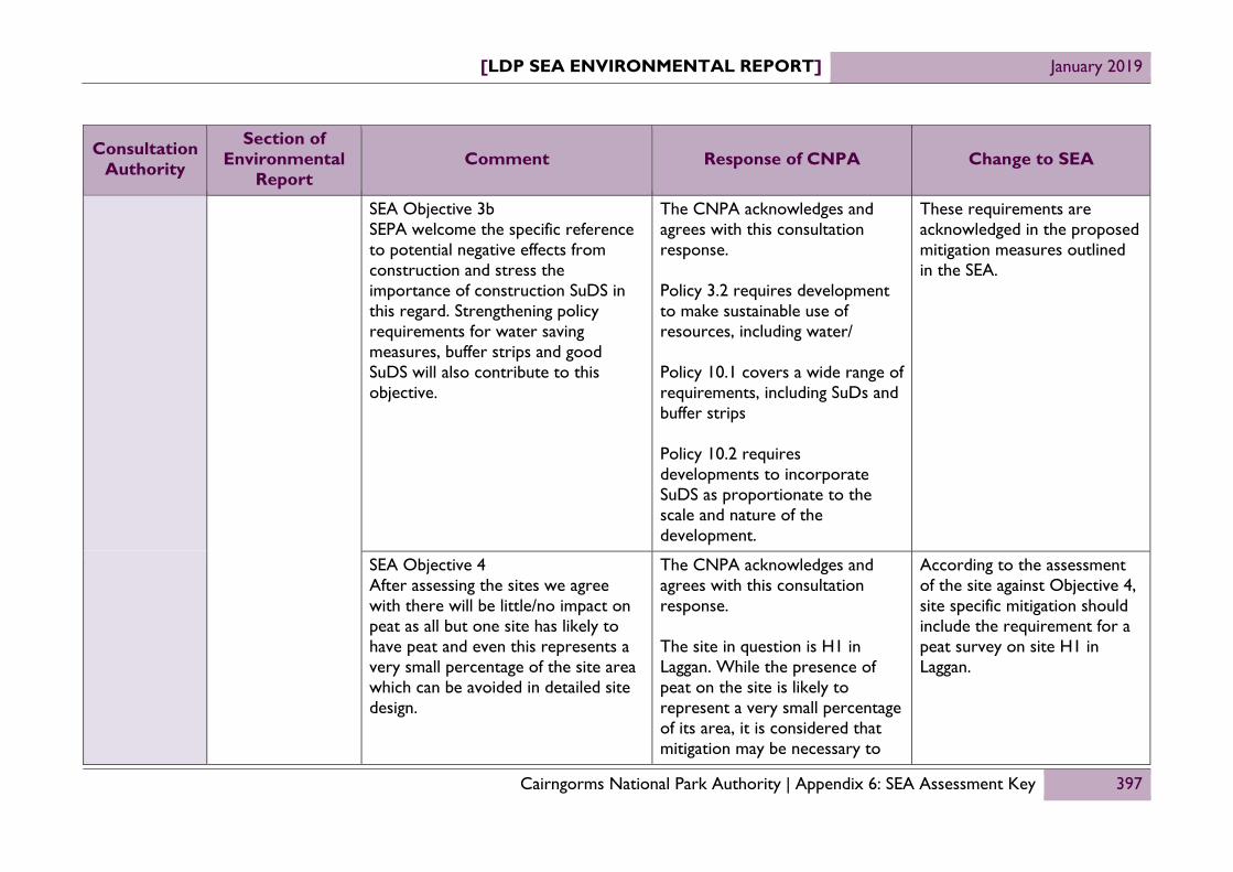
[LDP SEA ENVIRONMENTAL REPORT] January 2019
Cairngorms National Park Authority | Appendix 6: SEA Assessment Key 397
Consultation Authority
Section of Environmental
Report Comment Response of CNPA Change to SEA
SEA Objective 3b SEPA welcome the specific reference to potential negative effects from construction and stress the importance of construction SuDS in this regard. Strengthening policy requirements for water saving measures, buffer strips and good SuDS will also contribute to this objective.
The CNPA acknowledges and agrees with this consultation response. Policy 3.2 requires development to make sustainable use of resources, including water/ Policy 10.1 covers a wide range of requirements, including SuDs and buffer strips Policy 10.2 requires developments to incorporate SuDS as proportionate to the scale and nature of the development.
These requirements are acknowledged in the proposed mitigation measures outlined in the SEA.
SEA Objective 4 After assessing the sites we agree with there will be little/no impact on peat as all but one site has likely to have peat and even this represents a very small percentage of the site area which can be avoided in detailed site design.
The CNPA acknowledges and agrees with this consultation response. The site in question is H1 in Laggan. While the presence of peat on the site is likely to represent a very small percentage of its area, it is considered that mitigation may be necessary to
According to the assessment of the site against Objective 4, site specific mitigation should include the requirement for a peat survey on site H1 in Laggan.

[LDP SEA ENVIRONMENTAL REPORT] January 2019
Cairngorms National Park Authority | Appendix 6: SEA Assessment Key 398
Consultation Authority
Section of Environmental
Report Comment Response of CNPA Change to SEA
ensure negative effects do not occur.
SEA Objective 6a The avoidance and provision of buffer strips around GWDTE would be a further mitigation measure here and a developer requirement to undertake a Phase 1 habitat survey ion sites where GWDTE may be present would help in delivering this objective.
The CNPA acknowledge the comment. Buffer strips are a requirement of Policy 10.1.
Policy 10 forms part of the LDP’s built in mitigation and this has been considered in the SEA.
Monitoring Framework
SEPA welcome the monitoring proposals outlined and think these are a reasonable and realistic set of proposals. With regards to peatland monitoring the area of peat lost as well as peatland restored would be a good indicator. Another of the indicators perhaps under biodiversity should be percentage loss of wetlands.
CNPA welcomes the comment and agrees with the inclusion of the additional peatland indicator. The wetland indicator is however more problematic as it requires both a definition of what a wetland is and for the change in that to be practically measurable. The emerging CNAP has an indicator about pond creations and it is therefore proposed that the SEA monitoring framework adopt this as the appropriate wetland indicator.
Add the following indicators to the SEA monitoring framework:
Area of peatland lost due to development
Number of new ponds
created, including SuDS ponds.

[LDP SEA ENVIRONMENTAL REPORT] January 2019
Cairngorms National Park Authority | Appendix 6: SEA Assessment Key 399
Consultation Authority
Section of Environmental
Report Comment Response of CNPA Change to SEA
Next steps
SEPA note the timescale for the preparation of the Proposed Plan and updated ER. They note no consultation period has been set for the next ER however we request a minimum of 6 weeks is given and longer would be most welcome.
The CNPA note the comment and commit to set the consultation period for a minimum period of 6 weeks.
Consultation period is set out within the Next Steps section of this report.
Scottish Natural Heritage
General We have focussed our advice on the new allocations, both preferred and un-preferred. Our understanding is that the site assessment table presents scoring and assessment pre-mitigation. We have provided our advice on this basis. We have also provided advice on the individual allocations based on the size of the allocations in relation to the size of the existing settlement. This means that some of our advice is precautionary, because there is limited information at this stage about the proposed number of units for many allocations, making it difficult to provide more site specific advice on the potential for significant environmental effects.
Comment noted. No change to the SEA.

[LDP SEA ENVIRONMENTAL REPORT] January 2019
Cairngorms National Park Authority | Appendix 6: SEA Assessment Key 400
Consultation Authority
Section of Environmental
Report Comment Response of CNPA Change to SEA
While it may appear that we have extensive advice on the ER of the MIR, we do appreciate that several of the issues are likely to have arisen because this stage in the planning process can limit the potential for full assessment. We also expect that the Park Authority is likely to already be addressing several of the issues as part of the preparation of the proposed Local Development Plan (LDP).
Comment noted. No change to the SEA.
Environmental Report pages 35 – 41
Assessing the effects of Plan Options We find the categorisation by symbol and colouring of the assessment criteria useful. However, we do not find the radar graphs add value to the assessment. This is because they are, by necessity, presented at a very small scale without segmentation or accompanying labels. This renders them confusing as they are almost impossible to interpret. The symbol and colour categorisation of the assessment criteria already provide a visual overview for each item that is assessed. Our advice is that the radar
Comment noted. Radar graphs not included in this Report.

[LDP SEA ENVIRONMENTAL REPORT] January 2019
Cairngorms National Park Authority | Appendix 6: SEA Assessment Key 401
Consultation Authority
Section of Environmental
Report Comment Response of CNPA Change to SEA
graphs are not necessary.
Environmental Report pages 61 – 68, Mitigation
The mitigation measures in the ER document appear to focus on Main Issues and SEA objectives, rather than being site specific and addressing issues for individual allocations. We would expect the ER for the proposed LDP to include mitigation measures for each allocation where mitigation is identified as being necessary to avoid or minimise significant environmental effects. This will be particularly important for allocations with the potential to have significant environmental effects on areas protected for nature conservation, both alone and cumulatively with other allocations. (Our advice on the allocations provided in our separate response to the MIR should help identify appropriate mitigation where necessary.)
The CNPA acknowledges and agrees with this consultation response.
Because the proposed plan includes detailed policies and site schedules, it has been possible to outline the mitigation measures in place to address negative effects, including site specific measures such as the need for surveys.

[LDP SEA ENVIRONMENTAL REPORT] January 2019
Cairngorms National Park Authority | Appendix 6: SEA Assessment Key 402
Consultation Authority
Section of Environmental
Report Comment Response of CNPA Change to SEA
Environmental Report pages 56 – 59 Cumulative assessment
We have reservations about the cumulative assessment, as it appears to focus on the Main Issues and does not appear to include consideration of the potential cumulative impacts caused by the allocations. Cumulative environmental effects require specific attention to ensure appropriate mitigation is put in place at the allocation level. This is of particular importance for areas protected for nature conservation, such as the river Special Areas of Conservation (SACs) and capercaillie Special Protection Areas (SPAs). Our advice is that the ER of the proposed LDP should include full cumulative assessment, including identification of mitigation measures where necessary, for both the policies and allocations.
The CNPA notes the comment. However cumulative effects are not site specific. That is to say, while development might have a cumulative effect on a SEA Objective, the choice of one site over another in any particular settlement, would not. Indeed the same results would arise from any location, allocated or not. With respect to the issue of capercaillie, it is not the location of the sites that is the most problematic aspect, it is the level of development and this is not directed by the site, but the settlement strategy. The cumulative effects of the settlement strategy are considered in this report. It also needs to be recognised that the SEA is not the sole process of assessment undertaken on the LDP. A Habitats Regulations Appraisal has also been carried out, which
No change to SEA.

[LDP SEA ENVIRONMENTAL REPORT] January 2019
Cairngorms National Park Authority | Appendix 6: SEA Assessment Key 403
Consultation Authority
Section of Environmental
Report Comment Response of CNPA Change to SEA
has resulted in an Appropriate Assessment around the likely significant effects arising from development on the qualifying features of Natura designations. This has resulted in mitigation measures being included in the LDP. The issue is therefore considered to be fully addressed.
Environmental Report pages 69 – 73, Monitoring
While we welcome that monitoring is proposed, it is unclear what will happen to the results or in the event of an unexpected result. It would be helpful for the ER of the proposed LDP to include information on what will happen to monitoring results and what actions may be taken if the results are not as expected.
The CNPA welcomes the comment. As is stated in the Monitoring section of the Environmental Report, this Environmental Report is not the conclusion of the SEA process and the proposed monitoring framework will be refined following its publication. A finalised set of indicators will be set out in the Post-adoption Statement, which will be published following the LDP’s approval by the Scottish Government.
No change to SEA.

[LDP SEA ENVIRONMENTAL REPORT] January 2019
Cairngorms National Park Authority | Appendix 6: SEA Assessment Key 404
Consultation Authority
Section of Environmental
Report Comment Response of CNPA Change to SEA
Addendum: Site Assessments, presentation
The pdf site assessment table (referred to as “Addendum: Site Assessments” on the consultation webpage) unfortunately does not show all the text for each cell – where text over-fills cells it is truncated, meaning the full assessment is not visible. While this is not necessarily a significant issue for this stage in the process, it would be beneficial for complete text to be displayed for the next stage. For example, it would be helpful if the original excel spreadsheet could be provided instead of a pdf for the ER of the proposed LDP. This would also make navigating between allocations and objectives easier. - Addendum: Site Assessments, protected areas Unfortunately many of the assessments for allocations do not include recognition of proximity and/or connectivity to areas protected for nature conservation. As we understand that the assessments presented in the ER are pre-mitigation assessments, this means that many of these allocations have the potential to have significant environmental effects. We therefore disagree with some of the scoring and provide advice in relation to protected areas for
Comment noted. Full assessments of the sites taken forward into the Proposed Plan can be found in Appendix 7.

[LDP SEA ENVIRONMENTAL REPORT] January 2019
Cairngorms National Park Authority | Appendix 6: SEA Assessment Key 405
Consultation Authority
Section of Environmental
Report Comment Response of CNPA Change to SEA
Our advice is therefore that the implications of the changes in settlement boundaries and reduction of open space on objectives relating to placemaking, active travel/ accessible recreation opportunities within settlements, areas protected for nature conservation and biodiversity will require assessment in the ER of the proposed LDP.
Ballater, Braemar, Dinnet
None of the assessments for allocations in these settlements includes consideration of the River Dee Special Area of Conservation (SAC). As water supplying new development may be sourced by abstraction from the Dee, we recommend pre-mitigation scoring the allocations for these settlements as ‘-‘ under objective 6a, due to the potential to cause likely significant effects on the qualifying interests of the SAC. Some of the allocations may also cause disturbance to otter (through increase human activity, particularly dog walking), a qualifying interest of the SAC and also a
The effects described within this comment are non-site specific i.e. they apply to any proposals located within the settlement, or indeed, outside of the settlement. Since they relate to effects on off-site Natura designations it is considered that they are addressed more appropriately through the Habitats Regulations Appraisal.
No change to the SEA.

[LDP SEA ENVIRONMENTAL REPORT] January 2019
Cairngorms National Park Authority | Appendix 6: SEA Assessment Key 406
Consultation Authority
Section of Environmental
Report Comment Response of CNPA Change to SEA
European Protected Species, so this also needs consideration as part of the assessments. The assessments also need to include consideration of the two Deeside capercaillie Special Protection Areas (SPAs), Ballochbuie and Glen Tanar. Capercaillie are sensitive to disturbance from human activity on foot (particularly off-lead dog walking) and by bike. Woodlands outwith SPAs provide additional habitat that supports the population of capercaillie within SPAs. This means that impacts in one location supporting capercaillie (whether an SPA or supporting woodland) may have an effect on other capercaillie SPAs in the wider area. Cumulative effects caused by existing or planned proposals in combination with the individual allocation also need to be considered.
Aviemore, THC031 (An Camas Mor extended area)
While we agree that objective 6a has a pre-mitigation score of “- -“, the assessment does not mention the River Spey SAC or Site of Special Scientific Interest (SSSI), which runs
The CNPA acknowledges and agrees with this consultation response. The site is however not preferred and will not be included within the Proposed Plan. No
No change to the SEA.

[LDP SEA ENVIRONMENTAL REPORT] January 2019
Cairngorms National Park Authority | Appendix 6: SEA Assessment Key 407
Consultation Authority
Section of Environmental
Report Comment Response of CNPA Change to SEA
along the western boundary of the extended allocation site. The impacts identified under objectives 3a and 3b also have the potential to cause likely significant effects on the qualifying interests of SAC. An additional impact that should also be recognised is potential disturbance of otter, one of the qualifying interests of the SAC and a notified feature of the SSSI, from increased human activity (particularly dog walking) along the banks of the river. Otter are also a European Protected Species, so the potential for adverse impacts on them as a protected species should also be recognised under objective 6a.
amendments to the Environmental Report are therefore necessary. However, should the site be argued for during the examination process, then the proposer will need to take this information into account.
Aviemore, THC007 – THC014
We disagree with the -mitigation scoring for objective 6a and recommend that it is changed to ‘-‘, if not ‘- -‘. This is because of the potential for likely significant effects on the qualifying interests of the River Spey SAC (e.g. from development activities affecting water quality), and Badenoch and Strathspey capercaillie
The CNPA agrees with the comment and proposes that the factors be taken into account in the assessment of allocation M1, which is a composite of site THC007-THC014.
Account for potential effects on River Spey SAC and Kinveachy Forest SPA in assessment of M1.

[LDP SEA ENVIRONMENTAL REPORT] January 2019
Cairngorms National Park Authority | Appendix 6: SEA Assessment Key 408
Consultation Authority
Section of Environmental
Report Comment Response of CNPA Change to SEA
Special Protection Areas (SPAs), particularly Kinveachy Forest SPA (e.g. through increased recreation disturbance to capercaillie due to the increase in human population, both alone and cumulatively with other developments affecting capercaillie SPAs). The potential for impacts on these areas protected for nature conservation should be recognised under objective 6a.
Aviemore, THC045 and THC059
The assessment does not mention the potential for a likely significant effect on Badenoch and Strathspey SPAs with capercaillie as qualifying interests, particularly Kinveachy Forest SPA (e.g. through increased recreation disturbance to capercaillie due to the increase in human population, both alone and cumulatively with other developments affecting capercaillie SPAs). For THC059, additional consideration is required as to how the A9 dualling will affect access opportunities into Kinveachy forest in particular. The potential for impacts on these areas protected for nature
The CNPA agree with the recommendations.
Take account of these factors in the assessment of site LTH1.

[LDP SEA ENVIRONMENTAL REPORT] January 2019
Cairngorms National Park Authority | Appendix 6: SEA Assessment Key 409
Consultation Authority
Section of Environmental
Report Comment Response of CNPA Change to SEA
conservation should be recognised under objective 6a, and consideration given as to whether the pre-mitigation impacts would be more appropriately scored as ‘- - ‘.
Aviemore, THC061
We disagree with the ‘¨’ scoring for objective 6a and recommend that it is changed to ‘-‘ at least, if not ‘- -‘. This is because of the potential for likely significant effects on the qualifying interests of the River Spey SAC (e.g. from development activities affecting water quality or from human activity causing disturbance of otter), and Badenoch and Strathspey capercaillie SPAs, particularly Kinveachy Forest SPA (e.g. through increased recreation disturbance to capercaillie due to the increase in human population, both alone and cumulatively with other developments affecting capercaillie SPAs). Additional consideration is required as to how the A9 dualling will affect access opportunities into Kinveachy forest in particular. The potential for impacts on these areas protected for nature
The CNPA agree with the recommendations.
Take account of these factors in the assessment of site M2.

[LDP SEA ENVIRONMENTAL REPORT] January 2019
Cairngorms National Park Authority | Appendix 6: SEA Assessment Key 410
Consultation Authority
Section of Environmental
Report Comment Response of CNPA Change to SEA
conservation should be recognised under objective 6a. Otter are also a European Protected Species, so the potential for adverse impacts on them as a protected species should also be recognised under objective 6a.
North Aviemore We disagree with the ‘¨’ scoring for objective 6a and recommend that it is changed to ‘-‘ at least, if not ‘- -‘. This is because of the potential for likely significant effects on the qualifying interests of the River Spey SAC (e.g. from development activities affecting water quality), and Badenoch and Strathspey capercaillie SPAs, particularly Kinveachy Forest SPA (e.g. through increased recreation disturbance to capercaillie due to the increase in human population, both alone and cumulatively with other developments affecting capercaillie SPAs). Additional consideration is required as to how the A9 dualling will affect access opportunities into Kinveachy forest in particular. The potential for impacts on these areas
The CNPA agree with the recommendations.
Take account of these factors in the assessment of site LTH2.

[LDP SEA ENVIRONMENTAL REPORT] January 2019
Cairngorms National Park Authority | Appendix 6: SEA Assessment Key 411
Consultation Authority
Section of Environmental
Report Comment Response of CNPA Change to SEA
protected for nature conservation should be recognised under objective 6a. The potential for adverse impacts on the following additional protected species also require recognition under objective 6a: There are badger in the fields to the east of the A95 - badgers and their setts are legally protected under the Protection of Badgers Act 1992 (as amended). The majority of the proposed allocation is within the Northern Strathspey wildcat priority area and wildcat have been reported in this location. Wildcat are an EPS, and are sensitive to disturbance from human activity.
Ballater, AB017
We disagree with the ‘¨’ scoring for objective 6a and recommend that it is changed to ‘-‘. This is because of the potential for likely significant effects on the qualifying interests of the River Dee SAC, as water supplying new development may be sourced by abstraction from the Dee, and the potential for likely significant effects on capercaillie of the Deeside SPAs
The CNPA agree with the recommendations.
Take account of these factors in the assessment of site H1.

[LDP SEA ENVIRONMENTAL REPORT] January 2019
Cairngorms National Park Authority | Appendix 6: SEA Assessment Key 412
Consultation Authority
Section of Environmental
Report Comment Response of CNPA Change to SEA
through increased human activity causing disturbance
Blair Atholl, PKC004
We disagree with the ‘¨’ scoring for objective 6a and recommend that it is changed to ‘-‘. This is because of the potential for likely significant effects on the qualifying interests of the River Tay SAC (e.g. from development activities affecting water quality or from human activity causing disturbance of otter). The potential for impact on this area protected for nature conservation should be recognised under objective 6a. Otter are also a European Protected Species, so the potential for adverse impacts on them as a protected species should also be recognised under objective 6a.
The CNPA acknowledges and agrees with this consultation response. The site is however not preferred and will not be included within the Proposed Plan. No amendments to the Environmental Report are therefore necessary. However, should the site be argued for during the examination process, then the proposer will need to take this information into account.
No change to the SEA.
Blair Atholl, PKC006
We disagree with the ‘¨’ scoring for objective 6a and recommend that it is changed to ‘-‘. This is because of the potential for likely significant effects on the qualifying interests of the River Tay SAC (e.g. from development activities affecting water quality or
The CNPA acknowledges and agrees with this consultation response. The site is however not preferred and will not be included within the Proposed Plan. No amendments to the Environmental Report are
No change to the SEA.

[LDP SEA ENVIRONMENTAL REPORT] January 2019
Cairngorms National Park Authority | Appendix 6: SEA Assessment Key 413
Consultation Authority
Section of Environmental
Report Comment Response of CNPA Change to SEA
from human activity causing disturbance of otter). The potential for impact on this area protected for nature conservation should be recognised under objective 6a. Otter are also a European Protected Species, so the potential for adverse impacts on them as a protected species should also be recognised under objective 6a. Consideration of the potential impacts on the Glen Tilt Woods SSSI is also necessary.
therefore necessary. However, should the site be argued for during the examination process, then the proposer will need to take this information into account.
Boat of Garten, THC058
We disagree with the ‘¨’ scoring for objective 6a and recommend that it is changed to ‘-‘. This is because of the potential for likely significant effects on capercaillie SPAs, through increased recreation disturbance to capercaillie if economic development gives rise to increased human activity in the wider area (e.g. a bike hire shop), both alone and cumulatively with other developments affecting capercaillie SPAs
The CNPA acknowledges and agrees with this consultation response. The site is however not preferred and will not be included within the Proposed Plan. No amendments to the Environmental Report are therefore necessary. However, should the site be argued for during the examination process, then the proposer will need to take this information into account.
No change to the SEA.

[LDP SEA ENVIRONMENTAL REPORT] January 2019
Cairngorms National Park Authority | Appendix 6: SEA Assessment Key 414
Consultation Authority
Section of Environmental
Report Comment Response of CNPA Change to SEA
Boat of Garten, THC074 and THC075
We disagree with the ‘¨’ scoring for objective 6a and recommend that it is changed to ‘-‘ at least, if not ‘- -‘. This is because of the potential for likely significant effects on the Badenoch and Strathspey capercaillie SPAs through increased recreation disturbance to capercaillie due to the increase in human population, both alone and cumulatively with other developments affecting capercaillie SPAs. The potential for impacts on these areas protected for nature conservation should be recognised under objective 6a.
The CNPA acknowledges and agrees with this consultation response. The site is however not preferred and will not be included within the Proposed Plan. No amendments to the Environmental Report are therefore necessary. However, should the site be argued for during the examination process, then the proposer will need to take this information into account.
No change to the SEA.
Braemar, AB002 While we agree that SEA objective 6a scores “- -“, the assessment does not mention the potential for likely significant effects on Morrone Birkwood SAC (consideration is required of potential impacts caused by changes in hydrology impacting on habitats) or the River Dee SAC (there appears to be watercourse connectivity to the SAC so pollution may affect water quality, in addition to water supplying new development
The CNPA acknowledges and agrees with this consultation response. The site is however not preferred and will not be included within the Proposed Plan. No amendments to the Environmental Report are therefore necessary. However, should the site be argued for during the examination process, then the proposer will need to take this information into
No change to the SEA.

[LDP SEA ENVIRONMENTAL REPORT] January 2019
Cairngorms National Park Authority | Appendix 6: SEA Assessment Key 415
Consultation Authority
Section of Environmental
Report Comment Response of CNPA Change to SEA
potentially being sourced by abstraction from the Dee), or the potential for likely significant effects on capercaillie of the Deeside SPAs through increased human activity causing disturbance.. The potential for impacts on these areas protected for nature conservation should be recognised under objective 6a.
account.
Braemar, AB003 While we agree that SEA objective 6a scores “- -“, the assessment does not directly refer to the potential for likely significant effects on Morrone Birkwood SAC (consideration is required of potential impacts caused by changes in hydrology impacting on habitats) or the River Dee SAC (there appears to be watercourse connectivity to the SAC so pollution may affect water quality, in addition to water supplying new development potentially being sourced by abstraction from the Dee), or the potential for likely significant effects on capercaillie of the Deeside SPAs through increased human activity causing disturbance. The potential for
The CNPA acknowledges and agrees with this consultation response. The site is however not preferred and will not be included within the Proposed Plan. No amendments to the Environmental Report are therefore necessary. However, should the site be argued for during the examination process, then the proposer will need to take this information into account.
No change to the SEA.

[LDP SEA ENVIRONMENTAL REPORT] January 2019
Cairngorms National Park Authority | Appendix 6: SEA Assessment Key 416
Consultation Authority
Section of Environmental
Report Comment Response of CNPA Change to SEA
impacts on these areas protected for nature conservation should be recognised under objective 6a.
Braemar, AB004 and AB005
The assessment does not mention the potential for likely significant effects on the River Dee SAC (there appears to be watercourse connectivity to the SAC so pollution may affect water quality, in addition to water supplying new development potentially being sourced by abstraction from the Dee). AB005 also needs to recognised the potential for likely significant effects on capercaillie of the Deeside SPAs through increased human activity causing disturbance. The potential for impacts on these areas protected for nature conservation should be recognised under objective 6a.
The CNPA acknowledges and agrees with this consultation response. The site is however not preferred and will not be included within the Proposed Plan. No amendments to the Environmental Report are therefore necessary. However, should the site be argued for during the examination process, then the proposer will need to take this information into account.
No change to the SEA.
Braemar, AB006 and AB007
The assessment does not mention the potential for likely significant effects on Morrone Birkwood SAC (consideration is required of potential impacts caused by changes in hydrology impacting on habitats) or the River Dee SAC (there appears to
The CNPA acknowledges and agrees with this consultation response. The site is however not preferred and will not be included within the Proposed Plan. No amendments to the Environmental Report are
No change to the SEA.

[LDP SEA ENVIRONMENTAL REPORT] January 2019
Cairngorms National Park Authority | Appendix 6: SEA Assessment Key 417
Consultation Authority
Section of Environmental
Report Comment Response of CNPA Change to SEA
be watercourse connectivity to the SAC so pollution may affect water quality, in addition to water supplying new development potentially being sourced by abstraction from the Dee), or the potential for likely significant effects on capercaillie of the Deeside SPAs (through increased human activity causing disturbance). Consideration of the potential impacts on the Morrone Birkwood SSSI is also necessary. The potential for impacts on these areas protected for nature conservation should be recognised under objective 6a.
therefore necessary. However, should the site be argued for during the examination process, then the proposer will need to take this information into account.
Braemar, AB009 The assessment does not mention the potential for likely significant effects on the River Dee SAC (there appears to be watercourse connectivity to the SAC so pollution may affect water quality, in addition to water supplying new development potentially being sourced by abstraction from the Dee). The potential for impacts on this area protected for nature conservation should be recognised under objective 6a.
The CNPA agree with the recommendations relating to the River Dee SAC. The comments relating to water abstraction are however not site specific.
Take account of these factors in the assessment of site H4.

[LDP SEA ENVIRONMENTAL REPORT] January 2019
Cairngorms National Park Authority | Appendix 6: SEA Assessment Key 418
Consultation Authority
Section of Environmental
Report Comment Response of CNPA Change to SEA
Braemar, AB021 We disagree with the ‘¨’ scoring for objective 6a and recommend that it is changed to ‘-‘. This is because of the potential for likely significant effects on the River Dee SAC if the car park is surfaced with material unable to withstand flood events, which could result in fine particle pollution in run-off or exacerbate flood events. The potential for impacts on this area protected for nature conservation should be recognised under objective 6a.
The CNPA acknowledges and agrees with this consultation response. The site is however not preferred and will not be included within the Proposed Plan. No amendments to the Environmental Report are therefore necessary. However, should the site be argued for during the examination process, then the proposer will need to take this information into account.
No change to the SEA.
Braemar, AB022 and AB024
The assessment does not mention the potential for likely significant effects on the River Dee SAC (from development activities affecting water quality, in addition to water supplying new development potentially being sourced by abstraction from the Dee), or the potential for likely significant effects on capercaillie of the Deeside SPAs through increased human activity causing disturbance. The potential for impacts on these areas protected for nature conservation should be recognised under objective
The CNPA agree with the recommendations with reference to River Dee SAC and water quality. The comment on water abstraction is not a site specific effect. AB024 is not proposed for allocation and therefore no changes need in that regard.
Take account of these factors in the assessment of site H5.

[LDP SEA ENVIRONMENTAL REPORT] January 2019
Cairngorms National Park Authority | Appendix 6: SEA Assessment Key 419
Consultation Authority
Section of Environmental
Report Comment Response of CNPA Change to SEA
6a.
Carrbridge, H1/THC033, H2/THC034, THC057, THC066 - 069
The assessment does not mention the potential for a likely significant effect on Badenoch and Strathspey SPAs with capercaillie as qualifying interests, particularly Kinveachy Forest SPA (e.g. through increased recreation disturbance to capercaillie due to the increase in human population, both alone and cumulatively with other developments affecting capercaillie SPAs). Particular consideration is required as to how the A9 dualling will affect access opportunities to/from Carrbridge into Kinveachy forest in particular. The potential for impacts on these areas protected for nature conservation should be recognised under objective 6a, and consideration given as to whether the pre-mitigation impacts would be more appropriately scored as ‘- - ‘.
The effects described within this comment are non-site specific i.e. they apply to any proposals located within the settlement, or indeed, outside of the settlement. Since they relate to effects on off-site Natura designations it is considered that they are addressed more appropriately through the Habitats Regulations Appraisal.
No change to the SEA.
Coylumbridge, THC027
The assessment does not mention the potential for a likely significant effect on Badenoch and Strathspey SPAs with capercaillie as qualifying interests
The effects described within this comment relating to capercaillie are non-site specific i.e. they apply to any proposals located
No change to the SEA.

[LDP SEA ENVIRONMENTAL REPORT] January 2019
Cairngorms National Park Authority | Appendix 6: SEA Assessment Key 420
Consultation Authority
Section of Environmental
Report Comment Response of CNPA Change to SEA
(e.g. through increased recreation disturbance to capercaillie due to the increase in human population, both alone and cumulatively with other developments affecting capercaillie SPAs), or the River Spey SAC (from development activity as the River Druie, part of the SAC, is in close proximity to the site). The potential for impacts on these areas protected for nature conservation should be recognised under objective 6a, and consideration given as to whether the pre-mitigation impacts would be more appropriately scored as ‘- - ‘.
within the settlement, or indeed, outside of the settlement. Since they relate to effects on off-site Natura designations it is considered that they are addressed more appropriately through the Habitats Regulations Appraisal.
Cromdale, THC018 - 020
The assessments do not mention the potential for a likely significant effect on Badenoch and Strathspey SPAs with capercaillie as qualifying interests (e.g. through increased recreation disturbance to capercaillie due to the increase in human population, both alone and cumulatively with other developments affecting capercaillie SPAs). The potential for impacts on these areas protected for nature conservation should be recognised
The effects described within this comment relating to capercaillie are non-site specific i.e. they apply to any proposals located within the settlement, or indeed, outside of the settlement. The sites are also not preferred and will not be included within the Proposed Plan. No amendments to the Environmental Report are
No change to the SEA.

[LDP SEA ENVIRONMENTAL REPORT] January 2019
Cairngorms National Park Authority | Appendix 6: SEA Assessment Key 421
Consultation Authority
Section of Environmental
Report Comment Response of CNPA Change to SEA
under objective 6a. therefore necessary.
Cromdale, THC021
We disagree with the “?” scoring for objective 6a. This is because of the potential for likely significant effects on the River Spey SAC (from development activity due to potential connectivity with the Burn of Cromdale) and Badenoch and Strathspey capercaillie SPAs (e.g. through increased recreation disturbance to capercaillie due to the increase in human population, both alone and cumulatively with other developments affecting capercaillie SPAs). The potential for impacts on these areas protected for nature conservation should be recognised under objective 6a, and consideration given as to whether the pre-mitigation impacts would be more appropriately scored as ‘- - ‘.
The effects described within this comment relating to capercaillie are non-site specific i.e. they apply to any proposals located within the settlement, or indeed, outside of the settlement. The sites are also not preferred and will not be included within the Proposed Plan. No amendments to the Environmental Report are therefore necessary.
No change to the SEA.
Dalwhinnie, THC015
We disagree with the ‘¨’ scoring for objective 6a and recommend that it is changed to ‘-‘. This is because of the potential for likely significant effects on the qualifying interests of the River
The CNPA acknowledges and agrees with this consultation response. The site is however not preferred and will not be included within the Proposed Plan. No
No change to the SEA.

[LDP SEA ENVIRONMENTAL REPORT] January 2019
Cairngorms National Park Authority | Appendix 6: SEA Assessment Key 422
Consultation Authority
Section of Environmental
Report Comment Response of CNPA Change to SEA
Spey SAC caused by exacerbating flood risk (identified under objectives 3a and b), as the River Truim, part of the River Spey SAC, is in close proximity to the SAC. The potential for impacts on this area protected for nature conservation should be recognised under objective 6a.
amendments to the Environmental Report are therefore necessary. However, should the site be argued for during the examination process, then the proposer will need to take this information into account.
Dalwhinnie, THC056
While we agree that SEA objective 6a has a pre-mitigation score of “- -“, the assessment does not mention the River Spey SAC. The SAC is connected to the site via watercourses running into the River Truim, part of the River Spey SAC. The impacts identified under objectives 3a and 3b have the potential to cause likely significant effects on the qualifying interests of SAC. The potential for impacts on this area protected for nature conservation should be recognised under objective 6a.
The CNPA acknowledges and agrees with this consultation response. The site is however not preferred and will not be included within the Proposed Plan. No amendments to the Environmental Report are therefore necessary. However, should the site be argued for during the examination process, then the proposer will need to take this information into account.
No change to the SEA.
Dinnet, AB011, AB012, AB013, AB016
The assessment does not mention the River Dee SAC. Water supplying new development may be sourced by
The effects described within this comment are non-site specific i.e. they apply to any proposals
No change to the SEA.

[LDP SEA ENVIRONMENTAL REPORT] January 2019
Cairngorms National Park Authority | Appendix 6: SEA Assessment Key 423
Consultation Authority
Section of Environmental
Report Comment Response of CNPA Change to SEA
abstraction from the Dee, which has the potential to cause likely significant effects on the qualifying interests of the SAC. In addition, there appears to be watercourse connectivity to the SAC (AB011) / close proximity to the SAC (AB012, AB013), so sedimentation from construction activities will require consideration. For AB013 and AB016, the assessment also does not consider the potential for likely significant effects on capercaillie of the Deeside SPAs (through increased human activity causing disturbance). The potential for impact on this area protected for nature conservation should be recognised under objective 6a.
located within the settlement, or indeed, outside of the settlement. Since they relate to effects on off-site Natura designations it is considered that they are addressed more appropriately through the Habitats Regulations Appraisal.
Dinnet, AB015 The assessment does not mention the River Dee SAC. Water supplying new development may be sourced by abstraction from the Dee, which has the potential to cause likely significant effects on the qualifying interests of the SAC. The Muir of Dinnet SSSI also adjoins the site. The potential for impacts on these areas protected for
The effects described within this comment are non-site specific i.e. they apply to any proposals located within the settlement, or indeed, outside of the settlement. Since they relate to effects on off-site Natura designations it is considered that they are
No change to the SEA.

[LDP SEA ENVIRONMENTAL REPORT] January 2019
Cairngorms National Park Authority | Appendix 6: SEA Assessment Key 424
Consultation Authority
Section of Environmental
Report Comment Response of CNPA Change to SEA
nature conservation should be recognised under objective 6a.
addressed more appropriately through the Habitats Regulations Appraisal.
Dulnain Bridge, THC032, THC041, THC042 and THC070
The assessment does not mention the potential for likely significant effects on the River Spey SAC (from sedimentation from construction activities entering the water due to proximity) and Badenoch and Strathspey capercaillie SPAs (through increased recreation disturbance to capercaillie due to the increase in human population, both alone and cumulatively with other developments affecting capercaillie SPAs). The potential for impacts on these areas protected for nature conservation should be recognised under objective 6a
The effects described within this comment are non-site specific i.e. they apply to any proposals located within the settlement, or indeed, outside of the settlement. Since they relate to effects on off-site Natura designations it is considered that they are addressed more appropriately through the Habitats Regulations Appraisal.
No change to the SEA.
Grantown on Spey, THC028, THC038, THC039, THC040, THC048, THC055, THC064
The assessments do not mention the potential for a likely significant effect on Badenoch and Strathspey SPAs with capercaillie as qualifying interests, particularly Anagach Woods SPA (e.g. through increased recreation disturbance to capercaillie due to the
The effects described within this comment are non-site specific i.e. they apply to any proposals located within the settlement, or indeed, outside of the settlement. Since they relate to effects on off-
No change to the SEA.

[LDP SEA ENVIRONMENTAL REPORT] January 2019
Cairngorms National Park Authority | Appendix 6: SEA Assessment Key 425
Consultation Authority
Section of Environmental
Report Comment Response of CNPA Change to SEA
increase in human population, both alone and cumulatively with other developments affecting capercaillie SPAs). The potential for impacts on these areas protected for nature conservation should be recognised under objective 6a, and consideration given as to whether the pre-mitigation impacts would be more appropriately scored as ‘- - ‘.
site Natura designations it is considered that they are addressed more appropriately through the Habitats Regulations Appraisal.
Grantown on Spey, THC028, THC038, THC039 and THC040
The assessment does not mention the potential for likely significant effects on the River Spey SAC (from sedimentation from construction activities entering the water due to proximity). The potential for impacts on this area protected for nature conservation should be recognised under objective 6a
The effects described within this comment are non-site specific i.e. they apply to any proposals located within the settlement, or indeed, outside of the settlement. Since they relate to effects on off-site Natura designations it is considered that they are addressed more appropriately through the Habitats Regulations Appraisal.
No change to the SEA.
Kingussie, THC053 We disagree with the ‘¨’ scoring for objective 6a and recommend that it is changed to ‘-‘. This is because of the potential for likely significant effects
The CNPA acknowledges and agrees with this consultation response. The site is however not preferred and will not be included
No change to the SEA.

[LDP SEA ENVIRONMENTAL REPORT] January 2019
Cairngorms National Park Authority | Appendix 6: SEA Assessment Key 426
Consultation Authority
Section of Environmental
Report Comment Response of CNPA Change to SEA
on the qualifying interests of the River Spey SAC, Insh Marshes SAC, River Spey - Insh Marshes SPA (e.g. from development activities affecting water quality) as there appears to be watercourse connectivity to the SAC. The River Spey – Insh Marshes SSSI and Ramsar site cover much of the same area and so also appear to the connected to the allocation site. The potential for impacts on these areas protected for nature conservation should be recognised under objective 6a.
within the Proposed Plan. No amendments to the Environmental Report are therefore necessary. However, should the site be argued for during the examination process, then the proposer will need to take this information into account.
Laggan, THC065 The assessment does not mention the potential for likely significant effects on the qualifying interests of the River Spey SAC (from development activity as the site adjoins the River Mashie, part of the SAC, and appears to have watercourse connectivity with the SAC). The potential for impacts on this area protected for nature conservation should be recognised under objective 6a.
The CNPA agrees with the comment.
Take account of these factors in the assessment of site H1.
Lynchat, THC029 We disagree with the ‘¨’ scoring for The CNPA acknowledges and No change to the SEA.

[LDP SEA ENVIRONMENTAL REPORT] January 2019
Cairngorms National Park Authority | Appendix 6: SEA Assessment Key 427
Consultation Authority
Section of Environmental
Report Comment Response of CNPA Change to SEA
objective 6a and recommend that it is changed to ‘-‘. This is because of the potential for likely significant effects on the qualifying interests of the River Spey SAC, Insh Marshes SAC and the River Spey – Insh Marshes SPA, from development activity affecting water quality and/or flood risk (as identified under objectives 3a and 3b). The River Spey is in close proximity to the site and there appears to be connectivity to the SACs and SPA via drains and an unnamed watercourse to the east of the site. The River Spey - Insh Marshes SSSI and Ramsar site cover much of the same area as the SACs and SPA. The potential for impacts on these areas protected for nature conservation should be recognised under objective 6a.
agrees with this consultation response. The site is however not preferred and will not be included within the Proposed Plan. No amendments to the Environmental Report are therefore necessary. However, should the site be argued for during the examination process, then the proposer will need to take this information into account.
Nethy Bridge, THC002, THC003
The assessments do not mention the potential for likely significant effects on the qualifying interests of the River Spey SAC (from development activity and/or flood risk (as identified under objectives 3a and 3b) as the sites adjoin the River Nethy (a tributary
The CNPA agrees with the comment. However, the CNPA do not agree that these sites are likely to have a negative effect on the qualifying features of SAC in
Take account of factors relating to the river Spey SAC in the assessment of site H1 and H2.

[LDP SEA ENVIRONMENTAL REPORT] January 2019
Cairngorms National Park Authority | Appendix 6: SEA Assessment Key 428
Consultation Authority
Section of Environmental
Report Comment Response of CNPA Change to SEA
and part of the SAC) with THC002 also appearing to have watercourse connectivity with the SAC), and Badenoch and Strathspey capercaillie SPAs (through increased recreation disturbance to capercaillie due to the increase in human population, both alone and cumulatively with other developments affecting capercaillie SPAs). The potential for impacts on this area protected for nature conservation should be recognised under objective 6a.
which capercaillie are a qualifying species.
Nethy Bridge, THC005, H1/THC035
The assessment does not mention the potential for a likely significant effect on Badenoch and Strathspey SPAs with capercaillie as qualifying interests, particularly Abernethy Forest SPA (e.g. through increased recreation disturbance to capercaillie due to the increase in human population, both alone and cumulatively with other developments affecting capercaillie SPAs). The potential for impacts on these areas protected for nature conservation should be recognised under objective 6a.
The CNPA acknowledges and agrees with this consultation response. The site is however not preferred and will not be included within the Proposed Plan. No amendments to the Environmental Report are therefore necessary. However, should the site be argued for during the examination process, then the proposer will need to take this information into account.
No change to the SEA.

[LDP SEA ENVIRONMENTAL REPORT] January 2019
Cairngorms National Park Authority | Appendix 6: SEA Assessment Key 429
Consultation Authority
Section of Environmental
Report Comment Response of CNPA Change to SEA
Nethy Bridge, THC017
The assessments do not mention the potential for likely significant effects on the qualifying interests of River Spey SAC (from development activity as the site is in close proximity to the Allt Mor, a tributary and part of the SAC, and from increased human activity (particularly dog walking) causing disturbance to otter), and Badenoch and Strathspey capercaillie SPAs (through increased recreation disturbance to capercaillie due to the increase in human population, both alone and cumulatively with other developments affecting capercaillie SPAs). The potential for impacts on this area protected for nature conservation should be recognised under objective 6a. Otter are also a European Protected Species (EPS), so their EPS status also needs consideration as part of the assessment for objective 6a.
The CNPA acknowledges and agrees with this consultation response. The site is however not preferred and will not be included within the Proposed Plan. No amendments to the Environmental Report are therefore necessary. However, should the site be argued for during the examination process, then the proposer will need to take this information into account.
No change to the SEA.
Nethy Bridge, THC036
The assessment does not mention the potential for a likely significant effect on Badenoch and Strathspey SPAs with capercaillie as qualifying interests,
The CNPA acknowledges and agrees with this consultation response. The site is however not preferred and will not be included
No change to the SEA.

[LDP SEA ENVIRONMENTAL REPORT] January 2019
Cairngorms National Park Authority | Appendix 6: SEA Assessment Key 430
Consultation Authority
Section of Environmental
Report Comment Response of CNPA Change to SEA
particularly Abernethy Forest SPA (e.g. through increased recreation disturbance to capercaillie due to the increase in human population, both alone and cumulatively with other developments affecting Badenoch and Strathspey capercaillie SPAs) or the Cairngorms SAC. Abernethy Forest SSSI and Abernethy NNR covers much of the same area as the SPA. The potential for impacts on these areas protected for nature conservation should be recognised under objective 6a.
within the Proposed Plan. No amendments to the Environmental Report are therefore necessary. However, should the site be argued for during the examination process, then the proposer will need to take this information into account.
Nethy Bridge, THC037
While we agree with the scoring of ‘- -‘ due to the inclusion of land within the Abernethy National Nature Reserve (NNR) within the proposed allocation, the assessment does not mention the potential for a likely significant effect on Badenoch and Strathspey SPAs with capercaillie as qualifying interests, particularly Abernethy Forest SPA (e.g. through increased recreation disturbance to capercaillie due to the increase in human population, both alone and
The CNPA acknowledges and agrees with this consultation response. The site is however not preferred and will not be included within the Proposed Plan. No amendments to the Environmental Report are therefore necessary. However, should the site be argued for during the examination process, then the proposer will need to take this information into account.
No change to the SEA.

[LDP SEA ENVIRONMENTAL REPORT] January 2019
Cairngorms National Park Authority | Appendix 6: SEA Assessment Key 431
Consultation Authority
Section of Environmental
Report Comment Response of CNPA Change to SEA
cumulatively with other developments affecting Badenoch and Strathspey capercaillie SPAs) or the Cairngorms SAC. Abernethy Forest SSSI and Abernethy NNR covers much of the same area as the SPA. The potential for impacts on these areas protected for nature conservation should be recognised under objective 6a.
Nethy Bridge, THC052
We disagree with the ‘¨’ scoring for objective 6a and recommend that it is changed to ‘-‘. This is because of the potential for likely significant effects on the qualifying interests of the River Spey SAC (from development activity as there appears to be watercourse connectivity to the SAC, and/or flood risk as identified under objectives 3a and 3b), or Badenoch and Strathspey capercaillie SPAs, particularly Abernethy Forest SPA (through increased recreation disturbance to capercaillie, both alone and cumulatively with other developments affecting capercaillie SPAs, if economic development generates increased human activity in the wider area, e.g.
The CNPA acknowledges and agrees with this consultation response. The site is however not preferred and will not be included within the Proposed Plan. No amendments to the Environmental Report are therefore necessary. However, should the site be argued for during the examination process, then the proposer will need to take this information into account.
No change to the SEA.

[LDP SEA ENVIRONMENTAL REPORT] January 2019
Cairngorms National Park Authority | Appendix 6: SEA Assessment Key 432
Consultation Authority
Section of Environmental
Report Comment Response of CNPA Change to SEA
bike hire shop). The potential for impacts on these areas protected for nature conservation should be recognised under objective 6a.
Nethy Bridge, THC060
The assessment does not mention the potential for a likely significant effect on the River Spey SAC (from development activity as the site is in close proximity to the River Nethy, a tributary and part of the River Spey SAC) or Badenoch and Strathspey capercaillie SPAs, particularly Abernethy Forest SPA (through increased recreation disturbance to capercaillie due to the increase in human population, both alone and cumulatively with other developments affecting capercaillie SPAs). The potential for impacts on these areas protected for nature conservation should be recognised under objective 6a.
The CNPA acknowledges and agrees with this consultation response. The site is however not preferred and will not be included within the Proposed Plan. No amendments to the Environmental Report are therefore necessary. However, should the site be argued for during the examination process, then the proposer will need to take this information into account.
No change to the SEA.
Nethy Bridge, THC063
The assessment does not mention the potential for a likely significant effect on the River Spey SAC (from development activity as the site
The CNPA acknowledges and agrees with this consultation response. The site is however not preferred and will not be included
No change to the SEA.

[LDP SEA ENVIRONMENTAL REPORT] January 2019
Cairngorms National Park Authority | Appendix 6: SEA Assessment Key 433
Consultation Authority
Section of Environmental
Report Comment Response of CNPA Change to SEA
adjoins the River Nethy, a tributary and part of the SAC, and appears to have watercourse connectivity with the SAC) or Badenoch and Strathspey capercaillie SPAs, particularly Abernethy Forest SPA (through increased recreation disturbance to capercaillie due to the increase in human population, both alone and cumulatively with other developments affecting capercaillie SPAs). The potential for impacts on these areas protected for nature conservation should be recognised under objective 6a.
within the Proposed Plan. No amendments to the Environmental Report are therefore necessary. However, should the site be argued for during the examination process, then the proposer will need to take this information into account.
Newtonmore, THC022
We disagree with the ‘¨’ scoring for objective 6a and recommend that it is changed to ‘-‘. This is because of the potential for likely significant effects on the qualifying interests of the River Spey SAC (from flood risk as identified under objective 3a and b and/or development activities affecting water quality as the site is in close proximity to the River Calder, a tributary and part of the SAC). The potential for impacts on this area
The CNPA acknowledges and agrees with this consultation response. The site is however not preferred and will not be included within the Proposed Plan. No amendments to the Environmental Report are therefore necessary. However, should the site be argued for during the examination process, then the proposer will need to take this information into
No change to the SEA.

[LDP SEA ENVIRONMENTAL REPORT] January 2019
Cairngorms National Park Authority | Appendix 6: SEA Assessment Key 434
Consultation Authority
Section of Environmental
Report Comment Response of CNPA Change to SEA
protected for nature conservation should be recognised under objective 6a.
account.
Newtonmore, THC051
We disagree with the “?” scoring for objective 6a and recommend that it is changed to ‘-‘. This is because of the proximity to the River Calder, part of the River Spey SAC, as well as part of the Insh Marshes SAC, River Spey - Insh Marshes SPA. There is potential for likely significant effects on the qualifying interests of these protected areas from development exacerbating flood risk (as identified under objective 3a and b) and/or development activities affecting water quality. The River Spey – Insh Marshes SSSI and Ramsar site are also in close proximity. The potential for impacts on these areas protected for nature conservation should be recognised under objective 6a.
The CNPA acknowledges and agrees with this consultation response. The site is however not preferred and will not be included within the Proposed Plan. No amendments to the Environmental Report are therefore necessary. However, should the site be argued for during the examination process, then the proposer will need to take this information into account.
No change to the SEA.
Outwith, AB001 (Bridge of Gairn)
We disagree with the “?” scoring for objective 6a and recommend that it is changed to ‘-‘. This is because of the potential for likely significant effects
The CNPA acknowledges and agrees with this consultation response. The site is however not preferred and will not be included
No change to the SEA.

[LDP SEA ENVIRONMENTAL REPORT] January 2019
Cairngorms National Park Authority | Appendix 6: SEA Assessment Key 435
Consultation Authority
Section of Environmental
Report Comment Response of CNPA Change to SEA
on the qualifying interests of the River Dee SAC (from development activity, as it is in close proximity to the River Gairn, part of the SAC). The potential for impacts on this area protected for nature conservation should be recognised under objective 6a.
within the Proposed Plan. No amendments to the Environmental Report are therefore necessary. However, should the site be argued for during the examination process, then the proposer will need to take this information into account.
Outwith, PKC008, PKC009 and PKC010 (Glenshee)
We disagree with the ‘¨’ scoring for objective 6a and recommend that it is changed to ‘-‘. This is because of the potential for likely significant effects on the qualifying interests of the River Tay SAC (from development activity, as a watercourse appears to run through the site into the Shee Water, part of the SAC). The potential for impacts on this area protected for nature conservation should be recognised under objective 6a.
The CNPA acknowledges and agrees with this consultation response. The site is however not preferred and will not be included within the Proposed Plan. No amendments to the Environmental Report are therefore necessary. However, should the site be argued for during the examination process, then the proposer will need to take this information into account.
No change to the SEA.
Outwith, THC025 (Inverdruie and Coylumbridge)
We disagree with the ‘¨’ scoring for objective 6a and recommend that it is changed to ‘-‘. This is because of the potential for likely significant effects
The CNPA acknowledges and agrees with this consultation response. The site is however not preferred and will not be included
No change to the SEA.

[LDP SEA ENVIRONMENTAL REPORT] January 2019
Cairngorms National Park Authority | Appendix 6: SEA Assessment Key 436
Consultation Authority
Section of Environmental
Report Comment Response of CNPA Change to SEA
on the qualifying interests of the River Spey SAC (from development activity, as a watercourse in close proximity to the site runs into the River Druie, part of the SAC). Housing and economic development would need to be subject to assessment due to the potential for likely significant effects on Badenoch and Strathspey capercaillie SPAs (from increased recreation disturbance to capercaillie due to the increase in human population from housing and/or if economic development (such as a bike hire shop) generates increased human activity in the wider area, both alone and cumulatively with other developments affecting capercaillie SPAs). The potential for impacts on these areas protected for nature conservation should be recognised under objective 6a.
within the Proposed Plan. No amendments to the Environmental Report are therefore necessary. However, should the site be argued for during the examination process, then the proposer will need to take this information into account.
Outwith, THC026 (Inverdruie and Coylumbridge)
The assessment does not mention the potential for likely significant effects on Badenoch and Strathspey capercaillie SPAs (from increased recreation disturbance to capercaillie
The CNPA acknowledges and agrees with this consultation response. The site is however not preferred and will not be included within the Proposed Plan. No
No change to the SEA.

[LDP SEA ENVIRONMENTAL REPORT] January 2019
Cairngorms National Park Authority | Appendix 6: SEA Assessment Key 437
Consultation Authority
Section of Environmental
Report Comment Response of CNPA Change to SEA
if economic development (such as a bike hire shop) generates increased human activity in the wider area, both alone and cumulatively with other developments affecting capercaillie SPAs). The potential for impacts on these areas protected for nature conservation should be recognised under objective 6a.
amendments to the Environmental Report are therefore necessary. However, should the site be argued for during the examination process, then the proposer will need to take this information into account.
Outwith, THC050 (Lynwilg)
We disagree with the ‘¨’ scoring for objective 6a and recommend that it is changed to ‘-‘. This is because of the potential for likely significant effects on the qualifying interests of the River Spey SAC (from development activity, as it is in close proximity to the Allt na Criche, part of the River Spey SAC, and/or from water quality and quantity impacts from abstraction and/or discharge, if proposed). The potential for impacts on this area protected for nature conservation should be recognised under objective 6a.
The CNPA acknowledges and agrees with this consultation response. The site is however not preferred and will not be included within the Proposed Plan. No amendments to the Environmental Report are therefore necessary. However, should the site be argued for during the examination process, then the proposer will need to take this information into account.
No change to the SEA.

[LDP SEA ENVIRONMENTAL REPORT] January 2019
Cairngorms National Park Authority | Appendix 6: SEA Assessment Key 438
Appendix 5: SEA Assessment Key Table 47 SEA Assessment Key.
Significance of Effect
Plan element would have a major positive effect in its current form as it would resolve an existing issue or maximise opportunities. SIGNIFICANT.
++
Plan element would have a minor positive effect. +
Effect of plan element is uncertain. ?
Plan element would have no predicted effects or no site specific effects.
Plan element would have a minor adverse effect. -
The plan element would have a major adverse effect as it would create significant new problems or substantially exacerbate existing problems. Consider exclusion of option. SIGNIFICANT.
--
Scale and Permanence of Effect
Local (e.g. settlement or community council level)
L
Regional (e.g. National Park or neighbouring LA level)
R
National (i.e. Scotland) N
International (i.e. trans-national boundary effects)
I
Permanent P
Temporary T

[LDP SEA ENVIRONMENTAL REPORT] January 2019
Cairngorms National Park Authority | Appendix 7: Assessment of Outcomes and Options 439
Appendix 6: Assessment of Proposed Plan Vision, Strategy and Policies

[LDP SEA ENVIRONMENTAL REPORT] January 2019
Cairngorms National Park Authority | Appendix 7: Assessment of Outcomes and Options 440
Plan Element Nature of Effect
Scale
Perm
anence
Significance
Mitigation and Enhancement Short T
erm
Medium
T
erm
Long T
erm
Vision Vision: An Outstanding National Park, enjoyed by everyone, where nature and people thrive together
While not explicitly stated, the crucial aspect of the Vision with regard to reducing GHG emissions is the link to nature and people thriving together. Such an approach requires the management of the National Park to take on principles that limit negative impacts on the environment and encourage positive change; these may have either direct or indirect positive benefits in meeting the SEA Objective. For example, promoting woodland expansion and the better management of moorland both play a strong role in the storage and sequestration of carbon.
I P + + +
Spatial Strategy Spatial Strategy The policy focuses development in the strategic
settlements of Aviemore, Grantown-on-Spey, Kingussie and Newtonmore – along with a proposed new settlement at An Camas Mòr. Following this strategy should reduce the need to travel to access work and services and encourage alternative means of transport. The policy also supports the improvement of an integrated and sustainable walking and cycling
I P + + +

[LDP SEA ENVIRONMENTAL REPORT] January 2019
Cairngorms National Park Authority | Appendix 7: Assessment of Outcomes and Options 441
Plan Element Nature of Effect
Scale
Perm
anence
Significance
Mitigation and Enhancement Short T
erm
Medium
T
erm
Long T
erm
network with better links to transport.
Policies
Policy 1: New Housing Development 1.1 Housing delivery in settlements
The policy focuses development in the strategic settlements of Aviemore, Grantown-on-Spey, Kingussie and Newtonmore – along with a proposed new settlement at An Camas Mòr. Following this strategy should reduce the need to travel to access work and services and encourage alternative means of transport. The policy also supports the improvement of an integrated and sustainable walking and cycling network with better links to transport. However, given that the policy will facilitate a growth in households and is likely to facilitate a growth in population, which does have an environmental impact with regards to climate change, the overall effect is likely to be a minor negative one.
I P - - -
The policy partially mitigates itself by supporting the improvement of an integrated and sustainable walking and cycling network with better links to transport. Furthermore, Policies 3, 7 and 11 have a wide range of elements that will help mitigate the negative effects of this policy on the SEA Objective, including encouraging the incorporation of renewable energy technologies into development, requiring a high standard of design and the LPA to ask for developer obligations to deliver improvements to walking and cycling infrastructure and the public transport network. The overall policy approach is supported by the Cairngorms NPPP, particular Policy 3.2.
1.2 Housing The policy would only allow a small amount of I P

[LDP SEA ENVIRONMENTAL REPORT] January 2019
Cairngorms National Park Authority | Appendix 7: Assessment of Outcomes and Options 442
Plan Element Nature of Effect
Scale
Perm
anence
Significance
Mitigation and Enhancement Short T
erm
Medium
T
erm
Long T
erm
development in existing rural groups
development in the smallest settlements and groups of houses, and would only result in a very minor increase in the number of people travelling to access work and services. The need to travel will be partially offset by the principle of Intermediate and Rural Settlements, which should provide these groups with much of their daily facilities, and negate the need for people to travel further for these services. Neutral effects have therefore been predicted for this policy.
1.3 Other housing in the countryside
The policy would only allow a small amount of development outwith settlements, and would only result in a very minor increase in the number of people travelling to access work and services. The need to travel will be partially offset by the principle of Intermediate and Rural Settlements, which should provide these groups with much of their daily facilities, and negate the need for people to travel further for these services. Neutral effects have therefore been predicted for this policy.
I P
1.4 Designing for affordability
Smaller houses are more energy efficient and have a smaller environmental impact than larger ones, therefore the policy is likely to
I P + + +

[LDP SEA ENVIRONMENTAL REPORT] January 2019
Cairngorms National Park Authority | Appendix 7: Assessment of Outcomes and Options 443
Plan Element Nature of Effect
Scale
Perm
anence
Significance
Mitigation and Enhancement Short T
erm
Medium
T
erm
Long T
erm
result in minor positive effects. 1.5 Affordable housing There are no predicted effects associated with
this policy. I P
1.6 Affordable housing exception sites
The effects of the policy depend on the location and scale of the housing proposed. The effects are therefore uncertain.
I P ? ? ? See Mitigation for policy 1.1.
1.7 Alterations to existing houses
There are no predicted effects associated with this policy. I P
1.8 Conversions There are no predicted effects associated with this policy. I P
1.9 Replacement houses
There are no predicted effects associated with this policy. I P
1.10 Housing for gypsies and travellers
There are no predicted effects associated with this policy. I P
1.11 Long term designations
Two sites have been identified in Aviemore, which is home to the greatest concentration of services within the National Park. However, the sites are currently within moderate walking distance of public transport, local facilities and housing. However, their scale allows for the creation of local shops and their integration with the public transport network.
I P - - -
See Mitigation for policy 1.1. It is however important to note that the development of these sites is unlikely within the Plan period.
Policy 2: Supporting Economic Growth 2.1 Retail development The policy supports the SEA Objective by I P + + +

[LDP SEA ENVIRONMENTAL REPORT] January 2019
Cairngorms National Park Authority | Appendix 7: Assessment of Outcomes and Options 444
Plan Element Nature of Effect
Scale
Perm
anence
Significance
Mitigation and Enhancement Short T
erm
Medium
T
erm
Long T
erm
and high footfall generating uses
directing development to the most suitable locations and by resisting the loss of retail provision, reducing the need for people to travel elsewhere for their retail needs.
2.2 Tourist accommodation
Developing new tourist accommodation is likely to result in increased journeys by private transport. The overall effects of the policy are uncertain as they are entirely dependent on the location, scale and nature of the development.
I P ? ? ?
See Mitigation for policy 1.1.
2.3 Other tourism and leisure developments
Developing new tourism and leisure developments is likely to result in increased journeys by private transport. The overall effects of the policy are uncertain as they are entirely dependent on the location, scale and nature of the development.
I P ? ? ?
See Mitigation for policy 1.1.
2.4 Other economic development
Developing new tourist accommodation is likely to result in increased journeys by private transport. The overall effects of the policy are uncertain as they are entirely dependent on the location, scale and nature of the development.
I P ? ? ?
See Mitigation for policy 1.1.
2.5 Protecting existing economic activity
There are no predicted effects associated with this policy. I P
Policy 3: Design and Placemaking 3.1 Placemaking The option promotes a high standard of design, I P ++ ++ ++

[LDP SEA ENVIRONMENTAL REPORT] January 2019
Cairngorms National Park Authority | Appendix 7: Assessment of Outcomes and Options 445
Plan Element Nature of Effect
Scale
Perm
anence
Significance
Mitigation and Enhancement Short T
erm
Medium
T
erm
Long T
erm
energy efficiency, sustainably sourced materials and construction in new development and promotes active travel, the use for public transport and aims to reduce the reliance on private motorised transport.
3.2 Major Developments
Masterplanning major developments, which may cross ownership boundaries, can help maximise opportunities to reduce the need to travel by private motor vehicle, promote walking and cycling and ensure that renewable energy resources are incorporated into developments.
I P ++ ++ ++
3.3 Sustainable Design The option promotes a high standard of design, energy efficiency, sustainably sourced materials and construction in new development and promotes active travel, the use for public transport and aims to reduce the reliance on private motorised transport.
I P ++ ++ ++
3.4 Replacing existing building stock
There are no predicted effects associated with this policy I P
3.5 Converting existing building stock
There are no predicted effects associated with this policy I P
3.6 Alterations to existing building stock
There are no predicted effects associated with this policy I P

[LDP SEA ENVIRONMENTAL REPORT] January 2019
Cairngorms National Park Authority | Appendix 7: Assessment of Outcomes and Options 446
Plan Element Nature of Effect
Scale
Perm
anence
Significance
Mitigation and Enhancement Short T
erm
Medium
T
erm
Long T
erm
Policy 4: Natural Heritage 4.1 International designations
There are no predicted effects associated with this policy I P
4.2 National designations
There are no predicted effects associated with this policy I P
4.3 Woodlands There are opportunities for carbon sequestration through the protection and enhancement of woodlands.
I P + + +
4.4 Protected species There are no predicted effects associated with this policy I P
4.5 Other biodiversity There are opportunities for carbon sequestration through the protection and enhancement of biodiversity.
I P + + +
4.6 All development There are opportunities for carbon sequestration through the protection and enhancement of biodiversity.
I P + + +
Policy 5: Landscape 5.1 Special Landscape Qualities
There are no predicted effects associated with this policy. I P
5.2 Private Roads and Ways
There are no predicted effects associated with this policy. I P
Policy 6: The Siting and Design of Digital Communications Equipment Policy 6: The Siting and There are no predicted effects associated with I P

[LDP SEA ENVIRONMENTAL REPORT] January 2019
Cairngorms National Park Authority | Appendix 7: Assessment of Outcomes and Options 447
Plan Element Nature of Effect
Scale
Perm
anence
Significance
Mitigation and Enhancement Short T
erm
Medium
T
erm
Long T
erm
Design of Digital Communications Equipment
this policy.
Policy 7: Renewable Energy 7.1 All renewable energy developments
The policy directs the development of renewable energy sources within the county. The initial construction of the units may have a minor negative effect on greenhouse gas emissions; however, this will be offset against in the medium and long term by the greenhouse gas emissions saved.
I P + ++ ++
7.2 Hydropower The policy outlines additional requirements for the development of Hydropower permitted under policy 7.1. There are therefore no predicted negative or positive effects associated with this policy.
I P
7.3 Wind energy The policy outlines additional requirements for the development of wind energy permitted under policy 7.1. There are therefore no predicted negative or positive effects associated with this policy.
I P
7.4 Biomass The policy outlines additional requirements for the development of biomass facilities permitted under policy 7.1. There are therefore no predicted negative or positive effects associated
I P

[LDP SEA ENVIRONMENTAL REPORT] January 2019
Cairngorms National Park Authority | Appendix 7: Assessment of Outcomes and Options 448
Plan Element Nature of Effect
Scale
Perm
anence
Significance
Mitigation and Enhancement Short T
erm
Medium
T
erm
Long T
erm
with this policy. 7.5 Energy from waste The policy outlines additional requirements for
the development of energy from waste facilities permitted under policy 7.1. There are therefore no predicted negative or positive effects associated with this policy.
I P
7.6 Heat networks The policy outlines additional requirements for the development of heat networks permitted under policy 7.1. There are therefore no predicted negative or positive effects associated with this policy.
I P
Policy 8: Open Space, Sport and Recreation 8.1 New development There are no predicted effects associated with
this policy. I P
8.2 Re-development of outdoor sports facilities
There are no predicted effects associated with this policy. I P
8.3 Re-development of other open space
There are no predicted effects associated with this policy. I P
Policy 9: Cultural Heritage 9.1 Listed buildings There are no predicted effects associated with
this policy. I P
9.2 Cultural and historic designations
There are no predicted effects associated with this policy. I P

[LDP SEA ENVIRONMENTAL REPORT] January 2019
Cairngorms National Park Authority | Appendix 7: Assessment of Outcomes and Options 449
Plan Element Nature of Effect
Scale
Perm
anence
Significance
Mitigation and Enhancement Short T
erm
Medium
T
erm
Long T
erm
9.3 Conservation areas There are no predicted effects associated with this policy. I P
9.4 Other cultural heritage
There are no predicted effects associated with this policy. I P
Policy 10: Resources 10.1 Water resources There are no predicted effects associated with
this policy. I P
10.2 Flooding There are no predicted effects associated with this policy. I P
10.3 Connection to sewerage
There are no predicted effects associated with this policy. I P
10.4 Waste management and minimisation
There are no predicted effects associated with this policy. I P
10.5 Landfill There are no predicted effects associated with this policy. I P
10.6 Minerals The effect of the policy will be dependent on the location of the extraction site and the transportation of the resource. New development will inevitably lead to an increase in greenhouse gasses and will therefore have an overall negative affect on the SEA Objective.
I P - - -
See Mitigation for policy 1.1.
10.7 Carbon sinks and stores
Protecting carbon rich soils prevents the release of climate change causing greenhouse I P + + +

[LDP SEA ENVIRONMENTAL REPORT] January 2019
Cairngorms National Park Authority | Appendix 7: Assessment of Outcomes and Options 450
Plan Element Nature of Effect
Scale
Perm
anence
Significance
Mitigation and Enhancement Short T
erm
Medium
T
erm
Long T
erm
gas emissions. However, development on such soils is unlikely to be significant in the first place.
10.8 Contaminated land
There are no predicted effects associated with this policy. I P
Policy 11: Developer Obligations Policy 11: Developer Obligations
There are no predicted effects associated with this policy. I P

[LDP SEA ENVIRONMENTAL REPORT] January 2019
Cairngorms National Park Authority | Appendix 7: Assessment of Outcomes and Options 451

[LDP SEA ENVIRONMENTAL REPORT] January 2019
Cairngorms National Park Authority | Appendix 7: Assessment of Outcomes and Options 452

[LDP SEA ENVIRONMENTAL REPORT] January 2019
Cairngorms National Park Authority | Appendix 7: Assessment of Outcomes and Options 453
Plan Element Nature of Effect
Scale
Perm
anence
Significance
Mitigation and Enhancement Short T
erm
Medium
T
erm
Long T
erm
Vision Vision: An Outstanding National Park, enjoyed by everyone, where nature and people thrive together
While not explicitly stated, the crucial aspect of the Vision with regard to increasing resilience to climate change is the link to nature and people thriving together. Landscape scale habitat management and natural flood management techniques, such as woodland expansion and river restoration offer means of creating rich habitats that provide important ecosystem services with regard to climate change adaptation. Therefore it may be argued that the vision plays a direct role in meeting the SEA objective.
R P + + +
Spatial Strategy Spatial Strategy Encouraging sustainable patterns of
development will help ensure that it considers the potential effects of future climate conditions, deliver infrastructure and buildings are designed to cope with future climate conditions and encourage existing infrastructure and buildings to adapt to cope with future climate conditions.
R P + + +
Policies

[LDP SEA ENVIRONMENTAL REPORT] January 2019
Cairngorms National Park Authority | Appendix 7: Assessment of Outcomes and Options 454
Plan Element Nature of Effect
Scale
Perm
anence
Significance
Mitigation and Enhancement Short T
erm
Medium
T
erm
Long T
erm
Policy 1: New Housing Development 1.1 Housing delivery in settlements
Encouraging sustainable patterns of development will help ensure that it considers the potential effects of future climate conditions, deliver infrastructure and buildings are designed to cope with future climate conditions and encourage existing infrastructure and buildings to adapt to cope with future climate conditions.
R P + + +
1.2 Housing development in existing rural groups
There are no predicted effects associated with this policy. R P
1.3 Other housing in the countryside
There are no predicted effects associated with this policy. R P
1.4 Designing for affordability
There are no predicted effects associated with this policy. R P + + +
1.5 Affordable housing There are no predicted effects associated with this policy. R P
1.6 Affordable housing exception sites
There are no predicted effects associated with this policy. R P
1.7 Alterations to existing houses
The policy provides the opportunity to make alterations that could be designed to address the need to adapt in the face of climate change.
R P + + +
1.8 Conversions There are no predicted effects associated with R P

[LDP SEA ENVIRONMENTAL REPORT] January 2019
Cairngorms National Park Authority | Appendix 7: Assessment of Outcomes and Options 455
Plan Element Nature of Effect
Scale
Perm
anence
Significance
Mitigation and Enhancement Short T
erm
Medium
T
erm
Long T
erm
this policy. 1.9 Replacement houses
There are no predicted effects associated with this policy. R P
1.10 Housing for gypsies and travellers
There are no predicted effects associated with this policy. R P
1.11 Long term designations
Patches of the site areas affected by the medium probability surface water flood zone. Combined these equate to less than 10%.
R P - - -
Development, whether it be on allocated sites or windfall, will need to meet the requirements of Flood Risk Management (Scotland) Act 2009, National Planning Framework 3 and Scottish Planning Policy. Under the provisions of the 2009 Act, the CNPA has carried out a Strategic Flood Risk Assessment for all sites identified for allocation within the Proposed Plan and recommends methods of managing flood risk on sites that may be subject to some risk. Where necessary, these site specific recommendations have been incorporated into the Settlement Information section of the Proposed Plan and will therefore need to be met in order for planning permission

[LDP SEA ENVIRONMENTAL REPORT] January 2019
Cairngorms National Park Authority | Appendix 7: Assessment of Outcomes and Options 456
Plan Element Nature of Effect
Scale
Perm
anence
Significance
Mitigation and Enhancement Short T
erm
Medium
T
erm
Long T
erm
to be gained. Further, more detailed Flood Risk Assessments will be required on sites where they have been deemed necessary. Policies 3 and 10 have a wide range of elements relating to design and SuDS, which are applicable to all developments that will help mitigate the negative effects of this policy on the SEA Objective. Other policies may also have indirect effects in mitigating any negative effects, for example, Policies 4 and 5. It is however important to note that the development of these sites is unlikely within the Plan period.
Policy 2: Supporting Economic Growth 2.1 Retail development and high footfall generating uses
There are no predicted effects associated with this policy. R P
2.2 Tourist accommodation
There are no predicted effects associated with this policy. I P
2.3 Other tourism and leisure developments
There are no predicted effects associated with this policy. I P
2.4 Other economic There are no predicted effects associated with I P

[LDP SEA ENVIRONMENTAL REPORT] January 2019
Cairngorms National Park Authority | Appendix 7: Assessment of Outcomes and Options 457
Plan Element Nature of Effect
Scale
Perm
anence
Significance
Mitigation and Enhancement Short T
erm
Medium
T
erm
Long T
erm
development this policy. 2.5 Protecting existing economic activity
There are no predicted effects associated with this policy. I P
Policy 3: Design and Placemaking 3.1 Placemaking The option promotes a high standard of design,
energy efficiency, sustainably sourced materials and construction in new development.
R P + + +
3.2 Major Developments
Masterplanning major developments, which may cross ownership boundaries, can help maximise opportunities to incorporate adaptive features, for example, SuDS.
R P + + +
3.3 Sustainable Design The option promotes a high standard of design, energy efficiency, sustainably sourced materials and construction in new development.
R P + + +
3.4 Replacing existing building stock
There are no predicted effects associated with this policy. R P
3.5 Converting existing building stock
There are no predicted effects associated with this policy. R P
3.6 Alterations to existing building stock
There are no predicted effects associated with this policy. R P
Policy 4: Natural Heritage 4.1 International designations
There are no predicted effects associated with this policy. R P
4.2 National There are no predicted effects associated with R P

[LDP SEA ENVIRONMENTAL REPORT] January 2019
Cairngorms National Park Authority | Appendix 7: Assessment of Outcomes and Options 458
Plan Element Nature of Effect
Scale
Perm
anence
Significance
Mitigation and Enhancement Short T
erm
Medium
T
erm
Long T
erm
designations this policy. 4.3 Woodlands Protecting woodland will support the SEA
Objective as trees and woodlands play an important role in building resilience to climate change, for example by slowing throughflow and reducing surface water run-off.
R P + + +
4.4 Protected species The policy will also help species adapt to climate change by retaining habitat and, where needed, providing new habitat.
R P + + +
4.5 Other biodiversity The policy actively supports the SEA Objective by helping to reduce the National Park's ecological footprint. The retention and creation of new woodland habitats can play a role in slowing throughflow and reducing surface water-run-off. The policy will also help species adapt to climate change by retaining habitat and, where needed, providing new habitat.
R P + + +
4.6 All development The policy actively supports the SEA Objective by helping to reduce the National Park's ecological footprint. The retention and creation of new woodland habitats can play a role in slowing throughflow and reducing surface water-run-off. The policy will also help species adapt to climate change by retaining habitat and, where needed, providing new habitat.
R P + + +

[LDP SEA ENVIRONMENTAL REPORT] January 2019
Cairngorms National Park Authority | Appendix 7: Assessment of Outcomes and Options 459
Plan Element Nature of Effect
Scale
Perm
anence
Significance
Mitigation and Enhancement Short T
erm
Medium
T
erm
Long T
erm
Policy 5: Landscape 5.1 Special Landscape Qualities
There are no predicted effects associated with this policy. R P
5.2 Private Roads and Ways
There are no predicted effects associated with this policy. R P
Policy 6: The Siting and Design of Digital Communications Equipment Policy 6: The Siting and Design of Digital Communications Equipment
There are no predicted effects associated with this policy. R P
Policy 7: Renewable Energy 7.1 All renewable energy developments
There are no predicted effects associated with this policy. R P
7.2 Hydropower There are no predicted effects associated with this policy. R P
7.3 Wind energy There are no predicted effects associated with this policy. R P
7.4 Biomass There are no predicted effects associated with this policy. R P
7.5 Energy from waste There are no predicted effects associated with this policy. R P

[LDP SEA ENVIRONMENTAL REPORT] January 2019
Cairngorms National Park Authority | Appendix 7: Assessment of Outcomes and Options 460
Plan Element Nature of Effect
Scale
Perm
anence
Significance
Mitigation and Enhancement Short T
erm
Medium
T
erm
Long T
erm
7.6 Heat networks There are no predicted effects associated with this policy. R P
Policy 8: Open Space, Sport and Recreation 8.1 New development There are no predicted effects associated with
this policy. R P
8.2 Re-development of outdoor sports facilities
There are no predicted effects associated with this policy. R P
8.3 Re-development of other open space
There are no predicted effects associated with this policy. R P
Policy 9: Cultural Heritage 9.1 Listed buildings There are no predicted effects associated with
this policy. R P
9.2 Cultural and historic designations
There are no predicted effects associated with this policy. R P
9.3 Conservation areas There are no predicted effects associated with this policy. R P
9.4 Other cultural heritage
There are no predicted effects associated with this policy. R P
Policy 10: Resources 10.1 Water resources The policy's requirement that development
minimise the use of treated and abstracted R P + + +

[LDP SEA ENVIRONMENTAL REPORT] January 2019
Cairngorms National Park Authority | Appendix 7: Assessment of Outcomes and Options 461
Plan Element Nature of Effect
Scale
Perm
anence
Significance
Mitigation and Enhancement Short T
erm
Medium
T
erm
Long T
erm
water supports the SEA Objective. 10.2 Flooding The policy's requirement that development
take into account the impacts of climate change supports the SEA Objective.
R P + + +
10.3 Connection to sewerage
There are no predicted effects associated with this policy. R P
10.4 Waste management and minimisation
There are no predicted effects associated with this policy. R P
10.5 Landfill There are no predicted effects associated with this policy. R P
10.6 Minerals There are no predicted effects associated with this policy. R P
10.7 Carbon sinks and stores
There are no predicted effects associated with this policy. R P
10.8 Contaminated land
There are no predicted effects associated with this policy. R P
Policy 11: Developer Obligations Policy 11: Developer Obligations
There are no predicted effects associated with this policy. R P
[LDP SEA ENVIRONMENTAL REPORT] January 2019
Cairngorms National Park Authority | Appendix 7: Assessment of Outcomes and Options 462

[LDP SEA ENVIRONMENTAL REPORT] January 2019
Cairngorms National Park Authority | Appendix 7: Assessment of Outcomes and Options 463

[LDP SEA ENVIRONMENTAL REPORT] January 2019
Cairngorms National Park Authority | Appendix 7: Assessment of Outcomes and Options 464
Plan Element Nature of Effect
Scale
Perm
anence
Significance
Mitigation and Enhancement Short T
erm
Medium
T
erm
Long T
erm
Vision Vision: An Outstanding National Park, enjoyed by everyone, where nature and people thrive together
While not explicitly stated, the crucial aspect of the Vision with regard to protecting and enhancing air quality is the link to nature and people thriving together. For example, the protection and expansion of woodlands will have some indirect positive effects on air quality.
L P + + +
Spatial Strategy Spatial Strategy The policy focuses development in the strategic
settlements of Aviemore, Grantown-on-Spey, Kingussie and Newtonmore – along with a proposed new settlement at An Camas Mòr. Following this strategy should reduce the need to travel to access work and services and encourage alternative means of transport. The policy also supports the improvement of an integrated and sustainable walking and cycling network with better links to transport.
L P + + +
Policies
Policy 1: New Housing Development

[LDP SEA ENVIRONMENTAL REPORT] January 2019
Cairngorms National Park Authority | Appendix 7: Assessment of Outcomes and Options 465
Plan Element Nature of Effect
Scale
Perm
anence
Significance
Mitigation and Enhancement Short T
erm
Medium
T
erm
Long T
erm
1.1 Housing delivery in settlements
The policy focuses development in the strategic settlements of Aviemore, Grantown-on-Spey, Kingussie and Newtonmore – along with a proposed new settlement at An Camas Mòr. Following this strategy should reduce the need to travel to access work and services and encourage alternative means of transport. The policy also supports the improvement of an integrated and sustainable walking and cycling network with better links to transport. However, given that the policy will facilitate a growth in households and is likely to facilitate a growth in population, which does have an environmental impact with regards to air quality do to an increase in car journeys, the overall effect is likely to be a minor negative one.
L P - - -
The policy partially mitigates itself by supporting the improvement of an integrated and sustainable walking and cycling network with better links to transport. Furthermore, Policies 3, 7 and 11 have a wide range of elements that will help mitigate the negative effects of this policy on the SEA Objective, including encouraging the incorporation of renewable energy technologies into development, requiring a high standard of design and the LPA to ask for developer obligations to deliver improvements to walking and cycling infrastructure and the public transport network. The overall policy approach is supported by the Cairngorms NPPP, particular Policy 3.2.
1.2 Housing development in existing rural groups
The policy would only allow a small amount of development in the smallest settlements and groups of houses, and would only result in a very minor increase in the number of people travelling to access work and services. The
L P

[LDP SEA ENVIRONMENTAL REPORT] January 2019
Cairngorms National Park Authority | Appendix 7: Assessment of Outcomes and Options 466
Plan Element Nature of Effect
Scale
Perm
anence
Significance
Mitigation and Enhancement Short T
erm
Medium
T
erm
Long T
erm
need to travel will be partially offset by the principle of Intermediate and Rural Settlements, which should provide these groups with much of their daily facilities, and negate the need for people to travel further for these services. Neutral effects have therefore been predicted for this policy.
1.3 Other housing in the countryside
The policy would only allow a small amount of development outwith settlements, and would only result in a very minor increase in the number of people travelling to access work and services. The need to travel will be partially offset by the principle of Intermediate and Rural Settlements, which should provide these groups with much of their daily facilities, and negate the need for people to travel further for these services. Neutral effects have therefore been predicted for this policy.
L P
1.4 Designing for affordability
There are no predicted effects associated with this policy. L P
1.5 Affordable housing There are no predicted effects associated with this policy. L P
1.6 Affordable housing exception sites
The effects of the policy depend on the location and scale of the housing proposed. The effects are therefore uncertain.
L P ? ? ? See Mitigation for policy 1.1.

[LDP SEA ENVIRONMENTAL REPORT] January 2019
Cairngorms National Park Authority | Appendix 7: Assessment of Outcomes and Options 467
Plan Element Nature of Effect
Scale
Perm
anence
Significance
Mitigation and Enhancement Short T
erm
Medium
T
erm
Long T
erm
1.7 Alterations to existing houses
There are no predicted effects associated with this policy. L P
1.8 Conversions There are no predicted effects associated with this policy. L P
1.9 Replacement houses
There are no predicted effects associated with this policy. L P
1.10 Housing for gypsies and travellers
There are no predicted effects associated with this policy. L P
1.11 Long term designations
The site is within moderate walking distance of public transport, local facilities and housing. Odour issues originating from the Granish area have been reported to SEPA. This may effect site layout.
L P - - -
See Mitigation for policy 1.1. It is however important to note that the development of these sites is unlikely within the Plan period.
Policy 2: Supporting Economic Growth 2.1 Retail development and high footfall generating uses
The policy supports the SEA Objective by directing development to the most suitable locations and by resisting the loss of retail provision, reducing the need for people to travel elsewhere for their retail needs.
L P + + +
2.2 Tourist accommodation
Developing new tourist accommodation is likely to result in increased journeys by private transport. The overall effects of the policy are uncertain as they are entirely dependent on the location, scale and nature of the development.
L P ? ? ?
See Mitigation for policy 1.1.

[LDP SEA ENVIRONMENTAL REPORT] January 2019
Cairngorms National Park Authority | Appendix 7: Assessment of Outcomes and Options 468
Plan Element Nature of Effect
Scale
Perm
anence
Significance
Mitigation and Enhancement Short T
erm
Medium
T
erm
Long T
erm
2.3 Other tourism and leisure developments
Developing new tourism and leisure developments is likely to result in increased journeys by private transport. The overall effects of the policy are uncertain as they are entirely dependent on the location, scale and nature of the development.
L P ? ? ?
See Mitigation for policy 1.1.
2.4 Other economic development
Developing new tourist accommodation is likely to result in increased journeys by private transport. The overall effects of the policy are uncertain as they are entirely dependent on the location, scale and nature of the development.
L P ? ? ?
See Mitigation for policy 1.1.
2.5 Protecting existing economic activity
There are no predicted effects associated with this policy. L P
Policy 3: Design and Placemaking 3.1 Placemaking The option aims to make development easy to
move around and beyond thereby promoting active travel and public transport provision and reduce the reliance on private motorised transport.
L P + + +
3.2 Major Developments
Masterplanning major developments, which may cross ownership boundaries, can help maximise opportunities to reduce the need to travel by private motor vehicle, promote walking and cycling.
L P + + +

[LDP SEA ENVIRONMENTAL REPORT] January 2019
Cairngorms National Park Authority | Appendix 7: Assessment of Outcomes and Options 469
Plan Element Nature of Effect
Scale
Perm
anence
Significance
Mitigation and Enhancement Short T
erm
Medium
T
erm
Long T
erm
3.3 Sustainable Design The option aims to make development easy to move around and beyond thereby promoting active travel and public transport provision and reduce the reliance on private motorised transport.
L P + + +
3.4 Replacing existing building stock
There are no predicted effects associated with this policy. L P
3.5 Converting existing building stock
There are no predicted effects associated with this policy. L P
3.6 Alterations to existing building stock
There are no predicted effects associated with this policy. L P
Policy 4: Natural Heritage 4.1 International designations
There are no predicted effects associated with this policy. L P
4.2 National designations
There are no predicted effects associated with this policy. L P
4.3 Woodlands The protection of woodlands will have indirect positive effects on air quality. L P + + +
4.4 Protected species There are no predicted effects associated with this policy. L P
4.5 Other biodiversity The protection of biodiversity will have indirect positive effects on air quality. L P + + +
4.6 All development The protection of biodiversity will have indirect positive effects on air quality. L P + + +

[LDP SEA ENVIRONMENTAL REPORT] January 2019
Cairngorms National Park Authority | Appendix 7: Assessment of Outcomes and Options 470
Plan Element Nature of Effect
Scale
Perm
anence
Significance
Mitigation and Enhancement Short T
erm
Medium
T
erm
Long T
erm
Policy 5: Landscape 5.1 Special Landscape Qualities
There are no predicted effects associated with this policy. L P
5.2 Private Roads and Ways
There are no predicted effects associated with this policy. L P
Policy 6: The Siting and Design of Digital Communications Equipment Policy 6: The Siting and Design of Digital Communications Equipment
There are no predicted effects associated with this policy. L P
Policy 7: Renewable Energy 7.1 All renewable energy developments
There are no predicted effects associated with this policy. L P
7.2 Hydropower There are no predicted effects associated with this policy. L P
7.3 Wind energy There are no predicted effects associated with this policy. L P
7.4 Biomass There are no predicted effects associated with this policy. L P
7.5 Energy from waste There are no predicted effects associated with this policy. L P
7.6 Heat networks There are no predicted effects associated with this policy. L P

[LDP SEA ENVIRONMENTAL REPORT] January 2019
Cairngorms National Park Authority | Appendix 7: Assessment of Outcomes and Options 471
Plan Element Nature of Effect
Scale
Perm
anence
Significance
Mitigation and Enhancement Short T
erm
Medium
T
erm
Long T
erm
Policy 8: Open Space, Sport and Recreation 8.1 New development There are no predicted effects associated with
this policy. L P
8.2 Re-development of outdoor sports facilities
There are no predicted effects associated with this policy. L P
8.3 Re-development of other open space
There are no predicted effects associated with this policy. L P
Policy 9: Cultural Heritage 9.1 Listed buildings There are no predicted effects associated with
this policy. L P
9.2 Cultural and historic designations
There are no predicted effects associated with this policy. L P
9.3 Conservation areas There are no predicted effects associated with this policy. L P
9.4 Other cultural heritage
There are no predicted effects associated with this policy. L P
Policy 10: Resources 10.1 Water resources There are no predicted effects associated with
this policy. L P
10.2 Flooding There are no predicted effects associated with this policy. L P

[LDP SEA ENVIRONMENTAL REPORT] January 2019
Cairngorms National Park Authority | Appendix 7: Assessment of Outcomes and Options 472
Plan Element Nature of Effect
Scale
Perm
anence
Significance
Mitigation and Enhancement Short T
erm
Medium
T
erm
Long T
erm
10.3 Connection to sewerage
There are no predicted effects associated with this policy. L P
10.4 Waste management and minimisation
There are no predicted effects associated with this policy. L P
10.5 Landfill There are no predicted effects associated with this policy. L P
10.6 Minerals Mineral extraction is likely to lead to the creation of dust, which will have a negative effect on air quality within the locality of the sites. Additionally, the transportation of aggregates requires the use of large vehicles, the emissions from which also have an effect on air quality.
I P - - -
See Mitigation for policy 1.1.
10.7 Carbon sinks and stores
There are no predicted effects associated with this policy. L P
10.8 Contaminated land
There are no predicted effects associated with this policy. I P
Policy 11: Developer Obligations Policy 11: Developer Obligations
There are no predicted effects associated with this policy. L P

[LDP SEA ENVIRONMENTAL REPORT] January 2019
Cairngorms National Park Authority | Appendix 7: Assessment of Outcomes and Options 473

[LDP SEA ENVIRONMENTAL REPORT] January 2019
Cairngorms National Park Authority | Appendix 7: Assessment of Outcomes and Options 474

[LDP SEA ENVIRONMENTAL REPORT] January 2019
Cairngorms National Park Authority | Appendix 7: Assessment of Outcomes and Options 475
Plan Element Nature of Effect
Scale
Perm
anence
Significance
Mitigation and Enhancement Short T
erm
Medium
T
erm
Long T
erm
Vision Vision: An Outstanding National Park, enjoyed by everyone, where nature and people thrive together
While not explicitly stated, the crucial aspect of the Vision with regard to reducing flood risk is the link to nature and people thriving together. Landscape scale habitat management and other natural flood management techniques, such as woodland expansion and river restoration offer means of creating rich habitats while also reducing flood risk. Therefore it may be argued that the vision plays a strong and direct role in meeting the SEA objective.
R P ++ ++ ++
Spatial Strategy Spatial Strategy The policy focuses development in the strategic
settlements of Aviemore, Grantown-on-Spey, Kingussie and Newtonmore – along with a proposed new settlement at An Camas Mòr. Some of the settlements in the current strategy, including Ballater in particular, have recently experienced severe flood events. However, the choice of sites in the LDP and national planning policy effectively prevent future development from increasing flood risk and therefore it is not considered that the policy is likely to have an effect on the SEA
R P

[LDP SEA ENVIRONMENTAL REPORT] January 2019
Cairngorms National Park Authority | Appendix 7: Assessment of Outcomes and Options 476
Plan Element Nature of Effect
Scale
Perm
anence
Significance
Mitigation and Enhancement Short T
erm
Medium
T
erm
Long T
erm
objective
Policies
Policy 1: New Housing Development 1.1 Housing delivery in settlements
The policy focuses development in the strategic settlements of Aviemore, Grantown-on-Spey, Kingussie and Newtonmore – along with a proposed new settlement at An Camas Mòr. Some of the settlements in the current strategy, including Ballater in particular, have recently experienced severe flood events. However, the choice of sites in the LDP and national planning policy effectively prevent future development from increasing flood risk and therefore it is not considered that the policy is likely to have an effect on the SEA objective
R P
1.2 Housing development in existing rural groups
By providing for limited growth in rural groups it is likely that development will to some extent alter water flow patterns. However, the limited scale of developments that will be allowed to take place combined with the appropriate location of development will minimise these effects. Overall the effects of the policy are likely to be minimal.
R P

[LDP SEA ENVIRONMENTAL REPORT] January 2019
Cairngorms National Park Authority | Appendix 7: Assessment of Outcomes and Options 477
Plan Element Nature of Effect
Scale
Perm
anence
Significance
Mitigation and Enhancement Short T
erm
Medium
T
erm
Long T
erm
1.3 Other housing in the countryside
By providing for limited growth outwith settlements it is likely that development will to some extent alter water flow patterns. However, the limited scale of developments that will be allowed to take place combined with the appropriate location of development will minimise these effects. Overall the effects of the policy are likely to be minimal.
R P
1.4 Designing for affordability
There are no predicted effects associated with this policy. R P
1.5 Affordable housing There are no predicted effects associated with this policy. R P
1.6 Affordable housing exception sites
There are no predicted effects associated with this policy. R P
1.7 Alterations to existing houses
There are no predicted effects associated with this policy. R P
1.8 Conversions There are no predicted effects associated with this policy. R P
1.9 Replacement houses
There are no predicted effects associated with this policy. R P
1.10 Housing for gypsies and travellers
There are no predicted effects associated with this policy. R P
1.11 Long term designations
Patches of the site areas affected by the medium probability surface water flood zone. Combined these equate to less than 10%.
R P - - - Development, whether it be on allocated sites or windfall, will need to meet the requirements of Flood

[LDP SEA ENVIRONMENTAL REPORT] January 2019
Cairngorms National Park Authority | Appendix 7: Assessment of Outcomes and Options 478
Plan Element Nature of Effect
Scale
Perm
anence
Significance
Mitigation and Enhancement Short T
erm
Medium
T
erm
Long T
erm
Risk Management (Scotland) Act 2009, National Planning Framework 3 and Scottish Planning Policy. Under the provisions of the 2009 Act, the CNPA has carried out a Strategic Flood Risk Assessment for all sites identified for allocation within the Proposed Plan and recommends methods of managing flood risk on sites that may be subject to some risk. These site specific recommendations have been incorporated into the Settlement Information section of the Proposed Plan and will therefore need to be met in order for planning permission to be gained. Further, more detailed Flood Risk Assessments will be required on sites where they have been deemed necessary. Policies 3 and 10 have a wide range of elements relating to design and SuDS, which are applicable to all developments that will help mitigate the negative effects of this policy on

[LDP SEA ENVIRONMENTAL REPORT] January 2019
Cairngorms National Park Authority | Appendix 7: Assessment of Outcomes and Options 479
Plan Element Nature of Effect
Scale
Perm
anence
Significance
Mitigation and Enhancement Short T
erm
Medium
T
erm
Long T
erm
the SEA Objective. Other policies may also have indirect effects in mitigating any negative effects, for example, Policies 4 and 5. It is however important to note that the development of these sites is unlikely within the Plan period.
Policy 2: Supporting Economic Growth 2.1 Retail development and high footfall generating uses
There are no predicted effects associated with this policy. R P
2.2 Tourist accommodation
There are no predicted effects associated with this policy. R P
2.3 Other tourism and leisure developments
There are no predicted effects associated with this policy. R P
2.4 Other economic development
There are no predicted effects associated with this policy. R P
2.5 Protecting existing economic activity
There are no predicted effects associated with this policy. R P
Policy 3: Design and Placemaking 3.1 Placemaking The option promotes a high standard of design
in the construction in new development. This should include the implementation of SuDS schemes.
R P + + +

[LDP SEA ENVIRONMENTAL REPORT] January 2019
Cairngorms National Park Authority | Appendix 7: Assessment of Outcomes and Options 480
Plan Element Nature of Effect
Scale
Perm
anence
Significance
Mitigation and Enhancement Short T
erm
Medium
T
erm
Long T
erm
3.2 Major Developments
Masterplanning major developments, which may cross ownership boundaries, can help maximise opportunities to incorporate adaptive features, that manage water flows and reduce flood risk, for example, SuDS.
R P + + +
3.3 Sustainable Design The option promotes a high standard of design in the construction in new development. This should include the implementation of SuDS schemes.
R P + + +
3.4 Replacing existing building stock
There are no predicted effects associated with this policy. R P
3.5 Converting existing building stock
There are no predicted effects associated with this policy. R P
3.6 Alterations to existing building stock
There are no predicted effects associated with this policy. R P
Policy 4: Natural Heritage 4.1 International designations
There are no predicted effects associated with this policy. R P
4.2 National designations
There are no predicted effects associated with this policy. R P
4.3 Woodlands Protecting woodland will support the SEA Objective as trees and woodlands play an important role in building resilience to climate change, for example by slowing throughflow
R P + + +

[LDP SEA ENVIRONMENTAL REPORT] January 2019
Cairngorms National Park Authority | Appendix 7: Assessment of Outcomes and Options 481
Plan Element Nature of Effect
Scale
Perm
anence
Significance
Mitigation and Enhancement Short T
erm
Medium
T
erm
Long T
erm
and reducing surface water run-off. 4.4 Protected species There are no predicted effects associated with
this policy. R P
4.5 Other biodiversity The policy actively supports the SEA Objective because the retention and creation of new woodland habitats can play a role in slowing throughflow and reducing surface water-run-off.
R P + + +
4.6 All development The policy actively supports the SEA Objective because the retention and creation of new woodland habitats can play a role in slowing throughflow and reducing surface water-run-off.
R P + + +
Policy 5: Landscape 5.1 Special Landscape Qualities
There are no predicted effects associated with this policy. R P
5.2 Private Roads and Ways
There are no predicted effects associated with this policy. R P
Policy 6: The Siting and Design of Digital Communications Equipment Policy 6: The Siting and Design of Digital Communications Equipment
There are no predicted effects associated with this policy. R P

[LDP SEA ENVIRONMENTAL REPORT] January 2019
Cairngorms National Park Authority | Appendix 7: Assessment of Outcomes and Options 482
Plan Element Nature of Effect
Scale
Perm
anence
Significance
Mitigation and Enhancement Short T
erm
Medium
T
erm
Long T
erm
Policy 7: Renewable Energy 7.1 All renewable energy developments
The creation of hydroelectric schemes can have a positive benefit on flood risk by allowing for the control and management of abnormal flows.
R P + + +
7.2 Hydropower The policy outlines additional requirements for the development of Hydropower permitted under policy 7.1. There are therefore no predicted negative or positive effects associated with this policy.
R P
7.3 Wind energy The policy outlines additional requirements for the development of wind energy permitted under policy 7.1. There are therefore no predicted negative or positive effects associated with this policy.
R P
7.4 Biomass The policy outlines additional requirements for the development of biomass facilities permitted under policy 7.1. There are therefore no predicted negative or positive effects associated with this policy.
R P
7.5 Energy from waste The policy outlines additional requirements for the development of energy from waste facilities permitted under policy 7.1. There are therefore no predicted negative or positive effects associated with this policy.
R P

[LDP SEA ENVIRONMENTAL REPORT] January 2019
Cairngorms National Park Authority | Appendix 7: Assessment of Outcomes and Options 483
Plan Element Nature of Effect
Scale
Perm
anence
Significance
Mitigation and Enhancement Short T
erm
Medium
T
erm
Long T
erm
7.6 Heat networks The policy outlines additional requirements for the development of heat networks permitted under policy 7.1. There are therefore no predicted negative or positive effects associated with this policy.
R P
Policy 8: Open Space, Sport and Recreation 8.1 New development There are no predicted effects associated with
this policy. R P
8.2 Re-development of outdoor sports facilities
There are no predicted effects associated with this policy. R P
8.3 Re-development of other open space
There are no predicted effects associated with this policy. R P
Policy 9: Cultural Heritage 9.1 Listed buildings There are no predicted effects associated with
this policy. R P
9.2 Cultural and historic designations
There are no predicted effects associated with this policy. R P
9.3 Conservation areas There are no predicted effects associated with this policy. R P
9.4 Other cultural heritage
There are no predicted effects associated with this policy. R P

[LDP SEA ENVIRONMENTAL REPORT] January 2019
Cairngorms National Park Authority | Appendix 7: Assessment of Outcomes and Options 484
Plan Element Nature of Effect
Scale
Perm
anence
Significance
Mitigation and Enhancement Short T
erm
Medium
T
erm
Long T
erm
Policy 10: Resources 10.1 Water resources There are no predicted effects associated with
this policy. R P
10.2 Flooding The policy actively supports the aims of the SEA Objective. R P ++ ++ ++
10.3 Connection to sewerage
There are no predicted effects associated with this policy. R P
10.4 Waste management and minimisation
There are no predicted effects associated with this policy. R P
10.5 Landfill There are no predicted effects associated with this policy. R P
10.6 Minerals There are no predicted effects associated with this policy. R P
10.7 Carbon sinks and stores
Healthy carbon rich soils and the vegetation they support reduce surface water run-off. Therefore protecting them will contribute to reducing flood risk.
R P + + +
10.8 Contaminated land
There are no predicted effects associated with this policy. R P
Policy 11: Developer Obligations Policy 11: Developer Obligations
There are no predicted effects associated with this policy. R P

[LDP SEA ENVIRONMENTAL REPORT] January 2019
Cairngorms National Park Authority | Appendix 7: Assessment of Outcomes and Options 485

[LDP SEA ENVIRONMENTAL REPORT] January 2019
Cairngorms National Park Authority | Appendix 7: Assessment of Outcomes and Options 486

[LDP SEA ENVIRONMENTAL REPORT] January 2019
Cairngorms National Park Authority | Appendix 7: Assessment of Outcomes and Options 487
Plan Element Nature of Effect
Scale
Perm
anence
Significance
Mitigation and Enhancement Short T
erm
Medium
T
erm
Long T
erm
Vision Vision: An Outstanding National Park, enjoyed by everyone, where nature and people thrive together
While not explicitly stated, the crucial aspect of the Vision with regard to maintaining and improving water quality is the link to nature and people thriving together. By taking this approach the LDP must ensure that development and approaches to landscape management do not have a negative effect on the water quality of waterbodies within and flowing from the National Park.
N P + + +
Spatial Strategy Spatial Strategy The policy focuses development in the strategic
settlements of Aviemore, Grantown-on-Spey, Kingussie and Newtonmore – along with a proposed new settlement at An Camas Mòr. The level of growth, particularly in the Aviemore area, is likely to place pressure on the local water supply, with the Aviemore water treatment works only having capacity for a further 966 housing units.
N P - - -
Development, whether it be on allocated sites or windfall, will need to meet the requirements of Flood Risk Management (Scotland) Act 2009, National Planning Framework 3 and Scottish Planning Policy. Under the provisions of the 2009 Act, the CNPA has carried out a Strategic Flood Risk Assessment for all sites identified for allocation within the Proposed Plan and recommends methods of managing flood risk on sites that may be

[LDP SEA ENVIRONMENTAL REPORT] January 2019
Cairngorms National Park Authority | Appendix 7: Assessment of Outcomes and Options 488
Plan Element Nature of Effect
Scale
Perm
anence
Significance
Mitigation and Enhancement Short T
erm
Medium
T
erm
Long T
erm
subject to some risk. These site specific recommendations have been incorporated into the Settlement Information section of the Proposed Plan and will therefore need to be met in order for planning permission to be gained. Further, more detailed Flood Risk Assessments will be required on sites where they have been deemed necessary. Policies 3 and 10 have a wide range of elements relating to design and SuDS, which are applicable to all developments that will help mitigate the negative effects of this policy on the SEA Objective. Other policies may also have indirect effects in mitigating any negative effects, for example, Policies 4 and 5.
Policies
Policy 1: New Housing Development 1.1 Housing delivery in settlements
The policy focuses development in the strategic settlements of Aviemore, Grantown-on-Spey, Kingussie and Newtonmore – along with a
N P - - - See Mitigation for the Settlement Strategy.

[LDP SEA ENVIRONMENTAL REPORT] January 2019
Cairngorms National Park Authority | Appendix 7: Assessment of Outcomes and Options 489
Plan Element Nature of Effect
Scale
Perm
anence
Significance
Mitigation and Enhancement Short T
erm
Medium
T
erm
Long T
erm
proposed new settlement at An Camas Mòr. The level of growth, particularly in the Aviemore area, is likely to place pressure on the local water supply, with the Aviemore water treatment works only having capacity for a further 966 housing units. Negative effects may also arise from run-off as new impermeable surfaces are created. There may be a particular risk at the time of construction.
1.2 Housing development in existing rural groups
The effects of the policy depend on the location of the housing proposed. The effects are therefore uncertain.
N P ? ? ? See Mitigation for the Settlement Strategy.
1.3 Other housing in the countryside
The effects of the policy depend on the location of the housing proposed. The effects are therefore uncertain.
N P ? ? ? See Mitigation for the Settlement Strategy.
1.4 Designing for affordability
There are no predicted effects associated with this policy. N P
1.5 Affordable housing There are no predicted effects associated with this policy. N P
1.6 Affordable housing exception sites
The effects of the policy depend on the location and scale of the housing proposed. The effects are therefore uncertain.
N P ? ? ? See Mitigation for the Settlement Strategy.
1.7 Alterations to existing houses
There are no predicted effects associated with this policy. N P
1.8 Conversions There are no predicted effects associated with N P

[LDP SEA ENVIRONMENTAL REPORT] January 2019
Cairngorms National Park Authority | Appendix 7: Assessment of Outcomes and Options 490
Plan Element Nature of Effect
Scale
Perm
anence
Significance
Mitigation and Enhancement Short T
erm
Medium
T
erm
Long T
erm
this policy. 1.9 Replacement houses
There are no predicted effects associated with this policy. N P
1.10 Housing for gypsies and travellers
There are no predicted effects associated with this policy. N P
1.11 Long term designations
Patches of the sites are affected by the medium probability surface water flood zone. Combined these equate to less than 10%. This could lead to development having a negative effect on water quality.
N P - - -
See Mitigation for the Settlement Strategy. It is however important to note that the development of these sites is unlikely within the Plan period.
Policy 2: Supporting Economic Growth 2.1 Retail development and high footfall generating uses
There are no predicted effects associated with this policy. N P
2.2 Tourist accommodation
There are no predicted effects associated with this policy. N P
2.3 Other tourism and leisure developments
There are no predicted effects associated with this policy. N P
2.4 Other economic development
There are no predicted effects associated with this policy. N P
2.5 Protecting existing economic activity
There are no predicted effects associated with this policy. N P
Policy 3: Design and Placemaking 3.1 Placemaking The option promotes a high standard of design N P + + +

[LDP SEA ENVIRONMENTAL REPORT] January 2019
Cairngorms National Park Authority | Appendix 7: Assessment of Outcomes and Options 491
Plan Element Nature of Effect
Scale
Perm
anence
Significance
Mitigation and Enhancement Short T
erm
Medium
T
erm
Long T
erm
in the construction in new development. This should include the implementation of SuDS schemes which should help increase the ability of river catchments to store water, reduce diffuse pollution and improve water quality.
3.2 Major Developments
Masterplanning major developments, which may cross ownership boundaries, can help maximise opportunities to incorporate features that manage water flows. This includes the implementation of SuDS schemes.
N P + + +
3.3 Sustainable Design The option promotes a high standard of design in the construction in new development. This includes the implementation of SuDS schemes which should help increase the ability of river catchments to store water, reduce diffuse pollution and improve water quality.
N P + + +
3.4 Replacing existing building stock
There are no predicted effects associated with this policy. N P
3.5 Converting existing building stock
There are no predicted effects associated with this policy. N P
3.6 Alterations to existing building stock
There are no predicted effects associated with this policy. N P
Policy 4: Natural Heritage 4.1 International There are no predicted effects associated with N P

[LDP SEA ENVIRONMENTAL REPORT] January 2019
Cairngorms National Park Authority | Appendix 7: Assessment of Outcomes and Options 492
Plan Element Nature of Effect
Scale
Perm
anence
Significance
Mitigation and Enhancement Short T
erm
Medium
T
erm
Long T
erm
designations this policy. 4.2 National designations
There are no predicted effects associated with this policy. N P
4.3 Woodlands The protection of woodlands will have indirect positive effects on water quality and quantity. N P + + +
4.4 Protected species There are no predicted effects associated with this policy. N P
4.5 Other biodiversity The protection of biodiversity will have indirect positive effects on water quality and quantity. N P + + +
4.6 All development The protection of biodiversity will have indirect positive effects on water quality and quantity. N P + + +
Policy 5: Landscape 5.1 Special Landscape Qualities
There are no predicted effects associated with this policy. N P
5.2 Private Roads and Ways
There are no predicted effects associated with this policy. N P
Policy 6: The Siting and Design of Digital Communications Equipment Policy 6: The Siting and Design of Digital Communications Equipment
There are no predicted effects associated with this policy. N P
Policy 7: Renewable Energy 7.1 All renewable There are no predicted effects associated with N P

[LDP SEA ENVIRONMENTAL REPORT] January 2019
Cairngorms National Park Authority | Appendix 7: Assessment of Outcomes and Options 493
Plan Element Nature of Effect
Scale
Perm
anence
Significance
Mitigation and Enhancement Short T
erm
Medium
T
erm
Long T
erm
energy developments this policy. 7.2 Hydropower There are no predicted effects associated with
this policy. N P
7.3 Wind energy There are no predicted effects associated with this policy. N P
7.4 Biomass There are no predicted effects associated with this policy. N P
7.5 Energy from waste There are no predicted effects associated with this policy. N P
7.6 Heat networks There are no predicted effects associated with this policy. N P
Policy 8: Open Space, Sport and Recreation 8.1 New development There are no predicted effects associated with
this policy. N P
8.2 Re-development of outdoor sports facilities
There are no predicted effects associated with this policy. N P
8.3 Re-development of other open space
There are no predicted effects associated with this policy. N P
Policy 9: Cultural Heritage 9.1 Listed buildings There are no predicted effects associated with
this policy. N P
9.2 Cultural and historic designations
There are no predicted effects associated with this policy. N P

[LDP SEA ENVIRONMENTAL REPORT] January 2019
Cairngorms National Park Authority | Appendix 7: Assessment of Outcomes and Options 494
Plan Element Nature of Effect
Scale
Perm
anence
Significance
Mitigation and Enhancement Short T
erm
Medium
T
erm
Long T
erm
9.3 Conservation areas There are no predicted effects associated with this policy. N P
9.4 Other cultural heritage
There are no predicted effects associated with this policy. N P
Policy 10: Resources 10.1 Water resources The policy actively supports the aims of the
SEA Objective. N P ++ ++ ++
10.2 Flooding The policy ensures that development does not increase the risk of flooding, limiting the ability if pollutants to enter the water system.
N P + + +
10.3 Connection to sewerage
There are no predicted effects associated with this policy. N P
10.4 Waste management and minimisation
There are no predicted effects associated with this policy. N P
10.5 Landfill There are no predicted effects associated with this policy. N P
10.6 Minerals The development of minerals sites may have some adverse effects on water quality if water used for mining processes were to leak into the soil. Quarrying can involve dewatering and quarry process can consume water, which could put strain on the local water supply. However, the remediation of old quarries
N P ? ? ?
See Mitigation for the Settlement Strategy.

[LDP SEA ENVIRONMENTAL REPORT] January 2019
Cairngorms National Park Authority | Appendix 7: Assessment of Outcomes and Options 495
Plan Element Nature of Effect
Scale
Perm
anence
Significance
Mitigation and Enhancement Short T
erm
Medium
T
erm
Long T
erm
could include the creation of wetlands and locations for storing water.
10.7 Carbon sinks and stores
Healthy carbon rich soils and the vegetation they support reduce surface water run-off and therefore reduces pollutants entering the water system by this means.
N P + + +
10.8 Contaminated land
There are no predicted effects associated with this policy. N P
Policy 11: Developer Obligations Policy 11: Developer Obligations
Developer obligations could include the requirement to upgrade water and waste water facilities.
N P + + +

[LDP SEA ENVIRONMENTAL REPORT] January 2019
Cairngorms National Park Authority | Appendix 7: Assessment of Outcomes and Options 496

[LDP SEA ENVIRONMENTAL REPORT] January 2019
Cairngorms National Park Authority | Appendix 7: Assessment of Outcomes and Options 497

[LDP SEA ENVIRONMENTAL REPORT] January 2019
Cairngorms National Park Authority | Appendix 7: Assessment of Outcomes and Options 498
Plan Element Nature of Effect
Scale
Perm
anence
Significance
Mitigation and Enhancement Short T
erm
Medium
T
erm
Long T
erm
Vision Vision: An Outstanding National Park, enjoyed by everyone, where nature and people thrive together
While not explicitly stated, the crucial aspect of the Vision with regard to soil quality is the link to nature and people thriving together. By taking this approach the LDP must ensure that development and landscape management do not have a negative impact on soils, including those with a carbon rich content.
R P + + +
Spatial Strategy Spatial Strategy The policy focuses development in the strategic
settlements of Aviemore, Grantown-on-Spey, Kingussie and Newtonmore – along with a proposed new settlement at An Camas Mòr. While allocated sites in these settlements offer the ability to demand densities of development that maximise the use of land and limit the loss of soil, most sites are on greenfield land. Furthermore, An Camas Mòr is identified as an entirely new settlement on an entirely greenfield site and over the long term there is likely to be the loss of a considerable area of soil. It is important to note however that the mapping of agricultural soils indicates there are no areas of prime agricultural land in these
R P - - -
While a minor negative effect has been identified, the strategy aims to minimise the loss of soil by directingdevelopment to the most sustainable locations andencouraging the coalescence of uses. Sites are also scaled so that their use is maximised through the requirement to deliver higher densities than has been the historic norm. Policies 3, 4 and 10 also have elements that will help mitigate the negative effects of this policy on the SEA Objective.

[LDP SEA ENVIRONMENTAL REPORT] January 2019
Cairngorms National Park Authority | Appendix 7: Assessment of Outcomes and Options 499
Plan Element Nature of Effect
Scale
Perm
anence
Significance
Mitigation and Enhancement Short T
erm
Medium
T
erm
Long T
erm
areas, while mapping of carbon rich soils indicate that there are no areas of peat. The overall effect of the policy is therefore likely to be minor in scale.
Policies
Policy 1: New Housing Development

[LDP SEA ENVIRONMENTAL REPORT] January 2019
Cairngorms National Park Authority | Appendix 7: Assessment of Outcomes and Options 500
Plan Element Nature of Effect
Scale
Perm
anence
Significance
Mitigation and Enhancement Short T
erm
Medium
T
erm
Long T
erm
1.1 Housing delivery in settlements
The policy focuses development in the strategic settlements of Aviemore, Grantown-on-Spey, Kingussie and Newtonmore – along with a proposed new settlement at An Camas Mòr. While allocated sites in these settlements offer the ability to demand densities of development that maximise the use of land and limit the loss of soil, most sites are on greenfield land. Furthermore, An Camas Mòr is identified as an entirely new settlement on an entirely greenfield site and over the long term there is likely to be the loss of a considerable area of soil. It is important to note however that the mapping of agricultural soils indicates there are no areas of prime agricultural land in these areas, while mapping of carbon rich soils indicate that there are no areas of peat. The overall effect of the policy is therefore likely to be minor in scale.
R P - - -
See Mitigation for the Settlement Strategy.
1.2 Housing development in existing rural groups
With little to no brownfield land andfew opportunities for densedevelopments (due to the impact thiswould have on the character of thesegroups), the impact on soil willbe greater than that in the largersettlements. However, the lowlevel of development that islikely to
R P

[LDP SEA ENVIRONMENTAL REPORT] January 2019
Cairngorms National Park Authority | Appendix 7: Assessment of Outcomes and Options 501
Plan Element Nature of Effect
Scale
Perm
anence
Significance
Mitigation and Enhancement Short T
erm
Medium
T
erm
Long T
erm
occur in these locations limitsthe effect on the SEA Objective.
1.3 Other housing in the countryside
With little to no brownfield land and few opportunities for dense developments (due to the impact this would have on the character of these groups), the impact on soil will be greater than that in the larger settlements. However, the low level of development that is likely to occur in these locations limits the effect on the SEA Objective.
R P
1.4 Designing for affordability
Encouraging the construction of smaller houses, which have a smaller footprint, will reduce the area of soil lost, compacted or sealed and therefore the policy is likely to result in minor positive effects.
R P + + +
1.5 Affordable housing There are no predicted effects associated with this policy. R P
1.6 Affordable housing exception sites
The effects of the policy depend on the location and scale of the housing proposed. The effects are therefore uncertain.
R P ? ? ? See Mitigation for the Settlement Strategy.
1.7 Alterations to existing houses
There are no predicted effects associated with this policy. R P
1.8 Conversions There are no predicted effects associated with this policy. R P
1.9 Replacement There are no predicted effects associated with R P

[LDP SEA ENVIRONMENTAL REPORT] January 2019
Cairngorms National Park Authority | Appendix 7: Assessment of Outcomes and Options 502
Plan Element Nature of Effect
Scale
Perm
anence
Significance
Mitigation and Enhancement Short T
erm
Medium
T
erm
Long T
erm
houses this policy. 1.10 Housing for gypsies and travellers
There are no predicted effects associated with this policy R P
1.11 Long term designations
This is a mostly greenfield site therefore there will be some soil sealing.
R P - - -
See Mitigation for the Settlement Strategy. It is however important to note that the development of these sites is unlikely within the Plan period.
Policy 2: Supporting Economic Growth 2.1 Retail development and high footfall generating uses
The effects of the policy depend on the location and scale of the proposed development. The effects are therefore uncertain.
R P ? ? ?
See Mitigation for the Settlement Strategy.
2.2 Tourist accommodation
The effects of the policy depend on the location and scale of the proposed development. The effects are therefore uncertain.
R P ? ? ?
See Mitigation for the Settlement Strategy.
2.3 Other tourism and leisure developments
The effects of the policy depend on the location and scale of the proposed development. The effects are therefore uncertain.
R P ? ? ?
See Mitigation for the Settlement Strategy.
2.4 Other economic development
The effects of the policy depend on the location and scale of the proposed development. The effects are therefore
R P ? ? ? See Mitigation for the Settlement Strategy.

[LDP SEA ENVIRONMENTAL REPORT] January 2019
Cairngorms National Park Authority | Appendix 7: Assessment of Outcomes and Options 503
Plan Element Nature of Effect
Scale
Perm
anence
Significance
Mitigation and Enhancement Short T
erm
Medium
T
erm
Long T
erm
uncertain. 2.5 Protecting existing economic activity
There are no predicted effects associated with this policy R P
Policy 3: Design and Placemaking 3.1 Placemaking The policy promotes high standards of
sustainable design and the efficient use of land and materials in construction. The protection of high quality and carbon rich soils should therefore form part of this consideration.
R P + + +
3.2 Major Developments
Masterplanning major developments, which may cross ownership boundaries, can help promote high standards of sustainable design and the efficient use of land and materials in construction. The protection of high quality and carbon rich soils should therefore form part of this consideration.
R P + + +
3.3 Sustainable Design The policy promotes high standards of sustainable design and the efficient use of land and materials in construction. The protection of high quality and carbon rich soils should therefore form part of this consideration.
R P + + +
3.4 Replacing existing building stock
There are no predicted effects associated with this policy. N P
3.5 Converting existing There are no predicted effects associated with N P

[LDP SEA ENVIRONMENTAL REPORT] January 2019
Cairngorms National Park Authority | Appendix 7: Assessment of Outcomes and Options 504
Plan Element Nature of Effect
Scale
Perm
anence
Significance
Mitigation and Enhancement Short T
erm
Medium
T
erm
Long T
erm
building stock this policy. 3.6 Alterations to existing building stock
There are no predicted effects associated with this policy R P
Policy 4: Natural Heritage 4.1 International designations
There are no predicted effects associated with this policy. N P
4.2 National designations
There are no predicted effects associated with this policy. N P
4.3 Woodlands The protection of woodlands will have indirect positive effects on soil quality and quantity R P + + +
4.4 Protected species There are no predicted effects associated with this policy. N P
4.5 Other biodiversity The protection of biodiversity will have indirect positive effects on soil quality and quantity R P + + +
4.6 All development The protection of biodiversity will have indirect positive effects on soil quality and quantity R P + + +
Policy 5: Landscape 5.1 Special Landscape Qualities
There are no predicted effects associated with this policy R P
5.2 Private Roads and Ways
Having a presumption against hill track creation should help protect soils. Owing to the limited nature of the development relative to the size of the National Park, this effect is considered to be a minor one.
R P + + +

[LDP SEA ENVIRONMENTAL REPORT] January 2019
Cairngorms National Park Authority | Appendix 7: Assessment of Outcomes and Options 505
Plan Element Nature of Effect
Scale
Perm
anence
Significance
Mitigation and Enhancement Short T
erm
Medium
T
erm
Long T
erm
Policy 6: The Siting and Design of Digital Communications Equipment Policy 6: The Siting and Design of Digital Communications Equipment
There are no predicted effects associated with this policy R P
Policy 7: Renewable Energy 7.1 All renewable energy developments
There may be some loss of soil through the development of renewable energy sources. For example, in the case of wind turbines, the extent of the damage will also be considerably greater than the immediate footprint of the turbines. However, the exact effects of this policy are uncertain as they are dependent on the size, location and nature of any one development.
R P ? ? ?
See Mitigation for the Settlement Strategy.
7.2 Hydropower The policy outlines additional requirements for the development of Hydropower permitted under policy 7.1. There are therefore no predicted negative or positive effects associated with this policy.
R P
7.3 Wind energy The policy outlines additional requirements for the development of wind energy permitted under policy 7.1. There are therefore no predicted negative or positive effects associated
R P

[LDP SEA ENVIRONMENTAL REPORT] January 2019
Cairngorms National Park Authority | Appendix 7: Assessment of Outcomes and Options 506
Plan Element Nature of Effect
Scale
Perm
anence
Significance
Mitigation and Enhancement Short T
erm
Medium
T
erm
Long T
erm
with this policy. 7.4 Biomass The policy outlines additional requirements for
the development of biomass facilities permitted under policy 7.1. There are therefore no predicted negative or positive effects associated with this policy.
R P
7.5 Energy from waste The policy outlines additional requirements for the development of energy from waste facilities permitted under policy 7.1. There are therefore no predicted negative or positive effects associated with this policy.
R P
7.6 Heat networks The policy outlines additional requirements for the development of heat networks permitted under policy 7.1. There are therefore no predicted negative or positive effects associated with this policy.
R P
Policy 8: Open Space, Sport and Recreation 8.1 New development There are no predicted effects associated with
this policy. R P
8.2 Re-development of outdoor sports facilities
There are no predicted effects associated with this policy. R P
8.3 Re-development of other open space
There are no predicted effects associated with this policy. R P

[LDP SEA ENVIRONMENTAL REPORT] January 2019
Cairngorms National Park Authority | Appendix 7: Assessment of Outcomes and Options 507
Plan Element Nature of Effect
Scale
Perm
anence
Significance
Mitigation and Enhancement Short T
erm
Medium
T
erm
Long T
erm
Policy 9: Cultural Heritage 9.1 Listed buildings There are no predicted effects associated with
this policy. R P
9.2 Cultural and historic designations
There are no predicted effects associated with this policy. R P
9.3 Conservation areas There are no predicted effects associated with this policy. R P
9.4 Other cultural heritage
There are no predicted effects associated with this policy. R P
Policy 10: Resources 10.1 Water resources There are no predicted effects associated with
this policy. R P
10.2 Flooding There are no predicted effects associated with this policy. R P
10.3 Connection to sewerage
There are no predicted effects associated with this policy. R P
10.4 Waste management and minimisation
There are no predicted effects associated with this policy. R P
10.5 Landfill There are no predicted effects associated with this policy. R P
10.6 Minerals The nature of mineral extraction will inevitably lead to some form of degradation. However, most extraction will take place in existing
R P - - - See Mitigation for the Settlement Strategy.

[LDP SEA ENVIRONMENTAL REPORT] January 2019
Cairngorms National Park Authority | Appendix 7: Assessment of Outcomes and Options 508
Plan Element Nature of Effect
Scale
Perm
anence
Significance
Mitigation and Enhancement Short T
erm
Medium
T
erm
Long T
erm
quarries and the limited in scale will be required.
10.7 Carbon sinks and stores
The policy actively supports the SEA Objective, which aims to minimise contamination and safeguard and improve soil and peat quality
R P ++ ++ ++
10.8 Contaminated land
The Policy seeks to encourages the regeneration of contaminated land. R P ++ ++ ++
Policy 11: Developer Obligations Policy 11: Developer Obligations
There are no predicted effects associated with this policy R P

[LDP SEA ENVIRONMENTAL REPORT] January 2019
Cairngorms National Park Authority | Appendix 7: Assessment of Outcomes and Options 509

[LDP SEA ENVIRONMENTAL REPORT] January 2019
Cairngorms National Park Authority | Appendix 7: Assessment of Outcomes and Options 510

[LDP SEA ENVIRONMENTAL REPORT] January 2019
Cairngorms National Park Authority | Appendix 7: Assessment of Outcomes and Options 511
Plan Element Nature of Effect
Scale
Perm
anence
Significance
Mitigation and Enhancement Short T
erm
Medium
T
erm
Long T
erm
Vision Vision: An Outstanding National Park, enjoyed by everyone, where nature and people thrive together
While not explicitly stated, the crucial aspect of the Vision with regard to the sustainable use of material assets is the link to nature and people thriving together. By taking this approach the LDP must ensure that development and approaches to landscape management take a sustainable approach to such assets and that the resources within the National Park are not exploited without heed for other environmental and social concerns.
R P + + +
Spatial Strategy Spatial Strategy There are no predicted effects associated with
the Strategy. R P
Policies
Policy 1: New Housing Development 1.1 Housing delivery in settlements
There are no predicted effects associated with this policy. R P
1.2 Housing development in existing rural groups
There are no predicted effects associated with this policy. R P
1.3 Other housing in the countryside
There are no predicted effects associated with this policy. R P

[LDP SEA ENVIRONMENTAL REPORT] January 2019
Cairngorms National Park Authority | Appendix 7: Assessment of Outcomes and Options 512
Plan Element Nature of Effect
Scale
Perm
anence
Significance
Mitigation and Enhancement Short T
erm
Medium
T
erm
Long T
erm
1.4 Designing for affordability
Encouraging the construction of smaller houses, which are less resource intensive and have a smaller footprint, is likely to result in minor positive effects.
R P + + +
1.5 Affordable housing There are no predicted effects associated with this policy. R P
1.6 Affordable housing exception sites
There are no predicted effects associated with this policy. R P
1.7 Alterations to existing houses
There are no predicted effects associated with this policy. R P
1.8 Conversions There are no predicted effects associated with this policy. R P
1.9 Replacement houses
There are no predicted effects associated with this policy. R P
1.10 Housing for gypsies and travellers
There are no predicted effects associated with this policy. R P
1.11 Long term designations
There are no predicted effects associated with this policy. R P
Policy 2: Supporting Economic Growth 2.1 Retail development and high footfall generating uses
There are no predicted effects associated with this policy. R P
2.2 Tourist accommodation
There are no predicted effects associated with this policy. R P

[LDP SEA ENVIRONMENTAL REPORT] January 2019
Cairngorms National Park Authority | Appendix 7: Assessment of Outcomes and Options 513
Plan Element Nature of Effect
Scale
Perm
anence
Significance
Mitigation and Enhancement Short T
erm
Medium
T
erm
Long T
erm
2.3 Other tourism and leisure developments
There are no predicted effects associated with this policy. R P
2.4 Other economic development
There are no predicted effects associated with this policy. R P
2.5 Protecting existing economic activity
There are no predicted effects associated with this policy. R P
Policy 3: Design and Placemaking 3.1 Placemaking The policy supports the SEA objective through
its support for development of appropriately located and scaled renewable energy developments and promotes high standards of sustainable design and efficient use of energy and materials in constriction.
R P + + +
3.2 Major Developments
Masterplanning major developments, which may cross ownership boundaries, can help maximise opportunities to incorporate renewable energy resources into developments.
R P + + +
3.3 Sustainable Design The policy supports the SEA objective through its support for development of appropriately located and scaled renewable energy developments and promotes high standards of sustainable design and efficient use of energy and materials in constriction.
R P + + +

[LDP SEA ENVIRONMENTAL REPORT] January 2019
Cairngorms National Park Authority | Appendix 7: Assessment of Outcomes and Options 514
Plan Element Nature of Effect
Scale
Perm
anence
Significance
Mitigation and Enhancement Short T
erm
Medium
T
erm
Long T
erm
3.4 Replacing existing building stock
There are no predicted effects associated with this policy. R P
3.5 Converting existing building stock
There are no predicted effects associated with this policy. R P
3.6 Alterations to existing building stock
There are no predicted effects associated with this policy R P
Policy 4: Natural Heritage 4.1 International designations
There are no predicted effects associated with this policy. R P
4.2 National designations
There are no predicted effects associated with this policy. R P
4.3 Woodlands The policy indirectly promotes the sustainable management of woodland resources. R P + + +
4.4 Protected species There are no predicted effects associated with this policy. R P
4.5 Other biodiversity There are no predicted effects associated with this policy. R P
4.6 All development There are no predicted effects associated with this policy. R P
Policy 5: Landscape 5.1 Special Landscape Qualities
There are no predicted effects associated with this policy R P
5.2 Private Roads and Ways
A presumption against the development of hill tracks should result in fewer resources and R P + + +

[LDP SEA ENVIRONMENTAL REPORT] January 2019
Cairngorms National Park Authority | Appendix 7: Assessment of Outcomes and Options 515
Plan Element Nature of Effect
Scale
Perm
anence
Significance
Mitigation and Enhancement Short T
erm
Medium
T
erm
Long T
erm
materials being consumed.
Policy 6: The Siting and Design of Digital Communications Equipment Policy 6: The Siting and Design of Digital Communications Equipment
There are no predicted effects associated with this policy R P
Policy 7: Renewable Energy 7.1 All renewable energy developments
By encouraging the use of renewable energy, the demand for non-renewable sources will be reduced, having a positive effect on the SEA Objective.
R P + + +
7.2 Hydropower The policy outlines additional requirements for the development of Hydropower permitted under policy 7.1. There are therefore no predicted negative or positive effects associated with this policy.
R P
7.3 Wind energy The policy outlines additional requirements for the development of wind energy permitted under policy 7.1. There are therefore no predicted negative or positive effects associated with this policy.
R P
7.4 Biomass The policy outlines additional requirements for the development of biomass facilities permitted under policy 7.1. There are therefore no
R P

[LDP SEA ENVIRONMENTAL REPORT] January 2019
Cairngorms National Park Authority | Appendix 7: Assessment of Outcomes and Options 516
Plan Element Nature of Effect
Scale
Perm
anence
Significance
Mitigation and Enhancement Short T
erm
Medium
T
erm
Long T
erm
predicted negative or positive effects associated with this policy.
7.5 Energy from waste The policy outlines additional requirements for the development of energy from waste facilities permitted under policy 7.1. There are therefore no predicted negative or positive effects associated with this policy.
R P
7.6 Heat networks The policy outlines additional requirements for the development of heat networks permitted under policy 7.1. There are therefore no predicted negative or positive effects associated with this policy.
R P
Policy 8: Open Space, Sport and Recreation 8.1 New development There are no predicted effects associated with
this policy. R P
8.2 Re-development of outdoor sports facilities
There are no predicted effects associated with this policy. R P
8.3 Re-development of other open space
There are no predicted effects associated with this policy. R P
Policy 9: Cultural Heritage 9.1 Listed buildings There are no predicted effects associated with
this policy. R P
9.2 Cultural and There are no predicted effects associated with R P

[LDP SEA ENVIRONMENTAL REPORT] January 2019
Cairngorms National Park Authority | Appendix 7: Assessment of Outcomes and Options 517
Plan Element Nature of Effect
Scale
Perm
anence
Significance
Mitigation and Enhancement Short T
erm
Medium
T
erm
Long T
erm
historic designations this policy. 9.3 Conservation areas There are no predicted effects associated with
this policy. R P
9.4 Other cultural heritage
There are no predicted effects associated with this policy. R P
Policy 10: Resources 10.1 Water resources The Policy supports the SEA Objective's aim of
encouraging the sustainable use of resources e.g. water.
R P + + +
10.2 Flooding There are no predicted effects associated with this policy. R P
10.3 Connection to sewerage
There are no predicted effects associated with this policy. R P
10.4 Waste management and minimisation
The policy actively encourages the sustainable use and reuse of material assets, including the promotion of the waste hierarchy to reduce, reuse and recycle.
R P ++ ++ ++
10.5 Landfill The policy seeks to reduce the volume of waste going to landfill. R P + + +
10.6 Minerals The policy seeks to encourage the sustainable use of mineral resources within the National Park. There is also an opportunity to value, conserve and enhance geodiversity through the remediation of the site.
R P + + +
Policy could be enhanced by encouraging the processing of secondary aggregate/recycled materials:

[LDP SEA ENVIRONMENTAL REPORT] January 2019
Cairngorms National Park Authority | Appendix 7: Assessment of Outcomes and Options 518
Plan Element Nature of Effect
Scale
Perm
anence
Significance
Mitigation and Enhancement Short T
erm
Medium
T
erm
Long T
erm
"Proposals will be supported that enable a higher proportion of secondary aggregate/recycled materials to substitute for the consumption of primary aggregates; including facilities for storing, processing and recycling construction, demolition and excavation materials on construction sites and within active mineral sites and former quarries."
10.7 Carbon sinks and stores
There are no predicted effects associated with this policy. R P
10.8 Contaminated land
There are no predicted effects associated with this policy. R P
Policy 11: Developer Obligations Policy 11: Developer Obligations
There are no predicted effects associated with this policy. R P

[LDP SEA ENVIRONMENTAL REPORT] January 2019
Cairngorms National Park Authority | Appendix 7: Assessment of Outcomes and Options 519

[LDP SEA ENVIRONMENTAL REPORT] January 2019
Cairngorms National Park Authority | Appendix 7: Assessment of Outcomes and Options 520

[LDP SEA ENVIRONMENTAL REPORT] January 2019
Cairngorms National Park Authority | Appendix 7: Assessment of Outcomes and Options 521
Plan Element Nature of Effect
Scale
Perm
anence
Significance
Mitigation and Enhancement Short T
erm
Medium
T
erm
Long T
erm
Vision Vision: An Outstanding National Park, enjoyed by everyone, where nature and people thrive together
The vision’s objective to ensure that nature thrives within the National Park positively contributes to all aspects of the SEA objective. I P ++ ++ ++
Spatial Strategy Spatial Strategy The policy focuses development in the strategic
settlements of Aviemore, Grantown-on-Spey, Kingussie and Newtonmore – along with a proposed new settlement at An Camas Mòr. This development is to be delivered in while maintaining the integrity of designated sites, including SACs, SPAs and Ramsar sites, with mitigation proposed through the Habitats Regulations Appraisal. Overall the policy’s effects are uncertain as they will depend on site specific conditions. These have been assessed individually.
I P ? ? ?
Ecological appraisals have been carried out and have been used to inform the choice of allocations and the mitigation that may be applied to limit any negative effects they may have on biodiversity. Where necessary, these have been included within the Settlement Information Section of the Proposed Plan and their requirements will need to be met to gain planning permission. Where necessary, the requirement for further surveys has been identified. Where no site specific requirements have been identified, requirements are set out by Policy 4, which seeks to reduce any

[LDP SEA ENVIRONMENTAL REPORT] January 2019
Cairngorms National Park Authority | Appendix 7: Assessment of Outcomes and Options 522
Plan Element Nature of Effect
Scale
Perm
anence
Significance
Mitigation and Enhancement Short T
erm
Medium
T
erm
Long T
erm
negative effects on biodiversity, while Policies 5 and 11 also have some positive synergistic effects on the SEA Objective. With regard to Capercaillie, the CNPA is in the process of developing a Capercaillie Framework, which it is intended the LDP support, which will:
Bring together existing knowledge on the state of Capercaillie across the Cairngorms National Park, the combined knowledge of the pressures they face, particularly with regard to recreation and housing development; and the suite of management measures currently being deployed, using spatial mapped data where possible;
inform future decisions about

[LDP SEA ENVIRONMENTAL REPORT] January 2019
Cairngorms National Park Authority | Appendix 7: Assessment of Outcomes and Options 523
Plan Element Nature of Effect
Scale
Perm
anence
Significance
Mitigation and Enhancement Short T
erm
Medium
T
erm
Long T
erm
co-ordinated deployment of management measures for Capercaillie conservation;
identify what else we may need to do, where we may need further investment or resources and highlight the future agenda for management action.
The CNPA has published a report on Phase 1 of the Framework (2015). This takes the form of a map-based framework that helps to co-ordinate the management of the National Park with the aim of safeguarding and expanding the Capercaillie population across the area. Work on Phase 2 is underway and is supported by Heritage Lottery Funding. Where effects are identified from the development of sites, further funding for mitigation may be

[LDP SEA ENVIRONMENTAL REPORT] January 2019
Cairngorms National Park Authority | Appendix 7: Assessment of Outcomes and Options 524
Plan Element Nature of Effect
Scale
Perm
anence
Significance
Mitigation and Enhancement Short T
erm
Medium
T
erm
Long T
erm
levied through Policy 11. The HRA on the LDP has identified the areas where this is likely to be the case and mitigation measures have been identified included within the LDP where necessary.
Policies
Policy 1: New Housing Development 1.1 Housing delivery in settlements
The policy focuses development in the strategic settlements of Aviemore, Grantown-on-Spey, Kingussie and Newtonmore – along with a proposed new settlement at An Camas Mòr. This development is to be delivered in while maintaining the integrity of designated sites, including SACs, SPAs and Ramsar sites, with mitigation proposed through the Habitats Regulations Appraisal. Overall the policy’s effects are uncertain as they will depend on site specific conditions. These have been assessed individually.
I P ? ? ?
See Mitigation for the Settlement Strategy.
1.2 Housing development in existing rural groups
The effects of the policy depend on the location of the housing proposed. The effects are therefore uncertain.
I P ? ? ? See Mitigation for the Settlement Strategy.
1.3 Other housing in The effects of the policy depend on the I P ? ? ? See Mitigation for the Settlement

[LDP SEA ENVIRONMENTAL REPORT] January 2019
Cairngorms National Park Authority | Appendix 7: Assessment of Outcomes and Options 525
Plan Element Nature of Effect
Scale
Perm
anence
Significance
Mitigation and Enhancement Short T
erm
Medium
T
erm
Long T
erm
the countryside location of the housing proposed. The effects are therefore uncertain.
Strategy.
1.4 Designing for affordability
Encouraging the construction of smaller houses, which have a smaller footprint and therefore require less land to build on, means that it is likely that less habitat is lost and result in minor positive effects.
I P + + +
1.5 Affordable housing There are no predicted effects associated with this policy. I P
1.6 Affordable housing exception sites
The effects of the policy depend on the location and scale of the housing proposed. The effects are therefore uncertain.
I P ? ? ? See Mitigation for the Settlement Strategy.
1.7 Alterations to existing houses
There are no predicted effects associated with this policy. I P
1.8 Conversions There are no predicted effects associated with this policy. I P
1.9 Replacement houses
There are no predicted effects associated with this policy. I P
1.10 Housing for gypsies and travellers
There are no predicted effects associated with this policy. I P
1.11 Long term designations
The sites consist of agricultural areas interspersed with patches of mature trees. Concern is raised about the sites proximity to the Ricer Spey SAC. Due to the site's proximity to Kinveachy Forest SPA, offsite
I P -- -- --
See Mitigation for the Settlement Strategy. It is however important to note that the development of these sites is unlikely within the Plan period.

[LDP SEA ENVIRONMENTAL REPORT] January 2019
Cairngorms National Park Authority | Appendix 7: Assessment of Outcomes and Options 526
Plan Element Nature of Effect
Scale
Perm
anence
Significance
Mitigation and Enhancement Short T
erm
Medium
T
erm
Long T
erm
effects on capercaillie, one of the qualifying features of Kinveachy Forest SPA, could occur. There is also the potential for adverse impacts on the following protected species: badger and wildcat.
Policy 2: Supporting Economic Growth 2.1 Retail development and high footfall generating uses
There are no predicted effects associated with this policy. I P
2.2 Tourist accommodation
The effects of the policy depend on the location of the proposed development. The effects are therefore uncertain.
I P ? ? ? See Mitigation for the Settlement Strategy.
2.3 Other tourism and leisure developments
The effects of the policy depend on the location of the proposed development. The effects are therefore uncertain.
I P ? ? ? See Mitigation for the Settlement Strategy.
2.4 Other economic development
The effects of the policy depend on the location of the proposed development. The effects are therefore uncertain.
I P ? ? ? See Mitigation for the Settlement Strategy.
2.5 Protecting existing economic activity
The effects of the policy depend on the location of the proposed development. The effects are therefore uncertain.
I P ? ? ? See Mitigation for the Settlement Strategy.
Policy 3: Design and Placemaking

[LDP SEA ENVIRONMENTAL REPORT] January 2019
Cairngorms National Park Authority | Appendix 7: Assessment of Outcomes and Options 527
Plan Element Nature of Effect
Scale
Perm
anence
Significance
Mitigation and Enhancement Short T
erm
Medium
T
erm
Long T
erm
3.1 Placemaking There are no predicted effects associated with this policy. I P
3.2 Major Developments
Masterplanning major developments, which may cross ownership boundaries, can be used to ensure that sensitive areas are protected and mitigation and compensatory measures are delivered in the most beneficial way.
I P + + +
3.3 Sustainable Design There are no predicted effects associated with this policy. I P
3.4 Replacing existing building stock
There are no predicted effects associated with this policy. I P
3.5 Converting existing building stock
There are no predicted effects associated with this policy. I P
3.6 Alterations to existing building stock
There are no predicted effects associated with this policy. I P
Policy 4: Natural Heritage 4.1 International designations
The policy directly supports the aims of this SEA Objective. I P ++ ++ ++
4.2 National designations
The policy directly supports the aims of this SEA Objective. I P ++ ++ ++
4.3 Woodlands The policy directly supports the aims of this SEA Objective. I P ++ ++ ++
4.4 Protected species The policy directly supports the aims of this SEA Objective. I P ++ ++ ++

[LDP SEA ENVIRONMENTAL REPORT] January 2019
Cairngorms National Park Authority | Appendix 7: Assessment of Outcomes and Options 528
Plan Element Nature of Effect
Scale
Perm
anence
Significance
Mitigation and Enhancement Short T
erm
Medium
T
erm
Long T
erm
4.5 Other biodiversity The policy directly supports the aims of this SEA Objective. I P ++ ++ ++
4.6 All development The policy directly supports the aims of this SEA Objective. I P ++ ++ ++
Policy 5: Landscape 5.1 Special Landscape Qualities
The option may have synergistic positive effects on biodiversity. I P + + +
5.2 Private Roads and Ways
The option may have synergistic positive effects on upland habitats and species. I P + + +
Policy 6: The Siting and Design of Digital Communications Equipment Policy 6: The Siting and Design of Digital Communications Equipment
There are no predicted effects associated with this policy. I P
Policy 7: Renewable Energy 7.1 All renewable energy developments
There are no predicted effects associated with this policy. I P
7.2 Hydropower There are no predicted effects associated with this policy. I P
7.3 Wind energy There are no predicted effects associated with this policy. I P
7.4 Biomass There are no predicted effects associated with this policy. I P

[LDP SEA ENVIRONMENTAL REPORT] January 2019
Cairngorms National Park Authority | Appendix 7: Assessment of Outcomes and Options 529
Plan Element Nature of Effect
Scale
Perm
anence
Significance
Mitigation and Enhancement Short T
erm
Medium
T
erm
Long T
erm
7.5 Energy from waste There are no predicted effects associated with this policy. I P
7.6 Heat networks There are no predicted effects associated with this policy. I P
Policy 8: Open Space, Sport and Recreation 8.1 New development There are no predicted effects associated with
this policy. I P
8.2 Re-development of outdoor sports facilities
There are no predicted effects associated with this policy. I P
8.3 Re-development of other open space
There are no predicted effects associated with this policy. I P
Policy 9: Cultural Heritage 9.1 Listed buildings There are no predicted effects associated with
this policy. I P
9.2 Cultural and historic designations
There are no predicted effects associated with this policy. I P
9.3 Conservation areas There are no predicted effects associated with this policy. I P
9.4 Other cultural heritage
There are no predicted effects associated with this policy. I P
Policy 10: Resources 10.1 Water resources The policy requires development to minimise I P + + +

[LDP SEA ENVIRONMENTAL REPORT] January 2019
Cairngorms National Park Authority | Appendix 7: Assessment of Outcomes and Options 530
Plan Element Nature of Effect
Scale
Perm
anence
Significance
Mitigation and Enhancement Short T
erm
Medium
T
erm
Long T
erm
the use of abstracted water and not result in the ecological status of waterbodies.
10.2 Flooding There are no predicted effects associated with this policy. I P
10.3 Connection to sewerage
There are no predicted effects associated with this policy. I P
10.4 Waste management and minimisation
There are no predicted effects associated with this policy. I P
10.5 Landfill There are no predicted effects associated with this policy. I P
10.6 Minerals The policy has a presumption against the development of new mineral sites, though it does allow for amendments to and extensions of existing sites. It also requires the remediation of land after sites are closed, which providesopportunities for biodiversity enhancement, and states that all developments must take environmental considerations into account. The effects of this are uncertain as they are very much dependant on the scale location and nature, of any one development, and the standard of restoration.
I P ? ? ?
See Mitigation for the Settlement Strategy.
10.7 Carbon sinks and stores
Protecting healthy carbon rich soils and the habitats they support has a positive effect on I P + + +

[LDP SEA ENVIRONMENTAL REPORT] January 2019
Cairngorms National Park Authority | Appendix 7: Assessment of Outcomes and Options 531
Plan Element Nature of Effect
Scale
Perm
anence
Significance
Mitigation and Enhancement Short T
erm
Medium
T
erm
Long T
erm
the SEA objective. 10.8 Contaminated land
There are no predicted effects associated with this policy. I P
Policy 11: Developer Obligations Policy 11: Developer Obligations
The option offers a more effective procedural approach to asking for developer contribution, with requirements based on pre-identified settlement specifics. It is considered that these requirements could relate to habitat improvements.
I P + + +

[LDP SEA ENVIRONMENTAL REPORT] January 2019
Cairngorms National Park Authority | Appendix 7: Assessment of Outcomes and Options 532

[LDP SEA ENVIRONMENTAL REPORT] January 2019
Cairngorms National Park Authority | Appendix 7: Assessment of Outcomes and Options 533

[LDP SEA ENVIRONMENTAL REPORT] January 2019
Cairngorms National Park Authority | Appendix 7: Assessment of Outcomes and Options 534
Plan Element Nature of Effect
Scale
Perm
anence
Significance
Mitigation and Enhancement Short T
erm
Medium
T
erm
Long T
erm
Vision Vision: An Outstanding National Park, enjoyed by everyone, where nature and people thrive together
The vision’s objective to ensure that nature thrives within the National Park positively contributes to all aspects of the SEA objective. I P ++ ++ ++
Spatial Strategy Spatial Strategy There are no predicted effects associated with
the strategy. I P
Policies
Policy 1: New Housing Development

[LDP SEA ENVIRONMENTAL REPORT] January 2019
Cairngorms National Park Authority | Appendix 7: Assessment of Outcomes and Options 535
Plan Element Nature of Effect
Scale
Perm
anence
Significance
Mitigation and Enhancement Short T
erm
Medium
T
erm
Long T
erm
1.1 Housing delivery in settlements
The effects of the policy depend on the location of the housing proposed. The effects are therefore uncertain.
I P ? ? ?
Ecological appraisals, which included an assessment of the condition of woodlands and trees that may be affected by development, have been carried out and have been used to inform the choice of allocations and the mitigation that may be applied to limit any negative effects they may have on biodiversity. These have been included within the Settlement Information Section of the Proposed Plan and their requirements will need to be met to gain planning permission. Where necessary, the requirement for further surveys has been identified. Policy 4 also seeks to reduce any negative effects on biodiversity, while Policy 5 also has some positive synergistic effects on the SEA Objective.
1.2 Housing development in existing rural groups
The effects of the policy depend on the location of the housing proposed. The effects are therefore uncertain.
I P ? ? ? See Mitigation for Policy 1.1.
1.3 Other housing in the countryside
The effects of the policy depend on the location of the housing proposed. The effects I P ? ? ? See Mitigation for Policy 1.1.

[LDP SEA ENVIRONMENTAL REPORT] January 2019
Cairngorms National Park Authority | Appendix 7: Assessment of Outcomes and Options 536
Plan Element Nature of Effect
Scale
Perm
anence
Significance
Mitigation and Enhancement Short T
erm
Medium
T
erm
Long T
erm
are therefore uncertain. 1.4 Designing for affordability
There are no predicted effects associated with this policy. I P
1.5 Affordable housing There are no predicted effects associated with this policy. I P
1.6 Affordable housing exception sites
The effects of the policy depend on the location and scale of the housing proposed. The effects are therefore uncertain.
I P ? ? ? See Mitigation for Policy 1.1.
1.7 Alterations to existing houses
There are no predicted effects associated with this policy. I P
1.8 Conversions There are no predicted effects associated with this policy. I P
1.9 Replacement houses
There are no predicted effects associated with this policy. I P
1.10 Housing for gypsies and travellers
There are no predicted effects associated with this policy. I P
1.11 Long term designations
Mature trees exist on the sites, however theoretically these could be retained as part of a development. The overall effects are therefore uncertain as it depends on the nature of the development proposed.
I P ? ? ?
See Mitigation for Policy 1.1. It is however important to note that the development of these sites is unlikely within the Plan period.
Policy 2: Supporting Economic Growth 2.1 Retail development and high footfall
There are no predicted effects associated with this policy. I P

[LDP SEA ENVIRONMENTAL REPORT] January 2019
Cairngorms National Park Authority | Appendix 7: Assessment of Outcomes and Options 537
Plan Element Nature of Effect
Scale
Perm
anence
Significance
Mitigation and Enhancement Short T
erm
Medium
T
erm
Long T
erm
generating uses 2.2 Tourist accommodation
The effects of the policy depend on the location of the proposed development. The effects are therefore uncertain.
I P ? ? ? See Mitigation for Policy 1.1.
2.3 Other tourism and leisure developments
The effects of the policy depend on the location of the proposed development. The effects are therefore uncertain.
I P ? ? ? See Mitigation for Policy 1.1.
2.4 Other economic development
The effects of the policy depend on the location of the proposed development. The effects are therefore uncertain.
I P ? ? ? See Mitigation for Policy 1.1.
2.5 Protecting existing economic activity
The effects of the policy depend on the location of the proposed development. The effects are therefore uncertain.
I P ? ? ? See Mitigation for Policy 1.1.
Policy 3: Design and Placemaking 3.1 Placemaking There are no predicted effects associated with
this policy I P
3.2 Major Developments
Masterplanning major developments, which may cross ownership boundaries, can be used to ensure that sensitive areas are protected and mitigation and compensatory measures are delivered in the most beneficial way.
I P + + +
3.3 Sustainable Design There are no predicted effects associated with this policy I P
3.4 Replacing existing There are no predicted effects associated with I P

[LDP SEA ENVIRONMENTAL REPORT] January 2019
Cairngorms National Park Authority | Appendix 7: Assessment of Outcomes and Options 538
Plan Element Nature of Effect
Scale
Perm
anence
Significance
Mitigation and Enhancement Short T
erm
Medium
T
erm
Long T
erm
building stock this policy. 3.5 Converting existing building stock
There are no predicted effects associated with this policy. I P
3.6 Alterations to existing building stock
There are no predicted effects associated with this policy. I P
Policy 4: Natural Heritage 4.1 International designations
The Policy will help protect the integrity and qualifying features of woodland protected sites. I P + + +
4.2 National designations
The Policy will help protect the integrity and qualifying features of woodland protected sites. I P + + +
4.3 Woodlands The policy directly supports the aims of this SEA Objective. I P ++ ++ ++
4.4 Protected species Protecting woodland species will help support the ecological functioning of woodlands. I P + + +
4.5 Other biodiversity The policy is likely to support the aims of this SEA Objective through the protection and enhancement of woodland habitats.
I P + + +
4.6 All development The policy is likely to support the aims of this SEA Objective through the protection and enhancement of woodland habitats.
I P + + +
Policy 5: Landscape 5.1 Special Landscape Qualities
The option may have synergistic positive effects, through the creation new areas of trees and woodlands associated with landscaping
I P + + +

[LDP SEA ENVIRONMENTAL REPORT] January 2019
Cairngorms National Park Authority | Appendix 7: Assessment of Outcomes and Options 539
Plan Element Nature of Effect
Scale
Perm
anence
Significance
Mitigation and Enhancement Short T
erm
Medium
T
erm
Long T
erm
plans. 5.2 Private Roads and Ways
Forestry tracks are the subject of different legislation and guidance. Therefore, there are no predicted effects associated with option.
I P
Policy 6: The Siting and Design of Digital Communications Equipment Policy 6: The Siting and Design of Digital Communications Equipment
There are no predicted effects associated with this policy. I P
Policy 7: Renewable Energy 7.1 All renewable energy developments
There are no predicted effects associated with this policy. I P
7.2 Hydropower There are no predicted effects associated with this policy. I P
7.3 Wind energy There are no predicted effects associated with this policy. I P
7.4 Biomass There are no predicted effects associated with this policy. I P
7.5 Energy from waste There are no predicted effects associated with this policy. I P
7.6 Heat networks There are no predicted effects associated with this policy. I P
Policy 8: Open Space, Sport and Recreation

[LDP SEA ENVIRONMENTAL REPORT] January 2019
Cairngorms National Park Authority | Appendix 7: Assessment of Outcomes and Options 540
Plan Element Nature of Effect
Scale
Perm
anence
Significance
Mitigation and Enhancement Short T
erm
Medium
T
erm
Long T
erm
8.1 New development There are no predicted effects associated with this policy. I P
8.2 Re-development of outdoor sports facilities
There are no predicted effects associated with this policy. I P
8.3 Re-development of other open space
There are no predicted effects associated with this policy. I P
Policy 9: Cultural Heritage 9.1 Listed buildings There are no predicted effects associated with
this policy. I P
9.2 Cultural and historic designations
There are no predicted effects associated with this policy. I P
9.3 Conservation areas There are no predicted effects associated with this policy. I P
9.4 Other cultural heritage
There are no predicted effects associated with this policy. I P
Policy 10: Resources 10.1 Water resources There are no predicted effects associated with
this policy. I P
10.2 Flooding There are no predicted effects associated with this policy. I P
10.3 Connection to sewerage
There are no predicted effects associated with this policy. I P
10.4 Waste There are no predicted effects associated with I P

[LDP SEA ENVIRONMENTAL REPORT] January 2019
Cairngorms National Park Authority | Appendix 7: Assessment of Outcomes and Options 541
Plan Element Nature of Effect
Scale
Perm
anence
Significance
Mitigation and Enhancement Short T
erm
Medium
T
erm
Long T
erm
management and minimisation
this policy.
10.5 Landfill There are no predicted effects associated with this policy. I P
10.6 Minerals The policy has a presumption against the development of new mineral sites, though it does allow for amendments to and extensions of existing sites. It also requires the remediation of land after sites are closed, which providesopportunities for woodland creation and enhancement. The effects of this are uncertain as they are very much dependant on the scale location and nature, of any one development, and the standard of restoration.
I P ? ? ?
See Mitigation for Policy 1.1.
10.7 Carbon sinks and stores
There are no predicted effects associated with this policy. I P
10.8 Contaminated land
There are no predicted effects associated with this policy. I P
Policy 11: Developer Obligations Policy 11: Developer Obligations
The option offers a more effective procedural approach to asking for developer contribution, with requirements based on pre-identified settlement specifics. It is considered that these requirements could relate to habitat
I P + + +

[LDP SEA ENVIRONMENTAL REPORT] January 2019
Cairngorms National Park Authority | Appendix 7: Assessment of Outcomes and Options 542
Plan Element Nature of Effect
Scale
Perm
anence
Significance
Mitigation and Enhancement Short T
erm
Medium
T
erm
Long T
erm
improvements, such as woodland expansion.

[LDP SEA ENVIRONMENTAL REPORT] January 2019
Cairngorms National Park Authority | Appendix 7: Assessment of Outcomes and Options 543

[LDP SEA ENVIRONMENTAL REPORT] January 2019
Cairngorms National Park Authority | Appendix 7: Assessment of Outcomes and Options 544

[LDP SEA ENVIRONMENTAL REPORT] January 2019
Cairngorms National Park Authority | Appendix 7: Assessment of Outcomes and Options 545
Plan Element Nature of Effect
Scale
Perm
anence
Significance
Mitigation and Enhancement Short T
erm
Medium
T
erm
Long T
erm
Vision Vision: An Outstanding National Park, enjoyed by everyone, where nature and people thrive together
The vision’s objective to ensure that nature and people thrive together, encompassing both the natural and social aspects of landscape and cultural heritage, positively contributes to meeting all aspects of the SEA objective.
N P ++ ++ ++
Spatial Strategy Spatial Strategy Focusing development in the strategic
settlements concentrates the landscape impact of significant development in a small number of locations that are able to accommodate the scale proposed. Negative impacts can therefore be avoided at locations less able to accommodate development within the landscape.
N P + + +
Policies
Policy 1: New Housing Development 1.1 Housing delivery in settlements
Focusing development in the strategic and Intermediate settlements concentrates the landscape impact of significant development in a small number of locations that are able to accommodate the scale proposed. Negative impacts can therefore be avoided at locations
N P + + +

[LDP SEA ENVIRONMENTAL REPORT] January 2019
Cairngorms National Park Authority | Appendix 7: Assessment of Outcomes and Options 546
Plan Element Nature of Effect
Scale
Perm
anence
Significance
Mitigation and Enhancement Short T
erm
Medium
T
erm
Long T
erm
less able to accommodate development within the landscape.
1.2 Housing development in existing rural groups
The effects of the policy depend on the location of the housing proposed. The effects are therefore uncertain.
N P ? ? ?
Landscape appraisals have been carried out and have been used to inform the choice of allocations and the mitigation that may be applied to limit any negative effects they may have on the special qualities of the National Park. Although the effects of this policy are uncertain, Policies 4 and 5 will help mitigate against any of the possible negative effects facing the National Park's landscape.
1.3 Other housing in the countryside
The effects of the policy depend on the location of the housing proposed. The effects are therefore uncertain.
N P ? ? ? See Mitigation for Policy 1.2.
1.4 Designing for affordability
There are no predicted effects associated with this policy. N P
1.5 Affordable housing There are no predicted effects associated with this policy. N P
1.6 Affordable housing exception sites
The effects of the policy depend on the location and scale of the housing proposed. The effects are therefore uncertain.
N P ? ? ? See Mitigation for Policy 1.2.
1.7 Alterations to existing houses
There are no predicted effects associated with this policy. N P

[LDP SEA ENVIRONMENTAL REPORT] January 2019
Cairngorms National Park Authority | Appendix 7: Assessment of Outcomes and Options 547
Plan Element Nature of Effect
Scale
Perm
anence
Significance
Mitigation and Enhancement Short T
erm
Medium
T
erm
Long T
erm
1.8 Conversions There are no predicted effects associated with this policy. N P
1.9 Replacement houses
There are no predicted effects associated with this policy. N P
1.10 Housing for gypsies and travellers
There are no predicted effects associated with this policy. N P
1.11 Long term designations
The sites consist of pasture fields that articulate around stands of mature trees on glacio-fluvial knolls. Great views across this area to Cairngorm Massif from B9152. Provides high quality setting to Aviemore.
N P - - -
Landscape appraisals have been carried out and have been used to inform the choice of allocations and the mitigation that may be applied to limit any negative effects they may have on the special qualities of the National Park. Although the effects of this policy are uncertain, Policies 4 and 5 will help mitigate against any of the possible negative effects facing the National Park's landscape. In the case of sites LTH1 and LTH 2, the effects could be limited by the retention and enhancement of the sites' e wooded knolls and the retention and creation of open views to the Cairngorms. It is important to note that the development of these sites is

[LDP SEA ENVIRONMENTAL REPORT] January 2019
Cairngorms National Park Authority | Appendix 7: Assessment of Outcomes and Options 548
Plan Element Nature of Effect
Scale
Perm
anence
Significance
Mitigation and Enhancement Short T
erm
Medium
T
erm
Long T
erm
unlikely within the Plan period.
Policy 2: Supporting Economic Growth 2.1 Retail development and high footfall generating uses
There are no predicted effects associated with this policy. N P
2.2 Tourist accommodation
The effects of the policy depend on the location and scale of the housing proposed. The effects are therefore uncertain.
N P ? ? ? See Mitigation for Policy 1.2.
2.3 Other tourism and leisure developments
The effects of the policy depend on the location and scale of the housing proposed. The effects are therefore uncertain.
N P ? ? ? See Mitigation for Policy 1.2.
2.4 Other economic development
The effects of the policy depend on the location and scale of the housing proposed. The effects are therefore uncertain.
N P ? ? ? See Mitigation for Policy 1.2.
2.5 Protecting existing economic activity
The effects of the policy depend on the location and scale of the housing proposed. The effects are therefore uncertain.
N P See Mitigation for Policy 1.2.
Policy 3: Design and Placemaking 3.1 Placemaking The policy contributes towards promoting high
quality design based on a comprehensive understanding of landscape character and distinctiveness, protecting and enhancing townscapes and respecting the existing pattern, form and setting of settlements.
N P ++ ++ ++

[LDP SEA ENVIRONMENTAL REPORT] January 2019
Cairngorms National Park Authority | Appendix 7: Assessment of Outcomes and Options 549
Plan Element Nature of Effect
Scale
Perm
anence
Significance
Mitigation and Enhancement Short T
erm
Medium
T
erm
Long T
erm
3.2 Major Developments
Masterplanning major developments, which may cross ownership boundaries, can be used to ensure that sensitive areas are protected and landscaping schemes are delivered in the most effective way.
N P + + +
3.3 Sustainable Design The policy contributes towards promoting high quality design based on a comprehensive understanding of landscape character and distinctiveness, protecting and enhancing townscapes and respecting the existing pattern, form and setting of settlements.
N P ++ ++ ++
3.4 Replacing existing building stock
There are no predicted effects associated with this policy. N P
3.5 Converting existing building stock
There are no predicted effects associated with this policy. N P
3.6 Alterations to existing building stock
There are no predicted effects associated with this policy. N P
Policy 4: Natural Heritage 4.1 International designations
There are no predicted effects associated with this policy. N P
4.2 National designations
There are no predicted effects associated with this policy. N P
4.3 Woodlands By protecting and enhancing trees and woodlands, the policy is likely to have positive N P + + +

[LDP SEA ENVIRONMENTAL REPORT] January 2019
Cairngorms National Park Authority | Appendix 7: Assessment of Outcomes and Options 550
Plan Element Nature of Effect
Scale
Perm
anence
Significance
Mitigation and Enhancement Short T
erm
Medium
T
erm
Long T
erm
effects on landscape quality. 4.4 Protected species There are no predicted effects associated with
this policy. N P
4.5 Other biodiversity By protecting and enhancing biodiversity, the policy is likely to have positive effects on landscape quality. N P + + +
4.6 All development By protecting and enhancing biodiversity, the policy is likely to have positive effects on landscape quality.
N P + + +
Policy 5: Landscape 5.1 Special Landscape Qualities
The policy actively supports the aims of the SEA Objective. N P ++ ++ ++
5.2 Private Roads and Ways
The presumption against hill track development is likely to have a positive effect on landscape quality.
N P + + +
Policy 6: The Siting and Design of Digital Communications Equipment Policy 6: The Siting and Design of Digital Communications Equipment
The installation of new masts or antennas could have a negative effect on landscape value. The magnitude of the effect is however dependant on the scale and nature of the proposal
N P ? ? ?
See Mitigation for Policy 1.2.
Policy 7: Renewable Energy 7.1 All renewable The installation of new renewable N P ? ? ? See Mitigation for Policy 1.2.

[LDP SEA ENVIRONMENTAL REPORT] January 2019
Cairngorms National Park Authority | Appendix 7: Assessment of Outcomes and Options 551
Plan Element Nature of Effect
Scale
Perm
anence
Significance
Mitigation and Enhancement Short T
erm
Medium
T
erm
Long T
erm
energy developments infrastructure could have a negative effect on landscape value. The magnitude of the effect is however dependant on the scale and nature of the proposal
7.2 Hydropower The policy outlines additional requirements for the development of Hydropower permitted under policy 7.1. There are therefore no predicted negative or positive effects associated with this policy.
N P
7.3 Wind energy The policy outlines additional requirements for the development of wind energy permitted under policy 7.1. There are therefore no predicted negative or positive effects associated with this policy.
N P
7.4 Biomass The policy outlines additional requirements for the development of biomass facilities permitted under policy 7.1. There are therefore no predicted negative or positive effects associated with this policy.
N P
7.5 Energy from waste The policy outlines additional requirements for the development of energy from waste facilities permitted under policy 7.1. There are therefore no predicted negative or positive effects associated with this policy.
N P
7.6 Heat networks The policy outlines additional requirements for N P

[LDP SEA ENVIRONMENTAL REPORT] January 2019
Cairngorms National Park Authority | Appendix 7: Assessment of Outcomes and Options 552
Plan Element Nature of Effect
Scale
Perm
anence
Significance
Mitigation and Enhancement Short T
erm
Medium
T
erm
Long T
erm
the development of heat networks permitted under policy 7.1. There are therefore no predicted negative or positive effects associated with this policy.
Policy 8: Open Space, Sport and Recreation 8.1 New development There are no predicted effects associated with
this policy. N P
8.2 Re-development of outdoor sports facilities
There are no predicted effects associated with this policy. N P
8.3 Re-development of other open space
There are no predicted effects associated with this policy N P
Policy 9: Cultural Heritage 9.1 Listed buildings The Policy aims to protect and enhance the
historic and cultural environment thereby supporting the aims of the SEA Objective.
N P ++ ++ ++
9.2 Cultural and historic designations
The Policy aims to protect and enhance the historic and cultural environment thereby supporting the aims of the SEA Objective.
N P ++ ++ ++
9.3 Conservation areas The Policy aims to protect and enhance the historic and cultural environment thereby supporting the aims of the SEA Objective.
N P ++ ++ ++
9.4 Other cultural heritage
The Policy aims to protect and enhance the historic and cultural environment thereby N P ++ ++ ++

[LDP SEA ENVIRONMENTAL REPORT] January 2019
Cairngorms National Park Authority | Appendix 7: Assessment of Outcomes and Options 553
Plan Element Nature of Effect
Scale
Perm
anence
Significance
Mitigation and Enhancement Short T
erm
Medium
T
erm
Long T
erm
supporting the aims of the SEA Objective.
Policy 10: Resources 10.1 Water resources There are no predicted effects associated with
this policy. N P
10.2 Flooding There are no predicted effects associated with this policy. N P
10.3 Connection to sewerage
There are no predicted effects associated with this policy. N P
10.4 Waste management and minimisation
There are no predicted effects associated with this policy. N P
10.5 Landfill There are no predicted effects associated with this policy. N P
10.6 Minerals Well designed and thought-out restoration should benefit the landscape. However, the effects of this are uncertain as they are very much dependant on the scale location and nature, of any one development, and the standard of restoration.
N P ? ? ?
See Mitigation for Policy 1.2.
10.7 Carbon sinks and stores
Protecting carbon rick soils could have some minor landscape benefits. N P + + +
10.8 Contaminated land
There are no predicted effects associated with this policy. N P
Policy 11: Developer Obligations

[LDP SEA ENVIRONMENTAL REPORT] January 2019
Cairngorms National Park Authority | Appendix 7: Assessment of Outcomes and Options 554
Plan Element Nature of Effect
Scale
Perm
anence
Significance
Mitigation and Enhancement Short T
erm
Medium
T
erm
Long T
erm
Policy 11: Developer Obligations
The option offers a more effective procedural approach to asking for developer contribution, with requirements based on pre-identified settlement specifics. It is considered that these requirements could result in landscape enhancement.
N P + + +

[LDP SEA ENVIRONMENTAL REPORT] January 2019
Cairngorms National Park Authority | Appendix 7: Assessment of Outcomes and Options 555

[LDP SEA ENVIRONMENTAL REPORT] January 2019
Cairngorms National Park Authority | Appendix 7: Assessment of Outcomes and Options 556

[LDP SEA ENVIRONMENTAL REPORT] January 2019
Cairngorms National Park Authority | Appendix 7: Assessment of Outcomes and Options 557
Plan Element Nature of Effect
Scale
Perm
anence
Significance
Mitigation and Enhancement Short T
erm
Medium
T
erm
Long T
erm
Vision Vision: An Outstanding National Park, enjoyed by everyone, where nature and people thrive together
The vision explicitly supports the enjoyment of the National Park and therefore actively promotes opportunities that maximise the health and wellbeing of local people, visitors and communities.
R P ++ ++ ++
Spatial Strategy Spatial Strategy The co-location of housing and economic
growth development in the strategic settlements as identified in the will help reduce the reliance on private motor vehicles and encourage walking and cycling.
R P + + +
Policies
Policy 1: New Housing Development 1.1 Housing delivery in settlements
The co-location of housing and economic growth development in the strategic settlements as identified in the will help reduce the reliance on private motor vehicles and encourage walking and cycling.
R P + + +
1.2 Housing development in existing rural groups
The provision of housing in locations where it is needed at a scale where it does not adversely affect the amenity of the locality is likely to have some minor positive effects on health and
R P + + +

[LDP SEA ENVIRONMENTAL REPORT] January 2019
Cairngorms National Park Authority | Appendix 7: Assessment of Outcomes and Options 558
Plan Element Nature of Effect
Scale
Perm
anence
Significance
Mitigation and Enhancement Short T
erm
Medium
T
erm
Long T
erm
wellbeing. 1.3 Other housing in the countryside
The provision of housing in locations where it is needed at a scale where it does not adversely affect the amenity of the locality is likely to have some minor positive effects on health and wellbeing.
R P + + +
1.4 Designing for affordability
Good health and wellbeing is linked to the availability of good quality and affordable housing. Ensuring that housing is targeted at those who are most in need will have significant positive benefits against the SEA objective.
R P ++ ++ ++
1.5 Affordable housing Good health and wellbeing is linked to the availability of good quality and affordable housing. Aiming for a higher level of affordable housing provision in areas that are under particular pressure, namely Aviemore, Ballater, Braemar and Blair Atholl, will therefore have significant positive benefits against the SEA objective.
R P ++ ++ ++

[LDP SEA ENVIRONMENTAL REPORT] January 2019
Cairngorms National Park Authority | Appendix 7: Assessment of Outcomes and Options 559
Plan Element Nature of Effect
Scale
Perm
anence
Significance
Mitigation and Enhancement Short T
erm
Medium
T
erm
Long T
erm
1.6 Affordable housing exception sites
Good health and wellbeing is linked to the availability of good quality and affordable housing. The scale of the policy is however likely to be limited and therefore it is considered that the policy will have some minor positive benefits against the SEA objective.
R P + + +
1.7 Alterations to existing houses
There are no predicted effects associated with this policy. R P
1.8 Conversions There are no predicted effects associated with this policy. R P
1.9 Replacement houses
There are no predicted effects associated with this policy. R P
1.10 Housing for gypsies and travellers
There are no predicted effects associated with this policy. R P
1.11 Long term designations
Two sites have been identified in Aviemore, which is home to the greatest concentration of services within the National Park. However, the sites are currently within moderate walking distance of public transport, local facilities and housing. However, their scale allows for the creation of local shops and their integration with the public transport network.
R P - - -
Policies 3, 7 and 11 have a wide range of elements that will help mitigate the negative effects of this policy on the SEA Objective, Policy 11 allows the LPA to ask for developer obligations to deliver improvements to walking and cycling infrastructure and the public transport network.

[LDP SEA ENVIRONMENTAL REPORT] January 2019
Cairngorms National Park Authority | Appendix 7: Assessment of Outcomes and Options 560
Plan Element Nature of Effect
Scale
Perm
anence
Significance
Mitigation and Enhancement Short T
erm
Medium
T
erm
Long T
erm
Policy 2: Supporting Economic Growth 2.1 Retail development and high footfall generating uses
There are no predicted effects associated with this policy. R P
2.2 Tourist accommodation
There are no predicted effects associated with this policy. R P
2.3 Other tourism and leisure developments
There are no predicted effects associated with this policy. R P
2.4 Other economic development
There are no predicted effects associated with this policy. R P
2.5 Protecting existing economic activity
There are no predicted effects associated with this policy. R P
Policy 3: Design and Placemaking 3.1 Placemaking The policy aims to enable new development
that contributes positively to a sense of place and to retain and enhance local character, to create spaces that are legible, inclusive and pleasurable to be in and also promote active travel thus indirectly and directly promoting opportunities that maximise the health and wellbeing of local people, visitors and communities alike.
R P ++ ++ ++
3.2 Major Developments
Masterplanning major developments, which may cross ownership boundaries, can be used R P ++ ++ ++

[LDP SEA ENVIRONMENTAL REPORT] January 2019
Cairngorms National Park Authority | Appendix 7: Assessment of Outcomes and Options 561
Plan Element Nature of Effect
Scale
Perm
anence
Significance
Mitigation and Enhancement Short T
erm
Medium
T
erm
Long T
erm
to ensure that new sport and recreation facilities are delivered in conjunction with other uses, thereby having a positive effect on health and wellbeing.
3.3 Sustainable Design The policy aims to enable new development that contributes positively to a sense of place and to retain and enhance local character, to create spaces that are legible, inclusive and pleasurable to be in and also promote active travel thus indirectly and directly promoting opportunities that maximise the health and wellbeing of local people, visitors and communities alike.
R P ++ ++ ++
3.4 Replacing existing building stock
There are no predicted effects associated with this policy. N P
3.5 Converting existing building stock
There are no predicted effects associated with this policy. N P
3.6 Alterations to existing building stock
There are no predicted effects associated with this policy. R P
Policy 4: Natural Heritage 4.1 International designations
There are no predicted effects associated with this policy. R P
4.2 National designations
There are no predicted effects associated with this policy. R P

[LDP SEA ENVIRONMENTAL REPORT] January 2019
Cairngorms National Park Authority | Appendix 7: Assessment of Outcomes and Options 562
Plan Element Nature of Effect
Scale
Perm
anence
Significance
Mitigation and Enhancement Short T
erm
Medium
T
erm
Long T
erm
4.3 Woodlands The policy will help promote the improvement and maintenance of social and physical environments that provide opportunities to enhance health and wellbeing.
R P + + +
4.4 Protected species There are no predicted effects associated with this policy. R P
4.5 Other biodiversity The policy will help promote the improvement and maintenance of social and physical environments that provide opportunities to enhance health and wellbeing.
R P + + +
4.6 All development The policy will help promote the improvement and maintenance of social and physical environments that provide opportunities to enhance health and wellbeing.
R P + + +
Policy 5: Landscape 5.1 Special Landscape Qualities
By requiring development to take landscape quality into account, the policy contributes to the empowerment of people to experience, learn about and share the National Park's landscape.
R P + + +
5.2 Private Roads and Ways
There are no predicted effects associated with this policy. R P
Policy 6: The Siting and Design of Digital Communications Equipment Policy 6: The Siting and There are no predicted effects associated with R P

[LDP SEA ENVIRONMENTAL REPORT] January 2019
Cairngorms National Park Authority | Appendix 7: Assessment of Outcomes and Options 563
Plan Element Nature of Effect
Scale
Perm
anence
Significance
Mitigation and Enhancement Short T
erm
Medium
T
erm
Long T
erm
Design of Digital Communications Equipment
this policy.
Policy 7: Renewable Energy 7.1 All renewable energy developments
There are no predicted effects associated with this policy. R P
7.2 Hydropower There are no predicted effects associated with this policy. R P
7.3 Wind energy There are no predicted effects associated with this policy. R P
7.4 Biomass There are no predicted effects associated with this policy. R P
7.5 Energy from waste There are no predicted effects associated with this policy. R P
7.6 Heat networks There are no predicted effects associated with this policy. R P
Policy 8: Open Space, Sport and Recreation 8.1 New development Developing new sport and recreation facilities
could have a positive effect on health and wellbeing.
R P ++ ++ ++
8.2 Re-development of outdoor sports facilities
Re-developing and enhancing sport and recreation facilities could have a positive effect on health and wellbeing.
R P ++ ++ ++
8.3 Re-development of The policy seeks to prevent the loss of open R P ++ ++ ++

[LDP SEA ENVIRONMENTAL REPORT] January 2019
Cairngorms National Park Authority | Appendix 7: Assessment of Outcomes and Options 564
Plan Element Nature of Effect
Scale
Perm
anence
Significance
Mitigation and Enhancement Short T
erm
Medium
T
erm
Long T
erm
other open space spaces and recreational facilities, which provideopportunities for leading active and healthy lifestyles.
Policy 9: Cultural Heritage 9.1 Listed buildings The policy supports the SEA Objectives aim of
empowering people to experience, learn and share the National Park's historic and cultural environment.
R P ++ ++ ++
9.2 Cultural and historic designations
The policy supports the SEA Objectives aim of empowering people to experience, learn and share the National Park's historic and cultural environment.
R P ++ ++ ++
9.3 Conservation areas The policy supports the SEA Objectives aim of empowering people to experience, learn and share the National Park's historic and cultural environment.
R P ++ ++ ++
9.4 Other cultural heritage
The policy supports the SEA Objectives aim of empowering people to experience, learn and share the National Park's historic and cultural environment.
R P ++ ++ ++
Policy 10: Resources 10.1 Water resources There are no predicted effects associated with
this policy. R P
10.2 Flooding There are no predicted effects associated with R P

[LDP SEA ENVIRONMENTAL REPORT] January 2019
Cairngorms National Park Authority | Appendix 7: Assessment of Outcomes and Options 565
Plan Element Nature of Effect
Scale
Perm
anence
Significance
Mitigation and Enhancement Short T
erm
Medium
T
erm
Long T
erm
this policy. 10.3 Connection to sewerage
There are no predicted effects associated with this policy. R P
10.4 Waste management and minimisation
There are no predicted effects associated with this policy. R P
10.5 Landfill There are no predicted effects associated with this policy. R P
10.6 Minerals There are no predicted effects associated with this policy. R P
10.7 Carbon sinks and stores
There are no predicted effects associated with this policy. R P
10.8 Contaminated land
There are no predicted effects associated with this policy. R P
Policy 11: Developer Obligations Policy 11: Developer Obligations
The option offers a more effective procedural approach to asking for developer contribution, with requirements based on pre-identified settlement specifics. These requirements could relate to a range of recreation infrastructure and public services facilities that would contribute positively to the SEA Objective.
R P ++ ++ ++

[LDP SEA ENVIRONMENTAL REPORT] January 2019
Cairngorms National Park Authority | Appendix 7: Assessment of Outcomes and Options 566

[LDP SEA ENVIRONMENTAL REPORT] January 2019
Cairngorms National Park Authority | Appendix 7: Assessment of Outcomes and Options 567

[LDP SEA ENVIRONMENTAL REPORT] January 2019
Cairngorms National Park Authority | Appendix 7: Assessment of Outcomes and Options 568
Plan Element Nature of Effect
Scale
Perm
anence
Significance
Mitigation and Enhancement Short T
erm
Medium
T
erm
Long T
erm
Vision Vision: An Outstanding National Park, enjoyed by everyone, where nature and people thrive together
The vision’s explicit objectives to support the enjoyment of the National Park by everyone, where nature and people thrive together actively contributes towards supporting vibrant, safe and healthy communities.
R P ++ ++ ++
Spatial Strategy Spatial Strategy The Strategy's aim to meet the majority
housing need in in the strategic settlements but also to ensure that there is a flexible land supply in the smaller settlements should help deliver the SEA objective’s aims to ensure the population and household growth is accommodated in appropriate locations and to ensure a suitable affordable housing stock is available to meet needs, thus supporting vibrant, safe and healthy communities. The concentration of growth in these locations will also help provide easy access to the National Park’s main facilities and services.
R P ++ ++ ++
Policies
Policy 1: New Housing Development

[LDP SEA ENVIRONMENTAL REPORT] January 2019
Cairngorms National Park Authority | Appendix 7: Assessment of Outcomes and Options 569
Plan Element Nature of Effect
Scale
Perm
anence
Significance
Mitigation and Enhancement Short T
erm
Medium
T
erm
Long T
erm
1.1 Housing delivery in settlements
The Strategy's aim to meet the majority housing need in in the strategic settlements but also to ensure that there is a flexible land supply in the smaller settlements should help deliver the SEA objective’s aims to ensure the population and household growth is accommodated in appropriate locations and to ensure a suitable affordable housing stock is available to meet needs, thus supporting vibrant, safe and healthy communities. The concentration of growth in these locations will also help provide easy access to the National Park’s main facilities and services.
R P ++ ++ ++
1.2 Housing development in existing rural groups
There are no predicted effects associated with this policy. R P
1.3 Other housing in the countryside
There are no predicted effects associated with this policy. R P
1.4 Designing for affordability
Good health and wellbeing is linked to the availability of good quality and affordable housing. Ensuring that housing is targeted at those who are most in need will help address inequality and ensure that communities remain vibrant and healthy and have significant positive benefits against the SEA objective.
R P ++ ++ ++

[LDP SEA ENVIRONMENTAL REPORT] January 2019
Cairngorms National Park Authority | Appendix 7: Assessment of Outcomes and Options 570
Plan Element Nature of Effect
Scale
Perm
anence
Significance
Mitigation and Enhancement Short T
erm
Medium
T
erm
Long T
erm
1.5 Affordable housing Aiming for a higher level of affordable housing provision in areas that are under particular pressure, namely Aviemore, Ballater, Braemar and Blair Atholl, will have significant positive benefits against the SEA objective.
R P ++ ++ ++
1.6 Affordable housing exception sites
Good health and wellbeing is linked to the availability of good quality and affordable housing. The scale of the policy is however likely to be limited and therefore it is considered that the policy will have some minor positive benefits against the SEA objective.
R P + + +
1.7 Alterations to existing houses
There are no predicted effects associated with this policy. R P
1.8 Conversions There are no predicted effects associated with this policy. R P
1.9 Replacement houses
There are no predicted effects associated with this policy. R P
1.10 Housing for gypsies and travellers
The provision of designated sites and housing for gypsies and travellers where need is required will have a positive benefit on the health and wellbeing of those communities and promote overall social cohesion.
R P + + +
1.11 Long term designations
The sites are within moderate walkingdistance of public transport, localfacilities and housing R P - - - Policies 3, 7 and 11 have a wide
range of elements that will help

[LDP SEA ENVIRONMENTAL REPORT] January 2019
Cairngorms National Park Authority | Appendix 7: Assessment of Outcomes and Options 571
Plan Element Nature of Effect
Scale
Perm
anence
Significance
Mitigation and Enhancement Short T
erm
Medium
T
erm
Long T
erm
which maynot encourage community interactions and cohesion.
mitigate the negative effects of this policy on the SEA Objective, Policy 11 allows the LPA to ask for developer obligations to deliver improvements to walking and cycling infrastructure and the public transport network.
Policy 2: Supporting Economic Growth 2.1 Retail development and high footfall generating uses
The policy aims to meet the retail needs of both towns and smaller settlements, thereby helping to build vibrant, safe and cohesive communities and help redress past imbalances of inequality, deprivation and exclusion.
R P + + +
2.2 Tourist accommodation
Supporting the year round economy will help support vibrant and healthy communities d help redress past imbalances of inequality, deprivation and exclusion.
R P + + +
2.3 Other tourism and leisure developments
Supporting the year round economy will help support vibrant and healthy communities d help redress past imbalances of inequality, deprivation and exclusion.
R P + + +
2.4 Other economic development
Supporting the vitality and viability of the local economy with help build vibrant, safe and cohesive communities and help redress past imbalances of inequality, deprivation and
R P + + +

[LDP SEA ENVIRONMENTAL REPORT] January 2019
Cairngorms National Park Authority | Appendix 7: Assessment of Outcomes and Options 572
Plan Element Nature of Effect
Scale
Perm
anence
Significance
Mitigation and Enhancement Short T
erm
Medium
T
erm
Long T
erm
exclusion. 2.5 Protecting existing economic activity
Protecting existing economic activity will help support vitality and viability of the local economy with help build vibrant, safe and cohesive communities and help redress past imbalances of inequality, deprivation and exclusion.
R P + + +
Policy 3: Design and Placemaking 3.1 Placemaking The policy will help promote the design of
settlements that improve social fabric by removing barriers and creating opportunities for positive interactions and ensure the quality of the built environment complements the high quality natural environment.
R P + + +
3.2 Major Developments
Masterplanning major developments, which may cross ownership boundaries, can be used to ensure that the built environment compliments the high quality of the natural environment, provides access to high quality facilities and services and removes barriers to pubic interaction.
R P ++ ++ ++
3.3 Sustainable Design The policy will help promote the design of settlements that improve social fabric by removing barriers and creating opportunities for positive interactions and ensure the quality
R P + + +

[LDP SEA ENVIRONMENTAL REPORT] January 2019
Cairngorms National Park Authority | Appendix 7: Assessment of Outcomes and Options 573
Plan Element Nature of Effect
Scale
Perm
anence
Significance
Mitigation and Enhancement Short T
erm
Medium
T
erm
Long T
erm
of the built environment complements the high quality natural environment.
3.4 Replacing existing building stock
There are no predicted effects associated with this policy R P
3.5 Converting existing building stock
There are no predicted effects associated with this policy R P
3.6 Alterations to existing building stock
There are no predicted effects associated with this policy R P
Policy 4: Natural Heritage 4.1 International designations
There are no predicted effects associated with this policy R P
4.2 National designations
There are no predicted effects associated with this policy R P
4.3 Woodlands By protecting and enhancing woodlands and providing access to the natural environment, the policy creates opportunities for leading active, healthy lifestyles, promotes wellbeing and empowers people to access and appreciate the National Park's natural heritage.
R P + + +
4.4 Protected species There are no predicted effects associated with this policy R P
4.5 Other biodiversity By protecting and enhancing biodiversity and providing access to the natural environment, the policy creates opportunities for leading
R P + + +

[LDP SEA ENVIRONMENTAL REPORT] January 2019
Cairngorms National Park Authority | Appendix 7: Assessment of Outcomes and Options 574
Plan Element Nature of Effect
Scale
Perm
anence
Significance
Mitigation and Enhancement Short T
erm
Medium
T
erm
Long T
erm
active, healthy lifestyles, promotes wellbeing and empowers people to access and appreciate the National Park's natural heritage.
4.6 All development By protecting and enhancing biodiversity and providing access to the natural environment, the policy creates opportunities for leading active, healthy lifestyles, promotes wellbeing and empowers people to access and appreciate the National Park's natural heritage.
R P + + +
Policy 5: Landscape 5.1 Special Landscape Qualities
By requiring development to take landscape quality into account, the policy helps to ensure the quality of the built environment complements the high quality natural environment.
R P + + +
5.2 Private Roads and Ways
There are no predicted effects associated with this policy. R P
Policy 6: The Siting and Design of Digital Communications Equipment Policy 6: The Siting and Design of Digital Communications Equipment
The policy enables the provision of high quality services, namely broadband and mobile data. R P + + +
Policy 7: Renewable Energy

[LDP SEA ENVIRONMENTAL REPORT] January 2019
Cairngorms National Park Authority | Appendix 7: Assessment of Outcomes and Options 575
Plan Element Nature of Effect
Scale
Perm
anence
Significance
Mitigation and Enhancement Short T
erm
Medium
T
erm
Long T
erm
7.1 All renewable energy developments
There are no predicted effects associated with this policy. R P
7.2 Hydropower There are no predicted effects associated with this policy. R P
7.3 Wind energy There are no predicted effects associated with this policy. R P
7.4 Biomass There are no predicted effects associated with this policy. R P
7.5 Energy from waste There are no predicted effects associated with this policy. R P
7.6 Heat networks There are no predicted effects associated with this policy. R P
Policy 8: Open Space, Sport and Recreation 8.1 New development Providing sport and recreation facilities will
help sustain communities and directly support this SEA objective.
R P ++ ++ ++
8.2 Re-development of outdoor sports facilities
Re-developing and enhancing sport and recreation facilities will help sustain communities and directly support this SEA objective.
R P ++ ++ ++
8.3 Re-development of other open space
The policy seeks to prevent the loss of open spaces and recreational facilities, which provide opportunities for positive interactions and social cohesion.
R P ++ ++ ++

[LDP SEA ENVIRONMENTAL REPORT] January 2019
Cairngorms National Park Authority | Appendix 7: Assessment of Outcomes and Options 576
Plan Element Nature of Effect
Scale
Perm
anence
Significance
Mitigation and Enhancement Short T
erm
Medium
T
erm
Long T
erm
Policy 9: Cultural Heritage 9.1 Listed buildings There are no predicted effects associated with
this policy. R P
9.2 Cultural and historic designations
There are no predicted effects associated with this policy. R P
9.3 Conservation areas There are no predicted effects associated with this policy. R P
9.4 Other cultural heritage
There are no predicted effects associated with this policy. R P
Policy 10: Resources 10.1 Water resources There are no predicted effects associated with
this policy. R P
10.2 Flooding There are no predicted effects associated with this policy. R P
10.3 Connection to sewerage
There are no predicted effects associated with this policy. R P
10.4 Waste management and minimisation
There are no predicted effects associated with this policy. R P
10.5 Landfill There are no predicted effects associated with this policy. R P
10.6 Minerals There are no predicted effects associated with this policy. R P
10.7 Carbon sinks and There are no predicted effects associated with R P

[LDP SEA ENVIRONMENTAL REPORT] January 2019
Cairngorms National Park Authority | Appendix 7: Assessment of Outcomes and Options 577
Plan Element Nature of Effect
Scale
Perm
anence
Significance
Mitigation and Enhancement Short T
erm
Medium
T
erm
Long T
erm
stores this policy. 10.8 Contaminated land
There are no predicted effects associated with this policy. R P
Policy 11: Developer Obligations Policy 11: Developer Obligations
The option offers a more effective procedural approach to asking for developer contribution, with requirements based on pre-identified settlement specifics, including the provision of healthcare facilities. These requirements could relate to a range of recreation infrastructure and public services facilities that would contribute positively to the SEA Objective.
R P ++ ++ ++

[LDP SEA ENVIRONMENTAL REPORT] January 2019
Cairngorms National Park Authority | Appendix 7: Assessment of Outcomes and Options 578

[LDP SEA ENVIRONMENTAL REPORT] January 2019
Cairngorms National Park Authority | Appendix 8: Glossary 579
Appendix 7: Assessment of Sites

[LDP SEA ENVIRONMENTAL REPORT] January 2019
Cairngorms National Park Authority | Appendix 8: Glossary 580
Site Ref. Site Name Nature of Effect
Scale
Perm
anence
Significance
Mitigation and Enhancement Short T
erm
Medium
T
erm
Long T
erm
Strategic Centres
Aviemore H1 Dalfaber 1 The site is within moderate walking distance of
public transport, local facilities and other housing.
I P - - -
The effects of climate change have been a key consideration in the formation of the LDP's overall Settlement Strategy, with the focus of Strategic and Intermediate Settlement’s designed to reduce the reliance on private motor vehicles. Policies 1 and 2 have been designed to direct development to these more sustainable locations Policies 3, and 7 also have elements that require the delivery of different types of mitigation that will limit the effects of the site on the climate, including building high quality and energy efficient buildings that incorporate renewable energy technologies. Through these policies, where appropriate development should include provision for improved pedestrian and public transport infrastructure.

[LDP SEA ENVIRONMENTAL REPORT] January 2019
Cairngorms National Park Authority | Appendix 8: Glossary 581
Site Ref. Site Name Nature of Effect
Scale
Perm
anence
Significance
Mitigation and Enhancement Short T
erm
Medium
T
erm
Long T
erm
This may include the provision of pavements, public footpaths, cycle tracks and improved on-site access.
H2 Dalfaber 2 The site is within moderate walking distance of public transport, local facilities and other housing.
I P - - - See Mitigation for Site Aviemore H1.
M1 Aviemore Highland Resort
The site is within easy walking distance of public transport, other local facilities and housing, which reduces the need to travel by private motor vehicle.
I P + + +
M2 Laurel Bank The site is within easy walking distance of public transport, other local facilities and housing, which reduces the need to travel by private motor vehicle.
I P + + +
C1 Land on Dalfaber Drive
The site is within easy walking distance of public transport, other local facilities and housing, which reduces the need to travel by private motor vehicle.
I P + + +
C2 Former School Playing Fields
The site is within easy walking distance of public transport, other local facilities and housing, which reduces the need to travel by private motor vehicle.
I P + + +
C3 Land South of Dalfaber Drive
The site is within easy walking distance of public transport, other local facilities and housing, which reduces the need to travel by
I P + + +

[LDP SEA ENVIRONMENTAL REPORT] January 2019
Cairngorms National Park Authority | Appendix 8: Glossary 582
Site Ref. Site Name Nature of Effect
Scale
Perm
anence
Significance
Mitigation and Enhancement Short T
erm
Medium
T
erm
Long T
erm
private motor vehicle.
ED1 Dalfaber Industrial Estate
The site is within easy walking distance of public transport, other local facilities and housing, which reduces the need to travel by private motor vehicle.
I P + + +
ED2 Myrtlefield Industrial Estate
The site is within easy walking distance of public transport, other local facilities and housing, which reduces the need to travel by private motor vehicle.
I P + + +
ED3 Granish The site is within moderate walking distance of public transport, local facilities and other housing.
I P - - - See Mitigation for Site Aviemore H1.
ACM An Camas Mòr The effects will depend on the facilities available in the new settlement. There may be negative effects early in the site's early phases, as residents need to travel to Aviemore to access facilities, however these may reduce in the future as new facilities are developed in An Camas Mòr.
I P - ? ?
See Mitigation for Site Aviemore H1.
LTH1 North Aviemore 1
The site is within moderate walking distance of public transport, local facilities and other housing. However, the scale of development means that it is possible for limited facilities, such as those associated with retail and public transport, to be made available as part of the
I P - - -
See Mitigation for Site Aviemore H1.

[LDP SEA ENVIRONMENTAL REPORT] January 2019
Cairngorms National Park Authority | Appendix 8: Glossary 583
Site Ref. Site Name Nature of Effect
Scale
Perm
anence
Significance
Mitigation and Enhancement Short T
erm
Medium
T
erm
Long T
erm
site's development. LTH2 North Aviemore
2 The site is within moderate walking distance of public transport, local facilities and other housing. However, the scale of development means that it is possible for limited facilities, such as those associated with retail and public transport, to be made available as part of the site's development.
I P - - -
See Mitigation for Site Aviemore H1.
Ballater H1 Monaltrie Park The site is within easy walking distance of
public transport, other local facilities and housing, which reduces the need to travel by private motor vehicle.
I P + + +
C1 Former School Site
The site is within easy walking distance of public transport, other local facilities and housing, which reduces the need to travel by private motor vehicle.
I P + + +
ED1 Ballater Business Park
The site is within easy walking distance of public transport, other local facilities and housing, which reduces the need to travel by private motor vehicle.
I P + + +
T1 Ballater Caravan Park
The site is within easy walking distance of public transport, other local facilities and housing, which reduces the need to travel by private motor vehicle.
I P + + +

[LDP SEA ENVIRONMENTAL REPORT] January 2019
Cairngorms National Park Authority | Appendix 8: Glossary 584
Site Ref. Site Name Nature of Effect
Scale
Perm
anence
Significance
Mitigation and Enhancement Short T
erm
Medium
T
erm
Long T
erm
Grantown-on-Spey H1 Beachen Court The site is within easy walking distance of
public transport, other local facilities and housing, which reduces the need to travel by private motor vehicle.
I P + + +
H2 Castle Road The site is within easy walking distance of public transport, other local facilities and housing, which reduces the need to travel by private motor vehicle.
I P + + +
C1 Mossie Road The site is within easy walking distance of public transport, other local facilities and housing, which reduces the need to travel by private motor vehicle.
I P + + +
C2 Strathspey Railway extension
The site is within moderate walking distance of public transport, local facilities and other housing.
I P - - - See Mitigation for Site Aviemore H1.
ED1 Woodlands Industrial Estate
The site is within moderate walking distance of public transport, local facilities and other housing.
I P - - - See Mitigation for Site Aviemore H1.
T1 Grantown Caravan Park
The site is within moderate walking distance of public transport, local facilities and other housing.
I P - - - See Mitigation for Site Aviemore H1.
Kingussie

[LDP SEA ENVIRONMENTAL REPORT] January 2019
Cairngorms National Park Authority | Appendix 8: Glossary 585
Site Ref. Site Name Nature of Effect
Scale
Perm
anence
Significance
Mitigation and Enhancement Short T
erm
Medium
T
erm
Long T
erm
H1 Land between Ardbroilach Road and Crag an Darach
The site is within moderate walking distance of public transport, local facilities and other housing. I P - - -
See Mitigation for Site Aviemore H1.
C1 Ardovnie Car Park
The site is within easy walking distance of public transport, other local facilities and housing, which reduces the need to travel by private motor vehicle.
I P + + +
C2 Car Park The site is within easy walking distance of public transport, other local facilities and housing, which reduces the need to travel by private motor vehicle.
I P + + +
C3 Am Fasgadh The site is within easy walking distance of public transport, other local facilities and housing, which reduces the need to travel by private motor vehicle.
I P + + +
C4 Car Park The site is within easy walking distance of public transport, other local facilities and housing, which reduces the need to travel by private motor vehicle.
I P + + +
ED1 Council Depot The site is within easy walking distance of public transport, other local facilities and housing, which reduces the need to travel by private motor vehicle.
I P + + +
ED2 McCormack's The site is within easy walking distance of I P + + +

[LDP SEA ENVIRONMENTAL REPORT] January 2019
Cairngorms National Park Authority | Appendix 8: Glossary 586
Site Ref. Site Name Nature of Effect
Scale
Perm
anence
Significance
Mitigation and Enhancement Short T
erm
Medium
T
erm
Long T
erm
Garage public transport, other local facilities and housing, which reduces the need to travel by private motor vehicle.
T1 Kingussie Golf Club
The site is within moderate walking distance of public transport, local facilities and other housing.
I P - - - See Mitigation for Site Aviemore H1.
Newtonmore H1 Land between
Perth Road and Station Road
The site is within moderate walking distance of public transport, local facilities and other housing.
I P - - - See Mitigation for Site Aviemore H1.
ED1 Rear of Café The site is within moderate walking distance of public transport, local facilities and other housing.
I P - - - See Mitigation for Site Aviemore H1.
ED2 Industrial Park The site is within moderate walking distance of public transport, local facilities and other housing.
I P - - - See Mitigation for Site Aviemore H1.
T1 Highland Folk Museum
The site is within moderate walking distance of public transport, local facilities and other housing.
I P - - - See Mitigation for Site Aviemore H1.
Intermediate Settlements
Blair Atholl H1 Land between
Bridge of Tilt and Old Bridge
The site is a considerable walking distance from public transport, other local facilities and housing, which increases the need to travel by
I P -- -- -- See Mitigation for Site Aviemore H1.

[LDP SEA ENVIRONMENTAL REPORT] January 2019
Cairngorms National Park Authority | Appendix 8: Glossary 587
Site Ref. Site Name Nature of Effect
Scale
Perm
anence
Significance
Mitigation and Enhancement Short T
erm
Medium
T
erm
Long T
erm
of Tilt private motor vehicle. There is no pavement, though a public right away does run along the river side.
H2 Land Opposite Tilt Hotel
The site is within easy walking distance of public transport, other local facilities and housing, which reduces the need to travel by private motor vehicle.
I P + + +
ED1 Blair Atholl Saw Mill Yard
The site is within easy walking distance of public transport, other local facilities and housing, which reduces the need to travel by private motor vehicle.
I P + + +
T1 Blair Castle Caravan Park
The site is within easy walking distance of public transport, other local facilities and housing, which reduces the need to travel by private motor vehicle.
I P + + +
T2 Blair Atholl Caravan Park
The site is within easy walking distance of public transport, other local facilities and housing, which reduces the need to travel by private motor vehicle.
I P + + +
T3 Visitor Gateway The site is within easy walking distance of public transport, other local facilities and housing, which reduces the need to travel by private motor vehicle.
I P + + +
Boat of Garten ED1 The Steam The site is within easy walking distance of I P + + +

[LDP SEA ENVIRONMENTAL REPORT] January 2019
Cairngorms National Park Authority | Appendix 8: Glossary 588
Site Ref. Site Name Nature of Effect
Scale
Perm
anence
Significance
Mitigation and Enhancement Short T
erm
Medium
T
erm
Long T
erm
Railway Station public transport, other local facilities and housing, which reduces the need to travel by private motor vehicle.
T1 Boat of Garten Caravanning and Camping Park
The site is within easy walking distance of public transport, other local facilities and housing, which reduces the need to travel by private motor vehicle.
I P + + +
Braemar H1 Chapel Brae 1 The site is within easy walking distance of
public transport, other local facilities and housing, which reduces the need to travel by private motor vehicle.
I P + + +
H2 St Andrew's Terrace
The site is within easy walking distance of public transport, other local facilities and housing, which reduces the need to travel by private motor vehicle.
I P + + +
H3 Kindrochit Court
The site is within easy walking distance of public transport, other local facilities and housing, which reduces the need to travel by private motor vehicle.
I P + + +
H4 Chapel Brae 2 The site is within moderate walking distance of public transport, local facilities and other housing.
I P - - - See Mitigation for Site Aviemore H1.
H5 North Braemar The site is within easy walking distance of public transport, other local facilities and I P + + +

[LDP SEA ENVIRONMENTAL REPORT] January 2019
Cairngorms National Park Authority | Appendix 8: Glossary 589
Site Ref. Site Name Nature of Effect
Scale
Perm
anence
Significance
Mitigation and Enhancement Short T
erm
Medium
T
erm
Long T
erm
housing, which reduces the need to travel by private motor vehicle.
ED1 Ambulance Station
The site is within easy walking distance of public transport, other local facilities and housing, which reduces the need to travel by private motor vehicle.
I P + + +
ED2 The Mews The site is within easy walking distance of public transport, other local facilities and housing, which reduces the need to travel by private motor vehicle.
I P + + +
T1 Braemar Caravan Park
The site is within moderate walking distance of public transport, local facilities and other housing.
I P - - - See Mitigation for Site Aviemore H1.
Carr - Bridge H1 Carr Road The site is within moderate walking distance of
public transport, local facilities and other housing. There is also no pavement to the main part of the settlement.
I P - - -
See Mitigation for Site Aviemore H1. The creation of a footpath and traffic calming measures, as outlined in the site's current development Brief.
H2 Crannich Park The site is within moderate walking distance of public transport, local facilities and other housing.
I P - - - See Mitigation for Site Aviemore H1.
ED1 Land at Railway Station
The site is within moderate walking distance of public transport, local facilities and other housing.
I P - - - See Mitigation for Site Aviemore H1.

[LDP SEA ENVIRONMENTAL REPORT] January 2019
Cairngorms National Park Authority | Appendix 8: Glossary 590
Site Ref. Site Name Nature of Effect
Scale
Perm
anence
Significance
Mitigation and Enhancement Short T
erm
Medium
T
erm
Long T
erm
ED2 Carr-Bridge Garage
The site is within easy walking distance of public transport, other local facilities and housing, which reduces the need to travel by private motor vehicle.
I P + + +
ED3 Former Saw Mill The site is within moderate walking distance of public transport, local facilities and other housing.
I P - - - See Mitigation for Site Aviemore H1.
T1 Landmark Forest Adventure Park
The site is within easy walking distance of public transport, other local facilities and housing, which reduces the need to travel by private motor vehicle.
I P + + +
Cromdale H1 Kirk Road The site is within easy walking distance of
public transport, other local facilities and housing, which reduces the need to travel by private motor vehicle.
I P + + +
H2 Auchroisk Park The site is within easy walking distance of public transport, other local facilities and housing, which reduces the need to travel by private motor vehicle.
I P + + +
ED1 The Smoke House
The site is within easy walking distance of public transport, other local facilities and housing, which reduces the need to travel by private motor vehicle.
I P + + +

[LDP SEA ENVIRONMENTAL REPORT] January 2019
Cairngorms National Park Authority | Appendix 8: Glossary 591
Site Ref. Site Name Nature of Effect
Scale
Perm
anence
Significance
Mitigation and Enhancement Short T
erm
Medium
T
erm
Long T
erm
Dulnain Bridge H1 Land west of
play area The site is within easy walking distance of public transport, other local facilities and housing, which reduces the need to travel by private motor vehicle.
I P + + +
H2 Land adjacent to A938
The site is within easy walking distance of public transport, other local facilities and housing, which reduces the need to travel by private motor vehicle.
I P + + +
ED1 Dulnain Garage The site is within easy walking distance of public transport, other local facilities and housing, which reduces the need to travel by private motor vehicle.
I P + + +
Kincraig H1 Land Opposite
School The site is within easy walking distance of public transport, other local facilities and housing, which reduces the need to travel by private motor vehicle.
I P + + +
ED1 Baldow Smiddy The site is within easy walking distance of public transport, other local facilities and housing, which reduces the need to travel by private motor vehicle.
I P + + +
ED2 Land north of B9152
The site is within easy walking distance of public transport, other local facilities and I P + + +

[LDP SEA ENVIRONMENTAL REPORT] January 2019
Cairngorms National Park Authority | Appendix 8: Glossary 592
Site Ref. Site Name Nature of Effect
Scale
Perm
anence
Significance
Mitigation and Enhancement Short T
erm
Medium
T
erm
Long T
erm
housing, which reduces the need to travel by private motor vehicle.
Nethy Bridge H1 Land at Lynstock
Crescent The site is within moderate walking distance of public transport, local facilities and other housing.
I P - - - See Mitigation for Site Aviemore H1.
H2 Lettoch Road The site is within moderate walking distance of public transport, local facilities and other housing.
I P - - - See Mitigation for Site Aviemore H1.
Tomintoul H1 Conglass Lane The site is within easy walking distance of
public transport, other local facilities and housing, which reduces the need to travel by private motor vehicle.
I P + + +
H2 Lecht Drive The site is within easy walking distance of public transport, other local facilities and housing, which reduces the need to travel by private motor vehicle.
I P + + +
ED1 Garage North East
The site is within easy walking distance of public transport, other local facilities and housing, which reduces the need to travel by private motor vehicle.
I P + + +
ED2 Land by A939 The site is within easy walking distance of public transport, other local facilities and I P + + +

[LDP SEA ENVIRONMENTAL REPORT] January 2019
Cairngorms National Park Authority | Appendix 8: Glossary 593
Site Ref. Site Name Nature of Effect
Scale
Perm
anence
Significance
Mitigation and Enhancement Short T
erm
Medium
T
erm
Long T
erm
housing, which reduces the need to travel by private motor vehicle.
T1 Land to the South West
The site is within easy walking distance of public transport, other local facilities and housing, which reduces the need to travel by private motor vehicle.
I P + + +
Rural Settlement Calvine C1 Old School The site is within easy walking distance of
public transport, other local facilities and housing, which reduces the need to travel by private motor vehicle.
I P + + +
Dalwhinnie H1 Land by garage The site is within moderate walking distance of
public transport, local facilities and housing. I P - - - See Mitigation for Site Aviemore H1.
ED1 Garage Site The site is within moderate walking distance of public transport, local facilities and housing. I P - - - See Mitigation for Site Aviemore
H1. Dinnet H1 Land to East The site is within easy walking distance of
public transport, other local facilities and housing, which reduces the need to travel by private motor vehicle.
I P + + +
ED1 Former Steading The site is within moderate walking distance of I P - - - See Mitigation for Site Aviemore

[LDP SEA ENVIRONMENTAL REPORT] January 2019
Cairngorms National Park Authority | Appendix 8: Glossary 594
Site Ref. Site Name Nature of Effect
Scale
Perm
anence
Significance
Mitigation and Enhancement Short T
erm
Medium
T
erm
Long T
erm
public transport, local facilities and other housing. There is also no pavement to the main part of the settlement.
H1.
Glenmore T1 Glenmore Camp
Site The site is a considerable walking distance from public transport, other local facilities and housing, which increases the need to travel by private motor vehicle. There is however already good public footpath infrastructure connecting the site to other parts of Glenmore, the surrounding area and Aviemore.
I P -- -- --
See Mitigation for Site Aviemore H1.
T2 Glenmore Lodge The site is a considerable walking distance from public transport, other local facilities and housing, which increases the need to travel by private motor vehicle. There is however already good public footpath infrastructure connecting the site to other parts of Glenmore, the surrounding area and Aviemore.
I P -- -- --
See Mitigation for Site Aviemore H1.
Inverdruie and Coylumbridge T1 Camping Site The site is within moderate walking distance of
public transport, local facilities and housing. I P - - - See Mitigation for Site Aviemore H1.
Laggan

[LDP SEA ENVIRONMENTAL REPORT] January 2019
Cairngorms National Park Authority | Appendix 8: Glossary 595
Site Ref. Site Name Nature of Effect
Scale
Perm
anence
Significance
Mitigation and Enhancement Short T
erm
Medium
T
erm
Long T
erm
H1 Land adjacent to Achduchil, Laggan
The site is a considerable walking distance from public transport, other local facilities and housing, which increases the need to travel by private motor vehicle, being located some distance outside of Laggan. There is no pavement to Laggan itself, however there is an indirect network of public footpaths that means that the road can be avoided for the most part. In proactive however, journeys by private motor vehicle are likely to be the norm. The effects of the allocation are however limited by the scale of the proposed development.
I P -- -- --
See Mitigation for Site Aviemore H1. Furthermore, improvement to the public footpath network, which may include the creation of roadside pavements at certain points, would help encourage walking and cycling.

[LDP SEA ENVIRONMENTAL REPORT] January 2019
Cairngorms National Park Authority | Appendix 8: Glossary 596

[LDP SEA ENVIRONMENTAL REPORT] January 2019
Cairngorms National Park Authority | Appendix 8: Glossary 597
Site Ref. Site Name Nature of Effect
Scale
Perm
anence
Significance
Mitigation and Enhancement Short T
erm
Medium
T
erm
Long T
erm
Strategic Centres
Aviemore H1 Dalfaber 1 Around 10% site is affected by the low
probability river extent flood zone. This only affects an area along its eastern boundary.
R P - - -
The Settlement Strategy has been designed to locate development in the most sustainable locations, a key part of which has been the desire to locate development in those areas least susceptible to the effects of climate change. With respect to flood risk, both present and future, development, whether it be on allocated sites or windfall, will need to meet the requirements of Flood Risk Management (Scotland) Act 2009, National Planning Framework 3 and Scottish Planning Policy. Under the provisions of the 2009 Act, the CNPA has carried out a Strategic Flood Risk Assessment for all sites identified for allocation within the Proposed Plan and recommends methods of managing flood risk on

[LDP SEA ENVIRONMENTAL REPORT] January 2019
Cairngorms National Park Authority | Appendix 8: Glossary 598
Site Ref. Site Name Nature of Effect
Scale
Perm
anence
Significance
Mitigation and Enhancement Short T
erm
Medium
T
erm
Long T
erm
sites that may be subject to some risk. Where necessary, these site specific recommendations have been incorporated into the Settlement Information section of the Proposed Plan and will therefore need to be met in order for planning permission to be gained. Further, more detailed Flood Risk Assessments will be required on sites where they have been deemed necessary. Policies 3 and 10 have a wide range of elements relating to design and SuDS, which are applicable to all developments that will help mitigate the negative effects of this policy on the SEA Objective. Both policies may also be used to ensure that flood resistant building measures are incorporated into developments. Other policies may also have indirect effects in mitigating any negative effects, for

[LDP SEA ENVIRONMENTAL REPORT] January 2019
Cairngorms National Park Authority | Appendix 8: Glossary 599
Site Ref. Site Name Nature of Effect
Scale
Perm
anence
Significance
Mitigation and Enhancement Short T
erm
Medium
T
erm
Long T
erm
example, Policies 4 and 5. Site specific mitigation: Include following requirements: “Should the existing permission expire or be varied, a revised Flood Risk Assessment and hydromorphological study will be required to identify the functional floodplain and developable area.” “A revised Drainage Impact Assessment may be required.”
H2 Dalfaber 2 No site specific effects. R P M1 Aviemore
Highland Resort The site's north eastern boundary runs along a burn and consequently a small strip along this boundary is affected by the medium probability flood zone. Across the site there are patches of medium and high probability surface water flood risk, though combined this probably equates to less than 15%.
R P - - -
See Mitigation for Site Aviemore H1. Site specific mitigation: Include following requirements: “A Flood Risk Assessment or other supporting information will be required

[LDP SEA ENVIRONMENTAL REPORT] January 2019
Cairngorms National Park Authority | Appendix 8: Glossary 600
Site Ref. Site Name Nature of Effect
Scale
Perm
anence
Significance
Mitigation and Enhancement Short T
erm
Medium
T
erm
Long T
erm
to identify the developable area.” “A Drainage Impact Assessment is required and should address existing surface water flooding issues.”
M2 Laurel Bank Around 10% is affected by the medium probability river extent flood zone.
R P - - -
See Mitigation for Site Aviemore H1. Site specific mitigation Include following requirements: “A Flood Risk Assessment or other supporting information will be required to identify the developable area.” “A Drainage Impact Assessment is required and should address existing surface water flooding issues.”
C1 Land on Dalfaber Drive
No site specific effects. R P
C2 Former School Playing Fields
The whole site is affected by the low probability river extent flood zone. R P - - -
See Mitigation for Site Aviemore H1. Site specific mitigation

[LDP SEA ENVIRONMENTAL REPORT] January 2019
Cairngorms National Park Authority | Appendix 8: Glossary 601
Site Ref. Site Name Nature of Effect
Scale
Perm
anence
Significance
Mitigation and Enhancement Short T
erm
Medium
T
erm
Long T
erm
Include following requirements: “A Flood Risk Assessment or other supporting information will be required to identify the developable area.” “A Drainage Impact Assessment is required and should address existing surface water flooding issues.”
C3 Land South of Dalfaber Drive
Around 10% is affected by the medium probability surface water flood zone.
R P - - -
See Mitigation for Site Aviemore H1. Site specific mitigation Include following requirements: “A Drainage Impact Assessment is required and should address existing surface water flooding issues.”
ED1 Dalfaber Industrial Estate
Parts of the site are affected by the medium probability surface water flood zone. These areas are however already developed. R P
See Mitigation for Site Aviemore H1. Site specific mitigation

[LDP SEA ENVIRONMENTAL REPORT] January 2019
Cairngorms National Park Authority | Appendix 8: Glossary 602
Site Ref. Site Name Nature of Effect
Scale
Perm
anence
Significance
Mitigation and Enhancement Short T
erm
Medium
T
erm
Long T
erm
Include following requirements: “A Drainage Impact Assessment is required and should address existing surface water flooding issues.”
ED2 Myrtlefield Industrial Estate
No site specific effects. R P
ED3 Granish Patches of the site are affected by the medium probability surface water flood zone. Combined these equate to less than 10%.
R P - - -
See Mitigation for Site Aviemore H1. Site specific mitigation Include following requirements: “A Flood Risk Assessment or other supporting information will be required to identify the developable area.” “A Drainage Impact Assessment is required and should address existing surface water flooding issues.”
ACM An Camas Mòr Large areas of the site are affected by the medium and low probability river extent and surface water flood zones. These areas fall outside of the site's preferred area. However, a
R P - - -
See Mitigation for Site Aviemore H1. Site specific mitigation

[LDP SEA ENVIRONMENTAL REPORT] January 2019
Cairngorms National Park Authority | Appendix 8: Glossary 603
Site Ref. Site Name Nature of Effect
Scale
Perm
anence
Significance
Mitigation and Enhancement Short T
erm
Medium
T
erm
Long T
erm
large proportion of the site is wooded, so development would result in a loss of trees, which have benefits in terms of managing the effects of climate change, especially those related to flooding.
Include following requirements: “A Flood Risk Assessment or other supporting information will be required to identify the developable area.”
LTH1 North Aviemore 1
Small areas of the site are affected by the medium probability surface water flood zone. These are however so minor that they are unlikely to have an effect.
R P
See Mitigation for Site Aviemore H1. Site specific mitigation Include following requirements: “A Flood Risk Assessment or other supporting information will be required to identify the developable area.” “A Drainage Impact Assessment is required and should address existing surface water flooding issues.”
LTH2 North Aviemore 2
Patches of the site are affected by the medium probability surface water flood zone. Combined these equate to less than 10%. R P - - -
See Mitigation for Site Aviemore H1. Site specific mitigation

[LDP SEA ENVIRONMENTAL REPORT] January 2019
Cairngorms National Park Authority | Appendix 8: Glossary 604
Site Ref. Site Name Nature of Effect
Scale
Perm
anence
Significance
Mitigation and Enhancement Short T
erm
Medium
T
erm
Long T
erm
Include following requirements: “A Flood Risk Assessment or other supporting information will be required to identify the developable area.” “A Drainage Impact Assessment is required and should address existing surface water flooding issues.”
Ballater H1 Monaltrie Park Around 20% of the site is affected by the low
probability river flooding zone. Aberdeenshire Aberdeenshire Council has commissioned a flood study for Ballater, which reviewed the hydrology of the area in light of Storm Frank. The draft Storm Frank extents have been used to inform the site assessment.
R P - - -
See Mitigation for Site Aviemore H1. Site specific mitigation includes:
Adjustments to site layout to provide new open space in the areas that are at risk from flooding
Requirement in the site information section of the LDP that development of the site take account of the Ballater Flood study commissioned by Aberdeenshire Council and

[LDP SEA ENVIRONMENTAL REPORT] January 2019
Cairngorms National Park Authority | Appendix 8: Glossary 605
Site Ref. Site Name Nature of Effect
Scale
Perm
anence
Significance
Mitigation and Enhancement Short T
erm
Medium
T
erm
Long T
erm
that safe access and egress options need to be identified.
Requirement for a Drainage
impact assessment.
Add following wording:
“Aberdeenshire Council has commissar a flood study for Ballater. Any site layout will need to take account of the functional flood plain, as defined in the Ballater Flood Study, and will require safe access and egress.” “A Drainage Impact Assessment is required and should address existing surface water flooding issues.”
C1 Former School Site
No site specific effects. R P
ED1 Ballater Business Park
The whole site is affected by the low and medium probability river extent flood zone. The site is however already developed. R P
See Mitigation for Site Aviemore H1. Site specific mitigation

[LDP SEA ENVIRONMENTAL REPORT] January 2019
Cairngorms National Park Authority | Appendix 8: Glossary 606
Site Ref. Site Name Nature of Effect
Scale
Perm
anence
Significance
Mitigation and Enhancement Short T
erm
Medium
T
erm
Long T
erm
Include following requirements: “A Flood Risk Assessment or other supporting information will be required to identify the developable area.”
T1 Ballater Caravan Park
The whole site is affected by the medium probability river extent flood zone. The site is however already developed.
R P
See Mitigation for Site Aviemore H1. Site specific mitigation Include following requirements: “A Flood Risk Assessment or other supporting information will be required to identify the developable area.”
Grantown-on-Spey H1 Beachen Court Around 10% of the site is affected by the low
probability river extend flood zone.
R P - - -
See Mitigation for Site Aviemore H1. Site specific mitigation Include following requirements: “A revised Flood Risk Assessment will

[LDP SEA ENVIRONMENTAL REPORT] January 2019
Cairngorms National Park Authority | Appendix 8: Glossary 607
Site Ref. Site Name Nature of Effect
Scale
Perm
anence
Significance
Mitigation and Enhancement Short T
erm
Medium
T
erm
Long T
erm
be required.” “A revised Drainage Impact Assessment will be required and any new development must take account of and ensure integration with the existing SuDS scheme.”
H2 Castle Road Patches of the site, which combined equate to around 15% of its area, are affected by the medium probability surface water flood zone. The most significant of these of these are outside of the site's preferred area.
R P - - -
See Mitigation for Site Aviemore H1. Site specific mitigation Include following requirements: “A Flood Risk Assessment will be required.” “A Drainage Impact Assessment is required.”
C1 Mossie Road No site specific effects. R P
C2 Strathspey Railway extension
Around 10% of the site is affected by the medium probability surface water flooding.
R P - - -
See Mitigation for Site Aviemore H1. Site specific mitigation

[LDP SEA ENVIRONMENTAL REPORT] January 2019
Cairngorms National Park Authority | Appendix 8: Glossary 608
Site Ref. Site Name Nature of Effect
Scale
Perm
anence
Significance
Mitigation and Enhancement Short T
erm
Medium
T
erm
Long T
erm
Include following requirements:
“A Flood Risk Assessment or other supporting information will be required to identify the developable area.”
“A Drainage Impact Assessment is required and should address existing surface water flooding issues.”
ED1 Woodlands Industrial Estate
The site is affected by small patches of the medium probability surface water flood zone. Most of the site is however already developed.
R P
See Mitigation for Site Aviemore H1. Site specific mitigation Include following requirements:
“A Drainage Impact Assessment is required and should address existing surface water flooding issues.”
T1 Grantown Caravan Park
A small area of the site is affected by the medium probability surface water flooding zone. This area is however small and in an area currently in use by the site owners for caravan pitches. No effects are therefore considered likely from the identification of this allocation.
R P

[LDP SEA ENVIRONMENTAL REPORT] January 2019
Cairngorms National Park Authority | Appendix 8: Glossary 609
Site Ref. Site Name Nature of Effect
Scale
Perm
anence
Significance
Mitigation and Enhancement Short T
erm
Medium
T
erm
Long T
erm
Kingussie H1 Land between
Ardbroilach Road and Crag an Darach
A small area of the site is affected by the medium probability surface water flood zone. The area is however so small that it is unlikely to have an effect.
R P
C1 Ardovnie Car Park
The site is allocated as a carpark which is its current function. The LDP does not therefore propose any changes in land.
R P
C2 Car Park The site is allocated as a carpark which is its current function. The LDP does not therefore propose any changes in land.
R P
C3 Am Fasgadh Around 70% of the site is affected by the medium probability river extent flood zone. Most of the site is however already developed in some form.
R P - - -
See Mitigation for Site Aviemore H1. Site specific mitigation Include following requirements: “A Flood Risk Assessment or other supporting information will be required to identify the developable area.” “A Drainage Impact Assessment is required and should address existing surface water flooding issues.”

[LDP SEA ENVIRONMENTAL REPORT] January 2019
Cairngorms National Park Authority | Appendix 8: Glossary 610
Site Ref. Site Name Nature of Effect
Scale
Perm
anence
Significance
Mitigation and Enhancement Short T
erm
Medium
T
erm
Long T
erm
C4 Car Park Around 50% of the site is affected by the medium probability river extent flood zone. R P - - - See Mitigation for Site Aviemore
H1. ED1 Council Depot Around 50% of the site is affected by the low
and medium probability river extent flood zones.
R P - - -
See Mitigation for Site Aviemore H1. Site specific mitigation Include following requirements: “A Flood Risk Assessment or other supporting information will be required to identify the developable area.” “A Drainage Impact Assessment is required and should address existing surface water flooding issues.”
ED2 McCormack's Garage
No site specific effects, although the medium and high probability flood zone surrounds the site.
R P
See Mitigation for Site Aviemore H1. Site specific mitigation Include following requirements: “A Flood Risk Assessment or other supporting information will be required

[LDP SEA ENVIRONMENTAL REPORT] January 2019
Cairngorms National Park Authority | Appendix 8: Glossary 611
Site Ref. Site Name Nature of Effect
Scale
Perm
anence
Significance
Mitigation and Enhancement Short T
erm
Medium
T
erm
Long T
erm
to accompany any further development proposals.”
T1 Kingussie Golf Club
Around 15% of the site is affected by the medium probability river extent and surface water flood zones. These areas are however already developed or excluded from the developable area.
R P
See Mitigation for Site Aviemore H1. Site specific mitigation Include following requirements: “A Flood Risk Assessment or other supporting information will be required to identify the developable area.” “A Drainage Impact Assessment is required and should address existing surface water flooding issues.”
Newtonmore H1 Land between
Perth Road and Station Road
Around 20% of the site is affected by the medium probability river extend flood zone. This area is however confined to the south and is excluded from the site's developable area. R P
See Mitigation for Site Aviemore H1. Site specific mitigation Include following requirements: “A Flood Risk Assessment or other

[LDP SEA ENVIRONMENTAL REPORT] January 2019
Cairngorms National Park Authority | Appendix 8: Glossary 612
Site Ref. Site Name Nature of Effect
Scale
Perm
anence
Significance
Mitigation and Enhancement Short T
erm
Medium
T
erm
Long T
erm
supporting information will be required to identify the developable area.” “A Drainage Impact Assessment is required and should address existing surface water flooding issues.”
ED1 Rear of Café No site specific effects, although the site is surrounded by the medium and high probability flood zone.
R P
See Mitigation for Site Aviemore H1. Site specific mitigation Include following requirements: “A Flood Risk Assessment or other supporting information will be required to identify the developable area.” “A Drainage Impact Assessment is required and should address existing surface water flooding issues”
ED2 Industrial Park Parts of the site are affected by the low medium and low probability river extent flood zone. R P - - -
See Mitigation for Site Aviemore H1. Site specific mitigation

[LDP SEA ENVIRONMENTAL REPORT] January 2019
Cairngorms National Park Authority | Appendix 8: Glossary 613
Site Ref. Site Name Nature of Effect
Scale
Perm
anence
Significance
Mitigation and Enhancement Short T
erm
Medium
T
erm
Long T
erm
Include following requirements: “A Flood Risk Assessment or other supporting information will be required to identify the developable area.” “A Drainage Impact Assessment is required and should address existing surface water flooding issues”
T1 Highland Folk Museum
A small area along the site's southern boundary is affected by the medium probability river extent flood zone. Owing to the nature of the site's use it is unlikely that this is going to be developed.
R P
See Mitigation for Site Aviemore H1. Site specific mitigation Include following requirements: “A Flood Risk Assessment or other supporting information will be required to identify the developable area.” “A Drainage Impact Assessment is required and should address existing surface water flooding issues”
Intermediate Settlements

[LDP SEA ENVIRONMENTAL REPORT] January 2019
Cairngorms National Park Authority | Appendix 8: Glossary 614
Site Ref. Site Name Nature of Effect
Scale
Perm
anence
Significance
Mitigation and Enhancement Short T
erm
Medium
T
erm
Long T
erm
Blair Atholl H1 Land between
Bridge of Tilt and Old Bridge of Tilt
No site specific effects.
R P
H2 Land Opposite Tilt Hotel
A small part of the site is affected by the medium probability river flooding and surface water flood zones.
R P
See Mitigation for Site Aviemore H1. Site specific mitigation Include following requirements: “A Flood Risk Assessment or other supporting information will be required to identify the developable area.” “A Drainage Impact Assessment is required and should address existing surface water flooding issues”
ED1 Blair Atholl Saw Mill Yard
The whole site is affected by the medium probability river extent and surface water flood zones. The site is however already developed. R P - - -
See Mitigation for Site Aviemore H1. Site specific mitigation Include following requirements:

[LDP SEA ENVIRONMENTAL REPORT] January 2019
Cairngorms National Park Authority | Appendix 8: Glossary 615
Site Ref. Site Name Nature of Effect
Scale
Perm
anence
Significance
Mitigation and Enhancement Short T
erm
Medium
T
erm
Long T
erm
“A Flood Risk Assessment or other supporting information will be required to identify the developable area.” “A Drainage Impact Assessment is required and should address existing surface water flooding issues”
T1 Blair Castle Caravan Park
Small areas of the site are affected by the medium probability surface water flood zone. These are however so minor that they are unlikely to have an effect.
R P
See Mitigation for Site Aviemore H1. Site specific mitigation Include following requirements: “A Flood Risk Assessment or other supporting information will be required to identify the developable area.” “A Drainage Impact Assessment is required and should address existing surface water flooding issues”
T2 Blair Atholl Caravan Park
Around 20% of the site is affected by the medium probability river flooding zone. The site is however already developed.
R P - - - See Mitigation for Site Aviemore H1.

[LDP SEA ENVIRONMENTAL REPORT] January 2019
Cairngorms National Park Authority | Appendix 8: Glossary 616
Site Ref. Site Name Nature of Effect
Scale
Perm
anence
Significance
Mitigation and Enhancement Short T
erm
Medium
T
erm
Long T
erm
Site specific mitigation Include following requirements: “A Flood Risk Assessment or other supporting information will be required to identify the developable area.” “A Drainage Impact Assessment is required and should address existing surface water flooding issues”
T3 Visitor Gateway Around 50% of the site is affected by the medium probability river extent flood zone. The site is however already developed.
R P - - -
See Mitigation for Site Aviemore H1. Site specific mitigation Include following requirements: “A Flood Risk Assessment or other supporting information will be required to identify the developable area.” “A Drainage Impact Assessment is required and should address existing surface water flooding issues”

[LDP SEA ENVIRONMENTAL REPORT] January 2019
Cairngorms National Park Authority | Appendix 8: Glossary 617
Site Ref. Site Name Nature of Effect
Scale
Perm
anence
Significance
Mitigation and Enhancement Short T
erm
Medium
T
erm
Long T
erm
Boat of Garten ED1 The Steam
Railway Station No site specific effects. R P
T1 Boat of Garten Caravanning and Camping Park
No site specific effects. R P
Braemar H1 Chapel Brae 1 No site specific effects. R P H2 St Andrew's
Terrace No site specific effects. R P
H3 Kindrochit Court
No site specific effects. R P
H4 Chapel Brae 2 No site specific effects. R P H5 North Braemar No site specific effects. R P ED1 Ambulance
Station No site specific effects. R P
ED2 The Mews No site specific effects. R P T1 Braemar
Caravan Park Around 20% of the site is affected by the low probability river flooding zone. This part is not within the area preferred for the extension of the caravan park. R P - - -
See Mitigation for Site Aviemore H1. Site specific mitigation Include following requirements:

[LDP SEA ENVIRONMENTAL REPORT] January 2019
Cairngorms National Park Authority | Appendix 8: Glossary 618
Site Ref. Site Name Nature of Effect
Scale
Perm
anence
Significance
Mitigation and Enhancement Short T
erm
Medium
T
erm
Long T
erm
“A Flood Risk Assessment or other supporting information will be required to identify the developable area.”
Carr - Bridge H1 Carr Road Small areas of the site are affected by the
medium probability surface water flood zone. Around half the site is wooded, so development would result in a loss of trees, which have benefits in terms of managing the effects of climate change, especially those related to flooding. This wooded area falls outside of the site's preferred area.
R P - - -
See Mitigation for Site Aviemore H1. Site specific mitigation Include following requirements: “A Drainage Impact Assessment is required and should address existing surface water flooding issues”
H2 Crannich Park Around 10% is affected by the medium probability surface water flood zone.
R P - - -
See Mitigation for Site Aviemore H1. Site specific mitigation Include following requirements: “A revised Flood Risk Assessment may be required.”
ED1 Land at Railway Station
The site is affected by small patches of the medium probability surface water flood zone. R P - - - See Mitigation for Site Aviemore
H1.

[LDP SEA ENVIRONMENTAL REPORT] January 2019
Cairngorms National Park Authority | Appendix 8: Glossary 619
Site Ref. Site Name Nature of Effect
Scale
Perm
anence
Significance
Mitigation and Enhancement Short T
erm
Medium
T
erm
Long T
erm
Most of the site is wooded, so development would result in a loss of trees, which have benefits in terms of managing the effects of climate change, especially those related to flooding.
Site specific mitigation Include following requirements: “A revised Flood Risk Assessment may be required.”
ED2 Carr-Bridge Garage
No site specific effects. R P
ED3 Former Saw Mill Around 50% is affected by the medium probability river extent and surface water flood zone.
R P - - -
See Mitigation for Site Aviemore H1. Site specific mitigation Include following requirements: “A Flood Risk Assessment or other supporting information will be required to identify the developable area.”
T1 Landmark Forest Adventure Park
Small areas of the site are affected by the medium probability surface water flood zone. These are however so minor that they are unlikely to have an effect. R P
See Mitigation for Site Aviemore H1. Site specific mitigation Include following requirements:

[LDP SEA ENVIRONMENTAL REPORT] January 2019
Cairngorms National Park Authority | Appendix 8: Glossary 620
Site Ref. Site Name Nature of Effect
Scale
Perm
anence
Significance
Mitigation and Enhancement Short T
erm
Medium
T
erm
Long T
erm
“A Flood Risk Assessment or other supporting information will be required to identify the developable area.” “A Drainage Impact Assessment is required and should address existing surface water flooding issues”
Cromdale H1 Kirk Road No site specific effects. R P
H2 Auchroisk Park No site specific effects. R P
ED1 The Smoke House
No site specific effects. R P
Dulnain Bridge H1 Land west of
play area No site specific effects. R P
H2 Land adjacent to A938
No site specific effects. R P
ED1 Dulnain Garage No site specific effects. R P
Kincraig H1 Land Opposite
School Around 40% of the site is affected by the medium probability surface water flood zone R P - - - See Mitigation for Site Aviemore
H1.

[LDP SEA ENVIRONMENTAL REPORT] January 2019
Cairngorms National Park Authority | Appendix 8: Glossary 621
Site Ref. Site Name Nature of Effect
Scale
Perm
anence
Significance
Mitigation and Enhancement Short T
erm
Medium
T
erm
Long T
erm
and a watercourse runs along its western edge. Site specific mitigation Include following requirements: “A Flood Risk Assessment or other supporting information will be required to identify the developable area.” “A Drainage Impact Assessment is required and should address existing surface water flooding issues”
ED1 Baldow Smiddy No site specific effects. R P ED2 Land north of
B9152 No site specific effects. R P
Nethy Bridge H1 Land at Lynstock
Crescent No site specific effects. R P
H2 Lettoch Road Around 40% is affected by the medium probability river extent flood zone. The preferred part of the site is not within this area. R P - - -
See Mitigation for Site Aviemore H1. Site specific mitigation Include following requirements:

[LDP SEA ENVIRONMENTAL REPORT] January 2019
Cairngorms National Park Authority | Appendix 8: Glossary 622
Site Ref. Site Name Nature of Effect
Scale
Perm
anence
Significance
Mitigation and Enhancement Short T
erm
Medium
T
erm
Long T
erm
“A Flood Risk Assessment or other supporting information will be required to identify the developable area.”
Tomintoul H1 Conglass Lane No site specific effects. R P H2 Lecht Drive No site specific effects. R P ED1 Garage North
East No site specific effects. R P
ED2 Land by A939 No site specific effects. R P T1 Land to the
South West No site specific effects. R P
Rural Settlement Calvine C1 Old School No site specific effects. R P
Dalwhinnie H1 Land by garage No site specific effects. R P ED1 Garage Site No site specific effects. R P
Dinnet H1 Land to East Large amount of site is wooded so
development would result in a loss of trees, which have benefits in terms of managing the effects of climate change, especially those related to flooding.
R P - - -
See Mitigation for Site Aviemore H1.

[LDP SEA ENVIRONMENTAL REPORT] January 2019
Cairngorms National Park Authority | Appendix 8: Glossary 623
Site Ref. Site Name Nature of Effect
Scale
Perm
anence
Significance
Mitigation and Enhancement Short T
erm
Medium
T
erm
Long T
erm
ED1 Former Steading A small area of the site, certainly less than 5%, is affected by the medium probability river extent flood zone.
R P - - -
See Mitigation for Site Aviemore H1. Site specific mitigation Include following requirements: “A Flood Risk Assessment or other supporting information will be required to identify the developable area.”
Glenmore T1 Glenmore Camp
Site Around 15% of the site is affected by the medium probability river extend flood zone, essentially following the path of a water course.
R P - - -
See Mitigation for Site Aviemore H1. Site specific mitigation Include following requirements: “A Flood Risk Assessment or other supporting information will be required to identify the developable area.”
T2 Glenmore Lodge No site specific effects. R P Inverdruie and Coylumbridge
T1 Camping Site Around 40% of the site is affected by the R P - - - See Mitigation for Site Aviemore

[LDP SEA ENVIRONMENTAL REPORT] January 2019
Cairngorms National Park Authority | Appendix 8: Glossary 624
Site Ref. Site Name Nature of Effect
Scale
Perm
anence
Significance
Mitigation and Enhancement Short T
erm
Medium
T
erm
Long T
erm
medium probability river extend flood zone, essentially following the path of a water course.
H1. Site specific mitigation Include following requirements: “A Flood Risk Assessment or other supporting information will be required to identify the developable area.”
Laggan H1 Land adjacent to
Achduchil, Laggan
Around 15% is affected by the medium probability river extent flood zone and surface water run-off zone. Most of the site is wooded, so development would result in a loss of trees, which have benefits in terms of managing the effects of climate change, especially those related to flooding.
R P - - -
See Mitigation for Site Aviemore H1. Site specific mitigation Include following requirements: “A Flood Risk Assessment or other supporting information will be required to identify the developable area.”

[LDP SEA ENVIRONMENTAL REPORT] January 2019
Cairngorms National Park Authority | Appendix 8: Glossary 625

[LDP SEA ENVIRONMENTAL REPORT] January 2019
Cairngorms National Park Authority | Appendix 8: Glossary 626
Site Ref. Site Name Nature of Effect
Scale
Perm
anence
Significance
Mitigation and Enhancement Short T
erm
Medium
T
erm
Long T
erm
Strategic Centres
Aviemore H1 Dalfaber 1 The site is within moderate walking distance of
public transport, local facilities and housing.
L P - - -
The Settlement Strategy supports the improvement of an integrated and sustainable walking and cycling network with better links to transport. Policies 1 and 2 have been designed to direct development to more sustainable locations. Furthermore, Policies 3 and 11 have a wide range of elements that will help mitigate the negative effects of this policy on the SEA Objective, including encouraging the incorporation of renewable energy technologies into development, requiring a high standard of design and the LPA to ask for developer obligations to deliver improvements to walking and cycling infrastructure and the public transport network. The overall policy approach is supported by the Cairngorms

[LDP SEA ENVIRONMENTAL REPORT] January 2019
Cairngorms National Park Authority | Appendix 8: Glossary 627
Site Ref. Site Name Nature of Effect
Scale
Perm
anence
Significance
Mitigation and Enhancement Short T
erm
Medium
T
erm
Long T
erm
NPPP, particular Policy 3.2. H2 Dalfaber 2 The site is within moderate walking distance of
public transport, local facilities and housing. L P - - - See Mitigation for Site Aviemore H1.
M1 Aviemore Highland Resort
The site is within easy walking distance of public transport, other local facilities and housing, which reduces the need to travel by private motor car.
L P + + +
M2 Laurel Bank The site is within easy walking distance of public transport, other local facilities and housing, which reduces the need to travel by private motor car.
L P + + +
C1 Land on Dalfaber Drive
The site is within easy walking distance of public transport, other local facilities and housing, which reduces the need to travel by private motor car.
L P + + +
C2 Former School Playing Fields
The site is within easy walking distance of public transport, other local facilities and housing, which reduces the need to travel by private motor car.
L P + + +
C3 Land South of Dalfaber Drive
The site is within easy walking distance of public transport, other local facilities and housing, which reduces the need to travel by private motor car.
L P + + +
ED1 Dalfaber Industrial Estate
The site is within easy walking distance of public transport, other local facilities and L P + + +

[LDP SEA ENVIRONMENTAL REPORT] January 2019
Cairngorms National Park Authority | Appendix 8: Glossary 628
Site Ref. Site Name Nature of Effect
Scale
Perm
anence
Significance
Mitigation and Enhancement Short T
erm
Medium
T
erm
Long T
erm
housing, which reduces the need to travel by private motor car. In vicinity of WWTW, Granish Landfill and waste transfer station.
ED2 Myrtlefield Industrial Estate
The site is within easy walking distance of public transport, other local facilities and housing, which reduces the need to travel by private motor car.
L P + + +
ED3 Granish The site is within moderate walking distance of public transport, local facilities and housing. L P - - - See Mitigation for Site Aviemore
H1. ACM An Camas Mòr The effects will depend on the facilities available
in the new settlement. There may be negative effects early in the site's early phases, as residents need to travel to Aviemore to access facilities, however these may reduce in the future as new facilities are developed in An Camas Mòr
L P - ? ?
See Mitigation for Site Aviemore H1.
LTH1 North Aviemore 1
The site is within moderate walking distance of public transport, local facilities and other housing. However, the scale of development means that it is possible for limited facilities, such as those associated with retail and public transport, to be made available as part of the site's development. Odour issues originating from the Granish area have been reported to SEPA. This may affect site layout.
L P - - -
See Mitigation for Site Aviemore H1.

[LDP SEA ENVIRONMENTAL REPORT] January 2019
Cairngorms National Park Authority | Appendix 8: Glossary 629
Site Ref. Site Name Nature of Effect
Scale
Perm
anence
Significance
Mitigation and Enhancement Short T
erm
Medium
T
erm
Long T
erm
LTH2 North Aviemore 2
The site is within moderate walking distance of public transport, local facilities and other housing. However, the scale of development means that it is possible for limited facilities, such as those associated with retail and public transport, to be made available as part of the site's development. Odour issues originating from the Granish area have been reported to SEPA. This may affect site layout.
L P - - -
See Mitigation for Site Aviemore H1.
Ballater H1 Monaltrie Park The site is within easy walking distance of
public transport, other local facilities and housing, which reduces the need to travel by private motor car.
L P + + +
C1 Former School Site
The site is within easy walking distance of public transport, other local facilities and housing, which reduces the need to travel by private motor car.
L P + + +
ED1 Ballater Business Park
The site is within easy walking distance of public transport, other local facilities and housing, which reduces the need to travel by private motor car.
L P + + +
T1 Ballater Caravan Park
The site is within easy walking distance of public transport, other local facilities and housing, which reduces the need to travel by
L P + + +

[LDP SEA ENVIRONMENTAL REPORT] January 2019
Cairngorms National Park Authority | Appendix 8: Glossary 630
Site Ref. Site Name Nature of Effect
Scale
Perm
anence
Significance
Mitigation and Enhancement Short T
erm
Medium
T
erm
Long T
erm
private motor car. Grantown-on-Spey H1 Beachen Court The site is within moderate walking distance of
public transport, local facilities and housing. L P - - - See Mitigation for Site Aviemore H1.
H2 Castle Road The site is within easy walking distance of public transport, other local facilities and housing, which reduces the need to travel by private motor car.
L P + + +
C1 Mossie Road The site is within easy walking distance of public transport, other local facilities and housing, which reduces the need to travel by private motor car.
L P + + +
C2 Strathspey Railway extension
The site is within moderate walking distance of public transport, local facilities and housing. L P - - -
See Mitigation for Site Aviemore H1.
ED1 Woodlands Industrial Estate
The site is within moderate walking distance of public transport, local facilities and housing. L P - - - See Mitigation for Site Aviemore
H1. T1 Grantown
Caravan Park The site is within moderate walking distance of public transport, local facilities and housing. L P - - - See Mitigation for Site Aviemore
H1. Kingussie H1 Land between
Ardbroilach Road and Crag an Darach
The site is within moderate walking distance of public transport, local facilities and housing. L P - - -
See Mitigation for Site Aviemore H1.

[LDP SEA ENVIRONMENTAL REPORT] January 2019
Cairngorms National Park Authority | Appendix 8: Glossary 631
Site Ref. Site Name Nature of Effect
Scale
Perm
anence
Significance
Mitigation and Enhancement Short T
erm
Medium
T
erm
Long T
erm
C1 Ardovnie Car Park
The site is within easy walking distance of public transport, other local facilities and housing, which reduces the need to travel by private motor car.
L P + + +
C2 Car Park The site is within easy walking distance of public transport, other local facilities and housing, which reduces the need to travel by private motor car.
L P + + +
C3 Am Fasgadh The site is within easy walking distance of public transport, other local facilities and housing, which reduces the need to travel by private motor car. Area of site SE of railway is on site of old sewage works and scrap yard. Is adjacent to new Sewage works and existing scrap yard.
L P - - -
See Mitigation for Site Aviemore H1.
C4 Car Park The site is within easy walking distance of public transport, other local facilities and housing, which reduces the need to travel by private motor car.
L P + + +
ED1 Council Depot The site is within easy walking distance of public transport, other local facilities and housing, which reduces the need to travel by private motor car.
L P + + +
ED2 McCormack's Garage
The site is within easy walking distance of public transport, other local facilities and L P + + +

[LDP SEA ENVIRONMENTAL REPORT] January 2019
Cairngorms National Park Authority | Appendix 8: Glossary 632
Site Ref. Site Name Nature of Effect
Scale
Perm
anence
Significance
Mitigation and Enhancement Short T
erm
Medium
T
erm
Long T
erm
housing, which reduces the need to travel by private motor car.
T1 Kingussie Golf Club
The site is within moderate walking distance of public transport, local facilities and housing. L P - - - See Mitigation for Site Aviemore
H1. Newtonmore H1 Land between
Perth Road and Station Road
The site is within moderate walking distance of public transport, local facilities and housing. L P - - -
See Mitigation for Site Aviemore H1.
ED1 Rear of Café The site is within moderate walking distance of public transport, local facilities and housing. L P - - - See Mitigation for Site Aviemore
H1. ED2 Industrial Park The site is within moderate walking distance of
public transport, local facilities and housing. L P - - - See Mitigation for Site Aviemore H1.
T1 Highland Folk Museum
The site is within moderate walking distance of public transport, local facilities and housing. L P - - - See Mitigation for Site Aviemore
H1. Intermediate Settlements
Blair Atholl H1 Land between
Bridge of Tilt and Old Bridge of Tilt
The site is a considerable walking distance from public transport, other local facilities and housing, which increases the need to travel by private motor vehicle. There is no pavement, though a public right away does run along the river side.
L P -- -- --
See Mitigation for Site Aviemore H1.
H2 Land Opposite Tilt Hotel
The site is within easy walking distance of public transport, other local facilities and L P + + +

[LDP SEA ENVIRONMENTAL REPORT] January 2019
Cairngorms National Park Authority | Appendix 8: Glossary 633
Site Ref. Site Name Nature of Effect
Scale
Perm
anence
Significance
Mitigation and Enhancement Short T
erm
Medium
T
erm
Long T
erm
housing, which reduces the need to travel by private motor car.
ED1 Blair Atholl Saw Mill Yard
The site is within easy walking distance of public transport, other local facilities and housing, which reduces the need to travel by private motor car.
L P + + +
T1 Blair Castle Caravan Park
The site is within easy walking distance of public transport, other local facilities and housing, which reduces the need to travel by private motor car.
L P + + +
T2 Blair Atholl Caravan Park
The site is within easy walking distance of public transport, other local facilities and housing, which reduces the need to travel by private motor car.
L P + + +
T3 Visitor Gateway The site is within easy walking distance of public transport, other local facilities and housing, which reduces the need to travel by private motor car.
L P + + +
Boat of Garten ED1 The Steam
Railway Station The site is within easy walking distance of public transport, other local facilities and housing, which reduces the need to travel by private motor car.
L P + + +
T1 Boat of Garten Caravanning and
The site is within easy walking distance of public transport, other local facilities and L P + + +

[LDP SEA ENVIRONMENTAL REPORT] January 2019
Cairngorms National Park Authority | Appendix 8: Glossary 634
Site Ref. Site Name Nature of Effect
Scale
Perm
anence
Significance
Mitigation and Enhancement Short T
erm
Medium
T
erm
Long T
erm
Camping Park housing, which reduces the need to travel by private motor car.
Braemar H1 Chapel Brae 1 The site is within easy walking distance of
public transport, other local facilities and housing, which reduces the need to travel by private motor car.
L P + + +
H2 St Andrew's Terrace
The site is within easy walking distance of public transport, other local facilities and housing, which reduces the need to travel by private motor car.
L P + + +
H3 Kindrochit Court
The site is within easy walking distance of public transport, other local facilities and housing, which reduces the need to travel by private motor car.
L P + + +
H4 Chapel Brae 2 The site is within moderate walking distance of public transport, local facilities and housing. L P - - - See Mitigation for Site Aviemore
H1. H5 North Braemar The site is within easy walking distance of
public transport, other local facilities and housing, which reduces the need to travel by private motor car.
L P + + +
ED1 Ambulance Station
The site is within easy walking distance of public transport, other local facilities and housing, which reduces the need to travel by private motor car.
L P + + +

[LDP SEA ENVIRONMENTAL REPORT] January 2019
Cairngorms National Park Authority | Appendix 8: Glossary 635
Site Ref. Site Name Nature of Effect
Scale
Perm
anence
Significance
Mitigation and Enhancement Short T
erm
Medium
T
erm
Long T
erm
ED2 The Mews The site is within easy walking distance of public transport, other local facilities and housing, which reduces the need to travel by private motor car.
L P + + +
T1 Braemar Caravan Park
The site is within moderate walking distance of public transport, local facilities and housing. L P - - -
Carr - Bridge H1 Carr Road The site is within moderate walking distance of
public transport, local facilities and housing. L P - - - See Mitigation for Site Aviemore H1.
H2 Crannich Park The site is within moderate walking distance of public transport, local facilities and housing. L P - - - See Mitigation for Site Aviemore
H1. ED1 Land at Railway
Station The site is within moderate walking distance of public transport, local facilities and housing. L P - - - See Mitigation for Site Aviemore
H1. ED2 Carr-Bridge
Garage The site is within easy walking distance of public transport, other local facilities and housing, which reduces the need to travel by private motor car.
L P + + +
ED3 Former Saw Mill The site is within moderate walking distance of public transport, local facilities and housing. L P - - - See Mitigation for Site Aviemore
H1. T1 Landmark Forest
Adventure Park The site is within easy walking distance of public transport, other local facilities and housing, which reduces the need to travel by private motor car.
L P + + +
Cromdale

[LDP SEA ENVIRONMENTAL REPORT] January 2019
Cairngorms National Park Authority | Appendix 8: Glossary 636
Site Ref. Site Name Nature of Effect
Scale
Perm
anence
Significance
Mitigation and Enhancement Short T
erm
Medium
T
erm
Long T
erm
H1 Kirk Road The site is within easy walking distance of public transport, other local facilities and housing, which reduces the need to travel by private motor car.
L P + + +
H2 Auchroisk Park The site is within easy walking distance of public transport, other local facilities and housing, which reduces the need to travel by private motor car.
L P + + +
ED1 The Smoke House
The site is within easy walking distance of public transport, other local facilities and housing, which reduces the need to travel by private motor car.
L P + + +
Dulnain Bridge H1 Land west of
play area The site is within easy walking distance of public transport, other local facilities and housing, which reduces the need to travel by private motor car.
L P + + +
H2 Land adjacent to A938
The site is within easy walking distance of public transport, other local facilities and housing, which reduces the need to travel by private motor car.
L P + + +
ED1 Dulnain Garage The site is within easy walking distance of public transport, other local facilities and housing, which reduces the need to travel by private motor car.
L P + + +

[LDP SEA ENVIRONMENTAL REPORT] January 2019
Cairngorms National Park Authority | Appendix 8: Glossary 637
Site Ref. Site Name Nature of Effect
Scale
Perm
anence
Significance
Mitigation and Enhancement Short T
erm
Medium
T
erm
Long T
erm
Kincraig H1 Land Opposite
School The site is within easy walking distance of public transport, other local facilities and housing, which reduces the need to travel by private motor car.
L P + + +
ED1 Baldow Smiddy The site is within easy walking distance of public transport, other local facilities and housing, which reduces the need to travel by private motor car.
L P + + +
ED2 Land north of B9152
The site is within easy walking distance of public transport, other local facilities and housing, which reduces the need to travel by private motor car.
L P + + +
Nethy Bridge H1 Land at Lynstock
Crescent The site is within moderate walking distance of public transport, local facilities and housing. L P - - - See Mitigation for Site Aviemore
H1. H2 Lettoch Road The site is within moderate walking distance of
public transport, local facilities and housing. L P - - - See Mitigation for Site Aviemore H1.
Tomintoul H1 Conglass Lane The site is within easy walking distance of
public transport, other local facilities and housing, which reduces the need to travel by private motor car.
L P + + +
H2 Lecht Drive The site is within easy walking distance of L P + + +

[LDP SEA ENVIRONMENTAL REPORT] January 2019
Cairngorms National Park Authority | Appendix 8: Glossary 638
Site Ref. Site Name Nature of Effect
Scale
Perm
anence
Significance
Mitigation and Enhancement Short T
erm
Medium
T
erm
Long T
erm
public transport, other local facilities and housing, which reduces the need to travel by private motor car.
ED1 Garage North East
The site is within easy walking distance of public transport, other local facilities and housing, which reduces the need to travel by private motor car.
L P + + +
ED2 Land by A939 The site is within easy walking distance of public transport, other local facilities and housing, which reduces the need to travel by private motor car.
L P + + +
T1 Land to the South West
The site is within easy walking distance of public transport, other local facilities and housing, which reduces the need to travel by private motor car.
L P + + +
Rural Settlement Calvine C1 Old School The site is within easy walking distance of
public transport, other local facilities and housing, which reduces the need to travel by private motor car.
L P + + +
Dalwhinnie H1 Land by garage The site is within moderate walking distance of
public transport, local facilities and housing. L P - - - See Mitigation for Site Aviemore H1.

[LDP SEA ENVIRONMENTAL REPORT] January 2019
Cairngorms National Park Authority | Appendix 8: Glossary 639
Site Ref. Site Name Nature of Effect
Scale
Perm
anence
Significance
Mitigation and Enhancement Short T
erm
Medium
T
erm
Long T
erm
ED1 Garage Site The site is within moderate walking distance of public transport, local facilities and housing. L P - - - See Mitigation for Site Aviemore
H1. Dinnet H1 Land to East The site is within easy walking distance of
public transport, other local facilities and housing, which reduces the need to travel by private motor car.
L P + + +
ED1 Former Steading The site is within moderate walking distance of public transport, local facilities and housing. There is also no pavement.
L P - - - See Mitigation for Site Aviemore H1.
Glenmore T1 Glenmore Camp
Site The site is a considerable walking distance from public transport, other local facilities and housing, which increases the need to travel by private motor vehicle. There is however already good public footpath infrastructure connecting the site to other parts of Glenmore, the surrounding area and Aviemore.
L P -- -- --
See Mitigation for Site Aviemore H1.
T2 Glenmore Lodge The site is a considerable walking distance from public transport, other local facilities and housing, which increases the need to travel by private motor vehicle. There is however already good public footpath infrastructure connecting the site to other parts of Glenmore,
L P -- -- --
See Mitigation for Site Aviemore H1.

[LDP SEA ENVIRONMENTAL REPORT] January 2019
Cairngorms National Park Authority | Appendix 8: Glossary 640
Site Ref. Site Name Nature of Effect
Scale
Perm
anence
Significance
Mitigation and Enhancement Short T
erm
Medium
T
erm
Long T
erm
the surrounding area and Aviemore. Inverdruie and Coylumbridge
T1 Camping Site The site is within moderate walking distance of public transport, local facilities and housing. L P - - - See Mitigation for Site Aviemore
H1. Laggan H1 Land adjacent to
Achduchil, Laggan
The site is a considerable walking distance from public transport, other local facilities and housing, which increases the need to travel by private motor vehicle, being located some distance outside of Laggan. There is no pavement to Laggan itself; however there is an indirect network of public footpaths that means that the road can be avoided for the most part. In proactive however, journeys by private motor vehicle are likely to be the norm. The effects of the allocation are however limited by the scale of the proposed development.
L P -- -- --
See Mitigation for Site Aviemore H1.

[LDP SEA ENVIRONMENTAL REPORT] January 2019
Cairngorms National Park Authority | Appendix 8: Glossary 641

[LDP SEA ENVIRONMENTAL REPORT] January 2019
Cairngorms National Park Authority | Appendix 8: Glossary 642
Site Ref. Site Name Nature of Effect
Scale
Perm
anence
Significance
Mitigation and Enhancement Short T
erm
Medium
T
erm
Long T
erm
Strategic Centres
Aviemore H1 Dalfaber 1 Around 10% site is affected by the low
probability river extent flood zone. This only affects an area along its eastern boundary.
R P - - -
Development, whether it be on allocated sites or windfall, will need to meet the requirements of Flood Risk Management (Scotland) Act 2009, National Planning Framework 3 and Scottish Planning Policy. Under the provisions of the 2009 Act, the CNPA has carried out a Strategic Flood Risk Assessment for all sites identified for allocation within the Proposed Plan and recommends methods of managing flood risk on sites that may be subject to some risk. These site specific recommendations have been incorporated into the Settlement Information section of the Proposed Plan and will therefore need to be met in order for planning permission to be gained. Further, more detailed Flood Risk Assessments will be

[LDP SEA ENVIRONMENTAL REPORT] January 2019
Cairngorms National Park Authority | Appendix 8: Glossary 643
Site Ref. Site Name Nature of Effect
Scale
Perm
anence
Significance
Mitigation and Enhancement Short T
erm
Medium
T
erm
Long T
erm
required on sites where they have been deemed necessary. Policies 3 and 10 have a wide range of elements relating to design and SuDS, which are applicable to all developments that will help mitigate the negative effects of this policy on the SEA Objective. Other policies may also have indirect effects in mitigating any negative effects, for example, Policies 4 and 5. It is however important to note that the development of these sites is unlikely within the Plan period. Site specific mitigation: Include following requirements: “Should the existing permission expire or be varied, a revised Flood Risk Assessment and hydromorphological study will be required to identify the functional floodplain and developable area.”

[LDP SEA ENVIRONMENTAL REPORT] January 2019
Cairngorms National Park Authority | Appendix 8: Glossary 644
Site Ref. Site Name Nature of Effect
Scale
Perm
anence
Significance
Mitigation and Enhancement Short T
erm
Medium
T
erm
Long T
erm
“A revised Drainage Impact Assessment may be required.”
H2 Dalfaber 2 No site specific effects. R P M1 Aviemore
Highland Resort The site's north eastern boundary runs along a burn and consequently a small strip along this boundary is affected by the medium probability flood zone. Across the site there are patches of medium and high probability surface water flood risk, though combined this probably equates of less than 15%. R P - - -
See Mitigation for Site Aviemore H1. Site specific mitigation: Include following requirements: “A Flood Risk Assessment or other supporting information will be required to identify the developable area.” “A Drainage Impact Assessment is required and should address existing surface water flooding issues.”
M2 Laurel Bank Around 10% is affected by the medium probability river extent flood zone.
R P - - -
See Mitigation for Site Aviemore H1. Site specific mitigation Include following requirements:

[LDP SEA ENVIRONMENTAL REPORT] January 2019
Cairngorms National Park Authority | Appendix 8: Glossary 645
Site Ref. Site Name Nature of Effect
Scale
Perm
anence
Significance
Mitigation and Enhancement Short T
erm
Medium
T
erm
Long T
erm
“A Flood Risk Assessment or other supporting information will be required to identify the developable area.” “A Drainage Impact Assessment is required and should address existing surface water flooding issues.”
C1 Land on Dalfaber Drive
No site specific effects. R P
C2 Former School Playing Fields
The whole site is affected by the low probability river extent flood zone.
R P - - -
See Mitigation for Site Aviemore H1. Site specific mitigation Include following requirements: “A Flood Risk Assessment or other supporting information will be required to identify the developable area.” “A Drainage Impact Assessment is required and should address existing surface water flooding issues.”
C3 Land South of Dalfaber Drive
Around 10% is affected by the medium probability surface water flood zone. R P - - - See Mitigation for Site Aviemore
H1.

[LDP SEA ENVIRONMENTAL REPORT] January 2019
Cairngorms National Park Authority | Appendix 8: Glossary 646
Site Ref. Site Name Nature of Effect
Scale
Perm
anence
Significance
Mitigation and Enhancement Short T
erm
Medium
T
erm
Long T
erm
Site specific mitigation Include following requirements: “A Drainage Impact Assessment is required and should address existing surface water flooding issues.”
ED1 Dalfaber Industrial Estate
Parts of the site are affected by the medium probability surface water flood zone. These areas are however already developed.
R P
See Mitigation for Site Aviemore H1. Site specific mitigation Include following requirements: “A Drainage Impact Assessment is required and should address existing surface water flooding issues.”
ED2 Myrtlefield Industrial Estate
No site specific effects. R P
ED3 Granish Patches of the site are affected by the medium probability surface water flood zone. Combined these equate to less than 10%. R P - - -
See Mitigation for Site Aviemore H1. Site specific mitigation

[LDP SEA ENVIRONMENTAL REPORT] January 2019
Cairngorms National Park Authority | Appendix 8: Glossary 647
Site Ref. Site Name Nature of Effect
Scale
Perm
anence
Significance
Mitigation and Enhancement Short T
erm
Medium
T
erm
Long T
erm
Include following requirements: “A Flood Risk Assessment or other supporting information will be required to identify the developable area.” “A Drainage Impact Assessment is required and should address existing surface water flooding issues.”
ACM An Camas Mòr Large areas of the site are affected by the medium and low probability river extent and surface water flood zones. These areas fall outside of the site's preferred area. However, a large amount of the site is wooded, so development would result in a loss of trees, which have benefits in terms of managing the effects of climate change, especially those related to flooding.
R P - - -
See Mitigation for Site Aviemore H1. Site specific mitigation Include following requirements: “A Flood Risk Assessment or other supporting information will be required to identify the developable area.”
LTH1 North Aviemore 1
Small areas of the site are affected by the medium probability surface water flood zone. These are however so minor that they are unlikely to have an effect. R P
See Mitigation for Site Aviemore H1. Site specific mitigation Include following requirements:

[LDP SEA ENVIRONMENTAL REPORT] January 2019
Cairngorms National Park Authority | Appendix 8: Glossary 648
Site Ref. Site Name Nature of Effect
Scale
Perm
anence
Significance
Mitigation and Enhancement Short T
erm
Medium
T
erm
Long T
erm
“A Flood Risk Assessment or other supporting information will be required to identify the developable area.” “A Drainage Impact Assessment is required and should address existing surface water flooding issues.”
LTH2 North Aviemore 2
Patches of the site are affected by the medium probability surface water flood zone. Combined these equate to less than 10%.
R P - - -
See Mitigation for Site Aviemore H1. Site specific mitigation Include following requirements: “A Flood Risk Assessment or other supporting information will be required to identify the developable area.” “A Drainage Impact Assessment is required and should address existing surface water flooding issues.”
Ballater H1 Monaltrie Park Around 20% of the site is affected by the low
probability river flooding zone. Aberdeenshire R P - - - See Mitigation for Site Aviemore H1.

[LDP SEA ENVIRONMENTAL REPORT] January 2019
Cairngorms National Park Authority | Appendix 8: Glossary 649
Site Ref. Site Name Nature of Effect
Scale
Perm
anence
Significance
Mitigation and Enhancement Short T
erm
Medium
T
erm
Long T
erm
Council has commissioned a flood study for Ballater, which reviewed the hydrology of the area in light of Storm Frank. The draft Storm Frank extents have been used to inform the site assessment.
Site specific mitigation includes:
Adjustments to site layout to provide new open space in the areas that are at risk from flooding
Requirement in the site information section of the LDP that development of the site take account of the Ballater Flood study commissioned by Aberdeenshire Council and that safe access and egress options need to be identified.
Requirement for a Drainage
impact assessment.
Add following wording:
“Aberdeenshire Council has commissar a flood study for Ballater. Any site layout will need to take account of the functional flood plain, as defined in the Ballater Flood Study, and will require

[LDP SEA ENVIRONMENTAL REPORT] January 2019
Cairngorms National Park Authority | Appendix 8: Glossary 650
Site Ref. Site Name Nature of Effect
Scale
Perm
anence
Significance
Mitigation and Enhancement Short T
erm
Medium
T
erm
Long T
erm
safe access and egress.” “A Drainage Impact Assessment is required and should address existing surface water flooding issues.”
C1 Former School Site
No site specific effects. R P
ED1 Ballater Business Park
The whole site is affected by the low and medium probability river extent flood zone. The site is however already developed.
R P
See Mitigation for Site Aviemore H1. Site specific mitigation Include following requirements: “A Flood Risk Assessment or other supporting information will be required to identify the developable area.”
T1 Ballater Caravan Park
The whole site is affected by the medium probability river extent flood zone. The site is however already developed.
R P
See Mitigation for Site Aviemore H1. Site specific mitigation Include following requirements:

[LDP SEA ENVIRONMENTAL REPORT] January 2019
Cairngorms National Park Authority | Appendix 8: Glossary 651
Site Ref. Site Name Nature of Effect
Scale
Perm
anence
Significance
Mitigation and Enhancement Short T
erm
Medium
T
erm
Long T
erm
“A Flood Risk Assessment or other supporting information will be required to identify the developable area.”
Grantown-on-Spey H1 Beachen Court Around 10% of the site is affected by the low
probability river extend flood zone.
R P - - -
See Mitigation for Site Aviemore H1. Site specific mitigation Include following requirements: “A revised Flood Risk Assessment will be required.” “A revised Drainage Impact Assessment will be required and any new development must take account of and ensure integration with the existing SuDS scheme.”
H2 Castle Road Patches of the site, which combined equate to around 15% of its area, are affected by the medium probability surface water flood zone. The most significant of these of these are outside of the site's preferred area.
R P - - -
See Mitigation for Site Aviemore H1. Site specific mitigation Include following requirements:

[LDP SEA ENVIRONMENTAL REPORT] January 2019
Cairngorms National Park Authority | Appendix 8: Glossary 652
Site Ref. Site Name Nature of Effect
Scale
Perm
anence
Significance
Mitigation and Enhancement Short T
erm
Medium
T
erm
Long T
erm
“A Flood Risk Assessment will be required.” “A Drainage Impact Assessment is required.”
C1 Mossie Road No site specific effects. R P
C2 Strathspey Railway extension
Around 10% of the site is affected by medium probability surface water flooding.
R P - - -
See Mitigation for Site Aviemore H1. Site specific mitigation Include following requirements:
“A Flood Risk Assessment or other supporting information will be required to identify the developable area.”
“A Drainage Impact Assessment is required and should address existing surface water flooding issues.”
ED1 Woodlands Industrial Estate
The site is affected by small patches of the medium probability surface water flood zone. Most of the site is however already developed. R P
See Mitigation for Site Aviemore H1. Site specific mitigation

[LDP SEA ENVIRONMENTAL REPORT] January 2019
Cairngorms National Park Authority | Appendix 8: Glossary 653
Site Ref. Site Name Nature of Effect
Scale
Perm
anence
Significance
Mitigation and Enhancement Short T
erm
Medium
T
erm
Long T
erm
Include following requirements:
“A Drainage Impact Assessment is required and should address existing surface water flooding issues.”
T1 Grantown Caravan Park
A small area of the site is affected by the medium probability surface water flooding zone. This area is however small and in an area currently in use by the site owners for caravan pitches. No effects are therefore considered likely from the identification of this allocation.
R P
Kingussie H1 Land between
Ardbroilach Road and Crag an Darach
A small area of the site is affected by the medium probability surface water flood zone. The area is however so small that it is unlikely to have an effect.
R P
C1 Ardovnie Car Park
The site is allocated as a carpark which is its current function. The LDP does not therefore propose any changes in land.
R P
C2 Car Park The site is allocated as a carpark which is its current function. The LDP does not therefore propose any changes in land.
R P
C3 Am Fasgadh Around 70% of the site is affected by the medium probability river extent flood zone. R P - - - See Mitigation for Site Aviemore
H1.

[LDP SEA ENVIRONMENTAL REPORT] January 2019
Cairngorms National Park Authority | Appendix 8: Glossary 654
Site Ref. Site Name Nature of Effect
Scale
Perm
anence
Significance
Mitigation and Enhancement Short T
erm
Medium
T
erm
Long T
erm
Most of the site is however already developed in some form.
Site specific mitigation Include following requirements: “A Flood Risk Assessment or other supporting information will be required to identify the developable area.” “A Drainage Impact Assessment is required and should address existing surface water flooding issues.”
C4 Car Park Around 50% of the site is affected by the medium probability river extent flood zone. R P - - - See Mitigation for Site Aviemore
H1. ED1 Council Depot Around 50% of the site is affected by the low
and medium probability river extent flood zones.
R P - - -
See Mitigation for Site Aviemore H1. Site specific mitigation Include following requirements: “A Flood Risk Assessment or other supporting information will be required to identify the developable area.”

[LDP SEA ENVIRONMENTAL REPORT] January 2019
Cairngorms National Park Authority | Appendix 8: Glossary 655
Site Ref. Site Name Nature of Effect
Scale
Perm
anence
Significance
Mitigation and Enhancement Short T
erm
Medium
T
erm
Long T
erm
“A Drainage Impact Assessment is required and should address existing surface water flooding issues.”
ED2 McCormack's Garage
No site specific effects.
R P
See Mitigation for Site Aviemore H1. Site specific mitigation Include following requirements: “A Flood Risk Assessment or other supporting information will be required to accompany any further development proposals.”
T1 Kingussie Golf Club
Around 15% of the site is affected by the medium probability river extent and surface water flood zones. These areas are however already developed or excluded from the developable area.
R P
See Mitigation for Site Aviemore H1. Site specific mitigation Include following requirements: “A Flood Risk Assessment or other supporting information will be required to identify the developable area.”

[LDP SEA ENVIRONMENTAL REPORT] January 2019
Cairngorms National Park Authority | Appendix 8: Glossary 656
Site Ref. Site Name Nature of Effect
Scale
Perm
anence
Significance
Mitigation and Enhancement Short T
erm
Medium
T
erm
Long T
erm
“A Drainage Impact Assessment is required and should address existing surface water flooding issues.”
Newtonmore H1 Land between
Perth Road and Station Road
Around 20% of the site is affected by the medium probability river extend flood zone. This area is however confined to the south and is excluded from the site's developable area.
R P
See Mitigation for Site Aviemore H1. Site specific mitigation Include following requirements: “A Flood Risk Assessment or other supporting information will be required to identify the developable area.” “A Drainage Impact Assessment is required and should address existing surface water flooding issues.”
ED1 Rear of Café No site specific effects.
R P
See Mitigation for Site Aviemore H1. Site specific mitigation Include following requirements:

[LDP SEA ENVIRONMENTAL REPORT] January 2019
Cairngorms National Park Authority | Appendix 8: Glossary 657
Site Ref. Site Name Nature of Effect
Scale
Perm
anence
Significance
Mitigation and Enhancement Short T
erm
Medium
T
erm
Long T
erm
“A Flood Risk Assessment or other supporting information will be required to identify the developable area.” “A Drainage Impact Assessment is required and should address existing surface water flooding issues”
ED2 Industrial Park Parts of the site are affected by the low medium and low probability river extent flood zone.
R P - - -
See Mitigation for Site Aviemore H1. Site specific mitigation Include following requirements: “A Flood Risk Assessment or other supporting information will be required to identify the developable area.” “A Drainage Impact Assessment is required and should address existing surface water flooding issues”
T1 Highland Folk Museum
A small area along the site's southern boundary is affected by the medium probability river extent flood zone. Owing to the nature of the site's use it is unlikely that this is going to be
R P
See Mitigation for Site Aviemore H1. Site specific mitigation

[LDP SEA ENVIRONMENTAL REPORT] January 2019
Cairngorms National Park Authority | Appendix 8: Glossary 658
Site Ref. Site Name Nature of Effect
Scale
Perm
anence
Significance
Mitigation and Enhancement Short T
erm
Medium
T
erm
Long T
erm
developed. Include following requirements: “A Flood Risk Assessment or other supporting information will be required to identify the developable area.” “A Drainage Impact Assessment is required and should address existing surface water flooding issues”
Intermediate Settlements
Blair Atholl H1 Land between
Bridge of Tilt and Old Bridge of Tilt
No site specific effects.
R P
H2 Land Opposite Tilt Hotel
No site specific effects.
R P
See Mitigation for Site Aviemore H1. Site specific mitigation Include following requirements: “A Flood Risk Assessment or other

[LDP SEA ENVIRONMENTAL REPORT] January 2019
Cairngorms National Park Authority | Appendix 8: Glossary 659
Site Ref. Site Name Nature of Effect
Scale
Perm
anence
Significance
Mitigation and Enhancement Short T
erm
Medium
T
erm
Long T
erm
supporting information will be required to identify the developable area.” “A Drainage Impact Assessment is required and should address existing surface water flooding issues”
ED1 Blair Atholl Saw Mill Yard
The whole site is affected by the medium probability river extent and surface water flood zones. The site is however already developed.
R P - - -
See Mitigation for Site Aviemore H1. Site specific mitigation Include following requirements: “A Flood Risk Assessment or other supporting information will be required to identify the developable area.” “A Drainage Impact Assessment is required and should address existing surface water flooding issues”
T1 Blair Castle Caravan Park
Small areas of the site are affected by the medium probability surface water flood zone. These are however so minor that they are unlikely to have an effect.
R P
See Mitigation for Site Aviemore H1. Site specific mitigation

[LDP SEA ENVIRONMENTAL REPORT] January 2019
Cairngorms National Park Authority | Appendix 8: Glossary 660
Site Ref. Site Name Nature of Effect
Scale
Perm
anence
Significance
Mitigation and Enhancement Short T
erm
Medium
T
erm
Long T
erm
Include following requirements: “A Flood Risk Assessment or other supporting information will be required to identify the developable area.” “A Drainage Impact Assessment is required and should address existing surface water flooding issues”
T2 Blair Atholl Caravan Park
Around 20% of the site is affected by the medium probability river flooding zone. The site is however already developed.
R P - - -
See Mitigation for Site Aviemore H1. Site specific mitigation Include following requirements: “A Flood Risk Assessment or other supporting information will be required to identify the developable area.” “A Drainage Impact Assessment is required and should address existing surface water flooding issues”
T3 Visitor Gateway Around 50% of the site is affected by the medium probability river extent flood zone. R P - - - See Mitigation for Site Aviemore
H1.

[LDP SEA ENVIRONMENTAL REPORT] January 2019
Cairngorms National Park Authority | Appendix 8: Glossary 661
Site Ref. Site Name Nature of Effect
Scale
Perm
anence
Significance
Mitigation and Enhancement Short T
erm
Medium
T
erm
Long T
erm
The site is however already developed. Site specific mitigation Include following requirements: “A Flood Risk Assessment or other supporting information will be required to identify the developable area.” “A Drainage Impact Assessment is required and should address existing surface water flooding issues”
Boat of Garten ED1 The Steam
Railway Station No site specific effects. R P
T1 Boat of Garten Caravanning and Camping Park
No site specific effects. R P
Braemar H1 Chapel Brae 1 No site specific effects. R P H2 St Andrew's
Terrace No site specific effects. R P
H3 Kindrochit Court
No site specific effects. R P

[LDP SEA ENVIRONMENTAL REPORT] January 2019
Cairngorms National Park Authority | Appendix 8: Glossary 662
Site Ref. Site Name Nature of Effect
Scale
Perm
anence
Significance
Mitigation and Enhancement Short T
erm
Medium
T
erm
Long T
erm
H4 Chapel Brae 2 No site specific effects. R P
H5 North Braemar No site specific effects. R P
ED1 Ambulance Station
No site specific effects. R P
ED2 The Mews No site specific effects. R P T1 Braemar
Caravan Park Around 20% of the site is affected by the low probability river flooding zone. This part is not within the area preferred for the extension of the caravan park.
R P - - -
See Mitigation for Site Aviemore H1. Site specific mitigation Include following requirements: “A Flood Risk Assessment or other supporting information will be required to identify the developable area.”
Carr - Bridge H1 Carr Road Small areas of the site are affected by the
medium probability surface water flood zone. Around half the site is wooded, so development would result in a loss of trees, which have benefits in terms of managing the effects of climate change, especially those related to flooding. This wooded area falls outside of the site's preferred area.
R P - - -
See Mitigation for Site Aviemore H1. Site specific mitigation Include following requirements: “A Drainage Impact Assessment is

[LDP SEA ENVIRONMENTAL REPORT] January 2019
Cairngorms National Park Authority | Appendix 8: Glossary 663
Site Ref. Site Name Nature of Effect
Scale
Perm
anence
Significance
Mitigation and Enhancement Short T
erm
Medium
T
erm
Long T
erm
required and should address existing surface water flooding issues”
H2 Crannich Park Around 10% is affected by the medium probability surface water flood zone.
R P - - -
See Mitigation for Site Aviemore H1. Site specific mitigation Include following requirements: “A revised Flood Risk Assessment may be required.”
ED1 Land at Railway Station
The site is affected by small patches of the medium probability surface water flood zone. Most of the site is wooded, so development would result in a loss of trees, which have benefits in terms of managing the effects of climate change, especially those related to flooding.
R P - - -
See Mitigation for Site Aviemore H1. Site specific mitigation Include following requirements: “A revised Flood Risk Assessment may be required.”
ED2 Carr-Bridge Garage
No site specific effects. R P
ED3 Former Saw Mill Around 50% is affected by the medium probability river extent and surface water flood zone.
R P - - - See Mitigation for Site Aviemore H1.

[LDP SEA ENVIRONMENTAL REPORT] January 2019
Cairngorms National Park Authority | Appendix 8: Glossary 664
Site Ref. Site Name Nature of Effect
Scale
Perm
anence
Significance
Mitigation and Enhancement Short T
erm
Medium
T
erm
Long T
erm
Site specific mitigation Include following requirements: “A Flood Risk Assessment or other supporting information will be required to identify the developable area.”
T1 Landmark Forest Adventure Park
Small areas of the site are affected by the medium probability surface water flood zone. These are however so minor that they are unlikely to have an effect.
R P
See Mitigation for Site Aviemore H1. Site specific mitigation Include following requirements: “A Flood Risk Assessment or other supporting information will be required to identify the developable area.” “A Drainage Impact Assessment is required and should address existing surface water flooding issues”
Cromdale H1 Kirk Road No site specific effects. R P H2 Auchroisk Park No site specific effects. R P ED1 The Smoke No site specific effects. R P

[LDP SEA ENVIRONMENTAL REPORT] January 2019
Cairngorms National Park Authority | Appendix 8: Glossary 665
Site Ref. Site Name Nature of Effect
Scale
Perm
anence
Significance
Mitigation and Enhancement Short T
erm
Medium
T
erm
Long T
erm
House Dulnain Bridge H1 Land west of
play area No site specific effects. R P
H2 Land adjacent to A938
No site specific effects. R P
ED1 Dulnain Garage No site specific effects. R P Kincraig H1 Land Opposite
School Around 40% of the site is affected by the medium probability surface water flood zone and a watercourse runs along its western edge.
R P - - -
See Mitigation for Site Aviemore H1. Site specific mitigation Include following requirements: “A Flood Risk Assessment or other supporting information will be required to identify the developable area.” “A Drainage Impact Assessment is required and should address existing surface water flooding issues”
ED1 Baldow Smiddy No site specific effects. R P

[LDP SEA ENVIRONMENTAL REPORT] January 2019
Cairngorms National Park Authority | Appendix 8: Glossary 666
Site Ref. Site Name Nature of Effect
Scale
Perm
anence
Significance
Mitigation and Enhancement Short T
erm
Medium
T
erm
Long T
erm
ED2 Land north of B9152
No site specific effects. R P
Nethy Bridge H1 Land at Lynstock
Crescent No site specific effects. N P
H2 Lettoch Road Around 40% is affected by the medium probability river extent flood zone. The preferred part of the site is not within this area.
R P - - -
See Mitigation for Site Aviemore H1. Site specific mitigation Include following requirements: “A Flood Risk Assessment or other supporting information will be required to identify the developable area.”
Tomintoul H1 Conglass Lane No site specific effects. R P H2 Lecht Drive No site specific effects. R P ED1 Garage North
East No site specific effects. R P
ED2 Land by A939 No site specific effects. R P T1 Land to the
South West No site specific effects. R P

[LDP SEA ENVIRONMENTAL REPORT] January 2019
Cairngorms National Park Authority | Appendix 8: Glossary 667
Site Ref. Site Name Nature of Effect
Scale
Perm
anence
Significance
Mitigation and Enhancement Short T
erm
Medium
T
erm
Long T
erm
Rural Settlement Calvine C1 Old School No site specific effects. R P
Dalwhinnie H1 Land by garage No site specific effects. R P ED1 Garage Site No site specific effects. R P
Dinnet H1 Land to East Large amount of site is wooded so
development would result in a loss of trees, which have benefits in terms of managing the effects of climate change, especially those related to flooding.
R P - - -
See Mitigation for Site Aviemore H1.
ED1 Former Steading A small area of the site, certainly less than 5%, is affected by the medium probability river extent flood zone.
R P - - -
See Mitigation for Site Aviemore H1. Site specific mitigation Include following requirements: “A Flood Risk Assessment or other supporting information will be required to identify the developable area.”
Glenmore

[LDP SEA ENVIRONMENTAL REPORT] January 2019
Cairngorms National Park Authority | Appendix 8: Glossary 668
Site Ref. Site Name Nature of Effect
Scale
Perm
anence
Significance
Mitigation and Enhancement Short T
erm
Medium
T
erm
Long T
erm
T1 Glenmore Camp Site
Around 15% of the site is affected by the medium probability river extend flood zone, essentially following the path of a water course.
R P - - -
See Mitigation for Site Aviemore H1. Site specific mitigation Include following requirements: “A Flood Risk Assessment or other supporting information will be required to identify the developable area.”
T2 Glenmore Lodge No site specific effects. R P Inverdruie and Coylumbridge
T1 Camping Site The site is within moderate walking distance of public transport, local facilities and housing.
R P - - -
See Mitigation for Site Aviemore H1. Site specific mitigation Include following requirements: “A Flood Risk Assessment or other supporting information will be required to identify the developable area.”
Laggan H1 Land adjacent to Around 50% is affected by the medium R P - - - See Mitigation for Site Aviemore

[LDP SEA ENVIRONMENTAL REPORT] January 2019
Cairngorms National Park Authority | Appendix 8: Glossary 669
Site Ref. Site Name Nature of Effect
Scale
Perm
anence
Significance
Mitigation and Enhancement Short T
erm
Medium
T
erm
Long T
erm
Achduchil, Laggan
probability river extent flood zone. Most of the site is wooded, so development would result in a loss of trees, which have benefits in terms of managing the effects of climate change, especially those related to flooding.
H1. Site specific mitigation Include following requirements: “A Flood Risk Assessment or other supporting information will be required to identify the developable area.”

[LDP SEA ENVIRONMENTAL REPORT] January 2019
Cairngorms National Park Authority | Appendix 8: Glossary 670

[LDP SEA ENVIRONMENTAL REPORT] January 2019
Cairngorms National Park Authority | Appendix 8: Glossary 671
Site Ref. Site Name Nature of Effect
Scale
Perm
anence
Significance
Mitigation and Enhancement Short T
erm
Medium
T
erm
Long T
erm
Strategic Centres
Aviemore H1 Dalfaber 1 Around 10% site is affected by the low
probability river extent flood zone. This only affects an area along its eastern boundary. This could lead to development having a negative effect on water quality, during construction and the life of the development.
N P - - -
Policy 10 requires SUDS to be implemented as part of all developments in order to manage on-site run-off and reduce flood risk in adjacent areas. Management schemes can be put in place to ensure negative effects do not arise during construction.
H2 Dalfaber 2 No site specific effects. N P M1 Aviemore
Highland Resort The site's north eastern boundary runs along a burn and consequently a small strip along this boundary is affected by the medium probability flood zone. Across the site there are patches of medium and high probability surface water flood risk, though combined this probably equates of less than 15%. There is therefore a risk that surface water run-off, which could contain pollutants, could enter the river system having a negative effect on water quality, during construction and the life of the development..
N P - - -
See Mitigation for Site Aviemore H1.
M2 Laurel Bank Around 10% is affected by the medium probability river extent flood zone., which N P - - - See Mitigation for Site Aviemore
H1.

[LDP SEA ENVIRONMENTAL REPORT] January 2019
Cairngorms National Park Authority | Appendix 8: Glossary 672
Site Ref. Site Name Nature of Effect
Scale
Perm
anence
Significance
Mitigation and Enhancement Short T
erm
Medium
T
erm
Long T
erm
could lead to development having a negative effect on water quality, during construction and the life of the development.
C1 Land on Dalfaber Drive
No site specific effects. N P
C2 Former School Playing Fields
The whole site is affected by the low probability river extent flood zone, which could lead to development having a negative effect on water quality, during construction and the life of the development.
N P - - -
See Mitigation for Site Aviemore H1.
C3 Land South of Dalfaber Drive
Around 10% is affected by the medium probability surface water flood zone, which could lead to development having a negative effect on water quality, during construction and the life of the development.
N P - - -
See Mitigation for Site Aviemore H1.
ED1 Dalfaber Industrial Estate
No site specific effects. N P
ED2 Myrtlefield Industrial Estate
No site specific effects. N P
ED3 Granish Patches of the site are affected by the medium probability surface water flood zone. Combined these equate to less than 10%. This could lead to development having a negative effect on water quality.
N P - - -
See Mitigation for Site Aviemore H1.

[LDP SEA ENVIRONMENTAL REPORT] January 2019
Cairngorms National Park Authority | Appendix 8: Glossary 673
Site Ref. Site Name Nature of Effect
Scale
Perm
anence
Significance
Mitigation and Enhancement Short T
erm
Medium
T
erm
Long T
erm
ACM An Camas Mòr Large areas of the site are affected by the medium and low probability river extent and surface water flood zones. These areas fall outside of the site's preferred area. This could still however result in development having a negative effect on water quality. Furthermore, a development of this scale would put pressure on water infrastructure within the Strath and would require significant upgrades to the current systems.
N P - - -
See Mitigation for Site Aviemore H1.
LTH1 North Aviemore 1
Small areas of the site are affected by the medium probability surface water flood zone. These are however so minor that they are unlikely to have an effect on water quality, during construction and the life of the development.
N P
LTH2 North Aviemore 2
Patches of the site are affected by the medium probability surface water flood zone. Combined these equate to less than 10%. This could lead to development having a negative effect on water quality, during construction and the life of the development.
N P - - -
See Mitigation for Site Aviemore H1.
Ballater H1 Monaltrie Park Around 20% of the site is affected by the low
probability river flooding zone, which could N P - - - See Mitigation for Site Aviemore H1.

[LDP SEA ENVIRONMENTAL REPORT] January 2019
Cairngorms National Park Authority | Appendix 8: Glossary 674
Site Ref. Site Name Nature of Effect
Scale
Perm
anence
Significance
Mitigation and Enhancement Short T
erm
Medium
T
erm
Long T
erm
lead to development having a negative effect on water quality, during construction and the life of the development.
C1 Former School Site
No site specific effects. N P
ED1 Ballater Business Park
The whole site is affected by the low and medium probability river extent flood zone. The site is however already developed.
N P
T1 Ballater Caravan Park
The whole site is affected by the medium probability river extent flood zone. The site is however already developed.
N P
Grantown-on-Spey H1 Beachen Court Around 10% of the site is affected by the low
probability river extend flood zone, which could lead to development having a negative effect on water quality.
N P - - -
See Mitigation for Site Aviemore H1.
H2 Castle Road Patches of the site, which combined equate to around 15% of its area, are affected by the medium probability surface water flood zone. While most significant of these of these are outside of the site's preferred area, this could lead to development having a negative effect on water quality.
N P - - -
See Mitigation for Site Aviemore H1.
C1 Mossie Road No site specific effects. N P C2 Strathspey No site specific effects. N P

[LDP SEA ENVIRONMENTAL REPORT] January 2019
Cairngorms National Park Authority | Appendix 8: Glossary 675
Site Ref. Site Name Nature of Effect
Scale
Perm
anence
Significance
Mitigation and Enhancement Short T
erm
Medium
T
erm
Long T
erm
Railway extension
ED1 Woodlands Industrial Estate
The site is affected by small patches of the medium probability surface water flood zone. Most of the site is however already developed.
N P
T1 Grantown Caravan Park
No site specific effects. N P
Kingussie H1 Land between
Ardbroilach Road and Crag an Darach
A small area of the site is affected by the medium probability surface water flood zone. The area is however so small that it is unlikely to have an effect on water quality.
N P
C1 Ardovnie Car Park
The site is allocated as a carpark which is its current function. The LDP does not therefore propose any changes in land.
N P
C2 Car Park The site is allocated as a carpark which is its current function. The LDP does not therefore propose any changes in land.
N P
C3 Am Fasgadh Around 70% of the site is affected by the medium probability river extent flood zone. Most of the site is however already developed in some form.
N P
C4 Car Park Around 50% of the site is affected by the medium probability river extent flood zone. However, the site is already used as car parking
N P - - - See Mitigation for Site Aviemore H1.

[LDP SEA ENVIRONMENTAL REPORT] January 2019
Cairngorms National Park Authority | Appendix 8: Glossary 676
Site Ref. Site Name Nature of Effect
Scale
Perm
anence
Significance
Mitigation and Enhancement Short T
erm
Medium
T
erm
Long T
erm
and there will be no further surface-water runoff.
ED1 Council Depot Around 50% of the site is affected by the low and medium probability river extent flood zones, which could lead to development having a negative effect on water quality, during construction and the life of the development.
N P
ED2 McCormack's Garage
The site is currently in use as a car park and is entirely covered by impermeable surfaces. The LDP does not propose any changes in land.
N P
T1 Kingussie Golf Club
Around 15% of the site is affected by the medium probability river extent and surface water flood zones. These areas are however already developed or excluded from the developable area.
N P
Newtonmore H1 Land between
Perth Road and Station Road
Around 20% of the site is affected by the medium probability river extend flood zone. This area is however confined to the south and is excluded from the site's developable area.
N P
ED1 Rear of Café No site specific effects. N P ED2 Industrial Park Parts of the site are affected by the low
medium and low probability river extent flood zone, which could lead to development having a negative effect on water quality, during
N P - - -
See Mitigation for Site Aviemore H1.

[LDP SEA ENVIRONMENTAL REPORT] January 2019
Cairngorms National Park Authority | Appendix 8: Glossary 677
Site Ref. Site Name Nature of Effect
Scale
Perm
anence
Significance
Mitigation and Enhancement Short T
erm
Medium
T
erm
Long T
erm
construction and the life of the development. T1 Highland Folk
Museum A small area along the site's southern boundary is affected by the medium probability river extent flood zone. Owing to the nature of the site's use it is unlikely that this is going to be developed.
N P
Intermediate Settlements
Blair Atholl H1 Land between
Bridge of Tilt and Old Bridge of Tilt
No site specific effects.
N P
H2 Land Opposite Tilt Hotel
A small part of the site is affected by the medium probability river flooding and surface water flood zones. This area is not included within the part of the site that is considered to be preferred.
N P
ED1 Blair Atholl Saw Mill Yard
The whole site is affected by the medium probability river extent and surface water flood zones. The site is however already developed.
N P
T1 Blair Castle Caravan Park
Small areas of the site are affected by the medium probability surface water flood zone. These are however so minor that they are unlikely to have an effect on water quality.
N P

[LDP SEA ENVIRONMENTAL REPORT] January 2019
Cairngorms National Park Authority | Appendix 8: Glossary 678
Site Ref. Site Name Nature of Effect
Scale
Perm
anence
Significance
Mitigation and Enhancement Short T
erm
Medium
T
erm
Long T
erm
T2 Blair Atholl Caravan Park
No site specific effects. N P
T3 Visitor Gateway Around 50% of the site is affected by the medium probability river extent flood zone. The site is however already developed.
N P
Boat of Garten ED1 The Steam
Railway Station No site specific effects. N P
T1 Boat of Garten Caravanning and Camping Park
No site specific effects. N P
Braemar H1 Chapel Brae 1 No site specific effects. N P H2 St Andrew's
Terrace No site specific effects. N P
H3 Kindrochit Court
No site specific effects. N P
H4 Chapel Brae 2 No site specific effects. N P H5 North Braemar No site specific effects. N P ED1 Ambulance
Station No site specific effects. N P
ED2 The Mews No site specific effects. N P T1 Braemar Around 60% of the site is affected by the low N P - - - See Mitigation for Site Aviemore

[LDP SEA ENVIRONMENTAL REPORT] January 2019
Cairngorms National Park Authority | Appendix 8: Glossary 679
Site Ref. Site Name Nature of Effect
Scale
Perm
anence
Significance
Mitigation and Enhancement Short T
erm
Medium
T
erm
Long T
erm
Caravan Park probability river flooding zone, which could lead to development having a negative effect on water quality, during construction and the life of the development.
H1.
Carr - Bridge H1 Carr Road No site specific effects. N P H2 Crannich Park Around 10% is affected by the medium
probability surface water flood zone, which could lead to development having a negative effect on water quality, during construction and the life of the development.
N P - - -
See Mitigation for Site Aviemore H1.
ED1 Land at Railway Station
The site is affected by small patches of the medium probability surface water flood zone, which could lead to development having a negative effect on water quality, during construction and the life of the development.
N P - - -
See Mitigation for Site Aviemore H1.
ED2 Carr-Bridge Garage
No site specific effects. N P
ED3 Former Saw Mill Around 50% is affected by the medium probability river extent and surface water flood zone, which could lead to development having a negative effect on water quality, during construction and the life of the development.
N P - - -
See Mitigation for Site Aviemore H1.
T1 Landmark Forest Adventure Park
No site specific effects. N P

[LDP SEA ENVIRONMENTAL REPORT] January 2019
Cairngorms National Park Authority | Appendix 8: Glossary 680
Site Ref. Site Name Nature of Effect
Scale
Perm
anence
Significance
Mitigation and Enhancement Short T
erm
Medium
T
erm
Long T
erm
Cromdale H1 Kirk Road No site specific effects. N P H2 Auchroisk Park No site specific effects. N P
ED1 The Smoke House
No site specific effects. N P
Dulnain Bridge H1 Land west of
play area No site specific effects. N P
H2 Land adjacent to A938
No site specific effects. N P
ED1 Dulnain Garage No site specific effects. N P Kincraig H1 Land Opposite
School Around 40% of the site is affected by the medium probability surface water flood zone, which could lead to development having a negative effect on water quality.
N P - - -
See Mitigation for Site Aviemore H1.
ED1 Baldow Smiddy No site specific effects. N P ED2 Land north of
B9152 No site specific effects. N P
Nethy Bridge H1 Land at Lynstock
Crescent No site specific effects. N P
H2 Lettoch Road Around 40% is affected by the medium N P - - - See Mitigation for Site Aviemore

[LDP SEA ENVIRONMENTAL REPORT] January 2019
Cairngorms National Park Authority | Appendix 8: Glossary 681
Site Ref. Site Name Nature of Effect
Scale
Perm
anence
Significance
Mitigation and Enhancement Short T
erm
Medium
T
erm
Long T
erm
probability river extent flood zone. The preferred part of the site is not within this area, which could lead to development having a negative effect on water quality, during construction and the life of the development.
H1.
Tomintoul H1 Conglass Lane No site specific effects. N P H2 Lecht Drive No site specific effects. N P ED1 Garage North
East No site specific effects. N P
ED2 Land by A939 No site specific effects. N P T1 Land to the
South West No site specific effects. N P
Rural Settlement Calvine C1 Old School No site specific effects. N P
Dalwhinnie H1 Land by garage No site specific effects. N P ED1 Garage Site No site specific effects. N P
Dinnet H1 Land to East No site specific effects. N P ED1 Former Steading No site specific effects. N P

[LDP SEA ENVIRONMENTAL REPORT] January 2019
Cairngorms National Park Authority | Appendix 8: Glossary 682
Site Ref. Site Name Nature of Effect
Scale
Perm
anence
Significance
Mitigation and Enhancement Short T
erm
Medium
T
erm
Long T
erm
Glenmore T1 Glenmore Camp
Site Around 15% of the site is affected by the medium probability river extent flood zones, which could lead to development having a negative effect on water quality, during construction and the life of the development.
N P - - -
See Mitigation for Site Aviemore H1.
T2 Glenmore Lodge No site specific effects. N P Inverdruie and Coylumbridge
T1 Camping Site The site is within moderate walking distance of public transport, local facilities and housing. This could lead to development having a negative effect on water quality, during construction and the life of the development.
N P - - -
See Mitigation for Site Aviemore H1.
Laggan H1 Land adjacent to
Achduchil, Laggan
Around 15% is affected by the medium probability river extent flood zone and surface water run-off zone, which could lead to development having a negative effect on water quality, during construction and the life of the development.
N P - - -
See Mitigation for Site Aviemore H1.

[LDP SEA ENVIRONMENTAL REPORT] January 2019
Cairngorms National Park Authority | Appendix 8: Glossary 683

[LDP SEA ENVIRONMENTAL REPORT] January 2019
Cairngorms National Park Authority | Appendix 8: Glossary 684
Site Ref. Site Name Nature of Effect
Scale
Perm
anence
Significance
Mitigation and Enhancement Short T
erm
Medium
T
erm
Long T
erm
Strategic Centres
Aviemore H1 Dalfaber 1 This is a greenfield site therefore there will be
some soil sealing.
R P - - -
In order to maximise the use of land, thereby reducing the negative effects on soil, sites have been allocated to offer the highest density of development possible, without appearing out of place with their surroundings.
H2 Dalfaber 2 This is a greenfield site therefore there will be some soil sealing. R P - - - See Mitigation for Site Aviemore
H1. M1 Aviemore
Highland Resort The site is a mixture of greenfield, previously developed land and developed land. Much of the land identified as previously developed is currently used as overflow car-parking and is almost entirely covered in hard standing. There is a significant area of greenfield land in the north-west that is greenfield, which already has consent for housing. There will be some soil sealing.
R P - - -
See Mitigation for Site Aviemore H1.
M2 Laurel Bank This is a brownfield site therefore there will be little soil sealing. Building on brownfield land will also reduce the pressure to develop on greenfield land.
R P + + +

[LDP SEA ENVIRONMENTAL REPORT] January 2019
Cairngorms National Park Authority | Appendix 8: Glossary 685
Site Ref. Site Name Nature of Effect
Scale
Perm
anence
Significance
Mitigation and Enhancement Short T
erm
Medium
T
erm
Long T
erm
C1 Land on Dalfaber Drive
This is a greenfield site therefore there will be some soil sealing. R P - - - See Mitigation for Site Aviemore
H1. C2 Former School
Playing Fields This is a brownfield site therefore there will be little soil sealing. Building on brownfield land will also reduce the pressure to develop on greenfield land.
R P + + +
C3 Land South of Dalfaber Drive
This is a half greenfield and half brownfield site therefore there will be some soil sealing. Utilising the remaining on brownfield land will however reduce the pressure to develop on greenfield land. Due to the extent of the greenfield element, the overall effect is considered to be negative.
R P - - -
See Mitigation for Site Aviemore H1.
ED1 Dalfaber Industrial Estate
This is a brownfield site therefore there will be little soil sealing. Building on brownfield land will also reduce the pressure to develop on greenfield land.
R P + + +
ED2 Myrtlefield Industrial Estate
This is a brownfield site therefore there will be little soil sealing. Building on brownfield land will also reduce the pressure to develop on greenfield land.
R P + + +
ED3 Granish This is a mostly brownfield site therefore there will be little soil sealing. R P + + +
ACM An Camas Mòr This is a greenfield site therefore there will be some soil sealing. R P - - - See Mitigation for Site Aviemore
H1.

[LDP SEA ENVIRONMENTAL REPORT] January 2019
Cairngorms National Park Authority | Appendix 8: Glossary 686
Site Ref. Site Name Nature of Effect
Scale
Perm
anence
Significance
Mitigation and Enhancement Short T
erm
Medium
T
erm
Long T
erm
LTH1 North Aviemore 1
This is a mostly greenfield site therefore there will be some soil sealing. R P - - - See Mitigation for Site Aviemore
H1. LTH2 North Aviemore
2 This is a mostly greenfield site therefore there will be some soil sealing. R P - - - See Mitigation for Site Aviemore
H1. Ballater H1 Monaltrie Park This is a mostly greenfield site therefore there
will be some soil sealing. R P - - - See Mitigation for Site Aviemore H1.
C1 Former School Site
This is a brownfield site therefore there will be little soil sealing. Building on brownfield land will also reduce the pressure to develop on greenfield land.
R P + + +
ED1 Ballater Business Park
This is a brownfield site therefore there will be little soil sealing. Building on brownfield land will also reduce the pressure to develop on greenfield land.
R P + + +
T1 Ballater Caravan Park
This is a brownfield site therefore there will be little soil sealing. Building on brownfield land will also reduce the pressure to develop on greenfield land.
R P + + +
Grantown-on-Spey H1 Beachen Court This is a greenfield site therefore there will be
some soil sealing. R P - - - See Mitigation for Site Aviemore H1.
H2 Castle Road This is a greenfield site therefore there will be some soil sealing. R P - - - See Mitigation for Site Aviemore
H1.

[LDP SEA ENVIRONMENTAL REPORT] January 2019
Cairngorms National Park Authority | Appendix 8: Glossary 687
Site Ref. Site Name Nature of Effect
Scale
Perm
anence
Significance
Mitigation and Enhancement Short T
erm
Medium
T
erm
Long T
erm
C1 Mossie Road This is a greenfield site therefore there will be some soil sealing. R P - - - See Mitigation for Site Aviemore
H1. C2 Strathspey
Railway extension
This is a greenfield site therefore there will be some soil sealing. R P - - -
See Mitigation for Site Aviemore H1.
ED1 Woodlands Industrial Estate
This is a brownfield site therefore there will be little soil sealing. Building on brownfield land will also reduce the pressure to develop on greenfield land.
R P + + +
T1 Grantown Caravan Park
This is a mostly brownfield site therefore there will be little soil sealing. Building on brownfield land will also reduce the pressure to develop on greenfield land. Camping pitches do not require surfacing while other forms of development such as chalets or caravan pitches are unlikely to require significant loss of soil.
R P + + +
Kingussie H1 Land between
Ardbroilach Road and Crag an Darach
This is a greenfield site therefore there will be some soil sealing. R P - - -
See Mitigation for Site Aviemore H1.
C1 Ardovnie Car Park
The site is allocated as a carpark which is its current function. The LDP does not therefore propose any changes in land.
R P
C2 Car Park The site is allocated as a carpark which is its R P

[LDP SEA ENVIRONMENTAL REPORT] January 2019
Cairngorms National Park Authority | Appendix 8: Glossary 688
Site Ref. Site Name Nature of Effect
Scale
Perm
anence
Significance
Mitigation and Enhancement Short T
erm
Medium
T
erm
Long T
erm
current function. The LDP does not therefore propose any changes in land.
C3 Am Fasgadh This is a brownfield site therefore there will be little soil sealing. Building on brownfield land will also reduce the pressure to develop on greenfield land. Area of site SE of railway is on site of old sewage works and scrap yard. Is adjacent to new Sewage works and existing scrap yard.
R P + + +
C4 Car Park This is a brownfield site therefore there will be little soil sealing. R P + + +
ED1 Council Depot This is a brownfield site therefore there will be little soil sealing. Building on brownfield land will also reduce the pressure to develop on greenfield land.
R P + + +
ED2 McCormack's Garage
This is a brownfield site therefore there will be little soil sealing. Building on brownfield land will also reduce the pressure to develop on greenfield land.
R P + + +
T1 Kingussie Golf Club
This is a brownfield site therefore there will be little soil sealing. Building on brownfield land will also reduce the pressure to develop on greenfield land.
R P + + +
See Mitigation for Site Aviemore H1.
Newtonmore H1 Land between This is a greenfield site therefore there will be R P - - - See Mitigation for Site Aviemore

[LDP SEA ENVIRONMENTAL REPORT] January 2019
Cairngorms National Park Authority | Appendix 8: Glossary 689
Site Ref. Site Name Nature of Effect
Scale
Perm
anence
Significance
Mitigation and Enhancement Short T
erm
Medium
T
erm
Long T
erm
Perth Road and Station Road
some soil sealing. H1.
ED1 Rear of Café This is a brownfield site therefore there will be little soil sealing. Building on brownfield land will also reduce the pressure to develop on greenfield land.
R P + + +
ED2 Industrial Park This is a half greenfield and half brownfield site therefore there will be some soil sealing. Utilising the remaining on brownfield land will however reduce the pressure to develop on greenfield land. Due to the extent of the greenfield element, the overall effect is considered to be negative.
R P - - -
See Mitigation for Site Aviemore H1.
T1 Highland Folk Museum
This is a mostly greenfield site therefore there could be some soil sealing. R P - - - See Mitigation for Site Aviemore
H1. Intermediate Settlements
Blair Atholl H1 Land between
Bridge of Tilt and Old Bridge of Tilt
This is a greenfield site therefore there will be some soil sealing. R P - - -
See Mitigation for Site Aviemore H1.
H2 Land Opposite Tilt Hotel
This is a greenfield site therefore there will be some soil sealing. R P - - - See Mitigation for Site Aviemore
H1. ED1 Blair Atholl Saw This is a brownfield site therefore there will be R P + + +

[LDP SEA ENVIRONMENTAL REPORT] January 2019
Cairngorms National Park Authority | Appendix 8: Glossary 690
Site Ref. Site Name Nature of Effect
Scale
Perm
anence
Significance
Mitigation and Enhancement Short T
erm
Medium
T
erm
Long T
erm
Mill Yard little soil sealing. Building on brownfield land will also reduce the pressure to develop on greenfield land.
T1 Blair Castle Caravan Park
This is a mostly greenfield site therefore there could be some soil sealing. R P - - - See Mitigation for Site Aviemore
H1. T2 Blair Atholl
Caravan Park This is a brownfield site therefore there will be little soil sealing. Building on brownfield land will also reduce the pressure to develop on greenfield land.
R P + + +
T3 Visitor Gateway This is a brownfield site therefore there will be little soil sealing. Building on brownfield land will also reduce the pressure to develop on greenfield land.
R P + + +
Boat of Garten ED1 The Steam
Railway Station This is a brownfield site therefore there will be little soil sealing. Building on brownfield land will also reduce the pressure to develop on greenfield land.
R P + + +
T1 Boat of Garten Caravanning and Camping Park
This is a brownfield site therefore there will be little soil sealing. Building on brownfield land will also reduce the pressure to develop on greenfield land.
R P + + +
Braemar H1 Chapel Brae 1 This is a greenfield site therefore there will be R P - - - See Mitigation for Site Aviemore

[LDP SEA ENVIRONMENTAL REPORT] January 2019
Cairngorms National Park Authority | Appendix 8: Glossary 691
Site Ref. Site Name Nature of Effect
Scale
Perm
anence
Significance
Mitigation and Enhancement Short T
erm
Medium
T
erm
Long T
erm
some soil sealing. H1. H2 St Andrew's
Terrace This is a greenfield site therefore there will be some soil sealing. R P - - - See Mitigation for Site Aviemore
H1. H3 Kindrochit
Court This is a greenfield site therefore there will be some soil sealing. R P - - - See Mitigation for Site Aviemore
H1. H4 Chapel Brae 2 This is a greenfield site therefore there will be
some soil sealing. R P - - - See Mitigation for Site Aviemore H1.
H5 North Braemar This is a greenfield site therefore there will be some soil sealing. R P - - - See Mitigation for Site Aviemore
H1. ED1 Ambulance
Station This is a brownfield site therefore there will be little soil sealing. Building on brownfield land will also reduce the pressure to develop on greenfield land.
R P + + +
ED2 The Mews This is a brownfield site therefore there will be little soil sealing. Building on brownfield land will also reduce the pressure to develop on greenfield land.
R P + + +
T1 Braemar Caravan Park
This is a mixture of greenfield and brownfield land therefore there will be some soil sealing. Given the proposed use of the site, this is not considered to be significant,
R P - - -
See Mitigation for Site Aviemore H1.
Carr - Bridge H1 Carr Road This is a greenfield site therefore there will be
some soil sealing. R P - - - See Mitigation for Site Aviemore H1.

[LDP SEA ENVIRONMENTAL REPORT] January 2019
Cairngorms National Park Authority | Appendix 8: Glossary 692
Site Ref. Site Name Nature of Effect
Scale
Perm
anence
Significance
Mitigation and Enhancement Short T
erm
Medium
T
erm
Long T
erm
H2 Crannich Park This is a greenfield site therefore there will be some soil sealing. R P - - - See Mitigation for Site Aviemore
H1. ED1 Land at Railway
Station This is a mostly brownfield site therefore there will be little soil sealing. Greenfield element is steep so topography prevents development. Building on brownfield land will also reduce the pressure to develop on greenfield land.
R P + + +
ED2 Carr-Bridge Garage
This is a brownfield site therefore there will be little soil sealing. Building on brownfield land will also reduce the pressure to develop on greenfield land.
R P + + +
ED3 Former Saw Mill This is a brownfield site therefore there will be little soil sealing. Building on brownfield land will also reduce the pressure to develop on greenfield land.
R P + + +
T1 Landmark Forest Adventure Park
This is a mostly greenfield site therefore there could be some soil sealing. R P - - - See Mitigation for Site Aviemore
H1. Cromdale H1 Kirk Road This is a greenfield site therefore there will be
some soil sealing. R P - - - See Mitigation for Site Aviemore H1.
H2 Auchroisk Park This is a greenfield site therefore there will be some soil sealing. R P - - - See Mitigation for Site Aviemore
H1. ED1 The Smoke
House This is a greenfield site therefore there will be some soil sealing. R P - - - See Mitigation for Site Aviemore
H1.

[LDP SEA ENVIRONMENTAL REPORT] January 2019
Cairngorms National Park Authority | Appendix 8: Glossary 693
Site Ref. Site Name Nature of Effect
Scale
Perm
anence
Significance
Mitigation and Enhancement Short T
erm
Medium
T
erm
Long T
erm
Dulnain Bridge H1 Land west of
play area This is a greenfield site therefore there will be some soil sealing. R P - - - See Mitigation for Site Aviemore
H1. H2 Land adjacent to
A938 This is a greenfield site therefore there will be some soil sealing. R P - - - See Mitigation for Site Aviemore
H1. ED1 Dulnain Garage This is a brownfield site therefore there will be
little soil sealing. Building on brownfield land will also reduce the pressure to develop on greenfield land.
R P + + +
Kincraig H1 Land Opposite
School This is a greenfield site therefore there will be some soil sealing. R P - - - See Mitigation for Site Aviemore
H1. ED1 Baldow Smiddy This is a greenfield site therefore there will be
some soil sealing. R P - - - See Mitigation for Site Aviemore H1.
ED2 Land north of B9152
This is a half greenfield and half brownfield site therefore there will be some soil sealing. Utilising the remaining on brownfield land will however reduce the pressure to develop on greenfield land. Due to the extent of the greenfield element, the overall effect is considered to be negative.
R P - - -
See Mitigation for Site Aviemore H1.
Nethy Bridge H1 Land at Lynstock
Crescent This is a greenfield site therefore there will be some soil sealing. R P - - - See Mitigation for Site Aviemore
H1.

[LDP SEA ENVIRONMENTAL REPORT] January 2019
Cairngorms National Park Authority | Appendix 8: Glossary 694
Site Ref. Site Name Nature of Effect
Scale
Perm
anence
Significance
Mitigation and Enhancement Short T
erm
Medium
T
erm
Long T
erm
H2 Lettoch Road This is a greenfield site therefore there will be some soil sealing. R P - - - See Mitigation for Site Aviemore
H1. Tomintoul H1 Conglass Lane This is a greenfield site therefore there will be
some soil sealing. R P - - - See Mitigation for Site Aviemore H1.
H2 Lecht Drive This is a greenfield site therefore there will be some soil sealing. R P - - - See Mitigation for Site Aviemore
H1. ED1 Garage North
East This is a greenfield site therefore there will be some soil sealing. R P - - - See Mitigation for Site Aviemore
H1. ED2 Land by A939 This is a greenfield site therefore there will be
some soil sealing. Presence of peat on a small area of the site.
R P - - - See Mitigation for Site Aviemore H1.
T1 Land to the South West
This is a greenfield site therefore there is the potential for some soil sealing. However, the nature of the development, which is camping pitches, means that this is likely to be extremely limited.
R P
Rural Settlement Calvine C1 Old School This is a brownfield site therefore there will be
little soil sealing. Building on brownfield land will also reduce the pressure to develop on greenfield land.
R P + + +

[LDP SEA ENVIRONMENTAL REPORT] January 2019
Cairngorms National Park Authority | Appendix 8: Glossary 695
Site Ref. Site Name Nature of Effect
Scale
Perm
anence
Significance
Mitigation and Enhancement Short T
erm
Medium
T
erm
Long T
erm
Dalwhinnie H1 Land by garage This is a greenfield site therefore there will be
some soil sealing. R P - - - See Mitigation for Site Aviemore H1.
ED1 Garage Site This is a greenfield site therefore there will be some soil sealing. R P - - - See Mitigation for Site Aviemore
H1. Dinnet H1 Land to East This is a greenfield site therefore there will be
some soil sealing. R P - - - See Mitigation for Site Aviemore H1.
ED1 Former Steading This is a mostly brownfield site therefore there will be little soil sealing. Building on brownfield land will also reduce the pressure to develop on greenfield land.
R P + + +
Glenmore T1 Glenmore Camp
Site Proposal is to maintain the site's current use as a campsite. Further soil sealing is not considered likely.
R P
T2 Glenmore Lodge Proposal is to maintain the site's current use as a campsite. Further soil sealing is not considered likely.
R P
Inverdruie and Coylumbridge T1 Camping Site This is a greenfield site therefore there will be
some soil sealing, however the use of the site is unlikely to lead to significant soil sealing.
R P

[LDP SEA ENVIRONMENTAL REPORT] January 2019
Cairngorms National Park Authority | Appendix 8: Glossary 696
Site Ref. Site Name Nature of Effect
Scale
Perm
anence
Significance
Mitigation and Enhancement Short T
erm
Medium
T
erm
Long T
erm
Laggan H1 Land adjacent to
Achduchil, Laggan
This is a greenfield site therefore there will be some soil sealing. There is deep present along the site's north western boundary.
R P -- -- --
See Mitigation for Site Aviemore H1. Site specific mitigation: Recommend a peat survey be required as one of the site specific requirements.

[LDP SEA ENVIRONMENTAL REPORT] January 2019
Cairngorms National Park Authority | Appendix 8: Glossary 697

[LDP SEA ENVIRONMENTAL REPORT] January 2019
Cairngorms National Park Authority | Appendix 8: Glossary 698
Site Ref. Site Name Nature of Effect
Scale
Perm
anence
Significance
Mitigation and Enhancement Short T
erm
Medium
T
erm
Long T
erm
Strategic Centres
Aviemore H1 Dalfaber 1 No site specific effects. R P H2 Dalfaber 2 No site specific effects. R P M1 Aviemore
Highland Resort No site specific effects. R P
M2 Laurel Bank The reuse of a brownfield site represents the sustainable use of land, which is a finite resource.
R P + + +
C1 Land on Dalfaber Drive
No site specific effects. R P
C2 Former School Playing Fields
The reuse of a brownfield site represents the sustainable use of land, which is a finite resource.
R P + + +
C3 Land South of Dalfaber Drive
No site specific effects. R P
ED1 Dalfaber Industrial Estate
The reuse of a brownfield site represents the sustainable use of land, which is a finite resource.
R P + + +
ED2 Myrtlefield Industrial Estate
The reuse of a brownfield site represents the sustainable use of land, which is a finite resource.
R P + + +
ED3 Granish The reuse of a mostly brownfield site represents the sustainable use of land, which is R P + + +

[LDP SEA ENVIRONMENTAL REPORT] January 2019
Cairngorms National Park Authority | Appendix 8: Glossary 699
Site Ref. Site Name Nature of Effect
Scale
Perm
anence
Significance
Mitigation and Enhancement Short T
erm
Medium
T
erm
Long T
erm
a finite resource. ACM An Camas Mòr No site specific effects. R P LTH1 North Aviemore
1 No site specific effects. R P
LTH2 North Aviemore 2
No site specific effects. R P
Ballater H1 Monaltrie Park The reuse of a brownfield site represents the
sustainable use of land, which is a finite resource.
R P + + +
C1 Former School Site
The reuse of a brownfield site represents the sustainable use of land, which is a finite resource.
R P + + +
ED1 Ballater Business Park
The reuse of a brownfield site represents the sustainable use of land, which is a finite resource.
R P + + +
T1 Ballater Caravan Park
The reuse of a brownfield site represents the sustainable use of land, which is a finite resource.
R P + + +
Grantown-on-Spey H1 Beachen Court No site specific effects. R P H2 Castle Road No site specific effects. R P C1 Mossie Road No site specific effects. R P C2 Strathspey No site specific effects. R P

[LDP SEA ENVIRONMENTAL REPORT] January 2019
Cairngorms National Park Authority | Appendix 8: Glossary 700
Site Ref. Site Name Nature of Effect
Scale
Perm
anence
Significance
Mitigation and Enhancement Short T
erm
Medium
T
erm
Long T
erm
Railway extension
ED1 Woodlands Industrial Estate
The reuse of a brownfield site represents the sustainable use of land, which is a finite resource.
R P + + +
T1 Grantown Caravan Park
The reuse of a mostly brownfield site represents the sustainable use of land, which is a finite resource.
R P + + +
Kingussie H1 Land between
Ardbroilach Road and Crag an Darach
No site specific effects.
R P
C1 Ardovnie Car Park
The site is allocated as a carpark which is its current function. The LDP does not therefore propose any changes in land.
R P
C2 Car Park The site is allocated as a carpark which is its current function. The LDP does not therefore propose any changes in land.
R P
C3 Am Fasgadh The reuse of a brownfield site represents the sustainable use of land, which is a finite resource.
R P + + +
C4 Car Park The reuse of a brownfield site represents the sustainable use of land, which is a finite resource.
R P

[LDP SEA ENVIRONMENTAL REPORT] January 2019
Cairngorms National Park Authority | Appendix 8: Glossary 701
Site Ref. Site Name Nature of Effect
Scale
Perm
anence
Significance
Mitigation and Enhancement Short T
erm
Medium
T
erm
Long T
erm
ED1 Council Depot The reuse of a brownfield site represents the sustainable use of land, which is a finite resource.
R P + + +
ED2 McCormack's Garage
The reuse of a brownfield site represents the sustainable use of land, which is a finite resource.
R P + + +
T1 Kingussie Golf Club
The reuse of a brownfield site represents the sustainable use of land, which is a finite resource.
R P + + +
Newtonmore H1 Land between
Perth Road and Station Road
No site specific effects. R P
ED1 Rear of Café The reuse of a brownfield site represents the sustainable use of land, which is a finite resource.
R P + + +
ED2 Industrial Park No site specific effects. R P T1 Highland Folk
Museum No site specific effects. R P
Intermediate Settlements
Blair Atholl H1 Land between
Bridge of Tilt and Old Bridge
No site specific effects. R P

[LDP SEA ENVIRONMENTAL REPORT] January 2019
Cairngorms National Park Authority | Appendix 8: Glossary 702
Site Ref. Site Name Nature of Effect
Scale
Perm
anence
Significance
Mitigation and Enhancement Short T
erm
Medium
T
erm
Long T
erm
of Tilt H2 Land Opposite
Tilt Hotel No site specific effects. R P
ED1 Blair Atholl Saw Mill Yard
The reuse of a brownfield site represents the sustainable use of land, which is a finite resource.
R P + + +
T1 Blair Castle Caravan Park
No site specific effects. R P
T2 Blair Atholl Caravan Park
The reuse of a brownfield site represents the sustainable use of land, which is a finite resource.
R P + + +
T3 Visitor Gateway The reuse of a brownfield site represents the sustainable use of land, which is a finite resource.
R P + + +
Boat of Garten ED1 The Steam
Railway Station The reuse of a brownfield site represents the sustainable use of land, which is a finite resource.
R P + + +
T1 Boat of Garten Caravanning and Camping Park
The reuse of a brownfield site represents the sustainable use of land, which is a finite resource.
R P + + +
Braemar H1 Chapel Brae 1 No site specific effects. R P H2 St Andrew's No site specific effects. R P

[LDP SEA ENVIRONMENTAL REPORT] January 2019
Cairngorms National Park Authority | Appendix 8: Glossary 703
Site Ref. Site Name Nature of Effect
Scale
Perm
anence
Significance
Mitigation and Enhancement Short T
erm
Medium
T
erm
Long T
erm
Terrace H3 Kindrochit
Court No site specific effects. R P
H4 Chapel Brae 2 No site specific effects. R P H5 North Braemar No site specific effects. R P
ED1 Ambulance Station
The reuse of a brownfield site represents the sustainable use of land, which is a finite resource.
R P + + +
ED2 The Mews The reuse of a brownfield site represents the sustainable use of land, which is a finite resource.
R P + + +
T1 Braemar Caravan Park
No site specific effects. R P
Carr - Bridge H1 Carr Road No site specific effects. R P H2 Crannich Park No site specific effects. R P ED1 Land at Railway
Station The reuse of a brownfield site represents the sustainable use of land, which is a finite resource.
R P + + +
ED2 Carr-Bridge Garage
The reuse of a brownfield site represents the sustainable use of land, which is a finite resource.
R P + + +
ED3 Former Saw Mill The reuse of a brownfield site represents the sustainable use of land, which is a finite R P + + +

[LDP SEA ENVIRONMENTAL REPORT] January 2019
Cairngorms National Park Authority | Appendix 8: Glossary 704
Site Ref. Site Name Nature of Effect
Scale
Perm
anence
Significance
Mitigation and Enhancement Short T
erm
Medium
T
erm
Long T
erm
resource. T1 Landmark Forest
Adventure Park No site specific effects. R P
Cromdale H1 Kirk Road No site specific effects. R P H2 Auchroisk Park No site specific effects. R P ED1 The Smoke
House No site specific effects. R P
Dulnain Bridge H1 Land west of
play area No site specific effects. R P
H2 Land adjacent to A938
No site specific effects. R P
ED1 Dulnain Garage The reuse of a brownfield site represents the sustainable use of land, which is a finite resource.
R P + + +
Kincraig H1 Land Opposite
School No site specific effects. R P
ED1 Baldow Smiddy No site specific effects. R P ED2 Land north of
B9152 No site specific effects. R P
Nethy Bridge

[LDP SEA ENVIRONMENTAL REPORT] January 2019
Cairngorms National Park Authority | Appendix 8: Glossary 705
Site Ref. Site Name Nature of Effect
Scale
Perm
anence
Significance
Mitigation and Enhancement Short T
erm
Medium
T
erm
Long T
erm
H1 Land at Lynstock Crescent
No site specific effects. R P
H2 Lettoch Road No site specific effects. R P Tomintoul H1 Conglass Lane No site specific effects. R P H2 Lecht Drive No site specific effects. R P ED1 Garage North
East No site specific effects. R P
ED2 Land by A939 No site specific effects. R P T1 Land to the
South West No site specific effects. R P
Rural Settlement Calvine C1 Old School The reuse of a brownfield site represents the
sustainable use of land, which is a finite resource.
R P + + +
Dalwhinnie H1 Land by garage No site specific effects. R P ED1 Garage Site No site specific effects. R P
Dinnet H1 Land to East No site specific effects. R P ED1 Former Steading The reuse of a brownfield site represents the
sustainable use of land, which is a finite R P + + +

[LDP SEA ENVIRONMENTAL REPORT] January 2019
Cairngorms National Park Authority | Appendix 8: Glossary 706
Site Ref. Site Name Nature of Effect
Scale
Perm
anence
Significance
Mitigation and Enhancement Short T
erm
Medium
T
erm
Long T
erm
resource. Glenmore
T1 Glenmore Camp Site
No site specific effects. R P
T2 Glenmore Lodge No site specific effects. R P Inverdruie and Coylumbridge
T1 Camping Site This is a greenfield site therefore there will be some soil sealing, however the use of the site is unlikely to lead to significant soil sealing.
R P
Laggan H1 Land adjacent to
Achduchil, Laggan
No site specific effects. R P

[LDP SEA ENVIRONMENTAL REPORT] January 2019
Cairngorms National Park Authority | Appendix 8: Glossary 707

[LDP SEA ENVIRONMENTAL REPORT] January 2019
Cairngorms National Park Authority | Appendix 8: Glossary 708
Site Ref. Site Name Nature of Effect
Scale
Perm
anence
Significance
Mitigation and Enhancement Short T
erm
Medium
T
erm
Long T
erm
Strategic Centres
Aviemore H1 Dalfaber 1 Site mostly consists of improved agricultural
fields with low ecological value. Some areas of mature birch woodland, species rich grassland and scrub. Site is known site for Andrena marginata (Cairngorms Nature Action Plan species).
I P - - -
Ecological appraisals have been carried out and have been used to inform the choice of allocations and the mitigation that may be applied to limit any negative effects they may have on biodiversity. Where necessary, these have been included within the Settlement Information Section of the Proposed Plan and their requirements will need to be met to gain planning permission. Where necessary, the requirement for further surveys has been identified. Where no site specific requirements have been identified, requirements are set out by Policy 4, which applies to all development, and seeks to reduce any negative effects on biodiversity. Mitigation is applied through Policy 4, with:

[LDP SEA ENVIRONMENTAL REPORT] January 2019
Cairngorms National Park Authority | Appendix 8: Glossary 709
Site Ref. Site Name Nature of Effect
Scale
Perm
anence
Significance
Mitigation and Enhancement Short T
erm
Medium
T
erm
Long T
erm
4.1 dealing with the potential effects on International Designations, such as SACs, SPAs, SSSIs and Ramsar sites;
4.2 dealing with the potential effects on national designations such as SSSIs, NNRs and NSAs;
4.3 dealing with the potential effects on woodland habitats, including areas identified on the AWI;
4.4 dealing with the potential effects on protected species, including European Protected Species, species protected under Schedule 1, 1A, A1 and 5 of the Wildlife and Countryside Act 1981 and badgers and their sets, as required but h the Protection of Badgers Act1992 (as amended).

[LDP SEA ENVIRONMENTAL REPORT] January 2019
Cairngorms National Park Authority | Appendix 8: Glossary 710
Site Ref. Site Name Nature of Effect
Scale
Perm
anence
Significance
Mitigation and Enhancement Short T
erm
Medium
T
erm
Long T
erm
4.5 dealing with the potential effects on other habitats and species, such as those listed in Annexes 11 of V of the EC Habitats Directive, Annex I of the EC Birds Directive, CNAP, UKBAP, Birds of Conservation Concern and Scottish Biodiversity List.
4.6 dealing with the potential effects any other protected priority habitat or species that may be present on or adjacent to a site.
Policies 5 and 11 also have some positive synergistic effects on the SEA Objective as landscaping schemes can deliver biodiversity gain while Policy offers the means to fund broader scale mitigation. With regard to Capercaillie, the CNPA is in the process of

[LDP SEA ENVIRONMENTAL REPORT] January 2019
Cairngorms National Park Authority | Appendix 8: Glossary 711
Site Ref. Site Name Nature of Effect
Scale
Perm
anence
Significance
Mitigation and Enhancement Short T
erm
Medium
T
erm
Long T
erm
developing a Capercaillie Framework, which it is intended the LDP support, which will:
Bring together existing knowledge on the state of Capercaillie across the Cairngorms National Park, the combined knowledge of the pressures they face, particularly with regard to recreation and housing development; and the suite of management measures currently being deployed, using spatial mapped data where possible;
inform future decisions about co-ordinated deployment of management measures for Capercaillie conservation;
identify what else we may need to do, where we may need further investment or

[LDP SEA ENVIRONMENTAL REPORT] January 2019
Cairngorms National Park Authority | Appendix 8: Glossary 712
Site Ref. Site Name Nature of Effect
Scale
Perm
anence
Significance
Mitigation and Enhancement Short T
erm
Medium
T
erm
Long T
erm
resources and highlight the future agenda for management action.
The CNPA has published a report on Phase 1 of the Framework (2015). This takes the form of a map-based framework that helps to co-ordinate the management of the National Park with the aim of safeguarding and expanding the Capercaillie population across the area. Work on Phase 2 is underway and is supported by Heritage Lottery Funding. Where effects are identified from the development of sites, further funding for mitigation may be levied through Policy 11. The HRA on the LDP has identified the areas where this is likely to be the case and mitigation measures have been identified included within

[LDP SEA ENVIRONMENTAL REPORT] January 2019
Cairngorms National Park Authority | Appendix 8: Glossary 713
Site Ref. Site Name Nature of Effect
Scale
Perm
anence
Significance
Mitigation and Enhancement Short T
erm
Medium
T
erm
Long T
erm
the LDP where necessary.
H2 Dalfaber 2 The site comprises of semi-natural birch woodland with mature trees. Open glades contain grassland and heather communities.
I P - - - See Mitigation for Site Aviemore H1.
M1 Aviemore Highland Resort
This is a substantial site that encompasses a mixture of greenfield, brownfield and developed land. This includes an ornamental landscape with mature trees within amenity grassland, TPOs, annual meadow grass, thistle and rosebay willowherb, scrub and mosaic and riparian woodland. There is connectivity through Aviemore Burn to Spey SAC and woodland corridor further downstream. Furthermore, the proximity of the site to Kinveachy Forest SPA means there could be disturbance to capercaillie, one of its main qualifying features.
I P -- -- --
See Mitigation for Site Aviemore H1.
M2 Laurel Bank Site is a hall, two houses and amusement arcade and is located close to Aviemore Burn which runs into the River Spey SAC. Site is unlikely to be home to any species habitats of value. The site has the potential to deliver housing, though not in great number. This could result in offsite effects on capercaillie,
I P - - -
See Mitigation for Site Aviemore H1.

[LDP SEA ENVIRONMENTAL REPORT] January 2019
Cairngorms National Park Authority | Appendix 8: Glossary 714
Site Ref. Site Name Nature of Effect
Scale
Perm
anence
Significance
Mitigation and Enhancement Short T
erm
Medium
T
erm
Long T
erm
one of the qualifying features of Kinveachy Forest SPA, through recreation.
C1 Land on Dalfaber Drive
Some of the site has been built on – ATC building in western end, rest is mix of unmanaged amenity grassland bordered by a strip of mature trees, pine, birch and rowan.
I P - - -
See Mitigation for Site Aviemore H1.
C2 Former School Playing Fields
Former school playing fields, presumed low ecological value. I P
C3 Land South of Dalfaber Drive
Good habitats of birch woodland and heath, informal path runs through the site. The existing habitat should be retained as much as possible and managed to retain the areas of open heath.
I P - - -
See Mitigation for Site Aviemore H1.
ED1 Dalfaber Industrial Estate
Existing industrial estate, low ecological value I P
ED2 Myrtlefield Industrial Estate
Existing industrial estate, low ecological value I P
ED3 Granish Around 15% the site is on ancient woodland although some of this has been damaged through the on-site uses. The existing industrial estate, low ecological value.
I P -- -- --
See Mitigation for Site Aviemore H1.
ACM An Camas Mòr Owing to the site's scale and the habitats that exist on site, the effects of the proposal are likely to be significantly adverse in the short to medium term. Furthermore, due to the site's
I P -- -- --
See Mitigation for Site Aviemore H1.

[LDP SEA ENVIRONMENTAL REPORT] January 2019
Cairngorms National Park Authority | Appendix 8: Glossary 715
Site Ref. Site Name Nature of Effect
Scale
Perm
anence
Significance
Mitigation and Enhancement Short T
erm
Medium
T
erm
Long T
erm
proximity to Kinveachy Forest SPA and other capercaillie SPAs and woodlands, offsite effects on capercaillie, could occur.
LTH1 North Aviemore 1
The site comprises of species rich grassland – Devils bit scabious, wetland middle east of the site, burn runs through the site, woodland along western edge of site. The site has a burn running through it which connects to the Spey, a good woodland corridor along the A9 and western edge of the site. Due to the site's proximity to Kinveachy Forest SPA, offsite effects on capercaillie, one of the qualifying features of Kinveachy Forest SPA, could occur.
I P - - -
See Mitigation for Site Aviemore H1.
LTH2 North Aviemore 2
Agricultural areas interspersed with patches of mature trees. Retain mature trees. Concern is raised about the sites proximity to the Ricer Spey SAC. Due to the site's proximity to Kinveachy Forest SPA, offsite effects on capercaillie, one of the qualifying features of Kinveachy Forest SPA, could occur. There is also the potential for adverse impacts on the following protected species: badger and wildcat.
I P -- -- --
See Mitigation for Site Aviemore H1.
Ballater

[LDP SEA ENVIRONMENTAL REPORT] January 2019
Cairngorms National Park Authority | Appendix 8: Glossary 716
Site Ref. Site Name Nature of Effect
Scale
Perm
anence
Significance
Mitigation and Enhancement Short T
erm
Medium
T
erm
Long T
erm
H1 Monaltrie Park The NW section which comprises of species rich unimproved grassland and scattered mature broadleaves as this habitat is of high ecological value. The arable fields which are of low ecological value and will be relatively simple to assess (ecological surveys will be negligible). The site has connectivity with the River Dee SAC, which could be negatively affected during the construction phase.
I P -- -- --
See Mitigation for Site Aviemore H1.
C1 Former School Site
Derelict school - potential to support bats and breeding birds. Mitigation & compensation should be possible.
I P
ED1 Ballater Business Park
Existing industrial estate, low ecological value. Scope for enhancement with good design. I P + + +
T1 Ballater Caravan Park
Existing caravan park - comprises of amenity grassland with some planted trees. Adjacent to the River Dee SAC.
I P
Grantown-on-Spey H1 Beachen Court Pastoral area with some areas species rich,
small stand of aspens along dry stane dyke. Scope for enhancement with good design
I P + + +
H2 Castle Road Grassland mosaics including species rich meadow which supports Andrena marginata in the north-west corner, plus marshy grassland with potential for deep peat. Area known to
I P - - -
See Mitigation for Site Aviemore H1.

[LDP SEA ENVIRONMENTAL REPORT] January 2019
Cairngorms National Park Authority | Appendix 8: Glossary 717
Site Ref. Site Name Nature of Effect
Scale
Perm
anence
Significance
Mitigation and Enhancement Short T
erm
Medium
T
erm
Long T
erm
support breeding waders. Any proposal would need to avoid significant impacts to habitat that supports these features.
C1 Mossie Road Semi-improved field (pastoral - for horses). Low ecological value. Opportunities for ecological enhancement.
I P + + +
C2 Strathspey Railway extension
Semi-improved field (pastoral - for horses). Low ecological value. Opportunities for ecological enhancement.
I P + + +
ED1 Woodlands Industrial Estate
Existing industrial estate. Low ecological value. Scope for ecological enhancement. I P + + +
T1 Grantown Caravan Park
Caravan park which includes Ancient Woodland - though some of this has been damaged through encroachment of the caravan park into this area (i.e. development of lodges).
I P -- -- --
See Mitigation for Site Aviemore H1.
Kingussie H1 Land between
Ardbroilach Road and Crag an Darach
Semi-improved fields, species poor, of low ecological value. Scope for enhancement through good design and woodland planting in association with any proposals.
I P + + +
C1 Ardovnie Car Park
Existing car park. No ecological value. I P
C2 Car Park Existing car park. No ecological value. I P C3 Am Fasgadh Grassland - improved and semi-improved (low
ecological value). Mature trees on boundary. I P

[LDP SEA ENVIRONMENTAL REPORT] January 2019
Cairngorms National Park Authority | Appendix 8: Glossary 718
Site Ref. Site Name Nature of Effect
Scale
Perm
anence
Significance
Mitigation and Enhancement Short T
erm
Medium
T
erm
Long T
erm
Which must be retained. C4 Car Park Mature trees run along the boundary of the
site. However, the site's use as a car park needn't affect these.
I P
ED1 Council Depot Improved fields, low ecological value (some potential for breeding waders). I P
ED2 McCormack's Garage
The site has mature trees on its boundary. These exist alongside the existing use and should be retained.
I P
T1 Kingussie Golf Club
Existing caravan park that contains some mature trees. Southern portion of site entirely wooded (but not AWI). This part must be protected from development.
I P - - -
See Mitigation for Site Aviemore H1.
Newtonmore H1 Land between
Perth Road and Station Road
Improved fields, low ecological value (some potential for breeding waders). I P
ED1 Rear of Café Existing lorry park (hard standing) with some improved pasture. Low ecological value (buildings have some bat roost potential).
I P
ED2 Industrial Park Existing industrial estate - no ecological value. Field on north-side is not developed and comprises of wet grassland and a watercourse. This area must be protected from development and enhanced.
I P + + +

[LDP SEA ENVIRONMENTAL REPORT] January 2019
Cairngorms National Park Authority | Appendix 8: Glossary 719
Site Ref. Site Name Nature of Effect
Scale
Perm
anence
Significance
Mitigation and Enhancement Short T
erm
Medium
T
erm
Long T
erm
T1 Highland Folk Museum
The site is less than 250m from River Spey- Insh Marshes, which is an important wetland. The nature of the proposal means that negative effects are unlikely.
I P
Intermediate Settlements
Blair Atholl H1 Land between
Bridge of Tilt and Old Bridge of Tilt
The field is of low ecological value habitat but may have potential to provide foraging/breeding habitat for waders and if taken forward, a survey would be required to assess this at application stage.
I P
H2 Land Opposite Tilt Hotel
Loss of silage/pasture has a negligible impact, but development of the site will result in tree loss through: crossing of private road for access between fields; and loss of a corner of policy woodland in southern portion of site. The corner of woodland must be removed from the site or avoided. Tree impacts on minor road must be minimised as far as possible and replacement planting included.
I P - - -
See Mitigation for Site Aviemore H1.
ED1 Blair Atholl Saw Mill Yard
Existing industrial site, low ecological value. Scope for ecological enhancement through good design.
I P + + +
T1 Blair Castle Existing caravan park - mostly amenity I P
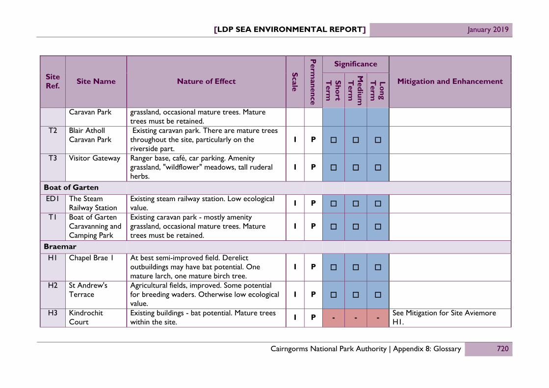
[LDP SEA ENVIRONMENTAL REPORT] January 2019
Cairngorms National Park Authority | Appendix 8: Glossary 720
Site Ref. Site Name Nature of Effect
Scale
Perm
anence
Significance
Mitigation and Enhancement Short T
erm
Medium
T
erm
Long T
erm
Caravan Park grassland, occasional mature trees. Mature trees must be retained.
T2 Blair Atholl Caravan Park
Existing caravan park. There are mature trees throughout the site, particularly on the riverside part.
I P
T3 Visitor Gateway Ranger base, café, car parking. Amenity grassland, "wildflower" meadows, tall ruderal herbs.
I P
Boat of Garten ED1 The Steam
Railway Station Existing steam railway station. Low ecological value. I P
T1 Boat of Garten Caravanning and Camping Park
Existing caravan park - mostly amenity grassland, occasional mature trees. Mature trees must be retained.
I P
Braemar H1 Chapel Brae 1 At best semi-improved field. Derelict
outbuildings may have bat potential. One mature larch, one mature birch tree.
I P
H2 St Andrew's Terrace
Agricultural fields, improved. Some potential for breeding waders. Otherwise low ecological value.
I P
H3 Kindrochit Court
Existing buildings - bat potential. Mature trees within the site. I P - - - See Mitigation for Site Aviemore
H1.

[LDP SEA ENVIRONMENTAL REPORT] January 2019
Cairngorms National Park Authority | Appendix 8: Glossary 721
Site Ref. Site Name Nature of Effect
Scale
Perm
anence
Significance
Mitigation and Enhancement Short T
erm
Medium
T
erm
Long T
erm
H4 Chapel Brae 2 Side from the woodland, which could be avoided, the only potential constraint could be waxcap fungi – a visit to the site in September/October could indicate if waxcap fungi are present (though ideally a couple of seasons are needed to assess this adequately). Larch bolete observed (common species) indicating that soils are intact. The grassland is attractive in that it is flower rich, but the species composition is of common, widespread species typical of semi-improved neutral sites. The habitat is of local value only. Not enough structural diversity to be of significant interest for rare invertebrates. Potential for reptiles (common lizard) but a small population if any. There is the potential for negative effects on the River Dee SAC (there appears to be watercourse connectivity to the SAC so pollution may affect water quality.
I P - - -
See Mitigation for Site Aviemore H1.
H5 North Braemar Currently no ecological constraints, although grassland, management does not favour waders but fields could be used at other times of year by waders, or if management changed to pastoral rather than hay/silage. Opportunity for tree planting particularly on the eastern
I P - - -
See Mitigation for Site Aviemore H1.

[LDP SEA ENVIRONMENTAL REPORT] January 2019
Cairngorms National Park Authority | Appendix 8: Glossary 722
Site Ref. Site Name Nature of Effect
Scale
Perm
anence
Significance
Mitigation and Enhancement Short T
erm
Medium
T
erm
Long T
erm
side, to enhance the existing birch woodland on the slope above. Some concern for River Dee GWDTE SAC (Clunie Water) which is <250m to the West.
ED1 Ambulance Station
Derelict workshops and "Braemar depot". Bat roost potential. Some tall ruderal herbs and scrub. Mitigation and compensation should be possible.
I P
ED2 The Mews Existing tourist facility - buildings and square. Buildings have bat potential. Mitigation and compensation should be possible.
I P
T1 Braemar Caravan Park
The site should pose no significant ecological problems as long as existing trees are retained and impacts to the burn/drain on north side of the site are avoided. A HRA may be required as the site has connectivity to the River Dee SAC via the burn but if impacts are minimised there should be no Likely Significant Effect.
I P
Carr - Bridge H1 Carr Road Some concern because River Spey GWDTE
SAC is less 250m to the North. Care will need to be taken during construction phase.
I P
H2 Crannich Park Site includes semi-natural wetland habitats, including those associated with deep peat. I P - - - See Mitigation for Site Aviemore
H1. ED1 Land at Railway Mosaic of semi-natural habitats, formed since I P -- -- --

[LDP SEA ENVIRONMENTAL REPORT] January 2019
Cairngorms National Park Authority | Appendix 8: Glossary 723
Site Ref. Site Name Nature of Effect
Scale
Perm
anence
Significance
Mitigation and Enhancement Short T
erm
Medium
T
erm
Long T
erm
Station the site was abandoned. Early successional woodland, grassland, heathland, woodland (including AWI) and bare ground habitat. Some concern because River Spey GWDTE SAC is less 250m away. Care will need to be taken during construction phase.
ED2 Carr-Bridge Garage
Existing petrol station and garage. Low ecological value (including low bat potential). I P
ED3 Former Saw Mill The old sawmill site itself has only recently been cleared and become disused and as such has had little time to develop ecological value. The western blocks beside the A9 have been derelict for longer and have had more time to develop scrub and young trees and successional vegetation. Invertebrate surveys would be required for these areas but not for the sawmill area. The woodland belts that intersect the site (shown on cover sheet) should be removed from the allocation. Significance of effect would depend on outcome of reptile survey. Reptile survey would be required for the whole site. Bat roost assessment and breeding bird assessment required for the remaining buildings within the sawmill site.
I P ? ? ?

[LDP SEA ENVIRONMENTAL REPORT] January 2019
Cairngorms National Park Authority | Appendix 8: Glossary 724
Site Ref. Site Name Nature of Effect
Scale
Perm
anence
Significance
Mitigation and Enhancement Short T
erm
Medium
T
erm
Long T
erm
T1 Landmark Forest Adventure Park
The existing theme park is surrounded by Ancient Woodland of high quality. Semi-natural Scots pine woodland with occasional stands of lodgepole. Good ground flora. Likely to support protected mammals (pine marten, red squirrel). Supports wood ants. Flora and fungi interest likely to be high.
I P -- -- --
Cromdale H1 Kirk Road Agricultural - arable. Low ecological value. I P H2 Auchroisk Park Rough grassland, semi-improved and species
poor. Low ecological value. I P
ED1 The Smoke House
Existing workshops/out buildings. Bat potential, but mitigation and compensation should be possible.
I P
Dulnain Bridge H1 Land west of
play area Grassland - pastoral, with clumps of Scots pine. Wet/marshy area in centre of site where field drains collect. Previous Phase 1 Habitat Survey found grassland to be species rich (was grazed by horses at the time). Potential to support invertebrates such as Andrena marginata (CNAP species) but further survey work needed to determine. Some concern that River Dulnain (R. Spey GWDTE SAC) is less than
I P - - -
See Mitigation for Site Aviemore H1.

[LDP SEA ENVIRONMENTAL REPORT] January 2019
Cairngorms National Park Authority | Appendix 8: Glossary 725
Site Ref. Site Name Nature of Effect
Scale
Perm
anence
Significance
Mitigation and Enhancement Short T
erm
Medium
T
erm
Long T
erm
250m to the North. H2 Land adjacent to
A938 Partially wooded with Scots pine and broadleaves, remainder is tall ruderal herbs. Some concern that River Dulnain (R. Spey GWDTE SAC) is less than 250m to the south.
I P - - -
See Mitigation for Site Aviemore H1.
ED1 Dulnain Garage Existing garage - no ecological value (low bat potential). I P
Kincraig H1 Land Opposite
School Pasture (species poor) with cluster of mature trees in south-east corner. Wet/marshy grassland habitat in low lying areas. Good design to avoid impacts to wet habitat and trees. Some concern that River Dulnain (R. Spey GWDTE SAC) is less than 250m to the North.
I P
ED1 Baldow Smiddy Existing garage - no ecological value (low bat potential). Mature trees on southern boundary to be retained. Potential drainage to Insh Marches.
I P
ED2 Land north of B9152
Ecological impact likely to be low, particularly if woodland is removed from allocation. A survey for breeding waders required as full planning application stage
I P
Nethy Bridge

[LDP SEA ENVIRONMENTAL REPORT] January 2019
Cairngorms National Park Authority | Appendix 8: Glossary 726
Site Ref. Site Name Nature of Effect
Scale
Perm
anence
Significance
Mitigation and Enhancement Short T
erm
Medium
T
erm
Long T
erm
H1 Land at Lynstock Crescent
Agricultural ground currently grazed by cattle, good stocking density which allows retention of species rich margins to the field. Pine marten, otter, water vole, red squirrel, badgers within 200m of the site boundary. Potentially a species rich grassland supporting a good range of plants and fungi, 30% of the site within the 1:200 flood envelope. Required to provide further information: NVC, Protected species survey, fungi survey. The site adjoins the River Nethy which is a tributary of the River Spey SAC.
I P - - -
See Mitigation for Site Aviemore H1.
H2 Lettoch Road Historically grazed field which is regenerating with scots Pine, broom, alder and birch. This site is within the riparian corridor of the River Nethy which is frequently used by otters, The river is also a tributary of the River Spey SAC. Daubenton’s bats and riverine birds including dipper. Extended Phase I including assessment for potential to support protected species should be undertaken on site and for a 200m radius around the site concentrating on the river corridor.
I P - - -
See Mitigation for Site Aviemore H1.
Tomintoul

[LDP SEA ENVIRONMENTAL REPORT] January 2019
Cairngorms National Park Authority | Appendix 8: Glossary 727
Site Ref. Site Name Nature of Effect
Scale
Perm
anence
Significance
Mitigation and Enhancement Short T
erm
Medium
T
erm
Long T
erm
H1 Conglass Lane Grassland - pasture. Potential for breeding waders (local area known to be important for waders). Could also be knock on effects to neighbouring fields if this site is developed. Mitigation would be required.
I P
H2 Lecht Drive Grassland - pasture. Potential for breeding waders (local area known to be important for waders). Could also be knock on effects to neighbouring fields if this site is developed. Mitigation would be required.
I P
ED1 Garage North East
Existing garage, hard standing, building (low bat potential). Tree planting (mostly Scots pine, some sycamore, spruce) on roadside approximately 50% of site. Poor woodland understory, relatively low ecological value.
I P
ED2 Land by A939 Existing developed area (fire station, council depot) is of low ecological value. Remaining open space - pastoral fields - likely to be high value for waders.
I P - - -
See Mitigation for Site Aviemore H1.
T1 Land to the South West
The site is currently used as a campsite with associated landscaping which is designed to support biodiversity.
I P
Rural Settlement

[LDP SEA ENVIRONMENTAL REPORT] January 2019
Cairngorms National Park Authority | Appendix 8: Glossary 728
Site Ref. Site Name Nature of Effect
Scale
Perm
anence
Significance
Mitigation and Enhancement Short T
erm
Medium
T
erm
Long T
erm
Calvine C1 Old School Former school - potential to support bats and
breeding birds. Mitigation & compensation should be possible.
I P
Dalwhinnie H1 Land by garage Grassland - pastoral. Likely to be wet in places.
Potential for waders. Otherwise low ecological value.
I P - - - See Mitigation for Site Aviemore H1.
ED1 Garage Site Existing petrol station. Some bat potential in building, but otherwise no ecological value. Scope for ecological enhancement with good design.
I P + + +
Dinnet H1 Land to East Development of this site would result in the
loss of mature semi-natural woodland of ecological value. Mitigation restricted as site is entirely wooded, off-site compensation would be required to replace lost habitat.
I P - - -
See Mitigation for Site Aviemore H1.
ED1 Former Steading The main ecological constraints are bats primarily, and also breeding hirundines (swallows, swifts and house martins). Retain mature trees on NE side.
I P
Glenmore

[LDP SEA ENVIRONMENTAL REPORT] January 2019
Cairngorms National Park Authority | Appendix 8: Glossary 729
Site Ref. Site Name Nature of Effect
Scale
Perm
anence
Significance
Mitigation and Enhancement Short T
erm
Medium
T
erm
Long T
erm
T1 Glenmore Camp Site
There are mature trees on site and it is partially occupied by ancient woodland, though this is heavily used by visitors to the area and customers of the caravan site. It is also located within an area of high sensitivity, being surrounded by the Cairngorms SAC. The use of the site is already well established.
I P
T2 Glenmore Lodge There are mature trees on site and it is partially occupied by ancient woodland. The majority of the site is however already built and is heavily used by its current use. The site is also located within an area of high sensitivity, being surrounded by the Cairngorms SAC. Additional effects, positive or negative, are unlikely.
I P
Inverdruie and Coylumbridge T1 Camping Site The site includes Ancient Woodland, though
the quality of this is affected by the site's use as a camping site.
I P -- -- -- See Mitigation for Site Aviemore H1.
Laggan

[LDP SEA ENVIRONMENTAL REPORT] January 2019
Cairngorms National Park Authority | Appendix 8: Glossary 730
Site Ref. Site Name Nature of Effect
Scale
Perm
anence
Significance
Mitigation and Enhancement Short T
erm
Medium
T
erm
Long T
erm
H1 Land adjacent to Achduchil, Laggan
The site has been subject to commercial forestry management and has a mix of habitats – dense thicket stage commercial spruce, wet heath/grass, planted Scots pine, natural regenerating birch, willow and pine plus scrub and tall ruderal vegetation. The site has wet habitats and watercourses which could make development of parts of the site tricky in terms of drainage. On drier parts of the site, there is a mix of semi-natural woodland habitats ranging from mature Scots pine to scrub and regenerating broadleaves and pine. The site offers habitat for a wide range of protected species and would also require assessment for Ground Water dependent Terrestrial Ecosystems. The site is also in close proximity to the River Mashie, which is a tributary to River Spey SAC.
I P - - -
See Mitigation for Site Aviemore H1.

[LDP SEA ENVIRONMENTAL REPORT] January 2019
Cairngorms National Park Authority | Appendix 8: Glossary 731

[LDP SEA ENVIRONMENTAL REPORT] January 2019
Cairngorms National Park Authority | Appendix 8: Glossary 732
Site Ref. Site Name Nature of Effect
Scale
Perm
anence
Significance
Mitigation and Enhancement Short T
erm
Medium
T
erm
Long T
erm
Strategic Centres
Aviemore H1 Dalfaber 1 No site specific effects. I P H2 Dalfaber 2 No site specific effects. I P M1 Aviemore
Highland Resort The site contains TPOs, mosaic and riparian woodland. Some of this is likely to be lost thought development.
I P - - -
Ecological appraisals have been carried out and have been used to inform the choice of allocations and the mitigation that may be applied to limit any negative effects they may have on woodlands. Policy 4, which applies to all development seeks to reduce any negative effects on biodiversity as a whole, with Policy 4.4 specifically seeking to avoid the loss of woodland habitats, including areas identified on the AWI.
M2 Laurel Bank No site specific effects. I P C1 Land on
Dalfaber Drive No site specific effects. I P
C2 Former School Playing Fields
No site specific effects. I P
C3 Land South of Dalfaber Drive
Good habitats of birch woodland and heath. I P

[LDP SEA ENVIRONMENTAL REPORT] January 2019
Cairngorms National Park Authority | Appendix 8: Glossary 733
Site Ref. Site Name Nature of Effect
Scale
Perm
anence
Significance
Mitigation and Enhancement Short T
erm
Medium
T
erm
Long T
erm
ED1 Dalfaber Industrial Estate
No site specific effects. I P
ED2 Myrtlefield Industrial Estate
No site specific effects. I P
ED3 Granish Around 15% of the site is identified as ancient woodland. I P -- -- -- See Mitigation for Site Aviemore
M1. ACM An Camas Mòr Around 50% of the site is wooded. Of this
woodland, around 50% has been identified as being ancient.
I P -- -- -- See Mitigation for Site Aviemore M1.
LTH1 North Aviemore 1
A good woodland corridor along the A9 and western edge of the site I P - - - See Mitigation for Site Aviemore
M1. LTH2 North Aviemore
2 Mature trees exist on site, however theoretically these could be retained as part of a development, The overall effects are therefore uncertain as it depends on the nature of the development proposed.
I P ? ? ?
See Mitigation for Site Aviemore M1.
Ballater H1 Monaltrie Park No site specific effects. I P C1 Former School
Site No site specific effects. I P
ED1 Ballater Business Park
No site specific effects. I P
T1 Ballater Caravan Park
No site specific effects. I P

[LDP SEA ENVIRONMENTAL REPORT] January 2019
Cairngorms National Park Authority | Appendix 8: Glossary 734
Site Ref. Site Name Nature of Effect
Scale
Perm
anence
Significance
Mitigation and Enhancement Short T
erm
Medium
T
erm
Long T
erm
Grantown-on-Spey H1 Beachen Court No site specific effects. I P H2 Castle Road There are patches of woodland and mature
trees on site. I P - - - See Mitigation for Site Aviemore M1.
C1 Mossie Road No site specific effects. I P C2 Strathspey
Railway extension
No site specific effects. I P
ED1 Woodlands Industrial Estate
No site specific effects. I P
T1 Grantown Caravan Park
Around 15% of the site is identified as ancient woodland. I P -- -- -- See Mitigation for Site Aviemore
M1. Kingussie H1 Land between
Ardbroilach Road and Crag an Darach
No site specific effects.
I P
C1 Ardovnie Car Park
No site specific effects. I P
C2 Car Park No site specific effects. I P C3 Am Fasgadh No site specific effects. I P C4 Car Park No site specific effects. I P � � � ED1 Council Depot No site specific effects. I P ED2 McCormack's No site specific effects. I P

[LDP SEA ENVIRONMENTAL REPORT] January 2019
Cairngorms National Park Authority | Appendix 8: Glossary 735
Site Ref. Site Name Nature of Effect
Scale
Perm
anence
Significance
Mitigation and Enhancement Short T
erm
Medium
T
erm
Long T
erm
Garage T1 Kingussie Golf
Club No site specific effects. I P
Newtonmore H1 Land between
Perth Road and Station Road
No site specific effects. I P
ED1 Rear of Café No site specific effects. I P ED2 Industrial Park No site specific effects. I P T1 Highland Folk
Museum No site specific effects. I P
Intermediate Settlements
Blair Atholl H1 Land between
Bridge of Tilt and Old Bridge of Tilt
No site specific effects.
I P
H2 Land Opposite Tilt Hotel
No site specific effects. I P
ED1 Blair Atholl Saw Mill Yard
No site specific effects. I P
T1 Blair Castle Caravan Park
No site specific effects. I P
T2 Blair Atholl The site contains two large areas identified as I P -- -- -- See Mitigation for Site Aviemore

[LDP SEA ENVIRONMENTAL REPORT] January 2019
Cairngorms National Park Authority | Appendix 8: Glossary 736
Site Ref. Site Name Nature of Effect
Scale
Perm
anence
Significance
Mitigation and Enhancement Short T
erm
Medium
T
erm
Long T
erm
Caravan Park Ancient woodland. This equates to around 20% of the site area.
M1.
T3 Visitor Gateway No site specific effects. I P Boat of Garten ED1 The Steam
Railway Station No site specific effects. I P
T1 Boat of Garten Caravanning and Camping Park
No site specific effects. I P
Braemar H1 Chapel Brae 1 No site specific effects. I P H2 St Andrew's
Terrace No site specific effects. I P
H3 Kindrochit Court
No site specific effects. I P
H4 Chapel Brae 2 There are patches of woodland and mature trees on site. Some concern for River Dee GWDTE SAC (Clunie Water) which is <250m to the West.
I P - - -
See Mitigation for Site Aviemore M1.
H5 North Braemar No site specific effects. I P ED1 Ambulance
Station No site specific effects. I P
ED2 The Mews No site specific effects. I P T1 Braemar No site specific effects. I P

[LDP SEA ENVIRONMENTAL REPORT] January 2019
Cairngorms National Park Authority | Appendix 8: Glossary 737
Site Ref. Site Name Nature of Effect
Scale
Perm
anence
Significance
Mitigation and Enhancement Short T
erm
Medium
T
erm
Long T
erm
Caravan Park Carr - Bridge H1 Carr Road No site specific effects. I P H2 Crannich Park No site specific effects. I P ED1 Land at Railway
Station Around 50% of the site is identified an ancient woodland. I P -- -- -- See Mitigation for Site Aviemore
M1. ED2 Carr-Bridge
Garage No site specific effects. I P
ED3 Former Saw Mill No site specific effects. I P T1 Landmark Forest
Adventure Park Around 95% of the site is identified on the Ancient Woodland Inventory, though most of this is already currently use by Landmark Forest Park, while the extended area is of relatively low value.
I P -- -- --
See Mitigation for Site Aviemore M1.
Cromdale H1 Kirk Road No site specific effects. I P H2 Auchroisk Park No site specific effects. I P ED1 The Smoke
House No site specific effects. I P
Dulnain Bridge H1 Land west of
play area No site specific effects. I P
H2 Land adjacent to A938
No site specific effects. I P

[LDP SEA ENVIRONMENTAL REPORT] January 2019
Cairngorms National Park Authority | Appendix 8: Glossary 738
Site Ref. Site Name Nature of Effect
Scale
Perm
anence
Significance
Mitigation and Enhancement Short T
erm
Medium
T
erm
Long T
erm
ED1 Dulnain Garage No site specific effects. I P Kincraig H1 Land Opposite
School No site specific effects. I P
ED1 Baldow Smiddy No site specific effects. I P ED2 Land north of
B9152 There is a small area of woodland along the site's southern boundary. I P
Nethy Bridge H1 Land at Lynstock
Crescent No site specific effects. I P
H2 Lettoch Road This historically grazed field is regenerating with scots Pine, broom, alder and birch now present.
I P - - - See Mitigation for Site Aviemore M1.
Tomintoul H1 Conglass Lane No site specific effects. I P H2 Lecht Drive No site specific effects. I P ED1 Garage North
East No site specific effects. I P
ED2 Land by A939 No site specific effects. I P T1 Land to the
South West Loss of trees for pitches has already been compensated. Woodland is of limited ecological value.
I P
Rural Settlement

[LDP SEA ENVIRONMENTAL REPORT] January 2019
Cairngorms National Park Authority | Appendix 8: Glossary 739
Site Ref. Site Name Nature of Effect
Scale
Perm
anence
Significance
Mitigation and Enhancement Short T
erm
Medium
T
erm
Long T
erm
Calvine C1 Old School No site specific effects. I P
Dalwhinnie H1 Land by garage No site specific effects. I P ED1 Garage Site No site specific effects. I P
Dinnet H1 Land to East Although not listed on the index, development
of this site would result in the loss of mature semi-natural woodland of ecological value.
I P - - - See Mitigation for Site Aviemore M1.
ED1 Former Steading No site specific effects. I P Glenmore
T1 Glenmore Camp Site
Around 20% of the site is identified an ancient woodland. However, the nature of the existing use and purpose of the allocation means negative effects are unlikely.
I P
T2 Glenmore Lodge Around 10% of the site is identified an ancient woodland. However, the nature of the existing use and purpose of the allocation means negative effects are unlikely.
I P
Inverdruie and Coylumbridge T1 Camping Site Around 80% of the site is identified as semi-
natural ancient woodland om the inventory. I P -- -- -- See Mitigation for Site Aviemore M1.

[LDP SEA ENVIRONMENTAL REPORT] January 2019
Cairngorms National Park Authority | Appendix 8: Glossary 740
Site Ref. Site Name Nature of Effect
Scale
Perm
anence
Significance
Mitigation and Enhancement Short T
erm
Medium
T
erm
Long T
erm
Laggan H1 Land adjacent to
Achduchil, Laggan
The site has been subject to commercial forestry management and has a mix of habitats – dense thicket stage commercial spruce, wet heath/grass, planted Scots pine, natural regenerating birch, willow and pine plus scrub and tall ruderal vegetation.
I P - - -
See Mitigation for Site Aviemore M1.

[LDP SEA ENVIRONMENTAL REPORT] January 2019
Cairngorms National Park Authority | Appendix 8: Glossary 741

[LDP SEA ENVIRONMENTAL REPORT] January 2019
Cairngorms National Park Authority | Appendix 8: Glossary 742
Site Ref. Site Name Nature of Effect
Scale
Perm
anence
Significance
Mitigation and Enhancement Short T
erm
Medium
T
erm
Long T
erm
Strategic Centres
Aviemore H1 Dalfaber 1 Former farm steading and associated fields.
Important woodland which 'buffers' this site from nearby extensive housing development. High quality views to Cairngorm massif.
N P
H2 Dalfaber 2 Remnant woodland with good semi-open understory. Edge of settlement location. Could have some minor adverse effects. The site contains a record on the Sites and Monuments Record, described as cropmarks from an unknown period.
N P - - -
Landscape appraisals have been carried out and have been used to inform the choice of allocations and the mitigation that may be applied to limit any negative effects they may have on the special qualities of the National Park.
As the overarching strategy for policy within the National Park the NPPP offers a means of mitigation that would need to be incorporated within the Proposed LDP. NPPP Policy 1.3 seeks to ensure that the management of the National Park results in the conservation and

[LDP SEA ENVIRONMENTAL REPORT] January 2019
Cairngorms National Park Authority | Appendix 8: Glossary 743
Site Ref. Site Name Nature of Effect
Scale
Perm
anence
Significance
Mitigation and Enhancement Short T
erm
Medium
T
erm
Long T
erm
enhancement of the National Park’s special qualities.
Within the LDP itself, Policy 5 aims to ensure that the impact of development on landscape will be limited and where possible contribute to its enhancement. Additionally Policy 4 and Policy and 8 offer synergistic effects as habitat mitigation and compensation and the protection and creation of open spaces can contribute positively to landscape quality.
With respect to the historic environment, Policy 9 provides the primary means of avoiding negative effects, with:
9.1 dealing with the potential effects on listed buildings;

[LDP SEA ENVIRONMENTAL REPORT] January 2019
Cairngorms National Park Authority | Appendix 8: Glossary 744
Site Ref. Site Name Nature of Effect
Scale
Perm
anence
Significance
Mitigation and Enhancement Short T
erm
Medium
T
erm
Long T
erm
9.2 dealing with the potential effects on cultural and historic designations such as scheduled monuments, inventory battlefield sites and designed gardens and landscapes
9.3 dealing with the potential effects on conservation areas; and
9.4 dealing with the potential effects on all other heritage assets, including those identified on the Sites and Monuments and Records.
Policy 3 also plays an important role in not only avoiding negative effects, but also delivering enhancements. Specifically:
3.1 requires all

[LDP SEA ENVIRONMENTAL REPORT] January 2019
Cairngorms National Park Authority | Appendix 8: Glossary 745
Site Ref. Site Name Nature of Effect
Scale
Perm
anence
Significance
Mitigation and Enhancement Short T
erm
Medium
T
erm
Long T
erm
developments to meet the six qualities of successful places;
3.2 requires all major developments to be subject to masterplans or development briefs, meaning that opportunities can be taken at a strategic level to manage the effects of development on landscape quality and heritage assets
3.3 requires development to meet a variety of tests, including that development be sympathetic to the traditional pattern and character of the surrounding area, use materials and landscaping that complement the setting of the development and

[LDP SEA ENVIRONMENTAL REPORT] January 2019
Cairngorms National Park Authority | Appendix 8: Glossary 746
Site Ref. Site Name Nature of Effect
Scale
Perm
anence
Significance
Mitigation and Enhancement Short T
erm
Medium
T
erm
Long T
erm
improve or add to existing public and amenity open space.
Where necessary, landscaping requirements have been highlighted in the Site information of the LDP.
M1 Aviemore Highland Resort
The site is dominated by its existing use, with the existing hotel buildings intruding into the landscape and visible form many receptors in the area. There are areas within the site that have mature trees that contribute positively to the site's sense of place, while areas of woodland bound the site on it western edge. The centre of the site is occupied by previously developed land that is currently used for overflow parking and is of low landscape quality. There are several sites on the Sites and Monuments Record within the site’s boundary, namely:
The Aviemore Centre The Aviemore Centre - Artificial Ski
Slope The Aviemore Centre – Swimming Pool
N P + + +

[LDP SEA ENVIRONMENTAL REPORT] January 2019
Cairngorms National Park Authority | Appendix 8: Glossary 747
Site Ref. Site Name Nature of Effect
Scale
Perm
anence
Significance
Mitigation and Enhancement Short T
erm
Medium
T
erm
Long T
erm
The Aviemore Centre - Ice Rink The Aviemore Centre- Freedom Inn The Aviemore Centre – Go Cart Track The Aviemore Centre – District
Heating Plant The Aviemore Centre – Aviemore
Chalets Hotel The Aviemore Centre – Post House
Hotel The Four Seasons Hotel
Consideration needs to be given to the site's heritage assets, however it is likely that the redevelopment of the site could result in improvements to the area's landscape.
M2 Laurel Bank Site on elevated west side of Grampian road, includes Laurel bank, Victorian villa and gardens. The elevation gives some fine views to cairngorm massif. Design and layout to reflect orientation of other buildings on west side Grampian road. The site has potential to help people ‘engage with their landscape, car parking on the site should be restricted in favour of other uses. Significance of effect would depend on nature of proposal.
N P

[LDP SEA ENVIRONMENTAL REPORT] January 2019
Cairngorms National Park Authority | Appendix 8: Glossary 748
Site Ref. Site Name Nature of Effect
Scale
Perm
anence
Significance
Mitigation and Enhancement Short T
erm
Medium
T
erm
Long T
erm
C1 Land on Dalfaber Drive
Part-developed site (air cadets building), remainder of site regenerating woodland (some quite large trees pine, birch, rowan), rank grassland/RB willow herb and broom. Providing the larger trees can be retained and amenity of nearby residents protected the site would be suitable for development. Significance of effect would depend on nature of proposal.
N P
C2 Former School Playing Fields
Site is remnant playground that floods regularly. The former school is recorded on the Sites and Monuments Record. Any potential uses are unlikely to have adverse effects.
N P
C3 Land South of Dalfaber Drive
a wedge of heath and open woodland that penetrates into heart of the settlement. Borders both mainline railway and strathspey railway. The open woodland experience from these railway lines should be retained
N P
ED1 Dalfaber Industrial Estate
existing industrial estate, no specific landscape effects N P + + +
ED2 Myrtlefield Industrial Estate
Existing industrial estate of little landscape value. The site is however adjacent to Aviemore Railway Station Signal Box, which is a Category B listed building and contains within its boundary, while within its boundary, the Myrtlefield Shopping Centre is listed on the
N P

[LDP SEA ENVIRONMENTAL REPORT] January 2019
Cairngorms National Park Authority | Appendix 8: Glossary 749
Site Ref. Site Name Nature of Effect
Scale
Perm
anence
Significance
Mitigation and Enhancement Short T
erm
Medium
T
erm
Long T
erm
Sites and Monuments Record.
ED3 Granish Existing industrial estate, no specific landscape effects, though development should ensure that trees are retained to ensure that development is shielded from surrounding views.
N P - - -
See Mitigation for Site Aviemore H2.
ACM An Camas Mòr Owing to the site's scale the effects of the proposal are likely to be significantly adverse in the short to medium term. The site is close to Scheduled Monument SM9337 (Rothiemurchus, palisaded enclosure to NW of Dell Farm) and will need to take account of its setting and the possibly of other archaeological remains existing within its development area.
N P -- -- --
See Mitigation for Site Aviemore H2.
LTH1 North Aviemore 1
Characterised by grazed pasture, rough grassland, heath, open birch and woodland. Site bisected by burn. The northern edge is key to setting and amenity of Aviemore and it provides a buffer between Aviemore environs and the A9. The site contains two sites listed on the Sites and Monuments Record, namely Sluggangranish Farmstead and Easter Aviemore Kiln barn, rig and barrow and township.
N P - - -
See Mitigation for Site Aviemore H2.
LTH2 North Aviemore 2
Pasture fields articulate around stands of mature trees on glacio-fluvial knolls. Great N P - - - See Mitigation for Site Aviemore
H2.

[LDP SEA ENVIRONMENTAL REPORT] January 2019
Cairngorms National Park Authority | Appendix 8: Glossary 750
Site Ref. Site Name Nature of Effect
Scale
Perm
anence
Significance
Mitigation and Enhancement Short T
erm
Medium
T
erm
Long T
erm
views across this area to Cairngorm Massif from B9152. Provides high quality setting to Aviemore. Retain and enhance wooded knolls. Retain open views to Cairngorms.
Ballater H1 Monaltrie Park This site is highly visible in views from the
north. Strong green structure throughout site necessary to conserve and enhance the character and SLQs of the strath and to avoid development appearing detached from settlement. The NW area of species rich grassland and parkland style planting contributes to the setting of Monaltrie house and the diversity of accessible green spaces along the settlement edge.
N P
C1 Former School Site
The old school buildings, which are now in a derelict state and on the Buildings at Risk Register, are Category C listed buildings. There is however scope for redevelopment consistent with conservation area designation and character of former school.
N P + + +
ED1 Ballater Business Park
Existing industrial estate. Scope for enhancement with good design. Retain roadside trees.
N P + + +
T1 Ballater Caravan Existing caravan park. Opportunities for N P

[LDP SEA ENVIRONMENTAL REPORT] January 2019
Cairngorms National Park Authority | Appendix 8: Glossary 751
Site Ref. Site Name Nature of Effect
Scale
Perm
anence
Significance
Mitigation and Enhancement Short T
erm
Medium
T
erm
Long T
erm
Park landscape and flood enhancement by native tree planting.
Grantown-on-Spey H1 Beachen Court Pastoral area with some areas species rich,
small stand of aspens along dry stane dyke. Scope for enhancement with good design
N P + + +
H2 Castle Road Open grassland site immediately adjacent to the settlement, edged by the hospital and scattered birch woodland and mature pine plantations. A continuation of the open pasture fields that run round this side of Grantown to Seaforth Ave. along the foot of the steeply rising wooded slopes of Dreggie. Site overlooked from these slopes and old railway, but otherwise quite enclosed. Scope for partial development of site without serious impacts on landscape character.
N P - - -
See Mitigation for Site Aviemore H2.
C1 Mossie Road Site is characterised by a pasture field, easy access site and adjacent to play area. Offers scope for community development, built development and/or green infrastructure without impacting upon settlement edge.
N P
C2 Strathspey Railway extension
Site is characterised by a pasture field, easy access site and adjacent to development area. Offers scope for community development, built
N P

[LDP SEA ENVIRONMENTAL REPORT] January 2019
Cairngorms National Park Authority | Appendix 8: Glossary 752
Site Ref. Site Name Nature of Effect
Scale
Perm
anence
Significance
Mitigation and Enhancement Short T
erm
Medium
T
erm
Long T
erm
development and/or green infrastructure without impacting upon settlement edge.
ED1 Woodlands Industrial Estate
Existing industrial estate associated with former railway line and station. There are two Sites and Monuments Records within the site's boundary, namely Grantown-On-Spey Railhead Military Depot and the west station. There is scope for enhancement tree planting throughout the area.
N P + + +
T1 Grantown Caravan Park
The site occupies a prominent location between the edge of the settlement and the old railway line. Mature pines on the face of the slope below the railway line are an important part of the backdrop and setting for the town and contribute to its special landscape qualities. The old railway is popular for local recreation and is a LDR, views from here look directly down on to the development site.
N P -- -- --
See Mitigation for Site Aviemore H2.
Kingussie H1 Land between
Ardbroilach Road and Crag an Darach
Site is characterised by semi-improved fields. Landscape character to be conserved and enhanced over time, by including a strong woodland infrastructure as part of any proposals
N P
C1 Ardovnie Car Ardvonie car park. Potential to enhance quality N P

[LDP SEA ENVIRONMENTAL REPORT] January 2019
Cairngorms National Park Authority | Appendix 8: Glossary 753
Site Ref. Site Name Nature of Effect
Scale
Perm
anence
Significance
Mitigation and Enhancement Short T
erm
Medium
T
erm
Long T
erm
Park of car park and surrounds - main central public car park
C2 Car Park Mart car park. No site specific landscape effects N P C3 Am Fasgadh C3 west of railway - grassland and trees. C3
east of railway - industrial/waste site. Mature trees to be retained. Significant potential to enhance landscape quality and access experience. There are several sites on the National Monuments Record within the site’s boundary, which are all associated with its former use as the Highland Folk Museum, namely:
Highway Folk Museum Pitmain House, which is a Category C
listed building MacRobert House, which is a Category
C listed building The site is also adjacent to St. Columba’s Church, St. Columba’s Church Burial Ground and Gate Piers, which are also Category B listed buildings.
N P
C4 Car Park The site's use and proposed retention as a car park means that there will be little negative N P

[LDP SEA ENVIRONMENTAL REPORT] January 2019
Cairngorms National Park Authority | Appendix 8: Glossary 754
Site Ref. Site Name Nature of Effect
Scale
Perm
anence
Significance
Mitigation and Enhancement Short T
erm
Medium
T
erm
Long T
erm
effects, particularly as the surrounding trees and buildings shield it from the surrounding landscape.
ED1 Council Depot Transport Scotland depot, hard standings, large nissen sheds, open storage. Opportunities for enhancing this site especially in views from the main railway line
N P + + +
ED2 McCormack's Garage
Site is occupied by a garage and hard standing. Opportunities for enhancing this site especially in views from the main railway line.
N P + + +
T1 Kingussie Golf Club
Trees within and immediately south of the caravan site are key to reducing visual impact from surrounding areas and from access routes. These trees and related ground flora should be retained and supplemented where possible. The Clubhouse is on the Sites and Monuments Record.
N P - - -
See Mitigation for Site Aviemore H2.
Newtonmore H1 Land between
Perth Road and Station Road
Open strath. Improved grassland fields. This openness emphasises the edge of the settlement. Site is prominent in views from the B9150, the main railway line and station road. Housing in this area occupies the raised river terrace and is set amongst mature trees. A strong landscape structure of woodland
N P - - -
See Mitigation for Site Aviemore H2.

[LDP SEA ENVIRONMENTAL REPORT] January 2019
Cairngorms National Park Authority | Appendix 8: Glossary 755
Site Ref. Site Name Nature of Effect
Scale
Perm
anence
Significance
Mitigation and Enhancement Short T
erm
Medium
T
erm
Long T
erm
planting and open space would be necessary to screen development, create a new settlement edge, reduce adverse impacts on the character and experience of the Newtonmore, and protect the setting.
ED1 Rear of Café Existing lorry park, recycling area and adjacent pasture. Proposals here should include tree planting to screen development and strengthen the immediate settlement edge.
N P
ED2 Industrial Park Existing industrial site and part of adjacent field. Field very visible from main railway line. Industrial/economic type development in field would adversely affect the character and experience of this side of Newtonmore. Development outwith the current industrial estate would need to be accompanied by substantial areas of tree planting to screen buildings/storage areas etc. and create a high quality landscape setting.
N P
T1 Highland Folk Museum
Site is currently in use and this use is unlikely to result in negative effects. The sites use means that it contains many historic buildings, a number of which are on the Sites and Monuments Record, though these are of course there to be preserved.
N P

[LDP SEA ENVIRONMENTAL REPORT] January 2019
Cairngorms National Park Authority | Appendix 8: Glossary 756
Site Ref. Site Name Nature of Effect
Scale
Perm
anence
Significance
Mitigation and Enhancement Short T
erm
Medium
T
erm
Long T
erm
Intermediate Settlements
Blair Atholl H1 Land between
Bridge of Tilt and Old Bridge of Tilt
The site is located outwit the settlement but close to an existing group of houses. It is a large field within the designed landscape type area. Any development ought to be closely related to the existing housing to give it proper context and limit the intrusion into the landscape.
N P - - -
See Mitigation for Site Aviemore H2.
H2 Land Opposite Tilt Hotel
This is a prominent site on the entrance to the village. The visual settlement boundary is clearly defined by the wall and the trees, including the avenue. This proposal would therefore be beyond this line. Building on the southern area is likely to intrude into the view across the designed landscape. This is an important view for the area and establishes an important relationship between the distinctive designed landscape and the village. In addition the duplication of the access road means two parallel tracks in close proximity and would diminish the importance of the avenue, a key feature of the historic landscape.
N P -- -- --
See Mitigation for Site Aviemore H2.

[LDP SEA ENVIRONMENTAL REPORT] January 2019
Cairngorms National Park Authority | Appendix 8: Glossary 757
Site Ref. Site Name Nature of Effect
Scale
Perm
anence
Significance
Mitigation and Enhancement Short T
erm
Medium
T
erm
Long T
erm
Cutting across the avenue would also reduce the integrity of this feature.
ED1 Blair Atholl Saw Mill Yard
An existing light industry site e.g. salt storage. Possibility for minor landscape enhancements. N P
T1 Blair Castle Caravan Park
Within an Inventory Garden and Designed Landscape. This parkland and woodland clumps make major contribution to Special Landscape Qualities of the area. Elements of the original 17th century layout are still discernible and should remain. There is scope for reducing the landscape and visual impact of caravans including replacement planting of over-mature trees and woodland.
N P - - -
See Mitigation for Site Aviemore H2.
T2 Blair Atholl Caravan Park
The site is an existing caravan park and chalets. Mature trees and riparian trees on this site contribute to the special landscape qualities of the settlement and essential to screen and reduce landscape and visual impact. To avoid negative effects there should be no loss of
N P - - -
See Mitigation for Site Aviemore H2.

[LDP SEA ENVIRONMENTAL REPORT] January 2019
Cairngorms National Park Authority | Appendix 8: Glossary 758
Site Ref. Site Name Nature of Effect
Scale
Perm
anence
Significance
Mitigation and Enhancement Short T
erm
Medium
T
erm
Long T
erm
trees. The site is adjacent to the Clach Na H'Iobairt, Standing Stone Scheduled Monument (SM730) and contains within its boundary a cairn on the Sites and Monuments Record.
T3 Visitor Gateway Site contains a ranger base and visitor centre, car park and amenity grassland, a few mature trees of landscape significance. The School And Schoolhouse, which is in use and in good condition, is a Category C listed building.
N P
Boat of Garten ED1 The Steam
Railway Station Existing steam railway station. There are a number of Category C listed buildings in the vicinity, namely the Boat of Garten Railway Station, including:
Former Station Master's House, North Signal Box, South Signal Box and Footbridge.
These are in use and in good condition. Opportunities for enhancement. Retain excellent views to Cairngorm Mountains.
N P
T1 Boat of Garten Caravanning and Camping Park
Existing caravan park - mostly amenity grassland, occasional mature trees. Visible from A95. Existing mature trees to be retained and augmented.
N P

[LDP SEA ENVIRONMENTAL REPORT] January 2019
Cairngorms National Park Authority | Appendix 8: Glossary 759
Site Ref. Site Name Nature of Effect
Scale
Perm
anence
Significance
Mitigation and Enhancement Short T
erm
Medium
T
erm
Long T
erm
Braemar H1 Chapel Brae 1 In NSA. Site already partially developed (large
larch trees have been retained). Site and mature trees in particular, important in views from Linn of Dee road.
N P - - -
See Mitigation for Site Aviemore H2.
H2 St Andrew's Terrace
open pasture fields, development would be highly visible and encroach on the relatively undeveloped character of the strath and the setting of the town.
N P - - -
See Mitigation for Site Aviemore H2.
H3 Kindrochit Court
large trees on and around this site are critical to the character and experience of the special landscape qualities of Braemar.
N P - - - See Mitigation for Site Aviemore H2.
H4 Chapel Brae 2 Site broadly within the village. Along Chapel Brae there is a notable sequence of low density cottages and villas with open spaces at intervals. The views to and through these spaces established a strong character for the street.
N P - - -
See Mitigation for Site Aviemore H2.
H5 North Braemar Located on the entrance to the village, sloping ground facing west with a relatively level section close to the road. The Invercauld hotel currently dominates the village entrance and this relationship would be affected by anything on this site. Entrance to village enhances the sensitivity of the site but there is potential for a
N P - - -
See Mitigation for Site Aviemore H2.

[LDP SEA ENVIRONMENTAL REPORT] January 2019
Cairngorms National Park Authority | Appendix 8: Glossary 760
Site Ref. Site Name Nature of Effect
Scale
Perm
anence
Significance
Mitigation and Enhancement Short T
erm
Medium
T
erm
Long T
erm
compact layout that becomes the new entrance to the village. The entrance location means that the design needs to mitigate the change to the hotels dominance. Quality architecture facing the street frontage would be important. The significance of the effect is therefore dependent on the design of the proposed development. Ordnance Survey maps appear to indicate that the site of the raising of the standard of the 1715 rebellion is in the vicinity of the site, though there does not appear to be any evidence to support this.
ED1 Ambulance Station
Derelict timber and tin buildings and a few regenerating trees. Design of development here key to maintain and enhance settlement character and Special Landscape Qualities within the NSA.
N P
ED2 The Mews The Mews is an existing tourist facility and the buildings on site, which are in use and in good condition are listed on the Sites and Monuments Record. The telephone box that exist on site is a Category B listed building. The Design to respect scale and character of traditional streetscape of this settlement in the National Scenic Area.
N P

[LDP SEA ENVIRONMENTAL REPORT] January 2019
Cairngorms National Park Authority | Appendix 8: Glossary 761
Site Ref. Site Name Nature of Effect
Scale
Perm
anence
Significance
Mitigation and Enhancement Short T
erm
Medium
T
erm
Long T
erm
T1 Braemar Caravan Park
Development on this site would breach the containing edge of the settlement and impact on the sense of arrival from the south. There is a distinct knoll within this site which is an important feature in the wider setting of the town. Any development, permanent or temporary, on this knoll would be highly visible and fragment the settlement edge. The western and more elevated part of the site should be removed. All trees should be retained and augmented with additional planting.
N P - - -
Carr - Bridge H1 Carr Road Significance of woodland in providing a visual
backdrop and setting for the settlement is key. Design and layout must build-in stewardship of existing woodland and creation of new such that the significance of the woodland in the landscape and experience of the settlement is maintained.
N P - - -
See Mitigation for Site Aviemore H2.
H2 Crannich Park Significance of woodland in providing a visual backdrop and setting for the settlement is key. Design and layout must build-in stewardship of existing woodland and creation of new such that the significance of the woodland in the landscape and experience of the settlement is
N P - - -
See Mitigation for Site Aviemore H2.

[LDP SEA ENVIRONMENTAL REPORT] January 2019
Cairngorms National Park Authority | Appendix 8: Glossary 762
Site Ref. Site Name Nature of Effect
Scale
Perm
anence
Significance
Mitigation and Enhancement Short T
erm
Medium
T
erm
Long T
erm
maintained. ED1 Land at Railway
Station Site of former railway sidings. Made up ground over 50% of site with limited scrub. Rest of site is mature woodland. Siding area is higher than woodland with a steep slope between the two. Few sensitives, but retention of the woodland is a high priority. Therefore reducing the site to limit it to just the extent of higher flat area and avoiding all woodland is necessary. The site is adjacent to Car-Bridge Station, which along with the platform and other features, is a Category B listed building.
N P - - -
See Mitigation for Site Aviemore H2.
ED2 Carr-Bridge Garage
This is a key site in respect of the experience of the pack horse bridge, which is on the Sites and Monuments Record and a Category B listed building, and the river, and also the main street. The nearby Car-Bridge Hotel and current road bridge are also on the Sites and Monuments Record. There is scope to enhance this experience.
N P + + +
ED3 Former Saw Mill Site is large brownfield site on the edge of Carr-Bridge. Previous sawmill structures have mostly been removed with the hard standings left in place. Surrounded on three sides with woodland with some trees lines retained on
N P + + +

[LDP SEA ENVIRONMENTAL REPORT] January 2019
Cairngorms National Park Authority | Appendix 8: Glossary 763
Site Ref. Site Name Nature of Effect
Scale
Perm
anence
Significance
Mitigation and Enhancement Short T
erm
Medium
T
erm
Long T
erm
eastern part of the site. Light industrial and business units would be appropriate considering the context of the existing units in the vicinity. Height of units and peripheral planting ought to be considered in a development brief. Development likely to result in improvement to landscape qualities of the area.
T1 Landmark Forest Adventure Park
Development constrained by the importance of the woodland in providing a visual backdrop and setting to the settlement and a well-used recreational resource. The Landmark Visitor Centre is on the Sites and Monuments Record.
N P - - -
Cromdale H1 Kirk Road The site consists of an open arable field, gently
undulating. Well-designed housing, associated landscaping and communal greenspace/access could help to reduce fragmented form of the settlement.
N P + + +
H2 Auchroisk Park Part-developed site and grassland. Well-designed housing, associated landscaping and communal greenspace/access could help to reduce fragmented form of the settlement.
N P + + +
ED1 The Smoke House
Unattractive derelict site close to the river. Potential for landscape enhancement. N P + + +

[LDP SEA ENVIRONMENTAL REPORT] January 2019
Cairngorms National Park Authority | Appendix 8: Glossary 764
Site Ref. Site Name Nature of Effect
Scale
Perm
anence
Significance
Mitigation and Enhancement Short T
erm
Medium
T
erm
Long T
erm
Dulnain Bridge H1 Land west of
play area Limited development. The pasture area offers some scope to extend the built form of the settlement, but trees, both in eastern part of the site and along roadside, are key to the character and quality of the village setting and the sense of arrival on the southern approach.
N P - - -
See Mitigation for Site Aviemore H2.
H2 Land adjacent to A938
partially wooded site (pine/spruce plantation), may be some potential to manage woodland and create a small development site without impacting on the setting of the village.
N P - - -
See Mitigation for Site Aviemore H2.
ED1 Dulnain Garage The site is occupied by an existing garage. 1930s era building a notable feature on the main road through the village and is recorded on the Sites and Monuments Record. The allocation does not propose any changes to this building and offers protection for its current use.
N P
Kincraig H1 Land Opposite
School Site and plot layout should respect and respond to natural features. Retain trees and prominent knoll in north end of site and respect wetland areas.
N P
ED1 Baldow Smiddy The site is occupied by an existing garage and N P

[LDP SEA ENVIRONMENTAL REPORT] January 2019
Cairngorms National Park Authority | Appendix 8: Glossary 765
Site Ref. Site Name Nature of Effect
Scale
Perm
anence
Significance
Mitigation and Enhancement Short T
erm
Medium
T
erm
Long T
erm
hard standing and is adjacent to the bridge over the Bladow burn, which is on the Sites and Monuments Record. Trees on southern boundary contribute to landscape character of area, retain and supplement.
ED2 Land north of B9152
Located between the A9 and the village, it acts as a buffer between the two and allows the setting of the village to be clear and discrete. Highly visible from the roads, railway and hills beyond the village to the west. Viewed from housing in village – acts as village ‘front garden’ and the buffer to the A9. The site is adjacent to a possible quarry on the Sites and Monuments Record.
N P - - -
See Mitigation for Site Aviemore H2.
Nethy Bridge H1 Land at Lynstock
Crescent This site is on the open farmland at the south eastern edge of Nethy. The contrast between woodland-edged settlement and open pasture would be diminished by development. This farmland adds diversity to the landscape surrounding Nethybridge and provides an open foreground across which great views of the surrounding hills, mountain and moorland can be experienced. Magnificent mountains towering over moorland and strath, landscapes
N P -- -- --
See Mitigation for Site Aviemore H2.

[LDP SEA ENVIRONMENTAL REPORT] January 2019
Cairngorms National Park Authority | Appendix 8: Glossary 766
Site Ref. Site Name Nature of Effect
Scale
Perm
anence
Significance
Mitigation and Enhancement Short T
erm
Medium
T
erm
Long T
erm
both cultural and natural, a landscape of layers, attractive and contrasting textures and colours (woodland, pasture, hills and mountains), grand panoramas and framed views. These open fields give the public the opportunity to look across the landscape and experience all of these special landscape qualities. Such open views from the straths and low-lying parts of the Park are becoming increasingly rare and where possible should be protected.
H2 Lettoch Road The site is contained between areas of woodland, the river and the road and housing immediately to the south. There are views across the site from the public road and nearby residential areas towards the Cairngorm mountains Limiting the number of buildings on the site to two in a step back/step forward arrangement and to one and a half stories would allow views to be maintained and space for garden ground. Trees planted on the lower ground would contribute to flood control and over time provide a treed backdrop to housing and compensate for loss of regenerating trees on river terrace.
N P - - -
See Mitigation for Site Aviemore H2.
Tomintoul

[LDP SEA ENVIRONMENTAL REPORT] January 2019
Cairngorms National Park Authority | Appendix 8: Glossary 767
Site Ref. Site Name Nature of Effect
Scale
Perm
anence
Significance
Mitigation and Enhancement Short T
erm
Medium
T
erm
Long T
erm
H1 Conglass Lane Linear field area adjacent to planned form of settlement. The long eastern edge of the village is open with little containment and very visible from east. Layout, design and access to reflect existing pattern of settlement. Planting to east to create shelter and strengthen settlement edge in wider landscape.
N P
H2 Lecht Drive Linear field area adjacent to planned form of settlement. The long eastern edge of the village is open with little containment and very visible from east. Layout, design and access to reflect existing pattern of settlement. Planting to east to create shelter and strengthen settlement edge in wider landscape.
N P
ED1 Garage North East
Opportunities for site enhancement including clearer delineation of functions and site boundaries with additional tree planting linking into the nearby woodland.
N P + + +
ED2 Land by A939 Existing developed area (salt depot and fire station) scope for landscape enhancement. Development outwith the settlement edge would alter the linear form of the planned settlement and be very visible from B9008 and A939.
N P - - -
See Mitigation for Site Aviemore H2.
T1 Land to the Nature of development, which is focused on N P

[LDP SEA ENVIRONMENTAL REPORT] January 2019
Cairngorms National Park Authority | Appendix 8: Glossary 768
Site Ref. Site Name Nature of Effect
Scale
Perm
anence
Significance
Mitigation and Enhancement Short T
erm
Medium
T
erm
Long T
erm
South West camping, means impact on wider landscape is likely to be very limited. The landscaping scheme that is currently being implemented is likely to support this. The site contains a site on the Sites and Monuments Record within its boundary, namely a Smithy from an unassigned period.
Rural Settlement Calvine C1 Old School The site consists of a former school, though
the buildings are relatively modern and of little architectural merit. There is scope for redevelopment that will deliver local landscape enhancements.
N P + + +
Dalwhinnie H1 Land by garage This site would breach the existing settlement
edge which is emphasised by existing mature trees. However given substantial new green infrastructure around the northern side of any development, the settlement form and sense of arrival could be redefined/recreated. Care required not to impinge upon the setting of the distillery.
N P
ED1 Garage Site Site is an existing petrol station that currently N P + + +

[LDP SEA ENVIRONMENTAL REPORT] January 2019
Cairngorms National Park Authority | Appendix 8: Glossary 769
Site Ref. Site Name Nature of Effect
Scale
Perm
anence
Significance
Mitigation and Enhancement Short T
erm
Medium
T
erm
Long T
erm
detracts from the experience at southern edge of village. There is considerable scope for landscape enhancement.
Dinnet H1 Land to East Development would disrupt the secluded
character of the woodland and sense of enclosure which it provides. Development here constrained by the quality and attractiveness of the setting and the robustness of the existing settlement boundary.
N P - - -
See Mitigation for Site Aviemore H2.
ED1 Former Steading There is scope for the retention and enhancement of 18th/19th century farm steading and farm house, which is a Category C listed building, at entrance to Dinnet. Any development to include enhancement of surrounds with substantial planting. Any additional buildings to be designed carefully in relation to the existing building cluster.
N P + + +
Glenmore T1 Glenmore Camp
Site The site is located within one of the most valued landscapes in the Cairngorms. It is however well shielded by surrounding woodland and the proposed use is unlikely to result in significant negative effects.
N P

[LDP SEA ENVIRONMENTAL REPORT] January 2019
Cairngorms National Park Authority | Appendix 8: Glossary 770
Site Ref. Site Name Nature of Effect
Scale
Perm
anence
Significance
Mitigation and Enhancement Short T
erm
Medium
T
erm
Long T
erm
T2 Glenmore Lodge The site is located within one of the most valued landscapes in the Cairngorms, with views out onto the Mountains. The site is however already largely developed and opportunities for significant new structures extremely limited. The centre itself is on the Sites and Monuments Record. Significant adverse effects are considered unlikely.
N P
Inverdruie and Coylumbridge T1 Camping Site The site sits within a high quality landscape
characterised by semi-natural native woodland. However, the proposed use is not an intrusive one and the trees screen the site from the surrounding area.
N P
Laggan H1 Land adjacent to
Achduchil, Laggan
Site is away from village but close to small group of forestry worker houses and close to wolf tracks. Woodland and wet grassland is common in the surrounding areas. The site is generally enclosed by the vegetation however this is variable and being on the floor of the strath is very visible from surrounding high point. Dun da Lamh (Scheduled Monument SM4361) is close by and the impact upon the
N P -- -- --
See Mitigation for Site Aviemore H2.

[LDP SEA ENVIRONMENTAL REPORT] January 2019
Cairngorms National Park Authority | Appendix 8: Glossary 771
Site Ref. Site Name Nature of Effect
Scale
Perm
anence
Significance
Mitigation and Enhancement Short T
erm
Medium
T
erm
Long T
erm
view from there is potentially significant depending on layout and design. The site also contains the following sites on the Sites and Monuments Record within its boundary:
Achduchil Farmstead Achduchil sawmill Achduchil Crags

[LDP SEA ENVIRONMENTAL REPORT] January 2019
Cairngorms National Park Authority | Appendix 8: Glossary 772

[LDP SEA ENVIRONMENTAL REPORT] January 2019
Cairngorms National Park Authority | Appendix 8: Glossary 773
Site Ref.
Site Name Nature of Effect
Scale
Perm
anence
Significance
Mitigation and Enhancement Short T
erm
Medium
T
erm
Long T
erm
Strategic Centres
Aviemore H1 Dalfaber 1 The site is within moderate walking distance of
public transport, community and other local facilities and housing, which may not encourage walking and cycling or promote opportunities for people to enjoy physical recreation and lead healthy lifestyles.
R P - - -
The desire to co-locate housing with other community facilities has been a key consideration in the formation of the LDP's overall Strategy as it promotes walking and cycling and provides easy access to health facilities. Policies 1 and 2 have been designed to locate development in the most sustainable locations, which limit the need to travel by elsewhere to get involved in community interactions. Healthy lifestyles are indirectly prompted through Policy 3, and in particular Policy 3.1, which requires all development to meet the six qualities of successful

[LDP SEA ENVIRONMENTAL REPORT] January 2019
Cairngorms National Park Authority | Appendix 8: Glossary 774
Site Ref.
Site Name Nature of Effect
Scale
Perm
anence
Significance
Mitigation and Enhancement Short T
erm
Medium
T
erm
Long T
erm
places, including the need to be safe and pleasant, welcoming and easy to move around and beyond. Policy 8 also promotes healthy lifestyles through encouraging the development and protection of recreational facilities and other open spaces, both formal and informal. Policies 4 and 5 both have elements that offer synergistic effects as good biodiversity mitigation and landscaping schemes can double up as recreational spaces and encourage people to engage in their surrounding environment. More practically, Policy 11 offers the means of delivering these.
H2 Dalfaber 2 The site is within moderate walking distance of R P - - - See Mitigation for Site Aviemore

[LDP SEA ENVIRONMENTAL REPORT] January 2019
Cairngorms National Park Authority | Appendix 8: Glossary 775
Site Ref.
Site Name Nature of Effect
Scale
Perm
anence
Significance
Mitigation and Enhancement Short T
erm
Medium
T
erm
Long T
erm
public transport, community and other local facilities and housing, which may not encourage walking and cycling or promote opportunities for people to enjoy physical recreation and lead healthy lifestyles.
H1.
M1 Aviemore Highland Resort
The site is within easy walking distance of public transport, community and other local facilities and housing, encouraging walking and cycling and promoting opportunities for people to enjoy physical recreation and lead healthy lifestyles.
R P + + +
M2 Laurel Bank The site is within easy walking distance of public transport, community and other local facilities and housing, encouraging walking and cycling and promoting opportunities for people to enjoy physical recreation and lead healthy lifestyles.
R P + + +
C1 Land on Dalfaber Drive
The site is within easy walking distance of public transport, community and other local facilities and housing, encouraging walking and cycling and promoting opportunities for people to enjoy physical recreation and lead healthy
R P + + +

[LDP SEA ENVIRONMENTAL REPORT] January 2019
Cairngorms National Park Authority | Appendix 8: Glossary 776
Site Ref.
Site Name Nature of Effect
Scale
Perm
anence
Significance
Mitigation and Enhancement Short T
erm
Medium
T
erm
Long T
erm
lifestyles. C2 Former School
Playing Fields The site is within easy walking distance of public transport, community and other local facilities and housing, encouraging walking and cycling and promoting opportunities for people to enjoy physical recreation and lead healthy lifestyles.
R P + + +
C3 Land South of Dalfaber Drive
The site is within easy walking distance of public transport, community and other local facilities and housing, encouraging walking and cycling and promoting opportunities for people to enjoy physical recreation and lead healthy lifestyles.
R P + + +
ED1 Dalfaber Industrial Estate
The site is within easy walking distance of public transport, community and other local facilities and housing, encouraging walking and cycling and promoting opportunities for people to enjoy physical recreation and lead healthy lifestyles.
R P + + +
ED2 Myrtlefield Industrial Estate
The site is within easy walking distance of public transport, community and other local facilities and housing, encouraging walking and
R P + + +

[LDP SEA ENVIRONMENTAL REPORT] January 2019
Cairngorms National Park Authority | Appendix 8: Glossary 777
Site Ref.
Site Name Nature of Effect
Scale
Perm
anence
Significance
Mitigation and Enhancement Short T
erm
Medium
T
erm
Long T
erm
cycling and promoting opportunities for people to enjoy physical recreation and lead healthy lifestyles.
ED3 Granish The site is within moderate walking distance of public transport, community and other local facilities and housing, which may not encourage walking and cycling or promote opportunities for people to enjoy physical recreation and lead healthy lifestyles.
R P - - -
See Mitigation for Site Aviemore H1.
ACM An Camas Mòr The effects will depend on the facilities available in the new settlement. There may be negative effects early in the site's early phases, as residents need to travel to Aviemore to access facilities, however these may reduce in the future as new facilities are developed in An Camas Mòr and more opportunities that maximise the health and wellbeing of local people, visitors and communities created.
R P ? ? ?
See Mitigation for Site Aviemore H1.
LTH1 North Aviemore 1
The site is within moderate walking distance of public transport, community and other local facilities and housing, which may not encourage walking and cycling or promote opportunities
R P - - -
See Mitigation for Site Aviemore H1.

[LDP SEA ENVIRONMENTAL REPORT] January 2019
Cairngorms National Park Authority | Appendix 8: Glossary 778
Site Ref.
Site Name Nature of Effect
Scale
Perm
anence
Significance
Mitigation and Enhancement Short T
erm
Medium
T
erm
Long T
erm
for people to enjoy physical recreation and lead healthy lifestyles.
LTH2 North Aviemore 2
The site is within moderate walking distance of public transport, community and other local facilities and housing, which may not encourage walking and cycling or promote opportunities for people to enjoy physical recreation and lead healthy lifestyles.
R P - - -
See Mitigation for Site Aviemore H1.
Ballater H1 Monaltrie Park The site is within easy walking distance of
public transport, community and other local facilities and housing, encouraging walking and cycling and promoting opportunities for people to enjoy physical recreation and lead healthy lifestyles.
R P + + +
C1 Former School Site
The site is within easy walking distance of public transport, community and other local facilities and housing, encouraging walking and cycling and promoting opportunities for people to enjoy physical recreation and lead healthy lifestyles.
R P + + +

[LDP SEA ENVIRONMENTAL REPORT] January 2019
Cairngorms National Park Authority | Appendix 8: Glossary 779
Site Ref.
Site Name Nature of Effect
Scale
Perm
anence
Significance
Mitigation and Enhancement Short T
erm
Medium
T
erm
Long T
erm
ED1 Ballater Business Park
The site is within easy walking distance of public transport, community and other local facilities and housing, encouraging walking and cycling and promoting opportunities for people to enjoy physical recreation and lead healthy lifestyles.
R P + + +
T1 Ballater Caravan Park
The site is within easy walking distance of public transport, community and other local facilities and housing, encouraging walking and cycling and promoting opportunities for people to enjoy physical recreation and lead healthy lifestyles.
R P + + +
Grantown-on-Spey H1 Beachen Court The site is within moderate walking distance of
public transport, community and other local facilities and housing, which may not encourage walking and cycling or promote opportunities for people to enjoy physical recreation and lead healthy lifestyles.
R P - - -
See Mitigation for Site Aviemore H1.
H2 Castle Road The site is within easy walking distance of public transport, community and other local
R P + + +

[LDP SEA ENVIRONMENTAL REPORT] January 2019
Cairngorms National Park Authority | Appendix 8: Glossary 780
Site Ref.
Site Name Nature of Effect
Scale
Perm
anence
Significance
Mitigation and Enhancement Short T
erm
Medium
T
erm
Long T
erm
facilities and housing, encouraging walking and cycling and promoting opportunities for people to enjoy physical recreation and lead healthy lifestyles.
C1 Mossie Road The site is within easy walking distance of public transport, community and other local facilities and housing, encouraging walking and cycling and promoting opportunities for people to enjoy physical recreation and lead healthy lifestyles.
R P + + +
C2 Strathspey Railway extension
The site is within moderate walking distance of public transport, community and other local facilities and housing, which may not encourage walking and cycling or promote opportunities for people to enjoy physical recreation and lead healthy lifestyles.
R P - - -
See Mitigation for Site Aviemore H1.
ED1 Woodlands Industrial Estate
The site is within moderate walking distance of public transport, community and other local facilities and housing, which may not encourage walking and cycling or promote opportunities for people to enjoy physical recreation and lead healthy lifestyles.
R P - - -
See Mitigation for Site Aviemore H1.

[LDP SEA ENVIRONMENTAL REPORT] January 2019
Cairngorms National Park Authority | Appendix 8: Glossary 781
Site Ref.
Site Name Nature of Effect
Scale
Perm
anence
Significance
Mitigation and Enhancement Short T
erm
Medium
T
erm
Long T
erm
T1 Grantown Caravan Park
The site is within moderate walking distance of public transport, community and other local facilities and housing, which may not encourage walking and cycling or promote opportunities for people to enjoy physical recreation and lead healthy lifestyles.
R P - - -
See Mitigation for Site Aviemore H1.
Kingussie H1 Land between
Ardbroilach Road and Crag an Darach
The site is within moderate walking distance of public transport, community and other local facilities and housing, which may not encourage walking and cycling or promote opportunities for people to enjoy physical recreation and lead healthy lifestyles.
R P - - -
See Mitigation for Site Aviemore H1.
C1 Ardovnie Car Park
The site is within easy walking distance of public transport, community and other local facilities and housing, encouraging walking and cycling and promoting opportunities for people to enjoy physical recreation and lead healthy lifestyles.
R P + + +
C2 Car Park The site is within easy walking distance of public transport, community and other local
R P + + +

[LDP SEA ENVIRONMENTAL REPORT] January 2019
Cairngorms National Park Authority | Appendix 8: Glossary 782
Site Ref.
Site Name Nature of Effect
Scale
Perm
anence
Significance
Mitigation and Enhancement Short T
erm
Medium
T
erm
Long T
erm
facilities and housing, encouraging walking and cycling and promoting opportunities for people to enjoy physical recreation and lead healthy lifestyles.
C3 Am Fasgadh The site is within easy walking distance of public transport, community and other local facilities and housing, encouraging walking and cycling and promoting opportunities for people to enjoy physical recreation and lead healthy lifestyles.
R P + + +
C4 Car Park The site is within easy walking distance of public transport, community and other local facilities and housing, encouraging walking and cycling and promoting opportunities for people to enjoy physical recreation and lead healthy lifestyles.
R P + + +
ED1 Council Depot The site is within easy walking distance of public transport, community and other local facilities and housing, encouraging walking and cycling and promoting opportunities for people to enjoy physical recreation and lead healthy lifestyles.
R P + + +

[LDP SEA ENVIRONMENTAL REPORT] January 2019
Cairngorms National Park Authority | Appendix 8: Glossary 783
Site Ref.
Site Name Nature of Effect
Scale
Perm
anence
Significance
Mitigation and Enhancement Short T
erm
Medium
T
erm
Long T
erm
ED2 McCormack's Garage
The site is within easy walking distance of public transport, community and other local facilities and housing, encouraging walking and cycling and promoting opportunities for people to enjoy physical recreation and lead healthy lifestyles.
R P + + +
T1 Kingussie Golf Club
The site is within moderate walking distance of public transport, community and other local facilities and housing, which may not encourage walking and cycling or promote opportunities for people to enjoy physical recreation and lead healthy lifestyles.
R P - - -
See Mitigation for Site Aviemore H1.
Newtonmore H1 Land between
Perth Road and Station Road
The site is within moderate walking distance of public transport, community and other local facilities and housing, which may not encourage walking and cycling or promote opportunities for people to enjoy physical recreation and lead healthy lifestyles.
R P - - -
See Mitigation for Site Aviemore H1.

[LDP SEA ENVIRONMENTAL REPORT] January 2019
Cairngorms National Park Authority | Appendix 8: Glossary 784
Site Ref.
Site Name Nature of Effect
Scale
Perm
anence
Significance
Mitigation and Enhancement Short T
erm
Medium
T
erm
Long T
erm
ED1 Rear of Café The site is within moderate walking distance of public transport, community and other local facilities and housing, which may not encourage walking and cycling or promote opportunities for people to enjoy physical recreation and lead healthy lifestyles.
R P - - -
See Mitigation for Site Aviemore H1.
ED2 Industrial Park The site is within moderate walking distance of public transport, community and other local facilities and housing, which may not encourage walking and cycling or promote opportunities for people to enjoy physical recreation and lead healthy lifestyles.
R P - - -
See Mitigation for Site Aviemore H1.
T1 Highland Folk Museum
The site is within moderate walking distance of public transport, community and other local facilities and housing, which may not encourage walking and cycling or promote opportunities for people to enjoy physical recreation and lead healthy lifestyles.
R P - - -
See Mitigation for Site Aviemore H1.
Intermediate Settlements
Blair Atholl H1 Land between The site is a considerable walking distance from R P -- -- -- See Mitigation for Site Aviemore

[LDP SEA ENVIRONMENTAL REPORT] January 2019
Cairngorms National Park Authority | Appendix 8: Glossary 785
Site Ref.
Site Name Nature of Effect
Scale
Perm
anence
Significance
Mitigation and Enhancement Short T
erm
Medium
T
erm
Long T
erm
Bridge of Tilt and Old Bridge of Tilt
public transport, community and other local facilities and housing, which does not support everyday walking and cycling.
H1.
H2 Land Opposite Tilt Hotel
The site is within easy walking distance of public transport, community and other local facilities and housing, encouraging walking and cycling and promoting opportunities for people to enjoy physical recreation and lead healthy lifestyles.
R P + + +
ED1 Blair Atholl Saw Mill Yard
The site is within easy walking distance of public transport, community and other local facilities and housing, encouraging walking and cycling and promoting opportunities for people to enjoy physical recreation and lead healthy lifestyles.
R P + + +
T1 Blair Castle Caravan Park
The site is within easy walking distance of public transport, community and other local facilities and housing, encouraging walking and cycling and promoting opportunities for people to enjoy physical recreation and lead healthy lifestyles.
R P + + +
T2 Blair Atholl The site is within easy walking distance of R P + + +

[LDP SEA ENVIRONMENTAL REPORT] January 2019
Cairngorms National Park Authority | Appendix 8: Glossary 786
Site Ref.
Site Name Nature of Effect
Scale
Perm
anence
Significance
Mitigation and Enhancement Short T
erm
Medium
T
erm
Long T
erm
Caravan Park public transport, community and other local facilities and housing, encouraging walking and cycling and promoting opportunities for people to enjoy physical recreation and lead healthy lifestyles.
T3 Visitor Gateway The site is within easy walking distance of public transport, community and other local facilities and housing, encouraging walking and cycling and promoting opportunities for people to enjoy physical recreation and lead healthy lifestyles.
R P + + +
Boat of Garten ED1 The Steam
Railway Station The site is within easy walking distance of public transport, community and other local facilities and housing, encouraging walking and cycling and promoting opportunities for people to enjoy physical recreation and lead healthy lifestyles.
R P + + +
T1 Boat of Garten Caravanning and Camping Park
The site is within easy walking distance of public transport, community and other local facilities and housing, encouraging walking and
R P + + +

[LDP SEA ENVIRONMENTAL REPORT] January 2019
Cairngorms National Park Authority | Appendix 8: Glossary 787
Site Ref.
Site Name Nature of Effect
Scale
Perm
anence
Significance
Mitigation and Enhancement Short T
erm
Medium
T
erm
Long T
erm
cycling and promoting opportunities for people to enjoy physical recreation and lead healthy lifestyles.
Braemar
H1 Chapel Brae 1 The site is within easy walking distance of public transport, community and other local facilities and housing, encouraging walking and cycling and promoting opportunities for people to enjoy physical recreation and lead healthy lifestyles.
R P + + +
H2 St Andrew's Terrace
The site is within easy walking distance of public transport, community and other local facilities and housing, encouraging walking and cycling and promoting opportunities for people to enjoy physical recreation and lead healthy lifestyles.
R P + + +
H3 Kindrochit Court
The site is within easy walking distance of public transport, community and other local facilities and housing, encouraging walking and cycling and promoting opportunities for people to enjoy physical recreation and lead healthy
R P + + +

[LDP SEA ENVIRONMENTAL REPORT] January 2019
Cairngorms National Park Authority | Appendix 8: Glossary 788
Site Ref.
Site Name Nature of Effect
Scale
Perm
anence
Significance
Mitigation and Enhancement Short T
erm
Medium
T
erm
Long T
erm
lifestyles.
H4 Chapel Brae 2 The site is within moderate walking distance of public transport, community and other local facilities and housing, which may not encourage walking and cycling or promote opportunities for people to enjoy physical recreation and lead healthy lifestyles.
R P - - -
See Mitigation for Site Aviemore H1.
H5 North Braemar The site is within easy walking distance of public transport, community and other local facilities and housing, encouraging walking and cycling and promoting opportunities for people to enjoy physical recreation and lead healthy lifestyles.
R P + + +
ED1 Ambulance Station
The site is within easy walking distance of public transport, community and other local facilities and housing, encouraging walking and cycling and promoting opportunities for people to enjoy physical recreation and lead healthy lifestyles.
R P + + +
ED2 The Mews The site is within easy walking distance of public transport, community and other local
R P + + +

[LDP SEA ENVIRONMENTAL REPORT] January 2019
Cairngorms National Park Authority | Appendix 8: Glossary 789
Site Ref.
Site Name Nature of Effect
Scale
Perm
anence
Significance
Mitigation and Enhancement Short T
erm
Medium
T
erm
Long T
erm
facilities and housing, encouraging walking and cycling and promoting opportunities for people to enjoy physical recreation and lead healthy lifestyles.
T1 Braemar Caravan Park
The site is within moderate walking distance of public transport, community and other local facilities and housing, which may not encourage walking and cycling or promote opportunities for people to enjoy physical recreation and lead healthy lifestyles.
R P - - -
See Mitigation for Site Aviemore H1.
Carr - Bridge H1 Carr Road The site is within moderate walking distance of
public transport, community and other local facilities and housing, which may not encourage walking and cycling or promote opportunities for people to enjoy physical recreation and lead healthy lifestyles.
R P - - -
See Mitigation for Site Aviemore H1.
H2 Crannich Park The site is within moderate walking distance of public transport, community and other local facilities and housing, which may not encourage walking and cycling or promote opportunities
R P - - -
See Mitigation for Site Aviemore H1.

[LDP SEA ENVIRONMENTAL REPORT] January 2019
Cairngorms National Park Authority | Appendix 8: Glossary 790
Site Ref.
Site Name Nature of Effect
Scale
Perm
anence
Significance
Mitigation and Enhancement Short T
erm
Medium
T
erm
Long T
erm
for people to enjoy physical recreation and lead healthy lifestyles.
ED1 Land at Railway Station
The site is within moderate walking distance of public transport, community and other local facilities and housing, which may not encourage walking and cycling or promote opportunities for people to enjoy physical recreation and lead healthy lifestyles.
R P - - -
See Mitigation for Site Aviemore H1.
ED2 Carr-Bridge Garage
The site is within easy walking distance of public transport, community and other local facilities and housing, encouraging walking and cycling and promoting opportunities for people to enjoy physical recreation and lead healthy lifestyles.
R P + + +
ED3 Former Saw Mill The site is within moderate walking distance of public transport, community and other local facilities and housing, which may not encourage walking and cycling or promote opportunities for people to enjoy physical recreation and lead healthy lifestyles.
R P - - -
See Mitigation for Site Aviemore H1.

[LDP SEA ENVIRONMENTAL REPORT] January 2019
Cairngorms National Park Authority | Appendix 8: Glossary 791
Site Ref.
Site Name Nature of Effect
Scale
Perm
anence
Significance
Mitigation and Enhancement Short T
erm
Medium
T
erm
Long T
erm
T1 Landmark Forest Adventure Park
The site is within easy walking distance of public transport, community and other local facilities and housing, encouraging walking and cycling and promoting opportunities for people to enjoy physical recreation and lead healthy lifestyles.
R P + + +
Cromdale H1 Kirk Road The site is within easy walking distance of
public transport, community and other local facilities and housing, encouraging walking and cycling and promoting opportunities for people to enjoy physical recreation and lead healthy lifestyles.
R P + + +
H2 Auchroisk Park The site is within easy walking distance of public transport, community and other local facilities and housing, encouraging walking and cycling and promoting opportunities for people to enjoy physical recreation and lead healthy lifestyles.
R P + + +
ED1 The Smoke House
The site is within easy walking distance of public transport, community and other local
R P + + +

[LDP SEA ENVIRONMENTAL REPORT] January 2019
Cairngorms National Park Authority | Appendix 8: Glossary 792
Site Ref.
Site Name Nature of Effect
Scale
Perm
anence
Significance
Mitigation and Enhancement Short T
erm
Medium
T
erm
Long T
erm
facilities and housing, encouraging walking and cycling and promoting opportunities for people to enjoy physical recreation and lead healthy lifestyles.
Dulnain Bridge H1 Land west of
play area The site is within easy walking distance of public transport, community and other local facilities and housing, encouraging walking and cycling and promoting opportunities for people to enjoy physical recreation and lead healthy lifestyles.
R P + + +
H2 Land adjacent to A938
The site is within easy walking distance of public transport, community and other local facilities and housing, encouraging walking and cycling and promoting opportunities for people to enjoy physical recreation and lead healthy lifestyles.
R P + + +
ED1 Dulnain Garage The site is within easy walking distance of public transport, community and other local facilities and housing, encouraging walking and cycling and promoting opportunities for people
R P + + +

[LDP SEA ENVIRONMENTAL REPORT] January 2019
Cairngorms National Park Authority | Appendix 8: Glossary 793
Site Ref.
Site Name Nature of Effect
Scale
Perm
anence
Significance
Mitigation and Enhancement Short T
erm
Medium
T
erm
Long T
erm
to enjoy physical recreation and lead healthy lifestyles.
Kincraig H1 Land Opposite
School The site is within easy walking distance of public transport, community and other local facilities and housing, encouraging walking and cycling and promoting opportunities for people to enjoy physical recreation and lead healthy lifestyles.
R P + + +
ED1 Baldow Smiddy The site is within easy walking distance of public transport, community and other local facilities and housing, encouraging walking and cycling and promoting opportunities for people to enjoy physical recreation and lead healthy lifestyles.
R P + + +
ED2 Land north of B9152
The site is within easy walking distance of public transport, community and other local facilities and housing, encouraging walking and cycling and promoting opportunities for people to enjoy physical recreation and lead healthy lifestyles.
R P + + +

[LDP SEA ENVIRONMENTAL REPORT] January 2019
Cairngorms National Park Authority | Appendix 8: Glossary 794
Site Ref.
Site Name Nature of Effect
Scale
Perm
anence
Significance
Mitigation and Enhancement Short T
erm
Medium
T
erm
Long T
erm
Nethy Bridge H1 Land at Lynstock
Crescent The site is within moderate walking distance of public transport, community and other local facilities and housing, which may not encourage walking and cycling or promote opportunities for people to enjoy physical recreation and lead healthy lifestyles.
R P - - -
See Mitigation for Site Aviemore H1.
H2 Lettoch Road The site is within moderate walking distance of public transport, community and other local facilities and housing, which may not encourage walking and cycling or promote opportunities for people to enjoy physical recreation and lead healthy lifestyles.
R P - - -
See Mitigation for Site Aviemore H1.
Tomintoul H1 Conglass Lane The site is within easy walking distance of
public transport, community and other local facilities and housing, encouraging walking and cycling and promoting opportunities for people to enjoy physical recreation and lead healthy lifestyles.
R P + + +
H2 Lecht Drive The site is within easy walking distance of R P + + +

[LDP SEA ENVIRONMENTAL REPORT] January 2019
Cairngorms National Park Authority | Appendix 8: Glossary 795
Site Ref.
Site Name Nature of Effect
Scale
Perm
anence
Significance
Mitigation and Enhancement Short T
erm
Medium
T
erm
Long T
erm
public transport, community and other local facilities and housing, encouraging walking and cycling and promoting opportunities for people to enjoy physical recreation and lead healthy lifestyles.
ED1 Garage North East
The site is within easy walking distance of public transport, community and other local facilities and housing, encouraging walking and cycling and promoting opportunities for people to enjoy physical recreation and lead healthy lifestyles.
R P + + +
ED2 Land by A939 The site is within easy walking distance of public transport, community and other local facilities and housing, encouraging walking and cycling and promoting opportunities for people to enjoy physical recreation and lead healthy lifestyles.
R P + + +
T1 Land to the South West
The site is within easy walking distance of public transport, community and other local facilities and housing, encouraging walking and cycling and promoting opportunities for people to enjoy physical recreation and lead healthy
R P + + +

[LDP SEA ENVIRONMENTAL REPORT] January 2019
Cairngorms National Park Authority | Appendix 8: Glossary 796
Site Ref.
Site Name Nature of Effect
Scale
Perm
anence
Significance
Mitigation and Enhancement Short T
erm
Medium
T
erm
Long T
erm
lifestyles.
Rural Settlement
Calvine C1 Old School The site is within easy walking distance of
public transport, community and other local facilities and housing, encouraging walking and cycling and promoting opportunities for people to enjoy physical recreation and lead healthy lifestyles.
R P + + +
Dalwhinnie H1 Land by garage The site is within moderate walking distance of
public transport, community and other local facilities and housing, which may not encourage walking and cycling or promote opportunities for people to enjoy physical recreation and lead healthy lifestyles.
R P - - -
See Mitigation for Site Aviemore H1.
ED1 Garage Site The site is within moderate walking distance of public transport, community and other local facilities and housing, which may not encourage walking and cycling or promote opportunities for people to enjoy physical recreation and lead
R P - - -
See Mitigation for Site Aviemore H1.

[LDP SEA ENVIRONMENTAL REPORT] January 2019
Cairngorms National Park Authority | Appendix 8: Glossary 797
Site Ref.
Site Name Nature of Effect
Scale
Perm
anence
Significance
Mitigation and Enhancement Short T
erm
Medium
T
erm
Long T
erm
healthy lifestyles.
Dinnet H1 Land to East The site is within easy walking distance of
public transport, community and other local facilities and housing, encouraging walking and cycling and promoting opportunities for people to enjoy physical recreation and lead healthy lifestyles.
R P + + +
ED1 Former Steading The site is within moderate walking distance of public transport, community and other local facilities and housing, which may not encourage walking and cycling or promote opportunities for people to enjoy physical recreation and lead healthy lifestyles.
R P - - -
See Mitigation for Site Aviemore H1.
Glenmore T1 Glenmore Camp
Site The sites use as a campsite means that it provides an excellent location for people to access the outdoors. It therefore promotes opportunities for walking and cycling and enables people to easily enjoy physical recreation and lead healthy lifestyles.
R P + + +

[LDP SEA ENVIRONMENTAL REPORT] January 2019
Cairngorms National Park Authority | Appendix 8: Glossary 798
Site Ref.
Site Name Nature of Effect
Scale
Perm
anence
Significance
Mitigation and Enhancement Short T
erm
Medium
T
erm
Long T
erm
T2 Glenmore Lodge The protection of the site's use as an outdoor education facility means that its ability to deliver benefits for health and wellbeing is maintained and possible enhanced.
R P + + +
Inverdruie and Coylumbridge T1 Camping Site The site is within moderate walking distance of
public transport, community and other local facilities and housing, which may not encourage walking and cycling or promote opportunities for people to enjoy physical recreation and lead healthy lifestyles.
R P
See Mitigation for Site Aviemore H1.
Laggan H1 Land adjacent to
Achduchil, Laggan
The site is a considerable walking distance from public transport, community and other local facilities and housing, which does not support everyday walking and cycling.
R P -- -- --
See Mitigation for Site Aviemore H1.

[LDP SEA ENVIRONMENTAL REPORT] January 2019
Cairngorms National Park Authority | Appendix 8: Glossary 799

[LDP SEA ENVIRONMENTAL REPORT] January 2019
Cairngorms National Park Authority | Appendix 8: Glossary 800
Site Ref. Site Name Nature of Effect
Scale
Perm
anence
Significance
Mitigation and Enhancement Short T
erm
Medium
T
erm
Long T
erm
Strategic Centres
Aviemore H1 Dalfaber 1 The site is within moderate walking distance of
public transport, local facilities and housing which may not encourages community interactions and cohesion.
R P - - -
The desire to co-locate housing with other community facilities has been a key consideration in the formation of the LDP's overall Strategy. Policies 1 and 2 have been designed to locate development in the most sustainable locations, which limit the need to travel by elsewhere to get involved in community interactions. Policies 3, 4, 5, 9 and 11 all have elements that will help mitigate many of the effects of the site on the SEA Objective. In Particular Policy 3.1 requires all development to meet the six qualities of successful places, which requires development to be safe and pleasant, welcoming and easy to move around and beyond, all of which can contribute positively towards enabling people, to engage with their environment

[LDP SEA ENVIRONMENTAL REPORT] January 2019
Cairngorms National Park Authority | Appendix 8: Glossary 801
Site Ref. Site Name Nature of Effect
Scale
Perm
anence
Significance
Mitigation and Enhancement Short T
erm
Medium
T
erm
Long T
erm
and those they share it with. This is supported by Policy 3.3, which requires development to add to excising public and amenity space and maintain and maximise all opportunities for responsible outdoor access.
H2 Dalfaber 2 The site is within moderate walking distance of public transport, local facilities and housing which may not encourages community interactions and cohesion.
R P - - -
See Mitigation for Site Aviemore H1.
M1 Aviemore Highland Resort
The site is within easy walking distance of public transport, community and other local facilities and housing, which may encourage community interactions and cohesion. Furthermore, the site already contains numerous facilities that are open to the public, such as the swimming pool and play park.
R P + + +
M2 Laurel Bank The site is within easy walking distance of public transport, community and other local facilities and housing, which may encourage community interactions and cohesion.
R P + + +
C1 Land on Dalfaber Drive
The site is within easy walking distance of public transport, community and other local facilities and housing, which may encourage
R P + + +

[LDP SEA ENVIRONMENTAL REPORT] January 2019
Cairngorms National Park Authority | Appendix 8: Glossary 802
Site Ref. Site Name Nature of Effect
Scale
Perm
anence
Significance
Mitigation and Enhancement Short T
erm
Medium
T
erm
Long T
erm
community interactions and cohesion. C2 Former School
Playing Fields The site is within easy walking distance of public transport, community and other local facilities and housing, which may encourage community interactions and cohesion.
R P + + +
C3 Land South of Dalfaber Drive
The site is within easy walking distance of public transport, community and other local facilities and housing, which may encourage community interactions and cohesion.
R P + + +
ED1 Dalfaber Industrial Estate
The site is within easy walking distance of public transport, community and other local facilities and housing, which may encourage community interactions and cohesion.
R P + + +
ED2 Myrtlefield Industrial Estate
The site is within easy walking distance of public transport, community and other local facilities and housing, which may encourage community interactions and cohesion.
R P + + +
ED3 Granish The site is within moderate walking distance of public transport, local facilities and housing which may not encourages community interactions and cohesion.
R P - - -
See Mitigation for Site Aviemore H1.
ACM An Camas Mòr The effects will depend on the facilities available in the new settlement. There may be negative effects early in the site's early phases, as residents need to travel to Aviemore to access
R P ? ? ?
See Mitigation for Site Aviemore H1.

[LDP SEA ENVIRONMENTAL REPORT] January 2019
Cairngorms National Park Authority | Appendix 8: Glossary 803
Site Ref. Site Name Nature of Effect
Scale
Perm
anence
Significance
Mitigation and Enhancement Short T
erm
Medium
T
erm
Long T
erm
facilities, however these may reduce in the future as new facilities are developed in An Camas Mòr and more opportunities for social interaction created.
LTH1 North Aviemore 1
The site is within moderate walking distance of public transport, local facilities and housing which may not encourages community interactions and cohesion.
R P - - -
See Mitigation for Site Aviemore H1.
LTH2 North Aviemore 2
The site is within moderate walking distance of public transport, local facilities and housing which may not encourages community interactions and cohesion.
R P - - -
See Mitigation for Site Aviemore H1.
Ballater H1 Monaltrie Park The site is within easy walking distance of
public transport, community and other local facilities and housing, which may encourage community interactions and cohesion.
R P + + +
C1 Former School Site
The site is within easy walking distance of public transport, community and other local facilities and housing, which may encourage community interactions and cohesion.
R P + + +
ED1 Ballater Business Park
The site is within easy walking distance of public transport, community and other local facilities and housing, which may encourage community interactions and cohesion.
R P + + +

[LDP SEA ENVIRONMENTAL REPORT] January 2019
Cairngorms National Park Authority | Appendix 8: Glossary 804
Site Ref. Site Name Nature of Effect
Scale
Perm
anence
Significance
Mitigation and Enhancement Short T
erm
Medium
T
erm
Long T
erm
T1 Ballater Caravan Park
The site is within easy walking distance of public transport, community and other local facilities and housing, which may encourage community interactions and cohesion.
R P + + +
Grantown-on-Spey H1 Beachen Court The site is within moderate walking distance of
public transport, local facilities and housing which may not encourages community interactions and cohesion.
R P - - -
See Mitigation for Site Aviemore H1.
H2 Castle Road The site is within easy walking distance of public transport, community and other local facilities and housing, which may encourage community interactions and cohesion.
R P + + +
C1 Mossie Road The site is within easy walking distance of public transport, community and other local facilities and housing, which may encourage community interactions and cohesion.
R P + + +
C2 Strathspey Railway extension
The site is within moderate walking distance of public transport, local facilities and housing which may not encourages community interactions and cohesion.
R P - - -
See Mitigation for Site Aviemore H1.
ED1 Woodlands Industrial Estate
The site is within moderate walking distance of public transport, local facilities and housing which may not encourages community interactions and cohesion.
R P - - -
See Mitigation for Site Aviemore H1.

[LDP SEA ENVIRONMENTAL REPORT] January 2019
Cairngorms National Park Authority | Appendix 8: Glossary 805
Site Ref. Site Name Nature of Effect
Scale
Perm
anence
Significance
Mitigation and Enhancement Short T
erm
Medium
T
erm
Long T
erm
T1 Grantown Caravan Park
The site is within moderate walking distance of public transport, local facilities and housing which may not encourages community interactions and cohesion.
R P - - -
See Mitigation for Site Aviemore H1.
Kingussie H1 Land between
Ardbroilach Road and Crag an Darach
The site is within moderate walking distance of public transport, local facilities and housing which may not encourages community interactions and cohesion.
R P - - -
See Mitigation for Site Aviemore H1.
C1 Ardovnie Car Park
The site is within easy walking distance of public transport, community and other local facilities and housing, which may encourage community interactions and cohesion.
R P + + +
C2 Car Park The site is within easy walking distance of public transport, community and other local facilities and housing, which may encourage community interactions and cohesion.
R P + + +
C3 Am Fasgadh The site is within easy walking distance of public transport, community and other local facilities and housing, which may encourage community interactions and cohesion.
R P + + +
C4 Car Park The site is within easy walking distance of public transport, community and other local facilities and housing, which may encourage community interactions and cohesion.
R P + + +

[LDP SEA ENVIRONMENTAL REPORT] January 2019
Cairngorms National Park Authority | Appendix 8: Glossary 806
Site Ref. Site Name Nature of Effect
Scale
Perm
anence
Significance
Mitigation and Enhancement Short T
erm
Medium
T
erm
Long T
erm
ED1 Council Depot The site is within easy walking distance of public transport, community and other local facilities and housing, which may encourage community interactions and cohesion.
R P + + +
ED2 McCormack's Garage
The site is within easy walking distance of public transport, community and other local facilities and housing, which may encourage community interactions and cohesion.
R P + + +
T1 Kingussie Golf Club
The site is within moderate walking distance of public transport, local facilities and housing which may not encourages community interactions and cohesion.
R P - - -
See Mitigation for Site Aviemore H1.
Newtonmore H1 Land between
Perth Road and Station Road
The site is within moderate walking distance of public transport, local facilities and housing which may not encourages community interactions and cohesion.
R P - - -
See Mitigation for Site Aviemore H1.
ED1 Rear of Café The site is within moderate walking distance of public transport, local facilities and housing which may not encourages community interactions and cohesion.
R P - - -
See Mitigation for Site Aviemore H1.
ED2 Industrial Park The site is within moderate walking distance of public transport, local facilities and housing which may not encourages community interactions and cohesion.
R P - - -
See Mitigation for Site Aviemore H1.

[LDP SEA ENVIRONMENTAL REPORT] January 2019
Cairngorms National Park Authority | Appendix 8: Glossary 807
Site Ref. Site Name Nature of Effect
Scale
Perm
anence
Significance
Mitigation and Enhancement Short T
erm
Medium
T
erm
Long T
erm
T1 Highland Folk Museum
The site is within moderate walking distance of public transport, local facilities and housing which may not encourages community interactions and cohesion.
R P - - -
See Mitigation for Site Aviemore H1.
Intermediate Settlements
Blair Atholl H1 Land between
Bridge of Tilt and Old Bridge of Tilt
The site is a considerable walking distance from public transport, local facilities and housing which does not support community interactions or cohesion.
R P -- -- --
See Mitigation for Site Aviemore H1.
H2 Land Opposite Tilt Hotel
The site is within easy walking distance of public transport, community and other local facilities and housing, which may encourage community interactions and cohesion.
R P + + +
ED1 Blair Atholl Saw Mill Yard
The site is within easy walking distance of public transport, community and other local facilities and housing, which may encourage community interactions and cohesion.
R P + + +
T1 Blair Castle Caravan Park
The site is within easy walking distance of public transport, community and other local facilities and housing, which may encourage community interactions and cohesion.
R P + + +
T2 Blair Atholl Caravan Park
The site is within easy walking distance of public transport, community and other local R P + + +

[LDP SEA ENVIRONMENTAL REPORT] January 2019
Cairngorms National Park Authority | Appendix 8: Glossary 808
Site Ref. Site Name Nature of Effect
Scale
Perm
anence
Significance
Mitigation and Enhancement Short T
erm
Medium
T
erm
Long T
erm
facilities and housing, which may encourage community interactions and cohesion.
T3 Visitor Gateway The site is within easy walking distance of public transport, community and other local facilities and housing, which may encourage community interactions and cohesion.
R P + + +
Boat of Garten ED1 The Steam
Railway Station The site is within easy walking distance of public transport, community and other local facilities and housing, which may encourage community interactions and cohesion.
R P + + +
T1 Boat of Garten Caravanning and Camping Park
The site is within easy walking distance of public transport, community and other local facilities and housing, which may encourage community interactions and cohesion.
R P + + +
Braemar H1 Chapel Brae 1 The site is within easy walking distance of
public transport, community and other local facilities and housing, which may encourage community interactions and cohesion.
R P + + +
H2 St Andrew's Terrace
The site is within easy walking distance of public transport, community and other local facilities and housing, which may encourage community interactions and cohesion.
R P + + +

[LDP SEA ENVIRONMENTAL REPORT] January 2019
Cairngorms National Park Authority | Appendix 8: Glossary 809
Site Ref. Site Name Nature of Effect
Scale
Perm
anence
Significance
Mitigation and Enhancement Short T
erm
Medium
T
erm
Long T
erm
H3 Kindrochit Court
The site is within easy walking distance of public transport, community and other local facilities and housing, which may encourage community interactions and cohesion.
R P + + +
H4 Chapel Brae 2 The site is within moderate walking distance of public transport, local facilities and housing which may not encourages community interactions and cohesion.
R P - - -
See Mitigation for Site Aviemore H1.
H5 North Braemar The site is within easy walking distance of public transport, community and other local facilities and housing, which may encourage community interactions and cohesion.
R P + + +
ED1 Ambulance Station
The site is within easy walking distance of public transport, community and other local facilities and housing, which may encourage community interactions and cohesion.
R P + + +
ED2 The Mews The site is within easy walking distance of public transport, community and other local facilities and housing, which may encourage community interactions and cohesion.
R P + + +
T1 Braemar Caravan Park
The site is within moderate walking distance of public transport, local facilities and housing which may not encourages community interactions and cohesion.
R P - - -
See Mitigation for Site Aviemore H1.
Carr - Bridge

[LDP SEA ENVIRONMENTAL REPORT] January 2019
Cairngorms National Park Authority | Appendix 8: Glossary 810
Site Ref. Site Name Nature of Effect
Scale
Perm
anence
Significance
Mitigation and Enhancement Short T
erm
Medium
T
erm
Long T
erm
H1 Carr Road The site is within moderate walking distance of public transport, local facilities and housing which may not encourages community interactions and cohesion.
R P - - -
See Mitigation for Site Aviemore H1.
H2 Crannich Park The site is within moderate walking distance of public transport, local facilities and housing which may not encourages community interactions and cohesion.
R P - - -
See Mitigation for Site Aviemore H1.
ED1 Land at Railway Station
The site is within moderate walking distance of public transport, local facilities and housing which may not encourages community interactions and cohesion.
R P - - -
See Mitigation for Site Aviemore H1.
ED2 Carr-Bridge Garage
The site is within easy walking distance of public transport, community and other local facilities and housing, which may encourage community interactions and cohesion.
R P + + +
ED3 Former Saw Mill The site is within moderate walking distance of public transport, local facilities and housing which may not encourages community interactions and cohesion.
R P - - -
See Mitigation for Site Aviemore H1.
T1 Landmark Forest Adventure Park
The site is within easy walking distance of public transport, community and other local facilities and housing, which may encourage community interactions and cohesion.
R P + + +
Cromdale

[LDP SEA ENVIRONMENTAL REPORT] January 2019
Cairngorms National Park Authority | Appendix 8: Glossary 811
Site Ref. Site Name Nature of Effect
Scale
Perm
anence
Significance
Mitigation and Enhancement Short T
erm
Medium
T
erm
Long T
erm
H1 Kirk Road The site is within easy walking distance of public transport, community and other local facilities and housing, which may encourage community interactions and cohesion.
R P + + +
H2 Auchroisk Park The site is within easy walking distance of public transport, community and other local facilities and housing, which may encourage community interactions and cohesion.
R P + + +
ED1 The Smoke House
The site is within easy walking distance of public transport, community and other local facilities and housing, which may encourage community interactions and cohesion.
R P + + +
Dulnain Bridge H1 Land west of
play area The site is within easy walking distance of public transport, community and other local facilities and housing, which may encourage community interactions and cohesion.
R P + + +
H2 Land adjacent to A938
The site is within easy walking distance of public transport, community and other local facilities and housing, which may encourage community interactions and cohesion.
R P + + +
ED1 Dulnain Garage The site is within easy walking distance of public transport, community and other local facilities and housing, which may encourage community interactions and cohesion.
R P + + +

[LDP SEA ENVIRONMENTAL REPORT] January 2019
Cairngorms National Park Authority | Appendix 8: Glossary 812
Site Ref. Site Name Nature of Effect
Scale
Perm
anence
Significance
Mitigation and Enhancement Short T
erm
Medium
T
erm
Long T
erm
Kincraig H1 Land Opposite
School The site is within easy walking distance of public transport, community and other local facilities and housing, which may encourage community interactions and cohesion.
R P + + +
ED1 Baldow Smiddy The site is within easy walking distance of public transport, community and other local facilities and housing, which may encourage community interactions and cohesion.
R P + + +
ED2 Land north of B9152
The site is within easy walking distance of public transport, community and other local facilities and housing, which may encourage community interactions and cohesion.
R P + + +
Nethy Bridge H1 Land at Lynstock
Crescent The site is within moderate walking distance of public transport, local facilities and housing which may not encourages community interactions and cohesion.
R P - - -
See Mitigation for Site Aviemore H1.
H2 Lettoch Road The site is within moderate walking distance of public transport, local facilities and housing which may not encourages community interactions and cohesion.
R P - - -
See Mitigation for Site Aviemore H1.
Tomintoul H1 Conglass Lane The site is within easy walking distance of R P + + +

[LDP SEA ENVIRONMENTAL REPORT] January 2019
Cairngorms National Park Authority | Appendix 8: Glossary 813
Site Ref. Site Name Nature of Effect
Scale
Perm
anence
Significance
Mitigation and Enhancement Short T
erm
Medium
T
erm
Long T
erm
public transport, community and other local facilities and housing, which may encourage community interactions and cohesion.
H2 Lecht Drive The site is within easy walking distance of public transport, community and other local facilities and housing, which may encourage community interactions and cohesion.
R P + + +
ED1 Garage North East
The site is within easy walking distance of public transport, community and other local facilities and housing, which may encourage community interactions and cohesion.
R P + + +
ED2 Land by A939 The site is within easy walking distance of public transport, community and other local facilities and housing, which may encourage community interactions and cohesion.
R P + + +
T1 Land to the South West
The site is within easy walking distance of public transport, community and other local facilities and housing, which may encourage community interactions and cohesion.
R P + + +
Rural Settlement Calvine C1 Old School The site is within easy walking distance of
public transport, community and other local R P + + +

[LDP SEA ENVIRONMENTAL REPORT] January 2019
Cairngorms National Park Authority | Appendix 8: Glossary 814
Site Ref. Site Name Nature of Effect
Scale
Perm
anence
Significance
Mitigation and Enhancement Short T
erm
Medium
T
erm
Long T
erm
facilities and housing, which may encourage community interactions and cohesion.
Dalwhinnie H1 Land by garage The site is within moderate walking distance of
public transport, local facilities and housing which may not encourages community interactions and cohesion.
R P - - -
See Mitigation for Site Aviemore H1.
ED1 Garage Site The site is within moderate walking distance of public transport, local facilities and housing which may not encourages community interactions and cohesion.
R P - - -
See Mitigation for Site Aviemore H1.
Dinnet H1 Land to East The site is within easy walking distance of
public transport, community and other local facilities and housing, which may encourage community interactions and cohesion.
R P + + +
ED1 Former Steading The site is within moderate walking distance of public transport, local facilities and housing which may not encourages community interactions and cohesion.
R P - - -
See Mitigation for Site Aviemore H1.
Glenmore T1 Glenmore Camp
Site The nature of the sites use means that it has little impact on encourage community interactions or cohesion.
R P

[LDP SEA ENVIRONMENTAL REPORT] January 2019
Cairngorms National Park Authority | Appendix 8: Glossary 815
Site Ref. Site Name Nature of Effect
Scale
Perm
anence
Significance
Mitigation and Enhancement Short T
erm
Medium
T
erm
Long T
erm
T2 Glenmore Lodge The protection of the site's use as an outdoor education facility means that its ability to support community interactions.
R P + + +
Inverdruie and Coylumbridge T1 Camping Site The site is within moderate walking distance of
public transport, local facilities and housing which may not encourages community interactions and cohesion.
R P - - -
See Mitigation for Site Aviemore H1.
Laggan H1 Land adjacent to
Achduchil, Laggan
The site is a considerable walking distance from public transport, local facilities and housing which does not support community interactions or cohesion.
R P -- -- --
See Mitigation for Site Aviemore H1.

[LDP SEA ENVIRONMENTAL REPORT] January 2019
Cairngorms National Park Authority | Appendix 8: Glossary 816
Appendix 8: Glossary Air Quality Management Area (AQMA) If a local authority finds any places where the air quality objectives are not likely to be achieved, it must declare an Air Quality Management Area there. This area could be just one or two streets, or it could be much bigger. Then the local authority will put together a plan to improve the air quality in this area.
Alternatives These are different ways of achieving the objectives of the plan. Alternatives are also referred to as options.
Baseline Data that describes issues and condition at the inception of the SEA. Serves as a starting point for measuring impacts, performance etc. and is an important reference for evaluations
Biodiversity The variety of life on Earth at all its levels, from genes to ecosystems, and the
ecological and evolutionary processes that sustain it.
Biogenetic Reserve Biogenetic Reserves area designated under the European network of ‘living laboratories’ representative of various types of natural environment found in Europe.
Buildings at Risk Buildings, usually of some historic or cultural importance, that are considered to be at risk or under threat and placed on the Buildings at Risk Register.
Built Heritage Built heritage represents the historical layers of our built environment in places made of brick, plaster, wood, metal and stone. Built heritage includes cathedrals and cemeteries, factories and fences, houses and hotels, museums and markets. It includes areas, precincts and streetscapes. It is the physical evidence of our cultural development.
Carbon Sink A natural resource that takes in and stores more carbon than it releases. Important examples are peat bogs, trees and woodlands.
Catchment Area An area of land bounded by watersheds draining into a river, basin, or reservoir. Also known as a catchment basin, drainage area or drainage basin.
Climate Change A long term change in the ‘average weather’ experienced by a given region. ‘Average weather’ includes features such as temperature, wind patterns and precipitation.
Compensation Providing for the equivalent of what has been lost. In biodiversity, compensation may be bigger or more than the actual original habitat due to the time delay, often years, for the compensation habitat to reach the size/quality of the original habitat.

[LDP SEA ENVIRONMENTAL REPORT] January 2019
Cairngorms National Park Authority | Appendix 8: Glossary 817
Conservation Areas Conservation areas are areas of special architectural or historic interest, the character or appearance of which it is desirable to preserve or enhance. Planning authorities may designate areas that are of special architectural or historic interest as Conservation Areas
Consultation Authorities Organisations with a particular status for involvement in the SEA under the Regulations. In Scotland these are the Scottish Natural Heritage, Scottish Environmental Protection Agency, Scottish Ministers (Historic Scotland).
Contaminated Land Land that has been polluted or harmed in some way making it unfit for safe development and usage unless cleaned.
Corbett Corbetts are Scottish mountains that are 2,500–3,000 ft (762.0–914.4 m) high with a relative height of 500ft (152.4 m).
Core Path Core paths are paths, waterways or any other means of crossing land to facilitate, promote and manage the exercise of access rights under the Land Reform (Scotland) Act 2003, and are identified as such in access authority (either a Local or National Park Authority) core paths plans.
Cultural Heritage Relates to both the physical artefacts and intangible attributes of a group or society that are inherited from past generations, maintained in the present for the benefit of future generations. Includes Scheduled Monuments and other significant archaeological sites and landscapes, listed buildings, conservation areas, historic gardens and designed landscapes included in the published inventory and others of national and corporate importance which are likely to be included.
Cultural Landscape A landscape that is taken to embrace any kind of human activity that can be related to landscape. It includes the contrived and sometimes pre-eminent expressions of
culture, like art or literature, in which the landscape may be depicted or described, as well as the prosaic and commonplace expressions, like the choice of building materials, which were perhaps not intended to create something valuable or special.
Cumulative Effects The effects that result from changes caused by a project, plan, programme or policy in association with other past, present or reasonably foreseeable future plans and actions. Cumulative effects are specifically noted in the SEA Directive in order to emphasise the need for broad and comprehensive information regarding effects.
Ecological Connectivity The natural link for species/genetic information to travel between habitats/populations to prevent/reverse the effects of habitats fragmentation and to allow species to adapt better to climate change.

[LDP SEA ENVIRONMENTAL REPORT] January 2019
Cairngorms National Park Authority | Appendix 8: Glossary 818
Ecological Footprint The ecological footprint is a measure of human demand on the Earth's ecosystems, the amount of natural capital used each year.
Ecosystem services Ecosystem services are the products and services, such as oxygen production, water purification, carbon sequestration etc., which humans receive from functioning ecosystems. These services and products are provided by the natural environment when it is in good condition. For example, a peat bog in good condition can provide services of water purification, carbon sequestration and flood alleviation.
Enhancement Measures envisaged to maximise the benefits of the positive actions of implementing the plan. Biodiversity enhancements are an improvement to a habitat/species population over and above what is already there. This could be through increasing/restoring habitats or increasing/improving opportunities for species.
Environment Mostly used in an ecological sense to cover natural resources and the relationships between them. However, more broadly it is the surroundings or conditions in which all persons, animals, or plants live or operate.
Environmental Assessment A tool for integrating environmental considerations into decision making by assessing the significant environmental effects. In the SEA Directive, an environmental assessment means “the preparation of an Environmental Report”, the carrying out of consultations, the taking into account of the Environmental Report and the results of the consultations in decision making and the provision of information on the decision”, in accordance with the Directive’s requirements.
Environmental Report Document required by the SEA Directive as part of an environmental assessment, which identifies, describes and evaluates the likely significant effects on the environment of implementing a plan or programme.
European Sites For the purpose of the SEA, European sites comprise Special Areas for Conservation (SACs), Special Protection Areas (SPA), Ramsar sites and Biogenetic Reserves.
Flood The temporary inundation of land not normally covered by water.
Flood Prevention Works, including man-made walls, channels, embankments and flood storage areas that are designed to protect and area from flooding or to reduce its effects.
Flood Risk A combination of the probability of a flood and of the potential for adverse consequences associated with a flood for human health, the natural and historic environment and economic activity.
Geoconservation Geoconservation involves recognising, protecting and managing sites and landscapes identified as important for their rocks, fossils, minerals, or other geological or geomorphological features of interest.

[LDP SEA ENVIRONMENTAL REPORT] January 2019
Cairngorms National Park Authority | Appendix 8: Glossary 819
Geodiversity Geodiversity is the variety of rocks, minerals, fossils, landforms, sediments and soils, together with the natural processes which form and alter them.
Geological Conservation Review (GCR) Sites The GCR identifies those sites of national and international importance that show the scientific elements of the Earth heritage of Britain. These sites display sediments, rocks, fossils, and features of the landscape that make a special contribution to our understanding and appreciation of Earth science and the geological history of Britain,
Geomorphology The branch of geology that is concerned with the structure, origin, and development of the topographical features of the earth's surface.
Habitats Regulation Assessment (HRA) An Assessment of the potential effects of PPS on one or more International sites, both within the Responsible Authority’s
boundary and any sites that could be affected outside the boundary. The assessment looks at whether a PPS is likely to have a significant effect on an International site, alone or incombination. If so, an Appropriate Assessment is carried out to see whether the PPS would have an adverse effect on site integrity. If it is found that the PPS is likely to have a significant negative impact on any of the sites, the plan will need to be amended accordingly.
Historic Environment The historic environment includes ancient monuments, archaeological sites and landscapes, historic buildings, townscapes, parks, gardens and designated landscapes and features, both statutory and non-statutory. It also includes the location of historic features in the landscape and the patterns of past use.
Historic Landscape A landscape which displays a myriad of features that are the result of the activities of the people who used and shaped the land to serve their needs in the past: they reflect
the beliefs, attitudes, traditions and values of those people.
Household A household is defined as:
one person living alone, or a group of people (not necessarily
related) living at the same address who share cooking facilities and share a living room or sitting room or dining area.
Household Waste Waste from a domestic property, caravan, residential home or from premises forming part of a university, school or other educational establishment.
Indicator A means by which change in a system or to an objective can be measured.
International Sites See European Sites.
Inventory of Gardens and Designed Landscapes in Scotland The Inventory of Gardens and Designed Landscapes in Scotland is a listing of gardens

[LDP SEA ENVIRONMENTAL REPORT] January 2019
Cairngorms National Park Authority | Appendix 8: Glossary 820
and designed landscapes of national artistic and/or historical significance.
The Inventory of Historic Battlefields The Inventory of Historic Battlefields is a heritage register listing nationally significant battlefields.
Job Seekers Allowance (JSA) JSA is an unemployment benefit that can be claim by those looking for work. It can be used as an indicator for employment rates.
Landfill The permanent disposal of waste into the ground, by the filling of man-made voids or similar features, or the construction of landforms above ground level (land-raising).
Landscape Character The distinct, recognisable and consistent pattern of elements that occur within a particular landscape and how these are perceived. It reflects particular combinations of geology, landforms, soils, vegetation, land use and human settlement.
Landscape Character Areas Single unique areas that are the discrete geographical expression of a particular landscape type.
Local Authority In Scotland, a Unitary Authority with the responsibility for responsible for all local government functions within its area.
Listed Buildings A building or structure of special archaeological or historic interest. Listed buildings are graded A, B or C, with Grade A being the highest. Listing can include the interior and exterior of a building an any building or permanent structure. Historic Scotland is responsible for designating listed buildings in Scotland.
Local Development Plan The Local Development Plan is a statutory plan which sets out policies and specific proposals for the development and use of land in the county for approximately 5 years and provides strategic direction for the next 20. Local Development Plans were introduced in 2004 following the
introduction of the Planning etc. (Scotland) Act 2006.
Mitigation Measures to avoid, reduce or offset significant adverse effects.
Monitoring Activities undertaken after the decision is made to adopt the plan or programme to examine its implementation. For example, monitoring to examine whether the significant environmental effects occur as predicted or to establish whether mitigation and enhancement measures are implemented and are working.
Muirburn Prescribed burning used to improve spring grazing for sheep and deer, but is deployed mainly on driven grouse moors as rotational strip burning (‘strip muirburn’) of heather moorland to maintain a mosaic of young and old heather to provide forage and cover respectively for red grouse.
Munro A Munro is a mountain in Scotland with a height over 3,000ft (914.4 m).

[LDP SEA ENVIRONMENTAL REPORT] January 2019
Cairngorms National Park Authority | Appendix 8: Glossary 821
National Designations For the purpose of the SEA, National Designations comprise areas statutorily designated by the UK government i.e. National Nature Reserves and Sites of Special Scientific Interest.
National Park Partnership Plan (NPPP) The Cairngorms National Park Partnership Plan (NPPP) 2017-2022 will be the management plan for the Cairngorms National Park as required under section 11 of the National Parks (Scotland) Act 2000.
National Nature Reserves (NNR) NNRs are statutory nature reserves designed under Part III of the National Parks and Access to the Countryside Act 1949.
National Scenic Area (NSA) NSAs were designated in 1980/1981 in recognition of their outstanding scenery. Along with Scotland's two National Parks, they represent our nation's finest landscapes
Natura 2000 Under the EU Habitats Directive, SPAs and SACs are together intended to form a European-wide network of protected areas designed to maintain or restore the distribution and abundance of species and habitats of EU interest. Many areas qualify for both SPA and SAC designation and as a matter of Government policy Ramsar Convention sites are afforded the same level of protection
Objective A statement of what is intended, specifying the desired direction of change in trends.
Options See Alternatives.
Placemaking A design process aimed at creating integrated communities that are based upon high quality, distinct, accessible areas, which will help, generate strong a sense of community enabling healthy lifestyles.
Planned Towns A town that was carefully planned from its inception and is typically constructed in a previously undeveloped area.
Plans, Policies and Strategies Part of Stage A of the SEA process, the ‘scoping’ stage, requires a thorough review of relevant plans, policies and strategies (PPSs) to be completed. This review is used to inform the SEA process, to ensure the plan is informed by up to date information and is also based on sound evidence.
Potentially Vulnerable Area (PVA) Potentially vulnerable areas are areas identified by the Scottish Environment Protection Agency (SEPA) in accordance with section 13 of the Flood Risk Management (Scotland) Act 2009 where SEPA considers that significant flood risk exists or is likely to occur.
Prime Quality Agricultural Land Prime Quality Agricultural Land is land identified as being of Class 1, 2 or 3.1 in the land capability classification for agriculture

[LDP SEA ENVIRONMENTAL REPORT] January 2019
Cairngorms National Park Authority | Appendix 8: Glossary 822
as developed by the Macaulay Land Use Research Institute.
Protected Areas Protected areas represent the very best of Scotland's landscapes, plants and animals, rocks, fossils and landforms. They take the form of local, national and international designations, including National Nature Reserves, Sites of Special Scientific Interest, Special Protection Areas and Ramsar sites.
Quantitative Reasoning Quantitative reasoning is the application of mathematical concepts and skills to solve real-world problems.
Ramsar Site Wetlands of international importance designated under the Ramsar Convention. The designation recognises the fundamental ecological functions of these areas as well as their economic, cultural, scientific, and recreational value.
Responsible Authority Under the Environmental Assessment (Scotland) Act 2005, the authority by which
or on whose behalf the plan is prepared, or its successor.
Scheduled Monuments A Scheduled Monument is a monument of national importance that the Scottish Ministers have given legal protection under the Ancient Monuments and Archaeological Areas Act 1979. There are over 200 classes of monuments from prehistoric standing stones and burial mounds, through the many types of medieval site (e.g. castles, monasteries, abandoned farmsteads and villages) to more the recent result of human activity, such as collieries and wartime pillboxes.
Scoping Report The Scoping Report summarises the findings of Stage A of the SEA process and outlines such matters as identifying other relevant plans, policies and programmes, baseline information, environmental issues (problems and opportunities).
Scottish Index of Multiple Deprivation (SIMD) The Scottish Index of Multiple Deprivation identifies small area concentrations of multiple deprivation across all of Scotland in a consistent way. It allows effective targeting of policies and funding where the aim is to wholly or partly tackle or take account of area concentrations of multiple deprivation.
Secondary Effects This concept recognises that achieving economic growth has to be done in such a way that does not harm the environment or squander the natural resources we depend on, whilst at the same time distributing the wealth this creates equally to improve quality of life now and in the future.
Significant Environmental Effects There is no statutory definition of significance. However, for the purposes of this assessment a significant effect has been defined as an effect that, either in isolation or in combination with others, should, in the opinion of the assessor, be taken into account in the decision-making process.

[LDP SEA ENVIRONMENTAL REPORT] January 2019
Cairngorms National Park Authority | Appendix 8: Glossary 823
Sites of Special Scientific Interest (SSSI) Designated under the Nature Conservation (Scotland) Act 2004, SSSIs are those areas of land and water that SNH considers to best represent Scotland’s natural heritage - its diversity of plants, animals and habitats, rocks and landforms, or a combinations of such natural features
Soil Sealing The covering of the soil surface with impervious materials as a result of urban development and infrastructure construction. Sealed areas are lost to uses such as agriculture or forestry while the ecological soil functions are severely impaired or even prevented (e.g. soil working as a buffer and filter system or as a carbon sink). In addition, surrounding soils may be influenced by change in water flow patterns or the fragmentation of habitats.
Special Areas of Conservation (SAC) SACs are strictly protected sites designated under the EC Habitats Directive.
Special Protection Areas SPAs are strictly protected sites classified in accordance with Article 4 of the EC Birds Directive.
Strategic Environmental Assessment Strategic Environmental Assessment is a systematic method for considering the likely environmental effects of certain PPS. It is required under the SEA Directive.
Sustainable Development This concept recognises that achieving economic growth has to be done in such a way that does not harm the environment or squander the natural resources we depend on, whilst at the same time distributing the wealth this creates equally to improve quality of life now and in the future.
Sustainable Drainage Systems (SuDS) An approach to managing rainfall and run off in developments, with a view to replicating natural drainage. SuDS also aim to reduce pollution, control flooding and often provide environmental enhancements.
Synergistic Effects A type of cumulative effect where two or more impacts combine to produce a complex interaction where the effect may be larger or smaller than component impacts. Synergistic effects are specifically noted in the SEA Directive in order to emphasise the need for broad and comprehensive information regarding the effects.
SEA Directive Directive 2001/42/EC on the assessment of the effects of certain plans and programmes on the environment.
Waste Waste is any material or object that is no longer wanted and requires disposal. If a material or object is re-usable, it is still classed as waste if it has first been discarded.
Waste Hierarchy A framework for securing a sustainable approach to waste management. The Revised Waste Framework Directive 2010 outlines a new hierarchy which should act

[LDP SEA ENVIRONMENTAL REPORT] January 2019
Cairngorms National Park Authority | Appendix 8: Glossary 824
as a ‘priority order’ in waste prevention, legislation and policy. The amended hierarchy is Prevention; then Preparing for reuse; Recycling; Other recovery including energy recovery; and finally Disposal.
Wellbeing A holistic, subjective state which is present when a range of feelings, among them energy, confidence, openness, enjoyment, happiness, calm and caring, are combined and balanced.
Wild Land Large areas whose largely semi-natural landscapes show minimal signs of human influence. These areas can be mountains and moorland, stretches of undeveloped coast or large areas of peat bog.

[LDP SEA ENVIRONMENTAL REPORT] January 2019
Cairngorms National Park Authority | Appendix 8: Glossary 825
Bibliography
Aber, J., Nadelhoffer, J., Steudler, P., & Mellilo, J. (1989). Nitrogen saturation in northern forest ecosystems. Bioscience, 39, 378-386.
Adam, B. (1998). Timescapes of Modernity: The Environment and Invisible Hazards. London: Routledge.
Ager, D. (2001). Motivation in Language Planning and Language Policy. Clevedon: Multilingual Matters.
Agren, G., & Bosatta, E. (1988). Nitrogen saturation of terrestrial ecosystems. Environmental Pollution, 45, 185-197.
Baird, P., & Lewis, W. (1957). The Cairngorm floods: summer solifluction and distributary formation. Scottish Geographical Magazine, 73, 91-100.
Ballantyne, C. (1986). Landslides and slope failures in Scotland: a review. Scottish Geographical Magazine, 102, 134-150.
Ballantyne, C. (2004). Geomorphological changes and trends in Scotland: debris-flows.
Scottish Natural Heritage Commissioned Report No. 052 (ROAME No. F00AC107A). Edinburgh: Scottish Natural Heritage.
Bauman, R., & Briggs, C. (1990). Poetics and performance as critical perspectives on language and social life. Annual Review of Anthropology, 19, 59-88.
Bilotta, G., Brazier, R., & Haygarth, P. (2007). Processes affecting transfer of sediment and colloids, with associated phosphorus, from intensively farmed grasslands: erosion. Hydrological Processes, 21, 135-139.
Bramley, G., & Watkins, D. (2013). Local Incomes and Poverty in Scotland: Developing Local and Small Area Estimates and Exploring Patterns of Income Distribution, Poverty and Deprivation. Edinburgh: Herriot-Watt University.
Broadband Speedchecker. (2015, June 22). Broadband Speedchecker. Retrieved June 22, 2015, from Broadband Speedchecker:
www.broadbandspeedchecker.co.uk/broadband_speed_in_my_area_v2.aspx
Broadband Strategies Limited. (2012). Cairngorms National Park Digital Connectivity Audit. Grantown-on-Spey: Cairngorms National Park.
Bruneau, P., Gordon, J., & Rees, S. (2011). Ecosystem sensitivity and responses to climate change: understanding the links between geodiversity and biodiversity at the landscape scale. JNCC Report No. 450. Peterborough: Joint Nature Conservation Committee.
Buckingham, S., Tipping, E., & Hamilton-Taylor, J. (2008). Concentrations and fluxes of dissolved organic carbon in UK topsoil. Science of the Total Environment, 407, 460-470.
Cairngorms National Park Authority. (2006). State of the Park Report. Grantown-on-Spey: Cairngorms National Park Authority.

[LDP SEA ENVIRONMENTAL REPORT] January 2019
Cairngorms National Park Authority | Appendix 8: Glossary 826
Cairngorms National Park Authority. (2008). The Forests of the Cairngorms: Cairngorms National Park Forest and Woodland Framework. Grantown-on-Spey: Cairngorms National Park Authority.
Cairngorms National Park Authority. (2011). Deer Framework for the Cairngorms National Park. Grantown-on-Spey: Cairngroms National Park Authority.
Cairngorms National Park Authority. (2013). Cairngorms Nature Action Plan 2013-2018. Grantown-on-Spey: Cairngorms National Park Authority.
Cairngorms National Park Authority. (2013, October). Digital Connectivity - Broadband and Mobile. Retrieved June 215, 22, from Cairngorms National Park Authority: http://cairngorms.co.uk/live-work/digital-connectivity/
Cairngorms National Park Authority. (2013). Gaelic Language Plan. Grantown-on-Spey: Cairngorms National Park Authority.
Cairngorms National Park Authority. (2015). Core Paths Plan. Grantown-on-Spey: Cairngorms National Park Authority.
Clyne, M. (2004). Learning a community language as a third language. International Journal on Multilingualism, 1(1), 33-52.
CogentSi. (2010). The Economic and Social Health of the Cairngorms National Park. Hollywood: Cogent Strategies International Ltd.
CogentSi. (2013). Benchmark Review of the Cairngorms National Park for the Cairngorms Economic Forum. Hollywood: Cogent Strategies International Ltd.
Commission of the European Communities. (2006). Proposal for a Directive of the European Parliament and of the Council establishing a framework for the protection of soil and amending Directive 2004/35/EC . Brussels: Commission of the European Communities.
Council of Europe. (2004). Recommendation Rec(2004)3 on conservation of the geological
heritage and areas of special geological interest . Strasbourg: Council of Europe.
Countryside Commission for Scotland. (1978). Scotland's Scenic Heritage. Edinburgh: Countryside Commission for Scotland.
Coupland, N. (2012). Bilingualism on display: The framing of Welsh and English in Welsh public spaces. Language in Society, 18(2-3), 77-101.
Coupland, N., & Garrett, P. (2010). Linguistic Landscapes, discursive frames and metacultural performance: The case of Welsh Patagonia. International Journal of the Sociology of Language, 205, 7-36.
Crystal, D. (2000). Language Death. Cambridge: Cambridge University Press.
Cundill, A., Bacon, J., Dale, P., Fordyce, F., Fowler, D., Hedmark, A., et al. (2011). Contamination. In K. Dobbie, P. Bruneau, & W. Towers (Eds.), The State of Scotland’s Soil (pp. 45-71). Edinburgh: Natural Scotland.
Dalglish, C., & Tarlow, S. (2012, September). Morern Panel Report. Retrieved

[LDP SEA ENVIRONMENTAL REPORT] January 2019
Cairngorms National Park Authority | Appendix 8: Glossary 827
May 26, 2015, from Scottish Archaeological Research Framework : http://tinyurl.com/cf3hm6m
DC Research. (2014). Ar Stòras Gàidhlig: The economic and social value of Gaelic as an asset. Inverness: Highlands and Islands Enterprise.
Dee Catchment Partnership. (2007). Dee Catchment Management Plan Summary. Aberdeen: Dee Catchment Partnerhship.
Department of Energy and Climate Change. (2015). Local Authority carbon dioxide emissions estimates 2013. London: Department of Energy and Climate Change.
Digital Scotland. (2015). Superfast Broadband. Retrieved June 22, 2015, from Digital Scotland: www.digitalscotland.org/superfast-broadband/
Digital Scotland. (2015, Feburary 3). Thousands more Scottish homes set for a superfast broadband boost. Retrieved June 22, 2015, from Digital Scotland: www.digitalscotland.org/news/thousands-
more-scottish-homes-set-for-a-superfast-broadband-boost/
Dinsmore, K., Billett, M., Skiba, U., Rees, R., Drewer, J., & Helfter, C. (2010). Role of the aquatic pathway in the carbon and greenhouse gas budgets of a peatland catchment. Global Change Biology, 16, 2750-2762.
Downes, J. (2012, September). Bronze Age Panel Report. Retrieved May 26, 2015, from Scottish Archaeological Research Framework: http://tinyurl.com/clxgf5s
Dykes, A., & Warburton, J. (2008). Characteristics of the Shetland Islands (UK) peat slides of 19 September 2003. Landslides, 5, 213-226.
Eaton, M., Marshall, K., & Gregory, R. (2007). Status of capercaillie Tetrao urogallus in Scotland during winter 2003/4. Bird Study, 54, 145-153.
Edwards, V., & Newcombe, L. (2005). When school is not enough: New initiatives in intergenerational language transmission in
Wales. The International Journal of Bilingual Education and Bilingualism, 8(4), 298-312.
European Commission. (2014, April 22). Introduction to the new EU Water Framework Directive . Retrieved June 3, 2015, from European Commission Environment: http://ec.europa.eu/environment/water/water-framework/info/intro_en.htm
Ewing, S., Eaton, M., Poole, T., Davies, M., & Haysom, S. (2012). The size of the Scottish population of capercaillie Tetrao urogallus: results of the fourth national survey. Bird Study, 59(2), 126-138.
Fishman, J. (1991). Reversing Language Shift. Clevedon: Multilingual Matters.
Gordon, J., Brazier, V., Thompson, D., & Horsfield, D. (2001). Geo-ecology and the conservation management of sensitive upland landscapes in Scotland. Catena,, 42, 323-332.
Gordon, J., Thompson, D., Haynes, R., MacDonald, R., & Brazier, V. (1998). Environmental sensitivity and conservation

[LDP SEA ENVIRONMENTAL REPORT] January 2019
Cairngorms National Park Authority | Appendix 8: Glossary 828
management in the Cairngorm Mountains, Scotland. Ambio, 27, 335-344.
Gordon, J., Wignall, R., Brazier, N., & Bruneau, P. (2006). Cairngorms: A landscape fashioned by Geology. Perth: Scottish Natural Heritage and British Geological Survey.
Grant, A., Anderson, C., Harden, J., & Hall, A. (2009). Cairngorms National Park Character Assessment. Alison Grant and Associates.
Gray, M. (2008). Geodiversity: the origin and evolution of a paradigm. In C. Burek, & C. Prosser (Eds.), The History of Geoconservation (Vol. 300, pp. 31-36). London: The Gological Society, Special Publications.
Gray, M. (2013). Geodiversity: valuing and conserving abiotic nature (2nd ed.). Chichester: Wiley-Blackwell.
Grin, F. (2007). Economics and language policy. In M. Hellinger, & A. Pauwels, Handbook of Language and Communications: Diversity and Change (pp. 271-297). New York / Berlin: Mouton de Gruyter.
Hall, M., & Price, N. (2012, September). Medieval Panel Report. Retrieved May 26, 2015, from Scottish Archaeological Research Framework: http://tinyurl.com/bogzn5w
Haynes, V., Grieve, I., Price-Thomas, P., & Salt, K. (1998). The geomorphological sensitivity of the Cairngorm high plateaux. Scottish Natural Heritage Research, Survey and Monitoring Report, No. 66. Edinburgh: Scottish Natural Heritage.
Helliwell, R., Ferrier, R., & Kernan, M. (2001). Interaction of nitrogen deposition and land use on soil and water quality in Scotland: issues of spatial variability and scale. Science of the Total Environment, 265, 51-63.
Highland Council. (2015). 2011 Census Results Travel to Work Statistics. Inverness: Highland Council.
Highland Council. (2015). Housing Land Information. Retrieved August 20, 2015, from Highland Council: www.highland.gov.uk/info/205/planning_-
_policies_advice_and_service_levels/556/housing_land_information
Historic Scotland. (2007). A Selection of the Cairngorms National Park’s Architectural Heritage. Edinburgh: Historic Scotland.
Historic Scotland. (2011). Scottish Historic Environment Policy. Edinburgh: Historic Scotland.
Historic Scotland. (2011). The Inventory of Historic Battlefields in Scotland. Edinburgh: Historic Scotland.
Historic Scotland. (2013, April 10). The List of Scheduled Monuments and Properties in Care. Edinburgh. Retrieved from http://hsewsf.sedsh.gov.uk/pls/htmldb/dmzlive.pdfsched?pid=130410132559
Hunter, F., & Carruthers, M. (2012, September). Iron Age Panel Report. Retrieved May 26, 2015, from Scottish Archaeological Research Framework: http://tinyurl.com/cx4nlt8

[LDP SEA ENVIRONMENTAL REPORT] January 2019
Cairngorms National Park Authority | Appendix 8: Glossary 829
Innes, J. (1982). Debris flow activity in the Scottish Highlands. Unpublished PhD Thesis. Cambridge: University of Cambridge .
Innes, J. (1985). Lichenometry. Progress in Physical Geography, 9, 187-295.
Intergovernmental Panel on Climate Change. (2014). Summary for Policymakers. In C. Field, V. Barros, D. Dokken, K. Mach, M. Mastrandrea, T. Bilir, et al. (Eds.), Climate Change 2014: Impacts, Adaptation, and Vulnerability: Part A: Global and Sectoral Aspects. Contribution of Working Group II to the Fifth Assessment Report of the Intergovernmental Panel on Climate Change (pp. 1-32). Cambridge, UK and New York, New York State, USA: University of Cambridge Press.
Joint Research Centre. (2012). The State of the Soil in Europe. Luxembourg: European Commission.
Jonasson, C., Gordon, J., Kociánová, M., Josefsson, M., Dvorák, I., & Thompson, D. (2005). Links between geodiversity and biodiversity in European mountains: case studies from Sweden, Scotland and the
Czech Republic. In D. Thompson, C. Galbraith, & M. Price (Eds.), The Mountains of Europe: Conservation, Management and Initiatives (pp. 57-70). Edinburgh: The Stationary Office.
Kirkbride, V., & Gordon, J. (2010). The geomorphological heritage of the Cairngorm Mountains. Scottish Natural Heritage Commissioned Report No. 348 (ROAME No. F00AC104). Edinburgh: Scottish Natural Heritage & British Geological Society.
Kirkbride, V., & Gordon, J. (2010). The Geomorphological Heritage of the Cairngorm Mountains. Scottish Natural Heritage Commissioned Report No. 348 (ROAME No. F00AC104). Edinburgh: Scottish Natural Heritage.
Kirshenblatt-Gimblett, B. (2004). Intangible heritage as metacultural production. Museum International, 56(1-2), 52-65.
Lilly, A., Auton, C., Baggaley, N., Bowes, J., Foster, C., Haq, M., et al. (2011). Soil Erosion and Landslides. In P. Dobbie, P. Bruneau, & W. Towers (Eds.), The State of
Scotland's Soils (pp. 86-99). Edinburgh: Natural Scotland.
Lilly, A., Grieve, I., Jordan, C., Baggaley, N., Birnie, R., Futter, M., et al. (2009). Climate change, land management and erosion in the organic and organo-mineral soils in Scotland and Northern Ireland. Scottish Natural Heritage Commissioned Report No.325 (ROAME No. F06AC104 - SNIFFER UKCC21). Edinburgh: Scottish Natural Heritage.
Luckman, B. (1992). Debris Flows and Snow Avalanche Landforms in the Lairig Ghru, Cairngorm Mountains, Scotland. Geografiska Annaler. Series A, Physical Geography, 74(2/3), 190-121.
MacKinnon, K. (1991). Gaelic: A Past and Future Prospect. Edinburgh: Saltire Society.
MacKinnon, K. (2000). Scottish Gaelic. In G. Price, Languages in Britain and Ireland (pp. 44-57). Oxford: Blackwell.
Maitland, P. (1985). The status of the River Dee in a national and international context. In D. Jenkins (Ed.), The Biology and

[LDP SEA ENVIRONMENTAL REPORT] January 2019
Cairngorms National Park Authority | Appendix 8: Glossary 830
Management of the River Dee (pp. 142-148). Huntingdon: Institute of Terestrial Ecology.
Marmot, M. (2010). Fair Society Healthy Lives. London: The Marmot Review.
McColl Millar, R. (2007). Northern and Insular Scots (Dialects of English). Edinburgh: Edinburgh University Press.
Met Office. (2015). UK climate - Historic station data. Retrieved May 6, 2015, from http://www.metoffice.gov.uk/public/weather/climate-historic/#?tab=climateHistoric
Moseley, C. (2010). Atlas of the World’s Languages in Danger, 3rd edition. Paris: UNESCO Publishing.
National Housing Federation. (2014). Connecting Housing and Health Briefing: Tackling health inequality through housing. London: National Housing Federation.
National Records of Scotland. (2014). Life Expectancy for Areas within Scotland 2011-2013. Edinburgh: National Records of Scotland.
National Records of Scotland. (2014). Population Projections for Scotland's Strategic Development Plan Areas and National Parks (2012-based). Edinburgh: National Records of Scotland.
National Records of Scotland. (2014). Population Projections for Scottish areas (2012-based): Population projections by age and sex at council area and NHS health board level. Edinburgh: National Records of Scotland.
National Records of Scotland. (2016). Population and Household Projections for Scottish Sub-Council Areas (2012-based). Edinburgh: National Records of Scotland.
National Records Scotland. (2014). Household Projections for Scotland’s Strategic Development Plan Areas and national Parks (2012-based). Edinburgh: National Records Scotland.
Office of Rail and Road. (2014, December 4). Estimates of station usage. Retrieved Jun 17, 2015, from Office of Rail and Road: http://orr.gov.uk/statistics/published-stats/station-usage-estimates
Office of the Deputy Prime Minister. (2005). A Practical Guide to the Strategic Environmental Assessment Directive. London: Office of the Deputy Prime Minister.
Parliamentary Office of Science and Technology. (2011). Post Note: Housing and Health. (371). london: Houses of Parliament.
Perth and Kinross Council. (2007). Blair Atholl Conservation Areas Appraisal. Perth: Perth and Kinross Council.
Peter McGowan Associates. (2013). Historic Designed Landscapes Project. Edinburgh: Peter McGowan Associates.
Poole, T. (2010). Cappercaillie conservation in Scotland: Importance of the Strathspey metapopulation.
Price, G. (2000). Prehistoric Britain. In G. Price, Languages in Britain and Ireland (pp. 3-5). Oxford: Balckwell.
Rees, R., Black, H., Chapman, S., Clayden, H., Edwards, A., & Waldron, S. (2011). Loss of soil organic matter. In K. Dobbie, P.

[LDP SEA ENVIRONMENTAL REPORT] January 2019
Cairngorms National Park Authority | Appendix 8: Glossary 831
Bruneau, & W. Towers (Eds.), The State of Scotland’s Soil (pp. 23-34). Edinburgh: Natural Scotland.
Romaine, S., & Nettle, D. (2000). Vanishing Voices: The Extinction of the World's Languages. Oxford: Oxford University Press.
Rosner, S., Mussard-Forster, E., Lorenc, T., & Muller, J. (2013). Recreation shapes a "landscape of fear" for threatened forest species in Central Europe. Landscape Ecology, 29(1), 55-66.
Royal Commission on the Ancient and Historical Monuments of Scotland & Historic Scotland. (2001). The Historic Landscape of the Cairngorms. Royal Commission on the Ancient and Historical Monuments of Scotland and Historic Scotland: Edinburgh.
Royal Commission on the Ancient and Historical Monuments of Scotland. (2015, 05 27). Buildings at Risk: Register for Scotland. Retrieved 05 27, 2015, from Buildings at Risk: Register for Scotland: www.buildingsatrisk.org.uk/
Sailsbury, E., Thistlethwaite, G., Pang, Y., & Bailey, R. (2014). Air Quality Pollutant Inventories for England, Scotland, Wales and Northern Ireland: 1990 - 2012. Didcot: National Atmospherice Emissions Inventory.
SamKnows. (2015). UK Broadband Availability. Retrieved June 2015, 22, from SamKnows: www.samknows.com
Saville, A., & Wickham-Jones, C. (2012, June). Palaeolithic & Mesolithic Panel Report. Retrieved May 26, 2015, from SCottish Archaeologica Research Framework: http://tinyurl.com/d86dgfq
Scottish and Southern Energy. (2015). Beauly Denny. Retrieved 03 08, 2015, from Scottish and Southern Energy: https://www.ssepd.co.uk/BeaulyDenny/
Scottish Environment Protection Agency. (2007, March 19). Scotland’s WFD aquatic monitoring strategy. Edinburgh. Retrieved from http://www.sepa.org.uk/media/38220/wfd_aquatic_monitoring_strategy-scotland_river_basin.pdf
Scottish Environment Protection Agency. (2015). Flood Risk Management Strategy - Findhorn, Nairn and Speyside. Edinburgh: Scottish Environment Protection Agency.
Scottish Environment Protection Agency. (2015). Flood Risk Management Strategy - North East. Edinburgh: Scottish Environment Protection Agency.
Scottish Environmental Protection Agency. (2015). Flood Risk Management Strategy - Tay. Edinburgh: Scottish Environmental Protection Agency.
Scottish Executive. (2007). ECOSSE: Estimating Carbon in Organic Soils - Sequestration and Emissions. Edinburgh: Scottish Executive.
Scottish Geodiversity Forum. (2013). Scotland's Geodiversity Charter 2012-2017. Scottish Geodiversity Forum.
Scottish Government. (2009). The Scottish Soil Framework. Edinburgh: Scottish Government.

[LDP SEA ENVIRONMENTAL REPORT] January 2019
Cairngorms National Park Authority | Appendix 8: Glossary 832
Scottish Government. (2010). Planning Advice Note 1/2010: Strategic Environmental Assessment of Development Plans. Edinburgh: Scottish Government.
Scottish Government. (2010). Scottish Zero Wast Plan. Edinburgh: Scottish Government.
Scottish Government. (2013). Strategic Environmental Assessment Guidance. Glasgow: Scottish Government.
Scottish Government. (2014). Ambition l Opportunity l Place: Scotland's Third National Planning Framework. Edinburgh: Scottish Government.
Scottish Government. (2014). Scotland's State of the Environment Report, 2014. Edinburgh: Scottish Government.
Scottish Government. (2014). Scottish Household Survey Transport: Local Area Analysis 2012 / 2013. Edinburgh: Scottish Government.
Scottish Government. (2014). Scottish Planning Policy. Edinburgh: Scottish Government.
Scottish Government. (2015). Low Emission Strategy for Scotland (Consultation). Edinburgh: Scottish Government.
Scottish Government. (2015). Total Income from Farming: Estimates for Scotland 2012 to 2014. Edinburgh: Scottish Government.
Scottish Natural Heritage & Cairngorms National Park Authority. (2010). The special landscape qualities of the Cairngorms National Park. Scottish Natural Heritage Commissioned Report, No.375 (iBids and Project no 648). Inverness: Scottish Natural Heritage.
Scottish Natural Heritage. (2008). Guidance for identifying the special qualities of Scotland’s National Scenic Areas. Inverness: Scottish Natural Heritage.
Scottish Natural Heritage. (2010). National Scenic Areas: Scotland's Finest Landscapes. Edinburgh: Scottish Natural Heritage.
Scottish Natural Heritage. (2010). The special qualities of the National Scenic Areas. Scottish Natural Heritage Commissioned Report No.374 (iBids and Project no 648). Inverness: Scottish Natural Heritage.
Scottish Natural Heritage. (2012). Information Notice No 318. Identification of carbon-rich soil mapping units. Edinburgh: Scottish Natural Heritage.
Scottish Natural Heritage. (2013). Scottish Wildcat Cosnervation Action Plan 2013-2018. Edinbugh: Scottish Natural Heritage.
Scottish Natural Heritage. (2014, June). SNH’s Mapping of Scotland’s Wildness and Wild Land: Non–technical Description of the Methodology. Inverness: Scottish Natural Heritage.
Sharples, C. (1993). Methodology for the identification of significant landforms and geological sites for geoconservation purposes. Technical Report. Hobart: Forestry Commission Tasmania.
Shein, R. (1997). A place of landscape: A conceptual framework for interpreting an American scene. Annals of the Association of Americal Geographers, 87(4), 660-680.
Shelter. (2006). Chance of a lifetime: the impact of bad housing on children’s lives. London: Shelter.

[LDP SEA ENVIRONMENTAL REPORT] January 2019
Cairngorms National Park Authority | Appendix 8: Glossary 833
Sheridan, A., & Brophy, K. (2012, September). Neolithic Panel Report. Retrieved May 26, 2015, from Scottish Archaeological Research Framework: http://tinyurl.com/d73xkvn
Sime, I. (2014). Report of site condition monitoring survey of freshwater pearl mussels in the River Spey during 2013 and 2014. Edinburgh: Scottish Natural Heritage.
Skutnubb-Kangas, T. (2000). Linguistic Genocide in Education - Or Worldwide Diversity and Human Rights? London: Erlbaum.
Smith, J. (2000). Scots. In G. Price, Languages in Britan and Ireland (pp. 159-170). Oxford: Blackwell.
Soil Survey of Scotland Staff. (1981). Land Capability for Agriculture maps of Scotland at a scale of 1:250 000. Aberdeen: Macaulay Institute for Soil Research.
Soulsby, C., Turnbull, D., Hirst, D., Langan, S., & Owen, R. (1997). Reversibility of stream acidification in the Cairngorm region of Scotland. Journal of Hydrology, 195, 291-311.
Spey Catchment Initiative. (2013). Allt Mor, Achnahannet Burn, and River Dulnain Riparian Habitat Enhancement Project. Knockando: Spey Catchment Initiative.
Spey Catchment Steering Group. (2003). River Spey Catchment Management Plan. Aviemore: Spey Catchment Steering Group.
Summers, R., McFarlane, J., & Pearce-Higgins, J. (2007). Measuring avoidance by capercaillies Tetrao urogallus of woodland close to tracks. Wildlife Biology, 13(1), 19-27.
Tewdwr-Jones, M. (2002). The Planning Polity: Planning, Government and the Policy Process. Basingstoke: Palgrave Macmillan.
The Housing and Ageing Alliance. (2013). Policy Paper: health, Housing and Ageing. Nottingham: The Housing and Ageing Alliance.
Thomas, C., Gillespie, M., Jordan, C., & Hall, A. (2004). Geological structure and landscape of the Cairngorm Mountains. Scottish Natural Heritage Commissioned Report No.064 (ROAME No. F00AC103). Edinburgh: Scottish
Natural Heritage and British Geological Survey.
Transport Scotland. (2013). A9 Dualling Programme: Strategic Enviornmental Assessment: Environmental Report. Glasgow: Transport Scotland.
Transport Scotland. (2014). Scottish Transport Statistics No. 33. Edinburgh: Transport Scotland.
Transport Scotland. (2015). A9 Dualling Update March 2015. Edinburgh: Transport Scotland.
UNESCO. (2003). Language Vitality and Engaderment. International Expert Meeting on UNESCO Programme Safeguarding Endangered Languages (pp. 1-27). Paris: UNESCO.
Urban, G. (2001). Metaculture: How Culture Moves Through the World. Minneapolis: University of Minnesota Press.
Winter, M., MacGregor, F., & Shackman, L. (2005). Scottish Road Network Landslide Study. Edinburgh: Scottish Executive.

[LDP SEA ENVIRONMENTAL REPORT] January 2019
Cairngorms National Park Authority | Appendix 8: Glossary 834
Withers, C. (1984). Gaelic in Scotland 1968-1981: The Geographical History of a Language. Edinburgh: John Donald.
Wright, S. (2004). Language Policy and Language Planning: From Nationalism to Globalisation. Basingstoke: Palgrave Macmillan.
Young, M. (2005). A literature review of the water quality requirements of the freshwater pearl mussel (Margaritifera margaritifera) and related freshwater bivalves. Scottish Natural Heritage Commissioned Report No. 084 (ROAME No. F01AC609d). Inverness: Scottish Natural Heritage.